sunbelt xxv international social network conference redondo beach, ca 2-17-05 using asymmetry to...
TRANSCRIPT

SUNBELT XXVInternational Social Network Conference
Redondo Beach, CA 2-17-05
Using Asymmetry to Estimate Potential
Waldo Tobler, GeographerUniversity of California
Santa Barbara, CA 93106-4060
http://www.geog.ucsb.edu/~tobler

Abstract
Network analysis is often based on matrices of connections. An asymmetric square array of this type can be decomposed into two components. The anti-symmetric part is especially interesting because this can be used to view influence patterns. A journal to journal table is examined as an example. Another application is to the geographic migration of people.

The concern is with complete, square, asymmetric, valued tables, though the procedure may also work
with two mode tables.
For this demonstration I have used only small examples.
One example is based on geographic data, the other on journal-to-journal citations.

The form of an interaction table Mij
In a non-geographic, network, environment the ‘places’ are sometimes called ‘actors’.

Let Mij represent the interaction table, with i rows and j columns. It can be separated into two parts, as
follows.Mij = M+ + M-
where
M+ = (Mij + Mji)/2 symmetric
M- = (Mij - Mji)/2 skew symmetric
The variance can also be computed for each component,
and the degree of asymmetry can be computed.

How the two parts are used
I consider the symmetric component as a type of background.
The real interest is in the asymmetric part.
In the geographic case the position of the places is known.
But if locations are not given then the symmetric part may be used to make an estimate of these positions.
This estimate is made using an ordination, trilateration, or multidimensional scaling algorithm.

The matrix is shown next.
A map of the regions is given in:
D. Fliedner, 1962, “Zyklonale Tendenzen bei Bevölkerungs und Verkehrsbewegungen in Städtischen Bereichen untersucht am Beispiel der Städte Göttingen, München, und Osnabrück”, Neues Archiv für Niedersachsen, 10:15 (April 4): 277-294, (following p. 285).
The first example uses a 33 by 33 matrix of commuting in the vicinity of Munich, Germany.

A geographic example
Munich Commuting 1939Between 33 districts of known location

Adding across the table, the column marginals give the outsums (a.k.a. outdegree). Summing
down the rows gives the insums (a.k.a indegree).
The ‘sending’ places (rows) are known as ‘origins’ or ‘sources’, and are shown on the
map as negative signs.
The ‘receiving’ places (columns) are the ‘destinations’ and are shown as plus signs.
The size of the symbol represents the magnitude of the movement volume.

Munich Commuting (1939)

The movement from source to sink can be computed to show the direction and
magnitude of the movement.
The computation is based on the asymmetry of the movement table.
Small directed vectors represent this movement on the next map.

Munich CommutingDisplacement vectors
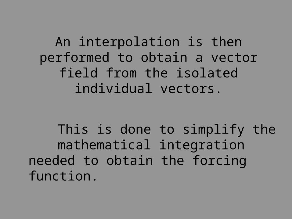
An interpolation is then performed to obtain a vector field from the isolated individual
vectors.
This is done to simplify the mathematical integration needed to obtain the forcing function.

Interpolated Fieldof displacement vectors

Computed Potentialbased on the displacement vectors
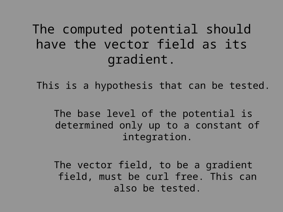
The computed potential should have the vector field as its gradient.
This is a hypothesis that can be tested.
The base level of the potential is determined only up to a constant of integration.
The vector field, to be a gradient field, must be curl free. This can also be tested.

The attempt is now made to apply these ideas in a social space.
This can be considered a development of Lewin’s Topological Psychology or his Field Theory in the Social Sciences.
The data represent citations between a small set of psychological journals. Larger citation tables are now
also available.

Citations among psychology journalsCoombs et al 1970
Data from 1964

In Journal Space
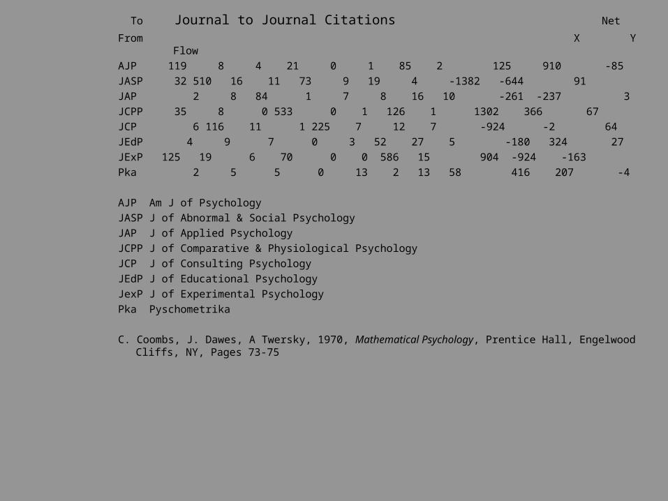
To Journal to Journal Citations Net
From X Y Flow
AJP 119 8 4 21 0 1 85 2 125 910 -85
JASP 32 510 16 11 73 9 19 4 -1382 -644 91
JAP 2 8 84 1 7 8 16 10 -261 -237 3
JCPP 35 8 0 533 0 1 126 1 1302 366 67
JCP 6 116 11 1 225 7 12 7 -924 -2 64
JEdP 4 9 7 0 3 52 27 5 -180 324 27
JExP 125 19 6 70 0 0 586 15 904 -924 -163
Pka 2 5 5 0 13 2 13 58 416 207 -4
AJP Am J of Psychology
JASP J of Abnormal & Social Psychology
JAP J of Applied Psychology
JCPP J of Comparative & Physiological Psychology
JCP J of Consulting Psychology
JEdP J of Educational Psychology
JexP J of Experimental Psychology
Pka Pyschometrika
C. Coombs, J. Dawes, A Twersky, 1970, Mathematical Psychology, Prentice Hall, Engelwood Cliffs, NY, Pages 73-75

The table gives the being-cited journal across the columns. But the information can be considered to
move from that journal to the citing journal.
Therefore the transpose is used to produce the source to destination map.

Journal Sources and Destinations

We now have an assignment problem. How to get 163 citations from JExP, 85 from AJP, & 4 from Pka to the 5
receiving journals, using only the table marginals. There are obviously many possibilities
One solution is to use the “Transportation Problem” (Koopmans, Kantorovich, ~1949): Minimize M..d.., subject to M.J = OI, MI.= IJ, MIJ >= 0, given the
distances computed from the coordinates and using the simplex method for the solution.
A more realistic solution is given by the quadratic transportation problem: Minimize M2..d.., subject to the same constraints.
Both of these solutions result in discrete answers, and ‘shadow prices’. We are looking for a spatially continuous solution that allows vectors and streamlines,
in order to determine spatial flow fields and a continuous potential.

The next step is to compute the displacements between the cited journals.
This is based on the asymmetry of the citations table.
The fundamental idea being that there exists a ‘wind’ making movement easier in some directions.
The mathematical details are given in a published paper.W. Tobler, 1976,“Spatial Interaction Patterns”, J. of Environmental Systems, VI(4):271-301

Displacement between Journal Citations

Then the potential is computed by integration.
This potential should be such that its gradient coincides with the displacement vectors.
It may be necessary to use an iteration to obtain this result.

Journal Potential Function

Flow and Potential between Psychological Journals

Some questions
Suppose a new psychological journal were started. Where should it be inserted into in this space?
Does it make sense to treat journal citations as being located in a continuous two-dimensional social
space?
Can other social data be treated in a similar fashion, for example social mobility tables?
And more general network data?

I have given some speculative thoughts on how one might represent network relations with vectors fields and scalar potentials in a continuous social space.
Still needed are error estimates.
Your comments are desired.
Thank you for your attention.
http://www.geog.ucsb.edu/~tobler
CONCLUSION

References
K. Boyack, 2004, XXX, Proceedings, NationalAcademy of the United States, 101, Supplement1, (April 6): 5192-5199.
C. Coombs, J. Dawes, A. Twersky, 1970,Mathematical Psychology, Prentice Hall,Englewood Cliffs, NY.
D. Fliedner, 1962, “ZyklonaleTendenzen bei Bevölkerungs undVerkehrsbewegungen in StädtischenBereichen untersucht am Beispiel derStädte Göttingen, München, und Osnabrück”,Neues Archiv für Niedersachsen, 10:15(April 4): 277-294 (Table 2, p. 281, mapfollowing p. 285).
K. Lewin, 1936, Principles of TopologicalPsychology, McGraw Hill, New York
K. Lewin, 1951, Field Theory in the SocialSciences, Harper, New York.
W. Tobler, 1976, "Spatial InteractionPatterns", J. of Environmental Systems, VI(4) 1976/77, pp. 271-301.
W. Tobler, 1981, "A Model of GeographicMovement", Geographical Analysis, 13 (1): 1-20.
W. Tobler, 1996, “A Graphical Introductionto Surveying Adjustment”, Cartographica, 33-42.
S. Wasserman, Faust, K., 1994, SocialNetwork Analysis: Methods and Application,Cambridge University Press, Cambridge.

Another geographic example as motivation
This was not presented at Sunbelt XXV

You have just seen this simple example
Commuting in Munich 1939Left to right: from places (sources -) and to places (sinks +),
vectors, and interpolated vectors, and the implied potential field

In the previous slide the source places (origins) were used to make a set of vectors pointing towards the sinks (destinations). These were then interpolated to obtain a field of vectors. Integration (in the mathematical sense) was then used to construct a potential field, shown by contours. The magnitude and direction of the vectors correspond to the gradient of the potential surface.
In the next example something similar is done. Except that the model is set up on the basis of interpolating the sources (out-flows) and sinks (in-flows) for the contiguous US. Then the potential is computed directly. The gradient vector field is obtained from this potential field.
To carry out this operation first assign the in-migration and out-migration totals to each state. Then ‘rasterize’ the region of interest into a large set of equally spaced nodes and spread the population change over the nodes in each state. This allows the treatment to approximate a continuous migration surface and is illustrated on the next slides. This is one of several ways to treat geographic space in a continuous fashion.
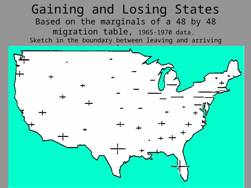
Gaining and Losing StatesBased on the marginals of a 48 by 48 migration
table, 1965-1970 data. Sketch in the boundary between leaving and arriving places.

“Rasterize” the USA to form a lattice.Use a point-in-polygon program to assign nodes to individual states. Then assign in and out
values to these nodes. There will be one equation for each node on this raster.Then solve the system of ~6000 simultaneous equations to yield the potential.

In the raster look at one node and its neighborsA raster is a special kind of network where movement takes place between neighboring nodes
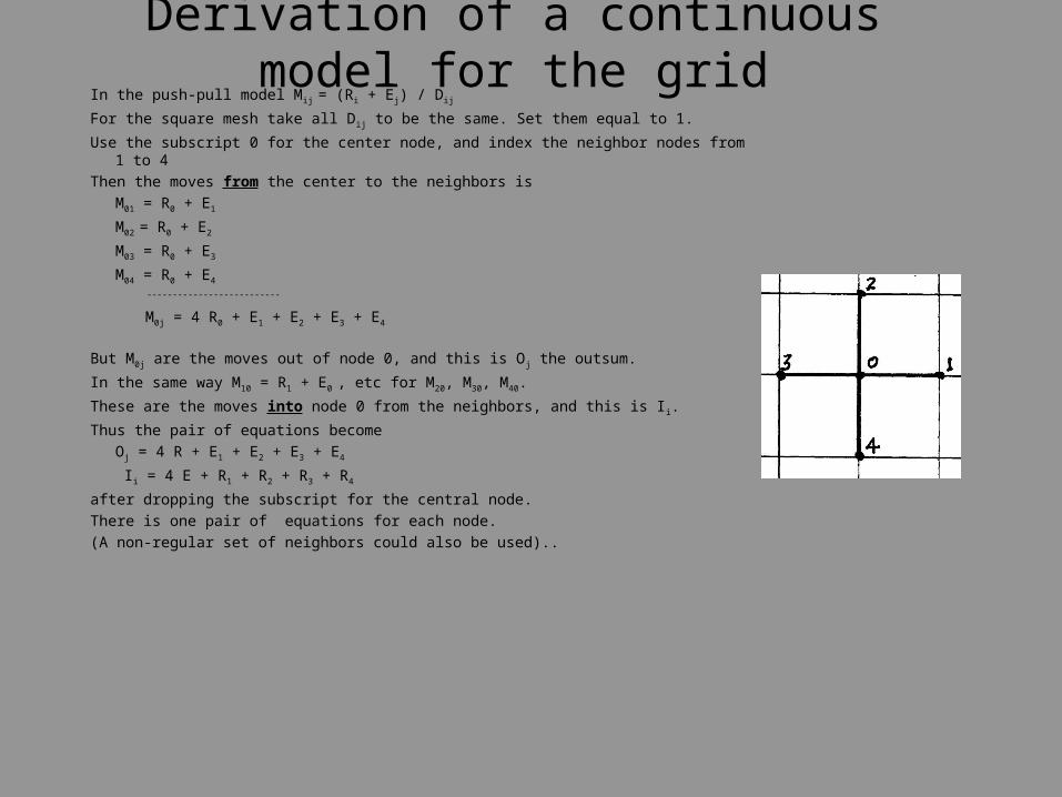
Derivation of a continuous model for the gridIn the push-pull model Mij = (Ri + Ej) / Dij
For the square mesh take all D ij to be the same. Set them equal to 1.
Use the subscript 0 for the center node, and index the neighbor nodes from 1 to 4
Then the moves from the center to the neighbors is
M01 = R0 + E1
M02 = R0 + E2
M03 = R0 + E3
M04 = R0 + E4
--------------------------
M0j = 4 R0 + E1 + E2 + E3 + E4
But M0j are the moves out of node 0, and this is O j the outsum.
In the same way M10 = R1 + E0 , etc for M20, M30, M40.
These are the moves into node 0 from the neighbors, and this is I i.
Thus the pair of equations become
Oj = 4 R + E1 + E2 + E3 + E4
Ii = 4 E + R1 + R2 + R3 + R4
after dropping the subscript for the central node.
There is one pair of equations for each node.
(A non-regular set of neighbors could also be used)..

The distance values Dij, as constants, have been dropped in the square mesh, for pedagogic purposes, but not a mathematical necessity.
Each place, except along the margins of the region, will have four neighbors.
Just derived were the two equations at each node:
4E = I - (R1 + R2 + R3 + R4), 4R = O - (E1 + E2 + E3 + E4).
The central E and R require no subscript; their neighboring locations are indexed from one to four - or if you wish - North, South, East, and West directions.
Now add - 4R to both sides of the first equation and - 4E to both sides of the second, rearrange slightly, and using T = E + R, to obtain
R1 + R2 + R3 + R4 - 4R = I - 4T, E1 + E2 + E3 + E4 - 4E = O - 4T,
The left-hand sides are recognized as finite difference versions of the Laplacian. Thus we can write, approximately and for a limiting uniform fine mesh, the pair
2R/u2 + 2R/v2 = I(u,v) - 4T(u,v),
2E/u2 + 2E/v2 = O(u,v) - 4T(u,v),
assuming that R and E are differentiable spatial functions and that I and O are continuous densities given as functions of the Cartesian coordinates u and v.

Now, making use of the continuous movement model. http:/www.geog.ucsb.edu/~tobler/presentations/A Flow Talk.pps
In this continuous model, we have a coupled system of two simultaneous partial differential equations covering the entire region. These equations can be combined to yield either gross movements or net movements. For the simultaneous movement in both directions at each pair of places add the two equations to get the ‘turnover’ potential. For the net movement we need only the difference between the ‘in’ and ‘out’ at each node for the ‘attractivity’ potential, as follows:
By subtraction from the two previous equations we have the single partial differential equation
2A/u2 + 2A/v2 = I(u,v) - O(u,v),
where A can be thought of as the attractivity of each location. This is the well-known Poisson equation for which numerical solutions are easily obtained. Once A(u,v) - the potential - has been found from this equation, the net movement pattern is given by the vector field
V = grad A,
or by the difference in potential between each pair of mesh nodes.
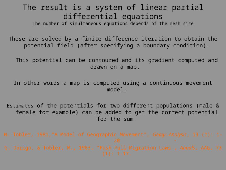
These are solved by a finite difference iteration to obtain the potential field (after specifying a boundary condition).
This potential can be contoured and its gradient computed and drawn on a map.
In other words a map is computed using a continuous movement model.
Estimates of the potentials for two different populations (male & female for example) can be added to get the correct potential for the sum.
W. Tobler, 1981,"A Model of Geographic Movement", Geogr. Analysis, 13 (1): 1-20
G. Dorigo, & Tobler, W., 1983, “Push Pull Migration Laws”, Annals, AAG, 73 (1): 1-17.
The result is a system of linear partial differential equationsThe number of simultaneous equations depends of the mesh size

The potential gives
The Pressure to Move in the USBased on the continuous spatial model
Using state data

Another view
The migration potentials shown as contours
and with gradient vectors connected to give streaklines

That these migration maps resemble maps of wind or ocean currents is not surprising given that we in fact speak of migration flows and backwaters, and use many such hydrodynamic terms when discussing migration and movement phenomena.
The foregoing equations have captured some of this effect in a realistic manner.
One advantage of the continuous potential model is in the
clarity that it provides of the overall pattern and domains.

Thank You For Your Attention
Waldo Tobler
Professor Emeritus
Geography department
University of California
Santa Barbara, CA 93106-4060
http://www.geog.ucsb.edu/~tobler