summary of surface exploration 1979-80 wilmar … · the property consists of 23 patented claims...
TRANSCRIPT
C, 3 - "^ S o(\
S2N04SW0057 63.3809 DOME TWP010
SUMMARY OF SURFACE EXPLORATION 1979-80
WILMAR-ANNCO PROPERTIES
WILANOUR RESOURCES LIMITED
COCHENOUR, ONTARIO
FOR: M.E.A.P. Agreement R. L. - 80
by: B. GilliesMarch 17th, 1981
Witanour Resources Group of CompaniesRED LAKE,ONTARIO
PRODUCERS AND FORMERPRODUCES
MARBOYa DICKENSON
LITTLELONGLAC
H.G.YOUNG (CAMPBELL),
•WILANbURRESOURCES
&
CAMPBELL RED LAKE
CRAIBBE FLETCHER
DICKENSON^SSilll
NEOMAR
DICKENSON

l INTRODUCTION:
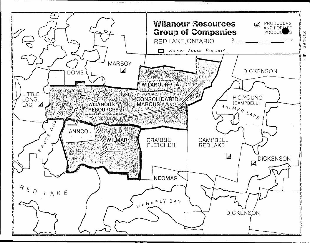
a) Location and Access^ (Map ref. 1)
The Wi linar/Annco property lies immediately southeast of the
village of Cochenour in Dome Township in the Red Lake district
of Ontario. The property consists of 23 patented claims cover
ing approximately 900 acres.
Walmar: KRL 91A, 92, 93A, 94, 5217, 5218, 6687, 7594, 8583,
]0888, 10889, 30890, 10891, 10896, 10976, 11619,
19851, 19852
Annco: KRL 90, 91, 93, 7741, 10985
Access is by paved Highway #125 which runs through the centre
of the property or by the Red Lake aerodome which lies on claims
KRL 5217, 5218 and 10890.
b) Topography^:
The property is generally flat to rolling. A hill in the
south central Wilmar area is called Rahill. Southern most claims
10976 and 11041 occupy higher ground. The Annco property, once
covered by natural swamp, is now the site for the Cochenour
Willans Gold Mines tailings pond. A north-northeasterly trending
ridge of outcrop separates the pond from Red Lake to the west.
Total relief is about 100 feet.
Sand and gravel deposits tend to be irregularly draped around
areas of outcrop and highland. Flatter areas are commonly clay
covered. Bedrock exposure is about 5?,.

- 2 -
HISTORY AND PREVIOUS WORK:
The history of the WiImar property is well documented by
Hutton, 1973. Considerable stripping and trenching was done on
the Wilmar claims in 1927-28. By 1936 Rahill Red Lake Mines
Limited had sunk a shaft or pit to 35 feet on KRL 6687. From
March to July 1945, a detailed magnetometer survey with 300 foot
line spacing was done by Koulomzine, Geoffrey, Brossard and
Company. Considerable surface drilling was done during the 1940's,
60's and 70's. (See Summary Table)
In 1958 Wilmar Mines Limited was incorporated by Martin McNeely
Mines Limited and Cochenour Willans Gold Mines Limited to explore
underground and develop the Wilmar property. By spring of 1961
the 1300 level crosscut from Cochenour was completed and the East
and West drifts started.
Wilmar Mines operated from 1967 to 1971 producing 58,130 oz.
Au at an average grade of 0.302 oz. Au/ton at an operating cost
of 514.27/ton for a loss of 2,382,996.00.
The property has been previously mapped by W. E. Snow, Martin
McNeely Mines Limited, 1944-45, S. A. Ferguson, Ontario Department
of Mines, 1960-62, and J. Pirie, Ontario Geological Survey 1978-79.
Airborne electromagnetic and total intensity magnetic surveys
were flown in 1977 by Questor Surveys Limited for the Ontario
Geological Survey.
In 1978 Camflo Mines Limited of Toronto gained controlling
interest of Wilmar Mines Limited through Camflo 1 s subsidiary
Wilanour Resources of Cochenour.

lCLyJll~ acc Diamond Drilling prior to 1980 .
s r; R i r; s FOOTAGE DATE COMPANY TARGET ZONE
i-ii
MMX-l to 57
MM-l to 64 (exclud ing MM27-33,35)
63-] to 25
S-73-1 to 19
S-74-20 to 35
S-74-50 to 55
3323'
7866'
29984'
12132'
10529'
7780'
1038'
1936 Rahill Red Lake Mines
1944-46 Martin McNeely Mines
1944-50 Martin McNeely Mines
1963 Wilmar Mines Limited
1973 Wilmar Mines Limited
1974 Wilmar Mines Limited
1974 Wilmar Mines Limited
Quartz Feldspar Porphyry dykes
General Exploration
General Exploration
East Zone Projection
East Zone and Granodiorite
Granodiorite
Quartz Feldspar Porphyry dyke
Total 190 ddh's 72643
iUJ
J

4 -
lil 1979-1980 EXPLORATION^ PROGRAM:
Following an initial compilation of the Wilmar property and
surrounding area, a surface exploration program was started in
August 1979 under the direction of I. M. Watson, consultant for
Camflo.
The aim was to reassess the property using recent theories
of gold deposition by compiling and interpreting all available
data including geological and geophysical information collected
during the present program. The object of the geophysical surveys
was to assist the geological interpretation by correlation of
magnetic and VLF features to known structure and lithology.
At the time of writing the recommended surface exploration
program is nearing completion. With the rehabilitation of much
of the Wilmar 1300 level in progress the underground phase of
exploration and development is starting.
The 1979-80 Wilmar exploration program included topographic
survey, line cutting, magnetometer survey, EM-16 survey, geological
mapping and compilation. Selected areas were diamond drilled from
surface.
IV Geological MappjLncj: (Map ref: 2)
Mapping of the Wilmar property at a scale of I'^IOO' was
done by J. M. Watson from September to November 1979. This
program was correlated with a more regional program of mapping
at 1"^500'. Approximately 250 grab samples were taken on the
Wilmar and other properties for representation or assay. Fifty-
six were selected for thin section study.
V G L NE RA L GEOLOGY^:
The Wilmar property is situated in the east central region
of the Red Lake greenstone belt. Geologically the ground forms
part of a major mafic volcanic complex. The complex is composed
of metamorphosed tholeii td c basalts , andesites and minor felsic
volcanic and sedimentary units. Major chemical and clastic
metasedimentary units tend to be found on the peripheral areas
of the belt.
The major intrusive bodies of the area are the Dome stock
and the East Bay Serpentinite. The Dome stock is a different
iated orbicular granitic mass whose eastern contact lies about
one (1) mile west of the Wilmar property. The East Bay Ser
pentinite is an ultramafic lens striking southwest across the
length of Bateman township and terminating in Dome township on
the 7innco property.
VI DETAILED GEOLOGY:
a) Rock Types:
Mafic Volcanics: Pillowed to massive flows form a broad
centre core on the Wilmar property surface. The basalts are
usually a medium chloritic green and are texturally variable from
fine-grained to equigranular medium grained. The pillow basalts
are often variolitic or amygdaloidal. The mafic volcanics are
moderately to highly foliated and display varying degrees of
alterati on.
Intermediate Volcanics: These have not been recognized as
such on surface. However, varying degrees of pervasive alteration
would make some mafic volcanics compositionally intermediate.
Some phases of the agglomerates and tuffs with some mafic matrices
have been classed as andesitic or intermediate by some mappers.
Felsic Volcanics: These range from massive flows to pyro
clastics, agglomerates and tuffs. They are medium to fine
grained, have a waxy yellow colour and a vitreous lustre. The
felsics often have reddish hematitic tinges or greenish epidote

6 ~
^V] DKTA3LKD GKOLOGY: (con't)
stain near basalt contacts. They are often highly sheared in a
diamond pattern and locally are highly pervasively carbonatized
or silicified. There is controversy as to the possible intrusive
nature of the massive felsic bodies. However, based on contact
relationships, they are presently felt to be extrusive.
Clastic Metasediments: A chert cobble conglomerate underlying
a banded chert magnetite iron formation is found only in the
western Tuinco area. On the southern Wilmar claims is found a
poorly sorted clast supported graywacke of felsic to intermediate
grains in an argillaceous matrix. The rock type is closely
associated with felsic to intermediate tuffs. Finally, Ferguson,
1966, interprets a sulphide bearing black slate to be occupying
a syncline on KRL 10976.
Chemical Metasediments: Banded chert magnetite iron form
ation is found on the north west side of the property and as
minor interflow sediments within the mafic volcanics. The chert
is highly fractured and displays varying degrees of replacement
by carbonate. Geophysically the unit is detected by high magnetic
relief and tends to be conductive.
Mafic to Ultramafic Intrusives: i) Gabbro diorite plugs
appear to be differentiated with dioritic cores and gabbroic
shells locally containing magnetite. The rock is medium, to
coarse-grained, fresh green, generally massive, weakly foliated
and highly pervasively carbonatized. Contact relationships with
basalt are unclear but appear to be gradational and, on a larger
scale, are cross cutting.
ii) Lenticular gabbro-serpentinite bodies near surface have been
found only in drill hole and are defined geophysically. They
are believed to be dyke-like intrusives along zones of struct
ural weakness. Fresh samples are dark gray, green, massive and
uniformly magnetic. However, the rock is usually highly sheared
and has undergone serpentine, chlorite, talc and/or carbonate
al terat i on.

|V] DETAILED GEOLOGY^ (con't)
Intermediate to Felsic Intrusives: These dyke like in-
trusives post-date the serpentinites. They range in composition
from quartz porphyry to diorite. They are massive, medium grain
ed and have sharp contact relationships. Carbonate and sericite
alteration is common. On surface a quartz feldspar porphyry is
exposed west of the airport windsock and an olive green diorite
is found on Rahill. The intrusion of these dykes may correlate
in time with the emplacement of the Dome Stock.
Minor Intrusives: Late dioritic dykes usually trend along
strike, are sulphide bearing and locally highly magnetic. Brown
lamprophyre dykes are biotitic, very irregular and cross cutting.
A late stage silceous mottled, sheared quartz-feldspar porphyry,
noted underground i s thought to be fault following. It contains
no quartz-tourmaline veins and as yet has not been found on
surface.
b) Metamorphism and Alteration;
The rocks have undergone greenshist facies metamorphism.
Sericite in the felsic volcanics, chlorite and epidote in the
mafic volcanics and serpentine and talc in the ultrabasics and
gabbros reflect this.
Hydrothermal alteration is recognized throughout the Wilmar
property in various stages and intensities. Each rock type has
responded differently depending on its original mineralogy and
texture. Carbonatization and silicification are the most
prominent types of alteration. The range of alteration is re
flected from an intensely pervasively carbonatized silicified
"dacite 1 ' with well formed amygdular pillows to dark green basalt
with carbonate filled fractures. An alteration sequence is
postulated:
1) An initial pervasive carbonate and silica soak, locally intense.
2) Various stages of structurally controlled remobilization of
quartz carbonate material into stringers, veinlets and massive
epigenetic bodies (e.g. Rahill). Mariposite and fuschite are

VJ DETA3LKD GKOLOGY: (con't)
also remobilised. Injection of ultrabasic lenses and sub
sequent talcose alteration may correlate with the early
stages of this step.
3) Late stage fracturing and carbonate fracture filling in all
rock types as well as pervasive carbonatization of late
mafic and felsic intrusives.
4) Tensional stresses and quartz tourmaline infilling.
c) Structurj2:
Previous theories have interpreted the WiImar property as
occupying a broad anticlinorium with fold axes striking east-west
and plunging southwest under the Goldray property. The central
core is mafic volcanics with general lithologic upward gradation
through felsic flows, tuffs, fragmentals, graywackes and topped
by chemical metasediments. Folding in primary features is
rarely seen due to obliteration by foliation and shearing except
in the banded iron formation and interflow sediments where plunges
are usually steeply to moderately southwesterly.
Jn the central Wilmar area structural trends are generally
cast to north east. This is reflected as one strong foliation in
basalt and two low angle directions in the massive felsic vol
canics. Dips are subvertical.
On surface the Rahill area appears to be an area of intense
structural deformation as well as alteration. On the western
7innco property structural trends are north-northeasterly. This
may be interpreted as the northwest limb of the anticlinorium or
a different area offset by a major structural north-south break,
or both.
/Although many lithologic contacts appear sheared, at least
three areas show shearing or foliation cross cutting lithologic
contacts or sedimentary banding at high angle. Based on inter
pretation, serpentinite dykes appear to be conformable to
structural trends and less se to lithologic trends.

9 —
VI DETAILED GEOLOGY: (con't)
Two north trending late fracture zones have been interpreted
based on geophysical and limited geological evidence.
VII CONCLUS K)NJ3 :
The geology of the Wilmar and Annco properties is litho-
logically and structurally complex. Geophysical surveys are
useful as mapping tools to aid in geological interpretation of
a property with little outcrop. Stripping, trenching and geolog
ical mapping at 1"^20' is required if local controls for gold
mineralization are to be ascertained.
B. Gillies, Cochonour, Ontario, March 17th, 1981.
10 -
VIII REFERENCES:
Bergman, H. J. 1950: Summary Report of Diamond Drilling Program, Martin McNeely Mines Limited, December 10, 1950.
Chastko, L. C. 1973: Cochenour Willans Gold Mines Limited - Report on Wilrnar Diamond Drilling Program, November 30, 1973.
Cluff, J. A. 1947: Progress Report on Martin McNeely Mines Limited October 1947.
Ferguson, S. A. 1966: Geology of Dome Township; O.D.M. Geological Report 45, 1966.
Horwood, H. C. 1945: Geology and Mineral Deposits of the Red Lake Area; O.D.M. Vol. XLIX pt2, 1940.
Hutton, D. A. 1963: Summary of Wilmar Exploration, July 16th -Oct. 25th, 1963, Cochenour Willans Gold Mines Limited.
1964: Summary of Wilmar Exploration October 26th - February 15th, 1964
1973: Wilmar Mines Limited, - A Study of Exploration Possibilities and the potential economic Objectives, March, 1973.
Mccartney, G. C. 1962: A report on Wilmar Gold Mines Limited; Toronto, Ontario, February 13, 1962.
Nowlan, J. P. 1950: Report on Proposed Exploratory Work, Martin McNeely Gold Mines Limited, June 7, 1950.
Ramsell, J. L. 1944: Letter to Martin McNeely Mines Limited, November l, 1944.
Shaw, J. W. 1934: Report to Martin McNeely Mines Limited, April 1934.
Sheperd, J. H. 1950: Report on Rahill Bay Group of Martin McNeely Mines Limited, May l, 1950.
Snow, W. E. 1947: Geological Report on Martin McNeely Mines Limited, Dome Township Red Lake Mining Division, February 1947.

a52N04SW0057 63.3809 DOME TWP
020
MAGNETIC SURVEY REPORT
ON THE
ANNCO AND WILMAR PROPERTIES
OF
WILANOUR RESOURCES LIMITED
DOME TOWNSHIP, ONTARIO.
by: B. GilliesMarch, 1981.

Wilanour Resources Group of Companies
PRODUCERS AND FORJKR
RED LAKE.ONTARIO
' MARBOYa DICKENSON
LITTLELONGLAC
H.G.YOUNG(CAMPBELL)
CRAIBBE FLETCHER
CAMPBELL RED LAKE
DICKENSON
NEOMAR
LAKE
DICKENSON
- l -
1. INTRODUCTION;
This report describes a fluxgate magnetometer survey and results
on the Wilmar and Annco properties of Wilanour Resources Limited,
Dome Township, Ontario (see figure #1). The survey area lies immed
iately east of the village of Cochenour and includes the following
patented mining claims:
Property Patented K.R.L.
Wilmar (Mines Ltd.) 91A, 93A, 92, 94, 6687, 11619, 10976, 19851,
19852, 8583, 5217, 5218, 7594, 10896, 10888,
10889, 10890, 10891
Annco (Mines Ltd.) 91, 93, 90, 7741, 10895
Access is by Highway 125 which runs through the central portion
of the survey area.
Field work was done from August 1979 to October 1979 by staff of
Wilanour Resources Limited under supervision of I. M. Watson, consult
ant for Wilanour Resources and J. Ratcliffe, independent consultant.
Several magnetometer surveys have been done over the properties
in the past. The largest one was by Koulomzine, Geoffrey, Brossard
and Company, 1945. Smaller sections had most recently been surveyed
by Cochenour Willans Gold Mines employees in 1973.
The purpose of this survey was to produce an accurate,
comprehensive magnetics map to aid in geological interpretation.
2. GEOLOGY;
A thorough description of the property and its geology is given
in a report by B. Gillies, dated, March, 1981. Other Company
geological reports of interest include those by W. E. Snow, 1947;
C. J. Kuryliw March 1963; D. A. Hutton, October, 1961.
Briefly, the area is underlain by highly altered acid and basic
volcanics cut by both felsic and mafic intrusives. Iron formation,
tuffs and agglomerates tend to be found in the southern and western
sections of the properties.
- 2 -
2. GEOLOGY; (con't)
Considerable work was done by Martin McNeely Mines Limited during
the 1940's and by Wilmar Mines Limited in the 60's and mid '70's.
The Wilmar property has been a past gold producer/operating from 1967
to 1971.
3 - SURVEY INSTRUMENTATION AND PROCEDURES:
The magnetic survey was carried out using a vertical field
fluxgate magnetometer, a digital model MFD-4 manufactured by Scintrex.
This instrument was used with a tripod stand enabling a reading re
solution of plus/minus one gamma. The readings were taken in gammas
as the earth's absolute vertical component of the magnetic field
according to the instrument calibration by the manufacturer.
While field loops were being run, a monitor magnetometer - a
Scintrex MF-2 fluxgate type, was placed in an area of low magnetic
gradient and noise. Diurnal magnetic fluctuations were recorded using
an Esterline Angus Model T 171 B chart recorder connected to the MF-2.
The recorder was set to highest sensitivity, a recording span of plus/
minus fifty gammas to enable a reading resolution of about plus/minus
one gamma,
The recorder permitted corrections to be made for magnetic fluct
uations during the course of a loop and enabled continuation of the
survey during magnetically unsettled but not active days. Loops in
the field were closed as a check on the consistency of the survey.
It is felt most readings are reproducible to within plus/minus ten
gammas.
Seventeen base stations on the grid {denoted by "^" on the maps
#3, #4) were established from an initial arbitrarily set main station.
Corrected readings at each base, taken during three loops closed with
the main station, were averaged for the final value providing the range
of the three corrected readings did not exceed ten gammas.
Cut line spacing was 200 feet and the station interval was fifty
feet. In areas where structural trends were obscure, paced inter
mediate lines were run. Some magnetic anomalies were outlined by mag-

- 3 -
3. SURVEY INSTRUMENTATION AND PROCEDURES; (con't)
netometer prospecting. Readings likely to be affected by man-made
or mechanical noise were noted as such but contoured with the rest
of the data regardless.
The number of line miles of magnetometer survey was 40.5 miles
miles {213,850') with the following breakdown according to property;
Wilmar 34.8 line miles
Annco 5.7 line miles
40.5 line miles (4277 readings)
The data is presented as contours of vertical field intensity
with a contour interval of one hundred gammas.
4 - INTERPRETATION;
Maps #1 and #2 show the contoured magnetic data.
Structure;
1. From magnetic information, structural trends appear to be east-
west in the southern section of the map, southwest-northeast in
the central and northeast map sections and possibly N-NE to S-SW in the western map section.
2. The contours interpreted in the central section may denote a folded
structure plunging west-southwest.
3. Crosscutting faults may be interpreted at the ends of distinct
magnetic bands or in cross cutting broad magnetic lows such as
one trending N-NE through the central map sheet or a similar one
trending north in the western section.
Lithology;
1. Broad magnetic highs are interpreted to be mafic or ultramafic
intrusives. In the eastern area the circular body surrounded by
a high magnetic rim is known by early drilling to be a differentiated
gabbroic plug. The extensive highly magnetic body to the north
is believed to be the East Bay serpentinite.

- 4 -
4. INTERPRETATION; (con't)
Lithology;
2. Areas of moderate magnetic relief may be underlain by inter
mediate to mafic volcanics and broad low magnetic areas may be:
a) felsic to intermediate volcanics, tuffs and agglomerates.
b) areas of extreme silicification and carbonatization.
c) areas having great thicknesses of overburden.
3. Magnetite and sulphide iron formation may be indicated by areas
of intense magnetic relief. Magnetic information from inter
mediate lines in these areas does not easily clarify the trends
of distinct bands or folding patterns.
4. Areas known to be underlain by acid intrusives do not have a
distinct magnetic expression that has been recognized.
5. RECOMMENDATIONS;
1. No further magnetic surveying on the survey area is recommended
except: a) to survey L28W 26N-30N after cutting and chaining.
b) to prospect specific magnetic features of interest and magnetically profile future drilling sections.
2. Any contouring may be reinterpreted if geologic strikes and trends
are known.
3. A fifty gamma contour interval in the low broad magnetic areas may
be useful.
6 - CONCLUSIONS;
The magnetic map has aided in structural and lithological inter
pretation in the areas of the properties having little or no
geological information.
The coincidence of the occurrence of gold mineralization with the
"folded" structures interpreted in the central area may have relevance
- 5 -
6 ' ^.N^UE!H)*JS . (con' t)
to similar folded features interpreted from magnetic surveys on
adjacent properties.
B. Gillies, March 17th, 1981.

3. 7- VO
S2N04SW8057 63.3809 DOME TWP 030
ELECTROMAGNETIC SURVEY REPORT ON
THE ANNCO AND WILMAR PROPERTIES OF
WILANOUR RESOURCES LIMITED
DOME TOWNSHIP, ONTARIO
by: B. GilliesMarch 17th, 1981.

Wilanour Resources Group of CompaniesRED LAKE,ONTARIOl j WiLMfiK
PRODUCERS AND FOHJtR
dVi
MARBOY
DICKENSON
LITTLE LONGu\c
H.G.YOUNG(CAMPBELL)
CRAIBBE FLETCHER
CAMPBELL RED LAKE
DICKENSON
NEOMAR
LAKE
DICKENSON

- l -
1.
This report describes an EM-16 survey and results on the Wilmar
Annco properties of Wilanour Resources, Dome Township, Ontario (see
figure #1) . The survey area lies immediately east of the village of
Cochenour and includes the following patented mining claims:
Property Patented K. R. L.
Wilmar (Mines Ltd.) 91A, 93A, 92, 94, 6687, 11619, 10976, 19851,
19852, 8583, 5217, 5218, 7594, 10896, 10888, 10889,
10890, 10891
Annco (Mines Ltd.) 90, 91, 93, 7741, 10895
Access i s by Highway 125 which runs through the central portion
of the survey area.
A thorough description of the property and its geology is given
in a report by B. Gillies, dated March, 1981.
The field work was done from September 1979 to November 1979 by
staff of Wilanour Resources Limited under supervision of I. M. Watson,
consultant for Wilanour Resources Limited and J. Ratcliffe, independent
consultant. No previous V.L.F. surveys had been done on the properties.
The purpose of the survey was to produce a map delineating bedrock
conductors to aid in geological interpretation.
2. SURVEY INSTRUMENTATION AND PROCEDURES:
The instrument used was a Geonics EM-16. Two readings were
taken at each survey station: inphase as percent deflection of the
primary field and quadrature or strength of the secondary field.
For cross lines, transmitter station Seattle, Washington, being
roughly perpendicular to the cross lines, was used. By convention
these readings were taken facing grid north.
For the baseline and other subparallel traverses, transmitter
station Annapolis, Maryland at roughly 60 to the traverse direction

2. SURVEY INSTRUMENTATION AND PROCEDURE: (con't)
was used in an attempt to detect regional crosscutting conductors.
Readings by convention were taken facing roughly grid east.
Cut line spacing was 200 feet and the station interval was
fifty feet. The conductor detected from the baseline traverse at
5E was detailed with a paced mini-grid to outline the direction and
extent of this crosscutting feature (see inset, Map #1 Wilmar EM-16
Survey - Main Sheet).
Readings likely to be affected by man made or mechanical noise
were noted as such but results were contoured with the rest of the
data regardless. Where readings could not be obtained due to high
noise levels, they were interpolated.
The number of line miles of EM-16 survey was 37.4 miles (197,700")
with the following breakdown according to property:
Wilmar 33.2 line miles {175,350')
Annco 4.2 line miles ( 22,350')
37.4 line miles (3954 readings)
The in-phase readings were filtered according to the method of
Fraser*. The data is presented as contours of dip angle gradient of
the primary field ellipse. Only the positive filtered
readings were contoured at an interval of ten units. Power lines,
telephone lines and buried cables were plotted.
3. RESULTS:
Large areas of the grid appear to be at least slightly con
ductive. All conductors exceeding an arbitrarily chosen filtered
value of 30 were numbered Wl to W31 except those conductors which
appear to be mechanical. (see figure #3)
4. INTERPRETATION:
There appear to be three types of conductors:
* Fraser, D.C.; Contouring of VLF-EM Data, Geophysics; Dec. 1969.

- 3 -
4. INTERPRETATION;
a) Man-made conductors have data profiles usually of high
filtered value but narrow lateral extent. This may be due
to their highly conductive shallow nature.
b) Topographic and surface effects such as valleys, concave
bedrock surfaces, benches, swamp and pond edges may appear
as conductors of highly variable strength and extent.
c) Bedrock features such as open faults, alteration zones,
particular rock types, banded iron formation, sulphides and
perhaps graphite may show up as conductors indistinguishable
from topographic ones. The particular nature of the bedrock
is often reflected topographically and therefore maybe in
dicated by surface conductors.
The following is a list of suggestions as to the nature of the
stronger filtered anomalies based on geologic, magnetic and topo
graphic information.
Anomaly No.
W1,W4, W17
W3,W2,W7,W5,W6
W5
W11,W13,W14,W15
W8 , W9
W10
W12
W16
VJ18
W19,20,21
Nature
sulphide or magnetite iron formation
topographic
unknown
topographic
mechanical
topographic
talc schist
topographic
unknown
unknown
Reason
High magnetic correlation relief.
Edge of tailings pond.
Magnetic correlation but near garbage dump.
outlines edge of outcrop and higher ground.
grounded fence and cable near airport.
depression in ground, cross cuts magnetic strike.
previous drilling but also in drainage low.
foot of hill along glacial strike.
near or on gabbroic intrusion,

Anomaly No.
W22
W23,W24
W25,W26
W27,W30 and end of W18
W28
W29
W31
Nature
mechanical
unknown
topographic
fault
unknown
topographic and sulph ide iron formation
Reason
radio transmitting station,
near or on gabbroic intrusion,
swamp edge.
coincides with mag low and may correlate with fault mapped underground.
base of hill and previous drilling.
topographic and contact base of hill and edge of of East Bay serpent- magnetically high region, inite
5. RECOMMENDATIONS:
If regionally crosscutting conductors are to be detected,
the survey should be rerun using the Annapolis Maryland
transmitter signal and inphase readings can be filtered
across cut lines. Conductor W30 may be outlined with a
paced mini-grid using the same signal.
Profile lines should be run over any conductors of interest
with a Max Min II or other comparable EM system to attempt
to define the nature of the conductors. This method is
especially recommended for W5, W10, WU, W12, W13, W18, and
W31.
One or two lines should be profiled with the Crone Radem
VLF system used in the Consolidated Marcus survey to compare
relative locations and Fraser filtered strengths of the
conductors detected by the 2 VLF systems.
Conductors which are relatively weak and en echelon maybe
conductive bodies with long axes at high angles to the
transmitter direction. Intermediate placed lines may be run
or the transmitter signal changed and appropriate traverse
lines run. Examples are W21 to W19 and W24 areas.

- 5 -
6. CONCLUSIONS:
More sophisticated electromagnetic methods, such as Max Min II,
are needed to determine the nature of the conductors located by the
V.L.F. survey. Geological interpretation based on the present EM-16
results may be difficult due to the possible topographic and surface
effects .
/J.B. Gillies, March 17th, 1981.

.i ' f a } x-*l* T l 52 H l -SI '
S4II4SC S4 l 147
i J _ J. _._ J - -T — — —i ~ l nrT1 .
.}0 JO^4 ^ pi
54U08 ' 541113 541121 I54II2S
r S4M t) 6 ' S4III5 -l— - - !
L l KRLS4II05I54III6
l b4M2Q l S4IU9 , 5411 12
iTHL ~ l KRL
441119 941130 i
Vbp: *tei
! S40613'S40616J4III K "L
MticKenzie i•' l KRL
540617 l 5406101
1048(54,056, ,4,0,., 4lot ,. - - - -L -
L j KRL f KHL 9410 " l l
'9410651341070) l
l L* rl"| W"'"-|7I" l'l.fl l- a. 94,061 .941064)541071 ' O M— J
OSO ' **l^54, ^J.^^J^^ —V3--0- L9 ^"H KRL KBI . ICRL irm . KHL 'KHL r'M""^^^1
S407IJ /S407I2
l^C -SO i l rf o . V
HEYSON TP M.2170
S2N44SW005? 63 3809 DOME TWP
i in . t 1 1 n i 'til
l j l l IN f i
t Ard t l K IJNhAK Y
ETC
AND HIGH l OF WAY
'jTil li t
G OR FLOODING MIGHTS
AL SHORELINE
'iM OR MUSKtG
MINESv)
DISPOSITION OF CROWN LANDS
OF DOCUMhNr
r,SURFACE rt MINING HIGHISSURFACE HIGHTS ONIY
MINING RIGHT s ONLYLtA',f , SURKACt tt MINING RIGHTS
SURFACE RICH l S ONLY
MINING RIGHTS ONLY
LICtNCF OF OCCUPATION
CHOWN L AND SALt
ORUtK-IN COUNCII
HrSERVAIION
CANCELLED . ~ -" ,, -
SAND a GRAVEL
SYMBOL
e
mn yT cs oc
0
ilr--
~SCALE : l INCH ^ 40 CHAINS
oo tooo *oooo too iuoofit*
a t-*) too ton too i KM
ACRtS HECTARES
16
TOWNSHIP
l
DISTRICT
KENORAPATRICIA PORTION
MINING DIVISION
RED LAKE
Ministry of Natural Resources
Ontario Surveys and Mapping BranchO.H'
//li.l r . f RI le K Qi i , L , P irk Tor.ml.)
Plan No
M.2156

Problem Page The original page in this document had a problem when scanned and as a result was unable to convert to Portable Document Format (PDF). We apologize for the inconvenience. Problème de conversion de page Un problème est survenu au moment de balayer la page originale dans ce document. La page n'a donc pu être convertie en format PDF. Nous regrettons tout inconvénient occasionné par ce problème.
TIF_JPG_Conversion_Failure_Bad_Header_MNDM111x1
I75OON
irpooN
6500 M

If)o
uJ OOO
o oifl o
o o o
o o to
o c oCM
lil oo toCM
UJo o inIT)
o o o
•I? '•o
^1
oo
\
'050C N
WILANOUR RESOURCES LTD
MAGNETIC GRADIENT
WILMAR MAGNETOMETER SURVEY
CONTOUR INTERVAL IOO gammas
Scale - l in * IOO ft.
INSTRUMENT SCINTREX MF4 FLUXGATE
STATIONS 50 FEET INTERVALS
BASE UNE (g
WILANOUR BOUNDARY -
lOOOC S i
9000 N
3M9 DOME T*P
220
DATE OF SURVEY AUGUST OCTOBER 79
SURVEYED BY B.C. E M.
DRAWN BY 8.C D B
PROPERTIES INCLUDE Annco, Wilfnor.MorcusCochenour
KEY MAP
SURVEY AREA
MAC KENZIE
ISLAND

Problem Page The original page in this document had a problem when scanned and as a result was unable to convert to Portable Document Format (PDF). We apologize for the inconvenience. Problème de conversion de page Un problème est survenu au moment de balayer la page originale dans ce document. La page n'a donc pu être convertie en format PDF. Nous regrettons tout inconvénient occasionné par ce problème.
TIF_JPG_Conversion_Failure_Bad_Header_MNDM111x1

isoe ft
A
l
*9b(,C*
,c,9' -.b*
.*fi*
,#
'vS9l*X
^q**
1o
i*
U^*,^"
y
.4*
-.-re*
V*** J
\***
^
,s^9q
-aOfc
t^
.bOC*
^ ' ^ rV
-*** , ^ 1**T e,9b**
rf*^ ^o*
W*3
,^fab'
\*fifr
\\ cAb**
fcr^o* * V ^fe6t)
-e. i
\ \ x- MWa s ^* r*1 *1 'r ^
-^C~ 7
,nh9G
\
Is \ W*i V^2Z \
\ Q l ' v s^^1V^
cqfeb"
c^'
,-cc-
-^^tv
-1-)^,^'7 \*
c.^'-A\t?
r2^S^'vT8l
^9^ Z,S
A"- ''
b'-
.T C c.q
.^' '
,^b',^
,32
^ AS
- ti-v
t
V , ^
A&
^"''
. *i. S&## cfi7\25^" •ei
.98' ^
c,qb:- b
c. 3'P^^t9(6^ e-9"tftfi
,^
-afc'c.1
i9'*^
'.qfcfe 1'
c9l Ab.^
^ c,q',^fe
^-r^
0-f^' .*)0'*^b
c 9' fa fabO()0*
*fr \^^
e.9'
c. 9r c
,^' s^
,Q^'.8
S.9*' fcv-:^0
*, S :9^A^
S9B*,A\
.^
Cq8'
e. 9
fT*
c9iC^Ic. ^
'-9*)^'
cQA'
c.9
.1 C
c9b2Cc9',62^
^c.q'-c A'.^
c.aA*-
c,9' rbC
*.o*k-r* c.9'fiOC
,9b^
, ^^6C
c-9 .ec,^"
.^' A^9',-ib^
-^
^9ft ri
,^6^3
.S .0*
,'^9*
,s^
,^^9bAe
-^' CA
^fc'-^
- fc ^b.^','^x
,^.*)^
* ' *^ 2^
fi*-^
Ibl
Q-c^
,fcC.^
V b^-"^
,^A( ^
,^fc2 *
^^0
^^-
c, 9'^C^
a4 c.9')^6
..Atf
. C- ^^\ ,C,w
-^'A^ b ,^' a ^e*
-^
,fcO' ftft.^' ft-
,,va*.60^
V^e*s
\te ^i*
,^
, *P
,^
,bC, C C6.
tqS',^
Vs^8\
s
V^
kO A^ni
0^3*^ e.9'
-:fc
,^fcbft
^e,^6
,^A'" tj9 a
c5'5fa^,*-b
-^'vj,\fc
,^'L-7^.^*^
^6qfe',io
,^'.cC 1*
c9*'ab
.^',Al fr
,,9^0
,s^ feC
^••p
c^"b ; .^
,*A
^^^
,^feV
.^SX
v^"7
,o*
VJc . , --^(it-
.^\^**
^tf^C'
-tf **,-r^
.bO
,9^
c,9l^
.^
v* J
^6
^C
^9^
,^fc'
s,^'S^,c.9',1^
.bO^: ^8
. ^'
nC, A1
^9
.^',-r6\
^9^
^ o
- i^*
u2-
, -o
.S^
-,-,fa,b-i
t,qb,8fe
,^bb "
c-9^ x9
c9
c.9 '
c.9 '
,SQ
.d
'.-^
•~tf A2^ A
*-^-
- Sl^
^o1ice'
59ftffC
,qe^ fec.9'
boc
\^b
\ ^ -bC.bC
:^b
!^e
. bQ
, b
-, e) ft -
-cvO'
bC
,oCV
-,;b"
.bO^'
,^qi
-c.6, t 1-
~ijQ5* i.^
i622
\
"TT -Tl3
.9b'
rOOOO 4
f 500 C*
i
l l
t b
MOON
^1b-~T\
il*
.21
-b-
A'b
,--i, --t "
--fe*^9-
-^c...
•3*-'
A-*-
A-*
,b'^
V
:^A
,i1bb
^-bb
^•3
-36 ,-*3
.-^-e
, 3-
5.9* *-
* 1 ,,
,bl
A9
- s-t
.-^i-
3-"*"
O**
6 9f'-A
, ^
~9-
c9b-
,^9^
.-e
^6^-
-1
-.9^
-A
9^?f
--r h
C**
-•?fc"-
c.9bb'
^\
5^'*
— (~
^Q le,9b A A \ .-HC*
t9b16
:.9 b"*^b A\ ' feCtf"
^
.i"C
tab"'2
^-o -
\
\ 5^4,*^
,-3'
^-T
u***-
^vS
,^A\ A
U4Oa , .O
^2
-*f*.tfff*
i
^tts--
tft
\ ?\***
*ft.* is.
52Na*SW**57 63 3849 DOME
ffi
l— ^ ** ^ -* ^

i
i
4
i IOOO tt
19*00*
V \
READINGS TAKEN USING A TRIPOD READINGS ARE CORRECTED TO BASE ST AT t ON (23 25 W 6 O5N) 59764 USING CHART RECORDER SYSTEM SCINTREX MF2 FLUXGATE MAG NETOMETER ANDESTERLINE ANGUS MODEL MS 4IIBB.
WILANOUR RESOURCES LTD
MAGNETOMETER READINGS
WILMAR MAGNETOMETER SURVEY
Scare fin.rfOOft.
INSTRUMENT SCIN TREX MF4 DIGITAL FLUXGATq
STATIONS
SURVEY LINES BASE LINE
BASE STATION
AUGUST OCTOBER 79 KG. E. M.
-*#
c*.*6,oA'
SO FEET INTERVALS
te
^.60**
5'''*'
A
DATE OF SURVEY
SURVEYED BY
DRAWN BY
-b' i 1(000 M
B.G. D.B. i O
PROPERTIES INCLUDE Annco,Wilmor,MarcU jCochtnour,
—- ^ ** ^ •** ^
.003"
rt*
rf "
^1^
#*,-tVe-
-—- ^

JL l
6000 N
. '"l
\
.4
WtLANOUR RESOURCES LTD.* STATION-f^PG SEATTLE WASHINGTON READINGS TAKEN FACING NORT^H 337." READINGS FILTERED ERASER METHOD)SOUTH-* NPTH '* - *
FILTERED READINGSWILMAR
EM 16 SURVEYCONTOUR INTERVAL 10 f.ltered un.ts
Scale l' n - 100 ft.
INSTRUMENT RONKA Mod** E M 16 S*r. 222STATIONS ;6 FEET INTERVALS
SURVEY LINES
BASE LINE
POWER LINES , RWY
DATE OF SURVEY 4U6UST OCTOBER 7^
SURVEYED BY EM.
DRAWN BY B. G. Di B.
PROPERTIES INCLOSE Aonco,Wilmar
KEY MAP
MAC KENZlE
ISLAND
650ON
6000 M
55OON
-.W
SQOOH
oo o m
-d o8w
iof*
UT O
8PT
j
ea ^\o
i ^-u ^---'T
5 ^o8 ^w
63.38*9 DOME TW
** ^
8OOON
75OOM
\
l
ITOOOH
69OON
t l
\
. .* - .
DOME TWP260
lOOOON
9000
9OOO N
\
S
•** ^

f**"'S:
ti
i4
f
f
rit /
HOOCH
toaoon
—- ^ -* ^
WILANOUR RESOURCES LTD
EM FILTERED READINGS
WILMAR
STATION NPG. SEATTLE WASHM6TON REAOMeS TAKEM F*CIMG NORTH 337- REAOIM6S RLTERCD (FRASER METHOD' SOUTH NORTH (A* B)-(C* O)
INSTRUMENT RON K A tfpctel EM. 16 S.r 222STATIONS if FEET INTERVALS
SURVEY LINES M
BASE LINE
POWER LINES , RWY. LIGHTS -
DATE OF SURVEY AU6UST OCTOBER
SURVEYED BY E. M.
DRAWN BY B G. ttB.
EM16 SURVEYCONTOUR INTERVAL JO filtered units
Scale (inch - 100feet
PROPERTIES INCLUOC •••CO.Wilimr.Mor
KEY MAP
MAC KENZIE
ISLAND
o o
UOOQ H
IOSOO N
** ^ •—- ^

9
8
7
rWilanour 1
Resources 1 Legend 1
ROCK TYPES 1
Minor Intrusives 1^-TH 9A Diorite dykes m
96 Lam prophyre Aes9C Quartz feidspaBlorahyrv dykes
Plutons and Batholks3 UnsubdividedW
' 8A Granite li7 SB Granodiorite 11~ 8C Diorite Jf
3D Syenite i3E Amphibolite |3F Gabbro 1
FIntermediate to Fe'ae Intrusives
aggamygbtotib*tolfraglap
~* c] CCV
c^
TEXTURESAggkimerate mass MassiveAmygdaloidal pit PillowedBedded ' por PorphyriticBrecciated pyro PyroclasticFkm breccia shr d ShearedFoliated sph SonerudttcFragmental str S* ri ngersLapilli tuft Tu^aceotibVariolitic
ALTERATION -^Carbonat zationCarbonate ve"":e*iand Stnngers
2
5OOO
WILANOUR RESOURCES LIMITED
WILMAR PROPERTYDOME TWP.
GEOLOGYDRAWN BY "O. B
VERIFIED BY l M*
SCALE l" " lOO*
DATE HfcRCH 198?
APPROVED BY
ACCOUNT MO. X-OOIO2
7A Granodiorite 78 D-orrte 7C Quartz diorite 70 Quartz feldspar 7E Quartz porphy. 7F Feldspar porph.
Mafic to Ultramafic
6B Peridotite 60 Pyroxenite 60 Amphibolite 6E Serpentinite
? 6F Talc carbonate
ep Epidote
j. 5s ser
qv qcv
SilicificationSericitizat'C"TalcoseSilica carocra'eQuartz carbc r ateQuartz vei"ier s aidQuartz carborate vvesnletsQuartz tourmaline
a^ d
list *
Chemical Metase * "-ents~^77 5A Chert
xT 5B Cnert-magne- -e ron ~T7^ 5C Sulphtde .ror -:- ~^ 5D Carbonate
tnlpmation
Aa
ascpyhem
ACCESSORIESStiver n- 11 Goia oo Arsenopyrite o •i Chalcopyrite V G Hematite
MagnetitePyrrhotine Pyrite
Clastic Metasediments r14A Arenite14B Arkosel AC Argillite
__14O Greywacke l jga 4E Conglomerate
Felsic Volcanics
GEOLOGICAL SYMBOLS
l ^ Glacial striae
Intermediate Volcarvcs
l Mafic Volcanics
"/x" Bedding banding vertical. ,xVV inclined
Foliation vertical inclined
P1 Mow elongation tops unknown known
Joints fractures vertical inclined
wit*1 D"jnge
Drag folds or crqpolat'ons with plunge
't shear
; Anticline synclinej
Diamond d^-ll note vertical
lf
o j* .
^V *! Schistosity, horizontal m-indineoSchistos cltned vertical
52fW4S***57 63.3849 DOME 270
RAHILL BAY
t
KRL '9852
KRL 11619
KRL 10976
KRL 19851
- —— c ___ ——— ——— ——— ———— \ *"* v
wfg ,fW
1
Io1^
10o m
"* "^ J
a O O On
~* ^ —- ^ •~* •s /

T5OO
rooo M
r^- ———————————— r ———————————1 r^(\o o o oA
l
1t t
i i
6800 H
ANNCO PROPERTY
KRL 1089
MINE TAILINGS
KRL91 A
KRL 93 A
KRL 8583

C-^ t-?r.jt .^