summary of forces for change - natural england
TRANSCRIPT

305
SuMMary oF ForceS For change
Section 5
Derwent Valley in the Peak District, Derbyshire (© English Heritage/J Humble)
306
Section 5
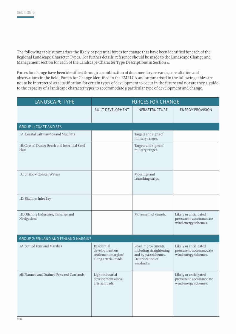
landScape type ForceS For change ForceS For changeBuilt developMent inFraStructure energy proviSion MineralS and
WaSte agriculture, land ManageMent and
FiShing
ForeStry and Woodland
touriSM and leiSure
environMent proceSSeS and
cliMate change
group 1: coaSt and Sea
1A. Coastal Saltmarshes and Mudflats Targets and signs of military ranges.
Reduction in grazing. Car parks and viewpoints.
Sea level riseFlood defence works.
1B. Coastal Dunes, Beach and Intertidal Sand Flats
Targets and signs of military ranges.
Reduction in grazing. Seasonal holiday makers. Recreational facilities, such as golf courses.Car parks and viewpoints.
Sea level riseFlood defence works.
1C. Shallow Coastal Waters Moorings and launching strips.
Litter from fishing activity. Pollution from fishing vessels and land-based activities.
Seasonal holiday makers.
Sea level rise Changes in coastline and marine environment
1D. Shallow Inlet Bay Trawling and dredging activity. Litter from fishing activity.
Loss or change in sand banks and marine environment
1E. Offshore Industries, Fisheries and Navigations
Movement of vessels. Likely or anticipated pressure to accommodate wind energy schemes.
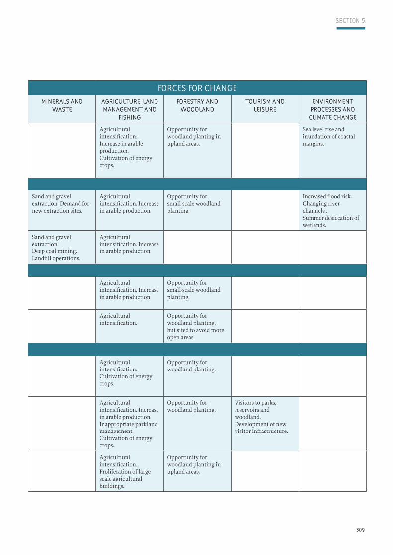
Sand and gravel extraction. Gas extraction. Demand for new extraction sites.
Litter from fishing activity.Pollution from fishing vessels.
Sea level rise and changes in coastline
group 2: Fenland and Fenland MarginS
2A. Settled Fens and Marshes Residential development on settlement margins/along arterial roads.
Road improvements, including straightening and by-pass schemes. Deterioration of windmills.
Likely or anticipated pressure to accommodate wind energy schemes.
Agricultural intensification. Increase in arable production.Proliferation of large scale agricultural buildings.
Planting of shelterbelts.No opportunity for new woodland planting.
Growth of static caravan parks.
Sea level riseFlood defence works.
2B. Planned and Drained Fens and Carrlands Light industrial development along arterial roads.
Likely or anticipated pressure to accommodate wind energy schemes.
Agricultural intensification. Increase in arable production.Proliferation of large scale agricultural buildings.Improvements to dykes and embankments. Cultivation of energy crops.
Planting of shelterbelts.Limited opportunity for new woodland planting.
Increasing number of visitor centres, caravan/camp sites and holiday cottages
Sea level and water table rise, and inundation and flooding
The following table summarises the likely or potential forces for change that have been identified for each of the Regional Landscape Character Types. For further details, reference should be made to the Landscape Change and Management section for each of the Landscape Character Type Descriptions in Section 4.
Forces for change have been identified through a combination of documentary research, consultation and observations in the field. Forces for Change identified in the EMRLCA and summarised in the following tables are not to be interpreted as a justification for certain types of development to occur in the future and nor are they a guide to the capacity of a landscape character types to accommodate a particular type of development and change.

307
Section 5
landScape type ForceS For change ForceS For changeBuilt developMent inFraStructure energy proviSion MineralS and
WaSte agriculture, land ManageMent and
FiShing
ForeStry and Woodland
touriSM and leiSure
environMent proceSSeS and
cliMate change
group 1: coaSt and Sea
1A. Coastal Saltmarshes and Mudflats Targets and signs of military ranges.
Reduction in grazing. Car parks and viewpoints.
Sea level riseFlood defence works.
1B. Coastal Dunes, Beach and Intertidal Sand Flats
Targets and signs of military ranges.
Reduction in grazing. Seasonal holiday makers. Recreational facilities, such as golf courses.Car parks and viewpoints.
Sea level riseFlood defence works.
1C. Shallow Coastal Waters Moorings and launching strips.
Litter from fishing activity. Pollution from fishing vessels and land-based activities.
Seasonal holiday makers.
Sea level rise Changes in coastline and marine environment
1D. Shallow Inlet Bay Trawling and dredging activity. Litter from fishing activity.
Loss or change in sand banks and marine environment
1E. Offshore Industries, Fisheries and Navigations
Movement of vessels. Likely or anticipated pressure to accommodate wind energy schemes.
Sand and gravel extraction. Gas extraction. Demand for new extraction sites.
Litter from fishing activity.Pollution from fishing vessels.
Sea level rise and changes in coastline
group 2: Fenland and Fenland MarginS
2A. Settled Fens and Marshes Residential development on settlement margins/along arterial roads.
Road improvements, including straightening and by-pass schemes. Deterioration of windmills.
Likely or anticipated pressure to accommodate wind energy schemes.
Agricultural intensification. Increase in arable production.Proliferation of large scale agricultural buildings.
Planting of shelterbelts.No opportunity for new woodland planting.
Growth of static caravan parks.
Sea level riseFlood defence works.
2B. Planned and Drained Fens and Carrlands Light industrial development along arterial roads.
Likely or anticipated pressure to accommodate wind energy schemes.
Agricultural intensification. Increase in arable production.Proliferation of large scale agricultural buildings.Improvements to dykes and embankments. Cultivation of energy crops.
Planting of shelterbelts.Limited opportunity for new woodland planting.
Increasing number of visitor centres, caravan/camp sites and holiday cottages
Sea level and water table rise, and inundation and flooding
It is acknowledged that the Forces for Change identified for Regional Landscape Character Types can be regarded as relevant for all landscape within the region. However, the EMRLCA seeks to identify the principal forces for change acting on the various landscape character types to help guide and promote positive change at the regional scale.
For further information about landscape character, forces for change and shaping the future landscape, refer to relevant Countryside Character Area descriptions, the National Landscape Typology and Landscape Character Assessments and Landscape Strategies that have been undertaken at national, county and district level.

308
Section 5
landScape type ForceS For change ForceS For changeBuilt developMent inFraStructure energy proviSion MineralS and
WaSte agriculture, land ManageMent and
FiShing
ForeStry and Woodland
touriSM and leiSure
environMent proceSSeS and
cliMate change
2C. Fen and Marsh Margin Farmlands Residential development on settlement margins. Industrial and commercial development around larger towns.
Road improvements, including straightening and by-pass schemes. Severance/loss of green lanes.
Likely or anticipated pressure to accommodate wind energy schemes.
Agricultural intensification. Increase in arable production.Cultivation of energy crops.
Opportunity for woodland planting in upland areas.
Sea level rise and inundation of coastal margins.
group 3: river valley FloodplainS
3A. Floodplain Valleys Development on settlement margins, including large-scale utility development
River flood defence works and river channel modifications
Sand and gravel extraction. Demand for new extraction sites.
Agricultural intensification. Increase in arable production.
Opportunity for small-scale woodland planting.
Increased flood risk.Changing river channels .Summer desiccation of wetlands.
3B. Sandland Farmlands Residential development on settlement margins.
Sand and gravel extraction. Deep coal mining.Landfill operations.
Agricultural intensification. Increase in arable production.
group 4: loWland valeS
4A. Unwooded Vales Mixed-used development on the fringes of larger settlements.
After-use and redevelopment of air-fields. Road improvements
Agricultural intensification. Increase in arable production.
Opportunity for small-scale woodland planting.
4B. Wooded Vale Village expansion. Agricultural intensification.
Opportunity for woodland planting, but sited to avoid more open areas.
group 5: village FarMlandS 5A. Village Farmlands Village expansion.
Mixed-used development on the fringes of larger settlements.
Road improvements, including widening and new junctions.
Agricultural intensification.Cultivation of energy crops.
Opportunity for woodland planting.
5B. Wooded Village Farmlands Mixed-used development on the fringes of larger settlements.
Road improvements, including widening and new junctions.Airport expansion
Agricultural intensification. Increase in arable production.Inappropriate parkland management.Cultivation of energy crops.
Opportunity for woodland planting.
Visitors to parks, reservoirs and woodland. Development of new visitor infrastructure.
5C. Undulating Mixed Farmlands Mixed-used development on the fringes of larger settlements.
Road improvements Likely or anticipated pressure to accommodate wind energy schemes.
Agricultural intensification. Proliferation of large scale agricultural buildings.
Opportunity for woodland planting in upland areas.
309
Section 5
landScape type ForceS For change ForceS For changeBuilt developMent inFraStructure energy proviSion MineralS and
WaSte agriculture, land ManageMent and
FiShing
ForeStry and Woodland
touriSM and leiSure
environMent proceSSeS and
cliMate change
2C. Fen and Marsh Margin Farmlands Residential development on settlement margins. Industrial and commercial development around larger towns.
Road improvements, including straightening and by-pass schemes. Severance/loss of green lanes.
Likely or anticipated pressure to accommodate wind energy schemes.
Agricultural intensification. Increase in arable production.Cultivation of energy crops.
Opportunity for woodland planting in upland areas.
Sea level rise and inundation of coastal margins.
group 3: river valley FloodplainS
3A. Floodplain Valleys Development on settlement margins, including large-scale utility development
River flood defence works and river channel modifications
Sand and gravel extraction. Demand for new extraction sites.
Agricultural intensification. Increase in arable production.
Opportunity for small-scale woodland planting.
Increased flood risk.Changing river channels .Summer desiccation of wetlands.
3B. Sandland Farmlands Residential development on settlement margins.
Sand and gravel extraction. Deep coal mining.Landfill operations.
Agricultural intensification. Increase in arable production.
group 4: loWland valeS
4A. Unwooded Vales Mixed-used development on the fringes of larger settlements.
After-use and redevelopment of air-fields. Road improvements
Agricultural intensification. Increase in arable production.
Opportunity for small-scale woodland planting.
4B. Wooded Vale Village expansion. Agricultural intensification.
Opportunity for woodland planting, but sited to avoid more open areas.
group 5: village FarMlandS 5A. Village Farmlands Village expansion.
Mixed-used development on the fringes of larger settlements.
Road improvements, including widening and new junctions.
Agricultural intensification.Cultivation of energy crops.
Opportunity for woodland planting.
5B. Wooded Village Farmlands Mixed-used development on the fringes of larger settlements.
Road improvements, including widening and new junctions.Airport expansion
Agricultural intensification. Increase in arable production.Inappropriate parkland management.Cultivation of energy crops.
Opportunity for woodland planting.
Visitors to parks, reservoirs and woodland. Development of new visitor infrastructure.
5C. Undulating Mixed Farmlands Mixed-used development on the fringes of larger settlements.
Road improvements Likely or anticipated pressure to accommodate wind energy schemes.
Agricultural intensification. Proliferation of large scale agricultural buildings.
Opportunity for woodland planting in upland areas.
310
Section 5
landScape type ForceS For change ForceS For changeBuilt developMent inFraStructure energy proviSion MineralS and
WaSte agriculture, land ManageMent and
FiShing
ForeStry and Woodland
touriSM and leiSure
environMent proceSSeS and
cliMate change
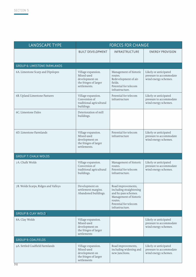
group 6: liMeStone FarMlandS
6A. Limestone Scarp and Dipslopes Village expansion. Mixed-used development on the fringes of larger settlements.
Management of historic routes.Redevelopment of air-fields.Potential for telecom infrastructure.
Likely or anticipated pressure to accommodate wind energy schemes.
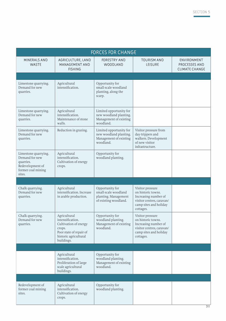
Limestone quarrying. Demand for new quarries.
Agricultural intensification.
Opportunity for small-scale woodland planting, along the scarp.
6B. Upland Limestone Pastures Village expansion. Conversion of traditional agricultural buildings.
Potential for telecom infrastructure
Likely or anticipated pressure to accommodate wind energy schemes.
Limestone quarrying.Demand for new quarries.
Agricultural intensification.Maintenance of stone walls.
Limited opportunity for new woodland planting. Management of existing woodland.
6C. Limestone Dales Deterioration of mill buildings.
Limestone quarrying.Demand for new quarries.
Reduction in grazing. Limited opportunity for new woodland planting. Management of existing woodland.
Visitor pressure from day-trippers and walkers. Development of new visitor infrastructure.
6D. Limestone Farmlands Village expansion. Mixed-used development on the fringes of larger settlements.
Potential for telecom infrastructure
Likely or anticipated pressure to accommodate wind energy schemes.
Limestone quarrying.Demand for new quarries.Redevelopment of former coal mining sites.
Agricultural intensification. Cultivation of energy crops.
Opportunity for woodland planting.
group 7: chalk WoldS
7A. Chalk Wolds Village expansion. Conversion of traditional agricultural buildings.
Management of historic routes.Potential for telecom infrastructure.
Likely or anticipated pressure to accommodate wind energy schemes.
Chalk quarrying. Demand for new quarries.
Agricultural intensification. Increase in arable production.
Opportunity for small-scale woodland planting. Management of existing woodland.
Visitor pressure on historic towns. Increasing number of visitor centres, caravan/camp sites and holiday cottages.
7B. Wolds Scarps, Ridges and Valleys Development on settlement margins. Abandoned buildings.
Road improvements, including straightening and by-pass schemes. Management of historic routes.Potential for telecom infrastructure.
Chalk quarrying. Demand for new quarries.
Agricultural intensification. Cultivation of energy crops.Poor state of repair of historic agricultural buildings.
Opportunity for woodland planting.Management of existing woodland.
Visitor pressure on historic towns. Increasing number of visitor centres, caravan/camp sites and holiday cottages.
group 8: clay Wolds
8A. Clay Wolds Village expansion. Mixed-used development on the fringes of larger settlements
Likely or anticipated pressure to accommodate wind energy schemes.
Agricultural intensification. Proliferation of large scale agricultural buildings.
Opportunity for woodland planting.Management of existing woodland.
group 9: coalFieldS
9A. Settled Coalfield Farmlands Village expansion. Mixed-used development on the fringes of larger settlements
Road improvements, including widening and new junctions.
Likely or anticipated pressure to accommodate wind energy schemes.
Redevelopment of former coal mining sites.
Agricultural intensification. Cultivation of energy crops.
Opportunity for woodland planting.
311
Section 5
landScape type ForceS For change ForceS For changeBuilt developMent inFraStructure energy proviSion MineralS and
WaSte agriculture, land ManageMent and
FiShing
ForeStry and Woodland
touriSM and leiSure
environMent proceSSeS and
cliMate change
group 6: liMeStone FarMlandS
6A. Limestone Scarp and Dipslopes Village expansion. Mixed-used development on the fringes of larger settlements.
Management of historic routes.Redevelopment of air-fields.Potential for telecom infrastructure.
Likely or anticipated pressure to accommodate wind energy schemes.
Limestone quarrying. Demand for new quarries.
Agricultural intensification.
Opportunity for small-scale woodland planting, along the scarp.
6B. Upland Limestone Pastures Village expansion. Conversion of traditional agricultural buildings.
Potential for telecom infrastructure
Likely or anticipated pressure to accommodate wind energy schemes.
Limestone quarrying.Demand for new quarries.
Agricultural intensification.Maintenance of stone walls.
Limited opportunity for new woodland planting. Management of existing woodland.
6C. Limestone Dales Deterioration of mill buildings.
Limestone quarrying.Demand for new quarries.
Reduction in grazing. Limited opportunity for new woodland planting. Management of existing woodland.
Visitor pressure from day-trippers and walkers. Development of new visitor infrastructure.
6D. Limestone Farmlands Village expansion. Mixed-used development on the fringes of larger settlements.
Potential for telecom infrastructure
Likely or anticipated pressure to accommodate wind energy schemes.
Limestone quarrying.Demand for new quarries.Redevelopment of former coal mining sites.
Agricultural intensification. Cultivation of energy crops.
Opportunity for woodland planting.
group 7: chalk WoldS
7A. Chalk Wolds Village expansion. Conversion of traditional agricultural buildings.
Management of historic routes.Potential for telecom infrastructure.
Likely or anticipated pressure to accommodate wind energy schemes.
Chalk quarrying. Demand for new quarries.
Agricultural intensification. Increase in arable production.
Opportunity for small-scale woodland planting. Management of existing woodland.
Visitor pressure on historic towns. Increasing number of visitor centres, caravan/camp sites and holiday cottages.
7B. Wolds Scarps, Ridges and Valleys Development on settlement margins. Abandoned buildings.
Road improvements, including straightening and by-pass schemes. Management of historic routes.Potential for telecom infrastructure.
Chalk quarrying. Demand for new quarries.
Agricultural intensification. Cultivation of energy crops.Poor state of repair of historic agricultural buildings.
Opportunity for woodland planting.Management of existing woodland.
Visitor pressure on historic towns. Increasing number of visitor centres, caravan/camp sites and holiday cottages.
group 8: clay Wolds
8A. Clay Wolds Village expansion. Mixed-used development on the fringes of larger settlements
Likely or anticipated pressure to accommodate wind energy schemes.
Agricultural intensification. Proliferation of large scale agricultural buildings.
Opportunity for woodland planting.Management of existing woodland.
group 9: coalFieldS
9A. Settled Coalfield Farmlands Village expansion. Mixed-used development on the fringes of larger settlements
Road improvements, including widening and new junctions.
Likely or anticipated pressure to accommodate wind energy schemes.
Redevelopment of former coal mining sites.
Agricultural intensification. Cultivation of energy crops.
Opportunity for woodland planting.
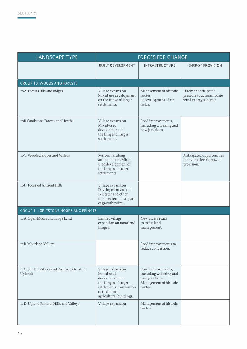
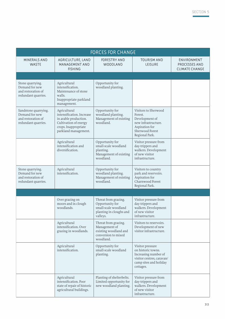
312
Section 5
landScape type ForceS For change ForceS For changeBuilt developMent inFraStructure energy proviSion MineralS and
WaSte agriculture, land ManageMent and
FiShing
ForeStry and Woodland
touriSM and leiSure
environMent proceSSeS and
cliMate change
group 10: WoodS and ForeStS
10A. Forest Hills and Ridges Village expansion.Mixed use development on the fringe of larger settlements.
Management of historic routes.Redevelopment of air-fields.
Likely or anticipated pressure to accommodate wind energy schemes.
Stone quarrying. Demand for new and restoration of redundant quarries.
Agricultural intensification. Maintenance of stone walls.Inappropriate parkland management.
Opportunity for woodland planting.
10B. Sandstone Forests and Heaths Village expansion. Mixed-used development on the fringes of larger settlements.
Road improvements, including widening and new junctions.
Sandstone quarrying. Demand for new and restoration of redundant quarries.
Agricultural intensification. Increase in arable production.Cultivation of energy crops. Inappropriate parkland management.
Opportunity for woodland planting.Management of existing woodland.
Visitors to Sherwood Forest. Development of new infrastructure. Aspiration for Sherwood Forest Regional Park.
10C. Wooded Slopes and Valleys Residential along arterial routes. Mixed-used development on the fringes of larger settlements.
Anticipated opportunities for hydro electric power provision.
Agricultural intensification and diversification.
Opportunity for small-scale woodland planting.Management of existing woodland.
Visitor pressure from day-trippers and walkers. Development of new visitor infrastructure.
10D. Forested Ancient Hills Village expansion.Development around Leicester and other urban extension as part of growth point.
Stone quarrying. Demand for new and restoration of redundant quarries.
Agricultural intensification.
Opportunity for woodland planting.Management of existing woodland.
Visitors to country park and reservoirs. Aspiration for Charnwood Forest Regional Park.
group 11: gritStone MoorS and FringeS
11A. Open Moors and Inbye Land Limited village expansion on moorland fringes.
New access roads to assist land management.
Over grazing on moors and in clough woodlands.
Threat from grazing. Opportunity for small-scale woodland planting in cloughs and valleys.
Visitor pressure from day-trippers and walkers. Development of new visitor infrastructure.
11B. Moorland Valleys Road improvements to reduce congestion.
Agricultural intensification. Over grazing in woodlands.
Threat from grazing. Management of existing woodland and conversion to mixed woodland.
Visitors to reservoirs. Development of new visitor infrastructure.
11C. Settled Valleys and Enclosed Gritstone Uplands
Village expansion. Mixed-used development on the fringes of larger settlements. Conversion of traditional agricultural buildings.
Road improvements, including widening and new junctions.Management of historic routes.
Agricultural intensification.
Opportunity for small-scale woodland planting.
Visitor pressure on historic towns. Increasing number of visitor centres, caravan/camp sites and holiday cottages.
11D. Upland Pastoral Hills and Valleys Village expansion. Management of historic routes.
Agricultural intensification. Poor state of repair of historic agricultural buildings.
Planting of shelterbelts.Limited opportunity for new woodland planting.
Visitor pressure from day-trippers and walkers. Development of new visitor infrastructure.
313
Section 5
landScape type ForceS For change ForceS For changeBuilt developMent inFraStructure energy proviSion MineralS and
WaSte agriculture, land ManageMent and
FiShing
ForeStry and Woodland
touriSM and leiSure
environMent proceSSeS and
cliMate change
group 10: WoodS and ForeStS
10A. Forest Hills and Ridges Village expansion.Mixed use development on the fringe of larger settlements.
Management of historic routes.Redevelopment of air-fields.
Likely or anticipated pressure to accommodate wind energy schemes.
Stone quarrying. Demand for new and restoration of redundant quarries.
Agricultural intensification. Maintenance of stone walls.Inappropriate parkland management.
Opportunity for woodland planting.
10B. Sandstone Forests and Heaths Village expansion. Mixed-used development on the fringes of larger settlements.
Road improvements, including widening and new junctions.
Sandstone quarrying. Demand for new and restoration of redundant quarries.
Agricultural intensification. Increase in arable production.Cultivation of energy crops. Inappropriate parkland management.
Opportunity for woodland planting.Management of existing woodland.
Visitors to Sherwood Forest. Development of new infrastructure. Aspiration for Sherwood Forest Regional Park.
10C. Wooded Slopes and Valleys Residential along arterial routes. Mixed-used development on the fringes of larger settlements.
Anticipated opportunities for hydro electric power provision.
Agricultural intensification and diversification.
Opportunity for small-scale woodland planting.Management of existing woodland.
Visitor pressure from day-trippers and walkers. Development of new visitor infrastructure.
10D. Forested Ancient Hills Village expansion.Development around Leicester and other urban extension as part of growth point.
Stone quarrying. Demand for new and restoration of redundant quarries.
Agricultural intensification.
Opportunity for woodland planting.Management of existing woodland.
Visitors to country park and reservoirs. Aspiration for Charnwood Forest Regional Park.
group 11: gritStone MoorS and FringeS
11A. Open Moors and Inbye Land Limited village expansion on moorland fringes.
New access roads to assist land management.
Over grazing on moors and in clough woodlands.
Threat from grazing. Opportunity for small-scale woodland planting in cloughs and valleys.
Visitor pressure from day-trippers and walkers. Development of new visitor infrastructure.
11B. Moorland Valleys Road improvements to reduce congestion.
Agricultural intensification. Over grazing in woodlands.
Threat from grazing. Management of existing woodland and conversion to mixed woodland.
Visitors to reservoirs. Development of new visitor infrastructure.
11C. Settled Valleys and Enclosed Gritstone Uplands
Village expansion. Mixed-used development on the fringes of larger settlements. Conversion of traditional agricultural buildings.
Road improvements, including widening and new junctions.Management of historic routes.
Agricultural intensification.
Opportunity for small-scale woodland planting.
Visitor pressure on historic towns. Increasing number of visitor centres, caravan/camp sites and holiday cottages.
11D. Upland Pastoral Hills and Valleys Village expansion. Management of historic routes.
Agricultural intensification. Poor state of repair of historic agricultural buildings.
Planting of shelterbelts.Limited opportunity for new woodland planting.
Visitor pressure from day-trippers and walkers. Development of new visitor infrastructure.

314