submitted to satluj jal vidyut nigam ltd. (sjvnl) shanan
TRANSCRIPT

Submitted to
Satluj Jal Vidyut Nigam Ltd. (SJVNL)
Shanan, Shimla-6
Prepared by
State Centre on Climate Change
H.P. Council for Science, Technology & Environment
Vigyan Bhawan, Bemloe, Shimla-1

i
DOCUMENT CONTROL AND DATA SHEET
Report Number SCSTE/HPSCCC/Const/SJVNL/2020
Month & Year of
Publication March, 2021
Title Monitoring of Glacial lakes/water bodies in the Satluj catchment using RS&GIS Techniques
Type of Report
Scientific Report Authors S.S.Randhawa, Nishtha Gautam,
Originating Unit H.P. State Centre on Climate Change (H.P. Council for Science Technology & Environment,
I HIMMCOSTE), Vigyan Bhawan, Near Udyog Bhawan, Bamloe, Shimla-1
Abstract With the projected increase in the frequency and intensity of extreme events including floods,
droughts, landslides etc which are attributable to climate change, disaster management need
greater attention. Susceptibility of the State of Himachal Pradesh to vagaries of climate
change has now been well documented. Scientific insight gained from the analysis of multi
spectral Satellite images carried out by the authors suggests that spatial extent of majority
of glaciers is changing very fast leading to the formation of moraine dammed lakes.
Formation of such lakes is posing potential threat to the infrastructure and human life
thriving in the downstream areas of many drainage systems originating from the snow clad
mountains ranges of the State. Various studies have been carried out on this vital issue of
climate change and reveals that there is an alarming increase in such potential lakes which
can be disastrous in the event of any break due to one or the other reasons. As per the studies
carried out in Himachal Himalaya, the number of such lakes has been found to be on the
increasing side in the present era of climatic variations. Based on the study carried out using
LISSIII satellite data for the year 2019, a total of 242 lakes in Chenab basin, 93 in Beas Basin,
38 in Ravi and 562 lakes in Satluj Basin have been delineated in Himachal Himalaya and
adjoining Tibetan Himalaya. The present study has been carried out using AWiFS, LISS III
and LISS IV satellite data for the year 2020 in the Satluj catchment of SJVNL Hydro Electric
Project. The interpretation has been carried out using ERDAS Imagine 9.3 software. The
inventory of lakes prepared during 2020 has been compared with respect to the database
generated during 2019 in order to assess the temporal variations if any. Monitoring has been
done from April to November 2020 during the ablation season and the results thus obtained
during 2020 have been compared with that of 2019. Regular monitoring of Parechhu Lake
has also been done separately using LISS IV and LISS III data from April to September
during 2020. Based on the baseline data for 2019(229) from AWIFS data, a total of 361 lakes
have been identified in the Satluj catchment which shows enhancement of 132 lakes with
respect to 2019 i.e about 57% enhancement in the total number of lakes and the lakes with
area more than 10 ha varies from 79(2017) to 69(2018 to 31(2019) to 62(2020). Besides this
an updated inventory of lakes in the entire catchment has also been prepared using LISS III
satellite for the year 2020 which will form the baseline data for monitoring during the next
ablation season. Based on the LISS III satellite data interpretation, a total of 993
lakes/wetlands have been delineated in comparison to 562 (2019) reflecting an increase of
about 76% with respect to 2019. As far as the lakes with area more than 10 ha based on LISS
III data is concerned, it varies from 52(2017) to 49(2018) to 5192019) to 52(2020) in the entire
catchment. Few accumulated water bodies could also be seen in the Spiti basin which needs
regular monitoring by virtue of their size and nature. The recent tragedy of 2013 in the
Uttrakhand Himalaya has also been correlated with the bursting of a lake having a total area
of about 08 ha in front of the snout of the Chorabari glacier that caused widespread damage
in the areas beside the heavy rainfall., Thus the magnitude of such lakes as far as the
destruction is concerned cannot be overruled. Hence the lakes with area > 10 ha and the area
between 5-10 ha can be seen as the potential vulnerable sites for causing damage in case of
bursting of any of them. Thus a proper monitoring of all such lakes is very much essential in
the Himalayan region in view of the refcent NDMA Guidelines for the Management of
GLOFs and LLOFs in order to avoid any eventuality like in Uttrakhand in future, which
will not only save the precious human life but also the public and Govt. property. Security
classification Unrestricted

ii
CONTENTS
Sr.No. Title Page No.
1.0 Background 1
2.0 Present Scenario 2
2.1 Glaciation in the Indian Himalaya 4
2.2 Glaciation in Himalaya 5
2.3 Distribution of Glacial lakes in Himachal Himalaya 9
3.0 Distribution of lakes with area more than 10ha 13
3.1 Concluding Remarks 15
4.0 Objectives of the present study 17
4.1 Study area and data used 17
5.0 Methodology 20
6.0 Monitoring of Parechhu Lake during 2020 21
6.1 Observations derived from the satellite data analysis: 22
7.0 Monitoring of glacial lakes and other water bodies using AWIFS Satellite data in
Satluj catchment during 2020 25
7.1 Status of lakes as on 16 April 2020 26
7.6 Status of lakes as on 02 September2020. 29
7.7 Status of Lakes as on 05 Sep 2020 34
7.8 Status of lakes as on 10 September 2020 37
7.9 Status of Lakes as on 12 September 2020 46
7.10. Status of Lakes as on 21September 2020 56
7.11 Status of Lakes as on 29September 2020 60
7.12 Status of lakes as on 01 October 2020 67
7.13 Status of lakes as on 16October 2020 75
7.14 Status of lakes as on 30 October 2020 82
8.0 Inventory of lakes based on LISS III satellite data for 2020 87
9.0 Basin wise comparative Analysis 119
10.0 Inventory of lakes based on Resourcesat-2 LISS -IV FMX Satellite data for 2020 129
11.0 Satellite view of Lakes in Satluj Basin 170
12.0 Conclusion 176
12.1 Concluding Remarks 184
13.0 Reference 190

iii
LIST OF TABLES
Sr.No. Title Page No.
Table: 2.3.1 Distribution of lakes in different sub basins in Himachal Pradesh based on LISS
- III satellite data analysis for 2019.
11
Table:3.1 Distribution of lakes with area more than 10ha in different sub basins in
Himachal Pradesh based on LISS III satellite data analysis
13
Table: 4.1 Satellite data used for monitoring in the study area 19
Table: 7.1 Aerial Extent of lakes as on April 2020 28
Table: 7.6 Aerial Extent of lakes as on 02 September2020 31
Table: 7.7 Aerial Extent of lakes as on 05 September2020 36
Table: 7.8 Aerial Extent of lakes as on 10 September 2020 39
Table: 7.9 Aerial Extent of lakes as on 12 September2020 49
Table: 7.10 Aerial Extent of lakes as on 21 September 2020 58
Table: 7.11 Aerial Extent of lakes as on 29 September2020 62
Table: 7.12 Aerial Extent of lakes as on 01 October2020 70
Table: 7.13 Aerial Extent of lakes as on 16 October 2020 77
Table: 7.14 Aerial Extent of lakes as on 30 October 2020 84
Table: 8.1 Distribution of Lakes as per satellite data interpretation for the year 2020 using
LISS-III sensor
92
Table 8.2 Distribution of Lakes as per satellite data interpretation for the year 2020 using
LISS-III sensor
99
Table:8.3 Distribution of Lakes as per satellite data interpretation for the year 2020 using
LISS-III sensor
101
Table: 8.4
Distribution of Lakes as per satellite data interpretation for the year 2020 using
LISS-III sensor
103
Table:8.5
Distribution of Lakes as per satellite data interpretation for the year 2020 using
LISS-III sensor
109
Table: 9.1 Basin wise distribution of total number of lakes in Satluj Catchment during the
year 2020 based on AWIFS and LISS III Satellite data interpretation.
122
Table: 10.1 Comparative analysis of three different sensors 130
Table: 10.2 Distribution of lakes and High Altitude Wetlands as per satellite data
interpretation for the year 2020 using LISS-IV Sensor
136

iv
LIST OF FIGURES
Sr.No. Title Page
No.
Fig.:2.3.1 Distribution of lakes in Satluj basin 11
Fig.2.3.2 Distribution of lakes in Chenab basin 12
Fig.2.3.3 Distribution of lakes in Beas basin 12
Fig.2.3.4 Distribution of lakes in Ravi basin 12
Fig.2.3.5 Distribution of lakes in Chenab, Beas, Ravi & Satluj basin 13
Fig.3.1 Distribution of lakes with area>10 Ha in Chenab, Beas, Ravi& Satluj basin in
2016, 2017, 2018 & 2019
15
Fig. 4.1 Different regions in Satluj basin 18
Fig. 4.2 False Colour Composite of Satellite images covering Satluj basin 18
Fig. 4.3 IRS-P6 LISS-III Data Coverage over Sutlej Basin 19
Fig.5.1 Flow Chart Methodology 21
Fig 6.1 Satellite View of Parechhu Lake 96-48-LISS-III 10 June 2020 22
Fig 6.2 Satellite View of Parechhu Lake 96-48B -LISS-IV 27 June 2020 23
Fig. 7.1(a) IRS-R2-AWiFS-96-49-16-04-20 26
Fig. 7.1(b) IRS-R2-AWiFS-96-49-16-04-20 Interpreted Layer 27
Fig. 7.1(c) No. of Lakes based on IRS-R2-AWiFS-96-49-16-04-20 27
Fig. 7.1(d) No. High altitude wetlands based on IRS-R2-AWiFS-96-49-16-04-20. 27
Fig.7.6 (a) IRS-R2-AWiFS-95-49-02-09-2020 29
Fig.7.6 (b) IRS-R2-AWiFS-95-49-02-09-20 Interpreted Layer 30
Fig. 7.6(c) No. of Lakes based on IRS-R2-AWiFS-95-49-02-09-2020 30
Fig. 7.6(d) No. High altitude wetlands based on IRS-R2-AWiFS-95-49-02-09-2020 30
Fig.7.7 (a) IRS-R2-AWiFS-99-48-05-09-2020 35
Fig.7.7 (b) IRS-R2-AWiFS-99-48-05-09-2020 35
Fig. 7.7 (c) No. of Lakes based on IRS-R2-AWiFS-99-48-05-09-2020 35
Fig. 7.7 (d) No. of High altitude wetlands based on IRS-R2-AWiFS-99-48-05-09-2020 36
Fig.7.8 (a) IRS-R2-AWiFS-100-48-10-09-2020 38
Fig.7.8 (b) IRS-R2-AWiFS-100-48-10-09-2020 Interpreted Layer 38
Fig. 7.8 (c) No. of Lakes based on IRS-R2-AWiFS-100-48-10-09-2020 39
Fig. 7.8 (d) No. of Lakes & High altitude wetlands based on IRS-R2-AWiFS-100-48-10-09-
2020
39
Fig.7.9 (a) IRS-R2-AWiFS-97-49-12-09-2020 47
Fig.7.9 (b): IRS-R2-AWiFS-97-49-12-09-2020 interpreted layer 47
Fig. 7.9 (c) No. of Lakes based on IRS-R2-AWiFS-97-49-12-09-2020 48
Fig. 7.9 (d): No. of High altitude wetlands based on IRS-R2-AWiFS-97-49-12-09-2020 48
Fig.7.10 (a) IRS-R2-AWiFS-94-48-21-09-2020 56
Fig.7.10 (b) IRS-R2-AWiFS-94-48-21-09-2020 Interpreted Layer 57
Fig. 7.10 (c) No. of Lakes based on IRS-R2-AWiFS-94-48-21-09-2020 57

v
Fig. 7.10(d) No. of Lakes & High altitude wetlands based on IRS-R2-AWiFS-94-48-21-09-
2020
57
Fig.7.11 (a) IRS-R2-AWiFS-99-48-29-09-2020 61
Fig.7.11 (b) IRS-R2-AWiFS-99-48-29-09-2020 Interpreted Layer 61
Fig. 7.11 (c): No. of Lakes based on IRS-R2-AWiFS-99-48-29-09-2020 62
Fig. 7.11 (d) No. of High altitude wetlands based on IRS-R2-AWiFS-99-48-29-09-2020 62
Fig.7.12 (a): IRS-R2-AWiFS-96-47-01-10-2020 68
Fig.7.12 (b): IRS-R2-AWiFS-96-47-01-10-2020 Interpreted Layer 69
Fig. 7.12 (c): No. of Lakes based on IRS-R2-AWiFS-96-47-01-10-2020 69
Fig. 7.12 (d): No. High altitude wetlands based on IRS-R2-AWiFS-96-47-01-10-2020 70
Fig.7.13 (a) IRS-R2-AWiFS-99-46-16-10-2020 75
Fig.7.13 (b) IRS-R2-AWiFS-99-46-16-10-2020 Interpreted Layer 76
Fig. 7.13 (c) No. of Lakes based on IRS-R2-AWiFS-99-46-16-10-2020 76
Fig. 7.13 (d) No. of High altitude wetlands based on IRS-R2-AWiFS-99-46-16-10-2020 76
Fig.7.14 (a) IRS-R2-AWiFS-97-49-30-10-2020 83
Fig.7.14 (b) IRS-R2-AWiFS-97-49-30-10-2020 Interpreted Layer 83
Fig. 7.14 (c) No. of Lakes based on IRS-R2-AWiFS-97-49-30-10-2020 83
Fig. 7.14 (d) No. of High altitude wetlands based on IRS-R2-AWiFS-97-49-30-10-2020 84
Fig. 8.1 No. of Lakes in Spiti (1) basin based on LISS III data 91
Fig. 8.2 No of Lakes in Lw. Satluj (2) basin based on LISS III data 91
Fig. 8.3 No. of Lakes in Up. Satluj (3) basin based on LISS III data 92
Fig.8.4a Resourcesat-2 LISS III image 96-48, 14 September 2020& the Interpreted layer 112
Fig.8.4b No of lakes based on Resourcesat-2 LISS III image 96-48, 14 September 2020 112
Fig.8.4 c No. of high altitude wetlands based on Resourcesat-2 LISS III image 96-48, 14
September 2020
113
Fig.8.5a
Resourcesat-2 LISS III image 97-48, 12 September 2020& the Interpreted layer 113
Fig. 8.5 b No. of lakes based on Resourcesat-2 LISS III image 97-48, 12 September 2020 114
Fig.8.5 c No. of high altitude wetlands based on Resourcesat-2 LISS III image 97-48, 12
September 2020
114
Fi g.8.6a Resourcesat-2 LISS III image 97-49, 12 September 2020 & the Interpreted
layer
115
Fig.8.6 b No. of lakes based on Resourcesat-2 LISS III image 97-49, 12 September 2020 115
Fig.8.6 c Resourcesat-2 LISS III image 97-49, 12 September 2020& the Interpreted layer 116
Fig.8.7a Resourcesat-2 LISS III image 99-49, 05 September 2020& the Interpreted layer 116
Fig.8.7 b No. of lakes based on Resourcesat-2 LISS III image 99-49, 05 September 2020 117
Fig.8.7 c Resourcesat-2 LISS III image 99-49, 05 September 2020& the Interpreted layer 117
Fig.8.8a Resourcesat-2 LISS III image100-49, 10 September 2020& the Interpreted
layer
118
Fig.8.8 b No. of lakes based on Resourcesat-2 LISS III image 100-49, 10 September 2020 118
Fig.8.8 c Resourcesat-2 LISS III image 100-49, 10 September 2020& the
Interpreted layer
119
Fig. 9.1 Total No. of Lakes based on AWIFS satellite data 2020 123
Fig. 9.2 Total No. of Lakes based on AWIFS satellite data 2017, 2018, 2019&2020 123
Fig. 9.3 Total No. of Lakes >10ha based on AWIFS satellite data 2020 124

vi
Fig. 9.4: Total No. of Lakes >10ha based on AWIFS satellite data 2017, 2018, 2019,2020 124
Fig. 9.5 Total Number of Lakes based on AWIFS Data 125
Fig. 9.6 Total No. of Lakes based on LISS III Satellite Data2020 125
Fig. 9.7 Total No. of Lakes based on LISS III Satellite Data 2017, 2018, 2019, 2020 126
Fig. 9.8 Total No. of Lakes >10ha based on LISS III Satellite Data 2020 126
Fig. 9.9 Total No. of Lakes >10ha based on LISS III Satellite Data 2017, 2018, 2019&
2020
127
Fig. 9.10 Total No. of Lakes in Satluj Basin based on LISS III Satellite Data (2020) 127
Fig. 9.11 a Satellite view of water bodies along the River Section in Spiti basin 128
Fig. 9.11 b Satellite view of water bodies along the River Section in Spiti basin 128
Fig: 10.1 (a-h) Interpreted layer of LISS-IV data in Satluj Basin in 2020 131
Fig 10.2 Interpreted layer of LISS-IV data in Satluj Basin in 2020 132
Fig: 10.3 No. of Lakes in Satluj basin Based on LISS-IV Data 132
Fig: 10.4 No. of High Altitude Wetlands in Satluj basin Based on LISS-IV Data 133
Fig: 10.5 No. of Lakes in Spiti basin (1) Based on LISS-IV Data 133
Fig: 10.6 of High Altitude Wetlands in Spiti basin (1) Based on LISS-IV Data 134
Fig: 10.7 No. No. of High Altitude Wetlands in Lw Satluj basin (2) Based on LISS-IV
Data
134
Fig: 10.8 No of Lakes in Up Satluj basin (3) Based on LISS-IV Data 135
Fig: 10.9 No of High Altitude Wetlands in Up Satluj basin (3) Based on LISS-IV Data 135
Fig: 11.0(a-l) Satellite view of Lakes in Satluj Basin 170-175

vii
ACKNOWLEDGEMENT
The HP Council for Science Technology & Environment acknowledges Satluj
Jal Vidyut Nigam Ltd. for entrusting the study for monitoring of all glacial lakes/water bodies
in the Satluj Catchment as part of their disaster preparedness program in their projects. The
author is also thankful to the Principal Secretary (Env, S & T) Govt. of H.P., Member
Secretary (EC) and the Joint Member Secretary, H.P. Council for Science, Technology &
Environment, HIMCOSTE for constant support and allowing us to undertake the
investigation as part of the disaster management activities in the State Center on Climate
Change of the H.P. Council using space technology.

viii
A TECHNICAL REPORT ON THE MONITORING OF GLACIAL
LAKES/WATER BODIES IN SATLUJ CATCHMENT USING RS,
GIS & IMAGE INTERPRETATION TECHNIQUES
TEAM MEMBERS
Dr.S.S.Randhawa Principal Scientific Officer
Nishtha Gautam Scientific Professional
Neha Thakur Scientific Professional
H.P. State Centre on Climate Change
H.P. Council for Science Technology & Environment,
Vigyan Bhawan,
Near Udyog Bhawan, Bemloe, Shimla-1

1
Monitoring of Glacial Lakes/Water Bodies in Satluj Catchment
using Remote Sensing& GIS Techniques
1. Background
Mountain ecosystems harbor a wide range of significant natural resources and play
critical role in the ecological and economic processes of the Earth. Deforestation, landslides, land
degradation, desertification and Glacier Lake Outbursts Flooding (GLOF) are some of the common
environmental issues in the mountain regions. The major challenge currently faced by the mountain
environment is the escalation of these issues through atmospheric as well as man-induced changes.
Mountain systems are particularly sensitive to climate changes. Since industrialization,
human activities have resulted in steadily increasing concentrations of greenhouse gases-
particularly carbon dioxide (CO2), methane (CH4), chlorofluorocarbons (CFCs) and nitrous oxide
(NOx) in the atmosphere. As these gases absorb some of the radiation emitted by the Earth rather
than allowing it to pass through the atmosphere to space, there is general consensus that the Earth’s
atmosphere is warming. The third assessment report of the Inter –Governmental Panel on Climate
Change (IPCC, 2001) concludes that global average surface temperatures have increased by 0.6
0.2 C during the 20th century and that, for the range of scenarios developed , the global average
surface air temperature is projected to warm 1.4 to 5.8 C by 2100 relative to 1990. Through the
recent release of 21-page report in Paris the Intergovernmental Panel on Climate Change (IPCC)
observed that ‘Warming of the Climate System is unequivocal as is now evident from observation
of increase in global air and ocean temperatures, widespread melting of snow and ice and rising
global mean sea land” Analysis of the temperature trend in the Himalayas and its vicinity shows
that temperature increases are greater in the uplands than lowlands areas. Regional changes in
climate have already affected diverse physical and biological systems in many parts of the
mountain regions. Shrinkage of glaciers, thawing of permafrost, late freezing and earlier break up
of ice on rivers and lakes, pole ward and altitudinal shifts of plant and animal species, declines of
some plant and animal population, and earlier emergence of insects have been observed (IPCC,
2001). Climate influences weathering processes, erosion, sediment transport, and hydrological
conditions. It also affects the type, quantity, quality, and stability of vegetation cover and, thereby,
biodiversity. Mountain systems are particularly sensitive to climate changes. Small changes in

2
climate can produce significant regional or larger-scale effects. In particular, marginal
environments are under high stress. Small changes in water availability, floods, droughts,
landslides and late frosts can have drastic effects on agriculture economics.
Geological History of the Earth indicates that glacial dimensions are constantly
changing with changing climate. There have been at least 17 major glacial advances (glaciations)
in the last 1.6 million years alone (Goudie 1983). The most recent, the Last Glacial, reached its
peak some 20,000 to 18,000 years ago and came to an end about 10,000 years ago (Goudie 1983).
Glaciations are followed by “interglacial” periods, during which the glacier ice retreats as a result
of global warming. The interglacial typically continues for about 10,000 years before the cooling
or the next glacial begins. This cyclical activity is generally accepted to be caused by gradual
changes in the earth’s rotation, tilt and orbit around the sun, which affects the solar radiation the
earth receives. This suggests that glaciers are constantly changing with time and these changes can
profoundly affect the run off the Himalayan Rivers. In the Himalayas there are about 33,000 Sq
.Km. area is covered by glaciers and this is one of the largest concentrations of glaciers outside the
Polar Regions. Melt water from these glaciers forms an important source of runoff into the North
Indian Rivers during the peak months.
Glacial cycles are punctuated by relatively short periods of localized cooling and
warming, during which glaciers advance and retreat. The most recent cooling episode of the present
interglacial commonly referred to as the “Little Ice Age” (LIA), affected parts of North America
(Curry 1969), Asia (Chu ko-Chan1973) and Europe from about 1300 AD through to the later half
of the 19th century. During the LIA (1550-1850 AD) glaciers were much longer than today
(Yamada et.al.1998). It may have been the result of volcanic eruptions and the presence of volcanic
ash in the atmosphere that caused cooling by reducing the amount of solar radiations reaching the
earth’s surface (lamb 1970). Changes to ocean currents have also been suggested, as has the
tectonic activity, concentration of carbon dioxide in the atmosphere, and sunspot activity (Goudie
1983).
2. Present Scenario
Himalayan glaciers have also been found to be in a state of general retreat since 1850
(Mayewski & Jeschke 1979). The Khumbu glacier, a popular climbing route to the summit of
Mt.Everest, has retreated over 5 km from where Sir Edmund Hillary and Tenzing Norgay set out
to conquer the world’s highest mountain in 1953. Since the mid1970s the average air temperature

3
measured at 49 stations of the Himalayan region rose by 1 C with high elevation sites warming
the most (Hasnain2000). This is twice as fast as the 0.6 average warming for the mid –latitudinal
northern hemisphere over the same time period (IPCC 2001b), and illustrates the high sensitivity
of mountain regions to climate change (Oerlemanns et.al, 2000). The DokrianiBamak glacier in
Uttranachal Himalayas has retreated 20m in 1998, and the Gangotri glacier is reducing at a rate of
30m/year.
At present the rivers have shown 3-4% surplus water due to a 10% increase in the
melting of the glaciers of the western Himalayas, and a 30% increase in the eastern Himalayan
glaciers. But, after 40 years, most of these glaciers will be wiped out and then South Asia will have
water problems. In March 2002, UK's Department of International Development funded a project
called Sagarmatha (Snow and Glacier Aspects of Water Resources Management in the Himalayas)
to assess the impact of deglaciation on the seasonal and long term water resources in snow-fed
Himalayan rivers. This study was vital for policy-makers and specially those working on
interlinking of rivers, as the flows available in rivers are likely to change dramatically over the
decades depending on the region. The study which reveals some major facts about the melting
mountain majesties and warming glaciers is an eye-opener.
In Upper Indus, the study sites show initial increases of 14% and 90% in mean flows
over the next few decades which will be followed by decreasing flows by 30% and 90% of baseline
in the subsequent decades in a 100-year scenario. For Ganges, the response of the river near the
glacier in Uttarkashi is different from downstream Allahabad. At Uttarkashi, flows peak at between
20% and 33% baseline within the first few decades and then recede to 50% of baseline after 50
years.
Near the source of the Brahmaputra, there is a general decrease in decadal mean flows
for all temperature scenarios as glaciers are few in the area and flows recede as the permanent snow
cover reduces with increasing temperature. The catchments in the eastern Himalayas which benefit
from high precipitation of the summer monsoon, are more vulnerable to impacts of deglaciation
than those in the west where the monsoon is weaker.
In short, the deglaciation in the Himalayas is influenced by various factors, climatic,
regional etc. However, the main underlying factor is ever increasing warming on the mountains,
chiefly because of excess emission of greenhouse gases and Asian brown cloud. The ongoing ice
melting is only the tip of the iceberg that will hit us in the near future.

4
As the Indian economy depends to a great extent on agriculture- a highly climate
sensitive sector and the knowledge about potential climate change impacts on agriculture has
special significance. Agriculture productivity is sensitive to two broad classes (a) direct effects
from change in temperature and (b) indirect effects through changes in soils, distribution and
frequency of infestation by pests, insects, diseases or weeds etc. Several studies predict that rice
and wheat yield would decline considerably with climatic changes in India. As the mountain areas
accounts only 21% of the total geographical area of India, where about 60-70% population largely
depends on agriculture, horticulture and animal husbandry related activities for their livelihood. If
the present trend of climate change continues, this will have adverse effect on their lifestyles.
Since the climate is an important determinant of geographical distribution, composition
and productivity of forest, at the simplest level, changing pattern of climate will change the natural
distribution limits for species or communities. In the absence of barriers it may be possible for
species or communities to migrate in response to changing conditions.Vegetation zone move
towards higher latitude following shifts in average temperature. These changes in turn, could have
profound implications for traditional livelihood, industry, biodiversity, soil and water resources
and hence agriculture productivity. More over these climate change induced effects would
aggravate the existing stress due to non-climate factors, such as land use changes and unsustainable
exploitation of natural resources. Some of the climate induced changes observed in the context of
the mountain environment in Himachal Pradesh are as follows.
Declining snow fall.
Drying up of perennial streams.
Temperate belt have shifted upward.
Productivity of apple has been adversely affected.
Rabi seasons has been shifted and shortened.
The incidences of diseases and pests have become more severe.
2.1 Glaciation in the Indian Himalaya
A Glacier is a mass of ice, snow, water and rock debris flowing down a gradient. Based
upon morphological characteristics of glaciers, they can be grouped into classes such as ice sheet,
ice cap, and glacier constrained by topography. Ice sheet and ice cap are formed when underlying
topography is fully submerged by ice and glacier flow is not influenced by topography. On the
other hand, when glaciers are constrained by the surrounding topography and the shape of valley

5
influences their flow, then such glaciers are classified as valley glaciers, cirque glaciers and ice
fields. Mountain glaciers as in Himalayas, Alps, Andes are basically constrained by topography
and are predominantly of valley type. In Himalayas, glaciers are distributed from West in Kashmir
to East in Arunachal Pradesh covering entire stretch of Himachal Pradesh, Uttarakhand, Nepal and
Sikkim Bhutan. The distribution and intensity of glaciation is governed by latitude and altitude of
the mountains. The earliest map showing glacier boundaries of Himalayan mountains are available
in Survey of India Topographical Maps of 1962.
2.2 Glaciation in Himalaya
During its geological history, the earth has experienced alternate cycles of warm and
cold climates. During cold climate, glaciers and ice sheets have formed on the surface of the earth.
Geological evidence suggests that the earth has experienced glaciations during, Perm-
Carboniferous and in the Pleistocene period (Embleton and King, 1975). Precambrian tillites and
boulder-beds are reported from many parts of the world, such as Scotland, U.S.A. Clear evidence
of Carboniferous-Carboniferous ice age is also established in India and South Africa. The
Carboniferous-Carboniferous glaciations was followed by Mesozoic era, during which the world
temperature was higher than that of today and no evidence of glaciation was observed in the
geological formations of that period. In Cenozoic era, large-scale glaciation was experienced,
which includes glaciation during Pleistocene and Quaternary periods (Smith et al., 2005). It has
also influenced the present distribution of glaciers on the earth's surface. During Pleistocene the
earth's surface had experienced repeated glaciation over a large land mass. During the peak of
glaciation, the area covered by the glaciers was 46 Million sq. km. (Embleton and King, 1975).
This was more than three times the present ice cover of the earth. Available data indicates that
during the Pleistocene, the earth has experienced four or five glaciation periods separated by an
interglacial periods. During an interglacial period, climate was warmer and deglaciation occurred
on a large scale. The most recent glaciation reached its maximum advance about 20,000 years ago
when the Himalayan snow line was depressed from 600 to 1000 meters lower than the present
elevation due to fall of temperatures by 5 to 8ºC. At present total glaciated area on the earth is
about 14.9 million sq. km. Out of this 2.5 million sq. km is located in Arctic and 1.7 million sq.
km in the Greenland ice sheet (Flint, 1971). The remaining 0.7 million sq. km area is distributed
in the other parts of the World. Himalaya has one of the largest concentrations of glaciers outside

6
the Polar Regions and some estimates suggest that the number could be as high as five thousand
(Kulkarni and Bahuguna, 2001).
In the Himalaya, glaciers cover approximately 33000 sq. km area, and this is one of
the largest concentrations of glacier-stored water outside the Polar Regions. Melt water from these
glaciers forms an important source into run-off of North Indian rivers during critical summer
months. This makes these rivers perennial and has helped to sustain and flourish the Indian
civilization along the banks of Ganga and Indus. This supply is available during dry periods and
naturally regulates the flow of large rivers thus compensating extremes of precipitation. Glacial
activity also generates sediments. However there have been several evidences in recent geological
history about the glacier mass fluctuations resulting in the stream runoff originating from them.
Stream runoff is an important component in planning of water resources and micro and mini
hydroelectric projects. Glacier mass fluctuations are also indicators of global climatic changes. In
the context of the Himalayan glaciers, which are source of many giant north Indian rivers,
systematic monitoring of Himalayan glaciers is of paramount importance in view of their large
number and area covered.
Global warming has already caused a significant glacier ice loss since the Little Ice
Age (AD 1550-1850) (Denton and Hughes, 1981) resulting in both glacier retreat and thinning
(loss of ice volume). Many glaciers in the Himalayan mountain chain are reported to be gradually
retreating (Mayeswki and Jeschke, 1979; Li et al., 1998; Kulkarni and Bahuguna, 2002; Raina,
2004; Kulkarni and Alex, 2003; Kulkarni et al., 2005; Kulkarni et al., 2006). Catastrophic natural
processes triggered by these glacier changes were responsible for considerable death and
destruction throughout the mountains. These processes included ice avalanches, landslides and
debris flows, outbursts from moraine-dammed lakes and also outbursts from glacier dammed lakes.
Glacier avalanches have occurred where glaciers have retreated up steep rock slopes. Sources of
debris flows are frequently moraine complexes exposed during glacier retreat, which may be ice-
cored. Outbursts from moraine dammed lakes result from the catastrophic breaching of the moraine
dam - a process that is commonly initiated by glacier avalanches - generated waves that overtop
the moraine. Himalayan and Trans-Himalayan glaciers are in general state of retreat since 1850
AD. Most of the Himalayan glaciers are covered by debris, which slows down their melting.
Glaciers in the Himalayas are fast retreating like other ice mountains the world over.
A recent study showed that the last three decades of the 20th century have been the hottest period
in 1,000 years. The melting of the Gangotri glacier is accelerating at an average retreat rate of 30

7
meters annually. The rate between 1935 and 1990 was 18 meters per year and 7 meters annually
between 1842 and 1935. The overall deglaciation from 1962 to 2001 in the Baspa basin of
Himachal Pradesh has been estimated as 19%. ChhotaShigri glacier of Chandra valley also
retreated by about 12% in the last one and half decade. The deglaciation processes are also
noticeable for large glaciers in Ganga headwater like Gangotri which shows about 10% decrease
during the last 18 years. The maximum retreat of 34.5 metres per year has been observed at Meola
glacier in Dhauliganga river basin. The retreat of the Parbati glacier is reported to be unusual and
more alarming.
In the Himalayas, during the retreating phase a large number of lakes are being formed
either at the snout of the glacier as a result of damming of the morainic material known as moraine
dammed lakes or supra glacial lakes formed in the glacier surface area. A glacial lake is defined as
a water mass existing in a sufficient amount and extending with a free surface in, under, beside
and/or in front of a glacier and originated by glacier activities and/or retreating processes of a
glacier. Most of these lakes are formed by the accumulation of vast amounts of water from the
melting of snow and by blockade of end moraines located in the down valleys close to the glaciers.
In addition, the lakes can also be formed due to landslides causing artificial blocks in the
waterways. The sudden break of a moraine/block may generate the discharge of large volumes of
water and debris from these glacial lakes and water bodies causing flash floods namely GLOF. A
Glacial Lake Outburst Flood (GLOF), also known as a jökulhlaup in Icelandic (A jökulhlaup is
technically a sudden and often catastrophic flood that occurs during a volcanic eruption, but is also
used to describe other sorts of glacial flooding), can occur when a lake contained by a glacier or a
terminal moraine dam fails. This can happen due to erosion, a buildup of water pressure, an
avalanche of rock or heavy snow, an earthquake, or if a large enough portion of a glacier breaks
off and massively displaces the waters in a glacial lake at its base. Many countries has a series of
monitoring efforts to help prevent death and destruction that are likely to experience due to these
events. The importance of this situation has magnified over the past century due to increased
population, and the increasing number of glacial lakes that have developed due to glacier retreat.
There are a number of GLOF events that have been reported worldwide. There are number of such
events that have happened in Nepal Himalayas but no such event has been reported so far from
Indian Himalayas. On the basis of mapping carried out in Himachal Himalayas in Satluj basin,
there are about 38 such lakes in entire Satluj basin out of which 14 falls in Himachal part. Similarly

8
50 moraine dammed lakes in Chenab basin and 5 supra glacial lakes have been mapped using
remote sensing based on the studies carried out in the past.
The state of Himachal Pradesh invariably experience flash floods, the cause of which
is unknown. In the year 2000, the Satluj valley experiences the heaviest floods causing loss of more
than 800 crores. It is still a matter of investigation weather the floods were caused by cloud bursting
or due to Glacier Lake Outburst Floods (GLOF) phenomena. The formation of landslide dammed
lakes in high altitude zones such as Parechhu in the upper catchment of Spiti basin in Tibet caused
tremendous threat to the life and property located in the downstream areas. It is therefore necessary
that a constant and repeated monitoring of the upper catchment areas having international
dimensions required to be carried out on a regular basis.
The present study has been carried out with the help of remote sensing data. As with
the modernization of technology, the application of Remote Sensing data in the mapping of Natural
Resources like the land use / land cover, ground water targeting, mineral resources, urban planning,
disaster management, flood protection, and monitoring of glacier lake out bursts floods and the
snow cover studies are gaining importance day by day in the world. Since this technology helps in
having the synoptic coverage of any desired area and having better spatial resolution, it can be used
as a very effective tool for planning and development. With the advancement of the technology,
now it has become possible even to map an object of less than one meter in its dimensions. This
technology attains significant importance when the area under investigation is inaccessible as in
the present case where the monitoring of glacial lakes formed in the upper catchments is not
possible by any other conventional method, so this technology has been successfully used for the
mapping and monitoring of such water bodies in the entire Satluj catchment right from Mansarovar
to downstream up to Nathpa in Kinnaur district of Himachal Pradesh. In this study a total of 197
lakes which were identified earlier by the National Remote Sensing Agency Hyderabad were
considered as the base line data for the year 2007 and since 2009 the State Council for Science
Technology & Environment has been monitoring all such lakes in the entire Satluj catchment
during the ablation period regularly for Satluj Jal Vidyut Nigam Ltd Shimla as part of their disaster
management plan. Besides this the main threat i.e. the Parechhu lake has been monitored regularly
and the water spread status of the lake during 2018 was assessed and the conveyed to the State
Government as well as to the SJVNL. Besides this during the year 2017, all glacial lakes/water
bodies have been monitored using IRS/AWIFS satellite data as well as IRS RS2-LISS 3 satellite

9
data for the entire catchment and water spread has been compared with that of the water spread
area during 2017 for both AWIFS and LISS -3 satellite data
2.3 Distribution of Glacial lakes in Himachal Himalaya
The comparative analysis based on the results obtained from the analysis of LISS III
data products during 2019 have been done with that of results obtained from 2018 for all the total
number of lakes and the lakes with area more than 10ha in each basin i.e. Spiti basin (Basin 1),
Lower Satluj basin (Basin 2) and Upper Satluj Basin (Basin3). Based on the LISS-III satellite data
analysis (96-48,96-49,97-48,97-49,98- 48,98-49,99-49,100-49 and 146-38) for 2019,a total of
562lakes have been delineatedcomprising458 lakes as the small one with area less 5ha, 53 lakes
with area 5- 10ha and 51 lakes with area more than 10ha. Maximum number of lakes mapped
from LISS III data falls in the path-row96-48(153) and 99-49(238) (Fig 10.4.4C). Further out of
562 lakes mapped, 62 are mainly the high altitude wetlands comprising 1 from Spiti basin, 1 from
Lr. Satluj and 60 from the Upper Satluj basin. The comparative analysis based on LISS-III satellite
data reveals that total number of lakes varies from 581 (2016) to 642 (2017) to 769 (2018) and
562 (2019) indicating an overall increase of about 10% between 2016-17, and about 19%
between 2017-18 and reduction of about 26% between 2018-19 respectively. As far as the big
lakes with area more than 10ha are concerned, total number of big lakes varies from 55 (2017) to
49 (2018) to 51 (2019) indicating a fluctuating trend in the lakes with area >10ha.The total
variation in the number of lakes mapped in Upper Satluj basin based on LISSS III data varies from
443 (2016) to 450 (2017) to 495 (2018) to 437 (2019), in Lower Satluj basin the number varies
from 72 (2016) to 102 (2017) to 98 (2018) to 52 (2019) and in case of Spiti sub basin it varies
from 66(2016)to90 (2017) to 176 (2018) to 73 (2019) (Fig.9.7) indicating about 1% increase
(2016-17) and about 10% (2017-18) and a reduction of about 11% (2018-19) in case of Upper
Saltuj basin, 41% increase between (2016-17) and about 2% reduction (2017-18) and a reduction
of about 46% (2018-19) in case of Lower Satluj and about 36% increase between 2016-17 and
about 95% increase between 2017-18 and a reduction of about 58% (2018-19) in case of Spiti
basin could be seen. Further in Spiti basin the lakes with id’s 1682 RS (0.40ha), 1683RS
(1.09ha),1684RS (1.95ha),1685RS (1.44ha), 1686RS (1.59ha) and 1687RS (1.57ha) are some of
the water bodies which have been developed along the nala section coming along the village
Chicham just upstream of Kaza on the left bank formed in series. All these water bodies are
although small but needs monitoring (Fig. 9.11).Thus from the above analysis, it is clear that

10
although the maximum number of lakes are being formed in the Upper Satluj basin of the study
area, but the reduction in the total number of lakes could be seen in all basins which is mainly due
to the non-availability of good quality snow free and cloud free LISS III satellite date coverage
during 2019.
Thus to summaries based on the results obtained by using LISS III data products, the
results obtained using AWIFS indicates an overall reduction of about 16% in total number of
lakes mapped in 2019 in comparison to 2018 reflecting 40% reduction in case of Spiti basin,
53% from Lower Satluj and 10% from the Upper Satluj basin and the maximum lakes (89%)
of the total 229 have been mapped from Upper Satluj, 3% and 7% from Lower Satluj and Spiti
basins respectively. In case of the bigger lakes with area >10ha, a reduction of about 55% could
also be seen in 2019 (31) in comparison to 2018 (69) with majority of the lakes (30) forming
part of the Upper Satluj basin, 0 from the Lower Satluj basin and 1 from the Spiti basin, out of
which 11 are the high altitude wetlands and the remaining 19 are from the glacial origin. Besides
this on 5 November 2019, where in total 116 lakes have been mapped, out of which 51 lakes
are with area more than 10ha comprising 17 lakes as the high altitude wetlands and the
remaining 34 are the lakes from glacial origin as a whole in the entire study area. Likewise
LISS-III data indicates a decrease of about 26% in terms of the total number of lakes with about
4% increase in case of the lakes with area more than 10ha. The comparative analysis based on
LISS-III satellite data reveals that total number of lakes varies from 581 (2016) to 642 (2017)
to 769 (2018) and 562 (2019) indicating an overall increase of about 10% between 2016-17,
and about 19% between 2017-18 and reduction of about 26% between 2018-19 respectively.
Thus the data base based on AWIFS data product is reflects a complete inventory of lakes in
the Satluj catchment with a coarse resolution (56mts) as the data product used covers the
complete study area and also free from the impact of clouds as well as not much snow could be
seen on 3rd October 2017, whereas the LISS-III data products reflects a more detailed inventory
of the lakes with a set of fine resolution (23.5mts) reflecting more detailed information about
the lakes with small dimensions.
11
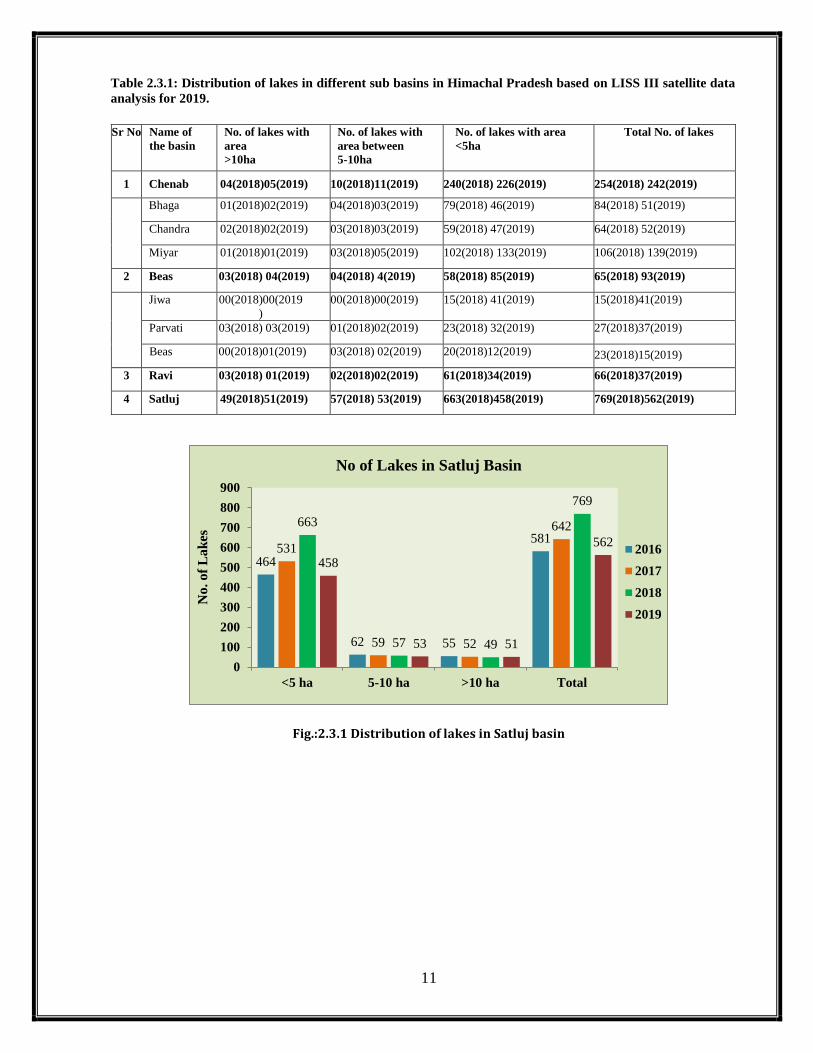
Table 2.3.1: Distribution of lakes in different sub basins in Himachal Pradesh based on LISS III satellite data
analysis for 2019.
Sr No Name of
the basin
No. of lakes with
area
>10ha
No. of lakes with
area between
5-10ha
No. of lakes with area
<5ha
Total No. of lakes
1 Chenab 04(2018)05(2019) 10(2018)11(2019) 240(2018) 226(2019) 254(2018) 242(2019)
Bhaga 01(2018)02(2019) 04(2018)03(2019) 79(2018) 46(2019) 84(2018) 51(2019)
Chandra 02(2018)02(2019) 03(2018)03(2019) 59(2018) 47(2019) 64(2018) 52(2019)
Miyar 01(2018)01(2019) 03(2018)05(2019) 102(2018) 133(2019) 106(2018) 139(2019)
2 Beas 03(2018) 04(2019) 04(2018) 4(2019) 58(2018) 85(2019) 65(2018) 93(2019)
Jiwa 00(2018)00(2019
)
00(2018)00(2019) 15(2018) 41(2019) 15(2018)41(2019)
Parvati 03(2018) 03(2019) 01(2018)02(2019) 23(2018) 32(2019) 27(2018)37(2019)
Beas 00(2018)01(2019) 03(2018) 02(2019) 20(2018)12(2019) 23(2018)15(2019)
3 Ravi 03(2018) 01(2019) 02(2018)02(2019) 61(2018)34(2019) 66(2018)37(2019)
4 Satluj 49(2018)51(2019) 57(2018) 53(2019) 663(2018)458(2019) 769(2018)562(2019)
Fig.:2.3.1 Distribution of lakes in Satluj basin
464
62 55
581531
59 52
642663
57 49
769
458
53 51
562
0
100
200
300
400
500
600
700
800
900
<5 ha 5-10 ha >10 ha Total
No. of
Lak
es
No of Lakes in Satluj Basin
2016
2017
2018
2019

12
Fig.2.3.2. Distribution of lakes in Chenab basin
Fig.2.3.3 Distribution of lakes in Beas basin
Fig.2.3.4 Distribution of lakes in Ravi basin
55
5 3
63
92
5 4
101
58
4 3
65
85
4 4
93
0
20
40
60
80
100
120
<5 ha 5-10 ha >10 ha Total
No. of
Lak
es
No of Lakes in Beas Basin
2016
2017
2018
2019
25
0 3
28
50
1 3
5461
2 3
66
35
2 1
38
0
10
20
30
40
50
60
70
<5 ha 5-10 ha >10 ha Total
No o
f L
ak
es
No of Lakes in Ravi Basin
2016
2017
2018
2019
125
6 2
133
207
8 5
220240
10 4
254226
11 5
242
0
50
100
150
200
250
300
<5 ha 5-10 ha >10 ha Total
No
. o
f L
ak
es
No. of Lakes in Chenab Basin
2016
2017
2018
2019

13
Fig.2.3.5: Distribution of lakes in Chenab, Beas, Ravi & Satluj basin
3. Distribution of lakes with area more than 10ha
Based on the satellite data interpretation for the year 2019, the study area has been
studied to understand the temporal variation of all such lakes with area more than 10ha. In Satluj
basin the total number of such lakes has increased from 40 (2013) to 42 (2015) to 55 (2016) to
52 (2017) to 49 (2018) to 51 (2019) respectively based on LISS III satellite data. Likewise in
other basins, i.e. in Chenab, the number of lakes varies from 3 (2013) to 4 (2015) to 2 (2016), 5
(2017) to 4 (2018) and 5(2019). In Beas basin the number varies from 2 (2013) to 2 (2015) to 3
(2016) to 4 (2017) to 3 (2018) and 4 (2019). In the Ravi basin, the number of lakes varies from
2 (2013) to 3 (2015) to 3 (2016) to 3 (2017) and 3 (2018) respectively (Table 12.1 & Fig 12.1).
The lakes with HWL are mainly the high altitude wetlands in high altitude regions.
Table 3.1: Distribution of lakes with area more than 10ha in different sub basins in Himachal Pradesh
based on LISS III satellite data analysis.
Sr. No. Lake Id. 2015 2016 2017 2018 2019
Bhaga
1 6 ---- 6.21 10.23 9.92 10.94
2 11 10.39 7.92 9.84 11.21 10.40
Chandra
3 1 90.51 90.18 115.51 95.03 98.68
4 3 151.42 131.58 179.64 160.99 162.07
Miyar
5 209 ---- ---- 16.08 15.06 15.97
63133
28
581
101
220
54
642
65
254
66
769
93
242
38
562
0
100
200
300
400
500
600
700
800
900
Beas Chenab Ravi Satluj
No. of
Lak
es
No. of Lakes in Beas, Chenab, Ravi & Satluj Basin
2016
2017
2018
2019

14
Jiwa
---- ---- ---- ---- ---- ----
Parvati
1 21 12.68 13.81 12.88 13.14 14.56
2 26 13.52 11.28 15.47 13.82 15.21
3 50 ---- 10.01 14.58 13.30 11.83
Upper Beas
4 6 ---- 7.54 10.86 9.82 10.47
Ravi
1 10 16 12.05 14.42 14.63 ----
2 16 30.97 27.28 34.50 11.35 ----
3 31 11.72 11.2 12.16 12.38 ----
Satluj
1 49HWL 23 ---- ---- 38 24.58
2 67 12 13.04 8.06 8 24.58
3 85 ---- ---- ---- ---- 34.89
4 86 9 10.88 10.11 10.06 10.10
5 87 9 10.06 9.38 10.5 10.41
6 99 19 18.37 17.12 18.8 14.72
7 101 24 24.65 21.37 22.8 21.10
8 122 7 16.16 15.34 16.5 16.86
9 173 3 9.32 7.65 ---- 13.20
10 184 ---- ---- ---- ---- 23.32
11 209 33 36.38 ---- ---- 33.76
12 145(HWL) 41584 41646.22 41498.50 41233.9 41640.43
13 179 25 26.26 25.07 25.6 24.26
14 184 27 19.51 19.15 25.5 19.96
15 210(HWL) 57 64.32 59.43 59.17 63.72
16 894 10 ---- 9.90 9.7 10.15
17 1063HWL 45 39.79 ---- ---- 44.09
18 138(HWL) 26065 26538.79 25891.56 25634.8 25920.91
19 178 205 190.71 204.05 206.39 201.14
20 181 13 13.72 18.07 19.28 12.39
21 1093(HWL) 5515 5676.31 5787.38 5854.36 5992.49
22 1094HWL 16 13.83 12.82 12.62 14.85
23 1128 23 24.45 23.95 25.14 25.00
24 1133 17 15.23 16.09 15.86 16.18
25 1153 63 64.41 66.74 69.2 74.10
26 1155 16 16.38 16.14 17.47 14.27
27 1156(HWL) 11 11.85 11.56 11.69 11.74
28 1164 15 15.12 14.94 14.86 16.08
29 1092HWL ---- 14.69 13.63 ---- 14.13
30 1363HWL ---- 28.25 17.77 ---- 22.24
31 1375HWL ---- 47.91 43.26 ---- 28.96
32 1510 ---- 54.52 54.37 54.38 52.93
33 1512 ---- 23.53 23.62 24.23 21.47
34 1518 ---- 13.78 12.53 14 12.19
35 1527 ---- 11.17 10.47 11.43 11.37
36 1548 ---- 17.95 14.62 19.91 17.41
37 1557RS ---- 69.88 96.36 80.87 92.85
38 1349HWL ---- 352.60 292.13 322.95 335.79
39 1095(HWL) ---- 17.26 14.31 15.58 17.22
40 1565 ---- 16.38 18.11 17.36 19.13
41 1566(HWL) ---- 22.81 24.35 18.76 10.77
42 1782(HWL) ---- ---- ---- 29.1 30.65

15
43 1774RS ---- ---- ---- 11.69 12.93
44 1771RS ---- ---- ---- 12.22 14.99
45 1776RS ---- ---- ---- ---- 13.98
46 1654 ---- ---- ---- ---- 22.28
47 2180 ---- ---- ---- ---- 23.56
48 1039HWL ---- ---- ---- ---- 12.16
49 1144HWL ---- ---- ---- ---- 89.47
50 2167HWL ---- ---- ---- ---- 214.31
51 1146 ---- ---- ---- ---- 10.60
(HWL-High Altitude Wetlands)
(RS-River Section)
Fig.3.1 Distribution of lakes with area>10 Ha in Chenab, Beas, Ravi& Satluj basin in 2016, 2017, 2018 &
2019
3.1. Concluding Remarks
Based on the IRS-RS2-LISS-III satellite data having spatial resolution of 23.5mts
and Landsat 8 MSS satellite data having spatial resolution of 30mts for the year 2019, the study
area was analyzed in order to make an updated inventory of moraine dammed glacial lakes known
as GLOFs (Glacial lake Outbursts Floods) in Himachal Himalaya comprising the Satluj, Chenab,
Beas and Ravi basins. The Satluj basin has been studied in detail right from its origin from the
Tibetan Himalaya, whereas the other basins have been analyzed for their areas of interest in
Himachal Pradesh.
The results based on the analysis thus obtained reveals that in Satluj basin, a total
of 562 lakes from the Satluj catchment covering 8 satellite imageries(96-48,96-49,97-48,97-
49,98-48,98-49,99-49,100-49) having spatial resolution of 23.5 mts. have been mapped during
3 2 3
55
4 5 3
52
3 4 3
49
4 51
51
0
10
20
30
40
50
60
Beas Chenab Ravi Satluj
No o
f L
ak
es
No of lakes >10 ha in Beas Chenab Ravi & Satluj Basin
2016
2017
2018
2019

16
2019. Further based on the LISS-III satellite data analysis for 2019 in Satluj basin ,a total of 562
lakes have been delineated out of which about 81% (458) lakes are the small one with area less
than 5ha, about 9% (53) falls within the aerial range of 5-10ha and about 9% (51) are the big one
with area more than 10ha. The comparative analysis based on LISS III data reveals that total
number of lakes in the Satluj catchment varies from 642 (2017) to 769 (2018) to 562 (2019)
reflecting an overall increase of about 19% between 2017-18 and a reduction of about 26%
between 2018-19, which is mainly due to the non-availably of good quality LISS III data products
in 2019. Out of the 562 lakes/wetlands mapped in 2019 using LISS III satellite data, basin 1 i.e.
Spiti basin constitutes about 12%= (73) of the total lakes mapped (562) which is about 58% less
than 2018 (176). Likewise basin 2 i.e. the Lower Satluj basin constitutes 9% (52) of the total
lakes mapped which is about 46% less than 2018(98)and the Upper Satluj basin i.e. the basin 3
constitutes of 77% (437) lakes in 2019 which is about 11% less than 2018(495).
As far as the big lakes based on LISS III satellite data is concerned, the analysis reveals
that the number varies from 52(2017) to 49(2018) to 51(2019) reflecting an overall increase of
about 4% between 2018-19.The Parechhu Lake in the Tibetan Himalayan Region was also
monitored separately during the ablation period of 2019 and does not show any major change in
its water spread and seems to be stable based on the observations made which have been reported
to SJVNL as well as to the Government during 2019. Besides this, the landslide on the upstream
side of the lake depression was also monitored in order to assess any change in the water level
by virtue of the landside which may block the river course causing major threat like that of the
Parechhu formation during the year 2004.
Along the course of main Satluj River, few isolated pockets have also been observed
which shows accumulated water in the upper catchment of the Tibetan Himalayan Region and
within the Spiti basin i.e. sub basin 1. In Spiti basin the lakes with ids 1682RS(0.40ha),
1683RS(1.09ha), 1684RS(1.95ha),1685RS(1.44ha), 1686RS(1.59ha) and 1687RS(1.57ha) are
some of the water bodies which have been developed along the nala section coming along the
village Chicham just upstream of Kaza on the left bank formed in series (Fig.13.1). All these
water bodies are although small but needs monitoring as this is along the river course and can
cause major damage in case if it bursts. Thus the lakes/water bodies coded with abbreviation RS
with their ids are some of the locations where accumulated water could be seen and these are the
17
permanent features which needs regular monitoring in order to assess any temporal change in
their behavior in the time to come.
4.0 Objectives of the present study
The main objectives of the study is to monitor the water spread area of the all the
moraine dammed glacier lakes/ water bodies on monthly basis in the entire Satluj Basin during
April to November 2020 based on the inventory of the lakes during the preceding year prepared
using space data.
4.1 Study area and data used
The study area comprises mainly the Sutlej basin right from its origin from the
Mansarovar Lake in Tibetan Region. The river Sutlej is one of the main tributaries of Indus and
has its origin near Mansarovar Lake and Rakas Tal in Tibetan Plateau at an elevation of about
4,500 m (approx.). Earlier the study area was divided into four major sub basins i.e. Tso Morari as
sub basin number 4, Spiti as sub basin number 1, Upper Tibet as 3 and Lower Satluj as sub basin
number 2 (Fig 4.1) based on the information provided by NRSC Hyderabad, now it has been found
while analyzing the Survey of India toposheet downloaded from internet that the Tso Morari Basin
is an independent sub basin and does not contribute to the Satluj River System, thus as a result the
study area has now been reduced to three sub basins viz. the Spiti Sub Basin(Basin No.1), Upper
Satluj Basin(basin No. 3) and the Lower Satluj (basin No. 2) . The Satluj River travels about 300
km (approx.) in Tibetan plateau in North-Westerly direction and changes direction towards South-
West and covers another 320 km.(approx.) up to Bhakra gorge where 225m high straight gravity
dam has been constructed. This western Himalayan basin is highly rugged terrain with abundant
natural water resource in the form of snow pack. The Sutlej basin is geographically located between
30° 00' N, 76° 00' E and 33° 00’ N, 82° 00’ E. The Nathpa dam is a 62.5 m high concrete dam
located on Satluj river at Nathpa. The dam is a main component of the 1,500 MW Nathpa Jhakri
Hydro-Electric Project – NJHEP. The project is located in the state of Himachal Pradesh and
derives its name from the names of two villages in the project vicinity - Nathpa in Kinnaur district
and Jhakri in Shimla district - in the interiors of Himachal Pradesh. The project was conceived as
a run-of-river type hydro power development, harnessing hydro-electric potential of the middle
reaches of the river Sutlej. The project's dam has been constructed near village Nathpa and its
power house has been constructed on the left bank of the river Satluj at village Jhakri. The project
18
stretches over a length of about 50 Km from the dam site to the power house site, on the Hindustan-
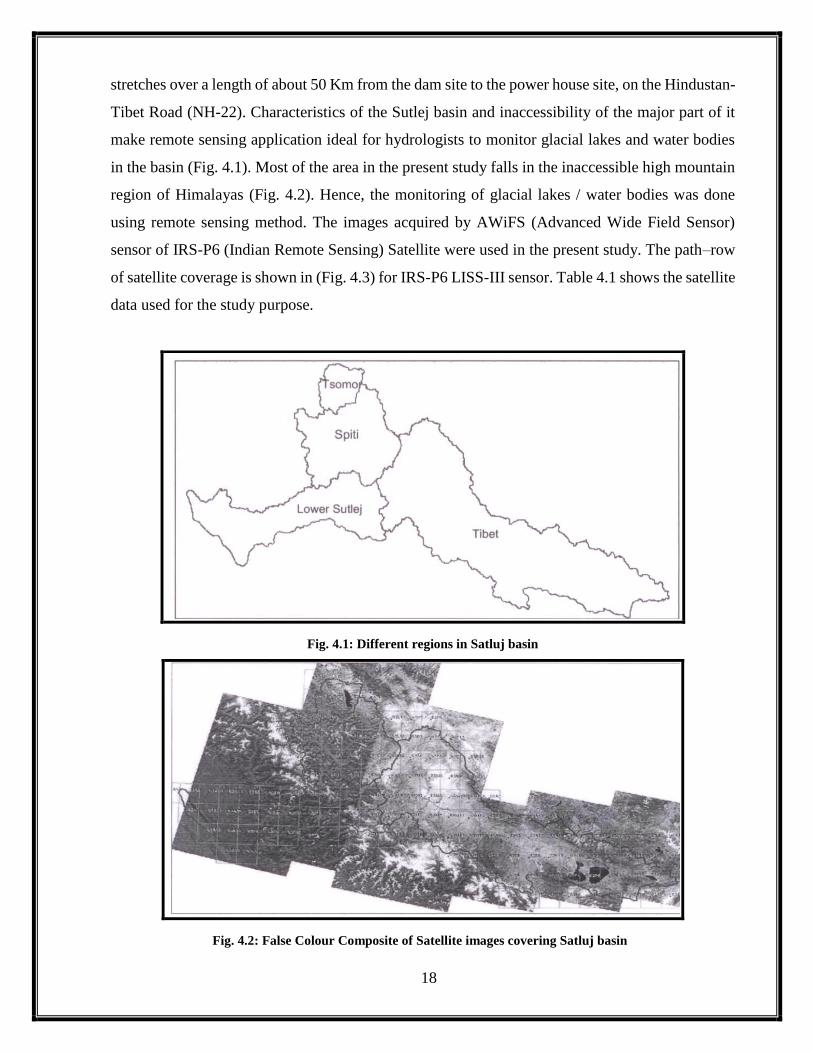
Tibet Road (NH-22). Characteristics of the Sutlej basin and inaccessibility of the major part of it
make remote sensing application ideal for hydrologists to monitor glacial lakes and water bodies
in the basin (Fig. 4.1). Most of the area in the present study falls in the inaccessible high mountain
region of Himalayas (Fig. 4.2). Hence, the monitoring of glacial lakes / water bodies was done
using remote sensing method. The images acquired by AWiFS (Advanced Wide Field Sensor)
sensor of IRS-P6 (Indian Remote Sensing) Satellite were used in the present study. The path–row
of satellite coverage is shown in (Fig. 4.3) for IRS-P6 LISS-III sensor. Table 4.1 shows the satellite
data used for the study purpose.
Fig. 4.1: Different regions in Satluj basin
Fig. 4.2: False Colour Composite of Satellite images covering Satluj basin

19
Fig. 4.3 IRS-P6 LISS-III Data Coverage over Sutlej Basin
Table 4.1: Satellite data used for monitoring in the study area
AWiFS Satellite data used for monitoring in the study area
Sr. No. Date of Pass Path –Row Satellite Sensor
1 16 April 20 94-49 Resourcesat2/AWIFS
2 02 Sep20 95-49 Resourcesat2/AWIFS
3 05 Sep 20 99-48 Resourcesat2/AWIFS
4 10 Sep 20 100-48 Resourcesat2/AWIFS
5 12 Sep20 97-49 Resourcesat2/AWIFS
6 21 Sep 20 94-48 Resourcesat2/AWIFS
7 29 Sep 20 99-48 Resourcesat2/AWIFS
8 01 Oct 20 96-47 Resourcesat2/AWIFS
9 16 Oct 20 99-49 Resourcesat2/AWIFS
10 30 Oct 20 97-49 Resourcesat2/AWIFS
LISS-III Satellite data used for monitoring in the study area
Sr. No. Date of Pass Path –Row Satellite Sensor
1 05 Sep 20 99-49 Resourcesat2/LISS III
2 07 Sep 20 96-48 Resourcesat2/LISS III
3 10 Sep20 100-49 Resourcesat2/LISS III
4 12 Sep 20 97-48 Resourcesat2/LISS III
5 12 Sep 20 97-49 Resourcesat2/LISS III
6 14 Sep 20 96-48 Resourcesat2/LISS III
LISS-IV Satellite data used for monitoring in the study area
Sr. No Path –Row Date of Pass Satellite Sensor
1 96-48A 07 Sep 20 Resourcesat2/2A/LISS IV
2 96-48A 08 Oct 20 Resourcesat2/2A/LISS IV
3 96-48B 01 Oct 20 Resourcesat2/2A/LISS IV
4 96-48C 08 Oct 20 Resourcesat2/2A/LISS IV
5 96-48D 14 Sep 20 Resourcesat2/2A/LISS IV

20
6 96-48D 01 Oct 20 Resourcesat2/2A/LISS IV
7 96-49A 08 Oct 20 Resourcesat2/2A/LISS IV
8 96-49B 01 Oct 20 Resourcesat2/2A/LISS IV
9 97-48A 12 Sep 20 Resourcesat2/2A/LISS IV
10 97-48B 19 Sep 20 Resourcesat2/2A/LISS IV
11 97-48C 12 Sep 20 Resourcesat2/2A/LISS IV
12 97-48D 19 Sep 20 Resourcesat2/2A/LISS IV
13 97-49A 12 Sep 20 Resourcesat2/2A/LISS IV
14 97-49B 12 Sep 20 Resourcesat2/2A/LISS IV
15 97-49C 12 Sep 20 Resourcesat2/2A/LISS IV
16 98-49A 17 Sep 20 Resourcesat2/2A/LISS IV
17 98-49C 17 Sep 20 Resourcesat2/2A/LISS IV
18 99-49B 29 Sep 20 Resourcesat2/2A/LISS IV
19 99-49D 05 Sep 20 Resourcesat2/2A/LISS IV
5.0 Methodology
The satellite data covering Sutlej basin during the months of April to November 2020
was browsed. The cloud free AWIFS satellite data for the year 2020 for monitoring of lakes during
2020 and the LISS-III images for further monitoring based on high resolution data for the year
2020 from IRS-RS2 &RS2A satellite were procured. With the spatial resolution of AWIFS (56 m)
the monitoring of lakes was done by identifying all the water bodies irrespective of their aerial
extent and was compared with that of the lake area mapped during 2019 from AWIFS satellite
data. Each of these satellite data sets was individually rectified with the reference image prepared
from the downloaded TM data sets. The geometric rectification was done using polynomial
transformation of third order with resulting Root Mean Square (RMS) error less than one pixel.
The Sutlej river basin boundary is superimposed on the satellite image of the basin and the lakes
which are visible and clearly demarkable were delineated using ERDAS software. The lake
boundaries were digitized using ERDAS /Imagine vector module tools. The digitized polygons
have been cleaned for open ends and built into a polygon layer. All the polygons have been
assigned polygon ID’s. Water spread area is considered to represent the boundary of lake. The
process of procurement of satellite data, geometric rectification, lake area digitization and
comparison is repeated for all the data sets during April to November2019. The flowchart
explaining the methodology is given in (Fig. 5.1).
Besides this, as the AWIFS has the spatial resolution of 56m, the lake inventory
prepared using LISS-III which has the spatial resolution of 23.5m, was compared with that of an
updated inventory using high resolution LISS-III satellite data for the year 2019.All the cloud free

21
satellite images for the month of September 2020 were selected for making an updated inventory
and were compared for their spatial variation with respect to that for the year 2018. The
methodology adopted is same as that of the AWIFS data product in the study area and the following
LISS III satellite data has been used for updating the inventory in the entire Satluj Basin.
During the year 2020, another baseline database was prepared using LISS IV satellite
data that has the spatial resolutions of 5.8mts. Using LISS IV sensor data, it has become possible
all such lakes which could not be mapped in LISS III and thus gives a highly accurate information
of the even smaller lakes which are coming up in the high altitude region of the Satluj catchment.
This database can now be compared with the 2021databasefor having a real time temporal analysis
of the glacial lakes in the region. The methodology adopted is same as that of the AWIFS data
product in the study area and the following LISS III satellite data has been used for updating the
inventory in the entire Satluj Basin.
Fig.5.1: Flow Chart Methodology
6.0 Monitoring of Parechhu Lake during 2020
Parechhu lake which has been known for its damage and since 2001 is being monitored
every year during the ablation season from April to September. This year also the lake was

22
monitored and its status was conveyed to all the stakeholders including SJVNL Shimla as well as
the Government of Himachal Pradesh.
6.1 Observations derived from the satellite data analysis:
Parechhu Lake is a small geomorphic depression along the Parechhu River which joins
the Spiti River on its left bank near Sumdo in Spiti Sub Division of District Lahaul & Spiti. The
fragile geology of the area and the Sumdo Kaurik fault passing nearby causes activation of the
landslides which results in chocking of the river course in the downstream, this causes
accumulation of the water in the depression. During the year 2020, the lake was regularly
monitored and its findings about the water spread were reported to the SJVNL as well as to the
Govt.
Fig 6.1: Satellite View of Parechhu Lake 96-48-LISS-III 10 June 2020
On analyzing the IRS RS2 LISS III Satellite data for 10 June 2020 the following observations
were made.

23
The water flow in the lake depression seems to be comparatively more on the
peripheral side and on the upstream side and downstream side of the depression,
whereas the central part does not show any accumulation.
Slight accumulation is seen on upstream side of the depression and a small
accumulation on the downstream side as well. .
The inflow and outflow seems to be normal.
Based on the satellite data interpretation, there does not seem to be any threat from
the Parechhu Lake for the downstream areas. However continuous monitoring would
be required as the ablation is still continuing for another 3-4 months and thus
requires regular monitoring
Fig 6.2: Satellite View of Parechhu Lake 96-48B -LISS-IV 27 June 2020
Observations:
On analyzing the IRS RS2 LISS IV-96-48-B-27 June 2020 Satellite data, the following
observations were made.
Based on the analysis of IRS-R2-L4-96-48-B-27 June 2020 satellite data having spatial resolution
of 5.8 mts , the following observations are made:-

24
The accumulated water in the lake depression seems to be flowing through the peripheral
sides, with some water on the upstream side.
The central part is comparatively free from any accumulation except a small portion on
the downstream side where some accumulation could be seen.
The inflow and the outflow seems to be normal.
Two landslides could be observed along the river course one on the upstream side of the
depression on the left bank of the Parechhu River and the second on the downstream side
of the depression on the right bank of the Parechhu River.
Along the river course on the downstream side, slight accumulation of water could be
seen which may have been resulted due to the encroachment of the landslide in the river
course on the right bank.
The landslide on the left bank on the upstream side also seems to encroaching the river
course, but no significant change in the river flow could be seen.
The region is now observed to be well connected because of the developmental activities
like road network developed in the area.
Based on the satellite data interpretation, there does not seem to be any threat from the
Parechhu Lake as on day but needs regular monitoring till its freezing.
Based on the analysis of IRS-R2-L3-96-48-14 August 2020 satellite data having spatial
resolution of 23 mts the following observations are made:-
The water flow is mainly through the peripheral side along the upstream and downstream
part of the depression and braiding in the upstream part of the depression could be seen.
The central part is comparatively free from any accumulation except a small
accumulation in the upstream part and a small patch in the frontal part.
The inflow and the outflow seem to be normal. But the outflow seems to be
comparatively reduced just after the landslide which was observed on 27th June 2020
along the right bank of the Parechhu River resulting to slight accumulation along the river
course as observed on 27th June 2020.
The landslide on the left bank on the upstream side does not show much change as
observed on 27th June and the river flow seems to normal but having wide distribution
along the flood plain.

25
The upper catchment is free from seasonal snow cover and thus there is no melting from
the seasonal snow cover in the Parechhu River catchment and whatever flow is there is
being contributed by the permanent snow and glaciers in the catchment.
The lakes which were identified in the adjoining Spiti catchment just upstream of Kaza
on the left bank of Spiti River having small lakes along the small stream, seems to be
normal in nature , but the water column in some of them seems to be little bit on higher
side.
The temporal analysis of these accumulated water bodies was carried out and found that
there is not much change in their spatial extent w.r.t 2019 but 02 new water bodies could
be seen having very shallow accumulation.
The temporal changes in the areas of these water bodies is as under:
Based on the above satellite data interpretation, there does not seem to be any threat from
the Parechhu Lake as well as water bodies in Spiti catchment formed along river course
as on day but needs regular monitoring to assess any threat in future.
7.0: Monitoring of glacial lakes and other water bodies using AWIFS Satellite
data in Satluj catchment during 2020
Based on the satellite data analysis for the period January to December 2007 on monthly
basis, the total 197 lakes which were identified by the National Remote Sensing Agency Hyderabad
earlier using satellite data for the year 2007 were used as the base line data. Thereafter all these 197
lakes were further analyzed and monitored for the year 2009, 2010, 2011, 2012, 2013, 2014, 2015,
2016, 2017, 2018 & 2019. In the present study the lakes which were mapped during 2020 have been
used to assess the temporal variation with that of the lakes mapped during the preceding years. The
status of lakes mapped during 2020 and their temporal variation with respects to 2019 is as per the
following observations derived from the AWIFS satellite data analysis using visual interpretation
Lake Id Area(hectare) 2019 Area(hectare) 2020 Change in Area
1682(RS) 0.40 0.46 (+)0.06
1683(RS) 1.09 1.30 (+)0.21
1684(RS) 1.96 1.98 (+)0.02
1685(RS) 1.44 3.95 (+)2.51
1686(RS) 1.60 1.45 (-)0.15
1687(RS) 1.57 1.40 (-)0.17
New ----- 2.12 Very shallow
New ----- 0.56 Very shallow

26
techniques. The lakes which are fully visible in the satellite image and the lake boundaries are
clearly demarkable, only in such cases the lake is mapped and its area computed. In cases where the
lakes are under fully/partly cloudy shadow or fully/partly cloud covered or fully/partly snow
covered the areas of such lakes are not reported. Further the lakes have been categorized into two
categories i.e. one which are having their origin from the glaciated terrains i.e. near or in front or
within the glacier bodies, are known as the moraine dammed glacial lakes or supra glacial lakes,
whereas the other category is that of all the lakes which are formed within the depressions are
classified as high altitude wetlands formed in the Tibetan region because of the one or the other
reason.
7.1: Status of lakes as on 16 April 2020
On analyzing the satellite data for 16 April 2020, it is found that the satellite image
covers mainly the areas falling in the sub basin 1,2 & 3, but most of the area is under the impact of
seasonal snow cover as a result only 18 lakes could be delineated from the satellite image (Fig 7.1a)
out of which 10 are the high altitude wetlands and the remaining 8 are lakes formed along the river
course. Further out of these 8 lakes, 4 lakes are such which have the area less than 5ha,1 lakes is
having area between 5-10ha and 3 lakes are with area more than 10ha and all lakes forming part of
the Upper Satluj sub basin i.e basin 3 (Fig 7.1c) . Likewise the remaining10 lakes are the high
altitude wetlands forming part of the sub basin 3 out of which 3 are small one with area <5ha, 2 are
within the areal range of 5-10ha and 5 are the big one with area more than10ha (Fig 7.1d). When
these 18 lakes are seen temporally to the lakes mapped in April 2020, the temporal could not be
done due to non -availability of information during 2019.
Fig. 7.1(a): IRS-R2-AWiFS-96-49-16-04-20
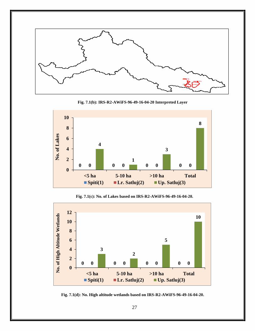
27
Fig. 7.1(b): IRS-R2-AWiFS-96-49-16-04-20 Interpreted Layer
Fig. 7.1(c): No. of Lakes based on IRS-R2-AWiFS-96-49-16-04-20.
Fig. 7.1(d): No. High altitude wetlands based on IRS-R2-AWiFS-96-49-16-04-20.
0 0 0 00 0 0 0
4
1
3
8
0
2
4
6
8
10
<5 ha 5-10 ha >10 ha Total
No. of
Lak
es
Spiti(1) Lr. Satluj(2) Up. Satluj(3)
0 0 0 00 0 0 0
32
5
10
0
2
4
6
8
10
12
<5 ha 5-10 ha >10 ha Total
No
. o
f H
igh
Alt
itu
de
Wet
lan
ds
Spiti(1) Lr. Satluj(2) Up. Satluj(3)

28
Table: 7.1 Aerial Extent of lakes as on April 2020
Sr.No. Lake Id. Number Basin
Number
Longitude Latitude Aerial
Extent on
April 2019
(ha.)
Aerial Extent
on 16 April
2020 (ha.)
Change in
Area w.r.t.
May 2019
(ha.)
1 1022RS 3 81.1075 30.9264 ------ 1.41 ------
2 138HWL 3 81.2361 30.6892 ------ 25711.00 ------
3 142HWL 3 81.5677 30.8043 ------ 250.24 ------
4 145HWL 3 81.4742 30.6861 ------ 41702.10 ------
5 1474HWL 3 81.5691 30.7685 ------ 18.51 ------
6 205HWL 3 81.5695 30.7894 ------ 4.51 ------
7 206HWL 3 81.5728 30.7908 ------ 0.87 ------
8 207HWL 3 81.5526 30.7859 ------ 7.29 ------
9 210HWL 3 81.5533 30.7733 ------ 111.04 ------
10 385HWL 3 81.5413 30.7798 ------ 3.97 ------
11 607RS 3 81.1773 30.9108 ------ 124.31 ------
12 608RS 3 81.0972 30.9265 ------ 14.92 ------
13 616RS 3 81.1208 30.9259 ------ 10.47 ------
14 8034HWL 3 81.559 30.7827 ------ 5.55 ------
15 8245RS 3 81.1106 30.9253 ------ 1.79 ------
16 8246RS 3 81.1383 30.9229 ------ 8.81 ------
17 8247RS 3 81.1437 30.9214 ------ 1.97 ------
18 8248RS 3 81.1483 30.9208 ------ 4.78 ------ HWL- High Altitude Wetlands
RS- River Section
7.2: Status of lakes as on May 2020.
No good quality satellite data was available during May 2020, so no interpretation could be made
during this month.
7.3: Status of lakes as on June 2020.
No good quality satellite data was available during June 2020, so no interpretation could be made
during this month.
7.4: Status of lakes as on July 2020.
No good quality satellite data was available during July 2020, so no interpretation could be made
during this month.
7.5: Status of lakes as on August 2020.
No good quality satellite data was available during August 2020, so no interpretation could be
made during this month

29
7.6: Status of lakes as on 02 September2020.
On analyzing the satellite data for 02 September 2020, it is found that most of the area
in the Upper Satluj and Lower Satluj basins is under the impact of cloud cover as a result of which
partial information could be derived (Fig. 7.6 a). Based on the interpretation of the satellite data, a
total of 161 lakes comprising 159 lakes from the glacial origin and only 2 lakes as the high-altitude
wetland (Fig.7.6 c & d) one each from Spiti and Upper Satluj basin respectively. Out of these 159
lakes, 119 lakes are such which have the area less than 5ha out of which 44 lakes forms a part of
the Spiti sub basin, 7 from the Lower Satluj and 68 lakes forms part of the Upper Satluj basins
respectively. Besides this, 27 lakes are such which have the area between 5-10 ha with 10 lakes
forming part of the Spiti sub basin and 17 that from the Upper Satluj sub basin. As far as the bigger
lakes with area more than 10ha are concerned, there are 14 lakes which comprise of 3 falling in
Spiti sub basin, 1 from the Lower Satluj basin and 10 from the Upper Satluj sub basin respectively.
When these 161 lakes are seen temporally w.r.t.229 lakes as mapped on 09 September 2019 (Table
7.6) reveals that only 39 lakes could be compared out of which 32 lakes are showing a positive
trend in their spatial coverage, whereas 07 lakes are showing negative trend w.r.t 2019 respectively
and the lakes those could not be compared forms the base line data for next year monitoring.
Fig.7.6 (a): IRS-R2-AWiFS-95-49-02-09-2020

30
Fig.7.6 (b): IRS-R2-AWiFS-95-49-02-09-20 Interpreted Layer
Fig. 7.6 (c): No. of Lakes based on IRS-R2-AWiFS-95-49-02-09-2020
Fig. 7.6 (d): No. High altitude wetlands based on IRS-R2-AWiFS-95-49-02-09-2020
44
103
57
70 1
8
68
1710
95
0
20
40
60
80
100
<5 ha 5-10 ha >10 ha Total
No. of
Lak
es
Spiti(1) Lr. Satluj(2) Up. Satluj(3)
0 0
1 1
0 0 0 00 0
1 1
0
0.2
0.4
0.6
0.8
1
1.2
<5 ha 5-10 ha >10 ha TotalNo
. o
f H
igh
Alt
itu
de
Wet
lan
ds
Spiti(1) Lr. Satluj(2) Up. Satluj(3)

31
Table: 7.6 Aerial Extent of lakes as on 02 September2020
Sr No Lake Id.
Number
Basin
Number
Longitude Latitude Aerial
Extent on
09 Sept
2019 (ha.)
Aerial
Extent on
02Sep 2020
(ha.)
Change in
Area
w.r.t.
Sept.2019
(ha.)
1 23 3 32.3918 79.4179 6.77 10.50 3.73
2 25 3 32.3798 79.3934 25.39 26.65 1.26
3 28 3 32.3493 79.051 4.26 5.12 0.86
4 31 3 32.3408 79.0021 4.28 7.72 3.44
5 39 3 32.2269 79.0264 5.39 8.27 2.88
6 41 3 32.2119 79.0434 21.17 25.53 4.36
7 51 3 32.1245 78.943 3.02 6.32 3.30
8 54 3 32.1095 78.9329 5.43 11.11 5.67
9 55 3 32.1098 78.9413 6.78 10.34 3.56
10 61 1 32.0316 78.8448 14.47 20.22 5.74
11 65 1 31.9948 78.8454 22.08 29.11 7.03
12 71 3 31.9794 79.8731 7.59 7.47 -0.13
13 73 3 31.9721 79.8829 2.18 4.81 2.63
14 74 3 31.9704 79.8767 2.14 4.82 2.68
15 79 3 31.9213 78.7838 19.51 17.86 -2..35
16 81 3 32.023 79.8193 ------ 1.79 ------
17 312 1 32.3276 78.9733 3.75 7.01 3.26
18 313 1 32.3222 78.9789 7.72 10.23 3.51
19 315 1 32.193 78.9726 2.70 7.06 4.37
20 317 3 32.1628 78.9779 5.70 9.57 3.87
21 343 3 31.9272 79.8658 29.70 33.87 4.16
22 404 1 32.2604 78.9779 ------ 2.45 ------
23 408 3 32.0203 78.911 3.23 8.45 5.22
24 417 3 32.2178 79.7057 1.36 2.67 1.31
25 559 1 32.7129 78.7083 ------ 3.98 ------
26 561 1 32.7099 78.6883 ------ 3.80 ------
27 562 3 32.2791 79.0172 1.61 2.68 1.07
28 563 1 32.2281 78.9834 1.37 2.07 0.70
29 570 3 32.4487 79.1303 4.82 5.04 0.23
30 571 3 32.4653 79.1306 ------ 1.77 ------
31 592 3 32.119 79.8047 ------ 3.28 ------
32 610 3 32.0949 78.9472 4.05 7.90 3.85
33 611 3 32.0622 78.9428 5.14 6.34 1.20
34 616 1 31.9141 78.703 2.17 5.12 2.94
35 620 3 32.2561 79.6842 3.75 6.03 2.28
36 632 3 31.1463 79.3667 2.34 3.09 0.75
37 640 3 32.1318 78.9704 ------ 2.77 ------
38 641 3 31.9607 79.896 ------ 5.59 ------
39 641 3 31.9619 79.8939 ------ 1.54 ------
40 663 3 31.1557 79.3424 ------ 3.09 ------
41 683 3 31.228 78.6958 ------ 9.52334 ------
42 804 1 32.0458 78.8317 2.07 3.65 1.57
43 811 3 31.9161 78.8419 27.41 25.29 -2.88
44 816 3 31.9651 79.8798 2.97 2.71 -0.26

32
45 884 3 31.9699 79.8899 ------ 3.85 ------
46 885 3 31.9345 79.8833 1.61 2.70 1.09
47 1038 3 32.1275 79.8021 ------ 3.30 ------
48 1531 3 31.972 78.8697 4.23 10.77 6.55
49 1532 3 31.9596 78.8674 2.11 6.28 4.17
50 1538 3 31.0953 79.5701 4.57 3.99 -0.57
51 1552 1 32.2569 78.9919 ------ 2.39 ------
52 1585 1 32.0883 78.8635 ------ 3.08 ------
53 8026 3 32.0312 79.8131 ------ 2.63 ------
54 8027 3 32.5308 79.271 ------ 3.24 ------
55 8028 3 32.1725 78.9728 ------ 1.78 ------
56 8037 3 31.0628 79.4112 ------ 2.45 ------
57 8038 3 31.0625 79.4144 ------ 9.75 ------
58 8077 3 31.3281 78.6964 ------ 4.02 ------
59 8084 3 31.3758 78.5802 ------ 1.59 ------
60 8094 2 31.8997 78.7155 ------ 1.21 ------
61 8095 2 31.9089 78.7101 ------ 1.19 ------
62 8096 1 31.92 78.7038 ------ 1.19 ------
63 8097 3 31.936 78.8149 ------ 1.81 ------
64 8098 3 31.9327 78.8217 ------ 0.89 ------
65 8099 3 31.9352 78.8225 ------ 2.09 ------
66 8100 3 31.935 78.82 ------ 2.39 ------
67 8101 1 31.9361 78.6858 ------ 1.50 ------
68 8102 3 31.9315 78.8186 ------ 2.12 ------
69 8105 3 31.9819 78.8378 ------ 17.37 ------
70 8106 3 31.9578 79.8787 ------ 4.49 ------
71 8107 3 31.9663 79.9001 ------ 4.83 ------
72 8108 3 31.9671 78.813 ------ 4.62 ------
73 8108 3 32.0063 78.9026 ------ 2.39 ------
74 8109 1 32.0138 78.8454 ------ 2.49 ------
75 8111 1 32.0224 78.8768 ------ 2.99 ------
76 8112 3 31.9904 79.8381 ------ 1.51 ------
77 8113 3 31.9941 79.8472 ------ 3.06 ------
78 8115 1 32.0362 78.779 ------ 1.10 ------
79 8116 3 32.0035 79.8563 ------ 2.12 ------
80 8117 1 32.0443 78.758 ------ 2.54 ------
81 8119 1 32.0469 78.7554 ------ 2.52 ------
82 8120 1 32.0555 78.7838 ------ 1.76 ------
83 8121 3 32.0197 79.828 ------ 4.43 ------
84 8125 3 32.0299 79.8166 ------ 2.35 ------
85 8126 3 32.0565 78.9047 ------ 1.24 ------
86 8129 3 32.0804 79.804 ------ 3.84 ------
87 8130 3 32.1218 78.951 ------ 1.48 ------
88 8131 3 32.1221 78.9472 ------ 5.82 ------
89 8132 3 32.1248 78.948 ------ 1.95 ------
90 8134 1 32.1319 78.9274 ------ 2.99 ------
91 8136 3 32.109 79.8019 ------ 1.50 ------
92 8137 1 32.1446 78.9184 ------ 4.72 ------
93 8138 3 32.1518 78.9629 ------ 2.47 ------
94 8139 3 32.1236 79.7953 ------ 4.08 ------
95 8141 1 32.1875 78.96 ------ 3.66 ------
96 8141 3 32.2267 79.0065 ------ 3.64 ------
97 8142 3 32.2105 79.0197 ------ 4.24 ------
98 8143 1 32.2455 77.7599 ------ 3.88 ------
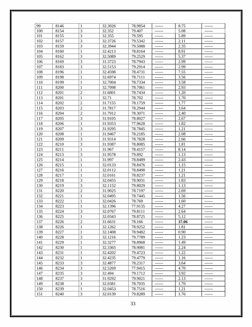
33
99 8146 1 32.3026 78.9854 ------ 8.75 ------
100 8154 3 32.352 79.407 ------ 5.08 ------
101 8155 3 32.355 79.595 ------ 5.89 ------
102 8157 3 32.3726 79.5342 ------ 2.11 ------
103 8159 3 32.3944 79.5088 ------ 2.35 ------
104 8160 1 32.4213 78.8164 ------ 8.91 ------
105 8162 3 32.5089 79.2529 ------ 5.37 ------
106 8169 3 31.3723 78.7943 ------ 2.99 ------
107 8183 3 32.5153 79.2914 ------ 2.99 ------
108 8196 1 32.4598 78.4731 ------ 7.55 ------
109 8198 1 32.6974 78.7111 ------ 3.56 ------
110 8199 1 32.7004 78.7334 ------ 3.58 ------
111 8200 1 32.7098 78.7061 ------ 2.93 ------
112 8201 2 31.6801 78.7434 ------ 1.20 ------
113 8201 1 32.71 78.702 ------ 1.70 ------
114 8202 2 31.7155 78.1759 ------ 1.77 ------
115 8203 2 31.7817 78.2944 ------ 3.64 ------
116 8204 2 31.7912 78.3071 ------ 2.40 ------
117 8205 3 31.9105 78.8027 ------ 2.67 ------
118 8206 1 31.9353 77.9628 ------ 1.82 ------
119 8207 3 31.9295 78.7845 ------ 1.21 ------
120 8208 1 31.9467 78.2185 ------ 2.08 ------
121 8209 3 31.9314 78.7828 ------ 2.66 ------
122 8210 3 31.9387 78.8085 ------ 1.81 ------
123 8211 1 31.967 78.4157 ------ 8.14 ------
124 8213 3 31.9578 79.892 ------ 1.13 ------
125 8214 1 31.997 78.8489 ------ 2.43 ------
126 8215 1 32.0133 78.8476 ------ 1.15 ------
127 8216 1 32.0112 78.8498 ------ 1.21 ------
128 8217 1 32.0161 78.8237 ------ 1.21 ------
129 8218 3 32.0455 78.9031 ------ 1.83 ------
130 8219 3 32.1152 79.8029 ------ 1.13 ------
131 8220 2 31.9025 78.7197 ------ 2.69 ------
132 8221 1 32.0495 78.7445 ------ 1.56 ------
133 8222 1 32.0426 78.769 ------ 1.60 ------
134 8223 1 32.1396 77.9135 ------ 4.27 ------
135 8224 3 32.0767 79.8111 ------ 2.64 ------
136 8225 1 32.0343 78.8725 ------ 5.12 ------
137 8226 2 31.6631 78.166 ------ 37.06 ------
138 8226 1 32.1262 78.9252 ------ 1.81 ------
139 8227 1 32.1408 78.9482 ------ 0.90 ------
140 8228 3 32.1216 79.7789 ------ 1.23 ------
141 8229 1 32.3277 78.8968 ------ 1.49 ------
142 8230 1 32.3365 78.9081 ------ 2.24 ------
143 8231 1 32.4202 79.4723 ------ 1.22 ------
144 8232 1 32.4235 79.4779 ------ 1.16 ------
145 8233 3 32.4877 78.2317 ------ 3.64 ------
146 8234 3 32.5269 77.9415 ------ 4.70 ------
147 8235 3 32.494 79.1712 ------ 3.92 ------
148 8237 3 31.9292 79.9021 ------ 2.13 ------
149 8238 1 32.0381 78.7035 ------ 1.70 ------
150 8239 1 32.0453 78.7516 ------ 1.21 ------
151 8240 3 32.0139 79.8289 ------ 1.76 ------

34
152 8241 1 32.073 78.8633 ------ 1.81 ------
153 8242 3 32.061 79.8012 ------ 2.11 ------
154 8243 1 32.7003 78.7197 ------ 1.53 ------
155 8244 1 32.7087 78.7393 ------ 2.45 ------
156 62SG 1 32.0195 78.8751 ------ 9.89 ------
157 32HWL 1 32.3308 78.7166 28.64 25.85 -2.79
158 8122SG 1 32.0957 78.9145 ------ 1.82 ------
159 8127SG 1 32.0607 78.8073 ------ 11.90 ------
160 8156SG 3 32.3752 79.4191 ------ 1.79 ------
161 8236SG 1 32.6095 77.9876 ------ 5.70 ------
162 96HWL 3 31.3069 79.5996 46.86 38.58 -8.28
HWL- High Altitude Wetlands
RS- River Section
SG-Supra Glacial
7.7 Status of Lakes as on 05 Sep 2020
On analyzing the satellite data for 05 September 2020, it is found that the satellite
image covers mainly the partial areas falling sub basin 1 & 3 (Fig. 7.7a) as a result of which only
46 lakes could be mapped in comparison to 229 lakes which were mapped in 09 September 2019
(Fig. 7.7c & d) and only 1 high altitude wetland that too from the Spiti sub basin having area
between 5-10ha. Out of these 46 lakes, 30 lakes are such which have the area less than 5ha out of
which 8 lakes forms a part of the Spiti sub basin and 22 lakes forms part of the Upper Satluj basins
respectively. Besides this, 12 lakes are such which have the area between 5-10 ha with 05 lakes
forming part of the Spiti sub basin and 7 that from the Upper Satluj sub basin. As far as the bigger
lakes with area more than 10ha are concerned, there are 4 lakes which comprise of 1falling in Spiti
sub basin and 3 from the Upper Satluj sub basin respectively (Fig. 7.7 c & d). When these 47 lakes
are seen temporally w.r.t.229 lakes as mapped on 09 September 2019 (Table 7.7) reveals that only
15 lakes could be compared out of which 14 lakes are showing a positive trend in their spatial
coverage, whereas 01 lakes are showing negative trend w.r.t 2019 respectively and the lakes those
could not be compared forms the base line data for next year monitoring.

35
Fig.7.7 (a): IRS-R2-AWiFS-99-48-05-09-2020
Fig.7.7 (b): IRS-R2-AWiFS-99-48-05-09-2020
Fig. 7.7 (c): No. of Lakes based on IRS-R2-AWiFS-99-48-05-09-2020
85
1
14
0 0 0 0
22
7
3
32
0
5
10
15
20
25
30
35
<5 ha 5-10 ha >10 ha Total
No. of
Lak
es
Spiti(1) Lr. Satluj(2) Up. Satluj(3)

36
Fig. 7.7 (d): No. High altitude wetlands based on IRS-R2-AWiFS-99-48-05-09-2020
Table: 7.7 Aerial Extent of lakes as on 05 September2020
Sr.No Lake Id.
Number
Basin
Number
Longitude Latitude Aerial Extent
on 09 Sept
2019 (ha.)
Aerial
Extent on 05
Sep 2020
(ha.)
Change in
Area w.r.t.
Sept.2019
(ha.)
1 25 3 79.3918 32.3778 25.39 28.36 2.97
2 28 3 79.0509 32.3466 4.26 6.03 1.77
3 31 3 79.0019 32.3382 4.28 10.97 6.68
4 51 3 78.9424 32.1221 3.02 6.81 3.79
5 54 3 78.9324 32.1069 5.43 8.51 3.08
6 55 3 78.9417 32.1069 6.78 11.38 4.60
7 312 1 78.973 32.325 3.75 6.85 3.11
8 313 1 78.9787 32.3193 7.72 9.38 2.67
9 315 1 78.9724 32.1904 2.70 6.76 4.07
10 414 1 78.9773 32.258 ------ 3.13 ------
11 415 3 79.0013 32.3287 1.61 2.85 1.24
12 417 3 79.7052 32.2151 1.36 4.45 3.10
13 559 1 78.7062 32.7074 ------ 4.08 ------
14 561 1 78.6883 32.7079 ------ 3.84 ------
15 562 3 79.0168 32.2768 1.61 3.24 1.63
16 563 1 78.9829 32.2256 1.37 3.16 1.78
17 592 3 79.8039 32.1165 ------ 3.79 ------
18 620 3 79.683 32.2538 3.75 7.23 3.49
19 640 3 78.97 32.1291 ------ 3.99 ------
20 870 1 78.9264 32.1292 ------ 1.91 ------
21 1038 3 79.8005 32.1255 ------ 3.60 ------
22 1552 1 78.9913 32.2543 ------ 2.56 ------
23 8028 3 78.9721 32.1704 ------ 2.03 ------
24 8130 3 78.9504 32.1191 ------ 1.23 ------
25 8131 3 78.9465 32.1193 ------ 5.69 ------
26 8132 3 78.9475 32.1222 ------ 1.81 ------
0
1
0
1
0 0 0 00 0 0 00
0.2
0.4
0.6
0.8
1
1.2
<5 ha 5-10 ha >10 ha TotalNo
. o
f H
igh
Alt
itu
de
Wet
lan
ds
Spiti(1) Lr. Satluj(2) Up. Satluj(3)

37
27 8139 3 79.7937 32.1211 ------ 3.51 ------
28 8140 3 79.7695 32.1333 ------ 4.41 ------
29 8141 1 78.9602 32.1848 ------ 2.86 ------
30 8146 1 78.9848 32.3001 ------ 14.75 ------
31 8147 3 79.6453 32.2872 ------ 2.89 ------
32 8154 3 79.4051 32.3496 ------ 4.44 ------
33 8155 3 79.5938 32.3523 ------ 6.57 ------
34 8160 1 78.8163 32.419 ------ 6.92 ------
35 8162 3 79.2534 32.5064 ------ 6.28 ------
36 8188 3 79.7964 32.1276 ------ 4.89 ------
37 8195 3 79.5895 32.3531 ------ 2.86 ------
38 8308 3 79.7886 32.175 ------ 1.87 ------
39 8323 1 78.7107 32.695 ------ 3.69 ------
40 8346 3 79.8015 32.1126 ------ 1.31 ------
41 8347 3 79.6551 32.262 ------ 3.16 ------
42 8348 3 78.9938 32.316 ------ 2.53 ------
43 8349 3 79.581 32.3257 ------ 1.96 ------
44 8350 3 79.2708 32.5281 ------ 1.91 ------
45 8352 3 79.6199 32.3266 ------ 2.44 ------
46 32HWL 1 78.7173 32.3283 28.64 25.85 -2.79
47 8351SG 1 77.989 32.6067 ------ 5.71 ------ HWL- High Altitude Wetlands
RS- River Section
7.8: Status of lakes as on 10 September 2020
On analyzing the satellite data for 10 September 2020, it is found that the satellite
image covers mainly the areas falling sub basin 1, 2 & 3 due to the partial coverage of the satellite
data (Fig 7.8a) as a result of which only 355 lakes could be mapped comprising 37 lakes from Spiti
sub basin i.e. basin 1, 10 lakes from Lower Satluj i.e basin 2 and 252 in basin 3 i.e Upper Satluj
basin. (Fig.7.8c). Further out of 355 lakes, 56 are the high altitude wetlands in the region
(Fig.7.8d). Out of these 355 lakes mapped, 189 lakes are such which have the area less than 5ha
out of which 24 lakes forms a part of the Spiti sub basin, 7 lakes forms part of the Lower Satluj
basin and 158 lakes forms part of the Upper Satluj basins respectively. Besides this, 55 lakes are
such which have the area between 5-10 ha with 07 lakes forming part of the Spiti sub basin, 3
forms part of the Upper Satluj basin and 45 that from the Upper Satluj sub basin. As far as the
bigger lakes with area more than 10ha are concerned, there are 55 lakes which comprise of 6 falling
in Spiti sub basin and 49 from the Upper Satluj sub basin respectively (Fig.7.8c).When these 355
lakes are seen temporally w.r.t.229 lakes as mapped on 09 September 2019 (Table 7.8) reveals that
only 74 lakes could be compared out of which 64 lakes are showing a positive trend in their spatial

38
coverage, whereas 10 lakes are showing negative trend w.r.t 2019 respectively and the lakes those
could not be compared forms the base line data for next year monitoring.
Fig.7.8 (a): IRS-R2-AWiFS-100-48-10-09-2020
Fig.7.8 (b): IRS-R2-AWiFS-100-48-10-09-2020 Interpreted Layer

39
Fig. 7.8 (c): No. of Lakes based on IRS-R2-AWiFS-100-48-10-09-2020
Fig. 7.8 (c): No. of High altitude wetlands based on IRS-R2-AWiFS-100-48-10-09-2020
Table: 7.8 Aerial Extent of lakes as on 10 September 2020
Sr.No. Lake Id.
Number
Basin
Number
Longitude Latitude Aerial
Extent on
09 Sep
2019 (ha.)
Aerial Extent
on 10 Sep
2020 (ha.)
Change in
Area w.r.t.
Oct 2019(ha.)
1 23 3 79.4149 32.3925 6.77 11.09 4.32
2 25 3 79.3904 32.3803 25.39 31.81 6.42
3 28 3 79.0508 32.3492 4.26 5.21 0.95
4 31 3 78.999 32.3414 4.28 10.73 6.44
5 39 3 79.0244 32.2272 5.39 7.34 1.95
6 41 3 79.0423 32.2119 17.70 18.06 0.36
247 6
37
7 3 0 10
158
45 49
252
0
75
150
225
300
<5 ha 5-10 ha >10 ha Total
No. of
Lak
es
Spiti(1) Lr. Satluj(2) Up. Satluj(3)
0 0 1 10 0 0 0
30
1114
55
0
10
20
30
40
50
60
<5 ha 5-10 ha >10 ha Total
No
. of
Hig
h A
ltit
ud
e W
etla
nd
s
Spiti(1) Lr. Satluj(2) Up. Satluj(3)

40
7 51 3 78.9399 32.1251 5.02 7.33 2.31
8 54 3 78.9303 32.1094 10.43 12.25 2.81
9 55 3 78.9393 32.1097 8.78 10.97 2.20
10 61 1 78.8421 32.0318 24.47 26.79 2.31
11 65 1 78.8431 31.9947 23.08 24.29 1.21
12 71 3 79.8712 31.9795 7.59 7.38 -0.22
13 73 3 79.8813 31.9719 2.18 4.83 2.65
14 74 3 79.875 31.9701 2.14 4.55 2.42
15 79 3 78.7818 31.9212 21.51 24.29 3.78
16 106 3 81.1026 31.2451 ------ 5.51 ------
17 107 3 81.0835 31.2416 3.60 6.84 3.24
18 112 3 81.1482 31.2004 12.16 16.39 4.23
19 113 3 81.1945 31.1835 53.36 56.84 3.48
20 114 3 81.152 31.1799 24.80 26.54 2.74
21 118 3 81.2808 31.1389 8.46 11.10 3.64
22 119 3 81.2282 31.131 6.04 8.50 2.46
23 122 3 81.4353 31.1159 3.34 6.49 3.15
24 166 3 81.4303 30.4728 ------ 6.32 ------
25 174 3 81.434 30.45 ------ 11.21 ------
26 178 3 81.4339 30.4321 203.62 217.48 13.86
27 181 3 81.4626 30.4311 14.90 19.23 4.32
28 183 3 81.872 30.4283 ------ 23.85 ------
29 193 3 81.8668 30.4001 ------ 9.12 ------
30 196 3 81.8954 30.3918 6.97 12.99 6.02
31 228 2 78.7517 31.5549 ------ 5.75 ------
32 241 1 78.6972 31.9149 ------ 8.89 ------
33 312 1 78.9711 32.3279 3.75 6.88 3.13
34 313 1 78.9773 32.3221 3.72 7.31 3.59
35 315 1 78.9701 32.1932 2.70 6.00 3.30
36 317 3 78.9752 32.1634 5.70 8.16 2.46
37 343 3 79.8638 31.9269 29.70 33.84 4.14
38 399 3 79.7298 31.0302 7.43 12.87 5.44
39 408 3 78.9084 32.0203 3.23 8.50 5.27
40 414 1 78.9736 32.2608 ------ 3.01 ------
41 415 3 78.9983 32.3311 1.61 3.95 2.34
42 416 3 79.1887 32.4535 ------ 2.95 ------
43 417 3 79.7056 32.2179 1.36 2.76 1.40
44 422 3 81.0696 31.2353 ------ 2.67 ------
45 423 3 81.1596 31.2194 6.70 9.57 2.87
46 424 3 81.2252 31.1508 1.31 1.89 0.58
47 426 3 81.5045 31.0958 ------ 9.28 ------
48 427 3 81.3837 31.14 ------ 7.35 ------
49 431 3 81.5027 31.1139 ------ 9.77 ------
50 432 3 81.5194 31.084 ------ 4.37 ------
51 443 3 81.5143 30.4824 ------ 7.74 ------
52 445 3 81.4835 30.4631 3.07 2.46 -0.62
53 448 3 81.458 30.4392 2.97 4.47 1.50
54 562 3 79.0147 32.2791 1.61 3.03 1.42
55 563 1 78.9804 32.2277 1.37 2.95 1.58
56 570 3 79.1322 32.4479 4.82 4.80 -0.02
57 571 3 79.131 32.4644 ------ 4.14 ------
58 592 3 79.8033 32.119 ------ 3.60 ------
59 607 3 81.1334 31.2468 2.21 4.02 1.81

41
60 610 3 78.9445 32.095 4.05 5.91 1.86
61 611 3 78.9415 32.0625 5.14 5.75 0.61
62 620 3 79.682 32.2566 3.75 3.31 -0.44
63 621 3 81.9309 30.386 ------ 86.25 ------
64 622 3 81.0852 31.2742 ------ 2.49 ------
65 632 3 79.3682 31.145 2.34 4.67 2.32
66 634 3 81.1419 31.2477 ------ 8.29 ------
67 636 3 81.0977 31.2707 3.01 3.45 0.44
68 637 3 81.8414 30.3861 9.46 18.14 8.68
69 638 3 81.831 30.3823 3.03 6.36 3.33
70 640 3 78.9679 32.1322 ------ 4.94 ------
71 641 3 79.8936 31.9612 ------ 3.56 ------
72 645 3 81.0895 31.268 5.15 8.25 3.11
73 646 3 81.1047 31.2647 2.63 2.43 -0.20
74 647 3 81.1054 31.261 2.74 4.45 1.71
75 648 3 81.1154 31.238 2.18 3.79 1.61
76 649 3 81.1221 31.2437 2.77 3.21 0.45
77 651 3 81.4018 31.1292 ------ 8.94 ------
78 652 3 81.4245 31.1389 4.81 5.61 0.80
79 655 3 81.5139 31.1004 ------ 3.98 ------
80 656 3 81.5318 31.0971 ------ 2.22 ------
81 657 3 81.5463 31.1043 ------ 4.68 ------
82 658 3 81.5432 31.1183 ------ 8.60 ------
83 663 3 79.3437 31.1542 ------ 5.74 ------
84 683 3 78.7032 31.2254 ------ 7.69 ------
85 804 1 78.8295 32.046 2.07 4.00 1.92
86 811 3 78.8364 31.9172 27.41 29.21 2.80
87 816 3 79.878 31.9651 2.97 2.76 -0.21
88 825 3 81.1132 31.2517 1.04 1.61 0.57
89 827 3 81.1382 31.1958 7.33 8.80 1.47
90 828 3 81.1539 31.21 1.73 2.49 0.76
91 849 3 81.4996 30.4607 ------ 1.86 ------
92 884 3 79.889 31.97 ------ 4.91 ------
93 885 3 79.8805 31.9346 1.61 2.73 1.12
94 888 3 81.1481 31.2059 ------ 1.51 ------
95 895 3 81.8433 30.3807 2.21 4.97 2.76
96 964 3 81.7667 30.4094 ------ 1.28 ------
97 1004 3 81.5148 30.4783 ------ 3.87 ------
98 1005 3 81.4807 30.4291 ------ 4.05 ------
99 1006 3 81.4767 30.4277 ------ 1.58 ------
100 1007 3 81.4143 30.4618 ------ 1.24 ------
101 1008 3 81.4111 30.4578 ------ 1.89 ------
102 1025 3 81.514 31.0369 1.04 2.73 1.69
103 1030 3 81.1781 31.1904 ------ 3.44 ------
104 1038 3 79.8000 32.1279 ------ 1.85 ------
105 1049 2 78.7358 31.5201 ------ 6.82 ------
106 1052 3 80.5972 30.5467 ------ 1.75 ------
107 1053 3 80.5921 30.4781 ------ 16.36 ------
108 1133 3 81.8685 30.4203 ------ 17.26 ------
109 1142 3 81.7748 30.4043 ------ 1.53 ------
110 1149 3 81.7694 30.398 ------ 7.24 ------
111 1508 3 81.4899 31.0076 ------ 1.82 ------
112 1509 3 81.5513 31.0955 ------ 1.25 ------

42
113 1510 3 81.5615 31.0953 ------ 1.85 ------
114 1511 3 81.4261 31.0859 ------ 3.51 ------
115 1512 3 81.4254 31.0813 ------ 1.96 ------
116 1514 3 81.4079 31.0567 ------ 2.15 ------
117 1515 3 81.4175 31.104 1.95 3.08 1.13
118 1517 3 81.3275 31.14 ------ 1.56 ------
119 1518 3 81.226 31.1623 ------ 3.48 ------
120 1519 3 81.2158 31.1659 ------ 3.09 ------
121 1522 3 81.1156 31.1696 ------ 2.47 ------
122 1524 3 81.0329 31.2944 1.88 4.66 2.78
123 1525 3 81.0319 31.2868 17.37 20.37 4.00
124 1531 3 78.8671 31.9722 8.23 10.97 2.74
125 1532 3 78.8641 31.9601 4.11 6.47 2.36
126 1538 3 79.5714 31.0938 4.57 5.90 1.33
127 1543 3 81.393 30.4559 ------ 3.45 ------
128 1545 3 80.4022 30.5991 ------ 5.83 ------
129 1546 3 79.5153 31.1329 ------ 4.61 ------
130 1552 1 78.9886 32.2568 ------ 3.34 ------
131 1585 1 78.8607 32.0885 ------ 1.81 ------
132 8001 3 81.9134 30.3596 ------ 3.76 ------
133 8002 3 81.9148 30.3707 ------ 1.61 ------
134 8003 3 81.8793 30.3774 ------ 2.48 ------
135 8004 3 81.826 30.3842 ------ 1.23 ------
136 8005 3 81.8317 30.3859 ------ 1.86 ------
137 8006 3 81.7963 30.3933 ------ 0.95 ------
138 8010 3 81.4659 30.4288 ------ 3.39 ------
139 8012 3 81.7414 30.4300 ------ 1.23 ------
140 8013 3 81.697 30.4339 ------ 2.64 ------
141 8014 3 81.3771 30.4526 ------ 3.51 ------
142 8015 3 81.4154 30.4548 ------ 1.24 ------
143 8017 3 81.7132 30.4423 ------ 1.24 ------
144 8018 3 81.4926 30.4558 ------ 2.17 ------
145 8019 3 81.4057 30.4672 ------ 1.30 ------
146 8020 3 80.532 30.5129 ------ 3.04 ------
147 8021 3 80.5339 30.5156 ------ 2.17 ------
148 8022 3 81.4013 30.4784 ------ 1.55 ------
149 8023 3 80.3819 30.5365 ------ 2.18 ------
150 8024 3 80.5084 30.5427 ------ 1.23 ------
151 8025 3 80.6211 30.5407 ------ 30.32 ------
152 8026 3 80.4495 30.5555 ------ 3.38 ------
153 8026 3 79.8105 32.0314 ------ 4.68 ------
154 8027 3 80.4719 30.5547 ------ 17.20 ------
155 8027 3 79.2696 32.5307 ------ 1.80 ------
156 8028 3 80.6155 30.5554 ------ 4.03 ------
157 8028 1 78.9701 32.1732 ------ 2.47 ------
158 8029 3 80.6311 30.5553 ------ 1.54 ------
159 8030 3 80.6155 30.5573 ------ 1.24 ------
160 8031 3 80.2931 30.608 ------ 12.02 ------
161 8036 3 79.7526 31.0418 ------ 5.85 ------
162 8037 3 79.4095 31.0622 ------ 6.00 ------
163 8038 3 79.4132 31.062 ------ 8.78 ------
164 8039 3 79.6147 31.064 ------ 1.23 ------
165 8040 3 79.6502 31.0741 ------ 1.90 ------
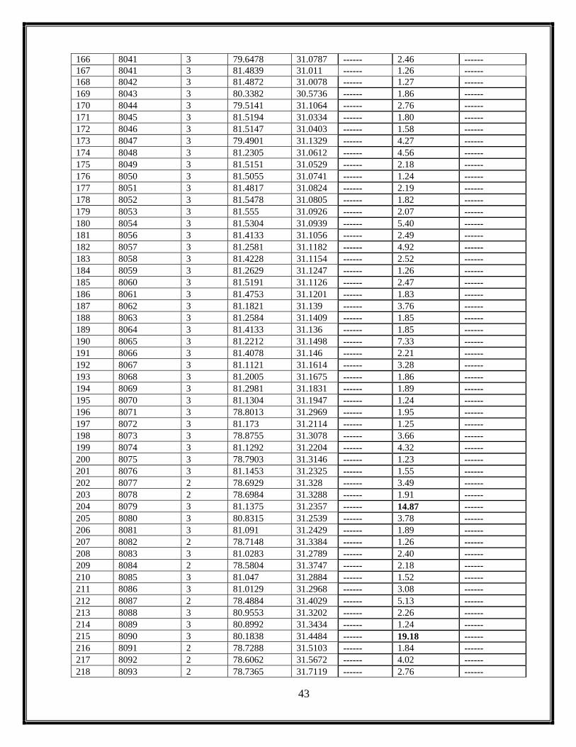
43
166 8041 3 79.6478 31.0787 ------ 2.46 ------
167 8041 3 81.4839 31.011 ------ 1.26 ------
168 8042 3 81.4872 31.0078 ------ 1.27 ------
169 8043 3 80.3382 30.5736 ------ 1.86 ------
170 8044 3 79.5141 31.1064 ------ 2.76 ------
171 8045 3 81.5194 31.0334 ------ 1.80 ------
172 8046 3 81.5147 31.0403 ------ 1.58 ------
173 8047 3 79.4901 31.1329 ------ 4.27 ------
174 8048 3 81.2305 31.0612 ------ 4.56 ------
175 8049 3 81.5151 31.0529 ------ 2.18 ------
176 8050 3 81.5055 31.0741 ------ 1.24 ------
177 8051 3 81.4817 31.0824 ------ 2.19 ------
178 8052 3 81.5478 31.0805 ------ 1.82 ------
179 8053 3 81.555 31.0926 ------ 2.07 ------
180 8054 3 81.5304 31.0939 ------ 5.40 ------
181 8056 3 81.4133 31.1056 ------ 2.49 ------
182 8057 3 81.2581 31.1182 ------ 4.92 ------
183 8058 3 81.4228 31.1154 ------ 2.52 ------
184 8059 3 81.2629 31.1247 ------ 1.26 ------
185 8060 3 81.5191 31.1126 ------ 2.47 ------
186 8061 3 81.4753 31.1201 ------ 1.83 ------
187 8062 3 81.1821 31.139 ------ 3.76 ------
188 8063 3 81.2584 31.1409 ------ 1.85 ------
189 8064 3 81.4133 31.136 ------ 1.85 ------
190 8065 3 81.2212 31.1498 ------ 7.33 ------
191 8066 3 81.4078 31.146 ------ 2.21 ------
192 8067 3 81.1121 31.1614 ------ 3.28 ------
193 8068 3 81.2005 31.1675 ------ 1.86 ------
194 8069 3 81.2981 31.1831 ------ 1.89 ------
195 8070 3 81.1304 31.1947 ------ 1.24 ------
196 8071 3 78.8013 31.2969 ------ 1.95 ------
197 8072 3 81.173 31.2114 ------ 1.25 ------
198 8073 3 78.8755 31.3078 ------ 3.66 ------
199 8074 3 81.1292 31.2204 ------ 4.32 ------
200 8075 3 78.7903 31.3146 ------ 1.23 ------
201 8076 3 81.1453 31.2325 ------ 1.55 ------
202 8077 2 78.6929 31.328 ------ 3.49 ------
203 8078 2 78.6984 31.3288 ------ 1.91 ------
204 8079 3 81.1375 31.2357 ------ 14.87 ------
205 8080 3 80.8315 31.2539 ------ 3.78 ------
206 8081 3 81.091 31.2429 ------ 1.89 ------
207 8082 2 78.7148 31.3384 ------ 1.26 ------
208 8083 3 81.0283 31.2789 ------ 2.40 ------
209 8084 2 78.5804 31.3747 ------ 2.18 ------
210 8085 3 81.047 31.2884 ------ 1.52 ------
211 8086 3 81.0129 31.2968 ------ 3.08 ------
212 8087 2 78.4884 31.4029 ------ 5.13 ------
213 8088 3 80.9553 31.3202 ------ 2.26 ------
214 8089 3 80.8992 31.3434 ------ 1.24 ------
215 8090 3 80.1838 31.4484 ------ 19.18 ------
216 8091 2 78.7288 31.5103 ------ 1.84 ------
217 8092 2 78.6062 31.5672 ------ 4.02 ------
218 8093 2 78.7365 31.7119 ------ 2.76 ------

44
219 8094 1 78.711 31.901 ------ 2.17 ------
220 8095 1 78.7047 31.9092 ------ 2.06 ------
221 8096 1 78.6993 31.9204 ------ 1.26 ------
222 8097 3 78.8144 31.9356 ------ 8.26 ------
223 8098 3 78.8208 31.9328 ------ 1.79 ------
224 8099 3 78.8214 31.9351 ------ 1.78 ------
225 8100 3 78.8193 31.9344 ------ 1.94 ------
226 8101 1 78.6815 31.9366 ------ 1.24 ------
227 8102 3 78.8172 31.9319 ------ 2.75 ------
228 8103 3 78.8095 31.9665 ------ 7.82 ------
229 8104 3 78.7945 31.974 ------ 2.71 ------
230 8105 3 78.8358 31.9819 ------ 13.76 ------
231 8106 3 79.8759 31.9583 ------ 4.94 ------
232 8107 3 79.8975 31.9665 ------ 7.19 ------
233 8108 3 78.9001 32.0065 ------ 1.91 ------
234 8109 1 78.8427 32.014 ------ 3.48 ------
235 8110 3 78.8922 32.0165 ------ 6.01 ------
236 8111 1 78.8742 32.0226 ------ 4.90 ------
237 8112 3 79.8344 31.9908 ------ 4.61 ------
238 8113 3 79.8441 31.9943 ------ 5.57 ------
239 8114 1 78.8123 32.0352 ------ 6.13 ------
240 8115 1 78.7781 32.0361 ------ 3.36 ------
241 8116 3 79.854 32.0029 ------ 2.13 ------
242 8117 1 78.7572 32.044 ------ 2.63 ------
243 8118 1 78.7605 32.0432 ------ 1.85 ------
244 8118 1 78.7533 32.0468 ------ 0.97 ------
245 8119 1 78.7575 32.0421 ------ 1.26 ------
246 8119 1 78.7548 32.047 ------ 1.26 ------
247 8120 1 78.78 32.0558 ------ 4.29 ------
248 8121 3 79.825 32.0203 ------ 5.22 ------
249 8123 1 78.8818 32.0748 ------ 6.39 ------
250 8124 3 78.9257 32.0658 ------ 1.21 ------
251 8125 3 79.8135 32.0302 ------ 1.52 ------
252 8126 1 78.9009 32.0567 ------ 1.17 ------
253 8127 1 78.8045 32.0609 ------ 11.89 ------
254 8128 1 78.9048 32.1008 ------ 1.50 ------
255 8129 3 79.8013 32.0806 ------ 4.25 ------
256 8130 3 78.9489 32.1218 ------ 1.22 ------
257 8131 3 78.9441 32.1223 ------ 5.17 ------
258 8132 3 78.9448 32.125 ------ 1.83 ------
259 8133 3 79.771 32.0971 ------ 3.35 ------
260 8134 1 78.9236 32.1318 ------ 1.51 ------
261 8135 3 79.7967 32.1079 ------ 2.06 ------
262 8136 3 79.7998 32.1091 ------ 2.53 ------
263 8137 1 78.9149 32.1445 ------ 4.31 ------
264 8138 3 78.9596 32.1521 ------ 3.33 ------
265 8139 3 79.7931 32.1235 ------ 3.63 ------
266 8140 3 79.7682 32.1359 ------ 5.16 ------
267 8141 1 78.9576 32.188 ------ 3.67 ------
268 8142 3 79.0175 32.2106 ------ 2.98 ------
269 8143 3 79.0084 32.2172 ------ 3.95 ------
270 8144 3 78.9957 32.2273 ------ 1.23 ------
271 8145 3 79.0042 32.2273 ------ 3.67 ------

45
272 8146 1 78.9818 32.3024 ------ 17.19 ------
273 8147 3 79.643 32.291 ------ 2.81 ------
274 8148 3 79.1175 32.3366 ------ 2.35 ------
275 8151 3 79.5719 32.3343 ------ 3.65 ------
276 8153 3 79.1001 32.3568 ------ 4.35 ------
277 8154 3 79.4038 32.3524 ------ 7.65 ------
278 8155 3 79.5928 32.3551 ------ 4.88 ------
279 8157 3 79.5323 32.3729 ------ 2.19 ------
280 8158 3 79.5188 32.3791 ------ 1.53 ------
281 8159 3 79.507 32.3947 ------ 1.74 ------
282 8160 1 78.8131 32.4223 ------ 7.53 ------
283 8161 3 79.2776 32.4798 ------ 1.53 ------
284 8162 3 79.2523 32.5089 ------ 6.44 ------
285 8163 3 79.2896 32.5155 ------ 2.55 ------
286 8164 3 79.2955 32.5143 ------ 1.20 ------
287 13801 3 80.4008 30.5531 ------ 44.809 ------
288 18701 3 81.8482 30.3879 2.48 4.28 1.80
289 18901 3 81.8192 30.3916 12.09 16.60 4.51
290 1001HWL 3 81.7493 30.4488 1.37 1.55 0.18
291 1012HWL 3 81.5437 30.8195 ------ 2.44 ------
292 1013HWL 3 81.5255 30.7777 ------ 2.20 ------
293 1015HWL 3 81.2308 30.8933 ------ 2.48 ------
294 1018HWL 3 81.2114 30.8954 2.11 1.99 -0.13
295 1019HWL 3 81.2082 30.8966 2.11 1.15 -0.96
296 1022RS 3 81.1109 30.9249 1.67 2.44 0.77
297 1093HWL 3 82.1359 30.6385 ------ 6002.45 ------
298 1124HWL 3 81.8217 30.4389 ------ 6.70 ------
299 1136HWL 3 81.7781 30.412 ------ 9.72 ------
300 1139HWL 3 81.7983 30.4248 ------ 2.49 ------
301 138HWL 3 81.234 30.6897 ------ 26020.60 ------
302 142HWL 3 81.5683 30.8023 ------ 307.42 ------
303 145HWL 3 81.4726 30.6858 ------ 41888.20 ------
304 1474HWL 3 81.5671 30.7665 ------ 4.78 ------
305 148HWL 3 81.5851 30.7625 ------ 108.37 ------
306 15002HWL 3 82.0726 30.5975 ------ 16.74 ------
307 15003HWL 3 82.0844 30.5932 ------ 19.12 ------
308 159HWL 3 81.7415 30.5503 ------ 16.48 ------
309 173HWL 3 81.6765 30.4494 ------ 9.37 ------
310 1788HWL 3 82.1242 30.5728 ------ 3.19 ------
311 179HWL 3 81.7143 30.431 ------ 25.10 ------
312 184HWL 3 81.722 30.4226 ------ 22.79 ------
313 185001HWL 3 81.7466 30.4104 ------ 9.82 ------
314 187004HWL 3 81.7843 30.402 ------ 5.23 ------
315 202HWL 3 80.541 31.3994 55.51 54.73 -1.78
316 205HWL 3 81.5667 30.7889 ------ 3.76 ------
317 206HWL 3 81.5703 30.7902 ------ 1.17 ------
318 207HWL 3 81.5499 30.7857 ------ 5.80 ------
319 209HWL 3 81.5463 30.7739 ------ 4.02 ------
320 210HWL 3 81.5548 30.7724 ------ 59.00 ------
321 211HWL 3 81.7022 30.516 ------ 8.98 ------
322 32HWL 1 78.7194 32.3302 ------ 39.05 ------
323 385HWL 3 81.5389 30.7795 ------ 2.44 ------
324 436HWL 3 81.6957 30.4988 1.38 1.87 0.49

46
325 437HWL 3 81.6933 30.4983 1.36 2.15 0.79
326 438HWL 3 81.7412 30.4034 ------ 5.28 ------
327 439HWL 3 81.7227 30.4294 ------ 3.69 ------
328 440HWL 3 81.7209 30.4495 2.47 5.61 3.14
329 441HWL 3 81.6991 30.4561 ------ 3.73 ------
330 442HWL 3 81.6979 30.4321 ------ 5.72 ------
331 455RS 3 80.7813 31.1097 ------ 30.49 ------
332 607RS 3 81.1645 30.9144 ------ 40.74 ------
333 608RS 3 81.0952 30.9269 17.15 21.95 3.80
334 616RS 3 81.1179 30.9256 12.43 15.34 3.91
335 62SG 1 78.8728 32.0195 ------ 11.10 ------
336 677HWL 3 81.7078 30.5035 ------ 2.71 ------
337 688HWL 3 81.8205 30.4096 ------ 11.17 ------
338 8007HWL 3 81.7851 30.3961 ------ 1.26 ------
339 8008HWL 3 81.7781 30.3999 ------ 1.20 ------
340 8009HWL 3 81.7754 30.4026 ------ 1.28 ------
341 8011SG 3 80.5687 30.4788 ------ 4.38 ------
342 8016HWL 3 81.6994 30.4404 ------ 1.54 ------
343 8032HWL 3 82.0641 30.5891 ------ 1.21 ------
344 8033HWL 3 81.5414 30.7796 ------ 0.90 ------
345 8034HWL 3 81.554 30.7854 ------ 1.31 ------
346 8035HWL 3 81.204 30.8948 ------ 2.19 ------
347 8055SG 3 81.2224 31.1117 ------ 3.79 ------
348 8122SG 1 78.9072 32.0937 ------ 3.03 ------
349 8156SG 3 79.415 32.3756 ------ 2.75 ------
350 839HWL 3 81.8042 30.3923 ------ 4.06 ------
351 840HWL 3 81.7931 30.3979 ------ 5.48 ------
352 842HWL 3 81.7637 30.4216 ------ 3.19 ------
353 844HWL 3 81.7721 30.4602 2.21 3.06 0.85
354 865HWL 3 81.7754 30.4003 ------ 3.69 ------
355 96HWL 3 79.6004 31.3061 46.86 40.08 -6.78
7.9 Status of Lakes as on 12 September 2020
From the analysis of 12 September 2020 satellite data, it is found that the data covers
the entire catchment of the study area and is clearly visible and fully exposed due to minimum
snow cover and negligible cloud cover impacts, as result of which a total of 322 lakes could be
delineated in comparison to the total of 229 lakes mapped in 2019 (Fig. 7.9a & Fig. 7.9b)
comprising 62 lakes from basin 1, 20 from basin 2 and 240 lakes basin 3 respectively (Fig. 7.9c).
Further analysis of 322 lakes based on their areal distribution pattern reveals that 200 lakes are
such, which have the area less than 5ha comprising 43 lakes from the Spiti sub basin, 13 from the
Lower Satluj and 144 from the Upper Satluj sub basin respectively. Likewise73 lakes are such
which have area between 5-10 ha comprising12 from the Spiti, 5 from the Lower Satluj and 56
from the Upper Satluj sub basin respectively. Besides this, 49 lakes are such which have the area
more than 10ha, out of which 7 lakes forms the part of the Spiti sub basin, 2 forms part of the

47
Lower Satluj sub basin and 40 lakes forms part of the Upper Satluj sub basin respectively
(Fig.7.9c). Besides 322 lakes in the catchment, 40 lakes haven mapped as high-altitude wetlands
comprising 1 from Spiti sub basin and 39 from Upper Satluj basin (Fig.7.9d). Further these 40
wetlands when seen based on their areal size, it is found that 19 wetlands have the area <5ha, 8
with area between 5-10ha and 13 high altitude wetlands with area more than 10ha.The temporal
variation of 361 lakes when seen w.r.t. the 229 lakes as mapped on 09 Sept 2019, it is found that
39 lakes are showing an increase in their water spread, whereas 25 lakes are showing a reduction
in their water spread w.r.t. 2019 data (Table 7.9) and those which could not be compared forms
the base line data for their monitoring during next ablation season.
Fig.7.9 (a): IRS-R2-AWiFS-97-49-12-09-2020
Fig.7.9 (b): IRS-R2-AWiFS-97-49-12-09-2020 interpreted layer

48
Fig. 7.9 (c): No. of Lakes based on IRS-R2-AWiFS-97-49-12-09-2020
Fig. 7.9 (d): No. of High altitude wetlands based on IRS-R2-AWiFS-97-49-12-09-2020
4312 7
62
13 5 220
143
5640
239
0
50
100
150
200
250
300
<5 ha 5-10 ha >10 ha Total
No
. o
f L
ak
es
Spiti(1) Lr. Satluj(2) Up. Satluj(3)
0 1 0 10 0 0 0
19
7
13
39
0
5
10
15
20
25
30
35
40
45
<5 ha 5-10 ha >10 ha Total
No. of
Hig
h A
ltit
ud
Wet
lan
ds
Spiti(1) Lr. Satluj(2) Up. Satluj(3)

49
Table: 7.9 Aerial Extent of lakes as on 12 September2020
Sr.No. Lake Id.
Number
Basin
Number
Longitude Latitude Aerial
Extent on
09Sep 2019
(ha.)
Aerial Extent on 12
Sept. 2020 (ha.)
Change in Area
w.r.t. Oct
2019(ha.)
1 23 3 79.4186 32.392 6.77 10.78 4.02
2 25 3 79.3948 32.3799 25.39 24.91 -0.48
3 28 3 79.0535 32.3491 4.53 4.72 0.19
4 31 3 79.0036 32.3407 ------ 7.98 ------
5 39 3 79.028 32.2261 ------ 8.58 ------
6 41 3 79.0457 32.2115 ------ 28.85 ------
7 51 3 78.9443 32.1243 ------ 6.14 ------
8 54 3 78.934 32.1091 ------ 14.00 ------
9 55 3 78.9431 32.1092 ------ 10.72 ------
10 60 1 78.8741 32.0341 ------ 5.77 ------
11 61 1 78.8457 32.0309 ------ 24.52 ------
12 62 1 78.8761 32.0187 ------ 13.17 ------
13 63 1 78.8778 32.0218 ------ 3.95 ------
14 65 1 78.8463 31.9944 ------ 26.79 ------
15 71 3 79.874 31.9785 ------ 8.98 ------
16 73 3 79.884 31.9712 ------ 2.98 ------
17 74 3 79.8774 31.9692 ------ 6.58 ------
18 79 3 78.7851 31.9208 ------ 25.27 ------
19 85 2 78.1685 31.6623 ------ 46.37 ------
20 106 3 81.1046 31.2447 ------ 4.54 ------
21 107 3 81.0851 31.241 2.73 8.41 5.68
22 112 3 81.1493 31.2005 19.17 17.28 -2.88
23 113 3 81.1956 31.1834 50.16 53.04 2.88
24 114 3 81.1537 31.1797 28.85 30.20 2.35
25 118 3 81.2819 31.1391 7.50 8.98 1.48
26 119 3 81.2286 31.1312 4.25 10.38 6.12
27 122 3 81.4365 31.1158 ------ 6.18 ------
28 166 3 81.4336 30.4724 4.38 5.52 1.13
29 174 3 81.4365 30.4497 9.69 8.17 -1.52
30 178 3 81.4359 30.4318 218.28 228.52 10.25
31 181 3 81.4652 30.4308 24.11 22.77 -1.34
32 183 3 81.873 30.4286 ------ 29.21 ------
33 193 3 81.868 30.4007 ------ 9.94 ------
34 196 3 81.8955 30.3928 ------ 15.38 ------
35 312 1 78.9745 32.3279 ------ 7.96 ------
36 313 1 78.9799 32.322 ------ 7.42 ------
37 315 1 78.9743 32.1929 ------ 3.81 ------
38 317 3 78.9792 32.1626 ------ 9.04 ------
39 319 3 78.8384 31.9818 ------ 17.10 ------
40 330 1 77.9252 32.1308 ------ 4.77 ------
41 330 1 77.9151 32.1386 ------ 3.03 ------
42 343 3 79.8664 31.9262 30.94 33.61 2.66
43 399 3 79.7312 31.0304 12.87 14.85 2.98
44 402 2 78.1265 31.7416 ------ 3.56 ------
45 408 3 78.9121 32.02 ------ 6.26 ------
46 413 3 79.0076 32.2263 ------ 4.17 ------
47 414 1 78.9789 32.2605 ------ 3.24 ------

50
48 415 3 79.0033 32.3313 ------ 2.05 ------
49 416 3 79.1892 32.4542 ------ 3.30 ------
50 417 3 79.7079 32.2173 1.39 3.34 1.95
51 422 3 81.0711 31.2346 ------ 3.26 ------
52 423 3 81.1616 31.2189 ------ 8.98 ------
53 424 3 81.2261 31.1506 1.02 1.84 0.82
54 426 3 81.5057 31.0958 ------ 7.39 ------
55 427 3 81.3856 31.1391 2.17 6.73 4.56
56 431 3 81.5057 31.1132 ------ 6.71 ------
57 432 3 81.5209 31.0839 ------ 4.29 ------
58 443 3 81.517 30.482 6.08 8.27 2.19
59 445 3 81.4857 30.4625 1.12 2.77 1.65
60 448 3 81.4599 30.4388 ------ 5.22 ------
61 559 1 78.7074 32.7099 ------ 2.92 ------
62 561 1 78.6897 32.7102 ------ 3.86 ------
63 562 3 79.0187 32.2791 ------ 3.81 ------
64 563 1 78.9845 32.2279 ------ 2.42 ------
65 570 3 79.1329 32.4486 ------ 3.25 ------
66 571 3 79.1329 32.4655 ------ 2.02 ------
67 592 3 79.8061 32.1182 ------ 3.33 ------
68 607 3 81.1348 31.2461 ------ 5.45 ------
69 610 3 78.9485 32.0945 ------ 5.67 ------
70 611 3 78.9445 32.0619 ------ 7.21 ------
71 616 1 78.7022 31.9143 ------ 6.26 ------
72 620 3 79.6858 32.256 ------ 6.33 ------
73 621 3 81.9297 30.3861 ------ 80.26 ------
74 622 3 81.0868 31.2737 ------ 2.99 ------
75 623 3 79.8473 31.9935 ------ 4.52 ------
76 625 3 79.8792 31.9574 ------ 4.50 ------
77 632 3 79.368 31.1453 ------ 8.21 ------
78 634 3 81.1428 31.2472 ------ 9.51 ------
79 635 2 78.2553 31.342 ------ 13.95 ------
80 636 3 81.1112 31.2705 1.83 5.28 3.45
81 637 3 81.843 30.3859 14.06 20.72 6.66
82 638 3 81.8322 30.3821 3.08 6.95 3.86
83 640 3 78.9717 32.1314 ------ 4.58 ------
84 641 3 79.8967 31.96 ------ 4.29 ------
85 645 3 81.0913 31.2672 5.82 8.18 2.36
86 646 3 81.1184 31.2645 ------ 2.80 ------
87 647 3 81.1191 31.2613 3.28 5.13 1.84
88 648 3 81.1263 31.2383 6.06 4.55 -1.51
89 649 3 81.1321 31.2452 ------ 3.11 ------
90 651 3 81.4034 31.1288 ------ 8.36 ------
91 652 3 81.4263 31.1385 4.47 9.64 5.17
92 655 3 81.5152 31.1005 ------ 6.53 ------
93 656 3 81.5323 31.0964 ------ 2.09 ------
94 657 3 81.5472 31.104 ------ 6.43 ------
95 658 3 81.5446 31.1179 8.80 11.15 3.36
96 663 3 79.3435 31.1548 ------ 5.23 ------
97 683 2 78.6984 31.2262 ------ 5.16 ------
98 804 1 78.8333 32.0455 ------ 3.57 ------
99 811 3 78.8417 31.9162 ------ 28.99 ------
100 816 3 79.8809 31.9643 ------ 2.74 ------

51
101 825 3 81.1157 31.251 ------ 1.21 ------
102 827 3 81.14 31.1962 7.89 5.92 -1.97
103 828 3 81.156 31.2097 ------ 2.42 ------
104 849 3 81.5019 30.46 1.19 4.59 3.40
105 870 1 78.9276 32.1313 ------ 1.54 ------
106 884 3 79.8915 31.9691 ------ 7.35 ------
107 885 3 79.8839 31.9334 ------ 2.42 ------
108 888 3 81.1495 31.2056 ------ 1.81 ------
109 895 3 81.8445 30.38 ------ 5.64 ------
110 964 3 81.7679 30.4095 ------ 1.25 ------
111 1004 3 81.5173 30.4781 4.37 2.70 -1.67
112 1005 3 81.4827 30.4285 ------ 3.71 ------
113 1006 3 81.4784 30.4271 ------ 1.83 ------
114 1030 3 81.1802 31.19 ------ 1.84 ------
115 1038 3 79.8032 32.1273 ------ 2.67 ------
116 1038 3 79.7986 32.1293 ------ 3.50 ------
117 1052 3 80.5999 30.5461 6.75 11.15 4.40
118 1053 3 80.5941 30.4777 14.72 16.61 2.89
119 1133 3 81.8696 30.4204 ------ 22.06 ------
120 1139 3 81.7243 30.4291 ------ 2.17 ------
121 1142 3 81.776 30.4022 ------ 1.22 ------
122 1149 3 81.771 30.398 ------ 6.46 ------
123 1155 3 79.8384 31.9896 ------ 4.20 ------
124 1510 3 81.5627 31.0953 ------ 3.03 ------
125 1511 3 81.4283 31.0849 ------ 4.01 ------
126 1512 3 81.4275 31.0813 ------ 3.07 ------
127 1515 3 81.4187 31.1039 ------ 4.84 ------
128 1518 3 81.2273 31.1623 ------ 0.91 ------
129 1519 3 81.2173 31.1655 ------ 1.83 ------
130 1522 3 81.1179 31.1688 ------ 3.40 ------
131 1524 3 81.0345 31.2935 2.39 5.47 3.08
132 1525 3 81.0339 31.2859 16.33 19.67 3.33
133 1531 3 78.8702 31.9713 ------ 11.53 ------
134 1532 3 78.868 31.9595 ------ 3.08 ------
135 1538 3 79.5708 31.0948 3.08 7.18 4.10
136 1543 3 81.3968 30.4551 ------ 2.18 ------
137 1545 3 80.4058 30.5987 ------ 6.73 ------
138 1546 3 79.5149 31.1331 ------ 4.86 ------
139 1552 1 78.9928 32.2567 ------ 3.51 ------
140 1564 3 78.8203 31.9312 ------ 2.91 ------
141 1565 3 78.8231 31.9321 ------ 1.29 ------
142 1566 3 78.8241 31.9348 ------ 1.15 ------
143 1568 1 78.8465 32.0135 ------ 2.91 ------
144 1585 1 78.865 32.0878 ------ 1.49 ------
145 1604 3 78.9033 32.0065 ------ 1.80 ------
146 1606 3 78.9992 32.2262 ------ 2.12 ------
147 8005 3 81.8331 30.3856 ------ 1.24 ------
148 8006 3 81.7969 30.3935 ------ 0.91 ------
149 8011 3 80.5709 30.4787 ------ 2.56 ------
150 8018 3 81.4957 30.4557 ------ 2.46 ------
151 8019 3 81.4089 30.467 ------ 2.23 ------
152 8022 3 81.4046 30.4779 ------ 1.62 ------
153 8024 3 80.5098 30.5423 ------ 1.26 ------

52
154 8025 3 80.624 30.5405 ------ 27.88 ------
155 8026 3 80.4522 30.5549 ------ 5.75 ------
156 8026 3 79.8148 32.0309 ------ 3.31 ------
157 8027 3 80.475 30.555 ------ 16.09 ------
158 8028 3 80.6186 30.5557 ------ 3.81 ------
159 8028 1 78.9739 32.1725 ------ 1.16 ------
160 8029 3 80.6326 30.555 ------ 1.89 ------
161 8031 3 80.2934 30.6076 ------ 13.41 ------
162 8037 3 79.4133 31.0621 ------ 3.65 ------
163 8038 3 79.4166 31.0618 ------ 7.82 ------
164 8047 3 79.493 31.1329 ------ 2.67 ------
165 8048 3 81.2324 31.0614 ------ 6.09 ------
166 8052 3 81.5495 31.0799 ------ 2.51 ------
167 8053 3 81.5559 31.0922 ------ 1.34 ------
168 8054 3 81.5313 31.0941 ------ 3.58 ------
169 8056 3 81.4147 31.1056 ------ 2.66 ------
170 8057 3 81.2595 31.1181 ------ 7.09 ------
171 8058 3 81.4246 31.1146 ------ 3.01 ------
172 8059 3 81.2636 31.1242 ------ 1.81 ------
173 8060 3 81.5201 31.112 ------ 1.53 ------
174 8061 3 81.4767 31.1196 ------ 2.38 ------
175 8062 3 81.1837 31.1386 ------ 3.40 ------
176 8063 3 81.2602 31.1407 ------ 2.46 ------
177 8065 3 81.2231 31.149 ------ 16.40 ------
178 8067 3 81.1139 31.1612 ------ 4.26 ------
179 8068 3 81.2015 31.1668 ------ 1.26 ------
180 8071 3 78.8054 31.2964 ------ 2.42 ------
181 8074 3 81.1308 31.2196 ------ 3.88 ------
182 8076 3 81.1469 31.232 ------ 2.11 ------
183 8077 2 78.6974 31.3276 ------ 3.34 ------
184 8079 3 81.1388 31.235 ------ 10.92 ------
185 8081 3 81.0933 31.2425 ------ 1.24 ------
186 8083 3 81.0301 31.278 ------ 2.45 ------
187 8084 2 78.5832 31.3752 ------ 2.24 ------
188 8086 3 81.015 31.2964 ------ 2.42 ------
189 8087 2 78.4907 31.4028 ------ 6.61 ------
190 8088 3 80.9571 31.3199 ------ 2.74 ------
191 8094 1 78.7153 31.9002 ------ 1.47 ------
192 8096 1 78.7039 31.9195 ------ 1.83 ------
193 8099 3 78.8218 31.9343 ------ 2.12 ------
194 8101 1 78.6856 31.9358 ------ 1.27 ------
195 8107 3 79.9004 31.9657 ------ 5.12 ------
196 8117 1 78.7588 32.0438 ------ 2.77 ------
197 8118 1 78.7623 32.043 ------ 1.23 ------
198 8120 1 78.7836 32.0547 ------ 2.50 ------
199 8121 3 79.8276 32.0191 ------ 3.61 ------
200 8123 1 78.8856 32.0739 ------ 3.55 ------
201 8124 3 78.9277 32.0653 ------ 1.85 ------
202 8125 3 79.8171 32.0288 ------ 1.83 ------
203 8126 1 78.9042 32.0563 ------ 1.19 ------
204 8127 1 78.8079 32.0602 ------ 15.32 ------
205 8129 3 79.8039 32.0796 ------ 3.91 ------
206 8131 3 78.9481 32.1217 ------ 4.88 ------

53
207 8133 3 79.7752 32.0961 ------ 2.98 ------
208 8136 3 79.8026 32.1084 ------ 2.05 ------
209 8137 1 78.9196 32.1439 ------ 3.56 ------
210 8138 3 78.9633 32.1513 ------ 2.10 ------
211 8139 3 79.7956 32.1233 ------ 4.19 ------
212 8140 3 79.7715 32.1352 ------ 5.31 ------
213 8141 1 78.9607 32.1871 ------ 2.96 ------
214 8142 3 79.0205 32.2102 ------ 3.39 ------
215 8143 3 79.0112 32.2167 ------ 2.38 ------
216 8146 1 78.9861 32.3021 ------ 13.19 ------
217 8153 3 79.1048 32.3564 ------ 3.58 ------
218 8154 3 79.4073 32.3522 ------ 3.30 ------
219 8155 3 79.5959 32.3539 ------ 6.86 ------
220 8157 3 79.5351 32.3727 ------ 1.59 ------
221 8159 3 79.5097 32.394 ------ 2.17 ------
222 8160 1 78.8175 32.4217 ------ 8.58 ------
223 8162 3 79.2544 32.5089 ------ 4.15 ------
224 8170 2 78.4211 31.4054 ------ 4.25 ------
225 8171 2 78.4106 31.4137 ------ 2.09 ------
226 8172 2 78.4109 31.44 ------ 2.42 ------
227 8173 2 78.3699 31.4606 ------ 3.00 ------
228 8194 1 78.2729 32.367 ------ 9.62 ------
229 8196 1 78.4741 32.4599 ------ 10.13 ------
230 8210 3 81.4686 30.4282 ------ 3.71 ------
231 8236 3 79.7557 31.0419 ------ 7.27 ------
232 8249 3 81.8546 30.3999 ------ 21.30 ------
233 8250 3 80.6414 30.4639 ------ 1.16 ------
234 8251 3 81.8884 30.4037 ------ 8.18 ------
235 8252 3 81.4369 30.4716 ------ 1.85 ------
236 8253 3 81.4789 30.4831 ------ 5.00 ------
237 8254 3 81.4797 30.4882 ------ 1.92 ------
238 8255 3 81.401 30.498 ------ 1.88 ------
239 8256 3 81.4872 30.4975 ------ 2.44 ------
240 8257 3 81.5267 30.5231 ------ 4.67 ------
241 8258 3 81.7124 30.561 ------ 6.15 ------
242 8259 3 80.564 30.6341 ------ 4.03 ------
243 8260 3 81.5542 30.7762 ------ 4.48 ------
244 8261 3 82.1732 30.8084 ------ 2.45 ------
245 8262 3 81.9822 30.8425 ------ 4.25 ------
246 8263 3 81.107 30.9254 ------ 1.60 ------
247 8264 3 81.668 30.9503 ------ 3.10 ------
248 8265 3 79.4928 31.0989 ------ 4.32 ------
249 8266 3 81.8511 31.0065 ------ 25.46 ------
250 8267 3 81.6694 31.0272 ------ 1.59 ------
251 8268 3 81.6787 31.0403 ------ 2.78 ------
252 8269 3 81.773 31.0445 ------ 4.21 ------
253 8270 3 81.7245 31.0716 ------ 9.02 ------
254 8271 3 81.2285 31.1178 ------ 2.78 ------
255 8272 3 81.253 31.1172 ------ 4.05 ------
256 8273 2 78.708 31.2192 ------ 2.72 ------
257 8274 3 81.5268 31.1121 ------ 2.14 ------
258 8275 3 81.4921 31.1233 ------ 3.01 ------
259 8276 3 81.4859 31.1271 ------ 5.39 ------

54
260 8277 2 78.3312 31.3141 ------ 2.78 ------
261 8278 3 78.761 31.3241 ------ 1.77 ------
262 8279 3 78.757 31.3262 ------ 1.18 ------
263 8280 2 78.0117 31.4089 ------ 6.44 ------
264 8281 2 78.0279 31.4107 ------ 8.65 ------
265 8282 3 80.9838 31.3142 ------ 2.75 ------
266 8283 2 78.069 31.4213 ------ 3.34 ------
267 8284 2 78.0692 31.4251 ------ 2.39 ------
268 8285 3 80.6862 31.3708 ------ 1.44 ------
269 8286 3 80.5571 31.3946 ------ 3.38 ------
270 8286 1 78.9034 32.0456 ------ 2.40 ------
271 8287 2 78.1775 31.587 ------ 2.67 ------
272 8288 2 78.1853 31.5877 ------ 8.71 ------
273 8289 1 78.7197 31.9027 ------ 2.39 ------
274 8290 1 77.9643 31.9339 ------ 3.59 ------
275 8291 3 79.903 31.9287 ------ 2.08 ------
276 8292 3 79.9206 31.9353 ------ 2.11 ------
277 8293 3 79.8571 31.9512 ------ 2.70 ------
278 8294 1 78.8492 31.9968 ------ 1.73 ------
279 8295 1 78.7027 32.0381 ------ 2.72 ------
280 8296 3 79.8188 32.0222 ------ 1.75 ------
281 8297 1 78.8995 32.0587 ------ 9.38 ------
282 8298 3 78.9382 32.0829 ------ 4.19 ------
283 8299 3 78.9483 32.1243 ------ 1.84 ------
284 8300 1 78.4888 32.1507 ------ 6.64 ------
285 8301 1 78.4576 32.1629 ------ 2.06 ------
286 8302 1 78.4631 32.1629 ------ 1.80 ------
287 8303 1 78.4557 32.1645 ------ 1.46 ------
288 8304 1 78.4135 32.1773 ------ 6.06 ------
289 8305 1 78.4334 32.1831 ------ 2.41 ------
290 8306 3 79.7554 32.1432 ------ 1.83 ------
291 8307 3 79.7533 32.1466 ------ 2.76 ------
292 8307 1 78.4185 32.2066 ------ 6.13 ------
293 8308 3 79.791 32.1772 ------ 1.47 ------
294 8309 1 77.7626 32.2447 ------ 5.29 ------
295 8310 3 79.0453 32.254 ------ 1.25 ------
296 8311 1 78.8972 32.3278 ------ 1.82 ------
297 8312 1 78.9102 32.3369 ------ 3.08 ------
298 8314 2 78.8994 32.3542 ------ 3.58 ------
299 8315 3 79.5916 32.3557 ------ 1.52 ------
300 8320 1 77.943 32.5273 ------ 3.56 ------
301 8321 1 77.9668 32.5359 ------ 1.49 ------
302 8322 1 78.429 32.5481 ------ 3.53 ------
303 8323 1 78.7115 32.6976 ------ 2.69 ------
304 8324 1 78.7202 32.7005 ------ 2.36 ------
305 8325 1 78.7344 32.7006 ------ 1.79 ------
306 8326 1 78.699 32.7069 ------ 5.61 ------
307 8327 1 78.7091 32.713 ------ 4.80 ------
308 8328 1 78.6983 32.7522 ------ 2.12 ------
309 13801 3 80.4013 30.5529 ------ 46.72 ------
310 15002 3 82.0737 30.5976 ------ 12.17 ------
311 18701 3 81.8503 30.3878 ------ 6.21 ------
312 18901 3 81.8211 30.3919 16.02 15.10 -0.91

55
313 187004 3 81.7854 30.402 6.18 -0.78
314 1012HWL 3 81.5444 30.8197 1.56 2.43 0.86
315 1013HWL 3 81.5263 30.7775 2.69 2.16 -0.53
316 1022RS 3 81.1109 30.9251 2.78 3.68 0.90
317 1093HWL 3 82.1347 30.6389 ------ 5989.46 ------
318 1124HWL 3 81.8225 30.439 ------ 4.95 ------
319 1136HWL 3 81.7786 30.4121 ------ 7.64 ------
320 1139HWL 3 81.7992 30.4247 ------ 2.40 ------
321 138HWL 3 81.2344 30.69 26196.20 26190.10 -6.10
322 142HWL 3 81.5683 30.8025 281.56 295.80 14.25
323 145HWL 3 81.4731 30.686 41773.70 41804.20 -21.30
324 148HWL 3 81.5822 30.7619 164.78 154.75 -10.30
325 15003HWL 3 82.0849 30.5931 ------ 18.02 ------
326 159HWL 3 81.7417 30.5514 12.43 12.74 0.31
327 173HWL 3 81.6788 30.449 ------ 11.21 ------
328 179HWL 3 81.7161 30.4302 ------ 22.67 ------
329 184HWL 3 81.7241 30.4219 ------ 21.52 ------
330 185001HWL 3 81.7478 30.4101 ------ 8.04 ------
331 202HWL 3 80.5425 31.3993 57.58 56.63 -1.95
332 205HWL 3 81.5672 30.789 5.13 5.22 0.09
333 206HWL 3 81.5704 30.7907 3.12 0.89 -2.23
334 207HWL 3 81.5572 30.7824 ------ 3.70 ------
335 210HWL 3 81.5557 30.7722 48.90 45.46 -3.43
336 211HWL 3 81.7026 30.516 9.70 8.27 -1.44
337 32HWL 1 78.7202 32.3305 28.64 25.85 -2.79
338 385HWL 3 81.5402 30.7792 7.09 2.83 -4.26
339 436HWL 3 81.6963 30.4991 2.37 1.87 -0.50
340 437HWL 3 81.6938 30.498 2.75 3.22 0.47
341 438HWL 3 81.7432 30.4029 ------ 3.73 ------
342 440HWL 3 81.7225 30.4492 4.23 5.36 1.13
343 441HWL 3 81.702 30.4539 ------ 2.52 ------
344 442HWL 3 81.7005 30.4317 ------ 7.41 ------
345 455RS 3 80.7807 31.1103 24.99 29.27 5.27
346 606RS 3 81.1647 30.915 31.22 32.39 1.17
347 607RS 3 81.1025 30.9267 3.09 2.49 -1.60
348 608RS 3 81.0942 30.927 20.09 18.29 -2.80
349 616RS 3 81.1182 30.9255 20.48 13.59 -6.88
350 677HWL 3 81.7085 30.5034 2.63 1.85 -0.78
351 688HWL 3 81.8225 30.4104 ------ 8.23 ------
352 8008HWL 3 81.7792 30.3995 ------ 1.32 ------
353 8055SG 3 81.224 31.1117 ------ 3.07 ------
354 8156SG 3 79.4195 32.3756 ------ 1.48 ------
355 8298SG 1 78.295 32.1186 ------ 13.20 ------
356 839HWL 3 81.8059 30.3921 ------ 4.91 ------
357 840HWL 3 81.7945 30.3984 ------ 3.96 ------
358 842HWL 3 81.7648 30.4215 ------ 4.28 ------
359 844HWL 3 81.7722 30.4603 5.42 3.98 -1.44
360 865HWL 3 81.7765 30.3998 ------ 1.84 ------
361 96HWL 3 79.6014 31.3064 28.83 35.16 6.33
HWL- High Altitude Wetlands
RS- River Section

56
7.10. Status of Lakes as on 21September 2020
From the analysis of 21 September 2020 satellite data, it is found that the data covers
partial area of Upper Satluj basin, whereas the Lower Satluj and Spiti basins are fully covered but
slight cloud cover impact could be seen. Based on the visual interpretation, it has become possible
to delineate a total of 137 lakes in the entire catchment and 1 high altitude wetland (Fig 7.10a &
7.10b) in comparison to the 229 lakes, the maximum mapped in 2019, out of which maximum
number of lakes (85) forms the part of the Upper Satluj sub basin i.e. basin 3, whereas 27 lakes
forms part of the Lower Satluj sub basin respectively and 25 lakes forms part of the Spiti basin i.e
sub basin 1 (Fig. 7.10c). Further analysis of 137 lakes based on their areal distribution pattern
reveals that 72 lakes are such, which have the area less than 5 ha comprising 15 lakes from Spiti,
18 from the Lower Satluj and 49 from the Upper Satluj sub basin respectively. Likewise,35 lakes
are such which have area between 5-10 ha comprising 6 from the Spiti, 7 from Lower Satluj and
22 from the Upper Satluj sub basin respectively. Besides this, 20 lakes are such which have the
area more than 10ha comprising 4 from Spiti, 2 from Lower Satluj and 14 from the Upper Satluj
sub basin respectively (Fig. 7.10c ). The temporal variation of 138 lakes w.r.t.229 lakes as mapped
on 18 Sept 2018, it is found that only 37 lakes could be compared out of which 35 lakes are showing
an increase in their water spread , whereas 02 lakes are showing a reduction in their water spread
w.r.t. 2018 data (Table7.10).
Fig.7.10 (a): IRS-R2-AWiFS-94-48-21-09-2020

57
Fig.7.10 (b): IRS-R2-AWiFS-94-48-21-09-2020 Interpreted Layer
Fig. 7.10 (c): No. of Lakes based on IRS-R2-AWiFS-94-48-21-09-2020
Fig. 7.10 (d): No. of High altitude wetlands based on IRS-R2-AWiFS-94-48-21-09-2020
156 4
2518
72
27
49
2214
85
0
20
40
60
80
100
<5 ha 5-10 ha >10 ha Total
No
. of
La
kes
Spiti(1) Lr. Satluj(2) Up. Satluj(3)
0 0 0 0
1
0 0
1
0
0.2
0.4
0.6
0.8
1
1.2
<5 ha 5-10 ha >10 ha TotalNo. of
Hig
h A
ltit
ud
e W
etla
nd
s
Spiti(1) Lr. Satluj(2) Up. Satluj(3)

58
Table: 7.10 Aerial Extent of lakes as on 21 September 2020
Sr.No. Lake Id.
Number
Basin
Number
Longitude Latitude Aerial Extent
on 09 Sept
2019 (ha.)
Aerial Extent
on 21 Sept 2020
(ha.)
Change in
Area w.r.t.
Sept.2019
(ha.)
1 23 32.389 79.4176 3 6.58 10.12 3.55
2 25 32.3767 79.3933 3 25.39 26.30 1.91
3 28 32.3464 79.05 3 4.26 7.62 3.36
4 31 32.3365 79.0027 3 4.28 12.91 8.62
5 39 32.2233 79.0269 3 5.39 8.39 3.00
6 41 32.209 79.0434 3 17.70 28.74 11.04
7 51 32.1217 78.9432 3 3.02 6.58 3.56
8 54 32.1068 78.9325 3 5.43 11.07 5.64
9 55 32.1067 78.9421 3 6.78 11.85 5.08
10 61 32.0293 78.8437 1 24.47 22.49 -1.98
11 62 32.0179 78.8744 1 14.63 16.27 2.64
12 65 31.9926 78.8441 1 22.08 30.12 8.04
13 71 31.9767 79.873 3 7.59 8.60 1.01
14 73 31.9692 79.8824 3 2.18 5.84 3.66
15 74 31.9677 79.8764 3 2.14 5.24 3.11
16 79 31.9189 78.7836 3 19.51 23.53 4.02
17 85 31.6604 78.1665 2 ------ 38.76 ------
18 228 31.5532 78.7505 2 ------ 7.47 ------
19 312 32.3244 78.9738 1 3.75 6.64 2.89
20 313 32.3193 78.9795 1 3.72 8.35 4.64
21 315 32.19 78.9727 1 2.70 4.77 2.07
22 317 32.1604 78.9778 3 5.70 7.05 1.35
23 343 31.9242 79.8652 3 29.70 32.92 3.21
24 399 31.0291 79.727 3 7.43 11.17 3.74
25 408 32.0176 78.91 3 3.23 5.73 2.50
26 414 32.2577 78.9781 1 ------ 2.74 ------
27 415 32.3283 79.0026 3 1.61 3.00 1.40
28 416 32.451 79.1886 3 ------ 2.95 ------
29 417 32.2147 79.7057 3 1.36 2.16 0.80
30 559 32.7098 78.7099 1 ------ 3.61 ------
31 561 32.7069 78.6891 1 ------ 4.73 ------
32 562 32.2764 79.0174 3 1.61 2.42 0.81
33 563 32.2252 78.9834 1 1.37 2.57 1.20
34 592 32.1159 79.8046 3 ------ 2.75 ------
35 610 32.0919 78.9471 3 4.05 5.67 1.62
36 611 32.0597 78.9424 3 5.14 7.97 2.83
37 620 32.253 79.6849 3 3.75 8.56 4.81
38 632 31.1431 79.3673 3 2.34 6.24 3.90
39 635 31.3393 78.2535 2 ------ 15.80 ------
40 640 32.1286 78.9704 3 ------ 4.00 ------
41 641 31.958 79.8957 3 ------ 5.21 ------
42 663 31.1527 79.3428 3 ------ 6.19 ------
43 683 31.2251 78.6942 2 ------ 6.85 ------
44 811 31.9138 78.8415 3 17.41 29.94 12.53

59
45 885 31.9315 79.883 3 1.61 3.14 1.52
46 1038 32.1249 79.8017 3 ------ 3.05 ------
47 1049 31.5182 78.7338 2 ------ 5.23 ------
48 1531 31.9696 78.8691 3 4.23 8.40 4.17
49 1532 31.9574 78.8674 3 2.11 3.29 1.18
50 1538 31.0929 79.5674 3 4.57 7.53 2.96
51 1552 32.2542 78.9917 1 ------ 1.55 ------
52 8026 32.0284 79.8127 3 ------ 1.55 ------
53 8027 32.5276 79.2711 3 ------ 1.81 ------
54 8036 31.0398 79.7533 3 ------ 8.99 ------
55 8037 31.06 79.4109 3 ------ 4.02 ------
56 8038 31.0598 79.4138 3 ------ 7.05 ------
57 8047 31.1307 79.4925 3 ------ 3.25 ------
58 8077 31.3253 78.6966 2 ------ 3.06 ------
59 8078 31.3262 78.7027 2 ------ 2.49 ------
60 8084 31.3747 78.581 2 ------ 1.87 ------
61 8087 31.4007 78.4889 2 ------ 2.74 ------
62 8092 31.5644 78.6097 2 ------ 4.19 ------
63 8097 31.9336 78.8142 3 ------ 3.34 ------
64 8098 31.9308 78.8212 3 ------ 2.09 ------
65 8099 31.933 78.8213 3 ------ 3.07 ------
66 8100 31.9326 78.8195 3 ------ 3.07 ------
67 8102 31.9294 78.8177 3 ------ 2.47 ------
68 8103 31.9638 78.8117 3 ------ 8.54 ------
69 8104 31.9712 78.7979 3 ------ 3.06 ------
70 8105 31.9796 78.8363 3 ------ 15.87 ------
71 8106 31.9554 79.8781 3 ------ 5.54 ------
72 8107 31.9634 79.8998 3 ------ 6.13 ------
73 8109 32.0117 78.8448 1 ------ 2.15 ------
74 8112 31.9873 79.8381 3 ------ 3.56 ------
75 8113 31.9913 79.8471 3 ------ 4.99 ------
76 8116 31.9956 79.8682 3 ------ 6.62 ------
77 8121 32.017 79.8279 3 ------ 4.02 ------
78 8125 32.0272 79.8164 3 ------ 1.29 ------
79 8128 32.17 78.9728 3 ------ 2.11 ------
80 8129 32.0776 79.8038 3 ------ 4.36 ------
81 8130 32.1191 78.9512 3 ------ 2.75 ------
82 8131 32.1194 78.9472 3 ------ 2.32 ------
83 8132 32.1221 78.948 3 ------ 1.74 ------
84 8136 32.1063 79.8013 3 ------ 3.65 ------
85 8138 32.1489 78.963 3 ------ 1.83 ------
86 8139 32.1209 79.795 3 ------ 4.50 ------
87 8141 32.1848 78.9606 1 ------ 1.47 ------
88 8142 32.2078 79.02 3 ------ 2.44 ------
89 8143 32.2147 79.0094 3 ------ 2.11 ------
90 8144 32.2238 78.998 3 ------ 2.15 ------
91 8145 32.2238 79.0061 3 ------ 2.71 ------
92 8146 32.2996 78.9858 1 ------ 11.23 ------
93 8153 32.3529 79.1054 3 ------ 3.28 ------
94 8154 32.349 79.4072 3 ------ 4.50 ------
95 8155 32.3519 79.5947 3 ------ 4.20 ------
96 8157 32.3698 79.5349 3 ------ 1.83 ------
97 8158 32.3817 79.5104 3 ------ 2.63 ------

60
98 8159 32.3913 79.5092 3 ------ 1.80 ------
99 8160 32.4187 78.817 1 ------ 9.11 ------
100 8162 32.5056 79.2533 3 ------ 4.19 ------
101 8165 31.3119 78.3278 2 ------ 5.27 ------
102 8166 31.3306 78.6633 2 ------ 3.35 ------
103 8167 31.3395 78.6274 2 ------ 3.07 ------
104 8168 31.3726 78.5821 2 ------ 1.90 ------
105 8169 31.3699 78.7932 3 ------ 3.12 ------
106 8170 31.4033 78.4199 2 ------ 3.66 ------
107 8171 31.4113 78.4094 2 ------ 1.53 ------
108 8172 31.4374 78.4092 2 ------ 3.11 ------
109 8173 31.4583 78.3673 2 ------ 1.86 ------
110 8174 31.4493 78.7938 2 ------ 7.97 ------
111 8175 31.484 78.4182 2 ------ 1.90 ------
112 8176 31.503 78.4319 2 ------ 2.50 ------
113 8177 31.5217 78.3841 2 ------ 4.75 ------
114 8178 31.6193 78.0187 2 ------ 6.95 ------
115 8179 31.7172 77.8724 2 ------ 4.66 ------
116 8180 31.7167 77.8984 2 ------ 8.82 ------
117 8181 31.7208 77.8999 2 ------ 2.54 ------
118 8182 31.7216 77.902 2 ------ 1.81 ------
119 8183 31.9943 78.8479 3 ------ 3.02 ------
120 8184 31.9952 79.8726 3 ------ 3.31 ------
121 8185 32.0202 79.8192 3 ------ 1.57 ------
122 8186 32.1063 78.9472 3 ------ 1.74 ------
123 8187 32.137 77.9146 1 ------ 5.79 ------
124 8188 32.1271 79.7978 3 ------ 4.47 ------
125 8189 32.2429 77.7603 1 ------ 4.66 ------
126 8190 32.2157 79.0585 3 ------ 21.04 ------
127 8191 32.328 78.7155 1 ------ 5.49 ------
128 8192 32.3246 78.8979 1 ------ 1.22 ------
129 8193 32.3338 78.9092 1 ------ 2.22 ------
130 8194 32.3639 78.2726 1 ------ 13.24 ------
131 8195 32.353 79.5903 3 ------ 1.27 ------
132 8196 32.4567 78.4742 1 ------ 7.98 ------
133 8197 32.4953 79.2759 3 ------ 4.38 ------
134 8198 32.6944 78.7123 1 ------ 2.43 ------
135 8199 32.6972 78.7343 1 ------ 4.00 ------
136 8200 32.7066 78.7071 1 ------ 2.54 ------
137 8201 32.7071 78.7032 1 ------ 1.84 ------
138 96 HWL 31.3041 79.5997 3 28.83 20.65 -8.18
HWL- High Altitude Wetlands
RS- River Section
7.11 Status of Lakes as on 29 September 2020
From the analysis of 29 September 2020 satellite data, it is found that the data covers
the entire catchment of the study area except some portion on the extreme southeastern side of the
catchment. Because of the quality of the data, it has become possible to delineate only 256 lakes
in the entire catchment in comparison to the 229 lakes which were mapped. Out of these 256 lakes,

61
maximum number of lakes (190) forms the part of the Upper Satluj sub basin, whereas 40 lakes
forms part of the Spiti sub basin and 26 forms the part of Lower Satluj basin respectively (Fig.
7.11c). Further analysis of 256 lakes based on their areal distribution pattern reveals that 171 lakes
are such, which have the area less than 5ha comprising 29 from Spiti, 21 from Lower Satluj and
121 from Upper Satluj sub basin. 47 lakes are such which have area between 5-10 ha comprising
6 each from Spiti, 4 from Lower Satluj and 37 Upper Satluj sub basins. Besides this, 38 lakes are
such which have the area more than 10ha, out of which 5 lakes from Spiti basin, 1 lake forms the
part of the Lower Satluj sub basin, 32lakes forms part of the Upper Satluj sub basin respectively
(Fig. 7.11c). The temporal variation of 259 lakes when seen w.r.t. the 229 lakes as mapped on 09
Sept 2019, only 79 lakes could be seen temporally out of which 6 lakes are showing decreasing
trend in their water spread, whereas 73 lakes are showing an increase in their water spread (Table
7.11) and the remaining forms base line data for monitoring during next ablation season.
Fig.7.11 (a): IRS-R2-AWiFS-99-48-29-09-2020
Fig.7.11 (b): IRS-R2-AWiFS-99-48-29-09-2020 Interpreted Layer

62
Fig. 7.11 (c): No. of Lakes based on IRS-R2-AWiFS-99-48-29-09-2020
Fig. 7.11 (d): No. of High altitude wetlands based on IRS-R2-AWiFS-99-48-29-09-2020
Table: 7.11 Aerial Extent of lakes as on 29 September2020
Sr.No. Lake Id.
Number
Basin
Number
Longitude Latitude Aerial Extent
on 09 Sept 2019
(ha.)
Aerial Extent
on 29 Sept 2020
(ha.)
Change in Area
w.r.t. Oct
2019(ha.)
1 23 3 79.417 32.3895 6.77 14.98 8.45
2 25 3 79.3923 32.3773 25.39 28.25 3.86
3 28 3 79.0511 32.3464 4.26 5.43 1.17
4 31 3 79.0021 32.3379 4.28 8.12 3.84
5 35 2 78.1673 31.6606 ------ 39.90 ------
6 39 3 79.0262 32.2238 5.39 6.70 1.31
296 5
4021
4 1
26
121
37 32
190
0
50
100
150
200
<5 ha 5-10 ha >10 ha Total
No. of
Lak
es
Spiti(1) Lr. Satluj(2) Up. Satluj(3)
0 0 0 00 0 0 0
1
0
2
3
0
0.5
1
1.5
2
2.5
3
3.5
<5 ha 5-10 ha >10 ha Total
No.
of
Hig
h A
ltit
ud
e W
etla
nd
s
Spiti(1) Lr. Satluj(2) Up. Satluj(3)

63
7 40 3 79.0197 32.2079 2.12 3.72 1.60
8 41 3 79.0431 32.2093 17.70 20.50 2.80
9 51 3 78.9427 32.122 3.02 6.30 3.28
10 54 3 78.9322 32.1068 5.43 10.91 5.47
11 55 3 78.9414 32.107 6.78 8.85 2.07
12 61 1 78.8443 32.0288 24.47 27.83 3.36
13 62 3 78.8751 32.0176 14.63 16.58 2.94
14 65 1 78.8448 31.992 22.08 25.64 3.56
15 71 3 79.8716 31.977 7.59 10.73 3.13
16 73 3 79.8815 31.9698 2.18 6.39 4.22
17 74 3 79.8751 31.9678 2.14 3.80 1.66
18 79 3 78.7833 31.9186 19.51 23.56 4.05
19 106 3 81.1018 31.2435 ------ 6.78 ------
20 107 3 81.0825 31.2397 3.60 7.72 4.12
21 112 3 81.147 31.1989 8.16 16.37 8.21
22 113 3 81.1938 31.1818 53.36 59.85 6.49
23 114 3 81.1512 31.1782 16.80 27.63 10.82
24 118 3 81.2795 31.1373 6.46 12.62 6.16
25 119 3 81.2273 31.1291 3.04 7.43 4.39
26 228 2 78.7509 31.5533 ------ 5.79 ------
27 312 1 78.9733 32.3251 3.75 7.57 3.82
28 313 1 78.9788 32.3196 3.72 8.02 4.30
29 315 1 78.9726 32.1903 2.70 4.56 1.87
30 317 3 78.9777 32.1604 5.70 7.89 2.19
31 319 3 78.837 31.9795 9.74 15.53 5.79
32 330 1 77.9147 32.1366 ------ 3.10 ------
33 343 3 79.8642 31.9247 29.70 33.88 4.17
34 399 3 79.7293 31.0281 7.43 10.56 3.14
35 402 2 78.1245 31.7393 ------ 2.75 ------
36 405 2 78.4205 31.4032 ------ 3.36 ------
37 408 3 78.9105 32.0177 3.23 4.82 1.59
38 412 1 78.96 32.1851 1.35 1.83 0.49
39 413 3 79.006 32.224 1.87 2.74 0.87
40 414 1 78.9775 32.2581 ------ 1.49 ------
41 415 3 79.0012 32.3287 1.61 3.32 1.71
42 416 3 79.187 32.4515 ------ 4.28 ------
43 417 3 79.7052 32.2154 1.36 2.99 1.63
44 422 3 81.0681 31.2335 ------ 2.85 ------
45 423 3 81.1582 31.2186 6.70 4.31 -2.39
46 424 3 81.2213 31.1478 1.31 10.92 9.61
47 562 3 79.0165 32.277 1.61 2.47 0.86
48 563 1 78.9833 32.2258 1.37 1.55 0.18
49 564 3 78.9475 32.122 0.53 2.41 1.88
50 570 3 79.1309 32.446 4.82 1.82 -3.00
51 571 3 79.1302 32.4624 ------ 2.78 ------
52 579 1 78.9186 32.1416 1.10 3.89 2.79
53 582 3 78.3264 31.3062 ------ 1.82 ------
54 592 3 79.8035 32.116 ------ 2.76 ------
55 604 1 77.9254 32.1286 ------ 3.12 ------
56 605 1 78.4157 31.9645 ------ 10.76 ------
57 607 3 81.1328 31.2447 2.21 5.27 3.06
58 610 3 78.9468 32.0921 4.05 3.65 -0.40
59 611 3 78.9428 32.0597 5.14 7.27 2.13

64
60 616 1 78.7013 31.912 2.17 7.62 5.45
61 620 3 79.6827 32.2536 3.75 6.77 3.02
62 622 3 81.0845 31.2721 ------ 2.75 ------
63 625 3 79.8766 31.9557 3.51 3.65 0.14
64 632 3 79.3655 31.1434 2.34 4.40 2.05
65 634 3 81.1421 31.2456 ------ 5.28 ------
66 635 3 78.2537 31.3395 ------ 16.52 ------
67 636 3 81.1386 31.2467 3.01 3.36 0.35
68 636 3 81.1085 31.2698 3.01 7.09 4.08
69 639 1 78.9726 32.1705 0.54 3.03 2.49
70 640 3 78.9702 32.1293 ------ 3.70 ------
71 641 3 79.8943 31.9584 ------ 6.69 ------
72 645 3 81.0885 31.2661 5.15 7.88 2.73
73 646 3 81.1155 31.2633 2.63 2.22 -0.41
74 647 3 81.1163 31.2601 2.74 4.36 1.62
75 648 3 81.1241 31.2371 2.18 5.30 3.12
76 649 3 81.1298 31.2438 2.77 3.08 0.32
77 663 3 79.3413 31.1531 ------ 7.67 ------
78 664 1 78.4877 32.1488 ------ 5.02 ------
79 683 3 78.6964 31.2254 ------ 5.87 ------
80 802 1 78.7581 32.0418 0.51 2.47 1.95
81 803 1 78.7611 32.0406 0.52 1.52 0.99
82 809 3 78.9624 32.1492 1.09 1.27 0.18
83 811 3 78.8406 31.9141 17.41 28.94 11.53
84 816 3 79.8787 31.9631 2.97 3.95 0.98
85 817 3 79.9186 31.9339 1.06 1.56 0.50
86 818 3 79.9005 31.9267 0.82 2.45 1.63
87 825 3 81.1126 31.25 1.04 2.76 1.73
88 827 3 81.1376 31.1942 7.33 11.82 4.49
89 828 3 81.1533 31.2081 1.73 3.76 2.03
90 884 3 79.8889 31.9673 ------ 6.86 ------
91 885 3 79.8816 31.9319 1.61 3.70 2.08
92 888 3 81.1471 31.2039 ------ 1.86 ------
93 891 2 78.3686 31.4583 ------ 1.83 ------
94 1030 3 81.178 31.1891 ------ 1.81 ------
95 1038 3 79.8008 32.1252 ------ 2.47 ------
96 1039 3 79.5939 32.3523 ------ 5.19 ------
97 1045 2 78.0273 31.4084 ------ 6.16 ------
98 1046 2 78.011 31.4059 ------ 6.47 ------
99 1052 3 80.5976 30.5447 ------ 10.47 ------
100 1053 3 80.5922 30.4765 ------ 14.60 ------
101 1518 3 81.2249 31.1609 ------ 1.90 ------
102 1519 3 81.2154 31.1641 ------ 2.44 ------
103 1522 3 81.1148 31.168 ------ 2.83 ------
104 1522 3 81.1448 31.2309 ------ 2.14 ------
105 1524 3 81.0321 31.2922 1.88 5.75 3.86
106 1525 3 81.0313 31.2844 11.37 20.19 8.82
107 1529 3 79.751 32.1446 ------ 1.88 ------
108 1530 3 79.0098 32.2148 ------ 1.19 ------
109 1532 3 78.8668 31.9573 2.11 4.64 2.53
110 1533 2 77.8715 31.7179 ------ 3.66 ------
111 1534 2 77.9021 31.7208 ------ 4.64 ------
112 1535 2 78.1855 31.5852 ------ 9.06 ------

65
113 1536 2 78.0685 31.4192 ------ 1.88 ------
114 1537 2 78.4096 31.4373 ------ 3.21 ------
115 1538 3 79.5688 31.0928 4.57 5.98 1.41
116 1538 2 78.3826 31.5223 4.57 4.26 -0.30
117 1545 3 80.4032 30.597 ------ 5.95 ------
118 1546 3 79.5131 31.1316 ------ 5.62 ------
119 1585 1 78.8637 32.0857 ------ 2.80 ------
120 8020 3 80.5319 30.5116 ------ 3.22 ------
121 8021 3 80.5337 30.5138 ------ 2.61 ------
122 8024 3 80.5084 30.541 ------ 1.89 ------
123 8025 3 80.6213 30.5389 ------ 27.08 ------
124 8026 3 80.4496 30.5537 ------ 4.66 ------
125 8026 3 79.8113 32.0285 ------ 1.28 ------
126 8027 3 80.4724 30.5531 ------ 13.65 ------
127 8027 3 79.2711 32.5282 ------ 3.62 ------
128 8028 3 80.6164 30.5556 ------ 2.15 ------
129 8029 3 80.6309 30.5537 ------ 1.54 ------
130 8031 3 80.2922 30.6059 ------ 15.67 ------
131 8037 3 79.4105 31.0602 ------ 3.66 ------
132 8038 3 79.4137 31.06 ------ 9.17 ------
133 8044 3 79.5147 31.1039 ------ 2.50 ------
134 8047 3 79.4911 31.1309 ------ 3.95 ------
135 8048 3 81.2303 31.06 ------ 3.37 ------
136 8057 3 81.2579 31.1166 ------ 6.16 ------
137 8059 3 81.2624 31.1229 ------ 1.28 ------
138 8062 3 81.1818 31.1374 ------ 3.71 ------
139 8063 3 81.2584 31.1393 ------ 1.56 ------
140 8067 3 81.111 31.1595 ------ 4.09 ------
141 8068 3 81.1998 31.1657 ------ 1.78 ------
142 8072 3 81.1724 31.209 ------ 2.76 ------
143 8074 3 81.1283 31.219 ------ 1.57 ------
144 8077 3 78.6962 31.3256 ------ 1.83 ------
145 8078 3 78.7017 31.3262 ------ 1.51 ------
146 8079 3 81.1368 31.2338 ------ 9.57 ------
147 8083 3 81.0278 31.2766 ------ 2.47 ------
148 8084 2 78.5802 31.374 ------ 1.28 ------
149 8085 3 81.0467 31.2863 ------ 1.26 ------
150 8086 3 81.0123 31.2947 ------ 3.08 ------
151 8087 2 78.4892 31.4007 ------ 4.61 ------
152 8088 3 80.9547 31.3186 ------ 2.09 ------
153 8089 2 78.3891 31.4585 ------ 1.23 ------
154 8090 2 78.4286 31.4908 ------ 1.86 ------
155 8092 2 78.6096 31.5642 ------ 1.87 ------
156 8093 2 78.7409 31.709 ------ 2.20 ------
157 8097 3 78.8154 31.933 ------ 6.79 ------
158 8098 3 78.8184 31.929 ------ 1.69 ------
159 8099 3 78.8222 31.9328 ------ 5.93 ------
160 8100 3 78.8203 31.9324 ------ 5.93 ------
161 8106 3 79.8738 31.9578 ------ 3.48 ------
162 8107 3 79.898 31.9639 ------ 6.09 ------
163 8112 3 79.836 31.988 ------ 1.90 ------
164 8113 3 79.8449 31.9917 ------ 2.74 ------
165 8120 1 78.7826 32.0528 ------ 2.56 ------

66
166 8121 3 79.8263 32.0177 ------ 5.07 ------
167 8125 3 79.8148 32.0267 ------ 2.96 ------
168 8127 1 78.8067 32.0581 ------ 12.85 ------
169 8129 3 79.8022 32.0781 ------ 4.90 ------
170 8133 3 79.7728 32.094 ------ 2.82 ------
171 8135 3 79.7973 32.1058 ------ 2.00 ------
172 8136 3 79.8005 32.1067 ------ 2.68 ------
173 8139 3 79.7937 32.1214 ------ 4.31 ------
174 8140 3 79.7692 32.1332 ------ 3.42 ------
175 8146 1 78.9842 32.3006 ------ 9.68 ------
176 8153 3 79.1032 32.3539 ------ 3.91 ------
177 8154 3 79.4051 32.3496 ------ 5.68 ------
178 8157 3 79.5332 32.3701 ------ 2.41 ------
179 8158 3 79.5201 32.3766 ------ 0.61 ------
180 8159 3 79.5082 32.392 ------ 1.21 ------
181 8160 1 78.8161 32.419 ------ 6.48 ------
182 8161 3 79.4771 32.4211 ------ 0.90 ------
183 8162 3 79.2527 32.5067 ------ 2.72 ------
184 8163 3 79.2913 32.5129 ------ 2.74 ------
185 8164 3 79.2972 32.5118 ------ 1.79 ------
186 8192 1 78.8964 32.325 ------ 2.43 ------
187 8193 1 78.9082 32.3336 ------ 2.46 ------
188 8194 1 78.2719 32.3635 ------ 8.25 ------
189 8277 3 78.3294 31.315 ------ 1.55 ------
190 8278 3 78.7592 31.3222 ------ 2.27 ------
191 8279 3 78.7553 31.3232 ------ 2.51 ------
192 8314 1 78.8984 32.3512 ------ 3.33 ------
193 8320 1 77.9427 32.5245 ------ 3.14 ------
194 8353 3 79.7668 30.9975 ------ 2.75 ------
195 8354 3 79.4901 31.0972 ------ 3.44 ------
196 8355 3 79.3187 31.1544 ------ 1.20 ------
197 8356 3 78.7319 31.2011 ------ 1.56 ------
198 8357 3 78.7236 31.2045 ------ 1.86 ------
199 8358 3 79.3063 31.2325 ------ 3.08 ------
200 8359 3 81.2427 31.1527 ------ 16.61 ------
201 8360 3 81.2495 31.1609 ------ 1.23 ------
202 8361 3 81.1398 31.1689 ------ 1.24 ------
203 8362 3 81.2566 31.1628 ------ 4.36 ------
204 8363 3 81.2657 31.1677 ------ 2.76 ------
205 8364 3 78.3353 31.2941 ------ 1.88 ------
206 8365 3 78.3264 31.3106 ------ 1.82 ------
207 8366 3 78.3293 31.3117 ------ 2.47 ------
208 8367 3 78.328 31.3138 ------ 1.86 ------
209 8368 3 78.7567 31.3216 ------ 1.88 ------
210 8369 3 81.1291 31.2309 ------ 14.93 ------
211 8370 3 78.6626 31.3308 ------ 1.60 ------
212 8371 3 78.6637 31.3327 ------ 1.84 ------
213 8372 3 81.1349 31.247 ------ 1.20 ------
214 8373 2 78.5821 31.3611 ------ 1.84 ------
215 8374 2 78.5807 31.3649 ------ 1.24 ------
216 8375 2 78.5785 31.3672 ------ 1.61 ------
217 8376 3 81.0736 31.2697 ------ 14.68 ------
218 8376 3 78.7955 31.3692 ------ 2.52 ------

67
219 8377 3 80.9917 31.2881 ------ 8.06 ------
220 8378 3 81.0002 31.2933 ------ 1.54 ------
221 8379 2 78.4325 31.5029 ------ 1.48 ------
222 8380 2 78.4334 31.5063 ------ 3.20 ------
223 8381 2 78.6024 31.5747 ------ 2.17 ------
224 8382 2 78.0209 31.6188 ------ 4.93 ------
225 8383 1 78.7024 31.9172 ------ 1.25 ------
226 8384 1 78.4613 31.972 ------ 11.57 ------
227 8385 3 79.8561 31.9495 ------ 2.52 ------
228 8386 3 79.892 31.9597 ------ 1.22 ------
229 8387 3 79.8815 31.9656 ------ 1.76 ------
230 8388 3 79.8662 31.9667 ------ 1.21 ------
231 8389 3 78.9259 32.0146 ------ 1.48 ------
232 8390 1 78.7018 32.0358 ------ 1.56 ------
233 8391 3 79.8271 32.0114 ------ 1.90 ------
234 8392 1 78.8632 32.0707 ------ 1.52 ------
235 8393 3 79.7997 32.0587 ------ 3.12 ------
236 8394 3 78.9296 32.0921 ------ 1.15 ------
237 8395 3 78.9352 32.1066 ------ 1.77 ------
238 8396 3 79.7965 32.1275 ------ 5.11 ------
239 8397 1 78.4144 32.1739 ------ 1.26 ------
240 8398 1 78.4111 32.1755 ------ 1.23 ------
241 8399 1 78.4181 32.204 ------ 4.21 ------
242 8400 1 77.7612 32.2423 ------ 5.08 ------
243 8401 3 78.9978 32.224 ------ 2.15 ------
244 8402 3 79.0022 32.3066 ------ 1.86 ------
245 8403 1 78.9932 32.3162 ------ 3.11 ------
246 8404 1 78.8915 32.3879 ------ 2.47 ------
247 8405 3 79.5087 32.3821 ------ 1.53 ------
248 13801 3 80.4 30.5519 ------ 37.56 ------
249 1022RS 3 81.1089 30.9237 1.67 2.84 1.17
250 1505RS 3 81.129 30.9222 ------ 5.36 ------
251 202HWL 3 80.5401 31.3978 85.51 44.11 -41.40
252 32HWL 1 78.718 32.3275 ------ 3.98 ------
253 455RS 3 80.7788 31.1086 ------ 28.96 ------
254 607RS 3 81.1625 30.9133 ------ 35.02 35.02
255 608RS 3 81.0935 30.9256 7.15 24.35 17.20
256 616RS 3 81.1166 30.9241 7.43 14.03 6.60
257 8011SG 3 80.5687 30.4772 ------ 4.30 ------
258 8055SG 3 81.2219 31.11 ------ 2.76 ------
259 96HWL 3 79.599 31.3056 28.83 13.48 15.35
HWL- High Altitude Wetlands
RS- River Section
7.12 Status of lakes as on 01 October 2020
From the analysis of the satellite data for 01 October 2020, it has become possible to
delineate 232 lakes in the entire catchment comprising 55 from Spiti, 29 from Lower Satluj and
148 from Upper Satluj sub basin (Fig.7.12a & 7.12b). On analyzing 232 lakes further, it is found
that 155 lakes are such which have the area less than 5ha comprising 37 from Spit, 17 from Lower

68
Satluj and 99 from Upper Satluj basin. Further 45 lakes are such which falls within the areal range
of 5-10ha comprising 12 from Spiti, 9 from Lower Satluj and 24 from Upper Satluj basin. Likewise
34 lakes are such which have the area more than 10ha and are considered big lakes comprising 6
from Spiti, 3 from Lower Satluj and 25 from Upper Satluj basin (Fig. 7.12c). Besides the 232 lakes,
it is found that 14 lakes as the high altitude wetlands comprising 4 wetlands having area less than
5ha, 10 having area more than10ha and all these high altitude wetlands forms part of the Upper
Satluj basin (13) and Spiti (1) basin respectively (Fig. 7.12d). On analyzing the 246 (2020) lakes
with that of lakes that were mapped on 21 October 2019, only 17 lakes could be compared out of
which 15 lakes/wetlands have shown an increasing trend in their water spread, whereas 02
lakes/wetlands shown a reducing trend in their water spread with reference to 2019 data
(Table7.12). The remaining lakes/wetlands which could not be compared form the base line data
for their monitoring during the next ablation season, which may be due to the fact that either these
lakes /wetlands were either not mapped during 2018 due to snow cover impacts or are the new one
and thus mapped this year only. The lakes with ids RS are mainly formed due to the accumulation
of water along the main Satluj river course in the Upper Satluj sub basin on the extreme
southeaster side downstream of the Mansarover Lake and the Rakas Tal (i.e lakes with 1ds 138 &
145) in the Tibetan Himalayan Region from where the Satluj originates
Fig.7.12 (a): IRS-R2-AWiFS-96-47-01-10-2020

69
Fig.7.12 (b): IRS-R2-AWiFS-96-47-01-10-2020 Interpreted Layer
Fig. 7.12 (c): No. of Lakes based on IRS-R2-AWiFS-96-47-01-10-2020
37
12 6
55
179 3
29
99
24 25
148
0
20
40
60
80
100
120
140
160
<5 ha 5-10 ha >10 ha Total
No. of
Lak
es
Spiti(1) Lr. Satluj(2) Up. Satluj(3)

70
Fig. 7.12 (d): No. High altitude wetlands based on IRS-R2-AWiFS-96-47-01-10-2020
Table: 7.12 Aerial Extent of lakes as on 01 October2020
Sr.No. Lake Id.
Number
Basin
Number
Longitude Latitude Aerial Extent
on 21Oct 2019
(ha.)
Aerial Extent on
01 Oct2020 (ha.)
Change in Area
w.r.t. Oct
2019(ha.)
1 23 3 79.3662 32.3575 6.77 14.00 7.23
2 25 3 79.3421 32.3452 18.40 25.14 6.74
3 28 3 79.0019 32.3136 6.51 7.42 0.91
4 31 1 78.9533 32.305 ------ 5.83 ------
5 41 3 78.9932 32.1752 17.17 24.51 7.34
6 51 1 78.8929 32.0868 ------ 4.38 ------
7 54 1 78.8827 32.0716 ------ 10.73 ------
8 55 1 78.8919 32.0715 5.97 10.67 4.71
9 60 1 78.8223 31.9954 ------ 6.20 ------
10 61 1 78.7944 31.9932 12.64 22.37 9.73
11 63 3 78.8261 31.9837 ------ 2.23 ------
12 65 1 78.795 31.9558 19.53 26.58 7.05
13 71 3 79.8059 31.938 ------ 11.71 ------
14 72 3 79.817 31.9429 ------ 8.62 ------
15 73 3 79.8263 31.9357 ------ 3.98 ------
16 74 3 79.8202 31.9336 ------ 5.30 ------
17 79 2 78.734 31.8819 ------ 22.77 ------
18 85 2 78.1165 31.6209 ------ 38.52 ------
19 106 3 81.0354 31.2072 ------ 3.76 ------
20 107 3 81.0156 31.2037 ------ 4.08 ------
21 112 3 81.0801 31.1626 ------ 17.14 ------
22 113 3 81.1262 31.1456 ------ 51.89 ------
23 114 3 81.0844 31.1418 ------ 25.41 ------
24 119 3 81.1601 31.0927 ------ 8.00 ------
25 166 3 81.3549 30.4314 ------ 6.60 ------
26 174 3 81.3578 30.4086 ------ 8.17 ------
27 178 3 81.3573 30.3907 ------ 222.56 ------
28 228 2 78.6978 31.514 ------ 6.50 ------
0 01 1
0 0 0 0
4
0
9
13
0
2
4
6
8
10
12
14
<5 ha 5-10 ha >10 ha Total
No
. o
f H
igh
Alt
itu
de
Wet
lan
ds
Spiti(1) Lr. Satluj(2) Up. Satluj(3)

71
29 312 1 78.9248 32.2917 3.78 6.06 2.28
30 313 1 78.9301 32.2861 16.99 7.57 -9.43
31 315 1 78.9228 32.156 ------ 4.94 ------
32 317 1 78.928 32.1257 ------ 8.24 ------
33 330 1 77.8796 32.0917 ------ 3.06 ------
34 343 3 79.8091 31.89 27.73 31.54 3.81
35 399 3 79.6656 30.9891 10.31 13.41 3.11
36 402 2 78.0755 31.7006 ------ 4.29 ------
37 408 3 78.8604 31.9815 3.27 5.32 2.04
38 414 1 78.9285 32.2241 ------ 2.15 ------
39 415 1 78.9533 32.295 ------ 1.85 ------
40 416 3 79.1387 32.4191 ------ 2.74 ------
41 417 3 79.6526 32.1826 2.42 3.06 0.64
42 422 3 80.9526 31.1697 ------ 3.45 ------
43 424 3 81.1582 31.1124 ------ 2.54 ------
44 448 3 81.3813 30.3979 ------ 3.74 ------
45 559 1 78.6638 32.6785 ------ 2.74 ------
46 561 1 78.6435 32.6762 ------ 6.88 ------
47 562 1 78.9678 32.2433 ------ 2.79 ------
48 563 1 78.9339 32.1912 ------ 2.15 ------
49 570 3 79.0821 32.4136 ------ 4.96 ------
50 571 3 79.0824 32.4305 ------ 3.41 ------
51 592 3 79.7499 32.0834 ------ 2.79 ------
52 604 1 77.8688 32.0998 ------ 3.37 ------
53 605 2 78.3672 31.9278 ------ 8.14 ------
54 607 3 81.0651 31.2089 ------ 5.95 ------
55 610 1 78.864 32.0579 ------ 4.25 ------
56 611 1 78.892 32.0242 3.54 6.72 3.18
57 616 1 78.6518 31.8751 ------ 6.48 ------
58 620 3 79.6311 32.2214 2.74 4.87 2.14
59 622 3 81.0179 31.2363 ------ 2.20 ------
60 632 3 79.3065 31.1035 ------ 4.34 ------
61 634 3 81.0745 31.2099 ------ 3.73 ------
62 636 3 81.0418 31.2339 ------ 6.23 ------
63 640 1 78.9203 32.094 ------ 3.08 ------
64 641 3 79.8392 31.9243 ------ 2.95 ------
65 645 3 81.0228 31.23 ------ 6.53 ------
66 646 3 81.0493 31.2271 ------ 2.19 ------
67 647 3 81.0501 31.2242 ------ 4.09 ------
68 648 3 81.0566 31.201 ------ 2.82 ------
69 649 3 81.0623 31.2079 ------ 3.69 ------
70 663 3 79.2822 31.1129 ------ 4.33 ------
71 664 1 78.4402 32.1129 ------ 7.10 ------
72 664 1 78.3709 32.1686 ------ 4.47 ------
73 683 2 78.6415 31.184 ------ 8.14 ------
74 817 3 79.8629 31.8993 ------ 0.86 ------
75 818 3 79.8452 31.8927 ------ 1.58 ------
76 825 3 81.0466 31.2137 ------ 1.25 ------
77 827 3 81.071 31.1576 ------ 8.57 ------
78 828 2 78.2749 31.2727 ------ 1.31 ------
79 884 3 79.8342 31.9333 ------ 4.00 ------
80 885 3 79.8266 31.8973 ------ 3.01 ------
81 1007 3 81.3382 30.4206 ------ 1.84 ------

72
82 1008 3 81.3352 30.4165 ------ 2.54 ------
83 1030 3 81.1113 31.1526 ------ 1.88 ------
84 1038 3 79.7473 32.0925 ------ 2.51 ------
85 1049 2 78.6814 31.4788 ------ 3.76 ------
86 1052 3 80.5298 30.5031 ------ 5.26 ------
87 1053 3 80.5242 30.4347 ------ 15.76 ------
88 1518 3 81.1583 31.1243 ------ 1.55 ------
89 1519 3 81.1482 31.1278 ------ 2.88 ------
90 1522 3 81.0488 31.131 ------ 3.49 ------
91 1524 3 80.9663 31.2566 ------ 5.34 ------
92 1525 3 80.9659 31.2485 ------ 17.41 ------
93 1531 3 78.8186 31.9334 ------ 7.03 ------
94 1532 3 78.8172 31.9207 ------ 3.15 ------
95 1538 3 79.5065 31.0533 ------ 5.41 ------
96 1545 3 80.3353 30.5562 ------ 5.00 ------
97 1546 3 79.4527 31.092 ------ 4.63 ------
98 1575 1 78.6952 32.011 ------ 0.95 ------
99 1606 1 78.9763 32.1898 ------ 6.75 ------
100 8010 3 81.3872 30.3898 ------ 20.34 ------
101 8015 3 81.3398 30.4133 ------ 1.26 ------
102 8020 3 80.4631 30.4703 ------ 3.09 ------
103 8021 3 80.4644 30.4728 ------ 1.83 ------
104 8024 3 80.4325 30.4935 ------ 0.96 ------
105 8025 3 80.5524 30.4975 ------ 31.42 ------
106 8026 3 80.3824 30.5124 ------ 3.77 ------
107 8026 3 79.7585 31.9952 ------ 1.57 ------
108 8027 3 80.4043 30.5116 ------ 8.42 ------
109 8027 3 79.2229 32.4965 ------ 1.50 ------
110 8028 1 78.9231 32.1355 ------ 1.84 ------
111 8029 3 80.5618 30.5123 ------ 1.87 ------
112 8031 3 80.2225 30.5651 ------ 12.78 ------
113 8037 3 79.3504 31.0199 ------ 5.35 ------
114 8038 3 79.3537 31.0195 ------ 6.78 ------
115 8040 3 79.5903 31.0322 ------ 2.66 ------
116 8041 3 79.5895 31.034 ------ 2.17 ------
117 8044 3 79.4309 31.0572 ------ 3.74 ------
118 8055 3 81.1563 31.0731 ------ 3.58 ------
119 8057 3 81.1921 31.0795 ------ 4.95 ------
120 8062 3 81.1158 31.1003 ------ 2.78 ------
121 8065 3 81.1547 31.111 ------ 8.66 ------
122 8076 3 81.0913 31.1822 ------ 4.68 ------
123 8076 3 81.0774 31.1948 ------ 0.93 ------
124 8079 3 81.0695 31.1978 ------ 12.19 ------
125 8086 3 80.9469 31.2587 ------ 3.08 ------
126 8087 2 78.4358 31.3604 ------ 1.81 ------
127 8091 2 78.6786 31.4682 ------ 1.25 ------
128 8093 2 78.689 31.6706 ------ 3.06 ------
129 8095 1 78.6598 31.8692 ------ 1.24 ------
130 8097 3 78.766 31.8964 ------ 6.55 ------
131 8099 3 78.7723 31.8962 ------ 1.48 ------
132 8100 3 78.7908 31.8768 ------ 31.27 ------
133 8102 3 78.7689 31.8929 ------ 1.78 ------
134 8105 3 78.7872 31.9433 ------ 11.20 ------

73
135 8106 3 79.8221 31.9215 ------ 2.52 ------
136 8107 3 79.8433 31.9298 ------ 7.08 ------
137 8108 3 78.8519 31.9677 ------ 1.26 ------
138 8112 3 79.7818 31.9537 ------ 2.15 ------
139 8113 3 79.7908 31.9578 ------ 3.08 ------
140 8116 3 79.7998 31.9665 ------ 1.83 ------
141 8117 1 78.7082 32.0057 ------ 2.17 ------
142 8118 1 78.7117 32.0045 ------ 1.59 ------
143 8119 1 78.7085 32.0031 ------ 1.80 ------
144 8120 1 78.7326 32.0168 ------ 1.79 ------
145 8124 1 78.8771 32.0276 ------ 2.10 ------
146 8125 3 79.7723 31.9839 ------ 3.40 ------
147 8125 3 79.7565 31.994 ------ 2.59 ------
148 8127 1 78.7567 32.0222 ------ 11.07 ------
149 8129 3 79.7489 32.0447 ------ 3.39 ------
150 8130 1 78.9008 32.0844 ------ 1.57 ------
151 8132 1 78.8975 32.087 ------ 1.24 ------
152 8133 3 79.7197 32.0607 ------ 3.69 ------
153 8136 3 79.7471 32.0734 ------ 4.30 ------
154 8137 1 78.8687 32.1065 ------ 4.11 ------
155 8138 1 78.9126 32.1143 ------ 1.62 ------
156 8139 3 79.7396 32.0884 ------ 7.94 ------
157 8140 3 79.7458 32.0972 ------ 3.14 ------
158 8141 1 78.9107 32.1503 ------ 2.13 ------
159 8142 1 78.9697 32.1737 ------ 2.43 ------
160 8144 1 78.9481 32.1898 ------ 0.91 ------
161 8145 1 78.9563 32.1901 ------ 2.76 ------
162 8146 1 78.9358 32.2667 ------ 14.07 ------
163 8153 3 79.0542 32.3207 ------ 1.60 ------
164 8154 3 79.3552 32.3172 ------ 4.27 ------
165 8155 3 79.5427 32.3203 ------ 4.56 ------
166 8157 3 79.4825 32.3382 ------ 3.02 ------
167 8159 3 79.4573 32.36 ------ 2.76 ------
168 8162 3 79.2048 32.4742 ------ 4.83 ------
169 8163 3 79.2431 32.4809 ------ 2.53 ------
170 8164 3 79.2485 32.4798 ------ 0.92 ------
171 8169 3 78.7403 31.3297 ------ 3.77 ------
172 8170 2 78.3806 31.3501 ------ 1.21 ------
173 8170 2 78.3679 31.3629 ------ 3.72 ------
174 8171 2 78.3573 31.3708 ------ 1.53 ------
175 8172 2 78.3571 31.3973 ------ 2.74 ------
176 8173 2 78.3163 31.4182 ------ 1.46 ------
177 8174 2 78.7394 31.4099 ------ 9.17 ------
178 8175 2 78.3764 31.4504 ------ 1.55 ------
179 8176 2 78.3805 31.4627 ------ 3.44 ------
180 8177 2 78.3305 31.4824 ------ 6.72 ------
181 8179 2 77.8226 31.6788 ------ 1.57 ------
182 8182 2 77.8545 31.6822 ------ 1.36 ------
183 8188 3 79.7436 32.0945 ------ 3.08 ------
184 8189 1 77.717 32.2059 ------ 3.80 ------
185 8194 1 78.2271 32.3294 ------ 11.18 ------
186 8198 1 78.6663 32.6631 ------ 3.63 ------
187 8200 1 78.6614 32.6755 ------ 2.11 ------

74
188 8253 3 81.3996 30.4425 ------ 2.72 ------
189 8254 3 81.4006 30.4477 ------ 0.94 ------
190 8258 3 81.6346 30.5212 ------ 4.79 ------
191 8279 3 78.7774 31.3235 ------ 1.28 ------
192 8281 2 77.9758 31.367 ------ 5.30 ------
193 8283 2 78.0173 31.3784 ------ 1.89 ------
194 8288 2 78.1354 31.5449 ------ 8.41 ------
195 8295 1 78.6533 31.9995 ------ 1.50 ------
196 8310 3 78.9948 32.2179 ------ 1.83 ------
197 8320 1 77.8993 32.4905 ------ 5.21 ------
198 8342 3 81.0647 31.2242 ------ 12.73 ------
199 8365 2 78.2766 31.2707 ------ 5.91 ------
200 8384 2 78.4128 31.9349 ------ 9.40 ------
201 8385 3 79.8006 31.9154 ------ 1.86 ------
202 8389 3 78.8757 31.9786 ------ 1.26 ------
203 8425 3 81.6035 30.4372 ------ 3.35 ------
204 8426 3 79.4698 32.3445 ------ 1.23 ------
205 8427 3 79.458 32.3502 ------ 3.33 ------
206 8428 3 79.1039 32.4222 ------ 1.20 ------
207 8429 3 79.1231 32.4597 ------ 2.19 ------
208 8430 1 78.6533 32.6726 ------ 3.69 ------
209 8431 1 78.1752 32.381 ------ 3.64 ------
210 8432 3 79.2989 31.1101 ------ 1.83 ------
211 8433 3 79.3209 31.1382 ------ 6.24 ------
212 8434 3 80.9622 31.2407 ------ 1.81 ------
213 8435 3 78.9369 31.3387 ------ 5.86 ------
214 8436 2 78.7296 31.643 ------ 1.84 ------
215 8437 3 81.3899 30.3873 ------ 1.90 ------
216 8438 3 80.4912 31.357 ------ 3.68 ------
217 8439 3 80.5485 30.5135 ------ 2.50 ------
218 8440 1 78.9442 32.2826 ------ 1.52 ------
219 8441 1 78.7021 32.0066 ------ 0.65 ------
220 8442 3 78.77 31.8956 ------ 1.93 ------
221 8443 1 78.9769 32.3221 ------ 7.57 ------
222 138001 3 80.3313 30.5111 ------ 34.19 ------
223 205HWL 3 81.4925 30.7502 ------ 3.82 ------
224 206HWL 3 81.4956 30.7513 ------ 1.36 ------
225 1022RS 3 81.0383 30.8859 ------ 1.89 ------
226 138HWL 3 81.1599 30.6493 ------ 25769.70 ------
227 142HWL 3 81.494 30.7632 ------ 311.48 ------
228 145HWL 3 81.3959 30.6463 ------ 42113.10 ------
229 148HWL 3 81.509 30.7235 ------ 86.71 ------
230 159HWL 3 81.6632 30.5107 ------ 12.75 ------
231 173HWL 3 81.6001 30.4085 ------ 10.06 ------
232 202HWL 3 80.4762 31.3622 ------ 44.58 ------
233 207HWL 3 81.482 30.7433 ------ 3.21 ------
234 210HWL 3 81.4804 30.7335 ------ 52.23 ------
235 32HWL 1 78.6712 32.2931 28.64 33.54 4.90
236 385HWL 3 81.4646 30.74 ------ 4.08 ------
237 608RS 3 81.0299 30.8874 ------ 3.99 ------
238 616RS 3 81.0454 30.8866 ------ 14.30 ------
239 62SG 3 78.8246 31.9807 ------ 12.75 ------
240 635SG 2 78.2016 31.2985 ------ 14.98 ------

75
241 8011SG 3 80.5003 30.4351 ------ 2.76 ------
242 8047SG 3 79.4312 31.0914 ------ 4.01 ------
243 8122SG 1 78.8968 32.0568 ------ 2.78 ------
244 8245RS 3 81.0343 30.8861 ------ 1.56 ------
245 96HWL 3 79.5396 31.2659 35.05 18.60 -16.45
246 8188 3 79.7436 32.0945 ------ 3.08 ------ HWL- High Altitude Wetlands
RS- River Section
7.13. Status of lakes as on 16 October 2020
From the analysis of satellite data for 16 October 2020, it is found that most of the area
is free from any cloud cover impact and is clearly visible as a result of which 234 lakes and 54 high
altitude wetlands could be mapped in the entire catchment. Further distribution of 234 lakes
suggests that 35 from Spiti basin, 28 from Lower Satluj and 171 from Upper Satluj sub basin (Fig.
7.13a &7.13b). When these 234 lakes are further classified with reference to the areal distribution,
it is found that 135 lakes are having area less than 5ha,42 lakes are within the aerial range 5-10 ha
and 57 lakes are the big one having area more than 10ha, (Fig.7.13c & Table 7.13). Distribution
54 wetlands suggest that 30 wetlands are less than 5ha, 10 are within5-10ha and 14 are the big one
with area more than 10ha (Fig 7.13d). Further only 19 lakes could be seen temporally out of which
14 lake/wetland is showing an increasing trend whereas the 5 is showing a reducing trend (Table
7.13).
Fig.7.13 (a): IRS-R2-AWiFS-99-46-16-10-2020

76
Fig.7.13 (b): IRS-R2-AWiFS-99-46-16-10-2020 Interpreted Layer
Fig. 7.13 (c): No. of Lakes based on IRS-R2-AWiFS-99-46-16-10-2020
Fig. 7.13 (d): No. of High altitude wetlands based on IRS-R2-AWiFS-99-46-16-10-2020
1 0 0 10 0 0 0
29
1014
53
0
10
20
30
40
50
60
<5 ha 5-10 ha >10 ha TotalNo
. o
f H
igh
Alt
itu
de
Wet
lan
ds
Spiti(1) Lr. Satluj(2) Up. Satluj(3)
194 12
3522
3 3
28
94
35 42
171
0
50
100
150
200
<5 ha 5-10 ha >10 ha Total
No. of
Lak
es
Spiti(1) Lr. Satluj(2) Up. Satluj(3)

77
Table: 7.13 Aerial Extent of lakes as on 16 October 2020
Sr. No. Lake Id.
Number
Basin
Number
Longitude Latitude Aerial Extent
on 21 Oct 2019
(ha.)
Aerial Extent on
16 Oct2020 (ha.)
Change in
Area w.r.t.
Oct 2019(ha.)
1 23 3 79.4173 32.3915 6.77 8.68 1.91
2 25 3 79.393 32.3793 18.40 26.31 7.91
3 28 3 79.0541 32.3482 6.51 5.05 -1.46
4 39 3 79.0272 32.2261 6.84 8.76 1.92
5 40 3 79.02 32.2102 ------ 2.97 ------
6 41 3 79.0451 32.2111 17.17 24.39 7.22
7 51 3 78.9431 32.1242 ------ 5.70 ------
8 54 3 78.9328 32.1094 ------ 11.27 ------
9 55 3 78.9425 32.1094 5.97 9.53 3.56
10 61 1 78.8449 32.0311 12.64 22.57 9.93
11 62 1 78.875 32.0187 ------ 12.15 ------
12 65 1 78.8454 31.994 19.53 25.33 5.80
13 71 3 79.872 31.9793 ------ 9.05 ------
14 73 3 79.8817 31.9717 ------ 4.40 ------
15 74 3 79.8756 31.97 ------ 4.17 ------
16 79 3 78.7835 31.9207 ------ 22.74 ------
17 85 2 78.1674 31.6628 ------ 44.38 ------
18 106 3 81.1038 31.2449 ------ 7.30 ------
19 107 3 81.0848 31.2418 ------ 5.11 ------
20 112 3 81.1487 31.2008 ------ 19.94 ------
21 113 3 81.1959 31.1841 ------ 52.04 ------
22 114 3 81.1531 31.1804 ------ 31.72 ------
23 118 3 81.2808 31.1386 ------ 24.40 ------
24 119 3 81.2287 31.1313 ------ 10.88 ------
25 122 3 81.4362 31.1163 ------ 10.94 ------
26 166 3 81.4308 30.4733 ------ 7.16 ------
27 174 3 81.4341 30.4504 ------ 5.75 ------
28 178 3 81.4337 30.4327 ------ 208.19 ------
29 181 3 81.4633 30.4319 ------ 18.80 ------
30 183 3 81.8713 30.4289 ------ 27.89 ------
31 193 3 81.8669 30.4005 ------ 14.18 ------
32 196 3 81.895 30.3925 ------ 11.92 ------
33 228 2 78.7516 31.5555 ------ 9.22 ------
34 312 1 78.9732 32.3269 3.78 7.81 4.03
35 313 1 78.9798 32.3212 16.99 11.70 -5.29
36 315 1 78.9727 32.1931 ------ 3.90 ------
37 317 3 78.9784 32.163 ------ 8.62 ------
38 319 3 78.8386 31.9807 ------ 11.20 ------
39 330 1 77.9164 32.138 ------ 4.14 ------
40 343 1 79.8649 31.9266 27.73 33.98 6.25
41 399 3 79.7313 31.0303 10.31 17.24 6.93
42 402 2 78.1257 31.7419 ------ 4.10 ------
43 404 2 78.4076 31.4145 ------ 1.73 ------
44 405 2 78.419 31.4062 ------ 3.32 ------
45 408 3 78.911 32.02 3.27 4.39 1.12
46 412 1 78.9609 32.1873 ------ 2.40 ------
47 414 1 78.9765 32.2603 ------ 2.40 ------
48 417 3 79.7074 32.2168 2.42 2.16 -0.26

78
49 422 3 81.0701 31.2358 ------ 1.84 ------
50 423 3 81.1602 31.2202 ------ 7.52 ------
51 424 3 81.2236 31.1503 ------ 19.23 ------
52 426 3 81.505 31.0963 ------ 7.56 ------
53 427 3 81.3846 31.1401 ------ 8.82 ------
54 431 3 81.5045 31.1139 ------ 8.58 ------
55 432 3 81.52 31.0844 ------ 2.20 ------
56 443 3 81.5145 30.4832 ------ 7.31 ------
57 445 3 81.4834 30.4637 ------ 4.25 ------
58 448 3 81.4578 30.4395 ------ 3.97 ------
59 559 1 78.7079 32.7132 ------ 3.97 ------
60 561 1 78.6882 32.7103 ------ 4.67 ------
61 562 3 79.0176 32.2785 ------ 3.28 ------
62 563 1 78.9835 32.2276 ------ 2.36 ------
63 564 3 78.9481 32.1246 ------ 1.44 ------
64 570 3 79.1316 32.4483 ------ 3.91 ------
65 571 3 79.1309 32.465 ------ 2.95 ------
66 574 3 79.2723 32.5298 ------ 2.43 ------
67 578 3 79.2547 32.5085 ------ 3.84 ------
68 579 1 78.9189 32.1441 ------ 3.87 ------
69 592 3 79.8046 32.1183 ------ 3.29 ------
70 604 1 77.9263 32.13 ------ 3.91 ------
71 605 1 78.417 31.9665 ------ 7.97 ------
72 607 3 81.1345 31.2469 ------ 4.06 ------
73 610 3 78.948 32.0944 ------ 5.10 ------
74 611 3 78.9437 32.062 3.54 8.39 4.85
75 616 1 78.6989 31.9142 ------ 11.40 ------
76 620 3 79.6835 32.256 2.74 5.09 2.35
77 621 3 81.9302 30.3864 ------ 81.73 ------
78 622 3 81.0856 31.274 ------ 3.35 ------
79 625 3 79.877 31.958 ------ 5.80 ------
80 632 3 79.3661 31.1456 ------ 8.23 ------
81 635 2 78.2502 31.342 ------ 23.86 ------
82 636 3 81.1106 31.2712 ------ 3.93 ------
83 637 3 81.8419 30.3864 ------ 19.65 ------
84 638 3 81.8313 30.3825 ------ 4.31 ------
85 639 3 78.973 32.1725 ------ 1.21 ------
86 640 3 78.9711 32.1312 ------ 2.40 ------
87 646 3 81.1175 31.2657 ------ 1.87 ------
88 647 3 81.1181 31.262 ------ 3.09 ------
89 648 3 81.1259 31.2396 ------ 4.51 ------
90 649 3 81.1316 31.2459 ------ 4.24 ------
91 651 3 81.402 31.1292 ------ 6.16 ------
92 652 3 81.4258 31.1389 ------ 5.17 ------
93 655 3 81.5144 31.101 ------ 6.41 ------
94 656 3 81.5323 31.0969 ------ 1.57 ------
95 657 3 81.547 31.1046 ------ 3.70 ------
96 663 3 79.3418 31.1553 ------ 4.43 ------
97 664 1 78.4838 32.1454 ------ 2.42 ------
98 664 1 78.4891 32.1508 ------ 8.41 ------
99 810 3 78.9517 32.1214 ------ 1.16 ------
100 811 3 78.8388 31.916 ------ 28.37 ------
101 825 3 81.1148 31.2518 ------ 1.49 ------

79
102 827 3 81.1393 31.1959 ------ 10.34 ------
103 828 3 81.1551 31.2105 ------ 3.38 ------
104 849 3 81.4995 30.461 ------ 2.79 ------
105 885 3 79.882 31.9343 ------ 2.12 ------
106 891 2 78.3657 31.461 ------ 4.37 ------
107 895 3 81.8434 30.3811 ------ 4.29 ------
108 1004 3 81.5148 30.4787 ------ 4.29 ------
109 1005 3 81.4806 30.4294 ------ 1.52 ------
110 1007 3 81.4145 30.4619 ------ 1.58 ------
111 1008 3 81.4115 30.4585 ------ 1.85 ------
112 1030 3 81.1796 31.1913 ------ 2.16 ------
113 1038 3 79.8014 32.127 ------ 2.60 ------
114 1039 3 79.5949 32.3542 ------ 4.75 ------
115 1040 3 79.59 32.3546 ------ 5.64 ------
116 1042 3 78.9374 32.0837 ------ 12.97 ------
117 1045 2 78.0249 31.4111 ------ 8.56 ------
118 1048 2 78.7946 31.4518 4.84 16.38 11.54
119 1049 2 78.7359 31.5208 ------ 3.79 ------
120 1052 3 80.5986 30.5472 ------ 11.79 ------
121 1053 3 80.5934 30.4789 ------ 14.74 ------
122 1133 3 81.8684 30.4209 ------ 20.92 ------
123 1142 3 81.7755 30.4028 ------ 1.23 ------
124 1142 3 81.7749 30.4055 ------ 1.25 ------
125 1149 3 81.7701 30.3986 ------ 4.59 ------
126 1509 3 81.5522 31.0956 ------ 1.20 ------
127 1510 3 81.562 31.0959 ------ 2.75 ------
128 1511 3 81.4272 31.086 ------ 1.82 ------
129 1514 3 81.4086 31.0571 ------ 4.51 ------
130 1515 3 81.4181 31.1039 ------ 8.65 ------
131 1519 3 81.2171 31.1657 ------ 4.83 ------
132 1524 3 81.0338 31.2943 ------ 3.98 ------
133 1525 3 81.0324 31.2867 ------ 17.14 ------
134 1530 3 79.0103 32.2168 ------ 2.40 ------
135 1532 3 78.8667 31.9598 ------ 3.87 ------
136 1533 2 77.8704 31.721 ------ 3.33 ------
137 1534 2 77.903 31.723 ------ 3.29 ------
138 1536 2 78.0652 31.422 ------ 2.73 ------
139 1537 2 78.4065 31.4401 ------ 1.81 ------
140 1538 2 78.3782 31.5254 ------ 9.62 ------
141 1545 3 80.404 30.5997 ------ 5.62 ------
142 1546 3 79.5138 31.1335 ------ 4.48 ------
143 8006 3 81.7963 30.3943 ------ 1.23 ------
144 8010 3 81.4665 30.4294 ------ 2.14 ------
145 8018 3 81.4932 30.4565 ------ 2.19 ------
146 8020 3 80.533 30.5137 ------ 4.23 ------
147 8025 3 80.6214 30.541 ------ 32.55 ------
148 8026 3 80.4511 30.5565 ------ 4.65 ------
149 8027 3 80.4738 30.5559 ------ 12.34 ------
150 8029 3 80.6322 30.5558 ------ 1.80 ------
151 8030 3 80.6176 30.5581 ------ 1.48 ------
152 8031 3 80.2925 30.6056 ------ 27.01 ------
153 8037 3 79.4119 31.0629 ------ 4.21 ------
154 8038 3 79.415 31.062 ------ 7.34 ------

80
155 8040 3 79.6511 31.0743 ------ 1.83 ------
156 8040 3 79.6546 31.0759 ------ 1.17 ------
157 8047 3 79.4918 31.1332 ------ 2.39 ------
158 8051 3 81.4827 31.0825 ------ 2.77 ------
159 8054 3 81.5312 31.0945 ------ 1.56 ------
160 8056 3 81.4139 31.1062 ------ 1.78 ------
161 8057 3 81.2598 31.118 ------ 7.72 ------
162 8058 3 81.4238 31.1158 ------ 4.76 ------
163 8059 3 81.2645 31.1249 ------ 1.22 ------
164 8063 3 81.2592 31.1405 ------ 6.37 ------
165 8064 3 81.4148 31.1354 ------ 4.49 ------
166 8066 3 81.4088 31.1465 ------ 1.80 ------
167 8074 3 81.1302 31.2214 ------ 1.20 ------
168 8079 3 81.1386 31.2362 ------ 11.83 ------
169 8080 3 80.8336 31.2541 ------ 2.74 ------
170 8091 2 78.7327 31.5099 ------ 1.83 ------
171 8093 2 78.7386 31.7118 ------ 3.29 ------
172 8111 1 78.8764 32.022 ------ 4.13 ------
173 8112 3 79.8362 31.9903 ------ 4.23 ------
174 8113 3 79.8455 31.9942 ------ 2.38 ------
175 8121 3 79.8266 32.0201 ------ 4.86 ------
176 8123 1 78.8871 32.0737 ------ 14.26 ------
177 8124 3 78.9285 32.0649 ------ 1.76 ------
178 8126 1 78.8986 32.0582 ------ 16.69 ------
179 8127 1 78.8065 32.0603 ------ 14.58 ------
180 8129 3 79.8031 32.0801 ------ 6.17 ------
181 8135 3 79.7982 32.107 ------ 1.83 ------
182 8149 3 79.6382 32.3186 ------ 7.55 ------
183 8153 3 79.1034 32.356 ------ 4.63 ------
184 8154 3 79.4059 32.3515 ------ 4.49 ------
185 8169 3 81.0136 31.2969 ------ 5.85 ------
186 8188 3 79.7978 32.1294 ------ 6.79 ------
187 8194 1 78.2737 32.3661 ------ 11.28 ------
188 8196 3 78.7985 31.3714 ------ 2.76 ------
189 8196 1 78.4733 32.4588 ------ 11.58 ------
190 8249 3 81.8537 30.3999 ------ 31.98 ------
191 8253 3 81.4759 30.4834 ------ 6.67 ------
192 8254 3 81.4766 30.489 ------ 0.91 ------
193 8258 3 81.7118 30.5614 ------ 2.44 ------
194 8278 2 78.7609 31.3242 ------ 1.19 ------
195 8320 1 77.9425 32.5273 ------ 3.25 ------
196 8323 1 78.7097 32.6974 ------ 2.46 ------
197 8324 1 78.7188 32.7001 ------ 1.33 ------
198 8325 1 78.7333 32.7001 ------ 2.08 ------
199 8335 3 79.3584 31.1526 ------ 1.54 ------
200 8340 3 81.1311 31.2329 ------ 14.58 ------
201 8342 3 81.1339 31.2623 ------ 12.22 ------
202 8352 3 79.6207 32.3287 ------ 1.78 ------
203 8359 3 81.2445 31.1547 ------ 14.57 ------
204 8365 2 78.3261 31.3087 ------ 1.20 ------
205 8366 2 78.3291 31.3138 ------ 3.24 ------
206 8384 1 78.4598 31.974 ------ 9.96 ------
207 8385 3 79.8564 31.9519 ------ 1.49 ------

81
208 8390 1 78.7008 32.038 ------ 3.38 ------
209 8406 3 81.7017 30.4961 ------ 1.88 ------
210 8407 3 81.8394 30.3931 ------ 1.60 ------
211 8408 3 82.1573 30.5448 ------ 3.97 ------
212 8410 3 79.677 31.0564 ------ 1.82 ------
213 8411 3 79.5072 31.1318 ------ 1.79 ------
214 8412 2 78.7194 31.2123 ------ 1.17 ------
215 8413 2 78.7159 31.2128 ------ 1.75 ------
216 8414 3 81.3203 31.1596 ------ 13.38 ------
217 8415 2 78.3303 31.3015 ------ 2.41 ------
218 8416 2 78.6675 31.3626 ------ 1.52 ------
219 8417 2 78.4332 31.3929 ------ 1.22 ------
220 8418 2 77.9606 31.4834 ------ 1.50 ------
221 8419 2 77.6608 31.6763 ------ 4.42 ------
222 8420 2 78.3018 31.7924 ------ 2.78 ------
223 8421 3 78.8707 31.9638 ------ 8.19 ------
224 8422 1 78.8922 32.066 ------ 11.95 ------
225 8423 3 79.1726 32.4934 ------ 1.73 ------
226 8424 1 78.6811 32.7091 ------ 0.91 ------
227 13801 3 80.4025 30.5546 ------ 40.99 ------
228 18701 3 81.8489 30.3888 ------ 6.78 ------
229 18901 3 81.8194 30.3919 ------ 13.50 ------
230 1001HWL 3 81.7493 30.4492 ------ 1.35 ------
231 1013HWL 3 81.5256 30.7779 ------ 1.55 ------
232 1474HWL 3 81.5666 30.7683 ------ 8.66 ------
233 184HWL 3 81.7224 30.4225 ------ 16.98 ------
234 385HWL 3 81.5389 30.7796 ------ 2.46 ------
235 436HWL 3 81.6953 30.4993 ------ 1.84 ------
236 438HWL 3 81.7414 30.4039 ------ 3.67 ------
237 439HWL 3 81.7228 30.4301 ------ 3.31 ------
238 440HWL 3 81.7211 30.4498 ------ 7.71 ------
239 441HWL 3 81.6993 30.4561 ------ 2.37 ------
240 442HWL 3 81.6976 30.4325 ------ 3.72 ------
241 8011SG 3 80.569 30.48 ------ 3.25 ------
242 8016HWL 3 81.6998 30.4409 ------ 1.78 ------
243 8035HWL 3 81.2013 30.8945 ------ 1.85 ------
244 1012HWL 3 81.5437 30.8198 ------ 1.90 ------
245 1015HWL 3 81.2335 30.8928 ------ 1.84 ------
246 1015HWL 3 81.2311 30.8936 ------ 1.90 ------
247 1018HWL 3 81.2122 30.8957 ------ 1.28 ------
248 1019HWL 3 81.2077 30.8963 ------ 1.93 ------
249 1022RS 3 81.1104 30.9258 ------ 3.21 ------
250 1093HWL 3 82.1351 30.6391 ------ 5953.51 ------
251 1124HWL 3 81.8218 30.4399 ------ 3.15 ------
252 1136HWL 3 81.7784 30.4127 ------ 8.94 ------
253 138HWL 3 81.2337 30.6896 ------ 25923.20 ------
254 142HWL 3 81.5675 30.8028 ------ 343.56 ------
255 145HWL 3 81.4723 30.6863 ------ 41785.60 ------
256 148HWL 3 81.5834 30.7629 ------ 111.22 ------
257 15002HWL 3 82.0726 30.5979 ------ 9.03 ------
258 15003HWL 3 82.0844 30.5932 ------ 11.87 ------
259 159HWL 3 81.7413 30.5507 ------ 14.37 ------
260 173HWL 3 81.6765 30.4499 ------ 8.46 ------

82
261 179HWL 3 81.7145 30.4314 ------ 21.96 ------
262 185001HWL 3 81.747 30.4108 ------ 8.57 ------
263 187004HWL 3 81.7851 30.4024 ------ 6.77 ------
264 202HWL 3 80.5417 31.4001 ------ 41.19 ------
265 205HWL 3 81.5667 30.7892 ------ 4.63 ------
266 206HWL 3 81.5701 30.7908 ------ 1.78 ------
267 207HWL 3 81.5563 30.7828 ------ 3.06 ------
268 209HWL 3 81.5417 30.7746 ------ 29.43 ------
269 210HWL 3 81.5547 30.7728 ------ 64.12 ------
270 211HWL 3 81.7023 30.5164 ------ 8.93 ------
271 32HWL 1 78.7216 32.3299 6.26 4.83 -1.43
272 437HWL 3 81.6931 30.4983 ------ 2.12 ------
273 455RS 3 80.7808 31.1107 ------ 28.07 ------
274 607RS 3 81.1638 30.9153 ------ 38.36 ------
275 608RS 3 81.098 30.9273 ------ 28.95 ------
276 616RS 3 81.1182 30.9264 ------ 20.35 ------
277 677HWL 3 81.7077 30.5036 ------ 1.84 ------
278 688HWL 3 81.8212 30.4104 ------ 7.21 ------
279 8008HWL 3 81.7781 30.4002 ------ 1.19 ------
280 839HWL 3 81.8014 30.3903 ------ 12.62 ------
281 839HWL 3 81.8046 30.393 ------ 3.06 ------
282 8409HWL 3 81.1989 30.8942 ------ 1.27 ------
283 840HWL 3 81.79 30.3943 ------ 5.52 ------
284 840HWL 3 81.7934 30.3981 ------ 4.52 ------
285 842HWL 3 81.7639 30.4221 ------ 3.96 ------
286 844HWL 3 81.7717 30.4606 ------ 3.32 ------
287 865HWL 3 81.7759 30.4007 ------ 4.35 ------
288 96HWL 3 79.6011 31.3075 35.05 14.30 -20.74 HWL= Highland Wetland
RS= River Section
7.14 Status of lakes as on 30 October 2020
From the analysis of satellite data for 30 October 2020, it is found that the catchment
is still clear from the fresh snow cover and is clearly visible as a result of 138 lakes could be
mapped in the entire catchment comprising 3 from Spiti, 8 from Lower Satluj and 127 from the
Upper Satluj sub basin (Fig.7.14a &7.14b). Besides this 34 high altitude have also mapped in the
catchment comprising 1 from Spiti and 33 from Upper Satluj basin (Fig.7. 14c ), Further when
these 138 lakes are further classified with reference to the areal distribution, it is found that 59
lakes are having area less than 5ha, 38 lakes are within the aerial range 5-10 ha and 41 lakes are
the big one having area more than 10ha, (Fig.7.14c & Table 7.14). Likewise, 34 wetlands when
seen based on their areal distribution, found that 18wetlands having area less than 5ha, 05wetlands
are within the aerial range 5-10 ha and 11 wetlands are the big one having area more than 10ha,
(Fig.7.14c). The temporal analysis of 13 lakes suggest that 9 are showing an increasing in their
water spread and 4 are showing a reduction in their water spread with respect to 2019 (Table 7.14).

83
Fig.7.14 (a): IRS-R2-AWiFS-97-49-30-10-2020
Fig.7.14 (b): IRS-R2-AWiFS-97-49-30-10-2020 Interpreted Layer
Fig. 7.14 (c): No. of Lakes based on IRS-R2-AWiFS-97-49-30-10-2020
2 0 1 34 3 18
53
35 39
127
0
20
40
60
80
100
120
140
<5 ha 5-10 ha >10 ha Total
No. of
Lak
es
Spiti(1) Lr. Satluj(2) Up. Satluj(3)
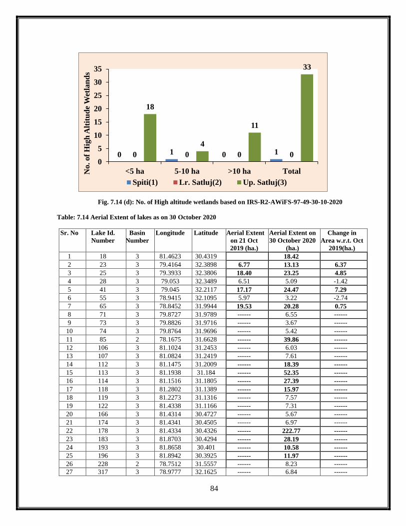
84
Fig. 7.14 (d): No. of High altitude wetlands based on IRS-R2-AWiFS-97-49-30-10-2020
Table: 7.14 Aerial Extent of lakes as on 30 October 2020
Sr. No Lake Id.
Number
Basin
Number
Longitude Latitude Aerial Extent
on 21 Oct
2019 (ha.)
Aerial Extent on
30 October 2020
(ha.)
Change in
Area w.r.t. Oct
2019(ha.)
1 18 3 81.4623 30.4319 18.42
2 23 3 79.4164 32.3898 6.77 13.13 6.37
3 25 3 79.3933 32.3806 18.40 23.25 4.85
4 28 3 79.053 32.3489 6.51 5.09 -1.42
5 41 3 79.045 32.2117 17.17 24.47 7.29
6 55 3 78.9415 32.1095 5.97 3.22 -2.74
7 65 3 78.8452 31.9944 19.53 20.28 0.75
8 71 3 79.8727 31.9789 ------ 6.55 ------
9 73 3 79.8826 31.9716 ------ 3.67 ------
10 74 3 79.8764 31.9696 ------ 5.42 ------
11 85 2 78.1675 31.6628 ------ 39.86 ------
12 106 3 81.1024 31.2453 ------ 6.03 ------
13 107 3 81.0824 31.2419 ------ 7.61 ------
14 112 3 81.1475 31.2009 ------ 18.39 ------
15 113 3 81.1938 31.184 ------ 52.35 ------
16 114 3 81.1516 31.1805 ------ 27.39 ------
17 118 3 81.2802 31.1389 ------ 15.97 ------
18 119 3 81.2273 31.1316 ------ 7.57 ------
19 122 3 81.4338 31.1166 ------ 7.31 ------
20 166 3 81.4314 30.4727 ------ 5.67 ------
21 174 3 81.4341 30.4505 ------ 6.97 ------
22 178 3 81.4334 30.4326 ------ 222.77 ------
23 183 3 81.8703 30.4294 ------ 28.19 ------
24 193 3 81.8658 30.401 ------ 10.58 ------
25 196 3 81.8942 30.3925 ------ 11.97 ------
26 228 2 78.7512 31.5557 ------ 8.23 ------
27 317 3 78.9777 32.1625 ------ 6.84 ------
0 1 0 10 0 0 0
18
4
11
33
0
5
10
15
20
25
30
35
<5 ha 5-10 ha >10 ha TotalNo. of
Hig
h A
ltit
ud
e W
etla
nd
s
Spiti(1) Lr. Satluj(2) Up. Satluj(3)

85
28 343 3 79.8655 31.9265 27.73 33.00 5.27
29 399 3 79.73 31.0309 10.31 10.27 -0.03
30 408 3 78.9114 32.0201 3.27 5.31 2.04
31 417 3 79.7069 32.2172 2.42 1.79 -0.63
32 423 3 81.16 31.2186 ------ 19.29 ------
33 424 3 81.2252 31.1513 ------ 2.69 ------
34 426 3 81.5025 31.0968 ------ 6.45 ------
35 427 3 81.3833 31.1401 ------ 1.52 ------
36 431 3 81.5023 31.1143 ------ 9.27 ------
37 443 3 81.5142 30.4824 ------ 6.05 ------
38 445 3 81.4834 30.4636 ------ 4.76 ------
39 448 3 81.4575 30.4399 ------ 4.61 ------
40 561 1 78.6887 32.7104 ------ 3.81 ------
41 592 3 79.8049 32.1186 ------ 1.77 ------
42 594 3 79.8274 32.0193 ------ 3.02 ------
43 607 3 81.1326 31.2468 ------ 3.59 ------
44 610 3 78.948 32.0945 ------ 4.79 ------
45 611 3 78.9436 32.0623 3.54 7.07 3.53
46 620 3 79.6839 32.2564 2.74 10.87 8.14
47 621 3 81.9291 30.3869 ------ 80.04 ------
48 622 3 81.0844 31.2743 ------ 2.39 ------
49 625 3 79.8781 31.9577 ------ 3.30 ------
50 632 3 79.3667 31.1459 ------ 6.05 ------
51 634 3 81.1413 31.248 ------ 7.89 ------
52 636 3 81.1088 31.2718 ------ 5.49 ------
53 637 3 81.8407 30.3869 ------ 14.46 ------
54 638 3 81.83 30.3826 ------ 2.76 ------
55 641 3 79.8951 31.9601 ------ 2.46 ------
56 646 3 81.1167 31.2656 ------ 2.42 ------
57 647 3 81.1169 31.262 ------ 5.47 ------
58 648 3 81.1241 31.2391 ------ 2.43 ------
59 649 3 81.1298 31.2458 ------ 2.76 ------
60 649 3 81.1505 31.2521 ------ 3.91 ------
61 651 3 81.4005 31.1299 ------ 6.07 ------
62 652 3 81.4238 31.1394 ------ 5.42 ------
63 655 3 81.5117 31.1018 ------ 6.34 ------
64 663 3 79.341 31.1553 ------ 16.26 ------
65 816 3 79.88 31.9643 ------ 3.31 ------
66 825 3 81.1133 31.2517 ------ 1.83 ------
67 827 3 81.1378 31.1972 ------ 8.40 ------
68 828 3 81.1536 31.2104 ------ 2.12 ------
69 849 3 81.4996 30.4609 ------ 1.81 ------
70 895 3 81.8425 30.3814 ------ 3.80 ------
71 1004 3 81.5144 30.4788 ------ 2.24 ------
72 1030 3 81.1788 31.1905 ------ 2.03 ------
73 1038 3 79.8023 32.1278 ------ 1.71 ------
74 1052 3 80.5982 30.547 ------ 11.06 ------
75 1053 3 80.5927 30.478 ------ 15.13 ------
76 1133 3 81.8671 30.4214 ------ 17.81 ------
77 1142 3 81.7743 30.4028 ------ 1.23 ------
78 1149 3 81.7692 30.3987 ------ 4.33 ------
79 1519 3 81.2157 31.1661 ------ 3.04 ------
80 1524 3 81.0326 31.2945 ------ 2.76 ------
86
81 1525 3 81.0326 31.2854 ------ 25.27 ------
82 1538 3 79.5697 31.0953 ------ 3.47 ------
83 1545 3 80.404 30.5991 ------ 4.59 ------
84 1546 3 79.5144 31.1338 ------ 7.27 ------
85 8011 3 80.5689 30.479 ------ 5.55 ------
86 8020 3 80.5325 30.5133 ------ 3.65 ------
87 8021 3 80.5343 30.5163 ------ 1.20 ------
88 8025 3 80.6213 30.5404 ------ 29.10 ------
89 8026 3 80.451 30.555 ------ 5.86 ------
90 8027 3 80.4729 30.5548 ------ 9.73 ------
91 8029 3 80.6317 30.5558 ------ 2.14 ------
92 8031 3 80.2927 30.608 ------ 14.03 ------
93 8037 3 79.4118 31.0626 ------ 4.17 ------
94 8038 3 79.4146 31.0623 ------ 5.76 ------
95 8047 3 79.4917 31.1323 ------ 5.80 ------
96 8057 3 81.2584 31.1182 ------ 8.15 ------
97 8064 3 81.4137 31.1358 ------ 3.08 ------
98 8065 3 81.2216 31.1496 ------ 12.09 ------
99 8079 3 81.1368 31.2359 ------ 9.89 ------
100 8107 3 79.8996 31.9657 ------ 5.98 ------
101 8117 1 78.7584 32.0435 ------ 3.27 ------
102 8127 1 78.8075 32.0599 ------ 21.72 ------
103 8129 3 79.8039 32.0802 ------ 3.42 ------
104 8149 3 79.6374 32.3168 ------ 4.59 ------
105 8154 3 79.4067 32.3524 ------ 5.17 ------
106 8155 3 79.595 32.355 ------ 5.22 ------
107 8157 3 79.5349 32.3727 ------ 2.72 ------
108 8170 2 78.4214 31.4054 ------ 3.02 ------
109 8173 2 78.3691 31.4602 ------ 1.58 ------
110 8177 2 78.3819 31.5251 ------ 9.03 ------
111 8182 2 77.9016 31.7226 ------ 2.40 ------
112 8188 3 79.7982 32.1297 ------ 3.28 ------
113 8249 3 81.8525 30.3992 ------ 32.09 ------
114 8281 2 78.027 31.4107 ------ 5.83 ------
115 8286 3 80.5563 31.3948 ------ 3.28 ------
116 8329 3 81.7189 30.4465 ------ 1.21 ------
117 8330 3 81.4304 30.4668 ------ 3.75 ------
118 8331 3 81.4338 30.4665 ------ 8.78 ------
119 8332 3 81.4775 30.4892 ------ 1.25 ------
120 8333 3 81.468 30.5008 ------ 2.39 ------
121 8334 3 81.1052 30.9264 ------ 2.40 ------
122 8335 3 79.3588 31.1525 ------ 2.21 ------
123 8336 3 81.2129 31.0983 ------ 13.66 ------
124 8337 3 81.066 31.184 ------ 18.88 ------
125 8338 3 81.1654 31.1842 ------ 4.67 ------
126 8339 3 81.0194 31.2093 ------ 3.73 ------
127 8340 3 81.1303 31.2328 ------ 14.81 ------
128 8341 3 81.1458 31.2584 ------ 2.73 ------
129 8342 3 81.1323 31.2622 ------ 13.15 ------
130 8343 3 81.0746 31.2718 ------ 19.25 ------
131 8344 2 77.9475 31.7036 ------ 2.35 ------
132 8345 3 79.6614 32.298 ------ 17.54 ------
133 13801 3 80.401 30.5539 ------ 34.12 ------

87
134 18701 3 81.8479 30.3885 ------ 4.59 ------
135 18901 3 81.8187 30.392 ------ 16.88 ------
136 187004 3 81.784 30.4023 ------ 5.16 ------
137 1001HWL 3 81.749 30.4492 ------ 1.73 ------
138 1013HWL 3 81.5239 30.7784 ------ 1.54 ------
139 1022RS 3 81.1091 30.926 ------ 1.82 ------
140 1093HWL 3 82.1318 30.6401 ------ 5861.89 ------
141 1124HWL 3 81.8207 30.4396 ------ 4.90 ------
142 1136HWL 3 81.777 30.4129 ------ 7.29 ------
143 138HWL 3 81.2324 30.6902 ------ 25755.60 ------
144 142HWL 3 81.5659 30.8036 ------ 326.92 ------
145 145HWL 3 81.4708 30.687 ------ 41859.70 ------
146 1474HWL 3 81.565 30.769 ------ 1.21 ------
147 148HWL 3 81.5826 30.7635 ------ 105.90 ------
148 15002HWL 3 82.0712 30.5984 ------ 9.51 ------
149 15003HWL 3 82.0825 30.5939 ------ 12.36 ------
150 173HWL 3 81.6762 30.4499 ------ 11.35 ------
151 179HWL 3 81.7143 30.431 ------ 23.31 ------
152 184HWL 3 81.7224 30.4227 ------ 19.39 ------
153 185001HWL 3 81.7464 30.4108 ------ 8.26 ------
154 202HWL 3 80.5415 31.4005 ------ 29.45 ------
155 205HWL 3 81.5648 30.79 ------ 4.88 ------
156 206HWL 3 81.5681 30.7918 ------ 1.23 ------
157 210HWL 3 81.5534 30.7733 ------ 54.12 ------
158 211HWL 3 81.7012 30.5169 ------ 9.14 ------
159 32HWL 1 78.7208 32.3295 6.26 7.35 1.09
160 385HWL 3 81.5375 30.7801 ------ 4.31 ------
161 436HWL 3 81.6941 30.4992 ------ 1.85 ------
162 438HWL 3 81.7415 30.4036 ------ 3.47 ------
163 439HWL 3 81.7227 30.4296 ------ 2.76 ------
164 440HWL 3 81.7209 30.4495 ------ 4.38 ------
165 455RS 3 80.7828 31.1087 ------ 12.67 ------
166 608RS 3 81.0943 30.9278 ------ 23.53 ------
167 616RS 3 81.1162 30.9264 ------ 16.92 ------
168 677HWL 3 81.7063 30.5037 ------ 2.17 ------
169 688HWL 3 81.8197 30.4099 ------ 4.82 ------
170 840HWL 3 81.7929 30.398 ------ 2.80 ------
171 842HWL 3 81.7635 30.4219 ------ 3.41 ------
172 865HWL 3 81.7747 30.4009 ------ 1.83 ------ HWL-Highland Wetland
RS-River Section
8.0: Inventory of lakes based on LISS III satellite data for 2020:
IRS LISS-III Resourcesat 2 satellite data having spatial resolution of 23.5mts have
been used for generating a more detailed inventory of glacial lakes/high altitude wetlands in Satluj
catchment and was compared with that of the information generated for the year 2019 using LISS-
III satellite data. The inventory based on LISS-III satellite data is more detailed one as this sensor
has the better spatial resolution (23.5mt) than AWIFS (56mts) and thus gives more information

88
about the terrain. Satellite data for the month of July to October 2020 was browsed and good quality
cloud free data was selected for the mapping purpose as during this period the glacier surfaces are
completely exposed and liable to give more detailed information about the glacier regions. During
the year 2020 , good quality data could not obtained by virtue of the area under the impact of snow
cover for a longer period and the thereafter the cloud cover during the monsoon season. The study
area is covered by LISS-III coverage mainly by seven number of scenes within 96-48, 97-48, 97-
49, 98-49, 99-49 and 100-49 path and rows and have been analyzed using visual interpretation
techniques and the same methodology adopted for the AWIFS satellite data. As far as data
availability is concerned, an attempt has been made to get the best quality data products during
August/September, but still in parts the impacts of cloud cover or snow could be seen. The study
area covered by path –row 96-48 of 7 Sept 2020 and 14 Sept 2020 (Fig.8.4a) shows that the area
is not fully exposed but is under the impact of partial cloud cover as a result of which not much
information could be derived. Likewise under path row 96-49 no data could be obtained resulting
to have data gap in the information during 2020 falling within 96-49 path -row. The study area
covered under path row 97-48 for the period 12 Sept 2020 (Fig 8.5a) and 97-49 for 12 Sept.2020
(Fig 8.6a) the coverage is almost clear and maximum information could be derived. On the extreme
eastern part of the study area which is covered by 98-48 is missing resulting to have data gap in
2020. Likewise the area covered under path row 99-49 for 5 Sept.2020 (Fig.8.7a) and 100-49
covered by 5 Sept.2020 (Fig 8.8a) does also show the partial cloud cover impacts, but it has become
possible to extract information to some extent. Thus, based on the above LISS III satellite data
products for the above mentioned path and rows, a total of 993 lakes could be mapped in the entire
catchment (197 in Spiti basin i.e sub basin 1, 89 in Lower Satluj basin i.e sub basin 2 and 707 in
Upper Satluj i.e sub basin 3) 197 in comparison to 562 lakes delineated in 2019 and a total of 769
lakes as mapped in 2018. The difference in the total number of lakes is mainly due to the non-
availability of good quality snow free and cloud free data coverage.
Further detailed analysis for 2020 based on different path and rows, it is found that the
area being covered under the path-row 96-48, a total of 362 lakes were delineated out of which 5
lakes have been classified as high-altitude wetland that too from the Spiti basin in comparison to
153 (2019) lakes and 275 lakes (2018) respectively. Further analysis reveals that out of 362 lakes
majority of the lakes (192) as small one with area less than 5ha out of which 177 lakes forms part
of the Spiti sub basin, 48 from the Lower Satluj and 103 from the Upper Satluj sub basin
respectively. Likewise 21 lakes are within the aerial range of 5-10ha, out of which 10 lakes are

89
from Spiti, 1 lake from the Lower Satluj and 10 from the Upper Satluj sub basin, whereas 8 lakes
are the big one having area more than 10ha comprising 05 from the Spiti, and 03 from the Upper
Satluj sub basin respectively (Fig.8.4b). Further analysis based on their classification reveals that
out of 362 lakes, only 5 lakes are the high altitude wetland that too from the Spiti sub basin, 2 are
with area less than 5 ha and 3 having area more than 10ha (Fig.8.4c). Likewise, from the satellite
data covering path-row 96-49, no information could be derived due to non-availability of good
quality data.
Based on the satellite data interpretation covering path row 97-48, a total of 115 lakes
could be mapped comprising 4 lakes from Spiti basin, 1 from Lower Satluj basin and 109 from
Upper Satluj basin (Fig.8.5b) in comparison to 59 lakes of 2019 and 52(2018) respectively. Further
analysis of 115 lakes suggest that 107 lakes are of area less than 5ha, falling 4 lakes in Spiti, 1 in
Lower Satluj and 102 from Upper Satluj basin. Besides this, 05 lakes are within the aerial range of
5-10ha and 02 lakes are having area more than 10ha and all these falls in the upper Satluj sub basin
(Fig. 8.5b) and only one lake is high altitude wetland that too from the Spit sub basin and with area
less than 5 ha (Fig. 8.5c) . Likewise from the data interpretation covering 97-49, a total of 93 lakes
could be mapped forming 39 from Lower Satluj and 54 from Upper Satluj basin in comparison to
27 lakes (2019) and 20 lakes (2018). Out of these 93 lakes mapped in 2020, 88 lakes are the small
one with area less than 5ha comprising 38 from Lower Satluj and 50 from Upper Satluj basin
respectively. Likewise 05 falling within the aerial range of 5-10 ha, 1 from Lower Satluj and 4
from Upper Satluj basin, there was no lake with area more than 10ha could be mapped (Fig.8.6b).
Further 3 high altitude wetland could also be mapped comprising 2 with area <5ha and 1 with are
area >0ha and all falling in Upper Satluj basin (Fig.8.6c)
Area covered under path row 99-49 and 100-49 mainly falls in Upper Satluj sub basin
and based on interpretation in 99-49, a total of 256 (2020) against of 238 (2019) lakes have been
mapped forming part of the Upper Satluj basin. Further, out of which 213 are the small one with
area less than 5ha against of 185 lakes (2019) indicating an increase of about 15% (28) lakes in
2020 in comparison to 2019. Likewise22 lakes mapped in 2020 are within areal range of 5-10ha
indicating a reduction of about 21% (6 lakes) in comparison to 28 lakes as mapped in 2019 and21
lakes are such which have the area more than 10ha indicating a reduction of about 16% (4 lakes)
in comparison to 25 lakes as mapped in 2019(25%) (Fig. 8.7b). Further 51 lakes have been
classified s high altitude wetlands in 2020 from 99-49 path-row out of which 32 are small one with
area less than 5ha against 45as mapped in 2019 within this areal range, 7 high altitude wetlands

90
are within the real range of 5-10ha in comparison to 4 that of 2019 and 21 are the big one with area
more than 10ha in comparison to 11(2019) (Fig. 8.7c). Likewise, in 100-49 a total of 92 lakes have
been mapped in comparison to 37 lakes of 2019 and comprise of 85 lakes with area less than 5ha,
2 between 5-10ha and 5 having area more than 10ha. Likewise 21 lakes have been mapped as high
altitude wetlands in comparison to 8 as mapped in 2019 and comprises of 17 with area less than
5ha, 1 with area between 5-10ha and 3 having area more than 10ha (Fig. 8.8b and Fig.8.8c) .
Based on the further analysis of LISS III satellite data, it has been found that total
number of lakes in Upper Satluj basin varies from 450 (2017) to 495 (2018) to 437 (2019) to 707
(2020) thus by indicating an increase of 250 lakes w.r.t. 2017 and 212 lakes w.r.t. 2018 and 270
w.r.t. 2019 data or in other words we can say that the increase is of the order of about 57%, 42%,
and about 61% with reference to 2017, 2018 and 2019 database is observed respectively (Fig.8.3)
and this variation is mainly due the non-availability of difference in the good quality snow free and
cloud free data coverage and area of interest during 2017, 2018 2019 based on LISS III satellite
data. Likewise in Lower Satluj basin, total number of lakes mapped in 2019 varies from 102 (2017)
to 98 (2018) to 52 (2019) to 89 (2020) thus by indicating a decrease of about 11% (12 lakes), 9%
(9 lakes) and enhancement by about 71% (37 lakes) with reference to 2017, 2018 and 2019
(Fig.8.2) and this large variation is again mainly due to the non-availability of good quality satellite
data. Similarly in Spiti basin, the variation in the total number of lakes is from 90 (2017) to 176
(2018) to 73 (2019) to 197 (2020) thus by indicating an increase of about 118% (107 lakes) w.r.t.
2017, 11% (21 lakes) w.r.t to 2017 &18 and 169% (124 lakes) w.r.t. to 2019 respectively (Fig.8.1)
and the difference is mainly due to the data quality which is either due to snow cover or cloud
cover impacts as a result of which there is always a variation in the total number of lakes delineated
between. Further analysis of these 993 lakes mapped in the entire Satluj basin using LISS-III
satellite data in 2020 reveals that total number of lakes with area more than 10 ha varies from 52
(2017) to 49 (2018) to 51 (2019) to 52 (2020). Likewise based on the analysis for 2020 using LISS-
III products, the total number of lakes with area less than 5ha are 878 (2020) in comparison to 458
(2019) in comparison to 663 (2018) indicating an enhancement of 420 lakes in comparison to 2019
and 215 lakes as that of 2018. Likewise the lakes within the aerial range of 5-10 ha shows an
increase of 2 lakes w.r.t 2019 (61), 6 lakes in comparison to 2018(57) respectively. The large
variation in the number of lakes with reference to the preceding years is mainly due to the non-
availability of cloud free satellite data covering the entire catchment. Hence these small
dimensional lakes/water bodies can be future vulnerable sites and thus needs proper monitoring

91
using higher resolution satellite data for better management. The lakes with 1682 RS to 1687RS
are the lakes formed along the small river section due to debris coverer along the river course on
the left bank of Spiti River are the vulnerable locations formed due to temporary damming along
the stream course and thus needs monitoring.
Fig. 8.1:No. of Lakes in Spiti (1) basin based on LISS III data
Fig. 8.2: No. of Lakes in Lw. Satluj (2) basin based on LISS III data
82
6 2
90
160
10 6
176
65
6 2
73
182
10 5
197
0
50
100
150
200
250
<5 ha 5-10 ha >10 ha Total
No
. o
f L
ak
es
No. of Lakes in Spiti (1) basin based on LISS III data
2017 2018 2019 2020
96
4 2
10294
3 1
98
49
2 1
52
87
2 0
89
0
20
40
60
80
100
120
<5 ha 5-10 ha >10 ha Total
No
. o
f L
ak
es
No. of Lakes in Lw. Satluj (2) basin based on LISS III
data
2017 2018 2019 2020

92
Fig. 8.3:No. of Lakes in Up. Satluj (3) basin based on LISS III data
Table 8.1: Distribution of Lakes as per satellite data interpretation for the year 2020 using LISS-III sensor
Sr.No. Lake Id.
Number
Basin
Number
Longitude Latitude Aerial Extent
on 20 August
2019 (ha.)
Aerial Extent
on 16 Oct
2020 (ha.)
Change in
Area w.r.t.
Oct 2019(ha.)
IRS RS2 LISS III 96-48
1 4 1 78.69650 32.75000 ------ 0.24 ------
2 37 1 78.68850 32.70740 5.30 4.10 -1.19
3 38 1 78.70840 32.71060 2.56 3.23 0.67
4 56 3 78.94120 32.10730 ------ 8.57 ------
5 57 3 78.93250 32.10710 ------ 9.53 ------
6 58 3 79.00210 32.33850 ------ 7.31 ------
7 59 3 79.00170 32.32870 1.68 2.38 0.70
8 61 1 78.97300 32.32530 7.18 6.21 -0.97
9 64 1 78.97760 32.25820 ------ 2.26 ------
10 65 1 78.97900 32.31950 7.68 8.14 0.46
11 67 3 79.04270 32.20930 25.68 26.09 1.40
13 68 3 79.02600 32.22420 6.30 6.98 0.68
14 69 1 78.86330 32.07040 2.54 0.96 -1.58
15 70 3 79.00960 32.21480 1.80 2.16 0.36
16 71 3 79.00570 32.22450 2.60 2.18 -0.42
17 72 1 78.98310 32.22580 2.28 2.00 -0.28
18 73 3 78.97540 32.20640 ------ 0.40 ------
19 74 1 78.97250 32.19070 4.76 4.19 -0.56
20 75 1 78.96030 32.18510 3.30 2.51 -0.79
21 76 3 78.97250 32.17050 1.59 1.42 -0.17
22 77 3 78.97760 32.16060 9.77 8.77 -1.00
23 78 1 78.75370 32.04520 ------ 0.17 ------
24 79 3 79.01920 32.20820 2.54 2.56 0.02
25 80 1 78.91860 32.14160 2.58 3.08 0.50
26 81 1 78.92670 32.12920 1.04 0.79 -0.26
27 82 1 78.94260 32.12230 4.47 3.83 -0.64
28 83 1 78.75300 32.04290 0.47 0.23 -0.25
353
49 48
450409
44 42
495
344
45 48
437
609
51 47
707
<5 ha 5-10 ha >10 ha Total
No
. o
f L
ak
es
No. of Lakes in Up. Satluj (3) basin based on LISS III
data
2017 2018 2019 2020

93
29 84 3 78.95070 32.11950 1.37 1.37 0.00
30 85 3 78.94710 32.10660 1.08 0.86 -0.22
31 86 3 78.94740 32.10460 1.10 0.23 -1.88
32 88 3 78.94690 32.09240 5.83 3.73 -2.10
33 89 3 78.92930 32.09230 0.80 0.73 -0.07
34 93 3 78.94250 32.06010 6.92 7.26 0.34
35 94 3 78.91060 32.01780 6.39 6.23 -0.16
36 95 1 78.87640 32.01990 2.21 2.91 0.70
37 95 3 78.90190 32.00420 2.21 1.83 -0.38
38 97 1 78.87470 32.01700 5.73 8.12 2.40
39 99 1 78.84430 32.02920 14.72 17.82 3.11
41 101 1 78.84480 31.99240 21.10 22.79 1.68
42 103 3 78.86690 31.95730 3.85 4.49 0.64
43 105 3 78.83610 31.97820 1.37 1.14 -0.23
44 106 3 78.83680 31.98070 5.63 6.57 0.95
45 112 1 78.68490 31.93370 ------ 1.03 ------
46 119 3 78.82810 31.93110 ------ 0.28 ------
47 120 1 78.69290 31.93060 ------ 0.23 ------
48 122 3 78.78350 31.91860 16.86 17.77 0.91
49 124 1 78.69430 31.92990 ------ 0.22 ------
50 126 1 78.69100 31.92890 ------ 0.29 ------
51 127 1 78.69540 31.92890 ------ 0.46 ------
52 131 1 78.70230 31.91750 0.71 0.69 -0.02
53 132 3 78.80160 31.90820 ------ 0.96 ------
54 133 3 78.78460 31.90670 ------ 0.23 ------
55 135 3 78.78570 31.90590 ------ 0.46 ------
56 136 3 78.78490 31.90570 ------ 0.12 ------
57 143 3 78.78990 31.88260 ------ 0.74 ------
58 147 3 78.80060 31.87570 ------ 0.92 ------
59 147 3 78.80030 31.87540 ------ 0.70 ------
60 148 3 78.80280 31.87350 ------ 0.34 ------
61 148 3 78.80220 31.87320 ------ 0.40 ------
62 151 1 77.92530 32.12870 ------ 1.89 ------
63 152 1 77.91450 32.13660 2.47 2.23 -0.23
64 153 2 78.15950 31.66180 ------ 0.28 ------
65 162 2 78.42970 31.49500 ------ 0.74 ------
66 165 2 78.42570 31.48960 ------ 0.29 ------
67 166 2 77.95880 31.48110 ------ 1.68 ------
68 405 2 78.42020 31.40330 3.14 2.71 -0.43
69 552 1 78.69820 32.70410 3.90 3.74 -0.16
70 570 3 78.92730 32.06320 0.92 1.36 0.44
71 586 1 78.70160 31.91200 5.56 3.82 -1.74
72 589 1 78.71830 31.90060 1.39 0.87 -0.52
73 801 1 78.89200 32.38780 ------ 1.80 ------
74 810 1 78.83160 32.04360 ------ 2.20 ------
75 811 1 78.80660 32.05840 9.86 8.77 -1.09
76 814 1 78.74450 32.04730 0.90 0.97 0.07
77 816 1 78.74500 32.04590 0.32 0.35 0.03
78 819 1 78.75460 32.04460 0.81 0.86 0.05
79 820 1 78.75610 32.04470 0.66 0.45 -0.21
80 821 1 78.75790 32.04170 1.76 2.23 0.47
81 822 1 78.76140 32.04070 0.65 0.34 -0.31
82 825 1 78.76910 32.04020 0.55 0.35 -0.20

94
83 848 2 78.74090 31.70880 2.23 2.25 0.01
84 854 2 78.60950 31.56420 2.92 2.43 -0.49
85 885 3 79.25330 32.50610 ------ 2.89 ------
86 887 3 79.28750 32.51920 ------ 0.91 ------
87 890 3 79.29150 32.51240 ------ 2.40 ------
88 891 3 79.29770 32.51160 1.21 0.68 -0.53
89 891 2 78.36800 31.45830 1.21 1.09 -0.12
90 998 1 78.70630 32.70710 1.11 1.70 0.59
91 999 1 78.68170 32.70640 1.10 0.74 -0.35
92 1001 1 78.27210 32.36300 ------ 14.21 ------
93 1013 3 79.01700 32.27680 3.06 2.67 -0.40
94 1016 3 79.03410 32.23780 ------ 0.91 ------
95 1022 1 78.70220 32.03570 0.95 0.92 -0.02
96 1033 3 78.78590 31.90490 0.52 0.41 -0.11
97 1035 1 78.70460 31.88680 0.80 1.01 0.21
98 1049 2 78.73470 31.51840 4.14 3.76 -0.38
99 1207 2 78.39900 31.73160 ------ 2.16 ------
100 1210 2 78.60180 31.57450 ------ 0.69 ------
101 1211 2 78.60030 31.57500 ------ 0.40 ------
102 1212 2 78.59980 31.57360 ------ 0.40 ------
103 1213 2 78.73140 31.50760 1.45 1.27 -0.18
104 1219 2 78.43220 31.50310 1.61 1.25 -0.36
105 1220 2 78.43310 31.50620 0.61 0.81 0.20
106 1227 1 78.81610 32.41880 ------ 7.21 ------
107 1230 1 78.87240 32.03180 5.06 4.44 -0.62
108 1231 1 78.75870 32.03910 0.45 0.58 0.12
109 1232 1 78.77950 32.03300 0.97 0.95 -0.02
110 1234 1 78.41560 31.96460 6.45 7.57 1.12
111 1234 3 78.81840 31.92910 1.21 1.21 0.00
112 1237 3 78.82300 31.93020 0.73 0.24 -0.50
113 1238 3 78.82190 31.93300 1.26 0.55 -0.71
114 1241 1 78.69340 31.92750 ------ 0.23 ------
115 1242 2 78.29290 31.77940 ------ 1.60 ------
116 1243 2 78.30530 31.78960 ------ 1.32 ------
117 1244 1 77.94260 32.52440 ------ 3.63 ------
118 1246 1 77.96610 32.53330 ------ 1.07 ------
119 1247 1 78.47330 32.45730 ------ 6.29 ------
120 1248 1 78.48090 32.37600 ------ 0.57 ------
121 1250 1 78.50230 32.34360 ------ 2.80 ------
122 1251 1 78.49520 32.34140 ------ 0.40 ------
123 1252 1 78.41800 32.20430 ------ 4.00 ------
124 1253 1 78.48760 32.14770 ------ 13.27 ------
125 1257 2 78.10360 31.77800 ------ 1.02 ------
126 1258 2 78.10150 31.77750 ------ 1.91 ------
127 1259 3 78.81200 31.96400 3.97 4.43 0.47
128 1260 3 78.86870 31.96940 ------ 9.01 ------
129 1620 2 78.40910 31.43750 ------ 0.92 ------
130 1623 2 78.40970 31.41150 0.64 0.80 0.16
131 1626 2 78.42150 31.39880 0.71 0.69 -0.02
132 1640 2 78.42840 31.49060 1.62 0.86 -0.76
133 1641 2 78.38240 31.52260 ------ 5.61 ------
134 1642 2 78.60100 31.57620 ------ 0.12 ------
135 1647 3 78.79380 31.88020 0.64 0.45 -0.19

95
136 1647 3 78.79350 31.88010 0.64 0.28 -0.35
137 1648 3 78.79370 31.88220 0.96 0.73 -0.23
138 1648 3 78.79350 31.88180 0.96 0.73 -0.23
139 1652 3 78.82150 31.93030 0.45 0.57 0.12
140 1654 3 78.84020 31.91370 22.28 22.03 -0.25
141 1655 1 78.84530 32.01140 ------ 2.46 ------
142 1656 1 78.75180 32.04270 0.76 0.68 -0.08
143 1658 1 78.77820 32.03410 0.45 0.59 0.14
144 1660 1 78.78730 32.03100 0.20 0.23 0.03
145 1661 3 78.90290 32.04330 ------ 1.37 ------
146 1662 3 78.90400 32.05410 ------ 0.86 ------
147 1663 3 78.82010 31.93230 0.47 0.97 0.50
148 1664 1 78.89480 32.06480 ------ 0.46 ------
149 1665 1 78.90570 32.07630 ------ 0.34 ------
150 1666 1 78.88500 32.07200 ------ 2.14 ------
151 1667 1 78.88650 32.07370 ------ 0.28 ------
152 1668 1 78.86390 32.08580 1.64 0.97 -0.67
153 1671 3 79.04430 32.25170 ------ 1.20 ------
154 1672 1 78.89640 32.32510 ------ 0.90 ------
155 1673 1 78.43290 32.18090 ------ 0.81 ------
156 1674 1 78.46180 32.38130 ------ 0.74 ------
157 1676 2 78.07870 31.70200 ------ 0.99 ------
158 1688 1 78.08100 32.61030 ------ 0.40 ------
159 1689 1 77.98950 32.60640 ------ 4.32 ------
160 1692 1 78.70290 32.70730 0.40 0.28 -0.11
161 1693 1 78.70180 32.70720 0.40 0.28 -0.12
162 1694 1 78.70100 32.70500 1.37 1.12 -0.26
163 1695 3 79.11970 32.33390 ------ 0.56 ------
164 1696 3 79.11740 32.34640 ------ 0.45 ------
165 1700 3 79.15250 32.45460 ------ 0.62 ------
166 1701 3 79.18730 32.45160 ------ 2.79 ------
167 1702 3 79.17140 32.49110 ------ 2.45 ------
168 2100 2 78.71700 31.53100 2.38 1.41 -0.97
169 2107 2 78.48880 31.40070 3.19 3.81 0.61
170 2113 3 78.81630 31.93280 2.77 2.15 -0.62
171 2115 3 78.81350 31.93370 0.45 1.27 0.82
172 2117 3 78.82760 31.93020 0.27 0.17 -0.10
173 2118 3 78.82640 31.92990 3.18 0.29 -2.90
174 2118 1 78.36830 32.31430 3.18 1.87 -1.31
175 2119 3 78.82410 31.92940 1.66 0.22 -1.43
176 2120 1 78.22800 32.09020 1.74 2.33 0.60
177 2132 3 79.13070 32.44630 ------ 5.02 ------
178 2133 3 79.13070 32.46280 ------ 3.28 ------
179 2134 3 79.10380 32.35380 ------ 3.18 ------
180 2135 3 79.05130 32.34630 ------ 3.69 ------
181 2136 2 78.79280 31.44930 ------ 6.19 ------
182 5000 1 77.92990 32.57060 ------ 0.98 ------
183 5002 1 77.96520 32.52970 ------ 0.17 ------
184 5005 1 78.07940 32.57030 ------ 0.45 ------
185 5009 1 78.22020 32.41520 ------ 0.81 ------
186 5010 1 78.22150 32.41430 ------ 0.23 ------
187 5015 1 78.30520 32.47470 ------ 0.40 ------
188 5019 1 78.41260 32.17500 ------ 3.90 ------

96
189 5020 2 78.12410 31.73950 ------ 2.79 ------
190 5021 2 78.11680 31.74870 ------ 0.62 ------
191 5023 2 78.11280 31.81070 ------ 0.24 ------
192 5040 1 78.82740 32.42120 ------ 0.28 ------
193 5044 1 78.89280 32.39650 ------ 0.52 ------
194 5045 1 78.90870 32.33410 2.44 1.89 -0.55
195 5045 1 78.90710 32.33270 2.44 0.73 -1.70
196 5047 3 78.99010 32.31520 ------ 0.72 ------
197 5048 3 78.99330 32.31610 0.94 1.03 0.08
198 5049 3 78.99420 32.31690 0.25 0.57 0.31
199 5052 1 78.99130 32.25480 1.83 0.96 -0.87
200 5055 1 78.98310 32.22080 ------ 0.74 ------
201 5056 1 78.98520 32.22180 0.42 0.35 -0.07
202 5057 1 78.98700 32.22060 ------ 0.34 ------
203 5058 3 78.99760 32.22430 1.25 1.08 -0.17
204 5059 3 79.01670 32.20250 ------ 0.40 ------
205 5061 1 78.96850 32.18040 ------ 0.75 ------
206 5063 3 78.96260 32.14940 1.22 1.53 0.32
207 5063 1 78.95490 32.14340 1.22 0.91 -0.31
208 5064 3 78.97020 32.12930 2.78 3.53 0.75
209 5064 3 78.95950 32.13700 2.78 0.46 -2.32
210 5065 1 78.94820 32.13850 ------ 0.40 ------
211 5068 3 78.94750 32.12230 1.41 1.08 -0.33
212 5073 1 78.90700 32.14420 1.27 1.14 -0.13
213 5074 1 78.90810 32.09850 1.17 0.86 -0.31
214 5075 3 78.92590 32.09400 0.45 0.23 -0.22
215 5077 1 78.80250 32.08100 0.31 0.28 -0.03
216 5079 1 78.80610 32.08020 0.35 0.41 0.05
217 5081 1 78.81810 32.07020 1.20 0.69 -0.51
218 5088 1 78.81420 32.03270 ------ 0.35 ------
219 5089 1 78.81600 32.03250 ------ 1.66 ------
220 5090 1 78.84730 32.01090 ------ 0.23 ------
221 5091 1 78.82320 32.01360 ------ 1.23 ------
222 5092 1 78.84920 32.00860 ------ 0.91 ------
223 5093 1 78.85090 32.00810 ------ 0.34 ------
224 5094 1 78.84820 31.99460 ------ 1.73 ------
225 5095 3 78.84370 31.98780 0.33 0.47 0.13
226 5098 3 78.79750 31.97140 ------ 1.31 ------
227 5099 3 78.79540 31.93320 ------ 0.28 ------
228 6000 3 78.78070 31.92900 ------ 6.57 ------
229 6001 3 78.78340 31.92700 ------ 2.09 ------
230 6002 1 78.72410 31.88920 ------ 1.22 ------
231 6003 1 78.69970 31.88920 ------ 0.29 ------
232 6004 1 78.71230 31.89450 0.40 0.28 -0.12
233 6005 1 78.70850 31.90620 ------ 0.46 ------
234 6013 3 78.83760 31.97710 1.19 1.19 0.00
235 6014 3 78.83550 31.98000 0.30 0.29 -0.01
236 6015 1 78.68850 32.75610 0.39 0.91 0.51
237 6016 1 78.69620 32.75460 0.69 0.68 -0.01
238 6017 1 78.69800 32.74970 0.49 1.25 0.76
239 6018 1 78.71830 32.74670 ------ 2.84 ------
240 6019 1 78.68920 32.73030 0.94 0.74 -0.20
241 6020 1 78.69100 32.70760 0.34 0.23 -0.12

97
242 6022 1 78.71100 32.69470 ------ 3.40 ------
243 6023 1 78.71920 32.69730 ------ 1.19 ------
244 6024 1 78.73930 32.70610 ------ 1.93 ------
245 6025 1 78.73880 32.70460 ------ 0.23 ------
246 6026 1 78.73660 32.69940 ------ 0.62 ------
247 6027 1 78.73350 32.69780 ------ 2.29 ------
248 6029 3 79.11710 32.45920 ------ 0.85 ------
249 6034 3 78.79670 31.93300 ------ 0.40 ------
250 6036 1 78.78050 32.03200 0.56 0.88 0.31
251 6037 1 78.83450 32.03620 ------ 0.46 ------
252 6038 1 78.87180 32.10050 ------ 0.35 ------
253 6047 3 78.81120 31.94110 ------ 0.27 ------
254 6049 1 77.76120 32.24250 ------ 1.60 ------
255 6075 3 79.27110 32.52790 ------ 1.42 ------
256 7091 3 78.96970 32.35150 ------ 0.63 ------
257 7092 2 78.38590 31.51570 ------ 1.72 ------
258 7094 3 78.80970 31.95100 ------ 0.46 ------
259 7095 2 78.02090 31.61910 ------ 3.78 ------
260 7096 2 77.75150 31.57020 ------ 0.82 ------
261 7097 2 77.75790 31.60770 ------ 0.35 ------
262 7098 1 78.62800 31.87950 ------ 0.80 ------
263 7099 1 78.88330 32.07270 ------ 0.40 ------
264 8000 1 78.98540 32.29990 ------ 12.66 ------
265 8001 1 78.04160 32.34510 ------ 0.46 ------
266 8002 1 78.06220 32.32370 ------ 0.40 ------
267 8003 1 77.96500 32.16750 ------ 1.54 ------
268 8004 1 77.96220 32.16500 ------ 1.08 ------
269 8005 1 78.52480 32.74670 ------ 7.81 ------
270 8006 1 78.89840 32.35140 ------ 2.33 ------
271 8007 1 78.88080 32.35210 ------ 0.75 ------
272 8008 3 78.92340 31.46740 ------ 1.06 ------
273 8009 1 78.61900 31.85610 ------ 1.02 ------
274 8010 3 79.11870 32.45770 ------ 0.23 ------
275 8011 3 79.11730 32.45820 ------ 0.28 ------
276 8012 3 79.11550 32.45870 ------ 0.29 ------
277 8014 3 78.94340 32.36130 ------ 0.58 ------
278 8015 3 78.96930 32.34480 ------ 0.46 ------
279 8016 3 79.00070 32.35700 ------ 0.47 ------
280 8017 3 78.82600 31.93230 ------ 0.23 ------
281 8018 3 78.81680 31.93180 ------ 0.35 ------
282 8019 3 78.95890 32.35630 ------ 1.04 ------
283 8020 3 78.95610 32.35530 ------ 0.17 ------
284 8021 1 78.85170 32.00750 ------ 0.52 ------
285 8022 1 78.78280 32.05280 ------ 1.32 ------
286 8023 3 78.87420 31.96560 ------ 0.51 ------
287 8024 3 78.93780 32.10410 ------ 0.23 ------
288 8026 3 78.96390 32.14330 ------ 0.34 ------
289 8027 1 78.73050 32.69480 ------ 0.34 ------
290 8028 1 78.70330 32.70590 ------ 0.29 ------
291 8029 1 78.69650 32.72990 ------ 0.40 ------
292 8030 1 78.69570 32.75570 ------ 0.23 ------
293 8031 1 78.45040 32.88700 ------ 7.33 ------
294 8032 1 77.82690 32.52800 ------ 0.68 ------
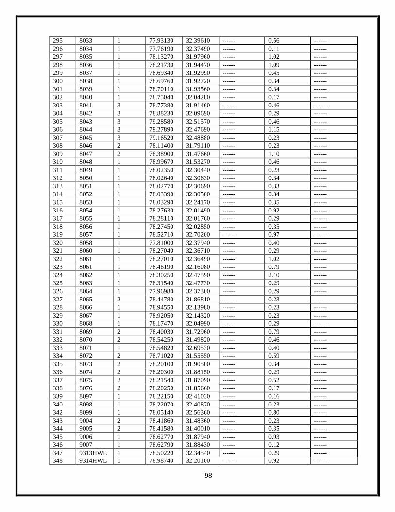
98
295 8033 1 77.93130 32.39610 ------ 0.56 ------
296 8034 1 77.76190 32.37490 ------ 0.11 ------
297 8035 1 78.13270 31.97960 ------ 1.02 ------
298 8036 1 78.21730 31.94470 ------ 1.09 ------
299 8037 1 78.69340 31.92990 ------ 0.45 ------
300 8038 1 78.69760 31.92720 ------ 0.34 ------
301 8039 1 78.70110 31.93560 ------ 0.34 ------
302 8040 1 78.75040 32.04280 ------ 0.17 ------
303 8041 3 78.77380 31.91460 ------ 0.46 ------
304 8042 3 78.88230 32.09690 ------ 0.29 ------
305 8043 3 79.28580 32.51570 ------ 0.46 ------
306 8044 3 79.27890 32.47690 ------ 1.15 ------
307 8045 3 79.16520 32.48880 ------ 0.23 ------
308 8046 2 78.11400 31.79110 ------ 0.23 ------
309 8047 2 78.38900 31.47660 ------ 1.10 ------
310 8048 1 78.99670 31.53270 ------ 0.46 ------
311 8049 1 78.02350 32.30440 ------ 0.23 ------
312 8050 1 78.02640 32.30630 ------ 0.34 ------
313 8051 1 78.02770 32.30690 ------ 0.33 ------
314 8052 1 78.03390 32.30500 ------ 0.34 ------
315 8053 1 78.03290 32.24170 ------ 0.35 ------
316 8054 1 78.27630 32.01490 ------ 0.92 ------
317 8055 1 78.28110 32.01760 ------ 0.29 ------
318 8056 1 78.27450 32.02850 ------ 0.35 ------
319 8057 1 78.52710 32.70200 ------ 0.97 ------
320 8058 1 77.81000 32.37940 ------ 0.40 ------
321 8060 1 78.27040 32.36710 ------ 0.29 ------
322 8061 1 78.27010 32.36490 ------ 1.02 ------
323 8061 1 78.46190 32.16080 ------ 0.79 ------
324 8062 1 78.30250 32.47590 ------ 2.10 ------
325 8063 1 78.31540 32.47730 ------ 0.29 ------
326 8064 1 77.96980 32.37300 ------ 0.29 ------
327 8065 2 78.44780 31.86810 ------ 0.23 ------
328 8066 1 78.94550 32.13980 ------ 0.23 ------
329 8067 1 78.92050 32.14320 ------ 0.23 ------
330 8068 1 78.17470 32.04990 ------ 0.29 ------
331 8069 2 78.40030 31.72960 ------ 0.79 ------
332 8070 2 78.54250 31.49820 ------ 0.46 ------
333 8071 1 78.54820 32.69530 ------ 0.40 ------
334 8072 2 78.71020 31.55550 ------ 0.59 ------
335 8073 2 78.20100 31.90500 ------ 0.34 ------
336 8074 2 78.20300 31.88150 ------ 0.29 ------
337 8075 2 78.21540 31.87090 ------ 0.52 ------
338 8076 2 78.20250 31.85660 ------ 0.17 ------
339 8097 1 78.22150 32.41030 ------ 0.16 ------
340 8098 1 78.22070 32.40870 ------ 0.23 ------
342 8099 1 78.05140 32.56360 ------ 0.80 ------
343 9004 2 78.41860 31.48360 ------ 0.23 ------
344 9005 2 78.41580 31.40010 ------ 0.35 ------
345 9006 1 78.62770 31.87940 ------ 0.93 ------
346 9007 1 78.62790 31.88430 ------ 0.12 ------
347 9313HWL 1 78.50220 32.34540 ------ 0.29 ------
348 9314HWL 1 78.98740 32.20100 ------ 0.92 ------

99
349 9315 1 78.74450 32.04500 ------ 0.40 ------
350 11685RS 1 78.08250 32.42240 ------ 2.95 ------
351 1650SG 1 78.71380 31.89790 0.75 1.08 0.33
352 1682RS 1 78.09280 32.43050 0.40 0.51 0.11
353 1683RS 1 78.08990 32.42750 1.09 0.58 -0.51
354 1684RS 1 78.08860 32.42610 1.96 1.75 -0.20
355 1686RS 1 78.06970 32.40440 1.60 1.09 -0.51
356 1687RS 1 78.06730 32.40180 1.57 1.17 -0.40
357 49HWL 1 78.72380 32.32540 7.43 8.82 1.40
358 8059RS 1 77.99510 32.42020 ------ 3.43 ------
359 8083HWL 3 78.78380 31.93080 ------ 0.34 ------
360 9002HWL 2 78.09570 31.79950 ------ 0.35 ------
361 83(3) 3 78.9471 32.1198 1.51 1.58 -0.08
362 9002 2 78.0957 31.7995 ------ 0.35 ------
Table 8.2: Distribution of Lakes as per satellite data interpretation for the year 2020 using LISS-III sensor
Sr.No. Lake Id.
Number
Basin
Number
Longitude Latitude Aerial
Extent on
12October
2019 (ha.)
Aerial Extent
on 12 Oct
2020 (ha.)
Change in
Area w.r.t.
Oct 2019(ha.)
IRS RS2 LISS III 97-48
1 149 3 78.74100 31.70890 ------ 2.25 ------
2 152 3 78.75050 31.66120 ------ 0.65 ------
3 155 3 78.75130 31.55310 ------ 5.38 ------
4 184 3 78.58250 31.37280 23.32 24.54 1.22
5 198 3 79.81690 32.02070 1.16 0.92 -0.24
6 199 3 79.82550 32.01770 3.26 2.82 -0.44
7 200 3 79.83540 31.98800 3.74 3.03 -0.71
8 201 3 79.84460 31.99190 2.91 4.20 1.29
9 202 3 79.87090 31.97690 8.32 8.70 0.37
10 203 3 79.88090 31.96940 3.44 4.75 1.31
11 204 3 79.87470 31.96780 3.65 4.14 0.49
12 205 3 79.39130 32.37720 ------ 0.65 ------
13 207 3 79.87630 31.95580 3.52 4.06 0.54
14 208 3 79.85540 31.94960 1.51 1.41 -0.10
15 209 3 79.86400 31.92450 33.76 32.42 -1.34
16 210 3 79.88120 31.93190 2.41 2.54 0.12
17 211 3 79.90050 31.92690 0.94 2.50 1.56
18 652 3 79.59260 32.35220 4.99 5.58 0.60
19 665 3 79.88850 31.96720 4.12 4.68 0.56
20 806 3 79.47620 32.42100 1.15 0.73 -0.41
21 894 3 79.41580 32.38920 10.15 9.15 -1.00
22 895 3 79.40440 32.34950 3.62 3.13 -0.48
23 900 3 79.58860 32.35320 1.39 1.31 -0.08
24 1007 3 79.47570 32.41790 0.60 0.92 0.32
25 1008 3 79.47040 32.41740 0.45 0.23 -0.22
26 1014 3 79.68200 32.25360 5.25 5.80 0.54
27 1017 3 79.70440 32.21510 1.92 3.33 1.41
28 1029 3 79.91810 31.93360 1.36 1.55 0.19
29 1728 3 79.50720 32.38210 2.24 1.94 -0.30
30 1731 3 79.79990 32.12510 1.86 3.03 1.17

100
31 1732 3 79.80160 32.12570 2.35 0.29 -2.06
32 1733 3 79.80280 32.11640 1.35 2.36 1.01
33 1734 3 79.80120 32.11220 0.60 1.01 0.41
34 1738 3 79.87820 31.96280 2.40 2.11 -0.29
35 1739 3 79.87330 31.95800 0.79 0.96 0.17
36 2121 3 79.90450 31.91720 1.33 1.08 -0.25
37 2122 3 79.86530 31.96680 0.31 0.23 -0.08
38 2123 3 79.81400 32.02710 0.94 1.26 0.32
39 2124 3 79.79940 32.05890 0.85 1.14 0.29
40 2125 3 79.77770 32.06230 0.24 0.40 0.16
41 2128 3 79.64450 32.28720 0.89 1.43 0.54
42 2129 3 79.58040 32.32550 1.00 0.79 -0.20
43 2130 3 79.57170 32.33120 0.94 1.31 0.38
44 2131 3 79.53210 32.37020 1.85 2.43 0.58
45 2142 3 79.77330 32.11970 ------ 0.22 ------
46 2143 3 79.75040 32.14430 ------ 1.49 ------
47 2144 3 79.76200 32.13360 ------ 0.23 ------
48 2145 3 79.79980 32.10960 ------ 0.52 ------
49 2146 3 79.76850 32.13290 ------ 3.37 ------
50 2147 3 79.79990 32.10630 ------ 1.94 ------
51 2147 3 79.79670 32.10530 ------ 0.57 ------
52 2147 3 79.77210 32.09590 ------ 0.35 ------
53 2150 3 79.80150 32.07800 ------ 4.03 ------
54 2151 3 79.81120 32.03990 ------ 0.34 ------
55 2152 3 79.80950 32.02790 ------ 0.80 ------
56 2153 3 79.87940 31.95140 ------ 0.65 ------
57 6079 3 79.77670 32.11900 0.50 0.68 0.18
58 6083 3 79.81150 32.02920 0.99 2.62 1.63
59 6086 3 79.87280 31.95910 0.30 0.39 0.10
60 6089 3 79.91420 31.92500 0.89 0.91 0.01
61 6090 3 79.87490 31.93970 0.40 0.68 0.28
62 9008 3 79.41680 32.37290 ------ 1.54 ------
63 9009 3 79.39750 32.36950 ------ 0.58 ------
64 9010 3 79.40220 32.34560 ------ 0.68 ------
65 9011 3 79.38150 32.32960 ------ 0.23 ------
66 9012 3 79.37230 32.31730 ------ 0.28 ------
67 9013 3 79.37290 32.33290 ------ 0.22 ------
68 9014 3 79.50680 32.39160 ------ 1.71 ------
69 9015 3 79.52830 32.38940 ------ 0.62 ------
70 9016 3 79.51900 32.37610 ------ 0.97 ------
71 9017 3 79.56170 32.35280 ------ 0.34 ------
72 9018 3 79.65240 32.23490 ------ 1.25 ------
73 9019 3 79.78790 32.17480 ------ 0.51 ------
74 9020 3 79.79560 32.17240 ------ 1.59 ------
75 9021 3 79.79760 32.13420 ------ 1.31 ------
76 9022 3 79.79590 32.12730 ------ 4.38 ------
77 9023 3 79.79300 32.12110 ------ 3.65 ------
78 9024 3 79.78400 32.10630 ------ 0.40 ------
79 9025 3 79.80250 32.12300 ------ 0.23 ------
80 9026 3 79.77210 32.09410 ------ 2.37 ------
81 9027 3 79.81280 32.07430 ------ 0.29 ------
82 9028 3 79.81230 32.05860 ------ 0.74 ------
83 9029 3 79.80170 32.06110 ------ 0.23 ------

101
84 9030 3 79.82660 32.01140 ------ 0.28 ------
85 9031 3 79.82980 32.01690 ------ 0.40 ------
86 9032 3 79.85390 32.00050 ------ 1.07 ------
87 9033 3 79.89760 31.96400 ------ 4.68 ------
88 9034 3 79.89370 31.95840 ------ 3.92 ------
89 9035 3 79.89170 31.95980 ------ 0.57 ------
90 9036 3 79.88960 31.95510 ------ 0.46 ------
91 9037 3 79.88100 31.96550 ------ 0.46 ------
92 9038 3 79.88890 31.93470 ------ 1.03 ------
93 9039 3 79.92580 31.93980 ------ 1.08 ------
94 9040 3 79.08410 31.61860 ------ 0.34 ------
95 9041 3 78.48100 31.41360 ------ 0.86 ------
96 9042 3 78.74170 31.67840 ------ 0.17 ------
97 9043 3 78.73760 31.67540 ------ 0.23 ------
98 9044 3 79.33000 32.55330 ------ 2.04 ------
99 9045 3 79.31830 32.55330 ------ 0.50 ------
100 9046 3 79.32970 32.55960 ------ 2.67 ------
101 9047 3 79.36350 32.52450 ------ 0.56 ------
102 9048 3 78.58150 31.37460 ------ 0.63 ------
103 9049 3 78.60600 31.38780 ------ 0.23 ------
104 9050 1 78.94220 32.36090 ------ 0.46 ------
105 9052 2 78.74400 31.73300 ------ 2.12 ------
106 9053 3 79.75200 32.14350 ------ 0.23 ------
107 9054 3 79.80090 32.11080 ------ 0.23 ------
108 9055 1 78.88270 32.39820 ------ 0.52 ------
109 9056 3 79.39270 32.35130 ------ 0.29 ------
110 9057 3 79.82100 32.01600 ------ 1.16 ------
111 9058 1 78.89100 32.39620 ------ 0.75 ------
112 9059 3 79.91180 31.92450 ------ 0.35 ------
113 9060 3 79.91340 31.92310 ------ 0.28 ------
114 9051HWL 1 78.87900 32.41280 ------ 2.44 ------
115 2148 3 79.7721 32.0959 ------ 0.35 ------
Table 8.3: Distribution of Lakes as per satellite data interpretation forthe year 2020 using LISS-III sensor
Sr.No. Lake Id.
Number
Basin
Number
Longitude Latitude Aerial
Extent on
12 October
2019 (ha.)
Aerial Extent
on 12 Oct
2020 (ha.)
Change in
Area w.r.t.
Oct 2019(ha.)
IRS RS2 LISS III 97-49
1 156 2 78.73620 31.54230 ------ 1.06 ------
2 183 2 78.74440 31.37430 ------ 0.62 ------
3 186 2 78.72260 31.36640 ------ 0.41 ------
4 188 2 78.58170 31.36500 ------ 0.46 ------
5 189 2 78.72400 31.36250 ------ 1.44 ------
6 192 2 78.73370 31.35840 ------ 1.85 ------
7 193 2 78.66830 31.35940 ------ 0.29 ------
8 194 2 78.66550 31.35390 ------ 0.35 ------
9 195 2 78.73100 31.34990 ------ 0.23 ------
10 196 2 78.71750 31.33940 ------ 2.19 ------
11 1066 3 79.51330 31.13160 5.31 5.51 0.20
12 1290 3 79.31890 31.15440 0.81 0.46 -0.35

102
13 1291 3 79.34150 31.15320 3.98 3.60 -0.38
14 1292 3 79.35750 31.15030 1.52 1.16 -0.36
15 1293 3 79.36180 31.14970 0.41 0.34 -0.07
16 1294 3 79.36580 31.14360 4.44 4.13 -0.31
17 1295 3 79.41060 31.06050 3.99 3.99 0.00
18 1296 3 79.41420 31.05990 0.98 6.60 5.62
19 1297 3 79.43770 31.11470 0.37 0.58 0.21
20 1297 3 79.41560 31.06190 0.37 0.46 0.09
21 1301 3 79.43660 31.11160 0.45 1.36 0.90
22 1538 3 79.56900 31.09260 ------ 2.73 ------
23 1643 2 78.78440 31.45660 ------ 1.34 ------
24 2136 2 78.79360 31.44970 7.41 7.96 0.55
25 2141 3 78.79620 31.36950 1.50 1.96 0.46
26 6043 3 79.75360 31.03990 ------ 5.90 ------
27 6092 3 79.49130 31.13110 1.26 1.50 0.24
28 6093 3 79.49060 31.09750 1.62 3.66 2.04
29 7050 3 78.77090 31.36090 ------ 0.64 ------
30 7051 3 78.75990 31.32210 ------ 1.26 ------
31 7091 3 79.60780 31.03110 1.40 1.50 0.10
32 7094 3 79.65180 31.07210 0.91 1.69 0.78
33 7095 3 79.65480 31.07390 0.46 0.99 0.53
34 7096 3 79.72950 31.02840 7.82 6.63 -1.19
35 9061 3 79.81610 31.02600 ------ 1.15 ------
36 9062 3 79.64890 31.07720 ------ 0.83 ------
37 9063 3 79.37960 31.15960 ------ 0.52 ------
38 9064 2 78.58290 31.36090 ------ 0.81 ------
39 9065 2 78.57800 31.37040 ------ 0.29 ------
40 9066 2 78.58160 31.36920 ------ 0.11 ------
41 9067 2 78.71760 31.33620 ------ 0.52 ------
42 9068 2 78.71710 31.33850 ------ 0.24 ------
43 9069 2 78.73330 31.36140 ------ 0.23 ------
44 9070 3 78.79300 31.31260 ------ 0.35 ------
45 9071 3 78.87800 31.30560 ------ 1.81 ------
46 9072 3 78.88190 31.30440 ------ 0.23 ------
47 9073 3 78.88940 31.29520 ------ 0.35 ------
48 9074 3 79.57580 31.30750 ------ 0.23 ------
49 9075 3 79.61830 31.32950 ------ 0.52 ------
50 9076 3 79.61530 31.33030 ------ 0.40 ------
51 9077 3 79.90890 31.26780 ------ 1.04 ------
52 9078 3 79.91170 31.30800 ------ 0.58 ------
53 9079 3 78.98660 31.37670 ------ 0.46 ------
54 9080 3 79.43510 31.11390 ------ 0.18 ------
55 9081 3 79.66340 31.08480 ------ 0.28 ------
56 9082 3 78.94600 31.66570 ------ 1.51 ------
57 9083 2 78.60030 31.57240 ------ 0.61 ------
58 9084 2 78.63440 31.51770 ------ 0.64 ------
59 9085 2 78.73910 31.54560 ------ 0.16 ------
60 9086 2 78.75230 31.55680 ------ 0.46 ------
61 9087 3 79.77760 31.00280 ------ 0.41 ------
62 9088 3 79.77080 31.00940 ------ 0.22 ------
63 9089 3 79.77080 31.01070 ------ 0.23 ------
64 9090 3 79.79320 31.06140 ------ 0.85 ------
65 9091 3 79.82110 31.05840 ------ 0.12 ------

103
66 9092 3 79.82220 30.99560 ------ 0.49 ------
67 9093 2 78.68160 31.34640 ------ 0.12 ------
68 9094 2 78.68220 31.34930 ------ 0.17 ------
69 9095 2 78.68060 31.34740 ------ 0.18 ------
70 9096 2 78.67870 31.36430 ------ 0.23 ------
71 9097 2 78.68470 31.36720 ------ 0.23 ------
72 9098 2 78.68500 31.36620 ------ 0.23 ------
73 9099 2 78.68560 31.36420 ------ 0.53 ------
74 9100 2 78.68290 31.36860 ------ 0.11 ------
75 9101 2 78.67960 31.36140 ------ 0.92 ------
76 9102 2 78.66360 31.35560 ------ 0.18 ------
77 9103 2 78.66410 31.35770 ------ 0.17 ------
78 9104 3 79.76720 30.99780 ------ 1.50 ------
79 9105 3 78.87600 31.30780 ------ 0.29 ------
80 9106 3 78.91590 31.34620 ------ 0.29 ------
81 9107 3 79.51090 31.19720 ------ 0.77 ------
82 9108 2 78.73820 31.54450 ------ 0.75 ------
83 9109 3 79.81450 31.03300 ------ 0.23 ------
84 9110 3 79.82100 30.99380 ------ 0.23 ------
85 9111 3 79.56240 31.09500 ------ 0.52 ------
86 9112 2 78.67750 31.35460 ------ 0.23 ------
87 9113 2 78.66540 31.36110 ------ 0.29 ------
88 9114 2 78.66580 31.35950 ------ 0.46 ------
89 9115 2 78.66540 31.36020 ------ 0.17 ------
90 9116 2 78.66550 31.35650 ------ 0.17 ------
91 9117 3 79.51470 31.10420 ------ 0.65 ------
92 9118 3 79.51610 31.10470 ------ 0.58 ------
93 1063HWL 3 79.59910 31.30470 40.03 37.97 -3.05
94 1743HWL 3 79.30640 31.23280 4.06 4.09 0.03
95 6091HWL 3 79.30180 31.23990 0.66 0.35 -0.31
96 9119SG 3 79.51260 31.08870 ------ 3.15 ------
Table 8.4: Distribution of Lakes as per satellite data interpretation for the year 2020 using LISS-III sensor
Sr.No. Lake Id.
Number
Basin
Number
Longitude Latitude Aerial Extent
on 22 Oct 2019
(ha.)
Aerial Extent
on 12 Oct 2020
(ha.)
Change in
Area w.r.t.
Oct 2019(ha.)
IRS RS2 LISS III 99-49
1 166 3 81.42910 30.47150 6.05 5.36 -0.69
2 173 3 81.67510 30.44770 7.50 8.98 1.48
3 174 3 81.43240 30.44880 8.92 8.37 -0.55
4 178 3 81.43240 30.43060 201.14 203.61 2.47
5 423 3 81.15940 31.21750 ------ 6.41 ------
6 424 3 81.16620 31.20860 ------ 0.23 ------
7 983 3 81.39240 30.45410 2.89 4.20 1.31
8 1126 3 81.73990 30.42890 ------ 1.19 ------
9 1137 3 81.81920 30.40840 8.57 7.55 -1.02
10 1142 3 81.77320 30.40350 0.51 0.97 0.45
11 1143 3 81.85280 30.40280 0.75 0.63 -0.12
12 1144 3 81.78300 30.40060 5.23 6.59 1.37
13 1145 3 81.77380 30.40120 1.17 1.15 -0.02
14 1146 3 81.86540 30.39900 10.60 9.80 -0.80

104
15 1147 3 81.77390 30.39910 3.12 2.93 -0.18
16 1148 3 81.77660 30.39840 0.60 0.92 0.32
17 1149 3 81.76810 30.39680 5.42 6.32 0.90
18 1150 3 81.79140 30.39660 4.02 3.68 -0.34
19 1151 3 81.78390 30.39510 2.18 1.73 -0.45
20 1152 3 81.77340 30.39500 1.27 0.92 -0.36
21 1154 3 81.79470 30.39240 0.82 0.75 -0.07
22 1155 3 81.81770 30.39040 14.27 15.04 0.77
23 1157 3 81.83740 30.39150 2.34 2.91 0.57
24 1158 3 81.80260 30.39110 4.12 3.68 -0.44
25 1159 3 81.81360 30.39150 0.71 0.58 -0.14
26 1162 3 81.84750 30.38850 0.30 0.35 0.04
27 1163 3 81.84350 30.38800 0.46 0.23 -0.23
28 1164 3 81.83980 30.38490 16.08 13.92 -2.16
29 1165 3 81.84690 30.38660 4.52 4.03 -0.49
30 1166 3 81.83010 30.38470 1.08 0.74 -0.34
31 1167 3 81.82410 30.38310 0.96 0.46 -0.50
32 1168 3 81.82960 30.38090 4.71 3.67 -1.04
33 1395 3 81.41240 30.46000 2.71 1.84 -0.87
34 1396 3 81.41430 30.45340 ------ 1.11 ------
35 1443 3 81.76120 30.98870 1.40 1.87 0.48
36 1445 3 81.72170 31.07060 7.61 7.38 -0.24
37 1446 3 81.72370 31.05680 0.50 0.40 -0.10
38 1448 3 81.68460 31.02810 0.85 0.96 0.11
39 1449 3 81.68360 31.02750 0.52 0.51 0.00
40 1453 3 81.54150 31.11670 9.74 8.90 -0.83
41 1454 3 81.54470 31.10270 6.09 5.61 -0.48
42 1457 3 81.56020 31.09400 2.32 1.89 -0.43
43 1458 3 81.54660 31.07910 1.91 1.92 0.02
44 1459 3 81.53040 31.09520 1.95 1.98 0.02
45 1462 3 81.51830 31.08260 2.04 2.33 0.29
46 1463 3 81.51360 31.03870 1.90 1.37 -0.54
47 1465 3 81.51820 31.03060 0.46 0.23 -0.23
48 1469 3 81.50460 31.07210 0.92 1.07 0.15
49 1471 3 81.51200 31.09960 4.23 2.20 -2.03
50 1472 3 81.50290 31.09450 5.60 4.39 -1.21
51 1473 3 81.47990 31.08050 3.24 3.20 -0.04
52 1475 3 81.42570 31.08380 3.38 0.75 -2.63
53 1476 3 81.42420 31.08000 1.26 1.65 0.39
54 1477 3 81.40660 31.05540 3.09 3.26 0.17
55 1479 3 81.41580 31.10250 2.80 1.54 -1.26
56 1480 3 81.41200 31.10420 1.37 1.42 0.05
57 1481 3 81.42200 31.11380 1.16 1.07 -0.09
58 1482 3 81.43500 31.11380 5.41 9.22 3.81
59 1483 3 81.42330 31.13730 5.48 5.58 0.11
60 1484 3 81.40690 31.14430 1.91 2.00 0.09
61 1485 3 81.41270 31.13410 1.97 1.20 -0.78
62 1486 3 81.40610 31.12520 1.46 1.03 -0.43
63 1487 3 81.40060 31.12740 5.79 4.67 -1.11
64 1488 3 81.38260 31.13810 8.32 7.75 -0.57
65 1493 3 81.26310 31.12440 0.31 0.34 0.02
66 1495 3 81.55450 30.78100 3.60 6.96 3.35
67 1496 3 81.20600 31.07370 0.94 0.51 -0.43

105
68 1497 3 81.19580 31.09540 0.46 0.80 0.34
69 1499 3 81.22700 31.12930 6.13 5.20 -0.94
70 1501 3 81.23090 31.14310 0.31 0.51 0.20
71 1502 3 81.23210 31.14580 0.46 0.68 0.23
72 1503 3 81.23460 31.14860 0.45 0.46 0.00
73 1505 3 81.22450 31.14930 1.79 1.88 0.09
74 1509 3 81.19940 31.16560 1.03 0.69 -0.33
75 1510 3 81.19370 31.18200 52.93 51.98 -0.94
76 1511 3 81.17770 31.18900 1.67 1.65 -0.02
77 1512 3 81.15110 31.17840 21.47 21.06 -0.41
78 1513 3 81.13990 31.16880 1.06 0.91 -0.14
79 1514 3 81.11120 31.15970 2.60 2.24 -0.36
80 1516 3 81.12960 31.19310 0.91 0.62 -0.28
81 1518 3 81.14700 31.19890 12.19 11.24 -0.95
82 1519 3 81.14710 31.20380 0.77 1.02 0.25
83 1526 3 81.14440 31.23090 2.10 1.78 -0.32
84 1527 3 81.13660 31.23380 11.37 10.05 -1.32
85 1528 3 81.14060 31.24590 8.82 10.58 1.76
86 1529 3 81.12960 31.24380 3.38 2.57 -0.81
87 1530 3 81.12400 31.23720 3.60 3.32 -0.28
88 1531 3 81.12540 31.25750 0.31 0.22 -0.08
89 1532 3 81.11590 31.26020 4.75 3.19 -1.56
90 1533 3 81.11560 31.26340 1.63 1.93 0.29
91 1534 3 81.10840 31.26970 3.93 3.39 -0.53
92 1535 3 81.08420 31.27230 1.77 1.72 -0.06
93 1537 3 81.08850 31.26610 5.38 6.55 1.17
94 1539 3 81.10170 31.24360 4.58 3.98 -0.61
95 1543 3 81.06800 31.23370 2.88 3.04 0.15
96 1547 3 81.03220 31.29230 5.79 5.10 -0.69
97 1548 3 81.03110 31.28460 17.41 16.00 -1.41
98 1549 3 81.02780 31.27660 2.31 1.47 -0.84
99 1550 3 81.01230 31.29500 3.06 3.00 -0.05
100 1551 3 81.01130 31.33160 0.70 0.34 -0.36
101 1552 3 81.13240 31.24480 4.38 3.63 -0.75
102 1553 3 81.13510 31.24690 0.71 1.46 0.74
103 1554 3 81.26190 31.12320 0.92 1.08 0.17
104 1562 3 81.82150 30.38990 1.69 1.33 -0.37
105 1564 3 81.84180 30.37920 3.93 3.37 -0.57
106 1565 3 81.85080 30.39810 19.13 21.43 2.29
107 1744 3 81.00100 31.28670 0.75 0.68 -0.07
108 1745 3 81.01970 31.37460 2.16 2.25 0.09
109 1748 3 81.01820 31.20650 2.83 2.82 -0.01
110 1749 3 81.15600 31.21790 ------ 0.23 ------
111 1751 3 81.13630 31.16160 1.42 1.03 -0.39
112 1753 3 81.32100 31.17270 1.00 0.97 -0.03
113 1754 3 81.32160 31.16050 0.39 1.17 0.78
114 1755 3 81.32580 31.13840 2.75 1.94 -0.82
115 1756 3 81.45720 31.01400 0.61 0.45 -0.17
116 1781 3 81.48220 30.46170 2.46 2.67 0.21
117 2171 3 81.08480 31.26970 0.79 0.58 -0.22
118 2173 3 81.13750 31.19430 6.04 7.20 1.17
119 2174 3 81.17310 31.20970 3.87 2.77 -1.10
120 2178 3 81.66630 31.02640 1.98 1.93 -0.05

106
121 2179 3 81.66720 30.94880 2.93 2.79 -0.14
122 2180 3 81.84980 31.00530 23.56 24.90 1.34
123 2183 3 81.83010 30.38650 0.39 0.23 -0.15
124 2184 3 81.81450 30.40130 0.44 0.18 -0.26
125 2185 3 81.77800 30.39100 0.80 0.69 -0.11
126 2190 3 80.95190 31.34160 0.75 0.51 -0.24
127 2191 3 80.95430 31.31860 1.97 1.92 -0.05
128 2195 3 81.41010 30.45640 2.12 2.21 0.08
129 6037 3 80.47080 30.55150 ------ 4.69 ------
130 6038 3 80.44990 30.55350 ------ 2.84 ------
131 6094 3 80.63110 30.55360 ------ 1.60 ------
132 7029 3 81.40060 30.47690 1.02 1.49 0.47
133 7037 3 81.48150 30.46280 0.31 0.23 -0.08
134 7043 3 81.75710 30.40090 0.86 1.15 0.29
135 7060 3 81.36620 31.12570 0.46 0.62 0.17
136 7064 3 81.31210 31.14960 0.80 0.46 -0.34
137 7065 3 81.31190 31.14740 0.60 0.12 -0.49
138 7066 3 81.29700 31.18120 1.94 2.89 0.95
139 7067 3 81.24750 31.10680 0.79 0.35 -0.45
140 7074 3 81.11360 31.24030 1.47 1.70 0.23
141 7075 3 81.09030 31.24160 0.50 0.47 -0.03
142 7076 3 81.09040 31.24060 0.45 0.46 0.00
143 7079 3 81.07290 31.25910 0.46 0.41 -0.05
144 7080 3 81.07160 31.27340 0.20 0.29 0.09
145 7081 3 81.06860 31.27610 0.30 0.51 0.21
146 7082 3 81.02400 31.28110 1.72 0.74 -0.98
147 7089 3 81.80340 30.40750 0.26 0.29 0.03
148 7090 3 81.84590 30.41010 0.50 0.46 -0.05
149 9121 3 81.91300 30.36930 ------ 1.38 ------
150 9122 3 80.98550 30.71270 ------ 0.29 ------
151 9123 3 80.97970 30.71690 ------ 0.34 ------
152 9124 3 80.83790 31.26410 ------ 0.22 ------
153 9125 3 80.83550 31.26370 ------ 0.11 ------
154 9126 3 80.84090 31.26210 ------ 0.22 ------
155 9127 3 81.20340 30.89280 ------ 0.79 ------
156 9128 3 81.19970 30.89310 ------ 1.71 ------
157 9129 3 81.19690 30.89240 ------ 0.46 ------
158 9130 3 80.99730 31.27520 ------ 0.11 ------
159 9131 3 80.98650 31.35360 ------ 0.59 ------
160 9132 3 80.63560 30.46200 ------ 0.29 ------
161 9133 3 80.53220 30.51110 ------ 3.31 ------
162 9134 3 81.36420 30.70150 ------ 7.23 ------
163 9135 3 81.77810 30.67790 ------ 1.08 ------
164 9136 3 81.77860 30.67850 ------ 0.34 ------
165 9137 3 81.72040 30.61110 ------ 1.10 ------
166 9138 3 81.56350 30.77240 ------ 0.35 ------
167 9139 3 81.56570 30.77400 ------ 0.45 ------
168 9140 3 81.56490 30.77470 ------ 0.23 ------
169 9141 3 81.55650 30.78010 ------ 0.63 ------
170 9142 3 81.59570 30.79610 ------ 1.60 ------
171 9143 3 81.56750 30.76960 ------ 0.57 ------
172 9144 3 81.56610 30.76980 ------ 0.34 ------
173 9145 3 81.53520 30.77640 ------ 0.35 ------

107
174 9146 3 81.53240 30.77620 ------ 0.39 ------
175 9147 3 81.36800 30.59530 ------ 20.91 ------
176 9148 3 81.39260 30.45610 ------ 0.34 ------
177 9149 3 81.39360 30.45610 ------ 0.22 ------
178 9150 3 81.42580 30.41670 ------ 18.62 ------
179 9151 3 81.89990 30.64800 ------ 0.63 ------
180 9152 3 81.71210 30.44090 ------ 2.05 ------
181 9154 3 81.77170 30.38880 ------ 0.12 ------
182 9155 3 81.76550 30.40830 ------ 2.00 ------
183 9156 3 81.81290 30.38600 ------ 0.23 ------
184 9157 3 81.84470 30.39020 ------ 0.57 ------
185 9160 3 80.43600 30.51970 ------ 0.68 ------
186 9162RS 3 80.39930 30.55080 ------ 41.96 ------
187 9163 3 80.40310 30.59730 ------ 4.33 ------
188 9164 3 80.44610 30.64960 ------ 0.35 ------
189 9165 3 80.49640 30.88290 ------ 3.22 ------
190 9166 3 80.50820 30.54090 ------ 0.91 ------
191 9187 3 80.50610 30.53380 ------ 0.29 ------
192 9188 3 80.56950 30.49110 ------ 0.23 ------
193 9189 3 80.63980 30.46260 ------ 1.09 ------
194 9190RS 3 80.62110 30.53880 ------ 23.90 ------
195 9191 3 80.62520 30.54320 ------ 0.71 ------
196 9192 3 80.59770 30.54480 ------ 7.83 ------
197 9193 3 80.61650 30.55430 ------ 0.92 ------
198 9194 3 80.61630 30.55540 ------ 1.17 ------
199 9195 3 80.62010 30.57230 ------ 0.70 ------
200 9196 3 80.62660 30.54480 ------ 0.12 ------
201 9197 3 80.56300 30.63250 ------ 4.30 ------
202 9198 3 80.55180 30.68280 ------ 0.23 ------
203 9199 3 80.57640 30.67280 ------ 0.85 ------
204 9200RS 3 80.74470 30.82220 ------ 628.42 ------
205 9201 3 80.75330 30.72590 ------ 0.57 ------
206 9202 3 80.77000 30.73360 ------ 2.30 ------
207 9203 3 80.76130 30.77960 ------ 0.65 ------
208 9204 3 80.75770 30.77490 ------ 2.36 ------
209 9205 3 80.76460 30.78120 ------ 5.36 ------
210 9206 3 80.97020 31.33770 ------ 0.17 ------
211 9207 3 81.07290 31.29310 ------ 0.17 ------
212 9209 3 81.13360 31.19520 ------ 0.28 ------
213 9210 3 81.22450 31.16070 ------ 1.14 ------
214 9211 3 81.23200 31.14900 ------ 0.80 ------
215 9212 3 81.24190 31.14240 ------ 0.23 ------
216 9213 3 81.24630 31.14290 ------ 0.23 ------
217 9214 3 81.25800 31.13930 ------ 0.69 ------
218 9215 3 81.22200 31.11030 ------ 1.77 ------
219 9216 3 81.24940 31.10550 ------ 0.23 ------
220 9217 3 81.25150 31.11600 ------ 1.20 ------
221 9218 3 81.26180 31.12400 ------ 0.12 ------
222 9219 3 81.25790 31.11670 ------ 2.92 ------
223 9220 3 81.41040 31.16640 ------ 0.28 ------
224 9221 3 81.37100 31.09270 ------ 1.32 ------
225 9222 3 81.43230 31.09200 ------ 0.28 ------
226 9223 3 81.42400 31.08390 ------ 0.96 ------

108
227 9224 3 81.44850 31.10990 ------ 0.23 ------
228 9225 3 81.50330 31.06420 ------ 0.86 ------
229 9226 3 81.53070 31.09420 ------ 0.34 ------
230 9227 3 81.54680 31.09180 ------ 0.23 ------
231 9228 3 81.51250 31.03520 ------ 2.90 ------
232 9229 3 81.51830 31.03180 ------ 0.51 ------
233 9230 3 81.55440 31.02690 ------ 0.68 ------
234 9231 3 81.89240 30.95350 ------ 4.79 ------
235 9232 3 81.89220 30.94680 ------ 5.50 ------
236 9233 3 81.90010 30.94710 ------ 0.51 ------
237 9234 3 81.97910 30.84120 ------ 3.71 ------
238 9235 3 80.44710 30.65030 ------ 0.23 ------
239 9236 3 80.44730 30.64890 ------ 0.23 ------
240 9237 3 80.50150 30.53450 ------ 0.35 ------
241 9238 3 80.50910 30.51200 ------ 0.40 ------
242 9239 3 80.51220 30.51150 ------ 0.11 ------
243 9240 3 80.52850 30.51490 ------ 0.29 ------
244 9241 3 80.64020 30.46000 ------ 1.27 ------
245 9242 3 81.23450 31.14730 ------ 0.28 ------
246 9243 3 81.25630 31.10640 ------ 0.23 ------
247 9244 3 81.39340 31.12840 ------ 0.46 ------
248 1557RS 3 81.17040 30.91040 92.85 85.56 -7.29
249 1771RS 3 81.09210 30.92540 14.99 12.04 -2.95
250 1772RS 3 81.10000 30.92560 3.52 4.02 0.50
251 1773RS 3 81.10900 30.92370 2.52 2.77 0.25
252 1774RS 3 81.11710 30.92410 12.93 15.07 2.13
253 1776RS 3 81.13680 30.92070 13.98 13.65 -0.33
254 2170RS 3 81.10480 30.92440 2.05 3.48 1.43
255 455RS 3 80.78280 31.10630 ------ 10.65 ------
256 1011HWL 3 81.52890 30.83100 ------ 2.41 ------
257 1031HWL 3 81.52390 30.77630 1.71 2.25 0.53
258 1039HWL 3 81.70090 30.51450 12.16 13.34 1.18
259 1088HWL 3 81.54200 30.81840 1.38 1.66 0.28
260 1090HWL 3 81.54060 30.77800 1.87 2.27 0.39
261 1092HWL 3 81.56470 30.76770 14.13 19.38 5.25
262 1122HWL 3 81.81620 30.43900 0.48 0.17 -0.31
263 1123HWL 3 81.81780 30.43910 0.55 0.34 -0.21
264 1124HWL 3 81.82010 30.43770 4.48 4.07 -0.42
265 1136HWL 3 81.77650 30.41060 7.57 7.12 -0.46
266 1139HWL 3 81.79690 30.42340 2.90 2.68 -0.23
267 1355HWL 3 81.54830 30.78160 1.28 2.62 1.34
268 1356HWL 3 81.54580 30.77960 0.65 0.94 0.30
269 1358HWL 3 81.55290 30.77840 2.04 1.39 -0.65
270 1363HWL 3 81.54060 30.77350 22.24 38.84 16.60
271 1375HWL 3 81.36050 30.70260 28.96 35.13 6.16
272 1383HWL 3 81.21050 30.89360 2.63 1.80 -0.83
273 1384HWL 3 81.20730 30.89430 1.92 1.49 -0.43
274 138HWL 3 81.23240 30.68840 25920.90 25922.90 1.99
275 139HWL 3 81.56560 30.80150 ------ 350.91 ------
276 145HWL 3 81.47110 30.68450 41573.40 41567.00 -6.40
277 172HWL 3 81.71970 30.44840 6.54
278 1782HWL 3 81.73800 30.54830 30.65 27.08 -3.56
279 1784HWL 3 81.71060 30.55970 2.68 2.40 -0.28

109
280 1786HWL 3 81.74960 30.54170 1.03 0.96 -0.07
281 179HWL 3 81.71280 30.42960 ------ 25.00 ------
282 184HWL 3 81.72070 30.42110 ------ 19.46 ------
283 185HWL 3 81.74520 30.40920 ------ 9.20 ------
284 205HWL 3 81.56530 30.78790 6.38 6.68 0.30
285 207HWL 3 81.54850 30.78430 6.34 5.65 -0.69
286 208HWL 3 81.55290 30.78380 2.55 2.17 -0.38
287 210HWL 3 81.55350 30.77110 63.72 69.07 5.35
288 211HWL 3 81.70640 30.50190 1.99 2.00 0.02
289 2165HWL 3 81.55080 30.78160 0.30 0.34 0.04
290 2166HWL 3 81.54940 30.78020 0.35 0.34 -0.01
291 2167HWL 3 81.59060 30.76170 250.31 255.97 5.66
292 257HWL 3 81.56880 30.78920 1.74 1.61 -0.12
293 282HWL 3 81.72120 30.42800 ------ 3.45 ------
294 385HWL 3 81.53730 30.77810 5.32 5.06 -0.26
295 692HWL 3 81.77010 30.45900 ------ 4.19 ------
296 7040HWL 3 81.69820 30.43910 ------ 0.81 ------
297 7042HWL 3 81.74810 30.40480 ------ 0.24 ------
298 7047HWL 3 81.69010 30.55440 1.40 0.86 -0.53
299 7088HWL 3 81.76220 30.42040 3.70 3.70 0.01
300 9153HWL 3 81.78480 30.46150 ------ 0.17 ------
301 9158HWL 3 81.74830 30.44740 ------ 2.00 ------
302 960HWL 3 81.69140 30.49650 2.65 4.01 1.36
303 961HWL 3 81.69410 30.49730 2.01 2.53 0.52
304 962HWL 3 81.70020 30.49440 1.34 1.22 -0.12
305 966HWL 3 81.73990 30.40230 ------ 5.24 ------
306 968HWL 3 81.69770 30.45460 ------ 3.51 ------
307 969HWL 3 81.69690 30.43090 ------ 5.83 ------
Table 8.5: Distribution of Lakes as per satellite data interpretation forthe year 2020 using LISS-III sensor
Sr.No. Lake Id.
Number
Basin
Number
Longitude Latitude Aerial Extent on 10 Oct
2020 (ha.)
6) IRS RS2 LISS III 100-49
1 181 3 81.4619 30.4299 17.94
2 970 3 81.5129 30.4812 7.44
3 971 3 81.5132 30.477 3.62
4 972 3 81.4918 30.4546 2.27
5 973 3 81.4955 30.4536 0.58
6 978 3 81.4566 30.4378 3.99
7 979 3 81.4332 30.4708 0.94
8 989 3 81.4754 30.4263 2.21
9 990 3 81.4793 30.4277 3.71
10 996 3 81.4982 30.4593 2.22
11 1102 3 81.4861 30.4793 0.40
12 1117 3 81.4648 30.4441 0.65
13 1128 3 81.8705 30.4269 24.07
14 1133 3 81.8671 30.419 14.43
15 1141 3 81.8844 30.4034 1.50
16 1153 3 81.9294 30.3843 69.23
17 1156 3 81.8939 30.3904 10.85
18 1447 3 81.7269 31.0517 1.09

110
19 1777 3 81.4654 30.4273 4.10
20 1778 3 81.4687 30.4279 0.70
21 1779 3 81.47 30.428 0.64
22 1780 3 81.4666 30.4226 0.23
23 7035 3 81.4832 30.4649 0.35
24 9244 3 81.9474 30.3499 1.57
25 9245 3 81.936 30.3655 0.29
26 9246 3 81.9382 30.366 0.77
27 9247 3 81.9621 30.4791 0.34
28 9248 3 81.9886 30.5486 0.35
29 9249 3 81.85 30.5142 2.01
30 9250 3 82.0144 30.5468 1.05
31 9251 3 81.8953 30.5407 1.00
32 9252 3 81.8937 30.5409 0.92
33 9253 3 82.0342 30.5573 0.87
34 9254 3 82.0348 30.5564 0.41
35 9255 3 82.0354 30.5734 0.64
36 9256 3 82.039 30.5729 0.23
37 9257 3 82.0577 30.5703 1.32
38 9258 3 82.0626 30.5696 0.58
39 9259 3 82.0623 30.5875 0.92
40 9260 3 82.1189 30.5449 1.62
41 9261 3 81.4733 30.4287 0.23
42 9262 3 81.4738 30.4264 0.29
43 9263 3 81.4869 30.4094 3.13
44 9264 3 81.432 30.4715 0.35
45 9265 3 81.4327 30.4715 0.46
46 9266 3 81.5583 30.4634 1.45
47 9267 3 82.2668 30.5608 4.45
48 9268 3 82.2622 30.5619 1.67
49 9269 3 82.2563 30.5638 0.23
50 9270 3 82.2552 30.5647 0.23
51 9271 3 82.1173 30.6854 1.52
52 9272 3 81.9926 30.8795 0.64
53 9273 3 81.9938 30.8789 0.46
54 9274 3 81.9947 30.8771 0.75
55 9275 3 82.1704 30.8076 2.71
56 9276 3 82.3563 30.7321 3.28
57 9277 3 82.2343 30.7312 0.92
58 9278 3 82.2523 30.5674 0.52
59 9279 3 82.2512 30.5664 0.99
60 9280 3 82.247 30.5801 1.67
61 9281 3 82.2243 30.5883 1.21
62 9282 3 82.2265 30.5835 0.86
63 9283 3 82.2163 30.5866 0.34
64 9284 3 82.2181 30.5858 1.15
65 9285 3 82.2176 30.5802 3.43
66 9286 3 82.1796 30.5849 1.68
67 9287 3 82.2471 30.5947 0.45
68 9288 3 82.2363 30.6151 0.46
69 9289 3 81.8778 30.3762 2.20
70 9290 3 81.8807 30.377 0.58
71 9291 3 81.9123 30.3586 0.99

111
72 9292 3 81.7433 30.5062 1.62
73 9293 3 81.8389 31.0114 0.58
74 9294 3 81.8591 31.0086 0.17
75 9295 3 81.5925 30.7548 0.35
76 9296 3 81.0399 30.6062 0.74
77 9297 3 80.9977 30.6959 5.35
78 9298 3 81.0066 30.7119 1.53
79 9299 3 80.9998 30.7029 0.80
80 9300 3 81.0028 30.7083 0.29
81 9301 3 80.9955 30.705 0.46
82 9302 3 81.4972 30.4542 0.23
83 9303 3 81.4845 30.4793 0.23
84 9304 3 81.4843 30.4657 0.35
85 9305 3 81.4859 30.4651 0.23
86 9306 3 81.427 30.4671 0.59
87 9307 3 81.9918 30.88 0.17
88 9308 3 81.4962 30.454 0.35
89 9309 3 81.8858 30.3818 1.77
90 9310 3 81.5774 30.4568 0.24
91 9311 3 81.6858 30.4477 0.23
92 9312 3 81.686 30.4411 0.34
93 1093HWL 3 82.1345 30.6371 6012.98
94 1094HWL 3 82.071 30.5963 12.70
95 1095HWL 3 82.0827 30.5915 14.44
96 1766HWL 3 81.7905 30.8807 0.76
97 1787HWL 3 82.1152 30.5851 1.46
98 1788HWL 3 82.1225 30.5713 1.86
99 1789HWL 3 82.1558 30.5427 4.72
100 1790HWL 3 82.2145 30.5936 6.37
101 1791HWL 3 82.2262 30.6235 0.86
102 1792HWL 3 82.2267 30.6226 0.64
103 1793HWL 3 82.2342 30.6189 1.33
104 1794HWL 3 82.2445 30.599 2.96
105 1795HWL 3 82.2457 30.5968 2.26
106 1796HWL 3 82.2414 30.5889 0.75
107 1797HWL 3 82.2456 30.5835 2.22
108 1798HWL 3 82.2361 30.5848 0.63
109 1802HWL 3 81.9902 30.5461 2.90
110 1804HWL 3 81.9692 30.4727 3.14
111 1805HWL 3 81.9623 30.4719 0.35
112 1808HWL 3 81.9593 30.4557 2.27
113 2188HWL 3 81.735 30.5537 3.91
HWL= High Altitude Wetland
RS= River Section

112
Fig.8.4a: Resourcesat-2 LISS III image 96-48, 14 September 2020 & the
Interpreted layer
Fig.8.4b: No of lakes based on Resourcesat-2 LISS III image 96-48, 14 September 2020
177
10 5
192
48
1 0
49
103
10 3
116
0
50
100
150
200
250
<5 ha 5-10 ha >10 ha Total
No
. of
Lake
s
Spiti(1) Lr. Satluj(2) Up. Satluj(3)

113
Fig.8.4c: No. of high altitude wetlands based on Resourcesat-2 LISS III image 96-48,
14 September 2020
Fig.8.5a: Resourcesat-2 LISS III image 97-48, 12 September 2020& theInterpreted layer
2
0
3
5
0 0 0 00 0 0 00
1
2
3
4
5
6
<5 ha 5-10 ha >10 ha Total
No
. of
Hig
h A
ltit
ud
e W
etla
nd
s
Spiti(1) Lr. Satluj(2) Up. Satluj(3)

114
Fig. 8.5b: No. of lakes based on Resourcesat-2 LISS III image 97-48, 12 September 2020
Fig.8.5c: No. of high altitude wetlands based on Resourcesat-2 LISS III image 97-48,
12 September 2020
1
0 0
1
0 0 0 00 0 0 00
0.2
0.4
0.6
0.8
1
1.2
<5 ha 5-10 ha >10 ha Total
No
. o
f L
ak
es
Spiti(1) Lr. Satluj(2) Up. Satluj(3)
40 0
41 0 0 1
102
5 2
109
0
20
40
60
80
100
120
<5 ha 5-10 ha >10 ha Total
No
. o
f L
ak
es
Spiti(1) Lr. Satluj(2) Up. Satluj(3)

115
Fig.8.6a: Resourcesat-2 LISS III image 97-49, 12 September 2020& the
Interpreted layer
Fig.8.6b: No. of lakes based on Resourcesat-2 LISS III image 97-49, 12 September 2020
0 0 0 0
38
1 0
39
50
40
54
0
10
20
30
40
50
60
<5 ha 5-10 ha >10 ha Total
No
. o
f L
ak
es
Spiti(1) Lr. Satluj(2) Up. Satluj(3)

116
Fig.8.6c: Resourcesat-2 LISS III image 97-49, 12 September 2020& the
Interpreted layer
Fig.8.7a: Resourcesat-2 LISS III image 99-49, 05 September 2020& the
Interpreted layer
0 0 0 00 0 0 0
2
0
1
3
0
0.5
1
1.5
2
2.5
3
3.5
<5 ha 5-10 ha >10 ha Total
No
. o
f L
ak
es
Spiti(1) Lr. Satluj(2) Up. Satluj(3)

117
Fig.8.7 b: No. of lakes based on Resourcesat-2 LISS III image 99-49, 05 September 2020
Fig.8.7 c: Resourcesat-2 LISS III image 99-49, 05 September 2020& the
Interpreted layer
0 0 0 00 0 0 0
213
22 21
256
0
50
100
150
200
250
300
<5 ha 5-10 ha >10 ha Total
No
. o
f L
ak
es
Spiti(1) Lr. Satluj(2) Up. Satluj(3)
0 0 0 00 0 0 0
32
7
12
51
0
10
20
30
40
50
60
<5 ha 5-10 ha >10 ha Total
No
of
Hig
h A
ltit
ud
e W
etla
nd
s
Spiti(1) Lr. Satluj(2) Up. Satluj(3)

118
Fig.8.8a: Resourcesat-2 LISS III image100-49, 10 September 2020& the
Interpreted layer
Fig.8.8 b: No. of lakes based on Resourcesat-2 LISS III image 100-49, 10 September 2020
0 0 0 00 0 0 0
85
2 5
92
0
10
20
30
40
50
60
70
80
90
100
<5 ha 5-10 ha >10 ha Total
No
. o
f L
ak
es
Spiti(1) Lr. Satluj(2) Up. Satluj(3)

119
Fig.8.8 c: Resourcesat-2 LISS III image 100-49, 10 September 2020& the
Interpreted layer
9.0: Basin wise comparative Analysis
The comparative analysis based on the results obtained from the analysis of AWIFS
and LISS III data products during 2020 have been done with that of results obtained from 2019 for
all the total number of lakes and the lakes with area more than 10ha in each basin i.e. Spiti basin
(Basin 1), Lower Satluj basin (Basin 2) and Upper Satluj Basin (Basin3). Based on the AWIFS
satellite data analysis from April to October 2020 (Table 9.1) and (Fig. 9.1) suggest that maximum
number of lakes/wetlands that could be delineated in 2020 using AWIFS satellite data having
spatial resolution of 56 mts are 361 on 12 September 2020 in comparison to 229 as that of 09
September 2019 and were compared with that of 2019 indicating an overall increase of about 57%
in total number of lakes mapped in 2020 in comparison to the maximum number of lakes mapped
in 2019, and the variation is mainly due to the fact that the area covered on 09 September 2019
satellite data does not have the full coverage of the study area and the some part in basin 1&2 is
missing as a result of which complete information could not be derived, where as in 2020 , the area
coverage in the AWIFS satellite data on 12 September 2020 is complete, free from any cloud cover
and snow cover impact, as a result of which the maximum information has been derived. The
comparative analysis of the two dates reveals that the Spiti basin shows an increase of 44 lakes i.e
18 (2019) increased to 62(2020) comprising 43 lakes with area less 5ha, 13 lakes with area between
5-10ha and 7 lakes with more than 10ha, or in other words we can say that an enhancement of
about 244% could be seen in the Spiti basin as a whole between 2019 and 2020 and 106%
0 0 0 00 0 0 0
17
13
21
0
5
10
15
20
25
<5 ha 5-10 ha >10 ha Total
No
. of
Hig
h A
ltit
ud
e W
etla
nd
s
Spiti(1) Lr. Satluj(2) Up. Satluj(3)

120
enhancement w.r.t 2018(30). Likewise in Lower Satluj basin, an increase of about 185% w.r.t
2019 and about 3% w.r.t 2018 is observed i.e the number of lakes varies from 15(2018) to 7 (2019)
to 20(2020) comprising 13 lakes having area less than 5ha, 5 lakes within the areal range of 5-
10ha and 2 lakes having area more than 10ha. In Upper Satluj basin, a reduction of about 11%
w.r.t 2018 and an increase of about 36% w.r.t 2019 could be seen in the total number of lakes
mapped in 22 8(2018) to 204 (2019) to 279 (2020) comprising 163 lakes with area <5ha, 63 lakes
with area between 5-10ha and 53 lakes with area >10ha. Thus from the analysis we can say about
77% of the total lakes falls in the Upper Satluj basin, 5% that from the Lower Satluj basin and 17%
from the Spiti basin. Further comparative analysis of the bigger lakes with area >10ha reflects that
55% reduction could be seen in total number of lakes falling in this category total number of lakes
with area more than 10ha varies from 69 (2018) to 31(2019) to 62 (2020) out of which 13 are the
high-altitude wetlands. Further it is found that the Spiti basin the number of lakes with area >10ha
that could be mapped varies from 4 (2018) to 1 (2019) to 7 (2020), in Lower Satluj basin the
number of such lakes varies from 0 (2018) to 0 (2019) to 2 (2020), whereas in Upper Satluj basin
the number varies from 60 (2018) to 30 (2019) to 53 (2020), and the variation is mainly due to the
fact the coverage of the study area is not complete in 2019 during this month where maximum
lakes have been mapped. Further analysis of (Table -7.8) reveals that total number of big lakes
/wetlands with area more than 10ha mapped during 2020 is 70 (10 September 2020) out of 355
lakes mapped and likewise the number increase to 71 (16 October 2020) out of which 14 lakes are
the high altitude wetlands, whereas the total number of lakes in October delineated as 288 (16
October ),Further analysis of the (Table-9.1) and (Fig. 9.4) suggest that the lakes with area more
than 10ha during 2017, 2018 and 2019 varies from 67 (2017) to 69 (2018) to 31(2019) to 62 (2020)
in the month of September in the entire catchment. When the total number of lakes based on
AWIFS data is seen w.r.t. 2007(196) onwards, it is found that a gradual increase has been observed
in their number with some abnormalities in the beginning, whereas a gradual increasing trend could
be seen from 2012 onwards (Fig.9.5). and then further reducing trend in 2018 and 2019. Out of
361 lakes mapped in 2020, 40 lakes are classified as high altitude wetlands in comparison to 38
(2019) and the remaining 321(2020) are from the glacial origin in comparison to 191(2019).
Further these 40 wetlands when seen based on their areal size, it is found that 19 wetlands are of
small dimensions i.e. less than 5ha, 8 are of the area between 5-10ha and 13 are of the area more
than 10 ha respectively.

121
Based on the LISS-III satellite data analysis (96-48, 97-48, 97-49, 99-49 and 100-49)
for 2020 a total of 993 have been delineated comprising 878 lakes as the small one with area less
5ha, 63 lakes with area 5-10ha and 52 lakes with area more than 10ha. As far as the full data
coverage is concerned, the LISS III data mainly covers (96-48, 96-49, 97-48, 97-49, 98-48, 98-49,
99-49, 100-49) and thus there was a data gap in 2020 for (96-49, 98-48, 98-49) but some
information could be derived by virtue of the data overlap. Maximum number of lakes mapped in
2020 from LISS III data falls in the path-row 96-48 (362) (Fig. 8.4 b and 8.4c) and 99-49 (307)
(Fig 8.7b and 8.7c). Further out of 993 lakes mapped, 81 are mainly the high-altitude wetlands
comprising 6 from Spiti basin and 75 from the Upper Satluj basin. The comparative analysis based
on LISS-III satellite data reveals that total number of lakes varies from 642 (2017) to 769 (2018)
to 562 (2019) to 993 (2020) indicating an overall increase of about 19% between 2017-18 and
reduction of about 26% between 2018-19 and further an enhancement by about 76% between 2019-
20 respectively. As far as the big lakes with area more than 10ha are concerned, total number of
big lakes varies from 55 (2017) to 49 (2018) to 51 (2019) to 62 (2020) indicating a fluctuating
trend in the lakes/wetlands with area >10ha.The total variation in the number of lakes mapped in
Upper Satluj basin based on LISSS III data varies from 450 (2017) to 495 (2018) to 437 (2019) to
707 (2020) (Fig 8.3), in Lower Satluj basin the number varies from 102 (2017) to 98 (2018) to 52
(2019) to 89 (2020) (Fig 8.2) and in case of Spiti sub basin it varies from 90 (2017) to 176 (2018)
to 73 (2019) to 197 (2020) (Fig.8.1) indicating about 10% (2017-18) and a reduction of about 11%
(2018-19) and about 61% (2019-20) in case of Upper Saltuj basin, about 2% reduction (2017-18)
and a reduction of about 46% (2018-19) and 71% (2019-20) in case of Lower Satluj and about 95%
increase between 2017-18 and a reduction of about 58% (2018-19) and about 169% (2019-20) in
case of Spiti basin could be seen. Further in Spiti basin the lakes with ids 1682RS (0.51ha), 1683RS
(0.58ha), 1684RS (1.75ha),1686RS (1.09ha) and 1687RS (1.17ha) are some of the water bodies
which have been developed along the nala section coming along the village Chicham just upstream
of Kaza on the left bank formed in series. All these water bodies are although small but needs
monitoring (Fig.9.11a and 9.11b). Thus from the above analysis, it is clear that although the
maximum number of lakes (about 71%) are being formed in the Upper Satluj basin , about 8% in
the Lower Satluj basin and about 19% in the Spiti basin of the study area and majority of the lakes
delineated in the entire study area during 2020 are small with area less than 5ha (about 88%) ,
about 6% are within 5-10 ha and about 5% with area more than 10ha reflects that the Upper Satluj

122
basin is more susceptible for undergoing climate induced changes resulting to have higher number
of such lakes than the Lower Satluj and Spiti basin.
Thus to summaries based on the results obtained by using AWIFS and LISS III data
products, the results obtained using AWIFS indicates an overall increase of about 57% in total
number of lakes mapped in 2020 in comparison to 2019 reflecting 244% enhancement in case of
Spiti basin, 185% increase in Lower Satluj and 36% from the Upper Satluj basin and the maximum
lakes (77%) of the total 361 lakes have been mapped from Upper Satluj, 5% and 17% from
Lower Satluj and Spiti basins respectively. In case of the bigger lakes with area >10ha, a 100%
increase could also be seen in 2020 (62) in comparison to 2019 (31with majority of the lakes (53)
forming part of the Upper Satluj basin, 2 from the Lower Satluj basin and 7 from the Spiti basin,
out of which 13 are the high-altitude wetlands and the remaining 49 are from the glacial origin.
Besides this on 16 October 2020, where in total 288 lakes have been mapped, out of which 71 lakes
are with area more than 10ha comprising 14 lakes as the high altitude wetlands and the remaining
57 are the lakes from glacial origin as a whole in the entire study area. Likewise, LISS-III data
indicates an increase of about 76% in terms of the total number of lakes with about 21% increase
in case of the lakes with area more than 10ha. The comparative analysis based on LISS-III satellite
data reveals that total number of lakes varies from 642 (2017) to 769 (2018) to 562 (2019) and
993 (2020) indicating an overall increase of about 19% between 2017-18 and reduction of about
26% between 2018-19 and about 76% increase between 2019-20 respectively. Thus, the data base
based on AWIFS data product is reflects a complete inventory of lakes in the Satluj catchment with
a coarse resolution (56mts) as the data product used covers the complete study area and also free
from the impact of clouds as on 12 September 2020, whereas the LISS-III data products reflect a
more detailed inventory of the lakes with a set of fine resolution (23.5mts) reflecting more detailed
information about the lakes with small dimensions.
Table 9.1:Basin wise distribution of total number of lakes in Satluj Catchment during the year 2020 based on
AWIFS and LISS III Satellite data interpretation.
Date of
Pass
No. of lakes
in Basin 1
No. of lakes in
Basin 2
No. of lakes in
Basin 3
Total No. of
lakes (2020)
Total No. of
lakes with
area>10ha
Number of lakes based on AWIFS Satellite data during 2020
16April2020 0 0 18 18 5
02Sep 2020 58 8 96 162 16
05Sep 2020 14 1 32 47 4
10 Sep 2020 38 10 307 355 70
12 Sep 2020 62 20 279 361 62
21Sep 2020 83 35 20 138 20

123
29Sep 2020 171 47 38 259 40
01 Oct 2020 56 29 161 246 44
16 Oct 2020 36 28 224 288 71
30 Oct 2020 4 8 160 172 52
Number of Lakes based on LISS III satellite Data during 2020
96-48
(07&14 Sep2020)
194 49 119 362 3
97-48
(12 Sep 2020)
5 1 109 115 2
97-49
(12 Sep 2020)
0 39 57 96 1
99-49
(22 Oct 2020)
0 0 307 307 33
100-49
(10 Oct 2020)
0 0 113 113 8
Fig. 9.1: Total No. of Lakes based on AWIFS satellite data 2020
Fig. 9.2: Total No. of Lakes based on AWIFS satellite data 2017, 2018, 2019&2020
180 0 0 0
361
288
00
50
100
150
200
250
300
350
400
April May June July August September October November
No
. o
f L
ak
es
2020
9 151 0
65
252280
153
15 1838
151
84
273
9378
0 6 2 0
98
229
45
126
180 0 0 0
361
288
00
50
100
150
200
250
300
350
400
April May June July August September October November
No
. o
f L
ak
es
2017 2018 2019 2020

124
Fig. 9.3: Total No. of Lakes >10ha based on AWIFS satellite data 2020
Fig. 9.4: Total No. of Lakes >10ha based on AWIFS satellite data 2017, 2018, 2019& 2020
50 0 0 0
62
71
00
10
20
30
40
50
60
70
80
April May June July August September October November
No
. o
f L
ak
es
2020
69
1 0
7
67
79
53
8 10
24
42
12
69
34
26
03 2 0
2631
7
41
50 0 0 0
62
71
00
10
20
30
40
50
60
70
80
90
April May June July August September October November
No
. o
f L
ak
es
2017 2018 2019 2020

125
Fig. 9.5: Total Number of Lakes based on AWIFS Data
Fig. 9.6: Total No. of Lakes based on LISS III Satellite Data2020
196
99 101
214
128 130
192
241
280 280 273
229
361
0
50
100
150
200
250
300
350
400
2007 2009 2010 2011 2012 2013 2014 2015 2016 2017 2018 2019 2020
No
. o
f L
ak
es
362
115 96
307
113
993
0
200
400
600
800
1000
1200
96-48 97-48 97-49 99-49 100-49 Total
No
. o
f L
ak
es
Total Number of Lakes in 2020

126
Fig. 9.7: Total No. of Lakes based on LISS III Satellite Data 2017, 2018, 2019, 2020
Fig. 9.8: Total No. of Lakes >10ha based on LISS III Satellite Data 2020
3 2 1 0
33
8
47
0
5
10
15
20
25
30
35
40
45
50
96-48 97-48 97-49 98-48 99-49 100-49 Total
No
. o
f L
ak
es
Total No. of Lakes >10ha in 2020
217
53 4815 0 11
224
74
642
275
9352
20 037
238
54
769
153
33 5927 15 0
238
37
562
362
0
115 96
0 0
307
113
993
0
200
400
600
800
1000
1200
96-48 96-49 97-48 97-49 98-48 98-49 99-49 100-49 Total
No
o
f L
ak
es
2017 2018 2019 2020

127
Fig. 9.9: Total No. of Lakes >10ha based on LISS III Satellite Data 2017, 20182019& 2020
Fig. 9.10: Total No. of Lakes in Satluj Basin based on LISS III Satellite Data (2020)
8
2 2 1 04
24
11
52
11
2 2 1 02
20
11
49
9
13
1 0 0
25
12
51
3 2 2 1 0 0
33
8
47
0
10
20
30
40
50
60
96-48 96-49 97-48 97-49 98-48 98-49 99-49 100-49 Total
No
. o
f L
ak
es
2017 2018 2019 2020
878
63 52
993
0
200
400
600
800
1000
1200
<5 ha 5-10 ha >10 ha Total
No
. o
f L
ak
es
Total No of lakes in Satluj Basin based on LISS III data (2020)

128
Fig. 9.11 (a-b): Satellite view of water bodies along the River Section in Spiti basin
b

129
10.0: Inventory of lakes based on LISS -IV satellite data for 2020
Besides the two datasets generated during 2020 using AWiFS (56mts) and LISS-III
(23.5mts), a new set of data has been created for the entire Satluj catchment for 2020 using LISS-
IV sensor having spatial resolution of 5.8mts, which provided a more precise and detailed
information of the catchment. Although the data procurement of the LISS-IV sensor is always a
challenge due to its very fine resolution and the less swath in comparison to the LISS III and
AWiFS sensors, however an attempt has been made in 2020 to procure whatever data which is
cloud free and snow free was browsed, acquired and analyzed. The data which was available
mainly falls within 96-48a, 96-48b, 96-48c, 96-48d, 97-48a, 97-48b, 97-49b, 99-49b path-row,
besides some data gap within 98-48/49 and 100-49 path -row. Based on the above mentioned LISS-
IV satellite data, a total of 1359 lakes/high altitude wetlands could be delineated comprising 225
from Spiti basin i.e basin1, 542 from the Lower Satluj basin i.e basin 2 and 592 from the Upper
Satluj basin i.e. basin3, which may enhance further if the available satellite data would have
covered the complete area (Fig.10.1a-h) & (Table 10.1and 10.2). Further out of these 1359
lakes/wetlands, 55 lakes have been classified as high-altitude wetlands and the remaining 1304 as
from the glacial origin. Further analysis of the data reveals that out of 1359 lakes/wetlands
delineated, 1278 are the small one with area less than 5ha, 36 are within the area range of 5-10 ha
and 25 are the one which have the aera more than 10ha respectively. In other words, we can say
that based on the LISS IV data, majority of the lakes /wetlands i.e.1298 (94%) are the small one
with area less than 5ha, 36(2%) are within the areal range of 5-10ha and 25 (about 2%) are the big
one with area more than 10ha.
As far as basin wise analysis based on LISS-IV data is concerned, it is observed that
Spiti basin comprises of 225 lakes/wetlands out of which 9 lakes are mainly the high altitude
wetlands, and the remaining 216 are from the glacial origin (Fig.10.5 &10.6). Further analysis
based on the areal distribution reveals that out 225 lakes/wetlands, 212 lakes/wetlands are with
area less than 5ha, 8 are within the areal range of 5-10ha and 5 lakes/wetlands are with area more
than 10ha.Likewise, the Lower Satluj basin, a total of 542 lakes could be delineated comprising
539 lakes with area less than 5ha, 1 lake with are 5-10ha and 2 lakes with area more than 10ha. No
high altitude wetland could be seen in this basin (Fig.10.7). Similarly in Upper Satluj basin i.e
basin 3, a total of 592 lakes/wetlands could be delineated comprising 547 lakes/wetlands with are
less than 5ha, 27 with area between 5-10ha and 18 with are more than 10ha (Fig.10.8) and out of
these 592 lakes, 46 are mainly the high altitude wetlands and the remaining from the glacial origin.

130
The comparative analysis of the information retrieved from the visual interpretation, from the three
different sensors reveals the following results
Table: 10.1: Comparative analysis of three different sensors
Sr.
No.
Basin Name AWiFS
(56mts)
LISS -III
(23.5mts)
LISS-IV
(5.8mts)
1 Spiti Basin (1) 62 197 225
2 Lower Satluj (2) 20 89 542
3 Upper Satluj (3) 279 707 592
4 Total Satluj Basin 361 993 1359
From the above Table it is clear that, as the spatial resolution has increased, the level of information
ahs also been increased, which is very much evident from the figures obtained that in Spiti basin,
the number of lakes delineated has been enhanced from 62 with AWiFS sensor has increased to
197 with LISS III sensor and 225 with LISS IV sensor. Likewise in Lower Satluj basin, the 20
lakes delineated from AWiFS sensor has increased to 89 in LISS III and 542 with LISS IV sensor.
Similarly in Upper Satluj basin, the 279 lakes as delineated from AWiFS sensor has increased to
707 with LISS III and 592 with LISS IV and the variation is mainly due to the data gap in LISS IV
which mainly covers the areas falling in Upper Satluj basin. Thus from the above analysis base don
LISS IV sensors, it is inferred that the level of information in the catchment has increased and more
detailed information could be seen which would form the base line data for future investigations
with higher resolutions satellite data.

131
10.1 Interpreted layer of LISS-IV data in Satluj Basin in 2020
Fig: 10.1 (a-h) Interpreted layer of LISS-IV data in Satluj Basin in 2020
h g
f e
a b
c d
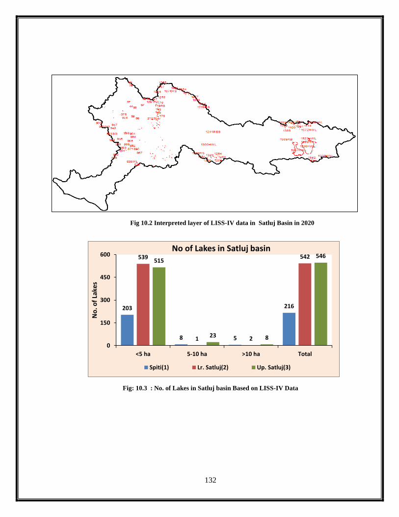
132
Fig 10.2 Interpreted layer of LISS-IV data in Satluj Basin in 2020
Fig: 10.3 : No. of Lakes in Satluj basin Based on LISS-IV Data
203
8 5
216
539
1 2
542515
23 8
546
0
150
300
450
600
<5 ha 5-10 ha >10 ha Total
No
. of
Lake
s
No of Lakes in Satluj basin
Spiti(1) Lr. Satluj(2) Up. Satluj(3)

133
Fig: 10.4 No. of High Altitude Wetlands in Satluj basin Based on LISS-IV Data
Fig: 10.5 No. of Lakes in Spiti basin (1) Based on LISS-IV Data
9
0 0
9
0 0 0 0
32
4
10
46
0
10
20
30
40
50
<5 ha 5-10 ha >10 ha Total
No
. Hig
h A
ltit
ud
e W
etla
nd
s
No of High Altitude Wetlands in Satluj Basin(2020)
Spiti(1) Lr. Satluj(2) Up. Satluj(3)
203
8 5
216
0
50
100
150
200
250
<5 ha 5-10 ha >10 ha Total
No
. of
Lake
s
No. of Lakes in Spiti basin (1) in 2020
No. of Lakes (2020)

134
Fig: 10.6 No. of High Altitude Wetlands in Spiti basin (1) Based on LISS-IV Data
Fig: 10.7 No. of High Altitude Wetlands in Lw Satluj basin (2) Based on LISS-IV Data
9
0 0
9
0
2
4
6
8
10
<5 ha 5-10 ha >10 ha Total
No
. of
Hig
h A
ltit
ud
e w
etl
and
s
No. of High Altitude Wetlands in Spiti basin (1) in 2020
No. of Lakes (2020)
539
1 2
542
0
100
200
300
400
500
600
<5 ha 5-10 ha >10 ha Total
No
. of
Lake
s
No. of Lakes in Lw. Satluj basin (2) in 2020
No. of Lakes (2020)

135
Fig: 10.8 No. of Lakes in Up Satluj basin (3) Based on LISS-IV Data
Fig: 10.9 No. of High Altitude Wetlands in Up Satluj basin (3) Based on LISS-IV Data
515
23 8
546
0
100
200
300
400
500
600
<5 ha 5-10 ha >10 ha Total
No
. of
Lake
s
No. of High Altitude Wetlands in Up Satluj (3) basin based on LISS-IV Data
No. of Lakes (2020)
32
4
10
46
0
10
20
30
40
50
<5 ha 5-10 ha >10 ha Total
No
. of
Hig
h A
ltit
ud
e W
etla
nd
s
No. of High Altitude Wetlands in Up Satluj basin(3) in 2020
No. of Lakes (2020)

136
Table: 10.2 Distribution of Lakes and High Altitude Wetlands as per satellite data interpretation for the
year 2020 using LISS-IV sensor
Sr.No. Path-row Lake Id.
Number
Basin
Number
Longitude Latitude Area
(ha)
1. 96-48a 1 1 77.7149 32.5342 0.13
2. 96-48a 2 1 77.8168 32.5121 0.36
3. 96-48a 3 1 77.8269 32.5280 2.06
4. 96-48a 4 1 77.9423 32.5249 0.10
5. 96-48a 5 1 77.9487 32.5301 0.80
6. 96-48a 6 1 77.9658 32.5332 0.18
7. 96-48a 12 1 77.9651 32.5297 1.69
8. 96-48a 13 1 78.0671 32.4019 0.06
9. 96-48a 14 1 78.0823 32.4224 0.13
10. 96-48a 15 1 78.0884 32.4262 0.23
11. 96-48a 16 1 78.0898 32.4276 0.16
12. 96-48a 17 1 78.0923 32.4307 0.23
13. 96-48a 18 1 78.2199 32.4153 0.19
14. 96-48a 19 1 78.2214 32.4143 13.16
15. 96-48a 20 1 78.2207 32.4087 0.11
16. 96-48a 21 1 78.2171 32.4053 0.11
17. 96-48a 22 1 78.2056 32.3986 0.35
18. 96-48a 23 1 78.1990 32.3915 0.03
19. 96-48a 24 1 78.2705 32.3672 0.25
20. 96-48a 25 1 78.2722 32.3630 0.39
21. 96-48a 26 1 78.1836 32.3178 0.38
22. 96-48a 35 1 78.1812 32.3134 1.22
23. 96-48a 36 1 78.1872 32.3094 0.13
24. 96-48a 37 1 78.1938 32.3052 0.02
25. 96-48a 10RS 1 78.2014 32.3022 0.91
26. 96-48a 11RS 1 78.2342 32.2853 0.30
27. 96-48a 27HWL 1 78.0414 32.3451 0.44
28. 96-48a 28HWL 1 78.0620 32.3237 0.13
29. 96-48a 29HWL 1 78.0175 32.3194 0.03
30. 96-48a 30HWL 1 78.0279 32.3068 0.13
31. 96-48a 31HWL 1 78.0265 32.3061 0.10
32. 96-48a 32HWL 1 78.0236 32.3045 0.07
33. 96-48a 33HWL 1 78.0241 32.3040 0.07
34. 96-48a 34HWL 1 78.0239 32.3036 0.03
35. 96-48a 7RS 1 78.2224 32.2328 0.85
36. 96-48a 8RS 1 77.7612 32.2424 3.03

137
37. 96-48a 9RS 1 77.7617 32.3750 1.14
38. 96-48b 37 1 78.4736 32.4572 7.99
39. 96-48b 38 1 78.5019 32.4203 0.22
40. 96-48b 39 1 78.4606 32.3811 0.38
41. 96-48b 40 1 78.4613 32.3812 0.36
42. 96-48b 41 1 78.4620 32.3814 0.30
43. 96-48b 42 1 78.4636 32.3819 0.09
44. 96-48b 44 1 78.4807 32.3762 1.03
45. 96-48b 56 1 78.5265 32.3404 0.13
46. 96-48b 57 1 78.5242 32.3191 0.06
47. 96-48b 59 1 78.4180 32.2042 4.32
48. 96-48b 60 1 78.4119 32.1766 0.12
49. 96-48b 61 1 78.4114 32.1755 0.70
50. 96-48b 62 1 78.4145 32.1741 0.75
51. 96-48b 63 1 78.4182 32.1731 0.06
52. 96-48b 66 1 78.4879 32.1488 6.96
53. 96-48b 67 1 78.7135 32.3285 3.00
54. 96-48b 92 1 78.8161 32.4191 6.92
55. 96-48b 93 1 78.8276 32.4215 0.97
56. 96-48b 94 1 78.8247 32.4132 0.02
57. 96-48b 95 1 78.8270 32.4138 0.30
58. 96-48b 96 1 78.8346 32.4080 0.21
59. 96-48b 97 1 78.8925 32.3966 0.55
60. 96-48b 98 1 78.8915 32.3880 1.82
61. 96-48b 99 1 78.8805 32.3521 1.17
62. 96-48b 100 1 78.8979 32.3512 2.85
63. 96-48b 101 1 78.9080 32.3341 2.77
64. 96-48b 102 1 78.8963 32.3252 1.31
65. 96-48b 103 1 78.8974 32.3230 0.04
66. 96-48b 107 3 79.0023 32.3380 5.62
67. 96-48b 108 3 79.0017 32.3288 2.27
68. 96-48b 110 3 78.9941 32.3168 0.27
69. 96-48b 111 3 78.9932 32.3161 1.02
70. 96-48b 112 1 78.9854 32.2999 13.54
71. 96-48b 114 3 79.0172 32.2767 1.87
72. 96-48b 115 3 79.0483 32.2557 0.27
73. 96-48b 116 3 79.0440 32.2516 1.28
74. 96-48b 117 3 79.0337 32.2376 1.13
75. 96-48b 118 3 79.0323 32.2391 0.13
76. 96-48b 120 1 79.0260 32.2241 6.96

138
77. 96-48b 121 1 78.9913 32.2550 1.42
78. 96-48b 122 1 78.9869 32.2528 0.19
79. 96-48b 123 1 78.9863 32.2532 0.15
80. 96-48b 124 1 78.9890 32.2512 0.04
81. 96-48b 125 1 78.9777 32.2584 2.57
82. 96-48b 126 1 78.9711 32.2589 8.96
83. 96-48b 127 1 78.9871 32.2350 0.06
84. 96-48b 128 1 78.9830 32.2259 1.03
85. 96-48b 129 1 78.9831 32.2209 0.74
86. 96-48b 130 1 78.9851 32.2218 0.44
87. 96-48b 131 1 78.9867 32.2206 0.49
88. 96-48b 133 1 78.9872 32.2212 0.10
89. 96-48b 135 3 79.0051 32.2249 2.65
90. 96-48b 136 3 79.0089 32.2147 1.73
91. 96-48b 137 3 79.0106 32.2145 0.26
92. 96-48b 138 3 79.0191 32.2085 3.11
93. 96-48b 139 3 78.9933 32.2158 0.04
94. 96-48b 140 3 78.9903 32.2147 0.11
95. 96-48b 142 3 79.0169 32.2028 0.69
96. 96-48b 143 3 78.9875 32.2013 1.01
97. 96-48b 145 1 78.9728 32.1907 4.62
98. 96-48b 146 1 78.9601 32.1849 2.76
99. 96-48b 147 1 78.9684 32.1801 0.63
100. 96-48b 148 3 78.9725 32.1703 1.58
101. 96-48b 149 3 78.9769 32.1609 8.53
102. 96-48b 150 1 78.9535 32.1671 0.05
103. 96-48b 151 1 78.9531 32.1588 0.08
104. 96-48b 152 3 78.9626 32.1493 1.41
105. 96-48b 153 3 78.9638 32.1433 0.53
106. 96-48b 154 3 78.9676 32.1447 0.14
107. 96-48b 155 3 78.9701 32.1288 3.42
108. 96-48b 156 3 78.9593 32.1370 0.30
109. 96-48b 157 1 78.9478 32.1444 0.05
110. 96-48b 159 1 78.9462 32.1434 0.02
111. 96-48b 160 3 78.9473 32.1221 1.63
112. 96-48b 161 3 78.9507 32.1193 1.62
113. 96-48b 162 1 78.9268 32.1292 1.09
114. 96-48b 163 1 78.9252 32.1257 0.12
115. 96-48b 164 1 78.9241 32.1284 0.10
116. 96-48b 165 1 78.9203 32.1433 0.23

139
117. 96-48b 167 1 78.9064 32.1442 1.60
118. 96-48b 168 3 78.9319 32.1073 11.62
119. 96-48b 169 3 78.9413 32.1072 11.77
120. 96-48b 170 3 78.9470 32.1067 0.39
121. 96-48b 172 1 78.9378 32.1042 0.23
122. 96-48b 173 3 78.9468 32.0926 4.09
123. 96-48b 174 3 78.9292 32.0921 0.78
124. 96-48b 177 1 78.9078 32.0984 0.56
125. 96-48b 178 3 78.9432 32.0596 7.84
126. 96-48b 179 3 78.9275 32.0629 1.18
127. 96-48b 180 1 78.9056 32.0762 0.16
128. 96-48b 181 3 78.9098 32.0584 0.05
129. 96-48b 182 3 78.9040 32.0542 0.89
130. 96-48b 183 3 78.9007 32.0638 0.05
131. 96-48b 184 3 78.8949 32.0692 0.08
132. 96-48b 185 3 78.8947 32.0648 0.26
133. 96-48b 186 1 78.8858 32.0740 0.08
134. 96-48b 187 1 78.8850 32.0719 2.67
135. 96-48b 188 1 78.8832 32.0728 0.37
136. 96-48b 189 1 78.8631 32.0705 1.23
137. 96-48b 190 1 78.8634 32.0857 1.42
138. 96-48b 191 1 78.8824 32.0970 0.15
139. 96-48b 192 1 78.8719 32.1007 0.21
140. 96-48b 194 1 78.8691 32.1051 0.02
141. 96-48b 195 1 78.8696 32.1052 0.02
142. 96-48b 196 1 78.8673 32.1008 0.11
143. 96-48b 198 3 78.9097 32.0178 5.91
144. 96-48b 199 1 78.8723 32.0313 4.97
145. 96-48b 200 1 78.8763 32.0196 2.64
146. 96-48b 201 1 78.8748 32.0169 9.43
147. 96-48b 202 1 78.8494 32.0229 0.11
148. 96-48b 204 1 78.8454 32.0304 20.15
149. 96-48b 205 1 78.8245 32.0560 0.87
150. 96-48b 206 1 78.8069 32.0584 10.24
151. 96-48b 207 1 78.7989 32.0557 0.06
152. 96-48b 208 1 78.7991 32.0554 0.06
153. 96-48b 209 1 78.7983 32.0551 0.01
154. 96-48b 210 1 78.7978 32.0551 0.07
155. 96-48b 211 1 78.7981 32.0559 0.15
156. 96-48b 212 1 78.7822 32.0529 1.53

140
157. 96-48b 1050 3 79.1193 32.3339 0.59
158. 96-48b 1051 3 79.1173 32.3463 0.31
159. 96-48b 1052 3 79.1035 32.3538 3.43
160. 96-48b 1054 3 79.1310 32.4459 4.26
161. 96-48b 1055 3 79.1871 32.4516 3.50
162. 96-48b 1056 3 79.1714 32.4919 1.82
163. 96-48b 1046HWL 3 79.0469 32.3479 0.07
164. 96-48b 1047HWL 3 79.0478 32.3481 0.03
165. 96-48b 1048HWL 3 79.0474 32.3447 0.10
166. 96-48b 1049RS 3 79.0516 32.3469 5.55
167. 96-48b 119RS 1 79.0429 32.2099 28.48
168. 96-48b 193SG 1 78.8702 32.1017 0.06
169. 96-48b 45SG 1 78.4647 32.3492 0.16
170. 96-48b 46SG 1 78.4655 32.3491 0.06
171. 96-48b 47SG 1 78.4955 32.3414 0.26
172. 96-48b 48SG 1 78.4990 32.3410 0.05
173. 96-48b 49SG 1 78.5005 32.3425 0.04
174. 96-48b 50SG 1 78.5023 32.3436 0.57
175. 96-48b 51SG 1 78.5030 32.3447 0.05
176. 96-48b 52SG 1 78.5025 32.3456 0.32
177. 96-48b 53AG 1 78.5086 32.3553 0.19
178. 96-48b 55SG 1 78.5073 32.3605 0.05
179. 96-48b 64SG 1 78.4567 32.1635 0.05
180. 96-48b 65SG 1 78.4619 32.1609 1.00
181. 96-48b 67A 1 78.7175 32.3238 1.15
182. 96-48b 67B 1 78.7245 32.3256 3.89
183. 96-48c 0 2 78.0636 31.6856 0.09
184. 96-48c 832 1 78.0773 31.4277 0.48
185. 96-48c 833 1 78.0685 31.4226 1.33
186. 96-48c 834 1 78.0684 31.4192 1.01
187. 96-48c 835 1 78.0272 31.4086 5.09
188. 96-48c 836 1 78.0135 31.4055 0.17
189. 96-48c 837 1 78.0120 31.4064 5.08
190. 96-48c 839 2 77.6626 31.6735 2.49
191. 96-48c 840 2 77.6650 31.6755 0.33
192. 96-48c 841 2 77.6670 31.6741 0.21
193. 96-48c 842 2 77.6681 31.6777 0.25
194. 96-48c 843 2 77.6689 31.6769 0.42
195. 96-48c 844 2 77.6714 31.6789 0.42
196. 96-48c 845 2 77.6723 31.6786 0.22

141
197. 96-48c 846 2 77.6744 31.6770 1.11
198. 96-48c 847 2 77.6794 31.6867 0.12
199. 96-48c 848 2 77.6769 31.6908 0.64
200. 96-48c 849 2 77.6863 31.6962 0.26
201. 96-48c 850 2 77.7111 31.6961 2.63
202. 96-48c 851 2 77.8253 31.7485 0.03
203. 96-48c 852 2 77.8266 31.7484 0.33
204. 96-48c 853 2 77.8809 31.7116 0.41
205. 96-48c 854 2 77.8713 31.7182 1.85
206. 96-48c 855 2 77.8720 31.7448 0.15
207. 96-48c 856 2 77.8709 31.7570 0.21
208. 96-48c 857 2 77.8661 31.7590 0.20
209. 96-48c 858 2 77.8966 31.7248 0.15
210. 96-48c 859 2 77.9000 31.7198 0.03
211. 96-48c 860 2 77.9009 31.7207 0.93
212. 96-48c 861 2 77.9031 31.7213 0.51
213. 96-48c 862 2 77.9449 31.7075 0.63
214. 96-48c 863 2 77.9458 31.7076 0.35
215. 96-48c 864 2 77.9457 31.7068 0.02
216. 96-48c 865 2 77.9460 31.7065 0.17
217. 96-48c 866 2 77.9477 31.7060 0.04
218. 96-48c 867 2 77.9372 31.7308 0.60
219. 96-48c 868 2 78.0666 31.7748 0.52
220. 96-48c 869 2 78.0663 31.7737 0.21
221. 96-48c 870 2 78.0787 31.7396 0.09
222. 96-48c 871 2 78.0792 31.7019 0.81
223. 96-48c 872 2 78.0805 31.6877 0.02
224. 96-48c 873 2 78.0696 31.6810 0.12
225. 96-48c 874 2 78.0675 31.6860 0.18
226. 96-48c 875 2 78.0636 31.6850 0.03
227. 96-48c 878 2 78.0617 31.6866 0.10
228. 96-48c 879 2 78.1247 31.6673 0.09
229. 96-48c 880 2 78.1387 31.6695 0.04
230. 96-48c 881 2 78.1394 31.6704 0.43
231. 96-48c 882 2 78.1485 31.6623 0.12
232. 96-48c 883 2 78.1598 31.6620 0.34
233. 96-48c 884 2 78.1672 31.6629 0.24
234. 96-48c 885 2 78.1684 31.6609 30.12
235. 96-48c 886 2 78.1623 31.6579 0.51
236. 96-48c 887 2 78.1631 31.6576 0.04

142
237. 96-48c 888 2 78.1628 31.6574 0.03
238. 96-48c 889 2 78.1627 31.6571 0.01
239. 96-48c 890 2 78.1622 31.6565 0.13
240. 96-48c 891 2 78.1263 31.7371 0.26
241. 96-48c 892 2 78.1242 31.7398 2.82
242. 96-48c 893 2 78.1151 31.7402 0.04
243. 96-48c 894 2 78.1173 31.7486 0.34
244. 96-48c 895 2 78.1254 31.7536 0.18
245. 96-48c 896 2 78.1254 31.7596 0.22
246. 96-48c 897 2 78.1270 31.7615 0.23
247. 96-48c 898 2 78.1277 31.7617 0.03
248. 96-48c 899 2 78.1284 31.7619 0.03
249. 96-48c 901 2 78.1013 31.7775 0.06
250. 96-48c 902 2 78.1018 31.7780 0.53
251. 96-48c 903 2 78.1036 31.7781 0.34
252. 96-48c 904 2 78.1140 31.7912 0.17
253. 96-48c 905 2 78.1130 31.8108 0.21
254. 96-48c 906 2 78.1212 31.8276 0.11
255. 96-48c 907 2 78.1083 31.8461 0.05
256. 96-48c 908 2 78.1130 31.8466 0.07
257. 96-48c 909 1 78.1086 31.8624 0.03
258. 96-48c 910 1 78.1019 31.8641 0.04
259. 96-48c 911 1 77.9713 31.8801 0.02
260. 96-48c 912 1 77.9709 31.8800 0.04
261. 96-48c 913 1 77.9581 31.8890 0.09
262. 96-48c 914 1 77.9370 31.9107 0.02
263. 96-48c 915 1 77.9365 31.9147 0.07
264. 96-48c 916 1 77.9401 31.9194 0.10
265. 96-48c 917 1 77.9216 31.9620 0.03
266. 96-48c 918 1 77.9134 31.9722 0.06
267. 96-48c 919 1 77.8567 31.9298 0.07
268. 96-48c 920 1 77.7976 31.9510 0.15
269. 96-48c 921 1 77.7972 31.9515 0.15
270. 96-48c 922 1 77.8091 31.9596 0.07
271. 96-48c 923 1 77.8081 31.9605 0.03
272. 96-48c 924 1 77.8087 31.9610 0.01
273. 96-48c 925 1 77.8107 31.9620 0.17
274. 96-48c 926 1 77.8001 31.9698 0.21
275. 96-48c 927 1 77.7874 31.9632 0.17
276. 96-48c 928 1 77.7821 31.9528 0.74

143
277. 96-48c 941 1 77.8906 32.1246 0.04
278. 96-48c 943 1 77.9144 32.1368 1.65
279. 96-48c 944 1 77.9155 32.1371 0.04
280. 96-48c 945 1 77.9254 32.1292 1.42
281. 96-48c 946 1 77.9642 32.1663 0.07
282. 96-48c 947 1 77.9644 32.1672 0.50
283. 96-48c 948 1 77.9640 32.1681 0.05
284. 96-48c 949 1 78.1152 31.9977 0.15
285. 96-48c 950 1 78.1188 31.9984 0.03
286. 96-48c 951 1 78.1139 32.0057 0.05
287. 96-48c 952 1 78.1148 32.0068 0.44
288. 96-48c 953 1 78.1325 31.9796 1.90
289. 96-48c 954 1 78.1827 31.9270 0.21
290. 96-48c 955 1 78.1805 31.9340 0.09
291. 96-48c 956 2 78.2012 31.9051 0.19
292. 96-48c 957 2 78.2133 31.8698 0.04
293. 96-48c 958 2 78.2156 31.8710 0.28
294. 96-48c 959 2 78.2141 31.8687 0.12
295. 96-48c 960 2 78.2085 31.8660 0.04
296. 96-48c 961 1 78.1580 31.8706 0.02
297. 96-48c 962 1 78.1586 31.8712 0.13
298. 96-48c 963 1 77.8484 32.2245 0.12
299. 96-48c 966 1 77.6871 32.3041 0.10
300. 96-48c 971 1 78.2337 32.2220 0.04
301. 96-48c 972 1 78.2336 32.2231 0.04
302. 96-48c 973 1 78.2341 32.2238 0.05
303. 96-48c 974 1 78.2477 32.2304 0.26
304. 96-48c 975 1 78.2447 32.2700 0.08
305. 96-48c 976 1 77.9720 31.7810 0.12
306. 96-48c 977 1 77.9650 31.8024 0.12
307. 96-48c 978 1 77.9657 31.8024 0.02
308. 96-48c 979 1 77.9675 31.8030 0.06
309. 96-48c 980 1 77.9656 31.8037 0.28
310. 96-48c 981 1 77.9648 31.8037 0.05
311. 96-48c 982 1 77.9650 31.8056 0.23
312. 96-48c 985 1 77.8496 31.8250 0.09
313. 96-48c 986 1 77.8554 31.8305 0.03
314. 96-48c 987 1 77.8554 31.8310 0.10
315. 96-48c 989 1 77.8512 31.8422 0.04
316. 96-48c 990 1 77.8544 31.8432 0.42

144
317. 96-48c 991 1 77.8514 31.8613 0.04
318. 96-48c 992 1 77.8522 31.8618 0.07
319. 96-48c 993 1 77.8565 31.8637 0.41
320. 96-48c 838WL 1 77.9590 31.4812 1.58
321. 96-48c 929SG 1 77.8153 32.0032 0.03
322. 96-48c 930SG 1 77.8336 32.0456 0.04
323. 96-48c 932SG 1 77.8425 32.0506 0.03
324. 96-48c 933SG 1 77.8429 32.0524 0.19
325. 96-48c 935SG 1 77.8155 32.0746 0.03
326. 96-48c 936SG 1 77.8158 32.0771 0.07
327. 96-48c 937SG 1 77.8230 32.0783 0.06
328. 96-48c 938SG 1 77.8825 32.1344 0.03
329. 96-48c 939SG 1 77.8844 32.1375 0.01
330. 96-48c 940SG 1 77.8865 32.1377 0.08
331. 96-48c 942SG 1 77.9111 32.1300 0.04
332. 96-48c 964SG 1 77.8037 32.2048 0.15
333. 96-48c 965SG 1 77.8039 32.2015 0.37
334. 96-48d 273 2 78.9479 32.1386 0.59
335. 96-48d 274 2 78.9457 32.1400 0.10
336. 96-48d 275 2 78.9456 32.1377 0.06
337. 96-48d 276 2 78.9431 32.1385 0.07
338. 96-48d 277 3 78.9425 32.1225 3.79
339. 96-48d 277 3 78.9457 32.1216 0.14
340. 96-48d 278 3 78.9469 32.1199 3.20
341. 96-48d 279 3 78.9409 32.1184 0.39
342. 96-48d 280 3 78.9322 32.1216 0.11
343. 96-48d 281 3 78.9315 32.1185 0.21
344. 96-48d 282 3 78.9371 32.0831 0.09
345. 96-48d 283 3 78.9367 32.0847 0.04
346. 96-48d 284 3 78.9365 32.0862 0.03
347. 96-48d 285 2 78.9113 32.0910 2.02
348. 96-48d 286 3 78.9259 32.0145 1.35
349. 96-48d 287 3 78.9018 32.0039 1.47
350. 96-48d 288 2 78.8025 32.0812 0.41
351. 96-48d 289 2 78.8064 32.0801 0.44
352. 96-48d 291 2 78.8304 32.0642 0.06
353. 96-48d 292 2 78.8319 32.0435 1.80
354. 96-48d 293 2 78.8344 32.0361 0.34
355. 96-48d 294 3 78.8453 32.0114 1.60
356. 96-48d 295 3 78.8473 32.0111 0.13

145
357. 96-48d 296 3 78.8465 32.0111 0.05
358. 96-48d 297 3 78.8490 32.0086 0.82
359. 96-48d 298 3 78.8506 32.0081 0.06
360. 96-48d 299 3 78.8515 32.0075 0.31
361. 96-48d 300 2 78.8159 32.0324 2.45
362. 96-48d 301 2 78.8139 32.0327 0.19
363. 96-48d 302 2 78.8133 32.0322 0.04
364. 96-48d 303 2 78.8151 32.0323 0.16
365. 96-48d 304 2 78.8232 32.0135 1.13
366. 96-48d 305 3 78.8443 31.9929 21.25
367. 96-48d 306 3 78.8481 31.9947 1.42
368. 96-48d 307 3 78.8434 31.9877 0.30
369. 96-48d 308 3 78.8374 31.9806 4.82
370. 96-48d 309 3 78.8356 31.9802 0.37
371. 96-48d 310 3 78.8364 31.9787 1.47
372. 96-48d 311 3 78.8379 31.9772 1.53
373. 96-48d 312 3 78.8692 31.9696 6.37
374. 96-48d 313 3 78.8671 31.9569 3.68
375. 96-48d 314 3 78.7977 31.9715 0.81
376. 96-48d 315 3 78.8120 31.9649 3.90
377. 96-48d 316 3 78.8109 31.9604 0.05
378. 96-48d 317 3 78.7952 31.9573 0.18
379. 96-48d 318 3 78.7823 31.9564 0.38
380. 96-48d 319 3 78.8084 31.9520 0.27
381. 96-48d 320 3 78.8097 31.9508 0.53
382. 96-48d 321 3 78.8097 31.9528 0.09
383. 96-48d 322 3 78.8102 31.9526 0.11
384. 96-48d 323 2 78.7830 32.0307 0.19
385. 96-48d 324 2 78.7834 32.0327 0.02
386. 96-48d 325 2 78.7822 32.0316 0.02
387. 96-48d 326 2 78.7795 32.0330 0.56
388. 96-48d 327 2 78.7782 32.0341 0.49
389. 96-48d 328 2 78.7549 32.0423 0.16
390. 96-48d 329 2 78.7546 32.0446 0.72
391. 96-48d 331 3 78.7840 31.9311 0.47
392. 96-48d 333 3 78.7959 31.9333 0.30
393. 96-48d 335 3 78.8138 31.9341 3.83
394. 96-48d 336 3 78.8123 31.9330 0.06
395. 96-48d 337 3 78.8167 31.9318 0.28
396. 96-48d 338 3 78.8201 31.9327 1.39

146
397. 96-48d 339 3 78.8213 31.9317 0.18
398. 96-48d 340 3 78.8223 31.9329 0.99
399. 96-48d 341 3 78.8262 31.9323 0.15
400. 96-48d 342 3 78.8247 31.9314 0.06
401. 96-48d 343 3 78.8258 31.9315 0.07
402. 96-48d 344 3 78.8282 31.9309 0.20
403. 96-48d 345 3 78.8275 31.9303 0.16
404. 96-48d 346 3 78.8266 31.9299 0.25
405. 96-48d 347 3 78.8243 31.9294 0.05
406. 96-48d 348 3 78.8228 31.9307 0.08
407. 96-48d 349 3 78.8230 31.9300 0.20
408. 96-48d 350 3 78.8228 31.9293 0.03
409. 96-48d 351 3 78.8215 31.9304 0.71
410. 96-48d 353 3 78.8202 31.9297 0.07
411. 96-48d 354 3 78.8197 31.9299 0.03
412. 96-48d 355 3 78.8197 31.9305 0.23
413. 96-48d 356 3 78.8187 31.9304 0.05
414. 96-48d 357 3 78.8184 31.9294 1.38
415. 96-48d 358 3 78.8173 31.9294 0.13
416. 96-48d 359 3 78.8166 31.9301 0.02
417. 96-48d 360 3 78.8159 31.9302 0.03
418. 96-48d 361 3 78.8153 31.9297 0.04
419. 96-48d 362 3 78.8150 31.9294 0.07
420. 96-48d 363 3 78.8134 31.9305 0.07
421. 96-48d 364 3 78.8127 31.9299 0.04
422. 96-48d 365 3 78.8272 31.9274 0.02
423. 96-48d 366 3 78.8398 31.9138 20.79
424. 96-48d 367 3 78.8018 31.9085 0.75
425. 96-48d 368 3 78.7861 31.9050 0.40
426. 96-48d 369 3 78.7860 31.9061 0.29
427. 96-48d 370 3 78.7852 31.9058 0.14
428. 96-48d 371 3 78.7848 31.9069 0.21
429. 96-48d 372 3 78.7827 31.9193 16.44
430. 96-48d 373 3 78.7736 31.9148 0.22
431. 96-48d 374 3 78.7900 31.8831 0.32
432. 96-48d 375 3 78.7905 31.8826 0.13
433. 96-48d 376 3 78.7890 31.8820 0.03
434. 96-48d 377 3 78.7936 31.8823 0.66
435. 96-48d 378 3 78.7934 31.8804 0.34
436. 96-48d 379 3 78.7948 31.8802 0.07

147
437. 96-48d 380 3 78.7947 31.8788 0.02
438. 96-48d 381 3 78.7954 31.8793 0.04
439. 96-48d 382 3 78.7993 31.8758 0.09
440. 96-48d 383 3 78.8003 31.8762 0.49
441. 96-48d 385 3 78.8015 31.8728 0.02
442. 96-48d 386 3 78.8023 31.8735 0.29
443. 96-48d 387 3 78.8033 31.8726 0.03
444. 96-48d 388 3 78.8044 31.8727 0.06
445. 96-48d 389 2 78.7047 31.8871 0.63
446. 96-48d 390 2 78.7042 31.8876 0.10
447. 96-48d 391 2 78.7042 31.8888 0.07
448. 96-48d 392 2 78.6997 31.8894 0.28
449. 96-48d 414 2 78.7185 31.9008 1.03
450. 96-48d 415 2 78.7173 31.9002 0.38
451. 96-48d 416 2 78.7138 31.8981 0.55
452. 96-48d 417 2 78.7089 31.9065 0.63
453. 96-48d 418 2 78.7036 31.9103 0.20
454. 96-48d 419 2 78.7003 31.9127 4.47
455. 96-48d 420 2 78.7021 31.9177 0.50
456. 96-48d 421 2 78.6977 31.9273 0.18
457. 96-48d 422 2 78.6952 31.9288 0.01
458. 96-48d 423 2 78.6954 31.9292 0.21
459. 96-48d 424 2 78.6943 31.9302 0.18
460. 96-48d 425 2 78.6934 31.9300 0.25
461. 96-48d 426 2 78.6930 31.9306 0.19
462. 96-48d 427 2 78.6924 31.9306 0.07
463. 96-48d 429 2 78.6933 31.9278 0.16
464. 96-48d 430 2 78.6919 31.9284 0.06
465. 96-48d 432 2 78.6850 31.9337 0.77
466. 96-48d 433 2 78.6856 31.9344 0.02
467. 96-48d 434 2 78.6858 31.9347 0.05
468. 96-48d 435 2 78.6765 31.9355 0.17
469. 96-48d 437 2 78.6712 31.9376 0.06
470. 96-48d 461 2 78.7202 31.9913 0.28
471. 96-48d 462 2 78.7106 31.9954 0.09
472. 96-48d 463 2 78.7106 31.9994 0.34
473. 96-48d 464 1 78.4617 31.9718 7.67
474. 96-48d 465 1 78.4446 31.9766 0.29
475. 96-48d 466 1 78.4155 31.9640 6.52
476. 96-48d 479 1 78.3408 31.9494 0.29

148
477. 96-48d 480 2 78.3720 31.9263 0.21
478. 96-48d 483 2 78.4637 31.9449 0.46
479. 96-48d 484 2 78.4627 31.9081 0.33
480. 96-48d 485 2 78.4497 31.8721 0.13
481. 96-48d 486 2 78.4478 31.8698 0.03
482. 96-48d 487 2 78.4480 31.8681 0.13
483. 96-48d 488 2 78.4514 31.8652 0.04
484. 96-48d 489 2 78.3038 31.8291 0.04
485. 96-48d 490 2 78.3055 31.7894 1.59
486. 96-48d 491 2 78.3046 31.7907 0.05
487. 96-48d 492 2 78.3091 31.7916 0.05
488. 96-48d 493 2 78.3164 31.7924 0.12
489. 96-48d 494 2 78.2935 31.7797 1.20
490. 96-48d 495 2 78.3994 31.7319 2.22
491. 96-48d 496 2 78.4006 31.7296 0.31
492. 96-48d 497 2 78.7410 31.7091 1.98
493. 96-48d 498 2 78.7529 31.6631 0.03
494. 96-48d 499 2 78.7545 31.6624 0.17
495. 96-48d 500 2 78.7506 31.6613 0.53
496. 96-48d 501 2 78.7527 31.6658 0.21
497. 96-48d 502 2 78.7479 31.6567 0.16
498. 96-48d 503 2 78.7468 31.6569 0.24
499. 96-48d 504 2 78.7616 31.6584 0.06
500. 96-48d 505 2 78.7071 31.6533 0.03
501. 96-48d 506 2 78.7087 31.6599 0.07
502. 96-48d 519 2 78.6001 31.5736 0.37
503. 96-48d 520 2 78.6009 31.5745 0.02
504. 96-48d 521 2 78.6005 31.5751 0.42
505. 96-48d 522 2 78.6023 31.5750 0.79
506. 96-48d 523 2 78.6010 31.5765 0.19
507. 96-48d 524 2 78.6033 31.5654 0.20
508. 96-48d 525 2 78.6100 31.5647 0.97
509. 96-48d 526 2 78.6302 31.5237 0.03
510. 96-48d 527 2 78.6339 31.5204 0.14
511. 96-48d 528 2 78.6329 31.5189 0.02
512. 96-48d 529 2 78.6338 31.5180 0.39
513. 96-48d 530 2 78.6346 31.5182 0.03
514. 96-48d 531 2 78.6349 31.5175 0.04
515. 96-48d 532 2 78.6326 31.5165 0.03
516. 96-48d 533 2 78.6928 31.5247 0.18

149
517. 96-48d 534 2 78.6935 31.5250 0.05
518. 96-48d 535 2 78.6935 31.5253 0.04
519. 96-48d 536 2 78.6939 31.5256 0.06
520. 96-48d 537 2 78.6905 31.5651 0.04
521. 96-48d 538 2 78.6931 31.5656 0.16
522. 96-48d 539 2 78.7102 31.5557 0.29
523. 96-48d 540 2 78.7170 31.5311 0.91
524. 96-48d 541 2 78.7142 31.5225 0.07
525. 96-48d 542 2 78.7466 31.5587 0.44
526. 96-48d 543 2 78.7530 31.5600 0.05
527. 96-48d 544 2 78.7519 31.5569 0.27
528. 96-48d 545 2 78.7506 31.5543 4.75
529. 96-48d 546 2 78.7709 31.5558 0.03
530. 96-48d 547 2 78.7388 31.5457 0.21
531. 96-48d 548 2 78.7379 31.5447 0.23
532. 96-48d 549 2 78.7358 31.5425 0.56
533. 96-48d 550 2 78.7346 31.5187 2.98
534. 96-48d 551 2 78.7317 31.5074 0.95
535. 96-48d 552 2 78.7324 31.4966 0.04
536. 96-48d 554 2 78.7499 31.4934 1.23
537. 96-48d 555 2 78.7953 31.4934 0.09
538. 96-48d 556 2 78.7969 31.4489 0.09
539. 96-48d 557 2 78.7927 31.4500 7.75
540. 96-48d 558 2 78.7842 31.4577 0.02
541. 96-48d 559 2 78.7844 31.4570 0.40
542. 96-48d 560 2 78.7838 31.4547 0.09
543. 96-48d 561 2 78.7840 31.4543 0.01
544. 96-48d 562 2 78.7762 31.4765 0.17
545. 96-48d 563 2 78.7759 31.4738 0.03
546. 96-48d 564 2 78.7041 31.4783 0.07
547. 96-48d 565 2 78.7028 31.4759 0.02
548. 96-48d 566 2 78.7046 31.4753 0.01
549. 96-48d 567 2 78.6718 31.4793 0.07
550. 96-48d 568 2 78.6730 31.4764 0.05
551. 96-48d 569 2 78.6717 31.4750 0.34
552. 96-48d 570 2 78.6744 31.4754 0.03
553. 96-48d 571 2 78.6744 31.4746 0.01
554. 96-48d 572 2 78.6740 31.4741 0.02
555. 96-48d 573 2 78.6746 31.4738 0.03
556. 96-48d 574 2 78.6752 31.4736 0.33

150
557. 96-48d 575 2 78.6535 31.4839 0.03
558. 96-48d 576 2 78.6537 31.4835 0.45
559. 96-48d 577 2 78.6529 31.4814 0.38
560. 96-48d 578 2 78.5567 31.5503 0.14
561. 96-48d 579 2 78.3830 31.5220 5.08
562. 96-48d 580 2 78.3856 31.5205 0.04
563. 96-48d 581 2 78.3859 31.5156 1.84
564. 96-48d 582 2 78.3897 31.5143 0.04
565. 96-48d 583 2 78.3553 31.4493 0.05
566. 96-48d 584 2 78.3642 31.4514 0.05
567. 96-48d 585 2 78.3654 31.4565 0.13
568. 96-48d 586 2 78.3677 31.4541 0.02
569. 96-48d 587 2 78.3685 31.4584 1.04
570. 96-48d 588 2 78.3657 31.4441 0.03
571. 96-48d 589 2 78.3662 31.4450 0.02
572. 96-48d 590 2 78.3672 31.4467 0.05
573. 96-48d 591 2 78.3709 31.4467 0.09
574. 96-48d 592 2 78.3742 31.4484 0.14
575. 96-48d 593 2 78.3778 31.4468 0.04
576. 96-48d 594 2 78.3885 31.4604 0.11
577. 96-48d 595 2 78.3888 31.4592 0.37
578. 96-48d 596 2 78.3870 31.4521 0.03
579. 96-48d 597 2 78.3881 31.4480 0.02
580. 96-48d 598 2 78.3721 31.4381 0.12
581. 96-48d 599 2 78.3715 31.4380 0.03
582. 96-48d 600 2 78.3709 31.4358 0.21
583. 96-48d 601 2 78.3864 31.4152 0.36
584. 96-48d 602 2 78.3896 31.4244 0.35
585. 96-48d 603 2 78.3896 31.4250 0.06
586. 96-48d 604 2 78.3927 31.4235 0.02
587. 96-48d 605 2 78.3934 31.4248 0.15
588. 96-48d 606 2 78.3950 31.4239 0.05
589. 96-48d 607 2 78.4064 31.4370 0.24
590. 96-48d 608 2 78.4096 31.4379 1.57
591. 96-48d 610 2 78.4098 31.4119 0.84
592. 96-48d 611 2 78.4093 31.4137 0.11
593. 96-48d 612 2 78.4124 31.4182 0.35
594. 96-48d 613 2 78.4248 31.4040 0.48
595. 96-48d 614 2 78.4239 31.4047 0.19
596. 96-48d 615 2 78.4205 31.4038 2.45

151
597. 96-48d 616 2 78.4218 31.3991 0.73
598. 96-48d 617 2 78.4158 31.4014 0.08
599. 96-48d 618 2 78.4160 31.4005 0.30
600. 96-48d 619 2 78.4335 31.3910 0.48
601. 96-48d 621 2 78.6040 31.3160 0.04
602. 96-48d 622 2 78.6058 31.3156 0.10
603. 96-48d 623 2 78.6045 31.3087 0.05
604. 96-48d 624 2 78.6242 31.3104 0.03
605. 96-48d 625 2 78.6245 31.3137 0.17
606. 96-48d 626 2 78.6250 31.3142 0.01
607. 96-48d 627 2 78.6263 31.3152 0.22
608. 96-48d 628 2 78.6396 31.3184 0.07
609. 96-48d 629 2 78.6578 31.3285 0.04
610. 96-48d 630 2 78.6614 31.3311 0.83
611. 96-48d 631 2 78.6625 31.3334 0.96
612. 96-48d 632 2 78.6967 31.3255 1.37
613. 96-48d 633 2 78.7017 31.3264 1.18
614. 96-48d 634 2 78.7178 31.3361 0.47
615. 96-48d 635 2 78.7171 31.3384 0.13
616. 96-48d 636 2 78.7171 31.3398 2.25
617. 96-48d 637 2 78.7510 31.3284 0.09
618. 96-48d 638 2 78.7516 31.3278 0.02
619. 96-48d 639 2 78.7542 31.3261 0.07
620. 96-48d 640 2 78.7546 31.3258 0.10
621. 96-48d 641 2 78.7542 31.3240 0.47
622. 96-48d 642 2 78.7544 31.3231 0.05
623. 96-48d 643 2 78.7553 31.3218 1.02
624. 96-48d 644 2 78.7563 31.3229 0.12
625. 96-48d 645 2 78.7567 31.3223 0.03
626. 96-48d 646 2 78.7564 31.3221 0.07
627. 96-48d 648 2 78.7612 31.3207 0.05
628. 96-48d 649 2 78.7607 31.3202 0.05
629. 96-48d 650 2 78.7974 31.2996 0.19
630. 96-48d 651 2 78.8023 31.2945 0.39
631. 96-48d 652 2 78.7184 31.2890 0.08
632. 96-48d 653 2 78.7219 31.2785 0.04
633. 96-48d 654 2 78.7195 31.2409 0.06
634. 96-48d 672 2 78.7860 31.2166 0.31
635. 96-48d 673 2 78.7859 31.2171 0.06
636. 96-48d 674 2 78.7924 31.2109 0.09

152
637. 96-48d 689 2 78.5036 31.2351 0.15
638. 96-48d 690 2 78.4856 31.2494 0.17
639. 96-48d 699 2 78.3264 31.3066 0.41
640. 96-48d 700 2 78.3265 31.3076 0.06
641. 96-48d 701 2 78.3270 31.3089 0.12
642. 96-48d 702 2 78.3276 31.3089 0.04
643. 96-48d 703 2 78.3273 31.3093 0.03
644. 96-48d 704 2 78.3282 31.3095 0.07
645. 96-48d 705 2 78.3268 31.3103 0.04
646. 96-48d 706 2 78.3265 31.3105 0.08
647. 96-48d 707 2 78.3258 31.3101 0.04
648. 96-48d 708 2 78.3256 31.3103 0.06
649. 96-48d 709 2 78.3259 31.3108 0.34
650. 96-48d 710 2 78.3296 31.3106 0.23
651. 96-48d 711 2 78.3298 31.3111 0.12
652. 96-48d 712 2 78.3286 31.3109 0.10
653. 96-48d 713 2 78.3286 31.3115 0.14
654. 96-48d 714 2 78.3283 31.3119 0.14
655. 96-48d 715 2 78.3291 31.3121 0.22
656. 96-48d 716 2 78.3298 31.3122 0.89
657. 96-48d 717 2 78.3300 31.3134 0.11
658. 96-48d 718 2 78.3293 31.3127 0.11
659. 96-48d 719 2 78.3293 31.3133 0.17
660. 96-48d 720 2 78.3286 31.3128 0.06
661. 96-48d 721 2 78.3288 31.3137 0.06
662. 96-48d 722 2 78.3278 31.3132 0.03
663. 96-48d 723 2 78.3276 31.3136 0.03
664. 96-48d 724 2 78.3282 31.3143 0.56
665. 96-48d 725 2 78.3299 31.3154 0.48
666. 96-48d 727 2 78.2932 31.3496 0.16
667. 96-48d 728 2 78.2604 31.3320 0.49
668. 96-48d 729 2 78.2546 31.3399 11.33
669. 96-48d 730 2 78.1852 31.3505 0.46
670. 96-48d 731 2 79.0069 31.3584 0.14
671. 96-48d 732 2 79.0056 31.3598 0.03
672. 96-48d 733 2 79.0049 31.3597 0.01
673. 96-48d 734 2 78.9904 31.3799 0.05
674. 96-48d 735 2 78.9893 31.3773 0.04
675. 96-48d 736 2 78.9864 31.3766 0.33
676. 96-48d 737 2 78.8618 31.3437 0.03

153
677. 96-48d 738 2 78.8616 31.3440 0.06
678. 96-48d 739 2 78.8620 31.3443 0.06
679. 96-48d 740 2 78.8652 31.3484 0.02
680. 96-48d 741 2 78.8637 31.3490 0.07
681. 96-48d 742 2 78.8654 31.3498 0.06
682. 96-48d 744 2 78.7695 31.3613 0.37
683. 96-48d 745 2 78.7563 31.3644 0.55
684. 96-48d 747 2 78.7448 31.3755 0.11
685. 96-48d 748 2 78.7332 31.3613 0.16
686. 96-48d 749 2 78.7318 31.3604 0.04
687. 96-48d 750 2 78.7333 31.3586 1.64
688. 96-48d 751 2 78.7238 31.3624 0.95
689. 96-48d 752 2 78.7224 31.3664 0.30
690. 96-48d 767 2 78.6775 31.3647 0.17
691. 96-48d 768 2 78.6818 31.3689 0.09
692. 96-48d 769 2 78.6670 31.3599 0.07
693. 96-48d 770 2 78.6653 31.3581 0.05
694. 96-48d 771 2 78.6643 31.3543 0.15
695. 96-48d 774 2 78.6190 31.3782 0.03
696. 96-48d 775 2 78.6174 31.3796 0.06
697. 96-48d 776 2 78.6168 31.3812 0.01
698. 96-48d 777 2 78.6150 31.3818 0.02
699. 96-48d 778 2 78.6084 31.3841 0.05
700. 96-48d 779 2 78.6080 31.3847 0.07
701. 96-48d 781 2 78.6049 31.3880 0.27
702. 96-48d 782 2 78.5862 31.3541 0.05
703. 96-48d 783 2 78.5860 31.3544 0.06
704. 96-48d 785 2 78.5814 31.3615 0.46
705. 96-48d 786 2 78.5806 31.3654 0.23
706. 96-48d 788 2 78.5765 31.3638 0.03
707. 96-48d 789 2 78.5768 31.3708 0.19
708. 96-48d 790 2 78.5810 31.3731 0.52
709. 96-48d 791 2 78.5800 31.3750 0.42
710. 96-48d 792 2 78.5152 31.3841 0.05
711. 96-48d 793 2 78.4892 31.4010 2.19
712. 96-48d 794 2 78.4757 31.3951 0.04
713. 96-48d 800 2 78.4506 31.4403 0.08
714. 96-48d 804 2 78.4509 31.4384 0.04
715. 96-48d 806 2 78.4252 31.4288 0.15
716. 96-48d 807 2 78.4307 31.4340 0.02

154
717. 96-48d 808 2 78.4311 31.4346 0.02
718. 96-48d 809 2 78.4303 31.4351 0.16
719. 96-48d 810 2 78.4443 31.4871 0.23
720. 96-48d 814 2 78.4285 31.4910 0.70
721. 96-48d 815 2 78.4286 31.4918 0.09
722. 96-48d 816 2 78.4296 31.4939 0.12
723. 96-48d 817 2 78.4301 31.4953 0.29
724. 96-48d 819 2 78.4326 31.5037 1.31
725. 96-48d 820 2 78.4303 31.5047 0.04
726. 96-48d 821 2 78.4345 31.5047 0.06
727. 96-48d 822 2 78.4348 31.5051 0.04
728. 96-48d 823 2 78.4331 31.5063 0.46
729. 96-48d 824 2 78.4337 31.5070 0.49
730. 96-48d 825 2 78.4335 31.5078 0.04
731. 96-48d 826 2 78.4355 31.5075 0.10
732. 96-48d 830 2 78.7758 32.0386 0.06
733. 96-48d 1000 2 78.7617 32.0429 0.06
734. 96-48d 1001 2 78.7615 32.0408 0.64
735. 96-48d 1003 2 78.7600 32.0412 0.07
736. 96-48d 1004 2 78.7601 32.0389 0.10
737. 96-48d 1005 2 78.7599 32.0396 0.14
738. 96-48d 1006 2 78.7593 32.0379 0.02
739. 96-48d 1007 2 78.7588 32.0367 0.21
740. 96-48d 1008 2 78.7583 32.0369 0.14
741. 96-48d 1009 2 78.7584 32.0376 0.09
742. 96-48d 1010 2 78.7584 32.0383 0.05
743. 96-48d 1011 2 78.7578 32.0385 0.06
744. 96-48d 1012 2 78.7587 32.0391 0.46
745. 96-48d 1013 2 78.7582 32.0393 0.09
746. 96-48d 1014 2 78.7579 32.0398 0.23
747. 96-48d 1015 2 78.7576 32.0394 0.04
748. 96-48d 1016 2 78.7582 32.0415 1.85
749. 96-48d 1017 2 78.7568 32.0413 0.03
750. 96-48d 1018 2 78.7580 32.0433 0.04
751. 96-48d 1019 2 78.7584 32.0439 0.02
752. 96-48d 1020 2 78.7563 32.0433 0.02
753. 96-48d 1021 2 78.7554 32.0438 0.10
754. 96-48d 1022 2 78.7560 32.0446 0.50
755. 96-48d 1023 2 78.7539 32.0453 0.07
756. 96-48d 1024 2 78.7540 32.0456 0.02

155
757. 96-48d 1025 2 78.7529 32.0459 0.05
758. 96-48d 1026 2 78.7531 32.0451 0.06
759. 96-48d 1027 2 78.7519 32.0446 0.27
760. 96-48d 1028 2 78.7529 32.0429 0.22
761. 96-48d 1029 2 78.7518 32.0427 0.63
762. 96-48d 1030 2 78.7506 32.0427 0.08
763. 96-48d 1031 2 78.7444 32.0473 0.76
764. 96-48d 1032 2 78.7451 32.0459 0.25
765. 96-48d 1033 2 78.7446 32.0451 0.22
766. 96-48d 1034 2 78.7433 32.0451 0.01
767. 96-48d 1040 2 78.7022 32.0329 0.08
768. 96-48d 1041 2 78.7033 32.0340 0.01
769. 96-48d 1035SG 2 78.7472 32.0402 0.03
770. 96-48d 1036SG 2 78.7464 32.0364 0.03
771. 96-48d 1037SG 2 78.7490 32.0362 0.03
772. 96-48d 1038SG 2 78.7367 32.0488 0.11
773. 96-48d 1039SG 2 78.7372 32.0484 0.01
774. 96-48d 393SG 2 78.6982 31.8970 0.01
775. 96-48d 394SG 2 78.7003 31.8962 0.01
776. 96-48d 395SG 2 78.7008 31.8958 0.04
777. 96-48d 396SG 2 78.7027 31.8961 0.11
778. 96-48d 397SG 2 78.7039 31.8951 0.02
779. 96-48d 398SG 2 78.7072 31.8966 0.03
780. 96-48d 399SG 2 78.7124 31.8949 0.14
781. 96-48d 401SG 2 78.7134 31.8961 0.01
782. 96-48d 402SG 2 78.7134 31.8955 0.02
783. 96-48d 403SG 2 78.7138 31.8954 0.03
784. 96-48d 404SG 2 78.7141 31.8946 0.04
785. 96-48d 405SG 2 78.7142 31.8937 0.10
786. 96-48d 406SG 2 78.7218 31.8928 0.06
787. 96-48d 407SG 2 78.7221 31.8921 0.07
788. 96-48d 408SG 2 78.7261 31.8907 0.06
789. 96-48d 409SG 2 78.7286 31.8913 0.05
790. 96-48d 410SG 2 78.7291 31.8914 0.08
791. 96-48d 411SG 2 78.7282 31.8928 0.12
792. 96-48d 412SG 2 78.7250 31.8964 0.02
793. 96-48d 413SG 2 78.7256 31.8965 0.05
794. 96-48d 438SG 2 78.7147 31.9414 0.01
795. 96-48d 439SG 2 78.7145 31.9429 0.01
796. 96-48d 440SG 2 78.7156 31.9430 0.03

156
797. 96-48d 441SG 2 78.7153 31.9446 0.02
798. 96-48d 442SG 2 78.7148 31.9448 0.02
799. 96-48d 443SG 2 78.7151 31.9452 0.01
800. 96-48d 444SG 2 78.7152 31.9453 0.02
801. 96-48d 445SG 2 78.7152 31.9456 0.02
802. 96-48d 446SG 2 78.7149 31.9463 0.01
803. 96-48d 447SG 2 78.7152 31.9465 0.03
804. 96-48d 448SG 2 78.7147 31.9495 0.03
805. 96-48d 449SG 2 78.7154 31.9503 0.02
806. 96-48d 450SG 2 78.7139 31.9512 0.04
807. 96-48d 451SG 2 78.7143 31.9519 0.04
808. 96-48d 452SG 2 78.7106 31.9530 0.06
809. 96-48d 453SG 2 78.7103 31.9532 0.02
810. 96-48d 454SG 2 78.7108 31.9534 0.01
811. 96-48d 455SG 2 78.7061 31.9546 0.08
812. 96-48d 456SG 2 78.7009 31.9559 0.03
813. 96-48d 457SG 2 78.7011 31.9576 0.13
814. 96-48d 458SG 2 78.7002 31.9585 0.01
815. 96-48d 459SG 2 78.7206 31.9724 0.03
816. 96-48d 460SG 2 78.7197 31.9729 0.16
817. 96-48d 467SG 1 78.3837 31.9722 0.02
818. 96-48d 469SG 1 78.3827 31.9747 0.09
819. 96-48d 470SG 1 78.3861 31.9754 0.14
820. 96-48d 471SG 1 78.3830 31.9769 0.03
821. 96-48d 472SG 1 78.3828 31.9773 0.10
822. 96-48d 473SG 1 78.3719 31.9719 0.19
823. 96-48d 474SG 1 78.3709 31.9757 0.36
824. 96-48d 476SG 1 78.3737 31.9768 0.02
825. 96-48d 477SG 1 78.3734 31.9791 0.05
826. 96-48d 478SG 1 78.3760 31.9783 0.02
827. 96-48d 507SG 2 78.5585 31.6174 0.09
828. 96-48d 508SG 2 78.5555 31.6072 0.04
829. 96-48d 509SG 2 78.5558 31.6070 0.03
830. 96-48d 510SG 2 78.5549 31.6058 0.04
831. 96-48d 511SG 2 78.5552 31.6035 0.07
832. 96-48d 512SG 2 78.5732 31.5902 0.05
833. 96-48d 513SG 2 78.5755 31.5897 0.02
834. 96-48d 514SG 2 78.5830 31.5930 0.02
835. 96-48d 515SG 2 78.5838 31.5929 0.02
836. 96-48d 516SG 2 78.5846 31.5933 0.02

157
837. 96-48d 517SG 2 78.5866 31.5947 0.01
838. 96-48d 518SG 2 78.5879 31.5810 0.04
839. 96-48d 655SG 2 78.7061 31.2165 0.01
840. 96-48d 656SG 2 78.7107 31.2132 0.11
841. 96-48d 657SG 2 78.7117 31.2117 0.15
842. 96-48d 658SG 2 78.7144 31.2134 0.01
843. 96-48d 659SG 2 78.7156 31.2107 0.20
844. 96-48d 660SG 2 78.7177 31.2117 0.05
845. 96-48d 661SG 2 78.7178 31.2098 0.03
846. 96-48d 662SG 2 78.7226 31.2049 0.44
847. 96-48d 663SG 2 78.7242 31.2054 0.02
848. 96-48d 664SG 2 78.7230 31.2040 0.07
849. 96-48d 665SG 2 78.7260 31.2041 0.03
850. 96-48d 666SG 2 78.7282 31.2036 0.14
851. 96-48d 667SG 2 78.7307 31.2031 0.01
852. 96-48d 668SG 2 78.7307 31.2018 0.43
853. 96-48d 669SG 2 78.7324 31.2022 0.04
854. 96-48d 670SG 2 78.7409 31.2002 0.23
855. 96-48d 671SG 2 78.7421 31.1996 0.01
856. 96-48d 675SG 2 78.6122 31.2451 0.04
857. 96-48d 676SG 2 78.6128 31.2454 0.02
858. 96-48d 677SG 2 78.6141 31.2463 0.04
859. 96-48d 678SG 2 78.6138 31.2469 0.01
860. 96-48d 679SG 2 78.6144 31.2488 0.16
861. 96-48d 680SG 2 78.6155 31.2506 0.04
862. 96-48d 681SG 2 78.6153 31.2510 0.02
863. 96-48d 682SG 2 78.6159 31.2516 0.06
864. 96-48d 683SG 2 78.6141 31.2511 0.18
865. 96-48d 684SG 2 78.6152 31.2544 0.03
866. 96-48d 685SG 2 78.5556 31.2502 0.31
867. 96-48d 686SG 2 78.5546 31.2481 0.02
868. 96-48d 687SG 2 78.5560 31.2465 0.04
869. 96-48d 688SG 2 78.5555 31.2463 0.04
870. 96-48d 691SG 2 78.4851 31.2337 0.03
871. 96-48d 692SG 2 78.4810 31.2326 0.07
872. 96-48d 693SG 2 78.4800 31.2364 0.03
873. 96-48d 694SG 2 78.4762 31.2386 0.02
874. 96-48d 695SG 2 78.4769 31.2432 0.04
875. 96-48d 696SG 2 78.4742 31.2469 0.02
876. 96-48d 697SG 2 78.4775 31.2613 0.17

158
877. 96-48d 698SG 2 78.4759 31.2627 0.10
878. 96-48d 743RS 2 78.7945 31.3697 1.53
879. 96-48d 753SG 2 78.6813 31.3459 0.01
880. 96-48d 754SG 2 78.6810 31.3457 0.04
881. 96-48d 755SG 2 78.6787 31.3457 0.01
882. 96-48d 756SG 2 78.6802 31.3468 0.17
883. 96-48d 757SG 2 78.6788 31.3471 0.04
884. 96-48d 758SG 2 78.6794 31.3478 0.17
885. 96-48d 759SG 2 78.6808 31.3496 0.12
886. 96-48d 760SG 2 78.6805 31.3514 0.05
887. 96-48d 761SG 2 78.6787 31.3538 0.08
888. 96-48d 762SG 2 78.6762 31.3549 0.22
889. 96-48d 763SG 2 78.6778 31.3568 0.02
890. 96-48d 764SG 2 78.6777 31.3573 0.04
891. 96-48d 765SG 2 78.6768 31.3598 0.01
892. 96-48d 766SG 2 78.6782 31.3604 0.07
893. 96-48d 772SG 2 78.6627 31.3550 0.02
894. 96-48d 773SG 2 78.6622 31.3559 0.12
895. 96-48d 787SG 2 78.5804 31.3696 0.08
896. 96-48d 797SG 2 78.4479 31.4552 0.04
897. 96-48d 798SG 2 78.4479 31.4409 0.02
898. 96-48d 799SG 2 78.4485 31.4410 0.12
899. 96-48d 801SG 2 78.4470 31.4392 0.02
900. 96-48d 802SG 2 78.4476 31.4390 0.02
901. 96-48d 803SG 2 78.4480 31.4384 0.09
902. 96-48d 805SG 2 78.4459 31.4354 0.11
903. 96-48d 811SG 2 78.4178 31.4769 0.04
904. 96-48d 812SG 2 78.4128 31.4764 0.19
905. 96-48d 813SG 2 78.4190 31.4837 0.25
96-49 c data not available
96-49 d data not available
906. 97-48a 1057 3 79.2537 32.5065 3.92
907. 97-48a 1058 3 79.2717 32.5285 1.56
908. 97-48a 1059 3 79.2790 32.4771 1.16
909. 97-48a 1060 3 79.2877 32.5197 0.71
910. 97-48a 1061 3 79.2861 32.5159 0.62
911. 97-48a 1062 3 79.2920 32.5130 1.48
912. 97-48a 1063 3 79.2973 32.5120 1.00
913. 97-48a 1064 3 79.2729 32.5270 0.10
914. 97-48a 1065 3 79.3197 32.5537 0.43

159
915. 97-48a 1066 3 79.3312 32.5599 2.75
916. 97-48a 1067 3 79.3317 32.5538 1.48
917. 97-48a 1068 3 79.3329 32.5541 0.90
918. 97-48a 1069 3 79.3337 32.5546 0.36
919. 97-48a 1070 3 79.3651 32.5250 0.53
920. 97-48a 1072 3 79.3937 32.3516 0.36
921. 97-48a 1073 3 79.4032 32.3459 0.55
922. 97-48a 1074 3 79.4057 32.3494 3.76
923. 97-48a 1075 3 79.4179 32.3734 1.90
924. 97-48a 1076 3 79.4172 32.3902 9.71
925. 97-48a 1080 3 79.5081 32.3920 1.84
926. 97-48a 1081 3 79.5085 32.3824 2.26
927. 97-48a 1082 3 79.5203 32.3762 0.73
928. 97-48a 1083 3 79.5297 32.3896 0.56
929. 97-48a 1085 3 79.5435 32.3757 0.19
930. 97-48a 1086 3 79.5443 32.3766 0.14
931. 97-48a 1071RS 3 79.3933 32.3763 23.48
932. 97-48a 1077HWL 3 79.4717 32.4176 0.39
933. 97-48a 1078HWL 3 79.4775 32.4184 0.75
934. 97-48a 1079HWL 3 79.4776 32.4215 0.90
935. 97-49b 1087 3 79.5939 32.3525 4.88
936. 97-49b 1088 3 79.5897 32.3535 1.41
937. 97-49b 1089 3 79.5727 32.3316 1.20
938. 97-49b 1090 3 79.5814 32.3258 0.88
939. 97-49b 1091 3 79.6192 32.3325 0.87
940. 97-49b 1092 3 79.6201 32.3267 1.91
941. 97-49b 1093 3 79.6431 32.3197 1.15
942. 97-49b 1094 3 79.6375 32.3169 5.39
943. 97-49b 1095 3 79.6455 32.2874 1.56
944. 97-49b 1096 3 79.6552 32.2776 0.16
945. 97-49b 1097 3 79.6519 32.2694 0.18
946. 97-49b 1098 3 79.6723 32.2600 0.10
947. 97-49b 1099 3 79.6682 32.2540 0.08
948. 97-49b 1100 3 79.6806 32.2586 1.42
949. 97-49b 1101 3 79.6829 32.2539 5.52
950. 97-49b 1102 3 79.6533 32.2351 1.02
951. 97-49b 1103 3 79.7052 32.2153 2.69
952. 97-49b 1104 3 79.7511 32.1446 1.23
953. 97-49b 1105 3 79.7627 32.1339 0.32
954. 97-49b 1106 3 79.7693 32.1333 1.88

160
955. 97-49b 1107 3 79.7966 32.1275 3.54
956. 97-49b 1108 3 79.8007 32.1253 2.08
957. 97-49b 1109 3 79.8036 32.1166 2.37
958. 97-49b 1110 3 79.8020 32.1126 0.66
959. 97-49b 1111 3 79.8032 32.1230 0.14
960. 97-49b 1112 3 79.7984 32.1222 0.04
961. 97-49b 1113 3 79.8016 32.1109 0.11
962. 97-49b 1114 3 79.8008 32.1111 0.02
963. 97-49b 1115 3 79.8007 32.1097 0.34
964. 97-49b 1116 3 79.8007 32.1066 1.64
965. 97-49b 1117 3 79.7982 32.1060 0.03
966. 97-48B 1118 3 79.7974 32.1056 0.78
967. 97-48B 1119 3 79.7848 32.1065 0.23
968. 97-48B 1120 3 79.7739 32.1199 0.26
969. 97-48B 1121 3 79.7773 32.1192 0.68
970. 97-48B 1122 3 79.7787 32.1190 0.10
971. 97-48B 1123 3 79.7831 32.1184 0.21
972. 97-48B 1124 3 79.7728 32.0960 0.21
973. 97-48B 1125 3 79.7728 32.0943 2.07
974. 97-48B 1126 3 79.7743 32.0938 0.17
975. 97-48B 1127 3 79.7589 32.0887 0.11
976. 97-48B 1128 3 79.8022 32.0782 3.76
977. 97-48B 1129 3 79.8024 32.0613 0.27
978. 97-48B 1130 3 79.7999 32.0590 0.91
979. 97-48B 1131 3 79.7784 32.0626 0.22
980. 97-48B 1132 3 79.8117 32.0401 0.26
981. 97-48B 1133 3 79.8123 32.0294 1.49
982. 97-48B 1134 3 79.8102 32.0281 0.62
983. 97-48B 1135 3 79.8148 32.0274 0.76
984. 97-48B 1136 3 79.8144 32.0267 0.20
985. 97-48B 1137 3 79.8175 32.0209 0.52
986. 97-48B 1138 3 79.8262 32.0178 3.02
987. 97-48B 1139 3 79.8271 32.0115 0.39
988. 97-48B 1140 3 79.8304 32.0170 0.25
989. 97-48B 1141 3 79.8545 32.0007 1.30
990. 97-48B 1142 3 79.8452 31.9919 3.45
991. 97-48B 1143 3 79.8360 31.9881 2.39
992. 97-48B 1144 3 79.8716 31.9770 7.58
993. 97-48B 1145 3 79.8661 31.9670 0.31
994. 97-48B 1146 3 79.8814 31.9696 3.19

161
995. 97-48B 1147 3 79.8816 31.9657 0.51
996. 97-48B 1148 3 79.8891 31.9673 3.42
997. 97-48B 1149 3 79.8787 31.9629 2.10
998. 97-48B 1150 3 79.8735 31.9593 0.33
999. 97-48B 1151 3 79.8740 31.9582 0.74
1000. 97-48B 1152 3 79.8769 31.9559 3.28
1001. 97-48B 1153 3 79.8800 31.9516 0.44
1002. 97-48B 1154 3 79.8922 31.9599 0.44
1003. 97-48B 1155 3 79.8943 31.9584 3.29
1004. 97-48B 1156 3 79.8982 31.9642 4.99
1005. 97-48B 1157 3 79.8754 31.9397 0.63
1006. 97-48B 1158HWL 3 79.8560 31.9498 1.50
1007. 97-48B 1159 3 79.8817 31.9321 2.42
1008. 97-48B 1160 3 79.8896 31.9349 0.41
1009. 97-48B 1161RS 3 79.8644 31.9247 33.22
1010. 97-48B 1162HWL 3 79.9012 31.9271 1.15
1011. 97-48B 1163 3 79.9263 31.9399 0.57
1012. 97-48B 1164 3 79.9188 31.9337 1.13
1013. 97-48B 1165 3 79.9072 31.9169 0.12
1014. 97-48B 1166 3 79.9055 31.9173 0.54
1015. 97-48B 1167 3 79.9045 31.9172 0.20
1016. 97-48B 1168 3 79.8951 31.9111 0.09
1017. 97-48B 1169 3 79.8969 31.9101 0.22
1018. 97-48B 1170 3 79.7934 32.1214 4.23
1019. 97-48B 1171 3 79.8753 31.9679 3.64
1020. 97-48B 1172 3 79.8903 31.9553 0.37
97-48c Data not available
1021. 97-49b 1243 3 79.7706 31.0106 0.10
1022. 97-49b 1244 3 79.7747 31.0099 0.02
1023. 97-49b 1245 3 79.7750 31.0099 0.04
1024. 97-49b 1246 3 79.7706 31.0094 0.20
1025. 97-49b 1247 3 79.7776 31.0031 0.03
1026. 97-49b 1248 3 79.7774 31.0028 0.19
1027. 97-49b 1249 3 79.7670 30.9980 1.10
1028. 97-49b 1250 3 79.7536 31.0398 4.19
1029. 97-49b 1251 3 79.7296 31.0285 6.55
1030. 97-49b 1252 3 79.7372 31.0099 0.07
1031. 97-49b 1253 3 79.7375 31.0081 0.07
1032. 97-49b 1254 3 79.6745 31.0850 0.12
1033. 97-49b 1255 3 79.6633 31.0846 0.16

162
1034. 97-49b 1256 3 79.6488 31.0773 0.87
1035. 97-49b 1257 3 79.6488 31.0757 0.03
1036. 97-49b 1258 3 79.6549 31.0739 0.70
1037. 97-49b 1262 3 79.6292 31.0124 0.02
1038. 97-49b 1263 3 79.6307 31.0116 0.05
1039. 97-49b 1264 3 79.6307 31.0112 0.01
1040. 97-49b 1265 3 79.6311 31.0110 0.01
1041. 97-49b 1266 3 79.6313 31.0106 0.04
1042. 97-49b 1267 3 79.6311 31.0099 0.01
1043. 97-49b 1268 3 79.6317 31.0098 0.03
1044. 97-49b 1269 3 79.6302 31.0101 0.15
1045. 97-49b 1270 3 79.6321 31.0083 0.02
1046. 97-49b 1271 3 79.6315 31.0080 0.05
1047. 97-49b 1272 3 79.6318 31.0078 0.01
1048. 97-49b 1273 3 79.6318 31.0073 0.02
1049. 97-49b 1274 3 79.6329 31.0047 0.05
1050. 97-49b 1275 3 79.6337 31.0031 0.01
1051. 97-49b 1276 3 79.6340 31.0030 0.04
1052. 97-49b 1277 3 79.6340 31.0024 0.03
1053. 97-49b 1278 3 79.6346 30.9990 0.03
1054. 97-49b 1280 3 79.6110 31.0749 0.06
1055. 97-49b 1281 3 79.6122 31.0650 0.05
1056. 97-49b 1282 3 79.6108 31.0635 0.07
1057. 97-49b 1283 3 79.6119 31.0629 0.17
1058. 97-49b 1284 3 79.6125 31.0629 0.06
1059. 97-49b 1285 3 79.6114 31.0616 0.05
1060. 97-49b 1286 3 79.6099 31.0612 0.04
1061. 97-49b 1287 3 79.6135 31.0575 0.05
1062. 97-49b 1294 3 79.5986 31.0382 0.02
1063. 97-49b 1295 3 79.5914 31.0351 0.07
1064. 97-49b 1296 3 79.6076 31.0307 1.31
1065. 97-49b 1301 3 79.5796 31.0238 0.06
1066. 97-49b 1302 3 79.5827 31.0213 0.07
1067. 97-49b 1309 3 79.5858 31.0717 0.04
1068. 97-49b 1310 3 79.5618 31.0802 0.04
1069. 97-49b 1311 3 79.5687 31.0883 0.03
1070. 97-49b 1312 3 79.5679 31.0883 0.10
1071. 97-49b 1313 3 79.5683 31.0888 0.05
1072. 97-49b 1314 3 79.5698 31.0898 0.09
1073. 97-49b 1315 3 79.5712 31.0893 0.04

163
1074. 97-49b 1316 3 79.5710 31.0922 0.05
1075. 97-49b 1317 3 79.5709 31.0925 0.02
1076. 97-49b 1319 3 79.5699 31.0923 0.02
1077. 97-49b 1320 3 79.5691 31.0922 1.71
1078. 97-49b 1321 3 79.5687 31.0936 0.73
1079. 97-49b 1322 3 79.5623 31.0949 0.18
1080. 97-49b 1323 3 79.5127 31.0887 2.93
1081. 97-49b 1324 3 79.5158 31.1030 0.03
1082. 97-49b 1325 3 79.5147 31.1040 0.77
1083. 97-49b 1326 3 79.5156 31.1046 0.51
1084. 97-49b 1327 3 79.5066 31.1016 1.72
1085. 97-49b 1328 3 79.4904 31.0974 2.93
1086. 97-49b 1329 3 79.5135 31.1311 5.15
1087. 97-49b 1330 3 79.4917 31.1310 1.52
1088. 97-49b 1331 3 79.4375 31.1146 0.33
1089. 97-49b 1332 3 79.4349 31.1139 0.15
1090. 97-49b 1333 3 79.4366 31.1117 0.92
1091. 97-49b 1334 3 79.4395 31.1123 0.03
1092. 97-49b 1335 3 79.4390 31.1109 0.02
1093. 97-49b 1336 3 79.4389 31.1081 0.20
1094. 97-49b 1337 3 79.4359 31.1061 0.03
1095. 97-49b 1338 3 79.4356 31.1059 0.05
1096. 97-49b 1339 3 79.4363 31.1057 0.01
1097. 97-49b 1340 3 79.4361 31.1026 0.10
1098. 97-49b 1341 3 79.4351 31.1023 0.08
1099. 97-49b 1342 3 79.4354 31.1018 0.09
1100. 97-49b 1343 3 79.4250 31.0957 0.04
1101. 97-49b 1344 3 79.4285 31.0943 0.03
1102. 97-49b 1345 3 79.4382 31.0889 0.13
1103. 97-49b 1346 3 79.4372 31.0863 0.03
1104. 97-49b 1347 3 79.4234 31.0788 0.25
1105. 97-49b 1349 3 79.4154 31.0618 0.37
1106. 97-49b 1350 3 79.4138 31.0603 6.07
1107. 97-49b 1351 3 79.4109 31.0604 3.59
1108. 97-49b 1352 3 79.4024 31.1260 0.03
1109. 97-49b 1353 3 79.4030 31.1263 0.03
1110. 97-49b 1354 3 79.4029 31.1275 0.03
1111. 97-49b 1355 3 79.3950 31.1253 0.11
1112. 97-49b 1356 3 79.3795 31.1595 0.46
1113. 97-49b 1357 3 79.3696 31.1459 0.09

164
1114. 97-49b 1358 3 79.3655 31.1434 3.54
1115. 97-49b 1359 3 79.3618 31.1496 0.32
1116. 97-49b 1360 3 79.3575 31.1501 1.21
1117. 97-49b 1361 3 79.3413 31.1530 3.56
1118. 97-49b 1362 3 79.3187 31.1543 0.47
1119. 97-49b 1241RES 3 79.8023 31.4758 0.27
1120. 97-49b 1242RES 3 79.7926 31.4724 0.11
1121. 97-49b 1260HWL 3 79.6501 31.0216 0.05
1122. 97-49b 1261HWL 3 79.6515 31.0215 0.06
1123. 97-49b 1288SG 3 79.6133 31.0545 0.12
1124. 97-49b 1289SG 3 79.6115 31.0538 0.07
1125. 97-49b 1290SG 3 79.6111 31.0512 0.06
1126. 97-49b 1291SG 3 79.6059 31.0428 0.14
1127. 97-49b 1292SG 3 79.6004 31.0362 0.02
1128. 97-49b 1293SG 3 79.6001 31.0357 0.01
1129. 97-49b 1299SG 3 79.5663 31.0336 0.02
1130. 97-49b 1300SG 3 79.5771 31.0320 0.03
1131. 97-49b 1303HWL 3 79.5884 31.0609 0.17
1132. 97-49b 1304HWL 3 79.5883 31.0620 0.06
1133. 97-49b 1305HWL 3 79.5888 31.0634 0.10
1134. 97-49b 1306HWL 3 79.5884 31.0682 0.25
1135. 97-49b 1307HWL 3 79.5879 31.0694 0.20
1136. 97-49b 1363RS 3 79.3060 31.2329 4.22
1137. 97-49b 1364RS 3 79.3015 31.2398 0.25
1138. 97-49b 1365RS 3 79.3020 31.2416 0.06
1139. 97-49b 1366HWL 3 79.5997 31.3042 32.84
1140. 97-49b 1367HWL 3 79.6181 31.3296 0.30
1141. 97-49b 1368HWL 3 79.5755 31.3075 0.23
97-49c Data Not available
97-49d Data not available
98-49b Data not available
98-49d Data not available
99-49a Data not available
1142. 99-49b 68 3 78.6965 32.7498 0.45
1143. 99-49b 69 3 78.6980 32.7497 1.05
1144. 99-49b 70 3 78.6892 32.7305 0.65
1145. 99-49b 71 3 78.6815 32.7065 0.75
1146. 99-49b 72 3 78.6883 32.7077 5.04
1147. 99-49b 73 3 78.6980 32.7044 3.86
1148. 99-49b 74 3 78.7011 32.7049 0.81

165
1149. 99-49b 76 3 78.7034 32.7062 0.27
1150. 99-49b 77 3 78.7017 32.7075 0.25
1151. 99-49b 78 3 78.7028 32.7075 0.32
1152. 99-49b 79 3 78.7058 32.7069 0.67
1153. 99-49b 80 3 78.7067 32.7078 0.52
1154. 99-49b 81 3 78.7120 32.7087 0.28
1155. 99-49b 82 3 78.7093 32.7096 0.06
1156. 99-49b 83 3 78.7074 32.7107 2.80
1157. 99-49b 84 3 78.7108 32.6950 3.06
1158. 99-49b 85 3 78.7193 32.6982 0.77
1159. 99-49b 86 3 78.7304 32.6952 0.19
1160. 99-49b 87 3 78.7336 32.6981 1.94
1161. 99-49b 88 3 78.7357 32.6983 0.09
1162. 99-49b 89 3 78.7366 32.6998 0.43
1163. 99-49b 90 3 78.7388 32.7047 0.22
1164. 99-49b 91 3 78.7396 32.7065 1.79
1165. 99-49b 1369 3 81.1952 31.1609 0.11
1166. 99-49b 1370 3 81.1996 31.1656 0.70
1167. 99-49b 1371 3 81.2152 31.1640 2.15
1168. 99-49b 1372 3 81.2249 31.1610 1.15
1169. 99-49b 1373 3 81.2068 31.1558 0.06
1170. 99-49b 1374 3 81.2055 31.1556 0.36
1171. 99-49b 1375 3 81.2212 31.1483 8.20
1172. 99-49b 1376 3 81.2245 31.1493 1.74
1173. 99-49b 1377 3 81.2323 31.1490 0.35
1174. 99-49b 1378 3 81.2346 31.1485 0.30
1175. 99-49b 1379 3 81.2346 31.1474 0.09
1176. 99-49b 1381 3 81.2310 31.1430 0.31
1177. 99-49b 1382 3 81.2273 31.1294 4.52
1178. 99-49b 1386 3 81.2277 31.0614 0.09
1179. 99-49b 1387 3 81.2281 31.0612 0.03
1180. 99-49b 1388 3 81.2288 31.0606 0.05
1181. 99-49b 1390 3 81.2496 31.1056 0.31
1182. 99-49b 1391 3 81.2478 31.1068 0.47
1183. 99-49b 1392 3 81.2514 31.1160 0.95
1184. 99-49b 1394 3 81.2621 31.1232 1.04
1185. 99-49b 1395 3 81.2619 31.1240 0.05
1186. 99-49b 1396 3 81.2631 31.1243 0.13
1187. 99-49b 1397 3 81.2582 31.1393 1.05
1188. 99-49b 1398 3 81.2789 31.1374 7.11

166
1189. 99-49b 1399 3 81.2761 31.1504 0.01
1190. 99-49b 1400 3 81.2754 31.1516 0.12
1191. 99-49b 1401 3 81.2761 31.1528 0.58
1192. 99-49b 1402 3 81.2974 31.1812 1.33
1193. 99-49b 1403 3 81.3105 31.1614 0.05
1194. 99-49b 1404 3 81.3096 31.1606 0.02
1195. 99-49b 1405 3 81.3091 31.1591 0.06
1196. 99-49b 1406 3 81.3077 31.1601 0.05
1197. 99-49b 1407 3 81.3120 31.1495 0.20
1198. 99-49b 1409 3 81.3217 31.1604 0.25
1199. 99-49b 1410 3 81.3224 31.1611 0.09
1200. 99-49b 1411 3 81.3208 31.1727 0.76
1201. 99-49b 1412 3 81.4003 31.1449 0.09
1202. 99-49b 1413 3 81.4071 31.1442 1.29
1203. 99-49b 1414 3 81.4232 31.1374 5.38
1204. 99-49b 1415 3 81.4128 31.1342 1.41
1205. 99-49b 1416 3 81.4061 31.1253 0.97
1206. 99-49b 1417 3 81.4014 31.1277 4.10
1207. 99-49b 1418 3 81.3945 31.1279 0.01
1208. 99-49b 1419 3 81.3936 31.1286 0.72
1209. 99-49b 1420 3 81.3819 31.1389 7.99
1210. 99-49b 1421 3 81.3664 31.1256 0.43
1211. 99-49b 1423 3 81.3682 31.1238 0.13
1212. 99-49b 1424 3 81.3913 31.1116 0.04
1213. 99-49b 1425 3 81.3717 31.0928 0.10
1214. 99-49b 1426 3 81.3709 31.0928 0.84
1215. 99-49b 1427 3 81.3498 31.0850 0.08
1216. 99-49b 1429 3 81.3450 31.0562 0.07
1217. 99-49b 1430 3 81.3112 31.0320 0.19
1218. 99-49b 1431 3 81.4106 31.0784 0.12
1219. 99-49b 1432 3 81.4118 31.0962 0.08
1220. 99-49b 1433 3 81.4119 31.1041 1.21
1221. 99-49b 1434 3 81.4146 31.1031 0.07
1222. 99-49b 1435 3 81.4159 31.1025 2.41
1223. 99-49b 1436 3 81.4223 31.1135 1.25
1224. 99-49b 1437 3 81.4341 31.1142 4.01
1225. 99-49b 1438 3 81.4476 31.1094 0.06
1226. 99-49b 1439 3 81.4486 31.1100 0.08
1227. 99-49b 1440 3 81.4494 31.1097 0.03
1228. 99-49b 1441 3 81.4742 31.1185 0.50

167
1229. 99-49b 1442 3 81.4443 31.0866 0.06
1230. 99-49b 1443 3 81.4439 31.0883 0.28
1231. 99-49b 1444 3 81.4324 31.0921 0.20
1232. 99-49b 1445 3 81.4250 31.0842 2.13
1233. 99-49b 1446 3 81.4271 31.0802 0.11
1234. 99-49b 1447 3 81.4257 31.0794 0.08
1235. 99-49b 1448 3 81.4240 31.0799 1.16
1236. 99-49b 1449 3 81.4160 31.0657 0.09
1237. 99-49b 1450 3 81.4064 31.0552 2.86
1238. 99-49b 1451 3 81.4585 31.0130 0.03
1239. 99-49b 1452 3 81.4574 31.0141 0.34
1240. 99-49b 1453 3 81.4654 31.0187 0.05
1241. 99-49b 1454 3 81.4654 31.0195 0.03
1242. 99-49b 1455 3 81.4681 31.0195 0.07
1243. 99-49b 1456 3 81.4723 31.0158 0.03
1244. 99-49b 1457 3 81.4689 31.0366 0.02
1245. 99-49b 1458 3 81.4694 31.0369 0.19
1246. 99-49b 1459 3 81.4824 31.0366 0.03
1247. 99-49b 1460 3 81.4819 31.0393 0.36
1248. 99-49b 1461 3 81.4808 31.0808 2.35
1249. 99-49b 1462 3 81.5033 31.0945 4.53
1250. 99-49b 1463 3 81.5132 31.0987 3.20
1251. 99-49b 1464 3 81.4820 31.1086 0.02
1252. 99-49b 1465 3 81.4820 31.1091 0.06
1253. 99-49b 1466 3 81.4815 31.1092 0.01
1254. 99-49b 1467 3 81.4810 31.1097 0.02
1255. 99-49b 1468 3 81.5019 31.1124 7.39
1256. 99-49b 1469 3 81.5240 31.1057 0.28
1257. 99-49b 1470 3 81.5301 31.0954 1.30
1258. 99-49b 1471 3 81.5307 31.0942 0.22
1259. 99-49b 1472 3 81.5291 31.0923 2.03
1260. 99-49b 1473 3 81.5312 31.0916 0.04
1261. 99-49b 1474 3 81.5184 31.0828 1.79
1262. 99-49b 1475 3 81.5204 31.0758 0.16
1263. 99-49b 1476 3 81.5048 31.0722 0.70
1264. 99-49b 1477 3 81.5033 31.0641 0.82
1265. 99-49b 1478 3 81.5143 31.0515 0.81
1266. 99-49b 1479 3 81.5153 31.0520 0.02
1267. 99-49b 1480 3 81.5156 31.0524 0.04
1268. 99-49b 1481 3 81.5180 31.0511 0.03

168
1269. 99-49b 1482 3 81.5043 31.0444 1.94
1270. 99-49b 1483 3 81.4963 31.0365 0.07
1271. 99-49b 1484 3 81.4982 31.0360 0.33
1272. 99-49b 1485 3 81.4950 31.0283 0.06
1273. 99-49b 1486 3 81.4963 31.0275 0.04
1274. 99-49b 1487 3 81.4968 31.0275 0.03
1275. 99-49b 1488 3 81.4992 31.0260 0.05
1276. 99-49b 1489 3 81.4892 31.0213 0.04
1277. 99-49b 1490 3 81.4895 31.0212 0.03
1278. 99-49b 1491 3 81.4830 31.0096 0.38
1279. 99-49b 1492 3 81.4839 31.0089 0.04
1280. 99-49b 1493 3 81.4841 31.0086 0.05
1281. 99-49b 1494 3 81.4855 31.0073 0.18
1282. 99-49b 1495 3 81.4861 31.0066 0.40
1283. 99-49b 1496 3 81.4888 31.0061 0.94
1284. 99-49b 1497 3 81.4887 31.0045 0.16
1285. 99-49b 1498 3 81.5174 31.0290 0.14
1286. 99-49b 1499 3 81.5181 31.0307 0.39
1287. 99-49b 1500 3 81.5185 31.0317 0.58
1288. 99-49b 1501 3 81.5131 31.0351 2.97
1289. 99-49b 1502 3 81.5138 31.0389 1.26
1290. 99-49b 1503 3 81.5440 31.0756 0.08
1291. 99-49b 1504 3 81.5469 31.0794 1.78
1292. 99-49b 1505 3 81.5402 31.0898 0.06
1293. 99-49b 1506 3 81.5467 31.0919 0.24
1294. 99-49b 1507 3 81.5499 31.0938 1.01
1295. 99-49b 1508 3 81.5539 31.0910 0.98
1296. 99-49b 1509 3 81.5602 31.0940 1.49
1297. 99-49b 1510 3 81.5454 31.1035 3.73
1298. 99-49b 1511 3 81.5423 31.1165 8.86
1299. 99-49b 1512 3 81.5547 31.0289 0.09
1300. 99-49b 1513 3 81.5543 31.0271 0.17
1301. 99-49b 1514 3 81.6662 31.0262 1.86
1302. 99-49b 1515 3 81.7269 31.0517 0.72
1303. 99-49b 1516 3 81.7235 31.0568 0.58
1304. 99-49b 1517 3 81.7223 31.0706 7.81
1305. 99-49b 1518 3 81.7616 30.9887 1.59
1306. 99-49b 1519 3 81.8390 31.0112 0.23
1307. 99-49b 1538 3 81.4007 30.4769 0.91
1308. 99-49b 1539 3 81.4126 30.4602 1.79

169
1309. 99-49b 1540 3 81.4102 30.4566 1.16
1310. 99-49b 1541 3 81.4141 30.4533 0.72
1311. 99-49b 1542 3 81.4292 30.4715 5.73
1312. 99-49b 1543 3 81.4330 30.4707 1.19
1313. 99-49b 1544 3 81.4463 30.4695 0.08
1314. 99-49b 1546 3 81.4371 30.4507 0.04
1315. 99-49b 1547 3 81.4321 30.4489 7.74
1316. 99-49b 1548 3 81.3924 30.4563 0.13
1317. 99-49b 1549 3 81.3935 30.4562 0.22
1318. 99-49b 1550 3 81.3959 30.4558 0.03
1319. 99-49b 1551 3 81.3921 30.4542 2.92
1320. 99-49b 1552 3 81.3945 30.4511 0.09
1321. 99-49b 1553 3 81.4297 30.4299 188.30
1322. 99-49b 1554 3 81.4625 30.4313 7.84
1323. 99-49b 1555 3 81.4813 30.4628 0.22
1324. 99-49b 1556 3 81.4818 30.4615 2.49
1325. 99-49b 1422RS 3 81.3645 31.1247 0.03
1326. 99-49b 1520HWL 3 81.8512 31.0060 24.87
1327. 99-49b 1521HWL 3 81.8592 31.0087 0.09
1328. 99-49b 1522RS 3 81.5421 30.8184 1.27
1329. 99-49b 1523HWL 3 81.5638 30.8031 288.21
1330. 99-49b 1524HWL 3 81.5687 30.7890 1.23
1331. 99-49b 1525HWL 3 81.5652 30.7876 5.07
1332. 99-49b 1526HWL 3 81.5526 30.7840 1.29
1333. 99-49b 1527HWL 3 81.5485 30.7842 4.25
1334. 99-49b 1528HWL 3 81.5376 30.7780 5.76
1335. 99-49b 1529HWL 3 81.5355 30.7764 0.16
1336. 99-49b 1530HWL 3 81.5325 30.7761 0.15
1337. 99-49b 1531HWL 3 81.5243 30.7764 1.44
1338. 99-49b 1532HWL 3 81.5455 30.7726 4.25
1339. 99-49b 1533HWL 3 81.5526 30.7717 60.42
1340. 99-49b 1534HWL 3 81.5651 30.7670 12.14
1341. 99-49b 1535HWL 3 81.5770 30.7614 55.00
1342. 99-49b 1536HWL 3 81.4620 30.6829 41479.40
1343. 99-49b 1537HWL 3 81.2404 30.6907 25772.40
1344. 99-49b 1557HWL 3 81.6755 30.4478 8.31
1345. 99-49b 1558HWL 3 81.6978 30.4547 2.77
1346. 99-49b 1559HWL 3 81.6980 30.4392 0.81
1347. 99-49b 1560HWL 3 81.6965 30.4306 5.64
1348. 99-49b 1561HWL 3 81.7195 30.4485 6.27

170
11.0 Satellite view of Lakes in Satluj Basin
a
1349. 99-49b 1562HWL 3 81.7128 30.4283 24.62
1350. 99-49b 1563HWL 3 81.7210 30.4276 3.19
1351. 99-49b 1564HWL 3 81.7223 30.4206 19.92
1352. 99-49b 1565RS 3 81.1314 30.9222 2.21
1353. 99-49b 1566RS 3 81.1380 30.9204 0.23
1354. 99-49b 1567HWL 3 81.1971 30.8922 0.22
1355. 99-49b 1569HWL 3 81.2032 30.8930 0.94
1356. 99-49b 1570HWL 3 81.2110 30.8937 1.86
1357. 99-49b 1571HWL 3 81.2295 30.8919 1.20
1358. 99-49b 1573HWL 3 81.5376 30.7780 5.76
1359. 99-49b 1572HWL 3 81.6673 30.9491 2.29
100-49 a-b Data not available
96 48C-SATLUJ PART DOWNSTREAM OF KARCHAAM
Area(1.11ha)
Area1.48ha
Area(2.48ha)
Area(1.11ha)
96-48ALISS4 08OCT 2020-SPITI BASIN (TIBET PART)
Area (13.6 Ha)
a
b

171
96-48B-SPITI—TIBET PART
Area11.61ha
Area 4.08ha
Area (10.24ha)
Area 20.15ha
Area 9.43ha
Spiti Basin, 96-48-b-01 Oct 2020
c
d

172
Fig: 10.10(a-h) Satellite view of Lakes in Satluj Basin basin
21.24ha
20.78
6.36ha
3.67ha
Area(30.11ha)
96-48-c-08 Oct 20 ( Lower Satluj Basin on northwest of Kalpa
e
f

173
Area(33.21ha)
Area7.57ha
Area 4.99ha Area 3.63ha
UPPER SATLUJ TIBET PART
9648C-ALONG KAFNU STREAM
g
h

174
99-49B-TIBET PART
9648C-ALONG KAFNU STREAM
i
j

175
Fig: 11(a-l) Satellite view of Lakes in Satluj Basin
96-48D-TIBET PART
96-48A LISS4 08 OCT 2020
k
l

176
12.0. Conclusion:
The present study ‘Monitoring of Glacial lakes/water bodies (2020)” has been carried out using
RS,GIS & Image Interpretation techniques comprising the total catchment area of the Satluj River
Basin right from its origin Mansarovar Lake in the Tibetan Himalayan Region up to Jhakri in
Shimla district of Himachal Pradesh and the study is being carried out as part of Disaster
Preparedness Plan of Satluj Jal Vidyut Nigam Ltd (SJVNL) Shimla.
Monitoring has been carried out using IRS RS2&RS2A AWIFS data product having spatial
resolution of 56mts during the ablation season from April to November along with a more detailed
inventory with high resolution data product using IRS RS2&RS2A-LISS III satellite data product
having spatial resolution of 23.5mts for the year 2020.
During 2020 another dataset using LISS-IV data having spatial resolution of 5.8 mts have been
generated for the entire Satluj catchment but a few data gaps were there due to the non-availability
of good quality cloud free satellite data in 2020 for LISS IV.
Parechhu Lake which is basically a Landslide Induced Lake (LLOFs) formed within a geomorphic
depression along the Parechhu River course and has a damage history in Himachal Pradesh way
back in 2005. Since then, this lake is being monitored regularly using high resolution LISS 3 and
LISS 4 satellite data products from April to September during the ablation period and it’s up to
date information has been given to the concerned agencies such as the State Disaster Management
Authority (SDMA), Govt. of Himachal Pradesh, and the SJVNL through online mode. However
the observations made during the year has also been complied and been incorporated in the present
technical report. During 2020, there was again satellite data limitation because of the cloud and
snow cover impacts as a result of which only 03 scenes i.e. 10 June 2020, 27 June 2020 and 14
August 2020 were procured based on which the analysis was done. Based on the findings, there
does not seem any threat from the lake but needs to be monitored regularly in order to avoid any
eventuality arising out of this as per the past. However, on 27 June 2020, landslide impact could
also be seen from the right bank of the Parechhu River which was nor so prominent earlier.
During 2020, the analysis was done using AWIFS, LISS III and LISS IV satellite data. A total of
10 AWIFS scenes were browsed and procured form April to October and a total of 10 AWIFS data
products have been used in the analysis of the moraine dammed glacial lakes (GLOFs) and the
high altitude wetlands in the catchment of the Satluj River from its origin i.e Mansarovar Lake in
the Tibetan Himalayan Region up to Jhakri i.e the project site. No good quality data could be

177
Procured during November 2020 for AWiFS so, the interpretation has been done up to October 30,
2020 only. As far as LISS III and LISS IV satellite is concerned, the cloud free and good quality
data products from August to September /October have been used in the analysis.
During the month of April 2020, when most of the area is under the influence of the seasonal snow
cover as a result of which the surface area is not fully exposed. But during 2020, on 16 April from
AWiFS data product, a total of 18 lakes/wetlands could be delineated that too from the Upper Satluj
basin, whereas the other basins were under the snow cover impact, and thus no information could
be derived.
No information could be derived during May, June 2020 due to non-availability of cloud free and
snow free AWiFS satellite data product.
Although July-August is the ideal period for carrying glaciological studies, but due to the
predominance of the cloud cover, the availability of the good quality data due to monsoon season
is very difficult. During July-August 2020, no information could be derived due to the non-
availability of good quality satellite data products.
During September which is considered as the end of the ablation season in the glaciated regions,
most of the area is completely exposed and the glacier features are fully developed as result of
which maximum information from the glaciated regimes can be obtained. However sometime early
snowfall during the second or third week of September may lead to have snowfall impacts resulting
to have less information about the glaciers in general.
During September 2020, 06 AWIFS satellite data products were browsed and analyzed for 2nd
September, 5th September, 10 September, 12 September, 21st September and 29 September
respectively. Based on the analysis of the data, it is found that the data product for 2nd, 5th, 10th,
21st and 29th September data products are partially covering the study area, whereas on 12th
September 2020, the data coverage is complete for all the basins and is clear from any cloud and
snow cover impact.
From the analysis of the 06 data products in September 2020, a total of 162, 47, 355, 361,138 and
259 lakes were mapped on 2nd, 5th,10th,12th,21st and 29th September 2020 respectably. Also in
October 2020, data shows the presence of 246,288 and 172 lakes as on 1st, 16th and 30th October
2020 respectively.
From the above analysis, it is found that 12th September 2020 shows the maximum number of lakes
that could be mapped and thus 361 lakes/wetlands mapped during 2020 has been considered as the
maximum input in terms of the lakes/wetlands based on AWIFS data product. Further analysis of

178
361 lakes reveals that 218 lakes are the small one with area less than 5ha, 81 lakes are within the
aerial range of 5-10 ha and 62 lakes are the big one with are more than 10ha.The analysis based on
classification suggest that out of 361 lakes, 40 are the high-altitude wetlands comprising 13 with
area more than 10ha and thus 49 lakes are from glacial origin from the total 62 lakes mapped with
area more than 10ha. Temporal analysis of 361 lakes/wetlands further reveals that 64
lakes/wetlands could be seen temporally with reference to 2019 out of which 39 lakes/wetlands
are showing an increasing trend and 25 are showing reducing trend in their water spread w.r.t 2019.
As far as the contribution of each basin is concerned, Spiti basin is characterized by 63
lakes/wetlands, Lower Satluj by 20 and Upper Saltuj basin by 278 lakes/wetlands reflecting that
maximum (77%) of the total (361) are observed in Upper Satluj basin, 5% from lower Satluj and
17% from the Spiti basin as on 12 September 2020.
From the comparative analysis of the maximum number of lakes/wetlands that have been
delineated during 2020 are in the month of September i.e on 12 September 2020 wherein 361
lakes/wetlands have been delineated in comparison to 229 lakes/wetlands as mapped on 09
September 2019 reveals that the Spiti basin shows an increase of 44 lakes i.e 18 (2019) increased
to 62(2020) comprising 43 lakes with area less 5ha, 13 lakes with area between 5-10ha and 7 lakes
with more than 10ha, or in other words we can say that an enhancement of about 244% could be
seen in the Spiti basin as a whole between 2019 and 2020 and 106% enhancement w.r.t 2018(30).
Likewise, in Lower Satluj basin, an increase of about 185% w.r.t 2019 and about 3% w.r.t 2018
is observed i.e the number of lakes varies from 15(2018) to 7 (2019) to 20(2020) comprising 13
lakes having area less than 5ha, 5 lakes within the areal range of 5-10ha and 2 lakes having area
more than 10ha. In Upper Satluj basin, a reduction of about 11% w.r.t 2018 and an increase of
about 36% w.r.t 2019 could be seen in the total number of lakes mapped in 228(2018) to 204(2019)
to 278(2020) comprising 162 lakes with area <5ha, 63 lakes with area between 5-10ha and 53
lakes with area >10ha.
Thus from the analysis we can say about 77% of the total lakes falls in the Upper Satluj basin, 5%
that from the Lower Satluj basin and 17% from the Spiti basin. Further comparative analysis of the
bigger lakes with area >10ha reflects that total number of lakes falling in this category varies from
69(2018) to 31(2019) to 62(2020) out of which 13 are the high-altitude wetlands. Further it is found
that in Spiti basin, the number of lakes with area >10ha that could be mapped varies from 4(2018)
to 1 (2019) to 7 (2020), in Lower Satluj basin, the number of such lakes varies from 0(2018) to
0(2019) to 2(2020), whereas in Upper Satluj basin, the number varies from 60(2018) to 30(2019)

179
to 53(2020), and the variation is mainly due to the fact that the coverage of the study area was not
complete in 2019 during this month where maximum lakes have been mapped.
Thus percentage increase/decrease in terms of the lakes with area more than 10ha is reflected by
about 200 % (6lakes/wetlands) increase in basin 1 i.e. Spiti basin, Lower Satluj basin i..e basin 2
does not show any lake in 2019 whereas, there are 2 lakes/wetlands in 2020 and about 47% (23
lakes ) increase in basin 3 as far as the lakes/wetlands with area more than 10ha as mapped on
12 September 2020 are concerned.
Likewise the total number of lakes in 2020 with area between 5-10 ha constitutes about 22% of
the total number of the lakes i.e 81(2020) and shows an increase by about 138% in comparison to
2019 i.e. 34 (2019) and by about 30% in comparison to 2018 i.e. 62(2018) .The lakes with area
<5ha varies from 142(2018) to 164(2019) to 218(2020) reflecting an increase of about 53% (76)
w.r.t. 2018 and 32% (54)with reference to 2019.
The lakes with abbreviation RS in their ids are mainly formed due to the accumulation of water
along the main river course i.e the Satluj River and seem to be the common feature in the preceding
years as well.
Although September is considered to be the end of the ablation season, but sometimes due to late
winter onset and the delay in the snowfall, the area remains exposed even in the month of October.
Thus, considering the AWIFS data availability on 01, 16 and 30 October 2020 have also been used
for undertaking analysis for the mapping of various lakes/wetlands in the study area
On 01, 16 and 30 October 2020, a total of 246,288 and 172 lakes have mapped from the satellite
data respectively. Further analysis of 246 lakes mapped on 1st October comprises of 56 lakes from
Spiti basin, 29 lakes from Lower Satluj and 161 from the Upper Satluj basin with 44 lakes as the
big one with area more than 10ha. Likewise, on 16th October 2020, the total 288 lakes mapped
comprises of 35 lakes from Spiti basin, 28 from Lower Satluj and 225 from the Upper Satluj and
out of 288 lakes 71 lakes are with area more than 10ha. A total of 172 lakes which were mapped
on 30th October 2020 comprises of 4 from Spiti, 8 from Lower Satluj and 160 from Upper Satluj
basin with 52 as the big lakes. The analysis carried out during the month of October also reveals
that the maximum lakes are being delineated from Upper Satluj basin and the number of big lakes
that could be mapped has also increased to 71 which may indicate that there are 71 lakes which
have the area more than 10ha.
During the month of November, no data product could be procured by virtue of the data quality
and thus analysis could not be done during November 2020.

180
Along the course of main Satluj River and Spiti River, few isolated pockets have also been
observed which shows accumulated water in the upper catchment of the Tibetan Himalayan
Region. Thus the lakes/water bodies coded with abbreviation RS with their ids are some of the
locations where accumulated water could be seen and these are the permanent features which needs
regular monitoring in order to assess any temporal change in their behavior.
Out of 361 lakes mapped on 12 September 2020, 40 lakes were classified as high-altitude wetlands
and the remaining 321 lakes are from the glacial origin. Further these 40 wetlands when seen based
on their areal size, it is found that 19 wetlands are of small dimensions i.e. less than 5ha, 8 are of
the area between 5-10ha and 13 are of the area more than 10 ha respectively
The total high-altitude wetlands (HWL) comprise about 11% (40) in 2020 reflecting a reduction of
about 5% in comparison to 2019 (38 lakes) out of the total number lakes mapped in 2020 and 2019.
As a whole the analysis of AWIFS data revels the presence of total maximum number of lakes that
could be mapped during 2020 varies from April (18), September (361), October (288) and the
variation in the numbers is mainly due to the availability of good quality satellite data and its
coverage and the exposed area available (Fig. 9.1)
Further analysis using AWIFS data based on total number of lakes mapped from April onwards
during 2018, 2019 and 2020 suggest that the number varies from 15, --,18 (April), 18,6,---(May),
38,2,---(June),151,0,---(July), 84,98,----(August), 273,229,361(Sept), 93,45,288(Oct) reflects that
the total number of lakes in Satluj catchment based on AWIFS data generally falls between 229-
361 during 2018-2020 (Fig.9.2).
As far as the lakes with area more than 10ha is concerned, the total no of lakes that could be mapped
is 62(2020) in comparison to 31(Sept 2019) and out of these 62 lakes, 25 lakes could be compared
with that of 2019 data which shows an increase/ decrease in their spatial extent w.r.t 2019 and 2
lakes/in comparison to 69 (Sept 2018) and 51 (November 2019) (Fig.9.3) and the variation in
number is mainly due to the fact 02 wetlands which were in the areal range category of 5-10 ha
in 2019 have shown an increase in their water spread in 2020 and thus have been counted in next
category of area i.e more than 10ha.w.r.t 2019 ha. In general the number of such lakes(>10ha)
varies over the years as in the lakes with area 2017(79) to 2018(69) to 2019(31&51) and 2020(62
& 71) (Fig.9.4)
As far the lakes with area less than 5ha and between 5-10ha are concerned during 2020, their
number keeps on varying and needs monitoring during the next ablations season wherein they may
change their status as far as the water spread distribution is concerned.

181
Based on the analysis for the updation of the detailed inventory of the lakes /wetlands using LISS
satellite data products having spatial resolution of 23.5 mts during 2020, total number of lakes
/wetlands mapped varies from 769 (2018) to 562(2019) to 993(2020) and the variation is mainly
due to the fact that the satellite data during 2019 is by and large does have the impact of snow and
cloud cover as a result of which complete information could not be derived.
Out of the 993 lakes/wetlands mapped in 2020 using LISS III satellite data, basin 1 i.e Spiti basin
constitutes about 19% (197) of the total lakes mapped (993) which is about 169% more in
comparison to 2019(73) and about 11% more than 2018 (176). Likewise, basin 2 i.e the Lower
Satluj basin constitutes 8% (89) of the total lakes mapped which is about 71% more than 2019 (52)
and 7% less than 2018(98) and likewise, the Upper Satluj basin i.e the basin 3 constitutes of 71%
(707) of the total lakes mapped in 2020 which is about 61% more than 2019 (437) and about 42%
more than 2018 (495).
Out of 993 lakes mapped in 2020 from LISS II data, about 88% (878) lakes are the small one with
area less than 5ha, about 6% (63) falls within the aerial range of 5-10ha and about 5% (52) are the
big one with area more than 10ha.
The comparative analysis based on LISS-III satellite data reveals that total number of lakes varies
from 642(2017) to 769(2018) to 562 (2019) to 993(2020) indicating an overall increase of about
19% between 2017-18 and reduction of about 26% between 2018-19 and further an enhancement
by about 76% between 2019-20 respectively, which is mainly due to the non-availability of good
quality LISS III data products in 2019.
The total variation in the number of lakes mapped in Upper Satluj basin based on LISSS III data
varies from 450(2017) to 495(2018) to 437(2019) to 707(2020), in Lower Satluj basin the number
varies from 102 (2017) to 98(2018) to 52(2019) to 89(2020) and in case of Spiti sub basin it varies
from 90(2017) to 176(2018) to 73(2019) to 197(2020) indicating about 10% increase between
(2017-18) and a reduction of about 11% (2018-19)) and increase of about 61% (2019-20) in case
of Upper Satluj basin, about 2% reduction (2017-18) and a reduction of about 46% (2018-19) and
71%(2019-20) in case of Lower Satluj and about 95% increase between 2017-18 and a reduction
of about 58% (2018-19) and about 169%(2019-20) in case of Spiti basin could be seen
As far as the big lakes with area more than 10ha are concerned, total number of big lakes varies
from 55 (2017) to 49(2018) to 51(2019) to 52(2020) indicating a fluctuating trend in the
lakes/wetlands with area >10ha, but are very close to each other.

182
Further distribution of lakes based on the LISS III data based on their areal size, the number of
lakes with area between 5-10ha shows an increase of 6 lakes/wetland w.r.t 2018(57) and 10
lakes/wetlands w.r.t 2019(53) indicting an overall increase of about 10% and 18% w.r.t 2018 and
2019 respectively.
Likewise, the small category lakes i.e the lakes with area less than 5ha based on LISS III data varies
from 663(2018) to 458(2019) to 878 (2020) indicating an overall increase of about 32% w.r.t 2018
and about 91% w.r.t 2019.
Thus from the above analysis, it is clear that although the maximum number of lakes (about 71%)
are being formed in the Upper Satluj basin , about 8% in the Lower Satluj basin and about 19% in
the Spiti basin of the study area and majority of the lakes delineated in the entire study area during
2020 are small with area less than 5ha (about 88%) , about 6% are within 5-10 ha and about 5%
with area more than 10ha reflects that the Upper Satluj basin is more susceptible for undergoing
climate induced changes resulting to have higher number of such lakes than the Lower Satluj and
Spiti basin.
Thus, based on the analysis carried out by using two different sets of data and having different
spatial resolution of the order of 56mts (AWIFS) and 23.5mts (LISS III), the results obtained using
AWIFS indicates an overall increase of about 57% in total number of lakes mapped in 2020 in
comparison to 2019 reflecting 244% enhancement in case of Spiti basin, 185% increase in Lower
Satluj and 36% from the Upper Satluj basin.
Further the maximum lakes based on AWiFS data (77%) of the total 361 lakes have been mapped
from Upper Satluj, 5% and 17% from Lower Satluj and Spiti basins respectively. In case of the
bigger lakes with area >10ha, a 100% increase could also be seen in 2020(62) in comparison to
2019(31) with majority of the lakes (53) forming part of the Upper Satluj basin, 2 from the Lower
Satluj basin and 7 from the Spiti basin, out of which 13 are the high-altitude wetlands and the
remaining 49 are from the glacial origin.
Likewise, LISS-III data indicates an increase of about 76% in terms of the total number of lakes
with about 2% increase in case of the lakes with area more than 10ha. The comparative analysis
based on LISS-III satellite data reveals that total number of lakes varies from 642(2017) to 769
(2018) to 562 (2019) and 993(2020) indicating an overall increase of about 19% between 2017-
18 and reduction of about 26% between 2018-19 and about 76% increase between 2019-20
respectively and the maximum number of lakes (about 71%) are being formed in the Upper Satluj
basin , about 8% in the Lower Satluj basin and about 19% in the Spiti basin of the study area

183
Classification of the lakes based on their origin suggest that, about 11%(40) of the total maximum
lakes mapped on 12 September 2020 are the high altitude wetlands out of 361 lakes mapped from
AWIFS satellite data and 8% (81) from the LISS III satellite data out of 993 total lakes mapped
.Remaining lakes are the lakes from the glacial origin i.e either these are formed at or near the
glacier snouts known as Moraine Dammed Glacial Lakes or more commonly known as GLOFs or
the Supra Glacial lakes i.e within the glacier body in the ablations zones of the glaciers.
Further in Spiti basin the lakes with ids 1682RS(0.51ha), 1683RS(0.58ha),
1684RS(1.75ha),1686RS(1.09ha) and 1687RS(1.17ha) are some of the water bodies which have
been developed along the nala section coming along the village Chicham just upstream of Kaza on
the left bank formed in series. All these water bodies are although small but needs monitoring.
Further based on the analysis carried out using LISS-IV(5.8mts) data , a very precise and more
detailed information about the glacial lakes and the wetlands has been generated for the Satluj
basin.
The data which was available mainly falls within 96-48a, 96-48b, 96-48c, 96-48d, 97-48a, 97-48b,
97-49b, 99-49b path-row, besides some data gap within 98-48/49 and 100-49 path -row.
Based on the above mentioned LISS-IV satellite data, a total of 1359 lakes/high altitude wetlands
could be delineated comprising 225 (16%) from Spiti basin i.e basin1, 542 (39%) from the Lower
Satluj basin i.e basin2 and 592 (43%) from the Upper Satluj basin i.e. basin3, out of which 55 lakes
have been classified as high-altitude wetlands and the remaining 1304 as from the glacial origin.
Further analysis of the data reveals that out of 1359 lakes/wetlands delineated, 1278 are the small
one with area less than 5ha, 36 are within the area range of 5-10 ha and 25 are the one which have
the aera more than 10ha respectively in other words we can say that (94%) are the small one with
area less than 5ha, (2%) are within the areal range of 5-10ha and (about 2%) are the big one with
area more than 10ha.
The comparative analysis based on three different sets of data reflects that in Spiti basin, the
number of lakes delineated has been enhanced from 62 with AWiFS sensor to 197 with LISS III
sensor and 225 with LISS IV sensor. Likewise, in Lower Satluj basin, the 20 lakes delineated from
AWiFS sensor increased to 89 in LISS III and 542 with LISS IV sensor. Similarly, in Upper Satluj
basin, the 279 lakes as delineated from AWiFS sensor has increased to 707 with LISS III and 592
with LISS IV and the variation is mainly due to the data gap in LISS IV which mainly covers the
areas falling in Upper Satluj basin. Thus, from the above analysis based on LISS IV sensors, it is

184
inferred that the level of information in the catchment has increased and more detailed information
could be seen which would form the base line data for future investigations with higher resolutions
satellite data.
Further based on the basin wise analysis and distribution of the lakes, it is found that the basin 3
i.e the Upper Satluj basin, the number of lakes is quite high in all the cases either in AWIFS (77%)
or LISS III (71%) or LISS IV (43%) followed by Lower Satluj basin (5%, 8% and 39%) and Spiti
basin (17% ,19% and 16%) and thus basin 3 i.e Upper Satluj basin seems to be more susceptible
as far as moraine dammed lakes/water bodies are concerned in the study area.
Thus, the data base based on AWIFS data product is reflects a complete inventory of lakes in the
Satluj catchment with a coarse resolution(56mts) as the data product used covers the complete
study area and also free from the impact of clouds as on 12 September 2020, whereas the LISS-III
data products reflect a more detailed inventory of the lakes with a set of fine resolution(23.5mts)
reflecting more detailed information about the lakes with small dimensions, besides a more precise
and detailed database by using LISS IV data product (5.8mts). Although there are some data gaps
in LISS IV data products due to non-availability of cloud freed data, but still information level has
been increased illustrating more detailed insight of the catchment, which would further be refined
during the next year.
12.1 Concluding Remarks:
The present study has been carried out using IRS–RS2, AWIFS, IRS RS2 & RS2A
LISS-III and IRS RS2A LISS -IV satellite data products having spatial resolution of 56mts,
23.5mts and 5.8mts for the year 2020 from April to November. The catchment area in the Satluj
River basin was studied from upstream of Jhakri to Mansarovar Lake in the Tibetan Himalayan
Region from where the Satluj River originates. The study was carried as part of the disaster
preparedness plan of Satluj Jal Vidyut Nigam Ltd (SJVNL) to assess the threat from the moraine
dammed glacial lakes/water during the year 2020. This study is being carried out regularly since
2009 during the ablation season (April to October) every year. During this year, the catchment area
was studied during the ablation period from April to November using visual interpretation
techniques and an inventory based on AWIFS and from LISSS III and LISS IV satellite data
products was prepared in the Satluj River catchment and thereby assessing any change in their
water spread area w.r.t the previous year.

185
In the present study, analysis has been carried out in the study area by using 10 AWIFS
data products from April to November and LISS III coverage within the path row 96-48,96-49,97-
48,97-49,98-48,98-49,99-49,100-49 using IRSRS2/RS2A LISS-III data products and 96-48a, 96-
48b,96-48c, 96-48d, 97-48a, 97-48b,97-49b,99-49b using LISS IV data products. During April 2020,
which is generally considered as the start of ablation season, very limited information could be
obtained as most of the catchment area was under the snow cover impact, so no information could be
derived. Due to non-availability of good quality cloud free and snow free AWiFS data products during
May to August, no information of the catchment could be derived.
During September 2020, the study area was investigated using data for six different
dates i.e.2,5,10,12,21 and 29 September, which reveals the presence of 162,47,355,361,138,259
lakes/wetlands in the entire study area, whereas in October 03 data sets were used mainly for 1st, 16
and 30th October 2020 and a total of 248,288 and 172 lakes/wetlands were mapped. Based on the
satellite data quality, cloud free and snow free coverage, the data procured on 12 September 2020
seems to be the best one and the information derived from this data has been considered as the
maximum number of lakes during 2020 from AWIFS data. Based on the results obtained for 12
September 2020, maximum of 361 lakes could be mapped in the study area comprising 278 from the
Upper Satluj basin i.e. sub basin 3, 63 from the Spiti basin i.e. sub basin1 and 20 form the Lower
Satluj basin i.e. sub basin2. Further out of 361 lakes, 218 lakes are the small one with area less than
5ha, 81 lakes are within the aerial range of 5-10 ha and 62 lakes are the big one with are more than
10ha.The analysis based on classification suggest that out of 361 lakes, 40 are the high-altitude
wetlands comprising 13 with area more than 10ha and thus 49 lakes are from glacial origin from the
total 62 lakes mapped with area more than 10ha.Temporally 39 lakes/wetlands show a positive trend
whereas 25 lakes/wetlands shows a negative trend in their spatial distribution out of 64 lakes which
were compared with reference to 2019 for spatial distribution.
The comparative analysis of the maximum number of lakes/wetlands that have been
delineated from 12 September 2020 wherein 361 lakes/wetlands have been delineated in comparison
to 229 lakes/wetlands as mapped on 09 September 2019 reveals that the Spiti basin shows an increase
of 44 lakes i.e 18 (2019) increased to 62(2020) indicating an overall increase of about 244% in the
Spiti basin as a whole between 2019 and 2020. Likewise, in Lower Satluj basin, an increase of about
185% w.r.t 2019 and in Upper Satluj basin, an increase of about 36% w.r.t 2019 could be seen in the
total number of lakes mapped in 204(2019) to 278(2020). Thus from the analysis we can say about
77% of the total lakes falls in the Upper Satluj basin, 5% that from the Lower Satluj basin and 17%

186
from the Spiti basin. Thus we can say that basin number 3 i.e. Upper Satluj basin of the study area
within Tibetan Himalayan Region is more susceptible for such changes due to climatic variations as
a result of which the basin 3 has more number of moraine dammed/supra glacial lakes in the area
under investigation. Based on the areal distribution of lakes/wetlands on 12 September 2020, the
bigger lakes with area >10ha, number of lakes falling in this category varies from 69(2018) to
31(2019) to 62(2020) out of which 13 are the high-altitude wetlands. The percentage
increase/decrease in terms of the lakes with area more than 10ha is reflected by about 200 % (6
lakes/wetlands) increase in basin 1 i.e. Spiti basin, Lower Satluj basin i..e basin 2 does not show any
lake in 2019 whereas, there are 2 lakes/wetlands in 2020 and about 47% (23 lakes ) increase in basin
3 as far as the lakes/wetlands with area more than 10ha as mapped on 12 September 2020 are
concerned. Likewise the total number of lakes in 2020 with area between 5-10 ha constitutes about
22% of the total number of the lakes i.e 81(2020) and shows an increase by about 138% in comparison
to 2019 i.e. 34 (2019) and by about 30% in comparison to 2018 i.e. 62(2018) .The lakes with area
<5ha varies from 142(2018) to 164(2019) to 218(2020) reflecting an increase of about 53% (76)
w.r.t. 2018 and 32% (54)with reference to 2019.
Further , the increase in the total number of lakes with area more than 10ha with respect
to the base line data of 2007(NRSC Hyderabad, 2007), it is found that this number has increased from
40(2007) to 85(2016) to 79(2017) to 69(2018) to 51(2019) to 62(2020) based on AWIFS data
reflecting an overall increase of about 112% between 2007-2016 and about 97% increase between
2007-2017 and 72% between 2007-18 and about 27% between 2007-19 and about 55% between
2007-20 and about 16% between 2019-20 and 71% between 2007-2020 and 39% between 2019-20
and in case when the number of lakes mapped is 51 on 16 October 2020 . Thus we can say that the
formation of the lakes with area more than 10ha reflects an increasing trend with respect to the base
line data of 2007 i.e. 40 lakes with area more than 10ha.Likewise there is an increasing trend in the
total number of lakes with reference to the base year i.e 196(2007) based on AWIFS data have been
observed which indicates an increase of about 42% w.r.t the base year i.e. 2007(196) to 2017(280),
39% in 2018(273) about 16% in 2019(229) and about 84% in 2020(361). Thus we can say the total
number of lakes in Satluj catchment is on the increasing side. Further Classification of lakes based
on their origin suggest that 40 lakes i.e. about 11% lakes are mainly the high altitude wetlands and
321 lakes i.e.88% lakes are from the glacial origin i.e. the lakes which are either formed at or near
the glacier snouts known as Moraine Dammed Glacier Lakes or more commonly known as (GLOFs)
or within the glacier body in the ablation zone known as Supra glacier lakes (SG).

187
Further based on the LISS-III satellite data analysis for 2020 , a total of 993 lakes have
been delineated out of which about 88% (878) lakes are the small one with area less than 5ha, about
6% (63) falls within the aerial range of 5-10ha and about 5% (52) are the big one with area more than
10ha. The comparative analysis based on LISS-III satellite data reveals that total number of lakes
varies from 642(2017) to 769(2018) to 562 (2019) to 993(2020) indicating an overall increase of
about 19% between 2017-18 and reduction of about 26% between 2018-19 and further an
enhancement by about 76% between 2019-20 respectively, which is mainly due to the non-
availability of good quality LISS III data products in 2019. From the analysis, it is clear that the
maximum number of lakes (about 71%) are being formed in the Upper Satluj basin, about 8% in the
Lower Satluj basin and about 19% in the Spiti basin of the study area reflects that the Upper Satluj
basin is more susceptible for undergoing climate induced changes resulting to have higher number of
such lakes than the Lower Satluj and Spiti basin. As far as the big lakes with area more than 10ha are
concerned, total number of big lakes varies from 55 (2017) to 49(2018) to 51(2019) to 52(2020)
indicating a fluctuating trend in the lakes/wetlands with area >10ha, but are very close to each other.
The Parechhu Lake in the Tibetan Himalayan Region was also monitored separately
during the ablation period of 2020 and does not show any major change in its water spread and seems
to be stable based on the observations made which have been reported to SJVNL as well as to the
Government during 2020 for June and August. Besides this, the landslide on the upstream side of the
lake depression was also monitored in order to assess any change in the water level by virtue of the
landside which may block the river course causing major threat like that of the Parechhu formation
during the year 2004. On 27 June 2020, another landslide from the right bank of Parechhu River
encroaching the river course could be seen, by virtue of which slight accumulation was noticed, but
the outflow was normal
Along the course of main Satluj River, few isolated pockets have also been observed
which shows accumulated water in the upper catchment of the Tibetan Himalayan Region and within
the Spiti basin i.e sub basin 1. In Spiti basin the lakes with ids 1682RS(0.51ha), 1683RS(0.58ha),
1684RS(1.75ha),1686RS(1.09ha) and 1687RS(1.17ha) are some of the water bodies which have been
developed along the nala section coming along the village Chicham just upstream of Kaza on the left
bank formed in series. All these water bodies are although small but needs monitoring as this is along
the river course and can cause major damage in case if it bursts. Thus the lakes/water bodies coded
with abbreviation RS with their ids are some of the locations where accumulated water could be seen

188
and these are the permanent features which needs regular monitoring in order to assess any temporal
change in their behavior in the time to come.
Further based on the analysis carried out using LISS-IV(5.8mts) data, a very precise and
more detailed information about the glacial lakes and the wetlands has been generated for the Satluj
basin for 2020.Based on the above mentioned LISS-IV satellite data, a total of 1359 lakes/high
altitude wetlands could be delineated comprising 225 (16%) from Spiti basin i.e basin1, 542 (39%)
from the Lower Satluj basin i.e basin2 and 592 (43%) from the Upper Satluj basin i.e. basin3, out of
which 55 lakes have been classified as high-altitude wetlands and the remaining 1304 as from the
glacial origin. The comparative analysis based on three different sets of data reflects that in Spiti
basin, the number of lakes delineated has been enhanced from 62 with AWiFS sensor to 197 with
LISS III sensor and 225 with LISS IV sensor. Likewise, in Lower Satluj basin, the 20 lakes delineated
from AWiFS sensor increased to 89 in LISS III and 542 with LISS IV sensor. Similarly, in Upper
Satluj basin, the 279 lakes as delineated from AWiFS sensor has increased to 707 with LISS III and
592 with LISS IV and the variation is mainly due to the data gap in LISS IV which mainly covers the
areas falling in Upper Satluj basin. Thus, from the above analysis based on LISS IV sensors, it is
inferred that the level of information in the catchment has increased and more detailed information
could be seen which would form the base line data for future investigations with higher resolutions
satellite data. Further based on the basin wise analysis and distribution of the lakes, it is found that
the basin 3 i.e the Upper Satluj basin, the number of lakes is quite high in all the cases either in
AWIFS (77%) or LISS III (71%) or LISS IV (43%) followed by Lower Satluj basin (5%, 8% and
39%) and Spiti basin (17% ,19% and 16%) and thus basin 3 i.e Upper Satluj basin seems to be more
susceptible than the Spiti and the Lower Satluj basin as far as moraine dammed lakes/water bodies
are concerned in the study area.
Thus based on the analysis carried out using AWIFS , LISS III and LISS IV data
products in the catchment area of Satluj Jal Vidyut Nigam Ltd. on upstream of Jhakari up to the
Mansarover lake in the Tibetan region, it is concluded that the frequency of lake formations varies in
each basin, which is evident from the different comparative analysis in all the three basins identified
in the Satluj catchment, especially the Tibetan Himalayan Region i.e the Upper Satluj basin(basin 3)
wherein the number of lakes is comparatively very high, which may be due to the more pronounced
effect of climatic variations in this region, as a result the small category lakes are coming at a very
fast pace. Thus, using space data, the variation in the spatial extent of different category of lakes can
be estimated, which would help in assessing their vulnerability if any arising out of the increasing

189
water spread considering the Guidelines on Management of Glacial Lake Outburst Floods (GLOFs)
Landslide Lake Outburst Floods (LLOFs) of NDMA (MHA)-2020 of Govt of India. The recent
tragedy of 2013 in the Uttrakhand Himalaya has also been correlated with the bursting of a lake
having a total area of about 08 hectare in front of the snout of the Chorabari glacier that caused
widespread damage in the downstream areas besides the heavy rainfall (Dobhal et.al.2013) and the
recent tragedy of 2020. Thus the magnitude of such lakes as far as the destruction is concerned cannot
be overruled. Hence the lakes with area >10 hectare and the area between 5-10 hectare can be seen
as the potential vulnerable sites considering the present trends in the climate science and the climate
induced hazards threat thereof, for causing damage in case of bursting of any one of them. Thus, a
proper monitoring of all such lakes using high resolution space data is essential, which is not possible
by any other conventional methods in order to avoid any eventuality like Parechhu and other instances
of GLOFs (Glacier lake Outbursts Floods) in the Himalayan Region of Nepal and Bhutan and the
recent tragedy of Uttrakhand Himalaya, which will not only save the precious human lives but also
the public and the Govt. property.

190
13.0 References:
o Bahuguna, I. M., A.V. Kulkarni, M. L. Arrawatia and D. G. Shresta, 2001, Glacier Atlas of Tista
Basin (Sikkim Himalaya), SAC/RESA/MWRG-GLI/SN/16/2001.
o Denton GH and Hughes TJ, 1981, the last great ice sheets, John Wiley and Sons, New York, USA,
PP 7-10
o Embleton, C., and King, C.A.M., 1975, Glacial Geomorphology, Edward Arnold, London, Volume
I, pp 9-40
o Flint, R.F., 1971, glacial and quaternary geology, Wiley, New York, 387p
o Kulkarni, A.V., 1991, Glacier inventory in Himachal Pradesh using satellite data, J. Ind. Soc. of
Remote Sensing, 19(3), pp 195-203.
o Kulkarni A.V., G. Philip, V.C. Thakur, R.K.Sood, S.S. Randhawa and Ram Chandra, 1999, Glacial
inventory of the Satluj Basin using remote sensing technique, Himalayan Geology Vol. 20(2), pp.
45-52.
o Kulkarni, A.V., and Bahuguna, I. M., 2001, Role of satellite images in snow and Glacial
investigations, Geological Survey of India Special Publication, 53, 233-240
o Kulkarni A. V., Rathore, B. P. Mahajan, S., and Mathur, P., 2005, Alarming retreat of Parbati
Glacier, Beas sub-basin, Himachal Pradesh, Current Science, 88(11), 1844-1850.
o Kulkarni A.V. Dhar, S., Rathore, B.P., Babugovindraj K., and Kalia, R., 2006, Recession of
SamudraTapu glacier, Chandra river sub-basin Himachal Pradesh, Journal of Indian Society of
Remote Sensing, 34(1), 39-46
o Kulkarni A.V,, B.P. Rathore, S.S. Randhawa and R.K. Sood.Snow and glacier melt run off model
to estimate hydro power potential. Journal Indian Society of Remote Sensing (photonirvactak)
o Raina, V.K., 2004, Is Gangotri retreating at an alarming rate? Journal of Geological Society of
India, 64, 819-821.
o Randhawa S.S, Sood R.K. & Kulkarni A.V. Delineation of moraine dammed lakes in Himachal
Pradesh using high resolution IRS LISS III satellite data. Proc. National symposium on Advances
in Remote Sensing Technology with special emphasis on High resolution Imagery, December.
11-13, 2001 at SAC Ahmedabad.

191
o Randhawa,S.S.,Anjna Sharma, A technical report on the inventory of moraine dammed glacial
lakes (GLOFs) in Satluj, Beas, Chenab and Ravi Basins in Himachal Pradesh using IRS LISS III
satellite data.SCSTE/SCCC/Glacier/April 2014.
o Randhawa,S.S.,Pooja Rana, A technical report on the inventory of moraine dammed glacial lakes
(GLOFs) in Satluj, Beas, Chenab and Ravi Basins in Himachal Pradesh using IRS LISS III satellite
data.SCSTE/SCCC/Glacier/April 2016
o Smith J. A., Seltzer G.O, Farber D.L., Rodbell D.T. and Finkel R.C. 2005, Early local last glacial
maximum in the tropical Andes, Science 308 (5722), 678-681.
*********