submission plan january 2018 - gedling
TRANSCRIPT

Papplewick Neighbourhood Plan 2017-2028
Submission Plan
January 2018
Papple
wic
k
Parish
Council

Papplewick Neighbourhood Plan – Submission Plan (Regulation 15)
2
Papplewick Neighbourhood Plan 2017-2028
Submission Plan – January 2018 Submission of the Neighbourhood Plan in accordance with Regulation 15 of Neighbourhood Planning Regulations 2012 Produced by the Neighbourhood Plan Working Group on behalf of Papplewick Parish Council: Councillor Stephen Walker (Lead) Roger Barratt Phil Brealey Maggie Else Debbie Fairholme Councillor Carolyn Hesketh Richard Hull Marguerite Hull Margaret Kerr Rob Kerr Helen McNish Councillor Nigel Penlington Councillor Stephanie Roberts Councillor Jules Salmons Terry Savage Bob Spencer Carol Spencer The Parish Council received professional planning support from Anthony Northcote at NEIGHBOURHOOD-PLAN.CO.UK during the production of this Neighbourhood Plan.
For any query relating to the Neighbourhood Plan contact: Liz Gretton – Clerk to Papplewick Parish Council By post: 47 Claremont Avenue, Hucknall, Nottinghamshire NG15 6EE Tel: 07971700434 Email: [email protected]
NEIGHBOURHOOD-PLAN.CO.UK

Papplewick Neighbourhood Plan – Submission Plan (Regulation 15)
3
Papplewick Neighbourhood Plan 2017-2028 The Papplewick Neighbourhood Plan is supported by a suite of supporting documents as detailed in the diagram below:
Papplewick
Neighbourhood
Plan
SEA & HRA Screening
Designated Area Plan
Basic Conditions Statement
Consultation Statement
Landscape Character Appraisal
Local Green Space Evidence
Document
Issues Scoping & Evidence Base
Document

Papplewick Neighbourhood Plan – Submission Plan (Regulation 15)
4
This page is intentionally blank

Papplewick Neighbourhood Plan – Submission Plan (Regulation 15)
5
Contents Foreword Page 6 Acknowledgements Page 7 Section 1 – The Neighbourhood Plan Introduction Page 10 The Development Plan Page 13 Background on Papplewick Page 17 The Papplewick Neighbourhood Plan Area Page 20 Vision Page 21 Objectives Page 21 Policy Delivery of Objectives Page 22 Natural Environment Policy 1 – Local Green Space Page 27 Policy 2 – The Natural Environment Page 28 Policy 3 – Setting of Papplewick Page 29 Policy 4 – Re-use of Rural Buildings Page 31 Policy 5 – Surface Water Page 32 Policy 6 – Community Renewable Energy Generation Page 35 Built Environment Policy 7 – Local Distinctiveness of Papplewick Page 42 Policy 8 – Public Realm Page 43 Policy 9 – Housing Page 44 Community Facilities Policy 10 – Community Facilities Page 47 Traffic and Transport Policy 11 – Sustainable Transport Page 52 Policy 12 – Highway Impact Page 53 Implementation and Delivery Page 55 Monitoring and Review Page 57 Glossary Page 58 Appendix 1 – Description of Designated Local Green Spaces Page 61 Appendix 2 – List of Key Vistas Page 65 Appendix 3 – Locally Designated Heritage Assets Page 67 Policies Map Page 69 Section 2 – Non Planning Issues Non-Planning Issues Page 72 Community Aspirations Page 72 Protecting How Papplewick Looks Page 72 Community Identity Page 73 Meeting the Needs of Local People Page 74 Managing the Impact of Traffic Page 75 Implementation of Community Aspirations Page 78

Papplewick Neighbourhood Plan – Submission Plan (Regulation 15)
6
Foreword The Papplewick Neighbourhood Plan sets out the vision, objectives and policies to ensure the village maintains its uniqueness over the period 2017 to 2028. The Neighbourhood Plan will seek to protect and enhance the natural and built environment of the village and the wider parish which forms the character of where we live. The Neighbourhood Plan has been drawn up by a Working Group made up of Parish Councillors and local residents, working under the guidance of Papplewick Parish Council which is the designated body for the plan area and provided the funding and support to enable the plan to go ahead. This Neighbourhood Plan has been developed through involving residents and key stakeholders through an extensive consultation process. To date we undertook early consultation in May 2016 and again in February 2017. Statutory consultation on the draft plan was undertaken during October and November 2017. All comments and suggestions received have been carefully considered and if viable and/or suitable the Neighbourhood Plan has been amended accordingly. The Neighbourhood Plan sets down a series of planning policies which, once adopted by means of a local referendum, will ultimately form part of Gedling’s wider statutory development plan when it has been adopted, a process legally known as being ‘made’. The Neighbourhood Plan has to be in general conformity with the Greater Nottingham Aligned Core Strategy. The Neighbourhood Plan must go to an Independent Examination and will finally be subjected to a local Parish referendum requiring a majority “yes” vote of all those voting in the referendum for it to be accepted. In the event of a “yes” vote, Gedling Borough Council will proceed to “make” the Neighbourhood Plan for the Parish of Papplewick. It is intended that the policies will be reviewed periodically to monitor the cumulative effects of the policies and, if necessary, make changes to keep them up to date and relevant.
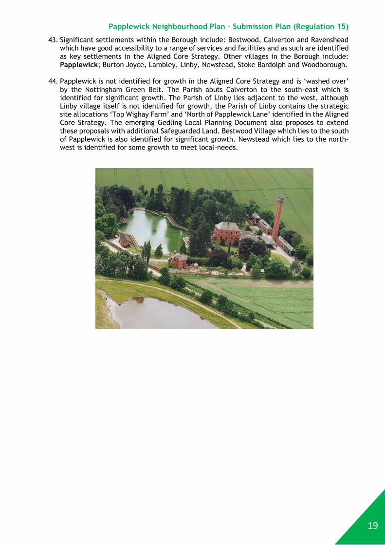
Councillor Dr Stephen Walker Councillor Carolyn Hesketh Lead Neighbourhood Plan Working Group
Councillor Stephanie Roberts Chairman Papplewick Parish Council

Papplewick Neighbourhood Plan – Submission Plan (Regulation 15)
7
Acknowledgements Papplewick Parish Council would like to extend their thanks to all those who have been involved with the formation of the Neighbourhood Plan. In undergoing this process, we have seen, at first-hand, the passion that our community has for our village and how it develops over the coming years. A working group drawn from the Parish Council and local residents have spent many hours working through the plan and developing it in to the high-quality document you see here and we are very grateful for their time, commitment and valuable input. We would especially like to thank the general public who have actively participated throughout the campaign. Without all their contributions, the Neighbourhood Plan would not exist and we would not have the opportunity to decide the village’s future as we do now. Additional thanks to:
All those who have contributed photographs to the Papplewick website over the years which make this plan look so much more interesting
The Griffin’s Head, Morton Farm Tearoom and the Village Hall, for provision of meeting space
Representatives from the Local Groups who have helped provide input into the Neighbourhood Plan
Rob Hollins – Traffic Consultant The Parish Council also acknowledges the support received from officers at Gedling Borough Council and Nottinghamshire County Council. The Parish Council is also grateful for the financial support of the DCLG grant programme operated by Locality.

Papplewick Neighbourhood Plan – Submission Plan (Regulation 15)
8
This page is intentionally blank

Papplewick Neighbourhood Plan – Submission Plan (Regulation 15)
9
Section 1 The Neighbourhood Plan
(This Section Forms Part of the Statutory Development Plan)
Papplewick Neighbourhood
Plan
Gedling Local
Planning Document
Greater Nottingham
Aligned Core
Strategy

Papplewick Neighbourhood Plan – Submission Plan (Regulation 15)
10
Introduction
1. The Localism Act 2011 introduced a new type of Community Led Plan. Communities now have the right to produce a Neighbourhood Plan, setting out policies on the development and use of land. Developing a Neighbourhood Plan is a way for communities to play a greater role in determining the future of their area.
2. The Papplewick Neighbourhood Plan will form part of the statutory development plan once made. This means that Gedling Borough Council will have to determine planning applications within the Parish of Papplewick in accordance with this Neighbourhood Plan alongside other Development Plan Documents.
3. This Neighbourhood Plan is a true Community Led Plan. It has been prepared by the Parish Council through a working group made up of Parish Councillors and local residents. It has been informed by public consultation with the local community. The options for the Plan and the Plan itself have been shaped by the results of the previous public consultation to ensure that the Neighbourhood Plan accurately reflects the aspirations of the community.
Sustainability Appraisal (SA) and Strategic Environmental Assessment (SEA)
4. Every Neighbourhood Plan needs to consider the need for a Sustainability Appraisal (incorporating a Strategic Environmental Assessment) for the Neighbourhood Plan. SA is a mechanism for considering and communicating the impacts of an emerging plan, and potential alternatives in terms of key sustainability issues. The aim of SA is to inform and influence the plan-making process with a view to avoiding and mitigating negative impacts. Through this approach, the SA where it is undertaken for the Neighbourhood Plan seeks to maximise the Neighbourhood Plan’s contribution to sustainable development. The Working Group has produced an SEA Screening for the Papplewick Neighbourhood Plan which has demonstrated that a SEA and/or SA is not required. All consultees including the 3 statutory environmental bodies and the LPA were consulted on the SEA and HRA Screening at the pre-submission (Regulation 14) stage. No party has indicated that either an SEA or a HRA is required. Natural England explicitly agreed that neither an SEA nor HRA is needed. Gedling Borough Council also agrees that no SEA or HRA is required.
National Planning Policy Framework (NPPF)
5. Throughout this Neighbourhood Plan reference is made to the National Planning Policy Framework (NPPF). The NPPF sets out the government’s planning policies for England and how these are expected to be applied. It was published on 27 March 2012 and is now also supplemented by Planning Practice Guidance.
6. The NPPF provides a framework
to produce locally distinctive Neighbourhood Plans which reflect the needs and aspirations of the community. The NPPF is clear that the planning system remains plan led. As set out in paragraph 2 of the NPPF, Section 38(6) of the Planning and Compulsory Purchase Act

Papplewick Neighbourhood Plan – Submission Plan (Regulation 15)
11
2004 remains unchanged and requires that planning applications must be determined in accordance with the development plan, unless material considerations indicate otherwise. The development plan is explained later in this Neighbourhood Plan.
7. At the heart of the NPPF is a presumption in favour of sustainable development. One of
the most widely used definitions of sustainable development comes from the report of the World Commission on Environment and Development (the Brundtland Commission), ‘Our Common Future’ (1987), which defines it as “development that meets the needs of the present without compromising the ability of future generations to meet their own needs”. A more detailed definition is offered in the UK Sustainable Development Strategy, Securing the Future, which includes the following five guiding principles for sustainable development.
a. Ensuring a Strong, Healthy and Just Society - Meeting the diverse needs of all people
in existing and future communities, promoting personal wellbeing, social cohesion and inclusion and creating equal opportunity for all.
b. Using Sound Science Responsibly -
Ensuring policy is developed and implemented on the basis of strong scientific evidence, whist taking into account scientific uncertainty (through the precautionary principle) as well as public attitudes and values.
c. Promoting Good Governance - Actively
promoting effective participative systems of levels of society – engaging people’s creativity and diversity.
d. Achieving a Sustainable Economy - Building a strong, stable and sustainable
economy which provides prosperity and governance in all opportunities for all, and in which environmental and social costs fall on those who impose them (polluter pays) and efficient resource use is incentivised.
e. Living within Environmental Limits - Respecting the limits of the planet’s
environment, resources and biodiversity – to improve our environment and ensure that the natural resources needed for life are unimpaired and remain so for future generations.
8. The Papplewick Neighbourhood Plan contributes towards the achievement of sustainable
development.
Planning Practice Guidance
9. The Planning Practice Guidance sets out the government’s advice on how to undertake neighbourhood planning within England. This is set out in detail within Section 41 of Planning Practice Guidance.
10. Planning Practice Guidance highlights that: “Neighbourhood planning gives communities direct power to develop a shared vision for their neighbourhood and shape the development and growth of their local area. They are able to choose where they want new homes, shops and offices to be built, have their say on what those new buildings should look like and what infrastructure should be provided, and grant planning permission for the new buildings they want to see go ahead. Neighbourhood planning provides a powerful set of tools for local people to ensure that they get the right types

Papplewick Neighbourhood Plan – Submission Plan (Regulation 15)
12
of development for their community where the ambition of the neighbourhood is aligned with the strategic needs and priorities of the wider local area.”
Structure of Neighbourhood Plan
11. The Neighbourhood Plan includes four themed sections: Natural Environment; Built Environment; Community Facilities; and Transport.
12. These are all issues that are important to the community and within each section policies are included to guide the development and use of land. Each Policy contains an introduction and explanatory text followed by the Policy itself in coloured text.
13. Following the themed sections, the Neighbourhood Plan contains an implementation and
delivery section. It is important that Neighbourhood Plans are deliverable and this section includes the key projects arising from the Neighbourhood Plan and details of how they will be delivered.
14. The final section includes a list of non-
planning issues that the community raised as being important. The Parish Council has not ignored these important issues, but as this is a statutory planning document it cannot include non-planning issues. This section is included in the Neighbourhood Plan to demonstrate to the community that all of their concerns have been taken into account and will be addressed by the Parish Council outside of the Neighbourhood Plan process.
Natural Environment
Built Environment
Community Facilities
Transport

Papplewick Neighbourhood Plan – Submission Plan (Regulation 15)
13
The Development Plan
15. The ‘Development Plan’ (excluding Minerals and Waste) for Papplewick is made up of 4 elements as follows:
Note – For Minerals and Waste the ‘Development Plan’ includes the Nottinghamshire and Nottingham Replacement Waste Local Plan – Part 1 Waste Core Strategy; the Saved Policies of the Nottinghamshire Waste Local Plan 2002 and the Nottinghamshire Minerals Local Plan 2005
16. All policies within the Papplewick Neighbourhood Plan should be read in conjunction with the Aligned Core Strategy, the Gedling Replacement Local Plan and the Gedling Local Planning Document. When determining proposals for development, no policy will be applied in isolation and account will be taken of all relevant policies.
Relationship to Greater Nottingham Aligned Core Strategy
17. The Aligned Core Strategy (ACS) for Greater Nottingham, including Gedling Borough, was adopted on the 10th September 2014. The Aligned Core Strategy has been prepared in partnership with the Councils in Greater Nottingham who have been working together to produce an aligned set of policies and principles on how the city region can develop between 2011 and 2028. The Aligned Core Strategies for Broxtowe, Gedling and Nottingham City are
Papplewick Neighbourhood
Plan
Gedling Replacement Local Plan 2005 (Saved
Policies)
Gedling Local Planning Document
(In Preparation)
Greater Nottingham Aligned Core
Strategy
Papplewick Neighbourhood Plan – Submission Plan (Regulation 15)
14
contained in one single document with Erewash Borough and Rushcliffe Borough producing aligned but separate Core Strategies.
18. The Aligned Core Strategy defines the spatial vision for the area, includes a number of objectives to achieve the vision and sets out the development strategy to meet these objectives. The document includes strategic planning policies to guide and control the overall scale, type and location of development including the allocation of strategic sites. It indicates the number of homes to be built by 2028, which is 7,250 homes for Gedling Borough. The Aligned Core Strategy recognises that each Council has local issues and priorities.
Relationship to Gedling Replacement Local Plan
19. The Gedling Borough Replacement Local Plan 2005 was in part replaced by the Aligned Core Strategy. In common with all Local Plans that were in place in 2008, it was necessary to decide which policies were to be ‘saved’. As such, certain policies ceased to have effect in 2008, other policies were superseded by the adoption of the Aligned Core Strategy. The remaining saved policies are used for development management purposes. The remaining Gedling Borough Replacement Local Plan 2005 (Saved Policies) will be replaced upon the adoption of the Gedling Local Planning Document.
The Emerging Gedling Local Planning Document
20. The Gedling Local Planning Document (LPD) includes more detailed planning policies that will work with the strategic policies set out in the Aligned Core Strategy and includes detailed polices for development management and the allocation of non-strategic development sites. The Local Planning Document also includes a Policies Map which illustrates the geographic extent of policies and proposals on a map. The Gedling Local Planning Document is currently undergoing its Independent Examination to determine whether it should become part of the Development Plan. If it passes its Independent Examination adoption is expected in the later part of 2018.
Strategic policies for the purposes of neighbourhood planning
21. The system of neighbourhood planning allows Parish and Town Councils to produce neighbourhood plans to guide development at a local level. One of the requirements of such plans is that they should be in line with the 'strategic policies' of the adopted development plan for the local area.
22. Gedling Borough Council as the Local Planning Authority
defines which policies are to be considered 'strategic' with regard to the production of a neighbourhood plan. They consider that the policies and allocations contained within the Aligned Core Strategy and the saved policies in the Gedling Replacement Local Plan, are all considered 'strategic' for the purposes of neighbourhood planning. Gedling also proposes that all of the policies, allocations and designations within the Local Planning Document are also considered 'strategic' for the purposes of neighbourhood planning. However until the Emerging

Papplewick Neighbourhood Plan – Submission Plan (Regulation 15)
15
Local Plan is adopted the Papplewick Neighbourhood Plan has no legal obligation to be in general conformity to it. The reasoning and evidence supporting the emerging Local Planning Document is likely to be relevant for the purpose of neighbourhood planning. The Papplewick Neighbourhood Plan seeks to complement the emerging Local Planning Document.
Adjacent Local Planning Authority Area
23. Papplewick lies on the western edge of Gedling Borough, the adjacent land to the south-west is the unparished area of Hucknall which is actually located in the neighbouring Ashfield District. There is no legal requirement for the Papplewick Neighbourhood Plan to have regard to the Development Plan in Ashfield. This is made up of the Saved Policies of the Ashfield Local Plan 2002 and the emerging Ashfield Local Plan.
24. The emerging Ashfield Local Plan is awaiting the outcome of its Independent Examination to determine whether it should become part of the Development Plan for Ashfield. The properties in Hucknall on the western side of Moor Road which abut the Papplewick boundary are excluded from the Green Belt and are included in the Main Urban Area Boundary for Hucknall. The undeveloped land which abuts the Papplewick boundary is included within the Green Belt, the woodland south of Papplewick Lane opposite the southern end of Moor Ponds Woods is designated as Green Space under the emerging Local Plan.
Surrounding Neighbourhood Plans
25. The Papplewick Neighbourhood Plan cannot be developed without consideration of other Neighbourhood Plans being developed. The Calverton Neighbourhood Plan has passed its Referendum and is scheduled to be ‘made’ at the end of January 2018. It does not contain any proposals with cross boundary implications for the Papplewick Neighbourhood Plan. The Parish of Calverton lies to the east of Papplewick.
26. The Linby Neighbourhood Plan is progressing alongside but separate to the Papplewick Neighbourhood Plan. Papplewick and Linby are sharing some evidence base particularly on transport. The draft Linby Neighbourhood Plan is anticipated to commence its Regulation 14 consultation in early 2018. The Parish of Linby lies to the west of Papplewick and is identified in the ACS for significant levels of growth. The draft Linby Neighbourhood Plan proposes to designate the parts of Dam Wood and Moor Pond Wood that lies within the Parish of Linby, this is consistent with the Papplewick Neighbourhood Plan that has already designated the parts of Dam Wood and Moor Pond Wood that lies within the Parish of Papplewick. The two plans share many non-land use planning aspirations and the two plans are considered to be complementary in terms of policy content, whilst each is locally distinctive. Both communities share a number of valuable community facilities and each plan protects those which lie within each plan area, this benefits both communities.

Papplewick Neighbourhood Plan – Submission Plan (Regulation 15)
16
27. To the north of Papplewick is the Parish of Ravenshead, to the north-west is the Parish of Newstead and to the south is the Parish of Bestwood St Albans. None of these Parishes are presently working on Neighbourhood Plans. To the south-east of Papplewick is the unparished area of Arnold and to the south-west of Papplewick is the unparished area of Hucknall which is actually located in the neighbouring Ashfield District. There are no Neighbourhood Plans in either of these unparished areas.
Designation of Papplewick Parish as a Neighbourhood Planning Area
28. A formal application was made by Papplewick Parish Council in April 2016 as a ‘relevant body’ under Section 61G of the Town and Country Planning Act 1990 (as amended) for the designation of a neighbourhood area in order to develop a neighbourhood plan. The area of the Neighbourhood Plan is based upon the parish boundary, which was seen as appropriate as this area is recognised as the distinct community of Papplewick. The request was that the Parish Council be recognised as a Neighbourhood Area for the purpose of producing a neighbourhood plan, in accordance with the Neighbourhood Planning Regulations 2012.
29. Gedling Borough Council publicised this application to produce a Neighbourhood Plan for
the required 6 week period. Gedling Borough Council designated the Parish of Papplewick as a neighbourhood area on 11 August 2016.
30. Papplewick Parish Council had wanted to include part of Ashfield District east of the river Leen, which was traditionally within Papplewick Parish and whose residents still consider themselves to live in Papplewick. However as this falls within Hucknall (an unparished area), there was no legal mechanism to include this area within the designated Neighbourhood Plan area.
Consultation with the Local Community
31. Since the designation of Papplewick as a neighbourhood area, various elements of consultation have been undertaken regarding the future planning of the Parish. Details of the consultation undertaken to date are set out in the Consultation Statement Document.
Associated Documents
32. The Neighbourhood Plan has a number of associated supporting documents as follows:
Consultation Statement
Basic Conditions Statement
SEA/HRA Screening
Landscape Character Appraisal
Designated Area Plan
Issues Scoping and Evidence Base Document
Local Green Spaces Evidence
33. Although not a Neighbourhood Plan supporting document, Gedling Borough Council has produced a Conservation Area Character Appraisal, this is to be published by the Borough Council for public consultation alongside the Submission version of the Neighbourhood Plan. This documents helps to explain what features make up the locally distinctive character of the Papplewick Conservation Area.

Papplewick Neighbourhood Plan – Submission Plan (Regulation 15)
17
Background on Papplewick Population and Historic Development
34. The parish of Papplewick is located within Gedling Borough in central Nottinghamshire, north-east of the town of Hucknall (which is in Ashfield District). Overall, the Parish has an area of around 715 Hectares. There are two main population centres in the Parish. The village of Papplewick lies to the west of the overall Parish, and is located around 7.5 miles north of Nottingham and 6 miles south of Mansfield. There is linear development bordering the A60 which forms the other main centre of population. Elsewhere, some of the residents live around the scattered farms. The Parish population has seen limited growth over the last 25 years. In 1991, there were 620 people living in the Parish, occupying 255 dwellings, increasing to a population of 756 at the 2011 census.
35. Papplewick Hall was built between 1781 and 1787 for the Hon. Frederick Montagu. He laid out parkland around Papplewick Hall, and also established woodland plantations commemorating the great naval victories of his time i.e. the battles of St Vincent (Feb 1797), the Nile (Aug 1798) and Trafalgar (Oct 1805). He did so to replenish the stocks of timber which were in short supply at that point in the Napoleonic Wars. In each plantation he erected a commemorative obelisk, two of which have survived.
36. The parish church of St James’ lies to the west of the village, occupying a secluded site bordering the River Leen. The church is a Grade 1 Listed Building of great historical interest, thought to have been built in the 12th century. The present tower dates from the 14th century. The nave and chancel were rebuilt by the Hon. Frederick Montagu in 1795 after he had rebuilt the Hall.
37. Water powered mills have existed along the River Leen in the Parishes of Papplewick and Linby since at least 1232 and probably earlier. In the 1780’s the Robinson family constructed cotton-spinning mills and homes for their workers. The population rose sharply at that time. However, cotton spinning foundered in the 1820s, the mills closed and workers moved away. The leats and ponds which provided water for the mills have become the basis for Moor Pond Woods, a valuable site for wildlife and archaeology.
38. Around 1850, management of the Montagu estate was developed. Papplewick Moor was drained in 1849, and 'the forest' was enclosed in order to create farmland. Many of the stone buildings in the village date from this time, and form the basis of the Papplewick Conservation Area.
39. The head of a griffin was a symbol which appeared on the crest of the Montagu family. The public house in the village is an historic structure which was re-named ‘The Griffin’s Head’ in the 19th century.

Papplewick Neighbourhood Plan – Submission Plan (Regulation 15)
18
40. Papplewick Pumping Station is a working museum which lies in the east of the Parish. It comprises steam-powered pumping engines, cooling pond and grounds, developed in the 1880s to supply water in Nottinghamshire.
41. The entire Parish is in the Nottingham Green Belt. Across the Parish are areas of farmland and woodland, which are accessible to the public by a network of footpaths. The village Conservation Area was defined in the 1980’s and includes Papplewick Hall, The Griffin's Head, the ancient church and the 18th-century cottages and farm buildings along Main Street. Role in Gedling
42. Gedling Borough is a mix of urban and rural areas with around 116,500 residents of which around 80% live within the suburbs of Arnold and Carlton (mid-2016 figure). Part of the north west of the Borough adjoins Hucknall which is located outside Gedling in Ashfield District but has close links to Nottingham City.
Map 1 – Location of Papplewick © Ordnance Survey – used under Open Government Licence
Papplewick Neighbourhood Plan – Submission Plan (Regulation 15)
19
43. Significant settlements within the Borough include: Bestwood, Calverton and Ravenshead which have good accessibility to a range of services and facilities and as such are identified as key settlements in the Aligned Core Strategy. Other villages in the Borough include: Papplewick; Burton Joyce, Lambley, Linby, Newstead, Stoke Bardolph and Woodborough.
44. Papplewick is not identified for growth in the Aligned Core Strategy and is ‘washed over’ by the Nottingham Green Belt. The Parish abuts Calverton to the south-east which is identified for significant growth. The Parish of Linby lies adjacent to the west, although Linby village itself is not identified for growth, the Parish of Linby contains the strategic site allocations ‘Top Wighay Farm’ and ‘North of Papplewick Lane’ identified in the Aligned Core Strategy. The emerging Gedling Local Planning Document also proposes to extend these proposals with additional Safeguarded Land. Bestwood Village which lies to the south of Papplewick is also identified for significant growth. Newstead which lies to the north-west is identified for some growth to meet local-needs.

Papplewick Neighbourhood Plan – Submission Plan (Regulation 15)
20
The Papplewick Neighbourhood Plan Area The plan below identifies the designated Neighbourhood Area:
Map 2 – Papplewick Neighbourhood Area © Gedling Borough Council © Crown Copyright – OS Licence No. LA100021246

Papplewick Neighbourhood Plan – Submission Plan (Regulation 15)
21
Vision
45. The following vision has been developed for the Papplewick Neighbourhood Plan:
The sustainable development of Papplewick will be achieved in a manner that protects the highly valued rural character of the area, yet ensures that the Parish remains a vibrant and attractive place to live and work, sustained by a range of local services.
Objectives
46. The following objectives have been set out for the Papplewick Neighbourhood Plan:
(A) Preserve and enhance Papplewick’s historic built environment
• Enhance the appearance and historic character of the village Conservation Area • Ensure that new development respects the use of local materials and preserves and
enhances the character and appearance of the streetscene
(B) Protect and enhance Papplewick’s natural environment, countryside and Green Belt setting
• Protect and enhance the green infrastructure network through the creation of new
open spaces and the protection and improvement of existing open spaces • Protect the Green Belt from inappropriate development and ensure that the
countryside is protected • Create attractive approaches to the village from every direction • Ensure that both new and existing development is fully integrated
(C) Protect and develop the community of Papplewick
• Support appropriate small-scale development that meets the needs of local residents
and businesses • Continue to improve the facilities on offer to support the local community • Work with partners to develop linkages between the two distinct developed areas in
the Parish, namely the village and the A60 Mansfield Road
(D) Ensure that Papplewick is not adversely affected by the strategic growth of Gedling and Ashfield
• Work with partners to develop appropriate traffic management measures within Papplewick village centre
• Develop footpath linkages around the Parish
• To develop public transport links to adjoining service centres

Papplewick Neighbourhood Plan – Submission Plan (Regulation 15)
22
Policy Delivery of Objectives
46. The following table demonstrates how the policies set out in the Neighbourhood Plan meet the objectives contained within the previous chapter. The policies that have been developed seek to address at least one of the objectives.
Obje
ctiv
e A
Obje
ctiv
e B
Obje
ctiv
e C
Obje
ctiv
e D
Natural Environment
Policy 1 – Local Green Space Policy 2 – The Natural Environment Policy 3 – Setting of Papplewick Policy 4 – Re-use of Rural Buildings Policy 5 – Surface Water Policy 6 – Community Renewable Energy Generation Built Environment
Policy 7 – Local Distinctiveness of Papplewick Policy 8 – Public Realm Policy 9 - Housing Community Facilities
Policy 10 – Community Facilities Traffic and Transport
Policy 11 – Sustainable Transport
Policy 12 – Highway Impact

Papplewick Neighbourhood Plan – Submission Plan (Regulation 15)
23
Natural Environment

Papplewick Neighbourhood Plan – Submission Plan (Regulation 15)
24
Natural Environment 1. Background
1.1 Most of the Parish of Papplewick is rural, and contains substantial areas of farmland which
contributes significantly to the character of the Parish and the setting of the village. The rolling landscape and open countryside around the village is identified in the draft Papplewick Conservation Area Appraisal and by local residents as being important to the setting of the Conservation Area.
1.2 Papplewick lies in a gently undulating landscape, which gradually descends to the west, towards the River Leen. Surrounded by arable land and pasture, Papplewick remains closely linked to its agricultural origins. This is particularly apparent when approaching the village along Blidworth Waye, Hall Lane, or the footpath from Linby.
1.3 Moor Pond Woods is an area of significant
archaeological and ecological interest that lies to the west of the village, between Linby and Papplewick. It is located mostly within the Neighbourhood Plan area, although part of the woods lie in the neighbouring Parish of Linby and some in Ashfield District. The woods occupy the site of a system of ponds and channels that fed water to cotton mills in the 18th century. The site is accessible to the public via a network of surfaced paths. A volunteer group supports the development and management of the Moor Pond Woods Project Area. The Moor Pond Woods project is a partnership between the landowner, the County Council, Papplewick and Linby Parish Councils, Gedling Borough Council, Ashfield District Council and the local residents (who are represented by the ‘Friends of Moor Pond Woods’).
1.4 Moor Pond Woods is now a Local Wildlife
Site (LWS), and is therefore significant not only for its historical links with the early industrialisation, but also for its biodiversity value. Papplewick Dam Wood and the Calverton mineral line disused railway are also Local Wildlife Sites.
1.5 The northern section of Moor Pond Woods
(no.1, on the map) is known as Papplewick Dam Wood. It is the site of the pond that supplied Castle (Top) Mill, built in 1782, and drained in 1946. This contains an area of wet woodland (dominated by willow and alder) and a section of the river Leen. Moor Pond Wood is on the site of the large pond which stood at the junction of Moor Road and Papplewick Lane (no.3, on the map). It is separated from Linby Lane by a thin strip of woodland called Dam Banks (no.2, on the map). These woodlands contain two wetland features but the banks are characterised by dry woodland dominated by sweet chestnut, ash and oak. To the south of Papplewick Lane is a small wood called Grange Cottage Wood, (no.4, on the map) where the Friends of Moor Pond Woods have created a woodland meadow amidst the oak and ash

Papplewick Neighbourhood Plan – Submission Plan (Regulation 15)
25
woodland. Grange Cottage Wood (no.4) falls within Ashfield District, under their emerging Local Plan, Ashfield District Council propose to designate that area as a Local Green Space.
Map 3 – Moor Ponds Woods © Friends of Moor Pond Woods
1.6 Part of the former estate of Papplewick Hall is included on the Register of Parks and Gardens
of Special Historic Interest. Papplewick Hall Park is a characteristic example of the landscape design that was popular in the 18th and early 19th centuries. Taking advantage of natural features, and using devices such as the embankment along Blidworth Waye to the east of the Hall and the ha-ha to the west, the aim was to provide picturesque views of the rolling countryside and pleasant walks or drives around the estate. Trees (and other greenery) were deliberately planted so as to enhance views and provide features of interest within the landscape. The existing mature trees play an important role in preserving the character of the park, not only to the east of the Hall, but also around the walled garden and north of Church Lane. Of equal importance are the mature trees within and around St James’ churchyard and the woodland plantations outside the Conservation Area, which make a valuable contribution to the setting of the village.
1.7 South-west of the crossroads, and south of the village hall, is an area of grassland and woodland known as the ‘Queen Elizabeth II Playing Field’. The site was purchased for the use of the community in 1951 and given to be maintained by the Parish Council in 1972. In 2013 it was dedicated as a ‘Field in Trust’ in commemoration of the anniversary of the accession of the Queen. The Parish Council maintain play equipment.
2. Local Green Space
2.1 In 2012, the Government introduced a new designation of Local Green Space through the
NPPF allowing local communities to put forward green areas of particular importance to

Papplewick Neighbourhood Plan – Submission Plan (Regulation 15)
26
them for protection. Once designated, planning permission will only be granted for the development of the sites in very special circumstances or if the development clearly enhances the Local Green Space for the purposes it was designated.
2.2 Local Green Space designation will not
be appropriate for all green areas or open space. The designation should only be used where the green space is in reasonably close proximity to the community it serves; where the green area is demonstrably special to a local community and holds a particular local significance, for example because of its beauty, historic significance, recreational value (including as a playing field), tranquillity or richness of its wildlife; and where the green area concerned is local in character and is not an extensive tract of land.
2.3 Although Papplewick is ‘washed over’ by the Green Belt which provides protection against
inappropriate development the proposed sites are closely related to the built-up area of the village and therefore may come under pressure for development. As they are demonstrably special to the local community they are considered worthy of additional protection through designation as Local Green Space. The policy imposes additional constraints relating to tranquillity and setting, beyond the restrictions imposed by Green Belt policy.
2.4 The sites listed in the policy have been assessed as according with the criteria for Local
Green Space as set out in the NPPF and are therefore considered to be in reasonably close proximity to the community they serve; local in character and not an extensive tract of land; and demonstrably special to the local community and holding a particular local significance. A tabular assessment of each of the designated Local Green Spaces against the criteria set out in the NPPF, together with a brief summary of each of the areas is set out in the Appendix.
2.5 The northern section of Moor Pond Woods is known as Papplewick Dam Wood, the Policy
below refers to this area as a separate designation to the remainder of Moor Ponds Wood as it has different characteristics. In addition to the Local Green Spaces to be designated by this Neighbourhood Plan, the emerging Gedling Local Planning Document also proposes to designate Moor Pond Woods as a Local Green Space. A plan is included in Appendix 1 to illustrate the relationship between the Neighbourhood Plan Local Green Space and the emerging Local Planning Document proposed Local Green Space. The Local Green Spaces are illustrated on the Policies Map, more detailed maps are where necessary also included in Appendix 1.
2.6 The River Leen and valley floor form an important protective corridor for wildlife and several
rare species of flora and fauna can be found either in the high quality clean water or along the river banks. The river corridor contains Moor Pond Woods and Papplewick Dam which form an important western gateway into Papplewick.

Papplewick Neighbourhood Plan – Submission Plan (Regulation 15)
27
Policy 1 – Local Green Space The following sites are designated as Local Green Spaces:
Queen Elizabeth Playing Field
Moor Pond Woods & Dam Banks
Papplewick Dam Wood
St James’ Churchyard and Driveway
Papplewick & Linby Cricket Ground
Land to the Rear of the Griffin’s Head Public House The policy taken towards development in these areas is consistent with that taken towards development in Green Belt. Inappropriate development will not be allowed other than in very special circumstances. Development should not adversely affect the tranquillity of the Local Green Spaces. Proposals adjacent to these sites will need to demonstrate that they will not harm the setting of the Local Green Space and where possible enhance access to the Local Green Space for people and wildlife.
Map 4 - Moor Pond Woods & Dam Banks and Papplewick Dam Wood © Friends of Moor Pond Woods
3. The Natural Environment
3.1 Papplewick is a rural parish. Whilst the village has seen development during the second half
of the 20th century it retains a number of green spaces that contribute to the rural character and provide opportunities for informal and formal recreation. In accordance with national planning guidance the community wishes to see the most important of these spaces protected for future generations.

Papplewick Neighbourhood Plan – Submission Plan (Regulation 15)
28
3.2 Within the Parish there are a number of different habitats identified in the Biodiversity Action Plan for Nottinghamshire. These support distinctive flora and fauna that provide character to different parts of the parish. These include, in particular, the wetlands of the Leen Valley, the mature hedgerows on farmland, the areas of mixed woodland and the habitats on sandy soils. The settlement and wider countryside of the Parish contain features of significant local wildlife value. The designation of Local Wildlife Sites is managed in Gedling Borough by the Nottinghamshire Biological and Geological Records Centre. Local Wildlife Sites are reviewed regularly and designations are updated to reflect evidence.
3.3 Former mill-ponds and leats created during the late eighteenth century are found in Moor
Pond Wood and Papplewick Dam Wood and these wetland ’nature reserves’ contain a great diversity of plant and animal species including the endangered great crested newt, White-tailed crayfish and water vole. The Goosedale area is also an important wetland feature with significant wildlife value. The River Leen is an important watercourse bordering the west of the parish
3.4 The open fields, particularly on Papplewick
Moor, support brown hare and birds such as lapwing, skylark and reed bunting. Hedgerows in the parish form important corridors for wildlife including badgers and foxes; small birds such as finches, great tits and blue tits; dragonflies and butterflies. Small woodland areas also provide important habitats for many species including the tawny owl and great spotted woodpecker. Watercourses also provide an important wildlife habitat for water vole.
3.5 Although modern agricultural practices have
been responsible for the loss of many landscape features over the past sixty years, future agri-environment funding may lead to the restoration of traditional features such as woodland, hedgerows, wildflower meadows and wetlands. To enable a greater appreciation of the Parish’s landscape features and interaction with the wildlife, access to the countryside is achieved via a network of public and permissive footpaths that cross the Parish, however, a lack of circular routes often necessitates a return via local roads.
Policy 2 – The Natural Environment Proposals that protect and enhance the natural features that are a key component of the landscape and provide habitat for Papplewick’s diverse wildlife populations, including:
a. Measures to protect & enhance Papplewick’s natural environment & landscape character and to maintain tree cover & hedgerows will be promoted wherever possible;
b. Proposals that provide favourable conditions for biodiversity including maintenance and enhancement of habitat connectivity and landscape scale conservation will be supported. Mitigation measures will be sought where any loss would be unavoidable and cause significant harm;

Papplewick Neighbourhood Plan – Submission Plan (Regulation 15)
29
c. In the built-up area along Mansfield Road and in the village centre, wherever practicable, development proposals should include measures to enhance biodiversity as part of landscaping and building design. Proposals should include enhancements such as sustainable drainage systems, re-naturalising watercourses, woodland planting, roosting opportunities for bats, the installation of bird nest boxes and the use of native species landscape planting;
d. Proposals that provide measures to increase the enhancement, reinstatement or creation of hedgerows along boundaries, and provide the creation of additional pockets of woodland will be supported.
4. Setting of Papplewick Village
4.1 The village of Papplewick is located on the eastern side of the valley of the River Leen, at between 75m and 90m above sea level. There is rich farmland surrounding the village, and most of the parish of Papplewick is situated on gently rolling hills between 75m and 125m above sea level. The highest land is located to the north along Blidworth Waye and in the east of the Parish around Forest Farm. A valley that runs from Seven-Mile House and Barracks Farmhouse westwards towards the Leen Valley dissects these hills. There is no stream in this valley at present, but the extensive deposits of alluvium and peat along its floor indicate that it was a river valley at some point in the past. The silty soils on Papplewick Moor are ideal for arable farming. They get very dry in summer and other periods of dry weather.
4.2 Farming is at the heart of Papplewick and management of five arable farms principally
influence the landscape of Papplewick. Top Farm comprises 223 hectares, lying largely to the north of the village. West View Farm covers 131 hectares, lying close to the village itself. This is jointly worked with Barracks Farm, which is a 111 hectare farm that lies to the east of the village. Stanker Hill Farm is a small farm of only 61 hectares located south-east of the village. This is worked in conjunction with four other local farms. Forest Farm is a mixed farm of 168 hectares to the north-east of the village.
4.3 The Papplewick Parish Landscape Character Appraisal Document identifies a number of
important open vistas, closed views and glimpsed views. These open vistas into and out of Papplewick village and the wider Parish across farmland make the biggest contribution to the overall setting of Papplewick. These key vistas are illustrated on the map below and summarised in Appendix 2. They are explained in more detail in the supporting Landscape Character Appraisal document.
Policy 3 – Setting of Papplewick Any development within the key vistas identified on the Map 5, must ensure that the key features of the vista can continue to be enjoyed including any distant views of buildings, views of areas of landscape; and that the juxtaposition of the village edge and transition to the open countryside is not adversely affected.

Papplewick Neighbourhood Plan – Submission Plan (Regulation 15)
30
Map 5 – Key Vistas © Ordnance Survey – Used under Open Government Licence 5. Re-use of Rural Buildings
5.1 Papplewick developed as an agricultural community, it still contains a number of important
farms which not only contribute to the built character of the village but also to the wider rural landscape character. The local community highly value the agricultural character of Papplewick and want to particularly support through this Neighbourhood Plan proposals to secure beneficial re-use of traditional rural buildings which are often unsuited to modern agricultural needs.
5.2 The conversion of former agricultural
buildings has enabled farm diversification, led to the sustainable re-use of vacant buildings and provided opportunities for the establishment and development of small businesses which generate income and employment opportunities for local people. This is supported, subject to the proper consideration of residential amenity for nearby houses, visual impact on the countryside and highway safety issues. Consideration should also be given to Policy 7 Local Distinctiveness of Papplewick.

Papplewick Neighbourhood Plan – Submission Plan (Regulation 15)
31
5.3 Rural buildings, including existing and former agricultural buildings are an asset which can be utilised for other uses when no longer required for their original intended use. The re-use and conversion of existing buildings helps prevent the pressure for new buildings within the Green Belt. However care needs to be taken to ensure that re-use does not result in unacceptable adverse impacts.
5.4 Given the pressures on existing road networks within the Parish, the re-use and conversion
of rural buildings for commercial or employment uses will only be supported if there is no adverse impact on surrounding areas. These adverse impacts on local residents could include excessive traffic; noise; dust; and damage to verges.
5.5 Paragraph 90 of the NPPF identifies that the re-use of buildings within the Green Belt is not
inappropriate provided they preserve the openness of the Green Belt, do not conflict with the purposes of including land within it and the buildings are of permanent and substantial construction. The re-use of buildings can have a number of benefits and will usually not result in a greater impact on the Green Belt. Careful consideration needs to be given to the nature of the proposed use to ensure that the activity it would generate does not result in an impact on the openness of the Green Belt or other forms of impact.
5.6 To help maintain the rural economy and
protect the Green Belt and open countryside from inappropriate development, the Plan supports the sustainable growth and expansion of business and enterprise through the development and where appropriate conversion of existing farm buildings in the countryside. Specifically, this is intended to:
Promote a viable and sustainable farming and rural economy in Papplewick parish;
Promote the diversification of rural businesses;
Encourage new businesses to provide a wider range of local produce, services and leisure facilities, to provide local employment and attract visitors to the Parish;
Maintain and enhance the local environment of rural and agricultural lands. Policy 4 – Re-use of Rural Buildings Proposals which encourage the re-use, conversion and adaptation of rural buildings for small businesses, recreation, or tourism purposes will be supported where:
The use proposed is appropriate to the rural location, having regard to other policies of the development plan;
The conversion/adaptation works respect the local character of the surrounding area;
The proposal preserves the openness of the Green Belt and does not conflict with the purposes of including land within it;
The buildings are of permanent and substantial construction, are structurally sound and capable of re-use without major alterations, adaptions or reconstruction;
The development will not have an adverse impact on any archaeological, architectural, historic, environmental features or protected species;

Papplewick Neighbourhood Plan – Submission Plan (Regulation 15)
32
The local road system is capable of accommodating the traffic generated by the proposed new use and adequate parking can be accommodated within the site; and
There is no significant adverse impact on neighbours through noise, light or other pollution, increased traffic levels or increased flood risk.
6. Surface Water
6.1 The capacity and condition of verges, ditches, drains and culverts have led to drainage
problems affecting roads through water pooling and some properties in the parish through flooding. The incidences of flooding have increased in recent years, resulting in limited access to areas within the Parish and even potentially dangerous conditions, for example on Blidworth Waye, Linby Lane and Forest lane. The state of our roads was a common issue which arose from all the consultations
6.2 Development should not exacerbate these conditions and, where possible, should
incorporate measures to address localised flooding. In addition, the Parish Council will work with the County Council to ensure that an annual maintenance programme that includes the cutting of verges, maintenance of gulleys and clearance of ditches and culverts is carried out, to ensure safe and consistent access to the village all year round, and avoid damage to property.
6.3 The centre of Papplewick
village around the junction of Linby Lane, Forest Lane, Main Street and Moor Road suffers from existing surface water flooding as illustrated on Map 6 below. Mansfield Road area of Papplewick also suffers from existing surface water flooding as illustrated on Map 7 below. The River Leen valley is also a source of surface water flooding as well as river flooding.
6.4 The River Leen is a tributary of the River Trent. The Leen rises at Robin Hood's Spring (in
Joan Slut Plantation to the east of Annesley in the District of Ashfield) and runs southwards along the western edge of the parish of Papplewick towards Nottingham. The river and valley floor form an important protective corridor for wildlife and several rare species of flora and fauna can be found either in the high quality clean water or along the river banks.
Policy 5 – Surface Water Development proposals will not be permitted where it will result in any additional surface water flows into the areas of surface water flood risk identified by the Environment Agency in Papplewick, including close to the centre of Papplewick village and close to Mansfield Road. Development should not cause or increase surface water flooding or risk of pollution from unsatisfactory foul water drainage where this might compromise the ability to achieve water quality targets for the River Leen.

Papplewick Neighbourhood Plan – Submission Plan (Regulation 15)
33
Where any of these are identified as a potential problem, developers will need to carry out detailed assessments and identify measures to be undertaken. Where the management of drainage needs to be addressed, developers should utilise sustainable drainage systems (SUDs) where this is practicable, including measures to support biodiversity.
Map 6 – Areas of Surface Water Flooding in Papplewick Village © Environment Agency

Papplewick Neighbourhood Plan – Submission Plan (Regulation 15)
34
Map 7 – Areas of Surface Water Flooding on Mansfield Road, Papplewick © Environment Agency 7. Community Renewable Energy Generation 7.1 A policy has been set to encourage and support the provision of small/domestic scale
renewable energy projects within the Plan area which benefit and support local community facilities, and which do not unacceptably adversely impact on the environment in other ways.
7.2 The Parish Council will work with local
community facilities, local community groups, local landowners and energy companies to explore whether proposals for a community small scale renewable energy generation facility could be developed which helps to

Papplewick Neighbourhood Plan – Submission Plan (Regulation 15)
35
meet the energy needs of local community facilities. The Parish Council will only support a proposal where it makes provision for benefits to the local community.
Policy 6 – Community Renewable Energy Generation Proposals for small scale community renewable energy generation will be supported in Papplewick where the following criteria are met:
They provide energy to one or more local community facilities;
They make provision for benefits to the local community throughout the lifetime of the energy generation;
They respect the rural and/or settlement character of the locality;
They do not adversely affect heritage assets including the character and appearance of the Papplewick Conservation Area;
They do not adversely affect landscape character or the openness of the Green Belt;
They will not adversely affect biodiversity; and
Residential amenity is protected.

Papplewick Neighbourhood Plan – Submission Plan (Regulation 15)
36
This page is intentionally blank

Papplewick Neighbourhood Plan – Submission Plan (Regulation 15)
37
Built Environment

Papplewick Neighbourhood Plan – Submission Plan (Regulation 15)
38
Built Environment
8. Background
8.1 The parish of Papplewick is located around 7.5 miles north of Nottingham and 6 miles south
of Mansfield. The village is sited in the west of the parish, slightly to the north of the town of Hucknall (which is in Ashfield District). The Parish covers an area of around 715 Hectares. In 1991, there were 620 people living in the parish, occupying 255 dwellings. This had increased to a population of 756 at the 2011 census. Only around half of the parishioners live in the village itself, the remainder predominantly being resident either along the western side of Mansfield Road (the A60) or along the eastern side of Moor Road (B683).
8.2 There are properties on Moor Road
which lie to the west of Moor Road. Whilst many of these residents consider themselves to be part of the community of Papplewick, they are technically located in Hucknall in Ashfield District.
8.3 Papplewick Hall was built between 1781
and 1787 for the Hon. Frederick Montagu. The former estate of Papplewick Hall is included on the Register of Historic Parks and Gardens. The church of St James, in the grounds of the Hall, was rebuilt in 1795. Despite twentieth century development within the village, the historic core of this agricultural settlement remains relatively intact and retains its rural character and traditional built form.
8.4 The village lies on a ridge of fluvio-glacial sand, in a gently undulating landscape. The village
centre straddles the old main road from Nottingham to Mansfield. The importance of this road may have had some influence on the linear development of the village. Papplewick’s early development as a farming community served to shape its present form. During the 18th century, earlier buildings were gradually replaced by cottages, farmhouses and associated outbuildings, which appear to follow the pattern of the earlier structures, with development concentrated along Main Street. Local stone was used to construct the ‘new’ buildings, which now form the historic core of the village.
8.5 Besides the farmhouse and barn on the
corner of Linby Lane and Moor Road, and the ‘Griffin’s Head’ at the corner of Forest Lane and Moor Road there was little other development by 1774. The development of Mill-housing on Moor Road was largely dismantled in the 19th century. Papplewick remained essentially a linear settlement until the development of suburban housing along Forest Lane, Linby Lane and Moor Road in the mid-20th century.
8.6 Land use in the village is predominantly
residential, several of the buildings have been converted from farm buildings. However, many important farm buildings around the parish remain in agricultural use.

Papplewick Neighbourhood Plan – Submission Plan (Regulation 15)
39
8.7 Papplewick village was designated as a Conservation Area in 1973. Within the Conservation Area which is designated for its special architectural or historic interest, there is a duty on local planning authorities to ensure that the character or appearance is preserved or enhanced.
8.8 After the turnpike road was opened in
1787 (now the A60), settlement spread to the eastern side of the parish. In the mid-20th century residential development took place along the western side of this road, forming a significant proportion of the housing stock in the parish.
8.9 Papplewick is a vibrant rural community.
There are numerous community and social groups, a village hall, a pub (The Griffin's Head) a Cricket Club and an ancient church. Heritage buildings in the parish include the 18th-century cottages and Papplewick Hall in the village conservation area. Papplewick Pumping Station lies at the east of the Parish, which is now a working museum comprising steam-powered pumping engines, cooling pond and grounds. The entire Parish is in the Nottingham Green Belt, and the village is linked to the surrounding rural area by a network of rights of way.
9. Local Distinctiveness of Papplewick 9.1 The Papplewick Neighbourhood Plan aims to ensure that any new development or change to
buildings should respond to local character and the history and identity of local surroundings. Maintaining local distinctiveness includes ensuring that the form of a vernacular building is respected. This includes architectural detailing and the nature of the locally available construction materials. In Papplewick village, the high quality local Magnesian limestone was used in the construction of almost all the older existing buildings and remains the predominant material.
9.2 Pantiles are the most frequently
occurring roofing material on stone buildings, although slates are also in use on a number of the older buildings within the village. The traditional roofing of the mid-20th century suburban houses was rosemary tiles. In addition to Papplewick Hall, the stone buildings within the Conservation Area include rows of cottages, detached houses and farm buildings, some of which have often been converted as homes.
9.3 The character of the conservation area
is provided by the building materials and whilst the agricultural buildings vary greatly in height, dependent on their original function, dwellings are typically two-storey and relatively small-scale. This mix of building types, combined with the irregular plot widths, heights and building types provides a high level of diversity. Nevertheless, coherence is maintained by the building materials and local constructional details.

Papplewick Neighbourhood Plan – Submission Plan (Regulation 15)
40
9.4 The buildings are most frequently simple in design, and unadorned with decorative detail. There are a number of exceptions, where decorative features such as coped gables, kneelers, keystones, or ashlar dressings do appear. Traditional buildings are constructed of coursed and squared rubble, generally with segmental heads or stone lintels to doors and windows. Timber horizontal sliding sash windows are typical, although mullioned windows with side-hung casements do occur. Roof pitches tend to be steep, generally varying from around 30 to 45 degrees.
9.5 Local distinctiveness in Papplewick
village has been identified through the draft Papplewick Conservation Area Appraisal and by local residents as including:
Traditional construction materials – particularly the predominant honey-coloured, local stone, used for buildings, boundary walls and embankments, which provides a ‘sense of place’;
The retention of historic architectural details – particularly with regard to door and window openings, and use of timber as the material;
The sense of enclosure (provided by either greenery or the stone buildings) along Church Lane, Blidworth Waye (to the north of Top Farm), Linby Lane, and Main Street;
The meandering road pattern of Church Lane, Blidworth Waye, Hall Lane, Linby Lane and Main Street, which, along with the topography and boundary treatments provide a variety of different views into and out of the village; and
The construction of suburban linear extensions in the mid-20th century, along Moor Road, Forest Lane, Linby Lane and Mansfield Road. Each line of properties lies alongside a principal road and faces open space or woodland.
9.6 Local distinctiveness of the setting of
Papplewick village, within the parish, has been identified by local residents as including:
The farming heritage;
The rolling landscape, open countryside around the village, and the use of hedges, and local stone walls and embankments as boundary markers which help to maintain Papplewick’s rural character;
The survival of earthworks from the middle ages or medieval times, and the remnant of the hollow way, which help to connect the village with its earliest settlers;
The survival of earthworks and structures relating to cotton spinning mills; and
The woodlands.
9.7 A number of structures (see list below) within Papplewick parish have statutory Listed Building status, afforded to those buildings recognised as being of special architectural or historic interest. These are afforded protection through the National Planning Policy Framework and the policies in the Aligned Core Strategy. The volunteer input that is put into the ongoing care of Papplewick Pumping Station is of vital importance to the protection of this important heritage asset.

Papplewick Neighbourhood Plan – Submission Plan (Regulation 15)
41
Grade I Papplewick Hall, off Blidworth Waye (Formerly Main Street) Church of St. James, Church Lane
Grade II* Engine House, Boiler House and workshop at Papplewick Pumping Station, Longdale Lane
Grade II Chetwynd House and Boundary Wall, off Blidworth Waye (Formerly Main Street) Stable range at Papplewick Hall off Blidworth Waye, (Formerly Main Street) Walled kitchen garden 100 metres north of Papplewick Hall, Off Blidworth Waye Top Farmhouse and adjoining stables, Blidworth Waye Barn and stable at Top Farmhouse, Blidworth Waye Gate piers and boundary wall, Church of St. James, Church Lane Various headstones and chest tomb at the Church of St. James, Church Lane Obelisk north-west of Vincent Lodge, Forest Lane The Griffins Head, Forest Lane 1 and The Barn, Linby Lane Boiler house chimney at Papplewick Pumping Station Smithy, stable and cartshed at Papplewick Pumping Station Cooling pond at Papplewick Pumping Station (Formerly listed as Retaining Walls to Reservoir) Deputy's house at Papplewick Pumping Station Superintendent's house at Papplewick Pumping Station Boundary wall and gates at Papplewick Pumping Station 9a, 9b, 11, 15, 17, 19, 21, 23, 25 Main Street 49 (Pembroke Cottage), 51 and 53 Main Street The Old Post Office, 55 Main Street Morton's Farmhouse, 57 Main Street Stable and garage to south of Morton's Farm, Main Street Papplewick Lodge and adjoining stables, Main Street Sundial north of Papplewick Lodge, Main Street 67, 69, 71, 73 Main Street (Formerly listed as Nos 68-71) Howe Plantation Obelisk, north-east of Woodland Grange, Mansfield Road Boundary stone 500 yards west of Mansfield Road Boundary stone 30 metres north of Howe Plantation Obelisk, Mansfield Road Boundary stone to north of Papplewick Pumping Station, Longdale Lane, at SK 58357 52201 Boundary stone to north of Papplewick Pumping Station, Longdale Lane, at SK 57454 52320 Boundary stone at entrance to Newstead Grange at SK 55276 52573
Scheduled Ancient Monument Papplewick Pumping Station
Historic Park and Garden Grade II* Papplewick Hall
Historic Park and Garden Grade II Papplewick Pumping Station
9.8 In addition to the listed buildings noted above, Gedling Borough Council has previously
assessed a number of other buildings in Papplewick through the Replacement Local Plan and subsequently in the draft Papplewick Conservation Area Appraisal which have architectural, historic or townscape value, but do not merit statutory listing. The Gedling Borough Council Local Interest Buildings list can be found at Appendix 1 of the Replacement Local Plan (2005). This identifies five buildings in Papplewick. Following the adoption of the emerging Local Planning Document, the Borough Council proposes to use a robust and proportionate process to prepare a list of Locally Important Heritage Assets which will effectively renew and replace the existing Local Interest Buildings Gedling Borough Council list. These buildings

Papplewick Neighbourhood Plan – Submission Plan (Regulation 15)
42
will be protected under Policy LPD31 and Policy LPD26 of the emerging Local Planning Document.
9.9 The eleven buildings in the policy are classed as being of local interest and are designated
as ‘Locally Designated Heritage Assets’. They are not afforded the full protection of statutory Listing, but as non-designated heritage assets they are still worthy of protection through the Neighbourhood Plan. When considering the impact of a proposed development on the significance of a heritage asset, importance should be given to the asset’s conservation. The more important the asset, the greater the weight should be. Significance can be harmed or lost through alteration or destruction of the heritage asset or development within its setting. A summary of these buildings is set out in Appendix 3 and further background on heritage is also contained in the Landscape Character Appraisal which supports this Neighbourhood Plan.
9.10 Gedling Borough Council has produced a Conservation Area Character Appraisal, this is to be
published by the Borough Council for public consultation alongside the Submission version of the Neighbourhood Plan. This documents helps to explain what features make up the locally distinctive character of the Papplewick Conservation Area.
Policy 7 – Local Distinctiveness of Papplewick All development proposals should be designed to a high quality that reinforces the local distinctiveness of Papplewick. Materials should be guided by the materials used in the surrounding area. Within the Conservation Area where appropriate local Magnesian limestone should be used; roofing should be pantiles or slates; and windows and doors should be timber. Design should be guided by the overall scale, density, massing, height, landscape, layout, materials, detailing, roof orientation, roof slope, relationship to back of pavement, wall to window ratios, and proportion of windows, plot depth, plot width, and access. The following buildings are identified as ‘Locally Designated Heritage Assets’:
Gateway to Papplewick Hall, Blidworth Waye
Wheelwrights Cottage, 30 Main Street
West View Farmhouse and adjoining outbuildings, 46 Main Street
West View Court, Main Street
Gardener's Cottage, Hall Lane
Ward Cottage, Blidworth Waye
Forge Cottage, 11 Linby Lane
Former Forge, Blacksmith’s Court
Stokers Cottages adjacent to Papplewick Pumping Station
Dovecote at Forest Farm
Seven Mile Cottages The retention of locally important heritage assets is encouraged, and development proposals affecting the significance of these will need to accord with the relevant policies set out in the development plan. 10. Public Realm 10.1 A high quality public realm made up of well-designed streets, pavements and other publicly
accessible areas, together with the boundary treatments to local properties and front gardens, make a positive contribution to how Papplewick looks. Within Papplewick village

Papplewick Neighbourhood Plan – Submission Plan (Regulation 15)
43
(in particular) the public realm is seen by local people as being an important element of the overall urban design of the village. A high quality public realm contributes to a high quality of life which can help to maintain healthy living, prevent anti-social behaviour and encourage high standards of property maintenance.
10.2 Traditional construction materials –
particularly the predominant honey-coloured, local stone, used for boundary walls, use of hedges and grassed embankments all make a positive contribution to the public realm. The front garden of Cornerstone House (No.72 Main Street) makes a particular visual contribution to the streetscene, with its juxtaposition to the road giving it an appearance akin to a village green.
10.3 The public realm of the Mansfield Road area is somewhat dominated by the A60 highway
itself. There is a mix of boundary treatments used on the properties such that there is no overall cohesive design or vernacular. The one-sided nature of the linear development is part of the character of Mansfield Road. This Neighbourhood Plan aims to improve linkages between the main part of Papplewick village and the Mansfield Road area, however the Mansfield Road area currently lacks a community identity. Therefore the Parish Council will work with Gedling Borough Council and Nottinghamshire County Council to help develop a community identity for the Mansfield Road area of Papplewick. This could include development of a gateway style feature on the A60 to identify that a settlement has been entered; and potential creation of a distinct name for the Mansfield Road area of Papplewick.
Policy 8 – Public Realm Development proposals which have the potential to impact negatively on the boundary treatment or open frontages which make a positive contribution to the public realm will be resisted. Any new development will be expected to demonstrate how they will contribute to high quality streets, pavements and other publicly accessible areas (the public realm) within Papplewick. Where appropriate, the Parish Council will work with the Highway Authority to ensure that improvements to the existing public realm, to ensure safe and high quality access for all users, should be delivered alongside road improvements or alterations. The Parish Council will work with Gedling Borough Council and Nottinghamshire County Council to help develop a community identity for the Mansfield Road area of Papplewick. 11. Housing 11.1 The entire parish of Papplewick is ‘washed over’ by the Nottingham Green Belt. As such, no
sites are allocated for new housing development. In accordance with longstanding national planning policy in the National Planning Policy Framework development judged to be ‘inappropriate development’ will not be permitted. Development proposals for additional housing is expected to accord with national Green Belt Policy.

Papplewick Neighbourhood Plan – Submission Plan (Regulation 15)
44
11.2 In response to a local questionnaire, the residents of the parish have identified that if small scale development was to happen in the parish, additional housing within the village for older people, and bungalows would be preferable to other types of development. Where a proposal comes forward which meets the need for downsizing or the changing needs of the local elderly population then this will be supported, subject to general conformity with Green Belt policy.
11.3 If local housing need is not being met then to respond to the changing needs of local
residents, the Parish Council will (if there is evidence of need) consider an option to provide housing specifically for the elderly through a measure which can be permissible as an exception to Green Belt Policy, this would be through a measure known as a Community Right to Build Order.
11.4 A Community Right to Build Order is a form of Neighbourhood Development Order that can
be used to grant planning permission for small scale development for community benefit on a specific site or sites in a neighbourhood area. If it were to be proposed then there is a defined process to go through which involves extensive public consultation.
11.5 A Community Right to Build Order can be used for
example to approve the building of homes, shops, businesses, affordable housing for rent or sale, community facilities or playgrounds. Where the community organisation wishes to develop the land itself (subject to acquiring the land if appropriate), then the resulting assets can only be disposed of, improved or developed in a manner which the organisation considers benefits the local community or a section of it.
11.6 The legislation also provides a mechanism that
enables housing developed using a Community Right to Build Order to be retained as housing that is affordable in perpetuity. This is achieved by disapplying certain statutory rights of tenants of long leases to buy their freehold and the statutory right given to qualifying tenants to acquire social housing.
Policy 9 – Housing Proposals for housing development in Papplewick will only be supported where it accords with national Green Belt Policy. Proposals for small scale infill development, and the development and reuse of derelict buildings within the Parish will be supported where they comply with national Green Belt Policy provided that the characteristics specific to local buildings are preserved and enhanced. Applications for housing development will be reviewed with a view to ensuring that the changing mix and balance of the population within the parish is taken into account. Proposals which involve the provision of additional housing designed for older people will be particularly supported. If local housing need is not being met then to respond to the changing needs of local residents, the Parish Council will if there is robust evidence of need, consider an option to provide housing specifically for the elderly through a Community Right to Build Order.

Papplewick Neighbourhood Plan – Submission Plan (Regulation 15)
45
Community Facilities

Papplewick Neighbourhood Plan – Submission Plan (Regulation 15)
46
Community Facilities 12. Background 12.1 Papplewick is fortunate to host some excellent and essential community facilities. These
include a number of built facilities and a number of open spaces. Papplewick and Linby share a village hall although this is located within Papplewick. The village is also fortunate to still have a traditional village pub, The Griffin’s Head. Community facilities play an important role in facilitating social interaction and creating healthy, inclusive communities. Encouraging communities to become more physically active through walking, cycling, informal recreation and formal sport plays an important part in this process. The retention of community facilities that provide opportunities for local residents to remain active and healthy is an important contributor to improving public health. As part of supporting health and wellbeing the Neighbourhood Plan looks to: create safe and accessible environments; ensure high quality public spaces; protect and support recreational space/sports facilities; support community facilities; and promote public rights of way. This approach is taken throughout the Neighbourhood Plan.
12.2 Other important community facilities include the Queen Elizabeth 2nd Playing Field, The
parish church of St James’s, and the Papplewick and Linby Cricket Club. 12.3 The village hall was replaced in 1995 with the existing modern brick structure. It is very well
used by a number of local groups. The village hall is managed by the Village Hall Trustees who are working on plans for continual development to meet ongoing community needs. It is considered one of the key assets of the village.
12.4 Local groups which meet in
Papplewick or cover Papplewick include the Lapwings Womens Institute; the Papplewick and Linby Day Centre which caters for the over 60s; Papplewick and Linby Ladies Circle of Friends; the 1st Papplewick and Linby Brownies; Village Ladies; Papplewick and Linby Leisure Enterprise Group; Papplewick and Linby Young Farmers Club; and Friends of Moor Pond Woods. Papplewick is served by the Linby cum Papplewick CofE Primary School, although this is sited in Linby. The Papplewick and Linby Cricket Club is also an important local community facility.

Papplewick Neighbourhood Plan – Submission Plan (Regulation 15)
47
13. Community Facilities 13.1 The retention of community assets is considered to be integral to ensuring that Papplewick
remains a sustainable and balanced community. The provision of appropriate facilities for outdoor sport, outdoor recreation and for cemeteries, are deemed to be appropriate development in the Green Belt as long as it preserves the openness of the Green Belt and does not conflict with the purposes of including land within it. In addition the Neighbourhood Plan will support the extension or expansion of the existing community facilities in Papplewick subject to the criteria in Policy 10. Some community facilities are based at areas of open space proposed to be designated as Local Green Spaces, the Neighbourhood Plan however recognises that the community facility and the open space have distinct importance for protection.
13.2 The consultation on the Neighbourhood Plan has reconfirmed the view expressed previously
within the parish that there is an unmet local desire for a small scale sustainable retail facility to help to support those people within the local area who do not have transport to be able to travel to the closest neighbouring shops. Any proposal for the provision of a local retail facility for example through a farm shop will be supported subject to criteria in Policy 10.
13.3 Although it is not a community facility which serves local need, Papplewick Pumping Station
is an important visitor attraction and makes an important contribution to the overall character of the parish of Papplewick. It is now a working museum comprising steam-powered pumping engines, cooling pond, underground reservoir and grounds. Papplewick Pumping Station was opened in 1884 and was designed to supplement the water supply for the growing city of Nottingham. It is regarded as one of Britain's finest Victorian Water Works and the only one in the Midlands to be preserved as a complete working water pumping station.
13.4 Community organisations can
nominate a building or amenity to be included on a list of assets of community value. If the owner of an asset wants to sell it and it’s on the list, the owner must tell Gedling Borough Council. The community will then be given a period of time to prepare and make a bid for the asset. Once the Council is in receipt of notification of a relevant disposal this will trigger a six week interim moratorium period. The Council will write to the nominating body and publish on their website the owner’s intention to sell the asset. In this time a qualifying community interest group should decide whether they wish to prepare a bid to purchase the asset. In Papplewick the Griffins Head Public House is listed as an asset of community value. It was added to the list on the 16th May 2016, it will expire from the list on the 15th May 2021.
Policy 10 – Community Facilities Development proposals that result in the improvement and expansion of community facilities or the provision of new community facilities will be supported where the proposal is in general conformity with Green Belt Policy and subject to the following criteria being met:

Papplewick Neighbourhood Plan – Submission Plan (Regulation 15)
48
The proposal will not generate unacceptable noise, fumes, smell or other disturbance to neighbouring residential properties;
The proposal will not lead to traffic congestion or adversely affect the free flow of traffic; and
Access arrangements and off street parking can be satisfactorily provided Any proposal for the provision of a small-scale local retail facility (for example through a farm shop) will be supported in principle provided that it is accessible to local residents by means of a range of modes of transport (walking, cycling and vehicular); satisfactorily addresses parking provision; and will not adversely affect the amenity of neighbouring residents. Development proposals that would result in the loss of the following community facilities will be resisted unless it can be shown that they are poorly used, not viable or adequate replacement provision is made elsewhere:
Papplewick and Linby Village Hall;
Queen Elizabeth 2nd Playing Field;
The Griffins Head Public House; and
Papplewick and Linby Cricket Club Proposals which enhance the visitor experience at Papplewick Pumping Station will be supported provided that they do not adversely affect the setting and function of the Pumping Station as a designated heritage asset.

Papplewick Neighbourhood Plan – Submission Plan (Regulation 15)
49
Traffic and Transport

Papplewick Neighbourhood Plan – Submission Plan (Regulation 15)
50
Traffic and Transport
14. Background
14.1 Traffic has been identified as a major issue of concern to the parish residents in all sessions
of consultation that have been undertaken. It is the volume and speed of traffic that are the primary concerns; the safety of pedestrians and cyclists, air pollution and noise pollution are also issues that are of common concern.
14.2 Unfortunately, traffic management is not an issue over which the Parish Council have direct
control. Most of the traffic originates outside the parish. As a consequence, traffic management cannot be addressed by this Neighbourhood Plan. The community aspiration to manage traffic, and improve the safety and health of residents has been covered in Section 2 of this plan.
14.3 The Aligned Core Strategy promotes sustainable transport modes such as public transport,
walking and cycling. It seeks to move away from the use of private cars to help tackle climate change, pollution and congestion. Many routes within Papplewick, particularly around the village centre and on the A60 suffer from high levels of vehicle movements in peak times and managing travel demand must form a key part of the approach to transport planning
14.4 There are two linear footpaths offering a
right of way through the parish. These are known as the “Meadows Path” (which lies partly in Linby Parish) and the “Moors Path.” (which links Moor Road to the A60 near Seven Mile House.) There is also a path leading north to Newstead Abbey and Ravenshead from Top farm, but only a short section (known as Hall Lane) lies within the parish.
14.5 There are concessionary paths through Moor
Pond Wood, linked to the meadows, Linby Lane and Papplewick Lane, which offer circular walks. These have been upgraded and improved recently to provide access for wheelchairs and pushchairs.
14.6 The “Robin Hood Way” loops through the
parish. In 2000, a Millennium project was to create the Walters Hill link path. The route was generously dedicated by the landowner and takes the Robin Hood Way from Top Farm, Papplewick to Newstead Grange. This allows pedestrians to avoid dangerous roadside verges along Blidworth Waye. Unfortunately, southwards from Papplewick pedestrians are forced to walk along the verges alongside Moor Road.
14.7 The disused mineral railway line is an identified recreational route, which has the potential
to link Bestwood Country Park with Papplewick, the Pumping Station and Calverton. It is owned by the County Council, but is not fit-for-purpose as a trail.
14.8 In terms of the movement of people and road traffic, County, Borough and Parish boundaries
have little relevance. The Traffic and Transport issues likely to arise from committed and planned development within Linby Parish and within Hucknall will have an effect on the B6011 between the A611 and A60, routes that are already busy, are of concern to both communities of Linby and Papplewick.

Papplewick Neighbourhood Plan – Submission Plan (Regulation 15)
51
14.9 Papplewick Parish Council and local residents are equally concerned over traffic issues on
the B683, Moor Road and on Papplewick Lane. Traffic and transport has therefore been considered across both Linby and Papplewick Parishes and this has informed the development of a joint Road Management Strategy. As this relates to the impact of development outside of the Papplewick Neighbourhood Plan area, policies cannot be included in this plan to address development outside of the area.
14.10 The A60 is a trunk road which has a large number of vehicle movements each day. There is
a footpath along the western side, linking Seven Mile House to Ravenshead. This is barely wide enough for the combined use of pedestrians and cyclist, though it is used by both.
14.11 There are limited public transport services within the parish.
a. The A60 is served by ‘Pronto’ buses which link southwards to Nottingham, and northwards to Mansfield and Chesterfield. On Weekdays there is a bus every 10 minutes to Nottingham and Mansfield and every half hour to Chesterfield, between around 6am and midnight. On a Sunday there is a half-hourly service to Nottingham and Mansfield between 8am and 6pm and an hourly service to Chesterfield.
b. The 141 service links Papplewick village southwards to Hucknall, Bestwood and Nottingham and northwards to Ravenshead, Mansfield and Sutton-in-Ashfield. On weekdays there is an hourly service southwards between 6.30am and 6.30pm, and northbound between 8.00 and 8.00. There is no Sunday service.
c. Community transport services are provided in the Papplewick area by Our Centre and
Ravenshead Community Transport.
Map 8 – Papplewick, Cycling and Walking Routes

Papplewick Neighbourhood Plan – Submission Plan (Regulation 15)
52
15. Connectivity Between Papplewick Village and the Mansfield Road Area 15.1 The residents of Papplewick parish are primarily centered around two distinct areas - the
Mansfield Road area (the A60) and the village of Papplewick itself, radiating out from the Griffin’s Head crossroads. At present, there is no safe way for pedestrians, cyclists, or mobility scooters to travel between these two areas. Community consultation suggests that proposals for the development of footpaths and cycle ways linking the A60 with the centre of the village, would be supported.
15.2 The parish has a number of existing footpaths, but no circular
pathway which would encourage locals and visitors to make more use of these facilities. Extension of the existing footpath network to create circular routes around the parish would be supported.
15.3 A disused railway line, which served the former Calverton Colliery,
crosses through the parish. It has the potential to provide connectivity between Mill Lakes County Park in Bestwood Village and Bestwood Country Park eastwards across the parish to the A60, towards Papplewick Pumping Station. The continued development of this disused railway into a pedestrian and cycle path will be supported.
Map 9 – The Mansfield Road area of Papplewick and the main village of Papplewick © Ordnance Survey – used under Open Government Licence Policy 11 – Sustainable Transport Papplewick Parish Council will work with local landowners, Bus Companies and with Gedling Borough Council and Nottinghamshire County Council to develop the following:
Proposals for the development of footpaths and cycle routes linking the Mansfield Road area (the A60) of Papplewick with the centre of Papplewick village;
Proposals to provide a safe route for the Robin Hood Way southwards from Papplewick;

Papplewick Neighbourhood Plan – Submission Plan (Regulation 15)
53
The extension of the existing footpath network to develop circular routes around the village and parish;
The continued conversion of the disused mineral railway line into a pedestrian and cycle path;
Improvements in the public transport network. 16. Highway Impact 16.1 Access to and from any development would be governed by the 6Cs Design Guide, which
covers Nottinghamshire, Derbyshire, Leicestershire and the cities of Nottingham, Derby and Leicester. This sets out the requirements for highway infrastructure for new development in terms of access and internal layout. Where new development negatively impacts on the highway network, developers will be required to fully mitigate these impacts by highway improvements or contributions towards their mitigation. Contributions will be used to mitigate the impacts associated with the development to ensure there is no detriment in terms of congestion or safety conditions.
Policy 12 – Highway Impact Where new development negatively impacts on the highway network, developers will be required to mitigate these impacts by highway improvements or contributions towards their mitigation. Contributions should be used to mitigate the impacts associated with the development to ensure there is no detriment in terms of congestion or safety conditions. New developments which involve alterations to existing highways and the provision of new highways must meet the following design criteria:
Provide suitable measures to accommodate traffic (including at peak times)
Improve the safety and attractiveness of the street scene
Integrate appropriate traffic-management measures within the development

Papplewick Neighbourhood Plan – Submission Plan (Regulation 15)
54
This page is intentionally blank

Papplewick Neighbourhood Plan – Submission Plan (Regulation 15)
55
Implementation and Delivery
46. The implementation and delivery section sets out what actions are required to turn this Neighbourhood Plan into reality on the ground.
47. The Parish Council needs the help of public and private partners to create a sustainable
community and deliver the policies set out in this Neighbourhood Plan. The Parish Council will work with a number of partners, including the following, to implement the Plan:
Local Partners Papplewick Parish Council (PPC) Nottinghamshire County Council (NCC)
Gedling Borough Council (GBC) Private Developers (PD) Local Schools (LS)
Local Bus Operators (LBO) Community Groups (CG) Local Residents (LR) Health Providers (HP)
48. New development creates a need to provide new infrastructure, facilities and services to
successfully incorporate new development into the surrounding area to benefit existing, new and future residents. Financial contributions will be sought from developers to combine with public funding to deliver the necessary facilities in infrastructure. The table below sets out the relevant implementation partners for the Neighbourhood Plan policies.
49. The Neighbourhood Plan provides a positive framework to ensure that development in
Papplewick will bring positive benefits to the village.
Policy Delivery Partners Implementation Method
Natural Environment
Policy 1 – Local Green Space LR, PPC, GBC, NCC, PD & GG Determination of Planning Applications
Policy 2 – The Natural Environment
LR, PPC, GBC, NCC, PD & GG Determination of Planning Applications
Policy 3 – Setting of Papplewick
LR, PPC, GBC, NCC, PD & GG Determination of Planning Applications
Policy 4 – Re-use of Rural Buildings
LR, PPC, GBC, NCC & PD Determination of Planning Applications
Policy 5 – Surface Water LR, PPC, GBC, NCC, PD & GG Determination of Planning Applications or Community Initiatives
Policy 6 – Community Renewable Energy Generation
LR, PPC, GBC, NCC, PD & GG Determination of Planning Applications or Community Initiatives

Papplewick Neighbourhood Plan – Submission Plan (Regulation 15)
56
Policy Delivery Partners Implementation Method
Built Environment
Policy 7 – Local Distinctiveness of Papplewick
LR, PPC, GBC, NCC & PD Determination of Planning Applications
Policy 8 – Public Realm LR, PPC, GBC, NCC & PD Determination of Planning Applications
Policy 9 – Housing LR, PPC, GBC, NCC, PD & GG Determination of Planning Applications & Planning Obligations and Community Infrastructure Levy or Community Initiatives
Community Facilities
Policy 10 – Community Facilities
LR, PPC, GBC, NCC, LS, CG & HP
Determination of Planning Applications & Planning Obligations and Community Infrastructure Levy or Community Initiatives
Traffic and Transport
Policy 11 – Sustainable Transport
LR, PPC, GBC, NCC, PD, LBO & GG
Determination of Planning Applications & Planning Obligations and Community Infrastructure Levy or Community Initiatives
Policy 12 – Highway Impact LR, PPC, GBC, NCC, PD & GG Determination of Planning Applications or Community Initiatives
50. Papplewick Parish Council is committed to Localism and bringing greater locally informed influence over planning decisions and it will be the key organisation in the implementation, monitoring and review of the Neighbourhood Plan. The Council will build upon its excellent track record in engaging in planning decisions (reactively through being consulted and proactively through promoting the policies and proposals of this Plan), and by delivering projects and infrastructure for the local community. However, the Council recognises the need to involve a range of other organisations if the potential of this plan is to be realised.
51. In England, communities that draw
up a Neighbourhood Plan and secure the consent of local people in a referendum, which is then legally “Made”, benefit from 25% of the Community Infrastructure Levy (CIL) revenues arising from development that takes place in their area. However this only applies to development permitted after the making of the NP and is not applied retrospectively. Up until that time the provision of eligibility for 15% of the CIL generated in the area applies.
52. Contributions through the Community Infrastructure Levy (CIL) will be very limited in
Papplewick as very little housing development is likely to take place in the Parish due to Green Belt restrictions. The Neighbourhood Proportion of the CIL and any financial

Papplewick Neighbourhood Plan – Submission Plan (Regulation 15)
57
contributions will be focused on assisting the delivery of community projects in Papplewick.
53. In addition, the Parish Council will seek to influence annual and other budget decisions by
the Borough and County Councils on housing, open space and recreation, economic development, community facilities and transport, through respective plans and strategies. The Parish Council will also work with the appropriate agencies and organisations to develop funding bids aimed at achieving Neighbourhood Plan policies and objectives. This might include the Lottery, UK Government programmes, EU Funds and LEP programmes.
Monitoring and Review
54. Continual plan review is a fundamental element of the planning system. It is important to check that the plan is being implemented correctly, ensure that outcomes match objectives and to change the plan if they are not. This Neighbourhood Plan will be carefully monitored and reviewed if it becomes apparent that the aim and objectives of the Plan are not being met.
55. The Neighbourhood Plan has been prepared to guide development up to 2028. This is in
line with the adopted Aligned Core Strategy – one of the documents which provides the strategic context for the Neighbourhood Plan. It is unlikely that the Neighbourhood Plan will remain current and entirely relevant for the entire plan period and may, in whole or in part, require some amendments before 2028.
56. There are a number of circumstances under which a partial review of the plan may be
necessary, in accordance with best practice, Papplewick Parish Council and its partners should consider undertaking a partial review of the Neighbourhood Plan every 5 years or so following finalisation.

Papplewick Neighbourhood Plan – Submission Plan (Regulation 15)
58
Glossary The majority of the glossary is copied from the NPPF to ensure consistency. Affordable housing: Social rented, affordable rented and intermediate housing, provided to eligible households whose needs are not met by the market. Eligibility is determined with regard to local incomes and local house prices. Affordable housing should include provisions to remain at an affordable price for future eligible households or for the subsidy to be recycled for alternative affordable housing provision. Conservation (for heritage policy): The process of maintaining and managing change to a heritage asset in a way that sustains and, where appropriate, enhances its significance. Community Infrastructure Levy: A levy allowing local authorities to raise funds from owners or developers of land undertaking new building projects in their area. Development plan: This includes adopted Local Plans and Neighbourhood Plans and is defined in section 38 of the Planning and Compulsory Purchase Act 2004. Economic development: Development, including those within the B Use Classes, public and community uses and main town centre uses (but excluding housing development). Ecological networks: These link sites of biodiversity importance. Green infrastructure: A network of multi-functional green space, urban and rural, which is capable of delivering a wide range of environmental and quality of life benefits for local communities. Heritage asset: A building, monument, site, place, area or landscape identified as having a degree of significance meriting consideration in planning decisions, because of its heritage interest. Heritage asset includes designated heritage assets and assets identified by the local planning authority (including local listing). Historic environment: All aspects of the environment resulting from the interaction between people and places through time, including all surviving physical remains of past human activity, whether visible, buried or submerged, and landscaped and planted or managed flora. Inclusive design: Designing the built environment, including buildings and their surrounding spaces, to ensure that they can be accessed and used by everyone. International, national and locally designated sites of importance for biodiversity: All international sites (Special Areas of Conservation, Special Protection Areas, and Ramsar sites), national sites (Sites of Special Scientific Interest) and locally designated sites including Local Wildlife Sites. Local planning authority: The public authority whose duty it is to carry out specific planning functions for a particular area. The local planning authority for Papplewick is Gedling Borough Council.

Papplewick Neighbourhood Plan – Submission Plan (Regulation 15)
59
Local Plan: The plan for the future development of the local area, drawn up by the local planning authority in consultation with the community. In law this is described as the development plan documents adopted under the Planning and Compulsory Purchase Act 2004. Current core strategies or other planning policies, which under the regulations would be considered to be development plan documents, form part of the Local Plan. The term includes old policies which have been saved under the 2004 Act. Neighbourhood plans: A plan prepared by a Town or Parish Council or Neighbourhood Forum for a particular neighbourhood area (made under the Planning and Compulsory Purchase Act 2004). Older people: People over retirement age, including the active, newly-retired through to the very frail elderly, whose housing needs can encompass accessible, adaptable general needs housing for those looking to downsize from family housing and the full range of retirement and specialised housing for those with support or care needs. Open space: All open space of public value, including not just land, but also areas of water (such as rivers, canals, lakes and reservoirs) which offer important opportunities for sport and recreation and can act as a visual amenity. Planning condition: A condition imposed on a grant of planning permission (in accordance with the Town and Country Planning Act 1990) or a condition included in a Local Development Order or Neighbourhood Development Order. Planning obligation: A legally enforceable obligation entered into under section 106 of the Town and Country Planning Act 1990 to mitigate the impacts of a development proposal. Previously developed land: Land which is or was occupied by a permanent structure, including the curtilage of the developed land (although it should not be assumed that the whole of the curtilage should be developed) and any associated fixed surface infrastructure. This excludes: land that is or has been occupied by agricultural or forestry buildings; land that has been developed for minerals extraction or waste disposal by landfill purposes where provision for restoration has been made through development control procedures; land in built-up areas such as private residential gardens, parks, recreation grounds and allotments; and land that was previously-developed but where the remains of the permanent structure or fixed surface structure have blended into the landscape in the process of time. Renewable and low carbon energy: Includes energy for heating and cooling as well as generating electricity. Renewable energy covers those energy flows that occur naturally and repeatedly in the environment – from the wind, the fall of water, the movement of the oceans, from the sun and also from biomass and deep geothermal heat. Low carbon technologies are those that can help reduce emissions (compared to conventional use of fossil fuels).
Papplewick Neighbourhood Plan – Submission Plan (Regulation 15)
60
Significance (for heritage policy): The value of a heritage asset to this and future generations because of its heritage interest. That interest may be archaeological, architectural, artistic or historic. Significance derives not only from a heritage asset’s physical presence, but also from its setting. Site of Special Scientific Interest: Sites designated by Natural England under the Wildlife and Countryside Act 1981. Strategic Environmental Assessment: A procedure (set out in the Environmental Assessment of Plans and Programmes Regulations 2004) which requires the formal environmental assessment of certain plans and programmes which are likely to have significant effects on the environment. Supplementary planning documents: Documents which add further detail to the policies in the Local Plan. They can be used to provide further guidance for development on specific sites, or on particular issues, such as design. Supplementary planning documents are capable of being a material consideration in planning decisions but are not part of the development plan. Sustainable transport modes: Any efficient, safe and accessible means of transport with overall low impact on the environment, including walking and cycling, low and ultra-low emission vehicles, car sharing and public transport. Transport assessment: A comprehensive and systematic process that sets out transport issues relating to a proposed development. It identifies what measures will be required to improve accessibility and safety for all modes of travel, particularly for alternatives to the car such as walking, cycling and public transport and what measures will need to be taken to deal with the anticipated transport impacts of the development. Wildlife corridor: Areas of habitat connecting wildlife populations.

Papplewick Neighbourhood Plan – Submission Plan (Regulation 15)
61
Appendix 1 - Descriptions of Designated Local Green Spaces
57. Local Green Space designation will not be appropriate for all green areas or open space.
The designation should only be used:
where the green space is in reasonably close proximity to the community it serves;
where the green area is demonstrably special to a local community and holds a particular local significance, for example because of its beauty, historic significance, recreational value (including as a playing field), tranquillity or richness of its wildlife; and
where the green area concerned is local in character and is not an extensive tract of land.
Queen Elizabeth Playing Field (Shown as 1 on Map 10 Below)
Close
Proximity
Demonstrably Special Significance Local in
Character Beauty Historic
Significance Recreational
Value Tranquillity Wildlife
Richness
The Parish Council owns and maintains this playing field and children's play area behind the village hall on Linby Lane. Moor Pond Wood & Dam Banks (Shown as 2 on Map 10 Below)
Close
Proximity
Demonstrably Special Significance Local in
Character Beauty Historic
Significance Recreational
Value Tranquillity Wildlife
Richness
Moor Pond Woods is an area of significant archaeological and ecological interest that lies to the west of the village, between Linby and Papplewick. The woods occupy the site of a system of ponds and channels that fed water to cotton mills in the 18th century. The site is accessible to the public via a network of surfaced paths. Papplewick Dam Wood (Shown as 3 on Map 10 Below)
Close
Proximity
Demonstrably Special Significance Local in
Character Beauty Historic
Significance Recreational
Value Tranquillity Wildlife
Richness
The River Leen passes through what was once Papplewick Dam. Originally built around 1780 to feed Castle Mill and regulate the flow of water between Papplewick and Bulwell, Papplewick Dam formed an expanse of open water extending to almost 3 hectares. In June 1946, the lake was drained. Two years later, the tipping of refuse commenced and the road was straightened, however the mill building still stands. Thereafter, lush vegetation began to takeover. In 1985, Nottinghamshire County Council recognised its worth as an ecological habitat and publicly accessible amenity. They entered into an agreement with the owners, Greater Nottingham Co-operative Society, and work got underway in March 1987. The Leen Valley Spadework Team pruned and felled a number of dangerous willow trees. Papplewick Dam remains open to the public throughout the year, with access from Linby Lane.

Papplewick Neighbourhood Plan – Submission Plan (Regulation 15)
62
Map 10 – Relationship Between Proposed Neighbourhood Plan Local Green Space and the Proposed Emerging Gedling Local Planning Document Local Green Space © Gedling Borough Council St James’ Churchyard and Driveway (Shown as 4 on Map 11 Below)
Close
Proximity
Demonstrably Special Significance Local in
Character Beauty Historic
Significance Recreational
Value Tranquillity Wildlife
Richness
As well as having historic and religious significance, the churchyard is a valuable ecological resource. It is located at the end of Church lane, accessible from Main Street. It is a fine building in a beautiful setting, with its own special tranquillity. The churchyard was extended in 2015, to provide additional space for burials and the interment of cremated remains. The volunteer group

Papplewick Neighbourhood Plan – Submission Plan (Regulation 15)
63
of Churchyard Mowers try to maintain and manage habitats in an eco-friendly way. In the Churchyard stands a magnificent yew which some say date back to the days of the royal decree that yews should be planted in every churchyard to maintain the supply for the famous English Longbow. The tree is about 350 years old. The oak seat surrounding it has been restored. Papplewick & Linby Cricket Ground (Shown as 5 on Map 11 Below)
Close
Proximity
Demonstrably Special Significance Local in
Character Beauty Historic
Significance Recreational
Value Tranquillity Wildlife
Richness
The ground provides a beautiful setting for the game of cricket behind Papplewick Hall. Horse-chestnut, ancient Yews, Larch and Scotch Fir surround the ground. Papplewick Hall and St James’ Church form the backdrop.
Map 11 – Proposed Neighbourhood Plan Local Green Space at Churchyard & Cricket Ground © Gedling Borough Council

Papplewick Neighbourhood Plan – Submission Plan (Regulation 15)
64
Land to the Rear of the Griffin’s Head Public House (Shown on Map 12 Below)
Close
Proximity
Demonstrably Special Significance Local in
Character Beauty Historic
Significance Recreational
Value Tranquillity Wildlife
Richness
The area of ground provides part of the open setting of the Griffin’s Head Public House. It is partly used as a pub garden but also plays host to a number of important parish events through the kind permission of the pub. As such it performs an important community role to the village as a significant open space.
Map 12 – Proposed Neighbourhood Plan Local Green Space at Griffin’s Head Public House © Ordnance Survey – used under Open Government Licence

Papplewick Neighbourhood Plan – Submission Plan (Regulation 15)
65
Appendix 2 – List of Key Vistas
58. Policy 3 identifies ‘Key Vistas’, full details of these are included in the supporting Landscape Character Appraisal document. A summary of these is also set out in the table below:
A v
iew
acro
ss t
he v
alley t
ow
ard
s Fore
st f
arm
and,
in t
he d
ista
nce,
Sanso
m W
oods
A v
iew
acro
ss t
he v
alley t
ow
ard
s Barr
acks
Farm
, w
ith a
rable
land a
nd w
oodla
nd c
opse
s.
A v
iew
acro
ss t
he r
ollin
g f
arm
land t
ypic
al of
the S
herw
ood u
pla
nds.
A g
lim
pse
dow
n into
the L
een v
alley,
acro
ss
Papple
wic
k.
A v
iew
thro
ugh t
he v
alley c
onta
inin
g
Papple
wic
k H
all P
ark
, fr
am
ed b
y w
oodla
nd.
Vie
w p
oin
t w
ith g
lim
pse
s of
Moor
Pond W
oods
and S
t Jam
es’
churc
h.
Vie
w into
the P
apple
wic
k H
all P
ark
land a
nd S
t
Jam
es’
churc
h.
Vie
w a
cro
ss t
he r
ollin
g a
rable
fie
lds
of
the
Goose
dale
valley,
tow
ard
s Racegro
und H
ill
A g
lim
pse
tow
ard
s Sta
nker
hill betw
een t
he
house
s.
A v
iew
acro
ss t
he v
alley t
ow
ard
s th
e v
illa
ge.
A w
ide p
anora
ma e
ncom
pass
ing t
he L
een
valley,
stre
tchin
g t
ow
ard
s Annesl
ey H
ills
and
Ratc
liff
e o
n S
oar
in t
he d
ista
nce
Scale
mid
dle
mid
dle
narr
ow
mid
dle
mid
dle
narr
ow
narr
ow
mid
dle
mid
dle
mid
dle
wid
e
Dir
ecti
on
Lookin
g S
E
Lookin
g S
W
Lookin
g E
Lookin
g S
SE
Lookin
g S
W
Lookin
g S
SW
Lookin
g N
Lookin
g E
Lookin
g S
E
Lookin
g S
W
Lookin
g W
,
SW
and S
Vie
wpoin
t
At
the t
rack e
nd e
ast
of
the
A60
On t
he w
est
sid
e o
f th
e A
60 a
t
the D
evils
Elb
ow
bend
Fro
m t
he R
oW
alo
ngsi
de
Walt
ers
Hill
Fro
m t
he R
oW
alo
ngsi
de
Walt
ers
Hill
Fro
m t
he P
apple
wic
k H
all
Cri
cket
Gro
und
Fro
m t
he s
eat
besi
de t
he R
oW
at
the e
nd o
f Churc
h L
ane
Fro
m t
he p
avem
ent
alo
ngsi
de
Dam
Banks
Wood
Fro
m t
he R
oW
at
the j
uncti
on
of
Papple
wic
k L
ane a
nd M
oor
Road.
Fro
m t
he e
nd o
f th
e f
arm
tra
ck
at
the e
nd o
f th
e h
ouse
s on
Fore
st lane
Fro
m t
he r
oadsi
de a
t end o
f
Sta
nker
Hill Farm
tra
ck.
Fro
m t
he R
oW
at
the t
op o
f th
e
scarp
slo
pe.
Vis
ta
a
b
c
d
e f g
h i j l

Papplewick Neighbourhood Plan – Submission Plan (Regulation 15)
66
This page is intentionally blank

Papplewick Neighbourhood Plan – Submission Plan (Regulation 15)
67
Appendix 3 – Locally Designated Heritage Assets
59. Policy 7 identifies a total of eleven ‘Locally Designated Heritage Assets’, a summary of these is set out below:
Gateway to Papplewick Hall, Blidworth Waye Papplewick Hall was built by Frederick Montague between 1781 and 1786, on his retirement from public life in London. He demolished a much older house on the site, formerly occupied by his parents, inherited by him in his twenties - the stable and cellar of which survive to this day. Papplewick Hall is a Grade I Listed Building and the Hall grounds are a Grade II* Historic Parkland. The gateway is strongly linked to the Parkland which gives it historic importance and significance. Wheelwrights Cottage, 30 Main Street Papplewick is primarily an agricultural settlement, typified by irregular plot widths and building line. Until the early 20th century, buildings within the village were largely farmhouses, cottages, and associated buildings. These included, for example, barns, a wheelwright’s workshop, and a smithy. Generally, subsidiary buildings stand gable-end to the street, while dwellings face it – their size determined by plot width. One notable exception is Wheelwrights Cottage, which stands gable-end to Main Street. Consequently its connection to the village wheelwright gives it historic importance and significance. The architectural quality is also drawn from the design and juxtaposition to the road. West View Farmhouse and adjoining outbuildings, 46 Main Street West View Farmhouse was built around 1850, when the Montagu Estate modernised and improved their holdings in the parish. The former farmhouse has an unusual double gable with a central gulley. The front elevation has bay windows and roof dormers. Alongside, are the stone pantiled outbuildings, presently disused. West View Court, Main Street This cluster of agricultural buildings surround a courtyard. The massive barn which borders the road was built in the 1850s, probably from stone recovered from the derelict cotton mills. It has a rare example of a reducing slate roof, constructed of Swithland Slate. This cluster of adjoining outbuildings is known as West View Court and was converted to residential use in the 1980s. Gardener's Cottage, Hall Lane This building is included on the Nottinghamshire County Council Historic Environment Record. It sits between the Grade II Listed walled former kitchen garden to Papplewick Hall and Hall Lane.

Papplewick Neighbourhood Plan – Submission Plan (Regulation 15)
68
It has a close functional connection to the overall Historic Park and Garden of Papplewick Hall and the enclosed kitchen garden, whose 4 metre high mid-eighteenth century brick wall is Listed. Ward Cottage, Blidworth Waye This building is included on the Nottinghamshire County Council Historic Environment Record. Ward Cottage has been created from the union of two stone cottages. The cottages date from before the 1835, because they are shown on Sanderson's map. Forge Cottage, 11 Linby Lane This building is included on the Nottinghamshire County Council Historic Environment Record. It was occupied for many years by the village blacksmith. The stone structure appeared on Sanderson's map of 1835 and is known locally as ‘Forge Cottage’. Former Forge, Blacksmiths Lane The building on Linby Lane was used for many years as the village forge. It is shown on Sanderson’s (1835) map. It was included within the ‘Crossroads Garage’ complex in the 1950s. The pantile roof was retained and the walls received a pebble-dash covering. When the garage closed, and houses were built on the site, the former forge was renovated and incorporated within Blacksmiths Court. Stokers Cottages adjacent to Papplewick Pumping Station Papplewick Pumping Station was built between 1882 and 1884 to supplement the water supply for the growing city of Nottingham. The Engine House is a Grade II* Listed Building, the Pumping Station is a Scheduled Ancient Monument and the grounds are a Grade II Historic Parkland. The Stokers Cottages do not fall within the Pumping Station grounds unlike the Superintendent’s House and Deputy’s House, however they are inextricably linked to the pumping station and this connection gives them historic importance and significance. Their architectural quality is also drawn from the architectural harmony with the Pumping Station. Dovecote at Forest Farm The dovecote at Forest Farm was built in the last century by Curtis Machin, and in the book on ‘The dovecotes of Nottinghamshire’ (1927 by Joseph Whittaker) it was said that this was the last great dovecote built in the county and probably in the country. It has three hundred and seventy nesting boxes of uniform size. It has fourteen entrance holes, fourteen inches apart, and nine inches between rows. The ledges are five inches wide. Seven Mile cottages These small stone cottages were built to house the shepherds who tended sheep on Papplewick Forest. They were occupied by the toll-keeper on the turnpike road after 1789, and appear on Sanderson’s map of 1835.

Papplewick Neighbourhood Plan – Submission Plan (Regulation 15)
69
Policies Map

Papplewick Neighbourhood Plan – Submission Plan (Regulation 15)
70
This page is intentionally blank

Papplewick Neighbourhood Plan – Submission Plan (Regulation 15)
71
Section 2
Non-Planning Issues
(This Section Does Not Form Part of the Statutory Development Plan)

Papplewick Neighbourhood Plan – Submission Plan (Regulation 15)
72
Non-Planning Issues (This Does Not Form Part of the Statutory Development Plan – It Contains Community Aspirations and Parish Council Ambitions Which Supplement the Policies in the Neighbourhood Plan)
The Neighbourhood Plan consultation identified the issues that are important to the local community. Some of the issues identified were non-planning issues and so cannot be included in the main body of the Neighbourhood Plan. However, these issues are important to local people. To show the community that their comments have been taken into account and will be addressed by the Parish Council, all non-planning issues are included in this section. Many of these issues build upon the issues that can be controlled by the planning system, which were discussed in section 1 of the Neighbourhood Plan which the planning system can control.
Community Aspirations
Overall, community aspirations can be divided into the following topics:
Protecting How Papplewick Looks
Community Identity
Meeting the Needs of Local People
Managing the Impact of Traffic
Protecting How Papplewick Looks
59. The public realm and appearance of Papplewick village is considered by local residents to
be very important. Small changes have the potential to impact significantly on how the village looks. These can include works undertaken to buildings, roads and property boundaries through the ‘Permitted Development’ regime. ‘Permitted Development’ allows some small alterations to properties to be undertaken without actually having to obtain any planning permission.
60. Where works are to be undertaken to buildings, roads and property boundaries through the
‘Permitted Development’ regime Papplewick Parish Council will attempt to achieve the following:
Aspiration 1 - The Parish Council will work with village residents to encourage them to use local materials and to retain front boundaries in order to protect the overall look of the village.
Aspiration 2 - Where appropriate, the Parish Council will work with the Highway Authority to ensure that improvements to the existing public realm, should be delivered alongside road improvements or alterations. The Parish Council will work with the Highway Authority to ensure that new road signage,

Papplewick Neighbourhood Plan – Submission Plan (Regulation 15)
73
road alterations and traffic calming respects and enhances the character of Papplewick with schemes being design-led rather than function-led. The Parish Council will work with the Highway Authority to ensure that existing signage is cleaned, maintained and (where necessary) replaced, so that the appearance of Papplewick can be maintained to a high standard.
Aspiration 3 - Where appropriate, the Parish Council will work with the Highway Authority to ensure that pavements remain fit for purpose, and that there is adequate provision of dropped kerbs to support parishioners and visitors with limited mobility. In addition the Parish Council will work with the Highway Authority to ensure that there is adequate drainage for the pavements and roads across Papplewick to ensure that they can be safely used and that pedestrians, walls and buildings are not harmed through splashing from inappropriate surface water accumulations.
Aspiration 4 - The Parish Council will work with community groups to facilitate the continued management of St James' Churchyard as a tranquil space that makes a positive contribution to biodiversity. Whilst the Churchyard is not designated for its biodiversity it does provide a locally important habitat within the village. The Parish Council will also work with the Friends of Moor Pond Woods to identify necessary funding and that the project continues to provide recreational and environmental opportunities to local residents
Aspiration 5 - The Parish Council will continue to lobby and work with Gedling Borough Council, as a matter of urgency, to review the boundary of the existing Papplewick Conservation Area. A review was commenced in January 2011 but was never finalised by Gedling Borough Council. The Parish Council will also continue to lobby and work with Gedling Borough Council to ensure that a Conservation Area Appraisal is published as soon as possible to enable decision makers to understand what makes up the character, appearance and special qualities of the Conservation Area.
Community Identity
61. The residents of Papplewick parish live
primarily in two distinct areas - the Mansfield Road area (alongside the A60) and the village of Papplewick itself, radiating out from the Griffin’s Head crossroads. At present, there is no safe way for pedestrians, cyclists, or mobility scooters to travel between these two areas. There is no public transport link between the two population centres. This has an adverse impact on the sense of community.
62. Two aspirations have arisen from consultation:
Aspiration 6 - The Parish Council will work with Nottinghamshire County Council, local farmers and potential funding bodies to develop proposals to establish a safe and secure footpath and cycle way linking the A60 with the centre of the village.
Aspiration 7 - The Mansfield Road residential area is somewhat dominated by the A60 highway itself. There is a mix of boundary treatments used on the properties such that there is no overall cohesive design or vernacular. This Neighbourhood Plan aims to

Papplewick Neighbourhood Plan – Submission Plan (Regulation 15)
74
improve linkages between the main part of Papplewick village and the Mansfield Road area, however the Mansfield Road area currently lacks a community identity and The Parish Council will work with Gedling Borough Council and Nottinghamshire County Council to help develop a community identity for the Mansfield Road area of Papplewick.
Meeting the Needs of Local People
63. In their response to the questionnaire, residents have identified a number of aspirations
which will ensure that future changes will respond to the perceived needs of local people. Increasing Housing Stock
64. Aspiration 8 - If small scale development was to happen in the parish, additional housing within the village for older people, and bungalows would be preferable to other types of development. Where a proposal comes forward which meets the need for downsizing or the changing needs of the local elderly population then this will be supported, subject to general conformity with Green Belt policy.
Assets of Community Value
65. Aspiration 9 - Community organisations can nominate a building or amenity to be included on a list of assets of community value. If the owner of an asset wants to sell it and it is on the list, the owner must tell Gedling Borough Council. The community will then be given a period of time to prepare and make a bid for the asset. The Parish Council will work with local residents to consider whether any other community facilities should be nominated to be included on a list of assets of community value.
66. The Griffin’s Head Public House is listed as an asset of community value. If the Griffin’s
Head is identified for disposal, the Parish Council will work with local residents and other partners to explore options for securing the continued operation of the Pub as a community facility.
The Village Hall
67. Aspiration 10 - The Parish Council will continue to support the Village Hall Management Trustees to create a facility that remains well used and can access the funding necessary to ensure that it continues to thrive as the heart of Linby and Papplewick.
Retail Services
68. Aspiration 11 - It is apparent from consultation that residents are keen to see the provision of a small-scale local retail facility within Papplewick, to help meet the day-to-day needs of local residents. The Parish Council will work with local businesses to explore how they

Papplewick Neighbourhood Plan – Submission Plan (Regulation 15)
75
could diversify or expand into small-scale retail or how new facilities such as a farm shop could be developed that might be able to meet local day-to-day needs.
Sustainable Energy Provision
69. Aspiration 12 - The Parish Council will work with community groups, landowners and energy companies to explore whether proposals for small-scale renewable energy generation could be developed which helps to meet the energy needs of the local community. The Parish Council will only support a proposal which makes provision for benefits to the local community.
Improved Public Transport Provision
70. Aspiration 13 - Consultation has highlighted the need for a public transport link between the two main population centres in the parish, and for better links with neighbouring service centres. The Parish Council will work with the County Council, District Councils and bus companies to review the provision of public transport, in order to improve the routes, timing and frequency of services.
Investment in Infrastructure
71. Aspiration 14 - The Parish Council will work with Linby Parish Council and Gedling Borough Council to access funding from the Community Infrastructure Levy and from planning obligations from the strategic development sites. This will be done in order to provide the necessary support to the shared facilities for Linby and Papplewick to cater for the impact of growth.
Managing the Impact of Traffic
72. Consultation has confirmed that traffic management is a major concern for most
residents. The volume and speed of traffic are perceived to be outside the control of residents. The road network is already close to capacity at certain times, and planned developments are likely to exacerbate the situation.
73. Residents have identified specific concerns and are keen to co-operate with the Highway
Authority to ensure that any proposed alterations meet five criteria:
a. That pedestrian safety is maintained or improved, especially for those crossing Main Street, Linby Lane, Moor Road or Forest Lane at the ‘Griffin’s Head crossroads’.
b. That vehicular access from/to properties throughout the parish can be safely achieved. c. That the volume of traffic on roads in the parish is managed. d. That traffic passing through the parish is encouraged to respect the speed limits. e. That the character and appearance of the village, and particularly of the conservation
area, is maintained.
74. In addition to the poor state of some of the pavements, there is a problem with vehicles being parked on the pavements. This results in damage to the pavement surface and kerbs and restricts access for those with visual impairment, pushchairs, mobility scooters and

Papplewick Neighbourhood Plan – Submission Plan (Regulation 15)
76
others. The Parish Council will actively work with the Highway Authority, Gedling Borough Council and residents to tackle this problem.
75. Strategic development is proposed in Linby at Top Wighay Farm and North of Papplewick Lane. Emerging land allocations for development at Bestwood, in the neighbouring district of Ashfield, are also predicted to add to traffic levels within the parish. In relation to these developments, concerns have been expressed over the resulting increase in traffic at the busy B6011/B683 Griffins Head cross-roads, acknowledging that capacity improvements are not possible because of the proximity/effect on listed buildings. Residents are equally concerned over traffic issues on the B683 (Moor Road) and on Papplewick Lane, and the potential impact of junction improvements on Moor Pond Wood.
76. The Parish Councils of Linby and Papplewick have jointly commissioned a Road Management
Strategy as part of their respective Neighbourhood Plan preparation. It considers: a. how infrastructure designs address existing concerns about road safety and vehicle
speed and the potential increase in traffic resulting from new development; and b. how design solutions could contribute to delivering the wider policy objectives of the
planning and highway authorities to deliver safe routes that provide a balanced environment for all road users.
77. Traffic and transport has therefore been considered
across both Linby and Papplewick Parishes to inform development of a joint Road Management Strategy. As this relates to the impact of development outside of the Papplewick Neighbourhood Plan area, policies cannot be included in the Neighbourhood Plan to address development outside of the area.
78. The Parish Council will continue to strongly oppose
development proposals in surrounding areas of Gedling or Ashfield that are likely to have a detrimental effect on the quality of life for local residents and the environment of Papplewick in the form of unabated traffic.
Improved Traffic Management
79. Aspiration 15 - The suggested Road Management Strategies aim to provide a consistent set of principles that can be applied in the design of highway measures which may be delivered through developer and other funding streams, across both Parishes. The Parish Council will urge the County Council to apply these strategies, wherever possible.
80. The strategy has been informed by a study of historic and existing road safety issues, the
likely effects of development and the sensitive nature of the highway environment in and

Papplewick Neighbourhood Plan – Submission Plan (Regulation 15)
77
around the parishes of Linby and Papplewick; specifically, the B6011 and B683 routes through the villages.
81. The following specific issues have been identified:
The existing layout of the B6011, as a main road route, splits the residential area and conservation area of the village, particularly at the B6011/B683 Griffins Head junction;
The B6011 through Linby and Papplewick has a historically poor highway safety record. This may have been partially addressed by changes in the speed limits implemented by the highway authority around 2014;
HGV weight restrictions for through traffic between the A611, A60 and B683 to the south of Papplewick are not fully effective; and
A conventional approach to highway scheme design does not compliment the Village/conservation area setting, and may not be effective in changing driver behaviour in these areas.
82. Based on observations and
research it has been concluded that highlighting the changes in highway environment and in speed limits within the residential and village environments could influence driver attitudes towards speed. Effective measures should aim to:
Reduce speed and lessen road safety risks;
Reduce the number of HGV drivers contravening the vehicle weight restrictions;
improve the balance between the needs of drivers/motorised traffic, pedestrians and cyclists; and
Conserve and enhance the character of the villages. Traffic at the Cross-roads
83. It is accepted that there is not one traffic solution which could be applied to the village cross-roads which will fulfil all the criteria (laid out in para 76). The Working Group considered and discussed several alternatives which had arisen from the consultation. There was support for consideration of the following measures:
a. To use coloured or textured surfacing to create a visually different highway, which
may encourage drivers to view the road through the village as a ‘village road’ and may reduce average speeds;
b. To create refuges on as many legs of the crossroads as possible, creating safer crossing points for pedestrians. If safe refuges are not practicable then other means of creating safe crossing points need to be explored;
c. To create narrowed entrances to the village from Forest Lane, Linby Lane and Moor Road, which would allow traffic leaving the village priority, and might be expected to create gaps in the traffic which would assist traffic entering the junction from Moor Road and Main Street, and might assist homeowners entering or leaving their driveways;
d. To place traffic lights at the western and eastern extremities of the village (Linby Lane and Forest Lane), controlling vehicles entering the village, in order to create gaps in the east-west traffic – in an attempt to assist traffic entering the junction from Moor Road and Main Street, and which might also might assist homeowners entering or leaving their driveways.

Papplewick Neighbourhood Plan – Submission Plan (Regulation 15)
78
The Moor Road / Papplewick Lane Junction
84. The Parish Council will work with Nottinghamshire County Council, Gedling Borough Council and Ashfield District Council to press the case that improvements at the junction of Moor Road and Papplewick Lane are carried out as soon as possible. This work was identified more than a decade ago as a condition of the construction of the Papplewick Grange housing development in Hucknall.
Mansfield Road
85. The Parish Council will support the Highways Authority to reduce the impact of traffic growth on the A60, so that an appropriate balance between free-flowing traffic and safe access/egress for local residents is achieved. The Council will press for adequate monitoring and enforcement of the speed limit and will work with the Highway Authority to try and secure a central refuge to allow local residents a safer opportunity to cross the A60 to/from the bus stop/shelter.
Limiting HGV traffic
86. Aspiration 16 - There is already a 7.5 tonne limit applied to the roads through the village. However, this is not adequately monitored and the signage is confusing. The Parish Council will work with Nottinghamshire County Council to improve the signage and monitoring of the HGVs passing through the village, so that the current 7.5 tonne weight limit restriction on routes through the Parish are more effectively enforced.
Implementation of Community Aspirations
Aspiration Paragraph Delivery Partners Implementation Method
Protecting How Papplewick Looks
Aspiration 1 - Properties 57 PPC, LR & LO Community Engagement and Discussions
Aspiration 2 - Signage 57 PPC & NCC Highway Works, Discussions and Traffic Management Strategy
Aspiration 3 - Pavements 57 PPC & NCC Highway Works, Discussions and Traffic Management Strategy
Aspiration 4 - Open Spaces 57 PPC, CG & LR Community Engagement and Discussions
Aspiration 5 - Conservation Area
57 PPC, GBC, NCC, CG, LR & LO
Conservation Area Review and Discussions

Papplewick Neighbourhood Plan – Submission Plan (Regulation 15)
79
Aspiration Paragraph Delivery Partners Implementation Method
Community Identity
Aspiration 6 - Safe Link Joining A60 and the Village
59 PPC, NCC, GBC, LO, CG & LR
Community Initiatives
Aspiration 7 - Mansfield Road Identity
59 PPC, NCC, GBC, LO, CG & LR
Community Initiatives
Meeting The Needs of Local People
Aspiration 8 - Diverse Housing Supply
61 PPC, LO, CG & LR Liaison with Landowners and Housing Associations
Aspiration 9 - Assets of Community Value
62 & 63 PPC, GBC, LO, CG & LR
Community Initiatives
Aspiration 10 - Village Hal 64 & 65 PPC, LPC, CG & LR Community Initiatives and CIL Funding or Grant Funding
Aspiration 11 - Retail Services
66 PPC, LO, & CG Community Initiatives
Aspiration 12 - Sustainable Energy
67 PPC, LO, CG, LS, EC & LR
Community Initiatives
Aspiration 13 - Improved Public Transport
68 PPC, LBO, NCC, GBC, LPC, CG & LR
Community Initiatives and NCC Public Transport Funding
Aspiration 14 - Investment in Shared Infrastructure
69 PPC, LBO, NCC, GBC, LPC, HP, LO & LR
Community Initiatives and Infrastructure Planning
Managing The Impact of Traffic
Aspiration 15 - Improved Traffic Management
77 to 83 PPC, NCC, GBC, LPC, CG & LR
Highway Works, Discussions and Traffic Management Strategy
Aspiration 16 - HGV Traffic 86 PPC, NCC, GBC, LPC, CG & LR
Highway Works, Discussions and Traffic Management Strategy
Local Partners Papplewick Parish Council (PPC) Nottinghamshire County Council (NCC)
Gedling Borough Council (GBC) Linby Parish Council (LPC) Landowners (LO) Local Schools (LS)
Local Bus Operators (LBO) Community Groups (CG) Local Residents (LR) Energy Companies (EC) Health Providers (HP)

Papplewick Neighbourhood Plan – Submission Plan (Regulation 15)
80
Papplewick Neighbourhood Plan
2017-2028
Submission Plan January 2018
Submission of the Neighbourhood Plan in accordance with Regulation 15 of Neighbourhood Planning Regulations 2012
Papplewick Neighbourhood Plan is led by a Working Group made up of local volunteers and Parish Councillors supported by
Papplewick Parish Council
www.papplewick.org/NeighbourhoodPlan/NPlan_main.html
Papplewick Parish Council
© Papplewick Parish Council 2018
NEIGHBOURHOOD-PLAN.CO.UK