subject: results from the focused plant survey for …
TRANSCRIPT

September 29, 2015 20884
Jemellee Cruz Flood Maintenance Division County of Los Angeles Department of Public Works 900 South Fremont Avenue, Annex Building Alhambra, California 91803
SUBJECT: RESULTS FROM THE FOCUSED PLANT SURVEY FOR SOFT-BOTTOM CHANNEL REACH 115, LOWER SAN GABRIEL RIVER; MAINTENANCE PROJECT, LOS ANGELES COUNTY, CALIFORNIA. TASK ORDER NUMBER FMD-C339
Dear Ms. Cruz:
This letter report summarizes the findings of the focused plant survey conducted for the Soft-Bottom Channel (SBC) Reach 115, Lower San Gabriel River, for the Los Angeles County Flood Control District (LACFCD) to support the Regional Water Quality Control Board (RWQCB) Waste Discharge Requirements (WDR) for the proposed actions relating to the Lower San Gabriel River SBC Reach Annual Maintenance Project (Project). Information contained in this document is in accordance with accepted scientific and technical standards that are consistent with the requirements of United States Fish and Wildlife Service (USFWS) and the California Department of Fish and Wildlife (CDFW).
The Project reach is located in the City of Long Beach and is surrounded mainly by residential, commercial, and industrial development. The Project extends from west of the Interstate 605 and I-405 interchange, to the coast, ending at Marina Drive in Long Beach (Figure 1). The proposed impact area includes:
The expanse from the top of the riprap on one bank, across the channel, to the top of the riprap on the other bank
A 50-foot buffer around any tree or shrub identified as having a 0.5-inch or more root diameter within the Lower San Gabriel River Project area (landward side of levee on one bank, across the channel, to the landward side of levee on the other bank plus an additional 15-foot buffer if it is contained within the LACFCD easement)
The total channel length of 3.97 linear miles
METHODS
The focused plant survey was conducted by Chambers Group, Inc. (Chambers Group) botanists Jeremy Smith and Christina Congedo on September 2, 2015. During the survey, the botanists visually scanned the impact area for the presence of southern tarplant (Centromadia parryi subsp. australis) within the Lower San Gabriel River Project area as identified by BonTerra in their biological reconnaissance survey report (BonTerra 2010).
Jemellee Cruz September 29, 2015
Page 2
The survey was conducted by walking parallel transects throughout the impact area. If a targeted plant species was observed during the survey, botanists recorded the location using Global Positioning System (GPS) technology that provides real-time sub-meter accuracy and that has the capability to provide sub-foot accuracy with post processing. All plant species observed during the survey were recorded (Attachment 1). Plants of uncertain identity were collected and subsequently identified from keys, descriptions, and illustrations in The Jepson Manual, Vascular Plants of California, Second Edition (Baldwin et al. 2012) and the Sunset Western Garden Book (Brenzel 2007). Plant nomenclature follows that of Baldwin et al. (2012) for native plants and naturalized waifs, or the Sunset Publishing Corporation (Brenzel 2007) for ornamental cultivars.
RESULTS
Vegetation
Open water is present within this reach, and developed areas consisting of riprap are present along the banks. The channel edges contain thin bands of disturbed salt marsh dominated by native common pickleweed (Salicornia pacifica) and nonnative African brass buttons (Cotula coronopifolia). The upper slopes of the banks contain patches of riparian herbaceous vegetation including native spearscale (Atriplex triangularis), common horseweed (Erigeron canadensis), and five-hook bassia (Bassia hyssopifolia), along with nonnative common sow-thistle (Sonchus oleraceus). On the upper banks at the downstream end of the reach, there are also patches of nonnative iceplant hottentot fig (Carpobrotus edulis) and nonnative grassland dominated by wild oats (Avena sp.), smilo grass (Stipa miliacea var. milacea), and foxtail barley (Hordeum murinum). Sensitive Plants
Southern tarplant was not observed within the impact area during the survey and is considered absent. No other sensitive plant species were observed within the reach.
CONCLUSIONS
Southern tarplant was not observed during the survey; therefore, this species is considered absent from the SBC Reach 115. Mitigation will not be required.
Please feel free to contact me at (949) 261-5414 ext. 7241 or at [email protected] if you have any questions.
Sincerely,
Heather Clayton Senior Botanist

Jemellee Cruz September 29, 2015
Page 3
References
Baldwin, B.G., D.H. Goldman, D.J. Keil, R. Patterson, and T.J. Rosatti, and D.H. Wilken (editors) 2012 The Jepson Manual: Vascular Plants of California, Second Edition. University of California
Press, Berkeley, CA.
BonTerra 2010 Results of Biological Reconnaissance Surveys of Two Soft-Bottom Channels, Los Angeles
County, Unpublished Letter Report Prepared for the County of Los Angeles Department of Public Works, Flood Control Maintenance Division, Los Angeles, CA.
Brenzel, K. N., (editor) 2007 The Sunset Western Garden Book, Eighth Edition. Sunset Publishing Corporation, Menlo
Park, CA.
Figures and Attachments Figure 1 – Project Location and Vicinity Map Attachment 1 – Plant Species Observed

^
Kern
LosAnge les
Orang eRiverside
SanBern ardino
SanDiego
SantaBarb ara
Ventura
Project Location
1:250,000 1:5,000,000
Figure 1Lower San Gabriel Reach
Project Location & Vicinity Map
Name: 20884 LowerSanGabe Fig1 Loc & Vicinity.MxdPrint Date: 9/4/2015, Author: stondre
´Legend
Survey Area
Project Location
0 4,000 8,0002,000Feet

ATT
AC
HM
ENT
1 –
PLA
NT
SPEC
IES
OB
SER
VED

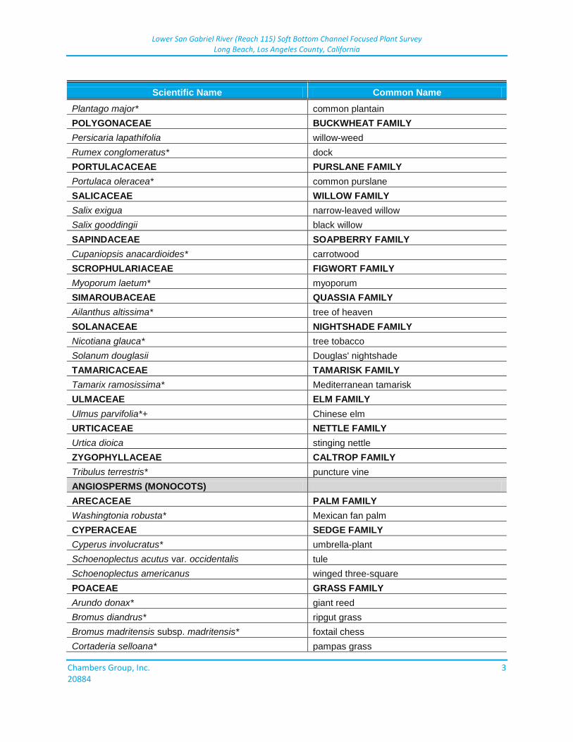
Lower San Gabriel River (Reach 115) Soft Bottom Channel Focused Plant Survey Long Beach, Los Angeles County, California
Chambers Group, Inc. 1 20884
ATTACHMENT 1 PLANT SPECIES OBSERVED
Scientific Name Common Name
GYMNOSPERMS
PINACEAE PINE FAMILY
Pinus halepensis*+ Aleppo pine
ANGIOSPERMS (EUDICOTS)
ADOXACEAE MUSKROOT FAMILY
Sambucus nigra subsp. caerulea blue elderberry
AIZOACEAE FIG-MARIGOLD FAMILY
Carpobrotus sp.* iceplant
AMARANTHACEAE AMARANTH FAMILY
Amaranthus palmeri Palmer's amaranth
ANACARDIACEAE SUMAC OR CASHEW FAMILY
Schinus terebinthifolius* Brazilian pepper tree
APIACEAE CARROT FAMILY
Apium graveolens* celery
Foeniculum vulgare* fennel
ASTERACEAE SUNFLOWER FAMILY
Ambrosia acanthicarpa annual bur-sage
Ambrosia psilostachya western ragweed
Artemisia californica California sagebrush
Artemisia douglasiana mugwort
Baccharis pilularis coyote brush
Baccharis salicifolia subsp. salicifolia mule fat
Baccharis salicina Emory baccharis
Bidens pilosa* common beggar-ticks
Centaurea melitensis* tocalote
Cirsium vulgare* bull thistle
Cotula coronopifolia* brass-buttons
Dimorphotheca fruticosa* trailing African daisy
Erigeron bonariensis* flax-leaved horseweed
Erigeron canadensis horseweed
Euthamia occidentalis western goldenrod
Helianthus annuus common sunflower
Helminthotheca echioides* bristly ox-tongue
Lactuca serriola* prickly lettuce
Pluchea odorata var. odorata salt marsh fleabane
Pseudognaphalium stramineum cotton-batting plant
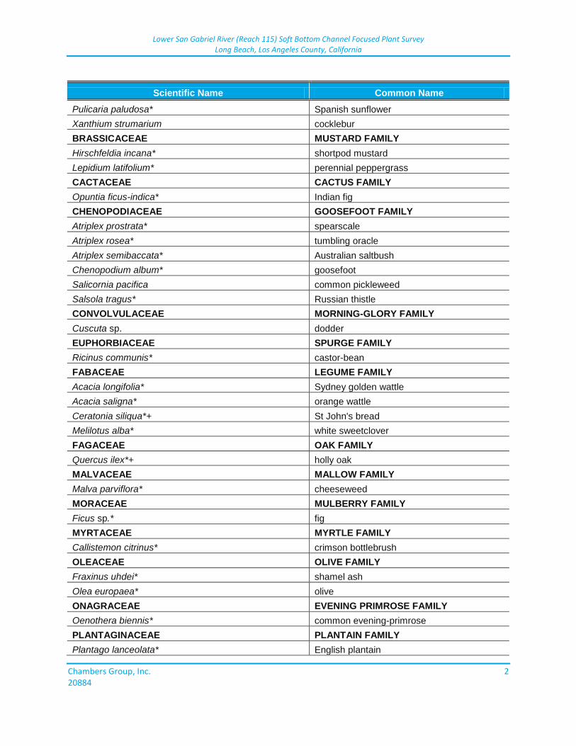
Lower San Gabriel River (Reach 115) Soft Bottom Channel Focused Plant Survey Long Beach, Los Angeles County, California
Chambers Group, Inc. 2 20884
Scientific Name Common Name
Pulicaria paludosa* Spanish sunflower
Xanthium strumarium cocklebur
BRASSICACEAE MUSTARD FAMILY
Hirschfeldia incana* shortpod mustard
Lepidium latifolium* perennial peppergrass
CACTACEAE CACTUS FAMILY
Opuntia ficus-indica* Indian fig
CHENOPODIACEAE GOOSEFOOT FAMILY
Atriplex prostrata* spearscale
Atriplex rosea* tumbling oracle
Atriplex semibaccata* Australian saltbush
Chenopodium album* goosefoot
Salicornia pacifica common pickleweed
Salsola tragus* Russian thistle
CONVOLVULACEAE MORNING-GLORY FAMILY
Cuscuta sp. dodder
EUPHORBIACEAE SPURGE FAMILY
Ricinus communis* castor-bean
FABACEAE LEGUME FAMILY
Acacia longifolia* Sydney golden wattle
Acacia saligna* orange wattle
Ceratonia siliqua*+ St John's bread
Melilotus alba* white sweetclover
FAGACEAE OAK FAMILY
Quercus ilex*+ holly oak
MALVACEAE MALLOW FAMILY
Malva parviflora* cheeseweed
MORACEAE MULBERRY FAMILY
Ficus sp.* fig
MYRTACEAE MYRTLE FAMILY
Callistemon citrinus* crimson bottlebrush
OLEACEAE OLIVE FAMILY
Fraxinus uhdei* shamel ash
Olea europaea* olive
ONAGRACEAE EVENING PRIMROSE FAMILY
Oenothera biennis* common evening-primrose
PLANTAGINACEAE PLANTAIN FAMILY
Plantago lanceolata* English plantain
Lower San Gabriel River (Reach 115) Soft Bottom Channel Focused Plant Survey Long Beach, Los Angeles County, California
Chambers Group, Inc. 3 20884
Scientific Name Common Name
Plantago major* common plantain
POLYGONACEAE BUCKWHEAT FAMILY
Persicaria lapathifolia willow-weed
Rumex conglomeratus* dock
PORTULACACEAE PURSLANE FAMILY
Portulaca oleracea* common purslane
SALICACEAE WILLOW FAMILY
Salix exigua narrow-leaved willow
Salix gooddingii black willow
SAPINDACEAE SOAPBERRY FAMILY
Cupaniopsis anacardioides* carrotwood
SCROPHULARIACEAE FIGWORT FAMILY
Myoporum laetum* myoporum
SIMAROUBACEAE QUASSIA FAMILY
Ailanthus altissima* tree of heaven
SOLANACEAE NIGHTSHADE FAMILY
Nicotiana glauca* tree tobacco
Solanum douglasii Douglas' nightshade
TAMARICACEAE TAMARISK FAMILY
Tamarix ramosissima* Mediterranean tamarisk
ULMACEAE ELM FAMILY
Ulmus parvifolia*+ Chinese elm
URTICACEAE NETTLE FAMILY
Urtica dioica stinging nettle
ZYGOPHYLLACEAE CALTROP FAMILY
Tribulus terrestris* puncture vine
ANGIOSPERMS (MONOCOTS)
ARECACEAE PALM FAMILY
Washingtonia robusta* Mexican fan palm
CYPERACEAE SEDGE FAMILY
Cyperus involucratus* umbrella-plant
Schoenoplectus acutus var. occidentalis tule
Schoenoplectus americanus winged three-square
POACEAE GRASS FAMILY
Arundo donax* giant reed
Bromus diandrus* ripgut grass
Bromus madritensis subsp. madritensis* foxtail chess
Cortaderia selloana* pampas grass
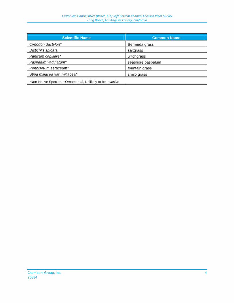
Lower San Gabriel River (Reach 115) Soft Bottom Channel Focused Plant Survey Long Beach, Los Angeles County, California
Chambers Group, Inc. 4 20884
Scientific Name Common Name
Cynodon dactylon* Bermuda grass
Distichlis spicata saltgrass
Panicum capillare* witchgrass
Paspalum vaginatum* seashore paspalum
Pennisetum setaceum* fountain grass
Stipa miliacea var. miliacea* smilo grass
*Non-Native Species, +Ornamental, Unlikely to be Invasive