subject: aircraft surveillance date: 09/16/2005 ac … 120... · avioni cs & sel et d ads-b...
TRANSCRIPT

Subject: AIRCRAFT SURVEILLANCE SYSTEMS AND APPLICATIONS
Date: 09/16/2005 Initiated By: AFS-400
AC No: 120-86 Change:
1. PURPOSE. This joint Flight Standards Service (AFS) and Aircraft Certification Service (AIR) advisory circular (AC) provides general information and acceptable methods of compliance for the certification, airworthiness, and operational approval of certain aircraft surveillance systems and selected associated aviation applications. Specific guidance for obtaining Federal Aviation Administration (FAA) approval /authorization for the installation and operation of these technologies is also addressed by this AC. Guidance for continued airworthiness and operational approval is included. This guidance material does not constitute a regulation and is not mandatory. It provides one means of compliance with applicable requirements and will provide the applicant with knowledge required to help in implementing these technologies. 2. APPLICABILITY.
• Aircraft manufacturers, businesses and others applying for installation approval under 14 CFR parts 23, 25, 27 and 29;
• Repair stations conducting alterations under 14 CFR part 43; • Air carriers operating under 14 CFR parts 121, 125, or 135, foreign air carriers
conducting operations in U.S. airspace, and U.S.-registered aircraft operated solely outside the United States in common carriage by a foreign person or foreign air carrier under 14 CFR part 129;
• General aviation aircraft operating under 14 CFR part 91 • Other organizations conducting training approved in accordance with 14 CFR
parts 121, 135, and 141; 3. BACKGROUND. The FAA is implementing a broadcast services ground network that will deliver to the flight deck real-time access to weather, traffic and advisory aeronautical information. The broadcast service will utilize aeronautical digital communications, or data link, that provides high-speed exchange of information between aircraft and ground-based systems or between aircraft. Avionics displays will be used to present this information to the flight crew. This implementation has begun in Alaska under the Capstone program. Additionally, an East Coast initiative, part of the FAA’s Safe Flight 21 program, is being established between Florida and New Jersey. The term “broadcast services” encompasses three forms of broadcast information: Automatic Dependent Surveillance – Broadcast (ADS-B), Traffic Information Services – Broadcast (TIS-B) and Flight Information Services – Broadcast (FIS-B). Figure 1 provides a block diagram and

AC 120-86 9/16/05
information flow among the various elements of the ADS-B air and ground infrastructure. A brief description of ADS-B and TIS-B is provided in this AC.
Functional Elements for Transmitting Participants
Nav/ Positionsensors(e.g., GPSreceiver)
Barometric Altitude andAltitude Rate
Pilot Inputs& Controls(e.g., Call sign)
Other Inputs(FMS, etc)
Dat
a So
urce
s on
Tran
smitt
ing
Airc
raft
Avionics & Selected ADS-B Broadcast Only
Ground Stations *
Surveillance TransmitProcessing(STP)
ADS-BTransmitSubsystem
Inte
rfac
es
ADS-B,TIS-B, & FIS-B ReceiverSubsystem
Functional Elements for Receiving Participants
Avionics Application Avionics
FIS-BProcessing
FIS-BDisplay
& Control
AirborneSurveillance
& SeparationAssuranceProcessing(ASSAP)
CDTIDisplay
andControl
ADS-BGnd.-to-Air & Air-to-Air
ReportInterface
DisplayInterface
GroundBased
Transceiver(GBT)
Ground Station
Gro
und-
to-A
ir T
IS-B
and
FIS
-B
Mes
sage
s
TIS-B and FIS-B Data **
ADS-B TrafficSurveillance
Infrastructure andSupporting Ground
Automation Interfaces
Flight Crew
AD
S-BA
ir- to-Grd.
Information Flow: ADS-B Broadcast Services
Gro
und
infr
astr
uxct
ure
Avi
onic
s inc
ludi
ng se
lect
ed g
roun
d st
atio
ns
Control Facility** FIS-B data link may not be available through all ADS-B links.
* Ground Stationsmay include ground vehicles and markedTowers.
Figure 1. ADS-B Information Flow, Air and Ground Infrastructure.
Page 2
9/16/05 AC 120-86
References to RTCA, Inc. Minimum Aviation System Performance Standards (MASPS) and Minimum Operational Performance Standards (MOPS) documents are made in this AC. RTCA MASPS provide information useful to designers, manufacturers, installers, service providers and users of avionics systems for operational use on an international basis. RTCA MOPS documents are standards for aircraft avionics equipment designs. MOPS may be adopted by the FAA via a Technical Standard Order (TSO). 4. SCOPE. This AC addresses certain aircraft surveillance systems and selected associated aviation applications, including:
• Aircraft Surveillance Applications (ASA) • Ground Surveillance Applications (GSA) • Automatic Dependent Surveillance-Broadcast (ADS-B) Data Link System • Traffic Information Services – Broadcast (TIS-B) • Airborne Collision Avoidance System (ACAS) and ASA Integration • Mode S Elementary and Enhanced Surveillance Downlink Systems
Guidance includes:
• Design aspects, along with failure effect classifications, • Risk mitigation strategies, • Testing criteria, • Installation approval processes, • Operational approval processes, and, • Maintenance and continued airworthiness programs.
Appendix A of this AC provides a list of acronyms, Appendix B provides definitions/glossary, and Appendix C provides a list of airworthiness and operational regulations. The following definitions are included in the main body as they apply to all aspects of the AC. The use of "should", "must", "will" and "may" are defined below:
Must The word MUST in the text is used for legislative or regulatory requirements (e.g., health and safety) and shall be complied with. It is not used to express a requirement of the document.
Should The word SHOULD in the text denotes a recommendation or advice on implementing such a requirement of the document. Such recommendations or advice is expected to be followed unless good reasons are stated for not doing so.
Will The word WILL in the text denotes a provision or service or an intention in connection with a requirement of the document.
May The word MAY in the text denotes a permissible practice or action. It does not express a requirement of the document.
4.1. Surveillance Systems And Associated Aviation Applications. There are many proposed air and surface applications for ADS-B. This section describes certain surveillance system functions and section 6.2.1.1.1 describes some of the associated applications. 4.1.1. Aircraft Surveillance Applications (ASA) function. As described in RTCA/DO-289, Minimum Aviation System Performance Standards (MASPS) for Aircraft Surveillance Applications (ASA), the ASA system comprises a number of flight deck based aircraft
Page 3

AC 120-86 9/16/05
surveillance and separation assurance capabilities including guidance and alerts. ADS-B and/or TIS-B surveillance Information for the ASA function is received on ADS-B data links. Refer to Appendix D of this AC for additional information. 4.1.2. Airborne Surveillance and Separation Assurance Processing (ASSAP) function. ASSAP is the subsystem that receives surveillance inputs from data links and performs processing for reports, tracks and other message set elements. Surveillance reports, tracks and any application specific alerts or guidance are output by ASSAP to a Cockpit Display of Traffic Information (CDTI). The CDTI function may be a dedicated display or integrated into a multiple function display (MFD). Refer to Appendix D of this AC for additional information. 4.1.3. Automatic Dependent Surveillance Broadcast (ADS-B) data link systems. This AC provides guidance for the following two FAA approved data links:
(1) Mode-S 1090 megahertz (MHz) extended squitter.
(2) Universal Access Transceiver (UAT).
As described in RTCA/DO-242A, Minimum Aviation System Performance Standards for Automatic Dependent Surveillance - Broadcast (ADS-B), the ADS-B data link is a function on an aircraft or surface vehicle that periodically broadcasts surveillance information (e.g., state vector horizontal/vertical position and velocity). A description of each ADS-B data link is contained in Appendix E of this AC. 4.1.4. Traffic Information Services-Broadcast (TIS-B) data link systems. As described in RTCA/DO-286, Minimum Aviation System Performance Standards (MASPS) For Traffic Information Service-Broadcast (TIS-B), the TIS-B data link broadcasts traffic information derived from one or more ground surveillance sources to suitably equipped aircraft or surface vehicles. TIS-B augments ADS-B by providing additional traffic information in situations where not all aircraft are equipped with ADS-B. Refer to Appendix F of this AC for additional information. 4.1.5. Airborne Collision Avoidance Systems (ACAS) and ASA Integration. ACAS and ASA integration is the correlation of ACAS and ADS-B targets. Such integration should consider all aspects of the ACAS display (e.g., target color, shape, own-ship and target position, TA / RA functionality and alerting). The FAA Traffic Collision Avoidance System (TCAS) II, Change 7, are considered equivalent to the Joint Airworthiness Authorities (JAA) ACAS. Refer to Appendix G of this AC for additional information. 4.1.6. Human Factors Considerations for the Display of Traffic Surveillance Information.
Appendix H of this AC provides human factors guidance for the display of traffic surveillance information. In addition, human factors guidance that addresses specific technologies can be found in other appendices.
4.1.7. Mode A, C, S and Mode S Elementary and Enhanced Surveillance Systems. Appendix I of this AC provides guidance material for the initial and follow-on certification of Mode A, C, S and Mode S elementary and enhanced surveillance downlink systems. 5. The Certification Approval Process. This section provides guidance in the following areas:
Page 4

9/16/05 AC 120-86
5.1. Design considerations for aircraft systems. 5.2. Equipment installation guidelines.
5.2.1. Environmental conditions and test procedures for airborne equipment. 5.2.2. Global Navigation Satellite Systems (GNSS) equipment integration. 5.2.3. Communication, navigation, and surveillance (CNS) integration. 5.2.4. Transponder and data link installation. 5.2.5. Required Surveillance Performance (RSP). 5.2.6. Safety, performance and interoperability requirements.
5.3. Safety assessment considerations.
5.3.1. Software and hardware development assurance guidance.
5.4. Verification and validation of safety, performance and interoperability requirements.
5.4.1. Airplane Flight Manual. 5.4.2. Aircraft Certification Flight and Ground Test. 5.4.3. Certification summary.
5.1. Design considerations for aircraft systems. The airborne surveillance intended function is based, in part, on aircraft installed equipment design and performance, crew workload, the operational environment, and the air-ground infrastructure. Specific guidelines for the design considerations of aircraft surveillance systems are contained in Appendices D through I of this AC. 5.2. Equipment installation guidelines. General equipment installation criteria are available in AC 21-40, Application Guide for Obtaining a Supplemental Type Certificate (STC). Additional guidelines for repairs and installation are specified in AC 43.13-1B, Acceptable Methods, Techniques, and Practices, Aircraft Inspection and Repair, and AC 43.13-2A, Acceptable Methods, Techniques, and Practices, Aircraft Alterations. Requirements for specific aircraft surveillance intended function and associated equipment installations are based in part on the requirements of the operational applications. 5.2.1. Environmental conditions and test procedures for airborne equipment. New surveillance equipment should be tested by the manufacturer to the appropriate environmental categories as described in RTCA/DO-160D, Environmental Conditions and Test Procedures for Airborne Equipment. Legacy surveillance equipment may be tested to earlier versions of RTCA/DO-160(x) based on the original equipment certification basis. The RTCA/DO-160(x) environmental test categories should be based on the aircraft and installed equipment operating environment.
Page 5
AC 120-86 9/16/05
5.2.2. GNSS equipment integration guidelines. GNSS equipment is the recommended own-ship position input to the surveillance systems. AC 20-138A, Airworthiness Approval of GNSS Equipment, provides installation guidance for GNSS antennae, sensors, and interface to other systems and should be considered. GNSS minimum operational performance standards are contained in various TSO’s. TSO C145A, Airborne Navigation Sensors Using the Global Positioning System (GPS) Augmented by the Wide Area Augmentation System (WAAS), specifies minimum operational performance standards for GNSS antennas, and equipment compatibility with satellite communications (SATCOM). A complete index of TSO standards is published in the current version of AC 20-110, Index of Aviation Technical Standard Orders. 5.2.2.1. GNSS Performance and Availability Issues. GNSS equipment certified in accordance with TSO-C129a, Airborne Supplemental Navigation Equipment Using the Global Positioning System (GPS), by itself may not be able to provide sufficient aircraft availability to support some surveillance applications. A means to “coast” through receiver autonomous integrity monitoring (RAIM) outages (either by aircraft avionics equipage and/or operational mitigation) for continued surveillance operations may be required based on the operational requirements. If TSO C129a equipment is used as the only sensor for a given function, then the loss of GNSS will require an operational safety assessment to determine the aircraft failure effect classification. Depending on the WAAS operational infrastructure, aircraft equipped with TSO C145A may not be susceptible to RAIM outages. 5.2.2.2. GNSS Augmentation by Differential Corrections. The intended function of the surveillance applications may require highly accurate position information that may be achieved by GPS augmentation (e.g., TSO-C144/145a GPS Wide Area Augmentation System (WAAS) or TSO-C162 GPS Local Area Augmentation System (LAAS)). The intended function should be used to determine the “failure effect” classification of the surveillance system. 5.2.3. CNS Integration. The design of an aircraft’s surveillance system and its hosted applications should be compatible with the communication and navigation systems on board the aircraft, as well as other aircraft systems’ intended function and failure classification. In developing the avionics architecture and designing software partitioning, common mode failures between communication, navigation, and surveillance functions must be considered. Consequences of common mode failures could result in higher failure classifications and RTCA/DO-178B, Software Considerations in Airborne Systems and Equipment Certification, software levels than failures affecting only one communication, navigation, or surveillance function. For example, AC 25-11, Transport Category Airplane Electronic Display Systems, states that "loss of all navigation information must be improbable, ” that “loss of all communication functions must be improbable” (i.e., major failure classification), and that “non-restorable loss of all navigation and communications functions must be extremely improbable” (i.e., catastrophic failure classification). AC 23.1309 and AC 23.11 provide additional guidance information for FAR Part 23 airplanes. 5.2.4. Transponder and data links installation. Guidance for installation approval of transponders is contained in AC 20-131A, “Airworthiness Approval of Traffic Alert and Collision Avoidance Systems (TCAS II) and Mode S Transponders,” or AC 20-151, “Airworthiness Approval of Traffic Alert and Collision Avoidance Systems (TCAS II) Version 7.0 and Associated Mode S Transponders”. In both ACs, Appendix I, “Mode A, C, S and Mode S Elementary and Enhanced Surveillance Systems” provides airworthiness consideration for initial and follow-on design approval.
Page 6

9/16/05 AC 120-86
5.2.5 Required Surveillance Performance (RSP). RSP is the surveillance capability required to perform a given operation or procedure in a particular airspace or environment. The technical parameters for RSP include latency and update rate, as well as accuracy, integrity, continuity, and availability. RSP is a static parameter and is determined prior to a flight operation or procedure. Actual Surveillance Performance (ASP) is an estimation of the surveillance performance that excludes human error. ASP measures accuracy and integrity of the various monitoring sources. It is a dynamic measure that is affected by the type and availability of position data sources and takes into account all sources of error. The operational application of ASP has not been determined. RSP and ASP are factors in Required Total System Performance (RTSP), which may be necessary for certain procedures or operations in various airspace. Elements of RTSP include Required Navigation Performance (RNP), Required Communication Performance (RCP), and Required Surveillance Performance (RSP), as well as the automation capabilities of Air Traffic Management (ATM) in the determination of separation standards. Standards for RSP are in development and should be addressed in future versions of this AC. 5.2.6. Safety, Performance and Interoperability Requirements. During the certification process, the applicant should identify and document any operational environment and service assumptions in the certification plan. System safety, performance, and interoperability requirements should be based, in part, on those assumptions. Interoperability considerations are used to define the operational environment in which the aircraft surveillance system and applications are intended to operate. Specific industry standards and FAA guidance material are in development for clarification of the operational environment and performance requirements. 5.3. Safety Assessment Considerations. The applicant must conduct an aircraft system safety assessment (SSA) to comply with applicable subsections 1301 and 1309 of Title 14 of the Code of Federal Regulations (14 CFR) parts 23, 25, 27, and 29. If the surveillance display (e.g., CDTI) is to be used to provide guidance and control, the failure condition classification has historically been shown to be at least MAJOR for misleading information. The failure condition classification for loss of function has historically been shown to be at least MINOR. Lower classifications should be substantiated by a safety analysis. More complex or integrated systems such as TCAS II and ADS-B may have higher failure condition classifications based upon the results of the airplane-level functional hazard assessment. For airborne systems that are developed only for enhanced traffic awareness (e.g., traffic advisories for see and avoid) operations, the failure condition classification for misleading information is considered “minor” and loss of the function has “no safety effect.” Current versions of AC 23.1309-1C, Equipment, Systems, and Installations in Part 23 Airplanes; AC 25.1309-1A, System Design and Analysis; AC 27-B, Certification of Normal Category Rotorcraft; and AC 29-2C, Certification of Transport Category Rotorcraft provide aircraft safety assessment guidance for other system safety issues for general aviation, transport category, and rotorcraft. Acceptable methods for performing a safety assessment are contained in Society of Automotive Engineering (SAE) Aerospace Recommended Practices (ARP) 4754/4761, Certification Considerations for Highly-Integrated or Complex Aircraft Systems, and SAE ARP 4761,
Page 7
AC 120-86 9/16/05
Guidelines and Methods for Conducting the Safety Assessment Process on Civil Airborne Systems and Equipment. 5.3.1. Software and Hardware Development Assurance Guidance. Software standards. AC 20-115B, Radio Technical Commission for Aeronautics, Inc. Document RTCA/DO-178B, provides an acceptable means for showing compliance to applicable airworthiness regulations for the software aspects of the aircraft airborne avionics systems. Once the aircraft system failure condition classification has been determined and the software level assignment has been substantiated, software design considerations in RTCA/DO-178B should be used to provide a methodology for software design assurance. Software levels for the transmission of ADS-B own-ship information. Based on existing transponder certification guidance, software for the transmission of data pertaining to one’s own-ship information has been historically developed to at least Level C criteria, as defined in RTCA/DO-178B. Appendix E contains additional guidance for the reduction of software levels for certain ADS-B parameters based on operational mitigation. If the ADS-B system is integrated with other aircraft functions, a higher software level may be appropriate, based on the results of the aircraft level safety analysis. Software levels for the display of traffic information. The software levels for display of traffic information will be determined during the SSA process as described above. Electronic hardware design assurance. If any functions are implemented using complex electronic hardware whose failure conditions are classified as “major,” “hazardous,” or “catastrophic,” the design of such hardware should be assured by a methodology acceptable to the FAA. Additionally, once the assurance levels are assigned by the safety assessment, it should be verified that the hardware and software design assurance levels are compatible with each other. 5.4. Verification and Validation of Safety, Performance and Interoperability Requirements. During the verification and validation of the surveillance system (e.g., analysis, laboratory test, ground and aircraft testing), the applicant must demonstrate that the surveillance system meets its intended function (e.g., xx.1301, xx.1309). The aircraft surveillance system safety, performance and interoperability with a representative ground or target aircraft system should be required during the demonstration process. 5.4.1. Airplane Flight Manual (AFM). In accordance with AC 25.1581-1, Airplane Flight Manual, the AFM documents the intended function and identifies tasks and procedures that will be used during aircraft surveillance systems operations, including operator, service provider, and air traffic services interfaces. Any operational limitations associated with flight crew tasks should be addressed in the AFM, AFM Supplement, and Pilot’s Operating Manual. AC 23-8B, Flight Test Guide for Certification of Part 23 airplanes provides additional AFM information. 5.4.2. Aircraft Certification Flight and Ground Test. Ground and flight tests should be conducted to show compliance with federal regulations, intended function, and acceptable operation. The applicant should submit aircraft installation ground and flight test plans combined with expected results and pass/fail criteria prior to issuance of the Type Inspection Authorization (TIA). Reference the applicable AC listed below for flight-testing guidance: • AC 23-8B, Flight Test Guide for Certification of Part 23 Airplanes.
Page 8

9/16/05 AC 120-86
• AC 25-7A, Flight Test Guide for Certification of Transport Category Airplanes • AC 25-11, Transport Category Airplane Electronic Display Systems. • AC 27-1B, Certification of Normal Category Rotorcraft. • AC 29-2C, Certification of Transport Category Rotorcraft. 5.4.3. Certification Summary. The applicant should submit a certification summary to the Aircraft Certification Office to provide the results and evidence that they comply with the provisions of the Certification Plan. Any deviation to the Certification Plan should be described in the certification summary together with the rationale needed to substantiate the deviation. 6. Flight Operations And Continuing Airworthiness Approval Guidance. The operational approval process complements the Aircraft Certification approval process. This section describes the processes that need to be followed for operational approval. FAA Orders 8300.10, Airworthiness Inspector's Handbook; 8400.10, Air Transportation Operations Inspector's Handbook; and 8700.10, General Aviation Operations Inspector's Handbook, contain instructions for the completion of a five-step approval process leading to formal operational approval. It is important for operators to coordinate early in the approval process with their principal operations inspector (POI), principal maintenance inspector (PMI), and principal avionics inspector (PAI). NOTE: The FAA Flight Standards Service is responsible for the operational authorization to use aircraft surveillance systems. Air traffic service providers are responsible for developing operational and system requirements for the ground based components of these systems. 6.1 Approval Criteria. NOTE: There are no specific criteria for the operational approval of aircraft equipped with aircraft surveillance systems when operating under 14 CFR part 91. However, guidance in this AC on manuals, training, and procedures for operating and using aircraft surveillance systems is pertinent to 14 CFR part 91 operations. The use of aircraft surveillance systems for 14 CFR parts 121, 125, and 135 operations requires FAA operational and airworthiness approval and for operations under 14 CFR part 129 within the U.S., authorization by the FAA. For operations under 14 CFR part 129 by foreign air carriers conducting operations in U.S. airspace and U.S. registered aircraft operated solely outside the U.S. by a foreign person or by a foreign air carrier, see Appendix K. This requirement includes FAA approval /authorization of the following:
• Operations manuals,
• Training and training manuals,
• Checklists,
• Procedures for operating and using aircraft surveillance systems,
• Maintenance programs, and,
Page 9

AC 120-86 9/16/05
• Minimum Equipment Lists (MEL’s). 6.1.1. Training. Prior to requesting operational approval, applicants should have all training needs identified and all training development completed. The FAA-Industry Training Standards (FITS) program has been introduced recently due to the recognition that the rapid introduction of new systems and technologies may not fit into existing training programs. The FITS program is focused on the technically advanced small reciprocating and jet-powered aircraft, however, the FITS training syllabus can be used as a guide for developing training for any user of aircraft surveillance systems. More information on FITS, including the FITS TAA Transition Training Master Syllabus Scenario Based Transition Guide, can be found at http://www.faa.gov/avr/afs/fits. Appendix J contains a sample generic lesson plan based on FITS guidance. 6.1.2. Operational Procedures Development. Develop procedures to achieve a specific operational capability. Display of aircraft surveillance systems information does not relieve the flight crew of regulatory responsibilities to “see-and-avoid” other traffic. 6.1.3. Manuals. 6.1.3.1. Flight Operations Manuals. An FAA-approved Aircraft Flight Manual (AFM), Aircraft Flight Manual Supplement (AFMS), or Pilot Operating Handbook (as appropriate) must be carried in the aircraft at all times when aircraft surveillance systems equipment is installed. Air carriers may use an Airplane Operating Manual (AOM) or Flight Crew Operating Manual (FCOM) instead of an AFM, if authorized. 6.1.3.2. Minimum Equipment Lists (MEL). MELs may be amended to reflect the installation of aircraft surveillance systems equipment. Changes made to MELs must be made in accordance with the approved Master Minimum Equipment List (MMEL) and FAA Order 8400.10. Aircraft surveillance systems equipment will not be listed as “administrative control items” in the MEL. 6.1.3.3. Aircraft Validation Tests. The evaluation of new aircraft surveillance systems operations may require a validation test in an aircraft. Validation test requirements for the aircraft surveillance system operation proposed should be based on the type of aircraft, crew workload, credit given for previously certified installations, and past simulator or ground testing. Validation test requirements will need to be evaluated for each installation and each application. First-time make and model installations and first-time hosted aircraft surveillance systems will likely require a validation flight test. Subsequent follow-on installations that introduce changes in the conformity of the system, including software upgrades, may require flight-testing if they cannot be adequately evaluated on the ground or in a simulator. 6.2. Operational Approval or Authorizations – Part 91. Most 14 CFR part 91 operations do not require any specific operational approval or authorization as long as aircraft surveillance systems avionics do not replace any system or equipment required by the regulations. U.S. registered large and turbine-powered multi-engine aircraft operating under 14 CFR part 91, sub-part F, will require a Letter of Authorization (LOA) if aircraft surveillance systems avionics are used to replace any system or equipment required by regulations. An LOA will include any conditions or limitations of use. U.S. operators using aircraft surveillance systems in foreign airspace will need training appropriate to the requirements of the State where these operations are conducted. Consult the AIP for each State prior to conducting aircraft surveillance systems operations in that State’s
Page 10
9/16/05 AC 120-86
airspace. Oceanic and remote area operations using aircraft surveillance systems require compliance with the appropriate International Civil Aviation Organization documents. 6.2.1. Air Carriers And Commercial Operators. The use of aircraft surveillance systems may be authorized in Operations Specifications (OpSpecs) however, it is not anticipated that every operational use of an aircraft surveillance system will require authorization by OpSpecs. FAA Order 8400.10 contains general policy guidance and requirements for issuing or amending OpSpecs. 6.2.1.1. Operations Specifications. 6.2.1.1.1. OpSpecs may be required for flight operations using ADS-B equipment. OpSpecs paragraph A052 may be used to authorize flight operations using ADS-B equipment. Aircraft used for these operations must be listed in Paragraph A052 by make, model, and series; aircraft registration number; and make, model, and series of the authorized ADS-B system/equipment. ADS-B operations include, but are not limited to:
• Visual acquisition of proximate aircraft for enhanced “see and avoid”
• Conflict detection and avoidance
• In-trail climb
• In-trail descent
• Station-keeping
• Passing maneuvers
• Long-range conflict management
• Reduced separation standards Note: See Appendix B for a definition of these terms. 6.2.1.1.2. OpSpecs paragraph A008, Operational Control Authorizations, should be issued or amended if approval to use aircraft surveillance systems for any flight-following or operational control is requested. The POI should evaluate and validate this capability before approval. 6.2.1.1.3. OpSpecs paragraph D095, Minimum Equipment List, may be issued or amended. 6.2.2. Foreign air carriers conducting operations in U.S. airspace, and U.S.-registered aircraft operated solely outside the United States in common carriage by a foreign person or foreign air carrier. Foreign air carriers conducting operations in the U.S. National Airspace System (NAS) will require FAA authorization. Foreign air carriers operating within the U.S. must be familiar with the aircraft surveillance systems operational procedures in use. In addition, foreign air carriers or persons operating U.S. registered aircraft anywhere, are required to have the maintenance programs and minimum equipment lists (MEL) approved by the FAA in accordance with 14 CFR 129.14. Appendix K provides detailed guidance information about the authorization/approval process. Additional guidance is under development and will be published
Page 11
AC 120-86 9/16/05
in the FAA’s Aeronautical Information Manual, part of U.S. Aeronautical Information Publication. 6.2.2.1. Aircraft surveillance systems operations by foreign air carriers, other international operators, and IGA aircraft in international airspace (e.g., within the New York Oceanic area or the West Atlantic Route System) do not require FAA operational approval authorizations. Aircraft surveillance systems operations that may be authorized for foreign air carriers, other international operators, or IGA aircraft are those listed in paragraph 6.2.1.1.1 of this AC. 6.3. Continuing Airworthiness – General. Certificate holders or operators are responsible for compliance with all regulatory requirements for ongoing maintenance and support of aircraft surveillance systems equipment. Maintenance programs should identify inspection items, establish time-in-service intervals for maintenance and inspections, and provide the details of the proposed methods and procedures. The maintenance program should also include:
• Maintenance manual information,
• Calibration procedures required to ensure continued airworthiness,
• Illustrated parts catalog, and,
• Wiring diagrams 6.3.1. Databases. Databases used in conjunction with aircraft surveillance systems, including airport map databases and navigation databases when used as part of an aircraft surveillance system, must be current and up-to-date. Compliance with Aeronautical Information Regulation and Control (AIRAC) publication dates does not guarantee currency. Consequently, an appropriate means needs to be identified to ensure accuracy and data timeliness. James J. Ballough Director, Flight Standards Service
Page 12

9/16/05 AC 120-86
Aircraft Surveillance Systems And Applications
Advisory Circular
APPENDICES A. Acronyms B. Definitions/Glossary C. Airworthiness and Operational regulations, and list of related/referenced documents D. Aircraft Surveillance Applications (ASA) Systems E. Automatic Dependent Surveillance - Broadcast (ADS-B) Link System F. Traffic Information Service-Broadcast (TIS-B) G. TCAS II/ASA Integration H. Human Factors Considerations for the Display of Traffic Surveillance Information I. Mode S Enhanced Surveillance Downlink Systems J. Sample General Aviation FITS Transition Training Master Syllabus K. Foreign Air Carriers and Foreign Operators of U.S.-Registered Aircraft Engaged in Common Carriage: Installation Approval and Authorization to Conduct Aircraft Surveillance Flight Operations
Page 13


9/16/05 AC 120-86
APPENDIX A.
ACRONYMS AND ABBREVIATIONS
Acronym Description A/C Aircraft AC Advisory Circular ACAS Airborne Collision Avoidance System ACL ASA Capability Level ACM Airborne Conflict Management ADS-B Automatic Dependent Surveillance - Broadcast AFM Airplane Flight Manual AIP Aeronautical Information Publication AOM Airplane Operating Manual ASA Airborne Surveillance Applications ASIA Approach Spacing for Instrument Approaches ASP Actual Surveillance Performance ASSA Airport Surface Situational Awareness ASSAP Airborne Surveillance and Separation Assurance Processing ATC Air Traffic Control ATM Air Traffic Management ATS Air Traffic Services A/V Aircraft/Vehicles CD Conflict Detection CDTI Cockpit Display of Traffic Information CNS Communication, Navigation, and Surveillance DAP/E-DAP Downlinking of Aircraft Parameters EHS Enhanced Surveillance ELS Elementary Surveillance ES Extended Squitter EVAcq Enhanced Visual Acquisition FAA Federal Aviation Administration FIS-B Flight Information Services - Broadcast FITS FAA-Industry Training Standards FMS Flight Management System FAROA Final Approach and Runway Occupancy Awareness FCOM Flight Crew Operating Manual GNSS Global Navigation Satellite System ICAO International Civil Aviation Organization ICSPA Independent Closely Spaced Parallel Approaches IFR Instrument Flight Rules IGA International General Aviation IMC Instrument Meteorological Conditions JAA Joint Aviation Authorities LOA Letter Of Authorization MASPS Minimum Aviation System Performance Standards MEL Minimum Equipment Lists MFD Multi Function Display MMEL Master Minimum Equipment List MOPS Minimum Operational Performance Standards
APPENDIX A Page A- 1
AC 120-86 9/16/05
NAC Navigation Accuracy Category (for position) NAS National Airspace System NIC Navigation Integrity Category OHA Operational Hazard Assessment LAAS Local Area Augmentation System PAI Principal Avionics Inspector PMI Principal Maintenance Inspector POH Pilot Operating Handbook POI Principal Operations Inspector PT Pilot in Training RA Resolution Advisory RAIM Receiver Autonomous Integrity Monitoring RCP Required Communication Performance RF Radio Frequency RSP Required Surveillance Performance SIL Surveillance Integrity Level SRM Single Pilot Resource Management SSA System Safety Assessment SSR Secondary Surveillance Radar STC Supplemental Type Certificate STP Surveillance Transmit Processing TA Traffic Advisory TAS Traffic Advisory System TCAS Traffic Alert Collision Avoidance System TCL Transmit Quality Level TIS-B Traffic Information System - Broadcast TSO Technical Standard Order TSP Total System Performance UAT Universal Access Transceiver VFR Visual Flight Rules WAAS Wide Area Augmentation System
Page 2

9/16/05 AC 120-86
APPENDIX B.
Definitions / Glossary
The following definitions may be specific to this AC and may differ with those definitions contained in other references. 1. Alert. A visual, aural, or tactile stimulus presented to the flight crew to attract attention or to convey information regarding system status, system condition, or both.
a. Applicant. Refers to but is not limited to:
• Aircraft manufacturers, businesses or any other entity applying for installation approval under 14 CFR parts 23, 25, 27 and 29:
• Repair stations conducting alterations under 14 CFR part 43: • Air carriers operating under 14 CFR parts 91, 121, 125 or 135: • Organizations conducting training approved in accordance with 14 CFR part 121 and 135
(e.g., training centers or aircraft manufacturers): • Operators under 14 CFR part 125: • Non-U.S. air carriers conducting operations in U.S. airspace under 14 CFR part 129.
3. Automatic Dependent Surveillance Broadcast (ADS-B). ADS-B is a function on an aircraft or vehicle that periodically broadcasts its state vector (horizontal and vertical position, horizontal and vertical velocity) and other information. ADS-B is expected to play an increasing role in the NAS as its capabilities evolve, and is expected to be a key element in improving use of airspace, reducing ceiling and visibility restrictions, improving airport surface surveillance, and enhancing safety features like Airborne Conflict Management (ACM). The ADS-B architecture may utilize a combination of enabling data links to achieve the appropriate intended function. These links include the 1090 MHz Extended Squitter (ES) and the UAT).
4. Cockpit Display of Traffic Information (CDTI). A CDTI is a generic display that provides a flightcrew with traffic surveillance information about other aircraft, surface vehicles, and obstacles including their identification, position, and other message set parameters. CDTIs generally also include an “own-ship” position indicator and may depict a moving map as an underlay. Traffic information displayed on a CDTI may be obtained from one or several sources including ADS-B, TIS-B, Traffic Alert and Collision Avoidance Systems (TCAS), and Traffic Collision Alerting Devices. CDTI’s may be portable, tethered (to the aircraft’s electrical, database, and or datalink systems), panel-mounted, head-worn, or head-up, depending upon the specific implementation.
5. Design assurance for aircraft systems. This term describes the means for ensuring that the implementations provided by the various aircraft systems (including its hosted software) satisfy the requirements for the aircraft system and what’s required for it to achieve its intended functions. Design requirements may change based on airplane type or intended function (e.g., Visual Flight Rules Vs. Instrument Flight Rules certification basis).
6. Free Flight. A safe and efficient flight capability in which operators have the freedom to select a flight trajectory and speed of their own choosing. Air traffic restrictions would be imposed only to ensure separation, to preclude exceeding the destination airport’s capacity, to prevent unauthorized flight through special-use airspace or to ensure safety of flight. Restrictions would be limited in extent and duration only to correct a known problem. Any activity that
APPENDIX B Page B- 1
AC 120-86 9/16/05
removes current restrictions to airspace use represents a move toward Free Flight. Specific operating rules enabling Free Flight may be called (in the future) Electronic Flight Rules.
7. Ground and flight tests. Define the objectives and acceptance criteria for flight and ground tests. The flight and ground tests should include tests to validate the airborne system and applications in the context of the safety and interoperability requirements and to check for adverse effects on other aircraft systems and functions.
8. In-Trail Climb/In-Trail Descent (ITC/ITD). The ITC/ITD procedure enables an aircraft to climb/descend though the altitude of another aircraft ahead when positive lead aircraft identification and separation distance can be established using ACAS/TCAS or ADS-B
9. Station-keeping. A flight maneuver whereby a trailing aircraft positions itself relative to a leading aircraft in terms of range and or bearing. 10. Surveillance. Defined as the detection, tracking, characterization, and observation of aircraft, other vehicles, weather and airspace status information and phenomena for the purposes of conducting flight operations in a safe and efficient manner. The primary purpose of traffic surveillance (as distinct from all surveillance functionality) is to control the flow of aircraft, provide situational awareness for pilots and controllers, and to separate aircraft. 11. Traffic Information Services-Broadcast (TIS-B). TIS-B provides ground-based surveillance data (potentially from multiple sources) via uplink to appropriately equipped ADS-B aircraft. Among other functions, these systems provide enhanced situational awareness information for the flightcrew, e.g., knowledge of proximate aircraft as an aid to visual acquisition.
11. Universal Access Transceiver (UAT). The UAT is a wide band, multi-purpose data link intended to operate globally on a single channel. The UAT data link supports multiple broadcast services including ADS-B, FIS-B, and TIS-B.
13. Validation of requirements. This term describes the means for validating the requirements for an aircraft’s surveillance system and its hosted applications. In this context, safety and interoperability requirements include the entire operational environment including the ground infrastructure.
Page B-2 APPENDIX B

9/16/05 AC 120-86
APPENDIX C.
Airworthiness and Operational Regulations, Related References and Documents
1. FAA Airworthiness and Operations Regulations. 14 CFR parts 21, 23, 25, 27, 29, 43, 91, 121, and 135. 2. FAA Advisory Circulars. Copies may be obtained from:
Department of Transportation Subsequent Distribution Office, SVC-121.23 Ardmore East Business Center 3341 Q 75th Ave. Landover, MD 20785.
AC 00-2, the Advisory Circular Checklist is available at: http://www.faa.gov/aba/html_policies/ac00_2.html. The advisory circular checklist contains status and order information for the FAA advisory circulars.
a. AC 20-115B, Radio Technical Commission for Aeronautics, Inc. Document RTCA/DO-178B. b. AC 20-129, Airworthiness Approval of Vertical Navigation (VNAV) Systems for Use in the U.S. National Airspace System (NAS) and Alaska. c. AC 20-130A, Airworthiness Approval of Navigation or Flight Management Systems Integrating Multiple Navigation Sensors. d. AC 20-131A, Airworthiness Approval of Traffic Alert and Collision Avoidance Systems (TCAS II) and Mode S Transponders. e. AC 20-138A, Airworthiness Approval of Navigation or Flight Management Systems Integrating Multiple Navigation Sensors. f. AC 20-151, Airworthiness Approval of Traffic Alert and Collision Avoidance Systems (TCAS II) Version 7.0 and Associated Mode S Transponders. g. AC 21-40, Application Guide for Obtaining a Supplemental Type Certificate. h. AC 23-1309-1C, Equipment, Systems, and Installations in Part 23 Airplanes. i. AC 23.1311-1B, Installation of Electronic Displays in Part 23 Airplanes. j. AC 25-11, Transport Category Airplane Electronic Display Systems. k. AC 25-1309-1A, System Design and Analysis. l. AC 27-1B, Certification of Normal Category Rotorcraft.
APPENDIX C Page C- 1

AC 120-86 9/16/05
m. AC 29-2C, Certification of Transport Category Rotorcraft AC 25-1309-1A, System Design and Analysis. n. AC 90-79, Recommended Practices and Procedures for the Use of Electronic Long-Range Navigation Equipment. o. AC 90-94, Guidelines for Using GPS Equipment for IFR En Route and Terminal Operations and for Nonprecision Instrument Approaches. p. AC 90-96, Approval of U.S. Operators and Aircraft to Operate Under Instrument Flight Rules (IFR) in European Airspace Designated for Basic Area Navigation (BRNAV/RNP-5). q. AC 91-49, General Aviation Procedures for Flight in North Atlantic Minimum Navigation Performance Specification Airspace. r. AC 120-29, Criteria for Approving Category I and Category II Landing Minima for FAR 121 Operators. s. AC 120-33, Operational Approval of Airborne Long-Range Navigation Systems for Flight Within the North Atlantic Minimum Navigation Performance Specification Airspace. t. AC 120-55B, Air Carrier Operational Approval and Use of TCAS II. u. AC 120-76A, Guidelines for the Certification, Airworthiness, and Operational Approval of Electronic Flight Bag Computing Device.
3. Technical Standard Orders. Federal Aviation Administration (FAA) Technical Standard Orders (TSO). Copies may be obtained from:
Department of Transportation FAA Aircraft Certification Service Aircraft Engineering Division, AIR-130 800 Independence Avenue, SW. Washington, D.C. 20591,
or on the FAA’s Aircraft Certification web site at: http://www.airweb.faa.gov/Regulatory_and_Guidance_Library/rgTSO.nsf/MainFrame?OpenFrameSet
a. TSO-C112 Air Traffic Control Radar Beacon System/Mode Select (ATCRBS/Mode S) Airborne Equipment.
b. TSO-C113, Airborne Multipurpose Electronic Display. c. TSO-C115b, Airborne Area Navigation Equipment Using Multi-Sensor Inputs.
d. TSO C119(a, b, c), Traffic Alert and Collision Avoidance System (TCAS) Airborne
Equipment, TCAS II.
e. TSO-C129a, Airborne Supplemental Navigation Equipment Using the Global Positioning System (GPS).
f. TSO-C144, Airborne Global Positioning System Antenna.
Page C-2 APPENDIX C

9/16/05 AC 120-86
g. TSO-C145a, Airborne Navigation Sensors Using the Global Positioning System (GPS)
Augmented by the Wide Area Augmentation System (WAAS).
h. TSO-C146a, Stand-Alone Airborne Navigation Equipment Using the Global Positioning System (GPS) Augmented by the Wide Area Augmentation System (WAAS).
i. TSO-C147, Traffic Advisory System (TAS) Airborne Equipment.
j. TSO-C151b Terrain Awareness and Warning System.
k. TSO-C153, Integrated Modular Avionics Hardware Elements.
l. TSO-C154, (or latest edition) Universal Access Transceiver (UAT) Automatic Dependent
Surveillance-Broadcast (ADS-B) Equipment Operating on the Frequency of 978 MHz.
m. TSO-C162, Local Area Augmentation System Positioning & Navigation Equipment.
n. TSO-C165, Electronic Map Display Equipment for Graphical Depiction of Aircraft Position.
o. TSO-C166, Extended Squitter Automatic Dependent Surveillance - Broadcast (ADS-B)
and Traffic Information Service - Broadcast (TIS-B) Equipment Operating on the Radio Frequency of 1090 Megahertz (MHz).
4. FAA Orders.
a. Order 8110-98, Addressing Human Factors/Pilot Interface issues of Complex, Integrated Avionics as Part of the Technical Standard Order (TSO) Process.
b. Order 8300.10, Airworthiness Inspector’s Handbook. c. Order 8400.10, Air Transportation Operations Inspector’s Handbook. d. Order 8400.12A, Required Navigation Performance 10 (RNP-10) Operational Approval. e. Order 8700.1, General Aviation Operations Inspector’s Handbook. f. FAA Report No. 010927-01, Design Analysis Report: ADS-B Operational Safety
Assessment. 5. Industry Documents. RTCA, Inc. documents. Copies may be purchased from:
RTCA, Inc. 1140 Connecticut Avenue, NW., Suite 1020 Washington, DC 20036.
Alternatively, copies may be purchased on-line at http://www.rtca.org/.
a. RTCA/DO-160D, Environmental Conditions and Test Procedures for Airborne Equipment.
APPENDIX C Page C- 3
AC 120-86 9/16/05
b. RTCA/DO-178B, Software Considerations in Airborne Systems and Equipment Certification.
c. RTCA/DO-181C, Minimum Operational Performance Standards for Air Traffic Control Radar Beacon System/Mode Select (ATCRBS/Mode S) Airborne Equipment.
d. RTCA/DO-185A, Minimum Operational Performance Standards for Traffic Alert and Collision Avoidance System II(TCAS II) Airborne Equipment.
e. RTCA/DO-197A, Minimum Operational Performance Standards for an Active Traffic Alert and Collision Avoidance System I (Active TCAS I).
f. RTCA/DO-200A, Standards for Processing Aeronautical Data.
g. RTCA/DO-201A, Standards for Aeronautical Information.
h. RTCA/DO-208, Minimum Operational Performance Standards for Airborne Supplemental Navigation Equipment Using Global Positioning System (GPS).
i. RTCA/DO-212, Minimum Operational Performance Standards for Airborne Automatic Dependant Surveillance (ADS) Equipment.
j. RTCA/DO-218B, Minimum Operational Performance Standards for the Mode S Airborne Data Link Processor.
k. RTCA/DO-229C, Minimum Operational Performance Standards for Airborne GPS/WAAS Equipment.
l. RTCA/DO-236B, Minimum Aviation System Performance Standards: Required Navigation Performance for Area Navigation.
m. RTCA/DO-239, Minimum Operational Performance Standards for Traffic Information Service (TIS) Data Link Communications.
n. RTCA/DO-242A, Minimum Aviation Performance Standards for Automatic Dependant
Surveillance Broadcast (ADS-B). o. RTCA/DO-243, Guidance for Initial Implementation of Cockpit Display of Traffic
Information
p. RTCA/DO-247, The Role of the Global Navigation Satellite System (GNSS) in Supporting Airport Surface Operations.
q. RTCA/DO-249, Development and Implementation Planning Guide for Automatic
Dependent Surveillance-Broadcast (ADS-B) Applications.
r. RTCA/DO-254, Design Assurance Guidance for Airborne Electronic Hardware.
s. RTCA/DO-257A Minimum Operational Performance Standards for the Depiction of Navigation Information on Electronic Maps. R
Page C-4 APPENDIX C
9/16/05 AC 120-86
t. TCA/DO-259, Applications Descriptions for Initial Cockpit Display of Traffic Information (CDTI) Applications.
u. RTCA/DO-260A, Minimum Operational Performance Standards for 1090 MHz
Automatic Dependent Surveillance-Broadcast (ADS-B).
v. RTCA/DO-263, Application of Airborne Conflict Management: Detection, Prevention, & Resolution.
w. RTCA/DO-264, Guidelines for Approval of the Provision and Use of Air Traffic Services
Supported by Data Communications.
x. RTCA/DO-267A, Minimum Aviation System Performance Standards (MASPS) for Flight Information Services Broadcast (FIS-B) Data Link.
y. RTCA/DO-272, User Requirements for Aerodrome Mapping Information.
z. RTCA/DO-276, User Requirements for Terrain and Obstacle Data.
aa. RTCA/DO-282A, Minimum Operational Performance Standards for Universal Access
Transceiver (UAT) Automatic Dependent Surveillance-Broadcast (ADS-B).
bb. RTCA/DO-289, Minimum Aviation System Performance Standards (MASPS) for Aircraft Surveillance Applications (ASA).
cc. RTCA/Paper 053-04 / SC186-221, Interim Guidance for UAT Avionics Operating with
Safe Flight 21 ADS-B, TIS-B and FIS-B Ground Infrastructure; March 26, 2004. 6. Industry Documents. ARINC documents.
a. ARINC 718A, Mark 4 Air Traffic Control Transponder (ATCRBS/MODE S).
b. ARINC 735A-1, Mark 2 Traffic Alert and Collision Avoidance System (TCAS). 7. Industry Documents. The Society of Automotive Engineers (SAE), Inc., documents are available from:
SAE 400 Commonwealth Drive Warrendale, PA 15096-0001,
or from their website at www.sae.org/servlets/index. a. SAE ARP4032, Human Engineering Considerations in the Application of Color to
Electronic Aircraft Displays b. SAE ARP4102/4, Flight Deck Alerting System.
c. SAE ARP4102/10A, Collision Avoidance System.
d. SAE ARP4153, Human Interface Criteria for Collision Avoidance Systems in Transport
Aircraft.
e. SAE ARP5289, Electronic Aeronautical Symbols.
APPENDIX C Page C- 5

AC 120-86 9/16/05
f. SAE ARP5898, Human Interface Criteria for Flight Deck Surface Operations Displays.
g. SAE ARP5365, Human Interface Criteria for Cockpit Display of Traffic Information
8. General Aviation Manufacturers Association (GAMA) Publication No. 10, Recommended Practices and Guidelines for Part 23 Cockpit/Flight Deck Design. This document is available from the GAMA website at www.gama.aero/home.php. 9. Eurocontrol/JAA/ICAO Documents.
a. ICAO Annex 10 Volume IV (3rd edition) amendment 77, 28 November 2002. b. JAA Temporary Guidance Leaflet (TGL) 13 Revision 1 c. JAA Notice of Proposed Amendment (NPA) 20-12A/ACJ20X11 Certification of
Mode S Transponder Systems for Enhanced Surveillance d. JAA Administrative and Guidance Material, Leaflet No. 18: Certification of Mode S
Transponder system for Enhanced Surveillance, 1 August 2003 Note: All FAA guidance material (e.g., AC, TSO,) referenced in this AC should be superseded by later FAA approved versions.
Page C-6 APPENDIX C
9/16/05 AC 120-86
Appendix D.
Aircraft Surveillance Applications (ASA) Systems 1. Purpose. The purpose of this Section is to provide certification guidance for design approval of ASA systems and to provide background material as it relates to requirements for aircraft installed equipment. 2. Scope. This Appendix provides certification guidance for design approval of aircraft ASA systems and applications. As described in RTCA/DO-289, MASPS for ASA, there are four subsystems of ASA:
• Automatic Dependent Surveillance Broadcast (ADS-B),
• Surveillance Transmit Processing (STP),
• Aircraft Surveillance and Separation Assurance Processing (ASSAP),
• Cockpit Display of Traffic Information (CDTI). 3. Background. The FAA, in the interests of enhancing safety and air traffic management, and in response to the expressed desires of the aviation community, established the Safe Flight 21 program. This program should provide a broadcast service ground network that will deliver to the cockpit real-time access to weather, traffic, and advisory aeronautical information. Aeronautical digital communications, or data link, will provide high-speed exchange of textual and graphical information between aircraft and ground based systems. Capstone, Ohio River Valley, and Free Flight initiatives have developed initial operational deployments incorporating some ASA applications. Additionally, during 2004, sites were established between Florida and New Jersey as part of the East Coast Safe Flight 21 program. Subsequently, approval is being sought for a national deployment of an ADS-B ground infrastructure. ASA considers previously defined ADS-B requirements and CDTI concepts. ASA applications were developed with the idea of using ADS-B and TIS-B surveillance information, and providing that information to the flight crew via a CDTI. It was also realized that surveillance and application processing would be required to support these applications, which led to the concept of an Airborne Surveillance and Separation Assurance Processing (ASSAP) subsystem. During early development work on Minimum Operational Performance Standards (MOPS) for ADS-B, CDTI and ASSAP, it became clear that the requirements for these systems needed to be based on the requirements of the applications themselves. As such, the need for an overall concept of ASA was realized. RTCA has published RTCA/DO-289, the ASA MASPS, that provides high-level industry standards for ADS-B, STP, ASSAP, and CDTI. 4. ASA Functional Architecture. The ASA system consists of four major subsystems: a surveillance transmit processing subsystem, a surveillance subsystem (including ADS-B and TIS-B transmit and receive), a surveillance data processing subsystem -- Airborne Surveillance and Separation Assurance Processing (ASSAP), and a display subsystem known as the Cockpit Display of Traffic Information (CDTI). ASA also interfaces with other aircraft systems.
APPENDIX D Page D- 1

AC 120-86 9/16/05
The Surveillance Transmit Processing (STP) subsystem prepares the required surveillance information from on-board aircraft sensors for the ADS-B Transmit Subsystem. Traffic Information Service Broadcast (TIS-B) messages are processed to include similar surveillance information obtained through ground surveillance systems. The ADS-B/TIS-B Receive Subsystem receives ADS-B and TIS-B messages. The ADS-B/TIS-B Receive Subsystem processes ADS-B and TIS-B messages and provides ADS-B and TIS-B traffic reports to ASSAP. ASSAP is the processing subsystem that accepts surveillance inputs, e.g., ADS-B/TIS-B reports, and performs surveillance processing to provide reports and tracks, and performs application-specific separation assurance processing. Surveillance reports, tracks, and any application-specific alerts or guidance are output by ASSAP to the CDTI function. In addition to these interfaces and depending on the actual ASA application, ASSAP may interface to the Flight Management System (FMS) and / or the Flight Control systems for flight path changes, speed commands, etc. ASSAP also interfaces with:
• The ADS-B transmitter and receiver to support transmission of application-specific messages, etc.,
• Inputs from the own-ship avionics system to obtain state information on own aircraft,
and,
• TCAS (TCAS I and TCAS II), for combined displays. 4.1. Position Source, ADS-B, ASSAP and CDTI. Accurate position source information is required to support ASA applications, such as Airport Surface Situational Awareness, where the own-ship and other traffic must be properly located on an airport map display. The Global Satellite System (GNSS), e.g., Global Positioning System (GPS), is the preferred source of this position data, but potentially any source of aircraft position data meeting the requirements of the intended ASA application may be used. GNSS by itself (i.e., without augmentation) will meet the performance, in terms of accuracy and integrity, needed to support most ASA applications. Other ASA applications may require higher position accuracy and integrity and may require augmentation by differential correction systems such as the Wide Area Augmentation System (WAAS) or the Local Area Augmentation System (LAAS). For applications that require high availability of the navigation data, GNSS augmentation systems or a secondary source of navigation information may be necessary. With ADS-B, each aircraft determines its own position and other state information, and broadcasts this information over a data link. Other aircraft may receive this information, and compare it with their own position to accurately determine relative positioning. Ground systems may also use ADS-B information to augment or replace less accurate radar-based surveillance information, or to provide cost effective surveillance coverage in non-radar airspace. TIS-B has been developed to provide the position data of traffic not equipped with ABS-B. TIS-B may also rebroadcast surveillance information from different ADS-B links. ASSAP takes the incoming surveillance information and processes it according to the appropriate ASA application(s) as selected by the flight crew. Display of traffic is accomplished through a Cockpit Display of Traffic Information (CDTI). The CDTI provides the flight crew interface to the ASA system. It displays traffic information
Page D-2 APPENDIX D

9/16/05 AC 120-86
processed by the ASSAP. It provides other necessary information, such as alerts and warnings, and guidance information. The CDTI also accepts flight crew inputs to the ASA system, such as display preferences, application selection, and designation of specific targets and parameters for certain applications. 4.2. TIS-B. Not all aircraft will be equipped to broadcast their position via ADS-B. It is anticipated that there will be a long transition period over which aircraft owners decide to equip their aircraft, and that some aircraft owners may choose never to equip. In addition, situations will occur where the ADS-B reporting equipment on an aircraft is not operating although it is installed. To fill this information gap, the concept of Traffic Information Service Broadcast (TIS-B) was developed. Within their coverage areas, ground surveillance systems can determine the positions of transponder-equipped aircraft and broadcast this position data to ASA-equipped aircraft via TIS-B. Additional information regarding TIS-B is covered in Appendix F of this AC. 4.3. Relationship To TCAS. The Traffic-Alert and Collision Avoidance System (TCAS II), Version 7, referred to internationally as the Airborne Collision Avoidance System (ACAS), provides flight crews with a traffic situation display and with safety alerts. TCAS provides a backup safety system for separation assurance. The integration of TCAS and ASA applications is covered in Appendix G of this AC. 5. ASA System Configurations: ASA Capability Level (ACL) and Transmit Quality Level (TQL) ASA system configurations are defined by ASA Capability Levels and Transmit Quality Levels as described in RTCA/DO-289. ASA applications each have unique requirements to support their operation. Aside from specific state information, applications require that the data received from other Aircraft/Vehicles (A/Vs) (or TIS-B) be of sufficient quality to support use of that state data. In addition, ATC and some applications require knowledge that an A/V is capable of using an application. Two parameters Transmit Quality Level (TQL) and ASA Capability Level (ACL) have been developed to broadcast the transmit quality and ASA capabilities.. These parameters are utilized to group similar performance requirements to provide a reduced set of system requirements. The benefits of such groupings lead to:
• Reduced number of equipment configurations. • Simplified certification due to reduced equipment configurations, thus avoiding a
proliferation of system and sub-system dependencies. • Simplified documentation of requirements.
TQL is independent from ACL. An ACL requires a minimum own-ship TQL so that broadcast data will support the same applications on other A/Vs. However, the TQL may exceed this minimum. 5.1. ASA Capability Level. ACL conveys the applications available, but not necessarily in current use, on the transmitting aircraft. (By available, it is meant that the applications are installed, the flight crew is qualified to use the applications, and the system is currently capable of performing its intended function.) Like TQL, the limited groupings provided by ACL are expected to expedite the manufacture and certification of processing sub-systems. However, ACL also serves two additional functions. It provides other users, including the ground system,
APPENDIX D Page D- 3

AC 120-86 9/16/05
with information necessary to allow use of some applications, to request use of applications, and to support use of some applications. It also provides the flight crew with information about the application capabilities of their own-ship. ACL has been defined in such a way to provide groupings of applications that should appeal to specific segments of the aviation community. The levels are intended to be hierarchical to the extent possible. Transmit-only The Transmit-only ASA Capability Level indicates that the broadcasting aircraft transmits ADS-B messages, but has no on-board application capabilities available. This could indicate that no applications are installed, the flight crew is not permitted to use the applications, or that there is some sort of failure in their ADS-B receiver, ASSAP, or CDTI subsystems. Basic ASA Capability Level The key characteristic of applications in the Basic ASA Capability Level is that other users (other aircraft and ATC) have no operational need to know that the applications are available and operational on the broadcasting aircraft. Basic ACL includes the Enhanced Visual Acquisition (EVAcq) application, and optionally any combination of Conflict Detection (CD), Final Approach and Runway Occupancy Awareness (FAROA), or Airport Surface Situational Awareness (ASSA). These applications support enhanced situational awareness, but do not alter current separation responsibilities. The CD application also requires alerting functions. The ASSA and FAROA applications require an airport map database. Note: The definitions for EVAcq, CD, FAROA and ASSA are in the initial revision of ASA MASPS, RTCA/DO-289. Note: FAROA and ASSA are essentially the same application, only differing in the required databases. The database needed for FAROA (airport runways) is a subset of the database needed for ASSA (runways and taxiways). If an aircraft is equipped with ASSA then it is also equipped with FAROA. Intermediate ASA Capability Level Intermediate and higher ACLs contain applications that benefit from or require that other A/Vs or ATC know of the application’s presence and operational status. The applications in the Intermediate ACL will provide tools to help the flight crew maintain appropriate spacing and separation with other aircraft, but will not change the current separation responsibility from ATC to the flight deck. Intermediate ACL includes the Enhanced Visual Approach (EVApp) application. This application involves cooperation with ATC. Additional system performance criteria, alerting mechanisms, and CDTI capabilities are required to provide spacing and closure information for enhanced visuals approach. Note: The definition for EVApp is in the initial revision of ASA MASPS, RTCA/DO-289.
Page D-4 APPENDIX D

9/16/05 AC 120-86
Advanced ASA Capability Levels (Future) Advanced ASA Capability Levels is reserved for future use. Advanced ACL applications are envisioned to provide a means to shift separation responsibility from ATC to the flight deck in certain airspace or for certain operational procedures, e.g., Airborne Conflict Management (ACM) applications. These applications require maneuvering guidance, as well as additional alerting capabilities. Other advanced applications are envisioned to be short-range applications that have a higher criticality than Basic and Intermediate ACLs, and may have more stringent requirements, e.g., Approach Spacing for Instrument Approaches (ASIA) and Independent Closely Spaced Parallel Approaches (ICSPA). Note: The definitions for ASIA and ICSPA are in the initial revision of ASA MASPS, RTCA/DO-289. 5.2. Transmit Quality Level (TQL). The Transmit Quality Level broadcast by the on-board ASA transmit subsystem or a TIS-B ground station indicates the quality of the transmitted surveillance information that when used with other data quality parameters, e.g., actual NIC, NAC, SIL, etc., allows users to assess the suitability of the received surveillance information to support a user application. The minimum Navigation Integrity Category (NIC), Navigation Accuracy Category (NAC), and Surveillance Integrity Level (SIL) defined for each TQL are not necessarily those needed for applications, but rather are the minimums for which other attributes of TQL (e.g., continuity), are to be met. The transmit quality level value sent identifies the quality of both the surveillance equipment and the surveillance information transmitted. Transmit quality levels group sets of requirements for surveillance equipment and transmitted surveillance information. TQLs are hierarchical in that higher transmit quality levels announce that a participant supports the capabilities of all lower transmit quality levels. Note: The definitions for NIC, NAC and SIL are in the initial revision of ASA MASPS, RTCA/DO-289. RTCA MOPS are in development for minimum requirements for NIC, NAC and SIL and should be invoked in future TSO(s). All A/Vs that transmit ASA data (i.e., ADS-B messages) should assess and transmit their Transmit Quality Levels. TIS-B ground stations should also assess and transmit an appropriate TQL for each A/V. The TQL should be assessed dynamically, so that changes in capabilities are announced, for example, when the equipment no longer qualifies for its previously announced TQL. The Transmit Quality Level conveys quality characteristics in addition to those already communicated in ADS-B messages, e.g., the actual NAC, NIC, and SIL values for position information. Transmit Quality Level should address the following characteristics:
• Maximum ASA transmit equipment integrity • Maximum ASA transmit subsystem continuity of service • Maximum ASA transmit data latency • Maximum state data latency • Maximum time error of state data • Minimum NACp for position information • Minimum NACv for velocity information • Minimum NIC for position information • Minimum SIL for position information
APPENDIX D Page D- 5

AC 120-86 9/16/05
• Maximum time to indicate integrity change • Minimum transmitted information requirements
5.3. Applications. There are many proposed applications for ADS-B, some of which are listed in the Automatic Dependent Surveillance Broadcast (ADS-B) MASPS, RTCA/DO-242A and Surveillance Applications (ASA) MASPS, RTCA/DO-289. Applicants proposing to use DO-289 as part of the certification methodology should be aware that the airworthiness and operational assumptions must be validated prior to certification and operational approval. This is necessary to ensure the intended function and failure classification is appropriate for each operational application. 6. Human Factors Considerations. The display of ASA traffic information should follow the guidance discussed in Appendix H of this AC.
Page D-6 APPENDIX D
9/16/05 AC 120-86
APPENDIX E.
Automatic Dependent Surveillance - Broadcast (ADS-B) Link Systems
1. Purpose. This Appendix provides guidance and background information on airborne ADS-B link systems. 2. Scope. ADS-B is a function on an aircraft that periodically broadcasts its state vector and other data. ADS-B is automatic because no external stimulus (e.g., interrogation) is required to elicit a transmission; it is dependent because it relies on on-board aircraft position sources (e.g., GPS) and on-board link systems to provide this surveillance information to other users. As discussed in the FAA’s ADS-B Link Decision, ADS-B link systems will consist of a combination of the 1090 Extended Squitter (ES) link, to be used primarily by air carrier and private/commercial operators of high performance aircraft, and Universal Access Transceiver (UAT), to be used primarily by the typical general aviation user. The guidance material in this Appendix addresses both of these ADS-B link systems. FAA / industry standards for a minimum safety, performance, interoperability and parameter set for ADS-B are under development and are not available for this version of the AC. Therefore, avionics developers should consider the current operating requirements (e.g., Europe, Australia, United States) in order to determine the intended function of the ADS-B system. 3. Description. As stated above, there will be two ADS-B link systems that will be used in the NAS:
1090 MHz ES: 1090 MHz ES is a transmit/receive technique, based on Mode S concepts, that uses periodic 1090 MHz transmissions (extended “squitters”) to broadcast information such as ADS-B messages. The transmit subsystem takes position, velocity, time (PVT) and other data from on-board systems, generates ADS-B messages and broadcasts this information on 1090 MHz as extended squitters. Since the message length of individual extended squitters is limited, it is necessary to encode the ADS-B message efficiently to keep the number of required transmissions to a minimum. The receive subsystem receives extended squitters and outputs the ADS-B messages to other on-board systems, such as a surveillance data processor and/or CDTI.ES capability supports both ADS-B and TIS-B, with their associated potential improvements in safety through future ground and airborne applications; however, ES is presently not operationally required.1090 MHz ES functions are usually integrated with Mode S Transponder functions in the same line replaceable units to share common system resources, although this also is not a requirement.
UAT: UAT is a wideband multi-purpose data link intended to operate globally on a single channel with a channel-signaling rate of just over 1Mbps.UAT supports multiple broadcast services including FIS-B, in addition to ADS-B and TIS-B. This is accomplished using a hybrid medium access approach that incorporates both time-slotted and random unslotted access. UAT can also support independent measurement of range to most other participants using the same link. Future iterations of UAT could also support downlink of various on condition message set data such as automated weather reports. Also, depending upon need,
APPENDIX E Page E- 1

AC 120-86 9/16/05
UAT functionality can be a medium to transmit ground based GPS augmentation signals to aircraft, a similar function to VHF enabled LAAS corrections but over the UAT.
4. Existing Guidance/Policy. ADS-B requirements are defined in RTCA/DO-242A, ADS-B
MASPS. 1090 ES requirements are defined in RTCA/DO-260A, 1090 ES ADS-B and TIS-B MOPS. UAT requirements are defined in RTCA DO-282A, UAT ADS-B MOPS. Mode S Airborne Data Link Processor requirements are defined in RTCA/DO-218B Mode S Airborne Data Link Processor MOPS. Note: Minimum operational performance standards (MOPS) for the ADS-B message set are being developed by RTCA SC-186.
5. Airworthiness Considerations. 5.1. Significant Technical Issues. Requirements and applications of 1090 ES or UAT data link have not been fully defined. As the ADS-B transmission subsystems themselves do not have any associated applications per se (i.e., the link systems transmit data, but the use of the data is determined by the receiving end user), the aircraft avionics manufacturer should define the intended function based in part on assumptions of the operating requirement. ADS-B data link intended function may be demonstrated for safety, performance and interoperability during the certification process (e.g., STC, TC). . Mode S transponders, that are compliant with ICAO Annex 10, Amendment 77, should meet the European Mode S Extended Squitter operational requirements. 5.2. Flight Data Recording of New Parameters. For Mode S transponders that incorporate extended squitter, the additional transponder parameters for current airspace operations do not add new significant failure modes; therefore flight data recording for accident investigation is not currently required. However, as ADS-B applications are not yet fully defined, further evaluation of unique operational aspects for flight recording purposes may be needed at the time of certification of the end user application. 6. Interoperability Assumptions. Long-term capabilities of ADS-B are not yet fully defined. Avionics and airframe manufacturers are encouraged to implement an airborne ADS-B architecture (using one of the ADS-B links, either 1090 ES or UAT) that will readily accommodate both ADS-B links. Also, certain air carriers may elect to equip with both 1090ES and UAT capabilities in the near-term as a means of achieving interoperability with general aviation users equipped with only UAT. The FAA’s link decision is compatible with a joint strategy currently being coordinated between EUROCONTROL and the FAA for implementing ADS-B enabled applications, thus providing for interoperability between the U.S. and Europe. 7. Minimum Equipment Standards. 1090 ES ADS-B link systems should meet the standards defined in TSO-C166, “Extended Squitter Automatic Dependent Surveillance - Broadcast (ADS-B) and Traffic Information Service - Broadcast (TIS-B) Equipment Operating on the Radio Frequency of 1090 Megahertz (MHz).” UAT ADS-B link systems should meet the standards defined in TSO C154 or later FAA approved version, “Universal Access Transceiver (UAT) Automatic Dependent Surveillance - Broadcast (ADS-B) Equipment Operating on the Frequency of 978 MHz. 1090 MHz ADS-B link systems should meet the standards defined in TSO-C166 or later FAA approved version,
Page E - 2 APPENDIX E

9/16/05 AC 120-86
“Extended Squitter Automatic Dependent Surveillance – Broadcast (ADS-B) and Traffic Information Service - Broadcast (TIS-B) Equipment Operating on the Radio Frequency of 1090 Megahertz (MHz)” 8. System Safety Assessment. Software criticality levels for transponders that include 1090 ES functionality remain unchanged at RTCA/DO-178A Level 2 or RTCA/DO-178B Level C for altitude reporting. However, additional transponder parameters (e.g., ES) should be classified as minor, where these data are subject to controller verification (reference Mode S /OHA/0001 OHA). Where the system remains the same as the current installation of the TCAS/ATC system, there are no new significant failure modes associated with transponders with extended squitter. Software criticality levels for UAT or stand-alone 1090 ES link systems are defined in their respective TSO’s. 9. Ground Test and Flight Test. If the Mode S transponder is already certified (such as for TCAS II), the certification of the Mode S extended squitter installation is required for proper transmission (output) of the additional data, and can be demonstrated on the ground with the appropriate ramp test equipment and procedure. 10. AFM. The AFM should document the transponder intended function (e.g., safety, performance, interoperability) based in part on operational assumptions. An AFM limitation may be required to ensure the appropriate use of the equipment based on the certified intended function. 11. Training and Crew Qualification. Crew operating instructions for the use of the ICAO defined format for Aircraft Identification (Flight Number) may be needed. 12. Continuing Airworthiness and Maintenance. Where the system installation remains the same as the current TCAS II/ACAS system, Mode S transponders that incorporate extended squitter result in no changes to current maintenance practices or continuing airworthiness instructions.
APPENDIX E Page E- 3


9/16/05 AC 120-86
APPENDIX F.
Traffic Information Service - Broadcast (TIS-B)
1. Purpose. The purpose of this Appendix is to provide certification guidance and background material on TIS-B as it relates to requirements for installed and portable equipment. While the TIS-B subsystem consists primarily of ground-based equipment, assumptions about the characteristics of broadcast TIS-B data and subsequent airborne processing of the data are necessary to ensure the overall ASA system will support ASA applications. This Appendix provides guidance material for applicants and certification authorities to evaluate airworthiness of airborne systems that utilize TIS-B data. 2. Description. As described in RTCA/DO-286, TIS-B comprises surveillance services that broadcast traffic information derived from one or more ground surveillance sources to suitably equipped aircraft or surface vehicles. TIS-B augments ADS-B by providing a more complete traffic picture in situations where not all aircraft are equipped with ADS-B. The Fundamental TIS-B Service supports enhanced visual acquisition of other aircraft by the flight crew. The ADS-B Rebroadcast Service translates ADS-B reports received on a particular data link and transmits the reports on the other available ADS-B data links. The TIS-B system relies on various sources of surveillance information, such as primary and Secondary Surveillance Radar (SSR). Surveillance information is processed and converted for use by ADS-B equipped aircraft. Broadcast services ground stations then transmit TIS-B messages to ADS-B equipped aircraft. The ground stations also receive ADS-B transmissions received from ADS-B equipped aircraft and convey the reports to the TIS-B system to be associated with reports obtained from other surveillance sensors. 3. Scope. The intended function of TIS-B is to provide traffic information about aircraft that is not available via direct reception of air-to-air ADS-B broadcasts. Cases where this information would be desirable are where the target aircraft is not equipped with ADS-B but it is within local radar coverage, or where the target aircraft is ADS-B equipped but is broadcasting on a different data link than the receiving aircraft, or where the reception of common data link signals is limited by line-of-sight blockage or RF interference. From an airborne systems perspective, the relevant installed equipment for TIS-B reception and processing is the ADS-B/TIS-B receive subsystem which must be capable of receiving and decoding TIS-B messages and the surveillance data processing subsystem which must be capable of correlating TIS-B data with ADS-B data to assemble coherent, individual aircraft tracks and provide them to applications. 4. Applications. The TIS-B Fundamental service supports the following ASA applications: Enhanced Visual Acquisition for See and Avoid: This application is intended to improve the pilot’s ability to visually acquire other traffic, both in the air and on the ground, so that the pilot can more effectively apply the see-and-avoid principle. Airport Surface Situational Awareness (ASSA): This application is intended to provide the pilot with an awareness of proximate surface traffic on ramps, taxiways, and runways.
APPENDIX F Page F- 1
AC 120-86 9/16/05
5. Description. Aircraft Avionics Architectures: From an aircraft perspective, the Fundamental Service TIS-B data link architecture is defined in the data link MOPS. The data link MOPS specify an ADS-B/TIS-B receive function that is interoperable with ground stations that are compliant to the TIS-B MASPS. TIS-B surveillance information received via ADS-B support selected ASA. As described in RTCA/DO-289: “The ASA system comprises a number of flight-deck-based aircraft surveillance and separation assurance capabilities that may directly provide flight crews with surveillance information as well as surveillance-based guidance and alerts.” Additional information on the set of specific applications can be found in RTCA/DO-289. This particular Appendix is intended to provide guidance for avionics implementations limited to support of the Basic ASA capability level (ACL) defined in RTCA/DO-289 that includes Enhanced Visual Acquisition, Conflict Detection, Airport Surface Situation Awareness and Final Approach and Runway Occupancy Awareness. 6. Human Factors Considerations. TIS-B technology necessitates consideration of human factors issues that do not generally apply to ADS-B. Some key differences between TIS-B and ADS-B are: Ground-based service volumes. The ability for own-ship to receive TIS-B traffic depends on the positions of own-ship and traffic relative to ground sites, versus the positions of own-ship and traffic relative to each other. The result is service availability dynamics and geometries that are not necessarily well matched to the pilots needs. For example, targets that are close to own-ship may drop out, while farther traffic remains. This condition should be noted in the AFM, pilots guide and training. Loss of multiple targets. TIS-B ground stations transmit information on multiple targets, as opposed to ADS-B aircraft that transmit information on only one aircraft. The loss of a single ADS-B transmission results in the loss of only one aircraft on the display, while the loss of a single TIS-B ground station may result in the loss of multiple aircraft on the display. This condition should be noted in the AFM, pilots guide and training. Low Performance Traffic Data. The performance of TIS-B traffic data, for both information content (e.g., position accuracy) and data link (e.g., update rate) may be worse than that of air-to-air ADS-B traffic, and for some applications and tasks it may be appropriate for the display to depict and handle traffic information based upon performance issues. For example, traffic whose position accuracy is low might be depicted with a unique symbol or data tag element in order for the pilot to visually acquire the target with less workload. Alternatively, traffic that is susceptible to frequent drop-outs might be annunciated differently from drop-outs of high-performance traffic information, to be less distracting to pilots. Human Factors guidance for TIS-B and ADS-B traffic can be found in Appendix H, "Human Factors Considerations for the Display of Traffic Surveillance Information." The display of all traffic information should be demonstrated to be safe and effective. 7. Existing Guidance/Policy References.
• RTCA/DO-286, Minimum Aviation System Performance Standards (MASPS) for Traffic Information Service-Broadcast (TIS-B), contains an initial set of requirements for TIS-B.
Page F - 2 APPENDIX F

9/16/05 AC 120-86
• RTCA/DO-289, ASA MASPS, provides ASA system requirements for the processing of TIS-B messages and target data.
• RTCA/DO-260A, 1090 MHz data link MOPS
• RTCA/DO-282A, Universal Access Transceiver (UAT) data link MOPS
• RTCA Paper 053-04/SC186-221, “Interim Guidance for UAT Avionics Operating with
Safe Flight 21 ADS-B, TIS-B and FIS-B Ground Infrastructure”. 8. Airworthiness Considerations. The performance attributes of TIS-B data, specifically its accuracy and latency, may not be sufficient to support some future ASA applications. The ASSAP/CDTI function of the airborne system should determine suitability of target data for specific applications (see Appendix D of this AC). Depending on the application, flight crews may need to be aware whether the quality of the ADS-B/TIS-B data is sufficient to support the current application. This issue is addressed in more detail in Appendix H, Human Factors Considerations of this AC. Interoperability Assumptions TIS-B requires no direct interaction with equipment on other aircraft. Rather, it is based on uplink of data on these aircraft collected by ground-based surveillance systems. Therefore there are no air-to-air interoperability issues. Ground Test and Flight Test TIS-B does not require any additional avionics other than those described in Appendix D (cockpit display and surveillance processor) and Appendix E (ADS-B link systems) of this AC. Ground and flight test procedures for these systems can be found in the minimum equipment standards referenced in those Appendices. AFM The performance, variability, and limitations of TIS-B should be described in the AFM. Training and Crew Qualifications No new training or crew qualifications are required specifically for TIS-B services. See Appendix D of this AC for any airborne surveillance application-related training or crew qualification requirements. Continuing Airworthiness and Maintenance TIS-B is a service supported in full by ASA application systems (a cockpit display such as CDTI and a surveillance processor) and ADS-B receiving avionics. Where the system installation remains the same as the current cockpit display and surveillance processor (See Appendix D of this AC) and ADS-B data link system (See Appendix I of this AC), the use of these systems to support TIS-B results in no changes to current maintenance practices or continuing airworthiness instructions.
APPENDIX F Page F- 3

9/16/05 AC 120-86
APPENDIX G.
Traffic Alert and Collision Avoidance System (TCAS) and Aircraft Surveillance Applications (ASA) Integration
1. Purpose. This Appendix provides guidance for the integration of Aircraft Surveillance Applications (ASA) traffic information with Traffic Alert and Collision Avoidance System (TCAS) traffic information on one traffic display. 2. Background. Integration of TCAS and ASA as described in this Appendix refers strictly to the combined display of surveillance information from multiple sources. ASA more accurately describes the operations supported by ADS-B surveillance data and will be referred to within this Appendix to describe applications supported by this capability. There are two approved TCAS systems: TCAS I and TCAS II. TCAS I displays proximate traffic and alerts the crew, via a “Traffic Advisory” (TA), to other aircraft that may become potential near midair collision threats. TCAS II enhances TCAS I by providing recommended vertical escape maneuvers to the crew, via a “Resolution Advisory” (RA), to avert potential near midair collisions. Referred to internationally as the Airborne Collision Avoidance System or ACAS, it is the internationally recognized global collision avoidance system required in international airspace by the International Civil Aviation Organization (ICAO). Two versions of TCAS—TCAS II Version 6.04A “Enhanced” and TCAS II Version 7—meet the current US requirements for TCAS equipage in domestic US Airspace. TCAS has the specific function of collision avoidance, whereas ASA, supported by ADS-B, is a general surveillance system that supports multiple applications. ASA can make use of surveillance information from various sources, including TCAS, for enhanced traffic situational awareness. ASA may also support advanced applications beyond situational awareness. ASA technology provides an opportunity for observing traffic at much longer ranges than TCAS, and provides opportunities for new applications, which can lead to enhanced capacity and efficiency in NAS operations. Conflict detection at longer ranges could provide an enhancement for air traffic management and in the end result in fewer TCAS traffic and resolution advisories. NOTE: The generic term “TCAS,” used in the remainder of this appendix, applies to TCAS, TCAS II Version 6.04A, and TCAS II Version 7. When the generic term TCAS is used in combination with ACAS (e.g., “TCAS-ACAS”) it applies to TCAS II Version 7 only. 3. Integration Guidance. Since TCAS is required for certain classes of aircraft, it is likely that some aircraft will be equipped with both TCAS and ASA. It is also conceivable that aircraft equipped with only one system may require conflict resolution with aircraft equipped with only the other. This section provides guidance for integrating TCAS and ASA where both are installed on the same aircraft. 3.1 Independence of TCAS. Care must be taken to preserve the independence of TCAS as a collision avoidance system, while allowing ASA to provide useful information to the flight crew. Any combination of surveillance data must not degrade the performance of the TCAS equipment, the performance of the system with which TCAS is combined, or any technical performance specification stated in any performance standard for the TCAS system or other equipment.
APPENDIX G Page G- 1

AC 120-86 9/16/05
3.2 Indicating the Source of Traffic Data. The primary purpose of the traffic display in a TCAS installation is to aid the flight crew in the visual acquisition of transponder equipped traffic. A traffic display that provides traffic information from multiple surveillance sources should have the capability to indicate the source of the surveillance data (e.g., through pilot selection). Furthermore, the source of traffic alerts (i.e., TCAS TA/RA and ASA Caution/Warning) should be continuously indicated on the traffic display. 3.3 Display of Correlated Traffic Targets. A single target should be displayed for each tracked aircraft. If both ASA and TCAS are tracking a target, and the ASA software can correlate the tracks, and a TCAS advisory is not in effect for that target, then the ASA track should be used to position the target on the display. If a TCAS Advisory is in effect, the TCAS track should be used to position the target on the display. 3.4 Traffic Symbols. TCAS II symbols are specified in RTCA/DO-185A, and TCAS I display requirements are specified in RTCA/DO-197A. An acceptable traffic symbol set for ASA traffic displays, including integrated ASA/TCAS traffic displays, are provided in Appendix H of this AC, Section 16. Other symbols and features may be used provided the applicant uses human factors principles to demonstrate that a clear and substantial benefit can be derived by its use. Otherwise, the integrated display must depict or provide the symbols, features, or information provided in RTCA/DO-185A for TCAS II, and RTCA/DO-197A for TCAS I. 3.5 Traffic with Directional Information. If valid directional data is available for any ASA/TCAS correlated traffic, the traffic symbols may indicate directionality unless a TCAS Resolution Advisory is in effect. 3.6 Alert Prioritization. Integrated ASA/TCAS traffic displays must be designed such that TCAS advisories (TA/RA), both aural and visual, have priority over ASA alerts and other traffic information (see also this AC, Appendix H, Section 3). All ASA alerts must be suppressed when a TCAS advisory (TA/RA) is in effect. ASA applications may, in the future, be shown to be acceptably safe, where an ASA system may suppress TCAS advisories (TA/RA) when performing an application (e.g. Closely Spaced Parallel Approaches). However these applications are considered future capabilities, which are beyond the scope of this guidance. This AC may be used in combination with other FAA approved guidance material to provide additional functionality. 3.7 ASA/TCAS Alert Discernability. ASA traffic alerts, both aural and visual, must be easily discernable from TCAS alerts. ASA alerts must not be depicted as a red square. 3.8 TCAS Aural Alerts. TCAS aural alerts (described in RTCA/DO-185A and RTCA/DO-197A) must remain clear and unambiguous on a system that integrates TCAS and ASA systems. 3.9 Inhibiting ASA Aural Alerts. A means should be provided to manually inhibit ASA aural alerts. There should be a means of indicating to the flight crew that ASA alerting has been inhibited. 3.10 Selected Traffic. The additional information associated with selected traffic (i.e., in data tag or data block) should not interfere with the legibility of the TCAS TA/RA symbols and their data tags.
Page G - 2 APPENDIX G

9/16/05 AC 120-86
4. Existing Guidance/Policy. AC 20-151, “Airworthiness Approval of Traffic Alert and Collision Avoidance systems (TCAS II) Version 7.0 and Associated Mode S Transponders.” This document (AC 20-151) describes the airworthiness approval process for TCAS II version 7.0, which includes some reduction in flight tests for systems that will be upgraded to version 7.0. AC 120-55B, “Air Carrier Operational Approval and Use of TCAS II”. This AC describes system performance and provides a means to address TCAS issued related to installation and use regarding compliance with 14 CFR parts 121, 125, and 129 requirements for air carriers. 5. Regulatory Basis. Automatic Dependent Surveillance-Broadcast. There is no United States regulatory requirement at this time for carriage of ADS-B equipment. Several ICAO member States are exploring the benefits of ADS-B and plan on implementation of ADS-B technology initially as an air traffic management tool. Traffic Alert and Collision Avoidance System. The regulatory requirement for U.S. operations can be found in 14 CFR. Airborne Collision Avoidance System (ACAS). The ICAO mandate for ACAS is found in Annex 10. The ACAS carriage requirements are based on maximum gross takeoff weight. The effective date for the ICAO mandate is 2005.
APPENDIX G Page G- 3


9/16/05 AC 120-86
APPENDIX H.
Human Factors Considerations for the Display of Traffic Surveillance Information
Table of Contents – Appendix H
1. Introduction
2. Other Traffic Surveillance Information
3. Information Presentation, General
4. Own-ship Symbol
5. Traffic Symbols, General
6. Traffic Source, Update Rate, and Time-of-Applicability
7. Traffic Data Fields
8. Traffic Altitude and Vertical Speed
9. Alerting Traffic
10. Selected Traffic
11. Traffic Velocity Vector and Ground Track History
12. Display Zooming, Panning, and Orientating
13. Databases
14. Surface Traffic
15. Multifunction Display Integration
16. Acceptable Traffic Surveillance Symbols
1. Introduction. This Appendix provides human factors guidance for the display of traffic surveillance information in aircraft. This Appendix applies to ADS-B and TIS-B as the traffic surveillance technologies. TCAS is not addressed, except in explicitly noted cases in which an ASA traffic surveillance display is integrated with a TCAS traffic display (See also Appendix G of this AC). The guidance in this Appendix is based on the assumption of a color plan view display of traffic information. Human factors guidance that is specific to particular surveillance equipment can be found in other Appendices. General human factors guidance that is not specific to traffic surveillance (e.g., guidance on aircraft displays and controls) still applies, but is not provided in this advisory circular. See also Appendix C of this AC for references. 2. Other Traffic Surveillance Information. The Table of Contents above lists the guidance topics provided in this Appendix. Other traffic information that is not addressed in this Appendix, but which might be additionally displayed, includes:
Traffic Intent Traffic Identification Format
APPENDIX H Page H- 1

AC 120-86 9/16/05
Coupled Traffic
Traffic/Own-ship Category
Traffic Length/Width Codes
Traffic Geometric Altitude
Degraded Traffic Directionality
Degraded Traffic Position
Depiction of Selected Traffic
Depiction of Traffic Air/Ground Status
Depiction of Surface Vehicles and Obstacles
Traffic Decision-Aid Information (e.g., speed
recommendation)
Traffic Closure Rate
Traffic Wake Vortex Information
Application-Specific Traffic Information
The above list is provided not only to understand the scope of this Appendix, but also to consider the large amount of other information that aircraft traffic displays might present. 3. Information Presentation, General. 3.1 Traffic Information Complexity. Traffic displays must allow each flight crew member to perform their duties without unreasonable concentration or fatigue (see 14 CFR § 2X.771(a)), and should therefore present information in a way that minimizes clutter, is intuitive, is simple to learn, and is consistent with applicable industry standards (see Appendix C). 3.2 Traffic Information Clarity. Traffic information should be discernable, legible, and unambiguous within all flight environments (e.g., ambient illumination), and when displayed in combination with other information (e.g., electronic map). 3.3 Use of Color. Color should not be used as the sole means of encoding traffic information, but instead should be used in addition to other encoding means (e.g., shape, size, border pattern). 3.4 Number of Colors. No more than six colors should be used for information encoding on the traffic display. The use of additional colors for purposes other than information encoding should not detract from the discernability of colors used for information encoding. See SAE ARP4032 for additional guidance on the use of color. 3.5 Manual Decluttering. The traffic display should have the capability for manual decluttering or filtering of information that is not essential for continuous display within the given operational application and flight crew task. The ability to return to the previous or default setting should also be provided. 3.6 Ease of Decluttering. It should be possible to accomplish the most important and/or common declutter function(s) with a simple action. 3.7 Identifying Removed Information. Information removed through decluttering should be easily identifiable (e.g., through accessible list of active/inactive filters). 3.8 Filters and Invalid Information. The traffic symbol associated with invalid or unknown information (e.g., altitude not reported) should not be removed by filtering or decluttering operations that are based on that information. NOTE: In addition to targets with invalid information, other specific traffic targets may also be displayed despite filtering and decluttering operations. See also Section 9, “Alerting Traffic,” and Section 10, “Selected Traffic.”
Page H - 2 APPENDIX H
9/16/05 AC 120-86
3.9 Information Prioritization for Overlay. To ensure visibility of the most important symbols and their associated proximate data, the following prioritization should be followed for information overlay, from highest to lowest priority:
1. Own-ship 2. Airborne traffic with warnings 3. Airborne traffic with cautions 4. Selected traffic 5. Other airborne traffic 6. Other surface traffic
Selected Traffic that is on the surface should only overlay other airborne traffic if appropriate for the application. Any information prioritization scheme should be demonstrated to be safe and effective. NOTE: Altitude, range, and other information may be used for further prioritization and tie breaking, as appropriate for the application. For additional information overlay guidance on displays that integrate ASA and TCAS traffic, see Appendix G, “TCAS and ASA Integration.” 4. Own-ship Symbol 4.1 Indication of Own-ship. When own-ship is within the traffic display’s field of view, a depiction of own-ship should be provided. 4.2 Own-ship Symbol Discernability. The own-ship symbol should be easily discernable from traffic and other symbols. 4.3 Own-ship Symbol Color. The color of the own-ship symbol should not be the same as traffic symbols, as recommended in AC 20-131A and RTCA/DO-185A. NOTE: Separate colors facilitate quick recognition and identification of the own-ship. Cyan or white are acceptable colors. 4.4 Obstruction of Own-ship Symbol. The own-ship symbol should be unobstructed. NOTE: Exceptions may be allowable for multi-function displays depicting higher priority information required by regulation that could temporarily obstruct the own-ship symbol. 4.5 Representation of Own-ship Location. The location on the own-ship symbol corresponding to the location on the own-ship should not cause pilot confusion about the own-ship position relative to traffic. The location on non-directional symbols should be the symbol center. For directional symbols, other locations on the symbol may be used. Both locations (on the own-ship symbol and on own-ship) should be described in the Pilot’s Operating Guide. See also this Appendix, Paragraph 5.5, “Representation of Traffic Location.” 4.6 Indication of Own-ship Directionality. If valid own-ship directionality data is available to the traffic display, the own-ship symbol should be depicted as a directional symbol. 4.7 Loss of Own-ship Directionality. If own-ship directionality becomes invalid (i.e., neither valid track angle nor valid heading data is available to the traffic display) the following traffic display criteria should be applied:
APPENDIX H Page H- 3

AC 120-86 9/16/05
a) The loss of own-ship directionality is clearly annunciated, b) The display of traffic and other surveillance information is conditional on the
following display orientation and surveillance information source criteria: For North-up Orientation:
• The own-ship is depicted with a non-directional symbol. • The own-ship symbol is positioned near the center of the traffic display. • Surveillance information measured relative to own-ship (e.g., weather
from own-ship radar, TCAS traffic) is removed. See NOTE. • The removal of surveillance information is clearly annunciated. • Surveillance information measured independently from own-ship (e.g.,
ADS-B/TIS-B traffic, up-linked weather) may remain on the display.
For Heading-up Orientation: • Surveillance information measured independently from own-ship (e.g.,
ADS-B/TIS-B traffic, up-linked weather) is removed. See NOTE. • The removal of surveillance information is clearly annunciated. • Surveillance information measured relative to own-ship (e.g., weather
from own-ship radar, TCAS traffic) may remain on the display.
c) Each display orientation mode listed in (b) above, if provided, is manually selectable. Automatic selection is allowable.
NOTE: Own-ship directionality may be invalid for a short period of time before the above display criteria applies (see RTCA/DO-257A for related guidance). Each ASA participant should input to ASSAP the highest quality state data that is available on-board (see RTCA/DO-289). In some situations, own-ship directionality data for the traffic display might be derived solely from GNSS track (see this Appendix, Section 14, “Surface Traffic”), such that a loss of directionality is not improbable. Traffic that is tracked and correlated by both TCAS and ASA systems (see Appendix G) may not have to be removed. For guidance on traffic display orientation, see this Appendix, Section 12, “Display Zooming, Panning, and Orientating.” If own-ship directionality becomes valid, automatic reversion is allowable. 5. Traffic Symbols, General 5.1 One Symbol Per Aircraft. If a target aircraft is displayed, it should be depicted by exactly one symbol. 5.2 Misleading Information. The attributes of traffic symbols (e.g., orientation, size, color, shape) should not provide misleading information about actual traffic states (e.g., position). 5.3 Indication of Traffic Directionality. If valid traffic target directionality data is available to the traffic display, the traffic target symbol should be depicted as a directional symbol. Traffic targets for which directionality information is not available or invalid should be depicted as a non-directional symbol. 5.4 Loss of Traffic Directionality. If directionality data for a traffic target becomes unavailable or invalid for an unacceptable period of time for the application (see RTCA/DO-289) the traffic symbol should revert to a non-directional shape (e.g., diamond) and any other directionality cues (e.g., velocity vector) should be removed.
Page H - 4 APPENDIX H

9/16/05 AC 120-86
5.5 Representation of Traffic Location. The location on the traffic symbol corresponding to the location on the aircraft that it represents should not cause pilot confusion about the traffic position. The location on non-directional symbols should be the symbol center. For directional symbols, other locations on the symbol may be used. Both locations (on the symbol and on the corresponding aircraft) on all traffic symbols should be clearly identified in the Pilot’s Operating Guide, along with the associated limitations. See also this Appendix, Paragraph 4.5, “Representation of Own-ship Location.” NOTE: The choice of both locations (on the symbol and on the corresponding aircraft) can have safety consequences. For airborne applications (i.e., large display range), the choice of the location on the symbol has the greater influence on conveying traffic position. For surface applications (i.e., small display range), the choice of the location on the aircraft might also be a factor. Pilot confusion about traffic location includes dynamic situations, such as when an aircraft symbol automatically changes shape (e.g., due to loss of directionality or a change in air/ground status). 6. Traffic Data Source, Update Rate, Time-of-Applicability. Traffic data that is received by own-ship might be transmitted from multiple sources. Traffic data has associated data link performance measures, some of which are largely influenced by the traffic data source. In this AC, “Traffic Data Source” refers to the surveillance system technology (i.e., ADS-B or TIS-B, but not TCAS unless explicitly noted). “Update Rate” refers to the frequency at which new traffic information is updated on the traffic display (versus from the data source). “Time-of-applicability” refers to the instant at which traffic information applies, which might vary among traffic due to different sampling/reporting times, information network latency, etc. It is the responsibility of the ASSAP (Aircraft Surveillance and Separation Assurance Processing) to perform the traffic tracking function, including correlation, registration, smoothing, extrapolation, coasting. See also Appendix D, “Aircraft Surveillance Applications (ASA) Systems,” and RTCA/DO-289. 6.1 Minimum Update Rate. The traffic display should be capable of updating traffic positions at a rate of at least once per second. 6.2 Indication of Traffic Data Source. The traffic display should be capable of indicating:
a) The source(s) of any traffic on the display b) The source(s) of traffic that is able to be received. This will help the flight crew
determine that equipment is functioning properly, even when traffic is not displayed. NOTE: The indication of traffic data source may be through textual or symbolic depiction, and may be presented on a part time basis through pilot selection. See also Appendix H, Section 16, “Acceptable Traffic Surveillance Symbols,” and Appendix G, “TCAS and ASA Integration.” 6.3 Indication of Unavailable Traffic Data. The traffic display should provide an explicit indication (e.g., text message) when a failure or degradation in traffic data sources and equipment results in a loss of functionality. NOTE: The presence/absence of traffic symbols is not an explicit indication. At any given moment, the source of displayed traffic data can be from a combination of ADS-B and one or more TIS-B ground sites, such that some level of traffic data source redundancy exists. In these cases the loss of a data source might not result in a loss of functionality.
APPENDIX H Page H- 5
AC 120-86 9/16/05
6.4 Same Time-of-Applicability. The traffic display should show the positions of all displayed traffic at the same time-of-applicability. 6.5 Automatic Removal of Invalid Traffic. If a traffic target position becomes invalid, the display should automatically remove the traffic symbol and its associated data fields. NOTE: The continued loss of signal from traffic data sources, or continued loss of traffic horizontal position information, might eventually result in an invalid target position estimate. Related guidance on time values is provided in RTCA/DO-289. 6.6 Indication of Automatic Removal of Traffic. The automatic removal of traffic symbols due to signal loss or invalid data should be explicitly indicated on the display. NOTE: The absence of traffic is not an explicit indication. In order to avoid unnecessary distractions to the flight crew, exceptions may apply for some traffic targets. 6.7 Traffic Jitter. Traffic symbols should be positioned on the display such that jitter is not distracting to pilots. NOTE: Jitter that is unavoidable (e.g., due to technology limitations) may be allowable. See also this AC, Appendix F, “TIS-B.” 7. Traffic Data Fields. Traffic Data Fields are areas within the display that are dedicated to providing information associated with individual traffic symbols, such as altitude or flight identification. A “data field” refers generically to two specific approaches: traffic “data blocks” and traffic “data tags.” Data blocks typically reside in a fixed location on the traffic display, independent of the target symbol location. In contrast, data tags are always located near the target symbol. 7.1 Minimum Data Tag Information for Airborne Traffic. Data tags for airborne traffic should display altitude and the vertical speed indicator. NOTE: Exceptions apply when data is invalid or unavailable. It may be allowable to suppress the display of altitude and/or vertical speed on some traffic data tags to reduce clutter. See also this Appendix, Paragraph 7.3, “Indication of Unavailable Data,” and Paragraph 8.8, “Indication of Traffic Vertical Speed.” 7.2 Traffic Identification. Data fields for airborne and surface traffic should have the capability to display the identification of the flight or vehicle (e.g., Flight ID, Call Sign, Vehicle ID). 7.3 Indication of Unavailable Data. The traffic display should have the capability to indicate any data field information that is unavailable or invalid. 7.4 Association with Traffic Symbol. Any traffic data field should be clearly associated with its corresponding traffic symbol. 7.5 Data Field Color. Data field information should be the same color as the corresponding traffic symbol, in order to facilitate the association between traffic symbol and data field. NOTE: Additional coloring (e.g., text outline) may be allowable to maintain legibility, as long as the association between the data field and the traffic symbol is not compromised.
Page H - 6 APPENDIX H

9/16/05 AC 120-86
7.6 Data Tag Decluttering. The traffic display should provide the capability to hide/redisplay optional elements of the data tags as part of decluttering. 7.7 Data Block Location. If a data block is used to provide additional information about selected traffic, it should appear in a consistent location that does not hide information essential to flight crew tasks. 7.8 Data Tag Positioning. The positioning of data tags should be consistent with the positioning of traffic altitude. 8. Traffic Altitude and Vertical Speed. Altitude and vertical speed is displayed in a traffic symbol’s data tag for airborne traffic. “Relative Altitude” is the altitude difference between traffic and own-ship. “Actual Altitude” is the pressure altitude of traffic above mean sea level. The display of geometric altitude is not addressed in this AC. See also this Appendix, Section 7, “Traffic Data Fields.” 8.1 Format of Relative Altitude Data. Relative altitude should be displayed as a 2-digit number representing hundreds-of-feet altitude difference from own-ship. For example, “+70” would represent 7,000 ft above own-ship. The relative altitude value of traffic aircraft located above the own-ship should be preceded by a “+” sign and displayed above the traffic symbol. Conversely, the relative altitude value of aircraft located below the own-ship should be preceded by a “-” sign and displayed below the traffic symbol. 8.2 Format of Co-Altitude Relative Altitude Data. The relative altitude for traffic that is located at the same altitude as the own-ship should be displayed as the digits “00”, and positioned above the traffic symbol if the traffic closed from above, and below the traffic symbol if the traffic closed from below. If no trend information is available, the co-altitude “00” symbol should be placed below the traffic symbol. To prevent distractions to pilots, co-altitude data tag information should not unnecessarily toggle between the positions above and below the traffic symbol. 8.3 Selection of Actual Altitude Mode. The traffic display should provide the pilot with the option to select the display of traffic’s actual barometric altitude in place of relative altitude. 8.4 Indication of Actual Altitude Mode. An explicit indication (e.g., text message) should be provided on the traffic display when the Actual Altitude mode is active. 8.5 Consistency of Altitude Type. Altitudes for all simultaneously displayed traffic should be of the same type: "relative" or "actual.” 8.6 Format of Actual Altitude Data. Actual altitude, if shown, should be displayed as a 3-digit number representing hundreds of feet above MSL. For example, “070” would represent 7,000 ft MSL. Negative flight levels (i.e., below MSL) should be preceded by a minus sign. The altitude should be positioned above or below the traffic symbol in a manner consistent with relative altitude data. 8.7 Corrected Actual Altitude. The display of actual barometric altitude while own-ship is below the transition altitude (18,000 feet MSL in the U.S.) requires a barometric pressure correction from own-ship. If barometric pressure corrections are not incorporated, the display of actual barometric altitudes below the transition altitude is considered potentially ambiguous, and
APPENDIX H Page H- 7

AC 120-86 9/16/05
may be displayed by pilot selection only for approximately 15 seconds per selection. See AC 20-131A. 8.8 Indication of Traffic Vertical Speed. A vertical arrow, pointing up for climbing traffic and down for descending traffic, should be located immediately to the right of a traffic symbol if the traffic is climbing or descending at more than 500 feet per minute (fpm) relative to ground, and if traffic is reporting altitude. The color of the arrow should be the same as the traffic symbol color. NOTE: The threshold value of 500 fpm is adopted from TCAS standards. Actual TCAS systems display vertical speed based on criteria that approximates 500 fpm. The use of TCAS criteria or similar criteria for the approximation of the 500 fpm threshold may be allowable. 8.9 Consistency of Traffic Vertical Speed Indicators. The criteria for displaying the traffic vertical speed arrow should be consistent across all displayed traffic. 8.10 Altitude Filter. A means should be provided to filter airborne traffic based upon their altitude. 8.11 Indication of Altitude Filter Setting. The altitude filter setting should be continuously displayed. 8.12 Altitude Filtering of Airborne Traffic While Own-ship is On Surface. A means should be available to optionally remove airborne traffic (e.g., above 1000 feet AGL) when own-ship is on the surface. See also Section 14, “Surface Traffic.” 9. Alerting Traffic. Traffic alerts can be visual or aural. The guidance in this section is a supplement to general alerting guidance (i.e., guidance not specific to traffic surveillance, as in AC 25-11 and SAE ARP4102/4), as well as to technology-specific alerting guidance (e.g., as in Appendix G, “TCAS and ASA Integration”). The guidance in this section does not supersede system-specific guidance (e.g., AC 20-131A, TSO C-119b). 9.1 Traffic Alert Integration. Traffic alerts should be integrated with other flight deck systems, follow a prioritization scheme, and be consistent with the flight deck alerting philosophy. 9.2 Alert Attributes. Traffic that triggers an alert should be indicated on the traffic display with information encoding that attracts attention, and is clear and unambiguous to the flight crew. 9.3 Attention-Getting. Attention-getting attributes of traffic alerts should not be distracting to pilots. Special consideration should be given to integration of attention-getting features with other displays in the flight deck. For example, short-term flashing symbols (approximately for 10 seconds, or until acknowledged) should be used only sparingly, and a permanent or long-term flashing symbol that is noncancellable should not be used. 9.4 Indication of Pilot Response. Traffic alerts should indicate whether or not an immediate response is necessary by the pilot. 9.5 Traffic Alert Colors. Traffic alerts must conform to the following color convention for visual alert indications (see 14 CFR §2X.1322):
• Red, for warnings. • Amber/yellow, for cautions.
Page H - 8 APPENDIX H

9/16/05 AC 120-86
The colors red and amber/yellow are normally reserved for alerting functions. The use of these colors for functions other than crew alerting should be limited and should not adversely affect crew alerting. 9.6 False and Nuisance Alerts. The traffic alerting system should be designed to minimize false and nuisance alerts while providing reliable alerts to the flight crew when needed. NOTE: Research suggests that trust and reliance can be improved in some situations (e.g., low workload) by displaying data underlying the alert logic, or by incorporating multiple levels of alerts. However, such additional information might contribute to clutter and adversely affect workload. See also SAE ARP4153 for additional guidance on false and nuisance alerts. 9.7 Traffic Alert Inhibits. The presentation of traffic alert indications should be inhibited under certain conditions, such as where:
• The traffic alert could cause a hazard if the flight crew was distracted by or responded to the alert.
• The traffic alert provides unnecessary information or awareness. NOTE: Alert inhibits are used to prevent the presentation of an alert which is inappropriate or unnecessary for the particular phase of operation. Alerts may be inhibited automatically by the alerting system, or manually by the flight crew. 9.8 Indication of Inhibited Alerts. There should be a clear indication that a traffic alert has been manually inhibited by the flight crew, for as long as the inhibit exists. 9.9 Aural Alerts and Pilot Communication. Presentation of traffic aural alerts should not inhibit pilot communication or other activities required to address the alert situation. 9.10 Displaying Alerts for Hidden Traffic. Symbology and required data tag information associated with alerting traffic should not be hidden by decluttering or filtering operations. NOTE: Exceptions may be allowed for advisory-level alerts, or to accommodate alert prioritization schemes of other systems (e.g., terrain alerts). It might be appropriate to redisplay non-alerting traffic in order to facilitate visual acquisition of the intended target by the flight crew. 9.11 Off-Scale Alerting Traffic. Alerting traffic that lies outside the configured traffic display range should be positioned at the measured relative bearing, and at the configured display maximum range (i.e., edge of display), and with a symbol shape modification that indicates that the traffic is off-scale. NOTE: A half-symbol at the display edge is one acceptable indication method. 10. Selected Traffic. In this Appendix, traffic that is selected by the flight crew is assumed to be only for the display of additional information beyond what is presented in the minimum data tag (see Section 7, “Traffic Data Fields”). The additional information might be customized for data block display, or for individual data tag display. This Appendix does not address the selection of traffic for advanced applications such as those involving coordinated maneuvers and passing maneuvers.
APPENDIX H Page H- 9

AC 120-86 9/16/05
10.1 Selection of Any Traffic. If a means is provided for traffic selection, pilots should be able to select any target on the traffic display to obtain additional information. 10.2 Discernability. Selected traffic should be easily discernable from non-selected traffic. 10.3 Ease of Traffic Selection. The traffic display should allow the selection of traffic to be performed easily and rapidly. 10.4 Off-Scale Selected Traffic. Traffic that has been selected and then moves outside the configured display range should be positioned at the appropriate relative bearing, and at the configured display maximum range (i.e., edge of display), and with a symbol shape modification that indicates off-scale. NOTE: A half-symbol at the display edge is one acceptable indication method. 11. Traffic Velocity Vector and Ground Track History. In this Appendix, traffic “velocity vectors” indicate the current horizontal velocity (magnitude and direction) with respect to the ground, and traffic “ground track histories” indicate past horizontal position with respect to the ground. The length of velocity vectors can be used to depict a horizontal position estimate of non-maneuvering traffic, for a given future time value. Traffic horizontal velocities that are not relative to the ground (e.g., traffic closure rate to own-ship) are not addressed in this AC. “Directionality lines,” which depict velocity direction but not magnitude (i.e., length does not vary with traffic speed), and “position trend indicators” (i.e., “noodles”), which depict short-term trajectories for maneuvering aircraft, are not addressed in this AC. 11.1 Discernability. If velocity vectors and ground track histories are available for display, they should be easily discernable from each other, and discernable from related graphics such as vertical speed indicators, directionality lines, and position trend indicators. 11.2 Confusion with Vertical Speed Indicator. Velocity vectors should be depicted without an arrowhead to avoid confusion with the vertical speed indicator in the traffic symbol data tag. 11.3 Ease of Decluttering. Simple methods (e.g., single button push) for removing velocity vectors and ground track histories should be provided. NOTE: Automatic decluttering of velocity vectors and ground track histories, such as during traffic alerts, may also be appropriate. 11.4 Interference with Other Traffic Information. Velocity vectors and ground track histories should not interfere with the legibility of other traffic information (e.g., data tags). 11.5 Selectable Time Value of Velocity Vectors. The time value associated with the length of velocity vectors should be selectable by the pilot. NOTE: Changing the time value will also change the vector length, for a fixed display range. The length of velocity vectors vary to reflect traffic speed, and hence future estimated position for a given time value. Therefore, small range values (zoomed in) can result in excessively long vectors, while large range values (zoomed out) can result in excessively short vectors.
Page H - 10 APPENDIX H
9/16/05 AC 120-86
11.6 Automatic Changes to Time Value of Velocity Vectors. The time value associated with the length of velocity vectors should not change automatically as the traffic display range changes. 11.7 Indication of Velocity Vector Time Value. The time value associated with the length of velocity vectors should be continuously indicated when velocity vectors are displayed. 12. Display Zooming, Panning, and Orientating. Traffic displays typically need to spatially configured to be appropriate for the traffic application and the pilot’s immediate task. “Zooming” refers to changing the scale of the display field-of-view. “Panning” refers to the horizontal translation of the display field-of-view. “Orientating” refers to changing the orientation mode of the display; not the actual angular position. For Track-up or Heading-up modes, the angular position (with respect to the pilot) of the traffic display varies dynamically, based on own-ship state. For North-up mode, the angular position of the display is static. For related guidance on electronic maps, see RTCA/DO-257A. 12.1 Manual Zooming. The traffic display should provide the capability for manual zooming. 12.2 Minimum and Maximum Zoom. The traffic display range (zoom) should be adjustable to values suitable for the intended function of the traffic surveillance application. NOTE: The choice of minimum and maximum range might include considerations of legibility and clutter. The choice of minimum range (i.e., zoomed in) might also include considerations of traffic and own-ship representation (e.g., symbol position, shape, and size) in order to minimize the risk of presenting misleading traffic position information. See also this Appendix, Paragraph 5.5, “Representation of Traffic Location.” 12.3 Indication of Display Range Value. The current traffic display range value should be continuously indicated, including the numerical value and its units (e.g., “10 nm”). NOTE: When multiple range values are displayed (e.g., for each range ring), the units may be displayed only once. 12.4 Range Value Association with Display Elements. The current traffic display range value should be clearly associated with a graphical element dimension (e.g., range ring radius) or other display dimension. 12.5 Range Marking Discernability. The range markings should be easily discernable from other symbology used on the traffic display. 12.6 Default Range Setting. The traffic display should provide a simple means to revert to a saved or default range setting. 12.7 Orientation Mode. The traffic display should provide the capability for Track-up or Heading-up orientation mode. NOTE: North-up mode might be needed to display some traffic during a loss of own-ship directionality (See this Appendix, Paragraph 4.7, “Loss of Own-ship Directionality”). 12.8 Indication of Display Orientation. The current traffic display orientation mode should be continuously indicated.
APPENDIX H Page H- 11

AC 120-86 9/16/05
12.9 Indication of Automatic Display Orientation Mode Change. Automatic changes to the traffic display orientation mode should be clearly annunciated. NOTE: The annunciation may be temporary and/or cancelable by the pilot. 12.10 Display Configuration Consistency. All data simultaneously presented on a traffic display should be based upon the same display configuration (zoom level, pan position, orientation). See also Section 15, “Multifunction Display Integration.” 12.11 Simultaneous Display Orientation Modes. Multiple traffic display orientation modes should not be displayed simultaneously. For example, a small “thumbnail” display that is presented simultaneously with the normal traffic display should each be oriented the same. 12.12 Maintaining Traffic Identity. Changes to traffic position and orientation due to display zooming, panning, and orientating should not cause the pilot to lose track of traffic identity. 12.13 Display Responsiveness. The display response time to display zooming, panning, and orientating inputs should not adversely impact workload or compromise the intended function of the traffic display. 12.14 Off-Scale Own-ship Symbol. If the traffic display can be panned/zoomed such that own-ship is no longer in view, the display should indicate the own-ship position relative to the current field-of-view, and should provide an easy means to return to the default view. 13. Databases. In addition to an external data source, the own-ship traffic surveillance system might use an internal database to provide information that changes less frequently than traffic information, such as airport surface maps and TIS-B service areas. 13.1 Database Validity. Databases should be validated and updated according to existing guidance, such as described in RTCA/DO-257A, RTCA/DO-200A, RTCA/DO-201A, RTCA/DO-272, RTCA/DO-276, and their data should be displayed consistently with existing paper symbol equivalents and established industry standards, such as described in SAE ARP5289. 13.2 Simultaneous Display of Traffic and Database Information. Database-generated chart information that is presented simultaneously with traffic should not adversely impact pilot workload, compromise the intended function of the traffic display, or confuse the pilot by providing misleading information about the actual location of traffic. NOTE: See also this Appendix, Paragraph 14.4, “Traffic Symbol Positions Over Airport Maps.” 14. Surface Traffic. “Surface Traffic” is defined here as aircraft and other vehicles such as service trucks. These are sometimes referred to in other documents as “A/Vs.” See also this Appendix, Section 8, “Databases,” as well as RTCA/DO-257A, RTCA/DO-289, and SAE ARP5898. 14.1 Indication of Traffic Air/Ground Status. The traffic display should be capable of indicating the air/ground status of traffic.
Page H - 12 APPENDIX H
9/16/05 AC 120-86
14.2 Discerning Airborne Traffic from Surface Traffic. Airborne traffic, surface aircraft traffic, and other surface traffic (i.e., ground vehicles) should be easily discernable from each other. NOTE: It may be appropriate to inhibit the display of altitude and vertical speed information in the data tag when traffic is on the surface. Changes to data tag information might not be a sufficient means for easily discerning surface from airborne traffic. The need to discriminate among surface traffic (e.g., aircraft versus trucks) might depend on the specific application. 14.3 Surface Traffic Alerts. Alerts associated with surface traffic should not interfere with the efficacy of alerts that are associated with airborne traffic. NOTE: Alerts on individual surface targets might be avoided or complemented through other forms of alerting (e.g., runway-occupancy alerts). See also SAE ARP5898. 14.4 Traffic Symbol Positions Over Airport Maps. Traffic symbology and horizontal position accuracy should be sufficient to place the symbols within runway and taxiway widths. NOTE: For some applications, traffic symbol shapes and positions might be used by pilots to determine runway occupancy. See also this Appendix, Paragraph 5.5, “Representation of Traffic Location.” 14.5 Display of Surface Traffic while Own-ship is Airborne. Surface traffic should not be displayed while the own-ship is airborne, unless appropriate for its intended function (e.g., display surface traffic only for a selected arrival airport). NOTE: Automatic decluttering of surface traffic might be appropriate due to the high density of surface traffic, particularly when own-ship is airborne and the display range is configured for airborne traffic. 14.6 Ease of Switching Between Airborne and Surface Display Modes. If both airborne and surface applications are simultaneously available, there should be an easily selectable (e.g., one button push) capability to switch between each display mode. 14.7 Display Orientation When on the Airport Surface. Track-up or Heading-up orientation should be available for airport surface operations, each with a 360-degree view (see also this Appendix, Paragraph 12.7, “Orientation Mode.” In addition, North-up might be appropriate during a loss of own-ship directionality (see also this Appendix, Paragraph 4.7, “Loss of Own-ship Directionality”). NOTE: If own-ship uses ground track as the sole means of determining its directionality, this might cause own-ship directionality, and hence Track-up display orientation, to be frequently invalid. 14.8 Ease of Decluttering Airport Maps. If an airport map is displayed simultaneously with traffic, there should be an easily selectable (e.g., one button push) capability to declutter airport map information. See also RTCA/DO-257A. 14.9 Ease of Decluttering Surface Traffic. There should be an easily selectable (e.g., one button push) capability to declutter surface traffic information.
APPENDIX H Page H- 13

AC 120-86 9/16/05
14.10 Data Tag Obstruction of Runway Labels. Data tags associated with surface traffic should minimize obstruction of runway and taxiway labels. 15. Multifunction Display Integration. A multifunction display (MFD) uses the same display hardware to present multiple applications/functions (e.g., traffic, weather, terrain). 15.1 MFD Display Configuration Consistency. Traffic and other information simultaneously presented on the MFD should be based upon the same display spatial configuration (e.g., range and orientation). See also Section 12, “Display Zooming, Panning, and Orientating.” 15.2 Discernable Information Across MFD Functions. Traffic and other information should be easily discernable across all MFD functions. For example, chevrons that represent traffic should not be confused with triangular navigation symbols; yellow (alerted) traffic should not blend in with yellow (alerted) terrain when overlaid; information that is overlaid (e.g., traffic over electronic maps) should not be cluttered. 15.3 Unambiguous Information Across MFD Functions. Symbols, colors, and other encoded information that have a certain meaning in the traffic display function should not have a different meaning in another MFD function. For example, a red traffic symbol and red terrain should both mean that immediate pilot action is required. 15.4 Traffic Alerts on MFD Functions. Traffic cautions and warnings should be indicated on the MFD, regardless of the active MFD function. 15.5 Simple Means to Display Traffic. An easy means should be provided on the MFD to select the display of traffic information. 15.6 Loss of Own-ship Directionality on an MFD. Other MFD functions in which data is positioned relative to own-ship (e.g., weather, terrain) should behave consistently with the traffic display function in the event that own-ship directionality becomes invalid (see this Appendix, Section 4.7, “Loss of Own-ship Directionality”). 16. Acceptable Traffic Surveillance Symbols. The purpose of providing traffic surveillance symbols in this AC is primarily to foster standardization and consistency in the presentation of traffic information, particularly during the early stages of ADS-B implementation in the NAS. The emphasis here is on retaining standards and tradition (e.g., TCAS) where appropriate, yet still allowing new information encoding (e.g., traffic directionality) that supports safe and effective traffic surveillance in all ASA applications considered in this AC. The symbol set provided in this Appendix may be used for complying with this AC, and the following guidance in this Section is based on the use of these traffic symbols. Other traffic symbols may be used if they are clearly demonstrated to be safe and effective for their intended function(s). 16.1 Symbol Overview. Acceptable traffic surveillance symbols are provided in Table H-1. All traffic symbol shapes, sizes, and colors in the table are illustrative; precise attributes (e.g., color, luminance, line width, size) should be based upon human factors analysis and on applicable standards and regulations. The traffic symbols are shown here without data tags (e.g., altitude), but the data tag guidance in this Appendix (Section 7, “Traffic Data Fields”) still applies. Table H-1 provides symbols for directional and non-directional airborne traffic. Table H-1 includes traffic symbols for TCAS/ASA correlated targets: those tracked by both TCAS and
Page H - 14 APPENDIX H

9/16/05 AC 120-86
ASA systems, and correlated by the ASA system to display a single target. Appendix G provides additional guidance on displays that integrate ASA and TCAS traffic.
Table H-1 Acceptable Traffic Symbol Set 16.2 Traffic Directionality. Two “basic symbol shapes” are presented in Table H-1: the diamond and the chevron. These two shapes do not necessarily represent a particular traffic data source, but, rather, discriminate two levels of traffic directionality accuracy. Although the non-directional diamond symbol is based on TCAS standards, a diamond does not necessarily represent traffic that is tracked by TCAS. For example, a diamond can also result from traffic that is tracked only by ASA and when directionality data is invalid or below some minimum accuracy value (e.g., due to hovering) for the application. In addition, it may be allowable for the diamond/chevron shapes to also represent other information relevant to traffic’s data quality, such as traffic position accuracy and/or its consequence on traffic’s ability to participate in an ASA application. Aggregating different (but related) information into a single symbol might be appropriate for minimizing the symbol set complexity. In such cases, a means may be provided to distinguish the aggregated symbolic information (e.g., automatic display via data tag). 16.3 Traffic Alert Levels. Color and shape encoding for the traffic symbols in Table H-1 follow an alerting philosophy that is internally consistent, and also compatible with existing TCAS and other alerting standards. The two basic symbol shapes (diamond and chevron) use the same modification rules, which apply to colors, borders, and fill. “Advisory” alerts (flight crew awareness required, but not immediately required) are depicted by adding fill to non-alert traffic. This technique is consistent with the depiction of TCAS “proximate” traffic status. For TCAS/ASA integrated traffic displays, the indication of advisory-alert (i.e., proximate) traffic should be based on the same criteria (within 6 nm and ±1200 ft) for all displayed traffic, including targets that are not correlated. For traffic displays that do not integrate TCAS, other advisory-level criteria may apply to ASA traffic. ASA “Caution” alerts are depicted with yellow/amber coloring and a circular border. The result is a symbol that retains the circular shape and color of the TCAS TA (Traffic Advisory) symbol,
APPENDIX H Page H- 15
AC 120-86 9/16/05
while remaining clearly distinct from the TCAS TA symbol. TCAS TA symbols and ASA Caution symbols are mutually discernable not only to identify that different pilot responses (or potential future responses) might be necessary, but also in part to discriminate the traffic data source in this special case of TCAS/ASA integrated displays. Otherwise, degraded pilot confidence in one system (e.g., from excessive nuisance alerts) could affect pilot confidence in the other. In the future, as ADS-B/TIS-B technology matures, this distinction of traffic alert source (TCAS vs. ASA) might no longer be recommended. As Table H-1 illustrates, the circular border may add to the overall size of the symbol to maintain legibility. For consistency, it may be appropriate for the size of all caution and warning symbols (including TCAS TAs and RAs) to be approximately the same for a given display configuration. In order to maintain the saliency and attention-getting properties of ASA alert symbols, it might be appropriate to ensure that the circular border is the most recognizable shape modification to the basic symbols, particularly if additional borders are used. The specific depiction of ASA “Warning” symbols is not addressed in this AC. 16.4 Deviations from TCAS Standards. For TCAS/ASA correlated traffic, the symbols in Table H-1 reflect a departure from TCAS standards (e.g., RTCA/DO-185A), primarily with respect to the depiction of traffic directionality:
• TCAS “Other Traffic” and “Proximate Traffic” Directionality. TCAS “other traffic” and “proximate traffic” symbols may be in the shape of a chevron (vs. a diamond).
• TCAS TA Directionality. TCAS TA symbols may include a velocity vector
(representing speed and direction) or directionality line (representing direction, but not speed) when directionality is valid for the application. Velocity vectors vary in length, based on traffic speed and the display range. Conversely, directionality lines have a length that are independent of traffic speed and display range. Each directionality indication type, if used, should be integrated with the presentation of other traffic information to avoid pilot confusion. Velocity vectors and directionality lines, if displayed, should be depicted without an arrowhead to avoid confusion with the vertical speed arrow in the data tag. See also this Appendix, Section 6, “Traffic Velocity Vector and Ground Track History.”
In addition to the depiction of directionality, ASA alerts are allowable providing they do not interfere with TCAS alerts (see Appendix G). TCAS traffic that is not tracked and correlated by the ASA system should use approved TCAS symbology. 16.5 Encoding Additional Traffic Information. The traffic symbol set presented in this section might not encode all the information necessary for a given aircraft surveillance application. Additional information might also be symbolically encoded, or depicted through other means. Table H-1 of this Appendix does not include traffic symbols that depict Selection status (e.g., selected by the flight crew; see Section 10, “Selected Traffic”), Air/Ground/Unknown status, Degraded Information status, or application-specific features, to name a few. However, the encoding of such information should be demonstrated to be compatible with the symbols in Table H-1, if used. For example, the combination of shape-following borders (e.g., used to indicate
Page H - 16 APPENDIX H

9/16/05 AC 120-86
Selection) and circular borders (indicating ASA caution alerts) should result in symbols that are easily discernable, are appropriately salient, and do not confuse the flight crew. As another example, the use of internal symbol modifications (e.g., center dot) or shaded fills should remain easily discernable from the standard fill shown in Table H-1.
APPENDIX H Page H- 17


9/16/05 AC 120-86
APPENDIX I.
Mode A, C, S, and Mode S Elementary & Enhanced Surveillance Systems
1. Purpose. This Appendix provides guidance information on airborne Mode A, C, S and Elementary and Enhanced Mode S surveillance systems. 2. Scope. The material in this Appendix provides guidance information for initial and follow-on certification of airborne surveillance systems (e.g., transponders). 3. Description. 3.1. Basic Transponders. Mode C and S transponders provide basic information, in which aircraft identification and altitude are transmitted to both ground based ATC systems and aircraft equipped with Traffic Alert and Collision Avoidance Systems (TCAS) I and II. As the TCAS systems have limited information on aircraft target position, collision avoidance algorithms are based on aircraft range and altitude. To improve Europe’s ground surveillance systems, both ELS and EHS will be mandated for certain classes of airplanes to enhance safety, address frequency congestion, and improve airspace capacity. Although ELS or EHS is not currently required in the United States National Air space (NAS), it is possible that future operations could require aircraft equipage. The new European Mode S implementation of Downlink Airborne Parameters (DAP) provides a means whereby aircraft can be interrogated on 1030 MHz and can reply on 1090 MHz, providing additional data elements for use in ATC automation. In addition to this information, ELS provides flight number/ID and TCAS II, Change 7, RA downlink to ATC ground systems. ELS is required in certain areas of Europe to support air traffic growth and reduce Radio Frequency (RF) congestion. EHS is anticipated to improve capacity and enhance safety in European airspace. It allows the ATC controllers to extract additional aircraft current state and intent parameters (e.g., heading, roll/track angle and air/ground/vertical speed). Certain aircraft parameters will be displayed for ATC, and other parameters may be used as ATM system functions enhancements. Transmission of aircraft parameters is via the Mode S Ground Initiated Comm-B (GICB) protocol where data is only transmitted upon request from a Mode S ground system (1030 request - 1090 reply). 4. Existing Guidance/Policy. All Mode S transponders design approvals should use the guidance contained in AC20-131A (or later approved FAA versions). For ELS/EHS design approvals the applicant should also follow guidance provided in JAA Temporary Guidance Leaflet (TGL) 13 Revision 1 and JAA NPA 20-12A, ACJ20X11, Certification of Mode S Transponder Systems for Enhanced Surveillance, which further define requirements such as parameter accuracy, flight manual supplements, minimum equipment list, maintenance, ground and flight test criteria. References (documents may be superseded by later approved versions):
• ARINC 718 and 718A, Mode S Transponder Characteristic
• TSO-C112
APPENDIX I Page I- 1

AC 120-86 9/16/05
• JTSO-2C112B
• AC 20-131A, Airworthiness Approval of Traffic Alert and Collision Avoidance Systems
(TCAS I) and Mode S Transponders.
• AC 25-10, Guidance for Installation of Miscellaneous, Non-required Electrical
Equipment.
• RTCA/DO-181C, Minimum Operational Performance Standards for Air Traffic Control
Radar Beacon System/Mode Select (ATCRBS/Mode S) Airborne Equipment.
• RTCA/DO-185A, Minimum Operational Performance Standards for Traffic Alert and
Collision Avoidance System II (TCAS II) Airborne Equipment.
• Mode S/OHA/0001, Operational Hazard Assessment of Elementary and Enhanced
Surveillance.
• JAA Temporary Guidance Leaflet (TGL) 13 Revision 1, Certification of Mode S
Transponder Systems for Elementary Surveillance.
• JAA NPA 20-12A, ACJ20X11, Certification of Mode S Transponder Systems for
Enhanced Surveillance.
5. Airworthiness Considerations. Airworthiness considerations are based in part on aircraft installed performance, environment and operational assumptions and mitigations. 5.1. Assumptions. This guidance assumes the following:
• Mode A, C, and S transponders meet the minimum performance standards in the applicable TSO.
• Guidance material for elementary and enhanced surveillance is based on assumptions
contained in the referenced EUROCONTROL Operational Hazard Assessment (OHA).
• Aircraft derived data are for ATC and are subject to operational mitigation as described in the OHA.
5.2. Significant Technical Issues. Although ELS or EHS is not currently required in the United States National Air space (NAS), it is possible that future operations could require similar aircraft equipage. Without ELS/EHS ATC ground station infrastructure, interrogation will not occur and the ELS/EHS aircraft parameters will not be transmitted which will have no effect on existing operations.
Page I - 2 APPENDIX I
9/16/05 AC 120-86
5.3. Flight Data Recording of New Parameters. The additional transponder ELS/EHS function failure effects classification is minor and flight data recording is not required. 6. Minimum Equipment Standards. The following is a partial list of Minimum Equipment Standards Mode S Transponders:
• TSO C112 (RTCA DO-181 MOPS for ATCRBS/Mode S Equipment) does not provide the full functionality required for certain European airspace operations. However, it is expected that the TSO will be updated to invoke DO-181C that defines an acceptable standard.
• ARINC 718A Mode S Transponder Characteristic.
• JTSO-2C112B is optional for US operations.
7. System Safety Assessment. 7.1. Airplanes equipped with basic transponder (Mode A, C, S) information (e.g., altitude & squawk code) but without TCAS II installed.
• 14 CFR part 25 "Major" failure classification with at least RTCA/DO-178B Level "C" software.
• 14 CFR part 23 "Major" failure classification but may use AC 23.1309-1C to reduce
software level to Level D for certain airplane installations.
• If the Part 23 airplane does not meet the criteria in AC 23.1309-1C for reduction in software levels, then at least Level "C" software.
7.2. Legacy airplanes equipped with TCAS II, version 6.04 and which upgrade to TCAS II, Version 7.0. Refer to AC 20-151 “Airworthiness Approval of Traffic Alert and Collision Avoidance Systems (TCAS II) Version 7.0 and Associated Mode S Transponders”. 7.3 New airplanes that do not have TCAS II version 6.04, and are installing TCAS II, Version 7.0 for the first time. Refer to AC 20-151 “Airworthiness Approval of Traffic Alert and Collision Avoidance Systems (TCAS II) Version 7.0 and Associated Mode S Transponders”. NOTE: There are no new significant failure modes associated with the transponder upgrades to ELS/EHS. The criticality level for the ATC transponder remains unchanged. New failure conditions as a result of the upgrade involving lost and erroneous aircraft derived data will be classified as minor, where these data are subject to controller verification (reference Mode S/OHA/0001 OHA). However, the applicant is encouraged to meet higher availability and integrity requirements for future applications such as automatic processing by ATC. 8. Ground Test and Flight Test. If the Mode S data link is already certified (such as for TCAS), the additional ELS/EHS function (ref. JAA TGL 13 Revision 1) certification requirement can be satisfied with a ground test for proper transmission and non-interference only.
APPENDIX I Page I - 3

AC 120-86 9/16/05
9. AFM. An AFM revision or supplement is not required for ELS/EHS operations in Europe (ref. JAA TGL 13 Revision 1 and TGL 18) unless an AFM limitation is required. ELS/EHS demonstrated performance should be documented in the Flight Crew Operating Manual (FCOM). Such revisions should be coordinated with the FCAA. It should include a statement documenting the ELS/EHS demonstrated performance. 10. Continuing Airworthiness and Maintenance. For airplanes equipped with a TCAS II, Version 7.0/ACAS system, the upgrade of the Mode S transponders with ELS/EHS does not result in changes to current maintenance practices or continuing airworthiness instructions.
Page I - 4 APPENDIX I

AC 120-86 9/16/05
APPENDIX J.
Sample General Aviation Generic ADS-B/TIS-B Training Guide 1. INTRODUCTION. This guide is intended to teach typical general aviation pilots how to make use of emerging technology. It should be used to develop a curriculum specific to the type of traffic display installed in the aircraft. It makes use of the latest applied human factors education, risk assessment, and risk management reduction techniques 2. Draft Lesson Plan. Scenario-Based Transition Training Using Onboard ADS-B / TIS-B Surveillance Systems OBJECTIVE. The pilot in training (PT) will demonstrate proficiency in all critical action emergency procedures and a representative cross section of non-critical action emergency procedures described in the aircraft’s Pilot Operating Handbook (POH). The emphasis on this lesson will be transitioning to use ADS-B/TIS-B for enhanced see and avoid functionality, with a proximate traffic alerting feature enabled. SCENARIOS. Preflight. The PT will plan the profile and perform all preflight procedures, engine start-up, avionics set-up, taxi, and before-takeoff procedures. This is accomplished prior to takeoff for each leg of the flight. Runway incursions, high wind taxi situations, and abnormal indications and corrective actions should be practiced. Use of the Airplane as a Training “Laboratory”. Leg 1 (Outbound from the first point of departure). The PT will initiate a normal takeoff and the instructor will call for an abort. The PT will taxi back and perform a high performance takeoff of their choice with an autopilot-assisted departure. The autopilot will be turned off in cruise and the first leg should proceed using basic attitude instrument flying. During cruise flight, the PT will execute the proper procedures for scanning the ADS-B display system and for operating the device during VFR flight conditions. If on an IFR flight plan, the PT will plan and perform an instrument flight including an approach as appropriate (e.g., ILS or GPS / WAAS enabled) at the first airport of intended landing followed with an autopilot assisted missed approach. The VFR PT will also plan and perform a GPS-based assisted entry at the landing airport to a full stop landing. The ADS-B system would be activated and used throughout the flight including use in IMC. Evasive maneuvering will be highlighted including the need for timely ATC coordination. Leg 2 (Outbound from the airport of first point of landing).
APPENDIX K Page J - 1

AC 120-86 9/16/05
The PT will perform a normal takeoff and autopilot assisted departure. In cruise, the PT will perform the proper procedures for a significant engine power loss, control surface failures, and a complete electrical failure, and will also use the ADS-B device throughout this flight segment. The IFR PT will plan and perform a GPS hold followed by an instrument approach (either an ILS or GPS /WAAS that was not performed at the first airport of landing), this to a full stop landing. The VFR pilot will also plan and execute a GPS assisted entry and approach procedure to a full stop landing. ADS-B scan and outside the window scan will be taught and critiqued. Leg 3 (Outbound from the second airport of landing): The PT will perform a normal takeoff and an autopilot assisted departure. If on an IFR flight plan, the IFR flight plan will be cancelled and the 3rd leg will be flown under VFR. The PT will accomplish various traffic alert and detection maneuvers. Upon arrival at the second airport, the PT will perform a GPS assisted VFR entry into the downwind pattern using ADS-B to help sequence into the traffic flow. The PT will then perform a normal closed pattern takeoff followed by another landing, all the time using the onboard surveillance system to assist in safely operating in the pattern. Post flight. The PT will perform all aircraft and avionics shutdown and securing procedures. Prerequisites. Completion of a worksheet on ADS-B systems operation and normal, abnormal & emergency procedures. Completion of a progress Quiz on the material that will be covered during the flight phase. Pilot In Training Preparation. Review the POH and AFMS. Develop / Plan a flight profile using the scenario as listed above Briefing Items.
A. Initial Introduction:
a. ADS-B and TIS-B -- What is it? How does it work?
b. ADS-B traffic alerting.
c. Weather and NAS status information, “Weather and traffic together.”
d. Flight profile planning.
e. VFR/IFR “rules of the road” review.
Page J - 2 APPENDIX J

9/16/05 AC 120-86
B. Single Pilot Resource Management (SRM): a. Avionics systems to be used during this flight.
b. Abnormal and emergency procedures.
c. Decision making enhancements that result from use of this avionics.
C. Safety:
a. Mid-air collision avoidance procedures.
b. Appropriate weather and NOTAMS.
c. Airport diagrams and taxi procedures.
d. Emergency procedures.
Student Actions. Complete all lessons prior to arriving for training/checkout flight(s). Completion standards. Satisfactory completion of all worksheets prior to flight training as determined by instructor. Desired Pilot in Training (PT) Scenario Outcomes. The object of scenario-based training is a change in the thought processes, habits, and behaviors of the students during the planning and execution of the scenario. Since the training is student centered the success of the training is measured in the following desired student outcomes:
• Describe – at the completion of the scenario the PT will be able to describe the physical characteristics and cognitive elements of the scenario activities.
• Explain – at the completion of the scenario the PT will be able to describe the scenario
activity and understand the underlying concepts, principles, and procedures that comprise the activity.
• Practice – at the completion of the scenario the student will be able to practice the
scenario activity with little input from the CFI. The PT with coaching and/or assistance from the CFI will quickly correct minor deviations and errors identified by the CFI.
• Perform - at the completion of the scenario, the PT will be able to perform the activity
without assistance from the CFI. Errors and deviations will be identified and corrected by the PT in an expeditious manner. At no time will the successful completion of the activity be in doubt. (“Perform” is used to signify that the PT is satisfactorily demonstrating proficiency in traditional piloting and systems operation skills.)
• Manage/Decide – at the completion of the scenario, the PT will be able to correctly
gather the most important data available both within and outside the cockpit, identify
APPENDIX J Page J - 3

AC 120-86 9/16/05
possible courses of action, evaluate the risk inherent in each course of action, and make the appropriate decision. (“Manage/Decide” is used to signify that the PT is satisfactorily demonstrating good SRM skills.)
Lesson Plan Details: The following activities will be completed as part of the training scenario and are not intended to be a list of training tasks to be completed in numerical order. Detailed Training Plan.
SCENARIO ACTIVITIES
SCENARIO SUB ACTIVITIES
DESIRED PT SCENARIO OUTCOME
Flight Planning 1. Scenario Planning
2. Weight and Balance and Aircraft Performance Calculations
3. Preflight SRM 4. Briefing 5. Decision making and risk
management
1. Perform 2. Perform 3. Perform 4. Explain/Practice
Normal Preflight and Cockpit Procedures
1. Normal Pre-Takeoff Checklist Procedures
2. GPS Programming 3. MFD / CDTI Setup 4. ADS-B / TIS-B Setup
1. Perform 1. Explain/Practice 2. Perform 3. Explain/Practice
Engine Start and Taxi Procedures
1. Engine Start 2. Taxi 3. SRM / Situational
Awareness
1. Perform 2. Perform 3. Explain
Before Takeoff Checks 1. Normal and Abnormal Indications
2. Aircraft Automation Management
3. Aeronautical Decision Making and Risk Management
1. Perform 2. Explain/Practice 3. Explain
Takeoff 1. Normal Takeoff 2. Use of ADS-B / TIS-B 3. Situational Awareness 4. ADM and Risk
Management
1. Perform 2. Perform 3. Practice 4. Perform 5. Explain/Practice 6. Explain/Practice
Climb procedures 1. Manual / autopilot Climb 2. ADS-B / TIS-B
programming 3. Scanning for non
equipped aircraft 4. Situational Awareness,
Task management, and ADM
1. Perform 2. Perform 3. Perform 4. Perform
Page J - 4 APPENDIX J

9/16/05 AC 120-86
SCENARIO ACTIVITIES
SCENARIO SUB ACTIVITIES
DESIRED PT SCENARIO OUTCOME
Cruise Procedures 1. Navigation programming
2. ADS-B / TIS-B management
3. Task Management, SA, and ADM
1. Perform 2. Explain 3. Perform
ADS-B Instrument and Visual outside the window Crosscheck Note: All items will be accomplished en route during the scenario
1. Straight and level 2. Normal Turns 3. Climbing and Descending
Turns 4. Steep Turns
1. Perform 2. Perform 3. Perform 4. Perform
ADS-B Operation and Programming
1. VFR (non instrument rated PT)
a. Normal, abnormal and emergency use
b. Use in marginal VFR conditions
2. IFR (instrument rated PT) a. Normal, abnormal
and emergency use
b. Use in marginal VFR conditions
1. Explain/Practice 2. Explain/practice
Avionics Operation 1. ADS-B / TIS-B Normal Operation
a. Setup Pages b. Navigation Mode c. Checklist Mode
2. Abnormal and Emergency Modes
1. Explain/Practice 2. Perform 3. Explain/Practice 4. Perform
Avionics Interface 1. Identification of data and power sources
2. Identification of failure modes
3. Automation management
1. Describe 2. Describe 1. Describe
Other data link functionality and Additional Avionics Setup
1. (UAT). Data link Weather and NAS Status information Setup and operation
2. Use
1. Describe 2. Explain/practice
APPENDIX J Page J - 5
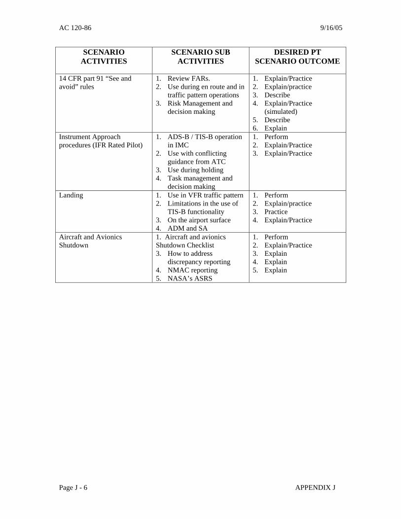
AC 120-86 9/16/05
SCENARIO ACTIVITIES
SCENARIO SUB ACTIVITIES
DESIRED PT SCENARIO OUTCOME
14 CFR part 91 “See and avoid” rules
1. Review FARs. 2. Use during en route and in
traffic pattern operations 3. Risk Management and
decision making
1. Explain/Practice 2. Explain/practice 3. Describe 4. Explain/Practice
(simulated) 5. Describe 6. Explain
Instrument Approach procedures (IFR Rated Pilot)
1. ADS-B / TIS-B operation in IMC
2. Use with conflicting guidance from ATC
3. Use during holding 4. Task management and
decision making
1. Perform 2. Explain/Practice 3. Explain/Practice
Landing 1. Use in VFR traffic pattern 2. Limitations in the use of
TIS-B functionality 3. On the airport surface 4. ADM and SA
1. Perform 2. Explain/practice 3. Practice 4. Explain/Practice
Aircraft and Avionics Shutdown
1. Aircraft and avionics Shutdown Checklist 3. How to address
discrepancy reporting 4. NMAC reporting 5. NASA’s ASRS
1. Perform 2. Explain/Practice 3. Explain 4. Explain 5. Explain
Page J - 6 APPENDIX J
AC 120-86 9/16/05
APPENDIX K.
Foreign Air Carriers and Foreign Operators of U.S.-Registered Aircraft Engaged in Common Carriage: Installation Approval and Authorization to
Conduct Aircraft Surveillance Flight Operations 1. Purpose. This appendix provides guidance for FAA approval of aircraft surveillance ADS-B system installations on U.S.-registered aircraft operated by foreign persons or foreign air carriers anywhere in common carriage and FAA authorization for foreign air carriers to conduct operations under 14 CFR Part 129 using aircraft surveillance systems within the United States NAS. 2. Scope. Material in this Appendix provides guidance information for initial and follow-up approval / authorization of aircraft surveillance systems. 3. Description. The process used to obtain approval/authorization of aircraft surveillance systems includes the standard airworthiness certification process for the installation of equipment. Additional acceptable criteria are provided below: 3.1. Acceptable Criteria. Criteria acceptable for use by foreign persons or foreign air carriers using aircraft surveillance system-equipped aircraft at U.S. airports, or aircraft surveillance system-equipped U.S.-registered aircraft anywhere where aircraft surveillance system operations are conducted, includes the latest version of this AC or other equivalent Joint Aviation Authorities (JAA) (European) or International Civil Aviation Organization (ICAO) criteria (when developed) that are acceptable to the FAA. 3.2. Operational and Airworthiness Approval/Authorization – Foreign Air Carriers. Operational approval/authorization by the civil aviation authority (CAA) of the State of the Operator and airworthiness approval by the State of the Operator acceptable to the State of Registry is required prior to conducting operations using aircraft surveillance systems in the U.S. NAS. Operational procedures must be included in the carrier’s manual and training for specific aircraft surveillance systems operations must be approved/accepted by the foreign CAA in accordance with ICAO Annex 6. Foreign air carriers wishing to perform aircraft surveillance systems operations in the U.S. NAS must provide the FAA with evidence of operational approval/authorization by the State of the Operator CAA and airworthiness approval/acceptance by the State of the Operator and State of Registry. The FAA may then authorize operations specified in 6.2.1.1.1 of this AC via OpSpecs. Aircraft surveillance systems operations by foreign air carriers in international airspace (e.g., within the New York Oceanic area or the West Atlantic Route System) do not require FAA authorization. 3.3. U.S.-Registered Aircraft - AFM Provisions. U.S.-registered aircraft used by foreign persons or foreign air carriers for aircraft surveillance system operations anywhere must have FAA type design approval. AFM provisions must reflect an appropriate level of aircraft surveillance system capability that meets the features and characteristics of avionics systems as outlined in this AC, or other acceptable criteria approved by the FAA. Approval of aircraft surveillance system installations on U.S.-registered aircraft shall be in accordance with section 5 of this AC.
APPENDIX K Page K - 1

AC 120-86 9/16/05
3.4. Foreign Air Carriers and Foreign Operators of U.S.-Registered Aircraft Engaged in Common Carriage. The maintenance program and MEL of U.S. registered aircraft must be FAA approved in accordance with 14 CFR § 129.14. 3.4.1 U.S.-registered Aircraft – Maintenance Program Approval. In accordance with 14 CFR section 129.14, each foreign air carrier and each foreign person operating a U.S.-registered aircraft within or outside the United States in common carriage shall ensure that each aircraft is maintained in accordance with a program approved by the Administrator (FAA). This maintenance program should address issues unique to aircraft surveillance systems as discussed in section 6.3.1 of this AC. The foreign civil aviation authority should not grant any operational approval/authorization for ADS-B system operations on U.S. registered aircraft before FAA approval of the maintenance program is granted. 3.4.2 U.S.-registered Aircraft – MEL Approval. In accordance with 14 CFR section 129.14 (b), no foreign air carrier or foreign person may operate a U.S.-registered aircraft with inoperable instruments or equipment unless a Master Minimum Equipment List (MMEL) exists for the aircraft type and the foreign operator submits for review and approval its aircraft minimum equipment list based on the master minimum equipment list, to the FAA. For aircraft surveillance system operations, the aircraft surveillance system and components should be taken into consideration during MEL submission, review and approval. 3.5 No specific FAA authorization is required for foreign persons conducting aircraft surveillance system operations with U.S.-registered aircraft NOT IN COMMON CARRIAGE (i.e., 14 CFR part 91 operations) except as referenced in section 6.2 of this AC for large and turbine-powered multi-engine aircraft. However, system installations on U.S.-registered aircraft shall be in accordance with section 5 of this AC, and when within a foreign country, comply with the regulations relating to the flight and maneuver of aircraft there in force. 3.6 Foreign air carriers conducting aircraft surveillance system operations within the U.S. and that meet criteria acceptable to FAA (e.g., European JAA, ICAO criteria when developed), and whose aircraft surveillance system operations with the applicable aircraft type are approved/authorized by the civil aviation authority (CAA) of the state of the operator, may be authorized aircraft surveillance system operations in the U.S. in accordance with the provisions of OpSpecs issued in accordance with14 CFR Part 129.
3.6.1 Issuance of Part 129 OpSpecs. Foreign air carriers operating aircraft in U.S. airspace and meeting the applicable provisions above may be authorized for operations with aircraft surveillance systems through issuance of part 129 OpSpecs. Principal inspectors shall ensure the following conditions have been met before issuing aircraft surveillance system OpSpecs to a foreign air carrier:
(a) Aircraft surveillance system equipment is installed in accordance with an approved type certificate (TC) or supplemental type certificate (STC) for the Make/Model/Series of aircraft.
(b) The aircraft approved AFM contains aircraft surveillance system provisions
appropriate to the aircraft surveillance system operation authorized.
Page K - 2 APPENDIX K

9/16/05 AC 120-86
(c) The state of the operator CAA has authorized/approved aircraft surveillance system operations for the carrier in accordance with the provisions of this AC or other criteria acceptable to the FAA.
(d) The FAA has approved the maintenance program and MEL for U.S. registered
aircraft including aircraft surveillance system provisions. * (e) The foreign air carrier has aircraft surveillance system training included in their
flight crew training program approved by the State of the Operator CAA. **
*Note: In the case of U.S.-registered aircraft operated solely outside the United States in
common carriage by a foreign person or foreign air carrier, only 129 OpSpecs approving the maintenance program and MEL are issued.
**Note: Although aircraft surveillance system training and operational procedures are
highly recommended, this is solely the responsibility of the State of the Operator CAA, for operations conducted solely outside the U.S.
APPENDIX K Page K - 3