structure of the southern jalisco subduction zone, mexico...
TRANSCRIPT

INTRODUCTION
The subduction of the Rivera plate beneath westernMexico along the Jalisco subduction zone (JSZ) is the domi-nant geologic process controlling the recent seismic activityand tectonic deformation within the crust of western Mexico.In this century alone, this process has generated three large,destructive, earthquakes; the two June 1932 events (e.g.,Singh et al., 1985) and the October 9, 1995 event (e.g.Courboulex et al., 1997; Melbourne et al., 1997; Pacheco etal., 1997a; Ortiz et al., 1998; Escobedo et al., 1998). In rela-tion to its importance, few studies have been conducted todetermine the detailed structure of the JSZ.
The seismicity occurring within the JSZ (Figure 1) (e.g.,Eissler and McNally, 1984; Kostoglodov and Ponce, 1994;Pardo and Suárez, 1993, 1995) adequately defines the ge-
Structure of the southern Jalisco subduction zone, Mexico, asinferred from gravity and seismicity
Bandy, W., V. Kostoglodov, A. Hurtado-Díaz and M. MenaInstituto de Geofísica, UNAM, México, D.F., México.
Received: January 19, 1999; accepted: May 22, 1999.
RESUMENUn modelo característico de la estructura geológica de la zona de subducción de Jalisco (JSZ) es determinado por la
comparación de las anomalías gravimétricas a lo largo de un perfil perpendicular a la costa de Jalisco cerca de Barra de Navidadcon la anomalía calculada de una sección geológica transversal restringida por datos de sismicidad. El espesor de la cortezacontinental del bloque de Jalisco es en promedio ~38 km, y aumenta gradualmente hacia el este hasta un espesor máximo de 44km. La densidad de la parte superior de la litosfera en subducción aumenta a una profundidad de ~30 km, reflejando quizá unatransición de fase de basalto a eclogita como se ha propuesto para la zona de subducción de Chile. El manto superior al oeste de latrinchera muestra densidades menores relativamente al resto del manto superior. Esta zona de baja densidad es más gruesa cercade la Cordillera del Pacífico Este (EPR) y disminuye hacia el este en direccíon de la Trinchera Mesoamericana, y esto puedereflejar una zona extensa de magma emplazada a lo largo del EPR, similar a la observada en el EPR a los 16°S.
PALABRAS CLAVE: Gravimetría, tectónica, estructura cortical, bloque de Jalisco, México.
ABSTRACTA type-model of the geological structure of the Jalisco subduction zone was determined by matching gravity anomalies
observed along a profile perpendicular to the Jalisco coast near Barra de Navidad with the gravitational attraction of a geologiccross section constrained by seismicity data. The thickness of the continental crust of the Jalisco block averages ~38 km, andgradually thickens eastward reaching a maximum thickness of 44 km. The density of the upper part of the subducting lithosphereincreases at a depth of ~30 km, perhaps reflecting a phase transition of basalt to eclogite as has been proposed for the Chilesubduction zone. The upper mantle west of the trench exhibits lower densities relative to the rest of the upper mantle. This lowdensity zone is thickest near the East Pacific Rise and thins eastward towards the Middle America Trench, and may reflect a broadzone of magma emplacement along the East Pacific Rise, similar to that observed at the East Pacific Rise at 16ES.
KEY WORDS: Gravity, tectonics, crustal structure, Jalisco block, western Mexico.
ometry of the subducting Rivera plate only in the southernpart of the JSZ. As a result, studies of the internal structureof the overriding plate, the Jalisco block, have relied prima-rily on potential field data. Further, these studies have beenundertaken mainly within the boundaries of the Jalisco block;namely, the Colima (Allan, 1985; Urrutia-Fucugauchi andMolina-Garza, 1992; Serpa et al., 1992; Bandy et al., 1993,1995, 1996; Molina-Garza and Urrutia-Fucugauchi, 1993;Medina et al., 1996) and the Tepic-Zacoalco (Alatorre-Zamora and Campos-Enríquez, 1991; Couch et al., 1991;Campos-Enríquez and Altorre-Zamora, 1998) rift systems.One regional study (Urrutia-Fucugauchi and Flores-Ruiz,1996; Flores-Ruiz, 1997) of the Bouguer gravity field of theentire Trans-Mexican volcanic belt addressed the crustalstructure of the interior of the Jalisco block. Further, thesestudies have not incorporated into their models the constraintsimposed by seismicity data.
127
Geofísica Internacional (1999), Vol., 38, num. 3, pp. 127-136

128
W. Bandy et al.
Fig. 1. Bathymetric-topographic map of the study area (Smith and Sandwell, 1997) and the location of the Barra de Navidad gravimetricprofile analyzed in this study. Red diamonds are the gravimetric stations. Small yellow circles are the epicenters of the seismic events from
Hurtado et al. (1998) whose loci were used to constrain the geometry of the subducting slab. Thin black line is the coastline.

129
Structure of the southern Jalisco subduction zone, Mexico.
The purpose of the present study is to determine a type-model, characteristic of the gross crustal structure of theJalisco block, from an integrated study of the seismicity andthe gravity data. We choose the southern part of the JSZ asthe area in which to develop this type-model for two rea-sons. First, the seismicity of this area can be used to con-strain the geometry of the subducting slab, independent ofthe gravity data. Such a constraint allows for a more accu-rate determination of the crustal structure from the gravitydata. Second, the continental crust in this region is uncom-plicated by volcanic processes. The resulting model mayprove useful as a starting point for future investigations intothe nature of the JSZ, particularly in the northern part of theJSZ where seismic activity is low.
GEOLOGIC SETTING
The JSZ, at which the Rivera plate converges with theJalisco block, comprises the northern part of the MiddleAmerica trench (MAT) between the Tres Marías Islands andthe southern Colima rift. The subduction process occurringwithin this zone produces large earthquakes (e.g., Singh etal., 1985; Pacheco et al., 1997a); however, the backgroundseismicity is low compared to the rest of the MAT to thesouth. In addition, this background seismicity decreases con-siderably northward from the southern Colima rift (Eisslerand McNally, 1984; Kostoglodov and Ponce, 1994).
The Jalisco block is bounded to the NE and SE by theTepic-Zacoalco and Colima rift systems, and to the SW bythe MAT. The Jalisco block exhibits two distinct surface litho-logic zones; namely, the Late Cretaceous-Paleocene coastalplutonic belt (e.g. Schaaf et al., 1993, 1995), and, to the NE,a zone of Cretaceous to early Cenozoic silicic ash flows whichare intruded by numerous Plio-Quaternary basalts (e.g., Luhret al., 1989; Lange and Carmichael, 1990; Righter andCarmichael, 1992; Wallace et al., 1992). The thickness ofthe central part of the Jalisco block has been determined fromspectral methods applied to gravity data to be ~40 km(Urrutia-Fucugauchi and Flores-Ruiz, 1996). The thicknessof the crust along the NE and SE boundaries of the Jaliscoblock has been determined to be either ~25 km (Urrutia-Fucugauchi and Flores-Ruiz, 1996) or ~43 km (Urrutia-Fucugauchi and Molina-Garza, 1992).In the southern part ofthe JSZ, the subducting slab initially dips at an angle of 9° to16° (Pardo and Suárez, 1993; Ortiz et al., 1998; Melbourneet al., 1997; Escobedo et al., 1998) down to mantle depths ofabout 20 km, and then increases gradually to a constant dipof ~50° below a depth of 40 km. A more recent, better con-strained model of the top of the Wadati-Benioff zone in thisarea (Hurtado et al., 1998), indicates an initial dip of 13°down to mantle depths of 20 km, gradually increasing to 46°at depths below 50 km. In the northern part of the JSZ, thegeometry of the Wadati-Benioff zone is poorly defined due
to the low level of seismic activity.The inner trench wall of the southern JSZ is comprised
of four geologic units (Mercier de Lepinay et al., 1997). Thefirst, located at the base of the inner trench wall, consists ofsiltstone, mudstone and sandstone layers. The second unitconsists of Late Cretaceous-Paleocene granodiorites and gab-bros which are correlated with the onshore coastal plutonicbelt of the Jalisco block. This unit is in thrust contact withthe underlying sedimentary unit. The third unit, whichunconformably overlies the plutonic unit, is a massive con-glomerate containing granitic and volcanic well-roundedpebbles. The uppermost unit consists of upper Miocene tolower Pliocene siltstone. The above sequence indicates thelack of an extensive accretionary prism in this area, and thatthe plutonic rocks extend to the trench axis. Further, the se-quence suggests that subduction erosion has been occurringsince the upper Miocene-lower Pliocene. This is suggestedby recent studies (Melbourne et al., 1997; Pacheco et al.,1997a) which conclude that there is a lack of unconsolidated,porous sediments within the plate interface zone.
The composition of the inner trench wall in the centralpart of the JSZ is not known. However, the stratigraphic se-quence on the Tres Marías Islands (McCloy et al., 1988) issimilar to that observed in the southern part of the JSZ(Mercier de Lepinay et al., 1997), suggesting that the obser-vations made in the inner trench wall of the southern JSZcan be applied to the central part of the JSZ.
The geologic cross section type-model presented in thisstudy was determined by matching the observed gravity datawith the gravitational attraction of the 2-D geologic modelcalculated using an algorithm based on Talwani et al. (1959).The top of the Wadati-Benioff zone is constrained by seis-micity data.
GRAVITY AND BATHYMETRY DATA
The onland gravity data used in this study were col-lected at 54 stations (Figure 1) during January 1993 andNovember 1994 using the LaCoste & Romberg model Ggeodetic gravimeter #247. These stations were located alongHighway 80 between Barra de Navidad, on the Pacific coast,to the intersection of Highways 80 and 54, about 30 km southof Guadalajara. Station spacing was about 5 km which yieldsa wavelength resolution of 10 km. The measured values werecorrected for the effects of theoretical earth-tides and reducedto Bouguer anomaly values employing the WGS-84 ellip-soid formulas (United States Defense Mapping Agency,1987), assuming a reference density of 2.67 g/cm3. We esti-mate the accuracy of the observations, corrected for the tidaleffect, to be “0.05 mGal. Terrain corrections were appliedemploying the digital data base of Aiken et al. (1997). Sta-tion elevations were determined employing a Paulin survey

130
W. Bandy et al.
micro-altimeter, in conjunction with elevations from INEGI,1:50 000 scale, topography sheets. We estimate the error inelevation to be half the contour spacing on these topographicmaps, or “10 m, which translates to an accuracy of “2 mGalfor the Bouguer anomaly values. Station locations were de-termined from INEGI 1:50 000 scale topography maps inthe southern part; whereas to the north, locations were deter-mined by GPS (non-differential) measurements. We estimatethe accuracy of the station locations to be ±200 m. The basestation for this survey is located in the Instituto Oceanográficoin Manzanillo, at 19°03’45.545”N ±0.017”, 104°18’08.800”W±0.023”, and the elevation with respect to the WGS-77ellipsoid is -11.15 meters, 2.5 meters above mean sea level.The observed gravity at the base station is 978581.46±0.07mGal. The Manzanillo base is tied to LAGSN77 gravity sta-tion #9712-62 in Puerto Vallarta (Ness, 1984).
Offshore, the gravity data used in this study are the free-air anomaly values derived from satellite altimetry data bySandwell and Smith (1997). These data have a reported ac-curacy of 3-7 mGal and a horizontal wavelength resolutionof 20 to 30 km (Sandwell and Smith, 1997; Yale et al., 1998;Green et al., 1998).
The bathymetric data used in the model are taken fromthe digital gridded (2' x 2' grid) bathymetric database of Smithand Sandwell (1997). These data are derived from qualitycontrolled ship depth soundings and the interpolation betweenthese soundings was guided by satellite altimetry data fromthe Geosat and ERS-1 spacecrafts. The estimated horizontalresolution of this data is between 1 and 25 km, depending onthe density of ship depth soundings.
EARTHQUAKE DATA
Earthquake data used in this study (Figure 2) to con-strain the geometry of the subducting slab under the south-ern part of the JSZ are those of Hurtado et al. (1988) andPacheco et al., (1997a). These two data sets include data fromlocal seismic networks, and provide the best constrained hy-pocenter information.
The earthquake data of Hurtado et al. (1998) consist ofseismic events recorded by 13 portable broadband digital seis-mographs deployed from March to July 1996, plus recordsfrom permanent seismic stations operated by the Universityof Colima (RESCO), and the broadband station CJIG(Chamela) operated by the National Seismological Service,UNAM. The hypocenters were located using the programSEISAN (Haskov, 1997) with the velocity model ofDomínguez et al. (1996), using Vp/Vs = 1.64 as for theColima area. Hypocentral locations were considered reliable,and were included in the data set, when they met the follow-ing criteria: (1) The locations were done using at least three
P-wave and three S-wave readings on three stations; (2) Theroot mean square error (rms) was less than 0.4 s in the finallocations; and (3) The estimated hypocentral errors were lessthan 20 km.
The earthquake data set of Pacheco et al. (1997a) con-sists of the locations of the aftershocks of the October 9,1995, Mw=8.0 thrust earthquake (Figure 2). Only aftershockswith an epicentral distance to the profile in Figure1 of lessthan 20 km were used.
In addition to the hypocenter information, we includein our data set eight focal mechanisms (Figure 2) determinedby Hurtado et al. (1998) using the method of P-wave firstmotion polarities. The other focal mechanisms from bodywave inversion shown on Figure 2 are from Pardo and Suárez(1993), and Pacheco et al. (1997b).
RESULTS
The geologic type-model (Figure 2) of the JSZ derivedfrom gravity and seismicity data consists of (1) the waterlayer, (2) the continental crust of the overriding North Ameri-can plate or, specifically, the Jalisco block, (3) the oceaniclithosphere of the Rivera plate and (4) the upper mantle. Thedifference between the observed gravity and that calculatedfrom the model can be seen in Figure 2. The standard devia-tion of the difference between the observed and modeledanomalies is ~7 mGal, and the mean difference is ~1 mGal
In this model, the continental unit is in direct contactwith the subducting oceanic plate for a distance of 100 kmeastward of the trench axis, where the crust thickens from 0km at the trench to 32 km. Eastward of the area where thecrust is in direct contact with the subducting plate, the crustgradually thickens from 32 km to 44 km at a distance of 300km from the trench axis.
The continental crust consists of an upper crustal layer(density 2.80 g/cm3), a lower crustal layer (density 2.90 g/cm3 ), and a thin sedimentary layer (density 2.30 g/cm3) whichoverlies the upper crustal layer in the continental slope re-gion. The upper crust has an average thickness of approxi-mately 10 km and extends westward to the trench axis. Fromthe coast, about 70 km east of the trench, the boundary be-tween the upper and lower crust deepens slightly, reachingits greatest depth 115 km from the trench axis. Several nor-mal-faulting events are located near the boundary betweenthe lower and upper crust where it attains its greatest depth.East of this point, until a point located 235 km from the trenchaxis, the boundary gradually shoals. A deepening of theboundary is indicated by the model east of this point; how-ever, this deepening should be viewed with caution as it is

131
Structure of the southern Jalisco subduction zone, Mexico.
Fig
. 2.
Top
: F
ree-
Air
(oce
an s
ide)
and
com
plet
e B
ougu
er (
cont
inen
tal
side
) gr
avity
ano
mal
ies
on t
he B
arra
de
Nav
idad
pro
file
(see
Fig
ure
1 fo
r pr
ofile
loc
atio
n).
Gre
en d
ots
indi
cate
obse
rved
val
ues
and
red
line
indi
cate
s va
lues
com
pute
d fr
om th
e m
odel
. Bot
tom
: str
uctu
ral d
ensi
ty m
odel
and
sei
smic
dat
a (c
olor
ed c
ircle
s, s
ee le
gend
) alo
ng th
e pr
ofile
. Foc
al m
echa
nism
sar
e: b
lue
quad
rant
s fr
om H
urta
do
et a
l. (1
998)
, vio
let q
uadr
ants
from
Par
do a
nd S
uáre
z (1
993)
, and
gre
en q
uadr
ants
is th
e ev
ent o
f 09/
28/1
996
from
Pac
heco
e
t al.
(199
7b).
Num
bers
insi
deco
lore
d fie
lds
are
the
dens
ities
in g
/cm
3 acc
epte
d fo
r the
mod
el. N
ote
that
the
max
imum
reco
rded
dep
th o
f sei
smic
ity d
irect
ly u
nder
the
Bar
ra d
e N
avid
ad p
rofil
e is
aro
und
80
km, w
hile
ther
ear
e se
vera
l dee
per
eart
hqua
kes
in th
e so
uthe
aste
rn p
art o
f the
Jal
isco
sub
duct
ion
zone
whi
ch a
re a
lso
show
n on
the
figur
e.
132
W. Bandy et al.
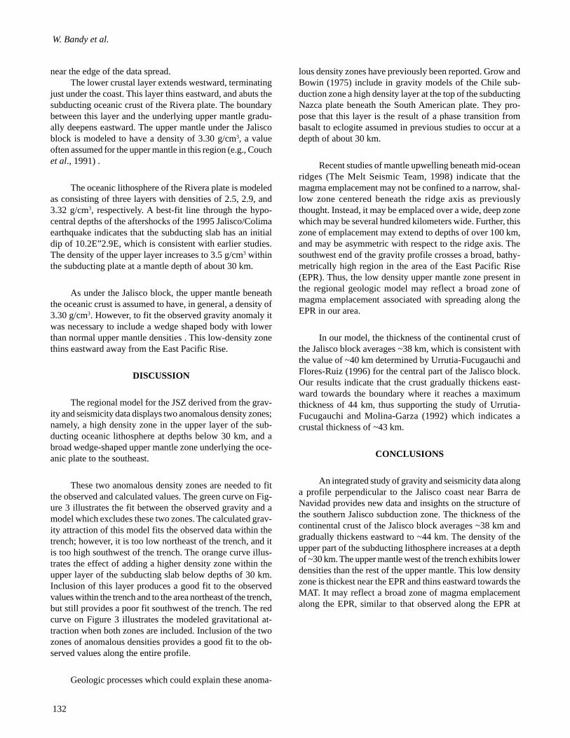
near the edge of the data spread.The lower crustal layer extends westward, terminating
just under the coast. This layer thins eastward, and abuts thesubducting oceanic crust of the Rivera plate. The boundarybetween this layer and the underlying upper mantle gradu-ally deepens eastward. The upper mantle under the Jaliscoblock is modeled to have a density of 3.30 g/cm3, a valueoften assumed for the upper mantle in this region (e.g., Couchet al., 1991) .
The oceanic lithosphere of the Rivera plate is modeledas consisting of three layers with densities of 2.5, 2.9, and3.32 g/cm3, respectively. A best-fit line through the hypo-central depths of the aftershocks of the 1995 Jalisco/Colimaearthquake indicates that the subducting slab has an initialdip of 10.2E”2.9E, which is consistent with earlier studies.The density of the upper layer increases to 3.5 g/cm3 withinthe subducting plate at a mantle depth of about 30 km.
As under the Jalisco block, the upper mantle beneaththe oceanic crust is assumed to have, in general, a density of3.30 g/cm3. However, to fit the observed gravity anomaly itwas necessary to include a wedge shaped body with lowerthan normal upper mantle densities . This low-density zonethins eastward away from the East Pacific Rise.
DISCUSSION
The regional model for the JSZ derived from the grav-ity and seismicity data displays two anomalous density zones;namely, a high density zone in the upper layer of the sub-ducting oceanic lithosphere at depths below 30 km, and abroad wedge-shaped upper mantle zone underlying the oce-anic plate to the southeast.
These two anomalous density zones are needed to fitthe observed and calculated values. The green curve on Fig-ure 3 illustrates the fit between the observed gravity and amodel which excludes these two zones. The calculated grav-ity attraction of this model fits the observed data within thetrench; however, it is too low northeast of the trench, and itis too high southwest of the trench. The orange curve illus-trates the effect of adding a higher density zone within theupper layer of the subducting slab below depths of 30 km.Inclusion of this layer produces a good fit to the observedvalues within the trench and to the area northeast of the trench,but still provides a poor fit southwest of the trench. The redcurve on Figure 3 illustrates the modeled gravitational at-traction when both zones are included. Inclusion of the twozones of anomalous densities provides a good fit to the ob-served values along the entire profile.
Geologic processes which could explain these anoma-
lous density zones have previously been reported. Grow andBowin (1975) include in gravity models of the Chile sub-duction zone a high density layer at the top of the subductingNazca plate beneath the South American plate. They pro-pose that this layer is the result of a phase transition frombasalt to eclogite assumed in previous studies to occur at adepth of about 30 km.
Recent studies of mantle upwelling beneath mid-oceanridges (The Melt Seismic Team, 1998) indicate that themagma emplacement may not be confined to a narrow, shal-low zone centered beneath the ridge axis as previouslythought. Instead, it may be emplaced over a wide, deep zonewhich may be several hundred kilometers wide. Further, thiszone of emplacement may extend to depths of over 100 km,and may be asymmetric with respect to the ridge axis. Thesouthwest end of the gravity profile crosses a broad, bathy-metrically high region in the area of the East Pacific Rise(EPR). Thus, the low density upper mantle zone present inthe regional geologic model may reflect a broad zone ofmagma emplacement associated with spreading along theEPR in our area.
In our model, the thickness of the continental crust ofthe Jalisco block averages ~38 km, which is consistent withthe value of ~40 km determined by Urrutia-Fucugauchi andFlores-Ruiz (1996) for the central part of the Jalisco block.Our results indicate that the crust gradually thickens east-ward towards the boundary where it reaches a maximumthickness of 44 km, thus supporting the study of Urrutia-Fucugauchi and Molina-Garza (1992) which indicates acrustal thickness of ~43 km.
CONCLUSIONS
An integrated study of gravity and seismicity data alonga profile perpendicular to the Jalisco coast near Barra deNavidad provides new data and insights on the structure ofthe southern Jalisco subduction zone. The thickness of thecontinental crust of the Jalisco block averages ~38 km andgradually thickens eastward to ~44 km. The density of theupper part of the subducting lithosphere increases at a depthof ~30 km. The upper mantle west of the trench exhibits lowerdensities than the rest of the upper mantle. This low densityzone is thickest near the EPR and thins eastward towards theMAT. It may reflect a broad zone of magma emplacementalong the EPR, similar to that observed along the EPR at

133
Structure of the southern Jalisco subduction zone, Mexico.
Fig
. 3. G
ravi
ty m
odel
adj
ustm
ent.
Top:
yel
low
dot
s ar
e ob
serv
ed g
ravi
ty a
nom
alie
s, g
reen
line
indi
cate
s a
mod
eled
fit w
ithou
t the
gra
vity
effe
ct o
f the
low
den
sity
(3.
22 g
/cm
3 ) m
antle
bod
ylo
cate
d un
der t
he E
PR
and
the
effe
ct o
f the
hig
h de
nsity
laye
r (3.
50 g
/cm
3 , p
resu
mab
ly o
f ecl
ogite
com
posi
tion)
in th
e su
bduc
ted
ocea
nic
crus
t. T
he u
pwar
d di
rect
ed a
rrow
and
the
diffe
renc
ebe
twee
n th
e pi
nk a
nd g
reen
line
s in
dica
te th
e gr
avity
effe
ct o
f the
hig
h de
nsity
laye
r. T
he d
ownw
ard
dire
cted
arr
ow a
nd th
e di
ffe
renc
e be
twee
n th
e pi
nk a
nd r
ed (
best
fit)
line
s in
dica
te th
eef
fect
of t
he lo
w d
ensi
ty b
ody.
Bot
tom
: str
uctu
ral d
ensi
ty m
odel
(sa
me
as th
at s
how
n in
Fig
ure
2). L
ight
gre
en is
the
high
den
sity
laye
r. Y
ello
w is
the
low
den
sity
man
tle b
ody.

134
W. Bandy et al.
16ES (The MELT Seismic Team, 1998).BIBLIOGRAPHY
AIKEN, C.L.V., M. BALDE, X. XU, M.G. ABDEL-SALAM, M.F. DE LA FUENTE and M. MENA, 1997.Integrated studies of Mexico with gravity, magnetic, andGIS database. The Leading Edge, 16, 1779-1785.
ALATORRE-ZAMORA, M. A. and J. O. CAMPOS-ENRIQUEZ, 1991. La Primavera caldera (Mexico):Structure inferred from gravity and hydrogeological con-siderations. Geophysics, 56, 992-1002.
ALLAN, J.F., 1985. Sediment depth in the northern Colimagraben from 3-D interpretation of gravity. Geofís. Int.,24, 21-30.
BANDY, W.L., C.A. MORTERA-GUTIERREZ and J.URRUTIA-FUCUGAUCHI, 1993. Gravity field of thesouthern Colima graben, Mexico. Geofís. Int., 32, 561-567.
BANDY, W., C. MORTERA-GUTIERREZ, J. URRUTIA-FUCUGAUCHI and T.W.C. HILDE, 1995. The sub-ducted Rivera-Cocos plate boundary: Where is it, whatis it, and what is its relationship to the Colima rift?Geophys. Res. Lett., 22, 22, 3075-3078.
BANDY, W. L., C. MORTERA-GUTIERREZ and J.URRUTIA-FUCUGAUCHI, 1996. Reply to commentsby J. García Abdeslem on: “Gravity field of the south-ern Colima graben”. Geofís. Int., 35, 89-91.
CAMPOS-ENRIQUEZ, O. and M. A. ALATORRE-ZAMORA, 1998, Shallow crustal structure of the north-ern portion of the junction of the grabens of Chapala,Tepic-Zacoalco and Colima, Mexico. Geofís. Int., 37,263-282.
COUCH, W.C., G.E. NESS, O. SANCHEZ-ZAMORA, G.CALDERON-RIVEROLLl, P. DOGUIN, T.PLAWMAN, S. COPERUDE, B. HUEHN and W.GUMMA, 1991. Gravity anomalies and crustal struc-ture of the gulf and peninsular province of theCalifornias, In: AAPG Mem. 47: The Gulf and Penin-sular Province of the Californias, Edited by J.P. Dau-phin and B.R.T. Simoneit, The American Association ofPetroleum Geologists, Tulsa, Oklahoma, pp. 25-45.
COURBOULEX, F., S.K. SINGH, J.F. PACHECO and C.J.AMMON, 1997. The 1995 Colima-Jalisco, Mexico,earthquake (Mw 8): A study of the rupture process.
Geophys. Res. Lett., 24, 1019-1022.DOMINGUEZ, J., A. HURTADO, J. PACHECO, G.
SUAREZ and G. SALINAS, 1996. Modelo unidimen-sional de velocidades sísmicas en los estados de Jaliscoy Colima. GEOS UGM, 16, 211.
EISSLER, H.K. and K.C. McNALLY, 1984. Seismicity andtectonics of the Rivera plate and implications for the1932 Jalisco, Mexico, earthquake. J. Geophys. Res., 89,4520-4530.
ESCOBEDO, D., J. F. PACHECO and G. SUAREZ, 1998.,Teleseismic body-wave analysis of the October, 1995(Mw=8.0), Colima-Jalisco, Mexico earthquake, and itslargest foreshock and aftershock. Geophys. Res. Lett.,25, 547-550.
FLORES-RUIZ, J. H., 1997. Estructura Cortical en el Centrode México Derivada del Análisis de AnomalíasGravimétricas Regionales. Ph.D. Thesis, UniversidadNacional Autónoma de México, Ciudad Universitaria,MEXICO D.F., pp.150.
GREEN, C. M., J. D. FAIRHEAD and D. S. MAUS, 1998.Satellite-derived gravity: Where we are and what’s next.The Leading Edge, 17, 77-79.
GROW, J. A. and C. O. BOWIN, 1975. Evidence for highdensity crust and mantle beneath the Chile Trench dueto the descending lithosphere. J. Geophys. Res., 80, 1449-1458.
HASKOV, J., 1997. The SEISAN earthquake analysis soft-ware for the IBM PC and SUN, Version 6, Institute ofSolid Earth Physics, University of Bergen, Norway, pp.236.
HURTADO, A., J. DOMINGUEZ, G. SUAREZ, J.VANDECAR, R. KUENHEL, S. SOLOMON and G.REYES, 1998. Geometry of the Benioff zone of theRivera plate beneath the Jalisco block and state of stress.Submitted to Geophys. Res. Lett.
KOSTOGLODOV, V. and L. PONCE, 1994. Relationshipbetween subduction and seismicity in the Mexican partof the Middle America trench. J. Geophys. Res., 99, 729-742.
LANGE, R.A. and I.S.E. CARMICHAEL, 1990. Hydrousbasaltic andesites associated with minette and relatedlavas in Western Mexico. J. Petrol., 31, 1225-1259.
LUHR, J. H., J. F. ALLAN, I. S. E. CARMICHAEL, S. A.

135
Structure of the southern Jalisco subduction zone, Mexico.
NELSON and T. HASENAKA, 1989. Primitive calc-alkaline and alkaline rock types from the western Mexi-can volcanic belt. J. Geophys. Res., 94, 4515-4530.
McCLOY, C., J.C. INGLE and J.A. BARRON, 1988. Neo-gene stratigraphy, foraminifera, diatoms, and deposi-tional history of María Madre Island Mexico: Evidenceof Early Neogene marine conditions in the southern Gulfof California. Marine Micropaleontology, 13, 193-212.
MEDINA, F., J.M. ESPINDOLA, M. DE LA FUENTE andM. MENA, 1996. A gravity model of the Colima, Mexicoregion. Geofís. Int., 35, 409-414.
MELBOURNE, T., I. CARMICHAEL, C. DEMETS, K.HUDNUT, O. SANCHEZ, J. STOCK, G. SUAREZ andF. WEBB, 1997. The geodetic signature of the M8.0 Oct.9, 1995, Jalisco subduction earthquake. Geophys. Res.Lett., 24, 715-718.
MERCIER DE LÉPINAY, B., F. MICHAUD, T. CALMUS,J. BOURGOIS, G. POUPEAU, P. SAINT-MARC andTHE NAUTIMATE TEAM, 1997. Large Neogene sub-sidence event along the Middle America Trench offMexico (18°-19°N): Evidence from submersible obser-vations. Geology, 25, 387-390.
MOLINA-GARZA, R. and J. URRUTIA-FUCUGAUCHI,1993. Deep crustal structure of central Mexico derivedfrom interpretation of Bouguer gravity anomaly data. J.Geodynamics, 17, 181-210.
NESS, G., 1984. Georeciever position and gravity tie at theInstituto Oceanográfico, Manzanillo, Mexico. OregonState University Internal Memo.
ORTIZ, M., S. K. SINGH, J. PACHECO and V.KOSTOGLODOV, 1998. Rupture length of the Octo-ber 9, 1995 Colima-Jalisco earthquake (Mw 8) estimatedfrom tsunami data. Geophys. Res. Lett., 25, 2857-2860.
PACHECO, J., S. K. SINGH, J. DOMINGUEZ, A. HURTA-DO, L. QUINTANAR, Z. JIMENEZ, J. YAMAMOTO,C. GUTIERREZ, M. SANTOYO, W. BANDY, M.GUZMAN and V. KOSTOGLODOV, 1997a. The Octo-ber 9, 1995 Colima-Jalisco, Mexico earthquake (Mw 8):An aftershock study and a comparison of this earthquakewith those of 1932. Geophys. Res. Lett., 24, 2223-2226.
PACHECO, J., S.K. SINGH and G. REYES, 1997b. TheSeptember 28, 1995, Colima, Mexico intermediate depthearthquake: Tectonic and crustal structure implications(abstract). Abstracts of the IASPEI 29th General Assem-
bly, Thessaloniki, Greece, 210.PARDO, M. and G. SUAREZ, 1995. Shape of the subducted
Rivera and Cocos plates in southern Mexico: Seismicand tectonic implications. J. Geophys. Res., 100, 12,373-12,373.
PARDO, M. and G. SUAREZ, 1993. Steep subduction ge-ometry of the Rivera plate beneath the Jalisco block inwestern Mexico. Geophys. Res. Lett., 20, 2391-2394.
RIGHTER, K. and I.S.E. CARMICHAEL, 1992. Hawaiitesand related lavas in the Atenguillo graben, western Mexi-can volcanic belt. Geol. Soc. Am. Bull., 104, 1592-1607.
SANDWELL, D.T. and W.H.F. SMITH, 1997. Marine grav-ity anomaly from Geosat and ERS 1 satellite altimetry.J. Geophys. Res., 102, 10,039-10,054.
SCHAAF, P., H. KÖHLER, D. MULLER-SOHNIUS and V.Von DRACH, 1993. The Puerto Vallarta Batholith-Itsanatomy displayed by isotopic fine structure. In: Pro-ceedings of the First Circum-Pacific and Circum-Atlan-tic Terrane Conference, edited by F. Ortega-Gutiérrez,P.J. Coney, E. Centeno-García and A. Gómez-Caballero,Instituto de Geología, Universidad Nacional Autónomade México, November, 1993, Guanajuato, México, pp.133-135.
SCHAAF, P., D. MORAN-ZENTENO, M. HERNANDEZ-BERNAL, G. SOLIS-PICHARDO, G. TOLSON and H.KÖHLER, 1995. Paleogene continental margin trunca-tion in southwest Mexico: Geochronological evidence.Tectonics, 14, 1339-1350.
SERPA, L., S. SMITH, C. KATZ, C. SKIDMORE, R.SLOAN and T. PAVLIS, 1992. A geophysical investi-gation of the southern Jalisco block in the state of Colima,Mexico. Geofís. Int., 31, 475-492.
SINGH, S.K., L. PONCE and S.P. NISHENKO, 1985. Thegreat Jalisco, Mexico, earthquakes of 1932: Subductionof the Rivera plate. Bull. Seismol. Soc. Am., 75, 1301-1313.
SMITH, W.H.F. and D.T. SANDWELL, 1997. Global seafloor topography from satellite altimetry and ship depthsoundings. Science, 277, 1956-1962.
TALWANI, M., J. L. WORZEL and M. LANDISMAN, 1959.Rapid gravity computations for two-dimensional bod-ies with applications for the Mendocino submarine frac-ture zone. J. Geophys. Res., 64, 49-59.
THE MELT SEISMIC TEAM, 1998. Imaging the deep seis-mic structure beneath a mid-ocean ridge: The MELT ex-

136
W. Bandy et al.
periment. Science, 280, 1215-1218.UNITED STATES DEFENSE MAPPING AGENCY, 1987.
Department of Defense World Geodetic System 1984:Its definition and relationships with local geodetic sys-tems. DMA Technical Report #8350.2.
URRUTIA-FUCUGAUCHI, J. and R.S. MOLINA-GARZA,1992. Gravity modelling of regional crustal and uppermantle structure of the Guerrero terrane - 1. Colima gra-ben and southern Sierra Madre Occidental, westernMexico. Geofís. Int., 31, 493-507.
URRUTIA-FUCUGAUCHI, J. and J. H. FLORES-RUIZ,1996. Bouguer gravity anomalies and regional crustalstructure in central Mexico. Int. Geol. Rev., 38, 176-194.
WALLACE, P., I.S.E. CARMICHAEL, K. RIGHTER andT.A. BECKER, 1992. Volcanism and tectonism in west-ern Mexico: A contrast of style and substance. Geology,20, 625-628.
YALE, M. M., D.T. SANDWELL and A.T. HERRING, 1998.What are the limitations of satellite altimetry?. The Lead-ing Edge, 17, 73-73.
____________
Bandy, W., V. Kostoglodov, A. Hurtado-Díaz, andM. MenaInstituto de Geofísica, UNAM, Cd. Universitaria 04510,México, D.F. México.E-mail. [email protected]