structure and stratigraphy of the palaeoproterozoic ... and stratigraphy of the palaeoproterozoic...
TRANSCRIPT

Structure and stratigraphy of the Palaeoproterozoic Karasjok Greenstone Belt, north Norway - regional implications
ALV AR BRAATHEN & BØRRE DAVIDSEN
Braathen, A. & Davidsen, B. : Structure and stratigraphy of the Palaeoproterozoic Karasjok Greenstone Belt, North Norway -regional implications. Norsk Geologisk Tidsskrift, Vol. 80, pp. 33-50. Oslo 2000. ISSN 0029-196X.
The Karasjok Greenstone Belt of the northwestern Baltic/Fennoscandian Shield forms the westernmost unit in a Palaeoproterozoic tectonic belt, recording crustal mobilization, tectonic reworking and metamorphism of the Archaean and Palaeoproterozoic Iithosphere during a 2.1-1. 7-Ga tectonic episode. In northern Norway, this 100 krn-wide tectonic belt consists of linear segments of highly strained rocks that are separated by N-S-striking thrust zones. The lowest unit, the Karasjok Greenstone Belt, consists of lowto medium-grade volcanogenic and sedimentary rocks. Excellent exposures in the northern part of the greenstone belt reveal a continuous Iithostratigraphic section towards the core of a major recumbent synform, which is related to the regional 01 deformation episode. This episode is responsible for transposition of primary features and formation of an east-dipping penetrative foliation and banding, with a well-developed east-plunging stretching lineation. Major 01 shear zones, marked by mylonites and blastomylonites, are found (i) locally at the base of the belt, (ii) at high tectonostratigraphic levels, and (iii) at the upper boundary of the greenstone belt. Shear-sense indicators support west-directed displacement along the thrusts. The superimposed 02 episode is evident as eastplunging folds, whereas a major 02 thrust with top-to-the-SSW shear occurs near the base of the greenstone belt. The younger 03 episode is manifested by N-S-trending folds of the former (01 and 02) structures. All fold systems are truncated by steep NE-SWstriking brittle faults of 04 affinity. The polyphase deformation seen in the Karasjok Greenstone Belt supports a model in which the assembling of the Karasjok Greenstone Belt, the Tanaelv Migmatite Complex and the Levajok Granulite Complex occurred from major orogen-normal E-W contraction (collision) during the 01 episode. At this stage the greenstone belt was isoclinally folded and welded to overlying units during west-directed overthrusting of the medium- to high-grade complexes. From then on the greenstone belt acted as a basal detachment zone. The 02 episode of NNE-SSW shortening and SSW-directed thrust emplacement suggest dextral and orogen-oblique movement patterns, prior to continued orogen-perpendicular E-W shortening during the 03 episode. The final faulting (04) may relate to a post-orogenic, shield-scale strike-slip event.
A. Braathen & B. Davidsen, Geological Survey of Norway, 7491 Trondheim, Norway. E-mail: alvar.braathen@ngu. no; bo"e.davidsen@ ngu.no
Introduction
The Karasjok Greenstone Belt of the northem Baltic/ Fennoscandian Shield forms the westemmost and tectonostratigraphically lowest unit of a Palaeoproterozoic tectonic belt, termed the Lapland-Kola Orogen by Marker ( 1985). In Norway, it consists of the Karasjok Greenstone Belt (KGB), the Tanaelv Migmatite Complex (TMC) and the Levajok Granulite Complex (LGC). This broad belt (nearly 100 km wide) is traceable from northwestem Russia, through northem Finland, into northem Norway (Fig. l; e.g., Gorbatschev & Bogdanova 1993). It records crustal mobilization, tectonic reworking and stabilization of dorninantly juvenile Archaean and Palaeoproterozoic lithosphere during a 2.1-1. 7 -Ga cycle of rifting, contraction, and subsequent stabilization and uplift (e.g., Barbey et al. 1984; Krill 1985; Marker 1985; Berthelsen & Marker 1986a; Berthelsen 1987; Gaal & Gorbaschev 1987; Gorbatschev & Bogdanova 1993). In northem Norway, this orogen consists of linear segments of highly strained rocks that are separated by N-S-striking, east-dipping thrust zones (Fig. lb), together forming a crustal-scale
tectonic boundary (suture?) between the Jer'gul and Baisvam gneiss domes of Archaean to Palaeoproterozoic ages (Siedlecka et al. 1985).
A key problem in understanding continental growth is the nature and evolution of convergent strain in a broad zone during accretion (Windley 1993). In northem Norway, as for most of the northem Fennoscandian Shield, there is a lack of detailed data on stratigraphy, metamorphism and deformation, undermining the establishment of sound tectonic models. The KGB, consisting of relatively incompetent supracrustals and intrusive rocks, metamorphosed to medium grade (Crowder 1959; Wennerwirta 1969; Siedlecka et al. 1985), represents the most complexly but also least deformed part of this tectonic belt, making it a well-suited area for studying the polyphase contractional evolution of the Palaeoproterozoic orogenic episode(s).
The aims of this contribution are to describe the lithostratigraphic section of the KGB from the Lakselv area, then to present extensive structural data from two key areas, the Lakselv Valley and Karasjokka River sections. This material is used in discussing the structural archi-

34 A. Braathen & B. Davidsen
B
70 �
Svecofennian dornain (-1,77-2,0 Ga)
Palacoproterozoic and An:heaen domain (-1,9-3,1 Ga)
Phanerozoic.: domain
NORSK GEOLOGISK TIDSSKRIFT 80 (2000)
N
A o 10 20 km
Leg end
Baisvårri Gneiss Complex Levajok Granulite Complex Tanaelv Migmatite Complex
Karasjok Greenstone Belt
Allochtonous(?) units Ø Undifferentiated KGB
B Fossestrand Formation
� Briittågielas Formation
D Corgasåvzi Formation
LJ Lavttevårri Formation
Autochtonous units D Skuvvanvårri Formation
0 Vuomegielas Formation
Kautokeino Greenstone Belt
rd Suoluvuobmi Formation
E:3 Jer'gul Gneiss Complex
0 Allochthonous? basements
Geological symbols _;-Å- Thrust fault
-- Fault
Profile A-B
A � B �:' ---.. 100�� =\ ,/..;- -�
�ø.trV·V • �:.v + + + + + .:��·V·V:� xx V·
m.o.h.
26° 27"
Fig. l. (A) Regional tectonic map of the northwestern Baltic/Fennoscandian Shield. (B) Bedrock map of main units in the Karasjok Greenstone Belt (KGB) and nearby complexes. Boxes locate the Lakselv and Karasjokka areas. The distribution of units within the KGB represents a highly modified version of the map by Often (1985).

NORSK GEOLOGISK TIDSSKRIFT 80 (2000)
tecture and the polyphase tectonic evolution of the greenstone belt, which has important implications for the proposed regional tectonic models.
Geological setting
Investigations by the Geological Survey of Norway in the 1980s obtained extensive map data from the Precambrian province of Finnmark. Same of the results are described in reports on the regional geology (e.g., Krill l985; Krill et al. 1985; Marker 1985; Often 1985; Siedlecka et al. 1985; Nilsen 1988) that place the various beits and complexes into a tectonic framework.
The Karasjok-Levajok tectonic belt consists of three different, N-S-striking, east-dipping segments, separated by east-dipping thrust zones (Fig. 1). In the following, a brief account of the three units is given as an introduction to the lithostratigraphic description of the Karasjok Greenstone Belt.
The Levajok Granulite Complex (LGC), which is part of the extensive Lapland Granulite Belt, consists of granulite facies metasedimentary and subordinate mafic to intermediate igneous rocks (Marker 1985; Berthelsen & Marker 1986a; Krill 1985; Gaal et al. 1989). Igneous activity and metamorphism took place 2.0-1.9 Ga ago (BernardGriffiths et al. 1984; Gaal et al. 1989; Korja et al. 1996). The western and southwestern parts of the LGC contain sheared, mylonitic rocks, while the eastern parts reveal less strained, migmatitic rocks (Marker 1985). The shearing post-dated the migmatitization (Marker 1985; Krill 1985).
The Tanaelv Migmatite Complex (TMC) consists of a high- to medium-grade, banded sequence of partly migmatitic rocks. It includes a variety of assumed Palaeoproterozoic rocks, such as various orthogneisses, amphibolites and lenses of ultramafites (Marker 1985; Krill 1985; Berthelsen & Marker 1986a; Gaal et al. 1989). The TMC forms a ductile high-strain zone, of age and structural evolution comparable to those of the LGC (Marker 1985), and may represent a tectonic mixture of exotic and adjacent, underlying rocks, formed during westward thrusting of the LGC (Marker 1985; Gaal et al. 1989).
The Karasjok Greenstone Belt (KGB) has a N-S trend with a length of about 160 km, and ranges in width from 20 to 40 km (Crowder 1959; Wennerwirta 1969; Krill 1985; Often 1985; Siedlecka et al. 1985). In Finland, the Kittilii Greenstone Belt constitutes the southern continuation for another 150 km towards the SSE. The KGB is nonconformably overlying and partly thrust over the granitic basement rocks of the Archaean(?) Jer' gul Gneiss Complex to the west. To the east it is bounded by the overthrust TMC (Wennerwirta 1969; Siedlecka et al. 1985).
Rocks of the KGB sit in an isoclinal recumbent syncline, e.g., the belt is sandwiched between the underlying and overlying units (Davidsen 1994). Two later fold-phases, superimposed on the regional recumbent syncline, are well expressed in the greenstone belt. However, the overlying
Karasjok Greenstone Belt, north Norway 35
complexes do not reveal similar folding. This structural situation illustrates the long-lived, more comprehensive deformation in the greenstone belt when compared to the overlying units, and shows that the greenstone belt acted as a regional detachment zone in the lower part of the regional tectonic belt.
The tectonostratigraphy of the KGB has been established by Often (1985) and Siedlecka et al. (1985). According to these authors, the KGB can be divided into five formations, from base to top: (l) the Vuomegielas Formation, characterized by fine-grained foliated amphibolites presumed to be mafic metavolcanites, biotite-rich schists, and ultramafic rocks representing possible metakomatiites, and (2) the Skuvvanvam Formation, made up of terrigenous clastic sediments represented by sandstones, conglomerates and mudstones, in places fuchsite-bearing and, locally, with a primary depositional contact against the Jer' gul Gneiss Complex. Above a thrust contact the allochthonous to para-autochthonous Iddjajav'ri Group consists of (3) the Gål'lebaike Formation, characterized by intermediate tuffaceous rocks, with layers of mafic metavolcanites and meta-komatiites, intermingled with metasediments, (4) the Bakkilvarri Formation, dominated by mafic and ultramafic (komatiitic) volcanites, and (5) the Rai'tegår'zi Formation, of aluminous mica schists and mafic volcanic and intrusive rocks. Metakomatiites in the Bakkilvarri Formation have been dated to 2085 ± 85 Ma, using the whole-rock Sm-Nd method (Krill et al. 1985).
The type section for the Iddjajav'ri Group is located in the south, along the Karasjokka River profile (Fig. lb). As the general degree of outcrops in areas adjacent to this pro file is very low, and indicators of stratigraphic polarity are not present, it has been difficult to identify possible stratigraphic repetitions caused by isoclinal falding, and also, to same extent, thrusting (cf. Siedlecka 1985). For example, work conducted by Braathen (1991) in the type area for the Iddjajav'ri Group suggests that the Rai'tegår'zi Formation is a tectonostratigraphic unit separated from the Bakkilvam Formation by a thrust contact. The informal name Rai'tegår'zi nappe is here given to this unit.
Lithostratigraphy of the Karasjok Greenstone Belt in the Lakselv area
The stratigraphic complexities encountered in the Karasjokka River section are not existent in the Lakselv area. The Lakselv Valley displays the northernmost extent of the Karasjok Greenstone Belt, surrounded by Caledonian nappes (Fig. lb). The unique degree of exposure has made it possible to conduct detailed bedrock mapping in the l :5000 scale, providing detailed knowledge of the field geology (Girard 1989a, b; Roberts & Davidsen 1992; Davidsen 1993a, b, 1994).
In the SSW, the Palaeoproterozoic supracrustal rocks of the Lakselv area are bound by a thrust zone towards the underlying basement rocks of the Jer'gul Gneiss Complex. Within the Lakselv Valley itself, the folded sequence of

36 A. Braathen & B. Davidsen
Fig. 2. Bedrock map of the Karasjok Greenstone Belt in the Lakselv Valley.
NORSK GEOLOGISK TIDSSKRIFf 80 (2000)
Leg end � Covered
D Caledonian nappes
Karasjok Greenstone Belt 1111 Fossestrand Fm.
� Briittågielas Fm.
D Corgasåvzi Fm.
� Lavttevårri Fm.
[§] Laevdnjavårri gneiss complex
Geological symbols
_. ... ··· Fm. boundary; rlPfinit,•fin,ti>n· .. rll -- Fault, definite '
- Joint or uncertain fault
45'>-., "><-. Layering l Foliation � Profil• lin"
NORSK GEOLOGISK TIDSSKRIFf 80 (2000)
X _l:e!!��njavarri - -
1 OOO • -�---...... Lavvoa1'V1 ----1----- --- -- -O m
-1000
y
1000
-1000
z
1000
-1000
Pro file A - A'
l
Profil a A- A'
l
Karasjok Greenstone Belt, north Norway
Profile B - B'
Brennelva
Profile Z' B - B'
Profil a C - C'
Corgas�avzi .·
Leg end
D Caledonian nappes
Karasjok Greenstone Belt - Fossestrand Fm.
� Briittagielas Fm.
O Corgasavzi Fm.
� Lavttevarri Fm.
III'J Basement gneiss (Laevdnjavarri complex?)
Geological symbols
--,_
o
Fm.boundary; definite/inferred
Fault, definite
Joint or uncertain fault
5 km
X'
37
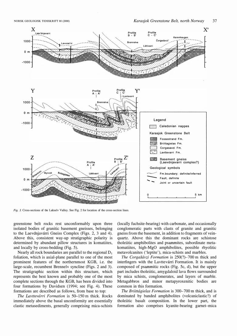
Fig. 3. Cross-sections of the Lakselv V alley. See Fig. 2 for location of the cross-section lines.
greenstone belt rocks rest unconformably upon three isolated bodies of granitic basement gneisses, belonging to the Laevdnjavarri Gneiss Complex (Figs. 2, 3 and 4). Above this, consistent way-up stratigraphic polarity is determined by abundant pillow structures in komatiites, and locally by cross-bedding (Fig. 5).
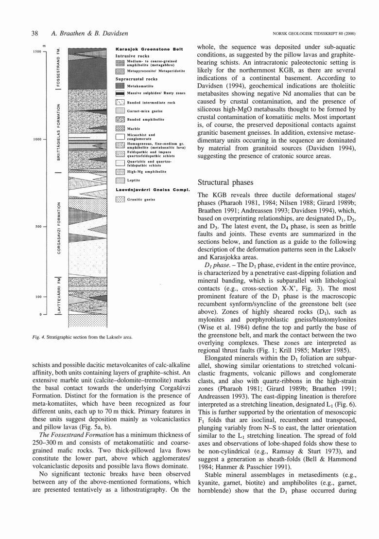
Nearly all rock boundaries are parallel to the regional D1 foliation, which is axial-plane parallel to one of the most prominent features of the northernmost KGB, i.e. the large-scale, recumbent Brennelv syncline (Figs. 2 and 3). The stratigraphic section within this structure, which represents the best known and probably one of the most complete sections through the KGB, has been divided into four formations by Davidsen (1994; see Fig. 4). These formations are described as follows, from base to top:
The Lavttewirri Formation is 50-150 m thick. Rocks immediately above the basal unconformity are essentially clastic metasediments, generally comprising mica-schists
(locally fuchsite-bearing) with carbonate, and occasionally conglomeratic parts with clasts of granite and granitic gneiss from the basement, in addition to fragments of veinquartz. Above this the dominant rocks are schistose tholeiitic amphibolites and psamrnites, subordinate metakomatiites, high-MgO amphibolites, possible rhyolitic metavolcanites ('leptite'), mica-schists and marbles.
The Corgasavzi Formation is 250(?)-700 m thick and interfingers with the Lavttevarri Formation. It is mainly composed of psamrnitic rocks (Fig. 5c, d), but the upper part includes tholeiitic, amygdaloid lava flows surrounded by mica schists, conglomerates, and layers of marble. Metagabbros and minor metapyroxenitic bodies are common in this formation.
The Briittagielas Formation is 300-700 m thick, and is dominated by banded amphibolites (volcaniclastic?) of tholeiitic basalt composition. In the lower part, the formation also comprises kyanite-bearing garnet-mica
38
m 1500
1000
soo
100
A. Braathen & B. Davidsen
:::;; u.. c z <( ..: .... (/) w (/) (/) o u..
z o >= <( :::;; ..: o u.. (/) <( ...J w o < .... � � al
z o � :::;; ..: o u.. ;::; � (/) <( (!) ..: o u
� ..: < > w .... .... � ...J
Karasjok Greenstone Belt Intrusive rocks
• �r::��:'o-u!: (:����-;::!:}d
m Metapyrounlte/ MetaperldotUt
Supracrustal rocks • Mttakomatiite
� Massive s u lphidn/ Ruaty zones
W Banded intermedlate ro ck
D Garnet-ml ca cneiu
� Banded ampbibo lite
m Marblt
D ��:.'oc!�':a:e
nd
R ��::,\'o�::eu�ym��.'b:S:�:�
mla��)
� Feldspatlllc and impan t::::::::l quartzofeldspatlatc s chilts {2]
��::;:���c •.:�l:t�
artzo-
� Hlgh -Mc amphlbolite
(TI] Leptlte
Laavdnjavirrl Gnalss Compl. D Granlti c gnehs
Fig. 4. Stratigraphic section from the Lakselv area.
schists and possible dacitic metavolcanites of calc-alkaline affinity, both units containing layers of graphite-schist. An extensive marble unit (calcite-dolomite-tremolite) marks the basal contact towards the underlying Corgasavzi Formation. Distinct for the formation is the presence of meta-komatiites, which have been recognized as four different units, each up to 70 m thick. Primary features in these units suggest deposition mainly as volcaniclastics and pillow la vas (Fig. 5a, b ).
The Fossestrand Fomw.tion has a minimum thickness of 250--300 m and consists of metakomatiitic and coarsegrained mafic rocks. Two thick-pillowed lava ftows constitute the lower part, above which agglomerates/ volcaniclastic deposits and possible lava fl.ows dominate.
No significant tectonic breaks have been observed between any of the above-mentioned formations, which are presented tentatively as a lithostratigraphy. On the
NORSK GEOLOGISK TIDSSKRIFT 80 (2000)
whole, the sequence was deposited under sub-aquatic conditions, as suggested by the pillow lavas and graphitebearing schists. An intracratonic paleotectonic setting is likely for the northernmost KGB, as there are several indications of a continental basement. According to Davidsen (1994), geochemical indications are tholeiitic metabasites showing negative Nd anomalies that can be caused by crustal contamination, and the presence of siliceous high-MgO metabasalts thought to be formed by crustal contamination of komatiitic melts. Most important is, of course, the preserved depositional contacts against granitic basement gneisses. In addition, extensive metasedimentary units occurring in the sequence are dominated by material from granitoid sources (Davidsen 1994 ), suggesting the presence of cratonic source areas.
Structural phases
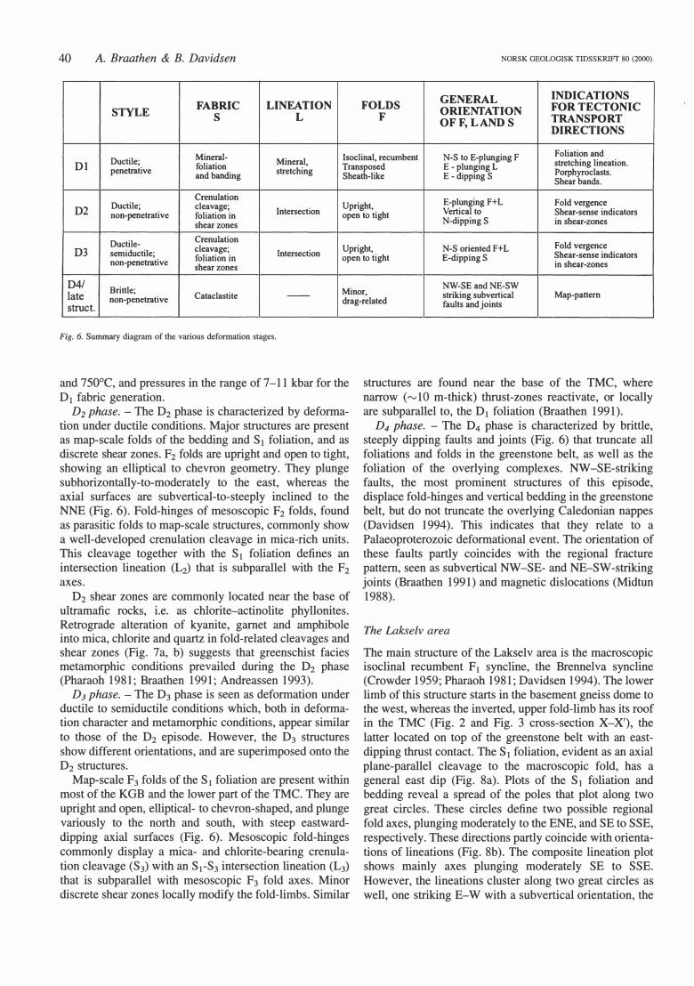
The KGB reveals three ductile deformational stages/ phases (Pharaoh 1981, 1984; Nilsen 1988; Girard 1989b; Braathen 1991; Andreassen 1993; Davidsen 1994), which, based on overprinting relationships, are designated Db D2, and D3• The latest event, the D4 phase, is seen as brittle faults and joints. These events are summarized in the sections below, and function as a guide to the following description of the deformation patterns seen in the Lakselv and Karasjokka areas.
D1 phase. - The D1 phase, evident in the entire province, is characterized by a penetrative east-dipping foliation and mineral banding, which is subparallel with lithological contacts (e.g., cross-section X-X', Fig. 3). The most prominent feature of the D1 phase is the macroscopic recumbent synform/syncline of the greenstone belt (see above). Zones of highly sheared rocks (D1), such as mylonites and porphyroblastic gneisslblastomylonites (Wise et al. 1984) define the tap and partly the base of the greenstone belt, and mark the contact between the two overlying complexes. These zones are interpreted as regional thrust faults (Fig. l; Krill 1985; Marker 1985).
Elongated minerals within the D1 foliation are subparallel, showing similar orientations to stretched volcaniclastic fragments, volcanic pillows and conglomerate clasts, and also with quartz-ribbons in the high-strain zones (Pharaoh 1981; Girard 1989b; Braathen 1991; Andreassen 1993). The east-dipping lineation is therefore interpreted as a stretching lineation, designated L1 (Fig. 6). This is further supported by the orientation of mesoscopic F 1 folds that are isoclinal, recumbent and transposed, plunging variably from N-S to east, the latter orientation similar to the L1 stretching lineation. The spread of fold axes and observations of lobe-shaped folds show these to be non-cylindrical (e.g., Ramsay & Sturt 1973), and suggest a generation as sheath-folds (Bell & Hammond 1984; Hanmer & Passchier 1991).
Stable mineral assemblages in metasediments (e.g., kyanite, garnet, biotite) and amphibolites (e.g., garnet, hornblende) show that the D1 phase occurred during

NORSK GEOLOGISK TIDSSKRIFT 80 (2000)
amphibolite facies conditions (Fig. 7a; for details on metamorphic textures and parageneses, see Davidsen 1994 and Braathen 1991). Migmatitization of metasediments in the KGB immediately below the TMC indicate upper amphibolite facies at high tectonostratigraphic levels (Krill
Karasjok Greenstone Belt, north Norway 39
Fig. 5. Photographs of primary features in the Lakselv area of the Karasjok Greenstone Belt. (A) Komatiitic pillow flow, viewed down-plunge, parallel to the L1 stretching lineation. (B) Flattened pillows in komatiite in a section that is viewed normal to the L1 stretching lineation. (C) Cross-bedding in psamrnite. Note the L1 stretching lineation. (D) Close-up of the cross-bedding in Fig. 5c.
1985), whereas kyanite, evident in pelites of the entire greenstone belt, suggest that Kyanite Zone (e.g., Yardley 1989) conditions affected the whole rock column. Based on stability fields for various mineral assemblages, Davidsen (1994) estimated temperatures between 625
40 A. Braathen & B. Davidsen NORSK GEOLOGISK TIDSSKRIFf 80 (2000)
GENERAL INDICATIONS STYLE FABRIC LINEATION FOLDS ORIENTATION FOR TECTONIC
s L F OFF, L AND S TRANSPORT DIRECTIONS
Mineral- Isoclinal, recumbent N-S to E-plunging F Foliation and Ductile; Mineral, stretching lineation. Dl penetrative foliation
stretching Transposed E - plunging L Porphyroclasts. and banding Sheath-like E - dipping S Shear hands.
Crenulation E-plunging F+L Fold vergence
D2 Ductile; c lea vage; Upright, Intersection Vertical to Shear-sense indicators non-penetrative foliation in open to light
N-dipping S in shear-zones shear zones
Crenulation Ductile- Fold vergence
D3 semiductile; cleavage;
Intersection Upright, N-S oriented F+L
Shear-sense indicators non-penetrative foliation in open to light E-dipping S
in shear-zones shear zones
D4/ Brittle; Minor,
NW-SE and NE-SW late Cataclastite -- striking subvertical Map-pattem
non-penetrative struct.
drag-related faults and joints
Fig. 6. Summary diagram of the various deformation stages.
and 750°C, and pressures in the range of 7-11 kbar for the D1 fabric generation.
D2 phase. - The D2 phase is characterized by deformation under ductile conditions. Major structures are present as map-scale folds of the bedding and S 1 foliation, and as discrete shear zones. F2 folds are upright and open to tight, showing an elliptical to chevron geometry. They plunge subhorizontally-to-moderately to the east, whereas the axial surfaces are subvertical-to-steeply inclined to the NNE (Fig. 6). Fold-hinges of mesoscopic F2 folds, found as parasitic folds to map-scale structures, commonly show a well-developed crenulation cleavage in mica-rich units. This cleavage together with the S1 foliation defines an intersection lineation (L2) that is subparallel with the F2 axes.
D2 shear zones are commonly located near the base of ultramafic rocks, i.e. as chlorite-actinolite phyllonites. Retrograde alteration of kyanite, garnet and amphibole into mica, chlorite and quartz in fold-related cleavages and shear zones (Fig. 7a, b) suggests that greenschist facies metamorphic conditions prevailed during the D2 phase (Pharaoh 1981; Braathen 1991; Andreassen 1993).
D3 phase. - The D3 phase is seen as deformation under ductile to semiductile conditions which, both in deformation character and metamorphic conditions, appear similar to those of the D2 episode. However, the D3 structures show different orientations, and are superimposed onto the D2 structures.
Map-scale F3 folds of the S1 foliation are present within most of the KGB and the Iower part of the TMC. They are upright and open, elliptical- to chevron-shaped, and plunge variously to the north and south, with steep eastwarddipping axial surfaces (Fig. 6). Mesoscopic fold-hinges commonly display a mica- and chlorite-bearing crenulation cleavage (S3) with an S1-S3 intersection lineation (L3) that is subparallel with mesoscopic F3 fold axes. Minor discrete shear zones locally modify the fold-limbs. Similar
structures are found near the base of the TMC, where narrow ("'l O m-thick) thrust-zones reactivate, or locally are subparallel to, the D1 foliation (Braathen 1991).
D4 phase. - The D4 phase is characterized by brittle, steeply dipping faults and joints (Fig. 6) that truncate all foliations and folds in the greenstone belt, as well as the foliation of the overlying complexes. NW -SE-striking faults, the most prominent structures of this episode, displace fold-hinges and vertical bedding in the greenstone belt, but do not truncate the overlying Caledonian nappes (Davidsen 1994). This indicates that they relate to a Palaeoproterozoic deformational event. The orientation of these faults partly coincides with the regional fracture pattem, seen as subvertical NW-SE- and NE-SW-striking joints (Braathen 1991) and magnetic dislocations (Midtun 1988).
The Lakselv area
The main structure of the Lakselv area is the macroscopic isoclinal recumbent F1 syncline, the Brennelva syncline (Crowder 1959; Pharaoh 1981; Davidsen 1994). The lower limb of this structure starts in the basement gneiss dome to the west, whereas the inverted, upper fold-limb has its roof in the TMC (Fig. 2 and Fig. 3 cross-section X-X'), the latter located on top of the greenstone belt with an eastdipping thrust contact. The S1 foliation, evident as an axial plane-parallel cleavage to the macroscopic fold, has a general east dip (Fig. 8a). Plots of the S1 foliation and bedding reveal a spread of the poles that plot along two great circles. These circles define two possible regional fold axes, plunging moderately to the ENE, and SE to SSE, respectively. These directions partly coincide with orientations of lineations (Fig. 8b ). The composite lineation p lot shows mainly axes plunging moderately SE to SSE. However, the lineations duster along two great circles as well, one striking E-W with a subvertical orientation, the

NORSK GEOLOGISK TIDSSKRIFT 80 (2000)
Fig. 7. (a) Microphotograph (polarized; margins= 2.4 x 4 mm) of kyanitegarnet-mica schist in the KGB, slightly above the basal thrust zone. Note how the S1 foliation (subhorizontal) is F2 crenulated (subvertical), and the fractured kyanite is altered into white mica. (b) Microphotograph (polarized; margins
= 2.4 x 4 mm) of mylonitic pebbly psammite in the Storfossen thrust zone. Pebbles are deformed into an ellipsoid shape and are surrounded by oriented fine-grained white mica, quartz and feldspar of the S2 mylonitic/phyllonitic foliation. Detailed descriptions of metamorphic textures and paragneses are presented in Davidsen (1994) and Braathen (1991).
other striking NNW-SSE and dipping steeply to the ENE. These great circles are similar in orientation to axial surfaces of mesoscopic F2 and F3 folds, respectively (see below).
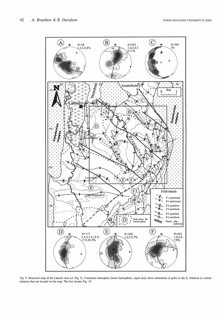
The F 1 macrofold c hang es from a tight elliptical shape in the northwest (Figs. 9 and 10), where primary volcanic features are preserved in the hinge-zone, to parallel limbs further southeast and east, where bedding is entirely transposed to become parallel with the S1 foliation. Further southeast the fold-binge is revealed from stratigraphic repetition. The Brennelva F1 syncline folds bedding, as well as an amphibolite-facies metamorphic foliation, which, at this locality, is preserved in the fold-binge zone. This implies that an older (than D1 ?) metamorphic episode may be present in the greenstone belt. However, this episode is almost entirely overprinted, and therefore not regionally preserved (see discussion).
Two sets of folds are superimposed on the Brennelva syncline. Eastward-plunging map-scale F2 folds are present within the entire area, as illustrated in stereoplots of bedding/S1 from various subareas (plots B, C, D, E and F
Karasjok Greenstone Belt, north Norway
LAKSELV AREA a) Sl N
b) Ll+F2+F3 N
N=2533
N=357
41
Fig. 8. Contoured stereoplots (lower hemisphere, equal area, Schmidt net) of (a) poles to the S1 foliation, and (b) structural linear features (L1 lineation, F2 and F3 fold axes) of the Lakselv area.
in Fig. 9). These folds are generally upright and open with subvertical axial surfaces, as seen in the southwest and west in Fig. 9 (see also Fig. 3, cross-sections X-X' and Z-Z'), where basement is upfolded in the core of an F2 anticline. Further northeast the F2 folds tend to be tighter and overturned to the south.
42 A. Braathen & B. Davidsen
N=177 2.5,5, 7.S,J2.S,
7.5 ,22. So/o
NORSK GEOLOGISK TIDSSKRIFT 80 (2000)
..... " .... ., F 1-synclinal
..._ '1.... Fl-anticlinal
F2-synform
F2-antiform
F3-synform
F3-antiform
Fault; obs., infcrrcd
Fig. 9. Structural map of the Lakselv area (cf. Fig. 2). Contoured stereoplots (lower hemisphere, equal area) show orientation of potes to the S1 foliation in various subareas that are located on the map. The box locates Fig. l O.

NORSK GEOLOGISK TIDSSKRIFT 80 (2000)
Al A2
Lacvdnjavårri Gnciss Complcx �1:Ii�g�ma�';Meiss,
Pole to plane .. Measured fold axis
Karasjok Greenstone Belt, north Norway 43
A3 B
• Constructed fold axis
Fig. JO. Detailed bedrock map of the Brennelva area, locating the Brennelva F1 syncline, superimposed F2 and F3 folds, and late brittle faults. Contoured stereoplots (lower hemisphere, equal area) show orientation of bedding/S1 foliation for various subareas that are located in the inset map. Plot A3 presents a plane and the associated fold axis (star) constructed with basis in the two average poles of foliations in plots Al and A2.

44 A. Braathen & B. Davidsen
The youngest fold set, F3, trends N-S (plots A and F, Fig. 9). They are present within two areas, in the east and in the northwest, where they show an open to tight elliptical geometry with steep east-dipping axial surfaces, i.e. they verge to the west (cross-section Y-Y', Fig. 3).
Several NW-SE-striking, subvertical D4 faults truncate and offset the various fold sets (Figs. 8 and 9). Subvertical bedding of some fold-limbs and subvertical axial surfaces are displaced up to 500 m right-laterally, suggesting that the structures represent dextral strike-slip faults. Faultoffsets terminate eastward in a NE-SW-striking, beddingparallel fracture zone with no visible displacement.
The Brennelva area (Fig. l O) is ideal for studying and documenting map-scale and mesoscopic superimposed folding of three generations of folds (Ft. F2 and F3). The Brennelva F 1 syncline, in its least deformed core to the northwest, shows an inter-limb angle of approximately 20°, as revealed from stereo-plots of bedding/banding in the upper and lower fold-limbs (plots Al and A2, Fig. 10). These fold-ftanks define a moderately SE-plunging fold axis (plot A3) that represents the best estimate for the original orientation of the major F1 axis in the greenstone belt.
The Brennelva F1 syncline is clearly folded around EW- and N-S-trending folds (Fig. 10). The E-W-oriented F2 fold system, present as an antiform-synform pair, folds the F 1 syncline into two NE- and SE-trending domains in the western area. Eastward, the F1 trace is folded into several N-S-trending F3 anti- and synforms.
The western area reveals a moderately east-plunging F2 fold axis (plot B, Fig. 10). Further eastwards, approaching the D3 tectonized area, the fold axes of the F2 folds change to southeast plunges (plots C and D, Fig. 10) and, in the intensely F3 folded domain, to west and southeast plunges (plot E). In the same domain F3 folds, which are parasitic to a major antiform to the east, plunge to the northeast and southeast (plots F and G, Fig. 10). These two plunge orientations are related to the north and south limbs of an E-W-trending F2 synform. The F3 fold axes plot along the general F3 axial surface, dipping steeply to the east, demonstrating that the NE and SE plunges of the F3 folds are controlled by inherited orientations of the SofS1.
The Karasjokka area
The Karasjokka River profile (Fig. lb; Often 1985) displays a section from the basal Jer' gul Gneiss Complex, through the greenstone belt, to the lower part of the TM C. The main outcrop-scale structure is the penetrative S1 foliation, which strikes approximately N-S and dips moderately east (plots A and B, Fig. 11). An eastward plunge is clear for the mineral and stretching lineation, Lt. whereas mesoscopic intrafolial F1 folds spread from north to east plunges (plot A).
Later deformation is divided into the D2 and D3 phases, as for the rest of the greenstone belt. Mesoscopic F2 folds plunge moderately to the ESE, having WNW-ESEstriking and steeply NNE-dipping axial surfaces (plots C
NORSK GEOLOGISK TIDSSKR!Ff 80 (2000)
KARASJÅKKAAREA FOLlA TI ON CLEAVAGE
Dl
Fig. 11. Stereoplots (lower hemisphere, equal area) of structural data from the Karasjokka area. Structural data for each deformation episode are presented as contoured poles to the foliation/cleavage (A, C, E) and contoured lineations (B, D, F). Note that the stars in A represent F1 fold axes.
and D, Fig. 11). F3 folds plunge subhorizontal to the north and south, displaying axial surfaces that dip steeply to the east (plots E and F).
Map-scale structures of the Karasjokka area include (l) the Storfossen Thrust (ST of Figs. 12 and 13) near the base of the greenstone belt, (2) an overlying isoclinal F1 synform (Noaidatjåkka synform, NIS) that is terminated by (3) the Luossajavri thrust (LT) in the upper limb, and (4) the Bourdnavarri synform (BS). The Noaidatjåkka synform (NIS) is an isoclinal, recumbent F1 synform with subparallel fold-limbs that has been located by stratigraphic repetition, S- and Z-shaped folds, and locally, by a distinct angle between bedding and the S1 axial planeparallel foliation in the fold-binge (Fig. 14a). This fold, which is strikingly similar to the Brennelva F1 syncline of the Lakselv area, repeats the lower part of the stratigraphic section. In the upper fold-limb the structure is truncated by a shear zone, identified by protomylonitic to mylonitic granitoid rocks, that is interpreted as a D1 thrust (= LT; Fig.

NORSK GEOLOGISK TIDSSKRIFT 80 (2000)
N
t
l l
l l
STI N
.•
. . . . + .
... . . ,._, ",.
·,_ ·· . .
ST2
. · . . · .. · · ·.
. .,
o
N F3+S3 =28+33
'i
-+-
Karasjok Greenstone Belt, north Norway 45
2 km
LEG END ----- Lithological contact, located, inferred � Tanaelv Migmatite
Complex o • Antiform, F2 and F3
� Raitegårzi Nappe � l Synform, F2 and F3
m Iddjajavri Gr.
n Synform, Fl D Skuvanvarri Fm. .
�;:;:1 Jergul Gneiss Faults, located
Complex - and inferred
� Dl thrust
• D2 and D3 thrusts
Fig. 12. Simplified bedrock map of the Karasjokka area. The stereoplots (lower hemisphere, equal area) present data for various subareas that are located in the map. BS = Bourdnavarri synform; LT = Luossajavri Thrust; NIS= Noaidatjåkka F1 synform; NOAS = Noaidatjavri synform; NT= Noaidatjavri thrust; RA= Raitevarri antiform; RT = Raitejåkka thrust; ST= Storfossen thrust zone.

46 A. Braathen & B. Davidsen NORSK GEOLOGISK TIDSSKRIFT 80 (2000)
A A'
LEG END
l tmc l Tanaelv Migmatite Complex V:.{ ]i Iddjajavri Gr. �+:+:+1 Jergul Gneiss Complex
� Raitegårzi nappe j:::::::::l Skuvvanvarri Fm. C2] Granite in Jergul Gneiss Complex (former upper Iddjajavri Gr.) (pre-dates Skuvvanvarri Fm.)
Fig. 13. Schematic E-W cross-section of the Karasjokka area. The cross-section line is located in Fig. 12. Abbreviations as in Fig. 12.
13). Further indications for a major tectonic boundary at this leve! are shown as a break in both the rock composition and the apparent metamorphic grade, i.e. the difference between supracrustal rocks below the shear zone and overlying large, granodioritic gneissic bodies situated in migmatitic supracrustal rocks.
The D1 synform and thrust (NIS and LT) are folded into an E-W- to WNW-ESE-trending, open and upright F2 antiform-synform pair (RA and NOAS, Fig. 12) that verges moderate ly to the south. Two N-S- to NW -SEstriking F3 synforms, the most prominent being the Buordnavarri synform (BS, Figs. 12 and 13), are superimposed on the D1 and D2 structures. This synform downfolds the TMC gneisses (Krill 1985; Often 1985), establishing a regional NW-directed tongue of the migmatite complex into the greenstone belt (see Fig. lb).
The F2 folds are rooted in the gently ENE-dipping Storfossen thrust (ST, Figs. 12 and 13). This thrust zone shows a tectonic mixture of slivers of the basement gneiss, locally with overlying basal conglomerate of the Skuvvanvam Formation, the basal Skuvvanvam Formation psammites, and the Iddjajav'ri Group metasediments and metavolcanites (Fig. 14a, b). A well-developed S2 foliation in the zone, characterized by a general grain size reduction and local proto- to orthomylonitic fabric, overprints the S 1 foliation, which in most cases is totally erased.
Common deformation structures of the Storfossen thrust zone indicating the sense-of-shear are: the vergence and asymmetrical shearing of folds (Fig. 14b ), composite shear fabrics (Fig. 14c) (Lister & Snoke 1984; Simpson & Schmidt 1983; Dennis & Secor 1987, 1990), asymmetrically winged porfyroclasts and conglomerate clasts
(Passchier & Simpson 1986; Hanmer & Passchier 1991), and outcrop-scale, stacked units and foliation duplexes (Fig. 14d). Together, the D2 structures suggest non-coaxial ftow and top-to-the-SSW movement in the Storfossen thrust zone. Orientation of mesoscopic folds within the zone (plot STl, Fig. 12), having gently east- to NE-dipping axial surfaces and eastward-plunging fold axes, are in accordance with the shear sense. However, variation in the fold-trend and locally curved hinge-zones suggest that progressive deformation and rotation (non-cylindrical/ sheath folds) and superimposed folding may have modified some folds.
The Storfossen thrust was apparently reactivated during the D3 episode. The S2 foliation is affected by mesoscopic folds, having N-S-trending axes (plot ST2, Fig. 12) and axial surfaces dipping moderately to the east or, less commonly, to the west. These folds are in general confined to discrete shear zones, where the S2 foliation is transposed into a new, S3 mylonitic/phyllonitic fabric, or erased by cataclasis in more competent rocks (Fig. 14d). Structures indicating sense-of-shear, i.e. similar to the ones assigned to the D2 episode, are present within the D3 tectonic zones as well, indicating non-coaxial ftow and top-to-the-west movement.
Structural evolution and kinematics
Overprinting structural relationships, such as those described for the Lakselv area (Fig. 10), document that a four-phase deformation sequence applies to the KGB. V ariation in the tectonometamorphic conditions are in accordance with such a sequence, rising to upper amphi-

NORSK GEOLOGISK TIDSSKRIFT 80 (2000) Karasjok Greenstone Belt, north Norway 47
Fig. 14. Photographs of structures in the Karasjokka area. (a) Primary bedding in the Gå!'Iebaike Formation, preserved in the fold-binge of the Noaidatjåkka F1 synform. Note the well-developed S 1 cleavage parallel to the pencil. (b) Shear zone rocks, represented by chlorite phyllonite and intense) y deformed lenses of psammite (note shear-folded lens), in the Storfossen thrust zone. (c) Tectonically intermingled chlorite phyllonite and psammite, the latter isoclinally folded, in the Storfossen thrust zone. Normal shear hands of S2 affinity that cut the fold. (d) Cold-shear duplex and local cataclasis in 03 mylonites of the Storfossen thrust zone.
bolite to amphibolite facies conditions during the D1 episode, followed by greenschist facies metamorphism during the D2 and D3 phases, and finally sub-greenschist facies and brittle deformation during the D4 episode (Fig.
7). Orientation of the D1 structures, present as an east
dipping, penetrative foliation that contains an east-plunging stretching lineation, variously oriented intrafolial folds, and shear sense indicators, indicate westwarddirected thrusting (Krill 1985; Marker 1985) during the D1 phase. Thrusts with a D1 signature are located at the base of the TMC along the length of the province (Krill 1985), at the base of the Rai'tegår'zi nappe of the Karasjokka area, as well as near the base of the greenstone belt south of the Lakselv Valley (Fig. l; Pharaoh 1984; Krill 1985; Andreassen 1993). A similar D1 thrust located near the base of the greenstone belt in the Karasjokka area cannot be ruled out, since the Storfossen thrust of D2 and D3 affinity overprints earlier formed structures. Thus, the extent of the D1 phase indicates that most of the KGB was allochthonous at this stage of deformation.
The well-preserved stratigraphic succession in the Lakselv Valley diverts from this strain pattern. There, domes of basement (Jer' gul Gneiss Complex?) and a
continuous stratigraphic cover section suggest that the basement and overlying cover was transported on a basal D1 thrust. Thus, the basement domes were detached from the underlying Jer' gul Gneiss Complex, and later upfolded during the D2 phase (see below).
The D2 phase shortened the greenstone belt in a N-S to NE-SW direction, as suggested from the fold-trends and vergences. Shear sense indicators in thrust zones like the Storfossen thrust support southward movement along D2 shear zones near the base of the belt. Folds in the overlying greenstone belt, rooted in the Storfossen thrust (Fig. 12), suggest that the D2 deformation was detached from the underlying basement. A similar situation is evident south of the Lakselv Valley, where several small shear zones, locally reactivating D1 structures, indicate that the greenstone belt was partly detached from the Jer' gul Gneiss Complex in this area as well (Andreassen 1993). These shear zones may form the base for the F2 upfolded basement domes of the Lakselv Valley.
Most of the D2 thrusts strike N-S to NW-SE, i.e. oblique to the indicated SSW direction of tectonic transport. This indicates that the D2 shear zones represent top-to-the-SSW dextral-oblique thrusts, which likely rejuvenated the D1 foliation.

48 A. Braathen & B. Davidsen
Dl
D2
D3
D4
JG
JG KG TM
TM
�? �+ /� �� /
�+ //_,, , ' / ,<
KG
TM
JG Jergul Gnciss Complex <i=:! Regional shortening direction
KG Karasjok Greenstone Belt ,k" Local shortening direction TM Tanaelv Migmatite Complex
NORSK GEOLOGISK TIDSSKRJFf 80 (2000)
The D3 phase is characterized by N-S-trending, westverging folds that affect distinct areas of the greenstone belt, as seen in the Lakselv Valley (Fig. 10). Shear zones of this stage are generally insignificant and located to the F3 fold-limbs, with exception of several 10 m-thick thrust zones located near the base of the TMC. These zones show retrograde alteration of the migmatitic, banded gneisses, and locally modify the map pattern (Braathen 1991). Similar retrograde shear-zones have reactivated many of the thrusts in the western part of the Karasjok-Levajok tectonic belt (Marker & Braathen, pers. comm. 1991), indicating that these D3 structures are of regional extent.
The Storfossen thrust is an example of a significant D3 shear zone that has reactivated a D2 thrust. Shear sense indicators from this structure indicate top-to-the-west D3 thrusting. Because similar structures are not known from other areas of the greenstone belt, the D3 reactivation of the Storfossen thrust may be a local feature.
D4 faulting and fracturing affected the entire region; however, significant faults have not been detected in the south. In the Lakselv area, NW-SE faults showing dextral separation of markers terminate in a NE-SW -oriented, foliation-parallel fracture zone. Movement within this fracture zone, if any, opens for a conjugate fault configuration, which may relate to a N-S-shortening axis. Alternatively, a regional dextral shear event may explain the dextral faulting (see below).
Tectonic model for the Karasjok Greenstone Belt
The structural evolution of the KGB can be summarized in a four-phase tectonic model, as presented in Fig. 15. This illustration of the orientation and genesis of various structures during the polyphase deformation history, which may well reflect a progressive sequence, places all deformation within a bulk crustal shear system. The regional, E-Woriented, orogen-normal shortening axis is directly reflected by the orientation of D1 and D3 structures. For the D2 phase, a counter-clockwise rotation of the regional shortening axis into a N-S to NE-SW orientation is suggested. Such a change to an orogen-oblique, contractional setting may have triggered right-lateral thrust movement near the base of the greenstone belt, and generated shear-related folds in the overlying units. The D4 structures, constituting a minor part of the bulk strain in the area, deviate from the deformation style and orientation of the earlier formed structures. This distinction may point to a younger, separate event, where strike-slip faults formed during N-S to NE-SW shortening (Fig. 15).
Discussion
Two important questions arise from the above description
Fig. 15. Tectonic model for the structural evolution of the Karasjok Greenstone Belt and overlying Tanaelv Migmatite Complex. See text for further explanation.

NORSK GEOLOGISK TIDSSKRIFT 80 (2000)
and discussion: First, does the lithostratigraphic section of the Lakselv area correlate with the tectonostratigraphy southward in the greenstone belt? Secondly, bow does the polyphase structural evolution and the proposed model correspond to other tectonic models for the region? In the following we address these questions.
Stratigraphic correlation. - An attempt to correlate the continuous lithostratigraphic section of the Brennelv area (Lakselv) with the tectonostratigraphy of Often ( 1985) and Siedlecka et al. (1985) , which is based mainly on the Karasjokka area, is presented in Fig. lb. In order for the correlation to be meaningful, we assume that some units can be traced for the length of the KGB.
There are some regional similarities, especially for the base of the belt. The Corgasavzi Formation of the Lakselv area most likely overlaps with the Skuvvanvam Formation, and perhaps also lower parts of the Gål'lebai'ke Formation; the two former rest non-conformably on basement, and contain a basal conglomerate and overlying psammites. Often (1985) places the boundary between the Skuvvanvam and Gål'lebaike formations to the first appearance of meta-volcanites/intrusives which, on a regional scale, are discontinuous or missing. In the Lakselv area, volcanic rocks appear near the base of the belt and interfinger with the psammites.
The overlying section, tectonically dismembered in the Karasjokka area, may be divided into two general parts: sedimentary rocks underneath volcanic rocks. In the Lakselv area, this subdivision applies to the Corgasavzi and Briittagielas-Fossestranda formations, respectively, which may equal the Gål'lebaike and Bakkilvarri formations in the Karasjokka area. The overlying Rai'tegår'zi nappe (Rai'tegår'zi Formation of Often 1985) in the Karasjokka area seems to be restricted to the southern part of the belt, or alternatively, it may have been incorporated in the TMC east of Lakselv. The map presented in Fig. lb is based on these correlations.
Regional models. - Models for the Karasjok-Levajok Mobile Belt (Krill 1985; Marker 1985; Berthelsen & Marker 1986a) place the KGB as a passive margin basin, which is in accordance with the continental inftux in sediments of the belt and possible continental magma contamination (see above; Davidsen 1994). The units overlying the KGB were located to the western margin of a collision zone, which involved several Archaean continents and Palaeoproterozoic volcanic arcs and basins. They were assembled during a ca. 2. 0--1. 8 -Ga cycle of continental growth. The main collision phase emplaced the hot LGC, yielding the heat for the metamorphism (Krill 1985) , over the TMC, which was thrust on top of the KGB. This tectonic scenario is consistent with our D1 phase , showing extensive deformation and infolding of the greenstone belt (Fig. 15) . However, amphibolite-facies metamorphism probably affected the greenstone belt before thrusting, as indicated by the early (pre-D1; from subduction?) metamorphic banding in the hinge- zone of the Brennelva F 1 syncline of the Lakselv area, and also from consistent D 1 mineral parageneses for the entire
Karasjok Greenstone Belt, north Norway 49
width of the belt. Thrust emplacement of the TMC probably occurred at a late stage of the D1 episode, during ultimate collision, before uplift (from thrusting?) and cooling.
An E-W-inverted metamorphic gradient, as proposed by Krill (1985) , is clear for the Karasjok-Levajok tectonic belt as a whole, if the Jer' gul Gneiss Complex represents the base of the tectonostratigraphic section, and the S 1 foliation defines the general dip of the Karasjok Greenstone Belt. However, stratigraphically, the greenstone belt is isoclinally folded, with an inverted upper fold-limb that is truncated by a regional thrust. Thus, the TMC is in a position which, without thrusting, would be the position of the basement gneisses of the Jer' gul Gneiss Complex in the upper fold-limb. This structural architecture allows for an interpretation of the highly strained TMC, at least partly, as a zone of sheared basement. In this case the metamorphic grade present in the TMC may reftect earlie r tectonometamorphic episodes that were partly overprinted during Palaeoproterozoic reworking.
During the following D2 phase the greenstone belt was shortened and transported on a basal thrust toward the SSW under retrograde, greenschist-facies conditions. The SSW transport direction suggests dextral, orogen-oblique movement for the greenstone belt and the attached (during D1) overlying complexes (Fig. 15) , i. e. at this stage the KGB acted as a basal detachment zone. Such a transcurrent phase may, for example, be related to somewhat later (than D1) approximately N-S collision in the Lapland-Kola Orogen in the south (e. g. , Barbey e t al. 198 4; Gaal & Gorbatschev 198 7; Gaal et al. 198 9; Gorbatschev & Bogdanova 1993 ) . According to Nironen (1997) , the D1-D2 collision occurred during 1. 90--1. 8 7 Ga, when NE-SW shortening in the northern part of the Svecofennian Orogen resulted in initial orogen-normal shortening and subse quent clockwise rotation, the latter leading to dextral transpression.
The following D3 phase could reftect a regional episode of E-W shortening, modifying the position of beits and complexes, as indicated by the numerous D3 thrusts that reactivate the foliation of the Karasjok-Levajok tectonic belt. Other indications for this regional extent are found as, for example , the N-S fo1ds in the Po1mak-PasvikPechenga belt further east (e . g. , Marker 1985; Melezhik & Sturt 1994) , striking1y similar to those in the KGB (Braathen 1996) . In the shield-scale model of Nironen (1997) , no E-W event is proposed. The timing of this event is uncertain, but could correlate with the major 1. 90--1. 8 7 Ga event mentioned above .
A possible explanation for the D4 faults may be found in a shield-scale , strike-slip shearing phase that has been proposed for the Baltic Shield by Berthelsen & Marker (198 6 b) and Karki et al. (1993 ) . In this model, the D4 faulting of the KGB occurred in a fairly stable block (assembled during the D�o D2 and D3 phases) that was slightly inftuenced by the regional shearing event.
Acknowledgements.- We thank Tor Otto Andreassen, Steffen Bergh, Peter Ihlen, Mogens Marker, Morten Often and Tore Torske for numerous fruitful discussions

50 A. Braathen & B. Davidsen
regarding the geology. Financial contributions from the University of Tromsø, the Geological Survey of Norway and Finnmark County are acknowledged. We also thank A. G. Krill, M. Nironen and B. A. Sturt for constructive reviews.
Manuscript received November 1998
References
Andreassen, T. O. 1993: Strukturelle og tektoniske undersøkelser i de nordlige deler av Karasjok grønnsteinsbelte, Finnmark fylke. Cand. scient. thesis, University of Tromsø, 148 pp.
Barbey, P., Convert, J., Moreau, B., Capdevilla, R. & Hameurt, J. 1984: Petrogenesis and evolution of an early Proterozoic collisional orogenic belt: the Granulite Belt of Lapland and the Belomorides (Fennoscandia). Geological
Society of Finland Bulletin 56, 161-188. Bell, T. H. & Harnmond, R. L. 1984: On the intemal geometry of mylonite zones.
Journal of Geology 92, 667-686. Bemard-Griffiths, J., Peucat, J. J., Postaire, B., Vida!, P., Convert, J. & Moreau, B.
1984: Isotopic data (U-Pb, Rb- Sr, Pb-Pb and Sm-Nd) on mafic granulites from Finnish Lapland. Precambrian Research 23, 325-348.
Berthelsen, A. 1987: A tectonic model for the crustal evolution of the Baltic shield. In Schaer, J. P. & Rodgers, J. (eds.): The Anatomy of Mountain Chains,
Princeton: Princeton University Press. Berthelsen, A. & Marker, M. 1986a: Tectonics of the Kola collision suture and
adjacent Archaean and Early Proterozoic terrains in the northeastem region of the Baltic Shield. In Galson, D. A. & Mueller, S. (eds.): The European
Geotraverse, Part l. Tectonophysics 126, 31-55. Berthelsen, A. & Marker, M. 1986b: 1.9-1.8 Ga old strike-slip megashears in the
Baltic Shield, and their plate tectonic implications. In Galson, D. A. & Mueller, S. (eds.): The European Geotraverse, Part 2. Tectonophysics 128, 163-181.
Braathen, A. 1991: Stratigrafi og strukturgeologi sentralt i Karasjok grønnsteinsbelte, Finnmark. Cand. scient. thesis, University of Tromsø, 130 pp.
Braathen, A. 1996: Results from a structural study in Pasvik, North Norway. Norges geologiske undersøkelse Report 97.018, 31.
Crowder, D. F. 1959: The Precambrian schists and gneisses of the Lakselv valley, Northem Norway. Norges geologiske undersøkelse 205, 17-41.
Davidsen, B. 1993a: Geological map of the northem part of the Karasjok greenstone belt, M l :25000. Unpublished.
Davidsen, B. 1993b: Geologien i nordre del av Karasjok grønnsteinsbelte. Abstract. Geonytt 20, 19-20.
Davidsen, B. 1994: Stratigrafi, petrologi og geokjemi med vekt på komatiittiske bergarter innen den nordligste del av Karasjok grønnsteinsbelte, Brennelv, Finnmark. Cand. scient. thesis, University of Tromsø, 380 pp. +51 pp. appendix.
Dennis, A. J. & Secor, D. T. 1987: A model for the development of crenulations in shear zones with application from the Southern Appalachian Piedmont. Journal
of Structural Geology 9, 289-297. Dennis, A. J. & Secor, D. T. 1990: On resolving shear direction in foliated rocks
deforrned by simple shear. Geological Society of America Bulletin 102, 1257-1267.
Gaål, G., Berthelsen, A., Gorbatschev, R., Kesola, R., Lehtonen, M. I., Marker, M. & Raase, P. 1989: Structure and composition of the Precambrian crust along the POLAR Profile in the northern Baltic Shield. Tectonophysics 162, 1-25.
Gaål, G. & Gorbatschev, R. 1987: An outline of the Precambrian Evolution of the Baltic Shield. Precambrian Research 35, 15-52.
Girard, R. 1989a: The Poikekuru, Sil'bacak'ka and Lavvoai'vi sulphides prospects, Lakselv valley, Finnmark. Norges geologiske undersøkelse, unpublished report, 73 pp.
Girard, R. 1989b: Stratigraphic and structural geology south and west of Porsangermoen, Lakselv val1ey, northem Norway. Norges geologiske under
søkelse, unpublished report, 32 pp. Gorbatschev, R. & Bogdanova, S. 1993: Frontiers in the Baltic Shield.
Precambrian Research 64, 3-21.
NORSK GEOLOGISK TIDSSKRIFT 80 (2000)
Hanmer, S. & Passchier, C. 1991: Shear-sense indicators: a review. Geological
Survey of Canada Paper 90-17, 72 pp. Krill, A. G. 1985: Svecokarelian thrusting with therrnal inversion in the Karasjok
Levajok area of the northern Baltic Shield. Norges geologiske undersøkelse
Bulletin 403, 89-101. Krill, A. G., Bergh, S., Lindahl, I., Mearns, E. W., Often, M., Olerud, S., Olesen,
0., Sandstad, J. S., Siedlecka, A. & Solli, A. 1985: Rb-Sr, U-Ph and Sm-Nd isotopic dates from Precambrian rocks of Finnmark. Norges geologiske
undersøkelse Bulletin 403, 37-54. Kmja, T., Tuisku, P., Pemu, T. & Karhu, J. 1996: Field, petrophysical and carbon
isotope studies on the Lapland Granulite Belt: implications for deep continental crust. Terra Nova 8, 48-58.
Kiirki, A., Laajoki, K. & Luukas, J. 1993: Major Palaeoproterozoic shear zones of the Fennoscandian Shield. Precambrian Research 64, 207-223.
Lister, G. S. & Snoke, A. W. 1984: S-C mylonites. Journal of Structural Geology
6, 617-638. Marker, M. 1985: Early Proterozoic (c. 2000-1900 Ma) crustal structure of the
northeastern Baltic Shield: tectonic division and tectogenesis. Norges
geologiske undersøkelse Bulletin 403, 55-74. Melezhik, V. A. & Sturt, B. A. 1994: General geology and evolutionary history of
the earl y Proterozoic Polmak - Pasvik - Pechenga - Imandra/V arzuga -Ust'Ponoy Greenstone Belt in the northeastern Baltic Shield. Earth Science
Reviews 36, 205-241. Midtun, R. D. 1988: Karasjok grønnsteinsbeltet. Regional geofysisk og geologisk
tolkning. Norges geologiske undersøkelse Skrifter 88, 1-19. Nilsen, K. S. 1988: Beskrivelse til det berggrunnsgeologiske kart Karasjok 2033 I,
M 1:50.000. Norges geologiske undersøkelse Report 88.208, 64 pp. Nironen, M. 1997: The Svecofennian Drogen: a tectonic model. Precambrian
Research 86, 21-44. Often, M. 1985: The Early Proterozoic Karasjok Greenstone Belt, Norway: a
preliminary description of lithology, stratigraphy and mineralization. Norges
geologiske undersøkelse Bulletin 403, 75-88. Passchier, C. W. & Simpson, C. 1986: Porphyroclast systems as kinematic
indicators. Journal of Structural Geology 8, 831-844. Pharaoh, T. 1981: Preliminary report on the geology of the northern part of the
Lakselv valley, Finnmark, N. Norway. Norges geologiske undersøkelse Report
81.016, 28 pp. Pharaoh, T. 1984: The Precambrian geology of the northem part of map sheet
Skoganvarre 2034 IV. Norges geologiske undersøkelse, unpublished report, 13 pp.
Ramsay, D. M. & Sturt, B. A. 1973: An analysis of noncylindrical and incongruous fold pattern from the Eo-Cambrian rocks of Sørøy, northem Norway. I. Noncylindrical, incongruous and aberrant folding. Tectonophysics
18, 81-107. Roberts, D. & Davidsen, B. 1992: Lakselv, berggrunnsgeologisk kart 2035 Ill, M
l :50.000, foreløpig utgave. Norges geologiske undersøkelse.
Siedlecka, A. 1985: Geology of the Ie�jav'ri - Skoganvarre area, northern Finnmarksvidda, North Norway. Norges geologiske undersøkelse Bulletin 403,
103-112. Siedlecka, A., Iversen, E., Krill, A. G., Lieungh, B., Often, M., Sandstad, J. S. &
Solli, A. 1985: Lithostratigraphy and correlation of the Archean and Early Proterozoic rocks of Finnmarksvidda and the Sørvaranger district. Norges
geologiske undersøkelse Bulletin 403, 7-36. Simpson, C. & Schmidt, S. M. 1983: An evaluation of criteria to deduce the sense
of movement in sheared rocks. Geological Society of America Bulletin 94,
1281-1288. Wennerwirta, H. 1969: Karasjokornrådets geologi. Norges geologiske under
søkelse 258, 131-184. Windley, B. F. 1993: Uniforrnitarianism today: plate tectonics is the key to the
past. Journal of the Geological Society of London 150, 7-19. Wise, D. U., Dunn, D.E., Engelder, J. T., Geiser, P. A., Hatcher, R. D., Kish, S. A.,
Odom, A. L. & Schamel, S. 1984: Fault rocks: suggestions for terrninology. Geology 12, 391-394.
Yardley, B. W. D. 1989: An introduction to metamorphic petrology. Longman, London, 248 pp.