structure and sediment budget of yinggehai–song … · china sea: implications for cenozoic...
TRANSCRIPT

Tectonophysics 655 (2015) 177–190
Contents lists available at ScienceDirect
Tectonophysics
j ourna l homepage: www.e lsev ie r .com/ locate / tecto
Structure and sediment budget of Yinggehai–Song Hong basin, SouthChina Sea: Implications for Cenozoic tectonics and river basinreorganization in Southeast Asia
Chao Lei a, Jianye Ren a,⁎, Pietro Sternai c, Matthew Fox d,h, Sean Willett b, Xinong Xie a, Peter D. Clift e,Jihua Liao f, Zhengfeng Wang g
a Key Laboratory of Tectonics and Petroleum Resources of Ministry of Education, China University of Geosciences, Wuhan 430074, Chinab Department of Earth Sciences, ETH Zürich, CH-8092 Zürich, Switzerlandc Division of Geological and Planetary Sciences, California Institute of Technology, Pasadena, CA 91125, USAd Department of Earth and Planetary Science, University of CA, Berkeley, USAe Department of Geology and Geophysics, Louisiana State University, Baton Rouge, LA 70803, USAf China National Offshore Oil Corporation Ltd., Beijing 100010, Chinag China National Offshore Oil Corporation Ltd., Zhanjiang 524057, Chinah Berkeley Geochronology Center, Berkeley, USA
⁎ Corresponding author.E-mail address: [email protected] (J. Ren).
http://dx.doi.org/10.1016/j.tecto.2015.05.0240040-1951/© 2015 Elsevier B.V. All rights reserved.
a b s t r a c t
a r t i c l e i n f oArticle history:Received 21 April 2014Received in revised form 30 April 2015Accepted 6 May 2015Available online 10 June 2015
Keywords:Yinggehai–Song Hong basinSouth China SeaExhumationSediment budgetRed River fault
The temporal link between offshore stratigraphy and onshore topography is of key importance for understandingthe long-term surface evolution of continentalmargins. Herewepresent a grid of regional, high-quality reflectionseismic andwell data to characterize the basin structure.We identify fast subsidence of the basin basement and alack of brittle faulting of the offshore Red River fault in the Yinggehai–Song Hong basin since 5.5 Ma, despitedextral strike-slip movement on the onshore Red River fault. We calculate the upper-crustal, whole-crustal,and whole-lithospheric stretching factors for the Yinggehai–Song Hong basin, which show that the overallextension observed in the upper crust is substantially less than that observed for the whole crust or wholelithosphere. We suggest that fast basement subsidence after 5.5 Ma may arise from crustal to lithosphericstretching by the regional dynamic lower crustal/mantle flow originated by collision between India–Eurasiaand Indian oceanic subduction below the Eurasianmargin. In addition, we present a basinwide sediment budgetin the Yinggehai–Song Hong basin to reconstruct the sedimentary flux from the Red River drainage constrainedby high-resolution age and seismic stratigraphic data. The sediment accumulation rates show a sharp increase at5.5 Ma, which suggests enhanced onshore erosion rates despite a slowing of tectonic processes. This highsediment supply filled the accommodation space produced by the fast subsidence since 5.5 Ma. Our data furtherhighlight two prominent sharp decreases of the sediment accumulation at 23.3 Ma and 12.5 Ma, which couldreflect a loss of drainage area following headwater capture from the Paleo-Red River. However, the lowaccumulation rate at 12.5 Ma also correlates with drier and therefore less erosive climatic conditions.
© 2015 Elsevier B.V. All rights reserved.
1. Introduction
The collision of India with Eurasia, starting in the late Paleocene–early Eocene (e.g. Leech et al., 2005; Replumaz et al., 2013; Royden,1997; Tapponnier et al., 2001) and continuing to the present, resultedin the formation of the Tibetan Plateau, the highest terrain on the planet.It is widely accepted that Tibetan mountain building influenced globalclimate (e.g. An et al., 2001; Molnar et al., 1993; Tapponnier et al.,2001) as well as regional drainage patterns (e.g. Brookfield, 1998;Clark et al., 2004), which in turn control the discharge of erodedsediment to the ocean (e.g. Molnar et al., 1993).
The region of Southeastern Tibet, northern Vietnam and southwestChina is particularly important for understanding the causativerelationships between climate, erosion and tectonic changes duringthe Cenozoic. There are several large rivers here (e.g. Red River, YangtzeRiver, Mekong River and Pearl River) separated by parallel mountainranges. The Red River has been a special focus of research because ofsuggestions that this drainage was much larger in the past than it is atpresent (Brookfield, 1998; Clark et al., 2004). According to this proposal,the Red River had been one of the largest systems in Asia, but sufferingprogressive loss of drainage area to the neighboring Yangtze Riverthrough the Cenozoic as a result of drainage capture. However, thetime for this river capture event has been the subject of debate formore than two decades. Local geomorphological studies along theeastern margins of the Tibetan Plateau show that major headwater

178 C. Lei et al. / Tectonophysics 655 (2015) 177–190
capture from the Paleo-Red River occurred before the late Miocene(Clark et al., 2004). Nd isotopes have been used as a provenance toolin the onshore Hanoi Depression and showed a rapid change of compo-sitions toward negative value during the Oligocene, before ca. 24 Ma(Clift et al., 2006). It has also been argued on the basis ofthermochronometric data that the capture of the middle Yangtze andSichuan basin by the lower Yangtze, beheading the Red River, tookplace in the Eocene (Richardson et al., 2010). However, detrital zirconU–Pb ages at the lower reaches of the Yangtze River suggested thatcapture of middle Yangtze River occurred at 36.5–23 Ma (Zheng et al.,2013). Furthermore, zircon data from close to the ‘first bend’ (theapparent capture point between the Red and Yangtze Rivers) seemsto suggest a re-routing of the river from the south to the northeastonly 1.7 Ma ago (Kong et al., 2012). Previous studies mainly focusedon the Red River estuary or the Yangtze River drainage system, butless attention was given to the sedimentary history of the Yinggehai–Song Hong basin, which has a better age control from biostratigraphicconstraints within the marine sediments.
In this study we present newly released high-resolution seismicreflection profiles and well data from the Yinggehai–Song Hong basin,located offshore of the Red River drainage (Fig. 1). Based on this newdata, we constrain the geology of the basin at depth and reconstructthe strike-slip movements of the offshore Red River fault. Unlike thedextral strike-slip movement of the onshore Red River fault, theoffshore Red River fault has been inactive and characterized by fast
Fig. 1. Location map for the study area, showing the total seismic reflection dataset consideredadopted from Rangin et al. (1995), Zhu et al. (2009) and Van Hoang et al. (2010), and the otheroutline the extent of the 3D seismic data used in this study.Diapirs aremodified after Lei et al. (2Asia show the location of Yinggehai–Song Hong basin and rivers discussed in this paper. SCS: S
subsidence since 5.5Ma. These observations cast doubt on the interpre-tation of the dextral strike-slip movement of the Red River fault in theYinggehai–Song Hong basin and its controls on the basin's evolution.A high-resolution sediment budget is reconstructed for the Yinggehai–Song Hong basin, which we consider to be dominated by the RedRiver, an assumption consistent with our data and supported byprevious multidisciplinary investigations (Shi et al., 2011; Wang et al.,2011). We use estimated accumulation rates of clastic material to infercontinental erosion rates in the source area and find an abrupt decreaseat 23.3 Ma and 12.5 Ma respectively, and a sharp increase at 5.5 Ma.Through these results, we constrain the climatic and tectonic evolutionof SE Asia and provide additional insights on potential Red River captureevents.
2. Geological setting
The Yinggehai–Song Hong basin formed at the southeasterntermination of the largest Tibetan strike-slip lineaments, the Red Riverfault zone, and is the principal repository of material eroded from theRed River drainage. To the north it is separated from the HanoiDepression by the structural high of the Lingao Uplift (Fig. 1), while tothe south and east it connects to the South China Sea. The basin containsa large thickness of Cenozoic sediments, up to 17–20 km thick (Gongand Li, 1997; Lei et al., 2011; Zhu and Lei, 2013), making theYinggehai–Song Hong basin one of the thickest basin sections on
and drilling wells (brown stars and solid points). The seismic lines marked by R, Z and Hs (black solid and gray solid lines) are from our available seismic profile library. Blue boxes011). The red box and blue solid lines in the insetmapof tectonics andgeologyof Southeastouth China Sea, YDF: Yingdong fault, DFF: Dongfang fault, YXF: Yingxi fault.

179C. Lei et al. / Tectonophysics 655 (2015) 177–190
Earth. Most of the sediments were delivered by the Red River (Shi et al.,2011;Wang et al., 2011), which currently originates in SE Tibet and SWChina, running across the SW edge of the Yangtze Craton, into NWVietnam and terminating at the Yinggehai–Song Hong basin. Thus, thesedimentary successions preserved within the Yinggehai–Song Hongbasin is a source of information about the processes affecting erosionacross the southeastern margin of the Tibetan Plateau and SE Asia.
Opening of the NW-trending Yinggehai–Song Hong basin has oftenbeen linked to the strike-slip motion of the Red River fault (e.g. Gongand Li, 1997; Jolivet et al., 1999; Rangin et al., 1995; Sun et al., 2003;Zhu et al., 2009),which has been proposed to have occurred in responseto collision of India and Asia (e.g. Leloup et al., 1995, 2001; Molnar andTapponnier, 1975; Peltzer and Tapponnier, 1988; Tapponnier et al.,1990, 2001) and/or back-arc extension associated to the Indian andother western Pacific subduction zones (e.g. Fournier et al., 2004;Jolivet et al., 1994; Sternai et al., 2014; Taylor and Hayes, 1983a,b).However, to the east of the Yinggehai–Song Hong basin, the structuresare closely related to rifting and oceanic spreading of the South ChinaSea (Clift and Sun, 2006; Zhu and Lei, 2013). The initial deformation ofthe Red River fault zonewas left-lateral in the Oligocene–early Miocene(Gilley et al., 2003; Leloup et al., 2001; Searle et al., 2010). Previousestimates of the left-lateral displacement range between 500 and1400 km (e.g. Leloup et al., 2001; Tapponnier et al., 1990). The highheat flow in the basin (Gong and Li, 1997; Hao et al., 1995) may bethe result of extension of the lithosphere by the mantle return flowdue to rollback of the Indian and other western Pacific subductionzones (Fournier et al., 2004; Jolivet et al., 1994; Sternai et al., 2014). Inthe Pliocene, the Red River fault changed its sense of motion to dextralstrike-slip (Allen et al., 1984; Leloup et al., 1995; Replumaz et al.,2001). The magnitude of right lateral displacement, however, is much
Fig. 2. Uninterpreted and interpreted regional seismic section of line 0793 running from southstrong faulting, which formed a succession of graben–horst structures. Line location is shown o
smaller and generally considered to be on the order of tens ofkilometers.
3. Data and methodology
This study is based on 155,000 km of recently reprocessed regional2D conventional reflection seismic data, kindly provided by the ChinaNational Offshore Oil Corporation (CNOOC). The 2D seismic reflectionprofiles cover large parts of the Yinggehai–SongHongbasin. The seismiclines in the Lingao Uplift, the Eastern Slope and the Central Yinggehai–Song Hong Depression are generally in a 5 × 8 km grid spacing, butdenser in some areas. Two 3D seismic reflection datasets cover thestructures and overlying strata of the Diapirs LD221 and DF11 (Fig. 1).
Well logs in the basin were used to verify our interpretation of thedepth to key horizons. Based on the configuration of the reflections, inaccordance to themethod of Sangree andWidmier (1979), theNeogenesuccession in the basin was divided into 13 seismic units. These hori-zons were then correlated across the entire study area with age picksfrom 28 drilling sites with nannofossil biostratigraphy. The original bio-stratigraphic zones provided in the drilling reports were converted intonumerical ages using the timescale ofWalker andGeissman (2009). Theoldest age from drillings was Cretaceous rocks in wells LT1135, YIN1,YIN6, YINQ2 and YX3211. However, these wells penetrated less than1 km into the Cenozoic sediments. The well LG1120 in Lingao Upliftand well LT11A1 in central Yinggehai–Song Hong basin penetrateddeeper in the section in a stratigraphic columnwithout erosion. Age res-olution is best forMiocene and Plio-Pleistocene strata because a numberof wells penetrated these formations. The Oligocene strata were coredfrom the industrial wells LG1120 and LT11A1. In contrast, Eocene stratawere not cored by industrial wells, so we could not provide a detailed
west to northeast through the Yinggehai–Song Hong basin. Basement is characterized byn Fig. 1.

Fig. 3. Interpreted regional seismic section of line 0755 from the northwest to southeast through the Yinggehai–Song Hong basin. The progradation configuration since the 23.3 Ma ob-served here suggests sediments spilled over to the Southeast. A large volume of sediment was trapped in the center of the basin and several pronounced large-scale shale diapirs appearthere. Line location is shown on Fig. 1.
180 C. Lei et al. / Tectonophysics 655 (2015) 177–190
temporal subdivision for these units. However, the base of Eocene stratais inferred from the basement reflector,which can be followed over longdistances from the Beibuwan and Qiongdongnan basins.
Age controls are present on regional mapped seismic horizons for55, 38, 32, 23.3, 17.5, 16.5, 15.5, 13.8, 12.5, 10.5, 5.5, 4.2, 3.8, 2.4 and1.9 Ma. The geophysical data were interpreted using the Geoframe
Fig. 4. Interpreted seismic section of line 0727 from the eastern margin
software produced by Schlumberger GeoQuest. After a time–depthconversion achieved by applying regional stacking velocities from theoriginal processing of multichannel reflection data and well loggingdata constructed by the CNOOC, themajor seismic unitswere convertedinto depth isopach maps based on a weighted least squares contouringalgorithm in Landmark's Z-Map Plus.
of the Yinggehai–Song Hong basin. Line location is shown on Fig. 1.

Fig. 6. (a) 2D seismic profile, line 0738, along the strike of the Red River system dispersion in Miocene time shows characteristics of a submarine fan; (b) a better resolution of seismicprofile from 3D seismic data shows a close-up of the investigated submarine fan constrained by the well DF1529 that allows its evolution to be seen more clearly. (c) Conceptual sketchof the Red River delta and submarine fan at 8.2–5.5Ma from onshoreHanoi Depression to Central Yinggehai–SongHongDepression. (d) Distribution of the Red River delta and submarinefan in the northwest corner of the South China Sea. Dash lines show the distribution of the shelf breaks in the late Miocene in the Yinggehai–Song Hong and Qiongdongnan basins. YGH–SH: Yinggehai–Song Hong basin, QDN: Qiongdongnan basin.
Fig. 5. Interpreted seismic section of line 0735 running the eastern margin of the Yinggehai–Song Hong basin. The seismic section shows diapirism and increased sediments thicknesstoward the Central Yinggehai Depression. Line location is shown on Fig. 1.
181C. Lei et al. / Tectonophysics 655 (2015) 177–190

Fig. 6 (continued).
182 C. Lei et al. / Tectonophysics 655 (2015) 177–190
Becausemost of the wells in the Yinggehai–Song Hong basin weredrilled on the basement highs or on diapiric structures, sedimentdecompaction estimates are performed on 523 pseudo-wells, syn-thesized from the seismic lines (Fig. 1). The synthetic wells are rep-resentative stratigraphic columns across different domains of thebasin. The lithological control for each of the synthetic wellsconsidered here was constrained by correlation with well-basedage data. Knowledge of the sediment type is important to thiscalculation because shales experience much greater loss of porosityduring burial than sandstones (Bahr et al., 2001). For the sedimentswe use a standard porosity–depth curve (Athy, 1930), with an initialporosity of 0.48 and a compaction coefficient between 0.51 and 0.21to calculate the present porosity. The porosity is calculated for eachlithostratigraphic unit and corresponds to a value derived fromporosity–depth curves. From the present volume and porosity wecalculate the volume of the eroded material. Bulk sediment volumewas inferred by integrating the point wise estimates andnormalizing the rates for each dated interval.
4. Seismic interpretation
4.1. Basin structure
The seismic line 0793 (Fig. 2), located in the modern offshore RedRiver delta, shows the general extensional structures of the Yinggehai–SongHong basin. It shows a classic pull-apart type basinwith a relativelysymmetrical morphology of the basement around an axis at the LingaoUplift. Since the deepest drilling well in the Yinggehai–Song Hongbasin, well LG1120 (Fig. 2), only penetrated the Oligocene sedimentary
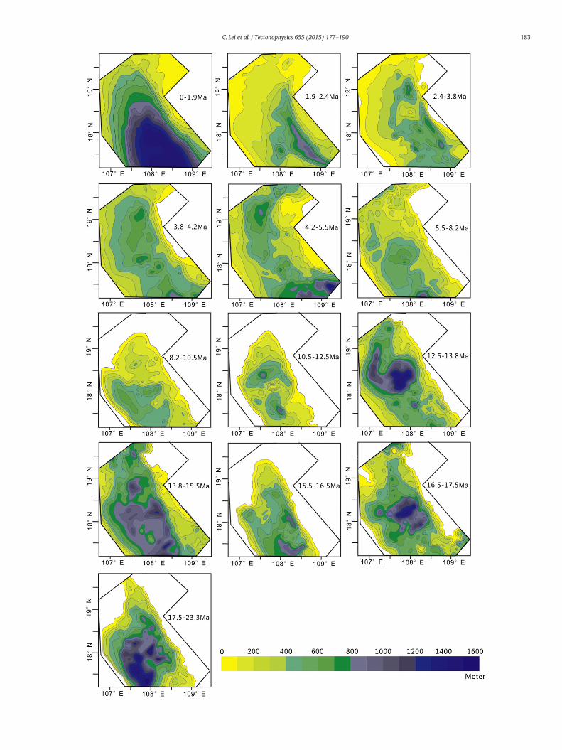
Fig. 7. Regional maps showing the sediment thickness variability during the thirteen time perinput to the sediment released from Red River catchment.
rocks, the nature of the oldest sedimentary formations in the basin centercannot be defined. However, the Paleocene–Eocene terrigenoussedimentary rocks penetrated by wells near the Beibuwan andQiongdongnan basins can be followed over long distances and are corre-lated with the deepest formations in the Yinggehai–Song Hong basin bysequence stratigraphy (Gong and Li, 1997). The Paleogene age section inthe line 0793 is offset by severalmedium-scale faults and the fault throwof the basin basement ranges between1.3 and2 km. It is noteworthy thatthe amount of extension accommodated by faulting in the Paleogenesediments decreases upwards.
The total Cenozoic stratigraphic succession in the central Yinggehai–Song Hong basin is up to 17 km thick based on gravity calculations(Gong and Li, 1997). The seismic line 0755 (Fig. 3) provides a large-scale regional image of the Yinggehai–Song Hong basin along its centralaxis, and shows the great sag forming here. Strata are subject to ageneral thickening southeastward from 6.1 km to 14.6 km on theseismic line 0755 along the longitudinal axis of basin, correspondingto the lithosphericflexure toward the oceanbasin. It iswell documentedthat the Lingao Uplift underwent significant extensional faulting in thePaleogene on the seismic profile 0755. However, the deep sedimentsbefore 32Ma in the Central Yinggehai–SongHongDepression are poorlyor not defined. 5 reflection-free structures are imaged in line 0755. Theexploration drilling cored muddy sediments from these structures. Inaddition, these reflection-free zones are surrounded by chaoticreflection patterns related to diapirism, which disrupts the sedimentsin the surrounding strata (Lei et al., 2011).
Nannofossil biostratigraphy in the Yinggehai–Song Hong andBeibuwan basins provided by CNOOC shows that the oldest age forsedimentation is ca. 55 Ma. This indicates that the basin started to rift
iods investigated in this study. Specific depositional units shown here represent the main
183C. Lei et al. / Tectonophysics 655 (2015) 177–190
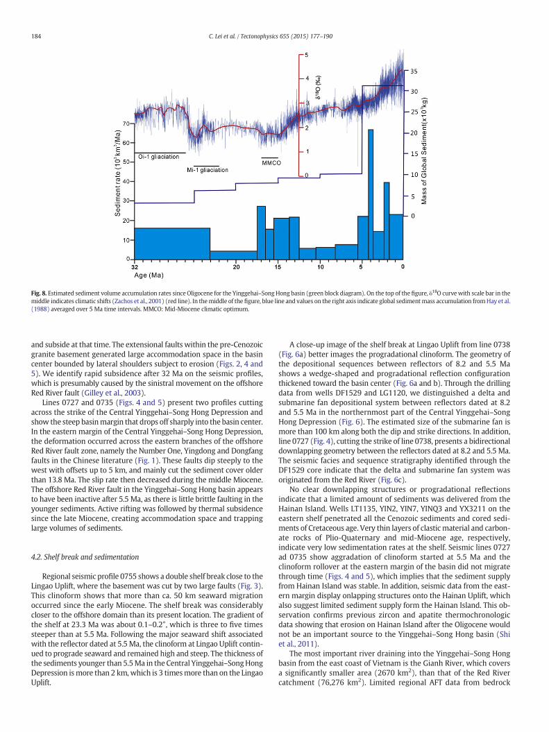
Fig. 8. Estimated sediment volume accumulation rates since Oligocene for the Yinggehai–SongHong basin (green block diagram). On the top of the figure, δ18O curvewith scale bar in themiddle indicates climatic shifts (Zachos et al., 2001) (red line). In themiddle of the figure, blue line and values on the right axis indicate global sedimentmass accumulation fromHay et al.(1988) averaged over 5 Ma time intervals. MMCO: Mid-Miocene climatic optimum.
184 C. Lei et al. / Tectonophysics 655 (2015) 177–190
and subside at that time. The extensional faults within the pre-Cenozoicgranite basement generated large accommodation space in the basincenter bounded by lateral shoulders subject to erosion (Figs. 2, 4 and5). We identify rapid subsidence after 32 Ma on the seismic profiles,which is presumably caused by the sinistral movement on the offshoreRed River fault (Gilley et al., 2003).
Lines 0727 and 0735 (Figs. 4 and 5) present two profiles cuttingacross the strike of the Central Yinggehai–Song Hong Depression andshow the steep basinmargin that drops off sharply into the basin center.In the eastern margin of the Central Yinggehai–Song Hong Depression,the deformation occurred across the eastern branches of the offshoreRed River fault zone, namely the Number One, Yingdong and Dongfangfaults in the Chinese literature (Fig. 1). These faults dip steeply to thewest with offsets up to 5 km, and mainly cut the sediment cover olderthan 13.8 Ma. The slip rate then decreased during the middle Miocene.The offshore Red River fault in the Yinggehai–Song Hong basin appearsto have been inactive after 5.5 Ma, as there is little brittle faulting in theyounger sediments. Active rifting was followed by thermal subsidencesince the late Miocene, creating accommodation space and trappinglarge volumes of sediments.
4.2. Shelf break and sedimentation
Regional seismic profile 0755 shows a double shelf break close to theLingao Uplift, where the basement was cut by two large faults (Fig. 3).This clinoform shows that more than ca. 50 km seaward migrationoccurred since the early Miocene. The shelf break was considerablycloser to the offshore domain than its present location. The gradient ofthe shelf at 23.3 Ma was about 0.1–0.2°, which is three to five timessteeper than at 5.5 Ma. Following the major seaward shift associatedwith the reflector dated at 5.5 Ma, the clinoform at Lingao Uplift contin-ued to prograde seaward and remained high and steep. The thickness ofthe sediments younger than 5.5Ma in the Central Yinggehai–SongHongDepression ismore than 2 km,which is 3 timesmore than on the LingaoUplift.
A close-up image of the shelf break at Lingao Uplift from line 0738(Fig. 6a) better images the progradational clinoform. The geometry ofthe depositional sequences between reflectors of 8.2 and 5.5 Mashows a wedge-shaped and progradational reflection configurationthickened toward the basin center (Fig. 6a and b). Through the drillingdata from wells DF1529 and LG1120, we distinguished a delta andsubmarine fan depositional system between reflectors dated at 8.2and 5.5 Ma in the northernmost part of the Central Yinggehai–SongHong Depression (Fig. 6). The estimated size of the submarine fan ismore than 100 km along both the dip and strike directions. In addition,line 0727 (Fig. 4), cutting the strike of line 0738, presents a bidirectionaldownlapping geometry between the reflectors dated at 8.2 and 5.5 Ma.The seismic facies and sequence stratigraphy identified through theDF1529 core indicate that the delta and submarine fan system wasoriginated from the Red River (Fig. 6c).
No clear downlapping structures or progradational reflectionsindicate that a limited amount of sediments was delivered from theHainan Island. Wells LT1135, YIN2, YIN7, YINQ3 and YX3211 on theeastern shelf penetrated all the Cenozoic sediments and cored sedi-ments of Cretaceous age. Very thin layers of clastic material and carbon-ate rocks of Plio-Quaternary and mid-Miocene age, respectively,indicate very low sedimentation rates at the shelf. Seismic lines 0727ad 0735 show aggradation of clinoform started at 5.5 Ma and theclinoform rollover at the eastern margin of the basin did not migratethrough time (Figs. 4 and 5), which implies that the sediment supplyfrom Hainan Island was stable. In addition, seismic data from the east-ern margin display onlapping structures onto the Hainan Uplift, whichalso suggest limited sediment supply form the Hainan Island. This ob-servation confirms previous zircon and apatite thermochronologicdata showing that erosion on Hainan Island after the Oligocene wouldnot be an important source to the Yinggehai–Song Hong basin (Shiet al., 2011).
The most important river draining into the Yinggehai–Song Hongbasin from the east coast of Vietnam is the Gianh River, which coversa significantly smaller area (2670 km2), than that of the Red Rivercatchment (76,276 km2). Limited regional AFT data from bedrock

185C. Lei et al. / Tectonophysics 655 (2015) 177–190
samples from the east coast of Vietnam (Carter et al., 2000) show thatthe average regional denudation rates is ~34 m/Ma prior to 16 Ma and390–500 m/Ma between 16 and 0 Ma (Carter et al., 2000). Assuming a35% average porosity, the volume of eroded material is estimated as~0.12 × 10³ km3/Ma (before 16 Ma) and 1.4–1.8 × 10³ km3/Ma (16–0 Ma). The lithology of the east coast of central Vietnam, however, isdominated by carbonates, while the lithology in the center of thebasin (as determined primarily from the well data) consists of sandy/muddy clastic rocks, not a mixture of carbonates and clastic rocks orcarbonate clasts. Therefore, the sediment supply from the east coast ofthe Vietnam is limited. Core data from DF1529 (Fig. 6b) and LG1120(Fig. 2) in the central Yinggehai–Song Hong basin further show thatthe delta and submarine fan consists predominately of clastic depositsdelivered from the longitudinal direction of the Yinggehai–Song Hongbasin, which are inferred to derive from the Red River.
5. Stratigraphic mapping and sediment budget
5.1. Stratigraphic mapping
Our new high-resolution seismic profiles constrained by detailednannofossil biostratigraphy from 28 drilling sites allow us to explorethe evolution of the sedimentary fill in great detail. As Paleocene–Eocenesequences are not well imaged in the southern part of the CentralYinggehai–Song Hong Depression, we focus on the sediment volume
Table 1Lithology and age constraints taken from wells LG1120 and LT11A1, which are used for the 1D
Depth Thickness Age Depositionalenvironment
Minimum paleo-waterdepth
Maximum pdepth
(m) (m) (Ma) (m) (m)
LG1120446 0.00573 127 1.90 Littoral 1.00 20.00735 162 2.40 Littoral 1.00 20.001050 315 3.40 Littoral 1.00 20.001495 445 3.80 Littoral 1.00 20.001675 180 4.00 Littoral 1.00 20.001750 75 4.20 Littoral 1.00 20.002075 325 5.00 Neritic 21.00 150.002150 75 5.50 Neritic 21.00 150.002320 170 5.80 Neritic 21.00 150.002350 30 6.30 Littoral 1.00 20.002520 170 9.20 Littoral 1.00 20.002595 75 10.50 Coastal plain 0.00 1.002675 80 11.60 Coastal plain 0.00 1.002839 164 13.80 Coastal plain 0.00 1.003272 433 15.50 Littoral 1.00 20.003327 55 16.50 Coastal plain 0.00 1.003475 149 17.50 Littoral 1.00 20.003803 328 23.00 Coastal plain 0.00 1.00
LT11A151 0445 394 1.64 Neritic 21.00 150.00670 225 1.8 Neritic 21.00 150.001270 600 2.7 Neritic 21.00 150.001730 460 3.2 Neritic 21.00 150.001900 170 4 Neritic 21.00 150.001975 75 4.2 Littoral 1.00 20.002100 125 5.5 Littoral 1.00 20.002150 50 7 Littoral 1.00 20.002250 100 8.2 Littoral 1.00 20.002295 45 10 Littoral 1.00 20.002335 40 10.5 Coastal plain 0.00 1.002370 35 11.6 Coastal plain 0.00 1.002430 60 13.8 Littoral 1.00 20.002680 250 15 Littoral 1.00 20.002724 44 15.5 Coastal plain 0.00 1.002920 196 16.5 Coastal plain 0.00 1.003010 90 17.5 Coastal plain 0.00 1.003048 38 18.5 Littoral 1.00 20.00
since 32 Ma because the high quality seismic reflection data allow us toconstruct isopach maps.
Fig. 7 shows contoured isopach of the major stratigraphic unitswithin the Yinggehai–Song Hong basin. There was no sedimentationon the eastern slope before 5.5 Ma with the exception of carbonaterocks between 13.8 and 15.5 Ma. The steepness of the eastern marginof the basin is largely influenced by the Number One fault, especiallybefore 13.8 Ma. Therefore, sedimentation on the eastern side of thebasin is closely related to active faulting. In contrast, thewesternmarginof the basin is characterized by gentler slopes generated by severalsplayed transform faults (Fig. 1). In Fig. 7, we also show the migrationof the depocenter, which was located in the central part of the CentralYinggehai–Song Hong Depression between 23.3 and 16.5 Ma, andthen migrated to the southeastern part of the basin between 16.5 and13.8 Ma. Between 13.8 and 10.5 Ma, the depocenters moved towardthe northwestern sector of the Central Yinggehai–Song Hong Depres-sion. Finally, after 10.5 Ma, the depocenter migrated to the southwest-ern part of the basin.
5.2. Sediment budget
To compare the volume of sediment in the Yinggehai–Song Hongbasin with the eroded material across the onshore Red River drainagearea, we estimate the original sediment thickness prior to burial asdescribed in Section 3. Average volumes and accumulation rates are
subsidence analysis.
aleo-water Litho 1 L1 Litho 2 L2 Litho 3 L3
(%) (%) (%)
Sand 0.53 Shale 0.47Shale 0.63 Sand 0.37Shale 0.56 Sand 0.44Shale 0.58 Sand 0.42Shale 0.78 Sand 0.22Shale 0.91 Sand 0.09Shale 0.67 Sand 0.33Sand 0.52 Shale 0.48Shale 0.65 Sand 0.35Shale 0.64 Sand 0.36Shale 0.88 Sand 0.12Shale 0.97 Sand 0.03Shale 0.83 Sand 0.17Shale 0.85 Sand 0.15Sand 0.60 Shale 0.40Shale 0.80 Sand 0.20Shale 0.54 Sand 0.46Shale 0.53 Sand 0.47
Sand 0.53 Shale 0.47Sand 0.54 Shale 0.46Shale 0.75 Sand 0.25Shale 0.66 Sand 0.34Shale 1.00 Sand 0.00Shale 1.00 Sand 0.00Shale 0.59 Sand 0.41Shale 1.00 Sand 0.00Shale 0.63 Sand 0.37Shale 0.74 Sand 0.26Shale 0.54 Sand 0.46Sand 0.54 Shale 0.46Sand 0.75 Shale 0.25Sand 0.74 Shale 0.26Sand 0.92 Shale 0.08Sand 0.59 Shale 0.41Shale 0.84 Conglomerate 0.09 Sand 0.07Shale 0.58 Sand 0.28 Conglomerate 0.14
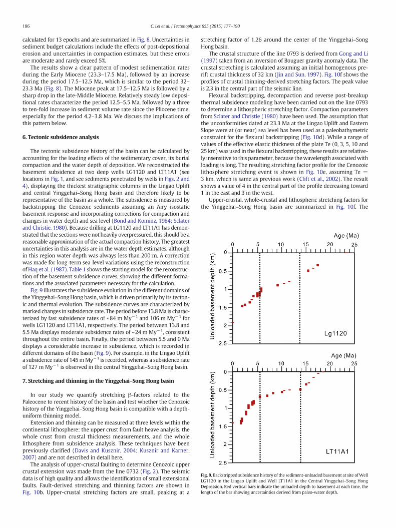
Fig. 9. Backstripped subsidence history of the sediment-unloaded basement at site ofWellLG1120 in the Lingao Uplift and Well LT11A1 in the Central Yinggehai–Song HongDepression. Red vertical bars indicate the unloaded depth to basement at each time, thelength of the bar showing uncertainties derived from paleo-water depth.
186 C. Lei et al. / Tectonophysics 655 (2015) 177–190
calculated for 13 epochs and are summarized in Fig. 8. Uncertainties insediment budget calculations include the effects of post-depositionalerosion and uncertainties in compaction estimates, but these errorsare moderate and rarely exceed 5%.
The results show a clear pattern of modest sedimentation ratesduring the Early Miocene (23.3–17.5 Ma), followed by an increaseduring the period 17.5–12.5 Ma, which is similar to the period 32–23.3 Ma (Fig. 8). The Miocene peak at 17.5–12.5 Ma is followed by asharp drop in the late-Middle Miocene. Relatively steady low deposi-tional rates characterize the period 12.5–5.5 Ma, followed by a threeto ten-fold increase in sediment volume rate since the Pliocene time,especially for the period 4.2–3.8 Ma. We discuss the implications ofthis pattern below.
6. Tectonic subsidence analysis
The tectonic subsidence history of the basin can be calculated byaccounting for the loading effects of the sedimentary cover, its burialcompaction and the water depth of deposition. We reconstructed thebasement subsidence at two deep wells LG1120 and LT11A1 (seelocations in Fig. 1, and see sediments penetrated by wells in Figs. 2 and4), displaying the thickest stratigraphic columns in the Lingao Upliftand central Yinggehai–Song Hong basin and therefore likely to berepresentative of the basin as a whole. The subsidence is measured bybackstripping the Cenozoic sediments assuming an Airy isostaticbasement response and incorporating corrections for compaction andchanges in water depth and sea level (Bond and Kominz, 1984; Sclaterand Christie, 1980). Because drilling at LG1120 and LT11A1 has demon-strated that the sectionswere not heavily overpressured, this should be areasonable approximation of the actual compaction history. The greatestuncertainties in this analysis are in the water depth estimates, althoughin this region water depth was always less than 200 m. A correctionwas made for long-term sea-level variations using the reconstructionof Haq et al. (1987). Table 1 shows the startingmodel for the reconstruc-tion of the basement subsidence curves, showing the different forma-tions and the associated parameters necessary for the calculation.
Fig. 9 illustrates the subsidence evolution in the different domains ofthe Yinggehai–SongHong basin, which is driven primarily by its tecton-ic and thermal evolution. The subsidence curves are characterized bymarked changes in subsidence rate. The period before 13.8Ma is charac-terized by fast subsidence rates of ~84 m My−1 and 106 m My−1 forwells LG1120 and LT11A1, respectively. The period between 13.8 and5.5 Ma displays moderate subsidence rates of ~24 m My−1, consistentthroughout the entire basin. Finally, the period between 5.5 and 0 Madisplays a considerable increase in subsidence, which is recorded indifferent domains of the basin (Fig. 9). For example, in the Lingao Uplifta subsidence rate of 145mMy−1 is recorded, whereas a subsidence rateof 127 m My−1 is observed in the central Yinggehai–Song Hong basin.
7. Stretching and thinning in the Yinggehai–Song Hong basin
In our study we quantify stretching β-factors related to thePaleocene to recent history of the basin and test whether the Cenozoichistory of the Yinggehai–Song Hong basin is compatible with a depth-uniform thinning model.
Extension and thinning can be measured at three levels within thecontinental lithosphere: the upper crust from fault heave analysis, thewhole crust from crustal thickness measurements, and the wholelithosphere from subsidence analysis. These techniques have beenpreviously clarified (Davis and Kusznir, 2004; Kusznir and Karner,2007) and are not described in detail here.
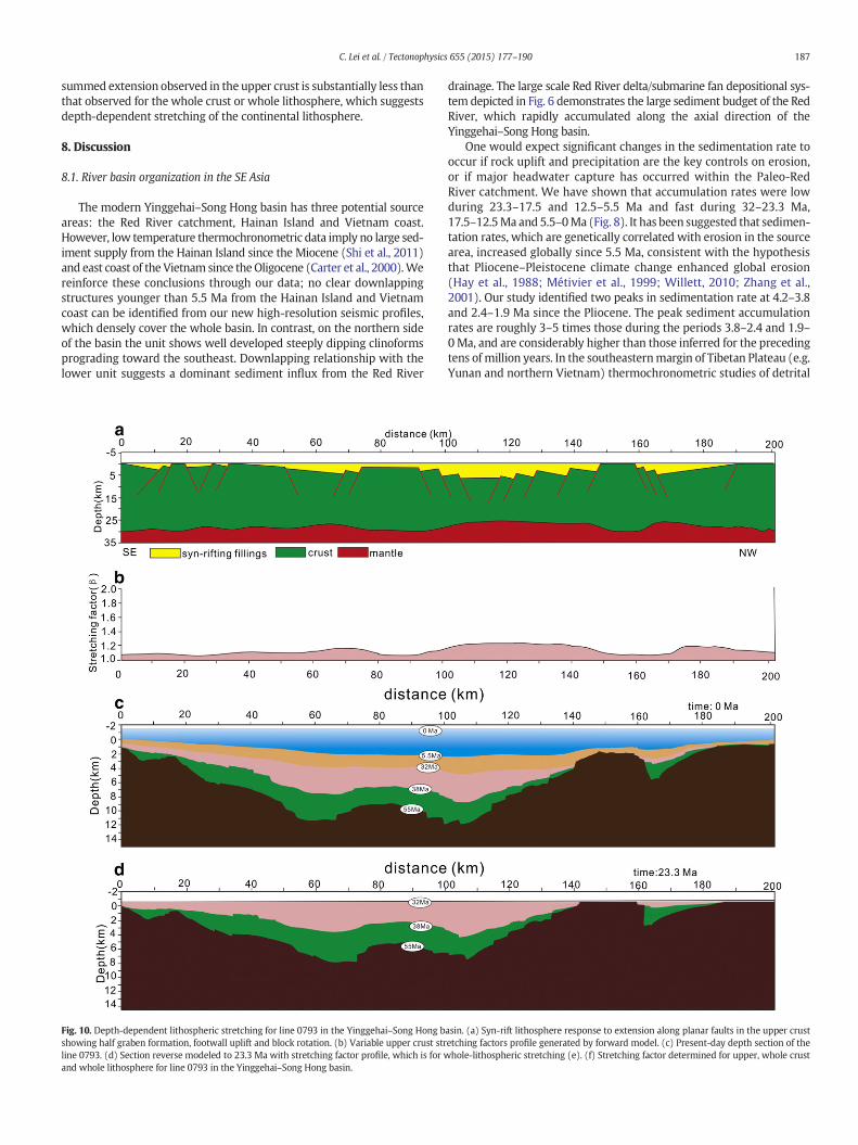
The analysis of upper-crustal faulting to determine Cenozoic uppercrustal extension was made from the line 0732 (Fig. 2). The seismicdata is of high quality and allows the identification of small extensionalfaults. Fault-derived stretching and thinning factors are shown inFig. 10b. Upper-crustal stretching factors are small, peaking at a
stretching factor of 1.26 around the center of the Yinggehai–SongHong basin.
The crustal structure of the line 0793 is derived from Gong and Li(1997) taken from an inversion of Bouguer gravity anomaly data. Thecrustal stretching is calculated assuming an initial homogenous pre-rift crustal thickness of 32 km (Jin and Sun, 1997). Fig. 10f shows theprofiles of crustal thinning-derived stretching factors. The peak valueis 2.3 in the central part of the seismic line.
Flexural backstripping, decompaction and reverse post-breakupthermal subsidence modeling have been carried out on the line 0793to determine a lithospheric stretching factor. Compaction parametersfrom Sclater and Christie (1980) have been used. The assumption thatthe unconformities dated at 23.3 Ma at the Lingao Uplift and EasternSlope were at (or near) sea level has been used as a paleobathymetricconstraint for the flexural backstripping (Fig. 10d). While a range ofvalues of the effective elastic thickness of the plate Te (0, 3, 5, 10 and25 km)was used in theflexural backstripping, these results are relative-ly insensitive to this parameter, because thewavelength associatedwithloading is long. The resulting stretching factor profile for the Cenozoiclithosphere stretching event is shown in Fig. 10e, assuming Te =3 km, which is same as previous work (Clift et al., 2002). The resultshows a value of 4 in the central part of the profile decreasing toward1 in the east and 3 in the west.
Upper-crustal, whole-crustal and lithospheric stretching factors forthe Yinggehai–Song Hong basin are summarized in Fig. 10f. The
187C. Lei et al. / Tectonophysics 655 (2015) 177–190
summed extension observed in the upper crust is substantially less thanthat observed for the whole crust or whole lithosphere, which suggestsdepth-dependent stretching of the continental lithosphere.
8. Discussion
8.1. River basin organization in the SE Asia
The modern Yinggehai–Song Hong basin has three potential sourceareas: the Red River catchment, Hainan Island and Vietnam coast.However, low temperature thermochronometric data imply no large sed-iment supply from the Hainan Island since the Miocene (Shi et al., 2011)and east coast of the Vietnam since the Oligocene (Carter et al., 2000).Wereinforce these conclusions through our data; no clear downlappingstructures younger than 5.5 Ma from the Hainan Island and Vietnamcoast can be identified from our new high-resolution seismic profiles,which densely cover the whole basin. In contrast, on the northern sideof the basin the unit shows well developed steeply dipping clinoformsprograding toward the southeast. Downlapping relationship with thelower unit suggests a dominant sediment influx from the Red River
Fig. 10. Depth-dependent lithospheric stretching for line 0793 in the Yinggehai–Song Hong bshowing half graben formation, footwall uplift and block rotation. (b) Variable upper crust strline 0793. (d) Section reverse modeled to 23.3 Ma with stretching factor profile, which is for wand whole lithosphere for line 0793 in the Yinggehai–Song Hong basin.
drainage. The large scale Red River delta/submarine fan depositional sys-tem depicted in Fig. 6 demonstrates the large sediment budget of the RedRiver, which rapidly accumulated along the axial direction of theYinggehai–Song Hong basin.
One would expect significant changes in the sedimentation rate tooccur if rock uplift and precipitation are the key controls on erosion,or if major headwater capture has occurred within the Paleo-RedRiver catchment. We have shown that accumulation rates were lowduring 23.3–17.5 and 12.5–5.5 Ma and fast during 32–23.3 Ma,17.5–12.5Ma and 5.5–0Ma (Fig. 8). It has been suggested that sedimen-tation rates, which are genetically correlated with erosion in the sourcearea, increased globally since 5.5 Ma, consistent with the hypothesisthat Pliocene–Pleistocene climate change enhanced global erosion(Hay et al., 1988; Métivier et al., 1999; Willett, 2010; Zhang et al.,2001). Our study identified two peaks in sedimentation rate at 4.2–3.8and 2.4–1.9 Ma since the Pliocene. The peak sediment accumulationrates are roughly 3–5 times those during the periods 3.8–2.4 and 1.9–0Ma, and are considerably higher than those inferred for the precedingtens of million years. In the southeasternmargin of Tibetan Plateau (e.g.Yunan and northern Vietnam) thermochronometric studies of detrital
asin. (a) Syn-rift lithosphere response to extension along planar faults in the upper crustetching factors profile generated by forward model. (c) Present-day depth section of thehole-lithospheric stretching (e). (f) Stretching factor determined for upper, whole crust
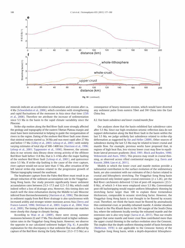
Fig. 10 (continued).
188 C. Lei et al. / Tectonophysics 655 (2015) 177–190
minerals indicate an acceleration in exhumation and erosion after ca.4 Ma (Schoenbohm et al., 2006), which correlates with strengtheningand rapid fluctuations of the monsoon in Asia since that time (Cliftet al., 2008). Therefore we attribute the increase of sedimentationsince 5.5 Ma in the basin to the rapid climate variability since thePliocene.
Strike-slip motion along the Red River fault zone strongly affectedthe geology and topography of the eastern Tibetan Plateau margin andmust have been instrumental in helping to guide the reorganization ofrivers in the region. Dating of the onshore Red River fault zone showsthat sinistral motion started ca. 34 Ma and was most rapid after 27 Maand before 17 Ma (Gilley et al., 2003; Leloup et al., 2001) with widelyvarying estimates of total slip of 500–1400 km (Harrison et al., 1996;Leloup et al., 2001; Tapponnier et al., 1990). However, the seismicdata in our seismic data library show strong activity of the offshoreRed River fault before 13.8 Ma, that is 3–4 Ma after the major faultingof the onshore Red River fault (Leloup et al., 2001), and quiescencesince 5.5 Ma. If strike-slip faulting is the cause of the river capture,river capture would not occur later than 17 Ma, after cessation of theleft lateral strike-slip motion related to the progressive growth ofTibetan topography toward the southeast.
The headwater capture from the Paleo-Red River must result in anabrupt reduction of the sediment accumulation rate in the Yinggehai–Song Hong basin. Our study presents significantly lower sedimentaccumulation rates between 23.3–17.5 and 12.5–5.5 Ma, which couldindeed reflect a loss of drainage area. However, this timing does notmatch well the slow exhumation during the Middle to Late Mioceneinferred from thermochronometry (Harrison et al., 1996). This decreasein sediment supply from Red River drainage is also synchronous withincreased aridity and stronger winter monsoon across Asia (Derry andFrance-Lanord, 1996; Dettman et al., 2003; Gupta et al., 2004; Wanet al., 2009). The timing of the decrease in sedimentation rate matchesmore closely this change in climatic forcing.
According to Wan et al. (2009), there were strong summermonsoons between 22 and 17Ma. This should result in higher sedimen-tation rates in the Yinggehai–Song Hong basin. However, we observethe opposite in our calculated sediment budget (Fig. 8). A possibleexplanation for this discrepancy is that sediment flux was affected bycapture of the Red River during the Early Miocene (23.3–17.5 Ma) as a
consequence of heavy monsoon erosion, which would have divertedany sediment pulse from eastern Tibet and SW China into the EastChina Sea.
8.2. Fast basin subsidence and lower crustal/mantle flow
Our analyses show that the basin exhibited fast subsidence ratesafter 5.5 Ma. Since our high-resolution seismic reflection data do notsupport deformation along the Red River fault in the basin within thelast 5.5 Ma, we judge unlikely fast subsidence related to strike-slipdeformation as suggested by Xie and Heller (2009). Other sources ofsubsidence during the last 5.5 Ma may be related to lower crustal andmantle flow. For example, previous works have proposed that, inregions of high heat flux, less viscous lower crust may flow to equili-brate lateral pressure gradients (Bird, 1991; Block and Royden, 1990;Wdowinski and Axen, 1992). This process may result in crustal thin-ning, as observed across rifted continental margins (e.g. Davis andKusznir, 2004; Liao et al., 2011).
Models in which the lower crust and mantle motion provide asubstantial contribution to the surface evolution of the sedimentarybasin, are also consistent with our estimates of the β-factors related tocrustal and lithospheric stretching. The Yinggehai–Song Hong basinexperienced only limited upper-crustal extension (β ≤ 1.26), yet theRed River catchments delivered 12 km of post-rift sequences (23.3–0 Ma), of which 3–4 km were emplaced since 5.5 Ma. Conventionalpost-rift backstripping would require uniform lithospheric thinning bystretching factor larger than 100 to explain these tremendousthicknesses, comparable to oceanic stretching factor. However, theYinggehai–Song Hong basin is not thought to be floored by oceaniccrust. Therefore, we think the basin must be floored by anomalouslythin continental crust, or possibly exhumed mantle. A similar situationis found in the Phu Khanh Basin in the SW margin of the South ChinaSea, where the sediments locally overlay the exhumed mantle and theextension rate is also very large (Savva et al., 2013). Thus our resultssuggest that some mantle and lower crust flow contributed more thanthe upper crustal thinning to the surface evolution since the Cenozoic.This implies that the depth-uniform thinning model of basin formation(McKenzie, 1978) is not applicable to the Cenozoic history of theYinggehai–Song Hong basin, while a depth-dependent lithosphere-

189C. Lei et al. / Tectonophysics 655 (2015) 177–190
scale thinning may be more appropriate, likewise in the neighboringQiongdongnan basin (Lei et al., 2013). Seismic tomography shows thatthe crust at 15 km depth beneath the Yinggehai–Song Hong basin haslow (up to 2% below average) seismic velocities (Lei et al., 2009),indicating relatively high temperatures. This is supported by petroleumexploration wells, which show that the geothermal gradient in theYinggehai–Song Hong basin is high (i.e., 46 °C/km) (Hao et al., 1995),which promoted gas generation from the source rocks. Diapirismoccurred if the gas volume increases with an effective seal. Therefore,we postulate that fast subsidence of the Yinggehai–Song Hong basinafter 5.5 Ma may arise from the occurrence of lithospheric warming,weakening and thinning by lower crustal and/or mantle flow resultingfrom collision between India–Eurasia and Indian oceanic subductionbelow the Eurasia.
9. Conclusions
In this study we explored the onshore tectonics and river organiza-tion of SE Asia from the observed offshore stratigraphy in theYinggehai–Song Hong basin during the Cenozoic period. A new grid ofhigh-resolution seismic profiles tied to wells with biostratigraphic agecontrol allowed us to examine the changes in sediment delivery ratefrom the Red River, which is related to both tectonics and climate inSE Asia. Our analysis showed that the sedimentary section comprises athick Cenozoic sequence, which is affected strongly by faulting of theoffshore Red River fault and basement subsidence of the basin. Most ofthe offshore Red River fault terminated at an unconformity dated at13.8 Ma. The result of the sediment accumulation rates shows severalprominent shifts, including a sharp decrease at 23.3 Ma and 12.5 Ma re-spectively, and a sharp increase at 5.5 Ma. The sediment decompactioncalculations show sharply reduced sedimentation rate at 12–13 Ma,which match similar trends in South Asia and the Pearl River Mouthbasin as result form monsoon weakened at that time. Fast sedimenta-tion resumed in the last 5.5 Ma, which is likely the consequence of theonset of cyclical glacial–interglacial climate during the Plio-Pleistoceneand is part of a global change in erosion at that time. Reconstructionsshow that sediment flux to the Yinggehai–Song Hong basin changedmarkedly from the Oligocene and early Miocene. However, becausethe Asian monsoon begins to strengthen significantly in the earlyMiocene (Wan et al., 2009), the loss of drainage area might have beenoffset by the increased sediment flux driven by the more erosiveclimate. We favor major headwater capture away from the Red Riverto predate the Middle Miocene, probably during the Oligocene andearly Miocene.
We have shown that the Yinggehai–Song Hong basin has experi-enced an apparently anomalous fast subsidence history since thePliocene–Quaternary. Qualifying stretching and thinning of the basinindicate that the Cenozoic history of the Yinggehai–Song Hong basin iscompatible with a depth-dependent lithospheric thinning model. Wesuggest that a combination of the mantle and lower crustal floworiginated by collision between India–Eurasia and Indian oceanicsubduction below the Eurasia may explain the large subsidence sincethe Pliocene–Quaternary, but paucity of faulting.
Acknowledgments
Our first acknowledgments go to the editor and the five reviewersfor their constructive criticism that helped considerably to improvethis article. We are grateful to Weilin Zhu from CNOOC, who kindlyprovided us with the seismic and well data used in this work. We alsoacknowledge grants from the National Natural Science Foundation ofChina (No. 91028009,41302082, 41272121), the Programme of Intro-ducing Talents of Discipline to Universities (No. B14031) and the Foun-dation of State Key Laboratory of Petroleum Resources and Prospecting,China University of Petroleum, Beijing (No. PRP/open-1404). Map ofregion aroundYinggehai–SongHongbasin is generated byGeoMapApp.
Alan Roberts is thanked for allowing use of Flex-Decomp™ to studysubsidence history. Chao Lei thanks the China Scholarship Council forsupporting his study at Earth Surface Dynamics group of ETH Zurich.
Appendix A. Supplementary data
Supplementary data to this article can be found online at http://dx.doi.org/10.1016/j.tecto.2015.05.024.
References
Allen, C.R., et al., 1984. Red River and associated faults, Yunnan Province, China: Quater-nary geology, slip rates, and seismic hazard. Bull. Geol. Soc. Am. 95 (6), 686–700.
An, Z., Kutzbach, J.E., Prell, W.L., Porter, S.C., 2001. Evolution of Asian monsoons andphased uplift of the Himalaya–Tibetan plateau since Late Miocene times. Nature411 (6833), 62–66.
Athy, L.F., 1930. Density, porosity, and compaction of sedimentary rocks. AAPG Bull. 14(1), 1–24.
Bahr, D.B., Hutton, E.W.H., Syvitski, J.P.M., Pratson, L.F., 2001. Exponential approximationsto compacted sediment porosity profiles. Comput. Geosci. 27 (6), 691–700.
Bird, P., 1991. Lateral extrusion of lower crust from under high topography in the isostaticlimit. J. Geophys. Res. Solid Earth (1978–2012) 96, 10275–10286.
Block, L., Royden, L.H., 1990. Core complex geometries and regional scale flow in thelower crust. Tectonics 9 (4), 557–567.
Bond, G.C., Kominz, M.A., 1984. Construction of tectonic subsidence curves for the earlyPaleozoic miogeocline, southern Canadian Rocky Mountains: implications forsubsidence mechanisms, age of breakup, and crustal thinning. Geol. Soc. Am. Bull.95 (2), 155–173.
Brookfield, M.E., 1998. The evolution of the great river systems of southern Asia duringthe Cenozoic India–Asia collision: rivers draining southwards. Geomorphology 22(3–4), 285–312.
Carter, A., Roques, D., Bristow, C.S., 2000. Denudation history of onshore central Vietnam:constraints on the Cenozoic evolution of the western margin of the South China Sea.Tectonophysics 322, 265–277.
Clark, M.K., et al., 2004. Surface uplift, tectonics, and erosion of eastern Tibet from large-scale drainage patterns. Tectonics 23 (1), 1006–1029.
Clift, P., Sun, Z., 2006. The sedimentary and tectonic evolution of the Yinggehai–SongHong basin and the southern Hainan margin, South China Sea: implications forTibetan uplift and monsoon intensification. J. Geophys. Res. Solid Earth 111.
Clift, P., Lin, J., Barckhausen, U., 2002. Evidence of low flexural rigidity and low viscositylower continental crust during continental break-up in the South China Sea. Mar.Pet. Geol. 19, 951–970.
Clift, P., Blusztajn, J., Duc, N.A., 2006. Large-scale drainage capture and surface uplift ineastern Tibet–SW China before 24 Ma inferred from sediments of the Hanoi Basin,Vietnam. Geophys. Res. Lett. 33, L19403.
Clift, P., Hodges, K., Heslop, D., Hannigan, R., Hoang, V., Calves, G., 2008. Correlation of Hi-malayan exhumation rates and Asian monsoon intensity. Nat. Geosci. 1 (12),875–880.
Davis, M., Kusznir, N.J., 2004. Depth-dependent lithospheric stretching at rifted continen-tal margins. In: Karner, G.D. (Ed.), Proceedings of NSF Rifted Margins TheoreticalInstitute. Columbia University Press, pp. 92–136.
Derry, L.A., France-Lanord, C., 1996. Neogene Himalayan weathering history and river87Sr/86Sr: impact on the marine Sr record. Earth Planet. Sci. Lett. 142 (1–2), 59–74.
Dettman, D.L., Fang, X., Garzione, C.N., Li, J., 2003. Uplift-driven climate change at 12Ma: along δ18O record from the NE margin of the Tibetan plateau. Earth Planet. Sci. Lett.214 (1–2), 267–277.
Fournier, M., Jolivet, L., Davy, P., Thomas, J., 2004. Backarc extension and collision: anexperimental approach to the tectonics of Asia. Geophys. J. Int. 157 (2), 871–889.
Gilley, L.D., Harrison, T.M., Leloup, P.H., Ryerson, F.J., Lovera, O.M., Wang, J.H., 2003. Directdating of left‐lateral deformation along the Red River shear zone, China and Vietnam.J. Geophys. Res. Solid Earth 108.
Gong, Z., Li, S., 1997. ContinentalMargin Basin Analysis and Hydrocarbon Accumulation ofthe Northern South China Sea. Science Press, Beijing.
Gupta, A.K., Singh, R.K., Joseph, S., Thomas, E., 2004. Indian Ocean high-productivity event(10–8 Ma): linked to global cooling or to the initiation of the Indian monsoons?Geology 32 (9), 753–756.
Hao, F., Sun, Y., Li, S., Zhang, Q., 1995. Overpressure retardation of organic-matter matura-tion and petroleum generation: a case study from the Yinggehai and QiongdongnanBasins, South China Sea. Am. Assoc. Pet. Geol. Bull. 79 (4), 551–562.
Haq, B.U., Hardenbol, J., Vail, P.R., 1987. Chronology of fluctuating sea levels since theTriassic. Science 235 (4793), 1156.
Harrison, T.M., Leloup, P.H., Ryerson, F.J., Tapponnier, P., Lacassin, R., Chen, W., 1996.Diachronous initiation of transtension along the Ailao Shan–Red River shear zone,Yunnan and Vietnam. In: Yin, A., Harrison, T.M. (Eds.), The Tectonic Evolution ofAsia. Cambridge Univ. Press, New York, pp. 208–222.
Hay, W.W., Sloan, J.L.I., Wold, C.N., 1988. Mass/age distribution and composition ofsediments on the ocean floor and the global rate of sediment subduction.J. Geophys. Res. 93 (B12), 14933–14940.
Jin, W.S., Sun, D.Z., 1997. Deep Crust Structure and its Evolution of South China Continent.Geological Publishing House, Beijing.
Jolivet, L., Tamaki, K., Fournier, M., 1994. Japan Sea, opening history and mechanism: asynthesis. J. Geophys. Res. Solid Earth 99, 22237–22259.
190 C. Lei et al. / Tectonophysics 655 (2015) 177–190
Jolivet, L., Maluski, H., Beyssac, O., Goff, B., Lepvrier, C., Thi, P.T., Vuong, N.V., 1999.Oligocene–Miocene Bu Khang extensional gneiss dome in Vietnam: geodynamicimplications. Geology 27 (1), 67–70.
Kong, P., Zheng, Y., Caffee, M.W., 2012. Provenance and time constraints on the formationof the first bend of the Yangtze River. Geochem. Geophys. Geosyst. 13, Q06017.
Kusznir, N.J., Karner, G.D., 2007. Continental lithospheric thinning and breakup inresponse to upwelling divergent mantle flow: application to the Woodlark,Newfoundland and Iberia margins. In: Karner, G.D., Manatschal, G., Pinheiro, L.M.(Eds.), Imaging, Mapping and Modelling Continental Lithosphere Extension andBreakup. Geological Society, Special Publications 282, pp. 389–419.
Leech, M.L., Singh, S., Jain, A.K., Klemperer, S.L., Manickavasagam, R.M., 2005. The onset ofIndia–Asia continental collision: early, steep subduction required by the timing of UHPmetamorphism in the western Himalaya. Earth Planet. Sci. Lett. 234 (1–2), 83–97.
Lei, J., Zhao, D., Steinberger, B., Wu, B., Shen, F., Li, 2009. New seismic constraints on theupper mantle structure of the Hainan plume. Phys. Earth Planet. Inter. 173 (1–2),33–50.
Lei, C., Ren, J., Clift, P., Wang, Z., Li, X., Tong, C., 2011. The structure and formation of diapirsin the Yinggehai–Song Hong Basin, South China Sea. Mar. Pet. Geol. 28, 980–991.
Lei, C., Ren, J., Tong, D., 2013. Geodynamics of the ocean–continent transition zone, north-ern margin of the South China Sea: implications for the opening of the South ChinaSea. Chin. J. Geophys. Chin. Ed. 56, 1287–1299.
Leloup, P.H., Lacassin, R., Tapponnier, P., Schärer, U., 1995. The Ailao Shan–Red River shearzone (Yunnan, China), tertiary transform boundary of Indochina. Tectonophysics 251(1–4), 3–10.
Leloup, P.H., Arnaud, N., Lacassin, R., Kienast, J.R., Harrison, T.M., Trong, T.T., Replumaz, A.,Tapponnier, P., 2001. New constraints on the structure, thermochronology, andtiming of the Ailao Shan–Red River shear zone, SE Asia. J. Geophys. Res. 106 (B4),6683–6732.
Liao, J., Zhou, D., Zhao, Z., Zhang, Y., Xu, Z., 2011. Numerical modeling of the anomalouspost-rift subsidence in the Baiyun Sag, Pearl River Mouth Basin. Sci. China Earth Sci.54 (8), 1156–1167.
McKenzie, D., 1978. Some remarks on the development of sedimentary basins. EarthPlanet. Sci. Lett. 40 (1), 25–32.
Métivier, F., Gaudemer, Y., Tapponnier, P., Klein,M., 1999. Mass accumulation rates in Asiaduring the Cenozoic. Geophys. J. Int. 137 (2), 280–318.
Molnar, P., Tapponnier, P., 1975. Cenozoic tectonics of Asia: effects of a continentalcollision. Science 189 (4201), 419–426.
Molnar, P., England, P., Martinod, J., 1993. Mantle dynamics, uplift of the Tibetan Plateau,and the Indian monsoon. Rev. Geophys. 31 (4), 357–396.
Peltzer, G., Tapponnier, P., 1988. Formation and evolution of strike-slip faults, rifts, andbasins during the India–Asia collision: an experimental approach. J. Geophys. Res.93 (B12), 15085–15117.
Rangin, C., Klein, M., Roques, D., Le Pichon, X., 1995. The Red River fault system in theTonkin Gulf, Vietnam. Tectonophysics 243 (3–4), 209–222.
Replumaz, A., Lacassin, R., Tapponnier, P., Leloup, P.H., 2001. Large river offsets and Plio-Quaternary dextral slip rate on the Red River fault (Yunnan, China). J. Geophys. Res.Solid Earth 106, 819–836.
Replumaz, A., Guillot, S., Villaseñor, A., Negredo, A.M., 2013. Amount of Asian lithosphericmantle subducted during the India/Asia collision. Gondwana Res. 24, 936–945.
Richardson, N.J., Densmore, A.L., Seward, D., Wipf, M., Yong, L., 2010. Did incision of theThree Gorges begin in the Eocene? Geology 38 (6), 551–554.
Royden, L., 1997. Surface deformation and lower crustal flow in Eastern Tibet. Science 276.Sangree, J.B., Widmier, J.M., 1979. Interpretation of depositional facies from seismic data.
Geophysics 44 (2), 131–160.Savva, D., et al., 2013. Seismic evidence of hyper-stretched crust and mantle exhumation
offshore Vietnam. Tectonophysics 608, 72–83.Schoenbohm, L.M., Burchfiel, B.C., Liangzhong, C., 2006. Propagation of surface uplift,
lower crustal flow, and Cenozoic tectonics of the southeast margin of the TibetanPlateau. Geology 34 (10), 813–816.
Sclater, J.G., Christie, P., 1980. Continental stretching: an explanation of the post-mid-Cretaceous subsidence of the central North Sea basin. J. Geophys. Res. 85 (B7),3711–3739.
Searle, M.P., Yeh, M., Lin, T., Chung, S., 2010. Structural constraints on the timing of left-lateral shear along the Red River shear zone in the Ailao Shan and Diancang ShanRanges, Yunnan, SW China. Geosphere 6 (4), 316–338.
Shi, X., Kohn, B., Spencer, S., Guo, X., Li, Y., Yang, X., Shi, H., Gleadow, A., 2011. Cenozoicdenudation history of southern Hainan Island, South China Sea: constraints fromlow temperature thermochronology. Tectonophysics 504, 100–115.
Sternai, P., Jolivet, L., Menant, A., Gerya, T., 2014. Driving the upper plate surface deforma-tion by slab rollback and mantle flow. Earth Planet. Sci. Lett. 405, 110–118.
Sun, Z., Zhou, D., Zhong, Z., Zeng, Z., Wu, S., 2003. Experimental evidence for the dynamicsof the formation of the Yinggehai basin, NW South China Sea. Tectonophysics 372(1–2), 41–58.
Tapponnier, P., Lacassin, R., Leloup, P.H., Schärer, U., Dalai, Z., Haiwei, W., Xiaohan, L.,Shaocheng, J., Lianshang, Z., Jiayou, Z., 1990. The Ailao Shan/Red River metamorphicbelt: tertiary left-lateral shear between Indochina and South China. Nature 343,431–437.
Tapponnier, P., Zhiqin, X., Roger, F., Meyer, B., Arnaud, N., Wittlinger, G., Jingsui, Y., 2001.Oblique stepwise rise and growth of the Tibet Plateau. Science 294, 1671–1677.
Taylor, B., Hayes, D.E., 1983a. Origin and History of the South China Sea Basin. TheTectonic and Geologic Evolution of Southeast Asian Seas and Islands: Part 2.pp. 23–56.
Taylor, B., Hayes, D.E., 1983b. Origin and history of the South China Sea Basin. In: Hayes,D.E. (Ed.), The Tectonic and Geologic Evolution of Southeast Asian Seas and Islands:Part 2. American Geophysical Union, Washington, D.C.
Van Hoang, L., Clift, P.D., Schwab, A.M., Huuse, M., Nguyen, D.A., Zhen, S., 2010. Large-scaleerosional response of SE Asia to monsoon evolution reconstructed from sedimentaryrecords of the Song Hong–Yinggehai and Qiongdongnan basins, South China Sea.Geol. Soc. Lond., Spec. Publ. 342, 219–244.
Walker, J.D., Geissman, J.W., 2009. Geologic time scale. Geological Society of America.Wan, S.M., Kurschner, W.M., Clift, P.D., Li, A.C., Li, T.G., 2009. Extreme weathering/erosion
during the Miocene Climatic Optimum: evidence from sediment record in the SouthChina Sea. Geophys. Res. Lett. 36, L19706.
Wang, Y., Xu, Q., Li, D., Han, J., Lü, M., Wang, Y., Li, W., Wang, H., 2011. Late Miocenered river submarine fan, northwestern South China Sea. Chin. Sci. Bull. 56,1488–1494.
Wdowinski, S., Axen, G.J., 1992. Isostatic rebound due to tectonic denudation: a viscousflow model of a layered lithosphere. Tectonics 11 (2), 303–315.
Willett, S.D., 2010. Late Neogene erosion of the Alps: a climate driver? Annu. Rev. EarthPlanet. Sci. 38, 411–437.
Xie, X., Heller, P.L., 2009. Plate tectonics and basin subsidence history. Geol. Soc. Am. Bull.121, 55–64.
Zachos, J., Pagani, M., Sloan, L., Thomas, E., Billups, K., 2001. Trends, rhythms, andaberrations in global climate 65 Ma to present. Science 292 (5517), 686–693.
Zhang, P., Molnar, P., Downs, W.R., 2001. Increased sedimentation rates and grain sizes2–4 Myr ago due to the influence of climate change on erosion rates. Nature 410(6831), 891–897.
Zheng, H., Clift, P.D., Wang, P., Tada, R., Jia, J., He, M., Jourdan, F., 2013. Pre-Miocene birthof the Yangtze River. Proc. Natl. Acad. Sci. 110, 7556–7561.
Zhu, W., Lei, C., 2013. Refining the model of South China Sea's tectonic evolution:evidence from Yinggehai–Song Hong and Qiongdongnan Basins. Mar. Geophys. Res.34 (3), 325–339.
Zhu, M., Graham, S., McHargue, T., 2009. The Red River Fault zone in the Yinggehai Basin,South China Sea. Tectonophysics 476 (3–4), 397–417.