structural models for the geology of the hanna basin ...€¦ · structural mechanisms that caused...
TRANSCRIPT

Structural Models for the Geology of the Hanna Basin, Carbon County,
Wyoming
Karen M. Aydinian
Senior Integrative Exercise
April 1, 2008
Submitted in partial fulfillment of the requirements for a Bachelor of Arts
degree from Carleton College, Northfield, Minnesota
1

Table of Contents
Abstract
Introduction
Geologic Setting
Methods
Discussion
Trishear and the Hanna Basin
“Evolved” Triangle Zones and the Hanna Basin
The Cross Sections
Conclusion
Acknowledgements
References
Appendix: Stratigraphic Units of the Study Area
2

Abstract
The Hanna Basin in Carbon County, Wyoming, poses unusual and little studied structural problems. Several hypotheses have been proposed previously to explain the geology in the basin, but no adequate strike and dip data had been collected to support the construction of cross-sections. This paper explores the previously proposed models, which include several north-verging out-of-the-basin thrust faults, and introduces several new possibilities with faults verging both north and south. Constructed cross-sections demonstrate the varying viability of these models as explanations for the geologic structures mapped at the surface of the northern boundary of the Hanna Basin. Both trishear and evolved triangle zones are discussed as means to model deformation styles in this basin. The most viable model based upon the cross-sections constructed for this paper involves a series of north-verging, out-of-the-basin thrust faults which place younger Tertiary/Cretaceous strata on older Cretaceous strata and create a triangle zone between the smaller north-verging thrusts, the south-verging Shirley Thrust, and a deep, south-verging blind master thrust.
3

Keywords Hanna Basin, Laramide basin, trishear, triangle zone, Shirley Thrust, Horseshoe
Ridge Anticline
Introduction
The Hanna Basin in Carbon County, Wyoming, is a structurally complex
but inadequately studied area. The Hanna Basin is a small basin, formed during
the Laramide orogeny, in the Rocky Mountain foreland of south-central Wyoming
(Lillegraven, 1996). It is anomalous for a basin formed in the Laramide because
it is very small in comparison to other Laramide-age basins, and it has very thick,
synorogenic strata (Lillegraven, 2004). The goal of this project is to examine the
structural mechanisms that caused the present geologic setting of the northern
Hanna Basin, just south of the Shirley Mountains, and to reconstruct the geologic
history of the area. A greater understanding of the structural geology of the
Hanna Basin can lead to the opportunity to discover more about the relationships
between Laramide activity in the Colorado Plateau to the south and activity in
north-central and northwestern Wyoming, such as in the Wind River and Owl
Creek ranges.
There are several previously proposed hypotheses to test in this region.
One is that the northern Hanna Basin is a simple, fault-bounded block of
Cretaceous sediments that has been rotated to vertical by a deep fault mechanism
(Heller). If this is so, there should be no intermediate dip values between 30º and
65º, those recorded in a previous study (Lillegraven, 1996), in sections 24, 19, 30,
and 29 on the USGS Schneider Ridge Quadrangle (Figure 1). Another proposed
model is that the vertical beds are part of a triangle structure between a splay
4

fault off a deep, south-verging blind thrust and a shallow, north-verging “out-of-
the-basin” fault (Lillegraven, 2004).
Geologic Setting
The Hanna Basin is bounded on the north by the Shirley Thrust, a high-
angle, basement involved reverse fault (Lillegraven, 1996). This fault brought up
the Shirley Mountains, which have been eroded to expose the Precambrian
basement (Lillegraven, 1996). The Shirley Thrust terminates to the east in a fold
of Upper Cretaceous units (Lillegraven, 1996). Directly east of the Shirley
Mountains, northeast of the study area, are the Freezeout Hills, composed of
folded and exposed Paleozoic and Mesozoic strata (Lillegraven, 1996). East from
the Hanna Basin is a series of en echelon, basement-involved asymmetric
anticlines, such as the Flat Top and Como Bluff anticlines (Lillegraven, 1996).
Northwest of the Hanna Basin are the Seminoe Mountains and the Ferris
Mountains. The E-W trending elongation of the Ferris, Seminoe, Shirley, and
Freezeout uplifts are part of the southeastern flank of the Sweetwater arch
(Lillegraven, 1996).
The majority of the study area is composed of the exposed
Tertiary/Cretaceous Ferris/Hanna Formations. The Ferris and Hanna formations
in the study area are primarily coarse-grained to very coarse-grained sandstones,
which become more conglomeritic in nature to the south. The exposed outcrops
are large channel flows, probably indicative of a braided stream environment.
These outcrops feature flat tops, broad scour surfaces on the bottom, and
crossbedding. In the area just south of Schneider Ridge, the beds dip between 65º
5

to the south and 90º. There is a shift in orientation of the Ferris and Hanna
formations about 2 miles south of the base of Schneider Ridge, on the south side
of a broad valley through which County Road 219 (Hanna-Leo Road) runs. The
rocks in the southern part of the basin dip between 20º and 35º to the southeast.
There are several locations in the study area in which these two orientations are
juxtaposed. This was previously mapped as a possible out-of-the-basin fault,
which places younger strata on older strata, by Lillegraven (1996).
Methods
Strike and dip data was collected for this area along three major north-
south transects (Figure 2). Several locations, such as the top of Schneider Ridge,
the channel “fins” of the Ferris/Hanna Formations, and the badlands to the south
of the Hanna-Leo Road were mapped in greater detail. Figure 2 shows a
representative portion of orientations of bedding in the study area. The
stratigraphy along these transects was mapped by Lillegraven (1996) and can be
seen, along with Lillegraven’s structural interpretations based on stratigraphic
section, in Figure 3.
Figure 2 displays structures that were hypothesized in the field based on
strike and dip data alone. Figures 4, 5, and 6 are the different interpretations
presented in the cross-section models of this paper. Based on these three
scenarios of fault vergences along the transects, the cross-sections represent at
least five models of varying viability and plausibility to explain the geologic
structures in the study area.
6

The cross-sections were constructed using the principle of constant
thickness of rock layers. The lines in each cross-section represent bedding planes
rather than formation boundaries. Each of these lines was drawn using the
measured dip angle for that point along the transect. To make these cross-sections
viable, the bedded layers must have a constant thickness throughout the cross-
section. This method assumes that a constant thickness for a rock unit ensures a
constant volume for that particular unit. In order to consider these cross-sections
balanced, the length of bedding layers both in the deformed state and restored
cross-sections would need to match. This paper considers deformed state models
only.
The cross-sections presented in this paper are not balanced. Four out of
the five models have major volume problems that would need to be resolved in
future studies. These volume problems suggest that some of these models do not
fit the collected data well enough to be considered as a final interpretation, but
may work if particular details are changed slightly. The cross-sections serve as a
preliminary examination of different structural possibilities; rather than prove one
model, they seek to eliminate those that do not work well.
Discussion
Trishear and the Hanna Basin
The cross-sections featured in this paper assume little to no deformation of
rock units themselves. As a whole, these units bend by slipping along bedding
planes in incompetent shales between the sturdier sandstone layers. Other than
this sliding and bending, the rock layers undergo little individual deformation.
7

The trishear model expounded by Erslev (1991) explains the deformation
as seen in nature more accurately than the simplified model used for this paper.
In the trishear model, the dips of beds are not uniform throughout the unit, as they
are in the cross-sections of this paper. Instead, the dips rotate so that beds in
closer proximity to the fault have dips that are close to that of the fault plane itself
(Figure 7). In order to accommodate this, beds close to the fault elongate and
shear, while minor folds and thrusts develop to accommodate shortening.
Trishear allows for the possibility of heterogeneous deformation, while the cross-
sections in this paper are homogeneous.
The trishear model is one possible deformation style to explain the
complexities of the Hanna Basin. When applied to the study area, the Shirley
Thrust breaks to the surface off the deep blind thrust. The Shirley Thrust causes
the sediments above it to form a fault propagation fold. The Cretaceous
sediments, such as the members of the Mesaverde group, would fold and shear as
a result of compression from movement along the blind master fault. As this
structure is unroofed, the Paleozoic and Mesozoic sediments overlaying the
Precambrian erode, exposing the metamorphic core in the north of the study area.
The overturned beds of Schneider Ridge might be the result of a smaller
fault that originated in the forelimb of the major fold. Shear in the center of the
fold near the fault plane caused these units to lengthen and overturn, and may
have been further overturned as the south-verging fault moved over them.
A possibility that fits with the trishear model is that there is an erosional
unconformity exposing the forelimb of the fault propagation fold (Hauge). As the
8

fold was lifted and exposed, the eroded sediment filled the basin. The system
remained active, rotating the earlier basin fill as the fold continued to propagate
and dumping newer basin fill along an angular unconformity in the tilted basin.
When the system stopped, the sediment continued to erode, eventually exposing
the forelimb of the fold. Figure 9 shows how the erosional uncomformity can
account for the exposure of beds with varying dips across the basin.
“Evolved” Triangle Zones and the Hanna Basin
The evolved triangle zone model proposed by Sterne (2006) provides a
balanced and restorable model to explain anomalous younger-over-older
relationships like those seen in the Hanna Basin. Sterne’s triangle zone model
differs from Erslev’s in the formation of fault propogation folds. While Erslev’s
trishear model involves shear of the layers closest to the fault driving the fold, the
triangle zone model features homogeneous propogation folds and prominent
backthrusts which are caused by crowding in front of the major thrust fault.
These backthrusts are foreland dipping, hinterland verging, tend to run parallel to
bedding in the hanging wall and cut across bedding in the footwall, and cause
younger-on-older relationships (Sterne, 2006). This scenario would correspond to
the orientation of the Hanna-Leo Road fault drawn in models 1-4 of the cross-
sections examined in this paper. Several out-of-the-basin backthrusts formed as a
result of crowding in the basin. These faults would place younger Tertiary rocks
on older Cretaceous sediment. According to the triangle zone model (Sterne,
2006) these faults would occur in several parts of the basin, and a passive roof
9

thrust may form over the south-verging wedge (Figure 8). Figure 10 illustrates
the evolution of the triangle zone from an underformed state.
The faults continue to build upon each other over time and may move
simultaneously, resulting in overturned bedding and faults (Sterne, 2006). The
extensive overturned bedding at the base and southern side of Schneider Ridge
may be a result of movement along a north-verging backthrust. The beds at the
base of Schneider Ridge are only slightly overturned, but become progressively
more overturned nearing the top of the ridge. The beds near the top of the ridge
might have been rotated to nearly horizontal while the underlying backthrust
became nearly vertical as it broke to the surface.
The Cross-Sections
Cross-section model 1 depicts a series of north-verging, out-of-the-basin
thrust faults that place younger rocks on older rocks throughout the northern part
of the Hanna Basin and Horseshoe and Schneider Ridges. Out of the various
cross-sections attempted, this has the fewest volume problems, and accordingly
would be the most promising model. This model was based on the hypothesis of
Taft (1997), using the seismic data from Homan (1988). Figure 11 shows Taft’s
interpretation of the data.
Model 1 is an example of the triangle zone model proposed by Lillegraven
et al (2004) and Sterne (2006). The Shirley Fault in the north is a high angle,
south-verging splay fault off a larger, low angle blind master thrust. Figure 12
illustrates the formation of the anticline to the north of the Hanna Basin, the core
of which is the Precambrian metamorphic that is now exposed as the Shirley
10

Mountains. The blind thrust continued to move southward, causing crowding in
the basin. A series of smaller, north-verging faults formed in the basin to
accommodate the crowding. One of these north-directed faults formed the
anticline of Horseshoe and Schneider Ridges. Figure 13 illustrates this process in
a very simplified way.
This model would label the variation in dips along the Hanna-Leo Road as
a low angle, out-of-the-basin thrust fault, which is confined to the TK
Ferris/Hanna Formations and places younger TK Ferris/Hanna on the steeply
dipping, TK Ferris/Hanna “fins.” One possible explanation for the steep dip of
the “fins” is that they are the forelimb of a north-directed fault propagation fold.
This would have to have been a very large fold, and seems unlikely. A more
plausible explanation is the first north-directed thrust occurred when the TK
Ferris/Hanna was nearly horizontal. The next north-directed fault propagated
through the footwall, tilting the previous fault slightly, as well as the layers of the
TK Ferris/Hanna between the faults. In order to have achieved the steep dips
between the two faults but shallow dips to the south of the Hanna-Leo Road, the
second, more northerly fault might have run horizontally, parallel to bedding,
several miles to the north of the first fault’s exposure at the surface, before
breaking to the surface itself.
Figures 14 and 15 illustrate this model in cross-section. Both feature a
syncline under the Hanna-Leo Road fault, with the “fins” rising close to vertical
as the back limb of a fault propagation fold that terminates in the Horseshoe and
Schneider Ridges.
11

Model 2 features a north-directed, out-of-the-basin thrust in the south and
a south-directed splay thrust forming the Horseshoe and Schneider Ridges. This
model has some significant problems; however it was the first attempt using this
fault configuration. Figure 16 is a simplified timeline of events for models 2, 3,
and 4, which feature the north-verging out-of-the-basin fault in the south and the
south-verging splay fault at Horseshoe and Schneider Ridges.
Like model 1, model 2 has the out-of-the-basin thrust juxtaposed against
much more steeply dipping layers. Whereas in model 1 these layers are the back
limb of a north-directed fault propagation fold, in model 2 these layers are the
limb of a basinal syncline. One of the major volume problems of this model is in
these layers, just south of A' (Figure 17). The thickest unit undergoes significant
change in thickness near the erosional surface, due in part to the anticline of
Horseshoe Ridge. This anticline is formed by the south-directed splay fault off
the Shirley Thrust. Underneath this splay fault is a north-leaning anticline. The
tilt of this anticline does not correspond with the movement of the blind master
fault, and is corrected in Figures 20 and 21. In Figure 18, the structure of
Schneider Ridge is represented as a less developed section of the anticline of
Horseshoe Ridge. Both Figures 18 and 19 illustrate the problem relating the
anticline to the steeply dipping beds in the basin.
Model 3, like model 2, features a north-directed, out-of-the-basin fault in
the south and a south-directed, deep splay fault forming the anticlines of
Horseshoe and Schneider Ridges (Figure 20). The main difference in this model
is the southernly tilt of the anticline underneath the splay fault. The half of the
12

syncline visible between A and A' of Figure 19 is nearly upright, and so is the
adjoining anticline. The anticline is truncated abruptly by the splay fault, which
originates very deeply along the Shirley Thrust. The lack of a hanging wall cutoff
is especially problematic.
Model 4 (Figure 21) corrects this problem. It is nearly the same as model
3, but the splay fault is shallower, and propagates parallel to the top of the
anticline. The hanging wall cutoff below A''' would have been lifted along the
Shirley Thrust and eroded away. The blind master fault developed first, forming
the anticline/syncline pair seen in Figure 21. Crowding in the basin, caused by
the south-directed master fault, resulted in the formation of the north-verging out-
of-the-basin thrust. At some point, either before or after the start of the north-
verging fault, the south-verging splay fault began, resulting in the formation of the
Horseshoe Ridge anticline.
The out-of-the-basin fault originates at the blind master fault. The point at
which this fault breaks upward corresponds to the “tip” of Sterne’s evolved
triangle model (2006). The area between the out-of-the-basin fault and the
Shirley Fault is the triangle zone.
Model 5 is only drawn on one transect, transect B (Figure 22). This
model was my initial field hypothesis, and it is included in this paper in order to
eliminate this hypothesis. Model 5 features two main south-verging faults. It is
the only model to postulate that the fault along the Hanna-Leo Road is south-
verging. This fault, as it is drawn, truncates the nearly vertical beds in the basin,
rather than propagating parallel to bedding. This is an unlikely scenario. It is also
13

not likely that this could be modeled as a rotated, fault-bounded block. The beds
are nearly vertical, but dipping to the south and not overturned. If this block had
been rotated due to movement on a south-verging blind master, the dips would be
overturned to the north.
The shallower dips on the south side of the Hanna-Leo Road fault are
represented in model 5 as drag from the south-verging fault. While this may be
plausible with the dips, the strikes of the beds to the south of this fault are
different than those to the north of the fault. This would not be merely the result
of drag. Either the beds to the north or the south of the road have been rotated as a
block, or there is a differently-trending fault plane or unconformity present.
Conclusion
The small size and symmetrical shape of the Hanna Basin set it apart from
other Laramide basins of the eastern Rocky Mountains. Located at the
convergence of the Colorado Front Range to the south and the Wind River Basin
to the north, the structures of the Hanna Basin and surrounding area can be an
important aspect of piecing together a cohesive sequence of events of the
Laramide orogeny throughout the Rocky Mountain foreland. In order to do this,
the hypotheses regarding principle stress systems and deformation styles must be
correlated.
The fieldwork of this study was used to examine the previous hypotheses
as to the structures of the northern boundary of the Hanna Basin, as well as to test
a new hypothesis. The new hypothesis of this study proposed that the fault seen
at the Hanna-Leo Road is south-verging; this model does not work well when put
14

into cross-section. The models featuring a south-verging splay thrust at
Horseshoe and Schneider Ridges and a north-verging out-of-the-basin thrust at the
Hanna-Leo Road have a few problems, but cannot be eliminated. With minor
changes, this fault configuration can be viable. The previously proposed
hypothesis of a series of north-verging out-of-the-basin faults at Horseshoe Ridge
(Taft, 1997), combined with the “evolved” triangle zone model featuring a
shallow roof thrust over the out-of-the-basin thrusts (Sterne, 2006) seems to be
the best fit with the data collected in this study.
Acknowledgements
I would like to thank Dr. Sarah Titus of Carleton College for her
assistance with this project, as well as Dr. Art Snoke, Dr. Barbara Carrapa, Dr.
Paul Heller, and Liz Hajek of the University of Wyoming for their assistance and
contributions. I would like to thank Dr. Tom Hauge for offering critique of the
cross-sections and suggestions for the erosional unconformity model. I would
like to thank Gene Aydinian for being my field assistant with this project.
References
Erslev, E. A., 1991, TRISHEAR FAULT-PROPAGATION FOLDING: Geology, v. 19, no. 6, p. 617-620.
Gill, J. R., Merewether, E. A., and Cobban, W. A., 1970, Stratigraphy and Nomenclature of Some Upper Cretaceous and Lower Tertiary Rocks in South-Central Wyoming: Geological Survey Professional Paper 667, United States Government Printing Office.
Hauge, T., Geophysical Advisor, ExxonMobil (Retired). Heller, P., Professor, University of Wyoming. Homan, K. S., 1988, Structural analysis of the south flank of the Sweetwater
uplift, Carbon County, Wyoming: Baylor University, 160 p. Lillegraven, J. A., and Snoke, A. W., 1996, A new look at the Laramide orogeny
in the Seminoe and Shirley mountains, Freezeout Hills, and Hanna Basin,
15

south-central Wyoming, in Jones, R. W., ed., Public Information Circular No. 36: Cheyenne, WY, Pioneer Printing and Stationary.
Lillegraven, J. A., Snoke, Arthur W., and McKenna, Malcolm C., 2004, Tectonic and paleogeographic implications of late Laramide geologic history in the northeastern corner of Wyoming's Hanna Basin: Rocky Mountain Geology, v. 39, no. 1, p. 7-64.
Sterne, E. J., 2006, Stacked, "Evolved" Triangle Zones Along the Southeastern Flank of the the Colorado Front Range: The Mountain Geologist, v. 43, no. 1, p. 65-92.
Taft, K., 1997, Masters Thesis of Kendale Taft: University of Wyoming. Appendix: Stratigraphic Units of the Study Area
South of the Shirley Mountains, in the northernmost part of the study area,
is a succession of Cretaceous units which proceed stratigraphically younger to the
south. These included both marine and nonmarine sandstones, shales, siltstones,
and carbonates. Beginning with the Thermopolis Shale, Muddy Shale, Mowry
Shale, Frontier Formation, and Niobrara Formation (Lillegraven, 1996). Above
the Niobrara Formation is the Steele Shale, approximately 2,300 to 3,800 feet of
marine limestone and bentonite, siltstones, and sandstones (Gill, 1970). Next is
the Mesaverde group—Haystack Mountains Fm., Allen Ridge Formation., Pine
Ridge Sandstone, and Almond Formation (Lillegraven, 1996). All but the Allen
Ridge Formation are marine sandstones and shales. The Allen Ridge Formation
is nonmarine sandstones, shales, and carbonates (Gill, 1970). Above the
Mesaverde group is the Lewis Shale, approximately 2,200 to 2,600 feet of dark
gray marine shale with interbedded sandy units (Gill, 1970). Above this is the
Medicine Bow Formation, 3,000 to 6.500 feet of mostly nonmarine lenticular
sandstones, siltstones, and shales. Lillegraven (1996) maps several thrust faults
among these units, as there is a significant amount of strategraphic section
16

missing in this particular part of the basin. The Medicine Bow Formation is
conformabely overlain by the Cretaceous Ferris Formation.
The Hanna Basin itself is mapped as undivided Cretaceous Ferris
Formation and Tertiary Hanna Formation (Figure 2). The Ferris Formation can
be up to 6,500 feet thick, and can be divided into two parts (Gill, 1970). The
lower 1,100 feet is congomeritic sandstone, sanstones, and shales deposited in the
late Cretaceous, while the upper 5, 400 feet are Paleocene gray, brown, and
yellow sandstones and coal beds (Gill, 1970). The clasts in the conglomerate are
pebbles of chert, quartzite, rhyolite, and quartz latite porphyry, none of which
suggest a local original source (Gill, 1970). The upper layer does not have
conglomerates, and plant fossils from this layer suggest it was deposited in the
early Paleocene (Gill, 1970).
The Hanna Formation unconformably overlays the Ferris Formation. This
formation was deposited in the late early Paleocene, during the tectonism that
formed the uplifts to the north (Lillegraven, 1996). It can be up to 13,500 feet
thick in parts of the basin, and is composed of conglomerates, sandstones, shales,
and coal beds (Gill, 1970). Most of the conglomerates are in the lower half of the
formation, and include pebbles of chert, granite, quartzite, sandstone, Mowry
Shale, and Cloverly Formation conglomerate (Gill, 1970). These are all locally
derived clasts (Gill, 1970), suggesting that the formations to the north had already
been uplifted and begun eroding. The Hanna Formation is most near a
conformable contact with the Ferris in the center of the basin, and forms an
17
unconformity with progressively older rocks, up to the Precambrian basement,
moving out from the basin (Gill, 1970).
The Ferris and Hanna formations in the study area are primarily coarse-
grained to very coarse-grained sandstones, which become more conglomeritic in
nature to the south. The exposed outcrops are large channel flows, probably
indicative of a braided stream environment. These outcrops feature flat tops,
broad scour surfaces on the bottom, and crossbedding.
18

Figure 1 From Lillegraven (1996). This map shows the Hanna Basin in
relation to the surrounding structures of Carbon County, Wyoming.
19

20
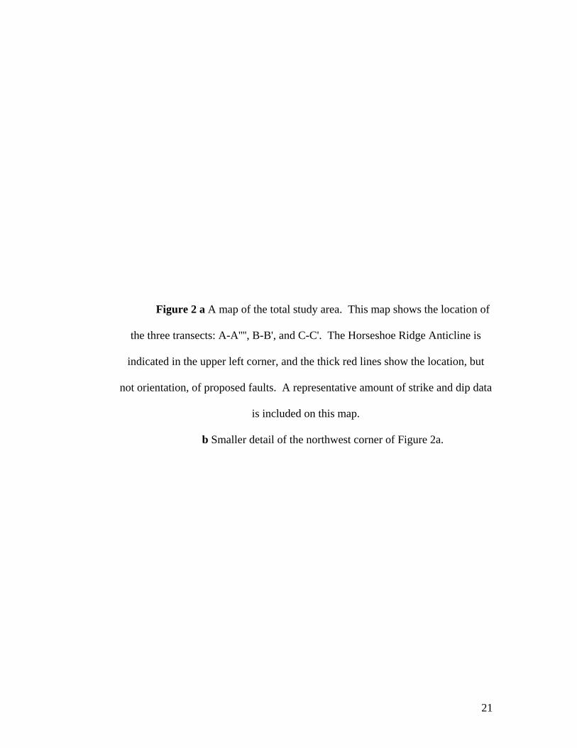
Figure 2 a A map of the total study area. This map shows the location of
the three transects: A-A'''', B-B', and C-C'. The Horseshoe Ridge Anticline is
indicated in the upper left corner, and the thick red lines show the location, but
not orientation, of proposed faults. A representative amount of strike and dip data
is included on this map.
b Smaller detail of the northwest corner of Figure 2a.
21

22

Figure 2b
23

Figure 3 From Lillegraven (1996). This map shows the mapped
strategraphic section, a limited amount of strike and dip data, and the proposed
structures for the study area and surrounding localities. The Hanna-Leo Road
fault in the southern section on the left side is dashed, indicating uncertainty in its
location or continuity. The Horseshoe Ridge Anticline is present in the middle
section on the far left. The numerous faults mapped in the Horseshoe Ridge and
Schneider Ridge areas are proposed based on significant amounts of missing
stratigraphic section.
24

25

Figure 4 One possible representation of fault vergences in the study area. The
Hanna-Leo Road fault in the south section of the map and the Schneider
Ridge/Horseshoe Anticline fault in the north section of the map are both north-
verging, out-of-the-basin faults. This structural map corresponds to the cross-
sections for Model 1 in Figures 13, 14, and 15.
26

27

Figure 5 A second representation of possible fault vergences in the study
area. The Hanna-Leo Road fault is a north-verging, out-of-the-basin fault. The
Schneider Ridge/Horseshoe Anticline fault is a south-directed splay thrust. This
structural map corresponds to the cross-sections of Models 2, 3. and 4 in Figures
16-20.
28

29

Figure 6 A third representation of fault vergences in the study area. Both the
Hanna-Leo Road fault in the south and the Schneider Ridge/Horseshoe
Anticline fault in the north are south-verging splay thrusts. This structural
map corresponds to the cross-section of Model 5 in Figure 21.
30

31

Figure 7 From Erslev (1991). This diagram illustrates the trishear model of
deformation. The layers closest to the fault elongate and shear, and the
dips of these layers rotate to become closer to the dip of the fault plane.
The trishear model allows for both heterogeneous and homogeneous
deformation.
32

33

Figure 8 From Sterne (2006). This figure illustrates the passive roof thrust
model. A deep, blind master thrust and splay thrust system cause
crowding in the foreland. To accommodate this, a number of oppositely-
verging backthrusts develop. Over the top of these backthrusts, a passive
roof thrust forms. Model 1 of this paper correlates best with this theory.
The north-verging Schneider Ridge/Horseshoe Anticline fault (and related
faults) are the faults contained within the triangle zone. The Hanna-Leo
Road fault is the passive roof thrust, with a shallower dip than the north-
verging faults in front of it.
34

35

Figure 9 This series of cartoons illustrates, in a simplified manner, the
hypothesis that the dips seen at the surface near the Hanna-Leo Road can be
explained using an erosional unconformity rather than a fault. In Stage 1, the
Shirley Thrust forms an anticline/syncline pair as it breaks toward the surface. As
this structure is raised above sea level, it erodes, and the debris fills the syncline
basin. Stage 2 shows how the syncline basin rotates as the Shirley Thrust
continues to propagate. The debris deposited in the basin during this stage is
deposited at an angle to the original debris. Stage 3 continues the rotation of the
basin. The area in the bold circle is illustrated in Stage 4. The forelimb of the
fault propagation fold is vertical to overturned at Schneider Ridge. The
syntectonic basin fill from stages 2 and 3and forelimb have eroded away, but
erosion continues in this stage and is deposited along the angular unconformity
from Stage 2. This unconformity is what is now exposed along the Hanna-Leo
Road. It follows the curve of the syncline basin margin.
36

37

Figure 10 From Sterne (2006). This figure shows the evolution of the triangle
zone, beginning with the undeformed state. Movement begins on the floor
thrust, bringing older layers on top of younger layers. At the tip point, the
backthrust begins to move in the original hanging wall, toward the
hinterland, placing younger layers on older layers. Continued movement
along the floor thrust causes crowding in the foreland, and a roof thrust
develops over the backthrust wedge. This roof thrust can place both
younger strata on older strata and older strata on younger strata.
38

39

Figure 11 From Taft (1997). This is the seismic data from Homan (Homan,
1988). The structural interpretations are Taft’s hypothesis for the
Horseshoe Ridge Anticline area. Taft’s model was the basis for Model 1
of this paper.
40

41

Figure 12 Cartoon representation of the sequence of events that formed the
Shirley Thrust. Movement began along a blind master thrust verging
south. At some point a splay fault broke toward the surface, forming a
fault propagation fold cored by the Precambrian metamorphics. The
Shirley Fault broke to the surface, bringing the Precambrian up to its
present height. The Paleozoic and Mesozoic sediments that had draped
the Precambrian have eroded to expose the metamorphics as the Shirley
Mountains.
42

43 43

Figure 13 This figure continues from the sequence of events shown in Figure 12,
and illustrates Model 1 in a simplified manner. After the Shirley Thrust
reached the surface, movement continued along the blind master thrust,
resulting in crowding in the foreland. The first north-verging out-of-the-
basin fault forms at a shallow angle. Later, a second north-verging fault
propagates through the first’s footwall, tilting the first fault as it breaks to
the surface. A third small splay fault develops on Schneider Ridge,
resulting in the shifting of the layers on the south side of the ridge and
causing some overturned bedding. This figure does not represent the
Hanna-Leo Road fault as a shallower, passive roof thrust, as proposed by
Sterne (Sterne, 2006).
44

45 45

Figure 14 This is the cross-section for Model 1 along the transect A-A''', at scale
1:9600. This model shows the blind master thrust and Shirley Thrust as
south-verging, and all other faults along the transect as north-verging, out-
of-the-basin faults. The Hanna-Leo Road fault here is shown as a deep,
steep fault similar to those that formed near the Horseshoe Anticline
(between A'' and A'''). A better interpretation might follow Sterne’s
triangle zone model (Figure 9), and draw this fault as a shallow roof thrust
that runs parallel to the bedding that dips about 30º in the south end of the
transect, rather than running parallel to the bedding that dips about 75º.
46

47

Figure 15 Model 1 illustrated along transect B-B', scale 1:9600. As in Figure 14,
the out-of-the-basin faults are steep and north-verging. The complexity of
Schneider Ridge (just south of B') is shown in a very simplified manner.
The scale of this cross-section is not small enough to enable the
geometries to be shown in a comprehensible manner.
48

49

Figure 16 This figure is a continuation of the timeline from Figure 12. After the
Shirley Thrust breaks to the surface, a smaller south-verging splay thrust
breaks off the Shirley Thrust. This thrust forms a fault propagation fold
(Horseshoe Ridge Anticline), and eventually breaks to the surface.
Continued movement along the south-verging blind master thrust causes
crowding in the basin, resulting the formation of a north-verging out-of-
the-basin fault.
50

51

Figure 17 This figure is the cross-section for Model 2 along transect A-A'''', scale
1:9600. Model 2 has the south-verging blind master fault and Shirley
Thrust, The fault at the Horseshoe Anticline (between A' and A'') is drawn
as a south-verging splay thrust off the Shirley Thrust in the north. This
splay thrust created a fault propagation fold (the Horseshoe Ridge
Anticline). The Hanna-Leo Road fault in the south is drawn as a north-
verging out-of-the-basin fault. Unlike Figures 14 and 15, the fault in this
figure follows the 30º dip of the bedding near the surface. The main
problem in this cross-section is the northern tilt of the anticline in the
footwall of the Shirley Thrust. This configuration seems incongruous with
the movement of the south-verging master thrust beneath it. A more
plausible model would have this anticline leaning south, as part of a
anticline/syncline pair. The syncline would have been the footwall cutoff
of the Shirley Thrust fault propagation fold.
52

53

Figure 18 Model 2 illustrated along transect B-B', scale 1:9600. As in Figure 16,
the fault that forms Schneider Ridge (just south of B') is a south-verging
splay off the Shirley Thrust. Again, the complex geometries of Schneider
Ridge are not illustrated here. The Hanna-Leo Road in the south is a
north-verging out-of-the-basin fault that runs parallel to the 30º bedding at
the surface.
54

55

Figure 19 Model 2 illustrated along transect C-C', scale 1:9600. This figure is
very similar to Figure 17, as the two transects are relatively close. It
features a south-verging blind thrust and Shirley Thrust, and a south-
verging splay fault forming Schneider Ridge (at C'). The Hanna-Leo
Road fault is a north-verging out-of-the-basin fault that runs parallel to the
30º bedding at the surface.
56

57

Figure 20 This is the cross-section for Model 3 along transect A-A'''', scale
1:9600. Model 3 features the same fault vergences as Model 2. Unlike
Figure 16, the anticline in the footwall of the Shirley Thrust (below A''') is
south-leaning, which corresponds with the movement along the master
fault beneath it. Rather than breaking off the Shirley Thrust near the
surface, the fault that forms the Horseshoe Anticline breaks off near the
master fault and comes up to the surface steeply. According to this model,
the fault truncates the anticline below it, which is unlikely in reality. The
Hanna-Leo Road fault is a north-verging, out-of-the-basin fault that runs
parallel to the 30º bedding at the surface.
58

59

Figure 21 This is the cross-section for Model 4 along transect A-A''', scale
1:9600. This model has the south-verging blind master fault and Shirley
Thrust, and illustrates the fault creating the Horseshoe Ridge Anticline as
a shallow splay off the Shirley Thrust. This model corrects the truncation
of the footwall anticline seen in Model 3 (Figure 19). The Hanna-Leo
Road fault is a north-verging, out-of-the-basin fault that runs parallel to
the 30º bedding at the surface.
60

61

Figure 22 This is the cross-section for Model 5 along transect B-B', scale 1:9600.
This model has a south-verging thrust fault forming a fault propagation
fold at Schneider Ridge (at B'). A second fault propagates through the
footwall and breaks to the surface at the Hanna-Leo Road. There are
significant problems with this model. The block between the two faults is
truncated by the second fault. It seems unlikely that a fault would run
nearly parallel to bedding. A better model may have this block rotated
rather than truncated. However, since the beds are not overturned and
dipping to the south, they would have needed a north-verging master fault
to rotate them to their current position. The overturned beds on Schneider
Ridge are depicted as footwall drag from the south-verging fault that runs
over them. The area beneath the faults poses a challenging geometry that
was not balanced successfully. Because of the problems with this
particular cross-section, this model was not attempted on the other two
transects.
62

63