structural geology and hydrogeology of the grandview...
TRANSCRIPT

Arizona Geological Surveywww.azgs.az.gov | repository.azgs.az.gov
March 2016
Contributed report Cr-16-b
Structural Geology and Hydrogeology of the Grandview Breccia Pipe, Grand
Canyon National Park, ArizonaM. Alter, R. Grant, P. Williams & D. Sherratt
Grandview breccia pipe on Horseshoe Mesa, Grand Canyon, Arizona

Arizona Geological Survey
M. Lee Allison, State Geologist and Director
Manuscript approved for publication in March 2016 Printed by the Arizona Geological Survey
All rights reserved
For an electronic copy of this publication: www.repository.azgs.az.govPrinted copies are on sale at the Arizona Experience Store
416 W. Congress, Tucson, AZ 85701 (520.770.3500)
For information on the mission, objectives or geologic products of the Arizona Geological Survey visit www.azgs.az.gov.
This publication was prepared by an agency of the State of Arizona. The State of Arizona, or any agency thereof, or any of their employees, makes no warranty, expressed or implied, or assumes any legal liability or responsibility for the accuracy, completeness, or usefulness of any information, apparatus, product, or process disclosed in this report. Any use of trade,
product, or firm names in this publication is for descriptive purposes only and does not imply endorsement by the State of Arizona.
Arizona Geological Survey Contributed Report series provides non-AZGS authors with a forum for publishing documents concerning Arizona geology. While review comments may have been incorpo-rated, this document does not necessarily conform to AZGS technical, editorial, or policy standards.The Arizona Geological Survey issues no warranty, expressed or implied, regarding the suitability of this product for a particular use. Moreover, the Arizona Geological Survey shall not be liable un-der any circumstances for any direct, indirect, special, incidental, or consequential damages with respect to claims by users of this product. The author(s) is solely responsible for the data and ideas expressed herein.
___________________________
Recommended Citation: Alter, M., Grant, R. Williams, P. and Sherratt, D., 2016, Structural Geology and Hydrogeology of the Grandview Breccia Pipe, Grand Canyon National Park, Arizona. Arizona Geological Survey Contributed Report CR-16-b, 23 p, 1 appendix (16 p.).

1
Abstract
A Research Project was conducted through the National Park Service to study the structural
geology and hydrogeology of the Grandview Breccia Pipe located within the Grand Canyon
north of Grandview Point. The pipe is located on Horseshoe Mesa and can only be reached
via the steep Grandview Trail, a distance of 4 miles.
The pipe is a classic model of a Colorado Plateau type solution collapse breccia pipe. Caverns
developed within the Redwall Limestone and collapsed to the surface, often to the Kaibab
Limestone, a vertical distance of about 2000 feet. On the plateau, the pipe expression is often
a circular depression in the Kaibab. The pipes are typically cylindrical in section and are filled
with broken fragments (breccia) of overlying formations, mostly siltstones, sandstones and
limestones. Hundreds, if not thousands of breccia pipes exist on the plateau, although only
about 4% are mineralized. The Grandview Pipe is mineralized with copper, uranium, zinc and
lead. The pipe was commercially mined for copper from about 1892 through 1916.
The details of the formation of these pipes are poorly understood and the source of
mineralization is even more unclear. The study of the Grandview Pipe offers an opportunity to
study a pipe in the formation of which it was formed, the Redwall Limestone. Few
mineralized pipes are exposed in the Redwall Limestone. Commercial mining occurs in
overlying formations, but none has penetrated to the depth of the Redwall Limestone.
Old mine workings of the Grandview Mine penetrate the pipe at various elevations throughout
the vertical extent of the Redwall limestone, offering a unique opportunity to map the pipe in
detail. Mine workings and the surface area were surveyed and geologically mapped, resulting
in the development of a 3-D model of the pipe.
The principal finding of the Project is the existence of north trending and vertically dipping
large fractures extending throughout the Redwall Limestone, extending to the Thunder
Springs member where mining stopped. It is clear that the limestone caverns were formed as
the result of solutioning along these large fractures. Fracture widths in excess of 10 feet in the
lower portions of the Redwall Limestone were mapped.
These fractures have been noted and mapped in other areas of the Grand Canyon. Researchers
have shown that the fractures are associated with regional tectonic events. Most importantly,
researchers suggest that these fractures extend vertically to the Grand Canyon basement rocks.
This establishes a direct conduit from the breccia pipe to the basement rock and groundwater.
The finding of a direct conduit to groundwater raises questions and may help direct mapping
and sampling of groundwater for potential contaminants. Some findings from this project
include:
The proximity of a spring or stream to a contaminant site may be hydraulically
disconnected due to the north trending fractures.
Current methods of sampling springs, seeps and streams may be inadequate to detect
contamination.

2
Monitoring wells, placed down-gradient from a potential contamination source may
be an effective method of detecting contaminants in consideration of any mapped
north trending fractures.
The mapping of north trending fractures in the Redwall Limestone (and below) in
association with a proposed mine, may provide a guide to potential sampling sites.
Depending on groundwater movement and the proximity of a mine to a groundwater
exit, if any, contamination may not be detected in a spring or stream for a long period
of time.
Under no circumstance should meteoric water be permitted to penetrate the
expression of a mineralized pipe on the surface.
The location of any groundwater contamination will be influenced by the north-
trending fractures.
Study Purpose:
Study GRCA-00519 was issued in May of 2009 with the purpose of investigating the
structural geology and hydrogeology of the Grandview Breccia Pipe (GBP). Mineralogy was
initially part of the scope, but due to unforeseen circumstances, the mineralogy portion of the
report was not completed. Mineral samples were provided to the Park for archiving.
The investigators propose to provide a qualitative assessment of the connectivity of meteoric
waters through the GBP as the result of detailed study of the structural geology of the GBP.
Overview of the GBP:
The GBP is a solution collapse breccia pipe (SCBP) located on Horseshoe Mesa in the Cape
Royal Quadrangle, Grand Canyon National Park. The pipe is well exposed on the neck of
Horseshoe Mesa. The majority of the surface exposure is located within the lower Supai
formation, while the majority of the pipe is located in the Redwall Limestone. The
southeasterly exposure is in the Redwall Limestone. The formation of breccia pipes within the
vicinity of the Grand Canyon National Park (GCNP) and surrounding Colorado Plateau has
been well documented by several authors. Models focus on the development of cave systems
within the Redwall with subsequent collapse to the surface. This results in a roughly
cylindrical cross-section of collapsed breccia within the cavern and extending for some
distance into overlying formations. Other pipes have extended upward from the Redwall to
the Kaibab formation, a distance of several thousand feet. The GBP is consistent with other
pipe geometries insofar as the cylindrical shape, although erosion has removed most overlying
formations.
The exposed portion of the pipe on the mesa consists of a bleached and possibly reformed
portion of an overlying formation, which is a breccia that has collapsed into the pipe.
Originally, the investigators believed this to be Coconino sandstone, indicating a significant
downward movement, however, upon more detailed investigation, it appears that it may be
derived from formations in the overlying Supai group. No cross-bedding could be identified.

3
Grain size varies significantly. Due to bleaching and apparent re-cementing of this collapsed
breccia, no distinct association can be made.
The development and study of SCBP’s on the Colorado Plateau has been associated with ore
bodies of uranium and copper. A number of uranium producing mines are located on BLM
land north of the Grand Canyon and several are located south of the GCNP boundary in the
South Kaibab National Forest. The Orphan Mine, located near the south rim village, produced
high-grade uranium and copper ore.
This study provides a unique opportunity to study a SCBP in the Redwall Limestone. The
investigators are unaware of other studies that have been undertaken within the Redwall
Limestone, the source of the collapse and lowest mineralized strata.
Economic Geology of the GBP:
The GBP was initially located as a copper prospect in 1890 and produced high-grade copper
until 1916. The history of the mine is well documented by Billingsley, Spanner and Menkes
(1997). Although the grade of the copper ore was very high (30-60% Cu), the necessity to
select ore and pack it to the rim on mules limited mining activity.
Nevertheless, mining occurred on three major levels with several sublevels, a vertical distance
of 370 feet. Ore is concentrated around the periphery of the pipe and is mostly copper
sulfates, although carbonates are common. Most abundant ore minerals include chalcocite
and brochantite, with the later being the most common copper mineral. The mine contains
significant high-grade ore in place. Samples of ore such as solid brochantite, are littered
around the mine dumps on the surface and are present underground. The core of the pipe is
relatively un-mineralized, though sulfate and iron are widespread.
Metals within the deposit, in decreasing order of abundance, are copper, zinc, uranium,
arsenic, lead and cobalt. Mineral zoning within the deposit was noted. While copper occurs
throughout the deposit, zinc is confined to a north-south trending fracture and uranium and
arsenic are confined to one localized area in the southern portion of the deposit (stope #1).
One area of lead mineralization was noted near stope #1. It should be noted that the
northeastern portion of the deposit was inaccessible for mapping due to cave-ins.
Mineralization occurs throughout the Redwall, extending from the surface to the lowest
exposed portions of the pipe near the base of the Redwall. Although mineralization occurs in
some north trending fractures as noted on the 7th level, curiously, some fractures on the 7th
level are not mineralized. These unmineralized fractures are of significant width and contain
breccia fragments. Equally interesting is the fact that mineralized fractures extend at least 150’
beyond the expression of the breccia pipe.
The fractures on the 7th level may hold the key to the source of mineralization. Several models
have been proposed by other researchers and include:
A “bottom-up” scenario involving classic emplacement as the result of hydrothermal
solutions generated from an igneous intrusive.

4
A “top-down” scenario involving surface transport of mineral bearing meteoric water
from the Mogollon Highlands located in Southern Arizona.
A Mississippi Valley Type (MVT) deposit where mineral bearing groundwater is
precipitated under certain geochemical environments and involving specific strata.
This project cannot specifically suggest a source of mineralization. However, some key
observations were determined as follows:
This study has established a direct connection via fractures with the Precambrian
basement rocks. Although mineralization via hydrothermal solutions is the least
popular theory, the connection supports this theory.
A north trending fracture, as observed on the 7th level is mineralized at least 150’
beyond the expression of the pipe on the 4th level.
As observed on the 7th level, some fractures located directly below the pipe expression
on the 4th level are unmineralized.
In general, the findings of the project generally support a “bottom-up” scenario, or at least do
not discount it. Specifically, the finding of a direct connection with the basement rocks and
mineralization present on the lowest accessible mine working. Similarly, the findings do not
contradict a “top-down” scenario, as it is plausible that fluids could migrate laterally, away
from the pipe, through the fractures. What is seemingly an important finding is the existence
of mineralized and non-mineralized fractures in relatively close proximity. This can be
explained in either top-down or bottom-up scenarios, but seems to preclude an MVT deposit.
Given that the fractures are structurally identical, an MVT scenario would likely result in
mineralization in all fractures. An MVT deposit also involves chemical reactions with organic
debris, none of which was observed during the study. It has been suggested that an MVT
scenario may involve brine-groundwater movement through the Surprise Canyon formation
(SCF). Although the SCF is present in the GBP, it appears to be hydraulically disconnected
from paleovalleys and other deposits of the SCF. The top of the Redwall in the vicinity of the
pipe does not appear to contain any feature of the SCF.
In summary, this study may provide some key observations for the source of mineralizing
fluids. It is hoped that these observations will be useful to future researchers.
Structural Geology:
The investigators completed bruton and tape surveys and geologic mapping of all accessible
mine workings and surface mapping using imagery and GPS. Survey points on the surface
were established by GPS and high-resolution color photography, and a model was developed
using ArcGIS. For consistency, mine working levels are denoted per historic mine maps
provided by the NPS. Major mine levels are denoted as 1, 4 and 7 with minor workings on 2,
3,5 and 6.

5
Regional Geology
The GBP is located within the Grandview Monocline (GM) a well mapped regional feature of
late cretaceous-early tertiary age (Huntoon, 1978). Horseshoe Mesa is on the downward
portion of the monocline. The neck of Horseshoe mesa marks the upper portion of the
monocline. Exhibit G6 provides a view of the regional geology.
A small fault is located a short distance north of the pipe on Horseshoe Mesa and marks the
northerly extent of the monocline. This fault shows several prospects on small brecciated
zones. Mineralization includes barite and iron and manganese oxides. No ore minerals were
observed. A reverse fault, known as the Cremation Fault, runs northwesterly near the neck of
Horseshoe Mesa. This fault is obvious in neighboring canyons, but is difficult to locate near
the pipe due to the presence of talus and the GBP.
North-trending Fissures
The principal finding of the Project is the existence of north trending and vertically dipping
large fractures extending throughout the Redwall Limestone, visually extending to the
Thunder Springs member where mining stopped. It is clear that the limestone caverns were
formed as the result of solutioning along these large fractures. Fracture widths in excess of 10
feet in the lower portions of the Redwall Limestone were mapped.
The fractures mapped as part of this project are consistent with the findings of Hutoon(7),
Sutfin and others (1983) and Roller(1987, 1989) and clearly show that these fissures extend to
the basement rocks, a distance of about 1000 feet.
Huntoon (1978) describes faults located in the Precambrian basement rocks that have
influenced subsequent geology events. He has demonstrated that reactivation along these
structures has occurred several times over a span of several hundred million years. After
formation of the faults in the basement rocks, a series of north trending, vertically dipping,
fractures were developed, presumably dating not less than 300-350 MY, as they are only
noted stratagraphically up to the Redwall Limestone and possibly into the lower Supai
formation. These faults coincide with the earlier faults in the basement rocks and represent
renewed activity along the Precambrian structure.
Roller(1987, 1989) mapped 7 major fracture sets in the Redwall in the western Grand Canyon.
One of these fracture sets (fracture set F4) closely matches the mapped fractures of this study.
Sutphin and others (1983) noted that these trends are surface manifestations of northwest and
northest trending basement structures. Sutphin and others go on to state; “cavern development
in the Redwall Limestone likely began along zones of high fracture density, resulting from
basement structure which propagated through the overlying strata”. They also verify the
“common north trends of faults”.
Figure 1 shows the relationship of mapped fractures to the GBP. The density of fractures is
significantly higher within the pipe. Fractures 1, 3 and 4 are mapped on the 4th level. Fractures
2,5,6,7 and 8 are mapped on the 7th level. Of the 7th level fractures, only 6 and 7
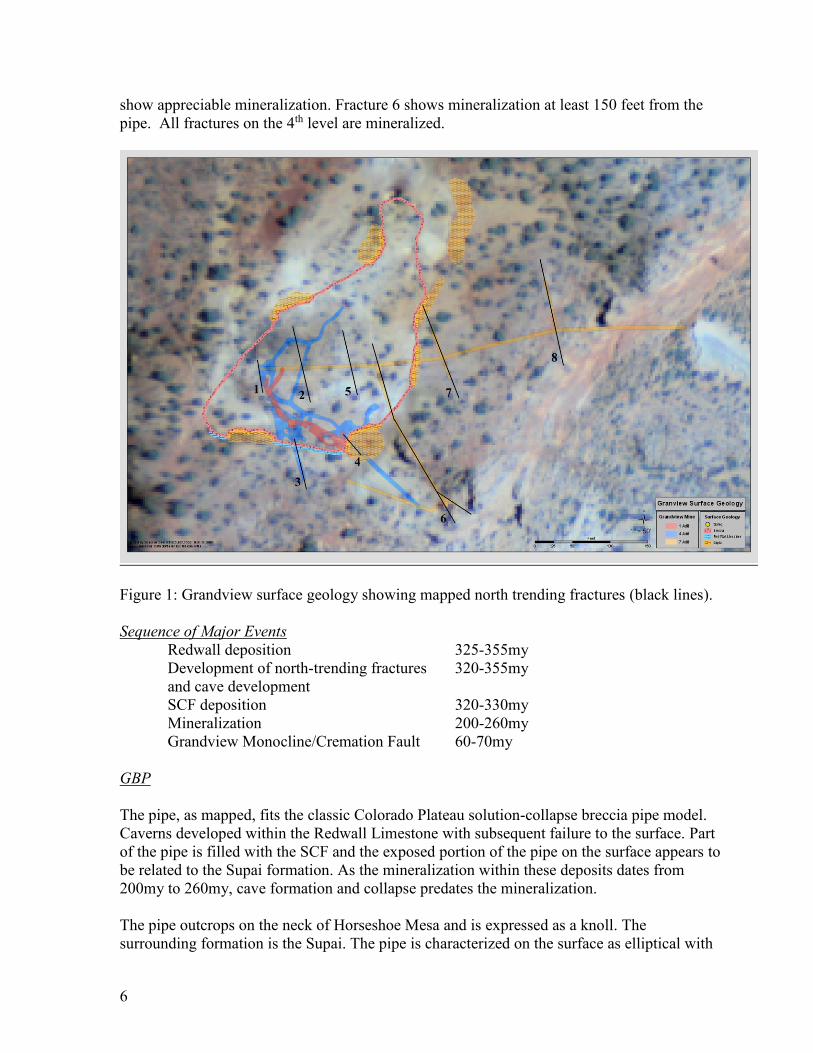
6
show appreciable mineralization. Fracture 6 shows mineralization at least 150 feet from the
pipe. All fractures on the 4th level are mineralized.
Figure 1: Grandview surface geology showing mapped north trending fractures (black lines).
Sequence of Major Events
Redwall deposition 325-355my
Development of north-trending fractures 320-355my
and cave development
SCF deposition 320-330my
Mineralization 200-260my
Grandview Monocline/Cremation Fault 60-70my
GBP
The pipe, as mapped, fits the classic Colorado Plateau solution-collapse breccia pipe model.
Caverns developed within the Redwall Limestone with subsequent failure to the surface. Part
of the pipe is filled with the SCF and the exposed portion of the pipe on the surface appears to
be related to the Supai formation. As the mineralization within these deposits dates from
200my to 260my, cave formation and collapse predates the mineralization.
The pipe outcrops on the neck of Horseshoe Mesa and is expressed as a knoll. The
surrounding formation is the Supai. The pipe is characterized on the surface as elliptical with
7
dimensions of 400 feet by 200 feet as exposed, primarily within the Supai formation. Within
the Redwall limestone, as exposed just below the outcrop on the southeasterly part of the pipe,
the pipe is somewhat smaller with dimensions of 260 feet by 150 feet. The differing
dimensions are attributed to the angle of failure within the Supai formation of overlying
formations moving downward into the caverns of the Redwall Limestone. The Redwall is not
as conducive to failure as is the overlying Supai formation. The pipe is exposed within the
mine working for a distance of 370 vertical feet, all within the Redwall limestone. This
distance also approximates the vertical thickness of the Redwall Limestone at Horseshoe
Mesa.
The pipe changes characteristics from the surface to the 7th level. At the surface, the pipe
exposure is roughly elliptical. On the 4th level, within the redwall limestone, the pipe is more
erratic, consisting of unaltered limestone walls of varying dip. The geologic map of the 4th
level (Exhibit G12) shows characteristics of typical cave formation, with the caverns filled
with breccia. The caves are quite large, but still smaller than the surface expression in the
Supai formation. The former caves are almost completely filled with breccia fragments of the
SCF and Redwall precipitates. Occasionally, small open caves are seen. These locations were
clearly removed from the effects of the collapse, usually located in smaller, remote areas of
the former caves. Somewhere between the 6th and 7th levels, a distance of about 200 feet, the
pipe changes characteristics from a large elliptical cross-section to a zone of vertical, north-
trending fissures. As no data points are available between these levels, cross-sections
(Exhibits G8 and G9) show a linear transition. These fissures are the “roots” of the original
cave formation and show significant solutioning along their strike. As seen on the geologic
map for the 7th level (exhibit G14), the fissures have a constant strike and vertical dip. They
contain breccia fragments within limited open spaces and show some mineralization. The 7th
level is very near the bottom of the Redwall limestone.
Within the pipe, structural movement was rarely noted. The deposit looks clearly as a cave
system filled with breccia from the SCF and a Redwall limestone breccia. It is very easy to
image the cave system in detail by observing the original limestone cave walls in the mine. On
the accompanying mine maps and block diagrams, the cave corresponds to the contact
between the breccia and the limestone.
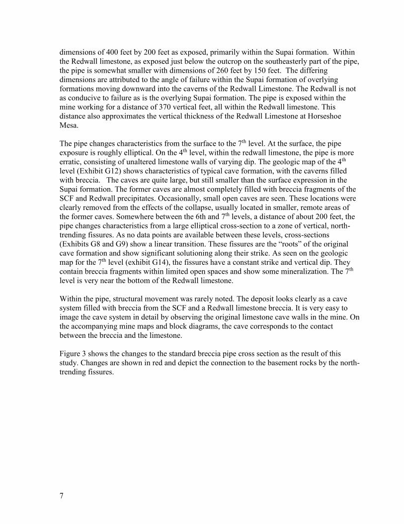
Figure 3 shows the changes to the standard breccia pipe cross section as the result of this
study. Changes are shown in red and depict the connection to the basement rocks by the north-
trending fissures.

8
Figure 3: Modified breccia pipe cross section (modified after Wenrich et al, 1986). Findings
of this study depicted in red.
9
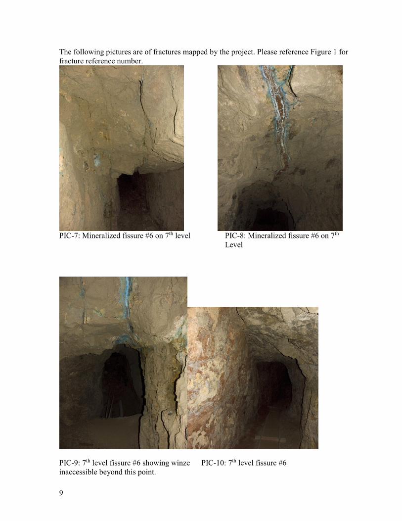
The following pictures are of fractures mapped by the project. Please reference Figure 1 for
fracture reference number.
PIC-7: Mineralized fissure #6 on 7th level PIC-8: Mineralized fissure #6 on 7th
Level
PIC-9: 7th level fissure #6 showing winze PIC-10: 7th level fissure #6
inaccessible beyond this point.

10
PIC-11: Fissure #8 on 7th level in the Thunder Springs Member.
PIC-12: Looking up at main fissure #3 on 4th level

11
One fault with visible movement was noted near the entrance to level 1 (PIC-13) on the
surface. The movement on the fault is about 30-40 feet. The exact disposition of the fault
cannot be ascertained without more detailed study, but it appears to form the contact between
the limestone and the breccia at the entrance to level 1. This fault is likely associated with the
Grandview monocline.
PIC-13: Fault visible on surface at level 1 entrance
Breccia Material
Two distinct breccias were observed. One is believed to be the SCF and the other a silt-clay
mixture derived from dissolved Redwall limestone. The breccia will be denoted as Breccia A
for the SCF and Breccia B for the dissolved Redwall limestone.
Breccia A
Breccia A is composed chiefly of the SCF of varying fragment size, ranging from about 1 inch
to 12 inches, but mostly in the smaller sizes. Occasionally a limestone fragment is noted. The
sandstone is largely unaltered and open space between fragments is common. The leaching of
post-mine minerals is very common as noted by chalcanthite and halotrichite and other
secondary iron sulfates. The breccia is uncemented and contains significant open space, so
mine cave-ins are common. The breccia is best exposed on the 4th level in the drift that
formerly connected to the O’Neil shaft but is now caved (Exhibit G12).

12
PIC-1: Breccia A (SCF) as observed on the 4th level.
PIC-2: Breccia A as observed on the 4th level. Brownish fragments are limestone in the SCF.

13
PIC-3: Breccia A. Note secondary chalcanthite and other sulfates.
Breccia B
Breccia B is likely composed of silt and clay derived from the Redwall limestone. The
formation has been leached of all iron, forming a white-grey color. It appears that the Redwall
that has been partially dissolved and reformed. Breccia fragments are observed, usually
Redwall limestone. In its current state, the formation is relatively competent and impervious
to meteoric water. Secondary minerals are not noted.

14
PIC-4: Breccia B
PIC-5: Breccia B on the 4th level.

15
PIC-6: Breccia B on the 4th level.
Hydrogeology:
The permeability of the GBP is related to the structural geology, alteration and mineralization
within the breccia and the creation of open space by mining activities. The GBP on the surface
is hydraulically disconnected from any major surface water source. The pipe is located at the
top of a small hill. The only stormwater that would be exposed to the pipe would be that
which falls directly on the pipe.
Two springs are located near the GBP (see Exhibit G6). Both are located on or near the GM.
Miners Spring is located to the southeast of the GBP and O’Neill Spring located to the
northwest of the GBP. Elevated arsenic has been noted at Miners Spring. O’Neill Spring has
not been sampled.
Structure Permeability: Fractures
Major north-trending fractures as mapped on the 4th and 7th levels are highly permeable
structures. Evidence of water is present on the major mineralized structure on the 7th level, and
significant amounts of water were noted throughout this zone. This structure is not accessible
beyond a 15 foot deep winze. A major flow of air was noted in this area. A review of the
composite level map shows that this structure is well beyond the limits of the pipe on the 4th
and 6th levels. Old mine maps indicate a “blind raise” some distance beyond the winze. The
composite level map (Exhibit G1) indicates that the raise may daylight on the surface in the

16
canyon below the 4th level entrance and near the trail to Miners Spring. It is theorized that
stormwater from the small canyon below the 4th level adit, enters the 7th level fracture in some
unknown manner. The “blind raise” may extend to the surface, a possible distance of about
100 vertical feet. It is also possible that the fracture extends to the surface and is highly
permeable. The canyon area in general, is located on the GM and exhibits numerous fault
zones. An effort should be undertaken to see if the raise or structure are present in the canyon.
The terrain is inhospitable due to the cliff forming limestone.
A major north-trending fracture is also noted on the 4th level. This fracture is characterized by
open karst formation. It is partially mineralized close to the pipe and farther away shows
barite mineralization that is likely not associated with the ore body. No moisture was directly
noted on this fracture, but open spaces extending some distance vertically were noted. It is
likely that this fracture is the vertical extension of a fissure on the 7th level. The fracture also
extends to the 1st level.
The connection of the north-trending fractures to the basement rocks presents some interesting
scenarios for groundwater contamination. Depending on the location and elevation of
groundwater and the gradient, some scenarios are detailed below. The scenarios assume that
contamination from metals will occur through downward migration through the north-
trending fractures.
Assuming that the fractures intercept groundwater above the basement rocks, down-
gradient will show contamination. Should the groundwater table daylight as springs,
the springs may show contamination. Up-gradient will show no contamination.
Irrespective of the groundwater location, contamination could move laterally along the
extent of the north-trending fractures. The fractures could daylight within the inner
canyon, at any point between the basement rocks and the top of the Redwall. The exit
may or may not be a spring.
Springs could be stratagraphically or topographically separated from the area of
contamination but still be located geographically close to the pipe.
Breccia Permeability
The permeability of the breccia within the exposed mine working varies from low to high.
The southwesterly portion of the pipe is characterized by a low permeability corresponding to
Breccia B, while the northeast portion of the breccia is of high permeability, corresponding to
Breccia A.
As previously described, Breccia B is composed of a relatively impermeable re-precipitated
Redwall limestone. Breccia A on the other hand is more open and porous and is considered
highly permeable and is likely the SCF.
The mapping of the breccias is straight-forward, but is limited by exposure in the mine. The
northern portion of the pipe is not accessible.
Exhibits H3-H7 show the breccia permeability on the mine level maps and Exhibits H1 and
H2 show a cross section of the breccia permeability.

17
Limestone-Breccia Contact Permeability:
The limestone-breccia contact is characterized by the presence of ore minerals. Copper and
zinc carbonates dominate the contact. While obviously permeable to mineralizing fluids at the
time of deposition, most open space has been filled with minerals and overall, must be
considered of a medium permeability. Open cave spaces were locally noted, but appear to be
hydraulically limited in extent. Moisture was rarely noted. Some localized contact areas are
relatively open and could be highly conducive to meteoric water.
PIC-14: Typical Limestone-Breccia contact as seen on the 4th level.
Mine Working Permeability:
The creation of highly permeable open spaces by mining has occurred within the GBP.
Mining methods were primarily open stoping, resulting in a more or less continuous open
space from near the surface to the 6th level, a distance of about 185 feet. Although the GBP is
hydraulically disconnected from surface waters, the abundant open spaces associated with the

18
removal of ore in the southwest portion of the pipe would be of concern for the transportation
of surface water through the deposit.
Although caved and inaccessible for the most part, the northeast portion of the pipe would be
of significant concern as the open spaces created by mining, coupled with the permeable
breccia in that portion of the pipe, would be highly conductive of meteoric waters. The old
mine maps show significant mine workings in this area, including a 5th level.
Most concerning and perhaps in immediate need of action is the potential surface water
connection with the main mineralized fissure on the 7th level. Direct evidence of stormwater
permeating the ore body is obvious as witnessed by the saturated 7th level fracture. It is
supposed that this structure outcrops in the canyon near the trail to Miners Spring, as
described previously.
One potential conduit for stormwater that should be mentioned is the collapsed O’Neil shaft
located on the northern portion of the GBP. The shaft is believed to be about 125 feet deep.
Although the surface drainage area draining to the collapsed shaft is small, the shaft would
provide a direct conduit for stormwater in to the pipe. Furthermore, it is believed that the
breccia within the shaft is highly permeable (Breccia A). Other surface workings do not
penetrate deeply into the pipe and therefore, do not appear to be significant conduits for
stormwater.
Solubility of Minerals
The deposit was originally sulfide mineralization consisting of pyrite and chalcopyrite with
subordinate amounts of uraninite, sphalerite and galena. Through the process of oxidation,
very little pyrite and an even smaller amounts of chalcopyrite are present today. Sulfates are
the most abundant mineral assemblage with a smaller amount of carbonates.
Remnant sulphides are continuing to oxidize and will eventually form an assemblage of
sulfates, carbonates and oxides as is the case elsewhere in the deposit. These are generally
more soluble in acidic solution. The release of sulphuric acid from oxidizing sulphides,
buffered by limestone, will result from interaction with oxygen-charged meteoric waters.
Metals in oxidized equivalents will move down-gradient.
Potential Area Spring Contamination:
Miners Spring located 1000 feet easterly of the GBP shows elevated arsenic. Although
the fractures seem to preclude movement in this direction, the GM is located adjacent
to the fractures and could be hydraulically connected. Movement from the fractures to
the GM and then down-gradient to the spring may be possible. The GBP shows
significant arsenic within the deposit.
O’Neil Spring is located 600 feet west of the GBP within the Redwall limestone.
Although located on the GM, it appears that it is topographically higher than the
majority of the GBP and likely not effected by contamination.
The springs located in Cottonwood Canyon to the northwest of the GBP are likely
located down-gradient, however, they are also significantly west of the extension of
the north-trending fractures.

19
Conclusion:
Structural Geology
The GBP fits the classic Colorado Plateau breccia pipe model. However this study has
completed the typical cross section, extending it to the Precambrian basement rocks of the
Grand Canyon.
The principle findings related to structural geology are:
The development of the GBP and associated mineralogy predates the GM. The GM
likely represents renewed movement along faults in the basement rocks that are also
responsible for the north trending fracture development.
The north trending fractures mapped throughout the GBP extend to the Grand Canyon
basement rocks.
The north-trending fractures, as mapped throughout the GBP are of significant size
and show mineralization at the lowest observed elevation.
Hydrogeology
The movement of meteoric waters through the GBP is highly variable and is dependent on
structure and the nature of the breccia. Overall the pipe should be considered highly
permeable for the transport of meteoric water. However, the GBP is hydraulically isolated
from stormwater due to its geographic location. Only one location in the mine shows
significant seepage. With the possible exception of highly faulted areas of the GM, the pipe is
more conducive to the movement of meteoric water than any geologic formation in the
vicinity. General findings of this study include:
Certain breccias are highly porous and conducive to stormwater migration/infiltration.
Breccia-Limestone contacts are conduits for meteoric water, although highly variable.
Mining activity has exaggerated the potential for meteoric water movement by
creating significant open spaces.
The predominant mineral suite, sulfates, is highly soluble in acidic water and therefore
downward movement of metals will occur if subject to stormwater infiltration.
With the exception of the 7th level blind raise, the GBP does not appear to present any
concern for spring contamination due to its hydraulic location.
Other pipes that may be subject to significant stormwater infiltration could be of
concern respecting groundwater/spring contamination.
The finding of a direct conduit to the Grand Canyon basement rocks and groundwater raises
questions and may help direct mapping and sampling of groundwater for potential
contaminants. Some findings from this project include:
The proximity of a spring or stream to a contaminant site may be hydraulically
disconnected due to the north trending fractures.

20
Current methods of sampling springs, seeps and streams may be inadequate to detect
contamination.
Monitoring wells, placed down-gradient from a potential contamination source may
be an effective method of detecting contaminants in consideration of any mapped
north trending fractures.
The mapping of north trending fractures in the Redwall Limestone (and below) in
association with a proposed mine, may provide a guide to impacts and potential
sampling sites.
Depending on groundwater movement and the proximity of a mine to a groundwater
exit, if any, contamination may not be detected in a spring or stream for a long period
of time.
Under no circumstance should meteoric water be permitted to penetrate the
expression of a mineralized pipe on the surface.
The location of any groundwater contamination will be influenced by the north-
trending fractures.
Recommendations
1. For any proposed mining activity, north-trending fractures should be mapped
throughout the region to help assess impacts and determine sampling locations.
2. Infiltration of stormwater should be a parameter to be considered for other pipes
within the Colorado Plateau. If a pipe is subject to significant stormwater infiltration,
surface mitigation should be considered to hydraulically remove the pipe from surface
water flows. Any water used as part of the mining process should be recovered and
mitigated.
3. An attempt should be made to determine the location of the blind raise, or fissure that
may be contributing stormwater to the main mineralized fissure on the 7th level. If
appropriate, the conduit should be sealed, or stormwater runoff should be diverted
away from the conduit.
4. A detailed mapping of Horseshoe Mesa should occur to determine the extent of the
north-trending fractures and other related structure.
5. Other pipes, both mineralized and un-mineralized, should be investigated for the
presence of north-trending fractures. Such opportunities are limited to exposures in the
Redwall and below. The Western Grand Canyon may have limited opportunities
including the Little Chicken pipe and the Bat Cave pipe.
6. Occurrences of sulfide mineral deposits in the basement rocks should be mapped to
determine if north-trending faults are present. If so, a relationship could be developed
supporting a hydrothermal source of mineralization.
Acknowledgements
The Team wishes to thank Ms. Ronda Newton and Mr. Steve Rice of the National Park
Service for their guidance and permitting. A special thanks to George Billingsley of the USGS
for his guidance in preparing this document. And lastly, to Scott Alter, whose field services
were critical to the completion of this project.

21
Note. This report was originally submitted to the National Park Service as GCNP Study #
GRCA-00519, Final Report August 2011
References:
Billingsley, George H., E.E. Spamer and D. Menkes (1997) Quest for the Pillar of Gold, Grand
Canyon Association 112p.
Billingsley, George H. and Beus, Stanley S., (1999), Geology of the Surprise Canyon Formation of the
Grand Canyon, Arizona, Museum of Northern Arizona Bulletin 61.
Billingsley, Priest and Felger. Geologic map of the Cameron 30’ x 60’ Quadrangle, Coconino County,
Arizona.
Canyon Copper Company (1907) Unpublished Mine Maps, 4p.
Chenoweth, W.L. (1978) The Orphan Lode Mine, Grand Canyon, Arizona: A Case History of a
Mineralized Collapse-Breccia Pipe, USGS OFR 86-510. 126p.
Hill, Carol, B.Buecher, D. Buecher, C. Mosch and M. Goar (1998) Trip Report-Horseshoe Mesa,
March 14-16, 1998, Grand Canyon National Park Trip Report (unpublished) 34p.
Huntoon, Peter W., The Post-Paleozoic Structural Geology of the Eastern Grand Canyon in Geology of
the Grand Canyon, Museum of Northern Arizona, 1978.
Leicht, Wayne C. (1971) Minerals of the Grandview Mine. The Mineralogical Record, October pp
215-221.
Roller, Julie A., Fracture History of the Redwall Limestone and Lower Supai Group, Western
Hualapai Indian Reservation, Northwestern Arizona, USGS Open File Report 87-359.
Roller, Julie A., Fracture History of the Redwall Limestone, lower Supai Group, and Tertiary units on
the Hualapai Indian Reservation, northwestern Arizona: Additional data to Open File Report 87-
359, USGS Open File Report 89-463.
Sutphin, Wenrich and Verbeek, 1983, GSA V15, No. 5, p376
Wenrich, K.J., Billingsley, G.H. and Huntoon, P.W., 1986, Breccia pipe and geologic map of the
northeastern Hualapai Indian Reservation and vicinity, Arizona, USGS Open-file Report 86-458.
Wenrich, Karen J., and S.R. Titley (2008) Uranium Exploration for Northern Arizona (USA) Breccia
Pipes in the 21st Century and Consideration of Genetic Models, Arizona Geological Society Digest
22. pp 295-309.

22
Appendix 1: Geologic sketches and cross sections of Grandview Mine, Grand
Canyon, Arizona
Exhibit G6 Regional geologic fabric expressed at Grandview Mine
Exhibit G7 Surface geology at Grandview Mine
Exhibit G8 Cross section A Grandview Mine
Exhibit G9 Cross section B Grandview mine
Exhibit G10 Level 1 geologic map Grandview Mine
Exhibit G11 Level 2 and level 6 geologic map
Exhibit G12 Level 4 geologic map
Exhibit G13 Level 5 geologic map
Exhibit G14 Level 7 geologic map
Exhibit H1 Cross section A hydro-geology
Exhibit H2 Cross section B hydro-geology
Exhibit H3 Level 1 hydro-geology
Exhibit H4 Level 2 and level 6 hydro-geology
Exhibit H5 Level 4 hydro-geology
Exhibit H6 Level 5 hydro-geology
Exhibit H7 Level 7 hydro-geology