stream inventory report bunker gulch
TRANSCRIPT

STREAM INVENTORY REPORT
Bunker Gulch INTRODUCTION A stream inventory was conducted on August 21 and 22, 2006 on Bunker Gulch. The survey began at the confluence with Hare Creek and extended upstream 1.4 miles. The objective of the habitat inventory was to document the habitat available to anadromous salmonids in Bunker Gulch. The objective of this report is to document the current habitat conditions and recommend options for the potential enhancement of habitat for coho salmon, and steelhead trout. Recommendations for habitat improvement activities are based upon target habitat values suitable for salmonids in California's north coast streams. WATERSHED OVERVIEW Bunker Gulch is a tributary to Hare Creek, which drains to the Pacific Ocean, located in Mendocino County, California (Map 1). Bunker Gulch's legal description at the confluence with Hare Creek is T18N R17W S26. Its location is 39.3877 north latitude and 123.7311 west longitude, LLID number 1237311393877. Bunker Gulch is an ephemeral stream according to the USGS Noyo Hill 7.5 minute quadrangle. Bunker Gulch drains a watershed of approximately 1.1 square miles. Elevations range from about 210 feet at the mouth of the creek to 1,000 feet in the headwater areas. Mixed conifer forest dominates the watershed. The watershed is entirely by Jackson Demonstration State Forest and is managed for timber production and recreation. Vehicle access exists via Highway 20, east of Fort Bragg. METHODS The habitat inventory conducted in Bunker Gulch follows the methodology presented in the California Salmonid Stream Habitat Restoration Manual (Flosi et al, 1998). The Pacific States Marine Fisheries Commission (PSMFC) Fisheries Technicians that conducted the inventory were trained in standardized habitat inventory methods by the California Department of Fish and Game (DFG). This inventory was conducted by a two-person team. SAMPLING STRATEGY The inventory uses a method that samples approximately 10% of the habitat units within the survey reach. All habitat units included in the survey are classified according to habitat type and their lengths are measured. All pool units are measured for maximum depth, depth of pool tail crest (measured in the thalweg), dominant substrate composing the pool tail crest, and embeddedness. Habitat unit types encountered for the first time are measured for all the parameters and characteristics on the field form. Additionally, from the ten habitat units on each field form page, one is randomly selected for complete measurement.

Bunker Gulch
2
HABITAT INVENTORY COMPONENTS A standardized habitat inventory form has been developed for use in California stream surveys and can be found in the California Salmonid Stream Habitat Restoration Manual. This form was used in Bunker Gulch to record measurements and observations. There are eleven components to the inventory form. 1. Flow: Flow is measured in cubic feet per second (cfs) near the bottom of the stream survey reach using a Marsh-McBirney Model 2000 flow meter. 2. Channel Type: Channel typing is conducted according to the classification system developed and revised by David Rosgen (1994). This methodology is described in the California Salmonid Stream Habitat Restoration Manual. Channel typing is conducted simultaneously with habitat typing and follows a standard form to record measurements and observations. There are five measured parameters used to determine channel type: 1) water slope gradient, 2) entrenchment, 3) width/depth ratio, 4) substrate composition, and 5) sinuosity. Channel characteristics are measured using a clinometer, hand level, hip chain, tape measure, and a stadia rod. 3. Temperatures: Both water and air temperatures are measured and recorded at every tenth habitat unit. The time of the measurement is also recorded. Both temperatures are taken in degrees Fahrenheit at the middle of the habitat unit and within one foot of the water surface. 4. Habitat Type: Habitat typing uses the 24 habitat classification types defined by McCain and others (1990). Habitat units are numbered sequentially and assigned a type identification number selected from a standard list of 24 habitat types. Dewatered units are labeled "dry". Bunker Gulch habitat typing used standard basin level measurement criteria. These parameters require that the minimum length of a described habitat unit must be equal to or greater than the stream's mean wetted width. All measurements are in feet to the nearest tenth. Habitat characteristics are measured using a clinometer, hip chain, and stadia rod. 5. Embeddedness: The depth of embeddedness of the cobbles in pool tail-out areas is measured by the percent of the cobble that is surrounded or buried by fine sediment. In Bunker Gulch, embeddedness was ocularly estimated. The values were recorded using the following ranges: 0 - 25% (value 1), 26 - 50% (value 2), 51 - 75% (value 3) and 76 - 100% (value 4). Additionally, a value of 5 was assigned to tail-outs deemed unsuited for spawning due to inappropriate substrate like bedrock, log sills, boulders or other considerations.

Bunker Gulch
3
6. Shelter Rating: Instream shelter is composed of those elements within a stream channel that provide juvenile salmonids protection from predation, reduce water velocities so fish can rest and conserve energy, and allow separation of territorial units to reduce density related competition for prey. The shelter rating is calculated for each fully-described habitat unit by multiplying shelter value and percent cover. Using an overhead view, a quantitative estimate of the percentage of the habitat unit covered is made. All cover is then classified according to a list of nine cover types. In Bunker Gulch, a standard qualitative shelter value of 0 (none), 1 (low), 2 (medium), or 3 (high) was assigned according to the complexity of the cover. Thus, shelter ratings can range from 0-300 and are expressed as mean values by habitat types within a stream. 7. Substrate Composition: Substrate composition ranges from silt/clay sized particles to boulders and bedrock elements. In all fully-described habitat units, dominant and sub-dominant substrate elements were ocularly estimated using a list of seven size classes and recorded as a one and two, respectively. In addition, the dominant substrate composing the pool tail-outs is recorded for each pool. 8. Canopy: Stream canopy density was estimated using modified handheld spherical densiometers as described in the California Salmonid Stream Habitat Restoration Manual. Canopy density relates to the amount of stream shaded from the sun. In Bunker Gulch, an estimate of the percentage of the habitat unit covered by canopy was made from the center of approximately every third unit in addition to every fully-described unit, giving an approximate 30% sub-sample. In addition, the area of canopy was estimated ocularly into percentages of coniferous or hardwood trees. 9. Bank Composition and Vegetation: Bank composition elements range from bedrock to bare soil. However, the stream banks are usually covered with grass, brush, or trees. These factors influence the ability of stream banks to withstand winter flows. In Bunker Gulch, the dominant composition type and the dominant vegetation type of both the right and left banks for each fully-described unit were selected from the habitat inventory form. Additionally, the percent of each bank covered by vegetation (including downed trees, logs, and rootwads) was estimated and recorded. 10. Large Woody Debris Count: Large woody debris (LWD) is an important component of fish habitat and an element in channel forming processes. In each habitat unit all pieces of LWD partially or entirely below the elevation of bankfull discharge are counted and recorded. The minimum size to be considered is twelve inches in diameter and six feet in length. The LWD count is presented by reach and is expressed as an average per 100 feet.

Bunker Gulch
4
11. Average Bankfull Width: Bankfull width can vary greatly in the course of a channel type stream reach. This is especially true in very long reaches. Bankfull width can be a factor in habitat components like canopy density, water temperature, and pool depths. Frequent measurements taken at riffle crests (velocity crossovers) are needed to accurately describe reach widths. At the first appropriate velocity crossover that occurs after the beginning of a new stream survey page (ten habitat units), bankfull width is measured and recorded in the appropriate header block of the page. These widths are presented as an average for the channel type reach. DATA ANALYSIS Data from the habitat inventory form are entered into Stream Habitat 2.0.19, a Visual Basic data entry program developed by Karen Wilson, Pacific States Marine Fisheries Commission in conjunction with the California Department of Fish and Game. This program processes and summarizes the data, and produces the following ten tables:
• Riffle, Flatwater, and Pool Habitat Types • Habitat Types and Measured Parameters • Pool Types • Maximum Residual Pool Depths by Habitat Types • Mean Percent Cover by Habitat Type • Dominant Substrates by Habitat Type • Mean Percent Vegetative Cover for Entire Stream • Fish Habitat Inventory Data Summary by Stream Reach (Table 8) • Mean Percent Dominant Substrate / Dominant Vegetation Type for Entire Stream • Mean Percent Shelter Cover Types for Entire Stream
Graphics are produced from the tables using Microsoft Excel. Graphics developed for Bunker Gulch include:
• Riffle, Flatwater, Pool Habitat Types by Percent Occurrence • Riffle, Flatwater, Pool Habitat Types by Total Length • Total Habitat Types by Percent Occurrence • Pool Types by Percent Occurrence • Maximum Residual Depth in Pools • Percent Embeddedness • Mean Percent Cover Types in Pools • Substrate Composition in Pool Tail-outs • Mean Percent Canopy • Dominant Bank Composition by Composition Type • Dominant Bank Vegetation by Vegetation Type

Bunker Gulch
5
HABITAT INVENTORY RESULTS * ALL TABLES AND GRAPHS ARE LOCATED AT THE END OF THE REPORT * The habitat inventory of August 21 and 22, 2006, was conducted by C. Hines and D. Wright (PSMFC). The total length of the stream surveyed was 7,354 feet. Stream flow was measured near the bottom of the survey reach with a Marsh-McBirney Model 2000 flowmeter at 0.1 cfs on August 24, 2006. Bunker Gulch is an F4 channel type for 7,354 feet of the stream surveyed. F4 channel types are entrenched meandering riffle/pool channels on low gradients with high width/depth ratios and gravel-dominant substrates. Water temperatures taken during the survey period ranged from 53 to 59 degrees Fahrenheit. Air temperatures ranged from 59 to 76 degrees Fahrenheit. Table 1 summarizes the Level II riffle, flatwater, and pool habitat types. Based on frequency of occurrence there were 39% pool units, 35% flatwater units, 23% riffle units, 1% dry units, and 1% culvert units (Graph 1). Based on total length of Level II habitat types there were 61% flatwater units, 22% pool units, 14% riffle units, 2% culvert units, and 1% dry units (Graph 2). Nine Level IV habitat types were identified (Table 2). The most frequent habitat types by percent occurrence were mid-channel pool units, 30%; step run units, 26%; low gradient riffle units, 22% (Graph 3). Based on percent total length, step run units made up 54%, mid-channel pool units 18%, and low gradient riffle units 14%. A total of 62 pools were identified (Table 3). Main channel pools were the most frequently encountered at 77% (Graph 4), and comprised 79% of the total length of all pools (Table 3). Table 4 is a summary of maximum residual pool depths by pool habitat types. Pool quality for salmonids increases with depth. Twenty-four of the 62 pools (39%) had a residual depth of two feet or greater (Graph 5). The depth of cobble embeddedness was estimated at pool tail-outs. Of the 62 pool tail-outs measured, 1 had a value of 1 (1.6%); 3 had a value of 2 (4.8%); 21 had a value of 3 (33.9%); 30 had a value of 4 (48.4%); 7 had a value of 5 (11.3%) (Graph 6). On this scale, a value of 1 indicates the best spawning conditions and a value of 4 the worst. Additionally, a value of 5 was assigned to tail-outs deemed unsuited for spawning due to inappropriate substrate such as bedrock, log sills, boulders, or other considerations. A shelter rating was calculated for each habitat unit and expressed as a mean value for each habitat type within the survey using a scale of 0-300. Riffle habitat types had a mean shelter rating of 18, flatwater habitat types had a mean shelter rating of 27, and pool habitats had a mean shelter rating of 85 (Table 1). Of the pool types, the scour pools had had the highest mean shelter rating at 104. Main channel pools had a mean shelter rating of 80 (Table 3).

Bunker Gulch
6
Table 5 summarizes mean percent cover by habitat type. Large woody debris is the dominant cover type in Bunker Gulch. Graph 7 describes the pool cover in Bunker Gulch. Large woody debris is the dominant pool cover type followed by small woody debris. Table 6 summarizes the dominant substrate by habitat type. Graph 8 depicts the dominant substrate observed in pool tail-outs. Gravel was the dominant substrate observed in 76% of the pool tail-outs. Small cobble was the next most frequently observed dominant substrate type and occurred in 11% of the pool tail-outs. The mean percent canopy density for the surveyed length of Bunker Gulch was 92%. Eight percent of the canopy was open. Of the canopy present, the mean percentages of hardwood and coniferous trees were 22% and 78%, respectively. Graph 9 describes the mean percent canopy in Bunker Gulch. For the stream reach surveyed, the mean percent right bank vegetated was 89%. The mean percent left bank vegetated was 96%. The dominant elements composing the structure of the stream banks consisted of 99% sand/silt/clay, and 1% bedrock (Graph 10). Coniferous trees were the dominant vegetation type observed in 71% of the units surveyed. Additionally, 16% of the units surveyed had brush as the dominant vegetation type and 12% had hardwood trees as the dominant vegetation type (Graph 11). DISCUSSION Bunker Gulch is an F4 channel type for 7,354 feet of the stream surveyed. The suitability of F4 channel types for fish habitat improvement structures is as follows: F4 channel types are good for bank-placed boulders and fair for plunge weirs, single and opposing wing-deflectors, channel constrictors, and log cover. The water temperatures recorded on the survey days August 21 to August 22, 2006, ranged from 53 to 59 degrees Fahrenheit. Air temperatures ranged from 59 to 76 degrees Fahrenheit. To make any conclusions, temperatures would need to be monitored throughout the warm summer months, and more extensive biological sampling would need to be conducted. Flatwater habitat types comprised 61% of the total length of this survey, riffles 14%, pools 22%, and dry 1%. Twenty-four of the 62 (39%) pools had a maximum residual depth greater than 2 feet. In general, pool enhancement projects are considered when primary pools comprise less than 40% of the length of total stream habitat. In first and second order streams, a primary pool is defined to have a maximum residual depth of at least two feet, occupy at least half the width of the low flow channel, and be as long as the low flow channel width. Installing large wood structures that will increase or deepen pool habitat is recommended. Four of the 62 pool tail-outs measured had embeddedness ratings of 1 or 2. Fifty-one of the pool tail-outs had embeddedness ratings of 3 or 4. Seven of the pool tail-outs had a rating of 5, which is considered unsuitable for spawning. Cobble embeddedness measured to be 25% or less, a

Bunker Gulch
7
rating of 1, is considered to indicate good quality spawning substrate for salmon and steelhead. Sediment sources in Bunker Gulch should be mapped and rated according to their potential sediment yields, and control measures should be taken. Fifty-four of the 62 pool tail-outs measured had gravel or small cobble as the dominant substrate. This is generally considered good for spawning salmonids. The mean shelter rating for pools was 85. The shelter rating in the flatwater habitats was 27. A pool shelter rating of approximately 100 is desirable. The amount of cover that now exists is being provided primarily by large woody debris in Bunker Gulch. Large woody debris is the dominant cover type in pools followed by small woody debris. Log and root wad cover structures in the pool and flatwater habitats would enhance both summer and winter salmonid habitat. Log cover structure provides rearing fry with protection from predation, rest from water velocity, and also divides territorial units to reduce density related competition. The mean percent canopy density for the stream was 92%. In general, revegetation projects are considered when canopy density is less than 80%. The percentage of right and left bank covered with vegetation was 89% and 96%, respectively. In areas of stream bank erosion or where bank vegetation is sparse, planting endemic species of coniferous and hardwood trees, in conjunction with bank stabilization, is recommended. RECOMMENDATIONS 1) Bunker Gulch should be managed as an anadromous, natural production stream. 2) The limited water temperature data available suggest that maximum temperatures are
within the acceptable range for juvenile salmonids. To establish more complete and meaningful temperature regime information, 24-hour monitoring during the July and August temperature extreme period should be performed for 3 to 5 years.
3) Increase woody cover in the pools and flatwater habitat units. Most of the existing cover
in the pools is from large woody debris. Adding high quality complexity with woody cover in the pools is desirable.
4) Inventory and map sources of stream bank erosion and prioritize them according to
present and potential sediment yield. Identified sites should then be treated to reduce the amount of fine sediments entering the stream.
5) Active and potential sediment sources related to the road system need to be identified,
mapped, and treated according to their potential for sediment yield to the stream and its tributaries.

Bunker Gulch
8
COMMENTS AND LANDMARKS The following landmarks and possible problem sites were noted. All distances are approximate and taken from the beginning of the survey reach. Position Habitat Comments: (ft): unit #: 40 0002.00 Start of survey 40' from the confluence with Hare Creek. The first 40’
was within the influence of Caspar Creek. There is a bridge located 25' into the unit.
190 0005.00 Coho young-or-the-year observed. 275 0008.00 Four coho young-of-the-year (YOY) observed. 436 0013.00 There is a road on the right bank. 791 0020.00 Coho YOY observed. 1643 0040.00 There is a road on the right bank. 1731 0042.00 There is a road on the right bank. 1854 0046.00 There is a 7' diameter culvert that is 60’ long. It is made of corrugated
metal and is in good condition. It is probably not a barrier to salmonid migration.
1978 0050.00 There is a road on the left bank. 2098 0055.00 Tributary #01 enters from the left bank. It is flowing at an estimated
0.01 cfs and is contributing to approximately 10% of Bunker Gulch’s flow. The temperature of the tributary and of Bunker Gulch upstream and downstream of the tributary was 54 degrees Fahrenheit. The tributary is not accessible to fish due to an impassable culvert. No fish were observed in the tributary.
2200 0056.00 There is a road on the left bank. 2340 0059.00 Coho YOY observed. 2433 0062.00 There is a right bank landslide bringing several stumps into the channel. 2480 0063.00 Culvert #02 has a 7' diameter and is 68’ long. It is made of corrugated
metal and is in poor condition. The bottom of the culvert is corroded. Currently it is probably not a barrier to salmonid migration.

Bunker Gulch
9
2548 0064.00 There is a road on the right bank. 2646 0066.00 Coho YOY observed. 2807 0072.00 There is a road on the right bank. 2977 0078.00 There is a right bank culvert 23' into the unit. 3278 0080.00 Coho YOY observed. 3526 0090.00 Coho YOY observed. 3582 0092.00 There is a road on the right bank. 4029 0102.00 There is a road on the right bank. 4182 0104.00 Coho YOY observed. 4684 0112.00 There is a road on the right bank. 4695 0113.00 Right bank culvert at top of unit. There is a tree uprooted on the left
bank. 5169 0122.00 There is a right bank seep at the top of the unit. 5878 0134.00 Log debris accumulation #01 is at top of the unit. It is approximately 8’
high x 12’ wide x 10’ long and contains 6 pieces of large woody debris. Water flows through it and it has visible gaps in it. Sediment is being retained in the approximate dimensions of 4’ wide x 6’ long x 1’ deep. The sediment is predominantly sand. The log debris accumulation is probably not a barrier to salmonid migration. Fish are observed above it.
6279 0145.00 There is an old railroad crossing at 65' into the unit. 6450 0147.00 There are several logs in the stream channel. 6662 0151.00 There are a few fish observed in this section; all are steelhead. 6681 0152.00 There is an old railroad crossing at 80' into the unit. 7035 0157.00 There are several logs in channel at the top of the unit. 7354 0161.00 End of survey due to the end of access.

Bunker Gulch
10
REFERENCES Flosi, G., Downie, S., Hopelain, J., Bird, M., Coey, R., and Collins, B. 1998. California Salmonid Stream Habitat Restoration Manual, 3rd edition. California Department of Fish and Game, Sacramento, California.

Bunker Gulch
11
LEVEL III and LEVEL IV HABITAT TYPES RIFFLE Low Gradient Riffle (LGR) [1.1] { 1} High Gradient Riffle (HGR) [1.2] { 2} CASCADE Cascade (CAS) [2.1] { 3} Bedrock Sheet (BRS) [2.2] {24} FLATWATER Pocket Water (POW) [3.1] {21} Glide (GLD) [3.2] {14} Run (RUN) [3.3] {15} Step Run (SRN) [3.4] {16} Edgewater (EDW) [3.5] {18} MAIN CHANNEL POOLS Trench Pool (TRP) [4.1] { 8 } Mid-Channel Pool (MCP) [4.2] {17} Channel Confluence Pool (CCP) [4.3] {19} Step Pool (STP) [4.4] {23} SCOUR POOLS Corner Pool (CRP) [5.1] {22} Lateral Scour Pool - Log Enhanced (LSL) [5.2] {10} Lateral Scour Pool - Root Wad Enhanced (LSR) [5.3] {11} Lateral Scour Pool - Bedrock Formed (LSBk) [5.4] {12} Lateral Scour Pool - Boulder Formed (LSBo) [5.5] {20} Plunge Pool (PLP) [5.6] { 9 } BACKWATER POOLS Secondary Channel Pool (SCP) [6.1] { 4 } Backwater Pool - Boulder Formed (BPB) [6.2] { 5 } Backwater Pool - Root Wad Formed (BPR) [6.3] { 6 } Backwater Pool - Log Formed (BPL) [6.4] { 7 } Dammed Pool (DPL) [6.5] {13} ADDITIONAL UNIT DESIGNATIONS Dry (DRY) [7.0] Culvert (CUL) [8.0] Not Surveyed (NS) [9.0] Not Surveyed due to a marsh (MAR) [9.1]

Table 1 - Summary of Riffle, Flatwater, and Pool Habitat Types
Stream Name:
Survey Dates:
Confluence Location: Quad: Legal Description: Latitude: Longitude:
Drainage:Bunker Gulch Noyo River
8/21/2006 to 8/22/2006
NOYO HILL T18NR17WS26 39:23:16.0N 123:43:52.0W
HabitatUnits
Units FullyMeasured
HabitatType
HabitatOccurrence
(%)
MeanLength
(ft.)
TotalLength
(ft.)
TotalLength
(%)
MeanWidth(ft.)
MeanDepth
(ft.)
MeanArea
(sq.ft.)
EstimatedTotal Area
(sq.ft.)
MeanVolume(cu.ft.)
EstimatedTotal
Volume(cu.ft.)
MeanResidualPool Vol(cu.ft.)
MeanShelterRating
MeanMax
Depth(ft.)
LLID: 1237311393877
CULVERT0 1.2 64 128 1.72
DRY0 1.2 22 44 0.62
FLATWATER8 35.4 78 4447 60.6 5.9 0.5 321 18305 142 8104 2757 1.0
NOSURVEY0 0.6 40 40 0.51
POOL62 38.5 26 1640 22.3 8.1 1.3 217 13469 331 20528 291 8562 1.9
RIFFLE7 23.0 28 1043 14.2 4.4 0.2 87 3222 16 574 1837 0.3
Total Units FullyMeasured
Total Length(ft.)
Total Area(sq.ft.)
Total Volume(cu.ft.)
TotalUnits161 77 7342 34996 29206

Table 2 - Summary of Habitat Types and Measured Parameters
Stream Name:
Survey Dates:
Confluence Location: Quad: Legal Description: Latitude: Longitude:
Drainage:Bunker Gulch Noyo River
8/21/2006 to 8/22/2006
NOYO HILL T18NR17WS26 39:23:16.0N 123:43:52.0W
HabitatUnits
Units FullyMeasured
HabitatType
HabitatOccurrence
(%)
MeanLength
(ft.)
TotalLength
(ft.)
TotalLength
(%)
MeanWidth(ft.)
MeanDepth
(ft.)
MeanArea
(sq.ft.)
EstimatedTotal Area
(sq.ft.)
MeanVolume(cu.ft.)
EstimatedTotal
Volume(cu.ft.)
MeanResidualPool Vol(cu.ft.)
MeanShelterRating
MeanCanopy
(%)
MaxDepth (ft.)
LLID: 1237311393877
LGR6 22.4 29 1028 14.0 5 0.2 96 3455 17 611 2136 910.5
BRS1 0.6 15 15 0.2 3 0.2 34 34 7 7 01 930.4
RUN3 9.3 30 451 6.1 5 0.6 153 2290 85 1270 2315 881.1
SRN5 26.1 95 3996 54.4 6 0.4 422 17733 177 7421 2942 891.2
MCP48 29.8 27 1301 17.7 8 1.3 230 11020 360 17297 318 8048 934.2
CRP1 0.6 24 24 0.3 8 1.0 192 192 269 269 192 401 971.8
LSL11 6.8 24 268 3.7 7 1.1 176 1933 232 2548 205 11111 922.4
LSBk2 1.2 24 47 0.6 6 1.0 163 325 207 414 163 952 981.7
DRY0 1.2 22 44 0.62 85
CUL0 1.2 64 128 1.72
NS0 0.6 40 40 0.51
Total Units FullyMeasured
Total Length(ft.)
Total Area(sq.ft.)
Total Volume(cu.ft.)
TotalUnits161 77 7342 36981 29837

Table 3 - Summary of Pool Types
Stream Name:
Survey Dates:
Confluence Location: Quad: Legal Description: Latitude: Longitude:
Drainage:Bunker Gulch Noyo River
8/21/2006 to 8/22/2006
NOYO HILL T18NR17WS26 39:23:16.0N 123:43:52.0W
HabitatUnits
Units FullyMeasured
HabitatType
HabitatOccurrence
(%)
MeanLength
(ft.)
TotalLength
(ft.)
TotalLength
(%)
MeanWidth(ft.)
MeanResidualDepth (ft.)
MeanArea
(sq.ft.)
EstimatedTotal Area
(sq.ft.)
EstimatedTotal
Resid.Vol.(cu.ft.)
MeanResidualPool Vol(cu.ft.)
MeanShelterRating
LLID: 1237311393877
MAIN48 77 27 1301 79 8.5 1.3 230 11020 15262318 8048
SCOUR14 23 24 339 21 7.0 1.1 175 2450 2771198 10414
Total UnitsFully Measured
Total Length(ft.)
Total Area(sq.ft.)
Total Volume(cu.ft.)
TotalUnits
62 62 1640 13469 18033

Table 4 - Summary of Maximum Residual Pool Depths By Pool Habitat Types
Stream Name:
Survey Dates:
Confluence Location: Quad: Legal Description: Latitude: Longitude:
Drainage:Bunker Gulch Noyo River
8/21/2006 to 8/22/2006
NOYO HILL T18NR17WS26 39:23:16.0N 123:43:52.0W
HabitatUnits
HabitatType
HabitatOccurrence
(%)
< 1 FootMaximumResidual
Depth
< 1 FootPercent
Occurrence
1 < 2 FeetMaximumResidual
Depth
1 < 2 FeetPercent
Occurrence
2 < 3 FeetMaximumResidual
Depth
2 < 3 FeetPercent
Occurrence
3 < 4 FeetMaximumResidual
Depth
3 < 4 FeetPercent
Occurrence
>= 4 FeetMaximumResidual
Depth
>= 4 FeetPercent
Occurrence
LLID: 1237311393877
MCP 7748 1 2 25 52 16 33 5 10 1 2
CRP 21 0 0 1 100 0 0 0 0 0 0
LSL 1811 0 0 9 82 2 18 0 0 0 0
LSBk 32 0 0 2 100 0 0 0 0 0 0
TotalUnits
62
Total< 1 Foot
Max Resid.Depth
Total< 1 Foot
% Occurrence
Total1< 2 Foot
Max Resid.Depth
Total1< 2 Foot
% Occurrence
Total2< 3 Foot
Max Resid.Depth
Total2< 3 Foot
% Occurrence
Total3< 4 Foot
Max Resid.Depth
Total3< 4 Foot
% Occurrence
Total>= 4 Foot
Max Resid.Depth
Total>= 4 Foot
% Occurrence
1 2 37 60 18 29 5 8 1 2
Mean Maximum Residual Pool Depth (ft.): 1.9

Table 5 - Summary of Mean Percent Cover By Habitat Type
Stream Name:
Survey Dates:
Confluence Location: Quad: Legal Description: Latitude: Longitude:
Drainage:Bunker Gulch Noyo River
8/21/2006 to 8/22/2006
NOYO HILL T18NR17WS26 39:23:16.0N 123:43:52.0W
HabitatUnits
HabitatType
Mean %Undercut
Banks
Mean %SWD
Mean %LWD
Mean %Root Mass
Mean %Terr.
Vegetation
Mean %Aquatic
Vegetation
Mean %WhiteWater
Mean %Boulders
Mean %BedrockLedges
UnitsFully
Measured
Dry Units: 2
LLID: 1237311393877
LGR636 26 0 44 0 0200 10 0
BRS11 0 0 0 0 000 0 0
TOTAL RIFFLE737 26 0 44 0 0200 10 0
RUN315 65 0 30 0 005 0 0
SRN542 18 0 28 0 0412 18 20
TOTAL FLAT857 31 0 29 0 0310 13 14
MCP4848 21 6 11 0 03523 3 1
CRP11 60 0 0 0 0040 0 0
LSL1111 31 0 2 0 0651 1 0
LSBk22 10 0 0 0 01555 0 20
TOTAL POOL6262 23 5 9 0 03920 2 1
CUL02
NS01
TOTAL77161 24 4 13 0 03518 4 2

Table 6 - Summary of Dominant Substrates By Habitat Type
Stream Name:
Survey Dates:
Confluence Location: Quad: Legal Description: Latitude: Longitude:
Drainage:Bunker Gulch Noyo River
8/21/2006 to 8/22/2006
NOYO HILL T18NR17WS26 39:23:16.0N 123:43:52.0W
HabitatUnits
HabitatType
% TotalSilt/Clay
Dominant
% TotalSand
Dominant
% TotalGravel
Dominant
% TotalSmall Cobble
Dominant
% Total LargeCobble
Dominant
% TotalBoulder
Dominant
% TotalBedrock
Dominant
Units FullyMeasured
Dry Units: 2
LLID: 1237311393877
LGR636 0 0 0 0 01000
BRS11 0 0 0 0 10000
RUN315 0 0 0 0 01000
SRN542 20 20 0 0 40200
MCP4848 27 4 4 0 4600
CRP11 0 0 0 0 10000
LSL1111 18 9 0 0 0730
LSBk22 0 0 0 0 50500

Table 7 - Summary of Mean Percent Canopy for Entire Stream
Stream Name:
Survey Dates:
Confluence Location: Quad: Legal Description: Latitude: Longitude:
Drainage:Bunker Gulch Noyo River
8/21/2006 to 8/22/2006
NOYO HILL T18NR17WS26 39:23:16.0N 123:43:52.0W
MeanPercentCanopy
MeanPercent
Hardwood
MeanPercent
Open Units
MeanPercentConifer
Mean RightBank %Cover
Mean LeftBank %Cover
LLID: 1237311393877
78 02292
Note: Mean percent conifer and hardwood for the entire reach are means of canopy components from units withcanopy values greater than zero.
Open units represent habitat units with zero canopy cover.
89 96
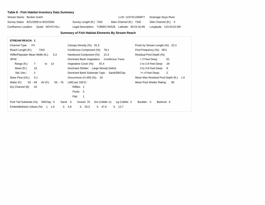
Table 8 - Fish Habitat Inventory Data SummaryStream Name:
Survey Dates:
Confluence Location: Quad: Legal Description: Latitude: Longitude:
Drainage:Bunker Gulch Noyo River
8/21/2006 to 8/22/2006
NOYO HILL T18NR17WS26 39:23:16.0N 123:43:52.0W
Survey Length (ft.): Main Channel (ft.): Side Channel (ft.):7342 7342 0
LLID: 1237311393877
Summary of Fish Habitat Elements By Stream Reach
STREAM REACH: 1
Channel Type:
Reach Length (ft.):
F4
7342
Riffle/Flatwater Mean Width (ft.):
Base Flow (cfs.):
5.2
0.1
Water (F): Air (F):
Dominant Bank Vegetation:
Vegetative Cover (%):
Dominant Bank Substrate Type:
53
Coniferous Trees
92.4
Sand/Silt/Clay
- 59 7659 -
Canopy Density (%):
Coniferous Component (%):
Hardwood Component (%):
Pools by Stream Length (%):
2 to 2.9 Feet Deep:
Mean Pool Shelter Rating:
Dominant Shelter:
Occurrence of LWD (%):
Dry Channel (ft):
91.5
78.1
21.9
22.3
85
Large Woody Debris
33
44
Embeddedness Values (%): 1. 2. 3. 4. 5.1.6 4.8 12.733.3 47.6
Pool Frequency (%):
Residual Pool Depth (%):
BFW: < 2 Feet Deep:
>= 4 Feet Deep:
3 to 3.9 Feet Deep:
Mean Max Residual Pool Depth (ft.):
LWD per 100 ft.:
Riffles:
Pools:
Flat:
Range (ft.):
Mean (ft.):
Std. Dev.:
to
Pool Tail Substrate (%): Silt/Clay: Sand: Gravel: Sm Cobble: Lg Cobble: Boulder: Bedrock:
7 13
10
2
38.5
1.9
61
29
8
2
0 756 11 02 6
1
5
1

Table 9 - Mean Percentage of Dominant Substrate and Vegetation
Stream Name:
Survey Dates:
Confluence Location: Quad: Legal Description: Latitude: Longitude:
Drainage:Bunker Gulch Noyo River
8/21/2006 to 8/22/2006
NOYO HILL T18NR17WS26 39:23:16.0N 123:43:52.0W
LLID: 1237311393877
Mean Percentage of Dominant Stream Bank Substrate
Mean Percentage of Dominant Stream Bank Vegetation
Total Stream Cobble Embeddedness Values:
Bedrock
Boulder
Cobble / Gravel
Sand / Silt / Clay
Grass
Brush
Hardwood Trees
Coniferous Trees
No Vegetation
Dominant Classof Substrate
Number of UnitsRight Bank
Number of UnitsLeft Bank
Total MeanPercent (%)
Dominant Classof Vegetation
Number of UnitsRight Bank
Number of UnitsLeft Bank
Total MeanPercent (%)
0 1 0.6
0 0 0.0
0 0 0.0
77 76 99.4
0 0 0.0
19 6 16.2
14 6 13.0
44 65 70.8
0 0 0.0
4

Table 10 - Mean Percent of Shelter Cover Types For Entire Stream
StreamName:
Survey Dates:
Confluence Location: Quad: Legal Description: Latitude: Longitude:
Drainage:Bunker Gulch Noyo River
8/21/2006 to 8/22/2006
NOYO HILL T18NR17WS26 39:23:16.0N 123:43:52.0W
Riffles Flatwater Pools
LLID: 1237311393877
UNDERCUT BANKS (%) 0 4 20
SMALL WOODY DEBRIS (%) 26 31 23
LARGE WOODY DEBRIS (%) 20 9 39
ROOT MASS (%) 0 11 5
TERRESTRIAL VEGETATION (%) 44 17 9
AQUATIC VEGETATION (%) 0 0 0
WHITEWATER (%) 0 0 0
BOULDERS (%) 10 13 2
BEDROCK LEDGES (%) 0 14 1

BUNKER GULCH 2006 HABITAT TYPES BY PERCENT OCCURRENCE
FLATWATER35.4%
NOSURVEY0.6%
POOL38.5%
RIFFLE23.0%
DRY1.2%
CULVERT1.2%
GRAPH 1

BUNKER GULCH 2006 HABITAT TYPES BY PERCENT TOTAL LENGTH
FLATWATER60.6%
NOSURVEY0.5%
POOL22.3%
RIFFLE14.2%
CULVERT1.7% DRY
0.6%
GRAPH 2

BUNKER GULCH 2006 HABITAT TYPES BY PERCENT OCCURRENCE
0%
5%
10%
15%
20%
25%
30%
35%
LGR BRS RUN SRN MCP CRP LSL LSBk DRY CUL NS
HABITAT TYPE
PER
CEN
T O
CC
UR
REN
CE
GRAPH 3

BUNKER GULCH 2006 POOL TYPES BY PERCENT OCCURRENCE
MAIN77.4%
SCOUR22.6%
GRAPH 4

BUNKER GULCH 2006 MAXIMUM DEPTH IN POOLS
0
5
10
15
20
25
30
35
40
<1 FOOT 1-<2 FEET 2-<3 FEET 3-<4 FEET >=4 FEET
MAXIMUM RESIDUAL DEPTH
# O
F PO
OLS
GRAPH 5

BUNKER GULCH 2006 PERCENT EMBEDDEDNESS
VALUE 333.9%
VALUE 448.4%
VALUE 511.3%
VALUE 24.8%
VALUE 11.6%
GRAPH 6

BUNKER GULCH 2006 MEAN PERCENT COVER TYPES IN POOLS
UNDERCUT BANKS20.1%
SMALL WOODY DEBRIS23.0%
LARGE WOODY DEBRIS39.3%
ROOT MASS5.0%
TERRESTRIAL VEGETATION
9.0%
BOULDERS2.4%
BEDROCK LEDGES1.2%
GRAPH 7

BUNKER GULCH 2006 SUBSTRATE COMPOSITION IN POOL TAIL-OUTS
0
10
20
30
40
50
60
70
80
SILT/CLAY SAND GRAVEL SMALL COBBLE LARGE COBBLE BOULDER BEDROCK
SUBSTRATE
% O
F PO
OL
TAIL
-OU
TS
GRAPH 8

BUNKER GULCH 2006 MEAN PERCENT CANOPY
CONIFEROUS TREES71.1%
HARDWOOD TREES20.5%
OPEN8.4%
GRAPH 9

BUNKER GULCH 2006 DOMINANT BANK COMPOSITION IN SURVEY REACH
BEDROCK0.6%
SAND/SILT/CLAY99.4%
GRAPH 10

BUNKER GULCH 2006 DOMINANT BANK VEGETATION IN SURVEY REACH
BRUSH16.2%
HARDWOOD TREES12.3%
CONIFEROUS TREES71.4%
GRAPH 11

Start of Survey
End of Survey
µ 0 1,500 3,000 FeetRESOURCES AGENCYCALIFORNIA
DEPARTMENTFISH & GAME
Map 1Bunker Gulch
Hare Creek WatershedNoyo Hill Quad, Mendocino County
LegendBunker Gulch End survey point is approximate.