stratigraphic implications of meteoric...
TRANSCRIPT

JOURNAL OF SEDIMENTARY RESEARCH, VOL. 71, NO. 6, NOVEMBER, 2001, P. 1017–1028Copyright q 2001, SEPM (Society for Sedimentary Geology) 1527-1404/01/071-1017/$03.00
STRATIGRAPHIC IMPLICATIONS OF METEORIC SPHAEROSIDERITE d18O VALUES IN PALEOSOLS OFTHE CRETACEOUS (ALBIAN) BOULDER CREEK FORMATION, NE BRITISH COLUMBIA FOOTHILLS,
CANADA
DAVID F. UFNAR,1 LUIS A. GONZALEZ,2 GREG A. LUDVIGSON,2,3 ROBERT L. BRENNER,1 AND BRIAN J. WITZKE3
1 Department of Geoscience, University of Iowa, Iowa City, Iowa 52242-1379, U.S.A.2 Center for Global and Regional Environmental Research, University of Iowa, Iowa City, Iowa 52242, U.S.A.
3 Iowa Geological Survey Bureau, Iowa City, Iowa 52242, U.S.A.e-mail: [email protected]
ABSTRACT: The MD 80-08 coal exploration core from the Albian Boul-der Creek Formation of northeastern British Columbia contains 90 mof alluvial strata that underwent extensive pedogenic modification.Gleyed colors, pedogenic slickensides, clay coatings, mottling, sphae-rosiderite, and sedimentary pyrite characterize the paleosols.
The isotopic compositions of 30 sphaerosiderite-bearing horizonscommonly show trends of invariant d18O and variable d13C values.Equal-area plots of d18O vs. d13C were used to construct meteoricsphaerosiderite lines (MSLs). The MSLs indicate that meteoric ground-water compositions ranged from approximately 211‰ to 216‰(SMOW). The sphaerosiderite d18O values indicate formation in shal-low groundwaters predominantly recharged by local precipitation. Thesphaerosiderite isotopic compositions are a proxy record of mid-Cre-taceous precipitation, and are useful for quantifying changes in thehydrologic cycle during humid ‘‘greenhouse’’ periods.
Micromorphology of a 1.15 meter interval (69.75–68.6 m), with a11.31‰ increase in the average d18O values, records a polygenetichistory of paleosol development. The pedocomplex has a four-stagedevelopmental history characterized by: (1) an initial well-drainedphase, with wet–dry cycles and relatively low baselevel; (2) erosion,baselevel rise and coarser-grained sedimentation; (3) saturated, reduc-ing soil conditions, high baselevel, with some marine influence on pe-dogenesis; and (4) meteoric-water-dominated hydromorphic soil con-ditions, high baselevel, and sphaerosiderite precipitation. The d18O ex-cursion recorded through this interval reflects minor mixing of marineand meteoric groundwaters. The modal abundance of pyrite, and in-creased Mg/(Ca 1 Mg) and Mg/Fe cation ratios in the sphaerosideritesfurther substantiate marine influence on pedogenesis.
The alluvial section of the Boulder Creek Formation is aggradation-al, and several changes in baselevel recorded in the paleosols are in-terpreted to have been driven by minor (parasequence-scale) changesin relative sea level.
INTRODUCTION
The use of sphaerosiderite d18O and d13C values as a proxy record forpaleoclimatic and paleohydrologic information is a recent developmentmade possible by the recognition of meteoric sphaerosiderite lines (MSLs)(Ludvigson et al. 1998). Sphaerosiderites are millimeter-scale FeCO3 spher-ulites that formed in ancient wetland soil environments. MSL’s are trendsdefined by sphaerosiderite isotopic compositions with invariant d18O valuesand highly variable d13C values (Ludvigson et al. 1998). The MSLs areanalogous to the meteoric calcite lines of Lohmann (1988). The constantd18O values reflect precipitation in a well-developed groundwater systemwith stable oxygen isotope ratios and uniform temperature (Hays andGrossman 1991; Ludvigson et al. 1998).
Recently, d18O values of sphaerosiderite latitudinal gradients have beendetermined for the Albian of the Western Interior Basin (Ludvigson et al.1998; White et al. in press). Reconstructing north–south latitudinal trendsin Albian meteoric d18O compositions is one of the long-term goals of ourresearch. The Albian meteoric d18O records we have compiled (including
data presented in this paper) indicate that meteoric d18O values progres-sively decrease with increased paleolatitude (Ludvigson et al. 1998). Fur-thermore, the Albian d18O latitudinal gradient is steeper than that modeledfor siderite forming in modern soil waters. It is widely accepted that muchof the mid-Cretaceous was a time of global warmth or ‘‘greenhouse’’ con-ditions (Spicer and Corfield 1992; Francis and Frakes 1993; Glancy et al.1993; Upchurch and Wolfe 1993). The steeper Albian meteoric d18O pa-leolatitudinal gradient is interpreted to have been a result of increased pre-cipitation during this ‘‘greenhouse’’ period (Ludvigson et al. 1998), and ithas been used to constrain estimates of the intensification of the mid-Cre-taceous hydrologic cycle (White et al. in press). Ultimately, using MSLsfrom amalgamated sphaerosiderite-bearing paleosols like those presentedhere (d18O chemostratigraphic profiles), we hope to correlate isotopictrends throughout the Cretaceous Western Interior Basin (KWIB) and re-construct precipitation d18O trends for shorter time intervals during themid-Cretaceous.
Although there is a well-defined northward depletion in sphaerosiderited18O values within any particular locality with multiple sphaerosiderite-bearing paleosols, there is systematic stratigraphic variability that reflectstemporal changes during the Albian. The amalgamated sphaerosiderite-bearing paleosols of the Boulder Creek Formation are ideal for investigat-ing this stratigraphic variation (Figs. 1, 2).
In this paper we explore some possible causes for temporal variabilityof sphaerosiderite d18O values in the amalgamated paleosols of the BoulderCreek Formation. Paleosol micromorphological characteristics and sphae-rosiderite minor-element data facilitate evaluation of the temporal varia-tions in sphaerosiderite d18O values. We hypothesize that the isotopic var-iability (positive d18O excursions) through some sphaerosiderite-bearingpaleosols may be related to changes in alluvial base level.
Boulder Creek Formation
As shown by Leckie et al. (1989) the upper 90 meters of the Late Albian(Fig. 1) Boulder Creek Formation consists of nonmarine, alluvial mud-stones and siltstones that were subjected to extensive pedogenic modifi-cation. The paleosols developed in floodplain deposits shed from the Cor-dillera to the southwest (Leckie et al. 1989; Leckie and Reinson 1993).There are 15 superposed paleosols and pedocomplexes in the nonmarineBoulder Creek Formation of the Monkman Pass area (Leckie and Foscolos1986; Leckie et al. 1989; Stelck and Leckie 1988, 1990; Leckie and Rein-son 1993). In general, the paleosols exhibit drab gray colors, root traces,pedogenic slickensides, blocky structure, clay coatings, mottling, andsphaerosiderite. The drab gray colors, manganese mottles, and abundanceof sphaerosiderites suggest that many of these paleosols formed in poorlydrained environments (Leckie et al. 1989; Leckie and Reinson 1993). Leck-ie and Reinson (1993) suggest that the waterlogged paleosols may haveresulted from topographic position on a low-relief alluvial plain with broad,gently sloping divides.
Leckie et al. (1989) described the paleosols in detail, and paleosol com-plex 1 (67–74 m in Figure 3) is of particular importance to this investi-gation (Table 1 of Leckie et al. 1989). Several sphaerosiderite-bearing sam-ples obtained for this study were acquired from paleosol complex 1, spe-

1018 D.F. UFNAR ET AL.
FIG. 1.—Stratigraphic correlation chart for the mid-Cretaceous in the Peace Riverarea of Alberta and British Columbia (modified from Leckie and Smith 1992).
FIG. 2.—Location of the Boulder Creek Formation Monkman Pass (MD 80-08)core in British Columbia, Canada (modified from Stelck and Leckie 1988 and Leckieet al. 1989).
cifically from the 68.6–69.75 m depth interval (described in detail below)(Fig. 4). Leckie et al. (1989) subdivided paleosol complex 1 into 11 ped-ogenic horizons following the Canadian system of soil classification (Ag-riculture Canada Expert Committee on Soil Survey 1987), and the 68.6–69.75 m samples we collected are from their Bt3 and II Bm (equivalent toBw of the U.S.D.A. classification scheme) horizons (Table 1 of Leckie etal. 1989). Figure 4 summarizes the macromorphological features we ob-served in paleosol complex 1.
METHODS
Lithologic descriptions and samples were collected from the MonkmanPass MD 80-08 coal exploration core curated at the Geological Survey ofCanada core facility in Calgary, Alberta. A total of 30 sphaerosiderite-bearing paleosol horizons were sampled, and the position of each sampleis marked with an asterisk adjacent to the lithologic log of Leckie et al.(1989) illustrated in Figure 3. At least 10 isotopic analyses of sphaerosi-derites were conducted on each of the 30 sampled horizons. Micromor-phological analyses were also performed on all 30 horizons (following themethods of Bullock et al. 1985), but sampling limitations prevented com-
plete, detailed analysis of any particular paleosol complex. The fairly densesampling between 68 and 70 m (Fig. 3) did permit detailed examinationof part of paleosol complex 1 of Leckie et al. (1989) (described in detailbelow).
Confirmation of unaltered, early diagenetic sphaerosiderite was evaluatedusing light microscopy, cathodoluminescence petrography, epifluorescencepetrography, and scanning electron microscopy. Polished slabs from eachof the 30 paleosol horizons were microsampled using a microscope-mount-ed drill assembly with a 0.5 mm drill bit. All samples extracted for massspectrometry were analyzed at the University of Iowa Paul H. Nelson Sta-ble Isotope Laboratory.
Powdered samples were vacuum-roasted at 3808C to remove volatilecontaminants. Samples were then reacted with anhydrous phosphoric acidat 728C in an on-line automated Kiel III carbonate reaction device coupledto the inlet of a Finnigan MAT 252 isotope-ratio mass spectrometer. Allisotopic values were reported relative to the PeeDee Belemnite (PDB) stan-dard, with analytical precision of better than 6 0.05‰ for carbon andoxygen. Siderite data were corrected with the experimentally determinedtemperature-dependent isotope fractionation factor of Carothers et al.(1988).
Electron microprobe analyses were conducted on sphaerosiderites from16 separate horizons using a JEOL JXA-8900R electron microprobe at theUniversity of Minnesota. Siderite analyses were performed using wave-length-dispersive spectrometry at an accelerating voltage of 15 kV, a beamcurrent of 10 nA, and with a beam diameter of 5 mm. The following X-
1019METEORIC SPHAEROSIDERITES, BOULDER CREEK FORMATION PALEOSOLS
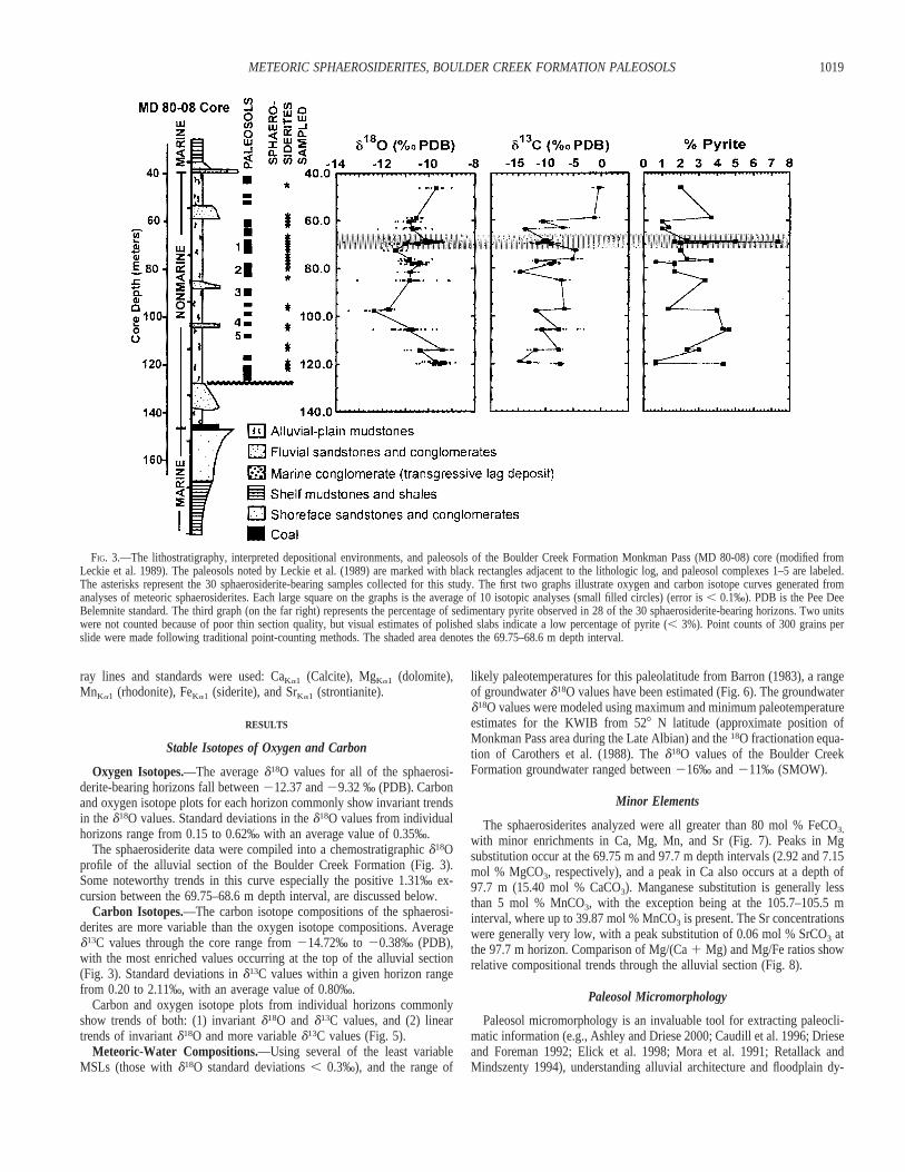
FIG. 3.—The lithostratigraphy, interpreted depositional environments, and paleosols of the Boulder Creek Formation Monkman Pass (MD 80-08) core (modified fromLeckie et al. 1989). The paleosols noted by Leckie et al. (1989) are marked with black rectangles adjacent to the lithologic log, and paleosol complexes 1–5 are labeled.The asterisks represent the 30 sphaerosiderite-bearing samples collected for this study. The first two graphs illustrate oxygen and carbon isotope curves generated fromanalyses of meteoric sphaerosiderites. Each large square on the graphs is the average of 10 isotopic analyses (small filled circles) (error is , 0.1‰). PDB is the Pee DeeBelemnite standard. The third graph (on the far right) represents the percentage of sedimentary pyrite observed in 28 of the 30 sphaerosiderite-bearing horizons. Two unitswere not counted because of poor thin section quality, but visual estimates of polished slabs indicate a low percentage of pyrite (, 3%). Point counts of 300 grains perslide were made following traditional point-counting methods. The shaded area denotes the 69.75–68.6 m depth interval.
ray lines and standards were used: CaKa1 (Calcite), MgKa1 (dolomite),MnKa1 (rhodonite), FeKa1 (siderite), and SrKa1 (strontianite).
RESULTS
Stable Isotopes of Oxygen and Carbon
Oxygen Isotopes.—The average d18O values for all of the sphaerosi-derite-bearing horizons fall between 212.37 and 29.32 ‰ (PDB). Carbonand oxygen isotope plots for each horizon commonly show invariant trendsin the d18O values. Standard deviations in the d18O values from individualhorizons range from 0.15 to 0.62‰ with an average value of 0.35‰.
The sphaerosiderite data were compiled into a chemostratigraphic d18Oprofile of the alluvial section of the Boulder Creek Formation (Fig. 3).Some noteworthy trends in this curve especially the positive 1.31‰ ex-cursion between the 69.75–68.6 m depth interval, are discussed below.
Carbon Isotopes.—The carbon isotope compositions of the sphaerosi-derites are more variable than the oxygen isotope compositions. Averaged13C values through the core range from 214.72‰ to 20.38‰ (PDB),with the most enriched values occurring at the top of the alluvial section(Fig. 3). Standard deviations in d13C values within a given horizon rangefrom 0.20 to 2.11‰, with an average value of 0.80‰.
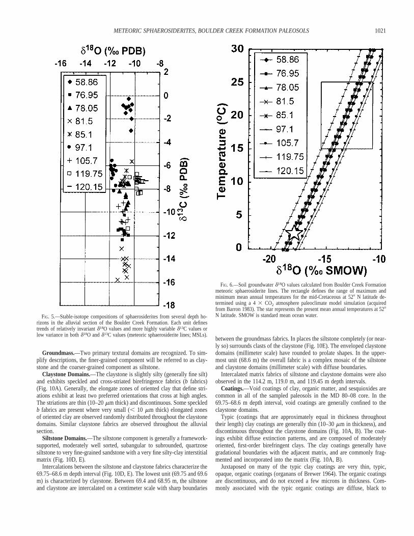
Carbon and oxygen isotope plots from individual horizons commonlyshow trends of both: (1) invariant d18O and d13C values, and (2) lineartrends of invariant d18O and more variable d13C values (Fig. 5).
Meteoric-Water Compositions.—Using several of the least variableMSLs (those with d18O standard deviations , 0.3‰), and the range of
likely paleotemperatures for this paleolatitude from Barron (1983), a rangeof groundwater d18O values have been estimated (Fig. 6). The groundwaterd18O values were modeled using maximum and minimum paleotemperatureestimates for the KWIB from 528 N latitude (approximate position ofMonkman Pass area during the Late Albian) and the 18O fractionation equa-tion of Carothers et al. (1988). The d18O values of the Boulder CreekFormation groundwater ranged between 216‰ and 211‰ (SMOW).
Minor Elements
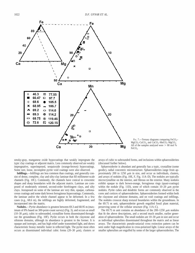
The sphaerosiderites analyzed were all greater than 80 mol % FeCO3,
with minor enrichments in Ca, Mg, Mn, and Sr (Fig. 7). Peaks in Mgsubstitution occur at the 69.75 m and 97.7 m depth intervals (2.92 and 7.15mol % MgCO3, respectively), and a peak in Ca also occurs at a depth of97.7 m (15.40 mol % CaCO3). Manganese substitution is generally lessthan 5 mol % MnCO3, with the exception being at the 105.7–105.5 minterval, where up to 39.87 mol % MnCO3 is present. The Sr concentrationswere generally very low, with a peak substitution of 0.06 mol % SrCO3 atthe 97.7 m horizon. Comparison of Mg/(Ca 1 Mg) and Mg/Fe ratios showrelative compositional trends through the alluvial section (Fig. 8).
Paleosol Micromorphology
Paleosol micromorphology is an invaluable tool for extracting paleocli-matic information (e.g., Ashley and Driese 2000; Caudill et al. 1996; Drieseand Foreman 1992; Elick et al. 1998; Mora et al. 1991; Retallack andMindszenty 1994), understanding alluvial architecture and floodplain dy-

1020 D.F. UFNAR ET AL.
FIG. 4.—Lithologic and pedogenic descriptionof the 67–74 m depth interval (paleosol complex1 of Leckie et al. 1989) of the MD 80-08 core.Refer to Figure 3 for the stratigraphic position ofthis depth interval in the alluvial section of theBoulder Creek Formation. The position of thesamples used to complete the detailedmicromorphological analysis described in thetext are labeled directly adjacent to the graphiclog (boxes with arrows).
namics, and recognizing sequence boundaries (Bestland 1997; Bestland etal. 1997; Driese et al. 1992; Kraus and Aslan 1993; Kraus 1997, 1999;McCarthy and Plint 1998; McCarthy et al. 1997a, 1997b; McCarthy et al.1998a, 1998b; McCarthy et al. 1999a, 1999b; Wright 1994).
Micromorphological characteristics were described for each of the 30sphaerosiderite-bearing units and, aside from the fact that they all containsphaerosiderite, some features were common to all of the examined paleo-sols. In general, all of the units are clay-rich mudstones with quartzose,silt-size framework grains in varying modal abundances, and characterizedby cross-striated birefringence fabrics (sepic plasmic fabrics of Brewer1964). Compound, dense, complete clay and silty-clay infillings and typicclay coatings (argillans of Brewer 1964) with sesquioxide hypocoatings(neo-cutans of Brewer 1964) are common. Often the clay coatings andinfillings exhibit evidence of degradation and reworking. Small, cube-shaped, silt-size pyrite nodules are ubiquitous, and are found as inclusionsin sphaerosiderites, disseminated throughout the matrix, or (less commonly)as pseudomorphs after organic matter. The sphaerosiderites generally occuras either: (1) individuals; (2) linear arrays of nodules; (3) pseudomorphsof root traces, or disseminated organic fragments; or (4) tight clusters wherethe boundaries of individuals have become diffuse.
The oxygen isotope excursion (Fig. 3) generated from the seven closelyspaced, sphaerosiderite-bearing paleosol samples in the 69.75–68.6 m depthinterval (paleosol complex 1 of Leckie et al. 1989) (Figs. 3, 4) prompteda more detailed micromorphological analysis. A brief description of themicromorphological characteristics observed in the 69.75–68.6 m depthinterval is given below.
Root Traces.—Vertical to subvertical, bifurcating, carbonaceous roottraces are observed throughout the paleosol at the macroscale (Fig. 9). Inthin section, numerous, thin (generally less than 10 mm), carbonaceous roottraces are observed, often in association with clay coatings. Commonly,the fine root traces are discontinuous and randomly oriented. At 69.75 m,numerous organic fragments are present; these may represent comminutedorganic matter or oblique slices through prominent root traces.
Mineral Components.—The coarser-grained material generally consistsof moderately well sorted, subangular to subrounded, quartzose (. 90%)siltstone to very fine-grained sandstone. Minor amounts of muscovite, bi-otite, chert, altered feldspar grains, lithic rock fragments, ferruginous ox-ides, and sulfides are also present. The finer-grained material consists of avariety of clay minerals, including kaolinite and mixed-layer clays (Leckieet al. 1989).
1021METEORIC SPHAEROSIDERITES, BOULDER CREEK FORMATION PALEOSOLS
FIG. 5.—Stable-isotope compositions of sphaerosiderites from several depth ho-rizons in the alluvial section of the Boulder Creek Formation. Each unit definestrends of relatively invariant d18O values and more highly variable d13C values orlow variance in both d18O and d13C values (meteoric sphaerosiderite lines; MSLs).
FIG. 6.—Soil groundwater d18O values calculated from Boulder Creek Formationmeteoric sphaerosiderite lines. The rectangle defines the range of maximum andminimum mean annual temperatures for the mid-Cretaceous at 528 N latitude de-termined using a 4 3 CO2 atmosphere paleoclimate model simulation (acquiredfrom Barron 1983). The star represents the present mean annual temperatures at 528N latitude. SMOW is standard mean ocean water.
Groundmass.—Two primary textural domains are recognized. To sim-plify descriptions, the finer-grained component will be referred to as clay-stone and the coarser-grained component as siltstone.
Claystone Domains.—The claystone is slightly silty (generally fine silt)and exhibits speckled and cross-striated birefringence fabrics (b fabrics)(Fig. 10A). Generally, the elongate zones of oriented clay that define stri-ations exhibit at least two preferred orientations that cross at high angles.The striations are thin (10–20 mm thick) and discontinuous. Some speckledb fabrics are present where very small (, 10 mm thick) elongated zonesof oriented clay are observed randomly distributed throughout the claystonedomains. Similar claystone fabrics are observed throughout the alluvialsection.
Siltstone Domains.—The siltstone component is generally a framework-supported, moderately well sorted, subangular to subrounded, quartzosesiltstone to very fine-grained sandstone with a very fine silty-clay interstitialmatrix (Fig. 10D, E).
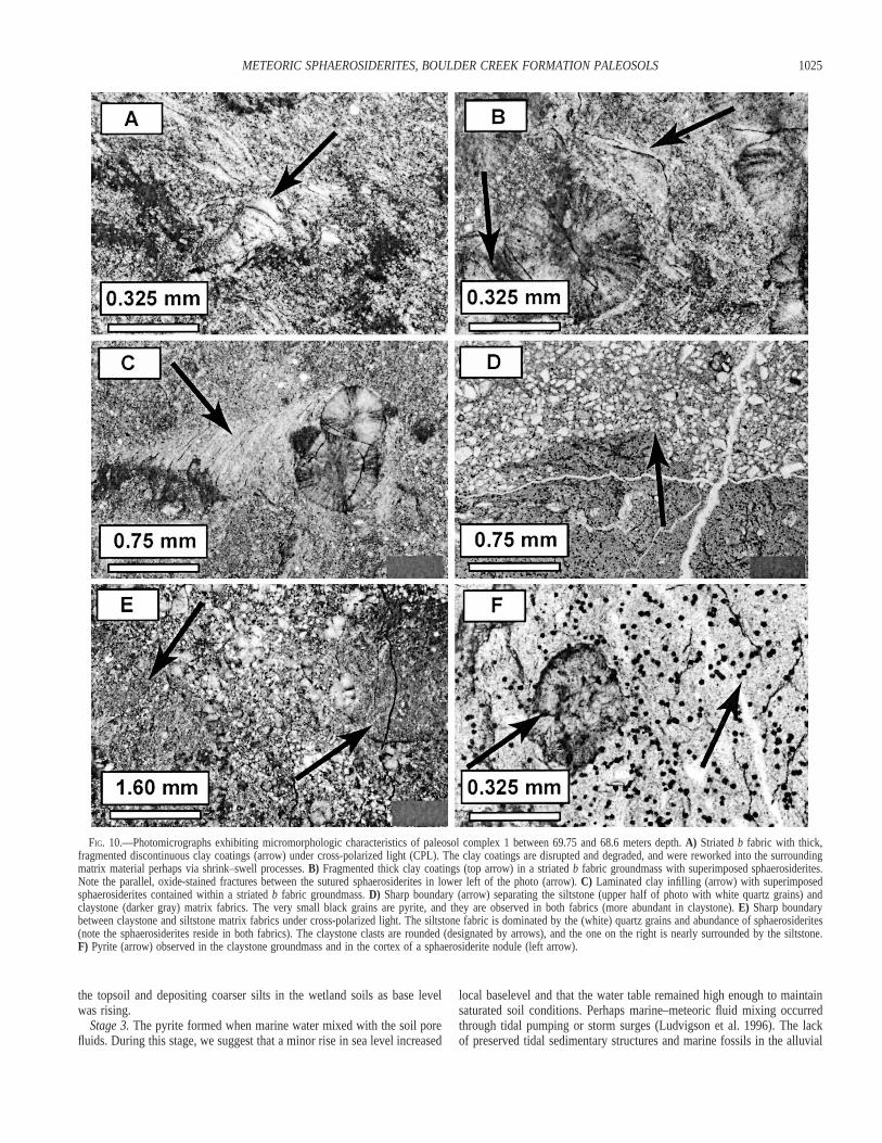
Intercalations between the siltstone and claystone fabrics characterize the69.75–68.6 m depth interval (Fig. 10D, E). The lowest unit (69.75 and 69.6m) is characterized by claystone. Between 69.4 and 68.95 m, the siltstoneand claystone are intercalated on a centimeter scale with sharp boundaries
between the groundmass fabrics. In places the siltstone completely (or near-ly so) surrounds clasts of the claystone (Fig. 10E). The enveloped claystonedomains (millimeter scale) have rounded to prolate shapes. In the upper-most unit (68.6 m) the overall fabric is a complex mosaic of the siltstoneand claystone domains (millimeter scale) with diffuse boundaries.
Intercalated matrix fabrics of siltstone and claystone domains were alsoobserved in the 114.2 m, 119.0 m, and 119.45 m depth intervals.
Coatings.—Void coatings of clay, organic matter, and sesquioxides arecommon in all of the sampled paleosols in the MD 80–08 core. In the69.75–68.6 m depth interval, void coatings are generally confined to theclaystone domains.
Typic (coatings that are approximately equal in thickness throughouttheir length) clay coatings are generally thin (10–30 mm in thickness), anddiscontinuous throughout the claystone domains (Fig. 10A, B). The coat-ings exhibit diffuse extinction patterns, and are composed of moderatelyoriented, first-order birefringent clays. The clay coatings generally havegradational boundaries with the adjacent matrix, and are commonly frag-mented and incorporated into the matrix (Fig. 10A, B).
Juxtaposed on many of the typic clay coatings are very thin, typic,opaque, organic coatings (organans of Brewer 1964). The organic coatingsare discontinuous, and do not exceed a few microns in thickness. Com-monly associated with the typic organic coatings are diffuse, black to
1022 D.F. UFNAR ET AL.
FIG. 7.—Ternary diagrams comparing FeCO3–MgCO3–CaCO3, and CaCO3–MnCO3–MgCO3.All of the samples analyzed were . 80 mol %FeCO3.
smoky-gray, manganese oxide hypocoatings that weakly impregnate thetypic clay coatings or adjacent matrix. Less commonly observed are weaklyimpregnative, superimposed, sesquioxide (orange-brown) hypocoatings.Some rare, loose, incomplete pyrite void coatings were also observed.
Infillings.—Infillings are less common than coatings, and generally con-sist of dense, complete, clay and silty-clay laminae that fill millimeter-scalechannels (Fig. 10C). Commonly, the channels have conical to crescenticshapes and sharp boundaries with the adjacent matrix. Laminae are com-posed of moderately oriented, second-order birefringent clays, and siltyclays. Juxtaposed on some of the laminae are very thin, opaque, carbona-ceous coatings and some dark brown ferruginous hypocoatings. Commonly,the laminae and/or the whole channel appear to be deformed. In a fewcases (e.g., 68.6 m), the infillings are highly deformed, fragmented, andincorporated into the matrix.
Nodules.—Pyrite abundance is greatest between 69.3 and 68.95 m (max-imum of 8% based on 300-point-count survey) (Fig. 3), and occurs as small(10–30 mm), cubic to subrounded, crystalline forms disseminated through-out the groundmass (Fig. 10F). Pyrite occurs in both the claystone andsiltstone domains, although its abundance is greatest in the former. It isopaque and isotropic, and has high relief under transmitted light, and showscharacteristic brassy metallic luster in reflected light. The pyrite most oftenoccurs as disseminated individual cubic forms (20–30 mm), clusters or
arrays of cubic to subrounded forms, and inclusions within sphaerosiderites(discussed further below).
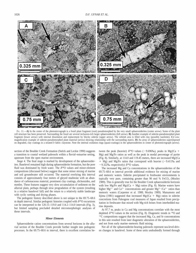
Sphaerosiderite is abundant and generally has a typic, crystalline (somegeodic), radial concentric microstructure. Sphaerosiderites range from ap-proximately 200 to 1250 mm in size, and occur as individuals, clusters,and arrays of nodules (Fig. 10E, F, Fig. 11A–D). The nodules are typicallymicrocrystalline on the interior, and fibrous on the exterior. Many nodulesexhibit opaque to dark brown-orange, ferruginous rings (quasi-coatings)within the nodule (Fig. 11D), some of which contain 10–20 mm pyritenodules. Pyrite cubes and dendritic forms are commonly observed in thecores and cortices of sphaerosiderites. Sphaerosiderites formed within boththe claystone and siltstone domains, and on void coatings and infillings.The nodules crosscut sharp textural boundaries within the groundmass. Inthe 69.75 m unit, sphaerosiderite growth engulfed fossil plant material,preserving some of the cellular structure (Fig. 11A–C).
The 69.75 m unit contains an abundance of the 200–1250 mm nodulesthat fit the above descriptions, and a second much smaller, earlier gener-ation of sphaerosiderite. The small nodules are 10–30 mm in size and occuras individual spherulites disseminated throughout the matrix and as lineararrays. The characteristic pseudo-uniaxial cross extinction pattern can beseen under high magnification in cross-polarized light. Linear arrays of thesmaller spherulites are engulfed by some of the larger sphaerosiderites. The

1023METEORIC SPHAEROSIDERITES, BOULDER CREEK FORMATION PALEOSOLS
FIG. 8.—Graphs illustrating the stratigraphic distribution of Mg, Ca, and Fe cation ratios in the 16 analyzed sphaerosiderite-bearing horizons. Note the correlation betweenthe positive d18O excursion between 68 and 70 m and the peaks in Mg/(Ca 1 Mg) and Mg/Fe ratios (shaded rectangle).
smaller nodules also nucleated on fossil plant material (roots) and are typ-ically succeeded by overgrowths of larger sphaerosiderites (Fig. 11A–C).
DISCUSSION
Oxygen Isotopes
The d18O values for all of the MD 80-08 sphaerosiderites (average forall horizons 5 210.4‰ PDB) suggest formation in meteoric phreaticgroundwaters recharged by local precipitation. Significantly more depletedcompositions would be expected if the soil water had been recharged byregional runoff from alpine meltwaters in the adjacent Cordillera (Dettmanand Lohmann 2000; Glancy et al. 1993; Bloch 1990; Carpenter et al. 1988).Furthermore, the pervasive gleyed character of the paleosols suggests thatevaporative enrichment of 18O in the soil groundwater was negligible.
The chemostratigraphic excursions toward heavier d18O values may bea consequence of marine and meteoric water mixing. If marine d18O valueswere approximately 21 to 21.2‰ (SMOW) (Shackleton and Kennett1975), infiltration and mixing of marine water with the soil (meteoric) watershould increase d18O values in proportion to the degree of mixing. Sub-sequently, siderite precipitated from mixed fluids would have heavier d18Ovalues.
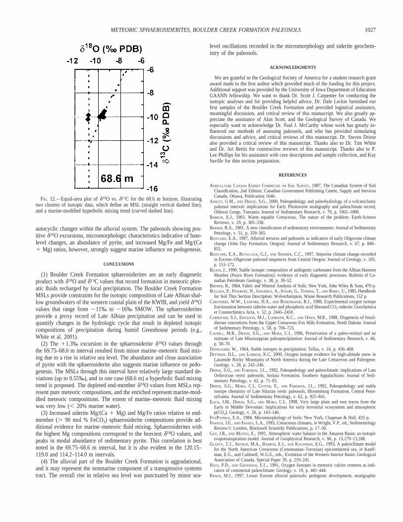
Within individual sphaerosiderite-bearing units, mixing of two or morediagenetic fluids should have resulted in hyperbolic trends of d18O andd13C values varying between meteoric and marine end-member composi-tions (e.g., Carpenter et al. 1988; Lohmann 1988). The isotopic composi-tions of sphaerosiderites from the 69.75–68.6 m interval generally do notexhibit hyperbolic compositional trends, with one exception at 68.6 m. Thisunit has two distinct clusters of data that can be fitted to a hyperbolicmixing curve (Fig. 12). As discussed below, this unit also records a highMg/(Ca 1 Mg) ratio. The enriched d18O cluster represents sphaerosideritesprecipitated from meteoric compositions modified by marine fluid mixing,and the depleted d18O cluster is interpreted to represent pure meteoric com-
positions (Fig. 12). Our calculations show that the percentage of seawatermixing was less than 20%.
The remaining units in the 69.75–68.6 m interval have somewhat poorlydefined MSLs with d18O standard deviations ranging from 0.2 to 0.55‰.Although hyperbolic fluid mixing trends are not evident in these units, thelightest end-member compositions probably represent pure meteoric com-positions and the heavier values represent marine-modified meteoric com-positions.
The sphaerosiderite isotopic compositions alone do not justify precipi-tation from marine-modified meteoric fluids. Many other factors, such aschanges in temperature, regional water balance (evaporation and precipi-tation fluxes), source water isotopic compositions, and precipitation amounteffects could account for the temporal variability in the d18O compositions(Dansgaard 1964; Gat and Matsui 1991; Rozanski et al. 1993). These fac-tors may have contributed to the trends in d18O values, but the paleosolmicromorphology and sphaerosiderite minor-element chemistries discussedbelow strongly suggest that marine fluids affected the siderite d18O com-positions.
Paleosol Micromorphology (69.75–68.6 m)
Paleosol micromorphology was used to further interpret the oxygen iso-tope excursion between the 69.75 and 68.6 m depth interval that recordsan enrichment of approximately 1.31‰ (Fig. 3). The micromorphologicalfeatures in this interval contain an archive of pedogenic changes forced bychanges in base level.
The presence of compound clay coatings in the claystone fabric suggeststhat illuviation was a significant pedogenic process in this interval. Themicrolaminated coatings developed by eluviation from overlying soil ho-rizons and progressive translocation and deposition of clay-size particles inlower horizons (FitzPatrick 1984; McCarthy and Plint 1998; McCarthy etal. 1998b). The presence and abundance of clay coatings indicates that thesoil was well drained for some time (McCarthy et al. 1999b). Fragmenta-

1024 D.F. UFNAR ET AL.
FIG. 9.—Cartoon illustrating the generalized pedogenic features and fabrics ob-served in the 69.75–68.6 meter depth interval of the MD 80-08 core. The stagesrepresent the polygenetic pedogenic history and corresponding relative baselevelchanges associated with development of this portion of the paleosol complex. Ingeneral, pedogenesis was influenced by: (Stage 1) a stable phase characterized byepisodic wetting and drying, fluctuating water table, and relatively low baselevel;(Stage 2) a rise of baselevel, erosion of soil material, and deposition of coarsersediment; (Stage 3) high baselevel, saturated (reducing redox) conditions, and mix-ing of marine and meteoric fluids, pyrite precipitation; (Stage 4) high baselevel,saturated soils, reducing redox conditions, sphaerosiderite precipitation.
tion, discontinuous grainy extinction patterns, and assimilation of coatingsinto the surrounding matrix suggests prolonged landscape stability. Thesefeatures reflect extensive shrink–swell reorganization of the soil and bio-turbation (FitzPatrick 1984; McCarthy et al. 1998b; McCarthy et al. 1999a).Leckie et al. (1989) also noted extensive reorganization of the paleosolmaterials and translocation of clays. The striated b fabric prevalent in theclaystone further substantiates shrink–swell reorganization of the soil dur-ing wetting–drying cycles (McCarthy and Plint 1998). The ferruginous hy-pocoatings may also reflect wet–dry cycles, and they further suggest somefluctuations in redox conditions (McCarthy et al. 1998b). The very thin,opaque carbonaceous coatings are fossil root fibers. Degraded argillaceouscoatings and infillings are not unique to the 69.75–68.6 m depth interval;they are found in nearly all of the sampled paleosols of the MD 80-08core.
The distinct textural change (also identified by Leckie et al. 1989) (Fig.10D) and siltstone–claystone intercalations noted in the 69.3–69.4 m unitmay reflect an episode(s) of erosion and flood deposition on the alluvialplain (McCarthy and Plint 1998). The rounded domains of claystone en-veloped in siltstone are intraclasts ripped up directly from the subjacentclay-rich paleosol horizon. The claystone clasts were unlithified, cohesiveunits as shown by the overprinting of pyrite and sphaerosiderite nodules.The intercalated siltstone and claystone units have sharp boundaries in thelower parts of the pedocomplex, but they become increasingly more ho-mogenized upsection. Fabric trends suggest that deposition of the siltstonewas preceded by periods of floodplain erosion. Claystone intraclasts were
eroded from the underlying material, yet sustained little transport and re-working. The paleosol was at least 80 cm thick, and postdepositional mix-ing seems to have been most prevalent in the upper 40 cm of the soil,where textural domains were homogenized by bioturbation and/or shrink–swell processes (68.6 m).
The ubiquitous, well-developed sphaerosiderites indicate that the pedo-complex was at times a poorly drained, hydromorphic soil (McCarthy andPlint 1999). Sphaerosiderites crosscut matrix fabrics as well as coatingsand infillings, thus they formed later. The very small (10–30 mm) spher-ulites observed in the 69.75 m unit, however, are an exception. Thesenodules were overprinted by the larger spherulites, and they represent anearlier stage of hydromorphism.
The internal oxidation rings within some sphaerosiderites suggest periodsof improved drainage due to water table fluctuations, or perhaps influxesof oxygenated fluid (McCarthy and Plint 1998). The presence of oxidationrings (quasicoatings) in some sphaerosiderites but not others implies rela-tive age differences between nodules. The oxidation rings may representbrief hiatuses in siderite precipitation, or multiple stages of developmentas suggested by Leckie et al. (1989). The presence of very small (, 10mm) pyrite inclusions lining some ferruginous quasi-coatings suggests thatsulfate-rich waters (marine) episodically infiltrated the soils (Wright 1986).
The pyrite present in the pedocomplex may have been derived fromweathered parent material, but it is much more likely that it formed in situ(FitzPatrick 1984). Pyrite is observed within many siderite nodules, sug-gesting that the sphaerosiderites formed later, engulfing matrix pyrite asthey precipitated.
Precipitation of siderite and pyrite may have oscillated with the produc-tion of H2S by sulfate-reducing bacteria in the soil water. There was anabundance of both iron and organic matter available in the system, thussulfate availability was likely the limiting factor on the formation of pyriteover siderite (Carpenter et al. 1988). Alternatively, siderite may have fol-lowed pyrite after all available sulfate was reduced, leading to methano-genesis (Berner 1981; Pye et al. 1990). If methane oxidation had been animportant process, the d13C values in this interval should be very depleted(220 to 260‰ PDB). The values obtained, however, are well within therange of organic-matter degradation (Fig. 3) (Pye et al. 1990). The presenceand abundance of pyrite suggests that marine fluids episodically infiltratedthe paleosols (Wright 1986), and this process occurred with enough fre-quency and duration to result in extensive pyrite precipitation.
Pedocomplex History.—Micromorphological analysis of the sphaero-siderite-bearing units in pedocomplex I of Leckie et al. (1989) suggests afour-stage polygenetic development (Fig. 9).
Stage 1. Initially, the alluvial plain was characterized by a stable land-scape with a fluctuating water table. This is shown by the well developedyet heavily degraded clay coatings present in the claystone matrix. The soilwent through wet–dry cycles that disturbed and reworked coatings andinfillings into the matrix. The striated b fabrics, and prominent illuvial claycoatings and infillings agree well with the Bt & Bm (Bw) soil horizondesignations of Leckie et al. (1989). Baselevel during this stage in the soildevelopment is interpreted to have been relatively low, prompting im-proved drainage of the soil during drier cycles. Occasional flooding ofnearby fluvial channels may have provided a source of suspended-load clayparticles, which subsequently were translocated through the soil profile.
Stage 2. An abrupt upward change in matrix fabric and the presence ofclaystone rip-up clasts at this boundary suggests erosion and subsequentdeposition of coarser-grained material on the floodplain. Anastomosing sys-tems are characterized by inhibited migration of fluvial channels, and apredominance of overbank deposits (e.g., levees, wetlands, and crevassesplays) (Smith and Smith 1980). Crevassing may lead to the developmentof new channels, and maintains dynamic anastomosing fluvial systems un-der conditions of rapid aggradation, and rising baselevel (Smith and Smith1980). Perhaps crevassing provided the mechanism for removing some of
1025METEORIC SPHAEROSIDERITES, BOULDER CREEK FORMATION PALEOSOLS
FIG. 10.—Photomicrographs exhibiting micromorphologic characteristics of paleosol complex 1 between 69.75 and 68.6 meters depth. A) Striated b fabric with thick,fragmented discontinuous clay coatings (arrow) under cross-polarized light (CPL). The clay coatings are disrupted and degraded, and were reworked into the surroundingmatrix material perhaps via shrink–swell processes. B) Fragmented thick clay coatings (top arrow) in a striated b fabric groundmass with superimposed sphaerosiderites.Note the parallel, oxide-stained fractures between the sutured sphaerosiderites in lower left of the photo (arrow). C) Laminated clay infilling (arrow) with superimposedsphaerosiderites contained within a striated b fabric groundmass. D) Sharp boundary (arrow) separating the siltstone (upper half of photo with white quartz grains) andclaystone (darker gray) matrix fabrics. The very small black grains are pyrite, and they are observed in both fabrics (more abundant in claystone). E) Sharp boundarybetween claystone and siltstone matrix fabrics under cross-polarized light. The siltstone fabric is dominated by the (white) quartz grains and abundance of sphaerosiderites(note the sphaerosiderites reside in both fabrics). The claystone clasts are rounded (designated by arrows), and the one on the right is nearly surrounded by the siltstone.F) Pyrite (arrow) observed in the claystone groundmass and in the cortex of a sphaerosiderite nodule (left arrow).
the topsoil and depositing coarser silts in the wetland soils as base levelwas rising.
Stage 3. The pyrite formed when marine water mixed with the soil porefluids. During this stage, we suggest that a minor rise in sea level increased
local baselevel and that the water table remained high enough to maintainsaturated soil conditions. Perhaps marine–meteoric fluid mixing occurredthrough tidal pumping or storm surges (Ludvigson et al. 1996). The lackof preserved tidal sedimentary structures and marine fossils in the alluvial
1026 D.F. UFNAR ET AL.
FIG. 11.—A) In the center of the photomicrograph is a fossil plant fragment (root) pseudomorphed by the very small sphaerosiderites (center arrow). Some of the plantcell structure has been preserved. Surrounding the fossil are several inclusion-rich larger sphaerosiderites (left arrow). B) Another example of siderite-pseudomorphed plantfragment (lower arrow) with internal dissolution and replacement by blocky siderite (upper arrow). The whitish area is filled with clay (possibly kaolinite). C) Low-magnification example of siderite-pseudomorphed plant material (arrow) showing relationship with the surrounding matrix. D) An array of sphaerosiderites superimposedon degraded, clay coatings in a striated b fabric claystone. Note the internal oxidation rings (quasi-coatings) in the sphaerosiderites in center of photomicrograph (arrow).
section of the Boulder Creek Formation (Stelck and Leckie 1990) suggestsa transition to coastal wetland paleosols within a fluvial–estuarine setting,upstream from the open marine environment.
Stage 4. The final stage is marked by development of the sphaerosider-ites. Baselevel remained high during sphaerosiderite formation, but the porefluid was dominated by fresh water. The d18O values and minor-elementcompositions (discussed below) suggest that some minor mixing of marineand soil groundwater still occurred. The material overlying this intervalconsists of approximately four meters of gleyed mudstone with an abun-dance of carbonaceous material, prominent clay coatings, slickensides, andmottles. These features suggest very slow accumulation of sediment on thealluvial plain, perhaps through slow progradation of the system (resultingin a relative baselevel fall) and the return to a relatively stable landscapewith cyclic wetting and drying phases.
The pedogenic history described above is not unique to the 69.75–68.6m depth interval. Similar pedogenic histories coupled with d18O excursionscan be interpreted in the 120.15–119.0 and 114.2–114.0 intervals (Fig. 3),but limited sampling precluded detailed micromorphologic analyses ofthose intervals.
Minor Elements
Sphaerosiderite cation concentrations from several horizons in the allu-vial section of the Boulder Creek provide further insight into pedogenicprocesses. In the 69.75–68.6 m interval, there is excellent correlation be-
tween the peak (heavier) d18O values (29.696‰), peaks in Mg/(Ca 1Mg) and Mg/Fe ratios as well as the peak in modal percentage of pyrite(Fig. 8). Similarly, at 114.0 and 119.45 meters, there are increased Mg/(Ca1 Mg) and Mg/Fe ratios that correspond with heavier (29.411‰ and29.322‰ respectively) d18O values.
The increased Mg and Ca concentrations in the sphaerosiderites of the69.75–68.6 m interval provide additional evidence for mixing of marineand meteoric waters. Siderite precipitated in freshwater environments istypically very pure, containing greater than 90 mol % FeCO3 (Mozley1989). This is generally true for the Boulder Creek sphaerosiderite horizonswith low Mg/Fe and Mg/(Ca 1 Mg) ratios (Fig. 8). Marine waters havehigher Mg21 and Ca21 concentrations and greater Mg21 /Ca21 ratios thanmeteoric waters (Carpenter et al. 1988; Mozley 1989). Matsumoto andIijima (1981) suggested that increased Mg/(Ca 1 Mg) ratios in sideriteconcretions from Paleogene coal measures of Japan resulted from precip-itation in freshwater that mixed with Mg-rich brines from interbedded ma-rine deposits.
At 97.7 m, peaks in Ca and Mg concentrations correlate with the mostdepleted d18O values in the section (Fig. 8). Diagenetic trends in 18O and13C compositions suggest that the increased Mg, Ca, and Sr concentrationsin this unit resulted from later diagenetic alteration of the sphaerosiderites,and not from early marine–meteoric fluid mixing.
Not all of the sphaerosiderite-bearing paleosols represent sea-level-driv-en changes in baselevel. Some of these units undoubtedly formed through
1027METEORIC SPHAEROSIDERITES, BOULDER CREEK FORMATION PALEOSOLS
FIG. 12.—Equal-area plot of d18O vs. d13C for the 68.6 m horizon, illustratingtwo clusters of isotopic data, which define an MSL (straight vertical dashed line),and a marine-modified hyperbolic mixing trend (curved dashed line).
autocyclic changes within the alluvial system. The paleosols showing pos-itive d18O excursions, micromorphologic characteristics indicative of base-level changes, an abundance of pyrite, and increased Mg/Fe and Mg/(Ca1 Mg) ratios, however, strongly suggest marine influence on pedogenesis.
CONCLUSIONS
(1) Boulder Creek Formation sphaerosiderites are an early diageneticproduct with d18O and d13C values that record formation in meteoric phre-atic fluids recharged by local precipitation. The Boulder Creek FormationMSLs provide constraints for the isotopic composition of Late Albian shal-low groundwaters of the western coastal plain of the KWIB, and yield d18Ovalues that range from 211‰ to 216‰ SMOW. The sphaerosideritesprovide a proxy record of Late Albian precipitation and can be used toquantify changes in the hydrologic cycle that result in depleted isotopiccompositions of precipitation during humid Greenhouse periods (e.g.,White et al. 2001).
(2) The 11.3‰ excursion in the sphaerosiderite d18O values throughthe 69.75–68.6 m interval resulted from minor marine–meteoric fluid mix-ing due to a rise in relative sea level. The abundance and close associationof pyrite with the sphaerosiderite also suggests marine influence on pedo-genesis. The MSLs through this interval have relatively large standard de-viations (up to 0.55‰), and in one case (68.6 m) a hyperbolic fluid mixingtrend is proposed. The depleted end-member d18O values from MSLs rep-resent pure meteoric compositions, and the enriched represent marine-mod-ified meteoric compositions. The extent of marine–meteoric fluid mixingwas very low (, 20% marine water).
(3) Increased siderite Mg/(Ca 1 Mg) and Mg/Fe ratios relative to end-member (. 90 mol % FeCO3) sphaerosiderite compositions provide ad-ditional evidence for marine–meteoric fluid mixing. Sphaerosiderites withthe highest Mg compositions correspond to the heaviest d18O values, andpeaks in modal abundance of sedimentary pyrite. This correlation is bestnoted in the 69.75–68.6 m interval, but it is also evident in the 120.15–119.0 and 114.2–114.0 m intervals.
(4) The alluvial part of the Boulder Creek Formation is aggradational,and it may represent the nonmarine component of a transgressive systemstract. The overall rise in relative sea level was punctuated by minor sea-
level oscillations recorded in the micromorphology and siderite geochem-istry of the paleosols.
ACKNOWLEDGMENTS
We are grateful to the Geological Society of America for a student research grantaward made to the first author which provided much of the funding for this project.Additional support was provided by the University of Iowa Department of EducationGAANN fellowship. We want to thank Dr. Scott J. Carpenter for conducting theisotopic analyses and for providing helpful advice. Dr. Dale Leckie furnished ourfirst samples of the Boulder Creek Formation and provided logistical assistance,meaningful discussion, and critical review of this manuscript. We also greatly ap-preciate the assistance of Alan Scott, and the Geological Survey of Canada. Weespecially want to acknowledge Dr. Paul J. McCarthy whose work has greatly in-fluenced our methods of assessing paleosols, and who has provided stimulatingdiscussions and advice, and critical reviews of this manuscript. Dr. Steven Driesealso provided a critical review of this manuscript. Thanks also to Dr. Tim Whiteand Dr. Art Bettis for constructive reviews of this manuscript. Thanks also to P.Lee Phillips for his assistance with core descriptions and sample collection, and KaySaville for thin section preparation.
REFERENCES
AGRICULTURE CANADA EXPERT COMMITTEE ON SOIL SURVEY, 1987, The Canadian System of SoilClassification, 2nd Edition: Canadian Government Publishing Centre, Supply and ServicesCanada, Ottawa, Publication 1646.
ASHLEY, G.M., AND DRIESE, S.G., 2000, Paleopedology and paleohydrology of a volcaniclasticpaleosol interval: implications for Early Pleistocene stratigraphy and paleoclimate record,Olduvai Gorge, Tanzania: Journal of Sedimentary Research, v. 70, p. 1065–1080.
BARRON, E.J., 1983, Warm equable Cretaceous, The nature of the problem: Earth-ScienceReviews, v. 19, p. 305–338.
BERNER, R.A., 1981, A new classification of sedimentary environments: Journal of SedimentaryPetrology, v. 51, p. 359–365.
BESTLAND, E.A., 1997, Alluvial terraces and paleosols as indicators of early Oligocene climatechange (John Day Formation, Oregon): Journal of Sedimentary Research, v. 67, p. 840–855.
BESTLAND, E.A., RETALLACK, G.J., AND SWISHER, C.C., 1997, Stepwise climate change recordedin Eocene–Oligocene paleosol sequences from Central Oregon: Journal of Geology, v. 105,p. 153–172.
BLOCH, J., 1990, Stable isotopic composition of authigenic carbonates from the Albian HarmonMember (Peace River Formation): evidence of early diagenetic processes: Bulletin of Ca-nadian Petroleum Geology, v. 38, p. 39–52.
BREWER, R., 1964, Fabric and Mineral Analysis of Soils: New York, John Wiley & Sons, 470 p.BULLOCK, P., FEDOROFF, N., JONGERIUS, A., STOOPS, G., TURSINA, T., AND BABEL, U., 1985, Handbook
for Soil Thin Section Description: Wolverhampton, Waine Research Publications, 152 p.CAROTHERS, W.W., LANFORD, H.A., AND ROSENBAUER, R.J., 1988, Experimental oxygen isotope
fractionation between siderite-water and phosphoric acid liberated CO2-siderite: Geochemicaet Cosmochimica Acta, v. 52, p. 2445–2450.
CARPENTER, S.J., ERICKSON, M.J., LOHMANN, K.C., AND OWEN, M.R., 1988, Diagenesis of fossil-iferous concretions from the Upper Cretaceous Fox Hills Formation, North Dakota: Journalof Sedimentary Petrology, v. 58, p. 706–723.
CAUDILL, M.R., DRIESE, S.G., AND MORA, C.I., 1996, Preservation of a paleo-vertisol and anestimate of Late Mississippian paleoprecipitation: Journal of Sedimentary Research, v. 66,p. 58–70.
DANSGAARD, W., 1964, Stable isotopes in precipitation: Tellus, v. 16, p. 436–468.DETTMAN, D.L., AND LOHMAN, K.C, 2000, Oxygen isotope evidence for high-altitude snow in
Laramide Rocky Mountains of North America during the Late Cretaceous and Paleogene:Geology, v. 28, p. 243–246.
DRIESE, S.G., AND FOREMAN, J.L., 1992, Paleopedology and paleoclimatic implications of LateOrdovician vertic paleosols, Juniata Formation, Southern Appalachians: Journal of Sedi-mentary Petrology, v. 62, p. 71–83.
DRIESE, S.G., MORA, C.I., COTTER, E., AND FOREMAN, J.L., 1992, Paleopedology and stableisotope chemistry of Late Silurian vertic paleosols, Bloomsburg Formation, Central Penn-sylvania: Journal of Sedimentary Petrology, v. 62, p. 825–841.
ELICK, J.M., DRIESE, S.G., AND MORA, C.I., 1998, Very large plant and root traces from theEarly to Middle Devonian: Implications for early terrestrial ecosystems and atmosphericp(CO2): Geology, v. 26, p. 143–146.
FITZPATRICK, E.A., 1984, Micromorphology of Soils: New York, Chapman & Hall, 433 p.FRANCIS, J.E., AND FRAKES, L.A., 1993, Cretaceous climates, in Wright, V.P., ed., Sedimentology
Review/1: London, Blackwell Scientific Publications, p. 17–30.GAT, J.R., AND MATSUI, E., 1991, Atmospheric water balance in the Amazon Basin: an isotopic
evapotranspiration model: Journal of Geophysical Research, v. 96, p. 13,179–13,188.GLANCY, T.J., ARTHUR, M.A., BARRON, E.J., AND KAUFFMAN, E.G., 1993, A paleoclimate model
for the North American Cretaceous (Cenomanian–Turonian) epicontinental sea, in Kauff-man, E.G., and Caldwell, W.G.E., eds., Evolution of the Western Interior Basin: GeologicalAssociation of Canada, Special Paper 39, p. 219–241.
HAYS, P.D., AND GROSSMAN, E.L., 1991, Oxygen Isotopes in meteoric calcite cements as indi-cators of continental paleoclimate: Geology, v. 19, p. 441–444.
KRAUS, M.J., 1997, Lower Eocene alluvial paleosols: pedogenic development, stratigraphic
1028 D.F. UFNAR ET AL.
relationships, and paleosol/landscape associations: Palaeogeography, Palaeoclimatology, Pa-laeoecology, v. 129, p. 387–406.
KRAUS, M.J., 1999, Paleosols in clastic sedimentary rocks: their geologic applications: Earth-Science Reviews, v. 47, p. 41–70.
KRAUS, M.J., AND ASLAN, A., 1993, Eocene hydromorphic paleosols: significance for interpret-ing ancient floodplain processes: Journal of Sedimentary Petrology, v. 63, p. 453–463.
LECKIE, D.A., AND FOSCOLOS, A.E., 1986, Paleosols and Late Albian sea level fluctuations:preliminary observations from the northeastern British Columbia foothills: Geological Sur-vey of Canada, Paper 86-1B, Current Research, Part B, p. 429–441.
LECKIE, D.A., FOX, C., AND TARNOCAI, C., 1989, Multiple paleosols of the Late Albian BoulderCreek Formation, British Columbia, Canada: Sedimentology, v. 36, p. 307–323.
LECKIE, D.A., AND REINSON, G.E., 1993, Effects of Middle to Late Albian sea-level fluctuationsin the Cretaceous Interior Seaway, western Canada, in Caldwell, W.G.E., and Kauffman,E.G., eds., Evolution of the Western Interior Basin: Geological Association of Canada,Special Paper 39, p. 151–176.
LECKIE, D.A., AND SMITH, D.G., 1992, Regional setting, evolution, and depositional cycles ofthe western Canada Foreland Basin, in Macqueen, R.W., and Leckie, D.A. eds., ForelandBasins and Fold Belts: American Association of Petroleum Geologists, Memoir 55, p. 9–46.
LOHMANN, K.C., 1988, Geochemical patterns of meteoric diagenetic systems and their appli-cation to studies of paleokarst, in James, N.P., and Choquette, P.W., eds., Paleokarst: Berlin,Springer-Verlag, p. 58–80.
LUDVIGSON, G.A., GONZALEZ, L.A., METZGER, R.A., WITZKE, B.J., AND BRENNER, R.L., 1996,Diagenesis of iron minerals in the Dakota Formation, in Witzke, B.J., and Ludvigson, G.A.,eds., Mid-Cretaceous Fluvial Deposits of the Eastern Margin, Western Interior Basin: Nishn-abotna Member, Dakota Formation. A Field Guide to the Cretaceous of Guthrie County:Iowa Department of Natural Resources, Energy and Geological Resources Division, Geo-logical Survey Bureau, Guidebook, Series no. 17, p. 31–38.
LUDVIGSON, G.A., GONZALEZ, L.A., METZGER, R.A., WITZKE, B.J., BRENNER, R.L., MURILLO, A.P.,AND WHITE, T.S., 1998, Meteoric sphaerosiderite lines and their use for paleohydrology andpaleoclimatology: Geology, v. 26, p. 1039–1042.
MATSUMOTO, R., AND IIJIMA, A., 1981, Origin and diagenetic evolution of Ca–Mg–Fe carbonatesin some coalfields of Japan: Sedimentology, v. 28, p. 239–259.
MCCARTHY, P.J., FACCINI, U., AND PLINT, A.G., 1999b, Evolution of an ancient coastal plain:paleosols, interfluves and alluvial architecture in a sequence stratigraphic framework, Cen-omanian Dunvegan Formation, NE British Columbia, Canada: Sedimentology, v. 46, p. 861–892.
MCCARTHY, P.J., MARTINI, I.P., AND LECKIE, D.A., 1997a, Pedosedimentary history and flood-plain dynamics of the Lower Cretaceous upper Blairmore Group, southwestern Alberta,Canada: Canadian Journal of Earth Sciences, v. 34, p. 598–617.
MCCARTHY, P.J., MARTINI, I.P., AND LECKIE, D.A., 1997b, Anatomy and evolution of a LowerCretaceous alluvial plain: sedimentology and paleosols in the upper Blairmore Group, south-western Alberta, Canada: Sedimentology, v. 44, p. 197–220.
MCCARTHY, P.J., MARTINI, I.P., AND LECKIE, D.A., 1998a, Use of micromorphology for pa-laeoenvironmental interpretation of complex alluvial palaeosols: an example from the MillCreek Formation (Albian), southwestern Alberta, Canada: Palaeogeography, Palaeoclima-tology, Palaeoecology, v. 143, p. 87–110.
MCCARTHY, P.J., MARTINI, I.P., AND LECKIE, D.A., 1999a, Pedogenic and diagenetic influenceson void coating formation in Lower Cretaceous paleosols of the Mill Creek Formation,southwestern Alberta, Canada: Geoderma, v. 87, p. 209–237.
MCCARTHY, P.J., MARTINI, I.P., AND LECKIE, D.A., 1998b, Pedogenic and diagenetic influences
on void coating formation in Lower Cretaceous paleosols of the Mill Creek Formation,southwestern Alberta, Canada: Geoderma, v. 87, p. 209–237.
MCCARTHY, P.J., AND PLINT, A.G., 1998, Recognition of interfluve sequence boundaries: Inte-grating paleopedology and sequence stratigraphy: Geology, v. 26, no. 5, p. 387–390.
MCCARTHY, P.J., AND PLINT, A.G., 1999, Floodplain paleosols of the Cenomanian DunveganFormation, Alberta and British Columbia, Canada: Micromorphology, pedogenic processes,and paleoenvironmental implications, in Marriott, S.B. and Alexander, J., eds., Floodplains:Interdisciplinary Approaches: Geological Society of America, Special Paper 163, p. 289–310.
MORA, C.I., DRIESE, S.G., AND SEAGER, P.G., 1991, Carbon dioxide in the Paleozoic atmosphere:evidence from carbon-isotope compositions of pedogenic carbonate: Geology, v. 19, p.1017–1020.
MOZLEY, P.S., 1989, Relation between depositional environment and the elemental compositionof early diagenetic siderite: Geology, v. 17, p. 704–706.
PYE, K., DICKSON, J.A.D., SCHIAVON, N., COLEMAN, M.L., AND COX, M., 1990, Formation ofsiderite–Mg–calcite–iron sulphide concretions in intertidal marsh and sandflat sediments,north Norfolk, England: Sedimentology, v. 37, p. 325–343.
RETALLACK, G.J., AND MINDSZENTY, A., 1994, Well preserved Precambrian paleosols from North-west Scotland: Journal of Sedimentary Research, v. A64, p. 264–281.
ROZANSKI, K., ARAGUAS-ARAGUAS, L., AND GONFIANTINI, R., 1993, Isotopic patterns in modernglobal precipitation, in Swart, P.K., Lohmann, K.C., McKenzie, J., and Savin, S., eds.,Climate Change in Continental Isotopic Records: American Geophysical Union, GeophysicalMonograph 78, p. 1–36.
SHACKLETON, N.J., AND KENNETT, J.P., 1975, Late Cenozoic oxygen and carbon isotopic changesat DSDP site 284: implications for glacial history of the Northern Hemisphere, in Kennett,J.P., Houtz, R.E., et al., eds., Initial Reports of the Deep Sea Drilling Project, v. 29: U.S.Government Printing Office, p. 801–807.
SMITH, D.G., AND SMITH, N.D., 1980, Sedimentation in anastomosed river systems: examplesfrom alluvial valleys near Banff, Alberta: Journal of Sedimentary Petrology, v. 50, p. 157–164.
SPICER, R.A., AND CORFIELD, R.M., 1992, A review of terrestrial and marine climates in theCretaceous with implications for modeling the ‘‘Greenhouse Earth’’: Geological Magazinev. 129, p. 169–180.
STELCK, C.R., AND LECKIE, D.A., 1988, Foraminiferal inventory and lithologic description ofthe Lower Cretaceous (Albian) Hulcross Shale, Monkman area, northeastern British Colum-bia: Canadian Journal of Earth Sciences, v. 25, p. 793–798.
STELCK, C.R., AND LECKIE, D.A., 1990, Biostratigraphic constraints and depositional environ-ment of the Lower Cretaceous (Albian) Boulder Creek Formation, Monkman area, north-eastern British Columbia: Canadian Journal of Earth Sciences, v. 27, p. 452–458.
UPCHURCH, G.R., JR., AND WOLFE, J.A., 1993, Cretaceous vegetation of the Western Interior andadjacent regions of North America, in Caldwell, W.G.E., and Kauffman, E.G., eds., Evo-lution of the Western Interior Basin: Geological Association of Canada, Special Paper 39,p. 243–281.
WHITE, T.S., GONZALEZ, L.A., LUDVIGSON, G.A., AND POULSEN, C., 2001, The mid-Cretaceousgreenhouse hydrologic cycle of North America: Geology, v. 29, p. 363–366.
WRIGHT, V.P., 1986, Pyrite formation and the drowning of a palaeosol: Geological Journal, v.21, p. 139–149.
WRIGHT, V.P., 1994, Paleosols in shallow marine carbonate sequences: Earth-Science Reviews,v. 35, p. 367–395.
Received 12 December 2000; accepted 26 April 2001.