stratigraphic evaluation of reservoir and seal in a...
TRANSCRIPT
Rocky Mountain Geology, v. 45, no. 2, p. 113–132, 11 figs., 2 tables, October 2010 113
Stratigraphic evaluation of reservoir and seal in a natural CO2 field: Lower Paleozoic, Moxa Arch, southwest Wyoming
Ranie Lynds1*, Erin Campbell-Stone1, Thomas P. Becker 2, and Carol D. Frost1
1Department of Geology and Geophysics, University of Wyoming, 1000 E. University Ave., Laramie, Wyoming 82071, U.S.A.2ExxonMobil Production Company, 396 West Greens Road, Houston, Texas 77067, U.S.A.
* Correspondence should be addressed to: [email protected]
ABSTRACT
The Moxa Arch in the Greater Green River Basin, southwestern Wyoming, hosts two potential reservoirs for CO2 sequestration. The Bighorn Dolomite and Madison limestone are interpreted to be independent reservoirs based on differing CO2 compositions and production histories; the two reservoirs are separated by Devonian carbonates, siliciclastic rocks, and evaporites. On the Moxa Arch, the Bighorn ranges in thickness from 67 to 120 m with porosities from 3 to 15 percent. The massive buff-colored Steamboat Point Member comprises the bulk of the subsurface Bighorn in southwest Wyoming. Mottled dolostone (light-colored patches with higher porosity and dark-colored patches with lower porosity) is very common and is presumably the result of preferential early dolomitiza-tion of bioturbation. Core study suggests that this factor affects gas saturation and storage in this extensive reservoir. The lower Member of the Jefferson Formation is the most probable seal within the Devonian stratigra-phy. Strata of this member are interpreted to have been deposited in a shallow basin semi-isolated from the deeper marine environment to the west. 87Sr/86Sr isotopic analyses of anhydrite sampled from Moxa Arch well cuttings support the interpretation of a depositional environment exposed to a mixture of seawater and fresh-water. High-frequency relative sea level fluctuations superimposed on a gently sloping shelf produced alternat-ing layers of marine carbonates, peritidal siliciclastic rocks, and evaporites. The evaporites are interpreted to seal CO2 in the Bighorn Dolomite from the overlying Madison limestone. The lower Paleozoic strata on the Moxa Arch provide an effective trap-reservoir-seal combination for naturally occurring CO2 with potential applications to future studies at analogous locations in the central Rocky Mountain Region.
KEYWORDS: anhydrite, Bighorn Dolomite, Darby Formation, Devonian, Greater Green River Basin, Jefferson Formation, Moxa Arch, Ordovician, reservoir, seal, sequestration, strontium, Wyoming.
INTRODUCTION
All proposed sites for geologic sequestration of anthropogenic CO2 should share three basic charac-teristics: (1) a geometric subsurface trap that contains the gas within a manageable area, (2) a reservoir with sufficient porosity and permeability, and (3) an effec-tive and robust overlying seal that can sustain a buoy-ant gas column for an appropriate time period (i.e., greater than 10,000 years; lindeberg, 2002). These characteristics also typify conventional hydrocarbon accumulations, which have been long-studied in the petroleum industry. Such accumulations are com-monly in traps that have held buoyant columns of
gas, often for tens to hundreds of millions of years, demonstrating the feasibility of subsurface storage of carbon dioxide for geologically significant time peri-ods. Porosity and permeability are important fac-tors for determining the storage capacity of the res-ervoir, its effectiveness as a reservoir, and the rate at which carbon dioxide can be put into the subsur-face. Following Darcy’s law, the permeability of the reservoir dictates the pressure required (and hence the energy required) to dispose of gas at a given rate. Capacity determination of a reservoir requires an understanding of variations in porosity and perme-

114 Rocky Mountain Geology, v. 45, no. 2, p. 113–132, 11 figs., 2 tables, October 2010
ability, which may compartmentalize a reservoir or create preferential pathways for flow. Depositional and post-depositional sedimentological features and structures need to be understood on a local and regional scale to properly determine the storage potential for CO2. The ability of the overlying, low-permeability sealing interval to hold a gas column is considered its sealing capacity (Downey, 1984). Assuming that the sealing interval is present over the entire extent of the trap, two independent factors determine capac-ity: mechanical strength and capillary entry pres-sure of the seal (e.g., Berg, 1975; Schowalter, 1979; Vavra et al., 1992; Gluyas and Swarbick, 2004). The mechanical capacity of a seal is compromised when the buoyant pressure on the unit exceeds its open-ing mode tensile strength (Secor, 1965; lorenz et al., 1991). Capillary seal capacity is related to the pore throat size of the grains that comprise the seal and the capillary entry pressure required to displace water in the pore throats (e.g., li and Wardlaw, 1986). The pressure required to overcome the interfacial surface tension rises exponentially as the pore throat diam-eter decreases (Vavra et al., 1992). Evaporite depos-its make extraordinarily good seals (in the absence of fractures), in large part because they effectively do not have any pore space, meaning that failure requires a column to exceed the mechanical strength of the evaporite. This paper focuses on the characteristics of an Ordovician reservoir and the overlying Devonian seal in a subsurface structure that has acted as a natural reservoir for carbon dioxide. The purposes of this study are to document what little informa-tion is known about the Bighorn Dolomite and the Devonian strata on the Moxa Arch in southwestern Wyoming, to provide the background information for a modeling framework, and to encourage future research into analogous viable reservoirs for CO2 sequestration.
GEOLOGIC SETTING
The Greater Green River Basin in southwest-ern Wyoming and northern Utah possesses several natural gas fields with high concentrations of carbon dioxide. The crest of the Moxa Arch, culminating at the laBarge Platform near laBarge, Wyoming (Fig. 1), supports many producing fields. At the laBarge
Field over 100 trillion cubic feet of natural gas are stored, much of it in the Mississippian Madison limestone and the Ordovician Bighorn Dolomite (Stilwell, 1989). Between these two reservoirs are Devonian deposits that are commonly called the “Darby Formation” in the hydrocarbon industry. Gas produced from the Bighorn Dolomite is composed of 84.7 percent CO2, whereas gas from the Madison limestone contains 64.9 percent CO2 (Stilwell, 1989). Production histories combined with CO2 gas composition indicates the Bighorn and Madison are likely separate reservoirs. The Mississippian Madison limestone has been the subject of extensive investigation (see Thyne et al., 2010), yet relatively little is known about the subsur-face Bighorn Dolomite and the overlying Devonian strata on the Moxa Arch. This can be attributed in part to economics: the Madison limestone is the only Paleozoic unit on the Moxa Arch from which natural gas has been produced. As a result, numerous wells have penetrated the Madison interval, but few extend below it. The lower Pa leozoic history of western Wyoming is closely tied to eustatic sea level changes. The paleogeography during this extended time was generally a north–south-oriented shoreline separat-ing source terrains to the east and depositional basins to the west. During early Cambrian time, subaerial erosion of Precambrian igneous and metamorphic rocks provided siliciclastic sediment to nearshore areas while thick successions of deep-water strata accumulated in what is now Utah and Idaho (Boyd, 1993). Middle to Upper Cambrian (and possibly lower Ordovician; Tice et al., 2002) deposits accu-mulated during an overall cratonward transgression of facies, resulting in a vertical succession consisting of the siliciclastic coarse-grained Flathead Sandstone, overlain by shale with interbedded limestone of the Gros Ventre Formation, and the capping mud-rich Gallatin limestone. A major unconformity separates these Cambrian to lower Ordovician strata from the Upper Ordovician Bighorn Dolomite. The latter formation is part of the record of perhaps the largest transgression in the history of North America (Boyd, 1993). Intervals of subaerial exposure following depo-sition of the Bighorn Dolomite resulted in thinning and/or removal of that formation in southern and eastern Wyoming, and removal of all evidence of the Silurian from western Wyoming (i.e., the interval
R. lyNDS, E. CAMPBEll-STONE, T. P. BECkER, AND C. D. FROST

Rocky Mountain Geology, v. 45, no. 2, p. 113–132, 11 figs., 2 tables, October 2010 115
between the second-order Tippecanoe and kaskaskia transgressions; Sloss, 1963). latera l ly discontinuous lenses of lower Devonian calcareous dolostone and conglomer-ate record terrestrial and shallow marine deposition (Sandberg and Mapel, 1967). Subsequent Middle Devonian regression and erosion produced a surface capped by an Upper Devonian transgressive sequence of limestones, dolostones, siliciclastics, and evaporites (Jefferson Formation and Three Forks Formation;
Benson, 1966). The late Devonian was a time of numerous and cyclical sea level fluctuations possibly controlled by Gondwanan glaciation (Isaacson et al., 1999). The landscape was most likely a broad coastal area with a shallow sea, estuaries, lagoons, and a strong tidal influence. A major Mississippian trans-gression resulted in the greater than 300-m-thick Madison limestone. The Moxa Arch is a basement-involved anticline formed in the late Cretaceous and Early Tertiary
Figure 1. location map of study area showing Wyoming and surrounding states, with the Greater Green River Basin highlighted in gray. Insert shows location of Moxa Arch, eastern front of Sevier fold-and-thrust belt, and key wells, core, and mountain ranges mentioned in text. Abbreviations are as follows: Riley Ridge 8-24 (RR 8-24), Tip Top F14-13 (TT 14-13), Graphite 116 (G 116), Fontanelle II Unit 22-35 (FU 22-35), keller Rubow 1 (kR 1), and Church Buttes Unit 19 (CB 19).
STRATIGRAPHIC EVAlUATION, MOxA ARCH

116 Rocky Mountain Geology, v. 45, no. 2, p. 113–132, 11 figs., 2 tables, October 2010
during a two-phase growth process (Royse, 1993; Becker et al., 2010) that is generally associated with Sevier-laramide orogenic defor-mation. This broad feature is 3.5 km high (Royse, 1993; Becker et al., 2010), with limbs dipping 0–5 degrees. It extends 200 km north-northwest from the Utah border to the eastern edge of the Wyoming fold-and-thrust belt (Fig. 1; Wach, 1977; Blackstone, 1990; Royse, 1993). Along much of its length, the Moxa Arch lacks emergent faults that displace any of the strata overlying the basement; the struc-ture resembles a long, continu-ous, cylindrical, open fold (Wach, 1977; Royse, 1993). The laBarge Platform represents the culmina-tion of the Moxa Arch. The plat-form is located at its northern trace along its intersection with the thrust belt. The laBarge Platform is characterized by a change in strike and the appearance of an emergent basement thrust fault along its southwestern edge (west-ward vergence) that displaces the overlying strata (kraig et al., 1987; Royse, 1993).
BIGHORN DOLOMITE AS A CO2 RESERVOIR
In subsurface reservoir char-acterization, an understanding of the degree of reservoir heterogene-ity is directly proportional to the number of wells that penetrate the interval. Although there is a paucity of subsurface informa-tion about the Bighorn Dolomite on the Moxa Arch, the regional framework acquired from study of surrounding outcrops helps to constrain assumptions about the formation’s age, extent, and stratal architecture.
Characteristics of the formation
The Bighorn Dolomite was deposited over a large portion of west-central North America as part of an extensive carbonate ramp (Wilson, 1975) that formed due to a major late Ordovician (second-order Tippecanoe) trans-gression on the laurentian cra-tonic shelf (Sloss, 1963; Boyd, 1993; Haq and Schutter, 2008). The Bighorn Dolomite crops out in southern Montana, far east-ern Idaho, north-central Utah, and the northwestern half of Wyoming (Parker, 1950). The formation has a maximum thick-ness of 150 m (Teel, 1994) and is commonly divided into the basal lander Sandstone Member, overlain by the Steamboat Point Member, the leigh Member, and finally the Horseshoe Mountain Member, as defined by Goodwin (Fig. 2; 1964). The Bighorn Dolomite is exposed throughout Wyoming as massive buff-colored cliffs. Although geologic study of this unit began as early as 1873, the f irst comprehensive investiga-tion of the Bighorn Dolomite was by Darton (1906). Subsequent studies followed by Blackwelder (1913, 1918) and Tomlinson (1917). Many of these ea rly papers, as well as several in the mid-1900s (e.g., Richards and Nieschmidt, 1957, 1961; larimer, 1959), focused on the controver-sial age of the Bighorn Dolomite. Goodwin, in his 1964 summary of the literature, favored an age of Trenton-Maysville (late Middle Ordovician), but subsequent pale-ontological work (e.g., Sweet, 1979) has led to agreement on a late Ordovician age for the for-mation. More recent work by
Zenger (1992) has concentrated on processes and controls on dolo-mitization of the formation. A c c ord i n g to G oodw i n (1964), the basal lander Sandstone Member ranges in thickness from 0 to 3 m, consists of medium- to coarse-grained sandstone with subrounded quartz grains, and can contain an abundance of shell fragments in isolated locations. This sandstone is primarily pres-ent in the Wind River Range near lander, Wyoming, and grades into the overlying Steamboat Point Member. The Steamboat Point Member, 0 to 140 m thick, is a massive, mottled, buff-colored cliff-former (Fig. 3). It occurs from western to central Wyoming and
Figure 2. Generalized stratigraphic column showing members of the Ordovician Bighorn Dolomite in Wyoming, from Steamboat Point in the Bighorn Mountains. All lithol-ogies are dolostone except for the lander Sandstone. Modified from Zenger (1992).
R. lyNDS, E. CAMPBEll-STONE, T. P. BECkER, AND C. D. FROST

Rocky Mountain Geology, v. 45, no. 2, p. 113–132, 11 figs., 2 tables, October 2010 117
throughout the eastern half of Montana and records a significant late Ordovician transgression. The leigh Member is 0 to 20 m thick, light to medium gray, very fine grained, “porcelaneous,” and breaks with sub-con-choidal fractures. The leigh Member can be found from northern Wyoming into southern Montana but was erosionally removed in the southern Wind River and Bighorn Mountains (Goodwin, 1964). The cap-ping Horseshoe Mountain Member is primarily mas-sive mottled dolostone, interrupted by layers of thin-bedded dolostone; it crops out in northern Wyoming and southeastern Montana where it is up to 64 m thick in the northern Bighorn Mountains. Goodwin (1964) attributed the variation in distribution and thickness of the Horseshoe Mountain Member to pre-Devonian erosion. These previous studies were based on detailed examination of outcrops primarily located in the Bighorn Mountains and the surrounding areas; the present work adds to the understanding of the Bighorn Dolomite through subsurface well log and core analysis.
Subsurface observations from the Moxa Arch and vicinity
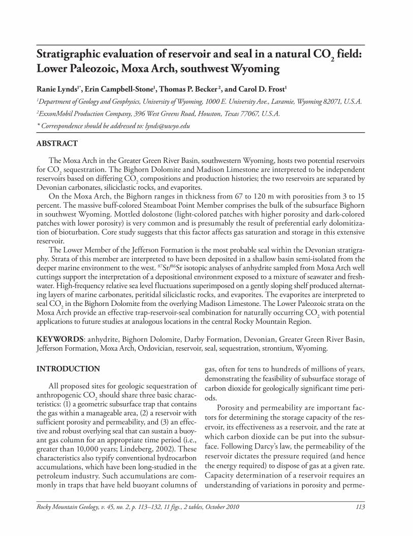
Subsurface log data from the Moxa Arch show the Bighorn Dolomite thinning from greater than 120 m on the northern tip of the Moxa Arch to 67 m near the Wyoming–Utah border (Fig. 4). The thin-ning is believed to be the result of post-Ordovician erosion (Sloss, 1963; Goodwin, 1964). The Bighorn Dolomite is absent within the Uinta Uplift, located
in northern Utah and Colorado at the southern tip of the Moxa Arch (Rowley et al., 1985), where the Mississippian Madison limestone lies disconform-ably on Cambrian strata. log interpretations suggest the Steamboat Point Member comprises most of the Bighorn in the subsurface, however up to 21 m of an overlying less massive member may also be present (most likely the leigh Member). Cores are rare through the lower Paleozoic sec-tion, yet one partial core of the Steamboat Point Member was available for viewing from the northern Moxa Arch (see Fig. 1 for location). This core, nearly 100 percent dolostone, shows three distinct textures. The most common texture, comprising as much as 85 percent of the available core, is the characteristic mottled dolostone (Fig. 5A). This texture has been described in outcrops by numerous authors, and Zenger (1996) most recently attributed it to prefer-ential early dolomitization of Thalassinoides-like bur-rows. The mottled texture involves noticeable poros-ity contrasts (over several centimeters). Relatively coarse-grained light tan dolostone has vuggy poros-ity, whereas vugs are rare in the fine-grained dark tan to brown dolostone. The second texture is similarly mottled but on a smaller scale (mottles less than one centimeter long) and is most likely also the result of preferential dolomitization of pre-existing burrows (Fig. 5B). This texture comprises approximately 5 percent of the core and may result in less of a poros-ity contrast because the light and dark texture (poros-ity) variations occur on scales less than 1 cm and are often interconnected. The third texture is a dolomitic mudstone (Fig. 5C) that is medium brown to gray
Figure 3. Photograph of Steamboat Point Member of Bighorn Dolomite taken in Sinks Canyon, in the Wind River Range, near lander, Wyoming, approximately 150 km northeast of the Moxa Arch. The Steamboat Point Member (black arrow) is 50 m thick.
STRATIGRAPHIC EVAlUATION, MOxA ARCH
118 Rocky Mountain Geology, v. 45, no. 2, p. 113–132, 11 figs., 2 tables, October 2010
and comprises 10 percent of the core. It commonly includes thin wispy stylolites that are not well devel-oped and are discontinuous laterally through the core. This dolomitic mudstone does not display vis-ible porosity and very rarely contain vugs.
Reservoir characteristics Although only visual inspection of the Bighorn Dolomite core was possible, it is clear that poros-ity and permeability, essential reservoir qualities, are affected by heterogeneities at a range of scales. In hand sample, there are centimeter-scale porosity variations probably resulting from the dolomitization process and subsequent deformation. Compaction produced a complex network of mutually cross-cut-ting stylolites, and deformation and change in stress resulted in the formation of fractures. Preferential fluid pathways and baffles and barriers to flow were formed by these permeability variations, suggesting reservoir heterogeneity at a multitude of scales. Heterogeneities within the Bighorn Dolomite can be subdivided into three categories: structural, compaction-related, and lithologic. Structural het-
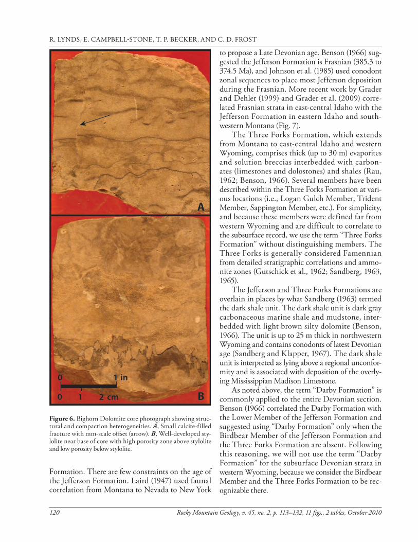
erogeneities are fractures and faults (Fig. 6A), which can enhance or hinder fluid migration within a res-ervoir, depending on the nature of the structural heterogeneity and the type of fill. In the core, frac-ture apertures ranged from less than 0.1 to 0.5 mm, and the fractures were variably unfilled or filled with calcite. Compaction resulted in the forma-tion of stylolites, which are pressure-solution seams along which rock is dissolved, leaving an insolu-ble residue at the interface. The residue can be an impermeable barrier and, in the case of Figure 6B, creates a visible break between higher and lower porosity zones. lithologic heterogeneities include variations in texture (Fig. 5) and in composition, such as the difference between a low-porosity dolo-mite mudstone and a higher-porosity mottled dolos-tone. lithologic heterogeneities may be the result of stratigraphic variation over tens to thousands of meters, and encompass various facies and litholo-gies that are preserved during basin filling or subse-quent diagenesis. As documented regionally, all four members of the Bighorn Dolomite display lithologic heterogeneities with varying amounts of dolomiti-zation within and between members and locations. Structural, compaction, and lithologic heterogene-ities combine to create internal baff les within the Bighorn Dolomite, complicating its evaluation as a reservoir.
JEFFERSON FORMATION AS A SEAL
More difficult than identification of a potential porous and permeable reservoir unit in the subsur-face is assessment of the effectiveness of an overlying low permeability sealing unit. The seal must both hold a buoyant column and be laterally continuous across the trap.
Devonian stratigraphy in southwest Wyoming
Devonian strata in the subsurface of southwest-ern Wyoming have been the subject of unresolved discussion for several decades, most likely due to the scarcity of subsurface data. The Devonian section in the subsurface of the Greater Green River Basin is referred to as the “Darby Formation,” as coined by Blackwelder (1918). The type locality of the Darby Formation is disputed (love, 1969), and the naming scheme for Devonian formations/members in the subsurface is not clear. Original work by Peale (1893)
347(106)
219(67)
406(124)
0
100(30)
200(61)
300(91)
400(122)
500(152)
400(122)
400(122)
200(61)100
(30)
Wyoming
?
Colorado
Thrust fault, triangles on upthrown side,dashed where covered
Anticline, dashed where covered
Bighorn Dolomite thickness from well (ft)
thickness in feet (meters)
N0 50 mi
Figure 4. Isopach map of the Bighorn Dolomite in Wyoming. Circles indicate thickness of Bighorn Dolomite as interpreted from well logs; the Greater Green River Basin is highlighted in gray; the front of the Sevier fold-and-thrust belt, Moxa Arch, and Rock Springs Uplift are represented with map symbols (see Fig. 1). Modified from Peterson (1989).
R. lyNDS, E. CAMPBEll-STONE, T. P. BECkER, AND C. D. FROST

Rocky Mountain Geology, v. 45, no. 2, p. 113–132, 11 figs., 2 tables, October 2010 119
subdivided the Devonian strata in southwestern Montana into the Jefferson Formation (lower) and the Three Forks Formation (upper). Subsequent stud-ies proceeded to subdivide these formations into a variety of members based on studies at differing loca-tions throughout Montana, Wyoming, Idaho, and Utah (e.g., Emmons and Calkins, 1913; Sandberg, 1962, 1965). The most comprehensive study of the Devonian strata in western Wyoming was first published in a thesis by Benson (1965) and in his follow-up paper (Benson, 1966). Benson (1965, 1966) subdivided the Devonian section in western Wyoming into the Jefferson Formation and the overlying Three Forks Formation (Fig. 7). The Jefferson Formation
can further be subdivided into the unnamed lower Member, which is a series of interbedded limestones, dolomites, evaporites, and clastics approximately 25 to 150 m thick, and the Birdbear Member, a distinc-tive massive and mottled buff-colored cliff-forming dolostone. Birdbear outcrops range in thickness from 18 to 35 m and are erosionally truncated along a north-south trend from the west side of the Big Horn Basin to the western Wind River Mountains and into the Green River Basin (Benson, 1966; Sandberg, 1965). Erosional truncation, evidence for subaerial exposure, and basal clastic beds in the Three Forks Formation (Benson, 1966) sug-gest sea level regression between deposition of the Jefferson Formation and the overlying Three Forks
Figure 5. Textures observed in core (see Fig. 1 for location) from Steamboat Point Member of the Bighorn Dolomite. A, Mottled (bioturbated) dolostone. B, Small-scale mottled (bioturbated) dolostone. C, Dolomite mudstone.
STRATIGRAPHIC EVAlUATION, MOxA ARCH
120 Rocky Mountain Geology, v. 45, no. 2, p. 113–132, 11 figs., 2 tables, October 2010
Formation. There are few constraints on the age of the Jefferson Formation. laird (1947) used faunal correlation from Montana to Nevada to New york
to propose a late Devonian age. Benson (1966) sug-gested the Jefferson Formation is Frasnian (385.3 to 374.5 Ma), and Johnson et al. (1985) used conodont zonal sequences to place most Jefferson deposition during the Frasnian. More recent work by Grader and Dehler (1999) and Grader et al. (2009) corre-lated Frasnian strata in east-central Idaho with the Jefferson Formation in eastern Idaho and south-western Montana (Fig. 7). The Three Forks Formation, which extends from Montana to east-central Idaho and western Wyoming, comprises thick (up to 30 m) evaporites and solution breccias interbedded with carbon-ates (limestones and dolostones) and shales (Rau, 1962; Benson, 1966). Several members have been described within the Three Forks Formation at vari-ous locations (i.e., logan Gulch Member, Trident Member, Sappington Member, etc.). For simplicity, and because these members were defined far from western Wyoming and are difficult to correlate to the subsurface record, we use the term “Three Forks Formation” without distinguishing members. The Three Forks is generally considered Famennian from detailed stratigraphic correlations and ammo-nite zones (Gutschick et al., 1962; Sandberg, 1963, 1965). The Jefferson and Three Forks Formations are overlain in places by what Sandberg (1963) termed the dark shale unit. The dark shale unit is dark gray carbonaceous marine shale and mudstone, inter-bedded with light brown silty dolomite (Benson, 1966). The unit is up to 25 m thick in northwestern Wyoming and contains conodonts of latest Devonian age (Sandberg and klapper, 1967). The dark shale unit is interpreted as lying above a regional unconfor-mity and is associated with deposition of the overly-ing Mississippian Madison limestone. As noted above, the term “Darby Formation” is commonly applied to the entire Devonian section. Benson (1966) correlated the Darby Formation with the lower Member of the Jefferson Formation and suggested using “Darby Formation” only when the Birdbear Member of the Jefferson Formation and the Three Forks Formation are absent. Following this reasoning, we will not use the term “Darby Formation” for the subsurface Devonian strata in western Wyoming, because we consider the Birdbear Member and the Three Forks Formation to be rec-ognizable there.
Figure 6. Bighorn Dolomite core photograph showing struc-tural and compaction heterogeneities. A, Small calcite-filled fracture with mm-scale offset (arrow). B, Well-developed sty-lolite near base of core with high porosity zone above stylolite and low porosity below stylolite.
R. lyNDS, E. CAMPBEll-STONE, T. P. BECkER, AND C. D. FROST

Rocky Mountain Geology, v. 45, no. 2, p. 113–132, 11 figs., 2 tables, October 2010 121
Surface and subsurface observations
We created a measured sec-tion for the interval between the Bighorn Dolomite and the Madison limestone to under-stand better the log signature of the Devonian strata in the Greater Green River Basin. The most complete accessible section is on the northeast side of Fred’s Mountain near Grand Targhee Ski Resort, Wyoming (base at longitude -110.9097 W, latitude 43.7839 N; Fig. 8).
At this location, the entire
Devonian section is 100 m thick (Fig. 8). The lower Member of the Jefferson Formation forms a slope with thin ledges 30 cm to 3 m thick. The ledges are resistant dark to medium brown, sucrosic-textured, thin-bedded dolostone, or light brown to gray brecciated dolostone and limestone. The brecciated units are interpreted as the result of evaporite solu-tion collapse and have also been documented in east-central Idaho (Grader et al., 2009). Minor chert
nodules and vugs are present, as are rare recognizable gastropods, echinoderm plates, and peloids. Interbedded with the dolostones and minor limestones are thin (30 cm or less) beds of non-resis-tant detrital siliclastic sandstone, siltstone, and claystone. These beds are primarily composed of very fine-grained to fine-grained, well-rounded and well-sorted, frosted quartz grains. The detri-tal beds are recessive and poorly exposed on the slope of the lower Member. There is a 3.4-m-thick dolomitized bioturbated wacke-stone in the upper quarter of the lower Member of the Jefferson Formation. Most of the Birdbear Member forms a covered slope, but the top 6 m is a resistant, mas-sive, and heavily bioturbated cliff-forming dolostone. The Three Forks Formation is entirely cov-ered at this location. The overlying 3-m-thick dark shale unit is recog-nizable by its dark gray color and distinctive Zoophycos trace fossils. To complement the outcrop study, we were able to locate (at the United States Geologica l Survey (USGS) Core Research Center in lakewood, Colorado) Devonian cuttings from four wel ls on the Moxa Arch and one complete Devonian core from the Rock Springs Uplift, 40 km east of the Moxa Arch. Analysis of the cuttings indi-cate that the primary lithologies include dolostone, limestone, sandstone, siltstone, claystone, and occasional coal fragments, micas, and pyrite. Textures are not apparent from the cuttings. The core is from the 4-UPRR-11-19-104 well (longitude -109.105 W, latitude 41.64011 N; Fig. 9), and the Devonian section in
Figure 7. Devonian and lower Mississippian stratigraphic terminology, modified from Benson (1966) with additions from Grader and Dehler (1999). Ages (Ma, at left) from the International Stratigraphic Chart (2009).
STRATIGRAPHIC EVAlUATION, MOxA ARCH

122 Rocky Mountain Geology, v. 45, no. 2, p. 113–132, 11 figs., 2 tables, October 2010
this core is 37 m thick (Fig. 9). The 4-UPRR-11-19-104 core is interesting because the primary lithology is sandstone with very fine-grained to medium-grained, well-rounded and well-sorted, frosted quartz grains that are dis-tributed fairly evenly throughout the core. In addition, there are two brecciated intervals located midway and at the top of the core, suggesting possible surface exposure. The Devonian in this core has been called the Darby Formation, but as previously mentioned we will assign it to the lower Member of the Jefferson Formation. Correlating the Devonian strata in the subsurface is chal-lenging. Only a few wells have been logged in the Devonian in the Greater Green River Basin, and there are no marker log sig-natures, because the detrita l material, argillaceous mudstones, and carbonates of the lower Jefferson Formation are interbed-ded over centimeters to meters. Furthermore, since detailed age control is not available in the sub-surface, interpreting the lower Jefferson Formation in a sequence stratigraphic context is nearly impossible. Figure 10 is a north–south cross section along the crest of the Moxa Arch of the complete Devonian section. lithologic cor-relation of the lower Jefferson interval points to a recurring series of anhydrite beds, as evidenced by low gamma and high density
Figure 8. Measured section through the Jefferson and Three Forks Formations, measured at outcrops in northwest Wyo-ming near Grand Targhee Ski Resort (base at longitude -110.9097 W, latitude 43.7839 N).
R. lyNDS, E. CAMPBEll-STONE, T. P. BECkER, AND C. D. FROST

Rocky Mountain Geology, v. 45, no. 2, p. 113–132, 11 figs., 2 tables, October 2010 123
signatures. Although log correla-tion suggests some of these anhy-drites may be continuous between wells, their minimal thickness (0.3 to 1.2 m) allows other interpreta-tions. These anhydrite layers are significant because anhydrite may be the most common reservoir seal worldwide (Hangx et al., 2010).
Anhydrite Sr isotopic analysis To determine if the anhydrite zones could be correlated from well to well, we identified sev-eral thin anhydrite beds from the logs and sampled anhydrite from lower Jefferson Formation well cuttings (see Fig. 1 for geographic location of wells). Our intent was to use 87Sr/86Sr isotopic ratios as a possible correlation tool. If the anhydrite crystallized on broad and shallow tidal f lats from the evaporation of seawater, then the 87Sr/86Sr ratio of anhydrite from equivalent stratigraphic levels should be identical. In addition, the Sr isotopic ratio should follow the Frasnian (385.3 to 374.5 Ma) seawater curve (e.g., Denison et al., 1997), which is not static throughout Frasnian time.
Laboratory methods Anhydrite cuttings, aver-aged over a 10-ft (3-m) interval, were handpicked from cuttings stored at the USGS Core Research Center and dissolved in ultra-pure
Figure 9. lower Member of the Jefferson Formation core correlated with gamma ray log from the 4-UPRR-11-19-104 well, located on the Rock Springs Uplift (see inset map). Birdbear Member of Jef-ferson Formation and Three Forks were removed by pre-Mississippian erosion. A clastic horizontal scale was chosen for the core description because of the profusion of well-rounded quartz grains.
STRATIGRAPHIC EVAlUATION, MOxA ARCH

124 Rocky Mountain Geology, v. 45, no. 2, p. 113–132, 11 figs., 2 tables, October 2010
Figu
re 1
0. C
orre
latio
n of
Dev
onia
n se
ctio
n in
five
wel
ls fro
m n
orth
to so
uth
on th
e Mox
a Arc
h (se
e Fig
. 1 fo
r loc
atio
ns).
Red
indi
cate
s anh
ydrit
e lay
ers,
dept
hs ar
e mea
sure
d in
feet
, and
log
valu
es in
crea
se to
the r
ight
. Not
e the
dat
um is
a lit
hostr
atig
raph
ic co
rrela
tion
at th
e bas
e of t
he B
irdbe
ar M
embe
r.
R. lyNDS, E. CAMPBEll-STONE, T. P. BECkER, AND C. D. FROST

Rocky Mountain Geology, v. 45, no. 2, p. 113–132, 11 figs., 2 tables, October 2010 125
water. One ml of solute was dried and redissolved in dilute nitric acid. Strontium was isolated using Teflon columns filled with Eichrom® Sr-Spec resin. The strontium isotopic composition was determined by thermal ionization mass spectrometry at the University of Wyoming. All analyses were normal-ized to an 86Sr/88Sr ratio value of 0.1194. Analytical blanks are less than 0.2 ng Sr. Six analyses of NBS 987 strontium standard measured during the course of these analyses gave an average value of 87Sr/86Sr = 0.71026 ± 0.00002 (2 standard deviations), identical to a long-term average of 0.71026 ± 0.00002 (2 stan-dard deviations) based upon 76 analyses of the stan-dard. Values are reported relative to modern seawater, defined as:∆sw = (87Sr/86Srsample – 87Sr/86Srmodern seawater) x 105 (1)where the 87Sr/86Sr of modern seawater is taken to be 0.709173 (McArthur, 1995).
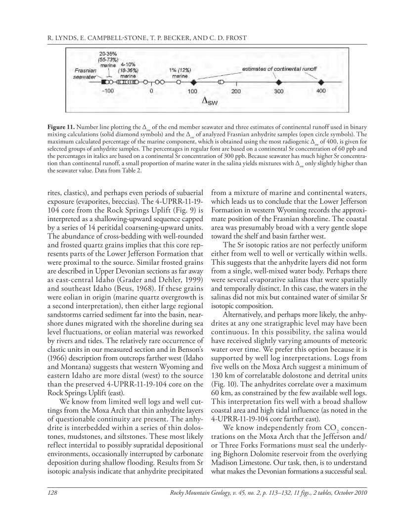
Sr isotopic results Sr isotopic results for 29 samples of anhydrite are reported on Table 1. Twenty-seven samples were taken from the Graphite 116, Fontanelle II Unit 22-35, keller Rubow 1, and Church Buttes Unit 19 wells on the Moxa Arch (see Fig. 1 for location). Two additional samples, interpreted as secondary anhydrite that fills fractures, are from the 4-UPRR-11-19-104 core on the Rock Springs Uplift to the east (see Fig. 9 for location). Sr isotopic composition of most samples from the Moxa Arch wells are between 87Sr/86Sr of 0.70822 and 0.70905 (∆sw = -69.3 to -12.3), but three are higher, ranging from 0.70931 to 0.71081 (∆sw = 13.4 to 164.2). Both samples from the Rock Springs Uplift are among the most radiogenic: 0.70982 and 0.71083 (∆sw = 64.3 and 165.3). All are higher than the estimates for con-temporary Frasnian seawater (0.70795 to 0.70815; Denison et al., 1997; John et al., 2008).
Sr isotopic data discussion All Sr isotopic ratios for our anhydrite samples are more radiogenic than Frasnian seawater values. This suggests that if the anhydrite is primary, it was not formed in an open marine environment, but instead was precipitated from a water body that was partially or totally isolated from the ocean. Denison et al. (1998) applied the term salina to such a body of water, which can be dominated by marine water, by continental runoff, or a combination of the two. If
the 87Sr/86Sr ratio and Sr concentration of the seawater and the continental runoff are known, then the mass
Table 1. Sr isotopic data for anhydrite from well cuttings of Devonian rocks from the Moxa Arch and Rock Springs Uplift.
Table 1. Sr isotopic data for anhydrite from well cuttings of Devonian rocks from the Moxa Arch and Rock Springs Uplift.
Top Depth (ft) 87Sr/86Sr
internal precision (% std. error) ∆SW
Keller Rubow 1 17200 0.70848 0.0017 -69.27 17220 0.70845 0.0015 -72.03 17230 0.70877 0.0013 -39.87 17250 0.70823 0.0016 -94.61 17260 0.70861 0.0014 -56.57 17270 0.70879 0.0015 -38.44 17280 0.70931 0.0016 13.44 17290 0.71081 0.0014 164.18 17300 0.70882 0.0017 -35.52
Graphite 116 17260 0.70868 0.0019 -49.32 17270 0.70855 0.0017 -61.85 17280 0.70905 0.0016 -12.3 17290 0.70863 0.0016 -54.69
Fontanelle II Unit 22-35 15680 0.70874 0.0038 -43.01 15690 0.70815 0.0016 -102.54 15710 0.70856 0.0016 -61.47 15720 0.70943 0.0020 25.24 15730 0.70814 0.0014 -102.91 15740 0.70869 0.0016 -48.79 15760 0.70869 0.0026 -48.46 15770 0.70857 0.0017 -60.21 15780 0.71078 0.0014 160.85 15790 0.70839 0.0016 -78.55 15800 0.70852 0.0016 -65.23 15810 0.70841 0.0017 -76.24 15820 0.70880 0.0017 -37.65
Church Buttes 19 19180 0.70868 0.0029 -49.79
4-UPRR-11-19-104 7902 0.71083 0.0016 165.26 7921 0.70982 0.0013 64.27
Note: See Fig. 1 for Moxa Arch and Rock Springs Uplift locations. All depths are in measured depth.
STRATIGRAPHIC EVAlUATION, MOxA ARCH

126 Rocky Mountain Geology, v. 45, no. 2, p. 113–132, 11 figs., 2 tables, October 2010
balance of a mixture of marine and continental water may be determined. The Sr isotopic composition of seawater has been determined from analyses of marine carbonates and, as noted above, the Frasnian seawater values varied from 0.70795 (∆sw of -122) in Early Frasnian, to a high of 0.70815 (∆sw of -102) in Middle Frasnian. The concentration of Sr in seawater is approximately 8 ppm, much greater than in average river water (~60 ppb; Denison et al., 1998). Modern major river water has ∆sw of 100 to 300 (Palmer and Edmond, 1992). However, the isotopic ratio and Sr concentration of individual rivers varies widely and are very much dependent upon the geology and geography of the drainage basin. Thus we do not know with any certainty the Sr isotopic composition and Sr concentration of the rivers that may have supplied a Devonian salina in present-day western Wyoming. A widespread unconformity at the base of the Paleozoic section in the Uinta Mountains, Wind River Range, and throughout the laramide uplifts of Wyoming suggests that Precambrian rocks were a source for terrigenous input. Exposed Cambro-Ordovician carbonates are another potential source of non-marine Sr to the late Devonian salinas. As a result, we can make only general estimates of the proportions of marine and meteoric water in the water body from which the anhydrite precipitated. For the purpose of illustration we calculate the fraction of marine water in the salina using three dif-ferent estimates of the 87Sr/86Sr ratio of the continen-tal end member: one based upon modern rivers drain-ing Paleozoic and older rocks on the margins of the Greater Green River Basin, a second estimate based upon modern average river Sr isotopic composition, and a third using the radiogenic 87Sr/86Sr ratios of the secondary anhydrite derived from the 4-UPRR-11-19-104 to approximate the continental end member. These three approaches give overlapping estimates of the 87Sr/86Sr ratio for Devonian continental runoff in the vicinity of the present-day Green River Basin. First, modern water sampled in the Greater Green River Basin near the headwaters of the Green, Big Sandy, and Sweetwater Rivers where they have traversed mainly Archean and Paleozoic rocks have 87Sr/86Sr ratios of 0.7212 to 0.7157 (Fenner and Frost, unpub-lished data). Assuming these rocks also supplied Sr to meteoric water in Frasnian time and correcting for radiogenic ingrowth of 87Sr by the decay of 87Rb in the rocks since Frasnian time, the ∆sw of Devonian mete-
oric water may have been around 100 to 400. Second, for modern rivers, mean ∆sw is estimated at 100 to 300. Third, if the fluids from which the secondary anhy-drite in the 4-UPRR-11-19-104 core (Rock Springs Uplift) precipitated represent an estimate of local con-tinental meteoric water (∆sw of 64 to 165), then those Sr isotopic ratios may also be reasonable estimates of the continental end member. Accordingly, we per-formed mixing calculations using continental end members ∆sw of 100, 300, and 400. We used two different estimates of Sr concen-tration of continental runoff (60 ppb and 300 ppb) to represent the mean Sr concentrations of 60 ppb of modern rivers and a higher Sr content typical of arid river water (Denison et al., 1998). The results of the calculations are displayed in Table 2. The calcu-lations were done using the two-component mixing model of Faure (1986). These calculations suggest that if the concentration of Sr in the continental water was 60 ppb, then the water body from which the anhydrite precipitated was dominated by the con-tinental component; the fraction of marine water is less than 10 percent for all but the three anhydrites with the lowest Sr isotopic compositions, which are closest to contemporary seawater values. If the con-centration of Sr in the continental end member was higher (300 ppb), then the proportion of marine water is higher, up to 36 percent for most samples and higher for the three anhydrite samples with the lowest ∆sw (Fig. 11). If these anhydrites are secondary, then they precipitated from a different fluid than one that produced the higher ratio group. The three samples from the Moxa Arch wells with higher ∆sw and the two Rock Springs Uplift samples that are clearly secondary fracture fills pre-cipitated from fluids with Sr isotopic characteristics expected of continental meteoric waters. It is possible that the three Moxa Arch samples are primary pre-cipitates that formed when the salina was supplied entirely by continental runoff, or they could be sec-ondary. In either case, the depositional environment was not entirely marine and exhibits a strong contri-bution of meteoric water, probably sourced from the adjacent continent.
Seal characteristics
lithology alone indicates that depositional envi-ronments of the Jefferson Formation include marine (carbonates), marginal marine (carbonates, evapo-
R. lyNDS, E. CAMPBEll-STONE, T. P. BECkER, AND C. D. FROST

Rocky Mountain Geology, v. 45, no. 2, p. 113–132, 11 figs., 2 tables, October 2010 127
Table 2. Mass balance calculations of proportions of seawater and continental runoff in Frasnian (Upper Devonian) salinas.
Top Depth (ft)
Anhydrite ∆SW
fraction marine for various river ∆SW, 60 ppb Sr
fraction marine for various river ∆SW, 300 ppb Sr
∆SW = 100
∆SW = 300
∆SW = 400
∆SW = 100
∆SW = 300
∆SW = 400
Keller Rubow 1 17200 -69.3 0.03 0.06 0.08 0.13 0.25 0.30 17220 -72.0 0.03 0.07 0.09 0.15 0.27 0.32 17230 -39.9 0.01 0.04 0.04 0.07 0.15 0.19 17250 -94.6 0.09 0.16 0.19 0.32 0.49 0.55 17260 -56.6 0.02 0.05 0.06 0.10 0.20 0.24 17270 -38.4 0.01 0.03 0.04 0.07 0.15 0.19 17280 13.4 0.01 0.02 0.02 0.03 0.08 0.11 17290 164.2 0.00 0.00 0.01 -0.01 0.02 0.03 17300 -35.5 0.01 0.03 0.04 0.06 0.14 0.18
Graphite 116 17260 -49.3 0.02 0.04 0.05 0.08 0.18 0.22 17270 -61.9 0.02 0.05 0.07 0.11 0.22 0.26 17280 -12.3 0.01 0.02 0.03 0.04 0.11 0.14 17290 -54.7 0.02 0.05 0.06 0.09 0.19 0.24
Fontanelle II Unit 22-35 15680 -43.0 0.02 0.04 0.05 0.07 0.16 0.20 15690 -102.5 0.17 0.29 0.34 0.50 0.67 0.72 15710 -61.5 0.02 0.05 0.07 0.11 0.22 0.26 15720 25.2 0.00 0.02 0.02 0.02 0.07 0.09 15730 -102.9 0.18 0.30 0.35 0.52 0.68 0.73 15740 -48.8 0.02 0.04 0.05 0.08 0.18 0.22 15760 -48.5 0.02 0.04 0.05 0.08 0.18 0.21 15770 -60.2 0.02 0.05 0.06 0.11 0.21 0.26 15780 160.8 0.00 0.00 0.01 -0.01 0.02 0.03 15790 -78.6 0.04 0.08 0.10 0.18 0.31 0.36 15800 -65.2 0.03 0.06 0.07 0.12 0.23 0.28 15810 -76.2 0.04 0.08 0.10 0.16 0.29 0.35 15820 -37.7 0.01 0.03 0.04 0.07 0.15 0.18
Church Buttes 19 19180 -49.8 0.02 0.04 0.05 0.09 0.18 0.12
4-UPRR-11-19-104 7902 165.3 0.00 0.00 0.01 -0.01 0.02 0.12 7921 64.3 0.00 0.01 0.01 0.01 0.05 0.12
Note: For all calculations, the ∆sw and Sr concentration of Frasnian seawater is assumed to be -110 and 8 ppm, respectively. All depths are in measured depth.
Table 2. Mass balance calculations of proportions of seawater and continental runoff in Frasnian (Upper Devonian) salinas.
STRATIGRAPHIC EVAlUATION, MOxA ARCH
128 Rocky Mountain Geology, v. 45, no. 2, p. 113–132, 11 figs., 2 tables, October 2010
rites, clastics), and perhaps even periods of subaerial exposure (evaporites, breccias). The 4-UPRR-11-19-104 core from the Rock Springs Uplift (Fig. 9) is interpreted as a shallowing-upward sequence capped by a series of 14 peritidal coarsening-upward units. The abundance of cross-bedding with well-rounded and frosted quartz grains implies that this core rep-resents parts of the lower Jefferson Formation that were proximal to the source. Similar frosted grains are described in Upper Devonian sections as far away as east-central Idaho (Grader and Dehler, 1999) and southeast Idaho (Beus, 1968). If these grains were eolian in origin (marine quartz overgrowth is a second interpretation), then either large regional sandstorms carried sediment far into the basin, near-shore dunes migrated with the shoreline during sea level f luctuations, or eolian material was reworked by rivers and tides. The relatively rare occurrence of clastic units in our measured section and in Benson’s (1966) description from outcrops farther west (Idaho and Montana) suggests that western Wyoming and eastern Idaho are more distal (west) to the source than the preserved 4-UPRR-11-19-104 core on the Rock Springs Uplift (east). We know from limited well logs and well cut-tings from the Moxa Arch that thin anhydrite layers of questionable continuity are present. The anhy-drite is interbedded within a series of thin dolos-tones, mudstones, and siltstones. These most likely reflect intertidal to possibly supratidal depositional environments, occasionally interrupted by carbonate deposition during shallow flooding. Results from Sr isotopic analysis indicate that anhydrite precipitated
from a mixture of marine and continental waters, which leads us to conclude that the lower Jefferson Formation in western Wyoming records the approxi-mate position of the Frasnian shoreline. The coastal area was presumably broad with a very gentle slope toward the shelf and basin farther west. The Sr isotopic ratios are not perfectly uniform either from well to well or vertically within wells. This suggests that the anhydrite layers did not form from a single, well-mixed water body. Perhaps there were several evaporative salinas that were spatially and temporally distinct. In this case, the waters in the salinas did not mix but contained water of similar Sr isotopic composition. Alternatively, and perhaps more likely, the anhy-drites at any one stratigraphic level may have been continuous. In this possibility, the salina would have received slightly varying amounts of meteoric water over time. We prefer this option because it is supported by well log interpretations. logs from five wells on the Moxa Arch suggest a minimum of 130 km of correlatable dolostone and detrital units (Fig. 10). The anhydrites correlate over a maximum 60 km, as constrained by the few available well logs. This interpretation fits well with a broad shallow coastal area and high tidal influence (as noted in the 4-UPRR-11-19-104 core farther east). We know independently from CO2 concen-trations on the Moxa Arch that the Jefferson and/or Three Forks Formations must seal the underly-ing Bighorn Dolomite reservoir from the overlying Madison limestone. Our task, then, is to understand what makes the Devonian formations a successful seal.
Figure 11. Number line plotting the ∆sw of the end member seawater and three estimates of continental runoff used in binary mixing calculations (solid diamond symbols) and the ∆sw of analyzed Frasnian anhydrite samples (open circle symbols). The maximum calculated percentage of the marine component, which is obtained using the most radiogenic ∆sw of 400, is given for selected groups of anhydrite samples. The percentages in regular font are based on a continental Sr concentration of 60 ppb and the percentages in italics are based on a continental Sr concentration of 300 ppb. Because seawater has much higher Sr concentra-tion than continental runoff, a small proportion of marine water in the salina yields mixtures with ∆sw only slightly higher than the seawater value. Data from Table 2.
R. lyNDS, E. CAMPBEll-STONE, T. P. BECkER, AND C. D. FROST

Rocky Mountain Geology, v. 45, no. 2, p. 113–132, 11 figs., 2 tables, October 2010 129
Hangx et al. (2010) studied the mechanical behav-ior of anhydrite as a seal and found CO2 penetration rates of approximately 3 m per 10,000 years. With this penetration rate, we must assume that the anhydrites in the lower Jefferson Formation are far thicker than what can be determined from a gamma ray or neutron density log, and the combined effect of numerous thin but stacked anhydrite layers interbedded with lime mudstones and thin shales can seal a reservoir, or the evaporites in the overlying Three Forks Formation sig-nificantly contribute to the overall Devonian seal. Based on one unpublished image log from the Jefferson Formation on the northern Moxa Arch and the amount of anhydrite recovered from cuttings where anhydrite was not interpreted from the density log signature, we believe there may be more and/or thicker anhydrite layers than originally noted. This stacked succession of laterally continuous (on the order of 50 to 100 km) evaporites may be the seal to the Bighorn Dolomite CO2 reservoir.
CONCLUSIONS
Potential sites for long-term geologic storage of carbon dioxide should have a well-defined and well-understood trap, reservoir, and seal. The lower Paleozoic rocks in the western Greater Green River Basin provide a natural CO2 storage area because they possess all three attributes. The trap, the Moxa Arch, is a gently folded, doubly plunging anticline. The reservoir (Steamboat Point Member of the Upper Ordovician Bighorn Dolomite) has adequate porosity and permeability to hold large amounts of naturally occurring CO2. The lower Member of the Upper Devonian Jefferson Formation, perhaps in combina-tion with the overlying Three Forks Formation, seals the CO2 from the overlying Mississippian Madison limestone. Sr isotopic analyses of the anhydrite layers within the Jefferson Formation yield 87Sr/86Sr ratios mainly between 0.70822 and 0.70905, suggesting anhydrite formed in a salina environment and recorded a mixed seawater and meteoric water signature. This isotopic composition implies that, at least in the part of the section in which anhydrites are present, the lower Jefferson Formation records the Frasnian paleo-shore-line. A few higher Sr isotopic ratios from wells on the Moxa Arch and from farther away on the Rock Springs Uplift most likely identify secondary fracture
fills precipitated from a more radiogenic fluid. Based on log interpretations and 87Sr/86Sr ratios, we interpret that the anhydrite layers noted in the few deep wells on the Moxa Arch are continuous on scales up to 100 km. These stacked and continuous anhydrite layers in the lower Member of the Jefferson Formation probably form the CO2 seal between the Bighorn Dolomite and Madison limestone.
ACKNOWLEDGMENTS
We thank ExxonMobil Corporation for their continued assistance with this project; in particular, we thank Aaron liesch, Treacy Roberts, and Michael Parker for their coordination efforts. Rodger “Tim” Denison of the University of Texas at Dallas provided insight on the interpretation of the Sr data. Jason Mailloux gave immense assistance with Sr isotopic analyses, Jennifer Goyette contributed assistance in the field, and William White described cuttings. The USGS Core Research Center in lakewood, Colorado, furnished access to cores and samples. We thank Don Boyd, Peter Isaacson, and George Grader for exceptionally constructive comments and reviews.
This work was supported by the Department of Energy National Energy Technology laboratory under Award Number DE-NT0004730. This report was prepared as an account of work sponsored by an agency of the United States Government. Neither the United States Government nor any agency thereof, nor any of their employees, makes any warranty, express or implied, or assumes any legal liability or responsibility for the accuracy, completeness, or usefulness of any information, apparatus, product, or process disclosed, or represents that its use would not infringe privately owned rights. Reference herein to any specif ic commercial product, process, or service by trade name, trademark, manufacturer, or otherwise does not necessarily constitute or imply its endorsement, recommendation, or favoring by the United States Government or any agency thereof. The views and opinions of authors expressed herein do not necessarily state or reflect those of the United States Government or any agency thereof.
REFERENCES CITED
Becker, T. P., McGroder, M. F., Rudolph, k., Hauge, T. A., and Fan, M., 2010, Paleogene influence of the Moxa Arch
STRATIGRAPHIC EVAlUATION, MOxA ARCH

130 Rocky Mountain Geology, v. 45, no. 2, p. 113–132, 11 figs., 2 tables, October 2010
on the architecture of the composite Darby-Hogsback-Prospect (DHP) thrust sheet near laBarge, Wy, U.S.A.: American Association of Petroleum Geologists Annual Convention and Exhibition, New Orleans, louisiana, Abstracts, v. 19, p. 23.
Benson, A. l., 1965, The Devonian system in western Wyoming and adjacent areas [Ph.D. thesis]: Columbus, Ohio State University, 141 p.
____1966, Devonian stratigraphy of western Wyoming and adjacent areas: American Association of Petroleum Geolo-gists Bulletin, v. 50, p. 2566–2603.
Berg, R. R., 1975, Capillary pressure in stratigraphic traps: American Association of Petroleum Geologists Bulletin, v. 59, p. 939–956.
Beus, S. S., 1968, Paleozoic stratigraphy of Samaria Mountain, Idaho-Utah: American Association of Petroleum Geologists Bulletin, v. 52, p. 782–808.
Blackstone, D. l., Jr., 1990, Precambrian basement map of Wyoming: outcrop and structural configuration: Geologi-cal Survey of Wyoming Map Series 27 (revised version), scale 1:1,000,000, 1 sheet.
Blackwelder, E., 1913, Origin of the Bighorn Dolomite of Wyoming: Geological Society of America Bulletin, v. 24, p. 607–624.
Blackwelder, E., 1918, New geological formations in western Wyoming: Journal of the Washington Academy of Sci-ences, v. 13, p. 417–426.
Boyd, D. W., 1993, Paleozoic history of Wyoming, in Snoke, A. W., Steidtmann, J. R., and Roberts, S. M., eds., Geology of Wyoming: laramie, Wyoming, The Geological Survey of Wyoming Memoir No. 5, v. 1, p. 164–187.
Darton, N. H., 1906, Geology of the Bighorn Mountains: U.S. Geological Survey Professional Paper, P0051, 129 p.
Denison, R. E., koepnick, R. B., Burke, W. H., Hetherington, E. A., and Fletcher, A., 1997, Construction of the Silurian and Devonian seawater 87Sr/86Sr curve: Chemical Geology, v. 140, p. 109–121.
Denison, R. E., kirkland, D. W., and Evans, R., 1998, Using strontium isotopes to determine the age and origin of gypsum and anhydrite beds: Journal of Geology, v. 106, p. 1–17.
Downey, M. W., 1984, Evaluating seals for hydrocarbon accu-mulations: American Association of Petroleum Geologists Bulletin, v. 68, p. 1752–1763.
Emmons, W. H., and Calkins, F. C., 1913, Geology and ore deposits of the Philipsburg quadrangle, Montana: U.S. Geological Survey Professional Paper 78, 271 p.
Faure, G., 1986, Principles of isotope geology, 2nd ed.: New york, Wiley, 589 p.
Gluyas, J. G., and Swarbick, R. E., 2004, Petroleum geoscience: london, Wiley-Blackwell, 376 p.
Goodwin, P. W., 1964, Ordovician formations of Wyoming [Ph.D. thesis]: Iowa City, State University of Iowa, 201 p.
Grader, G. W., and Dehler, C. M., 1999, Devonian stratigraphy in east-central Idaho: New perspectives from the lemhi Range and Bayhorse area, in Hughes, S. S., and Thackray, G. D., eds., Guidebook to the Geology of Eastern Idaho: Pocatello, Idaho Museum of Natural History, p. 29–54.
Grader, G., Pope, M., Doughty, P. T., and Isaacson, P., 2009, Devonian stratigraphic framework in western Montana and east-central Idaho: Paleogeographic highs and shared intra-shelf basin depositional patterns: American Association of Petroleum Geologists Annual Convention and Exhibition, Denver, Colorado, Abstract # 1010325.
Gutschick, R. C., Suttner, l. J., and Switek, M. J., 1962, Biostratigraphy of transitional Devonian-Mississippian Sappington Formation of southwest Montana: Billings Geological Society Guidebook, 13th Annual Field Confer-ence, p. 79–86.
Hangx, S. J. T., Spiers, C. J., and Peach, C. J., 2010, Mechanical behavior of anhydrite caprock and implications for CO2 sealing capacity: Journal of Geophysical Research, v. 115, p. B07402.
Haq, B. U., and Schutter, S. R., 2008, A chronology of Paleo-zoic sea level changes: Science, v. 322, p. 64–68.
International Stratigraphic Chart, 2009: International Commis-sion on Stratigraphy, http://www.stratigraphy.org/upload/ISChart2009.pdf.
Isaacson, P. E., Hladil, J., Shen, J. W., kalvoda, J., and Grader, G., 1999, late Devonian (Famennian) glaciation in South America and marine offlap on other continents, in Feist, R., Talent, J. A., and Daurer, A., eds., North Gondwana: Mid-Paleozoic terranes, stratigraphy and biota: Wien, Abhand-lungen der Geologischen Bundesanstalt, v. 54, p. 239–257.
John, E. H., Cliff, R., and Wignall, P. B., 2008, A positive trend in seawater 87Sr/86Sr values over the Early-Middle Frasnian boundary (late Devonian) recorded in well-preserved conodont elements from the Holy Cross Mountains, Poland: Palaeogeog-raphy, Palaeoclimatology, Palaeoecology, v. 269, p. 166–175.
Johnson, J. G., klapper, G., and Sandbert, C. A., 1985, Devonian eustatic fluctuations in Euramerica: Geological Society of America Bulletin, v. 96, p.567–587.
kraig, D. H., Wiltschko, D. V., and Spang, J. H., 1987, Interaction of basement uplift and thin-skinned thrusting, Moxa Arch and the Western Overthrust Belt, Wyoming: A hypothesis: Geological Society of America Bulletin, v. 99, p. 654–662.
laird, W. M., 1947, An Upper Devonian brachiopod fauna from northwestern Montana: Journal of Paleontology, v. 21, p. 453–459.
larimer, T. R., 1959, Paleogeography of the Pre-Mississippian surface, Bighorn Mountains, Wyoming [MS thesis]: Iowa City, State University of Iowa, 120 p.
R. lyNDS, E. CAMPBEll-STONE, T. P. BECkER, AND C. D. FROST

Rocky Mountain Geology, v. 45, no. 2, p. 113–132, 11 figs., 2 tables, October 2010 131
li, y., and Wardlaw, N. C., 1986, The influence of wettability and critical pore-throat size ratio on snap-off: Journal of Colloid Interface Science, v. 109, p. 461–472.
lindeberg, E., 2002, The quality of a CO2 repository: What is the sufficient retention time of CO2 stored underground?, in Gale, J., and kaya, y., eds., Proceedings of the 6th Greenhouse Gas Control Technologies Conference: kyoto, Japan, Elsevier, p. 255–260.
lorenz, J. C., Teufel, l. W., and Warpinski, N. R., 1991, Regional fractures I: A mechanism for the formation of regional fractures at depth in flat-lying reservoirs: Ameri-can Association of Petroleum Geologists Bulletin, v. 75, p. 1714–1737.
love, J. D., 1969, Type locality of Darby Formation, Western Wyoming: American Association of Petroleum Geologists Bulletin, v. 53, p. 167–170.
McArthur, J. M., 1995, Recent trends in strontium isotope stratigraphy: Terra Nova, v. 6, p. 331–358.
Palmer, M. R., and Edmond, J. M., 1992, Controls over the strontium isotope composition of river water: Geochimica et Cosmochimica Acta, v. 56, p. 2099–2111.
Parker, H. B., 1950, The Bighorn Dolomite [M.S. thesis]: Oxford, Miami University, 71 p.
Peale, A. C., 1893, Paleozoic section in the vicinity of Three Forks, Montana: United States Geological Survey Bulletin, v. 110, 56 p.
Peterson, J. A., 1989, Future petroleum resource potential of Northern Rocky Mountain-Great Plains area, in lorenz, J. C., and lucas, S. G., eds., Energy frontiers in the Rockies: Albuquerque, Albuquerque Geological Society, p. 46–55.
Rau, J. l., 1962, The stratigraphy of the Three Forks Formation: Billings Geological Society Guidebook, 13th Annual Field Conference, p. 51–65.
Richards, P. W., and Nieschmidt, C. l., 1957, The Bighorn Dolomite in south-central Montana and northwestern Wyoming: Billings Geological Society Guidebook, 8th Annual Field Conference, p. 54–62.
Richards, P. W., and Nieschmidt, C. l., 1961, The Bighorn Dolomite and correlative formations in southern Montana and northern Wyoming: U.S. Geological Survey Oil and Gas Investigations Map OM-202.
Rowley, P. D., Hansen, W. R., Tweto, O., and Carrara, P. E., 1985, Geologic map of the Vernal 1°x2° quadrangle, Colorado, Utah, and Wyoming: USGS Miscellaneous Investigations Series I:1526, scale 1:250,000.
Royse, F. Jr., 1993, An overview of the geologic structure of the thrust belt in Wyoming, northern Utah, and eastern Idaho, in Snoke, A. W., Steidtmann, J. R., and Roberts, S. M., eds., Geology of Wyoming: laramie, Wyoming, The Geological Survey of Wyoming Memoir No. 5, p. 273–311.
Sandberg, C. A., 1962, Stratigraphic section of type Three Forks and Jefferson Formations at logan, Montana: Bill-
ings Geological Society Guidebook, 13th Annual Field Conference, p. 47–50.
Sandberg, C. A., 1963, Dark shale unit of Devonian and Mis-sissippian age in northern Wyoming and southern Mon-tana: U.S. Geological Survey Professional Paper 475-C, p. C17-C20.
____1965, Nomenclature and correlation of lithologic sub-divisions of the Jefferson and Three Forks Formations of southern Montana and northern Wyoming: U.S. Geologi-cal Survey Bulletin 1194-N, 18 p.
Sandberg, C. A., and klapper, G., 1967, Stratigraphy, age, and paleotectonic significance of the Cottonwood Canyon Member of the Madison limestone in Wyo-ming and Montana: U.S. Geological Survey Bulletin 1251-B, 70 p.
Sandberg, C. A., and Mapel, W. J., 1967, The northern Rocky Mountains and plains, in Oswald, D. H., ed., International symposium of the Devonian system, v. 1: Calgary, Alberta, Alberta Society of Petroleum Geologists, p. 843–877.
Schowalter, T. T, 1979, Mechanics of secondary hydrocarbon migration and entrapment: American Association of Petro-leum Geologists Bulletin, v. 63, p. 723–760.
Secor, D. T., 1965, Role of fluid pressure in jointing: American Journal of Science, v. 263, p. 633–646.
Sloss, l. l., 1963, Sequences in the cratonic interior of North America: Geological Society of America Bulletin, v. 74, p. 93–114.
Stilwell, D. P., 1989, CO2 Resources of the Moxa Arch and the Madison reservoir: Wyoming Geological Association Guidebook, 40th Annual Field Conference, Guidebook, p. 105–115.
Sweet, W. C., 1979, late Ordovician conodonts and biostratig-raphy of the western Midcontinent Province, in Sandberg, C. A., and Clark, D. l., eds., Conodont biostratigraphy of the Great Basin and Rocky Mountains: Geology Studies, v. 26, Part 3, p. 45–86.
Teel, S., 1994, Petrography and depositional environment of the Ordovician Bighorn Dolomite, south-central Montana and northern Wyoming [M.S. thesis]: Moscow, University of Idaho, 96 p.
Thyne, G. D., Tomasso, M., Bywater-Reyes, S. V., Budd, D. A., and Reyes, B. M., 2010, Characterization of poros-ity and permeability for CO2 sequestration models in the Mississippian Madison Group, Moxa Arch–laBarge Platform, southwestern Wyoming: Rocky Mountain Geology, v. 45, p. 133–150.
Tice, l. P., Myrow, P. M., Taylor, J. F., Ripperdan, R. l., and Ethington, R. l., 2002, Stratigraphy and sedimentology of the Cambrian and Ordovician Gallatin Formation, Wyoming and Montana: Geological Society of America Abstracts with Programs, v. 34, p. 138.
STRATIGRAPHIC EVAlUATION, MOxA ARCH

132 Rocky Mountain Geology, v. 45, no. 2, p. 113–132, 11 figs., 2 tables, October 2010
Tomlinson, C. W., 1917, Middle Paleozoic stratigraphy of the central Rocky Mountain region: Journal of Geology, v. 25, p. 112–134, 244–257, 373–394.
Vavra, C. l., kaldi, J. G., and Sneider, R. M., 1992, Geologi-cal applications of capillary pressure: A review: American Association of Petroleum Geologists Bulletin, v. 76, p. 840–850.
Wach, S., 1977, The Moxa Arch, an overthrust model?, in Heisey, E. l., Norwood, E. R., and Wach, P. H., eds., Rocky Mountain thrust belt geology and resources: Casper, Wyoming Geological Association, 29th Annual Field Con-ference in conjunction with Montana Geological Society and Utah Geological Society, p. 665–671.
Wilson, J. l., 1975, Carbonate facies in geologic history: New york, New york, Springer-Verlag Publishers, 471 p.
Zenger, D. H., 1992, Burrowing and dolomitization patterns in the Steamboat Point Member, Bighorn Dolomite (Upper Ordovician), northwest Wyoming: Contributions to Geol-ogy, v. 29, p. 133–142.
____1996, Dolomitization patterns in widespread “Bighorn Facies” (Upper Ordovician), Western Craton, USA: Car-bonates and Evaporites, v. 11, p. 219–225.
Manuscript Submitted May 3, 2010
Revised Manuscript Submitted September 2, 2010
Manuscript Accepted September 8, 2010
R. lyNDS, E. CAMPBEll-STONE, T. P. BECkER, AND C. D. FROST