strategic environmental assessment (sea) of the … · slr consulting south africa (pty) ltd page...
TRANSCRIPT
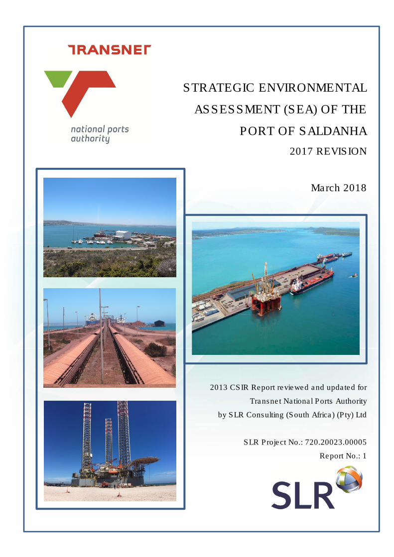
STRATEGIC ENVIRONMENTAL
ASSESSMENT (SEA) OF THE
PORT OF SALDANHA
2017 REVISION
March 2018
2013 CSIR Report reviewed and updated for
Transnet National Ports Authority
by SLR Consulting (South Africa) (Pty) Ltd
SLR Project No.: 720.20023.00005
Report No.: 1

SLR Consulting South Africa (Pty) Ltd Page 1
Strategic Environmental Assessment for the Port of Saldanha March 2018
DOCUMENT INFORMATION
Title Strategic Environmental Assessment (SEA) of the Port of Saldanha: 2017 Revision: 2013 CSIR Report reviewed and updated
Client Transnet National Ports Authority
Date last printed 2018/03/23 03:32:00 PM
Date last saved 2018/03/20 05:28:00 PM
Comments Report is a revision of a 2013 CSIR Report with Publication Number: CSIR/CAS/EMS/ER/2013/0009/B
Originally compiled by:
CSIR
PO Box 320, Stellenbosch, 7599, South Africa
Tel: 021 888 2583, Fax: 021 888 2693
Keywords Port of Saldanha, Strategic Environmental Assessment, Impact Assessment Report, revision
Project Number 720.20023.00005
Report Number 1
Status Final
Issue Date March 2018
CONSULTANT CONTACT DETAILS
Company SLR Consulting (South Africa) (Pty) Ltd
Project Manager Eloise Costandius
Project Manager e-mail [email protected]
Author Eloise Costandius and Peter Tarr
Reviewer Fuad Fredericks
Branch Cape Town
Postal address PO Box 10148
Caledon Square
7905
Physical address Unit 39 Roeland Square
30 Drury Lane
Cape Town
8001
Fax 021 461 1120
Phone 021 461 1118
This report revision has been prepared by an SLR Group company with all reasonable skill, care and
diligence, taking into account the manpower and resources devoted to it by agreement with the client.
Information reported herein is based on the interpretation of data collected, which has been accepted in
good faith as being accurate and valid.
No warranties or guarantees are expressed or should be inferred by any third parties.
This report may not be relied upon by other parties without written consent from SLR.
SLR disclaims any responsibility to the Client and others in respect of any matters outside the agreed
scope of the work.

SLR Consulting South Africa (Pty) Ltd Page i
Strategic Environmental Assessment for the Port of Saldanha March 2018
TABLE OF CONTENTS
CHAPTER 1: INTRODUCTION _____________________________________ 1
1.1 PURPOSE OF THE STRATEGIC ENVIRONMENTAL ASSESSMENT (SEA), REVIEW AND UPDATE 1
1.2 TERMS OF REFERENCE 1 1.3 STRUCTURE OF THE REPORT 2 1.4 PROJECT TEAM AND INFORMATION SOURCES 2
CHAPTER 2: PORT OF SALDANHA: CURRENT AND PLANNED OPERATIONS AND DEVELOPMENTS ___________________________ 6
2.1 TNPA SUSTAINABILITY VISION 6 2.2 NATIONAL PORTS AUTHORITY PORT DEVELOPMENT FRAMEWORK
PLAN 2016 7
2.2.1 Current layout 10 2.2.2 Short term layout 13 2.2.3 Medium term layout 15 2.2.4 Long-term layout 16
2.3 POLICY AND PLANNING CONTEXT 17
2.3.1 Strategic Integrated Projects 17 2.3.2 Operation Phakisa 18
2.4 LEGAL CONTEXT 18
2.4.1 National Ports Act (Act 12 of 2005) 19 2.4.2 National Environmental Management Act (NEMA)(Act 107 of 1998) 19 2.4.3 Draft Saldanha Bay Integrated Development Plan (IDP) 2017 to 2022 19 2.4.4 Draft Saldanha Bay Spatial Development Framework (SDF) 2017 20 2.4.5 Draft Greater Saldanha Region Spatial Implementation Framework (2016) 21 2.4.6 Greater Saldanha Environmental Management Framework (EMF) 2017 21
CHAPTER 3: BIO-PHYSICAL, SOCIAL & ECONOMIC DESCRIPTION ____ 23
3.1 INTRODUCTION 23 3.2 CLIMATE 23 3.3 MARINE ENVIRONMENT 25
3.3.1 Regional Biogeography 25 3.3.2 Coastline configuration 26 3.3.3 Wave regime 27 3.3.4 Marine water quality 28 3.3.5 Nutrients in Sediment 30 3.3.6 Hydrocarbons in Sediment 31
3.3.6.1 Poly-aromatic hydrocarbons 31 3.3.6.2 Total Petroleum Hydrocarbons 32
3.3.7 Marine & coastal ecosystems 32 3.3.7.1 Intertidal Habitat 32 3.3.7.2 Benthic macrofauna 33 3.3.7.3 Alien Invasive Species 36 3.3.7.4 Fish 37 3.3.7.5 Birds and Marine Mammals 38
3.4 TERRESTRIAL ENVIRONMENT 39
3.4.1 Topography and Geology 39 3.4.2 Rainfall, fresh water supply & regional hydro- and geohydrology 40 3.4.3 Flora & fauna 42 3.4.4 Protected areas 44
3.5 SOCIO-ECONOMIC ENVIRONMENT 46
3.5.1 Demographics 46

SLR Consulting South Africa (Pty) Ltd Page ii
Strategic Environmental Assessment for the Port of Saldanha March 2018
3.5.2 Employment and Economy 46 3.5.3 Marine aquaculture and important fisheries 47 3.5.4 Tourism & recreation 50 3.5.5 Large industry located in the study area 50 3.5.6 Heritage 54
CHAPTER 4: GENERAL APPROACH TO THE SEA AS APPLIED IN THIS STUDY 58
4.1 NEED FOR SEA 58 4.2 GENERAL SEA PRACTICE AND APPROACH ADOPTED FOR THIS SEA 59
4.2.1 General SEA practice 59 4.2.2 Approach to SEA adopted for the Port of Saldanha and its review and
update 62
CHAPTER 5: PORT OF SALDANHA: SES DEFINITION & RESILIENCE IMPLICATIONS _____________________________________________ 67
5.1 SOCIO-ECOLOGICAL SYSTEM DEFINITION AND RESILIENCE CHARACTERISTICS 67
5.2 SYSTEM FEEDBACK LOOPS 70
CHAPTER 6: OPPORTUNITIES, CONSTRAINTS & STRATEGIC MANAGEMENT ACTIONS (SMAS) _____________________________ 77
6.1 ASSESSMENT MATRIX 77 6.2 ENVIRONMENTAL THEME 78
6.2.1 Air quality 78 6.2.2 Natural vegetation 82 6.2.3 Marine water quality 84
6.3 ECONOMIC & ENGINEERING THEME 101
6.3.1 Economics 101 6.3.2 Civil & transport engineering 107
6.4 Social theme 112
6.4.1 Social changes 112
CHAPTER 7: CONCLUSION AND RECOMMENDATIONS _____________ 115
CHAPTER 8: REFERENCES ____________________________________ 119
SLR Consulting South Africa (Pty) Ltd Page iii
Strategic Environmental Assessment for the Port of Saldanha March 2018
TABLES
Table 1.1 TNPA Terms of reference for the original SEA of the Port of Saldanha and current revision 1 Table 1.2 Original SEA and SEA revision project teams 2
Table 2.1 Existing TNPA terminal infrastructure in the Port of Saldanha. 8
Table 2.2 New and planned TNPA infrastructure within the port of Saldanha 9
Table 2.3 Other notable projects within the port precinct and in close proximity to the port 9
Table 2.3 Potentially applicable legislation 22 Table 3.1 Total petroleum hydrocarbon in sediment samples collected over the period 2011-2017 from three
sites in Small Bay. Values in red indicate exceptionally high total petroleum hydrocarbon levels 32
Table 3.2 Fish species recorded during beach seine-net surveys in Small Bay, Saldanha in 1994, 2005 and
2007-2017 (Anchor, 2017) 37
Table 3.3 Details of aquaculture operators and the products farmed in Saldanha Bay (Anchor, 2017) 46
Table 3.4 Underlying geological formations of the Saldanha Bay area and their palaeontological sensitivity 53
Table 3.5 Summary of known shipwrecks in Saldanha Bay (adapted from SRK, 2017) 54
Table 4.1 Methodology for the compilation of the original Port of Saldanha SEA and subsequent update 60 Table 5.1 Port of Saldanha SES linking relationships (see Figure 5.1) 73 Table 7.1 Overall rating of proposed port development in the Port of Saldanha 115
FIGURES
Figure 2.1 Diagram showing the evolution of the PDFP from 2006 to its current format in 2016 7
Figure 2.2 Demand forecast for the Port of Saldanha (2016 to 2046) 8
Figure 2.3 Port of Saldanha limits as per Government Gazette No. 32873 of 22 January 2010 10
Figure 2.4 Location of current port infrastructure 12
Figure 2.5 Port of Saldanha (Current layout) 13
Figure 2.6 Port of Saldanha (Short-term layout) 14
Figure 2.7 Port of Saldanha (Medium-term layout) 16
Figure 2.8 Port of Saldanha (Long-term layout) 17
Figure 3.1 Prevailing wind directions and strenghts in Saldanha Bay from March 2014 to February 2015 24
Figure 3.2 Marine ecoregions and ecozones in the South African marine environment (Sink et al., 2012) 25
Figure 3.3 Saldanha Bay configuration 26
Figure 3.4 Predicted wave field in Saldanha Bay showing wave height and direction after the construction
of the causeway and the iron-ore Terminal (WSP Africa Coastal Engineers, 2010) 27
Figure 3.5 Cadmium (left) and copper (right) levels measured in Saldanha Bay and the Langebaan
Lagoon in 2017 (Anchor, 2017) 29
Figure 3.6 Concentrations of cadmium, copper, lead and nickel in mg/kg recorded at three sites in Saldanha
Bay between 2008 and 2015. Red dotted lines indicate Effects Range Low values for sediments 30
Figure 3.7 Total organic carbon (left) and total organic nitrogen (right) in Saldanha Bay in 2017 (Anchor, 2017) 31
Figure 3.8 Percentage cover of the seven functional groups surveyed by Anchor in 2015. Data were
averaged across the whole shore. Sites are organised from very sheltered to exposed 34
Figure 3.9 Trends in the biomass and abundance (g/m2) of benthic macrofauna in Small Bay as shown
by taxonomic and functional groups 35
Figure 3.10 Variation in the diversity of the benthic macrofauna in Saldanha Bay based on 2017 data.
H'=0 indicates low diversity, while H'=3.32 indicates high diversity (Anchor, 2017) 36
Figure 3.11 Average abundance of fish recorded from seine net surveys conducted in surf zone habitats within
Saldanha Bay-Langebaan Lagoon (Andhor, 2017) 38
Figure 3.12 Water demand trajectories for the West Coast District Municipality and allocations from the Berg River
and Langebaan aquifer (Greencape, 2015) 41
Figure 3.13 Google Earth Image showing the latest Critical Biodiversity Areas (green) within and surrounding
the port land (SANBI, 2017). The proposed expanded port area, including the SBIDZ area is outline
in yellow and additional mapped high sensitivity areas are indicated in red 42
Figure 3.14 Protected areas in the Saldanha Bay area (bgis.sanbi.org, 2017) 44
Figure 3.15 Map shwoing the location of current and proposed new expanded marine aquaculture areas as
part of the proposed DAFF ADZ project. The farming methodology is also indicated (SRK
Consulting, 2017) 48
SLR Consulting South Africa (Pty) Ltd Page iv
Strategic Environmental Assessment for the Port of Saldanha March 2018
Figure 3.16 Google Earth Image showing the extent of the industrial corridor (white outline) as envisaged
in the 2011 Saldanha Bay SDF. The latest CBA areas that overlap with the corridor are indicated
in red and green 51
Figure 3.17 Geology in the Saldanha Bay area (adapted from Visser & Schoch, 1972 by Pether, 2014).
The location if the SBIDZ area is indicated in red 52
Figure 3.18 Location of known shipwrecks in and near Saldanha Bay in relation to proposed ADZ areas
(SRK, 2017) 55
Figure 4.1 Main elements of a graphical causal loop diagram: SES variables, linking relationships and polarity 643
Figure 5.1 Port of Saldanha SES represented in a Causal Loop Diagram 687
Figure 5.2 Adaptive Cycle with key descriptors of Potential; Connectedness and Resilience. 698
Figure 5.3 Positive Feedback Loop 1 71
Figure 5.4 Positive Feedback Loop 2 72
Figure 5.5 Negative Feedback Loop 1 73
ACRONYMS
AEL Atmospheric Emissions Licence
ADZ Aquaculture Development Zone
CBA Critical Biodiversity Area
CD Chart Datum
CLD Causal Loop Diagram
CSIR Council for Scientific and Industrial Research
DAFF Department of Agriculture Forestry and Fisheries
DEA Department of Environmental Affairs
DEA&DP Department of Environmental Affairs and Development Planning
EIA Environmental Impact Assessment
EMF Environmental Management Framework
EMP Environmental Management Programme
ESA Ecological Support Area
GMQ General Maintenance Quay
IDP Integrated Development Plan
IDZ Industrial Development Zone
IGTT Intergovernmental Task Team
IOT Iron Ore Terminal
IUCN International Union for Conservation of Nature
LNG Liquid Natural Gas
LPG Liquid Petroleum Gas
MBM multi-buoy mooring
MPA Marine Protected Area
MPT Multi-purpose Terminal
MTPA million tons per annum

SLR Consulting South Africa (Pty) Ltd Page v
Strategic Environmental Assessment for the Port of Saldanha March 2018
NEMA National Environmental Management Act
OSSB Offshore Supply Base
PDFP Port Development Framework Plan
PICC Presidential Infrastructure Co-ordinating Commission
RO Reverse Osmosis
SANBI South African National Biodiversity Institute
SBIDZ-LC Saldanha Bay IDZ (SOC) Licencing Company
SDF Spatial Development Framework
SEA Strategic Environmental Assessment
SES Social-ecological System
SFF Strategic Fuel Fund
SIP Strategic Integrated Projects
SMAs Strategic Management Actions
TCP Transnet Capital Projects
TNPA Transnet National Ports Authority
TOC Total Organic Carbon
TON Total Organic Nitrogen
TPT Transnet Port Terminals

SLR Consulting (South Africa) (Pty) Ltd Page 1
Strategic Environmental Assessment for the Port of Saldanha March 2018
CHAPTER 1: INTRODUCTION
1.1 PURPOSE OF THE STRATEGIC ENVIRONMENTAL ASSESSMENT (SEA), REVIEW AND UPDATE
Extensive planning and construction programmes require strategic investigation in order to positively
contribute to sustainable development. The purpose of the original Strategic Environmental Assessment
(SEA) compiled by the Council for Scientific and Industrial Research (CSIR) in 2013 was to, as a first
step, investigate the strategic implications of implementing Transnet National Ports Authority’s (TNPA’s)
Port Development Framework Plan (PDFP) as it related to the expansion of the Port of Saldanha at the
time. Its purpose was also to propose Strategic Management Actions (SMAs) to guide port development
on a sustainable trajectory, thereby ensuring that environmental and social considerations inform, and are
integrated into, strategic decision-making in support of environmentally and socially sound and
sustainable development.
The purpose of the 2017 review and update is to confirm the continued applicability of the SEA and
suitability of the SMAs in line with the new project proposals and changes in project timelines included in
TNPA’s updated PDFP 2016.
1.2 TERMS OF REFERENCE
TNPA commissioned SLR Consulting (South Africa) (Pty) Ltd (SLR) to review and update the 2013 SEA
compiled by the CSIR for their long term (40+ year) expansion plan for the Port of Saldanha (Table 1.1).
This review and update process is in compliance with the statutory requirement for SEA of South African
port developments and operations (National Ports Act; Act 12 of 2005) and as advised in the Integrated
Environmental Management Information Series #10 (DEA 2004) regarding SEA. It is also aligned with the
institutional policies of TNPA.
The original SEA was based on the PDFP 2013. The PDFP is updated annually, based on changes in
the market and surrounding Saldanha Bay area. The future planned expansion of the Port of Saldanha
will be guided by the latest 2016 PDFP. As the PDFP and surrounding industrial and municipal
developments change and expand, so the SEA must be updated in order to stay relevant.
Table 1.1 TNPA Terms of reference for the original SEA of the Port of Saldanha and current revision.
TNPA TERMS OF REFERENCE
1. Development of a vision for the sustainable development and operations of the Port of Saldanha.
2. Identify key stakeholders/interested and affected parties for involvement in the SEA process.
3. Identify significant strategic issues and consolidation of known issues (as contained in the Port of Saldanha’s Long-Term Development Framework Plan).
4. Determine the compatibility of the Port’s Aspects & Impacts Register with identified strategic issues as well as the Long-term Development Framework Plan.
5. Address the causes of significant environmental impacts identified in the Port’s Aspects & Impacts register.
6. Identify and incorporate all legislation, plans, policies, programs that are required in order to inform the SEA.
7. Identify opportunities and constraints posed by the social, bio-physical and economic environment to achieve sustainability objectives, which must be stated.
8. Align the updated SEA with the current port development framework, and any other proposed plans for the port and greater Saldanha Bay area, to allow for streamlining of subsequent EIAs for individual TNPA projects, through the identification of, for example, limits of acceptable change.

SLR Consulting (South Africa) (Pty) Ltd Page 2
Strategic Environmental Assessment for the Port of Saldanha March 2018
9. Investigate and determine the potential environmental impact of commodities in the port’s natural hinterland that are currently or are planned to be explored, which can be handled /exported via the port.
10. Evaluate and highlight “fatal flaws” that will prohibit certain developments and the handling of a particular commodity in the port or precinct of the port.
11. Update the SEA with the latest baseline biophysical and socio-economic conditions of the surrounding environment.
12. Engage and make presentations to the Port of Saldanha EXCO, any other relevant personnel, key stakeholders and the public at large.
13. Engage with all relevant authorities including but not limited to the Saldanha Bay Local Municipality, Department of Environment Affairs and Development Planning (DEA&DP), etc.
14. Provide recommendations in line with planned development and applicable legislation.
1.3 STRUCTURE OF THE REPORT
The SEA report is broadly structured around two major themes: firstly, the Port of Saldanha’s current
context and proposed development within the enabling environment of the Saldanha Bay Municipal
boundaries; followed by a discussion of the SEA and review and update methodology, its key findings
and the related implications for sustainable port development.
Chapter 2 introduces the reader to the details of the PDFP as it relates to the Port of Saldanha and also
explains TNPA’s sustainability vision. The bio-physical, social and economic environment in which the
Port of Saldanha is located is discussed in Chapter 3, with the discussion placing particular emphasis on
implications for port development and operations. Chapter 4 explains the methodology employed in the
SEA and the review and update, and introduces the reader to key theory and concepts required to
understand and interpret the findings of the study. The latter findings are presented in Chapter 5. The
SMAs that are proposed, based on the outcome of the SEA review and update, are presented in Chapter
6; they are intended as a practical guide (for uptake in management planning and execution) for planned
port development activities and operations. Finally, a set of concluding remarks is presented in Chapter 7.
1.4 PROJECT TEAM AND INFORMATION SOURCES
The original SEA document was compiled by an experienced SEA team from the CSIR with input from an
independent specialist team with knowledge of the Saldanha Bay area. The revision team includes a
SEA specialist from the Southern African Institute for Environmental Assessment (SAIEA), with SLR
having considerable experience working in the Saldanha Bay area and within the Port of Saldanha.
Details of the project teams are presented in Table 1.2 below.
Table 1.2 Original SEA and SEA revision project teams.
Specialist study Specialist and their affiliation(s)
Comment on the selection of the specialists
Strategic
implications:
Terrestrial
ecosystems
Nick Helme (Nick Helme
Botanical Surveys)
Nick Helme is a specialist botanical consultant, specialising in the
diverse flora of the south-western Cape. He has been involved in
over 750 botanical assessments for proposed development sites
(golf courses, housing estates, quarries; roads; borrow pits;
pipelines, power lines; power stations; mines) throughout the
Western and parts of the Northern Cape in Strandveld, Lowland
Fynbos, Mountain Fynbos, and Renosterveld localities as far
afield as Plettenberg Bay, Knysna, Mossel Bay, Agulhas, Bot
River, Hermanus, Stellenbosch, Hopefield, Piketberg, Saldanha,
Lamberts Bay, Ceres, Clanwilliam, and Nieuwoudtville.

SLR Consulting (South Africa) (Pty) Ltd Page 3
Strategic Environmental Assessment for the Port of Saldanha March 2018
Strategic
implications:
Archaeology
Jonathan Kaplan (Agency
for Cultural Resource
Management)
Jonathan Kaplan has taken part in numerous archaeological
impact assessments, specializing in Stone Age, rock art and
herder studies. He has undertaken baseline studies on large
projects, including the Lesotho Highlands Water Project (a World
Bank project), Maguga Dam (Swaziland), Namibia/Botswana
Water Transfer Project, Sasol/ACO Gas Pipeline (South Africa),
Corridor Sands (Mozambique) and numerous utility projects for
Eskom, as well as coastal and catchment management surveys,
research projects and undertaken excavations of numerous rock
shelters and coastal shell middens.
Strategic
implications:
Palaeontology
John Pether (Private
consultant)
John is a recognized authority in the field of coastal-plain and
continental-shelf palaeoenvironments and is consulted by
exploration and mining companies, by the Council for
Geoscience, the Geological Survey of Namibia and by
colleagues/students in academia pursuing coastal-plain/shelf
projects. At present, an important involvement is in
palaeontological impact assessments (PIAs) and mitigation
projects in terms of the National Heritage Resources Act 25
(1999). The location of CTIA falls within an environment (ancient
coastal dune system) in which he has specialist knowledge.
Strategic
implications:
Atmospheric
receiving
environment
Dr. Mark Zunckel
(uMoya-NILU (Pty) Ltd )
Mark Zunckel is the Managing Director of uMoya-NILU Consulting
(Pty) Limited. He has a PhD from the University of the
Witwatersrand and is a meteorologist by profession with 13 years
of operational meteorology and research experience at the South
African Weather Service before he joined and led the air research
pollution group at CSIR. There he developed his career further
through many small and large research and consultancy projects
over a 15 year period, including work in a number of southern
African countries and in South America. These included air
quality specialist studies for industrial developments, the Dynamic
Air Pollution Prediction System, leading the consultancy team in
the development of the National Framework for Air Quality
Management. With uMoya-NILU he led ground-breaking projects
that include development of the air quality management plan
(AQMP) for the Western Cape, the development of the AQMP for
the Highveld Priority Area and the first AQMP review project for
the City of Johannesburg. Mark is a registered as a Professional
Natural Scientist with the South African Council for Natural
Scientific Professional (SACNSP, Reg. No.: 400449/04).
Strategic
implications:
Marine
ecosystems
Pat Morant (CSIR) Pat Morant has an M.Sc in Environmental Science and more than
26 years’ experience in coastal environmental management and
environmental impact assessment on the west coast of South
Africa, with strong experience in EIAs in the marine and coastal
environment. For example, in Namibia he has been closely
involved in several EIAs and EMPs for marine diamond mining, oil
and gas developments, and coastal and port developments. Pat
also has a sound knowledge of the BCLME Project and has been
involved in several environmental assessment contracts along the
African West Coast.
Strategic
implications:
Marine water
quality
Dr Susan Taljaard (CSIR) Dr Susan Taljaard is a principal researcher with more than 20
years’ experience in marine and estuarine water quality research
and management. She specializes in the design and application
of coastal and estuarine management plans and best practice
guides. Recently she assisted the Department of Environmental
Affairs with the development of the National program of action to
protect the marine environment from land-based activities and
assisted them with the revision of South Africa’s water quality
guidelines for coastal marine waters (focusing on recreational
use). Susan has also worked on related project as part on
regional programs such as the Benguela Large Marine
Ecosystems (BCLME) and Western Indian Ocean Land-based
Activities (WIO-Lab) programs. She is also actively involved in
applied research on the biogeochemical characteristics and
SLR Consulting (South Africa) (Pty) Ltd Page 4
Strategic Environmental Assessment for the Port of Saldanha March 2018
processes in coastal systems, specifically estuaries, and their
responses to global change pressures. Susan recently (2011)
completed her PhD studies at the University of Stellenbosch. Her
dissertation entitled An implementation model for integrated
coastal management in South Africa – from legislation to practice,
proposed an implementation model for integrated coastal
management (ICM) within the South African context and included
a review of relevant marine legislation.
Strategic
implications:
Marine water
quality (sediment)
Roy van Ballegooyen
(CSIR)
M.Sc. Physical Oceanography. He has 24 years’ experience in
undertaking both academic and applied research and contract
work whilst in the employment of maritime research institutes
(CSIR, Institute for Maritime Technology and the University of
Cape Town).
Strategic
implications:
Port’s economic
catchment
Dr Hugo van Zyl
(Independent Economic
Researchers)
Dr. Hugo van Zyl has extensive experience in economic impact
assessments and has completed approximately 50 economic
impacts assessments and specialist studies including for
infrastructure projects. Dr Van Zyl is also the lead author of the
Western Cape Provincial Government guidelines on economic
specialist inputs into EIAs (Van Zyl et al., 2005). These guidelines
have been accepted at a national level and are applied
throughout the country.
Strategic
implications:
Bulk services and
infrastructure
Bertie Philips (Kantey &
Templer Consulting
Engineers)
Bertie has over 25 years’ experience in conducting traffic planning
and traffic impact assessment. Bertie Phillips worked in the New
York City, Manhattan office of Urbitran Associates as a project
manager responsible for traffic impact studies and public
transport planning. He was seconded to the Port Authority of
NY&NJ for several large projects including Annual traffic counts at
Newark Airport; license plate Origin- Destination studies at
Kennedy Airport and investigation into congestion at the
Manhattan entrance to the Holland Tunnel. He was also
responsible for a NY DOT pilot study to evaluate the High
Occupancy Vehicle Lane on the Long Island Expressway.
Project leadership Dr Mike Burns (CSIR) Mike has played a foundational role incorporating novel concepts
such as social-ecological systems modelling and resilience
analysis in the projects he has been involved in relating to the
resources sector and strategic infrastructure. Much of his
professional focus has been on Central and West Africa’s oil and
gas sector. In this latter regard, he has played an important role in
building CSIR’s relationship with the African Oil and Gas sector
and supporting its contribution to sustainable development. Under
Mike’s leadership, CSIR has undertaken more than fifty (50) EIAs
for seismic, exploration drilling, production and product
conveyance and storage in more than 10 African states. Mike
also led many other environmental initiatives that have informed
developments within the oil and gas and energy sector, including,
for example, environmental due diligence studies, geotechnical
investigations and environmental performance monitoring.
Project
management
Rudolph du Toit (CSIR) Rudolph studied as a planner and chose to apply his trade in the
environmental management field. He has planned and managed
several Environmental Impact Assessments (EIA) in South Africa
and gained international environmental management experience
in the oil and gas sector of west Africa (Cameroon and Gabon).
Rudolph is currently involved in a CSIR applied science initiative
to operationalize social-ecological systems modelling and
resilience analysis as an established environmental management
tool.
SEA Revision
Team
Dr Peter Tarr (SAIEA) Peter is the founder and the Executive Director of the SAIEA, a
consulting NGO operating throughout Africa. He has led teams
undertaking large and complex SEAs in various countries over
the past 10 years. He has worked mostly in Africa, but also in
South America and Asia. Peter has a PhD in Environmental
Management and Planning from Aberdeen University, Scotland.

SLR Consulting (South Africa) (Pty) Ltd Page 5
Strategic Environmental Assessment for the Port of Saldanha March 2018
As part of the 2017 SEA revision, key issues and descriptions of the current affected environment
surrounding the Port of Saldanha have been revised to also include more recent specialist investigations
undertaken for TNPA and other Environmental Impact Assessment (EIA) processes in the area. These
more recent reports are referenced where relevant and include the following:
• State of the Bay Report 2017 (Anchor)
• Pre-feasibility Studies for Berth 205 and Mossgas Jetty, including geotechnical studies (ARUP,
2014 and 2016)
• General Maintenance Quay Basic Assessment (SRK, 2013)
• Oil and Gas Offshore Service Complex at the Saldanha Bay Industrial Development Zone (IDZ)
(CCA, 2015)
• Draft Environmental Management Framework for the Saldanha Bay area (Gibb, 2017)
• Physical, Marine Ecology and Air Quality assessments for new oil and gas repair marine
infrastructure undertaken as part of the TNPA Project Phakisa Screening Study (SLR, 2016)
SEA Revision
Team
Eloise Costandius (SLR) Eloise has worked as an Environmental Assessment Practitioner
since 2005 and holds an MSc in Ecological Assessment from the
University of Stellenbosch. Eloise has been involved in six EIA
processes within the Saldanha Bay area since 2010 and through
these projects have gained valuable experience in the
management of assessment processes within the Saldanha Bay
planning environment.
SEA Revision
Team
Fuad Fredericks (SLR) Fuad is a Director of SLR and is responsible for SLR’s Linear
Infrastructure sector in Africa. He holds an MSc in Botany from
the University of the Western Cape and has been involved in
environmental consulting since 1999. He has been responsible
for management and quality control of environmental
assessments dealing with a number of highly complex and
controversial projects and recently provided a review role for the
environmental monitoring of the General Maintenance Quay
upgrade project in the Port of Saldanha, as well as for the
Environmental Screening Study for TNPA’s proposed oil and gas
marine infrastructure within the port.
SLR Consulting (South Africa) (Pty) Ltd Page 6
Strategic Environmental Assessment for the Port of Saldanha March 2018
CHAPTER 2: PORT OF SALDANHA: CURRENT AND PLANNED
OPERATIONS AND DEVELOPMENTS
2.1 TNPA SUSTAINABILITY VISION
The sustainability vision for the Port of Saldanha was developed by the port management team. This
vision is of particular importance to the SEA as it provides the foundation to the strategic direction and
values that guide the port’s current operations and future development. The Port of Saldanha
sustainability vision is as follows:
“The Port of Saldanha acts as a catalyst to grow the economy in an environmentally responsible manner, through sustainable development,
innovation, cooperative governance and engagement with the community, protecting sensitive ecosystems and natural and cultural
heritage”.
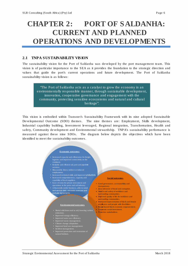
This vision is embodied within Transnet’s Sustainability Framework with its nine adopted Sustainable
Developmental Outcome (SDO) themes. The nine themes are: Employment, Skills development,
Industrial capability building, Investment leveraged, Regional integration, Transformation, Health and
safety, Community development and Environmental stewardship. TNPA’s sustainability performance is
measured against these nine SDOs. The diagram below depicts the objectives which have been
identified to meet the sustainability outcomes.
Economic outcomes
• Increased capacity and efficiencies for freight
logistics and improved connectivity on the
continent.
• Reliable and efficient rail, port and pipeline
services.
• Measurable direct, indirect or induced
employment.
• Increased technical skills and improved productivity.
• Increased competitiveness, capacity and
capability of local suppliers.
• Ease of entry for private investment and
operations in the ports and rail industry.
• A financially stable business, able to raise
and service debt, reinvests revenues and
pursues agreements.
Social outcomes
• Good governance, accountability and
transparency.
• Zero tolerance of fraud and corruption.
• Health and safety of workforce and
surrounding communities.
• Improved quality of life for workforce and
surrounding communities.
• Increased representation of black and female
employees and people with disabilities.
• Broad-based black economic empowerment.
• Corporate social investment.
• Proactive stakeholders.
Environmental outcomes
• Modal shift from road to rail, lowering carbon
emissions.
• Improved energy efficiency.
• Improved water use efficiency.
• Improved waste management.
• Climate change adaptation.
• Improved land use management.
• Incident management.
• Improved protection and restoration of
natural habitats.
SLR Consulting (South Africa) (Pty) Ltd Page 7
Strategic Environmental Assessment for the Port of Saldanha March 2018
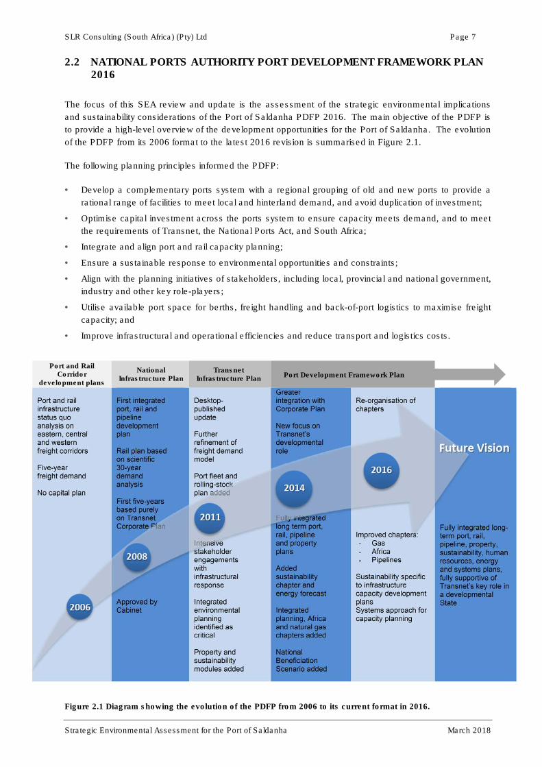
2.2 NATIONAL PORTS AUTHORITY PORT DEVELOPMENT FRAMEWORK PLAN 2016
The focus of this SEA review and update is the assessment of the strategic environmental implications
and sustainability considerations of the Port of Saldanha PDFP 2016. The main objective of the PDFP is
to provide a high-level overview of the development opportunities for the Port of Saldanha. The evolution
of the PDFP from its 2006 format to the latest 2016 revision is summarised in Figure 2.1.
The following planning principles informed the PDFP:
• Develop a complementary ports system with a regional grouping of old and new ports to provide a
rational range of facilities to meet local and hinterland demand, and avoid duplication of investment;
• Optimise capital investment across the ports system to ensure capacity meets demand, and to meet
the requirements of Transnet, the National Ports Act, and South Africa;
• Integrate and align port and rail capacity planning;
• Ensure a sustainable response to environmental opportunities and constraints;
• Align with the planning initiatives of stakeholders, including local, provincial and national government,
industry and other key role-players;
• Utilise available port space for berths, freight handling and back-of-port logistics to maximise freight
capacity; and
• Improve infrastructural and operational efficiencies and reduce transport and logistics costs.
Port and Rail Corridor
development plans
National Infrastructure Plan
Transnet Infrastructure Plan
Port Development Framework Plan
Port and rail infrastructure status quo analysis on eastern, central and western freight corridors Five-year freight demand No capital plan
First integrated port, rail and pipeline development plan Rail plan based on scientific 30-year demand analysis First five-years based purely on Transnet Corporate Plan Approved by Cabinet
Desktop-published update Further refinement of freight demand model Port fleet and rolling-stock plan added Intensive stakeholder engagements with infrastructural response Integrated environmental planning identified as critical Property and sustainability modules added
Greater integration with Corporate Plan New focus on Transnet’s developmental role Fully integrated long term port, rail, pipeline and property plans Added sustainability chapter and energy forecast Integrated planning, Africa and natural gas chapters added National Beneficiation Scenario added
Re-organisation of chapters Improved chapters: - Gas - Africa - Pipelines
Sustainability specific to infrastructure capacity development plans Systems approach for capacity planning
Fully integrated long-term port, rail, pipeline, property, sustainability, human resources, energy and systems plans, fully supportive of Transnet’s key role in a developmental State
Figure 2.1 Diagram showing the evolution of the PDFP from 2006 to its current format in 2016.

SLR Consulting (South Africa) (Pty) Ltd Page 8
Strategic Environmental Assessment for the Port of Saldanha March 2018
Demand forecast for the Port of Saldanha has guided the various aspects of port expansion proposed in
the PDFP 2016 (Figure 2.2). Saldanha’s freight volumes are currently dominated by iron ore export
through the Iron Ore Terminal (IOT). The forecasts for iron ore export show growth from current volumes
of 58 million tons per annum (MTPA) to more than 73 MTPA over a 30-year period. Liquid bulk demand is
forecast to grow from 3.9 to 6.4 MTPA over the same period. The forecast for break bulk and dry bulk
cargoes through the Multi-purpose Terminal (MPT) is expected to be stable and relatively low (2-3%) over
the 30-year period. No container or vehicle cargo volumes are forecast in the 30-year planning period,
with current manganese exports to cease soon when the activity is moved to the Port of Ngqura. The
proposed start-up capacity for manganese exports at Ngqura is 16 MTPA.
Figure 2.2 Demand forecast for the Port of Saldanha (2016 to 2046)
The main existing terminal infrastructure in the Port of Saldanha is listed in Table 2.1 below. The cargo
types, terminal and berthing details are provided. Major new and planned infrastructure within the port
limits is listed in Table 2.2, with the related costs and implementation timeframes provided.
Table 2.1 Existing TNPA terminal infrastructure in the Port of Saldanha.
EXISTING INFRASTRUCTURE
Cargo type Terminal Berths Usable berths
Terminal capacity
Berth length
Berth draft
Iron ore Iron ore 101, 102 2 60 000 000 1 260 m 23 m
Break bulk Multi-purpose 201, 202,
203, 204 4 7 000 000 874 m 13 m to 15.5 m
Liquid bulk Liquid bulk 103 1 25 000 000 360 m 23 m

SLR Consulting (South Africa) (Pty) Ltd Page 9
Strategic Environmental Assessment for the Port of Saldanha March 2018
Table 2.2 New and planned TNPA infrastructure within the Port of Saldanha.
NEW AND PLANNED INFRASTRUCTURE
Cargo type Project Timeframe Project cost
Dry bulk Iron ore expansion to 80 MTPA Medium term R3 403 m
Break bulk MPT expansion (Berth 200) Medium term To be confirmed
Liquid bulk LPG terminal Completed R1 200 m
Liquid bulk LNG terminal Medium term To be Confirmed
TNPA other Offshore Supply Base (OSSB) Short term R 155 m
Ship repair Jetty at Mossgas Quay (to 500 m) Medium term R5 620 m
Rig repair Berth 205 adjacent to MPT Medium term R 3 046 m
TNPA other Strategic land acquisition (230 ha) Short term R42 m
Liquid bulk Energy precinct with tank farm (300 ha) Medium term R900 m
The Port cannot develop in seclusion, therefore other developments proposed by large industry,
government (local, provincial and national) and private developers in the broader Saldanha area were
taken into consideration in the context of the study. Notable projects planned by other parties within and
in close proximity to the port are listed in Table 2.3.
Table 2.3 Other notable projects within the port precinct and in close proximity to the port.
INFRASTRUCTURE PLANNED BY OTHERS IN THE VICINITY OF THE PORT
Project Proponent Location Timeframe Project status
Saldanha Bay IDZ
- 124 ha Back-of Port Precinct
general services area
- 35 ha light and heavy
fabrication site
- 35 ha logistics support area
SBIDZ-LC
Adjacent to port
land
Port land
Port land
Short term
Short term
Short term
Services
completed
Design phase
Design phase
Establishment of an Aquaculture
Development Zone DAFF
Within offshore
port limits Short term
Approvals
received
Commercial crude oil blending and
storage terminal MOGS
Outside of port
land Short term
Approvals
received
Gas to Power Plant for Arcelor Mittal
International Power
Consortium South
Africa
Outside of port
land Short term
Approvals
received
Maintenance and upgrade of the
Saldanha Bay and Pepper Bay
Harbours (Small Harbours)
Department of Public
Works
Within and
adjacent to
offshore port
limits
Short term Application
pending
Saldanha Bay Waterfront development Saldanha Bay
Municipality
Adjacent to
offshore port
limits
Short term Planning phase
SLR Consulting (South Africa) (Pty) Ltd Page 10
Strategic Environmental Assessment for the Port of Saldanha March 2018
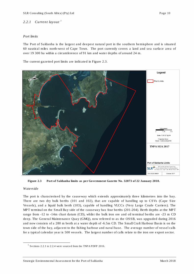
2.2.1 Current layout 1
Port limits
The Port of Saldanha is the largest and deepest natural port in the southern hemisphere and is situated
60 nautical miles north-west of Cape Town. The port currently covers a land and sea surface area of
over 19 300 ha within a circumference of 91 km and water depths of around 24 m.
The current gazetted port limits are indicated in Figure 2.3.
Figure 2.3 Port of Saldanha limits as per Government Gazette No. 32873 of 22 January 2010.
Waterside
The port is characterised by the causeway which extends approximately three kilometres into the bay.
There are two dry bulk berths (101 and 102), that are capable of handling up to CSVs (Cape Size
Vessels), and a liquid bulk berth (103), capable of handling VLCCs (Very Large Crude Carriers). The
MPT terminal on the Small Bay side of the causeway has four berths (201-204). Berth depths at the MPT
range from -12 to -14m chart datum (CD), whilst the bulk iron ore and oil terminal berths are -23 m CD
deep. The General Maintenance Quay (GMQ), now referred to as the OSSB, was upgraded during 2016
and now consists of a 280 m berth at a water depth of -6.5m CD. The Small Craft Harbour Basin is on the
town side of the bay, adjacent to the fishing harbour and naval base. The average number of vessel calls
for a typical calendar year is 500 vessels. The largest number of calls relate to the iron ore export sector.
1 Sections 2.2.1 to 2.2.4 were sourced from the TNPA PDFP 2016.
TNPA SEA 2017

SLR Consulting (South Africa) (Pty) Ltd Page 11
Strategic Environmental Assessment for the Port of Saldanha March 2018
Sunrise Energy is currently operating a new LPG terminal from a multi-buoy mooring (MBM) system in
Big Bay. The MBM is connected to the onshore terminal via a pipeline, approximately 700 m inland from
the iron ore stockpile area. The terminal became fully operational during 2017. Phase 1 of the terminal
includes storage capacity of 5 500 million tonnes (MT), allowing for the importation of up to 17 500 MT of
LPG per month. The facility has an ultimate storage capacity of 16 500 MT with a throughput capacity of
52 000 MT/month or 624 000 MTPA.
Landside
On the landside, the port limits encompass an area of 538 ha. Dry bulk operations occupy 73 ha, break
bulk 20 ha and ship repair activities 22 ha. A large portion of port land is undeveloped and zoned as
either open space or for other TNPA usage. This comprises 420 ha of the total area and provides a basis
for future port expansions and terminal development. Approximately 166 ha of the port land south of
MR559 were officially designated as part of the Saldanha Bay IDZ by the Minister of Trade and Industry
in the Government Gazette 36988 on 31 October 2013. The Saldanha Bay IDZ Licencing Company
(SBIDZ-LC) currently holds an Environmental Authorisation for the development and operation of an
offshore oil and gas service complex on port land within the IDZ area. During 2016, an Offshore Supply
Base Terminal, which would link into IDZ operations, was constructed by combining the GMQ and Rock
Quay to create a single facility. The OSSB operations will also incorporate a 20 ha landside area of the
Saldanha Bay IDZ northwest of the GMQ. TNPA envisions having a terminal operator appointed by the
start of the 2018/2019 financial year. The 20 ha landside area would include fuel bunkering facilities,
fabrication and lubrication yards and various storage and laydown areas.
Inland transport
The port is linked to the hinterland by the Sishen – Saldanha rail corridor, giving access to the Northern
Cape iron ore mines. The construction of a third iron ore tippler facility to the east of the rail line entering
the iron ore terminal is currently underway. There is a non-core rail line to Cape Town that connects with
the Cape-Gauteng corridor, enabling connectivity to the hinterland.
The Western Cape Government: Department of Transport and Public Works received authorisation in
May 2015 for a new road link and dedicated freight route between the R27 and R45. Construction of this
route has commenced and will ultimately link with the N7, which provides access to the national road
network.
Liquid fuel pipelines connect the port to the off-site Strategic Fuel Fund (SFF) storage facilities which is
connected to the Cape Town refinery.
The location of current infrastructure is depicted graphically in Figures 2.4 and 2.5.

SLR Consulting (South Africa) (Pty) Ltd Page 12
Strategic Environmental Assessment for the Port of Saldanha March 2018
Figure 2.4 Location of current port infrastructure.
TNPA SEA 2017

SLR Consulting (South Africa) (Pty) Ltd Page 13
Strategic Environmental Assessment for the Port of Saldanha March 2018
Figure 2.5 Port of Saldanha (Current layout). Key:
Current Layout
1. Iron ore export terminal with stockpiles and two berths, endpoint of the Sishen – Saldanha heavy haul rail corridor
2. Offshore supply base at the expanded General Maintenance Quay
3. Multi-purpose terminal
4. Liquid bulk berth at end of jetty
5. Saldanha Bay IDZ
6. Mossgas site fabrication yard and quay
7. Small craft harbour
8. LPG multi-boy mooring system floating berth (Sunrise Energy)
2.2.2 Short term layout
Short term plans for the port include strategic land acquisition to ensure improvements to the port access
corridor and ensuring that the future growth of the port is not restricted on the landside. The specific land
parcel identified for acquisition in the short term includes land occupied by the Sunrise Energy onshore
gas receiving and storage facility. The reconfiguration of the eastern side of the liquid bulk terminal at the
end of the jetty to provide for an additional berth is also considered. Construction of internal portside
infrastructure for the offshore oil and gas service complex within the IDZ area is set to commence in
2018. This would service a fabrication yard and bunkering facilities as part of the OSSB. The
development of a Port Commercial Precinct surrounding TNPA’s Bayvue offices is also planned. With the
planned land acquisition, the Port footprint is projected to increase from the current size of 975 ha to
1 020 ha (see Figure 2.6).
7
7
5
6
1
2 3
7
8
4

SLR Consulting (South Africa) (Pty) Ltd Page 14
Strategic Environmental Assessment for the Port of Saldanha March 2018
Figure 2.6 Port of Saldanha (Short-term layout). Key:
Short-term (7 year) layout
1. TNPA land acquisition
2. IDZ portside infrastructure linked to the OSSB
3. Port Commercial Precinct
4. Extension of liquid bulk terminal
Other notable projects planned in close proximity to port land and infrastructure in the short term include
the following:
• The establishment of an Aquaculture Development Zone (ADZ) by the Department of Agriculture,
Forestry and Fisheries (DAFF) in areas of Small Bay, Big Bay and Outer Bay (see Section 3.5.3);
• The commercial Oiltanking MOGS Saldanha (OTMS) crude oil blending and storage terminal
immediately to the east of the SFF facility, approximately 4 km east of the Port. The terminal will
consist of twelve 1.1 million-barrel in-ground concrete storage tanks, with the first eight tanks to be
commissioned in the third quarter of 2018 (see Section 3.5.5);
• A 1 507 megawatt (MW) Combined Cycle Gas Turbine (CCGT) power plant to service
ArcelorMittal’s Saldanha Steel facility. The project will require LNG as its main fuel supply and will
consume about 76 million gigajoules of natural gas per year and will be constructed approximately
5 km northeast of the Port, within 1 km east of the ArcelorMittal Steelworks (see Section 3.5.5);
• Maintenance and upgrade of the Saldanha Bay and Pepper Bay Small Harbours as part of the
Department of Public Works’ Small Harbours Upgrade Project; and
• The Saldanha Bay Waterfront development at the northern end of Saldanha Bay with the aim to
enhance the entire Main Road from the end of the main beach at the Hoedjiesbaai Hotel, above the
rocky coastline and around Hoedjiespunt, to the Pepper Bay and Saldanha Bay Yacht Club area.
1
2
3
4
SLR Consulting (South Africa) (Pty) Ltd Page 15
Strategic Environmental Assessment for the Port of Saldanha March 2018
The proposed development would include a dedicated Saldanha Bay Waterfront activity zone of
water extending about 200 m offshore from the shoreline for the full width of the Waterfront
Precinct. This project would tie in with the overall vision of integrating the Port of Saldanha with the
greater Saldanha Bay community to the socio-economic benefit of the region as a whole. The first
phase of the project would entail the redevelopment of the old Shell service station into a mixed
use area to be open for business during the second half of 2018.
2.2.3 Medium term layout
Medium-term plans for the port will include strategic land acquisitions (to ensure that the future growth of
the port is not restricted on the landside), improvements to the port access corridor, and a strong focus on
servicing the offshore oil and gas industry with the addition of major marine infrastructure. The medium-
term development plans strongly reflect Operation Phakisa’s strategic goals and initiatives (see
Section 2.3). Medium-term plans to provide ship and rig repair berths are also in line with improving and
expanding current vessel repair facilities in South Africa. The aim is to establish purpose-built oil and gas
infrastructure to serve Africa’s offshore oil and gas industry. A ship and rig repair facility would be
constructed on the waterside of the 35 ha IDZ leased area and a dedicated rig repair berth, Berth 205,
would be located at a preferred position immediately to the south of the Multi-Purpose Terminal.
A major energy cluster is being considered which could result in a liquid bulk basin in Big Bay, with
bunker and LPG berths adjacent to the iron ore stockpile area. Depending on whether new cargoes are
identified, there are plans to extend the Multi-Purpose Terminal. The current Ore Line Expansion Project
is considering expanding export capacity on the corridor and through the port to enable handling of
82 MTPA of iron ore. This will require additional iron ore stockpiles and an additional berth, with
associated rail capacity expansions. With the planned land acquisition, the Port footprint is projected to
increase to 1 241 ha in the medium term (see Figure 2.7).

SLR Consulting (South Africa) (Pty) Ltd Page 16
Strategic Environmental Assessment for the Port of Saldanha March 2018
Figure 2.7 Port of Saldanha (Medium-term layout).
Key:
Medium-term (30 year layout)
1. Land acquisition
2. Iron Ore Terminal Expansion: Phase 2 (3rd Berth)
3. Additional Break Bulk Berth and Quayside Terminal
4. Dedicated rig repair Berth 205
5. Ship and rig repair facility
6. Further development of the IDZ oil and gas offshore service complex
7. Liquid Bulk receiving facility and pipeline
2.2.4 Long-term layout
The long term plan shows the anticipated increased port limits, and a greatly expanded waterside
infrastructure. This includes further development in the liquid bulk basin, an expanded MPT, extension of
the OSSB berth for other use and an established ship build capacity. Expansion of the road and rail
access to the port is also included. The second phase of the Liquid Bulk facilities are also indicated with
a land-based storage and re-gas facility, gas transmission lines and a distribution hub (see Figure 2.8).
1
7
6
5
3 4 2

SLR Consulting (South Africa) (Pty) Ltd Page 17
Strategic Environmental Assessment for the Port of Saldanha March 2018
Figure 2.8 Port of Saldanha (Long-term layout)
2.3 POLICY AND PLANNING CONTEXT
2.3.1 Strategic Integrated Projects
The South African Government adopted a National Infrastructure Plan in 2012 that intends to transform
the economic landscape while simultaneously creating significant numbers of new jobs, strengthening the
delivery of basic services, and supporting the integration of African economies. A commission, the
Presidential Infrastructure Co‐ordinating Commission (PICC), was established to integrate and co‐
ordinate the long‐term infrastructure build. The PICC has identified infrastructure gaps, population
movement and economic performance within a special framework and have developed eighteen Strategic
Integrated Projects (SIPs) to address the country’s needs, as well as a more comprehensive
‘Infrastructure Book’ of 645 projects.
The draft Infrastructure Development Bill, 2013 (Government Gazette No. 36143) provides for, inter alia,
the identification and implementation of SIPs which are of significant economic or social importance. A
project qualifies as a SIP if:
(a) It comprises of one or more installation, structure, facility, system, service or process relating to any
matter specified in Schedule 1 of the Bill;
(b) It complies with any of the following criteria:
(i) It would be of significant economic or social importance to South Africa;
(ii) it would contribute substantially to any national strategy or policy relating to infrastructure
development; or
(iii) it is above a certain monetary value determined by the PICC.
SLR Consulting (South Africa) (Pty) Ltd Page 18
Strategic Environmental Assessment for the Port of Saldanha March 2018
(c) The PICC has included the project in the National Infrastructure Plan and has designated the
project as a SIP.
SIP 5 relates to the integrated development of the Saldanha-Northern Cape Development Corridor to
ensure that the linked regions become an integrated value-adding entity, rather than simply a transit
corridor for iron-ore export from the Sishen iron-ore mines in the Northern Cape. For the Saldanha Bay
area, this entails expansion of rail and port infrastructure, construction of industrial capacity in the back of
port areas (including the IDZ), strengthening maritime support capacity to create economic opportunities
from the gas and oil activities along the African West Coast and the expansion of iron ore mining
production (LTPF, 2016). Over the next 30 years, related projects in the Saldanha area include the
Export Iron Ore Expansion Programme (rail and port), the Saldanha Bay to Atlantis Natural Gas Pipeline
project, and other Port of Saldanha expansion projects (oil and gas service infrastructure).
2.3.2 Operation Phakisa
In September 2014, the Presidency launched Operation Phakisa, a national initiative which aims to
unlock the economic potential of South Africa’s oceans. The following four new growth areas were
identified as key priorities for growing the ocean economy:
• Marine transport and manufacturing;
• Offshore oil and gas;
• Fisheries and aquaculture; and
• Marine protection services.
As part of this overarching initiative, the Port of Saldanha has been identified by National Government for
the establishment of an offshore oil and gas complex providing support and services to oil and gas
exploration off the West African coast. Based on various pre-feasibility investigations, TNPA identified
two marine infrastructure components for development within the Port of Saldanha. These include the
addition of a dedicated facility for rig repairs (referred to as Berth 205) as well as a 500 m long jetty in the
vicinity of the existing Mossgas Quay. These projects have been nationally recognised as having
strategic value for the country. An OSSB terminal has been constructed at the GMQ area and will be the
first component of the infrastructure development plan under the Operation Phakisa initiative. The marine
components would tie into the onshore Saldanha Bay IDZ development covering the back of port area as
well as the industrial area to the north of Main Road 559.
As part of the fisheries and aquaculture growth area, Saldanha has also been identified for the
establishment of new aquaculture projects and the expansion of existing projects. In this regard, DAFF is
proposing to establish ADZ areas within the Port limits. The production methods identified as most viable
for farming in the Saldanha Bay ADZ areas include the following:
• Longlines for bivalve culture (mussels, oysters and seaweed);
• Rafts for bivalve culture (mussels and seaweed);
• Cages for finfish production (indigenous and exotic fish species); and
• Barrel culture for abalone.
2.4 LEGAL CONTEXT
This section provides a broad summary of the key pieces of legislation applicable to operations in the Port
of Saldanha and the planning of new developments within the port limits. Reference is also made to local
and regional plans and frameworks to be considered by TNPA in its future project planning in order to
align with other proposed developments in the surrounding greater Saldanha Bay area. Other potentially
SLR Consulting (South Africa) (Pty) Ltd Page 19
Strategic Environmental Assessment for the Port of Saldanha March 2018
applicable legislation is listed in Table 2.3. Individual project-level assessments of applicable legislation
would be required at the planning stages for specific projects in order to provide a more accurate
interpretation of the regulatory environment and to ensure that all applicable permits, licences and
authorisation are applied for.
2.4.1 National Ports Act (Act 12 of 2005)
The mainstay of the South African ports regulatory framework is the National Ports Act (Act 12 of 2005)
which creates a comprehensive institutional, operational and regulatory framework for port development
and management. All development within the Port of Saldanha will be subject to the regulation of the
National Ports Act.
The objectives of this Act are to-
a) promote the development of an effective and productive South African ports industry that is
capable of contributing to the economic growth and development of our country;
b) establish appropriate institutional arrangements to support the governance of ports;
c) promote and improve efficiency and performance in the management and operation of ports;
d) enhance transparency in the management of ports;
e) strengthen the State’s capacity to-
(i) separate operations from the landlord function within ports;
(ii) encourage employee participation, in order to motivate management and
(iii) facilitate the development of technology, information systems and managerial expertise
through private sector involvement and participation; and
f) promote the development of an integrated regional production and distribution system in support
of government’s policies.
2.4.2 National Environmental Management Act (NEMA)(Act 107 of 1998)
Section 2 of NEMA sets out a range of environmental principles that are to be applied by all organs of
state when taking decisions that significantly affect the environment. Included amongst the key principles
is that all development must be socially, economically and environmentally sustainable. It also states that
environmental management must place people and their needs at the forefront of its concern, and serve
their physical, psychological, developmental, cultural and social interests equitably. NEMA also provides
for the participation of Interested and Affected Parties (I&APs) and stipulates that decisions must take into
account the interests, needs and values of all I&APs.
Chapter 5 of NEMA outlines the general objectives and implementation of Integrated Environmental
Management, which provides a framework for the integration of environmental issues into the planning,
design, decision-making and implementation of plans and development proposals. Section 24 of the Act
provides a framework for granting of environmental authorisations. In order to give effect to the general
objectives of Integrated Environmental Management, the potential impacts of certain listed activities on
the environment must be considered, investigated, assessed and reported on to the competent authority.
Any proposed port expansion activities will either trigger the NEMA Regulations for an EIA process or, at
the very least, its objectives and principles will need to be considered as a guide to development within
the constraints of what the environment can permit on a sustainable basis.
2.4.3 Draft Saldanha Bay Integrated Development Plan (IDP) 2017 to 2022
Though not an Act, the Saldanha Bay Integrated Development Plan (IDP) represents the primary local-
level strategic planning tool with which proposed port expansions would need to align. The IDP provides
SLR Consulting (South Africa) (Pty) Ltd Page 20
Strategic Environmental Assessment for the Port of Saldanha March 2018
the framework to guide the Saldanha Bay Municipality’s planning and budgeting over the course of a set
legislative time frame. The fourth generation document that is currently in draft format applies to the 2017
to 2022 financial years. Integrated development planning as an instrument lies at the centre of
developmental local government in South Africa and represents the driving force for making municipalities
more strategic, inclusive, responsive and performance-driven in character (Saldanha Bay IDP, 2017). As
such, the IDP is the strategic planning instrument which guides and informs all planning, budgeting and
development in the Saldanha Bay municipal area.
According to the latest IDP, the strategic intent of the municipality over the next few years is to enhance
municipal service delivery and growth and development offerings driven by their new vision: S.M.A.R.T
Future Through Excellence. SMART is an acronym for the following aspects that would guide the
municipality’s objectives:
• Superior service – The rendering of service which exceed normal expectation;
• Mandate – The effective and efficient execution of the municipal mandate;
• Achievable – The setting of objectives which are realistically achievable;
• Responsive – The setting of objectives that respond to the needs of the public; and
• Team – The promotion of a consolidated approach to address the challenges.
The aim of the vision is to enable a future of prosperity for all through effective objectives promoting
service excellence and is a vision that TNPA should aim to align with.
Some of the key objectives of the IDP include the following:
• To diversify the economic base of the municipality through industrialisation, de-regulation,
investment facilitation and tourism development, whilst at the same time nurturing traditional
economic sectors;
• To facilitate an integrated transport system;
• To provide and maintain superior decentralised consumer services (water, sanitation, roads,
stormwater, waste management and electricity);
• To develop socially integrated, safe and healthy communities;
• To maintain and expand basic infrastructure for economic development and growth;
• To be an innovative municipality through technology, best practices and a caring culture;
• To be a transparent, responsive and sustainable decentralised administration;
• To ensure an effective communication system with clients and the public;
• To embrace a nurturing culture amongst team members in order to gain trust from the
community; and
• To ensure compliance as prescribed by relevant legislation.
TNPA should seek to align its operations and future development plans with these municipal objectives.
2.4.4 Draft Saldanha Bay Spatial Development Framework (SDF) 2017
The Saldanha Bay Spatial Development Framework (SDF) is one of the Sectoral Plans contained in the
Saldanha Bay IDP (2012 to 2017). An SDF is considered as an indicative plan intended to show desired
patterns of land use, directions for future growth, the alignment of urban edges and other special
development areas (SDF, 2017). The updating of municipal SDF documents are currently being
undertaken in line with the new system described in the Spatial Planning and Land Use Management Act
(No. 16 of 2013; SPLUMA) and the Municipal Systems Act (No. 32 of 2000). The Municipal Systems Act
explains the purpose of an SDF as the provision of general direction to inform decision-making on an
ongoing basis, with the aim of creating integrated, sustainable and habitable regions, cities, towns and
residential areas (WSP, 2013). The impact of SDFs is limited to providing policy to guide and inform land
development and management, while a Land Use Management System (LUMS), similar to a town

SLR Consulting (South Africa) (Pty) Ltd Page 21
Strategic Environmental Assessment for the Port of Saldanha March 2018
planning or zoning scheme, has a binding effect on the development rights attributed to land and confer
real rights on properties (SDF, 2017). LUMS may be amended from time to time to take into account
changing circumstances with regards to the socio-economic or natural environments. These
amendments may include rezonings, subdivisions and/or removal of title deed restrictions, which would
be guided by the SDF. In terms of the Port of Saldanha, the SDF should be consulted for any planned
expansion activities in the back of port area, or on land being acquired by TNPA for port expansion
purposes. The SDF is currently in the process of being updated and will be published in 2018. A draft
version of the document was made available during the SEA revision process. The new SDF would need
to be considered by TNPA when planning future development proposals, especially where it relates to
bulk service requirements.
2.4.5 Draft Greater Saldanha Region Spatial Implementation Framework (2016)
The draft Greater Saldanha Region Spatial Implementation Framework recognises the Saldanha area as
being the most significant area of spatial development potential within the West Coast district. This
recognition relates to the large number of potential development projects in the area, some of which are
listed in this chapter of the SEA. It also relates to its location as having tourism development potential.
The area is also identified as the area having the strongest functional linkages to the Greater Cape Metro
region and thus most open to the movement of people, goods and trade at a scale most likely to have a
material development impact (IDP, 2017).
2.4.6 Greater Saldanha Environmental Management Framework (EMF) 2017 Draft
The draft Department of Environmental Affairs (DEA) guideline on EMFs (2005) states that an EMF
provides an applicant with an “early indication of the areas in which it would be potentially appropriate to
undertake an activity” and thus also identifies areas where development should ideally be avoided or
where specific sensitive environmental attributes are to be considered. An EMF is also intended to assist
the competent environmental authority to determine whether there are any activities within the
geographical area that may not commence without environmental authorisation in light of the
environmental attributes or any activities within a geographical area that may be excluded from obtaining
environmental authorisation.
The objectives of the EMF is thus to facilitate the pursuit of a sustainable development path in the
geographical area, to provide a comprehensive and integrated information base on the environmental
attributes of an area through detailed information maps and serving as a decision-support tool for
environmental authorities, local authorities (informing SDFs) and applicants.
The vision of the draft EMF is for natural and cultural resources to be protected and managed to sustain
livelihoods, economic activity and the wellbeing of people.
Key Pressures
The EMF identifies the following key pressures currently experienced in the Greater Saldanha area:
• The availability of water resources;
• Coastal development and related impacts from erosion and stormwater discharged to the sea;
• Disturbance and degradation of terrestrial and aquatic ecosystems;
• Marine pollution and pollution risks linked to:
o Port activities (e.g. shipping, oil spills, desalination brine discharge, ship repair, ballast
water discharge, increased dredging, increased stormwater discharge);
o Organic nutrient overloading due to fish processing plants and marine aquaculture.
• Degradation of coastal and marine ecosystems linked to dredging;
SLR Consulting (South Africa) (Pty) Ltd Page 22
Strategic Environmental Assessment for the Port of Saldanha March 2018
• Climate change impacts (i.e. sea level rise, erosion, increased storm surges)
• Air quality;
• Poverty and unemployment levels;
• Inadequate infrastructure; and
• Loss of settlement character and identity.
A number of these key pressures relate to current and proposed future Port activities.
Conflict Areas
The EMF includes a Conflict Areas dataset that identifies conflicts between land use objectives, i.e.
conservation vs. development. Within the Greater Saldanha area, three types of Conflict Areas have
been identified:
• Conflict 1: conflicts between biodiversity and urban development plans;
• Conflict 2: conflicts between biodiversity and industrial development plans; and
• Conflict 3: conflicts between natural resources and agricultural areas.
Conflict 2 areas have been identified where intact natural vegetation and mapped Critical Biodiversity
Areas (CBAs) and Ecological Support Areas (ESAs) have been identified within Port land and in areas
proposed for new land acquisition as part of port expansion (see Section 3.4.3). TNPA would need to
take cognisance of the currently identified conflict areas and of the negotiations that would need to be
entered into with the relevant parties before any final decisions are taken on development proposals. In
order for conflicts to be resolved, trade-offs may need to take place with certain stakeholders, which may
include the consideration of biodiversity offset areas. For Conflict 2 areas, CapeNature, DEA&DP and the
investors, developer and applicable stakeholders would need to be consulted. TNPA would need to
abide by the findings of the final EMF document once it is gazetted and follow the procedures for
resolving conflicts.
Table 2.3 Potentially applicable legislation
1. Western Cape Provincial SDF
2. West Coast District Municipality SDF
3. The National Water Act (No. 36 of 1998)
4. Marine Living Resources Act, Act 18 of 1998
5. National Environmental Management: Air Quality Management Act, Act 39 of 2004
6. National Environmental Management: Biodiversity Act, Act 10 of 2004
7. National Environmental Management: Integrated Coastal Management Act, Act 24 of 2008
8. National Environmental Management: Protected Areas Act, Act 57 of 2003
9. National Environmental Management: Protected Areas Amendment Act, Act 15 of 2009
10. National Environmental Management: Waste Act, Act 59 of 2008
11. National Heritage Resources Act, Act 25 of 1999
12. Physical Planning Act, Act 125 of 1991
13. Western Cape Environmental Implementation Plan – November 2002
14. Western Cape Planning and Development Act, Act 7 of 1999

SLR Consulting (South Africa) (Pty) Ltd Page 23
Strategic Environmental Assessment for the Port of Saldanha March 2018
CHAPTER 3: BIOPHYSICAL AND SOCIO-ECONOMIC DESCRIPTION
3.1 INTRODUCTION
The town of Saldanha Bay is located approximately 150 km north of Cape Town and falls within the
jurisdiction of the Saldanha Bay Local Municipality and West Coast District Municipality. This chapter
provides a summary description of the biophysical and socio-economic environment in which the Port of
Saldanha is situated.
3.2 CLIMATE
The Saldanha area has a semi-arid Mediterranean climate, with hot dry summers and cool to cold wet
winters. The area receives on average about 278 mm of rain per year, mainly during winter, with the
lowest rainfall in February and the highest in July. The Western Cape has experienced below average
winter rainfall seasons over the last three years, leading to drought conditions and drastic municipal water
restrictions. The Saldanha Bay municipal area has been one of the regions most hard hit by these
drought conditions, with the municipality having proposed emergency responses to the water shortage
(see Section 3.4.2).
With regards to temperatures, maximum temperatures in the Saldanha Bay area range between 20 and
30°C and minimum temperatures range between 5 and 15°C through the year with the warmest months
being January and February and coldest, July and August.
The prevailing wind direction is mainly from the south in summer and from the north and south-west
during winter. Winds in the study area have a seasonal variability, reflecting the changes in synoptic
weather patterns prevailing at different times of the year (CSIR, 2015). During summer months from
November to February, prevailing south-southwest (SSW) winds cause regional scale upwelling along the
coast (Weeks et al. 1991a&b, Monteiro and Largier 1999). In the winter from May to August, winds are
gentle and blow predominantly from the north-northeast (NNE) (CSIR, 2015) (see Figure 3.1). This is
attributed to increases in the passage of cold fronts. The southerly components however remain strong,
with an increase in occurrence during spring. Distribution patterns for spring and autumn are similar. The
wind speed typically reaches a maximum in the late afternoon, reducing at night; calms generally prevail
in the mornings (CSIR, 2015).
The predominantly southerly character of the wind regime causes entrained iron ore dust to move inland
(north-north west, north and north-north east) and settle in neighborhoods of Saldanha Bay and
Vredenburg; causing a pinkish discoloration of buildings, infrastructure and vegetation. This not only
poses a health risk, but affects property prices and amenity value negatively and may also discourage
potential investors from establishing operations within the adjacent IDZ area.
The local wind regime, through its influence on the upwelling of coastal waters, has a very positive
influence in terms of human access to valuable ecosystem goods and services. Longshore and south-
easterly winds, under the influence of Coriolis force, causes surface water along the west coast of South
Africa to move offshore. This water is replaced by cold, nutrient-rich water upwelled from depths of up to
300 m. Nutrients like nitrates and phosphates are brought to the surface in this manner and provide a
food source for phytoplankton which sustains a complex trophic system. This makes the west coast one
of the richest fishing grounds in the world and also attracts large colonies of birds and seals (Branch and
Branch 1981). The areas that experience the most intense upwelling activity in the southern Benguela

SLR Consulting (South Africa) (Pty) Ltd Page 24
Strategic Environmental Assessment for the Port of Saldanha March 2018
system are off Cape Columbine and the Cape Peninsula (35 km north of Saldanha Bay and 100 km south
of Saldanha Bay respectively) (Anchor, 2016).
Figure 3.1 Prevailing wind directions and strengths in Saldanha Bay from March 2014 to February 2015
(Source: CSIR, 2015).
The United Nations 2008 Conference on Trade and Development identifies three key climate change
factors likely to impact port operations and infrastructure: Rising temperatures (e.g. triggering changes in
maritime trade patterns, for example through impacts on global agriculture), rising sea levels (e.g.
potentially triggering flooding and inundation, resulting in increased construction and maintenance costs
of port infrastructure) and extreme weather conditions (e.g. manifesting as tropical cyclones, strong
winds, etc., resulting in increased risk to vessel navigation and mooring safety in ports, damage to port
infrastructure and operational delays).
The following elements of port infrastructure, operations and port-associated littoral environments might
be impacted by climate change: breakwater structures, port entrance channel, navigation within port
limits, ship manoeuvring inside port, moored ship and cargo/container handling, cargo/container storage
and the integrity of littoral environments adjacent to ports. For each of these vulnerable elements, the
potential impacts attributable to a range of climate change ‘drivers’ will need to be understood, and
correlated adaptation measures devised.
Based on an investigation into the possibility of an increase in sea level due to climate change, it has
been postulated that an increase of up to 1.44 mm per annum may be expected along the west coast of
South Africa (Mather, 2011). In the feasibility process for the new proposed oil and gas marine
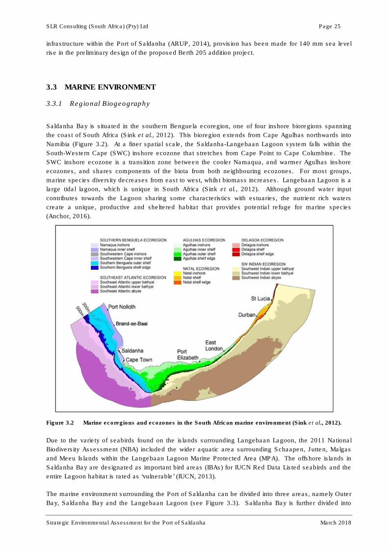
SLR Consulting (South Africa) (Pty) Ltd Page 25
Strategic Environmental Assessment for the Port of Saldanha March 2018
infrastructure within the Port of Saldanha (ARUP, 2014), provision has been made for 140 mm sea level
rise in the preliminary design of the proposed Berth 205 addition project.
3.3 MARINE ENVIRONMENT
3.3.1 Regional Biogeography
Saldanha Bay is situated in the southern Benguela ecoregion, one of four inshore bioregions spanning
the coast of South Africa (Sink et al., 2012). This bioregion extends from Cape Agulhas northwards into
Namibia (Figure 3.2). At a finer spatial scale, the Saldanha-Langebaan Lagoon system falls within the
South-Western Cape (SWC) inshore ecozone that stretches from Cape Point to Cape Columbine. The
SWC inshore ecozone is a transition zone between the cooler Namaqua, and warmer Agulhas inshore
ecozones, and shares components of the biota from both neighbouring ecozones. For most groups,
marine species diversity decreases from east to west, whilst biomass increases. Langebaan Lagoon is a
large tidal lagoon, which is unique in South Africa (Sink et al., 2012). Although ground water input
contributes towards the Lagoon sharing some characteristics with estuaries, the nutrient rich waters
create a unique, productive and sheltered habitat that provides potential refuge for marine species
(Anchor, 2016).
Figure 3.2 Marine ecoregions and ecozones in the South African marine environment (Sink et al., 2012).
Due to the variety of seabirds found on the islands surrounding Langebaan Lagoon, the 2011 National
Biodiversity Assessment (NBA) included the wider aquatic area surrounding Schaapen, Jutten, Malgas
and Meeu Islands within the Langebaan Lagoon Marine Protected Area (MPA). The offshore islands in
Saldanha Bay are designated as important bird areas (IBAs) for IUCN Red Data Listed seabirds and the
entire Lagoon habitat is rated as ‘vulnerable’ (IUCN, 2013).
The marine environment surrounding the Port of Saldanha can be divided into three areas, namely Outer
Bay, Saldanha Bay and the Langebaan Lagoon (see Figure 3.3). Saldanha Bay is further divided into

SLR Consulting (South Africa) (Pty) Ltd Page 26
Strategic Environmental Assessment for the Port of Saldanha March 2018
Small Bay and Big Bay by the Iron Ore Jetty which was constructed in 1975 and protrudes into the bay in
a southwesterly direction. Langebaan Lagoon is located to the south of Schaapen Island.
Figure 3.3 Saldanha Bay configuration.
3.3.2 Coastline configuration
The littoral zone in Small Bay is largely transformed by man-made structures (small craft harbour, fish
processing plants and industry) with a sandy beach section extending from the town of Saldanha Bay
eastward towards the Iron Ore Jetty. The coastline along Small Bay is relatively stable and is not
obviously vulnerable in terms of threats linked to beach erosion. Of much greater significance is the Big
Bay coastline. This littoral zone is approximately 5.5km long, with its northern and southern limits at the
Reclamation Dam and Lynch Point respectively (Figure 3.3). The beach, comprising the shoreline, is
generally narrow and for part of its length is backed by a relict dunefield with a steep calcrete cliff along
the central section of the back beach (CSIR, 2008). A significant feature of this section of coastline is a
wide accreted beach adjacent to the Reclamation Dam and an area of eroded beach immediately north of
Lynch Point.

SLR Consulting (South Africa) (Pty) Ltd Page 27
Strategic Environmental Assessment for the Port of Saldanha March 2018
3.3.3 Wave regime
Prior to the construction of the IOT, waves entering the Bay arrived at the shore of Big Bay largely
unimpeded and the entire shore was classified as exposed (Flemming, 1977). Construction of the IOT
provided some protection from waves along the northern shore of Big Bay resulting in sheltered and
semi-sheltered areas (Figure 3.4). Saldanha Bay provides natural shelter from waves coming from the
north and north-west and, as a result, the waves affecting most of Small Bay are from the south-west
(ARUP, 2014). The narrow entrance to the Bay between Marcus Island and Elands Point provides
reasonable protection to current and proposed new Port infrastructure. The Port is, however, affected by
long period waves (CSIR, 2013) and waves of a much shorter period may be generated locally within the
wider Bay.
Figure 3.4 Predicted wave field in Saldanha Bay showing wave height and direction after the construction of the causeway and the iron-ore Terminal (Source: WSP Africa Coastal Engineers, 2010).
The southern half of the coastline faces southwest and is exposed to offshore waves entering Saldanha
Bay, whereas the section closer to the Reclamation Dam experiences a slight reduction in wave exposure
due to the diffraction and refraction of wave energy around Marcus Island and the sheltering effect of the
Iron Ore Terminal (CSIR, 2008). This results in varying nearshore wave energy. Observation concerning
predicted waves (from offshore) is the shore-normal angle of approach of waves on the shoreline. Given
this angle of approach, a small volume of longshore sediment transport would be expected (CSIR, 2008).
In addition to swell waves the beach is also exposed to locally generated wind-waves. Strong southerly
winds, predominating from spring to autumn, blow from Schaapen Island, resulting in wave heights of
approximately 0.4 m to 1 m. Such wind-waves with an oblique attack on the shoreline tend to drive a
north-bound longshore flow; combined with the stirring effect of such waves on bed sediments, north-
bound littoral sediment transport is the result (CSIR, 2008). This north-bound transport is clearly evident
in the accreted beach developing at the Reclamation Dam, with a tendency for beach erosion to occur

SLR Consulting (South Africa) (Pty) Ltd Page 28
Strategic Environmental Assessment for the Port of Saldanha March 2018
towards Lynch Point. Estimated average net longshore transport of sediment within the littoral zone along
this section of coastline is approximately 8500 m3/year to the north. This is made up of gross transports of
about 10 000 m3/year to the north and about 1500 m
3/year to the south; i.e. net transport towards the
north of approximately 8 500 m3/year.
The following longshore transport components can be identified:
� Waves originating offshore are responsible for 10% of the net sediment transport;
� Local wind-waves (generated within Saldanha Bay) are responsible for about 50% of the net
sediment transport;
� Local wind-generated flow (superimposed on the stirring effect of waves) is responsible for about
40% of the net sediment transport (CSIR, 2008).
3.3.4 Marine water quality
According to the 2017 State of the Bay report, there is clear evidence of altered current strengths,
circulation patterns and wave energy within Saldanha Bay affecting marine water quality. This can be
ascribed to the construction of the iron ore terminal and causeway which is also contributing to the
deterioration in water quality, particularly in Small Bay. The water entering Small Bay appears to remain
within the more confined bay for longer periods than was historically the case, with the greater Saldanha
bay area having a reduced flushing capacity. There is also an enhanced clockwise circulation and
increased current strength flowing alongside unnatural obstacles such as the iron ore terminal. The wave
exposure patterns in Small Bay and Big Bay have also been altered as a result of the development and
expansion of Port facilities. The extent of sheltered and semi-sheltered areas has increased particularly
in Small Bay, but also in Big Bay (Anchor, 2017).
Due to healthier circulation and flushing, Big Bay exhibits superior water quality in comparison with Small
Bay (ZAA, 2016). Regular monitoring of microbial indicators as part of the State of the Bay reporting has
shown a considerable drop in the faecal coliform levels within the Greater Saldanha Bay area. Elevated
heavy/trace metal levels (i.e. lead, cadmium and zinc) in the inshore areas are, however, still of concern
and may remain of concern as Port facilities expand and related trace metal sources increase.
An investigation addressing trace metal contamination within the Port of Saldanha found that Small Bay
had been subjected to a greater extent of organic and trace metal contamination compared to Big Bay
and Langebaan Lagoon (Anchor, 2015). This is attributable to the poor circulation and flushing in Small
Bay in combination with organic and trace metal contamination by the surrounding industries and
activities. Within Small Bay, sediments from sites located alongside the MPT and in the vicinity of the
yacht club revealed elevated Cadmium concentrations that exceeded Effects Range Low (ERL –
concentration at which toxicity may be observed in sensitive species) limits. The enrichment values for
these sites have been very high since the 1980s, indicating significant long-term contamination.
Cadmium is a trace metal used in electroplating, in pigment for paints, in dyes and in photographical
processing. Likely sources of Cadmium in the marine environment include emissions from industrial
combustion processes, metallurgical industries, motor vehicle emissions and waste streams such as
storm water drains (OSPAR, 2010). As Cadmium is prone to bioaccumulation and becomes toxic at
elevated concentrations, its effect on the marine environment and on human consumers can be
significant (OSPAR, 2010). Although high concentrations of Cadmium and lead above the guideline limit
for human consumption have been recorded frequently in naturally occurring nearshore mussels, these
levels were found to be much lower and mostly within the guidelines for human consumption in the
mussels farmed away from the shore within Small Bay (Anchor, 2015; Pisces, 2017). Although Cadmium
may be naturally elevated at sites along the west coast due to high Cadmium concentrations in terrestrial
sediments, the spatial pattern in Saldanha Bay indicates that elevated values are likely a result of
activities related to shipping and boating (see Figure 3.5).

SLR Consulting (South Africa) (Pty) Ltd Page 29
Strategic Environmental Assessment for the Port of Saldanha March 2018
Similarly, elevated copper concentrations have been recorded along the IOT and near the yacht club
(Anchor, 2017). This suggests that there may be a source of copper pollution affecting most of the Small
Bay region. Copper is used as a biocide in antifouling products as it is very effective for killing marine
organisms that attach themselves to the surfaces of boats and ships. Anti-fouling paints release Copper
into the sea and can make a significant contribution to Copper concentrations in the marine environment
(Clark, 1986). The areas with elevated normalized Copper values also correspond with those with high
levels of boat traffic. It is thus likely that anti-fouling paints used on boats may have been contributing
Copper to the system. The Copper concentration at the Yacht Club Basin in Saldanha Bay exceeded the
ERL guideline and the extremely high enrichment factor indicated an anthropogenic pollution source
(Anchor, 2017) (see Figure 3.5). TNPA does not currently allow the removal and reapplication of anti-
fouling paints within the Port of Saldanha without the appropriate measures in place to contain any
residue. All removed paint residue and marine organisms are to be captured and disposed of onshore.
Figure 3.5 Cadmium (Cd; left) and copper (Cu; right) levels measured in Saldanha Bay and the Langebaan Lagoon in 2017 (Anchor, 2017).
A considerable increase in the concentration of cadmium was detected in the surficial sediments in Small
Bay between 2010 and 2014 at the GMQ, the MPT and the IOT (see Figure 3.6). Values were highest at
the MPT, exceeding the ERL values and indicating likely toxicity to marine life. The 2017 monitoring
campaign, however, showed these levels dropping below the ERL value at the MPT (Anchor, 2017).
Copper and nickel have not exceeded the ERL at any of these sites since 2008. Lead, however,
exceeded the ERL levels in 2008, 2009, 2011 and 2013 at the MPT, but remained below the ERL levels
since then (Anchor, 2017). Overall, contamination levels were lower at the IOT and the GMQ in
comparison to the channel opposite the MPT.
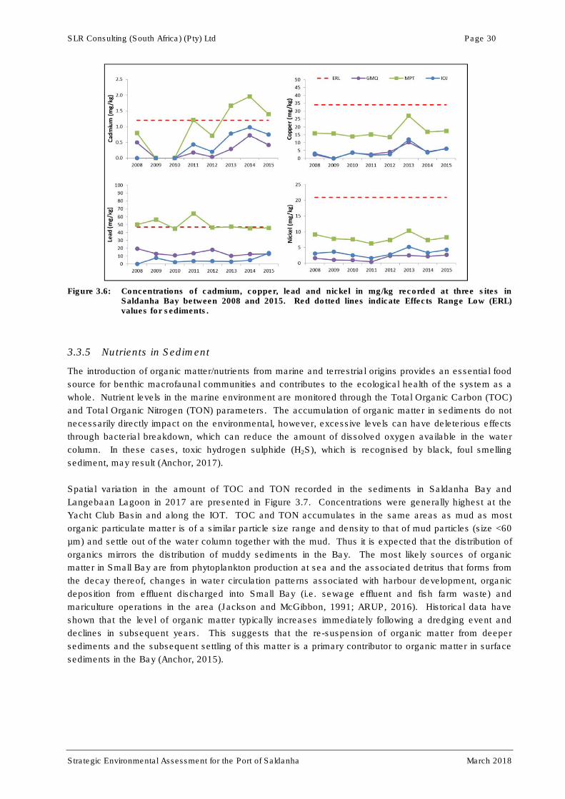
SLR Consulting (South Africa) (Pty) Ltd Page 30
Strategic Environmental Assessment for the Port of Saldanha March 2018
Figure 3.6: Concentrations of cadmium, copper, lead and nickel in mg/kg recorded at three sites in Saldanha Bay between 2008 and 2015. Red dotted lines indicate Effects Range Low (ERL) values for sediments.
3.3.5 Nutrients in Sediment
The introduction of organic matter/nutrients from marine and terrestrial origins provides an essential food
source for benthic macrofaunal communities and contributes to the ecological health of the system as a
whole. Nutrient levels in the marine environment are monitored through the Total Organic Carbon (TOC)
and Total Organic Nitrogen (TON) parameters. The accumulation of organic matter in sediments do not
necessarily directly impact on the environmental, however, excessive levels can have deleterious effects
through bacterial breakdown, which can reduce the amount of dissolved oxygen available in the water
column. In these cases, toxic hydrogen sulphide (H2S), which is recognised by black, foul smelling
sediment, may result (Anchor, 2017).
Spatial variation in the amount of TOC and TON recorded in the sediments in Saldanha Bay and
Langebaan Lagoon in 2017 are presented in Figure 3.7. Concentrations were generally highest at the
Yacht Club Basin and along the IOT. TOC and TON accumulates in the same areas as mud as most
organic particulate matter is of a similar particle size range and density to that of mud particles (size <60
µm) and settle out of the water column together with the mud. Thus it is expected that the distribution of
organics mirrors the distribution of muddy sediments in the Bay. The most likely sources of organic
matter in Small Bay are from phytoplankton production at sea and the associated detritus that forms from
the decay thereof, changes in water circulation patterns associated with harbour development, organic
deposition from effluent discharged into Small Bay (i.e. sewage effluent and fish farm waste) and
mariculture operations in the area (Jackson and McGibbon, 1991; ARUP, 2016). Historical data have
shown that the level of organic matter typically increases immediately following a dredging event and
declines in subsequent years. This suggests that the re-suspension of organic matter from deeper
sediments and the subsequent settling of this matter is a primary contributor to organic matter in surface
sediments in the Bay (Anchor, 2015).

SLR Consulting (South Africa) (Pty) Ltd Page 31
Strategic Environmental Assessment for the Port of Saldanha March 2018
Figure 3.7: Total organic carbon (left) and total organic nitrogen (right) in Saldanha Bay in 2017 (Anchor,
2017).
The ratio between TOC and TON is also important as it provides an indication of the source of organic
matter present in sediments (Anchor, 2017). Elevated carbon to nitrogen ratios (C:N) could be an
indication of organic matter originating from onshore sources, e.g. water enriched with processed sewage
in the vicinity of the Bok River. It could also be an indication of denitrification in areas where oxygen
levels have been depleted and nitrates are present. The C:N ratio is thus an indicator of system health.
3.3.6 Hydrocarbons in Sediment
3.3.6.1 Poly-aromatic hydrocarbons
Poly-aromatic hydrocarbons (PAHs) (also known as polynuclear or polycyclic-aromatic hydrocarbons) are
present in significant amounts in fossil fuels (i.e. natural crude oil and coal deposits), tar and various
edible oils. They are also formed through the incomplete combustion of carbon-containing fuels such as
wood, fat and fossil fuels. PAHs are one of the most wide-spread organic pollutants and they are of
particular concern as some of the compounds have been identified as carcinogenic for humans (Nikolaou
et al., 2009). PAHs are introduced to the marine environment by anthropogenic (e.g. combustion of fuels)
and natural means (e.g. oil welling up or products of biosynthesis). PAHs in the environment are found
primarily in soil, sediment and oily substances as they are lipophilic and are less prone to evaporation.
The highest values of PAHs recorded in the marine environment have been in areas with intense vessel
traffic and oil treatment (Nikolaou et al., 2009).
Total PAH concentrations in marine sediment samples from Saldanha Bay collected in 2017 were low
across all the sampling sites.

SLR Consulting (South Africa) (Pty) Ltd Page 32
Strategic Environmental Assessment for the Port of Saldanha March 2018
3.3.6.2 Total Petroleum Hydrocarbons
In 2011 all Total Petroleum Hydrocarbon (TPH) concentrations were below the detection limit of
20 mg/kg but slight increases in TPH levels were recorded at all sites in 2012 and 2013 (Table 3.1). TPH
levels at the MPT decreased in 2014 (130 to 19 mg/kg), however, an extreme increase was experienced
at the IOT (28 to 14 649 mg/kg). This is of major concern as such levels are considered to be toxic
(Nikolaou et al., 2009). The site of contamination is in close proximity to bulk-shipping berths and
associated mooring activities, thus it could be related to a pollution incident associated with shipping
activities. No formal pollution incidents that could explain such an increase were, however, recorded at
the IOT during 2014. Since 2015, TPH concentrations have been below the detection limit of 38 mg/kg
and have remained at this level at all sampling sites to date (Anchor, 2017).
Table 3.1: Total petroleum hydrocarbon (mg/kg) in sediment samples collected over the period 2011-2017 from three sites in Small Bay. Values in red indicate exceptionally high total petroleum hydrocarbon levels (Source: Anchor, 2017).
2011 2012 2013 2014 2015 2016 2017
MPT north (SB14) <20 34 130 19 <38 <38 <38
MPT south (SB15) <20 35 NO DATA 53 <38 <38 <38
IOT (SB16) <20 24 28 14 649 <38 <38 <38
3.3.7 Marine & coastal ecosystems
The Saldanha Bay – Cape Columbine coastline falls within the Namaqua biogeographic province. Marine
habitats on the open coast of the Cape Columbine peninsula, comprise primarily:
• Sandy intertidal and subtidal substrata,
• Intertidal rocky shores and subtidal reefs, and
• The water body.
The biological communities in these habitats are described briefly below. This section draws from the
baseline marine environment description provided by Anchor Environmental (2016). Additional habitats
within the Saldanha Bay-Langebaan Lagoon system include:
• Unvegetated sand flats;
• Macrophyte and seagrass beds, and
• Salt marshes.
Saldanha Bay and Langebaan Lagoon are considered to be one of the “biodiversity hot spots” in South
Africa (Day, 1959). A declared MPA incorporates sites in and around the Bay, while Langebaan Lagoon
and much of the surrounding land falls within the West Coast National Park. Langebaan Lagoon is
registered under two international conventions: the Ramsar Convention on Wetlands of International
Importance and the Bonn Convention on the Conservation of Migratory Species of Wild Animals.
3.3.7.1 Intertidal Habitat
Sandy shores within Saldanha Bay are predominantly exposed to high degrees of wave action and tend
to support a lower diversity and biomass of organisms than the sheltered shores within Langebaan
Lagoon. The Lagoon is dominated by intertidal mud- and sand-flats but also supports saltmarsh habitat
(Summers, 1977). Although the system is entirely marine, estuarine species such as the common
SLR Consulting (South Africa) (Pty) Ltd Page 33
Strategic Environmental Assessment for the Port of Saldanha March 2018
sandprawn (Callianassa kraussi) and the estuarine mudprawn (Upogebia africana) occur. Beds of the
sea grass (Zostra capensis) are distributed intermittently over the sand flats, and provide habitat for the
rare limpet Siphonaria compressa (Angel et al., 2006).
Intertidal rocky shores support fauna and flora typical of the cold west coast. Exposed and semi-exposed
rocky shores tend to be dominated by filter feeders (Anchor, 2015, Robinson et al., 2007), while algae are
more prolific on sheltered shores. At least 28 alien and 42 invasive marine species occur along the West
Coast of South Africa, of which 25 have been confirmed in the Saldanha Bay and/or Langebaan Lagoon
systems (Griffiths et al., 1992, Laird and Griffiths, 2008, Mead et al., 2011, de Greef et al., 2013). The
most prolific of these are the Mediterranean mussel Mytilus galloprovincialis and the barnacle Balanus
glandula, the abundance of which is limited by the long stretches of sandy beach and reduced wave
action in the Lagoon. Both these species have dramatic effects on community structure, and dominate
entire zones within the intertidal. Since 2014, the presence of the barnacle Perforatus perforates
(Anchor, 2017), the Japanese skeleton shrimp Caprella mutica (Peters & Robinson, 2017), and the
European porcelain crab Porcellana platycheles (Anchor, 2017) have also been confirmed in the
Saldanha Bay/Langebaan area.
Rocky shores sampled during the 2015 ‘State of the Bay’ survey included Dive School and Jetty within
Small Bay, IOT and Lynch Point within Big Bay, North Bay and Marcus Island at the mouth of Saldanha
Bay, and Schaapen Island East and West in Langebaan Lagoon (Anchor, 2015). In total, fifty-two
species were recorded at the two Small Bay rocky shore sites sampled in 2015. Of these, 33% were
grazers, 17% predators, 21% filter feeders, 6% encrusting algae, 6% ephemeral algae and 17%
corticated algae. These species are typical of semi-exposed rocky shores along the West Coast (Anchor,
2015).
Both rocky shore sites in Small Bay are considered to be very sheltered and considerable amounts of
sand and gravel accumulate amongst the boulders. The two sites surveyed in Small Bay had the lowest
overall percentage cover of biota of all eight sites assessed (see Figure 3.8). Grazers dominated at the
Dive School, while encrusting algae dominated at the Jetty.
The sites depicted in Figure 3.8 are arranged from ‘very sheltered’ to ‘exposed’, clearly illustrating that
filter feeders are more abundant at sites that experience higher degrees of wave exposure. The species
assemblages of the eight rocky shore sites differed largely due to the prevailing wave exposure (Anchor,
2015). Very sheltered shores had low biotic cover consisting primarily of grazers, while sheltered shores
were dominated by seaweeds and encrusting corallines.
3.3.7.2 Benthic macrofauna
Subtidally, the nutrient rich waters of the Saldanha Bay-Langebaan Lagoon system support an abundant
and diverse benthic macrofaunal (e.g. brittlestars, sea cucumbers and prawns) community on soft
sediment habitats. Macrofauna living within benthic substrata play an important role in the reworking of
sediments. These organisms assist in promoting the exchange of oxygen and nutrients within the
substrate by enhancing sediment porosity. Macrofaunal communities also provide an important food
source for numerous fish, bird and invertebrate species. Biological indicators, such as species
abundance, biomass and diversity, provide a direct measure of the state of the ecosystem in space and
time. Benthic macrofauna are the biotic component most frequently monitored to detect changes in the
health of a marine environment as they are short-lived and their community composition responds rapidly
to environmental change (Warwick, 1993). They also tend to be directly affected by pollution, are easy to
sample quantitatively (Warwick, 1993), and are scientifically well-studied compared to other sediment-
dwelling components.

SLR Consulting (South Africa) (Pty) Ltd Page 34
Strategic Environmental Assessment for the Port of Saldanha March 2018
Organic matter is one of the most universal pollutants affecting marine life and it can lead to significant
changes in community composition and abundance. Community responses include decreased growth
rates, disappearance of species due to anoxia, and changes in community composition. A reduction in
the number of species found in a habitat, or even the complete disappearance of all benthic organisms,
may result from repeat hypoxia caused by low levels of dissolved oxygen (Warwick, 1993). Within a
harbour environment, the community composition of benthic macrofauna is likely to be impacted by
increased levels of contaminants such as trace metals and hydrocarbons within the sediments.
Anthropogenic physical disturbance (e.g. dredging) may also affect benthic macrofauna and is likely to
result in the proliferation of opportunistic pioneer species.
Figure 3.8: Percentage cover of the seven functional groups surveyed by Anchor in 2015. Data were averaged across the whole shore. Sites are organised from very sheltered to exposed (Source: Anchor, 2015).
Studies conducted by Anchor in 2004 and 2008-2017 provide recent and comparable data on the benthic
macrofaunal community composition, abundance and biomass throughout the Saldanha-Langebaan
system. Approximately 80 macrofaunal species are regularly found within the system, with infaunal
abundance in Small Bay averaging around 1 500 individuals/m2 and infaunal biomass around 900 g/m
2
(see Figure 3.9). Average biomass within Langebaan Lagoon was found to be lower at around
450 g/m2. Monitoring of benthic macrofaunal communities over time has revealed a relatively stable
situation in most parts of Saldanha Bay and Langebaan Lagoon with the exception of 2008, when a
dramatic shift in benthic community composition occurred at all sites. Extensive dredging activities
undertaken during 2007 and early 2008 appear to have had bay-wide impacts on the macrobenthic
community structure, resulting in a temporary loss of less tolerant species and a shift in community
composition to one dominated by more tolerant species (Anchor, 2015). This shift involved a decrease in
the abundance and biomass of filter feeders and an increase in shorter lived, opportunistic detritivores.
Filter feeding species are typically more sensitive to changes in water quality than detritivores or
scavengers and account for much of the variation in overall abundance and biomass in Saldanha Bay
(see Figure 3.9).

SLR Consulting (South Africa) (Pty) Ltd Page 35
Strategic Environmental Assessment for the Port of Saldanha March 2018
The community composition in Small Bay was found to be more similar to that of Big Bay than to
Langebaan Lagoon. The hardier filter feeders such as Upogebia capensis were abundant in both Big Bay
and Small Bay, but the more sensitive filter feeders such as the amphipods Ampelisca spinimana and A.
anomala, the mollusc Macoma odinaria and the polychaete Sabellides luderitzi were notably more
abundant in Big Bay than Small Bay. Similarly, the sea pen Virgularia schultzei, widely regarded as a
sensitive species, is now found only in Big Bay (Anchor, 2017). This species was reportedly very
abundant in Saldanha Bay prior to the development of port infrastructure and fish factories, but is now
completely absent from Small Bay and is rare in Big Bay (Anchor, 2017).
Figure 3.9: Trends in the biomass and abundance (g/m2) of benthic macrofauna in Small Bay as shown by
taxonomic and functional groups.
Variations in species diversity (represented by the Shannon Weiner Index, H’) for Saldanha Bay, and
Langebaan Lagoon in 2017 are presented in Figure 3.10 (Anchor, 2017). Diversity was highest in
Langebaan Lagoon, intermediate in Big Bay and lowest around the IOT. Poor diversity is most likely
attributable to the higher levels of disturbance, mainly dredging, and a high proportion of mud in the
sediment. High levels of disturbance associated with pollution (e.g. high nutrient input from terrestrial
sources) can allow a small number of opportunistic, short-lived species to colonise the affected area and
prevent a more diverse community comprising longer living species from becoming established.

SLR Consulting (South Africa) (Pty) Ltd Page 36
Strategic Environmental Assessment for the Port of Saldanha March 2018
Figure 3.10: Variation in the diversity of the benthic macrofauna in Saldanha Bay based on 2017 data. H’ = 0 indicates low diversity, while H’ = 3.32 indicates high diversity (Anchor, 2017).
3.3.7.3 Alien Invasive Species
Alien species are plants, animals and microorganisms that are transported beyond their natural range and
become established in a new area. They are sometimes called exotic, introduced, non-native or non-
indigenous species but are not necessarily invasive. Invasive species are introduced species that have a
tendency to spread to a degree believed to cause damage to the environment, to the economy or to
human health. At least 92 marine alien species have been recorded from South African waters, 70 of
which are thought to occur along the west coast of South Africa, and 28 of which have been confirmed in
Saldanha Bay and/or Langebaan Lagoon (Anchor, 2015). An additional 39 species are currently
regarded as cryptogenic, which means they are of unknown origin but are likely introduced to South
Africa. Of these, five species have already been identified in Saldanha Bay.
Most of the introduced species in South Africa have been found in sheltered areas such as harbours, and
are believed to have been introduced through shipping activities, for example ballast water discharge or
hull fouling. As ballast water tends to be loaded in sheltered harbours, the species that are transported
originate from these habitats and have trouble adapting to South Africa’s exposed coast. This might
explain the low number of introduced species that have established along the coast (Griffiths et al., 2008)
in comparison to the high number found in sheltered bays or harbours.
Invasive species include the Mediterranean mussel (Mytilus galloprovincialis), the European green crab
(Carcinus maenas) (Griffiths et al., 1992), the acorn barnacle Balanus glandula (Laird & Griffiths, 2008),
and the Pacific South American mussel (Semimytilus algosus) (de Greef et al., 2013). Data from the
State of the Bay surveys suggest that Mytilus occurs mainly on exposed rocky shores in Saldanha Bay
(i.e. North Bay, IOT, Marcus Island and Lynch Point) and is present in low numbers at the more sheltered
sites (Dive School, Jetty and Schaapen Island East and West). Populations grew fairly rapidly in the
period 2005 until 2012/2013 at most exposed sites, after which populations stabilized. This mussel is by
far the most dominant faunal species on the rocky shore, and covers 100% of the available space across
substantial portions of the shore at some sites. It reaches its highest densities low on the shore, in areas
exposed to high wave action.
SLR Consulting (South Africa) (Pty) Ltd Page 37
Strategic Environmental Assessment for the Port of Saldanha March 2018
Surveys in Saldanha Bay have not turned up any live specimens of the European green crab to date, but
a single dead specimen was picked up by Robinson et al. (2004) in Small Bay at the Small Craft Harbour.
Due to a lack of specimens, it is unlikely that there is an extant population in Saldanha Bay at present.
Abundance of the acorn barnacle was very high when it was first detected in 2010 but has been declining
since. From 2011 to 2017, abundance at the IOT decreased by two thirds. The Pacific South American
mussel is usually present only on wave exposed shores, although in Saldanha Bay it has been observed
on the ropes at mussel farms.
3.3.7.4 Fish
Due to the sheltered nature of Saldanha Bay and the abundance of nutrients as a result of upwelling, the
area is an important nursery ground for a variety of fish species. There is considerable life history and
tagging evidence that populations of key fishery species, namely hound sharks, white stumpnose,
steentjies and elf, are resident within the Saldanha Bay-Langebaan system and comprise semi-isolated,
largely self-recruiting populations (Kerwath et al., 2009, Tunley et al., 2009, Attwood et al., 2010, Hedger
et al., 2010, da Silva et al., 2013). The shallow surf zone areas around the periphery of Saldanha Bay
are especially important, thus designated areas within the Langebaan Lagoon are closed to fishing.
Monitoring of fish populations in Saldanha Bay was initiated by means of experimental seine-netting in
1986. Surveys undertaken in 2011 recorded good recruitment of harders (Liza richardsonii), white
stumpnose (Rhabdosargus globiceps), gobies (Caffrogobius sp.) and silversides (Atherina breviceps) in
Big Bay (Anchor, 2012). In Small Bay, however, where commercially important species such as white
stumpnose have traditionally been most abundant, there were clear signs of decline (Anchor, 2012a).
Sampling of fish in the surf-zone habitats of Small Bay were conducted during April 1994, October 2005
and annually during April over the period 2007-2015 for the State of the Bay monitoring (Anchor, 2015).
Four sites spread around Small Bay were regularly sampled and are listed in a clockwise direction from
the Marcus Island causeway: Small Craft Harbour, Hoedjiesbaai, Campsite and Bluewater Bay. The 33
fish species landed in the 115 hauls in Small Bay during these surveys are recorded in Table 3.2 (Clark,
1997, Hutchings & Lamberth, 2002, Anchor, 2017).
Table 3.2: Fish species recorded during beach seine-net surveys in Small Bay, Saldanha in 1994, 2005 and 2007-2017 (Anchor, 2017).
Species Common name Species Common name
Amblyrhychotes honkenii* Evil eye blassop Gilchristella aestuaria Estuarine round herring
Argyrozona argyrozona Silverfish Gonorhynchus gonorhynchus Beaked sand eel
Atherina breviceps Silverside Haploblepherus pictus Dark shy Shark
Caffrogobius sp. Goby Heteromycteris capensis Cape sole
Callorhinchus capensis* St Joseph Lithognathus mormyrus Sand steenbras
Cancelloxus longior Snake eel Liza richardsonii Harder
Cheilidonichthys capensis Gurnard Mustelus mustelus Smoothhound shark
Chorisochismus sp? Suckerfish sp. Myliobatis aquila Eagle ray
Clinus latipennis False bay klipvis Parablennius cornutus Blenny
Clinus sp. larvae Klipvis larvae Pomatomus saltatrix Elf
Clinus superciliosus Super klipvis Poroderma africana Striped catshark
Clinus robustus Robust Klipvis Psammogobius knysnaensis Knysna sand gobi

SLR Consulting (South Africa) (Pty) Ltd Page 38
Strategic Environmental Assessment for the Port of Saldanha March 2018
Clinus venustris Bluntnose klipvis Raja clavata Thornback skate
Clinus heterodon West coast Klipvis Rhabdosargus globiceps White stumpnose
Cynoglossus capensis Tongue fish Rhinobatos blockii Bluntnose guitar fish
Dasyatis chrysonota Blue Stingray Spondyliosoma emarginatum Steentjie
Diplodus capensis Black tail Syngnathus temminckii Pipe fish
Etrumeus terres Red eye sardine Trachurus trachurus Horse mackerel
* Species newly recorded during 2017 survey
Small Bay provides habitat for the highest proportion of resident species, whilst a larger proportion of the
Big Bay and Langebaan Lagoon ichthyofauna occur sporadically in these areas. Although fish density in
Big Bay is generally lower than that recorded in Small Bay and Langebaan Lagoon (see Figure 3.11), Big
Bay constitutes nursery habitat for the two most important fish species (elf and white stumpnose) within
the system.
Overall, the catches made during the 2012 survey were the lowest on record for all three areas and
remained lower than any of the earlier surveys in both Small Bay and Big Bay, but was higher than
average in Langebaan Lagoon. From 2014 to 2017, the overall abundance of fish compared favourably
with earlier surveys (see Figure 3.11). The concerning trend in white stumpnose and blacktail abundance
over the 2012 to 2015 period in Small Bay appeared to have reversed with the third highest white
stumpnose abundance and second highest blacktail abundance recorded in the 2016 Small Bay samples.
Unfortunately blacktail juveniles were, for only the second time in the sampling history, entirely absent
from Small Bay catches in 2017 and white stumpnose abundance was slightly down from that recorded
during 2016 (Anchor, 2017). Blacktail are relatively long-lived species attaining 20 years of age, thus the
adult population within Saldanha Bay should persist to spawn in future years if natural variability was the
cause (Mann & Dunlop, 2013).
Figure 3.11: Average abundance of fish recorded from seine net surveys conducted in surf zone habitats within Saldanha Bay- Langebaan Lagoon (Anchor, 2017).
3.3.7.5 Birds and Marine Mammals
Saldanha Bay, Langebaan Lagoon and the associated islands provide important shelter, feeding and
breeding habitat for at least 53 species of seabirds, 11 of which are known to breed on the islands of
Malgas, Marcus, Jutten, Schaapen and Vondeling (Anchor, 2015). These islands support important

SLR Consulting (South Africa) (Pty) Ltd Page 39
Strategic Environmental Assessment for the Port of Saldanha March 2018
breeding colonies of African penguin (Spheniscus demersus), Cape gannet (Morus capensis), Cape
cormorants (Phalacrocorax capensis), bank cormorants (Phalacrocorax neglectus), white-breasted
cormorants (Phalacrocorax carbo lucidus), crowned cormorants (Phalacrocorax africanus), kelp gulls
(Larus dominicanus), Hartlaub’s gulls (Larus hartlaubii) and swift terns (Sterna bergii) (Anchor, 2006).
The African penguin, Hartlaub’s gull, Cape bank cormorant and Crowned cormorant are endemic to the
Benguela region. The rocky shore environment supports the endemic African black oystercatcher
(Haematopus moquini), a population which is successfully recovering from low numbers; while the tidal
flats of the Lagoon support large numbers of migrant waders during the summer months (Summers,
1977). The IUCN lists African penguins, Cape cormorants, and Bank cormorants as “endangered”
species; oyster catchers and crowned cormorants as “near threatened”; and Cape gannets as
“vulnerable” (IUCN, 2013). The majority of these species are piscivorous and depend largely on a
healthy population of fish for sustenance.
Populations of two cormorant species, namely Bank cormorants and Cape cormorants, that utilise islands
within the Saldanha Bay region for shelter and breeding, have decreased since early to mid-1990. In the
past this has been attributed to the construction of the causeway linking Marcus Island to the mainland,
and to increased human disturbance. However, given that the populations of several other seabirds that
breed on these islands have not decreased over this period, it appears that declines in local availability of
their principal prey species (rock lobster and sardines), as well as egg and chick predation by pelicans
and gulls may be the principal drivers.
The Cape gannet population on Malgas Island has also undergone severe decline due mainly to
predation by Cape fur seals and more recently by Great white pelicans. Predation by the seals was
responsible for a 25% reduction in the size of the colony at Malgas Island, between 2001 and 2006.
Management measures have been put in place, through selective culling of seals, which has improved
conditions for the gannets at Malgas Island. The African penguin populations are also under
considerable pressure, partially due to causes unrelated to conditions on the island such as the eastward
shift of the sardines, one of their main prey species. However, because populations are so depressed,
conditions at the islands in Saldanha have now become an additional factor in driving current population
decreases.
The Cape fur seal is a regular visitor in both the inner and outer bays during all months of the year. Five
whale species have been recorded within Saldanha Bay and along the adjacent coast: Orca, Humpback,
Southern Right, Minke and Bryde's whales. Dusky and Heaviside's dolphins have been recorded in Outer
Bay as well as along the open coast.
3.4 TERRESTRIAL ENVIRONMENT
3.4.1 Topography and Geology
The topography of the area consists of gently undulating coastal plains with low hills. The highest points
in the area include Malgaskop (173 m) to the west, Karringberg (175 m) to the east and the Postberg
(193 m) in the south. There are also several low hills and outcrops of granite boulders in the surrounding
areas.
The bedrock in the Saldanha/Langebaan region consists of Malmesbury Group shales that have largely
been eroded to below sea level along the coast. The Malmesbury shales are intruded by the crystalline
Cape Granites that are exposed as hills on the Vredenburg Peninsula (Pether, 2014).

SLR Consulting (South Africa) (Pty) Ltd Page 40
Strategic Environmental Assessment for the Port of Saldanha March 2018
The Port of Saldanha is situated on the outer edge of the broad, near-flat plain of the Saldanha
Embayment. Beneath a thin cover of sand, the whole area is underlain by calcareous aeolianites (old
dune sands) and calcretes (surface limestones) of the Langebaan Formation (Visser & Schoch, 1973).
The fossil dunes are evident in the coastal landscape as low ridges, hills and mounds (Pether, 2014).
The coastal plain contains surface deposits of calcareous and quartzous sands which support the
Saldanha Limestone Strandveld vegetation type. The Quaternary deposits of the Langebaan formation
consisting of calcrete capped dune sand cover support the Saldanha Flats Strandveld or Langebaan
Dune Strandveld vegetation types. The calcrete and limestone deposits are grey to cream medium
grained and contain shell fragments. The underlying sand is cohesionless, quartzitic and of aeolian origin.
Several extractive mining activities are established in the municipal area. These include, amongst others,
mining of construction materials such as lime scales and sand mining.
3.4.2 Rainfall, fresh water supply & regional hydro- and geohydrology
The West Coast is a water scarce area with rainfall averaging between 260 and 280 mm per annum
(DEA&DP, 2016). Potable water supply for the West Coast District Municipality (WCDM) is obtained from
both surface (Berg River) and groundwater sources (Langebaan Road Aquifer). Water from the Berg
River to the north, the Salt River to the east and the Elandsfontein Aquifer System to the south recharges
the Langebaan Road Aquifer; while the Berg River is fed by winter flows and releases from the
Misverstand, Voëlvlei and Berg River dams. The Misverstand Scheme currently supplies bulk water from
the Misverstand Dam via the Withoogte Water Treatment Works to the towns of Velddrif and
Dwarskersbos in the Berg River Municipality and to Hopefield, Langebaan, Saldanha Bay, Vredenburg,
Paternoster, St Helena Bay and Stompneusbaai in the Saldanha Bay Municipality.
Demand for water increased significantly in recent times due to industrial development, particularly the
further development of the Port of Saldanha and associated infrastructure. According to the West Coast
District Municipality’s 2016/2017 Annual Report, the water demand from the Misverstand Dam as part of
the Withoogte system for 2018 (assuming a 3.5% growth rate) would be at 21.482 million m3/a with a
shortfall of 4.042 million m3/a. Additional required allocation up to 2033 is indicated as approximately
17.2 million m3/a (WCDM Annual Report, 2016/2017). The pressure on water supply is further
exacerbated by the low winter rainfall experienced during the last few years, leading to the worst drought
in a decade in the Western Cape and Saldanha Bay Municipal area.
Clearly, further port expansion activities might be greatly influenced by the availability of potable water
supply and a strategy for augmenting this supply through mitigation and/or additional water sources will
need to be considered by TNPA in consultation with the Saldanha Bay Municipality.
A 2014-2015 study by Greencape stated that in response to a water availability constraint, one of the first
solutions to consider would be to reduce demand through improving water efficiency. A preliminary
investigation into the potential for a “Water Exchange Network” in which waters of different qualities are
cascaded (used and passed on) between major industrial users was completed for Saldanha Bay which
suggested that freshwater intake could be reduced by up to 15% and effluent reduced by up to 76% (SIF
Status Quo, 2016).
Since the implementation of strict water restrictions in 2017, municipal water use has already dropped
from 37 mega litres per day (ML/Day) to the current (2018) 28 ML/Day. Of this total, large industry in the
Saldanha Bay area (including ArcelorMittal, Tronox, Duferco, large fish factories and TNPA) currently
utilise 11 ML/Day (pers. comm., Mr Gavin Williams – Saldanha Bay Municipality). Current water projects
to meet growing water demand and to ensure that the Saldanha Bay Municipality does not reach a point

SLR Consulting (South Africa) (Pty) Ltd Page 41
Strategic Environmental Assessment for the Port of Saldanha March 2018
where municipal water provision is completely disrupted (Day Zero), include the following short-term
projects for completion by the end of April 2018 and an additional 27.3 ML/Day into the system:
• New boreholes for groundwater abstraction from the Langebaan Road Aquifer;
• Lowering the minimum level to which water can be abstracted from the Misverstand Dam;
• New boreholes for groundwater abstraction in the Hopefield area;
• Usage of treated effluent at ArcelorMittal; and
• Small desalination plants at two fish factories (Sea Harvest - 1.7 ML/Day; Lucky Star - 0.8 ML/Day).
Medium term projects to ensure water resilience should another below average winter rainfall be
experienced in 2018, include the following:
• Small desalination plant at Shelley Point; and
• Sourcing water from the Elandsfontein Aquifer.
These medium term projects are set for completion by the end of November 2018 and would add an
additional 41.9 ML/Day to the system. In addition, the municipality has established a water resilience
advisory committee consisting of specialists and municipal officials in order to drive the long term water
resilience plan for the municipal area. Long term plans will include the development of further larger
scale desalination plants, one of which has already received environmental authorisation.
Prior to the above proposed water projects, Greencape in 2015 projected water demand and supply for
the WCDM for different development growth scenarios, taking planned large infrastructure and industrial
projects into account. These projections are presented in Figure 3.12 below. The green scenarios
assume that industry would start investing in efficient water use solutions by treating process water and
using treated effluent onsite, thereby reducing the potable water demand (Greencape, 2015). In this
regard, ArcelorMittal has since already started using treated effluent from the WWTW in their Saldanha
Steel operations.

SLR Consulting (South Africa) (Pty) Ltd Page 42
Strategic Environmental Assessment for the Port of Saldanha March 2018
Figure 3.12 Water demand trajectories for the West Coast District Municipality and allocations from the
Berg River and Langebaan aquifer (Greencape, 2015).
3.4.3 Flora & fauna
Saldanha Bay is included within the Fynbos biome of the Cape Floristic Region (CFR). The CFR is one
of the world’s six floristic regions, and is the only one confined to a single country. It is also by far the
smallest floristic region, occupying only 0.1% of the world’s land surface; however, it includes an
estimated 9 500 plant species – almost half of all the plant species in South Africa. In 2004, the United
Nations Educational, Scientific and Cultural Organisation (UNESCO) declared the CFR as a world
heritage site. At least 70% of all the species occur only in the Western Cape region. Many species have
very small distribution ranges (these are known as narrow endemics). Most of the lowland habitats of the
CFR are under pressure from agriculture, urbanisation and invasion by alien plant species. Many of the
range-restricted species are, therefore, also under severe threat of extinction, as their habitat is reduced
to small ecologically non-viable fragments (DEA&DP, 2011).
The latest data from the Red Data Book listing process recently undertaken for South Africa indicate that
67% of the rare or threatened plant species in the country occur only in the south-western Cape, and
these total over 1 800 species (CSIR, 2012). It should thus be clear that the south Western Cape is a
major national and global conservation priority. Developments in the area thus need to take this into
account.
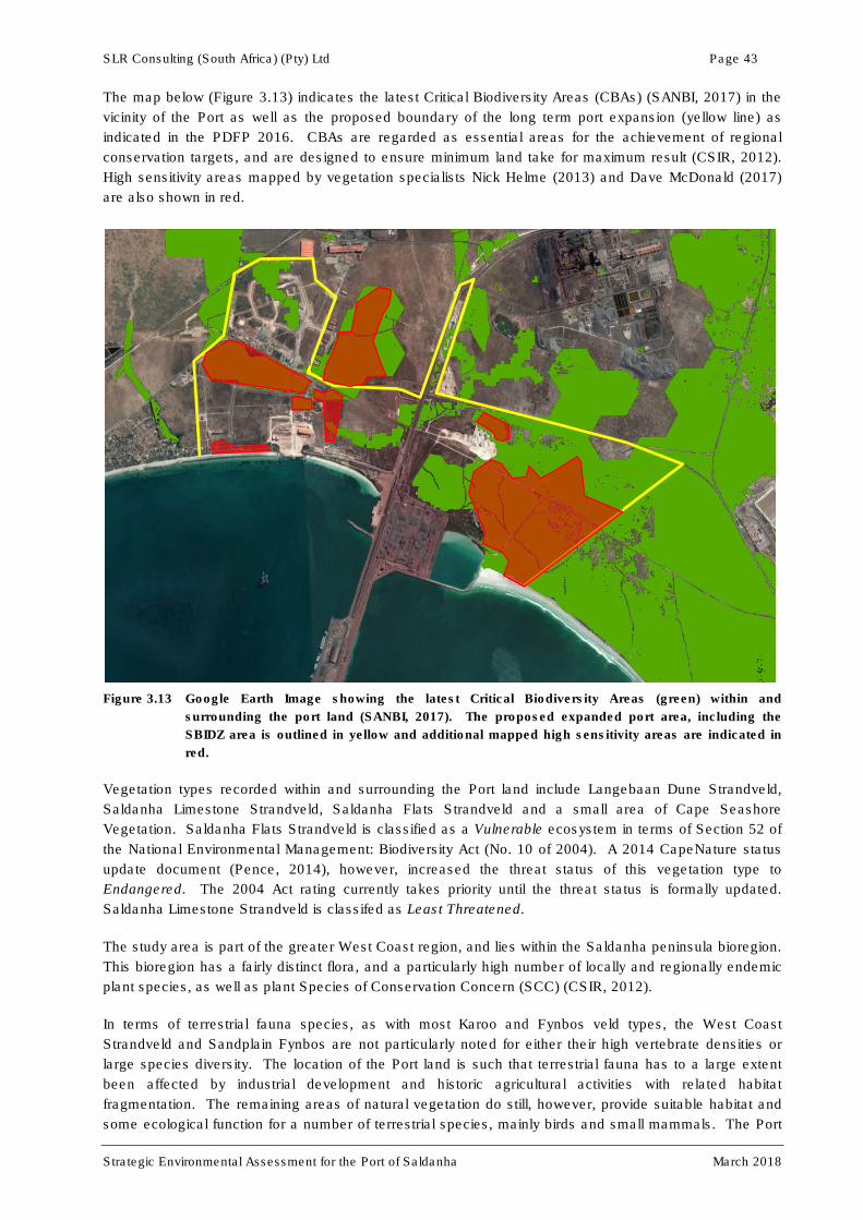
SLR Consulting (South Africa) (Pty) Ltd Page 43
Strategic Environmental Assessment for the Port of Saldanha March 2018
The map below (Figure 3.13) indicates the latest Critical Biodiversity Areas (CBAs) (SANBI, 2017) in the
vicinity of the Port as well as the proposed boundary of the long term port expansion (yellow line) as
indicated in the PDFP 2016. CBAs are regarded as essential areas for the achievement of regional
conservation targets, and are designed to ensure minimum land take for maximum result (CSIR, 2012).
High sensitivity areas mapped by vegetation specialists Nick Helme (2013) and Dave McDonald (2017)
are also shown in red.
Figure 3.13 Google Earth Image showing the latest Critical Biodiversity Areas (green) within and
surrounding the port land (SANBI, 2017). The proposed expanded port area, including the
SBIDZ area is outlined in yellow and additional mapped high sensitivity areas are indicated in
red.
Vegetation types recorded within and surrounding the Port land include Langebaan Dune Strandveld,
Saldanha Limestone Strandveld, Saldanha Flats Strandveld and a small area of Cape Seashore
Vegetation. Saldanha Flats Strandveld is classified as a Vulnerable ecosystem in terms of Section 52 of
the National Environmental Management: Biodiversity Act (No. 10 of 2004). A 2014 CapeNature status
update document (Pence, 2014), however, increased the threat status of this vegetation type to
Endangered. The 2004 Act rating currently takes priority until the threat status is formally updated.
Saldanha Limestone Strandveld is classifed as Least Threatened.
The study area is part of the greater West Coast region, and lies within the Saldanha peninsula bioregion.
This bioregion has a fairly distinct flora, and a particularly high number of locally and regionally endemic
plant species, as well as plant Species of Conservation Concern (SCC) (CSIR, 2012).
In terms of terrestrial fauna species, as with most Karoo and Fynbos veld types, the West Coast
Strandveld and Sandplain Fynbos are not particularly noted for either their high vertebrate densities or
large species diversity. The location of the Port land is such that terrestrial fauna has to a large extent
been affected by industrial development and historic agricultural activities with related habitat
fragmentation. The remaining areas of natural vegetation do still, however, provide suitable habitat and
some ecological function for a number of terrestrial species, mainly birds and small mammals. The Port
SLR Consulting (South Africa) (Pty) Ltd Page 44
Strategic Environmental Assessment for the Port of Saldanha March 2018
area is, however, not expected to constitute important habitat for terrestrial species of conservation
concern. Fifty-five mammal species may occur within the larger Saldanha area (Friedmann & Daly,
2004). These include:
• Smaller antelope species like the steenbok, grysbok and duiker;
• Small carnivores like genets, civets, jackals and bat eared foxes; and
• Dassie as well as a variety of rodent species, including striped field mice and mole-rats
(CSIR, 2011).
Only two species potentially occurring in the greater Saldanha area are, however, classified as
threatened red data species, namely Grant’s Golden Mole (Eremitalpa granti), which is listed as
Vulnerable and the White-tailed Rat (Mystromys albicaudatus) which is listed as Endangered (Friedmann
& Daly, 2004). These two species are not expected to occur in significant numbers on the site (CCA,
2015).
One hundred and sixty (160) bird species have been recorded in the vicinity of the Port as part of the
South African Bird Atlas Project 2 (launched in 2007 and set to run indefinitely). Five of these are listed
as Red Data Species, with Ludwig’s Bustard classified as Endangered and the Blue Crane, Black Harrier,
Secretary Bird and Southern Black Korhaan classified as Vulnerable. The West Coast National Park to
the south of the Port has been declared as an Important Bird Area and includes the Langebaan Lagoon.
Over 250 bird species have been recorded in the park. The lagoon is the most important wetland for
waders in South Africa (CSIR, 2011). It regularly accounts for 10% of South Africa’s coastal wader
numbers, one of the highest densities of waders worldwide, and more than 34 500 waders, of which 93%
are Palearctic migrants. In some years, the wader numbers can increase from 4 000 in winter to 50 000 in
summer. In winter, the lagoon regularly supports more than 10 500 birds of which 4 500 are Greater
Flamingos (CSIR, 2011).
Forty-one reptile species have been recorded in the three quarter degree grid cells surrounding Saldanha
Bay, Langebaan and Vredenburg (Bates et al., 2014). These include 24 lizard species, 15 snake species
and two tortoise species. Of these, the Cape sand snake (Psammophis leightoni) and Cape dwarf
chameleon (Bradypodion pumilum) are classified as Vulnerable and two burrowing skinks (Gronovi’s
dwarf burrowing skink and Kasner’s dwarf burrowing skink) are classified as Near Threatened. These
species are known to occur in sandy soils along the West Coast.
Six frog species have been recorded in the vicinity of Saldanha (Minter et al., 2004). Of these only the
Cape Caco (Cacosternum capense) is deemed to be of conservation concern, rated as Near Threatened
(Measy, 2011).
No Red Data butterfly species have been recorded in the vicinity of the Port. The closest Red Data
species, the Atlantic Skollie (Thestor dicksoni malagas, Vulnerable) is known to occur at Kreef Bay along
the Langebaan Peninsula, approximately 10 km south of the Port (Mecenero et al., 2013).
3.4.4 Protected areas
The Langebaan Lagoon was designated as a Ramsar site under Convention on Wetlands of International
Importance especially as Waterfowl Habitat. The Ramsar site includes the Schaapen, Marcus, Malgas
and Jutten islands, Langebaan Lagoon and a section of Atlantic coastline. The Langebaan Lagoon is
also included within the boundaries of the West Coast National Park (Figure 3.14). The park was
proclaimed in August 1985 and covers a total area of about 30 000 ha. The conservation area within
Langebaan Lagoon covers about 5 600 ha (15 km x 5 km). Also included in this National Park are
Schaapen, Malgas, Jutten and Marcus islands. Within the park, different zones have been proclaimed
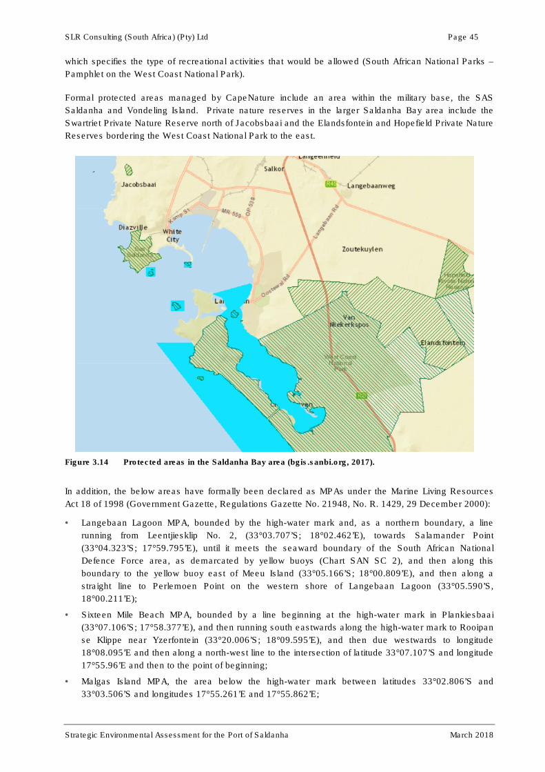
SLR Consulting (South Africa) (Pty) Ltd Page 45
Strategic Environmental Assessment for the Port of Saldanha March 2018
which specifies the type of recreational activities that would be allowed (South African National Parks –
Pamphlet on the West Coast National Park).
Formal protected areas managed by CapeNature include an area within the military base, the SAS
Saldanha and Vondeling Island. Private nature reserves in the larger Saldanha Bay area include the
Swartriet Private Nature Reserve north of Jacobsbaai and the Elandsfontein and Hopefield Private Nature
Reserves bordering the West Coast National Park to the east.
Figure 3.14 Protected areas in the Saldanha Bay area (bgis.sanbi.org, 2017).
In addition, the below areas have formally been declared as MPAs under the Marine Living Resources
Act 18 of 1998 (Government Gazette, Regulations Gazette No. 21948, No. R. 1429, 29 December 2000):
• Langebaan Lagoon MPA, bounded by the high-water mark and, as a northern boundary, a line
running from Leentjiesklip No. 2, (33°03.707’S; 18°02.462’E), towards Salamander Point
(33°04.323’S; 17°59.795’E), until it meets the seaward boundary of the South African National
Defence Force area, as demarcated by yellow buoys (Chart SAN SC 2), and then along this
boundary to the yellow buoy east of Meeu Island (33°05.166’S; 18°00.809’E), and then along a
straight line to Perlemoen Point on the western shore of Langebaan Lagoon (33°05.590’S,
18°00.211’E);
• Sixteen Mile Beach MPA, bounded by a line beginning at the high-water mark in Plankiesbaai
(33°07.106’S; 17°58.377’E), and then running south eastwards along the high-water mark to Rooipan
se Klippe near Yzerfontein (33°20.006’S; 18°09.595’E), and then due westwards to longitude
18°08.095’E and then along a north-west line to the intersection of latitude 33°07.107’S and longitude
17°55.96’E and then to the point of beginning;
• Malgas Island MPA, the area below the high-water mark between latitudes 33°02.806’S and
33°03.506’S and longitudes 17°55.261’E and 17°55.862’E;
SLR Consulting (South Africa) (Pty) Ltd Page 46
Strategic Environmental Assessment for the Port of Saldanha March 2018
• Jutten Island MPA, the area below the high-water mark between latitudes 33°04.706’S and
33°05.306’S and longitudes 17°56.961’E and 17°57.861’E; and
• Marcus Island MPA, the area below the high-water mark between latitudes 33°02.507’S and
33°02.806’S and longitudes 17°57.861’E and 17°58.361’E.
3.5 SOCIO-ECONOMIC ENVIRONMENT
3.5.1 Demographics
At the time of the last comprehensive census (i.e. 2011) the population of the Saldanha Bay Municipality
was 99 193, with the individual towns having populations as follows: Saldanha – 28 135, Vredenburg –
38 382, Langebaan – 8 294 and Jacobsbaai – 416 (www.statssa.gov.za).
More recently, the 2016 Community Survey (StatsSA, 2016) estimated that the Saldanha Bay
Municipality had the second largest population in the West Coast District with an estimated total of
111 315 people for the year 2017. This implies that Saldanha Bay’s population increased by an annual
average rate of 3.24% from 2011 to 2017. The 2016 Community Survey did not generate reliable
statistics for individual towns within the Saldanha Bay Municipality.
The forecasts of the Western Cape Department of Social Development is that this total will gradually
increase across the Saldanha Bay Municipality’s 5-year IDP planning cycle and is expected to reach
122 265 by 2023. This equates to an approximate 9.8% growth from the 2017 base estimate (IDP, 2017).
In 2017, Saldanha Bay Municipality’s population and gender breakdown are estimated at a relatively even
split between males (55 285 = 49.7%) and females (56 030 = 50.3%), with the majority (69.5%) of the
population being between the ages of 25 and 64, a large working age population (SDF, 2017).
3.5.2 Employment and Economy
Based on the 2011 Census figures, the Saldanha Bay Municipality had an unemployment rate of
approximately 15.2%, when considering the labour force between the ages of 15 and 65. Unemployment
had increased by a minor 0.84% from the 2001 Census figures. Saldanha Bay town itself experienced a
drop in unemployment from 22.8% to 15.95% between 2001 and 2011.
The primary economic sector within the Saldanha Bay Municipality is the agriculture, forestry and fishing
sector which comprised R887.21 million (or 15%) of the municipality’s GDP in 2015. The sector
experienced a growth rate of 4.49% per annum over the period 2010 to 2015 (IDP, 2017) and employed
31.77% of the area’s workforce.
According to the 2017 draft SDF document, the primary sector in 2015 contributed 12.4% to the Gross
Domestic Product (GDP) of the area, compared to 21.4% of the district municipality. The secondary
sector contributed 27.3% to the GDP, compared to 26.4% in the district; while the tertiary sector
contributed 60.4% to the Saldanha Bay GDP, compared to 52.1% in the district municipality. This
indicates that the secondary and tertiary sectors are stronger in the Saldanha Bay compared to the
district municipality. This could be attributed to the strong presence of manufacturing and tertiary
activities such as Saldanha Steel, Namakwa Sands, the Port of Saldanha and the Saldanha Bay IDZ
activities (SDF, 2017).
In 2015, the manufacturing sector (20.7%); the finance, insurance, real estate and business services
sector (17.9%); the wholesale and retail trade, catering and accommodation sector (16.1%); and the
agriculture, forestry and fishing sector (12.2%) contributed most to the Saldanha Bay GDP (SDF, 2017).

SLR Consulting (South Africa) (Pty) Ltd Page 47
Strategic Environmental Assessment for the Port of Saldanha March 2018
The tourism sector is also considered a key sector in the local and regional area, making a highly
significant contribution to employment creation. This might be reflected in the transport, business
services, retail, catering and accommodation sectors. These are considered part of the tertiary
commercial services sector, which showed substantial growth from 2005 to 2015, comprising the largest
sector in the region in 2015 (R2.404 billion or 41.0% of the municipal GDP).
It must be noted that with the continuing rise in population numbers, the number of job opportunities have
not significantly increased in the Saldanha Bay area. This has resulted in 90% of households in
Saldanha Bay falling in the low income category and the majority of inhabitants being unable or barely
able to meet their basic needs (IDP, 2017).
3.5.3 Marine aquaculture and important fisheries
The Saldanha Bay area, the only natural sheltered embayment in South Africa, is regarded as a major
area for marine aquaculture, or mariculture. A combined sea space of 430 ha is currently available for
aquaculture production in Outer Bay, Big Bay and Small Bay, of which 316.5 ha have been leased to 14
individual mariculture operators. About 70% of these concessions, mostly located in Small Bay, are
utilised for active farming of mussels, oysters and finfish (Anchor, 2017). Details of current right holders
are presented in Table 3.3.
Table 3.3 Details of aquaculture operators and the products farmed in Saldanha Bay (Anchor, 2017).
Products
Company
Mu
ssel
s
Oys
ters
Ab
alo
ne
Sca
llop
s
Red
Bai
t
Sea
wee
d
Fin
fish
Area and Location
Blue Ocean Mussel (previously trading as Blue Bay Aquafarm (Pty)
X X 52.1 ha (SB)
Blue Sapphire Pearls CC X X X X 10 ha (SB)
Imbaza Mussels (Pty) Ltd (previously trading as Masiza Mussel Farm (Pty) Ltd)
X X X 30 ha (SB)
Saldanha Bay Oyster Company (previously trading as Striker Fishing CC)
X X X 25 ha (BB)
West Coast Aquaculture (Pty) Ltd X X X 5 ha (SB), 10 ha (BB)
West Coast Oyster Growers CC X X 10 ha (BB), 15 ha (SB)
West Coast Seaweeds (Pty) Ltd X X 10 ha (SB)
African Olive Trading 232 (Pty) Ltd X 30 ha (SB) Port of
Saldanha
Aqua Foods SA (Pty) Ltd X X Port of Saldanha 10 ha
(BB), 10 ha (SB)
Southern Atlantic Sea Farms (Pty) Ltd. X Port of Saldanha 15 ha
(Outer Bay – North)
Salmar Trading (Pty) Ltd. X 10 ha (BB), 5 ha (SB)
Molapong Aquaculture (Pty) Ltd. X 1 ha (Outer Bay –
South), 4.1 ha (BB)
Chapman’s Aquaculture (Pty) Ltd X North Bay
Requa Enterprises X 15 ha (BB)

SLR Consulting (South Africa) (Pty) Ltd Page 48
Strategic Environmental Assessment for the Port of Saldanha March 2018
As previously mentioned, DAFF is proposing to establish a sea-based Aquaculture Development Zone
(ADZ) within the Saldanha Bay area, as part of the Operational Phakisa initiative. Two separate
Environmental Authorisations for the ADZ and the Southern Cross Salmon Farm within the ADZ were
issued by DEA on 8 January 2018. The ADZ project would entail the establishment of five ADZ precincts
for a total area of 1 872 ha, including the currently allocated mariculture areas. The proposed ADZ areas
are indicated in Figure 3.15 and would comprise the following:
• Small Bay: existing farmed and already allocated mariculture concession areas within the
confines of Small Bay (i.e. mussels and oyster rafts);
• Big Bay North: to the north of the Mykonos entrance channel;
• Big Bay South: to the south of the Mykonos entrance channel, with two alternative layouts;
• Outer Bay North: to the north of the Port entrance channel near Malgas Island; and
• Outer Bay South: to the south of the Port entrance channel near Jutten Island.
New species considered for farming include indigenous shellfish species (abalone, scallop), indigenous
finfish species (white stumpnose, silver kob, yellow tail), alien finfish species (Atlantic, Coho and
King/Chinook salmon, rainbow trout, brown trout) and seaweed. Cages are considered for the finfish
production, while longlines and rafts are considered for the bivalve (mussels, oysters, scallops) culture
and abalone barrels.
The approved ADZ project does not cover any land-based processing facilities that might require
environmental authorisation. Obtaining authorisation would be the responsibility of individual operators.
There are currently no specific details available of where such onshore facilities would be located, but
these may be required in close proximity to current onshore Port facilities.
Traditional net fishing takes place in the Saldanha/Langebaan area, currently targeting mullet. Large
shore angling, as well as recreational and commercial boat line-fisheries target white stumpnose, white
steenbras, silver kob, elf, steentjie, yellowtail and smooth hound shark (Anchor, 2017). The two most
important fisheries species in the Saldanha/Langebaan area are white stumpnose, caught by commercial
and recreational line fishers, and mullets (‘harders’), commercially harvested by approximately 16 gill net
permit holders. The commercial gill net fishery has shown a notable decline in the average size of
mullets landed in both Saldanha and Langebaan between 1999 and 2012, a possible sign of overfishing.

Page 49
Strategic Environmental Assessment for the Port of Saldanha March 2018
Figure 3.15: Map showing the location of current and proposed new expanded marine aquaculture areas as part of the proposed DAFF ADZ project.
The farming methodology is also indicated (SRK Consulting, 2017).

SLR Consulting (South Africa) (Pty) Ltd Page 50
Strategic Environmental Assessment for the Port of Saldanha March 2018
3.5.4 Tourism & recreation
The Draft 2017 SDF for the Saldanha Bay Municipality (SDF, 2017) provides information on tourist
attractions and trends between 2013 and 2016. The Spring flower season is the region’s biggest tourist
attraction with further peaks in visits being recorded over Christmas/New Year and Easter weekend. The
West Coast National Park is one of the region’s most prominent eco-attractions, with over 127 859
visitors recorded between January and July 2016. Other unique local tourist attractions are the West
Coast Fossil Park at Langebaanweg and Club Mykonos. According to Wesgro, the Cape West Coast
visitor trends for July to September 2016 showed that the top three activities in the region by international
visitors included scenic drives (40.5%), flowers (11.4%) and beaches (11.3%), while the top three
activities by domestic visitors were scenic drives (37.3%), culture/heritage (16.7%) and flowers (11.9%).
In addition to the wild flowers and unique fossils, tourist attractions in the Saldanha Bay Municipal area
are primarily orientated towards environmental assets such as the Berg River, the sea, whales,
mountains and protected fauna and flora species. The marine assets are particularly important and
support aesthetic as well as recreational activities, including swimming, fishing, boating, wind surfing, kite
boarding, kayaking and birding.
As mentioned in Section 3.5.2, the tourism economy is a prominent economic sector within the Saldanha
Bay Area, showing substantial growth as part of the tertiary commercial sector between 2005 and 2015.
The economy of the scenic coastal towns of Saldanha Bay, Paternoster, St. Helena Bay and Langebaan
rely heavily on year-round tourism.
A new Tourism Strategy for the Saldanha Bay Tourism Organisation (SBTO) was published in 2017. It
has as its vision that the West Coast Peninsula will be in the top three preferred tourism destinations in
the Western Cape by 2025. The mission of the SBTO is to attract more first time visitors to the West
Coast Peninsula, to attract more return visitors and to encourage visitors to stay longer and spend more
by unpacking the attributes and unique character of each town and improving the distribution of visitors
within the region. One of the key priorities for achieving the above mission is the implementation of a
modern marketing strategy, focusing on social media and an active online community.
Projects identified for prioritisation in the 2017 Tourism Strategy include the following:
• Upgrade and improved management of the Saldanha Cultural Village;
• Alignment of tourism opportunities at the West Coast Fossil Park with the new strategic tourism
plan;
• Development of the Saldanha Bay Waterfront into a recreational hub and tourism destination with
a distinct local character; and
• Use of the Langebaan informal trading area as a recycling spot, food court and area to sell local
produce.
3.5.5 Large industry located in the study area
Information on some of the key large industries located within the Saldanha Bay Municipal area is
summarised below.
ArcelorMittal
The ArcelorMittal Saldanha Works is a largely export-focused steel mill which was commissioned in
1998. It produces approximately 1.2 million tonnes of high-quality ultra-thin hot rolled coil (UTHRC)
per annum. This is an ISO 9002 and ISO 14001 certified plant and is the only mill in the world to
combine the Corex/Midrex process into a continuous chain. This technique replaces the need for
SLR Consulting (South Africa) (Pty) Ltd Page 51
Strategic Environmental Assessment for the Port of Saldanha March 2018
coke ovens and blast furnaces, making the plant a world leader in emissions control
(www.arcelormittal.com).
Even through the recent instability in the iron ore and steel markets, ArcelorMittal’s Saldanha facility
is the one steel plant that is currently still profitable due to increased efficiencies and some global
economic recovery. The plant is even rated as one of ArcelorMittal’s most productive plants
worldwide. Due to uncertainties with regards to the rising costs of electricity and reliable supply,
ArcelorMittal proposed the development of a gas-fired power station in order to support its Saldanha
facility. The plant would supply the power needs of the plant with approximately 160MW of base load
energy, peaking at up to 250MW. Excess electricity could be made available to industries within the
Saldanha Bay IDZ and/or surrounding municipalities. The plant is designed as a 1 507MW (net
capacity) Combined Cycle Gas Turbine (CCGT) power plant. Environmental Authorisation for the
project was issued in 2017, but its final implementation is dependent on when an LNG import terminal
will be developed in the Saldanha Bay area.
AfriSam Cement
AfriSam (South Africa) (Pty) plans to construct a cement plant and associated infrastructure in the
Saldanha Bay region and to re-enter the cement market in the Western Cape. The proposed project
includes the establishment of limestone and clay quarries and a transport corridor to transfer the raw
material from the quarries to the proposed cement plant. The plant will have a capacity of 600 000 TPA,
enabling a final maximum production of approximately 1.2 million TPA of cement.
Saldanha Bay IDZ
As previously mentioned, development of the Saldanha Bay IDZ commenced in 2016 with a first phase in
the back of port area. The objective of the IDZ is to become a competitive and highly efficient, leading
investor-responsive site for oil and gas and marine repair activities within the African continent. The
vision of the Saldanha Bay IDZ is to create and sustain economic development and facilitate job creation
by way of industrial investment and efficient development in the Saldanha Bay region.
One of the unique selling points of the IDZ is that it will eventually be a Free Port with a Customs Control
Area (CCA). This means that no VAT or duties would be charged on goods that are landed at the facility,
processed within the facility and again exported from the facility (thus goods that are not taken inland
from the CCA). Together with dedicated quayside access, this would ensure seamless transfers from sea
to land and back as well as short turnaround times.
It will have a sector-specific focus for attracting oilfield and marine services investors and its location is in
proximity of an already sophisticated engineering base, including companies already servicing the
industry.
In partnership with TNPA, the required marine infrastructure in the form of a 500 m jetty and floating dry
dock and a dedicated rig repair berth would be developed in support of the IDZ operations in the medium
term.
Site clearing, levelling and construction of bulk services infrastructure and roads are to commence on
Port land in 2018. The first phase of construction on Port land would be in the Bayvue Precinct, to the
east of the Bayvue entrance and would facilitate the establishment of the OSSB Terminal operator. The
bridge across MR559 connecting the back of port area to the Bayvue Precinct was finalised in 2017 (see
Plate 1).

SLR Consulting (South Africa) (Pty) Ltd Page 52
Strategic Environmental Assessment for the Port of Saldanha March 2018
Plate 1: Completed bridge across MR559, linking the back of port land to the Bayvue Precinct.
LPG projects
In addition to the Sunrise Energy Project mentioned in Section 2.2.1, Avedia Energy operates another
LPG handling and distribution facility in the back of Port area, inland of the Sunrise Energy facility. The
first phase of the facility became operational in August 2017, with six truck loading gantries being
supplied by LPG from eight 250 MT mounded tanks (bullets) (see Plate 2). The current storage capacity
is 2 000 MT, capable of supplying 6 500 tonnes of product per month. The project is economically viable
serving on the Western Cape market, but their long-term strategy is to supply all major provinces using a
rail/road connection from Saldanha Bay.
Plate 2: Enclosed storage bullets and pipe infrastructure at the Avedia Energy facility.
Oiltanking MOGS Saldanha
Oiltanking MOGS Saldanha (OTMS) is a new R 2 billion crude oil storage and blending facility located
adjacent to the SFF facility, approximately 4 km east of the Port. The facility is being developed as a
partnership between MOGS Oil & Gas and Oiltanking GmbH, a leading global supplier of storage
solutions for oils, petroleum products, chemicals, biofuels and gases. Construction of the facility has
commenced and the first phase is set to be completed during the third quarter of 2018 and the full
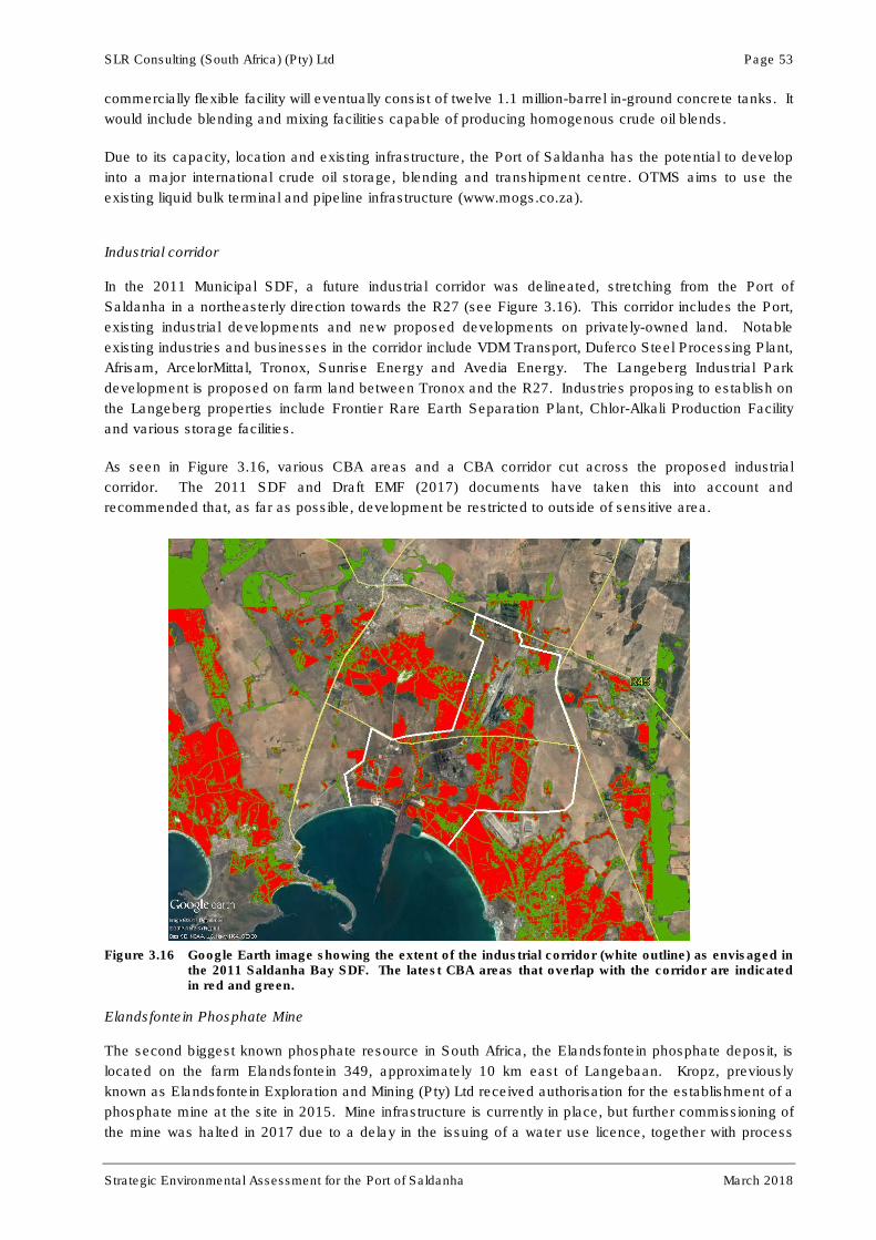
SLR Consulting (South Africa) (Pty) Ltd Page 53
Strategic Environmental Assessment for the Port of Saldanha March 2018
commercially flexible facility will eventually consist of twelve 1.1 million-barrel in-ground concrete tanks. It
would include blending and mixing facilities capable of producing homogenous crude oil blends.
Due to its capacity, location and existing infrastructure, the Port of Saldanha has the potential to develop
into a major international crude oil storage, blending and transhipment centre. OTMS aims to use the
existing liquid bulk terminal and pipeline infrastructure (www.mogs.co.za).
Industrial corridor
In the 2011 Municipal SDF, a future industrial corridor was delineated, stretching from the Port of
Saldanha in a northeasterly direction towards the R27 (see Figure 3.16). This corridor includes the Port,
existing industrial developments and new proposed developments on privately-owned land. Notable
existing industries and businesses in the corridor include VDM Transport, Duferco Steel Processing Plant,
Afrisam, ArcelorMittal, Tronox, Sunrise Energy and Avedia Energy. The Langeberg Industrial Park
development is proposed on farm land between Tronox and the R27. Industries proposing to establish on
the Langeberg properties include Frontier Rare Earth Separation Plant, Chlor-Alkali Production Facility
and various storage facilities.
As seen in Figure 3.16, various CBA areas and a CBA corridor cut across the proposed industrial
corridor. The 2011 SDF and Draft EMF (2017) documents have taken this into account and
recommended that, as far as possible, development be restricted to outside of sensitive area.
Figure 3.16 Google Earth image showing the extent of the industrial corridor (white outline) as envisaged in the 2011 Saldanha Bay SDF. The latest CBA areas that overlap with the corridor are indicated in red and green.
Elandsfontein Phosphate Mine
The second biggest known phosphate resource in South Africa, the Elandsfontein phosphate deposit, is
located on the farm Elandsfontein 349, approximately 10 km east of Langebaan. Kropz, previously
known as Elandsfontein Exploration and Mining (Pty) Ltd received authorisation for the establishment of a
phosphate mine at the site in 2015. Mine infrastructure is currently in place, but further commissioning of
the mine was halted in 2017 due to a delay in the issuing of a water use licence, together with process

SLR Consulting (South Africa) (Pty) Ltd Page 54
Strategic Environmental Assessment for the Port of Saldanha March 2018
plant efficiency challenges and weak phosphate prices. The decision was taken to place the plant on
care and maintenance in September 2017. The Elandsfontein mining company, Kropz SA, has, however,
reported that it is planning to finalise a revised plant design and raise capital to bring the project back on
stream during 2018.
While the mine is located some distance from any Port facilities or property, it is underlain by the
Elandsfontein Aquifer System which drains into the Langebaan Lagoon. Potential impacts on
groundwater entering the lagoon system is thus to be considered cumulatively with any impacts related to
Port activities. The 2017 State of Saldanha Bay and Langebaan Lagoon study includes a baseline
description of the Langebaan Lagoon conditions where the Elandsfontein Aquifer discharges and will be
monitoring against these baseline conditions going forward, in order to identify any changes in the system
that may be caused by the Elandsfontein mining operations and discharges into the groundwater system.
3.5.6 Heritage
Palaeontological significance
The fossil potential in the subsurface of the Saldanha Bay area is related to the underlying formations.
The formations present in the study area are indicated in Figure 3.17 and summarized in Table 3.4, with a
brief indication of their palaeontological sensitivity (CSIR, 2012).
Figure 3.17: Geology in the Saldanha Bay area (adapted from Visser & Schoch, 1972 by Pether, 2014). The
location of the SBIDZ area is indicated in red.

SLR Consulting (South Africa) (Pty) Ltd Page 55
Strategic Environmental Assessment for the Port of Saldanha March 2018
Table 3.4: Underlying geological formations of the Saldanha Bay area and their palaeontological sensitivity.
Formation Age and description Sensitivity
WITZAND – Q5 Holocene and recently active dune
fields and cordons <~12 ka.
Mainly archaeological sites.
SPRINGFONTYN –
QI & Q2
Quaternary to Holocene, mainly
quartzose dune and sandsheet
deposits, interbedded palaeosols,
basal fluvial deposits <~2 Ma.
Fossil bones very sparse, local
to high significance. Basal
fluvial deposits locally – high
significance.
VELDDRIF – VD Quaternary raised beaches &
estuarine deposits, <~1.2 Ma. Sea-
levels below ~15 m asl.
Shell fossils common, local
significance. Fossil bones very
sparse, high significance.
LANGEBAAN – LB Late Pliocene to Late Quaternary
aeolianites <~3 Ma to ~60 ka.
Fossil bones mod. Common,
local to high significance.
PROSPECT HILL –
PH
Late Miocene aeolianite 12-9 Ma? Fossils very sparse – high
significance.
As the formations underlying parts of the study area are known for containing fossils, monitoring of
bulk earthworks are required for any new developments within and surrounding Port land.
Archaeology and Cultural Heritage
Since the mid-1990s, numerous Archaeological Impact Assessments (AIAs) have been conducted in
Saldanha Bay, north of the port terminal (Kaplan, 1994; 1996; 1997a; 2006a; 2007a & 2010), where
archaeological remains assigned to the Early (ESA) and Middle Stone Age (MSA) have mostly been
documented. Later Stone Age (LSA) sites have also been recorded along, and near to, the coast south of
the town (Kaplan, 1997b; 1998; 2006b; 2007b & 1993) where the remains typically comprise dispersed
scatters of shellfish, a few stone artefacts, ostrich eggshell and pottery. None of these sites have been
dated, however. A 19th century veewagterhuis (shepherd’s hut) was also excavated by Kaplan (1996b) at
the site of Saldanha Steel.
There are shell middens (shellfish processing sites) with stone artefacts dating to the MSA in Saldanha
Bay. The evidence from Sea Harvest and Hoedjiespunt, for example, has provided some of the earliest
evidence we have in the world for the human exploitation of coastal resources, more than 100 000 years
ago. Beside evidence of well-preserved bone, ostrich eggshell, ochre and stone implements, the Sea
Harvest and Hoedjiespunt sediments also contain evidence of early modern humans about 125 000 years
ago (Berger & Parkington, 1995).
Bateman (1946) documented LSA middens in the vicinity of the Saldanha military base, as well as a few
MSA occurrences, and Kaplan (2012) documented LSA middens at the site of the proposed new
Saldanha Bay military sick bay, as well as along the shoreline inside the base (Kaplan, 2013). Rudner
(1968) recorded a cave with shell midden deposits at Noordbaaikop inside the military base.
Archaeological excavations at the sick bay site revealed substantial sub-surface LSA deposits, including
shellfish, large volumes of marine fauna, stone artefacts, and ostrich eggshell (Smith, 2013). A sample of
bone taken from the excavation was dated to 2 500 years BP, while the presence of pottery also indicates
that the site was visited after 2 000 years ago.
It is the more recent salvage excavations and recovery of six LSA Khoisan skeletons from the Diaz Street
Midden (Orton, 2009; Dewar, 2010), more than 2km inland from the shoreline, that has focused attention
on the important LSA industry in Saldanha Bay. More than 4 000 stone artifacts were recovered from the
small excavation (the site of the new Saldanha Bay Police Station), where sadly a large portion of the

SLR Consulting (South Africa) (Pty) Ltd Page 56
Strategic Environmental Assessment for the Port of Saldanha March 2018
archaeological deposits had already been destroyed during construction work. While all of the recent
upper deposits (probably dating to the last 2 000 - 3 000 years) were destroyed during initial earthworks,
some of the underlying deposits were still intact by the time the archaeologists were notified, when the
first of the burials were uncovered. These deposits were later dated to between 5 000 and
6 000 years ago, and comprised thousands of stone artifacts (including many retouched tools such as
scrapers and backed artifacts). Ostrich eggshell (OES) beads, decorated fragments of OES and some
worked bone were also found, as well as subsistence remains including shellfish, crayfish and marine
fauna.
Further south at Kraalbaai along the shores of the Langebaan Lagoon, lies the location of a significant
historic find known as Eve’s Footprints. This site of historical significance was found in 1995 and consists
of a set of fossilized footprints thought to be those of an early human, dated to approximately 117 000
years ago (Roberts & Berger, 1997).
Shipwrecks
Maritime activities have taken place in the Saldanha Bay area for more than 400 years, with activities
related to fishing, sealing and whaling being well documented near Marcus Island/Outer Bay and at
Salamander point (David & van Sittert, 2006). Whaling stations were active in Saldanha Bay between
1909 and 1967. The Donkergat whaling station and factory was established near the tip of the peninsula
in 1909 with a further station set up at Salamander Bay shortly after (www.sawestcoast.com). Due to the
extensive maritime activities, numerous shipwrecks have been documented along the coast. As part of a
recent heritage impact assessment for the proposed establishment of the Saldanha ADZ, the location of
known shipwrecks in relation to proposed ADZ areas were indicated by the African Centre for Heritage
Activities (SRK, 2017). These known sites are indicated in Figure 3.18 and further details of shipwrecks
in the vicinity of Port infrastructure are provided in Table 3.5.
Table 3.5: Summary of known shipwrecks in Saldanha Bay (adapted from SRK, 2017).
Vessel Name Date Information
Kildalkey 1937 This steamship was built during World War I and later converted into a
tanker for use in the sealing trade. While transporting whale oil, she hit the
rocks known as the Seven Blinders during a heavy fog. The wreck may
have been removed in 1974.
Karatara 1921 This vessel was built for the sealing trade, but caught fire while in Table Bay.
It was eventually scuttled at the whaling station in Saldanha Bay as part of
the jetty.
H.C. Richards 1893 Built in 1963, this 806 ton Norwegian barque struck a rock off Aliwal Shoal.
After filling with water she was run aground near the Illovo River and later
towed to Durban. After being towed to Cape Town, she was condemned and
eventually scuttled in Salamander Bay to form a jetty.
Middelburg 1781 This Dutch East-India 1 150 ton vessel was built in 1775 for the Zeeland
Yard. While homeward bound with a cargo of porcelain, tea, silk, aniseed
and tin, her crew set her alight in order to avoid capture by the British. She
eventually sank near Hoedjies Point. The wreck has been worked on by
various salvors over the years.
Cleopatra 1968 A 75 ton fishing vessel which caught alight and burned at her slip in
Saldanha Bay
Ovambo Coast 1958 This South African 217 ton vessel was built in 1939 and wrecked on Marcus
Island during heavy fog. She was carrying a cargo of fish oil bound for Cape
Town.
Petronella Alida 1738 This Dutch East-India 550 ton vessel was broken up at Saldanha Bay and it
is unlikely that any remnants of the vessel remain.

SLR Consulting (South Africa) (Pty) Ltd Page 57
Strategic Environmental Assessment for the Port of Saldanha March 2018
Figure 3.18: Location of known shipwrecks in and near Saldanha Bay in relation to proposed ADZ areas (SRK, 2017)

SLR Consulting (South Africa) (Pty) Ltd Page 58
Strategic Environmental Assessment for the Port of Saldanha March 2018
CHAPTER 4: GENERAL APPROACH TO THE SEA, REVIEW AND UPDATE
AS APPLIED IN THIS STUDY
4.1 NEED FOR SEA
SEA emerged in the 1990s as an approach specifically targeted at Policies, Plans and Programmes
(PPPs). Since then, the practice of SEA has spread across the world and at least 40 countries now have
systems and frameworks in place (including South Africa).
Box 4.1: The purpose of SEA
In summary, the purpose of SEA is to ensure that environmental and social considerations inform and are
integrated into strategic decision-making in support of environmentally and socially sound and sustainable
development. In particular, the SEA process assists authorities responsible for PPPs, as well as
decision-makers, to take into account:
• Key environmental and social trends, potentials and constraints that may affect or may be
affected by the PPPs.
• Environmental and social objectives and indicators that are relevant to the PPPs.
• Likely significant environmental and social effects of proposed options and the implementation of
the PPPs.
• Measures to avoid, reduce or mitigate adverse effects and to enhance positive effects.
• Views and information from relevant authorities and the public.
Although focused mainly on PPPs, SEA can be applied to legislation, lending, a particular geographical
area (e.g. greater Saldanha), a particular sector (e.g. spatial planning, transport, agriculture, forestry,
fisheries, energy, waste/water management, tourism) or to a specific issue (e.g. climate change,
biodiversity).
SEA is flexible in structure and adaptable to specific decision-making processes and their socio-economic
and political contexts. SEA enhances environmental and social awareness, integrates environmental and
social considerations into decision making – fostering sustainability, facilitates coordinated action across
development sectors, and contributes to the attainment of environmentally sound, integrated, and
balanced development.
SEA further strengthens strategic decision-making as it evaluates and integrates considerations of
environmental and social factors and their inter-linkages with economic considerations. SEA is based on
the following key principles of sustainability:
• early proactive consideration of the environmental and social effects of strategic actions;
• broad institutional and public engagement;

SLR Consulting (South Africa) (Pty) Ltd Page 59
Strategic Environmental Assessment for the Port of Saldanha March 2018
• analysis and integration of qualitative and quantitative information within a dynamic, interactive
framework;
• early warning of potential cumulative effects and large-scale changes; and
• identification of best practicable options that can be articulated from the policy level to the individual
project level.
South Africa has rich experience in the theory and practice of SEA (Retief et al., 2007). The first
Guideline for SEA in South Africa was published in 2000 by the national Department of Environmental
Affairs (DEAT, 2000) and updated in 2007. The national planning context for SEAs is set by the country’s
National Development Plan (2012) that provides the over-arching blueprint for accelerating sustainable
socio-economic development. As noted previously, this plan is supported by the government’s SIPs, of
which the Saldanha-Northern Cape Development Corridor is one.
There are numerous potential benefits arising from the use of SEA, the nature of which may depend on
how SEA is applied, its outcomes and its interactions with the decision-making process. For the Port of
Saldanha, the SEA process will be used to:
• Determine the future form of development in a way that promotes sustainability, through the
integration of sustainability considerations into the formulation, assessment and implementation of
PPPs;
• Help to identify, and address, potential areas of conflict or inconsistency between PPPs early on in
their formulation;
• Explore the opportunities for, and constraints to development posed by the broader receiving
environment, thus narrowing down consideration of projects to only those that could be sustained
by the environment;
• Consider cumulative effects and relatively large-scale environmental change (e.g. at regional level);
• Assist in defining and maintaining a chosen level of environmental quality;
• Enable stakeholder engagement (the public, non-governmental organisations, government
departments and other institutions) at a strategic level in the planning process; and
• Complement and strengthen EIAs at the project level by identifying prior information needs and
potential impacts, addressing strategic issues and concerns that may relate to project justification,
and streamlining the project review process.
The National Ports Act (Act 12 of 2005) requires pro-active integration of environmental impacts into
planning processes, and dictates that such planning must strive to achieve a reasonable balance
between the protection of the natural and social environment and the development and maintenance of
ports (to which, SEA provides direction).
4.2 GENERAL SEA PRACTICE AND APPROACH ADOPTED FOR THE SEA, REVIEW AND UPDATE
4.2.1 General SEA practice
In general, three types of SEA methodology can be applied, namely: integrated, EIA-based and
sustainability framework models.
SLR Consulting (South Africa) (Pty) Ltd Page 60
Strategic Environmental Assessment for the Port of Saldanha March 2018
The integrated model is best suited for integrating the SEA process into existing policy formulation and
planning processes (e.g. Spatial Development Plans). The EIA-based model on the other hand is usually
linked to the assessment of “end-of pipe” impacts and is generally reactive in nature. The sustainability
framework model has a strategic application whereby a vision and a set of sustainability indicators pro-
actively guides future planning processes. The Terms of Reference provided by TNPA for the compilation
of the original SEA clearly favoured a sustainability framework methodology for the SEA.
Although the sustainability framework methodology was applied by the CSIR in order to develop the SEA
for the Port of Saldanha, a novel approach was employed as methodological foundation. This approach,
which responds to limitations identified, for example, in State of Environment reporting in SEA (Box 4.1),
has been applied to great effect inter alia in the review of the SEA for the Port of East London (CSIR,
2012). The approach adopted for this SEA abandoned the separate consideration of key components of
the environment (social, ecological, economic), which is traditionally adopted for SEA (e.g. marine water
quality issues considered separately from issues pertaining to the port’s economic contribution,
considered separately from terrestrial ecosystem issues, etc.). A more effective social-ecological systems
approach is adopted, through which not only the strategic implications of social, economic and ecological
system components are accounted for, but also the systemic relationships that link these components. A
summary of the original methodology and review/update process tasks is provided in Table 4.1 below.
The consultants engaged to review the 2013 SEA report, examined the causal loop diagrams developed
by the CSIR, and found them to be adequate for the update analysis, and still valid. Thus, there was no
need for updating them in light of any changes that have occurred since 2013. More emphasis was,
however, placed on the proposed oil rig and ship repair project proposals for which feasibility studies
were undertaken since completion of the previous SEA report. Based on changes in the biophysical and
socio-economic environments of the Port of Saldanha and surrounding municipal area since 2013, the
sustainability indicators for some of the system components were amended (see Chapters 6 and 7).
Table 4.1 Methodology for the compilation of the original Port of Saldanha SEA and subsequent review/update.
METHODOLOGY FOR THE PORT OF SALDANHA SEA
Activity Description of activities and aims
1. Strategic workshop/s
involving TNPA and
the CSIR team
members
• Crafting of a vision for the sustainable development and operations of the
Port of Saldanha
• Consolidation of known strategic issues (e.g. as contained in the Port of
Saldanha’s latest Long-Term Development Framework Plan) and
clarification on known significant environmental impacts identified in the
Ports’ Aspects & Impacts register.
2. Identification of and
engagement with key
stakeholders
• Engaging with disciplinary experts in the SEA process, stakeholders with
local knowledge and various authorities and interest groups.
• Identification of key stakeholders by using existing EIA databases for the
Saldanha Bay area and updating the database throughout the SEA
process.
• Presentations to the Port of Saldanha EXCO and other relevant
personnel.
• Engagement with relevant authorities and identified stakeholders.
3. Prepare depictions of
the social-ecological
system, of which the
Port of Saldanha is
• Compilation of a series of graphical causal loop diagrams depicting the
social-ecological system of which the Port of Saldanha is part (also
accounting for different future scenarios).
• This systems perspective was used to identify potential fatal flaws

SLR Consulting (South Africa) (Pty) Ltd Page 61
Strategic Environmental Assessment for the Port of Saldanha March 2018
part. Depict variations
in system
configuration to
account for alternative
future scenarios for
the port. The
depictions comprised
graphical causal loop
diagrams.
through insight gained of system variables and relationship – some of
which may be re-enforcing or diminishing feedbacks.
• The systems diagram was made available to the SEA team and
specialists to identify opportunities, constraints and potential fatal flaws
relating to the different key variables and relationships.
4. Determine
opportunities &
constraints and
potential fatal flaws on
the basis of what is
revealed through the
social-ecological
system depictions; e.g.
on the basis of positive
and negative system
feedback loops
• Identification of opportunities and constraints posed by the social, bio-
physical and economic environment to achieve the port’s stated vision
(through various sustainability objectives).
• Investigation of the potential environmental impact of different
commodities handled by the port, originating from, or feeding into, its
economic hinterland/catchment.
• Identification and evaluation of potential “fatal flaws” that might prohibit
certain developments and operations (e.g. the handling of a particular
commodity through the port).
• Addressing the systemic causes of significant environmental impacts
identified in the Ports’ Aspects & Impacts register.
5. Integration and
interpretation of
findings
• Building on the social-ecological system analysis, integrate the various
specialist contributions in the form of an SEA report.
• Aiming at compatibility, ensure alignment between the SEA and the Port
Development Framework and master plan (also other significant plans
such as the 2018 SDF for Saldanha Bay).
• Revision of the Port’s Aspects & Impacts Register in the light of what is
revealed and produced through the SEA process.
• Ensuring that the SEA provides an easily interpreted foundation for any
EIAs that may subsequently be commissioned for port developments.
2017 Review and update of the 2013 SEA
6. Initiation of review • Initiation meeting with TNPA and confirmation of revision process.
• Collation of updated information sources on the baseline conditions within
and surrounding the Port of Saldanha.
• Review of the latest LTPF (2016) for the Port of Saldanha and
consideration of new key project components within the port limits.
• Review of original SEA methodology to confirm relevance within the 2017
context.
7. Strategic Workshop
with key identified
stakeholders
• Initial engagement workshop with key stakeholders (14 March 2017),
including members of the Intergovernmental Task Team for the Greater
Saldanha Bay area. Attendees included representatives from local,
provincial and national government, large industry, public and private
sector and NGOs.
• The aim of the initial engagement was to identify any constraints or
conflict with the latest PDFP for the Port of Saldanha and to inform the
scope of the SEA.
• Updating of SEA report to include a larger planning domain,
encompassing surrounding largescale government and public and private
sector projects
8. Compilation of
updated SEA report
• Compilation of the updated SEA report by incorporating the latest PDFP
information and current baseline conditions within and surrounding the
Port of Saldanha.
9. Finalising of SEA
review/update process
• The updated SEA document is to be reviewed by TNPA, finalised and
thereafter distributed for public and authority information.
SLR Consulting (South Africa) (Pty) Ltd Page 62
Strategic Environmental Assessment for the Port of Saldanha March 2018
and follow-up
Stakeholder
Engagement
• The main findings of the SEA update process will be presented to key
stakeholders at a focus group meeting.
10. Future preparation of a
series of systemically
linked strategic
environmental
management plans,
relevant to key areas
of port development
and operations
• A future aim of the SEA process would be to prepare a series of Strategic
Environmental Assessment Management Plans, to guide development
proposals and track environmental performance in line with the strategic
direction provided by the SEA and in conformance with applicable
legislation.
4.2.2 Approach to SEA adopted for the Port of Saldanha and its review and update
The Port of Saldanha is clearly embedded in a social-ecological system (or multiple systems defined, for
example, at different scales) in which ecological, economic and social components are integrally linked.
The functioning of the human spheres of such systems (i.e. individuals, groups and institutions; also, port
developments and operations) imposes effects on the ecological spheres which, if they retain the capacity
to do so, provide the human spheres with essential environmental goods and services (e.g. marine water
quality capable of supporting mariculture, clean air, etc.).
Conceptualising a social-ecological system requires the following to be defined: key social, economic and
ecological system elements/variables; the linking relationships between these elements (e.g. flows of
ecosystem services and other resources); and, the feedback effects that either reinforce or diminish
capacities within the system. It also requires account to be taken of critical exchanges across the
boundaries of the defined system, as it connects with other systems, including those that function at
different scales (e.g. the port’s connections with the town of Saldanha Bay, the Western Cape Province,
water catchments and water supply schemes, etc.).
Complexity arises as a result of the interactions between social-ecological system components, as these
create the emergent properties of such systems. Emergent properties are those that cannot be described
in terms of the separate components of the system but arise, rather, due to interactions between system
components. To approach an understanding of a complex system (acknowledging that some system
aspects may always be beyond grasp), the focus must, therefore, be on context-relevant system
interactions and not (at least primarily) on individual system components (Cilliers, 2008).
Systems dynamics modelling can be useful in describing cause-effect relationships between social-
ecological system components and in quantifying some of these relationships. This approach was used
as the core methodology for preparing the SEA for the Port of Saldanha (Table 1.3). It was used, in the
first instance, to conceptualise the system as a means to reveal strategic issues about which the SEA is
developed; i.e. the bulk of the bulleted items listed in the Terms of Reference (Section 1.1).
In order to conceptualise the social-ecological system to which the Port of Saldanha contributes and is
part, a causal loop diagram was constructed to aid understanding of the social-ecological system on
which the SEA focuses in order to: reveal significant strategic issues; determine the systemic relationship
between these issues and the issues comprising the port’s Aspects and Impact Register; the causes of
significant environmental impacts identified in the port’s Aspects and Impacts Register; systemically
defined opportunities for the development and operations of the port at a strategic level; etc.
The social-ecological system, as conceptualised for this SEA, has a spatial and temporal character. In
the original 2013 SEA the actual spatial boundary was considered to be the TNPA property boundary,
with selected cross boundary relationships primarily with the marine environment and local municipality.
In consultation with key stakeholders, the SEA revision team, however, opted to take a slightly wider view

SLR Consulting (South Africa) (Pty) Ltd Page 63
Strategic Environmental Assessment for the Port of Saldanha March 2018
of the “immediate TNPA zone of influence”, with a “soft” rather than hard boundary. Whilst this poses
practical challenges both in the review/update of the SEA and its implementation, it was deemed
appropriate to “look over the fence” as there is no doubt that TNPA has direct, indirect and cumulative
impacts well beyond its property boundary – some negative, others positive. The timeframe of the
depicted and considered SES stretches from the short-term (7 years) to long-term (30+ years) phases of
the proposed port development expansion strategy.
Methods of perceiving and depicting systems provide tools for an improved understanding of systems and
their management, particularly for complex situations, as in the case of Port of Saldanha and its enabling
function relating to sustainable industrial (and other) development in a resource-constrained situation
(e.g. marine water quality close to its maximum assimilative capacity, scarcity of freshwater resources for
development, constraints in electricity supply, changing trade and shipping patterns in response to global
change (climate, economic, political, etc.).
System dynamics diagrams present relationships that are difficult to describe verbally. This is because
normal language presents interrelations within systems as linear cause-and-effect chains. However,
system depictions can reveal circular chains of cause (e.g. ‘a’) >effect (e.g. ‘b’) >cause (e.g. ‘x’ + ‘y’ + ‘a’),
etc., which, in combination, result in self-regulation of whole systems. The example of a graphical causal
loop diagram presented in Figure 4.1 is illustrative (only a small portion of the model is shown) of what
was developed as the foundation for the SEA of the Port of Saldanha. The complete model is described
in detail in a later section of this report.
In a causal loop diagram, the influence of one variable on another is described as causality. When an
element of a system indirectly influences itself, the portion of the system involved is called a feedback loop
or a causal loop. Arrows representing system relationships are used to indicate directions of causal
influence, and signs (+ or -) adjacent to the arrows indicate the polarity of these relationships (Figure 4.1).
A plus (+) sign implies that a change in the variable at the tail of the arrow will cause a change in the
variable at the head of the arrow in the same direction (re-enforcing effect); a minus (-) sign implies that a
change in the variable at the tail of the arrow will cause a change in the variable at the head of the arrow
in the opposite direction (diminishing effect). It must be noted that the polarities (+ or -) assigned to linking
relationships do not have any normative significance (e.g. plus (+) does not necessarily imply
good/desirable; minus (-) does not necessarily imply bad/undesirable); they merely indicate either the re-
enforcing (+) or diminishing (-) influence of the relationships on the variables they connect to.
There are two types of effects that arise through feedback loops. A positive feedback loop reinforces
change, often at an ever-increasing rate. In some situations a rate of change may, during the early stages
of influence on a particular system relationship, appear to be minor (i.e. the cause of change and the
change itself may seem insignificant). However, as the change becomes magnified through repeating, re-
enforcing effects, the system implications thereof can rapidly assume significant proportions. Negative, or
balancing, feedback loops impose regulating or stabilizing system effects, which in a normative sense can
be either desirable or undesirable (e.g. an undesirable effect could be the resistance a feedback imposes
in terms of enabling desirable system change).
Specialists and key stakeholders were engaged in order to construct the SES of which the Port of
Saldanha is part. Stakeholders included representatives of the various port authorities (TNPA, Transnet
Capital Projects [TCP], Transnet Port Terminals [TPT]), local government and interest groups and
specialists in areas that are critical for the definition of the social-ecological system at issue (e.g.
specialists in the fields of marine and terrestrial ecology, archaeology, economics, heritage, marine water
quality, bulk services and infrastructure provision).

SLR Consulting (South Africa) (Pty) Ltd Page 64
Strategic Environmental Assessment for the Port of Saldanha March 2018
Figure 4.1 Main elements of a graphical causal loop diagram: SES variables, linking relationships and polarity
SLR Consulting (South Africa) (Pty) Ltd Page 65
Strategic Environmental Assessment for the Port of Saldanha March 2018
The process of model-building was also informed by a stakeholder engagement process that extended
beyond TNPA and specialist involvement.2 Two stakeholder engagement meetings were held during the
original SEA process. The main issue emerging from the stakeholder engagement meetings held during
the 2013 SEA, was for the SEA process to deliver a Strategic Master Plan (SMP) to guide all development
in the Saldanha Bay area. At the time, this expectation was regarded as beyond the scope of the SEA.
However, the essential message was acknowledged to be relevant: that planning undertaken by TNPA
must be as holistic as possible. To date, such a SMP has not been developed.
The need for an SEA for the greater Saldanha Area was also raised at the strategic workshop held on 14
March 2017. Given the expansion and diversification plans by TNPA and other proponents, the need for a
SMP is even greater now than before. However, the SMP cannot be the responsibility of TNPA alone.
Whilst TNPA may be the dominant partner, other proponents (e.g. Saldanha Bay Municipality, mariculture
industry, SBIDZ, large industrial projects, mining) should all join forces to contribute towards compiling
and implementing the SMP. Thus, the revision of the 2013 SEA is also regarded as being the catalyst for
initiating a “multi-stakeholder SMP for the greater Saldanha area”. DEA&DP has already embarked on a
process of compiling a Regional Spatial Implementation Framework for the Greater Saldanha Bay area,
with an SEA for the area to follow. Together, these processes would likely result in a similar document to
the SMP for assisting in the strategic approach to planning of developments in the larger Saldanha Bay
area, including the Port of Saldanha.
Other concerns and antagonisms raised during the 2013 and 2017 processes include the following:
• Air quality: the perceived ongoing poor management of fugitive iron ore dust emissions from the
TPT operations continues to be a concern. The effect this could have on surrounding
communities, tourism, companies establishing operations within the IDZ area and industry in
general was raised as a concern.
• Manganese export: limited volumes of manganese are currently being exported from the MPT.
This is a temporary activity and will soon be moved to Nquru. Concerns were raised regarding the
potential impact of heavy metal contamination from manganese dust on the aquaculture industry
and public health.
• Lead export: concerns were raised regarding water quality and public health from lead
contamination within Small Bay and in emissions to air. It was recommended that storage
facilities need to be improved and that export should take place in closed containers.
• Aquaculture: concerns were raised regarding the proposed establishment of an ADZ in the
Saldanha Bay area and its potential negative impact on tourism and ecosystem integrity. These
concerns relate to the potential eutrophication from cage farming of fin fish and increased
sedimentation from cleaning of shells. It was proposed that smaller fish farms should be
considered in the most suitable locations. Concerns were also raised that the industry could
potentially be dominated by foreign operators. Opportunities for synergy between tourism and
aquaculture (e.g. marketing locally farmed seafood at restaurants) and industry and aquaculture
(i.e. aquaculture to serve as a “check” on industry to ensure impacts on water quality are limited)
were proposed.
• Transport: concerns were raised regarding the potential impact of increased heavy vehicle traffic
on public health and tourism, through road user frustration and noise.
• Mining: concerns were raised regarding the increase in establishment of mining activities in the
Saldanha Bay area (including sand mining and quarries) and its potential impact on biodiversity
and, subsequently, tourism. It was proposed that the new Greater Saldanha Bay EMF identify no-
go areas in order to prevent/limit mining activities in sensitive areas.
2 The public consultation process applicable to this SEA process is not subject to the NEMA public participation requirements, nor is
it subject to the participatory requirements as stipulated in Government Notice R 982.

SLR Consulting (South Africa) (Pty) Ltd Page 66
Strategic Environmental Assessment for the Port of Saldanha March 2018
• Town expansion: concerns were raised regarding the potential pressure to be placed on bulk
services by further town expansion in the area. These concerns relate specifically to volumes of
treated effluent and potentially contaminated stormwater being discharged to the sea and
affecting environmental and human health. It was proposed that infrastructure be improved and
better and more innovative technology considered.
• Skills development and employment: during the 2013 process it was noted that TNPA is partly
responsible for the steady transformation of the Saldanha area from a fishing-determined
economy to one that is largely industrial in character. The need for re-skilling and
education/training aimed at enabling employment in the industrial sector was identified. With the
commencement of the Saldanha Bay IDZ project, the SBIDZ-LC initiated the iThemba Skills
Programme funded by merSETA and the Department of Trade and Industry (DTI) to train 674
candidates in foundational welding, fabrication, rigging, electrical, bricklaying, plumbing and
carpentering skills. This training is aimed at learners residing in the Saldanha Bay municipal area.
Almost every contribution to the SEA deliverable contained within the 2013 SEA and the 2017
review/update is grounded in, extracted out of, or interpreted from the social-ecological systems
perspective gained through the systems approach described above. The existence of revealed feedback
effects has, for example, assisted the identification of potential systemic fatal flaws that might prohibit or
limit certain developments and the handling of particular commodities in the port. It also reveals the
systemic causes of potentially significant environmental impacts. From this basis, management
guidelines were prepared by referencing foundational principles through which system functioning can be
influenced most effectively at key points (variables, relationships) within the social-ecological system, of
which the port is part. The main aim of this approach is to enhance sustainability (or at least the port’s
contribution in this regard) through both a progressive approach to planning and acknowledgement of the
need for adaptive management (e.g. to deal with situations that are difficult to anticipate).

SLR Consulting (South Africa) (Pty) Ltd Page 67
Strategic Environmental Assessment for the Port of Saldanha March 2018
CHAPTER 5: PORT OF SALDANHA: SES DEFINITION & RESILIENCE
IMPLICATIONS
5.1 SOCIO-ECOLOGICAL SYSTEM DEFINITION AND RESILIENCE CHARACTERISTICS
The graphical causal loop diagram (CLD) constructed for this SEA to depict key social-ecological system
(SES) elements and linking relationships is presented in Figure 5.1. The figure depicts the social-
ecological system, of which the Port of Saldanha is part, with the main planned port expansions included;
i.e. it does not reflect only the current situation.
Although there are myriad elements and relationships that could be depicted for the SES on which this
assessment is focused, those that have been selected for analysis are deemed to be most significant in
terms of their influence on system resilience and, thereby, on system sustainability, also considering other
notable development proposals in the surrounding area. Only a limited number of characteristics of a
complex system can be taken into account in any description thereof, which implies that knowledge
gained by such description will always be relative to the perspective from which it is made. The
subjectivity involved in the study team’s selection of certain system relationships, to the exclusion of
others is, therefore, acknowledged – although the breadth of expertise employed in the process is
considered to avoid analytical restrictions that such subjectivity could impose.
As mentioned previously, in reviewing and updating the SES elements, a broader study area extending
beyond the port boundary was considered in order to give due consideration to systemic relationships like
the port’s influences on marine water quality and air quality within the greater Saldanha Bay area.
The SES is shown in Figure 5.1 to comprise 63 variables. A proportion of these variables are directly
associated with the port whilst others either influence or are influenced by the port to varying degrees. A
total of 112 linking relationships directly and indirectly connect the identified system variables, providing
its dynamic and functional definition. To aid the discussion of the system relationships that follows, the
relationships are numbered in Figure 5.1 from #1 to #112. For ease of reference, the linking relationships
are also listed and briefly described in Table 5.1 (See end of Chapter 5).
Although the causal loop diagram in Figure 5.1 allows reasonably clear insight to be gained into what key
system variables and relationships comprise the SES of which the Port of Saldanha is part, the challenge
is to establish how certain of these system characteristics should inform, at a strategic level, port
planning, development and management actions in the short-, medium- and long-term. Put differently,
understanding is required as to how the key ecological, social and economic system variables and
relationships place constraints on and present opportunities for the port’s current operations and future
development and operations.
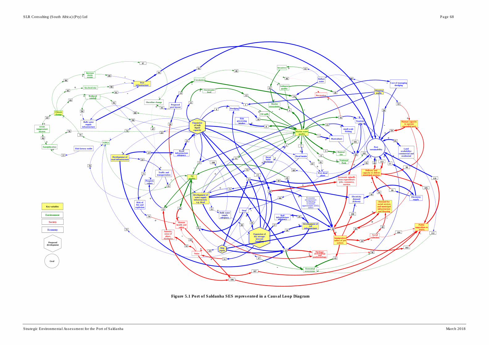
SLR Consulting (South Africa) (Pty) Ltd Page 68
Strategic Environmental Assessment for the Port of Saldanha March 2018
Figure 5.1 Port of Saldanha SES represented in a Causal Loop Diagram
-
Expansionof bulkliquid
capacityMarine water
quality
Oil spills
Mariculture
Marineecosystems
Ramsarsite
NationalPark
1
2
3
4
5
6
7
8
9
10
+-
+
Desal intake
+
Fishprocessing
intakes +
12
11
Dredging+
-
13
14
15
16
17
Stormwaterload+
-
18
19
Proposedport layout
Circulation
-
-
small-scaleFishing
+
Tourism+
Recreation
+
Expansion ofdry storage:
iron orehandling
20
21
22
23
24
25
26
27
28
29
30
Airquality
-
Humanhealth and
safety
+
Propertyvalues
Noise
Economicinfrastructure
facilitatingeconomic
opportunities (IDZ),sishen
+
Roadinfrastructure
adequacy
Electricitydemand(Eskom)
Risk offire and
explosion
41
31
32
33
34
35
36
37
38
39
40
+
+
Port desalplant
Desalbrine
discharge
50
-
Development ofroad infrastructure
++
Traffic andtransportation
+
-
Shippingtraffic
Railinfrastructure
adequacy
-
Development ofrail
infrastructure
+
+
-
Bulk watersupply
adequacy
-
Development ofwater supply
infrastructure,e.g. desal
+
-
+
Terrestrialecosystems
-
Heritage:archaeology
andpaeleontology
-
Dust
+
-
+
-
Demand forsocial servicesand municipalinfrastructureand Housing+
Inmigration:influx of job
seekers
+Social
cohesion
-
42
43
44
Economic spinoffsfrom expenditure:jobs, commerce,
services+
-
Delivery andcapacity to delivermunicipal services
-
Portsustainability
+
-
52
53
54
56
55
46
47
48
49
51
45
Landavailability:
commercial andresidential
+
Shoreline change
+
-
-
-
Sedimentquality
+Cost of managing
dredging-
-
Electricitysupply
+
Amenity,sense ofplace,
Aesthetics -
+
-
Shiprepair
+
Human capacityto operate
expanded port
Ballastwater
++
57
+
58
60
59
+
+
61Invasives +
62
-
63
-
+
+
64
+
65+
66
-
67
+68
+
70
71
73
72
+
+
+
+
Environment
Economy
Society
Climatechange
Increasestormevents
Sea level rise
Reducedrainfall
oceantemperature
increse
Portinfrastructure
Bulk watersupply
infrastructure
Eutriphication
GHGs
Fish factory outlet
74
75
76
77
78
80
81
82
83
84
85
86
87
88
89
91
90
92
93
94
95
96
+
+
+
+
+
+
-
-
-
-
-
+
+
+
-
+
+
+
+
+
+
97
+
98
+
99
+
100
+
101
102
++
Publicopposition to
TNPA
103
+104
-
105
106
-
-
107
+
108
+
109
+
110
-
111
+
112
-
Proposeddevelopment
Goal
Key variables
79
+

SLR Consulting (South Africa) (Pty) Ltd Page 69
Strategic Environmental Assessment for the Port of Saldanha March 2018
The ultimate contribution of the SEA for the Port of Saldanha is to direct planning, development
and operations towards building desirable resilience of the SES of which it is part. Resilience has
previously been defined as the capacity of a system to absorb disturbance, including major
shocks, and re-organise whilst undergoing change so as to still retain the same function, structure
and identity. It relates to the ability of systems to tolerate change/disturbance without transforming
into different states (although it must be recognised that transformation within some systems may
also be desirable). Some defining characteristics of system resilience include:
• The amount of change a system can experience and still retain its structure, function and
overall identity (the latitude for change that it possesses, before there is system
transformation or collapse);
• The degree to which a system is capable of self-organizing (autonomous adaptation in
response to external influences); and
• The ability to build and increase capacity for adaptation, through potential accumulated within
the system and, related to this, through system connectedness.
Resilience theory suggests that system resilience is, inter alia, a function of its potential (Figure
5.2). System potential may be understood, in one sense, as the ‘capital’ accumulated within a
system (in different forms: social, infrastructure, financial, etc.). It is also a function of latitude,
which is a system’s ability to shift in response to change, whilst not transforming into an
alternative state. Both system potential and latitude are functions of a system’s internal
connectedness. Generally, a high level of connectedness between system variables allows for
greater capacity for internal response to exogenous factors (factors tending to effect changes in
system state); related potential allows for an increased number of options for system response to
adapt and/or to build resilience. By implication, the system variables comprising the SES (of
which the Port of Saldanha is part) that are most connected to other variables will tend to have the
greatest determining effect on system resilience; i.e. connectedness can serve as a proxy for
resilience.
Figure 5.2 Adaptive Cycle with key descriptors of Potential; Connectedness and Resilience.
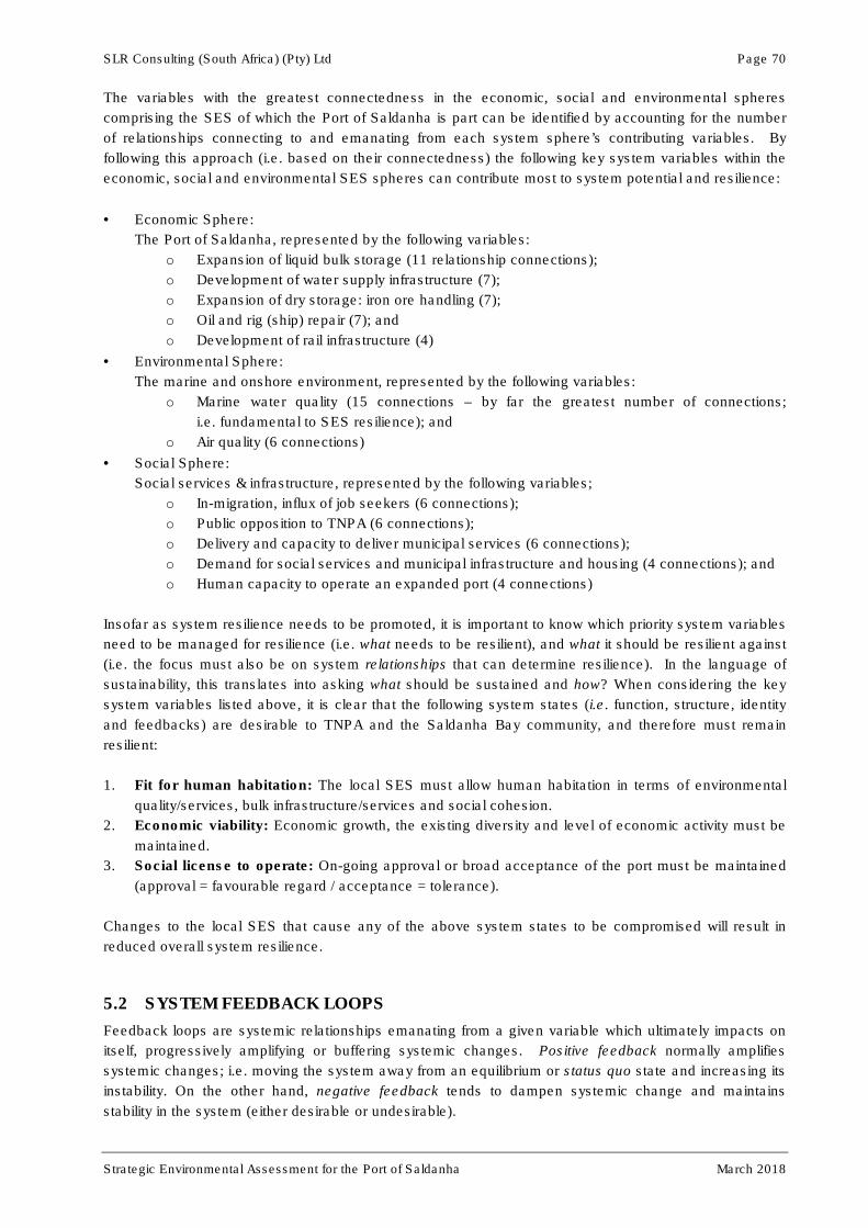
SLR Consulting (South Africa) (Pty) Ltd Page 70
Strategic Environmental Assessment for the Port of Saldanha March 2018
The variables with the greatest connectedness in the economic, social and environmental spheres
comprising the SES of which the Port of Saldanha is part can be identified by accounting for the number
of relationships connecting to and emanating from each system sphere’s contributing variables. By
following this approach (i.e. based on their connectedness) the following key system variables within the
economic, social and environmental SES spheres can contribute most to system potential and resilience:
• Economic Sphere:
The Port of Saldanha, represented by the following variables:
o Expansion of liquid bulk storage (11 relationship connections);
o Development of water supply infrastructure (7);
o Expansion of dry storage: iron ore handling (7);
o Oil and rig (ship) repair (7); and
o Development of rail infrastructure (4)
• Environmental Sphere:
The marine and onshore environment, represented by the following variables:
o Marine water quality (15 connections – by far the greatest number of connections;
i.e. fundamental to SES resilience); and
o Air quality (6 connections)
• Social Sphere:
Social services & infrastructure, represented by the following variables;
o In-migration, influx of job seekers (6 connections);
o Public opposition to TNPA (6 connections);
o Delivery and capacity to deliver municipal services (6 connections);
o Demand for social services and municipal infrastructure and housing (4 connections); and
o Human capacity to operate an expanded port (4 connections)
Insofar as system resilience needs to be promoted, it is important to know which priority system variables
need to be managed for resilience (i.e. what needs to be resilient), and what it should be resilient against
(i.e. the focus must also be on system relationships that can determine resilience). In the language of
sustainability, this translates into asking what should be sustained and how? When considering the key
system variables listed above, it is clear that the following system states (i.e. function, structure, identity
and feedbacks) are desirable to TNPA and the Saldanha Bay community, and therefore must remain
resilient:
1. Fit for human habitation: The local SES must allow human habitation in terms of environmental
quality/services, bulk infrastructure/services and social cohesion.
2. Economic viability: Economic growth, the existing diversity and level of economic activity must be
maintained.
3. Social license to operate: On-going approval or broad acceptance of the port must be maintained
(approval = favourable regard / acceptance = tolerance).
Changes to the local SES that cause any of the above system states to be compromised will result in
reduced overall system resilience.
5.2 SYSTEM FEEDBACK LOOPS
Feedback loops are systemic relationships emanating from a given variable which ultimately impacts on
itself, progressively amplifying or buffering systemic changes. Positive feedback normally amplifies
systemic changes; i.e. moving the system away from an equilibrium or status quo state and increasing its
instability. On the other hand, negative feedback tends to dampen systemic change and maintains
stability in the system (either desirable or undesirable).
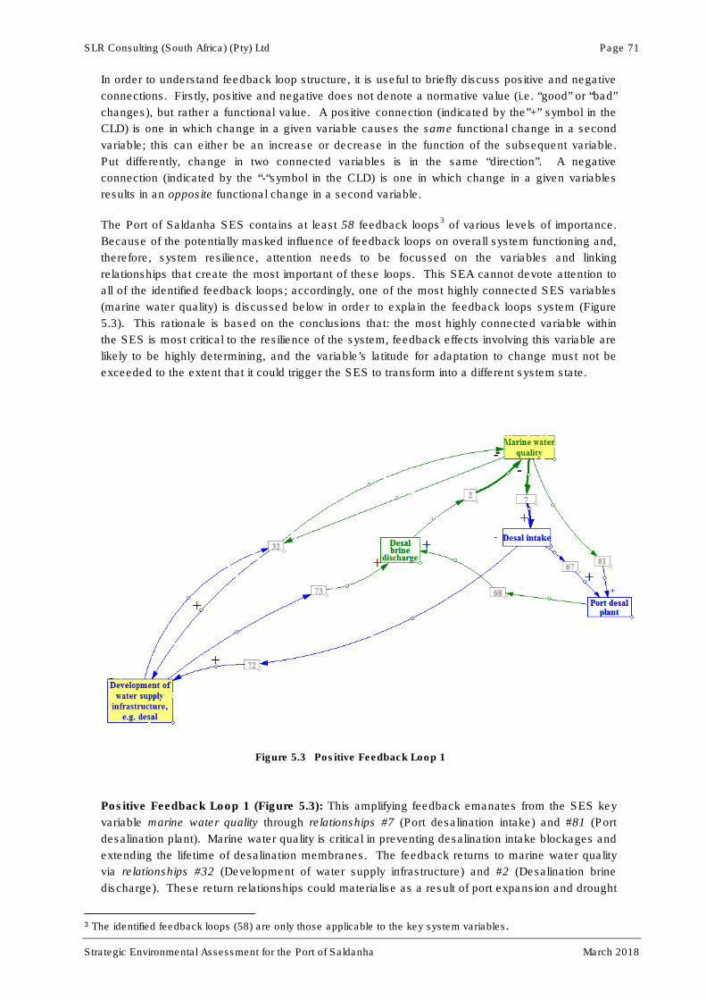
SLR Consulting (South Africa) (Pty) Ltd Page 71
Strategic Environmental Assessment for the Port of Saldanha March 2018
In order to understand feedback loop structure, it is useful to briefly discuss positive and negative
connections. Firstly, positive and negative does not denote a normative value (i.e. “good” or “bad”
changes), but rather a functional value. A positive connection (indicated by the”+” symbol in the
CLD) is one in which change in a given variable causes the same functional change in a second
variable; this can either be an increase or decrease in the function of the subsequent variable.
Put differently, change in two connected variables is in the same “direction”. A negative
connection (indicated by the “-“symbol in the CLD) is one in which change in a given variables
results in an opposite functional change in a second variable.
The Port of Saldanha SES contains at least 58 feedback loops3 of various levels of importance.
Because of the potentially masked influence of feedback loops on overall system functioning and,
therefore, system resilience, attention needs to be focussed on the variables and linking
relationships that create the most important of these loops. This SEA cannot devote attention to
all of the identified feedback loops; accordingly, one of the most highly connected SES variables
(marine water quality) is discussed below in order to explain the feedback loops system (Figure
5.3). This rationale is based on the conclusions that: the most highly connected variable within
the SES is most critical to the resilience of the system, feedback effects involving this variable are
likely to be highly determining, and the variable’s latitude for adaptation to change must not be
exceeded to the extent that it could trigger the SES to transform into a different system state.
Figure 5.3 Positive Feedback Loop 1
Positive Feedback Loop 1 (Figure 5.3): This amplifying feedback emanates from the SES key
variable marine water quality through relationships #7 (Port desalination intake) and #81 (Port
desalination plant). Marine water quality is critical in preventing desalination intake blockages and
extending the lifetime of desalination membranes. The feedback returns to marine water quality
via relationships #32 (Development of water supply infrastructure) and #2 (Desalination brine
discharge). These return relationships could materialise as a result of port expansion and drought
3 The identified feedback loops (58) are only those applicable to the key system variables.

SLR Consulting (South Africa) (Pty) Ltd Page 72
Strategic Environmental Assessment for the Port of Saldanha March 2018
conditions, necessitating development of water supply infrastructure in the study area (via
additional desalination projects), as well as the resultant brine discharge (waste product of the
desalination process) which impacts on marine water quality.
The feedback loop indicates that port expansion will require additional fresh-water supply for
potable uses and dust suppression. This will most likely materialise through desalination
technology. Desalination requires good marine water quality. However, desalination can
compromise marine water quality through brine discharge. Accordingly, expansion of the fresh-
water supply infrastructure, although essential to system resilience, might be self-limiting. This
feedback loop will tend to destabilise the Port of Saldanha SES; i.e. focused management is
required to monitor and mitigate its impact (see Chapter 6 for proposed management actions).
Positive Feedback Loop 2 (Figure 5.4): An amplifying feedback originates from marine water
quality through relationship 32 (Development of water supply infrastructure) and returns via
relationships #79 (Climate change), #83 (Reduced rainfall) and #82 (Ocean temperature increase)
to marine water quality through relationship #2 (Desalination brine discharge). This feedback
exists due to the need to develop fresh-water supply infrastructure as a result of planned port
expansion and drought conditions. These expansions could, in some measure, accelerate climate
change through the generation of greenhouse gasses (GHGs), which in turn is expected to result
in reduced rainfall which will increase demand for additional sources of fresh-water supply.
As in Positive Feedback Loop 1, increased use of desalination technology may compromise
marine water quality. Increased ocean temperature may result in increased desalination
operating costs and reduced efficiency due to an expected increase in algal blooms causing
intake blockages and membrane contamination. Consequently, the planned expansion of the Port
of Saldanha, if based on increased consumption of fossil fuel, might be self-limiting (see Chapter
6 for proposed management actions).
Figure 5.4 Positive Feedback Loop 2
Negative Feedback Loop 1 (Figure 5.5): A stabilising feedback originates from Public opposition
to TNPA via relationship #110 (Port sustainability) and relationship #111 (Delivery and capacity to
deliver municipal services) and returns to Public opposition to TNPA via relationship #105.

SLR Consulting (South Africa) (Pty) Ltd Page 73
Strategic Environmental Assessment for the Port of Saldanha March 2018
This feedback loop, though appearing simple, is of significant importance to TNPA. The feedback
loop is potentially stabilising; accordingly, it has a reducing effect on change within the system and
will potentially control public opposition to TNPA as long as the sustainability of the port is
maintained. Sustainability must here be interpreted in its broadest context; i.e. not only
sustainable in terms of TNPA’s operations, but also in terms of the needs of the local Saldanha
Bay community. It is therefore imperative that TNPA actively engages with the Saldanha Bay
Local Municipality, the West Coast District Municipality and members of the community through
appropriate forums to ensure the long-term sustainability of the port. In this regard, bodies similar
to the IGTT are important forums. Unlike amplifying feedback loops, a stabilising loop provides a
measure of control to TNPA and should be utilised to maximum effect. An open and consultative
process as part of any project planning can play an important role in a stabilising loop.
Figure 5.5 Negative Feedback Loop 1
Table 5.1 Port of Saldanha SES linking relationships (see Figure 5.1)
Relationship
No (as per
Causal Loop
Diagram).
Nature of relationship
1. Establishment of bulk liquid storage, new oil and gas service infrastructure and shipping
traffic will increase the risk of occurrence of oil spills
2. (i) Oil spills,
(ii) Desalination brine discharge, and
(iii) Oil rig and ship repair,
Will reduce marine water quality
3. Marine water quality supports mariculture
4. Marine water quality supports marine ecosystems
5. Marine water quality supports the Ramsar site designation
6. Marine water quality is critical to the functioning of aspects of the West Coast National

SLR Consulting (South Africa) (Pty) Ltd Page 74
Strategic Environmental Assessment for the Port of Saldanha March 2018
Park
7. Marine water quality facilitates proper desalination intake functioning
8. Marine water quality facilitates the effective functioning of fish processing activities (via
water intakes)
9. Establishment of a bulk liquid storage are and new marine oil and gas servicing
infrastructure will increase demand/need for dredging
10. Increased dredging can compromise marine water quality through increased turbidity,
the release of metals, etc. making these potentially bio-available
11. Establishment of bulk liquid storage will increase the stormwater load due to an increase
in impervious surfaces
12. Increased stormwater load will reduce marine water quality as all potentially
contaminated stormwater drains into Saldanha Bay
13. The proposed port layout will influence marine water circulation.
14. Poor marine water circulation and ballast water discharge reduces marine water quality
15. Marine water quality supports small-scale fishing
16. Marine water quality supports tourism
17. New bulk liquid storage and increase shipping traffic will reduce local air quality due to
an increase in released BTEX compounds
18. Decreased air quality adds to the risk to human health and safety
19. Oil rig and ship repairs increase noise levels
20. (i) Establishment of bulk liquid storage,
(ii) Expansion of dry storage (Iron ore handling), and
(iii) Oil rig and ship repair
Will produce economic spinoffs from related expenditure, jobs, commerce and services
21. Road infrastructure adequacy will facilitate the establishment of liquid bulk storage
22. Establishment of bulk liquid storage will necessitate the development of road
infrastructure
23. Development of new road infrastructure improves the adequacy of road infrastructure at
Saldanha
24. Development of road infrastructure will increase volumes of traffic and transportation
25. Increased traffic volumes will result in increased GHGs and will reduced air quality
26. Development of new rail infrastructure will improve the adequacy of rail infrastructure at
Saldanha
27. The adequacy of rail infrastructure will facilitate the expansion of dry storage
28. Expansion of dry storage will necessitate the development of rail infrastructure
29. Development of rail infrastructure at the port has the potential to reduce air quality
30. The adequacy of bulk water supply will facilitate expansion of dry storage
31. Development of new water supply infrastructure will improve the adequacy of water
supply infrastructure at Saldanha
32. Development of water supply infrastructure reduces marine water quality (due to
desalination effluent discharge) and good marine water quality facilitates the
development of water supply infrastructure through a feedback effect
33. (i) New bulk liquid storage,
(ii) Development of rail infrastructure,
(iii) Development of road infrastructure and
(iv) Oil rig and ship repair
Have the potential to reduce the extent and functioning of local terrestrial ecosystems
and might threaten heritage resources
34. Expansion of dry bulk storage (iron ore) will increase dust pollution
35. Increased dust levels will reduce local air quality
36. Quality of terrestrial ecosystems positively influences tourism
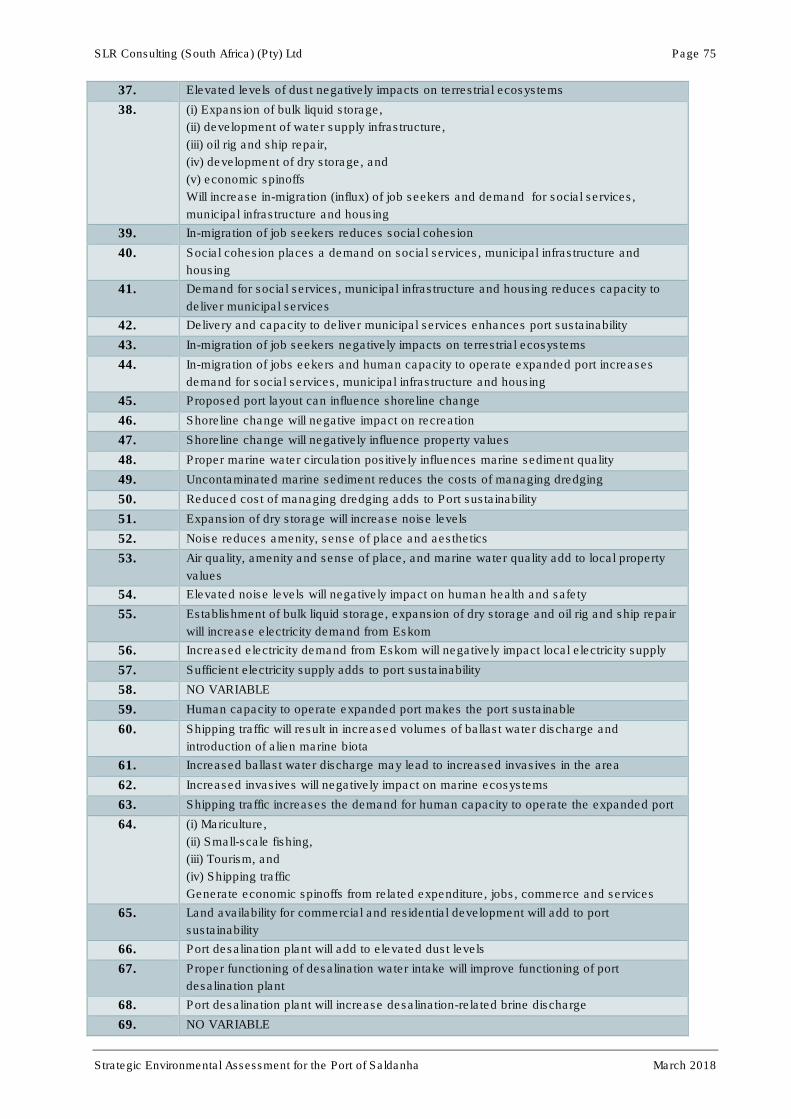
SLR Consulting (South Africa) (Pty) Ltd Page 75
Strategic Environmental Assessment for the Port of Saldanha March 2018
37. Elevated levels of dust negatively impacts on terrestrial ecosystems
38. (i) Expansion of bulk liquid storage,
(ii) development of water supply infrastructure,
(iii) oil rig and ship repair,
(iv) development of dry storage, and
(v) economic spinoffs
Will increase in-migration (influx) of job seekers and demand for social services,
municipal infrastructure and housing
39. In-migration of job seekers reduces social cohesion
40. Social cohesion places a demand on social services, municipal infrastructure and
housing
41. Demand for social services, municipal infrastructure and housing reduces capacity to
deliver municipal services
42. Delivery and capacity to deliver municipal services enhances port sustainability
43. In-migration of job seekers negatively impacts on terrestrial ecosystems
44. In-migration of jobs eekers and human capacity to operate expanded port increases
demand for social services, municipal infrastructure and housing
45. Proposed port layout can influence shoreline change
46. Shoreline change will negative impact on recreation
47. Shoreline change will negatively influence property values
48. Proper marine water circulation positively influences marine sediment quality
49. Uncontaminated marine sediment reduces the costs of managing dredging
50. Reduced cost of managing dredging adds to Port sustainability
51. Expansion of dry storage will increase noise levels
52. Noise reduces amenity, sense of place and aesthetics
53. Air quality, amenity and sense of place, and marine water quality add to local property
values
54. Elevated noise levels will negatively impact on human health and safety
55. Establishment of bulk liquid storage, expansion of dry storage and oil rig and ship repair
will increase electricity demand from Eskom
56. Increased electricity demand from Eskom will negatively impact local electricity supply
57. Sufficient electricity supply adds to port sustainability
58. NO VARIABLE
59. Human capacity to operate expanded port makes the port sustainable
60. Shipping traffic will result in increased volumes of ballast water discharge and
introduction of alien marine biota
61. Increased ballast water discharge may lead to increased invasives in the area
62. Increased invasives will negatively impact on marine ecosystems
63. Shipping traffic increases the demand for human capacity to operate the expanded port
64. (i) Mariculture,
(ii) Small-scale fishing,
(iii) Tourism, and
(iv) Shipping traffic
Generate economic spinoffs from related expenditure, jobs, commerce and services
65. Land availability for commercial and residential development will add to port
sustainability
66. Port desalination plant will add to elevated dust levels
67. Proper functioning of desalination water intake will improve functioning of port
desalination plant
68. Port desalination plant will increase desalination-related brine discharge
69. NO VARIABLE
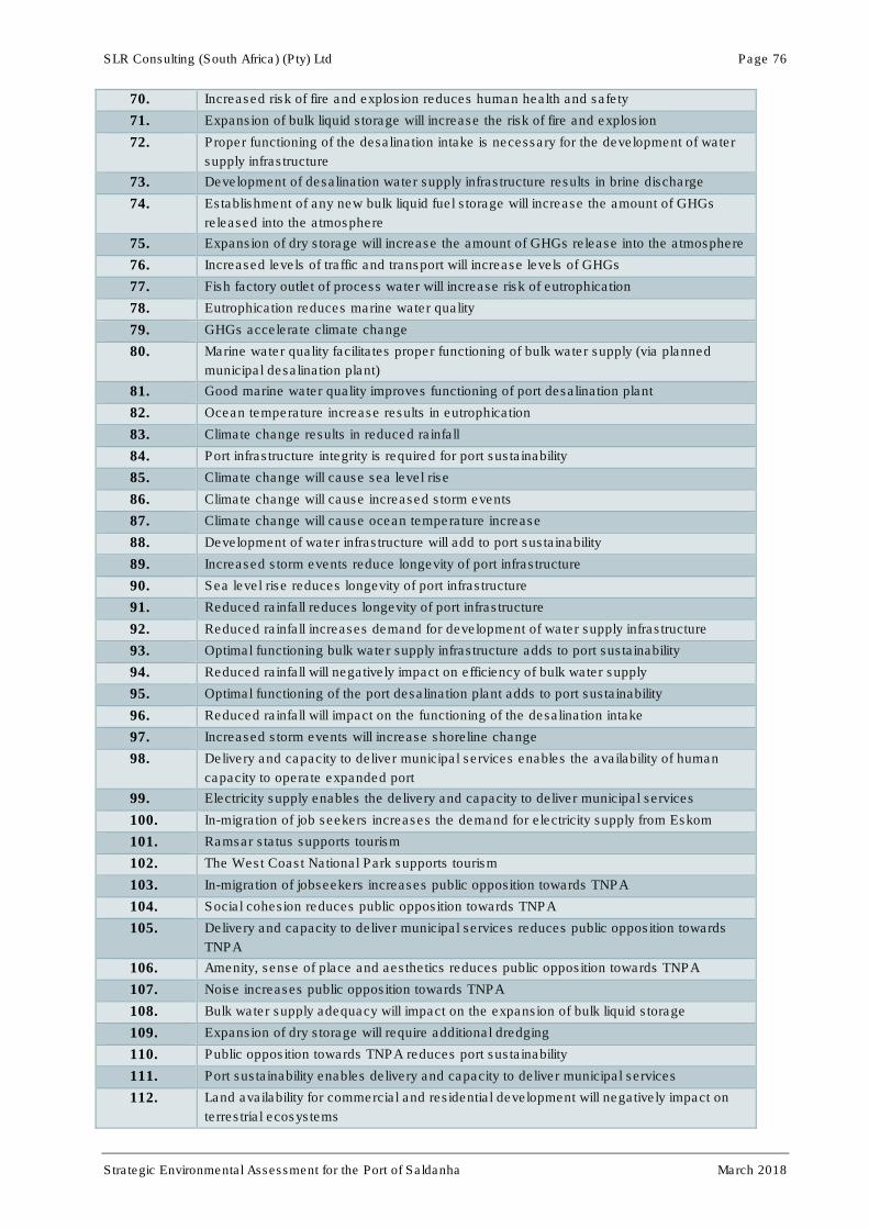
SLR Consulting (South Africa) (Pty) Ltd Page 76
Strategic Environmental Assessment for the Port of Saldanha March 2018
70. Increased risk of fire and explosion reduces human health and safety
71. Expansion of bulk liquid storage will increase the risk of fire and explosion
72. Proper functioning of the desalination intake is necessary for the development of water
supply infrastructure
73. Development of desalination water supply infrastructure results in brine discharge
74. Establishment of any new bulk liquid fuel storage will increase the amount of GHGs
released into the atmosphere
75. Expansion of dry storage will increase the amount of GHGs release into the atmosphere
76. Increased levels of traffic and transport will increase levels of GHGs
77. Fish factory outlet of process water will increase risk of eutrophication
78. Eutrophication reduces marine water quality
79. GHGs accelerate climate change
80. Marine water quality facilitates proper functioning of bulk water supply (via planned
municipal desalination plant)
81. Good marine water quality improves functioning of port desalination plant
82. Ocean temperature increase results in eutrophication
83. Climate change results in reduced rainfall
84. Port infrastructure integrity is required for port sustainability
85. Climate change will cause sea level rise
86. Climate change will cause increased storm events
87. Climate change will cause ocean temperature increase
88. Development of water infrastructure will add to port sustainability
89. Increased storm events reduce longevity of port infrastructure
90. Sea level rise reduces longevity of port infrastructure
91. Reduced rainfall reduces longevity of port infrastructure
92. Reduced rainfall increases demand for development of water supply infrastructure
93. Optimal functioning bulk water supply infrastructure adds to port sustainability
94. Reduced rainfall will negatively impact on efficiency of bulk water supply
95. Optimal functioning of the port desalination plant adds to port sustainability
96. Reduced rainfall will impact on the functioning of the desalination intake
97. Increased storm events will increase shoreline change
98. Delivery and capacity to deliver municipal services enables the availability of human
capacity to operate expanded port
99. Electricity supply enables the delivery and capacity to deliver municipal services
100. In-migration of job seekers increases the demand for electricity supply from Eskom
101. Ramsar status supports tourism
102. The West Coast National Park supports tourism
103. In-migration of jobseekers increases public opposition towards TNPA
104. Social cohesion reduces public opposition towards TNPA
105. Delivery and capacity to deliver municipal services reduces public opposition towards
TNPA
106. Amenity, sense of place and aesthetics reduces public opposition towards TNPA
107. Noise increases public opposition towards TNPA
108. Bulk water supply adequacy will impact on the expansion of bulk liquid storage
109. Expansion of dry storage will require additional dredging
110. Public opposition towards TNPA reduces port sustainability
111. Port sustainability enables delivery and capacity to deliver municipal services
112. Land availability for commercial and residential development will negatively impact on
terrestrial ecosystems

SLR Consulting (South Africa) (Pty) Ltd Page 77
Strategic Environmental Assessment for the Port of Saldanha March 2018
CHAPTER 6: OPPORTUNITIES, CONSTRAINTS & STRATEGIC
MANAGEMENT ACTIONS (SMAs)
In the presentation of Opportunities, Constraints and Strategic Management Actions (SMAs) that follows,
the organising structure that is used focuses on concrete social, environmental and economic themes.
These themes are related to the key system variables identified in Chapter 5.
In each instance the numbered relationship (as per the CLD presented in Chapter 5) is stated verbatim
followed by key opportunities, constraints and associated management actions relevant to the
relationships. Before this is presented, the assessment matrix used to assess the potential impact on
relative key SES variables is first introduced and described.
It must be noted that as part of the SEA review/update process, sustainability ratings for two of the below
listed environmental theme system variables (i.e. air quality and natural vegetation) were lowered from
the 2013 assessment. The lowering of the sustainability ratings relate to changes in the biophysical
environment and growing developmental pressures in the area surrounding the Port of Saldanha since
2013. Reasons for the changes in the sustainability ratings are set out under Sections 6.2.1 and 6.2.2
below.
6.1 ASSESSMENT MATRIX
Retief (2008) criticizes SEA practice for failing to actually “assess” potential strategic impacts even though
the function of an SEA is to act as an assessment instrument – albeit in a planning rather than EIA
(project level) context.
Given this absence of assessment practice in mainstream SEAs and given the TNPA Terms of Reference
which requires the assessment of “limits of acceptable change” to inform future EIAs; it was decided to
assess key impacts using an assessment matrix. The key difference between this assessment matrix and
those found in EIA practice is its focus on the level of systemic latitude available to accommodate
additional change, rather than the significance of a given impact on the receiving environment.
Accordingly, the assessment matrix has an inverse rating system, with HIGH indicating high levels of
latitude available (i.e. comparable to a low impact significance rating in an EIA rating system) and LOW
indicating limited or no latitude available (i.e. comparable to a high impact significance rating in an EIA
rating system). The assessment matrix is graphically presented below.
Assessment rating
Interpretation
VERY HIGH The SES has extensive latitude to accommodate change (impact). Such change would
typically be novel developments introduced into the SES.
HIGH The SES has sufficient latitude to accommodate change. Such change would typically
be either novel developments introduced into the SES, or relatively limited expansion of
existing activities already present in the SES.
MEDIUM The SES has latitude to accommodate change. Care should however be taken with
introducing such change as the SES is nearing its capacity to accommodate further
change and, as a result, could assume a LOW or VERY LOW rating. Such change would
generally be novel additions or expansions of activities already present within the SES.

SLR Consulting (South Africa) (Pty) Ltd Page 78
Strategic Environmental Assessment for the Port of Saldanha March 2018
LOW The SES has very little latitude to accommodate change. Changes should be
approached with caution or avoided altogether as the SES could shift into an
(undesirable) alternate state should further pressure be placed on it. Such change would
generally be associated with either novel additions or extensions or expansions of
activities already present within the SES.
VERY LOW The SES has no latitude to accommodate change. Changes should be approached with
extreme caution or preferably be avoided altogether as the SES could easily shift into an
(undesirable) alternate state. Such change would generally be associated with either
novel additions and extensions or expansions of activities already present within the
SES.
It should be noted that these assessment ratings attempt to capture complex systemic relationships
through a single, rather simplistic assessment score. As a result, accuracy in prediction cannot be
guaranteed; i.e. the SES in question, as a result of its complexity, might respond to change in a non-
linear, unexpected way. Assessment ratings should be used as a guide only, not a statement of fact.
6.2 ENVIRONMENTAL THEME
The environmental theme addresses biophysical aspects applicable to the key system variables. These
aspects are (i) Air quality, (ii) Natural vegetation and (iii) Marine water quality.
6.2.1 Air quality
Overall rating: LOW
Discussion: There is limited latitude available to accommodate air quality changes
attributable to current and planned TNPA and associated projects.
According to the air quality assessment (Airshed, 2016) undertaken as part
of the screening study for the TNPA’s proposed new marine oil and gas
infrastructure, dispersion modelling for inhalable particulate matter
concentrations (PM2.5 and PM10) in the vicinity of the Port showed that,
without the appropriate mitigation measures, the 24-hour National Ambient
Air Quality Standards (NAAQS) could be exceeded at the TNPA Saldanha
Port monitoring station. Simulated annual average PM10 concentrations
would also exceed the NAAQS of 40 µg/m3 at the Port monitoring station.
Although the simulations did not show exceeded levels beyond the Port
boundaries, developments that will cause additional air quality impacts
should still be approached with caution due to the existing and expected
negative response from Saldanha Bay/Vredenburg residents. High levels of
frustration are already present throughout the study area as a result of
fugitive iron ore emissions (the so-called “pink dust”). Accordingly, the
systemic latitude in this instance does not refer to biophysical constraints,
but rather to social and, potentially, economic system components which
might be exceeding absorptive limits. In addition, manganese exports are
set to continue in the short term from the MPT and TPT is currently in the
process of applying for an Atmospheric Emissions Licence (AEL) to allow
for the temporary storage and handling of manganese. Manganese
exports from the MPT commenced in 2013 and has increased by more
than a third each year, totalling approximately 3 million tonnes in the 2017
financial year, comprising around 60% of the total dry bulk exported from
the MPT. This is a product for which negative responses have already
been received from local residents due to the perceived health risks of
storing and handling manganese within the Port without the required AEL
and related compliance monitoring. This led to the compilation of a draft

SLR Consulting (South Africa) (Pty) Ltd Page 79
Strategic Environmental Assessment for the Port of Saldanha March 2018
The following SES relationships, associated opportunities and constraints and subsequent management
actions are applicable to local air quality:
Relationship # 17: New bulk liquid fuel storage, increased shipping traffic and oil and gas
servicing operations will reduce local air quality.
Opportunity: The envisaged expansion of existing infrastructure and implementing new projects provides
TNPA with an opportunity to advance its sustainability objective of the port vision by ensuring best
available technologies (BAT) are applied in the design and operation of the relevant projects. To enable
TNPA to realise the environmental responsibility objective of the port vision, it must ensure that ship
operations adhere to the requirements of Annex VI of the MARPOL Convention for the reduction of air
pollution from ships. Abrasive blasting, surface painting and ship emissions are unlikely to result in
exceedances of the NAAQS for particulates or health-effect screening levels of Volatile Organic
Compounds (VOCs) if emission controls are in place (Airshed, 2016). Some of these are listed under the
management actions below.
Management actions:
� BAT to be implemented in all relevant aspects of the design of the bulk fuel storage and oil and gas
servicing facilities, including tank design, vapour and paint recovery units and VOC destruction.
� BAT to be implemented in all aspects of maintenance and operations of the bulk fuel storage and oil
and gas servicing facilities, including fabric filters on abrasive blasting activities and the use of low
VOC paints as far as practically possible.
� Adoption of the requirements of the MARPOL Convention into port operations.
Constraint: The import, storage and distribution of fuel products does not fall exclusively under the
control of TNPA and might restrict the degree of investment in best available technologies to control
emissions from storage and handling. The fuel used by ships is also not under the direct control of
TNPA and the possibility exists for ships to use dirty fuels in the port limits.
Management actions:
� TNPA must play an active role in the engineering design of the bulk liquid fuel storage and oil and
gas servicing facilities at the port to ensure that BAT principles are implemented.
� TNPA must play an active role in the design of maintenance and operational plans for the bulk liquid
fuel storage and oil and gas servicing facilities to ensure that BAT principles are implemented
� Enforcement of the requirements of the MARPOL Convention on all vessels entering and operating
in the port
Relationship # 18: Decreased air quality adds to the risk to human health and safety
Opportunity: The need to control emissions of air pollutants from activities in and around the port
provides an opportunity for the realisation of the environmental responsibility objective of the port vision
by ensuring legal requirements are satisfied.
WCDM guideline document for the storing and handling of ore.
Based on the persisting iron ore dust issues within the Saldanha Bay area,
the additional manganese export operations and other largescale industrial
emitters in the surrounding area, the overall sustainability rating was
reduced from Medium to Low as part of the SEA review/update process.
SLR Consulting (South Africa) (Pty) Ltd Page 80
Strategic Environmental Assessment for the Port of Saldanha March 2018
Management actions:
� Ensure adherence by tenants to all legal requirements in terms of AELs, minimum emission
standards, dust control and ambient monitoring.
� Ensure all port tenants implement fugitive dust management plans.
Constraint: The control of emissions from activities in the port is not directly under the control of TNPA,
but with port tenants; this might limit the extent of management and control that might be implemented.
Management actions:
� Establish contractual arrangements with tenants to include emission reduction plans and dust control
measures.
� Establish a management forum to ensure consistent implementation of emission control activities.
Relationship # 25: Increased traffic volumes will result in increased greenhouse gas emissions
and reduced air quality
Opportunity: The expected increase in traffic in the port area and surrounds provides TNPA with an
opportunity to advance its sustainability objective of the port vision by applying measures to control
vehicle movement, optimise travel arrangements, regularly maintain vehicles and train staff in efficient
driving techniques.
Management action:
� Institute traffic control measures at the port aimed at reducing emissions from vehicles such as
access control, speed restrictions and traffic calming.
Constraint: The control of vehicle movement inhibits normal activities at the port and may constrain
operations and throughput.
Management actions:
� Explore alternatives to vehicles for in-port transportation needs, such as conveyors, electric powered
front-end loaders and cranes.
� Use Low Sulphur Diesel (LSD) for all on-site for port vehicles.
� Assist TPT in implementing the planned shuttle service for employees and permitting system limiting
port vehicle access to operational requirements only.
Relationship # 29: The development of rail infrastructure at the port will reduce air quality
Opportunity: The expected increase in rail traffic in the port area and surrounds provides TNPA with an
opportunity to advance the sustainability objective of the port vision by engaging with Transnet Freight
Rail (TFR) and assisting in applying measures to effectively manage locomotive use and to promote
efficient rail movement.
Management actions:
� Although TNPA does not have direct authority over TFR, it still has an oversight role to play and
should monitor the following TFR responsibilities:
o Implementation of service plans for locomotives to ensure they operate in accordance with
manufacturer specifications.
o Use of Low Sulphur Diesel (LSD) to fuel locomotives
� When assessing impacts of new infrastructure, consider cumulative impacts from increased rail
infrastructure.

SLR Consulting (South Africa) (Pty) Ltd Page 81
Strategic Environmental Assessment for the Port of Saldanha March 2018
Constraint: Restriction on locomotive movement inhibits normal activities at the port and may constrain
operations and throughput. TNPA has no direct control over TFR infrastructure and operations.
Management actions:
� Ensure that the interface agreement between TNPA and TFR is met in terms of the requirements of
the railway safety regulator (RSR).
� As part of its oversight role, TNPA should monitor the following TFR responsibilities:
o Ensuring that locomotives operate optimally in order to limit emissions.
o Ensuring that LSD fuel is available in sufficient quantities (bunkering) at the port.
Relationship # 34: Expansion of dry bulk storage will increase dust pollution
Opportunity: Controlling dust pollution from an increase in bulk storage and export provides an
opportunity for the realisation of the sustainability objective of the port, as well as the objectives for
environmental responsibility and protection of community heritage.
Management actions:
� Ensure BAT applies at all aspects of bulk product handling and storage facilities.
� Ensure implementation of fugitive dust management plans for all planned expansions and existing
operations.
� Establish a forum, or make use of existing structures, to facilitate discussion and feedback between
TNPA and property owners/rate payers regarding air quality measurements, BAT and dust
management plan implementation.
� Manganese and other potentially hazardous ores and concentrates (not covered under an AEL),
must be transported, stored and handled in line with the relevant WCDM guideline document. This
includes storage within an enclosed building on a hard, impervious surface graded and drained to a
sump. Loading and offloading of material must be undertaken inside enclosed storage facilities or
offloaded into containers or onto trucks for direct transportation in the enclosed storage facility. No
storage of hazardous materials (e.g. manganese and zinc) is to be undertaken in open air stockpiles
without an AEL.
� Dust fallout monitoring is to be conducted at storage and handling locations, along transport
corridors and within residential areas in close proximity to the transport corridors.
Constraint: The control of emissions from facilities at the bulk storage terminal is not directly under the
control of TNPA, but rather with the tenants/terminal operators, which restricts the degree of management
and control by TNPA.
Management actions:
� Establish contractual arrangements with tenants to include emission reduction plans and dust control
measures.
� Establish a management forum to ensure consistent implementation of emission control activities.
Relationship # 35: Increased dust levels will reduce local air quality
Opportunity: The need to control dust from new and planned bulk fuel and liquid gas storage facilities
provides an opportunity for realising the port’s objectives for environmental responsibility and protection of
community heritage.
Management actions:
� BAT is considered in aspects of the design of the bulk fuel and liquid gas storage facilities, including
tank design, vapour recovery units, VOC destruction.
SLR Consulting (South Africa) (Pty) Ltd Page 82
Strategic Environmental Assessment for the Port of Saldanha March 2018
� BAT is considered in all aspects of maintenance and operations of the bulk fuel and liquid gas
storage facility.
� Establish a forum, or make use of existing structures, to facilitate discussion and feedback between
TNPA and property owners/rate payers regarding air quality measurements, BAT and dust
management plan implementation.
Constraint: The control of emissions from activities at the bulk storage terminal is not directly under the
control of TNPA, but with rather with the tenants, which restricts their degree of management and control.
Management actions:
� Establish contractual arrangements with tenants to include emission reduction plans and dust control
measures.
� Establish management forum to ensure consistent implementation of emission control activities.
Relationship #74: Establishment of any new bulk liquid fuel storage will increase the amount of
greenhouse gases released into the atmosphere
Opportunity: The need to control emissions of GHGs from potential flaring at any new bulk liquid storage
facility, by ensuring the application of best available technologies in the design and operation of the
storage tanks and fuel handling equipment, will enable the realisation of the environmental responsibility
objective of the port.
Management actions:
� BAT is considered in aspects of the design of the of the bulk fuel storage facility, including tank
design, vapour recovery units and VOC destruction.
� BAT is considered in all aspects of maintenance and operations of the bulk fuel storage facility.
Constraint: The handling, storage and distribution of fuel products does not fall exclusively under the
control of TNPA and might restrict the degree of investment in best available technologies to control
emissions of GHGs from storage and handling.
Management actions:
� Establish contractual arrangements with tenants to include emission reduction plans and dust control
measures.
� Establish a management forum to ensure consistent implementation of emission control activities.
6.2.2 Natural vegetation
Overall rating: MEDIUM
Discussion: There is shrinking latitude available to accommodate more loss of natural
vegetation as a result of developments proposed in the port area and
surrounds. TNPA should note the presence of Critical Biodiversity Areas
(CBAs) within the property currently under its ownership as well as the
properties it intends to procure as part of its expansion strategy. Although
some CBAs can be avoided at the expenses of other terrestrial vegetation
types within the SES which do not have a determining influence on
systemic identity, structure and function (i.e. aspects of SES resilience),
these opportunities are decreasing, especially when considering the latest
draft revision of the Saldanha Bay EMF. The majority of the port land
behind and surrounding the iron ore terminal has been identified as a
conflict area in the draft EMF. Such areas would require negotiations with
the DEA&DP and CapeNature if any further development is to take place.

SLR Consulting (South Africa) (Pty) Ltd Page 83
Strategic Environmental Assessment for the Port of Saldanha March 2018
The following SES relationships, associated opportunities and constraints and subsequent management
actions are applicable to natural vegetation:
Relationship # 33: Increased terrestrial development, in the form of (inter alia) planned bulk liquid
storage, expansion of rail infrastructure, expansion of road infrastructure and development of
expanded ship repair and oil and gas facilities will reduce the quality, extent and connectivity of
the current vegetation and associated threatened plant species.
Opportunity: Expansion of the above infrastructure could be planned around and aid in formalising
essential conservation areas; i.e. careful planning, including impact avoidance, mitigation, rehabilitation,
restoration and securing of biodiversity offsets could reduce negative impacts and possibly advance
conservation aims as well as benefit the human environment.
Management actions:
� Existing CBAs need to be taken into account when planning development, and should be avoided;
they should be managed as formal conservation areas. There must be rehabilitation of certain key
ecological corridors.
� Scope exists for the implementation of biodiversity offsets for certain CBAs, and expert botanical
opinion should thus be obtained at the planning stage in line with the 2017 National Biodiversity
Offset Policy and the strategic biodiversity offset study for the greater Saldanha Bay area (once
completed).
Constraint: Expansion of the above infrastructure may be constrained by the presence of threatened
vegetation types and plant species, and by the need to plan around these areas.
Management actions:
� Existing CBAs need to be taken into account when planning development, and should be avoided. If
this is not possible, biodiversity offsets would need to be identified and formalised in line with the
biodiversity offset policy and guidelines.
� Expert botanical input should be obtained at the planning stage so that key conservation areas are
identified, and not eliminated through development.
Relationship # 43: Increased worker housing requirements, as a result of inmigration to the area,
will reduce the quality, extent and connectivity of the current vegetation and associated
threatened plant species.
Such negotiations could lead to the requirement for biodiversity offsets,
should no other options be available for avoidance. Due to the presence of
sensitive vegetation types such as Saldanha Flats Strandveld on and
surrounding port land, it might not be that easy to secure like-for-like
biodiversity offset areas and negotiations would be required with
surrounding large developers and property owners. A strategic biodiversity
offset study for the greater Saldanha Bay area was commissioned by
DEA&DP in 2017. This study aims to identify sensitive areas that would
require biodiversity offsets prior to any development taking place, providing
guidance on the ratio of land to be offset as well as identifying available
land where offset areas could be secured. Due to the continuing
developmental pressures surrounding the Port of Saldanha, the presence
of remaining threatened vegetation types on port land and land identified
for port expansion, and the challenge of securing suitable biodiversity
offsets in future, the overall sustainability rating was reduced from High to
Medium as part of the SEA review/update process.
SLR Consulting (South Africa) (Pty) Ltd Page 84
Strategic Environmental Assessment for the Port of Saldanha March 2018
Opportunity: Expansion of any new required housing component needs to be planned around and aid in
formalising important conservation areas; i.e. careful planning could advance conservation aims and
benefit the human environment.
Management actions:
� Existing CBAs need to be taken into account when planning development, and should be avoided if
possible, and should ideally be managed as formal conservation areas, with funding from local
developments. Rehabilitation of certain key ecological corridors could also be funded by local
developments.
� TNPA are to come to an agreement with CapeNature on the accuracy of the latest CBA mapped
areas within and surrounding Port land.
� Scope exists for implementation of biodiversity offsets for, and expert botanical opinion should thus
be obtained at the planning stage in line with the biodiversity offset policy and guidelines.
� Engage with the Saldanha Municipality regarding potential future housing requirements linked to
large development projects and ensure alignment with the SDF.
Constraint: Expansion of the above infrastructure may be constrained by the presence of threatened
vegetation types and plant species, and by the need to plan around these areas.
Management actions:
� Existing Critical Biodiversity Areas (CBAs) need to be taken into account when planning
development, and should be avoided if possible. If not possible, additional suitable, replacement
conservation areas will need to be identified and formalised.
� Expert botanical input should be obtained at the planning stage so that key conservation areas are
identified, and not permanently lost to development.
6.2.3 Marine water quality
The following SES relationships, associated opportunities and constraints and subsequent management
actions are applicable to natural vegetation:
Overall rating: LOW
Discussion: The SES has very little latitude available to accommodate further
anthropogenic change to marine water quality. This system variable is
highly connected and can easily reach a point where it could unexpectedly
trigger ripple-effect change in system state (into an undesirable state). Any
change to this system variable must be approached with extreme caution.
Activities that could cause changes in marine water quality include, the
expansion of marine infrastructure (i.e. bulk liquid storage, rig repair
facilities), increased shipping traffic, oil spills, ship repair activities, brine
discharge from desalination plants, increased dredging activities due to
infrastructure expansion, ballast water discharge, increased stormwater
discharge and poor water circulation and related eutrophication. These
activities must also be considered together with the new proposed
expanded mariculture operations as part of DAFF’s recently approved ADZ
project.
Based on the results of the latest State of the Bay Report (2017) there have
been improvements in some of the water quality indicators (e.g. sediment
quality and macrofauna abundance and composition) which are deemed to
be encouraging with regards to restoring the health of the bay in future.

SLR Consulting (South Africa) (Pty) Ltd Page 85
Strategic Environmental Assessment for the Port of Saldanha March 2018
Relationship # 1: Establishment of bulk liquid storage, new oil and gas service infrastructure and
shipping traffic will increase the risk of occurrence of oil spills
Opportunity: The broad opportunity is the benefits accrued from the increased capacity to handle
shipping and the development opportunities related to the offshore supply base at the GMQ, the SBIDZ
and industries of the region.
Management actions:
� Adhere to relevant legal requirements to reduce the risks. The pertinent legislation in this regard
includes:
o National legislation controlling pollution from ships, e.g. International Convention for Prevention of
Pollution from Ships Act (No. 2 of 1986) (MARPOL Act), South Africa Maritime Safety Authority
Act (No. 5 of 1998) (SAMSA Act), Marine Pollution: Control and Civil Liability Act (No. 6 of 1981),
and possibly National Ports Act (No. 12 of 2005)
� Ensure appropriate oil spill contingency planning and spill response capability and readiness are in
place.
� Ensure that development occurs within context(s) agreed upon in EMF, SEA, and other relevant
environmental planning initiatives.
� Ensure that all new marine operations are undertaken in line with an approved Operational EMP.
Constraint: Inadequate capacity to implement and enforce legislation or lack of adequately trained staff.
Inadequate context upon which to base investment/development decisions. Also, a possible lack of
capacity to ensure that such context is used to make future development decisions.
Management actions:
� Address capacity and appropriate training of staff in the planning phase of the proposed port
expansion to avoid reactive and piecemeal training and recruitment.
� Ensure sufficient alignment with the operational responses and services of an established 24-hour oil
pollution response service provider in order to facilitate timeous clean-up in the event of any oil spills
within the Port.
� Ensure that investors/operators have the necessary Operational EMP and oil spill contingency plans
in place before new developments commence. These must be in line with the EMF and SEA
requirements.
Relationship # 2: (i) Oil spills, (ii) desalination brine discharge, and (iii) oil rig and ship repair will
reduce marine water quality
Opportunity: Desalination guarantees water availability for mitigation measures (dampening of iron-ore
dust) for industrial purposes and potable water in a water stressed municipal area. Increased water
supplies will reduce development constraints in the region and could minimise impacts of water
abstraction from (e.g.) the Berg River on surrounding ecosystems and other activities in the region.
However, this must be achieved within the guidelines set by applicable legislation and authorisations.
The development of innovative solutions for ship and rig repair operations (e.g. containment of hull fouling
organisms and anti-fouling paint residue, and containment of paint overspray).
Management actions:
� Adhere to relevant legal requirements to reduce the risks. The pertinent legislation in this regard
include:
o National legislation controlling pollution from ships, e.g. International Convention for Prevention of
Pollution from Ships Act (No. 2 of 1986) (MARPOL Act), South Africa Maritime Safety Authority
Act (No. 5 of 1998) (SAMSA Act), Marine Pollution: Control and Civil Liability Act (No. 6 of 1981),

SLR Consulting (South Africa) (Pty) Ltd Page 86
Strategic Environmental Assessment for the Port of Saldanha March 2018
and possibly National Ports Act (No. 12 of 2005). National legislation controlling effluent
discharges to the coastal environment (Integrated Coastal Management Act (No 24 of 2008))
� Ensure appropriate contingency planning, particularly those relating to potential oil spills. The oil spill
contingency plan for the region and specifically for Saldanha Bay needs to be current and relevant.
� Pro-active engagement by TNPA in decision-making around further desalination opportunities (and
constraints) and waste management activities with surrounding industries and the municipality.
Engagement with mariculture industry should it be indicated that any of port activities will disrupt
mariculture and/or affect its commercial viability.
� Development of an adequate knowledge base to inform potential impact assessments, e.g. the 2015
specialist screening assessments for new marine infrastructure. Such pro-active research could
enhance the understanding of ecosystem function to the level necessary to make the requisite
impact assessments with a high degree of confidence and avoid the unnecessary invocation of the
Precautionary Principle (that may have associated with it significant opportunity costs in terms of
forgone or restricted development opportunities).
� High pressure blasting of vessel hulls to clear hull fouling is currently not permitted in the port and it
is crucial that these substances do not enter the marine environment. Blasting and painting activities
are to be undertaken in a dry dock area with all spilled substances being captured and removed for
spoiling onshore.
Constraint: Inadequate capacity to implement and enforce legislation, or staff is not trained adequately.
Potential lack of co-operation with other role-players in the region when making strategic and operational
decisions on these types of developments. This could lead to piecemeal, uncoordinated development that
has unnecessarily high impacts on the marine environment. TNPA also does not have control over vessel
cleaning operations and vessel maintenance at the yacht clubs and small harbour areas within Small Bay
managed by the Department of Public Works.
Management actions:
� Address capacity and appropriate training of staff in the planning phase of the proposed port
expansions to avoid reactive and piecemeal training and recruitment.
� Rectify potentially deficient guidelines for assessing and licencing brine discharges.
� Engagement in forums discussing/debating future development in the region, e.g. the IGTT.
� Maintenance of credibility of TNPA in such forums by ensuring compliance with the requirements of
the Environmental Authorisations of previous development approvals in the region, especially those
related to monitoring activities and the implementation of appropriate mitigation measures.
� Ensure that ongoing monitoring of brine discharges from the TNPA RO plant is undertaken in line
with the Environmental Authorisation and that results form part of the annual State of the Bay
reporting process.
� Engage with small harbour operators and competent authorities regarding the containment of hull
fouling organisms and paints used in small vessel maintenance.
Relationship # 3: Marine water quality supports mariculture
Opportunity: Saldanha Bay provides a sheltered environment where natural water quality is mostly
suitable for mariculture activities. Few such sheltered regions exist nationally. Mariculture is also
considered to be a significant source of employment opportunities and potentially important activity
supporting food security. The proposed ADZ areas within and surrounding the port area will also lead to
further expansion of mariculture activities in line with Operation Phakisa. DAFF considered future port
expansion plans in its assessment of potential ADZ areas.

SLR Consulting (South Africa) (Pty) Ltd Page 87
Strategic Environmental Assessment for the Port of Saldanha March 2018
Management actions:
� Pro-active engagement by TNPA with mariculture industry and DAFF when considering port
development. Early engagement with mariculture industry should it be indicated that any of the
proposed port development activities will disrupt mariculture and/or affect its commercial viability.
� Development of an adequate knowledge base to inform potential impact assessments, e.g. the 2015
specialist screening assessments for the proposed ship and rig repair facilities. Such pro-active
research could enhance the understanding of ecosystem function to the level necessary to make the
requisite impact assessments with a high degree of confidence and avoid the unnecessary
invocation of the Precautionary Principle (that may have associated with it significant opportunity
costs in terms of forgone or restricted development opportunities).
� Updating of the 2015 investigation into hydrodynamics and water quality in the Port of Saldanha
(ZAA, 2015) in order to determine the potential impact of fine suspended materials and dumping of
dredged materials in the marine environment on mariculture activities within Small Bay.
Constraint: Inadequate knowledge of the implications of port development on mariculture activities in the
bay as well as an inadequate knowledge of potential limitations that the mariculture industry may pose on
itself in the absence of port development (e.g. raft density, accumulation of mariculture wastes, limitations
on the area available for mariculture activities based on risks posed by winds, waves and currents on
mariculture infrastructure and/or operational down-time. There appears to be a growing conflict between
the mariculture and tourism industries, which would need to be resolved. Also, inadequate capacity
(number of staff) and or staff not trained adequately to implement and enforce legislation.
Management actions:
� Ongoing engagement with DAFF to gain a full understanding of proposed ADZ mariculture activities
in the bay. This would require that there is a full understanding of the capacity of the bay to support
mariculture activities, in the absence of further port development.
� Consider in detail the potential constraints/conflicts associated with proposed port development
(particularly in Big Bay) and existing/proposed future mariculture activities. Undertake further
detailed assessments of the potential impact of suspended fine sediments and heavy metals and
dumping of dredged material in the marine environment on the water quality required for viable
mariculture operations in and surrounding the Port.
� Address capacity and appropriate training of staff in the planning phase of the proposed port
expansion to avoid reactive and piecemeal training and recruitment.
Relationship # 4: Marine water quality supports marine ecosystems; Relationship # 5: Marine
water quality maintains the Ramsar site designation & Relationship # 6: Marine water quality
positively impacts on the West Coast National Park
Opportunity: Langebaan Lagoon supports a marine ecosystem within a Ramsar site. If these
ecosystems (and associated water quality) are protected it provides important ecotourism revenue for the
area. Compliance with South African National legislation controlling pollution from ships and effluent
discharges is essential.
Management actions:
� Adhere to relevant legal requirements to reduce the risks of pollution from ships and effluent
discharges. The pertinent legislation in this regard include:
o National legislation controlling pollution from ships, e.g. International Convention for Prevention of
Pollution from Ships Act (No. 2 of 1986) (MARPOL Act), South Africa Maritime Safety Authority
Act (No. 5 of 1998) (SAMSA Act), Marine Pollution: Control and Civil Liability Act (No. 6 of 1981),
and possibly National Ports Act (No. 12 of 2005). National legislation controlling effluent
discharges to the coastal environment (Integrated Coastal Management Act (No 24 of 2008))

SLR Consulting (South Africa) (Pty) Ltd Page 88
Strategic Environmental Assessment for the Port of Saldanha March 2018
� Adhere to acceptable marine water levels of salinity, temperature, pH, dissolved oxygen, nutrients
and toxic substances that do not detrimentally affect marine biota. Acceptable levels for the
Saldanha Bay area have been derived from the South African Water Quality Guidelines for Coastal
Marine Waters (1995, a,b,c and DEA, 2012), as well as Guidelines for the Benguela Current Large
Marine Ecosystem (Taljaard 2006).
� The cumulative effects of the proposed new ADZ areas on water quality in the Saldanha Bay area
and Langebaan Lagoon must be considered when assessing the impacts of future port expansions
on marine water quality.
Constraint: Inadequate capacity to implement and enforce legislation or staff that is not adequately
trained. Insufficient knowledge of natural ecosystem function and inadequate specification of locally
relevant water and sediment quality guidelines to ensure protection of natural ecosystems might also act
as constraints.
Management actions:
� Development of an adequate knowledge base (including a predictive capability) to fully understand
local ecosystem functioning and to inform potential impact assessments when development is being
considered, e.g. building on the 2015 specialist screening assessments for new marine
infrastructure. Such pro-active research could enhance the understanding of ecosystem function to
the level necessary to make the requisite impact assessments with a high degree of confidence and
avoid the unnecessary invocation of the Precautionary Principle (that may have associated with it
significant opportunity costs in terms of forgone or restricted development opportunities).
Specifically, locally relevant water and sediment quality guidelines need to be developed (i.e. beyond
those already suggested by van Ballegooyen et al., (2005, 2007, 2008 and 2012).
� Address capacity and appropriate training of staff in the planning phase of the proposed port
expansion to avoid reactive and piecemeal training and recruitment.
Relationship # 7: Marine water quality facilitates proper desalination intake functioning
(Desalination requires intake of marine water of acceptable quality. Acceptable quality for desalination
intake entails low levels of suspended solid or particulate concentrations, as well as low levels of toxic
chemicals and microbiological contaminants. High suspended /particulate concentrations result in
clogging of filters and high concentrations of toxic chemicals and microbiological contaminants increases
treatment costs prior to use. Of particular concern is the presence of grease and oils in the intake waters
as these can easily damage the membranes in the Reverse Osmosis (RO) plant)
Opportunity: Desalination guarantees water availability for mitigation measures (damping of iron-ore
dust) even under drought conditions and water availability for industrial purposes and potable water
supplies in a water stressed municipal area. Increased water supplies will also reduce development
constraints in the region and could minimise impacts of water abstraction on surrounding ecosystem and
other activities in the region (e.g. Berg River). Compliance with pollution control legislation is imperative to
prevent spills or pollution close to RO intake and subsequent contamination.
Management actions:
� Pro-active engagement by TNPA in decision-making around further desalination opportunities (and
constraints) and waste management activities with surrounding industries and the municipality.
Engagement with DAFF and mariculture industry should it be indicated that any of these activities
will disrupt mariculture activities and/or affect their commercial viability.
� Ensure that contingency plans and appropriate early warning measures are in place. Early warning
measures are important, as the RO intake is located close to sites where oil spills from shipping
vessels could occur. With an early warning system in place, the RO plant could be shut down in time
to protect the membranes from damage.
SLR Consulting (South Africa) (Pty) Ltd Page 89
Strategic Environmental Assessment for the Port of Saldanha March 2018
Constraint: Present and future port activities and potentially mariculture activities could compromise the
intake water quality in Saldanha Bay. The greatest constraints are likely to be associated with the release
of grease and oils into the marine environment (particularly unexpected oil spills) that could damage RO
plant membranes. Inadequate capacity to implement and enforce legislation or adequately trained staff
might also be a constraint.
Management actions:
� No particular management actions are proposed other than to be cognizant of the constraints that
port development and associated shipping will place on the location of intakes for desalination
plants. It is unlikely that this will be considered as major constraints in future port development
unless it relates to existing facilities.
� Address capacity and appropriate training of staff in the planning phase of the proposed port
expansion to avoid reactive and piecemeal training and recruitment.
Relationship # 8: Marine water quality facilitates the effective functioning of fish processing
activities via water intakes (Intake water for fish processing requires marine water of acceptable quality.
Acceptable quality for fish processing intake entails low levels of suspended solid or particulate
concentrations, as well as low levels of toxic chemicals and microbiological contaminants. High
suspended /particulate concentrations result in clogging of filters and high concentrations of toxic
chemicals and microbiological contaminants increases treatment costs prior to use)
Opportunity: Fish processing facilities and other mariculture operations that depend on acceptable
marine water quality may serve as avenues to monitor water quality by all industries linked to the marine
environment.
Management actions:
� Participating in joint marine water quality monitoring initiatives (e.g. Saldanha Bay Water Quality
Forum Trust initiative) together with all other industries linked to the marine environment.
Constraint: Inadequate capacity to implement and enforce legislation or staff is not trained adequately,
resulting in non-compliance with South African National legislation regulating pollution.
Management actions:
� Adhere to relevant legal requirements to reduce the risks. The pertinent legislation in this regard
include:
o National legislation controlling pollution from ships, e.g. International Convention for Prevention of
Pollution from Ships Act (No. 2 of 1986) (MARPOL Act), South Africa Maritime Safety Authority
Act (No. 5 of 1998) (SAMSA Act), Marine Pollution: Control and Civil Liability Act (No. 6 of 1981),
Draft Ballast Water Management Bill (2013) and possibly National Ports Act (No. 12 of 2005).
o National legislation controlling effluent discharges to the coastal environment, including the
Integrated Coastal Management Act (No 24 of 2008).
� All onshore stormwater management must comply with TNPA’s Stormwater Management Plan which
requires that all stormwater is to be collected onshore for infiltration and evaporation in detention
ponds of sufficient capacity to retain a 1:50 year rain event and no direct discharge to sea is allowed.
� Address capacity and appropriate training of staff in the planning phase of the proposed port
expansion to avoid reactive and piecemeal training and recruitment.
Relationship # 9: Establishment of a bulk liquid storage area and new marine oil and gas servicing
infrastructure will increase demand/need for dredging (Nature of impact: Associated with all
proposed developments of marine infrastructure is the requirements for capital dredging and maintenance
dredging. Fortunately in Saldanha Bay the need for maintenance dredging is limited. This is certainly true
for the approach channel and the berths located in Small Bay; however, should expansion occur into Big

SLR Consulting (South Africa) (Pty) Ltd Page 90
Strategic Environmental Assessment for the Port of Saldanha March 2018
Bay the maintenance dredging requirements (although likely to remain modest) could increase. Capital
dredging is a ”once-off” activity for such developments and results in impacts that are typically short to
medium term. For example, poor sediment quality associated with capital dredging activities typically
recovers within 3 to 5 years (Monteiro and Eglington, 2004; van Ballegooyen et al., 2008). A potential
mechanism for longer-term impacts is considered to exist (i.e. long-term detrimental changes to Zostera
beds near the mouth of Langebaan Lagoon); however, presently inadequate evidence exists to confirm
such impacts (van Ballegooyen et al., 2008). A detailed assessment of potential dredging impacts is
given in Relationship #10 below. The risks to the natural marine environment (particularly the Lagoon)
and associated ecosystem components connected with capital dredging in Big Bay greatly exceed those
associated with dredging activities in Small Bay. However, dredging in Small Bay is likely to have the
greatest effect on mariculture activities undertaken within Small Bay).
Opportunity: The establishment of bulk liquid storage facilities and new marine oil and gas servicing
infrastructure will greatly enhance the port’s ability to cope with emerging needs of industry. This is
clearly of socio-economic importance to the region. Whilst each new development is likely to require at
least some capital dredging, through careful planning and design, it is possible to minimise the impacts
associated with such dredging.
Management actions:
� It is important to plan each development appropriately and timeously, in so doing ensure that
potential impacts of dredging can be minimised. This will also allow for all options to be considered
both with respect to their engineering/commercial and environmental viability. Such activities would
include the selection of potential dredge spoil disposal options early in the detailed design stage and
the commissioning of appropriate additional geotechnical and sediment quality studies to be able to
assess the characteristics of the material to be dredged.
� Appropriate measures should be taken to ensure sufficiently robust assessment and mitigation of
potential dredging impacts (see Relationship #10 below). In this regard there needs to be compliance
with the 1972 London Convention and subsequent 1996 Protocol as South Africa is signatory to both
of these agreements.
Constraint: Should there be inadequate environmental screening of potential dredging impacts and
potential development options, delays associated with environmental objections are likely to occur.
Management actions:
� TNPA should commission an update of the 2016 screening study by ZAA into the potential impacts
resulting from all planned dredging operations. The study should be updated once details of where
dredged material is to be spoilt and should include the presence of fine calcrete dust in the updated
turbidity plume dispersion model. This should be undertaken very early in the detailed design of the
proposed new marine infrastructure.
� Include a stakeholder engagement component in all future environmental screening exercises in
order to clearly identify all potential concerns related to dredging and new development options at an
early stage of the planning process.
Relationship # 10: Increased dredging events will reduce marine water quality (If dredging activities
are not designed, managed and controlled appropriately, they can result in deterioration in marine water
quality in terms of increased turbidity and suspended solid concentrations, and the release of toxic
substances (e.g. associated with the dredge material). Investigations into the environmental impacts of
dredging and reclamation activities (van Ballegooyen et al., 2008; Anchor, 2016) identified and assessed
a number of potentially deleterious environmental impacts on components of the Saldanha Bay –
Langebaan Lagoon ecosystem.

SLR Consulting (South Africa) (Pty) Ltd Page 91
Strategic Environmental Assessment for the Port of Saldanha March 2018
For dredging activities in Big Bay van Ballegooyen et al. identified and assessed the following potential
impacts:
� the modification to macrophyte productivity due to reductions in underwater light levels (i.e. only
Zostera near the mouth of and in Langebaan Lagoon) resulting in long-term impacts of medium
significance;
� effects on juvenile fish nursery areas due to increased turbidity and TSS concentrations (i.e. the
nursery areas are rendered unsuitable for juvenile fish by elevated TSS affecting recruitment)
resulting in long-term impacts of medium significance;
� sub-lethal effects on benthos due to increased TSS concentrations resulting in medium term impacts
of medium significance; and
� lethal effects on benthos due to increased TSS concentrations resulting in medium-term impacts of
medium significance.
To the extent that these potential impacts could be considered to be of significance, they were considered
to constitute medium or long-term effects. Potential toxicity effects associated with the re-mobilisation of
contaminants in the sediments being dredged were not considered significant due to the low levels of
contamination in the sediments that were proposed to be dredged in Big Bay and the nature of the
dredging and re-mobilisation of contaminants.
For dredging activities within and at the entrance to Small Bay along the IOT, Anchor (2016) identified the
following potential impacts:
� increased turbidity and TSS concentrations during and immediately following dredging events could
impact on marine biota and mariculture activities if the TSS threshold of 20 mg/L is exceeded,
resulting in local, medium to long term impacts of low (along the causeway) to medium (along
Bayvue precinct) significance;
� smothering of subtidal bottom-dwelling organisms due to settlement of suspended sediments,
resulting in local, medium to long term impacts of very low (along the causeway) to medium (along
the Bayvue precinct) significance;
� mobilization of trace metal contaminants in sediment, resulting in local, medium term impacts of low
(along the causeway) to very low (along the Bayvue precinct) significance;
� mobilization of nutrients in sediment, resulting in local, short term impacts of very low significance;
and
� reduction in dissolved oxygen concentrations through disturbance of organic matter in anoxic
sediments, resulting in local, short term impacts of very low significance.
The above assessment is based on the assumption that the following mitigation measures would be
implemented by TNPA during future dredge events:
� Undertaking continuous visual and electronic real-time monitoring of turbidity levels during dredge
operations. If TSS values approach threshold levels of more than 20 mg/l in surface waters at the
edge of the dredge footprint, dredging must be halted until levels drop below the threshold;
� Minimising the duration of dredging operations as far as possible;
� Suspending dredging activities during periods of strong winds to prevent the sediment plume from
spreading to sensitive areas;
� It was also recommended to utilize a dredge hopper with a fully automated overflow system, a
suction dredge and silt curtains.
A dredge plume dispersion modelling exercise undertaken by ZAA as part of the initial screening
assessment for new marine infrastructure in 2016 indicated that it is not expected that any sediments
from dredging activities within Small Bay would reach the Langebaan Lagoon.

SLR Consulting (South Africa) (Pty) Ltd Page 92
Strategic Environmental Assessment for the Port of Saldanha March 2018
Opportunity: All substantial dredging activities will be associated with the development of major
infrastructure in the bay, all of which will greatly enhance the port’s ability to cope with emerging needs of
industry. This is clearly of socio-economic importance to the region. Whilst each new development is
likely to require at least some capital dredging, through careful planning and design, it is possible to
minimise the impacts associated with such dredging. National legislation controlling pollution from
dredging (Integrated Coastal Management Act (No 24 of 2008)) has to be complied with. Future
largescale dredging campaigns would be required for the planned medium term developments of Berth
205 and the rig and ship repair jetty alongside the SBIDZ.
Management actions:
� It is important to plan each development appropriately and timeously, and in so doing ensure that
potential impacts of dredging can be minimised. This will also allow for all options to be considered
both with respect to their engineering/commercial and environmental viability. Such activities would
include the selection of potential dredge spoil disposal or reuse options early in the detailed design
stage and the commissioning of appropriate additional geotechnical and sediment quality studies to
be able to accurately assess the characteristics of the material to be dredged.
� Appropriate measures should be taken to ensure sufficiently robust assessment and mitigation of
potential dredging impacts once decisions on the dredge spoil sites have been made. In this regard
there needs to be compliance with the 1972 London Convention and subsequent 1996 Protocol, as
South Africa is signatory to both of these agreements.
� Development of an adequate knowledge base (including a predictive capability) to fully understand
local ecosystem functioning and to inform potential impact assessments when development is being
considered, e.g. building on the 2016 specialist screening assessments for new marine
infrastructure. It is currently anticipated that dredge spoil will be reused onshore. In the unlikely
event that offshore dredge spoil sites are required, the hydrodynamics and water quality study (ZAA,
2016) update must consider these sites in the updated model. This study update would also
contribute to developing a better understanding of existing change within the Saldanha Bay –
Langebaan Lagoon system and the drivers of such change. Specific studies could also be
undertaken to better characterise water and sediment quality guidelines of relevance to existing and
proposed future activities in the bay (e.g. mariculture activities).
Constraint: Should there be inadequate environmental screening/assessment of potential dredging
impacts and potential development options, delays associated with environmental objections are likely to
occur.
Management action:
� Undertake appropriate studies to comprehensively assess the options and associated dredging and
dredge disposal or reuse activities with respect to their engineering/commercial and environmental
viability. Such studies need to be documented and professionally reviewed if they are to be
considered adequate.
Relationship # 12: Increased stormwater load will reduce marine water quality (If hardened areas
along the coast increase (e.g. through port infrastructure), direct stormwater runoff into the Saldanha Bay
area will increase, unless the runoff is diverted to detention ponds. As a result any contaminants in the
stormwater will enter the marine environment. The contaminants in stormwater depends on its origin, but
contaminated stormwater from port areas typically contain high suspended loads, organic matter (which
can affect oxygen concentrations) and toxic substances (e.g. metals and hydrocarbons)
Opportunity: Explicit consideration of stormwater run-off and potential mitigation measures when
proposing future port developments will help to diminish stormwater run-off as a potential development
constraint. National legislation controlling pollution from effluent discharges (Integrated Coastal
Management Act (No 24 of 2008)) has to be complied with.

SLR Consulting (South Africa) (Pty) Ltd Page 93
Strategic Environmental Assessment for the Port of Saldanha March 2018
Management actions:
� Early environmental screening of options where stormwater issues are explicitly considered.
� Ensuring appropriate environmental design of proposed developments that manage/mitigate
stormwater issues.
� Ensuring compliance with TNPA’s policy of no direct discharge of stormwater to sea for all future
developments within the Port.
Constraint: If stormwater management systems for proposed future port developments are not
adequately designed and implemented, the issue may be considered to be of environmental significance
and may delay environmental approval of the proposed developments with the related financial as well as
other opportunity costs.
Management actions:
� As above
Relationship # 14: Poor marine water circulation and ballast water discharge reduces marine
water quality (Man-made structures in the marine environment can alter water circulation patterns,
creating areas of weak circulation. Areas of weak circulation act as depositional zones; particles tend to
deposit in these areas and any toxic substances attached to such particles therefore also accumulate.
Areas of weak circulation are also characterised by long water residence times. Where areas experience
increased algal growth (e.g. attributable to the latter), subsequent decomposition can result in hypoxia or
anoxia (i.e. waters are not replaced fast enough to replace oxygen in the water column). [Ballast water
contains marine organisms or contaminants that originate from the area where it was taken from. As a
result the inappropriate release or treatment of ballast water can reduce water quality of the receiving
water or result in the introduction of foreign organisms (algae, marine animals) that can become a
nuisance as their natural predators may be absent.]
Opportunity: Improved ballast water management within the port would mitigate against the
inappropriate release of contaminants and foreign organisms.
Management actions:
� Implement TNPA’s Ballast Water Management Procedure, including ensuring that the Marine Safety
Specialist and Pollution Control Officers critically review all requests received from vessels for de-
ballasting and perform the necessary checks onboard all these vessels.
Constraints: The current state of circulation in the bay is significantly affected by past projects.
Management actions:
� Consider the implementation of artificial flushing mechanisms if found to be required in areas where
weak circulation becomes problematic. Typical mechanisms used include tidal gates or culverts
through structures such as breakwaters, causeways and jetties.
� Compliance with National legislation controlling pollution from ships, e.g. International Convention for
Prevention of Pollution from Ships Act (No. 2 of 1986) (MARPOL Act), Draft Ballast Water
Management Bill (2013) and possibly National Ports Act (No. 12 of 2005).
� Routine water quality assessment in line with activities by the Water Quality Forum Trust to facilitate
early detection and mitigation of pollution and poor water circulation.
Relationship # 32: Development of water supply infrastructure reduces marine water quality (due
to desalination) and good marine water quality facilitates the development of water supply
infrastructure through a feedback effect (Desalination (i.e. water supply infrastructure) produces a
brine effluent often containing biocides. If this effluent is disposed of inappropriately it can result in a

SLR Consulting (South Africa) (Pty) Ltd Page 94
Strategic Environmental Assessment for the Port of Saldanha March 2018
marked increase in water salinity and the introduction of toxic biocides. Other impacts associated with
brine discharges include possible increases in turbidity and changes in nutrient dynamics near the
seabed, with temperature changes associated with the brines. In turn, the intake for desalination plants
require water of an acceptable quality. Acceptable quality for desalination intake entails low suspended
solid or particulate concentrations, as well as low levels of toxic chemicals and microbiological
contaminants. High suspended/particulate concentrations result in clogging of filters whilst high
concentrations of toxic chemicals and microbiological contaminants increase treatment costs prior to use.
Of particular concern is the presence of grease and oils in the intake waters as these can easily damage
the membranes in the RO plant.)
Opportunity: Guaranteed water availability for mitigation measures (dampening of iron-ore dust) even
under drought conditions as well as water availability for industrial purposes and potable water supplies.
Increased water supplies will reduce development constraints in the region and could minimise impacts of
water abstraction on surrounding ecosystems and other activities in the region (e.g. Berg River system).
Management actions:
� Pro-active engagement by TNPA in decision-making around further desalination opportunities (and
constraints) and waste management activities with surrounding industries and the municipality.
Engagement with mariculture industry should it be indicated that any of these activities will disrupt
mariculture activities and/or affect their commercial viability.
� Compliance with National legislation controlling pollution from ships, e.g. International Convention for
Prevention of Pollution from Ships Act (No. 2 of 1986) (MARPOL Act), South Africa Maritime Safety
Authority Act (No. 5 of 1998) (SAMSA Act), Marine Pollution: Control and Civil Liability Act (No. 6 of
1981), and possibly National Ports Act (No. 12 of 2005). As well as National legislation controlling
pollution from effluent discharges to the marine environment (Integrated Coastal Management Act
(No 24 of 2008)).
� Ensure that contingency plans and appropriate early warning measures are in place. The early
warning measures are important if the intake is located close to locations were such spills could
occur, as the RO plant could in principles be shut-down to protect the membranes if sufficient.
� A shutdown of the RO plant should also be implemented during dredging activities in the vicinity of
the MPT.
Constraint: Present and future port activities and potentially mariculture activities could compromise the
intake water quality in Saldanha Bay. The greatest constraints are likely to be associated with the release
of grease and oils into the marine environment (particularly unexpected oil spills) that will damage RO
plant membranes. Chronic oil releases (even in small quantities will preclude the siting of such intakes in
the bay, while the risks of unexpected oil spills (a rare occurrence) will need to be assessed to determine
the likely vulnerability of desalination intakes to such events.
Management action:
� No particular management actions are proposed other than to be cognizant of the constraints that
port development and associated shipping will place on the location of intakes for any further
desalination plants and the functioning of the current RO plant. It is unlikely that this will be
considered as a major constraint in future port development.
Relationship # 60: Shipping traffic will cause increased volumes of ballast water discharge and
introduction of alien marine biota (If shipping traffic increases it could lead to higher volumes of ballast
water entering the Port. Ballast water contains marine organisms or contaminants that originate from the
area where it was taken from. The inappropriate release or treatment of ballast water can alter the water
quality of the receiving water or introduce foreign organisms (algae or marine animals) that can become a
nuisance as their natural predators may be absent. Alien biota can also be brought into the area through
biofouling organisms on hulls of ships and rigs. It should be noted here that mariculture also poses

SLR Consulting (South Africa) (Pty) Ltd Page 95
Strategic Environmental Assessment for the Port of Saldanha March 2018
potential risks of introducing alien species. Dredging activities also constitute a potential (but typically very
small) risk of the introduction of alien species if dredge hoppers, etc. are not appropriately cleaned prior to
the commencement of dredging operations.)
Opportunity: The old Oyster dam to the east of the IOT provides a significantly warmer environment than
the rest of the bay and has the potential to harbour alien species. The proposed bulk handling
expansions to the east of the IOT will result in the in-fill of what remains of the old Oyster dam and thus
eliminate this area.
Management actions:
� Limit the volumes of ballast water to be allowed for release to the absolute minimum required for
safe navigation and berthing within the port.
� Implement TNPA’s Ballast Water Management Procedure.
� In consultation with specialists and industry, develop innovative solutions for the containment of
fouling organisms during ship and rig repair operations.
� Ship hull, propeller and associated vessel cleaning should be undertaken in dry dock and all hull
fouling organisms and ballast sediment collected for either incineration or disposal at a registered
landfill site.
� All ballast sediment from onboard ballast water treatment plants must be placed into temporary
waste disposal containers supplied by a certified waste collector.
� Ensure all dredge operators are aware of and implement TNPA’s guidelines for dredging within the
Port in order to reduce the risk of alien organisms remaining in the dredge hoppers.
Constraint: Inadequate capacity to implement and enforce legislation or staff is not trained adequately.
Management actions:
� Compliance with National legislation controlling pollution from ships, e.g. International Convention for
Prevention of Pollution from Ships Act (No. 2 of 1986) (MARPOL Act), South Africa Maritime Safety
Authority Act (No. 5 of 1998) (SAMSA Act), Marine Pollution: Control and Civil Liability Act (No. 6 of
1981), Draft Ballast Water Management Bill (2013) and possibly National Ports Act (No. 12 of 2005).
Relationship # 78: Eutrophication reduces marine water quality (When eutrophication (excessive
algal growth) occurs, it can cause aesthetic impacts. High algal biomass also markedly increases
suspended solid concentrations. During algal die-off the degradation of the biological matter can result in
significant reduction of dissolved oxygen in the water column, even causing hypoxic (low oxygen) or
anoxic (no oxygen) conditions to develop. Eutrophication is typically caused by high (excessive) nutrient
inputs. Specifically the input of nutrients into the shallow waters may affect the Gracileria harvesting due
to the occurrence of Ulva blooms (Monteiro et al., 1997))
Opportunity: Excessive nutrient inputs into the bay can be the result of stormwater inflows, flows from
waste water treatment works (WWTW), fish factory discharges and mariculture wastes. The inherent
benefits associated with these inflows to the bay are related to the use of the assimilative capacity of the
bay. The use of this assimilative capacity allows for a reduced investment in waste management and /or
allows for activities like fish factory processing and WWTW return flows which would otherwise require
more onerous and costly mitigation. However, as noted elsewhere, the absorptive ability of the marine
environment may now be approaching its threshold and additional discharges, from whatever source,
should be avoided.
Management actions:
� The input of nutrients needs to be managed within the ecosystem threshold limits for the bay (e.g.
Monteiro and Kemp, 2004). These are system thresholds that are not necessarily informed by
existing South African Water Quality Guidelines (DWAF, 1995).

SLR Consulting (South Africa) (Pty) Ltd Page 96
Strategic Environmental Assessment for the Port of Saldanha March 2018
� Compliance with National legislation controlling pollution from effluent discharges, including nutrient
enrichment (Integrated Coastal Management Act (No 24 of 2008)).
Constraint: The nutrient inputs from the above sources if not sufficiently regulated could lead to
eutrophication effects and the exacerbation of low dissolved oxygen effects in the bottom waters that
could affect not only the natural ecosystem but also mariculture operations. Low dissolved oxygen
concentrations in the bottom waters also exacerbate the accumulation of trace metals in the sediments.
TNPA does not have control over discharges from the WWTW and fish factories.
Management actions:
� The input of nutrients needs to be managed within the ecosystem threshold limits for the bay (e.g.
Monteiro and Kemp, 2004). These are system thresholds that are not necessarily informed by
existing South African Water Quality Guidelines (DWAF, 1995).
Relationship # 79: GHGs accelerate climate change (Port development is intended to provide the
means to handle increased shipping. Increased shipping will result in an increase in GHG emissions.
However, depending on the vessels used (new technology), although there may be an overall increase in
GHG emissions, this could represent a relative decrease in GHG emissions if measured in terms of GHG
units per tonnage of cargo transported.)
Refer to Box 6.1 for further discussion on potential climate change impacts on port operations.
Opportunity: Port development that provides the means of handling increased shipping and all of the
socio-economic benefits thereof.
Management action:
� Encourage the use of the Port by responsible ship owners that are concerned about GHG
emissions and have programmes in place to reduce GHG emissions.
Constraint: There may be objections to the increased shipping and the associated increase in GHGs.
However cognisance should be taken of the fact that there will be an increased need for shipping. The
development of the Port will allow the region to benefit from such activities without having a significant
impact on the global emission of GHGs as, if the increased shipping occurs, the increase in GHGs will be
inevitable (i.e. not attributable to the specific port developments in Saldanha Bay).
Management action:
� As above.
Box 6.1 Potential Climate Change Impacts on Port Operations
Amongst the myriad manifestations of climate change that might occur, the following drivers are considered
most significant for South African ports, including the Port of Saldanha: Climate change-induced effects on short-
and long-period wave regimes (3 – 25 s and > 25 s respectively), wind and ocean current regimes, sea level rise,
changes in sediment transport dynamics and changing rainfall patterns (e.g. influencing visibility during pilotage
and other port operations).
In terms of breakwaters, the effect of short period waves could have major impacts on/over the lifetime of these
structures. In particular, breakwater design criteria and maintenance programs will need to be revisited for all
ports. In this regard, predictions will need to be made for expected regime change in wave heights and direction
and the related influencing effects of changing frequency and duration of storms.
SLR Consulting (South Africa) (Pty) Ltd Page 97
Strategic Environmental Assessment for the Port of Saldanha March 2018
Changing wind regime (specifically stronger winds) will contribute to potential increases in storm surges
experienced within ports and by port structures. The South African east and south-east coasts are particularly
vulnerable, for example, to wind effects associated with a potentially increased frequency and intensity of
cyclones.
The International Panel on Climate Change (Fourth Assessment Report; IPCC, 2007) predicts that the rise of
global average sea level by 2100 will be in a range from 0.18 to 0.59 m depending on which green-house gas
emissions scenario manifests. The mean value of the IPCC prediction for sea level rise is, therefore, about 0.4
m, by 2100. The probability of accelerated sea level rise (potentially up to several metres) due to catastrophic
failure of large ice-shelves was, until recently, considered unlikely to happen this century. However, events in
Greenland and Antarctica have led to several re-evaluations of this scenario. Drawing from these evaluations a
much wider range of sea level rise, in the order of 0.5 to 2 m, has been speculated for 2100.
Sea level rise will need to be accounted for in the design of South African port structures in response to the risk
of overtopping of breakwaters during wave attack, and increased levels of wave energy reaching inner basin port
structures. In this regard, depth-limited waves may be larger, with implications for the design, construction and
maintenance of affected structures.
Changes in sediment transport dynamics, influenced by changes in littoral currents, may result in changes in
bathymetry (scouring or deposition effects) next to or near affected breakwaters.
Port entrance channels may be exposed to the effects of changes in the regimes of short period waves, possibly
with higher levels of wave energy penetrating into the channels. This will have associated effects on the motion
of vessels navigating within channel environments. Changes in regimes of long period waves are expected to
manifest in the form of these waves detaching from groups of short period waves and travelling as free-bound
waves down port entrance channels, where conditions allow this. Additionally, a possible response of SLR, will
be the penetration and propagation of greater wave energy into and through port entrance channels, with
associated implications for port design and operations.
Currently, little can be predicted about potential changes in ocean currents (at scales that can inform port design
and operations); however, should these be significant within port limit environments, it may be necessary that
wider approach and port entrance channels are established to provide for safe port entry and departure of ships.
Changes in sediment transport dynamics, influenced by waves and littoral transport systems (i.e. along- and on-
offshore littoral sediment transport; also fluvial sediment deposition processes), can be expected to manifest as
changes in channel depths, potentially requiring attention to sand trap designs and a revision of established
maintenance dredging programs.
Changes in wind regime will also need to be accounted for in pilotage and tug operations within port entrance
channels. In this latter regard, potentially most significant will be the effects of cyclones on shipping activity within
the entrance channels of ports situated on the east and south-east coasts of South Africa. In terms of changes in
rainfall regimes (frequency, duration, intensity), an effect of this could be diminished visibility, which could
compromise safe port operations (ship navigation within port entrance channels and other port environments).
Vessel motion during navigation and anchorage within general port limits could be affected by short and long
period wave regimes that become established under conditions of changed climate. For example, excessive
vessel motions might be experienced periodically, safe anchoring of vessels waiting to enter ports may be
compromised, and storm waves could result in anchor lifting/dragging. Resonance of waves penetrating ports
may also affect vessel stability in advance of and following de-berthing. As previously stated, SLR could allow
more wave energy to penetrate port environments in entrance channel precincts.
Ship manoeuvring inside ports will be affected more by changes in long period wave regimes than the regimes
of short period waves (although the former are a product of the latter). Probably of more significance will be
changes in wind regimes, which may impact upon moored vessels and vessels that are in the process of
mooring. This will require adaptation of mooring designs and approaches to pilotage and tug operations.
SLR may require cope and quay levels to be raised and for the design of bollards for moored vessels and,
possibly, fixed tenders to be revised. More wave energy could penetrate port entrance channel and turning basin
environments as a result of sea level rise, requiring account to be taken of this during vessel manoeuvring in
port.
The efficiency of cargo handling operations could be compromised as a result of delays imposed by excess
motions of moored ships due to effects associated with changed long period wave regimes; i.e. account may
need to be taken of higher percentages of operational downtime. Similar effects could manifest as a result of
changed wind regimes and associated delays in crane and RTG operations. High intensity rainfall or increases in
general storminess (e.g. flooding of quays and back-of-port environments) would have similar effects on
compromised efficiency of cargo and container handling operations.
Exposed to the continuum of effects of climate change on general handling of cargo and storage (e.g.

SLR Consulting (South Africa) (Pty) Ltd Page 98
Strategic Environmental Assessment for the Port of Saldanha March 2018
stockpiling) cargo could be affected by changed wind regimes. This might require more secure (stronger, more
effectively enclosed) storage structures to be provided and for greater investment to be made, for example, in
dust and fugitive product control systems. In the case of the Port of Saldanha, the current issue of fugitive dust
associated with the Iron Ore Terminal could be compounded. As for handling operations, high intensity rainfall or
storm events that could pose potential risk of flooding in back-of-port environments, would need to be managed.
Littoral environments adjacent to ports, particularly in relation to breakwater structures and altered bathymetry
within approach and port entrance channels, will also be exposed to impacts associated with existing, and
adaptations to, port infrastructure in response to climate change. Erosion of shorelines adjacent to breakwaters
and changes in the dynamics of spending beaches (e.g. erosion) could result from the interaction between wave
regime and the hard port structures. Modified shorelines could alter/increase the energy of reflected long period
waves, with consequences for affected bio-physical environments [e.g. shoreline erosion, changed porosity of
beach sediments (coarser grain sizes) with habitat implications for invertebrate infauna]. Impacts such as these
could be re-inforced by changes in aeolian sediment transport dynamics affected by climate change, with bio-
physical implications attributable to beach/dune nourishment/starvation and the stability of soft shorelines.
Obvious consequences of sea level rise for littoral environments adjacent to ports include potential erosion (also,
accretion) of shorelines, as they achieve new environment-controlled equilibrium states, with the associated
requirement for new development set-back limits to be imposed.
As strategic planning is initiated, for port adaptation to the above drivers of climate change, cognizance will need
to be taken of the fact that inertia exists within the earth’s climate system. This implies that the need for
adaptation to avoid or mitigate climate change impacts on port structures and operations is unlikely to manifest in
a linear way. Few adaptations may appear necessary initially; however, non-linear change may give rise to
impacts for which responses may prove difficult to effect within a compressed program of urgent adaptation.
Planning for early adaptation interventions, before crisis conditions arise, is therefore essential.
In this regard, the preliminary engineering design process and pre-feasibility studies for the new oil and gas
marine infrastructure (i.e. Berth 205 and rig repair jetty) considered the predicted sea level rise for the Saldanha
area and made provision for it in their preliminary design proposals. The latest investigation into coastal
development setback lines by Royal HaskoningDHV (2014) included sections of Port land in the vicinity of the
IOT as being located within a General Risk area for future sea level rise and storm surges, while only most of the
Port land falls outside of a proposed 1:100 year coastal floodline (EMF, 2017).
Relationship # 82: Ocean temperature increase results in eutrophication (One of the environmental
parameters that influence primary production is temperature. For algal growth to occur there should be
sufficient light, enough inorganic nutrients and the correct temperature. When temperature increases, it
may disturb the natural balance, in which case it could lead to excessive algal growth (i.e.
eutrophication).)
Opportunity: Potential temperature increases could result in greater primary production in the water of
the bay that in turn could increase the carrying capacity of the bay for mariculture activities.
Management action:
� Development of an adequate knowledge base (including a predictive capability) to fully understand
local ecosystem functioning (including a predictive capability) and the effects that potential
temperature changes could have on the bay (e.g. changes in range distributions, changes in
vulnerability to the establishment of alien species, etc.).
Constraint: While the carrying capacity for the bay could be increased for mariculture, increased primary
production (and mariculture activities) could exacerbate the low dissolved oxygen conditions already
occurring in the bay.
Management action:
� Ensure that future developments within the bay take into account the likely effects of temperature
changes in the bay. This should be done during the planning phase of proposed port development
and expansion.

SLR Consulting (South Africa) (Pty) Ltd Page 99
Strategic Environmental Assessment for the Port of Saldanha March 2018
Relationship # 85: Climate change will cause sea level rise (Under present climate change scenarios,
a sea level rise between 0.5m and 2.0m (with a most likely scenario of 1m) is anticipated by 2100. These
changes will affect ecosystem habitats, possible sediment movements and will also have shoreline
impacts (typically erosion). These effects will occur no matter what the proposed future port
developments may be. What is however important is to what extent any future developments will
exacerbate the existing anticipated effects of sea level rise.)
Opportunity: Knowing the extent of likely sea level rise, it is possible to incorporate such effects and the
consequences thereof (as described above) in the design of future developments in the bay, as has
already been considered in the preliminary design process for Berth 205 and the rig repair jetty.
Management action:
� Consider the latest studies regarding predicted changes in the marine and coastal environments
associated with sea level rise both in the absence of further development and under a range of future
development scenarios. Of particular concern in this regard are potential shoreline changes and
impacts on coastal infrastructure. This will avoid the need to unnecessarily invoke the Precautionary
Principle in the face of uncertainty that is likely to have associated with it possible significant
opportunity costs in terms of developments not pursued.
� Follow a conservative approach in modelling the likely changes in current and wave action within
Small and Big Bay in relation to proposed new marine infrastructure, in order to sufficiently make
provision for predicted sea level rise.
Constraint: Sea level rise effects may limit some of the future developments under consideration. A
particular concern is likely to be the effects of sea level rise on shoreline change and how this may be
exacerbated by some of the future developments under consideration.
Management action:
� Adequate consideration of sea level rise effects when planning future developments. This should be
done during the planning phase of proposed new port developments and future longer term
planning.
Relationship # 86: Climate change will cause increased storm events (Global climate change
scenarios suggest that there is likely to be an increase in storminess. This is likely to have a direct impact
on mariculture activities (damage to rafts, increases in down-time, etc.) as well as an indirect impact on
shoreline stability/change.)
Opportunity: Knowing the extent of the likely increase in storminess, it is possible to incorporate such
effects and the consequences thereof (as described above) in the design of future developments in the
bay. For example, increased storminess could result in increased damage to mariculture facilities,
increased risk of shipping accidents, related oil spills, etc.
Management action:
� Undertake the requisite studies to predict likely changes in the marine and coastal environments
associated with sea level rise both in the absence of further development and under a range of future
development scenarios. Of particular concern in this regard are potential shoreline changes and
impacts on coastal infrastructure. This will avoid the need to unnecessarily invoke the Precautionary
Principle in the face of uncertainty that is likely to have associated with it possible significant
opportunity costs in terms of development not pursued.
Constraint: The effects of increased storminess may limit some of the future developments under
consideration. A particularly concern is likely to be the effects of increased storminess on the locations

SLR Consulting (South Africa) (Pty) Ltd Page 100
Strategic Environmental Assessment for the Port of Saldanha March 2018
and viability of mariculture activities and potential shoreline change effects (where the predicted increase
in storminess will exacerbate any deleterious effects on shorelines associated with sea level rise.
Management action:
� Adequate consideration of the effects of increased storminess when planning future developments.
This should be done during the planning phase of proposed port development and planning.
Relationship # 87: Climate change will cause ocean temperature increase (One of the environmental
parameters that influence primary production is temperature. For algal growth to occur there should be
sufficient light, enough inorganic nutrients and the correct temperature. When temperature increases, it
may disturb the natural balance in which case it could lead to excessive algal growth (i.e. eutrophication).
Changes in seawater temperature are also likely to causes shift in biogeographic distributions that may
have ecosystem effects.)
Opportunity: Potential temperature increases could result in greater primary production in the water of
the bay that in turn could increase the carrying capacity of the bay for mariculture activities. However it
should be noted that increased primary production (and mariculture activities) could exacerbate the low
dissolved oxygen conditions already occurring in the bay. Similarly changes in biogeographic
distributions of species are likely to occur which may have both beneficial and deleterious effects.
Management action:
� Development of an adequate knowledge base (including a predictive capability) to fully understand
local ecosystem functioning (including a predictive capability) and the effects that potential
temperature changes could have on the bay (e.g. changes in ranges distributions, changes in
vulnerability to the establishment of alien species, etc.).
Constraint: While, potential temperature increases could result in greater primary production in the water
of the bay (that in turn could increase the carrying capacity of the bay for mariculture activities), it should
be noted that increased primary production (and mariculture activities) could exacerbate the low dissolved
oxygen conditions already occurring in the bay. Shifts in biogeographic distributions have the potential to
impact significantly on mariculture operations.
Management action:
� Ensure that future developments within the bay take into account the likely effects of temperature
changes in the bay. This should be done during the planning phase of proposed port development
and planning.
Relationship # 109: Expansion of dry storage will require additional dredging
Opportunity: The expansion of the dry storage and associated shipping facilities will have a significantly
positive effect on socio-economics in the region. As noted in Relationship #60, proposed expansion of
dry storage facilities and expansion of bulk handling (iron-ore) export facilities will result in the in-fill of
what remains of the old Oyster dam that comprises a significantly warmer environment than the rest of
the bay and has the potential to harbour alien species.
Management action:
� None identified
Constraint: Should there be inadequate environmental screening of potential dredging impacts and
potential development options, delays associated with environmental objections are likely to occur.

SLR Consulting (South Africa) (Pty) Ltd Page 101
Strategic Environmental Assessment for the Port of Saldanha March 2018
Management action:
� Undertake appropriate studies to comprehensively assess the development options and associated
dredging and dredge disposal activities with respect to their engineering/commercial and
environmental viability. Such studies need to be documented and professionally reviewed if they are
to be considered adequate.
6.3 ECONOMIC & ENGINEERING THEME
This theme addresses the port expansion activities proposed by TNPA, while also considering noted new
development proposals by others in the vicinity of the Port. These aspects are (i) Development of water
supply infrastructure, (ii) Expansion of dry storage (iron ore handling), (iii) Ship repair, (iv) Marine water
quality and (v) Expansion of liquid bulk storage. Furthermore, the associated civil and transport
engineering aspects, acting in support of the proposed port expansions are also discussed in this section.
6.3.1 Economics
The following SES relationships, associated opportunities and constraints and subsequent management
actions are applicable to economics:
Relationship # 3 and #64: Marine water quality supports mariculture, tourism and its associated
economic spin-offs
Opportunity: Maintenance of adequate marine water quality and operating space will enable the
realisation of the sustainable development and community benefits objectives of the port by ensuring that
mariculture and tourism can continue thereby providing socio-economic benefits. An additional
opportunity is improved collaboration between TNPA and other key stakeholders.
Management action:
� Implement the specific SMAs including water quality guidelines recommended in the marine water
quality specialist input. Note that these contain standard/generic elements as well as elements
specific to Saldanha Bay. With direct relevance to mariculture, one element of these guidelines is
related to assessing changes in phytoplankton growth that is a food source for the mussels.
Overall rating: HIGH
Discussion: Sufficient systemic latitude is available to accommodate additional changes to
the local economy as suggested in the PDFP 2016. However, the unintended
consequences of such development must be understood and avoided where
possible, or mitigated where unavoidable. The following key risks should be
noted:
• Risks to the mariculture, small-scale fishing, and tourism and recreation
sectors from decreased water quality. In this regard the longer term
potential of mariculture to co-exist with an expanding port, as well as
with tourism, is a source for concern.
• Risks to nearby residential area (including property values) from
decreased air quality, decreased water quality and increased noise.
• The potential for the in-migration associated with the expansion projects
to strain the municipality’s ability to deliver services to existing residents
as well as newcomers to the area.

SLR Consulting (South Africa) (Pty) Ltd Page 102
Strategic Environmental Assessment for the Port of Saldanha March 2018
� Ensure open communication channels and regular engagement with the mariculture industry to
ensure that concerns or emergencies are dealt with speedily an according to an agreed process.
� Ensure that comprehensive and independently verified monitoring is done of the influence of the
port’s activities to assist with management and with resolving any disputes regarding responsibility
for decreased water quality and its consequences in the Bay. This would be particularly important
given the complex nature of dispute situations and the tendency for the parties involved to engage in
strategic/’gaming’ behaviour which is made easier by a lack of hard data.
� Ensure that TNPA insurance (and that of visiting ships if possible) is comprehensive and includes
adequate cover for damages due to spills or other accidents that includes damages to mariculture
operations.
Constraint: Maintenance of adequate marine water quality does not fall exclusively under the control of
TNPA. The failures of the TNPA and others (eg the municipality, industries, others with an influence on
marine water quality) could therefore (1) strain co-operative governance, (2) influence relationships with
the community and (3) increase the risk of restrictions being placed on port development as a ‘blanket
measure’ in order to keep water quality at acceptable levels.
Management actions:
� Actively and constructively engage in collective management forums including the Saldanha Bay
Water Quality Trust and the Saldanha Bay Forum.
� Actively and constructively engage in the building of specific relationships with key institutions and
groups with an interest in water quality management including the Saldanha Bay Municipality and
other key large polluters.
� Make data on water quality publicly available and publicise achievements or improvement measures
where relevant. This will help with clarifying the situation thereby countering speculation among
community members.
Relationship # 3 & #64: Marine water quality supports small-scale fishing and its associated
economic spin-offs
Opportunity: Maintenance of adequate marine water quality will facilitate the sustainable development
and community benefits objectives of the port by ensuring that small-scale fishing can continue, thereby
providing socio-economic benefits.
Management actions:
� Implement the specific SMAs related to marine water quality, including the 1995 Marine Water
Quality Guidelines for Coastal Waters (DWAF, 1995) and any updates to these guidelines that may
be developed specific to the Saldanha Bay area.
� Ensure open communication channels and regular engagement with the fishing industry to ensure
that concerns or emergencies are dealt with speedily and according to an agreed process.
� Ensure that comprehensive and independently verified monitoring is done of the influence of the
port’s activities to assist with management and with resolving any disputes regarding responsibility
for decreased water quality and its consequences in the Bay. This would be particularly important
given the complex nature of dispute situations that might arise. In this regard, ensure ongoing liaison
and cooperation with the annual State of the Bay monitoring and reporting process managed by the
Saldanha Bay Water Quality Forum Trust.
� Ensure that TNPA’s insurance (and that of visiting ships, if possible) is comprehensive and includes
adequate cover for damages due to spills or other accidents that includes damage to fishing
operations and mariculture facilities.
Constraint: Maintenance of adequate marine water quality does not fall exclusively under the control of
TNPA. The failures of the TNPA and others (e.g. the municipality, industries, others with an influence on

SLR Consulting (South Africa) (Pty) Ltd Page 103
Strategic Environmental Assessment for the Port of Saldanha March 2018
marine water quality) could therefore (1) strain co-operative governance, (2) influence relationships with
the community and (3) increase the risk of restrictions being placed on port development as a ‘blanket
measure’ in order to keep water quality at acceptable levels.
Management actions:
� Actively and constructively engage in collective management forums including the Saldanha Bay
Water Quality Forum Trust, the IGTT and any other industrial and business forums that may be
established in future.
� Actively and constructively engage in the building of specific relationships with key institutions and
groups with an interest in water quality management, including the Saldanha Bay Municipality and
other key large polluters.
� Make data on water quality publicly available and publicise achievements or improvement measures
where relevant. This would help with clarifying the situation, thereby countering speculation among
community members. This includes reporting any notable incidents such as oil or other hydrocarbon
spills and reporting on the containment and remedying of such an incident.
Relationship # 3, #101, #102 and #64: Marine water quality supports tourism and recreation and its
associated economic spin-offs
Opportunity: Maintenance of adequate marine water quality will enable the realisation of the sustainable
development and community development objectives of the port by ensuring that tourism and recreation
can continue thereby providing socio-economic benefits.
Management action:
� Implement the specific SMAs recommended in the marine water quality section.
� Ensure open communication channels and periodic engagement with the tourism and recreation
stakeholders such as the Saldanha Bay Tourism Organisation (SBTO) and municipality in order to
ensure that they are aware of future plans for the port and TNPA is in turn kept informed of any new
tourism proposals in close proximity to the Port facilities and/or sea area falling under the jurisdiction
of TNPA (e.g. new Saldanha Bay waterfront project).
Constraint: Failure to maintain adequate marine water quality will harm the sustainable development
objective of the port vision by damaging mariculture and resulting in the loss of the socio-economic
benefits associated with it.
Management actions:
� Implement the specific SMAs recommended in the marine water quality section.
� Ensure open communication channels and regular engagement with the mariculture industry to
ensure that concerns or emergencies are dealt with speedily and according to an agreed process.
� Ensure that comprehensive and independently verified monitoring is done of the influence of the
port’s activities to assist with management and with resolving any disputes regarding responsibility
for decreased water quality in the Bay. In this regard, ensure ongoing liaison and cooperation with
the annual State of the Bay monitoring and reporting process managed by the Saldanha Bay Water
Quality Forum Trust.
Constraint: Maintenance of adequate marine water quality does not fall exclusively under the control of
TNPA. The failures of the TNPA and others (e.g. the municipality, industries, others with an influence on
marine water quality) could therefore (1) strain co-operative governance, (2) influence relationships with
the community and (3) increase the risk of restrictions being placed on port development as a ‘blanket
measure’ in order to keep water quality at acceptable levels.

SLR Consulting (South Africa) (Pty) Ltd Page 104
Strategic Environmental Assessment for the Port of Saldanha March 2018
Management actions:
� Actively and constructively engage in collective management forums including the Saldanha Bay
Water Quality Forum Trust, the IGTT and any other industrial and business forums that may be
established in future.
� Actively and constructively engage in the building of specific relationships with key institutions and
groups with an interest in water quality management including the Saldanha Bay Municipality and
other key large polluters such as the fishing industry.
� Make data on water quality publicly available and publicise achievements or improvement measures
where relevant. This includes reporting any notable incidents such as oil or other hydrocarbon spills
and reporting on the containment and remedy of such an incident. This will help with clarifying the
situation, thereby countering speculation among community members.
Relationship # 20: Port expansion projects will produce economic spin-offs from expenditure,
jobs and increased commercial activity
Opportunity: Expansion project investments will enable the realisation of the sustainable development,
job creation, community benefit, local supplier development and broad-based black economic
empowerment objectives of the port by providing direct jobs, incomes at the port along with wider
economic spin-offs associated with increased commercial activity that the projects would
support/catalyse.
Management actions:
� Set targets for how much local labour should be used, taking into account the availability of existing
skills and people that are willing to undergo training. Opportunities for the training of workers from
local communities should be maximized.
� Local sub-contractors should be used where possible and construction contractors from outside the
local area that tender for work should also be required to meet targets for how many locals are given
employment. This will support the local supplier industry development objective of the port in
particular.
� Favour labour-intensive methods and options, where possible.
� Explore ways to enhance local community benefits with a focus on mechanisms such as community
projects that are needed and, ideally, are officially recognised as such by the municipality (e.g.
projects that appear in the IDP).
Constraint: Expectations among locals regarding jobs and contracting/supplier opportunities are
generally high. Competition for jobs in the economy is also intense, particularly for lower skilled workers.
This means that TNPA will have to be particularly careful in how it handles the process of recruitment of
new workers and how training is integrated into this process. If it is not well handled and seen to be
unfair, local people may resent TNPA, despite the jobs that the TNPA projects provide. This would be
counter to the community benefits and proactive stakeholder engagement objectives of the port.
Management actions:
• Ensure open communication channels and regular engagement with the local community to ensure
that they are adequately informed regarding project progress and opportunities. From a local
business perspective, at a minimum this should include engagement and participation in the
Saldanha Bay IDZ Business Forum (which includes the following other organisations in its
membership: BBBEE Forum, Cape Chamber of Commerce, Saldanha Bay Black Business Woman's
Association, Saldanha Bay Tourism Organisation, SBIDZ-LC, Weskus Sakekamer, West Coast
Business Development Centre, Women in Construction).
• Ensure that there is as much clarity as possible among communities regarding the magnitude and
type of direct job and contract opportunities that are on offer. If anything, be conservative in outlining
opportunities and carefully avoid overstating them.

SLR Consulting (South Africa) (Pty) Ltd Page 105
Strategic Environmental Assessment for the Port of Saldanha March 2018
• Avoid communicating indirect and induced job opportunity estimates with stakeholders. These
opportunities are notoriously difficult to estimate accurately and, given the high estimates that are
commonly arrived at, have the potential to be particularly misleading to job-seekers with high
expectations (most current ‘multiplier’ models used for the estimation of indirect and induced jobs are
prone to often significant over-estimation especially at a local level where these models are least
applicable).
Relationship # 38, #41, #42, and #44: Port expansion projects and their associated economic spin-
offs will increase in-migration of new workers and job seekers thereby boosting demand for
services
Opportunity: Municipality rises to the challenge of in-migration in collaboration with TNPA and provides
services adequately, thereby strengthening Saldanha with positive spin-offs for sustainable development
and community benefits objectives of the port.
Management action:
• Engage with the municipality in order to facilitate any new developments and opportunities.
Constraint: In-migration is relatively uncontrolled and results in very high demand for services to which
the municipality is not able to adequately respond and which diverts municipal resources away from
providing services to existing residents/customers. This would compromise the sustainable development
and community benefits objectives of the port.
Management actions:
� Provide the municipality with projections of jobs to be filled by locals and by those from outside the
area per income level as early as possible in the planning process and update these estimates when
they change.
� Allocate the role of liaison with municipal planners to an appropriately senior staff member and
ensure that liaising with the municipality and keeping them informed is one of the staff member’s key
performance indicators.
� Be prepared to be responsive to municipal needs and requests that may arise from time to time.
Constraint: At any given time, in-migration is likely to be associated with TNPA projects in combination
with other major projects in the area which TNPA has no control over. The municipality could
nevertheless assign the majority of the blame on TNPA for strain placed on it due to in-migration resulting
in strained relationships between TNPA and the municipality, thereby negatively affecting cooperative
governance objectives. Proactive stakeholder engagement is therefore key.
Management actions:
� Actively and constructively engage in municipal planning processes and forums. At a minimum this
should include active engagement and the provision of accurate information to the municipal IDP and
associated SDF processes.
� Ensure that the municipality is kept informed of challenges as well as progress being made by TNPA
in addressing issues of interest to the municipality.
Relationship # 53: Air and water quality, amenity and sense of place adds to local property values
Opportunity: Additional mitigation and compensation measures for air quality impacts in particular need
not be especially costly and would result in improved relations with neighbouring communities.
Management action:
� Ensure that TNPA performs its oversight role with regards to TPT’s compliance with its issued AEL.
SLR Consulting (South Africa) (Pty) Ltd Page 106
Strategic Environmental Assessment for the Port of Saldanha March 2018
Opportunity: The expansion projects would result in increased economic activity and opportunities in
Saldanha (relationship #20) which should have positive impacts on property values linked to increased
demand for housing in the wider area.
Management action:
� None identified
Constraint: Air quality, noise and water quality impacts create risks to residential property values and
therefore also damage community benefits and relations. Some of these risks are relatively unique,
especially in the case of iron ore dust and, arguably, are not adequately dealt with by existing standards.
This implies that TNPA should focus on the principles behind the standards rather than their strict legal
application.
Management actions:
� Implement the specific SMAs recommended for air quality, marine water quality and noise impacts.
� In addition to limiting dust in its own precinct, TNPA should fulfil an oversight role in monitoring TPT’s
compliance with its AEL. Tasks to be undertaken by TPT include the following:
o The implementation of a system for the compensation for iron ore dust damage. This system
should:
� Be a fair and absolutely clear system, including regular collaboration with affected parties.
� Identify clear trigger points when compensation is justifiable, appropriate and required.
� Ensure that the mutually agreed to compensation system (i.e. financial provision for re-
painting of houses) is regularly discussed with affected parties in order to ensure its continued
acceptability.
� Establish a clear process or system through which compensatory mechanisms can be
delivered.
� Establish clear timelines within which actions must be taken by TPT and stick to these
timelines.
� Ensure that clear responsibility for the delivery of actions is linked to the appropriate position
within TPT’s structures and that the person in the position has key performance indicators
associated with the delivery of actions.
o Ensure open communication channels and regular engagement with the communities nearby to
ensure that concerns or emergencies are dealt with speedily and according to an agreed process.
The Blue Water Bay Property Owners Association and Red Dust Action Group would, at a
minimum, be relevant here.
� Ensure that comprehensive and independently verified monitoring is done of the influence of the
port’s activities to assist with management and with resolving any disputes regarding responsibility
for decreased water quality, air quality or noise.
Constraint: Maintenance of adequate environmental quality does not fall exclusively under the control of
TNPA. The failures of the TNPA and others (e.g. the municipality, industries, others with an influence on
environmental quality) could therefore (1) strain co-operative governance, (2) influence relationships with
the community and (3) increase the risk of restrictions being placed on port development as a ‘blanket
measure’ in order to keep water quality at acceptable levels.
Management actions:
� Actively and constructively engage in collective management forums including the Saldanha Bay
Water Quality Forum Trust, the Air Quality Working Group Forum, the IGTT and any other industrial
and business forums that may be established in future.
� Actively and constructively engage in the building of specific relationships with key institutions and
groups with an interest in air quality, water quality and noise management.

SLR Consulting (South Africa) (Pty) Ltd Page 107
Strategic Environmental Assessment for the Port of Saldanha March 2018
� Make data on environmental quality publicly available and publicise achievements or improvement
measures where relevant. This will help with clarifying the situation thereby countering speculation
among community members.
6.3.2 Civil & transport engineering
The following SES relationships, associated opportunities and constraints and subsequent management
actions are applicable to civil and transport engineering:
Relationship #11 and #89: Establishment of bulk liquid storage will increase stormwater load due
to increase in impervious surfaces; increased storm events reduces longevity of port
infrastructure.
Opportunity: The stormwater could be captured and then quality improved, thereby allowing it to be
reused for grey water purposes or to supplement manufacturing processes. The stormwater once
captured could be used as a feature in a water-body or for irrigation purposes.
Management actions:
� Ensure that proposed new port infrastructure is considered in the Stormwater Master Plan for the
port.
� Ensure that TNPA’s policy of no direct discharge of stormwater to sea is implemented in all new port
infrastructure planning and upgrade existing stormwater infrastructure in order to ensure compliance
with this policy. This also applies to all tenants within the Port.
� The Supplier Development Plan (SDP) and specific land-uses applicable to port expansion need to
be finalised in order to accurately determine water storage and water uses.
Constraint: The potential for water pollution in the harbour as a direct result of runoff. Any increased
runoff volumes will result in a localised increase in water temperature in the bay which will have an impact
on marine life.
Management action:
� Pollution and temperature increases need to be addressed by means of sustainable urban drainage
systems and ensuring no direct discharge to sea.
Relationship #30 and #31: Bulk water supply adequacy will facilitate expansion of dry bulk
storage; such development (of new water supply infrastructure) will improve the adequacy of
water supply to the port and Saldanha Bay community.
Opportunity: The bulk water supply scheme planned for port expansions could provide an alternative
source of potable water to the Saldanha Bay Municipality.
Overall rating: VERY HIGH
Discussion: Extensive systemic latitude is available to accommodate change to the local
engineering environment coupled to port expansions as proposed in the PDFP
2016. If implemented correctly, additional engineering (bulk service
infrastructure) could improve the resilience of the SES by reducing vulnerability to
exogenous shocks and changes (e.g. Eskom-related power outages and lack of
potable water supply during drought conditions). However, the unintended
consequences of such development must be understood and avoided where
possible, or mitigated where unavoidable.

SLR Consulting (South Africa) (Pty) Ltd Page 108
Strategic Environmental Assessment for the Port of Saldanha March 2018
Management actions:
� Evaluate the existing infrastructure in order to consider any potential expansion opportunities.
� Identify alternative water sources.
� Obtain usage licenses from Department of Water and Sanitation and Saldanha Municipality.
Constraint: Should water not be readily available, any further largescale developments would be unable
to proceed until licenses have been obtained and new infrastructure and/or upgrades to infrastructure are
undertaken.
Management action:
� Engage with the Department of Water and Sanitation and Saldanha Bay Municipal Engineering
Services Department as early as possible to mitigate this risk.
Relationship #55, #99 and #100: Establishment of bulk liquid storage, expansion of dry storage
and oil rig and ship repair facilities will increase electricity demand from Eskom. This additional
electricity supply enables the delivery and capacity to deliver municipal services. However, in-migration of
job seekers will cause an increased demand for electricity supply from Eskom.
Opportunity: Alternative energy could be considered by means of solar panels and wind generators
thereby creating a more sustainable port expansion. Surplus electricity generated by alternative means
could be fed back into the Eskom Grid.
Management actions:
� Identify the most suitable methods of generating alternative energy given the site and energy
constraints4.
� Obtain necessary approvals and agreements with Eskom for the transfer of energy back into the
grid5.
Constraint: Eskom may not have sufficient capacity to accommodate renewable energy sources and the
renewable energy sources will require environmental approvals.
Management actions:
� Conduct a high-level determination of energy requirements resulting from port expansions.
� Engage with Eskom to determine spare electrical capacity in the port/ Saldanha Bay area. This
should be done as early as possible.
� Commission the necessary EIA processes to obtain Environmental Authorisations as early as
possible to avoid electricity supply constraints.
Relationships #32, #72, #73 and #80: Development of water supply infrastructure reduces marine
water quality (due to desalination) and good marine water quality facilitates the development of
water supply infrastructure (feedback). Proper functioning of desalination intakes is necessary for
the development of water supply infrastructure. However, development of water supply
infrastructure (RO plants) results in desalination brine discharge which negatively affects marine
water quality.
Opportunity: Desalination can create an alternative water supply for the greater Saldanha Bay
Municipality.
4 Wind and solar energy can, to a limited extent, provide alternative energy but would be severely constrained given the close
proximity of the port to residential areas (i.e. visual and noise buffer zones would limit the amount of turbines/panels). Wave energy appears to hold more promise for energy generation, given the morphology of Saldanha Bay.
5 At present, feedback of electricity into the Eskom grid is not allowed. However, this is an administrative barrier which could, in future, be eliminated.

SLR Consulting (South Africa) (Pty) Ltd Page 109
Strategic Environmental Assessment for the Port of Saldanha March 2018
Management actions:
� A thorough investigation needs to be performed into the viability and sustainability of expanding
desalination technology in the port. This should be completed as early as possible as potable water
supply is a significant limiting factor in terms of port expansion.
� Engagement with the Department of Water and Sanitation regarding further desalination options, as
well as other water management alternatives, is required as early as possible.
Constraint: Desalination is costly to implement and maintain and requires energy input from Eskom or
alternative energy sources. Disposal of brine into the environment also needs to be properly managed
and Environmental Authorisation for a desalination plant will be required.
Management actions:
� The cost of producing water for the proposed port expansion needs to be accurately determined in
terms of the total cost to TNPA. A detailed study in this regards should be commissioned as early as
possible.
� The process of obtaining Environmental Authorisation/s for desalination plant/s should be informed
by the aforementioned study and should be integrated into the planning phase of the proposed port
expansions.
Relationship #84: Port infrastructure integrity is required for port sustainability.
Relationship #88: Development of water infrastructure will add to port sustainability.
Relationship #90: Sea level rise reduces longevity of port infrastructure.
Relationship #92: Reduced rainfall increases demand for development of water supply
infrastructure.
Opportunity: The upgrading of municipal infrastructure may create spare capacity for the port upgrade,
thereby having a positive impact on the surrounding environment and services such as Water, Sewer,
Stormwater, Electrical and Roads in the area. Recent upgrades to municipal infrastructure include the
upgrading of the waste water treatment works and Besaansklip reservoir.
Management action:
� Engage with municipal engineers at the Saldanha Bay Municipality and Eskom in order to determine
the available spare capacity and condition of existing infrastructure.
Constraint: Environmental approvals will be required for any upgrade to infrastructure in the area. The
upgrade of municipal infrastructure can add significant costs to the project.
Management action:
� Early identification of service requirements is essential to the success of the port expansion. Without
adequate infrastructure in place it will be difficult to create a sustainable port expansion.
Relationship #21: Road infrastructure adequacy will facilitate the establishment of the liquid bulk
storage.
Relationship #22: Establishment of bulk liquid storage will necessitate the development of road
infrastructure.
Relationship #23: Development of new road infrastructure improves the adequacy of road
infrastructure. (The road infrastructure adequacy or supply as it is generally termed refers to the length
and breadth of surfaced of gravel roads in terms of number of lanes per direction and kilometres of
extent. The establishment of bulk liquid storage (and other projects) will lead to an increase in road
based freight haulage. The increase in road freight may or may not necessitate the development of new
road infrastructure. Should new road infrastructure be required to provide the necessary capacity for the
road freight then such infrastructure will by default improve the road network to the study area.)

SLR Consulting (South Africa) (Pty) Ltd Page 110
Strategic Environmental Assessment for the Port of Saldanha March 2018
Opportunity: If the existing and planned road infrastructure proves to be adequate to facilitate the
establishment of the liquid bulk storage, the resultant cost to the state will be reduced with the planned
liquid bulk storage facility. The logistics of the transfer from the liquid bulk storage to road infrastructure
needs to be studied in detail in order to evaluate the traffic impacts and the future road infrastructure
requirements. Adequacy of the road infrastructure will facilitate the sustainability objective of the port
vision by reinforcing the strategic importance of the Port of Saldanha and thereby attracting commerce.
The DTPW projects of extending the R79 link to the R45, future planned upgrade of the R79 for use as a
dedicated freight route and extension of MR559 to the Saldanha-Vredenburg road will significantly
improve freight access to and from the Port.
Management actions:
� Liaise with DTPW and the Saldanha Bay Municipality regarding the adequacy of planned road
infrastructure upgrades in terms of planned port expansion as early as possible.
� Determine the anticipated maximum transfer from liquid bulk storage to road in terms of tonnage of
liquid bulk.
Constraint: The extent of the existing and planned road infrastructure as per the transport and traffic
plans of the Saldanha Bay SDF will need to be studied in order to make an informed decision on the
availability of road infrastructure. The key roads are South African National Roads Agency Limited
(SANRAL) and DTPW and interagency cooperation is required in order to evaluate the adequacy of the
road infrastructure fully. Adequacy of the road infrastructure does not fall exclusively under the control of
TNPA and might restrict port development in terms of the carrying capacity of the adjacent road network.
Congestion could constrain the port activity to some degree although this outcome is unlikely, given the
low background traffic volumes on the network in the Saldanha Bay study area.
Management actions:
� Engage with DTPW and Saldanha Bay Local Municipality on the road infrastructure by keeping them
informed of planned expansion of the Port of Saldanha.
� Determine whether bulk service levies will be applicable to the project in terms of roads
infrastructure.
Relationship #24: Development of road infrastructure will increase volumes of traffic and
transportation. (The development of road infrastructure in the form of additional road capacity, new
linkages, improved signage and intersection upgrading will undoubtedly lead to increases in traffic
volumes on the network which is a direct result of increased capacity for bulk storage (relationship #22).
The development of road infrastructure attributable to the Port of Saldanha expansion will create latent
demand for traffic and consequently with the expansion of bulk storage, the traffic in and out of the port
will increase. The SBIDZ, port expansions and related increase in freight traffic has already been
considered in future plans for the provincial and local road network surrounding the port. Future road
upgrades in the vicinity that have already received environmental authorisation and/or are in the process
of being constructed include the extension of MR559, extension of the R79 to the R45 and upgrading of
the R79 to a dedicated freight route with related intersection upgrades to grade-separated interchanges.)
Opportunity: The opportunity is to identify the extent of road upgrading required as a result of the
planned developments and to plan judiciously to meet the future needs of the port. The emphasis should
be on the entrances and exits to the port and the aim should be to minimise congestion around these
access and egress points.
Management actions:
� Prepare a detailed travel demand forecast and modal split for the expansion of the port.

SLR Consulting (South Africa) (Pty) Ltd Page 111
Strategic Environmental Assessment for the Port of Saldanha March 2018
� Determine if the anticipated traffic on the network can be accommodated by existing road and rail
infrastructure.
� Determine if the increase in workforce at the port can be accommodated on the existing public
transport network and that adequate parking provision is made for private vehicle usage.
Constraint: The constraints are that the development of road infrastructure is outside the core
competency of the Port of Saldanha and Transnet. The road-based traffic and transportation network is in
the public domain and the cooperation and approval of DTPW and Saldanha Municipality is required for
any upgrading arising from the project outside of the port. Such upgrading will only be required if the
existing infrastructure proves to be inadequate.
Management action:
• Engage with the road authorities regarding the planned expansion of the port and provide anticipated
traffic volumes to the officials concerned so that they may plan accordingly.
Relationship #26: Development of new rail infrastructure will improve the adequacy of rail
infrastructure for dealing with current and planned operations.
Relationship #27: The adequacy of rail infrastructure will facilitate the expansion of dry storage.
Relationship #28: Expansion of dry storage will necessitate the development of rail infrastructure.
(The rail infrastructure consists of track, sidings, signals and rolling stock and any new rail infrastructure
will have a significantly positive impact on the handling of bulk goods inbound and outbound. The
adequacy of the rail infrastructure, considered to be the backbone of the transportation system, will in
some way influence the extent of the port expansion. Dry goods (bulk) in particular are transported by rail
and may or may not necessitate the expansion of the rail infrastructure.)
Opportunity: The opportunity is to identify the extent of rail upgrading required as a result of the project
and to plan judiciously to meet the future needs of the port. The emphasis should be on the railway
sidings and goods receipts facilities within the Port of Saldanha to enhance bulk goods and materials
handling.
Management action:
� Engage with Transnet Freight Rail (TFR) planning office as soon as possible to alert management to
the possibility of any changes to the rail infrastructure, particularly the sidings on the Port of
Saldanha goods receipts and dispatch areas.
Constraint: The constraint is that rail infrastructure is very difficult to implement, with long time horizons
and it is unlikely that any new infrastructure will materialise with the exception of the possible dualling of
the Sishen – Saldanha railway line. This is a much needed piece of infrastructure for transfer of bulk
goods from the Northern Cape to the Port of Saldanha.
Management action:
� Take timeous action in order to ensure that any required changes to the rail infrastructure are
appropriately planned for.

SLR Consulting (South Africa) (Pty) Ltd Page 112
Strategic Environmental Assessment for the Port of Saldanha March 2018
6.4 SOCIAL THEME
This theme addresses the social impacts resulting from the proposed port expansion. These aspects are:
(i) Inmigration (influx) of job seekers, (ii) Reduction of social cohesion, (iii) Increased demand for social
services, municipal infrastructure and housing, and (iv) Increased public opposition against TNPA.
6.4.1 Social changes
The following SES relationships, associated opportunities and constraints and related management
actions are applicable to social changes:
Relationship #38: The proposed port development will increase in-migration (influx) of job seekers
Opportunity: The in-migration of job seekers could increase the skills-base available in the area and the
potential exists for these skills to contribute towards growing the local economy.
Management actions:
� As part of a Corporate Social Responsibility Program, provide training that will enable the
development of portable skills that will benefit, not only the Port, but also broader economic
development, in the Saldanha Municipal Area in the future. Such training should be available to both
temporary workers during construction, as well as permanent employees post-construction.
� Formulate and implement a skills development plan, as well as a mentorship, bursary and internship
plan. In this regard, opportunities exist for partnering with the SBIDZ-LC’s as part of their skills
training initiatives.
Constraint: The in-migration of job seekers (if in excess of labour requirements) is likely to exacerbate
the existing competition for jobs in the Saldanha Municipal Area, increasing poverty levels. This is in an
area where unemployment levels are already a concern and in which high levels of in-migration already
exist (SDF, 2017).
Management actions:
� To reduce unrealistic employment expectations and to manage any potential influx of job seekers,
develop and implement an influx management strategy that includes clear communication to all
stakeholders on the nature – and number of –skills required during- and following construction. This
should include the recruitment policy and the job categories needed.
� Use local skills as far as possible, employing people that currently reside in the area. Require that all
sub-contractors follow a similar policy, including this requirement in their contracts.
� Implement a training program that enables local community members to develop some of the skills
required.
Overall rating: LOW to MEDIUM
Discussion: Systemic latitude is available to accommodate changes to the local social
environment as a result of port expansions proposed in the PDFP 2016.
However, care should be taken when triggering changes to the social component
of the SES as aspects thereof are close to reaching a point of saturation. Limited
latitude is primarily attributable to existing frustrations with TNPA which might,
given additional change, cause hostility towards TNPA operations. Furthermore,
unintended consequences of social changes must be understood and avoided
where possible, or mitigated where unavoidable.
SLR Consulting (South Africa) (Pty) Ltd Page 113
Strategic Environmental Assessment for the Port of Saldanha March 2018
Relationship #39: The in-migration of job seekers will reduce social cohesion
Opportunity: (Please note: Social cohesion is generally viewed as positive. This linkage is therefore
phrased as a constraint).
Constraint: An in-migration of job seekers could negatively affect social cohesion as a result of new
attitudes, beliefs and behaviours being introduced. In addition, the resultant increase in the demand for
services, which has not necessarily been planned for by the local authorities, can lead to the emergence
and/or expansion of informal settlements and further service delivery backlogs. Such backlogs have, in
the past, contributed to an increase in frustration, tension and protests (Wits, 2010).
Management actions:
� Employ local skills and/or train individuals residing in the area to develop these skills, as far as
possible.
� To reduce unrealistic employment expectations and to manage any potential influx of job seekers,
develop and implement an influx management strategy that includes clear communication to all
stakeholders on the nature – and number – of skills required during and following construction. This
should include the recruitment policy and the job categories needed.
Relationship #44: In-migration of job seekers and human capacity to operate the expanded port
increases the demand for social services, municipal infrastructure and housing
Opportunity: If an increase in the demand for services, infrastructure and housing is met, this could
contribute towards growing the local economy.
Management actions:
� Engage with the local authority around the expected increase in service, infrastructure and housing
demand, with the aim of informing municipal planning and budgeting.
� Determine the potential housing needs of the workforce, during and after construction. Formulate
and implement an accommodation strategy that accommodates both temporary and permanent
workers (e.g. arranging for temporary accommodation in guest houses, constructing temporary
accommodation on site, providing housing subsidies, providing information and other assistance
regarding coastal developments that are already approved and that have not yet been fully occupied,
among others).
Constraint: If an increase in the demand for services, infrastructure and housing is not met, this could
contribute to expanding informal settlements and unending backlogs. It is important to note, for example,
that currently (according to Saldanha Bay Municipality, 2017):
� Additional solid waste facilities may be required for the SBIDZ and implementation of the West Coast
Industrial Plan;
� Although the capacity of the Saldanha Bay WWTW was recently increased, it may not be sufficient to
handle any further largescale developments in future;
� Public health services are over-extended;
� Future development is limited by water scarcity;
� A housing backlog exists with a Department of Housing waiting list of around 8 900 in 2017;
� Projected population growth in the municipal area will lead to housing requirements (in all sectors of
the market) of up to around 21 500 by 2021.
Management actions:
� Determine the potential housing needs of the workforce, during and after construction. Formulate
and implement an accommodation strategy that accommodates both temporary and permanent

SLR Consulting (South Africa) (Pty) Ltd Page 114
Strategic Environmental Assessment for the Port of Saldanha March 2018
workers (e.g. arranging for temporary accommodation in guest houses, constructing temporary
accommodation on site, providing housing subsidies, providing information and other assistance
regarding coastal developments that are already approved and that have not yet been fully occupied,
among others).
� Engage with the local authority around the expected increase in service, infrastructure and housing
demand to inform municipal planning and budgeting.
� Use local skills as far as possible, employing people that currently reside in the area. Require that all
sub-contractors follow a similar policy, including this requirement in their contracts.
� To reduce unrealistic employment expectations and to manage any potential influx of job seekers,
develop and implement an influx management strategy that includes clear communication to all
stakeholders on the nature – and number of –skills required during- and post - construction. This
should include the recruitment policy and the job categories needed.
� Implement a training program that enables local community members to develop some of the skills
required. In this regard, opportunities exist for partnering with the SBIDZ-LC’s as part of their skills
training initiatives.
� As part of a Corporate Social Responsibility Program, invest in the currently over-extended public
health services.
� Develop and implement a strategy regarding waste and water management, which is informed by,
for example:
o An investigation into the potential re-use and recycling of waste products;
o Discussions with the municipality regarding the most appropriate landfill site to use, given the
current capacity shortages at the Vredenburg and Langebaan sites;
o An investigation into the potential for pre-treatment of effluent and water re-use; and
o An investigation into various options for water recycling.
Relationship #103: In-migration of job seekers increases public opposition towards TNPA
Constraint: If an in-migration of job seekers results in, for example, increased unemployment, an
increased demand for services that cannot be met and/or a loss in social cohesion, this could increase
public opposition towards TNPA.
Management actions:
� See management actions listed under relationship # 38; #39 and #44 above.
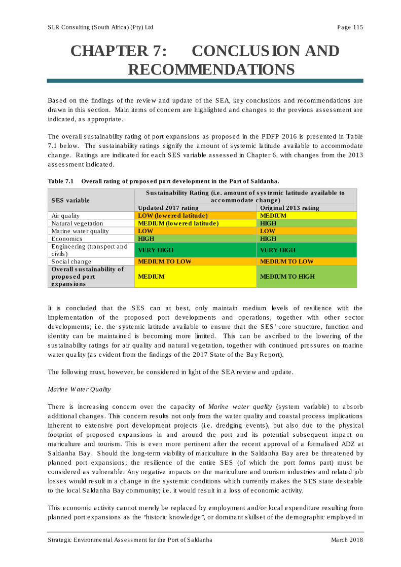
SLR Consulting (South Africa) (Pty) Ltd Page 115
Strategic Environmental Assessment for the Port of Saldanha March 2018
CHAPTER 7: CONCLUSION AND RECOMMENDATIONS
Based on the findings of the review and update of the SEA, key conclusions and recommendations are
drawn in this section. Main items of concern are highlighted and changes to the previous assessment are
indicated, as appropriate.
The overall sustainability rating of port expansions as proposed in the PDFP 2016 is presented in Table
7.1 below. The sustainability ratings signify the amount of systemic latitude available to accommodate
change. Ratings are indicated for each SES variable assessed in Chapter 6, with changes from the 2013
assessment indicated.
Table 7.1 Overall rating of proposed port development in the Port of Saldanha.
SES variable Sustainability Rating (i.e. amount of systemic latitude available to
accommodate change)
Updated 2017 rating Original 2013 rating
Air quality LOW (lowered latitude) MEDIUM
Natural vegetation MEDIUM (lowered latitude) HIGH
Marine water quality LOW LOW
Economics HIGH HIGH
Engineering (transport and civils)
VERY HIGH VERY HIGH
Social change MEDIUM TO LOW MEDIUM TO LOW
Overall sustainability of proposed port expansions
MEDIUM MEDIUM TO HIGH
It is concluded that the SES can at best, only maintain medium levels of resilience with the
implementation of the proposed port developments and operations, together with other sector
developments; i.e. the systemic latitude available to ensure that the SES’ core structure, function and
identity can be maintained is becoming more limited. This can be ascribed to the lowering of the
sustainability ratings for air quality and natural vegetation, together with continued pressures on marine
water quality (as evident from the findings of the 2017 State of the Bay Report).
The following must, however, be considered in light of the SEA review and update.
Marine Water Quality
There is increasing concern over the capacity of Marine water quality (system variable) to absorb
additional changes. This concern results not only from the water quality and coastal process implications
inherent to extensive port development projects (i.e. dredging events), but also due to the physical
footprint of proposed expansions in and around the port and its potential subsequent impact on
mariculture and tourism. This is even more pertinent after the recent approval of a formalised ADZ at
Saldanha Bay. Should the long-term viability of mariculture in the Saldanha Bay area be threatened by
planned port expansions; the resilience of the entire SES (of which the port forms part) must be
considered as vulnerable. Any negative impacts on the mariculture and tourism industries and related job
losses would result in a change in the systemic conditions which currently makes the SES state desirable
to the local Saldanha Bay community; i.e. it would result in a loss of economic activity.
This economic activity cannot merely be replaced by employment and/or local expenditure resulting from
planned port expansions as the “historic knowledge”, or dominant skillset of the demographic employed in

SLR Consulting (South Africa) (Pty) Ltd Page 116
Strategic Environmental Assessment for the Port of Saldanha March 2018
the mariculture industry, tends towards fishing and its related industries. Job losses in the mariculture
industry can, in theory, be replaced with employment in port or SBIDZ construction and operational
activities; however, such jobs may not be suitable to the skillset of the dominant demographic profile of
workers involved in the primary sector, which includes mariculture. Wesgro (2011) supports this
assessment, indicating that port expansion and IDZ activities may result in relatively few jobs for local
community members due to a lack of suitable skills and training in the Saldanha Bay area. Recent
training initiatives launched by the SBIDZ may, however, address this concern. The Saldanha Bay IDP
(2017) indicates that severe job losses were experienced during the recession between 2005 and 2010
and that the majority of these losses were experienced in the primary agriculture, forestry and fisheries
sectors. These sectors mostly employ semi-skilled and low-skilled labour which comprises the majority of
the workforce in the Saldanha Bay area. Although the primary sector showed growth in the post-
recessionary period between 2010 and 2015, this growth has not been sufficient to recover all the jobs
lost prior to and during the recession. In practice, jobs created by port expansions will, in all likelihood,
offer employment to locals not involved in mariculture or, more realistically, to job seekers from outside
the Saldanha Bay area.
It is important to note the potential secondary systemic effects which might result from job losses in the
mariculture and tourism industries. Such job losses are likely to exacerbate opposition to TNPA (system
variable), resulting in increased changes in the social environment and subsequent reduced systemic
latitude to accommodate more tension. Therefore social change as a system variable, being already rated
as having low to medium capacity, might be pushed beyond its adaptive capacity and trigger system
change into an undesirable state; i.e. making the entire SES vulnerable. This might seriously constrain or
eliminate TNPAs social license to operate.
It is suggested that TNPA invests in early and open communication with the mariculture and tourism
industries in order to: (i) Discuss the potential impacts of port expansion on mariculture and tourism
activities; (ii) Discuss and develop reskilling and employment programmes; and (iii) Develop reasonable
compensation packages where applicable. The changing nature of the study area, from one
characterised by a fishing community to one that is defined by an industrial port, as a result of TNPA
activities, must also be acknowledged. The change can be partially off-set by maximal employment of
local suitably qualified and experienced job seekers. A local training facility in partnership with the SBIDZ
focussing on port-related skills can serve a dual purpose of training up employable local residents, as well
as reskilling those currently employed in the fishing industry.
Air Quality
Saldanha Bay and Vredenburg residents continue to express particular frustration regarding existing
fugitive iron ore dust and its defacing effect on property, leading to the recent establishment of the Red
Dust Action Group and the matter receiving both local and national media attention. Concerns have also
been raised regarding continued manganese exports from the port and its potential impacts on air quality.
Given the planned expansion of dry bulk storage, new liquid bulk storage and oil and gas service
infrastructure, the potential related deterioration in air quality and its accompanying nuisance factors are
likely to increase dramatically if sufficient mitigation measures are not implemented. The resultant
impacts from port expansion will be both economic and social in nature as affected property prices may
continue to devalue, while associated social discontent increases. Based on the continued iron ore dust
issues, further concerns about manganese exports and air quality impacts from other large industries in
the area (e.g. ArcelorMittal) the sustainability rating for this variable was dropped from Medium to Low as
part of the SEA review/update process. Subsequently, air quality has the capacity to render the entire
SES vulnerable.
Although TNPA is not directly responsible for the iron ore dust problems, it is the landlord in the Port and
has to fulfil its oversight role by ensuring that TPT complies with the specifications of its AEL and its

SLR Consulting (South Africa) (Pty) Ltd Page 117
Strategic Environmental Assessment for the Port of Saldanha March 2018
commitments to compensate property owners for damages caused. It is recommended that TNPA
invests in BAT to control current and anticipated air emissions. TNPA must also comply with existing air
quality targets and ensure proper implementation of existing air emissions monitoring programs. The
results of these programs must be communicated to the local community via existing structures.
Furthermore, effort should be invested in developing an open and transparent relationship with the local
community regarding air quality issues. From interactions with the public, it appears that there is distrust
in TNPA and TPT’s ability and/or commitment to effectively monitor and mitigate emissions resulting from
port expansion activities. The negative perception among local residents might also in part be attributed
to a feeling of powerlessness as they have no direct input into the current monitoring program. TNPA
should consider involving existing forums, like the Saldanha Bay Water Quality Forum Trust and Red
Dust Action Group, in the actual monitoring of air quality, either directly, or in an auditing capacity.
Natural Vegetation
With the recent (2017) update of the CBA mapping in the Western Cape, a number of sensitive areas
have been identified in and surrounding port land, including areas proposed for further land acquisition.
In line with the latest draft EMF document, these areas are viewed as conflict areas which fall within
important economic development zones, but also contain areas of sensitive vegetation types required to
meet conservation targets. Coupled with other proposed largescale developments in the surrounding
area and upgrading of road infrastructure, it leaves little latitude for further loss of natural vegetation and
the sustainability rating was thus dropped from High to Medium as part of the SEA review/update
process. TNPA is to consult with CapeNature and DEA&DP regarding the implications of the latest CBA
maps and how to effectively resolve conflicts with future development proposals before the EMF for the
Greater Saldanha Bay area is finalised and gazetted, in order to ensure mutually acceptable alignment
between conservation targets and economic development.
The caveats discussed above, though originating in the natural environment, imply effects and limitations
in the social and economic environments. Accordingly, attention is drawn to Negative Feedback Loop 1
(page 73, Figure 5.5), which indicates that opposition towards TNPA (social discontent and associated
economic impacts) will be reduced, or controlled, by the Port of Saldanha being broadly sustainable (i.e.
sustainable for both TNPA and local Saldanha Bay/ Vredenburg residents). The negative nature of this
feedback loop implies that TNPA can control the level of opposition encountered from local residents, and
by implication maintain its social license to operate, by considering residents’ livelihoods, property and
quality of life as integral to port sustainability.
Potable Water Supply
Potable water supply remains the single-most important limitation identified in this study, even more so
due to the low rainfall conditions experienced since the SEA was first compiled. Further port expansions
and the SBIDZ development will not only require additional water supply for construction and operational
activities, but also to service the increased population likely to result from economic growth in the study
area.
Although not currently formally considered by TNPA, additional or expanded desalination technology may
be required in future, should drought conditions persist and municipal supply be placed under further
stress. Desalination is, however, both expensive and energy consumptive and its associated cost
implications must be considered as a potential threat to the resilience of the SES. If water can only be
supplied at a very high cost, or if it cannot be supplied in sufficient quantities, the adaptive capacity of the
system will clearly be exceeded and the entire SES may change into an undesirable condition from the
perspective of both TNPA and the local community. Apart from the financial implications of desalination,
the environmental constraints must also be considered. The energy intensive nature of desalination could

SLR Consulting (South Africa) (Pty) Ltd Page 118
Strategic Environmental Assessment for the Port of Saldanha March 2018
necessitate greater dependence on fossil fuel, thus producing GHGs which, in the long-term, will
exacerbate water shortage in the study area (see Positive Feedback Loop 2, page 72, Figure 5.4).
If further desalination projects are pursued, potential brine discharge to the marine environment would be
of concern. As indicated in Positive Feedback Loop 1 (page 57, Figure 5.3), brine discharged into the
marine environment will ultimately reduce marine water quality and in so doing, also increase the cost of
desalination. Apart from potential further desalination projects by TNPA to supply future port expansion
activities, WCDM and Saldanha Bay Municipality are also proposing desalination plants for bulk service
provision (the WCDM already holds an Environmental Authorisation for a municipal desalination plant and
further small-scale plants are being proposed by the Saldanha Bay Municipality and industry in the area).
Accordingly, the potential for multiple brine discharge sources into the littoral zone at Saldanha Bay
should be considered as highly probable. The resultant cumulative impact on marine water quality is likely
to exacerbate change in the marine environment as well as the cost of producing potable water in the
study area.
The positive or amplifying nature of Feedback Loop 1 suggests that TNPA has little or no control over the
expected high cost of fresh water supply and potential for deteriorating marine water quality, apart from
not expanding the port at all. Accordingly, it is reasonable to accept that the provision of fresh water
remains a clear and present threat to the SES, especially during the current drought conditions and even
if desalination technology is implemented. It is therefore recommended that TNPA quantify the water-use
needs and related costs (based on desalination technology and other alternative sources) of port
expansion activities and its associated influx of people into the study area, as well as projections of
expected cost increases over the 40 year port expansion time-frame. These cost estimates must be
completed and the implications thereof fully understood before any port expansion activities are
undertaken.
It is recommended that TNPA consider including the management actions listed in this report in future
strategic construction and operational EMP documents for the Port of Saldanha. Such strategic EMP
documents can be made available to future TNPA tenants for incorporation into project-specific EMP
documents. This would ensure that all future projects align with TNPAs overarching sustainability vision.

SLR Consulting (South Africa) (Pty) Ltd Page 119
Strategic Environmental Assessment for the Port of Saldanha March 2018
CHAPTER 8: REFERENCES
Anchor Environmental Consultants (AEC). 2012. Re-commissioning of a Fishmeal Processing Plant,
Saldanha Bay Marine Specialist Report. Prepared for SRK Consulting (South Africa) (Pty) Ltd.
Cape Town, 63 pp.
Anchor. 2015. The State of Saldanha Bay and Langebaan Lagoon 2015. Technical Report
No. 1642/1 prepared by Anchor Environmental Consultants for the Saldanha Bay water Quality
Trust.
Anchor. 2016. Marine Impact Assessment for the Construction of a Dedicated Ship and Rig Repair
Facility at Berth 205 and a Jetty at the Existing Mossgas Quay under Project Phakisa, Saldanha
Bay. Compiled for SLR Consulting as part of an Environmental Screening Assessment for
TNPA.
Anchor. 2017. The State of Saldanha Bay and Langebaan Lagoon 2017. Technical Report
No. 1741/1 prepared by Anchor Environmental Consultants for the Saldanha Bay water Quality
Trust.
Angel, A., Branch, G.M., Wanless, R.M. & Siebert, T. 2006. Causes of rarity and range restriction of an
endangered, endemic limpet, Siphonaria compressa. Journal of Experimental Marine Biology
and Ecology 330: 245-260.
ARUP. 2014. Transnet National Ports Authority – Saldanha. Location Study for Rig or Ship Repair
Facilities in the port of Saldanha. FEL2 Prefeasibility Report. Prepared by ARUP (Pty) Ltd for
TNPA.
ARUP. 2016. Transnet National Ports Authority – Saldanha. Mossgas Quay Oil and Gas Jetty. FEL2
Prefeasibility Report. Prepared by ARUP (Pty) Ltd for TNPA.
Attwood CG, Næsje TF, Fairhurst L & SE Kerwath. 2010. Life History parameters of white stumpnose
Rhabdosargus globiceps (Pisces: Sparidae) in Saldanha Bay, South Africa, with evidence for
stock separation. African Journal of Marine Science 32: 23-36.
Bateman, P. 1946. Archaeological notes on the Saldanha Bay District. South African Archaeological
Bulletin 1: 41-45.
Bates, M.F., Branch, W.R., Bauer, A.M., Burger, M., Marais, J., Alexander, G.J. & de Villiers, M.S. (eds).
2014. Atlas and Red List of the Reptiles of South Africa, Lesotho and Swaziland. Suricata 1. SANBI,
Pretoria, South Africa.
Berger, L.R., & Parkington, J.E. 1995. A new Pleistocene hominid-bearing locality at Hoedjiespunt, South
Africa. American Journal of Physical Anthropology 98:601-609.
Branch, G.M and Branch, M. 1981. The Living Shores of Southern Africa. Cape Town: Struik.
CCA, 2015. Proposed Oil and Gas Offshore Service Complex at the Saldanha Bay Industrial
Development Zone: Final Environmental Impact Report compiled as part of an Environmental
Impact Assessment process by CCA Environmental (Pty) Ltd for SBIDZ-LC.

SLR Consulting (South Africa) (Pty) Ltd Page 120
Strategic Environmental Assessment for the Port of Saldanha March 2018
Cilliers, P. 2008. Complexity Theory as a general framework for Sustainability Science. In Burns, M.,
Weaver, A. (eds.). Exploring Sustainability Science. A Southern African Perspective.
Stellenbosch: African Sun Media, pp. 39-57.
Clark, R.B. 1986. Marine Pollution. Claredon Press, Oxford, 215 pp.
Clark BM. 1997. Variation in surf-zone fish community structure across a wave-exposure gradient.
Estuarine and Coastal Shelf Science 44(6): 659-674.
CSIR. 2011. Saldanha Bay Desalination Project: Environmental Background report. Stellenbosch
CSIR. 2012. Final Scoping Report: WCDM Saldanha Bay Desalination Project. Stellenbosch
CSIR. 2013. Numerical Modelling of Long Period Waves. CSIR Report ENV-S-C-99050, /0015/B.
CSIR, 2015. Port of Saldanha Iron Ore Terminal Reverse Osmosis Plant Environmental Monitoring
Programme: Summary of Previous Study Finds and Recommended Sampling Design.
da Silva C, Kerwath SE, Attwood CG, Thorstad EB, Cowley PD, Økland F, Wilke CG, & TF Næsje. 2013.
Quantifying the degree of protection afforded by a no-take marine reserve on an exploited shark.
African Journal of Marine Science, 35(1): 57-66.
David, J. & van Sittert, L. 2006. A Reconstruction of the Cape (South African) fur seal harvest 1653 –
1899 and a comparison with the 20th century harvest. South African Journal of Science.
de Greef K, Griffiths CL & Z Zeeman. 2013. Deja vu? A second mytilid mussel, Semimytilus algosus,
invades South Africa’s west coast. African Journal of Marine Science 35(3): 307-313.
DEAT. 2000. Guideline Document: Strategic Environmental Assessment in South Africa, Pretoria.
DEA. 2012. South African Water Quality guidelines for coastal marine waters. Volume 2: Guidelines for
recreational use, Department of Environmental Affairs.
Department of Water Affairs (DWA). 2011. Reconciliation Strategy for Saldanha Bay. Pretoria
Department of Water Affairs and Forestry (DWAF). 1995a. South African water quality guidelines for
coastal marine waters. Volume 1. Natural Environment. Pretoria.
Department of Water Affairs and Forestry (DWAF). 1995b. South African water quality guidelines for
coastal marine waters. Volume 4. Mariculture. Pretoria.
Department of Water Affairs and Forestry (DWAF). 1995c. South African water quality guidelines for
coastal marine waters. Volume 3. Industrial use. Pretoria.
Dewar, G. 2010. Late Holocene burial cluster at Diaz Street Midden, Saldanha Bay, Western Cape, South
Africa. South African Archaeological Bulletin 65:191 26-34
Flemming, K.P. 1977. Distribution of recent sediments in Saldanha Bay and Langebaan Lagoon.
Transactions of the Royal Society of South Africa 42(3&4): 317-340.
Friedmann, Y. & Daly, B., (eds). 2004. Red Data Book of the Mammals of South Africa: A Conservation
Assessment: CBSG Southern Africa, Conservation Breeding Specialist Group (SSC/IUCN,
Endangered Wildlife Trust. South Africa.

SLR Consulting (South Africa) (Pty) Ltd Page 121
Strategic Environmental Assessment for the Port of Saldanha March 2018
GIBB. 2017. Environmental Management Framework for the Greater Saldanha Area. April 2017 draft
report compiled by GIBB (Pty) Ltd for WCG: DEA&DP
Greencape, 2015. Water as a Constraint on Economic Development. 2014-2015 Research Project
Progress Report prepared for WCG: DEA&DP.
Griffiths CL, Hockey PAR, Van Erkom Schurink C & PJL Roux. 1992. Marine invasive aliens on South
African shores: Implications for community structure and trophic functioning. South African
Journal of Marine Science 12: 713-722.
Hedger RD, Næsje TF, Cowley PD, Thorstad EB, Attwood C, Økland F, Wilke CG & S Kerwath. 2010.
Residency and migratory behaviour by adult Pomatomus saltatrix in a South African coastal
embayment. Estuarine, Coastal and Shelf Science 89: 12-20.
Holling, C.S. and Gunderson, L.H. 2002. Resilience and adaptive cycles. In: Gunderson, L.H. and
Holling C.S (eds.). Panarchy: Understanding transformations in human and natural systems.
Island Press, Washington D.C.: 25-62.
Hutchings K & SJ Lamberth. 2002. Bycatch in the gillnet and beach-seine fisheries in the Western Cape,
South Africa, with implications for management. South African Journal of Marine Science 24: 227-
241.
International Finance Corporation (IFC). 2009. Projects and People: A Handbook for Addressing Project-
Induced In-migration; Washington D.C.; Available [online] at:
http://www.ifc.org/wps/wcm/connect/topics_ext_content/ifc_external_corporate_site/ifc+sustainabi
lity/publications/publications_handbook_inmigration__wci__1319576839994, downloaded 27
August 2013.
IUCN. 2013. IUCN Red List. http://www.iucnredlist.org/ Accessed January 2016.
Jackson, L.F. and McGibbon. S. 1991. Human activities and factors affecting the distribution of
microbenthic fauna in Saldanha Bay. South African Journal of Aquatic Science 17(1/2): 89-102.
Kaplan, J. 2013.Archaeological Impact Assessment proposed construction of a security wall around the
Saldanha Bay Military Base. Report prepared for Delta Built Environmental Consultants. ACRM.
Kaplan, J. 2012. Heritage Impact Assessment proposed Saldanha Bay Sick Bay. Report prepared for
Footprint Environmental Services. ACRM.
Kaplan, J. 2010. Archaeological Impact Assessment Arcelor Mittal Saldanha Works and Exxaro
Namakwa Sands – Flared Gas Pipeline, Saldanha Bay. Report prepared for Resource
Management Services. ACRM.
Kaplan, J. 2007a. Phase 1 Archaeological Impact Assessment Proposed development Harbour View
Industrial Park Sal Dan Ha Bay Portion 9 of Farm No. 957, Malmesbury. Report prepared for
Enviro Logic. ACRM.
Kaplan, J. 2007b. Phase 1 Archaeological Impact Assessment proposed development Portion 13 of the
Farm Pienaars Poort No. 197 Saldanha Bay. Report prepared for Creative Profile. ACRM
Kaplan, J. 2006a. Phase 1 Archaeological Impact Assessment proposed construction of a new residue
dam Namakwa Sand Smelter Saldanha Bay. Report prepared for Resource Management
Services. ACRM

SLR Consulting (South Africa) (Pty) Ltd Page 122
Strategic Environmental Assessment for the Port of Saldanha March 2018
Kaplan, J. 2006b. Phase 1 Archaeological Impact Assessment proposed development Portion 5 of the
Farm Pienaars Poort No. 197. Report prepared for IC @ Plan. ACRM
Kaplan, J. 1998. Archaeological Study Proposed Public Access Road to the Port of Saldanha. Report
prepared for Crowther Campbell and Associates. Agency for Cultural Resource Management.
Riebeek West
Kaplan, J. 1997a. Archaeological Study: Duferco Steel Mill Project. Report prepared for Duferco. ACRM
Kaplan, J. 1997b. Archaeological Survey: Salamander Cove. Report prepared for Salamander Cove
Development Company (Pty) Ltd. ACRM
Kaplan, J. 1996. Archaeological investigation, Saldanha Steel Project. Report prepared for van Riet and
Louw Landscape Architects. ACRM.
Kaplan, J. 1994. Saldanha Steel Project Phase 2 Environmental Impact Assessment – Archaeological
Study. Report prepared for CSIR Environmental Services. ACRM
Kaplan, J. 1993. The state of archaeological information in the coastal zone from the Orange River to
Ponto do Ouro. Report prepared for the Department of Environmental Affairs and Tourism.
ACRM.
Kerwath SE, Thorstad EB, Næsje TF, Attwood CG, Cowley PD, Økland F & C Wilke. 2009. Crossing
Invisible Boundaries: The effectiveness of the Langebaan Lagoon marine protected area as a
harvest refuge for a migratory fish species in South Africa. Conservation Biology 23 (3): 653-661.
Laird MC & CL Griffiths. 2008. Present distribution and abundance of the introduced barnacle Balanus
glandula Darwin in South Africa. African Journal of Marine Science 30(1): 93-100.
Mann BQ & S Dunlop. 2013. Blacktail Diplodus capensis. In: Mann BQ (ed). Southern African Marine
Linefish Species Profiles. Special Publication, Oceanographic Research Institute, Durban 9, 230-
232 pp.
Mather, A.A. 2011. South African Coasts and Ports: What will Climate Change Bring? Presentation at Ad
Hoc Expert Meeting on Climate Change Impacts and Adaptation: A Challenge for Global Ports.
29 – 30 September 2011
McDonald, D.J. 2017. Botanical Short Report for delimitation of a conservation area at TNPA property,
Saldanha IDZ. Prepared for SLR Consulting as part of an EA Amendment Application for the
Saldanha Bay IDZ development.
Mead A, Carlton JT, Griffiths CL & M Rius. 2011. Revealing the scale of marine bioinvasions in
developing regions: a South African re-assessment. Biological Invasions 13: 1991-2008.
Measy, G.J. (ed). 2011. Ensuring a future for South Africa’s frogs: a strategy for conservation research.
SANBI Biodiversity Series 19. SANBI, Pretoria.
Mecenero, S., Ball, J.B., Edge, D.A., Hamer, M.L., Henning, G.A., Krüger, M.A., Pringle, E.L., Terblanche,
R.F. & Williams, M.C. (eds) 2013. Conservation Assessment of Butterflies of South Africa, Lesotho
and Swaziland: Red List and Atlas. Animal Demography Unit, University of Cape Town, Cape Town.
Minter, L.R., Burger, M., Harrison, J.A., Braack, H.H., Bishop, P.J., and Kloepfer, D., eds. 2004. Atlas
and Red data Book of the Frogs of South Africa, Lesotho and Swaziland. SI/MAB Series No. 9.
Smithsonian Institution, Washington, DC.
SLR Consulting (South Africa) (Pty) Ltd Page 123
Strategic Environmental Assessment for the Port of Saldanha March 2018
Monteiro, P.M.S., Anderson, R.J. and S. Woodbourne (1997). δ15N as a tool to demonstrate the
contribution of fish waste-derived nitrogen to an Ulva bloom in Saldanha Bay, South Africa. S
Afr.J. mar. Sci. 18, 1-9.
Monteiro, P.M.S. and Eglington, B. 2002. The origin and biogeochemistry of the elevated Cadmium (Cd)
and Lead (Pb) concentration in the sediments of Saldanha Bay. CSIR Report ENV-S-C-2002-
039, Council for Scientific and Industrial Research, South Africa.
Monteiro, P.M.S. and A. Kemp. 2004.Water quality management plan for Saldanha Bay: Phase III:
Setting of critical loads using a modelling based ecosystem approach. CSIR Report ENV-S-C
2004-083, 30pp. Stellenbosch.
Monteiro PMS & JL Largier. 1999. Thermal stratification in Saldanha Bay (South Africa) and subtidal,
density-driven exchange with the coastal waters of the Benguela Upwelling System. Estuarine
and Coastal Shelf Science 49: 877-890.
Nikolaou, A., Kostopoulou, M., Lofrano, G., Meric, S., Petsas, A. & Vagi, M. 2009. Levels and toxicity of
polycyclic aromatic hydrocarbons in marine sediments. Trends in Analytical Chemistry 28: 653-
664.
Orton, J. 2009. Rescue excavations at Diaz Street Midden Saldanha Bay, South Africa. Azania:
Archaeological Research in Africa. 44:1 107-120
OSPAR. 2010. Quality Status Report 2010: Status and Trend of marine chemical pollution. Accessed at
OSPAR.org on 13 June 2012.
Peters K & TB Robinson. 2017. First record of the marine alien amphipod Caprella mutica (Schurin, 1935)
in South Africa. BioInvasions Records 6(1): 61-66.
Pether, J. 2014. Proposed Oil and Gas Offshore Service Complex at the Saldanha Bay Industrial
Development Zone: Palaeontological Impact Assessment. Prepared for CCA Environmental (Pty)
Ltd as part of an Environmental Impact Assessment.
Pisces. 2017. Concept for a Proposed Sea-Based Aquaculture Development Zone in Saldanha Bay,
South Africa: Marine Ecology Specialist Study. Prepared by Pisces Environmental Services (Pty)
Ltd for SRK Consulting.
Retief, F., Jones, C. & Jay, S. 2007. The status and extent of Strategic Environmental Assessment (SEA)
practice in South Africa, 1996-2003. South African Geographic Journal 89(1): 44-54.
Roberts, D. and Berger, L.R. 1997. Last interglacial (c. 117 kyr) human footprints from South Africa.
South African Journal of Science 93(8): 349-350.
Robinson TB, Griffiths CL & N Kruger. 2004. Distribution and status of marine alien invasive species in
and bordering the West Coast National Park. Koedoe 47: 79-87.
Robinson TB, Branch GM, Griffiths CL, Govender A & PAR Hockey. 2007. Changes in South African
rocky intertidal invertebrate community structure associated with the invasion of the mussel
Mytilus galloprovincialis. Marine Ecology Progress Series 340: 163-171.
Rudner, J. 1963. Strandloper pottery from South and South West Africa. Annals of the South African
Museum. 49 (2): 441-663

SLR Consulting (South Africa) (Pty) Ltd Page 124
Strategic Environmental Assessment for the Port of Saldanha March 2018
Saldanha Bay Municipality (SBM). 2011. Saldanha Bay Spatial Development Framework. Saldanha Bay
Municipality, Saldanha.
SIF Status Quo. 2016. Greater Saldanha Regional Spatial Implementation Framework. Status Quo
Assessment Report compiled for WCG: DEA&DP by GIBB, Setplan, PDG & Sarah Winter.
Sink, K., Holness, S., Harris, L., Majiedt, P., Atkinson, L., Robinson, T., Kirkman, S., Hutchings, L., Leslie,
R., Lamberth, S., Kerwath, S., von der Heyden, S., Lombard, A., Attwood, C., Branch, G.,
Fairweather, T., Taljaard, S., Weerts, S., Cowley, P., Awad, A., Halpern, B., Grantham, H. and
Wolf, T. 2012. National Biodiversity Assessment 2011: Technical Report. Volume 4: Marine and
Coastal Component. South African National Biodiversity Institute, Pretoria.
SLR. 2016. Proposed Project Phakisa Rig Repair in the Port of Saldanha: Final Environmental Screening
Report. Compiled by SLR Consulting (South Africa) (Pty) Ltd for TNPA.
Smith, A.B. 2013. Final archaeological excavation report on the proposed Sick Bay Facility Farm 284/2
Saldanha. Report prepared for mlh Architects. Department of Archaeology University of Cape
Town
SRK. 2013. Proposed Upgrade of the General Maintenance Quay at the Port of Saldanha: Basic
Assessment Report. Compiled by SRK Consulting for TNPA.
SRK. 2016. Proposed Bulk Power Infrastructure Provision of a Third Tippler and Associated Infrastructure
in the Port of Saldanha: Basic Assessment Report. Compiled by SRK Consulting for Transnet.
SRK. 2017. Proposed Sea-Based Aquaculture Development Zone in Saldanha Bay: Basic Assessment
Report. Compiled by SRK Consulting for DAFF.
Summers, R.W. 1977. Distribution, abundance and energy relationships of waders (Aves: Charadrii) at
Langebaan Lagoon. Transactions of the Royal Society of South Africa 42(3&4): 483-495.
Taljaard, S. 2006. The development of a common set of water and sediment quality giuidelines for the
coastal zone of the BCLME, CSIR Report No CSIR/NRE/ECO/ER/2006/0011/C, 164 pp + 46 pp
App.
Transnet. 2012. Long-term Planning Framework (LTPF) for the Port of Saldanha.
Transnet. 2013. Draft Long-term Planning Framework (LTPF) for the Port of Saldanha (PowerPoint
presentation)
Tunley KL, Attwood CG, Moloney CL and Fairhurst L. 2009. Variation in population structure and life
history parameters of steentjies Spondyliosoma emarginatum: effects of exploitation and
biogeography. African Journal of Marine Science 31: 133-143.
Van Ballegooyen, R.C., A. Kemp, P.M.S. Monteiro, R. Carter and S. Luger. 2005. Environmental fatal
flaws assessment: Preliminary assessment of a proposed CCGT power plant purge water
discharge into Saldanha Bay, CSIR Report ENV-S-C 2005-067, 156 pp+52 pp App.
van Ballegooyen, R.C., N. Steffani and A. Pulfrich. 2007. Environmental Impact Assessment:
Proposed Reverse Osmosis Plant, Iron –ore Handling Facility, Port of Saldanha - Marine Impact
Assessment Specialist Study, Joint CSIR/Pisces Report, CSIR/NRE/ECO/ER/2007/0149/C,
190pp + 198pp App.

SLR Consulting (South Africa) (Pty) Ltd Page 125
Strategic Environmental Assessment for the Port of Saldanha March 2018
van Ballegooyen, R.C. Carter, P. Monteiro, G. Diedericks, S. Taljaard, S. Bergman, W. Joubert and A.
Meyer .2008. Environmental Impact Assessment: Phase 2 Expansion of the Saldanha Iron Ore
Export Terminal - Assessment of potential long-term ecosystem impacts and risks associated
with dredging and dredge spoil disposal and/or reclamation activities, CSIR Report No:
CSIR/NRE/ECO/ER/2008/0133/C, (incomplete) Stellenbosch.
van Ballegooyen, R.C., E. Mabille, S. Brown, B. Newman and S. Taljaard. 2012. Transnet Reverse
Osmosis desalination plant, Saldanha Bay: Physico-chemical environmental baseline. CSIR
Report, CSIR/NRE/ECO/ER/2012/0033/B, 146pp + 19pp App.
Visser, H.N. & Schoch, A.E. 1972. Map Sheet 255: 3217D & 3218C (St Helenabaai), 3317B & 3318A
(Saldanhabaai). Geological Survey of South Africa.
Visser, H.N. & Schoch, A.E. 1973. The geology and mineral resources of the Saldanha Bay area.
Memoir Geological Survey of South Africa 63: 156 pp.
Walker, B.H., Holling, C.S., Carpenter, S.R. and Kinzig, A. 2004. Resilience, adaptability and
transformability in social-ecological systems. Ecology and Society 9(2): 5. Online:
http://www.ecologyandsociety.org/vol19/iss2/art
Warwick RM. 1993. Environmental impact studies on marine communities: Pragmatical considerations.
Australian Journal of Ecology 18: 63-80.
WCDM. 2016/17. West Coast District Municipality Annual Report 2016/2017.
Weeks SJ, Monteiro PMS, Nelson G & Cooper RM. 1991a. A note on wind-driven replacement flow of the
bottom layer in Saldanha Bay, South Africa: implications for pollution. South African Journal of
Marine Science 11: 579-583.
Weeks SJ, Boyd AJ, Monteiro PMS & Brundrit GB. 1991b. The currents and circulation in Saldanha Bay
after 1975 deduced from historical measurements of drogues. South African Journal of Marine
Science 11: 525-535.
Wesgro. 2011. Saldanha Bay IDZ Feasibility Study: Revision 1.
Wits (University of the Witwatersrand). 2010). Population Movements in and to South Africa: Migration
Fact Sheet 1; prepared by Polzer, T., Forced Migration Studies Program.
WSP Consulting Engineers. 2013. Draft Master Plan: Port of Saldanha. Stellenbosch
ZAA. 2016. Specialist Study on the potential impact of the proposed Project Phakisa rig repair project on
hydrodynamics and water quality in the Port of Saldanha. Compiled by ZAA Engineering Projects
and Naval Architects for SLR as part of an Environmental Screening Report.