stormwater feasibility study final phase 1 report april...
TRANSCRIPT

Stormwater Feasibility Study Final Phase 1 Report
April 2008
prepared by: Nevada Tahoe Conservation District

Nevada Tahoe Conservation District Stormwater Feasibility Study Phase 1 Final Report, April 2008
ii
This publication, The Stormwater Feasibility Study, Final Phase 1, Task 2 Report, June 2007, was prepared and published by the Nevada Tahoe Conservation District. Funds for this publication were provided in part
by:
Nevada Division of State Lands Nevada Division of Environmental Protection
US Army Corps of Engineers Douglas County Round Hill GID Kingsbury GID
Logan Creek GID Glenbrook HOA
Hidden Woods HOA
This publication's statements, conclusions, recommendations, and/or data represent solely the findings and views of the authors and do not necessarily represent the views of the Tahoe Regional Planning Agency, the
US Army Corps of Engineers, any of the funding agencies listed above, or any reference sources used or quoted by this study. Reference to research projects, programs, books, magazines, or newspaper articles
does not imply an endorsement or recommendation by the authors unless otherwise stated. Correspondence regarding this document should be sent to:
Douglas Martin, District Manager Nevada Tahoe Conservation District
297 Kingsbury Grade, Suite J PO Box 4605
Stateline, Nevada 89449-4605 [email protected]
Cover Photo: Eric Martin, Northstar CSD

Nevada Tahoe Conservation District Stormwater Feasibility Study Phase 1 Final Report, April 2008
iii
PREFACE This report has been prepared to assist leaders and managers of Nevada jurisdictions and/or agencies that
implement stormwater treatment systems in Nevada Lake Tahoe (referred to hereafter as the “decision-
makers”) to determine if they should pool their resources to form a cooperative stormwater management
district or utility. In addition, the report will be circulated to the Stormwater Advisory Committee (SWAC) for
feedback and comments, which will be relayed to the Nevada Lake Tahoe decision-makers for their
consideration of whether or not a stormwater utility (SWU) makes sense.
Each chapter relates to a specific sub-task outlined in the original workplan approved by the SWAC in
December of 2006. Additional supporting or ancillary material is included in 12 appendices.
It is our hope that the readers of this report find it a useful tool in developing their comments to the Nevada
Lake Tahoe decision-makers and that perhaps this might become a useful tool for all our Basin partners
when considering the implementation of community-based stormwater utility districts.

Nevada Tahoe Conservation District Stormwater Feasibility Study Phase 1 Final Report, April 2008
iv
ACKNOWLEDGEMENTS Stormwater Stakeholders
Morris Alfano Ken Arnold Doris Azevedo Jim Beattie Cookie Bible Michael Bradford Linda Bradley Scott Brown Phillip Brozek Andy Burnham Mike Carney Blaise Carrig Scott Cecchi John Cobourn Kimble Corbridge Ronnie Devenish Mitch Dion Michael Donahoe Charlie Donohue Tom Duffey Thor Dyson Kay & Don Edwards Lynn Endicot Christopher Ennes Bea & Don Epstein Robert Fellows Ellery Foster John Friedrich Jack Gilman Steve Goldman Dave Goodell Ann Grant John Greenhut Darryl Harris Liz Harrison Nick Haven Bob Heffernan Stan Hill Dan Holler Larry Hough Yvonne Huck Jack Jacobs John Jandrey David Jinkens Doug Jones Theresa Jones Tom Kennedy Sue Kocher Steve Kooyman Jason Kuchnicki Nova Lance-Seghi Jacques Landy Bill Lane Tracy Larkin Erik Larson Bob Larson Doug Martin Susan Martinovich John & Diane McCall Patrick McKay Cameron McKay Charity Meakes Jean Merkelbach Gary Midkiff Ian Miller Dottie Miller Rochelle Nason Chuck Neff Paul Nielsen Tim Oliver Andy Osinski Jerry Owens Jovita Pajarillo Bruce Patras Tom and Anne Rackerby Julie Regan Carl Ribaudo Richard Robinson Ron Roman Jeanne Ruefer Michelle Runtzel Carl Ruschmeyer Jill Sarick Cary Sarnoff Jane Schmidt Catherine Schoen Teresa & Bill Schroeder Kathy Sertic Harold Singer John Singlaub Bob Slater Glen Smith Doug Smith Amir Soltani Dan St. John Lowry Stewart Penny Stewart Andrew Strain North Swanson Gary Tate Chuck Taylor Gail Taylor Steve Teshara Carolyn Treanor Matt Vitale Russ Wigart Steve Williams Gerry Yeazell
Stormwater Implementation Team (SWIT) Scott Brown, Nevada Tahoe Conservation District
Dave Goodell, Nevada Tahoe Conservation District Erik Larson, Tahoe Regional Planning Agency
Doug Martin, Nevada Tahoe Conservation District Charity Meakes, US Army Corps of Engineers Jill Sarick, Nevada Tahoe Conservation District
Jack Jacobs, Nevada Tahoe Conservation District
Funding Partners Nevada Division of State Lands
Nevada Division of Environmental Protection US Army Corps of Engineers
Douglas County Round Hill GID Kingsbury GID
Logan Creek GID Glenbrook HOA
Hidden Woods HOA

Nevada Tahoe Conservation District Stormwater Feasibility Study Phase 1 Final Report, April 2008
v
EXECUTIVE SUMMARY Lake Tahoe has been designated as an “outstanding national water resource” by California and the Federal
government, and as a “water of extraordinary ecological or aesthetic value” by Nevada. There have been
numerous efforts carried out during the last decade to help restore and protect Lake Tahoe from further
degradation and protect it for future generations. The Nevada Tahoe Conservation District (NTCD), a non-
regulatory agency whose mission is to assist private and public landowners through technical assistance,
leadership and education, responded to a need identified through various studies and stakeholder
interactions regarding improved management of stormwater in Nevada Lake Tahoe communities.
Many Nevada Tahoe local jurisdictions have stormwater authority and thus are the primary implementers of
public works water quality improvement projects as part of the Tahoe Regional Planning Agency’s (TRPA)
Environmental Improvement Program (EIP). The intent of this report is to address the concerns of local
jurisdictions over the complexity and cost of operations and maintenance, as well as the implementation of
pending new watershed management policies (i.e., the Lake Tahoe Total Maximum Daily Load (TMDL)).
Additionally, within the Nevada Tahoe Basin, there has been concern expressed regarding the high cost of
residential parcel Best Management Practice (BMP) Retrofit Program (EIP #16), possible failures due to
improper or lack of maintenance, and relatively low compliance rates regarding installations of the systems.
Also in the Basin, there is a growing awareness among the agencies implementing and planning water
quality improvement projects that stormwater management can be managed as a utility district similar to
wastewater or drinking water utilities. In response to these concerns and ideas, NTCD, with local and State
support and funding, initiated a Stormwater Initiative to determine if the jurisdictions should pool their
resources into a stormwater management cooperative or district.
This study has come to the following conclusions:
- There are no known regulations, policies, or statutes that would prevent the establishment of a stormwater
utility for all Nevada Lake Tahoe.
- The TMDL will likely drive increases in regulatory pressures and performance measures of the stormwater
system. Both drivers will increase the need for integrated, cost effective, and performance based
maintenance practices.
- Over $100 million dollars have been expended to install public and private BMPs in the Tahoe Basin in
order to prevent pollutants from entering Lake Tahoe. Of this value, $67 million was expended for public
BMP efforts in Douglas County.
- Stormwater utilities have been created in over 500 municipalities in the United States to solve technical,
management, fiscal, and planning challenges.
- Public outreach efforts reflect a general appreciation for the need to have an integrated approach to
stormwater infrastructure management and maintenance. However, it became clear during this process

Nevada Tahoe Conservation District Stormwater Feasibility Study Phase 1 Final Report, April 2008
vi
that the greatest need for an integrated stormwater program would be in Douglas County where there are
16 organizations tasked with maintenance of stormwater systems. Washoe County currently has a robust
stormwater maintenance program as does NDOT. Although those organizations may benefit from
participating in a larger Tahoe-specific stormwater organization, they have elected to sit out this phase of
the effort.
- There are multiple gaps in how the stormwater system is currently managed and how it ideally should be
managed and maintained. There are also gaps between the current expenditures for stormwater
maintenance and those that would be anticipated for the size of the system in Nevada Tahoe.
The bottom line is there are many management, programmatic, and technical reasons to create a stormwater
utility in Douglas County, there appears to be a general recognition that an entity needs to take an integrated
approach to addressing current stormwater maintenance problems and prepare for the imminent TMDL
challenges. Finally, there does not appear to be any statutory or technical reason a stormwater utility can
not be created in the Lake Tahoe area of Douglas County. For these reasons, it does make sense to
continue studying the details of establishing a stormwater utility.
Nevada Tahoe Conservation District Stormwater Feasibility Study Phase 1 Final Report, April 2008
vii
TABLE OF CONTENTS PREFACE .......................................................................................................................................................... iii
EXECUTIVE SUMMARY ................................................................................................................................... iv
TABLE OF CONTENTS .................................................................................................................................... vii
CHAPTER 1-- Water Quality and Erosion Control in the Lake Tahoe Basin ..................................................... 1
CHAPTER 2 -- Enabling and Regulatory Framework, Political and Physical Setting........................................ 9
CHAPTER 4 -- Capital Improvement Projects and Public BMPs..................................................................... 39
CHAPTER 5 -- Stormwater Utilities ................................................................................................................. 50
CHAPTER 6 -- Public Sentiment and Perceptions .......................................................................................... 55
CHAPTER 7 -- Gap Analysis ........................................................................................................................... 58
CHAPTER 8 -- Conclusion ............................................................................................................................... 64
APPENDIX 1 - Stormwater Advisory Committee List
APPENDIX 2 -- Stormwater Advisory Committee Charter
APPENDIX 3 -- Stormwater Feasibility Study Workplan
APPENDIX 4 -- Nevada Revised Statutes
APPENDIX 5 -- Tahoe Regional Planning Agency Compact
APPENDIX 6 -- Tahoe Regional Planning Agency Code of Ordinances
APPENDIX 7 -- BMPs for Private Residential Properties and BMP Homeowners Guide
APPENDIX 8 -- BMP Water Quality Inventory
APPENDIX 9 -- Capital Improvement Project BMPs
APPENDIX 10 -- SWU Case Study
APPENDIX 11 -- Northern Kentucky SWMP
APPENDIX 12 -- Frequently Asked Questions (FAQ)

Nevada Tahoe Conservation District Stormwater Feasibility Study, 2007 Phase 1, Task 2 Final Report, June 2007
1
CHAPTER 1-- Water Quality and Erosion Control in the Lake Tahoe Basin
Introduction
This report summarizes work conducted as a part of an initiative to study stormwater management options
performed by the Nevada Tahoe Conservation District (NTCD) in response to stakeholder input regarding
environmental regulations and water quality issues and concerns. NTCD received support and funding to
work on this project from multiple sources, including the Tahoe Regional Planning Agency (TRPA), Nevada
Division of Environmental Protection (NDEP), Nevada Division of State Lands (NDSL), U.S, Army Corps of
Engineers (ACE), Douglas County, Round Hill General Improvement District, Kingsbury General
Improvement District, Skyland General Improvement District, Logan Creek General Improvement District,
Glenbrook Homeowners Association, and Hidden Woods Homeowners Association.
Work began in September of 2006 with the development of a workplan to conduct a feasibility study to
determine “Does it Make Sense” (DIMS) to further explore cooperative management of stormwater systems.
The project’s primary purpose is to assist the implementers of stormwater conveyance and treatment
systems in determining if it makes sense economically, politically, and programmatically to pool resources
through a joint powers agreement in relation to some or all of the responsibilities associated with stormwater
management. These decision-makers include the local General Improvement Districts (GIDs), Homeowners
Associations (HOAs), the two counties, Carson City, and the Nevada Department of Transportation (NDOT).
To help guide the project, NTCD formed an ad hoc Stormwater Advisory Committee (SWAC) (Appendix 1)
and Stormwater Implementation Team (SWIT) that consists of agency staff from a variety of agencies Basin-
wide.
This report non-sequentially summarizes the sub-tasks identified in the workplan (Appendix 3) completed to
date. Chapter 2 outlines the environmental regulations and enabling authority pertinent to this project for the
decision-makers to consider. Chapter 3 and 4 detail water quality and erosion control measures from the
private and public perspectives, respectively. Chapter 5 summaries stormwater utilities and offers case
studies which have relative components. Chapter 6 summarizes the public involvement activities associated
with this project. Chapter 7 provides some overall conclusions and observations. Twelve appendices
provide additional support and ancillary documentation.
After many one-on-one meetings with the local and state partners from Nevada, NTCD hosted the first
SWAC meeting in December of 2006 that included participation from 25 Basin stakeholders at which the
proposed charter and workplan were approved. The Charter (Appendix 2) outlines membership, roles and
responsibilities of the SWAC and the workplan (Appendix 3) identifies four main tasks:
Nevada Tahoe Conservation District Stormwater Feasibility Study, 2007 Phase 1, Task 2 Final Report, June 2007
2
1. Establish a stormwater advisory committee and implementation team;
2. Analyze the existing and future conditions;
3. Conduct a gap analysis; and
4. Present findings in a final report.
The purpose of Task 1 was to establish the project scope and identify the partners who would assist in
completing the workplan. Tasks 1.1 through 1.8 identified stormwater advisory committee and
implementation team members, determined the functions, roles and responsibilities as well as defined the
charter for the SWAC and generated talking points and the introductory presentation. Additionally, the SWIT
conducted an informational assessment of impervious verses pervious coverage to be applied later in this
project in the successive gap analysis. The SWIT completed Task 1 on December 27, 2006.
Task 2 of the workplan includes sub-tasks that identify and summarize the regulatory climate, identify and
compile BMP standards and guidelines, and sources case studies that have been complied and written into
this report.
Task 3 comprises the gap analysis that will help characterize potential obstacles to implementation and
attempt to identify solutions to meet those obstacles. Task 3 will also identify cost sharing solutions and
options for SWU development.
Task 4 will include a compilation of input for local decision-makers to consider.
If the local decision-makers determine it is in fact feasible, more cost-effective, politically, equitably and
scientifically valid to pool resources in the form of a stormwater utility, NTCD will assist them with developing
a Stormwater Master Plan that fits the needs of Nevada Lake Tahoe.
Stormwater Advisory Committee
SWAC serves as ad hoc advisers mainly to assist the SWIT in providing input to the Nevada decision-
makers. Moreover, the SWAC is engaged in a participatory manner reflecting NTCD’s desire to provide fair
and balanced input to the decision makers.
The SWAC is open Basin-wide to all partnering agencies and organizations. Not only will this assist the
Nevada decision-makers but will encourage Basin-wide participation that will benefit both California and
Nevada.

Nevada Tahoe Conservation District Stormwater Feasibility Study, 2007 Phase 1, Task 2 Final Report, June 2007
3
Upon completing the DIMS Study, and making the final input and recommendations, the SWAC will disband.
At this point, a new committee may be created to work on second phase of this initiative, which would include
a stormwater master plan, rate study, and organizational analysis and development.
Background
Lake Tahoe is an outstanding national resource, which through scientific studies completed over the last
thirty years, has been documented to have lost water clarity at a rate of approximately one foot per year1.
Contributing to the loss of clarity are human activities (land disturbance and increased impervious coverage)
which through development have disturbed natural processes, resulting in accelerating nutrient and sediment
delivery to the Lake. Partially in response to this, regional and national leaders created the TRPA, the first
bi-state regional environmental planning agency in the country. Planning activities have included the 208
Water Quality Plan2 and the 1987 Regional Plan3, subsequent programs including the Lake Tahoe
Restoration Act of 1996, and the Environmental Improvement Program (EIP) which have directed much of
the environmental policy in the Basin.
The Lake Tahoe Watershed Assessment4 completed in February 2000 reported that the ecological integrity
of Lake Tahoe would continue to degrade unless restoration activities occur at a faster rate and become
better coordinated. In April 2001, TRPA and its partners updated the Environmental Improvement Program
that defines environmental improvement projects including stream zone restoration, erosion control, and
stormwater management projects needed to improve the Lake Tahoe watershed and restore water clarity
through targeted Environmental Threshold Carrying Capacities5. To date, of the 36 Environmental
Thresholds, about half are in a status of “attainment” or are in a trend towards “attainment.” The 2007 Draft
Environmental Threshold Evaluation Report proposes changes in order to accommodate the pending Total
Maximum Daily Load (TMDL).
The EIP identifies approximately 10,000 projects each with a unique EIP number. All of these projects
combined are estimated to cost more than $1 billion and are aimed at improving the Lake Tahoe watershed,
air shed, and lake clarity, with the costs shared between private, local, state, and federal funding sources.
There are 700 water quality related projects within the EIP, of which, EIP 16 contains approximately $86
million and 40,000 individual private residential Best Management Practices (BMPs). The original
breakdown, annually updated to reflect inflation is illustrated in Figure 1:
1 Jasby, et al., 1998 2 TRPA, 208 Water Quality Plan, 1986-87 3 TRPA 1987 Regional Plan, 1986-87 4 Murphy, Dennis D. and Knopp, Christopher M., May 2000, Lake Tahoe Watershed Assessment, Pacific Southwest Research Station, et al. 5 2005 TRPA Environmental Threshold Evaluation Report

Nevada Tahoe Conservation District Stormwater Feasibility Study, 2007 Phase 1, Task 2 Final Report, June 2007
4
Figure 1: EIP Investment by Funding Sector6
As of August, 2006 it was reported that $334 million has been spent on water quality and erosion control
projects. Of the $86 million earmarked for the private residential portion, about $40.8 million has been
expended. Not included in this breakdown are projects under construction, in design or yet to be planned.
In 2005, the University of California, Davis released their Lake Tahoe Clarity Model as a part of the TMDL
effort (Figure 2). The Model offers an encouraging preliminary assessment that with sustained effort the
Lake Tahoe community may restore a 100’ depth of clarity if a reduction of at least 35% in sediment and
nutrient loading and/or air deposition is attained. The TMDL will be discussed further in Chapter 2. Figure 2: Lake Tahoe Clarity Model showing an increase in clarity with a 35% reduction in fine sediment and nutrients7.
6 Conservation Clearly, Summer 2006, Tahoe Regional Planning Agency 7 Lake Tahoe Clarity Model, UC Davis Research Center, Lahontan Regional Water Quality Control Board, Nevada Division of Environmental Protection, July 2005

Nevada Tahoe Conservation District Stormwater Feasibility Study, 2007 Phase 1, Task 2 Final Report, June 2007
5
Water Quality and Erosion Control Measures for the Lake Tahoe Basin
In a typical undisturbed landscape only 10% of precipitation runs off the soil, but in developed landscapes, as
much as 55% runs off to streams, lakes, and reservoirs and degrades the natural water quality (see Figures
3 and 4). It was this phenomenon, an increase in urban development and a decrease in water quality of
Lake Tahoe, that has served as the basis for water quality regulations in the Tahoe basin. Figure 3: Undisturbed Watershed Figure 4: Urban Landscape
Water quality and erosion control projects were designed to capture, convey and treat stormwater and are a
major element in the EIP plan to restore and protect Lake Tahoe. Both the private homeowner BMP Retrofit
Program (EIP # 16) and public works capital improvement projects are part of this element and require
compliance with the TRPA Code of Ordinances8. Specifically, Chapter 25 establishes performance criteria for
permanent and temporary BMPs, and Chapter 31 establishes the EIP structure and priorities. Both private
and public funds are expended for the installation of BMPs to improve water quality through source control.
The Code if Ordinances identifies “source-control” as the basis in managing, “the volume from a twenty year,
one hour storm…an average intensity of 1 inch per hour” and requires the installation of, “BMP measures in
the following order:
- Pave legally established roads, driveways and parking areas;
- Install drainage conveyances;
- Walkways and cut and fill slopes;
- Vegetate denuded areas; and
- Treat surface runoff from land coverage.”
Additionally, Ordinance 25 provides for “special circumstances.” It states “…where special circumstances
occur, alternative BMPs may be approved to meet water quality standards. Special circumstances may
include, but are not limited to, streets, highways, and bike trails, existence of high ground water table,
8 TRPA Code of Ordinances, Chapter 25, http://www.trpa.org, February 2007

Nevada Tahoe Conservation District Stormwater Feasibility Study, 2007 Phase 1, Task 2 Final Report, June 2007
6
unusual upstream or downstream flow conditions, proximity to drinking water sources, and presence of
unusual concentrations of pollutants.”
The Private Parcel Retrofit Program (EIP #16) for the Lake Tahoe Basin
Mandating voluntary BMP installation on developed private parcels is unique compared to other communities
in the United States. Most other communities use a combination of the National Pollution Discharge
Elimination System (NPDES) permitting requirements on public systems and private voluntary BMP
installation. These programs will be discussed in further detail later in the document, along with other source
control BMPs (e.g., Low Impact Development (LID) or voluntary BMP installation measures on developed
private parcels).
The BMP Retrofit Program (EIP #16) is the largest project within the EIP both in scope and in total cost,
targeting over 40,000 private properties in the Lake Tahoe Basin. The program mandates a phased
compliance with the final phase to be completed by October, 2008. TRPA reports that less than 13%9 of
residential properties have complied Basin-wide despite the program being in place since 1988. Analysis,
including a 2005 survey looking at the causes for low compliance (chartered by TRPA) suggests a
combination of the following reasons: out of basin home ownership, cost, unique site constraints, time
investment, limited public understanding, lack of enforcement, and general public apathy towards the
program. The BMP Retrofit Program also plays a key role in supporting other funding sources that are
secured for restoration work in the Basin and since it represents such a significant portion of the private
sector contribution to the EIP, its success depends on the support, cooperation and participation from many
partners. The residential BMP program will be discussed in further detail in Chapter 3.
Public Works Capital Improvement Projects for the Lake Tahoe Basin
A significant component of the restoration work to improve water quality clarity of Lake Tahoe is focused on
Capital Improvement Projects (CIPs) relating to stormwater management from communities and roads.
Ordinance 25 stipulates that water quality improvement projects must address:
- Runoff water,
- Cut and fill slopes,
- Cut and denuded slopes,
- Drainage conveyances,
- Roads, driveways and parking areas, and the
- Protection of BMPs after installation.
9 TRPA BMP Retrofit Strategic Plan, March 31, 2006
Nevada Tahoe Conservation District Stormwater Feasibility Study, 2007 Phase 1, Task 2 Final Report, June 2007
7
While TRPA requires all stormwater projects be adequately maintained, a formal operations and
maintenance stipulation for a 20 year period is dictated if public funds from the Nevada Bond Act
administered by the Nevada Division of State Lands (NDSL) are used to help fund construction of a project.
To date, some $283 million dollars has been spent on completed projects in the basin ($83.7 million in
Nevada) while it is still estimated that an additional $500 million is needed to complete projects still in design
or planned. This estimate, however, does not account for projects:
- which were constructed prior to the 1987 Regional Plan Update,
- which have failed,
- new projects which have yet to be added to the EIP Update,
- costs to comply with sediment and nutrient discharge limits to be established by the future TMDL,
and
- operations and maintenance of the installed systems.
Lake Tahoe Total Maximum Daily Load
As a result of being listed as an impaired water body on the 303(d) list for clarity degradation, several
agencies including the Lahontan Regional Water Quality Control Board (LRWQCB), TRPA and NDEP have
collaborated to conduct a TMDL assessment. This TMDL, once implemented will require sediment and
nutrient load reductions Basin-wide and will have varying degrees of implications to certain sub-watersheds.
As stated in the Draft Lake Tahoe TMDL Source Category Group Work Plan10, “The TMDL will be
implemented through projects, programs, regulations and permits issued through Lahontan and NDEP. Load
reduction credits related to projects and programs will be tracked and effectiveness monitored.”
While there is no doubt that stormwater management policies will change as a result of the implementation of
a TMDL, NDEP is now entering phase II (allocation phase) of a three phased TMDL process, where Phase
III is the implementation phase and permitting may or may not be required.
Stormwater Utility District A stormwater utility can be seen as an umbrella under which individual jurisdictions address specific needs in
a manner consistent with regional problems, priorities, and practices. With the expected need for increased
stormwater management suggested by existing O&M programs and potential NPDES compliance through
the TMDL, the stability, flexibility, and adequacy of a utility provides a great advantage over other financing
methods.
10 Draft Lake Tahoe TMDL Source Category Group Work Plan , Nevada Division of Environmental Protection, December 2006

Nevada Tahoe Conservation District Stormwater Feasibility Study, 2007 Phase 1, Task 2 Final Report, June 2007
8
Stormwater utilities are comparable in many ways to more traditional municipal water supply and wastewater
treatment utilities. Nearly all involve management of a complex system of natural and man-made physical
structures, and demand continuing operational and regulatory programs as well as capital investment in the
systems. Because of previous and recent federal and state mandates, most provide a comprehensive
program that address water quality as well as quantity (flood) control. The programmatic needs eventually
dictate the utility structure and function.
Through the collection of low, monthly service fees, a stormwater utility can provide a vehicle for:
consolidating or coordinating activities and responsibilities that were previously dispersed among
several jurisdictions (i.e. operations, maintenance and education);
generating funding that is adequate, stable and equitable, and dedicated solely to stormwater
management ; and
developing and implementing other programs that are comprehensive, cohesive, and consistent
year-to-year (i.e. Low Impact Design (LID) development, treatment chains, etc.).
There are over 500 stormwater utility districts in the United States today and they range from small privately
run organizations to large multi-jurisdictional entities. There is no “cook-book” definition for creating and
operating a stormwater utility district. They are all unique to their watershed characteristics and needs,
addressing issues primarily associated with urban landscape disturbance from development. Many combine
private and public programs, projects and activities to create a holistic approach to stormwater management.
Collective stormwater management is ecological and strategic, not reactionary and haphazard. Treatment
systems are strategically placed within the watershed to capture and treat stormwater before it enters a
waterbody of significance. In Tahoe, most of the capital works improvement projects and the BMP Retrofit
Program Priority Watersheds don’t connect ecologically and were not strategically planned.

Nevada Tahoe Conservation District Stormwater Feasibility Study, 2007 Phase 1, Task 2 Final Report, June 2007
9
CHAPTER 2 -- Enabling and Regulatory Framework, Political and Physical Setting
Tasks 2.1 through 2.3 of the stormwater utility workplan requires an exploration of statutes and regulations at
all levels of government that either allow, bind, or drive the formation of a stormwater management system.
The workplan also requires the characterization of the political and physical boundaries.
A key element of establishing a stormwater utility is reviewing and understanding the political and physical
setting of the study area, the regulations, statutes, and ordinances that dictate the need to adopt a more
organized approach to a stormwater management system, restrict the form of a stormwater management
system, and enable such a system. This chapter will address aspects of the existing framework and settings
that would shape the structure of a potential stormwater utility.
Statutes are directives adopted by the legislature that can define functions, relationships, and authorities of
organizations and programs. Regulations, ordinances, and permits are tools utilized by public agencies to
implement the intent of the statute. In Tahoe, state programs of the Nevada Division of Environmental
Protection (NDEP) and regional programs of the Tahoe Regional Planning Agency (TRPA) overlap in
regulating stormwater. This section summarizes the federal, state, regional, and local regulations and
permitting requirements applicable to stormwater management activities. In addition, the political and
topographic setting is important when addressing stormwater to assure that adjoining systems are
compatible and complimentary. This is especially the case in Nevada Tahoe with steep topography, multiple
landowners, and a large number of political jurisdictions.
Federal Regulations
Federal regulations take two forms, those that govern the actions of Federal agencies (e.g., the National
Environmental Policy Act (NEPA) process), and those regulations that dictate national standards that are in
turn delegated to states to implement (e.g., the Clean Water Act (CWA))
National Environmental Policy Act (NEPA)
NEPA is a federal law important to a stormwater utility because the NEPA process is triggered for any project
in which a federal agency provides a portion of the financing, a federal permit is required, or the project is
implemented on federal land. NEPA requires the federal government to use all practical means to create
and maintain conditions under which development and nature can coexist.
The NEPA [42 U.S.C. 4321 et seq.] was signed into law on January 1, 1970 and establishes national
environmental policy and goals for the protection, maintenance, and enhancement of the environment, and
provides a process for implementing these goals within federal agencies. NEPA requires projects identify

Nevada Tahoe Conservation District Stormwater Feasibility Study, 2007 Phase 1, Task 2 Final Report, June 2007
10
the environmental impacts of proposed activities, including impacts to water and air quality. This requires the
agency to conduct a preliminary investigation of potential effects of their actions and decide whether further
investigation is warranted.
An Environmental Assessment (EA) is prepared for projects anticipated to have limited environmental
impact. If impacts are identified, the EA includes procedures to minimize and/or mitigate those impacts. A
Finding of No Significant Impact is issued when minimal or no adverse impacts are identified.
An Environmental Impact Statement (EIS) is prepared for complex projects expected to have a significant
impact to the human and natural environment. An EIS is a detailed document that describes project
alternatives to minimize the identified impacts and is subjected to comments from interested outside parties.
The EPA responds by issuing a Record of Decision detailing project activities and mitigation commitments. Clean Water Act (CWA)
A growing public awareness of and concern for controlling water pollution during the first half of the 20th
century led to the passage of the Federal Water Pollution Control Act (FWPCA) in 1948. The 1972
amendments became known as the CWA. The 1977 amendments created the basic structure for regulating
discharge of pollutants into waters of the United States called the National Pollutant Discharge Elimination
System (NPDES).
The CWA is the primary federal law in the United States governing water pollution and established the goals
of eliminating releases to water of toxic substances. The CWA restructured the responsibility for water
pollution control and gave that responsibility to the Administrator of the U.S. EPA. The 1977 Amendments
created the basic structure for regulating discharge of pollutants into waters of the United States called the
National Pollutant Discharge Elimination System (NPDES). The Water Quality Act (WQA) of 1987 amended
the CWA and formed the legislative basis for all federal stormwater regulations. The WQA requires the EPA
develop and publish information on methods for establishing and measuring water quality criteria. This
guidance must be updated every 2 years
The CWA is implemented at the State level by a process and delegate authority from EPA to an
implementing state after the state demonstrates their program meets basic federal requirements. An
implementing state has the ability to be more restrictive, but not less restrictive than the federal mandates.
Both California and Nevada have CWA authority; the Nevada implementing agency is NDEP.
Nevada Tahoe Conservation District Stormwater Feasibility Study, 2007 Phase 1, Task 2 Final Report, June 2007
11
There are six major elements to the CWA as follows:
Title I - Research and Related Programs (Sections 101-121) Title II - Grants for Construction of Treatment Works (Sections 201-221) Title III - Standards and Enforcement (Sections 301-320) Title IV - Permits and Licenses (Sections 401-406) Title V - General Provisions (Sections 501-519) Title VI - State Water Pollution Control Revolving Funds (Sections 601-607)
Section 208 of the CWA encourages and facilitates the development and implementation of area-wide waste
treatment management plans. This section is a key aspect of the TRPA Water Quality Management Plan.
Total Maximum Daily Load (TMDL)
Section 303(d) of the CWA requires states identify waters that do not comply with applicable water quality
standards for one or more pollutants even after technology-based effluent limitations have been
implemented. After listing and prioritizing these waters, states must determine, for each waterbody, the total
maximum daily loading of the non-attainment pollutant(s) that the water can accept without exceeding
applicable water quality standards or impacting “beneficial uses” of that waterbody. Beneficial uses for Lake
Tahoe are irrigation, watering of livestock, recreation not involving contact with the water, recreation involving
contact with the water, industrial supply, propagation of wildlife, propagation of aquatic life, including a
coldwater fishery, municipal or domestic supply, or both, and, water of extraordinary ecological or aesthetic
value11.
Section 303(d) of the CWA requires each State to submit to EPA a biennial list of waters for which effluent
limitations are not sufficient to meet water quality standards (Figure 4). Lake Tahoe is listed in both Nevada
and California as not meeting a clarity standard. To resolve the impairment and remove Lake Tahoe from
the 303(d) list, the state must develop a TMDL. The TMDL uses the following terms12:
- Loading capacity (LC) -- The greatest amount of loading that a water can receive without
violating water quality standards. (40 CFR 130.2(f))
11 http://www.leg.state.nv.us/nac/NAC-445A.html#NAC445ASec191 12 http://a257.g.akamaitech.net/7/257/2422/14mar20010800/edocket.access.gpo.gov/cfr_2002/julqtr/pdf/40cfr130.2.pdf
Nevada Tahoe Conservation District Stormwater Feasibility Study, 2007 Phase 1, Task 2 Final Report, June 2007
12
- Load allocation (LA) -- The portion of a receiving water's loading capacity that is attributed
either to one of its existing or future non-point sources of pollution or to natural background
sources. Load allocations are best estimates of the loading, which may range from
reasonably accurate estimates to gross allotments, depending on the availability of data and
appropriate techniques for predicting the loading. Wherever possible, natural and non-point
source loads should be distinguished. (40 CFR 130.2(g))
- Wasteload allocation (WLA) -- The portion of a receiving water's loading capacity that is
allocated to one of its existing or future point sources of pollution. WLAs constitute a type of
water quality-based effluent limitation. (40 CFR 130.2(h))
- TMDL -- The sum of the individual WLAs for point sources and LAs for non-point sources
and natural background. If a receiving water has only one point source discharger, the TMDL
is the sum of that point source WLA plus the LAs for any non-point sources of pollution and
natural background sources, tributaries, or adjacent segments. TMDLs can be expressed in
terms of either mass per time, toxicity, or other appropriate measure that relate to a State's
water quality standard. If Best Management Practices (BMPs) or other non-point source
pollution control actions make more stringent load allocations practicable, then WLAs can be
made less stringent. Thus, the TMDL process provides for non-point source control
tradeoffs. (40 CFR 130.2(i))
Stated another way, the TMDL process is the total pollutant load to a waterbody derived from point, non-
point, and background sources by direct discharge, overland flow, ground water, or atmospheric deposition.
The TMDL process distributes portions of the waterbody's assimilative capacity to various pollution
sources—including natural background sources, point sources and non-point sources with a margin of safety
so that the waterbody achieves its water quality standards. After identifying the necessary pollutant load
reductions through the development of TMDLs and after approval by EPA, State water quality management
plans should be updated and control measures implemented. Basically there are two process to control
discharges to the water body, one requiring permits, the other being through local and State programs. Both
technology-based and water quality-based controls are implemented through the NPDES permitting process.
Permit limits based on TMDLs are called water quality-based limits.
Control measures to implement TMDLs are not limited to NPDES authorities but should also be based on
state and local authorities and actions to reduce non-point source pollution (Figure 5). Increasingly, TMDLs
will impose additional burdens on NPDES permittees and indirect dischargers and may foster state

Nevada Tahoe Conservation District Stormwater Feasibility Study, 2007 Phase 1, Task 2 Final Report, June 2007
13
regulation of non-point sources pursuant to Section 319 of the CWA and various other USEPA and USDA
non-point source control programs. California Tahoe will be required to comply with the TMDL allocation and
implementation, whereas Nevada Tahoe is voluntarily participating in the creation of the these aspects of the
TMDL for Lake Tahoe13.
Figure 4. Simplified flowchart of the process to add a water body to the Nevada 303(d) list.
National Pollutant Discharge Elimination System (NPDES)
The 1977 Amendments created the basic structure of NPDES to regulate discharge of pollutants into waters
of the United States. The NPDES is the permit program established to set water-quality standards and to
regulate point source pollutant discharge into waters of the United States. As improvements in point source
(i.e., a pollutant which is generally discharged from an industrial activity) water quality were realized, the
impact of stormwater runoff as a non-point source (i.e., a distributed pollutant which enters a natural water
system through natural runoff and cumulatively changes the water quality of the receiving water body)
contributor to stream quality degradation became more evident. As a result, the 1987 amendments required
NPDES permits for stormwater discharges from municipal separate storm sewer systems (MS4s) and
industrial activities including construction. An MS4 denotes stormwater conveyance and treatment
infrastructure separate from the sanitary wastewater infrastructure. In 1990, the US Environmental
Protection Agency (EPA) issued the final NPDES regulations governing stormwater discharges. Stormwater
NPDES permitting was implemented in two phases. Phase I permitting became effective in 1990 and was
required for:
- Facilities previously permitted for stormwater discharges;
13 Personal communication with NDEP staff, NDEP, 4/13/2007
Designate beneficial uses
Determine water quality standards (WQS)
Designate beneficial uses
303(d) listing and TMDL Process development & implementation
Are WQS being achieved?
Implement controls to maintain & protect water quality
NO
YES

Nevada Tahoe Conservation District Stormwater Feasibility Study, 2007 Phase 1, Task 2 Final Report, June 2007
14
- Industrial activities, including construction sites that disturbed 5 acres or more;
- Transportation facilities;
- Large (population > 250,000) and medium (100,000 < population < 250,000) MS4s, and;.
- Facilities determined to be “significant contributors” of pollutants of water of the United States.
Figure 5. Flowchart of how a waterbody is removed from the 303(d) list14. The chart also shows how NPDES interacts with the TMDL process.
NPDES Phase 2 (NPDES II) permitting became effective on March 10, 2003 and expanded regulation of
stormwater to small MS4s, defined as communities with populations greater than 50,000 and a density of
14 US EPA Total Maximum Daily Loads, http://www.epa.gov/owow/tmdl/decisions/dec3.html, March, 28, 2007

Nevada Tahoe Conservation District Stormwater Feasibility Study, 2007 Phase 1, Task 2 Final Report, June 2007
15
1,000 people per square mile. MS4s can also be designated for regulation by NDEP if they are located
outside of urban areas but serve a population of at least 10,000 and have a density of at least 1,000 people
per square mile. The public may also petition NDEP to designate an MS4 fall under the program.
Additionally, NPDES II covers industrial activities including construction sites disturbing 1 acre or more and
transportation facilities.
No community in the Tahoe basin meets the population thresholds that would automatically trigger NPDES
compliance. However, the state NPDES permitting authority, Lahontan Regional Water Quality Control
Board (LRWQCB) and NDEP in California and Nevada respectively, had to determine if “stormwater
discharge caused or could cause adverse impact to water quality” and then whether they should require
compliance with NPDES. The permitting authority needs to weigh the following criteria15:
- Point source discharge to waters designed on the state’s 303(d) list,
- population growth and density,
- proximity to an urbanized area,
- mass of pollutant contributed, and
- ineffectiveness of other non-point source pollution control programs.
LRWQCB elected to require El Dorado, the city of South Lake Tahoe, and Placer County participate in
NPDES; NDEP did not, even though Lake Tahoe is on the Nevada 303(d) list. NDEP’s reasoning is that by
listing Lake Tahoe on the 303(d), development of a Total Maximum Daily Load (TMDL) must be developed
that sets discharge limits on constituents known to reduce lake clarity. By developing the TMDL with
LRWQCB and subsequently complying with those discharge limitations, Nevada Tahoe can restore lake
clarity without the burden of the NPDES permit process.
Nevada Regulations and Statutes
Nevada Division of Environmental Protection (NDEP)
The State of Nevada has adopted narrative and numeric water-quality standards to protect the designated
beneficial uses for water bodies in the state. The narrative standards are applicable to all surface waters of
the state and consist of statements requiring waters to be free from various pollutants including those that
are toxic. Additionally, site-specific numeric standards for certain constituents have been developed for major
water bodies (e.g. Lake Tahoe, Lake Mead). Water quality regulations including standards for Lake Tahoe in
the state of Nevada are published in the Nevada Administrative Code (NAC), Chapter 445A
(www.leg.state.nv.us/NRS/NRS-445A.html) . Specifically, beneficial uses and standards for Lake Tahoe and
its tributaries are contained in NAC 445A.1905 thru 445A.1917).
15 http://www.ecy.wa.gov/programs/wq/stormwater/municipal/resources/fact2-1.pdf

Nevada Tahoe Conservation District Stormwater Feasibility Study, 2007 Phase 1, Task 2 Final Report, June 2007
16
The Nevada Water Pollution Control Law, contained in NRS 445A.300 through 445A.730 designates NDEP
as the State Water Pollution Control Agency for all purposes of the Federal pollution control legislation. As
such, NDEP is responsible for assuming the responsibilities delegated by Federal legislation, including
standards development, monitoring TMDLs and NPDES permitting.
In addition, NDEP controls EPA-delegated 319 grants for EIP projects. These federal grants specify that the
project must be maintained through the useful life of the improvements.
Nevada Division of State Lands (NDSL)
Nevada helps fund, design, and construct water quality and erosion control projects within Lake Tahoe
through state bonds, license plate funds, and distribution of grants. These funds are allocated by NDSL.
When counties or GIDs accept state funds, they must “operate and provide maintenance for the project for
not less than 20 years after the project is completed16.”
Nevada has enacted several regulatory statutes that are key to enabling Nevada Tahoe jurisdictions to
organize, establish the responsibility and authority to raise funds and operate and maintain stormwater
systems. These statutes include Nevada Revised Statutes (NRS) Chapters 244 (County Government), 277
(Interagency Cooperative Agreements), 318 (General Improvement Districts), 458 (Conservation) and can be
found in Appendix 4. These statutes are discussed later in this chapter.
Tahoe Regional Planning Agency Regulations and Permitting An act of Congress in 1969 created the Tahoe Regional Planning Compact (Appendix 5). Adoption of this
compact by California and Nevada created the TRPA. The Compact, stipulates TRPA establish
Environmental Threshold Carrying Capacities, and a Regional Plan and Code of Ordinances “which will
achieve and maintain such capacities while providing opportunities for orderly growth and development
consistent with such capacities.” Environmental thresholds have been established in the following nine
areas: water quality, air quality, soil conservation, vegetation, fish habitat, wildlife habitat, noise, scenic
resources, and recreation. There are seven water quality thresholds and two soil conservation thresholds17
currently under revision by the Pathway 2007 effort (www.pathway2007.org).
One of the first comprehensive water quality management plans was developed by TRPA under section 208
of the federal CWA and the Code of Federal Regulations (40 CFR Part 130 and Part 35). The 208 Plan,
certified by California, Nevada, and the USEPA in 1981, seeks to control water quality problems in the Tahoe
16 http://leg.state.nv.us/NAC/NAC-321.html#NAC321Sec360 17 TRPA, 2002, 2001 Threshold Evaluation Report (http://www.trpa.org/default.aspx?tabindex=1&tabid=174)

Nevada Tahoe Conservation District Stormwater Feasibility Study, 2007 Phase 1, Task 2 Final Report, June 2007
17
Region through controls on land use, erosion, runoff, disturbance to stream environment zones, forest
practices, fertilizer use, wastewater, atmospheric deposition of nutrients, spills, vessel waters, dredging, and
projects in the shorezone. The 208 Plan contains a Handbook of Best Management Practices, the Water
Quality Problems and Management Program, and aspects of California State Water Regional Control Board
Lake Tahoe Basin Water Quality Plan.
The TRPA Code of Ordinances18 “represents the coordination of a series of documents relating to land use
regulation and environmental protection in the Tahoe Region. The documents are the Tahoe Regional
Planning Compact, as amended ("Compact"), the environmental threshold carrying capacities adopted in
Resolution 82-11, the Goals and Policies Plan, the Plan Area statements and Maps, and other TRPA plans
and programs.” Of interest to the stormwater effort are the following chapters of the Code: Chapter 25, Best
Management Practices; Chapter 31, the Environmental Improvement Program; Chapter 32, Regional Plan
and Threshold Reviews; Chapter 81, Water Quality Control; and Chapter 82, Water Quality Mitigation.
Two key provisions of the Code are specifically aimed at improving water quality through the reduction of
stormwater pollutant loadings. First is the requirement to manage the flow and volume of a storm that lasts
for one hour and occurs on average every 20 years. That is, all development with the potential to increase
runoff in the Tahoe basin must be mitigated to infiltrate or treat the volume of a 20-year 1-hour storm
[approximately equivalent to 1 inch of uniform rainfall over a one hour period (TRPA Code of Ordinances,
25.5)]. Second, water quality discharge limits are specified for a number of constituents (Table 1) (TRPA
Code of Ordinances, 81.2). More stringent performance requirements for BMPs in the Tahoe basin may be
adopted as part of the Lake Tahoe TMDL allocation.
Table 1. Maximum pollutant concentrations (mg/L) in surface runoff.19
Dissolved Inorganic
Nitrogen as N
Dissolved Phosphorus as P
Dissolved Iron as Fe Grease and Oil Suspended Sediment
0.5 0.1 0.5 2.0 250
In 1997, President Clinton and others convened at Lake Tahoe to focus efforts on protecting the lake for
future generations. As a result, the Environmental Improvement Program (EIP) was created to identify
programs, projects, and studies to attain, maintain, or surpass environmental thresholds (TRPA Code of
Ordinances, Chapter 31). The resulting program encompasses hundreds of capital improvement, research,
program support, and operation and maintenance projects in the Tahoe Basin, all designed to help restore
Lake Tahoe's clarity and environment.
18 TRPA Code of Ordinances (http://www.trpa.org/default.aspx?tabindex=2&tabid=172) 19 TRPA Code of Ordinances 81.2A (http://www.trpa.org/documents/docdwnlds/ordinances/COCh81.pdf)
Nevada Tahoe Conservation District Stormwater Feasibility Study, 2007 Phase 1, Task 2 Final Report, June 2007
18
Implementers and engineers incorporate BMPs in the design of EIP projects to help achieve and maintain
environmental thresholds. The Code of Ordinances, Chapter 25 (Appendix 6), sets forth requirements and
guidance for installation of BMPs for both private (i.e., BMP Retrofit Program or EIP # 16) and public lands
within TRPA’s jurisdictional authority. Additionally, TRPA requires that projects be maintained to ensure
continued effectiveness (TRPA Code of Ordinances, Chapter 25, 25.8).
Local Jurisdictions
Nevada Revised Statutes place the burden of residential and commercial infrastructure on local government
in most cases. Along with that responsibility is the authority to tax and collect fees. Within the Nevada
Tahoe Basin there are 19 statutory jurisdictional authorities (13 GIDs, 2 Special Districts, 2 counties, 1
Incorporated City (Carson City), and the Nevada Department of Transportation (NDOT)) with partial or
comprehensive infrastructure responsibilities. In addition, the Nevada Tahoe Conservation District (NTCD)
has the statutory authority to construct, operate, improve and maintain such facilities and structures as
related to erosion and conservation (stormwater being such an activity). By Statute (NRS 277) these entities
may formally cooperate together to create mutually beneficial arrangements for the performance of any
governmental function and may include furnishing or exchanging of personnel, equipment, property or
payment of funds.
Stormwater management is either a function of city government, county government, or a General
Improvement District (GID). All three municipal jurisdictions are subdivisions of the state of Nevada. In any
Nevada county, the board of county commissioners has the “jurisdiction, power and authority to create
districts within the county it serves.” The board of commissioners may adopt a resolution or consider a
petition by property owners to initiate the formation of a GID (NRS 318.050). Once the initiating ordinance
has been adopted, the property owners of the proposed district are notified and given the opportunity to
protest the formation of the GID (NRS 318.050). If after considering the protests and determining that the
GID is “required by public convenience and necessity” and that the creation of the GID is “economically
sound and feasible” the county board of commissioners can adopt an ordinance creating the GID (NRS
318.055 to 318.075). The board of commissioners establish the accounting and auditing practices and
procedures for the GID, and the budget and management standards. In counties of fewer than 400,000
people, the county has the option of appointing five people to serve as the first board of trustees for the GID.
These positions will subsequently be filled through general elections. The board also has the option of
serving as the ex-officio board of trustees in counties with fewer than 400,000 people (NRS 318.080 to NRS
318.09533).
Depending on the specific purposes of the GID, the board may have the power to levy a general ad valorem
tax, special assessments, establish tolls, rates and other service charges. The GID may also be able to

Nevada Tahoe Conservation District Stormwater Feasibility Study, 2007 Phase 1, Task 2 Final Report, June 2007
19
borrow money and issue short-term notes, warrants, interim debentures, general obligation bonds, revenue
bonds, and special assessment bonds. The ability of the board to utilize debt will depend on the population
and purpose of the district (NRS 318). A district may be eligible for distributions from the state government if
it provides two of the following: fire protection, road repair, maintenance and construction, or parks and
recreation (NRS 360.740).
The total ad valorem tax levy for all public purposes must not exceed $3.64 on each $100 of assessed
property valuation. This has certain implications for a GID, as any given piece of taxable property within its
boundaries may be subject to tax by the state, county, town, other special districts, or school district. If a GID
is being considered as one means of local organization and ad valorem taxes are being considered as one
source of possible revenue, then the $3.64 limit needs to be taken into consideration. It can be especially
difficult for GIDs with low assessed valuation of taxable property. To generate sufficient revenues, the GID in
this situation may have to levy higher ad valorem taxes than a local government with high assessed
valuation of taxable property. Once the statutory limit of $3.64 is reached, generating additional revenue can
be difficult. Local governments may find themselves competing for tax allocations. Disputes that cannot be
resolved by the local governments themselves will be resolved by the Tax Commission (NRS 361.455).
A GID may not find it financially feasible to pay for all of the services it would like to provide. According to
NRS 277.045, counties, incorporated cities, unincorporated towns, school districts, and other special districts
may enter cooperative agreements to provide governmental functions. These agreements may involve use of
property, equipment or personnel. A GID may not have to make the capital expenditures necessary to build
new structure, purchase equipment or hire additional staff. It may be able to reach an agreement with the
county to use existing structures, equipment, and staff as necessary for a fee.
Under these statutes, a GID can form for a variety of purposes, including for the management of stormwater
within their jurisdiction. A county can also take on the functions provided to a GID. A recent example is that
Washoe County passed the Washoe County Stormwater Management Ordinance, which addresses
stormwater drainage, stormwater utility formation, and enforcement in the unincorporated area of Spanish
Springs north of Reno/Sparks.
There are 12 General Improvement Districts in Nevada Lake Tahoe, 1 Limited Liability Corporation (LLC), 2
private water companies, a joint powers district, a separate collection and distribution district (Tahoe Douglas
District), a sewer district and water treatment plant (Tahoe Douglas Sanitation District and Douglas County
Sewer Improvement District #1, respectively ) and multiple Homeowner Associations (HOAs). Twenty of
these organizations are listed below and twelve are discussed in more detail in Table 2.

Nevada Tahoe Conservation District Stormwater Feasibility Study, 2007 Phase 1, Task 2 Final Report, June 2007
20
Cave Rock Estates GID Incline Village GID
Kingsbury GID Lake Ridge GID
Logan Creek GID Marla Bay GID
Oliver Park GID Round Hill GID
Skyland GID Zephyr Cove GID
Zephyr Heights GID Zephyr Knolls GID
Lincoln Park LLC Elk Point Sanitation District
Glenbrook HOA Glenbrook Water Company
Edgewood Water Company Zephyr Water Utility District (Douglas County)
Lake Village HOA Hidden Woods HOA
Pinewild HOA Tahoe Summit HOA
Tahoe Douglas Services District Tahoe Douglas Sanitation District
Skyland Water Company (Douglas
County)
Douglas County Sewer Improvement District #1
Table 2. Description of GIDs in Nevada Tahoe from the County Ordinance. GID Name
Year Authorized
Tax Rate*
Description of GID
Cave Rock Estates
1975 $0.6644 Created in 1975 pursuant to NRS 318.010, Ordinance CR-2. There are 5 elected Board members that administer and govern the District. The general purposes of the District are to acquire, construct, reconstruct, grade, improve, extend or better a works, system or facility; including by not limited to paving, curbs, gutters, sidewalks, drainage, lighting, water, sewer, garbage and refuse.
Elk Point Sanitation District**
1969 $0.0095 Created in 1969 pursuant to NRS 318.010, Ordinance # EP-3. There are 5 elected Board members that administer and govern the District. The District was formed for the basic power of furnishing sanitary sewer facilities, as follows: (a) To acquire, construct, reconstruct, improve, extend, better, operate, maintain, and repair a sanitary sewer system or any part thereof, including, without limiting the generality of the foregoing, mains, laterals, wyes, tees, meters and collection, treatment disposal plants. (b) To sell any product of by-product thereof, and to acquire appropriate outlets and rights of disposal within or without the District and extend the sewer lines of the District thereto. (c) In connection with the said basic power, the Board shall have and exercise all rights and powers necessary to incidental to or implied from said basic power, including with limiting the generality of the foregoing.
Kingsbury 1964 $0.2879 Created in 1964 pursuant to NRS 318.010, Ordinance #140. There are 5 elected Board members that administer and govern the District. The general purposes of the District are to acquire, construct, reconstruct, grade, improve, extend or better a works, system or facility; including by not limited to streets, highways, roads, curbs, gutters, sidewalks, drainage, lighting, water, sewer, garbage, refuse and snow removal.
Lakeridge 1964 $0.1174 Created in 1964 pursuant to NRS 318.010, Ordinance #143. There are 5 elected Board members that administer and govern the District. The general purposes of the District are to acquire, construct, reconstruct, grade, improve, extend or better a works, system or facility; including by not limited to streets, highways, roads, curbs, gutters, sidewalks, drainage, lighting, water, sewer, garbage and refuse.
Logan Creek
1965 $0.6828 Created in 1965 pursuant to NRS 318.010, Ordinance #149. There are 5 elected Board members that administer and govern the District. The general purposes of the District are to acquire, construct, reconstruct, grade, improve, extend or better a works, system or facility; including by not limited to streets, highways, roads, curbs, gutters, sidewalks, drainage, lighting, water, and recreation.
Oliver Park 1969 $0.2786 Created in 1969 pursuant to NRS 318.010, Ordinance OP-2. There are 5 elected Board members that administer and govern the District. The general purposes of the District are to acquire, construct, reconstruct, grade, improve, extend or better a works, system or facility; including by not limited to streets, highways, roads, curbs, gutters, sidewalks,

Nevada Tahoe Conservation District Stormwater Feasibility Study, 2007 Phase 1, Task 2 Final Report, June 2007
21
drainage, lighting, water, sewer, garbage and refuse.
Round Hill unknown unknown Pursuant to NRS 318.010. There are 5 elected Board members that administer and govern the District. The general purposes of the District are to make certain improvements within the District, including paving, curbs, gutters, sidewalks, storm drainage, and sanitary sewer improvements.
Skyland 1964 $0.0783 Created in 1964 pursuant to NRS 318.010, Ordinance #135. There are 5 elected Board members that administer and govern the District. The general purposes of the District are to acquire, construct, reconstruct, grade, improve, extend or better a works, system or facility; including by not limited to streets, highways, roads, curbs, gutters, sidewalks, drainage, lighting, water, sewer, garbage and refuse.
Tahoe Douglas Sanitation District
1969 $0.0294 Created in 1969 pursuant to NRS 318.010, Ordinance # 169. There are 5 elected Board members that administer and govern the District. The District was formed for the basic power of furnishing sanitary sewer facilities, as follows: (a) To acquire, construct, reconstruct, improve, extend, better, operate, maintain, and repair a sanitary sewer system or any part thereof, including, without limiting the generality of the foregoing, mains, laterals, wyes, tees, meters and collection, treatment disposal plants. (b) To sell any product of by-product thereof, and to acquire appropriate outlets and rights of disposal within or without the District and extend the sewer lines of the District thereto. (c) In connection with the said basic power, the Board shall have and exercise all rights and powers necessary to incidental to or implied from said basic power, including with limiting the generality of the foregoing.
Zephyr Cove
1964 $0.1000 Created in 1964 pursuant to NRS 318.010, Ordinance #141. There are 5 elected Board members that administer and govern the District. The general purposes of the District are to acquire, construct, reconstruct, grade, improve, extend or better a works, system or facility; including by not limited to streets, highways, roads, curbs, gutters, sidewalks, drainage, lighting, water, sewer, garbage and refuse.
Zephyr Heights
1960 $0.2798 Created in 1960 pursuant to NRS 318.010, Ordinance ZH-2. There are 5 elected Board members that administer and govern the District. The general purposes of the District are to make certain improvements within the District, including paving, curbs, gutters, sidewalks, storm drainage, and sanitary sewer improvements.
Zephyr Knolls
1964 $0.5067 Created in 1964 pursuant to NRS 318.010, Ordinance #142. There are 5 elected Board members that administer and govern the District. The general purposes of the District are to acquire, construct, reconstruct, grade, improve, extend or better a works, system or facility; including by not limited to streets, highways, roads, curbs, gutters, sidewalks, drainage, lighting, water, sewer, garbage and refuse.
*per $100 of assessed property value **a sanitation district is a general improvement district that serves only the single function of sanitation Physical and Political Boundaries
Nevada Tahoe encompasses approximately one third of the lake and land mass in the Lake Tahoe Basin.
TRPA has defined 27 sub-watersheds within Nevada Tahoe. Most of these drain high altitude areas to a
creek and then to the lake. However, some areas, called intervening areas, do not drain to a significant
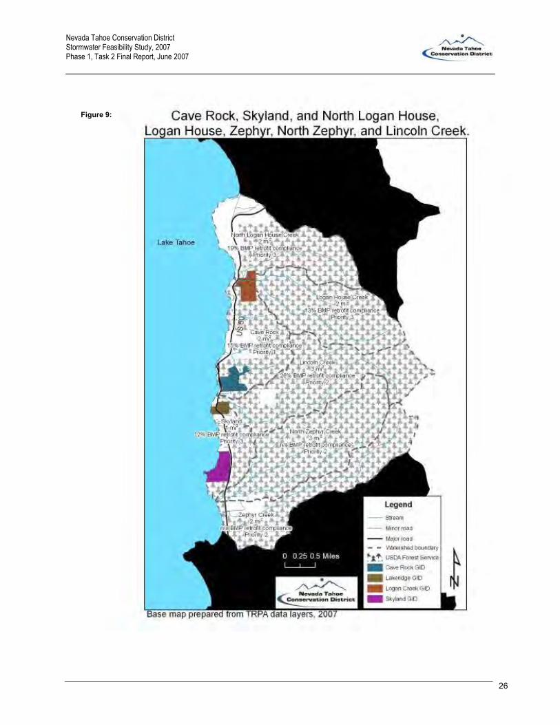
creek, but represent diffuse flow directly to the lake. Figures 6 through 14 (pgs. 23 – 31) show Nevada
Tahoe by groups of sub-watersheds with GID, county, city, and USFS boundaries delineated. The figures
show that 1) GID boundaries do not correspond to sub-watershed boundaries, 2) GIDs overlap with forest
service land (and other property areas), and 3) water from one GID may drain into another GID. The figures
illustrate how extensive (69% of the area) USFS-owned land is throughout the basin. Finally, the figures
provide an approximate percent compliance with EIP 16 and the priority of the sub-watershed with regard to
EIP 16 (see Chapter 3).

Nevada Tahoe Conservation District Stormwater Feasibility Study, 2007 Phase 1, Task 2 Final Report, June 2007
22
Another aspect of the Tahoe basin jurisdictional complexity is that NDOT-maintained roads run near or
through all communities and sub-watersheds. NDOT right of ways in the Tahoe basin generally extend to
the back of the sidewalk in urban areas and 10 ft beyond the fill slope in rural areas. In general, NDOT’s
priorities for control of water through their area of responsibility is safety of motor vehicles and to transmit
that stormwater to down-gradient property with a reasonable flow and water quality. NDOT’s goal is to have
water either pass under their facilities, or if it enters the roadway, to leave cleaner than it entered. See the
NDOT drainage manual plan for more details (www.nevadadot.com/reports_pubs/ Drainage_Manual).

Nevada Tahoe Conservation District Stormwater Feasibility Study, 2007 Phase 1, Task 2 Final Report, June 2007
23
Figure 6:
Nevada Tahoe Conservation District Stormwater Feasibility Study, 2007 Phase 1, Task 2 Final Report, June 2007
24
Figure 7:
Nevada Tahoe Conservation District Stormwater Feasibility Study, 2007 Phase 1, Task 2 Final Report, June 2007
25
Figure 8:
Nevada Tahoe Conservation District Stormwater Feasibility Study, 2007 Phase 1, Task 2 Final Report, June 2007
26
Figure 9:

Nevada Tahoe Conservation District Stormwater Feasibility Study, 2007 Phase 1, Task 2 Final Report, June 2007
27
Figure 10:

Nevada Tahoe Conservation District Stormwater Feasibility Study, 2007 Phase 1, Task 2 Final Report, June 2007
28
Figure 11:

Nevada Tahoe Conservation District Stormwater Feasibility Study, 2007 Phase 1, Task 2 Final Report, June 2007
29
Figure 12:

Nevada Tahoe Conservation District Stormwater Feasibility Study, 2007 Phase 1, Task 2 Final Report, June 2007
30
Figure 13:

Nevada Tahoe Conservation District Stormwater Feasibility Study, 2007 Phase 1, Task 2 Final Report, June 2007
31
Figure 14:
Nevada Tahoe Conservation District Stormwater Feasibility Study, 2007 Phase 1, Task 2 Final Report, June 2007
32
CHAPTER 3 -- Private Residential Best Management Practices Retrofit Program
Task 2.5b in the workplan inventory addresses privately installed stormwater systems under the best
management practices (BMP) Retrofit Program (EIP # 16), summarizes the level of compliance, and
summarizes how the community has complied with Tahoe Regional Planning Agency (TRPA) Ordinance 25.
It also will identify the maintenance requirements associated with these systems.
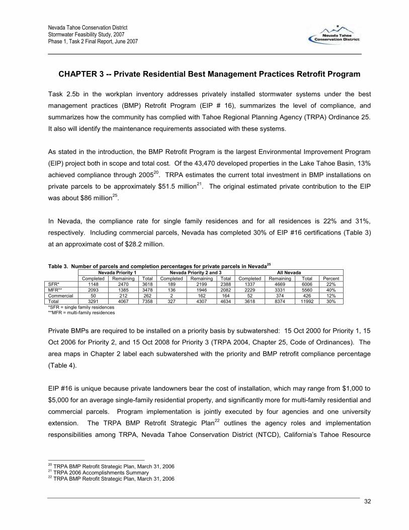
As stated in the introduction, the BMP Retrofit Program is the largest Environmental Improvement Program
(EIP) project both in scope and total cost. Of the 43,470 developed properties in the Lake Tahoe Basin, 13%
achieved compliance through 200520. TRPA estimates the current total investment in BMP installations on
private parcels to be approximately $51.5 million21. The original estimated private contribution to the EIP
was about $86 million25.
In Nevada, the compliance rate for single family residences and for all residences is 22% and 31%,
respectively. Including commercial parcels, Nevada has completed 30% of EIP #16 certifications (Table 3)
at an approximate cost of $28.2 million.
Table 3. Number of parcels and completion percentages for private parcels in Nevada25 Nevada Priority 1 Nevada Priority 2 and 3 All Nevada Completed Remaining Total Completed Remaining Total Completed Remaining Total Percent SFR* 1148 2470 3618 189 2199 2388 1337 4669 6006 22% MFR** 2093 1385 3478 136 1946 2082 2229 3331 5560 40% Commercial 50 212 262 2 162 164 52 374 426 12% Total 3291 4067 7358 327 4307 4634 3618 8374 11992 30% *SFR = single family residences **MFR = multi-family residences
Private BMPs are required to be installed on a priority basis by subwatershed: 15 Oct 2000 for Priority 1, 15
Oct 2006 for Priority 2, and 15 Oct 2008 for Priority 3 (TRPA 2004, Chapter 25, Code of Ordinances). The
area maps in Chapter 2 label each subwatershed with the priority and BMP retrofit compliance percentage
(Table 4).
EIP #16 is unique because private landowners bear the cost of installation, which may range from $1,000 to
$5,000 for an average single-family residential property, and significantly more for multi-family residential and
commercial parcels. Program implementation is jointly executed by four agencies and one university
extension. The TRPA BMP Retrofit Strategic Plan22 outlines the agency roles and implementation
responsibilities among TRPA, Nevada Tahoe Conservation District (NTCD), California’s Tahoe Resource
20 TRPA BMP Retrofit Strategic Plan, March 31, 2006 21 TRPA 2006 Accomplishments Summary 22 TRPA BMP Retrofit Strategic Plan, March 31, 2006
Figure:
Nevada Tahoe Conservation District Stormwater Feasibility Study, 2007 Phase 1, Task 2 Final Report, June 2007
33
Conservation District and USDA-Natural Resources Conservation Service. The University of Nevada
Cooperative Extension assists with education and outreach activities related to the Program.
Table 4. Disaggregated percent compliance for each subwatershed.
Subwatershed Priority Watershed
BMP Certificates23 Approximate Number of Parcels
Approximate Percent
Compliance Wood 1 770 1699 45% Incline 1 766 1851 41% Third 1 657 1739 38% Mill 1 258 674 38%
Second 1 295 872 34% First 1 28 91 31%
East Stateline 1 157 658 24% McFaul 1 139 719 19%
Cave Rock 1 32 215 15% Marlette 1 0 0 n/a
Deadman Point 2 5 4 100% Slaughterhouse 2 5 16 31%
Lincoln 2 7 27 26% Tunnel 2 5 65 8%
Zephyr Creek 2 0 3 0% Bonpland 2 0 0 n/a
Sand Harbor 2 0 0 n/a Secret Harbor 2 0 0 n/a
Bliss 2 0 0 n/a North Zephyr 2 0 0 n/a
Glenbrook 3 61 169 36% Burnt Cedar 3 307 939 33%
Burke 3 334 1476 23% North Logan House 3 16 83 19%
Logan House 3 2 15 13% Skyland 3 51 428 12%
Edgewood 3 85 1811 5% Total 3980 13554 29%
Basin-wide implementation of BMPs on developed private parcels is widely recognized as a major strategy to
reverse the decline in Lake Tahoe’s clarity. The BMP Retrofit aims to capture or control pollutants at their
source, and to reduce stormwater runoff volumes high in the watersheds before they reach downstream
capital improvement projects or local streams that convey runoff to the Lake. Coordination with local
jurisdiction’s public works projects is critical to the success of the overall goal. The effectiveness of local
jurisdiction EIP projects becomes fully viable within specific watersheds and neighborhoods when private
property owners participate in controlling erosion and stormwater runoff by retrofitting their properties with
BMPs.
23 Personal communication, TRPA staff, TRPA, March 2007

Nevada Tahoe Conservation District Stormwater Feasibility Study, 2007 Phase 1, Task 2 Final Report, June 2007
34
BMP retrofit aims to capture or control pollutants at the source and to reduce stormwater runoff volumes
high in the watersheds before they reach the lake by integrating several principles of infiltration and source
control. There are various types of BMPs which serve to accomplish this goal and are designed for site-
specific situations 24.
BMPs have a variety of functions that intend to:
- maximize stormwater infiltration on-site;
- slow down runoff;
- collect and convey runoff;
- provide runoff retention; and
- minimize maintenance.
BMPs (Appendix 7) are critical to the success of source control and are designed to be installed at
locations that maximize infiltration and minimize erosion by reducing the impact of concentrated flows
coming from impervious surfaces:
- under roof drip lines;
- under gutter downspouts;
- under open elevated structures;
- adjacent to parking areas; and
- at the end of conveyance structures.
BMPs promote infiltration by making use of existing conditions on the property and/or utilizing a media
that will enhance the ability of the soil to infiltrate. BMPs employ a variety of infiltration techniques that:
- spread runoff across vegetated and mulched areas on the property;
- store and infiltrate into prefabricated or drain rock filled infiltration systems;
- infiltrate into an area armored by drain rock; and
- collect runoff in above ground storage systems for infiltration.
Common infiltration systems (Appendix 7) which incorporate these techniques include:
- flat vegetated and mulched areas;
- rock lined and vegetated swales (aka: mini basins, retentions areas);
- drain rock armoring;
- berms;
- planter boxes;
- infiltration trenches; and
24 See www.ntcd.org/bcp_moreinfo.html for BMP Homeowners Guide and pictures.
Nevada Tahoe Conservation District Stormwater Feasibility Study, 2007 Phase 1, Task 2 Final Report, June 2007
35
- infiltration systems (aka: drywells, gravel pits).
BMPs are most effective when infiltrating stormwater with a low concentration of suspended sediment.
Preventing sediment from entering the system will reduce maintenance and ensure proper function of the
BMP. BMPs for controlling the source of the sediment include:
- slope stabilization;
- amendment of bare soil with vegetation and/or mulch; and
- restoration of compacted bare soil areas.
In order to infiltrate stormwater runoff on-site, conveyance structures are utilized to keep the runoff from
leaving the property and entering a public treatment system by directing the flows to an infiltration system
installed on the property. Conveyance structures are also utilized to convey concentrated flows to an
area suitable for infiltration. Common conveyance practices include:
- driveway conveyance systems (slotted channel drain, a/c swale);
- gutter downspouts; and
- subsurface conveyance systems.
Issues and Concerns
BMP effectiveness is driven by three factors: design, construction, and maintenance. Overall effectiveness
is compromised when one or any of these three elements fails or is no longer functioning at optimal levels.
Adding to the complexity is the cost to install, and specifically, the costs associated with the driveway BMP,
which is at times 50% to 70% of the total installation cost.
Design
Aside from site limitations, which inhibit the feasibility to fully implement BMPs on a property, design can be
influenced by two factors: soils and sizing. Through adaptive management, starting with the 2007 field
season, site evaluators will be testing the saturated hydraulic conductivity (Ksat) of the soil at the spot where
an infiltration system will be installed. Previously, although we used the best data available for soil types and
infiltration rates, it was not a completely accurate analysis of the soil adjacent to the roads due to the
compaction that takes place during the grading of the roads. When installing a system close to the right-of-
way, the soil could be compacted and might have characteristics that limit the capability to infiltrate the runoff
as designed. In some cases, costly systems designed to infiltrate the design storm sometimes fail due to an
altered soil characteristic in these areas which differs from the available data at the time of design.
Moreover, proper sizing of the BMP in order to manage the design storm (20 year, 1 hour) depends on the
amount of runoff generated by the impervious surface contributing to the system. Conservation District staff

Nevada Tahoe Conservation District Stormwater Feasibility Study, 2007 Phase 1, Task 2 Final Report, June 2007
36
are trained to recognize all impervious surfaces which contribute to an infiltration system. However, if the
homeowner or contractor miscalculates the area of contributing surfaces, the system may be undersized and
could fail to comply with certification standards. Even with proper design, the system must be installed to the
design specifications, but current final inspection procedures do not require verification of the size of the
installed BMP.
Construction
Proper construction and installation of BMPs depends on two major factors: the location of the BMPs on the
parcel and connectivity between the source and the system. Once a BMP evaluation is approved, the
homeowner or a private contractor often constructs and installs the BMP. Many site constraints inhibit
proper installation due to the size of these systems and the necessary location. Modifications often need to
be implemented during installation to accommodate these site variations. However, there is no inspection
requirement to verify the BMP is installed to specifications and/or modified to a correct size that will meet the
ordinance. All components of the system must have proper connectivity to ensure runoff is captured and
infiltrated within the system. Any obstruction within the system due to improper construction can inhibit the
capability of the system to properly infiltrate the design storm.
Certification Procedure
Final inspections currently consist of surface inspections and above ground conveyance verification. A water
test is performed on driveway conveyance systems to verify connectivity between the conveyance and
infiltration system, but not to determine if the system can infiltrate the design storm. Protocols are currently
being developed, through adaptive management, which will streamline the certification process and provide
guidelines for inspecting third-party installations not designed by a Conservation District. There may be
additional requirements the installer needs to provide in order for a Conservation District to inspect a site.
Maintenance
As designed, residential BMPs are capable of storing and infiltrating the runoff generated from the
impervious surfaces. They also capture and retain much of the sediment transported among the runoff.
However, as they serve their function, the void spaces within these systems fill with sediments and debris,
reducing the capability of the system to store and infiltrate the runoff. Through adaptive management,
measures have been taken to design these systems for reduced maintenance. The addition of pre-treatment
sediment traps at the end of conveyance structures and the use of filter fabric within the system has greatly
reduced the amount of sediment reaching the infiltration system. However, over the lifetime of the system,
some maintenance will be needed to ensure the systems are functioning properly. Routine maintenance will
ensure the systems function properly, but the maintenance tends to be labor intensive and cumbersome to
the homeowner, and therefore often neglected. As of the 2007 field season, all Certificates of Completion
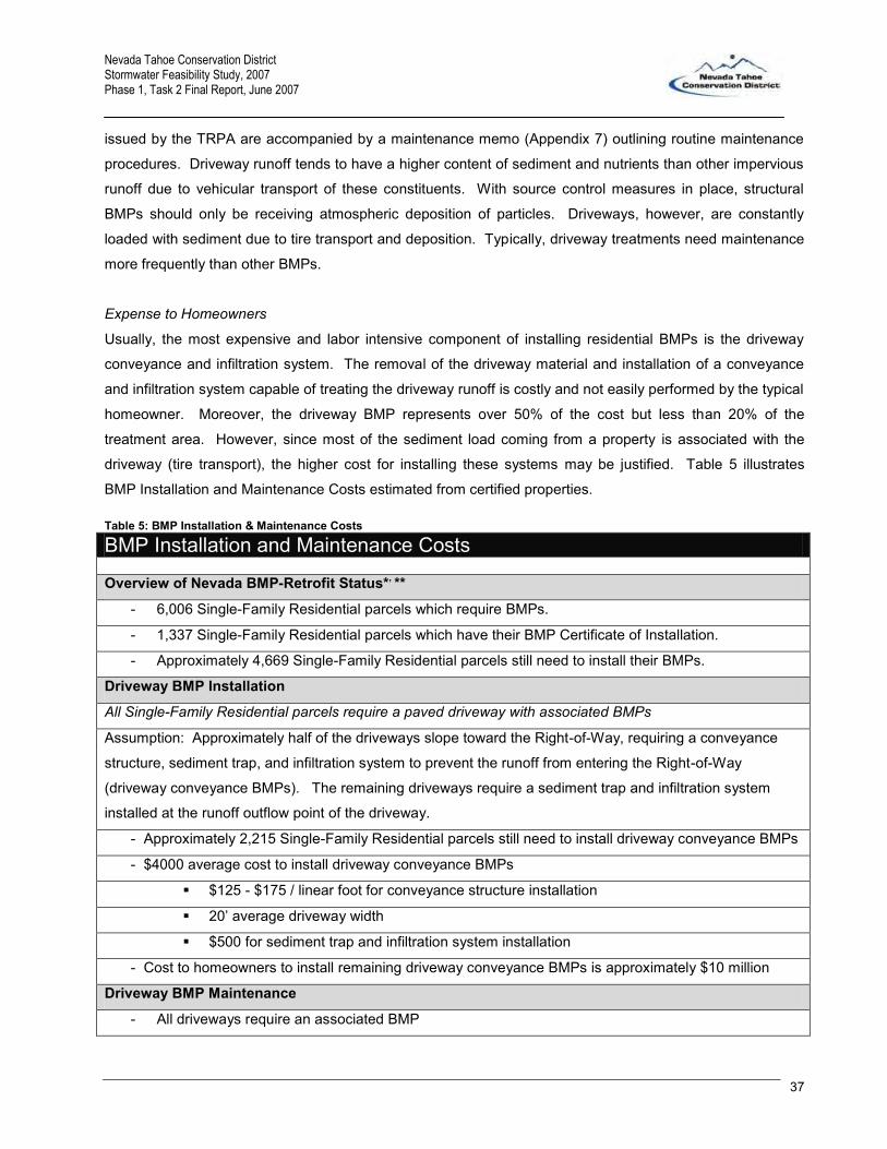
Nevada Tahoe Conservation District Stormwater Feasibility Study, 2007 Phase 1, Task 2 Final Report, June 2007
37
issued by the TRPA are accompanied by a maintenance memo (Appendix 7) outlining routine maintenance
procedures. Driveway runoff tends to have a higher content of sediment and nutrients than other impervious
runoff due to vehicular transport of these constituents. With source control measures in place, structural
BMPs should only be receiving atmospheric deposition of particles. Driveways, however, are constantly
loaded with sediment due to tire transport and deposition. Typically, driveway treatments need maintenance
more frequently than other BMPs.
Expense to Homeowners
Usually, the most expensive and labor intensive component of installing residential BMPs is the driveway
conveyance and infiltration system. The removal of the driveway material and installation of a conveyance
and infiltration system capable of treating the driveway runoff is costly and not easily performed by the typical
homeowner. Moreover, the driveway BMP represents over 50% of the cost but less than 20% of the
treatment area. However, since most of the sediment load coming from a property is associated with the
driveway (tire transport), the higher cost for installing these systems may be justified. Table 5 illustrates
BMP Installation and Maintenance Costs estimated from certified properties. Table 5: BMP Installation & Maintenance Costs
BMP Installation and Maintenance Costs Overview of Nevada BMP-Retrofit Status*, **
- 6,006 Single-Family Residential parcels which require BMPs.
- 1,337 Single-Family Residential parcels which have their BMP Certificate of Installation.
- Approximately 4,669 Single-Family Residential parcels still need to install their BMPs.
Driveway BMP Installation
All Single-Family Residential parcels require a paved driveway with associated BMPs
Assumption: Approximately half of the driveways slope toward the Right-of-Way, requiring a conveyance
structure, sediment trap, and infiltration system to prevent the runoff from entering the Right-of-Way
(driveway conveyance BMPs). The remaining driveways require a sediment trap and infiltration system
installed at the runoff outflow point of the driveway.
- Approximately 2,215 Single-Family Residential parcels still need to install driveway conveyance BMPs
- $4000 average cost to install driveway conveyance BMPs
$125 - $175 / linear foot for conveyance structure installation
20’ average driveway width
$500 for sediment trap and infiltration system installation
- Cost to homeowners to install remaining driveway conveyance BMPs is approximately $10 million
Driveway BMP Maintenance
- All driveways require an associated BMP

Nevada Tahoe Conservation District Stormwater Feasibility Study, 2007 Phase 1, Task 2 Final Report, June 2007
38
- BMPs must be regularly maintained in order to function properly
- Most common driveway BMP is a prefabricated or drain rock infiltration system
Assumption: 90% of driveway BMPs utilize this type of infiltration system which requires
annual maintenance
Average cost to hire contractor: $80/hr
Average time to maintain driveway BMPs: 1- 2 hours
Average annual cost to homeowners to maintain BMPs: $120
- Cost to homeowners to maintain driveway BMPs is approximately $650 thousand
* Figures reflect Single Family Residences in Nevada only. Figures do not include multi-family and commercial parcels. ** EIP 16 Strategic Plan, 2006 – 2008

Nevada Tahoe Conservation District Stormwater Feasibility Study, 2007 Phase 1, Task 2 Final Report, June 2007
39
CHAPTER 4 -- Capital Improvement Projects and Public BMPs
As outlined in Chapter 2, Tahoe Regional Planning Agency’s (TRPA’s) Regional Plan established the
Environmental Improvement Program (EIP) to attain, maintain, or surpass the environmental thresholds
through a variety of projects which impact areas such as the public health and safety of residents and visitors
as well as the scenic, recreational, educational, scientific, and natural values of the Lake Tahoe Basin
(http://www.trpa.org/documents/ docdwnlds/EIP/volume2.pdf). Chapters 25 and 31 of the TRPA Code of
Ordinances contain the regulatory language for BMPs and the EIP, respectively.
Tasks 2.5a, 2.6 and 2.8 of the stormwater utility workplan require the inventory of existing public works
stormwater systems, identification of recommended operations and maintenance (O&M) for these BMPs,
and a summary of the current cost and level of O&M for best management practices (BMPs) funded by the
Nevada Division of State Lands (NDSL).
Background: Construction of water quality BMPs is the primary method by which municipalities control the
adverse impacts on water quality and quantity of development and redevelopment. BMPs are defined as a
schedule of activities, prohibition of practices, maintenance procedures, and structural and/or managerial
practices, that when used singly or in combination, prevent or reduce the release of pollutants and other
adverse impacts to natural waters. Three general types of BMPs are source control, treatment, and flow
control. The primary purpose of using BMPs is to protect beneficial uses of water resources through the
reduction of pollutant loads and concentrations, and through reduction of discharges (volumetric flow rates)
causing stream channel erosion.
Maintenance is an important component of stormwater BMP effectiveness and longevity. However,
stormwater agencies around the United States report that stormwater systems are typically not operated and
maintained properly. For example, Maryland’s stormwater program has conducted a series of surveys on
the maintenance of stormwater practices and generated a report25 with the following conclusions:
Stormwater management facilities in Maryland, especially dry detention facilities, are not
particularly well maintained. In fact, a majority of facilities have failed due to a lack of routine
maintenance;
Public facilities are better maintained than private facilities;
25 Santa Clara Valley, January 2003, Draft Guidance for BMP Operation and Maintenance Verification Programs (http://www.scvurppp-w2k.com/pdfs/2003workshop/O_M_Agree_Memo_final.pdf) which references: State of Maryland, 1987, Maintenance of Stormwater Management Structures, a Departmental Summary (http://www.mde.state.md.us/Programs/WaterPrograms/SedimentandStormwater/publicationsList/index.asp)

Nevada Tahoe Conservation District Stormwater Feasibility Study, 2007 Phase 1, Task 2 Final Report, June 2007
40
Commercial/industrial facilities are more likely than residential facilities to be aesthetically
satisfactory;
Based on criteria set by the State of Maryland regarding satisfactory O&M, forty-five percent of
commercial/industrial facilities were completely satisfactory (for O&M) compared to twenty-four
percent of residential facilities. O&M is more likely to occur when very clear ownership exists (e.g.,
commercial/industrial facilities). O&M was less satisfactory for residential developments, where a
Homeowners Association or the developer is responsible;
Commercial/industrial facility owners are more concerned about their image, including the
appearance of their grounds, than residential facility owners. This is especially true if the
residential facility owner is the developer.
BMP Inventory: In 2005, NTCD led a combined NV/CA team to assemble an inventory of all water quality
and erosion control projects funded by the public and create a database of the projects and associated BMP
quantities. This effort, known as the 2005 BMP Inventory, also created a tool that depicts the general area of
each project on a geospatial map and dynamically linked the map to the BMP inventory database (see
www.ntcd.org/prog_water2.html). The inventory is currently being updated by NTCD primarily by
interviewing organizations associated with funding, managing, and maintaining public BMP systems
(Appendix 8). The update has added 33 Nevada projects to the 35 Nevada projects already inventoried in
the 2005 effort. When looking at the inventory, please note that the quality, accuracy, and completeness of
the data for each project varies and the inventory lacks an assessment of how the projects overlap
physically, hydrologically, and programmatically. For example, an old project may have some aspects
changed or replaced by more recent projects, or the effluent of a new project may flow into an older system
downstream.
A subsequent effort to the 2007 BMP Inventory seeks to display the computer design drawings of the
individual BMPs on a geospatial map. That effort is dependent on availability of design drawings and the
accuracy of the spatial reference. It is recognized that an inventory of systems currently in the ground using
the Global Positioning System will eventually be required to completely inventory and locate all structures
that may require maintenance by a stormwater utility.
Summary of the BMP inventory: For Nevada, a total of 68 public BMP projects were identified, 43 of these
projects were completed after 1998 (i.e., after water quality standards for BMPs were adopted and after the
EIP program was started). In general, projects concerning Stream Environment Zones (SEZ) restorations,
projects on private property, and projects installed as part of a larger effort (e.g., construction of a new
subdivision) were not included in the BMP inventory. Seven projects lack funding information, but the total
cost for the other 61 projects was $83.7M (not current dollar value). Two projects lack BMP quantity
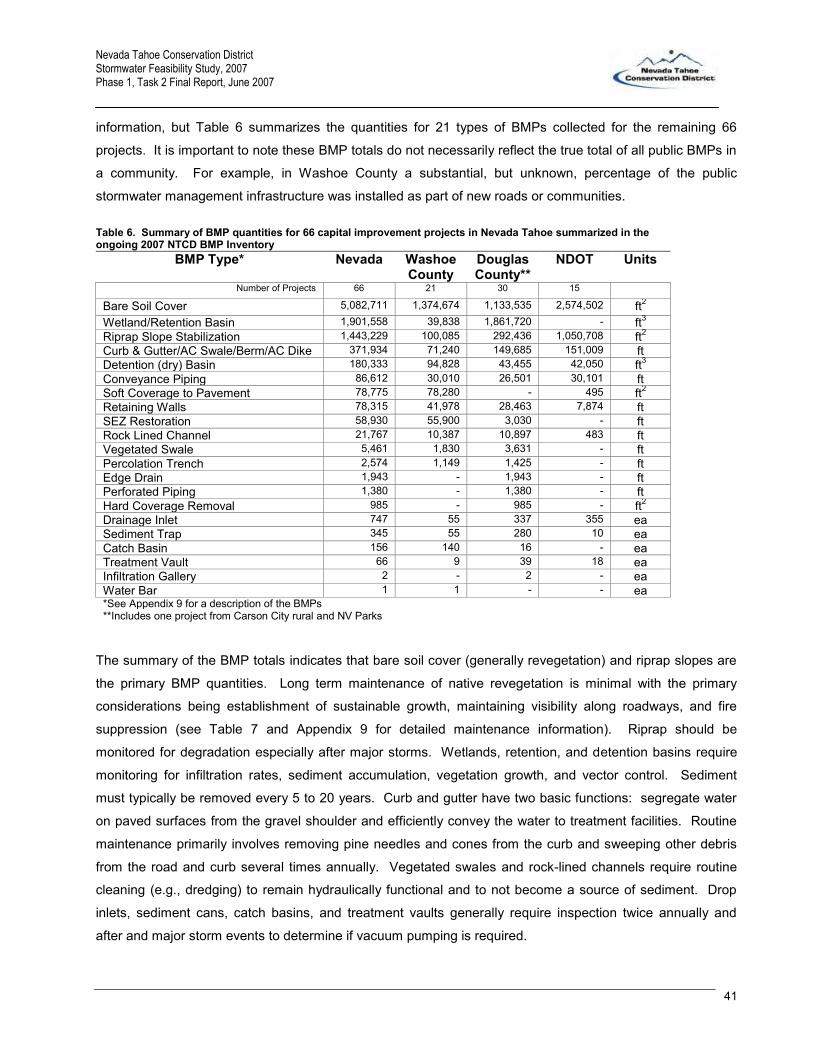
Nevada Tahoe Conservation District Stormwater Feasibility Study, 2007 Phase 1, Task 2 Final Report, June 2007
41
information, but Table 6 summarizes the quantities for 21 types of BMPs collected for the remaining 66
projects. It is important to note these BMP totals do not necessarily reflect the true total of all public BMPs in
a community. For example, in Washoe County a substantial, but unknown, percentage of the public
stormwater management infrastructure was installed as part of new roads or communities.
Table 6. Summary of BMP quantities for 66 capital improvement projects in Nevada Tahoe summarized in the ongoing 2007 NTCD BMP Inventory
BMP Type* Nevada Washoe County
Douglas County**
NDOT Units
Number of Projects 66 21 30 15 Bare Soil Cover 5,082,711 1,374,674 1,133,535 2,574,502 ft2 Wetland/Retention Basin 1,901,558 39,838 1,861,720 - ft3 Riprap Slope Stabilization 1,443,229 100,085 292,436 1,050,708 ft2 Curb & Gutter/AC Swale/Berm/AC Dike 371,934 71,240 149,685 151,009 ft Detention (dry) Basin 180,333 94,828 43,455 42,050 ft3 Conveyance Piping 86,612 30,010 26,501 30,101 ft Soft Coverage to Pavement 78,775 78,280 - 495 ft2 Retaining Walls 78,315 41,978 28,463 7,874 ft SEZ Restoration 58,930 55,900 3,030 - ft Rock Lined Channel 21,767 10,387 10,897 483 ft Vegetated Swale 5,461 1,830 3,631 - ft Percolation Trench 2,574 1,149 1,425 - ft Edge Drain 1,943 - 1,943 - ft Perforated Piping 1,380 - 1,380 - ft Hard Coverage Removal 985 - 985 - ft2 Drainage Inlet 747 55 337 355 ea Sediment Trap 345 55 280 10 ea Catch Basin 156 140 16 - ea Treatment Vault 66 9 39 18 ea Infiltration Gallery 2 - 2 - ea Water Bar 1 1 - - ea *See Appendix 9 for a description of the BMPs **Includes one project from Carson City rural and NV Parks
The summary of the BMP totals indicates that bare soil cover (generally revegetation) and riprap slopes are
the primary BMP quantities. Long term maintenance of native revegetation is minimal with the primary
considerations being establishment of sustainable growth, maintaining visibility along roadways, and fire
suppression (see Table 7 and Appendix 9 for detailed maintenance information). Riprap should be
monitored for degradation especially after major storms. Wetlands, retention, and detention basins require
monitoring for infiltration rates, sediment accumulation, vegetation growth, and vector control. Sediment
must typically be removed every 5 to 20 years. Curb and gutter have two basic functions: segregate water
on paved surfaces from the gravel shoulder and efficiently convey the water to treatment facilities. Routine
maintenance primarily involves removing pine needles and cones from the curb and sweeping other debris
from the road and curb several times annually. Vegetated swales and rock-lined channels require routine
cleaning (e.g., dredging) to remain hydraulically functional and to not become a source of sediment. Drop
inlets, sediment cans, catch basins, and treatment vaults generally require inspection twice annually and
after and major storm events to determine if vacuum pumping is required.

Nevada Tahoe Conservation District Stormwater Feasibility Study, 2007 Phase 1, Task 2 Final Report, June 2007
42
Stormwater Utility Operation and Maintenance Programs The expense of maintaining most stormwater systems is relatively small compared to original construction
costs. However, in the process of funding the EIP projects state funders stipulate the project owner (i.e., the
project proponent) operate and maintain the system for 20 years (NDEP 319 funding requires maintenance
for the “useful life” of the BMP). However, in general, no maintenance plan is required and thus the
understanding of cost and complexity of maintenance may not be fully appreciated by the project proponent.
Some municipalities have addressed the maintenance and performance issue with a robust program and
processes. For example, the elements of a stormwater BMP O&M verification program are well articulated
by the Santa Clara Valley Stormwater Utility26 and include:
• Stormwater operation and maintenance ordinance
• Performance bonds
• Inspection and maintenance agreements and arrangements
• Maintenance easement agreements
• Construction inspection checklists
• Maintenance inspection checklists
• BMP performance criteria and design guidance
• BMP maintenance educational materials
• BMP performance monitoring
• BMP tracking systems
• Tracking systems with poor bmp maintenance and performance
• Maintenance plans
• Maintenance unit costs
• Maintenance notifications and reminders
• Component for follow up on poor maintenance and performance
• Pollution prevention compliance
• As-built certification
• Maintenance of proprietary products
A common/major aspect of any BMP maintenance program is the establishment of inspection standards. To
ensure long-term O&M of stormwater treatment BMPs, it is necessary to include the following elements into
municipal inspection programs:
26 Santa Clara Valley O&M Guidance, 2004

Nevada Tahoe Conservation District Stormwater Feasibility Study, 2007 Phase 1, Task 2 Final Report, June 2007
43
1. Maintain information regarding BMPs. Without an understanding of when a component of a water quality
and erosion control system was installed, where it is, maintenance standards, inspection and maintenance
history, and other meta data, municipalities cannot optimize system performance and reduce operating
costs.
2. Establish inspection priorities. Maintenance issues can not be identified if systems are not inspected by
trained personnel, but it is generally unrealistic to inspect every BMP multiple times annually. A subset of
prioritized stormwater treatment systems may be selected for a detailed inspection and have performance
indicators measured to gage systemic problems or focused maintenance efforts. Selection of targeted
inspections may be based on any of the following criteria:
• Likelihood that failure would result in high repair and/or replacement costs;
• Frequency of maintenance needed for proper performance and operation;
• Age of the BMP and resulting decline in operational effectiveness;
• Located in areas with ongoing construction activities (i.e., increased sediment loading);
• Systems maintained by non-public entities within the jurisdiction of a stormwater utility;
• Complaints and/or history of poor performance;
• Likelihood of creating habitats favorable for vector production (e.g., mosquitoes);
• Potential to support endangered species populations; and,
• Potential to support invasive species.
BMP inspection standards are schedules and sets of procedures intended to trigger maintenance
activities for each BMP. For example, inspections of detention basins include measuring sediment
accumulation so that a standard maintenance activity (e.g., dredging and/or harvesting vegetation) can be
anticipated and planned. Inspection results are documented and tracked to determine the effectiveness of
maintenance activities and project future maintenance activities.
3. Establish inspection frequencies. BMPs that treat large runoff volumes will accumulate greater pollutant
load over time. Inspection frequencies should also account for impacts from large storm events.
Similarly, stormwater treatment system BMPs that are in land use areas suspected of generating high
concentrations of pollutants (e.g., sediments, oil and grease) should be inspected more frequently to
ensure proper operation. The type and total number of BMPs inspected each year also depends on the
cost of follow-up activities (e.g., the response required to address improperly maintained BMPs) and the
availability of resources to conduct inspections. The following factors are considered when determining
appropriate inspection frequencies:
• Type of BMP;
• Local climate and precipitation;

Nevada Tahoe Conservation District Stormwater Feasibility Study, 2007 Phase 1, Task 2 Final Report, June 2007
44
• Land use type;
• Level of effort required for inspection, and;
• Historic maintenance record.
4. Provide Staff Training. To ensure proper facility inspection and maintenance of stormwater treatment
BMPs, a stormwater utility must hire qualified individuals throughout the organization and provide
continuing education/training in their respective areas of expertise to remain abreast of scientific and
technological advances.
5. The four major aspects of a stormwater treatment BMP inspection procedure include:
a) Notify the local government of inspection. Typically a notification of inspection letter is provided to
inform local government officials that scheduled maintenance will occur and what to expect;
b) Pre-inspection preparation. The stormwater utility inspector reviews background information such
as: site plans/as-built drawings; previous inspection results; necessary procedures (e.g.,
underground confined space entry); and inspection and maintenance protocols. Assemble any
necessary tools and equipment.
c) Conduct inspections. Standardized inspection checklists are used to document each BMP
inspection. At a minimum, inspection checklists should:
Contain specific parameters to reduce subjectivity;
Link problems with specific actions;
Track maintenance activities for BMPs over time; and
Integrate well into a relational database.
d) Maintenance notification. Following the inspection, a report is generated that includes a list of
repairs or maintenance that may be required to bring the facility into compliance and when to
schedule this activity. The report may include assessment of BMP performance (as a result of
subjective or objective analysis). If no maintenance is required, the next inspection date is
suggested.
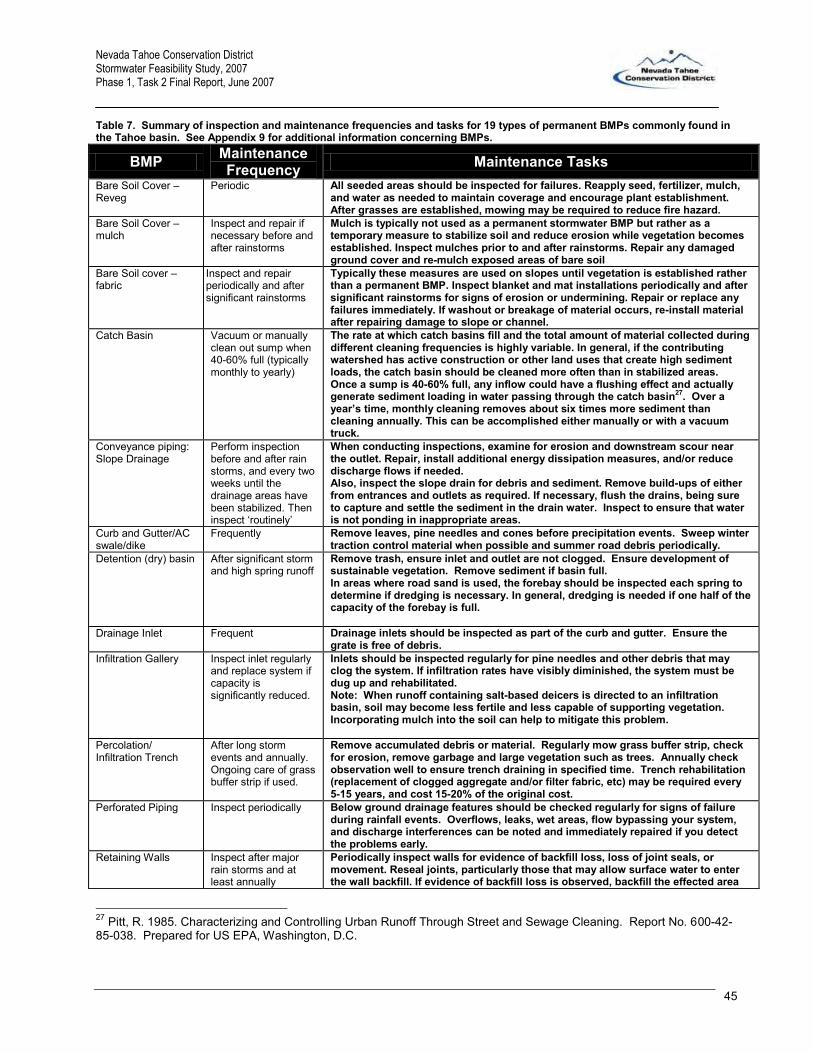
Nevada Tahoe Conservation District Stormwater Feasibility Study, 2007 Phase 1, Task 2 Final Report, June 2007
45
Table 7. Summary of inspection and maintenance frequencies and tasks for 19 types of permanent BMPs commonly found in the Tahoe basin. See Appendix 9 for additional information concerning BMPs.
BMP Maintenance Frequency Maintenance Tasks
Bare Soil Cover – Reveg
Periodic All seeded areas should be inspected for failures. Reapply seed, fertilizer, mulch, and water as needed to maintain coverage and encourage plant establishment. After grasses are established, mowing may be required to reduce fire hazard.
Bare Soil Cover – mulch
Inspect and repair if necessary before and after rainstorms
Mulch is typically not used as a permanent stormwater BMP but rather as a temporary measure to stabilize soil and reduce erosion while vegetation becomes established. Inspect mulches prior to and after rainstorms. Repair any damaged ground cover and re-mulch exposed areas of bare soil
Bare Soil cover – fabric
Inspect and repair periodically and after significant rainstorms
Typically these measures are used on slopes until vegetation is established rather than a permanent BMP. Inspect blanket and mat installations periodically and after significant rainstorms for signs of erosion or undermining. Repair or replace any failures immediately. If washout or breakage of material occurs, re-install material after repairing damage to slope or channel.
Catch Basin Vacuum or manually clean out sump when 40-60% full (typically monthly to yearly)
The rate at which catch basins fill and the total amount of material collected during different cleaning frequencies is highly variable. In general, if the contributing watershed has active construction or other land uses that create high sediment loads, the catch basin should be cleaned more often than in stabilized areas. Once a sump is 40-60% full, any inflow could have a flushing effect and actually generate sediment loading in water passing through the catch basin27. Over a year’s time, monthly cleaning removes about six times more sediment than cleaning annually. This can be accomplished either manually or with a vacuum truck.
Conveyance piping: Slope Drainage
Perform inspection before and after rain storms, and every two weeks until the drainage areas have been stabilized. Then inspect ‘routinely’
When conducting inspections, examine for erosion and downstream scour near the outlet. Repair, install additional energy dissipation measures, and/or reduce discharge flows if needed. Also, inspect the slope drain for debris and sediment. Remove build-ups of either from entrances and outlets as required. If necessary, flush the drains, being sure to capture and settle the sediment in the drain water. Inspect to ensure that water is not ponding in inappropriate areas.
Curb and Gutter/AC swale/dike
Frequently Remove leaves, pine needles and cones before precipitation events. Sweep winter traction control material when possible and summer road debris periodically.
Detention (dry) basin After significant storm and high spring runoff
Remove trash, ensure inlet and outlet are not clogged. Ensure development of sustainable vegetation. Remove sediment if basin full. In areas where road sand is used, the forebay should be inspected each spring to determine if dredging is necessary. In general, dredging is needed if one half of the capacity of the forebay is full.
Drainage Inlet Frequent Drainage inlets should be inspected as part of the curb and gutter. Ensure the grate is free of debris.
Infiltration Gallery Inspect inlet regularly and replace system if capacity is significantly reduced.
Inlets should be inspected regularly for pine needles and other debris that may clog the system. If infiltration rates have visibly diminished, the system must be dug up and rehabilitated. Note: When runoff containing salt-based deicers is directed to an infiltration basin, soil may become less fertile and less capable of supporting vegetation. Incorporating mulch into the soil can help to mitigate this problem.
Percolation/ Infiltration Trench
After long storm events and annually. Ongoing care of grass buffer strip if used.
Remove accumulated debris or material. Regularly mow grass buffer strip, check for erosion, remove garbage and large vegetation such as trees. Annually check observation well to ensure trench draining in specified time. Trench rehabilitation (replacement of clogged aggregate and/or filter fabric, etc) may be required every 5-15 years, and cost 15-20% of the original cost.
Perforated Piping Inspect periodically Below ground drainage features should be checked regularly for signs of failure during rainfall events. Overflows, leaks, wet areas, flow bypassing your system, and discharge interferences can be noted and immediately repaired if you detect the problems early.
Retaining Walls Inspect after major rain storms and at least annually
Periodically inspect walls for evidence of backfill loss, loss of joint seals, or movement. Reseal joints, particularly those that may allow surface water to enter the wall backfill. If evidence of backfill loss is observed, backfill the effected area
27 Pitt, R. 1985. Characterizing and Controlling Urban Runoff Through Street and Sewage Cleaning. Report No. 600-42-85-038. Prepared for US EPA, Washington, D.C.

Nevada Tahoe Conservation District Stormwater Feasibility Study, 2007 Phase 1, Task 2 Final Report, June 2007
46
with select fill if the area is accessible, or use flowable fill if access is restricted. Water infiltration into voids in walls can cause excessive pressures within the wall and result in displaced panels and wall failures. Treat voided areas when they are small and manageable, as they will always increase in size with time. Check top, wall attachments and facing for evidence of movement or deterioration.
Riprap Slope Stabilization
Spring, fall, and after severe storms
Little maintenance is required when rock riprap is installed properly. Periodic inspections should be made and any dislodged rocks replaced as required. Inspect the slopes in the spring, in the fall, and after severe storms for slumping, sliding, or seepage problems. Correct any problems immediately. Severe slumping or sliding may indicate that the slope is failing due to forces other than wave impact. Make a careful inspection of the land to the side of the riprap area. Near the riprap edge, erosion may be accelerated. If this is the case, additional measures may be necessary to halt the erosion.
Rock Lined Channel Annually or after major storms
When stones have been displaced, remove any debris and replace the stones in such a way as to not restrict the flow of water. Give special attention to outlets and points where concentrated flow enters the channel, and repair eroded areas promptly. Check for sediment accumulation, blockage, piping, breaks, bank instability, and scour holes; repair immediately. Remove significant debris and sediment from the channel to maintain design cross section and grade and to prevent spot erosion.
Sediment Trap Seasonally and after major storms
Maintenance is similar to “catch basins”
SEZ Restoration Annually and after major storms
Flow of sediment from upland sources and/or stream bank failure can significantly alter the hydraulics and performance of the streams. Inspection of restored streams should be done at least annually and after major rain or melt events. The keys to maintaining SEZs are as follows: 1) The trapping of sediments, 2) Nutrient uptake and storage, 3) Filtering of pollutants, 4) Vegetating to help stabilize stream banks and shorelines, thereby reducing bank and shoreline erosion, 5) Gathering and replanting of seeds, 6) Thinning, pruning and burning of vegetated stands, 7) Minor (seasonal) stream channel alterations, 8) Good stewardship, 9) No new development to naturally functioning SEZ lands, 10) Maintaining natural floodplain storage capacity and incised channels are reconnected with their floodplains, and 11) Management includes the protection, enhancement, restoration of SEZ vegetation, wildlife habitat and aquatic habitat.
Treatment Vault Annually or as required
Vaults are vacuumed as required which in most cases is annually, but could be monthly in areas with significant source load.
Vegetated Swale Inspect at least twice annually
Detailed inspections shall be conducted at least twice annually with inspections occurring (1) at the end of the wet season to schedule summer maintenance, (2) before major fall runoff in preparation for winter, and (3) after periods of heavy runoff. The objective of detailed inspections is to identify erosion, damage to vegetation, grass or plant height, debris, litter, areas of sediment accumulation, and pools/standing water.
Wetland - constructed
Inspect semi annually and harvest vegetation annually at end of growth season
Remove accumulated sediment in the forebay and re-grade about every 5-7 years or when the accumulated sediment volume exceeds 10 percent of the basin volume. Sediment removal may not be required in the main pool area for as long as 20 years. Schedule semiannual inspections for burrows, sediment accumulation, structural integrity of the outlet, and litter accumulation. Remove accumulated trash and debris in the basin at the middle and end of the wet season. The frequency of this activity may be altered to meet specific site conditions and aesthetic considerations. An annual vegetation harvest in summer appears to be optimum, in that it is after the bird breeding season, mosquito fish can provide the needed control until vegetation reaches late summer density, and there is time for re-growth for runoff treatment purposes before the wet season. In certain cases, more frequent plant harvesting may be required by local vector control agencies.
Maintenance Costs
The expense of maintaining most stormwater systems is relatively small compared to original construction
costs (Table 8). Maintenance costs are a function of many factors including administrative costs, complexity
of and access to the BMPs, frequency and intensity of storm events, concentration of pollutants, and regional
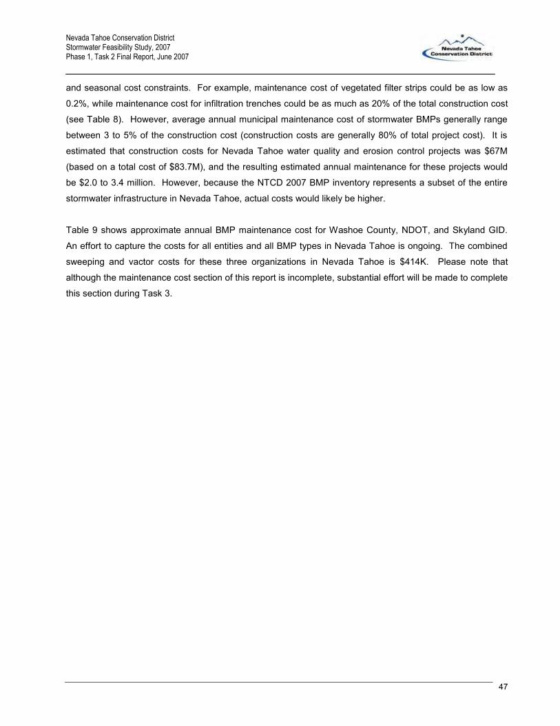
Nevada Tahoe Conservation District Stormwater Feasibility Study, 2007 Phase 1, Task 2 Final Report, June 2007
47
and seasonal cost constraints. For example, maintenance cost of vegetated filter strips could be as low as
0.2%, while maintenance cost for infiltration trenches could be as much as 20% of the total construction cost
(see Table 8). However, average annual municipal maintenance cost of stormwater BMPs generally range
between 3 to 5% of the construction cost (construction costs are generally 80% of total project cost). It is
estimated that construction costs for Nevada Tahoe water quality and erosion control projects was $67M
(based on a total cost of $83.7M), and the resulting estimated annual maintenance for these projects would
be $2.0 to 3.4 million. However, because the NTCD 2007 BMP inventory represents a subset of the entire
stormwater infrastructure in Nevada Tahoe, actual costs would likely be higher.
Table 9 shows approximate annual BMP maintenance cost for Washoe County, NDOT, and Skyland GID.
An effort to capture the costs for all entities and all BMP types in Nevada Tahoe is ongoing. The combined
sweeping and vactor costs for these three organizations in Nevada Tahoe is $414K. Please note that
although the maintenance cost section of this report is incomplete, substantial effort will be made to complete
this section during Task 3.

Nevada Tahoe Conservation District Stormwater Feasibility Study, 2007 Phase 1, Task 2 Final Report, June 2007
48
Tabl
e 8.
App
roxi
mat
e m
aint
enan
ce c
osts
from
var
ious
sou
rces
for d
iffer
ent B
MPs

Nevada Tahoe Conservation District Stormwater Feasibility Study, 2007 Phase 1, Task 2 Final Report, June 2007
49
Table 9 Comparison of maintenance costs for three entities in Nevada Tahoe
Washoe County NDOT Skyland
Number of miles of road (2-lane)* 86 53.7 2.8 Cost of street sweeping $192,441 $54,000 $10,158
cost per mile $2,238 $1,006 $3,628 Number of drop inlets/sediment cans and vaults** 268 573 40 Cost of vactor service in 2006 $15,478 $137,349 $5,845
cost per item $58 $240 $146 *estimated from a TRPA GIS road map **NDOT quantities determined from the BMP inventory. Washoe County and Skyland quantities are the
actual number of items cleaned (Washoe County, 2007) and (Skyland GID, personal communications, 3/26/07)

Nevada Tahoe Conservation District Stormwater Feasibility Study, 2007 Phase 1, Task 2 Final Report, June 2007
50
CHAPTER 5 -- Stormwater Utilities Stormwater utilities (SWUs) have been created by hundreds of municipalities across the country dating back
to the 1970s to focus organizational efforts and associated funding on systems that control, convey, and treat
stormwater. This chapter explores what SWUs are, how they function, why they were created, and how they
are funded.
Tasks 2.7 of the stormwater utility workplan requires a literature review of established stormwater utilities
with an emphasis on those in the local region.
What is a Stormwater Utility? Stormwater utilities are an organizational structure many communities around the country are turning to in
order to administer and fund their stormwater programs. Stormwater utilities have become a necessity in
many communities to pay for their share of stormwater flood control projects, maintenance of stormwater
infrastructure, and to help meet requirements of Total Maximum Daily Load (TMDL) and the National
Pollutant Discharge Elimination System (NPDES) programs.
Stormwater collection and treatment systems are an integral part of all communities. Prior to urban
development, a significant portion of rainwater would primarily infiltrate into the ground and be filtered by the
soil prior to discharge into rivers and lakes. Following urban development, stormwater discharge increased
in volume, peak flow, and pollution content because impervious areas such as roads, parking lots, roofs, and
driveways did not slow runoff or allow water to infiltrate. Pollution from stormwater is called ‘non-point
source’ (NPS) pollution because the pollutants are relatively distributed over developed areas. Fast moving
stormwater often contains excess sediment, nutrients and chemicals from running over land impacted by
vehicles (e.g., oil and antifreeze leaks, and brake and tire wear), fertilizers, herbicides and pesticides, road
sands, cleaners, metals, etc. To avert undesirable water quality and wildlife impacts, urban areas require
conveyance, collection, and treatment systems to promote infiltration and evaporation to mitigate transfer of
suspended or dissolved pollutants, and reduce peak flows before stormwater reaches creeks and rivers.
There are many costs involved in maintaining the system of stormwater conveyance and treatment that a
municipality typically must shoulder. Such costs include planning, design, construction, regular system
maintenance, performance monitoring (see the EPA BMP monitoring web site28), and periodic replacement
or upgrade of components. The need for stormwater conveyance to prevent flooding was realized long ago,
and stormwater conveyance systems were typically installed when communities were built. However,
infrastructure, even when properly maintained, has only a limited operational life, typically less than 20 years, 28 http://www.epa.gov/waterscience/guide/stormwater/monitor.htm

Nevada Tahoe Conservation District Stormwater Feasibility Study, 2007 Phase 1, Task 2 Final Report, June 2007
51
and will require replacement. Inadequate maintenance and/or upstream development will shorten the life
span of stormwater infrastructure.
More recently there has been increased awareness of the impact stormwater can have on the water quality
and aquatic flora and fauna of receiving water body. The federal Clean Water Act (CWA) has two regulatory
aspects that have started to address the concern of NPS pollution from urban stormwater runoff. They are
the TMDL program (triggered by the CWA section 303(d)) and NPDES municipal separate storm sewer
systems (MS4) requirements. These requirements have mandated communities around the nation to install
and maintain increasingly complex stormwater treatment systems and submit and implement stormwater
management programs that address several areas including public outreach/education, construction site
runoff control, illicit discharge elimination, and pollution prevention.
In the past, stormwater systems were often funded by general funds because they were part of flood control
with minimal treatment complexity. However, as the treatment requirements and system complexity
increase, the general fund is not sufficiently robust or dedicated to meet expanding maintenance
requirements, much less, adequately address infrastructure replacement or upgrade or respond to new CWA
requirements. That is, maintenance, monitoring, managing, and upgrading stormwater infrastructure is
largely reactionary without a dedicated staff and funding source. This evolution is similar to wastewater
treatment from the pre-1960s to modern publicly owned treatment work utilities now in place.
Depending on local regulations, stormwater utilities are typically established by either a vote of the city
council or county board of supervisors, or a public vote. The utility determines the funds for necessary
maintenance and programs and makes recommendations for a fee structure which is approved by the city
council or county board of supervisors. The stormwater utility is then in charge of assessing fees, controlling
funds, providing maintenance to the system, meeting all pertinent local, regional, and federal (e.g., Clean
Water Act) regulations, monitoring system performance, and making recommendations for major
infrastructure replacement or upgrades. Funding for capital projects may or may not come out of the
stormwater utility fees, but will often be fully or partially funded by outside loans or grants from local, state or
federal programs. The first stormwater utilities were formed in the early 1970s. By 1994, there were over
100, and by 2004 there were over 500 stormwater utilities across the nation.
Most stormwater utilities get their operating funds from fees paid by those who benefit from the stormwater
systems. These fees are typically included as an additional line item on the water or sewer bill (although
annual fees can be included in property taxes). Usually, fee rates are based upon the area of impervious
surface on a parcel of land. Residential properties are commonly billed at a flat rate or a step rate based on
square footage of the house to avoid measuring the impervious area for each residential parcel. For

Nevada Tahoe Conservation District Stormwater Feasibility Study, 2007 Phase 1, Task 2 Final Report, June 2007
52
example, a typical fee unit could be $3.00 per month for 2,000 square feet of living area and a house with
3,000 square feet would be billed for 1.5 units, or $4.50 per month.
Compliance with the EPA’s NPDES, a driving force in the establishment of many SWUs around the nation, is
not required in Nevada Tahoe because Nevada Tahoe is not designated an urbanized area. Nevertheless,
the driving factors to implement a stormwater utility in Nevada Tahoe are 1) the jurisdictional complexity and
2) the intense regulatory environment (through TRPA ordinances and the anticipated TMDL allocations).
Case Studies Following are brief discussions of some relevant aspects of SWUs around the nation. These discussions are
supplemented by a matrix of SWUs, a list of cities with SWUs, and a reference list of documents for further
research (Appendix 10). Although the basic function of a SWU is consistent, the details of the management
structures, O&M policies, authority, and fee structures can vary significantly.
In Santa Cruz, CA, single family units pay a flat rate of $21.24 per year, and fees for other land parcels are
based on acreage and average runoff of various land use types. The Basic Assessment Unit (BAU) was
based on an average family residential parcel size and a runoff coefficient and equals 0.4114. Other land
uses are charged based on the number of BAUs they have calculated as the parcel size times the runoff
coefficient divided by one BAU. For example, the rate for an acre of vacant land was $5.28/year; while an
acre of commercial land was assessed at $261.09/year. In addition, Santa Cruz imposes separate,
additional stormwater utility fees for those within the 100-year floodplain.
Another more complex fee structure was developed in Issaquah, Washington. Issaquah defined the
equivalent service unit (ESU) to be the average impervious area for single family residences, which was
approximately 2,000 square feet. The fee for one ESU was set as $148/year and is charged as a flat rate to
all residential properties. Other developed properties are charged per ESU on the land, with a minimum
charge of one ESU. Undeveloped land, which is defined as having 1,000 square feet or less of
development, are charged the rate for 1/2 ESU, or $74/year. Open space parcels, conservation parcels,
public facilities, and other types of public benefit land are exempt from charges. Issaquah also gives
discounts for properties that have professionally designed infiltration facilities on site as follows: 50% off if
the system is designed to infiltrate the 100 year storm, 40% off if designed for 50 year storm, and 30% if for
10 year storm.
Particularly relevant to Nevada Tahoe, some autonomous communities have seen the benefits of banding
together to address stormwater system requirements collectively. One such example is in northern Kentucky
(Appendix 11), where a stormwater utility serves 32 cities in 3 counties covering 245 square miles. The 35

Nevada Tahoe Conservation District Stormwater Feasibility Study, 2007 Phase 1, Task 2 Final Report, June 2007
53
governments decided to work together when they determined they could best serve the public by pooling
resources to address the worst problems first, while making the most efficient use of public money by not
duplicating efforts. This SWU determined that the average residential property had 2,600 square feet of
impervious area, and assigned this the “Equivalent Residential Unit”, or ERU. Other properties are billed
based on the number of ERUs on the property, at the rate of $4.02 per ERU per month. The district also
allows non-residential customers to apply for credits of 10 - 80% off their stormwater bill for installing
approved water quantity BMPs. The utility is responsible for meeting all NPDES program requirements,
including public education. They have created a five hour education course aligned with the state’s core
education content for 4th and 5th grade students, and gives stormwater utility fee credits to schools that
participate. The utility has inventoried the entire stormwater system, operates and maintains the system,
conducts master stormwater planning, and creates standard stormwater design and construction rules and
regulations. They conduct plan reviews and inspect construction sites. The utility has a cost share program
with the involved communities, where communities can apply for the utility to pay 50% of cost for stormwater
quantity capital projects, and 90% of the costs for stormwater public safety and water quality capital
improvement projects.
Also, relevant to the Lake Tahoe Basin, is the Lake Champlain Basin Program (LCBP)29 which works in
partnership with government agencies from New York, Vermont, and Quebec, private organizations, local
communities, and individuals to coordinate and fund efforts which benefit the Lake Champlain Basin's water
quality, fisheries, wetlands, wildlife, recreation, and cultural resources. LCBP is working to implement a
phosphorus TDML. As a tool to manage the growing stormwater system and to meet LCBP phosphorus
requirements, the city of South Burlington created a Stormwater Utility30. The utility charges $4.50 monthly
for a single family residence. Apartments and commercial property are charged based on impervious
surface area.
Carson City recently established a stormwater management utility in response to accelerating maintenance
issues, funding shortfalls, and NPDES requirements, with a mission to "acquire, construct, operate maintain,
and regulate the use of stormwater drainage systems and activities to ensure the public safety, protect
private and public properties, and enhance our environment." The utility assesses a monthly fee of $2.93 for
single family residences and significantly more for multi-family and other land use.
Washoe County established a stormwater management utility in the unincorporated Spanish Springs area
north of Reno/Sparks to address stormwater management and flooding issues. The topographically flat,
rapidly growing area has experienced relatively frequent flash flooding which threatened property and public
29 http://www.lcbp.org/OFA-APRIL2003/Final-April03.pdf 30 http://www.south-burlington.com/stormwater/

Nevada Tahoe Conservation District Stormwater Feasibility Study, 2007 Phase 1, Task 2 Final Report, June 2007
54
safety. A fee of $7.34 is assessed monthly for all single family residences and significantly more for multi-
family and commercial land use.

Nevada Tahoe Conservation District Stormwater Feasibility Study, 2007 Phase 1, Task 2 Final Report, June 2007
55
CHAPTER 6 -- Public Sentiment and Perceptions
The purpose of Task 2.9 was to ensure that this feasibility assessment to pool resources pertaining to
stormwater management obtained input from local and state stormwater implementers (also known as the
decision makers) to identify their issues, concerns and needs pertaining to stormwater management. To
achieve this, Nevada Tahoe Conservation District (NTCD) met with General Improvement District (GID),
County, regulatory and funding agencies both singularly (meeting with Washoe County Engineering staff in
Reno and Nevada Department of Transportation (NDOT) staff in Carson City) and through an outreach
meeting held in February, 2006 (the Decision Makers Meeting).
NTCD staff developed a communications plan as a part of Phase I to ensure consistent messaging among
partners and between partners and the public. This plan employs a variety of communications strategies
including but not limited to:
- websites, email and internet-based communications;
- newsletters, articles and contributions to national publications;
- public events, workshops and surveys;
- fact sheets, frequently asked questions (FAQs) (Appendix 12);
- trainings and educational material distribution;
- stakeholder engagement opportunities; and,
- other activities as identified.
The key message emphasized in Phase I of the Does it Make Sense (DIMS) Study is that the NTCD seeks
to promote the protection and restoration of Lake Tahoe by providing leadership, education and technical
assistance. If, upon completion of the Stormwater DIMS Study, it makes sense to pool resources into a
cooperative stormwater entity and it is deemed politically, economically, equitable and scientifically feasible,
NTCD will continue to assist Nevada Lake Tahoe stakeholders and decision-makers in the development of a
cooperative stormwater management district.
Phase II and III will require additional public outreach and education program development, however, not
likely to the extent of a standard National Pollutant Discharge Elimination System (NPDES) permit
requirements. Collaboration and cooperation among and between the different entities of Nevada Lake
Tahoe will however require significant facilitation in the overall implementation of the Stormwater Master Plan
(SWMP).

Nevada Tahoe Conservation District Stormwater Feasibility Study, 2007 Phase 1, Task 2 Final Report, June 2007
56
Decision-maker Meeting On February 2, 2007, NTCD hosted a decision maker local meeting which was attended by 22
representatives from 15 separate Nevada stormwater implementing entities including GIDs, Homeowner
Associations (HOAs), Douglas and Washoe Counties and NDOT (Figure 15). A presentation on the project
was given and input solicited from the decision makers regarding the scope of work, developing a workplan
and overall opportunities for the formation of a stormwater utility district. Through a facilitated discussion,
important recommendations were identified (Table 10).
Figure 15. Photo of Decision Maker meeting, 1 Feb 2007

Nevada Tahoe Conservation District Stormwater Feasibility Study, 2007 Phase 1, Task 2 Final Report, June 2007
57
Table 10. Decision Maker recommendations
Local Implementer Issues Comment A stormwater district would provide for collaboration and working together to collect funds, plan, build, operate and maintain systems, provide professional management, get grants, improve compliance
NTCD to assist with the negotiation of joint powers agreements between the local entities; NTCD to research & identify the different enabling actions and regulations pertinent to this project
A stormwater district would provide an opportunity for sediment control in stream environment zones
With coordinating planning, SEZ restoration can be incorporated into the stormwater master planning process
A stormwater district would provide for a system to collaborate with major contributors and manage stormwater run-off systemically instead of piecemeal
Again, with coordinated planning, stormwater could be managed systemically or ecologically, instead of piecemeal.
A Stormwater Utility District could provide environmental compliance & other benefits through logical, more cost effective methods in a single, local organization
As one entity (through joint-powers agreements) the SWUD could negotiate directly with NPDES permitting agencies (i.e. NDEP & TRPA)
A stormwater district would provide a secure long term funding source for maintenance activities
The monthly fee for impervious coverage could be used to pay for O & M.
A stormwater district would pool and share resources and leverage different finance opportunities
Cost-sharing opportunities include: operational equipment, bulk contracts for snow removal, annual maintenance, etc… and staffing.
A stormwater district would be a part of the effort to protect and restore Lake Tahoe; stewardship opportunities
Accelerating private contribution to the EIP and streamlining EIP O & M
A stormwater district would interface with & influence federal, state, county, local agencies with consistent one voice to prioritize resources
As one entity (through joint-powers agreements) the SWUD could negotiate directly with NPDES permitting agencies (i.e. NDEP & TRPA)
I A stormwater district would integrate road maintenance, snow removal and stormwater management activities between NDOT, the GIDs and the counties
Cost-sharing opportunities include: operational equipment, bulk contracts for snow removal, annual maintenance, etc… and staffing.
A stormwater district could use the existing relationship with our customers for communication, implementation, funding, and maintenance
A coordinated public outreach program aimed at reducing pollution.
A stormwater district would provide stability where now each GID is ever changing and often volunteer-based; this entity would have a professional management shared and have consistent stormwater O & M implementation practices
Cost-sharing opportunities include: operational equipment, bulk contracts for snow removal, annual maintenance, etc… and staffing.
A stormwater district would avoid duplicative efforts Cost-sharing opportunities include: operational equipment, bulk contracts for snow removal, annual maintenance, etc… and staffing.
Grass-roots effort collaborates with local, state and federal regulatory entities; bottom-top flow of leadership and communication
As one entity (through joint-powers agreements) the SWUD could negotiate directly with NPDES permitting agencies (i.e. NDEP & TRPA)
A stormwater district would promote and coordinate on correct snow removal and traction improvement techniques; i.e. Best Practices
Streamlined coordination and cooperation between local communities, Douglas County, TRPA and NDOT.
One entity could be more proactive at educating property owners and communities about local conservation needs
A coordinated public outreach program aimed at reducing pollution.
The participating organizations could learn and share techniques, strategies, ideas
Local stewardship efforts, trainings, joint-power partnerships, school-based education, business community outreach and engagement and education of the large second-homeowner
A stormwater district would have the responsibility of identifying and evaluating performance measures
Streamlined coordination and cooperation between local communities, Douglas County, TRPA and NDOT.
A stormwater district would share monitoring data and effectiveness evaluations of practices and techniques
Streamlined coordination and cooperation between local communities, Douglas County, TRPA and NDOT.
Opportunities for volunteer and/or stewardship activities like those of Incline Village and the Clean Water Team, Citizen Monitoring Program
Local stewardship efforts, trainings, joint-power partnerships, school-based education, business community outreach and engagement and education of the large second-homeowner

Nevada Tahoe Conservation District Stormwater Feasibility Study, 2007 Phase 1, Task 2 Final Report, June 2007
58
CHAPTER 7 -- A Gap Analysis
Introduction The Stormwater Utility Study workplan called for a detailed description of the gap between ideal maintenance
practices and associated costs of stormwater infrastructure and the actual practice and associated costs and
practices in Nevada Tahoe. The analysis was intended to highlight fiscal or performance benefits by
establishing a stormwater utility. This chapter is an attempt to provide that analysis; however, it became
clear that an accurate and complete analysis required an extensive amount of data…most of which was not
available. As a result many assumptions and estimations were required to arrive at a basic gap analysis.
Current Maintenance Practices & Associated Costs An effort was made by NDSL and NTCD to collect annual maintenance cost data for each of the 16
organizations responsible for stormwater maintenance in Nevada Tahoe. Letters were sent to Washoe and
Douglas County in early 2007 with copies provided to the GIDs. NTCD followed up with each organization,
but with the exception of Washoe County and NDOT maintenance cost data was not readily available.
Some qualitative information was collected for all GIDs. For example, the GIDs conduct maintenance
independently of each other. That is, as a rule these organizations do not pool resources or coordinate
maintenance activities. Maintenance efforts range from a full time, paid, and trained staff with state of the art
equipment, to community sweeping events with hand equipment. Also, six EIP stormwater projects were
installed during the summer of 2006, five of which were the first projects in that GID’s jurisdiction and as a
result, those GIDs have not established maintenance routines for those projects. The overarching problem
was the lack of a clear definition of what constitutes operations and maintenance or what it includes. For
example, none of the parties responding addressed inspection and replacement of failing or damaged
infrastructure. In addition, there is some uncertainty as to whether street sweeping is a BMP maintenance
activity, a pollutant source control activity, or an air pollution control activity. In Washoe County, the public
works department indicates that they sweep as part of required air pollution control mandates.
At the end of 2007, maintenance cost data had been collected from six organizations in Nevada Tahoe
(Table 11). As a rule the GIDs that responded, Washoe County, and NDOT vactor their DIs, catch basins,
and treatment vaults only once a year. The staffing, budget, and schedule are based on an annual cleaning
regime. Road sweeping is usually done once, sometimes twice annually for the small GIDs. KGID, NDOT,
and Washoe County sweep major roads as required…generally multiple times annually. It is estimated

Nevada Tahoe Conservation District Stormwater Feasibility Study, 2007 Phase 1, Task 2 Final Report, June 2007
59
these six organizations spend $500,000 annually for sweeping and BMP maintenance. Of that, only $113K is
spent in Douglas County (excluding NDOT). However, it is significant that there had been no historic
tracking of these costs by the Douglas County jurisdictions. Also important, these expenditures do not
include maintenance of infrastructure or other costs necessary to provide a long-term sustainable stormwater
management program for the region.
Table 11: BMP Operations and Maintenance Estimates by Jurisdiction
KGID Round Hill Skyland Zephyr Knolls
County Total/Avg
Annual Cost 192,441$ 38,783$ 41,000$ 2,525$ 10,158$ 2,400$ 56,083$ 287,307$
Number of Miles of Road 86 53.7 21.3 4.7 2.8 0.6 29.4 169.1Number of Times Road Swept Annually
Frequently in Winter
Frequently in Winter
When Possible 1 2 1 1.3
Unit Cost ($ per mile-2 lane eq) 2,238$ 722$ 1,925$ 537$ 1,814$ 4,000$ 1,908$ $1,699
Annual Cost of Vactor Service 15,478$ 137,349$ 50,000$ none 5,845$ 1,400$ 57,245$ 210,072$
Number of DIs, Sed Cans and Vaults Cleaned Annually 268 573 147 51 36 9 243 1084
Unit Cost ($ per structure cleaned) 58$ 240$ 340$ N/A 162$ 156$ 236$ $194
$ 207,919 $ 176,132 $ 91,000 $ 2,525 $ 16,003 $ 3,800 113,328$ 500,525$
Washoe County NDOTDescription Nevada
Total/Avg
Douglas County
Total Annual Cost
Street Sweeping
Sediment Removal
Inter-jurisdictional comparison of costs would be possible if a standardized set of practices to mitigate runoff
from urbanization were uniformly applied. In addition, without consistently applied standard practices, and
centralized data collection and tracking a baseline stormwater quality condition cannot be established. A
baseline condition could provide a basis for evaluating current investments and maintenance practices in
each watershed.
Optimal Maintenance Practices & Associated Costs Public stormwater quality improvement projects funded by the state of Nevada are mandated by the funder
to be maintained for 20 years…the inferred functional period of stormwater systems. However, is it not
entirely clear what maintenance is required, because there is no established standard for the required
maintenance by the funding agency. In Chapter 4 and in Appendix 8, maintenance activities are described
for various BMP systems and manufacturers. But this guidance is very conditional depending on soil and
geologic type, quantity of precipitation, peak precipitation, traffic, etc. Consistent guidance by manufacturers
is that optimal maintenance operations must be established by experience and will likely vary for the same
device depending on location and loading. It follows that the cost associated with optimal maintenance can

Nevada Tahoe Conservation District Stormwater Feasibility Study, 2007 Phase 1, Task 2 Final Report, June 2007
60
only be determined by experience and even then would vary from one year to the next much the way winter
road maintenance varies from one year to the next depending on temperature and snow fall.
Nevertheless, some tailored maintenance guidance is provided in the final design reports generated by the
design consultants for the new stormwater system. NTCD reviewed 10 of these reports and found limited
actionable information. One report consisted of a short paragraph that suggested frequent observations and
when a problem is identified, to correct it. On the other extreme, a different report specified cleaning the
stormwater system three times annually. However, most suggested cleaning “once annually, or as needed
after a major event.”
Another approach to determine minimal cost is to examine the per unit cost for bulk maintenance contracts.
NDOT, for example (Table 11), contracts the maintenance of 573 BMP in the Tahoe basin to external
companies. This costs averages $240 per stormwater BMP (i.e., typically DIs, catch basins, and treatment
vaults). Washoe County maintains 268 BMPs at a cost of $58 per unit. This cost disparity could be because
Washoe County is more efficient by doing the majority of the work in-house or it may be the BMPs easier to
maintain and/or traffic control requirements less intensive. In addition, neither data indicate if the
maintenance is optimal or adequate. It only says maintenance is being done. The issue is that comparative
analysis is not possible due to the lack of operational manuals or written procedures, common settings, or a
common data collection method.
The desired maintenance condition is to implement specific practices that achieve desired effluent goals (i.e.,
limits or loads) at minimal unit cost. This includes understanding how the pollutants are removed by BMPs
and understanding efficient maintenance procedures. Implied in this discussion is an understanding that as
effluent goals change, maintenance practices may need to change if they help achieve these goals,
balanced, of course, by the additional cost. As the desired situation for pollutant controls are established and
allocated, a more refined definition of the desired operating state can be identified and compared to the
current situation.
An impending change to stormwater effluent quality that will likely drive a change in maintenance is the
adoption and implementation of the TMDL. This change may have multiple implications. First would be a
renewed emphasis to monitor effluent water quality and improve the performance of existing systems.
Second, future stormwater systems will likely be more sophisticated and numerous to meet the TMDL goals.
The Lake Tahoe TMDL Technical Report31 identified fine sediment as the primary cause of clarity loss.
Further, it showed that urban stormwater was the primary source of fine sediment and phosphorus. Current 31 Roberts, D.M. and Reuter, J.E., September 2007, Lake Tahoe Total Maximum Daily Load Technical Report California and Nevada, California Regional Water Quality Control Board, Lahontan Region and Nevada Division of Environmental Protection
Nevada Tahoe Conservation District Stormwater Feasibility Study, 2007 Phase 1, Task 2 Final Report, June 2007
61
stormwater practices will not result in sufficient reduction of these pollutants to reach the clarity goal and as a
result, more and different stormwater treatment facilities/techniques are being discussed. Administering
stormwater management in the TMDL environment will require an integrated approach and an intimate
knowledge of the science behind the clarity strategy
Gap Analysis A gap analysis between the current and optimal maintenance and cost situation is an important metric to
determine if proceeding with development of a stormwater utility would be cost effective. The gap analysis
provided below is not a detailed cost benefit analysis of the best approach to stormwater management;
rather it provides some cost and practice perspectives with an eye toward creating a stormwater utility. It is
important to understand cost is but one of the factors in assessing effective stormwater management; the
others being improved stormwater quality, maintenance and replacement planning, more comprehensive
maintenance data collection and tracking, and water quality monitoring and analysis. Although the overhead
of funding these other factors would increase short term costs, in the long term implementing these
management features would likely reduced lifecycle costs. However, an assessment of this is well beyond
the scope of this document.
Unfortunately it is impossible to do even a simple cost estimate of the optimal or even required maintenance
in Nevada Tahoe. As stated above, optimal maintenance is very site specific and the Nevada Tahoe
jurisdictions have not focused on optimizing maintenance practices. It is key to note that maintenance
activities in Nevada Tahoe are not executed as a result of performance indicators (with the possible
exception of NDOT) probably because water quality performance indicators are not monitored or their
reporting required. As a result, maintenance is simply an annual ritual tied to the design report and the
funding agency requirements. Further, metadata regarding each stormwater device is not collected. For
example, GIDs should maintain a database for each DI, catch basin, infiltration trench, culvert, etc. with age,
location, size, type, date cleaned, sediment recovered and other parameters that could be used to assess
the long term performance of the device. It would also help system managers determine areas of significant
erosion so that future water quality and erosion control projects could be targeted. This data would also
facilitate this gap analysis, however, lack of this data is in itself a major gap.
There also is not an established standard of minimum maintenance and as a result, the default is annual
maintenance regardless of the condition of the system. This issue is another major gap in the existing
maintenance system, having an understanding of maintenance requirements is key to being able to maintain
a system. However, because annual maintenance is the default standard for stormwater systems, it is
possible to suggest some “optimized” cost data.

Nevada Tahoe Conservation District Stormwater Feasibility Study, 2007 Phase 1, Task 2 Final Report, June 2007
62
Assuming Washoe County has similar maintenance requirements as the GIDs (as opposed to NDOT that
has high traffic volume, higher sanding rates in general, and greater traffic control requirements) it is possible
to estimate some cost savings. Washoe County pays $58 per device to complete maintenance. This is less
than 25% of the average cost in Douglas County for the same type of maintenance. This suggests that
jurisdictions in Douglas County could save 75% of their maintenance cost if they used the same
maintenance practices as Washoe County. However, these data were not collected in a standardized
manner across all jurisdictions, so the uncertainty of this conclusion is high. For example, the exact type of
system maintained and level effort required could be significantly different between jurisdictions. Only a
standardized collection protocol with sufficient oversight could result in a dataset in which comparisons could
be made.
An alternate method of estimating the gap in BMP maintenance was outlined in Chapter 4 and is based on a
1999 EPA Study the compiled the average annual municipal maintenance cost of stormwater BMPs. The
study concluded maintenance costs range between 3 to 5% of the construction cost (construction costs are
generally 80% of total project cost). It is estimated that construction costs for Nevada Tahoe water quality
and erosion control projects was $67M (based on a total cost of $83.7M) resulting in an estimated annual
maintenance cost for these projects of $2.0 to 3.4M for 3 to 5%, respectively. Assuming the $500K total
annual maintenance cost summarized in Table 11 is the majority of current maintenance expenditures in
Nevada Tahoe, then it would appear maintenance activity is under funded. However there are a few unique
aspects to Nevada Tahoe that compromise the confidence in this estimate. First is the high cost of
construction in the Tahoe basin which would inflate the projected average maintenance cost. Second, the
stormwater systems in Nevada Tahoe inventoried to determine the $67M construction cost do not include all
stormwater systems currently maintained. These omissions would underestimate maintenance costs. Third,
with the implementation of the TMDL and the emphasis on sequestering fine sediment in stormwater it is
reasonable that Tahoe stormwater systems will not be considered “average” because the effluent water
quality requirements will be more stringent than the average municipality nation-wide. It follows, that Tahoe
maintenance costs should be higher due to a greater number of stormwater systems, the complexity of those
systems, and/or the frequency of maintenance needed to control fine sediment.
Conclusions
There exists a significant lack of a coherent, standardized maintenance approach to stormwater systems that
consistently control fine sediment in runoff to the lake. The approach currently used is generally the
minimum required with no apparent consideration for the near or long term future maintenance requirements.
In short, most the jurisdictions in Nevada Tahoe will need to significantly increase maintenance of their
stormwater systems and management effort to be prepared to adapt to TMDL regulatory requirements.
Meeting the TMDL clarity goals will require a more integrated and science-based approach to reducing fine

Nevada Tahoe Conservation District Stormwater Feasibility Study, 2007 Phase 1, Task 2 Final Report, June 2007
63
sediment and phosphorus from stormwater. The current distributed responsibility for stormwater
management in Douglas County will greatly complicate the development of an effective response to the
water clarity challenge posed by NDEP.
From a cost perspective, there is no definitive conclusion. It is likely the stormwater infrastructure in Douglas
County could be more efficiently maintained by coordinating and pooling maintenance activities and
providing unified management of the overall stormwater management responsibility. It is also likely a more
comprehensive program would be more costly due to substantial increase in workload to achieve desired
maintenance of the infrastructure currently installed. Providing desired maintenance at an increased cost
should provide additional benefits including improved water quality, useful data from maintenance auditing of
performance/condition, and reduced life cycle cost of all investments. For all of these reasons, a stormwater
utility would be the best solution for management of stormwater systems.

Nevada Tahoe Conservation District Stormwater Feasibility Study, 2007 Phase 1, Task 2 Final Report, June 2007
64
CHAPTER 8 -- Conclusion This document has attempted to capture and summarize the political, physical, and regulatory environment
in Nevada Tahoe as a major step in answering the question “does it make sense” to establish a stormwater
utility for some or all of the organizations in Nevada Tahoe responsible for stormwater management. It will
be left to each organization to determine if it makes sense to participate in a stormwater utility, but this study
has not found any regulation that would prevent Carson City, Washoe or Douglas Counties, NTCD, NDOT,
GIDs, or HOAs from participating in a stormwater utility.
Chapter 2 provides a wealth of regulatory information for (or from) each level of government. It shows that
due to the bi-state status of Lake Tahoe, Nevada cannot act unilaterally, but must act in accordance with
TRPA guidance. Nevada regulatory organizations currently collaborate with their California counterparts
jointly to develop programs such as the TMDL. However, there are no known regulations, policies, or
statutes that would prevent the establishment of a stormwater utility for all Nevada Lake Tahoe.
Chapter 3 and 4 explore the complexity of the stormwater management programs and infrastructure currently
in place. Over $100 million dollars has been expended for these programs to date. In addition, at the time of
this writing, the draft TMDL implementation plan projects the need for innovative and advanced practices. As
a result, implementation of stormwater infrastructure and associated maintenance costs will go up. The plan
is not prescriptive and will rely on jurisdictional stormwater master planning. Integrating jurisdictional
planning is an activity that a stormwater utility district can fulfill in the future (as it does in many of the national
examples).
Chapter 5 outlines how a stormwater utility as been used in over 500 municipalities in the United States to
fund and manage stormwater systems. It is clear that a stormwater utility is a model that solves technical,
management, fiscal, and planning challenges in a significant and growing segment of the US municipalities.
Several stormwater utilities were profiled that have structural or geographical relevance to Lake Tahoe And
could serve as a model for Nevada Lake Tahoe.
Chapter 6 highlights a general enthusiasm in Nevada Lake Tahoe for some organization or process to
assume management responsibilities for stormwater in Nevada Tahoe.
Finally, Chapter 7 identifies several aspects of the Nevada Tahoe stormwater maintenance that present
opportunities for improvement. As a minimum, maintenance standards should be established and
promulgated. Also, stormwater infrastructure maintenance expenditures have not kept pace with the capital
costs of that infrastructure, a tracking and monitoring program would help target maintenance activities and

Nevada Tahoe Conservation District Stormwater Feasibility Study, 2007 Phase 1, Task 2 Final Report, June 2007
65
upgrades, and planning for long-term replacement of infrastructure does not occur and needs to be
addressed. These issues may be most easily implemented by unifying maintenance activities in Douglas
County within a stormwater utility.
The bottom line is there are many management, programmatic, and technical reasons to create a stormwater
utility in Douglas County, there appears to be a general recognition that an entity needs to take an integrated
approach to addressing current stormwater maintenance problems and prepare for the imminent TMDL
challenges. Finally, there does not appear to be any statutory or technical reason a stormwater utility can
not be created in the Lake Tahoe area of Douglas County. For these reasons, it does make sense to
continue studying the details of establishing a stormwater utility.

APPENDIX 1 - Stormwater Advisory Committee List
Available at: http://www.ntcd.org/prog_stormwater.htm

APPENDIX 2 -- Stormwater Advisory Committee Charter
Available at: http://www.ntcd.org/prog_stormwater.htm

APPENDIX 3 -- Stormwater Feasibility Study Workplan
Available at: http://www.ntcd.org/prog_stormwater.htm

APPENDIX 4 -- Nevada Revised Statutes
Available at: http://www.ntcd.org/prog_stormwater.htm

APPENDIX 5 -- Tahoe Regional Planning Agency Compact
Available at: http://www.ntcd.org/prog_stormwater.htm

APPENDIX 6 -- Tahoe Regional Planning Agency Code of Ordinances
Available at: http://www.ntcd.org/prog_stormwater.htm
APPENDIX 7 -- BMPs for Private Residential Properties and BMP Homeowners Guide
Available at: http://www.ntcd.org/prog_stormwater.htm

APPENDIX 8 -- BMP Water Quality Inventory
Available at: http://www.ntcd.org/prog_stormwater.htm

APPENDIX 9 -- Capital Improvement Project BMPs
Available at: http://www.ntcd.org/prog_stormwater.htm

APPENDIX 10 -- SWU Case Study
Available at: http://www.ntcd.org/prog_stormwater.htm

APPENDIX 11 -- Northern Kentucky SWMP
Available at: http://www.ntcd.org/prog_stormwater.htm

APPENDIX 12 -- Frequently Asked Questions (FAQ)
Available at: http://www.ntcd.org/prog_stormwater.htm