stevens point geotechnical report - in wisconsin
TRANSCRIPT
GEOTECHNICAL ENGINEERING ENVIRONMENTAL SOIL ANALYSIS CONSTRUCTION MATERIALS TESTING
October 29, 2012
AECOM NTS Project No. 15366_STR
200 Indiana Avenue
Stevens Point, WI 54481
Attention: Mr. Kyle Wagoner
Subject: Subsurface Soil Investigation Report
East Park Commerce Center
Certified Site Program
762-Acre Site
Stevens Point, WI
As requested, Nummelin Testing Services, Inc. has conducted a Geotechnical
Engineering Subsurface Investigation and Report for the above named project. We
enclose our report, “Subsurface Soil Investigation, East Park Commerce Center, Certified
Site Program, 762-Acre Site, Stevens Point, WI – NTS 153.66,” which discusses our
conclusions and recommendations.
If additional information or clarification is needed, or if we may be of further service
during the construction phase of the project, please do not hesitate to contact our office.
The soil samples will be discarded after January 1, 2013, unless other instructions are
received prior to that date.
Respectfully,
Benjamin K. Nummelin, P.E.
NUMMELIN TESTING SERVICES, INC.
bkn/bn
encl. report & logs
abandonment forms
location sketch
CENTRAL WISCONSIN AREA: 3217 Whiting Avenue P.O. Box 127 Stevens Point, WI 54481 (715) 341-7974 • Fax (715) 341-8654
MADISON AREA: 5620 Woodland Drive Waunakee, WI 53597 (608) 849-9120 • Fax (608) 849-9122

GEOTECHNICAL ENGINEERING ENVIRONMENTAL SOIL ANALYSIS CONSTRUCTION MATERIALS TESTING
SUBSURFACE SOIL INVESTIGATION
EAST PARK COMMERCE CENTER
CERTIFIED SITE PROGRAM
762-ACRE SITE
STEVENS POINT
WISCONSIN
NTS 153.66
C12044
PREPARED FOR:
AECOM
200 INDIANA AVENUE
STEVENS POINT, WI 54481
ATTENTION: MR. KYLE WAGONER
FIELD INVESTIGATION BY:
NUMMELIN TESTING SERVICES, INC.
STEVENS POINT / WAUNAKEE, WI
OCTOBER 29, 2012
CENTRAL WISCONSIN AREA: 3217 Whiting Avenue P.O. Box 127 Stevens Point, WI 54481 (715) 341-7974 • Fax (715) 341-8654
MADISON AREA: 5620 Woodland Drive Waunakee, WI 53597 (608) 849-9120 • Fax (608) 849-9122

NTS 153.66
SUBSURFACE SOIL INVESTIGATION
EAST PARK COMMERCE CENTER
CERTIFIED SITE PROGRAM
762-ACRE SITE
STEVENS POINT
WISCONSIN
1. SUMMARY
This section contains summary information only and is limited in detail. Recommendations
given in following report sections should be reviewed prior to design and construction.
As requested, Nummelin Testing Services, Inc. (NTS) performed a subsurface soil investigation
with 20 borings, each to a depth of 20 feet, at the above-named site to provide general
subsurface information. Additional investigation is recommended for individual building sites to
provide more site-specific information.
In general, the soils encountered in the borings on the 762-acre site were sands that appeared
suitable for commercial development after typical site preparation such as topsoil stripping,
vegetation grubbing, and site grading. A site-specific investigation is recommended to
determine bearing capacity at individual sites and suitability for pavement support, but the native
sands are expected to have a bearing capacity between 2,500 and 4,000 pounds per square foot
(psf) for footings 6 feet in width or less and a modulus of subgrade reaction of 150 to 300
pounds per square inch per inch.
Some borings found clayey sands and sands with some silt in the top 3.5 to 9 feet which likely
will be suitable for use in infiltration device construction. However, sands at deeper depths
contained little or no silt and likely will not be adequate for infiltration device construction.
Groundwater was encountered generally below depths of 13.5 feet. However, in the absence of
irrigation, long term water levels may be significantly higher than those encountered during
boring. Bedrock is not expected to be encountered in excavations within the boring limits.
The sands encountered in the borings should be suitable for reuse as structural fill if they are not
too wet for compaction at the time of construction. Some sands encountered in the top 3.5 to 9
feet contained significant amounts of silts/clays, and obtaining good compaction of these sands
will be more difficult. The silty/clayey sands may be better suited for use as fill in ‘green’ areas
rather than in structural areas.

Subsurface Soil Investigation Report 3
East Park Commerce Center – 778-Acre Site
Stevens Point, WI
NTS 153.66
Most surface and near-surface soils will become soft if they are wet when exposed to
construction traffic. A layer of crushed rock placed in driveways and staging areas may help to
avoid subgrade disturbance and prevent construction delays because of muddy, impassible
terrain.
Some near surface soils will retain water for periods of days to weeks. The site should be graded
to promote drainage including positive drainage away from buildings and rain gutters to route
roof runoff away from buildings. A pavement cross-slope of two percent is recommended to
promote drainage in paved areas. All drainage measures should be routed to a suitable outlet.
2. INTRODUCTION
Nummelin Testing Services, Inc. (NTS) performed this investigation for the purpose of
providing soils information for the 762-acre site that is to be East Park Commerce Center located
from CTH ‘HH’ to the railroad tracks roughly one mile north of CTH ‘HH, and from roughly
1,200 feet east of Brilowski Road to Burbank Road in the Town of Hull, Town of Plover, Town
of Stockton, and City of Stevens Point, Portage County, Wisconsin. The results and
recommendations reported are based upon information obtained during a field investigation with
borings and the geotechnical analysis of that information.
The conclusions and recommendations reported are based on our interpretation of available
subsurface and project information. The report may not represent variations that occur between
or away from boring locations.
Should the scope of this project be altered, or if subsurface variations become evident during
construction, it may be necessary to modify our recommendations. See the attached
Geotechnical Engineering Report Information sheet for general information on NTS’s
geotechnical reports.
3. PROJECT DESCRIPTION
The proposed project is the future development of the project area. Construction details were
not known at the time of this report. However, slab-on-grade warehouse-type buildings
supported by shallow foundations, parking lots, driveways, access roads, and infiltration devices
are expected to be constructed. Some site grading is anticipated to establish final grades.
Subsurface Soil Investigation Report 4
East Park Commerce Center – 778-Acre Site
Stevens Point, WI
NTS 153.66
At the time of the investigation, the site was predominantly farm fields, some which had been
tilled and planted. The site sloped gently downward from east to west and from north to south.
4. FIELD INVESTIGATION
Twenty borings were performed from October 15 to 23, 2012, at the locations shown on the
attached map. NTS determined the proposed boring locations and depths. NTS also located the
borings in the field. Some borings were moved from proposed locations because of access
problems as a result of crops on fields. All borings were drilled approximately at the proposed
locations and were terminated at the proposed depth of 20 feet.
Standard penetration sampling was performed during boring according to ASTM Test Procedure
D1586 at the depths indicated on the boring logs with an automatic-trip hammer. Drilling
between samples was by the hollow-stem-auger technique. Soil samples taken from the site
have been examined in the lab by this writer to verify soil descriptions. Soil classifications and
parameters reported are based on field testing, soil descriptions, and the results of 15 gradation
tests on samples selected by NTS. The gradation tests were performed by mechanical sieving
according to ASTM D422 after washing the samples according to ASTM D1140. No other lab
tests were performed. Gradation test results are appended.
Ground elevations are to be determined by Point of Beginning, Inc.
After completion of the borings, the bore holes were backfilled with bentonite chips to comply
with WDNR requirements, and the last few inches were filled with auger cuttings.
Copies of the soil boring logs and a location sketch are appended to this report.
5. SUBSURFACE CONDITIONS
5. 1. Area Geology
The subsoils in this area are mapped as outwash deposits, which typically consist of stratified
sand and/or stratified sand with gravel. The underlying bedrock is mapped as granite and quartz
monzonite that is present at widely varying depths, but generally at depths of greater than 50 feet
below the average surface terrain. The NRCS web soil survey maps the near surface soils at the
site primarily as Billett sandy loam and Richford loamy sand, with small areas of Oesterle sandy
loam, Pearl loamy sand, Rosholt sandy loam, and Rosholt loam.

Subsurface Soil Investigation Report 5
East Park Commerce Center – 778-Acre Site
Stevens Point, WI
NTS 153.66
Mapped soil and bedrock conditions are provided for supporting information only. We do not
recommend basing any design on mapped or assumed conditions.
5. 2. Soils at the Boring Locations
A summary of soil conditions encountered in the borings is shown in Table 5. 2.
Table 5. 2. Summary of Subsurface Conditions in the Borings.
Boring Water
Depth
Topsoil
Depth
Sand w
Silt/Clay
Sand w
Little/No Silt Boring
Water
Depth
Topsoil
Depth
Sand w
Silt/Clay
Sand w
Little/No Silt
1 9’ 10” - 10”- 20’ 11 14’ 8” 8”- 3.5’ 3.5’- 20’
2 14.5’ 12” 12”- 3.5’ 3.5’- 20’ 12 14.5’ 5” 5”- 3.5’ 3.5’- 20’
3 14’ 8” - 8”- 20’ 13 15’ 8” 8”- 3.5’ 3.5’- 20’
4 17’ 8” 8”- 3.5’ 3.5’- 20’ 14 17.5’ 6” - 6”- 20’
5 14.5’ 10” - 10”- 20’ 15 14’ 9” - 9”- 20’
6 13.5’ 12” - 12”- 20’ 16 14’ 7” - 7”- 20’
7 17.5’ 11” 11”- 6’ 6’- 20’ 17 14.5’ 7” - 7”- 20’
8 14’ 10” 10”- 3.5’ 3.5’- 20’ 18 14’ 8” 8”- 9’ 9’- 20’
9 17’ 12” - 12”- 20’ 19 17.5’ 10” 10”- 3.5’ 3.5’- 20’
10 18’ 8” 8”- 3.5’ 3.5’- 20’ 20 17’ 8” 8”- 3.5’ 3.5’- 20’
Dark brown silty sand with organics (topsoil), 5 to 12 inches in thickness, was encountered at all
boring locations. Below the topsoil, most soil encountered was loose to medium-dense poorly-
graded sand with varying amounts of gravel. Sands encountered in the top 3.5 feet of Borings
2, 4, 7, 8, 10 through 13, 19, and 20, in the top 6 feet of Boring 7, and the top 9 feet of Boring 18
where clayey sands and sands with some silt. Sands elsewhere and at deeper depths contained
little or no silt. The sand was generally brown in the top 3.5 to 9 feet and light brown at deeper
depths. All borings were terminated at a depth of 20 feet.
See the boring logs for more detailed soil descriptions.
5. 3. Water Level Measurements
Groundwater was encountered in all borings, generally at depths of 13.5 to 18 feet, except in
Boring 1 where groundwater was encountered at 9 feet. These moisture conditions should be
considered as representative of the site at the time of boring only. It is possible that irrigation
has lowered the groundwater table at this site, and long-term groundwater levels may be
significantly higher than those encountered in the borings. Expect seasonal fluctuations in the
groundwater table of up to several feet.

Subsurface Soil Investigation Report 6
East Park Commerce Center – 778-Acre Site
Stevens Point, WI
NTS 153.66
6. DISCUSSION AND RECOMMENDATIONS
6. 1. Site Grading and Preparation
Strip the topsoil and vegetation, including tree and brush roots, from proposed structure and
pavement areas prior to further site grading. The topsoil is likely to compress, probably
unevenly below structures, and should be removed.
After the site has been stripped of topsoil and grubbed, the site may be filled to final grades. The
sands should be suitable for reuse as structural fill if they are not too wet at the time of
construction. Some sands contained appreciable amounts of silt and clay in the top 3.5 to 6 feet
that may be better suited for use as fill in ‘green’ areas rather than in structural areas.
Most surface and near-surface soils will become soft if they are wet when exposed to
construction traffic. A layer of crushed rock placed in driveways and staging areas may help to
avoid subgrade disturbance and prevent construction delays because of muddy, impassible
terrain.
6. 2. Foundations
Foundations for structures sensitive to frost movement should bear below the frost line. For
building construction purposes, the frost line should be considered to be 4 feet below the ground
surface.
The native sands are expected to provide adequate support for spread/strip footings. After
footing excavations are made, verify that the soils at the base of the excavation are not too wet
for compaction, then compact the base of the excavations with a high energy, vibratory
compactor such as with a vibratory plate mounted on a backhoe or with a smooth-drum,
vibratory roller weighing 10,000 pounds or more. A site-specific investigation is recommended
to determine bearing capacity at individual sites, but the native sands are expected to have a
bearing capacity between 2,500 and 4,000 pounds per square foot (psf) for footings 6 feet in
width or less.
The bearing capacity of the soils on which foundations will rest should be field verified at the
time of construction by NTS. NTS will provide alternate recommendations, including
undercutting or compacting existing soils, if adequate bearing capacity is not present.
If the recommendations in this report are followed, settlement of footing foundations are
expected to be limited to one inch.

Subsurface Soil Investigation Report 7
East Park Commerce Center – 778-Acre Site
Stevens Point, WI
NTS 153.66
6. 3. Floors and Slabs
The native sands below the topsoil are expected to provide adequate support for floors and slabs-
on-grade. After floor excavations are made, verify that the soils at the base of the excavation are
not too wet for compaction, then compact the base of the excavations with a high energy,
vibratory compactor such as with a vibratory plate mounted on a backhoe or with a smooth-
drum, vibratory roller weighing 10,000 pounds or more. A site-specific investigation is
recommended to determine modulus of subgrade reaction, but the native sands are expected to
have a modulus of subgrade reaction of 150 to 300 pounds per square inch per inch for floor and
slab design.
A layer of 1¼ inch dense-graded base course, at least 8 inches in thickness, is recommended to
be placed below floors and slabs. The base course will help to provide stability for the
floors/slabs and help to prevent subgrade soils from rutting below construction traffic. The base
course should meet the requirements of Section 305 of the Wisconsin DOT Standard
Specifications for Highway and Structure Construction, and the base course should be
compacted according to Section 6.5 of this report.
6. 4. Excavation
All excavations should comply with OSHA standards. This includes cutting excavation
sidewalls at slopes no steeper than 1.5 horizontal to 1 vertical unless the excavation is properly
braced. Braced excavations should use full bracing, not spaced braces.
Most common excavators (backhoes) are expected to be able to make the necessary excavations
within the boring limits.
Groundwater was encountered in all borings, generally at depths of 13.5 to 18 feet, except in the
boring the southwest corner of the site where groundwater was encountered at 9 feet. Expect
that excavations near or below these depths to encounter groundwater. Be aware that the site
was predominantly farm fields which were irrigated at the time of the investigation, and long
term groundwater levels, in the absence of irrigation, may be significantly shallower than those
encountered during boring. Where groundwater is encountered, dewater prior to further
excavating. Dewater using a method which draws water from outside the excavated area, such
as with well points or deep wells placed well outside the excavation. Sump pumping from
within the excavation should be avoided because this may loosen the soil below the pumps as
water flows upward to the pumps. The very loose soil may compress when the structure is
placed over the very loose soil, resulting in settlement and structure damage.
Undercutting is not expected to be necessary. However, should undercutting be required, the
recommended width of undercut is twice the undercut depth plus the width of the load-bearing
area, measured at the bottom of cut. If the load-bearing area is accurately marked and centered

Subsurface Soil Investigation Report 8
East Park Commerce Center – 778-Acre Site
Stevens Point, WI
NTS 153.66
in the base of the undercut, then the minimum width of the undercut is the depth of undercut plus
the width of load-bearing area, measured at the base of the undercut. A good practice is to add
at least one foot to this width. Replace all undercut soils with properly compacted fill (see
section 6. 5. “Compaction and Fill Requirements”). Use the 60-degree approximation to
determine the resulting pressure at the base of the undercut.
Bedrock is not expected to be encountered in excavations within the boring limits.
Excavations should be performed with a flat plate attached to the bucket teeth of the backhoe to
minimize the disturbance at the base of the excavation. Where a toothed bucket is used, the last
six inches (roughly) should be excavated by turning the bucket so that the teeth are parallel to the
proposed grade, thus minimizing the disturbance of footing-grade soils. Any soil loosened
during excavation should be compacted.
6. 5. Compaction and Fill Requirements
The native soils encountered below the topsoil, if the moisture content is suitable for compaction
at the time of construction, should be suitable for reuse as structural fill. Be aware that obtaining
adequate compaction of the existing silty and clayey sands will be moisture dependent and may
be difficult. It may be better to use the silty/clayey soils in ‘green’ areas. Where imported fill is
required, NTS recommends unsaturated granular soil that has no particles larger than 3 inches,
that has less than 15 percent passing the number 200 sieve, and that is free of deleterious
substances such as peat, wood, sod, snow, ice, frozen soil, and construction debris. At the time
of construction, NTS should verify that the proposed fill soils are acceptable. NTS will verify
that the moisture content is appropriate for proper compaction and that the fill contains no
deleterious materials. Frozen soil should not be used as structural fill.
Any required fill should be placed in lifts not exceeding 1 foot (uncompacted).
Compact fill placed to at least 95% of the maximum dry density (modified Proctor method -
ASTM D-1557). Site or soil conditions at the time of construction may warrant a change in the
recommended compaction levels and/or techniques. However, no changes should be made
without review by NTS or another qualified soils engineering firm.
Vibratory compaction of soil near or below the water table may cause the soil to become quick
(liquefaction) and ‘flow’. Prior to compaction of soil near or below the water table, drop the
water table at least 2 feet below the exposed grade. Use of light compaction equipment in
conjunction with thinner lifts may also help to avoid liquefaction while still achieving the
required compaction levels.

Subsurface Soil Investigation Report 9
East Park Commerce Center – 778-Acre Site
Stevens Point, WI
NTS 153.66
6. 6. Pavement Design
Pavement design is typically controlled by the near surface soils within the frost zone. Soils
encountered within the frost zone at this site ranged from sands with little or no silt to clayey
sands and sands with some silt. These sands are moderate to good soil types for pavement
design. A site specific investigation is recommended to determine local pavement design
parameters. The following are general pavement design parameters based on the most frost
susceptible soil type found by the borings, and are the recommended parameters for pavement
design in the absence of a site specific soils investigation.
The clayey sands and sands with some silt are moderately frost susceptible with a Frost Group
Designation of F-3 and an estimated Design Group Index (DGI) of 10. Based on the DGI, the
soil support value (SSV) is 4.5 considering a Regional Factor of 2. The silty/clayey sands are
USCS classified as SM and SC and AASHTO classified as A-2-4 and A-2-6. A CBR test was
not performed. However, the CBR factor for sands is estimated to be 8. A subgrade modulus of
200 pounds per cubic inch should be used for pavement and slab design on the soils at this site.
The sands have a very low shrink/swell potential as a result of moisture loss/gain.
If flexible (asphaltic concrete) pavement is used, the following asphaltic concrete and crushed
aggregate base course thicknesses from the “Wisconsin Asphalt Pavement Association Design
Guide” are recommended. The thicknesses are based on the expected design daily ESALs
(18,000 pound Equivalent Single Axle Loads) for pavement over a ‘medium’ subgrade.
Subgrades with CBRs of 6 to 10 are classified as ‘medium’ according to the Wisconsin Asphalt
Pavement Association Design Guide.
In general, traffic pavements experiencing loads around 1 to 5 design daily ESALs range include
car parking lots, residential streets, and similar traffic loads. Pavements experiencing loads in the
6 to 50 design daily ESALs range include collector streets, industrial lots, truck stalls, loading
zones, and similar traffic loads. Pavements experiencing loads in the 51 to 275 design daily
ESALs range include major service drives or entrances, arterial streets, industrial streets, and
similar traffic loads.
6. 6. 1. Flexible Pavement, 1 to 5 Design Daily ESALs
Use a minimum of 8 inches of crushed aggregate base course with a minimum of 3 inches of
asphaltic concrete.
6. 6. 2. Flexible Pavement, 6 to 50 Design Daily ESALs
Use a minimum of 9 inches of crushed aggregate base course with a minimum of 5 inches of
asphaltic concrete.

Subsurface Soil Investigation Report 10
East Park Commerce Center – 778-Acre Site
Stevens Point, WI
NTS 153.66
6. 6. 3. Flexible Pavement, 51 to 275 Design Daily ESALs
Use a minimum of 11 inches of crushed aggregate base course with a minimum of 7 inches of
asphaltic concrete.
If the expected daily traffic loads are greater, plan to increase these thicknesses.
Where heavy trucks will turn or be standing on asphaltic concrete pavement sections, a mix with
a very high stability number, designed to withstand the loading of heavy trucks, is recommended.
The E-10 Job Mix Formula (JMF), or higher numbered JMF, from the Wisconsin DOT Standard
Specifications for Highway and Structure Construction is suggested in such areas.
Rigid (Portland cement concrete - PCC) pavement tends to hold up better than asphaltic concrete
under heavy truck traffic and is recommended in areas experiencing high static shear stress or
where heavy trucks must make turns. A PCC slab thickness of at least 8 inches is recommended
for heavy traffic loads. A slab thickness of at least 6 inches is recommended for other parking
areas unless local experience has shown a thinner slab to perform adequately. There is no
specified numerical thickness for the base course layer below a PCC slab, but the base course
layer should be thick enough to provide stability for the slab.
The pavement construction should meet the requirements of the Wisconsin DOT Standard
Specifications for Road and Bridge Construction.
A prime requirement for successful pavement is preparation of the subgrade soil. At the time of
base course placement, the subgrade should be firm when proof-rolled. An acceptable proof-
roller for silt/clay would be a fully-loaded, tandem-axle dump truck. An acceptable proof-roller
for granular soil (sand and/or gravel) would be a smooth-drum vibratory roller. The subgrade
may yield slightly to the proof-roller, but after base course placement, the base grade should be
unyielding to fully-loaded, tandem-axle, dump trucks. This requirement also applies after the
completion of any undercut.
It may be necessary to stabilize areas of the subgrade with crushed rock or breaker run rock to
provide stability for pavement. Any rock used to stabilize a soft subgrade should not be
considered as part of the base course thickness.
6. 7. Drainage
Most near surface soils at the site will retain water for short periods. The site should be graded
to promote drainage including positive drainage away from buildings, and rain gutters are
recommended to route roof runoff away from buildings. A pavement cross-slope of two percent
Subsurface Soil Investigation Report 11
East Park Commerce Center – 778-Acre Site
Stevens Point, WI
NTS 153.66
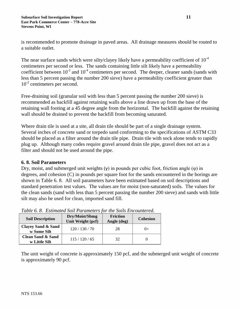
is recommended to promote drainage in paved areas. All drainage measures should be routed to
a suitable outlet.
The near surface sands which were silty/clayey likely have a permeability coefficient of 10-4
centimeters per second or less. The sands containing little silt likely have a permeability
coefficient between 10-2
and 10-4
centimeters per second. The deeper, cleaner sands (sands with
less than 5 percent passing the number 200 sieve) have a permeability coefficient greater than
10-2
centimeters per second.
Free-draining soil (granular soil with less than 5 percent passing the number 200 sieve) is
recommended as backfill against retaining walls above a line drawn up from the base of the
retaining wall footing at a 45 degree angle from the horizontal. The backfill against the retaining
wall should be drained to prevent the backfill from becoming saturated.
Where drain tile is used at a site, all drain tile should be part of a single drainage system.
Several inches of concrete sand or torpedo sand conforming to the specifications of ASTM C33
should be placed as a filter around the drain tile pipe. Drain tile with sock alone tends to rapidly
plug up. Although many codes require gravel around drain tile pipe, gravel does not act as a
filter and should not be used around the pipe.
6. 8. Soil Parameters
Dry, moist, and submerged unit weights (γ) in pounds per cubic foot, friction angle (φ) in
degrees, and cohesion (C) in pounds per square foot for the sands encountered in the borings are
shown in Table 6. 8. All soil parameters have been estimated based on soil descriptions and
standard penetration test values. The values are for moist (non-saturated) soils. The values for
the clean sands (sand with less than 5 percent passing the number 200 sieve) and sands with little
silt may also be used for clean, imported sand fill.
Table 6. 8. Estimated Soil Parameters for the Soils Encountered.
Soil Description Dry/Moist/Sbmg
Unit Weight (pcf)
Friction
Angle (deg) Cohesion
Clayey Sand & Sand
w Some Silt 120 / 130 / 70 28 0+
Clean Sand & Sand
w Little Silt 115 / 120 / 65 32 0
The unit weight of concrete is approximately 150 pcf, and the submerged unit weight of concrete
is approximately 90 pcf.

Subsurface Soil Investigation Report 12
East Park Commerce Center – 778-Acre Site
Stevens Point, WI
NTS 153.66
6. 9. Corrosion Potential
Any construction materials that will be placed in contact with organic soils should be protected
against corrosion.
This project falls into Area 1 of Figure 1, Procedure 13-1-15 of the Wisconsin DOT Facilities
Development Manual, which indicates strong potential for corrosion of galvanized steel culvert
pipe. Reinforced concrete culvert pipe (preferred) or other corrosion resistant pipe is
recommended over galvanized steel pipe.
6. 10. Site Classification for Seismic Design
To classify a site for seismic design, the 2009 International Building Code (IBC) requires
knowledge of the upper 100 feet of soil. The maximum depth of boring was only 20 feet. Based
on standard penetration values, the seismic site class for this site is Site Class ‘E’ according to
Table 1613.5.3 of the 2009 IBC.
However, according to section 1613.5.1 of the International Building Code (IBC), a structure
may be assigned to Seismic Design Category ‘A’ if Figures 1613.5(1) through 1613.5(14) of the
IBC show the mapped short period spectral response acceleration (SS) at the building site to be
less than 0.15g and the mapped one-second period spectral response acceleration (S1) at the
building site to be less than 0.04g. These figures show SS to be less than 0.15g and S1 to be less
than 0.04g at the project site. Therefore, although the seismic site class is ‘E’ for this site,
structures to be built at the site may be assigned to Seismic Design Category ‘A’.
Respectfully,
Benjamin K. Nummelin, P.E. Clifton E.R. Lawson, P.E.
Nummelin Testing Services, Inc. Consulting Engineer
bkn/cerl/bn
NUMMELIN TESTING SERVICES, INC
GEOTECHNICAL ENGINEERING REPORT INFORMATION SHEET
Subsurface soil conditions are responsible for many of the construction problems encountered at building
sites. In order to help you, our client, manage your risks, we offer you the following information and
suggestions.
Geotechnical engineering reports are based on observations of specific soil conditions existing at the
time of the subsurface soil investigation. As these conditions may change over time, construction decisions
should be made with the timeliness of the report in mind. Further testing may be advisable if subsurface
soil conditions are affected by natural events (flooding, spring thaws, etc.) and construction (drilling,
blasting, surcharges, etc.) on-site or adjacent to it. Talking to your geotechnical professional before
construction begins will help keep one informed if further tests are recommended.
The recommendations included in your geotechnical engineering report are based on a limited
number of samples/tests. These recommendations assume that subsurface conditions throughout the site
will be similar to those observed. As all recommendations are preliminary when based on limited testing, it
is important to have your geotechnical professional observe the actual conditions during construction. This
allows him/her to note any differences that may not have been revealed by the limited samples/tests and/or
that are more abrupt than reported in the preliminary report. It is this geotechnical professional, using
his/her knowledge and familiarity of site history, as well as construction observations, who will be able to
determine if there is adequate and appropriate support to consider these recommendations final. He/she will
also be able to document that the contractor is following these recommendations. Be aware that this
geotechnical professional can not assume responsibility and/or liability for his/her recommendations based
on observations and determinations by others.
Professional judgement, based on experience and observations, is at the heart of our geotechnical
recommendations. Geotechnical reports use information from a limited number of samples/tests to predict
conditions regarding your overall site. No one may say with certainty what subsurface conditions really
exist without actual observation. The conditions away from sample/test areas may vary from what is
predicted. It is important to identify variations as early as possible. This is why we encourage you to take
advantage of our knowledge and experience during the construction phase of your project. Working
together we can help minimize the impact when unexpected variations occur.
Geotechnical reports are written for a specific client, purpose, project and set of conditions. They are
not intended to be a generalized, generic report for a proposed site. They are for the sole use of our client
for the express purpose indicated to us. Should the scope of the project be altered, or if subsurface
variations become evident during construction, it may be necessary to modify our recommendations. Early
communication with your geotechnical professional can help you avoid expensive problems that may occur
when changes to a project’s purpose, structure, size, usage, site orientation, elevation, etc. are made after a
report is written.
Following these guidelines, your geotechnical subsurface report should provide informed and
accurate information to assist in the planning and construction of your project.

5
55
5
55
Bur
bank
Rd
BJ
Ct
Clems Way
Woodland Rd
Bt
RfARfA
Bt
Bt
RfA
RsB
RfB
RrB
Bt
RfAPaA
Oe
Oe
PaA
300600
300600
300900
300900
301200
301200
301500
301500
301800
301800
302100
302100
302400
302400
302700
302700
303000
303000
303300
303300
4930
200
4930
200
4930
500
4930
500
4930
800
4930
800
4931
100
4931
100
4931
400
4931
400
4931
700
4931
700
0 1,000 2,000 3,000500Feet
0 300 600 900150Meters
±
44° 30' 49''
89°
28' 2
2''
44° 29' 47''
89°
28' 1
9''
44° 29' 44''
44° 30' 46''89
° 30
' 29'
'89
° 30
' 32'
'
Map Scale: 1:13,700 if printed on A size (8.5" x 11") sheet.
Soil Map—Portage County, Wisconsin
Natural ResourcesNatural ResourcesNatural ResourcesNatural ResourcesConservation ServiceConservation ServiceConservation ServiceConservation Service
Web Soil SurveyNational Cooperative Soil Survey
10/24/2012Page 1 of 3
B1
B2
B3
B4
B5
B6B7
B8B9
B10
B11
B12
B13 B14
B15B16
B17 B18 B19
B20
Locations shown are approximate

BORING LOG NOTES
bornotes.bor
DESCRIPTIVE TERM, GRANULAR SOIL (% BY DRY WEIGHT)Trace 0% - 5%Little 5% - 12%Some 12% - 35%And 35% - 50%
QP = Estimated Unconfined Compressive Strength (by pocket penetrometer)expressed in tons per square foot (t/sf).
QU = Estimated Unconfined Compressive Strength (by ASTM 2166)expressed in tons per square foot (t/sf).
NM = Natural Moisture
M = MOISTURED = Dry F = FrozenM = Moist W = WetS = Saturated
LOI = Loss on Ignition (Organic Content)
N (Standard Blow Count) = blows per foot, as shown. Performed in general accordance with StandardPenetration Test Specifications (ASTM D-1586).
NR = No Recovery WOH = Weight of Hammer # = Sample Number
SOIL CLASSIFICATIONF = Fine LL = Liquid Limit, percentM = Medium PL = Plastic Limit, percentC = Coarse PI = Plasticity Index (LL-PL)W.L. = Water Level
SOIL STRENGTH CHARACTERISTICS
CONSISTENCY (Cohesive Soils) RELATIVE DENSITY (Granular Soils) Term Qu tons/sq.ft. Term “N” Value
Very Soft................ 0.0 to 0.25 Very Loose..................... 0 - 4 Soft......................... 0.25 to 0.50 Loose............................. 4 - 10 Firm........................ 0.50 to 1.0 Medium-Dense............... 10 - 30 Stiff......................... 1.0 to 2.0 Dense............................. 30 - 50 Very Stiff............... 2.0 to 4.0 Very Dense..................... Over 50 Hard........................ Over 4.0
ORGANIC CONTENT BY COMBUSTION METHOD PLASTICITYSoil Description Loss On Ignition Term Plastic IndexNon Organic Less than 4% None to Slight 0 - 4Organic Silt / Clay 4 - 12% Slight 5 - 7Sedimentary Peat 12 - 50% Medium 8 - 22Fibrous & Woody Peat More than 50% High to Very High Over 22
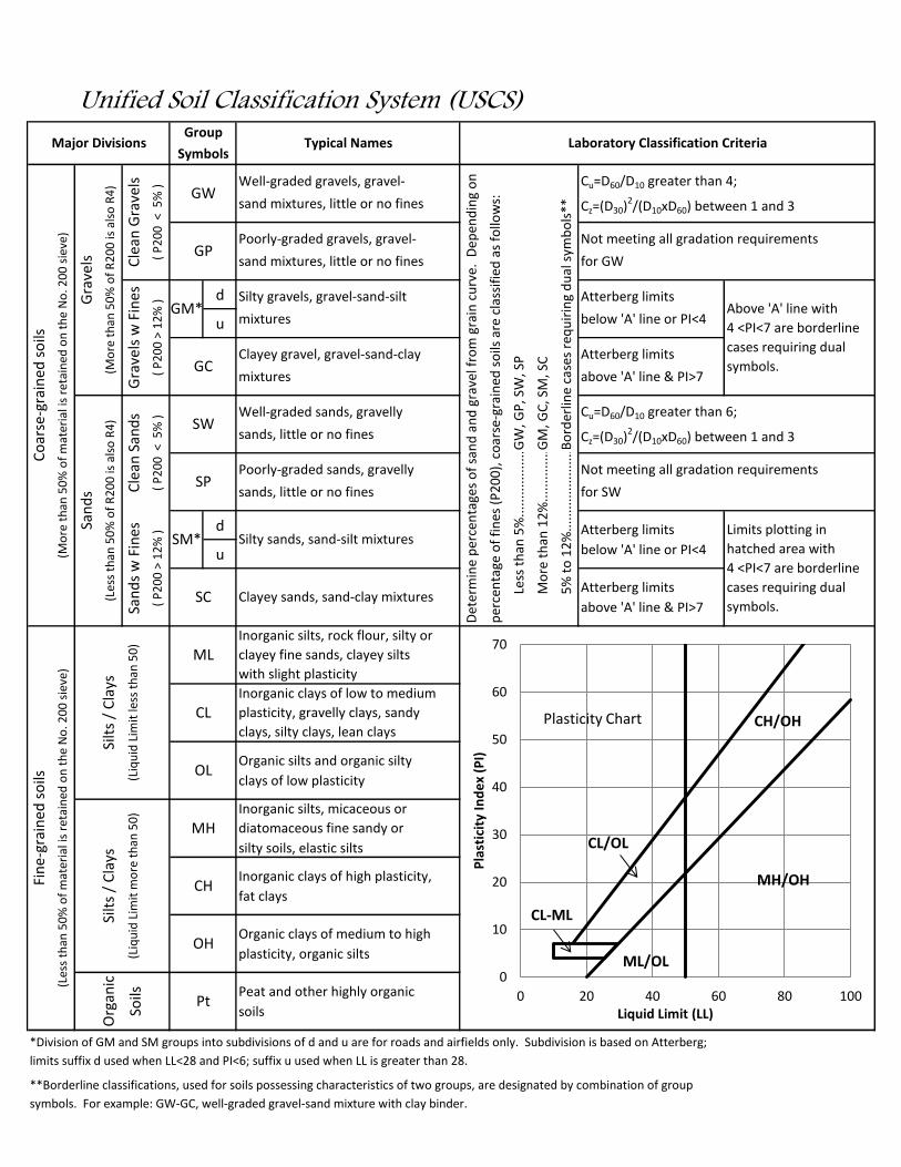
d
u
d
u
*Division of GM and SM groups into subdivisions of d and u are for roads and airfields only. Subdivision is based on Atterberg;
limits suffix d used when LL<28 and PI<6; suffix u used when LL is greater than 28.
**Borderline classifications, used for soils possessing characteristics of two groups, are designated by combination of group
symbols. For example: GW-GC, well-graded gravel-sand mixture with clay binder.
Det
erm
ine
per
cen
tage
s o
f sa
nd
an
d g
rave
l fro
m g
rain
cu
rve.
Dep
end
ing
on
per
cen
tage
of
fin
es (
P2
00
), c
oar
se-g
rain
ed s
oils
are
cla
ssif
ied
as
follo
ws:
clayey fine sands, clayey silts
plasticity, gravelly clays, sandy
diatomaceous fine sandy or
Cu=D60/D10 greater than 4;
Cz=(D30)2/(D10xD60) between 1 and 3
Not meeting all gradation requirements
for GW
Atterberg limits
GW
, GP
, SW
, SP
Bo
rder
line
case
s re
qu
irin
g d
ual
sym
bo
ls**
Less
th
an 5
%..
....
....
....
....
...
Mo
re t
han
12
%..
....
....
....
....
5%
to
12
%..
....
....
....
....
....
....
.
below 'A' line or PI<4
above 'A' line & PI>7
Cu=D60/D10 greater than 6;
Cz=(D30)2/(D10xD60) between 1 and 3
Not meeting all gradation requirements
Peat and other highly organic
soils
GM*
SM*
Silt
s /
Cla
ys
(Liq
uid
Lim
it le
ss t
han
50
)
Silt
s /
Cla
ys
(Liq
uid
Lim
it m
ore
th
an 5
0)
Silty sands, sand-silt mixtures
Clayey sands, sand-clay mixtures
Organic silts and organic silty
clays of low plasticity
Inorganic silts, micaceous or
silty soils, elastic silts
Inorganic clays of high plasticity,
fat clays
sands, little or no fines
Inorganic silts, rock flour, silty or
for SW
Atterberg limits
below 'A' line or PI<4
mixtures
Clayey gravel, gravel-sand-clay
mixtures
Well-graded sands, gravelly
sands, little or no fines
Poorly-graded sands, gravelly
Typical Names
Well-graded gravels, gravel-
sand mixtures, little or no fines
Poorly-graded gravels, gravel-
sand mixtures, little or no fines
GM
, GC
, SM
, SC
Laboratory Classification Criteria
Atterberg limits
Above 'A' line with
4 <PI<7 are borderline
cases requiring dual
symbols.
OH
Pt
Organic clays of medium to high
plasticity, organic silts
above 'A' line & PI>7
Atterberg limits
Limits plotting in
hatched area with
4 <PI<7 are borderline
cases requiring dual
symbols.
MH
CH
Unified Soil Classification System (USCS)
CL
OL
Inorganic clays of low to medium
clays, silty clays, lean clays
SC
MLwith slight plasticity
GW
GP
SW
SP
Silty gravels, gravel-sand-silt
GC
Fin
e-gr
ain
ed s
oils
Gra
vels
(Mo
re t
han
50
% o
f R
20
0 is
als
o R
4)
San
ds
(Les
s th
an 5
0%
of
R2
00
is a
lso
R4
)
Major Divisions
Co
arse
-gra
ined
so
ils
(Mo
re t
han
50
% o
f m
ater
ial i
s re
tain
ed o
n t
he
No
. 20
0 s
ieve
)
Cle
an G
rave
ls
Symbols
Group
( P
20
0 <
5%
)
Gra
vels
w F
ines
( P
20
0 >
12
% )
(Les
s th
an 5
0%
of
mat
eria
l is
reta
ined
on
th
e N
o. 2
00
sie
ve)
Org
anic
Soils
( P
20
0 >
12
% )
Cle
an S
and
s
( P
20
0 <
5%
)
San
ds
w F
ines
0
10
20
30
40
50
60
70
0 20 40 60 80 100
Pla
stic
ity
Ind
ex
(PI)
Liquid Limit (LL)
CL-ML
CL/OL
CH/OH
ML/OL
Plasticity Chart
MH/OH

Facilities Development Manual Procedure 13-1-15
Date April 26, 2007 Figure 1 1 of 1

SOIL BORING LOGBoring: 1
Boring By: Nummelin Testing Services, Inc. Auger: HSAPage: 1 of 1
Project: East Park Commerce Center Drillers: MA / NHLocation: 44° 29' 55.5" N, 89° 30' 0.2" W - See Plan Date: 10/16/12
Stevens Point, WI Elevation: 1100.2Depth Classification/Description # Sample N Rec M Qp Notes(ft.) Depth (ft.) (in.) (tsf)
- Dark Brown Silty SAND ( Topsoil ) 1 0 - 2 6 24 M1 - ------- 10" -------
-2 -
-3 - Brown F-M SAND
- Little Silt, Trace Gravel 2 3.5 - 5 8 14 M4 - ( USCS: SP-SM )
-5 -
-6 - ------- 6.0' ------- 3 6 - 7.5 9 12 M
-7 - Brown F-M SAND
- Little Gravel8 - ( USCS: SP )
-9 - ------- 9.0' ------- 4 9 - 10.5 8 12 S
-10 -
-11 -
-12 -
-13 -
-14 - Light Brown F-M SAND 5 14 - 15.5 9 12 S
- Little Gravel15 - ( USCS: SP )
-16 -
-17 -
-18 -
- 6 18.5 - 20 10 12 S19 -
-20 - ------- E.O.B. 20.0' -------
- ------- Water @ Completion 9' -------- ------- Backfilled with Bentonite Chips ---------------
Nummelin Testing Services, Inc. NTS # 153.66

SOIL BORING LOGBoring: 2
Boring By: Nummelin Testing Services, Inc. Auger: HSAPage: 1 of 1
Project: East Park Commerce Center Drillers: MA / NHLocation: 44° 30' 3.3" N, 89° 29' 42.7" W - See Plan Date: 10/18/12
Stevens Point, WI Elevation: 1109.7Depth Classification/Description # Sample N Rec M Qp Notes(ft.) Depth (ft.) (in.) (tsf)
- Dark Brown Silty SAND ( Topsoil ) 1 0 - 2 5 22 M1 - ------- 12" -------
-2 - Brown Clayey Fine SAND
- Trace Gravel3 - ( USCS: SC )
- ------- 3.5' ------- 2 3.5 - 5 6 12 W4 -
-5 -
- Brown F-M SAND6 - Little Silt, Trace Gravel 3 6 - 7.5 7 12 M
- ( USCS: SP-SM )7 -
-8 -
-9 - ------- 9.0' ------- 4 9 - 10.5 6 12 M
-10 -
-11 -
-12 -
-13 -
- Light Brown F-M SAND14 - Trace Gravel 5 14 - 15.5 6 12 S
- ( USCS: SP )15 -
-16 -
-17 -
-18 -
- 6 18.5 - 20 7 12 S19 -
-20 - ------- E.O.B. 20.0' -------
- ------- Water @ Completion 14.5' -------- ------- Backfilled with Bentonite Chips ---------------
Nummelin Testing Services, Inc. NTS # 153.66

SOIL BORING LOGBoring: 3
Boring By: Nummelin Testing Services, Inc. Auger: HSAPage: 1 of 1
Project: East Park Commerce Center Drillers: MA / NHLocation: 44° 30' 1.5" N, 89° 29' 29.7" W - See Plan Date: 10/23/12
Stevens Point, WI Elevation: 1112.5Depth Classification/Description # Sample N Rec M Qp Notes(ft.) Depth (ft.) (in.) (tsf)
- Dark Brown Silty SAND ( Topsoil ) 1 0 - 2 5 14 M1 - ------- 8" -------
-2 - Brown Fine SAND
- Little Silt, Trace Gravel3 - ( USCS: SP-SM )
- ------- 3.5' ------- 2 3.5 - 5 7 3 M4 -
-5 -
-6 - 3 6 - 7.5 8 12 M
-7 -
-8 -
-9 - 4 9 - 10.5 10 12 M
-10 -
- Light Brown F-M SAND11 - Little Gravel
- ( USCS: SP )12 -
-13 -
-14 - 5 14 - 15.5 5 12 S
-15 -
-16 -
-17 -
-18 -
- 6 18.5 - 20 12 12 S19 -
-20 - ------- E.O.B. 20.0' -------
- ------- Water @ Completion 14' -------- ------- Backfilled with Bentonite Chips ---------------
Nummelin Testing Services, Inc. NTS # 153.66

SOIL BORING LOGBoring: 4
Boring By: Nummelin Testing Services, Inc. Auger: HSAPage: 1 of 1
Project: East Park Commerce Center Drillers: MA / NHLocation: 44° 30' 7.3" N, 89° 29' 6.4" W - See Plan Date: 10/15/12
Stevens Point, WI Elevation: 1117.9Depth Classification/Description # Sample N Rec M Qp Notes(ft.) Depth (ft.) (in.) (tsf)
- Dark Brown Silty SAND ( Topsoil ) 1 0 - 2 9 12 M1 - ------- 8" -------
-2 - Brown Fine SAND
- Some Silt, Little Gravel3 - ( USCS: SM )
- ------- 3.5' ------- 2 3.5 - 5 7 12 M4 -
-5 -
- Brown F-M SAND6 - Some Gravel 3 6 - 7.5 9 12 M
- ( USCS: SP )7 -
-8 -
-9 - ------- 9.0' ------- 4 9 - 10.5 12 14 M
-10 -
-11 -
-12 -
-13 -
-14 - Light Brown F-M SAND 5 14 - 15.5 28 12 M
- Little Gravel15 - ( USCS: SP )
-16 -
-17 -
-18 -
- 6 18.5 - 20 23 12 S19 -
-20 - ------- E.O.B. 20.0' -------
- ------- Water @ Completion 17' -------- ------- Backfilled with Bentonite Chips ---------------
Nummelin Testing Services, Inc. NTS # 153.66

SOIL BORING LOGBoring: 5
Boring By: Nummelin Testing Services, Inc. Auger: HSAPage: 1 of 1
Project: East Park Commerce Center Drillers: MA / NHLocation: 44° 30' 1.3" N, 89° 28' 49.7" W - See Plan Date: 10/23/12
Stevens Point, WI Elevation: 1116.1Depth Classification/Description # Sample N Rec M Qp Notes(ft.) Depth (ft.) (in.) (tsf)
- Dark Brown Silty SAND ( Topsoil ) 1 0 - 2 3 24 M1 - ------- 10" -------
-2 - Brown F-M SAND
- Little Silt, Trace Gravel3 - ( USCS: SP-SM )
- ------- 3.5' ------- 2 3.5 - 5 4 10 M4 -
-5 -
- Brown F-M SAND6 - Some Gravel 3 6 - 7.5 11 10 M
- ( USCS: SP )7 -
-8 -
-9 - ------- 9.0' ------- 4 9 - 10.5 11 12 M
-10 -
-11 -
-12 -
-13 -
- Light Brown F-C SAND14 - Some Gravel 5 14 - 15.5 13 12 S
- ( USCS: SP )15 -
-16 -
-17 -
-18 -
- 6 18.5 - 20 15 12 S19 -
-20 - ------- E.O.B. 20.0' -------
- ------- Water @ Completion 14.5' -------- ------- Backfilled with Bentonite Chips ---------------
Nummelin Testing Services, Inc. NTS # 153.66

SOIL BORING LOGBoring: 6
Boring By: Nummelin Testing Services, Inc. Auger: HSAPage: 1 of 1
Project: East Park Commerce Center Drillers: MA / NHLocation: 44° 30' 10.0" N, 89° 30' 4.2" W - See Plan Date: 10/16/12
Stevens Point, WI Elevation: 1103.2Depth Classification/Description # Sample N Rec M Qp Notes(ft.) Depth (ft.) (in.) (tsf)
- Dark Brown Silty SAND ( Topsoil ) 1 0 - 2 6 24 M1 - ------- 12" -------
-2 - Brown Fine SAND
- Little Silt, Little Gravel3 - ( USCS: SP-SM )
- ------- 3.5' ------- 2 3.5 - 5 6 12 M4 -
-5 -
- Brown F-M SAND6 - Little Gravel 3 6 - 7.5 9 12 M
- ( USCS: SP )7 -
-8 -
-9 - ------- 9.0' ------- 4 9 - 10.5 9 10 M
-10 -
-11 -
-12 -
-13 -
-14 - Light Brown F-M SAND 5 14 - 15.5 4 12 S
- Little Gravel15 - ( USCS: SP )
-16 -
-17 -
-18 -
- 6 18.5 - 20 8 12 S19 -
-20 - ------- E.O.B. 20.0' -------
- ------- Water @ Completion 9' -------- ------- Backfilled with Bentonite Chips ---------------
Nummelin Testing Services, Inc. NTS # 153.66

SOIL BORING LOGBoring: 7
Boring By: Nummelin Testing Services, Inc. Auger: HSAPage: 1 of 1
Project: East Park Commerce Center Drillers: MA / NHLocation: 44° 30' 12.0" N, 89° 29' 46.3" W - See Plan Date: 10/18/12
Stevens Point, WI Elevation: 1112.2Depth Classification/Description # Sample N Rec M Qp Notes(ft.) Depth (ft.) (in.) (tsf)
- Dark Brown Silty SAND ( Topsoil ) 1 0 - 2 5 20 M1 - ------- 11" -------
-2 -
-3 - Brown F-M SAND
- Some Silt, Little Gravel 2 3.5 - 5 3 14 W4 - ( USCS: SM )
-5 -
-6 - ------- 6.0' ------- 3 6 - 7.5 7 12 M
-7 -
-8 -
-9 - 4 9 - 10.5 5 14 M
-10 -
-11 -
- Light Brown F-M SAND12 - Little Gravel
- ( USCS: SP )13 -
-14 - 5 14 - 15.5 12 12 M
-15 -
-16 -
-17 -
-18 -
- 6 18.5 - 20 11 4 S19 -
-20 - ------- E.O.B. 20.0' -------
- ------- Water @ Completion 17.5' -------- ------- Backfilled with Bentonite Chips ---------------
Nummelin Testing Services, Inc. NTS # 153.66
SOIL BORING LOGBoring: 8
Boring By: Nummelin Testing Services, Inc. Auger: HSAPage: 1 of 1
Project: East Park Commerce Center Drillers: MA / NHLocation: 44° 30' 11.5" N, 89° 29' 27.4" W - See Plan Date: 10/23/12
Stevens Point, WI Elevation: 1113.4Depth Classification/Description # Sample N Rec M Qp Notes(ft.) Depth (ft.) (in.) (tsf)
- Dark Brown Silty SAND ( Topsoil ) 1 0 - 2 5 20 M1 - ------- 10" -------
-2 - Brown Clayey SAND
- Little Gravel3 - ( USCS: SC )
- ------- 3.5' ------- 2 3.5 - 5 4 12 M4 -
-5 -
- Brown F-M SAND6 - Little Gravel 3 6 - 7.5 8 12 M
- ( USCS: SP )7 -
-8 -
-9 - ------- 9.0' ------- 4 9 - 10.5 4 12 M
-10 -
-11 -
-12 -
-13 -
- Light Brown F-M SAND14 - Trace Gravel 5 14 - 15.5 6 12 S
- ( USCS: SP )15 -
-16 -
-17 -
-18 -
- 6 18.5 - 20 7 12 S19 -
-20 - ------- E.O.B. 20.0' -------
- ------- Water @ Completion 14' -------- ------- Backfilled with Bentonite Chips ---------------
Nummelin Testing Services, Inc. NTS # 153.66

SOIL BORING LOGBoring: 9
Boring By: Nummelin Testing Services, Inc. Auger: HSAPage: 1 of 1
Project: East Park Commerce Center Drillers: MA / NHLocation: 44° 30' 9.3" N, 89° 29' 6.2" W - See Plan Date: 10/15/12
Stevens Point, WI Elevation: 1118.0Depth Classification/Description # Sample N Rec M Qp Notes(ft.) Depth (ft.) (in.) (tsf)
- Dark Brown Silty SAND ( Topsoil ) 1 0 - 2 5 20 M1 - ------- 12" -------
-2 - Brown Fine SAND
- Little Silt, Little Gravel3 - ( USCS: SP-SM )
- ------- 3.5' ------- 2 3.5 - 5 13 8 M4 -
-5 -
- Brown F-M SAND6 - Some Gravel 3 6 - 7.5 16 8 M
- ( USCS: SP )7 -
-8 -
-9 - ------- 9.0' ------- 4 9 - 10.5 17 12 M
-10 -
-11 -
-12 -
-13 -
-14 - Brown Fine SAND 5 14 - 15.5 15 12 M
- Little Gravel15 - ( USCS: SP )
-16 -
-17 -
-18 -
- 6 18.5 - 20 17 12 S19 -
-20 - ------- E.O.B. 20.0' -------
- ------- Water @ Completion 17' -------- ------- Backfilled with Bentonite Chips ---------------
Nummelin Testing Services, Inc. NTS # 153.66

SOIL BORING LOGBoring: 10
Boring By: Nummelin Testing Services, Inc. Auger: HSAPage: 1 of 1
Project: East Park Commerce Center Drillers: MA / NHLocation: 44° 30' 13.2" N, 89° 28' 50.7" W - See Plan Date: 10/23/12
Stevens Point, WI Elevation: 1121.2Depth Classification/Description # Sample N Rec M Qp Notes(ft.) Depth (ft.) (in.) (tsf)
- Dark Brown Silty SAND ( Topsoil ) 1 0 - 2 8 12 M1 - ------- 8" -------
-2 - Brown Clayey SAND & GRAVEL
- ( USCS: SP-SC )3 -
- ------- 3.5' ------- 2 3.5 - 5 18 4 M4 -
-5 -
-6 - 3 6 - 7.5 14 14 M
-7 -
-8 -
-9 - 4 9 - 10.5 13 14 M
-10 - Light Brown F-M SAND
- Some Gravel11 - ( USCS: SP )
-12 -
-13 -
-14 - 5 14 - 15.5 18 12 M
-15 -
-16 -
-17 -
-18 -
- 6 18.5 - 20 13 12 S19 -
-20 - ------- E.O.B. 20.0' -------
- ------- Water @ Completion 18' -------- ------- Backfilled with Bentonite Chips ---------------
Nummelin Testing Services, Inc. NTS # 153.66

SOIL BORING LOGBoring: 11
Boring By: Nummelin Testing Services, Inc. Auger: HSAPage: 1 of 1
Project: East Park Commerce Center Drillers: MA / NHLocation: 44° 30' 26.5" N, 89° 29' 47.7" W - See Plan Date: 10/15/12
Stevens Point, WI Elevation: 1109.5Depth Classification/Description # Sample N Rec M Qp Notes(ft.) Depth (ft.) (in.) (tsf)
- Dark Brown Silty SAND ( Topsoil ) 1 0 - 2 4 23 M1 - ------- 8" -------
-2 - Brown F-M SAND
- Some Silt, Trace Gravel3 - ( USCS: SM )
- ------- 3.5' ------- 2 3.5 - 5 4 10 M4 -
-5 -
- Brown F-M SAND6 - Little Gravel 3 6 - 7.5 7 12 M
- ( USCS: SP )7 -
-8 -
-9 - ------- 9.0' ------- 4 9 - 10.5 12 12 M
-10 -
-11 -
-12 -
-13 -
-14 - Light Brown F-M SAND 5 14 - 15.5 5 14 S
- Little Gravel15 - ( USCS: SP )
-16 -
-17 -
-18 -
- 6 18.5 - 20 10 12 S19 -
-20 - ------- E.O.B. 20.0' -------
- ------- Water @ Completion 14' -------- ------- Backfilled with Bentonite Chips ---------------
Nummelin Testing Services, Inc. NTS # 153.66

SOIL BORING LOGBoring: 12
Boring By: Nummelin Testing Services, Inc. Auger: HSAPage: 1 of 1
Project: East Park Commerce Center Drillers: MA / NHLocation: 44° 30' 20.9" N, 89° 29' 25.7" W - See Plan Date: 10/15/12
Stevens Point, WI Elevation: 1113.9Depth Classification/Description # Sample N Rec M Qp Notes(ft.) Depth (ft.) (in.) (tsf)
- Dark Brown Silty SAND ( Topsoil ) 1 0 - 2 6 14 M1 - ------- 5" -------
-2 - Brown Silty Fine SAND
- Little Gravel3 - ( USCS: SM )
- ------- 3.5' ------- 2 3.5 - 5 11 6 M4 -
-5 -
- Brown F-C SAND6 - Little Silt, Some Gravel 3 6 - 7.5 14 8 M
- ( USCS: SP-SM )7 -
-8 -
-9 - ------- 9.0' ------- 4 9 - 10.5 6 14 M
-10 -
-11 -
-12 -
-13 -
-14 - Light Brown F-M SAND 5 14 - 15.5 8 12 S
- Little Gravel15 - ( USCS: SP )
-16 -
-17 -
-18 -
- 6 18.5 - 20 8 12 S19 -
-20 - ------- E.O.B. 20.0' -------
- ------- Water @ Completion 14' -------- ------- Backfilled with Bentonite Chips ---------------
Nummelin Testing Services, Inc. NTS # 153.66

SOIL BORING LOGBoring: 13
Boring By: Nummelin Testing Services, Inc. Auger: HSAPage: 1 of 1
Project: East Park Commerce Center Drillers: MA / NHLocation: 44° 30' 27.7" N, 89° 29' 13.1" W - See Plan Date: 10/16/12
Stevens Point, WI Elevation: 1116.9Depth Classification/Description # Sample N Rec M Qp Notes(ft.) Depth (ft.) (in.) (tsf)
- Dark Brown Silty SAND ( Topsoil ) 1 0 - 2 6 16 M1 - ------- 8" -------
-2 - Brown Clayey SAND
- Some Gravel3 - ( USCS: SC )
- ------- 3.5' ------- 2 3.5 - 5 11 12 M4 -
-5 -
-6 - Brown F-C SAND 3 6 - 7.5 10 12 M
- Some Gravel7 - ( USCS: SP )
-8 -
-9 - ------- 9.0' ------- 4 9 - 10.5 11 14 M
-10 -
-11 -
-12 -
-13 -
-14 - Light Brown F-M SAND 5 14 - 15.5 11 12 S
- Little Gravel15 - ( USCS: SP )
-16 -
-17 -
-18 -
- 6 18.5 - 20 9 12 S19 -
-20 - ------- E.O.B. 20.0' -------
- ------- Water @ Completion 15' -------- ------- Backfilled with Bentonite Chips ---------------
Nummelin Testing Services, Inc. NTS # 153.66

SOIL BORING LOGBoring: 14
Boring By: Nummelin Testing Services, Inc. Auger: HSAPage: 1 of 1
Project: East Park Commerce Center Drillers: MA / NHLocation: 44° 30' 27.7" N, 89° 28' 49.2" W - See Plan Date: 10/23/12
Stevens Point, WI Elevation: 1121.5Depth Classification/Description # Sample N Rec M Qp Notes(ft.) Depth (ft.) (in.) (tsf)
- Dark Brown Silty SAND ( Topsoil ) 1 0 - 2 3 18 M1 - ------- 6" -------
-2 -
-3 -
- 2 3.5 - 5 3 10 M4 -
- Brown SAND & GRAVEL5 - ( USCS: SP )
-6 - 3 6 - 7.5 6 12 M
-7 -
-8 -
-9 - ------- 9.0' ------- 4 9 - 10.5 12 10 M
-10 -
-11 -
-12 -
-13 -
-14 - Light Brown F-M SAND 5 14 - 15.5 6 12 M
- Some Gravel15 - ( USCS: SP )
-16 -
-17 -
-18 -
- 6 18.5 - 20 15 12 S19 -
-20 - ------- E.O.B. 20.0' -------
- ------- Water @ Completion 17.5' -------- ------- Backfilled with Bentonite Chips ---------------
Nummelin Testing Services, Inc. NTS # 153.66

SOIL BORING LOGBoring: 15
Boring By: Nummelin Testing Services, Inc. Auger: HSAPage: 1 of 1
Project: East Park Commerce Center Drillers: MA / NHLocation: 44° 30' 37.7" N, 89° 30' 4.0" W - See Plan Date: 10/15/12
Stevens Point, WI Elevation: 1108.5Depth Classification/Description # Sample N Rec M Qp Notes(ft.) Depth (ft.) (in.) (tsf)
- Dark Brown Silty SAND ( Topsoil ) 1 0 - 2 6 18 M1 - ------- 9" -------
-2 - Brown Fine SAND
- Little Silt, Little Gravel3 - ( USCS: SP-SM )
- ------- 3.5' ------- 2 3.5 - 5 7 14 M4 -
-5 -
- Brown F-M SAND6 - Little Gravel 3 6 - 7.5 8 14 M
- ( USCS: SP )7 -
-8 -
-9 - ------- 9.0' ------- 4 9 - 10.5 10 14 M
-10 -
-11 -
-12 -
-13 -
-14 - Light Brown F-M SAND 5 14 - 15.5 6 14 S
- Trace Gravel15 - ( USCS: SP )
-16 -
-17 -
-18 -
- 6 18.5 - 20 7 14 S19 -
-20 - ------- E.O.B. 20.0' -------
- ------- Water @ Completion 14' -------- ------- Backfilled with Bentonite Chips ---------------
Nummelin Testing Services, Inc. NTS # 153.66

SOIL BORING LOGBoring: 16
Boring By: Nummelin Testing Services, Inc. Auger: HSAPage: 1 of 1
Project: East Park Commerce Center Drillers: MA / NHLocation: 44° 30' 37.4" N, 89° 29' 47.4" W - See Plan Date: 10/15/12
Stevens Point, WI Elevation: 1111.0Depth Classification/Description # Sample N Rec M Qp Notes(ft.) Depth (ft.) (in.) (tsf)
- Dark Brown Silty SAND ( Topsoil ) 1 0 - 2 11 12 M1 - ------- 7" -------
-2 - Brown Fine SAND
- Little Silt, Little Gravel3 - ( USCS: SP-SM )
- ------- 3.5' ------- 2 3.5 - 5 6 12 M4 -
-5 -
- Brown F-M SAND6 - Little Gravel 3 6 - 7.5 7 12 M
- ( USCS: SP )7 -
-8 -
-9 - ------- 9.0' ------- 4 9 - 10.5 10 14 M
-10 -
-11 -
-12 -
-13 -
-14 - Light Brown F-M SAND 5 14 - 15.5 9 10 S
- Little Gravel15 - ( USCS: SP )
-16 -
-17 -
-18 -
- 6 18.5 - 20 8 12 S19 -
-20 - ------- E.O.B. 20.0' -------
- ------- Water @ Completion 14' -------- ------- Backfilled with Bentonite Chips ---------------
Nummelin Testing Services, Inc. NTS # 153.66

SOIL BORING LOGBoring: 17
Boring By: Nummelin Testing Services, Inc. Auger: HSAPage: 1 of 1
Project: East Park Commerce Center Drillers: MA / NHLocation: 44° 30' 41.2" N, 89° 29' 23.8" W - See Plan Date: 10/16/12
Stevens Point, WI Elevation: 1116.6Depth Classification/Description # Sample N Rec M Qp Notes(ft.) Depth (ft.) (in.) (tsf)
- Dark Brown Silty SAND ( Topsoil ) 1 0 - 2 6 16 M1 - ------- 7" -------
-2 - Brown Fine SAND
- Little Silt, Little Gravel3 - ( USCS: SP-SM )
- ------- 3.5' ------- 2 3.5 - 5 5 12 M4 -
-5 -
-6 - Brown F-M SAND 3 6 - 7.5 8 12 M
- Little Gravel7 - ( USCS: SP )
-8 -
-9 - ------- 9.0' ------- 4 9 - 10.5 7 12 M
-10 -
-11 -
-12 -
-13 -
-14 - Light Brown F-M SAND 5 14 - 15.5 9 3 S
- Little Gravel15 - ( USCS: SP )
-16 -
-17 -
-18 -
- 6 18.5 - 20 8 12 S19 -
-20 - ------- E.O.B. 20.0' -------
- ------- Water @ Completion 14.5' -------- ------- Backfilled with Bentonite Chips ---------------
Nummelin Testing Services, Inc. NTS # 153.66

SOIL BORING LOGBoring: 18
Boring By: Nummelin Testing Services, Inc. Auger: HSAPage: 1 of 1
Project: East Park Commerce Center Drillers: MA / NHLocation: 44° 30' 40.8" N, 89° 29' 11.1" W - See Plan Date: 10/16/12
Stevens Point, WI Elevation: 1118.9Depth Classification/Description # Sample N Rec M Qp Notes(ft.) Depth (ft.) (in.) (tsf)
- Dark Brown Silty SAND ( Topsoil ) 1 0 - 2 4 20 M1 - ------- 8" -------
-2 - Brown F-M SAND
- Little Silt, Trace Gravel3 - ( USCS: SP-SM )
- ------- 3.5' ------- 2 3.5 - 5 4 12 M4 -
-5 -
-6 - Brown F-M SAND 3 6 - 7.5 7 12 M
- Some Silt, Little Gravel7 - ( USCS: SM )
-8 -
-9 - ------- 9.0' ------- 4 9 - 10.5 8 12 M
-10 -
-11 -
-12 -
-13 -
-14 - Light Brown F-M SAND 5 14 - 15.5 8 12 S
- Little Gravel15 - ( USCS: SP )
-16 -
-17 -
-18 -
- 6 18.5 - 20 11 12 S19 -
-20 - ------- E.O.B. 20.0' -------
- ------- Water @ Completion 14' -------- ------- Backfilled with Bentonite Chips ---------------
Nummelin Testing Services, Inc. NTS # 153.66

SOIL BORING LOGBoring: 19
Boring By: Nummelin Testing Services, Inc. Auger: HSAPage: 1 of 1
Project: East Park Commerce Center Drillers: MA / NHLocation: 44° 30' 39.0" N, 89° 28' 50.8" W - See Plan Date: 10/23/12
Stevens Point, WI Elevation: 1123.4Depth Classification/Description # Sample N Rec M Qp Notes(ft.) Depth (ft.) (in.) (tsf)
- Dark Brown Silty SAND ( Topsoil ) 1 0 - 2 5 18 M1 - ------- 10" -------
-2 - Brown F-M SAND
- Some Silt3 - ( USCS: SM )
- ------- 3.5' ------- 2 3.5 - 5 4 6 M4 -
- Brown F-M SAND5 - Little Gravel
- ( USCS: SP )6 - ------- 6.0' ------- 3 6 - 7.5 8 12 M
-7 -
-8 -
-9 - 4 9 - 10.5 10 12 M
-10 -
-11 -
- Light Brown F-M SAND12 - Some Gravel
- ( USCS: SP )13 -
-14 - 5 14 - 15.5 25 10 M
-15 -
-16 -
-17 -
-18 -
- 6 18.5 - 20 22 10 S19 -
-20 - ------- E.O.B. 20.0' -------
- ------- Water @ Completion 17.5' -------- ------- Backfilled with Bentonite Chips ---------------
Nummelin Testing Services, Inc. NTS # 153.66

SOIL BORING LOGBoring: 20
Boring By: Nummelin Testing Services, Inc. Auger: HSAPage: 1 of 1
Project: East Park Commerce Center Drillers: MA / NHLocation: 44° 30' 35.2" N, 89° 28' 46.5" W - See Plan Date: 10/23/12
Stevens Point, WI Elevation: 1124.7Depth Classification/Description # Sample N Rec M Qp Notes(ft.) Depth (ft.) (in.) (tsf)
- Dark Brown Silty SAND ( Topsoil ) 1 0 - 2 4 18 M1 - ------- 8" -------
-2 - Brown Fine SAND
- Some Silt, Trace Gravel3 - ( USCS: SM )
- ------- 3.5' ------- 2 3.5 - 5 3 10 M4 -
- Brown F-M SAND5 - Little Silt, Little Gravel
- ( USCS: SP )6 - ------- 6.0' ------- 3 6 - 7.5 8 12 M
-7 -
-8 -
-9 - 4 9 - 10.5 8 12 M
-10 -
-11 -
- Light Brown F-M SAND12 - Some Gravel
- ( USCS: SP )13 -
-14 - 5 14 - 15.5 18 3 M
-15 -
-16 -
-17 -
-18 -
- 6 18.5 - 20 8 12 S19 -
-20 - ------- E.O.B. 20.0' -------
- ------- Water @ Completion 17' -------- ------- Backfilled with Bentonite Chips ---------------
Nummelin Testing Services, Inc. NTS # 153.66

State of Wisconsin- Dept of Natural Resources
P.O. Box 7921, Madison WI 53707-7921Well / Drillhole / Borehole Abandonment
Form 3300-005 (R 10/03) Page 1
Route To:
1. General Information 2. Facility / Owner Information
Boring Number DNR Well ID No. County Facility Name
1 Portage
Common Well Name Gov't Lot # (if applic.) Facility ID City, Village, or Town
Stevens Point
1/4 / 1/4 1/4 Section Township Range Street Address of Well
N
Grid Location Present Well Owner Original Well Owner
OR
Street Address or Route of Owner
Latitude: Longitude: DEG MIN SEC DEG MIN SEC
N W
Reason For Abandonment
4. Pump, Liner, Screen, Casing & Sealing Material
3. Well / Drillhole / Borehole Information Pump and piping removed?
Original Construction Date Liner(s) removed?
Screen removed?
Casing left in place?
Casing cut off below surface?
Construction Type: Sealing material rise to surface?
Material settle after 24 hrs?
If yes, was hole retopped?
Formation Type
Required Method of Placing Sealing Material
Total Well Depth From Groundsurface (ft.) Casing Diameter (in.)
(Bentonite Chips) ___________________
Sealing Materials
Was Well Annular Space Grouted?
9
5. Material Used to Fill Well / Drillhole From (ft.)Mix Ratio or
Mud Weight
3/8" Bentonite Chips Surface
6. Comments
7. Supervision of Work DNR Use Only
Name of Person or Firm Doing Sealing Work Date of Abandonment Date Received Noted By
NTS, Inc.Street or Route Telephone Number Comments
P.O. Box 127 (715) 341-7974
City State ZIP Code Signature of Person Doing Work Date Signed
Stevens Point WI 54481
Feet
Notice: Completion of this report is required by chs. 160, 281, 283, 289, 291-293, 295 and 299, Wis Stats., and ch. NR 141, Wis. Adm. Code. In accordance
with chs. 281, 289, 291-293, 295, and 299, Wis. Stats., failure to file this form may result in a forfeiture of between $10-25,000, or imprisonment for up to one
year, depending on the program and conduct involved. Personally identifiable information on this form is not intended to be used for any other purpose. Return
form to the appropriate DNR office and bureau. See instructions for more information.
153.66
East Park Commerce Center
NE of Brilowski Rd & CTH 'HH' Intersection
License/Permit No.
NE Corner Badger Ave & Hwy 10
ZIP Code
10/16/12
If yes, to what depth (feet)? Depth to water (feet) For Monitoring Wells and Monitoring Well Boreholes Only:
To (ft.)
20
No. Yards, Sacks Sealant or
Volume (circle one)
Lower Drillhole Diameter (in.) Casing Depth (ft.)
available, please attach.
If a Well Construction Report is
___ ___ ___ ___ ___
WI Unique Well No. of Replacement Well
State
If bentonite chips were used, were they
hydrated with water from a known safe source?
10/16/2012
No
BedrockUnconsolidated Formation
Drilled Driven (sandpoint) Dug
Other (specify): ________________________________
Yes No Unknow n
Yes
Yes
Yes
Yes
N/ANoYes
No
No
No
N/A
N/A
N/A
N/A
Yes
Yes
Yes
Yes
No
No
No
No
N/A
N/A
N/A
N/A
Monitoring Well
Water Well
Borehole / Drillhole
N
S
E
W
E W
Local Grid Origin
(estimated)
Well Location
Drinking Water Watershed Water Waste Management Remediation/Redevelopment Other: ________________
Neat Cement Grout
Sand Cement (concrete) Grout
Concrete Bentonite Chips
Bentonite Chips
Granular Bentonite
Bentonite-Cement Grout
Bentonite-Sand Slurry
Bentonite-Sand Slurry
Clay Sand Slurry (11lb/gal w t.)
Conductor Pipe-Gravity
Screened and Poured
Conductor Pipe-Pumped
Other (explain):

State of Wisconsin- Dept of Natural Resources
P.O. Box 7921, Madison WI 53707-7921Well / Drillhole / Borehole Abandonment
Form 3300-005 (R 10/03) Page 1
Route To:
1. General Information 2. Facility / Owner Information
Boring Number DNR Well ID No. County Facility Name
2 Portage
Common Well Name Gov't Lot # (if applic.) Facility ID City, Village, or Town
Stevens Point
1/4 / 1/4 1/4 Section Township Range Street Address of Well
N
Grid Location Present Well Owner Original Well Owner
OR
Street Address or Route of Owner
Latitude: Longitude: DEG MIN SEC DEG MIN SEC
N W
Reason For Abandonment
4. Pump, Liner, Screen, Casing & Sealing Material
3. Well / Drillhole / Borehole Information Pump and piping removed?
Original Construction Date Liner(s) removed?
Screen removed?
Casing left in place?
Casing cut off below surface?
Construction Type: Sealing material rise to surface?
Material settle after 24 hrs?
If yes, was hole retopped?
Formation Type
Required Method of Placing Sealing Material
Total Well Depth From Groundsurface (ft.) Casing Diameter (in.)
(Bentonite Chips) ___________________
Sealing Materials
Was Well Annular Space Grouted?
14.5
5. Material Used to Fill Well / Drillhole From (ft.)Mix Ratio or
Mud Weight
3/8" Bentonite Chips Surface
6. Comments
7. Supervision of Work DNR Use Only
Name of Person or Firm Doing Sealing Work Date of Abandonment Date Received Noted By
NTS, Inc.Street or Route Telephone Number Comments
P.O. Box 127 (715) 341-7974
City State ZIP Code Signature of Person Doing Work Date Signed
Stevens Point WI 54481
Feet
Notice: Completion of this report is required by chs. 160, 281, 283, 289, 291-293, 295 and 299, Wis Stats., and ch. NR 141, Wis. Adm. Code. In accordance
with chs. 281, 289, 291-293, 295, and 299, Wis. Stats., failure to file this form may result in a forfeiture of between $10-25,000, or imprisonment for up to one
year, depending on the program and conduct involved. Personally identifiable information on this form is not intended to be used for any other purpose. Return
form to the appropriate DNR office and bureau. See instructions for more information.
153.66
East Park Commerce Center
NE of Brilowski Rd & CTH 'HH' Intersection
License/Permit No.
NE Corner Badger Ave & Hwy 10
ZIP Code
10/18/12
If yes, to what depth (feet)? Depth to water (feet) For Monitoring Wells and Monitoring Well Boreholes Only:
To (ft.)
20
No. Yards, Sacks Sealant or
Volume (circle one)
Lower Drillhole Diameter (in.) Casing Depth (ft.)
available, please attach.
If a Well Construction Report is
___ ___ ___ ___ ___
WI Unique Well No. of Replacement Well
State
If bentonite chips were used, were they
hydrated with water from a known safe source?
10/18/2012
No
BedrockUnconsolidated Formation
Drilled Driven (sandpoint) Dug
Other (specify): ________________________________
Yes No Unknow n
Yes
Yes
Yes
Yes
N/ANoYes
No
No
No
N/A
N/A
N/A
N/A
Yes
Yes
Yes
Yes
No
No
No
No
N/A
N/A
N/A
N/A
Monitoring Well
Water Well
Borehole / Drillhole
N
S
E
W
E W
Local Grid Origin
(estimated)
Well Location
Drinking Water Watershed Water Waste Management Remediation/Redevelopment Other: ________________
Neat Cement Grout
Sand Cement (concrete) Grout
Concrete Bentonite Chips
Bentonite Chips
Granular Bentonite
Bentonite-Cement Grout
Bentonite-Sand Slurry
Bentonite-Sand Slurry
Clay Sand Slurry (11lb/gal w t.)
Conductor Pipe-Gravity
Screened and Poured
Conductor Pipe-Pumped
Other (explain):

State of Wisconsin- Dept of Natural Resources
P.O. Box 7921, Madison WI 53707-7921Well / Drillhole / Borehole Abandonment
Form 3300-005 (R 10/03) Page 1
Route To:
1. General Information 2. Facility / Owner Information
Boring Number DNR Well ID No. County Facility Name
3 Portage
Common Well Name Gov't Lot # (if applic.) Facility ID City, Village, or Town
Stevens Point
1/4 / 1/4 1/4 Section Township Range Street Address of Well
N
Grid Location Present Well Owner Original Well Owner
OR
Street Address or Route of Owner
Latitude: Longitude: DEG MIN SEC DEG MIN SEC
N W
Reason For Abandonment
4. Pump, Liner, Screen, Casing & Sealing Material
3. Well / Drillhole / Borehole Information Pump and piping removed?
Original Construction Date Liner(s) removed?
Screen removed?
Casing left in place?
Casing cut off below surface?
Construction Type: Sealing material rise to surface?
Material settle after 24 hrs?
If yes, was hole retopped?
Formation Type
Required Method of Placing Sealing Material
Total Well Depth From Groundsurface (ft.) Casing Diameter (in.)
(Bentonite Chips) ___________________
Sealing Materials
Was Well Annular Space Grouted?
14
5. Material Used to Fill Well / Drillhole From (ft.)Mix Ratio or
Mud Weight
3/8" Bentonite Chips Surface
6. Comments
7. Supervision of Work DNR Use Only
Name of Person or Firm Doing Sealing Work Date of Abandonment Date Received Noted By
NTS, Inc.Street or Route Telephone Number Comments
P.O. Box 127 (715) 341-7974
City State ZIP Code Signature of Person Doing Work Date Signed
Stevens Point WI 54481
Feet
Notice: Completion of this report is required by chs. 160, 281, 283, 289, 291-293, 295 and 299, Wis Stats., and ch. NR 141, Wis. Adm. Code. In accordance
with chs. 281, 289, 291-293, 295, and 299, Wis. Stats., failure to file this form may result in a forfeiture of between $10-25,000, or imprisonment for up to one
year, depending on the program and conduct involved. Personally identifiable information on this form is not intended to be used for any other purpose. Return
form to the appropriate DNR office and bureau. See instructions for more information.
153.66
East Park Commerce Center
NE of Brilowski Rd & CTH 'HH' Intersection
License/Permit No.
NE Corner Badger Ave & Hwy 10
ZIP Code
10/23/12
If yes, to what depth (feet)? Depth to water (feet) For Monitoring Wells and Monitoring Well Boreholes Only:
To (ft.)
20
No. Yards, Sacks Sealant or
Volume (circle one)
Lower Drillhole Diameter (in.) Casing Depth (ft.)
available, please attach.
If a Well Construction Report is
___ ___ ___ ___ ___
WI Unique Well No. of Replacement Well
State
If bentonite chips were used, were they
hydrated with water from a known safe source?
10/23/2012
No
BedrockUnconsolidated Formation
Drilled Driven (sandpoint) Dug
Other (specify): ________________________________
Yes No Unknow n
Yes
Yes
Yes
Yes
N/ANoYes
No
No
No
N/A
N/A
N/A
N/A
Yes
Yes
Yes
Yes
No
No
No
No
N/A
N/A
N/A
N/A
Monitoring Well
Water Well
Borehole / Drillhole
N
S
E
W
E W
Local Grid Origin
(estimated)
Well Location
Drinking Water Watershed Water Waste Management Remediation/Redevelopment Other: ________________
Neat Cement Grout
Sand Cement (concrete) Grout
Concrete Bentonite Chips
Bentonite Chips
Granular Bentonite
Bentonite-Cement Grout
Bentonite-Sand Slurry
Bentonite-Sand Slurry
Clay Sand Slurry (11lb/gal w t.)
Conductor Pipe-Gravity
Screened and Poured
Conductor Pipe-Pumped
Other (explain):

State of Wisconsin- Dept of Natural Resources
P.O. Box 7921, Madison WI 53707-7921Well / Drillhole / Borehole Abandonment
Form 3300-005 (R 10/03) Page 1
Route To:
1. General Information 2. Facility / Owner Information
Boring Number DNR Well ID No. County Facility Name
4 Portage
Common Well Name Gov't Lot # (if applic.) Facility ID City, Village, or Town
Stevens Point
1/4 / 1/4 1/4 Section Township Range Street Address of Well
N
Grid Location Present Well Owner Original Well Owner
OR
Street Address or Route of Owner
Latitude: Longitude: DEG MIN SEC DEG MIN SEC
N W
Reason For Abandonment
4. Pump, Liner, Screen, Casing & Sealing Material
3. Well / Drillhole / Borehole Information Pump and piping removed?
Original Construction Date Liner(s) removed?
Screen removed?
Casing left in place?
Casing cut off below surface?
Construction Type: Sealing material rise to surface?
Material settle after 24 hrs?
If yes, was hole retopped?
Formation Type
Required Method of Placing Sealing Material
Total Well Depth From Groundsurface (ft.) Casing Diameter (in.)
(Bentonite Chips) ___________________
Sealing Materials
Was Well Annular Space Grouted?
17
5. Material Used to Fill Well / Drillhole From (ft.)Mix Ratio or
Mud Weight
3/8" Bentonite Chips Surface
6. Comments
7. Supervision of Work DNR Use Only
Name of Person or Firm Doing Sealing Work Date of Abandonment Date Received Noted By
NTS, Inc.Street or Route Telephone Number Comments
P.O. Box 127 (715) 341-7974
City State ZIP Code Signature of Person Doing Work Date Signed
Stevens Point WI 54481
___ ___ ___ ___ ___
WI Unique Well No. of Replacement Well
State
If bentonite chips were used, were they
hydrated with water from a known safe source?
10/15/2012
Lower Drillhole Diameter (in.) Casing Depth (ft.)
available, please attach.
If a Well Construction Report is
10/15/12
If yes, to what depth (feet)? Depth to water (feet) For Monitoring Wells and Monitoring Well Boreholes Only:
To (ft.)
20
No. Yards, Sacks Sealant or
Volume (circle one)
East Park Commerce Center
NE of Brilowski Rd & CTH 'HH' Intersection
License/Permit No.
NE Corner Badger Ave & Hwy 10
ZIP Code
Feet
Notice: Completion of this report is required by chs. 160, 281, 283, 289, 291-293, 295 and 299, Wis Stats., and ch. NR 141, Wis. Adm. Code. In accordance
with chs. 281, 289, 291-293, 295, and 299, Wis. Stats., failure to file this form may result in a forfeiture of between $10-25,000, or imprisonment for up to one
year, depending on the program and conduct involved. Personally identifiable information on this form is not intended to be used for any other purpose. Return
form to the appropriate DNR office and bureau. See instructions for more information.
153.66
No
BedrockUnconsolidated Formation
Drilled Driven (sandpoint) Dug
Other (specify): ________________________________
Yes No Unknow n
Yes
Yes
Yes
Yes
N/ANoYes
No
No
No
N/A
N/A
N/A
N/A
Yes
Yes
Yes
Yes
No
No
No
No
N/A
N/A
N/A
N/A
Monitoring Well
Water Well
Borehole / Drillhole
N
S
E
W
E W
Local Grid Origin
(estimated)
Well Location
Drinking Water Watershed Water Waste Management Remediation/Redevelopment Other: ________________
Neat Cement Grout
Sand Cement (concrete) Grout
Concrete Bentonite Chips
Bentonite Chips
Granular Bentonite
Bentonite-Cement Grout
Bentonite-Sand Slurry
Bentonite-Sand Slurry
Clay Sand Slurry (11lb/gal w t.)
Conductor Pipe-Gravity
Screened and Poured
Conductor Pipe-Pumped
Other (explain):

State of Wisconsin- Dept of Natural Resources
P.O. Box 7921, Madison WI 53707-7921Well / Drillhole / Borehole Abandonment
Form 3300-005 (R 10/03) Page 1
Route To:
1. General Information 2. Facility / Owner Information
Boring Number DNR Well ID No. County Facility Name
5 Portage
Common Well Name Gov't Lot # (if applic.) Facility ID City, Village, or Town
Stevens Point
1/4 / 1/4 1/4 Section Township Range Street Address of Well
N
Grid Location Present Well Owner Original Well Owner
OR
Street Address or Route of Owner
Latitude: Longitude: DEG MIN SEC DEG MIN SEC
N W
Reason For Abandonment
4. Pump, Liner, Screen, Casing & Sealing Material
3. Well / Drillhole / Borehole Information Pump and piping removed?
Original Construction Date Liner(s) removed?
Screen removed?
Casing left in place?
Casing cut off below surface?
Construction Type: Sealing material rise to surface?
Material settle after 24 hrs?
If yes, was hole retopped?
Formation Type
Required Method of Placing Sealing Material
Total Well Depth From Groundsurface (ft.) Casing Diameter (in.)
(Bentonite Chips) ___________________
Sealing Materials
Was Well Annular Space Grouted?
14.5
5. Material Used to Fill Well / Drillhole From (ft.)Mix Ratio or
Mud Weight
3/8" Bentonite Chips Surface
6. Comments
7. Supervision of Work DNR Use Only
Name of Person or Firm Doing Sealing Work Date of Abandonment Date Received Noted By
NTS, Inc.Street or Route Telephone Number Comments
P.O. Box 127 (715) 341-7974
City State ZIP Code Signature of Person Doing Work Date Signed
Stevens Point WI 54481
Feet
Notice: Completion of this report is required by chs. 160, 281, 283, 289, 291-293, 295 and 299, Wis Stats., and ch. NR 141, Wis. Adm. Code. In accordance
with chs. 281, 289, 291-293, 295, and 299, Wis. Stats., failure to file this form may result in a forfeiture of between $10-25,000, or imprisonment for up to one
year, depending on the program and conduct involved. Personally identifiable information on this form is not intended to be used for any other purpose. Return
form to the appropriate DNR office and bureau. See instructions for more information.
153.66
East Park Commerce Center
NE of Brilowski Rd & CTH 'HH' Intersection
License/Permit No.
NE Corner Badger Ave & Hwy 10
ZIP Code
10/23/12
If yes, to what depth (feet)? Depth to water (feet) For Monitoring Wells and Monitoring Well Boreholes Only:
To (ft.)
20
No. Yards, Sacks Sealant or
Volume (circle one)
Lower Drillhole Diameter (in.) Casing Depth (ft.)
available, please attach.
If a Well Construction Report is
___ ___ ___ ___ ___
WI Unique Well No. of Replacement Well
State
If bentonite chips were used, were they
hydrated with water from a known safe source?
10/23/2012
No
BedrockUnconsolidated Formation
Drilled Driven (sandpoint) Dug
Other (specify): ________________________________
Yes No Unknow n
Yes
Yes
Yes
Yes
N/ANoYes
No
No
No
N/A
N/A
N/A
N/A
Yes
Yes
Yes
Yes
No
No
No
No
N/A
N/A
N/A
N/A
Monitoring Well
Water Well
Borehole / Drillhole
N
S
E
W
E W
Local Grid Origin
(estimated)
Well Location
Drinking Water Watershed Water Waste Management Remediation/Redevelopment Other: ________________
Neat Cement Grout
Sand Cement (concrete) Grout
Concrete Bentonite Chips
Bentonite Chips
Granular Bentonite
Bentonite-Cement Grout
Bentonite-Sand Slurry
Bentonite-Sand Slurry
Clay Sand Slurry (11lb/gal w t.)
Conductor Pipe-Gravity
Screened and Poured
Conductor Pipe-Pumped
Other (explain):

State of Wisconsin- Dept of Natural Resources
P.O. Box 7921, Madison WI 53707-7921Well / Drillhole / Borehole Abandonment
Form 3300-005 (R 10/03) Page 1
Route To:
1. General Information 2. Facility / Owner Information
Boring Number DNR Well ID No. County Facility Name
6 Portage
Common Well Name Gov't Lot # (if applic.) Facility ID City, Village, or Town
Stevens Point
1/4 / 1/4 1/4 Section Township Range Street Address of Well
N
Grid Location Present Well Owner Original Well Owner
OR
Street Address or Route of Owner
Latitude: Longitude: DEG MIN SEC DEG MIN SEC
N W
Reason For Abandonment
4. Pump, Liner, Screen, Casing & Sealing Material
3. Well / Drillhole / Borehole Information Pump and piping removed?
Original Construction Date Liner(s) removed?
Screen removed?
Casing left in place?
Casing cut off below surface?
Construction Type: Sealing material rise to surface?
Material settle after 24 hrs?
If yes, was hole retopped?
Formation Type
Required Method of Placing Sealing Material
Total Well Depth From Groundsurface (ft.) Casing Diameter (in.)
(Bentonite Chips) ___________________
Sealing Materials
Was Well Annular Space Grouted?
9
5. Material Used to Fill Well / Drillhole From (ft.)Mix Ratio or
Mud Weight
3/8" Bentonite Chips Surface
6. Comments
7. Supervision of Work DNR Use Only
Name of Person or Firm Doing Sealing Work Date of Abandonment Date Received Noted By
NTS, Inc.Street or Route Telephone Number Comments
P.O. Box 127 (715) 341-7974
City State ZIP Code Signature of Person Doing Work Date Signed
Stevens Point WI 54481
___ ___ ___ ___ ___
WI Unique Well No. of Replacement Well
State
If bentonite chips were used, were they
hydrated with water from a known safe source?
10/16/2012
Lower Drillhole Diameter (in.) Casing Depth (ft.)
available, please attach.
If a Well Construction Report is
10/16/12
If yes, to what depth (feet)? Depth to water (feet) For Monitoring Wells and Monitoring Well Boreholes Only:
To (ft.)
20
No. Yards, Sacks Sealant or
Volume (circle one)
East Park Commerce Center
NE of Brilowski Rd & CTH 'HH' Intersection
License/Permit No.
NE Corner Badger Ave & Hwy 10
ZIP Code
Feet
Notice: Completion of this report is required by chs. 160, 281, 283, 289, 291-293, 295 and 299, Wis Stats., and ch. NR 141, Wis. Adm. Code. In accordance
with chs. 281, 289, 291-293, 295, and 299, Wis. Stats., failure to file this form may result in a forfeiture of between $10-25,000, or imprisonment for up to one
year, depending on the program and conduct involved. Personally identifiable information on this form is not intended to be used for any other purpose. Return
form to the appropriate DNR office and bureau. See instructions for more information.
153.66
No
BedrockUnconsolidated Formation
Drilled Driven (sandpoint) Dug
Other (specify): ________________________________
Yes No Unknow n
Yes
Yes
Yes
Yes
N/ANoYes
No
No
No
N/A
N/A
N/A
N/A
Yes
Yes
Yes
Yes
No
No
No
No
N/A
N/A
N/A
N/A
Monitoring Well
Water Well
Borehole / Drillhole
N
S
E
W
E W
Local Grid Origin
(estimated)
Well Location
Drinking Water Watershed Water Waste Management Remediation/Redevelopment Other: ________________
Neat Cement Grout
Sand Cement (concrete) Grout
Concrete Bentonite Chips
Bentonite Chips
Granular Bentonite
Bentonite-Cement Grout
Bentonite-Sand Slurry
Bentonite-Sand Slurry
Clay Sand Slurry (11lb/gal w t.)
Conductor Pipe-Gravity
Screened and Poured
Conductor Pipe-Pumped
Other (explain):

State of Wisconsin- Dept of Natural Resources
P.O. Box 7921, Madison WI 53707-7921Well / Drillhole / Borehole Abandonment
Form 3300-005 (R 10/03) Page 1
Route To:
1. General Information 2. Facility / Owner Information
Boring Number DNR Well ID No. County Facility Name
7 Portage
Common Well Name Gov't Lot # (if applic.) Facility ID City, Village, or Town
Stevens Point
1/4 / 1/4 1/4 Section Township Range Street Address of Well
N
Grid Location Present Well Owner Original Well Owner
OR
Street Address or Route of Owner
Latitude: Longitude: DEG MIN SEC DEG MIN SEC
N W
Reason For Abandonment
4. Pump, Liner, Screen, Casing & Sealing Material
3. Well / Drillhole / Borehole Information Pump and piping removed?
Original Construction Date Liner(s) removed?
Screen removed?
Casing left in place?
Casing cut off below surface?
Construction Type: Sealing material rise to surface?
Material settle after 24 hrs?
If yes, was hole retopped?
Formation Type
Required Method of Placing Sealing Material
Total Well Depth From Groundsurface (ft.) Casing Diameter (in.)
(Bentonite Chips) ___________________
Sealing Materials
Was Well Annular Space Grouted?
17.5
5. Material Used to Fill Well / Drillhole From (ft.)Mix Ratio or
Mud Weight
3/8" Bentonite Chips Surface
6. Comments
7. Supervision of Work DNR Use Only
Name of Person or Firm Doing Sealing Work Date of Abandonment Date Received Noted By
NTS, Inc.Street or Route Telephone Number Comments
P.O. Box 127 (715) 341-7974
City State ZIP Code Signature of Person Doing Work Date Signed
Stevens Point WI 54481
___ ___ ___ ___ ___
WI Unique Well No. of Replacement Well
State
If bentonite chips were used, were they
hydrated with water from a known safe source?
10/18/2012
Lower Drillhole Diameter (in.) Casing Depth (ft.)
available, please attach.
If a Well Construction Report is
10/18/12
If yes, to what depth (feet)? Depth to water (feet) For Monitoring Wells and Monitoring Well Boreholes Only:
To (ft.)
20
No. Yards, Sacks Sealant or
Volume (circle one)
East Park Commerce Center
NE of Brilowski Rd & CTH 'HH' Intersection
License/Permit No.
NE Corner Badger Ave & Hwy 10
ZIP Code
Feet
Notice: Completion of this report is required by chs. 160, 281, 283, 289, 291-293, 295 and 299, Wis Stats., and ch. NR 141, Wis. Adm. Code. In accordance
with chs. 281, 289, 291-293, 295, and 299, Wis. Stats., failure to file this form may result in a forfeiture of between $10-25,000, or imprisonment for up to one
year, depending on the program and conduct involved. Personally identifiable information on this form is not intended to be used for any other purpose. Return
form to the appropriate DNR office and bureau. See instructions for more information.
153.66
No
BedrockUnconsolidated Formation
Drilled Driven (sandpoint) Dug
Other (specify): ________________________________
Yes No Unknow n
Yes
Yes
Yes
Yes
N/ANoYes
No
No
No
N/A
N/A
N/A
N/A
Yes
Yes
Yes
Yes
No
No
No
No
N/A
N/A
N/A
N/A
Monitoring Well
Water Well
Borehole / Drillhole
N
S
E
W
E W
Local Grid Origin
(estimated)
Well Location
Drinking Water Watershed Water Waste Management Remediation/Redevelopment Other: ________________
Neat Cement Grout
Sand Cement (concrete) Grout
Concrete Bentonite Chips
Bentonite Chips
Granular Bentonite
Bentonite-Cement Grout
Bentonite-Sand Slurry
Bentonite-Sand Slurry
Clay Sand Slurry (11lb/gal w t.)
Conductor Pipe-Gravity
Screened and Poured
Conductor Pipe-Pumped
Other (explain):

State of Wisconsin- Dept of Natural Resources
P.O. Box 7921, Madison WI 53707-7921Well / Drillhole / Borehole Abandonment
Form 3300-005 (R 10/03) Page 1
Route To:
1. General Information 2. Facility / Owner Information
Boring Number DNR Well ID No. County Facility Name
8 Portage
Common Well Name Gov't Lot # (if applic.) Facility ID City, Village, or Town
Stevens Point
1/4 / 1/4 1/4 Section Township Range Street Address of Well
N
Grid Location Present Well Owner Original Well Owner
OR
Street Address or Route of Owner
Latitude: Longitude: DEG MIN SEC DEG MIN SEC
N W
Reason For Abandonment
4. Pump, Liner, Screen, Casing & Sealing Material
3. Well / Drillhole / Borehole Information Pump and piping removed?
Original Construction Date Liner(s) removed?
Screen removed?
Casing left in place?
Casing cut off below surface?
Construction Type: Sealing material rise to surface?
Material settle after 24 hrs?
If yes, was hole retopped?
Formation Type
Required Method of Placing Sealing Material
Total Well Depth From Groundsurface (ft.) Casing Diameter (in.)
(Bentonite Chips) ___________________
Sealing Materials
Was Well Annular Space Grouted?
14
5. Material Used to Fill Well / Drillhole From (ft.)Mix Ratio or
Mud Weight
3/8" Bentonite Chips Surface
6. Comments
7. Supervision of Work DNR Use Only
Name of Person or Firm Doing Sealing Work Date of Abandonment Date Received Noted By
NTS, Inc.Street or Route Telephone Number Comments
P.O. Box 127 (715) 341-7974
City State ZIP Code Signature of Person Doing Work Date Signed
Stevens Point WI 54481
___ ___ ___ ___ ___
WI Unique Well No. of Replacement Well
State
If bentonite chips were used, were they
hydrated with water from a known safe source?
10/23/2012
Lower Drillhole Diameter (in.) Casing Depth (ft.)
available, please attach.
If a Well Construction Report is
10/23/12
If yes, to what depth (feet)? Depth to water (feet) For Monitoring Wells and Monitoring Well Boreholes Only:
To (ft.)
20
No. Yards, Sacks Sealant or
Volume (circle one)
East Park Commerce Center
NE of Brilowski Rd & CTH 'HH' Intersection
License/Permit No.
NE Corner Badger Ave & Hwy 10
ZIP Code
Feet
Notice: Completion of this report is required by chs. 160, 281, 283, 289, 291-293, 295 and 299, Wis Stats., and ch. NR 141, Wis. Adm. Code. In accordance
with chs. 281, 289, 291-293, 295, and 299, Wis. Stats., failure to file this form may result in a forfeiture of between $10-25,000, or imprisonment for up to one
year, depending on the program and conduct involved. Personally identifiable information on this form is not intended to be used for any other purpose. Return
form to the appropriate DNR office and bureau. See instructions for more information.
153.66
No
BedrockUnconsolidated Formation
Drilled Driven (sandpoint) Dug
Other (specify): ________________________________
Yes No Unknow n
Yes
Yes
Yes
Yes
N/ANoYes
No
No
No
N/A
N/A
N/A
N/A
Yes
Yes
Yes
Yes
No
No
No
No
N/A
N/A
N/A
N/A
Monitoring Well
Water Well
Borehole / Drillhole
N
S
E
W
E W
Local Grid Origin
(estimated)
Well Location
Drinking Water Watershed Water Waste Management Remediation/Redevelopment Other: ________________
Neat Cement Grout
Sand Cement (concrete) Grout
Concrete Bentonite Chips
Bentonite Chips
Granular Bentonite
Bentonite-Cement Grout
Bentonite-Sand Slurry
Bentonite-Sand Slurry
Clay Sand Slurry (11lb/gal w t.)
Conductor Pipe-Gravity
Screened and Poured
Conductor Pipe-Pumped
Other (explain):

State of Wisconsin- Dept of Natural Resources
P.O. Box 7921, Madison WI 53707-7921Well / Drillhole / Borehole Abandonment
Form 3300-005 (R 10/03) Page 1
Route To:
1. General Information 2. Facility / Owner Information
Boring Number DNR Well ID No. County Facility Name
9 Portage
Common Well Name Gov't Lot # (if applic.) Facility ID City, Village, or Town
Stevens Point
1/4 / 1/4 1/4 Section Township Range Street Address of Well
N
Grid Location Present Well Owner Original Well Owner
OR
Street Address or Route of Owner
Latitude: Longitude: DEG MIN SEC DEG MIN SEC
N W
Reason For Abandonment
4. Pump, Liner, Screen, Casing & Sealing Material
3. Well / Drillhole / Borehole Information Pump and piping removed?
Original Construction Date Liner(s) removed?
Screen removed?
Casing left in place?
Casing cut off below surface?
Construction Type: Sealing material rise to surface?
Material settle after 24 hrs?
If yes, was hole retopped?
Formation Type
Required Method of Placing Sealing Material
Total Well Depth From Groundsurface (ft.) Casing Diameter (in.)
(Bentonite Chips) ___________________
Sealing Materials
Was Well Annular Space Grouted?
17
5. Material Used to Fill Well / Drillhole From (ft.)Mix Ratio or
Mud Weight
3/8" Bentonite Chips Surface
6. Comments
7. Supervision of Work DNR Use Only
Name of Person or Firm Doing Sealing Work Date of Abandonment Date Received Noted By
NTS, Inc.Street or Route Telephone Number Comments
P.O. Box 127 (715) 341-7974
City State ZIP Code Signature of Person Doing Work Date Signed
Stevens Point WI 54481
___ ___ ___ ___ ___
WI Unique Well No. of Replacement Well
State
If bentonite chips were used, were they
hydrated with water from a known safe source?
10/15/2012
Lower Drillhole Diameter (in.) Casing Depth (ft.)
available, please attach.
If a Well Construction Report is
10/15/12
If yes, to what depth (feet)? Depth to water (feet) For Monitoring Wells and Monitoring Well Boreholes Only:
To (ft.)
20
No. Yards, Sacks Sealant or
Volume (circle one)
East Park Commerce Center
NE of Brilowski Rd & CTH 'HH' Intersection
License/Permit No.
NE Corner Badger Ave & Hwy 10
ZIP Code
Feet
Notice: Completion of this report is required by chs. 160, 281, 283, 289, 291-293, 295 and 299, Wis Stats., and ch. NR 141, Wis. Adm. Code. In accordance
with chs. 281, 289, 291-293, 295, and 299, Wis. Stats., failure to file this form may result in a forfeiture of between $10-25,000, or imprisonment for up to one
year, depending on the program and conduct involved. Personally identifiable information on this form is not intended to be used for any other purpose. Return
form to the appropriate DNR office and bureau. See instructions for more information.
153.66
No
BedrockUnconsolidated Formation
Drilled Driven (sandpoint) Dug
Other (specify): ________________________________
Yes No Unknow n
Yes
Yes
Yes
Yes
N/ANoYes
No
No
No
N/A
N/A
N/A
N/A
Yes
Yes
Yes
Yes
No
No
No
No
N/A
N/A
N/A
N/A
Monitoring Well
Water Well
Borehole / Drillhole
N
S
E
W
E W
Local Grid Origin
(estimated)
Well Location
Drinking Water Watershed Water Waste Management Remediation/Redevelopment Other: ________________
Neat Cement Grout
Sand Cement (concrete) Grout
Concrete Bentonite Chips
Bentonite Chips
Granular Bentonite
Bentonite-Cement Grout
Bentonite-Sand Slurry
Bentonite-Sand Slurry
Clay Sand Slurry (11lb/gal w t.)
Conductor Pipe-Gravity
Screened and Poured
Conductor Pipe-Pumped
Other (explain):

State of Wisconsin- Dept of Natural Resources
P.O. Box 7921, Madison WI 53707-7921Well / Drillhole / Borehole Abandonment
Form 3300-005 (R 10/03) Page 1
Route To:
1. General Information 2. Facility / Owner Information
Boring Number DNR Well ID No. County Facility Name
10 Portage
Common Well Name Gov't Lot # (if applic.) Facility ID City, Village, or Town
Stevens Point
1/4 / 1/4 1/4 Section Township Range Street Address of Well
N
Grid Location Present Well Owner Original Well Owner
OR
Street Address or Route of Owner
Latitude: Longitude: DEG MIN SEC DEG MIN SEC
N W
Reason For Abandonment
4. Pump, Liner, Screen, Casing & Sealing Material
3. Well / Drillhole / Borehole Information Pump and piping removed?
Original Construction Date Liner(s) removed?
Screen removed?
Casing left in place?
Casing cut off below surface?
Construction Type: Sealing material rise to surface?
Material settle after 24 hrs?
If yes, was hole retopped?
Formation Type
Required Method of Placing Sealing Material
Total Well Depth From Groundsurface (ft.) Casing Diameter (in.)
(Bentonite Chips) ___________________
Sealing Materials
Was Well Annular Space Grouted?
18
5. Material Used to Fill Well / Drillhole From (ft.)Mix Ratio or
Mud Weight
3/8" Bentonite Chips Surface
6. Comments
7. Supervision of Work DNR Use Only
Name of Person or Firm Doing Sealing Work Date of Abandonment Date Received Noted By
NTS, Inc.Street or Route Telephone Number Comments
P.O. Box 127 (715) 341-7974
City State ZIP Code Signature of Person Doing Work Date Signed
Stevens Point WI 54481
___ ___ ___ ___ ___
WI Unique Well No. of Replacement Well
State
If bentonite chips were used, were they
hydrated with water from a known safe source?
10/23/2012
Lower Drillhole Diameter (in.) Casing Depth (ft.)
available, please attach.
If a Well Construction Report is
10/23/12
If yes, to what depth (feet)? Depth to water (feet) For Monitoring Wells and Monitoring Well Boreholes Only:
To (ft.)
20
No. Yards, Sacks Sealant or
Volume (circle one)
East Park Commerce Center
NE of Brilowski Rd & CTH 'HH' Intersection
License/Permit No.
NE Corner Badger Ave & Hwy 10
ZIP Code
Feet
Notice: Completion of this report is required by chs. 160, 281, 283, 289, 291-293, 295 and 299, Wis Stats., and ch. NR 141, Wis. Adm. Code. In accordance
with chs. 281, 289, 291-293, 295, and 299, Wis. Stats., failure to file this form may result in a forfeiture of between $10-25,000, or imprisonment for up to one
year, depending on the program and conduct involved. Personally identifiable information on this form is not intended to be used for any other purpose. Return
form to the appropriate DNR office and bureau. See instructions for more information.
153.66
No
BedrockUnconsolidated Formation
Drilled Driven (sandpoint) Dug
Other (specify): ________________________________
Yes No Unknow n
Yes
Yes
Yes
Yes
N/ANoYes
No
No
No
N/A
N/A
N/A
N/A
Yes
Yes
Yes
Yes
No
No
No
No
N/A
N/A
N/A
N/A
Monitoring Well
Water Well
Borehole / Drillhole
N
S
E
W
E W
Local Grid Origin
(estimated)
Well Location
Drinking Water Watershed Water Waste Management Remediation/Redevelopment Other: ________________
Neat Cement Grout
Sand Cement (concrete) Grout
Concrete Bentonite Chips
Bentonite Chips
Granular Bentonite
Bentonite-Cement Grout
Bentonite-Sand Slurry
Bentonite-Sand Slurry
Clay Sand Slurry (11lb/gal w t.)
Conductor Pipe-Gravity
Screened and Poured
Conductor Pipe-Pumped
Other (explain):
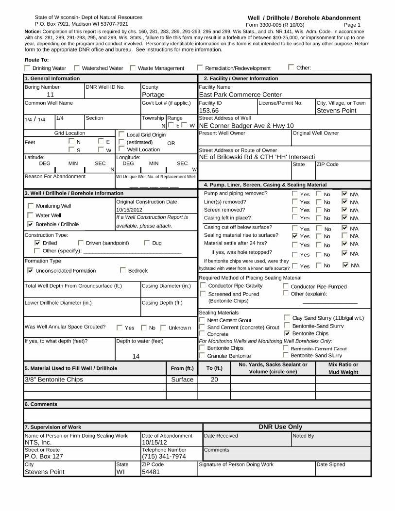
State of Wisconsin- Dept of Natural Resources
P.O. Box 7921, Madison WI 53707-7921Well / Drillhole / Borehole Abandonment
Form 3300-005 (R 10/03) Page 1
Route To:
1. General Information 2. Facility / Owner Information
Boring Number DNR Well ID No. County Facility Name
11 Portage
Common Well Name Gov't Lot # (if applic.) Facility ID City, Village, or Town
Stevens Point
1/4 / 1/4 1/4 Section Township Range Street Address of Well
N
Grid Location Present Well Owner Original Well Owner
OR
Street Address or Route of Owner
Latitude: Longitude: DEG MIN SEC DEG MIN SEC
N W
Reason For Abandonment
4. Pump, Liner, Screen, Casing & Sealing Material
3. Well / Drillhole / Borehole Information Pump and piping removed?
Original Construction Date Liner(s) removed?
Screen removed?
Casing left in place?
Casing cut off below surface?
Construction Type: Sealing material rise to surface?
Material settle after 24 hrs?
If yes, was hole retopped?
Formation Type
Required Method of Placing Sealing Material
Total Well Depth From Groundsurface (ft.) Casing Diameter (in.)
(Bentonite Chips) ___________________
Sealing Materials
Was Well Annular Space Grouted?
14
5. Material Used to Fill Well / Drillhole From (ft.)Mix Ratio or
Mud Weight
3/8" Bentonite Chips Surface
6. Comments
7. Supervision of Work DNR Use Only
Name of Person or Firm Doing Sealing Work Date of Abandonment Date Received Noted By
NTS, Inc.Street or Route Telephone Number Comments
P.O. Box 127 (715) 341-7974
City State ZIP Code Signature of Person Doing Work Date Signed
Stevens Point WI 54481
___ ___ ___ ___ ___
WI Unique Well No. of Replacement Well
State
If bentonite chips were used, were they
hydrated with water from a known safe source?
10/15/2012
Lower Drillhole Diameter (in.) Casing Depth (ft.)
available, please attach.
If a Well Construction Report is
10/15/12
If yes, to what depth (feet)? Depth to water (feet) For Monitoring Wells and Monitoring Well Boreholes Only:
To (ft.)
20
No. Yards, Sacks Sealant or
Volume (circle one)
East Park Commerce Center
NE of Brilowski Rd & CTH 'HH' Intersection
License/Permit No.
NE Corner Badger Ave & Hwy 10
ZIP Code
Feet
Notice: Completion of this report is required by chs. 160, 281, 283, 289, 291-293, 295 and 299, Wis Stats., and ch. NR 141, Wis. Adm. Code. In accordance
with chs. 281, 289, 291-293, 295, and 299, Wis. Stats., failure to file this form may result in a forfeiture of between $10-25,000, or imprisonment for up to one
year, depending on the program and conduct involved. Personally identifiable information on this form is not intended to be used for any other purpose. Return
form to the appropriate DNR office and bureau. See instructions for more information.
153.66
No
BedrockUnconsolidated Formation
Drilled Driven (sandpoint) Dug
Other (specify): ________________________________
Yes No Unknow n
Yes
Yes
Yes
Yes
N/ANoYes
No
No
No
N/A
N/A
N/A
N/A
Yes
Yes
Yes
Yes
No
No
No
No
N/A
N/A
N/A
N/A
Monitoring Well
Water Well
Borehole / Drillhole
N
S
E
W
E W
Local Grid Origin
(estimated)
Well Location
Drinking Water Watershed Water Waste Management Remediation/Redevelopment Other: ________________
Neat Cement Grout
Sand Cement (concrete) Grout
Concrete Bentonite Chips
Bentonite Chips
Granular Bentonite
Bentonite-Cement Grout
Bentonite-Sand Slurry
Bentonite-Sand Slurry
Clay Sand Slurry (11lb/gal w t.)
Conductor Pipe-Gravity
Screened and Poured
Conductor Pipe-Pumped
Other (explain):

State of Wisconsin- Dept of Natural Resources
P.O. Box 7921, Madison WI 53707-7921Well / Drillhole / Borehole Abandonment
Form 3300-005 (R 10/03) Page 1
Route To:
1. General Information 2. Facility / Owner Information
Boring Number DNR Well ID No. County Facility Name
12 Portage
Common Well Name Gov't Lot # (if applic.) Facility ID City, Village, or Town
Stevens Point
1/4 / 1/4 1/4 Section Township Range Street Address of Well
N
Grid Location Present Well Owner Original Well Owner
OR
Street Address or Route of Owner
Latitude: Longitude: DEG MIN SEC DEG MIN SEC
N W
Reason For Abandonment
4. Pump, Liner, Screen, Casing & Sealing Material
3. Well / Drillhole / Borehole Information Pump and piping removed?
Original Construction Date Liner(s) removed?
Screen removed?
Casing left in place?
Casing cut off below surface?
Construction Type: Sealing material rise to surface?
Material settle after 24 hrs?
If yes, was hole retopped?
Formation Type
Required Method of Placing Sealing Material
Total Well Depth From Groundsurface (ft.) Casing Diameter (in.)
(Bentonite Chips) ___________________
Sealing Materials
Was Well Annular Space Grouted?
14
5. Material Used to Fill Well / Drillhole From (ft.)Mix Ratio or
Mud Weight
3/8" Bentonite Chips Surface
6. Comments
7. Supervision of Work DNR Use Only
Name of Person or Firm Doing Sealing Work Date of Abandonment Date Received Noted By
NTS, Inc.Street or Route Telephone Number Comments
P.O. Box 127 (715) 341-7974
City State ZIP Code Signature of Person Doing Work Date Signed
Stevens Point WI 54481
___ ___ ___ ___ ___
WI Unique Well No. of Replacement Well
State
If bentonite chips were used, were they
hydrated with water from a known safe source?
10/15/2012
Lower Drillhole Diameter (in.) Casing Depth (ft.)
available, please attach.
If a Well Construction Report is
10/15/12
If yes, to what depth (feet)? Depth to water (feet) For Monitoring Wells and Monitoring Well Boreholes Only:
To (ft.)
20
No. Yards, Sacks Sealant or
Volume (circle one)
East Park Commerce Center
NE of Brilowski Rd & CTH 'HH' Intersection
License/Permit No.
NE Corner Badger Ave & Hwy 10
ZIP Code
Feet
Notice: Completion of this report is required by chs. 160, 281, 283, 289, 291-293, 295 and 299, Wis Stats., and ch. NR 141, Wis. Adm. Code. In accordance
with chs. 281, 289, 291-293, 295, and 299, Wis. Stats., failure to file this form may result in a forfeiture of between $10-25,000, or imprisonment for up to one
year, depending on the program and conduct involved. Personally identifiable information on this form is not intended to be used for any other purpose. Return
form to the appropriate DNR office and bureau. See instructions for more information.
153.66
No
BedrockUnconsolidated Formation
Drilled Driven (sandpoint) Dug
Other (specify): ________________________________
Yes No Unknow n
Yes
Yes
Yes
Yes
N/ANoYes
No
No
No
N/A
N/A
N/A
N/A
Yes
Yes
Yes
Yes
No
No
No
No
N/A
N/A
N/A
N/A
Monitoring Well
Water Well
Borehole / Drillhole
N
S
E
W
E W
Local Grid Origin
(estimated)
Well Location
Drinking Water Watershed Water Waste Management Remediation/Redevelopment Other: ________________
Neat Cement Grout
Sand Cement (concrete) Grout
Concrete Bentonite Chips
Bentonite Chips
Granular Bentonite
Bentonite-Cement Grout
Bentonite-Sand Slurry
Bentonite-Sand Slurry
Clay Sand Slurry (11lb/gal w t.)
Conductor Pipe-Gravity
Screened and Poured
Conductor Pipe-Pumped
Other (explain):

State of Wisconsin- Dept of Natural Resources
P.O. Box 7921, Madison WI 53707-7921Well / Drillhole / Borehole Abandonment
Form 3300-005 (R 10/03) Page 1
Route To:
1. General Information 2. Facility / Owner Information
Boring Number DNR Well ID No. County Facility Name
13 Portage
Common Well Name Gov't Lot # (if applic.) Facility ID City, Village, or Town
Stevens Point
1/4 / 1/4 1/4 Section Township Range Street Address of Well
N
Grid Location Present Well Owner Original Well Owner
OR
Street Address or Route of Owner
Latitude: Longitude: DEG MIN SEC DEG MIN SEC
N W
Reason For Abandonment
4. Pump, Liner, Screen, Casing & Sealing Material
3. Well / Drillhole / Borehole Information Pump and piping removed?
Original Construction Date Liner(s) removed?
Screen removed?
Casing left in place?
Casing cut off below surface?
Construction Type: Sealing material rise to surface?
Material settle after 24 hrs?
If yes, was hole retopped?
Formation Type
Required Method of Placing Sealing Material
Total Well Depth From Groundsurface (ft.) Casing Diameter (in.)
(Bentonite Chips) ___________________
Sealing Materials
Was Well Annular Space Grouted?
15
5. Material Used to Fill Well / Drillhole From (ft.)Mix Ratio or
Mud Weight
3/8" Bentonite Chips Surface
6. Comments
7. Supervision of Work DNR Use Only
Name of Person or Firm Doing Sealing Work Date of Abandonment Date Received Noted By
NTS, Inc.Street or Route Telephone Number Comments
P.O. Box 127 (715) 341-7974
City State ZIP Code Signature of Person Doing Work Date Signed
Stevens Point WI 54481
___ ___ ___ ___ ___
WI Unique Well No. of Replacement Well
State
If bentonite chips were used, were they
hydrated with water from a known safe source?
10/16/2012
Lower Drillhole Diameter (in.) Casing Depth (ft.)
available, please attach.
If a Well Construction Report is
10/16/12
If yes, to what depth (feet)? Depth to water (feet) For Monitoring Wells and Monitoring Well Boreholes Only:
To (ft.)
20
No. Yards, Sacks Sealant or
Volume (circle one)
East Park Commerce Center
NE of Brilowski Rd & CTH 'HH' Intersection
License/Permit No.
NE Corner Badger Ave & Hwy 10
ZIP Code
Feet
Notice: Completion of this report is required by chs. 160, 281, 283, 289, 291-293, 295 and 299, Wis Stats., and ch. NR 141, Wis. Adm. Code. In accordance
with chs. 281, 289, 291-293, 295, and 299, Wis. Stats., failure to file this form may result in a forfeiture of between $10-25,000, or imprisonment for up to one
year, depending on the program and conduct involved. Personally identifiable information on this form is not intended to be used for any other purpose. Return
form to the appropriate DNR office and bureau. See instructions for more information.
153.66
No
BedrockUnconsolidated Formation
Drilled Driven (sandpoint) Dug
Other (specify): ________________________________
Yes No Unknow n
Yes
Yes
Yes
Yes
N/ANoYes
No
No
No
N/A
N/A
N/A
N/A
Yes
Yes
Yes
Yes
No
No
No
No
N/A
N/A
N/A
N/A
Monitoring Well
Water Well
Borehole / Drillhole
N
S
E
W
E W
Local Grid Origin
(estimated)
Well Location
Drinking Water Watershed Water Waste Management Remediation/Redevelopment Other: ________________
Neat Cement Grout
Sand Cement (concrete) Grout
Concrete Bentonite Chips
Bentonite Chips
Granular Bentonite
Bentonite-Cement Grout
Bentonite-Sand Slurry
Bentonite-Sand Slurry
Clay Sand Slurry (11lb/gal w t.)
Conductor Pipe-Gravity
Screened and Poured
Conductor Pipe-Pumped
Other (explain):

State of Wisconsin- Dept of Natural Resources
P.O. Box 7921, Madison WI 53707-7921Well / Drillhole / Borehole Abandonment
Form 3300-005 (R 10/03) Page 1
Route To:
1. General Information 2. Facility / Owner Information
Boring Number DNR Well ID No. County Facility Name
14 Portage
Common Well Name Gov't Lot # (if applic.) Facility ID City, Village, or Town
Stevens Point
1/4 / 1/4 1/4 Section Township Range Street Address of Well
N
Grid Location Present Well Owner Original Well Owner
OR
Street Address or Route of Owner
Latitude: Longitude: DEG MIN SEC DEG MIN SEC
N W
Reason For Abandonment
4. Pump, Liner, Screen, Casing & Sealing Material
3. Well / Drillhole / Borehole Information Pump and piping removed?
Original Construction Date Liner(s) removed?
Screen removed?
Casing left in place?
Casing cut off below surface?
Construction Type: Sealing material rise to surface?
Material settle after 24 hrs?
If yes, was hole retopped?
Formation Type
Required Method of Placing Sealing Material
Total Well Depth From Groundsurface (ft.) Casing Diameter (in.)
(Bentonite Chips) ___________________
Sealing Materials
Was Well Annular Space Grouted?
17.5
5. Material Used to Fill Well / Drillhole From (ft.)Mix Ratio or
Mud Weight
3/8" Bentonite Chips Surface
6. Comments
7. Supervision of Work DNR Use Only
Name of Person or Firm Doing Sealing Work Date of Abandonment Date Received Noted By
NTS, Inc.Street or Route Telephone Number Comments
P.O. Box 127 (715) 341-7974
City State ZIP Code Signature of Person Doing Work Date Signed
Stevens Point WI 54481
___ ___ ___ ___ ___
WI Unique Well No. of Replacement Well
State
If bentonite chips were used, were they
hydrated with water from a known safe source?
10/23/2012
Lower Drillhole Diameter (in.) Casing Depth (ft.)
available, please attach.
If a Well Construction Report is
10/23/12
If yes, to what depth (feet)? Depth to water (feet) For Monitoring Wells and Monitoring Well Boreholes Only:
To (ft.)
20
No. Yards, Sacks Sealant or
Volume (circle one)
East Park Commerce Center
NE of Brilowski Rd & CTH 'HH' Intersection
License/Permit No.
NE Corner Badger Ave & Hwy 10
ZIP Code
Feet
Notice: Completion of this report is required by chs. 160, 281, 283, 289, 291-293, 295 and 299, Wis Stats., and ch. NR 141, Wis. Adm. Code. In accordance
with chs. 281, 289, 291-293, 295, and 299, Wis. Stats., failure to file this form may result in a forfeiture of between $10-25,000, or imprisonment for up to one
year, depending on the program and conduct involved. Personally identifiable information on this form is not intended to be used for any other purpose. Return
form to the appropriate DNR office and bureau. See instructions for more information.
153.66
No
BedrockUnconsolidated Formation
Drilled Driven (sandpoint) Dug
Other (specify): ________________________________
Yes No Unknow n
Yes
Yes
Yes
Yes
N/ANoYes
No
No
No
N/A
N/A
N/A
N/A
Yes
Yes
Yes
Yes
No
No
No
No
N/A
N/A
N/A
N/A
Monitoring Well
Water Well
Borehole / Drillhole
N
S
E
W
E W
Local Grid Origin
(estimated)
Well Location
Drinking Water Watershed Water Waste Management Remediation/Redevelopment Other: ________________
Neat Cement Grout
Sand Cement (concrete) Grout
Concrete Bentonite Chips
Bentonite Chips
Granular Bentonite
Bentonite-Cement Grout
Bentonite-Sand Slurry
Bentonite-Sand Slurry
Clay Sand Slurry (11lb/gal w t.)
Conductor Pipe-Gravity
Screened and Poured
Conductor Pipe-Pumped
Other (explain):

State of Wisconsin- Dept of Natural Resources
P.O. Box 7921, Madison WI 53707-7921Well / Drillhole / Borehole Abandonment
Form 3300-005 (R 10/03) Page 1
Route To:
1. General Information 2. Facility / Owner Information
Boring Number DNR Well ID No. County Facility Name
15 Portage
Common Well Name Gov't Lot # (if applic.) Facility ID City, Village, or Town
Stevens Point
1/4 / 1/4 1/4 Section Township Range Street Address of Well
N
Grid Location Present Well Owner Original Well Owner
OR
Street Address or Route of Owner
Latitude: Longitude: DEG MIN SEC DEG MIN SEC
N W
Reason For Abandonment
4. Pump, Liner, Screen, Casing & Sealing Material
3. Well / Drillhole / Borehole Information Pump and piping removed?
Original Construction Date Liner(s) removed?
Screen removed?
Casing left in place?
Casing cut off below surface?
Construction Type: Sealing material rise to surface?
Material settle after 24 hrs?
If yes, was hole retopped?
Formation Type
Required Method of Placing Sealing Material
Total Well Depth From Groundsurface (ft.) Casing Diameter (in.)
(Bentonite Chips) ___________________
Sealing Materials
Was Well Annular Space Grouted?
14
5. Material Used to Fill Well / Drillhole From (ft.)Mix Ratio or
Mud Weight
3/8" Bentonite Chips Surface
6. Comments
7. Supervision of Work DNR Use Only
Name of Person or Firm Doing Sealing Work Date of Abandonment Date Received Noted By
NTS, Inc.Street or Route Telephone Number Comments
P.O. Box 127 (715) 341-7974
City State ZIP Code Signature of Person Doing Work Date Signed
Stevens Point WI 54481
___ ___ ___ ___ ___
WI Unique Well No. of Replacement Well
State
If bentonite chips were used, were they
hydrated with water from a known safe source?
10/15/2012
Lower Drillhole Diameter (in.) Casing Depth (ft.)
available, please attach.
If a Well Construction Report is
10/15/12
If yes, to what depth (feet)? Depth to water (feet) For Monitoring Wells and Monitoring Well Boreholes Only:
To (ft.)
20
No. Yards, Sacks Sealant or
Volume (circle one)
East Park Commerce Center
NE of Brilowski Rd & CTH 'HH' Intersection
License/Permit No.
NE Corner Badger Ave & Hwy 10
ZIP Code
Feet
Notice: Completion of this report is required by chs. 160, 281, 283, 289, 291-293, 295 and 299, Wis Stats., and ch. NR 141, Wis. Adm. Code. In accordance
with chs. 281, 289, 291-293, 295, and 299, Wis. Stats., failure to file this form may result in a forfeiture of between $10-25,000, or imprisonment for up to one
year, depending on the program and conduct involved. Personally identifiable information on this form is not intended to be used for any other purpose. Return
form to the appropriate DNR office and bureau. See instructions for more information.
153.66
No
BedrockUnconsolidated Formation
Drilled Driven (sandpoint) Dug
Other (specify): ________________________________
Yes No Unknow n
Yes
Yes
Yes
Yes
N/ANoYes
No
No
No
N/A
N/A
N/A
N/A
Yes
Yes
Yes
Yes
No
No
No
No
N/A
N/A
N/A
N/A
Monitoring Well
Water Well
Borehole / Drillhole
N
S
E
W
E W
Local Grid Origin
(estimated)
Well Location
Drinking Water Watershed Water Waste Management Remediation/Redevelopment Other: ________________
Neat Cement Grout
Sand Cement (concrete) Grout
Concrete Bentonite Chips
Bentonite Chips
Granular Bentonite
Bentonite-Cement Grout
Bentonite-Sand Slurry
Bentonite-Sand Slurry
Clay Sand Slurry (11lb/gal w t.)
Conductor Pipe-Gravity
Screened and Poured
Conductor Pipe-Pumped
Other (explain):

State of Wisconsin- Dept of Natural Resources
P.O. Box 7921, Madison WI 53707-7921Well / Drillhole / Borehole Abandonment
Form 3300-005 (R 10/03) Page 1
Route To:
1. General Information 2. Facility / Owner Information
Boring Number DNR Well ID No. County Facility Name
16 Portage
Common Well Name Gov't Lot # (if applic.) Facility ID City, Village, or Town
Stevens Point
1/4 / 1/4 1/4 Section Township Range Street Address of Well
N
Grid Location Present Well Owner Original Well Owner
OR
Street Address or Route of Owner
Latitude: Longitude: DEG MIN SEC DEG MIN SEC
N W
Reason For Abandonment
4. Pump, Liner, Screen, Casing & Sealing Material
3. Well / Drillhole / Borehole Information Pump and piping removed?
Original Construction Date Liner(s) removed?
Screen removed?
Casing left in place?
Casing cut off below surface?
Construction Type: Sealing material rise to surface?
Material settle after 24 hrs?
If yes, was hole retopped?
Formation Type
Required Method of Placing Sealing Material
Total Well Depth From Groundsurface (ft.) Casing Diameter (in.)
(Bentonite Chips) ___________________
Sealing Materials
Was Well Annular Space Grouted?
14
5. Material Used to Fill Well / Drillhole From (ft.)Mix Ratio or
Mud Weight
3/8" Bentonite Chips Surface
6. Comments
7. Supervision of Work DNR Use Only
Name of Person or Firm Doing Sealing Work Date of Abandonment Date Received Noted By
NTS, Inc.Street or Route Telephone Number Comments
P.O. Box 127 (715) 341-7974
City State ZIP Code Signature of Person Doing Work Date Signed
Stevens Point WI 54481
___ ___ ___ ___ ___
WI Unique Well No. of Replacement Well
State
If bentonite chips were used, were they
hydrated with water from a known safe source?
10/15/2012
Lower Drillhole Diameter (in.) Casing Depth (ft.)
available, please attach.
If a Well Construction Report is
10/15/12
If yes, to what depth (feet)? Depth to water (feet) For Monitoring Wells and Monitoring Well Boreholes Only:
To (ft.)
20
No. Yards, Sacks Sealant or
Volume (circle one)
East Park Commerce Center
NE of Brilowski Rd & CTH 'HH' Intersection
License/Permit No.
NE Corner Badger Ave & Hwy 10
ZIP Code
Feet
Notice: Completion of this report is required by chs. 160, 281, 283, 289, 291-293, 295 and 299, Wis Stats., and ch. NR 141, Wis. Adm. Code. In accordance
with chs. 281, 289, 291-293, 295, and 299, Wis. Stats., failure to file this form may result in a forfeiture of between $10-25,000, or imprisonment for up to one
year, depending on the program and conduct involved. Personally identifiable information on this form is not intended to be used for any other purpose. Return
form to the appropriate DNR office and bureau. See instructions for more information.
153.66
No
BedrockUnconsolidated Formation
Drilled Driven (sandpoint) Dug
Other (specify): ________________________________
Yes No Unknow n
Yes
Yes
Yes
Yes
N/ANoYes
No
No
No
N/A
N/A
N/A
N/A
Yes
Yes
Yes
Yes
No
No
No
No
N/A
N/A
N/A
N/A
Monitoring Well
Water Well
Borehole / Drillhole
N
S
E
W
E W
Local Grid Origin
(estimated)
Well Location
Drinking Water Watershed Water Waste Management Remediation/Redevelopment Other: ________________
Neat Cement Grout
Sand Cement (concrete) Grout
Concrete Bentonite Chips
Bentonite Chips
Granular Bentonite
Bentonite-Cement Grout
Bentonite-Sand Slurry
Bentonite-Sand Slurry
Clay Sand Slurry (11lb/gal w t.)
Conductor Pipe-Gravity
Screened and Poured
Conductor Pipe-Pumped
Other (explain):

State of Wisconsin- Dept of Natural Resources
P.O. Box 7921, Madison WI 53707-7921Well / Drillhole / Borehole Abandonment
Form 3300-005 (R 10/03) Page 1
Route To:
1. General Information 2. Facility / Owner Information
Boring Number DNR Well ID No. County Facility Name
17 Portage
Common Well Name Gov't Lot # (if applic.) Facility ID City, Village, or Town
Stevens Point
1/4 / 1/4 1/4 Section Township Range Street Address of Well
N
Grid Location Present Well Owner Original Well Owner
OR
Street Address or Route of Owner
Latitude: Longitude: DEG MIN SEC DEG MIN SEC
N W
Reason For Abandonment
4. Pump, Liner, Screen, Casing & Sealing Material
3. Well / Drillhole / Borehole Information Pump and piping removed?
Original Construction Date Liner(s) removed?
Screen removed?
Casing left in place?
Casing cut off below surface?
Construction Type: Sealing material rise to surface?
Material settle after 24 hrs?
If yes, was hole retopped?
Formation Type
Required Method of Placing Sealing Material
Total Well Depth From Groundsurface (ft.) Casing Diameter (in.)
(Bentonite Chips) ___________________
Sealing Materials
Was Well Annular Space Grouted?
14.5
5. Material Used to Fill Well / Drillhole From (ft.)Mix Ratio or
Mud Weight
3/8" Bentonite Chips Surface
6. Comments
7. Supervision of Work DNR Use Only
Name of Person or Firm Doing Sealing Work Date of Abandonment Date Received Noted By
NTS, Inc.Street or Route Telephone Number Comments
P.O. Box 127 (715) 341-7974
City State ZIP Code Signature of Person Doing Work Date Signed
Stevens Point WI 54481
___ ___ ___ ___ ___
WI Unique Well No. of Replacement Well
State
If bentonite chips were used, were they
hydrated with water from a known safe source?
10/16/2012
Lower Drillhole Diameter (in.) Casing Depth (ft.)
available, please attach.
If a Well Construction Report is
10/16/12
If yes, to what depth (feet)? Depth to water (feet) For Monitoring Wells and Monitoring Well Boreholes Only:
To (ft.)
20
No. Yards, Sacks Sealant or
Volume (circle one)
East Park Commerce Center
NE of Brilowski Rd & CTH 'HH' Intersection
License/Permit No.
NE Corner Badger Ave & Hwy 10
ZIP Code
Feet
Notice: Completion of this report is required by chs. 160, 281, 283, 289, 291-293, 295 and 299, Wis Stats., and ch. NR 141, Wis. Adm. Code. In accordance
with chs. 281, 289, 291-293, 295, and 299, Wis. Stats., failure to file this form may result in a forfeiture of between $10-25,000, or imprisonment for up to one
year, depending on the program and conduct involved. Personally identifiable information on this form is not intended to be used for any other purpose. Return
form to the appropriate DNR office and bureau. See instructions for more information.
153.66
No
BedrockUnconsolidated Formation
Drilled Driven (sandpoint) Dug
Other (specify): ________________________________
Yes No Unknow n
Yes
Yes
Yes
Yes
N/ANoYes
No
No
No
N/A
N/A
N/A
N/A
Yes
Yes
Yes
Yes
No
No
No
No
N/A
N/A
N/A
N/A
Monitoring Well
Water Well
Borehole / Drillhole
N
S
E
W
E W
Local Grid Origin
(estimated)
Well Location
Drinking Water Watershed Water Waste Management Remediation/Redevelopment Other: ________________
Neat Cement Grout
Sand Cement (concrete) Grout
Concrete Bentonite Chips
Bentonite Chips
Granular Bentonite
Bentonite-Cement Grout
Bentonite-Sand Slurry
Bentonite-Sand Slurry
Clay Sand Slurry (11lb/gal w t.)
Conductor Pipe-Gravity
Screened and Poured
Conductor Pipe-Pumped
Other (explain):

State of Wisconsin- Dept of Natural Resources
P.O. Box 7921, Madison WI 53707-7921Well / Drillhole / Borehole Abandonment
Form 3300-005 (R 10/03) Page 1
Route To:
1. General Information 2. Facility / Owner Information
Boring Number DNR Well ID No. County Facility Name
18 Portage
Common Well Name Gov't Lot # (if applic.) Facility ID City, Village, or Town
Stevens Point
1/4 / 1/4 1/4 Section Township Range Street Address of Well
N
Grid Location Present Well Owner Original Well Owner
OR
Street Address or Route of Owner
Latitude: Longitude: DEG MIN SEC DEG MIN SEC
N W
Reason For Abandonment
4. Pump, Liner, Screen, Casing & Sealing Material
3. Well / Drillhole / Borehole Information Pump and piping removed?
Original Construction Date Liner(s) removed?
Screen removed?
Casing left in place?
Casing cut off below surface?
Construction Type: Sealing material rise to surface?
Material settle after 24 hrs?
If yes, was hole retopped?
Formation Type
Required Method of Placing Sealing Material
Total Well Depth From Groundsurface (ft.) Casing Diameter (in.)
(Bentonite Chips) ___________________
Sealing Materials
Was Well Annular Space Grouted?
14
5. Material Used to Fill Well / Drillhole From (ft.)Mix Ratio or
Mud Weight
3/8" Bentonite Chips Surface
6. Comments
7. Supervision of Work DNR Use Only
Name of Person or Firm Doing Sealing Work Date of Abandonment Date Received Noted By
NTS, Inc.Street or Route Telephone Number Comments
P.O. Box 127 (715) 341-7974
City State ZIP Code Signature of Person Doing Work Date Signed
Stevens Point WI 54481
___ ___ ___ ___ ___
WI Unique Well No. of Replacement Well
State
If bentonite chips were used, were they
hydrated with water from a known safe source?
10/16/2012
Lower Drillhole Diameter (in.) Casing Depth (ft.)
available, please attach.
If a Well Construction Report is
10/16/12
If yes, to what depth (feet)? Depth to water (feet) For Monitoring Wells and Monitoring Well Boreholes Only:
To (ft.)
20
No. Yards, Sacks Sealant or
Volume (circle one)
East Park Commerce Center
NE of Brilowski Rd & CTH 'HH' Intersection
License/Permit No.
NE Corner Badger Ave & Hwy 10
ZIP Code
Feet
Notice: Completion of this report is required by chs. 160, 281, 283, 289, 291-293, 295 and 299, Wis Stats., and ch. NR 141, Wis. Adm. Code. In accordance
with chs. 281, 289, 291-293, 295, and 299, Wis. Stats., failure to file this form may result in a forfeiture of between $10-25,000, or imprisonment for up to one
year, depending on the program and conduct involved. Personally identifiable information on this form is not intended to be used for any other purpose. Return
form to the appropriate DNR office and bureau. See instructions for more information.
153.66
No
BedrockUnconsolidated Formation
Drilled Driven (sandpoint) Dug
Other (specify): ________________________________
Yes No Unknow n
Yes
Yes
Yes
Yes
N/ANoYes
No
No
No
N/A
N/A
N/A
N/A
Yes
Yes
Yes
Yes
No
No
No
No
N/A
N/A
N/A
N/A
Monitoring Well
Water Well
Borehole / Drillhole
N
S
E
W
E W
Local Grid Origin
(estimated)
Well Location
Drinking Water Watershed Water Waste Management Remediation/Redevelopment Other: ________________
Neat Cement Grout
Sand Cement (concrete) Grout
Concrete Bentonite Chips
Bentonite Chips
Granular Bentonite
Bentonite-Cement Grout
Bentonite-Sand Slurry
Bentonite-Sand Slurry
Clay Sand Slurry (11lb/gal w t.)
Conductor Pipe-Gravity
Screened and Poured
Conductor Pipe-Pumped
Other (explain):

State of Wisconsin- Dept of Natural Resources
P.O. Box 7921, Madison WI 53707-7921Well / Drillhole / Borehole Abandonment
Form 3300-005 (R 10/03) Page 1
Route To:
1. General Information 2. Facility / Owner Information
Boring Number DNR Well ID No. County Facility Name
19 Portage
Common Well Name Gov't Lot # (if applic.) Facility ID City, Village, or Town
Stevens Point
1/4 / 1/4 1/4 Section Township Range Street Address of Well
N
Grid Location Present Well Owner Original Well Owner
OR
Street Address or Route of Owner
Latitude: Longitude: DEG MIN SEC DEG MIN SEC
N W
Reason For Abandonment
4. Pump, Liner, Screen, Casing & Sealing Material
3. Well / Drillhole / Borehole Information Pump and piping removed?
Original Construction Date Liner(s) removed?
Screen removed?
Casing left in place?
Casing cut off below surface?
Construction Type: Sealing material rise to surface?
Material settle after 24 hrs?
If yes, was hole retopped?
Formation Type
Required Method of Placing Sealing Material
Total Well Depth From Groundsurface (ft.) Casing Diameter (in.)
(Bentonite Chips) ___________________
Sealing Materials
Was Well Annular Space Grouted?
17.5
5. Material Used to Fill Well / Drillhole From (ft.)Mix Ratio or
Mud Weight
3/8" Bentonite Chips Surface
6. Comments
7. Supervision of Work DNR Use Only
Name of Person or Firm Doing Sealing Work Date of Abandonment Date Received Noted By
NTS, Inc.Street or Route Telephone Number Comments
P.O. Box 127 (715) 341-7974
City State ZIP Code Signature of Person Doing Work Date Signed
Stevens Point WI 54481
___ ___ ___ ___ ___
WI Unique Well No. of Replacement Well
State
If bentonite chips were used, were they
hydrated with water from a known safe source?
10/23/2012
Lower Drillhole Diameter (in.) Casing Depth (ft.)
available, please attach.
If a Well Construction Report is
10/23/12
If yes, to what depth (feet)? Depth to water (feet) For Monitoring Wells and Monitoring Well Boreholes Only:
To (ft.)
20
No. Yards, Sacks Sealant or
Volume (circle one)
East Park Commerce Center
NE of Brilowski Rd & CTH 'HH' Intersection
License/Permit No.
NE Corner Badger Ave & Hwy 10
ZIP Code
Feet
Notice: Completion of this report is required by chs. 160, 281, 283, 289, 291-293, 295 and 299, Wis Stats., and ch. NR 141, Wis. Adm. Code. In accordance
with chs. 281, 289, 291-293, 295, and 299, Wis. Stats., failure to file this form may result in a forfeiture of between $10-25,000, or imprisonment for up to one
year, depending on the program and conduct involved. Personally identifiable information on this form is not intended to be used for any other purpose. Return
form to the appropriate DNR office and bureau. See instructions for more information.
153.66
No
BedrockUnconsolidated Formation
Drilled Driven (sandpoint) Dug
Other (specify): ________________________________
Yes No Unknow n
Yes
Yes
Yes
Yes
N/ANoYes
No
No
No
N/A
N/A
N/A
N/A
Yes
Yes
Yes
Yes
No
No
No
No
N/A
N/A
N/A
N/A
Monitoring Well
Water Well
Borehole / Drillhole
N
S
E
W
E W
Local Grid Origin
(estimated)
Well Location
Drinking Water Watershed Water Waste Management Remediation/Redevelopment Other: ________________
Neat Cement Grout
Sand Cement (concrete) Grout
Concrete Bentonite Chips
Bentonite Chips
Granular Bentonite
Bentonite-Cement Grout
Bentonite-Sand Slurry
Bentonite-Sand Slurry
Clay Sand Slurry (11lb/gal w t.)
Conductor Pipe-Gravity
Screened and Poured
Conductor Pipe-Pumped
Other (explain):

State of Wisconsin- Dept of Natural Resources
P.O. Box 7921, Madison WI 53707-7921Well / Drillhole / Borehole Abandonment
Form 3300-005 (R 10/03) Page 1
Route To:
1. General Information 2. Facility / Owner Information
Boring Number DNR Well ID No. County Facility Name
20 Portage
Common Well Name Gov't Lot # (if applic.) Facility ID City, Village, or Town
Stevens Point
1/4 / 1/4 1/4 Section Township Range Street Address of Well
N
Grid Location Present Well Owner Original Well Owner
OR
Street Address or Route of Owner
Latitude: Longitude: DEG MIN SEC DEG MIN SEC
N W
Reason For Abandonment
4. Pump, Liner, Screen, Casing & Sealing Material
3. Well / Drillhole / Borehole Information Pump and piping removed?
Original Construction Date Liner(s) removed?
Screen removed?
Casing left in place?
Casing cut off below surface?
Construction Type: Sealing material rise to surface?
Material settle after 24 hrs?
If yes, was hole retopped?
Formation Type
Required Method of Placing Sealing Material
Total Well Depth From Groundsurface (ft.) Casing Diameter (in.)
(Bentonite Chips) ___________________
Sealing Materials
Was Well Annular Space Grouted?
17
5. Material Used to Fill Well / Drillhole From (ft.)Mix Ratio or
Mud Weight
3/8" Bentonite Chips Surface
6. Comments
7. Supervision of Work DNR Use Only
Name of Person or Firm Doing Sealing Work Date of Abandonment Date Received Noted By
NTS, Inc.Street or Route Telephone Number Comments
P.O. Box 127 (715) 341-7974
City State ZIP Code Signature of Person Doing Work Date Signed
Stevens Point WI 54481
___ ___ ___ ___ ___
WI Unique Well No. of Replacement Well
State
If bentonite chips were used, were they
hydrated with water from a known safe source?
10/23/2012
Lower Drillhole Diameter (in.) Casing Depth (ft.)
available, please attach.
If a Well Construction Report is
10/23/12
If yes, to what depth (feet)? Depth to water (feet) For Monitoring Wells and Monitoring Well Boreholes Only:
To (ft.)
20
No. Yards, Sacks Sealant or
Volume (circle one)
East Park Commerce Center
NE of Brilowski Rd & CTH 'HH' Intersection
License/Permit No.
NE Corner Badger Ave & Hwy 10
ZIP Code
Feet
Notice: Completion of this report is required by chs. 160, 281, 283, 289, 291-293, 295 and 299, Wis Stats., and ch. NR 141, Wis. Adm. Code. In accordance
with chs. 281, 289, 291-293, 295, and 299, Wis. Stats., failure to file this form may result in a forfeiture of between $10-25,000, or imprisonment for up to one
year, depending on the program and conduct involved. Personally identifiable information on this form is not intended to be used for any other purpose. Return
form to the appropriate DNR office and bureau. See instructions for more information.
153.66
No
BedrockUnconsolidated Formation
Drilled Driven (sandpoint) Dug
Other (specify): ________________________________
Yes No Unknow n
Yes
Yes
Yes
Yes
N/ANoYes
No
No
No
N/A
N/A
N/A
N/A
Yes
Yes
Yes
Yes
No
No
No
No
N/A
N/A
N/A
N/A
Monitoring Well
Water Well
Borehole / Drillhole
N
S
E
W
E W
Local Grid Origin
(estimated)
Well Location
Drinking Water Watershed Water Waste Management Remediation/Redevelopment Other: ________________
Neat Cement Grout
Sand Cement (concrete) Grout
Concrete Bentonite Chips
Bentonite Chips
Granular Bentonite
Bentonite-Cement Grout
Bentonite-Sand Slurry
Bentonite-Sand Slurry
Clay Sand Slurry (11lb/gal w t.)
Conductor Pipe-Gravity
Screened and Poured
Conductor Pipe-Pumped
Other (explain):

(X=NO)PERCENTFINERSIZE
PASS?SPEC.*PERCENTSIEVE
Project No:
Project:
Client:
Elev./Depth:Location:
Date:Source of Sample:Sample No.:
Remarks
Classification
Coefficients
Atterberg Limits
Soil Description
*
AASHTO=USCS=
Cc=Cu=
D10=D15=D30=
D50=D60=D85=
PI=LL=PL=
Grain Size Distribution Report
10
20
30
40
50
60
70
80
90
0
100
PERCENT FINER
100 10 1 0.1 0.01 0.001500
GRAIN SIZE - mm
% COBBLES% GRAVEL
CRS. FINE
% SAND
CRS. MEDIUM FINE
% FINES
SILT CLAY
6 in.
3 in.
2 in.
1-1/2 in.
1 in.
3/4 in.
1/2 in.
3/8 in.
#4
#10
#20
#30
#40
#60
#100
#140
#200
0.0 0.0 2.9 3.6 13.0 70.9 9.6
Figure 153.66
Annexation Project
AECOM
0'-2'
B1, S1B1, S1
SP-SM
1.303.580.07750.1080.1670.2360.2770.529
SAND, Brown, F-M, Little Silt, Trace Gravel
(no specification provided)
NUMMELIN TESTING
SERVICES, INC.
100.099.497.193.586.480.525.09.6
.5 in..375 in.
#4#10#30#40
#100#200

(X=NO)PERCENTFINERSIZE
PASS?SPEC.*PERCENTSIEVE
Project No:
Project:
Client:
Elev./Depth:Location:
Date:Source of Sample:Sample No.:
Remarks
Classification
Coefficients
Atterberg Limits
Soil Description
*
AASHTO=USCS=
Cc=Cu=
D10=D15=D30=
D50=D60=D85=
PI=LL=PL=
Grain Size Distribution Report
10
20
30
40
50
60
70
80
90
0
100
PERCENT FINER
100 10 1 0.1 0.01 0.001500
GRAIN SIZE - mm
% COBBLES% GRAVEL
CRS. FINE
% SAND
CRS. MEDIUM FINE
% FINES
SILT CLAY
6 in.
3 in.
2 in.
1-1/2 in.
1 in.
3/4 in.
1/2 in.
3/8 in.
#4
#10
#20
#30
#40
#60
#100
#140
#200
0.0 0.0 4.9 2.1 29.0 63.1 0.9
Figure 153.66
Annexation Project
AECOM
14'-15.5'
B2, S5B2, S5
SP
0.902.330.1700.1900.2460.3360.3960.832
SAND, Light Brown, F-M, Trace Gravel
(no specification provided)
NUMMELIN TESTING
SERVICES, INC.
100.098.097.395.193.080.564.05.40.9
.75 in..5 in.
.375 in.#4
#10#30#40
#100#200

(X=NO)PERCENTFINERSIZE
PASS?SPEC.*PERCENTSIEVE
Project No:
Project:
Client:
Elev./Depth:Location:
Date:Source of Sample:Sample No.:
Remarks
Classification
Coefficients
Atterberg Limits
Soil Description
*
AASHTO=USCS=
Cc=Cu=
D10=D15=D30=
D50=D60=D85=
PI=LL=PL=
Grain Size Distribution Report
10
20
30
40
50
60
70
80
90
0
100
PERCENT FINER
100 10 1 0.1 0.01 0.001500
GRAIN SIZE - mm
% COBBLES% GRAVEL
CRS. FINE
% SAND
CRS. MEDIUM FINE
% FINES
SILT CLAY
6 in.
3 in.
2 in.
1-1/2 in.
1 in.
3/4 in.
1/2 in.
3/8 in.
#4
#10
#20
#30
#40
#60
#100
#140
#200
0.0 0.0 26.8 23.5 33.7 13.1 2.9
Figure 153.66
Annexation Project
AECOM
9'-10.5'
B5, S4B5, S4
SP
0.8410.290.2870.4020.8472.022.967.37
SAND, Light Brown, F-C, Some Gravel
(no specification provided)
NUMMELIN TESTING
SERVICES, INC.
100.094.990.573.249.722.816.04.42.9
.75 in..5 in.
.375 in.#4#10#30#40#100#200
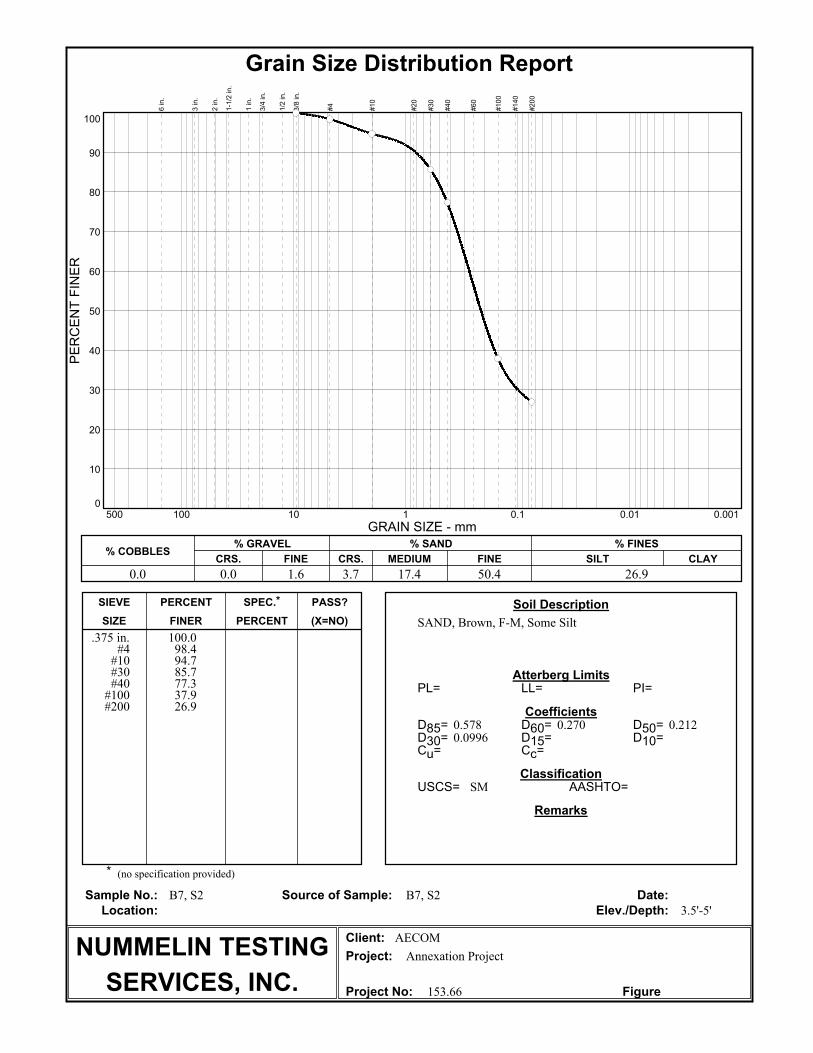
(X=NO)PERCENTFINERSIZE
PASS?SPEC.*PERCENTSIEVE
Project No:
Project:
Client:
Elev./Depth:Location:
Date:Source of Sample:Sample No.:
Remarks
Classification
Coefficients
Atterberg Limits
Soil Description
*
AASHTO=USCS=
Cc=Cu=
D10=D15=D30=
D50=D60=D85=
PI=LL=PL=
Grain Size Distribution Report
10
20
30
40
50
60
70
80
90
0
100
PERCENT FINER
100 10 1 0.1 0.01 0.001500
GRAIN SIZE - mm
% COBBLES% GRAVEL
CRS. FINE
% SAND
CRS. MEDIUM FINE
% FINES
SILT CLAY
6 in.
3 in.
2 in.
1-1/2 in.
1 in.
3/4 in.
1/2 in.
3/8 in.
#4
#10
#20
#30
#40
#60
#100
#140
#200
0.0 0.0 1.6 3.7 17.4 50.4 26.9
Figure 153.66
Annexation Project
AECOM
3.5'-5'
B7, S2 B7, S2
SM
0.09960.2120.2700.578
SAND, Brown, F-M, Some Silt
(no specification provided)
NUMMELIN TESTING
SERVICES, INC.
100.098.494.785.777.337.926.9
.375 in.#4#10#30#40#100#200

(X=NO)PERCENTFINERSIZE
PASS?SPEC.*PERCENTSIEVE
Project No:
Project:
Client:
Elev./Depth:Location:
Date:Source of Sample:Sample No.:
Remarks
Classification
Coefficients
Atterberg Limits
Soil Description
*
AASHTO=USCS=
Cc=Cu=
D10=D15=D30=
D50=D60=D85=
PI=LL=PL=
Grain Size Distribution Report
10
20
30
40
50
60
70
80
90
0
100
PERCENT FINER
100 10 1 0.1 0.01 0.001500
GRAIN SIZE - mm
% COBBLES% GRAVEL
CRS. FINE
% SAND
CRS. MEDIUM FINE
% FINES
SILT CLAY
6 in.
3 in.
2 in.
1-1/2 in.
1 in.
3/4 in.
1/2 in.
3/8 in.
#4
#10
#20
#30
#40
#60
#100
#140
#200
0.0 0.0 11.7 4.5 20.1 38.8 24.9
Figure 153.66
Annexation Project
AECOM
0'-2'
B8, S1B8, S1
SC
0.1390.2840.3792.63
SAND, Brown, F-M, Clayey, Little Gravel
(no specification provided)
NUMMELIN TESTING
SERVICES, INC.
100.096.993.788.383.873.063.731.424.9
.75 in..5 in.
.375 in.#4
#10#30#40
#100#200

(X=NO)PERCENTFINERSIZE
PASS?SPEC.*PERCENTSIEVE
Project No:
Project:
Client:
Elev./Depth:Location:
Date:Source of Sample:Sample No.:
Remarks
Classification
Coefficients
Atterberg Limits
Soil Description
*
AASHTO=USCS=
Cc=Cu=
D10=D15=D30=
D50=D60=D85=
PI=LL=PL=
Grain Size Distribution Report
10
20
30
40
50
60
70
80
90
0
100
PERCENT FINER
100 10 1 0.1 0.01 0.001500
GRAIN SIZE - mm
% COBBLES% GRAVEL
CRS. FINE
% SAND
CRS. MEDIUM FINE
% FINES
SILT CLAY
6 in.
3 in.
2 in.
1-1/2 in.
1 in.
3/4 in.
1/2 in.
3/8 in.
#4
#10
#20
#30
#40
#60
#100
#140
#200
0.0 0.0 21.4 10.3 37.7 26.6 4.0
Figure 153.66
Annexation Project
AECOM
3.5'-5'
B9, S2B9, S2
SP
0.895.190.1950.2580.4190.6771.017.84
SAND, Brown, F-M, Some Gravel
(no specification provided)
NUMMELIN TESTING
SERVICES, INC.
100.093.488.178.668.345.630.67.14.0
.75 in..5 in.
.375 in.#4#10#30#40#100#200

(X=NO)PERCENTFINERSIZE
PASS?SPEC.*PERCENTSIEVE
Project No:
Project:
Client:
Elev./Depth:Location:
Date:Source of Sample:Sample No.:
Remarks
Classification
Coefficients
Atterberg Limits
Soil Description
*
AASHTO=USCS=
Cc=Cu=
D10=D15=D30=
D50=D60=D85=
PI=LL=PL=
Grain Size Distribution Report
10
20
30
40
50
60
70
80
90
0
100
PERCENT FINER
100 10 1 0.1 0.01 0.001500
GRAIN SIZE - mm
% COBBLES% GRAVEL
CRS. FINE
% SAND
CRS. MEDIUM FINE
% FINES
SILT CLAY
6 in.
3 in.
2 in.
1-1/2 in.
1 in.
3/4 in.
1/2 in.
3/8 in.
#4
#10
#20
#30
#40
#60
#100
#140
#200
0.0 28.6 14.7 13.7 11.1 20.0 11.9
Figure 153.66
Annexation Project
AECOM
0'-2'
B10, S1B10, S1
SP-SC
0.1560.3603.036.8925.3
SAND & GRAVEL, Brown, Clayey
(no specification provided)
NUMMELIN TESTING
SERVICES, INC.
100.085.371.470.264.056.743.033.331.914.511.9
1.25 in.1 in.
.75 in..5 in.
.375 in.#4
#10#30#40
#100#200

(X=NO)PERCENTFINERSIZE
PASS?SPEC.*PERCENTSIEVE
Project No:
Project:
Client:
Elev./Depth:Location:
Date:Source of Sample:Sample No.:
Remarks
Classification
Coefficients
Atterberg Limits
Soil Description
*
AASHTO=USCS=
Cc=Cu=
D10=D15=D30=
D50=D60=D85=
PI=LL=PL=
Grain Size Distribution Report
10
20
30
40
50
60
70
80
90
0
100
PERCENT FINER
100 10 1 0.1 0.01 0.001500
GRAIN SIZE - mm
% COBBLES% GRAVEL
CRS. FINE
% SAND
CRS. MEDIUM FINE
% FINES
SILT CLAY
6 in.
3 in.
2 in.
1-1/2 in.
1 in.
3/4 in.
1/2 in.
3/8 in.
#4
#10
#20
#30
#40
#60
#100
#140
#200
0.0 0.0 2.4 2.5 13.2 59.3 22.6
Figure 153.66
Annexation Project
AECOM
0'-2'
B11, S1B11, S1
SM
0.1200.2070.2530.482
SAND, Brown, F-M, Some Silt, Trace Gravel
(no specification provided)
NUMMELIN TESTING
SERVICES, INC.
100.097.997.997.695.188.581.936.322.6
.75 in..5 in.
.375 in.#4
#10#30#40
#100#200

(X=NO)PERCENTFINERSIZE
PASS?SPEC.*PERCENTSIEVE
Project No:
Project:
Client:
Elev./Depth:Location:
Date:Source of Sample:Sample No.:
Remarks
Classification
Coefficients
Atterberg Limits
Soil Description
*
AASHTO=USCS=
Cc=Cu=
D10=D15=D30=
D50=D60=D85=
PI=LL=PL=
Grain Size Distribution Report
10
20
30
40
50
60
70
80
90
0
100
PERCENT FINER
100 10 1 0.1 0.01 0.001500
GRAIN SIZE - mm
% COBBLES% GRAVEL
CRS. FINE
% SAND
CRS. MEDIUM FINE
% FINES
SILT CLAY
6 in.
3 in.
2 in.
1-1/2 in.
1 in.
3/4 in.
1/2 in.
3/8 in.
#4
#10
#20
#30
#40
#60
#100
#140
#200
0.0 5.9 15.7 14.3 35.8 20.2 8.1
Figure 153.66
Annexation Project
AECOM
3.5'-5'
B12, S2B12, S2
SP-SM
1.0011.770.1310.2310.4480.8741.547.93
SAND, Brown, F-C, Some Gravel, Little Silt
(no specification provided)
NUMMELIN TESTING
SERVICES, INC.
100.094.191.087.478.464.140.028.310.8
8.1
1 in..75 in.
.5 in..375 in.
#4#10#30#40
#100#200

(X=NO)PERCENTFINERSIZE
PASS?SPEC.*PERCENTSIEVE
Project No:
Project:
Client:
Elev./Depth:Location:
Date:Source of Sample:Sample No.:
Remarks
Classification
Coefficients
Atterberg Limits
Soil Description
*
AASHTO=USCS=
Cc=Cu=
D10=D15=D30=
D50=D60=D85=
PI=LL=PL=
Grain Size Distribution Report
10
20
30
40
50
60
70
80
90
0
100
PERCENT FINER
100 10 1 0.1 0.01 0.001500
GRAIN SIZE - mm
% COBBLES% GRAVEL
CRS. FINE
% SAND
CRS. MEDIUM FINE
% FINES
SILT CLAY
6 in.
3 in.
2 in.
1-1/2 in.
1 in.
3/4 in.
1/2 in.
3/8 in.
#4
#10
#20
#30
#40
#60
#100
#140
#200
0.0 19.0 6.2 6.0 12.9 30.9 25.0
Figure 153.66
Annexation Project
AECOM
0'-2'
B13, S1B13, S1
SC
0.1220.3210.55027.1
SAND, Brown, F-M, Clayey, Some Gravel
(no specification provided)
NUMMELIN TESTING
SERVICES, INC.
100.081.081.081.078.174.868.861.155.933.125.0
1.25 in.1 in.
.75 in..5 in.
.375 in.#4#10#30#40#100#200

(X=NO)PERCENTFINERSIZE
PASS?SPEC.*PERCENTSIEVE
Project No:
Project:
Client:
Elev./Depth:Location:
Date:Source of Sample:Sample No.:
Remarks
Classification
Coefficients
Atterberg Limits
Soil Description
*
AASHTO=USCS=
Cc=Cu=
D10=D15=D30=
D50=D60=D85=
PI=LL=PL=
Grain Size Distribution Report
10
20
30
40
50
60
70
80
90
0
100
PERCENT FINER
100 10 1 0.1 0.01 0.001500
GRAIN SIZE - mm
% COBBLES% GRAVEL
CRS. FINE
% SAND
CRS. MEDIUM FINE
% FINES
SILT CLAY
6 in.
3 in.
2 in.
1-1/2 in.
1 in.
3/4 in.
1/2 in.
3/8 in.
#4
#10
#20
#30
#40
#60
#100
#140
#200
0.0 17.7 19.6 11.7 34.4 11.9 4.7
Figure 153.66
Annexation Project
AECOM
6'-7.5'
B14, S3B14, S3
SP
0.4513.910.2830.3940.7101.873.9422.2
SAND & GRAVEL, Brown
(no specification provided)
NUMMELIN TESTING
SERVICES, INC.
100.088.982.375.773.162.751.025.616.66.34.7
1.25 in.1 in.
.75 in..5 in.
.375 in.#4
#10#30#40
#100#200

(X=NO)PERCENTFINERSIZE
PASS?SPEC.*PERCENTSIEVE
Project No:
Project:
Client:
Elev./Depth:Location:
Date:Source of Sample:Sample No.:
Remarks
Classification
Coefficients
Atterberg Limits
Soil Description
*
AASHTO=USCS=
Cc=Cu=
D10=D15=D30=
D50=D60=D85=
PI=LL=PL=
Grain Size Distribution Report
10
20
30
40
50
60
70
80
90
0
100
PERCENT FINER
100 10 1 0.1 0.01 0.001500
GRAIN SIZE - mm
% COBBLES% GRAVEL
CRS. FINE
% SAND
CRS. MEDIUM FINE
% FINES
SILT CLAY
6 in.
3 in.
2 in.
1-1/2 in.
1 in.
3/4 in.
1/2 in.
3/8 in.
#4
#10
#20
#30
#40
#60
#100
#140
#200
0.0 0.0 2.0 6.0 40.2 48.5 3.3
Figure 153.66
Annexation Project
AECOM
9'-10.5'
B15, S4B15, S4
SP
0.982.770.1760.2050.2890.4130.4860.881
SAND, Light Brown, F-M
(no specification provided)
NUMMELIN TESTING
SERVICES, INC.
100.098.092.071.851.86.33.3
.375 in.#4#10#30#40#100#200

(X=NO)PERCENTFINERSIZE
PASS?SPEC.*PERCENTSIEVE
Project No:
Project:
Client:
Elev./Depth:Location:
Date:Source of Sample:Sample No.:
Remarks
Classification
Coefficients
Atterberg Limits
Soil Description
*
AASHTO=USCS=
Cc=Cu=
D10=D15=D30=
D50=D60=D85=
PI=LL=PL=
Grain Size Distribution Report
10
20
30
40
50
60
70
80
90
0
100
PERCENT FINER
100 10 1 0.1 0.01 0.001500
GRAIN SIZE - mm
% COBBLES% GRAVEL
CRS. FINE
% SAND
CRS. MEDIUM FINE
% FINES
SILT CLAY
6 in.
3 in.
2 in.
1-1/2 in.
1 in.
3/4 in.
1/2 in.
3/8 in.
#4
#10
#20
#30
#40
#60
#100
#140
#200
0.0 0.0 7.5 4.5 11.1 51.3 25.6
Figure 153.66
Annexation Project
AECOM
3.5'-5'
B18, S2B18, S2
SM
0.1040.2050.2591.05
SAND, Brown, F-M, Some Silt, Little Gravel
(no specification provided)
NUMMELIN TESTING
SERVICES, INC.
100.098.397.492.588.081.376.938.425.6
.75 in..5 in.
.375 in.#4#10#30#40#100#200

(X=NO)PERCENTFINERSIZE
PASS?SPEC.*PERCENTSIEVE
Project No:
Project:
Client:
Elev./Depth:Location:
Date:Source of Sample:Sample No.:
Remarks
Classification
Coefficients
Atterberg Limits
Soil Description
*
AASHTO=USCS=
Cc=Cu=
D10=D15=D30=
D50=D60=D85=
PI=LL=PL=
Grain Size Distribution Report
10
20
30
40
50
60
70
80
90
0
100
PERCENT FINER
100 10 1 0.1 0.01 0.001500
GRAIN SIZE - mm
% COBBLES% GRAVEL
CRS. FINE
% SAND
CRS. MEDIUM FINE
% FINES
SILT CLAY
6 in.
3 in.
2 in.
1-1/2 in.
1 in.
3/4 in.
1/2 in.
3/8 in.
#4
#10
#20
#30
#40
#60
#100
#140
#200
0.0 0.0 0.8 0.8 10.0 60.8 27.6
Figure 153.66
Annexation Project
AECOM
0'-2'
B19, S1B19, S1
SM
0.09930.1930.2330.384
SAND, Brown, F-M, Some Silt
(no specification provided)
NUMMELIN TESTING
SERVICES, INC.
100.099.298.494.488.439.027.6
.375 in.#4#10#30#40#100#200

(X=NO)PERCENTFINERSIZE
PASS?SPEC.*PERCENTSIEVE
Project No:
Project:
Client:
Elev./Depth:Location:
Date:Source of Sample:Sample No.:
Remarks
Classification
Coefficients
Atterberg Limits
Soil Description
*
AASHTO=USCS=
Cc=Cu=
D10=D15=D30=
D50=D60=D85=
PI=LL=PL=
Grain Size Distribution Report
10
20
30
40
50
60
70
80
90
0
100
PERCENT FINER
100 10 1 0.1 0.01 0.001500
GRAIN SIZE - mm
% COBBLES% GRAVEL
CRS. FINE
% SAND
CRS. MEDIUM FINE
% FINES
SILT CLAY
6 in.
3 in.
2 in.
1-1/2 in.
1 in.
3/4 in.
1/2 in.
3/8 in.
#4
#10
#20
#30
#40
#60
#100
#140
#200
0.0 0.0 6.1 5.3 39.3 44.2 5.1
Figure 153.66
Annexation Project
AECOM
3.5'-5'
B20, S2B20, S2
SP
0.933.310.1610.1930.2830.4310.5341.38
SAND, Brown, F-M, Little Silt, Little Gravel
(no specification provided)
NUMMELIN TESTING
SERVICES, INC.
100.098.693.988.664.949.38.55.1
.5 in..375 in.
#4#10#30#40
#100#200