stephen j. walsh - carolina population center — unc ... · stephen j. walsh lyle v. jones...
TRANSCRIPT

STEPHEN J. WALSH
Lyle V. Jones Distinguished Professor of Geography Department of Geography
Director, UNC Center for Galapagos Studies Co‐Director, UNC‐USFQ Galapagos Science Center, San Cristobal Island, Ecuador
Fellow, Carolina Population Center Member, Curriculum for the Environment & Ecology
Adjunct Professor, Universidad San Francisco de Quito, Ecuador Adjunct Professor, University of the Sunshine Coast, Queensland, Australia
University of North Carolina at Chapel Hill, Chapel Hill, North Carolina 27599‐3220
(919) 962‐3867 (tel), (919) 962‐0927 (tel), (919) 962‐1537 (fax), [email protected] (email)
January 2018
BIO‐SKETCH
Lyle V. Jones Distinguished Professor; Professor of Geography; Director, Center for Galapagos Studies; Co‐Director, Galapagos Science Center, San Cristobal Island, Galapagos Archipelago, Ecuador; Member, Curriculum for the Environment & Ecology; Research Fellow, Carolina Population Center, University of North Carolina at Chapel Hill; Adjunct Professor, Universidad San Francisco de Quito, Ecuador and the University of the Sunshine Coast, Queensland, Australia.
Developed and leads the Galapagos Initiative at the University of North Carolina at Chapel Hill, in association with the Universidad San Francisco de Quito; Dedicated (May 2011) the Galapagos Science Center, San Cristobal Island, Galapagos Archipelago, Ecuador – a facility for research, education, and community outreach and engagement programs in the Galapagos Islands; Galapagos Science Center is approximately 20,000 square feet in size and contains a Microbiology & Genetics Lab, Terrestrial Ecology Lab, Marine Ecology Lab, and Spatial Analysis & Modeling Lab, in addition to faculty, staff, and student offices, conference room, community classroom, and equipment storage and outside terrace space for field experiments and teaching opportunities.
Through an extensive and intensive program of integrated and interdisciplinary research, the primary goals of the Galapagos Initiative are to understand the complex nature of population‐environment interactions, challenges related to resource conservation and economic development, global interconnections, science, education, and knowledge transfer programs that benefit UNC‐Chapel Hill, our collaborators, and the global community, inform policy and management through investigative and integrative science, develop and translate research technologies to industry and government, and develop insights and understandings to address the cross‐cutting challenges that face science, society, and the Galapagos Islands. In addition, the Galapagos Initiative will create a global template for the study of other conflicted and challenged places around the globe that are located in and around protected areas as well as in the many diverse environments where social and ecological sustainability is at risk. The primary question that guides the Galapagos Initiative is “What are the interconnections within the coupled human‐natural system in the Galapagos Islands, and how do they affect the social and ecological vulnerability & sustainability of this World Heritage Site?”
Fulbright Scholar (2011‐2015), Council for International Exchange of Scholars, Specialists Program – Accepted an invitation to the University of the Sunshine Coast, Queensland, Australia (2012), lectures presented at University of the Sunshine Coast, Griffith University, and Queensland University of
2
Technology; Participated in “Workshop on Climate Change, Social‐Ecological Dynamics, and Tourism in Iconic Protected Areas.”
Invited Speaker, Arthur M. Sackler Colloquia of the National Academy of Sciences on “Coupled Human and Environmental Systems,” Washington, DC (2016), invited author, Proceedings of the National Academy of Sciences (see below):
Walsh, S.J. and Mena, C.F. (2016). Interactions of social, terrestrial, and marine sub‐systems in the Galapagos Islands, Ecuador. Sackler Colloquium on Coupled Human and Environmental Systems (Social Sciences, Environmental Sciences, Sustainability Science), Proceedings of the National Academy of Sciences 113(51): 14536‐14543.
Invited Project Scientist, Chinese Academy of Sciences, Institute for Geographic Sciences and Natural Resources Research (IGSNRR) (2012‐2013); Distinguished Teaching Award for Post‐Baccalaureate Instruction, University of North Carolina at Chapel Hill (2008); Awarded Honors for Lifetime Achievement, Southeastern Division of the Association of American Geographers (2007); Elected Fellow, American Association for the Advancement of Science (2006); Edward J. Taaffe Distinguished Lecturer, Department of Geography, Ohio State University (2004); Ida Beam Distinguished Visiting Professor, Department of Geography, University of Iowa (2002); Elected President (2003‐2005), Vice‐President (2000‐2002), and Secretary (1992‐1994), Southeastern Division of the Association of American Geographers; Awarded National Research Honors for Distinguished Scholarship, Association of American Geographers (2001); Awarded Research Honors, Southeastern Division of the Association of American Geographers (1999); Awarded Outstanding Contributions Award and Medal from the Remote Sensing Specialty Group of the Association of American Geographers (1997); Named the Amos H. Hawley Professor at the University of North Carolina at Chapel Hill (1993‐96); Served as Director, Spatial Analysis Unit, Carolina Population Center (1992‐97), and faculty advisor to the Spatial Analysis Unit (2000‐present); Elected Chair of the Geographic Information Systems (1998‐2000) and Remote Sensing (1994‐1996) Specialty Groups of the Association of American Geographers.
Editorial Board Member, Annals of the Association of American Geographers & GeoCarto International, and formerly on the Editorial Broads of Plant Ecology, Journal of Geography, The Professional Geographer, & Southeastern Geographer; Served on the Dissertation Improvement Panel for the Geography and Regional Science Division of the National Science Foundation (1997‐1999); Member of Review Panels, National Institutes of Health (2001, 2005); Member, Committee of Visitors, National Science Foundation (2003).
Launched a Book Series on the Galapagos Islands, with Springer Science and Business Media, Series Editors (S.J. Walsh & C.F. Mena), “Social, Terrestrial, and Marine Interactions in the Galapagos Islands,” (2012): “Science and Conservation in the Galapagos Islands: Frameworks & Perspectives,” (2013), (S.J. Walsh & C.F. Mena, Guest Editors); “Evolution from the Galapagos: Two Centuries after Darwin,” (2013), (G. Trueba & C. Montufar, Guest Editors); “The Galapagos Marine Reserve: a Dynamic Social‐Ecological System,” (2014) (J. Denkinger & L. Vinueza, Guest Editors); “Darwin, Darwinism and Conservation in the Galapagos Islands,” (2016) (D. Quiroga & A. Sevilla, Guest Editors); “Sustainable Energy Mix in Fragile Environments – Frameworks and Perspectives,” (2017) (M.E. Tyler, Guest Editor); “Disease Ecology: Galapagos Birds & their Parasites,” (2017) (P. Parker, Guest Editor).
Co‐Editor of Special Issues in the Journal of Vegetation Science (1994), Photogrammetric Engineering and Remote Sensing (2002, 2008), Geomorphology (2003, 2011), GeoForum (2008), Journal of Land Use Science (2008).
Co‐Edited a series of books for Kluwer Academic Publishers – “GIS and Remote Sensing Applications in Biogeography and Ecology,” (2001); “Linking People, Place, and Policy: A GIScience Approach,” (2002); and “People and the Environment: Approaches for Linking Household and Community
3
Surveys to Remote Sensing and GIS,” (2003); Co‐Editor for Elsevier, “Mountain Geomorphology – Integrated Earth Systems,” (2003); “The Changing Alpine Treeline,” (2009); and “Geospatial Technologies and Geomorphological Mapping,” (2012); Editor for Elsevier, “Remote Sensing Applications for Society Benefits,” (2017).
RESEARCH EMPHASES
•General Areas of Research: Geographic information systems, remote sensing, spatial analysis & modeling, physical geography, and human‐environment interactions.
• Human‐Environment Interactions: Relationships between environment and population in Thailand and Ecuador are examined with particular emphasis on the linkages between deforestation, agro‐forestry systems, urbanization, population demographics and socio‐economic patterns, household livelihoods, land use/land cover change, social‐ecological vulnerability, and island sustainability.
• Coupled Human‐Natural Systems: The integration of people, place, and environment are considered through the lens of Complexity Theory in which nonlinear relationships, feedback mechanism, emergent behavior, and complex adaptive systems are examined using multi‐agent based models and spatial and statistical analyses. The general goal is to understand pattern‐process relations within the context of a dynamic environment, evolving characteristics of multiple agents, interaction mechanisms, rules of behavior, and scenarios of change.
• Geographic Methods: Remote Sensing, GIS & spatial analysis and modeling approaches are examined within the context of landscape characterization and representation of social and biophysical systems with particular emphasis on the use of spatial models for landscape characterization and simulation of the drivers of LULC change.
RESEARCH OVERVIEW
My research examines coupled human‐natural systems and land use/cover dynamics in the frontier environments of the Northern Ecuadorian Amazon, the Galapagos Islands, and in rural Nang Rong District, Northeastern Thailand. This research recognizes that at local, regional, and global scales land use changes are significantly altering land cover types and their spatial structures, perhaps at an accelerating pace. This transformation of the Earth’s surface, particularly through deforestation, agricultural extensification, secondary forest succession, and urbanization, is linked to a variety of scientific and policy issues articulated by international organizations, such as, the International Human Dimensions Program and the International Geosphere‐Biosphere Program. In addition, program initiatives of the National Science Foundation (e.g., Coupled Natural‐Human Systems Program), National Aeronautics and Space Administration (e.g., Land Cover/Land Use Change Program), and the National Institutes of Health (e.g., National Institutes for Child Health and Development Program and the former Roadmap Initiatives) revolve around the human dimensions of land use/cover change and the proximate and distal causes and consequences of such changes.
My research also emphasizes pattern‐process relationships at the alpine and sub‐alpine environments of Glacier National Park, Montana, the Northern Rocky Mountains, and, more recently, the mountains of the US American West. With particular emphasis on the alpine treeline ecotone, the biotic and abiotic factors and disturbance regimes are examined, particularly, those that are mediated by local to global forcing functions that affect the loss of biodiversity, and represent ecological indicators of climate change. More broadly, my research seeks to understand ecological, biogeographic, and geomorphic factors affecting landscape patterns at a host of space‐time scales.
Finally, my research focuses on landscape characterization through statistical and spatial modeling and spatial analysis approaches. Geospatial data and spatial digital technologies (e.g.,

4
geographic information systems, satellite remote sensing, and global positioning systems) and approaches are developed and applied to study ecological systems and linked social‐ecological systems. Of particular interest are new developments in complexity theory that conceives the world as consisting of self‐organized systems, either reproducing their state through negative feedbacks with their environment or moving along trajectories from one state to another as a result of positive feedbacks.
Biocomplexity combines social‐ecological co‐evolution and adaptive resilience to study coupled human‐natural systems. Biocomplexity is described as the “properties emerging from the interplay of behavioral, biological, chemical, physical, and social interactions that affect, sustain, or are modified by living organisms, including humans” – it encompasses the complex interactions within and among ecological systems, the physical systems on which they depend, and the human systems with which they interact. My research in biocomplexity and system dynamics are motivated by questions that seek to understand the following broad areas of concern:
• How does a complex systems approach help explore the internal mechanisms of system dynamics and provide plausible explanations?
• How do results derived from applying complexity theory help in understanding decision‐making across levels of social organization ranging from individual households to national governments?
• How do fundamental characteristics of complex dynamics of coupled natural‐human systems limit their predictability, sustainability, and resilience?
• How can economic development and resource conservation be reconciled, and how can social and ecological systems adapt, leading to sustainability?
• What are the impacts of climate change on the behavioral shifts and adaptive capacities of social, terrestrial, and marine systems?
• Can Agent Based Models be used to explore the environment as well as scenarios of land use/land cover dynamics by integrating the characteristics of agents (e.g., individuals and households), a changing environment, neighborhood associations, and interaction rules?
• Can the goal of exploring “what if scenarios” of land use/cover change through spatial simulations provide links between theory and model outcomes, and trajectories of land change set by the pathways of human‐environment interactions?
EDUCATION
Degree Institution Specialty Year_______
Ph.D. Oregon State University Resource & Physical 1977 Corvallis, OR 97331 Geography M.S. Oregon State University Resource & Physical 1975 Corvallis, OR 97331 Geography B.S. Fitchburg State College Physical & Earth 1973 Fitchburg, MA 01420 Sciences
5
POSITIONS
Organization Dates Title
UNC‐USFQ Galapagos Science Ctr. 2011‐present Professor & Co‐Director San Cristobal Island Galapagos Archipelago, Ecuador
Center for Galapagos Studies 2010‐present Professor & Director University of North Carolina Chapel Hill, NC
Spatial Analysis Unit 1995‐1998 Organizer and Director Carolina Population Center
University of North Carolina Chapel Hill, NC
Spatial Analysis Lab 1986‐2011 Professor & Director Department of Geography
University of North Carolina Chapel Hill, NC
Department of Geography 1991‐present Full Professor & Director University of North Carolina Chapel Hill
Department of Geography 1986‐1991 Associate Professor & Director University of North Carolina Chapel Hill
Department of Geography 1981‐1986 Associate Professor Oklahoma State University Stillwater, OK
Center for Applications of 1977‐1985 Organizer & Director Remote Sensing Oklahoma State University Stillwater, OK
Department of Geography 1977‐1981 Assistant Professor Oklahoma State University Stillwater, OK
SELECTED RECOGNITION & RESPONSIBILITIES
•Invited Speaker, 2017. NASA Land Cover/Land Use Change (LCLUC) Fall Webinar Series: Synthesis Studies, Synthesis of Drivers, Patterns, and Trajectories of LCLUC in Island Ecosystems.
•Invited Speaker, 2016. Arthur M. Sackler Colloquia of the National Academy of Sciences on “Coupled Human and Environment Systems,” Washington, DC.
•National Association of Foreign Student Affairs (NAFSA), Association of International Educators selected the University of North Carolina at Chapel Hill as a winner of the 2016 Senator Paul Simon Spotlight Award for the Galapagos Initiative. The award is granted to just three universities each year that demonstrate innovation and creativity in a particular area of internationalization – i.e., the collaborative partnership between UNC‐Chapel Hill and the Universidad San Francisco de Quito and the development of the Galapagos Initiative, with particular emphasis on the development of the Galapagos Science Center, an education,
6
research, and community outreach facility on San Cristobal Island in the Galapagos Archipelago of Ecuador (Carlos F. Mena & Stephen J. Walsh, Program Founders & GSC Co‐Directors).
•Invited Reviewer, Ralph Powe Junior Faculty Enhancement Award Program, 2016. Oak Ridge Associated Universities (ORAU).
•Named Best College/University Article for 2014 by the National Council for Geographic Education, Journal of Geography Awards Task Force; Brewington, L., Engie, K., Walsh, S.J., Mena, C.F. 2013. Collaborative Learning & Global Education: Human‐Environment Interactions in the Galapagos Islands, Ecuador. Journal of Geography, 112(5): 179‐192.
•Course Instructor, 2014. Geospatial Data & Technologies (S.J. Walsh & C.F. Mena), USAID Training Grant, Certificate in Amazonian Studies, Universidad San Francisco de Quito, Ecuador.
•Invited Member, Graduate School Review Panel, 2014. Department of Marine Sciences & Institute for Marine Sciences (Morehead City, NC), University of North Carolina at Chapel Hill.
•Invited NASA Peer Review Panel, 2014. Terrestrial Ecology, New Investigator Program, Washington, DC.
•Invited Program Reviewer, 2011. NSF Partnerships for International Research and Education (PIRE): Collaborative Research and Training in Social Context, Population Processes, and Environmental Change, Institute for Social Research, University of Michigan.
•Member, Terra Populus Advisory Board, A Global Population‐Environment Data Network, Minnesota Population Center, University of Minnesota, 2012‐present.
•Council for International Exchange of Scholars, Fulbright Foreign Scholarship Board, and Bureau of Education and Cultural Affairs of the US Department of State, Fulbright Specialist Roster Candidate, 2011‐2015.
•Marquis “Who’s Who in America” 2011.
•Invited Session Co‐Organizer, 2009 (C.F. Mena & S.J. Walsh). Population‐Environment Interactions in the Galapagos Islands, Galapagos Science Symposium, Puerto Ayora, Santa Cruz Island, Galapagos, Charles Darwin Foundation.
•Invited Workshop Participant, 2009. Vulnerability of the Galapagos Islands to Climate Change, Conservation International and World Wildlife Fund, Santa Cruz Island, Galapagos Islands, Ecuador.
•Panel Member, 2009. NASA Fellowship – Carbon Cycle & Ecosystems, Washington, DC.
•Co‐Organizer, 2008. Research Symposium on Integrative Research in the Galapagos Islands, University of San Francisco Quito, Ecuador and the University of North Carolina at Chapel Hill, Quito, Ecuador
•Expert Panel on Geospatial Research, Surveillance and Capacity Building, Center for Disease Control, Atlanta, Georgia, 2008.
•Honors for Lifetime Achievement, 2007. Southeastern Division, Association of American Geographers.
•Distinguished Teaching Award for Post‐Baccalaureate Instruction, 2008. University of North Carolina at Chapel Hill.
•Invited PhD External Examiner, 2007. University of Copenhagen, Department of Geography.
•Invited Session Organizer, 2007. Population Association of America, Modeling Population and Environment. New York City.
7
•Elected Fellow of the American Association for the Advancement of Science, 2006; honored for “substantive landscape characterization and spatial analysis through remote sensing and geographic information science.”
•Invited Special Session Presentation, 2006; Scenarios of Land Use and Land Cover Change Using Spatial Simulation Models, “Space Matters! Spatial Dimensions of Complex Interactions between People and the Natural Environment,” Daniel Brown and So‐Min Cheong, Co‐Organizers, American Association for the Advancement of Science.
•Invited Special Session Presentation, 2006. Pattern‐Process Relations in Coupled Human‐Natural Systems: Reflections on Theories, Frameworks, and Perspectives, Presidential Plenary, Association of American Geographers.
•Invited PhD External Examiner, 2005. University of Leicester, Department of Geography, United Kingdom.
•Member, 2004. Social Sciences and Population Studies Study Section (Review Panel), National Institutes of Health.
•Director, 2004‐2010, Graduate Certificate Program in Geographic Information Science, Department of Geography, University of North Carolina – Chapel Hill.
•Edward J. Taaffe Colloquium Series, Distinguished Lecturer, 2004. Ohio State University, Department of Geography.
•Co‐Organizer, 2004, “Modeling Land Use and Land Cover Dynamics 1 & 2,” International Geographical Union, Glasgow, Scotland.
•Member, Honors Committee A, 2004‐2006, Association of American Geographers.
•Elected, 2003‐2005, President, Southeastern Division of the Association of American Geographers.
•Member, 2003, Committee of Visitors, National Science Foundation, Ad Hoc Review Subcommittee of the NSF Advisory Committee for the Social, Behavioral, and Economic Sciences, emphasis on the program review of Anthropological and Geographic Sciences Cluster.
•Ida Beam Distinguished Visiting Professor, 2002, University of Iowa, Department of Geography.
•Co‐Organizer, 2001‐2002, Workshop on “Linking People and Pixels: Human Actions and Landuse/Landcover Change,” National Science Foundation, Biocomplexity Program, East‐West Center, Honolulu, Hawaii.
•Co‐Organizer & Program Chair, 2001, Binghamton Geomorphology Symposium, Chapel Hill, NC.
•Vice‐President and Program Chair, 2001‐2002, Southeastern Division of the Association of American Geographers.
•Co‐Editor, 2001, Special Issue of Geomorphology (Elsevier), “Mountain Geomorphology – Integrating Earth Systems”
•Association of American Geographers, 2001, National Honors for Distinguished Scholarship.
•Member, 2001, Special Emphasis Panel, National Institutes of Health, National Institute for Child Health and Development
•Co‐Organizer and Co‐Editor (L. Bian & S.J. Walsh), 2002, Special Issue, “Characterizing and Modeling Landscape Dynamics,” Photogrammetric Engineering and Remote Sensing, 68(10): 999‐1105.
•Chair, 2001‐2002, Research Grants Committee, Association of American Geographers.
8
•First Prize Recipient, 2000, ERDAS Award for Best Scientific Paper in Remote Sensing from the American Society of Photogrammetry and Remote Sensing for the paper, “Scale‐Dependent Relationships between Population and Environment in Northeastern Thailand,” S.J. Walsh, T.P. Evans, W.F. Welsh, B. Entwisle, and R.R. Rindfuss in Photogrammetric Engineering and Remote Sensing, 65(1): 97‐105.
•Elected, 2000‐2002, Vice President, Southeastern Division of the Association of American Geographers.
•Invited Plenary Speaker, 2000, Emerging Technologies for Remote Sensing and GeoSpatial Data. National Academy of Science, Space Studies Board, "A Workshop on Moving Remote Sensing from Research to Applications: Case Studies of the Knowledge Transfer Process."
•Invited Workshop Presenter, 1999, Scale Dependent Relationships in Northeast Thailand: NDVI Variation as a Function of Biophysical, Social, and Geographical Factors and their Influence on Landscape Form and Function. An International Workshop, “Current Progress in Quantifying Spatially‐Explicit Causes and Effects of Land‐Use/Cover Change: Examples from Different Parts of the World, Wageningen, The Netherlands.
•Research Honors, 1999, Southeastern Division, Association of American Geographers.
•Chair, 1999‐2001, Honors Committee, Remote Sensing Specialty Group, Association of American Geographers.
•Panel Member, 1997‐1999, Dissertation Improvement Grant, National Science Foundation, Division of Geography and Regional Science.
•Elected, 1997‐1998, Vice‐Chair and Chair, 1998‐2000, GIS Specialty Group, Association of American Geographers.
•Co‐Guest Editor, 1998, Special Issue, Applications of Remote Sensing and GIS in Geomorphology, Geomorphology.
•Outstanding Contribution Award and Medal, 1997, Remote Sensing Specialty Group, Association of American Geographers.
•Member, 1996, UNC‐CH Faculty Council.
•Organizer & Director, 1995‐1998, Spatial Analysis Unit, Carolina Population Center, University of North Carolina.
•Named Professor of Geography, Amos H. Hawley Professorship, 1993‐1996, University of North Carolina at Chapel Hill.
•Member, Editorial Board, The Southeastern Geographer (1992‐1999), Journal of Geography (1995‐2000), Vegetatio (1994‐1996), Plant Ecology, (1996‐present), The Professional Geographer (1997‐2000), GeoCarto International (Education section: 2000‐2010).
•Subject Matter Editor, “Landscape Ecology, Remote Sensing, and GIS,” for Plant Ecology (1999‐2010).
•Site Review Panel, 1995, National Science Foundation; Conservation and Survey Division, University of Nebraska.
•Academic Councilor, GIS Specialty Group, Association of American Geographers, 1995‐97.
•Co‐Guest Editor, 1994, Special Issue, Journal of Vegetation Science.
•Chair, 1994‐1996, Association of American Geographers, Remote Sensing Specialty Group.
•Vice‐Chair, 1992‐1994, Association of American Geographers, Remote Sensing Specialty Group.

9
•Member, National Research Review Board, National Institute of Health, 1993.
•Member, National Scientific Review Panel, U.S. Environmental Protection Agency, Environmental Monitoring Assessment Program, Landscape Characterization Program, 1990 and 1993.
INVITED LECTURES & REVIEWS Appalachian State University East Carolina University Griffith University, Australia Kansas State University King’s College London Mahidol University, Thailand Michigan State University National Center for Atmospheric Research Ohio State University Oregon State University Queensland University of Technology South Dakota State University SUNY ‐ Buffalo Texas A & M University Texas State University – San Marcos University of Arizona University of Brunei University of California – Santa Barbara University of Central Michigan University of Colorado
University of Copenhagen University of Florida University of Georgia University of Iowa University of Maryland University of Massachusetts University of Michigan University of Minnesota University of Nebraska University of North Carolina ‐ Charlotte University of North Carolina – Chapel Hill University of North Carolina – Greensboro University of Oklahoma Universidad San Francisco de Quito, EC University of South Alabama University of South Carolina University of the Sunshine Coast, Australia Wageningen University, The Netherlands West Virginia University
TENURE & PROMOTION REVIEWS
Arizona State University Boston University Clark University East Carolina University Florida State University George Mason University Kansas State University Michigan State University Ohio State University Oregon State University Queen’s University Rutgers University San Diego State University South Dakota State University Stanford University Texas A & M University University of Alabama University of Arizona University of British Columbia ‐ Okanagan University of California at Los Angeles
University of Florida University of Georgia University of Iowa University of Kansas University of Kentucky University of Maryland University of Maryland – Baltimore County University of Michigan University of Minnesota University of Nebraska University of North Carolina – Charlotte University of Oklahoma University of Punjab ‐ Pakistan University of South Carolina University of Southern California University of Tennessee University of Texas – Austin University of Texas – Dallas University of Toronto University of Washington ‐ Bothell

10
University of Waterloo University of West Virginia
Western Michigan University
ORGANIZATION MEMBER
Association of American Geographers; American Society for Photogrammetry and Remote Sensing; Southeastern Division, Association of American Geographers; American Association for the Advancement of Science.
GRANTS AND CONTRACTS FUNDED
Walsh, S.J., Rindfuss, R.R., Bilsborrow, R.E., Brewington, L., Yang, S., Mattei, H. (2017‐2019). Synthesis of Drivers, Patterns, and Trajectories of LCLUC in Island Ecosystems. NASA Land Cover/Land Use Change Program, $720,000.
Walsh, S.J. 2015‐2016. A Sustainable Science Infrastructure in the Galapagos Islands: Designing a Long‐Term Ecological Research Network & Critical Zone Observatory for Integrated Studies in the Galapagos Islands. Vice Chancellor for Research, University of North Carolina at Chapel Hill, $89,500.
Mena, C.F., Walsh, S.J., Rindfuss, R.R., Quiroga, D., Reck, G., Valle, C. 2013‐2014. “Carrying Capacity” of the Galapagos Islands. Galapagos National Park & World Wildlife Fund, $72,000.
Bilsborrow, R.E., Mena, C.F., Walsh, S.J. 2012‐2015. Improving University Education and Research on the Ecuadorian Amazon: A New Partnership. US Agency for International Development, $749,915.
Walsh, S.J. 2012‐2014. Identification of Potential Reservoir Sites for Public Water Supplies in North Carolina: Development of a Data Management and Analysis System for Local and Regional Water Planners. Clean Water Management Trust Fund, $131,000.
Walsh, S.J. 2012. Galapagos Observation and Measurement Network: Strategic Design of an Intelligent Information System for the Galapagos Islands. University of North Carolina at Chapel Hill, $43,000.
Walsh, S.J., Rindfuss, Guilkey, D., Mena, C.F., Quiroga, D. 2011‐2015. Modeling Population‐Environment Interactions in a World Heritage Site: Comparison of Statistical and Agent Based Modeling Approaches to Study Complex Systems. James S. McDonnell Foundation, $410,810.
Walsh, S.J. and Mena, C.F., 2011. Galapagos Science Center, San Cristobal Island, Galapagos Archipelago of Ecuador. Partnership between the University of North Carolina at Chapel Hill and the Universidad San Francisco de Quito, $2,500,000.
Moreau, D.H. and Walsh, S.J., 2008‐2010. Identification of Potential Reservoir Sites for Public Water Supplies in North Carolina. North Carolina Clean Water Management Trust Fund, $206,783.
Walsh, S.J., 2008‐2010. Development of the Galapagos Initiative: Challenges & Opportunities. University of North Carolina at Chapel Hill, $250,000.
Walsh, S.J., 2009. Water and Health in a World Heritage Site: Development of a Spatial Data Infrastructure to Assess Diarrheal Diseases on Isabela Island, Galapagos Archipelago, Ecuador. Institute for Global Health & Infectious Disease, University of North Carolina at Chapel Hill, $20,000.
Walsh, S.J. 2008. Center for Global Initiatives, University of North Carolina at Chapel Hill, Galapagos Islands, Ecuador, $5,000.
11
Bilsborrow, R.E., Arguello, E., Suchindran, C.M., Walsh, S.J., 2007‐2009. Frontier Migration and the Rural Environment in Ecuador. National Institutes of Health, $373,848.
Entwisle, B., Rindfuss, R.R., Walsh, S.J., Malanson, G.P., 2007‐2009. Modeling Household Dynamics and Land Use. National Institutes of Health, $399,210.
Entwisle, B., Rindfuss, R.R., Walsh, S.J., Malanson, G.P., Mucha, P., 2007‐2011. Dynamically‐Integrating Macro and Micro Processes in Northeast Thailand, National Institutes of Health, $1,176,008.
Entwisle, B., Rindfuss, R.R., Walsh, S.J., Malanson, G.P., Mucha, P., 2007‐2010. Marginality in a Marginal Environment: An Agent‐Based Approach to Population‐Environment Relationships, National Science Foundation, $629,642.
Walsh, S.J., Lu, F., Rindfuss, R.R., Emch, M., Wolford, W., Mena, C.F., 2007. A Preliminary Data Collection and Analysis of Population‐Environment Interactions in the Galapagos Islands of Ecuador. Carolina Population Center, University of North Carolina at Chapel Hill, $27,500.
Walsh, S.J., 2006. Land Use/Land Cover in Frontier Environments: Cellular Automata and Agent Based Models for Testing Scenarios of Change. National Science Foundation (Supplement to Biocomplexity Grant), Workshop in Honolulu, Hawaii, $15,000.
Walsh, S.J., 2006. Research Initiatives in the Galapagos Islands, Ecuador: A Visiting Scholar from the Charles Darwin Research Station and/or the Galapagos National Park; University of North Carolina – Chapel Hill, North Carolina. National Aeronautics and Space Administration ($3,000); Department of Geography ($3,000), Carolina Population Center ($3,000), Vice‐Chancellor for Research ($7,500), University of North Carolina at Chapel Hill, $16,500.
Walsh, S.J. 2006‐2008. Feedbacks between Invasive Plants and Invasive Animals in the Galapagos Islands, Ecuador: Challenges to Ecosystem Restoration. University Research Council, University of North Carolina at Chapel Hill, $3,600.
Walsh, S.J., Bilsborrow, R.E., Malanson, G.P., 2006‐2009. Multi‐Agent Models of Land Cover/Land Use Dynamics in the Northern Ecuadorian Amazon: Coupling Human & Natural Systems through Pattern‐Process Relationships and Spatial Simulations. National Aeronautics and Space Administration, ECO‐LBA Program, $254,441.
Rindfuss, R.R., B. Entwisle, S.J. Walsh. 2004‐2006. Population, Land use Change, and Health in Frontier Regions. National Institutes of Health, $219,000.
Walsh, S.J., G.P. Malanson, R.E. Bilsborrow, F.L. Holt, J.P. Messina, 2004‐2009. Feedbacks among Patterns and Processes of Land Use and Land Cover Dynamics in the Northern Ecuadorian Amazon. National Science Foundation, Biocomplexity in the Environment, $321,488.
Walsh, S.J., G.P. Malanson, D.R. Butler, 2004‐2009. Response of Western Mountain Treelines to Climatic Variability and Change – the Western Mountain Initiative. US Geological Survey, $395,000.
Walsh, S.J. and R.E. Bilsborrow, 2004‐2005. Urbanizing the Ecuadorian Frontier: Links between Rural and Urban Places in the Northern Oriente. Mellon Foundation, $36,900.
Walsh, S.J., R.R. Rindfuss, B. Entwisle, 2004‐2005. Spatial Patterns of Rural Migrants Living in Urban Places: A Look at Bangkok, Thailand. Mellon Foundation, $38,442.
Walsh, S.J. and R.E. Bilsborrow, 2003‐2007. Modeling the Scale Dependent Drivers of LCLU Dynamics in Northeastern Ecuador: Simulating Patterns of Landscape Change and Assessing their Cause and Consequence through Multi‐Level Models and Cellular Automata. National Aeronautics and Space Administration, $597,649.
12
Malanson, G.P., D.R. Butler, S.J. Walsh, 2003. Effects of Avalanches on Local Carbon Budgets and Regional Forest Dynamics. National Science Foundation, $30,000.
Walsh, S.J. 2002. Simulating the Effects of Urbanization on Landuse and Landcover Patterns in the Northern Ecuadorian Amazon. Mellon Foundation, $54,500.
Entwisle, B., R.R. Rindfuss, S.J. Walsh, 2002. Populations Linked through Migration: Bangkok and Nang Rong, Thailand. Mellon Foundation, $90,500.
Walsh, S.J., B. Entwisle, R.R. Rindfuss, P. Prasartkul, W. Rohe, C. Song, 2002‐2005. Population‐Environment Interrelationships in Urban Areas in Thailand. Mellon Foundation, $100,000.
Walsh, S.J. and G.N. Taff, 2001‐2003. Drivers of Landcover and Landuse Change Associated with Land Restitution Policies in Gauja National Park, Latvia. National Aeronautics and Space Administration, $25,000.
Walsh, S.J. and R.E. Bilsborrow, 2001‐2003. Agricultural Colonization in the Ecuadorian Amazon: Human and Biophysical Factors Affecting Landuse/Landcover Change and Landscape Structure (Grant Extension). National Aeronautics and Space Administration, $159,959.
Rindfuss, R.R., S.J. Walsh, B. Entwisle, 2001‐2006. Simulating Complexity in a Dynamic Landscape. National Science Foundation, $1,350,000.
Rindfuss, R.R., S.J. Walsh, B. Entwisle, 2001‐2005. Simulating Land Use Dynamics in Southeast Asia: A Cellular Automaton Approach. National Aeronautics and Space Administration, $558,232.
Walsh, S.J. and R.E. Bilsborrow, 2000. Agricultural Colonization in the Ecuadorian Amazon. National Aeronautics and Space Administration, $80,134.
Walsh, S.J. and R.E. Bilsborrow, 2000. Linking People and Land in the Ecuadorian Amazon. Mellon Foundation, $45,229.
Fox, J., V. Mishra, R.R. Rindfuss, S.J. Walsh, 2000. Biocomplexity‐Incubation Activity: Human Actions and Landuse/Landcover Change. National Science Foundation, $100,000.
Gesler, W.M., T.A. Arcury, J. Preisser, S.J. Walsh, 2000‐2004. Geographic Effects on Rural Health Care Utilization. Agency for Health Care Policy and Research, $1,218,949.
Bilsborrow, R.E., F.E. Lu, S.J. Walsh, 2000‐2003. Comparison of Colonist and Indigenous Amazonian Land Use. National Institute for Child Health and Development, $1,511,406.
Malanson, G.P., S.J. Walsh, D.R. Butler, D.G. Brown, D.M. Cairns (Co‐PIs), 1999‐2004. Climate Change and Thresholds of Ecosystem Change: Invasibility of Tundra in the Northern Rocky Mountains. US Geological Survey, Biological Resources Division, $506,710.
Bilsborrow, R.E. and S.J. Walsh, 1999. Agricultural Colonization in the Ecuadorian Amazon: Human and Biophysical Factors Affecting Landuse/Landcover Change and Landscape Structure. NASA (grant augmentation), $25,922.
Walsh, S.J. 1998‐1999. Geographic Accessibility and Site Suitability: Factors Influencing Settlement Patterns and their Sustainability in the Ecuadorian Amazon. Mellon Foundation, $78,935.
Rindfuss, R.R., B. Entwisle, S.J. Walsh, 1999‐2004. Households and the Land: Spatial and Social Linkages. National Institute for Child Health and Development, $2,541,469.
Gesler, W.M., T.A. Arcury, S.J. Walsh, J. Preisser, 1998‐2000. Geographic Accessibility of Health Care in Rural Areas. Agency for Health Care Policy and Research, $1,032,419.
13
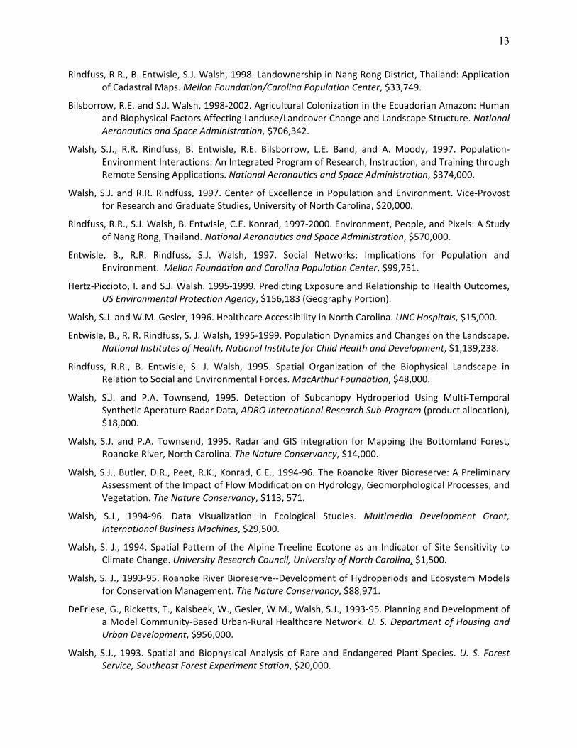
Rindfuss, R.R., B. Entwisle, S.J. Walsh, 1998. Landownership in Nang Rong District, Thailand: Application of Cadastral Maps. Mellon Foundation/Carolina Population Center, $33,749.
Bilsborrow, R.E. and S.J. Walsh, 1998‐2002. Agricultural Colonization in the Ecuadorian Amazon: Human and Biophysical Factors Affecting Landuse/Landcover Change and Landscape Structure. National Aeronautics and Space Administration, $706,342.
Walsh, S.J., R.R. Rindfuss, B. Entwisle, R.E. Bilsborrow, L.E. Band, and A. Moody, 1997. Population‐Environment Interactions: An Integrated Program of Research, Instruction, and Training through Remote Sensing Applications. National Aeronautics and Space Administration, $374,000.
Walsh, S.J. and R.R. Rindfuss, 1997. Center of Excellence in Population and Environment. Vice‐Provost for Research and Graduate Studies, University of North Carolina, $20,000.
Rindfuss, R.R., S.J. Walsh, B. Entwisle, C.E. Konrad, 1997‐2000. Environment, People, and Pixels: A Study of Nang Rong, Thailand. National Aeronautics and Space Administration, $570,000.
Entwisle, B., R.R. Rindfuss, S.J. Walsh, 1997. Social Networks: Implications for Population and Environment. Mellon Foundation and Carolina Population Center, $99,751.
Hertz‐Piccioto, I. and S.J. Walsh. 1995‐1999. Predicting Exposure and Relationship to Health Outcomes, US Environmental Protection Agency, $156,183 (Geography Portion).
Walsh, S.J. and W.M. Gesler, 1996. Healthcare Accessibility in North Carolina. UNC Hospitals, $15,000.
Entwisle, B., R. R. Rindfuss, S. J. Walsh, 1995‐1999. Population Dynamics and Changes on the Landscape. National Institutes of Health, National Institute for Child Health and Development, $1,139,238.
Rindfuss, R.R., B. Entwisle, S. J. Walsh, 1995. Spatial Organization of the Biophysical Landscape in Relation to Social and Environmental Forces. MacArthur Foundation, $48,000.
Walsh, S.J. and P.A. Townsend, 1995. Detection of Subcanopy Hydroperiod Using Multi‐Temporal Synthetic Aperature Radar Data, ADRO International Research Sub‐Program (product allocation), $18,000.
Walsh, S.J. and P.A. Townsend, 1995. Radar and GIS Integration for Mapping the Bottomland Forest, Roanoke River, North Carolina. The Nature Conservancy, $14,000.
Walsh, S.J., Butler, D.R., Peet, R.K., Konrad, C.E., 1994‐96. The Roanoke River Bioreserve: A Preliminary Assessment of the Impact of Flow Modification on Hydrology, Geomorphological Processes, and Vegetation. The Nature Conservancy, $113, 571.
Walsh, S.J., 1994‐96. Data Visualization in Ecological Studies. Multimedia Development Grant, International Business Machines, $29,500.
Walsh, S. J., 1994. Spatial Pattern of the Alpine Treeline Ecotone as an Indicator of Site Sensitivity to Climate Change. University Research Council, University of North Carolina, $1,500.
Walsh, S. J., 1993‐95. Roanoke River Bioreserve‐‐Development of Hydroperiods and Ecosystem Models for Conservation Management. The Nature Conservancy, $88,971.
DeFriese, G., Ricketts, T., Kalsbeek, W., Gesler, W.M., Walsh, S.J., 1993‐95. Planning and Development of a Model Community‐Based Urban‐Rural Healthcare Network. U. S. Department of Housing and Urban Development, $956,000.
Walsh, S.J., 1993. Spatial and Biophysical Analysis of Rare and Endangered Plant Species. U. S. Forest Service, Southeast Forest Experiment Station, $20,000.

14
Walsh, S.J., 1993. Spatial Database Development for Forest Management Operations. U. S. Forest Service, Asheville, NC, $5,000.
Walsh, S.J., 1993. Topology at Alpine Treeline, Equipment Supplement. National Science Foundation, Geography and Regional Science Program, $19,687.
Walsh, S.J., 1993. Spatial Analysis of Plant Communities in Linville Gorge and Shinning Rock Wilderness, NC. U. S. Forest Service, $7,500.
Walsh, S J., 1993. Mapping Employee Demographics in Central North Carolina, Duke University. Duke University, $2,500.
Walsh, S.J., 1993. Incorporating GIS into Evaluation Studies for Family Planning, Mellon Foundation, $20,000.
Walsh, S.J., Butler, D. R., Peet, R. K., Konrad, C. E., 1994‐96. The Roanoke River Bioreserve: A Preliminary Assessment of the Impact of Flow Modification on Hydrology, Geomorphological Processes, and Vegetation. The Nature Conservancy, $113, 571.
Rindfuss, R., Entwisle, B., Walsh, S.J., 1993. Integration of Social and Spatial Data in the Study of Social Change, Population, and the Environment. National Science Foundation, Sociology Program, $70,499.
Robinson, P.J. and S J. Walsh, 1992. Development of Climate Change Scenarios Using Synoptic Analysis. U. S. Environmental Protection Agency, $53,491.
Walsh, S.J., D.R. Butler, G.P. Malanson, 1991. Topological Relationships at Alpine Treeline. National Science Foundation, Geography and Regional Science Division, $72,507.
Brown, D.G., and S.J. Walsh, 1991. Global Climate Change and Alpine Treeline. National Aeronautics and Space Administration, Washington, D.C., $22,000.
Walsh, S.J., 1990. Spatial Implications of Forest Management Practices on Environmental Quality. U.S. Forest Service, $10,000.
Brower, D., R. Burby, D.R. Godschalk, E. Kaiser, S.J. Walsh, 1989. Fort Bragg/Pope Air Force Base Impact Assessment and Land Use Compatibility Study. U.S. Department of Defense, $150,000.
Walsh, S.J., 1989. Impact of Topographic Variability on Vegetation and Geomorphic Characteristics in Mountain Environments: Integration of Landsat TM, SPOT, and AVHRR Digital Data within a GIS Framework for Detection and Modeling. NASA, Washington, D.C., $100,000.
Jarnigan, R.C. and S.J. Walsh, 1989. Development of a UNC Computer Graphics Laboratory for Undergraduate Research. National Science Foundation, $99,500.
Robinson, P.J. and S.J. Walsh, 1988. Precipitation Regime Changes Resulting from Climatic Variability. U.S. Geological Survey, $129,050.
Walsh, S.J. and D.R. Godschalk, 1988. Geographic Information Systems and Regional Planning. Triangle J Council of Governments, North Carolina, $22,000.
Walsh, S.J., 1988. Evaluation of the Landsat Thematic Mapper, SPOT, and SMMR Sensors for the Recognition and Modeling of Selected Biophysical Characteristics Associated with Drought and Periglacial Phenomena. NASA, Washington, D.C., $100,000.
15
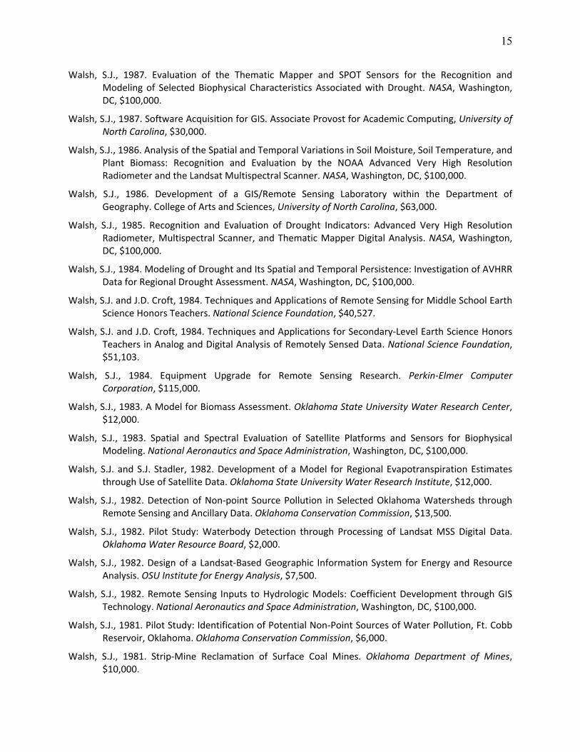
Walsh, S.J., 1987. Evaluation of the Thematic Mapper and SPOT Sensors for the Recognition and Modeling of Selected Biophysical Characteristics Associated with Drought. NASA, Washington, DC, $100,000.
Walsh, S.J., 1987. Software Acquisition for GIS. Associate Provost for Academic Computing, University of North Carolina, $30,000.
Walsh, S.J., 1986. Analysis of the Spatial and Temporal Variations in Soil Moisture, Soil Temperature, and Plant Biomass: Recognition and Evaluation by the NOAA Advanced Very High Resolution Radiometer and the Landsat Multispectral Scanner. NASA, Washington, DC, $100,000.
Walsh, S.J., 1986. Development of a GIS/Remote Sensing Laboratory within the Department of Geography. College of Arts and Sciences, University of North Carolina, $63,000.
Walsh, S.J., 1985. Recognition and Evaluation of Drought Indicators: Advanced Very High Resolution Radiometer, Multispectral Scanner, and Thematic Mapper Digital Analysis. NASA, Washington, DC, $100,000.
Walsh, S.J., 1984. Modeling of Drought and Its Spatial and Temporal Persistence: Investigation of AVHRR Data for Regional Drought Assessment. NASA, Washington, DC, $100,000.
Walsh, S.J. and J.D. Croft, 1984. Techniques and Applications of Remote Sensing for Middle School Earth Science Honors Teachers. National Science Foundation, $40,527.
Walsh, S.J. and J.D. Croft, 1984. Techniques and Applications for Secondary‐Level Earth Science Honors Teachers in Analog and Digital Analysis of Remotely Sensed Data. National Science Foundation, $51,103.
Walsh, S.J., 1984. Equipment Upgrade for Remote Sensing Research. Perkin‐Elmer Computer Corporation, $115,000.
Walsh, S.J., 1983. A Model for Biomass Assessment. Oklahoma State University Water Research Center, $12,000.
Walsh, S.J., 1983. Spatial and Spectral Evaluation of Satellite Platforms and Sensors for Biophysical Modeling. National Aeronautics and Space Administration, Washington, DC, $100,000.
Walsh, S.J. and S.J. Stadler, 1982. Development of a Model for Regional Evapotranspiration Estimates through Use of Satellite Data. Oklahoma State University Water Research Institute, $12,000.
Walsh, S.J., 1982. Detection of Non‐point Source Pollution in Selected Oklahoma Watersheds through Remote Sensing and Ancillary Data. Oklahoma Conservation Commission, $13,500.
Walsh, S.J., 1982. Pilot Study: Waterbody Detection through Processing of Landsat MSS Digital Data. Oklahoma Water Resource Board, $2,000.
Walsh, S.J., 1982. Design of a Landsat‐Based Geographic Information System for Energy and Resource Analysis. OSU Institute for Energy Analysis, $7,500.
Walsh, S.J., 1982. Remote Sensing Inputs to Hydrologic Models: Coefficient Development through GIS Technology. National Aeronautics and Space Administration, Washington, DC, $100,000.
Walsh, S.J., 1981. Pilot Study: Identification of Potential Non‐Point Sources of Water Pollution, Ft. Cobb Reservoir, Oklahoma. Oklahoma Conservation Commission, $6,000.
Walsh, S.J., 1981. Strip‐Mine Reclamation of Surface Coal Mines. Oklahoma Department of Mines, $10,000.
16
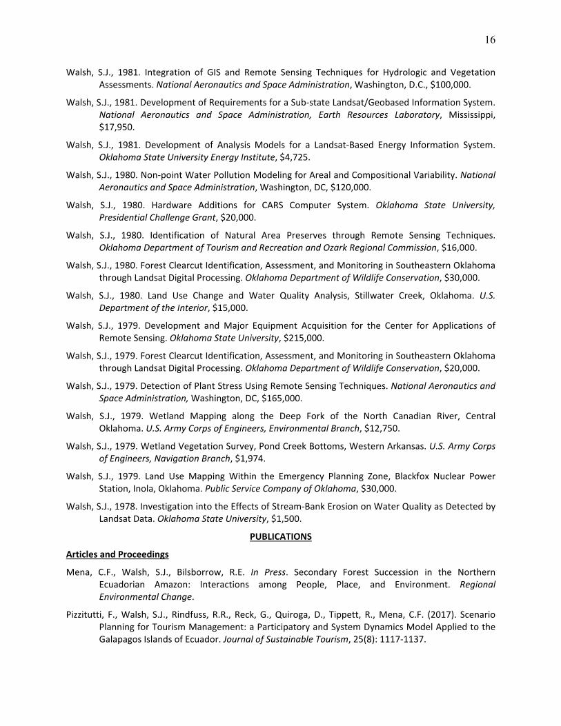
Walsh, S.J., 1981. Integration of GIS and Remote Sensing Techniques for Hydrologic and Vegetation Assessments. National Aeronautics and Space Administration, Washington, D.C., $100,000.
Walsh, S.J., 1981. Development of Requirements for a Sub‐state Landsat/Geobased Information System. National Aeronautics and Space Administration, Earth Resources Laboratory, Mississippi, $17,950.
Walsh, S.J., 1981. Development of Analysis Models for a Landsat‐Based Energy Information System. Oklahoma State University Energy Institute, $4,725.
Walsh, S.J., 1980. Non‐point Water Pollution Modeling for Areal and Compositional Variability. National Aeronautics and Space Administration, Washington, DC, $120,000.
Walsh, S.J., 1980. Hardware Additions for CARS Computer System. Oklahoma State University, Presidential Challenge Grant, $20,000.
Walsh, S.J., 1980. Identification of Natural Area Preserves through Remote Sensing Techniques. Oklahoma Department of Tourism and Recreation and Ozark Regional Commission, $16,000.
Walsh, S.J., 1980. Forest Clearcut Identification, Assessment, and Monitoring in Southeastern Oklahoma through Landsat Digital Processing. Oklahoma Department of Wildlife Conservation, $30,000.
Walsh, S.J., 1980. Land Use Change and Water Quality Analysis, Stillwater Creek, Oklahoma. U.S. Department of the Interior, $15,000.
Walsh, S.J., 1979. Development and Major Equipment Acquisition for the Center for Applications of Remote Sensing. Oklahoma State University, $215,000.
Walsh, S.J., 1979. Forest Clearcut Identification, Assessment, and Monitoring in Southeastern Oklahoma through Landsat Digital Processing. Oklahoma Department of Wildlife Conservation, $20,000.
Walsh, S.J., 1979. Detection of Plant Stress Using Remote Sensing Techniques. National Aeronautics and Space Administration, Washington, DC, $165,000.
Walsh, S.J., 1979. Wetland Mapping along the Deep Fork of the North Canadian River, Central Oklahoma. U.S. Army Corps of Engineers, Environmental Branch, $12,750.
Walsh, S.J., 1979. Wetland Vegetation Survey, Pond Creek Bottoms, Western Arkansas. U.S. Army Corps of Engineers, Navigation Branch, $1,974.
Walsh, S.J., 1979. Land Use Mapping Within the Emergency Planning Zone, Blackfox Nuclear Power Station, Inola, Oklahoma. Public Service Company of Oklahoma, $30,000.
Walsh, S.J., 1978. Investigation into the Effects of Stream‐Bank Erosion on Water Quality as Detected by Landsat Data. Oklahoma State University, $1,500.
PUBLICATIONS
Articles and Proceedings
Mena, C.F., Walsh, S.J., Bilsborrow, R.E. In Press. Secondary Forest Succession in the Northern Ecuadorian Amazon: Interactions among People, Place, and Environment. Regional Environmental Change.
Pizzitutti, F., Walsh, S.J., Rindfuss, R.R., Reck, G., Quiroga, D., Tippett, R., Mena, C.F. (2017). Scenario Planning for Tourism Management: a Participatory and System Dynamics Model Applied to the Galapagos Islands of Ecuador. Journal of Sustainable Tourism, 25(8): 1117‐1137.

17
Walsh, S.J. and Mena, C.F. (2016). Interactions of social, terrestrial, and marine sub‐systems in the Galapagos Islands, Ecuador. Sackler Colloquium on Coupled Human and Environmental Systems (Social Sciences, Environmental Sciences, Sustainability Science), Proceedings of the National Academy of Sciences 113(51): 14536‐14543.
Entwisle, B., Williams, N.E., Verdery, A.M., Rindfuss, R.R., Walsh, S.J., Malanson, G.P., Mucha, P.J., Frizzelle, B.G., McDaniel, P.M., Yao, X., Heumann, B.W., Prasartkul, P., Sawangdee, Y., Jampaklay, A. 2016. Climate Shocks and Migration: An Agent‐Based Modeling Approach. Population & Environment 39: 47‐71, DOI 10.1007/s11111‐016‐0254‐y.
Weiss, D.J., Malanson, G.P., Walsh, S.J. 2015. Multi‐Scale Relationships between Alpine Treeline Elevation and Hypothesized Environmental Controls in the Western United States. Annals of the Association of American Geographers, 105(3): 437‐453.
Walsh, S.J. 2015. Drought Assessment through Advanced Very High Resolution Radiometer Satellite Data (Reprinted from Papers and Proceedings of the Applied Geography Conference (1986), 9: 45‐55). G.A. Tobin and B.E. Montz (eds.), Evolving Approaches to Understanding Natural Hazards. Cambridge Scholars Publishing: Newcastle‐Upon‐Tyne, 157‐168.
Malanson, G.P. and Walsh, S.J. 2015. ABM: Individuals Interacting in Space (Invited Commentary). Journal of Applied Geography, 56: 95‐98.
Walsh, S.J., Page, P.H., McKnight, S.A., Yao, X., Morrissey, T.P. 2015. A Reservoir Siting Tool for North Carolina: System Design & Operations for Screening and Evaluation. Journal of Applied Geography, 60: 139‐149.
Walsh, S.J., Carter, R.W., Quiroga, D., Mena, C.F. 2014. Examining the Vulnerability of Iconic National Parks through Modeling Global Change and Social and Ecological Threats. The George Wright Forum, A Special Issue on “Global Change and the World’s Iconic Protected Areas,” (P. Eagles & P.A. Taylor), 31(3): 311‐323.
Carter, R.W., Walsh, S.J., Jacobson, C., Miller, M.L. 2014. Socio‐Economic Challenges in Managing Iconic National Parks. The George Wright Forum, A Special Issue on “Global Change and the World’s Iconic Protected Areas,” (P. Eagles & P.A. Taylor), 31(3): 245‐255.
Miller, M.L., Carter, R.W., Walsh, S.J., Peake, S. 2014. A Conceptual Model for Studying Global Change, Tourism and the Sustainability of Iconic National Parks. The George Wright Forum, A Special Issue on “Global Change and the World’s Iconic Protected Areas,” (P. Eagles & P.A. Taylor), 31(3): 256‐269.
Malanson, G.P., Verdery, A.M., Walsh, S.J., Sawangdee, Y., Jampaklay, A., Heumann, B.W., McDaniel, P.M., Frizzelle, B.G., Williams, N.E., Yao, X., Entwisle, B., Rindfuss, R.R. 2014. Changing Crops in Response to Climate: Virtual Nang Rong, Thailand in an Agent Based Simulation. Journal of Applied Geography, 53: 202‐212.
Pizzitutti, F., Mena, C.F., Walsh, S.J. 2014. Modeling Tourism in the Galapagos Islands: An Agent‐Based Model Approach. Journal of Artificial Societies and Social Simulation, 17(1): 1‐25.
Brewington, L., Engie, K., Walsh, S.J., Mena, C.F. 2013. Collaborative Learning & Global Education: Human‐Environment Interactions in the Galapagos Islands, Ecuador. Journal of Geography, 112(5): 179‐192. [Named Best College/University Article for 2014 by the NCGE Journal of Geography Awards Task Force.]

18
Heumann, B.W., Walsh, S.J., Verdery, A., Entwisle, B., McDaniel, P.A., Rindfuss, R.R. 2013. Land Suitability Modeling using a Geographic Socio‐Economical Niche‐Based Approach: A Case Study from Northeastern Thailand. Annals of the Association of American Geographers, 103(4): 764‐784.
Walsh, S.J., Malanson, G.P., Entwisle, B., Rindfuss, R.R., Mucha, P.J., Heumann, B.W., McDaniel, P.M., Frizzelle, B.G., Verdery, A.M., Williams, N., Xiaozheng, Y., Ding, D. 2013. Design of an Agent‐Based Model to Examine Population‐Environment Interactions in Nang Rong District, Thailand. Journal of Applied Geography, 39: 183‐198.
Walsh, S.J., R.E. Bilsborrow, and B.G. Frizzelle. 2013. LBA‐ECO LC‐01 Landsat MSS, TM, ETM+ Imagery, Northern Ecuadorian Amazon: 1973‐2002. Data set. Available on‐line [http://daac.ornl.gov] from Oak Ridge National Laboratory Distributed Active Archive Center, Oak Ridge, Tennessee, USA. http://dx.doi.org/10.3334/ORNLDAAC/1187.
Bishop, M.P., James, L.A., Shroder, J.F., Walsh, S.J. 2012. Geospatial Technologies and Digital Geomorphological Mapping: Concepts, Issues, and Research. Geomorphology, 137: 5‐26.
James, A.L., Walsh, S.J., Bishop, M.P. 2012. Geospatial Technologies and Geomorphological Mapping – Preface to Binghamton Geomorphology Symposium. Geomorphology, 137: 1‐4.
Heumann, B.W, Walsh, S.J., McDaniel, P. 2011. Assessing the Application of a Geographic Niche‐Based Model for Crop Suitability Mapping in Northeast Thailand. Ecological Informatics, 6: 257‐269.
Shao, Y. and Walsh, S.J., 2011. Shadow Detection and Building Height Estimation using IKONOS Data. International Journal of Remote Sensing, 32: 6929‐6944.
Mena, C.F. Walsh, S.J., Frizzelle, B.G., Malanson, G.P., 2011. Land Use Change of Household Farms in the Ecuadorian Amazon: Design and Implementation of an Agent Based Model. Journal of Applied Geography, 31(1): 210‐222.
Shao, Y., Taff, G.N., Walsh, S.J. 2011. Comparison of Early Stop Criteria for Neural Network‐Based Sub‐Pixel Classification. IEEE Geoscience and Remote Sensing Letters, 8(1): 113‐117.
Walsh, S.J., McCleary, A.L., Heumann, B.W., Brewington, L., Raczkowski, E.J., Mena, C.F. 2010. Community Expansion and Infrastructure Development: Implications for Human Health and Environmental Quality in the Galapagos Islands of Ecuador. Journal of Latin American Geography, 9(3): 137‐159.
Walsh, S.J. 2010. Beyond People & Pixels: Integrating People & Environment in LULC Studies. CIESIN, Columbia University, PERNSEMINARS – Invited Expert Contributions, 4p.
Miller, B.W., Breckheimer, I., McCleary, A.L., Guzman‐Ramirez, L., Caplow, S.C., Walsh, S.J. 2010. Using Stylized Agent‐Based Models for Population‐Environment Research: A Case from the Galapagos Islands. Population & Environment, 31(6): 401‐426.
Lu, F., Gray, C., Bilsborrow, R.E., Mena, C.F., Erlien, C.M., Bremner, J., Barbieri, A., Walsh, S.J. 2010. Contrasting Colonist and Indigenous Impacts on Amazonian Forests. Conservation Biology, Research Note, 24(3): 881‐885.
Lu, F., Gray, C.L., Mena, C.F., Barbieri, A., Erlien, C.M., Bremner, J., Walsh, S.J., 2010. Contrasting Colonist and Indigenous Impacts on Amazonian Forests. Proceedings, International Union for the Scientific Study of Population, Marrakech, Morocco.
19
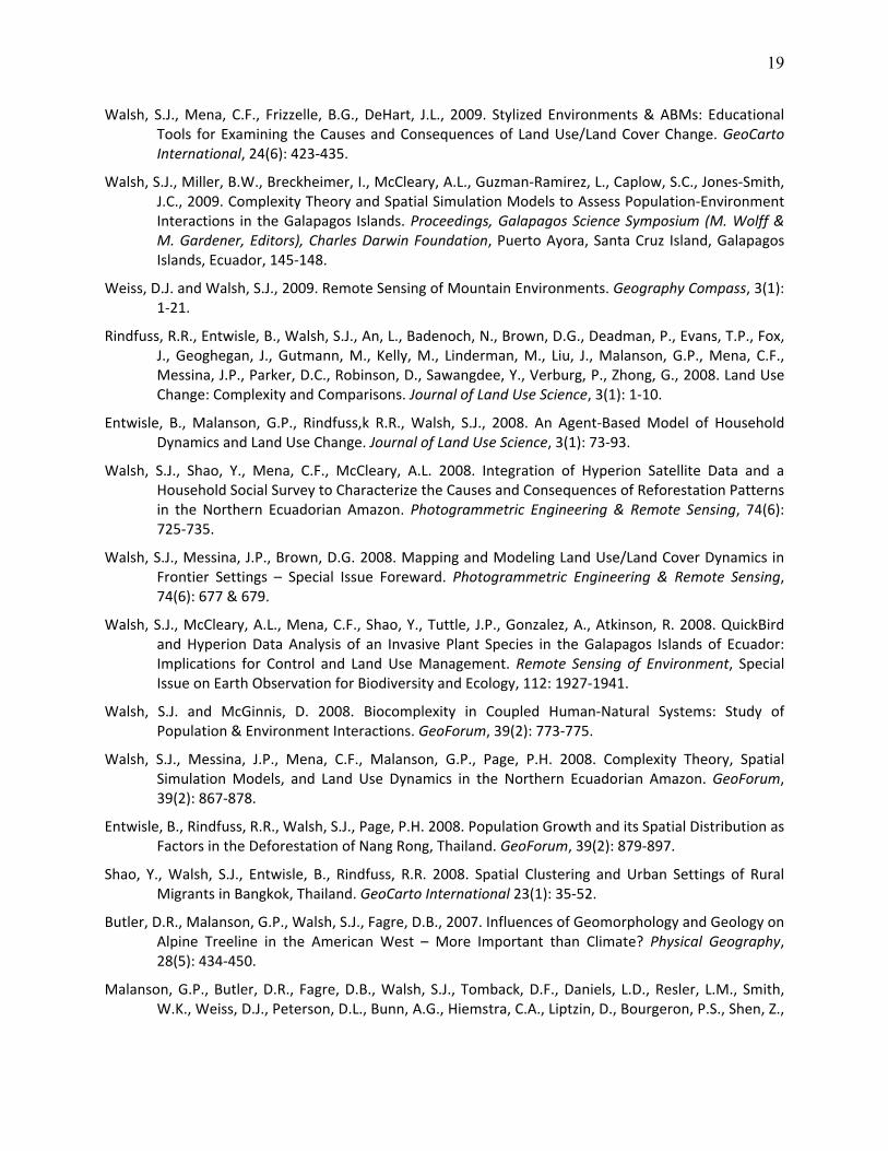
Walsh, S.J., Mena, C.F., Frizzelle, B.G., DeHart, J.L., 2009. Stylized Environments & ABMs: Educational Tools for Examining the Causes and Consequences of Land Use/Land Cover Change. GeoCarto International, 24(6): 423‐435.
Walsh, S.J., Miller, B.W., Breckheimer, I., McCleary, A.L., Guzman‐Ramirez, L., Caplow, S.C., Jones‐Smith, J.C., 2009. Complexity Theory and Spatial Simulation Models to Assess Population‐Environment Interactions in the Galapagos Islands. Proceedings, Galapagos Science Symposium (M. Wolff & M. Gardener, Editors), Charles Darwin Foundation, Puerto Ayora, Santa Cruz Island, Galapagos Islands, Ecuador, 145‐148.
Weiss, D.J. and Walsh, S.J., 2009. Remote Sensing of Mountain Environments. Geography Compass, 3(1): 1‐21.
Rindfuss, R.R., Entwisle, B., Walsh, S.J., An, L., Badenoch, N., Brown, D.G., Deadman, P., Evans, T.P., Fox, J., Geoghegan, J., Gutmann, M., Kelly, M., Linderman, M., Liu, J., Malanson, G.P., Mena, C.F., Messina, J.P., Parker, D.C., Robinson, D., Sawangdee, Y., Verburg, P., Zhong, G., 2008. Land Use Change: Complexity and Comparisons. Journal of Land Use Science, 3(1): 1‐10.
Entwisle, B., Malanson, G.P., Rindfuss,k R.R., Walsh, S.J., 2008. An Agent‐Based Model of Household Dynamics and Land Use Change. Journal of Land Use Science, 3(1): 73‐93.
Walsh, S.J., Shao, Y., Mena, C.F., McCleary, A.L. 2008. Integration of Hyperion Satellite Data and a Household Social Survey to Characterize the Causes and Consequences of Reforestation Patterns in the Northern Ecuadorian Amazon. Photogrammetric Engineering & Remote Sensing, 74(6): 725‐735.
Walsh, S.J., Messina, J.P., Brown, D.G. 2008. Mapping and Modeling Land Use/Land Cover Dynamics in Frontier Settings – Special Issue Foreward. Photogrammetric Engineering & Remote Sensing, 74(6): 677 & 679.
Walsh, S.J., McCleary, A.L., Mena, C.F., Shao, Y., Tuttle, J.P., Gonzalez, A., Atkinson, R. 2008. QuickBird and Hyperion Data Analysis of an Invasive Plant Species in the Galapagos Islands of Ecuador: Implications for Control and Land Use Management. Remote Sensing of Environment, Special Issue on Earth Observation for Biodiversity and Ecology, 112: 1927‐1941.
Walsh, S.J. and McGinnis, D. 2008. Biocomplexity in Coupled Human‐Natural Systems: Study of Population & Environment Interactions. GeoForum, 39(2): 773‐775.
Walsh, S.J., Messina, J.P., Mena, C.F., Malanson, G.P., Page, P.H. 2008. Complexity Theory, Spatial Simulation Models, and Land Use Dynamics in the Northern Ecuadorian Amazon. GeoForum, 39(2): 867‐878.
Entwisle, B., Rindfuss, R.R., Walsh, S.J., Page, P.H. 2008. Population Growth and its Spatial Distribution as Factors in the Deforestation of Nang Rong, Thailand. GeoForum, 39(2): 879‐897.
Shao, Y., Walsh, S.J., Entwisle, B., Rindfuss, R.R. 2008. Spatial Clustering and Urban Settings of Rural Migrants in Bangkok, Thailand. GeoCarto International 23(1): 35‐52.
Butler, D.R., Malanson, G.P., Walsh, S.J., Fagre, D.B., 2007. Influences of Geomorphology and Geology on Alpine Treeline in the American West – More Important than Climate? Physical Geography, 28(5): 434‐450.
Malanson, G.P., Butler, D.R., Fagre, D.B., Walsh, S.J., Tomback, D.F., Daniels, L.D., Resler, L.M., Smith, W.K., Weiss, D.J., Peterson, D.L., Bunn, A.G., Hiemstra, C.A., Liptzin, D., Bourgeron, P.S., Shen, Z.,

20
and Millar, C.I. 2007. Alpine Treeline of Western North America and Global Climate Change: Linking Organism‐to‐Landscape Dynamics. Physical Geography, 28(5): 378‐396.
Rindfuss, R.R., Entwisle, B., Walsh, S.J., Mena, C.F., Erlien, C.M., Gray, C.L., 2007. Frontier Land Use Change: Synthesis, Challenges, and Next Steps. Annals of the Association of American Geographers, 97(4): 739‐754.
Walsh, S.J. 2007. “Feedbacks.” Encyclopedia of Environment & Society (P. Robbins, General Editor), Golson Books, Ltd, Croton‐on‐Hudson, NY, Sage Publications, Thousand Oaks, CA (Publisher), 655‐656.
Walsh, S.J. and Welsh, W.F. 2007. “Deforestation.” Encyclopedia of Environment & Society (P. Robbins, General Editor), Golson Books, Ltd, Croton‐on‐Hudson, NY, Sage Publications, Thousand Oaks, CA, 422‐427.
Walsh, S.J. and Shao, Y. 2007. “Geographic Information Science.” Encyclopedia of Environment & Society (P. Robbins, General Editor), Golson Books, Ltd, Croton‐on‐Hudson, NY, Sage Publications, Thousand Oaks, CA, 750‐752.
Butler, D.R., Malanson, G.P., and Walsh, S.J. 2007. “Glacier National Park, Montana, USA.” Encyclopedia of Environment & Society (P. Robbins, General Editor), Golson Books, Ltd, Croton‐on‐Hudson, NY, Sage Publications, Thousand Oaks, CA, 769‐770.
Walsh, S.J. 2007. Remote Sensing of Invasive Plants in the Galapagos National Park and Archipelago, Ecuador: Merging Hyper‐Spatial & Hyper‐Spectral Data for Enhanced Mapping. Directions Mag. http://www.directionsmag.com/article.php?article_id=2419.
Erlien, C.M., Tuttle, J.P., McCleary, A.L., Mena, C.F., Walsh, S.J. 2006. Complexity Theory and Spatial Simulations of Land Use/Land Cover Dynamics: the Use of “What if” Scenarios for Education, Land Management, and Decision‐Making. GeoCarto International, 21(4): 67‐74.
Mena, C.F., Barbieri, A., Walsh, S.J., Erlien, C.M., Holt, F.L., Bilsborrow, R.E. 2006. Pressure on the Cuyabeno Wildlife Reserve: Development and Land Use/Cover Change in the Northern Ecuadorian Amazon. World Development 34(10): 1831‐1849.
Malanson, G.P., Zeng, Y., Walsh, S.J., 2006. Landscape Frontiers, Geography Frontiers: Lessons to be Learned. Professional Geographer 58(4): 383‐396.
Walsh, S.J., Entwisle, B., Rindfuss, R.R., Page, P.H. 2006. Spatial Simulation Modeling of Land Use/Land Cover Change Scenarios in Northeastern Thailand: a Cellular Automata Approach. Journal of Land Use Science, 1(1): 5‐28.
Messina, J.P., Walsh, S.J., Mena, C.F., Delamater, P.L., 2006. Land Tenure and Deforestation Patterns in the Ecuadorian Amazon: Conflicts in Land Conservation in a Frontier Setting. Applied Geography, 26: 113‐128.
Malanson, G.R., Zeng, Y., Walsh, S.J., 2006. Complexity at Advancing Ecotones and Frontiers. Environment and Planning A, 38: 619‐632.
Entwisle, B., Walsh, S.J., Rindfuss, R.R., VanWey, L.K., 2005. Population and Upland Crop Production in Nang Rong, Thailand. Population and Environment, 26(6): 449‐470.
Messina, J.P. and Walsh, S.J., 2005. Dynamic Spatial Simulation Modeling of the Population‐Environment Matrix in the Ecuadorian Amazon. Environment and Planning B, 32(6): 835‐856.
21
Frizzelle, B.G., Walsh, S.J., Mena, C.F., Erlien, C.M., 2005. Land Use Change Patterns of Colonists and Indigenous Groups in the Northern Ecuadorian Amazon: A Comparison of Landsat TM Spectral and Spatial Analyses. Proceedings, American Society for Photogrammetry and Remote Sensing, Baltimore, Maryland (Electronic).
Walsh, S.J., Entwisle, B., Rindfuss, R.R., Page, P.H., 2005. A Cellular Automata Approach to Land Use Change Modeling in Northeastern Thailand. Proceedings, GIS Planet 2005, International Conference and Exhibition on Geographic Information, Estoril Congress Center, Portugal (Electronic).
Tang, W., Malanson, G.P., Walsh, S.J., 2004. Model for Land Use Change in Thailand. Asian Surveying and Mapping, 2: 1‐3.
Rindfuss, R.R., Walsh, S.J., Turner II, B.L., Fox, J., Mishra, V., 2004. Developing a Science of Land Change: Challenges and Methodological Issues. Proceedings of the National Academy of Science, 101(939): 13976‐13981.
Walsh, S.J., Weiss, D.J., Butler, D.R., Malanson, G.P. 2004. An Assessment of Snow Avalanche Paths and Forest Dynamics Using Ikonos Satellite Data. GeoCarto International, 19(2): 85‐93.
Pan, W.K.Y., S. J. Walsh, R.E. Bilsborrow, B.G. Frizzelle, C.M. Erlien, F.D. Baquero. 2004. Farm‐Level Models of Spatial Patterns of Land Use and Land Cover Dynamics in the Ecuadorian Amazon. Agriculture, Ecosystems, and Environment, 101: 117‐134.
Walsh, S.J., Rindfuss, R.R., Entwisle, B., Shao, Y., Weiss, D.J., McDaniel, P.M., Pullen, R.E. 2003. Characterizing Land Use/Land Cover Change in Northeast Thailand and Analyzing the Causes and Consequences of Landscape Dynamics. Proceedings, 30th International Symposium on Remote Sensing of Environment, Honolulu, Hawaii, 6p.
Frizzelle, B.G., Walsh, S.J., Erlien, C.M., Mena, C.F., 2003. Collecting Control Data for Remote Sensing Applications in the Frontier Environment of the Ecuadorian Amazon. Earth Observation Magazine, 12(7): 20‐24.
Walsh, S.J. and Welsh, W.F., 2003. Approaches for Linking People, Place, and Environment for Human Dimensions Research. GeoCarto International 18(3): 51‐61.
Walsh, S.J., L. Bian, S.A. McKnight, D.G. Brown, E.S. Hammer, 2003. Solifluction Steps and Risers, Lee Ridge, Glacier National Park, Montana, USA: A Scale and Pattern Analysis. Geomorphology, 55(5 & 6): 381‐398.
Walsh, S.J., Bian, L., McKnight, S., Hammer, E., Erlien, C.M. 2003. Characterizing the Spatial Pattern of Solifluction Steps and Risers in an Alpine Environment: Application of Digital Image Enhancements and Geostatistics. Technical Proceedings, American Society for Photogrammetry and Remote Sensing, Anchorage, Alaska, 12p.
Frizzelle, B.G., Walsh, S.J., Erlien, C.M., Mena, C.F., Baquero, F.D., 2003. Establishing Remote Sensing Control in a Frontier Environment: The Case of the Ecuadorian Amazon. Technical Proceedings, American Society for Photogrammetry and Remote Sensing, Anchorage, Alaska (Electronic).
Walsh, S.J., D.R. Butler, G.P. Malanson, K.A. Crews‐Meyer, J.P. Messina, N. Xiao, 2003. Mapping, Modeling, and Visualization of the Influences of Geomorphic Processes on the Alpine Treeline Ecotone, Glacier National Park, Montana, USA. Geomorphology, 53(1‐2): 129‐145.

22
Butler, D.R., S.J. Walsh, G.P. Malanson, 2003. Introduction to the Special Issue, 32nd Annual Binghamton Geomorphology Symposium: Mountain Geomorphology – Integrating Earth Systems. Geomorphology, 55 (5 & 6): 1‐4.
Walsh, S.J. 2003. Report of the Program Committee, 2002. Southeastern Geographer, 43(1): 143‐145.
Bian, L. and S.J. Walsh, 2002. Characterizing and Modeling Landscape Dynamics: An Introduction. Photogrammetric Engineering and Remote Sensing, 68(10): 999‐1000.
Walsh, S.J. 2002. Report of the Program Committee (SEDAAG), 2001. Southeastern Geographer, 42(1): 135‐136.
Messina, J.P. and S.J. Walsh, 2001. Simulating Land Use and Land Cover Dynamics in the Ecuadorian Amazon through Cellular Automata Approaches and an Integrated GIS. Proceedings, Open Meeting of the Human Dimensions of Global Environmental Change Research Community, Rio de Janeiro, Brazil (Electronic).
Townsend, P.A. and S.J. Walsh, 2001. Remote Sensing of Forested Wetlands: Application of Multitemporal and Multispectral Satellite Imagery to Determine Plant Community Composition and Structure in Southeastern USA. Plant Ecology, 157(2): 129‐149.
Messina, J.P. and S.J. Walsh, 2001. 2.5D Morphogenesis: Modeling Landuse and Landcover Dynamics in the Ecuadorian Amazon. Plant Ecology, 156(1): 75‐88.
Walsh, S.J., T.W. Crawford, W.F. Welsh, and K.A. Crews‐Meyer. 2001. A Multiscale Analysis of LULC and NDVI Variation in Nang Rong District, Northeast Thailand. Agriculture Ecosystems and Environment, 85(1‐3): 47‐64.
Messina, J.P. and S.J. Walsh, 2000. The Application of a Cellular Automaton Model for Predicting Deforestation: Patterns and Processes of LULCC in the Ecuadorian Amazon. Proceedings (electronic), 4th International Conference on Integrating GIS and Environmental Modeling, Banff, Canada, 8p.
Walsh, S.J., K.A. Crews‐Meyer, J.P. Messina, 2000. Landscape Variation in Frontier Environments: The Case of Agricultural Extensification in Ecuador and Thailand. Proceedings (electronic), 4th International Conference on Integrating GIS and Environmental Modeling, Banff, Canada, 7p.
Malanson, G.P., N. Xiao, K. Alftine, M. Bekker, D.R. Butler, D.G. Brown, D.M. Cairns, D. Fagre, S.J. Walsh, 2000. Abiotic and Biotic Controls of Spatial Pattern at Alpine Treeline. Proceedings (electronic), 4th International Conference on Integrating GIS and Environmental Modeling, Banff, Canada, 9p.
Messina, J.P., K.A. Crews‐Meyer, S.J. Walsh, 2000. Scale Dependent Pattern Metrics and Panel Data Analysis as Applied in a Multiphase Hybrid Land Cover Classification Scheme. Proceedings, American Society for Photogrammetry and Remote Sensing, 9p.
Faust, K., B. Entwisle, R.R. Rindfuss, S.J. Walsh, Y. Sawangdee, 2000. Spatial Arrangement of Social and Economic Networks among Villages in Nang Rong District, Thailand. Social Networks, 21(4): 311‐337.
Walsh, S.J. 1999. Deforestation and Agricultural Extensification in Northeast Thailand: A Remote Sensing and GIS Study of Landscape Structure and Scale. Proceedings, Applied Geography Conference, 22: 223‐232.
Messina, J.P., S.J. Walsh, G. Valdivia, G. Taff, 1999. The Application of Cellular Automata Modeling for Enhanced Landcover Classification in the Ecuadorian Amazon. Proceedings, GeoComputation, 13p.
23
Crawford, T.W., K.A. Crews‐Meyer, S.J. Walsh, 1999. Instructional Technologies and the Internet: Options and Possibilities for Geographic Information Science Education. GeoCarto International, 14(2): 75‐82.
Walsh, S.J., W.F. Welsh, T.P. Evans, B. Entwisle, R.R. Rindfuss, 1999. Scale Dependent Relationships between Population and Environment in Northeastern Thailand. Photogrammetric Engineering and Remote Sensing, 65(1): 97‐105.
Walsh, S.J., T.P. Evans, W.F. Welsh, R.R. Rindfuss, B. Entwisle, 1998. Population and Environmental Characteristics Associated with Village Boundaries and Landuse/Landcover Patterns in Nang Rong District, Thailand. Proceedings, Pecora 13 Symposium, Human Interactions with the Environment: Perspectives from Space. American Society for Photogrammetry and Remote Sensing, Bethesda, Maryland, 395‐404.
Townsend, P.A. and S.J. Walsh, 1998. Modeling Floodplain Inundation through an Integrated GIS with Radar and Optical Remote Sensing. Geomorphology, 21(3‐4): 295‐312.
Walsh, S.J., D.R. Butler, G.P. Malanson, 1998. An Overview of Scale, Pattern, and Process Relationships in Geomorphology: A Remote Sensing and GIS Perspective. Geomorphology, 21(3‐4): 183‐205.
Butler, D.R. and Walsh, S.J. 1998. Application of Remote Sensing and Geographic Information Systems in the Study of Geomorphology: An Introduction. Geomorphology, 21(3‐4): 179‐181.
Entwisle, B., R.R. Rindfuss, S.J. Walsh, T.P. Evans, S.R. Curran, 1997. Geographic Information Systems, Spatial Network Analysis, and Contraceptive Choice. Demography, 34(2): 171‐187.
Walsh, S.J., P.H. Page, W.M. Gesler, 1997. Normative Models and Healthcare Planning: Network‐Based Simulations within a Geographic Information System Environment. Health Services Research, 32(2): 243‐260.
Walsh, S.J. and D.R. Butler, 1997. Morphometric and Spectral Analyses of Debris Flows: Components of a Natural Hazards Methodology. GeoCarto International, 12(1): 59‐70.
Townsend, P.A. and S. J. Walsh, 1996. Spatial Variability of a Wetness Model to Soil Parameter Estimation Approaches. Earth Surface Processes and Landforms, 21(4): 307‐326.
Allen, T.R. and S.J. Walsh, 1996. Spatial and Compositional Structure of the Alpine Treeline Ecotone. Photogrammetric Engineering and Remote Sensing, 62(11): 1261‐1268.
Townsend, P.A., S.J. Walsh, D. R. Butler, 1995. Beaver Pond Identification through a Satellite‐Based Ecological Habitat Classification. Proceedings, American Society for Photogrammetry and Remote Sensing, 2: 102‐111.
Walsh, S.J. and P.A. Townsend, 1995. Comparison of Change Detection Approaches for Assessing a Riverine Flood Hydroperiod. Proceedings, American Society for Photogrammetry and Remote Sensing, 2: 134‐143.
Allen, T.R., D.G. Brown, D. R. Butler, S.J. Walsh, 1995. Local and Regional Patterns of Modern Glacier Equilibrium‐Line Altitudes in Glacier National Park, Northwest Montana. Proceedings, American Society for Photogrammetry and Remote Sensing, 2: 112‐122.
Henderson, B.M. and S.J. Walsh, 1995. Plowed, Paved, or in Succession: Landcover Change on the North Carolina Piedmont. Southeastern Geographer, 35(2): 132‐149.
Evans, T.P., S.J. Walsh, B. Entwisle, R.R. Rindfuss, 1995. Testing Model Parameters of Transportation Network Analyses in Rural Thailand. Proceedings, LIS/GIS '95, Nashville, TN, 1: 302‐311.
24
Walsh, S.J., W.M. Gesler, P.H. Page, T.W. Crawford, 1995. Health Care Accessibility: Comparison of Network and Indices of Hospital Service Areas. Proceedings, LIS/GIS '95, Nashville, TN, 2: 994‐1005.
Walsh, S.J., W.M. Gesler, P.H. Page, T.C. Ricketts, 1995. Modeling Health Care Accessibility through an Integration of Network Analysis and Geographic Information System. Proceedings, CREDES, Hospitals and the Geography of Health Care, Paris, France, 25‐36
Gesler, W.M., S.J. Walsh, T.W. Crawford, P.S. Wittie, T.C. Ricketts, 1995. Analysis of Hospital Service Areas in Charlotte‐Mecklenburg Region of North Carolina, USA through GIS Approaches. Proceedings, CREDES, Hospitals and the Geography of Health Care, Paris, France, 85‐99.
Moody, A., S.J. Walsh, T.R. Allen, D.G. Brown, 1995. Scaling Properties of NDVI and their Relationship to Land‐Cover Type and Landscape Spatial Pattern. Proceedings, IGARSS Conference on Remote Sensing, Florence, Italy, 3: 1962‐1965.
Allen, T.R., T.J. Bara, and S.J. Walsh, 1994. Observed Biases in the Conterminous U. S. AVHRR Satellite Data Set: A North Carolina Case Study. GeoCarto International, 2: 2‐12.
Butler D.R. and S.J. Walsh, 1994. Site Characteristics of Debris Flows and their Relationship to Alpine Treeline. Physical Geography, 15(2): 181‐199.
Walsh, S.J., D.R. Butler, T.R. Allen, G.P. Malanson, 1994. Influence of Snow Patterns and Snow Avalanches on the Alpine Treeline Ecotone. Journal of Vegetation Science, 5: 657‐672.
Walsh, S.J., D.G. Brown, L. Bian, T.R. Allen, 1994. Effects of Spatial Scale on Data Certainty: An Assessment through Data Dependency and Sensitivity Analyses. International Symposium on the Spatial Accuracy of Natural Resource Data Bases, American Society for Photogrammetry and Remote Sensing, 151‐160.
Walsh S.J. and F.W. Davis, 1994. Remote Sensing and GIS Applications in Vegetation Science: Introduction. Journal of Vegetation Science, 5: 610‐613.
Walsh, S.J., D.R. Butler, T. R. Allen, G.P. Malanson, 1994. Effects of Snowpatches and Snow Avalanches on the Alpine Treeline Ecotone. Journal of Vegetation Science, 5: 48‐61.
Bian, L. and S.J. Walsh, 1993. Scale Dependencies of Vegetation and Topography in a Mountainous Environment of Montana. The Professional Geographer, 45(1): 1‐11.
Walsh, S.J. 1993. Spatial and Biophysical Analysis of Alpine Vegetation through Landsat TM and SPOT MX/PAN Data. Proceedings, American Congress on Surveying and Mapping and American Society for Photogrammetry and Remote Sensing, 2:
Allen, T.R. and S.J. Walsh, 1993. Characterizing Multitemporal Alpine Snowmelt Patterns for Ecological Inferences. Photogrammetric Engineering and Remote Sensing, 59(10): 1521‐1529.
Brown, D.G. and S.J. Walsh 1993. Spatial Autocorrelation in Remotely‐Sensed and GIS Data. Proceedings, American Congress on Surveying and Mapping and American Society for Photogrammetry and Remote Sensing, 3: 31‐39.
Brown, D.G. L. Bian, S.J. Walsh, 1993. Response of a Distributed Watershed Erosion Model to Variations in Input Data Aggregation Levels. Computers and Geosciences, 19(4): 499‐509.
Joao, E.M. and S.J. Walsh, 1992. Interfacing GIS to a Hydrological Model: Simulation of Non‐Point Pollution Generated by the Location of Urban Development. Computers, Environment, and Urban Systems, 16: 43‐63.

25
Walsh, S.J. 1992. Biophysical Modeling and Spatial Analysis of Alpine Treeline. Proceedings, European Conference on GIS, Munich, Germany, 2: 1591‐1592.
Walsh, S.J. 1992. Spatial Education and Integrated Hands‐on Training: Essential Foundations of GIS Instruction. Journal of Geography, 91(2): 54‐61.
Brown, D.G. and S.J. Walsh, 1992. Relationship between the Morphometry of Alpine and Sub‐Alpine Basins and Remotely‐Sensed Estimates of Lake Turbidity, Glacier National Park, Montana, USA. Physical Geography, 13(3): 250‐272.
Walsh, S.J. and D.R. Butler, 1992. Book Review: Terrain Evaluation‐‐An Introductory Handbook to the History, Principles, and Methods of Practical Terrain Assessment by C. W. Mitchell, The Professional Geographer, 44(4): 489‐490.
Butler, D.R. S.J. Walsh, G.P. Malanson, 1991. GIS Applications to the Indirect Effects of Forest Fires in Mountainous Terrain. S.C. Nodvin and T.A. Waldrop, eds., Fire and the Environment: Ecological and Cultural Perspectives, Proceedings of an International Symposium. USDA Forest Service, Southeastern Forest Experiment Station General Technical Report SE‐69, 202‐211.
Brown, D.G. and S.J. Walsh, 1991. Compatibility of Non‐Synchronous In‐Situ Water Quality Data and Remotely‐Sensed Spectral Information for Assessing Lake Turbidity Levels in Complex and Inaccessible Terrain. GeoCarto International, 6(2): 5‐11.
Walsh, S.J., J.D. Vitek, and S.E. Panciera, 1991. Variability of Soil Temperature: A Spatial and Temporal Analysis. Journal of Geography, 90(2): 82‐90.
Davis, F.D., D.A. Quattrochi, M.K. Ridd, N. S‐N. Lam, S.J. Walsh, J.C. Michaelson, J. Franklin, D.A. Stow, C.J. Johannsen, 1991. Environmental Analysis Using Integrated GIS and Remotely Sensed Data: Some Research Needs and Priorities. Photogrammetric Engineering and Remote Sensing, 57(6): 689‐697.
Joao, E.M. and S.J. Walsh, 1991. Linking GIS to a Hydrological Model in Order to Simulate the Effects of Non‐Point Pollution. Proceedings, EUROCARTO IX, Poland, 125‐135.
Butler, D.R. G.P. Malanson, S.J. Walsh, 1991. Identification of a Deltaic Environment in an Alpine Finger Lake. Environmental Professional, 13: 352‐362.
Walsh, S.J., L. Bian, D.G. Brown, 1991. Issues of Spatial Dependency for Surface Representation through Remote Sensing and GIS. The Integration of Remote Sensing and Geographic Information Systems, American Congress on Surveying and Mapping and American Society for Photogrammetry and Remote Sensing, Baltimore, Maryland, 175‐183.
Walsh, S.J. and D.R. Butler, 1991. Biophysical Impacts of Snow‐Avalanche Paths, Glacier National Park, Montana. Proceedings, GIS/LIS '91, A133‐A143.
Fleischmann, C.G. and S.J. Walsh, 1991. Multitemporal AVHRR Digital Data: An Approach for Landcover Mapping of Heterogeneous Landscapes. GeoCarto International, 6(4): 5‐20.
Butler, D.R., S.J. Walsh, D.G. Brown, 1991. Three‐Dimensional Displays for Natural Hazards Analysis, Using Classified Landsat Thematic Mapper Digital Data and Large‐Scale Digital Elevation Models. GeoCarto International, 6(4): 65‐69.
Walsh, S.J. 1990. Comparison of Temporal Differences in Models of Soil Moisture and Plant Biomass Variability in the Southern Great Plains of the U.S. Geographical Bulletin, 32(1): 25‐45.
26
Von Essen, I.E. and S.J. Walsh, 1990. Automated Approaches for Displaying Spatially Oriented Time‐Series Data Through Image Processing Techniques. GeoCarto International, 4: 27‐37.
Walsh, S.J. D.R. Butler, D.G. Brown, L. Bian, 1990. Cartographic Modeling of Snow Avalanche Path Location in Glacier National Park, Montana. Photogrammetric Engineering and Remote Sensing, 56(5): 615‐621.
Walsh, S.J. D.G. Brown, L. Bian, 1990. Comparison of Landsat Thematic Mapper Digital Enhancements of Snow‐Avalanche Paths: Validation Through GIS/Remote Sensing Integration. Proceedings, International Geoscience and Remote Sensing Symposium, Washington, D.C., 2: 1161‐1164.
Abkowitz, M. S.J. Walsh, E. Houser, L. Minor, 1990. Adaptation of GIS to Highway Management. Journal of Transportation Engineering, 116(3): 310‐327.
Walsh, S.J., J.W. Cooper, I.E. Von Essen, K.R. Gallager, 1990. Image Enhancement of Landsat Thematic Mapper Data and GIS Integration for Evaluation of Resource Characteristics. Photogrammetric Engineering and Remote Sensing, 54(8): 1135‐1141.
Bian, L. and S.J. Walsh, 1990. Reduction in the Effects of Clouds on Remotely‐Sensed Digital Data through the Integration of Spectral Information from Complementary Satellites. Proceedings, Canadian Symposium of Remote Sensing, New Brunswick, Canada, 78‐81.
Butler, D.R. and S.J. Walsh, 1990. Lithologic, Structural, and Topographic Controls of Snow‐Avalanche Path Location, Eastern Glacier National Park, Montana. Annals, Association of American Geographers, 80(3): 362‐378.
Walsh, S.J. and N.M. Kelly, 1990. Treeline Migration and Terrain Variability: Integration of Remote Sensing Digital Enhancements and Digital Elevation Models. Proceedings, Applied Geography Conference, 13, 24‐32.
Malanson, G.P., S.J. Walsh, D.R. Butler, 1990. The Theory of Chaos in Physical Geography. Physical Geography, (11): 293‐304.
Walsh, S.J. and D.R. Butler, 1989. Spatial Pattern of Snow Avalanche Path Location and Morphometry, Glacier National Park, Montana. Proceedings, GIS/LIS '89, 286‐294.
Walsh, S.J., L. Bian, D.G. Brown, D.R. Butler, and G.P. Malanson, 1989. Image Enhancement of Landsat Thematic Mapper Digital Data for Terrain Evaluation, Glacier National Park, Montana, USA. GeoCarto International, 3: 55‐58.
Walsh, S.J. 1989. Growth and Development of Remote Sensing Education and Research within the Discipline of Geography. GeoCarto International, Guest Editorial, 101‐105.
Walsh, S.J. 1989. Book Review, Satellite Monitoring of the Earth by Karl‐Heinz Szekielda. Photogrammetric Engineering and Remote Sensing, 40(10): 1475‐1476.
Butler, D.R. and S.J. Walsh, 1988. The Use of Eastern Redcedar in a Tree‐Ring Study in Oklahoma. Prairie Naturalist, 20(1): 47‐56.
Walsh, S.J. 1988. Geographic Information Systems: An Instructional Tool for Earth Science Educators. Journal of Geography, 87(1): 17‐25.
Walsh, S.J. and L. Bian, 1988. Comparison of NOAA AVHRR and Landsat MSS Digital Data to In‐situ Measures of Plant Biomass and Soil Characteristics‐‐the Local Versus the Regional Perspective. Proceedings, American Congress on Surveying and Mapping and the American Society for Photogrammetry and Remote Sensing, 299‐309.

27
Walsh, S.J. K.R. Gallager, I.E. Von Essen, J.W. Cooper, 1988. Integration of Digital Terrain Models and Enhanced Landsat Thematic Mapper Digital Data within a Geographic Information System: Hydrologic Analysis of Glacier National Park, Montana. Proceedings, American Congress on Surveying and Mapping and the American Society for Photogrammetry and Remote Sensing, 175‐181.
Walsh, S.J. T.M. DeGuire, D.R. Butler, 1987. Variability of Oklahoma Grassland Biomass: A Temporal and Spatial Perspective. Geographical Bulletin, 29(2): 10‐25.
Walsh, S.J., D.R. Lightfoot, D.R. Butler, 1987. Assessment of Inherent and Operational Errors in Geographic Information Systems. Proceedings, American Society for Photogrammetry and Remote Sensing, Baltimore, Maryland, 5: 24‐35.
Walsh, S.J. and M.S. Gregory, 1987. Signature of a Thunderstorm: A Comparison of Three Perspectives. Geographical Bulletin, 29(1): 44‐52.
Walsh, S.J. 1987. Geographic Information Systems for Natural Resource Management. GIS Compendium, American Society for Photogrammetry and Remote Sensing, 190‐193.
Walsh, S.J. 1987. Variability of Landsat MSS Spectral Response of Forests in Relation to Stand and Site Characteristics. International Journal of Remote Sensing, 8(9): 1289‐1299.
Walsh, S.J. 1987. Comparison of NOAA AVHRR Data to Meteorologic Drought Indices. Photogrammetric Engineering and Remote Sensing, 53(8): 1069‐1074.
Walsh, S.J., D.R. Lightfoot, D.R. Butler, 1987. Recognition and Assessment of Error in Geographic Information Systems. Photogrammetric Engineering and Remote Sensing, 53(10): 1423‐1430.
Walsh, S.J. 1987. Relationship of Selected Biophysical Variables to Soil Moisture and Soil Temperature Variability. Physical Geography, 8(3): 287‐297.
Walsh, S.J. 1987. State of the Art: Summary and Recommendations for Hydrologic Research through Remote Sensing and GIS Techniques. Proceedings, Remote Sensing and GIS for Use in Managing the Albemarle‐Pamlico Estuary, North Carolina Water Resources Institute, 27‐30.
Tweedie, S.W., J.R. Rowland, S.J. Walsh, P.I. Hagle, R.P. Rhoten, 1986. A Methodology for Estimating Emergency Evacuation Times. The Social Science Journal, 23(2): 189‐204.
Walsh, S.J. and F. Mynar, II, 1986. Landsat Digital Enhancement for Lineament Detection. Environmental Geology, 8(3): 123‐128.
Mynar, II F. and S.J. Walsh, 1986. Comparison of Lineament Detection: Landsat Digital Enhancements. The Geographical Bulletin, 27: 5‐19.
Walsh, S.J. 1986. Remote Sensing Workshop for Secondary‐Level Earth Science Teachers: A Suggested Framework for Presentation of Concepts and Applications. Journal of Geography, 85(2): 72‐77.
Karaska, M.A., S.J. Walsh, D.R. Butler, 1986. Impact of Environmental Variables on Spectral Signatures Acquired by the LANDSAT Thematic Mapper. International Journal of Remote Sensing, 7(12): 1653‐1667.
Panciera, S.E., S.J. Walsh, J.D. Vitek, 1986. Preliminary Analysis of Spatial and Temporal Variations of Soil Moisture in West‐Central Oklahoma. Physical Geography, 7(3): 258‐274.
Walsh, S.J., 1986. Drought Assessment through Advanced Very High Resolution Radiometer Satellite Data. Proceedings: Association of American Geographers, Applied Geography Specialty Group, West Point, New York, 9: 45‐55.

28
Walsh, S.J. 1985. Geographic Information System Approach: A Strategy for Resource Management. Journal of Soil and Water Conservation, 40(2): 202‐205.
Walsh, S.J. and M.S. Gregory, 1985. Hydrologic Modeling through Remote Sensing and Geographic Information Systems. Proceedings, Eight Annual Applied Geography Conference, Denton, Texas, 109‐116.
Walsh, S.J. 1985. Ground Signature of an Antecedent Precipitation Event: Detection of Surface Cooling by AVHRR Satellite Data. Physical Geography, 6(3): 260‐271.
Vitek, J.D., S.J. Walsh, M.S. Gregory, 1984. Accuracy in Geographic Information Systems: An Assessment of Inherent and Operational Error. Proceedings, PECORA IX Symposium on Spatial Information Technologies for Remote Sensing Today and Tomorrow, 296‐302.
Walsh, S.J., S.J. Stadler, M.S. Gregory, 1984. Modeling of Regional Evapotranspiration through a Geographic Information Systems Approach. Proceedings, International Conference on Spatial Data Handling, Zurich, Switzerland, August, 252‐266.
Walsh, S.J., R.P. Rhoten, S.W. Tweedie, J.R. Rowland, P.I. Hagle, 1983. Applications of Population Projections and Remote Sensing for Nuclear Power Plant Licensing. The Social Science Journal, 20(4): 89‐102.
Walsh, S.J. and S.J. Stadler, 1983. Regional Evapotranspiration Modeling of Oklahoma's Little Washita Drainage Basin. Proceedings, Ninth International Symposium on Machine Processing of Remotely‐Sensed Data, Purdue University, West Lafayette, Indiana, 389‐398.
Blanchard, W.A. and S.J. Walsh, 1983. Update on OGIRS: the Oklahoma Geographic Information Retrieval System. Oklahoma Geology Notes, 43(5): 134‐137.
Blanchard, W.A. and S.J. Walsh, 1982. Development of the Oklahoma Geographic Information Retrieval System for Resource Management and Environmental Assessment. Oklahoma Geology Notes, 42(6): 224‐229.
Gregory, M.S. S.J. Walsh, J.D. Vitek, 1981. Mechanics of Monitoring Forest Clearcuts and Their Regeneration. Proceedings, Seventh International Symposium on Machine Processing of Remotely‐Sensed Data, Purdue University, West Lafayette, Indiana, 520‐528.
Walsh, S.J. and J.D. Vitek, 1981. Lineaments in Southeastern Oklahoma: Detection with Landsat Data. Oklahoma Geology Notes, 104‐114.
Walsh, S.J. 1980. Coniferous Tree Species Mapping Using Landsat Data. Remote Sensing of Environment, 9: 11‐26.
Book Chapters
Walsh, S.J. and Mena, C.F. In Press. Preface – Galapagos Book Series. Sustainable Energy Mix in Fragile Environments – Frameworks and Perspectives (M.E. Tyler, Guest Editor), Springer Business + Business Media, 2p.
Mena, C.F., Quiroga, D., Walsh, S.J. In Press. Threats to sustainability in the Galapagos Islands: a social‐ecological perspective. International Handbook of Geography and Sustainability (F.O. Sarmiento and L.M. Frolich, Editors), Edward Elgar Publishing, UK.
Walsh, S.J. In Press. Multi‐Scale Remote Sensing of Introduced and Invasive Species: An Overview of Approaches and Perspectives. Understanding Invasive Species in the Galapagos Islands: From the Molecular to the Landscape (M.L Torres & C.F. Mena, Guest Editors), “Social and Ecological
29
Interactions in the Galapagos Islands” (S.J. Walsh, C.F. Mena, Series Editors), Springer Science + Business Media.
Walsh, S.J., Engie, K., Page, P.H., Frizzelle, B.G. In Review. Demographics of Change: Modelling the transition of fishers to tourism in the Galapagos Islands. In “Urban Galapagos: Transitions to Sustainability in Complex Adaptive Systems (T. Kvan & J.A. Karakiewicz, Guest Editors), “Social and Ecological Interactions in the Galapagos Islands” (S.J. Walsh, C.F. Mena, Series Editors), Springer Science + Business Media..
Johannes de Haan, F., Bettencourt, L., Quiroga, D., Walsh, S.J. In Review. Geography scales for urban sustainability. In “Urban Galapagos: Transitions to Sustainability in Complex Adaptive Systems (T. Kvan & J.A. Karakiewicz, Guest Editors), “Social and Ecological Interactions in the Galapagos Islands” (S.J. Walsh, C.F. Mena, Series Editors), Springer Science + Business Media.
Walsh, S.J. 2018. Remote Sensing, Human Dimension and Societal Benefits. In Comprehensive Remote Sensing, Vol. 9, Applications for Societal Benefits (S.J. Walsh, Book Editor; S. Liang, Organizing Editor), Elsevier Publisher (London), 1‐3.
Walsh, S.J., Page, P.H., Brewington, L., Bradley, J.R., Mena, C.F. 2018. Beach Vulnerability in the Galapagos Islands: Fusion of World‐View 2 Imagery, 3‐D Laser Scanner Data & Unmanned Aerial Systems. In Comprehensive Remote Sensing, Vol. 9, Applications for Societal Benefits (S.J. Walsh, Book Editor; S. Liang, Organizing Editor), Elsevier Publisher (London), 159‐176.
Zhang, H., Walsh, S.J. 2018. Comparison of the Zhoushan Islands, China and the Galapagos Islands, Ecuador: Island Sustainability and Forces of Change. In Comprehensive Remote Sensing, Vol. 9, Applications for Societal Benefits (S.J. Walsh, Book Editor; S. Liang, Organizing Editor), Elsevier Publisher (London), 306‐329.
Miller, M.L., Lieske, S.N., Walsh, S.J., Carter, R.W. 2018. Understanding the Interaction between a Protected Destination System and Conservation Tourism through Remote Sensing. In Comprehensive Remote Sensing, Vol. 9, Applications for Societal Benefits (S.J Walsh, Book Editor; S. Liang, Organizing Editor), Elsevier Publisher (London), 123‐143.
Brewington, L, Frizzelle, B.G., Walsh, S.J., Mena, C.F. Sampedro, C. 2014. Remote Sensing of the Marine Environment: Challenges and Opportunities in the Galapagos Islands. Galapagos Marine Reserve: A Social‐Ecological System, Denkinger, J. & Vinueza, L. (Editors), Springer Science & Business Media, 109‐136.
Walsh, S.J. and Mena, C.F. 2014. Book Series Preface, Social and Ecological Interactions in the Galapagos Islands. In Galapagos Marine Reserve: A Social‐Ecological System (Denkinger, J. & Vinueza, L., Editors), Springer Science & Business Media, vii‐viii.
Walsh, S.J. and Mena, C.F. 2013. Book Series Preface, Social and Ecological Interactions in the Galapagos Islands. In Evolution from the Galapagos: Two Centuries after Darwin (Trueba, G. & Montufar, C., Editors), Springer Science & Business Media,
Walsh, S.J. and Mena, C.F. 2013. Foreward to Science and Conservation in the Galapagos Islands – Frameworks & Perspectives (Walsh, S.J. & Mena, C.F., Editors), Springer Science & Business Media.
Walsh, S.J. and Mena, C.F. 2013. Perspectives for the Study of the Galapagos Islands: Complex Systems and Human‐Environment Interactions. Science and Conservation in the Galapagos Islands – Frameworks & Perspectives, (Walsh, S.J. & Mena, C.F. Editors), Springer Science & Business Media, 49‐67.

30
Malanson, G.P. and Walsh, S.J. 2013. A Geographical Approach to Optimization of Response to Invasive Species. Science and Conservation in the Galapagos Islands – Frameworks & Perspectives, (Walsh, S.J. & Mena, C.F., Editors), Springer Science & Business Media, 199‐215.
Walsh, S.J. and Weiss, D.J., 2011. Solifluction. Encyclopedia of Snow, Ice and Glaciers (V.P. Singh, P. Singh. U.K. Haritashya, Eds.), Springer Science & Business Media.
Batistella, M., Alves, D.S., Moran, E.F., Souza, C., Walter, R., Walsh, S.J. 2009. People and Environment in Amazonia: the LBA Experience and other Perspectives. Amazonia and Global Change, Keller, M., Bustamante, M., Gash, J., Dias, P.S. (Editors), American Geophysical Union, Geophysical Monograph Series, Volume 186: 1‐9.
Perz, S., Messina, J.P., Reis, E., Walker, R., Walsh, S.J. 2009. Scenarios of Future Amazonian Landscapes: Econometric and Dynamic Simulation Models. Amazonia and Global Change, Keller, M., Bustamante, M., Gash, J., Dias, P.S. (Editors), American Geophysical Union, Geophysical Monograph Series, Volume 186: 83‐100.
Walsh, S.J., Malanson, G.P., Messina, J.P., Brown, D.G., Mena, C.F. 2011. Biocomplexity. In: Handbook of Biogeography (Blumler, M., MacDonald, G., Millington, A., Schickhoff, U., editors), Sage Publications: London, 469‐487.
Crews, K.A. and Walsh, S.J., 2009. Remote Sensing Links to the Social Sciences. Handbook of Remote Sensing (Warner, T.A., Nellis, M.D., Foody, G.M.), Sage Publications: London, 437‐445.
Taff, G.N., Muller, D., Kuemmerle, T., Ozdeneral, E., Walsh, S.J. 2009. Reforestation in Central and Eastern Europe after the Breakdown of Socialism. Reforesting Landscapes: Linking Pattern and Process. Nagendra, H. and Southworth, J. (Editors). Springer Landscape Series.
Hammer, E.S. and Walsh, S.J. 2009. Canopy Structure in the Krummholz and Patch Forest Zones. In: The Changing Alpine Treeline, Butler, D.R., G.P. Malanson, S.J. Walsh, D.B. Fagre (Editors). Elsevier, The Netherlands, Developments in Earth Surface Processes 12, 119‐150.
Weiss, D.J., Walsh, S.J., McKnight, S.A., Hammer, E.S. 2009. Environmental Controls on Turf‐Banked Terraces. In: The Changing Alpine Treeline, Butler, D.R., G.P. Malanson, S.J. Walsh, D.B. Fagre (Editors). Elsevier, The Netherlands, Developments in Earth Surface Processes 12, 85‐106.
Walsh, S.J., Brown, D.G., Geddes, C.A., Weiss, D.J., Hammer, E.S. Tuttle, J.P., 2009. Pattern‐Process Relations in the Alpine and Subalpine Environments: A Remote Sensing and GIScience Perspective. In: The Changing Alpine Treeline, Butler, D.R., G.P. Malanson, S.J. Walsh, D.B. Fagre (Editors). Elsevier, The Netherlands, Developments in Earth Surface Processes 12, 11‐34.
Malanson, G.P., Brown, D.G., Butler, D.R., Cairns, D.M., Fagre, D.B., Walsh, S.J. 2009. Ecotone Dynamics: Invasibility of Alpine Tundra by Tree Species from the Subalpine Forest. In: The Changing Alpine Treeline, Butler, D.R., G.P. Malanson, S.J. Walsh, D.B. Fagre (Editors). Elsevier, The Netherlands, Developments in Earth Surface Processes 12, 35‐61.
Butler, S.J., Malanson, G.P., Resler, L.M., Walsh, S.J., Wilkerson, F.D., Schmid, G.L., Sawyer, C.F. 2009. Geomorphic Patterns and Processes at Alpine Treeline. In: The Changing Alpine Treeline, Butler, D.R., G.P. Malanson, S.J. Walsh, D.B. Fagre (Editors). Elsevier, The Netherlands, Developments in Earth Surface Processes 12, 63‐84.
Butler, D.R., Malanson, G.P., Walsh, S.J. 2009. The Future of Treeline. In: The Changing Alpine Treeline, Butler, D.R., G.P. Malanson, S.J. Walsh, D.B. Fagre (Editors). Elsevier, The Netherlands, Developments in Earth Surface Processes, 191‐194.
31
Entwisle, B., Edmeades, J., Malanson, G.P., Podhisita, C., Prasartkul, P., Rindfuss, R.R., Walsh, S.J. 2008. Village Settlement, Deforestation, and the Expansion of Agriculture in a Frontier Region: Nang Rong, Thailand. Land‐Change Science in the Tropics: Changing Agricultural Landscapes, Millington, A. & Jepson, W., Co‐Editors. Springer Science & Business Media, LLC, New York, New York, 165‐179.
Verburg, P., Kok, K., Pntius, Jr., R.G., Veldkamp, A., 2006. Modeling Land‐Use and Land‐Cover Change (Emphasis box, p. 123: Land‐use/cover change models in interdisciplinary research). In: Land‐Use and Land‐Cover Change: Local Processes and Global Impacts, The IGBP Series (E. Lambin and H. Geist, editors), Springer Publishing, 117‐135.
Walsh, S.J., Rindfuss, R.R., Prasartkul, P., Entwisle, B., Chamratrithrong, A., 2005. Population Change and Landscape Dynamics: The Nang Rong, Thailand Studies. In: Research Directions: Population, Land Use, and Environment (Entwisle, B. and Stern, P.C., editors). Washington, DC: National Academies of Science, Committee on the Human Dimensions of Global Change, National Research Council, 135‐162.
Rindfuss, R.R., Turner II, B.L., Entwisle, B., Walsh, S.J., 2004. Land Cover/Use and Population. In: Land Change Science: Observing, Monitoring, and Understanding Trajectories of Change on the Earth's Surface (G. Gutman, editor), Kluwer Academic Publishers, 351‐366.
Rindfuss, R.R. Walsh, S.J., Turner II, B.L., Moran, E.F., Entwisle, B., 2004. Linking Pixels and Pixels. In: Land Change Science: Observing, Monitoring, and Understanding Trajectories of Change on the Earth's Surface (G. Gutman, editor), Kluwer Academic Publishers, 379‐394.
Allen, T.R., S.J. Walsh, D.M. Cairns, J.P. Messina, D.R. Butler, G.P. Malanson,. 2004 Geostatistics and Spatial Analysis: Characterizing Form and Pattern at the Alpine Treeline. In: Geographic Information Science and Mountain Geomorphology (M.P. Bishop and J.F. Shroder, editors), Praxis Scientific Publishing in cooperation with Springer‐Verlag, 189‐218.
Walsh, S.J., K.A. Crews‐Meyer, T.W. Crawford, W.F. Welsh, 2004. Population and Environment Interactions: Spatial Considerations in Landscape Characterization and Modeling. In: Scale and Geographic Inquiry: Nature, Society, and Method (E. Sheppard and R.B. McMaster, editors), Blackwell Publishers, 41‐65.
Quattrochi, D.A., S.J. Walsh, J.R. Jensen, M.K. Ridd, 2004. Remote Sensing: Prospects, Challenges, and Emergent Opportunities .In: Geography in America at the Dawn of the 21st Century (G.L. Gaile and C.J. Willmott, editors), Oxford University Press, 376‐416.
Walsh, S.J., Evans, T.P., Turner II, B.L., 2004. Population‐Environment Interactions with an Emphasis on LULC Dynamics and the Role of Technology. In: Geography and Technology, (S.D. Brunn, S.L Cutter, J.W. Harrington, Jr., editors), Kluwer Academic Publishers, 491‐519.
Walsh, S.J., Messina, J.P., Zonn, L. 2004. Deforestation of the Ecuadorian Amazon: Characterizing Patterns and Associated Drivers of Change. In: WorldMinds: Geographical Perspectives on 100 Problems (D.G. Janelle, B. Warf, K. Hansen, editors), Kluwer Academic Publishers, 299‐304.
Malanson, G.P., Butler, D.R., Walsh, S.J. 2004. Ecological Response to Global Climatic Change. In: WorldMinds: Geographical Perspectives on 100 Problems (D.G. Janelle, B. Warf, K. Hansen, editors), Kluwer Academic Publishers, 469‐473.
Walsh, S.J., L. Bian, S.A. McKnight, D.G. Brown, E.S. Hammer, 2003. Solifluction Steps and Risers, Lee Ridge, Glacier National Park, Montana, USA: A Scale and Pattern Analysis. In: Mountain
32
Geomorphology – Integrating Earth Systems. Proceedings of the 32nd Binghamton Symposium in Geomorphology (2001), Elsevier, 381‐398.
Rindfuss, R.R., Walsh, S.J., Mishra, V., Fox, J., Dolcemascolo, G.P., 2003. Linking Households and Remotely Sensed Data: Methodological and Practical Problems. In: People and the Environment: Approaches for Linking Household and Community Surveys to Remote Sensing and GIS, (J. Fox, R.R. Rindfuss, S.J. Walsh, V. Mishra, editors), Kluwer Academic Publishers: Boston, 1‐29.
Rindfuss, R.R., Prasartkul, P., Walsh, S.J., Entwisle, B., Sawangdee, Y., Vogler, J.B. 2003. Household‐Parcel Linkages in Nang Rong, Thailand: Challenges of Large Samples. In: People and the Environment: Approaches for Linking Household and Community Surveys to Remote Sensing and GIS, (J. Fox, R.R. Rindfuss, S.J. Walsh, V. Mishra, editors), Kluwer Academic Publishers: Boston, 131‐172.
Walsh, S.J., R.E. Bilsborrow, S.J. McGregor, B.G. Frizzelle, J.P. Messina, W.K.T. Pan, K.A. Crews‐Meyer, G.N. Taff, F. Baquero, 2003. Integration of Longitudinal Surveys, Remote Sensing Time‐Series, and Spatial Analyses: Approaches for Linking People and Place. In: People and the Environment: Approaches for Linking Household and Community Surveys to Remote Sensing and GIS, (J. Fox, R.R. Rindfuss, S.J. Walsh, V. Mishra, editors), Kluwer Academic Publishers: Boston, 91‐130.
Walsh, S.J., J.P. Messina, K.A. Crews‐Meyer, R.E. Bilsborrow, W. Pan, 2002. Characterizing and Modeling Patterns of Deforestation and Agricultural Extensification in the Ecuadorian Amazon. In: Linking People, Place, and Policy: A GIScience Approach (S.J. Walsh and K.A. Crews‐Meyer, editors), Kluwer Academic Publishers: Boston, 187‐214.
Rindfuss, R.R., B. Entwisle, S.J. Walsh, P. Prasakurt, Y. Sawangdee, T.W. Crawford, J. Reade, 2002. Continuous and Discrete: Where They Have Met in Nang Rong, Thailand. In: Remote Sensing and GIS Applications for Linking People, Place, and Policy (S.J. Walsh and K.A. Crews‐Meyer, editors), Norwell, MA: Kluwer Academic Publishers, 7‐37.
Walsh, S.J., D.R. Butler, G.P. Malanson, K.A. Crews‐Meyer, J.P. Messina, N. Xiao, 2001. Mapping, Modeling, and Visualization of the Influences of Geomorphic Processes on the Alpine Treeline Ecotone, Glacier National Park, Montana, USA. In: Digital Technologies in Geomorphology (M. Bishop and J. Shroder), (Elsevier: London), 129‐145.
Walsh, S.J., K.A. Crews‐Meyer, T.W. Crawford, W.F. Welsh, B. Entwisle, R.R. Rindfuss, 2001. Patterns of Change in LULC and Plant Biomass: Separating Intra‐ and Inter‐Annual Signals in Monsoon‐Driven Northeast Thailand. In: Remote Sensing and GIS Applications in Biogeography and Ecology (A.C. Millington, S.J. Walsh, and P.E. Osborne, editors), Kluwer Academic Publishers: Boston, 91‐108.
Millington, A.C., S.J. Walsh, P.E. Osborne, 2001. Introduction: Thinking Spatially. In: Remote Sensing and GIS Applications in Biogeography and Ecology (A.C. Millington, S.J. Walsh, and P.E. Osborne, editors), Kluwer Academic Publishers: Boston, 1‐6.
Entwisle, B., S.J. Walsh, R.R. Rindfuss, A. Chamratrithirong, 1998. Landuse/Landcover and Population Dynamics, Nang Rong, Thailand. In: People and Pixels (D. Liverman, E.F. Moran, R.R. Rindfuss, P.C. Stern, editors), National Academy Press, National Academy of Sciences, Committee on the Human Dimensions of Global Change, Washington, DC, 121‐144.
Walsh, S.J., B. Entwisle, and R.R. Rindfuss, 1998. Population‐Environment Interactions in Thailand: Landscape Characterization through Remote Sensing, GIS, and Population Surveys. In: GIS Solutions in Natural Resource Management (S. Morain, Editor), Albuquerque, NM: Onward Press, 251‐265.
33
Walsh, S.J., A. Moody, T.R. Allen, D.G. Brown, 1997. Scale Dependence of NDVI and Its Relationship to Mountainous Terrain. In: Scaling in Remote Sensing and GIS, (D.A. Quattrochi and M.F. Goodchild (Editors), Lewis Publishers, 27‐55.
Allen, T.R. and S.J. Walsh, 1995. Characterizing Multitemporal Alpine Snowmelt Patterns for Ecological Inferences. Photogrammetric Engineering and Remote Sensing, 59(10): 1521‐1529, In: Remote Sensing and Geographic Information Systems ‐An Integration of Technologies for Resource Management: A Compendium (A. L. MacLean, Editor).
Walsh, S.J., D. R. Butler, D. G. Brown, 1994. Form and Pattern of Alpine Environments: An Integrative Approach to Spatial Modeling and Analysis. In: Mountain Environments and GIS (D. I. Heywood and M. F. Price, Editors), London: Taylor and Francis Publishing, 189‐216.
Brown, D.G., D. M. Cairns, G. P. Malanson, S. J. Walsh, D. R. Butler, 1994. Remote Sensing and GIS Techniques for Spatial and Biophysical Analyses of Alpine Treeline through Process and Empirical Models. Environmental Information Management and Analysis (W. K. Michener, J. W. Brunt, and S. G. Stafford, Editors), London: Taylor and Francis Publishing, 453‐481.
Butler, D.R., G.P. Malanson, S.J. Walsh, 1992. Snow‐Avalanche Paths: Conduits from the Periglacial‐Alpine to the Subalpine‐Depositional Zone. In: Periglacial Geomorphology, ed. J. Dixon and A. Abrahams, London: J. Wiley & Sons, Ltd., Chichester, 185‐202.
Walsh, S.J., G.P. Malanson, D.R. Butler, 1992. Pattern of Alpine Treeline, Glacier National Park, Montana. In: Geographical Snapshots of North America, ed., D.G. Janelle, et al., Guilford Press, Chapter 35: 167‐171.
Walsh, S.J. 1990. User Considerations in Landscape Characterization. In: Accuracy of Spatial Databases, (M. Goodchild and S. Gopal, Editors), London: Taylor and Francis Publishing, (Chapter 3), 35‐43.
Walsh, S.J. and A.J. Hawley, 1989. Remote Sensing Education: Enhancing Course Curricula through Experience in Digital Processing with a Research Orientation. In: Current Trends in Remote Sensing Education (M.D. Nellis, R. Lougeay, and K. Lulla, Editors), Hong Kong: GeoCarto International, 29‐41.
Walsh, S.J., J.D. Vitek, M.S. Gregory, 1981. Landsat Digital Analysis of Forest Clearcuts and Reforestation. In: Remote Sensing for Resource Management, (C.J. Johannsen and J.L. Sanders, Editors), Ankey, Iowa: Soil Conservation Society of America, (Chapter 14), 159‐171.
Books and Monographs
Walsh, S.J. (Editor), 2018. Remote Sensing Applications for Societal Benefits, Volume #9, Comprehensive Remote Sensing (S. Liang, Organizing Editor), Elsevier Publisher (London).
Walsh, S.J. and Mena, C.F. (Editors), 2013. Science and Conservation in the Galapagos Islands – Frameworks & Perspectives. Springer Science & Business Media, 243p.
James, L.A., Bishop, M.P., Walsh, S.J. (Editors), 2012. Geospatial Technologies and Geomorphological Mapping. Proceedings of the 41st Annual Binghamton Geomorphology Symposium, Elsevier, 137: 198p.
Butler, D.R., G.P. Malanson, S.J. Walsh, D.B. Fagre (Editors), 2009. The Changing Alpine Treeline: The Example of Glacier National Park, MT, USA. Elsevier, Amsterdam, The Netherlands, xxii and 199p.

34
Butler, D.R., S.J. Walsh, G.P. Malanson (Editors), 2003. Mountain Geomorphology – Integrating Earth Systems. Proceedings of the 32nd Binghamton Symposium in Geomorphology (2001). Elsevier, The Netherlands, 398p.
Fox, J., R.R. Rindfuss, S.J. Walsh, V. Mishra (Editors), 2003. People and the Environment: Approaches for Linking Household and Community Surveys to Remote Sensing and GIS. Kluwer Academic Publishers: Boston, 319p.
Walsh, S.J. and K.A. Crews‐Meyer (Editors), 2002. Linking People, Place, and Policy: A GIScience Approach. Kluwer Academic Publishers: Boston, 348p.
Millington, A.C., S.J. Walsh, P.E. Osborne (Editors), 2001. GIS and Remote Sensing Applications in Biogeography and Ecology. Kluwer Academic Publishers: Boston, 333p.
Butler, D.R. and S.J. Walsh (Editors), 1998. Application of Remote Sensing and GIS in Geomorphology. Special Issue, Geomorphology. The Netherlands: Elsevier, 173p.
Walsh, S.J., F.W. Davis, R.K. Peet (Editors), 1995. Applications of Remote Sensing and Geographic Information Systems for Vegetation Science. Special Issue, Journal of Vegetation Science. Uppsala, Sweden: Opulus Press, 144p.
Walsh, S.J., 1985. Techniques and Applications of Remote Sensing for Earth Science Honors Teachers: A Workshop Presentation (Chapter 1); Framework for a Remote Sensing Workshop for Earth Science Teachers (Chapter 2). Remote Sensing for Earth Science Honors Teachers, (S.J. Walsh, editor), Oklahoma State University (National Science Foundation Sponsored Workshop Proceedings): 352 p.
Book Series Editor
Launched a Book Series on the Galapagos Islands, “Social, Terrestrial, and Marine Interactions in the Galapagos Islands,” with Springer Science and Business Media, S.J. Walsh & C.F. Mena, Series Editors, books in the Series are listed below:
Walsh, S.J. & Mena, C.F. (Guest Editors), 2013. Science and Conservation in the Galapagos Islands – Frameworks & Perspectives. In the Galapagos Book Series, “Social, Terrestrial, and Marine Interactions in the Galapagos Islands,” (S.J. Walsh & C.F. Mena, Series Editors), Springer Science & Business Media, 243p.
Trueba, G. & Montufar, C. (Guest Editors), 2013. Evolution from the Galapagos: Two Centuries after Darwin. In the Galapagos Book Series, Social, Terrestrial, and Marine Interactions in the Galapagos Islands,” (S.J. Walsh & C.F. Mena, Series Editors), Springer Science & Business Media, 168p.
Denkinger, J. & Vinueza, L. (Guest Editors), 2014. The Galapagos Marine Reserve: a Dynamic Social‐Ecological System. In the Galapagos Book Series, “Social, Terrestrial, and Marine Interactions in the Galapagos Islands,” (S.J. Walsh & C.F. Mena, Series Editors), Springer Science & Business Media, 285p.
Quiroga, D., & Sevilla, A. (Guest Editors), 2016. Darwin, Darwinism and Conservation in the Galapagos Islands. In the Galapagos Book Series, “Social, Terrestrial, and Marine Interactions in the Galapagos Islands,” (S.J. Walsh & C.F. Mena, Series Editors), Springer Science & Business Media, 167p.
35
Parker, P.G. (Guest Editor), 2018. Disease Ecology: Galapagos Birds & Their Parasites. In the Galapagos Book Series, “Social, Terrestrial, and Marine Interactions in the Galapagos Islands,” (S.J. Walsh & C.F. Mena, Series Editors), Springer Science + Business Media, 328p.
Tyler, M.E. (Guest Editor), 2018. Sustainable Energy Mix in Fragile Environments – Frameworks and Perspectives. In the Galapagos Book Series, “Social, Terrestrial, and Marine Interactions in the Galapagos Islands,” (S.J. Walsh & C.F. Mena, Series Editors), Springer Science + Business Media, 220p.
Reports/Newsletters
Walsh, S.J., 2016. The Galapagos Initiative, University of North Carolina at Chapel Hill, Five‐Year Periodic Center Review (Center for Galapagos Studies & Galapagos Science Center), UNC Vice Chancellor for Research, 64p.
Walsh, S.J., C.F. Mena, Y. Shao, A. McCleary, J.P. Tuttle, C.M. Erlien, 2006. Characterization of Invasive Plant Species on the Galapagos Islands: Experimental Remote Sensing Image Processing for Selected Test Sites. CLIRSEN (Centro de Levantamientos Integrados de Recursos Naturales por Sensores Remotos), Quito, Ecuador, 31p.
Walsh, S.J., 2004. Climate Change and Thresholds of Ecosystem Change: Invasibility of Tundra in the Northern Rocky Mountains, 1999‐2004. US Geological Survey – Biological Resources Division, 40p.
Peuquet, D., B.L. Turner II, S.J. Walsh, 2004. Report of the Review Committee on the Department of Geography, University of Maryland, 9p.
Walsh, S.J. and K.A. Crews‐Meyer, 2001. Remote Sensing and GIS Applications for Linking People, Place, and Policy. LUCC (Land Use and Land Cover Change) Newsletter, International Geosphere‐Biosphere Program, Vol. 7: 5.
Walsh, S.J., J.P. Messina, and G. Valdivia, 1999. Geographic Accessibility and Site Suitability: Factors Influencing Settlement Patterns and their Sustainability in the Ecuadorian Amazon. Ministry of the Environment, Quito, Ecuador, 16p.
Walsh, S.J., J.P. Messina, and G. Valdivia, 1999. Geographic Accessibility and Site Suitability: Factors Influencing Settlement Patterns and their Sustainability in the Ecuadorian Amazon. INEFAN, Quito, Ecuador, 16p. (3 accompanying maps).
Wolpert, J., R. Crane, and S.J. Walsh, 1998. Issues, Findings, and Recommendations: Academic Program Review, University of California‐Santa Barbara, 19p.
Walsh, S.J., D.R. Butler, and J.W. Florin (Editors), 1997. Field Guide for the Tarheel Bus Tour. Chancellor’s Bus Tour of North Carolina, University of North Carolina‐Chapel Hill, 45p.
Townsend, P.A. and S.J. Walsh, 1997. Roanoke River Floodplain of North Carolina: GIS Database Development and Documentation. The Nature Conservancy, 101p.
Townsend, P.A. and S.J. Walsh. 1997. Roanoke River Floodplain of North Carolina: Remote Sensing Image Processing and Community Classification. The Nature Conservancy, 87p.
Walsh, S.J., 1993. Invited External Reviewer, Course Curricula and Information Technology in the Spatial Sciences, Department of Geography and Planning, East Carolina University: A Review and Evaluation, 24p.
36
Walsh, S.J., 1993. Spatial and Biophysical Analyses of Rare and Endangered Plant Species, Uwharrie National Forest, NC, Progress Report, 5p.
Walsh, S.J., 1993. Recommended Revisions to the Course Curricula in the Spatial Sciences, Department of Geography, UNC‐CH, 16p.
Walsh, S.J., 1993. Spatial and Biophysical Analyses of Rare and Endangered Plant Species, Uwharrie National Forest, NC, Progress Report, 5p.
Walsh, S.J., 1993. Recommended Revisions to the Course Curricula in the Spatial Sciences, Department of Geography, UNC‐CH, 16p.
Walsh, S.J., T.R. Allen, T.J. Bara, 1992. Biases in the Conterminous AVHRR Data Set. U. S. Environmental Protection Agency, Research Triangle Park, NC, 16p.
Walsh, S.J., 1992. Integration Remote Sensing and GIS for Evaluation of Rare and Endangered Plant Species. U. S. Forest Service, Southeast Forest Experiment Station, 12p.
Robinson, P.J. and S.J. Walsh, 1991. Precipitation Regime Changes Associated with Climatic Changes. North Carolina Water Resources Research Institute, Report No. 257, 124p.
Walsh, S.J. 1991. Summary of Research Findings, Presentation Activities, and Student Research Opportunities through NASA Funding. National Aeronautics and Space Administration, Washington, D.C., 51p.
Walsh, S.J. (contributing author), 1990. Scientific Peer Review Panel. Commentary and Critique, Environmental Monitoring and Assessment Program (EMAP), Landscape Characterization Group. U.S. Environmental Protection Agency. Las Vegas, Nevada, 19p.
Miles, M., D. Godschalk, S.J. Walsh, Z. Rachwal, T. Evans, 1990. Building a State‐of‐the‐Art, User‐Friendly, Decision‐Oriented Geographic Information System: The Next Step. Lincoln Institute for Land Policy and the Homer Hoyt Institute, 48p.
Walsh, S.J. and R.C. Smith, 1989. Data Base Summary: Status and Recommendations. North Carolina Triangle J Council of Governments, 1‐19.
Walsh, S.J., P. Bowen, D. Gabriel, 1989. Computer graphics at UNC: Needs for Institutional Support. UNC Academic Computing Advisory Committee, 5p.
Walsh, S.J. (contributing author), 1989. GIS Assessment and Implementation Plan. North Carolina Department of Transportation, Division of Highways, Raleigh, NC, 78p.
Godschalk, D.R. and S.J. Walsh, 1989. Growth Management, GIS, and Real Estate Investment. UNC School of Business seminar for Prudential‐Bache Investment Corporation, 33p.
Miles, M., D.R. Godschalk, S.J. Walsh, Z. Rachwal, T. Evans, 1988. Building a State‐of‐the‐Art, User‐Friendly, Decision‐Oriented Geographic Information System: The Next Step. Lincoln Institute for Land Policy and the Homer Hoyt Institute, 31p.
Walsh, S.J., 1988. Research Capabilities at UNC‐CH in Support of Geographic Information Systems: A Prospectus. National Science Foundation, Geography Program, 7p.
Walsh, S.J., 1988. Evaluation of the Landsat Thematic Mapper, Multispectral Scanner, and the NOAA AVHRR Sensors for the Recognition and Modeling of Selected Biophysical Characteristics Associated with Drought and Periglacial Phenomena. National Aeronautics and Space Administration, 61p.
37
Walsh, S.J. (Committee Chairman), 1987. Geographic Information System User Needs Assessment. Triangle J Council of Governments, Research Triangle Park, NC, 5p.
Walsh, S.J., 1987. Analysis of the Spatial and Temporal Variations in Soil Moisture, Soil Temperature, and Plant Biomass: Recognition and Evaluation by the NOAA Advanced Very High Resolution Radiometer and the Landsat Multispectral Scanner. NASA, Washington, DC, 146p.
Walsh, S.J., 1986. Analysis of the Spatial and Temporal Variations in Soil Moisture, Soil Temperature, and Plant Biomass: Recognition and Evaluation by the NOAA Advanced Very High Resolution Radiometer. NASA, Washington, DC, 132p.
Walsh, S.J., 1985. Recognition and Evaluation of Drought Indicators: AVHRR, MSS and TM Digital Analysis. NASA, Washington, DC, 175p.
Walsh, S.J., 1985. Techniques and Applications of Remote Sensing for Earth Science Honors Teachers: A Workshop Presentation. National Science Foundation Conference Proceedings, 325p.
Walsh, S.J., 1984. Integration of Supplementary Information with NOAA AVHRR Data for State‐Wide Vegetation Studies: A Method for Biomass Assessment. OSU Water Research Center, 18p.
Walsh, S.J., 1984. Modeling of Drought and Its Spatial and Temporal Persistence: Investigation of AVHRR Data for Regional Drought Assessment. NASA, Washington, DC, 48p.
Walsh, S.J., 1983. Spatial and Spectral Evaluation of Satellite Platforms and Sensors for Biophysical Modeling. NASA, Washington, D.C., 63p.
Vitek, J.D., M.S. Gregory, S.J. Walsh, 1982. Development of LANDSAT/Geo‐based Information System Requirements for an Oklahoma Substate Demonstration Project. NASA/Earth Resources Laboratory, NSTL Station, Mississippi, 33p.
Walsh, S.J., W.A. Blanchard, L.M. Bunse, 1982. Pilot Study: Oklahoma Geographic Information Retrieval System Applications to Surface Coal Mine Management. Oklahoma Department of Mines, 79p.
Walsh, S.J., 1982. Integration of GIS and Remote Sensing Techniques for Hydrologic and Vegetation Assessments. NASA Headquarters, Washington, D.C., 48p.
Walsh, S.J., M.S. Gregory, J.D. Vitek, 1981. Inventory of Clearcuts in Southwestern Oklahoma through the Application of LANDSAT Data. Oklahoma Department of Wildlife Conservation, Oklahoma City, OK, 65p.
Walsh, S.J., 1981. Non‐point Water Pollution Modeling within Watersheds of Areal and Compositional Variability. NASA, Washington, D.C., 53p.
Walsh, S.J. and W.A. Blanchard, 1980. Mapping of Wetland‐Vegetation of Pond Creek Bottoms. DeQueen, Arkansas, U.S. Army Corps of Engineers, Navigation Branch, Tulsa District, Tulsa, Oklahoma, 20p.
Walsh, S.J., S.W. Tweedie, P.I. Hagle, J.R. Rowland, R.A. Rhoten, 1980. Evacuation Planning and Land Use Mapping Within the Emergency Planning Zone around Blackfox Nuclear Power Station, Inola, Oklahoma, Public Service Company of Oklahoma, Tulsa, Oklahoma, 50p.
Walsh, S.J., 1980. Detection of Plant Stress Using Remote Sensing Techniques. NASA Headquarters, Washington, DC, 40p.
Blanchard, W.A. and S.J. Walsh, 1980. Wetlands Mapping along the Deep Fork of the North Canadian River, Oklahoma. U.S. Army Corps of Engineers, 96p.

38
Walsh, S.J. and J.D. Vitek, 1979. Choctaw Indian Nation Land Resource Inventory. Choctaw Indian Nation, Oklahoma, 21p.
Walsh, S.J., 1978. Stream‐Bank Erosion as Detected by LANDSAT Data. Oklahoma Conservation Commission, Oklahoma City, Oklahoma, 19p.
Walsh, S.J., 1977. An Investigation Into the Comparative Utility of Color Infrared Aerial Photograph and LANDSAT Data for Detailed Surface Cover Type Mapping Within Crater Lake National Park, Oregon. National Park Service, Denver Science Center, Doctoral Dissertation, 356p.
Walsh, S.J., 1976. Inventory of State‐Owned Lands for Potential Natural Areas (Southern Oregon). Environmental Remote Sensing Applications Laboratory, Oregon State University, Corvallis, Oregon, Natural Area Preserves Advisory Committee, 55p.
Walsh, S.J., 1976. Inventory of State‐Owned Lands for Potential Natural Areas (Central Oregon Coast). Environmental Remote Sensing Applications Laboratory, Oregon State University, Corvallis, Oregon, Natural Area Preserves Advisory Committee, 48p.
Walsh, S.J., 1976. Inventory of State‐Owned Lands for Potential Natural Areas (Northeast Oregon). Environmental Remote Sensing Applications Laboratory, Oregon State University, Corvallis, Oregon, Natural Area Preserves Advisory Committee, 41p.
SELECTED PRESENTATIONS
Walsh, S.J. 2017. Coupled Human‐Natural Systems in the Galapagos Islands. Institute for the Environment, University of North Carolina at Chapel Hill
Walsh, S.J. 2017. The Galapagos Initiative. Alumni Committee on Racial and Ethnic Diversity, University of North Carolina at Chapel Hill.
Walsh, S.J., Page, P.H., Brewington, L., Mena, C.F. 2017. Beach Vulnerability in the Galapagos Islands. Community Symposium II, San Cristobal Island, Galapagos Archipelago, Ecuador.
Walsh, S.J. 2017. Demographic Change: Modeling Household Livelihoods of Galapagos Fishers. ABM‐17 Symposium, San Diego, CA.
Walsh, S.J. 2017. Dynamics of Coupled Natural and Human Systems: Models, Feedbacks, Analyses, and Outcomes (Panel Presentation). Association of American Geographers, Boston, MA.
Walsh, S.J. 2016. Coupling Social, Terrestrial & Marine Sub‐Systems in the Galapagos Islands through Integrative Science Perspectives. Geography Seminar: Galapagos Islands, UNC Libraries.
Walsh, S.J. 2016. Coupled Human‐Natural Systems in the Galapagos Islands. World View Symposium, UNC‐Chapel Hill.
Walsh, S.J. 2016. The Galapagos Initiative: a Global Partnership. Deans and Directors of Centers/Institutes Research Meetings. UNC‐Chapel Hill, Vice Chancellor for Research.
Walsh, S.J. 2016. Interactions of Social, Terrestrial & Marine Sub‐Systems in the Galapagos Islands, Ecuador. East Chapel Hill Rotary, NC.
Walsh, S.J. 2016. Land Cover and Land Use Change: Perspectives & Lessons Learned. NASA Land Cover/Land Use Change Program, Bethesda, Maryland.
Walsh, S.J. 2016. Process Understanding on Coupled Human‐Natural Systems: Interactions of Social, Terrestrial, and Marine Subsystems in the Galapagos Islands, Ecuador. Arthur M. Sackler Colloquia of the National Academy of Sciences, Washington, DC.
39
Walsh, S.J. 2015. Beaches, Sea Lions, and Data Fusion: Leveraging Remotely Sensed Assets in the Galapagos Islands of Ecuador. Research Triangle Institute – International, “Unmanned Aircraft and Remote Sensing for Academic and Applied Research: Addressing Opportunities and Challenges through a Multidisciplinary Workshop,” Research Triangle Park, North Carolina.
Walsh, S.J. 2015. Human‐Environment Interactions in the Galapagos Islands of Ecuador: Agents and Trajectories of Change in Darwin’s Paradise. Institute for the Study of the Americas, University of North Carolina at Chapel Hill.
Walsh, S.J. 2015. Ecuadorian Amazon to the Galapagos Islands: Modeling Human‐Environment Interactions in "Complex" Settings. University of North Carolina at Charlotte, Department of Geography and Earth Sciences & Center for Applied GIScience (CAGIS).
Walsh, S.J. 2015. The Galapagos Islands – What is UNC Doing There & Why Should we be Concerned about these Enchanted Islands? Chapel Hill Country Club, North Carolina.
Page, P.H., Walsh, S.J., McKnight, S.A., Yao, X. 2015. A Reservoir Siting Tool for North Carolina: System Design & Operations for Screening and Evaluation. Second Annual Research Computing Symposium, University of North Carolina at Chapel Hill.
Walsh, S.J. 2015. Ecuadorian Amazon to the Galapagos Islands: Modeling Human‐Environment Interactions in “Complex” Settings. University of South Alabama.
Walsh, S.J. 2015. Simulation, Modeling, and Analytics for Complex Systems: Identifying Research Needs and Opportunities for Collaborative Research. NSF I/UCRC Planning Meeting, Renaissance Computing Institute, Chapel Hill, NC.
Walsh, S.J. 2015. Walking in the Footsteps of Darwin: Program of Research, Education, and Community Engagement in the Galapagos Islands of Ecuador. UNC World View, A Seminar for K‐12 and Community College Educators: Latin America and North Carolina, Friday Center for Continuing Education, UNC‐Chapel Hill.
Walsh, S.J. 2015. Challenges to the Sustainability of the Galapagos Islands. Carol Woods Retirement Community, Chapel Hill, NC.
Walsh, S.J. 2015. Enhanced Process Understanding of Human‐Environmental Interactions through Dynamic Simulation Models. National Center for Atmospheric Research (NCAR), Boulder, Colorado.
Walsh, S.J. and Stewart, J. 2014. Walking in the Footsteps of Darwin: Carolina’s Collaborative and Interdisciplinary Program in the Galapagos Islands of Ecuador. UNC Chancellor Carol Folt & the UNC Board of Trustees, University of North Carolina at Chapel Hill.
Walsh, S.J. 2014.Modeling Human‐Environment Interactions in the Galapagos Islands: Dynamic Systems Models to Study Complex Systems. James S. McDonnell Foundation, Complex Systems Scholars, Atlanta, GA.
Walsh, S.J. 2014. Ecuadorian Amazon to the Galapagos Islands: Modeling Human‐Environment Interactions in “Complex” Settings. King’s College London, Department of Geography, London, UK.
Walsh, S.J. 2014. Walking in the Footsteps of Darwin: UNC’s Research & Education Partnership in the Galapagos Islands of Ecuador. UNC General Alumni Association, Winston House, London, UK.
Walsh, S.J. 2014. Bringing UNC to Wilmington, NC: An Evening with Professor Steve Walsh. UNC General Alumni Association, Wilmington, NC.
40
Walsh, S.J. 2014. The Galapagos Science Center: UNC’s Research & Education Partnership in the Galapagos Islands. UNC General Alumni Association, Galapagos Islands, Ecuador.
Walsh, S.J. 2014. It’s Not Just Biology: the History of People in the Galapagos Islands. UNC General Alumni Association, Galapagos Islands, Ecuador.
Walsh, S.J., 2014. Bio‐Ethics at the Galapagos Science Center: Issues Related to IRB & IACUC. Universidad San Francisco de Quito, Ecuador.
Walsh, S.J., 2013. Enhanced Process Understanding of the Drivers of Land Use/Land Cover Change by Synthesizing Agent Based Models: the Thailand, Amazon, and Galapagos Case Studies. University of Minnesota, Minneapolis.
Walsh, S.J., 2012. Climate and Environmental Change: Mapping and Modeling the Alpine Treeline Ecotone. Chinese Academy of Sciences, Institute for Geographic Sciences and Natural Resources Research, Beijing, China.
Walsh, S.J., 2012. Land Use Change and Agent Based Models. Chinese Academy of Sciences, Institute for Geographic Sciences and Natural Resources Research, Beijing, China.
Walsh, S.J., 2012. Human‐Environment Interactions in the Amazon Rainforest and the Galapagos Islands of Ecuador. University of Brunei, Darussalam.
Walsh, S.J., 2012. Research Opportunities in the Galapagos Islands and Introduction to the Galapagos Science Center. University of Brunei, Darussalam.
Walsh, S.J., 2012. Water, Health, and Infrastructure on Isabela Island, Galapagos Archipelago of Ecuador. The Prince’s Foundation, London, UK.
Walsh, S.J. 2012. Human‐Environment Interactions in the Ecuadorian Amazon and the Galapagos Islands: Complexity Theory and Agent Based Models. University of the Sunshine Coast, Queensland, Australia.
Walsh, S.J. 2012. Mapping and Modeling Social‐Ecological Change in Mountain and Island Ecosystems. Queensland University of Technology, Queensland, Australia.
Walsh, S.J. 2012. Spatial Simulation Models and Social‐Ecological Interactions and Dynamics. Griffith University, Queensland, Australia.
Walsh, S.J. and Mena, C.F. 2010. Land Use Change on Household Farms in the Ecuadorian Amazon. Association of American Geographers, Washington, DC.
Walsh, S.J. 2010. In the Footsteps of Darwin: Challenges of Conservation and Development in the Enchanted Islands. General Alumni Association, University of North Carolina at Chapel Hill.
Walsh, S.J. 2010. Population‐Environment Interactions in the Galapagos Islands. General Alumni Association, University of North Carolina at Chapel Hill.
Walsh, S.J. 2009. Galapagos Initiative: Integration of Research, Education, and Outreach in a World Heritage Site. UNC Board of Visitors.
Walsh, S.J. and McCleary, A.L. 2009. Water & Health in a World Heritage Site. UNC Center for Global Health and Infectious Diseases.
Lu, F., Gray, C.L., Mena, C.F., Barbieri, A., Erlien, C.M., Bremner, J., Walsh, S.J., 2009. Contrasting Colonist and Indigenous Impacts on Amazonian Forests. Proceedings, International Union for the Scientific Study of Population, Marrakech, Morocco.
41
Walsh, S.J., Miller, B.W., Breckheimer, I., McCleary, A.L., Guzman‐Ramirez, L., Caplow, S.C., Jones‐Smith, J.C., 2009. Complexity Theory and Spatial Simulation Models to Assess Population‐Environment Interactions in the Galapagos Islands. Proceedings, Galapagos Symposium, Charles Darwin Foundation, Santa Cruz, Galapagos Islands, Ecuador.
Walsh, S.J. 2009. Spatial Models of Land Use/Land Cover Change in Northeastern Thailand. Royal Golden Jubilee PhD Congress X, Pattaya, Chonburi, Thailand.
Walsh, S.J., 2009. Measuring Landscape Change in Nang Rong, Thailand: Social and Ecological Approaches. Institute for Population and Social Research, Mahidol University, Thailand.
Mena, C.F., Walsh, S.J., Frizzelle, B.G., Xiaozheng, Y., Bilsborrow, R.E., Malanswon, G.P. 2008. Modeling Land Use/Land Cover Change in the Northern Ecuadorian Amazon: Linking Agent‐Based Models, Remote Sensing, and Household Surveys. NASA LBA‐Ecology Science Team Meeting, Manaus, Brazil.
Walsh, S.J., 2008. People and Environment in a World Heritage Site: Directions and Challenges in the Galapagos Islands. Association of American Geographers, Boston, MA.
Malanson, G.P., S.J. Walsh, R.J. Atkinson, B. Milstead, 2008. Detection and Control Protocols for Invasive Plant Species in the Galapagos Islands. Association of American Geographers, Boston, MA.
Tuttle, J.P., S.J. Walsh, L. Brewington, 2008. Vegetation Recovery after Eradication of Introduced Feral Animals on Northern Isabela Island, Galapagos, Ecuador. Association of American Geographers, Boston, MA.
Brewington, L. and S.J. Walsh, 2008. Scale‐Dependent Resilience and Vulnerability of Coupled Human‐Natural Systems in the Galapagos Islands. Association of American Geographers, Boston, MA.
Walsh, S.J., 2008. Land Use Dynamics in the Ecuadorian Amazon and the Galapagos Islands: Pattern‐Process Relations. Department of Geography, Kansas State University.
Walsh, S.J., 2007. Land Use Dynamics along the Equator: Examples of Population‐Environment Interactions from the Ecuadorian Amazon and the Galapagos Islands. Department of Geography, Colloquium Series, University of North Carolina at Chapel Hill.
Walsh, S.J. and C.F. Mena. 2007. Coupled Human‐Natural Systems in the Galapagos Islands, Ecuador. Galapagos Conservancy, Falls Church, Virginia.
Walsh, S.J., 2007. Linking People and Environment in Studies of Land Use Change. Department of Geography & Geology, University of Copenhagen.
Walsh, S.J., 2007. Composition and Spatial Structure of Turf‐Banked Terraces in Glacier National Park, Montana, USA. Association of American Geographers, San Francisco, CA.
Walsh, S.J., 2007. Mapping & Modeling Deforestation Patterns and Dynamics in the Northern Ecuadorian Amazon. Department of Geography, University of Georgia.
Walsh, S.J., 2006. Mapping and Modeling Deforestation Patterns and Land Use/Land Cover Dynamics in the Rainforest of the Northern Ecuadorian Amazon. Department of Geography, University at Buffalo, State University of New York.
Walsh, S.J., 2006. Approaches for Representing and Linking People and Environment in Coupled Human‐Natural Systems. NSF IGERT Program on GIScience, University at Buffalo, State University of New York.

42
Walsh, S.J., 2006. Modeling the Scale Dependent Drivers of Land Use/Land Cover Dynamics in Northeastern Ecuador. NASA Land Cover/Land Use Change Science Team, College Park, Maryland.
Walsh, S.J., 2006. Mapping and Modeling Deforestation Patterns and Land Use/Land Cover Dynamics in the Northern Ecuadorian Amazon. Department of Geography, Texas A & M University.
Walsh, S.J., 2006. Deforestation of the Ecuadorian Amazon: Pattern‐Process Relationships in Coupled Human‐Natural Systems. Department of Geography, South Dakota State University.
Walsh, S.J., 2006. Pattern‐Process Relations in Coupled Human‐Natural Systems: Reflections on Theories, Frameworks, and Perspectives. Association of American Geographers, Presidential Plenary, “Geography: the Original Integrated Environmental Science.”
Shao, Y. S.J. Walsh, B. Entwisle, R.R. Rindfuss, 2006. Rural Migration to Bangkok: Urban Destinations and Spatial Patterns of Migrants from Nang Rong District, Northeast, Thailand. Association of American Geographers.
Weiss, D.J., S.J. Walsh, J.P. Tuttle. 2006. Development of an Alpine Treeline Ecotone Typology Based on the Vegetation Patterns of Glacier National Park, Montana. Association of American Geographers.
Walsh, S.J., B. Entwisle, R.R. Rindfuss, P.H. Page, 2006. Scenarios of Land Use/Land Cover Change using Spatial Simulation Models. American Association for the Advancement of Science.
Erlien, C.M., C.F. Mena, S.J. Walsh, 2005. Land Use and Land Cover Change in and around Protected Areas: the Case of the Cuyabeno Wildlife Production Reserve, Ecuador. Southeastern Division of the Association of American Geographers, West Palm Beach, Florida.
Walsh, S.J., R.E. Bilsborrow, C.F. Mena, C.M. Erlien, A.F. Barbieri, J.P. Messina, G. Medina, G.P. Malanson. 2005. Modeling Deforestation and Agricultural Extensification in the Ecuadorian Amazon. NASA Science Team Meeting, São Paulo, Brazil.
Walsh, S.J., 2005. Models of Coupled Human‐Natural Systems: People, Place, and Environment in the Northern Ecuadorian Amazon and Northeastern Thailand. King’s College London, Department of Geography.
Walsh, S.J., J.P. Messina, C.F. Mena, C.M. Erlien, J. Olmedo, 2005. Modeling Approaches for Assessing Deforestation and Agricultural Extensification in the Ecuadorian Amazon. 6th Open Meeting of the Human Dimensions of Global Environmental Change Research Community, Special Session, “Human Dimensions of Landscape Change in the Amazon,” Bonn, Germany.
Taff, G.N. and S.J. Walsh, 2005. Implications of Post‐Soviet Political Changes on Land Use/Land Cover Change Patterns in Gauja National Park, Latvia. 6th Open Meeting of the Human Dimensions of Global Environmental Change Research Community, Special Session, “Effects of Post‐Socialist Transformations on Land Use and Agrarian Institutions,” Bonn, Germany.
Walsh, S.J., Entwisle, B., Rindfuss, R.R., Page, P.H., 2005. A Cellular Automata Approach to Land Use Change Modeling in Northeastern Thailand. GIS Planet 2005, International Conference and Exhibition on Geographic Information, Estoril Congress Center, Portugal.
Walsh, S.J., 2005. Modeling Approaches for Linking People, Place, and Environment in the Northeastern Ecuadorian Amazon. NASA, Land Cover/Land Use Change Science Team Meeting, College Park, Maryland.
43
Weiss, D.J., S.A. McKnight, S.J. Walsh. 2005. A Multivariate Analysis of Turf‐Bank Terraces in Glacier National Park, Montana, USA. Association of American Geographers, Denver.
Walsh, S.J., W.K.Y. Pan, C.M. Erlien, C.F. Mena. 2005. Land Fragmentation and Change Patterns as Descriptors of Deforestation in the Ecuadorian Amazon Frontier. Association of American Geographers, Denver.
Mena, C.F., C.M. Erlien, S.J. Walsh, 2005. Development and Land Use/Land Cover Change in the Cuyabeno Wildlife Reserve, Ecuador. Association of American Geographers, Denver.
Shao, Y. and S.J. Walsh, 2005. Assessing the Spectral, Spatial, and Demographic Characteristics of Rural Migrants in Bangkok, Thailand. Association of American Geographers, Denver.
Erlien, C.M., C.F. Mena, A.F. Barbieri, S.J. Walsh, 2005. Demography, Socioeconomics, and Geography: Endeavoring to Explain Land Cover Change in and around the Cuyabeno Wildlife Reserve, Ecuador. Population Association of American, Philadelphia.
Walsh, S.J., 2004. Pattern‐Process Relationships of Land Use/Land Cover Change in the Ecuadorian Amazon. University of North Carolina – Chapel Hill, Ecology 190, Invited Course Lecture.
Walsh, S.J., 2004. Ecotones and Frontiers: An Overview of Research in Natural and Coupled Human‐Natural Systems. Oregon State University, Department of Geosciences, Corvallis.
Walsh, S.J., R.E. Bilsborrow, J.P. Messina, G.P. Malanson, C.F. Mena, C.M. Erlien, 2004. Pattern‐Process Relationships of Land Use/Land Cover Dynamics in the Ecuadorian Amazon. International Geographical Union, Glasgow, Scotland, UK.
Walsh, S.J., R.R. Rindfuss, B. Entwisle, G.P. Malanson, J.P. Messina, 2004. Mapping and Modeling Land Use/Land Cover Dynamics in Northeast Thailand. Ecological Society of America, Portland, Oregon.
Walsh, S.J., 2004. Linking People & Environment through Studies of Deforestation in the Ecuadorian Amazon. Explore Carolina, UNC‐Chapel Hill.
Walsh, S.J., C. Mena, J.P. Messina. 2004. Complexity in the Ecuadorian Amazon Frontier: Influence of Urbanization and Landscape Pattern on LULC Dynamics. Association of American Geographers, Philadelphia.
Weiss, D.J., E.S. Hammer, S.J. Walsh, G.P. Malanson, D.R. Butler, 2004. An Assessment of Snow Avalanche Paths Using IKONOS Satellite Data and LAI Field Data. Association of American Geographers, Philadelphia.
Zeng, Y., G.P. Malanson, S.J. Walsh, 2004. Searching for Complexity on Landscapes. Association of American Geographers, Philadelphia.
Varnakovida, P., J.P. Messina, S.J. Walsh, W.F. Welsh, 2004. Urban Modeling and Landscape Prediction: the Case Study of Nang Rong, Thailand. Association of American Geographers, Philadelphia.
Mena, C.F. and S.J. Walsh, 2004. Demographic and Socioeconomic Drivers of Forest Succession in the Northern Ecuadorian Amazon. Association of American Geographers, Philadelphia.
Tang, W., G.P. Malanson, S.J. Walsh, 2004. Agent‐Based Simulation of Pattern Formation of Village Territory in Thailand. Association of American Geographers, Philadelphia.
Malanson, G.P., Y. Zeng, S.J. Walsh, 2004. Frontiers as Frontiers. Association of American Geographers, Philadelphia.

44
Walsh, S.J., 2004. Approaches and Challenges for Characterizing Landscape Dynamics in Coupled Human‐Natural Systems. Taaffe Colloquium Series, Department of Geography, Ohio State University.
Walsh, S.J., 2004. Linking People and Place: Assessing Pattern and Meaning through Spatial Digital Technologies. School of Social Work, University of North Carolina – Chapel Hill.
Entwisle, B., S.J. Walsh, J. Edmeades, P. Prasartkul, 2004. Village Settlement and Land Cover Change in a Frontier Region. Population Association of America, Boston, MA.
Walsh, S.J., 2004. LCLUC in Thailand & Ecuador: Pattern‐Process Relations & Some Research Challenges. Land Cover/Land Use Change Science Team Meeting: Significant Results Meeting. Keynote Research Results Presentation. National Aeronautics and Space Administration, College Park, MD.
Walsh, S.J., Rindfuss, R.R., Prasartkul, P., Entwisle, B., Chamratrithrong, A., 2004. Population Change and Landscape Dynamics: The Case of Nang Rong, Thailand (Invited). Workshop on Research on Population, Land Use, and Environment, Panel on New Research on Population and Environment, National Academies of Science, Committee on the Human Dimensions of Global Change, National Research Council, Irvine, California.
Walsh, S.J., 2003. Trajectories of Land Change in Southeast Asia. Focus 1 – Land Use Dynamics, Indiana University, Bloomington, Indiana.
Walsh, S.J., R.R. Rindfuss, B. Entwisle, Y. Shao, D.J. Weiss, P.M. McDaniel, R.E. Pullen, 2003. Characterizing Land Use/Land Cover Change in Northeast Thailand and Analyzing the Causes and Consequences of Landscape Dynamics. 30th International Symposium on Remote Sensing of Environment, Honolulu, Hawaii.
Walsh, S.J., B.L. Turner II, R.R. Rindfuss, V. Mishra, J. Fox, 2003. Challenges in Understanding Human Impacts on Land‐Use and Land‐Cover Change. Open Meeting of the Human Dimensions of Global Environmental Change Research Community, Montreal, Canada.
Entwisle,B., J. Edmeades, G. Malanson, C. Podhista, P. Prasartkul, R.R. Rindfuss, S.J. Walsh, 2003. Village Settlement and Land Use‐Land Cover Change in a Frontier Region: Nang Rong, Thailand. Open Meeting of the Human Dimensions of Global Environmental Change Research Community, Montreal, Canada.
Zeng, Y., G.P. Malanson, S.J. Walsh, 2003. Searching for Geographic Complexity. East‐West Division, Association of American Geographers, Kalamazoo, MI.
Walsh, S.J. and J.P. Messina, 2003. LULC Dynamics in the Northern Ecuadorian Amazon. The Ecuadorian Minister of the Environment, Quito, Ecuador.
Walsh, S.J., 2003. Biocomplexity and Geographers – How can Geographers be Leaders in the NSF Biocomplexity in the Environment Program (Panelist). Association of American Geographers, New Orleans, LA.
Malanson, G.P., S.J. Walsh, D.R. Butler, B. Reardon, D.B. Fagre, S. McKnight, 2003. Effects of Avalanches on Local Carbon Budgets and Regional Forest Dynamics. Association of American Geographers, New Orleans, LA.
Mena, C.F., C.M. Erlien, S.J. Walsh, 2003. Modeling the Scale Dependent Drivers of LCLU Dynamics in Northeastern Ecuador. Association of American Geographers, New Orleans, LA.
45
Butler, D.R., G.P. Malanson, S.J. Walsh, B. Reardon, D.B. Fagre, 2003. Tree‐Ring Dating of High Magnitude Snow‐Avalanche Winters and their Relationship with Snow‐Water Equivalence (SWE). Association of American Geographers, New Orleans, LA.
Walsh, S.J., L. Bian, S. McKnight, E. Hammer, C.M. Erlien, 2003. Characterizing the Spatial Pattern of Solifluction Steps and Risers in an Alpine Environment: Application of Digital Image Enhancements and Geostatistics. Technical Proceedings, American Society for Photogrammetry and Remote Sensing, Anchorage, Alaska.
Frizzelle, B.R., S.J. Walsh, C.M. Erlien, C.F. Mena, F.D. Baquero, 2003. Establishing Remote Sensing Control in a Frontier Environment: The Case of the Ecuadorian Amazon. Technical Proceedings, American Society for Photogrammetry and Remote Sensing, Anchorage, Alaska.
Entwisle, B., J. Edmeadees, R.R. Rindfuss, S.J. Walsh, 2003. Dynamics of Village Settlement in a Frontier Region: Nang Rong, Thailand. Population Association of America, Minneapolis, Minnesota.
Walsh, S.J., 2002. Invited Workshop participant: Synthesis of Land Change Processes in Latin America. Focus 1 Office: Land Use Dynamics and Comparative Case Studies, Indiana University), Tempe, Arizona.
Walsh, S.J., 2002. Land Use/Land Cover Change from Space. Public Presentation, University of Iowa.
Walsh, S.J., 2002. Pattern and Process of LULC Change: Case Studies from Ecuador and Thailand. University of Iowa, Department of Geography.
Walsh, S.J., 2002. Models of the Cause and Consequence of LULC Dynamics. West Virginia University, Department of Geography.
Walsh, S.J., 2002. Causes and Consequences of Land Use/Land Cover Dynamics: GIScience Approaches for Characterizing Population‐Environment Interactions in Thailand and Ecuador. Central Michigan University, Department of Geography.
Rindfuss, R.R., B. Entwisle, S.J. Walsh, 2002. Simulating Complexity in a Dynamic Landscape. Workshop Series, Complexity and the Environment. Carolina Environmental Program and the Law School, University of North Carolina – Chapel Hill.
Walsh, S.J., and R.R. Rindfuss, 2002. Bridging Perspectives and Approaches in Characterizing Land Use/Land Cover Dynamics and their Associated Drivers. University of Michigan, School of Natural Resources & Environment.
Malanson, G.P., J.P. Messina, S.J. Walsh, R.R. Rindfuss, B. Entwisle, 2002. Linking Households and Parcels in Models of Land‐Use Change. International Association for Landscape Ecology – US Regional Association. “Landscapes in Transition: Cultural Drivers and Natural Constraints,” Lincoln, Nebraska.
Walsh, S.J., D.G. Brown, L. Bian, 2002. Characterizing Solifluction Lobes and Terraces and their Scale Dependence in an Alpine Environment through Remote Sensing and Geostatistics. Association of American Geographers.
Taff, G.N., S.J. Walsh, W.F. Welsh, F. Baquero, 2002. Satellite Images, Image Change Trajectories, and Model Simulations to Characterize LULC Fragmentation and the Drivers of Change. Association of American Geographers.
Walsh, S.J., Crews‐Meyer, K.A., Messina, J.P., Entwisle, B., R.R. Rindfuss. 2002. Exploration Maps and Geographic Information Systems: landscape variation in frontier environments. Science Engineering and Technology Day 2002. Michigan State University.

46
Walsh, S.J., Crews‐Meyer, K.A., Messina, J.P., Entwisle, B., R.R. Rindfuss. 2002. Landscape Variation in Frontier Environments: the Case of Agricultural Extensification in Ecuador and Thailand. Michigan State University Land Use Poster Forum.
Walsh, S.J., 2001. Mapping and Modeling Approaches for Characterizing Population‐Environment Interactions: A Geographic Information Science Perspective. University of Oklahoma, Department of Geography.
Walsh, S.J., 2001. GIScience for Mapping and Modeling Landscape Dynamics: Some Challenges and Opportunities. University of North Carolina at Greensboro, Department of Geography.
Messina, J.P. and S.J. Walsh, 2001. Simulating Land Use and Land Cover Dynamics in the Ecuadorian Amazon through Cellular Automata Approaches and an Integrated GIS. Open Meeting of the Human Dimensions of Global Environmental Change Research Community, Special Session, “Integrated Modeling of LULCC,” Rio de Janeiro, Brazil.
Walsh, S.J. and R.E. Bilsborrow, 2001. Colonization in the Ecuadorian Amazon. Population Movement and Urbanization Seminar, Carolina Population Center, UNC‐Chapel Hill.
Bilsborrow, R.E., W. Pan, S.J. Walsh, K.A. Crews‐Meyer, 2001. Change Patterns of Population and Land Use in Ecuador’s Northern Amazon. Open Meeting of the Human Dimensions of Global Environmental Change Research Community, Special Session, Contributions of the Large‐Scale Biosphere Atmosphere Experiment in Amazonia Project to Understanding the Human Dimensions of Land Use and Land Cover Change, Rio de Janeiro, Brazil.
Walsh, S.J., R.E. Bilsborrow, S.J. McGregor, J.P. Messina, K.A. Crews‐Meyer, B. Frizzelle, W. Pan, 2001. Landscape Dynamics in the Ecuadorian Amazon: Characterizing Patterns and Processes of Deforestation and Agricultural Extensfication through Space and Time Dependent Models of Change. Open Meeting of Ecology LBA, Atlanta.
Entwisle, B., R.R. Rindfuss, S.J. Walsh, 2001. Population Dynamics and Landscape Change in Nang Rong, Thailand: Some Lessons Learned. Population Association of America, Washington, DC.
Walsh, S.J., 2001. Mapping and Modeling Approaches for Characterizing Population‐Environment Interactions in Thailand and Ecuador: A Geographic Information Science Perspective. Department of Geography, Southwest Texas State University.
Walsh, S.J., K.A. Crews‐Meyer, J.P. Messina, R.R. Rindfuss, B. Entwisle, 2001. Landscape Variation in Frontier Environments: Deforestation and Agricultural Extensification in Ecuador and Thailand. Global Change Open Science Conference ‐‐ Challenges of a Changing Earth, Amsterdam, The Netherlands.
Walsh, S.J., J.P. Messina, K.A. Crews‐Meyer, S.J. McGregor, B.G. Frizzelle, 2001. Assessing Landscape Dynamics in the Ecuadorian Amazon: Application of Satellite Change‐Detections and Cellular Automata Simulations. Association of American Geographers, New York.
Walsh, S.J., D.R. Butler, G.P. Malanson, K.A. Crews‐Meyer, J.P. Messina, Q. Xiao, 2000. Mapping, Modeling, and Visualization of Geomorphic Processes at the Alpine Treeline Ecotone, Glacier National Park, Montana, USA. Binghamton Geomorphology Symposium.
Walsh, S.J., 2000. Characterizing Dynamic Landscapes in Northeast Thailand through LULC Classification Schemes: Approaches, Challenges, and Opportunities. Meeting in the Middle, Focus 1 of the Land Use Cover Change, International Geosphere‐Biosphere Program, Ispra, Italy.
47
Messina, J.P., S.J. Walsh, K.A. Crews‐Meyer, 2000. Scale Dependent Pattern Metrics and Panel Data Analysis as Applied in a Multiphase Hybrid Land Cover Classification Scheme. American Society of Photogrammetry and Remote Sensing, Washington, DC.
Walsh, S.J., K.A. Crews‐Meyer, J.P. Messina, 2000. Plant Biomass Variation in Frontier Environments: The Case of Deforestation and Agricultural Extensification in Thailand and Ecuador. Fourth International Conference on Integrating GIS and Environmental Modeling, Banff, Canada.
Walsh, S.J., 2000. Emerging Technologies for Remote Sensing and GeoSpatial Data. "A Workshop on Moving Remote Sensing from Research to Applications: Case Studies of the Knowledge Transfer Process," National Academy of Sciences, Washington, DC
Walsh, S.J., E.S. Hammer, S. McKnight, K.A. Crews‐Meyer, 2000. Field Instrumentation and Measurement at Alpine Treeline: Integration of Spatial and Temporal Digital Technologies. Association of American Geographers, Pittsburgh, PA.
Gesler, W.M., T.A. Arcury, S.J. Walsh, J. Preisser, 2000. Utilization of Health Care in the Mountain Area of North Carolina. Association of American Geographers, Pittsburgh, PA.
Messina, J.P. and S.J. Walsh, 2000. Analysis of Land Change across Spatial Scales Using Geographic Techniques: A Comparison of Deforestation in Ecuador and Thailand. Latin America Studies Association, Miami, FL
Walsh, S.J., T.W. Crawford, K.A. Crews‐Meyer, W.F. Welsh, 1999. Scale Dependent Relationships in Northeast Thailand: NDVI Variation as a Function of Biophysical, Social, and Geographical Factors and their Influence on Landscape Form and Function. An International Workshop, “Current Progress in Quantifying Spatially‐Explicit Causes and Effects of Land‐Use/Cover Change: Examples from Different Parts of the World, abstract, Wageningen, The Netherlands.
Walsh, S.J., 2000. Population and Environment Interactions: Spatial Considerations in Landscape Characterization and Modeling. University of Minnesota, Department of Geography, series on "Scale in Geography."
Walsh, S.J., W.F. Welsh, T.P. Evans, R.R. Rindfuss, B. Entwisle, 1999. Scaling Population‐Environment Relationships, Northeast Thailand. Association of American Geographers, Honolulu, HI.
Brown, D.G., M.A. Bowersox, S.J. Walsh, E.S. Hammer, 1999. Relationship between the Leaf Area Index and Spectral Vegetation Indices at the Alpine Treeline. Association of American Geographers, Honolulu, HI.
Quattrochi, D.A., J.R. Jensen, S.A. Morain, S.J. Walsh, and M.K. Ridd, 1999. Remote Sensing: Prospects, Challenges, and Opportunities. Association of American Geographers, Honolulu, HI.
Walsh, S.J., B. Entwisle, and R.R. Rindfuss, 1998. Scale Dependent Relationships between Population and Environment in Northeast Thailand. Association of American Geographers, Boston, MA.
Crawford, T.W. and S.J. Walsh, 1998. Social, Biophysical, and Spatial Domains: Village Associations in Northeast Thailand. Association of American Geographers, Boston, Ma.
Walsh, S.J., B. Entwisle, R.R. Rindfuss, and T.P. Evans, 1998. A Scale Dependent Analysis of Population‐Environment Interactions in Northeast Thailand. Global Change and Terrestrial Ecosystems, Barcelona, Spain.
Walsh, S.J., 1998. Community: A Geographic Perspective. US Air Force Community Resilience. School of Social Work, University of North Carolina ‐ Chapel Hill.
48
Walsh, S.J. and T.W. Crawford, 1997. The Future of Mapping. The Southeast in Early Maps. University of North Carolina ‐ Chapel Hill.
Malanson, G.P., D.R. Butler, S.J. Walsh, 1997. Geoecology of Hidden Pass and Vicinity, Glacier National Park, Montana, USA. Field trip conducted in association with the US Geological Survey‐Sponsored Conference, Human‐Induced Environmental Change in the Rocky Mountains, Flathead Lake Biological Station, Montana.
Rosero‐Bixby, L., R.R. Rindfuss, S.J. Walsh, B. Entwisle, 1997. Geographic Information Systems in Evaluation of Family Planning Programs: Examples from Costa Rica and Thailand. IUSSP Seminar on Methods for Evaluating Family Planning Program Impact, Carara Biological Reserve, Costa Rico.
Walsh, S.J., D.R. Butler, G.P. Malanson, 1997. Scale, Pattern, and Process in a Mountainous Environment, Glacier National Park, Montana, USA. Invited presentation, US Geological Survey‐Sponsored Conference, Human‐Induced Environmental Change in the Rocky Mountains, Flathead Lake Biological Station, Montana.
Walsh, S.J., T.P. Evans, W.F. Welsh, R.R. Rindfuss, B. Entwisle, 1997. Population and Environment Interactions in Northeast Thailand: An Integrated GIS Approach. Association of American Geographers, Dallas/Ft. Worth, Texas.
Entwisle, B., S.J. Walsh, R.R. Rindfuss, 1997. Migration and the Extensification of Agriculture in Nang Rong, Thailand. Population Association of America, Washington, DC.
Faust, K., B. Entwisle, R.R. Rindfuss, S.J. Walsh, 1997. Spatial Arrangement of Social and Economic Networks of Villages in Nang Rong, Thailand. International Sunbelt Social Network Conference, San Diego, CA.
Walsh, S.J., T.P. Evans, B. Entwisle, R.R. Rindfuss, 1997. Scale Dependence of Landuse/Landcover, Terrain, and Plant Biomass in Northeast Thailand and their Relationships to Population Characteristics at the Community Level. Open Meeting of Landuse Change Community, Vienna, Austria.
Walsh, S.J., 1996. GIS and Social Science Research. Institute for Research in Social Science, University of North Carolina, Chapel Hill.
Rindfuss, R.R., S. J. Walsh, B. Entwisle, 1996. Landuse, Competition, and Migration. Population Society of America, New Orleans, LA.
Walsh, S.J., 1996. Pattern Metrics and Scale Dependence: Approaches for Assessing Vegetation Structure and Biophysical Relationships in the Alpine Environment. Invited Colloquium Seminar, University of South Carolina, Department of Geography.
Entwisle, B., S.J. Walsh, R.R. Rindfuss, 1996. Landuse/Landcover and Population Dynamics, Nang Rong, Thailand. National Academy of Sciences, Workshop on People and Pixels: Using Remotely Sensed Data in Social Science Research, Committee on the Human Dimensions of Global Change, Washington, DC.
Walsh, S.J., T.P. Evans, W.F. Welsh, R.R. Rindfuss, B. Entwisle, 1996. Population and Environmental Characteristics Associated with Village Boundaries and Land use/Land cover patterns in Nang Rong District, Thailand. United State Geological Survey and National Aeronautics and Space Administration, Pecora 13 Symposium, Human Interactions with the Environment: Perspectives from Space.
49
Townsend, P.A., S.J. Walsh, R. Chastain, 1996. Characterizing Landscape Patterns within the Roanoke River Bioreserve and Their Relationships to Biophysical Controls. North Carolina Geographic Information Systems Conference, Winston‐Salem, NC.
Crawford, T.W., S.J. Walsh, W.M. Gesler, P.A. Page, 1996. Network Analysis and Hospital Use Indices: Approaches for Assessing Health Care Accessibility. North Carolina Geographic Information Systems Conference, Winston‐Salem, NC.
Walsh, S.J., 1996. How to Use Remote Sensing and Geographic Information Systems in the Study of Population‐Environment Interactions in Nang Rong District, Thailand. Institute for Population and Social Research, Mahidol University, Bangkok, Thailand.
Townsend, P.A., S.J. Walsh, D.R. Butler, 1995. Beaver Pond Identification through a Satellite‐Based Ecological Habitat Classification. American Society for Photogrammetry and Remote Sensing, Charlotte, NC.
Walsh, S.J. and P.A. Townsend, 1995. Comparison of Change Detection Approaches for Assessing a Riverine Flood Hydroperiod. American Society for Photogrammetry and Remote Sensing, Charlotte, NC.
Allen, T.R., D.G. Brown, D.R. Butler, S.J. Walsh, 1995. Local and Regional Patterns of Modern Glacier Equilibrium‐Line Altitudes in Glacier National Park, Northwest Montana. American Society for Photogrammetry and Remote Sensing, Charlotte, NC.
Walsh, S.J., 1995. Health Care Accessibility and Service Area Analysis. Health Administration and Planning (HPAA 240), University of North Carolina, Chapel Hill.
Walsh, S.J. and P.H. Page, 1995. Linkage of Spatial Analysis and Population Research. Carolina Population Center, Seminar Series, University of North Carolina, Chapel Hill.
Walsh, S.J., 1995. Models of Health Care Accessibility through a GIS Environment. Federal Office of Rural Health, University of North Carolina, Chapel Hill.
Walsh, S.J., 1995. GIS and Remote Sensing for Social and Biophysical Examinations. Department of Economics and Geography, US Air Force Academy, Colorado Springs, Colorado.
Walsh, S.J., 1995. Biophysical Modeling at the Alpine Treeline Ecotone, UNC‐CH Special Interest Group in Geographic Information Science, Chapel Hill, NC.
Entwisle, B., R.R. Rindfuss, S.J. Walsh, T.P. Evans, S. Curran, 1995. Geographic Information Systems, Spatial Network Analysis, and Family Planning Program Evaluation, Population Association of America, San Francisco, CA.
Townsend, P.A. and S.J. Walsh, 1995. A Hierarchical Classification Scheme for Mapping Floodplain Vegetation through GIS and a Remote Sensing Time‐Series. Association of American Geographers, Chicago, IL.
Walsh, S.J., W.M. Gesler, P.H. Page, T.C. Ricketts, 1995. Modeling Health Care Accessibility through an Integration of Network Analysis and Geographic Information System. CREDES, Hospitals and the Geography of Health Care, Paris, France.
Walsh, S.J., P. Wittie, T. Crawford, P. Page, 1995. Health Care Planning and the Spatial Perspective within a GIS Environment. Carolinas Medical Center, Charlotte, North Carolina.
50
Gesler, W.M., S.J. Walsh, T.W. Crawford, P.S. Wittie, T.C. Ricketts, 1995. Analysis of Hospital Service Areas in Charlotte‐Mecklenburg Region of North Carolina, USA through GIS Approaches. CREDES, Hospitals and the Geography of Health Care, Paris, France.
Walsh, S.J., 1994. Geographic Information Systems and Remote Sensing: Spatial Technologies for the 1990s. UNC‐CH Advisory Committee on Information Technology.
Walsh, S.J., P.A. Townsend, S. Pearsall, 1994. Roanoke River BioReserve: Development of River Hydroperiods through an Integrated GIS. Association of American Geographers, San Francisco.
Walsh, S.J., 1994. Service Area Delineation for Health Care Planning. Carolina Medical Center, Charlotte, NC.
Walsh, S.J., D.G. Brown, L. Bian, T.R. Allen, 1994. Effects of Spatial Scale on Data Certainty: An Assessment through Data Dependency and Sensitivity Analyses. International Symposium on the Spatial Accuracy of Natural Resource Data Bases, American Society for Photogrammetry and Remote Sensing, Williamsburg, Virginia.
Walsh, S.J., 1994. Teleconference on GIS Education and Research at UNC‐CH. North Carolina GIS Consortium, North Carolina Microelectronics Center, Research Triangle Park.
Walsh, S.J., 1994. GIS and Remote Sensing: Tools for Spatial Inquiry. Demographic and Behavioral Sciences Branch, National Institute of Child Health and Human Development, National Institutes of Health.
Walsh, S.J., D.G. Brown, L. Bian, T.R. Allen, 1994. Effects of Spatial Scale on Data Certainty: An Assessment through Data Dependency and Sensitivity Analyses. International Symposium on the Spatial Accuracy of Natural Resource Data Bases, American Society for Photogrammetry and Remote Sensing, Williamsburg, Virginia.
Walsh, S.J., D.G. Brown, L. Bian, T.R. Allen, 1994. Effects of Spatial Scale on Data Certainty: An Assessment through Data Dependency and Sensitivity Analyses. International Symposium on the Spatial Accuracy of Natural Resource Data Bases, American Society for Photogrammetry and Remote Sensing, Williamsburg, Virginia.
Walsh, S.J., 1993. Characterizing Spatial Variability through GIS‐Based Pattern Analysis. North Carolina GIS '93 Conference, Raleigh, NC.
Walsh, S.J., 1993. The Spatial Perspective Applied to the Social Sciences. University of North Carolina, Carolina Population Center.
Walsh, S.J., D.R. Butler, T.R. Allen, W.F. Welsh, 1993. The Influence of Mass Movements on the Spatial Pattern of Alpine Treeline, Glacier National Park, Montana. Association of American Geographers, Atlanta, GA.
Malanson, G.P., D.R. Butler, S.J. Walsh, D.G. Brown, 1993. Hierarchical Modeling of the Position and Pattern of Alpine Treeline. Association of American Geographers, Atlanta, GA.
Walsh, S.J., 1993. Computer Technology and Mapping, UNC‐CH Program in the Humanities and Human Values, Chapel Hill, NC.
Walsh, S.J. and S. Pearsall, 1993. Roanoke River Ecosystem: A Program of Research. The Nature Conservancy, Roundtable discussion.
Walsh, S.J., 1993. Biophysical Modeling through the Integrated Geographic Information System Environment, US Forest Service, Research Triangle Park, NC.
51
Townsend, P.A., S.A. McKnight, S.J. Walsh, 1993. Modeling Alternatives for Assessing Potential Sites of Rare and Endangered Plant Species, Southeastern Division of the Association of American Geographers, Greensboro, NC.
Brown, D.G., D. Cairns, G.P. Malanson, S.J. Walsh, D.R. Butler, 1993. Remote Sensing and GIS Techniques for Spatial and Biophysical Analysis through Process and Empirical Models, Environmental Information Management and Analysis: Ecosystem to Global Scales, Sponsored by the National Science Foundation, Albuquerque, NM.
Walsh, S.J., 1992. Comparison of Remote Sensing Techniques for Evaluating Alpine Krummholz Vegetation. Association of American Geographers, Remote Sensing Specialty Group, San Diego, California.
Walsh, S.J., 1992. Biophysical Modeling and Spatial Analysis of Alpine Treeline. European Conference on Geographic Information Systems, Munich, Germany.
Walsh, S.J., 1992. ANSWERS Hydrologic Model: Spatial Data Representation and Modeling through GIS. Workshop on Data Acquisition for the Tar‐Pamlico Basin, Research Triangle Institute, NC.
Walsh, S.J., 1992. Invited Lectures, Spatial Dependencies at Alpine Treeline: Remote Sensing and GIS Derived Community Patterns and Models. Department of Geography and the National Center for Geographic Information and Analysis, University of California, Santa Barbara.
Walsh, S.J., 1992. The Integrated GIS for Rare and Endangered Plant Species Modeling. U. S. Forest Service, Southeast Forest Experiment Station.
Allen, T.R., T.J. Bara, S.J. Walsh, 1992. A Preliminary Study of Biases in the Conterminous U. S. AVHRR Satellite Data Set: Adjustments and Implications. Southeastern Division of the Association of American Geographers.
Butler, D.R. and S.J. Walsh, 1992. The Role of Snow‐Avalanches as an Agent of Alpine Treeline Disturbance. Southeastern Division of the Association of American Geographers.
Walsh, S.J., L. Bian, D.G. Brown, 1991. Invited Presentation on the Spatial Dependencies of Remote Sensing and GIS. American Society for Photogrammetry and Remote Sensing and the American Congress of Surveying and Mapping, Baltimore, Maryland.
Walsh, S.J., 1991. Integrating GIS and Remote Sensing for Geoprocessing. North Carolina GIS Conference, Raleigh.
Walsh, S.J., 1991. Spatial Training and GIS Education. North Carolina GIS Conference, Raleigh.
Butler, D.R., K.A. Schipe, S.J. Walsh, 1991. Wetland Environments on Polygenetic Alluvial Fans. Southeast Division of Association of American Geographers, Asheville, NC.
Walsh, S.J. and D.R. Butler, 1991. Biophysical Impacts on the Morphological Components of Snow‐Avalanche Paths. GIS/LIS '91, Atlanta.
Walsh, S.J., P.H. Page, D.G. Brown, 1991. Cartographic and Statistical Modeling of Biophysical Phenomena through GIS Techniques. Southeast ARC/INFO Users Conference, Charlotte, NC.
Butler, D.R., S.J. Walsh, G.P. Malanson, 1990. Inclusion of Temporal and Spatial Data on Forest Fires in a GIS for Potential Erosion Hazards Analysis: An Example from Glacier National Park, Montana. Fire and the Environment: Ecological and Cultural Perspectives, Knoxville, TN.
52
Walsh, S.J. and D.R. Butler, 1990. Topographic Impacts of Snow‐Avalanche Path Characterization Through TM and SPOT Digital Enhancement Techniques. Association of American Geographers, Toronto, Canada.
Butler, D.R. and S.J. Walsh, 1990. Aspect‐Related Morphometric Differences on Snow‐Avalanche Paths in Southern Glacier National Park, Montana. Association of American Geographers, Toronto, Canada.
Walsh, S.J., D.G. Brown, L. Bian, 1990. Comparison of Landsat Thematic Mapper Digital Enhancements of Snow‐Avalanche Paths: Validation Through GIS/Remote Sensing Integration. International Geoscience and Remote Sensing Symposium, Washington, D.C.
Walsh, S.J. and N.M. Kelly, 1990. Treeline Migration and Terrain Variability: Integration of Remote Sensing Digital Enhancements and Digital Elevation Models. Applied Geography Conference, Charlotte, North Carolina.
Walsh, S.J., 1989. Geographic Information System and Remote Sensing Technology: Spatial Considerations in Landscape Representation. Invited Seminar, University of Iowa, Iowa City, Iowa.
Walsh, S.J., 1989. Snow‐Avalanche Paths in Glacier National Park: Remote Sensing and GIS Implications. Invited Seminar, Appalachian State University, Boone, North Carolina.
Fleischmann, C.G. and S.J. Walsh, 1989. Bioregional Investigation of Temporally Composited AVHRR Imagery for Dynamic Landcover Input to a Geographic Information System Generated Erosion Model. Association of American Geographers, Baltimore, Maryland.
Butler, D.R. and S.J. Walsh, 1989. Lithologic, Structural, and Topographic Controls of Snow‐Avalanche Paths, Glacier National Park, Montana. Association of American Geographers, Baltimore, Maryland.
Smith, R.C., S.J. Walsh, I.E. Von Essen, 1989. Conversion of the Rural Landscape: Spatial Modeling of Development Pressures through Automated GIS Techniques. Association of American Geographers, Baltimore, Maryland.
Walsh, S.J. and D.R. Butler, 1989. Evaluation of Snow Avalanche Paths within Glacier National Park, Montana: Remote Sensing Digital Enhancements and GIS Spatial Modeling. Association of American Geographers, Baltimore, Maryland.
Walsh, S.J. and D.R. Butler, 1989. Date Integration and Spatial Modeling within a Geographic Information System Environment: Some Geomorphic Implications. American Association for the Advancement of Science, San Francisco, California.
Walsh, S.J., 1989. GIS Training and Spatial Modeling: the UNC Geography Program and Support Facilities. North Carolina Department of Natural Resources and Community Development Conference on Geographic Information Systems, Raleigh, NC.
Walsh, S.J. and D.R. Butler, 1989. Spatial Pattern of Snow‐Avalanche Path Location and Morphometry, Glacier National Park, Montana. GIS/LIS '89, Orlando, Florida.
Walsh, S.J., 1988. Inherent and Operational Error within a GIS: Evaluation from a User Perspective. Invited Speaker, National Center for Geographic Information and Analysis, Santa Barbara, California.
Walsh, S.J., 1987. Computer‐Assisted Design and Geographic Information Systems: A Technique for Site Selection. Department of Civil Engineering, North Carolina State University, Raleigh.

53
Walsh, S.J., 1987. Problems in Resource Assessment: Applications of Remote Sensing and Geographic Information Systems. Department of Geography, University of North Carolina at Greensboro.
Walsh, S.J., 1987. Environmental Systems Management: GIS and Computer Modeling. Department of Geography, University of North Carolina at Charlotte.
Walsh, S.J., 1987. Satellite Digital Enhancement and Classification for Resource Evaluation. Department of Geology, University of North Carolina at Chapel Hill.
Walsh, S.J., 1987. Soil Moisture and Soil Temperature: Spatial and Temporal Variations in Oklahoma. Associations of American Geographers, Portland, Oregon.
Walsh, S.J., D.R. Lightfoot, D.R. Butler, 1987. Assessment of Inherent and Operational Errors in Geographic Information Systems. American Society for Photogrammetry and Remote Sensing and the American Congress on Surveying and Mapping, Baltimore, Maryland.
Walsh, S.J., 1987. Investigating the Behavior of Drought: A Remote Sensing Perspective. Ecology Curriculum Seminar Series, University of North Carolina at Chapel Hill.
Walsh, S.J., 1987. State‐of‐the‐Art: Remote Sensing and Geographic Information Systems Applied to Hydrologic Modeling. Invited presentation, Workshop on Remote Sensing and Geographic Information Systems for use in Managing the Albemarle‐Pamlico Estuary, Environmental Protection Agency and the State of North Carolina.
Walsh, S.J., 1987. Geographic Information Systems and Research Potential. Environmental Protection Agency, Research Triangle Park, NC.
Walsh, S.J., 1987. Soil Moisture and Soil Temperature: Spatial and Temporal Variations in Oklahoma, Association of American Geographers, Portland, Oregon.
Walsh, S.J., 1987. Assessing the Behavior of Drought: An In‐Situ and Remote Sensing Perspective. Southeastern Division of the Association of American Geographers, Charlotte, North Carolina.
Walsh, S.J., 1986. Comparison of the Advanced Very High Resolution Radiometer Satellite to Meteorological Drought Indices, Canadian Association of Geographers, Calgary, Alberta.
Walsh, S.J., 1986. Analysis of Soil Moisture and Soil Techniques: Models of Spatial and Temporal Variability. Southeast Association of American Geographers, Lexington, Kentucky.
Walsh, S.J., 1986. Drought Assessment through Advanced Very High Resolution Radiometer Satellite Data. Associations of American Geographers, Applied Geography Specialty Group, West Point, New York.
Walsh, S.J., 1985. Satellite Reconnaissance and Computer Modeling. Association of American Geographers, Detroit, Michigan.
Walsh, S.J., 1985. Hydrologic Modeling through Remote Sensing and Geographic Information Systems. Applied Geography Conference, Denton, Texas.
Walsh, S.J. and F. Mynar II, 1985. Comparison of a Landsat Digital Enhancement Techniques for Lineament Detection. Geological Society of America, Orlando, Florida.
Walsh, S.J., S. Panciera, T. DeGuire, 1985. Planning, Instrumentation, and Data Collection: Basic Field Research Considerations. Geography Seminar Series, Oklahoma State University.
Walsh, S.J. and J.D. Croft, 1984. Techniques and Applications of Remote Sensing for Middle School Earth Science Honors Teachers. National Science Foundation sponsored workshop.
54
Walsh, S.J. and J.D. Croft, 1984. Techniques and Applications for Secondary‐Level Earth Science Honors Teachers in Analog and Digital Analysis of Remotely‐Sensed Data. National Science Foundation sponsored workshop.
Walsh, S.J., 1984. Drought and Evapotranspiration: Modeling and Coefficient Refinement through Remote Sensing Inputs. NASA International Satellite Land‐Surface Climatology Project, Stillwater, Oklahoma.
Walsh, S.J., 1983. Surface Modeling through a Geographic Information Approach. National Severe Storms Laboratory, Norman, Oklahoma.
Walsh, S.J., 1983. Regional Evapotranspiration Estimates Using Landcover, Soils, and Atmospheric Data. Association of American Geographers, Denver, Colorado.
Walsh, S.J., 1983. Comparison of Evapotranspiration Estimates Using Landsat Digital Data. Association of American Geographers, Denver, Colorado.
Walsh, S.J., 1983. Non‐Point Pollution Analysis through a Geographic Information Systems Approach. Association of American Geographers, Denver, Colorado.
Walsh, S.J., 1983. Water Loss to the Atmosphere: A Geographic Information Systems Approach. Association of American Geographers, Denver, Colorado.
Walsh, S.J., 1983. Modeling of the Regional Perspective: Biomass and Evapotranspiration. U.S. Department of Agriculture, Agricultural Research Service, Durant, Oklahoma.
Walsh, S.J., 1983. Interfacing Ground Measures with Weather Satellites. National Severe Storms Laboratory, Norman, Oklahoma.
Walsh, S.J., 1982. Geographic Information System Approach to Water Resource Management. OSU Water Resource Research Institute Conference, Horizons in Water.
Walsh, S.J., 1982. Incorporation of Socioeconomic Data in Geographic Information Systems. Oklahoma Department of Economic and Community Affairs.
Walsh, S.J., 1982. Geologic Prospecting. Phillips Petroleum Company.
Walsh, S.J., 1982. CARS: Uses by Foresters. Society of American Foresters, Oklahoma Division.
Walsh, S.J., 1982. Information Systems and Geologic Investigation. Oklahoma Geological Survey.
Blanchard, W.A., S.J. Walsh, M.A. Williams, 1982. The Oklahoma Geographic Information Retrieval System: A Method of Environmental Assessment. United States Geological Survey, Remote Sensing Conference, Rolla, Missouri.
Mynar, F., S.J. Walsh, M.S. Gregory, 1982. Computer Enhancement of Remotely‐Sensed Data for Lineament Detection. United States Geological Survey, Remote Sensing Conference, Rolla, Missouri.
Walsh, S.J., 1982. The Oklahoma Geographic Information Retrieval System: A Strategy for Resource Management. Southwest Association of American Geographers, Hot Springs, Arkansas.
Walsh, S.J., 1981. Mechanics of Monitoring Forest Clearcuts and Their Regeneration. Seventh International Symposium on Machine Processing of Remotely‐Sensed Data, Purdue University, Laboratory for Application of Remote Sensing, West Lafayette, Indiana.
Walsh, S.J., 1980. Reconnaissance and Mapping of Natural Resources. Oklahoma Governor's Cabinet on Natural Resources.
55
Walsh, S.J., 1980. Remote Sensing and Digital Processing. Institute of Electrical and Electronics Engineers, Tulsa Section.
Walsh, S.J., 1980. Urban Change Detection for Population Modeling. Public Service Company of Oklahoma, Tulsa, Oklahoma.
Walsh, S.J., 1980. Mapping of Forest Clearcuts in Southeast Oklahoma. Weyerhauser Company, Wright City, Oklahoma.
Walsh, S.J., 1980. Remote Sensing of Water Resources. Oklahoma State University Water Research Seminar Series.
Walsh, S.J., 1980. Role of Center for Applications of Remote Sensing in Oklahoma. Oklahoma Academy of Science.
Walsh, S.J., 1979. Remote Sensing in Oklahoma. Oklahoma Academy of Science, Edmond, Oklahoma.
Walsh, S.J., 1979. Wetlands Mapping Through Remote Sensing. U.S. Army Corps of Engineers, Navigation Branch, Tulsa District, U.S. Environmental Protection Agency, Southwest District, Waterways Experiment Station, Vicksburg, Mississippi.
Walsh, S.J., 1979. Wildlife Habitat Mapping and Monitoring. U.S. Army Corps of Engineers, Environmental Branch, Tulsa District.
Walsh, S.J., 1979. Mapping of Natural Area Preserves through Color Infrared Aerial Photography. Oklahoma Department of Tourism and Recreation.
Walsh, S.J., 1979. A Vegetation Analysis of Crater Lake National Park, Oregon, Utilizing LANDSAT II Digital Tapes and High Flight U‐2 Infrared Imagery. Science and Resource Management Conference, Pacific Northwest Region, National Park Service, Oregon State University, Corvallis, Oregon.
Walsh, S.J., 1978. Differentiation and Mapping of Coniferous Tree Species within Crater Lake National Park, Oregon through use of LANDSAT Digital Tapes. Association of American Geographers, New Orleans, Louisiana.
Walsh, S.J., 1978. Terrestrial and Aquatic Vegetation Mapping. U.S. Corps of Engineers, Tulsa, Oklahoma.
Walsh, S.J., 1978. Wildlife Habitat Mapping Though Remote Sensing Techniques. U.S. Fish and Wildlife Service, Tulsa, Oklahoma.
Walsh, S.J., 1977. Uses of Remote Sensing in Resource Management. National Park Service Regional Center Headquarters, Denver, Colorado.
Walsh, S.J., 1977. Remote Sensing and Its Use in Resource Management. Oklahoma Academy of Science.
Walsh, S.J., 1975. Analysis of Stone and Sand and Gravel Statistics for Selected Counties in Oregon. Oregon Academy of Science.
THESES & DISSERTATIONS: COMMITTEE CHAIR
Francisco Laso, 2019, PhD. In Progress.
Jennifer Carter, 2017, MA. In Progress.
Kim Engie, 2015, PhD. Adaptation and Shifting Livelihoods of Small‐Scale Fishers in the Galapagos Marine Reserve, Ecuador.
Amy McCleary, 2013, PhD. Characterizing Human‐Environment Interactions in the Galapagos Islands: a Case Study of Land Use/Land Cover Dynamics on Isabela Island.
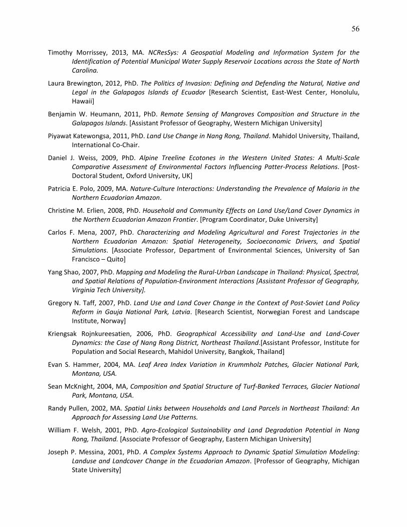
56
Timothy Morrissey, 2013, MA. NCResSys: A Geospatial Modeling and Information System for the Identification of Potential Municipal Water Supply Reservoir Locations across the State of North Carolina.
Laura Brewington, 2012, PhD. The Politics of Invasion: Defining and Defending the Natural, Native and Legal in the Galapagos Islands of Ecuador [Research Scientist, East‐West Center, Honolulu, Hawaii]
Benjamin W. Heumann, 2011, PhD. Remote Sensing of Mangroves Composition and Structure in the Galapagos Islands. [Assistant Professor of Geography, Western Michigan University]
Piyawat Katewongsa, 2011, PhD. Land Use Change in Nang Rong, Thailand. Mahidol University, Thailand, International Co‐Chair.
Daniel J. Weiss, 2009, PhD. Alpine Treeline Ecotones in the Western United States: A Multi‐Scale Comparative Assessment of Environmental Factors Influencing Patter‐Process Relations. [Post‐Doctoral Student, Oxford University, UK]
Patricia E. Polo, 2009, MA. Nature‐Culture Interactions: Understanding the Prevalence of Malaria in the Northern Ecuadorian Amazon.
Christine M. Erlien, 2008, PhD. Household and Community Effects on Land Use/Land Cover Dynamics in the Northern Ecuadorian Amazon Frontier. [Program Coordinator, Duke University]
Carlos F. Mena, 2007, PhD. Characterizing and Modeling Agricultural and Forest Trajectories in the Northern Ecuadorian Amazon: Spatial Heterogeneity, Socioeconomic Drivers, and Spatial Simulations. [Associate Professor, Department of Environmental Sciences, University of San Francisco – Quito]
Yang Shao, 2007, PhD. Mapping and Modeling the Rural‐Urban Landscape in Thailand: Physical, Spectral, and Spatial Relations of Population‐Environment Interactions [Assistant Professor of Geography, Virginia Tech University].
Gregory N. Taff, 2007, PhD. Land Use and Land Cover Change in the Context of Post‐Soviet Land Policy Reform in Gauja National Park, Latvia. [Research Scientist, Norwegian Forest and Landscape Institute, Norway]
Kriengsak Rojnkureesatien, 2006, PhD. Geographical Accessibility and Land‐Use and Land‐Cover Dynamics: the Case of Nang Rong District, Northeast Thailand.[Assistant Professor, Institute for Population and Social Research, Mahidol University, Bangkok, Thailand]
Evan S. Hammer, 2004, MA. Leaf Area Index Variation in Krummholz Patches, Glacier National Park, Montana, USA.
Sean McKnight, 2004, MA, Composition and Spatial Structure of Turf‐Banked Terraces, Glacier National Park, Montana, USA.
Randy Pullen, 2002, MA. Spatial Links between Households and Land Parcels in Northeast Thailand: An Approach for Assessing Land Use Patterns.
William F. Welsh, 2001, PhD. Agro‐Ecological Sustainability and Land Degradation Potential in Nang Rong, Thailand. [Associate Professor of Geography, Eastern Michigan University]
Joseph P. Messina, 2001, PhD. A Complex Systems Approach to Dynamic Spatial Simulation Modeling: Landuse and Landcover Change in the Ecuadorian Amazon. [Professor of Geography, Michigan State University]

57
Phillip M. McDaniel, 2000, MA. Household and Community Drivers of Land Clearing: Human‐Environment Interactions in the Ecuadorian Amazon.
Courtney E. Hart, 2000, MA. Assessing the Nature and Magnitude of Landuse/Landcover Change in Northeast Thailand.
Thomas W. Crawford, 2000, Ph.D. Human‐Environment Interactions and Regional Change in Northeast Thailand: Relationships between Socio‐Economic, Environmental, and Geographic Patterns. [Associate Professor of Geography, East Carolina University]
Kelley A. Crews, 2000, PhD. Integrated Landscape Characterization via Landscape Ecology and GIScience: A Policy Ecology of Northeast Thailand. [Associate Professor of Geography and the Environment, University of Texas – Austin]
Gabriela Valdivia, 1999, MA. Colonization, Communas, and Reserves: The Ecology of Land Use and Land Cover Change in Indigenous Communities of Northeast Ecuador.
Tom P. Evans, 1998, PhD. Village Boundary Form, Function, and Composition: Social, Spatial, and Environmental Linkages in Nang Rong District, Northeast Thailand. [Professor of Geography, Indiana University]
Philip A. Townsend, 1997, PhD. Biodiversity and Environmental Gradients in Deepwater Swamps of the Roanoke River Floodplain, North Carolina. [Professor of Forest Ecology, University of Wisconsin – Madison]
Robert A. Chastain, Jr., 1995, MA. Variation in the Pattern and Composition of Plant Productivity within the Roanoke River Floodplain: A Seasonal Perspective.
Stephen J. McGregor, 1995, PhD. An Integrated Geographic Information Systems Approach for Modeling Autogenic Succession Potential of the Alpine Tundra Ecosystem in Glacier National Park, Montana. [Lead Project Scientist, US Department of Defense]
Thomas R. Allen, 1995, PhD. Relationships between Spatial Pattern and Environment at the Alpine Treeline Ecotone, Glacier National Park, Montana. [Associate Professor of Geography, East Carolina University]
James Stewart, 1995, MA. Topography and Fire: Factors Affecting Landscape Productivity in Glacier National Park, Montana.
Barry F. Doll, 1993. MA. Use of Topographic Information in Estimating Areal Precipitation in the Mountain Environment of Western North Carolina.
Thaddeus J. Bara, 1993. MA. A Probabilistic Approach to Land Cover Regionalization in Glacier National Park, Montana.
Daniel G. Brown. 1992. PhD. Topographical and Biophysical Modeling of Vegetation Patterns at Alpine Treeline. [Professor of Natural Resources and the Environment, University of Michigan]
Ling Bian, 1991. PhD. Effects of Spatial Scale on Estimating the Relationship between Vegetation and Topography in a Mountainous Environment. [Professor of Geography, SUNY – Buffalo]
Bonnie M. Henderson, 1991, MA. Plowed, Paved, on in Succession: A Study of Landscape Change in Orange County, North Carolina.
Nina M. Kelly, 1991, MA. Role of Topography in the Establishment and Maintenance of Treeline Ecosystem Components in Glacier National Park, Montana: An Integration of Remote Sensing Methods and Digital Elevation Models.
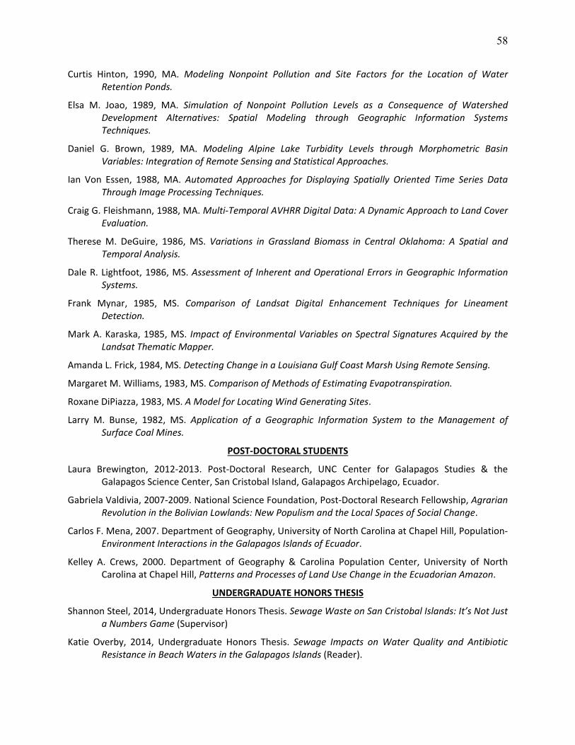
58
Curtis Hinton, 1990, MA. Modeling Nonpoint Pollution and Site Factors for the Location of Water Retention Ponds.
Elsa M. Joao, 1989, MA. Simulation of Nonpoint Pollution Levels as a Consequence of Watershed Development Alternatives: Spatial Modeling through Geographic Information Systems Techniques.
Daniel G. Brown, 1989, MA. Modeling Alpine Lake Turbidity Levels through Morphometric Basin Variables: Integration of Remote Sensing and Statistical Approaches.
Ian Von Essen, 1988, MA. Automated Approaches for Displaying Spatially Oriented Time Series Data Through Image Processing Techniques.
Craig G. Fleishmann, 1988, MA. Multi‐Temporal AVHRR Digital Data: A Dynamic Approach to Land Cover Evaluation.
Therese M. DeGuire, 1986, MS. Variations in Grassland Biomass in Central Oklahoma: A Spatial and Temporal Analysis.
Dale R. Lightfoot, 1986, MS. Assessment of Inherent and Operational Errors in Geographic Information Systems.
Frank Mynar, 1985, MS. Comparison of Landsat Digital Enhancement Techniques for Lineament Detection.
Mark A. Karaska, 1985, MS. Impact of Environmental Variables on Spectral Signatures Acquired by the Landsat Thematic Mapper.
Amanda L. Frick, 1984, MS. Detecting Change in a Louisiana Gulf Coast Marsh Using Remote Sensing.
Margaret M. Williams, 1983, MS. Comparison of Methods of Estimating Evapotranspiration.
Roxane DiPiazza, 1983, MS. A Model for Locating Wind Generating Sites.
Larry M. Bunse, 1982, MS. Application of a Geographic Information System to the Management of Surface Coal Mines.
POST‐DOCTORAL STUDENTS
Laura Brewington, 2012‐2013. Post‐Doctoral Research, UNC Center for Galapagos Studies & the Galapagos Science Center, San Cristobal Island, Galapagos Archipelago, Ecuador.
Gabriela Valdivia, 2007‐2009. National Science Foundation, Post‐Doctoral Research Fellowship, Agrarian Revolution in the Bolivian Lowlands: New Populism and the Local Spaces of Social Change.
Carlos F. Mena, 2007. Department of Geography, University of North Carolina at Chapel Hill, Population‐Environment Interactions in the Galapagos Islands of Ecuador.
Kelley A. Crews, 2000. Department of Geography & Carolina Population Center, University of North Carolina at Chapel Hill, Patterns and Processes of Land Use Change in the Ecuadorian Amazon.
UNDERGRADUATE HONORS THESIS
Shannon Steel, 2014, Undergraduate Honors Thesis. Sewage Waste on San Cristobal Islands: It’s Not Just a Numbers Game (Supervisor)
Katie Overby, 2014, Undergraduate Honors Thesis. Sewage Impacts on Water Quality and Antibiotic Resistance in Beach Waters in the Galapagos Islands (Reader).
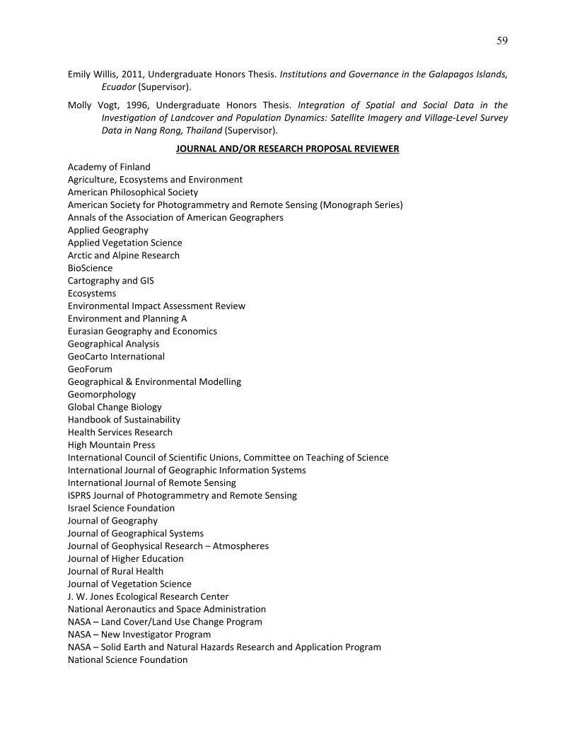
59
Emily Willis, 2011, Undergraduate Honors Thesis. Institutions and Governance in the Galapagos Islands, Ecuador (Supervisor).
Molly Vogt, 1996, Undergraduate Honors Thesis. Integration of Spatial and Social Data in the Investigation of Landcover and Population Dynamics: Satellite Imagery and Village‐Level Survey Data in Nang Rong, Thailand (Supervisor).
JOURNAL AND/OR RESEARCH PROPOSAL REVIEWER
Academy of Finland Agriculture, Ecosystems and Environment American Philosophical Society American Society for Photogrammetry and Remote Sensing (Monograph Series) Annals of the Association of American Geographers Applied Geography Applied Vegetation Science Arctic and Alpine Research BioScience Cartography and GIS Ecosystems Environmental Impact Assessment Review Environment and Planning A Eurasian Geography and Economics Geographical Analysis GeoCarto International GeoForum Geographical & Environmental Modelling Geomorphology Global Change Biology Handbook of Sustainability Health Services Research High Mountain Press International Council of Scientific Unions, Committee on Teaching of Science International Journal of Geographic Information Systems International Journal of Remote Sensing ISPRS Journal of Photogrammetry and Remote Sensing Israel Science Foundation Journal of Geography Journal of Geographical Systems Journal of Geophysical Research – Atmospheres Journal of Higher Education Journal of Rural Health Journal of Vegetation Science J. W. Jones Ecological Research Center National Aeronautics and Space Administration NASA – Land Cover/Land Use Change Program NASA – New Investigator Program NASA – Solid Earth and Natural Hazards Research and Application Program National Science Foundation
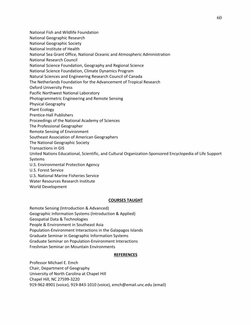
60
National Fish and Wildlife Foundation National Geographic Research National Geographic Society National Institute of Health National Sea Grant Office, National Oceanic and Atmospheric Administration National Research Council National Science Foundation, Geography and Regional Science National Science Foundation, Climate Dynamics Program Natural Sciences and Engineering Research Council of Canada The Netherlands Foundation for the Advancement of Tropical Research Oxford University Press Pacific Northwest National Laboratory Photogrammetric Engineering and Remote Sensing Physical Geography Plant Ecology Prentice‐Hall Publishers Proceedings of the National Academy of Sciences The Professional Geographer Remote Sensing of Environment Southeast Association of American Geographers The National Geographic Society Transactions in GIS United Nations Educational, Scientific, and Cultural Organization‐Sponsored Encyclopedia of Life Support Systems U.S. Environmental Protection Agency U.S. Forest Service U.S. National Marine Fisheries Service Water Resources Research Institute World Development
COURSES TAUGHT
Remote Sensing (Introduction & Advanced) Geographic Information Systems (Introduction & Applied) Geospatial Data & Technologies People & Environment in Southeast Asia Population‐Environment Interactions in the Galapagos Islands Graduate Seminar in Geographic Information Systems Graduate Seminar on Population‐Environment Interactions Freshman Seminar on Mountain Environments
REFERENCES
Professor Michael E. Emch Chair, Department of Geography University of North Carolina at Chapel Hill Chapel Hill, NC 27599‐3220 919‐962‐8901 (voice), 919‐843‐1010 (voice), [email protected] (email)
61
Emeritus Professor George P. Malanson Department of Geography University of Iowa Iowa City, IA 52242‐1316 319‐335‐0540 (voice), george‐[email protected] (email) Professor David R. Butler Department of Geography Texas State University at San Marcos San Marcos, TX 78666‐4616 512‐245‐7977 (voice), [email protected]