step 2025 thematic concept high-rise buildings ... · taken a very cautious position regarding...
TRANSCRIPT

THEMATIC CONCEPT
WER
KSTATTB
ERIC
HT 146
WER
KSTATTB
ERIC
HT 156
HIGH-RISE BUILDINGS�


THEMATIC CONCEPT
HIGH-RISE BUILDINGS�STRATEGIES FOR THE PLANNING AND EVALUATION OF HIGH-RISE PROJECTS�

2
TABLE OF CONTENTS�
FOREWORDS 3 Preamble 6
01 SPECIFIC SITUATION OF VIENNA 9 Starting position 10 High-rises in Vienna 12
02 URBANISTIC MODEL 15 Areas 18
Consolidated city 22 Urban composite 24 Southern terraces 26 Fluvial cityscape 28 Transdanubian expanse 30 Transitional areas 32
03 PLANNING AND EVALUATION 35 Programmes for high-rise buildings 36
Multifunctional programmes 37 Living in high-rises 38
Added values 40 Process 42
Phase 1: Idea 44 Phase 2: Concept 46 Phase 3: Design 48 Phase 4: Implementation 49
Transitional provisions 50
APPENDIX 53 Explanatory notes on the urban development interventions 54 Contributors 60

10 3
FOREWORDS�

4
In Vienna there are currently more than 250 highrises – that means buildings higher than 35 m. The topic of high-rises was intensively discussed in the past years. One look at buildings such as the highrise in the Herrengasse or the Ringturm shows that this issue is not new. The 2002 high-rise guidelines, which are valid up to today, had caused several significant limitations to high-rise projects in regard to content and procedures, and stimulated the discussion over locations, programmes, qualities and processes.
Following this line, the thematic concept for high-rise buildings, which is subordinate to STEP 2025, formulates a clarification and extension of the criteria for the planning and construction of high-rises in Vienna. On account of the special Viennese planning circumstances, the challenge was to harmonise urban development criteria and procedural decision-making. A well-founded, not too narrow, but nonetheless contoured urban development model, public added values and, above all, the structuring of planning and decisionmaking processes in the context of high-rises constitute the cornerstones of the thematic concept. The requirements placed on the planning and construction of high-rises were considerably increased compared to the 2002 high-rise guidelines.
The Thematic Concept: High-rise Buildings deals carefully and sensitively with Vienna’s building stock. Different areas are described with the correspondingly different types of interventions for high-rises. On the basis of an urban development analysis, the foundation for further steps has been laid. This approach conforms to a deeper lying character of Viennese urban intervention – not to make hasty decisions, to weigh the pros and cons, and to seek compromises in the sense of cooperation. This aspect of the Thematic Concept: High-rise Buildings is crucial: It makes a continuous further development in accordance with the urban dynamics and their exponents possible. But it also opens the specialized discussion and, not least, the possibility of a public negotiation. And this is what it must ultimately be about, because a city can only be a city if its contents are supported by the citizens.
Mag.a Maria Vassilakou Vice Mayor Executive City Councillor for Urban Planning, Traffic & Transport, Climate Protection, Energy and Public Participation

High-rise Concept Vienna 5
The current growth of Vienna requires a comprehensive reappraisal of the goals and means of urban development. The dynamism of future urban space creation is to be guided less normatively and able to be much more flexibly adapted to the very quickly changing prerequisites and conditions.
STEP 2025 (the Urban Development Plan 2025) therefore concentrates on the establishment of overriding planning principles that range from a gentle further development of existing building stock to intelligent mobility systems, to the design and management of open spaces and the supply of social infrastructures, just to mention a few aspects. This thematic framework planning thus differs from the previous urban development plans of 1984, 1995 and 2005, which were rather oriented towards concrete spatial localisations.
At the same time, it is absolutely essential in urban construction and urban planning to outline spatial structuring efforts, since it is a question of decisions that will have a far-reaching effect on the cityscape. In the sense of quality assurance and legal equality,
the decision-making paths that are to be observed during the planning are to likewise be described. For this concrete level of planning, STEP 2025 includes so-called expert concepts that provide extensive fundamentals on different topics.
This expert concept pertains to high-rises in Vienna. It traces out basic urban planning and spatial intentions, as well as programmatic settings, public added values and planning design in highrise schemes. Because high-rises can enrich the city only if the participation of all those involved and affected is structured as a process and extraordinary added values for the public result out of it. These planning decisions should take place more discursively rather than normatively in the future – based on arguments and negotiations. This intention seeks to shape the high-rise concept with the goal of enabling urban development changes that are comprehensible and supported by a wide community of interests.
DI Thomas Madreiter Director of Urban Planning Group

6
PREAMBLE�
As a quintessential Central European city, Vienna enjoys all advantages of a geographically, topographically, scenically, spatially, typologically and atmospherically outstanding, very clearly structured, visually highly readable and extremely liveable city. Not least due to its rich urbanity and urban coherence, Vienna has traditionally taken a very cautious position regarding high-rise construction projects – not because high-rises in the modern sense would constitute something new and potentially suspect, but rather because highrises, with their prominent physical presence in the urban environment, should serve not just a few but, if possible, all denizens of the city.
High-rises embody an emblematic typology of modern urban design and contrast clearly with the traditional city, where edifices of outstanding height equalled extraordinary functions and significance. As prototypes of economically charged, sometimes condensed, sometimes individual, isolated architectural design, contemporary high-rise structures often act as projection surfaces for metropolitan development and refurbishment scenarios that reflect international peer ventures. Yet interpreting or instrumenting the high-rise question in this simplistic manner would run counter to any responsible planning approach to deal with Vienna’s urbanistic qualities, which have evolved over centuries. Evidently, though, Vienna should not close itself to future transformations – also including high-rises – but rather appropriate these by means of strategically formulated concepts. This principally calls for the provision of added value for the city at large as well as for broad-based consensus sustained by a majority of citizens.
Viewed against this background, the present High- rise Concept for Vienna focuses first and foremost on the question of what should constitute the appropriate type of intervention for highrise developments and describes this type of intervention both by assessing, on a large-scale basis, the urbanistic significance of the various areas of Vienna and by defining what would
constitute the situational added value of a high-rise project, without defining categories in normative fashion. Rather, the document stipulates that each and every high-rise project must be justified, in accordance with the framework conditions formulated in the High- rise Concept, regarding its quantitative and qualitative disposition. The concept defines added value as an enrichment with necessities and qualities of equal relevance for the local situation, the neighbourhood and the city as a whole.
This postulate for planners duly requires that the most important planning steps towards viable solutions be sketched and dealt with in the context of binding process design. Principally, this includes the involvement of all stakeholders, in particular of the general public, at all levels of the planning process so as to broadly optimise and, ultimately, bindingly enshrine urban development projects including high-rises. The legal embodiment of these optimisations might take the form of e.g. urban development contracts and could be safeguarded in the medium term through temporary land use designations. Quite apart from these novel contractual instruments, it is still very important – and may even become more so in the future – to develop projects on the basis of common perspectives, co-operation and consensus. Co-operative planning and participation procedures act as catalysts for the transformation of the urban environment towards a smart city; this applies to a particular degree for high-rise developments.
Beside the behaviour of high-rises in the urban context as well as added value and process design, the rapid growth of Vienna additionally brings the issue of residential high-rises into sharp focus. Social housing traditionally occupies a very special position in Vienna’s urban development, a fact that has manifested itself time and again in exemplary solutions, sometimes even taking the form of buildings exceeding 35 metres of height. Naturally, the framework conditions of subsidised housing construction have changed many times over the

7 High-rise Concept Vienna
years, and new challenges, such as energy-related and ecological objectives, new housing demands or family patterns and the safeguarding of social sustainability and affordability under difficult economic framework conditions, have emerged and were duly tackled. However, providing affordable housing options in high-rise buildings calls for novel approaches to co-operative project development and financing models; the present High-rise Concept can only propose key demands to be met by current and future residential high-rise projects. This includes above all the demand for mixed-use and flexible-use options, for socio-spatial added value, for the provision of adequate, carefully planned open spaces – and, obviously, for high- quality architectural solutions at all levels.
The High-rise Concept aims to render urbanistic and procedural interrelationships transparent and relies on an appropriate planning culture to address these complex issues and processes. An approach steeped in process-based problem solution methods and taking account of the co-operative community sense confronts all stakeholders of high-rise projects planned for Vienna with ambitious demands. However, it is precisely this challenge that constitutes the core of the High-rise Concept for Vienna and should be definitely understood as a promise that experiments in the field of future urban development will find room and can be embedded within this concept.
It seems useful at this point to mention some planning-related and practical desiderata that have emerged while drafting the High-rise Concept: With its data stock, the City of Vienna has a hoard of knowledge at its disposal that is probably unique worldwide regarding its completeness and presentation options; in the future, data transparency and accessibility will be translated into a new planning mentality, which is very much to be welcomed, as this e.g. permits all impacts and consequences of high-rise projects to be clearly visualised. Beyond the scope of concrete case-bycase analyses, however, data transparency should also support the ways and means of obtaining an
accurate picture of the development of Vienna’s urban structure, which is effectively supported by continuously updated 3D models and, above all, a physical model. These two methods of visualising Vienna have made it possible to not only depict future high-rise developments, but all larger-scale plans for Vienna and allowed for comprehensive discussion and decision-making regarding these plans.
The present High-rise Concept builds on the values embodied in the urbanistic guidelines for high-rise buildings of 2002, but deliberately adopts a view-point that embraces the city as a whole and focuses on flexible, structured decision-making processes involving all stakeholders so as to ensure maximum quality assurance. In this respect, involvement also means responsibility – for this reason, the Highrise Concept provides for legal guarantees as a fundamental principle for all stakeholders.
The present High-rise Concept is not a binding legal document, but should be regarded as a guideline and mission statement. It sensitively shifts the urbanistic assessments and premises of the previous high-rise guidelines towards a less normative and more process-oriented, urbananalytical and comprehensive perspective.
High-rise buildings in Vienna always generate discussions about all sorts of interests and ideologies. These discussions are important and need to be conducted on an ongoing basis. The High-rise Concept thus defines itself as a summary of concrete conceptual decision aids, which will be further adapted and specified in the future.

8�
9
SPECIFIC SITUATION OF VIENNA
01

10
STARTING POSITION�
Vienna is a very diligently developed, substantially consolidated city that allows for transformations precisely because of its stability.

Specific situation of Vienna | Starting position 11
The uniqueness of Vienna’s cityscape stems from its topographic and scenic setting and from a very specific urban structure that has continuously evolved over the centuries. Vienna Woods, Danube, Prater, Ringstrasse, St. Stephen’s Cathedral, Schönbrunn, Wien River, Gürtel, the southern river terraces, Lainzer Tiergarten, Lobau, Belvedere, the Danube Platform, Urania, Danube Canal, Bisamberg, Cobenzl, Höhenstrasse, Grinzing and many others – all these are insignia of a city that can be described in terms of distinct spaces and is thus embedded in the collective mind, too.
Vienna’s urban territory is characterised by the horizontally oriented architecture of large parts of its inner districts, whose physical presence provided a setting for the monumental buildings of all urban development phases until the mid-20th century. This compact spatiality was embodied in the 1893 Building Code and the subsequent
General Regulation Plan with its height stipulations decreasing concentrically from centre to periphery (Building Classes V – I). The areas across the Danube (Transdanubia) were only incorporated after 1900, and their urban structure reflects a versatile spatial paradigm that is in contrast with the largely consolidated, compact city in the center of Vienna. In between, we find the landscape of the Danube River proper, with its generous open spaces. At the periphery of this tripartite basic constellation, specially formed urban particles are inserted, such as mainly industrial areas composed of closely packed set pieces to the south-east or isolated, large-scale ensembles, whose wideranging effect transcends a merely local impact, to the south-west and north-east.
12
HIGH-RISES IN VIENNA�
In Vienna, high-rises have been factors of importance for urban development policy and urban design only since the 1950s. Apart from church spires, stately mansions, military constructions or special industrial edifices, all earlier architectural developments towering above the traditional building horizon concerned a few individual objects from the interwar period, e.g. municipal housing projects of Red Vienna or the high-rise in Herrengasse. In the postwar period, high-rise developments were limited to prestigious locations, such as the Ringturm, the InterContinental Hotel, the Gartenbau grounds or the Hilton Hotel. In other words: until the 1990s, Vienna was anything but a “high-rise metropolis”.
After the dismantling of the Iron Curtain in 1989, Vienna’s position was changed inasmuch as the construction of commercial, office and service buildings began to boom around the turn of the millennium, which strongly fuelled the proliferation of high-rise buildings as well. Against this backdrop and based on several relevant expertises, the hitherto applicable recommendations were formulated in the document “High-rise Buildings in Vienna – Urbanistic Guidelines” and adopted by the City Council in 2002. This document emphasised the importance of continuity and permanence for Vienna’s urban design, the city’s physical-spatial qualities and atmospheric density as an identitycreating starting position for the evaluation of high-rise projects. Expressly building on these definitions and in accord with today’s status of Vienna as a future-oriented city characterised by strong population growth, the present High-rise Concept now replaces the previous objectives and guidelines.
However, these objectives must be measured and judged against the actual developments that have occurred since 2002. Concretely, it must be clarified how the guidelines of 2002 have impacted Vienna’s urban development and building practice.
The real estate market does not reflect urban design guidelines as much as it follows the criteria of the market, of supply and demand. Consequently, the new High-rise Concept for Vienna needs to take account of the different motivations of public planning and private investment and must promote a constructive dialogue with the twofold aim of approaching all future high-rise developments in Vienna sensitively and analysing them for their potential to enhance local and neighbourhood qualities. Duly, criteria of programmes for, and added value embodied by, high-rises are decisive for the assessment of such projects.
High-rises are very prominent architectural marks – or landmarks – in the urban landscape; for this reason, their presence should also entail an obligation to offer something in return. Profits resulting from land reclassification for the benefit of high-rises should largely be given back to the general public by making sure that such buildings will sustainably and actively contribute to upgrading their environs.
The present document should be understood as a thematic concept according to STEP 2025 and will be continuously supplemented and evolved through the evaluation and implementation, as outlined by process design, of the knowledge obtained, but also in agreement with other superordinate guidelines and mission statements.

Specific situation of Vienna | High-rises in Vienna 13
In accordance with Article 7 par. f of the Building Code for Vienna, buildings with a height in excess of 35 metres are considered as high-rises. Under the fire safety regulations, buildings with a height difference of at least 22 metres between the upper flooring edge of the top storey and the lowest point of the terrain adjoining the building have to comply with more stringent standards; starting from a height difference of 32 metres, additional provisions
apply. For this reason, the High-rise Concept distinguishes between “high buildings” (height: 26-35 metres) and “high-rises” (height: over 35 metres).
CURRENT HIGH-RISE BUINature reserves and protected landscapes City limits Main roads High-level public transport High-level public transport, planned Bodies of water
High-rises, designated plots High-rises, current/under construction
35 m - 60 m 61 m - 90 m 91 m - 120 m 120 m +
LDING STOCK
0 1km 2km 5km
Scale: 1:200.000

14�

15�
URBANISTIC MODEL
02

16
Due to the city’s topographic, morphological, atmospheric, natural landscape-related, functional, social and ecological qualities, it becomes evident that Vienna needs high-rises only under the premise that these will contribute outstanding added value for the community at large.
The present High-rise Concept is based on an urbanistic interpretation of the superordinate topographic, structural and morphological features of Vienna as outlined above, but also on an assessment of architectural developments over the coming 10 to 15 years, thereby reflecting demographic forecasts that assume a population growth of approx. 230,000 inhabitants until 2025. As compared to the concept of 2002, several preconditions have changed fundamentally, in particular with regard to development possibilities for the inner districts of Vienna, but also – due to different or more precisely formulated political goals – with respect to sustainable internal and external urban development. Vienna is growing in a quantitative sense; however, it should above all grow qualitatively as well. Seen against this backdrop, high-rise developments ought to be viewed as exceptional cases subject to certain conditions.
The construction of high-rises is excluded in nature reserves and protected landscapes. Safety zones of Vienna International Airport, protection zones according to Art. 7 of the Building Code for Vienna as well as, in particular, the core and buffer zones of the UNESCO World Heritage properties call for increased vigilance in the evaluation of high-rise projects. Studies and visualisations of Vienna’s cityscape quality are to be updated on an ongoing basis so that it will also be possible in the future to measure the dynamic development of the Austrian capital against its extant building stock.
High-rises should act as catalysts of urban development, should contribute essentially to the
sustainable improvement of urban qualities in their direct and indirect surroundings and thus cannot be built in Vienna unless they fulfil this compensatory role for the benefit of the community.
Moreover, various general requirements must be met by all high-rise projects. These include public accessibility or permeability of the ground-floor areas, outstanding functional and design quality, appropriate dimensioning in relation to pre-existing structures, as well as minimum standards regarding public transport connections.
Every high-rise is embedded in a network of green and open spaces that spans the entire city. The design and equipment of green and open spaces must correspond to contemporary aesthetic, technical and ecological criteria and, moreover, must interact with the urban structure as a whole. A key criterion is the quality of use afforded by open spaces, with special attention paid to the needs of different user groups. Furthermore, all projects must comply with the principles of building culture embraced by the City of Vienna.
However, urban densification – such as the development of new high-rise sites – also strongly impacts local energy demand. In adopting STEP 2025, Vienna pursues the goal of evolving a system of integrated spatial and energy planning and urban densification in order to attain the best possible future balance of locally available, highly eco-friendly energy potentials on the one hand and increasing demand on the other hand. This must be taken into account when selecting sites for new high-rise buildings.

Urbanistic model 17
The role of high-rises differs depending on the urban context in which they are situated. For this reason, the High-rise Concept structures the city into six areas with different site-specific requirements to be met. These areas result from a consideration of Vienna’s urban structure and spatial development, which underpins the present High-rise Concept and is described separately
for each area. The delimitations between areas are mostly not clearly drawn and rather constitute transitions from one to another part of the city, each with its specific structural, morphological and atmospheric characteristics. Within these zones, rules adapted to the respective situation are formulated in order to steer the development of high-rises.
FRAMEWORK CONDITIONSCity limitsMain roadsHigh-level public transportHigh-level public transport, plannedBodies of water
Exclusion zones:Nature reserves and protected landscapes
0
Scale:
1km 2km 5km
1:200.000
Heightened attention required in: Protection zones acc. to Art. 7 of the Building Code for Vienna UNESCO World Heritage site, core zone UNESCO World Heritage site, buffer zone Safety zone, Vienna International Airport

These areas form the framework of high-rise developments.
18
AREAS
Six areas were identified: the consolidated city, the urban composite, the southern terraces, the fluvial cityscape, the Transdanubian expanse and the transitional areas.
This structuring into areas is the expression of a spatial organisation that, while still oriented towards a strong centre, also assumes concentric, partially radial and, more and more frequently, tangential and, to a degree, decentralised forms. The areas of the present High-rise Concept describe spatialthematic focuses and hence cannot always be viewed as spatially clearly distinct from each other. In the peripheral area sections, the allocation of a site to a specific area must be argued in keeping with the qualitative area description. While high points in the consolidated city mainly serve the purpose of accenting already existing local spatial configurations, they engage in a generous interrelationship with local open spaces of the fluvial cityscape. In the context of the urban composite, high-rises form dense, intensively utilised
clusters, while acting as elements of autonomous development concentrations along the southern terraces. In the fluid, extensive Transdanubian expanse, they support the emergence of a capillary network of public spaces that interconnects the heterogeneous settlement units. Finally, only moderate height developments seem suitable for the transitional areas in order to establish spatial continuity between the city of built structures and the open landscape (high buildings not exceeding 35 metres as opposed to high-rises with a height in excess of 35 metres).
As a result of this overarching definition of urban space, the individual areas are assigned differentiated descriptions of possible dispositions and qualitative recommendations for the
Due to the differentiated landscape, the gradual urban development of Vienna entails the accretion of variously shaped and structured city areas, whose spatial characteristics are consolidated over time.
Vienna, 1850 Vienna, 1890 Vienna, 1913

Due to the differentiated landscape, the gradual urban development of Vienna entails the accretion of variously shaped and structured city areas, whose spatial characteristics are consolidated over time.
19Urbanistic model | Areas
appropriate height relations of high-rises. In any case, the integration of a project into the High-rise Concept must always be evaluated or brought into line in the context of quality assurance procedures. The idea is to place high-rises in a relation with the surrounding urban context – transparently, on the basis of a precise urban space analysis and an evaluation of the respective situation, especially with a view to orientation, visibility and sightlines in urban space. The instruments to safeguard these procedures are outlined in this concept.
The present High-rise Concept aims at a hermeneutic and hence analytical and interpretative approach to the city. Again, the idea is to argue high-rises transparently, on the basis of a precise urban space analysis and an evaluation of the
These areas form the framework of high-rise developments.
respective situation and to place them in a relation with the surrounding urban context. These preconditions are evaluated by quality assurance bodies, as described in the High- rise Concept. The diagrams attached to the area descriptions offer exemplary illustrations of spatial situations and interrelations typical for each area.
Vienna, 1938 Vienna, 1970 Vienna, 2000

20 Urbanistic model | Areas 21
AREAS Nature reserves and protected landscapes City limits Main roads High-level public transport High-level public transport, planned Bodies of water
KS Consolidated city UK Urban composite ST Southern terraces FS Fluvial cityscape TA Transdanubian expanse Ü Transition areas
0
Scale:
0,5km 1km 2,5km
1:200.000

22

23 Urbanistic model | Areas
CONSOLIDATED CITY
The consolidated city area comprises the compact body of the inner city, grown over time, and the adjacent Gründerzeit expansion areas. This area is characterised by high architectural and social density, concise morphology, typological readability and traditional space creation with clear-cut delimitations between open spaces and buildings, as well as by a largely even building horizon that is historically broken up only by very few, special high points, e.g. church spires or military buildings. Streetscapes, open spaces and courtyards interact tensely with the urban blocks and their individual edifices; open space is often markedly compressed; in some spots, it expands into larger, contiguous spatial sequences, such as in the area of the Glacis or the large former railway and industrial sites. Frequently, this engenders spatially contrasting interfaces between urban layers repeatedly remoulded over time.
Grown and consolidated over centuries, the area encompassing Vienna’s inner districts constitutes an outstanding monument of European urban development. High-rise projects in this consolidted inner-city area must be evaluated against this background.
The fundamental principle underlying high-rise projects in the consolidated city is respect and restraint vis-à-vis the quality of the existing building stock. Enriching the cityscape by accenting the height relief in spatially significant points – interfaces in the urban structure, city edges, activity poles, inner-city development areas, etc. – may be definitely desirable. Emphasising and strengthening prominent spots and city edges within the existing built structure by means of high buildings (up to 35 metres) and high- rises (exceeding 35 metres); the creation of focal points in selected
locations; second- or third-row, discreet vertical developments; targeted systemic breaks that add vibrancy to the surroundings – these are just some keywords to sketch possible urban development options that would allow for the implementation of high-rises in the consolidated city.
High-rises embodying appropriate dimensions in relation to the existing building stock may be acceptable in such situations if they are conducive to local enrichment of the urban fabric, to spatial and functional clarification, to a meaningful transformation of the respective situation in keeping with the requirements of urban typology and urban sociology, and if they help to compensate for structural deficits and support the public appropriation of urban space. In sub-areas characterised by functional deficits of e.g. the social infrastructure, the integration of public facilities for education, social services and healthcare can constitute significant added value. The actual demand must be established through a detailed analysis of the respective environment. In the KS area, special attention must be paid to utilisation structures in tune with the neighbourhood, in particular with regard to public, non-commercial facilities at ground-floor level in combination with the surrounding public space. Ideally, the actual demand is to be determined and visualised on the basis of an in-depth socio-spatial analysis.

24
Urbanistic model | Are 25 as
URBAN COMPOSITE
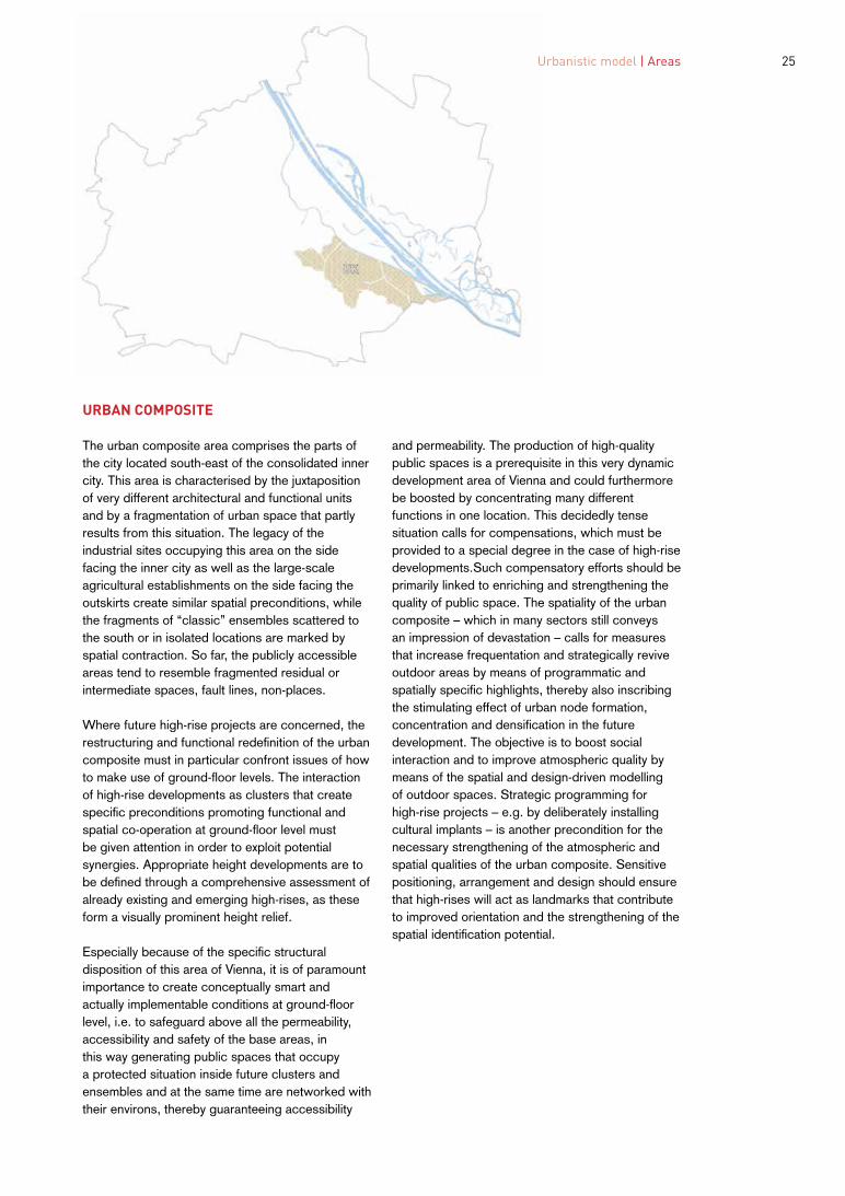
The urban composite area comprises the parts of the city located south-east of the consolidated inner city. This area is characterised by the juxtaposition of very different architectural and functional units and by a fragmentation of urban space that partly results from this situation. The legacy of the industrial sites occupying this area on the side facing the inner city as well as the large-scale agricultural establishments on the side facing the outskirts create similar spatial preconditions, while the fragments of “classic” ensembles scattered to the south or in isolated locations are marked by spatial contraction. So far, the publicly accessible areas tend to resemble fragmented residual or intermediate spaces, fault lines, non-places.
Where future high-rise projects are concerned, the restructuring and functional redefinition of the urban composite must in particular confront issues of how to make use of ground-floor levels. The interaction of high-rise developments as clusters that create specific preconditions promoting functional and spatial co-operation at ground-floor level must be given attention in order to exploit potential synergies. Appropriate height developments are to be defined through a comprehensive assessment of already existing and emerging high-rises, as these form a visually prominent height relief.
Especially because of the specific structural disposition of this area of Vienna, it is of paramount importance to create conceptually smart and actually implementable conditions at ground-floor level, i.e. to safeguard above all the permeability, accessibility and safety of the base areas, in this way generating public spaces that occupy a protected situation inside future clusters and ensembles and at the same time are networked with their environs, thereby guaranteeing accessibility
and permeability. The production of high-quality public spaces is a prerequisite in this very dynamic development area of Vienna and could furthermore be boosted by concentrating many different functions in one location. This decidedly tense situation calls for compensations, which must be provided to a special degree in the case of high-rise developments.Such compensatory efforts should be primarily linked to enriching and strengthening the quality of public space. The spatiality of the urban composite – which in many sectors still conveys an impression of devastation – calls for measures that increase frequentation and strategically revive outdoor areas by means of programmatic and spatially specific highlights, thereby also inscribing the stimulating effect of urban node formation, concentration and densification in the future development. The objective is to boost social interaction and to improve atmospheric quality by means of the spatial and design-driven modelling of outdoor spaces. Strategic programming for high-rise projects – e.g. by deliberately installing cultural implants – is another precondition for the necessary strengthening of the atmospheric and spatial qualities of the urban composite. Sensitive positioning, arrangement and design should ensure that high-rises will act as landmarks that contribute to improved orientation and the strengthening of the spatial identification potential.

2626

2727 Urbanistic model | Areas
SOUTHERN TERRACES
The southern terraces comprise those parts of Vienna that are situated south of the consolidated city. This area is characterised by a special topography marked by extensive rising and falling plains and individual, striking plateaus. Pronounced urban terraces visible from afar have already resulted from architectural transformation, the addition of structural levels and accenting. Apart from these traits of the urban landscape, highly distinct large-scale projects add their specific weight to the spatial fabric, thereby both facilitating visual and mental orientation in space and at the same time contributing to supra-local identity creation due to their urbanistic and architectural uniqueness. “Heavyweight ensembles” such as Alt-Erlaa, Schöpfwerk, Kabelwerk and Wienerberg are the focuses of a superordinate force field that deploys a terrain-regulating effect within a manifold spatial milieu composed of settlement structures of highly different dimensions and spatial impact, large-scale enclaves of industrial and commercial complexes and individual recreational landscapes. Moving through this space – especially when travelling by the elevated Vienna Underground and S-Bahn commuter trains –, an intermediate cityscape, which derives its character and quality not least from these sequentially experienced, striking large-scale projects, is perceived.
High-rise projects for the area occupied by the southern terraces should pay particular attention to their enriching and integrative role in terms of future urban development ensembles by offering a comprehensively co-ordinated concept of heights, densities and spaces. The time-tried tradition of arranging high-rises in groups and ensembles should be continued by avoiding the construction of stand-alone buildings. The maximum acceptable building heights are to be derived from
a simultaneous assessment of the dimensions of the immediately surrounding structures and the effect on the horizon in the wider sense, i.e. the superordinate height relief with its larger impact.
Ideally, the added value generated by high-rises for the southern terraces should be felt in the immediate environs, e.g. by creating and upgrading ample, publicly useable open spaces that contribute to the individuality and urban quality of new ensembles. The integration of cultural facilities, which also act as attractors for the wider catchment area, provides a further possibility of combining new high-rise projects for the southern terraces with added value benefiting the community.

2828
2929 Urbanistic model | Areas
FLUVIAL CITYSCAPE
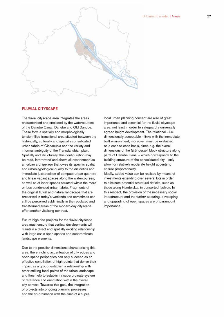
The fluvial cityscape area integrates the areas characterised and enclosed by the watercourses of the Danube Canal, Danube and Old Danube. These form a spatially and morphologically tension-filled transitional area situated between the historically, culturally and spatially consolidated urban fabric of Cisdanubia and the variety and informal ambiguity of the Transdanubian plain. Spatially and structurally, this configuration may be read, interpreted and above all experienced as an urban archipelago that owes its specific spatial and urban-typological quality to the dialectics and immediate juxtaposition of compact urban quarters and linear vacant spaces along the watercourses, as well as of inner spaces situated within the more or less condensed urban fabric. Fragments of the original fluvial and natural landscape that are preserved in today’s wetlands and sometimes can still be perceived subliminally in the regulated and transformed areas of the modern-day cityscape offer another vitalising contrast.
Future high-rise projects for the fluvial cityscape area must ensure that vertical developments will maintain a direct and spatially exciting relationship with large-scale open spaces and superordinate landscape elements.
Due to the peculiar dimensions characterising this area, the enriching accentuation of city edges and open-space peripheries can only succeed as an effective conciliation of high points that derive their impact as a group, establish a relationship with other striking focal points of the urban landscape and thus help to establish a superordinate system of reference and orientation within the overall city context. Towards this goal, the integration of projects into ongoing planning processes and the co-ordination with the aims of a supra
local urban planning concept are also of great importance and essential for the fluvial cityscape area, not least in order to safeguard a universally agreed height development. The relational – i.e. dimensionally acceptable – links with the immediate built environment, moreover, must be evaluated on a case-to-case basis, since e.g. the overall dimensions of the Gründerzeit block structure along parts of Danube Canal – which corresponds to the building structure of the consolidated city – only allow for relatively moderate height accents to ensure proportionality. Ideally, added value can be realised by means of investments extending over several lots in order to eliminate potential structural deficits, such as those along Handelskai, in concerted fashion. In this respect, the provision of the necessary social infrastructure and the further securing, developing and upgrading of open spaces are of paramount importance.

3030

3131 Urbanistic model | Areas
TRANSDANUBIAN EXPANSE
The Transdanubian expanse area comprises the extensive areas north-east of the New and Old Danube. The extremely heterogeneous Transdanubian cityscape is aligned along only a few infrastructure axes, which mostly also sketch the direction that gradual urban development in the area will take. In some places, the space created by this partly very loose agglomeration of settlement units from various construction periods tends to be quite fragmented. More distant destinations on this side of the river as well as the city centre across the Danube sometimes seem to be closer than the immediate environs. Conversely, identity is created by historic urban structures, such as old, partly transformed but still discernible village cores and a few visually distinct housing estates, witnesses to ongoing experiments in the Transdanubian city lab. Spatial coherence, in turn, depends on the texture of the intermediate areas that interconnect or separate individual settlement fragments from each other. So far, only some sections of the area boast a capillary network of superordinate routes and open spaces that would allow for unobstructed movement on foot or by bike as a complement to motorised traffic and public transport in this area, although such a network might become an identifying trait of the Transdanubian expanse.
Ideally, future high-rises in Transdanubia will establish a network of identity-creating landmarks that facilitates orientation in this largely flat terrain – by providing something akin to a mental map rather than a perspective of visual links – and strengthens the capillary qualities of the intermediate spaces both spatially and economically. Suitable locations are thus key spots along the periphery of residential areas or in the intermediate spaces between such areas; here, high-rises might play the role of connecting links and attractors acting as visual
and programmatic “draws” in the cityscape. Such a network of high points should hence be understood as a contextually sensitive system on the one hand – the individual object is to play an enriching role within its immediate, specific spatial milieu – and on the other hand should be viewed as part of a superordinate reference level that counteracts the tendency towards spatial fragmentation by setting deliberate focuses. In this future, strengthened capillary network, the individual high-rise is to occupy a strategic position within a flexible choreography of high points. The compatibility of building heights must be derived from their dimensionally and aesthetically enriching relationship with the local environs and the function of the individual object as a landmark within the network, thereby facilitating spatial orientation and thus improving the quality of perception in the Transdanubian area.
In and around sub-centres that have already established themselves or are emerging, further high-rise developments are conceivable; however, such developments would have to demonstrate their qualities and strengthening effect on decentralised urbanity to a particular degree.
As a result, added value of relevance for the community must primarily be generated through the establishment, strengthening and appointment of publicly permeable and connective intermediate spaces with a view to creating an alternative network that is able to engender synergies between settlement fragments and to ensure spatial continuity in the Transdanubian space.

Für die Allgemeinheit relevante Mehrwerte sind also vorrangig in der Etablierung, Stärkung und Ausrüstung öffentlich durchlässiger und verbindender Zwischenräume im Hinblick auf ein alternatives Netzwerk zu generieren, das in der Lage ist, Synergien zwischen den Siedlungsfragmenten herzustellen und räumliche Kontinuität im transdanubischen Raum sicherzustellen.
Im Bereich der Subzentren, die sich bereits etabliert haben oder in Bildung begriffen sind, sind zusätzlich Hochhausentwicklungen denkbar, die aber in besonderem Maß die Qualitäten bzw. die Stärkung dezentraler Urbanität nachweisen müssen.
den Siedlungsrändern beziehungsweise in den Siedlungszwischenräumen, wo Hochhäuser als Verbindungsglieder und Attraktoren eingesetzt werden können, die in der Stadtlandschaft als visuelle und programmatische Anziehungspunkte wirken. Ein derartiges Netzwerk aus Hochpunkten ist somit einerseits als kontextuell sensibles System zu verstehen – das Einzelobjekt hat eine bereichernde Rolle innerhalb seines unmittelbaren, spezifischen räumlichen Milieus zu spielen – und ist andererseits als Teil einer übergeordneten Referenzebene zu betrachten, die der Tendenz zur räumlichen Fragmentierung durch gezielte Schwerpunktsetzungen entgegenwirkt. Im künftig zu stärkenden kapillaren Netzwerk übernimmt das einzelne Hochhaus eine strategische Position innerhalb einer anpassungsfähigen Choreografie an Hochpunkten. Die Verträglichkeit der Höhenentwicklung ist aus der maßstäblich und ästhetisch bereichernden Beziehung mit der jeweiligen Nachbarschaft und der Funktion des Einzelobjekts als Landmarke innerhalb des Netzwerks abzuleiten, das die Orientierung im Raum erleichtern soll und so die Wahrnehmungsqualität im transdanubischen Raum erhöht.
Künftige Hochhäuser werden in Transdanubien im Idealfall ein Netzwerk aus identitätsstiftenden Landmarken etablieren, das in der weitgehend flachen Ausdehnung des Bereichs Orientierung im Sinne einer mentalen Karte, weniger im Sinne von perspektivischen Sichtbeziehungen, erlaubt und räumlich wie ökonomisch die kapillaren Qualitäten der Zwischenräume stärkt. Geeignete Standorte sind dementsprechend neuralgische Punkte an
Der Bereich der Transdanubischen Ausdehnung (TA) umfasst die weitläufigen Gebiete nordöstlich der Neuen und der Alten Donau. Die äußerst heterogen zusammengesetzte transdanubische Stadtlandschaft orientiert sich an wenigen infrastrukturellen Achsen, die meist auch die Richtung der sukzessiven Stadtentwicklung vorgeben. Die teilweise nur lose gefügte Agglomeration aus Siedlungsbestandteilen unterschiedlicher Bauepochen tendiert mancherorts zu einer von Fragmentierung geprägten Raumbildung. Transdanubische Fernziele und das Stadtzentrum jenseits der Donau scheinen da und dort näher zu liegen als die unmittelbar angrenzende Nachbarschaft. Zur Identitätsstiftung tragen wiederum tradierte städtebauliche Strukturen wie die alten, teilweise überformten, aber immer noch ablesbaren Dorfkerne und einige markante Siedlungen – Zeugen fortlaufender Experimente im transdanubischen Stadtlabor – bei. Der räumliche Zusammenhalt wiederum hängt von der Beschaffenheit der Zwischenbereiche ab, die einzelne Siedlungsfragmente voneinander trennen oder verbinden. Ein kapillares Netzwerk aus übergeordneten Wegen und Freiräumen, das komplementär zur verkehrlichen Erschließung eine durchgängige Bewegung zu Fuß und per Rad durch den Raum erlaubt, ist bisher nur in Teilbereichen vorhanden, kann jedoch zu einem eigenständigen transdanubischen Merkmal werden.
3232
3333 Urbanistic model | Areas
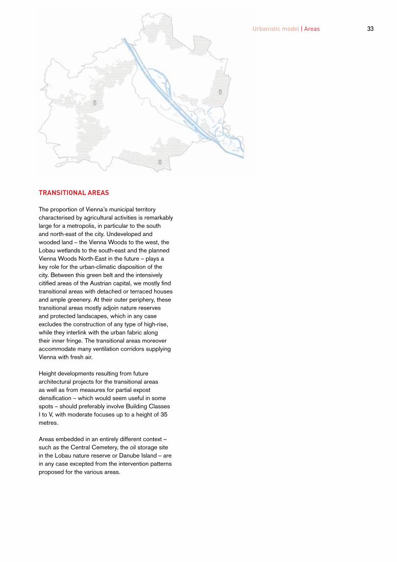
TRANSITIONAL AREAS
The proportion of Vienna’s municipal territory characterised by agricultural activities is remarkably large for a metropolis, in particular to the south and north-east of the city. Undeveloped and wooded land – the Vienna Woods to the west, the Lobau wetlands to the south-east and the planned Vienna Woods North-East in the future – plays a key role for the urban-climatic disposition of the city. Between this green belt and the intensively citified areas of the Austrian capital, we mostly find transitional areas with detached or terraced houses and ample greenery. At their outer periphery, these transitional areas mostly adjoin nature reserves and protected landscapes, which in any case excludes the construction of any type of high-rise, while they interlink with the urban fabric along their inner fringe. The transitional areas moreover accommodate many ventilation corridors supplying Vienna with fresh air.
Height developments resulting from future architectural projects for the transitional areas as well as from measures for partial expost densification – which would seem useful in some spots – should preferably involve Building Classes I to V, with moderate focuses up to a height of 35 metres.
Areas embedded in an entirely different context – such as the Central Cemetery, the oil storage site in the Lobau nature reserve or Danube Island – are in any case excepted from the intervention patterns proposed for the various areas.

34�
35
PLANNING AND EVALUATION
03
36
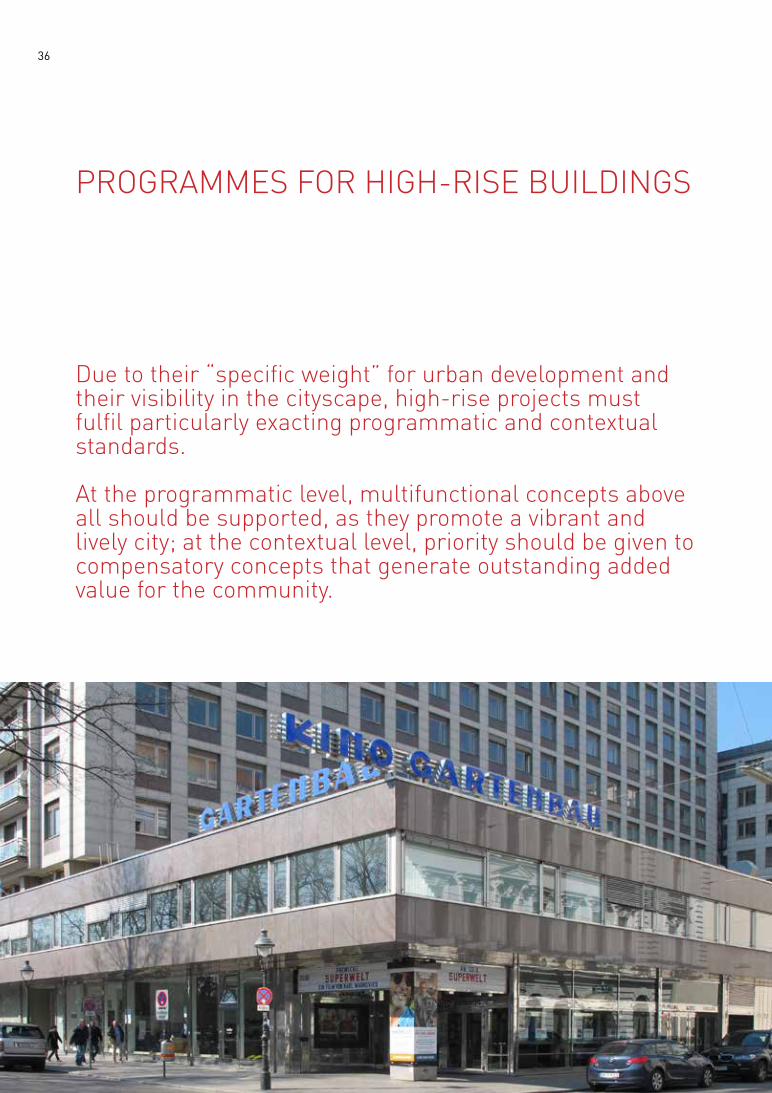
PROGRAMMES FOR HIGH-RISE BUILDINGS�
Due to their “specific weight” for urban development and their visibility in the cityscape, high-rise projects must fulfil particularly exacting programmatic and contextual standards.
At the programmatic level, multifunctional concepts above all should be supported, as they promote a vibrant and lively city; at the contextual level, priority should be given to compensatory concepts that generate outstanding added value for the community.

37 Planning and evaluation | Programmes for high-rise buildings
MULTIFUNCTIONAL PROGRAMMES
High-rise developments generally offer great opportunities for multifunctional programmes that can also revive and enrich the environs and hence constitute major added value for the community.
At the same time, mixed-use concepts for high-rises may also entail some difficulties both of a structural kind and with regard to building utilities and organisation. However, apart from technical and building-law issues to be clarified, the competent implementation of multifunctional programmes is also a question of building culture and a challenge for the innovative acumen of project developers, planners and administrators. The range of possibilities for mixed use is widespread and e.g. extends from the combined residential and hotel utilisation of high-rises – a solution that is relatively easy to realise due to the similar spatial and structural requirements to be met by both forms of use – to a mix of housing and work or housing, work and special functions; the latter is a type of multiple use that can only be implemented with increased effort both from the viewpoint of building law and due to the special demands made by the different types of use. However, it is above all the conversion of vacant office high- rises to new forms of use that will become a key issue of resourceconserving urban transformation; the same goes for the adaptability of residential units for office purposes where needed.
Flexible layouts and maximised openness of use, which ideally should already be included in the basic concept for the building in question – e.g. by providing for sufficient ceiling heights, the strategic separation of primary and secondary building structures as well as of load-bearing and non-loadbearing tectonic elements and, last but not least, due to the installation of intelligent building
utilities –, can contribute to the lasting sustainability of high-rises, which after all are projects entailing very high construction costs.
The ground floor as well as the lowest storeys of any high-rise should be primarily understood as elements of the urban environment and are to be accordingly planned and incorporated as an integral part of public space. Facilities for social services, shopping and culture can enrich urban space and the surrounding neighbourhood and hence constitute significant added value for the community. Exactly like the ground-floor level, the prominent position of the top storey and the related symbolic capital make this an asset suitable for special forms of use with public appeal. In its turn, the circulation system harbours the significant potential of creating high-quality public space that can be appropriated by the persons living and/or working in the building if the necessary useable floor area, space reserves and sufficient natural lighting are available.

38
LIVING IN HIGH-RISES
Precisely because residential high-rises have never been widespread in Vienna – with the exception of some outstanding pilot projects, such as Alt-Erlaa (1973-1985, Harry Glück & Partner, Kurt Hlaweniczka and Requat & Reinthaller), – and hence cannot rely on a sufficient basis of concrete experience, the planning and construction of residential high-rises must meet specific requirements. Not only regarding building utilities and building typology, but also with respect to social and cultural issues, living in high- rises is a question that has to be approached with maximum attention.
Contrary to office high-rises, the patterns of use that characterise residential high-rises are reflected in their façades. For example, private outside spaces and natural lighting for circulation routes inside the building are only two evident factors that need to be observed to meet the basic qualitative requirements for residential high-rises. The sustainability of the planned forms of use and the flexibility of the building structure regarding unpredictable changes in purpose are to be facilitated by increased ceiling heights allowing for many different types of use. Natural lighting for the circulation routes of all storeys is a desideratum.
Accommodating a large share of affordable dwellings in high-rise buildings harbours the opportunity of rendering this form of housing accessible to wider strata of the population; however, social stratification – taking the form of affordable housing for the lower storeys to cofinance construction costs through public funds vis-à-vis privately financed flats for the upper floors – is not welcomed. Conversely, a multifaceted range of housing units that can be adapted to changing requirements promotes the desired social mix. In
particular, attractive common areas also for the upper storeys add qualitative assets to residential high-rises, as such facilities support appropriate diversity of use and a good vertical mix. Residential high-rises are, in essence, vertical urban quarters and should offer comparable urban qualities.
Due to the more intensive utilisation of the plot, the areas close to the ground floor present higher user frequency; as a result, it seems appropriate to house functions ancillary to the residential purpose, e.g. communal spaces, bike storage rooms and other collectively used secondary premises, in the lower storeys. In addition, it is a prime task of the groundfloor level to mediate the spatial and functional transition to the urban context; mixed and complementary forms of use can and should provide welcome links with public space. Moreover, the plot must also accommodate necessary open spaces, such as playgrounds. In other words, ground-floor areas are under great pressure generated by these diverse forms of use, which in turn entail very ambitious programmatic and architectural demands.
The quality standards to be met by residential high-rises regarding maintenance costs, suitability for modernisation or refurbishment and open space design must particularly be given sufficient attention. The standards attained by subsidised housing in Vienna over the course of several decades, which already today embody higher qualities in practice than privately financed housing, are to be applied here, too, as guidance values. This is to be complemented by stricter requirements regarding safety, fire prevention, wind effects, technical appointments and ease of circulation inside the building.

Planning and evaluation | Programmes for high-rise buildings 39
Reflecting the standards to be met by subsidised housing, the requirements for residential high-rises must be taken account of as follows:
Health -Excellent lighting, sun incidence and ventilation of living areas and public spaces inside buildings -Special protective measures against overheating during the summer months -Healthy housing: use of eco-friendly materials for interior fittings -Special immission-reducing measures -Noise insulation and visual privacy
Common areas -General areas and informal communication zones: multiple use, communicative qualities -(Outdoor) areas that can be appropriated by different user groups -Good social mix due to inclusion of different housing types -Services for specific user groups, e.g. in collaboration with operators
Green and open spaces -Quarter-related options, communication and codetermination possibilities -Opportunities for play and sports, suitable open space furniture, play equipment -Suitable premises for storing bikes and prams -Functionality and design quality for green wall systems (façades)
Building structure -Differentiated choice of flats and layouts -Functionality of layouts -Orientation of rooms, views -Easily useable private open spaces adapted to flat size -Possibility to furnish flats with standard furniture -Allowing for a combination of working and living, e.g. by offering rental premises close to flats

40
ADDED VALUE�
In the context of the quality assurance procedure, planned high-rises must be evaluated for their potential to improve their environs.
The social and public benefits of any high-rise project must be visualised: new open spaces, additional cultural facilities, design interventions in the surroundings, public and semi-public areas inside the building, elimination of structural deficits in the environs (e.g. green spaces, garage for the surrounding residential quarter, design of lounges, common and communication areas, etc.). It is a declared objective to have marked improvements of the surroundings co-financed through high-rise projects. The planned utilisation structure must be formulated, tested for its sustainability and duly visualised. Public accessibility and permeability of the ground-floor level must be the rule.
The spatial programme of high-rises is particularly important with regard to the ground-floor areas and the top levels. Above all, the accommodation of attractively situated social and educational facilities is absolutely necessary for infrastructure provision. Buildings of these dimensions are part of a “vertical city”, where the social conditions applying to the metropolis must also be met across all storeys. “Development zones” as ground-floor areas suitable for appropriation are to be realised as spaces for social, cultural and alternative commercial use. Offering convenient conditions for the use of these areas guarantees vibrant plinth areas and creates a varied range of services for the local population as well. The implementation of any residential project is also contingent on the creation of a sufficiently large proportion of attractive, common open spaces
close to the housing units.
The advantages of proposed high-rise projects must be plausibly presented against the background of the specific urbanistic qualities of the individual areas as described in the present High-rise Concept. The added value table for different scales on page 41 should be consulted for guidance.
To determine reasonable added value to be expected for a given location, complementary studies, such as development concepts for public space in the municipal districts or social space analyses, may be used and can, if necessary, be developed anew in addition to the co-operative procedure.
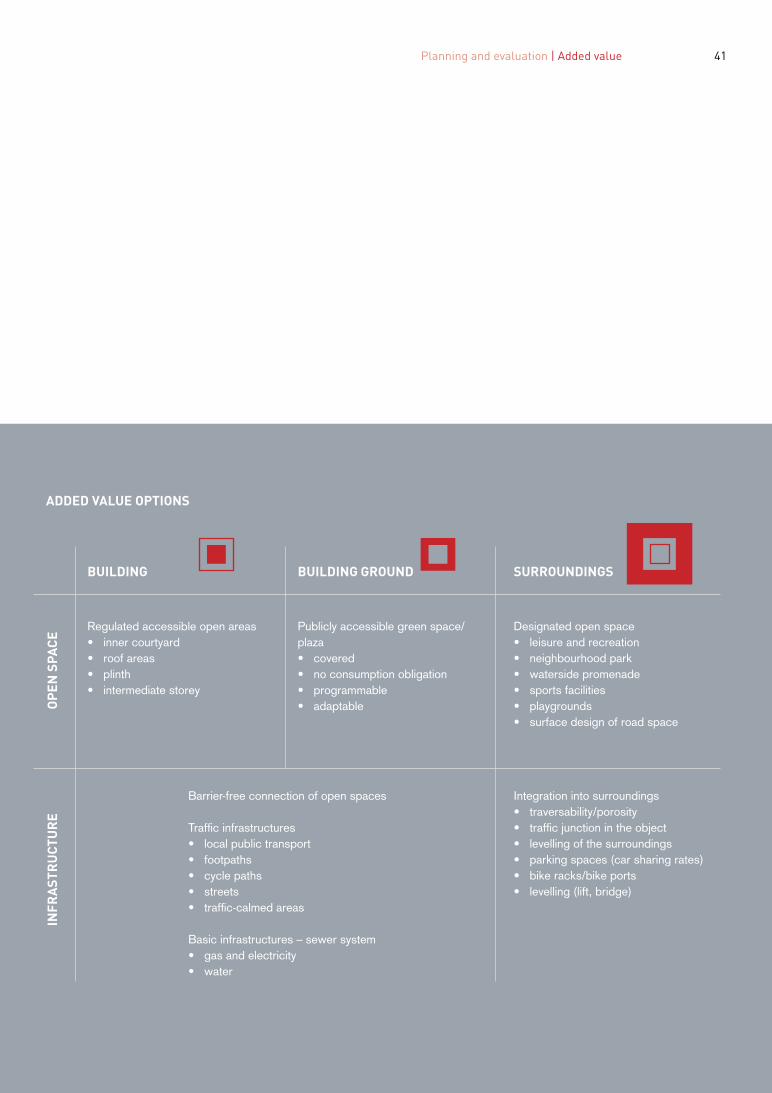
BUILDING BUILDING GROUND SURROUNDINGS
CE
Regulated accessible open areas Publicly accessible green space/ Designated open space
SPA
• inner courtyard plaza • leisure and recreation• roof areas • covered • neighbourhood park• plinth • no consumption obligation • waterside promenade
OP
EN
• intermediate storey • programmable • sports facilities• adaptable • playgrounds
• surface design of road space
Barrier-free connection of open spaces Integration into surroundings
E • traversability/porosity
TUR Traffic infrastructures • traffic junction in the object
C • local public transport • levelling of the surroundings
RU • footpaths • parking spaces (car sharing rates)
ST • cycle paths • bike racks/bike ports• streets • levelling (lift, bridge)
INFR
A
• traffic-calmed areas
Basic infrastructures – sewer system • gas and electricity• water
41 Planning and evaluation | Added value
ADDED VALUE OPTIONS�

-
43 42
PROCESS�
The procedural overview provides for four planning phases for high-rise projects in the following areas: consolidated city, urban composite, southern terraces, fluvial cityscape and Transdanubian expanse, all involving the relevant stakeholders. The planning phases should be understood as consecutive, i.e. a planning phase may only be initiated after the previous one has been concluded. The procedural overview shows the standard sequence of phases. Project applicants may be public or private actors. In case of already formulated urbanistic models providing for high-rise developments in the relevant area, the respective phases of the procedure may be shortened to an updating of the existing requirements and objectives.
Planning and evaluation | Process
The process is monitored by a Steering Group composed specifically for each project, which particularly serves to safeguard public interests. The core team of the Steering Group is in any case made up of one representative each of Municipal Departments 18, 19 and 21 (MA 18, MA 19 and MA 21), of the respective Municipal District Office, as well as of one or two experts commissioned by MA 21 and financed by the project applicant or applicants. As soon as a project has passed the initial evaluation by the Expert Advisory Board for Urban Planning and Urban Design, the Steering Group is constituted on an initiative of MA 21; from that moment on, it co-ordinates the involvement of the representatives of all planning departments of the Vienna City Administration in accordance with the individual planning steps and regularly reports to the Expert Advisory Board on the proceedings.
PHASE 1: IDEA
PR
ECO
NST
RU
CTIO
N T
EST
LEG
AL
SUP
PO
RT
ZON
ING
QU
ALI
TY C
ON
TRO
L
Project applicants Project applicants, urban planning, districts, domain experts, planning teams and citizens
Project applicants, urban planning, districts, domain experts, planning teams (and citizens)
Project applicants, urban planning, districts, domain experts, planning teams (and citizens)
Pilot studies, project development plan Quality assurance measures, public participation Architectural design competition, public pre sentation and discussion
Building construction
PHASE 2: CONCEPT PHASE 3: DESIGN PHASE 4: REALISATION
• suitability acc. to areas• urban structural integration acc. to areas• traffic compatibility, public transport
connection, parking regulations• pattern of use• potential plinth utilisation• spatial, functional and infrastructural
upgrading of the surroundings, publicadded value
• compatibility: protection zones, UNESCOWorld Heritage site, visual axes
• integrated energy-space planning
PUB
LIC
INFO
RM
ATIO
N
PUB
LIC
INFO
RM
ATIO
N
PUB
LIC
INFO
RM
ATIO
N
Involved parties
Instruments
• local urban planning model• urban structural integration acc. to areas• spatial, functional and infrastructural
upgrading of the surroundings, addedvalue-performance acc. to areas
• argued height determination acc. to areas• proof of wind and shading effect (2-hour
shadow)• planned programming• plinth utilisation concept• presentation of findings in models and
plans
• design (volumetry, proportion, tectonics,materialisation)
• height acc. to Phase 2 specification• detailed proof of wind and shading effect• proof of convertibility• proof of all required safety, sustainability
and energy provisions• detailed project realisation plan
• submission planning• building permit• implementation planning• ongoing PR• accompanying quality control
PLANNING PHASES
FEEDBACK CO
NTI
NU
OU
S A
DJU
STM
ENT
OF
THE
HIG
H-R
ISE
CO
NC
EPT
PR
OC
ESS
PER
SPEC
TIVE
SEV
ALU
ATIO
N in
the
cros
s-se
ctio
n w
ith o
ther
hig
h-ri
se d
evel
opm
ent p
roce
sses
PO
LITC
AL A
GR
EEM
ENTS
FEEDBACK FEEDBACK FEEDBACK
STEERING GROUP

44
PHASE 1: IDEA
The project applicants initiate the planning procedure for a high-rise project by submitting the following documentation: - project outline - preliminary studies of the urban environment - on-site embedding of the planned object - information about the planned utilisation structure - first concrete presentation of public added value - project development plan - further goal definitions
Urban environment The location of the planned object must correspond to the urban design stipulations laid down in the High-rise Concept and interpret the criteria specified in this document in a sensible manner. Its alignment with existing supra-local development projects must be evaluated. If necessary, the City Administration is called upon to develop local urbanistic models as a complement before the initial evaluation. Alternatively, a concept going beyond the level of the single object may be developed in the context of the quality assurance procedure during Phase 2. In addition, the integration of the project into the urban fabric must be evaluated as well: the high-rise must enter into a functional design relationship creating positive added value with the surrounding urban structure and other projects in the environs. Furthermore, it must be demonstrated that the project also complies with the need for technical and social infrastructure. A foundation soil investigation to be financed by the project applicant or applicants must prove the static load-bearing capacity of the proposed edifice.
Utilisation structure In order to evaluate the compatibility of the project with the urban structure, the intended forms and planned intensity of use, as well as the effect on the existing urban structure in the relevant catchment area need to be analysed.
Compatibility with cityscape, visual axes and sightlines Compatibility with nature reserves, protected landscapes, safety zones of Vienna International Airport, protection zones according to Art. 7 of the Building Code for Vienna, the UNESCO World Heritage properties and visual axes must be demonstrated. The position taken, and the effects caused, by the high- rise within all these zones must be clearly visualised. All technical and thematic clarifications are to be exclusively co-ordinated by MA 21 and the Steering Group. Special attention is to be paid to the visual axes and sightlines that determine the urban space. Concretely, project applicants must show, by way of a written and visual set of arguments (in combination with visual impact assessments and visualisations), what effect a planned high-rise project would have on the future cityscape, as well as on the two UNESCO World Heritage properties.
With a view to the city as a whole, the following sightlines are of special importance: - visual axes from and to identification points of historic and identity-creating significance (e.g. St. Stephen’s Cathedral, Church of St. Charles Borromeo, Schönbrunn Palace/Gloriette, Belvedere, Danube Tower, Giant Wheel). - visual axes to be understood as part of urban vedutas and panoramas of importance for Vienna. What is of significance here are not only the single sightlines per se, but the way in which the city as a whole is perceived visually from these points (relevance for the urban silhouette, the cityscape as a whole). By way of example, the following urban vedutas and panoramas as perceived from the following viewing points are of special significance (non-exhaustive listing): Kahlenberg Hill, Leopoldsberg Hill, Wilhelminenberg Hill, Upper Belvedere, Gloriette/ Schönbrunn Palace, Danube Tower, Giant Wheel. These visual impact analyses and visualisations to be submitted by the project applicant or applicants (based on the 3D city model of the City of Vienna) must be implemented in close technical cooperation with MA 41 – Surveyors.

Planning and evaluation | Process 45
In connection with planning considerations for high-rise buildings, the abovementioned reasons principally require that all project applicants establish agreement with MA 19 – Architecture and Urban Design and, in connection with matters touching on the World Heritage properties, with the Chief Executive Office of the City of Vienna, Executive Group for Construction and Technology, Directorate General for Urban Planning, Development and Construction (co-ordination of UNESCO World Heritage matters) at the earliest possible moment, in order to ensure that a potential high-rise building will have no negative impact on Vienna’s cityscape.
Integrated spatial and energy planning Urban densification, such as the development of new high-rise locations, also strongly impacts local energy demand. In adopting STEP 2025, Vienna pursues the goal of evolving a system of integrated spatial and energy planning and urban densification in order to attain the best possible future balance of locally available, highly ecofriendly energy potentials on the one hand and increasing demand on the other hand. This calls for the capturing of comprehensive energy data and making these available to lay a good basis for future urban planning processes. For example, potential sites are particularly favoured if they dispose of ample environmental heat potentials, such as watercourses, groundwater, geothermal energy or waste heat, e.g. from sewage treatment plants, etc.
Compatibility with traffic and transport system and mobility concept For the required compatibility with the traffic and transport system, high-rises may not exceed a maximum motorised individual traffic share of 20 percent; moreover, the legal provision to provide an obligatory number of parking slots applies as well. A sufficiently effective connection to the public transport network, in particular to railbound mass transit, is essential, too. This is defined as a walking distance of up to 500 metres to the nearest Underground/S- Bahn station as well as 250 metres to the nearest tram stop, which must be
demonstrated by appropriate spatial compatibility expertises.
In co-ordination with the planning departments and construction authorities, MA 21 conducts an initial evaluation and together with the project applicant or applicants co-ordinates the preparations for Phase 2. In consultation with MA 21, the project applicant or applicants publish their first information about the planned project. The procedure is conducted in accordance with the requirements of the Master Plan for Participatory Urban Development of the City of Vienna; the service and counselling point of the City of Vienna offers interested citizens ongoing information about the current planning status.
PUBLIC TRANSPORT Catchment area of public transport, current Catchment area of public transport, planned
5 min to underground/S-Bahn train 3 min to tram

46
PHASE 2: CONCEPT
A quality assurance-based, preferably co-operative procedure practically headed by the planning bodies of the City of Vienna is conducted to concretise the local urbanistic model for the respective location. This can be defined in greater detail on the basis of existing supra-local development concepts or developed in the course of the overall procedure, but must in any case be compiled in close collaboration with all urban planning divisions and formally adopted by the urban planning bodies.
During Phase 2, the following documentation must be submitted: - wind and shading effect - mobility concept (taking special account of eco-friendly transport options and mobility management) - increases in cubage and gross floor area in accordance with the applicable legal provisions
Wind and shading effect The shading effect of the planned volume must be expounded in both written and graphic form. With a mean solar altitude (on 21 March), the shading of lounges and living rooms of existing residential buildings or of dedicated façade surfaces must not exceed the “two-hour shade”. Moreover, first analyses of the expected wind effects must be prepared for every high-rise project already during Phase 2.
Furthermore, the quality assurance procedure is to produce a definition of the following parameters for the subsequent realisation competition: - added value - requirements to be met by the programme for the high-rise building - integration of public space, utilisation concept for the base level - height definition and orientation options
Added value and programmes Predefined measures to generate added value and improve the surroundings as well as the planned programme for the high-rise building must be negotiated and determined in a process involving all relevant stakeholders.

Planning and evaluation | Process 47
The quality assurance procedure must involve at least three interdisciplinary planning teams. By the same token, the composition of the evaluation and monitoring body for the quality assurance procedure must be handled in accordance with the respective manuals of MA 21 (in particular the manual on cooperative procedures).
In addition to the relevant municipal departments and the project applicant or applicants, the quality assurance procedure is also to involve external experts from various disciplines, local inhabitants and interested citizens by means of corresponding instruments of public participation. The Master Plan for Participatory Urban Development offers methodological options for such a procedure.
Urban development concept The outcome is an urban development concept done on a suitable scale, usually 1:500, and 3D visualisations including a representation of the surrounding open spaces and typological principles. The results of the procedure (as well as the stipulated added value) are then embodied in a written agreement and in plans and duly published, e.g. in the form of an urban development contract.
If a new urbanistic model is developed or the existing one revised in the course of the procedure, this needs to be additionally confirmed by the Commission for Urban Development.

48
PHASE 3: DESIGN
Based on the outcome of the quality assurance procedure, a multi-tier realisation competition is organised. The competition may be open or selective, i.e. may involve a prior prequalification procedure. The interdisciplinary planning teams headed by the responsible team of architects must nominate experts in the fields of traffic and transport planning, open space planning, energy planning, structural engineering, fire prevention and building utilities. Retaining the services of consultants for other disciplines is recommended.
Apart from the implementation of the negotiated added value and location criteria, the competition serves to concretise the following object qualities: - building volume, proportions, tectonics and choice of materials - lighting - wind and shading effects - programme for the high-rise building - refurbishment and safety
Lighting The quality of the building volume, proportions, tectonics and choice of materials is assigned a special role in the competition. Moreover, lighting concepts and documentation of both proximity and long-distance effects of the planned building at night must be submitted during the competition.
Wind and shading effects The shading effect of the concretised volume must be once more assessed; the wind effect is to be evaluated by means of expertises in the field of aerodynamics and fluidics; if necessary, measures to reduce adverse impacts on the project and its environs must be expounded.
Programme for the high-rise building In addition to the general framework conditions, the special requirements listed under “Programmes for High-rise Buildings” in connection with the utilisation plan defined in Phase 2 must be taken account of in the tender and evaluated regarding compliance.
Refurbishment and safety The suitability of key structural elements for easy modernisation or refurbishment must be demonstrated; the same goes for considerations regarding the potential demolition of the building in the future. Moreover, the following documentation must be developed, submitted and mandatorily complied with: ecological construction concept and safety concept in accordance with the standards of the competent municipal departments.
Energy In addition to a mandatory energy concept in accordance with the requirements of the competent municipal department, the following energy standards need to be complied with: - construction and equipment of the building with materials entailing low ecological lifecycle costs - high overall energy efficiency (nearly-zero energy house or passive house standards) - energy-efficient heat generation with minimised emissions - use of renewable energy carriers - decentralised power generation and storage (photovoltaics, etc.)
The realisation competition concludes with a public presentation and discussion of the results. The composition of the evaluation and monitoring body for the realisation competition must reflect the competition manual of the City of Vienna (Werkstattbericht “Grundlagen für die Durchführung von Wettbewerben auf dem Gebiet der Architektur und des Städtebaus”, ed. MA 18, 2008). Together with the agreements entered into in the context of the quality assurance procedure, the winning project of the realisation competition provides the basis for the drafting of the land use and development plan.

Planning and evaluation | Process 49
PHASE 4: IMPLEMENTATION
In the course of the building permit procedure, the project must be submitted to the Expert Advisory Board for Urban Planning and Urban Design and agreed with this body as necessary. After the building permit has been granted, the usual quality checks and PR measures for large-scale projects must be complied with, involving all relevant specialised bodies and supervisory authorities of the Vienna City Administration.
The planning process ends with a final quality check regarding compliance with the negotiated objectives and a corresponding evaluation of the entire procedure for the benefit of future procedures in the public interest.
If the property should change ownership, all obligations entered into shall pass on to the new owner. If the new owner does not agree to this, the respective procedural steps must be renegotiated.

50
TRANSITIONAL PROVISIONS�
The provisions of the High-rise Concept do not extend to projects that have already completed a quality assurance procedure or realisation competition; neither do they cover projects whose plots were duly classified as suitable for high-rise construction, but which were not implemented.

51 Planning and evaluation | Transitional provisions

52�
53
APPENDIX�

entions
54
Explanatory notes on the urban development interv�
IN THE CONSOLIDATED CITY AREA�
Accentuation of block structures in keeping with aspects of the local urbanistic situation and the public transport connections.
Architectural complexes comprising high points are possible outside perimeter developments. In areas not linked to perimeter developments, high-rises are conceivable if proportional relations with the environs are observed.

Explanatory notes on the urban development int
55 High-rise Concept Vienna
erventions�
IN THE URBAN COMPOSITE AREA�
A porous, publicly accessible plinth with a differentiated spatial programme provides the backbone for potential high-rise projects.
Appropriable open areas and plinths with varied spatial programmes enhance the networking of the heavily fragmented urban structure.

56
IN THE SOUTHERN TERRACES AREA�
Ensembles with high points create identity and constitute autonomous components of urban development.
Large-scale projects set within the southern terraces may be composed of high-rises or contain high points as part of such ensembles.

57 High-rise Concept Vienna
IN THE FLUVIAL CITYSCAPE AREA�
Landscape edges and boundaries must be emphasised in conjunction with several high points and on a scale corresponding to the local environment as developed over time (cf. STUDIOVLAY, North Railway Station grounds).
Danube Canal Large-scale open spaces Danube riverbank
High-rises serve to emphasise spatial edges of both riverbank areas and large-scale green spaces and, in turn, reflect existing high points in the surroundings.

58
IN THE TRANSDANUBIAN EXPANSE AREA
High points serve as nodal points and landmarks for a capillary network of intermediate areas between the heterogeneous settlement units. The function of high-rises is to enrich their direct surroundings and to act as connectors linking the interspaces typical of the dispersed urban fabric of the Transdanubian expanse.

59 High-rise Concept Vienna

60
CONTRIBUTORS�
The present concept was developed by Christoph Luchsinger, Vienna University of Technology / Bosshard & Luchsinger Architekten AG Lucerne, André Krammer, Frank Schwenk and Barbara Maschat on behalf of, and in co-operation with, Municipal Department 21 (MA 21) under the aegis of Hans Peter Graner and constitutes a revision and in-depth reworking of “High-rises in Vienna – Urbanistic Guidelines” of 2002, which served as the basis for this document.
The concept was formulated in close collaboration with external experts and all thematically relevant planning divisions. These actors were organised as three reference groups – steering, core and response group – and involved the following participants:
Steering group and core group: Bernhard Steger, Executive Policy Group for Urban Planning, Traffic & Transport, Climate Protection, Energy and Public Participation; Planning Director Thomas Madreiter and Rudolf Zunke, both Chief Executive Office of the City of Vienna, Executive Group for Construction and Technology, Directorate General for Urban Planning, Development and Construction, Urban Planning Group; Andreas Trisko, Head of MA 18 – Urban Development and
Planning as well as Kurt Mittringer, MA 18; Franz Kobermaier, Head of MA 19 – Architecture and Urban Design as well as Andrea Kreppenhofer and Erich Streichsbier, both MA 19; Bernd Vogl, Head of MA 20 – Energy Planning and Thomas Kreitmayer, MA 20; Walter Krauss, Head of MA 21 – District Planning and Land Use as well as Gregor Puscher, Ingrid Nausch, Wolfgang Sengelin, Volkmar Pamer, Leopold Graf and Rudolf Polan, all MA 21; Christian Härtel, MA 22 – Environmental Protection; Gerhard Cech, Head of MA 37 – Building Inspection and Irmgard Eder, MA 37; Peter Belada, Head of MA 41 – Surveyors as well as Lionel Dorffner and Andreas Zöchling, both MA 41.
Response group: Bernd Vlay, Christoph Lammerhuber, Marta Schreieck, Max Rieder, Silja Tillner, Erich Raith.
Moreover, extensive talks were directly conducted with experts in order to obtain additional thematic input.
Several co-ordination talks were conducted in parallel with the project teams for the Glacis Master Plan and the Master Plan for Participatory Urban Development.
High-rise Concept Expert Conference, 12 September 2014, Vienna University of Technology

High-rise Concept Expert Conference, 12 September 2014, Vienna University of Technology
Hochhauskonzept Wien 61High-rise Concept Vienna
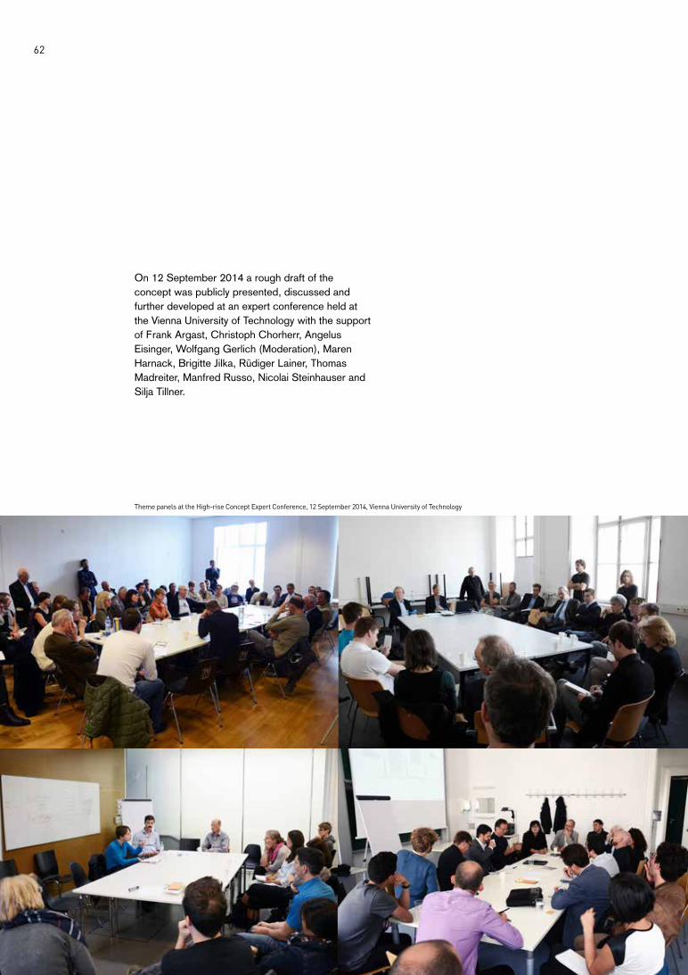
62
On 12 September 2014 a rough draft of the concept was publicly presented, discussed and further developed at an expert conference held at the Vienna University of Technology with the support of Frank Argast, Christoph Chorherr, Angelus Eisinger, Wolfgang Gerlich (Moderation), Maren Harnack, Brigitte Jilka, Rüdiger Lainer, Thomas Madreiter, Manfred Russo, Nicolai Steinhauser and Silja Tillner.
Theme panels at the High-rise Concept Expert Conference, 12 September 2014, Vienna University of Technology

Theme panels at the High-rise Concept Expert Conference, 12 September 2014, Vienna University of Technology
63 High-rise Concept Vienna
LIST OF ILLUSTRATIONS
Planning material, photographs and diagrams on the intervention
types, unless specified otherwise in the following, were created
and processed by Bosshard & Luchsinger Architekten AG and are
based on data collected by the Municipal Departments (MA) MA
19 – Architecture and Urban Design, MA 21 – District Planning
and Land Use and MA 41 – Surveyors. The displayed aerial
photographs were provided by the Municipal Department MA 18 –
Urban Development and Planning.
Further image rights:
Title page, Herrengasse high-rise, photo
Austrian National Library, Picture Archives
Pages 18 and 19, time sections of Vienna, plan sketches
Bosshard & Luchsinger Architekten AG on the basis of: Karl
Brunner und Petra Schneider (Eds.), Umwelt Stadt, Geschichte
des Natur- und Lebensraumes Wien, Vienna: Böhlau Verlag, 2005;
illustrations 39/1, 43/3, 45/1, 47/3, 49/3 and 51/2
Page 28, K6 open spaces, photo
AnnA BlaU, Housing Association for Private-Sector Employees
Ltd.; colour processing Bosshard & Luchsinger Architekten AG
Page 43, Neighbourhood Day in aspern Seestadt, photo
Amélie Chapalain/Neighbourhood Management Seestadt aspern
Page 51, Scheme of the Fluvial Cityscape intervention type
STUDIOVLAY, North Railway Station; colour processing Bosshard
& Luchsinger Architekten AG

64
LEGAL NOTICE
Acknowledged by the City Development Commission on 11 November 2014 and adopted by the Vienna City Council on 19 December 2014.
Owner and publisher: Municipal Department 21 (MA 21) – District Planning and Land Use
Project management: Hans Peter Graner, MA 21 Christoph Luchsinger, Bosshard & Luchsinger Architekten AG
Content and editing: Municipal Department 21 (MA 21) – District Planning and Land Use Bosshard & Luchsinger Architekten AG
The content is based on the extensive expertise of City of Vienna staff, external planning specialists, and enlarged by findings drawn from a broad-based consultation process.
Graphic design and layout: Bosshard & Luchsinger Architekten AG
Data basis: MA 18, MA 19, MA 21 and MA 41
Translation: Sigrid Szabo Copy editing: Brian Dorsey
Printed by: Hans Jentzsch & Co GmbH
Copyright: Municipal Department 21 (MA 21) – District Planning and Land Use Bosshard & Luchsinger Architekten AG All rights reserved Vienna 2015
www.step.wien.at/fachkonzepte/hochhaeuser


ISBN 978-3-903003-10-1