status quo report on hydrographical activities · status quo report on hydrographical activities...
TRANSCRIPT
“NETWORK OF DANUBE WATERWAY ADMINISTRATIONS”
South-East European Transnational Cooperation Programme
STATUS QUO REPORT ON HYDROGRAPHICAL
ACTIVITIES
Document ID: O 3.10
Activity: 3.1 Improve methods , process and procedures for
hydrophical and hydrological activities
Author / Project Partner: Date: Version:
Dan Craciun / AFDJ (Romania) 24.12.2009 1.0
Dan Craciun / AFDJ (Romania) 04.03.2010 final
TABLE OF CONTENTS
1 LIST OF ABBREVIATIONS ...................................................................................................................................... 2
2 SCOPE OF DOCUMENT ......................................................................................................................................... 4
3 ASSIGNED REGION OF INTEREST – GENERAL INFORMATION ................................................................................... 5
3.1. Geographical position and area ........................................................................................................................ 5
3.2. Economical position and area........................................................................................................................... 6
3.1. Water river network – main basins and sub basins ......................................................................................... 7
4 CLIMATOLOGICALLY CONDITIONS ....................................................................................................................... 9
4.1. Network ............................................................................................................................................................ 9
4.2. Temperature ................................................................................................................................................... 10
4.3. Precipitation ................................................................................................................................................... 11
4.4. Long-time variation climatological elements ................................................................................................. 12
5 MAIN BASINS DESCRIPTION ............................................................................................................................... 13
5.1. Geomorphic and morphometric conditions ................................................................................................... 13
5.2. Vegetation ...................................................................................................................................................... 14
5.3. Sensitivity of basins to creation the flood extreme ........................................................................................ 14
6 HYDROGRAPHICAL MEASUREMENTS ................................................................................................................ 15
6.1. River bed measurements ................................................................................................................................ 15
6.2. Types of used equipments for measurements ............................................................................................... 15
6.3. Processing of data .......................................................................................................................................... 17
7 LEGISLATIVE MEASURES .................................................................................................................................... 20
8 LIST OF FIGURES................................................................................................................................................. 22
8 LIST OF TABLES................................................................................................................................................... 22
1 LIST OF ABBREVIATIONS
ABBR. Abbreviation
AFDJ River Administration OF the Lower Danube
DXF Drawing exchange format (data file format-Autodesk)

Page 3 of 23
DC Donau Commission
DGPS Differential Global Positioning System
RIS River Information Services
WGS World Geodetic System
2 SCOPE OF DOCUMENT
This document, in the NEWADA project, describes the main hydrographical activities of AFDJ,
on the Romanian section of the Danube. The report contains information about surveying
activities, measurement equipment, measurement processes and data processing. For an
overview of the sector, are presented general information about the geographic,
climatologically conditions and main basins in Romania.
The document is prepared and structured in within Activity 3.1 - improve methods, process and
procedures for hydrographical activities.

Page 5 of 23
3 ASSIGNED REGION OF INTEREST – GENERAL INFORMATION
3.1. Geographical position and area
Romania is located in the SE of Central Europe, on the Lower Danube and on the Black Sea,
between 43°37΄07˝ and 48°15΄06˝ N latitude and 20°15΄44˝ şi 29°41΄24˝ E longitude.
Figure 1: location of Romania
Its extreme length is 789 km (E-W) and its greatest breadth is 475 km (N-S). Its altitudinal range
is from 3.5 m below sea level to 2 545 m.Limits: in NE is Ucraina, in E Black Sea and Republic of
Moldavia , in S Bulgaria, in SW Iugoslavia and in W Ungary.
The surface of Romania is 238391 km² , population 23 816 000 and Danube catchment area =
817,000 sq km, and from this 29% in Romania and 37.7% in length.

Page 6 of 23
3.2. Economical position and area
Danube is an important international river road, flowing through 10 countries (Austria, Bulgaria,
Croatia, Germany, Hungary, Moldova, Slovakia, Romania, Ukraine and Serbia) and has
tributaries in seven other countries.
Through four state capitals: Vienna, Bratislava, Budapest and Belgrade.
Danube Black Sea Canal is a waterway which connects the ports of Constanta and Cernavoda on
the Danube south of the Black Sea, and is part of the important European waterways of the
Black Sea and North Sea (channel Rhine - Main - Danube)-figure 2.
Figure 2: Danube maritime vessel traffic
The river Danube represents a true axis of central Europe which connects the Black Sea.
Navigation on the arms and transport channel is another concern of local people.
Along the Danube and local developers, some of them with important Shipyards such as Braila,
Galati, Tulcea.
Danube is of particular importance to: navigation, hydropower, fish, water supplies for industry,
agriculture, population.
A special importance has the construction of those two dams at 943 river km and 863 river km
for the navigation and for the power industry (Iron Gate I-1080MW and Iron Gate II- 27 MW).
Reservoirs are numerous and used extensively for fish production. The Romanian inland fishery

Page 7 of 23
ranges from sport fishing for salmonids in the mountains to commercial fishing for warmwater
species in overflow and deltaic areas and brackish water lagoons. The harvest from the
Romanian inland fishery constitutes over 80 percent of the country's take from all of its
freshwater, brackish, and marine territorial waters. Carp culture, which is traditional, is
increasing in importance and is being supplemented by an ensemble of other species.
Also, the Danube waters are used for obtaining electricity (hydro mentioned), use of irrigation
systems , for drinking and industrial water supply of city-ports.
By the existence of varied relief , Danube Delta and Black Sea on Romanian territory, Romania
is a special attraction for domestic and international tourism.
Romania, after entry into EU has a number of advantages, knowing a prounced economic
development.
3.1. Water river network – main basins and sub basins
Almost all the rivers of Romania belong to the Danube catchment area draining outward from
the Carpathian arc to the south and east - to flow directly into the Danube within the confines
of Romania.
Figure 3: Romanian river network

Page 8 of 23
The exceptions include a few northern and western rivers (e.g., Someş and Mureş) which reach
the Danube indirectly through the Tisza in Hungary, and some minor Dobrogean streams that
drain directly into the Black Sea. The lengths of the principal Romanian rivers are listed in Table
1.
On the Romanian Danube sector owns 29% of catchment area and travel 1075 km (38% in
length) from Bazias where the river enter the country to Sulina (Black Sea). The Danube forms
the common border countries: Bulgaria 470.5 km long (river km 845.5-km 375), Ukraine,
Moldova 0.8 kilometers long, Serbia 229.5 kilometers in length (river km 1075-km 845.5). It add
almost all rivers in Romania (78905km), making the network to be unitary. The flow wich entry
into the country is about 5400 mc / s reaching the sea at about 6800mc / s. The gradient is 64m
with an average of 0.06 percent.
The most important tributaries in Romania are: Jiu, Olt, Arges, Siret, Prut with a discharge
between 50 m³/s and 150 m³/s.
Page 9 of 23
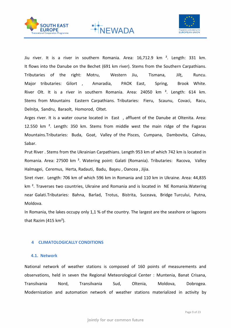
Jiu river. It is a river in southern Romania. Area: 16,712.9 km ². Length: 331 km.
It flows into the Danube on the Bechet (691 km river). Stems from the Southern Carpathians.
Tributaries of the right: Motru, Western Jiu, Tismana, Jilţ, Runcu.
Major tributaries: Gilort , Amaradia, PAOK East, Spring, Brook White.
River Olt. It is a river in southern Romania. Area: 24050 km ². Length: 614 km.
Stems from Mountains Eastern Carpathians. Tributaries: Fieru, Scaunu, Covaci, Racu,
Delniţa, Sandru, Baraolt, Homorod, Oltet.
Arges river. It is a water course located in East , affluent of the Danube at Oltenita. Area:
12.550 km ². Length: 350 km. Stems from middle west the main ridge of the Fagaras
Mountains.Tributaries: Buda, Goat, Valley of the Pisces, Cumpana, Dambovita, Calnau,
Sabar.
Prut River . Stems from the Ukrainian Carpathians. Length 953 km of which 742 km is located in
Romania. Area: 27500 km ². Watering point: Galati (Romania). Tributaries: Racova, Valley
Halmagei, Ceremus, Herta, Radauti, Badu, Başeu , Oancea , Jijia.
Siret river. Length: 706 km of which 596 km in Romania and 110 km in Ukraine. Area: 44,835
km ². Traverses two countries, Ukraine and Romania and is located in NE Romania.Watering
near Galati.Tributaries: Bahna, Barlad, Trotus, Bistrita, Suceava, Bridge Turcului, Putna,
Moldova.
In Romania, the lakes occupy only 1,1 % of the country. The largest are the seashore or lagoons
that Razim (415 km²).
4 CLIMATOLOGICALLY CONDITIONS
4.1. Network
National network of weather stations is composed of 160 points of measurements and
observations, held in seven the Regional Meteorological Center : Muntenia, Banat Crisana,
Transilvania Nord, Transilvania Sud, Oltenia, Moldova, Dobrogea.
Modernization and automation network of weather stations materialized in activity by

Page 10 of 23
introducing the 70 stations MAWS.
A number of 5 weather stations perform measurements on sea water temperature, wave
height and frequency.
Meteorological network has to forward SMS Alert, whenever weather phenomenal occur with
high risk.
Considering the importance of ensuring conditions of navigation and the need to ensure all
necessary information, each hydrometeorological station located along the Danube is equipped
with meteorological equipment . So, in the Romanian sector of the Danube there are a number
of 23 such stations that provide weather information (air temeperature, water temperature,
wind, atmespherical pressure, etc) sent to the browser and all those interested.
4.2. Temperature
Climate is determined primarily by the position of Romania in the world, midway between pole
and equator, being crossed by the parallel of 45 degrees, and by its geographical position on
the continent, about 2000 km of the Atlantic Ocean, 1,000 km from Baltic Sea , 400 km from the
Adriatic Sea and bordering the Black Sea.
These features gives a temperate continental climate. Routed to the air masses over Romania in
different contexts synoptic, evolves in a very wide range ranging from the Arctic to the tropical
(Sahara) is what gives a character transitional climate.
Expanding the country on about 5 ° of latitude mpune greater differentiation between south
and north of the country in terms of temperature than the extension to about 10 ° of longitude,
so if the annual average temperature in the south amounts to about 11 °, north country at
comparable altitudes the parameter values are lower by about 3 ° C. Between the extreme
western and the eastern part of the national territory thermal difference is reduced to a degree
(10 ° C in the West, 9 ° C in the east) in exchange differences are more important about rainfall.
The topography of the country has an essential role in defining areas and climate floors.
Carpathian Mountains form a barrier that separates the harsh continental climates east of the
Page 11 of 23
western type Oceanic and Adriatic.
This mountain range and the hills and plateaus in the center of the country but cause the
appearance of at least four stories that differ profoundly from climate change zonal. In
conclusion, the climate of Romania is temperate-continental, with 4 seasons and is marked by
the influences of steppe climates of east Adriatic in the southwest, west and ocean northwest.
Average annual maximum temperature varies between 22 ° C and 24 ° C in summer, between -
3 ° C and -5 ° C during winter. Extreme temperatures were recorded in Romania -38.5 ° C,
minimum, from Bod, Brasov Depression, and a maximum of +44.5 ° C at Ion Sion Bărăgan.
Hydrometeological stations located along the Danube, General values of air temperature it is
between -10 °C to -11°C and from +3°C to +35°C and the water between +0.6°C and 26°C -28°C
with some exceptions. The minimum is registered in months January-february and maximum in
months july-august.The average annual air temperature is around 12°C -13°C.
4.3. Precipitation
Specific to this parameter is that rain neregional exceptional nature, often representing
large storm intensity during small, but significant amounts of accumulated moderate
intensity throughout the day and at the same time affecting small areas, so restricted
areas of action .
Average annual rainfall is 640 mm.
The annual quantity of precipitation varies widely both within the country and the
distribution over time. So,summer rainfall is 1 / 3 of the total annual and winter 1 / 5 of
the total. Number of days with precipitation decreases from 155-165 days in central and
East, to 110 days in Southeast and in the south-east.
Days number with precipitation over 20 mm is about 10 days.
In recent years, no. days with snow showed higher values (range 70-100 days) in
recent years, number of days with snow showed higher values (range 70-100 days)

Page 12 of 23
Decrease in average precipitation from west to east (below 400 mm), and increases
with altitude. The hilly lands fall 600-800 mm rainfall per year, and in the high mountains
over 1 200 mm, which contributes to the smooth supply of rivers with sources in the
Carpathians. Precipitation new arrangements were irregular. Multiannual average
values are mentioned. Rainy years are but that, in the same place, almost double
precipitation may fall and dry years in which rainfall is halved. The study of droughts in
our country, most common in creep, as indicated as necessary irregularity of rainfall
irrigation.
4.4. Long-time variation climatological elements
According to inter-governmental Commission on Climate Change (Intergovernmental
Panel of Climate Change - IPCC), says that warming in recent decades is closely
related to changes in the hydrological cycle. Climate models assuming an increase in
precipitation at high latitudes and in some tropical areas, and a drop in their particular
regions and sub-tropical latitudes below average.
By the mid-century annual average flow in rivers and water quantity will increase by 10-
40% at high latitudes and some wet tropical areas, decreasing by 10-30% in some dry
regions at middle latitudes and subtropical areas. Areas affected by drought are more
likely to expand. Precipitation, whose frequency will increase certainly will increase the
risk of flooding.
Analysis of an impressive volume of global observational data highlighted the following
conclusions:
- Global average air temperature increased by about 0.74 º C in the last 100 years
(1906 -2005), compared to 0.6 º C over the period 1901-2000 (IPCC Report, 2001).
- 11 of the last 12 years (1995-2006) were among the warmest of string data registered
after 1850.
- Sea levels rose by 1.8 mm / year during 1961-2003, 3.1 mm / year (1993-2003) and
0.17 m on the entire twentieth century.
- Area covered with ice and snow fell on average in both hemispheres.

Page 13 of 23
Europe has warmed by about 1 ° C in the last century, faster than the world average. A
warmer atmosphere contains more water vapor, but new precipitation differ greatly from
one region to another. Rainfall and snowfall has increased significantly in northern
Europe, while droughts in the south have become increasingly common. Recently
recorded extremes such as heat wave of summer 2003, which surpassed any record,
are consistent with the climate change caused by humans.
These phenomens were noted in the observations made at stations Danube, observing
the growth of an annual average temperature on 10-11 to 12-13 and the occurrence of
extreme events in recent years, established itself so close to such a monitoring
developments and the need to conduct more realistic forecasts of duration.
5 MAIN BASINS DESCRIPTION
5.1. Geomorphic and morphometric conditions
The Danube is the second longest river of river’s Europe (after Volga river) being the self
European river which runs from west to east, and has its source in Germany , in the Black Forest
Mountains. The river flowing into the Black Sea was formed Delta.Danube come in Romania
right out of town and country Bazias on the Sulina, with a length of 1075 km and is the border
with Serbia, Bulgaria, Moldova and Ukraine .Topographically, Romania consists of three major
elements, each constituting about one third of the total area: a central range of mountains
(over 800 m in elevation and averaging 1 200 m) surrounded by a succession of hills and
plateaux (200–800 m), and a fringe of lowlands or plains (under 200 m). The central range, the
Carpathians, enters from the north and swings southeast as the Eastern Carpathians, and then
westward in a great are as the Southern Carpathians or Transylvanian Alps. Within the arc is the
Transylvanian Basin and an isolated massif, part of the Western Carpathians. East of the arc is
the Moldavian Plain, south of the arc is the Walachian Plain, and west of the massif is the
Western Plain. The Walachian Plain merges into the floodplain of the Danube and the latter
grades into the Danube Delta, the third largest delta in Europe, on the Black Sea. Lastly,

Page 14 of 23
confined between the Danube and the Black Sea is the Dobrogea, mostly steppe land but with a
series of lagoons on its seaward side.
On the Bulgarian side, there are undercut bluffs and hills, but on the lower Romanian
side the braided river parallels the low plain from which it is separated by dams, lakes
and swamps. From the point where it turns north from the Bulgarian border to Braila, it
has two main arms enclosing great dammed areas. Near Tulcea, it starts to spread and
finally empties into the Black Sea through three distributaries: the northern Chilia arm,
100 km long and carrying 65 percent of the flow; the central Sulina arm, 83 km long
carrying only 14 percent of the flow, but dredged to 7 m for navigation, and the
southern Sfintu Gheorghe arm, 120 km long with 22 percent of the flow.The Delta
proper, starting about 150 km from the Black Sea at Galati, has an area of about 3 430
km2 in Romania.
Besides small tributary rivers of the Black Sea, hydrographic network around the
country is collected from the Danube, forming a halo around real weddings Carpathians,
where, indeed, spring, except the Siret and Prut rivers that wash all Romanian territory.
5.2. Vegetation
Vegetation is distributed in accordance with the characteristics of soil and climate and
according with the altitude. Off the high valley, due to persistent moisture, there is a specific
vegetation of meadow. The forests occupy 26,2% of the country consisting of beech forest,
coniferous and other species such as hornbeam, poplar, ash, lime.
5.3. Sensitivity of basins to creation the flood extreme
The Danube , during the high levels period, has a zone of innundation of more than 9
000 km2 within Romania.The upper part of the Romanian Danube is narrow. Above the
Iron Gate it flows between 3.5–18 km/h. It then flows across a wide plain where its
velocity varies. Usually , these floods occur in spring and due the soil to the Romanian
bank, has large negative effects.

Page 15 of 23
6 HYDROGRAPHICAL MEASUREMENTS
6.1. River bed measurements
One of the main hydrographical activities is the river bed measurements. They are performed
by particular surveys to determine the depth. Measurements to determine depth includes two
data acquisition systems: single-beam and multi-beam echosounder.
The detailed river bottom measurements are made generally performed four-five times per
year. They are made with single and multi beam equipment and mounted on specialized
vessels. In critical areas and into the passage difficult they are execute monthly by signalisation
vessels with single beam equipment. In periods of extreme levels or when there are frequent
changes of riverbed, teams are located in areas difficult measurements to monitor the areas
concerned.
6.2. Types of used equipments for measurements
The river bed measurements are made using echo-sounders. For this work we are
using two systems: single-beam and multi-beam echo-sounders.
The single-beam system is a simpler and faster processing is used for shallow water
areas, for controlling the depths with signalisation ships, for measurements in harbour
areas (because of obstacles), for winter basins and channels, secondary branch,etc.
mounted in the bow of ships or in one of the board.
When we use the single-beam system the measurements are done by crossed
profiles with equidistant different depending on needs (25m, 50m, 100m).The system
uses GPS technology, software acquisition and processing , echo-sounder and sound
velocity profiles.
The measurements are made using Atlas Deso 350 –dual channel 33-210 KHz(depth
range 600m; accuracy-0.01m) or Odom Hydrotrac (single channel).

Page 16 of 23
Figure 4: single-beam echosounder (Atlas)
For positioning we are using Trimble DSM 232 /Trimble SPS 750 ( RTK, DGPS, GPS)
and Omnistar 3200 (DGPS). For data acquisition and processing –Hypack 2008.
The system multibeam we are using him for detailed measurements, determination
sized sailing line, execution profile longitudinal for Danube, determining obstacles,
engineering works, works on the bridges, etc. For this type of measurement we use
equipment Atlas Fansweep 20, which is fixed and installed by special vessels (Donaris).
For the sector of the Danube 1075 km we have a number of such ships, three (two for
river and one is maritime wich work and for Sulina bar). This ships are equipped and
singlebeam equipment (Atlas), Radar Pilot 720 and boats for making measurements in
areas with shallow water. For positioning we are using Trimble DSM 232 /Trimble SPS
750 ( RTK, DGPS, GPS) and Omnistar 3200 (DGPS). For data acquisition and
processing –Hypack Max 2008.
For a higher accuracy we use motion sensors (TSS-DMS 3-01 for peach, heave and
roll) , RTK positioning (base station and rover) and differential correction.
For river bed measurements we have three ships (Donaris I, II and III) with multibeam
system and seven singlebeam systems mounted on other vessels.

Page 17 of 23
Figure 5: survey vessel (Donaris)
-equipments on board (Donaris):
-singlebeam Atlas Deso 350 -software Hypack.
-multibeam Atlas fansweep 20 -Radar pilot 720
-motion sensor TSS DMS 3-05 -internet connection
-GPS Trimble DSM 232/Trimble SPS 750 -printer
-motorola GM360-VHF radio (for RTK)
-sound velocity – Odom/SVC 300
6.3. Processing of data
After the work of field data collection, data should be processed. Depending on the method
chosen for measurement, there are two ways of processing: from single-beam data collected
and the multi-beam system.
In general, measurements with single-beam is accomplished by making cross sections and the
need to complete and a few longitudinal profiles. For the survey, before, should be preparing
an action plan that includes a base with profiles drawn.

Page 18 of 23
Figure 6: single-beam raw data
Both sets of data collected are processed by Hydrographic software Hypack .
For processing the raw data are over several steps :
Figure 7: Workflow for process single-beam data
- first, all single-beam data should be run for apply tide and sound velocity corrections;
- examine quality (manual corrections or filter applied), output bad data and edit cleaned data;
- run the single beam editor statistics – can overlayng previous survey beam data;
- sorted sounding- a optional program that reduce the data in an attempt to speed the final
product;

Page 19 of 23
- calculation for TIN (triangulation irregular network) model – connect three soundings to
represent a surface, interpolated soundings (figure 7) and export files (contour lines, 3D files,
2D files, ASCII files, CAD systems files,etc);
Figure 8: interpolated soundings
After this, the data can be analyze and can be use for determine the gauges navigation and
many others information. The single-beam system is a cheaper way for surveys, because is need
for less time to measure and process the raw data.
The processing of multi-beam data is done by the same software Hypack. The procedure
involves a few steps for output data:
- check that all sensors are working (GPS, motion sensors, RTK tides, etc);
- swath editing – review line – by-line (filtering, cleared data and editing );
- area based editing and output data;
- save, create TIN model (remove unwanted triangles, modify edit tin) and computation for a
DTM , after calculate and export data (depth polygons, 3D files, 2D files, ASCII files, CAD
systems files,etc) – figure 9.
Page 20 of 23
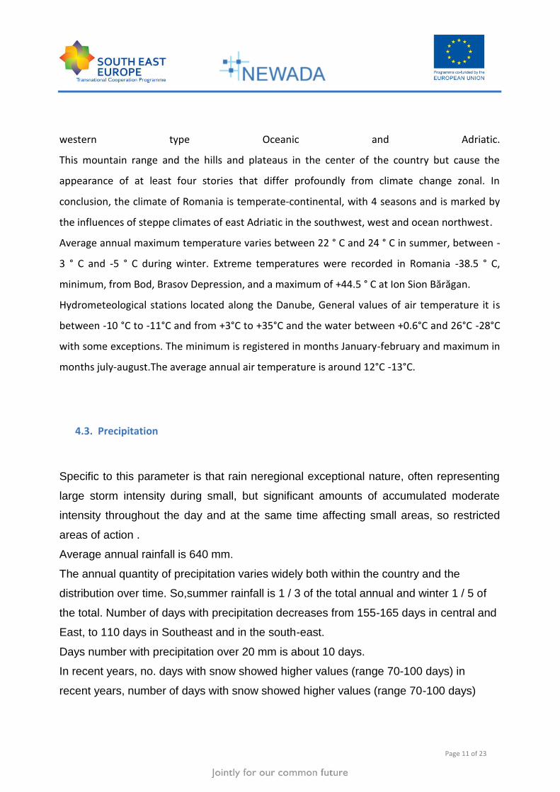
Figure 9: topohydrographical chart in Calafat area
All these operations are carried out with Hypack software and AutoCAD.
We are producing charts in different scales (bathymetric, topohydrographical, profiles, etc) –
figure 9.
7 LEGISLATIVE MEASURES
The "Lower Danube River Administration" Galati is a Romanian legal person operating as
autonomous administration under the authority of the Ministry of Transports and
Infrastructure of Romania, in compliance with the provisions of the Decision no. 492/2003 of
the Romanian Government and those of the international conventions and agreements in
which Romania is part and according to the provisions of the Convention Regarding the Regime
of the Navigation on the Danube.
To the European level there is a cross-border collaboration between countries by
international agreements concluded (Romania-Bulgaria; Romania-Serbia;Romania-
Ucraina). Romania is also member of the Danube Commission in Budapest.
Each country submits information about the navigational conditions in the section that it
is maintaining and is obliged to maintain and improve them. According to this
Agreement a Romania –Bulgaria and Romaia-Serbia Commission for fairway
maintenance and improvement was established. The Commission has regular sessions

Page 21 of 23
twice a year(Romania-Bulgaria) and once a year Romania-Serbia as they are held on a
successive base on the territory of each country.
The mutual exchange of information and documents is done according to the
Regulations for Organization and Work .
Daily, there is a constant for exchange of information (levels, depth, fairway dimension,
etc).
Annualy, are a series of surveys common to many sectors, changing the date and
information with partners (measurements in Belene area, bridge Calafat-Vidin area,
Iron Gate area, etc).

Page 22 of 23
8 LIST OF FIGURES
Figure 1: location of Romania ..................................................................................................... 5
Figure 2: Danube maritime vessel traffic .................................................................................... 6
Figure 3: Romanian river network .............................................................................................. 7
Figure 4: single-beam echosounder (Atlas) .............................................................................. 16
Figure 5: survey vessel (Donaris) .............................................................................................. 17
Figure 6: single-beam raw data ................................................................................................ 18
Figure 7: workflow for process single-beam data .................................................................... 18
Figure 8: interpolated soundings .............................................................................................. 19
Figure 9: topohydrographical chart (Calafat) ........................................................................... 20
8 LIST OF TABLES
Table 1: principal rivers of Romania ........................................................................................... 8
Page 23 of 23
- End of document -