status and importance of traditional water conservation
TRANSCRIPT

Status and importance of
traditional water conservation
system in present scenario
Dr. Sameer Vyas
Smt. Beena Anand
Dr. SN Sharma
Central Soil and Materials Research Station, New Delhi
28-Sep-196th IWW-CSMRS-SNS 27/09/2019

28-Sep-19 6th IWW-SNS-27/09/2019

28-Sep-19 6th IWW-SNS-27/09/2019

28-Sep-19 6th IWW-SNS-27/09/2019

28-Sep-19 6th IWW-SNS-27/09/2019

28-Sep-19 6th IWW-SNS-27/09/2019

28-Sep-19 6th IWW-SNS-27/09/2019

28-Sep-19 6th IWW-SNS-27/09/2019

28-Sep-19 6th IWW-SNS-27/09/2019

28-Sep-19 6th IWW-SNS-27/09/2019

28-Sep-19 6th IWW-SNS-27/09/2019

28-Sep-19 6th IWW-SNS-27/09/2019

28-Sep-19 6th IWW-SNS-27/09/2019

➢ Water: A prime life sustaining natural resource; cannot be
created like other commodities.
➢ A nature’s gift to all living beings on the earth.
➢ Is is the elixir of life.
➢ In India: Stress on availability of water is due to
population explosion & improved standard of living.
➢ The scarcity is compounded further because of massive
agricultural and industrial development coupled with
improper and indiscriminate exploitation of groundwater
resources.
➢ Only handful of countries in the globe can boast of such
an extensive river network that our country has.
➢ The mighty Indus-Ganga-Brahmaputra in the North, the
Narmada-Tapi-Mahanadi in the Central region and Godavari-
Krishna-Cauvery in the South have been symbols of
existence and growth of our country right from its inception.
➢ Yet, the availability of water resources in India has its
unique complexities.28-Sep-19 6th IWW-SNS-27/09/2019

➢Post-independence, the population of India has
increased almost nearly fourfold and growth is expected to
continue upto 2050
➢Thereafter it will stabilize sometime during 2060
➢What is required is an integrated planning, development
and management of the water resources with the
involvement of all stakeholders and taking into
consideration the multi-sectoral needs and the judicious
distribution of the water resources amongst various sectors
based upon certain priorities.
➢With a view to achieve this vision, the country adopted
the National Water Policy in 1987 for the first time, updated
in the year 2002 and last revision took place in 2012.
➢Since then many new challenges have emerged in the
water resources sector which further needs the revision in
the existing National Water Policy.
28-Sep-19 6th IWW-SNS-27/09/2019

28-Sep-19 6th IWW-SNS-27/09/2019
28-Sep-19 6th IWW-SNS-27/09/2019

28-Sep-19 6th IWW-SNS-27/09/2019

✓By 2025 it is predicted that large parts of India will join
countries or regions having absolute water scarcity.
✓Water stress occurs when water availability is between
1000 and 1600 cubic meter per person per year.
✓A Niti Aayog report released last year predicts Day Zero for
21 Indian cities by next year. Day Zero refers to the day
when a place is likely to have no drinking water of its own.
✓According to the Niti Aayog's Composite Water
Management Index (CWMI), Bengaluru, Chennai, Delhi and
Hyderabad are among the most susceptible. The
government has created a new Jal Shakti ministry to dealwith drinking water crisis.
28-Sep-19 6th IWW-SNS-27/09/2019

✓About 89 per cent of groundwater extracted in India is used for
irrigation making it the highest category user in the country.
Household use comes second with 9 per cent share of the extracted
groundwater followed by industry that uses only two per cent of it.
✓Overall, 50 per cent of urban water requirement and 85 per cent of
rural domestic water need are fulfilled by groundwater.
✓This kind of use has caused a reduction in groundwater levels in
India by 61 per cent between 2007 and 2017, according to report by
Central Ground Water Board (CGWB), presented in the Lok Sabha
last year.
✓The report prepared under the ministry of water resources cited
rising population, rapid urbanisation, industrialisation and
inadequate rainfall as reasons for sharp decline in groundwater
volume in the country.
✓It is estimated that while 81 per cent of all households have
access to 40 litres of water per day
28-Sep-19 6th IWW-SNS-27/09/2019

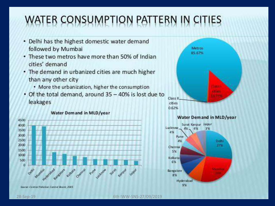
Water is not properly distributed where it is supplied through
pipes. Mega cities like Delhi and Mumbai get more that than
the standard municipal water norm of 150 litres per capita per
day (LPCD) while others get 40-50 LPCD.
The World Health Organization prescribes 25 litres of water
for one person a day to meet all basic hygiene and food
needs. Extra available water, according to the WHO
estimates, is used for non-potable purposes like mopping and
cleaning.
28-Sep-19 6th IWW-SNS-27/09/2019

Wastage of water
✓Arithmetically, India is still water surplus and receives enough
annual rainfall to meet the need of over one billion plus people.
According to the Central Water Commission, India needs a maximum
of 3,000 billion cubic metres of water a year while it receives 4,000
billion cubic metres of rain.
✓But the problem is India captures only eight per cent of its annual
rainfall - among the lowest in the world. The traditional modes of
water capturing in ponds have been lost to the demands of rising
population and liberal implementation of town planning rules.
✓India has been also poor in treatment and re-use of household
wastewater. About 80 per cent of the water reaching households in
India are drained out as waste flow through sewage to pollute other
water bodies including rivers and also land.
28-Sep-19 6th IWW-SNS-27/09/2019

loss of wetlands, water bodies
Almost every single city and village in the country has lost
its wetlands, water bodies and even rivers to
encroachment to meet the needs of rising population.
Chennai that is facing acute water shortage had nearly
two dozen water bodies and wetlands but most of them
are out of use today. A recent assessment found that only
nine of them could be reclaimed as water bodies.
The main causes of disappearance of traditional water
conservation structures are:
➢ Urbanization
➢ Population
➢ Encroachments
➢ Poor sewerage structures
➢ Blocking of the recharging path ways
➢ Poor maIntenance and negligence from civic authorities
➢ Pollution
28-Sep-19 6th IWW-SNS-27/09/2019

The United Nation's (UN) World Water Development Report
of 2018 harks back to the traditional nature-based solution
to address water crisis.
It particularly highlights two examples.
One is the good old experiment by India's waterman
Rajendra Singh in Rajasthan which restored water
resources in Alwar district through construction of small-
scale water harvesting structures. This brought water back
to 1,000 drought-hit villages, revived five rivers which had
gone dry, increased farm productivity by 20 to 80 per cent,
increased forest cover by 33 per cent and also brought
back antelopes and leopards.
The other is from Jordan where an experiment in reviving
traditional land management system, called 'Hima'- which
basically consisted of setting land aside to allow for the
land to naturally regenerate itself - that led to increase in
economic growth (through cultivation of indigenous plants
of economic value) and conservation of natural resources
in the Zarqa river basin. It has now become Jordan's
national policy.28-Sep-19 6th IWW-SNS-27/09/2019

History tells us that floods and droughts bothwere regular phenomenon in ancient India.Perhaps this was the reason for the everyregion of country; for having its own traditionalwater conservation and managementtechniques depending upon the geographicalpeculiarities and cultural uniqueness. Thebasic concept underlying all these techniquesis that rain should be harvested whenever and
wherever falls.
28-Sep-19 6th IWW-SNS-27/09/2019

Archaeological evidence shows that the practice of water
conservation and management is deep rooted in the science of
ancient India. Excavations show that the cities of the Indus
Valley Civilization had excellent systems of water conservation,
harvesting and drainage system.
The settlement of Dholavira, laid out on a slope between two
storm water channels, is a great example of Water Engineering.
Chanakya’s Arthashashtra mentions irrigation using water
harvesting systems. Sringaverapura, near Allahabad, had a
sophisticated water harvesting system that used the natural
slope of the land to store the floodwaters of the river Ganga
Chola King Karikala built the Grand Anicut or Kallanai across
the river Cauvery to divert water for irrigation (it is still functional)
while King Bhoja of Bhopal built the largest artificial lake in India.28-Sep-19 6th IWW-SNS-27/09/2019

Drawing upon centuries of experience, Indians
continued to build structures to catch, hold and store
monsoon rainwater for the dry seasons to come.
These traditional techniques, though less popular
today, are still in use and efficient. Drawing upon
centuries of experience, Indians continued to build
structures to catch, hold and store monsoon rainwater
for the dry seasons to come.
Water has been conserved and managed in India
since antiquity, with our ancestors perfecting the art of
water management. Many water conservation
structures and water conveyance systems specific to
the ecoregions and culture has been developed
28-Sep-19 6th IWW-SNS-27/09/2019

Encroachment of water bodies has been identified
as a "major cause" of flash floods in Mumbai
(2005), Uttarakhand (2013), Jammu and Kashmir
(2014) and Chennai (2015) in the past one-and-
half decades.
28-Sep-19 6th IWW-SNS-27/09/2019

Their revival and better management assume even
more significance if the Niti Aayog's warning is to be
taken seriously: Groundwater levels in 21 major cities,
including Delhi, Bangalore and Hyderabad, will dry up
completely by 2020 (next year), affecting 100 million
people.
28-Sep-19 6th IWW-SNS-27/09/2019

Everyday experiences and studies have shown
that more and more water bodies are disappearing
from the urban and rural landscapes due to
uncontrolled urbanization leading to their
encroachment for construction activities; dumping
of sewage, industrial waste water, deposition of
debris and last but not the least a shift from
community-based water-use system to
groundwater dependent system, etc.
28-Sep-19 6th IWW-SNS-27/09/2019

FAST DISAPPEARING WATER BODIES
According to the 4th MI census, carried out during 2006-
2007, there were 5,23,816 water bodies - declining by
32,785 from 5,56,601 water bodies identified during the 3rd
MI census of 2000-2001.
Of these 5,23,816 water bodies, 80,128 (or 15 per cent) were
found "not in use" any more.
Most such water bodies in disuse were found in Karnataka
(51 per cent of its total water bodies), Rajasthan (40 per
cent), Andhra Pradesh (32 per cent), Tamil Nadu (30 per
cent), Uttarkhand (29 per cent) and Gujarat (23 per cent).
28-Sep-19 6th IWW-SNS-27/09/2019

REPURPOSING REPAIR, RENOVATION AND RESTORATION SCHEME
Realizing the seriousness of problem confronting water
bodies, the Centre had launched the Repair, Renovation and
Restoration (RRR) of Water Bodies' scheme in 2005 with the
objectives of comprehensive improvement and restoration of
traditional water bodies, including increasing tank storage
capacity, ground water recharge, increased availability of
drinking water, improvement of catchment areas of tank
commands, etc.
28-Sep-19 6th IWW-SNS-27/09/2019

Water conservation is a key element of any strategy that
aims to alleviate the water scarcity crisis in India.
With rainfall patterns changing almost every year, the
Indian government has started looking at means to
revive the traditional systems of water harvesting in the
country. Given that these methods are simple and eco-
friendly for the most part, they are not just highly effective
for the people who rely on them but they are also good
for the environment.
28-Sep-19 6th IWW-SNS-27/09/2019

Sr.
No.
Ecological Region Traditional Water Management
System
1. Trans - Himalayan
Region
Zing
2. Western Himalaya Kul, Naula, Kuhl, Khatri
3. Eastern Himalaya Apatani
4. North Eastern Hill
Ranges
Zabo
5. Brahmaputra Valley Dongs / Dungs/ Jampois
6. Indo-Gangetic
Plains
Ahars – Pynes, Bengal’s Inundation Channels, Dighis,
Baolis
7. The Thar Desert Kunds, Kuis/beris, Baoris / Ber/
Jhalaras, Nadi, Tobas, Tankas,
Khandins, Vav/Bavadi, Virdas,
Paar28-Sep-19 6th IWW-SNS-27/09/2019

8. Central Highlands Talab, Bandhis, Saza Kuva,
Johads, Naada/Bandh, Pat, Rapat,
Chandela Tank, Bundela Tank
9. Eastern Highlands Katas / Mundas / Bandhas
10. Deccan Plateau Cheruvu, Kohli Tanks, Bhandaras,
Phad, Kere, The Ramtek
Model
11. Western Ghats Surangam
12. West Coastal
Plains
Virdas
13. Eastern Ghats Korambu
14. Eastern Coastal
Plains
Eri / Ooranis
15. The Islands Jack Wells
28-Sep-19 6th IWW-SNS-27/09/2019

28-Sep-19 6th IWW-SNS-27/09/2019

Jhalara
Jhalaras are typically rectangular-shaped step wells that have tiered
steps on three or four sides. These step wells collect the
subterranean seepage of an upstream reservoir or a lake. Jhalaras
were built to ensure easy and regular supply of water for religious
rites, royal ceremonies and community use. The city of Jodhpur has
eight jhalaras, the oldest being the Mahamandir Jhalara that dates
back to 1660 AD.28-Sep-19 6th IWW-SNS-27/09/2019

28-Sep-19 6th IWW-SNS-27/09/2019

TALAB
Talabs are reservoirs that store water forhousehold consumption and drinking purposes.
They may be natural, such as the pokhariyanponds at Tikamgarh in the Bundelkhand region ormanmade, such as the lakes of Udaipur. Areservoir with an area less than five bighas iscalled a talai, a medium sized lake is called abandhi and bigger lakes are called sagar orsamand.
28-Sep-19 6th IWW-SNS-27/09/2019

Talab /Bandhi
28-Sep-19 6th IWW-SNS-27/09/2019
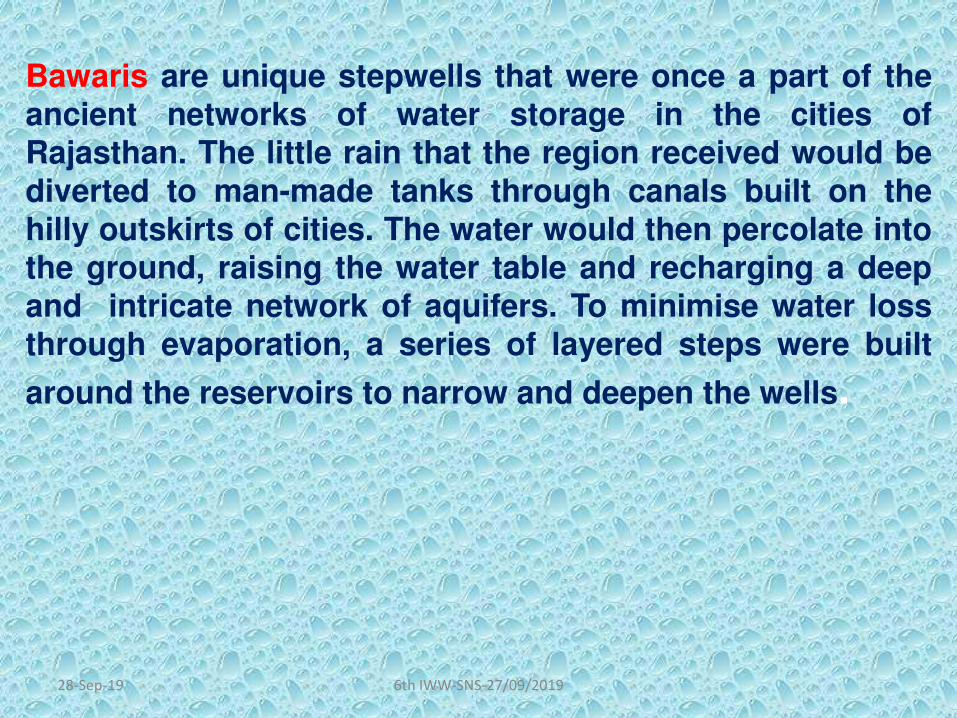
Bawaris are unique stepwells that were once a part of theancient networks of water storage in the cities ofRajasthan. The little rain that the region received would bediverted to man-made tanks through canals built on the
hilly outskirts of cities. The water would then percolate intothe ground, raising the water table and recharging a deepand intricate network of aquifers. To minimise water lossthrough evaporation, a series of layered steps were built
around the reservoirs to narrow and deepen the wells.
28-Sep-19 6th IWW-SNS-27/09/2019

Bawari
28-Sep-19 6th IWW-SNS-27/09/2019

Taanka
Taanka is a traditional rainwater harvesting technique indigenous to
the Thar desert region of Rajasthan. A Taanka is a cylindrical pavedunderground pit into which rainwater from rooftops, courtyards orartificially prepared catchments flows. Once completely filled, thewater stored in a taanka can last throughout the dry season and issufficient for a family of 5-6 members. An important element of watersecurity in these arid regions, taankas can save families from theeveryday drudgery of fetching water from distant sources.
28-Sep-19 6th IWW-SNS-27/09/2019

JohadsJohads, one of the oldest systems used to conserve and recharge
ground water, are small earthen check dams that capture and store
rainwater. Constructed in an area with naturally high elevation on
three sides, a storage pit is made by excavating the area, and
excavated soil is used to create a wall on the fourth
side. Sometimes, several johads are interconnected through deep
channels, with a single outlet opening into a river or stream nearby.
This prevents structural damage to the water pits that are also
called madakas in Karnataka and pemghara in Odisha.
28-Sep-19 6th IWW-SNS-27/09/2019

Ahar Pynes
Ahar Pynes are traditional floodwater harvesting systems indigenous to
South Bihar. Ahars are reservoirs with embankments on three sides that are
built at the end of diversion channels like pynes. Pynes are artificial rivuletsled off from rivers to collect water in the ahars for irrigation in the dry
months. Paddy cultivation in this relatively low rainfall area depends mostly
on ahar pynes.
28-Sep-19 6th IWW-SNS-27/09/2019

Khadin
Khadins are ingenious constructions designed to harvest surface runoff
water for agriculture. The main feature of a khadin, also called dhora, is a long
earthen embankment that is built across the hill slopes of gravelly uplands.
Sluices and spillways allow the excess water to drain off and the water-
saturated land is then used for crop production. First designed by the Paliwal
Brahmins of Jaisalmer in the 15th century, this system is very similar to the
irrigation methods of the people of ancient Ur (present Iraq).
28-Sep-19 6th IWW-SNS-27/09/2019

KundA kund is a saucer-shaped catchment area that gently slope towards
the central circular underground well. Its main purpose is to harvest
rainwater for drinking. Kunds dot the sandier tracts of western
Rajasthan and Gujarat. Traditionally, these well-pits were covered in
disinfectant lime and ash, though many modern kunds have been
constructed simply with cement. Raja Sur Singh is said to have built
the earliest known kunds in the village of Vadi Ka Melan in the year
1607 AD.
28-Sep-19 6th IWW-SNS-27/09/2019

BaoliBuilt by the nobility for civic, strategic or philanthropic reasons,
baolis were secular structures from which everyone could draw
water. These beautiful stepwells typically have beautiful arches,
carved motifs and sometimes, rooms on their sides. The locations
of baolis often suggest the way in which they were used. Baolis
within villages were mainly used for utilitarian purposes and social
gatherings. Baolis on trade routes were often frequented as resting
places. Stepwells used exclusively for agriculture had drainage
systems that channelled water into the fields.
28-Sep-19 6th IWW-SNS-27/09/2019

NadiFound near Jodhpur in Rajasthan, nadis are village ponds that store
rainwater collected from adjoining natural catchment areas. The
location of a nadi has a strong bearing on its storage capacity and
hence the site of a nadi is chosen after careful deliberation of its
catchment and runoff characteristics. Since nadis received their
water supply from erratic, torrential rainfall, large amounts of sandy
sediments were regularly deposited in them, resulting in quick
siltation. A local voluntary organisation, the Mewar Krishak Vikas
Samiti (MKVS) has been adding systems like spillways and silt traps
to old nadis and promoting afforestation of their drainage basin to
prevent siltation.
28-Sep-19 6th IWW-SNS-27/09/2019

Bhandara Phad
Phad, a community-managed irrigation system, probably came into
existence a few centuries ago. The system starts with
a bhandhara (check dam) built across a river, from
which kalvas (canals) branch out to carry water into the fields in the
phad (agricultural block). Sandams (escapes outlets) ensure that the
excess water is removed from the canals by charis (distributaries)
and sarangs (field channels). The Phad system is operated on three
rivers in the Tapi basin – Panjhra, Mosam and Aram – in the Dhule
and Nasik districts of Maharashtra.
28-Sep-19 6th IWW-SNS-27/09/2019

28-Sep-19 6th IWW-SNS-27/09/2019

28-Sep-19 6th IWW-SNS-27/09/2019

28-Sep-19 6th IWW-SNS-27/09/2019

28-Sep-19 6th IWW-SNS-27/09/2019

28-Sep-19 6th IWW-SNS-27/09/2019

28-Sep-19 6th IWW-SNS-27/09/2019

28-Sep-19 6th IWW-SNS-27/09/2019

28-Sep-19 6th IWW-SNS-27/09/2019

28-Sep-19 6th IWW-SNS-27/09/2019

28-Sep-19 6th IWW-SNS-27/09/2019

28-Sep-19 6th IWW-SNS-27/09/2019

Sewage from housing colonies
For want of adequate sewerage network and treatment facilities
domestic sewage from the catchment settlements freely flows in
to the water bodies which is a basic challenge for management 28-Sep-19 6th IWW-SNS-27/09/2019

THANK YOU
28-Sep-19 6th IWW-SNS-27/09/2019

Addressing the urban drivers of river health in the Ganga River Basin
27 Sep 2019
Project Concept

Project Concept
Treatment PlantsSewer Networks Cleanliness Drives
Ghat development Water body conservation Research and Innovations

Project Concept
Need to integrate river health management
into the long-term planning for a city

River City, Gothenburg, Sweden, EuropeBusan River City, South Korea Södertälje, Sweden, EuropeVancouver’s River Dist., Canada Qinhuangdao, China
Project Objectives
OBJECTIVE 1: Develop Strategic Guidelines to mainstream urban river
マaミageマeミt iミto a city’s Master Plaミ

Project Objectives
OBJECTIVE 2: Supporting the city of Kanpur in the development of an Urban
River Management Plan

1. Click on this icon to insert a new photo.
2. Reset the slide. 3. Where necessary, change the section using the けCropげ function.
River Basin PlanningWater Strategy, Planning and Delivery – Overview
Dr Martin Griffiths
Support to Ganga Rejuvenation
Implementation of the India EU-Water Partnership| New Delhi 27.09.2019

Developed for Support to Ganga Rejuvenation Project
Water Protection and Improvement Programmes are developed via aRiver Basin Planning and Management Cycle
2

water.europa.eu
Example - EU Water StrategyThe Water Framework Directive
European Commission, DG Environment
United Nations Sustainable Development Goals

Outcomes in the Environment - UK
4

5
Outcomes in the Environment - India

Setting Outcome Based Targets
6
• Strategic Questions
• What does India want from the Ganga
• What is realistic and achievable
• What are the significant management issues
• What timeframes should be set
• What are the costs
• Capital
• Operational
• What are the benefits
• Who will deliver these
• What is the most cost effective way to achieve these Outcomes
• River Basin Planning provides a process to determine this

Developed for Support to Ganga Rejuvenation Project
River Basin Planning and Management CycleInner Cycle – Technical ProcessPlanning and Setting Objectives
7

Clear Governance
8
• United Nations Road-Mapping recommends creating
• Enabling Environment• Clear Institutional Structures• Management Instruments• Infrastructure Development
• EU introduces the concept of ‘Competent Authority’
• A clear and empowered organisation to lead and deliver the RPM plan
• In England this is the Environment Agency
• On the Rhine and the Danube• International Commission for the Protection of the Rhine River (ICPR)
• International Commission for the Protection of the Danube River (ICPDR)
• For the Ganga this will be ???

Characterisation
Risk Based Approach
Understand the characteristics of the Basin/Sub-basin
Identify Significant Management Issues
Use Driver-Pressure-State-Impact-Response (DPSIR) Model

Risk Based Approach
Risk Based Monitoring
Risk Based Modelling
Risk Based Regulation
Risk Based Enforcement

Monitoring
11
• Risk Based
• Assess current Water Quality• State of Environment reporting• Essential to set realistic River Quality Objectives• Data to calibrate and run models• Assess remediation options• Ensure correct infrastructure development and operation• Optimise regulatory environment and assess delivery
• Very cost effective when compared with infrastructure capital and operational costs
• All infrastructure options are modelled to ensure certainty of improvement and that benefits are realised

Monitoring
12
• A sample of Ganga Water 15 April 1987 taken by me
• Its been on my desk for over 30 years!

Chemical
Elements
Biological Elements
Hydromorphological
Elements
Physico-chem
Elements
Environmental Monitoring - Programmes
13

From Monitoring Information
Assess Current Quality
Undertake modelling of options and interventions
Set realistic Objectives
Develop improvement Programme
Feed this into Implementation Programme

River Quality Objectives are progressively improved according to an Environmental Improvement Programme

HIGH
GOOD
MODERATE
POOR
BAD
Classes
No orminimal
{
Slight {
Moderate {
Major {
Severe {
Courtesy Peter Pollard, Scottish Environment Protection Agency
EU - Good Ecological Status Objective

Must agree a Timetable for Improvement –EU WFD Example

Don’t Forget the Groundwater!
18

Integrated options for ecological improvement
FlowRegime
PhysicalHabitat
WaterQuality
19
What is the most cost efficient combination of interventions

FlowRegime
PhysicalHabitat
WaterQuality
20
Integrated options for ecological improvement
What is the most cost efficient combination of interventions

FlowRegime
PhysicalHabitat
WaterQuality
21
Integrated options for ecological improvement
What is the most cost efficient combination of interventions

FlowRegime
PhysicalHabitat
WaterQuality
22
Integrated options for ecological improvement
What is the most cost efficient combination of interventions

FlowRegime
PhysicalHabitat
WaterQuality
23
Integrated options for ecological improvement
What is the most cost efficient combination of interventions

Adapted from. Paul Whitehead – Oxford University
Must consider Regulatory Options to Implement Improvement Programme – The Regulatory Cycle
25

Permit standards are progressively tightened

Adapted from. Paul Whitehead – Oxford University 27
Permit Conditions must reflect the Environmental Objectives !

Permits drive water resource Improvement Programmes

29
Regulation for Water Quality - Book
Free to download at
http://www.fwr.org/WQreg/
Or Hard Copy from
Foundation for Water
Reseach

River Basin Planning
Public Participation and Consultation
30

Public participation
in the Water
Framework Directive
supply of information•• consultation
• active involvement
31
River Basin Planning
Public Participation Model

Publish - River Basin Management Plans
• Implementing Water Framework Directive River Basin Plans

Support to Ganga Rejuvenation
Implementation of the India EU-Water Partnership
Thank You!
