statement of strategy 2016 -2018 - ordnance survey ireland · this statement of strategy from...
TRANSCRIPT
Statement of Strategy
2016 -2018
Mission
To create, maintain and provide the State’s definitive mapping and geospatial information services to support
citizens, business and government.
Vision The national providers of trusted, maintained
geospatial data and platforms to ensure the State’s location data is easy to find, share and use.

1
This Statement of Strategy is the eighth statement to be published by Ordnance Survey
Ireland (OSi) and arises in the context of the Public Service Management Act, 1997. The
Statement continues to build on the strategic management process which is well
established in OSi and comprises a number of strategic themes which are designed to
assist the organisation in successfully meeting the challenges of a constantly changing
environment in which the organisation fulfils its mandate.
There has been consultation with the European National Mapping & Cadastral and Land
Registry Authorities (EuroGeographics) in the preparation of this statement.
2
INTRODUCTION
Chairman This Statement of Strategy from Ordnance Survey Ireland (OSi) sets out the organisations strategic intent over the course of the three year period 2016 – 2018. OSi is a technologically advanced public service body operating in a fast changing geographic information environment providing a wide range of national mapping and geospatial products and services to meet the needs of both the public and private sectors. OSi has a proud tradition of innovation which continues today at an ever increasing pace, with OSi being recognised internationally as one of the global leaders in the development of national mapping. With OSi’s function being clearly defined in the Ordnance Survey Act, 2001, this three year strategic statement has been developed to ensure that OSi continues to provide the best national mapping and geospatial services to meet the changing needs of citizens, business and government, whilst clearly focusing on efficiencies and value for all its stakeholders. With OSi playing a leading role within the public service reform agenda, to enable national geospatial data to be used to support an analytics approach to evidence based decision making, this Statement of Strategy has been developed to strongly support the public service reform’s focus on service users and public sector efficiencies through shared infrastructure, digitisation and innovation, data sharing, governance and capability. Accordingly a new organisation mission and vision has been defined for this Statement of Strategy.
Our Mission: To create, maintain and provide the State’s definitive mapping and geospatial information services to support citizens, business and government.
Our Vision: The national providers of trusted, maintained geospatial data and platforms to ensure the State’s location data is easy to find, share and use.
During the course of this Statement of Strategy OSi will face a number of challenges including increased competition within the geographic information industry and managing its funding model whilst engaging with important Government initiatives such as Open Data. This three year Statement of Strategy provides a clear focus and set of actions to deal with the challenges ahead. The establishment of a national mapping agreement and the development of a national geospatial data strategy are critical elements of this strategy. During the course of this Statement of Strategy OSi will continue to prepare for merging with our colleagues in the Property Registration Authority and the Valuation Office as part of Government’s programme of rationalisation of State bodies.

3
OSi’s staff are its greatest asset and through their commitment and professionalism this Statement of Strategy will be successfully implemented for the benefit of all OSi’s stakeholders. Their focus on innovation and standards ensures OSi’s quality mapping products and services to its customers continues to be a major strength in the organisation’s future strategic direction. I would also like to thank my fellow Board colleagues for their contribution to this Statement of Strategy. Ronan O’Reilly Chairman

4
FOREWORD
Chief Executive Officer On behalf of Ordnance Survey Ireland I am delighted to present this Statement of Strategy for the period 2016 – 2018. The Strategy sets out the objectives, strategies, outcomes and performance indicators of Ordnance Survey Ireland for the next three years, defined under the following four strategic goals:
Leadership in National Geospatial Strategy
Provision of trusted and maintained Geospatial Platforms
Innovating to meet the changing needs of citizens, business and government
People and organisational excellence With Ordnance Survey Ireland’s mandated function to create, maintain and provide the State’s authoritative national mapping and related geographic databases, this Strategy builds upon Ordnance Survey’s recent investment in a world class, award winning, industry best practise next generation national mapping database (Prime2). The Prime2 strategy has created a rules based automated production workflow environment delivering production efficiencies, ensuring the highest quality of data management and governance, and enabling OSi to create the next generation of geospatial products and services to meet the needs of the citizen, business and government. See Figure 1 below.
Figure 1: OSi Production & Supply Environment
5
With the key focus of this Strategy being ‘supporting citizens, business and government’ its objectives include:
OSi data being the default core geospatial reference data for the State
Public & Civil Service gaining maximum benefit from authoritative geospatial data
OSi data and services being easy to find, use and integrate
OSi’s data being maintained to meet the needs of citizens, business and government
Creating new OSi products and services to meet the needs of citizens, business and government.
The key performance indicators to measure our achievements over 2016 – 2018 are outlined in the Statement of Strategy. The Strategy will be underpinned by an annual Corporate Business Plan and Ordnance Survey Ireland’s Annual Reports will report on our performance by reference to the indicators contained within the Strategy. By definition this is a dynamic document; objectives and strategies will inevitably evolve and Ordnance Survey Ireland will respond accordingly and re-orientate priorities and resources as this arises. As Ordnance Survey Ireland continues to deliver more with less, providing increased value for money to its stakeholders, and all in an increasingly challenging operating environment, this is only achieved by the dedication, technical expertise and professionalism of its staff. Finally I would like to thank the OSi Board for their support and input into this Statement. Colin Bray Chief Executive Officer

6
OUR MANDATE Our functions as mandated by Government are set down in the Ordnance Survey Ireland Act, 2001 (as amended by the Official Languages Act 2003) and are stated as follows: The general function of OSi is to provide a national mapping service in the State. In this regard it shall operate in the public interest by creating and maintaining the definitive national mapping and related geographic records of the State. OSi’s functions shall include all tasks as are necessary to fulfil its general function including, but without prejudice to the foregoing, the following: (a) To maintain and develop the underlying physical infrastructure which is needed to
support mapping applications, including to maintain a national grid and the national geodetic and height frameworks and to link these to international systems,
(b) To create and maintain for the entire State mapping and related geographic databases
which have national consistency of content, currency, style and manner including for those areas which do not provide a commercial return on the activity,
(c) To provide mapping and related geographic information to the public and private
sectors in support of social, economic, legislative, educational, security, business and administrative functions and requirements,
(d) To encourage and promote the benefits of the use of the national mapping and related
databases and the development of products, services and markets to meet national and user needs,
(e) To advise the Government, a Minister of the Government, a body established by or
under statute and other public sector organisations on matters relating to the policy and practice of survey, mapping and geographic information and on the development of national spatial database infrastructures,
(f) To represent the State at international level on matters relating to mapping and
geographic information, (g) To provide the necessary technical support to the Chief Boundary Surveyor in the
performance of his or her duties in delimiting statutory boundaries and the delineation of such boundaries on maps,
(h) To depict place-names and ancient features in the national mapping and related records
and databases in the Irish language or in the English and Irish languages, (i) To protect Government copyright on OSi records, databases, products and published
material including copyright on OSi records, databases, products and published material made prior to establishment day.
7
Ordnance Survey Ireland
Statement of Strategy 2016-2018
OUR MISSION
To create, maintain and provide the State’s definitive mapping and geospatial information services to support
citizens, business and government.
OUR VISION
The national providers of trusted, maintained geospatial data and platforms to ensure the State’s location data is
easy to find, share and use.
OUR VALUES
Honesty & Trustworthiness – displayed at all times from staff in their interactions with each other and with customers
Responsibility & Accountability – culture of accountability, efficiency and value for money
Commitment & Technical Expertise – personal and organisational excellence to meet the highest standards of professionalism, leadership and rigour
Enterprise – continuously seek to interpret, innovate, shape and meet the needs of the citizen, business and government in a timely manner
OUR STRATEGIC GOALS
OSi will endeavour to deliver on these following goals during the course of this Statement of Strategy:
1. Leadership in National Geospatial Strategy 2. Provision of trusted and maintained Geospatial Platforms 3. Innovating to meet the changing needs of citizens, business and government 4. People & Organisational Excellence
8
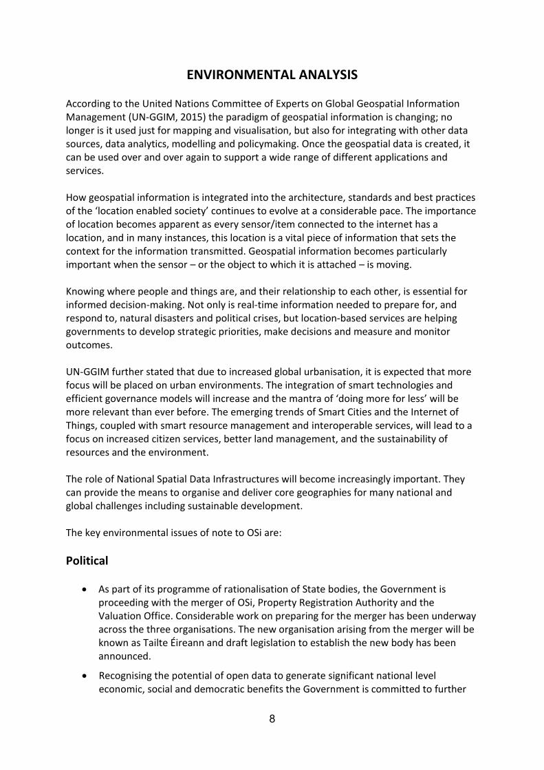
ENVIRONMENTAL ANALYSIS According to the United Nations Committee of Experts on Global Geospatial Information Management (UN-GGIM, 2015) the paradigm of geospatial information is changing; no longer is it used just for mapping and visualisation, but also for integrating with other data sources, data analytics, modelling and policymaking. Once the geospatial data is created, it can be used over and over again to support a wide range of different applications and services. How geospatial information is integrated into the architecture, standards and best practices of the ‘location enabled society’ continues to evolve at a considerable pace. The importance of location becomes apparent as every sensor/item connected to the internet has a location, and in many instances, this location is a vital piece of information that sets the context for the information transmitted. Geospatial information becomes particularly important when the sensor – or the object to which it is attached – is moving. Knowing where people and things are, and their relationship to each other, is essential for informed decision‐making. Not only is real‐time information needed to prepare for, and respond to, natural disasters and political crises, but location‐based services are helping governments to develop strategic priorities, make decisions and measure and monitor outcomes. UN-GGIM further stated that due to increased global urbanisation, it is expected that more focus will be placed on urban environments. The integration of smart technologies and efficient governance models will increase and the mantra of ‘doing more for less’ will be more relevant than ever before. The emerging trends of Smart Cities and the Internet of Things, coupled with smart resource management and interoperable services, will lead to a focus on increased citizen services, better land management, and the sustainability of resources and the environment. The role of National Spatial Data Infrastructures will become increasingly important. They can provide the means to organise and deliver core geographies for many national and global challenges including sustainable development. The key environmental issues of note to OSi are:
Political
As part of its programme of rationalisation of State bodies, the Government is proceeding with the merger of OSi, Property Registration Authority and the Valuation Office. Considerable work on preparing for the merger has been underway across the three organisations. The new organisation arising from the merger will be known as Tailte Éireann and draft legislation to establish the new body has been announced.
Recognising the potential of open data to generate significant national level economic, social and democratic benefits the Government is committed to further

9
developing its Open Data Initiative and has recently announced the appointment of an Open Data Governance Board to provide strategic vision and leadership in this area. In contribution, OSi openly released 50 individual data items. Open Data is data that is free to use, reuse or redistribute without restriction and as such has an impact upon OSi’s self-generated funding mechanisms.
OSi plays an important role in support of Government policy. Specifically, the Public Service ICT Strategy recognises data as a critical enabler which supports better decision-making and OSi believe that by making the State’s location data easy to find, share and use that it can contribute to the delivery of this strategy. The Public Service Reform Plan 2014 – 2016 has specific actions concerning the delivery of improved access to geo-spatial information for public services, businesses and citizens by developing a National Spatial Data Strategy and National Mapping Agreement. OSi is committed to making progress in this regard.
Economic
The medium term outlook for the Irish economy is optimistic. According to the latest ESRI report (Autumn 2015) the Irish economy continues to recover strongly from the downturn experienced after the 2007/2008 financial crisis. This is driven by both external demand for goods and services, and domestic sources of growth, investment and consumption. The economy is expected to grow by 4.5% in 2016, and income per capita is set to equal its pre-financial crisis peak.
This growth, and in particular the recovery of the construction sector in urban and suburban areas, has been evidenced by the growth in our online sales market segment where customers predominantly purchase maps for planning applications or land transfer.
The vast majority of OSi’s self-generated income is derived from our corporate customer base that licence OSi data on a long term basis. However the impact of the optimistic economic outlook has been slow to impact OSi’s Public and Private sector.
Within some sectors, particularly telecoms, contract consolidations are a feature as organisations merger with each other or are acquired by new entities.
Geospatial applications are now provided across a wide range of Internet and mobile platforms, and operating systems. Whilst dramatically increasing the awareness of the value of location information and therefore the importance of the industry as a whole most offer low-cost or free access to map data and imagery through their platforms. This has had the effect of increasing competition in the industry.
The maintenance of adequate budgetary and staffing levels to meet our business needs and deliver effectively and efficiently on our mandate is likely to remain challenging due to current fiscal policy being framed under the rules of the Stability and Growth Pact where the underlying principle is to ensure the sustainability of public finances.
OSi will seek to minimise risk through the operation of a business model that aims to maintain our current income stream. A critical element of this strategy is the

10
establishment of a National Mapping agreement for Public Sector customers. Such an agreement will maximise the value of national mapping to Government and provide stability in this segment of OSi revenue.
Social
Legislative and social pressures will require continuing initiatives to make the work environment more appreciative of diversity as well as offering equality of opportunities and flexible working conditions.
In the present circumstances, the implementation of work/life balance policies presents a particular challenge to the management of workloads and resources to maintain effective delivery of services.
The increased awareness of the value of geospatial information by citizens provides opportunities for OSi in provision of new products and services.
Technological
Customers now demand greater access to on-line services and expect that public service providers make optimum use of information and communications technology.
The growth of Smart Cities and The Internet of Things (IoT) technologies presents opportunities for the geo-spatial industry as the sensors involved collect location data that needs to be accurately described in terms of positioning, topology and attribution. Whilst recognising the opportunity, OSi will be required to forge new partnerships, business networks and products / services to take advantage of this opportunity.
Technology advances in remote sensing and data processing has dramatically impacted the availability of lower cost, high resolution imagery.
Location based services technology is advancing at a rapid pace and end users have an expectation of the integration of indoor and outdoor positioning. While aerial sensors, such as vertical and oblique, will provide wide area collection of highly accurate outdoor 3 dimensional data other ground based location enabled sensors will provide the ability to integrate indoor and outdoor surveying. OSi will continue to gauge these technologies for the benefit of end users.
OSi has seen significant technology advances in the area of Cloud computing and engineered systems and has invested in the latest technologies to gain advantage of high end processing power in its day-to-day operations. This investment has allowed for consolidation of legacy IT systems and provides additional business continuity options to the organisation in the event of unplanned outages.
11
Customer Requirements
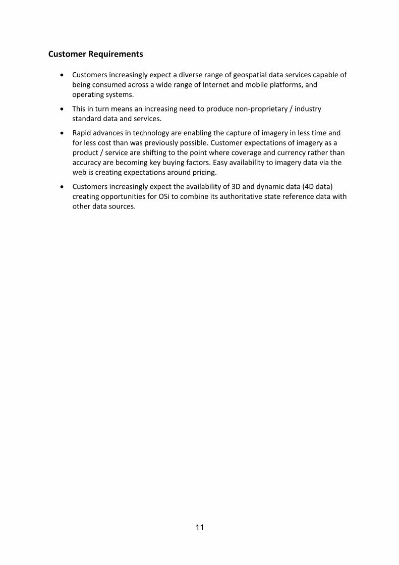
Customers increasingly expect a diverse range of geospatial data services capable of being consumed across a wide range of Internet and mobile platforms, and operating systems.
This in turn means an increasing need to produce non-proprietary / industry standard data and services.
Rapid advances in technology are enabling the capture of imagery in less time and for less cost than was previously possible. Customer expectations of imagery as a product / service are shifting to the point where coverage and currency rather than accuracy are becoming key buying factors. Easy availability to imagery data via the web is creating expectations around pricing.
Customers increasingly expect the availability of 3D and dynamic data (4D data) creating opportunities for OSi to combine its authoritative state reference data with other data sources.
12
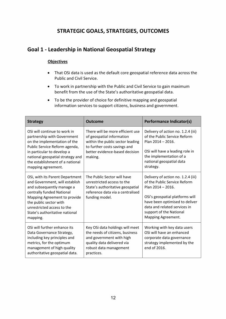
STRATEGIC GOALS, STRATEGIES, OUTCOMES
Goal 1 - Leadership in National Geospatial Strategy
Objectives
That OSi data is used as the default core geospatial reference data across the Public and Civil Service.
To work in partnership with the Public and Civil Service to gain maximum benefit from the use of the State’s authoritative geospatial data.
To be the provider of choice for definitive mapping and geospatial information services to support citizens, business and government.
Strategy Outcome Performance Indicator(s)
OSi will continue to work in partnership with Government on the implementation of the Public Service Reform agenda, in particular to develop a national geospatial strategy and the establishment of a national mapping agreement.
There will be more efficient use of geospatial information within the public sector leading to further costs savings and better evidence-based decision making.
Delivery of action no. 1.2.4 (iii) of the Public Service Reform Plan 2014 – 2016.
OSi will have a leading role in the implementation of a national geospatial data strategy.
OSi, with its Parent Department and Government, will establish and subsequently manage a centrally funded National Mapping Agreement to provide the public sector with unrestricted access to the State’s authoritative national mapping.
The Public Sector will have unrestricted access to the State’s authoritative geospatial reference data via a centralised funding model.
Delivery of action no. 1.2.4 (iii) of the Public Service Reform Plan 2014 – 2016.
OSi’s geospatial platforms will have been optimised to deliver data and related services in support of the National Mapping Agreement.
OSi will further enhance its Data Governance Strategy, including key principles and metrics, for the optimum management of high quality authoritative geospatial data.
Key OSi data holdings will meet the needs of citizens, business and government with high quality data delivered via robust data management practices.
Working with key data users OSi will have an enhanced corporate data governance strategy implemented by the end of 2016.
13
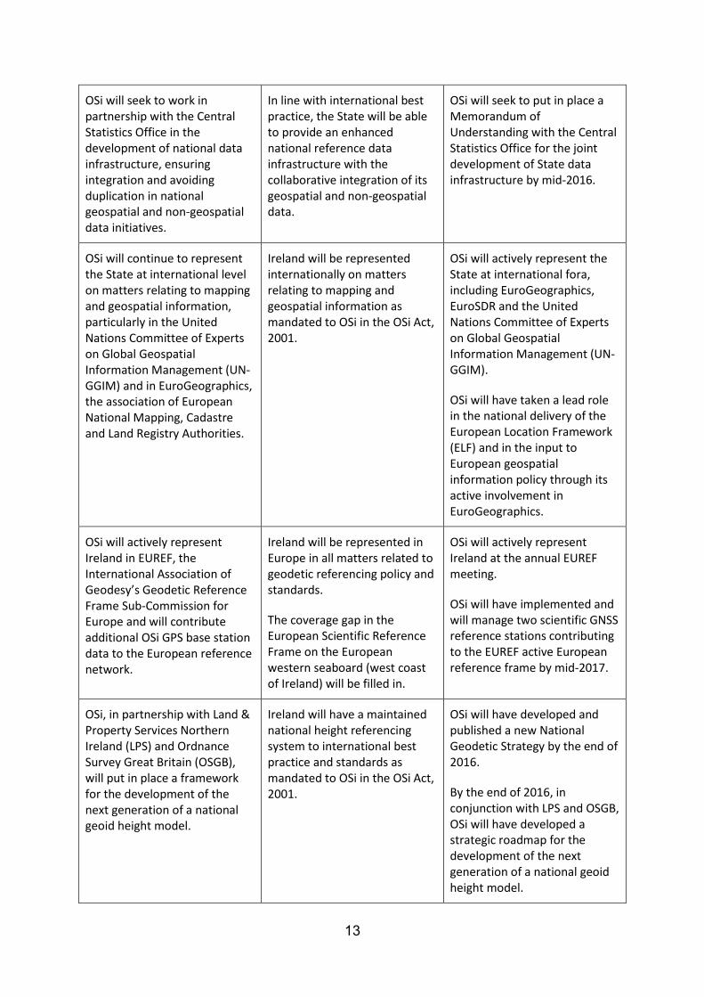
OSi will seek to work in partnership with the Central Statistics Office in the development of national data infrastructure, ensuring integration and avoiding duplication in national geospatial and non-geospatial data initiatives.
In line with international best practice, the State will be able to provide an enhanced national reference data infrastructure with the collaborative integration of its geospatial and non-geospatial data.
OSi will seek to put in place a Memorandum of Understanding with the Central Statistics Office for the joint development of State data infrastructure by mid-2016.
OSi will continue to represent the State at international level on matters relating to mapping and geospatial information, particularly in the United Nations Committee of Experts on Global Geospatial Information Management (UN-GGIM) and in EuroGeographics, the association of European National Mapping, Cadastre and Land Registry Authorities.
Ireland will be represented internationally on matters relating to mapping and geospatial information as mandated to OSi in the OSi Act, 2001.
OSi will actively represent the State at international fora, including EuroGeographics, EuroSDR and the United Nations Committee of Experts on Global Geospatial Information Management (UN-GGIM).
OSi will have taken a lead role in the national delivery of the European Location Framework (ELF) and in the input to European geospatial information policy through its active involvement in EuroGeographics.
OSi will actively represent Ireland in EUREF, the International Association of Geodesy’s Geodetic Reference Frame Sub-Commission for Europe and will contribute additional OSi GPS base station data to the European reference network.
Ireland will be represented in Europe in all matters related to geodetic referencing policy and standards.
The coverage gap in the European Scientific Reference Frame on the European western seaboard (west coast of Ireland) will be filled in.
OSi will actively represent Ireland at the annual EUREF meeting.
OSi will have implemented and will manage two scientific GNSS reference stations contributing to the EUREF active European reference frame by mid-2017.
OSi, in partnership with Land & Property Services Northern Ireland (LPS) and Ordnance Survey Great Britain (OSGB), will put in place a framework for the development of the next generation of a national geoid height model.
Ireland will have a maintained national height referencing system to international best practice and standards as mandated to OSi in the OSi Act, 2001.
OSi will have developed and published a new National Geodetic Strategy by the end of 2016.
By the end of 2016, in conjunction with LPS and OSGB, OSi will have developed a strategic roadmap for the development of the next generation of a national geoid height model.
14
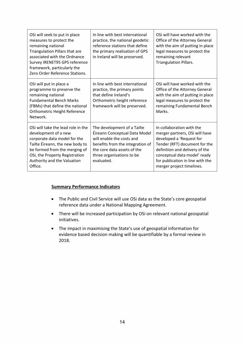
OSi will seek to put in place measures to protect the remaining national Triangulation Pillars that are associated with the Ordnance Survey IRENET95 GPS reference framework, particularly the Zero Order Reference Stations.
In line with best international practice, the national geodetic reference stations that define the primary realisation of GPS in Ireland will be preserved.
OSi will have worked with the Office of the Attorney General with the aim of putting in place legal measures to protect the remaining relevant Triangulation Pillars.
OSi will put in place a programme to preserve the remaining national Fundamental Bench Marks (FBMs) that define the national Orthometric Height Reference Network.
In line with best international practice, the primary points that define Ireland’s Orthometric height reference framework will be preserved.
OSi will have worked with the Office of the Attorney General with the aim of putting in place legal measures to protect the remaining Fundamental Bench Marks.
OSi will take the lead role in the development of a new corporate data model for the Tailte Éireann, the new body to be formed from the merging of OSi, the Property Registration Authority and the Valuation Office.
The development of a Tailte Éireann Conceptual Data Model will enable the costs and benefits from the integration of the core data assets of the three organisations to be evaluated.
In collaboration with the merger partners, OSi will have developed a ‘Request for Tender (RFT) document for the definition and delivery of the conceptual data model’ ready for publication in line with the merger project timelines.
Summary Performance Indicators
The Public and Civil Service will use OSi data as the State’s core geospatial reference data under a National Mapping Agreement.
There will be increased participation by OSi on relevant national geospatial initiatives.
The impact in maximising the State’s use of geospatial information for evidence based decision making will be quantifiable by a formal review in 2018.

15
Goal 2 - Provision of trusted and maintained Geospatial Platforms
Objectives
OSi’s data and services will be maintained to meet the needs of citizens, business and government.
OSi’s data and services will be easy to find, use and integrate.
OSi’s data and services will comply with National and European legislation and will meet with relevant industry data and system standards.
Strategy Outcome Performance Indicator(s)
OSi will further enhance and develop its geospatial platforms and services, including Prime2, GeoHive, MapGenie and e-Commerce, to meet the changing needs of citizens, business and government.
OSi’s systems and services will meet the changing needs of citizens, business and government.
OSi will have developed a new Supply / e-Commerce system by end 2016.
OSI GeoHive and MapGenie quarterly development plans will be agreed and fully implemented.
OSi will seek to ensure that its geospatial platforms and services reflect legislative drivers at National and European level.
OSi’s users will have access to geospatial services and platforms that reflect legislative drivers at both National and European levels.
OSi will undertake an annual end-of-year audit on its geospatial platforms and services to assess compliance with National and European legislation.
OSi will seek to continuously keep its geospatial platforms up-to-date with the latest industry data and system standards.
OSi’s users will have access to geospatial platforms that reflect the latest industry data and system standards ensuring ease of access and data interoperability.
OSi will undertake an annual end-of-year audit on its geospatial platforms and services to assess alignment with the latest industry data and system standards.
OSi will develop and position its GeoHive web and mobile platforms to provide data hosting and publishing services, including the development of innovative collaborative web services and geo-processing tools.
OSi’s users will have access to a greater range of mapping and data services.
OSi will have developed its platforms and services to ensure greater mobile integration by the end of Q1-2017.
OSi will have developed a partnership programme for the creation of new products and services by mid-2016.

16
OSi will continue to work closely with the Placenames Branch and Fiontar in Dublin City University to ensure that OSi is the authoritative source for the publishing of Placenames of mapping in the Irish and English language.
OSi’s users will have access to the authoratitive source of Placenames in the Irish and English language.
OSi will implement published Placenames Orders within its core data holding within one month of their publication.
OSi will continue to develop and maintain the national INSPIRE Geoportal on behalf of the Department of Environment, Community and Local Government.
OSi is enabling Ireland to fulfil its obligations under the EU INSPIRE Directive that was transposed into Irish Law under Statutory Instruments (S.I.) No. 382 of 2010.
The Geoportal service will be available as per OSi’s Service Level Agreement with the Department of Environment Community and Local Government.
OSi will continue to maximise its return on investment and provide additional value to the State from the reuse of OSi’s technical infrastructure for the provision of national geospatial services.
The State will gain additional value from the existing investment made in OSi’s technical infrastructure.
In line with the Government’s ICT Strategy, OSi’s technical infrastructure will have been used in the provision of a National Spatial Data Infrastructure.
OSi will continue to maintain and develop the national Global Navigation Satellite System (GNSS) Network with the establishment of at least two scientific GNSS stations for inclusion in the European GNSS reference Frame (EUREF).
OSi will continue to provide the surveying community in Ireland with a robust, standardised, authoritative GNSS network as mandated to OSi in the OSi Act, 2001.
The European active GNSS network, EUREF, will be improved with the addition of two scientific stations on the west coast of Ireland.
OSi will have published a Request For Tender (RFT) document for the replacement of the existing end-of-life OSi GNSS network stations by mid-2016.
OSi will have developed a specification for at least two scientific GNSS stations for inclusion in the EUREF network by mid-2016.
Summary Performance Indicators
OSi will continue to have systems in place to measure that the nationally significant data layers within its geospatial platform are being maintained to meet user needs.
There will be an increase in customer online self-service of 25% by the end of this Statement of Strategy.
OSi’s systems and services will be audited to evaluate compliance with relevant National and European legislation.

17
Goal 3 - Innovating to meet the changing needs of citizens, business and government
Objectives
To improve and expand the range of products and services to meet the needs of citizens, business and government.
To establish formal collaborative initiatives with research institutions to enable targeted applied research.
To amend legislation to efficiently and effectively maintain nineteenth century Statute Boundaries on modern OSi topographic mapping.
Strategy Outcome Performance Indicator(s)
OSi will build on its strategy for the ongoing enhancement of its core topographic information (Prime2) in line with the changing needs of citizens, business and government, particularly addressing data content, 3D city / landscape modelling, revision cycles and positional accuracy requirements.
The State’s core geospatial reference data, Prime2, will continue to be enhanced to meet the changing needs of citizens, business and government.
Following extensive end user consultation during 2016, OSi will have produced a new ‘Prime2 Data Content & Surveying Strategy’ by the end of 2016.
OSi will continue to maintain a programme to provide national coverage of high resolution imagery.
OSi will be able to update national mapping in a timely and efficient manner to meet the needs of citizens, business and government.
OSi will have published a Request For Tender (RFT) document to upgrade the two existing aerial sensors by end February 2016.
OSi will have completed a formal procurement process to upgrade the two existing aerial sensors by mid-2016.
OSi will establish product / service innovation partner initiatives for the development of new geospatial products and services in collaboration with industry partners.
OSi’s users will have access to a greater range of mapping and data services.
Strategic partnership agreements will be in place by mid-2016 which will expand the OSi range of products and services.
18
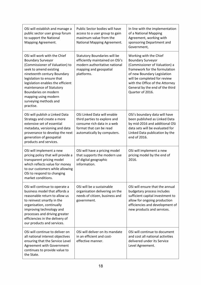
OSi will establish and manage a public sector user group forum to support the National Mapping Agreement.
Public Sector bodies will have access to a user group to gain maximum value from the National Mapping Agreement.
In line with the implementation of a National Mapping Agreement, working with sponsoring Department and Government,
OSi will work with the Chief Boundary Surveyor (Commissioner of Valuation) to seek to amend existing nineteenth century Boundary legislation to ensure that legislation enables the efficient maintenance of Statutory Boundaries on modern mapping using modern surveying methods and practise.
Statutory Boundaries will be efficiently maintained on OSi’s modern authoritative national mapping and geospatial platforms.
Working with the Chief Boundary Surveyor (Commissioner of Valuation) a framework for the formulation of new Boundary Legislation will be completed for review with the Office of the Attorney General by the end of the third Quarter of 2016.
OSi will publish a Linked Data Strategy and create a more extensive set of essential metadata, versioning and data provenance to develop the next generation of geospatial products and services.
OSi Linked Data will enable third parties to explore and consume rich data in a web format that can be read automatically by computers.
OSi’s boundary data will have been published as Linked Data by mid-2016 and additional OSi data sets will be evaluated for Linked Data publication by the end of 2016.
OSi will implement a new pricing policy that will provide a transparent pricing model which reflects value for money to our customers while allowing OSi to respond to changing market conditions.
OSi will have a pricing model that supports the modern use of digital geographic information.
OSi will implement a new pricing model by the end of 2016.
OSi will continue to operate a business model that affords a reasonable return to allow us to reinvest smartly in the organisation, continually improving technology and processes and driving greater efficiencies in the delivery of our products and services.
OSi will be a sustainable organisation delivering on the needs of citizen, business and government.
OSi will ensure that the annual budgetary process includes sufficient capital investment to allow for ongoing production efficiencies and development of new products and services.
OSi will continue to deliver on all national interest objectives ensuring that the Service Level Agreement with Government continues to provide value to the State.
OSi will deliver on its mandate in an efficient and cost-effective manner.
OSi will continue to document and cost all national activities delivered under its Service Level Agreement.

19
OSi will ensure that its Strategic Marketing plan includes content led marketing initiatives via the OSi website, social media channels and the OSi GeoHive platform.
OSi’s customers will have access to, and be actively informed about, OSi products and services via appropriate channels.
OSi will have developed and implemented a Strategic Marketing Plan by the end of 2016 and met all agreed annual Key Performance Indicators.
OSi will identify and develop opportunities for collaboration with other organisations and research institutions which could enable the attainment of key objectives in a cost and resource effective way.
OSi will gain further operational efficiencies and enhance its range of products and services.
OSi will launch an OSi research bursary programme in March 2016.
OSi will commence a research bursary programme in October 2016.
OSi will further participate in government’s shared services initiatives resulting in cost savings and operational efficiencies.
OSi will realise additional cost savings.
OSi will further participate in government’s shared services initiatives resulting in cost savings and operational efficiencies.
Summary Performance Indicators
OSi will have added 10 new products and services by the end of this Statement of Strategy.
The results of research initiatives will be applied, providing additional value in terms of production efficiencies and product development to benefit the end user.
The process of changing Statute Boundary Legislation will have significantly advanced during the period of this Statement of Strategy.
20
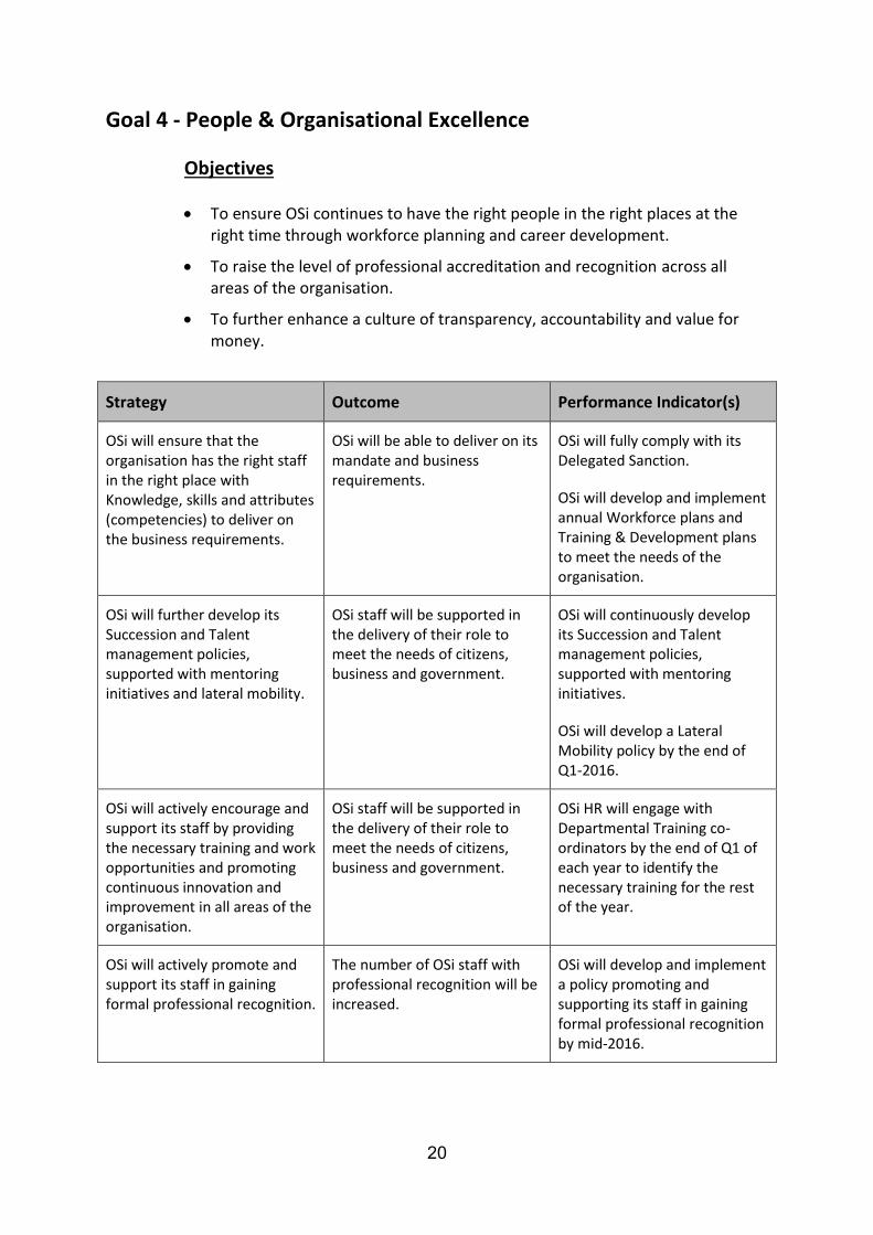
Goal 4 - People & Organisational Excellence
Objectives
To ensure OSi continues to have the right people in the right places at the right time through workforce planning and career development.
To raise the level of professional accreditation and recognition across all areas of the organisation.
To further enhance a culture of transparency, accountability and value for money.
Strategy Outcome Performance Indicator(s)
OSi will ensure that the organisation has the right staff in the right place with Knowledge, skills and attributes (competencies) to deliver on the business requirements.
OSi will be able to deliver on its mandate and business requirements.
OSi will fully comply with its Delegated Sanction.
OSi will develop and implement annual Workforce plans and Training & Development plans to meet the needs of the organisation.
OSi will further develop its Succession and Talent management policies, supported with mentoring initiatives and lateral mobility.
OSi staff will be supported in the delivery of their role to meet the needs of citizens, business and government.
OSi will continuously develop its Succession and Talent management policies, supported with mentoring initiatives.
OSi will develop a Lateral Mobility policy by the end of Q1-2016.
OSi will actively encourage and support its staff by providing the necessary training and work opportunities and promoting continuous innovation and improvement in all areas of the organisation.
OSi staff will be supported in the delivery of their role to meet the needs of citizens, business and government.
OSi HR will engage with Departmental Training co-ordinators by the end of Q1 of each year to identify the necessary training for the rest of the year.
OSi will actively promote and support its staff in gaining formal professional recognition.
The number of OSi staff with professional recognition will be increased.
OSi will develop and implement a policy promoting and supporting its staff in gaining formal professional recognition by mid-2016.

21
OSi will seek to put in place an academic accreditation process for its staff based on their experience and will develop and implement a Continuous Professional Development (CPD) programme for its staff.
There will be an increase in ongoing staff professional development and post-graduate education where appropriate.
OSi will put in place an academic accreditation programme by end of 2016.
OSi will put in place a CPD Programme by mid-2017.
OSi will put in place a training programme for ‘Service Led Client Engagements’ and will further develop teams with specialised industry experience.
OSi customers will be dealt with in a professional and service -led manner in all interactions within the organisation.
OSi will have commenced a client focused service delivery training programme for staff where required by end of 2016.
OSi will continue to identify, negotiate and support change management initiatives such as the Tailte Éireann merger.
OSi will be open to and ready for change.
OSi will continue to identify, negotiate and support change management initiatives such as the Tailte Éireann merger.
OSi will expand its ISO accreditation process to put in place Standard Operating Procedures (SOPs) to standardise key internal work processes.
Customers will gain further assurance from additional OSi processes being ISO certified.
OSi will develop a work programme for the next phase of ISO accreditation of OSi Standard Operating Procedures by mid-2016.
OSi will continue to foster a culture of accountability and value for money across the organisation so that expenditure is appropriately appraised for benefits to the organisation and the customer.
OSi will continue to be an efficient and cost-effective organisation enhancing its value to the State.
OSi will further enhance its budgetary and planning process to ensure that only activities fully aligned with our strategy or our mandate are undertaken and that resource allocation is in accordance with priorities.
Business cases will be completed for all non-routine expenditure greater than €20,000 and for all capital expenditure.
OSi will continually enhance its governance and compliance framework to help deliver on its objectives, meet its obligations, ensure accountability and transparency in its operations, identify and mitigate risks and plan in a strategic and focused way how to meet its key objectives.
OSi will operate to the highest standards of corporate governance.
OSi will implement the recommendations of an OSi initiated external review of OSi Corporate Governance undertaken in Q4-2015.

22
Summary Performance Indicators
OSi will have an increased capability to deliver on the changing needs of citizens, business and government.
There will be a 20% increase in the participation by staff on formal professional accreditation programmes.
All OSi corporate governance and financial control obligations are found to be in place by internal and external audits.
23
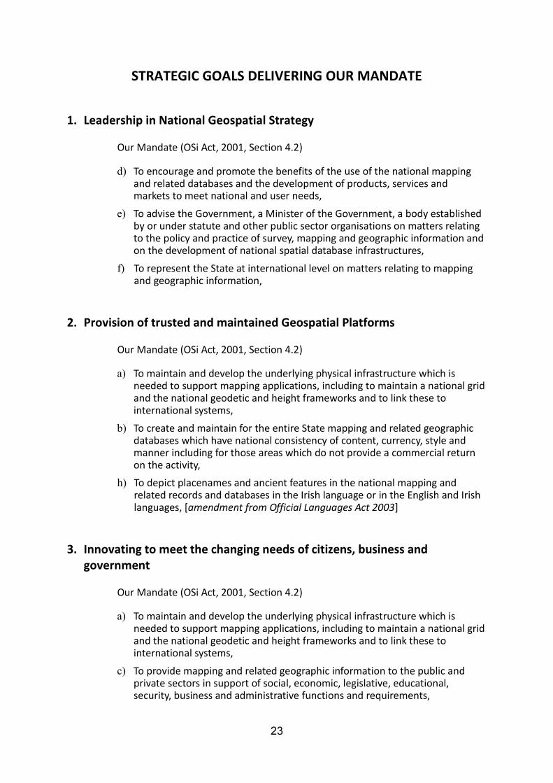
STRATEGIC GOALS DELIVERING OUR MANDATE
1. Leadership in National Geospatial Strategy
Our Mandate (OSi Act, 2001, Section 4.2) d) To encourage and promote the benefits of the use of the national mapping
and related databases and the development of products, services and markets to meet national and user needs,
e) To advise the Government, a Minister of the Government, a body established by or under statute and other public sector organisations on matters relating to the policy and practice of survey, mapping and geographic information and on the development of national spatial database infrastructures,
f) To represent the State at international level on matters relating to mapping and geographic information,
2. Provision of trusted and maintained Geospatial Platforms
Our Mandate (OSi Act, 2001, Section 4.2) a) To maintain and develop the underlying physical infrastructure which is
needed to support mapping applications, including to maintain a national grid and the national geodetic and height frameworks and to link these to international systems,
b) To create and maintain for the entire State mapping and related geographic databases which have national consistency of content, currency, style and manner including for those areas which do not provide a commercial return on the activity,
h) To depict placenames and ancient features in the national mapping and related records and databases in the Irish language or in the English and Irish languages, [amendment from Official Languages Act 2003]
3. Innovating to meet the changing needs of citizens, business and government
Our Mandate (OSi Act, 2001, Section 4.2) a) To maintain and develop the underlying physical infrastructure which is
needed to support mapping applications, including to maintain a national grid and the national geodetic and height frameworks and to link these to international systems,
c) To provide mapping and related geographic information to the public and private sectors in support of social, economic, legislative, educational, security, business and administrative functions and requirements,

24
g) To provide the necessary technical support to the Chief Boundary Surveyor in the performance of his or her duties in delimiting statutory boundaries and the delineation of such boundaries on maps,
4. People & Organisational Excellence
Our Mandate (OSi Act, 2001, Section 4.2)
The general function of OSi is to provide a national mapping service in the State. In this regard it shall operate in the public interest by creating and maintaining the definitive national mapping and related geographic records of the State.
i) To protect Government copyright on OSi records, databases, products and published material including copyright on OSi records, databases, products and published material made prior to establishment day.