state of oregon archaeological … of oregon archaeological reporting guidelines ... keep in mind...
TRANSCRIPT

STATE OF OREGON ARCHAEOLOGICAL REPORTING GUIDELINES
Oregon State Historic Preservation Office 725 Summer Street NE, Suite C
Salem, OR 97301
July 2011

2
TABLE OF CONTENTS INTRODUCTION 3 IDENTIFYING CULTURAL RESOURCES: A THEORETICAL FOUNDATION 5 PREPARING THE ARCHAEOLOGY SITE INVENTORY FORM 11 SITE TYPE TABLE 14 SURVEY PROJECT REPORTING – GENERAL GUIDELINES 19 ARCHAEOLOGY SURVEY REPORT GUIDELINES 20 FREQUENTLY ASKED QUESTIONS ON THE OREGON STATE
INVENTORY OF CULTURAL RESOURCES 28 TRIBAL POSITION POLICY: TREATMENT OF NATIVE AMERICAN HUMAN REMAINS DISCOVERED INADVERTENTLY OR THROUGH CRIMAL INVESTIGATIONS ON PRIVATE AND PUBLIC, STATE-OWNED LANDS IN OREGON 32 APPENDICES 34
A. CULTURAL RESOURCES SURVEY COVER SHEET 35 B. ARCHAEOLOGY SITE RECORD FORM 37 C. ARCHAEOLOGY ISOLATE FORM 45 D. OREGON SHPO CLEARANCE FORM 47 E. REQUEST FOR REPATRIATION OF ARCHAEOLOGICAL MATERIAL FROM OREGON NON-FEDERAL PUBLIC & PRIVATE LANDS 52

3
INTRODUCTION
he Oregon Archeological Database and the Oregon Historic Sites Database (herein after referred to as the survey databases) contain thousands of records documenting archaeological
and historic resources across the state. As such, this repository contains volumes of information revealing important insights into the thousands of years of human activity within the present-day boundaries of Oregon. The survey databases play a critical role in cultural resource management and historic preservation planning activities statewide. The survey forms, survey reports, maps, photographs, sketches, and other document types held in the databases are invaluable for a variety of users including property owners, cultural resource consultants, researchers, government agencies, tribal governments, and students. By first exploring the Oregon State Historic Preservation Office (SHPO) survey holdings, researchers are able to gain important information for project planning, environmental assessments, and land use management, as well as local growth management planning efforts. Federal and state statutes mandate that Oregon SHPO retain and manage survey records of sites in Oregon. Records held in the databases document “property types” in one of the following general categories: buildings, structures, sites, districts, and objects. As steward of the survey information, SHPO is responsible for managing these large and complex databases. In this role, the department strives to make the information as useful as possible. Several staff members devote their full time and energy toward this end. As a result, major progress has been made to place the new records into electronic databases. The department has been working to enter our paper survey documents into survey databases. This transformation into a digital format is designed to speed the retrieval of a specific record while at the same time helping to conserve the original documents. While Oregon State law exempts from disclosure public records that include location information of archaeological sites or objects (ORS 192.501 (11)) the SHPO provides access to such information to professional archaeologists, tribal governments and qualified researchers. Currently, archaeological records can only be accessed at the SHPO (see our web page www.oregonheritage.org under Archaeological Services for the policy regarding who can access these records) but we intend to have such records available on-line by 2014. Chambers Prairie excavations Within these report guidelines, Oregon SHPO conveys general guidelines, specific requirements, and useful tips about the survey process. The resulting document is intended to explain survey standards and expectations as well as provide direction for the preparation and submission of archaeological site record forms along with the accompanying survey reports. The document’s
T
Weed Creek Ditch, Harney, Co.

4
intended audience includes survey project personnel charged with conducting survey activities, plus authors who complete site forms and write the survey project reports. Readers should be aware that information in this document is guided in large part by National Park Service (NPS) directives as identified in the Secretary of the Interior’s Standards and Guidelines for Archaeology and Historic Preservation, Federal Register, Vol. 90, No. 140:44716. Readers should also be aware that these guidelines do not set or interpret any policies, regulations, or permit requirements of any other public agency. For survey projects tied to federal, state, or local laws, these guidelines provide only technical information about the survey process and the completion of related technical reports. For questions about procedures and parameters of cultural resource legislation and regulations (such as Section 106 of the NHPA and related policies and protocols) contact should be made directly with the federal, state, or local decision-making agency. Agencies conducting multiple small-scale surveys are encouraged to contact SHPO regarding field strategies as well as reporting requirements for large scale projects requiring cultural resource surveys (e.g., pipelines, wind power developments, transmission line projects).
Prior to delving into the “nuts & bolts” of survey work, we devote a few pages to provide a theoretical framework on the topic. This background information is followed by limited discussion about historic preservation terminology with the intent of clarifying terminology used within this document. Finally, it should be remembered that when specific questions or issues arise during the use or preparation of materials associated with the databases or forms, readers are encouraged to contact appropriate SHPO staff for assistance. For additional information, visit our website at www.oregonheritage.org or contact our office. Questions regarding archaeological concerns on specific projects should be addressed to Dr. Dennis Griffin (503-986-0674) or John Pouley (503-986-0675), while questions regarding ODOT related projects addressed to Matthew Diederich (503-986-0577). Questions regarding the built environment should be addressed to Julie Osborne (503-986-0686) and about the National Register to Ian Johnson (503-986-0678) or Cara Kaser (503-986-0784).
These guidelines are adapted from the State of Washington report guidelines and from the Department of Interior, National Park Service, Secretary of the Interior Standards and Guidelines for Archaeology and Historic Preservation: Federal Register Vol 90 #140: 44716. Other sections are adapted from NPS-49 Chapter 6, Section E.2.
Weed Creek Ditch, Harney Co. Examination of shell midden, Coos Co.

5
IDENTIFYING CULTURAL RESOURCES: A THEORETICAL FOUNDATION
efore presenting technical aspects of cultural resource survey work and completing forms, it is useful to provide a brief discussion on underlying principles guiding cultural resource
identification efforts. These principles have been developed by Heritage Preservation Services staff at the National Park Service (NPS) in order to set minimum standards for state historic preservation agencies to apply toward identification efforts within their respective jurisdictions. Therefore, this theoretical foundation is intended to explain how SHPO has arrived at guidelines deemed necessary for successful implementation of a statewide survey program meeting NPS standards. To begin, cultural resource identification activities (i.e. all the steps needed to survey cultural resources in the field and record resulting data onto survey forms) are fundamental to historic preservation decision-making processes. Essentially, identification or a “survey” is undertaken for the purpose of locating and compiling information about cultural resources within a defined geographic area. Survey work is comprised of a number of activities, including, but not limited to, research design, archival research, informant interviews, field survey, and analysis. Though straightforward in concept, implementation of survey work can rapidly become a complex process as the project scope increases in size. Logistics need to be planned well in advance; complicated issues need to be anticipated; and seemingly petty details must be addressed in order to successfully gather data and satisfactorily complete survey records. To assist historic preservation practitioners, the NPS (as the federal government’s chief steward of the nation’s heritage) has articulated four principles that form a theoretical basis for the design and implementation of survey projects. These four principles, with supporting narrative, are as follows: Principle 1: Identification and Survey of Historic Properties are Undertaken to the Degree Required to Make Specific Decisions Archival research and on-site inspection activities should be designed to gather the information necessary to achieve a set of defined identification goals. The objectives, chosen methods, techniques, and anticipated results are specified in a research design. These activities may include archival research and other techniques to develop historic contexts, sampling an area to gain a broad understanding of the kinds of properties it contains, or examining every property in an area as a basis for property specific decisions. Where possible, use of quantitative methods is important because it can produce an estimate, whose reliability may be assessed, of the kinds of properties that may be present in the studied area. Identification activities should use a research procedure consistent with the management needs for information and the character of the area to be investigated. Careful selection of methods, techniques, and level of detail is necessary so the gathered information will provide a sound basis for making decisions. Principle 2: Results of Identification Activities are Integrated Into the Planning Process Results of cultural resource surveys are reviewed for their contribution to existing planning data. Archival research or field data may refine the understanding of one or more historic contexts or property
B

6
types. Incorporation of the identification activities into the planning process is necessary to ensure that the project planning efforts are based on the best available information. Principle 3: Identification Activities Include Explicit Procedures for Record Keeping and Information Distribution Information gathered in identification is only useful in other future preservation planning activities and scientific studies when it is systematically gathered and recorded, made available to those responsible for planning and scientific research, and communicated to the interested public and to SHPO. The results of identification activities should be reported in a format that summarizes the design and methods of the identification activities, provides a basis for others to review the results, and states where information on identified properties is maintained. Sensitive information, like the location of archaeological sites and traditional cultural properties, must be safeguarded consistent with public disclosure requirements. Principle 4: Survey Activity Entails Effective Consultation with Concerned Tribes, Local Governments, Interested Public, Professional Community and Other Governmental Agencies Cultural resource survey and research requires effective communication and consultation with concerned Native American Tribes, local governments, historical organizations, and state and federal agencies that have review responsibility. All identification activities should be coordinated with concerned entities to assure that their concerns and data are incorporated into the cultural resource report and environmental process. In essence, the guidelines contained within this publication are intended to translate the four identification principles as set forth above into specific technical guidance. Keep in mind that SHPO has tailored this guidance to meet the special considerations and practices of the Oregon survey databases. A Word About Nomenclature With background information of cultural resource identification principles, it is useful to set some ground rules about historic preservation nomenclature used in this document. Like other highly specialized and technical fields of expertise, historic preservation has evolved its own formal and informal glossary of terms, jargon, acronyms, and word usage that is peculiar unto itself. For example, the word “restoration” takes on a very definite intent when used by preservationists that is much narrower and more technical than would be encountered in common usage. While useful for communication amongst professionals, these fine distinctions in word usage in historic preservation conversations also may cause confusion amongst persons outside (and sometimes even for persons within) the historic preservation community. Therefore, a brief discussion is offered here to provide explanation about how various terms found in these guidelines are used and intended. It is SHPO’s intention that usage of terms in this document, though perhaps not universally agreed upon, offers at least consistency internal to the document and practice at SHPO. First and probably most important is to explain our use of the term “cultural resources”. In some circles, “cultural resources” is used to refer to a limited group of artifacts associated with archaeological sites that typically, though not necessarily, are associated with Native American use and habitation. For SHPO as well as within these guidelines, “cultural resources” refers to a

7
much broader range of resources associated with human manipulation of the environment. Hence, the Oregon survey databases encompass all resources that are potentially eligible for listing in the National Register of Historic Places (NRHP), such as: sites, buildings, structures, districts, and objects. Therefore, in these guidelines, “cultural resources” would include a wide range of property types, such as: an archaeological site dating back hundreds or thousands of years, a Civilian Conservation Camp from the 1930s, an irrigation ditch from the early 1900s, a residential historic district, a locomotive on the floor of Odell Lake, and everything in between. Another important term to discuss is “historic properties.” Confusion arises with the use of this term since the word “historic” is often associated with cultural resources (especially buildings and structures) that date after European-American contact with Native American peoples, or by around 1805 in what is now the State of Oregon. For the purposes of these guidelines and informal usage, SHPO follows this interpretation and the use of the term “historic properties.” As a result, existing elements of the built environment that include buildings, structures, sites, districts, and objects dating from the contact era will be referred to as “historic properties” and the Historic Sites Database is used to document these resources. To understand this confusion over use of the term “historic property” it should be noted that the term derives from formal NPS definition and usage. In essence, NPS usage refers only to cultural resources that have been listed, or determined to be eligible for listing, in the National Register of Historic Places. Therefore, from the NPS perspective, significant archaeological sites and traditional cultural places dating prior to contact are considered to be “historic properties” and join with other properties of the built environment that were constructed as recently as 50 years ago. As a result it is important to keep in mind the distinction between common/SHPO usage of the term “historic property” and NPS usage, especially when formally evaluating eligibility of properties for the National Register. Adding to the confusion over usage of the term “historic property” is the fact that it is often interchanged with similar terms such as “historic resource,” “historic place,” or “historic site.” In these guidelines, SHPO’s use of terms that include the word “historic” can be interpreted to refer to the same property types representing buildings, structures, sites, districts, or objects (in essence, the built environment) that date from the contact era of the late 18th century. Typically, this would include standing buildings, structures, and districts. However, it should be kept in mind that a historic “resource,” “place” or “site” could also include archaeological sites dating after the 1800s. Examples of historic archaeological sites include places in Oregon such as the Jason Lee Mission, the location of an early 1800s Methodist mission; the Champoeg townsite in Marion County, where a vote was taken to form a provisional government leading to statehood; and the 1906 shipwreck site of the Peter Iredale. In summary, the above portion of the survey guidelines is intended to provide the reader with some clarification about how various terms are used in this document and, by extension, at SHPO. If any confusion remains, please contact SHPO staff. Before Starting Fieldwork Now that we have established a theoretical foundation plus some grounding in terminology, it would seem appropriate to begin fieldwork. Not quite. Before hitting the road, it is wise for survey project personnel to do some planning that will help make actual fieldwork go smoother. Recommended tasks include:

8
1) For Section 106 Actions, Follow Necessary Procedures:
The vast majority of survey projects are directly related to fulfilling the Section 106 consultation procedures as required by the National Historic Preservation Act of 1966 (NHPA). Briefly, Section 106 of the NHPA requires federal agencies to take into consideration the effect of their actions (Note: This includes any projects having federal funding, federal permits, or federal licenses) on properties listed, or determined eligible to be listed in the National Register of Historic Places. The Section 106 implementing regulations require the responsible federal agency (or their designee) to identify all cultural resources that are 50 years of age or older within a pre-determined project Area of Potential Effect, referred to as the APE. The consultation process also requires, at minimum, contact with the SHPO and tribal governments to obtain comments about the effect of the project on cultural resources. Depending upon circumstances, other interested members of the public should be identified and contacted as well. The survey guidelines contained in this document are intended to convey SHPO’s expectations of the survey process as it relates to the “identification” stage of the Section 106 consultation process. Please be aware that these guidelines are not intended to substitute as Section 106 instructions. For such instruction, good sources of information about 106 procedures may be obtained from the federal Advisory Council on Historic Preservation (ACHP) website at www.achp.gov; this site may also be linked from SHPO’s website at www.oregonheritage.org. However, as the requirement to survey cultural resources is of paramount importance in the Section 106 process (see 36CFR 800.4), policies and guidelines contained within these report guidelines should be strictly adhered to when conducting survey activities and other steps fulfilling 106 procedures. Special note should be made to delineating and documenting the project APE (see Task 6, below). The federal regulations defining the Section 106 process (36 CFR Part 800.4), requires the responsible federal agency to make “a reasonable and good faith effort to carry out appropriate identification efforts.” A clearly defined survey methodology that articulates this “level of effort” may be submitted to SHPO for review in conjunction with a letter to SHPO initiating consultation. However, the APE and survey methodology should be reviewed before fieldwork begins. If SHPO does not see the level of effort prior to initiating survey work, federal regulations allow SHPO to reserve the right to ask for more inventory work at a later date. The final methodology should be included as part of the final survey report (see Guidelines beginning on page 20). Due to the protection of archaeological sites on non-federal public and private lands in Oregon (ORS 358-920, ORS 390.235, OAR 736-051-0000 to 0090), survey guidelines and reporting procedures outlined here should be considered the same for federal and nonfederal projects alike in Oregon. 2) Develop a Research Design Before fieldwork begins, a statement of objectives, or research design, should be drafted and reviewed. The research design provides a mechanism for integrating the identification activities and links those activities to defined goals of the survey. All surveys, whether to identify archaeological or historic resources, regardless of size, should have a research design. The research design should include the following:
A. Defined objectives about the identification activities. The statement of objectives should refer to current knowledge about the historic contexts or property types in the area

9
based upon background research. It should clearly define the physical extent of the area to be investigated, the types and level of proposed ground disturbing activities, how the APE will be established, and the types of historical information to be reviewed.
B. Methodology proposed to obtain data. Archival and field survey methods should be
carefully explained so that survey report readers can understand how the information was obtained. Particular attention should be devoted to establishing the linkage between the statement of objectives and the selection of methods.
C. An articulated statement about the expected results and the reasons for those expectations. Expectations about the kind, number, location, character, and condition of cultural resources are derived from background research, proposed or tested models of either pre-contact or historic land use and settlement, or analogy to property types known to exist in areas of similar environment or history.
3) Conduct Archival Research Archival or background research is generally undertaken prior to any field inspection. Archival research should address specific issues and topics relevant to the geographical and cultural area under investigation. It should not duplicate previous work. Sources should include, but are not limited to; historic maps (e.g., General Land Office [GLO], Sanborn Fire Insurance Company), tax records, photographs (e.g., both aerial [Google Earth] and historic), GIS/digital data, previous historic and archaeological research (both at the SHPO and land managing agency office), ethnographies, review of databases and records maintained by local, state and federal agencies, and consultation with knowledgeable experts, concerned tribes, and the interested public as appropriate for the research design and area under study. 4) Identify Public Involvement All historic preservation professionals know that public involvement can be an important (though sometimes complex) element of a cultural resource survey project. Indeed, for agency reviews of land use actions triggered by Section 106 of the NHPA, the federal regulations guiding 106 consultation requires that public involvement be addressed as part of the consultation process. Though required under Section 106 and other public review procedures, public input should be pursued regardless of actual requirements. Conversations with property owners, tribal representatives, public officials and a host of other stakeholders will enrich the survey process, provide meaningful information, and strengthen data analysis and report recommendations. Therefore, as part of the research design and goal development stage, project managers and survey personnel should identify the extent and format of public involvement. Survey timelines and budgets should then be adjusted accordingly. 5) Plan the Field Survey Process Numerous techniques combined with varying levels of applied effort give great flexibility to implementing field surveys. It is important that the selection of particular field techniques and level of effort be responsive to the identification goals, research design, and management needs
10
that direct the survey. When conducting a field survey of archaeological sites, particular attention should be given to assessing the value of employing geophysical techniques and geo-morphological analysis. These techniques may serve to assist in archaeological site identification and to aid in the nondestructive examination of subsurface deposits (check our website [www.oregon.gov/OPRD/HCD/ARCH/docs/Remote_Sensing.pdf] for a summary of available remote sensing methods). Whether for archaeological or historic property survey projects, field survey work should document:
A. The survey boundaries or APE for survey projects undertaken in fulfillment of Section 106 or other consultation. B. How the survey boundary (or APE) was determined. C. The kinds of properties within the survey boundaries or the APE. D. For archaeological property survey work, be sure to document field methods including
number and spacing of transects and subsurface examination procedures. Please note it is critical that field methods be documented in order for SHPO to digitally map a
surveyed area. SHPO needs to know the types of field methods used for each part of the surveyed area (See Figure 3 for an example of proper survey area documentation).
E. The precise location of identified properties by providing Universal Transverse Mercator (UTM) data. F. Description of identified properties. G. Information on the integrity, significance and boundary of each property, if possible to
obtain during the survey. 6) Establish the APE For survey efforts that are in fulfillment of Section 106 consultation or for compliance with other environmental review procedures, the project planning must include delineation of the APE in coordination with the SHPO. In Section 106 consultation, identification of the APE is a required step and serves, in essence, as the survey boundary. For small projects such as the installation of a telephone pole, the APE is usually straightforward and would typically be comprised of the parcel boundary. However, for larger more complex projects, the APE must be drawn to include all areas that have any potential to be affected by project planning, construction, and operation. The APE could conceivably include (but not be limited to) areas such as construction “lay-down” or staging zones, storm-water retention facilities, borrow pits, view-sheds, shorelines, submerged landforms, wetland mitigation areas or banks, and all areas that could be impacted by ground disturbance including vibrations, and access roads. Project personnel should contact the responsible federal agency for further guidance or questions about defining the APE. Anyone dealing with Section 106 should understand that the APE frequently changes during the course of project planning and construction. Therefore, ongoing communication amongst agency staff, contractors, designers, the SHPO, and the cultural resource survey staff, is strongly recommended to ensure that the APE remains current, accurate and up-to-date.

11
7) Evaluate which Inventory Form to Use Cultural resource survey project personnel typically record data using either an Archaeological Site Record Form (new or update site form), the Historic Sites Database or a Section 106 Documentation Form. Examples of these forms plus the less frequently used Archaeology Isolate Form can be found in the appendices. Keep in mind that SHPO generally considers archaeological resources to be cultural resources found beneath or visible on the ground surface, such as lithic scatters, shell middens, village sites, and building foundations. Archaeological Site Record forms are to be completed in order to document these kinds of resources. Refer to page 20 of these guidelines when reporting on related sites. Similarly, for survey projects that focus on documenting buildings, structures, districts and property types comprising the existing built environment, data should be recorded in the Historic Sites Database, an electronic Microsoft Access database. This database has been designed specifically to standardize the data collection process across the state. For conducting above-ground surveys please utilize the “Guidelines for Conducting Historic Resource Surveys in Oregon”, found at: www.oregonheritage.org/OPRD/HCD/NATREG/nrhp_surveyprogram.shtml. Currently, there is one Section 106 documentation methods for above-ground resources. Please refer to Appendix D for a copy of the Oregon Clearance Form that should be used to address such resources If your agency has its own form that contains all of the relevant fields included on the SHPO Clearance Form it is fine to submit that. It is more important to submit sufficient information for your project to be reviewed than the particular form you submit it on. Substitution of forms is only acceptable for above-ground resource evaluations. Archaeological resource information is now entered into a comprehensive database and use of the state’s site record form is mandatory for recording archaeological sites. The Historic Sites Database can be searched on-line on the SHPO website at: http://heritagedata.prd.state.or.us/historic/ . In the future, the on-line capabilities of the Historic Sites Database will be expanded to allow on-line downloads of survey information for single and multiple resources. Surveyors may come across resources where it is unclear about which survey form to use. Some property types could be considered an archaeological resource as well as an historic resource. Examples of such situations include ruins of mining camps or abandoned irrigation structures. In these instances, the Site Type Table (found on page 14) should first be consulted. If still unclear, please contact SHPO staff for specific instruction PREPARING THE ARCHAEOLOGY SITE INVENTORY FORM
rchaeological site numbers, otherwise known as Smithsonian Trinomials, are assigned to archaeological resources submitted on completed State of Oregon Archaeological Site
Record forms. Site and Isolate forms are available online at http://www.oregonheritage.org . This site form must be completed, reviewed or approved by a professional archaeologist who
A

12
meets the Secretary of the Interior’s Standards for Historic Preservation prior to being submitted to SHPO. To submit a State of Oregon Archaeological Site Record form to SHPO for Smithsonian Trinomial assignment, update an existing site form or submit an Archaeological Isolate Form, please use the on-line State of Oregon Archaeological Site Record form and document any changes under the appropriate fields. Please note that all information categories must be completed. Site form guidelines can be found on the web (www.oregonheritage.org under Archaeological Services) and are summarized below. The older WORD version of the Oregon site form is not acceptable. Be sure to include a USGS map (Figure 1) illustrating current site boundaries. Due to the variety of map sizes available, be sure that your site form map includes: 1) at least one (1) full section (i.e., 1 square mile); 2) scale; 3) legend; and 4) north arrow. Additional maps (e.g., sketch or feature maps) may be included as appropriate. Please double check your form to ensure the following information is included with your submission:
1) A 7.5min USGS Quad map clearly depicting site location / boundaries
Figure 1. USGS Quad Map showing location of site with boundaries.
2) UTM Coordinates (Northing/ Easting)
• Define the site area (point, polygon, line) by a single coordinate / list of coordinates. Multiple coordinates are preferable where possible and appropriate.

13
• Indicate the UTM Zone and Datum used (e.g. UTM, Zone 10, NAD27 meters)
3) Legal Description including Quarter Quarter Quarter Sections
(e.g. T37S R07E S32 located in the NW ¼, of the NW ¼, of the SE ¼)
4) Site Dimensions & Area (length x width in square meters). Historic archaeological sites can be recorded in feet rather than meters.
5) Site Description
• Define the Site Type (pre-contact, historic archaeology or multi-component): For a specific listing of archaeological and historic site types and how they are classified according to Oregon SHPO, as well as which forms to use, please refer to the Site Type Table (page 14). ● Provide Complete Site Description: Site description should include information on site function, discovered artifacts, artifact counts, features, etc. Be sure to include any observations on probable site use and provide a sketch map where appropriate. Sketch maps should include a legend, scale, and north arrow.
6) Dates
● Including the date recorded and approximate age of the resource: When forms are submitted for historic archaeological resources, only those sites that meet the minimum National Register (36CFR60) age threshold (50 years of age or older for federal land; 75 years of age or older for non-federal public & private land) will be retained as historic archaeological records and assigned Smithsonian Trinomials by Oregon SHPO. If you feel you have an important archaeological site that is less than 50 years old that you would like to survey, please contact
SHPO’s Archaeological Services before proceeding. If known, ages for prehistoric sites should be included. Otherwise they should be listed as unknown prehistoric. Archaeological site record forms lacking required information such as location details, legal description, age, maps, photographs, boundary definition, cultural context, and property ownership will not be assigned Smithsonian numbers and will be returned to the applicant/author for completion of all data fields.
Site forms will also be returned if they are not completed, reviewed and/or approved by a professional meeting the Secretary of the Interior’s Standards (36 CFR 61 Appendix A) for the relevant discipline, or if the forms contain erroneous or false information.
Road Cut Site, Wasco Co.

14
If the site being recorded is on private land, landowners should be given a copy of the site form along with a cover letter informing them of current state cultural resource protection laws. In this way landowners will be aware of the location of sites on their property and can better manage them in the future. SITE TYPE TABLE
hree types of forms are used to document cultural resources in the state of Oregon. Archaeological site types are recorded onto archaeology site forms, archaeological isolates
(i.e., nine objects or less) are recorded on Isolate forms, and components of the built environment (i.e. buildings and structures) are recorded in the Historic Sites Database or on an Oregon SHPO Clearance Form. The following table has been created to provide guidance when it is unclear which inventory form should be used. Table 1 includes a list of property types that may be encountered in the field. If questions arise, please contact Oregon SHPO staff for guidance. It should be noted that a single site may have multiple components - both historic and prehistoric archaeological, or historic above-ground and historic archaeological, etc. More than one site type may be used in describing/recording a single site. Please select all types that may apply and record each feature on the appropriate form. Historic features in ruin (i.e., no longer inhabitable - collapsed structures, foundations, etc.) that are older than 50 years (75 years on non-federal public and private land) are considered historic archaeological sites and must be recorded on the State of Oregon Archaeological Site Record form. If the resource in ruin is less than 50 years old, it should not be recorded on a site form unless it possesses exceptional significance, but should be noted in the survey report.
Table 1: Site Type Table: Archaeology Site – Archaeology Site Record Form (ten or more artifacts or a feature)
Isolate - Archaeological Isolate Form (nine or less artifacts). Historic Above-ground Site – Oregon SHPO Clearance Form.
SITE TYPES DESCRIPTION INVENTORY FORM
Pre-contact camp Short term occupation site Archaeology Site
Pre-contact village Describes larger sites or cluster of dwellings/ house pits
Archaeology Site
Pre-contact house pit/ depression
Archaeology Site
Pre-contact trail Archaeology Site
T
Ruble House, Golden, Josephine Co.

15
Pre-contact burial Buried/ eroding human remains Archaeology Site
Pre-contact cairn Rock pile, cache or suspected burial Archaeology Site
Historic cairn/rock feature
Rock pile alignment or wall Archaeology Site/ Historic Above-ground (if
part of homestead, etc...) Pre-contact shell midden Matrix of shell/ bone/ FCR/ lithics Archaeology Site
Pre-contact fishing station Including fish weirs Archaeology Site
Pre-contact lithic material Lithic scatter/ quarry/ misc. tool/ debitage
Archaeology Site (> 10 artifacts)
Pre-contact isolate Less than 10 artifacts- flake, knife, point, pestle, canoe anchor, net sinker, etc. An isolate feature (e.g., culturally modified tree) should be recorded on an Archaeological Site Record form.
Archaeology Isolate form
Pre-contact feature Post molds, hearth, oven, fire cracked rock concentration, peeled tree
Archaeology Site
Pre-contact rock alignment Walls, circles, figures and misc. rock features
Archaeology Site
Pre-contact talus pit Hunting blinds, storage pits, cache, depressions
Archaeology Site
Pre-contact cave site Cave having greater depth than width Archaeology Site
Pre-contact rock shelter Shallow overhang/ coverage, greater width than depth
Archaeology Site
Traditional cultural property (TCP)
Traditional cultural property or place
Archaeology Site
Multi-archaeological components
Site contains both pre-contact and historic archaeological materials
Archaeology Site
Pre-contact petroglyph Pre-contact carvings on stone Archaeology Site Historic petroglyph Historic graffiti/ carvings on stone Archaeology Site Pre-contact pictograph Pre-contact paintings Archaeology Site Historic pictograph Historic period graffiti/ paintings
Archaeology Site
Pre-contact culturally modified tree
Pre-contact carvings, peeling, altering
Archaeology Site
Historic culturally modified tree
Historic period graffiti or carvings, surveyor’s marks, sign, dendroglyphs
Archaeology Site

16
Submerged other
Pre-contact or historic feature (if greater than 50/75 years old) located in draw down zone
Archaeology Site
Historic maritime properties
Schooners, tugboats, sternwheelers, etc.
Historic Above-ground / Archaeology Site
(if in ruin) Historic homestead Inventory the entire homestead as one
site and if necessary, record each archaeological feature and historic property as a separate component.
Historic Above-ground / Archaeology Site
(if in ruin)
Historic agriculture Designed landscape (shelter belts, orchards) ranch/ farm features (stock pens, corrals, fences, canal or irrigation features)
Historic Above-ground /Archaeology (if in ruin)
Segments (intact or missing one or more components), campsites, berms, trestles, material dumps and associated structural ruins (if greater than 50/75 years old)
Archaeology Site
Historic railroad properties
Intact/ complete tracks, cars, standing shelters and stations
Historic Above-ground
Collapsed mine portals, dredges, adits, tailings (inventory the entire mine as one site and if necessary, record each archaeological feature as a separate detail).
Archaeology Site
Historic mining properties
Open mines, shafts, portals (inventory the entire mine as one site and if necessary, record each archaeological feature and/or historic property as a separate detail).
Historic Above-ground / Archaeological Site (if
abandoned for over 50/75 years)
Segmented/ structural ruins (mills, flumes, chutes and railroad), logging camps, holdings (if greater than 50/75 years old)
Archaeology Site
Historic logging properties
Free standing/ intact structures (mills, flumes, chutes and railroad)
Historic Above-ground
Human burials that lack headstones/grave markers/ in ruin
Archaeology Site Historic cemetery/ burial
Headstones standing Historic Above-ground Historic bridges Structural ruins (pilings, abutment,
footings) (if greater than 50/75 years old) Archaeology Site

17
Free standing/ intact bridges and foot bridges (along a trail)
Historic Above-ground
Segments, abandoned roadbeds, puncheon, corduroy and wagon roads (if greater than 50/75 years old)
Archaeology Site
Historic road
Intact/ functioning roads Historic Above-ground Wagon frames, car parts, machinery (farm equipment), etc. (major/ large object or objects < 10 in number) (if greater than 50/75 years old)
Archaeology Isolate form
Historic object(s)
Historic markers, monuments Historic Above-ground
Historic debris scatter/ concentration (any size)
Refuse scatter, can scatter, refuse deposits, land fill, debris pit (if greater than 50/75 years old)
Archaeology Site
Submerged shipwreck (if greater than 50/75 years old) Archaeology Site Submerged aircraft (if greater than 50/75 years old) Archaeology Site Historic trail All Archaeology Site Historic town site Site of former town with no extant
buildings Archaeology Site
Historic isolate
One-nine (1-9) items- can, bottle, etc. (if greater than 50/75 years old)
Archaeology Isolate form
Historic residential structure
Includes homes, cellars, garages, sheds, privies
Historic Above-ground / Archaeology Site
(if in ruin) Historic structure unknown Function unknown, foundation, etc. Archaeology Site
Historic cabin Forest service cabins, summer homes, recreational
Historic Above-ground / Archaeology Site
(if in ruin) Historic commercial properties
Hotels, motels, gas stations, stores, blacksmith shops, museums, town halls, etc.(not in ruin)
Historic Above-ground
Historic schools Includes educational buildings (not in ruin)
Historic Above-ground
Historic libraries (not in ruin) Historic Above-ground
Historic theatres (not in ruin) Historic Above-ground
Historic lookouts (not in ruin) Historic Above-ground
Historic fire stations (not in ruin) Historic Above-ground
Historic forts (not in ruin) Historic Above-ground
Historic depression era Including CCC, WPA (i.e. PWA) Historic Above-ground

18
properties structures.(not in ruin)
Historic military properties
(not in ruin) Historic Above-ground
Historic federal properties Includes parks, post offices, USFS admin properties, border stations/ crossings, courthouses, etc. (not in ruin)
Historic Above-ground
Historic religious properties
Churches, parsonages & rectories (not in ruin
Historic Above-ground
Historic hydroelectric Dams and associated features (not in ruin
Historic Above-ground
Historic Industrial Historic Above-ground / Archaeology Site (if in
ruin) Historic Water Structures Wharves, pilings, piers, dolphins
(inventory the entire water related resource as one site and if necessary, record each archaeological feature and/or historic property as a separate detail).
Historic Above-ground / Archaeology Site (if in
ruin)
Historic Public Works Water systems, sewer systems, tanks, power transmission features
Historic Above-ground / Archaeology Site (if in
ruin)
Fort Yamhill, Yamhill, Co.
George L. Olson, Coos Co. ByBee Howell House, Multnomah Co.

19
SURVEY PROJECT REPORTING – GENERAL GUIDELINES
esults of survey activities plus data analysis and recommendations are essential elements of any survey report. When appropriate, survey results and recommendations should be placed
in the larger context of community-wide planning goals and development trends. The author of the survey report is responsible for ensuring that the report is succinct, adheres to SHPO guidelines, conveys all necessary information, and responds to the client’s needs. The surveyor and/or report author should also be judicious in tailoring the length and content of the survey report to be commensurate with the scale of the project. For example, a survey project covering a single resource or small survey area does not necessarily need pages describing methodologies, historic contexts, research designs, analysis, and future planning implications when the project is straightforward and limited in scope and impact. Much of this information can likely be addressed in a few paragraphs. In contrast, survey projects covering large areas, documenting diverse property types, and affecting complex issues will obviously need a matching level of detail.
R

20
ARCHAEOLOGY SURVEY REPORT GUIDELINES
he outline presented below indicates the preferred organizational format of a professional archaeological resource survey report. It contains the information needed by governmental
agencies, SHPO staff, Tribes, property owners, planners, and interested parties to make informed decisions. If a report submitted to Oregon SHPO lacks this type of documentation, SHPO reviewers reserve the right to return the report to the author or lead agency for additional work. However, SHPO realizes that the size of the undertaking is related to the detail required in a report. As such, smaller undertakings (< 5 acres) may not require the level of detail and analyses as outlined below, but all fields should be addressed in every report. In all cases, survey reports submitted to SHPO should be unbound and unstapled. Fasten only with clips or rubber bands. Also note that in addition to the paper copy, an electronic copy of the report including the cover sheet, in .pdf format is needed. The electronic copy should be submitted on a CD along with the paper copy. Both copies should contain a complete report including copies of all site forms and photographs. If available, SHPO encourages all submissions to include a copy of the GIS shapefiles of project areas, survey areas and identified sites since it will greatly assist in mapping, insure accuracy of data recordation and expedite the project review process.
I. Cultural Resources Survey Cover Sheet and Title Page
See the format and content of the Cultural Resources Survey Report Cover Sheet in Appendix A of these guidelines. This report cover sheet should be completed and attached to all survey project reports to be considered complete. Field site number(s) are to be listed. Be sure to enter the total number of project acres and acres surveyed during the project. You can download an electronic version of the cover sheet on our website at: www.oregonheritage.org under Archaeological Services.
A. Title Page
1. Report Title 2. Principal Investigator, author and organization, in addition to agency
address. 3. Date 4. Contracting Sponsor, permit number, contract number 5. Federal or State lead governmental agency 6. Report summary box: Somewhere on cover or following page include:
positive/negative findings [+/-], county, complete legal description, USGS Quad, project type, project acreage, survey acreage, # of sites found, field note location, Archaeological excavation permit #, artifact curation location and Accession # [if applicable]. When used, the Cultural Resources Survey Cover Sheet will include all of the information contained in this summary box and there will be no need to duplicate it here. See Figure 2 for an example of the report summary box.
T

21
Figure 2: Report Summary Box
II. Introduction
A. Executive Summary or Abstract B. Credits and Acknowledgements C. Table of Contents D. List of Figures and Tables E. Project Description
1. Describe proposed project activities and elements. 2. Describe vertical and horizontal depth of disturbance. 3. Include a description of borrow and staging areas, cut and fill,
excavation for utilities, and access roads. F. Project Background
1. Report the location and size (in acres) of the survey area. 2. Identify the project proponent, property owner, agency, and/or compliance
action that the survey project is addressing. 3. Regulatory background: Section 106, Forest Practice Act, Ocean Shore
Permit, etc. 4. Describe project APE in addition to anticipated direct and indirect project
impacts. 5. List survey personnel. Indicate project personnel meeting Secretary of the
Interior’s Professional Qualifications Standards, and what tasks these persons performed during the project.
6. List other individuals and/or organizations involved in initiating the survey process.
7. If applicable, describe noteworthy circumstances or chain of events that occurred to instigate the survey.
8. Indicate where copies of the inventory forms and report are located (for example: Oregon SHPO, university, library, planning agency, etc.).
9. Provide a portion of a USGS 7.5 minute quad map (i.e., include at least one full section) indicating Township/ Range/ Section number, and U.S.G.S. quadrangle name highlighting the APE and outlining the surveyed boundaries. Be sure to include a scale, legend and north arrow. In order for SHPO to digitally create a shapefile for GIS, SHPO needs to recapture the exact surveyed area (see Figure 3). If available, submission of shape file will increase accuracy when SHPO adds area to GIS database.
Findings (+ or -) _________________ County _________________________ Township/Range/Section __________ USGS Quad(s)/Date _______________ Project Type _____________________ Project Acres ____________________ Acres Surveyed __________________ New Prehistoric 0 Historic 0 Isolate 0 Archaeological Permit No.# _________ Field Notes Location: ______________ Curation Location: ________________ Accession Number:

22
Figure 3. Examples of project survey areas indicating APEs.
III. Environmental Setting
A. Summary of the environmental setting with an emphasis on current and historical vegetation, geomorphology, regional depositional history, soils, watershed information, and natural resources.
IV. Cultural Setting
A. Summary of the cultural history, ethnography and history of the region with an emphasis on the trends in settlement and human activity within the project area.
V. Literature Review
A. Existing Data and Background Data
Current knowledge about archaeological resources both in the APE and within one to two miles of the APE based upon a review of existing archaeological inventories and databases, historic records, historic maps, and consultation with appropriate Native American Tribes. For project areas having few previous archaeological inventories background data should be compiled for a two mile radius from the project. Provide details as to the range of sources consulted in compiling the background data. This research should also include interested parties, local historic societies and preservation officials at SHPO, state and federal agencies with technical information.

23
VI. Research Design
A. Objectives / Expectations
1. Delineate project research goals and questions based on both the environmental and cultural setting in relation to the project activity. Include hypothesis formulation and testing procedures.
2. Describe the data and methods required to answer research questions. Include sampling strategies.
3. Describe how the results of this study will add to the knowledge-base developed through other archaeological inventories in the vicinity of the project area.
B. Field and Laboratory Methodology
1. Describe the proposed survey methodology.
This section must include a discussion of the following:
• Proposed archaeological survey methods. Transect intervals should be no greater than 30 meters apart; preferably 20 meters or less;
• Standing structure inventory method; • Geoarchaeological techniques employed to assess the depositional
environment; • Archaeometry (all instruments must be metric with English
equivalents); • Methods for identifying Traditional Cultural Properties; and • Remote sensing strategies, etc.
This section should include the proposed interval range for shovel probes, backhoe trenches, test units, etc. Please provide justifications for interval spacing and vertical termination of subsurface tests. Subsurface probes should be spaced at a maximum 30 meter intervals (preferably 20 meters or less) in all areas of high probability and low surface visibility. All subsurface probes within a known site must be square with a minimum size of 50 cm x 50 cm. Round > 30cm diameter, cylindrical probes may be used to determine the presence or absence of cultural material outside of a known site but only limited information can be gained from such units so square units are recommended. All subsurface probes should extend a minimum of 50 cm in depth and terminate only after excavating 2 sterile levels or are unable to be continued due to an obstruction. Refer to Guidelines for Conducting Field Archaeology in Oregon (2007) for details on testing and excavation strategies.
Remote sensing strategies should be identified with a description of methods to be used and expected results. Include a description of all
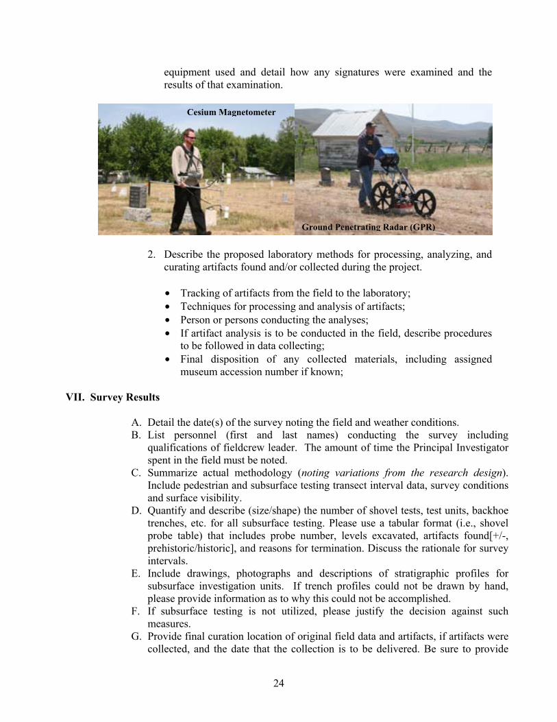
24
equipment used and detail how any signatures were examined and the results of that examination.
2. Describe the proposed laboratory methods for processing, analyzing, and curating artifacts found and/or collected during the project.
• Tracking of artifacts from the field to the laboratory; • Techniques for processing and analysis of artifacts; • Person or persons conducting the analyses; • If artifact analysis is to be conducted in the field, describe procedures
to be followed in data collecting; • Final disposition of any collected materials, including assigned
museum accession number if known;
VII. Survey Results
A. Detail the date(s) of the survey noting the field and weather conditions. B. List personnel (first and last names) conducting the survey including
qualifications of fieldcrew leader. The amount of time the Principal Investigator spent in the field must be noted.
C. Summarize actual methodology (noting variations from the research design). Include pedestrian and subsurface testing transect interval data, survey conditions and surface visibility.
D. Quantify and describe (size/shape) the number of shovel tests, test units, backhoe trenches, etc. for all subsurface testing. Please use a tabular format (i.e., shovel probe table) that includes probe number, levels excavated, artifacts found[+/-, prehistoric/historic], and reasons for termination. Discuss the rationale for survey intervals.
E. Include drawings, photographs and descriptions of stratigraphic profiles for subsurface investigation units. If trench profiles could not be drawn by hand, please provide information as to why this could not be accomplished.
F. If subsurface testing is not utilized, please justify the decision against such measures.
G. Provide final curation location of original field data and artifacts, if artifacts were collected, and the date that the collection is to be delivered. Be sure to provide
Cesium Magnetometer
Ground Penetrating Radar (GPR)
25
copies of field notes and photographs with curated collection. If a tribe has notified the archaeologist of the presence of a sacred object or object of cultural patrimony that they are requesting be returned to the tribe, be sure and include a copy of the repatriation request form with your report (see Appendix F).
H. Describe types of artifacts, features and/or other cultural materials identified. If artifacts are collected, provide an artifact catalogue.
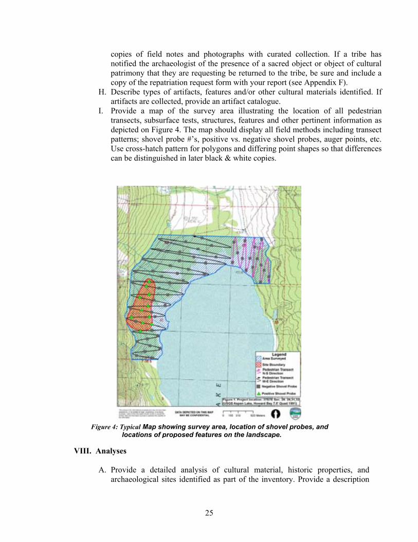
I. Provide a map of the survey area illustrating the location of all pedestrian transects, subsurface tests, structures, features and other pertinent information as depicted on Figure 4. The map should display all field methods including transect patterns; shovel probe #’s, positive vs. negative shovel probes, auger points, etc. Use cross-hatch pattern for polygons and differing point shapes so that differences can be distinguished in later black & white copies.
VIII. Analyses
A. Provide a detailed analysis of cultural material, historic properties, and archaeological sites identified as part of the inventory. Provide a description
Figure 4: Typical Map showing survey area, location of shovel probes, and locations of proposed features on the landscape.

26
of each property, drawings or photographs of the properties, and a description and drawings of any associated features.
B. Provide a table showing artifact distribution by probe/unit/level including information on location of sterile levels and reasons for termination.
C. Provide a description and the results of dating or analysis techniques. D. Provide a description and results of remote sensing techniques employed.
Discuss the value and use of the remote sensing program for determining presence or absence of archaeological deposits.
E. Describe the stratigraphic and temporal context of the archaeological deposits discovered during subsurface testing. This should be discussed in relationship to landform development history. If no archaeological deposits were located discuss the potential for false negative results, and use the depositional and landform analysis to review possible environmental reasons for the absence of archaeological deposits.
F. Discuss the eligibility recommendations of each property according to National Park Service standards and evaluate each for the National Register of Historic Places using the appropriate criteria. Solid, legally defensible justifications should be made for both eligible and ineligible determination.
IX. Conclusions and Recommendations
A. Results
1. Discuss the results of the project based on the research design and include a discussion of the findings based upon the developed hypotheses.
2. If no properties were located, identify probable explanation for a no properties finding. Include an analysis of the depositional environment for archaeological properties.
3. List persons and entities to whom the report was distributed.
B. Recommendations
1. Provide recommendations for future archaeology work, property management, and avoidance or mitigation options based on the nature of the undertaking or the significance of any identified cultural resource property.
2. Note if concurrence on determinations of site eligibility is being sought from SHPO or review of project activity effects.
2. If monitoring is recommended, provide a figure depicting the area recommended to be monitored. Explain why monitoring is necessary, what techniques should be employed to monitor, what resources could be encountered, and protocols in the event of a discovery of artifacts/features or human remains.
X. Bibliography
A. Provide a full citation of all published sources including author, title, place,

27
publisher, and date following the American Antiquity Style Guide. B. Indicate names and locations of all unpublished sources. C. Names and addresses of local informants plus names and dates of oral interviews. D. Indicate all published and unpublished sources used in dating artifacts located during survey.
XI. Tribal/Agency Consultation
A. Provide evidence of consultation with appropriate Native American tribes. List type of contact, frequency, contacts, and dates.
B. Provide evidence of consultation with SHPO with reference to the SHPO Case number (if known).
C. Provide evidence of consultation with the local preservation officer. D. Provide evidence of consultation with other governmental agencies. E. Provide copy of ARPA permit if on federal land. F. Provide copy of Oregon archaeological excavation permit, if applicable.
Include copy of any conditions requested by reviewing tribes or agencies G. Approval of report by the federal agency (the federal agency should formally
submit the report) and request for concurrence on eligibility decisions.
XII. Appendices
A. Location of original field data B. SHPO site inventory forms C. Informants D. Location of Artifacts – both temporary and permanent (if applicable) E. Osteological report F. Copies of specialized analyses (e.g., C14, Obsidian Sourcing, Blood Residue)
28
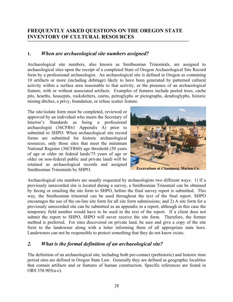
FREQUENTLY ASKED QUESTIONS ON THE OREGON STATE INVENTORY OF CULTURAL RESOURCES 1. When are archaeological site numbers assigned? Archaeological site numbers, also known as Smithsonian Trinomials, are assigned to archaeological sites upon the receipt of a completed State of Oregon Archaeological Site Record form by a professional archaeologist. An archaeological site is defined in Oregon as containing 10 artifacts or more (including debitage) likely to have been generated by patterned cultural activity within a surface area reasonable to that activity, or the presence of an archaeological feature, with or without associated artifacts. Examples of features include peeled trees, cache pits, hearths, housepits, rockshelters, cairns, petroglyphs or pictographs, dendroglyphs, historic mining ditches, a privy, foundation, or refuse scatter feature. The site/isolate form must be completed, reviewed or approved by an individual who meets the Secretary of Interior’s Standards as being a professional archaeologist (36CFR61 Appendix A) prior to submittal to SHPO. When archaeological site record forms are submitted for historic archaeological resources, only those sites that meet the minimum National Register (36CFR60) age threshold (50 years of age or older on federal lands/75 years of age or older on non-federal public and private land) will be retained as archaeological records and assigned Smithsonian Trinomials by SHPO. Archaeological site numbers are usually requested by archaeologists two different ways: 1) If a previously unrecorded site is located during a survey, a Smithsonian Trinomial can be obtained by faxing or emailing the site form to SHPO, before the final survey report is submitted. This way, the Smithsonian trinomial can be used throughout the text of the final report. SHPO encourages the use of the on-line site form for all site form submissions; and 2) A site form for a previously unrecorded site can be submitted as an appendix in a report, although in this case the temporary field number would have to be used in the text of the report. If a client does not submit the report to SHPO, SHPO will never receive the site form. Therefore, the former method is preferred. For sites discovered on private land, be sure and give a copy of the site form to the landowner along with a letter informing them of all appropriate state laws. Landowners can not be responsible to protect something that they do not know exists. 2. What is the formal definition of an archaeological site? The definition of an archaeological site, including both pre-contact (prehistoric) and historic time period sites are defined in Oregon State Law. Generally they are defined as geographic localities that contain artifacts and or features of human construction. Specific references are found in ORS 358.905(a-c).
Excavations at Champoeg, Marion Co.

29
ORS 358.905 Archaeological Objects and Sites provides definitions for terms: "Archaeological Site" means a geographic locality in Oregon, including but not limited to, submerged and submersible lands and the bed of the sea within the state's jurisdiction that contains archaeological objects and contextual associations of the archaeological objects with each other or biotic or geological remains or deposits. Examples of archaeological sites include but are not limited to shipwrecks, lithic quarries, house pit villages, camps, burials, lithic scatters, homesteads and town sites. In Oregon a locality must have 10 or more artifacts or a single feature to be considered a site. "Archaeological object" means an object that is at least 75 years old, is part of the physical record of an indigenous or other culture found in the state or waters of the state; and is material remains of past human life or activity that are of archaeological significance including, but not limited to, monuments, symbols, tools, facilities, technological by-products and dietary by-products. “Site of archaeological significance” means any archaeological site on, or eligible for inclusion on, the National Register of Historic Places as determined in writing by the State Historic Preservation Officer or any archaeological site that has been determined significant in writing by an Indian Tribe. All sites are generally treated as significant until they can be fully evaluated. 3. For inventory purposes, what distinguishes a historic property from an
archaeological property? SHPO considers historic properties to be existing elements of the built environment that include buildings, structures, sites, districts, and objects that date from the contact era. Any historic features that are in ruin (i.e. collapsed structures, foundations, etc.) and that are 75 years of age or older are considered archaeological sites (50 years of age on federal lands). Such properties must be recorded on an Oregon State Archaeology Site Form. If the resource in ruin is less than 50 years in age it should not be recorded on any formal form unless it is determined to possess exceptional significance, however, it can be noted within the survey report. For example, if a surveyor needs to record a historic irrigation canal that continues to serve this function, the canal is considered to be a “historic property” and should be recorded in the Historic Sites Database or 106 form. The Historic Sites Database should also be used if the irrigation canal has been abandoned but conceivably still could function for its intended purpose. However, using this same example, if the canal structure has been significantly breached or lies only in ruins or disconnected segments, the resource would be considered an historic archaeological site and documented on the Archaeology Site Form. For a specific listing of historic site types, how they are classified, and use of SHPO’s Archaeology Site Inventory Form, Isolate Inventory Form or the Historic Sites Database, please refer to the Site Type Table (Page 14).
Golden Church, Josephine, Co.

30
4. Will SHPO give inventory numbers to cultural landscapes? SHPO does not assign inventory numbers to cultural landscapes as a class of properties. Those wishing to document cultural landscapes should follow the NPS guidelines and provide the associated contributing properties on the respective SHPO archaeological site record form or Historic Sites Database and/or the NPS National Register form. 5. Will SHPO reject inventory forms or reports? SHPO will reject any submitted archaeological site or isolate forms, or Historic Sites Database submittal/Section 106 form or cultural resource survey reports when the information provided is deemed to be incomplete by SHPO reviewers. Each form should have all of the required information, including, but not limited to the following: location details, required maps, photographs, boundary definition, cultural context, site description, setting, and property ownership.
SHPO will also return forms that are not submitted on approved State of Oregon archaeology site forms1, the Historic Sites Database, Section 106 forms or National Register of Historic Places forms. Any isolate find form will be accepted as long as it contains the pertinent location and description data and includes a USGS map of the find’s location. [A sample Isolate Form is available on the SHPO web page.] Forms may also be rejected if they are not completed, reviewed and/or approved by a professional meeting the Secretary of
Interior’s Standards for the relevant discipline or if they contain erroneous or false information.
Note that SHPO does not assign Smithsonian Trinomials to archaeology sites that are less than 50/75 years old. If you feel you have an important archaeological site from the recent past that you would like to survey, please contact SHPO before proceeding. Currently SHPO is encouraging the submittal of surveys for resources that are less than 50 years old that have exceptional significance. This is part of a program developed to encourage the discussion and appreciation of architecture that best represents the last 50 years. If you have identified an important historic property from the recent past that you would like to survey, please contact SHPO’s Survey and National Register staff, Ian Johnson (503-986-0678) or Cara Kaser (503-986-0784) for additional information.
1 The Microsoft WORD Archaeological Site Record form is not accepted by the Oregon SHPO
Lewis & Clark Hotel, Centralia
Tseriadan, Curry, Co.

31
6. How often should site inventory forms be updated? Existing archaeology site forms should be updated anytime an archaeological site or traditional cultural place is visited by an archaeologist and a change in size, composition or status (e.g., condition/integrity) is noted. A site form update should be considered a part of standard survey and reporting procedures. SHPO expects existing archaeological site record forms to be updated when new information about the site arises or becomes available, or if the site inventory form is more than 10 years old. 7. What are the specific laws and regulations that protect archaeological
resources in the state? In Oregon State several laws protect archaeological sites and Native American graves. These include the ORS 97.740 (the Indian Graves and Protected Objects Act), ORS 358.905-962 (the Archaeological Objects and Sites Act), ORS 390.235-240 (Archaeological Sites and Historical Materials), OAR 736-051-0000 to 0090 (Administrative Rules for Archaeological Permits), ORS 166.076 (Abuse of a Memorial of the Dead), and ORS 166.085 (Abuse of a Corpse in the Second Degree). For the full text of the various laws visit our website at: www.oregonheritage.org . 8. What do I do if I find human remains? By law, all persons who know of the existence and location of human remains suspected to be native Indian must notify the State Police, the State Historic Preservation Office, Commission on Indian Services (CIS), and the appropriate Indian Tribe(s) (as determined by CIS) [ORS 97.745(4)]. This must be done in the most expeditious manner possible. Any person engaging in ground disturbing activity that encounters skeletal human remains on private land must cease all activity which may cause further disturbance to the remains, make a reasonable effort to protect the area from further disturbance, and report the presence and location of those remains to the landowner, State Police, the State Historic Preservation Office, and the Commission on Indian Services (CIS) [ORS 358.920(6)]. The nine federally recognized tribes in Oregon have developed a Protocol for dealing with the inadvertent discovery of human remains which the SHPO supports. It is included below. We encourage contactors to incorporate this Protocol within future research designs.
L’Amourita Apartments, Seattle
Sunken Village, Multnomah Co.

32
Treatment of Native American Human Remains Discovered Inadvertently or Through Criminal Investigations on Private and Public, State-Owned Lands in Oregon Native American burial sites are not simply artifacts of the tribe’s cultural past, but are considered sacred and represent a continuing connection with their ancestors. Native American ancestral remains, funerary objects, sacred objects and objects of cultural patrimony associated with Oregon Tribes are protected under state law, including criminal penalties (ORS 97.740-.994 and 358.905-.961). The laws recognize and codify the Tribes’ rights in the decision-making process regarding ancestral remains and associated objects. Therefore both the discovered ancestral remains and their associated objects should be treated in a sensitive and respectful manner by all parties involved. Identification of Human Remains
Oregon laws (ORS 146.090 & .095) outline the types of deaths that require investigation and the accompanying responsibilities for that investigation. The law enforcement official, district medical examiner, and the district attorney for the county where the death occurs are responsible for deaths requiring investigation. Deaths that require investigation include those occurring under suspicious or unknown circumstances.
If human remains that are inadvertently discovered or discovered through criminal investigations are not clearly modern, then there is high probability that the remains are Native American and therefore ORS 97.745(4) applies, which requires immediate notification with State Police, State Historic Preservation Office, Commission on Indian Services, and all appropriate Native American Tribes. To determine who the “appropriate Native American Tribe” the responsible parties should contact the Legislative Commission on Indian Services (CIS). To determine whether the human remains are Native American the responsible parties should contact the appropriate Native American Tribes at the initial discovery. It should be noted that there may be more than one appropriate Native American Tribe to be contacted.
If the human remains are possibly Native American then the area should be secured from further disturbance. The human remains and associated objects should not be disturbed, manipulated, or transported from the original location until a plan is developed in consultation with the above named parties. These actions will help ensure compliance with Oregon state law that prohibits any person willfully removing human remains and/or objects of cultural significance from its original location (ORS 97.745).
All parties involved and the appropriate Native American Tribes shall implement a culturally sensitive plan for reburial.
Notification
State law [ORS 97.745 (4)] requires that any discovered human remains suspected to be Native American shall be reported to-
1. State Police (current contact Sgt. Chris Allori, Department of State Police, office phone 503-731-4717, cell 503-708-6461.
2. State Historic Preservation Office (SHPO) (503) 986-0674 or 986-0675

33
3. Commission on Indian Services: (CIS) : Karen Quigley (503) 986-1068 4. Appropriate tribes as designated by CIS

34
APPENDICES

35
.
APPENDIX A
CULTURAL RESOURCES SURVEY COVER SHEET

36
STATE OF OREGON
CULTURAL RESOURCES SURVEY COVER SHEET
Please submit reports unbound.
Author(s) Name: Last First Title of Report: Date: District/Contractor: Agency/Client: Agency Report Number:
County (ies): Township: N/S Range: E/W Section: Quad(s): Project Acres: Survey Acres: CD Submitted? Yes No Does this replace a draft? Yes No Project activity: Archaeological Permit No.: Field note location: Curation Location: Accession # Sites Found? Yes No Prehistoric #: Historic #: Historic Properties. Found? Yes No Historic Property #: TCP(s) found? Yes No Isolates Found? Yes No Isolate #: Keywords: SHPO Trinomial #: Temporary site # Please be sure that any electronic version of a report submitted to Oregon SHPO has its figures, appendices, attachments, correspondence, graphic elements, etc., compiled into one single PDF file. Thank you!
REPORT CHECK LIST
Report should contain the following items:
• Location, legal description (T,R,S) with USGS map
• Clear objectives and methods
• A summary of the results of the survey
• A report of where the survey records and data are stored
• A research design that:
• Details survey objectives • Details specific methods • Details expected results • Details area surveyed including map(s) and legal
location information • Details how results will feedback in the planning
process (i.e., recommendations, future work)
37
APPENDIX B
ARCHAEOLOGY SITE INVENTORY FORM

38
APPENDIX C
ARCHAEOLOGY ISOLATE INVENTORY FORM

39
APPENDIX D
OREGON SHPO CLEARANCE FORM

40
APPENDIX E
REQUEST FOR REPATRIATION OF ARCHAEOLOGICAL MATERIAL FROM OREGON NON-FEDERAL PUBLIC & PRIVATE LANDS

41