start and finish: red brow wood car park. i - st helens · (15m) wide by 70ft. (23m) high. ......
TRANSCRIPT

crossed the footbridge, follow the stonefootpath upslope to the right.
(556 metres) Follow the stone footpath tothe left, heading south along the edge of a field.Bradlegh Old Hall will come into view on theright.
The fortified Bradlegh Hall used tostand where the main farmhouse is
now, and the remains of the moat are stillpresent, along with a 15th Centurygatehouse. The Hall was once the home ofSir Piers Legh whose family held the titleof ‘Lords of the Manor’. It is said that in1482 Richard, Duke of Gloucester – wholater became Richard III - stayed here onhis way to take Berwick Castle.
Before a hedgerow obscures the view, theSankey or Nine Arches railway viaduct can also beseen looking off northwest to the far right.
This Grade 1 listed viaduct was builtin 1830 to carry the world’s first
passenger railway from Liverpool toManchester. The massive structure wasengineered by George Stephenson and cost£45,000, a huge total at the time. Each of itsnine arches is 50ft. (15m) wide by 70ft.(23m) high. This was to accommodate thetall-masted Mersey Flat boats that used totransport goods on the St.Helens Canal thatpassed through the third arch from theright.
(926 metres) Continue around a metalvehicle gate, watching out for passing vehiclesaccessing Bradlegh Old Hall and New Bradley HallFarm. Continue south along a short section ofprivate road until you reach Hall Lane.
4
3
(1.1km) Turn left and walk around vehicleaccess barriers along this traffic-free section ofHall Lane, heading in an easterly directionfollowing the edge of Gypsy Wood. You willeventually encounter another set of vehicleaccess barriers before Hall Lane Farm appearson your left.
(2km) At Hall Lane Farm, there is a choiceof two routes - the longer blue route or theshorter red route.
The blue route follows field edge footpathsthat are unsurfaced and can be heavy goingat times. Prolonged periods of heavy rainfallcan lead to sections of the route betweenPoints 6 and 15 being flooded, given that thisarea is a flood plain.
To follow the red route, continue headingsoutheast along Hall Lane for 290 metres toWatercross & Hall Lane Stables. Havingpassed the private access road into thestables, turn left at Point 6a onto asignposted footpath. Follow this footpathnorth over Sankey Brook via the footbridge,passing back into the Borough of St.Helens.After 310 metres, this footpath eventuallyjoins the Sankey Canal towpath at Point 16.From here, continue left, following the canalheading north to Point 17 and then to thefinish at Red Brow Wood car park (Point 1).Total distance walked for the shorter redroute is 4km (2.5 miles).
To follow the longer blue route from Point 6,turn right onto a signposted footpath thatimmediately crosses a field. In the distance, asmall waymarker is positioned at the start of adrainage ditch. Continue along the footpath in asoutherly direction keeping this ditch to your left.The footpath then follows a line of maturebroadleaf trees along the field edge.
6
5After passing a small pond in a wooded area onyour left, Stoneyard Cottage comes into view.
At the rear boundary of Stoneyard Cottage, turnleft through the line of mature trees. Keepfollowing the narrow footpath south along theedge of a garden and then private drive, beforenegotiating a small brick stile positioned to theright of an electric gate pillar post, finally toemerge on Alder Lane.
(2.4km) At Alder Lane, turn right and walkwest along the footway for approximately 330metres to reach Point 8.
(2.7km) Look out for passing vehiclesbefore carefully crossing over Alder Lane to headsouth along a field-edge footpath. You will alsopass a small pond before arriving at Point 9.
(3.1km) A waymarker post will appear toyour right at this junction of footpaths. Continuestraight on, heading south along a more definedfarm access track.
(3.2km) Look out for a finger post on yourright as you approach another footpath junction.Continue following the defined farm access trackto the left, heading eastwards. Afterapproximately 400 metres, you will encounter a
small mixed wooded areacontaining a
pond.
7
8
9
10
Head south from the car park to cross theSt.Helens Canal via the old swing bridge.
The Act of Parliament authorisingconstruction of this historic canal
for navigation was passed on 20th March1755. Henry Berry from Parr, who at thetime was Liverpool’s Second DockEngineer, was appointed Engineer for thescheme. Construction work began in 1755and lasted until 1757 at which point thecanal was opened to traffic. This allowedtransportation of coal from theLancashire coalfield mines to the growingchemical industries of Liverpool, togetherwith iron ore and corn. These industriesrapidly expanded, and spread back alongthe line of the canal to St.Helens,Haydock, Earlestown and Widnes, whichwere small villages until this period. Thecanal was thus an important factor in theregions industrial growth.
Continue south from the old swing bridge,following a narrow tarmac footpath into a smallwooded area, before arriving at anotherfootbridge that crosses the Sankey Brook.
This once clear trout stream was sobadly polluted by various local
industries that it was nicknamed the‘Stinking Brook’. Following the demise ofthese industries, the brook’s water qualityhas dramatically improved again, to thepoint that it is now home to an increasingnumber of birds and fish, as well asfreshwater invertebrates such as thestriking Banded Demoiselle damselfly.
(136 metres) The footbridge over theSankey Brook marks the Council boundarybetween St.Helens and Warrington. Having
2
Start and Finish:Red Brow Wood car park.Nearest postcode WA12 8RABy car, from Bradlegh Road, follow signs for the carpark down a narrow tarmac access road. Please notethat there is a maximum vehicle height barrier set at2 metres.
By public transport, regular bus and train servicesstop at Earlestown, approximately 1km to the north.Some bus services also extend to Bradlegh Road.
To walk from Earlestown to the car park, start onEarle Street and head south down Junction Lane.Follow the eastern side of Sankey Valley IndustrialEstate service road before heading down past the‘Mucky Mountains’ to the Red Brow Wood car park.This 1km walk should take around 20 minutes.
Enjoy your walk!
(Start & finish) Red Brow Wood car park.
The car park gets its name from theadjacent red sandstone outcrop.
Sandstone quarried from here was usedfor local building works, including theNine Arches railway viaduct and possiblythe nearby Bradlegh Old Hall. If you lookclosely, the tool marks made by masonsin past centuries can still be seen on thevertical rock face at thenorth side of thecar park.
1
i
i
i
i
i
© Crown copyright and database rights 2012. Ordnance Survey LicenceNumber LA100018360. You are not permitted to copy, sub-license,distribute or sell any of this data to third parties in any form.
Red Brow Wood
1
23
4
5
6
6a
7
8
9
1011 12 13
14
15
16
17
START/FINISH
1 kilometre
KeyRed route 4km (2.5m)Blue route 8km (5m)
Banded Demoiselle damselfly
Start/Finish
Red Brow Wood car park. Nearest postcode WA12 8RA.Map Ref: SJ 576 945
Sheet 108 1:50000 OS map
Sheet 276 1:25000 OS map
Longer Route – 8km (approx. 5 miles)Estimated time – 2.5 hours (Blue route)Going – Medium
Shorter Route – 4km (approx. 2.5 miles)Estimated time – 1.25 hours (Red route)Going – Easy
Further InformationTo find out more about walks in your localarea, please contact St.Helens Ranger Serviceon 01744 677772, [email protected]
www.sthelens.gov.uk/rangers
Contact Centre,Wesley House, Corporation StreetSt.Helens WA10 1HF
Tel: 01744 676789Minicom: 01744 671671Fax: 01744 676895Email: [email protected] www.sthelens.gov.uk
Please contact us to request translation ofCouncil information into Braille, audio tapeor a foreign language.
Welcome toBradlegh LoopTrail & Map
The original West Coast Railway Lineopened on 25th July 1831 and ran
between Earlestown and Warrington BankQuay. Through trains had to negotiate slowrail curves at Earlestown and ParksideJunction to the east of Newton-le-Willows.A more direct route between Winwick andGolborne Junctions was opened on 1stAugust 1864 to facilitate quicker passengerjourney times and increased freight trafficand is the main line used today.
(6.3km) Continue over Newton Brook via afootbridge, passing from Warrington back into theSt.Helens area. Newton Brook was previouslyculverted below the open water canal, but nowcuts through the in-filled canal by way of aconcrete and steel-piled channel.
The Sankey Canal Restoration Society(SCARS) was formed in 1985, with thehelp and encouragement of the
St.Helens Groundwork Trust. The principalaim of the Society is to achieve the fullrestoration of the canal. To bring this about,the Society actively publicises and promotesthe cause of the canal, particularly in thethree administrative Boroughs throughwhich it runs – Halton, St.Helens andWarrington.
(6.7km or 2.6km for the shorter route)Continue following the canal north to Hey Lock.This canal section is well-used by the Newton-le-Willows Angling Association.
The canal contains a healthy population ofcoarse fish, making it popular withwaterbirds such as Kingfisher andGrey Heron, while other locally rare
species such as Goosander and Great
15
16
an undefined field footpath in a southerly direction,aiming to the left of a powerline pole positionedahead. Shortly after passing under the powerline,you will see another finger post clearly marking thecontinuation of this footpath. Continue along thefield edge following the side of Phipp’s Brook and ahedgerow before reaching Old Alder Lane.
(4.5km) At Old Alder Lane, turn right andhead east along the tarmac road, looking out forpassing vehicles. You will firstly cross Sankey Brookand then Causey Bridge. As the road turns again,you arrive at a narrow linear wooded area.
(5.0km) In the wooded area, take a narrowtarmac track off to your left and proceed northwestalong the Sankey Valley, following the former canaltowpath. Immediately to the left is the now filled inSt.Helens Canal which can be identified by unevenraised and unmanaged rough ground.
The former cargo along this canalsection was raw sugar for the Sankey
Sugar Works at Earlestown, shipped fromLiverpool to where coal was transported theother way. The ending of sugar traffic in1959 led to the closure of the canal in 1963,although the canal north of the SugarWorks had already closed in 1931.
As you head northwest, fields appear on your rightused mainly for horse grazing.
(5.7km) Continue beneath Alder Lane Bridge,constructed in 1954. Here the tarmac trackswitches to the left side of the former canal. Asyou continue northwards, you will see Alder RootFarm on the right operating an equestrian businessand a golf course, between which is the prominentWinwick Junction on the West Coast Railway Line.
13
12
14
Northern Diver have also been seen here.Insect life is abundant, and both the BrownHawker and Migrant Hawker dragonfliescan be seen skimming the water’s surfacein summer.
(6.9km or 2.9km for the shorter route)The site of the old Hey Lock is positioned to theright of the towpath.
Nearby is Vulcan Village, wherethousands of railway locomotiveswere built in the former engine
works established in the 1830s. Theadjoining streets of workers' cottages havesince been preserved and now form adistinctive conservation area.
Continue heading north along the canal towpath.After a kilometre, you will finally reach the oldswing bridge over the canal.
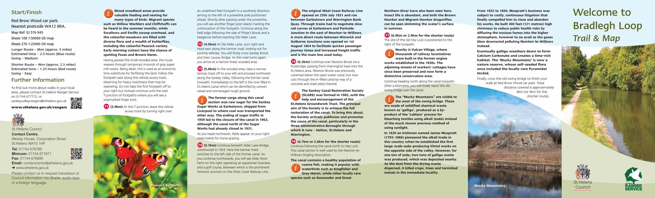
The “Mucky Mountains” are visible tothe west of the swing bridge. These
are made of solidified chemical wasteknown as ‘galligu’, produced as a by-product of the ‘Leblanc’ process forbleaching textiles using alkali (soda) insteadof the much slower previous method ofusing sunlight.
In 1830 an Irishman named James Muspratt(1793-1886) pioneered the alkali trade inthis country when he established the firstlarge-scale soda-producing Vitriol works onthe opposite side of the valley. However, forone ton of soda, two tons of galligu wastewas produced, which was deposited nearby.As the dust from the drying wastedispersed, it killed crops, trees and tarnishedmetals in the immediate locality.
17
From 1832 to 1850, Muspratt’s business wassubject to costly, continuous litigation thatfinally compelled him to close and abandonhis works. He built 400 feet (121 metres) highchimneys to reduce public health risks bydiffusing the noxious fumes into the higheratmosphere, however to no avail as the gasesblew downwind polluting Newton-le-Willowsinstead.
Eventually galligu weathers down to formCalcium Carbonate and creates a lime-richhabitat. The ‘Mucky Mountains’ is now anature reserve, whose self-seeded floraonce included the locally rare PyramidalOrchid.
Finally, cross the old swing bridge to finish yourwalk at Red Brow Wood car park. Total
distance covered is approximately8km (or 4km for the
shorter route).
Mixed woodland areas providevaluable feeding and nesting formany types of birds. Migrant species
such as Willow Warblers and Chiffchaffs canbe heard in the summer months, whileSwallows and Swifts swoop overhead, andthe colourful meadows are filled withdiverse flora and a wealth of butterflies,including the colourful Peacock variety.Early morning visitors have the chance ofspotting Foxes and Brown Hares.
Having passed the small wooded area, the routeweaves through temporary mounds of grey papermill waste. Being alkali, this is used as an economiclime substitute for fertilizing the land. Follow thefootpath east along this vehicle access track,observing for heavy machinery that may beoperating. Do not take the first footpath off toyour right but instead continue until the next T-junction of footpaths where you will see awaymarked finger post.
(3.9km) At this T-junction, leave the vehicleaccess track by turning right over
11
i
i
i
i
i
i
Peacock butterfly Mucky Mountains
i