staff report - kitsap county, washingtoncompplan.kitsapgov.com/documents/bremerton west...
TRANSCRIPT
1
STAFF REPORT
Permit Number: 15 00522 | Bremerton West Ridge
DATE: November 9, 2015
TO: Kitsap County Board of Commissioners; Kitsap County Planning Commission
FROM: Katrina Knutson, AICP, Senior Planner, DCD and
Jeff Arango, AICP, Senior Associate, BERK Consulting
RE: Bremerton West Ridge Reclassification Request
APPLICATION INFORMATION
1. Applicant Name: Mark Mauren (applicant and authorized agent/representative); Bremerton West
Ridge, LLC (owner)
2. Parcel Number: 202401-2-012-2005, 202401-2-025-2000, 202401-3-004-2003, 202401-2-026-2009
(City of Bremerton jurisdiction), 202401-2-011-2006, 202401-2-024-2001, 202401-3-002-2005
3. Address or location information: 818 Archie Ave W, Bremerton; see Attachment 1.
4. Current Land Use: Undeveloped, resource production; see Attachment 3.
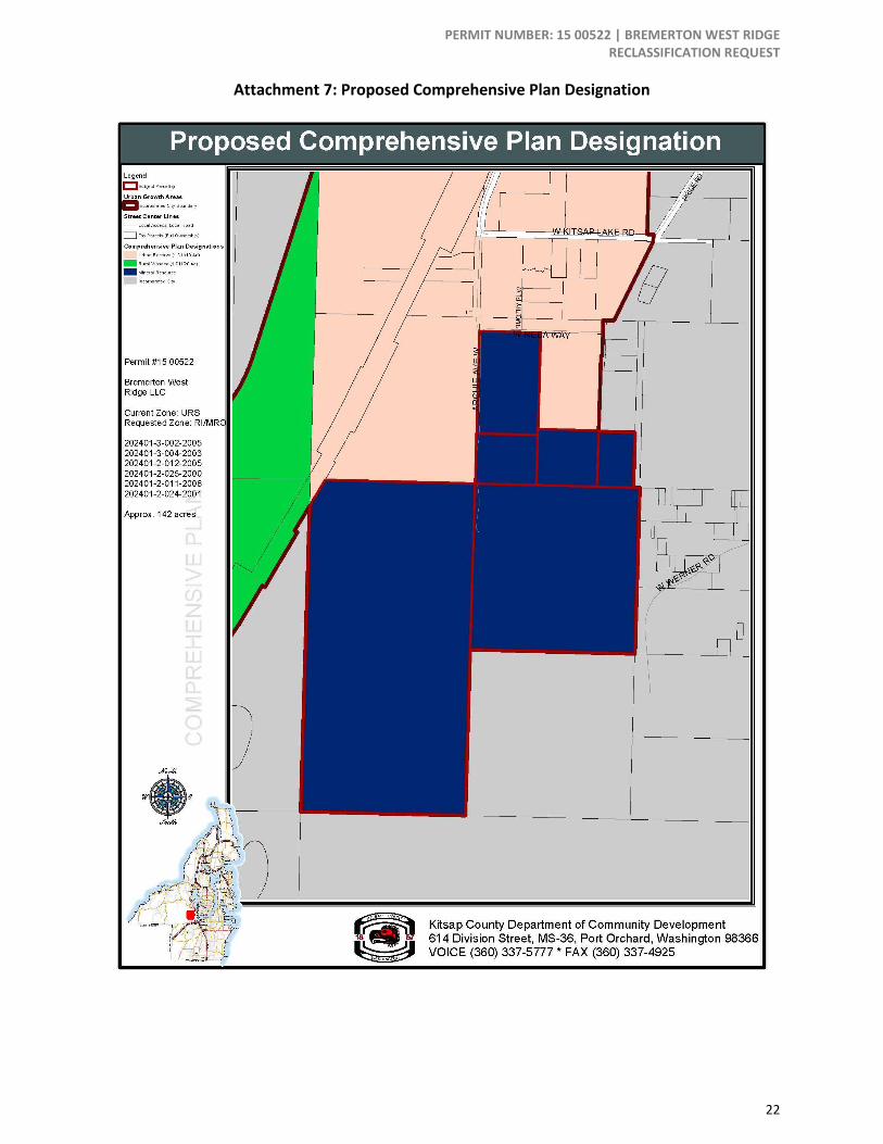
5. Current Comprehensive Plan Map Designation: Urban Reserve (URS)
6. Proposed Comprehensive Plan Map Designation: Rural Industrial (RI)
7. Current Zoning: Urban Reserve (URS) (6 parcels), Incorporated City - Bremerton (1 parcel); see
Attachment 4.
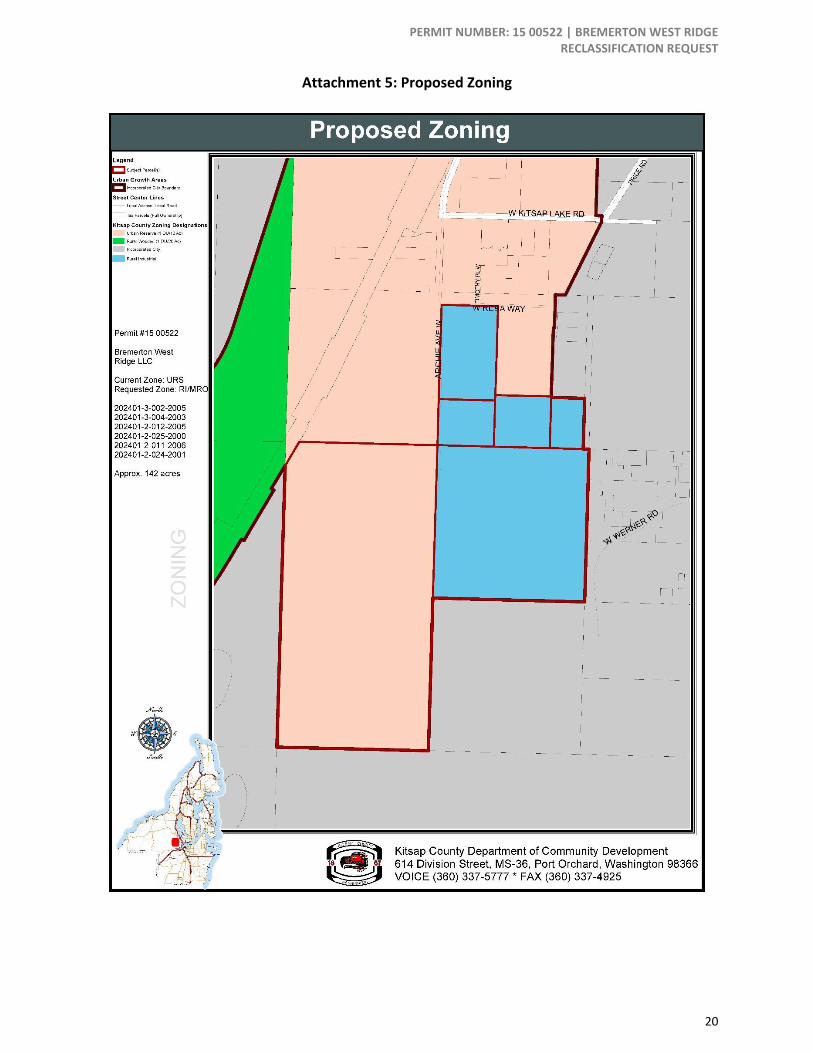
8. Proposed Zoning: Rural Industrial (RI) with Mineral Resource (MR) overlay; see Attachment 5.
9. Lot size: Site involves 7 parcels, 142 acres.
10. Comprehensive Plan Alternatives: Request included with Comprehensive Plan Update 2016
Supplemental Environmental Impact Statement (SEIS) Alternative 2 and Alternative 3. Parcel
202401-3-002-2005 is designated as Rural Protection (RP) in both alternatives.
Application Materials Project Application
Environmental Checklist
PERMIT NUMBER: 15 00522 | BREMERTON WEST RIDGE RECLASSIFICATION REQUEST
2
Ownership Certification
Reclassification Request Criteria
Application Request The applicant seeks three Comprehensive Plan Map and Zoning Map Amendments:
Kitsap Quarry (parcel #’s - 202401-2-026-2009*, 202401-2-011-2006, 202401-2-024-2001, 202401-
2-012-2005, 202401-2-025-2000, 202401-3-004-2003)
o Mineral Resource overlay (MRO) Request- 4 parcels that are part of Kitsap Quarry (202401-2-
011-2006, 202401-2-024-2001, 202401-2-012-2005, and 202401-2-025-2000). Currently only
Parcel # 202401-3-004-2003 has a MRO, however, all of the above parcels are part of the mining
operation (Access road and stormwater retention facilities) and currently do not have am MRO.
o Zoning change Urban Reserve (URS) to Rural Industrial (RI) – Change 5 parcels in Kitsap Quarry
(See above parcel list) current zoning and designation from URS to RI. These parcels are
currently zoned residential but given that Kitsap Quarry is expected to be the primary processing
facility for Ueland Tree Farm and Kitsap Quarry for the next 50+ years the applicant believes it
appropriate that these parcels be zoned industrial.
o *Parcel 202401-2-026-2009 – This parcel is within the City of Bremerton and not under County
jurisdiction. Therefore, the parcel should not be considered as part of the amendment request.
MRO Request (Parcel # 202401-3-002-2005) - The rock formation for Kitsap Quarry extends into the
SE corner of Parcel # 202401-3-002-2005. We are requesting a MRO designation on Parcel # 202401-
3-002-2005 so we can mine this valuable mineral resource concurrently with the existing Kitsap
Quarry mining operation.
BACKGROUND
The subject property is located south of Kitsap Lake at Archie Avenue W with access from Werner Road.
The City of Bremerton city limits are near the subject property to the north, east, and south. All parcels
except 202401-2-026-2009 are under County jurisdiction and are currently designated on the
Comprehensive Plan Map and Zoning Maps as URS. Parcel 202401-3-004-2003 also has an MRO and
according to the Kitsap County Assessor, has a property class for mining and related services. The other
subject parcels are currently classified by the Assessor as undeveloped except for Parcel #202401-3-002-
2005, which is classified as forest land. The applicant states that the subject parcels are currently being
used for forestry and as a rock quarry.
The subject properties are 142 acres and within the Ueland Tree Farm (UTF), an approximately 1,646 acre
area that includes forestry, mining activities, and public trails. The Kitsap Quarry, which has been in
operation since 1962, was acquired by UTF in 2012 and was not being actively mined at the time. Mining
resumed at the Kitsap Quarry soon after UTF purchased the site. The amendment request includes the
Kitsap Quarry parcels associated with the active mine and a large undeveloped and forested parcel
(#202401-3-002-2005) west of the quarry that was purchased by UTF in 2013. The parcel is currently being
used for timber harvest. A minor Timber Harvest permit was issued by Kitsap County for the parcel on
June 18, 2015.
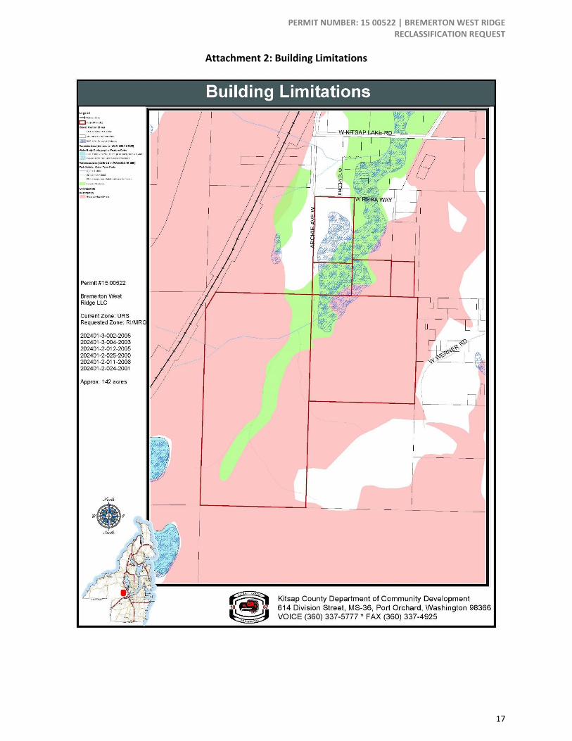
The applicant states that the subject property contains surveyed and potential wetlands and steep slopes,
see Attachment 2. The applicant also states that Kitsap Creek and Kitsap Lake are on or near the subject
parcels.
PERMIT NUMBER: 15 00522 | BREMERTON WEST RIDGE RECLASSIFICATION REQUEST
3
In 2006, a geologic survey of the area was conducted to study the feasibility of mining activity and development on the UTF site, which at the time did not include the subject parcels. UTF began the Conditional Use Permit (CUP) application process for mineral resource development in 2007 (DCD File No. 07-449975). In 2010 a gravel mine, two rock quarries and a concrete batch plant on 152 acres within UTF were approved by the Kitsap County Hearing Examiner. Following a request for reconsideration, UTF received the final Conditional Use Permit (CUP) for mineral extraction in 2011. In 2014 a permitted access road was constructed between Kitsap Quarry and Werner Road and a future connection to UTF is proposed and the subject of a recently completed Supplemental EIS (ESA 2015). In 2015, UTF and Kitsap County began a Development Agreement in accordance with the approved Mineral Resource Development CUP to develop sand, gravel and basalt mineral mines on approximately 118 acres, within a project site of approximately 327 acres on the UTF site. The Development Agreement was recommended for approval on April 8, 2015 by the Kitsap County Hearing Examiner and by the County Commissioners approved the agreement on April 13, 2015. The 2015 CUP Modification was approved on September 22, 2015 (DCD File No. 14-02844 and 15-03289) and included the subject properties as an additional development area for UTF.
Surrounding Zoning and Land Use Adjacent parcels to the north and west are part of unincorporated Kitsap County and are zoned URS.
Adjacent parcels to the east and south are within the City of Bremerton city limits and zoned Industrial.
See Exhibit 1 and Attachment 3.
Exhibit 1. Summary of Surrounding Areas Current Zoning and Land Use
Surrounding Areas Current Zoning Current Land Use
North URS Residential
Undeveloped
East City of Bremerton Resource Production
Undeveloped
South City of Bremerton Resource Production
West City of Bremerton
Rural Wooded (RW)
Resource Production
Undeveloped
Current Future CP Map and Zoning Designations The current Comprehensive Plan Map and Zoning Map designations for property is Urban Reserve (URS),
which is described similarly in the Comprehensive Plan and in the Kitsap County Zoning Code. The
Comprehensive Plan describes the URS designation as:
Urban Reserve: This designation indicates areas that may be suitable for inclusion in the UGA in the
future. It is implemented by the URS zone.
The URS zone is described in the Kitsap County Code as:
Urban Reserve (URS): This zone is intended to allow continued rural development while
discouraging land use patterns that could foreclose options for inclusion into future UGAs and their
higher densities and land use intensities. This zone may also apply to properties which are being
considered for non-residential use.

PERMIT NUMBER: 15 00522 | BREMERTON WEST RIDGE RECLASSIFICATION REQUEST
4
Proposed Future CP and Zoning Designations As described in the current Comprehensive Plan, the proposed Comprehensive Plan and Zoning Map
designations are Rural Industrial (RI) with the MRO. The Comprehensive Plan describes RI as:
Rural Industrial: The intent and function of the RI Zone is to provide for small-scale light industrial,
light manufacturing, recycling, mineral processing, and resource-based goods production uses that
are compatible with rural character and do not require an urban level of utilities and services.
Exhibit 2 provides a comparison of allowed land uses between the RI and RP zones.
The Kitsap County Code describes the RI Zone and MRO as:
Rural Industrial. This zone provides for small-scale light industrial, light manufacturing, recycling,
mineral processing, and resource-based goods production uses that are compatible with rural
character and do not require an urban level of utilities and services.
Mineral Resource overlay (MRO). The intent of this overlay is to protect and enhance significant
sand, gravel and rock deposits as identified mineral resource lands. It is also used to ensure the
continued or future use without disrupting or endangering adjacent land uses, while safeguarding
life, property, and the public welfare. Provisions of state statutes applicable to Kitsap County
pertaining to surface mining are hereby adopted by reference.”
The following table compares the existing and proposed zoning designations for selected allowed uses.
See Exhibit 2. Aggregate extraction (i.e. mineral extraction) is not a permitted or conditional use in the
existing URS zone, but is a permitted use in the MRO and a conditional use in the RI zone. The addition of
the MRO with the exiting URS overlay would allow for aggregate extraction.
Exhibit 2. Selected Allowed Uses (KCC 17.381.040.E)
Selected Uses RI (proposed
zoning)
MR (proposed
zoning
overlay)
URS
(current
zoning)
Residential Uses
Dwelling, existing P P P
Dwelling, single-family detached X X P
Dwelling, multi-family X X X
Mobile homes X P P
Commercial/Business Uses
Automobile repair and car washes C X X
Conference center X X X
General retail merchandise stores (less than 4,000 s.f.) X X X
Restaurants X X X
Industrial Uses
Manufacturing and fabrication, light C X X
Manufacturing and fabrication, medium C X X
Manufacturing and fabrication, heavy X X X
Rock crushing C C X

PERMIT NUMBER: 15 00522 | BREMERTON WEST RIDGE RECLASSIFICATION REQUEST
5
Selected Uses RI (proposed
zoning)
MR (proposed
zoning
overlay)
URS
(current
zoning)
Storage, vehicle and equipment C X X
Top soil production, stump grinding ACUP C X
Warehousing and distribution ACUP X X
Resource Land Uses
Aggregate Extraction Sites C P X
Legend: P = Permitted, X = Prohibited, ACUP = Administrative Conditional Use, C = Conditional Use
Exhibit 3 provides a comparison of development standards allowed between the RI and URS zones. Both
zones have the same height limitation of 35’ and the URS zone has additional standards for minimum lot
size, depth, width, and minimum and maximum residential densities.
Exhibit 3. Selected Development Standards Comparison (KCC 17.382.100)
Density and Dimensions RI (proposed zoning) URS (current
zoning)
Base/Maximum density (du/acre) NA 1 du/10 acres
Minimum lot size (acre) None 10
Lot width (feet) NA 140
Lot depth (feet) NA 140
Maximum height (feet) 35 35
Maximum impervious surface coverage (%)
85 NA
PUBLIC COMMENTS
The applicant states that the City of Bremerton provided a transportation concurrency letter to Kitsap
County for the construction of a private haul road from Kitsap Quarry to Werner Road. See Attachment 9.
EVALUATION
Site specific reclassification requests to the Comprehensive Plan must be reviewed in accordance with the
criteria outlined in the Kitsap County Code (KCC) Chapter 21.08. Applicable review criteria for site specific
reclassification requests are in sections KCC 21.08.070.A and KCC 21.08.070.D.
General Criteria (KCC 21.08.070.A) A. General. For each proposed amendment to the Comprehensive Plan the review authority, the
planning commission in reaching its recommendation, and the board of commissioners in making its
decision, shall develop findings and conclusions, which demonstrate:

PERMIT NUMBER: 15 00522 | BREMERTON WEST RIDGE RECLASSIFICATION REQUEST
6
1. How circumstances related to the proposed amendment and/or the area in which the property
affected by the proposed amendment is located have substantially changed since the adoption of the
Comprehensive Plan or applicable development regulations;
Circumstances related to the proposed amendment or area in which the property is located have
substantially changed since the adoption of the Comprehensive Plan. UTF purchased the Kitsap Quarry
properties in 2012 and the forested parcel to the west in 2013. UTF received a CUP in 2011 for aggregate
extraction, signed a development agreement with Kitsap County in 2015, and received a CUP modification
in 2015 that includes approval of the South Haul route through the subject property to Werner Road.
2. How the assumptions upon which the Comprehensive Plan is based are no longer valid, or there is
new information available which was not considered during the adoption of, or during the last annual
amendment to, the Comprehensive Plan or development regulations; and
The assumptions upon which the Comprehensive Plan is based are still generally valid. Updated growth
targets and capacity analysis is being conducted as part of the 2016 Comprehensive Plan update, but in
general that process will not change the assumptions relative to the subject property and proposed
amendment.
In Alternative 2 and Alternative 3, the subject parcels with the exception of parcel 202401-3-002-2005 are
designated as RI. Parcel 202401-3-002-2005 and adjacent parcels (not part of subject parcels) are
designated as being changed to Rural Protection (RP).
3. How the requested redesignation is in the public interest and the proposal is consistent with the
Kitsap County Comprehensive Plan.
The RI zone may not be consistent with the Kitsap County Comprehensive Plan. The subject parcels are
adjacent to City of Bremerton jurisdiction. The current URS zoning is suitable given the area’s close
proximity to the City on the north, east and south. Additionally, other areas in the County with the MRO
in rural areas do not have an RI zoning; many have Rural Residential (RR) zoning such as the mine adjacent
to the Port Orchard Airport.
The MRO designation is consistent with the Comprehensive Plan. There are already existing mining
activities on or near the subject parcels. The protection of mineral resources with the MRO designation is
in the public interest. A CUP modification was approved in 2015. UTF also completed an EIS in 2009 and
a supplemental EIS in 2015 that meets requirements for assessing and mitigating environmental impacts.
Additionally, the applicant states that the quarry products meet local needs.
Reclassification Request Criteria (KCC 21.08.070.D) D. Reclassification Requests. In addition to the findings and conclusions in subsection (A) of this
section, a proposed reclassification to the map may be recommended for approval by the planning
commission and may be approved by the board of commissioners if the following findings are made:
1. All Reclassification Requests. Each of the following requirements must be satisfied for a
recommendation for approval.
a. The proposed amendment meets concurrency requirements for transportation, sewer and water,
and will not result in significant adverse impacts on adopted level of service standards for other
public facilities and services, such as police, fire and emergency medical services, park services,
and general government services;
The zoning amendment would not have adverse impacts on adopted level of service standards. UTF
is building an access road to connect the gravel mines to Kitsap Quarry and Werner Road. This would

PERMIT NUMBER: 15 00522 | BREMERTON WEST RIDGE RECLASSIFICATION REQUEST
7
offset the transportation impacts by diverting gravel trucks away from Northlake Way in Bremerton.
Additionally, see the City of Bremerton letter of support in Attachment 9.
b. The proposed amendment is consistent with the balance of the goals, policies and objectives of
the current Kitsap County Comprehensive Plan and reflects the local circumstances of the County;
Kitsap County Comprehensive Plan 2036 Vision Statements
Kitsap County’s Comprehensive Plan includes vision statements that direct policy for industrial land use.
See Exhibit 4.
Exhibit 4. County Vision for Rural Areas and Economic Development
Vision Rural Chapter Relationship to Vision
Natural Environment. Natural ecosystems – including interconnected wetlands, streams, wildlife habitat, and water quality – that are rehabilitated, protected, and enhanced and that allow for flexible and innovative development to meet environmental and growth goals. In developed areas, the growth pattern supports conservation of non-renewable energy and minimizes impacts on air quality and climate.
Provide for protection of natural ecosystems in rural areas through rural designations, through compliance with Kitsap County “Water as a Resource” Policy (Res.109-2009), and with lower levels of development and lower availability of public services.
Rural Areas. Rural areas and communities where unique historical characters, appearances, functions, and pioneering spirits are retained and enhanced. Natural resource activities, such as forestry, agriculture, and mining continue to contribute to the rural character and economy. Rural recreation opportunities are enhanced, including equestrian facilities, trails, and others.
Maintain low residential densities in rural areas and provides policy guidance for development standards which help to preserve the County’s rural character.
Foster small sustainable farms and agricultural enterprises that provide locally-grown food and fiber for Kitsap citizens.
Economic Development. A stable, prosperous and diversified economy that provides living wage jobs for residents, supported by adequate land for a range of employment uses and that encourages accomplishment of local economic development goals.
Preserve opportunities for resource-based economic activities within the County
Allow for limited commercial and industrial uses in rural areas, while preserving rural character
Source: Kitsap County Comprehensive Plan (December 2012).
The proposed RI designation is not required to support the existing mining operation. Other mining
operations in the rural area have rural residential zoning and are not zoned Rural Industrial. The County
should consider the need for additional RI lands independent of the existing mining operation. No
compelling reason for the change to RI has been cited by the applicant, yet a change to RI would allow for
the full range of uses in the RI Zone.
The proposed MRO amendment is supported by the above vision statements as it would allow continued
mining activities in an area near an existing mining operation. The subject property is currently in the
rural area and a rural designation appears to be supported by the Natural Environment vision statement
to protect natural resources, including aggregate resources. The County aims to protect mineral resources
from incompatible adjacent land uses to ensure opportunities for existing and future extraction are
maintained.
PERMIT NUMBER: 15 00522 | BREMERTON WEST RIDGE RECLASSIFICATION REQUEST
8
Kitsap County Comprehensive Plan 2036 Goals and Policies:
The following comprehensive plan goals and policies are applicable to the amendment request:
3A.2.1 Rural Lands
Goal 2. Encourage development standards that help preserve the County’s rural character.
o Policy RL-7. Allow and encourage home-based cottage-type businesses and industries in the
rural areas consistent with Kitsap County Code 17.381.060(B) (1).
o Policy RL-8. Unlimited expansion of commercial and industrial uses in the rural areas is not
appropriate. Accordingly, only limited new commercial and industrial uses will be permitted in
the rural areas, per Kitsap County Code 21.08. Such commercial and industrial uses must be
consistent with GMA and Comprehensive Plan requirements for rural areas, preserve Kitsap
County’s character, and shall not allow urban-type uses or services.
UTF and Kitsap County completed a Development Agreement to develop sand, gravel and basalt
mineral mines on approximately 118 acres, within a project site of approximately 327 acres on
the approximately 1,646-acre Ueland Tree Farm site. The Development Agreement ensures that
the complex, long-range project meets all applicable regulatory requirements over the entirety of
the project.
RI zoning would not be consistent with surrounding areas in the County and with Kitsap County
goals. The subject parcels are not adjacent to existing RI areas. If the mining operation were to
cease there would be an opportunity for the County and the public to plan for future use of the
property and make any adjustments to land use and zoning designations at that time.
3B.1b Mineral Resource Lands
Goal 13: Discourage inappropriate land uses in the vicinity of commercial quality mineral deposits
in the County through regulatory means.
o Policy RL-51: Designate as mineral resource sites lands that have valid surface mining permits
through DNR, and sites identified by individual property owners, and apply the Mineral
Resource overlay to these sites once proper permits are in place. This overlay permits mineral
resource extraction activities and accessory supporting industrial uses and discourages land
uses that would impede such activities.
There are four subject parcels that were identified by the applicant as being part of the existing
Kitsap Quarry, but are not currently designated MRO. A Washington State Department of Natural
Resources (DNR) permit exists for Kitsap Quarry (Permit #10783), but it is unclear if the permit
includes the four additional parcels. The large forested parcel to the west that is not being mined
is not currently permitted for mining and a quarry site was not identified on the site as part of the
2015 CUP modification. The WA DNR active earth resources permit data shows five active permits
in the surrounding area including the Kitsap Quarry. See Attachment 8.
o Policy RL-53: Allow industrial uses associated with mineral resource extraction and forestry
activities in the Mineral Resource overlay.
RI zoning is not necessary to support the existing and planned mining operation. Other mine sites
in the rural area have RR zoning with the MRO designation.
o Policy RL-54: Encourage the preservation of lands identified as mineral deposits.
The requested MRO helps to protect identified lands with mineral deposits by prohibiting
incompatible uses.

PERMIT NUMBER: 15 00522 | BREMERTON WEST RIDGE RECLASSIFICATION REQUEST
9
o Policy RL-55: Discourage the conversion of identified aggregate lands to uses incompatible
with extraction activities.
The requested MRO does not allow incompatible uses with extraction activities. See Exhibit 2.
o Policy RL-56: Use the Mineral Resource overlay to serve as interim protection of mineral
resource areas until a comprehensive geologic study is undertaken to determine the extent of
additional mineral deposits.
A geologic study was conducted of the Ueland Tree Farm area in 2006 to study the location and
availability of mineral resources, which did not include the subject properties. The applicant did
not provide any further documentation on mineral resources for the subject property. DNR earth
resources permit data identify the existing Kitsap Quarry operation and show four other active
permits in the surrounding area. Prior to the start of any aggregate extraction a comprehensive
geological study should be required by the County prior to the second Comprehensive Plan annual
review following approval of the MRO designation.
o Policy RL-58: Recognize those sites with valid surface mining permits from the State DNR as
well as those that have been identified by the property owner as mineral resource lands.
Mineral Resource overlay lands that currently appear on the Comprehensive Plan Land Use
Map which have been identified by the property owner must submit a geologic study,
conducted by a qualified geologist, pertaining to the presence of commercial quality mineral
deposits by the second annual review of the plan in order to keep such a designation.
Resource designations for lands for mineral resource use may only be added or deleted during
the annual review of the adopted Comprehensive Plan. Any additions or deletions will be
based upon submission of a geologic study, conducted by a qualified geologist, pertaining to
the presence, or lack of commercial quality mineral deposits.
A geologic study of UTF was conducted by GeoResources, LLC in 2006, but did not include the
subject property. The purpose of the services was to perform geologic mapping and a preliminary
site investigation for potential mineral resources available on UTF. The evaluation was to be used
as a basis for an initial economic feasibility analysis for mining the mineral resources. The site
evaluation was directed at locating sources of sand and gravel, as well as quarry rock. The
evaluation determined that “Based on the results of our site reconnaissance, subsurface
exploration program, and review of published information development of both a sand and gravel
borrow source and hard rock quarry appears feasible on the site” (GeoResources, 2006). However,
the GeoResources report did not include the subject parcels, which at the time were under
separate ownership from UTF. A similar study should be provided for the subject properties if the
reclassification request is approved.
o Policy RL-59: Kitsap County should classify lands with potential long-term commercial
significance for extracting at least the following minerals: sand, gravel, and valuable metallic
substances. Other minerals may be classified as appropriate.
The geologic report from 2006 identifies both sand and gravel deposits within the UTF area. A
similar study should be provided for the subject property if the reclassification request is
approved.
Goal 15: Mineral Resource Lands shall not be designated solely on a parcel-by-parcel basis.
o Policy RL-62: Kitsap County should approach the effort of designating mineral resource lands
as a county-wide or regional process, with the exception of owner-initiated requests for
designation.

PERMIT NUMBER: 15 00522 | BREMERTON WEST RIDGE RECLASSIFICATION REQUEST
10
This is an owner-initiated request.
o Policy RL-63: Kitsap County should determine if adequate mineral resources are available for
projected needs from currently designated mineral resource lands.
Kitsap County recently completed a development agreement with UTF for mining activity at the
site. A future geological study should be conducted for the subject property that includes an
assessment of projected needs.
o Policy RL-64: In designating mineral resource lands, counties and cities must also consider that
mining may be a temporary use at any given mine, depending on the amount of minerals
available and the consumption rate, and that other land uses can occur on the mine site after
mining is completed subject to approval. Submission of a reclamation plan and approval by
the Washington State Department of Natural Resources is required prior to allowing
subsequent uses.
The proposed amendment seeks to apply an MRO designation to several contiguous parcels
adjacent to land that is currently mined and already has an MRO.
c. The subject parcel(s) is suitable for the requested land use designation based upon, but not
limited to, access, provision of utilities, consistency with existing and planned uses, environmental
constraints and compatibility with the neighborhood;
The subject property is suitable for the proposed MRO designations in accordance with the existing
mining operation at Kitsap Quarry and provisions of the CUP. Access to the site is from Werner Road,
and the City of Bremerton has provided a letter of support for the construction of a private haul road
from Kitsap Quarry to Werner Road. The Kitsap Quarry has appropriate rural services to support the
current and future mining and processing operation.
The subject property is not contiguous to other RI zoned lands under Kitsap County jurisdiction and
has been planned for mineral extraction and resource land uses to date. In addition, several of the
subject parcels have identified wetlands per Kitsap County Maps and the CUP.
d. The proposed amendment does not materially affect the land uses and growth projections which
are the basis for comprehensive planning, and reflects local circumstances in the county;
The MRO and RI zoning change is unlikely to have an effect on land uses and growth projections as
there are already existing mining activities in the vicinity of the subject parcels.
e. The proposed amendment does not materially affect the adequacy or availability of urban
facilities and services to the immediate area or the overall area of the urban growth area;
The proposal is unlikely to increase demands on urban facilities and services because Kitsap Quarry
has been an existing use. Additionally, the applicant built an access road to mitigate increased traffic.
f. The proposed amendment is consistent with the GMA, Kitsap County-wide Planning Policy, state
and local laws and other applicable inter-jurisdictional policies or agreements.
The following state and local policies and laws are applicable to the applicant’s zoning amendment
request.
Growth Management Act Planning Goals (RCW 36.70a.020)
(5) Economic development. Encourage economic development throughout the state that is
consistent with adopted comprehensive plans, promote economic opportunity for all citizens of
this state, especially for unemployed and for disadvantaged persons, promote the retention and
expansion of existing businesses and recruitment of new businesses, recognize regional

PERMIT NUMBER: 15 00522 | BREMERTON WEST RIDGE RECLASSIFICATION REQUEST
11
differences impacting economic development opportunities, and encourage growth in areas
experiencing insufficient economic growth, all within the capacities of the state's natural
resources, public services, and public facilities.
The proposed MRO amendment promotes the retention and expansion of an existing business that
has been in operation since 1962 and is generally consistent with the CUP.
The RI designation is not required to support the existing mining operation if the MRO request is
approved and may lead to impacts to on-site wetlands from future industrial uses. Other significant
mining operations in the rural area are zoned for low-density residential development with the MRO.
(8) Natural resource industries. Maintain and enhance natural resource-based industries, including
productive timber, agricultural, and fisheries industries. Encourage the conservation of productive
forest lands and productive agricultural lands, and discourage incompatible uses.
The proposed amendment promotes the retention and expansion of existing mining activity at Kitsap
Quarry that has been in operation since 1962. Ueland Tree Farm has both existing forestry uses and
planned and permitted mining extraction activities. The mining activity is a compatible use with
forestry practices.
The RI designation is not necessary to support existing uses and no future land uses are planned in
accordance with the RI designation. Kitsap County-wide Planning Policies
D-1. Preserving rural character and enhancing the natural environment.
a. Preserve the character of identified rural areas by protecting and enhancing the natural
environment, open spaces, recreational opportunities, and scenic and historic areas. Support
small scale farming and working resource land, promote locally grown food, forestry, eco- and
heritage-tourism. Support low-density residential living and cluster development that provides for
a mix of housing types, rural levels of service, cultural activities, and employment that services the
needs of rural areas at a size and scale that is compatible with long-term character, productivity,
and use of these lands.
b. Rural land use designations in the County's Comprehensive Plan shall recognize ecological
functions and support rural uses such as farming, forestry, mining, recreation, and other rural
activities, and permit a variety of low-density residential uses which preserve rural character and
ecological functions, and can be sustained by rural service levels.
The proposed zoning amendment for an MRO supports mining activities in the rural area. The Ueland
Tree Farm also contains forestry activities and public trails for recreation. The subject property already
has rural services for water, septic sewer, electricity, etc. It is also planning to mitigate transportation
impacts by building a service road that connects to Kitsap Quarry and Werner Road.
The proposed amendment for the RI designation may impact the character of rural areas as it
prohibits rural residential uses unlike other mine sites in the rural area. Additionally, the subject
property is not contiguous to other RI zoned properties and other rural MRO sites have the rural
residential designation.
D-2. Rural Land uses and Development Patterns
c. The County shall develop criteria consistent with the Growth Management Act for designating
future industrial and commercial development outside of Urban Growth Areas that protect rural
character while encouraging vehicle trip reduction. The criteria should allow for industrial
resource-based land use and recreation and for convenience commercial that is scaled to serve
the daily needs of rural residents.

PERMIT NUMBER: 15 00522 | BREMERTON WEST RIDGE RECLASSIFICATION REQUEST
12
The proposed MRO designation supports resource-based land use in the rural area where mining
activities already exist. Many customers for the quarry’s products are local. The RI designation is not
necessary to support the existing and planned mining operation.
D-4. Conserving small-scale natural resource use in rural areas:
c. Rural land use designations in the County's Comprehensive Plan shall recognize ecological
functions and support rural uses such as farming, forestry, mining, recreation, and other rural
activities, and permit a variety of low-density residential uses which preserve rural character and
ecological functions, and can be sustained by rural service levels.
The proposed MRO designation supports mining activity, a desired rural use and activity.
3. Rural Commercial/Industrial and Type III LAMIRD Reclassification Requests. Each of the following
requirements must be satisfied for a recommendation for approval.
a. Demonstration of an unmet need for the proposed land use designation in the rural area.
There is a lack of RI designated land in the area. There are no parcels adjacent to the subject site
that is zoned RI. However, an unmet need has not been identified by the applicant and the RI
designation is not necessary to support the existing mining operation. Should the mining
operation cease there would be an opportunity to address Comprehensive Plan Map and zoning
designations at that time.
b. Demonstration that Kitsap County’s rural character will be preserved or unaffected by the
change of designation.
The RI designation will not affect the County’s rural character, as both are rural land uses and
zones. The subject parcels are located near current forestry and mining activities, both of which
are allowed rural resource land uses. The subject parcels are also adjacent and contiguous to
areas that have existing mining activity.
c. Demonstration that the proposed designation will principally serve the rural area.
No unmet need has been identified by the applicant or any proposed future land uses and
development consistent with the RI designation. The County seeks to direct more commercial and
industrial development to urban areas and the amendment would be contrary to this goal.
d. Demonstration that appropriate rural services are available (i.e., water, wastewater disposal,
etc.) and that urban services will not be required for the proposed designation.
The subject area already has rural services available, urban services will not be required.
e. Demonstration that the proposal is contiguous to existing industrial or commercial zoning.
(Exceptions to this policy must demonstrate a unique or exceptional need for the proposed
land use designation).
The subject properties are not contiguous to properties zoned RI.
f. Demonstration that the property is sized appropriately for the proposed land use designation.
The subject property includes 7 parcels of 142 acres and is appropriately sized for the RI
designation. However, due to the large size of the site it would significantly increase industrial
land capacity in the rural area that may be contrary to the County’s goal to direct more growth to
urban areas.
g. Demonstration that there is a lack of appropriately designated and available sites within the
vicinity.

PERMIT NUMBER: 15 00522 | BREMERTON WEST RIDGE RECLASSIFICATION REQUEST
13
There are no parcels nearby zoned RI.
Washington Administrative Code (WAC)
The Washington Administrative Code (WAC) 365-190-070 establishes criteria for classifying mineral
resource lands. See Exhibit 5 for a list of the criteria and an assessment of consistency for the
reclassification request to designated mineral resource lands on the subject property.
Exhibit 5. WAC Criteria for Classifying Mineral Resource Lands (WAC 365-190-070)
Criteria Discussion
(1) In designating mineral resource lands, counties and cities must approach the effort as a county-wide or regional process, with the exception of owner-initiated requests for designation. Counties and cities should not review mineral resource lands designations solely on a parcel-by-parcel basis.
The Kitsap County Department of Community Development developed a report in 1992 on the classification of mineral resource lands including criteria and data sources for classifying mineral resource lands.
This is an owner-initiated request.
(2) Counties and cities must identify and classify mineral resource lands from which the extraction of minerals occurs or can be anticipated. Counties and cities may consider the need for a longer planning period specifically to address mineral resource lands, based on the need to assure availability of minerals for future uses, and to not inadvertently preclude access to available mineral resources due to incompatible development. Other proposed land uses within these areas may require special attention to ensure future supply of aggregate and mineral resource material, while maintaining a balance of land uses.
Four of the parcels that are part of the reclassification request are part of the existing Kitsap Quarry aggregate extraction operation. According to the applicant, the aggregate resources for Kitsap Quarry extend into the southwest corner of Parcel #202401-3-002-2005, which is currently undeveloped and in forest use. No documentation of mineral resources on any of the subject parcels was submitted by the applicant. DNR earth resource permit data identifies the existing Kitsap Quarry operation and show four other active permits in the area, which indicates the subject parcels are likely to have mineral resources. The subject parcels are included in the CUP modification approval to accommodate a portion of the South Haul Route.
(3) Classification criteria.
(a) Counties and cities classify mineral resource lands based on geologic, environmental, and economic factors, existing land uses, and land ownership. It is expected that mineral resource lands will be depleted of minerals over time, and that subsequent land uses may occur on these lands after mining is completed. Counties and cities may approve and permit land uses on these mineral resource lands to occur after mining is completed.
The subject property is part of an existing and planned aggregate extraction operation that includes the Kitsap Quarry and the UTF site.
Once mining is completed on the subject and surrounding properties the County and the property may consider the appropriate land use and zoning designations to support future development. The Comprehensive Plan and Zoning Map designations may be amended at that time.
(b) Counties and cities should classify lands with potential long-term commercial significance for extracting at least the following minerals: Sand, gravel, and valuable metallic substances. Other minerals may be classified as appropriate.
A geological study for surrounding properties and DNR earth resources permit data show a concentration of permits in the surrounding area. Approval of the reclassification request should be conditioned on the property owner providing a geological study of the area to support the long
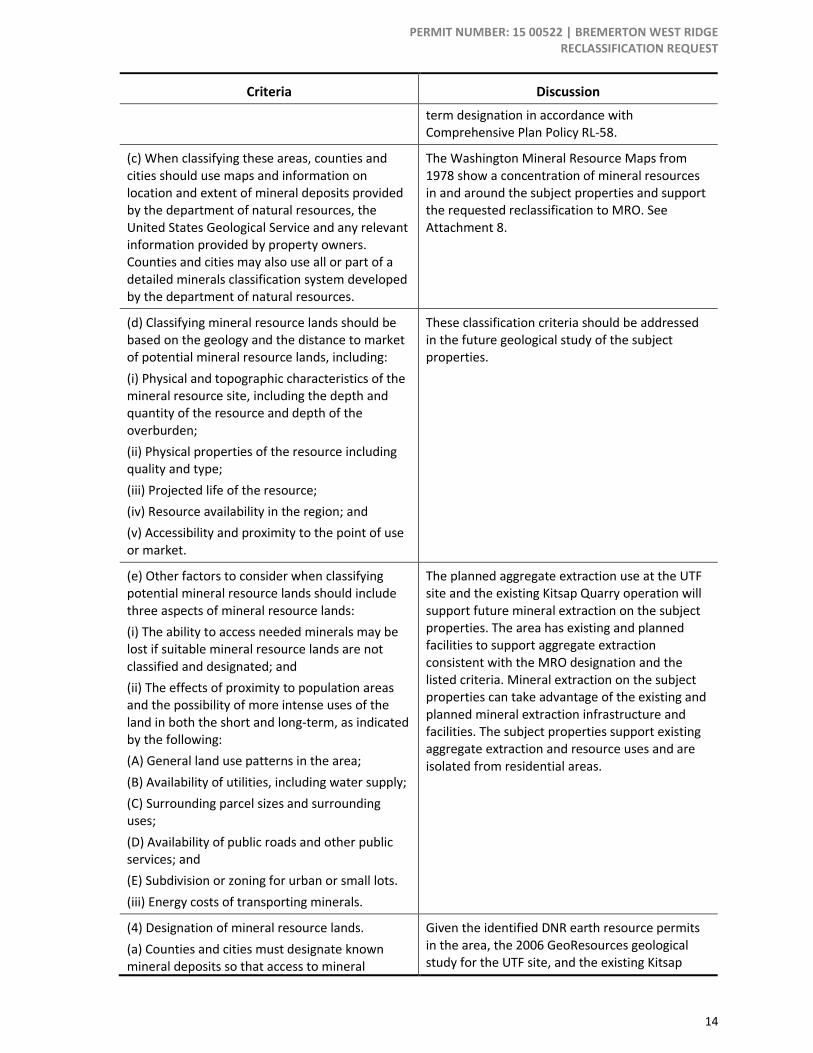
PERMIT NUMBER: 15 00522 | BREMERTON WEST RIDGE RECLASSIFICATION REQUEST
14
Criteria Discussion
term designation in accordance with Comprehensive Plan Policy RL-58.
(c) When classifying these areas, counties and cities should use maps and information on location and extent of mineral deposits provided by the department of natural resources, the United States Geological Service and any relevant information provided by property owners. Counties and cities may also use all or part of a detailed minerals classification system developed by the department of natural resources.
The Washington Mineral Resource Maps from 1978 show a concentration of mineral resources in and around the subject properties and support the requested reclassification to MRO. See Attachment 8.
(d) Classifying mineral resource lands should be based on the geology and the distance to market of potential mineral resource lands, including:
(i) Physical and topographic characteristics of the mineral resource site, including the depth and quantity of the resource and depth of the overburden;
(ii) Physical properties of the resource including quality and type;
(iii) Projected life of the resource;
(iv) Resource availability in the region; and
(v) Accessibility and proximity to the point of use or market.
These classification criteria should be addressed in the future geological study of the subject properties.
(e) Other factors to consider when classifying potential mineral resource lands should include three aspects of mineral resource lands:
(i) The ability to access needed minerals may be lost if suitable mineral resource lands are not classified and designated; and
(ii) The effects of proximity to population areas and the possibility of more intense uses of the land in both the short and long-term, as indicated by the following:
(A) General land use patterns in the area;
(B) Availability of utilities, including water supply;
(C) Surrounding parcel sizes and surrounding uses;
(D) Availability of public roads and other public services; and
(E) Subdivision or zoning for urban or small lots.
(iii) Energy costs of transporting minerals.
The planned aggregate extraction use at the UTF site and the existing Kitsap Quarry operation will support future mineral extraction on the subject properties. The area has existing and planned facilities to support aggregate extraction consistent with the MRO designation and the listed criteria. Mineral extraction on the subject properties can take advantage of the existing and planned mineral extraction infrastructure and facilities. The subject properties support existing aggregate extraction and resource uses and are isolated from residential areas.
(4) Designation of mineral resource lands.
(a) Counties and cities must designate known mineral deposits so that access to mineral
Given the identified DNR earth resource permits in the area, the 2006 GeoResources geological study for the UTF site, and the existing Kitsap

PERMIT NUMBER: 15 00522 | BREMERTON WEST RIDGE RECLASSIFICATION REQUEST
15
Criteria Discussion
resources of long-term commercial significance is not knowingly precluded. Priority land use for mineral extraction should be retained for all designated mineral resource lands.
Quarry operation it is likely the subject property has mineral resources that should be protected with the MRO designation. Approval of the reclassification request should be conditioned on a detailed geological study being submitted to the County before any aggregate extraction use is approved and implemented.
(b) In designating mineral resource lands, counties and cities should determine if adequate mineral resources are available for projected needs from currently designated mineral resource lands.
The County addresses this through Transportation Planning.
(c) Counties and cities may consult with the department of transportation and the regional transportation planning organization to determine projected future mineral resource needs for large transportation projects planned in their area.
The County will continue to do so.
(d) In designating mineral resource lands, counties and cities must also consider that mining may be a temporary use at any given mine, depending on the amount of minerals available and the consumption rate, and that other land uses can occur on the mine site after mining is completed, subject to approval.
The County and the property owner will have sufficient time to address future land uses, including Comprehensive Plan and Zoning Map designations, prior to the aggregate extraction operations ceasing.
(e) Successful achievement of the natural resource industries goal set forth in RCW 36.70A.020 requires the conservation of a land base sufficient in size and quality to maintain and enhance those industries and the development and use of land use techniques that discourage uses incompatible with the management of designated lands.
Kitsap County has several sites already designated MRO and protected for existing and future aggregate extraction uses. If the reclassification request is approved, the subject properties would also be protected to support future aggregate extraction uses.
Policy RL-56 anticipates interim placement of the MRO designation until a comprehensive study is undertaken.
Source: Washington Administrative Code, 2015; BERK, 2015

PERMIT NUMBER: 15 00522 | BREMERTON WEST RIDGE RECLASSIFICATION REQUEST
16
Attachments
Attachment 1: Aerial Imagery
PERMIT NUMBER: 15 00522 | BREMERTON WEST RIDGE RECLASSIFICATION REQUEST
17
Attachment 2: Building Limitations

PERMIT NUMBER: 15 00522 | BREMERTON WEST RIDGE RECLASSIFICATION REQUEST
18
Attachment 3: Current Land Use

PERMIT NUMBER: 15 00522 | BREMERTON WEST RIDGE RECLASSIFICATION REQUEST
19
Attachment 4: Current Zoning
PERMIT NUMBER: 15 00522 | BREMERTON WEST RIDGE RECLASSIFICATION REQUEST
20
Attachment 5: Proposed Zoning

PERMIT NUMBER: 15 00522 | BREMERTON WEST RIDGE RECLASSIFICATION REQUEST
21
Attachment 6: Current Comprehensive Plan Designation
PERMIT NUMBER: 15 00522 | BREMERTON WEST RIDGE RECLASSIFICATION REQUEST
22
Attachment 7: Proposed Comprehensive Plan Designation

23
Attachment 8. WA DNR Active Earth Resource Permit Locations
Source: Washington Department of Natural Resources, 2015
Kitsap Quarry

24
Attachment 9. City of Bremerton Transportation Concurrency Letter