staff report commission/2015/907.pdftotal approximately 10,450 square feet (5,225 square feet per...
TRANSCRIPT
SALT LAKE CITY CORPORATION 451 SOUTH STATE STREET, ROOM 406 WWW.SLCGOV.COM PO BOX 145480 SALT LAKE CITY, UT 84114-5480 TEL 801-535-7757 FAX 801-535-6174
PLANNING DIVISION COMMUNITY & ECONOMIC DEVELOPMENT
Staff Report
To: Salt Lake City Planning Commission From: David J. Gellner, 801-535-6107, [email protected] Date: April 8, 2015 Re: PLNPCM2014-00907 – McClelland Power Station – Rezone
Zoning Map Amendment PROPERTY ADDRESS: 1022 and 1026 East 800 South PARCEL ID: 16-08-251-005 and 16-08-251-006 MASTER PLAN: Central Community Master Plan (2005) ZONING DISTRICT: R-2 – Single and Two-Family Residential REQUEST: Brad Knoles, representing Rocky Mountain Power and Camarlot Investments LLC, is requesting that the City amend the zoning map for two parcels located at 1022 East 800 South and 1026 East 800 South respectively. The properties are currently zoned R-2 – Single and Two-Family Residential. The applicant is requesting that these two properties (0.24 acres total) be rezoned to RMF-30 – Low Density Multi-Family Residential in order to accommodate the relocation of an off-site parking facility serving an existing apartment complex on the property directly to the east. The intent of the proposed rezone is to ensure that zoning is uniform between the existing apartment building and the parking lot that serves that use, and, that the zoning will be consistent with the lot changes proposed. The rezone is also intended to help accommodate a reciprocal access agreement between Rocky Mountain Power and Salt Lake City Public Utilities.
RECOMMENDATION: Based on the information in this staff report, Planning Staff recommends that the Planning Commission forward a recommendation of approval to the City Council for the proposed zoning map amendment.
The following motion is provided in support of the recommendation:
Based on the findings listed in the staff report and the testimony and plans presented, I move that the Planning Commission transmit a positive recommendation to the City Council for the proposed zoning map amendment.
ATTACHMENTS:
A. Vicinity Maps B. Property Photographs C. Additional Applicant Information D. Existing Conditions E. Analysis of Standards F. Public Process & Comments G. Department Review Comments H. Motions
Page 2
PROJECT DESCRIPTION:
The block that contains this property (bounded by 800 South and 900 South and 1000 East and McClelland ) has many oddly configured lots compared to other similarly-sized blocks in the area. This is largely due to the bisection of the block by a canal and the establishment of the McClelland Power Substation in this area as well as the associated access easements from these uses. As a result, property boundaries are not uniform and there are many oddly shaped lots. The intent of the proposed rezone is to ensure that zoning is uniform between the existing apartment building and the parking lot that serves that use, and, that the zoning will be consistent with the lot changes proposed. The rezone is also intended to help accommodate a reciprocal access agreement between Rocky Mountain Power and Salt Lake City Public Utilities. These rezones, along with an associated lot-line adjustment represent an attempt to “clean up” some of these boundary and property issues and create some uniformity.
A vicinity map, property photographs and parcel boundary configuration are included in the Attachments section of this report.
The subject property is located within the East Central North neighborhood planning area, specifically in the Douglas neighborhood. The Master Plan describes this area as follows:
The Douglas neighborhood is located between 500 South and 900 South from 1000 East to 1350 East. It consists mostly of low-density single-family dwellings, predominantly of Bungalow style, although student apartments are disbursed throughout. Judge Memorial High School has impacted the local traffic circulation patterns and availability of on street parking for area residents. To help decrease the impact of through traffic, the City erected a barrier on 800 South and 1100 East, preventing continuous north/ south traffic flow on 1100 East across 800 South.
The Central Community Master Plan contains a future land use map that designates the desired type of land use that should occur on the property. The future land use map shows a designation of the subject property as Low Density Residential. Adjacent land uses are shown as Low, Low Medium, and Medium Density Residential with considerable Institutional land in the vicinity. This is consistent with how the area has been previously developed and indicates an anticipated continuation of that established community development pattern. KEY ISSUES: The key issues listed below have been identified through the analysis of the project, neighbor and community input and department review comments. 1. Zoning Compatibility with Adjacent Properties 2. Current “Low Density Residential” Designation 3. Parking Lot Buffering and Landscape Requirements
Issue 1 - Zoning Compatibility with Adjacent Properties Compatibility with adjacent properties is a concern with any zone change. The current proposal seeks to change the zoning from one low-density designation to another in order to establish zoning that is uniform between the existing apartment building and the parking lot that serves that use, and, that the zoning will be consistent with the lot changes proposed. The rezone is also intended to help accommodate a reciprocal access agreement between Rocky Mountain Power and Salt Lake City Public Utilities. The rezone should not create issues of incompatibility with neighboring properties as they represent an attempt to “clean up” some of the existing boundary line and property issues to create uniformity in reflection of how the area has developed over time.
The purpose of the R-2 single- and two-family residential district is to preserve and protect for single-family dwellings the character of existing neighborhoods which exhibit a mix of single- and two-family dwellings by controlling the concentration of two-family dwelling units. Uses are intended to be compatible with the existing scale and intensity of the neighborhood. The standards for the district are intended to provide for safe and comfortable places to live and play and to promote sustainable and compatible development patterns.
Page 3
The purpose of the RMF-30 low density multi-family residential district is to provide an environment suitable for a variety of housing types of a low density nature, including single-family, two-family, and multi-family dwellings, with a maximum height of thirty feet (30'). This district is appropriate in areas where the applicable master plan policies recommend multi-family housing with a density of less than fifteen (15) dwelling units per acre. Uses are intended to be compatible with the existing scale and intensity of the neighborhood. The standards for the district are intended to provide for safe and comfortable places to live and play, promote sustainable and compatible development patterns and to preserve the existing character of the neighborhood.
While the owner has not indicated a desire to do so, the property rezone would allow additional uses to take place under the new zoning designation. A table showing a comparison of allowed uses in both the R-2 and RMF-30 zones, and whether those uses would be Permitted or Conditional in the zoning district is included in Attachment D: Existing Conditions. While the two zones are relatively similar there are some differences. The RMF-30 zone does allow for some uses that could potentially create more impacts on the surrounding community. For instance, a multi-family dwelling, residential healthcare facility and attached single-family dwellings are all allowed in RMF-30 zone as permitted uses, and not allowed in the R-2 zone. A community garden is a conditional use in the R-2 zone and a permitted use in the RMF-30. A large group home is allowed as a conditional use in the RMF-30 and not allowed in the R-2. Aside from those differences, the two zones support very similar uses. In addition, the bulk and yard requirements of the 2 zones are essentially the same for both zones.
The R-2 zone requires a lot area minimum of 5,000 square feet for a single-family detached dwelling, 4,000 square feet per dwelling unit for twin homes, and, 8,000 square feet for a two-family dwelling. The 2 parcels total approximately 10,450 square feet (5,225 square feet per parcel). Using the lot minimums, each parcel could support a single-family detached dwelling, or a twin home or two-family dwelling could be built using both parcels and combining the lots under the current R-2 zone. The RMF-30 zone allows for single-family detached, two-family and twin homes with the same lot area requirements specified in the R-2 zone. The RMF-30 zone allows for a multi-family dwelling with a minimum lot area of 9,000 square feet (9,000 sf minimum for 3 dwelling units plus 3,000 square feet for each additional dwelling unit). The zone also allows single-family attached dwellings (3 or more) with 3,000 square feet of minimum lot area. In terms of total unit density, if rezoned to RMF-30, the property could potentially support one additional dwelling unit if a multi-family dwelling were to be developed or if single-family attached dwellings were to be built upon the combined parcels. This potential increase of 1 dwelling unit represents a negligible change in accordance with both zones being classified as low density.
Issue 2 - Current “Low Density Residential” Designation The portion of land proposed for rezoning is identified on the future land use map of the Central Community Master Plan (2005) as “Low Density Residential.” The proposed change would change the zoning from the R-2 (single- and two-family residential district) to the RMF-30 (low density multi-family residential district). Both the proposed zoning designation and current designations are defined as “low density” in nature. The change in the zoning does not impact the identified designations shown on the Future Land Use Map in the Master Plan and is compatible with the anticipated future land use identified in that document. As such, the Zoning Map Amendment does not require an associated change to the Central Community Master Plan. Issue 3 – Parking Lot Buffering and Landscape Requirements The applicant has indicated the intent to relocate the parking for the existing multi-family complex to a new area, specifically on the rezoned parcel directly to the east. There are specific zoning requirements related to the screening and buffering of parking areas in order to protect the aesthetics along public streets. Where parking lots are located within rear and interior side yards, and minimum requirements for beautification of both residential and nonresidential uses are the city's goal. The intent is to require a higher level of landscaping for residential uses (principally multi-family uses) than for nonresidential uses. Buffering of parking areas is intended to lessen the impacts of the parking on adjacent land uses in terms of aesthetics and operational issues such as car headlights shining into adjacent properties. The extent of landscaping requirements is partially based on the size

Page 4
of parking lot. A landscape buffer of 10-feet is required in the RMF-30 zone when the property abuts a lot in a single-family or two-family residential district. Abutting properties are zoned R-2, so this provision would apply. Parking lots with 15 spaces or more are subject to the landscaping requirements of Section 21A.48.070: Parking Lot or Vehicle Sales or Lease Lots Landscaping. Smaller parking lots are not required to provide landscaping other than yard area landscaping and landscaped buffer requirements. At such time that the applicant were to improve the property and add a parking lot, compliance with the appropriate buffering and landscaping requirements would be applied to the property improvements. DISCUSSION:
Applicable Master Plan Policies The section “A Vision for the Central Community of the Future” in the Master Plan speaks to livable communities and neighborhoods and land use patterns that are compatible with the characteristic of specific neighborhoods within the community. This section includes the following items:
• A variety of residential land use supports all types of housing and the affordability of the housing stock.
• Preservation of the housing stock is an integral part of maintaining neighborhood character. • The appropriate transition of multi-family housing with mixed land uses in designated areas
support sustainable development within the community. The subject property is located in the East Central North neighborhood planning area. This area is made up of several distinct neighborhoods including the Douglas neighborhood where the subject property is located. The overall defining characteristics of this planning area and its neighborhoods is an eclectic architecture style to include mature landscaping, small shops, office buildings, student housing, institutional buildings and many different housing styles. The area is reflective of development that took place and evolved over a long period of time in this area. Residential land use policies in the Master Plan pertinent to this application include the following: RLU 1.0- Based on the Future Land Use map, use residential zoning to establish and maintain a variety of housing opportunities that meet social needs and income levels of a diverse population. RLU 3.0 – Promote construction of a variety of housing options that are compatible with the character of the neighborhoods of the Central Community. In terms of Public Utilities and Facilities, the Master Plan provides the following goal: Provide and maintain dependable infrastructure, public facilities and utilities that ensure adequate services and a safe environment in the community. The proposed zoning map amendment appears to be in compliance with the master plan policies and goals and community vision. It supports the established development pattern and mix of land uses in the neighborhood. It supports a mix of diverse housing opportunities in order to meet the social needs and income levels of a diverse population.
The general public and surrounding residents were given the opportunity to weigh in on the proposal at a Planning Department Open House. Details of this meeting and any other public outreach activities are included in Attachment F of this report.
NEXT STEPS: With a recommendation of approval or denial for the zoning amendment, the proposal will be sent to the City Council for a final decision by that body.
Page 5
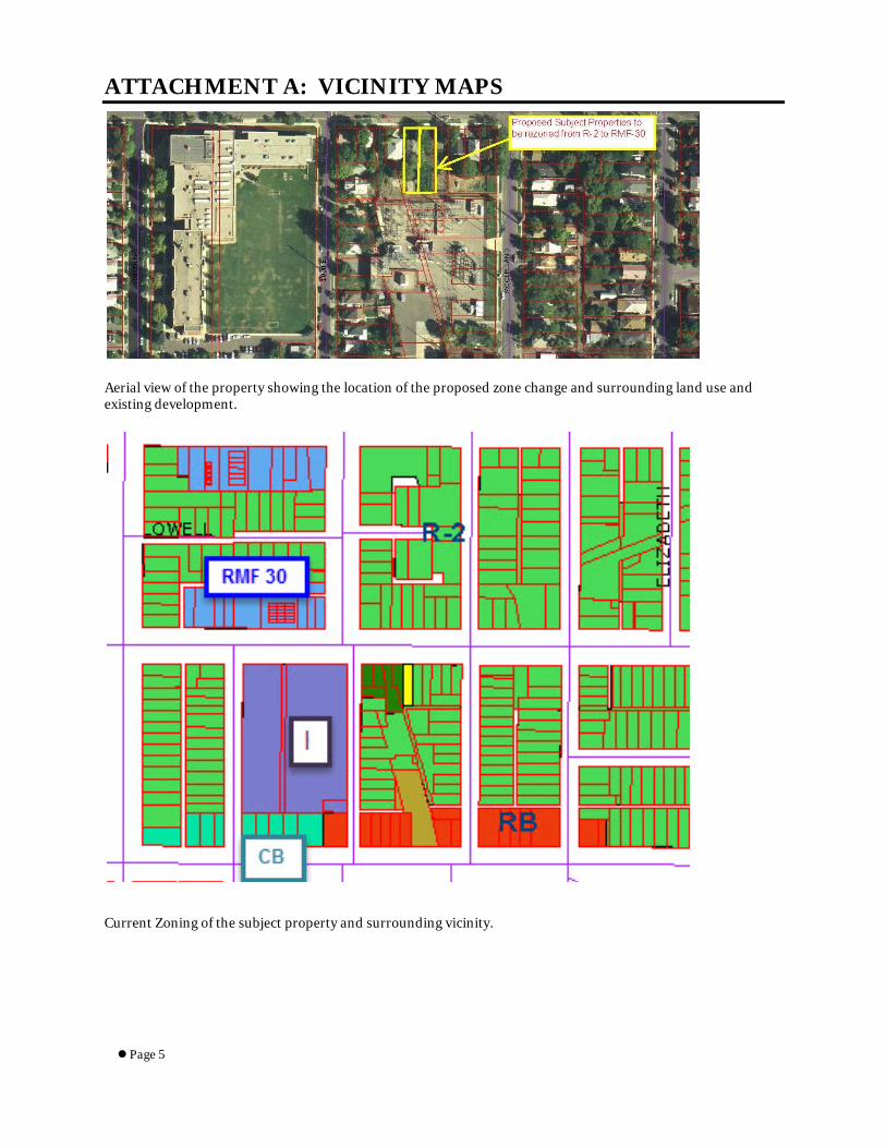
ATTACHMENT A: VICINITY MAPS
Aerial view of the property showing the location of the proposed zone change and surrounding land use and existing development.
Current Zoning of the subject property and surrounding vicinity.

Page 6
Future Land Use Map from the Central Community Master Plan (2005)

Page 7
ATTACHMENT B: PROPERTY PHOTOGRAPHS
View looking Northeast toward 800 South from the existing apartment parking area.
View from 800 South looking south toward the subject properties with the existing apartment building visible.
1335 EAST

Page 8
ATTACHMENT C: ADDITIONAL APPLICANT INFORMATION
Page 9
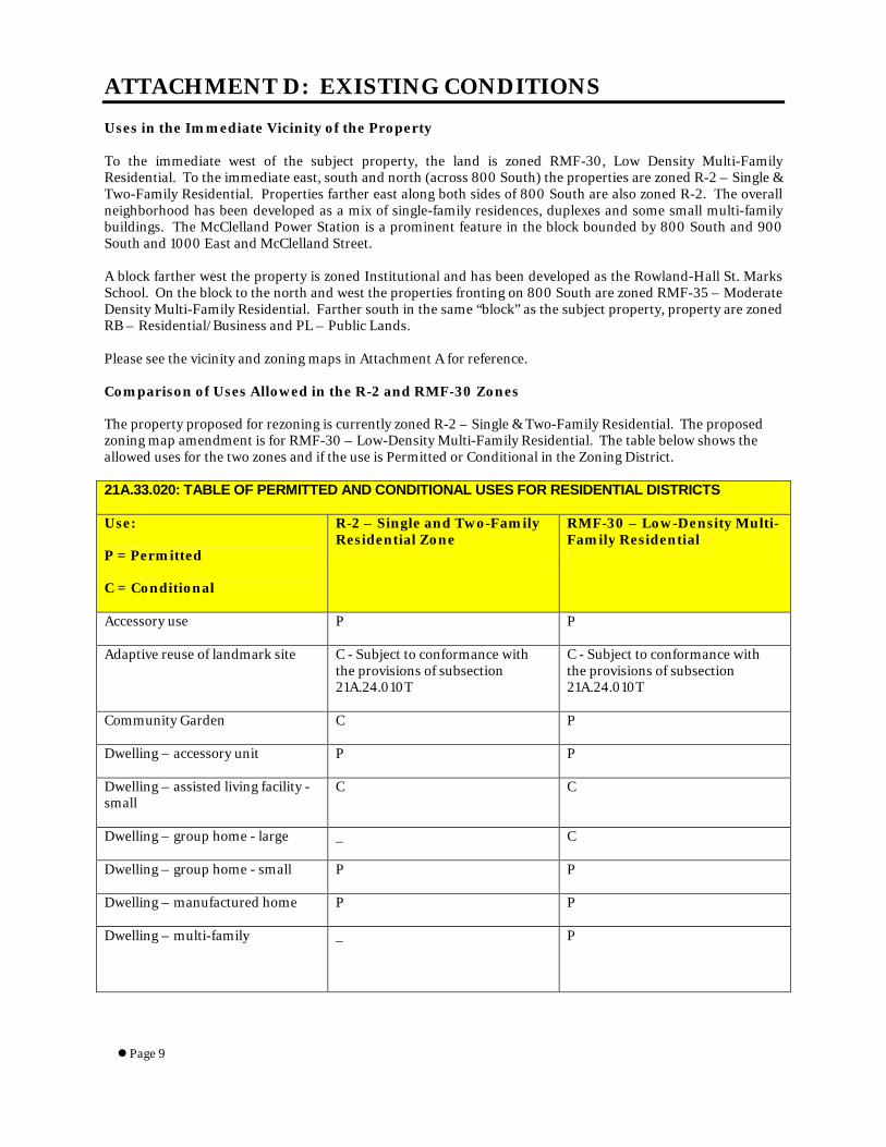
ATTACHMENT D: EXISTING CONDITIONS
Uses in the Immediate Vicinity of the Property To the immediate west of the subject property, the land is zoned RMF-30, Low Density Multi-Family Residential. To the immediate east, south and north (across 800 South) the properties are zoned R-2 – Single & Two-Family Residential. Properties farther east along both sides of 800 South are also zoned R-2. The overall neighborhood has been developed as a mix of single-family residences, duplexes and some small multi-family buildings. The McClelland Power Station is a prominent feature in the block bounded by 800 South and 900 South and 1000 East and McClelland Street. A block farther west the property is zoned Institutional and has been developed as the Rowland-Hall St. Marks School. On the block to the north and west the properties fronting on 800 South are zoned RMF-35 – Moderate Density Multi-Family Residential. Farther south in the same “block” as the subject property, property are zoned RB – Residential/Business and PL – Public Lands. Please see the vicinity and zoning maps in Attachment A for reference. Comparison of Uses Allowed in the R-2 and RMF-30 Zones
The property proposed for rezoning is currently zoned R-2 – Single & Two-Family Residential. The proposed zoning map amendment is for RMF-30 – Low-Density Multi-Family Residential. The table below shows the allowed uses for the two zones and if the use is Permitted or Conditional in the Zoning District.
21A.33.020: TABLE OF PERMITTED AND CONDITIONAL USES FOR RESIDENTIAL DISTRICTS
Use:
P = Permitted
C = Conditional
R-2 – Single and Two-Family Residential Zone
RMF-30 – Low-Density Multi-Family Residential
Accessory use P P
Adaptive reuse of landmark site C - Subject to conformance with the provisions of subsection 21A.24.010T
C - Subject to conformance with the provisions of subsection 21A.24.010T
Community Garden C P
Dwelling – accessory unit P P
Dwelling – assisted living facility - small
C C
Dwelling – group home - large _ C
Dwelling – group home - small P P
Dwelling – manufactured home P P
Dwelling – multi-family _ P

Page 10
Dwelling – residential healthcare facility
_ P
Dwelling – single attached _ P
Dwelling – single – detached P P
Dwelling – twin home and 2-Family
P - Provided that no more than 2 two-family buildings are located adjacent to one another and no more than 3 such dwellings are located along the same block face (within subdivisions approved after April 12, 1995).
P
Eleemosynary facility C C
Governmental facility C C
Municipal service use, including city utility use and police and fire station
C C
Open space on lots less than 4 acres in size
P P
Park P P
Parking, park and ride lot shared with existing use
P P
Place of worship on lots less than 4 acres in size
C C
School, seminary and religious institute
C C
Urban Farm P P
Utility, building or structure P – subject to specifics of 21A.02.050 – Utility regulations
P – subject to specifics of 21A.02.050 – Utility regulations
Utility, transmission wire, line, pipe or pole
P – subject to specifics of 21A.02.050 – Utility regulations
P – subject to specifics of 21A.02.050 – Utility regulations

Page 11
ATTACHMENT E: ANALYSIS OF STANDARDS
ZONING MAP AMENDMENTS
21A.50.050: A decision to amend the text of this title or the zoning map by general amendment is a matter committed to the legislative discretion of the city council and is not controlled by any one standard. In making a decision to amend the zoning map, the City Council should consider the following:
Factor Finding Rationale 1. Whether a proposed map amendment is consistent with the purposes, goals, objectives, and policies of the city as stated through its various adopted planning documents;
Consistent with the general goals and
policies. An amendment to the
future land use map of the Central
Community Master Plan is not required.
See the “Discussion” section regarding applicable Master Plan policies. As discussed, staff finds that the zoning amendment is consistent with the general policies of the Central Community Master Plan.
2. Whether a proposed map amendment furthers the specific purpose statements of the zoning ordinance.
Complies The purpose statement of the zoning ordinance, Chapter 21A is defined in 21A.02.030 as such: The purpose of this title is to promote the health, safety, morals, convenience, order, prosperity and welfare of the present and future inhabitants of Salt Lake City, to implement the adopted plans of the city, and to carry out the purposes of the municipal land use development and management act, title 10, chapter 9, of the Utah Code Annotated or its successor, and other relevant statutes. The purpose statement of the RMF-30 zone is as follows: The purpose of the RMF-30 low density multi-family residential district is to provide an environment suitable for a variety of housing types of a low density nature, including single-family, two-family, and multi-family dwellings, with a maximum height of thirty feet (30'). The proposed rezone would be in compliance with the stated purposes of the overall Zoning Ordinance as well as the specific stated purpose of the proposed RMF-30 zoning district.
3. The extent to which a proposed map amendment will affect adjacent properties;
The proposed change should have a negligible impact
on adjacent
The zone change is intended to help facilitate to accommodate the relocation of an off-site parking facility serving an existing apartment complex on the
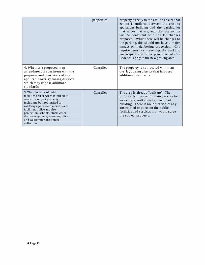
Page 12
properties. property directly to the east, to ensure that zoning is uniform between the existing apartment building and the parking lot that serves that use, and, that the zoning will be consistent with the lot changes proposed. While there will be changes to the parking, this should not have a major impact on neighboring properties. City requirements for screening the parking, landscaping and other provisions of City Code will apply to the new parking area.
4. Whether a proposed map amendment is consistent with the purposes and provisions of any applicable overlay zoning districts which may impose additional standards
Complies The property is not located within an overlay zoning district that imposes additional standards.
5. The adequacy of public facilities and services intended to serve the subject property, including, but not limited to, roadways, parks and recreational facilities, police and fire protection, schools, stormwater drainage systems, water supplies, and wastewater and refuse collection.
Complies The area is already “built up”. The proposal is to accommodate parking for an existing multi-family apartment building. There is no indication of any anticipated impacts on the public facilities and services that would serve the subject property.

Page 13
ATTACHMENT F: PUBLIC PROCESS & COMMENTS
Public Notice, Meetings, Comments: The following is a list of public meetings that have been held, and other public input opportunities, related to the proposed project: Notice of Application: A notice of the application and information was sent to the chairpersons of the East Central and East Liberty Park Community Council areas to ask for their input. Since the subject properties are located in the overlap between the East Central CC and East Liberty Park CC areas, the Planning Division invited both Council representatives and neighboring property owners to an Open House to take public input on the proposed applications. The Open House was held at the City/County Building on Thursday, February 19th. No public comments or questions were received by staff or the applicant at the Open House. The Chair of the East Central Community Council has sent several comments and questions to staff including the following:
Do you know if the owner is planning to build? It seems like an awful lot of space to just park cars for what looks like a very small number of units unless this is mostly to serve RMP and correctly align a problem are due to their access and so forth. Will you please let me know? Also would there be any requirement to shield the parking from the street view? I believe if one were to add parking now there would some requirements for safety and also some shielding for the neighborhood and the public view all listed in the parking ordinance. It will be very helpful to know if the owner will be expected to do the same and if not a requirement by code I wonder if between all the parties, Public Utilities, RMP and this owner there could be some progress made to shield the neighborhood from viewing a parking lot, the station and so forth.
The owners have not indicated plans to build anything other than a new parking lot. The intent is mostly to serve Rocky Mountain Power and correct and clean up access issues to their station. There is an easement between the City’s Public Utilities Department and RMP that deals with an old canal right of way. This is intended to address that issue as well. Longstanding issues all around that RMP is trying to “clean up” for lack of better wording. Issues of what additional uses the zone change would allow are outlined in the Key Issues section, Issue 1 – Zoning Compatibility with Adjacent Properties. Requirements related to landscaping and buffering questions brought up by the Community Council are outlined in the Key Issues section, Issue 3 – Parking Lot Buffering and Landscape Requirements City Engineering provided the following comment: The revision is in keeping with past (2011) discussion for the revision to the Substation and the abutting Residential uses in order to develop a consistent use and separation between the two functions in this area. Notice of the public hearing for the proposal included:
• Notice of the Open House was sent out via the CED list serve on February 9, 2015 • Public hearing notice mailed on March 12, 2015 • Public hearing notice posted on March 12, 2015 • Public notice posted on City and State websites and Planning Division list serve on March12, 2015
Public Input: No additional public comments have been received by staff.
Page 14
ATTACHMENT G: DEPARTMENT REVIEW COMMENTS
The rezone petition was sent out internally to solicit comments and input from other City departments. The following comments were received: Salt Lake City Transportation Division The proposed Zoning change and lot line adjustment present no change or impact to the public transportation corridor of 800 South or McClelland Street as shown. The revision is in keeping with past (2011) discussion for the revision to the Substation and the abutting Residential uses in order to develop a consistent use and separation between the two functions in this area. Salt Lake City Engineering Division Engineering has no objections. No other internal review comments were received in relation to the proposal. ATTACHMENT H: MOTIONS
Potential Motions
Staff Recommendation: Based on the findings listed in the staff report and the testimony and plans presented, I move that the Planning Commission transmit a positive recommendation to the City Council for the proposed zoning map amendment. Not Consistent with Staff Recommendation: Based on the testimony, plans presented and the following findings, I move that the Planning Commission transmit a negative recommendation to the City Council for the proposed zoning map amendment. (The Planning Commission shall make findings on the Zoning Amendment standards and specifically state which standard or standards are not being complied with. Please see Attachment E for applicable standards.)