srl06043 execsumm final2 - epa wa
TRANSCRIPT
Yannarie Solar
a Straits i n i t i a t i ve
N O V E M B E R 2 0 0 6
E x e c u t i v e S u m m a r y
ENVIRONMENTAL REVIEW &
MANAGEMENT PROGRAMME

Yannarie Solara Straits initiative
ENVIRONMENTAL REVIEW &MANAGEMENT PROGRAMME
Executive Summary
November 2006
Straits Salt Pty Ltd1st Floor, 35 Ventnor Avenue
West Perth WA 6005ACN: 107 118 570
Cover Photograph AcknowledgementsBiota: Sandpipers
Oceanica: Whales

Yannarie Solar Project Executive Summary
SRL06043_ExecSumm_Final2 - 27/11/2006
INVITATION
Straits Salt Pty Ltd (Straits) is proposing to construct and operate a nominal 10 million tonne per annum (Mtpa)solar saltfield (known as the Yannarie Solar Project) on the eastern margin of the Exmouth Gulf (the Gulf) inWestern Australia.
The Environmental Protection Authority (EPA) invites people to participate in the environmental assessmentprocess for the Yannarie Solar Salt proposal. Most of the information about this proposal is included within themain Environmental Review and Management Programme (ERMP) document, which is open for publiccomment for twelve (12) weeks from 4 December 2006, closing on 26 February 2007.
Additional information about:
Flora and vegetation; Subterranean fauna; and, Subtidal benthic communities
will be published in the first half of 2007. These supplementary reports will be made available for a further four(4) week public submission period.
Comments from government agencies and from the public will assist the EPA to prepare an assessment report inwhich it will make recommendations to government. If you are able to, the EPA would welcome electronicsubmissions in particular, emailed to the project assessment officer or via the EPA’s Website (see addressbelow).
WHERE TO GET COPIES OF THIS DOCUMENT
Printed copies of this document may be obtained from Mr James Barrie at Straits Salt Pty Ltd, Level 1, 35Ventnor Avenue, WEST PERTH WA 6872, (61 8) 9480 0500 at a cost of $10.00.
Copies may also be obtained from http://www.straits.com.au
WHY WRITE A SUBMISSION?
A submission is a way to provide information, express your opinion and put forward your suggested course ofaction - including any alternative approach. It is useful if you indicate any suggestions you have to improve theproposal.
All submissions received by the EPA will be acknowledged. Electronic submissions will be acknowledgedelectronically. The proponent will be required to provide adequate responses to points raised in submissions. Inpreparing its assessment report for the Minister for the Environment, the EPA will consider the information insubmissions, the proponent’s responses and other relevant information. Submissions will be treated as publicdocuments unless provided and received in confidence subject to the requirements of the Freedom ofInformation Act, and may be quoted in full or in part in each report.
WHY NOT JOIN A GROUP?
If you prefer not to write your own comments, it may be worthwhile joining with a group or groups interested inmaking a submission on similar issues. Joint submissions may help to reduce the workload for an individual orgroup, as well as increase the pool of ideas and information. If you form a small group (up to 10 people) pleaseindicate all the names of the participants. If your group is larger, please indicate how many people yoursubmission represents.
Yannarie Solar Project Executive Summary
SRL06043_ExecSumm_Final2 - 27/11/2006
DEVELOPING A SUBMISSION
You may agree or disagree with, or comment on, the general issues discussed in the ERMP or the specificproposal. It helps if you give reasons for your conclusions, supported by relevant data. You may make animportant contribution by suggesting ways to make the proposal more environmentally acceptable.
When making comments on specific elements of the ERMP:
clearly state your point of view;
indicate the source of your information or argument if this is applicable; and
suggest recommendations, safeguards or alternatives.
POINTS TO KEEP IN MIND
By keeping the following points in mind, you will make it easier for your submission to be analysed:
attempt to list points so that issues raised are clear. A summary of your submission is helpful;
refer each point to the appropriate section, chapter or recommendation in the ERMP;
if you discuss different sections of the ERMP, keep them distinct and separate, so there is no confusion asto which section you are considering; and
attach any factual information you may wish to provide and give details of the source. Make sure yourinformation is accurate.
Remember to include:
your name;
address;
date; and
whether and the reason why you want your submission to be confidential.
The closing date for submissions is: 26 February 2007
The EPA prefers submissions to be sent in electronically. You can either e-mail the submission to the followingaddress:
OR
use the submission form on the EPA’s website:
wwwwwwwww...eeepppaaa...wwwaaa...gggooovvv...aaauuu///sssuuubbbmmmiiissssssiiiooonnnsss...aaasssppp
and click on the EIA Assessment Submission option
OR you can post your submission to:
The CharimanEnvironmental Protection AuthorityPO Box K822PERTH WA 6842Attention: Dr Sue Osborne
Yannarie Solar Project Executive Summary
SRL06043_ExecSumm_Final2 - 27/11/2006
EXECUTIVE SUMMARY
TABLE OF CONTENTS
1 INTRODUCTION 1
2 OVERVIEW OF THE REGION 4
2.1 SOCIO-ECONOMIC 4
2.1.1 Existing land uses 4
2.1.2 Aboriginal heritage 4
2.1.3 European heritage 4
2.2 THE EXMOUTH GULF ECOSYSTEM 5
2.3 GULF AREA BELOW LOW TIDE MARK 9
2.3.1 Benthic habitat and Gulf fauna 9
2.4 INTERTIDAL ZONE – AREA BETWEEN THE LOW AND HIGH TIDES 9
2.4.1 Algal mats, mangroves and tidal creeks 11
2.5 SUPRATIDAL SALT FLATS 11
2.5.1 Hinterland (dunefield and outwash plain) 12
3 THE PROPOSAL 14
3.1 COMMONWEALTH AND WESTERN AUSTRALIAN IMPACT ASSESSMENT AND APPROVAL 16
3.2 COMMUNITY CONSULTATION AND PEER REVIEW 18
4 ENVIRONMENTAL FACTORS 19
4.1 MINOR FACTORS 19
4.1.1 Greenhouse gases 19
4.1.2 World heritage area 19
4.1.3 Subterranean fauna 19
4.1.4 Solid and liquid waste disposal 19
4.2 KEY RELEVANT ENVIRONMENTAL FACTORS 21
4.2.1 Key environmental issues and outcomes 21
4.2.2 Soils and landforms 22
4.2.3 Groundwater 22
4.2.4 Surface water 24
4.2.5 Terrestrial vegetation and flora (excluding mangroves) 25
4.2.6 Terrestrial fauna 26
4.2.7 Marine water and sediment quality 28
Yannarie Solar Project Executive Summary
SRL06043_ExecSumm_Final2 - 27/11/2006
4.2.8 Benthic primary producer habitat and ecological integrity 29
4.2.9 Marine fauna 32
4.2.10 Commercial fishing and aquaculture 34
4.2.11 Recreation and tourism 36
4.2.12 Cultural heritage and conservation values 37
5 ERMP STRUCTURE 39
6 COMMITMENTS 40
LIST OF TABLES
1. Key project characteristics 15
2. Summary of potential environmental impacts associated with solid andliquid waste production 20
3. Number of vertebrate fauna species recorded during the Yannarie Solarfauna surveys 26
4. Species of conservation significance potentially occurring and thelikelihood of occurrence within the project study area 27
5. Proponent’s Environmental Management Commitments for themanagement of Yannarie Solar Project 41
6. Summary of key environmental issues, potential impacts and management 45
LIST OF FIGURES
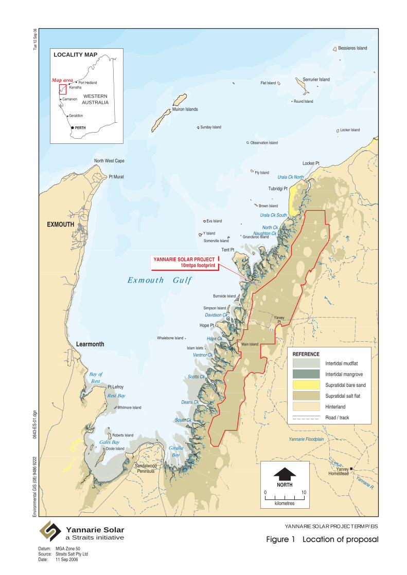
1. Location of proposal 2
2. Proposed location and layout of Yannarie Solar Project 3
3. Conceptual diagram of the Exmouth Gulf Ecosystem 7
4. Boundaries of the Exmouth Gulf prawn fishery 8
5. Location of all pods of whales sighted during all flights to July 2005 10
6. (a) View of salt flat area and (b) example of mainland remnant 12
7. View of longitudinal dunefield towards the Yannarie River South andsupratidal salt flats 13
8. Commonwealth and State environmental assessment and approvalprocess 17
9. Mangrove associations and algal mat near the Yannarie Solar Project 30
10. Northern Prawn Fishery life cycle 32
Yannarie Solar Project Executive Summary
SRL06043_ExecSumm_Final2 - 27/11/2006 1
1 INTRODUCTION
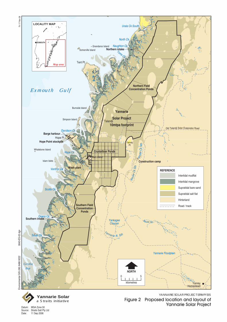
The proponent, Straits Salt Pty Ltd (Straits), is a wholly owned subsidiary of Straits ResourcesLimited. Straits Salt proposes to construct and operate a nominal 10 million tonne per annum (Mtpa)solar saltfield on the eastern margin of the Exmouth Gulf (the Gulf) in Western Australia (Figure 1)known as the Yannarie Solar Project (Figure 2).
The solar salt production will involve natural evaporative processes to crystallise sodium chloride saltfrom seawater and does not involve any chemical processing or hazardous chemicals.
An Environmental Review and Management Programme (ERMP) for the Yannarie Solar Project hasbeen prepared in accordance with administrative procedures under Part IV of the EnvironmentalProtection Act 1986. The ERMP, community and agency submissions (received during the publicreview of the ERMP) and Straits response to these submissions including the results of additionalinvestigations to be undertaken, will be considered by the EPA who will then provide an assessmentreport to the Minister for Environment. The Minister will then decide whether or not the proposalshould be implemented and if so under what conditions.
This proposal has been determined to be a controlled action under the Environmental Protection andBiodiversity Conservation Act 1999 (EPBC Act) for listed threatened species and communities andmigratory species. The Commonwealth has accredited the Western Australian impact assessmentprocess under the bilateral agreement between the Commonwealth and Western AustralianGovernments. This ERMP has been prepared to specifically address the potential impacts on theselisted species.
Mura
t
Road
Minily
a
Exm
outh
Road
Murat
Road
Road
Murat
Road
Yan
Cree
k
Creek
Nipper
Creek
Chinty
Envi
ronm
enta
l GIS
(08)
948
6 92
2206
43-E
S-01
.dgn
Tue
12 S
ep 0
6
YANNARIE SOLAR PROJECT ERMP/EISYannarie Solara Straits initiative
0NORTH
10
kilometres
Port HedlandKarratha
WESTERNAUSTRALIA
PERTH
Map area
LOCALITY MAP
Carnarvon
Geraldton
YANNARIE SOLAR PROJECT10mtpa footprint
REFERENCE
Intertidal mudflat Intertidal mangrove Supratidal bare sand Supratidal salt flat Hinterland Road / track
MGA Zone 50Straits Salt Pty Ltd11 Sep 2006
Datum:Source:Date:
EXMOUTH
Learmonth
North West Cape
Muiron Islands
Serrurier Island
Pt Murat
Locker Pt
Tubridgi Pt
Tent Pt
Hope Pt
SandalwoodPeninsula
Pt Lefroy
Bessieres Island
Locker Island
Observation Island
Sunday Island
Flat Island
Round Island
Fly Island
Brown Island
Eva Island
Y IslandGnandaroo Island
Somerville Island
Burnside Island
Simpson Island
Whalebone Island
Islam Islets
Doole Island
Roberts Island
Whitmore Island
Gales BayGiralia
Bay
Bay ofRest
Rest Bay
Exmouth Gulf
Urala Ck North
Urala Ck South
North CkNaughton Ck
Davidson Ck
Ventnor Ck
Hope Ck
Scotts Ck
Deans Ck
South Ck
Yannarie Floodplain
Main Island
YanreyPt
Yannarie R.
YanreyHomestead
Tent Pt
Hope Pt
Eva Island
Y Island Gnandaroo Island
Somerville Island
Burnside Island
Simpson Island
Whalebone Island
Islam Islets
GiraliaBay
Exmouth Gulf
Urala Ck South
C
North Ck
Naughton Ck
Toms Ck
Davidson Ck
Ventnor Ck
Hope Ck
Scotts Ck
Deans Ck
South Ck
Main Island
YanreyPt
Barge harbour
Hope Point stockpile
Southern intake
Northern intake
Wash plant
Construction camp
Rous
e C
k N
th
Rou
se C
k St
h
Yannarie R. Sth
Yannarie Floodplain
Rouse Ck
YanreyHomestead
Old Talandji Solar Evaporator Road
Talandji
Northern FieldNorthern FieldConcentration PondsConcentration Ponds
YannarieYannarie
Solar ProjectSolar Project
10mtpa footprint10mtpa footprint
Crystalliser PondsCrystalliser Ponds
Southern FieldSouthern FieldConcentrationConcentration
PondsPonds
YankageeClaypan
Envi
ronm
enta
l GIS
(08)
948
6 92
2206
43-E
S-02
.dgn
Fri 1
7 N
ov 0
6
YANNARIE SOLAR PROJECT ERMP/EISYannarie Solara Straits initiative
Map area
LOCALITY MAP
EXMOUTH
0
NORTH
5
kilometres
REFERENCE
Intertidal mudflat Intertidal mangrove Supratidal bare sand Supratidal salt flat Hinterland Road / track
MGA Zone 50Straits Salt Pty Ltd11 Sep 2006
Datum:Source:Date:
Yannarie Solar Project Executive Summary
SRL06043_ExecSumm_Final2 - 27/11/2006 4
2 OVERVIEW OF THE REGION
2.1 SOCIO-ECONOMIC
The project area is located in the Gascoyne region on the north west coast of Western Australia.Exmouth and Onslow are the nearest townships to the development location (Figure 1).
The most recent Australia-wide census of the Gascoyne region was on 30 August 2001, where thepopulation of the Gascoyne stood at around 10,300 people, of which 17% were Indigenous.
In 2001, the Australian Bureau of Statistics counted a residential population of 2069 for the Shire ofExmouth. Visitors from local, interstate and overseas locations added a further 2199 temporaryresidents and illustrates the significance of tourism in the region. Of the Shire’s population, 40 people(approximately 0.9%) identified themselves as Indigenous Australians. Currently, the town ofExmouth represents approximately 78% of the Shire’s total population.
In 2001 the population of the Shire of Ashburton was approximately 5258; with approximately 9% ofthe population identifying themselves as Indigenous Australians. The project area is located withinthis Shire.
The Shire of Ashburton is similar to the Shire of Exmouth in that it also experiences a high number ofvisitors to the region for tourism, employment and cultural purposes. Temporary visitors to the regionadded an additional 1626 individuals to the population.
2.1.1 Existing land uses
Existing landuses within the area include:
pastoral leases including Urala, Koordarrie and Yanrey Stations (Giralia lease has recently beenacquired by DEC to be managed as a conservation reserve)
commercial and recreational fisheries and aquaculture
defence training area
recreational use and tourism.
2.1.2 Aboriginal heritage
According to the National Native Title register, there are 2 claims covering the area around theproposed development site. These are the Thalanyji Claimant Application (WC99/45) and the GnulliApplication (WC97/28).
2.1.3 European heritage
There are no known significant European Heritage sites within the project area. Although there are anumber of shipwreck sites within the region, none have been identified in locations that are likely tobe affected by the project.
Yannarie Solar Project Executive Summary
SRL06043_ExecSumm_Final2 - 27/11/2006 5
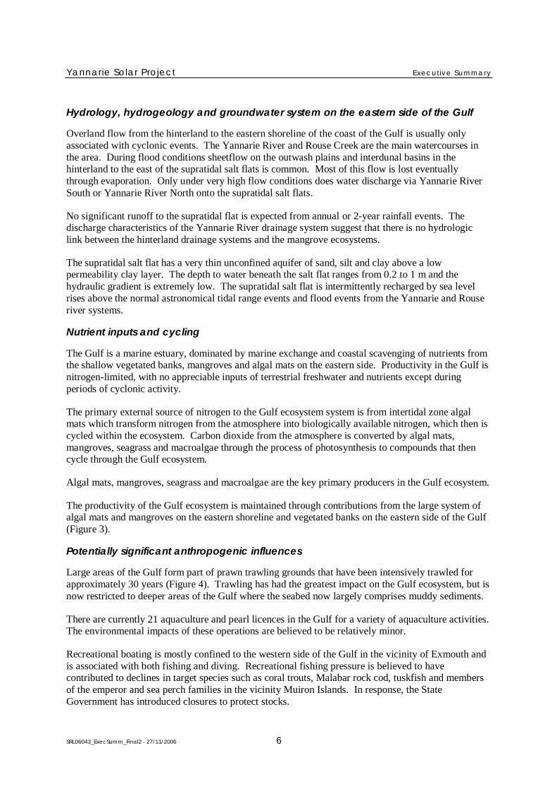
2.2 THE EXMOUTH GULF ECOSYSTEM
The Gulf is one of the largest embayments (approximately 3000 km2) on the Western Australian coast(Figure 1). The Gulf is set in a remote tropical arid area enclosed by the Cape Range Peninsula to thewest and the Yannarie Coastal Plain to the east. The catchment contributing runoff to the Gulf isrelatively small resulting in an estuary dominated by marine processes.
The annual rainfall in the region is highly variable with an average of 260 mm recorded at LearmonthAirport, located approximately 70 km south of Exmouth. The peak rainfall occurs between Januaryand March, and May and June. The heaviest rainfall is generally associated with tropical cycloneswhich can cause extensive flooding in the area. Evaporation rates are high, with annual averagerainfall significantly exceeded by the mean annual evaporation of around 3140 mm.
The Gulf falls within the Carnarvon Bioregion as defined in the most recent update of the InterimBioregionalisation of Australia. The Department of Environment and Conservation (DEC) places theproject area in the CAR1 (Cape Range) biological subregion within this bioregion.
Exmouth Gulf marks the start of the shallow Pilbara coastal waters region. At its deepest, the Gulf is21 m in depth and the relatively narrow entrance between Point Murat and the Muiron Islands crossedby a small sill is at most about 19 m in depth. The shallow protected waters of the Gulf provide astark contrast to the waters of Ningaloo Reef, which outside the reef line are exposed to the openocean and rapidly drop off into waters approximately 1000 m deep.
Tides and winds
The Gulf is strongly influenced by the Leeuwin Current, being in the region where it forms and beginsto head south down the Western Australian coast. There is no direct link between waters of the eastcoast of the Gulf and the Ningaloo Marine Park.
The winds in the region are predominately south westerlies and south easterlies (the south westerliesgenerally the strongest), resulting in water being driven out of the Gulf towards the north east. Theland mass of the North West Cape is sufficiently large to potentially set up a dual sea breeze regimewith one sea breeze generated on the ocean side (south westerly) and the other on the Gulf side (northeasterly).
Circulation in the Gulf is affected by winds and semi-diurnal tides, with tidal currents dominating thenearshore region of the east coast and winds tending to drive currents northwards parallel to the eastcoast. Tidal excursions are 5 km or less, and result in detritus, nutrients, spawn and planktonoriginating from the east coast remaining in the vicinity of this area for several tidal cycles.
Storm events
Severe cyclones occur approximately every 25 years and can permanently alter the coastline and causewide-scale loss of benthic habitat, including mangroves. In 1999 Cyclone Vance removedapproximately 5700 ha, or 44%, of the estimated mangrove habitat. Some 1580 ha of mangroverecovered over the period 1999-2004 resulting in the total area of mangroves being 68% of theirformer coverage. The post Cyclone Vance recovery of this habitat is the most rapid recovery observedin Australia.
Yannarie Solar Project Executive Summary
SRL06043_ExecSumm_Final2 - 27/11/2006 6
Hydrology, hydrogeology and groundwater system on the eastern side of the Gulf
Overland flow from the hinterland to the eastern shoreline of the coast of the Gulf is usually onlyassociated with cyclonic events. The Yannarie River and Rouse Creek are the main watercourses inthe area. During flood conditions sheetflow on the outwash plains and interdunal basins in thehinterland to the east of the supratidal salt flats is common. Most of this flow is lost eventuallythrough evaporation. Only under very high flow conditions does water discharge via Yannarie RiverSouth or Yannarie River North onto the supratidal salt flats.
No significant runoff to the supratidal flat is expected from annual or 2-year rainfall events. Thedischarge characteristics of the Yannarie River drainage system suggest that there is no hydrologiclink between the hinterland drainage systems and the mangrove ecosystems.
The supratidal salt flat has a very thin unconfined aquifer of sand, silt and clay above a lowpermeability clay layer. The depth to water beneath the salt flat ranges from 0.2 to 1 m and thehydraulic gradient is extremely low. The supratidal salt flat is intermittently recharged by sea levelrises above the normal astronomical tidal range events and flood events from the Yannarie and Rouseriver systems.
Nutrient inputs and cycling
The Gulf is a marine estuary, dominated by marine exchange and coastal scavenging of nutrients fromthe shallow vegetated banks, mangroves and algal mats on the eastern side. Productivity in the Gulf isnitrogen-limited, with no appreciable inputs of terrestrial freshwater and nutrients except duringperiods of cyclonic activity.
The primary external source of nitrogen to the Gulf ecosystem system is from intertidal zone algalmats which transform nitrogen from the atmosphere into biologically available nitrogen, which then iscycled within the ecosystem. Carbon dioxide from the atmosphere is converted by algal mats,mangroves, seagrass and macroalgae through the process of photosynthesis to compounds that thencycle through the Gulf ecosystem.
Algal mats, mangroves, seagrass and macroalgae are the key primary producers in the Gulf ecosystem.
The productivity of the Gulf ecosystem is maintained through contributions from the large system ofalgal mats and mangroves on the eastern shoreline and vegetated banks on the eastern side of the Gulf(Figure 3).
Potentially significant anthropogenic influences
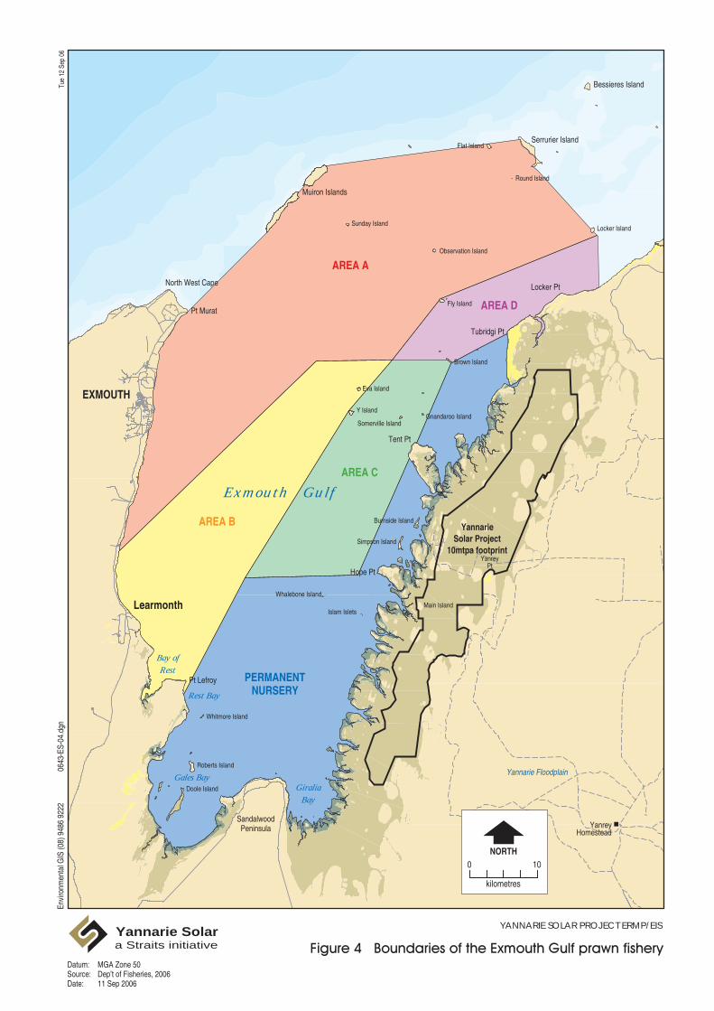
Large areas of the Gulf form part of prawn trawling grounds that have been intensively trawled forapproximately 30 years (Figure 4). Trawling has had the greatest impact on the Gulf ecosystem, but isnow restricted to deeper areas of the Gulf where the seabed now largely comprises muddy sediments.
There are currently 21 aquaculture and pearl licences in the Gulf for a variety of aquaculture activities.The environmental impacts of these operations are believed to be relatively minor.
Recreational boating is mostly confined to the western side of the Gulf in the vicinity of Exmouth andis associated with both fishing and diving. Recreational fishing pressure is believed to havecontributed to declines in target species such as coral trouts, Malabar rock cod, tuskfish and membersof the emperor and sea perch families in the vicinity Muiron Islands. In response, the StateGovernment has introduced closures to protect stocks.

Envi
ronm
enta
l GIS
(08)
948
6 92
2206
43-E
S-03
.dgn
Tue
12 S
ep 0
6
YANNARIE SOLAR PROJECT ERMP/EISYannarie Solara Straits initiative
Sherri Brown, 200611 Sep 2006
Source:Date:
Mura
t
Road
Minily
a
Exm
outh
Road
Murat
Road
Road
Murat
Road
Yan
EXMOUTH
Learmonth
North West Cape
Muiron Islands
Serrurier Island
Pt Murat
Locker Pt
Tubridgi Pt
Tent Pt
Hope Pt
SandalwoodPeninsula
Pt Lefroy
Bessieres Island
Locker Island
Observation Island
Sunday Island
Flat Island
Round Island
Fly Island
Brown Island
Eva Island
Y IslandGnandaroo Island
Somerville Island
Burnside Island
Simpson Island
Whalebone Island
Islam Islets
Doole Island
Roberts Island
Whitmore Island
Gales BayGiralia
Bay
Bay ofRest
Rest Bay
Exmouth Gulf
Yannarie Floodplain
Main Island
YanreyPt
YanreyHomestead
Envi
ronm
enta
l GIS
(08)
948
6 92
2206
43-E
S-04
.dgn
Tue
12 S
ep 0
6
Datum:Source:Date:
YANNARIE SOLAR PROJECT ERMP/EISYannarie Solara Straits initiative
AREA A
AREA B
AREA C
AREA D
PERMANENTNURSERY
YannarieSolar Project
10mtpa footprint
0NORTH
10
kilometres
MGA Zone 50Dep’t of Fisheries, 200611 Sep 2006
Yannarie Solar Project Executive Summary
SRL06043_ExecSumm_Final2 - 27/11/2006 9
2.3 GULF AREA BELOW LOW TIDE MARK
The Gulf has two distinct bathymetric regions; the deeper waters >10 m in the west (maximum depthof 21 m), and shallows of the east. These distinct bathymetric regions tend to regulate the flora andfauna found in each region, for example the deep region does not support seagrasses, while theshallow region is not frequented by whales.
2.3.1 Benthic habitat and Gulf fauna
There are extensive shallow vegetated banks on the east coast of the Gulf which support the majorityof marine fauna in this area. These banks support ephemeral seagrasses, sponges and macroalgae andextend predominantly south of Hope Point generally 0.5 to 1.5 m below mean sea level.
This benthic habitat is a very important foundation for the Gulf ecosystem through the fixation ofcarbon and provision of shelter and food for organisms higher in the food chain. These banks are theprimary feeding ground for the Gulf dugong population (approximately 1000) with the greatestconcentration in the south east corner of the Gulf. These banks are also likely to be important feedinggrounds for turtles and are key component for the lifecycle of the commercially significant tigerprawn.
The eastern banks produce significant quantities of seagrass detritus and the supply of this material tothe remainder of the Gulf may be an important contributor of nutrients to the Gulf ecosystem.
The Gulf is an important resting ground for nursing humpback whales (Figure 5) on their southwardmigration between September and November. Large numbers of whales and their calves gather in thedeeper waters along the west coast of the Gulf and near Point Murat. The Gulf is also frequented byother whale species.
2.4 INTERTIDAL ZONE – AREA BETWEEN THE LOW AND HIGH TIDES
The intertidal zone includes areas of mudflats, mangroves and algal mats which experience periodicinundation by tides and hypersaline groundwater or soil. Ecological processes of nitrogen (algal matsonly) and carbon fixation in the algal mat and mangrove communities are key sources of nutrients tothe eastern Gulf ecosystem, in addition to sustaining other organisms through the provision of shelterand food. The input of nutrients from the supratidal salt flats to the mangroves and algal mats isinsignificant.
The distribution of the mangroves and algal mat communities is governed by a combination ofgroundwater salinity and inundation frequency. Surface and groundwater flows from the hinterlandhave negligible influence on the maintenance of salinities in the intertidal zone.

EXMOUTH
Learmonth
North West Cape
Muiron Islands
Serrurier Island
Pt Murat
Locker Pt
Tubridgi Pt
Tent Pt
Hope Pt
SandalwoodPeninsula
Pt Lefroy
Bessieres Island
Gales BayGiralia
Bay
Bay ofRest
Rest Bay
Exmouth Gulf
Yannarie Floodplain
Main Island
YanreyPt
YanreyHomestead
Envi
ronm
enta
l GIS
(08)
948
6 92
2206
43-E
S-05
.dgn
Tue
12 S
ep 0
6
Datum:Source:Date:
YANNARIE SOLAR PROJECT ERMP/EISYannarie Solara Straits initiative
0NORTH
10
kilometres
REFERENCE
Herd Size
Pod with calves
Preferred habitat(50% P. contour plot) Medium density area(75% P. contour plot) Probable annual range(95% P. contour plot) Flight path
123
4
5
YannarieSolar Project
10mtpa footprint
MGA Zone 50Centre for Whale Research WA, 200611 Sep 2006
Yannarie Solar Project Executive Summary
SRL06043_ExecSumm_Final2 - 27/11/2006 11
2.4.1 Algal mats, mangroves and tidal creeks
The cyanobacteria algal mats form the inland margins of the intertidal zone to the east of themangrove communities above the Mean High Water spring tides. These are generally wet from tidalinundation only 1-3% of the time during spring tides.
The algal mats are an important component of the ecosystem as they fix nitrogen and carbon from theatmosphere and contribute nutrients, particularly organic nitrogen and organic matter, to the downgradient mangrove communities and the east coast of the Gulf. The east coast is dominated by one ofthe most extensive stands of arid zone mangroves in Western Australia. Mangrove communitiesstabilise the coast and fix carbon from carbon dioxide in the atmosphere and also receive nutrientsfrom algal mats further up the tidal gradient. The mangroves contribute nutrients and organic matterto eastern Gulf system, as well as provide shelter for a wide range of fauna. The east coast ecosystemis a foundation for the Exmouth Gulf prawn fishery.
The distribution and range of mangrove species is governed by a combination of groundwatersalinities and periods of tidal inundation. Groundwater salinities in mangroves vary typically between40 and 90 ppt, and complete tidal inundation of mangroves varies between 5 and 50% of the time.
Tidal creeks facilitate the inundation and draining of mangrove and algal communities, and conveynutrients and carbon to offshore areas of the eastern Gulf. These tidal creeks are characterised byturbid water and strong tidal currents.
The salinity at the inland end of tidal creeks ranges between 50-70 ppt with salinities in the main bodyof a creek ranging between 40-50 ppt. The concentrations of inorganic nitrogen in these creeks tend tobe higher than offshore waters, indicating the export of nitrogen to the eastern Gulf subtidal areas.
The creeks perform an important ecological function as a refuge for juvenile fish and prawns as wellas attracting fauna that use the local conditions or are larger predators.
2.5 SUPRATIDAL SALT FLATS
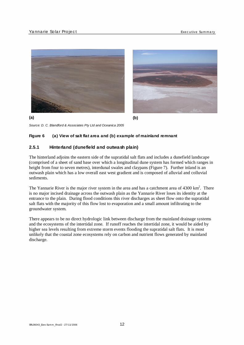
This area adjoins the eastern side of the algal mat communities, has a lack of vertical relief and isoccasionally inundated by seawater during storm surges or spring tides coincidental with the passageof low pressure systems. The supratidal salt flats are up to 10 km wide with slopes of 1:5000 to1:10,000. Within the supratidal flat there are occasional mainland remnants and very slightdepressions, channels and ridges.
The environment of the salt flats is generally extremely hostile to life due to hypersaline groundwaterand salt in the near surface sediments. The area is devoid of flora and vegetation (except foroccasional mainland remnants within the flats) and biological activity and is not utilised by terrestrialfauna on any regular basis (Figure 6).
Yannarie Solar Project Executive Summary
SRL06043_ExecSumm_Final2 - 27/11/2006 12
(a) (b)
Source: D. C. Blandford & Associates Pty Ltd and Oceanica 2005
Figure 6 (a) View of salt flat area and (b) example of mainland remnant
2.5.1 Hinterland (dunefield and outwash plain)
The hinterland adjoins the eastern side of the supratidal salt flats and includes a dunefield landscape(comprised of a sheet of sand base over which a longitudinal dune system has formed which ranges inheight from four to seven metres), interdunal swales and claypans (Figure 7). Further inland is anoutwash plain which has a low overall east west gradient and is composed of alluvial and colluvialsediments.
The Yannarie River is the major river system in the area and has a catchment area of 4300 km2. Thereis no major incised drainage across the outwash plain as the Yannarie River loses its identity at theentrance to the plain. During flood conditions this river discharges as sheet flow onto the supratidalsalt flats with the majority of this flow lost to evaporation and a small amount infiltrating to thegroundwater system.
There appears to be no direct hydrologic link between discharge from the mainland drainage systemsand the ecosystems of the intertidal zone. If runoff reaches the intertidal zone, it would be aided byhigher sea levels resulting from extreme storm events flooding the supratidal salt flats. It is mostunlikely that the coastal zone ecosystems rely on carbon and nutrient flows generated by mainlanddischarge.

Yannarie Solar Project Executive Summary
SRL06043_ExecSumm_Final2 - 27/11/2006 13
Source: D. C. Blandford & Associates Pty Ltd and Oceanica 2005
Figure 7 View of longitudinal dunefield towards the Yannarie River South and supratidal saltflats
Yannarie Solar Project Executive Summary
SRL06043_ExecSumm_Final2 - 27/11/2006 14
3 THE PROPOSAL
The salt production process involves the pumping of seawater into a series of large, shallow pondswhere solar energy evaporates water and concentrates the dissolved salts as it proceeds through theponds. In the last concentrator pond the brine becomes saturated with salt (sodium chloride) and istransferred to a series of smaller crystalliser ponds where 75% of the salt (sodium chloride) crystallisesout of solution. The residual brine, called bitterns, continually exits the crystalliser ponds.
Straits have developed a bitterns resource recovery strategy (Appendix 1) which involves furtherextraction of sodium and then mixed salts. Ultimately the goal is to completely recover all value fromthe bitterns resource (including magnesium) resulting in no requirement to discharge bitterns.Consequently, this proposal does not include the discharge of bitterns. The financial and technicalfeasibility of achieving no discharge will be assessed in the first 10 years of operation.
An initial feasibility study by the CSIRO on the technical capacity for bitterns re-use and the potentialvalue of bitterns products has identified significant long term opportunities.
On completion of the final assessment of bitterns re-use, any new value adding processes will bereferred to the Environmental Protection Authority (EPA) for assessment. If necessary, a separatereferral to the EPA would also be made for the disposal of any bitterns not able to be practicably re-used.
The salt from the crystalliser ponds will be harvested, washed, stockpiled and then loaded viaconveyors onto barges, which transport the salt offshore for loading onto a bulk carrier anchored inExmouth Gulf.
The proposal is intended to be developed in four distinct stages, with Stages One and Two expected totake at least ten years to fully establish:
Stage 1 – establish a saltfield at the southern end of the lease having a nominal capacity of3.1 Mtpa.
Stage 2 – increase the capacity of the southern end to a nominal 4.7 Mtpa.
Stages 3 and 4 – establish a saltfield at the northern end of the lease having an ultimate capacityof 5.8 Mtpa. The combination of the southern and northern end fields gives a total capacity of 10Mtpa.
Straits is seeking, as a condition of approval, to conduct an environmental review of the project beforecommencing Stages 3 and 4. This review will consider all environmental impacts and how they arebeing managed as well as a review of any social issues associated with the project. The scope of thisreview will be in accordance with the requirements of the EPA. The EPA would assess the review andprovide advice to the Minister on any new or amended environmental conditions required to ensurethe project continues to proceed in an environmentally acceptable manner.
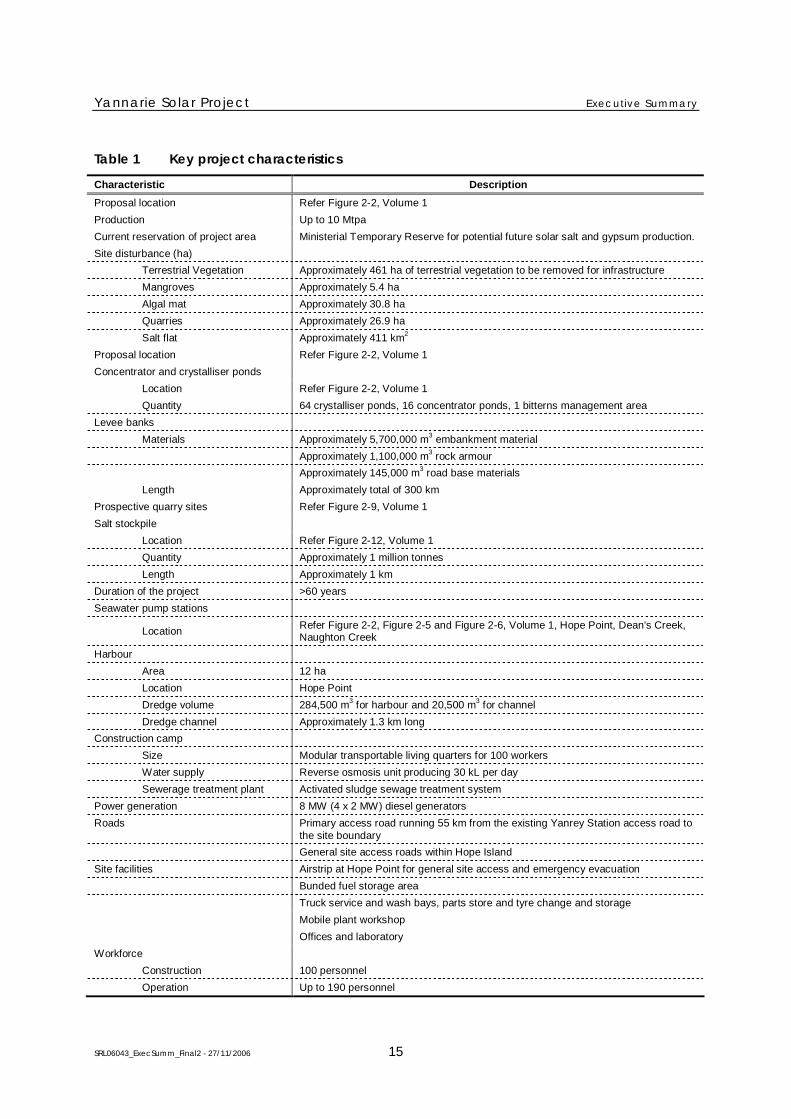
A summary of the key characteristics of the project are presented in Table 1.
Yannarie Solar Project Executive Summary
SRL06043_ExecSumm_Final2 - 27/11/2006 15
Table 1 Key project characteristics
Characteristic Description
Proposal location Refer Figure 2-2, Volume 1
Production Up to 10 Mtpa
Current reservation of project area Ministerial Temporary Reserve for potential future solar salt and gypsum production.
Site disturbance (ha)
Terrestrial Vegetation Approximately 461 ha of terrestrial vegetation to be removed for infrastructure
Mangroves Approximately 5.4 ha
Algal mat Approximately 30.8 ha
Quarries Approximately 26.9 ha
Salt flat Approximately 411 km2
Proposal location Refer Figure 2-2, Volume 1
Concentrator and crystalliser ponds
Location Refer Figure 2-2, Volume 1
Quantity 64 crystalliser ponds, 16 concentrator ponds, 1 bitterns management area
Levee banks
Materials Approximately 5,700,000 m3
embankment material
Approximately 1,100,000 m3
rock armour
Approximately 145,000 m3
road base materials
Length Approximately total of 300 km
Prospective quarry sites Refer Figure 2-9, Volume 1
Salt stockpile
Location Refer Figure 2-12, Volume 1
Quantity Approximately 1 million tonnes
Length Approximately 1 km
Duration of the project >60 years
Seawater pump stations
LocationRefer Figure 2-2, Figure 2-5 and Figure 2-6, Volume 1, Hope Point, Dean’s Creek,Naughton Creek
Harbour
Area 12 ha
Location Hope Point
Dredge volume 284,500 m3
for harbour and 20,500 m3
for channel
Dredge channel Approximately 1.3 km long
Construction camp
Size Modular transportable living quarters for 100 workers
Water supply Reverse osmosis unit producing 30 kL per day
Sewerage treatment plant Activated sludge sewage treatment system
Power generation 8 MW (4 x 2 MW) diesel generators
Roads Primary access road running 55 km from the existing Yanrey Station access road tothe site boundary
General site access roads within Hope Island
Site facilities Airstrip at Hope Point for general site access and emergency evacuation
Bunded fuel storage area
Truck service and wash bays, parts store and tyre change and storage
Mobile plant workshop
Offices and laboratory
Workforce
Construction 100 personnel
Operation Up to 190 personnel

Yannarie Solar Project Executive Summary
SRL06043_ExecSumm_Final2 - 27/11/2006 16
3.1 COMMONWEALTH AND WESTERN AUSTRALIAN IMPACT ASSESSMENT AND APPROVAL
The EPA has set an Environmental Review and Management Programme (ERMP) level of assessment(which Straits recommended) for the Yannarie Solar Project and under the EPA administrativeprocedures Straits was required to prepare:
an acceptable scoping report which outlines the environmental factors to be addressed,investigations to be conducted, the methodologies for the conduct of investigations, stakeholderconsultation and a timetable for the assessment process
an ERMP document, suitable for public review, which provides a detailed review of potentialenvironmental impacts and management measures for the relevant environmental factors outlinedin the scoping report for public and government agency review and subsequent assessment by theEPA.
The key steps in the Yannarie Solar Project environmental impact assessment and approval process aresummarised in Figure 8.
The project was also referred to the Department of the Environment and Heritage (DEH) inaccordance with the Environment Protection and Biodiversity Conservation Act 1999 (EPBC Act).The DEH confirmed that the project was to be treated as a controlled action and an EnvironmentalImpact Statement (EIS) is required for assessment under the EPBC Act.
The Commonwealth has accredited the Western Australian impact assessment process under thisagreement such that this ERMP document will be satisfying the requirements of both theCommonwealth and State assessment processes.
This ERMP is subject to a 10-week public review period and at the end of this period, issues raised inwritten submissions from the public and government agencies are transmitted to Straits for anopportunity to provide responses to the submissions for the EPA’s consideration before finalising itsassessment report.
The DEH will also review the ERMP, public submissions and Straits’ responses to prepareenvironmental assessment reports and recommendations for the Commonwealth Minister.

Yannarie Solar Project Executive Summary
SRL06043_ExecSumm_Final2 - 27/11/2006 17
Submission of referral with scoping document
Minister decides proposal is a
controlled action
Commonwealth Minister
Assessment proceeds by
accredited process
Minister consults with DMAs*
Minister publishes EPA Report
EPA prepares assessment report to the
Minister
Request response to submissions
EPA approves ERMP for public review
EPA considers Draft ERMP
Straits prepares ERMP
EPA approves Scoping
EPA
Public review of scoping document
EPA set ERMP level of assessment
and public review period
Commonwealth Minister decision on approval
Environment Australia agrees to
scoping document
Appeal(s) to the MinisterMinister determines
appeals
Minister decision on approval
No
Yes
*Decision making authorities
Figure 8 Commonwealth and State environmental assessment and approval process
Once the EPA has released its report and recommendations to the Minister for the Environment andthe public, any person has the right to appeal against the contents of that report. The AppealsConvenor then collates any appeals, consults where required and provides advice to the Minister forthe Environment.
The Minister for the Environment is required to consult with relevant Decision Making Authoritiesbefore making a final determination on whether the Yannarie Solar Project should be approved and theconditions under which any approval will be granted.
Yannarie Solar Project Executive Summary
SRL06043_ExecSumm_Final2 - 27/11/2006 18
3.2 COMMUNITY CONSULTATION AND PEER REVIEW
Straits will prepare an Annual Environmental Report (AER) for the Yannarie Solar project. Thisreview will report on the environmental commitments, including monitoring results, managementresponses and environmental performance.
A Tripartite Stakeholder Liaison Group (TSRG) has been established and will continue to provide apublic forum for transparent environmental management.
The TSRG will be provided with all monitoring data resulting from management commitments as wellas helping to develop and implement the respective community based monitoring programs.
Meetings of the TSRG will be open to the public and the group will include representatives from:
community environment organisations
local Government
Government agencies
Chamber of Commerce and Industry
Recreation fishing sector
Commercial fishing sector
Tourism
Straits Resources.
Yannarie Solar Project Executive Summary
SRL06043_ExecSumm_Final2 - 27/11/2006 19
4 ENVIRONMENTAL FACTORS
4.1 MINOR FACTORS
4.1.1 Greenhouse gases
The greenhouse gas (GHG) emissions for the Yannarie Solar project will be predominantly fromcombustion sources as carbon dioxide (CO2).
The implementation of the Yannarie Solar project will result in an increase in greenhouse emissions,but Straits is committed to investigation of other renewable energy sources to compliment the solarponds as well as the carbon sequestration capacity of the concentrator ponds.
In addition, emissions will be offset by energy saving initiatives incorporated into the design of theproject, to achieve an overall improvement in the greenhouse gas emission rates.
4.1.2 World heritage area
The State Government has recently delineated a boundary for World Heritage Area nomination forcommunity consultation and the area now nominated for World Heritage excludes the Exmouth Gulfand the project area on the eastern coast of the Gulf.
4.1.3 Subterranean fauna
Subterranean fauna are animals that inhabit underground habitats, and comprise stygofauna andtroglofauna. Stygofauna are fauna that inhabit groundwater, sometimes occurring very close to thesurface.
The available data suggest that it is unlikely that subterranean fauna occur within the proposedsaltfield footprint, however sampling and reporting will be undertaken at the time of installation of thedewatering system to verify the occurrence, or otherwise, of subterranean fauna.
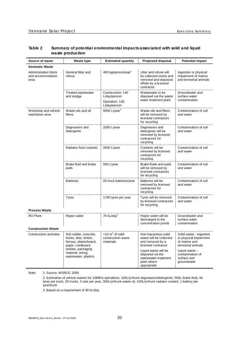
4.1.4 Solid and liquid waste disposal
The solid and liquid wastes that may be generated through the construction and operation of theproject are summarised in Table 2. The Construction and Environmental Management Plan (CEMP)and Operation Environmental Management Plan (OEMP) will address the issues of solid and liquidwaste disposal.
Yannarie Solar Project Executive Summary
SRL06043_ExecSumm_Final2 - 27/11/2006 20
Table 2 Summary of potential environmental impacts associated with solid and liquidwaste production
Source of waste Waste type Estimated quantity Proposed disposal Potential impact
Domestic Waste
General litter andrefuse
400 kg/person/year1
Litter and refuse willbe collected onsite andremoved and disposedoffsite by a licensedcontractor
Ingestion or physicalimpairment of marineand terrestrial animals
Administration blockand accommodationarea
Treated wastewaterand sludge
Construction: 140L/day/person
Operation: 140L/day/person
Wastewater to bedisposed via the wastewater treatment plant
Groundwater andsurface watercontamination
Waste oils and oilfilters
6000 L/year2
Waste oils and filterswill be removed bylicensed contractorsfor recycling
Contamination of soiland water
Degreasers anddetergents
2000 L/year Degreasers anddetergents will beremoved by licensedcontractors forrecycling
Contamination of soiland water
Radiator fluid coolants 2000 L/year Coolants will beremoved by licensedcontractors forrecycling
Contamination of soiland water
Brake fluid and brakepads
500 L/year Brake fluids and padswill be removed bylicensed contractorsfor recycling
Contamination of soiland water
Batteries 20 truck batteries/year Batteries will beremoved by licensedcontractors forrecycling
Contamination of soiland water
Workshop and vehiclewashdown area
Tyres 1760 tyres per year Tyres will be removedby licensed contractorsfor recycling
Contamination of soiland water
Process Waste
RO Plant Reject water 70 kL/day3
Reject water will bedischarged to theconcentration ponds
Groundwater andsurface watercontamination
Construction Waste
Construction activities Soil rubble, concrete,bricks, tiles, timber,ferrous, plasterboard,paper, cardboard,textiles, packagingmaterial, wiring,wastewater, plastics
<10 m3
of solidconstruction wastematerials
Non-hazardous solidwaste will be collectedand removed by alicensed contractor
Liquid waste will bedisposed via thewastewater treatmentplant whereappropriate
Solid waste - Ingestionor physical impairmentof marine andterrestrial animals
Liquid waste –contamination ofsurface andgroundwater
Note: 1. Source: WSROC 2000
2. Estimation of vehicle wastes for 10MtPa operations: 100L/yr/truck degreasers/detergents, 500L brake fluid, 44tyres per truck, 20 trucks, 2 sets per year, 300L/yr/truck waste oil, 100L/yr/truck radiator coolant, 1 battery peryear/truck
3. Based on a requirement of 30 kL/day
Yannarie Solar Project Executive Summary
SRL06043_ExecSumm_Final2 - 27/11/2006 21
4.2 KEY RELEVANT ENVIRONMENTAL FACTORS
The environmental factors (summarised at the end of this report) that were considered relevant to theproject which require detailed consideration are:
soils and landforms
groundwater
surface water
terrestrial vegetation and flora
terrestrial fauna
marine water and sediment quality
benthic primary producer habitat and ecological integrity
marine fauna
commercial fishing and aquaculture
recreation and tourism
cultural heritage and conservation values.
4.2.1 Key environmental issues and outcomes
The mangrove and algal mat ecosystems will be maintained with only 5.4 ha of mangrove (0.05%in project area) and 31 ha of algal mat (0.38% in project area) being cleared. Mangroves andalgal mats are expected to colonise some parts of the saltfield and 75 ha of mangroves will bereplanted.
The project has been designed to avoid any impact on the nutrient and carbon flows to the Gulfresulting from the tidal wetting of the algal mats and mangrove systems.
Only 0.05% of benthic habitat will be disturbed in dredging 16.4 ha for the barge channel. Alldredge spoil will be disposed onshore and no seagrass banks will be affected.
There will be no impacts on aquaculture leases or any significant risk to commercial orrecreational fish and prawn yields. The project offers potential benefits for aquaculture andrecreational fishing.
The project has been designed to maximize environmental and economic benefits through abitterns resource recovery programme.
Whales, dugongs and other marine fauna will be protected from vessel strike by strict speedlimits, fixed navigational routes, careful monitoring and review of management actions. Theprovision of a monitoring programme for introduced marine organisms will be a new andeffective environmental safeguard for the Exmouth Gulf.
The majority of the proposal will be constructed on unvegetated hypersaline salt flats. 461 ha willbe cleared for infrastructure, but no Declared Rare Flora or vegetation types of specialconservation significance will be affected.
Yannarie Solar Project Executive Summary
SRL06043_ExecSumm_Final2 - 27/11/2006 22
4.2.2 Soils and landforms
The project area is located within the Cape Range Province and can be roughly divided into fourparallel geomorphic landscape elements that trend north east to south west including the outwashplain, dunefield, salt flat and coastal units.
The distribution of these landscape elements has been historically governed by fluvial and aeolianprocesses (rather than pedological processes) occurring in the Yannarie River and Rouse Creeksystems in the east and the coastline in the west.
Potential impacts
Key activities or aspects of the proposal that may potentially affect soils and landform include:
site preparation potentially increasing erosion including removal of topsoil and changes in surfacewater flows
landform removal or modification through sourcing materials for earthworks of ponds, bunds andassociated infrastructure including the barge harbour
exposure of potential acid sulphate soils through the construction of infrastructure and dredging.
Environmental outcome
The construction of the Yannarie Solar project will result in landform modification through thesourcing of construction materials for the salt field and associated infrastructure. The largest landformmodification will be the construction of ponds on the salt flats landform. A mainland remnant in thisflat and at Hope Point will be modified to accommodate the processing plant and construction of thebarge harbour respectively.
The area of the supratidal flat landform occupied by the project will be approximately 410 km2, whichrepresents 32% of this landform within the Ashburton Land System. This loss of landform isecologically insignificant and there is still sufficient area remaining for the values of this landform unitto be retained.
Rehabilitation of landforms and vegetation will be conducted on areas (if not required for operationalactivities) disturbed by construction activities and quarry operations to the satisfaction of the EPA.Overall erosional events will be limited to those naturally expressed within the region, and thedisturbance of low quantities of potentially acid generating soils will be minimised or otherwisemanaged in accordance with the Construction Environmental Management Plan (CEMP).
4.2.3 Groundwater
The hydrogeological component of the physical environment within the project area is important inunderstanding the links between surface water drainage, claypan recharge and discharge, and thewashout features observed from the dunefields onto the supratidal salt flats. Hydrogeologicalprocesses often play a significant role in controlling or buffering surface water flows in this type ofenvironment.
Water levels in superficial aquifer wells and bores on the outwash plain are between 8 m and 20 mbelow ground level. Flows in the Yannarie River channel are considered to recharge the superficialaquifer. The contributions to recharge of groundwater by direct rainfall infiltration are minimal as themajority of rainfall is lost to either surface runoff or evaporation and evapotranspiration.
Yannarie Solar Project Executive Summary
SRL06043_ExecSumm_Final2 - 27/11/2006 23
Discharge from the superficial formations in the outwash plain system is by through-flow towards thewest, and a small component of leakage into the underlying pre-quaternary sandstones, calcarenitesand shales.
Groundwater in the dunefield is between 4 and 8 m below the level of the claypans coinciding withthin discontinuous lenses of calcrete. Groundwater yields within the calcrete and claypan deposits arelow and therefore groundwater gradients within the dunefield landscape unit are consequently flat(0.0002), with groundwater recharged by a small component of through flow from the outwash plain.
The supratidal salt flat forms a thin unconfined aquifer of sand, silt and clay above a low permeabilityclay layer. The depth to water beneath the supratidal salt flat ranges from 0.2–1 m. The hydraulicgradient is extremely low (0.00009) due to negligible topographic variation and recharge is bythrough-flow from the claypan deposits in the dunefield.
The elevation of the underlying clay layer is generally above sea-level, hydraulically isolating thewater levels beneath the plain from tidal influences. The supratidal salt flats are intermittentlyrecharged by spring tide events coinciding with periods of extended low pressure or storm surgeevents. The majority of surface water on the supratidal salt flats is lost to evaporation, concentratingsalts in the surficial sediments as halite crusts. These are subsequently dissolved by infiltrating surfacewater to produce hypersaline groundwater.
Potential impacts
Key activities or aspects of the proposal that may potentially affect the quality and/or quantity ofgroundwater resources within the project area include:
dewatering during construction could potentially impact water quality and groundwaterdependent ecosystems (including subterranean fauna)
spills (e.g. from diesel storage) pose a potential threat to water quality
seepage from the salt ponds
saline groundwater intrusion into groundwater of mainland remnants resulting from constructionof salt ponds
effluent disposal from wastewater treatment plants could potentially affect water quality.
Environmental outcome
Construction will require temporary dewatering (e.g. barge harbour) which could potentially affectgroundwater quantity and quality and any subterranean fauna (if they exist). Sampling and reportingthe presence or otherwise of subterranean fauna will be undertaken prior to dewatering. Given thereplication of limestone habitat across the project area it is not expected that any subterranean faunawill be limited to the proposed quarry locations.
Groundwater quality may be potentially affected by oil and fuel spills (e.g. from diesel stored on site),seepage losses from the salt ponds and discharge of treated wastewater. These risks will be reducedthrough good design, development of appropriate operational procedures, the very low permeability ofpond walls and development of monitoring and response plans.
The flooding of the saltfield may lead to limited saline water intrusion and hydrostatically elevatedgroundwater levels for the isolated mainland remnants within the concentrator ponds. The low lying
Yannarie Solar Project Executive Summary
SRL06043_ExecSumm_Final2 - 27/11/2006 24
areas that may be affected mostly comprise claypans and halophytic vegetation and these are leastlikely to be affected by an increase in salinity or waterlogging long term. Straits will develop andimplement a monitoring programme targeting low-lying areas on the islands identified as being atpotential risk within the saltfield.
4.2.4 Surface water
Surface water flows within the study area are the result of a complex interrelationship between thewater courses, floodplain and an intricate maze of dunal ridges. In addition, due to the arid climateand very high evaporation rates, the occurrence of overland flow is rare and usually only associatedwith extreme rainfall associated with tropical cyclones. There are a number of watercourses in thehinterland to the east of the project area in the study area. These include Chinty Creek, Rouse Creekand Yannarie River with the majority of freshwater flows occurring within Rouse Creek and theYannarie River.
During very high flow conditions, the Yannarie River and Rouse Creek discharge as sheet flow ontothe alluvial plain. The majority of the water discharged to these areas is eventually lost throughevaporation and to a lesser extent through infiltration. Under very high flow conditions waterdischarges onto the supratidal salt flats via four outlets (Yannarie South, Yannarie North, Rouse Southand Rouse North).
Potential impacts
Key activities or aspects of the proposal that may potentially affect surface water flow include:
diversion or redirection of Yannarie River flows will alter local hydrology patterns downstreamof the diversion weir
impoundment and inundation as a result of construction of diversion weir may alter vegetationand affect sediment and nutrient transmission pathways.
Environmental outcome
Diversion of Yannarie North flows will increase flow volumes to Rouse North and South channels.The weir will increase the area inundated to approximately 151 ha (for a 1 in 5 year event), beingflooded for about 2-4 weeks.
As these systems infrequently ‘break out’ to the Gulf, any alteration in the flow route and point ofoutlet is not expected to adversely affect freshwater, sediment and nutrient fluxes to the Gulf.Additionally, the intertidal ecosystem of the east coast of the Gulf does not rely on hinterland flows asa source of nutrients, thus the diversion of flows is not expected to have a significant impact. Therewill be some minor losses from the system associated with evaporation and sedimentation arising fromimpoundment, but these losses will be insignificant in terms of events >1 in 20 years.
Some vegetation types may be affected by the increased residence time of the floodwaters andreduction in flow down the Yannarie North channel below the diversion weir. However, the area ofpotential impact represents a very small amount of the widely occurring Yanrey Land System.
The net quantity of water flows to the Exmouth Gulf will remain the same, however the distribution ofwater flowing between watercourses and outlets will be affected. Water quality is not expected to beaffected by the diversion of flow and operation of the salt field.
Yannarie Solar Project Executive Summary
SRL06043_ExecSumm_Final2 - 27/11/2006 25
4.2.5 Terrestrial vegetation and flora (excluding mangroves)
The project area is located within the CAR1 (Cape Range) biological subregion within the CarnarvonBioregion, which is 2,547,911 ha in size. The three main vegetation types identified in historicalsurveys included:
mangrove vegetation on the coastline and covering the intertidal zone, dominated by Avicenniamarina, with some Rhizophora stylosa
behind the intertidal zone is a belt of bare hypersaline mud, which sometimes floods with springtides. This zone is mostly devoid of any vegetation, but some samphire communities (Halosarciaspecies) occur locally
behind the saline tidal mud flat area is a zone mapped as shrub steppe which is typicallydominated by Triodia species (T. epactia/pungens) with Acacia bivenosa, A. synchronicia, A.tetragonophylla and A. xiphophylla the most common shrub species present.
No vegetation types within the project area represent Threatened Ecological Communities (TECs) orcommunities of special conservation significance. Most vegetation types are widespread within theproject area.
No plant species identified within the project area were found to be listed as Declared Rare (DRF) orPriority at State or Federal level. There are two Declared Rare Flora species Lepidium catapycnon andThryptomene wittweri currently listed as ‘Vulnerable’ (EPBC Act) within the Carnarvon IBRABioregion, however these are located 50 km from the project area.
Potential impacts
Key activities or aspects of the proposal that may potentially affect terrestrial vegetation and florainclude:
site preparation and construction of infrastructure will involve removal or disturbance ofterrestrial vegetation, with associated primary and secondary effects (e.g. habitat loss and risk ofweed spread)
salt water intrusion from operation of the ponds
hydrological changes (e.g. flooding, inundation or reduced stream flow) could lead to the loss ofvegetation in certain soil types.
Environmental outcome
Through regular monitoring of vegetation and flora within and adjacent to the project area, Straits willincrease the knowledge of vegetation communities, plant ecology and function in the region.Similarly, Straits commits to further research on these communities so that significant flora andvegetation communities are identified.
Approximately 461 ha of terrestrial vegetation within the project area will be cleared for infrastructureincluding access and haul roads, the conveyor, Hope Point infrastructure, southern pump station,settling ponds and quarries. This clearing is not considered significant as it is less than 1% of theproject area (which is 41,364 ha in size), no Declared Rare Flora or Priority Flora species have beenidentified by surveys within the project area, and vegetation communities potentially affected do notappear to be restricted in their distribution.
Yannarie Solar Project Executive Summary
SRL06043_ExecSumm_Final2 - 27/11/2006 26
Straits will progressively rehabilitate temporarily disturbed areas arising from construction.
With construction, there is an increased risk of the spread of weeds, which will be managed throughweed control and management procedures.
There is a low risk of saltwater intrusion impacting vegetation within the mainland remnants locatedthroughout the proposed pond areas due to differences in elevation between pond water and the heightof remnants (> 2 m).
A flood protection weir will be primarily utilised for diverting hinterland flows of water away from theconcentrator ponds during major rainfall events. Hydrological impacts (flooding and inundation) tovegetation within the project area from the weir are difficult to quantify at this stage, howevervegetation condition, abundance and species diversity will be monitored, particularly during largerainfall events.
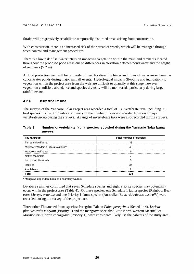
4.2.6 Terrestrial fauna
The surveys of the Yannarie Solar Project area recorded a total of 138 vertebrate taxa, including 90bird species. Table 3 provides a summary of the number of species recorded from each majorvertebrate group during the surveys. A range of invertebrate taxa were also recorded during surveys.
Table 3 Number of vertebrate fauna species recorded during the Yannarie Solar faunasurveys
Fauna group Total number of species
Terrestrial Avifauna 33
Migratory Waders / Littoral Avifauna* 48
Mangrove Avifauna* 9
Native Mammals 7
Introduced Mammals 5
Reptiles 34
Amphibians 2
Total 138
* Mangrove dependent birds and migratory waders
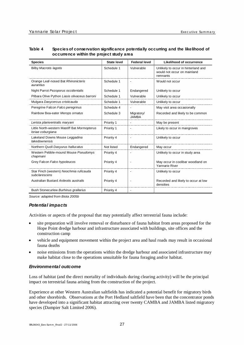
Database searches confirmed that seven Schedule species and eight Priority species may potentiallyoccur within the project area (Table 4). Of these species, one Schedule 1 fauna species (Rainbow Bea-eater Merops ornatus) and one Priority 1 fauna species (Australian Bustard Ardeotis australis) wererecorded during the survey of the project area.
Three other Threatened fauna species; Peregrine Falcon Falco peregrinus (Schedule 4), Leristaplaniventralis maryani (Priority 1) and the mangrove specialist Little North-western Mastiff BatMormopterus loriae coburgiana (Priority 1), were considered likely use the habitats of the study area.
Yannarie Solar Project Executive Summary
SRL06043_ExecSumm_Final2 - 27/11/2006 27
Table 4 Species of conservation significance potentially occurring and the likelihood ofoccurrence within the project study area
Species State level Federal level Likelihood of occurrence
Bilby Macrotis lagotis Schedule 1 Vulnerable Unlikely to occur in hinterland andwould not occur on mainlandremnants
Orange Leaf-nosed Bat Rhinonicterisaurantius
Schedule 1 - Would not occur
Night Parrot Pezoporus occidentalis Schedule 1 Endangered Unlikely to occur
Pilbara Olive Python Liasis olivaceus barroni Schedule 1 Vulnerable Unlikely to occur
Mulgara Dasycercus cristicauda Schedule 1 Vulnerable Unlikely to occur
Peregrine Falcon Falco peregrinus Schedule 4 - May visit area occasionally
Rainbow Bea-eater Merops ornatus Schedule 3 Migratory/JAMBA
Recorded and likely to be common
Lerista planiventralis maryani Priority 1 - May be present
Little North-western Mastiff Bat Mormopterusloriae coburgiana
Priority 1 - Likely to occur in mangroves
Lakeland Downs Mouse Leggadinalakedownensis
Priority 4 - Unlikely to occur
Northern Quoll Dasyurus hallucatus Not listed Endangered May occur
Western Pebble-mound Mouse Pseudomyschapmani
Priority 4 - Unlikely to occur in study area
Grey Falcon Falco hypoleucos Priority 4 - May occur in coolibar woodland onYannarie River
Star Finch (western) Neochmia ruficaudasubclarescens
Priority 4 - Unlikely to occur
Australian Bustard Ardeotis australis Priority 4 - Recorded and likely to occur at lowdensities
Bush Stonecurlew Burhinus grallarius Priority 4 -
Source: adapted from Biota 2005b
Potential impacts
Activities or aspects of the proposal that may potentially affect terrestrial fauna include:
site preparation will involve removal or disturbance of fauna habitat from areas proposed for theHope Point dredge harbour and infrastructure associated with buildings, site offices and theconstruction camp
vehicle and equipment movement within the project area and haul roads may result in occasionalfauna deaths
noise emissions from the operations within the dredge harbour and associated infrastructure maymake habitat close to the operations unsuitable for fauna foraging and/or habitat.
Environmental outcome
Loss of habitat (and the direct mortality of individuals during clearing activity) will be the principalimpact on terrestrial fauna arising from the construction of the project.
Experience at other Western Australian saltfields has indicated a potential benefit for migratory birdsand other shorebirds. Observations at the Port Hedland saltfield have been that the concentrator pondshave developed into a significant habitat attracting over twenty CAMBA and JAMBA listed migratoryspecies (Dampier Salt Limited 2006).
Yannarie Solar Project Executive Summary
SRL06043_ExecSumm_Final2 - 27/11/2006 28
The similarity in fauna habitats throughout the area is reflected in the ground fauna assemblage, withmost species recorded from the study area being represented in other sites locally or in the widerregion. Terrestrial fauna species most likely to be impacted by the construction of the project will bewader and shoreline bird species. Clearing will lead to the loss of approximately 5.36 ha of mangrovehabitat which may potentially be used by wader and shoreline birds as feeding and breeding habitat.Breeding habitat may be replaced after rehabilitation although it would take time for new habitats tobecome established. Clearing of mangrove habitats will be minimised through project design andconstruction, to minimise impacts on wader and shoreline bird species.
The primary outcome that Straits aim to achieve in relation to terrestrial fauna is to reduce the risk ofadverse impacts on the regional abundance of significant species. The successful rehabilitation ofdisturbed areas may encourage fauna to return to current levels of abundance and distribution, and thecontrol of feral animals within and surrounding the project area will have positive benefits to faunavalues.
The ongoing fauna surveys and associated monitoring and research will also increase the knowledgeof fauna ecology in the region.
4.2.7 Marine water and sediment quality
Water quality in the Gulf is naturally turbid and primary production (phytoplankton biomass) is lowand is limited by the availability of nitrogen. Water salinity is approximately 38 ppt at near shoreareas on the coast.
There are greater nutrient (particularly nitrogen) and chlorophyll-a concentrations on the eastern shoreof the Gulf with highest concentrations occurring in tidal creeks.
The quality of sediments in the eastern side of the Gulf shows no anthropogenic influence. Naturallyelevated levels of total arsenic could exceed the EPA environmental quality guidelines, however thebioavailable fraction of arsenic will be substantially lower. The acid neutralising capacity of thesediments layer is high owing to high calcium carbonate content.
Potential impacts
Key activities or aspects of the proposal that may potentially affect marine water and sediment qualityinclude:
the discharge of bitterns (not part of this proposal)
hydrocarbon/oil spills
dredging can give rise to turbidity that may affect water quality and smothering of marine habitat
ship and barge movements may give rise to turbidity that affects water quality and smothering ofmarine habitat.
Environmental outcome
The implementation of the proposal poses only a minor risk to water and sediment quality in ExmouthGulf. The proposed Marine Management Plan and Dredging Management Plan will ensuremanagement procedures are in place to mitigate any adverse impact to the marine environment.
Yannarie Solar Project Executive Summary
SRL06043_ExecSumm_Final2 - 27/11/2006 29
The Bitterns Resource Recovery Strategy (Appendix 1) aims to completely recover resource valuesfrom bitterns and to ensure there is no discharge of bitterns.
Ship and barge movements will be restricted to designated lanes and will largely occur in deep water.The area is naturally turbid and has been subject to prawn trawling for decades and there is anegligible risk of additional environmental impacts from shipping and barge movements.
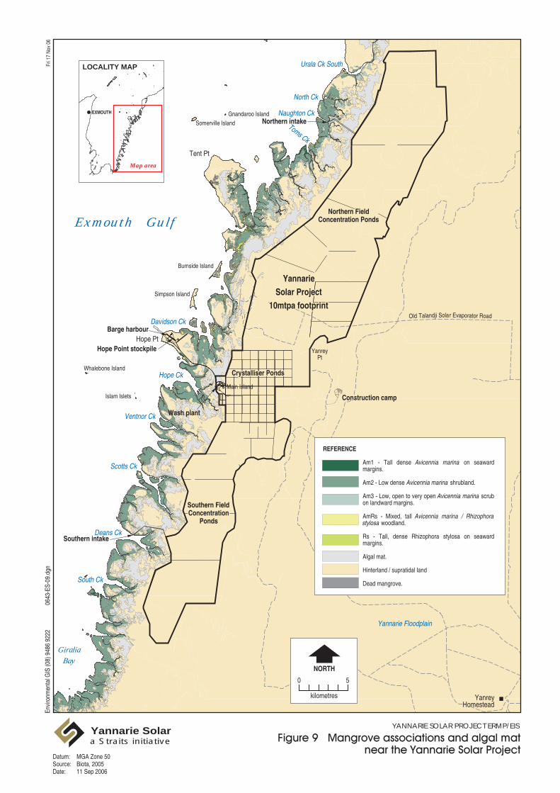
4.2.8 Benthic primary producer habitat and ecological integrity
Benthic primary producers are predominately marine plants (e.g. seagrasses, mangroves, seaweeds andalgal mats and beds) (Figure 9) but also include invertebrates such as scleractinian corals, whichacquire a significant proportion of their energy from symbiotic microalgae that live in coral polyps.These organisms grow attached to the seabed (subtidal or intertidal), sequester carbon fromsurrounding seawater or air and convert it to organic compounds through photosynthesis.
Benthic primary producers undertake important ecosystem processes such as carbon fixing, cyclingand nitrogen fixation in the case of algal mats. These producers also provide important ecologicalfunctions including shelter and food for other trophic levels in the ecosystem and stabilisation ofmarine and coastal sediments.
Potential impacts
Key activities or aspects of the proposal that may potentially affect BPPH include:
site preparation (including construction of ponds, pump stations, infrastructure corridor andseawater canals) leading to the physical removal/clearing of intertidal benthic primary producerhabitats (mangroves and algal mat)
location of project infrastructure and pumping of water into ponds could lead to hydrodynamicchanges resulting in a reduction in tidal flushing in creeks and in the extent of inundation duringhigh tides. This may affect mangroves and algal mat extent in marginal fringing environmentswhich have high salinities under natural conditions
impoundment of brine at higher than natural surface levels potentially leading to seepage of salinewater from the salt field towards algal mat and mangrove communities
surface water contamination through spills of hydrocarbons or wastewater.
Tent Pt
Hope Pt
Eva Island
Y Island Gnandaroo Island
Somerville Island
Burnside Island
Simpson Island
Whalebone Island
Islam Islets
GiraliaBay
Exmouth Gulf
Urala Ck South
North Ck
Naughton Ck
Toms Ck
Davidson Ck
Ventnor Ck
Hope Ck
Scotts Ck
Deans Ck
South Ck
Main Island
YanreyPt
Barge harbour
Hope Point stockpile
Southern intake
Northern intake
Wash plant
Construction camp
Yannarie Floodplain
YanreyHomestead
Old Talandji Solar Evaporator Road
Envi
ronm
enta
l GIS
(08)
948
6 92
2206
43-E
S-09
.dgn
Fri 1
7 N
ov 0
6
Datum:Source:Date:
YANNARIE SOLAR PROJECT ERMP/EISYannarie Solara Straits initiative
Northern FieldNorthern FieldConcentration PondsConcentration Ponds
YannarieYannarieSolar ProjectSolar Project
10mtpa footprint10mtpa footprint
Crystalliser PondsCrystalliser Ponds
Southern FieldSouthern FieldConcentrationConcentration
PondsPonds
0
NORTH
5
kilometres
Map area
LOCALITY MAP
EXMOUTH
REFERENCE
Am1 - Tall dense Avicennia marina on seaward margins. Am2 - Low dense Avicennia marina shrubland. Am3 - Low, open to very open Avicennia marina scrub on landward margins. AmRs - Mixed, tall Avicennia marina / Rhizophora stylosa woodland. Rs - Tall, dense Rhizophora stylosa on seaward margins. Algal mat. Hinterland / supratidal land Dead mangrove.
MGA Zone 50Biota, 200511 Sep 2006
Yannarie Solar Project Executive Summary
SRL06043_ExecSumm_Final2 - 27/11/2006 31
Environmental outcome
Mangroves and algal mat
The area of mangroves and algal mat directly affected has been reduced as far as practicable throughproject infrastructure design.
The project will result in the permanent loss of approximately 5.4 ha of the 11,154 ha (0.05%) ofmangroves and 31 ha of the 8054 ha (0.38%) of active algal mats occurring in the study area in orderto accommodate key project infrastructure. This loss, expressed as a percentage of proposedmanagement units for the east coast of the Gulf, is below the 1% criterion in the EPA GuidanceStatement 29 for Category B areas for each BPPH type.
No indirect losses of mangroves or algal mat are expected. Localised hydrodynamic changes mayresult in small scale changes to wetting and drying regimes, however these are not expected to haveany significant impact on mangroves or algal mats. There are no expected impacts to mangrovecommunities from the very low levels of saline seepage expected, due to the extent of setback from thesalt field levees to the mangrove zone along most of the field. Based on experience with othersaltfields in Western Australia, the infrastructure of the field has been set well back from themangrove zone so no impacts on mangroves are expected from changes to small-scale surfacehydrology. Mangrove colonisation of some parts of the project area is expected, based onobservations at other Western Australian saltfields.
Discharge of runoff water from stockpiles, drainage water from the plant site, fuel storage and othereffluents will be managed to reduce the risk of contamination and keep potential impacts toinsignificant levels.
Seawater pumping at Naughton Creek may result in enhanced sedimentation which could affectmangrove and algal mats if sedimentation was significant. Alternative locations may be investigatedto select a site which will be environmentally more benign. In any case, bathymetric surveys will beundertaken to monitor changes in creek morphology, and in the event that pumping is found to becausing siltation that may result in the loss of mangroves and algal mats, the pumping operation willbe reviewed.
The observation from other saltfields in Western Australia is that algal mats tend to colonise areaswithin project areas offsetting to some degree the loss through clearing.
Seagrasses, algae and corals
The loss of BPPH through the construction of the dredge channel is less than the 1% BPPH criterion(expressed as a percentage of the proposed marine management unit) in the EPA Guidance StatementNo. 29 for Category B areas.
There is a low risk of any indirect loss of benthic habitats due to turbidity associated with dredgingand excavation works at Hope Point.
The proposed seawater pumping at Dean’s Creek will not significantly affect the current or tidal fluxand will therefore not affect sediment dynamics in the creek, and there will be no loss of habitat due topumping. Seawater pumping at Naughton Creek will however lead to changes in current velocities,and this may result in enhanced sedimentation. There is unlikely to be vegetated benthic habitatwithin Naughton Creek due to the combination of high velocities and turbid waters.

Yannarie Solar Project Executive Summary
SRL06043_ExecSumm_Final2 - 27/11/2006 32
The barge harbour and channel at Hope Point will not affect sediment transport beyond the immediatevicinity of Hope Point and there will not be any significant impacts on benthic habitat due to modifiedsediment transport processes.
4.2.9 Marine fauna
A number of marine fauna found in the region (e.g. whales, dugongs, sharks, turtles and sea snakes)are ecologically significant and protected under the EPBC Act.
The Gulf also supports a valuable prawn fishery as estuarine and marine conditions are favourable fortheir life cycle (Figure 10). For example, the brown tiger and western king prawns are the primarycommercial target species in the Gulf, with additional commercially significant catches of endeavourprawns and occasionally banana prawns. Brown tiger prawns and western king prawns spawn in thedeep waters of the Gulf and then the larvae drift to the shallow areas on the east coast where thejuveniles then grow out and repeat the cycle. As such, these species do not rely directly on themangrove creek habitat and they are unlikely to be entrained in large numbers. However, bananaprawns tend to live within mangrove creeks and spawn continuously, with peaks in spring and autumn.
Source: CSIRO 2005
Figure 10 Northern Prawn Fishery life cycle
The pre-existing impacts on marine fauna in Exmouth Gulf are primarily associated with prawntrawling, and commercial and recreational fishing. In addition to these impacts, there are alsooccasional oil exploration activities, pearl shell collection and boat traffic associated with tourism andcommercial activities (primarily whale watching and pearl farm support).
Potential impacts
Key activities or aspects of the proposal that may potentially affect marine fauna include:
site preparation (in particular dredging at Hope Point) leading to the physical removal ormodification of habitat and potentially interrupting water flows
salt barge and ship movements in the Gulf may result in:
Yannarie Solar Project Executive Summary
SRL06043_ExecSumm_Final2 - 27/11/2006 33
noise emissions and vibration which may disturb marine fauna
collisions with marine megafauna
loss of antifoulants from hulls potentially leading to contamination of marine waters
introduction non-indigenous marine species (NIMS) with potential to affect native speciesand local aquaculture
light spill primarily associated with barge harbour infrastructure may potentially disturb somefauna species
seawater pumping leading to entrapment and entrainment of marine fauna (of the species ofprawns present, there is most likely to be entrainment of banana prawns and their larvae).
Environmental outcome
The impact of pumping of sea water on prawn recruitment and species losses are unlikely to bemeasurable outside the pumping areas of Dean’s Creek and Naughton Creek, therefore there is a lowrisk of impact on the viability of the commercial fishery in the Gulf marine waters.
Overall the environmental impact on marine fauna in the Gulf or the east coast of the Gulf isanticipated to be insignificant. Commitments for the preparation and implementation of a MarineManagement Plan to apply controls to the operations and monitor its affects, and the proposedExmouth Gulf Research Project that will provide more information on the characteristics of theExmouth Gulf ecosystem, will mitigate potential impacts of the project as far as practicable.
Habitat loss and modification
The area of direct habitat loss from dredging will not have a measurable detrimental effect on marinefauna (e.g. prawns) of the Gulf.
Indirect impacts on marine fauna from dredging (such as turbidity) are expected to be negligible due tomanagement controls that will be applied to dredging, on shore dredge spoil disposal and the timing ofdredging during the winter months when seagrass and algae are likely to be dormant.
Light spill
The lighting system for the project will be designed on the assumption that the area is a turtle nestingarea, even though there is no evidence of nesting sites at either pumping station sites or at Hope Point.Appropriate controls will be applied to lighting consistent with the project being near a turtle nestingarea.
Noise and vibration from marine vessel operations
Noise will be produced by stable platforms which either do not move (loading ships), move slowly(tugs and ships), or whose movements are independent of any nearby whales (i.e. no deliberateapproaches). The noise is also predicted to be reasonably constant in nature.
It is probable that, under normal operations, nearby marine megafauna will be aware of the operationsfrom approximately 5–10 km from the loading area, and may approach to approximately 400–1000 mbefore exhibiting avoidance behaviour. Given the continual and constant nature of the noise, it isprobable that animals will quickly habituate and the noise will not produce any startled or alarmedtypes of responses.
Yannarie Solar Project Executive Summary
SRL06043_ExecSumm_Final2 - 27/11/2006 34
Vessel avoidance
The potential for vessel strike has been reduced with the workforce transportation proposed to be byair rather than ferry. Implementation of the Marine Management Plan will also further reduce any riskof vessel strike through speed limits, fixed navigational routes and a program of whale monitoring andmanagement review.
Contamination associated with anti-foulants on marine vessels
No vessels owned by Straits will use TBT based paints. In addition, potential contractors will beinformed of the sensitivities of the local environment and that a clear preference will be given toengage contractors that use current best practise anti-fouling systems.
A sediment quality monitoring program will be implemented that will include baseline and ongoingmonitoring for the effects of anti-foulants. Initial surveys found no existing evidence of TBT orcopper contamination at Hope Point.
Introduction of non-indigenous marine species by marine vessels
Non-indigenous marine species (NIMS) will be strictly managed according to Australian Quarantinerequirements and with an appropriately strict set of management actions. The ongoing NIMSmonitoring program will be the first of its kind for the Exmouth Gulf and provide a significant newlevel of environmental defence for the region. Consequently, there are not likely to be any significantrisks from NIMS as a result of Straits operations.
Seawater pumping – entrapment and entrainment
The intake velocities at the screens to both pump stations are predicted to be substantially lower thanthe maximum pre-development tidal velocities within the creek systems and also lower than theaverage swimming speed of dugongs. It is expected that a dugong would be quite capable ofswimming away from an intake screen should it find itself in the vicinity of the intake screen at pumpstart-up. The other large marine fauna commonly found in the Gulf are all capable of swimming fasterthan the dugong and could therefore also be reasonably expected to swim away from the intakescreens.
Removal of small marine organisms (e.g. prawns) through seawater intake represents a low risk to theviability of the biota within the tidal creeks or regionally.
The recruitment of fauna to the concentrator ponds provides an opportunity to offset any loss (albeitinsignificant) to commercial fisheries in the Gulf.
4.2.10 Commercial fishing and aquaculture
The Exmouth Gulf Beach Seine Fishery is a small fishery that has operated in southern Exmouth Gulfsince 1988. There were only two licensed fishers using beach seines and gill nets as of the year 2000.
The Exmouth Gulf Prawn Managed Fishery is one of Western Australia’s three most valuablemanaged fisheries. It is the second largest prawn fishery in Western Australia after the Shark BayPrawn Fishery, and has an annual value to fishers of approximately $12 million.

Yannarie Solar Project Executive Summary
SRL06043_ExecSumm_Final2 - 27/11/2006 35
The fishery targets western king prawns (Penaeus latisulcatus) and brown tiger prawns (Penaeusesculentus), with lesser but still commercially significant catches of endeavour prawns (Metapenaeusendeavouri) and occasionally banana prawns (Penaeus merguiensis).
There are some relatively small commercial fishing activities which may occur in the eastern side ofthe Gulf from time to time including:
Blue Swimmer Crab Fishery
Tropical Rock Lobster Fishery
Marine Aquarium Managed Fishery
There are currently 21 aquaculture licenses and 8 pearl farm lease sites in the Gulf. The mainaquaculture species are silver lipped pearl oysters (Pinctada maxima), black lipped pearl oysters(Pinctada margaritifera) and black tiger prawns (Penaeus monodon).
The pearling operation in the Exmouth Gulf involves both the capture of wild pearl oysters by divingand the cultivation of pearl oysters on pearl farms. South sea pearls are grown in the silver lipped pearloyster (Pinctada maxima) which occurs naturally in the Gulf.
It is understood that there has been a move away from the capture of wild pearl oysters in recent yearsand hatchery production of Pinctada maxima is now of critical importance to the pearl industry, whererecruitment of oysters in the wild is irregular and unable to be relied on for commercial operations.
Potential impacts
Key activities or aspects of the proposal that may potentially affect commercial fishing andaquaculture include:
dredging resulting in direct habitat loss and modification through increased turbidity of the watercolumn associated with sediment plumes
seawater pumping resulting in the entrainment of small marine fauna and juveniles
barge and ship movements in the Gulf potentially leading to:
the introduction of non-indigenous marine species
navigation risks and interference with trawling operations
contamination from antifoulants
oil spills
project infrastructure leading to the interference with nutrient flows to the Gulf.
Environmental outcome
The proposed Yannarie Solar Salt project has been developed to avoid impacts on commercial fishingand aquaculture operations. The Exmouth Gulf Aquaculture Plan (Department of Fisheries 2004)recognises the benefits that the establishment of solar salt production facilities would have with regardto providing potential aquaculture facilities (e.g. saltfields are highly suitable for the production ofArtemia (or brine shrimp)) (Oceanica 2005b). Straits Resources have committed to fund a feasibilitystudy to investigate aquaculture opportunities which do not compromise the primary function of theYannarie Solar project.
Yannarie Solar Project Executive Summary
SRL06043_ExecSumm_Final2 - 27/11/2006 36
Dredging and seawater intake from pumping stations will be required within the Gulf, which couldimpact habitat both directly and indirectly. Dredging is expected to affect less than 1% of the marinemanagement unit area, whilst the footprint of the pumping stations is anticipated not to exceed0.04 ha.
Barge and ship movements could potentially impact commercial fisheries and aquaculture through theintroduction of non-indigenous marine species, interference with trawlers, inappropriate anti-foulingtechniques or fuel/oil spills. The risks associated with these activities will be managed through theimplementation of AQIS requirements and Ship Right (a pilot and vessel international accreditationscheme) communication with the Department of Fisheries and commercial fishery operators, anddevelopment and implementation of procedures in regards to fuel/oil spills.
Non-indigenous marine species will be strictly managed according to Australian Quarantinerequirements and in line with a very strict set of management actions. Consequently, there are notlikely to be any significant risks from NIMS as a result of Straits operations.
4.2.11 Recreation and tourism
Recreational fishing activity in the Gascoyne area has increased significantly since the early 1980s.The estimate of recreational fishing participation in the region is 5% of the State’s fishers or 30,000fishers a year.
The total annual recreational fishing effort for the Gascoyne region was 243,000 fisher-days fromApril 1998 to March 1999. Charter activity is significant, with 72 fishing tour licenses and 12“ecotour” licenses valid for the Gascoyne region in 2003.
The frequent strong winds, the distance across the Gulf (approximately 40 km) and the proximity toother attractions such as Ningaloo Reef and the Muiron Islands means that recreational boating is not asignificant source of vessel movement across the Exmouth Gulf to the east coast.
A number of charter boats operate out of Exmouth, the number varying with season. The charters aregenerally focused on the Ningaloo Marine Park or the Muiron Islands. However, during the months ofpeak Humpback Whale aggregation, operators run whale-watching tours in the deep area of the Gulf.
Potential impacts
Key activities or aspects of the proposal requiring assessment and potentially requiring management inrelation to recreation and tourism include:
vessel interaction with marine megafauna
dredging resulting in direct habitat loss and modification through increased turbidity of the watercolumn associated with sediment plumes
construction of saltfield infrastructure affecting the visual amenity of the area
operation of the saltfield could potentially reduce recreational access to tidal creeks, increasevisitation to the east coast of the Gulf and increase recreational fishing pressures from on site staffand contractors
indirect impacts from seawater pumping on marine fauna, introduction of non-indigenous marinespecies, changes to nutrient flows, navigational risks and hydrocarbon spills.
Yannarie Solar Project Executive Summary
SRL06043_ExecSumm_Final2 - 27/11/2006 37
Environmental outcome
Marine operations associated with the project could increase the risk of vessel strike to fauna and thiswill be managed through development and implementation of the Marine Management Plan andDredging Management Plan. Construction of the saltfield will affect the visual appearance of thesupratidal salt flat, but given the isolation of the project, its location well behind the mangrove fringeand relatively low profile, no significant impact on visual amenity is anticipated.
Operation of the saltfield could increase access to the area and result in increased fishing in thevicinity. Straits will ensure adequate communication with the community and relevant authorities toensure increased access is appropriately controlled. Straits will seek to incorporate means andmanagement of public access to the first stage concentrator ponds in the vicinity of the pump stationsto facilitate controlled recreational fishing.
4.2.12 Cultural heritage and conservation values
According to the National Native Title Tribunal Register, there are 2 claims covering the area aroundthe proposed development site. These are the Thalanyji Claimant Application (WC99/45) and theGnulli Application (WC97/28).
Only four sites on the Department of Indigenous Affairs (DIA) Register of Aboriginal sites are locatedwithin the project area.
There are no known significant European Heritage sites within the project area. Although there are anumber of shipwreck sites within the region, none have been identified in locations that are likely tobe affected by the project.
The east coast of the Exmouth Gulf has been identified as having a range of high conservation values,including extensive mangrove and algal mat systems, fish and prawn nursery areas and importanthabitat for threatened marine fauna. A nomination for World Heritage listing for Cape Range andExmouth Gulf is currently in the process of being advanced by the State Government. A number ofboundary options were originally considered by the State Government which included the ExmouthGulf and the eastern coast and hinterland. The boundary for World Heritage Area nomination that hasbeen endorsed for community consultation excludes the waters of Exmouth Gulf and the YannarieSolar Project Area on the eastern shore of the Gulf, and therefore there are no existing or proposedmarine or terrestrial conservation reserves immediately adjacent to the project area.
Potential impacts
Key activities or aspects of the proposal that may potentially affect cultural heritage and conservationvalues are common to those described for other environmental factors.
Environmental outcome
The implementation of the project will avoid disturbance to Aboriginal sites but where this is notpossible approval will be obtained from the Minister for Indigenous Affairs. There are no identifiedEuropean heritage sites affected in the project area.
The conservation values of Exmouth Gulf and the adjoining area will not be significantly affected bythe project because:

Yannarie Solar Project Executive Summary
SRL06043_ExecSumm_Final2 - 27/11/2006 38
there will be no discharge of bitterns
the design of the project results in only a small loss of mangroves (which will be offset) and otherbenthic primary producer habitat leading to minimal impact on ecological processes
there will not be a significant impact on marine fauna.
Implementation of the Aboriginal Sites Management Plan will ensure the EPA objectives are met.
Yannarie Solar Project Executive Summary
SRL06043_ExecSumm_Final2 - 27/11/2006 39
5 ERMP STRUCTURE
The Environmental Review and Management Program (ERMP) is presented in three volumes.Volume 1 describes the assessment process, the sustainability evaluation process and proposal,environmental impact assessment and management, mitigation requirements for a range ofenvironmental factors, and consolidated proponent commitments.
Volume 2 contains an Environmental Management Program which outlines management plans,monitoring programs and contingency planning for relevant environmental factors.
Volume 3 (compact disc) contains the Appendices.

Yannarie Solar Project Executive Summary
SRL06043_ExecSumm_Final2 - 27/11/2006 40
6 COMMITMENTS
The following section sets out the full range of commitments made by the proponent to beimplemented in proceeding with the proposal if approved. The commitments presented in Table 5 areexpected to form part of the conditions of formal environmental approval of the proposal.
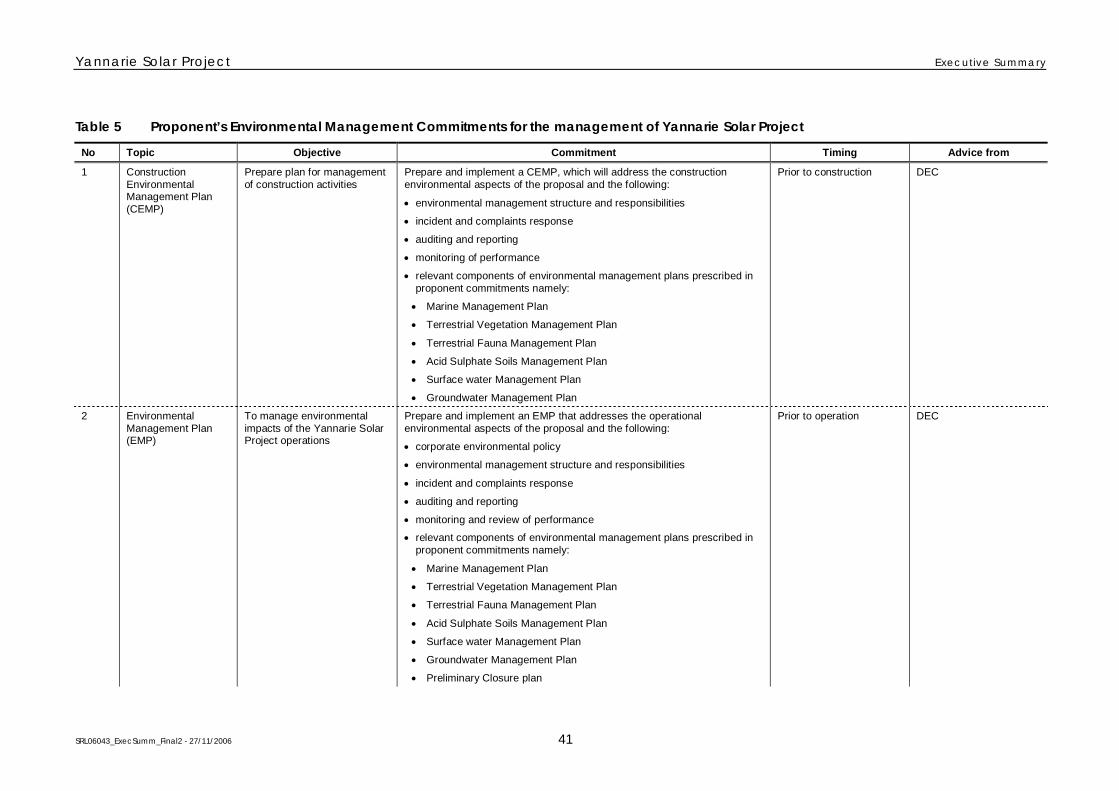
Yannarie Solar Project Executive Summary
SRL06043_ExecSumm_Final2 - 27/11/2006 41
Table 5 Proponent’s Environmental Management Commitments for the management of Yannarie Solar Project
No Topic Objective Commitment Timing Advice from
1 ConstructionEnvironmentalManagement Plan(CEMP)
Prepare plan for managementof construction activities
Prepare and implement a CEMP, which will address the constructionenvironmental aspects of the proposal and the following:
environmental management structure and responsibilities
incident and complaints response
auditing and reporting
monitoring of performance
relevant components of environmental management plans prescribed inproponent commitments namely:
Marine Management Plan
Terrestrial Vegetation Management Plan
Terrestrial Fauna Management Plan
Acid Sulphate Soils Management Plan
Surface water Management Plan
Groundwater Management Plan
Prior to construction DEC
2 EnvironmentalManagement Plan(EMP)
To manage environmentalimpacts of the Yannarie SolarProject operations
Prepare and implement an EMP that addresses the operationalenvironmental aspects of the proposal and the following:
corporate environmental policy
environmental management structure and responsibilities
incident and complaints response
auditing and reporting
monitoring and review of performance
relevant components of environmental management plans prescribed inproponent commitments namely:
Marine Management Plan
Terrestrial Vegetation Management Plan
Terrestrial Fauna Management Plan
Acid Sulphate Soils Management Plan
Surface water Management Plan
Groundwater Management Plan
Preliminary Closure plan
Prior to operation DEC

Yannarie Solar Project Executive Summary
SRL06043_ExecSumm_Final2 - 27/11/2006 42
No Topic Objective Commitment Timing Advice from
3 Subterranean fauna To determine the occurrenceof subterranean fauna
Undertake a subterranean fauna survey in areas where dewatering willoccur
Prior to installation of thedewatering system
DEC – NatureConservation Division
4 Soils and landforms To minimise environmentalimpacts from disturbance ofacid sulphate soils
Prepare and implement an Acid Sulphate Soil Management Plan Prior to grounddisturbance
-
5 Groundwater To minimise changes togroundwater levels and qualitythat may affect groundwaterdependent ecosystems
Prepare and implement a Groundwater Management Plan which addressesthe following issues:
Baseline and ongoing groundwater monitoring
saltwater intrusion in mainland remnants
dewatering
oil and fuel spills
treated wastewater
reverse osmosis tailwater
Prior to construction -
6 Surface water To ensure impacts on surfacewater flows and quality do notadversely affect ecosystemprocesses
Develop and implement a Surface Water Management Plan whichaddresses the following issues:
baseline and ongoing surface water monitoring
diversion and redirection of surface water
impoundment and inundation
treated wastewater and reverse osmosis tailwater
Prior to construction -
A terrestrial vegetation and flora survey should identify areas ofconservation significance for retention of native flor and vegetation. focusingon the southern portion of the project area
Prior to construction -7 Terrestrial vegetationand flora
To minimise impacts onsignificant flora and vegetation
Develop and implement a Terrestrial Vegetation Management Plan whichaddresses the following issues:
baseline and ongoing vegetation and flora surveys
vegetation clearing controls
weeds
rehabilitation
research
Prior to construction -
8 Terrestrial Fauna To minimise impacts on faunapopulations
Develop and implement a Terrestrial Fauna Management Plan whichaddresses the following issues:
baseline and ongoing fauna surveys
habitat clearing controls
wildlife corridors and re-creation of fauna habitat
vehicle and equipment movement
Prior to construction -
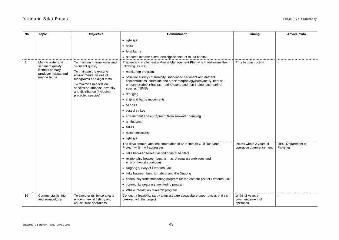
Yannarie Solar Project Executive Summary
SRL06043_ExecSumm_Final2 - 27/11/2006 43
No Topic Objective Commitment Timing Advice from
light spill
noise
feral fauna
research into the extent and significance of fauna habitat
Prepare and implement a Marine Management Plan which addresses thefollowing issues:
monitoring program
baseline surveys of turbidity, suspended sediment and nutrientconcentrations, shoreline and creek morphology/bathymetry, benthicprimary producer habitat, marine fauna and non-indigenous marinespecies (NIMS)
dredging
ship and barge movements
oil spills
vessel strikes
entrainment and entrapment from seawater pumping
antifoulants
NIMS
noise emissions
light spill
Prior to construction -9 Marine water andsediment quality,Benthic primaryproducer habitat andmarine fauna
To maintain marine water andsediment quality
To maintain the existingenvironmental values ofmangroves and algal mats
To minimise impacts onspecies abundance, diversityand distribution (includingprotected species)
The development and implementation of an Exmouth Gulf ResearchProject, which will addresses:
links between terrestrial and coastal habitats
relationship between benthic macrofauna assemblages andenvironmental conditions
Dugong survey of Exmouth Gulf
links between benthic habitat and the Dugong
community turtle monitoring program for the eastern part of Exmouth Gulf
community seagrass monitoring program
Whale interaction research program
Initiate within 2 years ofoperation commencement
DEC, Department ofFisheries
10 Commercial fishingand aquaculture
To avoid or minimise affectson commercial fishing andaquaculture operations
Conduct a feasibility study to investigate aquaculture opportunities that canco-exist with the project
Within 2 years ofcommencement ofoperation
-
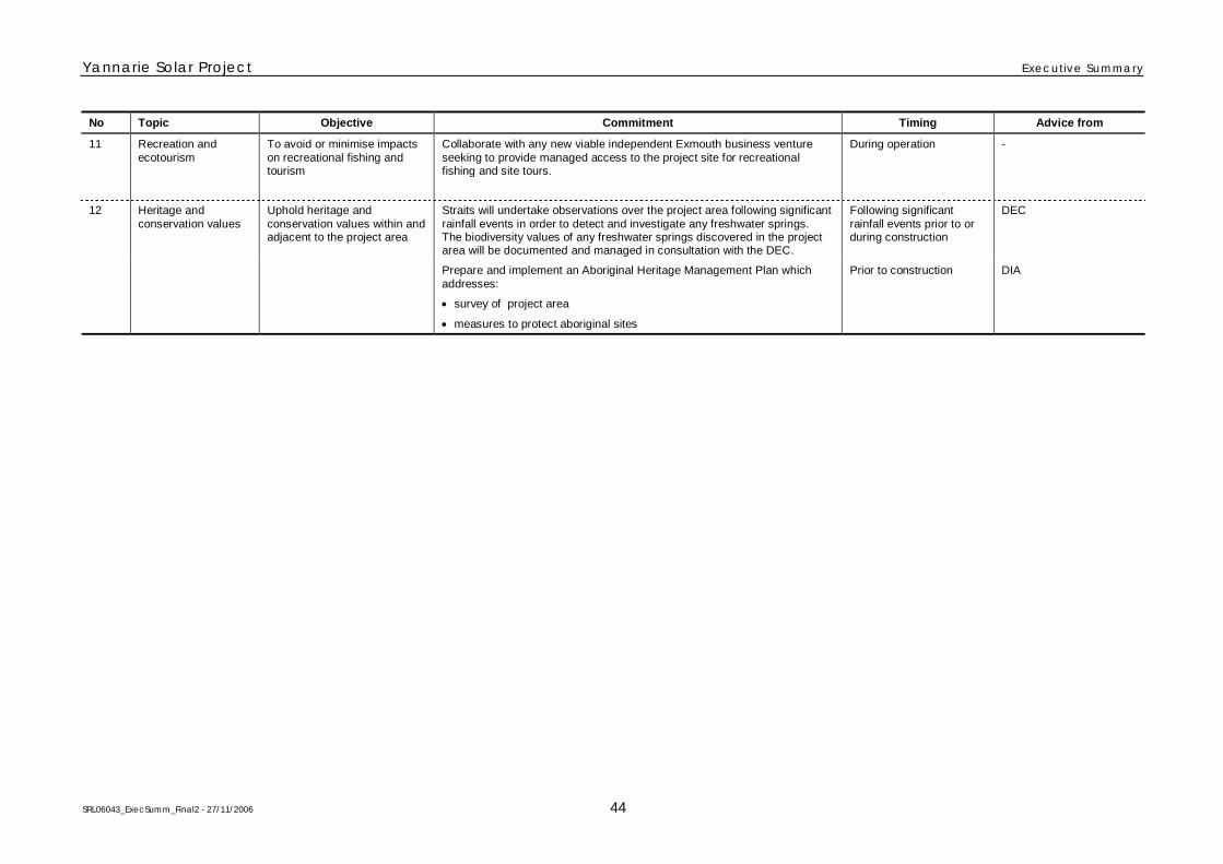
Yannarie Solar Project Executive Summary
SRL06043_ExecSumm_Final2 - 27/11/2006 44
No Topic Objective Commitment Timing Advice from
11 Recreation andecotourism
To avoid or minimise impactson recreational fishing andtourism
Collaborate with any new viable independent Exmouth business ventureseeking to provide managed access to the project site for recreationalfishing and site tours.
During operation -
Straits will undertake observations over the project area following significantrainfall events in order to detect and investigate any freshwater springs.The biodiversity values of any freshwater springs discovered in the projectarea will be documented and managed in consultation with the DEC.
Following significantrainfall events prior to orduring construction
DEC12 Heritage andconservation values
Uphold heritage andconservation values within andadjacent to the project area
Prepare and implement an Aboriginal Heritage Management Plan whichaddresses:
survey of project area
measures to protect aboriginal sites
Prior to construction DIA

Yannarie Solar Project Executive Summary
SRL06043_ExecSumm_Final2 - 27/11/2006 45
Table 6 Summary of key environmental issues, potential impacts and management
Environmental factor EPA objective Existing environment Potential impacts Potential management Predicted outcomes
Terrestrial biophysical
Soils and landforms To maintain theintegrity, ecologicalfunctions andenvironmental valuesof soils and landform.
The project area is located withinthe Cape Range Province andcan be roughly divided into fourparallel geomorphic landscapeelements that trend north east tosouth west.
These geomorphic units includethe Outwash Plain, Dunefield,Salt Flats and Coastal Fringe.
The distribution of theselandscape elements has beenhistorically governed by fluvialand aeolian processes occurringin the Yannarie River and RouseCreek systems in the east and thecoastline in the west.
Site preparation potentiallyincreases or changes in erosion.
Landform removal or modificationthrough sourcing materials forearthworks of ponds, bunds andassociated infrastructure includingthe barge harbour.
Exposure of potential acidsulphate soils on the supratidalsalt flat and the hinterland throughthe construction of infrastructureand dredging.
An Acid Sulphate Soils ManagementPlan will be developed andimplemented and will address thefollowing:
assessment of areas of moderate tohigh risk of acid sulphate soils
management measures to control thegeneration of ASS
sampling of dredge spoil.
Cleared areas to be kept to a minimumand rehabilitated as soon as possibleafter construction completion.
Utilisation of materials from theconstruction of the barge harbour tooffset requirements from borrow pitsand quarries.
The area of the supratidal flatlandform occupied by the projectwill be 410 km
2, which represents
32% of the Ashburton LandSystem. This loss of landform isecologically insignificant andthere is still sufficient arearemaining for geo-heritage valuesto be retained.
Rehabilitation of landforms andvegetation will be conducted onareas (if not required foroperational activities) disturbed byconstruction activities and quarryoperations to the satisfaction ofthe EPA.
The overall environmentaloutcome will be that erosionalevents will be limited to thosenaturally expressed within theregion and that the disturbance oflow quantities of potentially acidgenerating soils will be minimisedor otherwise managed inaccordance with an Acid SulphateSoil Management Plan.

Yannarie Solar Project Executive Summary
SRL06043_ExecSumm_Final2 - 27/11/2006 46
Environmental factor EPA objective Existing environment Potential impacts Potential management Predicted outcomes
Groundwater To maintain thequantity of water sothat existing andpotentialenvironmental values,including ecosystemmaintenance, areprotected.
The superficial aquifer formationsof the study area were separatedinto three areas namely OutwashPlain, Dunefield and Supratidalsalt flat (progressing towards theGulf).
Rainfall recharge is minimal dueto high evaporation and generallylow permeability soils.
Yannarie River and Rouse Creekrecharge the Outwash Plain withfreshwater.
Depth to groundwater rangesfrom 20 - 0.2 m bgl and salinityfrom 10,000 µs/cm to263,000 µS/cm (i.e. hypersaline)as you progress towards the Gulf.
Dewatering during constructioncould potentially affect waterquality and groundwater-dependent ecosystems (includingsubterranean fauna).
Construction of salt ponds couldresult in saline groundwaterintrusion and an increase in waterlevels under existing vegetation.
Hydrocarbon spills from plant andmachinery, effluent disposal anddischarge of tailwater fromreverse osmosis plants couldpotentially affect water quality.
Dewatering undertaken incrementally tominimise drawdown impacts andreductions in soil moisture levels as faras practicable.
Sedimentation ponds employed toensure the turbidity of dewateringdischarges does not adversely impactsensitive receiving environments.
Groundwater levels and quality will bemonitored regularly to combat anychanges as soon as possible.
Prepare and implement a GroundwaterManagement Plan.
Discharge of tailwater will be to the saltfield process.
Sewerage treatment.
Dewatering will only be requiredduring construction within thebarge harbour, after which timethe groundwater levels shouldreturn to their previous state.
Monitoring programs will beimplemented and correctiveaction taken as required toaddress any adverse changes togroundwater quantity and quality,vegetation and fauna.
Procedures will be developed andimplemented to reduce the risk ofspills.
Surface water To maintain thequantity of water sothat existing andpotentialenvironmental values,including ecosystemmaintenance, areprotected.
To minimise thepotential fordisplacement of floodvalues and erosiondue to stormwaterflows.
Surface flows within study areaare result of complexinterrelationships betweenwatercourses, floodplain andmaze of dunal ridges.
Majority of rainfall runoff is lostthrough evaporation andinfiltration.
Two main watercourses exist,being the Yannarie River andRouse Creek.
During very high rainfall theydischarge to floodplain. Fouroutlets then dispel water from thefloodplain onto the supratidal flat.
Diversion or redirection of flowswill alter local hydrology patternsand may cause changes towatercourse morphology.
Impoundment and inundation as aresult of constructing a diversionweir may alter vegetation andaffect sediment and nutrienttransmission pathways.
Hydrocarbon spills and effluentdisposal pose a potential risk towater quality.
Design diversion at Yannarie Riverchannel so flow will still ultimately dispelinto the Gulf during flood events.
Monitoring erosion/scouring and installerosion control measures whererequired.
Monitoring programs developed andimplemented for water quality and areasof inundated vegetation.
Design wastewater treatment plant inaccordance with Department of Healthrequirements and procedures will be putin place for handling and response tohydrocarbon spills.
Prepare and implement a Surface WaterManagement Plan.
The project will result in thediversion of flows in a number ofwatercourses however netfreshwater flows to the Gulf willremain the same.
An increase in the area ofinundation during flood events willbe monitored.
Procedures will be developed andimplemented to reduce the risk ofspills.
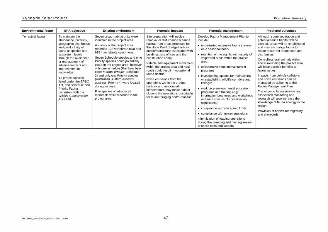
Yannarie Solar Project Executive Summary
SRL06043_ExecSumm_Final2 - 27/11/2006 47
Environmental factor EPA objective Existing environment Potential impacts Potential management Predicted outcomes
Terrestrial fauna To maintain theabundance, diversity,geographic distributionand productivity offauna at species andecosystem levelsthrough the avoidanceor management ofadverse impacts andimprovement inknowledge.
To protect specieslisted under the EPBCAct, and Schedule andPriority Faunaconsistent with theWildlife ConservationAct 1950.
Seven broad habitat units wereidentified in the project area.
A survey of the project arearecorded 138 vertebrate taxa and915 invertebrate specimens.
Seven Schedule species and ninePriority species could potentiallyoccur in the project area, howeveronly one schedule (Rainbow bee-eater Merops ornatus, Schedule3) and only one Priority species(Australian Bustard Ardeotisaustralis, Priority 4) were locatedduring surveys.
Five species of introducedmammals were recorded in theproject area.
Site preparation will involveremoval or disturbance of faunahabitat from areas proposed forthe Hope Point dredge harbourand infrastructure associated withbuildings, site offices and theconstruction camp.
Vehicle and equipment movementwithin the project area and haulroads could result in occasionalfauna deaths.
Noise emissions from theoperations within the dredgeharbour and associatedinfrastructure may make habitatclose to the operations unsuitablefor fauna foraging and/or habitat.
Develop Fauna Management Plan toinclude:
undertaking extensive fauna surveyson a seasonal basis
retention of the significant majority ofvegetated areas within the projectarea
collaborative feral animal controlprograms
investigating options for maintainingor establishing wildlife corridors andlinkages
workforce environmental educationprograms and training (e.g.information brochures and workshopson fauna species of conservationsignificance)
compliance with site speed limits
compliance with noise regulations
minimisation of loading operationsduring the breeding and nesting seasonof shore birds and waders
Although some vegetation andpotential fauna habitat will becleared, areas will be rehabilitatedand may encourage fauna toreturn to current abundance anddistribution.
Controlling feral animals withinand surrounding the project areawill have positive benefits tofauna values.
Impacts from vehicle collisionsand noise emissions can bemanaged by adhering to theFauna Management Plan.
The ongoing fauna surveys andassociated monitoring andresearch will also increase theknowledge of fauna ecology in theregion.
Provision of habitat for migratoryand shorebirds.
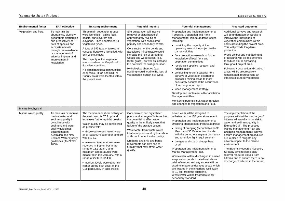
Yannarie Solar Project Executive Summary
SRL06043_ExecSumm_Final2 - 27/11/2006 48
Environmental factor EPA objective Existing environment Potential impacts Potential management Predicted outcomes
Vegetation and flora To maintain theabundance, diversity,geographic distributionand productivity offlora at species andecosystem levelsthrough the avoidanceor management ofadverse impacts andimprovement inknowledge.
Three main vegetation groupswere identified – saline flats,coastal dune system andclaypans. These contained 11vegetation types.
A total of 192 taxa of terrestrialvascular flora were identified, withonly 2 exotic taxa.
The majority of the vegetationwas considered of Very Good toExcellent condition.
No significant flora communitiesor species (TECs and DRF orPriority flora) were located withinthe project area.
Site preparation will involveremoval or disturbance ofapproximately 461 ha ofvegetation, with associatedprimary and secondary effects.
Construction of the ponds andassociated infrastructure couldincrease the risk of spreadingweeds and weed-seeds (e.g.Buffel grass), as well as increasethe potential for dust generation.
Hydrological changes (e.g.flooding) could lead to the loss ofvegetation in certain soil types.
Preparation and implementation of aTerrestrial Vegetation and FloraManagement Plan, to address issuesincluding:
restricting the majority of theoperating area of the project to thebarren salt flats
flora protection research to furtherknowledge of local flora andvegetation communities
recalcitrant species research andrehabilitation
conducting further seasonal florasurveys of vegetation external toproposed mining areas to moreaccurately document the occurrenceof site vegetation types
weed management strategy.
Develop and implement a RehabilitationManagement Plan.
Monitoring potential salt water intrusionand changes to vegetation and flora.
Additional surveys and researchwill be undertaken by Straits toimprove the knowledge ofvegetation communities withinand surrounding the project area.This will provide long-termprotection.
Weed control and managementprocedures will be implementedto reduce risk of spreadingthroughout project area.
Following construction, disturbedareas will be progressivelyrehabilitated, representing anoffset to disturbed vegetation.
Marine biophysical
Marine water quality To maintain or improvemarine water andsediment quality incompliance withsediment and waterquality guidelinesdocumented inAustralian and NewZealand Water Qualityguidelines (ANZECC2000).
The median near shore salinity onthe east coast is 37.9 ppt andincreases further up tidal creeks.
Water quality may be consideredas pristine with:
dissolved oxygen levels wereall at least 99% saturation and pHwas 8.1-8.2
minimum temperatures wererecorded in September in therange of 18.1-20.6˚C andmaximum temperatures weremeasured in mid-January, with arange of 27˚C to 32.4˚C
nutrient levels were generallyhigher on the east coast of theGulf particularly in tidal creeks.
Concentrator and crystalliserponds and storage of bitterns hasthe potential to affect waterquality in the unlikely event thatfailure of the storage occurs.
Wastewater from waste watertreatment plants and hydrocarbonspills could affect water quality.
Dredging and ship and bargemovements can give rise toturbidity that may affect waterquality.
Levee walls will be designed towithstand a 1 in 100 year storm event.
Preparation and implementation of aDredging Management Plan to address:
timing of dredging (occur between 30March and 30 October to coincidewith the period of seagrass dormancyand when low light requirements).
the type and size of dredge headused.
Preparation and implementation of aMarine Management Plan.
Wastewater will be discharged in sealedevaporation ponds located well abovetidal influences and any excess will beused to irrigate landscaped areas whichare located in the hinterland well away(5-10 km) from the shoreline.Wastewater will be treated to uppersecondary standard.
The implementation of theproposal without the discharge ofbitterns will avoid a minor risk towater and sediment quality inExmouth Gulf. The proposedMarine Management Plan andDredging Management Plan willensure management proceduresare in place to mitigate anyadverse impact to the marineenvironment.
The Bitterns Resource RecoveryStrategy aims to completelyrecover resource values frombitterns and to ensure there is nodischarge of bitterns in the future.
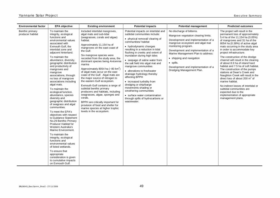
Yannarie Solar Project Executive Summary
SRL06043_ExecSumm_Final2 - 27/11/2006 49
Environmental factor EPA objective Existing environment Potential impacts Potential management Predicted outcomes
Benthic primaryproducer habitat
To maintain theintegrity, ecologicalfunctions andenvironmental valuesassociated withExmouth Gulf, theintertidal zone andadjacent hinterland.
To maintain theabundance, diversity,geographic distributionand productivity ofmangroves andmangroveassociations, throughno loss of mangroveassociations includingalgal mats.
To maintain theecological function,abundance, speciesdiversity andgeographic distributionof seagrass and algalcommunities.
To meet the EPA’sobjectives with respectto Guidance StatementNo.29 Benthic PrimaryProducer Habitat forWestern Australia’sMarine Environment.
To maintain theintegrity, ecologicalfunctions andenvironmental valuesof listed wetlands.
To ensure thatappropriateconsideration is givento cumulative impactson Exmouth Gulf.
Included intertidal mangroves,algal mats and sub-tidal(seagrasses, corals and algae)habitat.
Approximately 11,154 ha ofmangroves on the east coast ofthe Gulf.
Six mangrove species wererecorded from the study area, thedominant species being Avicenniamarina
Approximately 8054 ha (~80 km2)
of algal mats occur on the eastcoast of the Gulf. Algal mats arethe major source of nitrogen tothe eastern Gulf ecosystem.
Exmouth Gulf contains a range ofsubtidal benthic primaryproducers and habitats, includingseagrasses, algae, sponges andcorals.
BPPH are critically important forprovision of food and shelter formarine species at higher trophiclevels in the ecosystem.
Potential impacts on intertidal andsubtidal communities include:
physical removal/ clearing ofcommunities/ habitat
hydrodynamic changesresulting in a reduction in tidalflushing in creeks and extent ofinundation during high tides
seepage of saline water fromthe salt field into algal mat andmangrove communities
alterations to freshwaterdrainage hydrology therebyaffecting BPPH
increased turbidity fromdredging or ship/bargemovements shading orsmothering communities
surface water contaminationthrough spills of hydrocarbons orwastewater.
No discharge of bitterns.
Mangrove vegetation clearing limits.
Development and implementation of amangrove ecosystem and algal matmonitoring program.
Development and implementation of aMarine Management Plan to address:
shipping and navigation
spills.
Development and implementation of aDredging Management Plan.
The project will result in thepermanent loss of approximately5.4 ha of the 11,154 ha (0.05%)of mangroves and 31 ha of the8054 ha (0.38%) of active algalmats occurring in the study areain order to accommodate keyproject infrastructure.
The construction of the dredgechannel will result in the clearingof about 8.9 ha of inland hardhabitat and 7.5 ha of soft habitat.The construction of the pumpsstations at Dean’s Creek andNaughton Creek will result in thedirect loss of about 200 m
2of
marine habitat.
No indirect losses of intertidal orsubtidal communities areexpected due to theimplementation of appropriatemanagement plans.
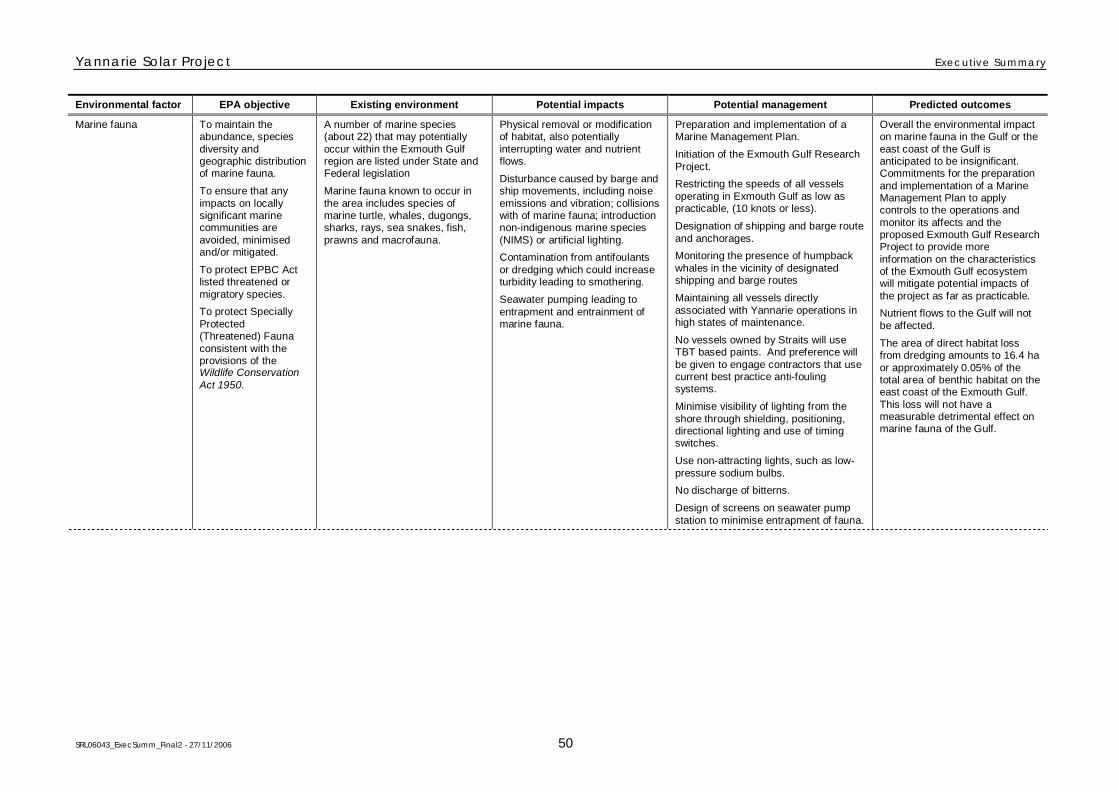
Yannarie Solar Project Executive Summary
SRL06043_ExecSumm_Final2 - 27/11/2006 50
Environmental factor EPA objective Existing environment Potential impacts Potential management Predicted outcomes
Marine fauna To maintain theabundance, speciesdiversity andgeographic distributionof marine fauna.
To ensure that anyimpacts on locallysignificant marinecommunities areavoided, minimisedand/or mitigated.
To protect EPBC Actlisted threatened ormigratory species.
To protect SpeciallyProtected(Threatened) Faunaconsistent with theprovisions of theWildlife ConservationAct 1950.
A number of marine species(about 22) that may potentiallyoccur within the Exmouth Gulfregion are listed under State andFederal legislation
Marine fauna known to occur inthe area includes species ofmarine turtle, whales, dugongs,sharks, rays, sea snakes, fish,prawns and macrofauna.
Physical removal or modificationof habitat, also potentiallyinterrupting water and nutrientflows.
Disturbance caused by barge andship movements, including noiseemissions and vibration; collisionswith of marine fauna; introductionnon-indigenous marine species(NIMS) or artificial lighting.
Contamination from antifoulantsor dredging which could increaseturbidity leading to smothering.
Seawater pumping leading toentrapment and entrainment ofmarine fauna.
Preparation and implementation of aMarine Management Plan.
Initiation of the Exmouth Gulf ResearchProject.
Restricting the speeds of all vesselsoperating in Exmouth Gulf as low aspracticable, (10 knots or less).
Designation of shipping and barge routeand anchorages.
Monitoring the presence of humpbackwhales in the vicinity of designatedshipping and barge routes
Maintaining all vessels directlyassociated with Yannarie operations inhigh states of maintenance.
No vessels owned by Straits will useTBT based paints. And preference willbe given to engage contractors that usecurrent best practice anti-foulingsystems.
Minimise visibility of lighting from theshore through shielding, positioning,directional lighting and use of timingswitches.
Use non-attracting lights, such as low-pressure sodium bulbs.
No discharge of bitterns.
Design of screens on seawater pumpstation to minimise entrapment of fauna.
Overall the environmental impacton marine fauna in the Gulf or theeast coast of the Gulf isanticipated to be insignificant.Commitments for the preparationand implementation of a MarineManagement Plan to applycontrols to the operations andmonitor its affects and theproposed Exmouth Gulf ResearchProject to provide moreinformation on the characteristicsof the Exmouth Gulf ecosystemwill mitigate potential impacts ofthe project as far as practicable.
Nutrient flows to the Gulf will notbe affected.
The area of direct habitat lossfrom dredging amounts to 16.4 haor approximately 0.05% of thetotal area of benthic habitat on theeast coast of the Exmouth Gulf.This loss will not have ameasurable detrimental effect onmarine fauna of the Gulf.
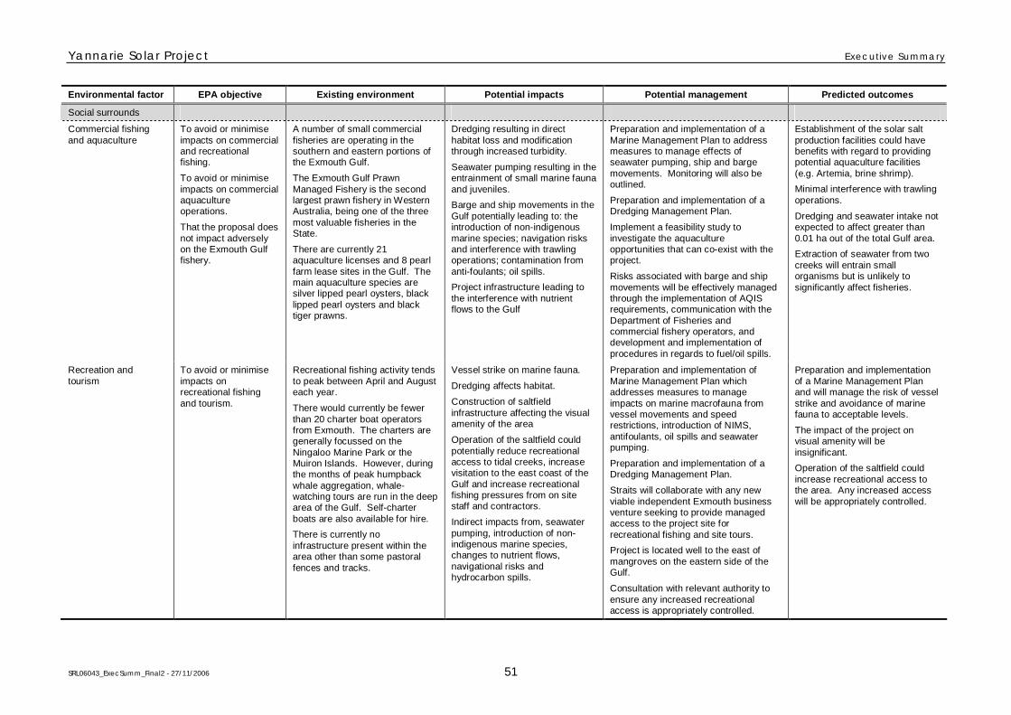
Yannarie Solar Project Executive Summary
SRL06043_ExecSumm_Final2 - 27/11/2006 51
Environmental factor EPA objective Existing environment Potential impacts Potential management Predicted outcomes
Social surrounds
Commercial fishingand aquaculture
To avoid or minimiseimpacts on commercialand recreationalfishing.
To avoid or minimiseimpacts on commercialaquacultureoperations.
That the proposal doesnot impact adverselyon the Exmouth Gulffishery.
A number of small commercialfisheries are operating in thesouthern and eastern portions ofthe Exmouth Gulf.
The Exmouth Gulf PrawnManaged Fishery is the secondlargest prawn fishery in WesternAustralia, being one of the threemost valuable fisheries in theState.
There are currently 21aquaculture licenses and 8 pearlfarm lease sites in the Gulf. Themain aquaculture species aresilver lipped pearl oysters, blacklipped pearl oysters and blacktiger prawns.
Dredging resulting in directhabitat loss and modificationthrough increased turbidity.
Seawater pumping resulting in theentrainment of small marine faunaand juveniles.
Barge and ship movements in theGulf potentially leading to: theintroduction of non-indigenousmarine species; navigation risksand interference with trawlingoperations; contamination fromanti-foulants; oil spills.
Project infrastructure leading tothe interference with nutrientflows to the Gulf
Preparation and implementation of aMarine Management Plan to addressmeasures to manage effects ofseawater pumping, ship and bargemovements. Monitoring will also beoutlined.
Preparation and implementation of aDredging Management Plan.
Implement a feasibility study toinvestigate the aquacultureopportunities that can co-exist with theproject.
Risks associated with barge and shipmovements will be effectively managedthrough the implementation of AQISrequirements, communication with theDepartment of Fisheries andcommercial fishery operators, anddevelopment and implementation ofprocedures in regards to fuel/oil spills.
Establishment of the solar saltproduction facilities could havebenefits with regard to providingpotential aquaculture facilities(e.g. Artemia, brine shrimp).
Minimal interference with trawlingoperations.
Dredging and seawater intake notexpected to affect greater than0.01 ha out of the total Gulf area.
Extraction of seawater from twocreeks will entrain smallorganisms but is unlikely tosignificantly affect fisheries.
Recreation andtourism
To avoid or minimiseimpacts onrecreational fishingand tourism.
Recreational fishing activity tendsto peak between April and Augusteach year.
There would currently be fewerthan 20 charter boat operatorsfrom Exmouth. The charters aregenerally focussed on theNingaloo Marine Park or theMuiron Islands. However, duringthe months of peak humpbackwhale aggregation, whale-watching tours are run in the deeparea of the Gulf. Self-charterboats are also available for hire.
There is currently noinfrastructure present within thearea other than some pastoralfences and tracks.
Vessel strike on marine fauna.
Dredging affects habitat.
Construction of saltfieldinfrastructure affecting the visualamenity of the area
Operation of the saltfield couldpotentially reduce recreationalaccess to tidal creeks, increasevisitation to the east coast of theGulf and increase recreationalfishing pressures from on sitestaff and contractors.
Indirect impacts from, seawaterpumping, introduction of non-indigenous marine species,changes to nutrient flows,navigational risks andhydrocarbon spills.
Preparation and implementation ofMarine Management Plan whichaddresses measures to manageimpacts on marine macrofauna fromvessel movements and speedrestrictions, introduction of NIMS,antifoulants, oil spills and seawaterpumping.
Preparation and implementation of aDredging Management Plan.
Straits will collaborate with any newviable independent Exmouth businessventure seeking to provide managedaccess to the project site forrecreational fishing and site tours.
Project is located well to the east ofmangroves on the eastern side of theGulf.
Consultation with relevant authority toensure any increased recreationalaccess is appropriately controlled.
Preparation and implementationof a Marine Management Planand will manage the risk of vesselstrike and avoidance of marinefauna to acceptable levels.
The impact of the project onvisual amenity will beinsignificant.
Operation of the saltfield couldincrease recreational access tothe area. Any increased accesswill be appropriately controlled.
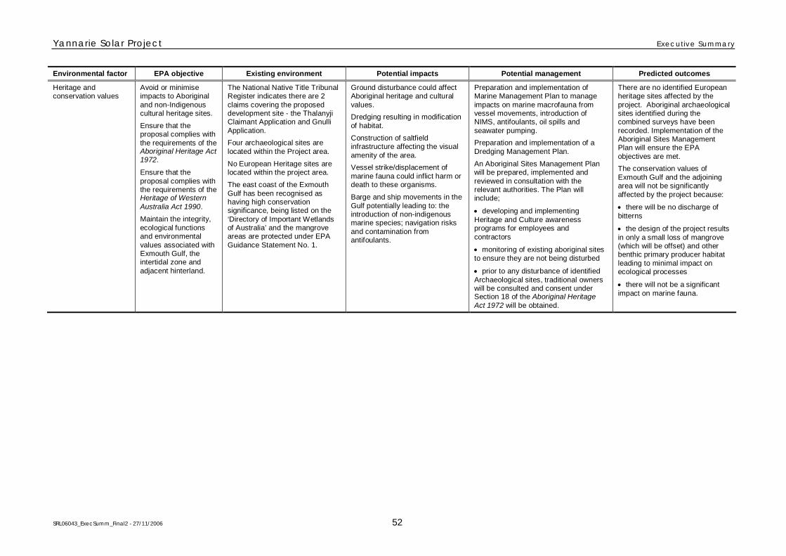
Yannarie Solar Project Executive Summary
SRL06043_ExecSumm_Final2 - 27/11/2006 52
Environmental factor EPA objective Existing environment Potential impacts Potential management Predicted outcomes
Heritage andconservation values
Avoid or minimiseimpacts to Aboriginaland non-Indigenouscultural heritage sites.
Ensure that theproposal complies withthe requirements of theAboriginal Heritage Act1972.
Ensure that theproposal complies withthe requirements of theHeritage of WesternAustralia Act 1990.
Maintain the integrity,ecological functionsand environmentalvalues associated withExmouth Gulf, theintertidal zone andadjacent hinterland.
The National Native Title TribunalRegister indicates there are 2claims covering the proposeddevelopment site - the ThalanyjiClaimant Application and GnulliApplication.
Four archaeological sites arelocated within the Project area.
No European Heritage sites arelocated within the project area.
The east coast of the ExmouthGulf has been recognised ashaving high conservationsignificance, being listed on the‘Directory of Important Wetlandsof Australia’ and the mangroveareas are protected under EPAGuidance Statement No. 1.
Ground disturbance could affectAboriginal heritage and culturalvalues.
Dredging resulting in modificationof habitat.
Construction of saltfieldinfrastructure affecting the visualamenity of the area.
Vessel strike/displacement ofmarine fauna could inflict harm ordeath to these organisms.
Barge and ship movements in theGulf potentially leading to: theintroduction of non-indigenousmarine species; navigation risksand contamination fromantifoulants.
Preparation and implementation ofMarine Management Plan to manageimpacts on marine macrofauna fromvessel movements, introduction ofNIMS, antifoulants, oil spills andseawater pumping.
Preparation and implementation of aDredging Management Plan.
An Aboriginal Sites Management Planwill be prepared, implemented andreviewed in consultation with therelevant authorities. The Plan willinclude;
developing and implementingHeritage and Culture awarenessprograms for employees andcontractors
monitoring of existing aboriginal sitesto ensure they are not being disturbed
prior to any disturbance of identifiedArchaeological sites, traditional ownerswill be consulted and consent underSection 18 of the Aboriginal HeritageAct 1972 will be obtained.
There are no identified Europeanheritage sites affected by theproject. Aboriginal archaeologicalsites identified during thecombined surveys have beenrecorded. Implementation of theAboriginal Sites ManagementPlan will ensure the EPAobjectives are met.
The conservation values ofExmouth Gulf and the adjoiningarea will not be significantlyaffected by the project because:
there will be no discharge ofbitterns
the design of the project resultsin only a small loss of mangrove(which will be offset) and otherbenthic primary producer habitatleading to minimal impact onecological processes
there will not be a significantimpact on marine fauna.