sr 36 transportation concept report · facility concept and future design concept ... sr 36...
TRANSCRIPT
SR 36 Transportation Concept Report
Segment Fact Sheets
Segment Fact Sheet Pages
The Segment Fact Sheets that follow provide detailed information for each segment on SR 36. Definitions for vocabulary on the Segment Fact Sheets are found in Appendix N- Glossary.
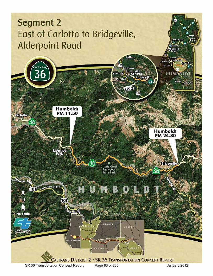
Segment Map (page 1) ► Provides a visual reference for the segment including beginning and ending Post Miles
and other significant location features.
Segment Fact Sheet (page 2) ► System Designations
► Facility Concept and Future Design Concept
► Current Highway Information
► Existing and Future Traffic performance data
Average Daily Traffic (ADT) and Peak Hour traffic volume ranges.
Level of Service (LOS).
Collision rates.
o Actual Collision Rates on Segment and Statewide Average for Highway type.
General Information Sheet (page 3)
► Segment Description
► Segment Issues
► Segment Management
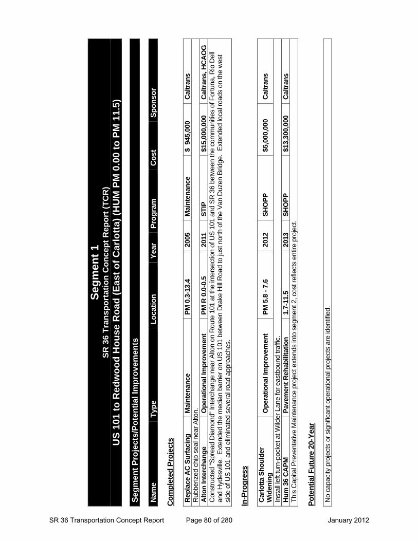
Projects (page 4) ► Projects to improve operations are separated into three categories:
“Completed” – year the project was completed.
“In - Progress” – projects under development. Year shown is when construction is expected to begin. Estimated construction cost information reflects costs available during the development of the SR 36 Transportation Concept Report. Final costs of projects may vary from those shown.
“Potential Future 20-Year” – potential projects within 20 years.
“Potential Future 20-Year” improvements are identified based on capacity and operational analysis along with a public outreach program that included workshops and meetings with local and regional agencies and the general public. Future improvements may include features appropriate for all uses of the transportation system including: motorists, cyclists, and pedestrians. Implementation of many of the identified improvements will require funding and delivery partnerships between Caltrans and its local and regional partners.
Implementation of Improvements
SR 36 Transportation Concept Report Page 73 of 280 January 2012

This page intentionally left blank
SR 36 Transportation Concept Report Page 74 of 280 January 2012
Segment 1
SR 36 Transportation Concept Report Page 75 of 280 January 2012

This page intentionally left blank
SR 36 Transportation Concept Report Page 76 of 280 January 2012
SR 36 Transportation Concept Report Page 77 of 280 January 2012
SR 36 Transportation Concept Report
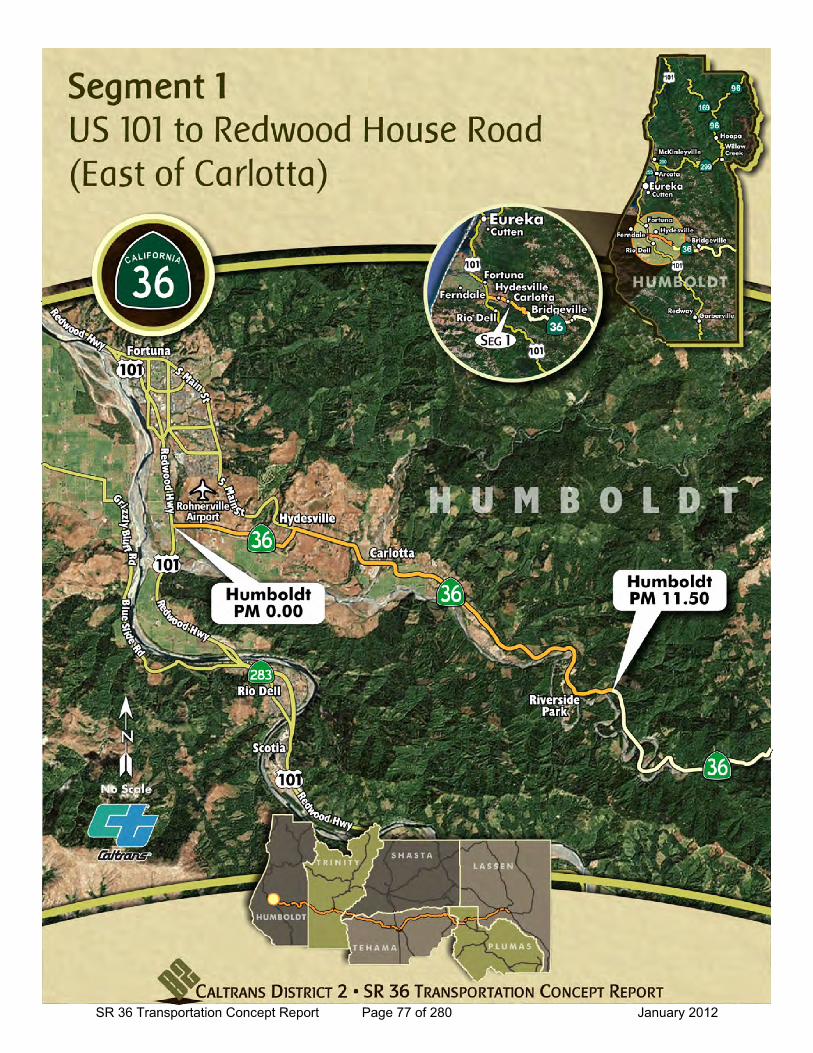
Location: US 101 to Redwood House Road (East of Carlotta)
General Information
to
Current Highway Information
Length Miles:
PM Limits: 0.0 11.5
Facility Concept2C2C2C
Present:Twenty-Year:
Long Range:Future Design Concept
System Designations
Segment #: 1
Terrain: Level/Rolling
Percent RVs: 1-5 %
Lane Width: Mostly 11-12 ft.
11.5County Humboldt Route 36
Number of Lanes: 2
Percent Trucks: 9-20 %
Other Classifications:California Legal Advisory (From PM 1.65), Blue Star Memorial Highway
Traffic Volume Ranges and LOS Collision Rates
Year Peak Hour Average
Daily Traffic LOS
Actual Collision Rates on Segment
Statewide Average for Highway Type
2010 270 - 610 2100 - 4300 B
Fatal + Injury
Collision
Total Collision
Fatal + Injury
Collision
Total Collision
2020 300 - 800 2150 -5600 B 0.65 1.67 0.63 1.36
2030 400 - 1100 2200 - 6800 B Rates are A CC/MV M (A ccidents per Mil lion Vehic le Mi les ) Source: Caltrans Distric t 2, Office of Traffic Safety, Collision Data fr om 01/01/2004 to 12/31/2008
Caltrans District 2, Office S ystem Planning and Traffic Census
Bicycle Status: Allowed
Average Treated Shoulder:
0-4 ft. (PMs 0.0-2.76); 2-8 ft. (PMs 2.81-5.084); 0-4 ft. (PMs 5.084-11.487).
01
Functional Classification: Minor Arterial
None Specified
The Caltrans District 1 Route Concept Report for Route 36 in Humboldt County is
available at the following web site link:
http://www.dot.ca.gov/dist1/d1transplan/r36.pdf
SR 36 Transportation Concept Report Page 78 of 280 January 2012
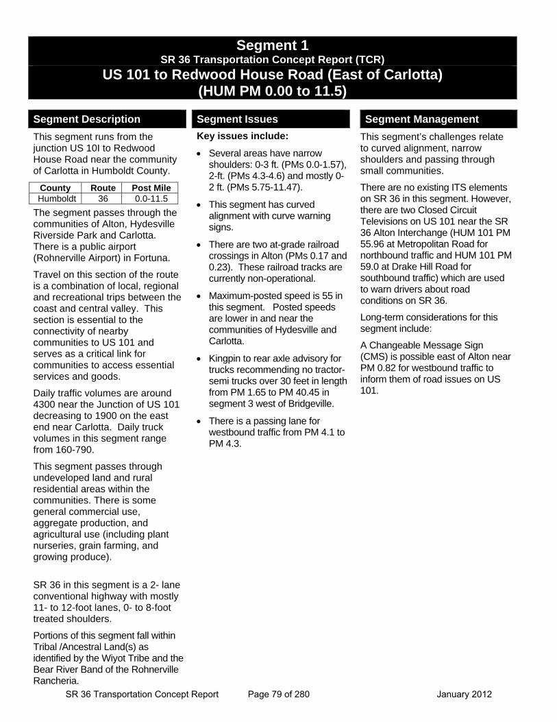
Segment 1 SR 36 Transportation Concept Report (TCR)
US 101 to Redwood House Road (East of Carlotta) (HUM PM 0.00 to 11.5)
Segment Description
This segment runs from the junction US 10I to Redwood House Road near the community of Carlotta in Humboldt County.
The segment passes through the communities of Alton, Hydesville Riverside Park and Carlotta. There is a public airport (Rohnerville Airport) in Fortuna.
Travel on this section of the route is a combination of local, regional and recreational trips between the coast and central valley. This section is essential to the connectivity of nearby communities to US 101 and serves as a critical link for communities to access essential services and goods.
Daily traffic volumes are around 4300 near the Junction of US 101 decreasing to 1900 on the east end near Carlotta. Daily truck volumes in this segment range from 160-790.
This segment passes through undeveloped land and rural residential areas within the communities. There is some general commercial use, aggregate production, and agricultural use (including plant nurseries, grain farming, and growing produce).
SR 36 in this segment is a 2- lane conventional highway with mostly 11- to 12-foot lanes, 0- to 8-foot treated shoulders.
Portions of this segment fall within Tribal /Ancestral Land(s) as identified by the Wiyot Tribe and the Bear River Band of the Rohnerville Rancheria.
Segment Issues
Key issues include:
Several areas have narrow shoulders: 0-3 ft. (PMs 0.0-1.57), 2-ft. (PMs 4.3-4.6) and mostly 0-2 ft. (PMs 5.75-11.47).
This segment has curved alignment with curve warning signs.
There are two at-grade railroad crossings in Alton (PMs 0.17 and 0.23). These railroad tracks are currently non-operational.
Maximum-posted speed is 55 in this segment. Posted speeds are lower in and near the communities of Hydesville and Carlotta.
Kingpin to rear axle advisory for trucks recommending no tractor-semi trucks over 30 feet in length from PM 1.65 to PM 40.45 in segment 3 west of Bridgeville.
There is a passing lane for westbound traffic from PM 4.1 to PM 4.3.
Segment Management
This segment’s challenges relate to curved alignment, narrow shoulders and passing through small communities.
There are no existing ITS elements on SR 36 in this segment. However, there are two Closed Circuit Televisions on US 101 near the SR 36 Alton Interchange (HUM 101 PM 55.96 at Metropolitan Road for northbound traffic and HUM 101 PM 59.0 at Drake Hill Road for southbound traffic) which are used to warn drivers about road conditions on SR 36.
Long-term considerations for this segment include:
A Changeable Message Sign (CMS) is possible east of Alton near PM 0.82 for westbound traffic to inform them of road issues on US 101.
County Route Post Mile Humboldt 36 0.0-11.5
SR 36 Transportation Concept Report Page 79 of 280 January 2012
Seg
men
t 1
S
R 3
6 T
ran
spo
rtat
ion
Co
nce
pt
Rep
ort
(T
CR
)
US
101
to
Red
wo
od
Ho
use
Ro
ad (
Eas
t o
f C
arlo
tta)
(H
UM
PM
0.0
0 to
PM
11.
5)
S
egm
ent
Pro
ject
s/P
ote
nti
al Im
pro
vem
ents
N
ame
Typ
e L
oca
tio
n
Yea
r P
rog
ram
C
ost
S
po
nso
r C
om
ple
ted
Pro
ject
s R
epla
ce A
C S
urf
acin
g
Mai
nte
nan
ce
PM
0.3
-13.
4 20
05
Mai
nte
nan
ce
$ 9
45,0
00
Cal
tran
s R
ubbe
rized
chi
p se
al n
ear
Alto
n.
Alt
on
Inte
rch
ang
e O
per
atio
nal
Imp
rove
men
t P
M R
0.0
-0.5
20
11
ST
IP
$15,
000,
000
Cal
tran
s, H
CA
OG
C
onst
ruct
ed “
Spr
ead
Dia
mon
d” In
terc
hang
e ne
ar A
lton
on R
oute
101
at t
he in
ters
ectio
n of
US
101
and
SR
36
betw
een
the
com
mun
ities
of F
ortu
na, R
io D
ell
and
Hyd
esvi
lle.
Ext
ende
d th
e m
edia
n ba
rrie
r on
US
101
bet
wee
n D
rake
Hill
Roa
d to
just
nor
th o
f the
Van
Duz
en B
ridge
. E
xten
ded
loca
l roa
ds o
n th
e w
est
side
of U
S 1
01 a
nd e
limin
ated
sev
eral
roa
d ap
proa
ches
.
In-P
rog
ress
C
arlo
tta
Sh
ou
lder
W
iden
ing
O
per
atio
nal
Imp
rove
men
t P
M 5
.8 -
7.6
20
12
SH
OP
P
$5,0
00,0
00
Cal
tran
s
Inst
all l
eft t
urn-
pock
et a
t Wild
er L
ane
for
east
boun
d tr
affic
. H
um
36
CA
PM
P
avem
ent
Reh
abili
tati
on
1.
7-11
.5
2013
S
HO
PP
$1
3,30
0,00
0 C
altr
ans
Thi
s C
apita
l Pre
vent
ativ
e M
aint
enan
ce p
roje
ct e
xten
ds in
to s
egm
ent 2
, cos
t ref
lect
s en
tire
proj
ect.
Po
ten
tial
Fu
ture
20-
Yea
r N
o ca
paci
ty p
roje
cts
or s
igni
fican
t ope
ratio
nal p
roje
cts
are
iden
tifie
d.
SR 36 Transportation Concept Report Page 80 of 280 January 2012

Segment 2
SR 36 Transportation Concept Report Page 81 of 280 January 2012

This page intentionally left blank
SR 36 Transportation Concept Report Page 82 of 280 January 2012
SR 36 Transportation Concept Report Page 83 of 280 January 2012
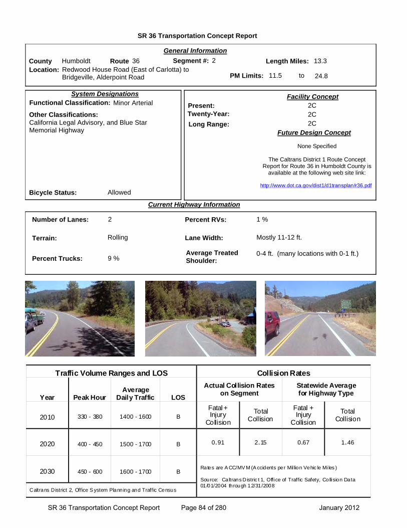
SR 36 Transportation Concept Report
Location: Redwood House Road (East of Carlotta) to Bridgeville, Alderpoint Road
General Information
to
Current Highway Information
Length Miles:
PM Limits: 11.5 24.8
Facility Concept2C2C2C
Present:Twenty-Year:
Long Range:Future Design Concept
System Designations
Segment #: 2
Terrain: Rolling
Percent RVs: 1 %
Lane Width: Mostly 11-12 ft.
13.3County Humboldt Route 36
Number of Lanes: 2
Percent Trucks: 9 %
Other Classifications:California Legal Advisory, and Blue Star Memorial Highway
Traffic Volume Ranges and LOS Collision Rates
Year Peak Hour Average
Daily Traffic LOS
Actual Collision Rates on Segment
Statewide Average for Highway Type
2010 330 - 380 1400 - 1600 B
Fatal + Injury
Collision
Total Collision
Fatal + Injury
Collision
Total Collision
2020 400 - 450 1500 - 1700 B 0.91 2.15 0.67 1.46
2030 450 - 600 1600 - 1700 B Rates are A CC/MV M (A ccidents per Mil lion Vehic le Mi les ) Source: Caltrans Distric t 1, Office of Traffic Safety, Collision Data 01/01/2004 through 12/31/2008
Caltrans District 2, Office S ystem Planning and Traffic Census
Bicycle Status: Allowed
Average Treated Shoulder:
0-4 ft. (many locations with 0-1 ft.)
02
Functional Classification: Minor Arterial
None Specified
The Caltrans District 1 Route Concept Report for Route 36 in Humboldt County is
available at the following web site link:
http://www.dot.ca.gov/dist1/d1transplan/r36.pdf
SR 36 Transportation Concept Report Page 84 of 280 January 2012
Segment 2 SR 36 Transportation Concept Report (TCR)
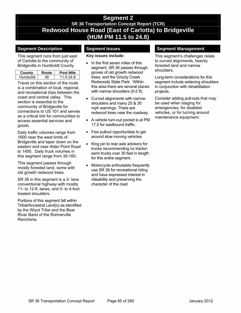
Redwood House Road (East of Carlotta) to Bridgeville (HUM PM 11.5 to 24.8)
Segment Description
This segment runs from just east of Carlotta to the community of Bridgeville in Humboldt County.
Travel on this section of the route is a combination of local, regional, and recreational trips between the coast and central valley. This section is essential to the community of Bridgeville for connections to US 101 and serves as a critical link for communities to access essential services and goods.
Daily traffic volumes range from 1600 near the west limits of Bridgeville and taper down on the eastern end near Alder Point Road to 1400. Daily truck volumes in this segment range from 30-160.
This segment passes through mostly forested land, some with old growth redwood trees.
SR 36 in this segment is a 2- lane conventional highway with mostly 11- to 12-ft. lanes, and 0- to 4-foot treated shoulders.
Portions of this segment fall within Tribal/Ancestral Land(s) as identified by the Wiyot Tribe and the Bear River Band of the Rohnerville Rancheria.
Segment Issues
Key issues include:
• In the first seven miles of this segment, SR 36 passes through groves of old growth redwood trees, and the Grizzly Creek Redwoods State Park. Within this area there are several places with narrow shoulders (0-2 ft).
• Curved alignments with narrow shoulders and many 25 & 30 mph warnings. There are redwood trees near the roadway.
• A vehicle turn-out pocket is at PM 17.0 for eastbound traffic.
• Few pullout opportunities to get around slow moving vehicles.
• King pin to rear axle advisory for trucks recommending no tractor-semi trucks over 30 feet in length for this entire segment.
• Motorcycle enthusiasts frequently use SR 36 for recreational riding and have expressed interest in rideability and preserving the character of the road.
Segment Management
This segment’s challenges relate to curved alignments, heavily forested land and narrow shoulders.
Long-term considerations for this segment include widening shoulders in conjunction with rehabilitation projects.
Consider adding pull-outs that may be used when staging for emergencies, for disabled vehicles, or for turning around maintenance equipment.
County Route Post Mile Humboldt 36 11.5-24.8
SR 36 Transportation Concept Report Page 85 of 280 January 2012

Seg
men
t 2
S
R 3
6 T
ran
spo
rtat
ion
Co
nce
pt
Rep
ort
(T
CR
)
Red
wo
od
Ho
us
e R
oad
(E
ast
of
Car
lott
a) t
o B
rid
gev
ille
(H
UM
PM
11.
5 to
PM
24.
80)
S
egm
ent
Pro
ject
s/P
ote
nti
al Im
pro
vem
ents
N
ame
Typ
e L
oca
tio
n
Yea
r P
rog
ram
C
ost
S
po
nso
r C
om
ple
ted
Pro
ject
s
Rec
on
stru
ct R
oad
way
M
ajo
r D
amag
e (E
mer
gen
cy
Op
enin
g)
PM
21.
3-21
.8
2000
S
HO
PP
$1
,775
,000
C
altr
ans
Rec
onst
ruct
Roa
dway
Sto
rm D
amag
e R
epai
r M
ajo
r D
amag
e (E
mer
gen
cy
Op
enin
g)
15.7
-22.
6 20
03
SH
OP
P
$136
0,00
0 C
altr
ans
Rep
air s
lip o
ut/c
oncr
ete
crib
wal
l and
repa
ir ro
adw
ay.
Cos
t ref
lect
s tw
o co
mbi
ned
proj
ects
with
in th
e po
st m
ile ra
nge.
Sto
rm D
amag
e R
epai
r M
ajo
r D
amag
e (E
mer
gen
cy
Op
enin
g)
19.2
4-24
.8
2006
S
HO
PP
$8
00,0
00
Cal
tran
s
Rep
air R
oadw
ay S
lip-o
ut.
Proj
ect e
xten
ds in
to s
egm
ent 3
, cos
t ref
lect
s en
tire
proj
ect.
Sw
ain
s F
lat
Slid
e M
ajo
r D
amag
e (P
erm
anen
t R
esto
rati
on
) P
M 2
0.8-
21.0
20
10
SH
OP
P
$615
,000
C
altr
ans
Rep
lace
Stru
ctur
al S
ectio
n H
um
bo
ldt
Slip
s
Sto
rm D
amag
e R
epai
r P
M 2
3.3-
24.8
2 20
11
SH
OP
P
$1, 5
10,0
00
Cal
tran
s R
epai
r sto
rm d
amag
e at
var
ious
loca
tions
nea
r Brid
gevi
lle.
Proj
ect e
xten
ds in
to s
egm
ent 3
, cos
t ref
lect
s en
tire
proj
ect.
In-P
rog
ress
Hu
mb
old
t 36
CA
PM
P
avem
ent
Reh
abili
tati
on
11
.5-1
3.5
2013
S
HO
PP
$1
3,30
0,00
0 C
altr
ans
Cap
ital P
reve
ntat
ive
Mai
nten
ance
. Pr
ojec
t ext
ends
into
seg
men
t 1, c
ost r
efle
cts
entir
e pr
ojec
t.
Hu
m 3
6 C
ulv
erts
D
rain
age
Sys
tem
R
esto
rati
on
P
M 2
3.3-
24.8
0 20
13
SH
OP
P
$ 4
60,0
00
Cal
tran
s
Rec
onst
ruct
Dra
inag
e. P
roje
ct e
xten
ds in
to s
egm
ent 3
, cos
t ref
lect
s en
tire
proj
ect.
Po
ten
tial
Fu
ture
20-
Yea
r
No
capa
city
pro
ject
s or
sig
nific
ant o
pera
tiona
l pro
ject
s ar
e id
entif
ied.
SR 36 Transportation Concept Report Page 86 of 280 January 2012

Segment 3
SR 36 Transportation Concept Report Page 87 of 280 January 2012

This page intentionally left blank
SR 36 Transportation Concept Report Page 88 of 280 January 2012
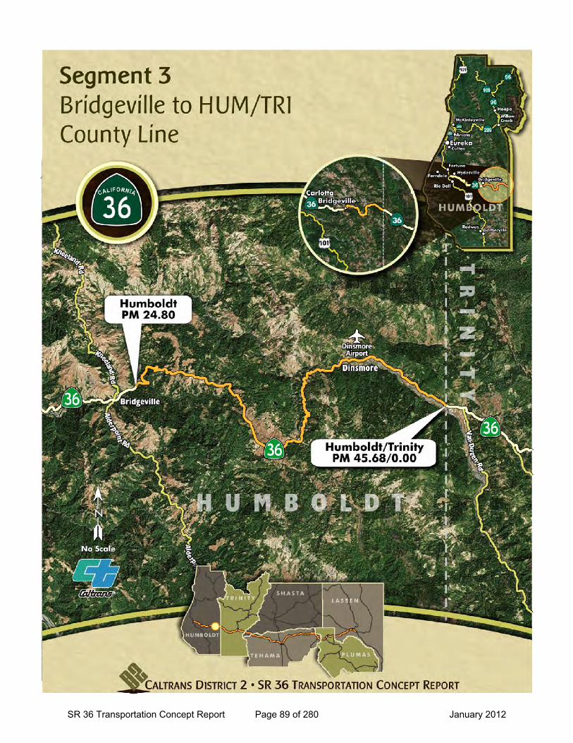
SR 36 Transportation Concept Report Page 89 of 280 January 2012
SR 36 Transportation Concept Report
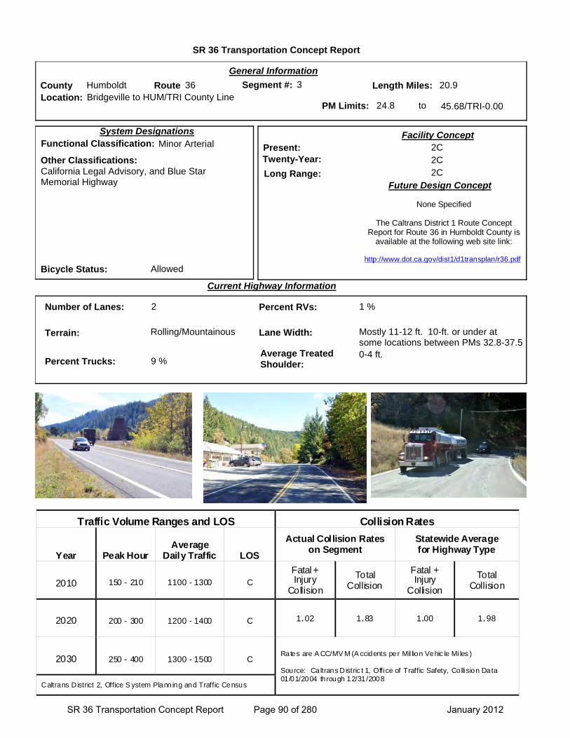
Location: Bridgeville to HUM/TRI County Line
General Information
to
Current Highway Information
Length Miles:
PM Limits: 24.8 45.68/TRI-0.00
Facility Concept2C2C2C
Present:Twenty-Year:
Long Range:Future Design Concept
System Designations
Segment #: 3
Terrain: Rolling/Mountainous
Percent RVs: 1 %
Lane Width: Mostly 11-12 ft. 10-ft. or under at some locations between PMs 32.8-37.5
20.9County Humboldt Route 36
Number of Lanes: 2
Percent Trucks: 9 %
Other Classifications:California Legal Advisory, and Blue Star Memorial Highway
Traffic Volume Ranges and LOS Collision Rates
Year Peak Hour Average
Daily Traffic LOS
Actual Collision Rates on Segment
Statewide Average for Highway Type
2010 150 - 210 1100 - 1300 C
Fatal + Injury
Collision
Total Collision
Fatal + Injury
Collision
Total Collision
2020 200 - 300 1200 - 1400 C 1.02 1.83 1.00 1.98
2030 250 - 400 1300 - 1500 C Rates are A CC/MV M (A ccidents per Mil lion Vehic le Mi les ) Source: Caltrans Distric t 1, Office of Traffic Safety, Collision Data 01/01/2004 through 12/31/2008
Caltrans District 2, Office S ystem Planning and Traffic Census
Bicycle Status: Allowed
Average Treated Shoulder:
0-4 ft.
03
Functional Classification: Minor Arterial
None Specified
The Caltrans District 1 Route Concept Report for Route 36 in Humboldt County is
available at the following web site link:
http://www.dot.ca.gov/dist1/d1transplan/r36.pdf
SR 36 Transportation Concept Report Page 90 of 280 January 2012
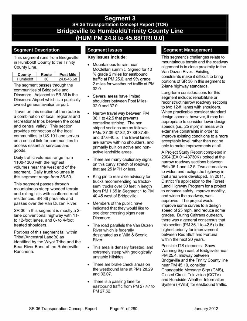
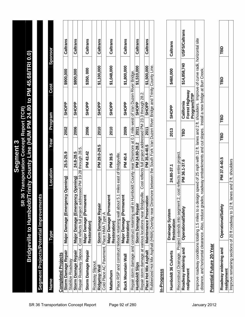
Segment 3 SR 36 Transportation Concept Report (TCR)
Bridgeville to Humboldt/Trinity County Line (HUM PM 24.8 to 45.68/TRI 0.0)
Segment Description
This segment runs from Bridgeville in Humboldt County to the Trinity County Line.
The segment passes through the communities of Bridgeville and Dinsmore. Adjacent to SR 36 is the Dinsmore Airport which is a publically owned general aviation airport.
Travel on this section of the route is a combination of local, regional and recreational trips between the coast and central valley. This section provides connection of the local communities to US 101 and serves as a critical link for communities to access essential services and goods.
Daily traffic volumes range from 1100-1300 with the highest volumes near the west end of the segment. Daily truck volumes in this segment range from 35-50.
This segment passes through mountainous steep wooded terrain and rolling hills with scattered rural residences. SR 36 parallels and passes over the Van Duzen River.
SR 36 in this segment is mostly a 2-lane conventional highway with 11- to 12-foot lanes, and 0- to 4-foot treated shoulders.
Portions of this segment fall within Tribal/Ancestral Land(s) as identified by the Wiyot Tribe and the Bear River Band of the Rohnerville Rancheria.
Segment Issues
Key issues include:
• Mountainous terrain near McClellan summit. Signed for 10 % grade 2 miles for eastbound traffic at PM 25.6, and 9% grade 2 miles for westbound traffic at PM 32.0.
• Several areas have limited shoulders between Post Miles 32.0 and 37.0.
• Narrow travel way between PM 36.1 to 42.5 that prevents centerline striping. The non striped sections are as follows: PMs: 37.09-37.32, 37.36-37.49, and 37.6-40.5. The travel lanes are narrow with no shoulders, and primarily built on active and non-active landslide areas.
• There are many cautionary signs on this curvy stretch of roadway that are 25 MPH or less.
• King pin to rear axle advisory for trucks recommending no tractor-semi trucks over 30 feet in length from PM 1.65 in Segment 1 to PM 40.45 west of Bridgeville.
• Members of the public have indicated that they would like to see deer crossing signs near Dinsmore.
• The road parallels the Van Duzen River which is federally designated as a Wild & Scenic River.
• This area is densely forested, and extremely steep with geologically unstable hillsides.
• There are brake check areas on the westbound lane at PMs 28.29 and 32.07.
• There is a passing lane for eastbound traffic from PM 27.47 to PM 27.62.
Segment Management
This segment’s challenges relate to mountainous terrain and the roadway alignment is in close proximity to the Van Duzen River. Existing constraints make it difficult to bring portions of SR 36 in this segment to 2-lane highway standards. Long-term considerations for this segment include: rehabilitate or reconstruct narrow roadway sections to two 12-ft. lanes with shoulders. When practicable consider standard design speeds, however, it may be appropriate to consider lower design speeds (i.e., 25 mph) in areas with extensive constraints in order to improve existing conditions to a more acceptable level rather than not be able to make improvements at all. A Project Study Report completed in 2004 (EA 01-43730K) looked at the narrow roadway sections between PMs 36.1 and 42.5. Two alternatives to widen and realign the highway in that area were developed. In 2011, District 1’s application to the Forest Land Highway Program for a project to enhance safety, improve mobility, and widen the roadway, was approved. The project would improve some curves to a design speed of 25 mph, and reduce some grades. During Caltrans outreach, there was a general consensus that this section (PM 36.1 to 42.5) is the highest priority for improvement between Red Bluff and Fortuna within the next 20 years. Possible ITS elements: Snow Warning Sign east of Bridgeville near PM 25.4, midway between Bridgeville and the Trinity County line near PM 45.10, consider: Changeable Message Sign (CMS), Closed Circuit Television (CCTV) and Roadside Weather Information System (RWIS) for eastbound traffic.
County Route Post Mile Humboldt 36 24.8-45.68
SR 36 Transportation Concept Report Page 91 of 280 January 2012
Seg
men
t 3
SR
36
Tra
nsp
ort
atio
n C
on
cep
t R
epo
rt (
TC
R)
B
rid
gev
ille
to H
um
bo
ldt/
Tri
nit
y C
ou
nty
Lin
e (H
UM
PM
24.
80 t
o P
M 4
5.68
/TR
I 0.0
)
Seg
men
t P
roje
cts/
Po
ten
tial
Imp
rove
men
ts
Nam
e T
ype
Lo
cati
on
Y
ear
Pro
gra
m
Co
st
Sp
on
sor
Co
mp
lete
d P
roje
cts
Sto
rm D
amag
e R
epai
r M
ajo
r D
amag
e (E
mer
gen
cy O
pen
ing
) 25
.5-2
5.9
2002
S
HO
PP
$9
00,0
00
Cal
tran
s S
tabi
lize
Roa
dway
S
torm
Dam
age
Rep
air
Maj
or
Dam
age
(Em
erg
ency
Op
enin
g)
24.8
-28.
5 20
06
SH
OP
P
$800
,000
C
altr
ans
Rep
air
Roa
dway
Slip
out.
Cos
t ref
lect
s fu
ll pr
ojec
t add
ress
ed P
M 1
9.28
thro
ugh
28.5
.
Sto
rm D
amag
e R
epai
r M
ajo
r D
amag
e (P
erm
anen
t R
esto
rati
on
) P
M 4
3.42
20
06
SH
OP
P
$350
, 000
C
altr
ans
Roa
dway
Slip
out.
Rid
get
op
Wal
l S
torm
Dam
age
Rep
air
PM
29.
0-29
.5
2010
S
HO
PP
$1
,100
,000
C
altr
ans
Col
d P
lace
AC
Pav
emen
t, P
lace
HM
A T
ype
A
Mat
terh
orn
M
ajo
r D
amag
e (P
erm
anen
t R
esto
rati
on
) P
M 3
9.5
2010
S
HO
PP
$1
,048
,000
C
altr
ans
Pla
ce R
SP
and
con
stru
ct ti
ebac
k re
tain
ing
wal
l abo
ut 5
.1 m
iles
east
of B
ridge
ville
.
Bu
ck M
ou
nta
in W
all
Maj
or
Dam
age
(Per
man
ent
Res
tora
tio
n)
PM
40.
4 20
09
SH
OP
P
$1,8
00,0
00
Cal
tran
s
Rep
air
stor
m d
amag
e an
d co
nstr
uct r
etai
ning
wal
l in
Hum
bold
t Cou
nty
near
Din
smor
e at
0.1
mile
wes
t of V
an D
uzen
Riv
er B
ridge
. H
um
bo
ldt
Slip
s
Sto
rm D
amag
e R
epai
r P
M 2
4.80
-28.
2 20
11
SH
OP
P
$1,5
10,0
00
Cal
tran
s R
epai
r st
orm
dam
age
at v
ario
us lo
catio
ns n
ear
Brid
gevi
lle.
Cos
t ref
lect
s fu
ll pr
ojec
t add
ress
ed P
M 2
3.3
thro
ugh
28.2
. P
lace
Ho
t M
ix A
sph
alt
Mai
nte
nan
ce P
rese
rvat
ion
P
M 3
5.4-
40.5
20
11
SH
OP
P
$1,5
00,0
00
Cal
tran
s R
ubbe
rized
Hot
Mix
Asp
halt
(HM
A)
Ove
rlay
near
Din
smor
e be
twee
n th
e S
outh
For
k V
an D
uzen
Riv
er B
ridge
and
Trin
ity C
ount
y Li
ne.
In-P
rog
ress
Po
ten
tial
Fu
ture
20-
Yea
r R
oad
way
wid
enin
g a
nd
re
alig
nm
ent
Op
erat
ion
al/S
afet
y P
M 3
7.6-
40.5
T
BD
T
BD
T
BD
T
BD
Impr
ove
rem
aini
ng s
ectio
ns o
f 20
ft ro
adw
ay to
12
ft. la
nes
and
2 ft.
sho
ulde
rs
Hu
mb
old
t 36
Cu
lver
ts
Dra
inag
e S
yste
m
Res
tora
tio
n
24.8
0-37
.1
2013
S
HO
PP
$4
60,0
00
Cal
tran
s
Rec
onst
ruct
Dra
inag
e. P
roje
ct e
xten
ds in
to s
egm
ent 2
, cos
t ref
lect
s en
tire
proj
ect.
Ro
adw
ay w
iden
ing
an
d
real
ign
men
t O
per
atio
nal
/Saf
ety
PM
36.
1-37
.6
TB
D
Cal
ifo
rnia
F
ore
st H
igh
way
P
rog
ram
/ST
IP
$14,
858,
740
U
SF
S/C
altr
ans
Impr
ove
road
way
con
ditio
ns to
talin
g 1.
5 m
iles
to a
des
ign
spee
d of
25
mph
with
12
ft. la
nes
and
2 ft.
sho
ulde
rs.
Impr
ove
of c
urve
rad
ii, h
oriz
onta
l site
di
stan
ce, a
nd h
oriz
onta
l cle
aran
ce. A
lso,
red
uce
grad
es, r
oadw
ay e
mba
nkm
ents
and
cut
slo
pes.
Ins
tall
a ne
w b
ridge
at B
urr
Cre
ek.
SR 36 Transportation Concept Report Page 92 of 280 January 2012

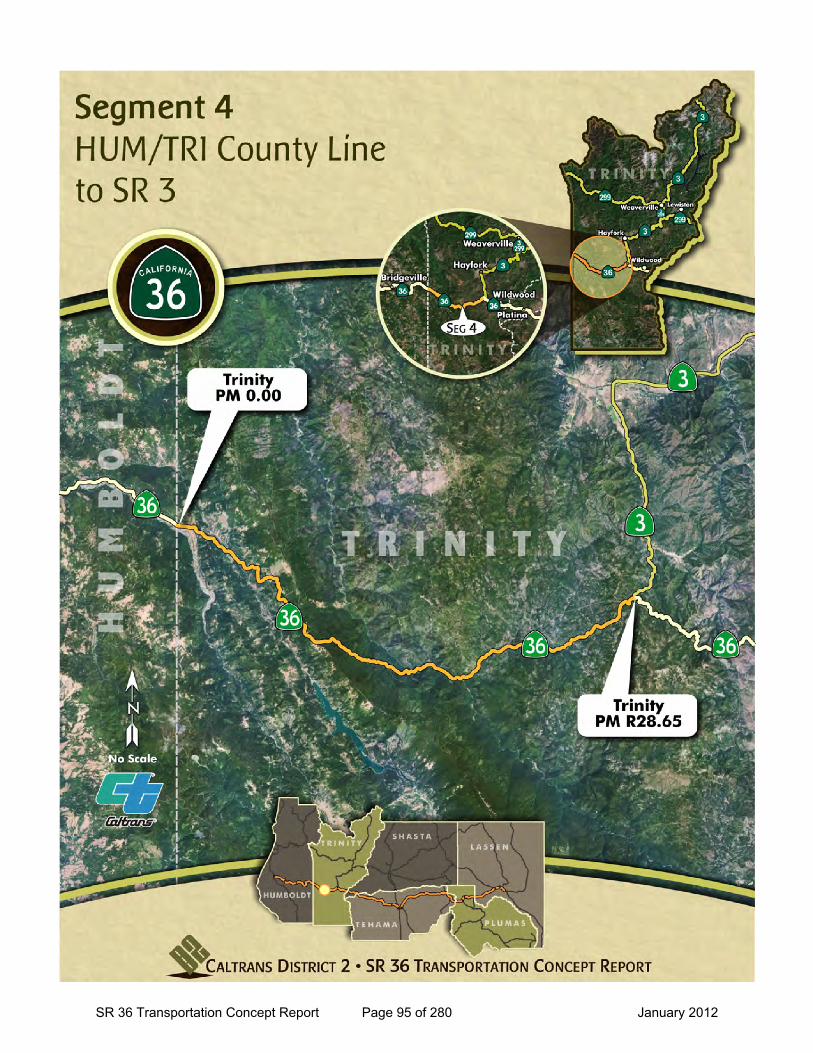
Segment 4
SR 36 Transportation Concept Report Page 93 of 280 January 2012

This page intentionally left blank
SR 36 Transportation Concept Report Page 94 of 280 January 2012
SR 36 Transportation Concept Report Page 95 of 280 January 2012
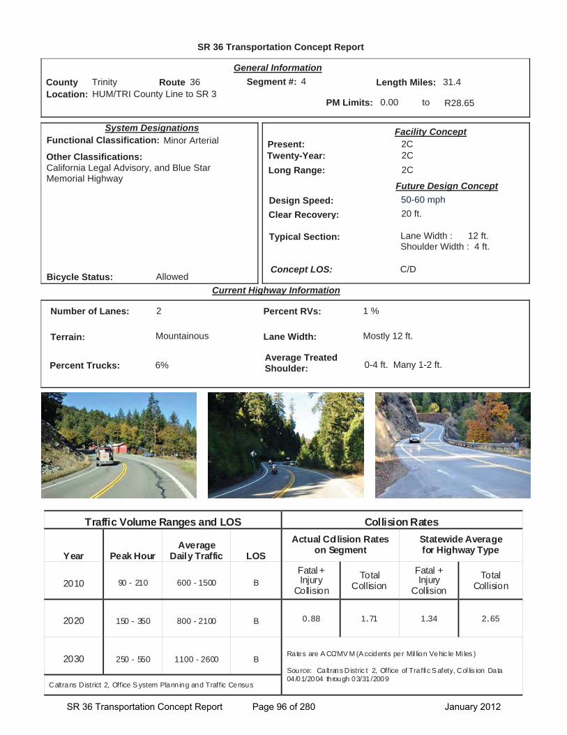
SR 36 Transportation Concept Report
Location: HUM/TRI County Line to SR 3
General Information
to
Current Highway Information
Length Miles:
PM Limits: 0.00 R28.65
Facility Concept2C2C2C
Present:Twenty-Year:Long Range:
Future Design Concept
Clear Recovery: 20 ft.
System Designations
Segment #: 4
Terrain: Mountainous
Percent RVs: 1 %
Lane Width: Mostly 12 ft.
Concept LOS:
31.4County Trinity Route 36
C/D
Number of Lanes: 2
Percent Trucks: 6%
Other Classifications:California Legal Advisory, and Blue Star Memorial Highway
Traffic Volume Ranges and LOS Collision Rates
Year Peak Hour Average
Daily Traffic LOS
Actual Collision Rates on Segment
Statewide Average for Highway Type
2010 90 - 210 600 - 1500 B Fatal + Injury
Collision Total
Collision Fatal + Injury
Collision Total
Collision
2020 150 - 350 800 - 2100 B 0.88 1.71 1.34 2.65
2030 250 - 550 1100 - 2600 B Rates are A CC/MV M (A ccidents per Mil lion Vehic le Mi les )
Source: Caltrans Distric t 2, Office of Traffic S afety, Col lis ion Data 04/01/2004 through 03/31/2009
Caltrans District 2, Office S ystem Planning and Traffic Census
Bicycle Status: Allowed
Average Treated Shoulder: 0-4 ft. Many 1-2 ft.
Typical Section: Lane Width : 12 ft.Shoulder Width : 4 ft.
04
Functional Classification: Minor Arterial
Design Speed: 50-60 mph
SR 36 Transportation Concept Report Page 96 of 280 January 2012
Segment 4 SR 36 Transportation Concept Report (TCR)
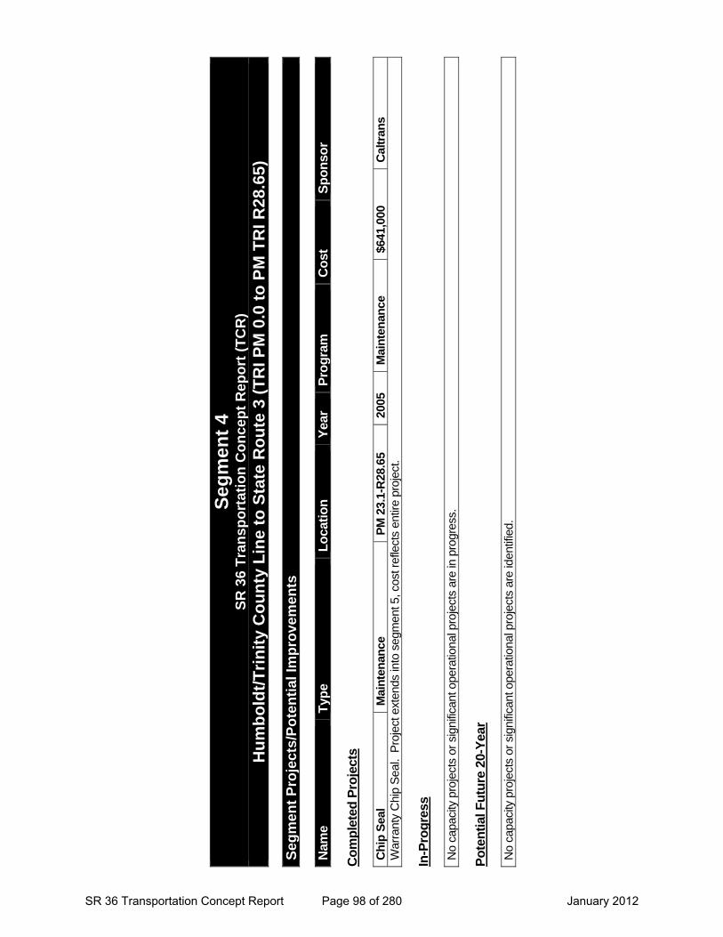
Humboldt/Trinity County Line to State Route 3 (TRI PM 0.0 to R28.65)
Segment Description
This segment runs from the Humboldt/Trinity County Line to State Route 3 in Trinity County.
The segment passes through the communities of Mad River and Forest Glen. Ruth Lake Reservoir is accessed by Lower Mad River Road from SR 36.
Travel on this section of the route is a combination of local, regional, and, recreational trips between the coast and central valley. This section serves as a critical link for communities to access essential services and goods. SR 36 provides connectivity for small communities to US 101, I-5 near Red Bluff and to SR 299 via SR3.
Daily traffic volumes range from 600-1500 with the highest volumes in the beginning of the segment on the west end near the Humboldt County Line. Daily truck volumes in this segment average near 30.
This segment passes through part of Six River National Forest near Ruth Lake Reservoir, Shasta-Trinity National Forest, and private undeveloped timberland. Timber harvest for lumber production is common here.
SR 36 in this segment is a 2-lane conventional highway with mostly 12-foot lanes, and 0- to 4-foot treated shoulders.
Segment Issues
Key issues include:
SR 36 has curved alignment where it winds through mountainous terrain in this segment.
Several locations in this segment have limited shoulders (1-2 foot).
Heavy rainfall and moisture build-up is common causing debris shed, rock fall on steep cut slopes and ongoing slip-outs.
On-going road bed movement between PMs 4-4.5 and 17-19 requiring yearly repair.
South Fork Mountain (PM 10.22) elevation 4,077 ft. Harsh winter conditions are common in the higher elevations where heavy snows are difficult to manage during severe weather.
There is a Vista Point and additional paved areas near PM 10.11 South Fork Mountain Road.
Near Post Mile 27.0 a cautionary sign is posted to inform westbound travelers that narrow winding road begins 15 miles ahead which is not advisable for autos with trailers.
Posted sign (PM 27.18 for westbound trucks) Kingpin to rear axle advisory recommending no tractor-semi trucks over 30 feet in length for the next 80 miles.
Chain control requirements are common during winter snow storms.
This remote area has limited cell phone coverage and limited services such as gas, food, lodging; which, complicates management of traffic incidents and temporary road closures. Near PM 2.5 there is a sign informing eastbound traffic that the “Next Services are 39 miles”.
Fourteen miles of switch back curves between PM 3.0 and PM 16.5.
There are limited passing opportunities for vehicles to get around slower traffic.
Members of the public have indicated that they would like to see deer crossing signs near South Fork Mountain and Forest Glen.
There is a passing lane for eastbound (EB) traffic between PM 24.86 to 25.80 and one for westbound (WB) traffic between PM 25.64 to 25.82. There is a turn-out pocket on the EB lane at PMs R7.67-7.89.
Recreational motorcycle and bicycle use has been increasing.
A 27 mile portion of this segment is posted with cautionary signs to inform travelers of cattle.
This segment’s challenges relate to high elevation, mountainous highway where weather variations can result in slippery conditions complicating driving on this winding roadway. Long-term considerations for this segment include additional cautionary signs or Intelligent Transportation System elements. Possible elements to consider in this segment: Remote Weather Information System PM 10.26 and Closed Circuit Television PM 10.30 (both at South Fork Mountain) and a Highway Advisory Radio PM 2.40 near Mad River.
Adding more pullouts may be beneficial for slower vehicle use, when staging for emergencies, for disabled vehicles and for maintenance operations. Consider adding a sand house to enhance snow removal operations.
County Route Post Mile Trinity 36 0.0-R28.65
TRI 36 PM 26.58 westbound
Segment Management
SR 36 Transportation Concept Report Page 97 of 280 January 2012
Seg
men
t 4
S
R 3
6 T
ran
spo
rtat
ion
Co
nce
pt
Rep
ort
(T
CR
)
Hu
mb
old
t/T
rin
ity
Co
un
ty L
ine
to S
tate
Ro
ute
3 (
TR
I PM
0.0
to
PM
TR
I R
28.6
5)
S
egm
ent
Pro
ject
s/P
ote
nti
al Im
pro
vem
ents
N
ame
Typ
e L
oca
tio
n
Yea
r P
rog
ram
C
ost
S
po
nso
r C
om
ple
ted
Pro
ject
s C
hip
Sea
l M
ain
ten
ance
P
M 2
3.1-
R28
.65
2005
M
ain
ten
ance
$6
41,0
00
Cal
tran
s W
arra
nty
Chi
p S
eal.
Pro
ject
ext
ends
into
seg
men
t 5, c
ost r
efle
cts
entir
e pr
ojec
t. In
-Pro
gre
ss
No
capa
city
pro
ject
s or
sig
nific
ant o
pera
tiona
l pro
ject
s ar
e in
pro
gres
s.
Po
ten
tial
Fu
ture
20-
Yea
r N
o ca
paci
ty p
roje
cts
or s
igni
fican
t ope
ratio
nal p
roje
cts
are
iden
tifie
d.
SR 36 Transportation Concept Report Page 98 of 280 January 2012

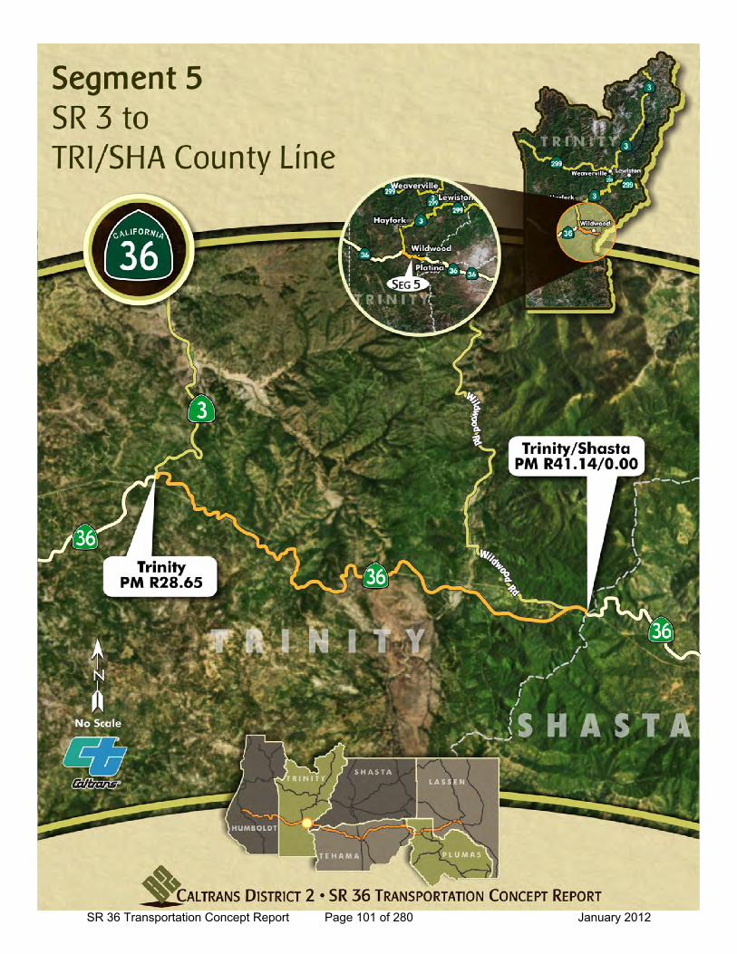
Segment 5
SR 36 Transportation Concept Report Page 99 of 280 January 2012

This page intentionally left blank
SR 36 Transportation Concept Report Page 100 of 280 January 2012
SR 36 Transportation Concept Report Page 101 of 280 January 2012
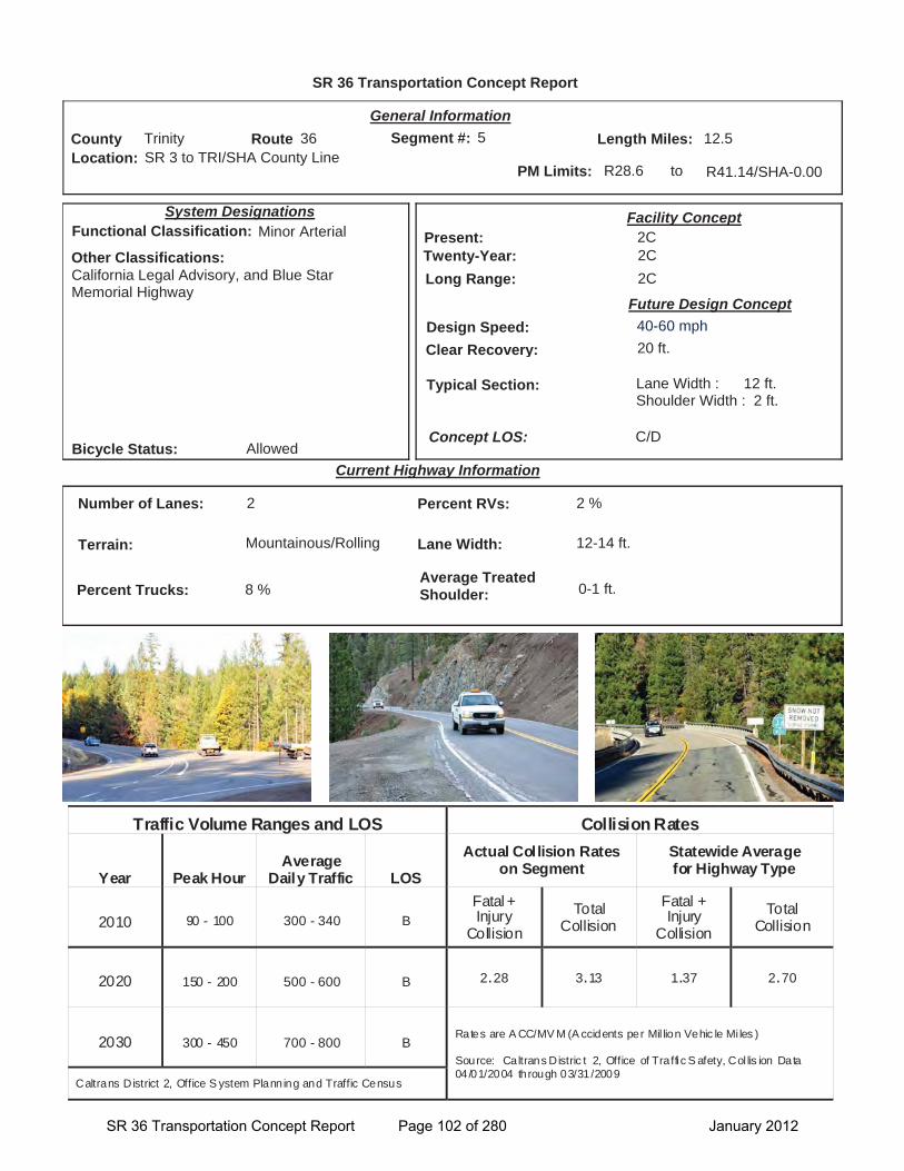
SR 36 Transportation Concept Report
Location: SR 3 to TRI/SHA County Line
General Information
to
Current Highway Information
Length Miles:
PM Limits: R28.6 R41.14/SHA-0.00
Facility Concept2C2C2C
Present:Twenty-Year:Long Range:
Future Design Concept
Clear Recovery: 20 ft.
System Designations
Segment #: 5
Terrain: Mountainous/Rolling
Percent RVs: 2 %
Lane Width: 12-14 ft.
Concept LOS:
12.5County Trinity Route 36
C/D
Number of Lanes: 2
Percent Trucks: 8 %
Other Classifications:California Legal Advisory, and Blue Star Memorial Highway
Traffic Volume Ranges and LOS Collision Rates
Year Peak Hour Average
Daily Traffic LOS
Actual Collision Rates on Segment
Statewide Average for Highway Type
2010 90 - 100 300 - 340 B Fatal + Injury
Collision Total
Collision Fatal + Injury
Collision Total
Collision
2020 150 - 200 500 - 600 B 2.28 3.13 1.37 2.70
2030 300 - 450 700 - 800 B Rates are A CC/MV M (A ccidents per Mil lion Vehic le Mi les )
Source: Caltrans Distric t 2, Office of Traffic S afety, Col lis ion Data 04/01/2004 through 03/31/2009
Caltrans District 2, Office S ystem Planning and Traffic Census
Bicycle Status: Allowed
Average Treated Shoulder: 0-1 ft.
Typical Section: Lane Width : 12 ft.Shoulder Width : 2 ft.
05
Functional Classification: Minor Arterial
Design Speed: 40-60 mph
SR 36 Transportation Concept Report Page 102 of 280 January 2012
Segment 5 SR 36 Transportation Concept Report (TCR)
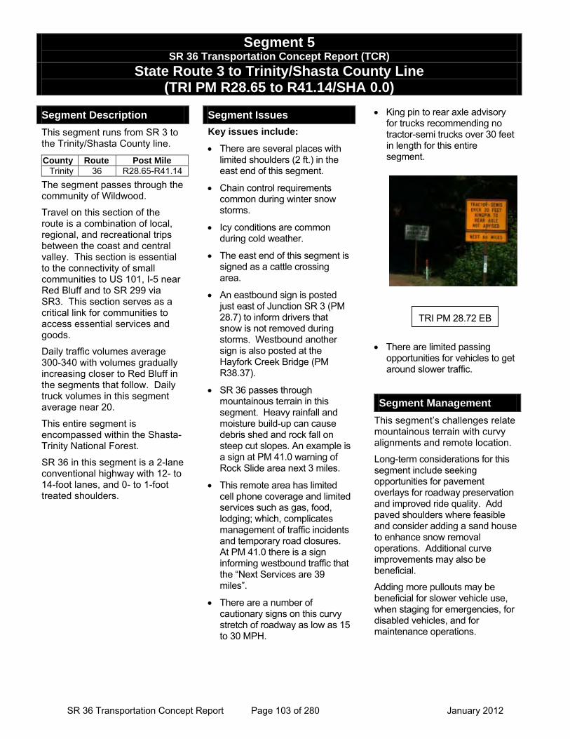
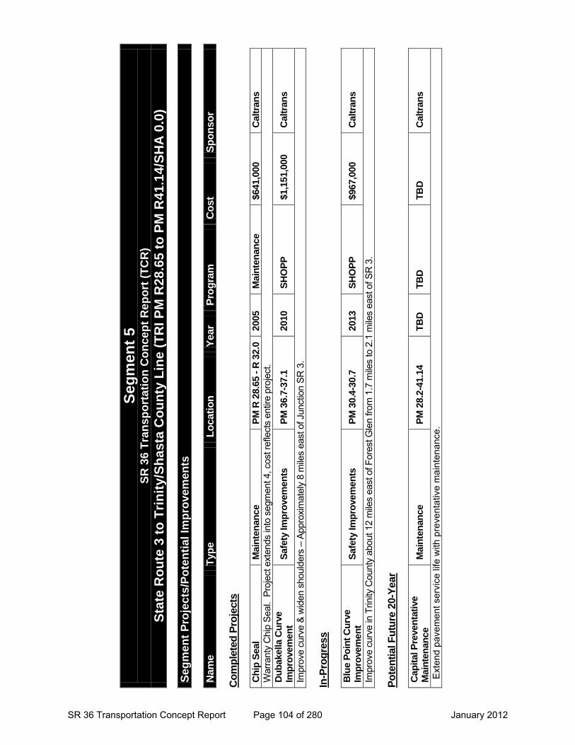
State Route 3 to Trinity/Shasta County Line (TRI PM R28.65 to R41.14/SHA 0.0)
TRI PM 28.72 EB
Segment Description
This segment runs from SR 3 to the Trinity/Shasta County line.
The segment passes through the community of Wildwood.
Travel on this section of the route is a combination of local, regional, and recreational trips between the coast and central valley. This section is essential to the connectivity of small communities to US 101, I-5 near Red Bluff and to SR 299 via SR3. This section serves as a critical link for communities to access essential services and goods.
Daily traffic volumes average 300-340 with volumes gradually increasing closer to Red Bluff in the segments that follow. Daily truck volumes in this segment average near 20.
This entire segment is encompassed within the Shasta-Trinity National Forest.
SR 36 in this segment is a 2-lane conventional highway with 12- to 14-foot lanes, and 0- to 1-foot treated shoulders.
Segment Issues
Key issues include:
• There are several places with limited shoulders (2 ft.) in the east end of this segment.
• Chain control requirements common during winter snow storms.
• Icy conditions are common during cold weather.
• The east end of this segment is signed as a cattle crossing area.
• An eastbound sign is posted just east of Junction SR 3 (PM 28.7) to inform drivers that snow is not removed during storms. Westbound another sign is also posted at the Hayfork Creek Bridge (PM R38.37).
• SR 36 passes through mountainous terrain in this segment. Heavy rainfall and moisture build-up can cause debris shed and rock fall on steep cut slopes. An example is a sign at PM 41.0 warning of Rock Slide area next 3 miles.
• This remote area has limited cell phone coverage and limited services such as gas, food, lodging; which, complicates management of traffic incidents and temporary road closures. At PM 41.0 there is a sign informing westbound traffic that the “Next Services are 39 miles”.
• There are a number of cautionary signs on this curvy stretch of roadway as low as 15 to 30 MPH.
• King pin to rear axle advisory for trucks recommending no tractor-semi trucks over 30 feet in length for this entire segment.
• There are limited passing
opportunities for vehicles to get around slower traffic.
Segment Management
This segment’s challenges relate mountainous terrain with curvy alignments and remote location.
Long-term considerations for this segment include seeking opportunities for pavement overlays for roadway preservation and improved ride quality. Add paved shoulders where feasible and consider adding a sand house to enhance snow removal operations. Additional curve improvements may also be beneficial.
Adding more pullouts may be beneficial for slower vehicle use, when staging for emergencies, for disabled vehicles, and for maintenance operations.
County Route Post Mile Trinity 36 R28.65-R41.14
SR 36 Transportation Concept Report Page 103 of 280 January 2012
Seg
men
t 5
S
R 3
6 T
ran
spo
rtat
ion
Co
nce
pt
Rep
ort
(T
CR
)
Sta
te R
ou
te 3
to
Tri
nit
y/S
has
ta C
ou
nty
Lin
e (T
RI
PM
R28
.65
to P
M R
41.1
4/S
HA
0.0
)
Seg
men
t P
roje
cts/
Po
ten
tial
Imp
rove
men
ts
Nam
e T
ype
Lo
cati
on
Y
ear
Pro
gra
m
Co
st
Sp
on
sor
Co
mp
lete
d P
roje
cts
Ch
ip S
eal
Mai
nte
nan
ce
PM
R 2
8.65
- R
32.
0 20
05
Mai
nte
nan
ce
$641
,000
C
altr
ans
War
rant
y C
hip
Seal
. Pr
ojec
t ext
ends
into
seg
men
t 4, c
ost r
efle
cts
entir
e pr
ojec
t. D
ub
akel
la C
urv
e Im
pro
vem
ent
Saf
ety
Imp
rove
men
ts
PM
36.
7-37
.1
2010
S
HO
PP
$1
,151
,000
C
altr
ans
Impr
ove
curv
e &
wid
en s
houl
ders
– A
ppro
xim
atel
y 8
mile
s ea
st o
f Jun
ctio
n SR
3.
In-P
rog
ress
Blu
e P
oin
t C
urv
e Im
pro
vem
ent
Saf
ety
Imp
rove
men
ts
PM
30.
4-30
.7
2013
S
HO
PP
$9
67,0
00
Cal
tran
s
Impr
ove
curv
e in
Trin
ity C
ount
y ab
out 1
2 m
iles
east
of F
ores
t Gle
n fro
m 1
.7 m
iles
to 2
.1 m
iles
east
of S
R 3
. P
ote
nti
al F
utu
re 2
0-Y
ear
Cap
ital
Pre
ven
tati
ve
Mai
nte
nan
ce
Mai
nte
nan
ce
PM
28.
2-41
.14
TB
D
TB
D
TB
D
Cal
tran
s
Exte
nd p
avem
ent s
ervi
ce li
fe w
ith p
reve
ntat
ive
mai
nten
ance
.
SR 36 Transportation Concept Report Page 104 of 280 January 2012

Segment 6
SR 36 Transportation Concept Report Page 105 of 280 January 2012

This page intentionally left blank
SR 36 Transportation Concept Report Page 106 of 280 January 2012
SR 36 Transportation Concept Report Page 107 of 280 January 2012
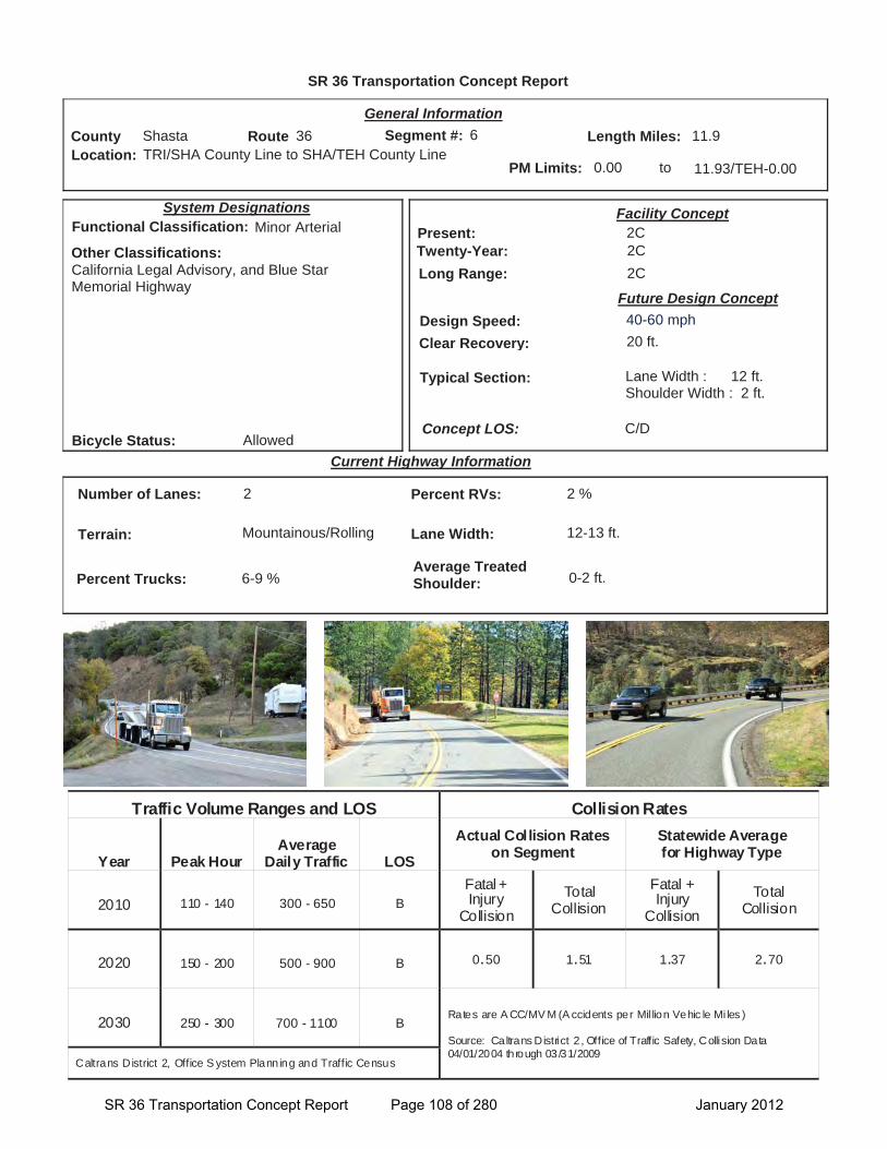
SR 36 Transportation Concept Report
Location: TRI/SHA County Line to SHA/TEH County Line
General Information
to
Current Highway Information
Length Miles:
PM Limits: 0.00 11.93/TEH-0.00
Facility Concept2C2C2C
Present:Twenty-Year:Long Range:
Future Design Concept
Clear Recovery: 20 ft.
System Designations
Segment #: 6
Terrain: Mountainous/Rolling
Percent RVs: 2 %
Lane Width: 12-13 ft.
Concept LOS:
11.9County Shasta Route 36
C/D
Number of Lanes: 2
Percent Trucks: 6-9 %
Other Classifications:California Legal Advisory, and Blue Star Memorial Highway
Traffic Volume Ranges and LOS Collision Rates
Year Peak Hour Average
Daily Traffic LOS
Actual Collision Rates on Segment
Statewide Average for Highway Type
2010 110 - 140 300 - 650 B Fatal + Injury
Collision Total
Collision Fatal + Injury
Collision Total
Collision
2020 150 - 200 500 - 900 B 0.50 1.51 1.37 2.70
2030 250 - 300 700 - 1100 B Rates are A CC/MV M (A ccidents per Mil lion Vehic le Mi les )
Source: Caltrans District 2 , Office of Traffic Safety, Collision Data 04/01/2004 through 03/31/2009
Caltrans District 2, Office S ystem Planning and Traffic Census
Bicycle Status: Allowed
Average Treated Shoulder: 0-2 ft.
Typical Section: Lane Width : 12 ft.Shoulder Width : 2 ft.
06
Functional Classification: Minor Arterial
Design Speed: 40-60 mph
SR 36 Transportation Concept Report Page 108 of 280 January 2012

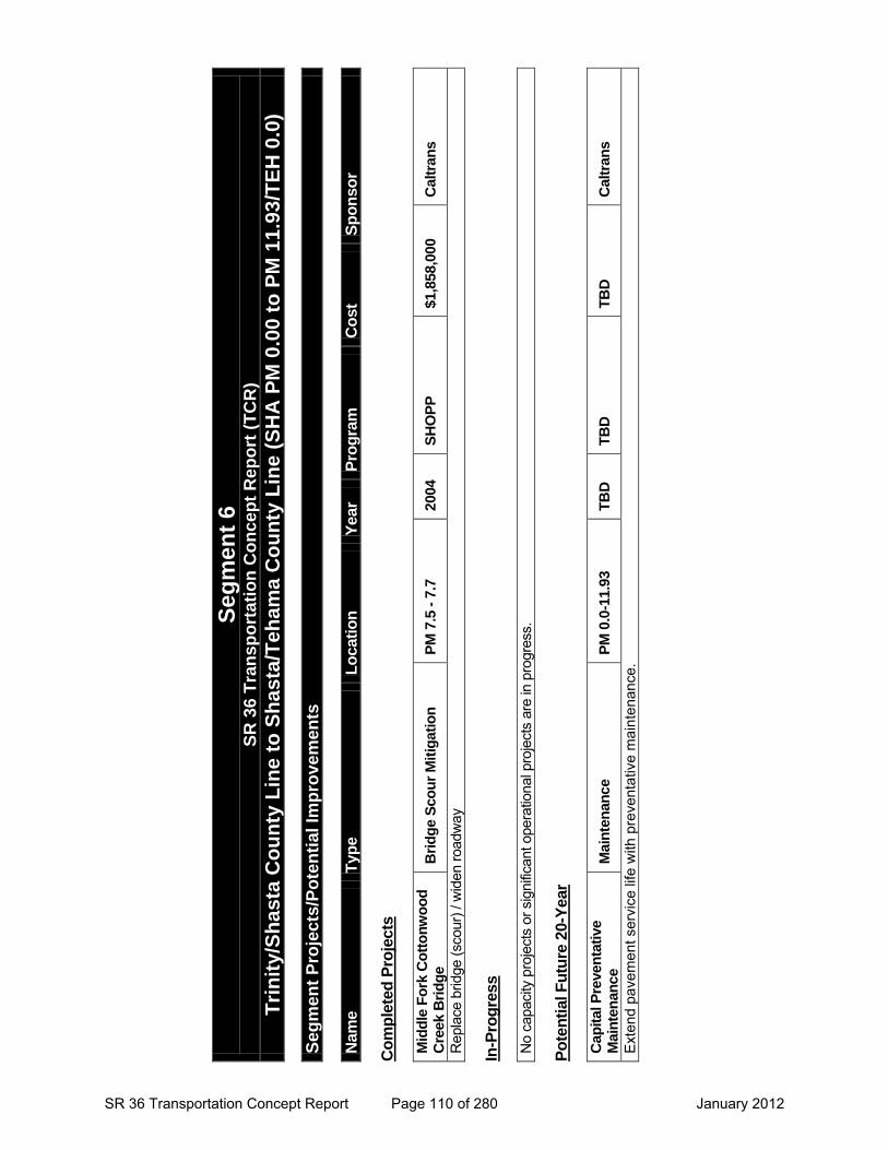
Segment 6 SR 36 Transportation Concept Report (TCR)
Trinity/Shasta County Line to Shasta/Tehama County Line (SHA PM 0.0 to SHA 11.93/ TEH 0.0)
Segment Description
This segment crosses the south west corner of Shasta County from the Trinity/Shasta County Line to the Shasta/Tehama County Line.
The segment passes through the small community of Platina.
Travel on this section of the route is a combination of local, regional, and recreational trips between the coast and central valley and serves as a critical link for communities to access essential services and goods.
Daily traffic volumes range from 300-650 with the highest volumes in the middle of the segment near Platina Road (County Road A16). Daily truck volumes range from 20-60.
The highest traffic volumes are near the middle of the segment by Platina Road.
Travelling eastbound on this Shasta County segment, SR 36 descends from forested mountainous terrain into rolling foothills with mixed oak trees and varied shrubs.
Elevations continue to drop as the route extends towards the Sacramento River Valley in Tehama County.
SR 36 in this segment is a 2-lane conventional highway with 12- to 13-foot lanes, and 0- to 2-foot treated shoulders.
Portions of this segment fall within Tribal/Ancestral Land(s) as identified by the Paskenta Band of Nomlaki Indians.
Segment Issues
Key issues include:
Most of this mountainous segment has limited shoulder widths (1’-2’).
This segment passes by the Harrison Ranger Station (PM 4.3) in the Shasta-Trinity National Forest.
The first few miles of this segment has a very curvilinear alignment and is signed as a rock slide area where rock fall is typical. For example there is such a warning sign at SHA PM 2.53 westbound
The posted speed in this segment is 55 mph.
There are several curves with cautionary 35 mph curve warning signs on the last 2 miles of the east end of this segment.
Pedestrian crossing and School Bus Stop in Platina. Warning signs posted to alert drivers.
King pin to rear axle advisory for trucks recommending no tractor-semi trucks over 30 feet in length for this entire segment.
The Elevation of the highway is 3000 ft. at PM 2.64, and descends to 2000 ft at PM 9.7.
Segment Management
This segment’s challenges relate to steep/constricting terrain, curvy alignment and rock fall management.
Long-term considerations for this segment include:
Widen shoulders where feasible and consider improvements to aid rock fall management and snow storage between PM 0.0 and PM 3.5. Additional curve improvements may also be beneficial.
County Route Post Mile Shasta 36 0.0-11.93
SR 36 Transportation Concept Report Page 109 of 280 January 2012
Seg
men
t 6
S
R 3
6 T
ran
spo
rtat
ion
Co
nce
pt
Rep
ort
(T
CR
)
Tri
nit
y/S
has
ta C
ou
nty
Lin
e to
Sh
ast
a/T
eham
a C
ou
nty
Lin
e (S
HA
PM
0.0
0 to
PM
11.
93/T
EH
0.0
)
Seg
men
t P
roje
cts/
Po
ten
tial
Imp
rove
men
ts
Nam
e T
ype
Lo
cati
on
Y
ear
Pro
gra
m
Co
st
Sp
on
sor
Co
mp
lete
d P
roje
cts
Mid
dle
Fo
rk C
ott
on
wo
od
C
reek
Bri
dg
e B
rid
ge
Sco
ur
Mit
igat
ion
P
M 7
.5 -
7.7
20
04
SH
OP
P
$1,8
58,0
00
Cal
tran
s
Rep
lace
brid
ge (s
cour
) / w
iden
road
way
In
-Pro
gre
ss
No
capa
city
pro
ject
s or
sig
nific
ant o
pera
tiona
l pro
ject
s ar
e in
pro
gres
s.
Po
ten
tial
Fu
ture
20-
Yea
r
Cap
ital
Pre
ven
tati
ve
Mai
nte
nan
ce
Mai
nte
nan
ce
PM
0.0
-11.
93
TB
D
TB
D
TB
D
Cal
tran
s
Exte
nd p
avem
ent s
ervi
ce li
fe w
ith p
reve
ntat
ive
mai
nten
ance
.
SR 36 Transportation Concept Report Page 110 of 280 January 2012

Segment 7
SR 36 Transportation Concept Report Page 111 of 280 January 2012

This page intentionally left blank
SR 36 Transportation Concept Report Page 112 of 280 January 2012
SR 36 Transportation Concept Report Page 113 of 280 January 2012
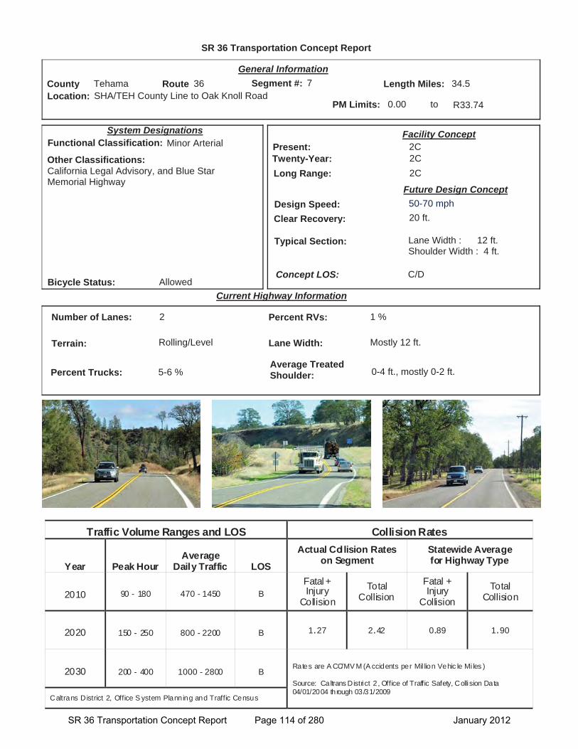
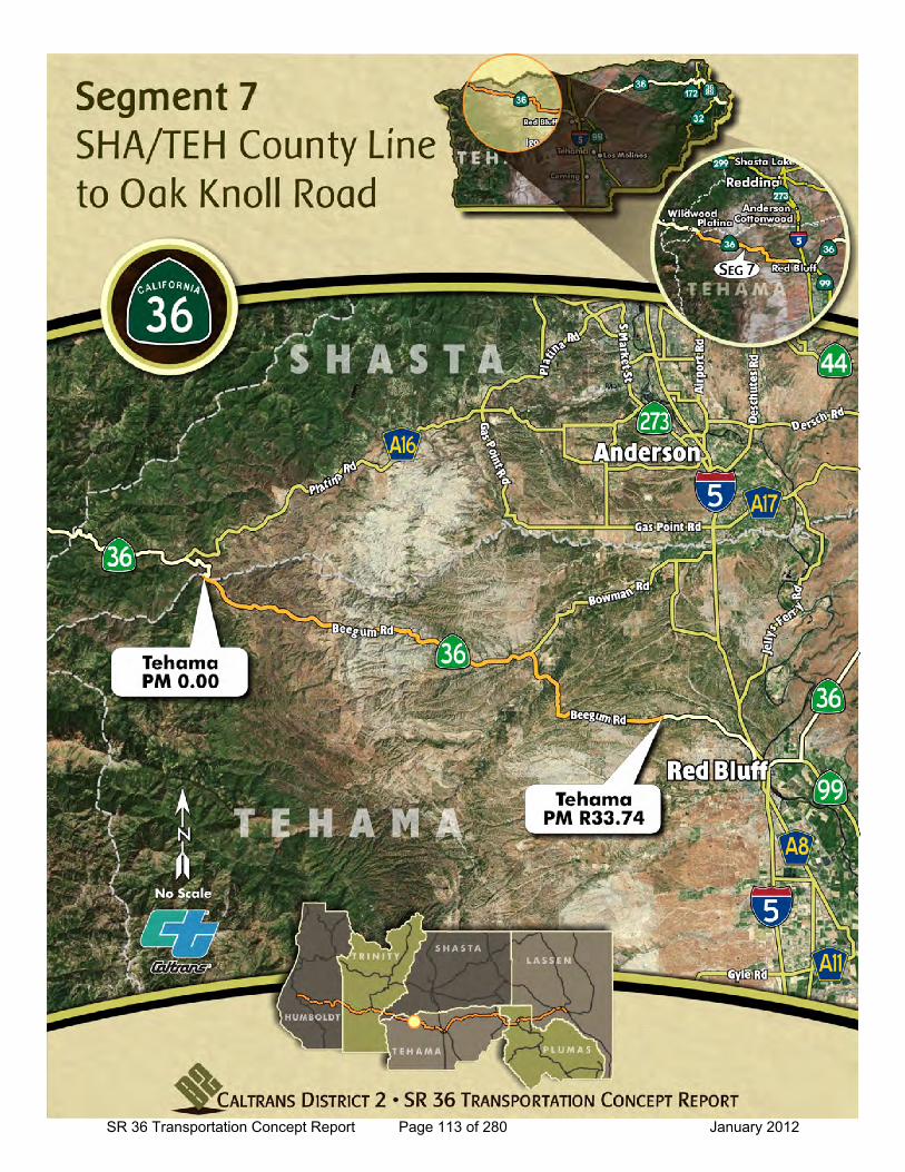
SR 36 Transportation Concept Report
Location: SHA/TEH County Line to Oak Knoll Road
General Information
to
Current Highway Information
Length Miles:
PM Limits: 0.00 R33.74
Facility Concept2C2C2C
Present:Twenty-Year:Long Range:
Future Design Concept
Clear Recovery: 20 ft.
System Designations
Segment #: 7
Terrain: Rolling/Level
Percent RVs: 1 %
Lane Width: Mostly 12 ft.
Concept LOS:
34.5County Tehama Route 36
C/D
Number of Lanes: 2
Percent Trucks: 5-6 %
Other Classifications:California Legal Advisory, and Blue Star Memorial Highway
Traffic Volume Ranges and LOS Collision Rates
Year Peak Hour Average
Daily Traffic LOS
Actual Collision Rates on Segment
Statewide Average for Highway Type
2010 90 - 180 470 - 1450 B Fatal + Injury
Collision Total
Collision Fatal + Injury
Collision Total
Collision
2020 150 - 250 800 - 2200 B 1.27 2.42 0.89 1.90
2030 200 - 400 1000 - 2800 B Rates are A CC/MV M (A ccidents per Mil lion Vehic le Mi les )
Source: Caltrans District 2 , Office of Traffic Safety, Collision Data 04/01/2004 through 03/31/2009
Caltrans District 2, Office S ystem Planning and Traffic Census
Bicycle Status: Allowed
Average Treated Shoulder: 0-4 ft., mostly 0-2 ft.
Typical Section: Lane Width : 12 ft.Shoulder Width : 4 ft.
07
Functional Classification: Minor Arterial
Design Speed: 50-70 mph
SR 36 Transportation Concept Report Page 114 of 280 January 2012
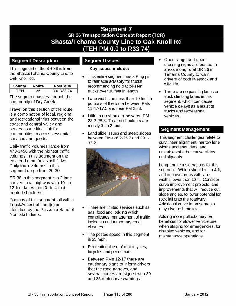
Segment 7 SR 36 Transportation Concept Report (TCR)
Shasta/Tehama County Line to Oak Knoll Rd (TEH PM 0.0 to R33.74)
Segment Description
This segment of the SR 36 is from the Shasta/Tehama County Line to Oak Knoll Rd.
The segment passes through the community of Dry Creek.
Travel on this section of the route is a combination of local, regional, and recreational trips between the coast and central valley and serves as a critical link for communities to access essential services and goods.
Daily traffic volumes range from 470-1450 with the highest traffic volumes in this segment on the east end near Oak Knoll Drive. Daily truck volumes in this segment range from 20-30.
SR 36 in this segment is a 2-lane conventional highway with 10- to 12-foot lanes, and 0- to 4-foot treated shoulders.
Portions of this segment fall within Tribal/Ancestral Land(s) as identified by the Paskenta Band of Nomlaki Indians.
Segment Issues
Key issues include:
This entire segment has a King pin to rear axle advisory for trucks recommending no tractor-semi trucks over 30 feet in length.
Lane widths are less than 10 feet in portions of the route between PMs 11.47-17.5 and near PM 28.8.
Little to no shoulder between PM 23.2-28.8. Treated shoulders are mostly 0- to 2-foot.
Land slide issues and steep slopes between PMs 26.2-25.7 and 29.1-32.2.
There are limited services such as gas, food and lodging which complicates management of traffic incidents and temporary road closures.
The posted speed in this segment is 55 mph.
Recreational use of motorcycles, bicycles and pedestrians.
Between PMs 12-17 there are cautionary signs to inform drivers that the road narrows, and several curves are signed with 30 and 35 mph curve warnings.
Open range and deer crossing signs are posted in areas along rural SR 36 in Tehama County to warn drivers of both livestock and wild life.
There are no passing lanes or truck climbing lanes in this segment, which can cause vehicle delays as a result of trucks and recreational vehicles.
Segment Management
This segment challenges relate to curvilinear alignment, narrow lane widths and shoulders, and unstable soils that cause slides and slip-outs.
Long-term considerations for this segment: Widen shoulders to 4-ft, and improve areas with lane widths lower than 12 ft. Consider curve improvement projects, and improvements that will reduce cut slope angles, to lower potential for rock fall onto the roadway. Additional curve improvements may also be beneficial.
Adding more pullouts may be beneficial for slower vehicle use, when staging for emergencies, for disabled vehicles, and for maintenance operations.
County Route Post Mile TEH 36 0.0-R33.74
SR 36 Transportation Concept Report Page 115 of 280 January 2012
Seg
men
t 7
S
R 3
6 T
ran
spo
rtat
ion
Co
nce
pt
Rep
ort
(T
CR
)
Sh
asta
/Teh
ama
Co
un
ty L
ine
to O
ak K
no
ll R
oad
(T
EH
PM
0.0
0 to
PM
R33
.74)
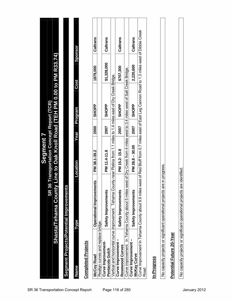
Seg
men
t P
roje
cts/
Po
ten
tial
Imp
rove
men
ts
Nam
e T
ype
Lo
cati
on
Y
ear
Pro
gra
m
Co
st
Sp
on
sor
Co
mp
lete
d P
roje
cts
McC
oy
Ro
ad
Op
erat
ion
al Im
pro
vem
ents
P
M 3
8.1-
39.2
20
00
SH
OP
P
1879
,000
C
altr
ans
Rea
lign
curv
es a
nd re
plac
e br
idge
. C
urv
e Im
pro
vem
ent-
Pen
taco
la G
ulc
h
Saf
ety
Imp
rove
men
ts
PM
11.
4-11
.8
2007
S
HO
PP
$1
,328
,000
C
altr
ans
Verti
cal a
nd h
oriz
onta
l cur
ve im
prov
emen
t. T
eham
a C
ount
y ne
ar P
latin
a fro
m 1
.1 m
iles
to 1
.4 m
iles
east
of D
ry C
reek
Brid
ge.
Cu
rve
Imp
rove
men
t –
Ro
sew
oo
d C
urv
es
Saf
ety
Imp
rove
men
ts
PM
15.
2- 1
5.8
2007
S
HO
PP
$7
07,3
00
Cal
tran
s
Cur
ve im
prov
emen
t. In
Teh
ama
Cou
nty
abou
t 5 m
iles
wes
t of D
ry C
reek
from
4 m
iles
wes
t to
3.4
mile
s w
est o
f Sal
t Cre
ek B
ridge
. C
urv
e Im
pro
vem
ent
– M
cKay
Cu
rve
Saf
ety
Imp
rove
men
ts
PM
28.
8 –
30.0
0 20
07
SH
OP
P
2,22
0,60
0 C
altr
ans
Cur
ve Im
prov
emen
t In
Teha
ma
Cou
nty
abou
t 9.9
mile
s w
est o
f Red
Blu
ff fro
m 0
.7 m
iles
east
of E
ast L
eg C
anno
n R
oad
to 1
.3 m
iles
wes
t of D
ibbl
e C
reek
R
oad.
In
-Pro
gre
ss
No
capa
city
pro
ject
s or
sig
nific
ant o
pera
tiona
l pro
ject
s ar
e in
pro
gres
s.
Po
ten
tial
Fu
ture
20-
Yea
r
No
capa
city
pro
ject
s or
sig
nific
ant o
pera
tiona
l pro
ject
s ar
e id
entif
ied.
SR 36 Transportation Concept Report Page 116 of 280 January 2012

Segment 8
SR 36 Transportation Concept Report Page 117 of 280 January 2012

This page intentionally left blank
SR 36 Transportation Concept Report Page 118 of 280 January 2012
SR 36 Transportation Concept Report Page 119 of 280 January 2012
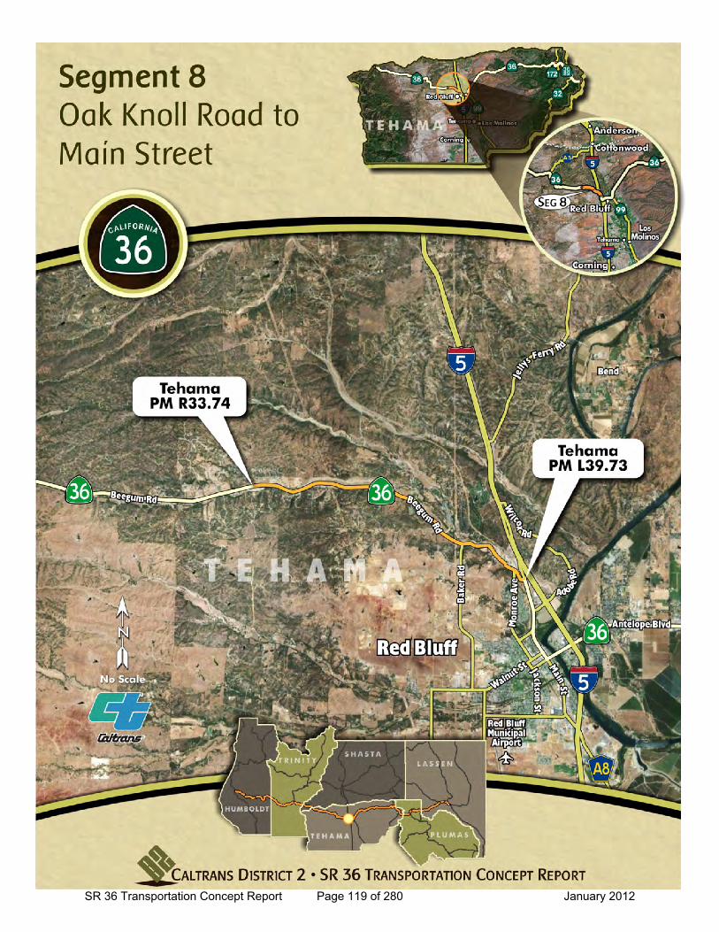
SR 36 Transportation Concept Report
Location: Oak Knoll Road to Main Street
General Information
to
Current Highway Information
Length Miles:
PM Limits: R33.7 L39.73
Facility Concept2C2C2C
Present:Twenty-Year:Long Range:
Future Design Concept
Clear Recovery: 20 ft.
System Designations
Segment #: 8
Terrain: Rolling/Level
Percent RVs: 1 %
Lane Width: 9-12 ft.
Concept LOS:
6.6County Tehama Route 36
C/D
Number of Lanes: 2
Percent Trucks: 3-6%
Other Classifications:California Legal Advisory, and blue Star Memorial Highway
Traffic Volume Ranges and LOS Collision Rates
Year Peak Hour Average
Daily Traffic LOS
Actual Collision Rates on Segment
Statewide Average for Highway Type
2010 180 - 330 1450 - 3250 B Fatal + Injury
Collision Total
Collision Fatal + Injury
Collision Total
Collision
2020 250 - 600 2800 - 5200 B 0.65 1.43 0.69 1.60
2030 350 - 1050 3900 - 6800 C Rates are A CC/MV M (A ccidents per Mil lion Vehic le Mi les )
Source: Caltrans District 2 , Office of Traffic Safety, Collision Data 04/01/2004 through 03/31/2009
Caltrans District 2, Office S ystem Planning and Traffic Census
Bicycle Status: Allowed
Average Treated Shoulder: 0-8 ft, mostly 0-2 ft.
Typical Section: Lane Width : 12 ft.Shoulder Width : 8 ft.
08
Functional Classification: Minor Arterial
Design Speed: 50-70 mph
SR 36 Transportation Concept Report Page 120 of 280 January 2012
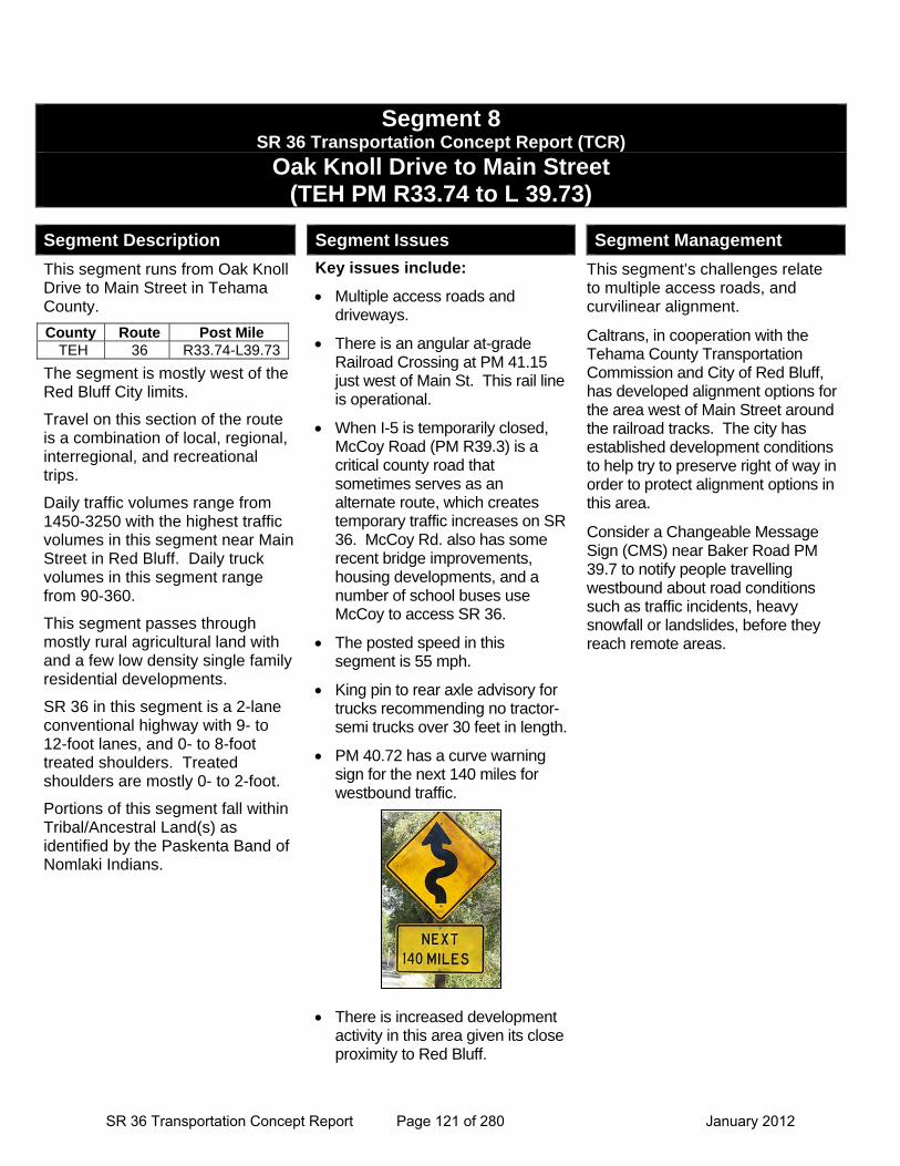
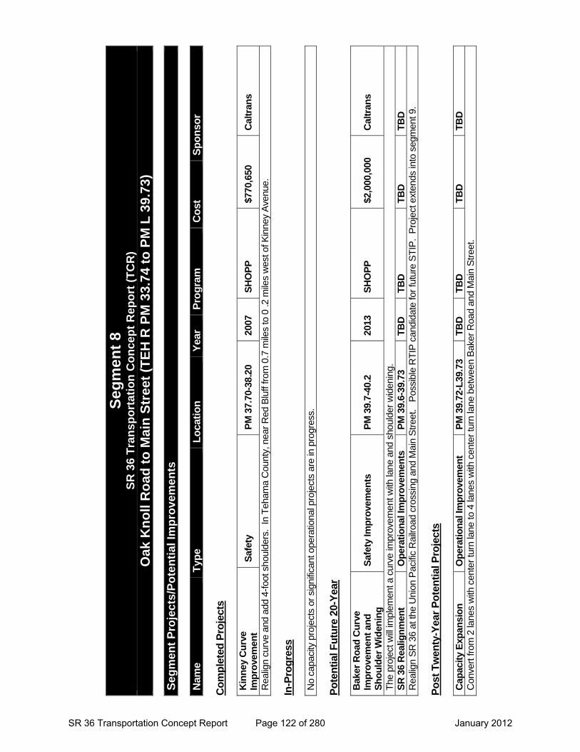
Segment 8 SR 36 Transportation Concept Report (TCR)
Oak Knoll Drive to Main Street (TEH PM R33.74 to L 39.73)
Segment Description
This segment runs from Oak Knoll Drive to Main Street in Tehama County.
The segment is mostly west of the Red Bluff City limits.
Travel on this section of the route is a combination of local, regional, interregional, and recreational trips.
Daily traffic volumes range from 1450-3250 with the highest traffic volumes in this segment near Main Street in Red Bluff. Daily truck volumes in this segment range from 90-360.
This segment passes through mostly rural agricultural land with and a few low density single family residential developments.
SR 36 in this segment is a 2-lane conventional highway with 9- to 12-foot lanes, and 0- to 8-foot treated shoulders. Treated shoulders are mostly 0- to 2-foot.
Portions of this segment fall within Tribal/Ancestral Land(s) as identified by the Paskenta Band of Nomlaki Indians.
Segment Issues
Key issues include:
Multiple access roads and driveways.
There is an angular at-grade Railroad Crossing at PM 41.15 just west of Main St. This rail line is operational.
When I-5 is temporarily closed, McCoy Road (PM R39.3) is a critical county road that sometimes serves as an alternate route, which creates temporary traffic increases on SR 36. McCoy Rd. also has some recent bridge improvements, housing developments, and a number of school buses use McCoy to access SR 36.
The posted speed in this segment is 55 mph.
King pin to rear axle advisory for trucks recommending no tractor-semi trucks over 30 feet in length.
PM 40.72 has a curve warning sign for the next 140 miles for westbound traffic.
There is increased development activity in this area given its close proximity to Red Bluff.
Segment Management
This segment’s challenges relate to multiple access roads, and curvilinear alignment.
Caltrans, in cooperation with the Tehama County Transportation Commission and City of Red Bluff, has developed alignment options for the area west of Main Street around the railroad tracks. The city has established development conditions to help try to preserve right of way in order to protect alignment options in this area.
Consider a Changeable Message Sign (CMS) near Baker Road PM 39.7 to notify people travelling westbound about road conditions such as traffic incidents, heavy snowfall or landslides, before they reach remote areas.
County Route Post Mile TEH 36 R33.74-L39.73
SR 36 Transportation Concept Report Page 121 of 280 January 2012
Seg
men
t 8
S
R 3
6 T
ran
spo
rtat
ion
Co
nce
pt
Rep
ort
(T
CR
)
Oak
Kn
oll
Ro
ad t
o M
ain
Str
eet
(TE
H R
PM
33.
74 t
o P
M L
39.
73)
S
egm
ent
Pro
ject
s/P
ote
nti
al Im
pro
vem
ents
N
ame
Typ
e L
oca
tio
n
Yea
r P
rog
ram
C
ost
S
po
nso
r C
om
ple
ted
Pro
ject
s K
inn
ey C
urv
e Im
pro
vem
ent
Saf
ety
PM
37.
70-3
8.20
20
07
SH
OP
P
$770
,650
C
altr
ans
Rea
lign
curv
e an
d ad
d 4-
foot
sho
ulde
rs.
In T
eham
a C
ount
y, n
ear
Red
Blu
ff fr
om 0
.7 m
iles
to 0
.2 m
iles
wes
t of K
inne
y A
venu
e.
In-P
rog
ress
N
o ca
paci
ty p
roje
cts
or s
igni
fican
t ope
ratio
nal p
roje
cts
are
in p
rogr
ess.
P
ote
nti
al F
utu
re 2
0-Y
ear
Bak
er R
oad
Cu
rve
Imp
rove
men
t an
d
Sh
ou
lder
Wid
enin
g
Saf
ety
Imp
rove
men
ts
PM
39.
7-40
.2
2013
S
HO
PP
$2
,000
,000
C
altr
ans
The
pro
ject
will
impl
emen
t a c
urve
impr
ovem
ent w
ith la
ne a
nd s
houl
der
wid
enin
g.
SR
36
Rea
lign
men
t O
per
atio
nal
Imp
rove
men
ts
PM
39.
6-39
.73
TB
D
TB
D
TB
D
TB
D
Rea
lign
SR
36
at th
e U
nion
Pac
ific
Rai
lroad
cro
ssin
g an
d M
ain
Str
eet.
Pos
sibl
e R
TIP
can
dida
te fo
r fu
ture
ST
IP.
Pro
ject
ext
ends
into
seg
men
t 9.
Po
st T
wen
ty-Y
ear
Po
ten
tial
Pro
ject
s C
apac
ity
Exp
ansi
on
O
per
atio
nal
Imp
rove
men
t P
M 3
9.72
-L39
.73
TB
D
TB
D
TB
D
TB
D
Con
vert
from
2 la
nes
with
cen
ter
turn
lane
to 4
lane
s w
ith c
ente
r tu
rn la
ne b
etw
een
Bak
er R
oad
and
Mai
n S
tree
t.
SR 36 Transportation Concept Report Page 122 of 280 January 2012
Segment 9
SR 36 Transportation Concept Report Page 123 of 280 January 2012

This page intentionally left blank
SR 36 Transportation Concept Report Page 124 of 280 January 2012
SR 36 Transportation Concept Report Page 125 of 280 January 2012
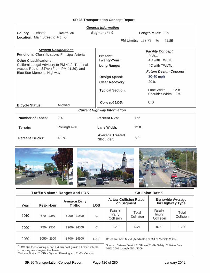
SR 36 Transportation Concept Report
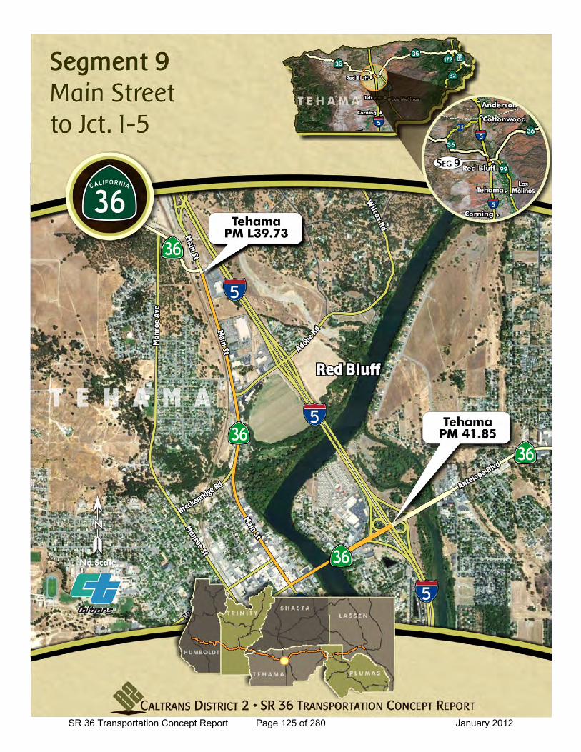
Location: Main Street to Jct. I-5
General Information
to
Current Highway Information
Length Miles:
PM Limits: L39.73 41.85
Facility Concept2C/4C4C with TWLTL4C with TWLTL
Present:Twenty-Year:Long Range:
Future Design Concept
Clear Recovery: 20 ft.
System Designations
Segment #: 9
Terrain: Rolling/Level
Percent RVs: 1 %
Lane Width: 12 ft.
Concept LOS:
1.5County Tehama Route 36
C/D
Number of Lanes: 2-4
Percent Trucks: 1-2 %
Other Classifications:California Legal Advisory to PM 41.2, Terminal Access Route - STAA (From PM 41.29), and Blue Star Memorial Highway
Traffic Volume Ranges and LOS Co llision Rates
Year Peak Hour Average Daily
Traffic LOS Actual Collision Rates
on Segment Statewide Average for Highway Type
2010 670 - 2350 6900 - 21500 C Fatal + Injury
Collision Total
Collision Fatal + Injury
Collision Total
Collision
2020 750 - 2500 7900 - 24000 C 1.29 4.21 0.79 1.97
2030 1050 - 2900 8700 - 24500 D/C1 Rates are ACC/M VM (Accidents per Mi llion V ehicle M iles)
Source: Caltrans District 2, Office of Traffic Safety, Collision Data 04/01/2004 through 03/31/2009
1 LOS D reflects existing 2-lane & 4-lane configuration, LOS C reflects expanding entire segment to 4-lane. Caltrans District 2, Office S ystem Planning and Traffic Census
Bicycle Status: Allowed
Average Treated Shoulder: 8 ft.
Typical Section: Lane Width : 12 ft.Shoulder Width : 8 ft.
09
Functional Classification: Principal Arterial
Design Speed: 30-40 mph
SR 36 Transportation Concept Report Page 126 of 280 January 2012
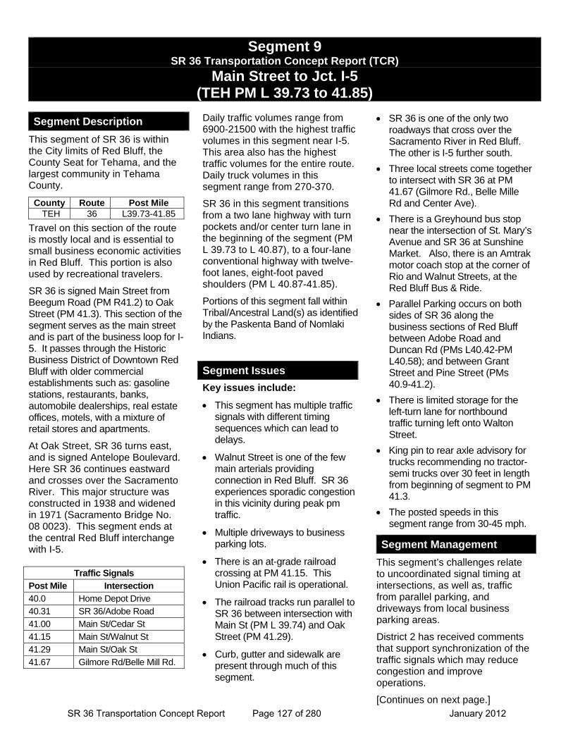
Segment 9 SR 36 Transportation Concept Report (TCR)
Main Street to Jct. I-5 (TEH PM L 39.73 to 41.85)
Segment Description
This segment of SR 36 is within the City limits of Red Bluff, the County Seat for Tehama, and the largest community in Tehama County.
Travel on this section of the route is mostly local and is essential to small business economic activities in Red Bluff. This portion is also used by recreational travelers.
SR 36 is signed Main Street from Beegum Road (PM R41.2) to Oak Street (PM 41.3). This section of the segment serves as the main street and is part of the business loop for I-5. It passes through the Historic Business District of Downtown Red Bluff with older commercial establishments such as: gasoline stations, restaurants, banks, automobile dealerships, real estate offices, motels, with a mixture of retail stores and apartments.
At Oak Street, SR 36 turns east, and is signed Antelope Boulevard. Here SR 36 continues eastward and crosses over the Sacramento River. This major structure was constructed in 1938 and widened in 1971 (Sacramento Bridge No. 08 0023). This segment ends at the central Red Bluff interchange with I-5.
Daily traffic volumes range from 6900-21500 with the highest traffic volumes in this segment near I-5. This area also has the highest traffic volumes for the entire route. Daily truck volumes in this segment range from 270-370.
SR 36 in this segment transitions from a two lane highway with turn pockets and/or center turn lane in the beginning of the segment (PM L 39.73 to L 40.87), to a four-lane conventional highway with twelve-foot lanes, eight-foot paved shoulders (PM L 40.87-41.85).
Portions of this segment fall within Tribal/Ancestral Land(s) as identified by the Paskenta Band of Nomlaki Indians.
Segment Issues
Key issues include:
This segment has multiple traffic signals with different timing sequences which can lead to delays.
Walnut Street is one of the few main arterials providing connection in Red Bluff. SR 36 experiences sporadic congestion in this vicinity during peak pm traffic.
Multiple driveways to business parking lots.
There is an at-grade railroad crossing at PM 41.15. This Union Pacific rail is operational.
The railroad tracks run parallel to SR 36 between intersection with Main St (PM L 39.74) and Oak Street (PM 41.29).
Curb, gutter and sidewalk are present through much of this segment.
SR 36 is one of the only two roadways that cross over the Sacramento River in Red Bluff. The other is I-5 further south.
Three local streets come together to intersect with SR 36 at PM 41.67 (Gilmore Rd., Belle Mille Rd and Center Ave).
There is a Greyhound bus stop near the intersection of St. Mary’s Avenue and SR 36 at Sunshine Market. Also, there is an Amtrak motor coach stop at the corner of Rio and Walnut Streets, at the Red Bluff Bus & Ride.
Parallel Parking occurs on both sides of SR 36 along the business sections of Red Bluff between Adobe Road and Duncan Rd (PMs L40.42-PM L40.58); and between Grant Street and Pine Street (PMs 40.9-41.2).
There is limited storage for the left-turn lane for northbound traffic turning left onto Walton Street.
King pin to rear axle advisory for trucks recommending no tractor-semi trucks over 30 feet in length from beginning of segment to PM 41.3.
The posted speeds in this segment range from 30-45 mph.
Segment Management
This segment’s challenges relate to uncoordinated signal timing at intersections, as well as, traffic from parallel parking, and driveways from local business parking areas.
District 2 has received comments that support synchronization of the traffic signals which may reduce congestion and improve operations.
[Continues on next page.]
County Route Post Mile TEH 36 L39.73-41.85
Traffic Signals
Post Mile Intersection
40.0 Home Depot Drive
40.31 SR 36/Adobe Road
41.00 Main St/Cedar St
41.15 Main St/Walnut St
41.29 Main St/Oak St
41.67 Gilmore Rd/Belle Mill Rd.
SR 36 Transportation Concept Report Page 127 of 280 January 2012

This page intentionally left blank
SR 36 Transportation Concept Report Page 128 of 280 January 2012
Segment 9 (Continued) SR 36 TRANSPORTATION CONCEPT REPORT (TCR)
Main Street to Jct. I-5 (TEH PM L 39.73 - 41.85)
Main Street (PM L 39.73) to Crittenden Street (L40.87) is currently 2-lane conventional with a two-way center turn lane, and on street parking. Level of Service will decline as traffic growth continues. In order to accommodate future traffic increases, the 20 year facility concept for this area is 4-lanes with two-way center turn lane.
The City of Red Bluff may consider relocating the Walton Street / SR 36 intersection to the north. Relocating the local road to make a 4-way intersection at SR 36 and State Street would increase the distance between Walton Street and Adobe Road. The resulting increase in storage capacity for vehicles staging to turn left onto Walton Street would benefit operations on SR 36.
On interstate 5, there are two CCTV’s (PMs R 28.38 and R 26.53) and a HAR (PM R 26.58) that can be used in conjunction with the elements on SR 36 in the next segment, to relay information to travelers on SR 36.
Segment Management (continued)
SR 36 Transportation Concept Report Page 129 of 280 January 2012

This page intentionally left blank
SR 36 Transportation Concept Report Page 130 of 280 January 2012
Seg
men
t 9
SR
36
Tra
nsp
ort
atio
n C
on
cep
t R
epo
rt (
TC
R)
M
ain
Str
eet
to J
ct. I
-5 (
TE
H P
M L
39.
73 t
o P
M 4
1.85
)
Seg
men
t P
roje
cts/
Po
ten
tial
Imp
rove
men
ts
Nam
e T
ype
Lo
cati
on
Y
ear
Pro
gra
m
Co
st
Sp
on
sor
Co
mp
lete
d P
roje
cts
Red
Blu
ff C
edar
/Mai
n
Sig
nal
O
per
atio
nal
P
M L
41.0
20
09
SH
OP
P
$357
,000
C
altr
ans
Sign
al, l
ight
ing,
and
AD
A R
amps
at C
edar
Stre
et.
In-P
rog
ress
No
capa
city
pro
ject
s or
sig
nific
ant o
pera
tiona
l pro
ject
s ar
e in
pro
gres
s.
Po
ten
tial
Fu
ture
20-
Yea
r
SR
36
Rea
lign
men
t O
per
atio
nal
Imp
rove
men
ts
PM
39.
73-4
1.2
TB
D
TB
D
TB
D
TB
D
Rea
lign
SR 3
6 at
the
Uni
on P
acific
Rai
lroad
cro
ssin
g an
d M
ain
Stre
et.
Pos
sibl
e R
TIP
cand
idat
e fo
r fut
ure
STIP
. Pr
ojec
t ext
ends
into
seg
men
t 8.
Cap
acit
y E
xpan
sio
n
Op
erat
ion
al Im
pro
vem
ent
PM
L39
.73-
L40
.87
TB
D
TB
D
TB
D
Cal
tran
s C
onve
rt fro
m 2
lane
s w
ith c
ente
r tur
n la
ne to
4 la
nes
with
cen
ter t
urn
lane
bet
wee
n M
ain
Stre
et a
nd C
ritte
nden
Stre
et.
Sig
nal
Syn
chro
niz
atio
n
Op
erat
ion
al Im
pro
vem
ent
PM
L39
.73-
41.8
5 T
BD
T
BD
T
BD
C
altr
ans
Adju
st s
igna
l tim
ing
in R
ed B
luff
betw
een
Mai
n St
reet
to I-
5.
SR 36 Transportation Concept Report Page 131 of 280 January 2012

This page intentionally left blank
SR 36 Transportation Concept Report Page 132 of 280 January 2012

Segment 10
SR 36 Transportation Concept Report Page 133 of 280 January 2012

This page intentionally left blank
SR 36 Transportation Concept Report Page 134 of 280 January 2012
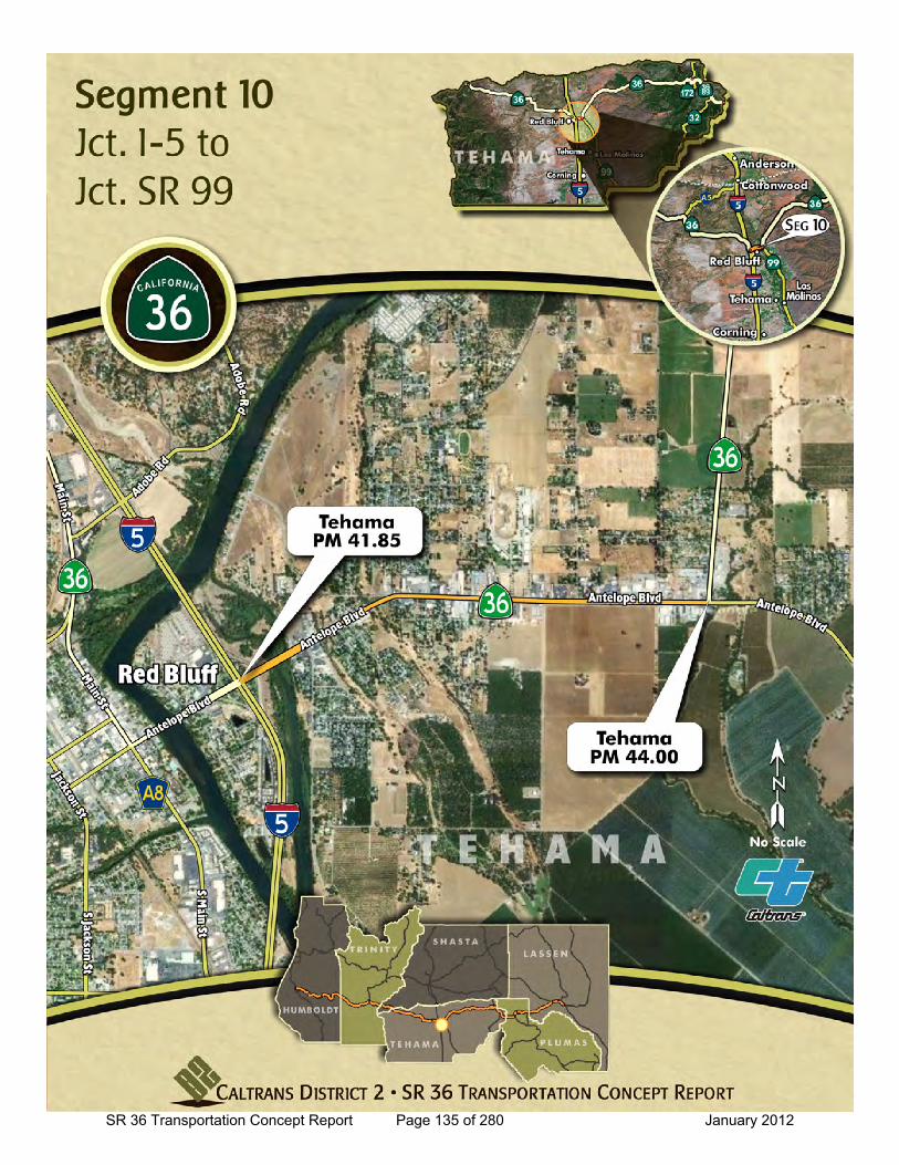
SR 36 Transportation Concept Report Page 135 of 280 January 2012
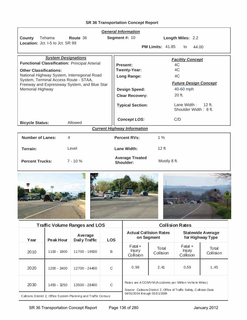
SR 36 Transportation Concept Report
Location: Jct. I-5 to Jct. SR 99
General Information
to
Current Highway Information
Length Miles:
PM Limits: 41.85 44.00
Facility Concept4C4C4C
Present:Twenty-Year:Long Range:
Future Design Concept
Clear Recovery: 20 ft.
System Designations
Segment #: 10
Terrain: Level
Percent RVs: 1 %
Lane Width: 12 ft
Concept LOS:
2.2County Tehama Route 36
C/D
Number of Lanes: 4
Percent Trucks: 7 - 10 %
Other Classifications:National Highway System, Interregional Road System, Terminal Access Route - STAA, Freeway and Expressway System, and Blue Star Memorial Highway
Traffic Volume Ranges and LOS Collision Rates
Year Peak Hour Average
Daily Traffic LOS
Actual Collision Rates on Segment
Statewide Average for Highway Type
2010 1100 - 1900 11700 - 19500 B Fatal + Injury
Collision Total
Collision Fatal + Injury
Collision Total
Collision
2020 1200 - 2400 12700 - 24400 C 0.98 2.41 0.59 1.45
2030 1450 - 3250 13500 - 28400 C Rates are A CC/MV M (A ccidents per Mil lion Vehic le Mi les )
Source: Caltrans District 2 , Office of Traffic Safety, Collision Data 04/01/2004 through 03/31/2009
Caltrans District 2, Office S ystem Planning and Traffic Census
Bicycle Status: Allowed
Average Treated Shoulder: Mostly 8 ft.
Typical Section: Lane Width : 12 ft.Shoulder Width : 8 ft.
10
Functional Classification: Principal Arterial
Design Speed: 40-60 mph
SR 36 Transportation Concept Report Page 136 of 280 January 2012
Segment 10 SR 36 Transportation Concept Report (TCR)
Jct. I-5 to Jct. SR 99 (TEH PM 41.85 to 44.00)
Segment Description
This segment runs from junction I-5 to the junction of SR 99 in Tehama County. SR 36 is signed as Antelope Boulevard in this segment as in the previous.
The segment is within the Red Bluff City limits. Travel on this section of the route is a combination of local/regional, interregional and recreational trips. This section is essential to the connectivity of SR 99 to I-5.
Daily traffic volumes range from 11700-19500 with the highest traffic volumes on the west end of this segment near I-5. Daily truck volumes in this segment range from 890-1540.
This segment passes through many different types of land uses. There is commercial and general commercial with motels/hotels, gasoline stations, food establishments, and retail stores. There is also a portion on the south side of the highway dedicated to agriculture. The commercial uses are more concentrated near the junction with I-5. The California Department of Corrections, California Department of Forestry & Fire Protection, and the Tehama District Fairgrounds are within this area.
SR 36 in this segment is a 4-lane conventional highway with 12-foot lanes, 8-foot paved shoulders. Most of the highway segment has a two-way center turn lane.
Portions of this segment fall within Tribal/Ancestral Land(s) as identified by the Paskenta Band of Nomlaki Indians.
Segment Issues
Key issues include:
Traffic, bicycle and pedestrian volumes increase when large events are held at the Tehama District Fair Grounds.
A 25 mph speed limit is posted for the Antelope Elementary School zone (between PMs 43.44-43.72) for when children are present. This location includes a flashing beacon.
Given this segments proximity to schools, residential and commercial areas, there is bicycle and pedestrian usage.
Sidewalks are not continuous in this area.
The posted speeds in this segment range from 40-55 mph.
Multiple driveways can cause delay.
At PM 43.87 there is sign for Lassen Volcanic National Park 48 miles. This section of highway serves as a gateway to the park.
Sale Lane just east of I-5 interchange provides access to the Red Bluff Diversion Dam Recreation Area.
Segment Management
This segment’s challenges relate to multiple access roads, commercial activity & signalized intersections.
Continue to work with City of Red Bluff and school staff to monitor traffic in the vicinity of Antelope Elementary School.
Interest has been expressed for a pedestrian crossing near the Tehama County District Fairgrounds. The City of Red Bluff would like to coordinate with Caltrans to identify and address multimodal needs near the fairgrounds and other areas in the community.
Caltrans has prepared a proposal for Transportation Enhancement funds to look a conceptual bicycle route from the City of Chico to the City of Redding. The network would consist of portions of State Routes 99, 36, 273, and Interstate 5. The portion of SR 36 included in this study is from the I-5 separation near Adobe Road through Red Bluff to SR 99.
There are two Highway Advisory Radio flashers (HAR Flasher) on SR 36 in Red Bluff (at PM 42.93 near Mulberry Avenue for eastbound traffic, and PM 43.65 near St. Mary’s Road for westbound traffic. The HAR Flashers are useful to alert drivers to tune into the radio when there are road closures due to severe weather affecting areas miles ahead (such as at Morgan Summit-PM 87.79).
Possible ITS elements to consider: Changeable Message Signs (CMS) near SR 36 PM 44.0, with additional CMS on SR 99 near the junction of SR 36 (TEH 99 PM 24.0). CMS can provide advanced warning for a road closure, or adverse driving conditions, with no need for the driver to use their radio.
County Route Post Mile TEH 36 41.85-44.0
Traffic Control Devices Post Mile Location
41.92 S Jct. SR 36 / I-5 NB on-ramp
41.92 S Jct. SR 36 / I-5 SB off-ramp
42.18 S Sale Lane
42.79 S Chestnut Ave./ Colony Rd.
43.66 F School Flasher
S= Signal F= Flashing Beacon
SR 36 Transportation Concept Report Page 137 of 280 January 2012
Seg
men
t 10
S
R 3
6 T
ran
spo
rtat
ion
Co
nce
pt
Rep
ort
(T
CR
)
Jct.
I-5
to J
ct. S
R 9
9 (P
M T
EH
41.
85 t
o P
M 4
4.00
)
Seg
men
t P
roje
cts/
Po
ten
tial
Imp
rove
men
ts
Nam
e T
ype
Lo
cati
on
Y
ear
Pro
gra
m
Co
st
Sp
on
sor
Co
mp
lete
d P
roje
cts
Red
Blu
ff R
ehab
ilita
tio
n
Ro
adw
ay R
ehab
ilita
tio
n
TE
H L
39.7
-44.
0 20
09
SH
OP
P
$8,6
23,0
00
Cal
tran
s R
oadw
ay R
ehab
ilita
tion
in v
ario
us lo
catio
ns in
Red
Blu
ff.
Fla
shin
g B
eaco
ns
An
telo
pe
Sch
oo
l M
ino
r B
T
EH
43.
3-43
.8
2009
S
HO
PP
$7
0,40
0 C
altr
ans
Inst
all f
lash
ing
beac
ons
with
tim
er a
t Ant
elop
e S
choo
l bet
wee
n H
oy R
oad
and
Sai
nt M
ary’
s A
venu
e.
In-P
rog
ress
N
o ca
paci
ty p
roje
cts
or s
igni
fican
t ope
ratio
nal p
roje
cts
are
in p
rogr
ess.
P
ote
nti
al F
utu
re 2
0-Y
ear
Red
Blu
ff C
AP
M
Pav
emen
t R
ehab
ilita
tio
n
PM
42.
1-44
.0
TB
D
SH
OP
P
$6,9
00,0
00
Cal
tran
s P
avem
ent o
verla
y an
d A
DA
Ram
ps.
Pro
ject
ext
ends
into
seg
men
t 11.
Cos
t ref
lect
s en
tire
proj
ect.
SR 36 Transportation Concept Report Page 138 of 280 January 2012

Segment 11
SR 36 Transportation Concept Report Page 139 of 280 January 2012

This page intentionally left blank
SR 36 Transportation Concept Report Page 140 of 280 January 2012
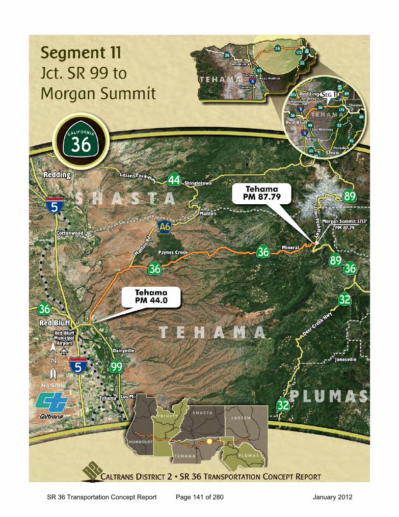
SR 36 Transportation Concept Report Page 141 of 280 January 2012
SR 36 Transportation Concept Report
Location: Jct. SR 99 to Morgan Summit
General Information
to
Current Highway Information
Length Miles:
PM Limits: 44.00 87.79
Facility Concept2C2C2C
Present:Twenty-Year:Long Range:
Future Design Concept
Clear Recovery: 20 ft.
System Designations
Segment #: 11
Terrain: Rolling to Mountainous
Percent RVs: 1 %
Lane Width: Mostly 12 ft, except 10-11 ft. (PMs 83.14-87.63)
Concept LOS:
44.7County Tehama Route 36
C/D
Number of Lanes: 2 with some passing
Percent Trucks: 7-10 %
Other Classifications:Terminal Access Route - STAA (To PM 64.0), California Legal Advisory (From 75.2 to 83.14), Volcanic Legacy Scenic Byway All American Road from PM 87.68, and Blue Star Memorial Highway
Traffic Volume Ranges and LOS Collision Rates
Year Peak Hour Average
Daily Traffic LOS
Actual Collision Rates on Segment
Statewide Average for Highway Type
2010 180 - 290 850 - 1850 B Fatal + Injury
Collision Total
Collision Fatal + Injury
Collision Total
Collision
2020 250 - 350 1100 - 2300 B 0.49 1.07 0.52 1.14
2030 350 - 500 1300 - 2600 B Rates are A CC/MV M (A ccidents per Mil lion Vehic le Mi les )
Source: Caltrans District 2 , Office of Traffic Safety, Collision Data 04/01/2004 through 03/31/2009
Caltrans District 2, Office S ystem Planning and Traffic Census
Bicycle Status: Allowed
Average Treated Shoulder: 0-8 ft., mostly 2-4 ft.
Typical Section: Lane Width : 12 ft.Shoulder Width : 4 ft.
11
Functional Classification: Minor Arterial
Design Speed: 40-60 mph
SR 36 Transportation Concept Report Page 142 of 280 January 2012
Segment 11 SR 36 Transportation Concept Report (TCR)
Jct. SR 99 to Morgan Summit (TEH PM 44.00 to 87.79)
Segment Description
This segment in Tehama County runs from Junction of SR 99 past the Junction of SR 89 N and to Morgan Summit (5753’), which is the highest elevation on the route. SR 36 is shared with SR 89 from SR 89 N and through the next two segments. SR 36 passes through the communities of Dales, Paynes Creek and Mineral.
Travel on this section of the route is a combination of local, regional, interregional, and recreational trips between Red Bluff and the mountain communities. SR 36 serves as a critical link for these communities to access essential services and goods.
Daily traffic volumes range from 850-1850 with the highest traffic volumes near the west end of the segment. Daily truck volumes in this segment range from 75-140.
This segment passes through rural agricultural land on the grassy valley floor and foothills with mostly oak woodlands and digger pines. These lands are typically used for livestock grazing and growing products such as hay, grain, and grapes. Along the route there are scattered rural residential uses with some low density communities. Midway between Paynes Creek and Mineral the vegetation transitions to conifer forests. The land is generally undeveloped along SR 36, as the elevations climb toward Morgan Summit.
SR 36 in this segment is a 2-lane conventional highway with 12-foot lanes, and 0- to 8-foot treated shoulders, with treated shoulders mostly 2- to 4-foot.
Portions of this segment fall within Tribal/Ancestral Land(s) as identified by the Paskenta Band of Nomlaki Indians and the Greenville Rancheria.
Segment Issues
Key issues include:
• SR 36 eastbound traffic climbs from the valley to rolling foothills and to the mountainous terrain of Morgan Summit.
• No services such as gas, food and lodging which complicates management of traffic incidents and temporary road closures.
• King pin to rear axle advisory for trucks recommending no tractor-semi trucks over 30 feet in length from PM 75.39-83.14.
• Several curves have turning radii that are not STAA Standard between Post Miles 75-76.5 (between Paynes Creek and Mineral). Several alignment alternatives for the approximate 1.5 mile section were developed in a Caltrans study completed in 2000.
• The posted speeds in this segment range from 50-65 mph.
• Terrain is rolling to PM 54.8 and then transitions to mountainous.
• Route passes through the Lassen National Forest beginning at PM 80.77 and continues through the forest in the next two segments.
• There are passing lanes for eastbound traffic from: PM 60.55 to 60.79, 61.25-61.48, 68.18 to 74.73, and 80.70 to 80.84. There is a passing lane for west bound traffic from PM 80.75 to 81.0.
• SR 89 North provides access to Lassen Volcanic National Park (LVNP). Red Bluff is one of the Gateway communities. The “Lassen Gateway Coalition” formed to bring together community partners (area businesses, chambers of commerce, economic development groups, conservation organizations, local governments, federal and state agencies) to help promote LVNP recreational attractions and increase tourism at the park; and enhance economic opportunities between LVNP and its gateway communities. Access to the park is via SR 89 North at PM 87.63.
Segment Management
Challenges in this segment include curved alignments, steep grades, narrow shoulders, and severe weather conditions in the higher elevations.
There is an approved project to lengthen and construct turn-outs near Morgan Summit to be completed in 2012. Additional pull-outs between SR 99 and Morgan Summit would be beneficial. Additional curve improvements may also be beneficial.
A HAR Flasher is installed on SR 36 just north of SR 99 junction at PM 44.62 to alert drivers to tune to 1610 on the radio for roadway information.
Possible future ITS elements within this segment include two Roadside Weather Information Systems: (PMs R 73.00 and 82.2), two Closed Circuit Televisions (CCTV’s) near PMs R 73.0 and 83.50, and a Highway Advisory Radio Station (HAR) near PM 83.14.
County Route Post Mile TEH 36 44.0-87.68
SR 36 Transportation Concept Report Page 143 of 280 January 2012
Seg
men
t 11
SR
36
Tra
nsp
ort
atio
n C
on
cep
t R
epo
rt (
TC
R)
Ju
nct
ion
SR
99
To
Ju
nct
ion
SR
89
N (
TE
H P
M 4
4.00
to
PM
87.
68)
S
egm
ent
Pro
ject
s/P
ote
nti
al Im
pro
vem
ents
N
ame
Typ
e L
oca
tio
n
Yea
r P
rog
ram
C
ost
S
po
nso
r C
om
ple
ted
Pro
ject
s
Bat
tle
Cre
ek B
rid
ge
Bri
dg
e R
ehab
ilita
tio
n
PM
81.
5 20
03
SH
OP
P
$979
,000
C
altr
ans
Reh
abilit
ate
Dec
k M
org
an S
um
mit
Tu
rno
ut
Op
erat
ion
al
PM
86.
2-86
.5
2006
S
HO
PP
$4
8,00
0 C
altr
ans
Nea
r Min
eral
from
1.5
mile
s to
1.1
mile
s w
est o
f SR
89.
U
pg
rad
e an
d In
stal
l Met
al
Bea
m G
uar
dra
il S
afet
y Im
pro
vem
ent
PM
78.
1-78
.3
2006
S
HO
PP
$8
2,19
7 C
altr
ans
Nea
r Min
eral
from
1.0
mile
s to
0.8
1 m
iles
wes
t of D
iam
ond
Roa
d.
Su
mm
it S
ho
uld
er
Wid
enin
g
Op
erat
ion
al
PM
87.
3-87
.6
2008
S
HO
PP
$4
22,8
00
Cal
tran
s
Nea
r Min
eral
from
0.3
mile
s to
0.1
mile
wes
t of S
R 8
9 P
ayn
es C
reek
Th
in
Bla
nke
t O
verl
ay
Mai
nte
nan
ce
PM
67.
5-75
.5
2010
H
igh
way
M
ain
ten
ance
$1
,731
,000
C
altr
ans
Thin
bla
nked
ove
rlay
near
Pay
nes
Cre
ek fr
om 0
.2 m
ile e
ast o
f Lat
ka R
oad
to 0
.5 m
ile e
ast o
f Litt
le G
iant
Mill.
H
og
Lak
e C
hip
Sea
l M
ain
ten
ance
P
M 4
6.0-
55.3
20
11
Mai
nte
nan
ce
$837
,000
C
altr
ans
Seal
coa
t. In
-Pro
gre
ss
Mo
rgan
Su
mm
it P
ull-
ou
ts
Op
erat
ion
al
PM
85.
8-87
.5
2011
$7
00,0
00
$837
,000
C
altr
ans
Exte
nd th
e ex
istin
g tu
rn-o
ut a
nd c
onst
ruct
two
new
turn
-out
s.
Po
ten
tial
Fu
ture
20-
Yea
r
Red
Blu
ff C
AP
M
Pav
emen
t R
ehab
ilita
tio
n
PM
44.
0-46
.0
TB
D
SH
OP
P
$6,9
00,0
00
Cal
tran
s Pa
vem
ent o
verla
y an
d AD
A R
amps
. Pr
ojec
t ext
ends
into
seg
men
t 10.
Cos
t ref
lect
s en
tire
proj
ect.
Ad
dit
ion
al P
ullo
uts
O
per
atio
nal
P
M 4
4.0-
87.6
T
BD
T
BD
T
BD
T
BD
In
stal
l tur
nout
s to
allo
w p
assi
ng o
f slo
wer
veh
icle
s. P
ost M
ile lo
catio
ns T
BD.
SR 36 Transportation Concept Report Page 144 of 280 January 2012

Segment 12
SR 36 Transportation Concept Report Page 145 of 280 January 2012

This page intentionally left blank
SR 36 Transportation Concept Report Page 146 of 280 January 2012
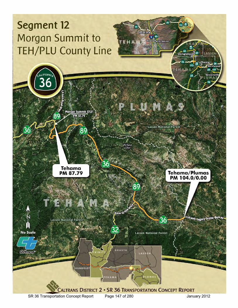
SR 36 Transportation Concept Report Page 147 of 280 January 2012
SR 36 Transportation Concept Report
Location: Morgan Summit to TEH/PLU County Line
General Information
to
Current Highway Information
Length Miles:
PM Limits: 87.79 104.00/PLU-0.00
Facility Concept2C2C2C
Present:Twenty-Year:Long Range:
Future Design Concept
Clear Recovery: 20 ft.
System Designations
Segment #: 12
Terrain: Mountainous to Rolling
Percent RVs: 1-2 %
Lane Width: 12 ft.
Concept LOS:
15.0County Plumas Route 36
C/D
Number of Lanes: 2, with some passing
Percent Trucks: 7-10 %
Other Classifications:Volcanic Legacy Scenic Byway All American Road, and Blue Star Memorial Highway
Traffic Volume Ranges and LOS Collision Rates
Year Peak Hour Average
Daily Traffic LOS
Actual Collision Rates on Segment
Statewide Average for Highway Type
2010 100 - 490 700 - 1800 B Fatal + Injury
Collision Total
Collision Fatal + Injury
Collision Total
Collision
2020 150 - 600 800 - 2300 B 0.58 1.87 0.66 1.40
2030 250 - 850 900 - 2600 B Rates are A CC/MV M (A ccidents per Mil lion Vehic le Mi les )
Source: Caltrans District 2 , Office of Traffic Safety, Collision Data 04/01/2004 through 03/31/2009
Caltrans District 2, Office S ystem Planning and Traffic Census
Bicycle Status: Allowed
Average Treated Shoulder: 0-8 ft., mostly under 4 ft.
Typical Section: Lane Width : 12 ft.Shoulder Width : 4 ft.
12
Functional Classification: Minor Arterial
Design Speed: 40-60 mph
SR 36 Transportation Concept Report Page 148 of 280 January 2012
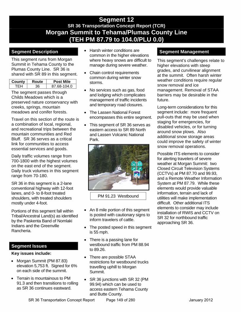
Segment 12 SR 36 Transportation Concept Report (TCR)
Morgan Summit to Tehama/Plumas County Line (TEH PM 87.79 to 104.0/PLU 0.0)
Segment Description
This segment runs from Morgan Summit in Tehama County to the Plumas County Line. SR 36 is shared with SR 89 in this segment.
The segment passes through Childs Meadows which is a preserved nature conservancy with creeks, springs, mountain meadows and conifer forests.
Travel on this section of the route is a combination of local, regional, and recreational trips between the mountain communities and Red Bluff. SR 36 serves as a critical link for communities to access essential services and goods.
Daily traffic volumes range from 700-1800 with the highest volumes on the east end of the segment. Daily truck volumes in this segment range from 70-180.
SR 36 in this segment is a 2-lane conventional highway with 12-foot lanes, and 0- to 8-foot treated shoulders, with treated shoulders mostly under 4-foot.
Portions of this segment fall within Tribal/Ancestral Land(s) as identified by the Paskenta Band of Nomlaki Indians and the Greenville Rancheria.
Segment Issues
Key issues include:
Morgan Summit (PM 87.83) elevation 5,753 ft. Signed for 6% on each side of the summit.
Terrain is mountainous to PM 91.3 and then transitions to rolling as SR 36 continues eastward.
Harsh winter conditions are common in the higher elevations where heavy snows are difficult to manage during severe weather.
Chain control requirements common during winter snow storms.
No services such as gas, food and lodging which complicates management of traffic incidents and temporary road closures.
The Lassen National Forest encompasses this entire segment.
This segment of SR 36 serves as eastern access to SR 89 North and Lassen Volcanic National Park.
An 8 mile portion of this segment is posted with cautionary signs to inform travelers of cattle.
The posted speed in this segment is 55 mph.
There is a passing lane for westbound traffic from PM 88.94 to 89.26.
There are possible STAA restrictions for westbound trucks travelling uphill to Morgan Summit.
SR 36 junctions with SR 32 (PM 99.94) which can be used to access eastern Tehama County and Butte County.
Segment Management
This segment’s challenges relate to higher elevations with steep grades, and curvilinear alignment at the summit. Often harsh winter weather conditions require regular snow removal and ice management. Removal of STAA barriers may be desirable in the future.
Long-term considerations for this segment include: more frequent pull-outs that may be used when staging for emergencies, for disabled vehicles, or for turning around snow plows. Also additional snow storage areas could improve the safety of winter snow removal operations.
Possible ITS elements to consider for alerting travelers of severe weather at Morgan Summit: two Closed Circuit Television Systems (CCTVs) at PM 87.70 and 99.93, and a Remote Weather Information System at PM 87.79. While these elements would provide valuable information, terrain and lack of utilities will make implementation difficult. Other additional ITS elements to consider may include installation of RWIS and CCTV on SR 32 for northbound traffic approaching SR 36.
County Route Post Mile TEH 36 87.68-104.0
PM 91.23 Westbound
SR 36 Transportation Concept Report Page 149 of 280 January 2012
Seg
men
t 12
SR
36
Tra
nsp
ort
atio
n C
on
cep
t R
epo
rt (
TC
R)
J
un
ctio
n S
R 8
9 N
to
Teh
am
a/P
lum
as C
ou
nty
Lin
e (T
EH
PM
87.
68 t
o P
M 1
04.0
/PL
U 0
.0)
S
egm
ent
Pro
ject
s/P
ote
nti
al Im
pro
vem
ents
N
ame
Typ
e L
oca
tio
n
Yea
r P
rog
ram
C
ost
S
po
nso
r C
om
ple
ted
Pro
ject
s
No
rth
Fo
rk D
eer
Cre
ek
Bri
dg
e B
rid
ge
Reh
abili
tati
on
P
M 9
8.9
2006
S
HO
PP
$3
,060
,000
C
altr
ans
Fir
e M
ou
nta
in C
urv
e Im
pro
vem
ent
Saf
ety
PM
99.
6-99
.9
2007
S
HO
PP
$8
53,0
00
Cal
tran
s
Cur
ve im
prov
emen
t abo
ut 1
2 m
iles
wes
t of C
hest
er fr
om 0
.4 M
iles
wes
t to
SR 3
2.
In-P
rog
ress
No
capa
city
pro
ject
s or
sig
nific
ant o
pera
tiona
l pro
ject
s ar
e in
pro
gres
s.
Po
ten
tial
Fu
ture
20-
Yea
r
Mill
Cre
ek B
rid
ge
Sco
ur
P
M 9
1.4
2012
S
HO
PP
$1
,200
,000
C
altr
ans
Brid
ge s
cour
mitig
atio
n.
Ad
dit
ion
al P
ullo
uts
O
per
atio
nal
P
M 8
7.6-
104.
0
TB
D
TB
D
TB
D
TB
D
Inst
all t
urno
uts
to a
llow
pas
sing
of s
low
er v
ehic
les.
Pos
t Mile
loca
tions
TBD
.
SR 36 Transportation Concept Report Page 150 of 280 January 2012

Segment 13
SR 36 Transportation Concept Report Page 151 of 280 January 2012

This page intentionally left blank
SR 36 Transportation Concept Report Page 152 of 280 January 2012
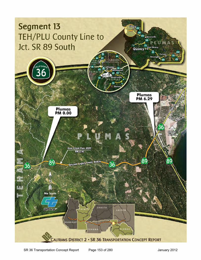
SR 36 Transportation Concept Report Page 153 of 280 January 2012
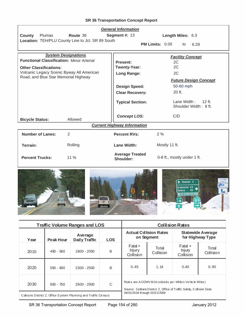
SR 36 Transportation Concept Report
Location: TEH/PLU County Line to Jct. SR 89 South
General Information
to
Current Highway Information
Length Miles:
PM Limits: 0.00 6.29
Facility Concept2C2C2C
Present:Twenty-Year:Long Range:
Future Design Concept
Clear Recovery: 20 ft.
System Designations
Segment #: 13
Terrain: Rolling
Percent RVs: 2 %
Lane Width: Mostly 11 ft.
Concept LOS:
6.3County Plumas Route 36
C/D
Number of Lanes: 2
Percent Trucks: 11 %
Other Classifications:Volcanic Legacy Scenic Byway All American Road, and Blue Star Memorial Highway
Traffic Volume Ranges and LOS Collision Rates
Year Peak Hour Average
Daily Traffic LOS
Actual Collision Rates on Segment
Statewide Average for Highway Type
2010 490 - 560 1800 - 2050 B Fatal + Injury
Collision Total
Collision Fatal + Injury
Collision Total
Collision
2020 550 - 600 2300 - 2500 B 0.45 1.14 0.40 0.90
2030 650 - 750 2600 - 2900 C Rates are A CC/MV M (A ccidents per Mil lion Vehic le Mi les )
Source: Caltrans District 2 , Office of Traffic Safety, Collision Data 04/01/2004 through 03/31/2009
Caltrans District 2, Office S ystem Planning and Traffic Census
Bicycle Status: Allowed
Average Treated Shoulder: 0-8 ft., mostly under 1 ft.
Typical Section: Lane Width : 12 ft.Shoulder Width : 8 ft.
13
Functional Classification: Minor Arterial
Design Speed: 50-60 mph
SR 36 Transportation Concept Report Page 154 of 280 January 2012
Segment 13 SR 36 Transportation Concept Report (TCR)
Tehama/Plumas County Line to Jct. SR 89 South (PLU PM 0.0 to 6.29)
Segment Description
This segment of SR 36 is from Tehama/Plumas County Line to Junction SR 89 South. SR 36 is shared with SR 89 in this segment.
Travel on this section of the route is a combination of local, regional, and recreational trips between the mountain communities and Red Bluff. SR 36 serves as a critical link for communities to access essential services and goods.
Daily traffic volumes range from 1800-2050 with the higher volumes near the junction of SR 89. Daily truck volumes in this segment average around 200.
This segment consists of a 2-lane paved highway with 11- to 12-foot lanes, and 1- to 8-foot treated shoulders, however paved shoulders are mostly under 1-foot.
Portions of this segment fall within Tribal/Ancestral Land(s) as identified by the Greenville Rancheria and the Susanville Indian Rancheria.
Segment Issues
Key issues include:
West of Chester an informational sign is posted to inform westbound travelers that the next available fuel is 68 miles.
Deer Creek Pass - elevation 4,939 ft (PM 0.93). Harsh winter conditions are common in the higher elevations where heavy snows are difficult to manage during severe weather.
Deer warning signs posted.
Most of this segment has minimal treated shoulders (1-foot).
Chain control requirements common during winter snow storms.
The first two and a half miles of this segment passes through the Lassen National Forest.
The posted speed in this segment is 55 mph.
Segment Management
This segments challenges relate to high elevations with severe winter weather conditions and narrow shoulders for the majority of this section.
Future considerations for this segment may include: projects to widen shoulders to 8 ft. and adding turn outs that may be used when staging for emergencies, for disabled vehicles, or for turning around snow plows. Also additional snow storage areas could improve the safety of winter snow removal operations.
Management of this segment will focus on deployment of additional ITS elements to warn travelers of incidents and/or severe weather. A project is underway to install Closed Circuit Television (CCTV) at the junction of SR 89 South and HAR Flasher just west of Chester (EA 02-1E240). Also a second HAR Flasher will be installed in the next segment east of Chester.
Additional ITS elements may also be considered on SR 89 at two junctions (SR 36, and SR 147 near Canyon Dam). Near SR 36 would be two CMS. Near 147 would be RWIS, CCTV and HAR Flasher.
County Route Post Mile Lassen 36 0.0-6.29
SR 36 Transportation Concept Report Page 155 of 280 January 2012
Seg
men
t 13
SR
36
Tra
nsp
ort
atio
n C
on
cep
t R
epo
rt (
TC
R)
T
eham
a/P
lum
as C
ou
nty
Lin
e t
o J
un
ctio
n S
R 8
9 S
ou
th (
PL
U P
M 0
.0 t
o P
M 6
.29
)
Seg
men
t P
roje
cts/
Po
ten
tial
Imp
rove
men
ts
Nam
e T
ype
Lo
cati
on
Y
ear
Pro
gra
m
Co
st
Sp
on
sor
Co
mp
lete
d P
roje
cts
Ch
este
r S
ho
uld
er
Wid
enin
g
Saf
ety
Imp
rove
men
ts
PM
R 3
.6-R
3.8
20
05
SH
OP
P
$300
,000
C
altr
ans
Wid
en p
aved
sho
ulde
r. C
old
Sp
rin
gs
Cu
rve
Imp
rove
men
t S
afet
y Im
pro
vem
ents
P
M 1
.2-1
.6
2006
S
HO
PP
$1
,600
,000
C
altr
ans
Verti
cal c
urve
impr
ovem
ent a
bout
7.5
mile
s w
est o
f Che
ster
. W
est
Ch
este
r P
avem
ent
Reh
abili
tati
on
P
avem
ent
Reh
abili
tati
on
P
M 4
.0-6
.5
2010
S
HO
PP
$9
92,0
00
Cal
tran
s
Reh
abilit
ated
pav
emen
t nea
r Che
ster
. In
-Pro
gre
ss
No
capa
city
pro
ject
s or
sig
nific
ant o
pera
tiona
l pro
ject
s ar
e in
pro
gres
s.
Po
ten
tial
Fu
ture
20-
Yea
r
No
capa
city
pro
ject
s or
sig
nific
ant o
pera
tiona
l pro
ject
s ar
e id
entif
ied.
SR 36 Transportation Concept Report Page 156 of 280 January 2012

Segment 14
SR 36 Transportation Concept Report Page 157 of 280 January 2012

This page intentionally left blank
SR 36 Transportation Concept Report Page 158 of 280 January 2012
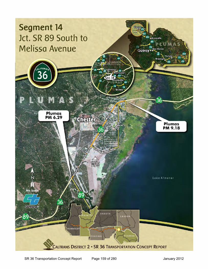
SR 36 Transportation Concept Report Page 159 of 280 January 2012
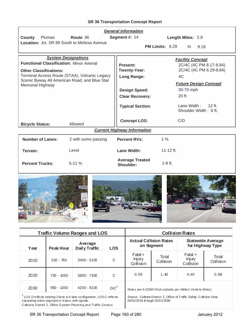
SR 36 Transportation Concept Report
Location: Jct. SR 89 South to Melissa Avenue
General Information
to
Current Highway Information
Length Miles:
PM Limits: 6.29 9.18
Facility Concept2C/4C (4C PM 8.17-8.84)2C/4C (4C PM 6.29-8.84)4C
Present:Twenty-Year:Long Range:
Future Design Concept
Clear Recovery: 20 ft.
System Designations
Segment #: 14
Terrain: Level
Percent RVs: 1 %
Lane Width: 11-12 ft.
Concept LOS:
2.9County Plumas Route 36
C/D
Number of Lanes: 2 with some passing
Percent Trucks: 5-11 %
Other Classifications:Terminal Access Route (STAA), Volcanic Legacy Scenic Byway All American Road, and Blue Star Memorial Highway
Traffic Volume Ranges and LOS Collision Rates
Year Peak Hour Average
Daily Traffic LOS
Actual Collision Rates on Segment
Statewide Average for Highway Type
2010 610 - 760 3400 - 5100 C Fatal + Injury
Collision Total
Collision Fatal + Injury
Collision Total
Collision
2020 750 - 1050 3800 - 7300 C 0.59 1.40 0.40 0.98
2030 950 - 1350 4200 - 8100 D/C1Rates are A CC/MV M (A ccidents per Mil lion Vehic le Mi les )
Source: Caltrans District 2 , Office of Traffic Safety, Collision Data 04/01/2004 through 03/31/2009
1LOS D reflects existing 2-lane & 4-lane configuration, LOS C reflects
expanding entire segment to 4-lane, wi th signals. Caltrans District 2, Office S ystem Planning and Traffic Census
Bicycle Status: Allowed
Average Treated Shoulder: 1-8 ft.
Typical Section: Lane Width : 12 ft.Shoulder Width : 8 ft.
14
Functional Classification: Minor Arterial
Design Speed: 30-70 mph
SR 36 Transportation Concept Report Page 160 of 280 January 2012
Segment 14 SR 36 Transportation Concept Report (TCR)
SR 89 South to Melissa Avenue (PLU PM 6.29 to 9.18)
Segment Description
This segment of SR 36 is from the junction of SR 89 South to Melissa Avenue in the community of Chester.
The majority of this segment passes through the community of Chester. The roadway transitions from 2-lane conventional highway to 4-lanes with parking in the center of town, between Glenwood Drive and the Feather River Bridge near Willow Way. The Feather River Bridge has 2-lanes, past the bridge SR 36 continues east as a 2 lane highway with a center turn lane in “Old Town.”
Travel on this section of the route is a combination of local, regional, and recreational trips. SR 36 serves as a critical link for rural residents to access essential services and goods in Chester. Chester has a public airport, Rogers Field, which contributes to Chester’s attractiveness as a regional tourism center and is also used by the U.S. Forest Service and State CAL FIRE operations. This section also has two schools, Chester Elementary and Chester Jr. Sr. High School, Seneca Hospital, and the Chester Fire Protection District.
Daily traffic volumes range from 3400-5100 with the higher volumes near the Feather River Bridge. Daily truck volumes in this segment range from 340-360.
Lane widths are 11- to 12- foot with exception of the Feather River Bridge which has two 10-foot lanes. In Chester paved shoulders are mostly 8-foot.
Portions of this segment fall within Tribal/Ancestral Land(s) as identified by the Greenville Rancheria and the Susanville Indian Rancheria.
Segment Issues
Key issues include:
• The 4-lane portion of the segment poses challenges for pedestrians crossing the roadway.
• On-street parking is common in front of Main Street buildings near the intersection of Willow Street and south. The parking areas are undefined which results in a mix of parallel and perpendicular parking and double parking. Inconsistent parking reduces the ability of regular commuters to anticipate car movements in and out of parking areas.
• Around Lake Almanor the residential population more than doubles during the summer months, as summer is the peak season for this area. Recreational travel increases; bringing higher traffic volumes, as well as, more bicycle and pedestrian activity in Chester.
• The route passes through two school zone areas: The first (PM 8.2-8.36) with a school crossing at Irwin Way, and second (PM 8.8-9.0) with a school crossing at First Avenue. Just west of the Feather River Bridge another pedestrian crossing is signed and delineated (near Aspen Street and Martin Way).
• There are no locations in Chester where the traffic is stopped to allow for pedestrians to cross.
• Community members have expressed concern about speed enforcement on the wider sections of the highway.
• There is no center turn which causes vehicles to stop in the travel lane to turn.
• Snow removal operations are prevalent during the winter months.
• The posted speed in this segment ranges between 30-55 mph.
• There are some drainage issues along Main Street where areas with relatively flat grade collect pools of storm water.
Segment Management
This segment’s challenges relates to heavy recreational traffic, especially in summer, pedestrian and bicycle activity, and wintertime snow removal.
The twenty-year design concept for this segment is to expand it to a 4-lane with center turn lane from SR 89 South to the Feather River Bridge. Part of the reason for this expansion will be to better control the parking operations with delineation.
[Continues on next page.]
County Route Post Mile Plumas 36 6.29-9.18
Traffic Control Devices Post Mile
Location
8.48 Flashing Beacon System
SR 36 Transportation Concept Report Page 161 of 280 January 2012

This page intentionally left blank
SR 36 Transportation Concept Report Page 162 of 280 January 2012
Segment 14 SR 36 TRANSPORTATION CONCEPT REPORT (TCR)
SR 89 South to Melissa Avenue PLU PM 6.29-9.18
The community of Chester is exploring a streetscape design to promote pedestrian and bicycle activity. The Chester Main Street Design Plan covers an approximate 3 mile section of SR 36 between Melissa Way and the Chester Airport Road. The design concept shows roadway cross sections for north of Myrtle Street and a different concept for south of Myrtle St. Both sections include sidewalks, parking and 6 ft. bike lanes. As part of the streetscape concept one of the focus areas for improvement would be pedestrian crosswalk enhancements. Coordination between the community and Caltrans will be required when any projects are proposed in Chester.
A project is underway to install a HAR Flasher on the east side of Chester in this segment (EA 02-1E240).
The project will also install a second HAR and CCTV in the previous segment, near the junction of SR 89 South.
Consider measures to mitigate traffic speed when designing projects within Chester. The concept design speed ranges between 30-70 mph. Higher Design speeds (40-70 mph) are appropriate to consider outside of the community, such as, the lightly developed area near and west of the airport (Rogers Field). Lower Design speeds (30-40 mph) would be more appropriate within the community of Chester where there is more extensive development along Main Street.
Segment Management (continued)
SR 36 Transportation Concept Report Page 163 of 280 January 2012

This page intentionally left blank
SR 36 Transportation Concept Report Page 164 of 280 January 2012
Seg
men
t 14
SR
36
Tra
nsp
ort
atio
n C
on
cep
t R
epo
rt (
TC
R)
Jc
t. S
R 8
9 to
Ch
este
r/M
elis
sa A
ven
ue
(L
AS
PM
6.2
9 to
PM
9.1
8)
S
egm
ent
Pro
ject
s/P
ote
nti
al Im
pro
vem
ents
N
ame
Typ
e L
oca
tio
n
Yea
r P
rog
ram
C
ost
S
po
nso
r C
om
ple
ted
Pro
ject
s
Alm
ano
r/M
olin
os
Ove
rlay
M
ain
ten
ance
P
M 7
.9 –
8.8
20
11
Mai
nte
nan
ce
$1,1
75,0
00
Cal
tran
s G
rind
and
Rep
lace
Hot
Mix
Asp
halt
(HM
A) T
hin
Blan
ket.
In
-Pro
gre
ss
Ch
este
r P
avem
ent
Res
tora
tio
n
Pav
emen
t R
esto
rati
on
P
M 6
.5-9
.2
2012
M
ain
ten
ance
$3
,500
,000
C
altr
ans
Col
d in
-pla
ce R
ecyc
le w
ith H
MA
Ove
rlay
from
0.2
mile
s ea
st o
f Rou
te 8
9 to
Mel
issa
Ave
nue.
P
ote
nti
al F
utu
re 2
0-Y
ear
Ch
este
r S
tree
tsca
pe
Tra
nsp
ort
atio
n
En
han
cem
ents
P
M 7
.5-9
.5
TB
D
ST
IP
TB
D
Cal
tran
s/P
lum
as
Co
un
ty R
TP
A
Con
text
Sen
sitiv
e So
lutio
ns in
Che
ster
. E
xpan
sio
n t
o 5
-lan
es
(Ch
este
r 5-
Lan
e)
Cap
acit
y/O
per
atio
nal
P
M 6
.28-
8.84
T
BD
S
TIP
T
BD
T
BD
Expa
nd to
four
-lane
s, w
ith tw
o-w
ay c
ente
r tur
n la
ne a
nd s
houl
ders
, fro
m S
R 8
9 So
uth
to th
e N
orth
For
k Fe
athe
r Riv
er B
ridge
. In
clud
e dr
aina
ge im
prov
emen
ts
thro
ugh
dow
ntow
n C
hest
er (c
urb,
gut
ter,
and
side
wal
ks fr
om W
atso
n R
oad
to M
elis
sa A
ve.)
and
a m
inim
um o
f tw
o tra
ffic
sign
als
(loca
tion
to b
e de
term
ined
).
Del
inea
te p
arki
ng a
reas
, bik
e an
d pe
dest
rian
faci
lities
. P
ote
nti
al P
ost
20-
Yea
r
Exp
ansi
on
of
2 la
ne
sect
ion
to
4-l
anes
C
apac
ity
PM
TB
D
TB
D
TB
D
TB
D
TB
D
Expa
nd to
4 la
nes
in O
ld T
own.
SR 36 Transportation Concept Report Page 165 of 280 January 2012

This page intentionally left blank
SR 36 Transportation Concept Report Page 166 of 280 January 2012

Segment 15
SR 36 Transportation Concept Report Page 167 of 280 January 2012

This page intentionally left blank
SR 36 Transportation Concept Report Page 168 of 280 January 2012
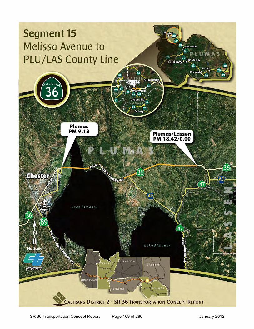
SR 36 Transportation Concept Report Page 169 of 280 January 2012
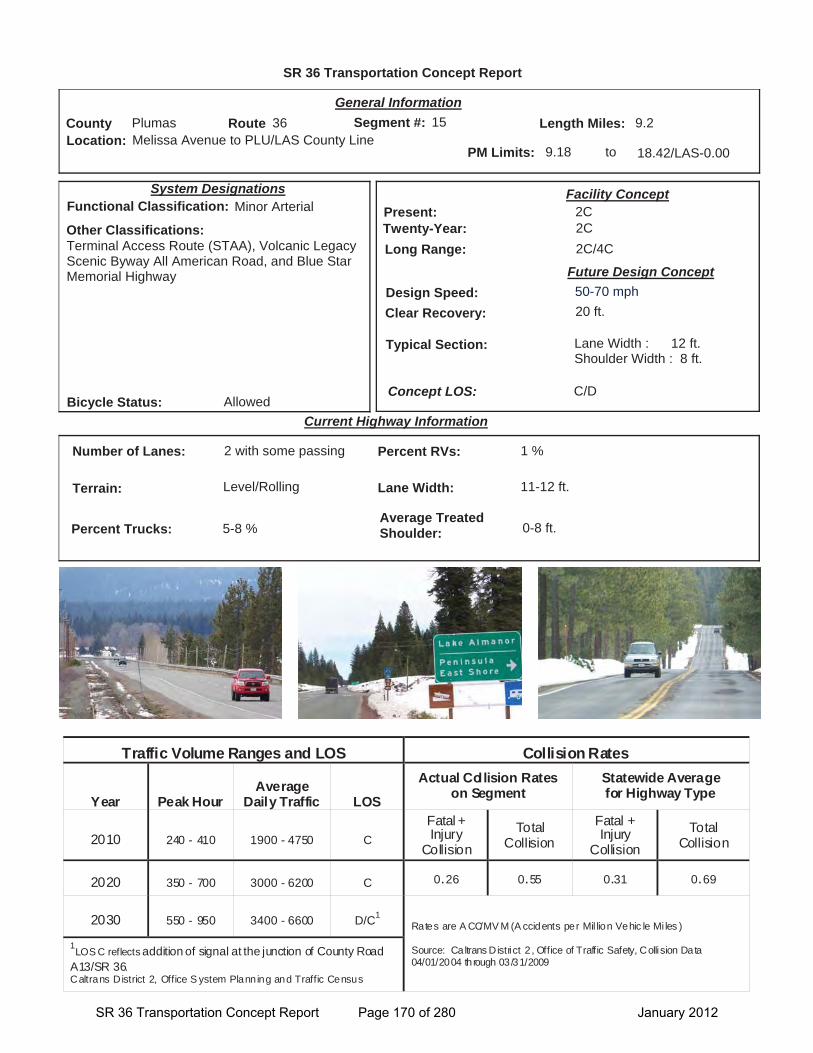
SR 36 Transportation Concept Report
Location: Melissa Avenue to PLU/LAS County Line
General Information
to
Current Highway Information
Length Miles:
PM Limits: 9.18 18.42/LAS-0.00
Facility Concept2C2C2C/4C
Present:Twenty-Year:Long Range:
Future Design Concept
Clear Recovery: 20 ft.
System Designations
Segment #: 15
Terrain: Level/Rolling
Percent RVs: 1 %
Lane Width: 11-12 ft.
Concept LOS:
9.2County Plumas Route 36
C/D
Number of Lanes: 2 with some passing
Percent Trucks: 5-8 %
Other Classifications:Terminal Access Route (STAA), Volcanic Legacy Scenic Byway All American Road, and Blue Star Memorial Highway
Traffic Volume Ranges and LOS Collision Rates
Year Peak Hour Average
Daily Traffic LOS
Actual Collision Rates on Segment
Statewide Average for Highway Type
2010 240 - 410 1900 - 4750 C Fatal + Injury
Collision Total
Collision Fatal + Injury
Collision Total
Collision
2020 350 - 700 3000 - 6200 C 0.26 0.55 0.31 0.69
2030 550 - 950 3400 - 6600 D/C1Rates are A CC/MV M (A ccidents per Mil lion Vehic le Mi les )
Source: Caltrans District 2 , Office of Traffic Safety, Collision Data 04/01/2004 through 03/31/2009
1LOS C reflects addition of signal at the junction of County Road
A13/SR 36.Caltrans District 2, Office S ystem Planning and Traffic Census
Bicycle Status: Allowed
Average Treated Shoulder: 0-8 ft.
Typical Section: Lane Width : 12 ft.Shoulder Width : 8 ft.
15
Functional Classification: Minor Arterial
Design Speed: 50-70 mph
SR 36 Transportation Concept Report Page 170 of 280 January 2012
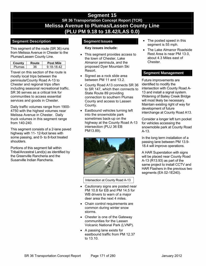
Segment 15 SR 36 Transportation Concept Report (TCR)
Melissa Avenue to Plumas/Lassen County Line (PLU PM 9.18 to 18.42/LAS 0.0)
Segment Description
This segment of the route (SR 36) runs from Melissa Avenue in Chester to the Plumas/Lassen County Line.
Travel on this section of the route is mostly local trips between the peninsula/County Road A-13 to Chester and regional trips often including seasonal recreational traffic. SR 36 serves as a critical link for communities to access essential services and goods in Chester.
Daily traffic volumes range from 1900-4750 with the highest volumes near Melissa Avenue in Chester. Daily truck volumes in this segment range from 140-240.
This segment consists of a 2-lane paved highway with 11- 12-foot lanes with some passing, and 0- to 8-foot treated shoulders.
Portions of this segment fall within Tribal/Ancestral Land(s) as identified by the Greenville Rancheria and the Susanville Indian Rancheria.
Segment Issues
Key issues include:
• This segment provides access to the town of Chester, Lake Almanor peninsula, and the proposed Dyer Mountain Ski Resort.
• Signed as a rock slide area between PM 11 and 13.2.
• County Road A13 connects SR 36 to SR 147, which then connects to State Route 89 providing connection to southern Plumas County and access to Lassen County.
• Eastbound vehicles turning left into the snowmobile park sometimes back-up on the highway at the County Road A-13 intersection (PLU 36 EB PM13.89).
• Cautionary signs are posted near PM 10.8 for EB and PM 14.5 for WB drivers to warn of a major deer area the next 4 miles.
• Chain control requirements are common during winter snow storms.
• Chester is one of the Gateway communities for the Lassen Volcanic National Park (LVNP).
• A passing lane exists for eastbound traffic from PM 12.37 to 13.10.
• The posted speed in this segment is 55 mph.
• The Lake Almanor Roadside Rest Area is near PM 13.0, about 4.3 Miles east of Chester.
Segment Management
Future improvements are identified to modify the intersection with County Road A-13 and install a signal system. Widening of Bailey Creek Bridge will most likely be necessary. Maintain existing right of way for development of future interchange at County Road A13.
Consider a longer left turn pocket for vehicles accessing the snowmobile park at County Road A-13.
In the long term installation of a passing lane between PM 13.9-18.4 will improve operations.
A HAR Superstation with signs will be placed near County Road A-13 (R13.93) as part of the same project to install CCTV and HAR Flashers in the previous two segments (EA 02-1E240).
County Route Post Mile Plumas 36 9.18-18.42
Intersection at County Road A-13
SR 36 Transportation Concept Report Page 171 of 280 January 2012
Seg
men
t 15
SR
36
Tra
nsp
ort
atio
n C
on
cep
t R
epo
rt (
TC
R)
M
elis
sa A
ven
ue
to P
lum
as/
Las
sen
Co
un
ty L
ine
(L
AS
PM
9.1
8 t
o P
M 1
8.42
)
Seg
men
t P
roje
cts/
Po
ten
tial
Imp
rove
men
ts
Nam
e T
ype
Lo
cati
on
Y
ear
Pro
gra
m
Co
st
Sp
on
sor
Co
mp
lete
d P
roje
cts
Rig
ht
Tu
rn L
ane
and
L
igh
tin
g
Op
erat
ion
al Im
pro
vem
ents
P
M 1
2.8
2006
S
HO
PP
$1
97,0
00
Cal
tran
s
Rig
ht T
urn
Lane
and
Lig
htin
g at
Lak
e Al
man
or S
afet
y R
oads
ide
Res
t Are
a.
Th
in B
lan
ket
Ove
rlay
an
d
Dig
ou
ts
Mai
nte
nan
ce
PM
R 1
4-18
.4
2006
M
ain
ten
ance
$1
,852
,000
C
altr
ans
Thin
bla
nket
ove
rlay
and
digo
uts
near
Che
ster
eas
t of C
ount
y R
oad
A13
to th
e La
ssen
Cou
nty
Line
. L
ake
Alm
ano
r S
afet
y R
oad
sid
e R
est
Are
a S
afet
y Im
pro
vem
ents
P
M R
12.3
-R14
.0
2009
M
ain
ten
ance
1,
288,
000
Cal
tran
s
Col
d in
-pla
ce re
cycl
e 0.
8 m
ile w
est t
o 1.
2 m
iles
east
of L
ake
Alm
anor
Saf
ety
Roa
dsid
e R
est A
rea.
In
-Pro
gre
ss
No
capa
city
pro
ject
s or
sig
nific
ant o
pera
tiona
l pro
ject
s ar
e in
pro
gres
s.
Po
ten
tial
Fu
ture
20-
Yea
r
Ch
este
r R
ehab
ilita
tio
n
Pav
emen
t R
ehab
ilita
tio
n
TB
D
TB
D
TB
D
TB
D
Cal
tran
s Pa
vem
ent r
ehab
ilitat
ion
in C
hest
er.
Sig
nal
Inst
alla
tio
n C
R A
13
Op
erat
ion
al Im
pro
vem
ent
PM
13.
5-14
.3
TB
D
ST
IP
TB
D
Plu
mas
Co
un
ty
RT
PA
/Cal
tran
s Si
gnal
ize
Jct S
R 3
6/C
ount
y R
oad
A-13
and
wid
en B
aile
y C
reek
Brid
ge.
In
stal
l In
telli
gen
t T
ran
spo
rtat
ion
Sys
tem
E
lem
ents
O
per
atio
nal
Imp
rove
men
ts
PM
R 1
3.9
TB
D
SH
OP
P
$658
,000
C
altr
ans
Inst
all S
uper
HAR
, HAR
Fla
sher
ele
men
t and
CC
TVs
Po
ten
tial
Po
st 2
0-Y
ear
Pas
sin
g L
ane
Op
erat
ion
al Im
pro
vem
ent
PM
13.
9 to
18.
4 T
BD
T
BD
T
BD
T
BD
Ad
d ea
stbo
und
pass
ing
lane
, exa
ct P
ost M
ile lim
its T
BD.
This
pas
sing
lane
is id
entif
ied
as m
itigat
ion
in th
e La
ke F
ront
Env
ironm
enta
l Im
pact
Rep
ort.
Inte
rch
ang
e at
Co
un
ty
Ro
ad A
13
Op
erat
ion
al Im
pro
vem
ent
PM
13.
5-14
.3
TB
D
TB
D
TB
D
TB
D
Con
stru
ct a
n in
terc
hang
e at
Cou
nty
Roa
d A-
13, d
esig
n TB
D.
SR 36 Transportation Concept Report Page 172 of 280 January 2012
Segment 16
SR 36 Transportation Concept Report Page 173 of 280 January 2012

This page intentionally left blank
SR 36 Transportation Concept Report Page 174 of 280 January 2012
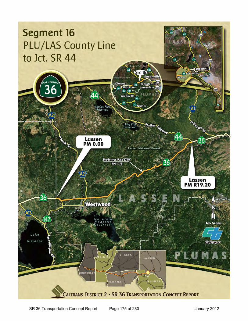
SR 36 Transportation Concept Report Page 175 of 280 January 2012
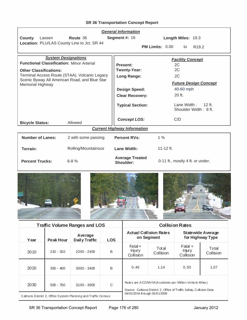
SR 36 Transportation Concept Report
Location: PLU/LAS County Line to Jct. SR 44
General Information
to
Current Highway Information
Length Miles:
PM Limits: 0.00 R19.2
Facility Concept2C2C2C
Present:Twenty-Year:Long Range:
Future Design Concept
Clear Recovery: 20 ft.
System Designations
Segment #: 16
Terrain: Rolling/Mountainous
Percent RVs: 1 %
Lane Width: 11-12 ft.
Concept LOS:
19.3County Lassen Route 36
C/D
Number of Lanes: 2 with some passing
Percent Trucks: 6-8 %
Other Classifications:Terminal Access Route (STAA), Volcanic Legacy Scenic Byway All American Road, and Blue Star Memorial Highway
Traffic Volume Ranges and LOS Collision Rates
Year Peak Hour Average
Daily Traffic LOS
Actual Coll ision Rates on Segment
Statewide Average for Highway Type
2010 210 - 310 2200 - 2400 B Fatal + Injury
Collision Total
Collision Fatal + Injury
Collision Total
Collision
2020 350 - 400 3000 - 3400 B 0.46 1.14 0.50 1.07
2030 500 - 750 3100 - 3900 C Rates are A CC/MV M (A ccidents per Mil lion Vehic le Mi les )
Source: Caltrans District 2 , Office of Traffic Safety, Collision Data 04/01/2004 through 03 /31/2009
Caltrans District 2, Office S ystem Planning and Traffic Census
Bicycle Status: Allowed
Average Treated Shoulder: 0-11 ft., mostly 4 ft. or under.
Typical Section: Lane Width : 12 ft.Shoulder Width : 8 ft.
16
Functional Classification: Minor Arterial
Design Speed: 40-60 mph
SR 36 Transportation Concept Report Page 176 of 280 January 2012
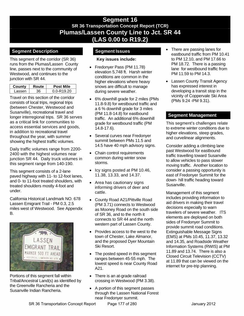
Segment 16 SR 36 Transportation Concept Report (TCR)
Plumas/Lassen County Line to Jct. SR 44 (LAS 0.00 to R19.2)
Segment Description
This segment of the corridor (SR 36) runs from the Plumas/Lassen County line, passes next to the community of Westwood, and continues to the junction with SR 44.
Travel on this section of the corridor consists of local trips, regional trips (between Chester, Westwood and Susanville), recreational travel and longer interregional trips. SR 36 serves as a critical link for communities to access essential services and goods, in addition to recreational travel throughout the year, with summer showing the highest traffic volumes.
Daily traffic volumes range from 2200-2400 with the highest volumes near junction SR 44. Daily truck volumes in this segment range from 140-190.
This segment consists of a 2-lane paved highway with 11- to 12-foot lanes, and 0- to 11-foot treated shoulders, with treated shoulders mostly 4-foot and under.
California Historical Landmark NO. 678 Lassen Emigrant Trail - PM 0.3, 2.5 miles west of Westwood. See Appendix B.
Portions of this segment fall within Tribal/Ancestral Land(s) as identified by the Greenville Rancheria and the Susanville Indian Rancheria.
Segment Issues
Key issues include:
Fredonyer Pass (PM 11.78) elevation 5,748 ft. Harsh winter conditions are common in the higher elevations where heavy snows are difficult to manage during severe weather.
6% downhill grade for 2 miles (PMs 11.8-9.8) for westbound traffic and a 6 % downhill grade for 3 miles (PM 11.8-14.8) for eastbound traffic. An additional 6% downhill grade for westbound traffic (PM 14.8-17.6).
Several curves near Fredonyer summit between PMs 11.5 and 14.5 have 40 mph advisory signs.
Chain control requirements common during winter snow storms.
Icy signs posted at PM 10.46, 11.38, 13.33, and 14.37.
Area has cautionary signs informing drivers of deer and cattle.
County Road A21/Pittville Road (PM 3.71) connects to Westwood as Mooney Road on the south side of SR 36, and to the north it connects to SR 44 and the north western part of Lassen County.
Provides access to the west to the town of Chester, Lake Almanor, and the proposed Dyer Mountain Ski Resort.
The posted speed in this segment ranges between 45-55 mph. The lowest speed is near County Road A21.
There is an at-grade railroad crossing in Westwood (PM 3.38).
A portion of this segment passes through the Lassen National Forest near Fredonyer summit.
There are passing lanes for eastbound traffic from PM 10.41 to PM 12.10, and PM 17.66 to PM 18.72. There is a passing lane for westbound traffic from PM 11.59 to PM 14.3.
Lassen County Transit Agency has expressed interest in developing a transit stop in the vicinity of Coppervale Ski Area (PMs 9.24 -PM 9.31).
Segment Management
This segment’s challenges relate to extreme winter conditions due to higher elevations, steep grades, and curvelinear alignments.
Consider adding a climbing lane past Westwood for eastbound traffic travelling toward Susanville to allow vehicles to pass slower moving traffic. Another location to consider a passing opportunity is east of Fredonyer Summit for the down- hill traffic heading toward Susanville.
Management of this segment includes providing information to aid drivers in making their travel decisions especially to warn travelers of severe weather. ITS elements are deployed on both sides of Fredonyer Summit to provide summit road conditions. Extinguishable Message Signs (EMS) at PMs 10.45, 11.37, 13.32 and 14.35, and Roadside Weather Information Systems (RWIS) at PM 11.89 and 13.74. There is also a Closed Circuit Television (CCTV) at 11.89 that can be viewed on the internet for pre-trip planning.
County Route Post Mile Lassen 36 0.0-R19.20
SR 36 Transportation Concept Report Page 177 of 280 January 2012
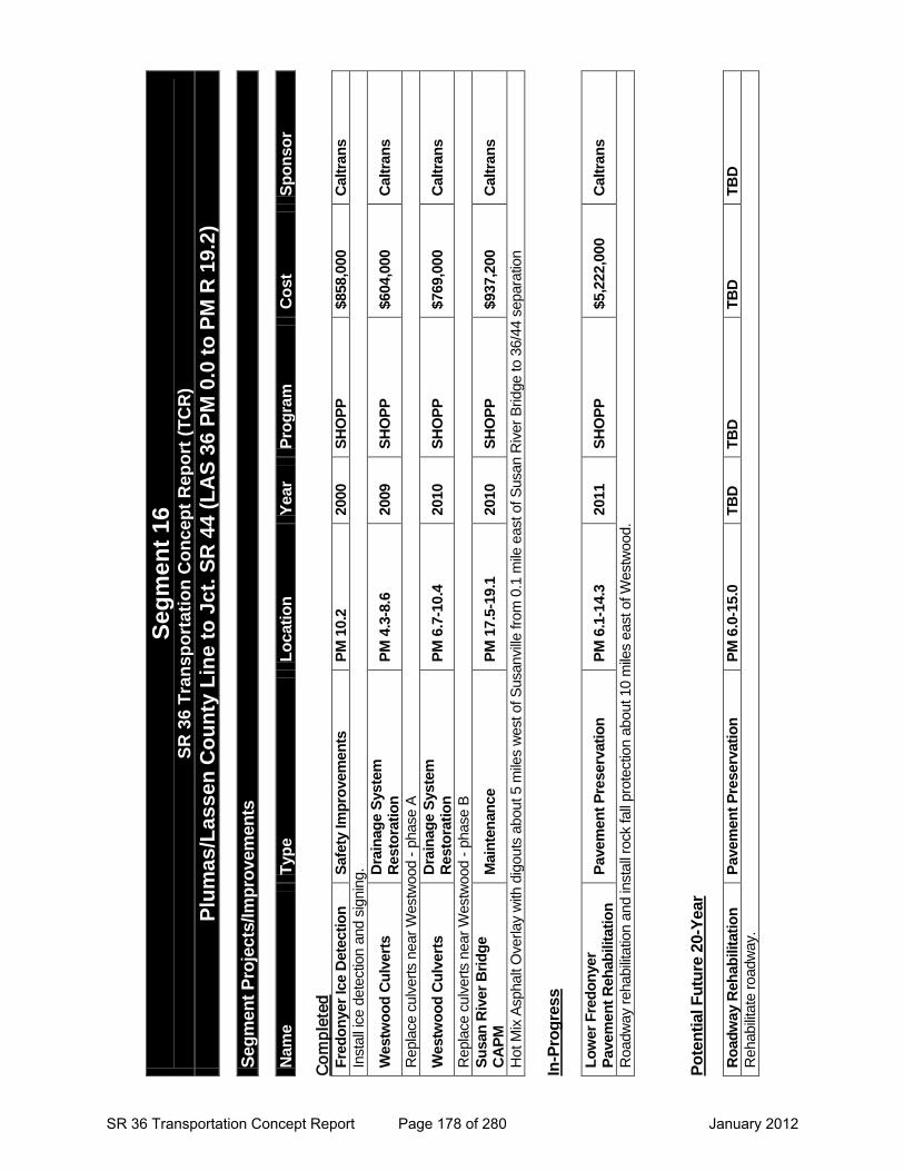
Segm
ent 1
6 SR
36
Tran
spor
tatio
n C
once
pt R
epor
t (TC
R)
Plum
as/L
asse
n C
ount
y Li
ne to
Jct
. SR
44
(LA
S 36
PM
0.0
to P
M R
19.
2)
Segm
ent P
roje
cts/
Impr
ovem
ents
Nam
e Ty
pe
Loca
tion
Year
Pr
ogra
m
Cos
t Sp
onso
r
Fred
onye
r Ice
Det
ectio
n
Co
mp
lete
d
Safe
ty Im
prov
emen
ts
PM 1
0.2
2000
SH
OPP
$8
58,0
00
Cal
trans
In
stal
l ice
det
ectio
n an
d si
gnin
g.
Wes
twoo
d C
ulve
rts
Dra
inag
e Sy
stem
R
esto
ratio
n PM
4.3
-8.6
20
09
SHO
PP
$604
,000
C
altra
ns
Rep
lace
cul
vert
s ne
ar W
estw
ood
- ph
ase
A
Wes
twoo
d C
ulve
rts
Dra
inag
e Sy
stem
R
esto
ratio
n PM
6.7
-10.
4 20
10
SHO
PP
$769
,000
C
altra
ns
Rep
lace
cul
vert
s ne
ar W
estw
ood
- ph
ase
B
Susa
n R
iver
Brid
ge
CA
PM
Mai
nten
ance
PM
17.
5-19
.1
2010
SH
OPP
$9
37,2
00
Cal
trans
Hot
Mix
Asp
halt
Ove
rlay
with
dig
outs
abo
ut 5
mile
s w
est o
f Sus
anvi
lle fr
om 0
.1 m
ile e
ast o
f Sus
an R
iver
Brid
ge to
36/
44 s
epar
atio
n In
-Pro
gres
s
Low
er F
redo
nyer
Pa
vem
ent R
ehab
ilita
tion
Pave
men
t Pre
serv
atio
n PM
6.1
-14.
3 20
11
SHO
PP
$5,2
22,0
00
Cal
trans
Roa
dway
reh
abili
tatio
n an
d in
stal
l roc
k fa
ll pr
otec
tion
abou
t 10
mile
s ea
st o
f Wes
twoo
d.
Pote
ntia
l Fut
ure
20-Y
ear
Roa
dway
Reh
abili
tatio
n Pa
vem
ent P
rese
rvat
ion
PM 6
.0-1
5.0
TBD
TB
D
TBD
TB
D
Reh
abili
tate
roa
dway
.
SR 36 Transportation Concept Report Page 178 of 280 January 2012

Segment 17
SR 36 Transportation Concept Report Page 179 of 280 January 2012

This page intentionally left blank
SR 36 Transportation Concept Report Page 180 of 280 January 2012
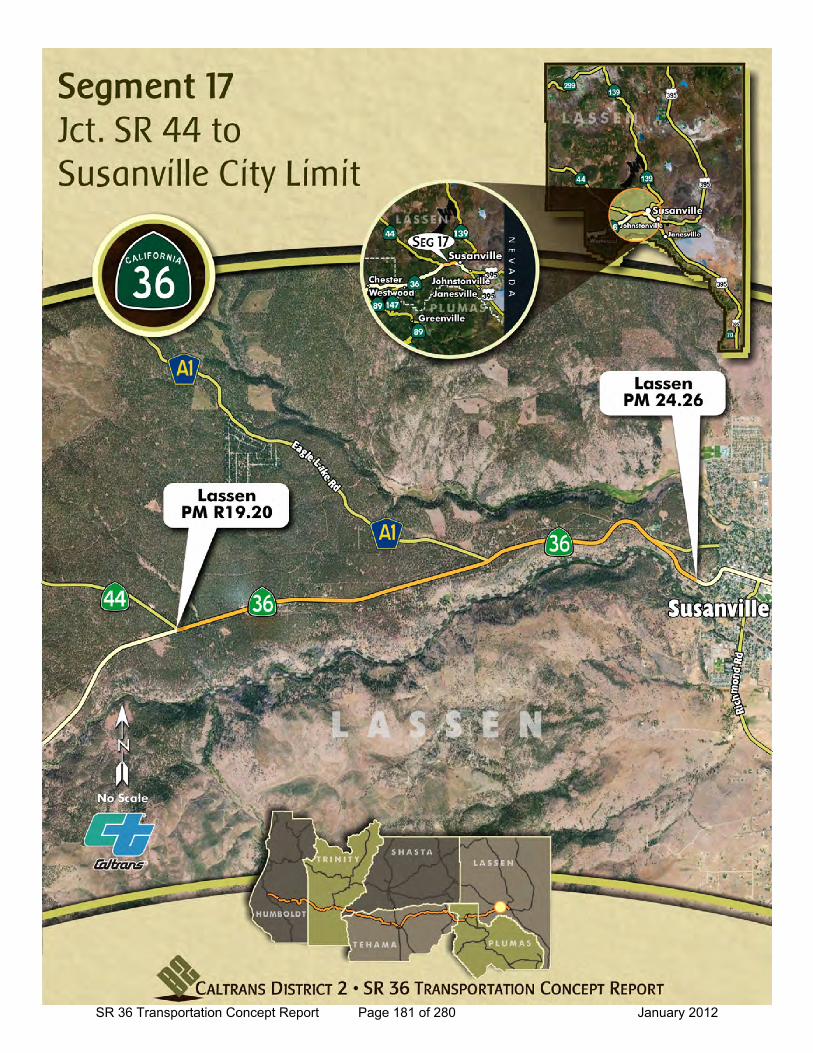
SR 36 Transportation Concept Report Page 181 of 280 January 2012
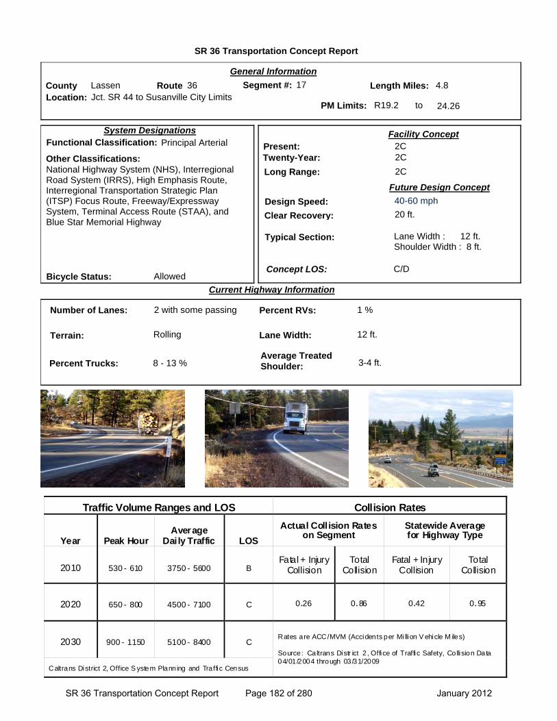
SR 36 Transportation Concept Report
Location: Jct. SR 44 to Susanville City Limits
General Information
to
Current Highway Information
Length Miles:
PM Limits: R19.2 24.26
Facility Concept2C2C
2C
Present:Twenty-Year:
Long Range:
Future Design Concept
Clear Recovery: 20 ft.
System Designations
Segment #: 17
Terrain: Rolling
Percent RVs: 1 %
Lane Width: 12 ft.
Concept LOS:
4.8County Lassen Route 36
C/D
Number of Lanes: 2 with some passing
Percent Trucks: 8 - 13 %
Other Classifications:National Highway System (NHS), Interregional Road System (IRRS), High Emphasis Route, Interregional Transportation Strategic Plan (ITSP) Focus Route, Freeway/Expressway System, Terminal Access Route (STAA), and Blue Star Memorial Highway
Traffic Volume Ranges and LOS Collision Rates
Year Peak Hour Average
Daily Traffic LOS
Actual Coll ision Rates on Segment
Statewide Average for Highway Type
2010 530 - 610 3750 - 5600 B Fatal + Injury
Collision Total
Collision Fatal + Injury
Collision Total
Collision
2020 650 - 800 4500 - 7100 C 0.26 0.86 0.42 0.95
2030 900 - 1150 5100 - 8400 C Rates are ACC/MVM (Accidents per Mi llion V ehicle M iles) Source: Caltrans Distr ict 2 , Office of Traffic Safety, Collision Data 04/01/2004 through 03/31/2009
Caltrans District 2, Office S ystem Planning and Traffic Census
Bicycle Status: Allowed
Average Treated Shoulder: 3-4 ft.
Typical Section: Lane Width : 12 ft.Shoulder Width : 8 ft.
17
Functional Classification: Principal Arterial
Design Speed: 40-60 mph
SR 36 Transportation Concept Report Page 182 of 280 January 2012
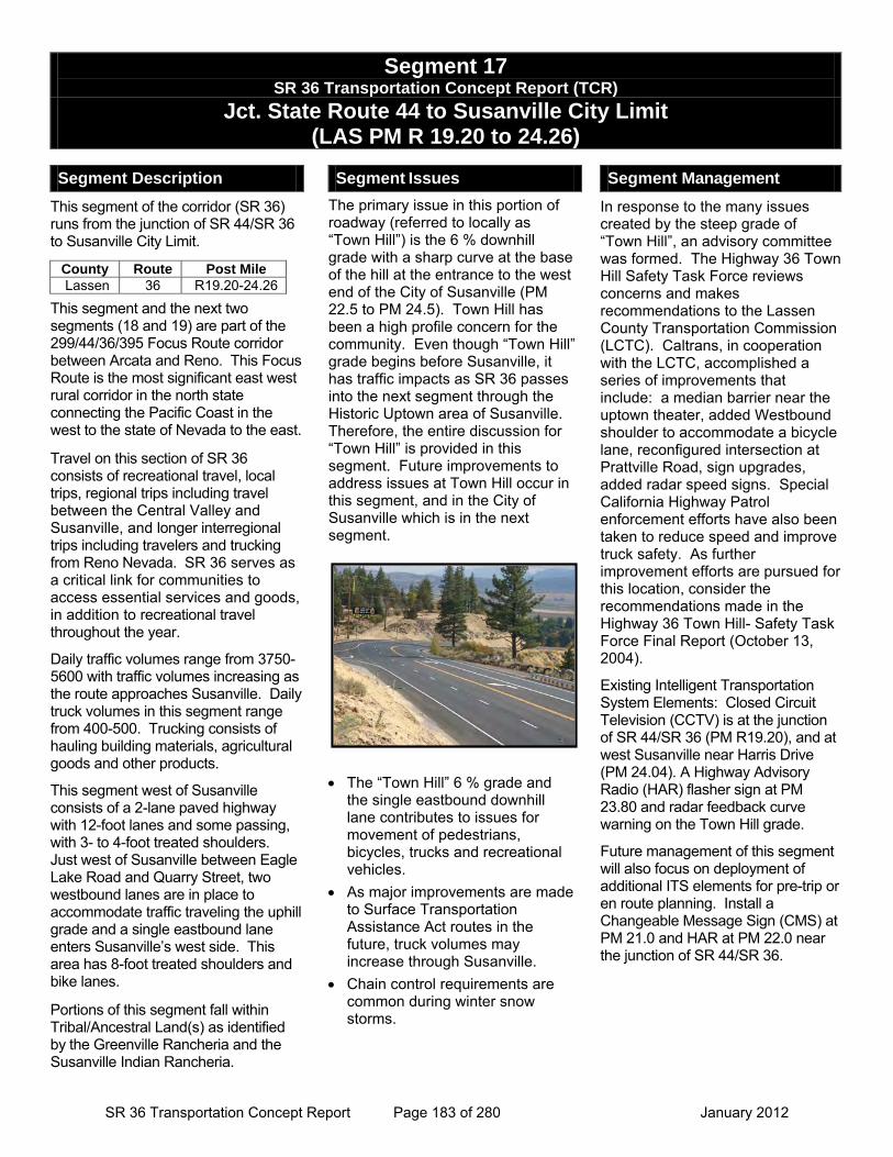
Segment 17 SR 36 Transportation Concept Report (TCR)
Jct. State Route 44 to Susanville City Limit (LAS PM R 19.20 to 24.26)
Segment Description
This segment of the corridor (SR 36) runs from the junction of SR 44/SR 36 to Susanville City Limit.
This segment and the next two segments (18 and 19) are part of the 299/44/36/395 Focus Route corridor between Arcata and Reno. This Focus Route is the most significant east west rural corridor in the north state connecting the Pacific Coast in the west to the state of Nevada to the east.
Travel on this section of SR 36 consists of recreational travel, local trips, regional trips including travel between the Central Valley and Susanville, and longer interregional trips including travelers and trucking from Reno Nevada. SR 36 serves as a critical link for communities to access essential services and goods, in addition to recreational travel throughout the year.
Daily traffic volumes range from 3750-5600 with traffic volumes increasing as the route approaches Susanville. Daily truck volumes in this segment range from 400-500. Trucking consists of hauling building materials, agricultural goods and other products.
This segment west of Susanville consists of a 2-lane paved highway with 12-foot lanes and some passing, with 3- to 4-foot treated shoulders. Just west of Susanville between Eagle Lake Road and Quarry Street, two westbound lanes are in place to accommodate traffic traveling the uphill grade and a single eastbound lane enters Susanville’s west side. This area has 8-foot treated shoulders and bike lanes.
Portions of this segment fall within Tribal/Ancestral Land(s) as identified by the Greenville Rancheria and the Susanville Indian Rancheria.
Segment Issues
The primary issue in this portion of roadway (referred to locally as “Town Hill”) is the 6 % downhill grade with a sharp curve at the base of the hill at the entrance to the west end of the City of Susanville (PM 22.5 to PM 24.5). Town Hill has been a high profile concern for the community. Even though “Town Hill” grade begins before Susanville, it has traffic impacts as SR 36 passes into the next segment through the Historic Uptown area of Susanville. Therefore, the entire discussion for “Town Hill” is provided in this segment. Future improvements to address issues at Town Hill occur in this segment, and in the City of Susanville which is in the next segment.
• The “Town Hill” 6 % grade and
the single eastbound downhill lane contributes to issues for movement of pedestrians, bicycles, trucks and recreational vehicles.
• As major improvements are made to Surface Transportation Assistance Act routes in the future, truck volumes may increase through Susanville.
• Chain control requirements are common during winter snow storms.
Segment Management
In response to the many issues created by the steep grade of “Town Hill”, an advisory committee was formed. The Highway 36 Town Hill Safety Task Force reviews concerns and makes recommendations to the Lassen County Transportation Commission (LCTC). Caltrans, in cooperation with the LCTC, accomplished a series of improvements that include: a median barrier near the uptown theater, added Westbound shoulder to accommodate a bicycle lane, reconfigured intersection at Prattville Road, sign upgrades, added radar speed signs. Special California Highway Patrol enforcement efforts have also been taken to reduce speed and improve truck safety. As further improvement efforts are pursued for this location, consider the recommendations made in the Highway 36 Town Hill- Safety Task Force Final Report (October 13, 2004).
Existing Intelligent Transportation System Elements: Closed Circuit Television (CCTV) is at the junction of SR 44/SR 36 (PM R19.20), and at west Susanville near Harris Drive (PM 24.04). A Highway Advisory Radio (HAR) flasher sign at PM 23.80 and radar feedback curve warning on the Town Hill grade.
Future management of this segment will also focus on deployment of additional ITS elements for pre-trip or en route planning. Install a Changeable Message Sign (CMS) at PM 21.0 and HAR at PM 22.0 near the junction of SR 44/SR 36.
County Route Post Mile Lassen 36 R19.20-24.26
SR 36 Transportation Concept Report Page 183 of 280 January 2012
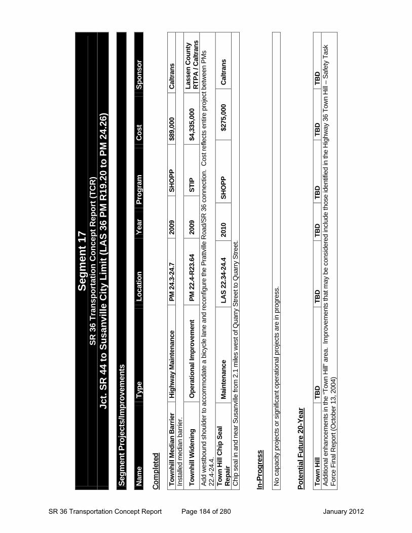
Segm
ent 1
7
SR 3
6 Tr
ansp
orta
tion
Con
cept
Rep
ort (
TCR
) Jc
t. SR
44
to S
usan
ville
City
Lim
it (L
AS
36 P
M R
19.2
0 to
PM
24.
26)
Segm
ent P
roje
cts/
Impr
ovem
ents
Nam
e Ty
pe
Loca
tion
Year
Pr
ogra
m
Cos
t Sp
onso
r
Co
mp
lete
d
Tow
nhill
Med
ian
Bar
rier
Hig
hway
Mai
nten
ance
PM
24.
3-24
.7
2009
SH
OPP
$8
9,00
0 C
altra
ns
Inst
alle
d m
edia
n ba
rrie
r.
Tow
nhill
Wid
enin
g O
pera
tiona
l Im
prov
emen
t PM
22.
4-R
23.6
4 20
09
STIP
$4
,335
,000
La
ssen
Cou
nty
RTP
A /
Cal
trans
A
dd w
estb
ound
sho
ulde
r to
acc
omm
odat
e a
bicy
cle
lane
and
rec
onfig
ure
the
Pra
ttvill
e R
oad/
SR
36
conn
ectio
n. C
ost r
efle
cts
entir
e pr
ojec
t bet
wee
n P
Ms
22.4
-24.
4.
Tow
n H
ill C
hip
Seal
R
epai
r M
aint
enan
ce
LAS
22.3
4-24
.4
2010
SH
OPP
$275
,000
C
altra
ns
Chi
p se
al in
and
nea
r S
usan
ville
from
2.1
mile
s w
est o
f Qua
rry
Str
eet t
o Q
uarr
y S
tree
t. In
-Pro
gres
s
No
capa
city
pro
ject
s or
sig
nific
ant o
pera
tiona
l pro
ject
s ar
e in
pro
gres
s.
Pote
ntia
l Fut
ure
20-Y
ear
Tow
n H
ill
TBD
TB
D
TBD
TB
D
TBD
TB
D
Add
ition
al e
nhan
cem
ents
in th
e “T
own
Hill
” ar
ea.
Impr
ovem
ents
that
may
be
cons
ider
ed in
clud
e th
ose
iden
tifie
d in
the
Hig
hway
36
Tow
n H
ill –
Saf
ety
Tas
k F
orce
Fin
al R
epor
t (O
ctob
er 1
3, 2
004)
SR 36 Transportation Concept Report Page 184 of 280 January 2012

Segment 18
SR 36 Transportation Concept Report Page 185 of 280 January 2012

This page intentionally left blank
SR 36 Transportation Concept Report Page 186 of 280 January 2012
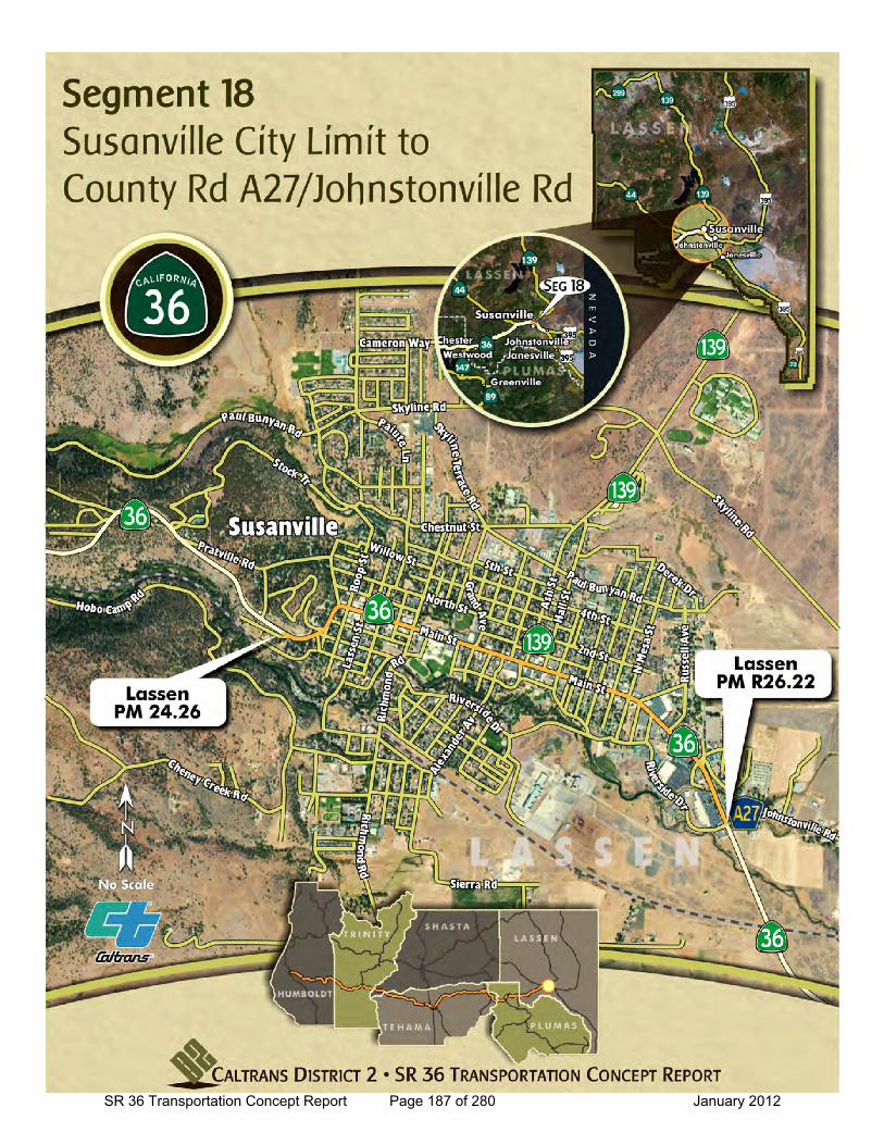
SR 36 Transportation Concept Report Page 187 of 280 January 2012
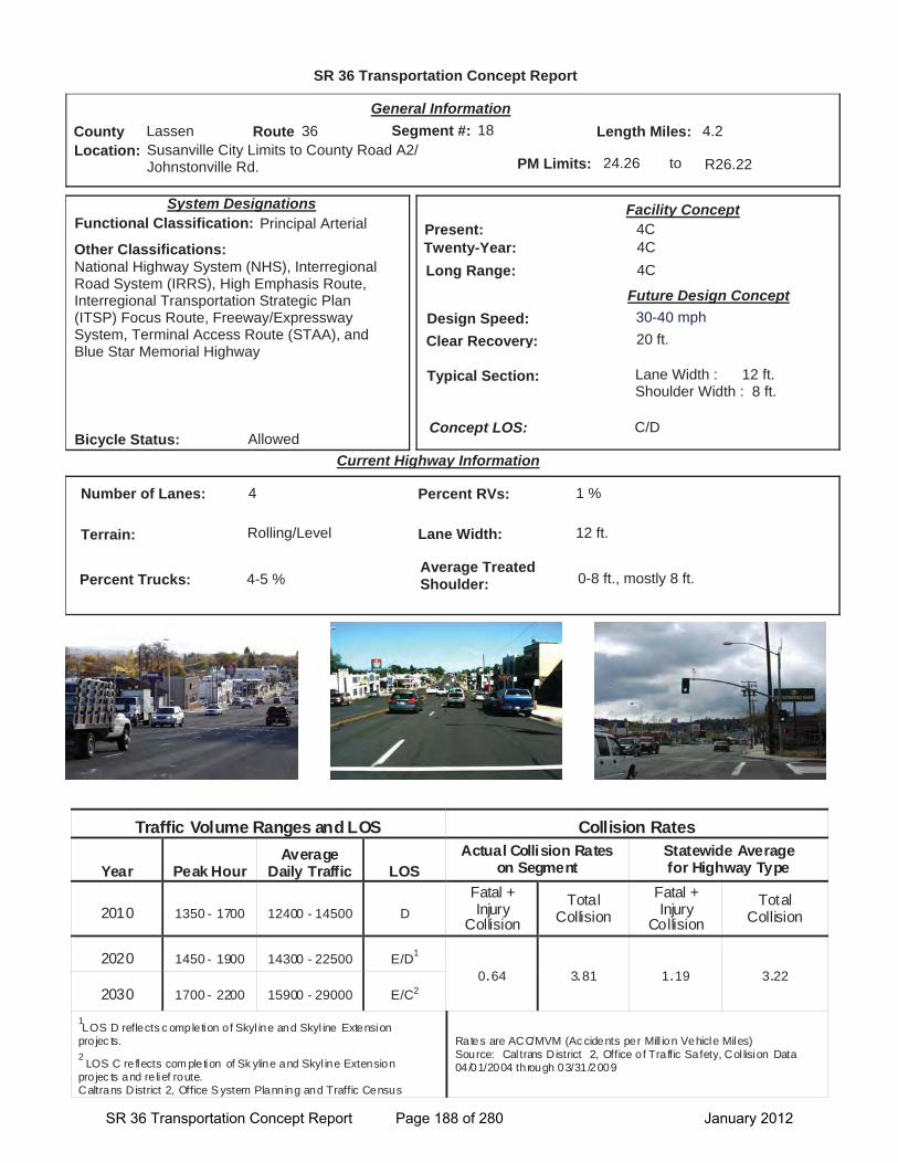
SR 36 Transportation Concept Report
Location: Susanville City Limits to County Road A2/ Johnstonville Rd.
General Information
to
Current Highway Information
Length Miles:
PM Limits: 24.26 R26.22
Facility Concept4C4C4C
Present:Twenty-Year:Long Range:
Future Design Concept
Clear Recovery: 20 ft.
System Designations
Segment #: 18
Terrain: Rolling/Level
Percent RVs: 1 %
Lane Width: 12 ft.
Concept LOS:
4.2County Lassen Route 36
C/D
Number of Lanes: 4
Percent Trucks: 4-5 %
Other Classifications:National Highway System (NHS), Interregional Road System (IRRS), High Emphasis Route, Interregional Transportation Strategic Plan (ITSP) Focus Route, Freeway/Expressway System, Terminal Access Route (STAA), and Blue Star Memorial Highway
Traffic Volume Ranges and LOS Collision Rates
Year Peak Hour Average
Daily Traffic LOS Actual Collision Rates
on Segment Statewide Average for Highway Type
2010 1350 - 1700 12400 - 14500 D Fatal + Injury
Collision Total
Collision Fatal + Injury
Collision Total
Collision
2020 1450 - 1900 14300 - 22500 E/D1
0.64 3.81 1.19 3.22 2030 1700 - 2200 15900 - 29000 E/C2
1LOS D reflects c ompletion of Skyl ine and Skyl ine Extension
pro jec ts. 2
LOS C re flects com pletion of Sk yline and Skyl ine Extension pro jec ts and re lief route. Caltrans District 2, Office S ystem Planning and Traffic Census
Rates are ACC/MVM (Ac cidents per Mill ion Vehicle Miles) Source: Cal trans District 2, Office o f Traffic Safety, Col lision Data 04/01/2004 through 03/31/2009
Bicycle Status: Allowed
Average Treated Shoulder: 0-8 ft., mostly 8 ft.
Typical Section: Lane Width : 12 ft.Shoulder Width : 8 ft.
18
Functional Classification: Principal Arterial
Design Speed: 30-40 mph
SR 36 Transportation Concept Report Page 188 of 280 January 2012
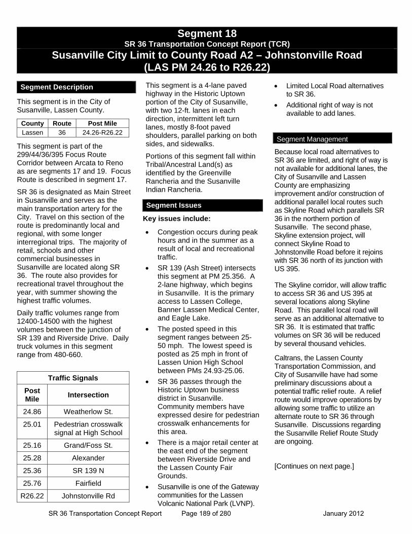
Segment 18 SR 36 Transportation Concept Report (TCR)
Susanville City Limit to County Road A2 – Johnstonville Road (LAS PM 24.26 to R26.22)
Segment Description
This segment is in the City of Susanville, Lassen County.
This segment is part of the 299/44/36/395 Focus Route Corridor between Arcata to Reno as are segments 17 and 19. Focus Route is described in segment 17.
SR 36 is designated as Main Street in Susanville and serves as the main transportation artery for the City. Travel on this section of the route is predominantly local and regional, with some longer interregional trips. The majority of retail, schools and other commercial businesses in Susanville are located along SR 36. The route also provides for recreational travel throughout the year, with summer showing the highest traffic volumes.
Daily traffic volumes range from 12400-14500 with the highest volumes between the junction of SR 139 and Riverside Drive. Daily truck volumes in this segment range from 480-660.
This segment is a 4-lane paved highway in the Historic Uptown portion of the City of Susanville, with two 12-ft. lanes in each direction, intermittent left turn lanes, mostly 8-foot paved shoulders, parallel parking on both sides, and sidewalks.
Portions of this segment fall within Tribal/Ancestral Land(s) as identified by the Greenville Rancheria and the Susanville Indian Rancheria.
Key issues include:
Congestion occurs during peak hours and in the summer as a result of local and recreational traffic.
SR 139 (Ash Street) intersects this segment at PM 25.356. A 2-lane highway, which begins in Susanville. It is the primary access to Lassen College, Banner Lassen Medical Center, and Eagle Lake.
The posted speed in this segment ranges between 25-50 mph. The lowest speed is posted as 25 mph in front of Lassen Union High School between PMs 24.93-25.06.
SR 36 passes through the Historic Uptown business district in Susanville. Community members have expressed desire for pedestrian crosswalk enhancements for this area.
There is a major retail center at the east end of the segment between Riverside Drive and the Lassen County Fair Grounds.
Susanville is one of the Gateway communities for the Lassen Volcanic National Park (LVNP).
Limited Local Road alternatives to SR 36.
Additional right of way is not available to add lanes.
Because local road alternatives to SR 36 are limited, and right of way is not available for additional lanes, the City of Susanville and Lassen County are emphasizing improvement and/or construction of additional parallel local routes such as Skyline Road which parallels SR 36 in the northern portion of Susanville. The second phase, Skyline extension project, will connect Skyline Road to Johnstonville Road before it rejoins with SR 36 north of its junction with US 395.
The Skyline corridor, will allow traffic to access SR 36 and US 395 at several locations along Skyline Road. This parallel local road will serve as an additional alternative to SR 36. It is estimated that traffic volumes on SR 36 will be reduced by several thousand vehicles.
Caltrans, the Lassen County Transportation Commission, and City of Susanville have had some preliminary discussions about a potential traffic relief route. A relief route would improve operations by allowing some traffic to utilize an alternate route to SR 36 through Susanville. Discussions regarding the Susanville Relief Route Study are ongoing.
[Continues on next page.]
Traffic Signals
Post Mile
Intersection
24.86 Weatherlow St.
25.01 Pedestrian crosswalk signal at High School
25.16 Grand/Foss St.
25.28 Alexander
25.36 SR 139 N
25.76 Fairfield
R26.22 Johnstonville Rd
County Route Post Mile Lassen 36 24.26-R26.22
Segment Issues
Segment Management
SR 36 Transportation Concept Report Page 189 of 280 January 2012

This page intentionally left blank
SR 36 Transportation Concept Report Page 190 of 280 January 2012
Segment 18 (Continued) SR 36 Transportation Concept Report (TCR)
Prattville Road to County Road A2 – Johnstonville Road
(LAS PM 23.64 / R26.22)
Community members and City Staff have expressed interest in developing a common vision for Main Street (SR 36) in Susanville. District 2 will work with local agencies and the community as they explore community enhancement options. They have identified four emphasis areas:
1. Town Hill Gateway into the community from Town Hill to Weatherlow Street, concepts here would address features such as community entrance signage, pedestrian crossing enhancements, and lighting improvements.
2. South East Gateway into the community would include concepts for entrance signs, landscaping, and pedestrian enhancements.
3. Develop a uniform design theme for mid-block sections between Uptown and South Gateway.
4. City to obtain an encroach permit from Caltrans to simplify the process for business owners to install features such as benches, and planter boxes in designated locations on sidewalks between Weatherlow Street and Pine Street.
Segment Management (continued)
SR 36 Transportation Concept Report Page 191 of 280 January 2012

This page intentionally left blank
SR 36 Transportation Concept Report Page 192 of 280 January 2012
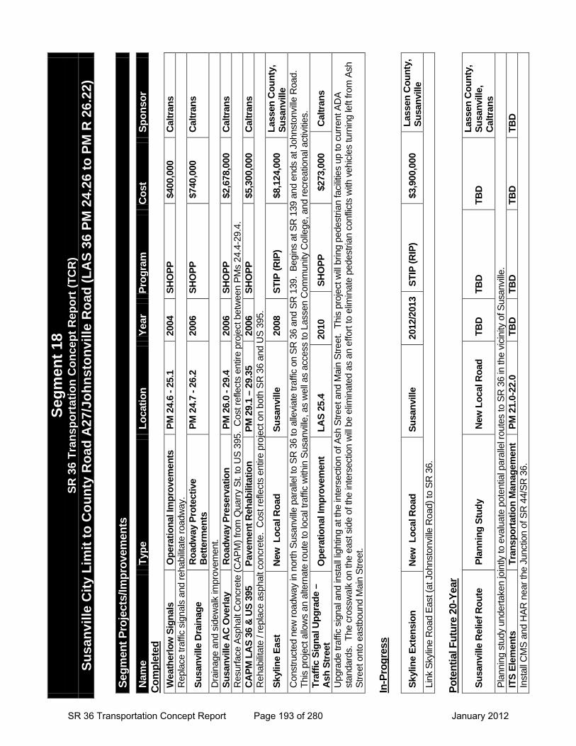
Segm
ent P
roje
cts/
Impr
ovem
ents
Nam
e Ty
pe
Loca
tion
Year
Pr
ogra
m
Cos
t Sp
onso
r C
ompl
eted
W
eath
erlo
w S
igna
ls
Ope
ratio
nal I
mpr
ovem
ents
PM
24.
6 - 2
5.1
2004
SH
OPP
$4
00,0
00
Cal
trans
R
epla
ce tr
affic
sig
nals
and
reh
abili
tate
roa
dway
.
Susa
nvill
e D
rain
age
Roa
dway
Pro
tect
ive
Bet
term
ents
PM
24.
7 - 2
6.2
2006
SH
OPP
$7
40,0
00
Cal
trans
Dra
inag
e an
d si
dew
alk
impr
ovem
ent.
Susa
nvill
e A
C O
verla
y R
oadw
ay P
rese
rvat
ion
PM 2
6.0
- 29.
4 20
06
SHO
PP
$2,6
78,0
00
Cal
trans
R
esur
face
Asp
halt
Con
cret
e (C
AP
M)
from
Qua
rry
St.
to U
S 3
95.
Cos
t ref
lect
s en
tire
proj
ect b
etw
een
PM
s 24
.4-2
9.4.
C
APM
LA
S 36
& U
S 39
5 Pa
vem
ent R
ehab
ilita
tion
PM 2
9.1
– 29
.35
2006
SH
OPP
$5
,300
,000
C
altra
ns
Reh
abili
tate
/ re
plac
e as
phal
t con
cret
e. C
ost r
efle
cts
entir
e pr
ojec
t on
both
SR
36
and
US
395
.
Skyl
ine
East
N
ew L
ocal
Roa
d Su
sanv
ille
2008
ST
IP (R
IP)
$8,1
24,0
00
Lass
en C
ount
y,
Susa
nvill
e C
onst
ruct
ed n
ew r
oadw
ay in
nor
th S
usan
ville
par
alle
l to
SR
36
to a
llevi
ate
traf
fic o
n S
R 3
6 an
d S
R 1
39.
Beg
ins
at S
R 1
39 a
nd e
nds
at J
ohns
tonv
ille
Roa
d.
Thi
s pr
ojec
t allo
ws
an a
ltern
ate
rout
e to
loca
l tra
ffic
with
in S
usan
ville
, as
wel
l as
acce
ss to
Las
sen
Com
mun
ity C
olle
ge, a
nd r
ecre
atio
nal a
ctiv
ities
.
Traf
fic S
igna
l Upg
rade
–
Ash
Stre
et
Ope
ratio
nal I
mpr
ovem
ent
LAS
25.4
20
10
SHO
PP
$2
73,0
00
Cal
trans
Upg
rade
traf
fic s
igna
l and
inst
all l
ight
ing
at th
e in
ters
ectio
n of
Ash
Str
eet a
nd M
ain
Str
eet.
Thi
s pr
ojec
t will
brin
g pe
dest
rian
faci
litie
s up
to c
urre
nt A
DA
st
anda
rds.
The
cro
ssw
alk
on th
e ea
st s
ide
of th
e in
ters
ectio
n w
ill b
e el
imin
ated
as
an e
ffort
to e
limin
ate
pede
stria
n co
nflic
ts w
ith v
ehic
les
turn
ing
left
from
Ash
S
tree
t ont
o ea
stbo
und
Mai
n S
tree
t.
In-P
rogr
ess
Skyl
ine
Exte
nsio
n N
ew L
ocal
Roa
d Su
sanv
ille
2012
/201
3 ST
IP (R
IP)
$3,9
00,0
00
Lass
en C
ount
y,
Susa
nvill
e Li
nk S
kylin
e R
oad
Eas
t (at
Joh
nsto
nvill
e R
oad)
to S
R 3
6.
Pote
ntia
l Fut
ure
20-Y
ear
Susa
nvill
e R
elie
f Rou
te
Plan
ning
Stu
dy
New
Loc
al R
oad
TBD
TB
D
TBD
La
ssen
Cou
nty,
Su
sanv
ille,
C
altra
ns
Pla
nnin
g st
udy
unde
rtak
en jo
intly
to e
valu
ate
pote
ntia
l par
alle
l rou
tes
to S
R 3
6 in
the
vici
nity
of S
usan
ville
. IT
S El
emen
ts
Tran
spor
tatio
n M
anag
emen
t PM
21.
0-22
.0
TBD
TB
D
TBD
TB
D
Inst
all C
MS
and
HA
R n
ear
the
Junc
tion
of S
R 4
4/S
R 3
6.
Segm
ent 1
8
SR 3
6 Tr
ansp
orta
tion
Con
cept
Rep
ort (
TCR
) Su
sanv
ille
City
Lim
it to
Cou
nty
Roa
d A
27/J
ohns
tonv
ille
Roa
d (L
AS
36 P
M 2
4.26
to P
M R
26.
22)
SR 36 Transportation Concept Report Page 193 of 280 January 2012

This page intentionally left blank
SR 36 Transportation Concept Report Page 194 of 280 January 2012

Segment 19
SR 36 Transportation Concept Report Page 195 of 280 January 2012

This page intentionally left blank
SR 36 Transportation Concept Report Page 196 of 280 January 2012
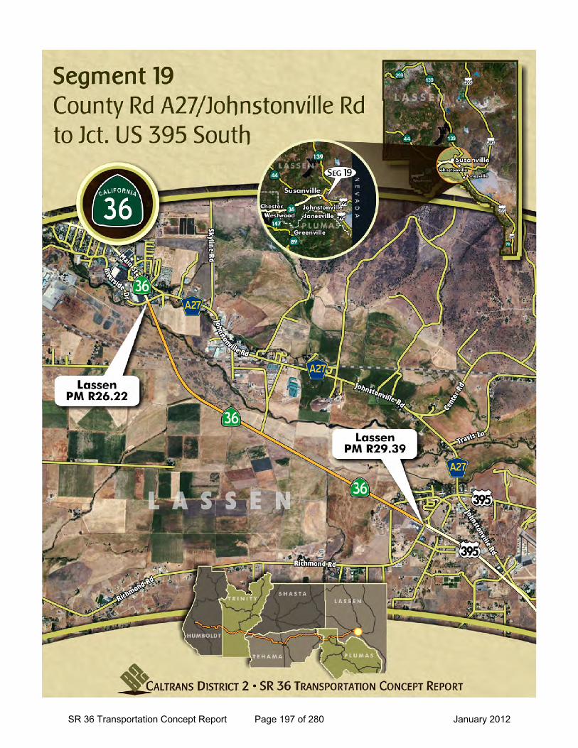
SR 36 Transportation Concept Report Page 197 of 280 January 2012
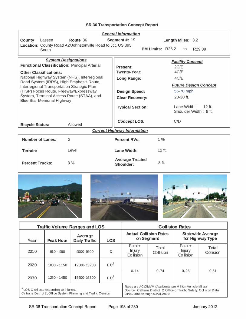
SR 36 Transportation Concept Report
Location: County Road A2/Johnstonville Road to Jct. US 395 South
General Information
to
Current Highway Information
Length Miles:
PM Limits: R26.2 R29.39
Facility Concept2C/E4C/E4C/E
Present:Twenty-Year:Long Range:
Future Design Concept
Clear Recovery: 20-30 ft.
System Designations
Segment #: 19
Terrain: Level
Percent RVs: 1 %
Lane Width: 12 ft.
Concept LOS:
3.2County Lassen Route 36
C/D
Number of Lanes: 2
Percent Trucks: 8 %
Other Classifications:National Highway System (NHS), Interregional Road System (IRRS), High Emphasis Route, Interregional Transportation Strategic Plan (ITSP) Focus Route, Freeway/Expressway System, Terminal Access Route (STAA), and Blue Star Memorial Highway
Traffic Volume Ranges and LOS Collision Rates
Year Peak Hour Average
Daily Traffic LOS Actual Collision Rates
on Segment Statewide Average for Highway Type
2010 910 - 960 9000-9500 D Fatal + Injury
Collision
Total Collision
Fatal + Injury
Collision
Total Collision
2020 1000 - 1150 12600-13200 E/C1
0.14 0.74 0.26 0.61
2030 1250 - 1450 15600-16300 E/C1
1LOS C reflects expanding to 4 lanes.
Caltrans District 2 , Office System Planning and Traffic Census
Rates are ACC/MVM (Acc idents per M ill ion Vehicle Miles) Source: Cal trans District 2, Office of Traffic Safety, Coll ision Data 04/01/2004 through 03/31/2009
Bicycle Status: Allowed
Average Treated Shoulder: 8 ft.
Typical Section: Lane Width : 12 ft.Shoulder Width : 8 ft.
19
Functional Classification: Principal Arterial
Design Speed: 55-70 mph
SR 36 Transportation Concept Report Page 198 of 280 January 2012
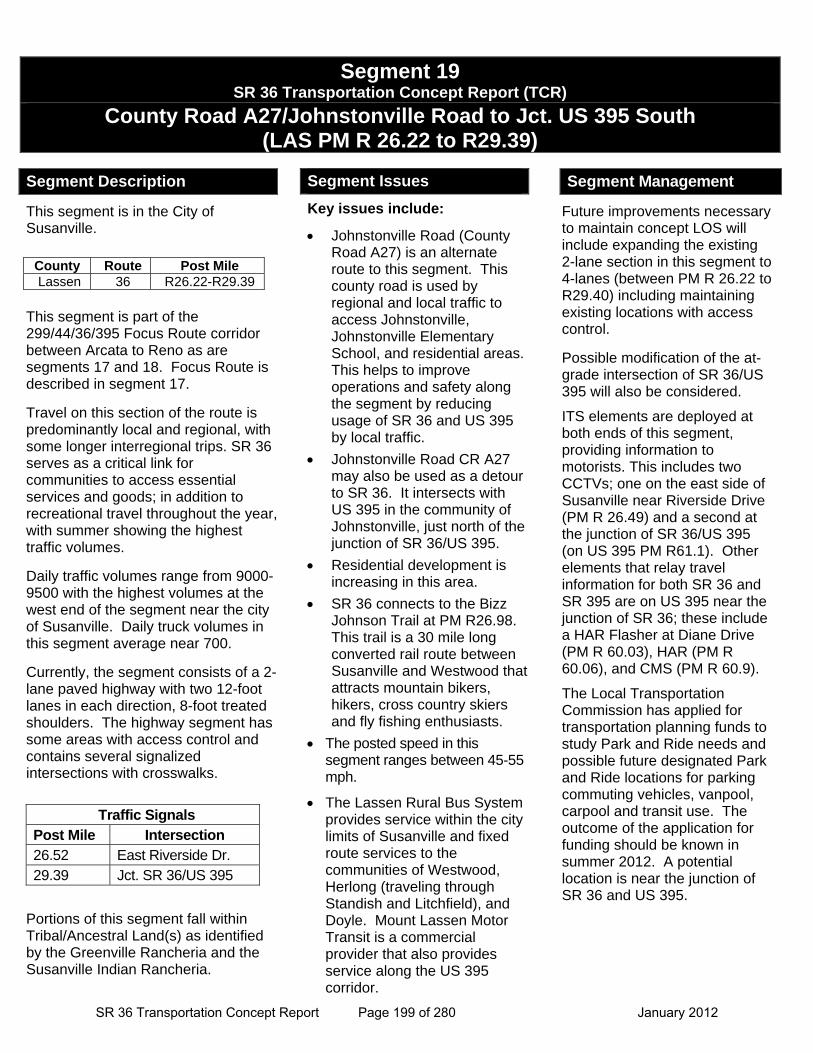
Segment 19 SR 36 Transportation Concept Report (TCR)
County Road A27/Johnstonville Road to Jct. US 395 South (LAS PM R 26.22 to R29.39)
This segment is in the City of Susanville.
This segment is part of the 299/44/36/395 Focus Route corridor between Arcata to Reno as are segments 17 and 18. Focus Route is described in segment 17.
Travel on this section of the route is predominantly local and regional, with some longer interregional trips. SR 36 serves as a critical link for communities to access essential services and goods; in addition to recreational travel throughout the year, with summer showing the highest traffic volumes.
Daily traffic volumes range from 9000-9500 with the highest volumes at the west end of the segment near the city of Susanville. Daily truck volumes in this segment average near 700.
Currently, the segment consists of a 2-lane paved highway with two 12-foot lanes in each direction, 8-foot treated shoulders. The highway segment has some areas with access control and contains several signalized intersections with crosswalks.
Portions of this segment fall within Tribal/Ancestral Land(s) as identified by the Greenville Rancheria and the Susanville Indian Rancheria.
Segment Issues
Key issues include:
Johnstonville Road (County Road A27) is an alternate route to this segment. This county road is used by regional and local traffic to access Johnstonville, Johnstonville Elementary School, and residential areas. This helps to improve operations and safety along the segment by reducing usage of SR 36 and US 395 by local traffic.
Johnstonville Road CR A27 may also be used as a detour to SR 36. It intersects with US 395 in the community of Johnstonville, just north of the junction of SR 36/US 395.
Residential development is increasing in this area.
SR 36 connects to the Bizz Johnson Trail at PM R26.98. This trail is a 30 mile long converted rail route between Susanville and Westwood that attracts mountain bikers, hikers, cross country skiers and fly fishing enthusiasts.
The posted speed in this segment ranges between 45-55 mph.
The Lassen Rural Bus System provides service within the city limits of Susanville and fixed route services to the communities of Westwood, Herlong (traveling through Standish and Litchfield), and Doyle. Mount Lassen Motor Transit is a commercial provider that also provides service along the US 395 corridor.
Future improvements necessary to maintain concept LOS will include expanding the existing 2-lane section in this segment to 4-lanes (between PM R 26.22 to R29.40) including maintaining existing locations with access control.
Possible modification of the at-grade intersection of SR 36/US 395 will also be considered.
ITS elements are deployed at both ends of this segment, providing information to motorists. This includes two CCTVs; one on the east side of Susanville near Riverside Drive (PM R 26.49) and a second at the junction of SR 36/US 395 (on US 395 PM R61.1). Other elements that relay travel information for both SR 36 and SR 395 are on US 395 near the junction of SR 36; these include a HAR Flasher at Diane Drive (PM R 60.03), HAR (PM R 60.06), and CMS (PM R 60.9).
The Local Transportation Commission has applied for transportation planning funds to study Park and Ride needs and possible future designated Park and Ride locations for parking commuting vehicles, vanpool, carpool and transit use. The outcome of the application for funding should be known in summer 2012. A potential location is near the junction of SR 36 and US 395.
Segment Description
County Route Post Mile Lassen 36 R26.22-R29.39
Traffic Signals Post Mile Intersection 26.52 East Riverside Dr. 29.39 Jct. SR 36/US 395
Segment Management
SR 36 Transportation Concept Report Page 199 of 280 January 2012
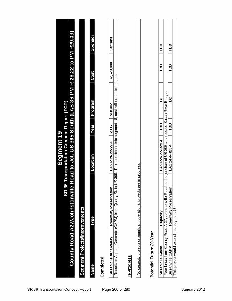
Seg
men
t 19
S
R 3
6 T
ran
spo
rtat
ion
Co
nce
pt
Rep
ort
(T
CR
)
Co
un
ty R
oad
A27
/Jo
hn
sto
nvi
lle R
oad
to
Jct
. U
S 3
95 S
ou
th (
LA
S 3
6 P
M R
26.
22 t
o P
M R
29.3
9)
S
egm
ent
Pro
ject
s/Im
pro
vem
ents
N
ame
Typ
e L
oca
tio
n
Yea
r P
rog
ram
C
ost
S
po
nso
r C
om
ple
ted
S
usa
nvi
lle A
C O
verl
ay
Ro
adw
ay P
rese
rvat
ion
L
AS
R 2
6.22
-29.
4 20
06
SH
OP
P
$2,6
78,0
00
Cal
tran
s R
esur
face
Asp
halt
Con
cret
e (C
AP
M)
from
Qua
rry
St.
to U
S 3
95.
Pro
ject
ext
ends
into
seg
men
t 18,
cos
t ref
lect
s en
tire
proj
ect.
In-P
rog
ress
N
o ca
paci
ty p
roje
cts
or s
igni
fican
t ope
ratio
nal p
roje
cts
are
in p
rogr
ess.
P
ote
nti
al F
utu
re 2
0-Y
ear
Su
san
ville
4-l
ane
Cap
acit
y
LA
S R
26.2
2-R
29.4
T
BD
T
BD
T
BD
T
BD
F
our
lane
s fr
om C
ount
y R
oad
A 2
7, J
ohns
tonv
ille
Roa
d, to
the
junc
tion
of U
S 3
95 a
nd r
epla
ce S
usan
Riv
er B
ridge
. S
usa
nvi
lle C
AP
M
Ro
adw
ay P
rese
rvat
ion
L
AS
24.
4-R
29.4
T
BD
T
BD
T
BD
T
BD
T
his
proj
ect w
ould
ext
end
into
seg
men
t 18
SR 36 Transportation Concept Report Page 200 of 280 January 2012