sr-15 mid-city station area planning study urban design
TRANSCRIPT

SR-15 Mid-City Station Area Planning Study Urban Design Vision and Land Use Final Report Submitted to City of San Diego Development Services Department by IBI Group in collaboration with CH2M HILL, Bay Area Economics, Dave Potter Associates February 2013

SR-15 MID-CITY STATION AREA PLANNING STUDY – URBAN DESIGN VISION AND LAND USE FINAL REPORT
TABLE OF CONTENTS
February 2013 Page i.
1. INTRODUCTION ........................................................................................................................................... 1
1.1 OPPORTUNITIES & CONSTRAINTS MAPPING ................................................................................................................ 1 1.2 OPPORTUNITIES & CONSTRAINTS MAPPING ................................................................................................................ 1 1.3 URBAN DESIGN VISION ........................................................................................................................................... 9 1.4 TRANSITION STRATEGY .......................................................................................................................................... 26
2. MASSING STUDIES ..................................................................................................................................... 33
3. CONCLUSION ............................................................................................................................................. 48

LIST OF FIGURES
Figure 1 Gateways and Landmarks ........................................................................................... 2 Figure 2 Street Trees .................................................................................................................. 3 Figure 3 Pedestrian Shed ........................................................................................................... 4 Figure 4 Views and Vistas .......................................................................................................... 5 Figure 5 Cycling Facilities ........................................................................................................... 6 Figure 6 Potential Development ................................................................................................. 7 Figure 7 Right of Way Opportunities .......................................................................................... 8 Figure 8 El Cajon Avenue BRT Station Enhancements ........................................................... 10 Figure 9 University Avenue BRT Station Enhancements ........................................................ 10 Figure 10 Typical Ray Huffman-Style Apartments ................................................................... 11 Figure 11 Ray Huffman-Style Apartments Enhancements ...................................................... 12 Figure 12 Test Parking Alternatives –Angled Head-In Parking ............................................... 13 Figure 13 Cars “For Sale” on University Avenue ..................................................................... 14 Figure 14 Open Space Plan ..................................................................................................... 15 Figure 15 Connectivity and Mobility ......................................................................................... 18 Figure 16 El Cajon Blvd. Station - Plan View ........................................................................... 20 Figure 17 El Cajon Boulevard – Typical Section ..................................................................... 21 Figure 18 University Avenue Station - Plan View..................................................................... 22 Figure 19 University Avenue Station – Typical Proposed Section ........................................... 23 Figure 20 Sharrows .................................................................................................................. 24 Figure 21 Use Re-striping to Create Curb Extensions, Public Space ...................................... 25 Figure 22 Volunteer-Built Temporary Plaza in Parking Lane ................................................... 25 Figure 23 Street Fairs, Festivals............................................................................................... 26 Figure 24 Land Use Scenarios Composite .............................................................................. 27 Figure 25 Proposed Land Uses ................................................................................................ 32 Figure 26 Massing Study Key Plan .......................................................................................... 34 Figure 27 MA-S1 2.5 TA1 – View From Southeast .................................................................. 35 Figure 28 MA-S1 2.5 TA1 – View From Northwest .................................................................. 36 Figure 29 MA-S1 2.5 TA1 – Section Looking West.................................................................. 36 Figure 30 MA-S1 2.5 TA1 – Floor Plans .................................................................................. 37 Figure 31 Example of MA-S1 Massing Concept ...................................................................... 37 Figure 32 MB-S1 2.0 – View From Northeast .......................................................................... 39 Figure 33 MB-S1 2.0 – View From Southwest ......................................................................... 39 Figure 34 MB-S1 2.0 – Section Looking West ........................................................................ 40 Figure 35 MB-S1 2.0 – Floor Plans .......................................................................................... 40 Figure 36 Example of MB-S1 Massing ..................................................................................... 41 Figure 37 MA5 2.0 TA11 – View From Southwest ................................................................... 42 Figure 38 MA5 2.0 TA11 – View From Northeast .................................................................... 43 Figure 39 MA5 2.0 TA11 – Section Looking West ................................................................... 43 Figure 40 MA5 2.0 TA11 – Floor Plans .................................................................................... 44 Figure 41 Example 1 of MA5 2.0 .............................................................................................. 44 Figure 42 Example 2 of MA5 2.0 .............................................................................................. 45 Figure 43 RA2 .75 – View From Southwest ............................................................................. 46 Figure 44 RA2 .75 – View From Northeast .............................................................................. 47 Figure 45 RA2 .75 – Section Looking North ............................................................................. 47 Figure 46 RA2 .75 – Floor Plans .............................................................................................. 48

SR-15 MID-CITY STATION AREA PLANNING STUDY – URBAN DESIGN VISION AND LAND USE FINAL REPORT
1. INTRODUCTION
New bus rapid transit (BRT) facilities and services are being planned for SR-15 in Mid-City as part of the region’s efforts to enhance the performance and attractiveness of transit. Included in the improvements are new transit stations at El Cajon Boulevard and University Avenue. The Mid-City Station Area Planning Study is being undertaken by the City of San Diego to take advantage of the planned transit facilities and services to spur land use improvements in the areas near the stations in support of Transit-Oriented Development (TOD). Funded by a Smart Growth Incentive Program grant from the San Diego Association of Governments (SANDAG), the study aims to develop a vision and identify implementation actions to foster TOD in the study area on both sides of SR-15. The study includes a planning analysis of land use, mobility, and economic considerations to develop plans and policies to support development that makes the most of the increased travel options within this BRT corridor. To establish an urban design framework for these stations and the surrounding study area, this report documents opportunities and constraints; develops an urban design vision that identifies key issues and recommends actions to address the issues; provides massing studies for various development intensity scenarios; presents three land use scenarios; presents a transition strategy; and provides a series of 3-D models that illustrate potential building massing and implications of proposed development.
1.1 Opportunities & Constraints Mapping
During the planning process, a number of urban design strengths, weaknesses, opportunities and threats to the study area were identified; they are represented on Figures 1 – 7 and are summarized below:
1.2 Opportunities & Constraints Mapping
During the planning process, a number of urban design strengths and opportunities in the study area were identified, These should be considered in any land use proposals for the area. Urban design strengths include: gateway structures at the BRT Stations at El Cajon Boulevard and University Avenue; an orthogonal grid pattern of streets and blocks that is ideal for “walkability”; and mountain views. Opportunities include: a park, plazas and school playgrounds which could be used for public open space; existing street trees that can serve as the basis for an expanded street tree program; existing and planned bicycle facilities that can serve as a framework for expanding cycling opportunities; undeveloped sites and under-developed sites that can support additional development, including higher densities; and excess street right-of-way that could be reclaimed for other public improvements such as linear community gardens, public markets, or “shared streets” for the benefit of pedestrians, cyclists and vehicles alike. Urban design strengths and opportunities are represented on Figures 1 – 7 as listed below.
Figure 1: Gateways and Landmarks
Figure 2: Street Trees
Figure 3: Pedestrian Shed
Figure 4: Views and Vistas
Figure 5: Cycling Facilities
Figure 6: Potential Development
Figure 7: Right of Way Opportunities

SR-15 MID-CITY STATION AREA PLANNING STUDY – URBAN DESIGN VISION AND LAND USE FINAL REPORT
February 2013 Page 2
Figure 1 Gateways and Landmarks
Gateways and Landmarks shows existing Gateway Structures at the BRT Stations over the I-15 at El Cajon Boulevard and University Avenue which are an urban design strength. It also shows existing Teralta Park, plazas at the BRT stations and school playgrounds which could be used for public open space. Wilson Middle School currently operates as a joint-use facility, and Central Elementary has the potential to provide opportunities for joint-use including children’s play areas, multi-purpose turf areas, multi-purpose courts, and sports fields.

SR-15 MID-CITY STATION AREA PLANNING STUDY – URBAN DESIGN VISION AND LAND USE FINAL REPORT
February 2013 Page 3
Figure 2 Street Trees
Street Trees illustrates existing street trees which can serve as the basis for an expanded street tree program. Additional street trees, particularly along the major thoroughfares of El Cajon Boulevard and University Avenue, would provide an opportunity for creating a more enjoyable streetscape that would further encourage walking in the area.

SR-15 MID-CITY STATION AREA PLANNING STUDY – URBAN DESIGN VISION AND LAND USE FINAL REPORT
February 2013 Page 4
Figure 3 Pedestrian Shed
Pedestrian Shed identifies the ¼ mile walking distance from the BRT Stations at El Cajon Boulevard and University Avenue. As shown, the study area is laid out in an orthogonal grid – streets and blocks that, for the most part, intersect at right angles. This configuration is ideal for “walkability.” The grid pattern is an urban design strength that should be maintained to facilitate vehicular, pedestrian, and cycling movement throughout the study area.

SR-15 MID-CITY STATION AREA PLANNING STUDY – URBAN DESIGN VISION AND LAND USE FINAL REPORT
February 2013 Page 5
Figure 4 Views and Vistas
Views and Vistas show mountain views from Teralta Park, El Cajon Boulevard, Orange Avenue, Polk Avenue, and University Avenue. These mountain views are an urban design strength that should be protected as the area re-develops.

SR-15 MID-CITY STATION AREA PLANNING STUDY – URBAN DESIGN VISION AND LAND USE FINAL REPORT
February 2013 Page 6
Figure 5 Cycling Facilities
Cycling Facilities shows existing Class II Bike Path along the east side of Teralta Park, existing Class III Bike Routes along Orange Avenue and Wightman Avenue, and Planned Bike Routes along El Cajon Boulevard, Central Avenue, and Copeland Street north of El Cajon Boulevard. These existing and planned bicycle facilities can serve as a framework for expanding cycling opportunities in the area.

SR-15 MID-CITY STATION AREA PLANNING STUDY – URBAN DESIGN VISION AND LAND USE FINAL REPORT
February 2013 Page 7
Figure 6 Potential Development
Potential Development shows potential development in terms of Undeveloped Sites and Under-Developed Sites. These sites represent an important opportunity because of the shortage of vacant land in the study area. As Figure 6 illustrates, these sites are extensive and are located throughout the area. The sites within the High-Density Development Zone, which is located along both sides of the I-15 corridor, provide the opportunity for higher densities because of their proximity to the proposed BRT stations at El Cajon Boulevard and University Avenue.

SR-15 MID-CITY STATION AREA PLANNING STUDY – URBAN DESIGN VISION AND LAND USE FINAL REPORT
February 2013 Page 8
Figure 7 Right of Way Opportunities
Right of Way Opportunities illustrates rights-of-way that should be examined for possible reduction. The excess width provides an opportunity to be reclaimed for other public improvements such as linear community gardens, public markets, or in the case of Polk Street, a linear hardscaped “shared street” for the benefit of pedestrians, cyclists and vehicles alike. The excess right-of-way could also provide for additional parking in residential areas.

SR-15 MID-CITY STATION AREA PLANNING STUDY – URBAN DESIGN VISION AND LAND USE FINAL REPORT
February 2013 Page 9
1.3 Urban Design Vision
The Urban Design Vision encompasses future multimodal transit-oriented land use around the planned Bus Rapid Transit (BRT) stations at the intersections of SR-15 with El Cajon Boulevard and University Avenue, and is intended to encourage residential, retail, and employment uses near the BRT stations. It is intended to enhance the local “sense of place” and create an attractive, vibrant and sustainable environment for all residents. Importantly, community redevelopment should not come at the expense of existing residents. Working with the stakeholder groups the following guiding principles for shaping the urban design were identified:
Respect previously approved development densities;
Reinforce existing building height restrictions;
Provide pedestrian, cycling and transit opportunities;
Promote urban “placemaking” strategies such as parks and plazas, outdoor and night markets, and theatre-in-the park;
Ensure no loss of current residential parking;
Share existing community resources such as school grounds for recreation;
Encourage interim uses, such as community gardens, for vacant city-owned lands along El Cajon Boulevard and University Avenue.
Seek design solutions to make Ray Huffman-style apartments better neighbors. Following are key issues that have been identified for existing conditions and visions for the future. BRT Station Areas Issue: the BRT Station areas at El Cajon Boulevard and University Avenue are not considered attractive or pedestrian friendly. There is also concern that Caltrans has so far blocked the use of the existing kiosks on the SR-15 bridge decks over El Cajon Boulevard and University Avenue. Vision #1: Create attractive and pedestrian friendly BRT Station Areas. In order to encourage the use of the BRT stations, a well-defined pedestrian realm should be created, that makes the stations more attractive, safe and secure places. These enhancements, as shown in Figures 8 and 9 may include:
Enhanced tree plantings and landscaping;
Portable kiosks offering convenience items and travel necessities;
Unique and attractive station pylon/markers;
High quality banners, graphics and branding;
Resilient, decorative paving materials;
High quality, well-defined pedestrian crossings
Note: the pavement patterns shown in Figures 8, 9, 16, and 18 were developed by the consultant team for illustrative purposes. During the course of the study, several community members expressed their preference for the pavement treatments developed previously as part of the implementation of SR-15 freeway.

SR-15 MID-CITY STATION AREA PLANNING STUDY – URBAN DESIGN VISION AND LAND USE FINAL REPORT
February 2013 Page 10
Vision #2: Utilize the existing kiosks. Work with Caltrans to allow the use of the existing kiosks.
Figure 8 El Cajon Avenue BRT Station Enhancements
Note: several community members expressed their preference for the pavement treatments developed previously as part of the implementation of SR-15 freeway.
Figure 9 University Avenue BRT Station Enhancements
Note: several community members expressed their preference for the pavement treatments developed previously as part of the implementation of SR-15 freeway.

SR-15 MID-CITY STATION AREA PLANNING STUDY – URBAN DESIGN VISION AND LAND USE FINAL REPORT
February 2013 Page 11
Ray Huffman-Style Apartments Issue: In the 1960s and 70s numerous two-story apartment buildings were constructed throughout the study area and elsewhere in the City in what previously had been predominantly single-family neighborhoods. A style that was popularized by Developer Ray Huffman devoted the entire area in front of these buildings to parking. This resulted in little to no front yard landscaping and a continuous curb cut to allow access to the parking as illustrated in Figure 10. One hundred ninety four (194) Ray Huffman-Style Apartments providing 1,500 ± units were identified in the study area, an average of nearly 8 units per lot.
Figure 10 Typical Ray Huffman-Style Apartments
Vision: Front yard with landscaping instead of parking. Prepare and adopt regulations and policies that would permit the replacement of the front yard parking with lawn and landscaping, removal of the curb cut, and provision of angle or head-in parking in the street. See Figure 11. More specifically, the Central Urbanized Planned District regulations could be amended to allow the removal of front yard parking with a Neighborhood Use Permit (NUP). At a minimum the NUP would be subject to the following conditions: 1) an acceptable landscape plan for the front yard; 2) determination that the fronting street has adequate width to allow angle; and 3) the provision of angle or head-in parking in the street.

SR-15 MID-CITY STATION AREA PLANNING STUDY – URBAN DESIGN VISION AND LAND USE FINAL REPORT
February 2013 Page 12
Figure 11 Ray Huffman-Style Apartments Enhancements
Implementation of a pilot project may be advisable to demonstrate the advantages and feasibility of the program and to entice other owners of Ray Huffman-style Apartments to follow suit. Parking in Residential Areas Issue: Members of the community have identified a shortage of parking in residential areas as an issue. Most of the commercial areas on El Cajon Boulevard and University Avenue were developed prior to the requirement for on-site parking; as a result parking spills over into the adjoining residential areas. The on-street parking supply was further limited due in large part to the high number of small apartment buildings developed in the 1960s and 70s that did not provide sufficient parking on site. Current development regulations will require future development to provide parking, although at a reduced level for the study area, which is within a Transit Area Overlay Zone (TAOZ). The TAOZ is intended to permit special parking regulations for developments within areas that have a high level of transit service. The TAOZ regulations generally allow for a 20 percent reduction per bedroom in required parking spaces for multi-family residential developments and a 16 percent reduction per 1,000 square feet for retail and commercial uses. Regardless of the current requirement for parking for new development, the problem generated by older development will persist. The parking shortage is exacerbated by cars “for sale” being parked on University Avenue and El Cajon Boulevard, precluding business owners and clients from using the parking spaces.

SR-15 MID-CITY STATION AREA PLANNING STUDY – URBAN DESIGN VISION AND LAND USE FINAL REPORT
February 2013 Page 13
Vision #1: Additional parking in residential areas. Identify residential streets of sufficient width to allow angle parking, head-in parking, or parking in center of street and work with City Traffic Operations to implement such projects. See Figure 12.
Figure 12 Test Parking Alternatives – Angled Head-In Parking
Vision #2: Streets free of cars “for sale”. Pursuant to Municipal Code §86.23.1 request the City Council to adopt a resolution designating El Cajon Boulevard and University Avenue as streets where City staff would have the authority to issue a notice of violation to any vehicle which because of a sign or placard on the vehicle, it appears that the primary purpose of parking the vehicle at that location is to display to the public that the vehicle is for sale. The ordinance also allows the subsequent removal of a violating vehicle. See Figure 13.

SR-15 MID-CITY STATION AREA PLANNING STUDY – URBAN DESIGN VISION AND LAND USE FINAL REPORT
February 2013 Page 14
Figure 13 Cars “For Sale” on University Avenue
Parks and Open Space
Issue: Located on a deck over the SR-15 between El Cajon Boulevard and University Avenue, Teralta Park is a 5.6-acre park that serves the study area and surrounding community. The park provides much needed open and recreational space, including a playground, basketball courts, a grass play area, and picnic tables, for this area of City Heights. A dedicated pedestrian and bicycle path provides a linkage between the park and University Avenue to the south. Figure 6 shows the location of Teralta Park within the study area. However, like many inner-city communities across the country, the study area has a deficiency of public open space. In 2010 the study area population was 19,638. Based on the General Plan guideline of 2.8 acres of neighborhood parks for each 1,000 population, the study area should have approximately 55 acres of neighborhood parks.
Vision: Increase parks and open space. Using Teralta Park as its “heart”, an Open Space Plan that includes a network of green, walkable streets connecting to other open space/park opportunities is recommended. These opportunities include the existing public plazas on the El Cajon Boulevard and University Avenue decks over I-15; proposed public plazas on El Cajon Boulevard and University Avenue adjacent to the SR-15 decks; joint-use of school facilities for children’s play areas, multi-purpose turf areas, multi-purpose courts, and sports fields. (Wilson Middle School and Cherokee Point Elementary (outside the study area) are currently available for recreation under joint use agreements.) The Open Space Plan is illustrated in Figure 14.

SR-15 MID-CITY STATION AREA PLANNING STUDY – URBAN DESIGN VISION AND LAND USE FINAL REPORT
February 2013 Page 15
Figure 14 Open Space Plan

SR-15 MID-CITY STATION AREA PLANNING STUDY – URBAN DESIGN VISION AND LAND USE FINAL REPORT
February 2013 Page 16
Connectivity and Mobility Issue: The study area has the benefit of having been laid out as an orthogonal grid – streets and blocks that, for the most part, intersect at right angles. This configuration is ideal for “walkability” – in this case the safe and pleasurable experience of traveling on foot throughout one’s community. However, pedestrians frequently encounter gaps in sidewalks and sidewalks in poor repair. Vision: Improved connectivity. To encourage mobility, the quality of the pedestrian experience should be improved wherever possible. All streets in the study area will benefit from the implementation of the following universal principles:
A “complete” network of well-maintained sidewalks; Uneven, broken and poor quality paving should be repaired or replaced.
Narrower roadways with wider sidewalks; This principle applies to all streets in the study area. Where sufficient right-of-way exists, especially along El Cajon, drive lanes should be narrowed and sidewalks widened. On University Ave., the City should consider increasing the right-of-way over time to allow for wider sidewalks.
Regularly spaced, mature street trees; Most streets in the study area suffer from gaps in the spacing of street trees. These should be filled over time to create a continuous line of closely-spaced shade trees along all sidewalks. The City of San Diego Street Tree Selection Guide specifies the type of trees to be used. Generally, small canopy trees such as Weeping Acacia and Crape Myrtle can be provided in the parkway areas adjacent to the sidewalk at 20-foot spacing. Larger canopy trees such as Brisbane Box and California Sycamore can be provided in the median at 30-foot spacing.
Enhanced crosswalks; All crosswalks should be clearly marked, with bold painted lines, demarcating a wide crossing zone for pedestrians. Crosswalks at stations should be further enhanced with special pavements treatments that compliment the station design.
Reduced traffic speed; Traffic speeds should be reduced on all streets, especially on El Cajon and University Ave. Care should be taken to not treat these streets as "thoroughfares', as this tends to be detrimental to the healthy development of a thriving community, encouraging drivers to speed through, rather than stop and be engaged.
Improved bicycling facilities; Increased cyclist traffic contributes to overall mobility and should be improved throughout the study area. Bike facilities, such as dedicated lanes, paths and routes, as well as bike racks and storage facilities on major streets and at BRT stations will encourage cycling and create a safer environment for cyclists.
The Connectivity and Mobility Plan illustrates where many of these principles can be applied. There are additional recommendations that apply more to larger, commercially-oriented streets such as El Cajon and University:
Mixed-use development adjacent to sidewalks; New development along University and El Cajon should consist of a mix of uses on every site, where economically feasible.
Building entrances fronting the street; All new development on these two major streets must be clearly visible and easily accessible by pedestrians from the public sidewalk.
These recommendations are addressed more specifically in subsequent sections of this report.

SR-15 MID-CITY STATION AREA PLANNING STUDY – URBAN DESIGN VISION AND LAND USE FINAL REPORT
February 2013 Page 17
Issue: The study area has the benefit of having been laid out as an orthogonal grid – streets and blocks that, for the most part, intersect at right angles. This configuration is ideal for “walkability” – in this case the safe and pleasurable experience of traveling on foot throughout one’s community. However, pedestrians frequently encounter gaps in sidewalks and sidewalks in poor repair. Vision: Improved connectivity. To encourage mobility consider the provision of:
A “complete” network of well-maintained sidewalks;
Mixed-use development adjacent to sidewalks;
Narrower roadways with wider sidewalks;
Regularly spaced, mature street trees;
Enhanced crosswalks;
Building entrances fronting the street;
Reduced traffic speed;
Provision of street furnishings – seating, trash receptacles, bike racks;
Improved bicycling facilities;
The Connectivity and Mobility Plan is illustrated in Figure 15.

SR-15 MID-CITY STATION AREA PLANNING STUDY – URBAN DESIGN VISION AND LAND USE FINAL REPORT
February 2013 Page 18
Figure 15 Connectivity and Mobility

SR-15 MID-CITY STATION AREA PLANNING STUDY – URBAN DESIGN VISION AND LAND USE FINAL REPORT
February 2013 Page 19
El Cajon Boulevard Issue: El Cajon Boulevard, with a 120’ right-of-way, is the widest street in the study area. With average daily traffic counts between 23,400 and 35,800, El Cajon Boulevard is prominently a car-oriented thoroughfare and not pedestrian friendly. Vision: A safer and more pedestrian friendly El Cajon Boulevard. To make the street safer, more appealing, and to encourage more non-motorized use, consider the following improvements as illustrated in Figures 16 and 17:
Maximum of two through lanes of traffic in each direction with left turn lanes as required;
12 foot-wide sidewalks with street trees;
Street furnishings including benches, trash containers, and bike racks;
Street pedestrian-scaled street lighting with hanging flower baskets and banners;
Parallel parking;
Dedicated bike lanes between the sidewalk and parallel parking;
Retention of current median with enhanced landscaping;
Enhanced crosswalks; and
Pedestrian bulb-outs at crosswalks.
The typical section shown in Figure 17 is a long-term recommendation that will need further detailed study.

SR-15 MID-CITY STATION AREA PLANNING STUDY – URBAN DESIGN VISION AND LAND USE FINAL REPORT
February 2013 Page 20
Figure 16 El Cajon Blvd. Station - Plan View
Note: several community members expressed their preference for the pavement treatments developed previously as part of the implementation of SR-15 freeway.

SR-15 MID-CITY STATION AREA PLANNING STUDY – URBAN DESIGN VISION AND LAND USE FINAL REPORT
February 2013 Page 21
Figure 17 El Cajon Boulevard – Typical Section
University Avenue Issue: University Avenue is not as wide as El Cajon Boulevard but could be more pedestrian friendly. Vision: A more pedestrian friendly University Avenue. To make the street more appealing, consider the following improvements as illustrated in Figures 18 and 19:
Maximum of two through lanes of traffic in each direction;
10 foot-wide sidewalks with street trees;
Street pedestrian-scaled street lighting with hanging flower baskets and banners;
Parallel parking;
Enhanced crosswalks; At a minimum, all crosswalks should be striped with large, bold markings. At all intersections immediately surrounding the BRT stations, cross walks should be enhanced with inset pavers or stamped concrete and the entire road surface at the stations should be decoratively treated as illustrated in Figures 8 and 9.
Pedestrian bulb-outs at crosswalks. All intersections along University Ave. within the study area should be improved with curb bulb-outs and enhanced crosswalks. This applies both to pedestrian crossings of University Ave. itself, as well as the crossings serving all intersecting streets. Where University Ave. is too narrow to allow curb bulb-outs, they should still be provided on all cross streets that are wide enough to have on-street parking lanes.

SR-15 MID-CITY STATION AREA PLANNING STUDY – URBAN DESIGN VISION AND LAND USE FINAL REPORT
February 2013 Page 22
Vacant City-owned Land Issue: The City of San Diego owns 5 parcels of vacant land within the Study Area – two are on El Cajon Boulevard and three are on University Avenue. In their present state these parcels detract from the viability of the area. Vision: Viable use of vacant parcels. As an interim use until the parcels are developed, allow public plazas, pocket parks, community gardens and/or outdoor markets. Short Term Issue: Due to the current economic climate, significant development investment in the study area is not likely for some time. The area cannot rely on an influx of residents and new construction to help revitalize the community.
Figure 18 University Avenue Station - Plan View
Note: several community members expressed their preference for the pavement treatments developed previously as part of the implementation of SR-15 freeway. The same comments apply to Figure 16 and 18:

SR-15 MID-CITY STATION AREA PLANNING STUDY – URBAN DESIGN VISION AND LAND USE FINAL REPORT
February 2013 Page 23
Station enhancements recommended: Develop strong station identity
Use decorative paving treatments on both sidewalk and roadway
Improve human scale to contract affects of freeway and openness of site
Plant additional trees to provide shade and a feeling of enclosure
Add street furniture, seating and planters to counteract openness of site
Extend and define pedestrian realm to establish identity and increase safety
Extend special pavement treatments to nearby crosswalks to clearly define pedestrian space
Employ themed signage and way finding to direct people to the station and further develop sense of identity
Enhance pedestrian lighting and preserve clear views through the site to foster public safety The typical section shown in Figure 19 is a long-term recommendation that will need further detailed study.
Figure 19 University Avenue Station – Typical Proposed Section
The City is also limited in what it can spend to make improvements to the public realm, which would help attract new development.
Vision: Interim improvements. The City and the neighborhood should work together to make temporary, less-costly improvements including but not limited to those cited below:
El Cajon Boulevard and University Avenue roadways:
Re-stripe lanes to narrow their width and calm traffic;

SR-15 MID-CITY STATION AREA PLANNING STUDY – URBAN DESIGN VISION AND LAND USE FINAL REPORT
February 2013 Page 24
Add bike lanes and sharrows (Figure 20);
Create curb extensions using re-striping and planters (Figure 21);
Improve crosswalks with re-striping;
Enforce regulations to remove “For Sale” cars; and
Encourage development of temporary mini-plazas or parklets in parking lanes (Figure 22).
Sidewalks:
Enforce regulations to remove signs in public rights-of-way;
Repair sidewalks; and
Enlist schools and volunteer organizations to plant street trees and install temporary improvements, such as potted plants, flower baskets on light poles, etc.
Community amenities:
Promote and develop farmers’ markets, street festivals and street fairs (Figure 23);
Encourage the removal of fencing around vacant lots and encourage use of these lots for interim uses such as community gardens;
If this fencing can’t be removed, organize community improvement projects, possibly involving students, to paint or otherwise decorate these fences;
Develop a community center on the site of the handball courts on 37th Street.
Figure 20 Sharrows

SR-15 MID-CITY STATION AREA PLANNING STUDY – URBAN DESIGN VISION AND LAND USE FINAL REPORT
February 2013 Page 25
Figure 21 Use Re-striping to Create Curb Extensions, Public Space
Figure 22 Volunteer-Built Temporary Plaza in Parking Lane

SR-15 MID-CITY STATION AREA PLANNING STUDY – URBAN DESIGN VISION AND LAND USE FINAL REPORT
February 2013 Page 26
Figure 23 Street Fairs, Festivals
Sidewalk Signs
Issue: The placement of signs on the sidewalk, particularly along El Cajon and University Avenue, adds to the visual blight of the area and conflicts with pedestrian traffic. Furthermore, the placement of signs within the public right-of-way is a violation of the City’s sign regulations pursuant to §142.1206.
Vision: Sidewalks free of signs. Signs placed on the sidewalk should be reported to City of San Diego Code Enforcement.
1.4 Transition Strategy
The SR-15 BRT stations at El Cajon Boulevard and University Avenue combined with transit service on both east-west streets support both nodal intensification and linear (corridor) intensification. The proposed land use would place more density, and therefore potential riders, nearest the SR-15 BRT stations and transit service on El Cajon Boulevard and University Avenue and less density closer to existing residential development. This strategy is reflected in the following Land Use Scenarios and Massing Studies:
Initial Land Use Scenarios
Three land use scenarios were originally proposed by the consultant team for the study area:
Scenario 1 Increased development is provided only in the vicinity of the two BRT stations.
Scenario 2 In addition to the increased development near the stations, increased development is also provided along the El Cajon Boulevard and University Avenue corridors.
Scenario 3 New multifamily residential development on the west and east sides of Teralta Park is added to the increased development in Scenario 2.
A composite of the three land use scenarios is shown in Figure 24.

SR-15 MID-CITY STATION AREA PLANNING STUDY – URBAN DESIGN VISION AND LAND USE FINAL REPORT
February 2013 Page 27
Figure 24 Land Use Scenarios Composite

SR-15 MID-CITY STATION AREA PLANNING STUDY – URBAN DESIGN VISION AND LAND USE FINAL REPORT
February 2013 Page 28
A more detailed description of the scenarios, including development densities as supported in BAE’s market analysis, follows: Scenario 1 The El Cajon Blvd Station will be served by the new BRT alignment on the SR-15, as well as a planned trolley line arriving from the west along El Cajon Boulevard which, if terminated here, would make this the busier of the two stations. Four sites fronting on El Cajon Boulevard immediately adjacent to this station are proposed for Mixed-Use at a density of up to 73 du/acre. These sites are designated as MA-S1 - MA-S4 on Figure 24. The Mixed-use development around the El Cajon Boulevard BRT station would accommodate approximately 168,000 square feet of retail space and 290 residential units in 290,600 square feet. Augmenting sites MA-S1 – MA-S4 would be the sites immediately behind the mixed-use sites on El Cajon Boulevard. These sites, identified as TA1 – TA4 on Figure 24 are designated as residential development and would provide a transition in scale to neighboring existing housing. Should such a site be developed in concert with its fronting Mixed-use site, these sites may be used to accommodate structured parking for the total combined sites, wrapped by residential development compatible in scale to the neighboring housing. These transitions sites with a density up to 30 du/acre would accommodate approximately 280 residential units in 279,500 square feet. Total development in the generally 1/8-mile radius around the El Cajon Boulevard Station area would be approximately 168,000 square feet of retail space and 570 residential units in 570,100 square feet. University Avenue Station Area The scale of development at the University Avenue Station would be reduced to suit the smaller scale of the station. Three sites fronting on University Avenue immediately adjacent to this station are proposed for Mixed Use at a density of up to 43 du/acre. These sites are designated as MB-S1, MB-S2 and MB-S3 on Figure 24. The mixed-use development around the University Avenue BRT station would accommodate approximately 89,200 square feet of retail space and 149 residential units in 148,800. Augmenting sites MB-S1, MB-S2 and MB-S3 would be the sites immediately behind the mixed-use sites on University Avenue. These transitions sites, identified as TB1 and TB2 on Figure 24 are designated as residential development and would provide a transition in scale to neighboring existing housing. Should such a site be developed in concert with its fronting mixed-use site, these sites may be used to accommodate structured parking for the total combined sites, wrapped by residential development compatible in scale to the neighboring housing. These transition sites with a density of up to 30 du/acre would accommodate approximately 113 residential units in 112,400 square feet. Total development in the generally 1/8-mile radius around the University Avenue Station area would be approximately 89,200 square feet of retail space and 261 residential units in 261,200 square feet. Total development under Scenario 1 would be approximately 257,200 square feet of retail space and 831 residential units in 831,300 square feet. Scenario 2 Scenario 2 includes the development in Scenario 1 plus mixed-use development fronting elsewhere on the El Cajon Boulevard and University Avenue Corridors. El Cajon Boulevard Corridor The proposed mixed-use sites on El Cajon Boulevard would have a density of 43-73 du/acre. As shown on Figure 24_ the sites with the higher density (MA1 – MA12) are located closer to the station; the exceptions are MA13 and MA14, which are larger parcels on the eastern edge of the study area. Mixed-use developments with a density of 43 du/acre are shown on Figure 24_ as MB1 – MB9. The proposed mixed-

SR-15 MID-CITY STATION AREA PLANNING STUDY FINAL URBAN DESIGN VISION AND LAND USE REPORT
February 2013 Page 29
are MA13 and MA14, which are larger parcels on the eastern edge of the study area. Mixed-use developments with a density of 43 du/acre are shown on Figure 24_ as MB1 – MB9. The proposed mixed-use development along the El Cajon Boulevard Corridor would accommodate approximately 272,700 square feet of retail space and 546 residential units in 546,300 square feet. Augmenting sites MA1 – MA14 and MB1 – MB9 would be the sites immediately behind the mixed-use sites on El Cajon Boulevard. These transition sites, identified as TA5 – TA20 and TB3 – TB12 on Figure 24_ are designated as residential development and would provide a transition in scale to neighboring existing housing. Should such a site be developed in concert with its fronting mixed-use site, these sites may be used to accommodate structured parking for the total combined sites, wrapped by residential development compatible in scale to the neighboring housing. These transition sites with a density of 30 du/acre would accommodate approximately 560 residential units in 559,600 square feet. Total development in the El Cajon Boulevard Corridor would be approximately 272,700 square feet of retail space and 1,106 residential units 1,105,900 square feet. University Avenue Corridor The proposed mixed-use sites on University Avenue would have a lower density of up to 30 to reflect the scale of the street. These sites are shown on Figure 24_ as MC-1 – MC-24. The proposed mixed-use development along the University Avenue Corridor would accommodate approximately 159,700 square feet of retail space and 320 residential units in 320,000 square feet. Augmenting sites MC-1 – MC-24 would be the sites immediately behind the mixed-use sites. These transition sites, identified as TC1 – TC24 on Figure 24_ are designated as residential development and would provide a transition in scale to neighboring existing housing. Should such a site be developed in concert with its fronting mixed-use site, these sites may be used to accommodate structured parking for the total combined sites, wrapped by residential development compatible in scale to the neighboring housing. These transition sites with a density of up to 30 du/acre would accommodate approximately 651 residential units in 651,300 square feet. Total development in the University Avenue Corridor would be approximately 159,700 square feet of retail space and 971 residential units in 971,300 square feet. The combined mixed-use development along the El Cajon Boulevard and University Avenue Corridors would be approximately 432,500 square feet of retail space and 2,000 residential units in 2,077,200 square feet. Total development under Scenario 2 (combined with Scenario 1) would be approximately 689,800 square feet of retail space and 2,908 residential units in 2,908,600 square feet. Scenario 3 Scenario 3 includes the development in Scenario 2 plus residential development adjacent to Teralta Park. As shown on Figure 24 the eastern portion would be bounded by Orange Avenue on the north, 41
st Street
on the east, and Polk Avenue on the south and the western portion would be bounded by Orange Avenue on the North, 39
th Street on the west, and Polk Avenue on the south. The proposed residential
development with a density of .75 FAR would provide opportunities to increase density and attract market housing. Their situation immediately adjacent to Teralta Park and their close proximity to both stations makes them very attractive for higher quality development. These projects would accommodate 257 residential units in 257,400 square feet. Total development under Scenario 3 would be 689,811 square feet of retail space and 3,165 residential units in 3,165,681 square feet.

SR-15 MID-CITY STATION AREA PLANNING STUDY FINAL URBAN DESIGN VISION AND LAND USE REPORT
February 2013 Page 30
The following table compares the three land use scenarios in terms of residential units and residential and retail square footage.
Scenario 1 Station Areas
Scenario 2 Scenario 3
Corridors Plus Scenario 1 Residential Plus Scenario 2
Residential Units 831 2,077 2,908 257 3,165
Residential Sq Ft 831,300 2,077,200 2,908,500 257,000 3,165,500
Retail Sq Ft 257,200 432,500 689,700 0 689,700
These summations focus solely on the areas proposed for change. The uses for the rest of the study area were unchanged from the community plan. The scenarios were considered by the Working Group and City staff. The Working Group responded unfavorably to the increased density adjacent to Teralta Park in Scenario 3. In response to those comments, City staff and the consultant team removed that proposal. Recommended Land Use Proposals The final proposed land use recommendations for the study area were developed from Scenarios 1 and 2. The proposed land use plan incorporate the General Plan land use designations of Community Commercial and Neighborhood Commercial that would allow for increasing density in close proximity to the BRT stations as shown in Figure 26. Along University Avenue, density would be highest at both blocks adjacent to the BRT Station, allowing for mixed-use development up to 60 dwelling units per acre. Density along University Avenue would decrease to 30 dwelling units per acre between 37
th and 39
th streets on the west,
and between 41st and 42
nd street on the east. Density at the eastern and western boundaries of the study
area would allow for mixed-use development up to 20 dwelling units per acre. Along El Cajon Boulevard, density would be highest at both blocks adjacent to the BRT Station, allowing for mixed-use development up to 60 dwelling units per acre. Density would also increase within the blocks immediately adjacent to SR-15, allowing for development up to 50 dwelling units per acre in order to promote increased development in close proximity to the BRT Stations. The focus of development in the areas adjacent to the stations and along the El Cajon Boulevard and University Avenue corridors results in a residential density that is no significantly different when compared to the allowed densities of the adopted community plan. The figures reported below cover development for the entire area of each of the nine TAZs, including areas outside the study area. The figures show virtually no change in residential dwelling units and square footage, and an increase of 940,707 in commercial square footage, reflecting the mixed use nature of the proposed land uses.
Adopted Community Plan
Land Uses*
Proposed Land Uses*
Residential Units 7,795 7,786
Residential Sq Ft 7,795,000 7,786,000
Retail Sq Ft 735,395 1,676,102
*for the nine TAZs in the study area The Adopted Community Plan Land Uses for the study area are shown in Figure 25 and the Proposed Land Uses for the study area are shown in Figure 26.

SR-15 MID-CITY STATION AREA PLANNING STUDY FINAL URBAN DESIGN VISION AND LAND USE REPORT
February 2013 Page 31
Figure 25 Adopted Community Plan Land Use

SR-15 MID-CITY STATION AREA PLANNING STUDY FINAL URBAN DESIGN VISION AND LAND USE REPORT
February 2013 Page 32
Figure 26 Proposed Land Use

SR-15 MID-CITY STATION AREA PLANNING STUDY – URBAN DESIGN VISION AND LAND USE FINAL REPORT
February 2013 Page 33
2. MASSING STUDIES
Massing studies were conducted for four distinct typologies in support of the land use scenarios presented above. The four typologies as located on Figure 26 are:
MA-S1 2.5 TA1 - high-rise, mixed-use development adjacent to the El Cajon Boulevard BRT station;
MB-S1 2.0 - high-rise, mixed-use development adjacent to the University Avenue BRT station;
MA5 2.0 TA11 - mid-rise, mixed-use development on El Cajon Boulevard; and
RA2 .75 - low-rise, residential development adjacent to Teralta Park.

SR-15 MID-CITY STATION AREA PLANNING STUDY – URBAN DESIGN VISION AND LAND USE FINAL REPORT
February 2013 Page 34
Figure 27 Massing Study Key Plan

SR-15 MID-CITY STATION AREA PLANNING STUDY – URBAN DESIGN VISION AND LAND USE FINAL REPORT
February 2013 Page 35
A description of the four typologies follows: MA-S1 2.5 TA1 MA-S1 2.5 TA1 is a high-rise, mixed-use development adjacent to the El Cajon Boulevard BRT station. More specifically, it is located on a 108,000 square-foot (2.48) site on the north side of El Cajon Boulevard, immediately west of the SR-15 southbound off-ramps, and east of 39
th Street.
The portion fronting onto El Cajon Boulevard would be six stories and approximately 65 feet high. This portion would accommodate 31,602 square feet of retail on the ground floor and 55 dwelling units in 54,648 square feet on levels 4, 5, and 6. Parking for 148 vehicles would be located on the second and third floors. An outdoor living area for the residents would be located on the roof of the third floor. As shown in Figure 26 a public plaza of approximately 48 feet by 70 feet would be located at the intersection of El Cajon Boulevard and the SR-15 on-ramps. The rear portion, which fronts on 39
th Street to the west and 40
th Street to the east, would be a maximum of
three stories with a height of 30 feet. This portion would accommodate 39 dwelling units in 39,000 square feet. Covered parking for 59 vehicles would be located between the residential units. An outdoor living area for the residents would be located on the roof of the parking structure. The combined development would accommodate 31,602 square feet of retail, 94 dwelling units, and parking for 207 vehicles. Views of the development from the southeast and northwest and a cross section looking west are shown in Figures 27, 28, and 29. Floor plans are shown in Figure 30 and a photo of a representative example is shown in Figure 31.
Figure 28 MA-S1 2.5 TA1 – View From Southeast

SR-15 MID-CITY STATION AREA PLANNING STUDY – URBAN DESIGN VISION AND LAND USE FINAL REPORT
February 2013 Page 36
Figure 29 MA-S1 2.5 TA1 – View From Northwest
Figure 30 MA-S1 2.5 TA1 – Section Looking West

SR-15 MID-CITY STATION AREA PLANNING STUDY – URBAN DESIGN VISION AND LAND USE FINAL REPORT
February 2013 Page 37
Figure 31 MA-S1 2.5 TA1 – Floor Plans
Figure 32 Example of MA-S1 Massing Concept

SR-15 MID-CITY STATION AREA PLANNING STUDY – URBAN DESIGN VISION AND LAND USE FINAL REPORT
February 2013 Page 38
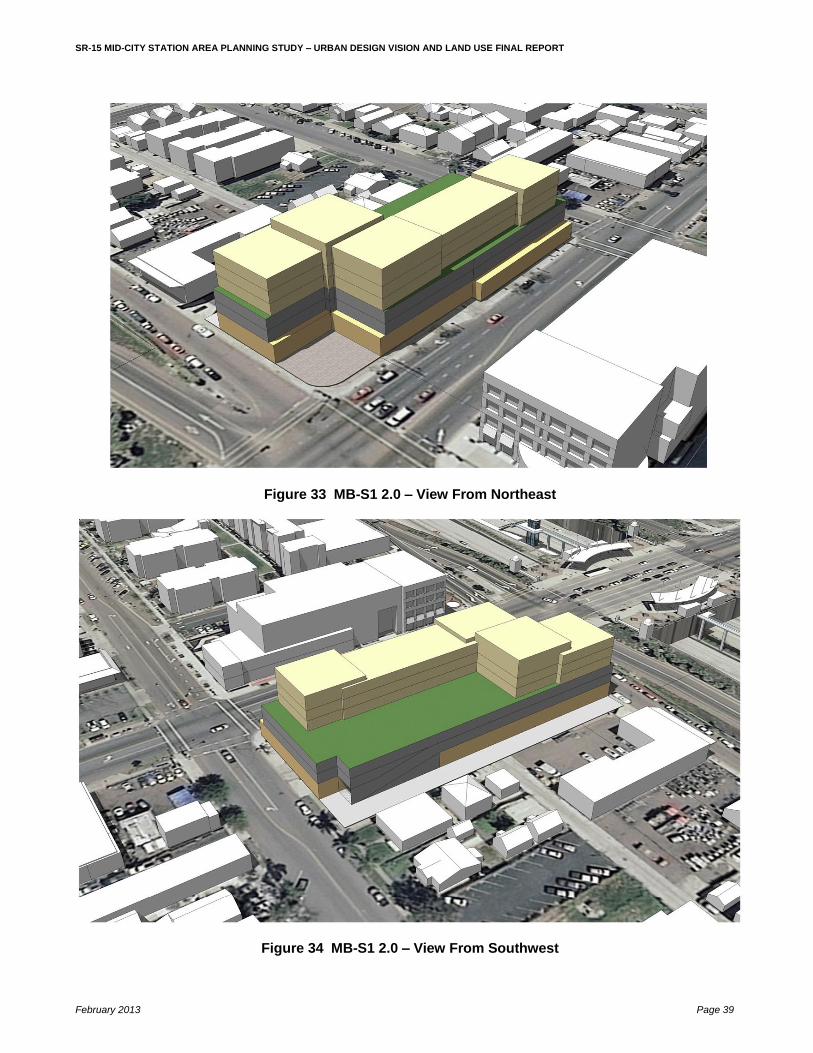
MB-S1 2.0 MB-S1 2.0 is a high-rise, mixed-use development adjacent to the University Avenue BRT station. More specifically, it is located on a 42,800 square-foot (0.98 acre) site the south side of University Avenue, immediately west of 40
th Street/SR-15 southbound on-ramps, and east of 39
th Street.
The six-story, approximately 65-foot high, development would accommodate 32,079 square feet of retail and 54 dwelling units in 53,521 square feet. Parking for 148 vehicles would be located on the second and third floors. The residential units would be located on floors 4, 5, and 6. An outdoor living area for the residents would be located on the roof of the third floor. Views of the development from the northeast and southwest are shown in Figure 32 and 33. A cross section looking west is shown in Figure 34, with floor plans shown in Figure 35 and a photo of a representative example in Figure 36. As shown in Figure 30 a public plaza of approximately 50 feet by 55 feet would be located at the intersection of University Avenue and 40
th Street/SR-15 on-ramps.
SR-15 MID-CITY STATION AREA PLANNING STUDY – URBAN DESIGN VISION AND LAND USE FINAL REPORT
February 2013 Page 39
Figure 33 MB-S1 2.0 – View From Northeast
Figure 34 MB-S1 2.0 – View From Southwest

SR-15 MID-CITY STATION AREA PLANNING STUDY – URBAN DESIGN VISION AND LAND USE FINAL REPORT
February 2013 Page 40
Figure 35 MB-S1 2.0 – Section Looking West
Figure 36 MB-S1 2.0 – Floor Plans

SR-15 MID-CITY STATION AREA PLANNING STUDY – URBAN DESIGN VISION AND LAND USE FINAL REPORT
February 2013 Page 41
Figure 37 Example of MB-S1 Massing
MA5 2.0 TA11 MA5 2.0 TA11 is a mid-rise, mixed-use development on El Cajon Boulevard. More specifically, it is located on 28,600 square-foot (0.66 acre) site at the northeast corner of El Cajon Boulevard and 41
st Street.
The portion fronting onto El Cajon Boulevard would be three stories and approximately 35 feet high. This would accommodate 8,258 square feet of retail on the ground floor and 17 dwelling units in 16,542 square feet on levels 2 and 3. The rear portion, which fronts on 41
st Street, would be a maximum of four stories with a height of 40 feet.
This would accommodate 27 dwelling units in 27,400 square feet. A 2-level parking structure accommodating 83 vehicles is proposed to serve the entire development. An outdoor living area for the residents would be located on the roof of the parking structure. The combined development would accommodate 8,258 square feet of retail, 44 dwelling units, and parking for 83 vehicles. Views of the development from the southwest and northeast are shown in Figures 37 and 38. A cross section looking west is shown in Figure 39, with floor plans shown in Figure 40 and photos of representative examples shown in Figures 41 and 42.

SR-15 MID-CITY STATION AREA PLANNING STUDY – URBAN DESIGN VISION AND LAND USE FINAL REPORT
February 2013 Page 42
Figure 38 MA5 2.0 TA11 – View From Southwest

SR-15 MID-CITY STATION AREA PLANNING STUDY – URBAN DESIGN VISION AND LAND USE FINAL REPORT
February 2013 Page 43
Figure 39 MA5 2.0 TA11 – View From Northeast
Figure 40 MA5 2.0 TA11 – Section Looking West

SR-15 MID-CITY STATION AREA PLANNING STUDY – URBAN DESIGN VISION AND LAND USE FINAL REPORT
February 2013 Page 44
Figure 41 MA5 2.0 TA11 – Floor Plans
Figure 42 Example 1 of MA5 2.0

SR-15 MID-CITY STATION AREA PLANNING STUDY – URBAN DESIGN VISION AND LAND USE FINAL REPORT
February 2013 Page 45
Figure 43 Example 2 of MA5 2.0

SR-15 MID-CITY STATION AREA PLANNING STUDY – URBAN DESIGN VISION AND LAND USE FINAL REPORT
February 2013 Page 46
RA2 .75 RA2 .75 is a low-rise, residential development adjacent to Teralta Park. More specifically, it is located on a 43,000 (0.99 acre) square-foot site on the north side of Polk Avenue between Teralta Park on the west and 41
st Street on the east.
The three-story, approximately 30-foot high, development would accommodate 32 town homes in 32,250 square feet. Eight units each would front onto Teralta Park, Polk Avenue, 41
st Street, and a walkway along
the north edge of the development. Surface parking for 48 vehicles would be located in the interior of the development in private garages located within each unit, accessed from the rear. Views of the development from the southwest and northeast are shown in Figures 43 and 44. A cross section looking north is shown in Figure 45, with floor plans shown in Figure 46.
Figure 44 RA2 .75 – View From Southwest

SR-15 MID-CITY STATION AREA PLANNING STUDY – URBAN DESIGN VISION AND LAND USE FINAL REPORT
February 2013 Page 47
Figure 45 RA2 .75 – View From Northeast
Figure 46 RA2 .75 – Section Looking North

SR-15 MID-CITY STATION AREA PLANNING STUDY – URBAN DESIGN VISION AND LAND USE FINAL REPORT
February 2013 Page 48
Figure 47 RA2 .75 – Floor Plans
3. CONCLUSION
This report presents a vision for a viable, sustainable community in Mid City centered around the two proposed SR-15 BRT stations at El Cajon Boulevard and University Avenue. If properly implemented it will take advantage of the planned transit facilities and services to spur land use improvements in the areas near the stations in support of Transit-Oriented Development (TOD). The intense development and public improvements envisioned, of course, are predicated upon a recovery in the market. For the interim, however, the report also identifies many actions which can be undertaken by the residents working with the City to create a lively, more attractive and liveable community immediately with minimal cost. In addition to the immediate benefits to the residents, it is anticipated that these interim actions focusing upon improving the quality of life within the community will also serve as a catalyst for the ultimate development as envisioned in this report.