springs, caves and the rural landscape in hittite … springs, caves and the rural landscape in...
TRANSCRIPT

1
Springs, Caves and the Rural Landscape in Hittite Anatolia: Yalburt Yaylası Archaeological Landscape Research Project (Ilgın, Konya)
Preliminary Results of the 2011 Season1
Ömür Harmanşah and Peri Johnson
1. Introduction
Springs, caves, sinkholes and dolines are fundamental components of the Anatolian karstic landscapes
and have long been associated with a multiplicity of cultural meanings, became central places of
everyday life and served as symbolically charged spaces of stories and mythologies. The accumulation of
local knowledge about the rural environment and the geographical imagination of local communities are
first of all shaped by the stories of such powerful locales, while the roads that cross the landscape and
areas of settlement are often configured around them. Therefore for archaeological survey projects,
such places are mines for exploring long term, dense cultural activity, even though they are frequently
neglected when compared to settlement mounds, burials and burial mounds (tumuli), fortresses or
hilltop settlements, and similar sites. At the same time, springs and other karstic features are associated
with a particularly long sense of time, an alternative temporality, which allows them to be always linked
to deep pasts, ancient times and collective memories. They carry the traces of the deep local histories.
Since 2010, Yalburt Yaylası Archaeological Landscape Project has focused its research questions on an
area where karstic geologies, local social practices, memory and local culture come together.
Yalburt Project is a diachronic regional survey project centered at Yalburt Yaylası Hittite Spring
Monument and covers the entire subdistrict territory of Ilgın and partially that of Kadınhanı and Yunak.
1 This is a translation of the following published article: Ömür Harmanşah and Peri Johnson; 2013. “Pınarlar, Mağaralar, ve Hitit Anadolu’sunda Kırsal Peyzaj: Yalburt Yaylası Arkeolojik Yüzey Araştırma Projesi (Ilgın, Konya), 2011 Sezonu Sonuçları.” 30. Araştırma Sonuçları Toplantısı. Ankara: T.C. Kültür ve Turizm Bakanlığı Kültür Varlıkları ve Müzeler Genel Müdürlüğü, 2. Cilt: 73-84.

2
Designed as a five-year project, it is institutionally based at and financially supported by Brown
University (USA)2. The first season of Yalburt Survey Project was carried out in the summer of 2010 (See
Harmanşah and Johnson 2012) while the second season of took place between 19th July and 22nd August
2013 for the duration of five weeks3.
The survey region of Yalburt Project, is a pastoral highland landscape approximately 70 km.
northwest of modern town of Konya and includes the Ilgın and Atlantı plains, Çavuşçu Lake basin, and
the mountainous landscapes that surround these hydrologically connected tectonic basins. It falls
directly to the west of the Central Anatolian Plateau. The region is crossed by the most important route
that connects Konya, known as Ikkuwaniya in the Hittite geography, and the fertile Konya plain to the
west. As discussed in greater detail in last year’s report, it is well known from a variety of historical
sources that this route is one of the busiest routes in antiquity especially used for military purposes, 2 The funding for the 2011 season came from Brown University’s Department of Egyptology and Ancient Western Asian Studies, Joukowsky Institute for Archaeology and the Ancient World and the Richard B. Solomon Faculty Research Grant. Additionally Ilgın Municipality has sponsored the transportation of two stone pieces to Akşehir Museum grounds from the survey unit Şangır Mağaza (a.k.a. “Körkuyunun Mağaza”) which has been registered in 2011 as a 1st degree archaeological site and natural heritage site by Konya Regional Preservation Council at our request. Ilgın Sugar Factory has allowed our team to use one of its buildings as our survey laboratory, therefore contributed to the project in that way. We are grateful to all mentioned institutions. 3 We are grateful to the Turkish Ministry of Culture and Tourism’s General Directorate of Cultural Assets and Museums for issuing the official permit for the project, especially to Mr. Melik Ayaz, Aliye Usta and Levent Vardar for their help and support, to our government representative Gülsüm Baykal from Eskişehir Archaeological Museum, the staff at Akşehir Museum and Konya Archaeological Museum who supported our work with their openness and relentless help, to Ilgın Sugar Factory for housing our team in their guesthouse and allowing us to use extra spaces for our laboratory work and study offices, finally to our survey team, especially PhD candidates Müge Durusu-Tanrıöver and Türkan Pilavcı, and to Bochay Drum, who made a big difference with his innovative wok on indigenous vegetation. Without their help and unyielding work ethic, this project would not have been possible. Prof. Ben Marsh, Professor of Geography and Environmental Studies at Bucknell University has been known with his influential geomorphological work associated with major archaeological projects such as Gordion/Yassıhöyük and Hattuša/Boğazköy. In 2011 he kindly accepted our invitation for collaboration in Yalburt Project and worked with the Yalburt team for four weeks, and investigated the geology and geomorphology of the region. His presence as a professor of cultural landscapes has been transformative for the project. We are grateful to him on all fronts. Additionally, with the official permission of the Ministry of Culture and Tourism, Yalburt team studied, documented and digitized the archival materials and inventoried artifacts from Ankara Anatolian Civilization Museum’s excavations and architectural restoration work at Yalburt Yaylası, directed by Raci Temizer between 1970 and 1975. The archival materials from the 1970s excavations included excavation notebooks, drawings, reports, photographs, and inventoried objects that are kept in the archives of the Ankara Anatolian Civilizations Museum. We thank the staff at the Ankara Museum who were always generous with their time and energy. These materials are being prepared for publication by our team within the framework of Yalburt Survey Project.

3
especially from the Hittite Great King Tudhaliya IV’s Lukka campaign, the campaign of the Persian army
under the command of Cyrus the Younger witnessed by Xenophon, and finally Mustafa Kemal Paşa’s
famous Ilgın Plain maneuver in the spring of 1922. In the Hellenistic Period, the ancient road coming
from Ephesus/Apasa connected to Ilgın, passing through Afyon and this was known as the Common
Road. In the marble inscription from Mahmuthisar village that documents and monumentalizes the
Pergamene king Eumenes II’s letters to the citizens of Tyriaion (usually identified as Ilgın by ancient
historians) emphasizes the settlement of mercenary soldiers and the economic and political autonomy
granted to the city while it does not mention the local inhabitants or those who may have been moved
from Ilgın’s countryside to Tyriaion4. A similar political power-local community relationship existed at
the time of the Hittite Empire, between the Hittite Great Kings and the local inhabitants of the region.
Yalburt Project seeks to investigate precisely how this relationship was reflected in settlement patterns
and material culture, while considers the concept of place as its core research problem.
In the previous year’s report, we had proposed that an agricultural rehabilitation based on
irrigation and a new settlement program was implemented by the Hittite powers within the survey
area, referred as Pedassa at the time of Tudhaliya IV and Phrygia Paroreios in classical antiquity
(Harmanşah and Johnson 2012). We had based this argument on the evidence from Yalburt Yaylası
where Tudhaliya IV had constructed a monumental pool and from Köylütolu Yayla where a massive
earthen dam was constructed in Büyük Büvet Mevkii in the midst of agricultural fields. Pedassa region
that is known from Hittite texts was separated from the Hulaya River Land (further south in the area of
Beyşehir Lake and Çarşamba River) by Sultan Mountains, identified as Mt. Huwatnuwanda, and Pedassa
was futhermore neighbors with Siyanta River which is generally thought to correspond to Upper Sakarya
4 Jonnes 2002: 61, 85 and Text 393. The inscription was found in Mahmuthisar village in October 1997 and is currently in the back garden of Konya Archaeological Museum. Mahmuthisar village is 15 km. to the southeast of Ilgın on the lower terraces of Sultan Mountains and is included in Yalburt Project’s study area. The inscription is a white marble stele that is 1.35 m. high, 0.67 m wide, and 0.22 m thick and features a well preserved 52 line inscription published by Jonnes and Ricl (1997).
4
River (Barjamovic 2011: 371-372; Hawkins 1995: 51, n. 177). Furthermore, the Ulmi-Tešup treaty of
Hattušili III and Tudhaliya IV’s treaty with Kurunta of Tarhuntassa both start their description of the
Hatti-Tarhuntassa borders by the definition of the region Pedassa (Hawkins 1998: 22). In such a
strategically important frontier landscape, Tudhaliya IV’s construction of ideologically powerful
monuments on the one hand, and his intervention into the settlement systems by founding new centers
and implementing irrigation programs is part of a long term narrative based on archaeological evidence.
Our main goal in 2011 season was to investigate such landscape interventions during the Late Bronze
Age and to see if this could be observed in the long term dynamics of settlement in the region. At the
same time, we also aimed at studying the relationship between local cultures and political power from
the point of view of spatial politics and local identity.
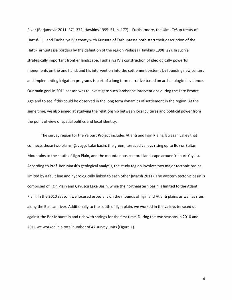
The survey region for the Yalburt Project includes Atlantı and Ilgın Plains, Bulasan valley that
connects those two plains, Çavuşçu Lake basin, the green, terraced valleys rising up to Boz or Sultan
Mountains to the south of Ilgın Plain, and the mountainous pastoral landscape around Yalburt Yaylası.
According to Prof. Ben Marsh’s geological analysis, the study region involves two major tectonic basins
limited by a fault line and hydrologically linked to each other (Marsh 2011). The western tectonic basin is
comprised of Ilgın Plain and Çavuşçu Lake Basin, while the northeastern basin is limited to the Atlantı
Plain. In the 2010 season, we focused especially on the mounds of Ilgın and Atlantı plains as well as sites
along the Bulasan river. Additionally to the south of Ilgın plain, we worked in the valleys terraced up
against the Boz Mountain and rich with springs for the first time. During the two seasons in 2010 and
2011 we worked in a total number of 47 survey units (Figure 1).
5
Figure 1. Yalburt Survey Project survey units of 2010-2011 seasons
6
2. Geomorphology: Irrigation projects, settlement history and rural landscape in Ilgın
19th century traveler W. J. Hamilton speaks about encountering plague in marshy Ilgın (Hamilton
1842, vol. 2: 187-190). This rural landscape points to an agricultural landscape that has deteriorated and
lost its fecundity as a result of alluvial soils that were deposited in the plains and poorly drained fields.
The geological and geomorphological work carried out by Prof Ben Marsh or Bucknell University with
the assistance of Brown University graduate Bochay Drum during the 2011 season on the one hand
provided us ample evidence for landscapes that have been slowly buried since antiquity, and on the
other hand important guidelines for the choice of location for intensive survey units that would be most
productive. As Marsh explains in his detailed report, these investigations especially focused on
geomorphological change in the Ilgın landscapes since antiquity, the impact of these changes on
settlement systems, and the changing land use in agriculture and settlement strategies since prehistory
(Marsh 2011).

7
Figure 2. Landscape regions within the survey area (Ben Marsh)
Figure 3. Contemporary landuse (green is row crops) compared to mound distribution (Ben Marsh).

8
At Çayır Höyük, which is one of the largest known mounds in Ilgın Plain, Hellenistic pottery was
collected in a deposit 2 ,5 m. below the current level of the plain (Figure 4). At Karatepe Höyük located
in the Atlantı Plain, Roman pottery was collected 2.5 m. below the current alluvial level. The alluvial
deposits in these two plains and in Bulasan valley bottom must have developed rapidly with the impact
of agricultural cultivation, forest clearing, erosion and irrigation projects. We observe that today’s
intensive agricultural use areas do not correspond to the areas where settlement mounds cluster,
therefore this makes us think that today’s cultivation zones with irrigation were probably not in
agriculturally used in antiquity. These areas constitute poorly drained lake deposits: this is especially the
case to the north of the Çavuşçu Lake basin. In antiquity, we are suggesting that these areas were fairly
waterlogged and most likely marshy. Therefore, it must have been impossible to practice agriculture in
these areas through the use of traditional technologies. Furthermore, in the areas where settlement
mounds cluster, we don’t see significant scales of irrigated agriculture. This is especially observed in the
environs of the archaeological sites of Ören Çeşmesi, Osmancık and Çeşmecik. These areas are rich in
water sources, however they lack flat landscapes that are more amenable to contemporary technologies
of cultivation (Figure 3). However, past cultivation systems must have been much more efficient in the
use of small and dispersed pieces of land (Marsh 2011).

9
Figure 4. Çayır Höyük. Sediment accumulation and alluvial fill near the mound of Çayır Höyük. (Photograph: Ben Marsh)
In the 20th century, State Waterworks Department (D.S.İ.)’s various irrigation projects both
Atlantı Plain and Ilgın Plain were implemented in 1960s and in 1990s with the damming of Çavuşçu Göl
from the north and the south and its transformation into a reservoir (Özen 1975). These projects were
partially successful and partially failed. In the Hittite Empire period, similar irrigation projects were tried
with different technologies (Emre 1993). The channeling of the water source at Ören Çeşmesi and the
construction of Köylütolu Dam must be understood in this framework. Ben Marsh’s observations in his
2011 report was that Köylütolu Dam was in fact constructed over a sinkhole and most probably never
effectively used. Likewise no sedimentation has been attested in the small test bore using a hand-held
auger.

10
3. Changing Settlement Geography during the Late Bronze Age: An Archaeological
Assessment
Despite this possible failure in the implementation of the irrigation project, we observe an
important settlement pattern densification during the Late Bronze Age. It was understood that several
of these settlements were new foundations concentrating especially in Ilgın and Atlantı Plains, Bulasan
valley, and along other rivers and nearby springs. Because of the limitation of space, it would be
impossible to speak about all the survey units we have worked on, documented and collected surface
materials in 2011 season, however in the rest of this article, we will concentrate on settlements that are
particularly significant for the Late Bronze Age geography of settlement. The most important ones
among these archaeological sites are Boz Höyük, a single period Hittite Empire period settlement near
the modern town of Ilgın, Karaköy Kale Tepesi a fortress with well-preserved fortification walls and
onethat controls the narrow pass at the entrance of Bulasan River valley, Köprünün Küllük Höyük which
is a settlement about 3 km northeast of the Hittite fortress on a river terrace, Mahmuthisar Höyüğü
which is a high mound with one of the longest sequences on the valleys that descend Boz Dağ, İmircik
Tepe founded on Atlantı Plain, and the twin sites Dereköy Höyüğü and Macar Mevkii located on the road
that connected Yalburt Yaylası to Çavuşçu Lake basin (Figures 1 and 5).

11
Figure 5. Late Bronze Age settlements in Ilgın Plain and the southwest entry to Bulasan Valley
The first of these archaeological sites is Boz Höyük, located 2.3 km to the south of Ilgın city
center, and immediately east of the asphalt road that connects Ilgın to the villages Ormanözü and Çatak.
This asphalt road in fact destroyed part of the mound when it was constructed5. The stream that flows
from the direction of Balkı-Göstere and Harmanyazı villages and eventually pours into Bulasan River
most likely flowed pretty close to the site. In May and June 2011, Konya region received record level
precipitation of the last 60 years, therefore the state of overgrown vegetation limited our work at this
site. Furthermore, Ilgın Municipality continues to use the site as a construction dump, which lead to
extremely low visibility at the site. Therefore, our surface collection at the site was limited to the
ploughed fields in the periphery of the high mound, the frequently attested looters’ pits on the mound,
5 Prof. Hasan Bahar and his team have worked at this mound during their survey season in 1994. Bahar refers to this site as “Ilgın Höyük” (See Bahar 1996: 154).

12
and the irrigation canal sections and road cut. These visibility problems were in fact a major issue at
many of the sites during the 2011 season, continuously forcing us to rethink alternative surface sampling
methodologies at each new situation.
Figure 6. Selected examples of Boz Höyük ceramics.
Despite these difficulties, Boz Höyük offered a rich assemblage of surface finds especially thanks
to the recently ploughed field to the east of the mound which offered 100% visibility, and allowed us to
identify it as a new and rich urban foundation in the Hittite Empire Period. Despite the fact that the final
and thorough study of its ceramics is still under way, the preliminary analysis of the showed that Early
and Middle Bronze Age materials ar not attested at Boz Höyük, contrary to the other prominent Late
Bronze Age sites. For this reason, its ceramic tradition certainly does not overlap with the Assyrian
Colony Period site of Orta Tepe which was documented in 2010. Boz Höyük pottery is directly related to
the the Hittite Empire period wares of Kızılırmak (Halys) river basin and demonstrates a rich assemblage
from thin walled wares also known as eggshell ware to coarse wares. This group of ceramics dominated
light brown palace drabwares known from Boğazköy and other Hittite settlements are represented from
biege to mottled red and from white to white slipped, while string-cut bowls are also attested (Figure

13
6). Brown University Joukowsky Institute for Archaeology and the Ancient World phD candidate Müge
Durusu-Tanrıöver is currently working on this body of material for final publication6.
The second important archaeological site that we would like to discuss here is Köprünün Küllük
Höyük, located 3 km. northeast of Kale Tepesi: a low, flat or widely spread mound that rises only about
1-3 m. above the surrounding plain (Bahar 1996: 155)(Figure 5). Situated to the west-northwest edge of
the metavolcanic hill Küçük Tokmak Tepesi and in an area where Bulasan valley narrows, the Küllük
Höyük is squeezed between various modern irrigation canals, a bridge and an asphalt road, therefore
barely noticed. In the center of the mound, Chalcolthic, Early Bronze Age, Middle and Late Iron Age as
well as medieval period ceramics have been collected, while unusually no Hellenistic material was
obtained at all. The assemblage of pottery that caused much excitement among the team members
came from Locus 4 which was a corn field to the southwest of the site. The surface of this field has been
intensively and systematically surveyed with %50 coverage. The large amounts of Late Bronze Age
material that came from this locus are particularly wheel-made string cut cooking pots, large basins, a
rich collection Hittite common wares and fine palace wares known from Boğazköy and Boz Höyük.
Thirdly, we present the fortress at Karaköy Kale Tepesi, which was briefly discussed in last year’s
report. Kale Tepesi is located 3.7 km northwest of Köylütolu dam structure as the crow flies. It was built
at a strategically important pass that connects Ilgın Plain to the fertile Bulasan river valley, where the
limestone gorge through which Bulasan Çay flows narrows. The monumental citadel was constructed on
the northeastern slopes of a steep and impressive limestone hill (Figures 7-9). One of the most abundant
springs of the region emerges from the limestone-schist contact on the northwestern slopes of Kale
Tepesi. In the archaeological site, the most impressive architectural remains belong to the well
preserved walls of the fortress, built on the steep northwestern slopes of the limestone hill, built of
6 Our team is grateful to Ulf-Dietrich Schoop and Andreas Schachner for allowing Müge Durusu-Tanrıöver to study Boğazköy ceramics collection and for their guidance with Yalburt survey materials.

14
monumental ashlar masonry that did not involve the use of clamps or mortar. No chisel marks are
visible on the surfaces of the blocks either, pointing to the exclusive use of stone hammers to finish
surfaces. On one side, the walls are preserved to a height of 8-9 courses, and the height of the courses
vary between 60 and 85 cm (Figure 9).
Figure 7. Karaköy Kale Tepesi and the nearby archaeological landscape, with survey loci marked
Having carried out a detailed study of the ashlar stone masonry of the fortress, we have noted
that the masonry techniques are closely related to the Yalburt Spring monument, based on a series of
observations on the close fitting details of corner blocks, the vertical relationship between the courses,
the monumental size an d shape of the blocks as well as the finishing techniques of various surfaces.

15
Based on these observations, it is possible to suggest confidently that the fortress must belong without
doubt to a pre-Hellenistic date and most likely to the Hittite Empire Period7.
Figure 8. Plan of Kale Tepesi fortress (Ömür Harmanşah and Peri Johnson)
Following the 2011 operations at Kale Tepesi that included surface collection, architectural
documentation, topographic survey and ceramic analysis, we documented architectural remains on the
western, northern and northeastern slopes of the Kale Tepesi hill and shown that the site was settled
7 We are grateful to Martin Bachmann of the German Archaeological Institute for discussing the dating of the masonry with us. For a similar proposal for dating of this fortress to the Late Bonze Age, see Yakar et al. 2001: 716.

16
continuously from the Hittite Empire period all the way to the Roman Period. 200 m. south of the
fortress, on the northeastern terraces of the limestone hill, we systematically surveyed a series of fields
with 50% coverage and surveyors walking 4 m. apart. In two of the loci we have covered in this way,
Locus 4 and Locus 5, Hittite Empire Period ceramics have been collected (Figure 7). This ceramic
assemblage consists especially of darbware light brown bowls, and a cooking pot with a string
decoration below the rim (Figure 10). In the vicinity of the fortress, Early and Middle Bronze Age
ceramics were also found although very rarely. In the lower slopes of the hill, the ceramic concentration
shifts towards the Hellenistic Period. However within the confines of the buildings with stone
foundations on the summit of the Kale Tepesi hill, Late Bronze Age ceramics were also collected.
Figure 9. Kale Tepesi fortress Locus 7 Section (ashlar masonry detail from east face of the eastern north-south wall) (Ömür Harmanşah)
17
When Prof. Ben Marsh studies the blocks that were used on the fortifications at Kale Tepesi, he
concluded that the stones could not have been quarried locally from the limestone bedrock of the hill
itself, since he identified the ashlar blocks to be marl and quite different than the locally available stone
at the site. Following this observation in 2011 season, our team surveyed the nearby landscape for marl
sources, and made an exciting discovery at Yıldıztepe, approximately 1.2 km south-southeast of Kale
Tepesi. At Yıldıztepe, our team with the leadership of of Prof. Marsh identified an ancient quarry, which
represents one of the extremely rare outcrops of marl limestone in the region. During our preliminary
observations several quarried galleries are observed, where a dense concentration of green gabbro ( a
very hard volcanic stone usually used for stone hammers in the Bronze Age) chips and fragments were
found. The absence of quarrying marks specific to metal chiseling, preponderance of drill holes and the
abundance of green gabbro stone hammer fragments at the site suggested that we had located a Bronze
Age quarry. Because this discovery came right at the end of the 2011 season, the study of the
relationship between Yıldıztepe and Kale Tepesi as well as the detailed architectural documentation of
the site were postponed until 2012 season.

18
Figure 10. Karaköy Kale Tepesi, Late Bronze Age pottery samples from Locus 4 and Locus 5.
Mahmuthisar Höyüğü, visited for the first time in 2011 saeson, is one of the very rare mounds
with one of the longest sequences of habitation in antiquity in Ilgın and its environs. Located 15 km.
southeast of the modern town of Ilgın. It is located on a fertile and water rich valley that cascades down
from Sultan Mountains. It is especially well positioned on a high terrace at an area where the valley
narrows down and the site overlooks the Mahmuthisar Çayı streambed. The impressive spring at Yeşilgöl
about 1 km. upstream (south) of Mahmuthisar and the several minor springs in the vicinity of
Mahmuthisar feeds this stream, which eventually flows into the Ilgın Plain. Mahmuthisar is located on a
relatively high elevation (1100 m.) such that its current seasonal pastoral settlements and camps (yayla)
are located in lower elevations. The current Mahmuthisar village is built on a large portion of the top of
the Mahmuthisar mound. As far as we were able to observe and document, the fairly large mound is
450 m. long and 170 m. wide and stretches on a northwest-southeast axis. The higher southeastern
portion of the mound does not have any modern village buildings on it and was overgrown with a thick
cover of thistles and other vegetation. In the areas that we were able to access to surface materials,
the ceramic assemblage suggests rich variety and continuous sequence from Early Bronze Age to
19
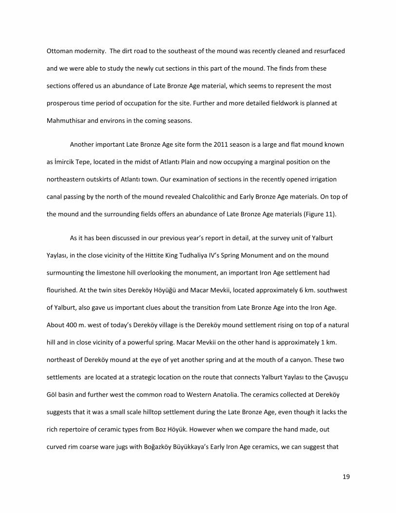
Ottoman modernity. The dirt road to the southeast of the mound was recently cleaned and resurfaced
and we were able to study the newly cut sections in this part of the mound. The finds from these
sections offered us an abundance of Late Bronze Age material, which seems to represent the most
prosperous time period of occupation for the site. Further and more detailed fieldwork is planned at
Mahmuthisar and environs in the coming seasons.
Another important Late Bronze Age site form the 2011 season is a large and flat mound known
as İmircik Tepe, located in the midst of Atlantı Plain and now occupying a marginal position on the
northeastern outskirts of Atlantı town. Our examination of sections in the recently opened irrigation
canal passing by the north of the mound revealed Chalcolithic and Early Bronze Age materials. On top of
the mound and the surrounding fields offers an abundance of Late Bronze Age materials (Figure 11).
As it has been discussed in our previous year’s report in detail, at the survey unit of Yalburt
Yaylası, in the close vicinity of the Hittite King Tudhaliya IV’s Spring Monument and on the mound
surmounting the limestone hill overlooking the monument, an important Iron Age settlement had
flourished. At the twin sites Dereköy Höyüğü and Macar Mevkii, located approximately 6 km. southwest
of Yalburt, also gave us important clues about the transition from Late Bronze Age into the Iron Age.
About 400 m. west of today’s Dereköy village is the Dereköy mound settlement rising on top of a natural
hill and in close vicinity of a powerful spring. Macar Mevkii on the other hand is approximately 1 km.
northeast of Dereköy mound at the eye of yet another spring and at the mouth of a canyon. These two
settlements are located at a strategic location on the route that connects Yalburt Yaylası to the Çavuşçu
Göl basin and further west the common road to Western Anatolia. The ceramics collected at Dereköy
suggests that it was a small scale hilltop settlement during the Late Bronze Age, even though it lacks the
rich repertoire of ceramic types from Boz Höyük. However when we compare the hand made, out
curved rim coarse ware jugs with Boğazköy Büyükkaya’s Early Iron Age ceramics, we can suggest that

20
there is most probably continuity of habitation during the Early Iron Age at Dereköy. The Late Bronze
Age ceramics at Macar Mevkii resembles Beycesultan materials with their central burnishing (Figure 12).
Figure 11. İmircik Tepe (Atlantı) Late Bronze Age ceramics

21
Figure 12. Dereköy Höyüğü and Macar Mevkii Late Bronze Age-Early Iron Age transitional ceramics.
4. Conclusions
The frontier region known as Pedassa at the time of the Hittite Empire was a region into which
the Hittite kings made military interventions while also investing through agricultural programs and
commemorative monuments. This phenomenon which was already known through Yalburt Yaylası and
Köylütolu Yayla monuments and their inscriptions, has been shown to have deeply impacted the local,
micro-geographic settlement dynamics. This transformation was further consolidated with the
foundation of settlements such as Boz Höyük, İmiricik tepe, Köprünün Küllük Höyük, and Mahmuthisar
along rivers or nearby springs. Karaköy Kale Tepesi which is situated in the approximate center of the
geography of Ilgın region and attracts attention with its monumental architecture, is a good candidate to
have served as the administrative center of Pedassa. In the Early and Middle Iron Age, these low
elevation riverine settlements are abandoned, while local communities occupied higher elevation hilltop
settlements such as Şarampol Tepe, as reported in 2010. It is important to note that precisely such a

22
move may have taken place between the two adjacent settlements of Orta Tepe and Şarampol Tepe,
where the Middle Bronze (Assyrian Colony Period) and Early Hittite settlement at Orta Tepe is
abandoned in preference for the hilltop at Şarampol Tepe, 500 m. to the north. At the same time,
monuments and structures such as Yalburt Spring Monument and Kale Tepesi fortress which occupy a
powerful place in collective memory remained important during the Iron Age and the Hellenistic Period
with increasing interest which may be associated with particular local memory practices and the local
relationship with the Hittite past. In this way, the Hittite heritage took a central role in cultural practices
of the post-Hittite communities.
There is no doubt that regional archaeological landscape projects will have a great role in the
writing of the long-term social, cultural, political, and economic history of the Central Anatolian
countryside. While this history is being written, we must balance our interest in large cities and
monumental settlements which have always been favored by tradition archaeological practices, with the
colorful and complex worlds of the countryside which we have long marginalized with the notion of the
“provincial” (taşra). We must address its very nature being not static, but to the contrary always shaken
by the fast paced changes in the landscape. We can only understand the rapidly changing nature of rural
landscapes, on the one hand through the use of methodologies of ecological history and the study of
archaeological evidence, and on the other hand listening and seriously paying attention to the local
knowledge of contemporary communities about these landscapes. This rich history of the countryside
can be read in the stories of places and localities, pastures and plains, reed marshes by the lakes and the
caves on top of the mountains, the gushing mouths of the springs and the dried wells.

23
Bibliography
Bahar, Hasan; 1996. “Ilgın çevresi höyükleri 1994,” XIII. Araştırma Sonuçları Toplantısı I. Cilt. Ankara: Kültür Bakanlığı Yayınları, 153-184.
Barjamovic, Gojko; 2011. A Historical Geography of Anatolia in the Old Assyrian Colony Period. The Carsten Neibuhr Institute of Ancient Near Eastern Studies. Copenhagen: University of Copenhagen, Museum Tusculanum Press.
Emre, Kutlu; 1993. “The Hittite dam of Karakuyu,” Essays on Anatolian archaeology içinde. H.I.H. Prince Takahito Mikasa (ed.). Bulletin of the Middle Eastern Culture Center in Japan vol VII. Wiesbaden: Harrassowitz Verlag, 1-42.
Hamilton, William John; 1842. Researches in Asia Minor, Pontus and Armenia: With Some Account of Their Antiquities and Geology. London: J Murray.
Harmanşah, Ömür ve Peri Johnson; 2012. “Yalburt Yaylası (Ilgın, Konya) Arkeolojik Yüzey Araştırma Projesi, 2010 Sezonu Sonuçları,” 29. Araştırma Sonuçları Toplantısı içinde. Adil Özme (ed). Ankara: T.C. Kültür ve Turizm Bakanlığı Kültür Varlıkları ve Müzeler Genel Müdürlüğü Yayın No: 153/2. Cilt 2: 335-360.
Hawkins, J. David; 1995. The Hieroglyphic Inscription of the Sacred Pool Complex at Hattusa. Studien zu den Boğazköy-Texten: Beiheft, Volume 3. Wiesbaden: Otto Harrassowitz Verlag.
Hawkins, J. David; 1998. “Tarkasnawa King of Mira 'Tarkondemos', Boğazköy Sealings and Karabel” Anatolian Studies 48: 1-31.
Jonnes, Lloyd (ed.); 2002. Inscriptions of the Sultan Dağı I (Philomelion, Thymbrion/Hadrianopolis, Tyraion). Inschriften Griechischer Städte aus Kleinasien Band 62. Bonn: Dr. Rudolf Habelt GMBH.
Jonnes, Lloyd and Marijana Ricl; 1997. “A new royal inscription from Phrygia Paroreios: Eumenes II grants Tyriaion the status of a polis.” Epigraphica Anatolica 29: 1-30.
Marsh, Ben; 2011. “Preliminary and interim report, 2011 Season.” Yalburt Survey Archives.
Özen, Necati; 1975. Ilgın Projesi Planlama Revizyon Raporu. Ankara: Devlet Su İşleri Genel Müdürlüğü.
Yakar , J.; A.M. Dinçol; B. Dinçol; A. Taffet; 2001. “The territory of the appanage kingdom of Tarhuntassa. An archaeological appraisal.” Akten des IV Internationalen Kongresses für Hethitologie Würzburg, 4.-8. Oktober 1999 içinde. G. Wilhelm (der.) Wiesbaden: Harasssowitz Verlag, 711-720.

24
Appendix I: Site Catalogue
101. Yalburt Yaylası
Work was carried out at Yalburt in one day. Intensive 50% percent coverage survey in the area above
the Hittite pool (Locus 17) was carried out. This is the bedrock slope between the base of the mound
and the Hittite pool (Locus 17). The purpose of this intensive pickup was to complement our assemblage
of our EBA pottery that was collected and reported in the previous season. It is likely that this is the date
for the building excavated underneath the Phrygian house by Raci Temizer and his team. Originally we
intended to carry out this intensive survey below the Hittite pool on the East side of the asphalt road,
between the road and the concrete spring sheep trough. However the dense ground cover of 2 m high
thistles prohibited this survey collection in this area. In future years pickup in this area might yield
further EBA materials. In Locus 17, the ceramics reflect what we would anticipate downslope from the
excavated mound with 4th c. BCE through the end of the Hellenistic period (around Year 0). Strong
representation and high concentration are observed of common and coarse black slipped graywares
familar from Şarampol Tepe assemblage. However much to our surprise we were able to pick up 5 body
sherds of a ware that is either EBA or Chalcolithic in date. This allows us to be much more confident in
our dating of the early cultural activity around the spring. The fact that these early sherds were found
above the spring resting on exposed bedrock suggests that the interventions in the area of the Hittite
pool were extensive enough to place material uphill from the Hittite Pool (See Figure 13 for a
distribution of the loci and the location of various archaeological features).

25
Figure 13. Yalburt Yaylası. Distribution of Loci
103. Şangır Mağaza
Brief visit to Şangır Mağaza resulted in the investigation of further architectural fragments and the
collection of three new figurine fragments and ceramics. We also investigated the series of building
foundations in the area surrounding the mouth of the sinkhole. We identified a monumental compound
or possibly sanctuary wall enclosing the mouth of the sinkhole while a series of minor structures or
rooms attached to the enclosure wall (Figure 14). However the roof tiles that were discovered in 2010 in
the sinkhole could not belong to these structures. These red slipped large tiles must have belonged to a
much more monumental and well-built temple-like structure. The architectural fragments that were
studied in the sinkhole include column drums, column bases, and entablature fragments suggest to us
that there must have been a naiskos type small scale temple within the sinkhole in the upper western

26
section. The angle of deposition of ceramics, figurines and bones in the northern section of the sinkhole
suggests that feasting remnants and figurines were thrown from the west down into the deeper
northern sections of the sinkhole.
Figure 14. Şangır Mağaza. Achitectural remains around the sinkhole. (Peri Johnson and Bochay Drum)
Transfer of two architectural fragments to Akşehir Museum from the site was facilitated by Ilgın
Municipality. One marble funerary stele with inscription (Figure 15) and a marble column base (Figure
16) was reported to the Konya Regional Preservation Council, who found our request appropriate and
grated the official permission to house these two architectural pieces in Akşehir Museum (Taş Medrese)
courtyard. In order to lift the pieces from the 25 m. deep sinkhole, our project had to hire a crane. This
was partially funded by Ilgın Municipality and partially by Brown University. Afterwards, the blocks were
transported from Ilgın to Akşehir on an Ilgın Municipality fire truck.
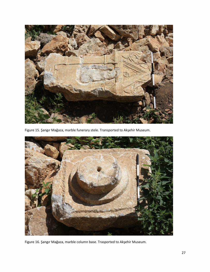
27
Figure 15. Şangır Mağaza, marble funerary stele. Transported to Akşehir Museum.
Figure 16. Şangır Mağaza, marble column base. Trasported to Akşehir Museum.

28
104. Kale Tepesi
The work in 2011 at Kale Tepesi was dedicated in part to finding the pre-Iron Age ceramics at
the survey unit (See Figure 17 for a distribution of the loci). Intensive collection of pits within the limits
of the fortress was carried out with this goal in mind. Pick up was carried out in two pits inside the
northern terrace wall of the fortress (Loci 11 and 12), and a pit inside and abutting the west wall of the
fortress (Locus 13). Only the last pit (Locus 13) produced anything other than Hellenistic and Roman
material. In Locus 13, a couple of Late Bronze Age sherds were picked up. The distribution pattern of
scant LBA ceramics overwhelmed by an abundance of Hellenistic and Roman material mirror the pattern
elsewhere in the site such as the area uphill (S-SW) of the fort, except for the limited area further south-
southeast of the fortress. This limited area consists of a series of agricultural fields (some left fallow in
recent years) that are below and to the west of exposed limestone bedrock of Kale Dağı. The fields in
the uppermost terraces of these fields (Locus 5, 15 and 16) offer a majority of LBA sherds and our only
diagnostic Early Iron Age from Kale Tepesi. Downslope from these fields, LBA material gradually
becomes more scant and the surface assemblage becomes composed of Iron Age, Hellenistic, Roman
and medieval (e.g. Locus 1). Locus 1 was systematically walked in 2010 season. In Locus 2 (the general
area within the limit of the fortress but not including the pits), while the majority of the material is
Hellenistic and Roman, the LBA is represented as well in addition to a few EBA or Chalcolithic body
sherds which is not surprising considering the proximity of the fortress to the fossil mouth of the spring.

29
Figure 17. Kale Tepesi. Intensively surveyed loci (Peri Johnson)
We also investigated the summit of Kale Dağı, Loci 9 and 10. In this area, the sherds are eroded
and most lack surfaces. As a result, very little difference can be found between the various mica-schist
common and coarse wares that dominate the assemblage. However there are several Hittite flat bowls
in addition to various Hellenistic graywares. High on Kale Dağı, just to the south of these loci are two
fossil spring mouths, one of which was designated as Locus 17. The ceramics in this area consist only of
non-diagnostic oxidized mica-schist coarse wares with eroded surfaces. To the west of the Kale Dağı, on
the contemporary bed of Bulasan Çayı. Prof. Ben Marsh located a monumental wall that crossed the
streambed and that was built of ashlar blocks similar to the the stones used for the construction of the
fortress. Our further investigation of the area allowed us to locate a portion of an ancient street feature

30
and a rock cut stepped feature at the foot of the Kale Dağı. A detailed topographic survey of the are is
carred out using the EDM.
116. Çayır Höyük
Çayır Höyük is located near the northern edge of the Ilgın Plain, SE of Sivri Tepe. The mound is extensive
yet still buried under at least two meters of alluvial deposit since the Hellenistic period (See Figure 4).
During the digging of the DSI (Waterworks Department) irrigation canals in 1990s or the large scale
wastewater evaporation pond (260 m. x 280 m.), which is located only 400 m SW of the mound, the
excavated fill was deposited on the Eastern slopes of the mound. This fill obscures large portions of the
mound. A large irrigation canal passes immediately north of the mound. In the first field to the North of
the mound is a buried spring evidenced by a patch of mud and reeds in the midst of a harvested wheat
field. The summit of the mound has been a pasture area in recent history with a well developed grass
cover (hense the name of the mound) and this cover limits visibility. The absence of thistles suggests
that the mound has not been ploughed in the recent past.
To the southwest lies an extensive lower mound that dates mostly to the EBA, Hellenistic and
Roman periods. Two major looters’ trenches on the summit have been collected. The first pit (Locus 1)
has a diverse assemblage that represents all periods on the site, Chalcolithic, EBA, possible MBA-LBA,
Hellenistic and Roman. The second pit (Locus 2) is fairly different – a shallow pit that produced slag,
metal fragments, charcoal and fragments of one well-preserved jug (unstudied). This same pot was
attested in one of the sections on the Eastern cuts and its identification will be helpful for the dating of
that section (Locus 5). Locus 3 is a fox hole is on the N slopes of the mound and offered Chalcolithic, EBA
and Roman sherds. The first three loci were on the summit. Locus 4 is a small and localized
concentration of glass fragments, slag fragments, drops of glass and a square glass ingot fragment-. Loci
5 and 6 are sections facing SE edge of the mound important for the alluvial history of the area.

31
Collections were done from exposed sections. EBA and Chalcolithic sherds were collected. These
sections produced most diagnostic EBA sherds. However the latest sherds from these section sare
Hellenistic below 2 m of alluvial deposit. Locus 6 is a pond excavated to the SE of the mound with deep
cuts. At the base of the pond in the shallow section, several Hellenistic sherds were collected.
117. Boz Höyük
[See extensive discussion of this site above p. 12]
The mound has been cut by field leveling practices but it is not buried under the alluvial
deposits. Therefore it is easy identify the slope of the mound and the gray soil of the mound as disticnt
from the surrounding yellow soils. The fields are cutting into the mound allowing us to see the very
shallow slope. Reconstructing the pre-modern mound shape was therefore easy to identify. Except for
one or two Late Roman-Byzantine sherds, the site, according to our preliminary analysis, is settled in the
Late Bronze Age only. There is no ceramic overlap (ware or shape) between Boz Höyük and Orta Tepe
(except for the cooking pot ware). In terms of cooking wares, at Orta Tepe we had whole mouth jars,
whereas at Boz Höyük we don’t have them anymore, those are replaced by similarly wared vessels with
turned out rims. The common wares range between an overfired biscuit ware to thin white slipped
drabware to egg shell to a biege colored drab ware but the most predominant ware is a mottled cream-
pink drabware. Majority of the common ware pots have not been burnished, but they have frequently
string impressions all over them (every single form from flat bowls, to carinated bowls, to more coarser
versions of drabware pots). Majority of the forms are flat bowls with outturned rims of innumerable
variety. Carinated bowls almost all are common, there is no fine wares. There is a tendency of multiple
string impressions above the carination (parallel). Although poorly represented, there are red slipped
highly burnished (palace ware?) vessels (only body sherds) with plastic triangular decorations. (At Orta
Tepe we only had brown wares, but not red slipped ones).
32
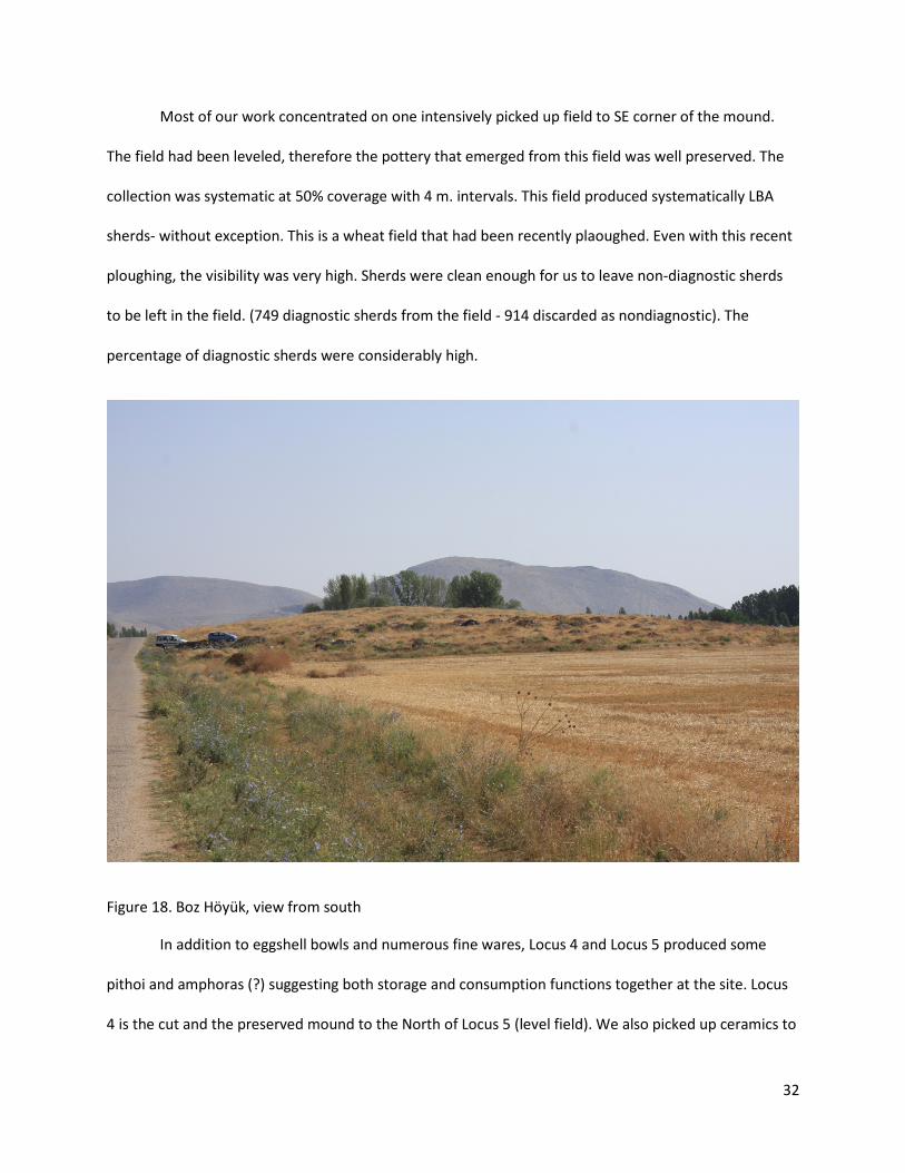
Most of our work concentrated on one intensively picked up field to SE corner of the mound.
The field had been leveled, therefore the pottery that emerged from this field was well preserved. The
collection was systematic at 50% coverage with 4 m. intervals. This field produced systematically LBA
sherds- without exception. This is a wheat field that had been recently plaoughed. Even with this recent
ploughing, the visibility was very high. Sherds were clean enough for us to leave non-diagnostic sherds
to be left in the field. (749 diagnostic sherds from the field - 914 discarded as nondiagnostic). The
percentage of diagnostic sherds were considerably high.
Figure 18. Boz Höyük, view from south
In addition to eggshell bowls and numerous fine wares, Locus 4 and Locus 5 produced some
pithoi and amphoras (?) suggesting both storage and consumption functions together at the site. Locus
4 is the cut and the preserved mound to the North of Locus 5 (level field). We also picked up ceramics to

33
the S of the mound, but only within the confines of the graysoil cultural deposit. The field to the south is
also cutting into the mound, but only for 5-6 m. on the top of the mound, no ceramics have been
collected due to extremely low visibility and extensive garbage dumping. We picked up on the E and W
sides of the gravel rod that cuts through the mound. in future years, intenisve collection could be done
in the fields to the West of the asphalt road to Ormanözü.
118. Mahmuthisar
[See extensive discussion of this site above pp. 17-18]
The mound at Mahmuthisar is located in the middle of a NW to SE running valley. Multiple
springs are located in the vicinity of the village. The mound is very high and most of old neighborhood of
the village sits on the mound. Extensive reconnaissance was undertaken to identify suitable places to
pick up on the mound. Although certain sections were visible in the village occupied area, collection was
not feasible, due to the steepness of the cuts. The unoccupied SE section of the mound this year was
covered on top by dense and very high thistles with occasional Hellenistic, Roman and Byzantine spolia
and other architectural blocks and fragments were visible on the surface of the top of the mound. The
only feasible area for collection turned out to be a road starting on the NE section of the mound going
SE and curving around the lower slopes of the mound and climbing to the summit in the NW. This whole
road cut was divided into three loci (Locus 3-NW facing section, Locus 4 the U shaped end going around
the mound, Locus 5- starts at a Y in the road and climbs to the summit.) Locus 4 produced the best LBA
material and one EIA diagnostic. There was later material in Loci 3 and 5, Middle Iron Age and Late Iron
Age, Hellenistic, Roman, medieval and Ottoman. The gravel road had been recently been resurfaced and
graded by a bulldozer.
Locus 3 presents a wide chronological span from MBA through the end of medieval period, but a
majority of the sherds is Iron Age and Hellenistic period material. Locus 4 has strongest representation

34
of LBA material and a good representation of Early, Middle and Late Iron Age. Cultural features were
visible in the recent bulldozer cut including an oven. It is likely that our collection reflects what has been
recently cut (not slope wash but LBA-IA in-situ mid slope context). Various sized flat bowls, cooking pots,
carinated bowls, string impressed body sherds form the LBA assemblage. The wares of these bowls are
both beige ware and the mottled pink-creamy ware and thinly white slipped drabware. Locus 5
produced small worn body sherds that may be identified as EBA which indicates that the pre-Middle
Bronze age mound at Mahmuthisar is a roundish höyük forming the base of the NW side of mound
under the current village. Locus 5 offers MBA, LBA, and MIA sherds. MIA sherds are graywares from fine
to coarse carinated bowls and other shapes. This is locus that is nearest to the summit. It also produced
30% Hellenistic Roman and Late Roman fine wares (6 terra sigillata and red slip, 9 Hellenistic fine ware
sherds).
119. Yeşilgöl
Yeşilgöl is located 1 km south of Mahmuthisar village on a high terrace and it is a current (20th c.)
dammed pond at a spring that has been copiously active since antiquity, probably into geological times,
because there is ample evidence of fossil springs on the slope above the current mouth of the spring. At
the very top of the fossil spring slope is carved a single rock-cut tomb. The rock that the tomb is carved
into was never very suitable for carving with fissures in the rock itself (Figure 19).
Although there were reports on the other rock cut features in the vicinity, we were not able to
locate them. There were no ceramics and no adjacent additional tombs nearby it. The façade of the
tomb itself was lost not because of recent damage but beacuse of erosion of the poor quality bedrock.
There is evidence on the ground level of a central doorway that may have led into the tomb. Interior of
the tomb is a simple squared room with gabled ceiling. The vertical back wall of the tomb is broken away
revealing a fissure. The tomb is provisionally dated to the Late Iron Age or the Hellenistic Period, on the

35
grounds that there is no surrounding necropolis which would have been common in the Roman period.
Also no bench-like features are attested in the tomb. Late Iron Age and Hellenistic Period are amply
attested at Mahmuthisar.
Figure 19. Yeşilgöl, general view
120. Nodalar Höyük
Nodalar Höyük is a small mound located in the Mahmuthisar irrigation area of the Ilgın plain, 2.3
km north of the Eldeş village in the territory of that village. The mound had a low rising belt surrounding
the higher section and the dense vegetation cover again prevented us to study the surface material
evenly and comprehensively. A looter’s pit on the south slope just below the summit of the mound
produced a representative selection of Late Bronze Age pottery from egg-shell bowls to palace ware

36
incurved bowls, carinated bowls and fat basins, all of them with string impressions at the carination or
rim. We even had a very interesting handmade baking pan but with a string impression below the rim
also dating to the Late Bronze Age. In this locus there are a few finds of small sherds that may belong to
the MBA, EBA and Chalcolithic. But the evidence for MBA is scant but the other loci in the site provided
substantial evidence for EBA and Chalcolithic. The odd shape of the mound (steep sides and a fat topped
mound) may have been determined by the construction work in the Late Bronze Age, possibly a small
fort. The vertical edges may perhaps be reflecting the existence of mud brick defensive walls (pudding
bowl mound).
Lower on the North slope there were a series of pits which were investigated, old looting pits
overgrown with thistles and some animal burrows with low visibility (30%). In these pits we picked up
our first radial patterned burnished LBA sherd possibly from the top of a pedestal bowl known from
Beycesultan, one of our first good western comparisons. Also in this locus, we identified red burnished
chaff tempered beige-gray core with red slip wares known from Ören Çeşmesi and date to the EBA. In
these pits Chalcolithic material is also identified, although hard to be precise, since our identification is
based on the fabric (distinctively not EBA). These are handmade fine wares.
In the lower slopes of the mound on the lower belt, we surveyed Locus 3 to the south-west of
the mound (a field that had been ploughed in the past- a fallow field with higher visibility of soil
although still covered with thistles) and Locus 4 off-mound in the sugar beet filed that cuts the edge of
the mound to the east/south-east. In terms of percentage, these loci produced our best long-term
assemblage with a good percentage of Chalcolithic, EBA, and LBA. Also in these loci, we identified
Middle Iron Age black burnished fine wares and other graywares. The Iron Age materials are both from
the Middle Iron Age and the late Iron Age. Further investigation at the site might clarify whether our
hypothesized fort dates from the Iron Age or the LBA. Intensive work on the summit may help with this

37
question. Except for the high mound in the middle, in the last 5 years, the whole mound has been
ploughed in a possible attempt to convert it to agricultural field. All but the highest elevations had been
ploughed although they were fallow in 2010.
Figure 20. Yalburt team members struggling with dense vegetation on Nodalar Höyük.
121. Eldeş
Eldeş village is located 10 km southeast of Ilgın. Jonnes has published a series of marble
inscribed funerary monuments (2002: nos 394-404). The only published inscription noted by us was
embedded in the monumental fountain just to the north of the central square of the village downslope.
In addition to these monuments, our team documented two marble basins in a historic cemetery area in
the Alayaka Mevkii neighborhood (located to the NW of the village). There were additional spolia in the
neighborhood itself, some of them reportedly looted directly from village houses.

38
Figure 21. Eldeş village. Inscribed block with relief incorporated into a fountain.
122. Kurban Tepesi
It is a natural hill on valley terrace overlooking the Eldeş village from the West, to the SE of the
Alayaka Mevkii cemetery area. This is the site of rain prayers and sacrifices are performed by villagers of
Eldeş and nearby villages. This site has been little disturbed therefore the sherds on the surface are
heavily eroded. No diagnostics were picked up. The oxidized common and coarse wares (body sherds)
and chaff tempered tile fragments indicate a Roman and possibly early Byzantine site. No surface
architecture and no visible areas of deposition were observed. No evidence of springs in the vicinity
either.

39
123. Samudun Höyüğü
Late in the afternoon on July 28th, we briefly stopped at Samudun Höyüğü- located 1.5 km
North-Northwest of Çeşmecik village, accessed by a difficult dirt road. The site is located on a ridge at a
lower elevation on a slope between Çeşmecik and the high pasture (yayla) plateau belonging to
Beykonak. An active spring is located 250 m. below to the west-northwest of the mound on the dirt
road. The settlement overlooks the plateau the north while it has its back to the rolling hills climbing to
Çeşmecik. This northern plateau stretches beyond the Beykonak “ağıl” (sheepfold) establishments all
the way to just south of Ören Çeşmesi where the river valley finally cuts into the plateau. There was no
time for any systematic collection. The team divided into two. One group took off to the anticipated
tumuli which were located on a rise to the north. We came to the conclusion that these are natural
bedrock hillocks that had been looted in such a way that the looters thought that they were tumuli.
Although we did not collect, the site was clearly of fairly short duration spanning the Late Iron Age
through Early Hellenistic period. Abundant gray course and common wares and a limited amount of fine
wares were found on the summit. Fine wares could be easily dated to the 4th and 3rd c. BCE based upon
the comparison with Gordion Hellenistic ceramics and Shannon Stewart’s dissertation research. It is
possible that the site might have been a farmstead or a small estate (based on the ceramics).
124. Dediği Dede Tekkesi (or Dediği Sultan Tekkesi)
The site of the Tekke is located on a high prominence to the southeast of the modern town of
Beykonak (a municipality). The tekke complex overlooks an impressive landscape including Tekke deresi
down below and its deep valley gorge flowing towards Beykonak. Behind the complex on a higher
elevation rises the Keçiağıl Tepesi which is today forested. A spring is located a few hunderd meters
down the stream. This medieval shrine/mascid complex (tekke) is composed of a small courtyard filled
with old graves and spolia and the türbe-tekke complex. Several architectural features and stone

40
monuments were documented in the courtyard. The slope below the türbe (tomb) overlooking the
valley was recently planted with trees, and this disturbance revealed no tombs, no ceramics and no
artifacts. On this slope however were Byzantine architectural fragments, most likely spolia from a
church, including a double column. The slope above the türbe has also recently been planted and no
artifacts were visible on the surface. All cultural materials seem to have been clustered in the türbe
compound and immediately downslope from it. Directly to the south, downslope of the kible of the
mosque of the tekke, we surveyed a rock-cut tomb with recessed squared entrance opening to the
valley. The interior has a gabled roof. This rock-cut tomb, as far as poor preservation allows us to be
confident, is architecturally identical to the rock-cut tomb surveyed in Yeşilgöl (SU 119), located only
2.25 km to the west of Dediği Dede Tekkesi.
125. Bulcuk
Bulcuk village is located 10 km south of Ilgın. A small, most likely Ottoman bath building is
preserved in the middle of the village. Only two stone built rooms are preserved in a private garden.
With the guidance of the local inhabitants, we were able to visit a spring site with the inscribed stele
(Figure). This is a limestone stele that was published previously by Jonnes (2002: 413). There are a series
of springs down below the village to the west, all contributing to the stream Bulcuk Çayı that flows by
the village. The main source of the stream is uphill from Bulcuk, Pınarbaşı Mevkii Bulcuk Göleti
(reservoir) where there now is a recreational park. A road that runs past the reservoir climbs the
mountain towards the source of the Bulcuk Çayı and the yayla settlements of Bulcuk village was closed
beyond the reservoir. Some looting activity was reported to us in that area by Akşehir Museum Director
and the Jandarma, however they could not get there either.

41
Figure 22. Inscribed stele at a spring near Bulcuk
126. Bulcuk Höyük
This mound is located on a natural promontory to the north of the village of Bulcuk, a few
hundred meters from the center of the village. It is visible immediately east of the asphalt road that
enters the village from north. The long and narrow promontory, made-up of conglomerate bedrock that
runs NE-SW is approximately 30 m. wide and extends approximately 250 m. on the ridge. The ceramic
evidence (diagnostic sherds) suggests that the settlement spans early Hellenistic through Roman
imperial times. High footed concentric ring bowls from Early Hellenistic period were noted. The top of
the ridge seems particularly eroded especially at the NE end although there is greater deposition in the
SW end (seen in the high vegetation). Looting pits were seen in the middle of the mound revealing

42
mostly roof tiles. Road on the southeastern edge of the ridge cut into the site as well. Recent backhoe
trenches cut into this slope for the purpose of looting revealed common gray wares, black glossy fine
wares and well-preserved Hellenistic sherds in that area (surely washed down the slope but well
preserved nonetheless). Most of our pick up was in Locus 1 which is the looted pit. We have also picked
up along the road (Locus 3).
127. Uyuz Kuyusu
Uyuz Kuyusu is a place of healing, located 1.25 km to the east of the Bulcuk village at a swampy
spring site in the middle of grain fields upland of İçme Tepe to the NE. In the fields around the spring,
the field examination of lightly scattered ceramics (but recently ploughed area) suggested similar time
span as Bulcuk Höyük. It is possible that a farmstead or small settlement associated with the settlement
at Bulcuk was located here.
128. Antike Mevkii
In our attempt to locate early mounds at the mouth of each of the southern valleys, we investigated
Bulcuk and Ormanözü (Puhtu/Şevketiye/Çerkez) villages. At Bulcuk, the evidence only pointed to
Hellenistic and Roman periods, and at Ormanözü, the mounds are located along the river but in lower
elevations. We had very little help from the village since it was largely abandoned. The elders pointed to
us two places in the vicinity of the village both uphill from the village, Soğuk Su mevkii (location of a
spring) and Antike mevkii. We were unable to locate Soğuk Su mevkii however we were able to locate
Antike Mevkii 750 m. south of the village on the summit of Koru Tepesi. The site of Antike Mevkii is a
clearing at the edge of the pine forest offering a thin scatter of pottery, mostly body sherds and non-
diagnostics. These are mostly very eroded late Hellenistic and Roman sherds and perhaps Byzantine. No
sherds were collected at the site.

43
129. Saraycık Höyüğü
This is a mound which was known from 1:25,000 maps, located at the mouth of the western-most valley
that runs into Ilgın Plain. It is located 5 km south-southwest of Ilgın and 3.7 km from Boz Höyük. It is
located close to the Beyşehir Road from Ilgın and on the eastern side of the stream Battal Deresi and
close to the Garibin Değirmeni mevkii. It is a low mound surrounded by irrigated agricultural fields right
at the edge of the floodplain. It is possibly slightly buried but the visible part is approximately 150 m in
diameter.
The settlement evidence on the mound suggests a discontinuous habitation. Only one field
covering the eastern side of the mound had high visibility so our collection was concentrated in that
field, which was picked up systematically by a small team of surveyors. The ceramics from this field has
Chalcolithic and EBA in almost equal numbers in high quality and quantity. These sherds include
Chalcolithic brown highly burnished wares and red slipped Early Bronze Age wares. Two thirds of the
whole assemblage is constituted by this body of material. It is clear that the mound morphologically
belongs to this period. The site is again occupied in the Hellenistic period, with the possibility of the the
marked presence of Early, Middle and Late Hellenistic. Close to one third of the ceramic assemblage
dates to the Hellenistic period, and constitutes a thin draping over the otherwise largely EBA mound. A
break follows this occupation. Six glazed sherds are identified as medieval or Ottoman, pointing to a
medieval or early modern reoccupation of the site. In the vicinity, reportedly there was yet another
Ottoman period settlement as well. The site is located right on the Salt Road (also known locally as
Deveci Yolu) which curves around the promontory adjacent to the mound and leads through the
Göstere Boğazı (Göstere Pass). 500 m. west-southwest of the mound is a major spring at Gavurun
Değirmeni where a Byzantine cave complex is located.

44
Figure 23. Saraycık Höyük from the Byzantine rock cut space at Garibin Değirmeni (southwest).
130. Garibin Değirmeni
Located in the SW corner of the Ilgın Plain in the limestone buffs leading to the Göstere Pass, and close
to the Beyşehir road, and overlooking Battal Deresi, and right on the Salt Road, immediately above the
Garibin Değirmeni (İnönü Değirmeni) spring in the lower slopes of Çevlikkaya Tepesi, there is a rock-cut
complex of interconnected rooms. The intricately carved rooms are roughly rectilinear in plan with flat
ceilings and multiple niches, sometimes evenly spaced along the walls. We entered through a natural
crevice while locals suggested that there existed in the past other entrances as well. The rooms are
connected with low doors. No surface material was collected at the site.

45
131. Aşağı Kuyu Höyüğü
Osmancık is a small town belonging to the subdistrict of Kadınhanı and located 7.5 km south
west of Kadınhanı. This mound is located at the north east edge of the small town of Osmancık
(belediyelik/belde), directly northwest of a large modern cemetery. The site is in fact composed of a
large and a small mound named “Büyük Höyük” and “Küçük Höyük” with widespread artifact scatter
between and around them (Figure 24). Therefore the settlement is quite extensive. A dirt road passing
by the spring downhill below the two mounds separates the two mounds. At the northeast base of
Büyük Höyük is a major spring and three wells, maintained by the city. Embedded in the trough of the
main well, was a stone block with a series of inset relief panels (a door). Surface materials at several loci
on both mounds were systematically collected by transects. Büyük Höyük is possibly on the shoulder of
a natural terrace and the northern slope is too steep for agriculture and is planted in clover. Even so
there is a lot of erosion out of the northern slope of the summit.
Figure 24. Osmancık Aşağı Kuyu Höyüğü, general view from the rock outcrop to the east
46
The sherds that were collected on the northern slope of summit are exclusively Chalcolithic and
EBA, showing that the morphological formation of this mound can be dated to these periods. In
contrast, the fairly gradual slope of the southern half of the mound has these periods and in addition
Hellenistic, Roman and glazed medieval and post-medieval sherds. Reconnaissance (but no collection) in
the cemetery on the SW corner of the mound shows that the later sherds continue to be found within
the cemetery, and that these later periods produced a thin and widespread deposition. On Küçük Höyük
by contrast, we find all of the periods that are represented on Büyük Höyük. Küçük Höyük is separated
from Büyük Höyük by an artificial break. Prior to the construction of the road the two would have been
morphologically contiguous and marked with two peaks. The visibility was low on the surface of Küçük
Höyük and covered with chaff, the field was recently harvested. To the north east of the mounds,
colluvial wash from Kazanlı Tepe and Sivri Tepe were recently quarried giving us 2-8 m. sections, where
we collected cultural material that provided us important information on the geomorphological history
of the region and the evidence for local deforestation in the area. This has been reported in the
geomorphology section of the report (see above). Only preliminary analysis of the pottery has been
done, especially considering the new Chalcolithic wares, shapes and forms this site has produced for us.
It is possible that there are additional periods that are poorly represented in our assemblage such as
Late Bronze Age and Iron Age.
132. Harun Dede Mezarlığı
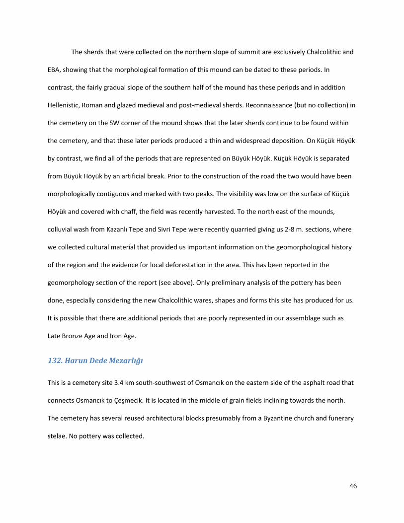
This is a cemetery site 3.4 km south-southwest of Osmancık on the eastern side of the asphalt road that
connects Osmancık to Çeşmecik. It is located in the middle of grain fields inclining towards the north.
The cemetery has several reused architectural blocks presumably from a Byzantine church and funerary
stelae. No pottery was collected.

47
133. Karatepe
Previously surveyed by Hasan Bahar, Karatepe mound is located in the flat Atlantı Plain, 5.15 km north
east of Atlantı town, 6 km southwest of the village Kolukısa. The mound is very difficult to access due to
the dense irrigation canal network in Atlantı Plain. A major DSI irrigation canal (Bulasan canal), cuts deep
through the eastern edge of the site and goes 2.5 m deep below the current surface. The inaccessibility
of the mound has led to major looting operations, leaving massive pits on the mound, ranging between
2 and 6 m deep. On top of the mound our team has concentrated on the looted pits due to the dense
vegetation cover. We also inspected the canal cut and the surrounding fields where a large artifact
scatter exists. The backfill mounds of the pits on the summit yielded well preserved Hellenistic fine
common coarse wares. No earlier periods are well represented in those pit assemblages. Terra sigillata
and Roman red slip wares are alos represented on the summit. In contrast in the ploughed fields
surrounding the central mound, worn Roman coarse wares predominate with some medieval glazed
sherds. The sherds and numerous basalt grinding stones indicate that, in the Roman period, the
settlement was a substantial agricultural village. When the canal cut was investigated, cultural
deposition was found at the bottom of the canal, 2.5 m below the current land surface. In particular,
Roman glass was collected from the backfill piles along the canal. From this evidence, Ben Marsh
concluded that there has been 2.5 m of deposition on top of the Roman levels since antiquity.
134. Köprünün Küllük Höyük
[See extensive discussion of this site above pp. 12-13]
Köprünün Küllük Höyük is located 1.5 km to the northwest of Karaköy village, immediately
below the west- northwest foot of Küçük Tokmak Tepesi which is a meta-volcanic, andesite hill along,
similar to the adjacent Koca Tokmak Tepesi (Figure 25). The mound is located 2.75 km northeast of
Karaköy Kale Tepesi, therefore fairly close and therefore closely related. The mound is squeezed

48
between the Bulasan Çayı streambed and a major irrigation canal, south of Tepearası Mevkii, in the
floodplain of Bulasan Çayı. An asphalt road that connects the road along the canal with Karaköy bisects
the mound in half crossing the two canals on two bridges. A small, concrete-lined canal runs aparallel to
this road and angles off to the northwest. The central mound itself has a very low visibility, and we only
collected in pits along the road cut and in fields along the edges. The central mound is only 1-3 m higher
than the surrounding fields (higher on the North). These fields also belong to the mound and have been
leveled and flattened by agricultural activity and mechanical intervention. On the central mound, there
is a mixture of Early Bronze Age, Middle or Late Iron Age and possibly medieval period sherds with the
absence of the Hellenistic period. Where the mound has been cut in the southwest and in adjacent
fields, the pottery overwhelmingly dates to the Middle and Late Bronze Ages.
Figure 25. Köprünün Küllük Höyük seen from Küçük Tokmak Tepesi (East-Southeast)

49
The most interesting area of the mound was one of the fields on the southwest side of the
mound where we collected at 50% coverage (Locus 4). This locus produced high percentage of Late
Bronze Age sherds. The other periods on the site are also represented, namely Chalcolithic, Early Bronze
Age, Iron Age (Middle or Late), and medieval and Ottoman glazed wares and some 20th century garbage.
The Late Bronze Age pottery is represented by wheel-thrown cooking pots with string cuts, large basins,
Hittite common ware comparable to Boğazköy and similar to our Boz Höyük assemblage, a good
assemblage of drab and fine ware bowls. In the cut at the north eastern corner of the adjacent Locus 5,
a dry wall built of roughly hewn ashlars with no mortar was visible in the section and was documented.
This is possibly a Late Bronze or Iron Age wall. In contrast to the southwestern and southern cuts into
the central mound, the cuts on the northern side revealed only Early Bronze Age sherds. Since most of
the landscape in the vicinity is formed by modern interventions and due to alluviation in the floodplain,
we can presume that the current shape of the mound is entirely post-depositional, and even post-
medieval. At this site we were not looking at very many preserved ancient surfaces. However our study
is only preliminary at this site.
An L-shaped megalithic block was located and documented to the east of the mound, on the
western slopıng bank of the Bulasan Çayı (Figure 26). According to Ben Marsh, the block was most likely
quarried from the same source as the massive ashlar blocks of Kale Tepesi. It was probably an
architectural block or pavement slab used in a monumental structure such as a city gate. Given the
significant location of the site and it close proximity to Kale Tepesi, and the rich late Bronze Age pottery
assemblage, we plan to return to this site for further documentation and additional systematic
collection of surface material.

50
Figure 26. Ömür Harmanşah and Ben Marsh studying the megalithic architectural block at Köprünün Küllük Höyük
135. Eski Kaleköy Höyük
Eski Kaleköy Mevkii Höyük is located on the asphalt road that runs from Şeker Höyük towards Düğer and
Atlantı, and it is spread over a large area bisected by this road where an active trout farm and restaurant
has been established and is frequently visited by locals. It is located where the road forks towards
Kaleköy and Avdan. Kaleköy is only 2.25 km to the north of the site and Kale Tepesi only 500 m to the
southeast across the Bulasan Çayı. The mound extends from the road to Kaleköy to the edge of the first
terrace right above the floodplain on the east side of the road to Düğer. The Düğer road cuts a two
meter deep transect through the mound. In addition to the road, the surface of the mound is covered by
fenced and unfenced gardens and overgrown area with dense, high weeds to the north of the trout

51
farm. The mound begins in the vicinity of the mescid (at the road fork) and the construction of the
parking lots of the trout farm has removed parts of the mound.
On the upper slopes and terraces beyond the Kaleköy road is found the visible foundations of
the old Kaleköy village, perhaps going back to the Ottoman period. According to the locals, the village
was originally settled on the slopes of Kale Tepesi. It was then moved to this particular location, only to
be abandoned for the new location further to the north. We have not been able to identify the exact
date of these settlement foundations. Reconnaissance in the southwest of these slopes revealed
Hellenistic and Roman coarse wares including large pithoi, and black slipped roof tiles. The sherds that
were collected in the area of the disturbed mound itself date to the Chalcolithic, Hellenistic and Roman
periods, possibly including the Middle but more likely Late Iron Age. Glazed sherds possibly date to the
medieval or Ottoman period. We have no overlap with Ören Çeşmesi Early Bronze Age materials.
136. Karaköy
In the village of Karaköy itself, our team surveyed a series of classical architectural fragments
and funerary stelae reused in village structures.
137. Şeker Höyük
The mound is located on the north-west corner of the intersection of Konya-Afyon road, east of
the main gate of the Ilgın Sugar Factory. It has been fenced around and landscaped by the Sugar Factory.
The rebuilt canal that now contains Bulasan Çayı cuts through the middle of the mound and a dynamited
canal on the bedrock that the mound sits upon. The earlier Bulasan streambed was to the south and
east of the mound. The settlement was built on a bedrock outcrop right adjacent to the stream. The
canal cut gives us a perfect section of the cultural layers of the mound. Potentially, thorough

52
investigation of the various post-depositional cuts through the mound will allow us to understand the
geormorphological processes of alluvial deposition in the vicinity.
There are no ceramics from the mound defined (fenced in) by the Sugar Factory. This is
presumably due to soil added to foster grass growth (the mound has been planted with grass). Although
it is not watered, the mound is covered with lawn grass. The visibility was not great but it had been
mowed. Areas out of the fenced part of the mound to the west were covered with impenetrable
thistles. A cemetery is located across the highway access roads to the west and it was not investigated in
this season. The area to the south of the highway was investigated and it is alluvium- no cultural
material was found. The area to the north of the canal is a continuation of the mound but it is an area of
dumping and canal backfill that obscures the surface of the mound. All collection was done in the canal
cuts on both sides. The mound dates to the Hellenistic and Roman periods. But it seems to have carried
more of significance in the Hellenistic period.
138. Orhaniye Höyük
In Orhaniye, we were unable to locate the Early Bronze Age mound surveyed by David French
based on his description. Subsequent to the filing of this report, our work in the British Institute of
Archaeology at Ankara ceramics study collection revealed that the site referred to as Orhaniye Höyük by
D. French is in fact “Çayır Höyük” which is our own survey unit 116 (above). In the same collection, our
understanding is that Bozuk-Zaferiye Höyük is our survey unit 137 “Şeker Höyük”8.
We did however survey two archaeological areas . The first one is a ridge of Bağtepe where a
looted ancient cemetery was located, possibly Roman cist burials built of rubble. Unfortunately, no
datable surface pottery was recovered from this area. The second is a mound on the edge of a terrace in
8 We refer here to the British Institute of Archaeology at Ankara’s Ceramic Database, reached at http://www.biaatr.org/collections2/index.php. There is a group of pottery in this collection labeled as Ilgın, collected by David French in 1961-1962. These British surveys, to our knowledge, were never published.

53
Bağlık Mevkii to the west of Orhaniye, right outside the village. The mound is half covered by the
village’s garbage dump and half enclosed by the village cemetery. The mound is dated to late Hellenistic
and Roman periods.
139. Yıldıztepe
When Prof. Ben Marsh studied the blocks that were used on the fortifications at Kale Tepesi, he
concluded that the stones could not have been quarried locally from the limestone bedrock of the hill
itself, since he identified the ashlar blocks to be marl and quite different than the locally available stone.
Following this observation in 2011 season, our team surveyed the nearby landscape for marl sources,
and made an exciting discovery at Yıldıztepe, approximately 1.2 km south-southeast of Kale Tepesi.
Figure 27. Ben Marsh taking notes on the landscape at Yıldıztepe Quarry

54
At Yıldıztepe, our team with the leadership of of Prof. Marsh identified an ancient quarry, which
represents one of the extremely rare outcrops of marl limestone in the region. During our preliminary
observations several quarried galleries are observed, where a dense concentration of green gabbro ( a
very hard volcanic stone usually used for stone hammers in the Bronze Age) chips and fragments were
found. The absence of quarrying marks specific to metal chiseling, preponderance of drill holes and the
abundance of green gabbro stone hammer fragments at the site suggested that we had located a Bronze
Age quarry. Because this discovery came right at the end of the 2011 season, the study of the
relationship between Yıldıztepe and Kale Tepesi as well as the detailed architectural documentation of
the site were postponed until 2012 season.
140. İmircik Tepe
[See detailed discussion of the site above p. 19]
The site is located to the east-northeast of Atlantı town only about 1 km from the outskirts of
the modern settlement. It is a widespread and shallow mound surrounded by extensive areas of
additional settlement, accessed through the main east-northeast road out of the town. A major modern
irrigation canal runs to the southwest of the site, while an additional conduit went through the site. In
2011, migrant agricultural laborers were camped on the central mound near the spring. A spring is
located on the central western edge of the central mound, and the spring is heavily used by Atlantı’s
sheep and goat flocks. Although the site is denuded, the contemporary use obscured ancient deposits
on the surface of the central mound. The secondary conduit cut through the northern tip of the central
mound. Collection along this cut yielded mostly Early Bronze Age and Chalcolithic sherds. Off the central
mound in a triangular agricultural field north of the northward road to Saçıkara, we encountered our
best collections of Late Bronze Age sherds. Late Bronze Age is one of the most prominent periods of
occupation with a widespread presence across the mound. LBA materials are located on the central

55
mound, visible in north and south cuts, and in the triangular area beyond the dirt road to Saçıkara. A low
density sherd scatter was also located extending 350 m. to the southeast of the mound. Hellenistic and
Roman periods are also represented on the mound. A broken fragment of a circular decorated marble
object was found on the central mound. This circular, ring like architectural object is finely carved with a
rosette pattern on one side and with a radiating pattern on the reverse.
Figure 28. Late Bronze Age Ceramics from İmircik Tepe
Figure 29. Stone, decorated artifact from İmircik Tepe
141. Gümüşlü Höyük
Gümüşlü Höyük is located in the middle of the Atlantı plain, 3.5 km northeast of Atlantı town
center. The visible circular mound is the tip of the buried mound and cultural debris does not extend
into the field surrounding the mound. The mound is relatively undisturbed, although it is defined by
secondary irrigation conduits all around. Where cultural material extends into the field, it seems to have
been spread after the edge of the mound was cut by agricultural activity especially to the north-east of
the mound. In 2011, the mound was covered by high thistles and other weed hindering collection and
adversely affecting visibility. The site dates to Chalcolithic, Early Bronze Age and Middle Bronze Age
56
periods. Although we collected wherever visibility permitted and our assemblage is relatively small, the
sherds that we did collect were well-preserved and highly diagnostic.
142. Çeşmecik Höyük
Çeşmecik Höyük is located within the settlement limits of the village Çeşmecik which is in the
subdistrict of Kadınhanı, which is 13.8 km to the north-east. The village is on a northeast-southwest
valley in the southern highlands overlooking the Ilgın Plain. The mound is on an eminence directly west
of the main mosque and central plaza of the village (Figure 30). The bedrocky landscape continues to
rise to the west of the mound where the village cemetery is located. Although the village is encroaching
on the mound, most of the mound is covered by agricultural fields and gardens adjacent to village house
complexes. The summit of the mound and the main slopes is located near a spring which is located
slightly south of the summit.
The mound is occupied in early and late periods with an apparent hiatus in-between them. The
Chalcolithic and Early Bronze Age is restricted to the central mound. Across dip/ravine to the west, the
site continues where only Hellenistic through medieval sherds were encountered. These periods were
the most prevalent in the fields above the central mound to the south-west across the road. However,
several questions remain with respect to the ceramics in these fields. Although sherds extended in the
lower slopes where house complexes were located, no attempt was made to survey those areas due to
the built modern features. Certain classical architectural fragments found in house courtyards were
recorded.

57
Figure 30. Çeşmecik Höyük, site plan and distribution of loci
143. Kempos
Kempos, or Gökçeyurt with its new name, is a belde settlement 18 km south-southeast of the town Ilgın
and juristically under Ilgın municipality. It is on a high pasture in the midst of a forested and water-rich
area. The forests are composed of pines and juniper around the town which is settled in a flat high
plateau, surrounded by Çakmaklı Tepesi, Akdağ Sırtı and Yumru Tepesi. During our brief visit in 2011
season, the town was virtually empty, therefore we could not get much help from the local community.
Since we were not able to meet any of the town officials, work was not efficient or possible. In various
parts of the town, we noted several classical architectural pieces although no documentation has been
carried out. We plan to return to this town in the coming seasons.

58
144. Dereköy Höyük
Dereköy archaeological site, also known locally as Dereköy Domalan Höyük, is on a natural hill to
about 400 m west of the village of Dereköy, which is located 16 km north of Ilgın. Dereköy is on an
important crossing, the opening point of a valley when traveling from Yalburt Yaylası to the Çavuşçu
Lake basin. The village captivates the visitors’ attention with its lush and green landscape within a heat
scorched and barren zone as well as its striking rocky geology. A spring is adjacent to the riverbed on the
southeastern foot of the Domalan hill. The stream flows from its major source at Macar Mevkii (the
location of the other archaeological site in the vicinity), across the village all the way to Dereköy Höyük,
though a rocky gorge. The site is limited to the flat summit of the hill (although sherds were rarely
collected on the slopes as well). There was a relatively thin scatter of very eroded sherds, particularly
the coarse wares. Fine wares were better preserved and included the flanged carinated drab ware bowls
and egg-shell bowls that date to the Late Bronze Age. The limited repertoire of the sherds indicate that
the site may have had a short duration of settlement. One particular pit on the northern edge of the
mound was collected separately, and included incurved cooking pots and pithoi- presenting a limited
assemblage of shapes and wares of the Late Bronze Age. A scant scatter of Hellenistic was also present
on top of the mound. Spolia found in the village date to the Roman period and suggest that the
settlement continued into the Roman period in the vicinity. The village administration has recently
initiated a tree plantation project on top of the site.
145. Macar Mevkii
Macar Mevkii is the site of the main spring that the village of Dereköy uses, and it is located 1
km east- northeast of the village center. The spring contributes to the streambed that flows down all the
way from the vicinity of Yalburt Yaylası. The rocky streambed gorge with monumental blue-schist
outcrops snakes around a high rising hill of Macar Mevkii, and the archaeological site is limited to the

59
very flat top of that hill. Uphill to the west, one finds numerous weathered and rock fall cavelets within
the gorge. Except for two possibly Late Bronze Age sherds (one drab ware string cut type), the sherds on
the site date to the Hellenistic and Roman periods with a lot of painted black stripy decoration on red.
Nowhere on the site is deposition deep, and the sherds are often quite worn like Dereköy Höyük.
Figure 31. Macar Mevkii site plan
146. Dokuz Höyük
Dokuz Höyük, literally translated as “Nine Mounds,” is a landscape of imaginary antiquity. It is a
broad pastoral highland landscape, located about 11 km to the northwest of Yalburt Yaylası and we
became aware of it through the striking toponym recorded on 1:25,000 government/military
topographic maps. Towards the very end of the 2011 season, Yalburt Project team visited this landscape

60
briefly with the hopes of identifying a few archaeological sites. This area is within the Gavur Dağı
mountainous zone at the border between Ilgın and Yunak subdistricts. It is geologically a fascinating
landscape populated with hundreds of karstic depressions or dolines, which is transformed into a
pastoral landscape of summer pasture and animal husbandry. That’s why the whole valley of Köhün
Deresi is speckled with dozens of stone built sheepfolds and cattlepens (“ağıl”), making use of the
accumulation of water across the valley. The summer pasture residences and animal pens belong to the
town and families of Hursunlu (under the municipality of Yunak) who reside in this upland for two or
three months in the summer. In the area that was pointed for us by the inhabitants as “Dokuz Höyük”
we noted several looting pits, although no archaeological materials were found. Further ethnographic
work is needed in this valley to understand the social and cultural significance of this landscape with an
imaginary archaeological past.
Figure 32. Dokuz Höyük, general view.