splash screen chapter introduction section 1exploring geography section 2the geographer’s craft...
TRANSCRIPT


Chapter Introduction
Section 1 Exploring Geography
Section 2 The Geographer’s Craft
Chapter Summary & Study Guide
Chapter Assessment
Click on a hyperlink to view the corresponding slides.Click on a hyperlink to view the corresponding slides.


Click the mouse button or press the Space Bar to display the information.Click the mouse button or press the Space Bar to display the information.
• North Pole • South Pole
• Prime Meridian
• Equator
Places to LocateExploring Geography

Click the Speaker button to listen to the audio again.
Click the Speaker button to listen to the audio again.

The Elements of Geography• Geographers are specialists who
describe Earth’s physical and human features and the interactions of people, places, and environments.
• Two Types of Geography:
• Physical Geography=Rivers/Mountains/Countries/Deserts
• Human Geography=People and Culture and race/language
(pages 19–20)(pages 19–20)

List some of the tools geographers might use to describe the features of Earth and the relationships between them.
Geographers might use maps, atlases, charts, measuring devices, thermometers, and barometers to describe the features of Earth and the relationships between them.
Click the mouse button or press the Space Bar to display the answer.
Click the mouse button or press the Space Bar to display the answer.
The Elements of Geography (cont.)
(pages 19–20)(pages 19–20)

• Absolute location The exact latitude and longitude at which a place is found on the globe is its absolute location.
Click the mouse button or press the Space Bar to display the information.Click the mouse button or press the Space Bar to display the information.
The World in Spatial TermsSpatial relations means “relations in space”: how places, people, and features of the earth are connected because of their locations.
• Relative location Relative location describes a place’s location in relation to another place.
(pages 20–21)(pages 20–21)

When is it useful to know the absolute location of a place? When is it useful to know its relative location?
Absolute location is useful for a team of explorers trying to find a ship that had sunk, like the Titanic, for example.
Relative location is useful for giving directions to travelers.
The World in Spatial Terms (cont.)
Click the mouse button or press the Space Bar to display the answer.
Click the mouse button or press the Space Bar to display the answer.
(pages 20–21)(pages 20–21)

Click the mouse button or press the Space Bar to display the information.Click the mouse button or press the Space Bar to display the information.
Places and Regions
• A region, larger than a place, is a group of places that are united by shared characteristics.
•
• A place is a particular space on Earth with physical and human meaning.
(page 21)(page 21)

• People affect the environment by clearing or planting forests, building industries and cities, and hunting animals.
• Features of the environment such as mountain ranges and deserts often pose barriers to human migration.
• Why is Red Cloud located where it is?
Click the mouse button or press the Space Bar to display the information.Click the mouse button or press the Space Bar to display the information.
Environment and Society
(page 22)(page 22)

How can people overcome the physical obstacles of their environment?
People can fly planes over mountain ranges. They can build tunnels through mountains for roads or railroads. They can clear paths and build roads through forests. They can build bridges, dams, and canals.
Environment and Society (cont.)
Click the mouse button or press the Space Bar to display the answer.
Click the mouse button or press the Space Bar to display the answer.
(page 22)(page 22)
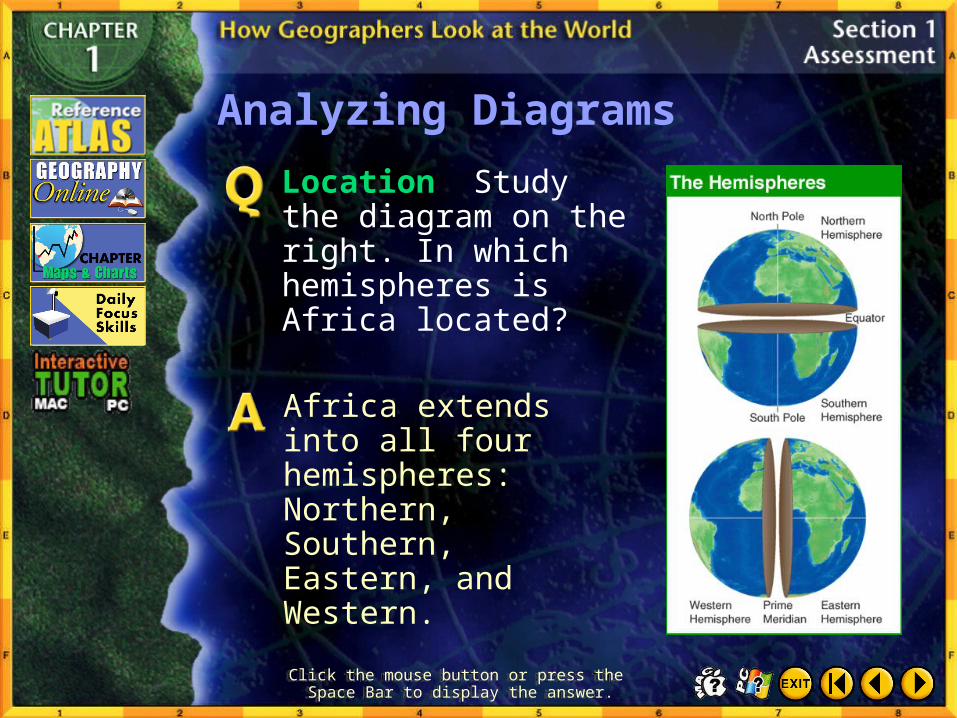
Analyzing Diagrams
Location Study the diagram on the right. In which hemispheres is Africa located?
Click the mouse button or press the Space Bar to display the answer.
Click the mouse button or press the Space Bar to display the answer.
Africa extends into all four hemispheres: Northern, Southern, Eastern, and Western.

Cartography, or mapmaking, began to develop in the Age of Exploration. Explorers such as Christopher Columbus and Ferdinand Magellan drew rough maps of the lands they found across the Atlantic Ocean. By the early 1500s, European maps showed entire unexplored continents between Europe and Asia.

Branches of Geography
• Human geography, or cultural geography, studies human activities and their relationship to the environment.
• Physical geography focuses on the study of Earth’s physical features.
Click the mouse button or press the Space Bar to display the information.Click the mouse button or press the Space Bar to display the information.
(pages 23–24)(pages 23–24)

What kinds of questions would you ask a physical geographer? A cultural geographer?
Sample questions: Physical: Where are the world’s tallest mountains?
Cultural: Which languages are most commonly spoken worldwide?
Record your questions and look for answers as you study various world regions.
Click the mouse button or press the Space Bar to display the answer.
Click the mouse button or press the Space Bar to display the answer.
Branches of Geography (cont.)
(pages 23–24)(pages 23–24)

Click the Speaker button to listen to the audio again.
Click the Speaker button to listen to the audio again.
Geographers at Work (cont.)
(pages 24–26)(pages 24–26)

Click the Speaker button to listen to the audio again.
Click the Speaker button to listen to the audio again.
Geographers at Work (cont.)
(pages 24–26)(pages 24–26)
Why do geographers often rely on maps rather than on verbal descriptions?
Geographers rely on maps because they can show a great deal of information quickly. For example, maps may show relative distances, elevation, crops, population, and resources at a glance. Verbal descriptions take much longer to read.
Geographers at Work (cont.)
Click the mouse button or press the Space Bar to display the answer.
Click the mouse button or press the Space Bar to display the answer.
(pages 24–26)(pages 24–26)

Click the mouse button or press the Space Bar to display the information.Click the mouse button or press the Space Bar to display the information.
Geography and Other Disciplines
• Culture Human geographers study sociology and anthropology to learn how people have interacted with their environment over time.
• History and Government Geographers study history and government to understand changes that have taken place over time.
(pages 26–27)(pages 26–27)
Name a job in which it would be helpful to understand geography. Explain.
Possible answers: A travel agent needs to inform clients about climates and weather so they can make the best travel plans. A director who wants to shoot a film in the desert needs to know what access he or she will have to necessary supplies and housing and to weather information.
Geography as a Career (cont.)
Click the mouse button or press the Space Bar to display the answer.
Click the mouse button or press the Space Bar to display the answer.
(page 27)(page 27)

Checking for Understanding
__ 1. the science of mapmaking
__ 2. the study of human activities and their relationship to the cultural and physical environments
__ 3. computer tools for processing and organizing details and satellite images with other pieces of information
__ 4. the study of weather and weather forecasting
__ 5. the study of Earth’s physical features
A. physical geography
B. human geography
C. meteorology
D. cartography
E. geographicinformationsystems (GIS)
Define Match each definition in the left column with the appropriate term in the right column.
Click the mouse button or press the Space Bar to display the answers.
Click the mouse button or press the Space Bar to display the answers.
D
B
E
C
A

Click the mouse button or press the Space Bar to display the answers.
Click the mouse button or press the Space Bar to display the answers.
Locating PlacesMatch the letters on the map with the places and physical features of the earth.
__1. North America
__2. South America
__3. Africa
__4. Asia
__5. Europe
__6. Antarctica
__7. Australia
__8. Atlantic Ocean
__9. Indian Ocean
__10. Pacific Ocean
B
A
D
E
C
G
F
I
H
J
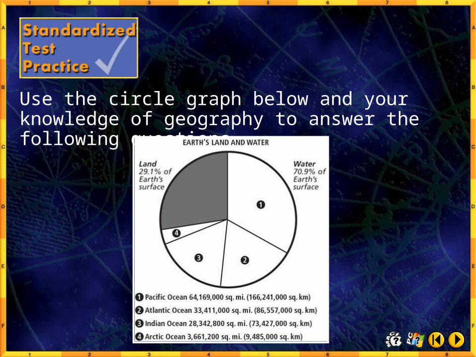
Use the circle graph below and your knowledge of geography to answer the following questions.

1. Which ocean covers the smallest area of the earth’s surface?
A Atlantic
B Indian
C Pacific
D Arctic
Click the mouse button or press the Space Bar to display the answer.
Click the mouse button or press the Space Bar to display the answer.
Test–Taking Tip Study the information shown on the circle graph for the areas of the earth covered by land and by oceans. Then compare the relative sizes of the different graph segments. By comparing the segments you will be able to determine the correct answers.

2. Which ocean covers about as much of the earth’s surface as land does?
F Indian
H Arctic
G Pacific
J Atlantic
Click the mouse button or press the Space Bar to display the answer.
Click the mouse button or press the Space Bar to display the answer.
Test–Taking Tip Study the information shown on the circle graph for the areas of the earth covered by land and by oceans. Then compare the relative sizes of the different graph segments. By comparing the segments you will be able to determine the correct answers.

Click the mouse button or press the Space Bar to display the answer.
Click the mouse button or press the Space Bar to display the answer.
Why are international time zones determined from the time at the Royal Naval Observatory at Greenwich, England (Greenwich Mean Time)?
Time zones are determined at the Royal Naval Observatory because the Prime Meridian passes through Greenwich.

Understanding Graphs
Graphs are visual representations of statistical data. Large amounts of information can be condensed when presented in graphs. Studying graphs allow readers to see relationships clearly.

