specifi c projects - gristboulevards that will mark the transformation of today’s traffi...
TRANSCRIPT

63
A Transportation Future for the Puget Sound Region
Highway 99/Alaskan Way Viaduct
On February 28, 2001, when the Alaskan Way Viaduct (Highway 99 in downtown Seattle) was badly damaged in a 6.8 magnitude earthquake it became clear that the next big quake might bring the structure down. It also turns out that the sea-wall holding back Elliott Bay is so badly deterio-rated it must be replaced. Engineers estimate that there is a fi ve percent chance the viaduct will fall in a more serious quake in the next ten years. The state DOT and the City of Seattle have collabo-rated on a plan to design options for replacing the viaduct and seawall as quickly as possible. The loss of Referendum 51 will shut down that effort for now unless voters in the three-county Central Puget Sound area approve a new fi nance package.
The viaduct carries 110,000 vehicles a day in and out of downtown Seattle and also serves as a major corridor through Seattle. After consider-ing 65 options, plans have been narrowed to three
in the environmental review process: “Rebuild,” “Aerial” and “Tunnel.”
In 2002, the City of Seattle and the state DOT endorsed a four-mile design from Spokane Street to Mercer Street between the Seattle Center and I-5. Two miles of cut and cover and bored tunnels were the favored option, to which the Advi-sory Committee has concurred. As Bruce Agnew is a member of the Committee, we can report that the methodology used in exploring various options was thorough and open.
The tunnel option is the most expensive pro-posal, up to $11.6 billion if it is built within 15 years, and potentially $15.7 billion if built over 30 years. These high estimates are due in part to util-ity relocation and the cost of keeping existing traf-fi c open during construction. According to the state DOT and City engineers, the tunnel plan would need to be built in three phases. In Phase I, the area of greatest seismic risk will be addressed. This includes the central waterfront tunnel, the Olympic Sculpture Park underpass, and the south end aerial structure, along with the construction of a tempo-
Specifi c Projects

64
How Do We Get There From Here?
rary Battery Street Tunnel connection, and com-pleted Mercer and Roy Street grade separations. (Smarting from defeat of Referendum 51, Seattle and the state are thinking of a $4.7 billion replace-ment, very likely a serious error in the long run.)
In addition, consideration should be given in future phases of the project to conversion of SR-99, both north of downtown Seattle and south of the industrial area, into more of a parkway or, in places, a fast-moving boulevard, instead of the blighted stop-and-start traffi c strip it is today. Com-pletion of SR-509 from Sea-Tac Airport, where it ends, to I-5 at Federal Way, is a key part of the vision.
A series of underpasses could speed through traffi c on Aurora Avenue North. Think of Con-necticut Avenue in Washington, D.C., where under-passes separate the busy thoroughfare from side streets and still allow side street traffi c to pass over-head (as Aurora Ave. SR-99 north of downtown and on Phinney Ridge, does not.)
Thirty years ago when John Miller and Bruce Chapman, members of the city council, pro-posed to tear down the Alaskan Way Viaduct, put in a tunnel, open the city to Elliott Bay and regain both green space and saleable, leasable, taxable land for Seattle’s development, people thought the idea laughable. Today, after similar viaducts have been removed in other cities, Seattle’s downtown land prices are far higher than they were in the 1970s, making the case even stronger for replacing the viaduct with a tunnel and rebuilding the sea-wall. With a lidded tunnel/trench, expanded carry-ing capacity for both auto traffi c and freight traffi c can be gained, along with a larger commercial tax base. Tunneling adds the potential for increased density of housing and other buildings to upland sites. And it ties in with the site of the planned new aquarium and Olympic Sculpture Park.
There will be a tremendous temptation to try to build a tunnel on the cheap or to limit it to merely the present stretch of waterfront covered by the Alaskan Way Viaduct. There also are thoughts of limiting the new thoroughfare to the same traffi c-carrying capacity it has today, even though current
traffi c already backs up in many rush hours. And some suggest scrapping the tunnel idea altogether and replacing the viaduct with a surface boule-vard, complete with traffi c lights. But rather than
taking the “less is more” approach to this signif-icant problem/opportunity, we believe the region should aim high both to increase capacity enough to relieve some pressure on I-5 and also to make the tunnels a key factor in the economic, aesthetic and housing revitalization of the city. This will mean mixing many revenue sources, as we argue, and it also may mean staggering phases of the pro-ject to make the total product more affordable. It’s complicated. But if there is any transportation choice that calls for a vision that is responsible to posterity, this is it. Remodeling the waterfront will make Seattle a far more attractive, livable, and effi -cient city for the entire 21st century.
South Lake Union: Linking I-5 and Alaskan Way with Urban Design Features
Part of the Alaskan Way Viaduct planning also seeks to disentangle the Mercer Street Mess (between Seattle Center and I-5) by extending the proposed Highway 99 tunnels to Roy Street. We urge the City and state DOT to consider tunneling the remainder of the Mercer Street corridor most of the way to I-5 in partnership with the Vulcan
If there is any transportation choice that calls for a vision that is responsible to
posterity, this is it.

65
A Transportation Future for the Puget Sound Region
Northwest property organization. Vulcan’s concept of turning South Lake Union into a multimodal center deserves support. It is the region’s most appealing opportunity for adding living units close to downtown, and to that extent, relieving density pressures elsewhere.
Thirty years ago, the City Council killed an elevated freeway like the Alaskan Way Viaduct that the state and city planned to build along the south end of Lake Union. That’s fortunate, because now we would want to tear it down as another case of blight standing in the way of redeveloping that part of town. Instead, a cut-and-cover tunnel can be built that will save scores of acres of surface space for development, while an enlarged artery of traffi c fl ows below ground.
Plans presented by Vulcan Northwest for South Lake Union, currently under discussion with city offi cials and community leaders, provide a much more effi cient transportation corridor between Alaskan Way and I-5, while adding urban design features that will attract close-in housing and neighborhood retail space to complement the neighborhoods’ emerging biotech employment cen-ters. The needs of the greater region and the imme-diate community both can be met in this fashion.
Vulcan’s plan calls for the partial lidding of Highway 99 between Seattle Center and South Lake Union to connect the two major activity cen-ters. The awkward serpentine of traffi c along Mercer street corridors would be replaced with a two way, straight lined expressway for through
traffi c, patterned after such famous boulevards as Park Avenue and the Embarcadero. Valley Street, which most directly parallels the south Lake Union shore, would be transformed, mean-while, from an endless stream of through traf-fi c to a calmer, pedestrian and marine oriented local access street, served by street cars.
For South Lake Union, the plan can serve as a catalyst for other property owners to share a vision that melds rail transit, includ-ing a renaissance of futuristic street cars cur-rently popular in Portland, bus service, water taxi service and tree-lined, pedestrian-friendly boulevards that will mark the transformation of
today’s traffi c-choked Mercer Mess and adjacent hardscrabble, warehouse-lined streets.
The infamous “Mercer Mess,” the approach to I-5
Once the Embarcadero freeway (above) was removed in San Francisco, a whole new promenade opened up (below)

66
How Do We Get There From Here?
The plan is impressive. To further achieve the goals of reuniting a community divided by the noise pollution of transportation corridors, tun-nels for Highway 99 and Mercer Street should be explored to increase through traffi c capacity while quieting the overall noise levels for this newly created urban living space. Thought should be given to using the existing waterfront trolley line,
extended up the gradual grade to Seattle Center and on to South Lake Union and back. Even better would be an extension of the line south through the eastside of downtown to make a circle route for the trolley.
King Street Station and BNSF Tunnel
Recently, the Seattle Chamber of Com-merce created an ad hoc committee that included Bruce Agnew, former U.S. Senator Slade Gorton and several Downtown Seattle Association mem-bers to explore the possibility of a new transit tunnel through downtown. At Discovery Institute, we think that such a tunnel should be an expan-sion of the mile-long Burlington Northern Santa Fe train tunnel that now begins at King Street and re-emerges at Broad Street, where trains presently contribute to growing congestion on the waterfront
from the World Trade Center at Pier 66 to Myrtle Edwards Park.
The existing train tunnel was built almost a century ago, in 1906. It lacks an adequate fi re suppression system and the capacity to handle pos-sible new commuter and inter-city passenger trains, let alone the increase in freight traffi c. The rail tunnel crosses under the Third Avenue bus tunnel
at University Street downtown. In its new incarnation it could be joined to a multi-modal station to provide a mid-town con-nection for Amtrak trains, Sounder com-muter trains, the proposed monorail on Second Avenue, and regional buses at Uni-versity Station. The new mid-town station would be within walking distance of the Coleman Ferry Dock and the waterfront trolley. As it is, the only point of intersec-tion under the state plan will be King Street Station. (New York has such an under-ground center between Grand Central Sta-tion and 42nd Street.)
At the other end of downtown, the train tunnel should not end, as now, at Broad Street, but continue as a cut-and-
cover tunnel up the full length of the waterfront, recovering the entire northeast section of the Elliott Bay waterfront for public access, green space and taxable (non-view-blocking) development. This is such a neglected part of Seattle’s waterfront that most people are barely aware of its existence, let alone its potential. It’s a lost asset that now can be regained for the public’s benefi t.
The Olympic Sculpture Park’s intended design appears to point to an exciting future for the railroad tracks if these could be buried in a cut-and-cover tunnel. The potential tax-contribut-ing development of offi ces and condos along the site where the tracks now run would justify the expense of lowering the tracks. It did in Manhat-tan many years ago, and on the Chicago riverfront more recently.
It is important to re-emphasize that a new train tunnel would not replace, absorb or confl ict with the Third Avenue bus tunnel constructed in
Burlington Northern/Santa Fe railroad tracks along the central waterfront

67
A Transportation Future for the Puget Sound Region
Aerial shot of central waterfront with Alaskan Way Viaduct replaced by a lidded tunnel and developable green space (Discovery Institute and BLJ Design)
>

68
How Do We Get There From Here?
Case Study Six
A New Deal for the King Street Station
The Washington State Department of Transportation is embarking on a two-phase approach to refurbishing and revitalizing King Street Station. The structure is owned by Burlington Northern Santa Fe Railroad and serves as the historic railroad structure currently used by Amtrak inter-city trains and Sounder com-muter trains. King Street Station was one of two railroad stations built in Seattle early in the 20th Century. It served Great Northern and Northern Pacifi c passen-ger trains for six decades. Union Station, Seattle’s other passenger rail facil-ity was used by Union Pacifi c and Milwaukee Railroad trains.
Currently ten Amtrak Cascades corridor trains operating to Port-land, Eugene and Vancou-ver, BC and four long distance trains to and from California and the Midwest use King Street Station every day. Sounder service at King Street consists of three weekday round trips from Tacoma to Seattle. The number of travel-ers using the station has tripled since 1995, and currently exceeds 4,000 on an average week-day. The station is crowded during peak travel times, facilities are shabby and unattractive. The station is operationally ineffi cient for both the transportation providers and the traveling public.
In approaching the two phased rehabil-itation of King Street Station, The state DOT has adopted three guiding principles: 1) provide adequate capacity at the station for trains and passengers in an attractive and functional envi-ronment; 2) preserve the character and design of the historic structure; and, 3) draw together all of the various public transportation linkages in the area into a complex of facilities that is truly multi-modal in order to enhance mobility for the traveling public.
Phase I will be a $15 million makeover of the waiting room, ticket counter, and grand staircase inside the station as well as a rehab of the brick, terra-cota and granite face on the exterior. This work will be bid out in stages with construction expected to begin in the fi rst quar-ter, 2003. Completion is expected to take about 18 months.
Phase II will cost $150 million and address longer term needs. Planned Sounder service and the state DOT sponsored Amtrak
Proposed renovation of King Street Station and inter-modal connection (courtesy of J. Craig Thorpe, commissioned by Nitze-Stagen and Co., Inc.)

69
A Transportation Future for the Puget Sound Region
Cascades train additions will bring the number of trains operating in and out of King Street Station to 80 a day in the next decade. King Street Station would become the third busiest train station (after Los Angeles and San Jose, CA) west of Chicago. The present track con-fi guration is inadequate to handle the planned growth in traffi c. To resolve the issue and to address the goal of developing a true multi-modal transportation center a new vision and concept have been put forth — the King Street Transportation Center.
In the state DOT plan, Link light rail and Sound Transit and Metro buses will be available at the nearby International District station. Transit enhancements would be added
for bus transit users on Fourth Avenue and Jack-son Street. A new inter-city bus terminal would be built nearby, possibly on air rights over the tracks. The new Seattle Monorail will have a sta-tion at the transportation center. One proposal includes upgrading the Waterfront Streetcar and bringing it into the Third and King Street level where it could be a key link between the King
Street Transportation Center, the sports venues, Colman Dock, other waterfront attractions and Seattle Center. In addition there are signifi cant development opportunities for nearby property and on air rights over the BNSF track.
Funds are available to start planning, design and engineering work in 2003. Nearly $8 million in capital funds were lost in the failure of R-51 at the polls in November. Nearly $35 million in capital funds have been requested by the City of Seattle for inclusion in a regional transportation funding package. Future federal funds for high speed rail and Amtrak improvements are seen as potential capital sources.
the 1980s. We agree with the Downtown Seattle Association that the bus tunnel should remain a bus-only tunnel and should not be altered to include light rail. Otherwise downtown streets, already near the saturation point, will be swamped with the many buses that currently use the tunnel.
Some commentators believe that the next reauthorization of TEA-21, the six-year federal
transportation plan, will include sizeable new invest-ments for passenger and freight rail. Modernizing and expanding the freight rail tunnel, therefore, could be eligible for future federal funds. Once again, we point out that part of the transportation project “sticker shock” voters are experiencing is due to a lack of federal support of transportation mega-projects.

70
How Do We Get There From Here?
Interstate 5 –The Neglected Central Artery
As large transportation projects are pro-posed in the region, I-5, the region’s mainstreet, has been nearly ignored. Until now, only devel-oper Kemper Freeman’s ambitious “End Conges-tion Now” report has argued for expansion and tun-neling of I-5.
The Interstate 5 Freeway that stretches from British Columbia to Baja California is the third busiest trucking corridor in the U.S. It is also the corridor that carries the most traffi c in the Central Puget Sound region. Yet there are no current plans to expand its capacity or to mitigate the day-to-day environmental problems created by what some have called “orphan land space” — the air space over the corridor in high density areas.
Does anyone believe that I-5 can continue to carry increasing traffi c loads over the next fi fty years, or even 10-20 years? On the contrary, in all modes, I-5 offers an opportunity to add signif-icant transportation capacity, while reconnecting communities that were divided in the 1960s when it was built.
The construction of this 16.5 mile stretch of I-5 freeway through Seattle commenced in 1961 and required six years, $173 million, and displace-ment of over 5,000 households to complete. The resulting “Central Freeway” created a strong order-ing element through the city. Given the monumen-
tality of its physical presence, it has dominated the urban landscape and Seattle’s urban transportation over the past half century. This continuing role lends urgency to reviewing and revising the unspo-ken assumption that it simply should remain as it is.
For all the negative environmental and physical externalities of its design and placement, I-5 affords opportunities. It is the largest physical structure in the city and the region. That structure can be better used to benefi t a broader population. Here are some of the attractive possibilities:
Regional Freeway Monorail (RFM)
An intriguing concept has been advanced by an informal group of volunteers, Regional Free-way Monorail (RFM),who have no funds but a lot of imagination. They propose to use the existing right of way along the I-5 corridor to run a mono-rail from Northgate to Sea-Tac Airport. They have been rebuffed by the state DOT, which says that there is no room on the existing right of way, and by Sound Transit, which says that people will not walk to a freeway station that is merely adjacent to the University District. Instead, Sound Transit insists that the University District needs to be served through an extremely costly tunnel directly under the corner of 45th and University.
RFM supporters say, “For about half the building cost per mile of light rail, riders can travel along the I-5 corridor up and out of traffi c on a
Does anyone believe that I-5 can continue to carry increasing traffi c loads
over the next fi fty years, or even 10-20 years?
I-5 construction at Eastlake, Seattle, 1958 (courtesy of MOHAI)

71
A Transportation Future for the Puget Sound Region
system that requires less disruption and much less time to erect than do massive streetcars. Monorails won’t require closing the downtown bus tunnel and forcing the buses back on the street.
“The proposed RFM is a form of high-capac-ity transit with a narrow footprint that could fi t within the freeway right-of-way. It has potential to move thousands of people and relieve congestion without displacing homes or businesses.”
The Seattle Popular Monorail Authority (SPMA), whose own monorail proposal was adopted by the voters in the 2002 election, con-sidered but rejected a freeway alignment as a fi rst line. It opted instead for the Ballard-Downtown-West Seattle route. SPMA representatives say the freeway is better suited to regional transportation, while the company’s charge is to link neighbor-hoods.
The sensible compromise is to construct the neighborhood-based system now (the “Green Line”) that voters just approved, and the freeway route in a Phase Two that would be part of a gen-eral redevelopment of I-5. Phase Two of the mono-rail could be constructed from Northgate to Mercer
Street and then on to Seattle Center (or alternatively, the Convention Center-Westlake area), where it would connect to the Green Line. From the south end of the Green Line, the line could split, with one line going to West Seattle and the other to Sea-Tac via Boeing Field.
Indeed, given the problems with light rail, it would make sense to abort the route scope for light rail and merge Sound Transit’s Link light rail project with the SPMA and reprogram the light rail
money to an I-5 aligned freeway monorail as the second line.
It is important that the new mono-rail system incorporate a line from down-town to Sea-Tac Airport via Boeing Field. In the not very distant future, air traffi c growth may require the equivalent of a fourth runway, and if Boeing Field has a swift monorail connection to Sea-Tac, it could meet that need and obviate argu-ments for a new airport elsewhere in the region.Note that once the “Green Line” and the
“I-5 Line” are operational, one or more lines east of Lake Washington and further into the north and south suburbs could follow. Citizens need to see a rapid transit system built; this is how to do it.
Given the problems with light rail, it would make sense to abort the route
scope for light rail and merge Sound Transit’s Link
light rail project with the SPMA and reprogram the light rail money to an I-5
aligned freeway monorail as the second line.
Conceptual drawing of monorail along I-5 (courtesy of Regional Freeway Monorail)

72
How Do We Get There From Here?
High Occupancy Toll (HOT) lanes
High Occupancy Toll (HOT) lanes are lim-ited-access lanes that high occupancy vehicles (car-pools and buses) are allowed to use free. Other vehicles gain access to them by paying variable tolls. The lanes are “managed” by pricing to main-tain free-fl ow conditions even during peak use peri-ods. HOT lanes have been in operation for several years at two sites in Califor-nia: Orange County (SR 91 Express lanes) and San Diego County (converted HOV lanes on I-15). Environmental groups have endorsed HOT lanes as an innovative transportation concept that benefi ts all users of congested corridors, car-poolers and transit, as well as single occupancy automobile users.
We propose that all new highway lanes in the region be constructed not as general purpose “free lanes” but rather as HOT lanes, and that current HOV lanes be considered for conversion to managed HOT lanes. The underutilized I-405, I-90 and SR-520 HOV lanes could be a prime pilot project for funding. The state transpor-tation commission reportedly has that under consid-eration now. Transit and carpools would have con-tinued priority during rush hours, but lanes would be open for fee-based travel. An immediate short-term benefi t would be a sharp reduction in traffi c jams in non-rush hour periods.
Bus Rapid Transit (BRT)
Bus Rapid Transit (BRT) refers to high-capacity bus service along major travel corridors. BRT is designed to match the capacity and level of service of rail transit but with the inherent fl exibil-ity of buses. For BRT to offer service quality com-parable to that of rail, buses must operate in limited access, congestion-free lanes. The Federal Transit Administration defi nes BRT as express bus service on major streets with traffi c signal preemption as well as exclusive bus lanes on arterials and freeway HOV lanes.
The Federal Transit Administration recom-mends that cities “Think Rail, Build Bus” because the operating and capital costs are signifi cantly lower, speed is higher, safety higher and more of the system can be built quickly. Seventeen cities in the U.S. are building BRT systems. Metropolitan Seattle has over two-thirds of the HOV system fi n-ished: 197 miles. The Downtown Bus Tunnel is
recognized as a model BRT facility, serving 23,000 passengers (boarding) a day. The best examples of BRT, however, are in Curitiba, Brazil and Ottawa, Canada, where buses travel on separate, dedicated busways.
As applied to I-5, a special BRT/HOT lane could be added between Northgate and the I-90 interchange (at the heart of the I-5 bottleneck just south of Seattle’s downtown). This would not be a “free” lane, but rather a combination of High Occupancy Toll and Bus Rapid Transit lanes (or Regional Freeway Monorail — see above). An additional toll/transit lane would mitigate one of Seattle’s most chronic problems, the backups that develop in the “reverse” direction when reversible lanes are open either northbound or southbound.
If it were determined that the best design for the toll/transit lane was use for a Freeway Mono-rail line rather than BRT + HOT lane at the Ship Canal, the Monorail could be added outside the
Rendering of Bus Rapid Transit system in Eugene, Oregon(courtesy of Lane County, Oregon Bus Rapid Transit System)

73
A Transportation Future for the Puget Sound Region
views, as it happens), business and open space. Here the added lanes for cars and transit would be achieved by digging down and then double deck-ing, and adding a lid at the surface.
Part of Sound Transit’s rationale for not using the I-5 corridor for its routes was the need to directly serve the University of Washington at NE 45th Street by tunneling under Portage Bay. This turned out to be a spectacular fi nancial miscalcula-tion that imperiled the whole light rail plan. We believe the University District can be revitalized instead by re-joining it on “ground level” with the Wallingford neighborhood and turning the verita-ble wasteland of today’s I-5 into a community con-nection center for both north-south and east-west travel. Wallingford/Greenlake neighborhoods and the University/Roosevelt neighborhoods would be reunited.
We are also intrigued, as noted, with the pos-sibility of integrating the Regional Freeway Mono-rail proposal into this plan. There is no denying that adding capacity by re-using existing right-of-way is more cost effective than creating new right of way elsewhere. The freeway monorail route could take one of the two lanes we are proposing for BRT/HOT lanes. The concept is particularly exciting at the Ship Canal where the monorail could be cantilevered over the high bridge and need not interfere with existing highway lanes.
A major retrofi t of I-5, for bus rapid transit or monorail, could qualify as a federal project, and be funded accordingly. It could be the pilot for land recovery and capacity additions elsewhere.
Connections with State Route 520 and Alaskan Way Viaduct/Highway 99
In the State Route 520 section of this paper (see below), we advocate a shallow tunnel for SR-520 from the western high-rise to the I-5 cor-ridor — the few blocks between Portage Bay and the I-5 freeway intersection. This SR-520-corridor tunnel would connect at I-5 with the HOT lane/BRT/Freeway Monorail coming from North-gate in a shared two-lane tunnel from Roanoke
express lanes. One of the reversible lanes could be walled off for counter-fl ow traffi c. A potentially necessary seismic retrofi t of the Ship Canal Bridge also could be accomplished as part of this rede-sign.
For the Capitol Hill-Eastlake area, we pro-pose a cut and cover lid from the Ship Canal Bridge through Roanoke Street to the Lakeview under-pass (see below). The BRT/HOT lane or Freeway Monorail would connect to the lanes coming from a redeveloped SR-520 corridor.
Again, for the lid over the Capitol Hill-East-lake section of I-5 we propose a mix of open space and taxable housing and business. The reconnec-tion of Capitol Hill, Roanoke Park and Eastlake will provide one of the most dramatic vistas in Seat-tle and a sharp reduction in noise and pollution to one of the most heavily traveled intersections in the region.
Underground Stacking and Lidding of I-5 Segments
A new transit/toll lane on I-5 could be engi-neered from Northgate to the Ship Canal Bridge as a “stacked lane” over the current reversible lanes. We propose a lid over I-5 from Northgate to the NE 85th Street interchange. (The current lanes already are below the ground level of adjacent property for much of the distance.) This would lower the noise volume and reconnect the regional Northgate Mall, North Seattle Community College campus and the nearby Northwest Hospital campus. Development of Northgate’s urban village would be facilitated, with new in-city housing, a park, commercial space and an expanded transit center. The lid would be divided by the two BRT/HOT lanes built directly above the current reversible lanes — at grade. Such a development would end the current North-gate freeway snarl that ties up traffi c frequently, and not just at rush hour.
We also propose to cut and cover I-5 from NE 71st Street to the Ship Canal Bridge with similar land uses, including a transit center that links north-south and east-west lines, housing (with excellent

74
How Do We Get There From Here?
Depiction of a lid covering I-5 at the intersection of SR-520 in Seattle, accommodating monorail, transit plaza, and potential sites for neighborhood business and housing (above); depiction (below) of a lid covering I-5, reconnecting First Hill to downtown. (Both depictions from Discovery Institute and BLJ Designs.)

75
A Transportation Future for the Puget Sound Region
Street to the Mercer Street cor-ridor, at the south end of Lake Union. Moving west, Alaskan Way would connect to High-way 99 through a tunnel. The I-5 tunnel itself would con-tinue through downtown Seattle (with connections for the cen-tral business district) until the interchange with I-90, where it would return to the main line. The proposed I-5 tunnel from Mercer Street to I-90 is a long-term concept and depends on improving Alaskan Way as a reliable north-south corridor.
The downtown segment of I-5 in Seattle should have been covered by a lid when the freeway was built in the early 60s. Though the option was advocated vigorously in and out of government, misguided leadership omitted that prudent choice. However, even if the I-5 cut through downtown Seattle had been lidded then, a retrofi t would be needed now. The entry ramps at Union Street and the exit ramp at Mercer Street going north constitute one of the classic traffi c design mistakes of this or any other urban area. The traffi c paths of the heavily-used on-and-off-
ramps actually cross each other, erecting jam ups even in off-peak hours. Instead of expanding the number of lanes as I-5, going north, reaches its top usage in approaching downtown, as one would expect, the number of lanes actually narrows. There simply isn’t enough road capacity for the traffi c that fl owed under the convention center ten years ago, let alone today. Imagine the load ten or fi fty years hence!
To get needed space for cars, trucks, buses and monorail, and to do so while recovering build-able overhead space to rejoin First Hill to the down-town, the only option is to dig down. It will have to happen sometime and sometime really is now coming fast, even though the construction chal-lenge on one of the most intensely traveled thor-oughfares on the West Coast surely will be great. But the payoff in smoother, safer traffi c, added transportation uses, and new environmental and community purposes will be even greater. Sale of air rights alone can generate substantial cost-offset-ting revenues. It will be analogized to Boston’s
“Big Dig,” but it will be multi-modal, unlike the
Before construction of I-5: Citizens march along the prospective I-5 route in downtown Seattle, protesting against an unlidded freeway trench (courtesy of MOHAI)
To get needed space for cars, trucks, buses and monorail,
and to do so while recov-ering buildable overhead space to rejoin First Hill
to the downtown, the only option is to dig down.
76
How Do We Get There From Here?
“Big Dig,” and it defi nitely must be better-planned and executed than Boston’s problem-racked road-way extravaganza. That is why we have called for new accountability features in transportation and a Design-Build-Operate approach to new mega-pro-jects.
State Route 520: A Hub Corridor in Crisis
The state-organized Trans-Lake Committee, headed by long-time transportation leader Aubrey Davis, has come up with a compromise plan for the SR-520 bridge/corridor. It includes a six-lane bridge expandable to eight lanes for high capacity transit. The proposal calls for a continuous HOV lane on both sides from Redmond to I-5.
Some Eastside representatives wanted an eight-lane alignment to handle future capacity, while the City of Seattle and com-munity members wanted no increase in gen-eral purpose lanes but rather enhancements for HOV and bicycles. Five lids up to 500 feet long, and sound walls, are part of the design — two on the west side and three on the east side of the bridge. Tolls could also be a major part of the funding strategy.
The good news is that the committee came up with a plan; the bad news is that, given the importance of the corridor to the metropolitan economy and environment, the plan should have been far bolder.
State Route 520 serves one of the most dynamic economic sub-regions in North America, stretching eastward 12.5 miles from Seattle to Red-mond. Some 120,000 jobs exist within one mile of its centerline, and thousands of other jobs in down-town Seattle and downtown Bellevue are reached by using it. Major employment along its edge includes the Microsoft main campus, the Univer-sity of Washington medical research complex, and a host of world-class fi rms in biotechnology and information sciences. SR-520 is a hub corridor that connects Interstates 5 and 405, the two highest-
volume freeways in the state. And it is the most robust suburban transit corridor in the region, with better transit use relative to size than I-5. Over half the westbound morning commute travels in the HOV lane and more than 80 percent of these users are on a bus.
However, SR-520 is a diffi cult and troubled corridor. It is infamous for long backups and lack of reliability, a trench that cuts through commu-nities and acts as a barrier against travel to the other side. It is environmentally unfriendly to the neighborhoods through which it winds, excessively noisy, an obstacle to pedestrians and bicyclists, and in some stretches barren, if not bleak.
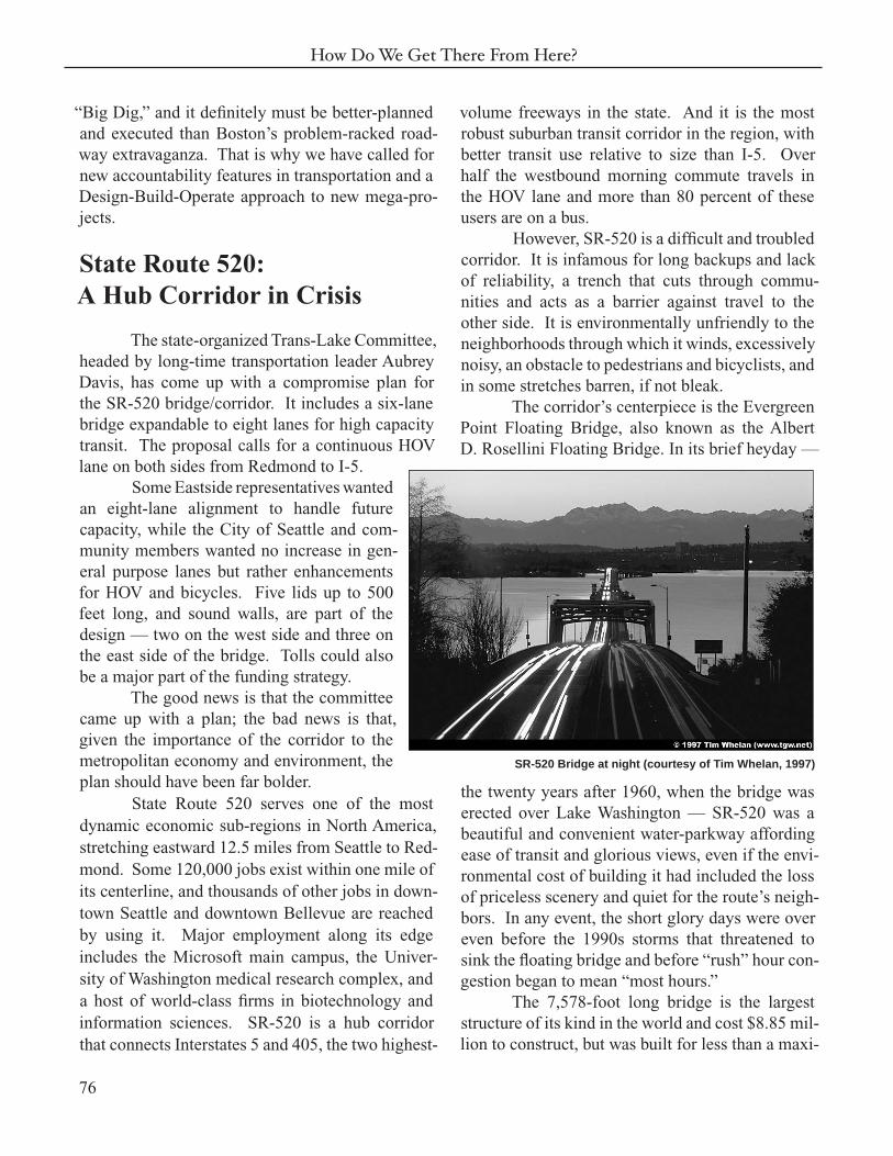
The corridor’s centerpiece is the Evergreen Point Floating Bridge, also known as the Albert D. Rosellini Floating Bridge. In its brief heyday —
the twenty years after 1960, when the bridge was erected over Lake Washington — SR-520 was a beautiful and convenient water-parkway affording ease of transit and glorious views, even if the envi-ronmental cost of building it had included the loss of priceless scenery and quiet for the route’s neigh-bors. In any event, the short glory days were over even before the 1990s storms that threatened to sink the fl oating bridge and before “rush” hour con-gestion began to mean “most hours.”
The 7,578-foot long bridge is the largest structure of its kind in the world and cost $8.85 mil-lion to construct, but was built for less than a maxi-
SR-520 Bridge at night (courtesy of Tim Whelan, 1997)

77
A Transportation Future for the Puget Sound Region
mum of 100,000 vehicle crossings per day. It now already carries 120,000. The four-lane bridge is at or near capacity most of the time, and has almost no accommodation for accidents or other incidents. Moreover, the bridge is rated as capa-ble of withstanding only one more 20-year storm. That equates to a 40 percent chance of its failing within a decade.
This fact is, in a strange way, welcome warning. As with the seismically-challenged Alas-kan Way Viaduct, doing nothing is not an option any more. The inescapable need to replace the fl oating bridge should encourage a new look at SR-520 that explores the potential to transform the corridor for the next fi ve decades, from:
• congested in both directions to decongested through improved design and value pric-ing;
• an important-but-slow bus corridor to a well-used-and-swift rail transit (or bus) cor-ridor;
• diffi cult or impossible to user-friendly for non-motorized travel;
• strip development along much of its East-side course, to mixed uses focused on tran-sit nodes;
• a route originally built as a one way suburb-to-city commute to a two-way connector;
• a narrow east-west road corridor to an inte-grated hub corridor also serving South Lake Union/Denny Regrade, Seattle Center, the waterfront, sports stadiums and the SoDo district by transit;
• a community divider to a scenic regional parkway that unites communities.
Dynamic employment and residential growth, and the interdependence of Seattle and the
Eastside, make it highly conceivable to transform the “sinking bridge” into a “silk road.” Moreover, the potential for default is preposterous, given the wealth of the region and what’s at stake.
Current discussions, as noted, revolve around the jejune question of whether the bridge should be 6 or 8 lanes. Yet, consensus on key design themes has been stymied by “the politics of veto,” suggesting that a unifi ed constituency for a 520 solution cannot be built on transportation themes alone. For many groups, the mitigation of impacts is more important than the transportation solution. Moreover, some communities along the route justifi ably view themselves as having unfairly borne 520’s impacts to date and want remedies for current conditions as well as mitigation for any expansion.
Advocates for more capacity and advo-cates for amenities are holding each other hostage. Along the 520 corridor there is a perceived con-fl ict between economic “progress” and community identity. This confl ict can be resolved only if infrastructure investments are treated as a means to human development through the freedom and access offered by mobility. From this perspective, community and livability can be seen as the intended result, not just as a mitigation. The region can and should have both more carrying capacity on 520 and a much gentler footprint on the land.
In 1999, as noted, the Trans-Lake Study Committee was convened by the state government. Representing a broad spectrum of stakeholders and interested parties, its task was to move beyond the lack of trust that characterized earlier 520 plan-ning efforts. Among its 47 committee members, 43 endorsed these recommendations that still seem solid to us:
• Focus on 520, not I-90, as a rail transit cor-ridor.
• Reduce travel demand across the bridge.
• Design a replacement structure with mini-mum footprint across the lake.
78
How Do We Get There From Here?
• Provide (HOV) lanes in combination with transit or general purpose lanes.
• Do not contemplate a third bridge cross-ing the lake.
With defeat of Referendum 51, some state and local offi cials are discussing a much reduced bridge replacement budget of one billion dollars. It is a poor prospect in our view.
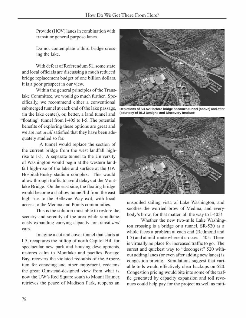
Within the general principles of the Trans-lake Committee, we would go much further. Spe-cifi cally, we recommend either a conventional submerged tunnel at each end of the lake passage, (in the lake center), or, better, a land tunnel and “fl oating” tunnel from I-405 to I-5. The potential benefi ts of exploring these options are great and we are not at all satisfi ed that they have been ade-quately studied so far.
A tunnel would replace the section of the current bridge from the west landfall high-rise to I-5. A separate tunnel to the University of Washington would begin at the western land-fall high-rise of the lake and surface at the UW Hospital/Husky stadium complex. This would allow through traffi c to avoid delays at the Mont-lake Bridge. On the east side, the fl oating bridge would become a shallow tunnel/lid from the east high rise to the Bellevue Way exit, with local access to the Medina and Points communities.
This is the solution most able to restore the scenery and serenity of the area while simultane-ously expanding carrying capacity for transit and cars.
Imagine a cut and cover tunnel that starts at I-5, recaptures the hilltop of north Capitol Hill for spectacular new park and housing developments, restores calm to Montlake and pacifi es Portage Bay, recovers the violated redoubts of the Arbore-tum for canoeing and other enjoyment, redeems the great Olmstead-designed view from what is now the UW’s Red Square south to Mount Rainier, retrieves the peace of Madison Park, reopens an
unspoiled sailing vista of Lake Washington, and soothes the worried brow of Medina, and every-body’s brow, for that matter, all the way to I-405!
Whether the new two-mile Lake Washing-ton crossing is a bridge or a tunnel, SR-520 as a whole faces a problem at each end (Redmond and I-5) and at mid-route where it crosses I-405: There is virtually no place for increased traffi c to go. The surest and quickest way to “decongest” 520 with-out adding lanes (or even after adding new lanes) is congestion pricing. Simulations suggest that vari-able tolls would effectively clear backups on 520. Congestion pricing would bite into some of the traf-fi c generated by capacity expansion and toll reve-nues could help pay for the project as well as miti-
Depictions of SR-520 before bridge becomes tunnel (above) and after (courtesy of BLJ Designs and Discovery Institute

79
A Transportation Future for the Puget Sound Region
the tides or the ship, whale or submarine movements that other regions, like Scan-danavia, have had to contend with.
In revisiting plans for the 520 crossing, meanwhile, transit should be included in the tunnel plan.
Interstate 405
Interstate 405 was fi rst planned in 1948 as a bypass to Seattle’s I-5. Orig-inally designed to carry 6,000 cars in 1960, it now handles 200,000.
The defeat of Referendum 51 delivers the biggest blow to plans to widen I-405. By far the grandest pro-ject on the Referendum 51 project, I-405
gation and amenities. The tolls would be a positive incentive, not a negative one where one pays to go faster.
Elevated, immersed tunnel
While the Trans-Lake Committee rejected a third highway bridge across the Lake, we believe a fl oating transit tunnel north of the Evergreen Point (520) bridge has merit as a future option to further relieve congestion on the 520 corridor.
Local architect Jim Felch has proposed a transit-only fl oating tunnel from Kirkland to Sand Point, a relatively short distance, as a way to relieve congestion on SR-520. By diverting some of the traffi c from Northeast King County and Southeast Snohomish County to transit and to a third lake crossing, the lifespan of the 520 bridge could be extended. Buses or monorail could provide the mode and blend in with land uses in Kirkland/Juanita and along Sand Point to the University of Washington. This is a short crossing worthy of long-range consideration. A fl oating tunnel, anchored to the lake bottom, could work on the fresh waters of Lake Washington because you would not have
A closeup of the same scene above emphasizing the restoration of the Lake Washington Park Arboretum
Illustration of fl oating transit tunnel from Kirkland to Sand Point (courtesy of Jim Felch)
80
How Do We Get There From Here?
Case Study Seven
One Model for 520: The Oresund Bridge
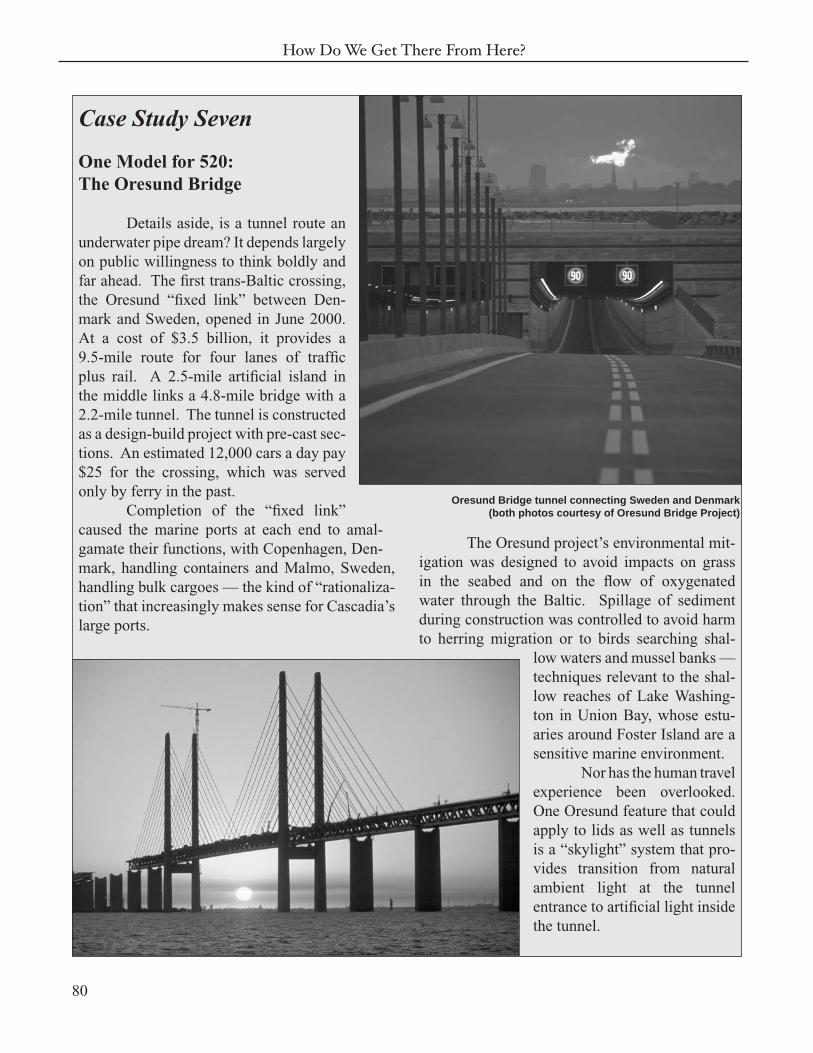
Details aside, is a tunnel route an underwater pipe dream? It depends largely on public willingness to think boldly and far ahead. The fi rst trans-Baltic crossing, the Oresund “fi xed link” between Den-mark and Sweden, opened in June 2000. At a cost of $3.5 billion, it provides a 9.5-mile route for four lanes of traffi c plus rail. A 2.5-mile artifi cial island in the middle links a 4.8-mile bridge with a 2.2-mile tunnel. The tunnel is constructed as a design-build project with pre-cast sec-tions. An estimated 12,000 cars a day pay $25 for the crossing, which was served only by ferry in the past.
Completion of the “fi xed link” caused the marine ports at each end to amal-gamate their functions, with Copenhagen, Den-mark, handling containers and Malmo, Sweden, handling bulk cargoes — the kind of “rationaliza-tion” that increasingly makes sense for Cascadia’s large ports.
The Oresund project’s environmental mit-igation was designed to avoid impacts on grass in the seabed and on the fl ow of oxygenated water through the Baltic. Spillage of sediment during construction was controlled to avoid harm to herring migration or to birds searching shal-
low waters and mussel banks — techniques relevant to the shal-low reaches of Lake Washing-ton in Union Bay, whose estu-aries around Foster Island are a sensitive marine environment.
Nor has the human travel experience been overlooked. One Oresund feature that could apply to lids as well as tunnels is a “skylight” system that pro-vides transition from natural ambient light at the tunnel entrance to artifi cial light inside the tunnel.
Oresund Bridge tunnel connecting Sweden and Denmark (both photos courtesy of Oresund Bridge Project)
81
A Transportation Future for the Puget Sound Region
was scheduled to receive $1.77 billion, which rep-resented approximately 16 percent of the project’s total estimated costs. Funding plans now shift to the proposed regional transportation package being developed by the three-county council.
The state DOT has completed the Environ-mental Impact Study of I-405, and the I-405 com-mittee of stakeholders had settled on a “mixed mode” package of improvements that:
• Adds up to two lanes in each direction to I-405.
• Implements a corridor-wide bus rapid tran-sit (BRT) system and increases local transit service.
• Creates potential for a high-capacity transit system in the core eastside area.
• Fixes bottlenecks such as the I-405/SR167 interchange.
• Adds 5,000 park and ride spaces.
• Creates 1,700 new vanpools.
The I-405 committee chair, State Senator Jim Horn, points out that a substantial amount of funding in the I-405 proposal was dedicated to environmental mitigation especially to provide for stream rehabilitation and surface water runoff. The I-405 Committee’s fi nal report stated the plan is designed to reduce traffi c congestion, fi x key choke points, enhance environmental quality, improve liv-ability for communities within the corridor, foster a vigorous state and regional economy and accom-modate planned regional growth. With a price tag of roughly $7 billion and a 20-year timeframe this is a plan that needs to be looked at from every angle. But as King County Councilman Rob Mc-Kenna observes, the I-405 project is really 33 sepa-rate and distinct projects that could “stand alone” in seeking new, more limited funding.
Other proposals are being offered. The Transportation Choices Coalition is a non-profi t coalition of advocacy groups, with its own plan for I-405.
Rather than two lanes in each direction along the entire corridor, the coalition plan would focus on one added lane in the most congested areas between I-90 and I-5 and along SR-167 to the county line and make these lanes HOT lanes. The plan would improve local street connec-tivity, adding more HOV, bicycle and pedestrian features, and encouraging transit-oriented develop-ment (TOD). Further, it suggests that purchase of the BNSF alignment used by the Spirit of Wash-ington Dinner Train should be considered for com-muter rail and as a freight rail alternative to the main line from Seattle to Everett.
The I-405 Committee might well investi-gate other features and modifi cations to maximize livability and economic growth. Perhaps the best way to manage a project of this magnitude would be through a Corridor Development Authority, simi-lar to an improvement district, governed by a board of business, government and community leaders. The Corridor Development Authority (following the model we have suggested earlier in this report) would create a business plan to do fi ve things:
• Oversee state DOT project construction.
• Handle the sale of air rights over lids for development.
• Work with civil service union pension funds to develop workforce housing for police, fi refi ghters, teachers, etc.
• Work with transit agencies to coordinate transit services.
• Provide oversight for toll collection and dis-bursement for HOT lanes.
Construction of HOT/transit lanes in areas around Tukwila’s I-405/SR-167 intersection, the

82
How Do We Get There From Here?
Highway 167 at the I-405 interchange (“S” curves) before (above) and after (below) redesign (courtesy of Washington State DOT)

83
A Transportation Future for the Puget Sound Region
Kingsgate/Totem Lake Intersection in Kirkland/Redmond and the Canyon Park-Bothell-Everett Highway intersection could be combined with cut-and-cover lids. Such a lid is also defi nitely indi-cated along I-405 in downtown Bellevue. Again, air rights could be sold or leased to help pay for the project. New amenities, noise reduction, urban density and taxable property would be the result. Lids fi t basic criteria for a successful transporta-
tion plan on I-405. They are long-term. They are not affordable all at once, they are the long-term plan. The region should commit to them as an investment, just as the federal government did with the interstate highway system. They defi nitely are bold, and some would qualify for federal support. They constitute a mutually supporting network, but you don’t have to build all the tunnels to get sys-temic benefi ts from some of them.
84
How Do We Get There From Here?
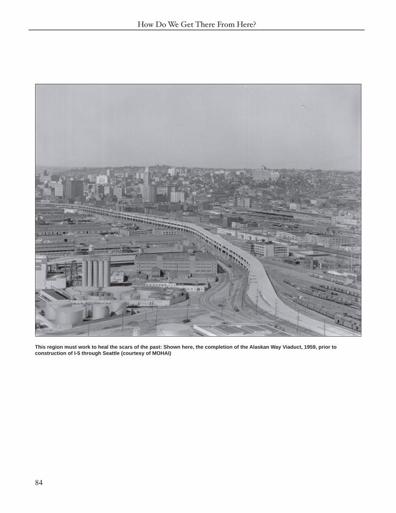
This region must work to heal the scars of the past: Shown here, the completion of the Alaskan Way Viaduct, 1959, prior to construction of I-5 through Seattle (courtesy of MOHAI)