specific plan - placer county, ca
TRANSCRIPT

SPECIFIC PLAN
Lead Agency:Placer County
Community Development Resource Agency3091 County Center Drive
Auburn, CA 95603
Approved by:Placer County
Board of Supervisorson December 8, 2015
Resolution No. 2015-261

Guide to Abbreviations ARC Architectural Review Committee
BRSP Bickford Ranch Specific Plan
CDRA Community Development Resource Agency
CFD Community Facilities District
CSA County Service Area
DRC Design Review Committee
ESD Engineering and Surveying Division
EIR Environmental Impact Report
EVA Emergency Vehicle Access
HOA Homeowners Association
LID Low Impact Development
LDR Low Density Residential
LDM Land Development Manual
LTMP Long-Term Management Plan
MDR Medium Density Residential
MPT Multi-Purpose Trail
MMRP Mitigation Monitoring and Reporting Plan
NEV Neighborhood Electric Vehicle
OS-PKY Open Space Parkway
OSP Open Space Preserve
OST Open Space Transition
PCWA Placer County Water Agency
PUE Public Utility Easement
RR Rural Residential

Bickford Ranch Specific Plan
Approved by Placer County Board of Supervisors
October 19, 2004 Resolution No. 2004-297
Amended on
December 8, 2015 Resolution No. 2015-261
Lead Agency: Placer County Community Development Resource Agency
3091 County Center Drive Auburn, CA 95603

BICKFORD RANCH SPECIFIC PLAN | DECEMBER 8, 2015
Table of Contents
1. Introduction 1.1 Project Location ...................................................................................................................................... 1-1 1.2 Legal Authority ........................................................................................................................................ 1-1 1.3 Project Objectives ................................................................................................................................... 1-2 1.4 Specific Plan Organization....................................................................................................................... 1-2 1.5 Related Documents ................................................................................................................................. 1-3 1.6 Relationship to County Plans .................................................................................................................. 1-3
2. Setting 2.1 Project Location ...................................................................................................................................... 2-1 2.2 Site Conditions ........................................................................................................................................ 2-1 2.3 Surrounding Uses .................................................................................................................................... 2-2 2.4 General Plan and Zoning ......................................................................................................................... 2-2 2.5 Ranch History .......................................................................................................................................... 2-2 2.6 Project Background ................................................................................................................................. 2-4
3. Land Use 3.1 Land Use Plan .......................................................................................................................................... 3-1 3.2 Residential............................................................................................................................................... 3-4 3.3 Open Space & Recreation ....................................................................................................................... 3-8 3.4 Public Facilities ........................................................................................................................................ 3-9 3.5 Major Roadways ..................................................................................................................................... 3-9 3.6 Development Standards and Design Guidelines ..................................................................................... 3-9
4. Circulation 4.1 Local Roadways ....................................................................................................................................... 4-1 4.2 Plan Roadways ........................................................................................................................................ 4-1 4.3 Street Design Criteria .............................................................................................................................. 4-3 4.4 Gated Entries .......................................................................................................................................... 4-3 4.5 Traffic Controls ........................................................................................................................................ 4-4 4.6 Emergency Vehicle Access ...................................................................................................................... 4-4 4.7 Bikeways and Trails ................................................................................................................................. 4-4 4.8 Electric Vehicles ...................................................................................................................................... 4-6 4.9 Public Transportation .............................................................................................................................. 4-6
5. Resource Management 5.1 Placer County Conservation Plan ............................................................................................................ 5-1 5.2 Wildlife and Vegetation .......................................................................................................................... 5-1 5.3 Wetlands ................................................................................................................................................. 5-2 5.4 Trees........................................................................................................................................................ 5-5 5.5 Cultural Resources .................................................................................................................................. 5-6

BICKFORD RANCH SPECIFIC PLAN | DECEMBER 8, 2015
6. Public Services 6.1 Parks ........................................................................................................................................................ 6-1 6.2 Recreation Centers ................................................................................................................................. 6-6 6.3 Open Space ............................................................................................................................................. 6-7 6.4 Schools ................................................................................................................................................... 6-9 6.5 Fire & Emergency Services ...................................................................................................................... 6-9 6.6 Law Enforcement .................................................................................................................................... 6-9
7. Public Utilities 7.1 Potable Water ......................................................................................................................................... 7-1 7.2 Raw Water .............................................................................................................................................. 7-4 7.3 Wastewater ............................................................................................................................................. 7-4 7.4 Drainage and Flood Control .................................................................................................................... 7-4 7.5 Stormwater Quality................................................................................................................................. 7-7 7.6 Dry Utilities ............................................................................................................................................. 7-9 7.7 Solid Waste Disposal ............................................................................................................................... 7-9
8. Implementation 8.1 Phasing Plan ............................................................................................................................................ 8-1 8.2 Financing of Public Improvements ......................................................................................................... 8-3 8.3 Maintenance ........................................................................................................................................... 8-4 8.4 Specific Plan Approvals ........................................................................................................................... 8-5 8.5 Subsequent Entitlements Process .......................................................................................................... 8-5 8.6 Interpretations, Administrative Modifications and Specific Plan Amendments .................................... 8-7
8.7 Development Standard Modifications and Exceptions .......................................................................... 8-9 8.8 Subdivision Map Revisions .................................................................................................................... 8-10 8.9 Residential Unit Transfer ...................................................................................................................... 8-11 8.10 Severability............................................................................................................................................ 8-12

BICKFORD RANCH SPECIFIC PLAN | DECEMBER 8, 2015
List of Figures
1-1 Regional Location ................................................................................................................................ 1-1 2-1 Site Features ....................................................................................................................................... 2-3 3-1 Land Use Diagram ............................................................................................................................... 3-2 3-2 Conceptual Lotting Plan ...................................................................................................................... 3-5 4-1 Circulation Plan ................................................................................................................................... 4-2 4-2 Trails and Bikeways ............................................................................................................................. 4-5 5-1 Wetland Resources ............................................................................................................................. 5-3 5-2 Open Space Preserve .......................................................................................................................... 5-4 6-1 Public Services ..................................................................................................................................... 6-2 6-2 Bickford Ranch Community Park – Conceptual Plan .......................................................................... 6-4 6-3 Typical Neighborhood Parks ............................................................................................................... 6-5 6-4 West Recreation Center – Conceptual Plan ........................................................................................ 6-6 6-5 East Recreation Center – Conceptual Plan ......................................................................................... 6-6 6-6 Relationship of Open Space Preserve and Transition Area ................................................................ 6-8 7-1 Water Facilities ................................................................................................................................... 7-3 7-2 Wastewater Collection Facilities ......................................................................................................... 7-5 7-2 Drainage Facilities ............................................................................................................................... 7-6 8-1 Conceptual Phasing Plan ..................................................................................................................... 8-2
List of Tables
3-1 Land Use Summary ............................................................................................................................. 3-1 3-2 Land Use, Acreage and Units by Parcel ............................................................................................... 3-3 4-1 Roadway Summary ............................................................................................................................. 4-3 5-1 Wetland Resource Summary .............................................................................................................. 5-2 6-1 Public Service Providers ...................................................................................................................... 6-1 6-2 Park and Open Space Requirements .................................................................................................. 6-3 6-3 Student Generation ............................................................................................................................ 6-9 7-1 Public Utility Providers ........................................................................................................................ 7-1 8-1 Maintenance Providers and Financing Mechanisms .......................................................................... 8-3

The Bickford Ranch Specific Plan (BRSP, Specific Plan or Plan Area) is a comprehensive land use and regulatory framework for development of the 1,927.9-acre Bickford Ranch property.
1.1 Project Location The BRSP lies in the southern portion of Placer County, between the communities of Lincoln, Newcastle and Penryn. The cities of Rocklin Roseville and the Town of Loomis are south of the BRSP. The BRSP site is located approximately four miles north of Interstate 80 and south of State Route 193 (SR 193), as shown on Figure 1-1. The western boundary of the BRSP is Sierra College Boulevard between SR 193 on the north and English Colony Way on the south except for a parcel at the northeast corner of Sierra College Boulevard and Caperton Court. Union Pacific Railroad is located along portions of the southern boundary of the site and passes beneath Boulder Ridge in the southeast portion of the site through the 1,600-foot long Clark Tunnel.
1.2 Legal Authority Placer County is authorized to adopt this Specific Plan following the provisions of California Planning and Land Use Law (Title 7, Chapter 3, Article 8 [Sections 65450 – 65457] (Planning and Zoning Law) of the California Government Code and of Section 17.58.200 of the Placer County Zoning Ordinance. As a mechanism for the implementation of the goals and policies of the General Plan, State law stipulates specific plans
can only be adopted or amended if they are consistent with the jurisdiction’s adopted General Plan. This Specific Plan is consistent with the policies of the General Plan, as well as other State and local regulations. All projects that follow within the BRSP shall be consistent with this Specific Plan and the General Plan.
INTRODUCTION 1
Figure 1-1 | Regional Location

BICKFORD RANCH SPECIFIC PLAN | DECEMBER 8, 2015 | PAGE 1-2
1. Aid the County in meeting its
recognized obligation to accommodate a percentage of future population growth in the County in the unincorporated portion of the County by providing 1,890 new residential units in an area identified by the General Plan as appropriate for such residential development.
2. Establish residential
development in an area of the County identified for growth.
3. Create a quality recreation
and residential development with a mix of residential, open space and recreational land uses designed in a manner that provides a distinct identity and sense of place that will be an asset to the region.
4. Establish a high-quality
residential community integrated into existing natural open space, native oak woodlands, slopes and ridges, preserving these features to the extent possible.
5. Provide an active adult
community that responds to the market preferences and needs of senior adults as they relate to housing type, size, cost, security, and recreational and social amenities.
6. Respect the natural grade,
terrain and character of the land by designing residential communities with respect to existing natural resources and topography, especially around the perimeter of the site to minimize impacts to off-site viewsheds.
7. Provide all public facilities and
services necessary to meet the needs of development within the Plan Area.
1.4 Specific Plan Organization The Specific Plan consists of eight sections listed below:
Section 1 Introduction Summarizes the purpose, organization, authority, and objectives of the Specific Plan and related documents.
Section 2 Setting Describes the site location and setting, and identifies the regulatory framework and physical features that shaped the land use plan.
Section 3 Land Use Describes the land use plan and corresponding land use designations.
Section 4 Circulation Describes the circulation system for movement of vehicles, pedestrians, hikers, equestrians and cyclists.
Section 5 Resource Management Describes existing resources and the approach to protecting wetlands, trees, open space, and cultural resources.
Section 6 Public Services Identifies public services including parks, open space, schools, law enforcement and fire services.
Section 7 Public Utilities Describes water, wastewater, storm drainage, electric, natural gas, and solid waste services.
Section 8 Implementation Describes the conceptual phasing plan, financing of public improvements, subsequent approval actions, amendment procedures, and residential unit transfers.
1.3 Project Objectives
The ultimate development pattern and framework are guided by the following project objectives:

BICKFORD RANCH SPECIFIC PLAN | DECEMBER 8, 2015 | PAGE 1-3
Development Standards The Bickford Ranch Development Standards describe permitted and conditionally-permitted uses, applicable zoning and development standards for the Specific Plan land uses.
Design Guidelines The Bickford Ranch Design Guidelines describe design attributes for consistent streetscapes, entry features, walls, fencing, and other common elements and site specific considerations.
Environmental Impact Report In 2001, an Environmental Impact Report (EIR) was certified concurrent with approval of the BRSP. The EIR, prepared in accordance with the California Environmental Quality Act (CEQA), examines the potential direct and indirect environmental effects associated with development of the BRSP and identifies appropriate mitigation measures to reduce impacts determined to be significant. The EIR will serve as the base environmental document for purposes of evaluating subsequent project-related entitlements. The EIR is a project EIR and examines all phases of the project including planning, construction and operation. The EIR also serves as a Program EIR for purposes of evaluating future requests for use permits, specific plan amendments and variances.
Addendums to the EIR were prepared in 2004 and 2015 to evaluate project revisions to the BRSP. Supplemental environmental analysis may need to be prepared if subsequent changes to the plan are proposed, or other circumstances change, which create impacts not considered in the original environmental analysis (2001), 2004 Addendum or 2014 Addendum.
Development Agreement Pursuant to Section 17.58.210 of the Placer County Zoning Ordinance, developers/property owners within the BRSP have executed a development agreement with Placer County to vest the development rights of the property. Development agreement(s) are approved by the County in accordance with applicable State and local codes, and as such, functions as legal and binding contracts between Placer County, the property owners, and their successors-in-interest. The development agreement outlines development rights, establishes obligations for infrastructure improvements and land dedications, secures the timing and methods for financing improvements, and specifies other performance obligations for development of the BRSP.
1.6 Relationship to County Plans
General Plan The Placer County General Plan serves as the long-term policy guide for the physical and economic development of the County. The County’s core values are the foundation of the General Plan and the underlying basis for its vision and direction. The BRSP implements the goals and policies of the General Plan, and augments these goals and policies by providing specific direction to reflect conditions unique to the BRSP. The BRSP is consistent with the General Plan.
County Code The County Code, including the Zoning Ordinance, is a tool for implementing the General Plan. Development standards contained in the Bickford Ranch Development Standards apply to the BRSP. Where the BRSP is silent, the Zoning Ordinance’s regulations prevail.
1.5 Related Documents
The BRSP is implemented by Placer County with the supporting documents listed below. These documents are to be used in conjunction with the Specific Plan to ensure full implementation of General Plan goals and policies.

2.1 Project Location The Bickford Ranch Specific Plan (BRSP, Specific Plan or Plan Area) is located in the southern portion of unincorporated Placer County. The 1,927.9-acre BRSP is approximately four miles northwest of Interstate 80 and south of State Route 193 (SR 193) between the City of Lincoln and town of Newcastle in unincorporated Placer County, and one mile north of the Town of Loomis and City of Rocklin. The BRSP is located in the southeast corner of Sierra College Boulevard and SR 193. The western boundary of the site is defined by Sierra College Boulevard from SR 193 on the north side to English Colony Road on the south except for a parcel at the northeast corner of Sierra College Boulevard and Caperton Court. The Union Pacific Railroad (formerly Southern Pacific Railroad) is generally the southern boundary except for a parcel south of the railroad tracks. The railroad passes beneath Boulder Ridge in the southeast portion of the property through the approximately 1,600 foot long Clark Tunnel. Clover Valley Reservoir and Clover Valley Creek are located near the southern boundary. Caperton and Antelope Canals as well as Clark Tunnel Road cross the property. Existing vehicular access to the site is from Sierra College Boulevard on the
west and Clark Tunnel Road from the north and south. Clark Tunnel Road is closed at the northerly and southerly project boundaries for vehicular traffic only. The Clark Tunnel Road easement is available to pedestrians, bicycles, equestrians and emergency vehicles. The site is located within Sections 18, 19, 20, 21, 22, 28, 29, and 30 of Township 12 North, Range 7, East Mount Diablo Base and Meridian as depicted on the Rocklin and Gold Hill quadrangles of United States Geological Survey topographic maps.
2.2 Site Conditions The site’s elevation varies across the property from about 300 feet above mean sea level near the intersection of Sierra College Boulevard and SR 193 to approximately 950 feet above mean sea level along the southeastern portion of the site near an existing communication tower owned by Placer County. Site topography is characterized by rolling hills and steep terrain, with a large amount of oak woodlands, grassland and vegetation. A broad volcanic ridge and cap runs east to west generally in the middle of the property with several narrow ridges fingering off in a northerly direction. The ridge of the property is known as Boulder Ridge and is generally flat and provides a plateau with views in all directions including the Sierra
Nevada, Folsom Lake, the Sutter Buttes, and the Coastal Range. The mid-area of the main ridge line is treeless and covered with thin soils, rocks and meadow grass. The top of the broad ridge slopes gently to the southwest at a slope ranging from two to ten percent. The percent of slope is much greater on the sides of the ridges and exceeds thirty percent in places. Various oak species and pine trees are found along the convergence between the volcanic cap and more porous subsoils. The broad ridges in the southern half of the site are sparsely vegetated with trees, brushes, and short grasses while narrow ridges in the northwest have a slightly greater concentration of trees. Most trees are along the sides of the ridges and in the valleys between adjacent ridges. Tree density is sporadic in the lower elevations of the northwest portion of the site. Numerous swales drain the summit on a seasonal basis. The northwestern portion of the property is generally level pasture land. Caperton Canal extends approximately ten miles in length, of which approximately 6.5 miles are within the BRSP site. The canal starts at a point commonly called the Pot Hole and terminates at Whitney Reservoir. The Caperton Canal provides raw water to the PCWA Sunset Water Treatment Plant. Pot
SETTING 2

BICKFORD RANCH SPECIFIC PLAN | DECEMBER 8, 2015 | PAGE 2-2
Hole is a point of flow diversion at which the incoming flow from the Lower Fiddler Green Canal is split into the Caperton and Antelope canals. The Antelope Canal delivers water to the Penryn, Morgan, Ben Franklin, and the Antelope Stub canals. The Caperton Reservoir is part of the Caperton Canal system while Clover Valley Reservoir is part of the Antelope Canal System. Clover Valley Reservoir is located on the southern boundary of the Plan Area. A 300-foot communication tower, owned by Placer County, adjacent to the eastern boundary of the property near the topographic high point of the site, is used by a cable television company and Placer County. From Sierra College Boulevard to the communication tower is a distance of approximately three miles. An old mine site is located in the northeast corner of the project site. On-site vegetation types include annual grassland, oak savanna, and foothill woodland. Clover Valley Creek supports a narrow woodland corridor along the southerly edge of the property. Annual grassland, typical of the region, covers a majority of the site and occurs on shallow soils with low water-holding capacities. Dominant trees in the grassy savannas are Blue Oak and Interior Live Oak. These open groves of oaks are underlain by grasslands. Existing site features are shown on Figure 2.1.
2.3 Surrounding Uses Existing land uses adjacent to the site are generally ranchettes. Land uses north are generally two to twenty acre ranchettes and land uses east and south of the site are five to twenty-acre ranch estates. Along the northwestern boundary on Sierra
College Boulevard there are five to twenty-acre ranch estates. The Twelve Bridges Specific Plan Area, including the Village 1 Specific Plan area, located in the City of Lincoln, is located on the west side of Sierra College Boulevard. Two ten-acre ranches, including main houses and several barns and structures located in the western portion of the site, are not part of the BRSP.
2.4 General Plan and Zoning The Placer County General Plan land use designation for the BRSP is Rural Residential, 1 to 10 acre minimum. The BRSP is zoned Farm (F), combining Develoment Reserve (-DR) with 10 and 20-acre minum parcel sizes (F-B-X-DR 10 and 20 acre minimum and F-B-X 10 acre and 20 acre minimum). With the Specic Plan approvals, the BRSP will be zoned SPL-BRSP.
2.5 Ranch History The Bickford Ranch was a working ranch for more than a century. The earliest settlers in the area were local Native Americans, the Nisenan, a part of the southern Maidu tribe. A large Nisenan village was located west of the site near Auburn Ravine Creek. The Nisenan lived peacefully in the area for centuries until the unfortunate outbreak of smallpox in the early 1800s eradicated much of the Nisenan population. In 1848, gold was discovered in California, first in Coloma and four months later in Auburn Ravine near Bickford Ranch. Soon the quiet countryside bustled with miners, merchants, bankers, and other settlers flocking there to profit from the gold mines.
By 1852, the mining town called Virginia emerged and the next year, miners built California's first railroad to haul auriferous soil from Virginia to Auburn Ravine for washing in the river. The towns of Newcastle, Penryn and Loomis rose from mining camps along the ravine. On April 2, 1851, John Herbert Bickford, the pioneer who built Bickford Ranch, was born in Cumberland County, Maine. Twenty-five years later, he would take Horace Greely’s famous advice to "Go west, young man!" by purchasing eighty acres of what was eventually to become the Bickford Ranch. Initially a sheep rancher and fruit orchard operator, John Bickford went into the stock and dairy business in 1896. John Bickford's descendants continued to own and manage the cattle ranch until it was sold in the early 1980s. Fires in the 1930s and 1940s caused severe damage to natural vegetation on the property. Ranch operations were moved to McArthur in Shasta County.

BICKFORD RANCH SPECIFIC PLAN | DECEMBER 8, 2015 | PAGE 2-3
Figure 2-1 | Site Features

BICKFORD RANCH SPECIFIC PLAN | DECEMBER 8, 2015 | PAGE 2-4
1994 General Plan In August 1994, the Placer County Board of Supervisors (Board), during the County’s General Plan update, designated the BRSP site as Rural Residential (1-10 acres per dwelling unit). The zoning designation was also changed to add a Development Reserve (-DR) designation that requires a specific plan for any development of the property beyond those uses permitted by the Farm Zone with a 10-acre minimum. In addition, the Placer County General Plan Policy document, in Appendix C, outlined the development standards for the BRSP Area. The Placer County General Plan was updated in May 2014 and no longer includes Appendix C, including the BRSP development standards.
1999 Draft EIR & 2000 Final EIR In the 1990s, Southwest Bickford Holdings, Inc. purchased the property and proposed the Bickford Ranch Specific Plan project. Placer County prepared the BRSP Draft Environmental Impact Report (EIR) (August 17, 1999) and BRSP Final EIR dated November 13, 2000.
2001 Revised EIR The 2001 Draft EIR was prepared to reflect revisions made in the Final EIR and on December 18, 2001, the Board certified the BRSP Environmental Impact Report (EIR) (Resolution No. 2001-340). The Bickford EIR analyzed the impacts of the project as described in the then proposed BRSP, Development Standards and Design Guidelines. It also analyzed the changes to the project described in Chapter 2.0 of the BRSP FEIR dated November 13, 2000.
2001 Approvals On December 18, 2001, the Board approved the entitlements related to the BRSP.
2001 Approvals Challenged
Subsequently the foregoing actions were challenged in court. The Court determined that the Board's approval of the Specific Plan, Design Guidelines, Development Standards, Development Agreement, adoption of mitigation measures, and the Mitigation Monitoring and Reporting Plan, and resolutions pertaining to Clark Tunnel Road were invalid and consequently, ordered those actions be rescinded. Following nearly three years of litigation proceedings, Placer County and the project developer entered into the settlement agreements with interested parties in 2004.
2001 Approvals Rescinded On August 10, 2004, the Board complied with the Court's writ by rescinding its 2001 approval of the Specific Plan, Design Guidelines, Development Standards, Development Agreement, adoption of mitigation measures, Mitigation Monitoring and Reporting Plan, and the resolutions pertaining to Clark Tunnel Road.
2004 Approvals On October 19, 2004, the Board reconsidered and approved the project. The Board considered the previously certified BRSP EIR (2001), together with an Addendum to the EIR (2004). The Addendum addressed the changes between the project evaluated in the BRSP EIR (2001) and the project described in the September 1, 2004 BRSP as well as other changes that occurred since 2001.
The Board approved the Specific Plan, Design Guidelines, Development Standards, Development Agreement, adoption of mitigation measures, and the Mitigation Monitoring and Reporting Plan, and resolutions pertaining to Clark Tunnel Road.
Site Development Commenced In early 2005, site development activities commenced, including mass grading, a portion of tree removals and wetland species mitigation. None of the site work was completed. Off-site construction of sewer and water infrastructure was also initiated but not completed.
2015 Approvals In 2012, LV Bickford Ranch, LLC acquired the property and proposed revisions to the BRSP. The 2015 Approval reflects the following modifications to the BRSP: Reduction in the size of the
development footprint by increasing the size of the open space preserves and addition of the open space transition area;
The overall density and number of units (1,890) were unchanged. The conceptual lotting of residential villages was modified with respect with greater avoidance of slopes and trees;
Residential Increase in the residential density
from 2.47 units per acre to 2.69 units per acre while maintaining the overall project density of approximately 0.98 units per acre.
Reduction in the area designated
for residential uses by 63.6 acres with offsetting increases in open space.
2.6 Project Background

BICKFORD RANCH SPECIFIC PLAN | DECEMBER 8, 2015 | PAGE 2-5
Modification to the mix of residential housing types to shift units from the lowest and highest density ranges (High Density Residential and Rural Residential) to mid-range densities (Low Density and Medium Density).
Increase in the number of age-
restricted residential units by three units from 947 to 950 units, with a corresponding three unit reduction in the number of conventional units from 943 to 940 units, thus maintaining the 1,890 residential unit cap established with the 2004 BRSP.
Elimination of the 17.3-acre high
density site (Village Residential site).
Commercial Elimination of the 9.7-acre
commercial site (Village Commercial site).
Open Space and Recreation Golf Course Facilities. Elimination
of the golf course, driving range and golf course maintenance facility (316 acres).
Parks. Reduction in overall
parkland by 18.1 acres and shift of 15.2 acres of parkland from public parks to multiple smaller parks (maintained privately) within neighborhoods. Tower Park was removed.
Open Space. Increase in the
acreage of open space preserves by 109.7 acres and creation of an open space transition area of 163.5 acres between residential and open space preserves uses.
Open Space Corridors/Parkways.
Increase in the acreage of open space parkways by 77.5 acres. A portion of the acreage previously
located in open space parkways is now in Open Space Preserves.
Public Facilities Public Facilities Parcel.
Elimination of the 4.7-acre Public Facilities parcel on the east side of the Plan Area and addition of 5.1-acre Public Facilities parcel (PF-5) adjacent to the school site.
School Site. Increase in the acreage of the school site (PF-3) by 3.0 acres to a 15.0-acre site.
Fire Station Site. Increase in the
acreage of the fire station site (PF-1) by 0.4 acre.
Public Utilities Water Facilities. Increase in the
size of the water tank site on the east side of the project site by 1.6 acres to accommodate Placer County Water Agency (PCWA)’s water facilities. Addition of a three-acre site on the west side of the site to accommodate a second water tank and pump station.
Infrastructure Plans. Update to
infrastructure and utility service plans to correspond to revised land use plan and updated roadway network.
Water Conservation. Addition of
water conservation measures (e.g. reduced turf, smart irrigation controls, recirculating hot water, etc.) that will result in a water savings of 24.5 percent.
Transportation Elimination of the Bickford
Ranch Road intersection near English Colony Way and relocated main access of Bickford Ranch Road to intersect with Sierra College Boulevard across from Penny Lane.
Shifted secondary access north on Sierra College Boulevard.
Reduced the number of project
entries from three to two.
Realignment of trails to correspond to updated village design, open space constraints, and roadway network.
Modification of street
alignments and trail sections.
Enhancements (paving,
restriping) to the existing park and ride lot located on the west side of Sierra College Boulevard near SR 193. The 2004 BRSP included a park and ride facility within the Village Commercial Site that was eliminated as part of the 2014 BRSP.
December 8, 2015, the Board approved the revised project. The Board considered the previously certified BRSP EIR, together with an Addendum to the EIR (2015). The 2015 Addendum addresses the changes between the project evaluated in the BRSP EIR including the 2004 Addendum and the project described in the December 8, 2015 Bickford Ranch Specific Plan/Development Standards/Design Guidelines.

The Bickford Ranch Specific Plan (BRSP, Specific Plan or Plan Area) includes a mix of land uses including rural, low-, and medium-density residential; open space, parks and public facilities uses.
At buildout, the BRSP will provide 1,890 residential units, accommodate 4,154 residents and include 60% of the Plan Area in open space, park and recreation uses.
The development footprint has been designed to maximize open space preservation and to create residential home sites that relate to open space opportunities and view sheds. BRSP is a low-density single family residential community with an overall density of less than one unit per acre.
3.1 Land Use Plan
Land Use Plan and Summary The BRSP Land Use Plan sets forth the land use framework and circulation pattern connecting land use areas. The BRSP Land Use Plan is presented in Figure 3-1 and summarized on Table 3-1, Land Use Summary. Table 3-2 lists land use, acreage and units by parcel. The Land Use Diagram specifically locates land uses; however, refinements within substantial compliance with the original design may be required to accommodate technical issues that may occur during the subdivision design process. The Land Use Summary is a tabular listing of all proposed land uses in the BRSP and includes land uses, densities, approximate lot yields, and acreages.
Table 3-1 Land Use Summary Land Use Density Acres Units
Residential
RR Rural Residential 1 unit/1 - 10 acres 108.2 27
LDR Low Density Residential 1-5 units/acre 576.6 1,798
MDR Medium Density Residential 5-10 units/acre 16.3 65
Subtotal 701.1 1,890
Open Space, Parks and Recreation
OSP Open Space – Preserve 783.5
OST Open Space – Transition 163.5
OSPKY Open Space – Parkway 123.8
PR Community Park 27.6
PR Neighborhood Park 15.2
PR Recreation Centers (RC) 17.2
Subtotal 1,130.8
Public Facilities
PF School, fire station, water
facilities, public facilities
27.9
Subtotal 27.9
Roadways and Landscape
Roadways 51.0
Landscape 17.1
Subtotal 68.1
Total 1,927.9 1,890
LAND USE 3

BICKFORD RANCH SPECIFIC PLAN | DECEMBER 8, 2015 | PAGE 3-2
Figure 3-1 | Land Use Diagram

BICKFORD RANCH SPECIFIC PLAN | DECEMBER 8, 2015 | PAGE 3-3
Table 3-2 Land Use, Acreage and Units by Parcel
Parcel Specific Plan Land Use Acres Units
Parcel Specific Plan Land Use Acres Units
RR-1 Rural Residential 3.5 1 OSP-13 Open Space Preserve 2.2
RR-2 Rural Residential 12.7 3 OSP-14 Open Space Preserve 13.2
RR-3 Rural Residential 14.0 6 OSP-15 Open Space Preserve 18.6
RR-4 Rural Residential 7.0 2 OSP-16 Open Space Preserve 76.7
RR-5 Rural Residential 13.2 6 OSP-17 Open Space Preserve 19.6
RR-6 Rural Residential 22.3 4 OSP-18 Open Space Preserve 27.0
RR-7 Rural Residential 35.5 5 OSP-19 Open Space Preserve 19.5
LDR-01 Low Density Residential 32.1 26 OSP-20 Open Space Preserve 17.8
LDR-02 Low Density Residential 19.7 20 OST-1-38 Open Space Transition 163.5
LDR-03 Low Density Residential 11.7 35 OS-PKY-1 Open Space Parkway 7.4
LDR-04 Low Density Residential 22.8 72 OS-PKY-2 Open Space Parkway 19.5
LDR-05 Low Density Residential 28.3 103 OS-PKY-3 Open Space Parkway 2.3
LDR-06 Low Density Residential 4.4 8 OS-PKY-4 Open Space Parkway 5.8
LDR-07 Low Density Residential 2.1 3 OS-PKY-5 Open Space Parkway 25.4
LDR-08 Low Density Residential 31.4 103 OS-PKY-6 Open Space Parkway 15.1
LDR-09 Low Density Residential 3.2 4 OS-PKY-7 Open Space Parkway 3.4
LDR-10 Low Density Residential 21.8 36 OS-PKY-8 Open Space Parkway 19.9
LDR-11 Low Density Residential 12.9 44 OS-PKY-9 Open Space Parkway 9.7
LDR-12 Low Density Residential 6.3 23 OS-PKY-10 Open Space Parkway 8.6
LDR-13 Low Density Residential 19.6 73 OS-PKY-11 Open Space Parkway 6.7
LDR-14 Low Density Residential 7.3 21 PR-A (RC) Recreation Center (West) 8.5
LDR-15 Low Density Residential 4.3 13 PR-B (RC) Recreation Center (East) 8.7
LDR-16 Low Density Residential 43.0 173 PR-1 Park (Bickford Ranch Park) 23.4
LDR-17 Low Density Residential 8.9 26 PR-2 Park (Bickford Ranch Park) 4.2
LDR-18A Low Density Residential 48.5 59 PR-4 Park (Neighborhood Park) 4.5
LDR-18B Low Density Residential 5.4 6 PR-5 Park (Neighborhood Park) 1.8
LDR-19 Low Density Residential 48.9 196 PR-6 Park (Neighborhood Park) 0.5
LDR-20 Low Density Residential 27.5 89 PR-7 Park (Neighborhood Park) 0.5
LDR-21A Low Density Residential 49.2 198 PR-7 Park (Neighborhood Park) 0.5
LDR-21B Low Density Residential 35.1 128 PR-8 Park (Neighborhood Park) 0.1
LDR-22 Low Density Residential 5.1 24 PR-9 Park (Neighborhood Park) 1.1
LDR-23 Low Density Residential 44.2 173 PR-10 Park (Neighborhood Park) 0.3
LDR-24 Low Density Residential 8.0 30 PR-11 Park (Neighborhood Park) 0.2
LDR-25A Low Density Residential 3.5 18 PR-12 Park (Neighborhood Park) 0.1
LDR-25B Low Density Residential 5.8 27 PR-13 Park (Neighborhood Park) 0.4
LDR-26 Low Density Residential 10.0 40 PR-14 Park (Neighborhood Park) 2.4
LDR-27 Low Density Residential 5.6 27 PR-15 Park (Neighborhood Park) 0.3
MDR-01 Medium Density Residential 16.3 65 PR-16 Park (Neighborhood Park) 0.2
OSP-1 Open Space Preserve 32.5 PR-17 Park (Neighborhood Park) 1.2
OSP-2 Open Space Preserve 36.2 PR-18 Park (Neighborhood Park) 0.8
OSP-3 Open Space Preserve 8.0 PR-19 Park (Neighborhood Park) 0.6
OSP-4 Open Space Preserve 92.2 PR-20 Park (Neighborhood Park) 0.2
OSP-5 Open Space Preserve 66.4 PF-1 Public Facilities (Fire Station) 1.4
OSP-6 Open Space Preserve 70.0 PF-2 Public Facilities (School) 15.0
OSP-7 Open Space Preserve 70.1 PF-3 Public Facilities (PCWA) 3.4
OSP-8 Open Space Preserve 35.5 PF-4 Public Facilities (Water Tank) 3.0
OSP-9 Open Space Preserve 59.1 PF-5 Public Facilities 5.1
OSP-10 Open Space Preserve 72.8 Landscape 17.1
OSP-11 Open Space Preserve 41.9 Roadway 51.0
OSP-12 Open Space Preserve 4.2 Total 1,927.9 1,890
BICKFORD RANCH SPECIFIC PLAN | DECEMBER 8, 2015 | PAGE 3-4
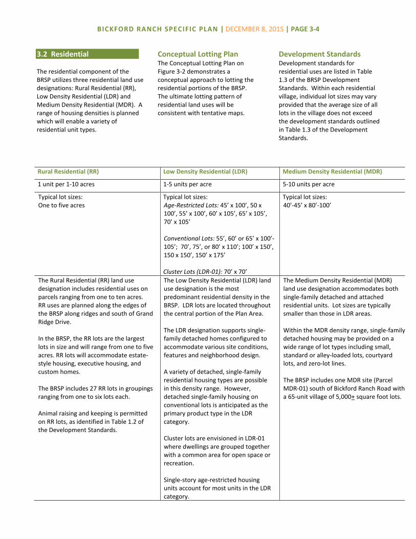
Rural Residential (RR) Low Density Residential (LDR) Medium Density Residential (MDR)
1 unit per 1-10 acres 1-5 units per acre 5-10 units per acre
Typical lot sizes: One to five acres
Typical lot sizes: Age-Restricted Lots: 45’ x 100’, 50 x 100’, 55’ x 100’, 60’ x 105’, 65’ x 105’, 70’ x 105’ Conventional Lots: 55’, 60’ or 65’ x 100’-105’; 70’, 75’, or 80’ x 110’; 100’ x 150’, 150 x 150’, 150’ x 175’ Cluster Lots (LDR-01): 70’ x 70’
Typical lot sizes: 40’-45’ x 80’-100’
The Rural Residential (RR) land use designation includes residential uses on parcels ranging from one to ten acres. RR uses are planned along the edges of the BRSP along ridges and south of Grand Ridge Drive. In the BRSP, the RR lots are the largest lots in size and will range from one to five acres. RR lots will accommodate estate-style housing, executive housing, and custom homes. The BRSP includes 27 RR lots in groupings ranging from one to six lots each. Animal raising and keeping is permitted on RR lots, as identified in Table 1.2 of the Development Standards.
The Low Density Residential (LDR) land use designation is the most predominant residential density in the BRSP. LDR lots are located throughout the central portion of the Plan Area. The LDR designation supports single-family detached homes configured to accommodate various site conditions, features and neighborhood design. A variety of detached, single-family residential housing types are possible in this density range. However, detached single-family housing on conventional lots is anticipated as the primary product type in the LDR category. Cluster lots are envisioned in LDR-01 where dwellings are grouped together with a common area for open space or recreation. Single-story age-restricted housing units account for most units in the LDR category.
The Medium Density Residential (MDR) land use designation accommodates both single-family detached and attached residential units. Lot sizes are typically smaller than those in LDR areas. Within the MDR density range, single-family detached housing may be provided on a wide range of lot types including small, standard or alley-loaded lots, courtyard lots, and zero-lot lines. The BRSP includes one MDR site (Parcel MDR-01) south of Bickford Ranch Road with a 65-unit village of 5,000+ square foot lots.
3.2 Residential The residential component of the BRSP utilizes three residential land use designations: Rural Residential (RR), Low Density Residential (LDR) and Medium Density Residential (MDR). A range of housing densities is planned which will enable a variety of residential unit types.
Conceptual Lotting Plan The Conceptual Lotting Plan on Figure 3-2 demonstrates a conceptual approach to lotting the residential portions of the BRSP. The ultimate lotting pattern of residential land uses will be consistent with tentative maps.
Development Standards Development standards for residential uses are listed in Table 1.3 of the BRSP Development Standards. Within each residential village, individual lot sizes may vary provided that the average size of all lots in the village does not exceed the development standards outlined in Table 1.3 of the Development Standards.

BICKFORD RANCH SPECIFIC PLAN | DECEMBER 8, 2015 | PAGE 3-5
Figure 3-2 | Conceptual Lotting Plan

BICKFORD RANCH SPECIFIC PLAN | DECEMBER 8, 2015 | PAGE 3-6
Age-Restricted Community Approximately half of the BRSP is planned as an age-restricted community for residents 55 years and older (active adults). The age-restricted portion of the Plan Area consists of 950 residential units located through the central portion of the Plan Area along Boulder Ridge. The area planned for the age-restricted community includes the West Recreation Center (Parcel RC-1), trails, several neighborhood parks and amenities designed for adults. Lots for age-restricted units are designed with an emphasis on living space and amenities and are single-story. The age-restricted villages will be included within a homeowners’ association specific to the age-restricted community. Residency will be restricted by deed restriction in accordance with California Civil Code Section 51.3, the Federal Fair Housing Act amendment of 1988 and the Housing for Older Persons Act of 1995, with amendments.
Custom Home Lots The BRSP includes opportunities for small builders and custom homes with larger single-family residential lots. Residential areas targeted for executive housing and custom lots are in enclaves that are oriented to maximize views into the open space and vistas beyond the BRSP. Custom homes may be designated for construction in any RR or LDR village. Custom homes are single-family residential units with unique exterior styling and individualized interior floor plans and each home’s architectural design is distinct from others in the subdivision.
Affordable Housing The Placer County Housing Element sets forth policies and programs for the County to meet its fair share of regional housing allocation and to provide an adequate housing supply. The Housing Element requires each new development to satisfy its affordable housing obligation by providing ten percent of residential units as affordable to lower income households, or dedicating land to accommodate the affordable housing requirement, or paying an in-lieu fee in an amount equivalent to providing the units.
The affordable housing requirement for the BRSP is 189 units (ten percent of 1,890 units). The BRSP will satisfy its affordable housing obligation through payment of an equivalent in-lieu fee collected at building permit. Fees collected for BRSP would be used by the County to fund the County’s affordable housing priorities in the unincorporated area. Additional information regarding the affordable housing in-lieu fee is included in the Bickford Ranch Development Agreement.
Residential Population The BRSP will accommodate a population of 4,154 total residents, of whom 1,705 will be age-qualified adults. The average household sizes are 2.6 persons per household for conventional units and 1.8 for age-restricted adult units. The smaller household size for age-restricted households accounts for fewer occupants per households which results in fewer impacts to public services and facilities.
Residential Unit Transfer Over time, there may be a desire or need to adjust (reduce or increase) the number of units assigned to some large-lot residential parcels. These adjustments may be permitted under certain conditions, pursuant to the provisions outlined in Section 8.9 (Residential Unit Transfer) of this Specific Plan.

BICKFORD RANCH SPECIFIC PLAN | DECEMBER 8, 2015 | PAGE 3-7
3.3 Open Space & Recreation Approximately 60% of the BRSP is designated for open space and parks and recreation uses. Uses in the open space designation include preserves (permanent open space), transition areas and parkways. Parks and recreation uses include two community parks, seventeen neighborhood parks and two recreation centers. The BRSP is designed to maximize views and access into open space. Every residential lot in the BRSP is no more than 150 feet from an open space or park feature. Development standards and permitted uses for open space uses are included in the Bickford Ranch Development Standards, Section 2
Open Space (OS) Parks and Recreation (PR)
The Open Space (OS) land use designation is applied to lands which are environmentally-sensitive habitat and provide opportunities for resource avoidance and preservation, views, passive recreation, pedestrian/bike paths, water conveyance and detention, flood control, and stormwater quality and treatment. Open Space Preserves (OSP). Most of
the open space (41% of the Plan Area) is included in an expansive open space preserve that will be protected by a conservation easement. Open space preserves include natural open space areas, oak woodland, wetland and cultural resource avoidance and preservation, detention and stormwater quality/treatment, fuel reduction areas, and trails.
Open Space Transition (OST). Open Space Transition accounts for 163.5 acres and is the band of open space located between the rear property line of residential areas and open space preserves. The OST parcels transition the developed (graded) area of the residential lots to the open space preserve (non-graded).
In the transition area, limited activities may occur such as slope easements, drainage outfalls, and utilities, fire breaks, trails, etc. The OST parcels will not be included in a conservation easement.
Open Space Parkways (OSPKY). Parkways are linear open space areas among residential uses and adjacent to roadways which serve multiple functions including tree planting, water quality, detention, and floodwater conveyance. The parkways will link neighborhoods via a neighborhood trail system. The parkways will also include tree plantings and landscaped areas.
Open space uses are further described in the Resource Management and Public Services sections (Section 5 and 6).
The Parks and Recreation (PR) land use designation is applied where private and public park facilities and recreation uses are planned. A combination of active and passive recreation facilities is planned in one community park, seventeen neighborhood parks and two recreation centers. Community Park. The 27.6-acre
Bickford Ranch Community Park (PR-1 and PR-2) is located on the west side of the BRSP, adjacent to Sierra College Boulevard, north and south of Bickford Ranch Road. The park complex consists of two parts: an equestrian staging area, and an active recreation area with play fields.
Neighborhood Parks. Seventeen
small neighborhood park sites totaling 15.2 acres are distributed within residential villages and will provide passive recreation facilities within a short walking distance of residential uses.
Recreation Centers. Two recreation
centers (Parcel RC-1 and RC-2) will provide recreation and social spaces including meeting and instructional spaces, fitness equipment, outdoor recreation facilities (swimming pool, tennis courts, bocce courts) and other amenities for residents. The West Recreation Center (RC-1) will serve the age-restricted community and the East Recreation Center (RC-2) will serve all residents.
Park and recreation facilities are further described in the Public Services section (Section 6).

BICKFORD RANCH SPECIFIC PLAN | DECEMBER 8, 2015 | PAGE 3-8
3.4 Public Facilities The Public Facilities (PF) land use designation accommodates public-serving uses and facilities. Five parcels are designated PF. Development standards and permitted uses for Public Facilities are included in the Bickford Ranch Development Standards, Section 3.
School A 15.0-acre site (Parcel PF-2) for a K-8 school is planned on the southwest side of School Ranch Road near Sierra College Boulevard. The school is within the Loomis Union School District. Additional information regarding the school site is in the Public Services section (Section 6).
Fire Station A 1.4-acre site (Parcel PF-1) for a fire station is proposed at the northeast corner of Bickford Ranch Road and Sierra College Boulevard. The fire station will serve BRSP as well as neighboring areas of the County. In the event the site is not utilized for a fire station, the site could be developed with other Public Facilities uses. Additional information regarding the fire station is in the Public Services section (Section 6).
Water Facilities Two sites are planned for water facilities. A 3.4-acre site (Parcel PF-3) on the eastern side of the BRSP is designated for facilities owned and operated by Placer County Water Agency (PCWA). The facilities are accessible from Bickford Ranch Road. A 3.0-acre site (PF-4) is planned for a water storage tank and pump station south of Sierra College Boulevard in Village RR-07.
Public Facilities Site A 5.1-acre Public Facilities site (PF-5) is located on School Ranch Road, adjacent to the school site (PF-2). Site PF-5 is suitable for Public Facilities such as utilities, County service yard, government facilities, school, park and houses of worship.
3.5 Major Roadways 51.0 acres of the BRSP are designated for major roadways including arterials and collectors. Roadways are described in the Circulation section (Section 4).
3.6 Development Standards and Design Guidelines Development standards and design guidelines applicable to BRSP land uses are contained in the Bickford Ranch Development Standards and Bickford Ranch Design Guidelines, respectively.

The circulation system for the Bickford Ranch Specific Plan (BRSP) includes a hierarchy of roadways and other improvements designed to link with existing roadway facilities and provide safe and efficient access to throughout the BRSP. These facilities include roadways, bikeways, pedestrian paths and equestrian trails.
4.1 Local Roadways State Route 193 and Sierra College are local roadways that provide access to the BRSP site.
State Route 193 State Route 193 (SR 193), also known as the Lincoln Newcastle Highway, is an east-west State highway that links the City of Lincoln with Newcastle. This two-lane highway provides access to State Route 65 to the west and Interstate 80 to the east. Access to SR 193 from the BRSP is available via Sierra College Boulevard. SR 193 is located approximately three hundred feet north of northeast portion of the BRSP.
Sierra College Boulevard
Sierra College Boulevard is a two-lane, north-south arterial roadway that is located along the western boundary of the BRSP. It provides access from Interstate 80 northward to its terminus at SR 193, connecting the BRSP to Lincoln, Loomis, Rocklin,
Roseville and Sacramento. Sierra College Boulevard provides direct access to the BRSP, and it will continue to function as the BRSP’s primary access corridor.
4.2 Plan Roadways The BRSP roadway system includes arterial, collector and residential roadways, which are illustrated on Figure 4-1. Lane capacity, easement widths and other roadway characteristics are summarized on Table 4-1. Roadway sections and design details are shown and described in the Bickford Ranch Development Standards, Section 4. Construction of roadways will be phased as described in the BRSP Development Agreement. All public and private roads will be constructed to Placer County standards.
Bickford Ranch Road
Bickford Ranch Road is the primary access and is designed to accommodate most of the BRSP’s traffic. Bickford Ranch Road is an east-west, four- and two-lane collector extending from Sierra College Boulevard to the southeastern portion of the BRSP. The signalized intersection of Bickford Ranch Road and Sierra
College Boulevard will be located opposite Penny Lane, a local private roadway west of Sierra College Boulevard. Between Sierra College Boulevard and School Ranch Road, Bickford Ranch Road will be a four-lane divided roadway with a median. From School Ranch Road to the east side of the BRSP, Bickford Ranch Road will be a two-lane undivided and divided roadway. On-street bike lanes and a 10-foot detached Class 1 path are planned along Bickford Ranch Road.
School Ranch Road Extending from Sierra College Boulevard to Bickford Ranch Road, School Ranch Road provides a secondary access to Sierra College Boulevard. The intersection of School Ranch Road and Sierra College Boulevard may be signalized in the future. School Ranch Road is a two lane-roadway with on-street bike lanes, detached 5-foot sidewalks, and a detached 10-foot Class 1 path. School Ranch Road will provide access from Sierra College Boulevard and from inside the BRSP to the school site.
CIRCULATION 4

BICKFORD RANCH SPECIFIC PLAN | DECEMBER 8, 2015 | PAGE 4-2
Figure 4-1 | Circulation Plan
Figure 7-2 | Water Facilities

BICKFORD RANCH SPECIFIC PLAN | DECEMBER 8, 2015 | PAGE 4-3
Grand Ridge Drive Grand Ridge Drive is a secondary east-west roadway located south of and generally parallel to Bickford Ranch Road and will be the primary street within the age-restricted community. Grand Ridge Drive, a two-lane roadway, will intersect Bickford Ranch Road at two traffic circle locations to create a looped circulation system. Grand Ridge Drive features on-street bike lanes, an attached 5-foot sidewalk, and a detached 10-foot Class I path.
Upper Ranch Road Upper Ranch Road is a short roadway located near the center of the BRSP connecting Bickford Ranch Road with Grand Ridge Drive. Upper Ranch Road features on-street bike lanes,
an attached 5-foot sidewalk and a detached 10-foot Class I path.
Residential Streets Several types of residential streets are planned within the BRSP, with designs that relate to the function of the roadway, adjacent lotting and access. Some residential streets feature detached and attached sidewalks. Residential streets provide access within neighborhoods and will link collector roadways to residential areas, parks and recreation centers.
4.3 Street Design Criteria Design details for all roadways are shown in Section 4 of the Bickford Ranch Development Standards. All roadways, driveways and
intersections shall be designed in accordance with the Placer County Land Development Manual.
4.4 Gated Entries
Gated entries are permitted at the entries to residential villages. Gated entries shall include unlocked pedestrian doors to facilitate pedestrian access. Gated entries shall be designed to allow adequate area for queuing and for vehicles to turn around, consistent with Development Standards Figure 4.17. The locations of gated village entries are illustrated on Figure 6-1 of the Bickford Ranch Development Standards.
Table 4-1 Roadway Summary
Street & Location Lanes Highway
Easement Median
Bike Lane
On-Street Parking
Class I Path/ Sidewalk
Development Standards
Figure
Bickford Ranch Road
Sierra College Blvd. to School Ranch Rd 4 82’ 14’ 5’ None 10’-detached 4.2
School Ranch Road to Traffic Circle A 2 44’ None 5’ None 10’-detached 4.3
Traffic Circle A to Grand Ridge Drive 2 58’ 14’ 5’ None 10’-detached 4.4
Grand Ridge Drive to Traffic Circle F 2 46’/54’ None 5’ Optional 10’-detached 4.5
Frontage Lanes 2 24’1 None - None 10’-detached 4.6
School Ranch Road 2 40’/45.5’ None 5’ Optional 10’-detached & 5’-detached
4.7
Upper Ranch Road & Grand Ridge Drive (west entry only)
2 44’ None 5’ None 10’-detached & 5’-attached
4.8
Grand Ridge Drive 2 44’/48’ None 5’ None 10’-detached & 4’-attached
4.9
Residential Street (Main Drive) 2 46’ None - Two sides 4’ (2 sides) 4.10
Residential Street (Standard Drive) 2 44’ None - Two sides 4’ (2 sides) 4.11
Residential Street (Single-Loaded Alternative) 2 44.5’ None - Two sides 4’ (1 or 2 sides) 4.12
Gated Residential Street – 2-way (Private) 2 40’1 None - Two sides 5’ (one side) 4.13
Gated Residential Street – 1-way (Private) 1 40’1 None - One side 5’ (one side) 4.14
Estate Lot Lanes (Private) 2 40’1 None - None None 4.15
Reduced Estate Lot Lanes (Private) 2 40’1 None - None None 4.16
EVAs at Clark Tunnel Rd. & Woodsdale Court n/a 40’1 None - None None 4.17
1 Easement for private road.
Figure 7-2 | Water Facilities

BICKFORD RANCH SPECIFIC PLAN | DECEMBER 8, 2015 | PAGE 4-4
4.5 Traffic Controls A signal is planned for the Sierra College Boulevard/Bickford Ranch Road intersection. A second signal will be constructed at the Sierra College Boulevard/School Ranch Road intersection if the school is constructed. The signals will allow all turn movements. Interior to the BRSP, six traffic circles (roundabouts) will control traffic at roadway intersections along Bickford Ranch Road and Grand Ridge Drive. Traffic circles direct both turning and through traffic into a one-way circular roadway that creates traffic calming. Traffic circles are a safe and efficient alternative to four-way stops.
4.6 Emergency Vehicle Access Three emergency vehicle accesses (EVAs) are planned in the BRSP – two on Clark Tunnel Road and one on Woodsdale Court. Access at each of these three locations is limited to emergency vehicles. Clark Tunnel Road previously traversed the BRSP site from north to south and has since been closed to traffic within the boundaries of the BRSP. North of Bickford Ranch Road, the alignment of Clark Tunnel Road will serve as an EVA roadway to the northern boundary of the BRSP. The EVA segment of Clark Tunnel Road will be used as a trail. In the southeast corner of the BRSP, east of LDR-18A, a short segment of the Clark Tunnel Road alignment will function as an EVA. The third EVA will extend from the cul-de-sac in the southernmost portion of LDR-03 to Woodsdale Court. These three EVA accesses are planned to connect to County
maintained roads exterior to the BRSP and emergency vehicle accesses internal to the BRSP will be constructed with small lot subdivision improvements.
4.7 Bikeways and Trails The BRSP features a 45.6-mile trail and bikeway network consisting of multi-purpose trails (MPT), neighborhood trails, Class I and II bikeways and sidewalks for pedestrians. The trail and bikeway network connects residential villages in the BRSP with recreation centers, parks, school and open space areas. All trails and bikeways will be public.
Multi-Purpose Trail Approximately 11.3 miles of multi-purpose trails (MPT) are planned through open space transition areas and preserves. The MPT will be open to the public. The MPT is designed for use by equestrians, pedestrians and off-road cyclists. The trail design consists of a surface constructed of native materials such as compacted, decomposed granite in an alignment cleared of brush and vegetation. The MPT is five feet wide. The MPT makes a complete loop through the BRSP. It will wind through open space preserves and generally follow the exterior edges of residential villages. It will be adjacent to the north side of Bickford Ranch Road in a few locations. Where the MPT is located adjacent to resources in open space preserves, design of the MPT shall be coordinated with the 404 Permit requirements. Rest stops will be located along the trail. An equestrian staging area, including parking area for trailers, is planned in Bickford Ranch Park, north of the first station, to provide
equestrian access to the MPT. A second trailhead is planned on the east side of the BRSP, east of Bickford Ranch Road west of Parcel LDR-16. The trailhead will include on-street vehicle parking on Bickford Ranch Road. The equestrian staging area and trailhead locations are shown on Figure 4-2. Additional access points to the trail will be located in residential neighborhoods and at locations adjacent to open space preserves. The MPT will connect north along Clark Tunnel Road and Sierra College Boulevard and south off-site to the trails planned in the Horseshoe Bar/Penryn Community Plan. The MPT could become part of a regional trail system in the future with its linkages to adjacent trails. The MPT will be constructed in phases to correspond to the BRSP phasing shown in Figure 8-1 so that a looped trail system is available in each phase of the BRSP.
Neighborhood Trail Approximately 5.9 miles of neighborhood trails will be located inside residential neighborhoods in the age-restricted community. Neighborhood trails consist of a 10-foot wide paved surface suitable for pedestrians and cyclists. Approximately six miles of neighborhood trails are planned within open space areas and parkways and will link residential areas, recreation centers and open space amenities. Neighborhood trails will be open to the public and be owned and maintained privately by the age-restricted community homeowners’ association.

BICKFORD RANCH SPECIFIC PLAN | DECEMBER 8, 2015 | PAGE 4-5
Figure 4-2 | Trails and Bikeways
Figure 7-2 | Water Facilities

BICKFORD RANCH SPECIFIC PLAN | DECEMBER 8, 2015 | PAGE 4-6
Class I and Class II Bikeways The bikeway network consists of approximately 14.2 miles of Class I and 14.2 miles of Class II bikeways, as shown on Figure 4-2. The bikeway system encourages pedestrian and bicycle movement within the BRSP and provides linkages among land uses and to MPTs. The planned network of bikeways consists of two components: Class I bike paths located adjacent to major roadways and Class II bike lanes within major roadways. Together, these components provide a system of on and off-street bikeways. Class I bike paths are adjacent to roadways including Bickford Ranch Road, School Ranch Road, Grand Ridge Drive and Upper Ranch Road. Class I paths typically consist of a 10-foot wide paved path with lane striping and two-foot decomposed granite or gravel shoulders on each side. Class II bikeways are designated bike lanes located on roadways. The width of these lanes varies depending on the roadway type and bike lanes are delineated with signage and striping. Locations of Class II bikeways are identified on street sections in Section 4 of the Bickford Ranch Development Standards.
Sidewalks Sidewalks are required along all BRSP public roadways. Along major roadways, a combination of 10-foot Class I detached pathways and 5-foot sidewalks are planned. Class 1 facilities are to be shared with pedestrians and cyclists, while the 5-foot walks are for the use of pedestrians. Where provided on residential streets, sidewalks consist of a five-foot (5’) wide attached sidewalk. Adjacent to Rural Residential lots, no sidewalks are planned.
4.8 Electric Vehicles
Roadways within the loop created by Bickford Ranch Road and Grand Ridge Drive are designed to accommodate neighborhood electric vehicle (NEV) travel. NEVs will be permitted to circulate on designated streets in automobile travel lanes. NEVs can safely use the same streets as vehicles because of lower travel volumes and reduced automobile speeds. NEV access along roadways provides connections among residential areas, recreation centers and parks. Gasoline-powered golf carts will be prohibited.
4.9 Public Transportation
Local transit service in Placer County is provided by local governments and social service agencies. Placer County Transit provides the Taylor Road shuttle, a fixed route service between the City of Auburn and Sierra College in Rocklin. A fourteen-space park and ride facility is located on the west side of Sierra College Boulevard, north of Sage Avenue, south of SR 193. As part of the BRSP, the park and ride facility will be paved and re-striped to create additional spaces. The park and ride lot will serve commuters in the BRSP and could be used as a future transit stop. Park and ride lots provide parking for commuters to park their vehicles to meet carpools or access transit services.
Figure 7-2 | Water Facilities

The natural undeveloped character of the Bickford Ranch Specific Plan (BRSP, Specific Plan or Plan Area) site is generally rural. The site topography is characterized by two major broad, northeast to southwest trending ridges in the southern half of the property with several minor narrow ridges branching off in a northwesterly direction. The plateaus of the major ridges slope gently to the southwest, with slopes of between two to ten percent. The minor ridge tops also slope at between two and fifteen percent to the northwest. Slopes on the sides of the ridges are much greater, at times exceeding 30 percent. The northwestern portion of the site consists of gently sloping hills and pastures. The site is vegetated with trees, brushes and short grasses. The narrow ridges in the northwest have a slightly greater concentration of trees, with most trees located along the sides of the ridges and in the valleys between adjacent ridges. The BRSP is consistent with the goals of the General Plan. The BRSP includes 947.0 acres of contiguous open space, including a 783.5-acre open space preserve established to protect natural resources including wetland features and tree canopy. In addition to resource protection, the open space areas define the visual character of the site and provide for passive recreation opportunities, equestrian, pedestrian and cyclist access, storm water drainage and
treatment, flood water conveyance, utility infrastructure, and land use buffering. On-site resource preservation in the BRSP and off-site tree preservation and restoration efforts are intended to complement larger-scale regional conservation strategies, such as the proposed Placer County Conservation Plan, the County’s proposed habitat conservation plan.
5.1 Placer County Conservation Plan At the time of Specific Plan approval, Placer County was preparing a Natural Community Conservation Plan and Habitat Conservation Plan to address the conservation of natural communities, endangered species, and other sensitive species of native wildlife. Simultaneously, the County was pursuing a California Department of Fish and Wildlife (DFW) Master Streambed Alteration Agreement and Regional Water Quality Control Board (RWQCB) Clean Water Act Section 401 water quality certification. Collectively, these activities have been termed the Placer County Conservation Plan (PCCP). The County is also in the process of applying for a Clean Water Act Section 404 Programmatic General Permit through a County Aquatic Resource Permit (CARP). The purpose of the PCCP is to
encourage and simplify the process of conserving sensitive habitats for special-status species. The General Plan and the PCCP set the minimum mitigation ratios needed for the off-site mitigation component of the eventual federal, state, and local mitigation package.
5.2 Wildlife and Vegetation The BRSP site consists of four basic habitat types that have developed in response to underlying geologic formations and related soils: annual grassland, Blue Oak woodland, Valley Oak woodland, and valley-foothill riparian. Volcanic formations on the site support only scattered trees and woody vegetation. A variety of non-native grasses and forbs, including star thistle dominate the site. Blue oak is the dominant tree species mixed with fewer foothill pine and interior live oak. These trees form woodlands on slopes where cooler environments and deeper soils exist. Diameters of the oak trees are typically less than fourteen inches with an average diameter of approximately eight inches. The Foothill pine is typically larger with an average diameter of approximately 22 inches. These dense mixed forests provide a near closed canopy with an understory of scattered grasses, forbs, and brush.
RESOURCE
MANAGEMENT 5

BICKFORD RANCH SPECIFIC PLAN | DECEMBER 8, 2015 | PAGE 5-2
Narrow bands of riparian habitat are found in the lower reaches of the canyons and adjacent to wetland seeps. Vegetation in the northwestern reaches is dominated by non-native and invader species with limited wetlands interspersed. Past land management activities have strongly influenced the vegetation of the site. Historic grazing practices encouraged the invasion of undesirable species such as star thistle, as well as the exclusion or control of wild fires, have caused changes in the species composition. The heavy invasion of star thistle has substantially reduced the pasture and habitat value of the site. Grazing and the invasion of weedy annual grasses and forbs have reduced the oak regeneration over time resulting in an oak community with limited regeneration. The site’s biological communities support wildlife species including field mice, lizards, rattlesnakes, hummingbirds, finches, quails, mockingbirds, owls, hawks, mule deer and coyotes. These animals inhabit the site because of vegetation, nesting, foraging and water opportunities.
5.3 Wetlands Pre-Development Conditions Several types of wetland features existed in the pre-development condition of the BRSP site. The most prominent of these are wetland swales which are found throughout the site and carry water briefly during winter rainfall. Wetland swales occur predominantly in the northwest area of the site. The
second most common wetland type by size is riparian wetland which occurs along Clover Valley Creek and in drainages in canyon areas. These drainages carry natural and/or irrigation water outside of the normal wet season. Seasonal wetlands occur predominantly in the northwest corner of the site and at the east end along Clover Valley Creek. Vernal pools occur within the volcanic mudflow on the ridgeline and intermittent drainages are unvegetated bed and bank features that occur primarily within side canyons of the main ridge. A total of 17.15 acres of wetlands and other waters of the United States were located on the site prior to development, as listed on Table 5-1 and shown on Figure 5-1.
Avoidance and Mitigation The BRSP development plan is the result of extensive planning and is influenced by the desire to reduce impacts on wetlands and habitat for endangered species. Open space uses, as shown on Figure 5-2, are configured to minimize impacts to wetland features, create an extensive open space preserve, and provide
buffers for habitat protection. The system is designed to avoid impacts to resources to the fullest extent feasible. A minimum of 14.77 acres of wetland features will be avoided and preserved within the 781.3-acre open space preserve. Development of the BRSP is subject to approvals from state and federal resource agencies including the U.S. Fish & Wildlife Service (USFWS), U.S. Army Corps of Engineers (USACE), the California Regional Water Quality Control Board (CRWQCB) and California Department of Fish and Wildlife (CDFW). The BRSP open space preserve was designed in consultation with the resource agencies to ensure compliance with the Clean Water Act and Endangered Species Act.
Site Improvements Following approval of the BRSP in 2004, grading and site improvements commenced. At that time, wetlands that were authorized for fill under the permits from the USFWS and USACE were filled.
Table 5-1 Wetland Resources Summary
Wetland Type Pre-Development
Acreage1
Impacted Acreage
Avoided Acreage
Wetland Swale 7.71 0.53 7.18
Seasonal Wetland 3.31 1.60 1.53
Vernal Pools 0.23 0.23 0.00
Riparian Wetland 4.46 0.00 4.46
Intermittent Drainage 1.62 0.02 1.60
Total 17.15 2.38 14.77 1 Pre-development acreage includes on-site and off-site resources.

BICKFORD RANCH SPECIFIC PLAN | DECEMBER 8, 2015 | PAGE 5-3
Figure 5-1 | Wetland Resources

BICKFORD RANCH SPECIFIC PLAN | DECEMBER 8, 2015 | PAGE 5-4
Figure 5-2 | Open Space Preserves

BICKFORD RANCH SPECIFIC PLAN | DECEMBER 8, 2015 | PAGE 5-5
Preservation and Mitigation Aquatic features and habitat within the BRSP open space system will be preserved in perpetuity, within 783.5 acres of open space preserves, as shown on Figure 5-2 Conservation easements will be placed over the open space preserves and a funding mechanism will be established for long-term maintenance of the open space preserves. The open space preserve will be managed by a third party (e.g. open space group, etc.). Mitigation for impacted aquatic resources has been completed.
Long-Term Management Plan The Bickford Ranch Long-Term Management (LTMP) will be implemented in accordance with the 404 permit to continually monitor, report, and correct disturbance, if any, to the open space preserve areas. The LTMP will ultimately be approved by the regulatory agencies and will specify the permitted activities and maintenance obligations within the BRSP open space preserve. At a minimum, preserve management strategies will address fire/fuel modification zones, mowing activities, grading and construction activities, pedestrian and bikeway paths, storm drainage systems (including outfall locations and the treatment and transfer of stormwater to receiving waters), utility crossings, and other permitted and prohibited activities. LTMP functions will be funded by a funding mechanism established by the BRSP.
5.4 Trees Regulatory Framework The 1994 General Plan Policy Document contains policy language explicitly written to protect oak woodland habitat. In 1987, Placer County adopted a new tree ordinance (Chapter 12, Article 12.16 PCC). In addition, Placer County has developed the draft PCCP with the goal to protect and conserve open space and agricultural lands. The draft PCCP identifies oak woodlands as natural communities within the single greatest opportunity for large-scale conservation. Impacts to oak woodlands within the BRSP are further regulated by Placer County’s Oak Woodlands Management Plan (OWMP) (2009) which provides a consistent policy for oak woodland habitats throughout the County and complements programs and policies including: (1) projects subject to an environmental assessment under CEQA; (2) projects subject to the Placer County Tree Preservation Ordinance; and (3) projects evolving out of the draft PCCP. The goal of the OWMP is to mitigate the impact of the loss of oak woodland communities and to provide guidance on the conservation of oak woodland communities. The OWMP also takes into consideration other trees and plants associated with the oak woodland-dominated natural communities and the value these communities contribute to wildlife, to air and water quality benefits, and to quality of life. While the plan is countywide in nature, it provides opportunities to address oak woodland issues on a project-priority basis to achieve oak woodland protection.
A secondary purpose of the OWMP is to provide the opportunity to obtain funding for special projects designed to conserve and restore Placer’s oak woodlands. To assess and mitigate impacts to oak woodlands for development projects considered before the OWMP implementation program is adopted, the County issued Draft Guidelines for Evaluating Development Impacts on Oak Woodlands (Guidelines) (2008). The Guidelines define the oak woodlands and significant trees to which the guidelines apply. The Guidelines also establish methodologies for inventorying oak woodlands and assessing impacts to them, and identify mitigation measures required to offset impacts to oak woodlands. The methodologies contained in the draft Guidelines were used for measuring canopy impacts in the BRSP.
Tree Survey In 2002, 78,700 trees were estimated to occur on the BRSP. Approximately 95% of the trees are oaks, including mostly blue oak, but also interior live oak and valley oak. Most trees are in poor to fair health. Past land management practices including mining, grazing, grassland planting, and fire exclusion have created a non-natural ecosystem on the site. In 1934, a fire swept through the Bickford Ranch burning a significant amount of trees. Trees remaining after the fire were cut down to promote re-growth of grasslands for pasture. A majority of the existing trees on-site are relatively new growth following the fire.

BICKFORD RANCH SPECIFIC PLAN | DECEMBER 8, 2015 | PAGE 5-6
Tree Impacts and Mitigation Development of the BRSP will result in impacts to trees within the development footprint, although significant interior oak groves will be preserved in set-aside natural open space areas. The BRSP will impact a total of 216.7 acres of tree canopy which includes 156.3 acres of canopy located within the development footprint and 60.4 acres of canopy removed as a result of site development activities after the 2004 BRSP approvals. Impacts to tree canopy will be mitigated by preserving on-site canopy and through payment of in-lieu fees for the preservation and restoration of oak woodlands. The BRSP will preserve 542.8 acres of on-site tree canopy located within the open space preserve and outside of the development footprint. The open space preserve includes natural features such as wetlands, wildlife habitat, other resources and trees. A conservation easement will be recorded over the open space preserve on-site, including the canopy and the Bickford Ranch Long-Term Management Plan includes mechanisms for the preservation of the preserved oak woodland. To address restoration and compensation for Significant Trees impacted by the BRSP, mitigation fees will be paid to Placer County. Mitigation funds generated from the fee will be available to the County to acquire and conserve open space, restore existing open space, or for the restoration and/or conservation of oak woodland habitat in locations prioritized by the County. Additional information regarding tree impacts and mitigation is contained in the Bickford Ranch Tree Mitigation Plan.
On-Site Tree Planting Construction of the BRSP includes tree planting throughout the site. Trees will be planted at project and neighborhood entries, within landscape corridors, park sites, and within residential lots as street and landscape screens. Of the trees that will be planted on-site, approximately twenty percent (20%) of the trees will be oaks and other native species. On-site tree planting is described in Section 1 of the Bickford Ranch Design Guidelines.
Tree Permitting Requirements As the BRSP develops, many trees will be preserved in park sites, landscape corridors, and open space areas inside the development footprint and within residential neighborhoods. To reduce the likelihood of future tree removals by private property owners and home builders, a Tree Permit is required for removal of trees located outside the building envelope on ungraded lots and partially-graded lots. Lots subject to tree restrictions are identified in the Bickford Ranch Development Standards (BRDS) Section 1.5. Ungraded lots and partially-graded lots are located along the ridges on the north and south of Bickford Ranch Road. The process for obtaining a tree permit and mitigation requirements are consistent with the Placer County Tree Preservation Ordinance.
5.5 Cultural Resources The Lincoln/Penryn vicinity is within the ethnographic territory of the Nisenan, one of three Maiduan-speaking tribelets inhabiting the north-eastern half of the Sacramento Valley and adjoining western slopes of the Sierra Nevada.
Field surveys have identified cultural resources on-site including midden deposits with stationary milling stations, isolated stationary milling stations, historic ditches, segments of two historic and currently active canals (Caperton and Antelope Canals), rock alignments, small mines/mine tailings, remnants of a cattle chute, work camp, ranch complex and granite quarries. In several instances, resources exhibit both prehistoric and historic constituents. Resources have been inventoried and documented and subsurface testing has been completed, where required. Data has been recovered from the resources through excavation. Based on the results of the testing, resources will be treated by capping or other methods to ensure their long term protection. Resources will be incorporated in the BRSP open space preserve and easements will be used to protect resources located in the preserve, including the mine in the northeast portion of the site. The Bickford Ranch Long-Term Management Plan (LTMP) will include additional measures to protect cultural resources in the open space preserve. The LTMP is further described in Section 5.3.

The following is an overview of the public services and facilities to meet the needs of Bickford Ranch Specific Plan (BRSP, Specific Plan or Plan Area) residents, in accordance with the General Plan. Services addressed include parks and recreation, open space, schools, law enforcement and fire protection and emergency services. Phasing and financing obligations relating to public services are outlined in the Bickford Ranch Development Agreement and in Section 8, Implementation. Table 6-1 summarizes the public service providers to the BRSP and Figure 6-1 shows locations of public services.
General Plan Park Requirements The General Plan requires new development to provide a minimum of five acres of improved parkland for every 1,000 new residents. Based on a projected population of 4,154 people in the BRSP, approximately 20.8 acres of improved parkland are required, as shown in Table 6-2.
The BRSP includes 42.8 acres of improved parkland which exceeds the improved parkland requirement of 20.8 acres. The BRSP includes the Bickford Ranch Community Park, School Ranch Park and seventeen neighborhood parks.
PUBLIC SERVICES 6
6.1 Parks
Table 6-1 Public Service Providers Service Provider
Parks and Recreation Placer County Bickford Ranch Homeowners’ Association
Recreation Centers Bickford Ranch Homeowners’ Association
Open Space Third Party Conservation Manager Bickford Ranch Homeowners’ Association
Schools Loomis Union School District Placer Union High School District
Law Enforcement Placer County Sheriff’s Department California Highway Patrol
Fire and Emergency Services
Placer County Fire Department California Department of Forestry & Fire Protection (CAL FIRE)

BICKFORD RANCH SPECIFIC PLAN | DECEMBER 8, 2015 | PAGE 6-2
Figure 6-1 | Public Services

BICKFORD RANCH SPECIFIC PLAN | DECEMBER 8, 2015 | PAGE 6-3
Bickford Ranch Community Park The largest park in the BRSP is the 27.4-acre Bickford Ranch Park (Parcels PR-1 and PR-2). Bickford Ranch Park is a community park located on the west side of the BRSP, adjacent to Sierra College Boulevard, north and south of Bickford Ranch Road.
The park complex consists of two components: an equestrian staging area and an area for trailer parking planned north of Bickford Ranch Road (Parcel PR-2) and active recreation facilities planned south of Bickford Ranch Road (Parcel PR-1). The equestrian staging and parking area are proposed adjacent to the Public Facilities site (PF-1) and includes a graded parking area for trucks and trailers with adequate area for maneuvering trailers. The equestrian area provides access to the multi-purpose trail. In the portion of Bickford Ranch Park south of Bickford Ranch Road, active recreation uses are planned including practice fields, multi-sport field, adult and youth softball fields, soccer fields, a basketball court and tennis courts. In addition, the park features turfed open spaces, child play area, group picnic areas and a trailhead parking. Picnic areas are planned on
the south side of the park, adjacent to the open space preserve and close to trail connections. An area for concessions and restrooms is planned in the center of the park. The park will be gated at night to restrict vehicular access for security purposes Field lighting and sound systems are planned within the park. Security lighting is planned in limited areas consistent with the lighting standards in the Bickford Ranch Development Standards. Bickford Ranch Park will be publicly owned and maintained through a County Service Area (CSA) or similar funding mechanism. A conceptual plan of the Bickford Ranch Community Park is shown on Figure 6-2. Final locations and sizes of the facilities are subject to review and approval of the County Parks and Recreation Commission and the Department of Facility Services.
Table 6-2 Park and Open Space Requirements
General Plan Standard
Acreage Required
Acreage Provided
Improved Parkland 5 acres per 1,000 population
20.8 acres Community Park (Bickford Ranch Park) 27.6 acres
Neighborhood Parks 15.2 acres
Subtotal 42.8 acres
Passive Recreation/ Open Space
5 acres per 1,000 population
20.8 acres Open Space Preserve 783.5 acres
Open Space Transition Zone 163.5 acres
Parkways 123.8 acres
Subtotal 1,070.8 acres
41.6 acres Total 1,113.6 acres

BICKFORD RANCH SPECIFIC PLAN | DECEMBER 8, 2015 | PAGE 6-4
Figure 6-2 | Bickford Ranch Community Park – Conceptual Plan

BICKFORD RANCH SPECIFIC PLAN | DECEMBER 8, 2015 | PAGE 6-5
Neighborhood Parks In addition to Bickford Ranch Community Park, the BRSP includes seventeen (17) small neighborhood park sites totaling 15.2 acres. The neighborhood parks are located within individual residential enclaves and provide passive recreation uses (benches, open turf, tot lot) within a short walk of most residential uses. Neighborhood parks range in size from 0.1 to 4.5 acres each. Conceptual plans of typical neighborhood park designs are shown in Figure 6-3. No field lighting or sound systems are proposed for the neighborhood parks. Neighborhood parks will incorporate water conservation measures including turf limitations, low water use plantings and smart irrigation systems or centrally-controlled irrigation systems. Neighborhood parks will be open to the public and will be privately-owned and maintained by the Bickford Ranch Homeowners’ Association (HOA).
+
Figure 6-3 | Typical Neighborhood Parks
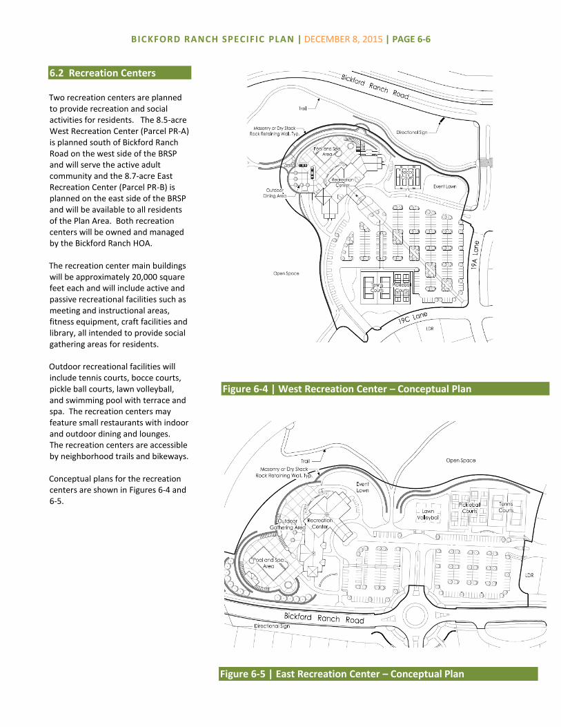
BICKFORD RANCH SPECIFIC PLAN | DECEMBER 8, 2015 | PAGE 6-6
6.2 Recreation Centers Two recreation centers are planned to provide recreation and social activities for residents. The 8.5-acre West Recreation Center (Parcel PR-A) is planned south of Bickford Ranch Road on the west side of the BRSP and will serve the active adult community and the 8.7-acre East Recreation Center (Parcel PR-B) is planned on the east side of the BRSP and will be available to all residents of the Plan Area. Both recreation centers will be owned and managed by the Bickford Ranch HOA. The recreation center main buildings will be approximately 20,000 square feet each and will include active and passive recreational facilities such as meeting and instructional areas, fitness equipment, craft facilities and library, all intended to provide social gathering areas for residents. Outdoor recreational facilities will include tennis courts, bocce courts, pickle ball courts, lawn volleyball, and swimming pool with terrace and spa. The recreation centers may feature small restaurants with indoor and outdoor dining and lounges. The recreation centers are accessible by neighborhood trails and bikeways. Conceptual plans for the recreation centers are shown in Figures 6-4 and 6-5.
Figure 6-5 | East Recreation Center – Conceptual Plan
Figure 6-4 | West Recreation Center – Conceptual Plan
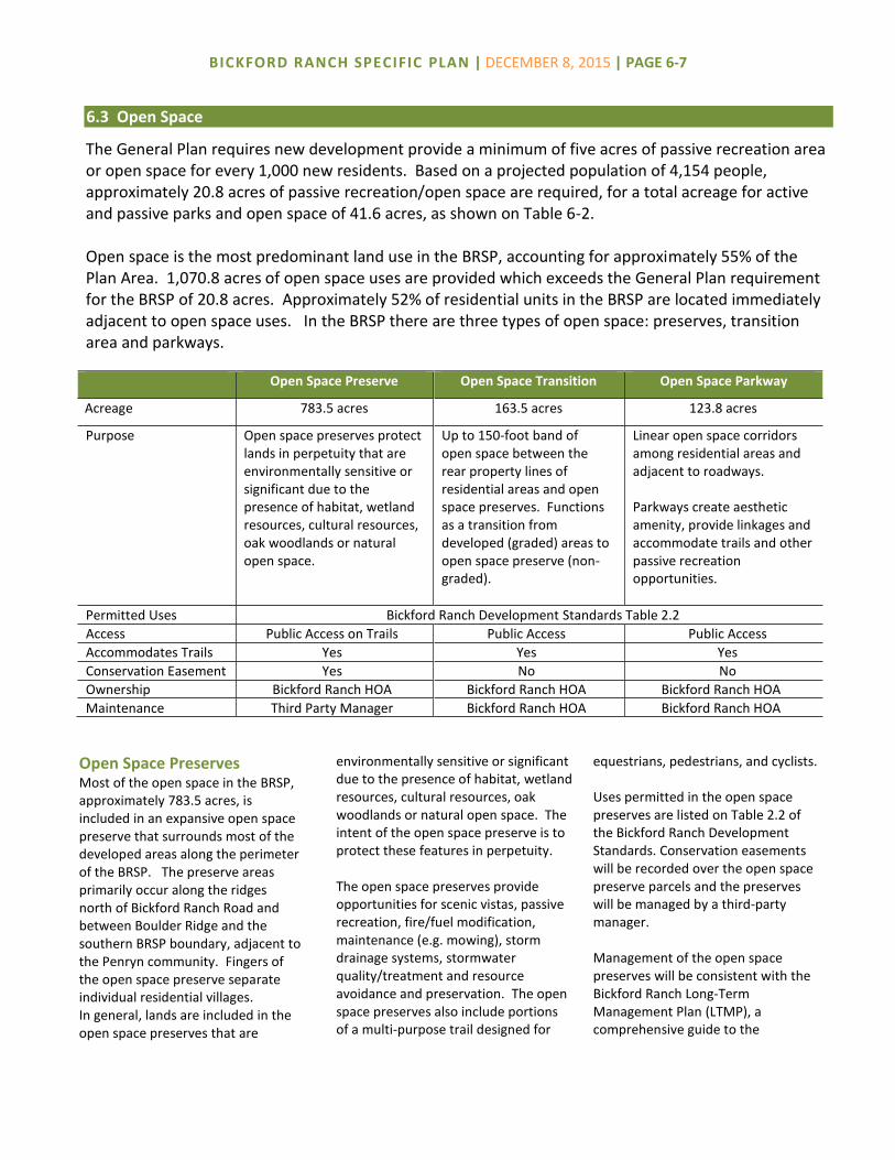
BICKFORD RANCH SPECIFIC PLAN | DECEMBER 8, 2015 | PAGE 6-7
Open Space Preserve Open Space Transition Open Space Parkway
Acreage 783.5 acres 163.5 acres 123.8 acres
Purpose Open space preserves protect lands in perpetuity that are environmentally sensitive or significant due to the presence of habitat, wetland resources, cultural resources, oak woodlands or natural open space.
Up to 150-foot band of open space between the rear property lines of residential areas and open space preserves. Functions as a transition from developed (graded) areas to open space preserve (non-graded).
Linear open space corridors among residential areas and adjacent to roadways. Parkways create aesthetic amenity, provide linkages and accommodate trails and other passive recreation opportunities.
Permitted Uses Bickford Ranch Development Standards Table 2.2
Access Public Access on Trails Public Access Public Access
Accommodates Trails Yes Yes Yes
Conservation Easement Yes No No
Ownership Bickford Ranch HOA Bickford Ranch HOA Bickford Ranch HOA
Maintenance Third Party Manager Bickford Ranch HOA Bickford Ranch HOA
Open Space Preserves Most of the open space in the BRSP, approximately 783.5 acres, is included in an expansive open space preserve that surrounds most of the developed areas along the perimeter of the BRSP. The preserve areas primarily occur along the ridges north of Bickford Ranch Road and between Boulder Ridge and the southern BRSP boundary, adjacent to the Penryn community. Fingers of the open space preserve separate individual residential villages. In general, lands are included in the open space preserves that are
environmentally sensitive or significant due to the presence of habitat, wetland resources, cultural resources, oak woodlands or natural open space. The intent of the open space preserve is to protect these features in perpetuity. The open space preserves provide opportunities for scenic vistas, passive recreation, fire/fuel modification, maintenance (e.g. mowing), storm drainage systems, stormwater quality/treatment and resource avoidance and preservation. The open space preserves also include portions of a multi-purpose trail designed for
equestrians, pedestrians, and cyclists. Uses permitted in the open space preserves are listed on Table 2.2 of the Bickford Ranch Development Standards. Conservation easements will be recorded over the open space preserve parcels and the preserves will be managed by a third-party manager. Management of the open space preserves will be consistent with the Bickford Ranch Long-Term Management Plan (LTMP), a comprehensive guide to the
6.3 Open Space
The General Plan requires new development provide a minimum of five acres of passive recreation area or open space for every 1,000 new residents. Based on a projected population of 4,154 people, approximately 20.8 acres of passive recreation/open space are required, for a total acreage for active and passive parks and open space of 41.6 acres, as shown on Table 6-2. Open space is the most predominant land use in the BRSP, accounting for approximately 55% of the Plan Area. 1,070.8 acres of open space uses are provided which exceeds the General Plan requirement for the BRSP of 20.8 acres. Approximately 52% of residential units in the BRSP are located immediately adjacent to open space uses. In the BRSP there are three types of open space: preserves, transition area and parkways.

BICKFORD RANCH SPECIFIC PLAN | DECEMBER 8, 2015 | PAGE 6-8
management practices of the preserve (including information regarding permitted and prohibited uses, access information, resource management, fuel modification and trail maintenance). The LTMP will be implemented by a funding mechanism established for the BRSP.
Open Space Transition Where open space preserves abut residential uses, an open space transition corridor, generally 50-foot wide or more, will be designated to separate residential areas and open space preserves. Located adjacent to development, the corridor functions
as a transition from developed (graded) areas where residential lots are located to the non-developed (non-graded) area of the open space preserve. The relationship of the open space preserve and transition area is shown on Figure 6-6. This band of open space transition area accounts for 163.5 acres and allows limited activities to occur (e.g. tree planting for mitigation, detention ponds, stormwater quality facilities, fuel maintenance, fire breaks, fire truck access, trail construction, grading, drainage outfalls and utilities). Uses permitted in the open space transition
area are listed on Table 2.2 of the Bickford Ranch Development Standards. Near the Caperton Canal, the open space transition area expands to encompass the canal and an area up to 150 feet beyond the canal for maintenance purposes. Taken together, the open space preserve and the open space transition area create a seamless open space area of 947.0 acres. The open space transition area will be owned and managed by the Bickford Ranch HOA and will not be included in a conservation easement.
Open Space Parkways In addition to the open space preserves and open space transition areas, the BRSP includes a network of 123.8 acres of open space parkways. The parkways generally consist of areas with prominent groupings of existing oak trees and in some cases include areas of steep slope. The open space parkways may also accommodate tree planting areas, drainage features and stormwater quality facilities. The parkways provide linkages and accommodate neighborhood trails, bikeways along roadways, and other passive recreation opportunities. The parkways include approximately six miles of neighborhood paths. Additional information regarding trails in the BRSP is contained in Section 4, Circulation. Open space parkways will be owned and managed by the Bickford Ranch HOA and will not be included in a conservation easement.
Figure 6-6 | Relationship of Open Space Preserve and Transition Area

BICKFORD RANCH SPECIFIC PLAN | DECEMBER 8, 2015 | PAGE 6-9
6.4 Schools
School Requirements The BRSP is located within the Loomis Union School District (LUSD) and Placer Union High School District (PUHSD). The LUSD serves students in grades K-8 and the PUHSD serves students in grades 9-12. The portion of the BRSP with age-restricted units does not generate students or require school facilities. At buildout, the remaining portion of BRSP (conventional units) will generate approximately 400 students in grades K-8 and 222 students in grades 9-12, as shown on Table 6-3.
School Facilities Provided The number of K-8 students generated creates sufficient demand for one K-8 school in the BRSP. One 15-acre school site (Parcel PF-2) is planned for a K-8 school in the LUSD. The school site is planned in the northwest corner of the BRSP, south of School Ranch Road near Sierra College Boulevard. The school site will be reserved pursuant to Government Code 66480 and based on the terms of the Bickford Ranch Development Agreement. In the event the site is not utilized for a school, the site will be developed with single-family residential units (LDR units), consistent with the Residential Unit Transfer provisions in Section 8. Until the school is constructed, K-8 students will attend other K-8 schools in the LUSD. High school students (grades 9-12) in the BRSP will attend Del Oro High School, located approximately seven miles southeast of the BRSP.
6.5 Fire & Emergency Services The Placer County Fire Department (PCFD), through a contract with the California Department of Forestry and Fire Protection (CAL FIRE) provides fire service for the BRSP. The Bickford Ranch Development Agreement includes additional information regarding fire service to the BRSP. A fire station is planned on a 1.4-acre site (Parcel PF-1) at the northeast corner of Bickford Ranch Road and Sierra College Boulevard. The conceptual design of the fire station is described in Section 3.8 of the Bickford Ranch Development Standards. The fire station will provide fire protection for the BRSP as well as to adjacent areas in the County. Ambulance services will be staged from the fire station to provide timely emergency medical response. Until the fire station is constructed, other fire stations will provide interim service to ensure adequate response time. A Sheriff’s service center will be located within the BRSP fire station.
Additional fire facilities in the BRSP will include fire hydrants along roadways, enhanced access to open space for the purpose of fire protection and sprinklers inside residential units and other structures.
6.6 Law Enforcement The BRSP is serviced by both the Placer County Sheriff’s Department and the California Highway Patrol (CHP). General law enforcement services will be provided to the BRSP by the Sheriff’s Department and traffic related enforcement services will be provided by the CHP. A Sheriff’s service center will be located within the BRSP fire station.
Table 6-3 Student Generation Residential Units
(Non-Age Restricted) Student
Generation Rate
Students Generated
Loomis Union School District
Grades K-8 940 0.425 400
Placer Union High School District
Grades 9-12 940 0.2362 222
Total 622

This chapter describes the utility infrastructure required to serve the Bickford Ranch Specific Plan (BRSP, Specific Plan or Plan Area). Each component of the utility infrastructure system is designed to accommodate build out of the BRSP. Phasing of infrastructure improvements and funding obligations are detailed in the Bickford Ranch Development Agreement. Table 7-1 summarizes the utility providers to the BRSP. Utility infrastructure will be constructed, dedicated, and easements provided consistent with this Specific Plan, the BRSP Development Agreement, and other applicable standards and requirements of the County.
Water service to the Plan Area, for both potable and raw water, will be provided by Placer County Water Agency (PCWA). The northwest portion of the BRSP is located within an exclusion area of the Nevada Irrigation District (NID) which indicates that although the area is within the service area of NID, water service is provided by PCWA. NID does not have infrastructure in the vicinity to physically serve the BRSP with potable or treated water.
Due to site constraints, four Rural Residential parcels located in the south portion of the Plan Area (Parcel RR-06) may be served by private water wells.
Water Supply and Demand Water demand for the BRSP is approximately 1.18 million gallons per day (mgd) (1,319.6 acre feet per year). Water demand is reduced by 295 acre feet to 1,024 acre feet per year through the implementation of water conservation measures described later in this section.
Water Transmission System The BRSP will tie into PCWA’s existing system for potable water. The BRSP’s point of connection to the PCWA system is a 30-inch pipeline southwest of the site, adjacent to parcel RR-07. At the point of connection, water from PCWA would flow into Storage Tank #1 and Pump Station #1 from which it will serve the Plan Area via an 18-inch distribution pipeline. The 18-inch distribution pipeline will be constructed within the existing
Table 7-1 Public Utility Providers Provider
Potable Water Raw Water
Placer County Water Agency (PCWA)
Wastewater Treatment City of Lincoln
Wastewater – On-Site Placer County
Drainage and Flood Control Placer County
Electric Service Pacific Gas and Electric (PG&E)
Natural Gas Pacific Gas and Electric (PG&E)
Communications AT&T/Wave
Solid Waste Disposal Recology Auburn Placer
7.1 Potable Water
PUBLIC UTILITIES 7

BICKFORD RANCH SPECIFIC PLAN | DECEMBER 8, 2015 | PAGE 7-2
rights-of-way of Sierra College Boulevard, Caperton Court, and Woodsdale Court. From the northwesterly point of Woodsdale Court, the 18-inch distribution pipeline extends north into the Plan Area adjacent to residential village LDR-3 to Bickford Ranch Road. As the BRSP extends east of Upper Ranch Road, the primary water distribution pipeline will extend from Bickford Ranch Road through roadways in residential villages until it terminates at Storage Tank #2 on the east side of the Plan Area. The distribution system will consist of 8-, 12- and 18-inch pipelines. In addition to pipelines, on-site water facilities include two storage tanks and two pump stations. The storage tanks are planned to meet the storage needs of the BRSP. Storage Tank #1 and Pump Station #1 are planned on the west side of the BRSP (Parcel PF-4) and Storage Tank #2 and Pump Station #2 are planned on the east side of the BRSP (Parcel PF-3). The system for water delivery through the site is shown on Figure 7-1.
Ophir Transmission Pipeline In addition to the infrastructure required to serve the BRSP, a portion of PCWA’s 42-inch Ophir transmission pipeline will be constructed within the Plan Area on Bickford Ranch Road and Storage Tanks #1 and #2. The Ophir transmission pipeline will provide a future service connection point to the Plan Area. The 42-inch Ophir transmission pipeline will remain dry for a period of time until the remaining segments from the Ophir Water Treatment Plant are constructed.
When the Ophir pipeline is constructed, the new transmission pipeline and Storage Tank #2 would replace Pump Station #1 as the primary source of water to the Plan Area. Pump Station #1 would then serve as a secondary source of water to the Plan Area, should the gravity pipeline from Ophir be unavailable for any reason. All water improvements will be constructed to PCWA’s standards using a phased approach. Details regarding the water facilities are contained in the BRSP Water Master Plan on file with the County and PCWA.
Water Conservation The BRSP includes water-saving measures aimed at reducing overall water demands for potable water to the extent feasible and practicable. With full implementation, the water conservation measures outlined below will reduce the BRSP’s overall water demand by approximately 364 acre feet per year, which is approximately 30.4% of water demand. Turf Reductions in Residential Areas.
This measure involves limiting the amount of turf in the front yards of residential properties and using a greater percentage of low-water use plant species in lieu of turf.
Typically, about 75% of a total residential front yard is assumed to consist of landscaping, with the balance consisting of driveways, planter, or walkways. For the BRSP, limitations will be placed on the landscaped portion of each front yard, allowing up to 42% of the total landscaped area to be turf, with the remaining landscaped area comprised of low water use plant species which use between 65-75% less water than an average lawn.
Turf Reductions in Non-Residential Landscape. This measure involves limiting the use of turf on non-residential parcels in the parks, landscape corridors, school, recreation centers, public facilities and roadways.
For these areas, landscape design will reduce the area of turf and increase the area of low-water-use plant species, as compared to the design of these features in other development areas.
Smart Irrigation Controllers. Smart
irrigation controllers restrict irrigation to times and water application rates necessary to maintain landscaping. They account for changes in the demand for water, which varies with weather patterns and seasonal influences. In the BRSP, smart irrigation controllers are required for residential, recreation centers, parks, school, public facilities sites and roadways.
Re-Circulating Hot Water Systems. Re-
circulating hot water systems feature a pump on a residential hot water line system which reduces the time necessary to receive hot water at any hot water faucet. This type of system will be included on all residential units to generate additional water conservation.
Water Efficient Landscape Requirements. Landscape in the BRSP shall be consistent with the Placer County Landscape Design Guidelines and water efficiency landscape requirements.
Low-flow and high efficiency bathroom faucets, kitchen faucets, toilets and showers will be installed in all residential units, recreation centers and Bickford Ranch Park.

BICKFORD RANCH SPECIFIC PLAN | DECEMBER 8, 2015 | PAGE 7-3
Figure 7-1 | Water Facilities

BICKFORD RANCH SPECIFIC PLAN | DECEMBER 8, 2015 | PAGE 7-4
7.2 Raw Water Raw water service is supplied to the BRSP by PCWA from the Caperton and Antelope Canals. Caperton Canal extends approximately ten miles in length, of which approximately 6.5 miles are within the BRSP along Boulder Ridge. A short segment of Antelope Canal is located in the southeast portion of the Plan Area. Both canals are comprised of unlined, natural channels, underground pipe and open, gunite-lined channels. Raw water from the Caperton Canal and/or Antelope Canals may be used for irrigating landscaped areas in the open space parkways, project entries and landscape corridors. Historically, 206 miner’s inches of raw water have been purchased for the BRSP and will be sufficient to service the irrigation needs of the Plan Area. Improvements, including encasement, will be made to the portions of Caperton Canal on-site at the direction of PCWA pursuant to the Agency’s policies. Improvements to the canal will protect water quality and result in a reduction to the water losses from the canal channel.
7.3 Wastewater Wastewater treatment will be provided at the regional wastewater treatment facility located in the City of Lincoln as provided for in the Construction, Operations and Joint Exercise of Powers Agreement between the City of Lincoln and Placer County. The City of Lincoln will operate and maintain the treatment facility and Placer County will operate and maintain the trunk wastewater facilities from the project boundary
to the connection with the regional trunk sewer line approximately 3,400 linear feet west of the Sierra College Boulevard/SR 193 intersection. Sewage will be transported from the BRSP to the City of Lincoln through a connection to the Regional Sewer Project trunk line in Highway 193. A pipeline will be constructed north in Sierra College Boulevard then west in Highway 193 to the connection point west of Stardust Lane. The BRSP is located within County Service Area (CSA) 28, Zone 183. The sewer generation for the BRSP is approximately 0.39 million gallons per day. The on-site wastewater system will consist of gravity and force main pipelines, lift stations, low pressure sewer pipelines and Septic Tank Effluent Pump (STEP) systems. Site constraints, including topography, soil conditions, parcel size, and economic factors may require septic systems on approximately twelve lots within Rural Residential villages RR-2, RR-6 and RR-7 and STEP systems are proposed in areas where lots are topographically constrained and can be pumped via a common low-pressure pipe to the nearest gravity main. The on-site wastewater collection system for the BRSP is shown on Figure 7-2. Sewer improvements will be consistent with Placer County standards. Upon project completion and acceptance, the sewer system will be operated and maintained by Placer County Department of Facility Services.
7.4 Drainage and Flood Control The BRSP is located along the ridge line separating the Dry Creek and Auburn Ravine watersheds. In general, areas of the BRSP north of the ridge drain toward Auburn Ravine and areas south of the ridge drain toward Dry Creek. Development of the BRSP will introduce impervious surfaces which will result in an increase in the runoff leaving the site. Runoff will be routed through detention storage facilities that will reduce the rate of runoff from the site and provide on-site detention. Detention basins will be constructed to reduce off-site drainage runoff in accordance with the Placer County Stormwater Management Manual. Detention basins will typically be constructed by installing berms across ravines to restrict flow. The basins will be normally dry and will have a low flow outlet and high flow spillways. There may be excavated detention basins that function similarly as the ravine detention basins but will be constructed by excavating soil rather than building a berm. In addition to detention of peak flows on-site, the BRSP will mitigate for 52 acre feet of retention volume off-site at the City of Lincoln’s Lakeview Farms Volumetric Mitigation Facility within the floodplain of Coon Creek. The Lakeview Farms stormwater retention facility provides a volumetric mitigation for waters entering the Sacramento Basin.
Stormdrain Improvements On-site drainage improvements consist of a combination of conventional subsurface and surface drainage systems shown in Figure 7-3.

BICKFORD RANCH SPECIFIC PLAN | DECEMBER 8, 2015 | PAGE 7-5
Figure 7-2 | Water Facilities
Figure 7-2| Wastewater Collection Facilities
Figure 7-2 | Water Facilities

BICKFORD RANCH SPECIFIC PLAN | DECEMBER 8, 2015 | PAGE 7-6
Figure 7-3| Drainage Facilities
Figure 7-2 | Water Facilities

BICKFORD RANCH SPECIFIC PLAN | DECEMBER 8, 2015 | PAGE 7-7
7.5 Stormwater Quality The BRSP provides a comprehensive plan for the management of urban runoff for flow control and water quality improvement. The integrated stormwater management system plan is reflected, in part, in specific design criteria contained in this section. The objectives of the BRSP Stormwater Management Plan (SWMP) are intended to meet the requirements of the County’s National Pollutant Discharge Elimination System (NPDES) Permit, as issued by the State Regional Water Quality Control Board, and to minimize effects of stormwater runoff on the natural open space areas. The BRSP SWMP will be in accordance with permit criteria applicable at the time of development. The SWMP provides the framework for stormwater treatment during two components of the development process. First, during the construction phase while infrastructure is being built to support the community, and then during the post-construction phase, which will be part of the improvements that make up the community and continue to protect the natural resources in perpetuity.
Stormwater Management During Construction The release of on-site stormwater runoff during construction activities is regulated by the State General Construction Permit issued by the Regional Water Quality Control Board for all construction sites greater than one acre. The General Construction permit requires that a Storm Water Pollution Prevention Plan (SWPPP) address how stormwater from the construction site will be maintained and treated prior to discharge from the site. The SWPPP is an evolving document that changes with the dynamics of the site development.
The use of Best Management Practices (BMPs) during the construction process will generally incorporate erosion controls and sediment controls. Erosion and sediment control BMPs include such things as applying straw mulch to disturbed areas, the use of fiber rolls and silt fences, sedimentation basins, drain inlet protection, stabilized construction accesses, and material management. Final sizing and selection of non-mechanical BMPs will consider requirements specific to the watersheds and proposed developed.
Post Construction Stormwater Management Post construction stormwater management is intended to treat the urban runoff generated on-site in perpetuity. The BMP techniques within the site will reduce and/or eliminate the pollutants from the urban stormwater runoff and prevent the contamination of receiving waters. The BRSP will work with the permit criteria applicable at the time of development and in conformance with Placer County Improvement Standards, the County’s Stormwater Quality Design Manual to design and address post construction stormwater treatment. Post-construction stormwater treatment is composed of three general elements: source control, runoff reduction and treatment of runoff. All three elements will be used in the BRSP SWMP. The basic practice of source control is to minimize the potential for constituents to enter runoff at the source. Low Impact Development (LID) measures are the main tool the BRSP will employ for runoff reduction.
Implementation of LID includes construction of decentralized small-scale improvements to provide local infiltration and treatment opportunities to reduce the quantity of runoff entering the storm drain systems during a rainfall event. LID will be implemented to offset runoff increases resulting from the development and the conversion of native ground cover to impervious surfaces. Additional treatment control BMPs may be located at the end of the pipe and provide further treatment of the stormwater before it enters into the natural creek system.
Low Impact Development (LID) Low impact development (LID) is an approach to stormwater management emphasizing the use of small-scale, natural, constructed and proprietary drainage features to capture urban runoff and precipitation. LID measures can slow, clean, and infiltrate runoff, improving the quality and reducing the quantity of urban runoff entering the storm drain systems. The added opportunities for infiltration offered by the use of LID can add water to local aquifers, increasing water reuse. It is a sustainable practice which benefits water quality protection, stream stability and can contribute to water supply. The intent is to incorporate natural systems into the built environment in addition to traditional stormwater management, which collects and conveys stormwater runoff through storm drains, pipes, or other conveyances to a centralized stormwater facility. LID features within the BRSP will take a different approach by using site design elements, LID and stormwater management to minimize changes to the site’s predevelopment runoff rates and volumes.

BICKFORD RANCH SPECIFIC PLAN | DECEMBER 8, 2015 | PAGE 7-8
Key principles of low impact development include: Decentralize and manage urban
runoff to integrate stormwater management throughout the watershed.
Preserve the ecosystem’s natural
hydrological functions and cycles. Account for a site’s topographic
features in its design. Reduce directly connected
impervious surfaces to slow runoff and provide additional infiltration opportunities.
Reduce impervious ground cover
and maximize infiltration on-site. As the BRSP develops, specific LID techniques, tools, and material, specified in construction documents, will control the amount of impervious surface, increase infiltration, and improve water quality by reducing runoff from the developed sites. Additional project design elements within the open space areas will also provide hydrograph modification benefits. The created swale and riparian elements will provide additional floodplain storage capacity which is factored into the hydrology analysis. The created swales also provide LID and treatment potential which has not been factored into the project mitigation, which include: added infiltration opportunities, evapo-transpiration opportunities, nutrient uptake, biological filtering, and buffers. LID elements may be implemented into development plans within the BRSP to achieve an overall reduction in stormwater runoff. The selection and use of these elements may vary by development project, depending on the runoff reduction needed. The
various LID options may include, but are not limited to, the following: Disconnected roof drains; Disconnected and separated
pavement; Bio-retention facilities, rain
gardens, and bioswales; Tree planting, interceptor trees
along sidewalks; Permanent wet ponds; Grass swales and channels; Curb cuts and vegetated filter
strips; Impervious surface reduction –
permeable pavements and porous pavements;
Notched curbs to direct
stormwater runoff into drainage facilities
Soil amendments; and/or
Pollution prevention and good
housekeeping practices.
End of Pipe Stormwater Treatment Control In addition to the implementation of the above-referenced LID measures, the storm drain system will be designed to provide additional protection of the natural environment by providing non-mechanical end of pipe treatment techniques. This element adds to the treatment train and consists of final treatment elements such as grass treatment swales. Special consideration will be taken to capture, convey and release the urban stormwater. The treatment and conveyance of storm runoff in
and through the open space preserves will be made part of the Corps of Engineers 404 permitting process. Standard practices include the use of headwall structures directly at the outfall location which stabilize and protect the outlet pipe and surrounding topography. The headwall structures also aid in velocity attenuation while minimizing future maintenance costs. Standard practices also include the use of conveyance “grassy swales” at outfalls that direct stormwater from the pipe outlets to receiving waters and avoid sensitive habitat while distributing concentrated pipe flows. Depending on the size and frequency of particular storm events, and the actual drainage area being conveyed, the conveyance swales will be armored with geo-synthetics to minimize the potential for future erosion of the open space. Soft-armoring will provide opportunities to create grassy swales and additional wetland habitat to aide in stormwater filtration and infiltration. In a few locations in the open space preserves, water will be discharged upstream of an established swale or water feature. To protect the area from erosion, the area between the pipe and swale/water feature will be treated with a flexible armor channel system in a U-shape design.
Additional structural BMPs can be added to the treatment train and end of pipe treatment if needed. These may include such devices as: Installation of “fossil filter” or
equivalent petroleum absorbing insert assemblies in the drop inlets;
Trash screen vaults; or Other structural BMPs as
approved by the County.

BICKFORD RANCH SPECIFIC PLAN | DECEMBER 8, 2015 | PAGE 7-9
7.6 Dry Utilities
Natural Gas Natural gas will be provided by Pacific Gas & Electric (PG&E). PG&E operates natural gas lines in three locations near the Plan Area. Natural gas service will be extended to the Plan Area from the Twelve Bridges Drive/Sierra College Boulevard intersection. The extension would include an eightinch distribution main which would generally follow the water pipeline alignment up Woodsdale Court.
Electric Service PG&E will provide electric service to the Plan Area from an existing 12 kV three-phase electrical overhead distribution circuit along Sierra College Boulevard and from an existing 21 kV circuit on Twelve Bridges Drive. These circuits will be the primary sources of electricity to the Plan Area with a backbone feeder system installed along the frontage on Sierra College Boulevard. The existing overhead utilities along Sierra College Boulevard will be undergrounded. The electric backbone will require a six-inch conduit with splice boxes looping along primary streets. The proximity of the existing 12 kV and 21 kV circuits will not require a substation or new overhead transmission lines.
Communications AT&T or a competitive provider will provide telephone services to the site from an existing distribution system located on Sierra College Boulevard. The telephone system is expected to enter the Plan Area from Sierra College Boulevard at Bickford Ranch Road. Either one of two telephone exchanges could serve the BRSP: the
Lincoln Exchange or the Newcastle Exchange. The telephone distribution systems will participate in joint trenching operation with the other dry utilities. A private cable provider will serve the Plan Area with a network of fiber lines, which extend from Sierra College Boulevard. Each lot within the Plan Area will be wired for a high-speed internet connection. This capacity will enhance the ability of residents within the Plan Area to telecommute and to obtain information and services electronically, including resources that would ordinarily require vehicle trips to local libraries or other information centers.
7.7 Solid Waste Disposal The Western Regional Sanitary Landfill is located approximately five miles to the southwest of the Plan Area. The Class II/III facility is owned by the Western Placer Waste Management Authority (WPWMA), which is comprised of the City of Lincoln, Roseville, Rocklin and Placer County. Based on the permitted configuration and projected growth rates, the landfill closure date is estimated at 2058. The County anticipates additional expansion of the facility due to the projected growth in western Placer County. A materials recovery facility that receives, separates, processes and markets all recyclable materials is located adjacent to the landfill. The BRSP will generate short-term construction debris and long-term solid waste. These materials will be collected by Recology Auburn Placer, a private collection firm, and transported to the WPWMA facilities for recycling recovery and disposal. Collection will be in sufficient frequency to prevent overflow and accumulation.

Government Code Section 65451 requires every specific plan to include a program of implementation measures necessary to carry out its proposed land uses, infrastructure and development standards. Implementation of the Bickford Ranch Specific Plan (BRSP, Specific Plan or Plan Area) will be administered by Placer County and carried out in accordance with the terms and conditions of several related entitlements, including the Bickford Ranch Development Agreement, phasing plans, a financing plan, and an environmental impact report, which augment the policies and regulations set forth in the General Plan and County Code. The Specific Plan includes a conceptual program for the phasing of units to support financing, and construction of public improvements, review of individual development projects, transfer of residential units, and process for Specific Plan amendments/minor modifications. These programs are summarized in this section, with details and specific requirements included in the above-referenced documents.
The BRSP is anticipated to be built-out over fifteen to twenty years depending on a number of factors including shifts in economic conditions and demands for various housing types. The BRSP includes a comprehensively planned infrastructure system with coordinated phasing and construction of facilities. Three phases are anticipated and the boundaries of each phase are reflected on Figure 8-1. In general, the phasing plan is structured to ensure the improvements in each phase can support its respective development in compliance with County policies and standards, and the development in each phase can support the costs of the required improvements. Development and construction of the BRSP will generally begin immediately east of Sierra College Boulevard and proceed in an easterly direction. Portions of Phase 3 are located at both the east and west sides of the site. A portion of Phases 1 and 3 are located west of Sierra College Boulevard.
The infrastructure requirements for each phase of development include all on-site backbone infrastructure and off-site facilities necessary for the build out of each phase as described in the BRSP Development Agreement. These include roadways, sewer, water, storm drainage, dry utilities, school site, parks, open space, and other facilities and improvements. All in-tract sewer, storm drain, water and dry utilities will be installed as part of local project improvements.
IMPLEMENTATION 8
8.1 Phasing Plan

BICKFORD RANCH SPECIF IC PLAN | DECEMBER 8, 2015 | PAGE 8-2
Figure 8-1 | Conceptual Phasing Plan

BICKFORD RANCH SPECIF IC PLAN | DECEMBER 8, 2015 | PAGE 8-3
Financing Direct developer/merchant builder financing may be used to contribute toward backbone improvements and facilities, shortfall financing, and in-tract subdivision improvements.
Development Impact Fees The County and other agencies have adopted development impact fees to finance capital improvements. The fee structure requires payment of fees prior to issuance of a building permit. Such fees include, but are not limited to, the following:
County Public Facilities Fee Traffic Mitigation Fees Regional Traffic Mitigation Fees
(SPRTA Fee) Dry Creek Watershed Drainage Fee Placer County Fire District Impact Fee Placer County Water Agency Fees
Project-Specific Fees To finance improvements within the BRSP, fee programs may be established to fund the improvements. These fees are specific to the Plan Area, payable at building permit, and include, but are not limited to, the Affordable Housing In-Lieu Fee, Sierra College Boulevard Fee, Air Quality Mitigation Fee, Tree Mitigation Fee, Open Space Fee, Park and Trail Fee and Fire Protection Facility Fee.
8.2 Financing of Public Improvements
Construction of public improvements to serve the BRSP will be funded by a variety of mechanisms
including Community Facilities Districts (CFD), County impact fees, school impact fees, developer
financing and other methods. The Bickford Ranch Public Facilities Financing Plan, hereby
incorporated by reference, demonstrates feasibility and financing mechanisms that could be used to
construct the BRSP’s public facilities. Major infrastructure and facilities required for development of
the BRSP will be funded through a combination of public and private sources. These financing
mechanisms are summarized in Table 8-1.
Table 8-1 Maintenance Providers and Financing Mechanisms Service Capital Improvements
Financing Mechanisms Maintenance Provider Maintenance Funding
Street Lighting CFD and/or Developer Financing Placer County County Service Area
Public Streets Placer County County Service Area
Private Streets Developer Financing Homeowners’ Association Member Assessment
Bickford Ranch Community Park
CFD Placer County County Service Area and /or CFD
Neighborhood Parks CFD and/or Developer Financing
Homeowners’ Association Member Assessment
Recreation Centers Homeowners’ Association Member Assessment
Open Space Preserves Third Party Preserve Manager Endowment
Open Space Transition Homeowners’ Association Member Assessment
Open Space Parkways Homeowners’ Association Member Assessment
Trails - Multi-Purpose Trails and
Class I Bike Path
Fees, CFD and/or Developer Financing Placer County County Service Area and/or Services CFD
Trails – Neighborhood Trails CFD and/or Developer Financing Homeowners’ Association Member Assessment
Water Bickford Ranch CFD and/or Developer Financing
Placer County Water Agency User Fees
Sewer – On-Site Placer County County Service Area
Sewer – Off-Site Placer County/City of Lincoln County Service Area
Sewer Treatment Sewer Connection Fees/County City of Lincoln County Service Area
Drainage – Roadways CFD and/or Developer Financing Placer County County Service Area
On-Site Drainage Homeowners’ Association Member Assessment
School State Funding, Impact Fees Loomis Union School District Placer Union High School District
Property Taxes
Fire Station and Facilities Fire/Public Facilities Fee Placer County Fire County Service Area and/or Services CFD

BICKFORD RANCH SPECIF IC PLAN | DECEMBER 8, 2015 | PAGE 8-4
Community Facilities District One or more Community Facilities Districts (CFD) may be established to help fund the construction and/or acquisition of backbone infrastructure and facilities to serve the BRSP. The 1982 Mello Roos Community Facilities Act enables counties and other entities to establish a CFD to fund various facilities and services. The proceeds of the Mello-Roos special tax may be used for direct funding of facilities and/or to service debt, subject to the rules and procedures as set forth by the Placer County Bond Screening Committee. A separate CFD for Services may be established for maintenance of certain facilities as may be allowed by law.
School Impact Fees The Loomis Union School District and Placer Union High School District have established fees, in accordance with Section 17620 of the California Education Code, to be used to construct school facilities. Pursuant to Section 65995 of the California Government Code, these school impact fees will be collected by the school district prior to issuance of a building permit.
Developer Funding Developer funding will be used for improvements not included in existing fee programs or through a CFD. Some of the improvements to be funded through developer funding/private capital may be subject to, where appropriate, reimbursement agreements with the County. Developers may either receive fee credits or reimbursements for advancing eligible projects based on the reimbursement structure described in the Development Agreement. Developer funding will finance costs associated with in-tract infrastructure such as neighborhood roadways, street
frontage improvements, lighting, local water distribution lines, sewer collectors and laterals, storm drains and stormwater quality facilities.
8.3 Maintenance Maintenance providers and funding sources for BRSP facilities are listed in Table 8-1.
Homeowners’ Associations Homeowners’ Assocations (HOAs) are proposed to fund maintenance of private facilities. HOAs may only be used for operations and maintenance of facilities in common areas. Two types of HOAs are envisioned for the BRSP. A Master HOA would be created to own and maintain facilities in areas common to the entire Plan Area, such as entry features, landscaping, signs, lighting, drainage, stormwater quality features and the open space transition zone. Individual HOAs for residential neighborhoods will own and/or maintain internal roads, landscaping, parkways and improvements specific to the village(s). A HOA would be formed for the residential villages that contain active adult residential units.
County Service Areas One or more County Service Area (CSA) Zone(s) of Benefit will be created and assessments will be established to fund on-going maintenance of public improvements. CSA Zones of Benefit would fund maintenance of improvements such as streets, street lighting, parks, trails, fire and emergency services and sewer maintenance. County Service Area 28 has been established for Bickford Ranch with zones of benefits for various services.
CFD for Services Community Facilities Districts (CFDs) may be established to help fund on-going maintenance of public improvements in the BRSP. Maintenance in the BRSP could include park maintenance, landscape maintenance, emergency services, and other improvements as allowed by law and subject to the rules and procedures of the Placer County Bond Screening Committee. The CFDs for services would be an alternative to County Service Areas.

BICKFORD RANCH SPECIF IC PLAN | DECEMBER 8, 2015 | PAGE 8-5
8.4 Specific Plan Approvals
Specific Plan Area Zoning The zoning of the BRSP is BRSP-SPL. The –SPL suffix is the County’s Specific Plan zone district that is applied to all Specific Plan projects. For BRSP, the SPL district is combined with the Bickford Ranch Specific Plan to function as the zoning text and map for the BRSP.
Development Standards The Bickford Ranch Development Standards (Development Standards) have been adopted by ordinance. The Development Standards supplement the Placer County Zoning Ordinance and serve as the zoning regulations governing development, improvements and construction in the BRSP. Where a standard is not provided in the Development Standards document, the standards contained in the Placer County Zoning Ordinance, Placer County Code, and/or Land Development Manual shall apply. The standards in the Development Standard supersede, replace, and shall take precedence over conflicting County standards governing the BRSP.
Processing of Subsequent Development Applications Individual development projects within the BRSP are subject to review and approval of subsequent entitlements (e.g. tentative subdivision maps, conditional use permits, and/or other permits). Applications and processing requirements shall be in accordance with the County’s Zoning Ordinance and other regulations, unless otherwise modified by this Specific Plan. All subsequent development projects, public improvements and other activities shall be consistent with this Specific Plan and accompanying Development Standards and Design Guidelines, Development Agreement, applicable County policies, requirements and standards and all State and Federal permit conditions and environmental review documents (CEQA and NEPA).
In acting to approve a subsequent project or permit, the County may impose conditions as are reasonably necessary to ensure the project is in compliance with the Specific Plan and all applicable plans and regulations.
Development Plan Review
The Placer County Development Review Committee (DRC) is responsible for determining the consistency of any development proposal within the BRSP with the Bickford Ranch Development Standards, then forming a recommendation to the decision-making body. Based on the type of permit sought, permits are acted on by the Planning Director, Zoning Administrator or Planning Commission pursuant to the administrative procedures outlined in Article 17.58 of the Placer County Zoning Ordinance.
8.5 Subsequent Entitlement Process
Development Application Filed
Evaluate Application with BRSP
(Specific Plan, Development Standards, Design Guidelines, Development Agreement)
Environmental Review of Application
(Consistency with MMRP)
Development Plan Review
(Development Review Committee)
Review by Hearing Body
(Board of Supervisors, Planning Commission, Zoning Administrator, etc.)

BICKFORD RANCH SPECIF IC PLAN | DECEMBER 8, 2015 | PAGE 8-6
Environmental Review All applications for a development entitlement that are submitted after approval of the Specific Plan shall be reviewed for conformity with the Specific Plan and for compliance with the California Environmental Quality Act (CEQA), Public Resources Code Section 21000 et seq. The Bickford Ranch Environmental Impact Report (EIR) and subsequent environmental documents (including the 2004 Addendum and 2015 Addendum) shall serve as the base environmental document(s) for subsequent entitlement approvals within the Plan Area. By definition under Section 65457(a) of the California Government Code and the CEQA Guidelines Section 15182, any residential development project, including any subdivision, that is undertaken to implement and is consistent with the Specific Plan, is exempt from additional CEQA review. All applications for a development entitlement shall be accompanied by an application for Subsequent Conformity Review (Environmental Questionnaire) for review by the Environmental Review Committee. If it is determined by the Environmental Review Committee that the application or amendment is inconsistent with the Specific Plan and/or that substantial evidence exists which supports a determination of the occurrence of any of the events set forth in CEQA Guidelines Section 15162, a determination will be made as to the appropriate subsequent environmental document.
Mitigation Monitoring A mitigation monitoring and reporting program (MMRP) consistent with Public Resources Code Section 21081.6 was adopted with the Bickford Ranch EIR and amended with the 2004 and 2015 Addendums to the EIR. The MMRP will be used by County staff and project developers to ensure compliance with mitigation measures during project implementation. The MMRP is contained in Appendix A to this document. Monitoring and documentation of mitigation measures will be coordinated by County staff according to Article 18.24 of the Placer County Environmental Review Ordianance.

BICKFORD RANCH SPECIF IC PLAN | DECEMBER 8, 2015 | PAGE 8-7
Interpretations Interpretations are judgments that apply the vision, goals and intent of the Specific Plan to specific issues and situations related to the land use decisions and development. Interpretations are generally limited to details where the requirements and guidelines of this Specific Plan may appear to provide alternative guidance, differ from each other, or from other adopted County policies or requirements from other agencies. Interpretations may be needed when the County is considering discretionary development applications (such as a subdivision map), or ministerial application (such as a building permit). Interpretations for the BRSP shall be made as described in County Code Section 17.02.050 of the Placer County Zoning Ordinance. In making interpretations, the Planning Director will consult with any other affected County department or other agency as needed.
Administrative Modification/Specific Plan Amendment Determination The Planning Director is authorized to determine whether an Administrative Modification or Specific Plan amendment is required. Amendments to the adopted BRSP shall be categorized by the County Planning Director as either an Administrative Modification or a SpecIfic Plan Amendment. Any such determination may be appealed pursuant to County Code Section 17.60. All requests to amend the BRSP shall be made using the appropriate application forms, required documentation, and applicable fees as established by the County CDRA and Planning Services Division. Any or all of
the following information may be required: Detailed justification statement
explaining why an amendment to the Specific Plan is warranted, and any exhibits deemed necessary by the Planning Director;
A statement of consistency with General Plan policies and Specific Plan land use designations;
A statement of consistency with the
Specific Plan;
Analysis as required by CEQA; and
Identification of any required modifications of the public infrastructure improvements that are not currently mandated by the Specific Plan (description,location, timing, funding source, etc.).
Administrative Modifications
Administrative Modifications do not have a signifcant impact on the character of the BRSP. Administrative Modifications are consistent with the spirit and intent of the vision, goals, and policies of the Specific Plan. Administrative Modifications shall conform to the following criteria: The Planning Director determines that
the proposed adjustments to the development standards and design guidelines are offset by the merits of the proposed design and do not significantly change the anticipated physical characteristics, goals and intent of the Specific Plan;
Proposed changes to the alignment
of arterials or local streets, if adopted, woud not substantially alter the land use or circulation concepts set forth in the Specific Plan;
Proposed changes to land use diagram shapes or to the alignment of collector and secondary streets maintain the general land use pattern and/or provide an improved circulation system consistent with the intent and direction of the vision of the Specific Plan.
The proposed change will not result
in an increase in environmental impacts beyond levels identifed in the EIR; and
The proposed change will not result
in an increase in the total maximum number of units (1,890) proposed in the BRSP.
An Administrative Modification may be reviewed and acted upon by the County Planning Director. No Planning Commisison or Board of Supervisors review is required, unless the Planning Director’s decision on the Administrative Modification is appealed.
Specific Plan Amendments
An amendment is any change proposed to the Specific Plan that could significantly increase environmental impacts or other changes determined to be significant by the Planning Director. An amendment is the appropriate procedure where changes to the Specific Plan are proposed that meet one or more of the following criteria: A new type of land use not
specifically intended in the Specific Plan or identified in the Land Use Plan is proposed.
Changes are proposed that increase the overall residential density or number of units (1,890) of the Plan Area.
8.6 Interpretations, Administrative Modifications and Specific Plan Amendments

BICKFORD RANCH SPECIF IC PLAN | DECEMBER 8, 2015 | PAGE 8-8
Changes are proposed in lot design and/or parcel size which result in a substantial and significant change in the character of the area.
Conversion of age-qualified units to
unrestricted units that results in increased infrastructure and/or public services demands.
Significant changes to the Plan Area's circulation pattern that would result in a substantial alteration of any land uses or circulation concepts.
Significant changes to the
distribution of land uses or elimination of a major land use of the Plan, which would substantially alter the overall mix of land uses set forth in the Land Use section (Section 3) of the Specific Plan.
Changes to or deletion of any
Specific Plan policy that results in a substantial and significant change to the overall character or intent of the Plan.
An amendment to the BRSP shall be processed in the same manner as the original adoption of the BRSP, as set forth in County Code, Chapter 17, Article 17.62. The BRSP may be amended as many times as necessary. Specific Plan Amendments require Board of Supervisors approval, with a prior recommendation forwarded by the Planning Commission. Approval of a Specific Plan amendment shall require findings and conclusions in the affirmative on the following: 1. The amendment is consistent with
the General Plan; 2. The amendment will not have a
significant effect on the environment or is subject to the overriding findings specified in
Chapter 17, Article 17.60 of the County Code;
3. All other plans of the County that
are applicable to the same areas or matters affected by a General Plan Amendment have been reviewed and amended as necessary to be consistent with the proposed specific plan amendment; and
4. The amendment will not
compromise either the project or the project's community benefits that would otherwise exist without the proposed amendments.

BICKFORD RANCH SPECIF IC PLAN | DECEMBER 8, 2015 | PAGE 8-9
Development Standard Modifications The Development Standards may be amended as many times as necessary pursuant to the provisions of Government Code Section 65853 et seq. and County Code Chapter 17, Article 17.60, unless the application to amend the Development Standards is accompanied with a concurrent General Plan Amendment request. A concurrent Specific Plan Amendment shall not be required to revise the Development Standards provided the Development Standard revision satisfies all of the following: The alternative development
standard will result in a project of improved design and/or greater community benefits than would otherwise be possible without the proposed alternative development standard.
The revision in the Development
Standard does not materially change a physical characteristic of the anticipated development.
The objectives and intent of the
Specific Plan are better served through the revision of the Development Standard.
The revision in the Development
Standard does not materially change the general land use pattern of the Plan Area.
The revision in the Development
Standard is consistent with the Specific Plan and General Plan.
No increase in density will result through the revision of the Development Standard except as authorized in Chapter 8.9 herein.
Development Standard Exceptions Exceptions to the Development Standards may be requested. The Zoning Administrator shall be authorized to hear any applications for exceptions to Development Standards. Decisions of the Zoning Administrator may be appealed pursuant to County Code Chapter 17, Article 17.60.110. The Zoning Administrator may approve exceptions to development standards provided the following findings can be affirmatively made: The intent and objectives of the
Specific Plan are better served through an exception to the Development Standards.
The granting of the variance does
not result in unmitigated impacts to the Plan Area.
The exception to the Development
Standards does not materially change the general land use pattern of the BRSP or the physical character of the project.
The objectives and intent of the
Specific Plan are better served through the revision in the Development Standard.
The variance to the development
standards will not compromise the BRSP’s design that would otherwise exist without the requested exception.
8.7 Development Standard Modifications and Exceptions

BICKFORD RANCH SPECIF IC PLAN | DECEMBER 8, 2015 | PAGE 8-10
8.8 Subdivision Map Revisions Revisions made to any tentative subdivision map(s) approved with or subsequent to this Specific Plan shall not require a concurrent amendment to the Specific Plan unless it results in one of the changes addressed previously. The County Surveyor, in consultation with the Environmental Review Committee, is authorized to determine substantial conformance of a final map with the approved tentative map based on all of the following: 1. The revision does not result in an
increase in the permitted number of total units of the approved specific plan;
2. The revision does not substantially
alter the location of the major streets or intersections;
3. The amendment will not have a
significant effect on the environment or is subject to the overriding findings specified in Chapter 17, Article 17.60 of the County Code;
4. The revision does not substantially
alter the location of the major infrastructure improvements, such as water and sewer lines; and
5. The revision does not substantially
alter the location of public parks and recreational facilities.

BICKFORD RANCH SPECIF IC PLAN | DECEMBER 8, 2015 | PAGE 8-11
Each residential large lot parcel (village) on the BRSP land use plan are assigned a residential unit allocation (Table 3-2 of the Specific Plan), with associated gross land use density. Residential unit allocations are based on an assessment of the constraints and opportunities of each large lot parcel and anticipated long-term demand for various housing types. As individual residential small lot tentative maps are processed over time, a more detailed assessment of site, market, and other conditions will occur. It is anticipated this process may result in the need to adjust (reduce or increase) the number of residential units assigned to some residential large lot parcels. This Specific Plan includes a provision which allows the County to approve minor transfers of residential units between large lot parcels. The Planning Director may administratively approve a residential unit transfer/density adjustment between any Specific Plan large lot parcels provided the following conditions are satisfied: 1. The transfer and receiving parcels
are located within the BRSP and the total maximum number of approved units for the entire Specific Plan does not exceed 1,890;
2. The transfer of units does not result
in a change to the land use designation (i.e. Rural Residential, Low Density Residential, Medium Density Residential), specifically, the transfer does not: (a) reduce the number of units from the transfer parcel below the minimum
number of unis allowed by the applicable land use designation; or (b) increase the number of units to the receiving parcel above the maximum number of units allowed by the applicable land use designation;
3. The adjustment is made between
parcels before a small lot final map is approved by Placer County for either the receiving or sending parcel;
4. The transfer of units does not result
in increased impacts beyond those identified in the BRSP EIR or significantly affect planned infrastructure, roadways, schools or other public facilities or the Plan Area financing districts;
5. In parcels with more than thirty
units, the cumulative increase or decrease in units resulting from the adjustment does not change the unit allocation by more than 30% of the units to either the transfer or receiving parcel. Transfers greater than 30% may be granted but require review and approval by the Planning Commission; and
6. In parcels with fewer than thirty
units, the cumulative increase or decrease in units resulting from the adjustment does not change the unit allocation by more than 60% of the units to either the transfer or receiving parcel. Transfers of greater than 60% of the units may be granted but require review and approval by the Planning Commission.
The transfer of residential units, if consistent with the above criteria, is administrative in nature, is contemplated by and within the intent of this Specific Plan and the Specific Plan EIR, and will not require an amendment to the Specific Plan, zoning, Development Agreement, or the General Plan. To request a residential unit transfer, the owner(s) of both the transferring and receiving parcels shall submit a written request to the Planning Director with information needed to determine compliance with the above criteria. The submittal is considered an Administrative Modification (Section 8.6) and shall include information identifying the affected parcels and designating the number of units to be transferred and other documentation requested by the Planning Director. Residential unit transfers that fulfill the above criteria and are consistent with the intent of the Specific Plan and EIR will be processed as an Administrative Modification (Section 8.6). If a request for a residential unit transfer does not comply with the above criteria, the request may be denied or may be referred or appealed to the Planning Commission.
8.9 Residential Unit Transfer
It is the intent of the Specific Plan to permit flexibility in adjusting the residential allocation within each residential land use category. The Specific Plan includes a provision which allows the County to approve minor transfers of residential units among large lot parcels.
BICKFORD RANCH SPECIF IC PLAN | DECEMBER 8, 2015 | PAGE 8-12
Unit Transfer to School Site The school site (Parcel PF-2) will be reserved pursuant to Government Code §66480. The 15.0-acre school site (Parcel PF-2) is designated with the Public Faciilites (PF) land use designation. In the event the school site is not utilized for a school, residential unit transfer(s) is/are permitted between Rural Residential and/or Low Density Residential parcels in the BRSP and Parcel PF-2 such that the unit transfer(s) does/do not result in more than 74 units or a density of greater than five (5) units per acre on Parcel PF-2. Under this scenario, residential uses are permitted on Parcel PF-2 and the residential unit transfer(s) between Rural Residential and/or Low Density Residential land use categories to Parcel PF-2 are permitted. In this instance, the restriction of Residential Unit Transfer conditions #2 and #6 in Specific Plan Section 8.9 above do not apply. All other provisions shall apply.
Subdivision Map Density Reductions and increases of the density (residential unit transfers) on any approved small lot tentative subdivision map are permitted and do not require a concurrent Specific Plan Amendment. Such revisions, if processed subsequent to approval of small lot tentative maps, will require a modification to the approved tentative subdivision map consistent with Section 8.8. In the instance of a request to transfer residential units to an approved tentative map, a concurrent Specific Plan Amendment will not be required provided the overall density of the Plan Area does not exceed the total project entitlement of 1,890 dwelling units and subject to the conditions listed above in Section 8.9.
8.10 Severability In the event that any regulation, condition, program or portion of this Specific Plan is held invalid or unconstitutional by a California or Federal court or other jurisdictions, such portions shall be deemed separate, distinct and independent provisions and the validity of such provisions shall not affect the validity of the remaining provisions thereof. In such an event, the Planning Director may determine if an amendment to the Specific Plan is required to replace the stricken provision with an alternative regulation, condition, program or portion of the Specific Plan in order to maintain consistency of the Specific Plan with the General Plan goals and policies and to maintain internal consistency with the remaining Specific Plan goals, policies and/or regulations.