spatial patterns of groundwaterlake exchange … · spatial patterns of groundwater-lake exchange...
TRANSCRIPT
HYDROLOGICAL PROCESSESHydrol. Process. (2013)Published online in Wiley Online Library(wileyonlinelibrary.com) DOI: 10.1002/hyp.9656
Spatial patterns of groundwater-lake exchange – implicationsfor acid neutralization processes in an acid mine lake
Christiane Neumann,1,† Julia Beer,2,† Christian Blodau,2,3 Stefan Peiffer1 and Jan H. Fleckenstein1,4*1 Department of Hydrology, University of Bayreuth, Bayreuth, Germany
2 Limnological Research Station, University of Bayreuth, Bayreuth, Germany3 Hydrology Group, Institute of Landscape Ecology, University of Muenster, Muenster, Germany
4 Department of Hydrogeology, Helmholtz Centre for Environmental Research – UFZ, Leipzig, Germany
*CHePerE-m†Th
Co
Abstract:
Exchange of groundwater and lake water with typically quite different chemical composition is an important driver forbiogeochemical processes at the groundwater-lake interface, which can affect the water quality of lakes. This is of particularrelevance in mine lakes where anoxic and slightly acidic groundwater mixes with oxic and acidic lake water (pH< 3). Toidentify links between groundwater-lake exchange rates and acid neutralization processes in the sediments, exchange rates werequantified and related to pore-water pH, sulfate and iron concentrations as well as sulfate reduction rates within the sediment.Seepage rates measured with seepage meters (�2.5 to 5.8 L m-2 d-1) were in reasonable agreement with rates inverted frommodeled chloride profiles (�1.8 to 8.1 L m-2 d-1). Large-scale exchange patterns were defined by the (hydro)geologic setting butsuperimposed by smaller scale variations caused by variability in sediment texture. Sites characterized by groundwater upwelling(flow into the lake) and sites where flow alternated between upwelling and downwelling were identified. Observed chlorideprofiles at the alternating sites reflected the transient flow regime. Seepage direction, as well as seepage rate, were found toinfluence pH, sulfate and iron profiles and the associated sulfate reduction rates. Under alternating conditions proton-consumingprocesses, for example, sulfate reduction, were slowed. In the uppermost layer of the sediment (max. 5 cm), sulfate reductionrates were significantly higher at upwelling (>330 nmol g-1 d-1) compared to alternating sites (<220 nmol g-1 d-1). Althoughdifferences in sulfate reduction rates could not be explained solely by different flux rates, they were clearly related to theprevailing groundwater-lake exchange patterns and the associated pH conditions. Our findings strongly suggest thatgroundwater-lake exchange has significant effects on the biogeochemical processes that are coupled to sulfate reduction such asacidity retention and precipitation of iron sulfides. Copyright © 2012 John Wiley & Sons, Ltd.
KEY WORDS groundwater-lake exchange; acid mine lake; seepage flux; pH-profiles; chloride profiles; acid neutralizationprocesses
Received 2 December 2011; Accepted 20 November 2012
INTRODUCTION
Lakes are an integral part of groundwater flow systems(Winter et al., 1998). The qualitative and quantitativedescription of the exchange between groundwater and lakesis of central importance, for example, for themanagement ofthese water resources because it can determine the waterbalance of lakes and also their water quality (Winter et al.,1998; Sophocleous, 2002). Several studies report seepagerates in lakes with values ranging from -7 Lm-2 d-1 to valuesas high as +475 Lm-2 d-1 (Lee, 1977; Lee and Cherry, 1978;Brock et al., 1982; Shaw and Prepas, 1990b; Shaw andPrepas, 1990a; Taniguchi, 1993; Rosenberry et al., 2000;Kishel and Gerla, 2002; Alexander and Caissie, 2003;Simpkins, 2006; Zielinski et al., 2007). Locally, even higherrates up to -2630 L m-2 d-1 have been reported (Rosenberry,2000). However, mostly groundwater-lake exchange ratesare lower and typically range between -10 and+50Lm-2 d-1.Advective groundwater flow into the lake and the seepage
orrespondence to: Jan H. Fleckenstein, Department of Hydrogeology,lmholtz Centre for Environmental Research – UFZ, Leipzig, Germany,moserstrasse 15, 04318 Leipzigail: [email protected] authors contributed equally to this work.
pyright © 2012 John Wiley & Sons, Ltd.
of lake water into groundwater are major pathways for thetransfer of solutes – such as oxygen, carbon, nutrients, butalso pollutants and acidity – across the lake-sedimentinterface. This transition zone is typically characterized bystrong physical (e.g. hydraulic potential, temperature) andbiogeochemical (e.g. dissolved oxygen, redox potential)gradients (Winter et al., 1998), because of active mixing ofthe two adjacent water bodies with different chemicalloadings. Groundwater-lake exchange has been shown toinfluence the lake sediment pore-water composition(Schafran and Driscoll, 1990; Schuster et al., 2003; Blodau,2005), biogeochemical processes in the lake sediments(Blodau, 2005) and lakeshore ecosystems (Sebestyen andSchneider, 2004). Direction and magnitude of the exchangerates are key controls for such effects, and a reliablequantification of exchange rates is an important prerequisiteto better understand the underlying processes.In this study, we investigated the effects of ground-
water-lake exchange patterns and dynamics on acidneutralization processes in the sediments of an acid minelake. Groundwater-lake exchange in former open pitmining areas is of major importance because it is directlyrelated to the water quality of the lakes (Banks et al.,1997). The usability of mining lakes for recreation or as
C. NEUMANN ET AL.
water reservoirs is often severely restricted because ofacid mine drainage following flooding with ground- andsurface waters. Oxidative weathering of sulfide-containingminerals in the mining dumps leads to an enrichment ofgroundwater with dissolved ferrous iron and sulfate(Blodau, 2006). Groundwater-borne ferrous iron andits precipitation as iron oxides (e.g. schwertmannite orjarosite) at the groundwater-lake interface result in iron-richand strongly acidic lake water (pH often< 3). The ground-water affected by seepage from the mining dumps is oftenonly weakly acidic because of buffering processes; typicalpH values lie between 3.5 and 6 (Blodau, 2006 andreferences therein). Hence, upwelling groundwater as wellas downward seepage of acidic lakewater can be assumed toexert a significant influence on biogeochemical processes atthe groundwater-lake interface, which are linked to theoverall acidity budget of a mining lake (Blodau, 2006).To study these effects, we chose Mine Lake 77 (ML77)
in the Lusatia mining area (East Germany), which is awell-characterized system, in terms of both hydrology(Knoll et al., 1999; Fleckenstein et al., 2009) andbiogeochemistry (Blodau 2005, Knorr and Blodau2006). Blodau (2005) attributed differences in sedimentpore-water chemistry and calculated acidity balancesobserved between two locations at the northern andsouthern shore of ML77 to the different magnitudes ofgroundwater upwelling reported for these locations byKnoll et al. (1999). Flow conditions were not quantifiedin the study by Blodau (2005). Later, Fleckenstein et al.(2009) were able to demonstrate that ML77 was not onlyreceiving groundwater inflows, as reported by Knoll et al.(1999), but instead, exchange patterns were more diverseand in the South, ML77 was predominantly losing water tothe underlying aquifer. In this contribution, we link spatiallyexplicit information on groundwater lake exchange rateswith detailed synchronous measurements of key biogeo-chemical variables and processes directly at the respectivesites. We hypothesize that despite spatial and temporalvariability of exchange fluxes, characteristic exchangeregimes can be identified, which are associated with distinctpatterns in the key biogeochemical variables. We expect thatthe upwelling of only mildly acidic groundwater (pH 4 to 5)increases the pore water pH close to the water-sedimentinterface and, in turn, enhances sulfate reduction. Proton-consuming sulfate reduction has been reported to preferen-tially occur at pH values between 4 and 5 (Gyure et al.,1990; Küsel, 2003). If sulfate reduction exceeds ironreduction at favorable pH conditions, groundwater-borneiron can be retained in the sediments as iron sulfides, therebyreducing the iron flux and subsequently the acidity flux intothe lake (Peine et al., 2000; Blodau, 2005;Knorr andBlodau,2006). Such a dependency would have important implica-tions for the generation and consumption of acidity at thegroundwater-lake interface (e.g. by precipitation of iron-sulfides), not only in mining lakes.The main objectives of this work were as follows: a) to
characterize the dominant space and time patterns ofgroundwater-lake exchange and to quantify flux ratesusing direct and indirect methods, and b) to directly link
Copyright © 2012 John Wiley & Sons, Ltd.
the observed exchange patterns and rates to acidneutralization processes in the sediments at selected keylocations. Exchange rates were measured directly usingseepage meters. Indirect estimates were obtained frominverse simulation of vertical pore-water chloride profilesfrom pore-water peepers deployed next to the seepagemeters and from mapped vertical temperature profiles.General pore-water chemistry was also obtained from thepore-water peepers. Acid neutralization processes wereassessed based on the variables pore-water pH, sulfateand ferrous iron concentrations as well as sulfatereduction rates in the sediments. These variables arebelieved to be the key controls for the regulation ofacidity at the groundwater-lake interface (Blodau, 2006).
MATERIALS AND METHODS
Study site
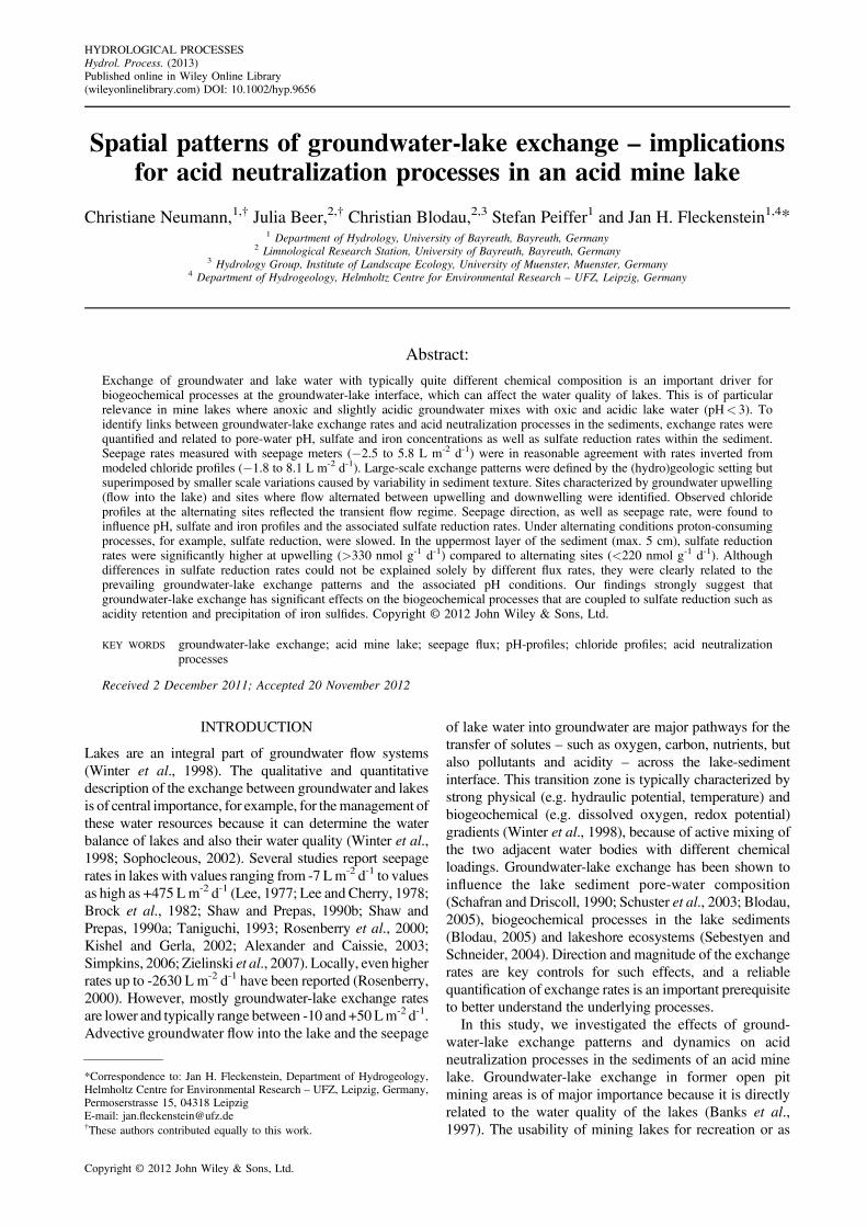
The study site – ML77 – is located in Lusatia, EastGermany (Figure 1). This region has been impacted bymining activities since the 1890s. Abandoned open pitsfrom lignite mining have been flooded, starting in the1960s. ML77 formed during the late 1960s and is situatedwithin a chain of lakes (connected by small canals)draining into the river Schwarze Elster. The mined 2nd
Lusatia coal seam separates the lower regional tertiaryaquifer from the upper aquifer complex, which consists oftertiary and quaternary sediments – mainly silt, sand andgravel (Nowel, 1994). These sediments were removedduring active mining. The resulting mining dumps formthe northern shoreline of ML77, whereas in the southeast,undisturbed tertiary sediments prevail (Fleckenstein et al.,2009). The regional groundwater flow direction is fromnorth and northeast to southwest (Knoll et al., 1999).ML77 has a surface area of 24.4 ha and a maximum depthof about 8 m (Knoll et al., 1999). At the outlet of thedownstream lake, a weir regulates the water level of thelakes upstream (including ML77). Chemically, ML77 isstrongly affected by acid mine drainage, lake waterchemistry is dominated by ferric iron and sulfate andcharacterized by a low pH of about 2.8 (Peine et al.,2000). The lake sediments at ML77 are rich in the ironminerals schwertmannite and goethite.
Seepage meter measurements
Exchange rates between groundwater and surface waterwere quantified using seepage meters, constructedaccording to (Lee, 1977). Modifications, described indetail in Fleckenstein et al. (2009), are mainly related tomaterial and size of the open-end cylinder and theduration of measurements. The stainless steel seepagemeters with a diameter and height of 0.5 m were pushedinto the lake sediment. A closable valve on top of theseepage meters allowed the removal of trapped gasbubbles potentially emitted from the lake sediment. Thevalve was opened before and after the seepage metermeasurements to check, if gas had collected in the seepagemeter during the measurement. After equilibration and
Hydrol. Process. (2013)
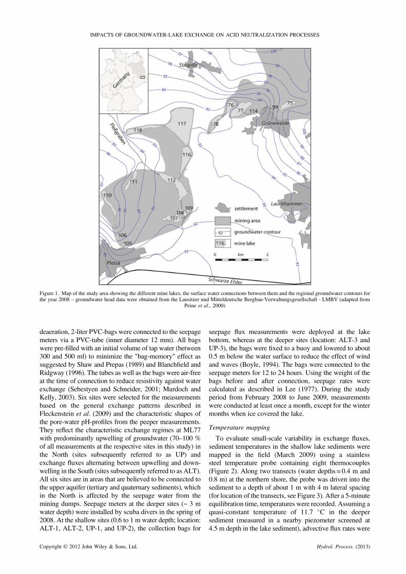
Figure 1. Map of the study area showing the different mine lakes, the surface water connections between them and the regional groundwater contours forthe year 2008 – groundwater head data were obtained from the Lausitzer und Mitteldeutsche Bergbau-Verwaltungsgesellschaft - LMBV (adapted from
Peine et al., 2000)
IMPACTS OF GROUNDWATER-LAKE EXCHANGE ON ACID NEUTRALIZATION PROCESSES
deaeration, 2-liter PVC-bags were connected to the seepagemeters via a PVC-tube (inner diameter 12 mm). All bagswere pre-filled with an initial volume of tap water (between300 and 500 ml) to minimize the "bag-memory" effect assuggested by Shaw and Prepas (1989) and Blanchfield andRidgway (1996). The tubes as well as the bags were air-freeat the time of connection to reduce resistivity against waterexchange (Sebestyen and Schneider, 2001; Murdoch andKelly, 2003). Six sites were selected for the measurementsbased on the general exchange patterns described inFleckenstein et al. (2009) and the characteristic shapes ofthe pore-water pH-profiles from the peeper measurements.They reflect the characteristic exchange regimes at ML77with predominantly upwelling of groundwater (70–100 %of all measurements at the respective sites in this study) inthe North (sites subsequently referred to as UP) andexchange fluxes alternating between upwelling and down-welling in the South (sites subsequently referred to as ALT).All six sites are in areas that are believed to be connected tothe upper aquifer (tertiary and quaternary sediments), whichin the North is affected by the seepage water from themining dumps. Seepage meters at the deeper sites (~ 3 mwater depth) were installed by scuba divers in the spring of2008. At the shallow sites (0.6 to 1 m water depth; location:ALT-1, ALT-2, UP-1, and UP-2), the collection bags for
Copyright © 2012 John Wiley & Sons, Ltd.
seepage flux measurements were deployed at the lakebottom, whereas at the deeper sites (location: ALT-3 andUP-3), the bags were fixed to a buoy and lowered to about0.5 m below the water surface to reduce the effect of windand waves (Boyle, 1994). The bags were connected to theseepage meters for 12 to 24 hours. Using the weight of thebags before and after connection, seepage rates werecalculated as described in Lee (1977). During the studyperiod from February 2008 to June 2009, measurementswere conducted at least once a month, except for the wintermonths when ice covered the lake.
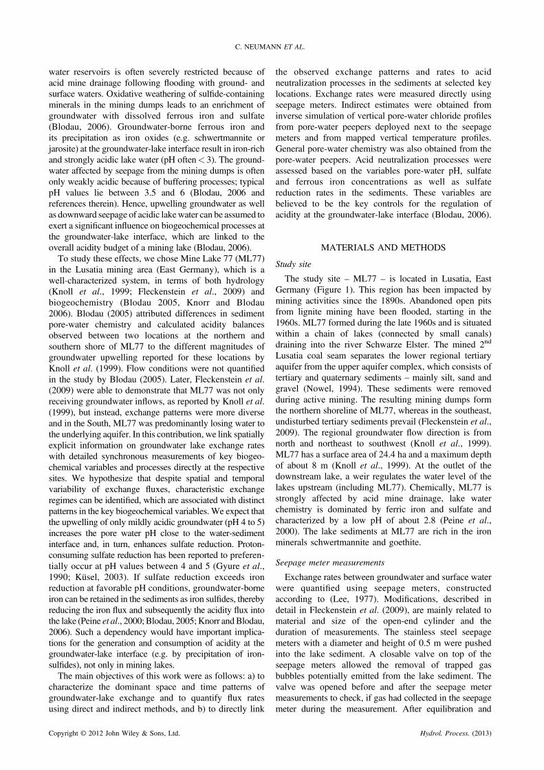
Temperature mapping
To evaluate small-scale variability in exchange fluxes,sediment temperatures in the shallow lake sediments weremapped in the field (March 2009) using a stainlesssteel temperature probe containing eight thermocouples(Figure 2). Along two transects (water depths = 0.4 m and0.8 m) at the northern shore, the probe was driven into thesediment to a depth of about 1 m with 4 m lateral spacing(for location of the transects, see Figure 3). After a 5-minuteequilibration time, temperatures were recorded. Assuming aquasi-constant temperature of 11.7 �C in the deepersediment (measured in a nearby piezometer screened at4.5 m depth in the lake sediment), advective flux rates were
Hydrol. Process. (2013)
Figure 2. Schematic setup of the temperature probe and the analyticalsolution to the 1D steady state heat transport equation by Bredehoeft and
Papadopulos (1965) used for the inversion of exchange flux rates
C. NEUMANN ET AL.
inverted from a steady-state analytical solution to the 1Dheat flow equation from Bredehoeft and Papadopoulos(1965) as described in Schmidt et al. (2006).
Pore-water chemistry and sediment properties
Concentration-depth profiles of chemical species inthe sediment pore-water were determined using 60 cm longpore-water peepers with a spatial resolution of 1 cm
Figure 3. Seepage meter and pore water peeper sites and seepage rates (L mgrey line in the seepage plots depicts lake water level, and the arr
Copyright © 2012 John Wiley & Sons, Ltd.
(Hesslein, 1976). They were pre-filled with deionized,degassed water, covered with a permeable membrane(0.2 mm pore size, HT Tuffryn membrane, PALLCorporation), and installed at the sediment-lake waterinterface. To minimize the effects of small-scale hetero-geneity on the different flux estimation methods, peeperswere placed within 1 m from the seepage meters.Equilibration time was at least 3 weeks, mainly to avoideffects from the sediment disturbance during installation.The time for the diffusive equilibration of concentrations istypically on the order of a few days for the used peepers with5 ml chambers and a diffusive length of about 1 cm (Laskovet al. 2007). As for the seepagemeters, peepers in deep waterwere installed by scuba divers and removed from thesediment between summer 2008 and spring 2009 (exactremoval dates are indicated in Figure 3). After retrieval of thepeeper, the pH was directly measured in the field using asulfide-resistant pH-electrode (Mettler Toledo Inlab 412) in asample aliquot. After transport to the lab, chloride and sulfateconcentrations were measured on filtered samples (nylonsyringe micro-filter, 0.2 mm, Roth) with ion chromatography(Metrohm IC-SystemMetrosep Anion Dual 3 column at 0.8ml min-1 flow rate, conductivity detection after chemicalsuppression). Concentrations of dissolved ferrous iron weremeasured photometrically by the phenanthroline method at512 nm (Tabatabai, 1974; Tamura et al., 1974).Lake sediment cores were taken in November and
December 2008 by a gravity corer (Uwitec) in acrylic glasstubes. The cores were sliced according to physical properties
-2 d-1) between February 2008 and May 2009 (positive = upwelling). Theow indicates the date of the removal of the pore water peepers
Hydrol. Process. (2013)

IMPACTS OF GROUNDWATER-LAKE EXCHANGE ON ACID NEUTRALIZATION PROCESSES
(color, texture) as described by Peine et al. (2000). For eachlayer, porosity was determined by drying of a given volume ofsediment until no further changes inweight could be observed.Sulfate reduction rates were determined for the uppermostlayer (0 to 2.5. . .5 cm depth) using the radiotracer method(Jorgensen, 1978) in slurries from fresh sediment samples(sodium chloride solution 7%). Samples were incubated with40 kBq of oxygen-free 35S solution (sodium sulfate, PerkinElmer) for ca. 24 h at 10 �C. Total reduced inorganic 35S wasextracted under a N2-stream and trapped in NaOH solution.An aliquot of the NaOH solution and of the residue weremeasured with a scintillation cocktail (Aquasafe 300Plus,Zunsser Analytic) on a Beckmann LS 6500 scintillationcounter. Measured counts were corrected for countingefficiencies of the cocktail and the instrument. Sulfatereduction rates were calculated after Jorgensen (1978). Therequired sulfate concentration was measured in an aliquot ofthe slurry as described above. For comparison, the pH in theslurrieswasmeasured and found to be comparable to the pore-water pH (+/� 0.5 pH units), except for location UP-2 (pH of3.0 in the slurry vs ~5 in the sediment).
Inverse modelling with VS2DT
In addition to the seepage meter measurements, ground-water-surface water exchange rates were inversely derivedfrom vertical chloride profiles. Chloride, a common ion in(ground)water, is highly mobile, not involved in commongeochemical reactions (Cox et al., 2007) and, therefore,an adequate conservative tracer. For inverse simulation, the2-dimensional (2D) numerical code VS2DT (Healy andRonan, 1996) was used. For transport, VS2DT uses a finite-difference solution to the advection-dispersion equation. To
Table I. Flow and transport parameters
[cm] [%] [m2s-1]
Shallow ALT-1&2,UP-1&2
0. . .30.5 40 3.3 E-1030.5. . .lower end 35 2.5 E-10
Deep ALT-3, UP-3 0. . .20 90 1.6 E-920. . .25 80 1.3 E-925. . .30 70 1.0 E-930. . .35 60 7.3 E-10
35. . .lower end 50 5.1 E-10
Table II. Results from seepage meter measurements and inverse simuthe day of retrieval of the pore-water peeper and mean of measuredchloride concentrations – range Clobs [mmol L-1], absolute and relativ
chloride concentrations [mmol L-1 and %
location ALT-1 ALT-2 A
Date 24 June 2008 18 December 2008 03 JuMeasured rate �1.88 0.34 0.mean rate �0.09 �0.27 0.modeled rate (s) �0.03/0.03 0.04/0.23 �1.range Clobs 1300–2150 981–1220 47RMSE [m mol l-1] 45/49 41/42 3RMSE [%] 5.7 17.6 12.R2 0.99/0.99 0.90/0.95 0.
Copyright © 2012 John Wiley & Sons, Ltd.
estimate the advective component of chloride transport andto fit the measured chloride concentration-depth profile, a1D transport model for the upper sediment was set up. Thelength of the model domain was equal to the measuredchloride concentration profile (depths of the pore-waterpeeper in the sediment). The model was discretized into1 cm slices, each containing an observation point and runas a steady-state model for flow and transport. The upperand lower ends of the 1D model domain were treated asfirst-type boundary conditions (Dirichlet) for both flowand transport. Chloride concentrations at the boundarieswere obtained from the cells of the pore-water peepersright at the water-sediment interface and at the lower endof the peeper. Variations in chloride concentrations at thelower end between sites are attributed to variability ofchloride concentrations in the adjoining groundwatercaused by differences in geology and sediment compos-ition. The hydraulic gradients were fixed based onestimates from head measurements in nested piezometersat sites UP-1 and ALT-2 (�0.0024 and 0.0024, respect-ively), and the hydraulic conductivity was varied to fit themeasured profile. In line with Fleckenstein et al. (2009)and based on Gelhar et al. (1992), hydrodynamicdispersivities of 0.01 m and 0.06 m were assumed forthe shallow and deeper locations, respectively, reflectingdifferences in sediment texture. Table I summarizes theapplied flow and transport parameters. The diffusioncoefficient for chloride was calculated after Lerman(1978) from the self-diffusion coefficient for chloride of2.3.10-9 m2 s-1 (Appelo and Postma, 2005) times thesquared value of the sediment porosity.
RESULTS
Space and time patterns of groundwater-lake exchange
Measured seepage rates at ML77 were spatially as wellas temporally variable (Figure 3). In the North, the lakepredominantly received groundwater inflow. Rates ofgroundwater upwelling into the lake ranged from +0.1 to+5.8 L m-2 d-1. Sites UP-2 and UP-3 with generally thelowest flux rates also had occasional periods of down-welling. In the South, downward seepage of lake waterinto the aquifer (> = 50% of the time) as well as
lations of chloride profiles for all sites: measured rate [L m-2 d-1] onrates [L m-2 d-1]; modeled rate [L m-2 d-1], range of the observede RMSE (root mean square error) between modeled and observed], and coefficient of determination [ ]
LT-3 UP-1 UP-2 UP-3
ne 2008 12 March 2009 28 October 2008 04 Jun 200814 5.28 3.15 0.2904 3.68 0.82 0.2380/-0.21 8.14 0.27 0.826–900 275–735 215–900 760–11462/51 14 39 270 3.0 5.7 7.097/0.98 0.97 0.98 0.99
Hydrol. Process. (2013)
C. NEUMANN ET AL.
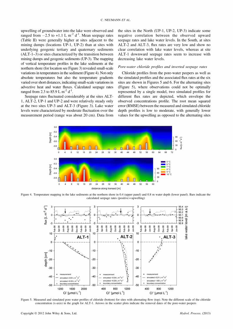
upwelling of groundwater into the lake were observed andranged from �2.5 to +1.1 L m-2 d-1. Mean seepage rates(Table II) were generally higher at sites adjacent to themining dumps (locations UP-1, UP-2) than at sites withunderlying geogenic tertiary and quaternary sediments(ALT-1–3) or sites characterized by the transition betweenmining dumps and geogenic sediments (UP-3). The mappingof vertical temperature profiles in the lake sediments at thenorthern shore (for location see Figure 3) revealed small-scalevariations in temperatures in the sediment (Figure 4). Not onlyabsolute temperatures but also the temperature gradientsvaried over short distances, indicating small-scale variations inadvective heat and water fluxes. Calculated seepage ratesranged from 2.3 to 85.9 L m-2 d-1.Seepage rates fluctuated considerably at the sites ALT-
1, ALT-2, UP-1 and UP-2 and were relatively steady onlyat the two sites UP-3 and ALT-3 (Figure 3). Lake waterlevels were characterized by moderate fluctuation over themeasurement period (range was about 20 cm). Data from
Figure 4. Temperature mapping in the lake sediments at the northern shore icalculated seepage rates
Figure 5. Measured and simulated pore water profiles of chloride (bottom) fconcentration (x-axis) in the graph for ALT-1. Arrows in the sca
Copyright © 2012 John Wiley & Sons, Ltd.
the sites in the North (UP-1, UP-2, UP-3) indicate somenegative correlation between the observed upwardseepage rates and lake water levels. In the South, at sitesALT-2 and ALT-3, flux rates are very low and show noclear correlation with lake water levels, whereas at siteALT-1 downward seepage rates seem to increase withdecreasing lake water levels.
Pore-water chloride profiles and inverted seepage rates
Chloride profiles from the pore-water peepers as well asthe simulated profiles and the associated flux rates at the sixsites are shown in Figures 5 and 6. For the alternating sites(Figure 5), where observations could not be optimallyrepresented by a single model, two simulated profiles fordifferent flux rates are depicted, which envelope theobserved concentrations profile. The root mean squarederror (RMSE) between the measured and simulated chloridedepth profiles is low to moderate, with generally lowervalues for the upwelling as opposed to the alternating sites
n 0.4 (upper panel) and 0.8 m water depth (lower panel). Bars indicate the(positive = upwelling)
or sites with alternating flow (top). Note the different scale of the chloridetter plots indicate the removal dates of the pore-water peepers
Hydrol. Process. (2013)
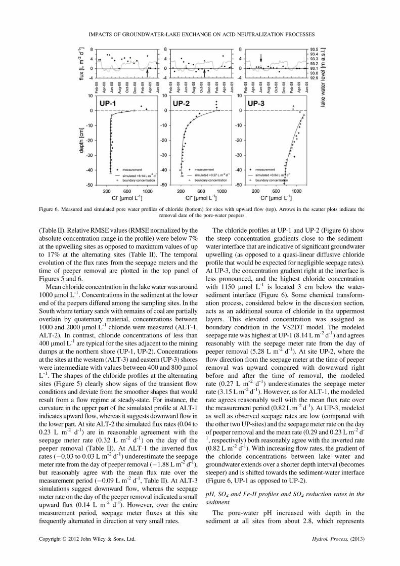
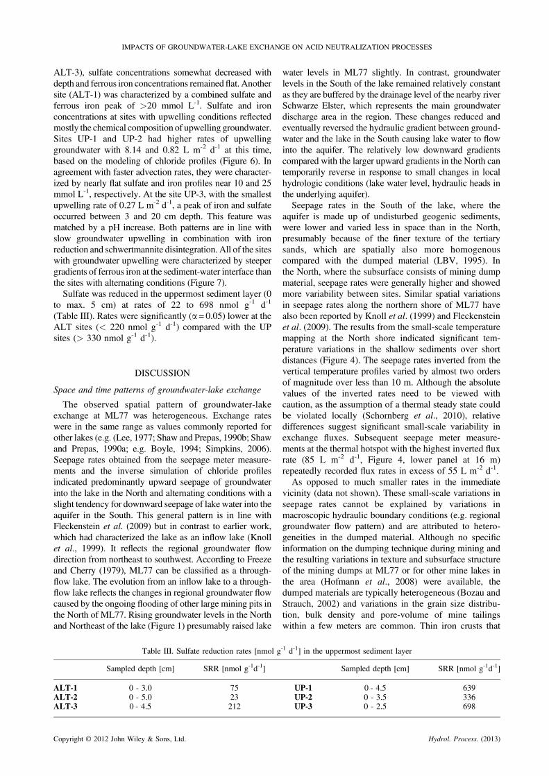
Figure 6. Measured and simulated pore water profiles of chloride (bottom) for sites with upward flow (top). Arrows in the scatter plots indicate theremoval date of the pore-water peepers
IMPACTS OF GROUNDWATER-LAKE EXCHANGE ON ACID NEUTRALIZATION PROCESSES
(Table II). Relative RMSEvalues (RMSEnormalized by theabsolute concentration range in the profile) were below 7%at the upwelling sites as opposed to maximum values of upto 17% at the alternating sites (Table II). The temporalevolution of the flux rates from the seepage meters and thetime of peeper removal are plotted in the top panel ofFigures 5 and 6.Mean chloride concentration in the lakewater was around
1000 mmol L-1. Concentrations in the sediment at the lowerend of the peepers differed among the sampling sites. In theSouth where tertiary sands with remains of coal are partiallyoverlain by quaternary material, concentrations between1000 and 2000 mmol L-1 chloride were measured (ALT-1,ALT-2). In contrast, chloride concentrations of less than400 mmol L-1 are typical for the sites adjacent to the miningdumps at the northern shore (UP-1, UP-2). Concentrationsat the sites at the western (ALT-3) and eastern (UP-3) shoreswere intermediate with values between 400 and 800 mmolL-1. The shapes of the chloride profiles at the alternatingsites (Figure 5) clearly show signs of the transient flowconditions and deviate from the smoother shapes that wouldresult from a flow regime at steady-state. For instance, thecurvature in the upper part of the simulated profile at ALT-1indicates upward flow, whereas it suggests downward flow inthe lower part. At site ALT-2 the simulated flux rates (0.04 to0.23 L m-2 d-1) are in reasonable agreement with theseepage meter rate (0.32 L m-2 d-1) on the day of thepeeper removal (Table II). At ALT-1 the inverted fluxrates (�0.03 to 0.03 L m-2 d-1) underestimate the seepagemeter rate from the day of peeper removal (�1.88 L m-2 d-1),but reasonably agree with the mean flux rate over themeasurement period (�0.09 L m-2 d-1, Table II). At ALT-3simulations suggest downward flow, whereas the seepagemeter rate on the day of the peeper removal indicated a smallupward flux (0.14 L m-2 d-1). However, over the entiremeasurement period, seepage meter fluxes at this sitefrequently alternated in direction at very small rates.
Copyright © 2012 John Wiley & Sons, Ltd.
The chloride profiles at UP-1 and UP-2 (Figure 6) showthe steep concentration gradients close to the sediment-water interface that are indicative of significant groundwaterupwelling (as opposed to a quasi-linear diffusive chlorideprofile that would be expected for negligible seepage rates).At UP-3, the concentration gradient right at the interface isless pronounced, and the highest chloride concentrationwith 1150 mmol L-1 is located 3 cm below the water-sediment interface (Figure 6). Some chemical transform-ation process, considered below in the discussion section,acts as an additional source of chloride in the uppermostlayers. This elevated concentration was assigned asboundary condition in the VS2DT model. The modeledseepage rate was highest at UP-1 (8.14 Lm-2 d-1) and agreesreasonably with the seepage meter rate from the day ofpeeper removal (5.28 L m-2 d-1). At site UP-2, where theflow direction from the seepage meter at the time of peeperremoval was upward compared with downward rightbefore and after the time of removal, the modeledrate (0.27 L m-2 d-1) underestimates the seepage meterrate (3.15 L m-2 d-1). However, as for ALT-1, the modeledrate agrees reasonably well with the mean flux rate overthe measurement period (0.82 L m-2 d-1). At UP-3, modeledas well as observed seepage rates are low (compared withthe other twoUP-sites) and the seepagemeter rate on the dayof peeper removal and the mean rate (0.29 and 0.23 L m-2 d-1, respectively) both reasonably agree with the inverted rate(0.82 L m-2 d-1). With increasing flow rates, the gradient ofthe chloride concentrations between lake water andgroundwater extends over a shorter depth interval (becomessteeper) and is shifted towards the sediment-water interface(Figure 6, UP-1 as opposed to UP-2).
pH, SO4 and Fe-II profiles and SO4 reduction rates in thesediment
The pore-water pH increased with depth in thesediment at all sites from about 2.8, which represents
Hydrol. Process. (2013)

Figure 7. Pore-water pH, sulfate and ferrous iron profiles at all sampling sites. The dashed line (0 cm depth) marks the sediment-water interface. Sites aregrouped according to their prevailing flow conditions: ALT for alternating conditions (left), UP for groundwater upwelling (right)
C. NEUMANN ET AL.
lake water pH, to values of 3.5 to> 6.0 (Figure 7).Depending on the predominant flow regime, characteristicpH-profiles had developed. At sites with alternatingconditions (Figure 7, ALT), lake water with a low pHpenetrated into the sediment, and maximum pH values werereached at the lower end of the profile. No sharp increase ofthe pH directly below the sediment-water interface occurredat these sites, and pH increased rather steadily with depth. At
Copyright © 2012 John Wiley & Sons, Ltd.
sites with upwelling conditions, the pH within the sedimentsincreased from lake water pH to values of> 5 within a fewcentimeters below the sediment-water interface (UP,Figure 7). There, maximum pH-values were measured inthe upper part of the profile, slightly decreasing with depth.Sulfate concentrations above the surface water-sediment
interface were close to 10 mmol L-1 at all sites (Figure 7). Intwo of the three sediments with alternating flow (ALT-2 and
Hydrol. Process. (2013)
IMPACTS OF GROUNDWATER-LAKE EXCHANGE ON ACID NEUTRALIZATION PROCESSES
ALT-3), sulfate concentrations somewhat decreased withdepth and ferrous iron concentrations remainedflat. Anothersite (ALT-1) was characterized by a combined sulfate andferrous iron peak of >20 mmol L-1. Sulfate and ironconcentrations at sites with upwelling conditions reflectedmostly the chemical composition of upwelling groundwater.Sites UP-1 and UP-2 had higher rates of upwellinggroundwater with 8.14 and 0.82 L m-2 d-1 at this time,based on the modeling of chloride profiles (Figure 6). Inagreement with faster advection rates, they were character-ized by nearly flat sulfate and iron profiles near 10 and 25mmol L-1, respectively. At the site UP-3, with the smallestupwelling rate of 0.27 L m-2 d-1, a peak of iron and sulfateoccurred between 3 and 20 cm depth. This feature wasmatched by a pH increase. Both patterns are in line withslow groundwater upwelling in combination with ironreduction and schwertmannite disintegration. All of the siteswith groundwater upwelling were characterized by steepergradients of ferrous iron at the sediment-water interface thanthe sites with alternating conditions (Figure 7).Sulfate was reduced in the uppermost sediment layer (0
to max. 5 cm) at rates of 22 to 698 nmol g-1 d-1
(Table III). Rates were significantly (a= 0.05) lower at theALT sites (< 220 nmol g-1 d-1) compared with the UPsites (> 330 nmol g-1 d-1).
DISCUSSION
Space and time patterns of groundwater-lake exchange
The observed spatial pattern of groundwater-lakeexchange at ML77 was heterogeneous. Exchange rateswere in the same range as values commonly reported forother lakes (e.g. (Lee, 1977; Shaw and Prepas, 1990b; Shawand Prepas, 1990a; e.g. Boyle, 1994; Simpkins, 2006).Seepage rates obtained from the seepage meter measure-ments and the inverse simulation of chloride profilesindicated predominantly upward seepage of groundwaterinto the lake in the North and alternating conditions with aslight tendency for downward seepage of lake water into theaquifer in the South. This general pattern is in line withFleckenstein et al. (2009) but in contrast to earlier work,which had characterized the lake as an inflow lake (Knollet al., 1999). It reflects the regional groundwater flowdirection from northeast to southwest. According to Freezeand Cherry (1979), ML77 can be classified as a through-flow lake. The evolution from an inflow lake to a through-flow lake reflects the changes in regional groundwater flowcaused by the ongoing flooding of other large mining pits inthe North of ML77. Rising groundwater levels in the Northand Northeast of the lake (Figure 1) presumably raised lake
Table III. Sulfate reduction rates [nmol g
Sampled depth [cm] SRR [nmol g-1d-1]
ALT-1 0 - 3.0 75ALT-2 0 - 5.0 23ALT-3 0 - 4.5 212
Copyright © 2012 John Wiley & Sons, Ltd.
water levels in ML77 slightly. In contrast, groundwaterlevels in the South of the lake remained relatively constantas they are buffered by the drainage level of the nearby riverSchwarze Elster, which represents the main groundwaterdischarge area in the region. These changes reduced andeventually reversed the hydraulic gradient between ground-water and the lake in the South causing lake water to flowinto the aquifer. The relatively low downward gradientscompared with the larger upward gradients in the North cantemporarily reverse in response to small changes in localhydrologic conditions (lake water level, hydraulic heads inthe underlying aquifer).Seepage rates in the South of the lake, where the
aquifer is made up of undisturbed geogenic sediments,were lower and varied less in space than in the North,presumably because of the finer texture of the tertiarysands, which are spatially also more homogenouscompared with the dumped material (LBV, 1995). Inthe North, where the subsurface consists of mining dumpmaterial, seepage rates were generally higher and showedmore variability between sites. Similar spatial variationsin seepage rates along the northern shore of ML77 havealso been reported by Knoll et al. (1999) and Fleckensteinet al. (2009). The results from the small-scale temperaturemapping at the North shore indicated significant tem-perature variations in the shallow sediments over shortdistances (Figure 4). The seepage rates inverted from thevertical temperature profiles varied by almost two ordersof magnitude over less than 10 m. Although the absolutevalues of the inverted rates need to be viewed withcaution, as the assumption of a thermal steady state couldbe violated locally (Schornberg et al., 2010), relativedifferences suggest significant small-scale variability inexchange fluxes. Subsequent seepage meter measure-ments at the thermal hotspot with the highest inverted fluxrate (85 L m-2 d-1, Figure 4, lower panel at 16 m)repeatedly recorded flux rates in excess of 55 L m-2 d-1.As opposed to much smaller rates in the immediate
vicinity (data not shown). These small-scale variations inseepage rates cannot be explained by variations inmacroscopic hydraulic boundary conditions (e.g. regionalgroundwater flow pattern) and are attributed to hetero-geneities in the dumped material. Although no specificinformation on the dumping technique during mining andthe resulting variations in texture and subsurface structureof the mining dumps at ML77 or for other mine lakes inthe area (Hofmann et al., 2008) were available, thedumped materials are typically heterogeneous (Bozau andStrauch, 2002) and variations in the grain size distribu-tion, bulk density and pore-volume of mine tailingswithin a few meters are common. Thin iron crusts that
-1 d-1] in the uppermost sediment layer
Sampled depth [cm] SRR [nmol g-1d-1]
UP-1 0 - 4.5 639UP-2 0 - 3.5 336UP-3 0 - 2.5 698
Hydrol. Process. (2013)

C. NEUMANN ET AL.
were locally observed at the top of or within the shallowlake sediments in the North shore may explain some ofthe observed variations.Temporal changes in seepage rates can only partly be
explained by variations in lake water levels, which wereassociated with water level changes in the connected lakeML76 (Figure 1) caused by the weir at the outflow ofML76 and periods of strong precipitation or evaporation.At the sites in the North (UP-1, UP-2, UP-3) seepage ratesindicate a mild negative correlation with lake water levelsand upward seepage fluxes are generally higher for lowerlake water levels than for high lake water levels (Figure 3).This tendency is most pronounced at the sites with thehighest exchange rates (UP-1, UP-2) and much less forsites with low exchange rates (UP-3, ALT-2, ALT-3).This is probably caused by a relatively quick equilibrationbetween lake water levels and hydraulic heads in theadjoining aquifer at the sites that generally show smallhead differentials between lake and groundwater (UP-3,ALT-2, ALT-3). This can be seen at ALT-3, where thelowest seepage rates and minimal fluctuations, whichpractically do not correlate with lake water levels, wereobserved (Figure 3). Groundwater heads in the narrowridge of quaternary sediments between the two adjacentlakes ML77 and ML76 (see Figure 1) are stronglycontrolled by the water levels in the lakes. As the twolakes are connected by a short canal and, therefore, havesimilar water level fluctuations, groundwater heads in thequaternary sediments adjacent to site ALT-3 quicklyequilibrate to lake water levels. Consequently, the overallhydraulic gradients between the lake and the adjoiningaquifer hardly change, resulting in the relatively steadyflux rates observed at this site. At site ALT-1, therelationship between seepage rates and lake water levelsis more complex and almost seems to be reversed. Thehighest rates of downward seepage were recorded duringlow lake water levels in late June and August of 2008.The transition from lower to higher rates of downwardseepage between early June and August, when lake waterlevels were constantly low, probably reflects the seasonaldecline in groundwater levels in the adjacent aquifer tothe South of the lake. Similarly, the subsequent decreasein downward seepage rates and the eventual reversal toupwelling conditions between the later summer and fall ispresumably caused by the seasonal recovery of ground-water heads after the dry summer period. At ALT-1,seasonal variations in groundwater heads in the adjacentaquifer seem to be the dominant control of seepage fluxesas opposed to fluctuations of lake water levels. Theseresults highlight that lake water levels are not the onlysignificant control for temporal patterns in groundwaterlake exchange and instead seasonal changes and fluctua-tions in hydraulic potentials in the connected aquifers candominate temporal variability in exchange fluxes. Thegeologic structure and heterogeneity of the aquifer alsoaffect local groundwater head fluctuations by causing thesystem to react with different time delays and to differentdegrees to changes in the hydro-meteorological forcing.Such effects are presumably also the main reason for the
Copyright © 2012 John Wiley & Sons, Ltd.
short-term fluctuations that were observed at most sites.In some cases, these variations could be related to individualrainfall events, which may have caused spatially differ-entiated responses in local groundwater heads. The complexgeology of artificial mine lakes including heterogeneousmining dumps and tailings can further exacerbate sucheffects (Fleckenstein et al., 2009). However, similarfluctuations in groundwater-lake exchange rates have alsobeen reported for natural lakes (Sebestyen and Schneider,2001; Kishel and Gerla, 2002) and are likely quite commonin most groundwater-lake systems.
Chloride profiles and modeled vs. measured seepage rates
Lake water chloride concentrations at the water-sedimentinterface were relatively uniform across the lake at valuesslightly below 1000 mmol L-1. In contrast, concentrations inthe sediments varied considerably with a general pattern ofconcentrations increasing fromUP-2 to ALT-1 in clockwisedirection around the lake and a decrease going back upalong the western shore. This general pattern correspondswith changes in the geology surrounding the lake, withmining dumps in the North, a transition frommining dumpsto geogenic tertiary and quaternary sediments in the East,geogenic tertiary and quaternary sediments in the Southand quaternary sediments (Woberg discontinuity) in theSouthwest (Fleckenstein et al., 2009). It seems to reflectgeneral differences in the geogenic availability of chloride inthe different sediments that are underlying the lake. Forthe inversion of flux rates from the chloride profiles, thesedifferences do not constitute a problem as long as thedifferences are accounted for in the lower boundaryconditions of the site-specific models. At site UP-3, thehighest chloride concentrations in the profile were found at3 cm depth (Figure 6). The elevated chloride concentrationsare attributed to a release of chloride from biogeochemicalprocesses in the sediment. According to Bigham et al.(1990), chloride can partly replace sulfate in the tunnelstructure of the precipitated iron sulfate-mineral schwert-mannite, which may subsequently be released duringthe mineral transformation process into goethite. Such arelease could increase chloride concentrations close tothe sediment-water interface, where schwertmannite ispreferentially transformed (Peine et al., 2000), especiallyif subsequent removal by advection is slow. It was assumedthat the shape of the chloride profile below the pointof maximum concentration adequately reflects the advec-tive-diffusive transport of chloride between the groundwaterand the lake. Hence, the point of maximum chlorideconcentration was chosen as an upper boundary conditionfor the transport model.The better agreement between simulated and observed
chloride profiles at the upwelling sites (range of relativeRMSE values: 3 to 7 %) as opposed to the alternating sites(range of relative RMSE values: 6 to 17 %) reflects thesteadier flow regime at these sites. At UP-1 and UP-3 whereseepage rates in the period before the removal of thepore-water peepers were relatively steady, the inverted fluxrates reasonably agree with the seepage meter rate from theday of peeper removal (Table II). In contrast at UP-2, where
Hydrol. Process. (2013)

IMPACTS OF GROUNDWATER-LAKE EXCHANGE ON ACID NEUTRALIZATION PROCESSES
a relatively high upwelling flux on the day of peeperremoval was preceded by a period with mild downwelling,the inverted flux rate is an order of magnitude lower than theseepage meter rate. However, it agrees reasonably well withthe mean flux rate over the measurement period (Table II)reflecting the integral character of the peeper measurements.At all upwelling sites, the predominant direction ofexchange and the relative differences in the overallmagnitude of fluxes are adequately reflected in the shapesof the profiles as well as in the inverted flux rates (Figure 6).Local deviations between the simulated and observedchloride concentrations along the profile (most pronouncedat UP-3) indicate fluctuations and reversals in the exchangefluxes over the period preceding the removal of the pore-water peeper.Such deviations are also clearly evident in the chloride
profiles at the alternating sites where observed valuescould only be bracketed by two simulated profiles fordifferent flux rates (Figure 5). For the observed frequencyof the changes in magnitude and direction of flow at thesesites, chloride concentrations in the pore-water do notreach a steady state. The uneven shapes of the chlorideprofiles, which neither represent an idealized diffusive noradvective profile, as described by Lerman (1978) andSchlüter et al. (2004), reflect transients in the advectiveflux. Another reason for the shifting slopes in the chlorideprofiles (e.g. ALT-1, ALT-3) might be non-vertical flowcomponents, which are precluded when using a 1Dmodel. This simplifying assumption, which can lead toerroneous flux estimates (Schornberg et al., 2010) mightnot be strictly met at all sites. The inverted flux rates atthese sites can hence only provide an envelope for theobserved flux rates and a general indication of thedirection and magnitude of flow. At these sites, estimatesof absolute flux rates are problematic. At ALT-1 and ALT-3, the profiles are also less than 30 cm deep because thepeeper could not be installed to greater depth. The profilesdo not extend deep enough into the sediment to havereached a constant value that does not change further withdepth. This may introduce additional uncertainty in theabsolute flux estimate at these sites. However, the very lowmean flux rates from the seepage meters at ALT-1 andALT-3 (Table II) suggest a mainly diffusive exchangeregime, which is also reflected in the somewhat linear trendin the profiles at these sites. Therefore, we suspect that withfurther depth, chloride concentrations will change at thesame rate as in the uppermost 20–30 cm of the profile untilambient groundwater concentrations are reached. Thiswould minimize potential errors in the flux rates invertedfrom these profiles.At ALT-1 and ALT-2, the inverted fluxes rather reflect
seepage rates from the previous seepage meter measure-ment. This highlights that seepage meters allow a more orless instantaneous measurement of flux rates, whereas theestimation from concentration-depth profiles integratesover time and hence reflects the flow regime from thepreceding period. Nevertheless, the inverted flux rates thatenvelope the observed profiles (Figure 5) adequatelyreflect the transient flow regime in the preceding period
Copyright © 2012 John Wiley & Sons, Ltd.
and reasonably match magnitude and direction of eitherthe mean (ALT-1) or instantaneous rates from the seepagemeters (ALT-2). Only at site ALT-3 with the overalllowest seepage rates that fluctuate between upwelling anddownwelling, the inverted flux from the chloride profiledeviates from the instantaneous seepage meter rate inmagnitude and direction.Despite the discussed limitations, the method of
estimating seepage rates by the inversion of chlorideprofiles was able to capture the same large-scale patternsof groundwater lake exchange that were derived from therepeated seepage meter measurements. At most sites,general magnitudes and directions of flow were alsocomparable between the methods. However, the invertedflux rates provide estimates that integrate over time,whereas seepage meter measurements are quasi-instantaneous. Therefore flux estimates obtained fromboth methods at the same point in time can only becompared, when the preceding exchange regime wasrelatively steady so that measured chloride profiles in thesediments could reach a steady state. If the exchangeregime is characterized by strong fluctuations or evenreversals in flow direction, as it is the case at several sitesin this study, chloride profiles will be uneven, andinverted flux rates deviate from instantaneous rates andrather reflect average conditions over the precedingperiod. For studies on biogeochemical transformationsin lake sediments, where the predominant exchangeregime is often more important than the instantaneousrates or short-term fluctuations, the inversion of flux ratesfrom chloride concentration profiles provides a viablealternative to seepage meter measurements. Pore waterpeepers have the additional advantage to enable theanalyses of other dissolved species in the pore-water,which can provide further insights into the biogeochemicaltransformations at the groundwater-lake interface. Astemporal variability of exchange fluxes seems to be acommon feature in artificial (this study, Fleckenstein et al.,2009) and natural groundwater-lake systems (Sebestyen andSchneider, 2001; Kishel and Gerla, 2002), seepage metermeasurements need to be frequent enough to capture therelevant temporal variability in fluxes.
Effects of exchange fluxes on pH and acid neutralizationprocesses in the sediment
The quantification of groundwater-lake exchange ratesat the iron-rich acid mining lake ML77 allowed us tointerpret our biogeochemical data within a hydrologicframework: (1) the observed groundwater-lake exchangealtered the pore-water pH-profiles, particularly close tothe lake-sediment interface (Figure 7). Our data further(2) suggest that raised pH promoted sulfate reduction(Table III). The sulfate and ferrous iron concentrationsamong sites (3) also illustrate how the pore-waterchemistry was modified by the interplay of advectionand microbial iron reduction and related schwertmannitedisintegration. Because we used identical locations for thedetermination of hydrological fluxes, pH, and sulfatereduction, we can link local processes directly to
Hydrol. Process. (2013)

C. NEUMANN ET AL.
hydrological conditions, which was not possible inprevious investigations, such as presented in Blodau(2004, 2005)The sediment pore-water pH in mining lake sediments
results from proton-consuming and proton-producingprocesses and the interaction between the acidic lakeand less acidic groundwater (Blodau, 2004). The pore-water pH measured deeper in the sediment was within therange observed in sediments with low carbonate contentsin similar mine lake settings (Werner et al., 2001; Bozauand Strauch, 2002; Blodau, 2006). The pH valuesgenerally increased with depth and approached valuestypical for groundwater (pH> 4.5, which is significantlyhigher than in the lake water) at depth no deeper thanabout 20 cm into the sediment. An exception is ALT-3,where groundwater in the narrow ridge between ML77and ML76 (Figure 1) is probably strongly affected by thelow-pH water of the adjoining lakes and does notrepresent genuine groundwater. In contrast to chlorideconcentrations, which showed significant variationsbetween sites depending on the local geology, the pH inthe deeper sediments was always higher than in the lakeand reflected the values observed in shallow piezometersdirectly at the lake shore and in deeper groundwater wellsup to several hundred meters away from the lake (> 4.5,data not shown). The characteristic shapes of the pH-profiles (Figure 7) were clearly distinct for the differentexchange regimes. At sites with upwelling groundwater,the pH sharply increased right below the sediment-waterinterface to values> 4.5. The pore-water chemistry wasfurther modified by release of ferrous iron and sulfate andtheir removal by groundwater advection (Figure 6 and 7).At the upwelling sites, inflow of groundwater with arelatively high pH may have triggered a further increaseof the pH within the sediments because of an activation ofproton-consuming, reductive processes (i.e. iron andsulfate reduction, Blodau, 2004). At the other sites, pHincreased only gradually with depth and remained lownear the interface, indicating a predominance of down-welling. Penetration of lake water with a low pH mayhave slowed proton consumption by sulfate reduction sothat the pH remained low at these sites. Also here, somevariation of pH occurred because of local conditions.Where the microbial activity in the sediment was strongand ferrous iron and sulfate were released (ALT-1,Figure 7), likely in response to increased input of organicmatter from macrophytes along the shoreline, the pH wassomewhat higher, yet without reaching the levels of thesites with upwelling groundwater. This was not the caseat the sites with groundwater upwelling.We further expected an impact of the water flux and
pH level on sulfate reduction rates. Indeed, reductionrates in the uppermost sediment layers were significantlyhigher at the UP sites (Table III) at pH values of> 5compared with the ALT sites with values< 4 (Figure 7).This pattern can be attributed to changes in thecompetition between iron and sulfate reduction, whichis less competitive when pH is low (Blodau and Peiffer,2003). Previous studies have postulated such a depend-
Copyright © 2012 John Wiley & Sons, Ltd.
ency: Blodau (2004) reported higher net-sulfate reductionrates along with higher pH-values near the northern shoreat ML77 compared with the southern shore and linkedthis effect to the groundwater inflow rates reported byKnoll et al. (1999).
CONCLUSIONS
The combined use of frequent seepage meter measure-ments and chloride profiles from pore-water peepers toestimate groundwater-lake exchange rates provideddetailed insights into the spatial and temporal patternsof groundwater-lake exchange at ML77. Exchangepatterns were spatially and temporally heterogeneous.Relatively steady upwelling of groundwater into the lakein the North and alternating fluxes in the South werefound. This was congruent with the regional groundwaterflow direction from the Northeast to Southwest andgenerally corroborates the earlier work by Fleckensteinet al. (2009). The magnitude of flux rates varied withgeology – artificial mining dumps in the North andtertiary and quaternary sediments in the South. At thesmaller scale, variations within short distances wereprevalent in the North, presumably caused by heteroge-neous sediment texture, which is typical for man-mademining dumps. Flux rates at several sites variedsignificantly in time. Only at some sites variations wereclearly correlated with fluctuations in lake water levels.At other sites, flux rates remained relatively constant,indicating synchronous fluctuations of lake water levelsand hydraulic heads in the underlying aquifer or showedtrends that were related to seasonal variations in ground-water levels. Flux rates inverted from chloride profilesprovide time-integrated values as opposed to the quasi-instantaneous values provided by seepage meter measure-ments. Despite the simplifying assumptions that had to bemade in the inverse modeling both methods providedsimilar results. This suggests that the relevant informationon the exchange (e.g. predominance of flow direction,frequency of flow reversals, overall magnitude of flow),which is most pertinent for biogeochemical studies insediments at the groundwater-lake interface, can beadequately deduced from pore-water peepers withoutthe need for additional frequent seepage meter measure-ments. The observed spatial pattern of groundwater-lakeexchange influenced the vertical profiles of sulfate, ferrousiron and pH in the sediment pore-water. The increased pHclose to the sediment-water interface at the upwelling sitesstipulated elevated sulfate reduction rates in the uppermostsediment layers. Such an effect had been postulated(Blodau, 2004), but a direct combination of synoptic fluxmeasurements and biogeochemical sampling to demonstratethese mechanisms had been missing to date. This study thusconfirms that groundwater exchange influences acidneutralization in acid mine lake sediments and suggeststhat knowledge of water exchange patterns is needed for theinterpretation of biogeochemical processes in acidmine lakesystems.
Hydrol. Process. (2013)

IMPACTS OF GROUNDWATER-LAKE EXCHANGE ON ACID NEUTRALIZATION PROCESSES
ACKNOWLEDGEMENTS
We thank T. Broder, N. Volze, B. Kopp for assistance inthe field and S. Hammer for technical assistance in thelaboratory. Funding was provided by the GermanResearch Foundation to J. H. Fleckenstein (DFG,FL631/5-1) and to C. Blodau (DFG, BL563/15-1). Theconstructive criticism of three anonymous reviewers greatlyhelped to improve the final manuscript. The Lausitzer undMitteldeutsche Bergbau-Verwaltungsgesellschaft (LMBV)granted permission for field work and provided data onregional groundwater levels.
REFERENCES
AlexanderMD, Caissie D. 2003. Variability and comparison of hyporheicwater temperatures and seepage fluxes in a small Atlantic salmonstream. Ground Water 41(1): 72–82. DOI: 10.1111/j.1745-6584.2003.tb02570.x.
Appelo CA, Postma D. 2005. Geochemistry, groundwater andpollution. Balkema: Leiden/London/New York/Philadelphia/Singapore; 649.
Banks D, Younger PL, Arnesen R-T, Iversen ER, Banks SB. 1997. Mine-water chemistry: the good, the bad and the ugly. EnvironmentalGeology 32(3): 157–174. DOI: 10.1007/s002540050204.
Bigham JM, Schwertmann U, Carlson L, Murad E. 1990. A PoorlyCrystallized Oxyhydroxysulfate of Iron Formed by Bacterial Oxidationof Fe(II) in Acid-Mine Waters. Geochimica Et Cosmochimica Acta 54(10): 2743–2758. DOI: 10.1016/0016-7037(90)90009-A.
Blanchfield PJ, Ridgway MS. 1996. Use of seepage meters to measuregroundwater flow at brook trout redds. Transactions of the AmericanFisheries Society 125(5): 813–818.
Blodau C. 2004. Evidence for a hydrologically controlled iron cycle inacidic and iron rich sediments. Aquatic Sciences 66(1): 47–59.DOI: 10.1007/s00027-003-0689-y
Blodau C. 2005. Groundwater inflow controls acidity fluxes in an iron richand acidic lake. Acta hydrochimica et hydrobiologica 33(2): 104–117.DOI: 10.1002/aheh.200300563
Blodau C. 2006. A review of acidity generation and consumption in acidiccoal mine lakes and their watersheds. Science of the Total Environment369(1–3): 307–332. DOI:10.1016/j.scitotenv.2006.05.004.
Blodau C, Peiffer, S. 2003. Thermodynamics and organic matter:constraints on neutralization processes in sediments of highly acidicwaters. Applied Geochemistry 18(1): 25–36. DOI: 10.1016/S0883-2927(02)00052-5.
Boyle DR. 1994. Design of a Seepage Meter for Measuring GroundwaterFluxes in the Nonlittoral Zones of Lakes - Evaluation in a Boreal ForestLake. Limnology and Oceanography 39(3): 670–681. DOI: 10.4319/lo.1994.39.3.0670.
Bozau E, Strauch, G. 2002. Hydrogeological Basis for BiotechnologicalRemediation of the Acidic Mining Lake ‘RL 111’, Lusatia (Germany).Water, Air, & Soil Pollution: Focus 2(3): 15–25. DOI: 10.1023/A:1019974806933.
Bredehoeft JD, Papadopoulos IS. 1965. Rates of Vertical GroundwaterMovement Estimated from Earths Thermal Profile. Water ResourcesResearch 1(2): 325–328.
Brock TD, Janes D, Winek D. 1982. Groundwater seepage as a nutrientsource to a drainage lake; Lake Mendota, Wisconsin. Water Resources16: 1255–1263. DOI: 10.1016/0043-1354(82)90144-0.
Cox MH, Su GW, Constantz J. 2007. Heat, chloride, and specificconductance as ground water tracers near streams. Ground Water 45(2):187–195. DOI: 10.1111/j.1745-6584.2006.00276.x
Fleckenstein JH, Neumann C, Volze N, Beer J. 2009. Spatio-temporalpatterns of lake-groundwater exchange in an acid mine lake.Grundwasser 14(3): 207–217. DOI: 10.1007/s00767-009-0113-1.
Freeze RA, Cherry JA. 1979. Groundwater. Prentice Hall: EnglewoodCliffs; 604 p.
Gelhar LW, Welty C, Rehfeldt KR. 1992. A Critical-Review of Data onField-Scale Dispersion in Aquifers. Water Resources Research 28(7):1955–1974. DOI: 10.1029/92WR00607.
Gyure RA, Konopka A, Brooks A, Doemel W. 1990. Microbial sulfatereduction in acidic (pH 3) strip-mine lakes. FEMS Microbiology Letters73(3): 193–201. DOI: 10.1016/0378-1097(90)90730-E.
Copyright © 2012 John Wiley & Sons, Ltd.
Healy RW, Ronan AD. 1996. Documentation of Computer ProgramVS2DH for Simulation of Energy Transport in Variably SaturatedPorous Media - Modefication of the U.S. Geological Surveys’sComputer Program VS2DT. Water-Resources Investigations Report96–4230. U.S. Geological Survey. Denver. 36
Hesslein RH. 1976. Insitu Sampler for Close Interval Pore Water Studies.Limnology and Oceanography 21(6): 912–914.
Hofmann H, Knoeller K, Lessmann D. 2008. Mining lakes asgroundwater-dominated hydrological systems: assessment of the waterbalance of Mining Lake Plessa 117 (Lusatia, Germany) using stableisotopes. Hydrological Processes 22(23): 4620–4627. DOI: 10.1002/hyp.7071
Jorgensen BB. 1978. Comparison of Methods for the Quantification ofBacterial Sulfate Reduction in Coastal Marine-Sediments .1.Measurement with Radiotracer Techniques. Geomicrobiology Jour-nal 1(1): 11–27.
Kishel HF, Gerla PJ. 2002. Characteristics of preferential flow andgroundwater discharge to Shingobee Lake, Minnesota, USA. Hydro-logical Processes 16(10): 1921–1934. DOI: 10.1002/hyp.363
Knoll D, Weber L, Schäfer W. 1999. Grundwasseranbindung von altenTagebaurestseen im Niederlausitzer Braunkohlentagebaugebiet. Grund-wasser 2: 55–61. DOI: 10.4319/lo.1994.39.3.0670.
Knorr KH, Blodau C. 2006. Experimentally altered groundwater inflowremobilizes acidity from sediments of an iron rich and acidic lake.Environmental Science & Technology 40(9): 2944–2950.DOI: 10.1021/es051874u.
Küsel K. 2003. Microbial cycling of iron and sulfur in acidic coal mininglake sediments. Water, Air, & Soil Pollution: Focus 3(1): 67–90.DOI: 10.1023/A:1022103419928.
Laskov C, Herzog C, Lewandowski J, Hupfer M. 2007. Miniaturizedphotometrical methods for the rapid analysis of phosphate, ammonium,ferrous iron, and sulfate in pore water of freshwater sediments.Limnology and Oceanography Methods 4: 63–71.
LBV. 1995. Technische Dokumentation Restloch 77. Lausitzer BergbauVerwaltungsgesellschaft mbH.
Lee DR. 1977. Device for Measuring Seepage Flux in Lakes andEstuaries. Limnology and Oceanography 22(1): 140–147.DOI: 10.4319/lo.1977.22.1.0140.
Lee DR, Cherry JA. 1978. A Field Exercise on Groundwater Flow UsingSeepage Meters and Mini-Piezometer. Journal of Geological Education27: 6–10.
Lerman A. 1978. Chemical exchange across sediment-water interface.Annual Review of Earth and Planetary Sciences 6(1): 281–303.DOI: 10.1146/annurev.ea.06.050178.001433.
Murdoch LC, Kelly SE. 2003. Factors affecting the performance ofconventional seepage meters. Water Resources Research 39(6):1163–1173. DOI: 10.1029/2002WR001347.
Nowel W. 1994. Geologie des Lausitzer Braunkohlereviers. LausitzerBraunkohle AG: Senftenberg; 102
Peine A, Tritschler A, Kusel K, Peiffer S. 2000. Electron flow in an iron-rich acidic sediment - evidence for an acidity-driven iron cycle.Limnology and Oceanography 45(5): 1077–1087.
Rosenberry DO. 2000. Unsaturated-zone wedge beneath a large, naturallake. Water Resources Research 36(12): 3401–3409.
Rosenberry DO, Striegl RG, Hudson DC. 2000. Plants as indicators offocused ground water discharge to a northern Minnesota lake. GroundWater 38(2): 296–303.
Schafran GC, Driscoll CT. 1990. Porewater Acid–base Chemistry in near-Shore Regions of an Acidic Lake - the Influence of Groundwater Inputs.Biogeochemistry 11(2): 131–150. DOI: 10.1016/j.gca.2003.07.015.
Schlüter M, Sauter E, Andersen CE, Dahlgaard H, Dando PR. 2004.Spatial distribution and budget for submarine groundwater discharge inEckernforde Bay (Western Baltic Sea). Limnology and Oceanography49(1): 157–167. DOI: 10.4319/lo.2004.49.1.0157.
Schmidt C, Bayer-Raich M, Schirmer M. 2006. Characterization of spatialheterogeneity of groundwater-stream water interactions using multipledepth streambed temperature measurements at the reach scale.Hydrology and Earth System Science 10(6): S. 849–859.
Schornberg C, Schmidt C, Kalbus E, Fleckenstein JH. 2010. Simulatingthe effects of geologic heterogeneity and transient boundary conditionson streambed temperatures -- Implications for temperature-based waterflux calculations. Advances in Water Resources 33(11): 1309–1319.DOI: 10.1016/j.advwatres.2010.04.007.
Schuster PF, Reddy MM, LaBaugh JW, Parkhurst RS, Rosenberry DO,Winter TC, Antweiler RC, Dean WE. 2003. Characterization of lakewater and ground water movement in the littoral zone of Williams Lake,a closed-basin lake in north central Minnesota. Hydrological Processes17(4): 823–838.
Hydrol. Process. (2013)

C. NEUMANN ET AL.
Sebestyen SD, Schneider RL. 2001. Dynamic temporal patterns ofnearshore seepage flux in a headwater Adirondack lake. Journal ofHydrology 247(3–4): 137–150. DOI: 10.1016/S0022-1694(01)00377-8.
Sebestyen SD, Schneider RL. 2004. Seepage patterns, pore water, andaquatic plants: hydrological and biogeochemical relationships in lakes.Biogeochemistry 68(3): 383–409. DOI: 10.1016/S0022-1694(01)00377-8.
Shaw RD, Prepas EE. 1989. Anomalous, Short-Term Influx of Water intoSeepage Meters. Limnology and Oceanography 34(7): 1343–1351.DOI: 10.4319/lo.1989.34.7.1343.
Shaw RD, Prepas EE. 1990a. Groundwater Lake Interactions .1. Accuracyof Seepage Meter Estimates of Lake Seepage. Journal of Hydrology119(1–4): 105–120. DOI: 10.1016/0022-1694(90)90037-X.
Shaw RD, Prepas EE. 1990b. Groundwater Lake Interactions .2.Nearshore Seepage Patterns and the Contribution of Ground-Water toLakes in Central Alberta. Journal of Hydrology 119(1–4): 121–136.DOI: 10.1016/0022-1694(90)90038-Y.
Simpkins WW. 2006. A multiscale investigation of ground water flow atClear Lake, Iowa. Ground Water 44(1): 35–46. DOI: 10.1111/j.1745-6584.2005.00084.x
Copyright © 2012 John Wiley & Sons, Ltd.
Sophocleous M. 2002. Interactions between groundwater and surfacewater: the state of the science. Hydrogeology Journal 10(1): 52–67.DOI: 10.1007/s10040-001-0170-8
Tabatabai MA. 1974. A rapid method for determination of sulfate in watersamples. Environmental Letters 7(3): 237–243.
Tamura H, Goto K, Yotsuyan.T, Nagayama M. 1974. SpectrophotometricDetermination of Iron(Ii) with 1,10-Phenanthroline in Presence of LargeAmounts of Iron(Iii). Talanta 21(4): 314–318.
Taniguchi M. 1993. Evaluation of Vertical Groundwater Fluxes andThermal-Properties of Aquifers Based on Transient Temperature-DepthProfiles. Water Resources Research 29(7): 2021–2026. DOI: 10.1029/93WR00541
Werner F, Bilek F, Luckner L. 2001. Impact of regional groundwater flowon the water quality of an old post-mining lake. Ecological Engineering17(2–3): 133–142. DOI: 10.1016/S0925-8574(01)00061-1.
Winter TC, Harvey JW, Franke OL, Alley WM. 1998. Ground water andSurface Water - A Single Resource. US Geological Service. 79
Zielinski RA, Herkelrath WN, Otton JK. 2007. Composition of pore water inlake sediments, research site "B", Osage County, Oklahoma: Implicationsfor lake water quality and benthic organisms. Applied Geochemistry 22(10): 2177–2192. DOI: 10.1016/j.apgeochem.2007.04.013
Hydrol. Process. (2013)