spatial patterns of emergency pre-hospital medical
TRANSCRIPT

Spatial patterns of emergency pre-hospital medical response
resources and demands for them
Gordon R. Redmond
University of North Texas Dr. Minhe Ji
GEOG 4520 - Intermediate GIS May 5, 2004
Table of Contents
I. Introduction • General statements on the context for the research problem • Purpose/objectives • Research question/hypotheses
II. Literature Review III. Methodology
• Study area (Denton, TX) • Methodology/research design (show me the flowchart!)
IV. Scientific Merits • Who cares? • Advancement in knowledge, science, policy making, social welfare, etc.
V. Time Schedule • Priority • Planning by backtracking from the finishing date
VI. Conclusions VII. References VIII. Appendices
• Definitions

Spatial patterns of emergency pre-hospital medical response resources and the demands for them
Gordon R. Redmond 2 GEOG 4520 – Intermediate GIS
I. Introduction
Objective of the paper: To show how GIS is a tool for Emergency Managers to solve problems faster and more cost effective than a few years ago. Also to raise the level of awareness of current tools, and formal professional trained theoreticians/practitioners available to perform or initiate a variety of other analyses, both general and specific, and benefit emergency planning programs.
1.There are many good solutions in Emergency Management, especially coming from those who have actual emergency field/disaster experience. But some ideas cannot be implemented by organizations because of the limits in funding, technology and other current best practices.
2. Good ideas in Emergency Management cannot be implemented on a timely basis. Current practices are slow and inefficient and many good ideas or analysis are constrained by budgetary considerations. GIS can improve the implementation of good ideas by speeding up the process and also help by effective application of limited resources
In this study, we will consider an example of how these two areas can benefit by the use of GIS as a tool and how it can help the emergency manager more effectively to operate. Is it possible to predict future demands in a methodical way to realistically plan for resource needs beyond current demand? The public safety is improved; money is efficiently spent and mitigates future losses not achievable in a timely way with current best practices. GIS can facilitate critical decision-making years before a disaster impacts an area. In the early, crucial stages of a disaster or an emergency, and throughout the four disaster phases, managers can use GIS products as they provide important information, such as described above, in easy-to-understand formats in a short time. “As with all tools, an inability to understand the tasks that they are designed for and that they are capable of performing limits both how well and how often they will be used.” DeMers, Micheal N. (2002)
• Project objectives � To address real-world issues in Emergency Management of evaluating the resources
and performance which contain spatial components. � Areas of this course to be incorporated are:
o Raster Data models o Density mapping o Application functions (analysis) o Spatial interpolation o Surface 3D rendering o Network-based location/allocation analysis (not able to incorporate due to time)

Spatial patterns of emergency pre-hospital medical response resources and the demands for them
Gordon R. Redmond 3 GEOG 4520 – Intermediate GIS
(1) As the population in urban areas increases are existing Pre-hospital resources (Ambulance Station locations) adequate to equally serve the emergency medical transport needs; (2) Are existing station locations best suited to serve the existing populations; (3) Are there other suitable locations which could be considered to improve the existing resource allocation structure to ensure continued or improve emergency response times. This study will evaluate to what extent does the existing data indicate the change in resources and demands for these resources over a 10 year period. We want to create a 3D scene to help officials and the public visualize the problem. II. Literature Review There are as such few studies in Canada, which address the application of GIS to study the spatial distributions of demand variants for emergency pre-hospital health care. There are many examples from ESRI of specific tools and their potential applications, but no published studies of EMS services.
There were a number of studies done, which impact the use of medical resources. We have reviewed a census density study completed on Vancouver, which indicated how polygon vector data could be easily converted to point data. These methods prove the use of the GIS as a tool but still are simplistic and with further study could provide a more accurate pre-hospital demand analysis. One study in Brazil indicated the focus could be more on medical patient data and hospital capabilities; these were not considered and factored into this model. Given the variety of medical systems in the US and across Canada, there is no one perfect solution. Depending on the location a model could be developed which could more accurately predict the demands for resources. If these predictions were used with emergency managers and other response agencies, a more complete set of problems could be completely avoided. An example could be to incorporate this tool into the planning for the up coming 2010 Winter Olympic Games in Vancouver, BC, Canada. Incorporating this kind of a model of resources, with the hazard analysis mapping capabilities, could provide a more complete current perspective of the needs of a community. III. Methodology One of the major challenges with this study was the securing of adequate data in a usable format. Many agencies already incorporate GIS methods into their management practices, but to date few have accurate models to simulate future demands. To develop a future demand model there are a few considerations.

Spatial patterns of emergency pre-hospital medical response resources and the demands for them
Gordon R. Redmond 4 GEOG 4520 – Intermediate GIS
Figure 1. Study Area, Denton, TX, and Hypothetical locations for resources stations are shown. Urban areas could be serviced in this way 2000. First the methods have to be formulated and tested on a small sample area; this was done in Denton, Texas. The second part will include conversion of data into a usable format in GIS for the analysis. Conversion of point data to surface, Inverse Distance Weighting (IDW) interpolation technique. IDW interpolation calculates a value for each cell in the output raster from the values of the data points, with closer points giving more influence and distant points less influence.

Spatial patterns of emergency pre-hospital medical response resources and the demands for them
Gordon R. Redmond 5 GEOG 4520 – Intermediate GIS
Figure 2. Census data conversion to centroids, (Xtools). The Census data for our study area was imported and converted to centroids and these could be converted to 3D data sets to provide a simplistic demand surface, which will serve as the basis for our demand model. Created 3D features, extruded point features, and interpolated a raster surface from a set of data points. We explore this data to better understand the occurrences of the phenomenon. We will need to identify the definitions of the problem and define all the components and specific terms used in this study. When we consider the population we need to determine the needy populations, what are the parameters of the study population, what are the current resources and their distribution in the study area? We will define the study area and what tests will be conducted based on the types of data available. The distribution dependant variable (Ambulance Stations) will be mapped and compared with the distribution of populations. We will determine if any relationships exist and determine other tests to help explain the existence of them. This researcher did not have time to fully explore the other factors, which would be required to accurately build a model to simulate reality. But with the basis shown it is possible to start to develop a model that could be further enhanced by road analysis and census population stratification.
Spatial patterns of emergency pre-hospital medical response resources and the demands for them
Gordon R. Redmond 6 GEOG 4520 – Intermediate GIS
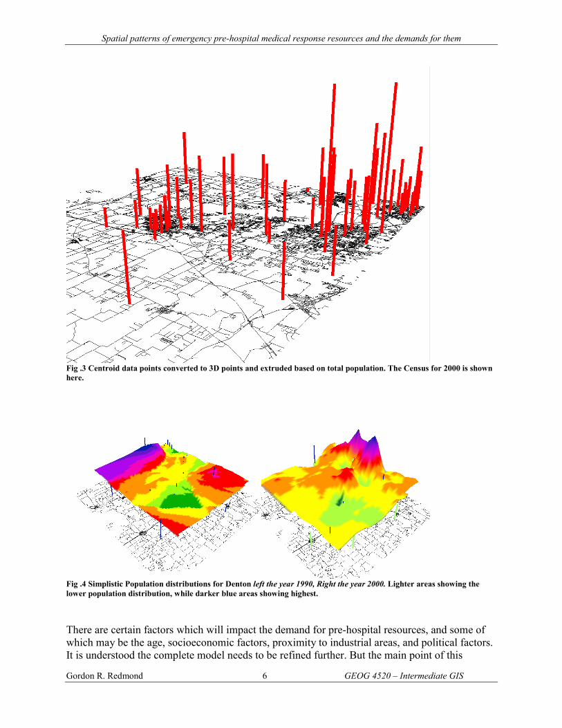
Fig .3 Centroid data points converted to 3D points and extruded based on total population. The Census for 2000 is shown here.
Fig .4 Simplistic Population distributions for Denton left the year 1990, Right the year 2000. Lighter areas showing the lower population distribution, while darker blue areas showing highest. There are certain factors which will impact the demand for pre-hospital resources, and some of which may be the age, socioeconomic factors, proximity to industrial areas, and political factors. It is understood the complete model needs to be refined further. But the main point of this

Spatial patterns of emergency pre-hospital medical response resources and the demands for them
Gordon R. Redmond 7 GEOG 4520 – Intermediate GIS
exercise is to demonstrate the possible solutions to existing problems and use GIS to model current and potentially future vulnerabilities.
Fig .4b Hypothetical Station distribution in 1990. When we consider the resource distribution for the study area in 1990 and compare it to the 2000 data, we can see in our work; the increase in the resource is proportional to the census data. This is a hypothetical assumption for this study, if the real data were available to us during this study, we could with greater certainty answer this question. IV. Scientific Merits Given the fixed nature of demands, and if we assume that demand is proportional to population distribution, then it follows this study methodology could be applied to any data set. It would follow the analysis of the greater Vancouver region and proposed Olympic area for the 2010 Winter Games could use GIS to see the current and projected demands for Pre-hospital medical resources. It is only by using GIS tools that it might quickly and easily be possible to validate planning assumptions and realistically gets a sense of the worst-case scenarios. The results obtained in this study could then reasonably be applied to any urban or rural area to determine and help better predict future demands of resources.

Spatial patterns of emergency pre-hospital medical response resources and the demands for them
Gordon R. Redmond 8 GEOG 4520 – Intermediate GIS
Fig. 5 Study area showing simplistic demand surface of total population only. Vertical lines indicate 3D point data of 2000 census. A subtraction of the 1990 and 2000 census surfaces will indicate the change in total population. This is easily communicated to the average population and thus able to quickly and easily communicate need. Adjustments in our model are required to indicate more accurately the factors. An index was suggested to help us develop a demand surface.
Fig .6 The 1990 Census simplistic model surface with year 2000 census data imposed. The rate of change in 10 years can be easily viewed. Certain areas south of Denton have shown considerable growth. We would expect the resources for this area to increase also if they are to remain providing the same or similar service levels.

Spatial patterns of emergency pre-hospital medical response resources and the demands for them
Gordon R. Redmond 9 GEOG 4520 – Intermediate GIS
GIS as a problem solver for Olympic Planning.
1.There are many ideas in Emergency Management that are good ideas especially coming from those who have actual emergency/Disaster experience. But some ideas cannot be implemented by organizations because of the limits in technology and other current best practices. GIS can help Emergency Managers and project planners achieve their best ideas.
2. Good ideas in Emergency Management and analysis of spatial variations of the response resource demands can be currently implemented but not usually on a timely basis. Current practices are slow and inefficient and many good ideas or analysis are constrained by budgetary considerations. GIS can improve the implementation of good ideas by speeding up the process and also help current efficiencies by effective application of limited resources
In this study we will consider an example of how these two areas can benefit by the use of GIS as a tool and how it can help the Emergency Manger more effectively operate to ensure the public safety is improved, money is efficiently spent and mitigate future losses not achievable in a timely way with current practices. When distance is considered, if a medical responding resource travels at 80 Km/hr, in 5 minutes 6.66 Km will be traveled in a straight line. This was used as a rough estimate of the response time of 5 minutes and indicated by the circles in (Fig. 7).
Fig .7 This figure shows 5 minute simplistic travel time as crow flies from each resource location in this study (Shown in brown circles), the vertical bars indicate the population distribution from the 2000 census.

Spatial patterns of emergency pre-hospital medical response resources and the demands for them
Gordon R. Redmond 10 GEOG 4520 – Intermediate GIS
• It is an assumption that demand for pre-hospital resources will depend on proximity to healthcare facilities and patients.
• It is assumed that all population sub groups equally demand use or potential use of pre-hospital medical resources over the study area.
• It is assumed the demand for medical pre-hospital resources will depend directly on the census (population) distribution.
• It is assumed all Pre-hospital medical resources will perform similarly and thus considered equally in response and spatial characteristics will be the sole determination for this study. Traffic and road access will not be considered in this study.
• It is assumed that resources can access all geographic areas similarly; we do not change response characteristics to account for reduction of capacity due to restrictions in road networks.
• It is assumed that the availability of resources will be constant. That this study looks at one time period and does not account for temporal variances in demand over time or consider the variance of availability due to shift coverage patterns.
• It is assumed that each supply of resources has a similar capability to supply resources and this study does not account for variances in supply of resources from one station/hall location to another in the study area.
For the purposes of this study emergency pre-hospital medical resources are considered only if they have the capacity to treat and carry patients to a higher definitive level of medical care. So, pre-hospital medical resources, which are not used for transport of patients, are considered uniform over the study area. This uniform distribution assumption allows us to find the specific relationship to medical transport capabilities, and ultimately limiting our study to effective pre-hospital resources only. Responding and not transporting is not an extension of pre-hospital medical resources and will be considered first aid. Any high school coach, teacher, First-aid attendant can respond to an incident and will not be considered part of our study. Locations of responding pre-hospital medical resources will be the focus of this study and predicting future demands of these resources is our primary goal. One serious consideration that comes about from recent trends in emergency management, many organizations are choosing to follow international standards as a measure of performance. The NFPA 1600 standards used in this study specifically state the kinds of performance goals needed; these are outlined at the end of this document. This means the current methods will need to be adjusted at all levels and GIS applications may prove very helpful to local emergency managers who might not otherwise see a benefit to the use of theoretical models. With the requirements for emergency preparedness, it is worthy for all managers to consider the uses and applications for GIS. And won’t that make the world a safer happier place. V. Time Schedule

Spatial patterns of emergency pre-hospital medical response resources and the demands for them
Gordon R. Redmond 11 GEOG 4520 – Intermediate GIS
VI. Conclusions This study does not provide an accurate model in which demands for future pre-hospital resources could be predicted. But it does show how data can be collected and presented to help the emergency managers incorporate GIS as an effective tool to help them better plan for future and get a better sense of the current resource limitations. Using the current North American standards NFPA 1600 as a guide, it is time all the resources are used effectively to solve real world problems. Emergency managers would potentially benefit from applying current tools and methodologies to help predict and plan for future needs. This allows EM to benefit and actualize ideas they are not currently able to, now in a much more cost-effective manor. These tools can be incorporated into existing planning systems to strengthen and validate the decisions made by the few experienced personnel. The application of computer GIS tools has evolved to the level beyond just maps and other visuals, into a practical cost effective problem solver, to analyze problems we could not conceive of a decade ago.
Census Data
Station Data
Real Call Data
a. Centroids b. 2D to 3D points c. Raster conversion
a. 3D Surface Interpolations
Buffer of travel distance
Data used to calibrate model
a. Analysis of 1990 and 2000 data sets b. Compare service levels
a. Display 3D b. Animations c. Recommendations
Are service levels same - Yes / No

Spatial patterns of emergency pre-hospital medical response resources and the demands for them
Gordon R. Redmond 12 GEOG 4520 – Intermediate GIS
Other benefits of this study could be to help local emergency managers to incorporate GIS applications into their respective organizations to help in the following areas:
• Risk analysis • Resource allocation studies • Transportation studies • Vulnerability assessments
• Mitigation • Preparedness Planning • Response • Recovery
Further study is indicated, as this researcher has found out there are many more complex factors to producing a model to simulate the response demands of the real world. Many years of experience are now needed to adequately determine acceptable levels of performance. Existing methods could be explored further to determine a more usable prediction model. One thing is certain, the more GIS is used on a daily work tool by emergency managers and planners, the more likely they will be able to utilize its power for quick analysis, should the unfortunate need arise to respond to a disaster / emergency. Knowing better how well the community is protected with existing resources can only improve the safety and security. I am sure you will agree, we have achieved our stated objective. We have demonstrated in a simplistic way the application of GIS to help emergency managers better perform their tasks and ultimately reduce problems before they become painfully aware of them. If we realize that GIS is more than just a mapping tool and that with considerable effort end critical thought (beyond what is displayed here) it would be cost effective to apply current tools in a new and dramatic way. VII. References
1. Givisiez. Gustavo H. N., Hospital Demand: Using GIS and Spatial Analysis for estimation. PhD Student at Cedeplar – UFMG – Brazil
2. Olligschlaeger, Andreas M., Spatial Analysis of Crime Using GIS-Based Data:Weighted Spatial Adaptive Filtering and Chaotic Cellular Forcasting with Applications to Street Level Drug Markets., PhD Student at H. John Heitz III School of Public Policy and management,. Carnegie Mellon University, 1997
3. Lee, D.,Malko, J …, Dasymetric mapping of Population Density Using Centroids, Simon Fraser University, 2003
4. National Fire Protection Association, NFPA 1600, Standard on Disaster / Emergency Management and business Continuity Programs, 2004
5. Cutter, Susan, L., Mitchell, J.T., Revealing Vulnerability of People and Places: A Case Study of Georgetown County, Association of American Geographers, 2000
VIII. Appendix Definitions Mitigation is defined as any sustained action taken to reduce or eliminate long-term risk to human life and property from a hazard event. Mitigation, also known as prevention (when done before a disaster), encourages long-term reduction of hazard vulnerability. The goal of mitigation

Spatial patterns of emergency pre-hospital medical response resources and the demands for them
Gordon R. Redmond 13 GEOG 4520 – Intermediate GIS
is to decrease the need for response as opposed to simply increasing the response capability. Mitigation can save lives and reduce property damage, and is cost-effective and environmentally sound. This, in turn, can reduce the enormous cost of disasters to property owners and all levels of government. In addition, mitigation can protect critical community facilities, reduce exposure to liability, and minimize community disruption. Mitigation: Activities taken to eliminate or reduce the probability of an event, or reduce its severity or consequences, either prior to or following a disaster / emergency. Preparedness: Activities, programs, and systems developed and implemented prior to a disaster / emergency that are used to support and enhance mitigation or, response to, and recovery from disasters / emergency. Response: In disaster / emergency management applications, activities designed to address the immediate and short-term effects of a disaster / emergency. Program management Standards: 4.4 Program Evaluation: The entity shall establish performance objectives for program elements listed in chapter 4 and chapter 5 and shall conduct periodic evaluation of the objectives as described in Sec 5.13. 5.5 Resource Management 5.5.1 The entity shall establish resource management objectives consistent with the overall program goals and objectives as identified in Sec 4.1 and for hazards as identified in section 5.3. 5.5.2 The resource management objectives established shall consider, but not be limited to, the
following: (1) Personnel, equipment, training, facilities, funding, expert knowledge,
materials, and the time frames within which they will be needed (2) Quantity, response time, capability, limitations, cost, and liability connected
with using the involved resources 5.7 Planning 5.7.1 The program shall include, but not be limited to, a strategic plan, an emergency
operations / response plan, a mitigation plan, a recovery plan, and a continuity plan. 5.13 Evaluations, and Corrective Actions 5.13.1 The entity shall evaluate program plans, procedures, and capabilities through periodic reviews, testing, post incident reports, lessons learned, performance evaluations, and exercises. 5.13.3 Procedures shall be established to ensure that corrective action is taken on any deficiency identified in the evaluation process and to revise the relevant program plan.