spatial modeling of the european anchovy habitat in …arch.her.hcmr.gr/papers/gfcm2006.pdf · gis...
TRANSCRIPT

GENERAL FISHERIES COMMISSION FOR THE MEDITERRANEANSCIENTIFIC ADVISORY COMMITTEE
Sub-Committee for Stock AssessmentWorking Group on Small Pelagic Species
FAO, Rome, 11-14 September 2006
SPATIAL MODELING OF THE EUROPEAN ANCHOVY HABITAT IN THE EASTERN MEDITERRANEAN BASIN USING GAMS AND GIS
TECHNOLOGY.
Giannoulaki Marianna,1 Machias Athanassios,1 Valavanis Vasilis,1 Somarakis Stylianos,2 Palialexis A.1, Papaconstantinou Costas1
1/ Hellenic Center for Marine Research, Crete, 71003, Greece2/ University of Patras, Patras, 26500, Greece
Corresponding author: Giannoulaki Marianna: [email protected]
AbstractAcoustic survey data were combined with oceanographic parameters to investigate the relationship between the spatial distribution of European anchovy and environmental features of the Greek seas (Eastern Mediterranean basin). Acoustic sampling was carried out in the northern Aegean Sea (the main fishing ground of the species in the area) in June 2004 and June 2005. Environmental data (i.e., sea surface temperature, chlorophyll-a and sea surface salinity) were derived from satellite imagery using GIS procedures. Generalized Additive Models (GAMs) were then applied in a presence/absence approach in order to identify the link of anchovy’s presence with environmental variables. The estimated model was subsequently used to predict the extent and spatial location of potential anchovy habitat in all Greek Seas by applying GIS techniques. The resulting picture was compared with information on actual fish distributions as derived from past acoustic surveys, i.e, within the peak of the spawning period of anchovy in Greece.
Introduction
The present work is a first approach to identify the Essential Fish Habitat (EFH) of the European anchovy (Engraulis encrasicolus L.), in the Greek Seas (Eastern Mediterranean Sea, Figure 1), during June (i.e. the peak of anchovy spawning season). EFH is a term first issued in the Magnuson-Stevens Fishery Conservation and Management Act (1996), commonly used since to describe the habitats that a fish needs during its life (i.e. spawning grounds, nursery areas, feeding grounds, shelter from predators, Benaka 1999). In order to identify the environmental characteristics that describe the areas that serve as potential habitat of anchovy, acoustic data together with environmental satellite data (i.e. sea surface temperature, sea surface salinity, chlorophyll-a concentration, irradiance and sea level anomaly) were used. GIS techniques were applied to identify the geographical areas where the specific set

of environmental parameters is met, implying the existence of potential anchovy habitat.
Materials and Methods
Acoustic survey data were combined with oceanographic parameters to identify the environmental characteristics that describe the areas that serve as potential habitat of anchovy in the Greek seas (Eastern Mediterranean basin). Acoustic data used, derived from surveys that were carried out in the Aegean Sea, along predetermined acoustic transects (Fig. 1, Tsimenides et al., 1995a, Tsimenides et al., 1995b, Somarakis et al., 2005) by a Biosonic Split Beam DT-X echosounder 38kHz, in June 2004 and June 2005 (i.e within the peak of the spawning period of anchovy in Greek waters). Echo integration was done per 1 nautical mile. Environmental data (i.e., sea surface temperature–SST in oC, chlorophyll-a CHLO in mg/m³, sea surface salinity-SSS in psu, sea level anomaly-SLA in cm and photosynthetic active radiation -PAR in Ein/m2/day) were derived from mean monthly values of satellite imagery using GIS procedures. Initial satellite data were obtained regarding SST from DLR database, CHLO imagery from SeaWiFS database, SLA from AVISO database and SSS from the Columbia University database.
Generalized Additive Models (GAMs) were applied in a presence/absence approach in order to identify the link of anchovy’s presence with the aforementioned environmental variables and define the set of the parameters values that describe the anchovy presence in pooled data from the examined years. Nature is too complex and heterogeneous to be predicted accurately in every aspect of time and space from a single model, so pooled data are used to obtain more possible observed conditions and ensure potentiality (ICES 2005).
Thracian Sea was used as a pilot area since it is the area that includes the main anchovy concentrations in Aegean Sea, covering both nursery and adult grounds and it is a relatively open sea area characterized by strong gradation of environmental conditions. Model selection was based on the minimization of the AIC criterion in the basis of a general backward selection method (Hastie & Tibshirani 1990), a binomial error distribution and the cubic spline smoother (s) was chosen as appropriate. In a next step, GIS techniques based on the specific range of values indicated by GAMs results (range of parameters values with a positive effect on anchovy presence) were used for mapping those areas where the specific environmental conditions are met and may serve as potential anchovy habitat (Valavanis et al., 2004). Mapping covered the Aegean Sea, Ionian Sea as well as the entire Mediterranean basin, using mean monthly satellite data from June 2005.
The other areas of the Aegean Sea e.g. Thermaikos and Evoikos gulf in June 2004 and June 2005 as well as acoustic data from past studies in Central Aegean and Ionian Sea in June 1998 and June 1999 (Machias et al., 2000a; Machias et al., 2000b; Machias et al. 2001; Somarakis et al., 2000) were used for the cross validation of the results.
Results
GAMs results of the final selected model (Deviance explained = 26.5%) showed that within the available range of values there was a higher probability of finding anchovy present (Table 1, Fig. 2) in: SST values ranging from 20.1 to 22.5 oC, PAR 50.55 to 57.5 Ein/m2/day and CHLO values 0.778 to 1.407 mg/m3.

GIS mapping of the estimated conditions mainly indicated areas within the continental shelf and in the more productive waters (Figure 3). The map of this set of environmental conditions seems to describe sufficiently the locations where the main anchovy concentrations were found, as cross validation of the results with existing data shows.
The data set of environmental parameters derived from Thracian Sea seems to describe sufficiently also the areas of the actual anchovy distribution in Thermaikos as well as Evoikos gulf in June 2004 and 2005 (Figure 4). In addition, the same set of parameters describes sufficiently the areas where usually the main anchovy concentration were found, based on past surveys in Central Aegean and Ionian Sea in June 1998 and 1999 (Figure 5, Machias et al., 2000a; Machias et al. 2000b; Machias et al. 2001; Somarakis et al., 2000). Mapping also indicated the specific set of environmental conditions for areas (e.g. north part of the Ionian Sea, Marmara Sea etc) in the Eastern Mediterranean basin where the distribution of anchovy is unknown.
GIS mapping for the entire Mediterranean region (Fig. 6) indicates the location of the specific environmental conditions in 2005.
The use of data from additional areas and pooled data from several years could better define the set of the environmental parameters that characterize the areas of the main anchovy concentrations and improve estimations results.
References
Benaka L.,1999. Fish Habitat: Essential Fish Habitat and Rehabilitation. American Fisheries Society, Bethesda, MD.
Hastie, T. & Tibshirani, R. 1990. Generalized Additive Models. London, Chapman and Hall.
ICES 2005. Report on the study group on regional scale ecology of small pelagic fish (SGRESP), 28th February to 5th March, Plymouth, ICES CM/2005 G:06.
Machias, A., M. Giannoulaki, S. Somarakis, C. Koutsikopolos, L. Manousakis, A. Kapantagakis and N. Tsimenides- 2001. Estimation of the anchovy (Engraulis encrasicolus) stocks in the central Aegean and Ionian Seas by means of hydroacoustics. Proc. of the 10th Panellenic Conf. of Ichthyologists, p. 57-60.
Machias, A., S. Somarakis and C. Koutsikopoulos- 2000b. The anchovy stocks in the central Aegean and Ionian Seas. Hellenic Fishing news, 233: 89-95. (in Greek)
Machias, A., S. Somarakis, P. Drakopoulos, A. Magoulas and C. Koutsikopoulos- 2000a. Evaluation of the Southern Greek anchovy stocks. Project 97-0048. Institute of Marine Biology, Crete. Final Report: 105 pp.
Somarakis S., Machias A., Giannoulaki M. Siapatis A., Torre M., Anastasopoulou K., Vassilopoulou V., Kalianiotis A. and Papaconstantinou C. (2005) Icthyoplanktonic and acoustic biomass estimates of anchovy in the Aegean Sea (June 2003 and June 2004). GFCM working document, Sub-Committee for Stock Assessment, Working Group on Small Pelagic Species, FAO, Rome, 26-30 September 2005.
Somarakis, S., A. Machias, C. Koutsikopoulos, E. Maraveya, M. Giannoulaki and N. Tsimenides- 2000. Distribution of anchovy and its spawning grounds off the central Aegean and Ionian Seas. Proc. of the 6th Panhellenic Symp. on Oceanography and Fisheries. Vol. 2: 94-98.
Tsimenides, N., G. Bazigos, E. Georgakarakos and A. Kapadagakis, 1995b. Distribution of acoustic pelagic fish populations in the northern Aegean Sea. Proc. of the 1st World Fisheries Congress, Athens, 59-65.

Tsimenides, N., S. Somarakis, A. Magoulas and G. Tserpes- 1995a. Evaluation of the anchovy stocks in the Aegean Sea. Final report. Project no XIV-1/MED/91/011.
Valavanis V., Georgakarakos S., Kapantagakis A., Palialexis A., & Katara I., 2004. A GIS environmental modeling approach to Essential Fish Habitat Designation. Ecological Modeling, 178 (3-4), 417-427.

Table 1. GAMs results regarding model selection of anchovy presence/absence data in Thracian Sea. PAR=photosynthetic active radiation, CHLO=chlorophyll, SST=Sea Surface Temperature, s=cubic spline smoother.
Parameter Chi-square test value
P-value Deviance explained of the model
s(PAR, 4) 14.25 0.0061424 26.5%
s(CHLO, 4) 12.99 0.009708
s(SST, 4) 21.24 0.000002

22o 23o 24o 25o 26o
38o
39o
40o
41o
22o 23o 24o 25o 26o22o 23o 24o 25o 26o
38o
39o
40o
41o
Fig. 1. Map of the study area showing acoustic transects in June 2004 and 2005. Circle indicates Thracian Sea, area that acoustic data were used for modeling.
Thracian Sea

Fig. 2.Gam model results. Partial plots indicating the effect of environmental variables on anchovy presence
0.2 0.4 0.6 0.8 1.0 1.2
Chlo
-20
24
68
Effe
ct o
n an
chov
y pr
esen
ce
22.0 22.6 23.2 23.8 24.4 25.0
SST
-8-6
-4-2
02
Effe
ct o
n an
chov
y pr
esen
ce
54.0 55.2 56.4 57.6 58.8 60.0
par
-4-2
02
4
Effe
ct o
n an
chov
y pr
esen
ce

Fig. 3. A GIS extrapolated map of anchovy potential habitat in the Aegean and Ionian Sea, based on GAMs results from Thracian Sea acoustic data and satellite data from June 2004.

Fig. 4. Anchovy distribution echo (NASC in m2/nm2) in northern Aegean Sea in a) June 2004 and b) June 2005.
22o 23o 24o 25o 26o
38o
39o
40o
41o
0 1 2 3 4
22o 23o 24o 25o 26o
38o
39o
40o
41o
0 1 2 3 4
a)
23o 24o 25o 26o
38o
39o
40o
41o
0 2.5 5 7.5
23o 24o 25o 26o
38o
39o
40o
41o
0 2.5 5 7.5
b)

Fig. 5. Anchovy distribution echo (NASC in m2/nm2) in Central Aegean and Ionian Sea in June 1999.
20o 21o 22o 23o 24o37o
38o
39o
0 2 4 6
20o 21o 22o 23o 24o20o 21o 22o 23o 24o37o
38o
39o
0 2 4 6
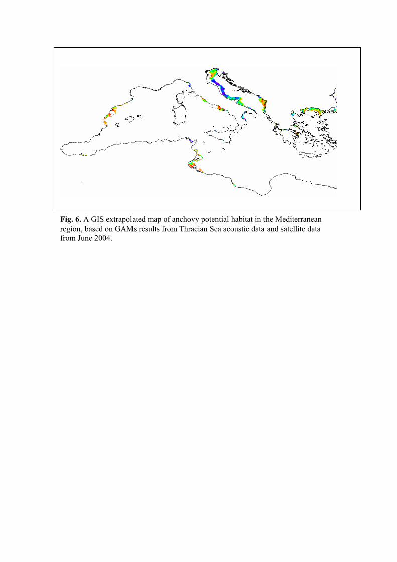
Fig. 6. A GIS extrapolated map of anchovy potential habitat in the Mediterranean region, based on GAMs results from Thracian Sea acoustic data and satellite data from June 2004.