space geospatial data utilizing for complex … · © jsc «russian space systems» 3...
TRANSCRIPT

© JSC «Russian Space Systems» 1
JOINT STOCK COMPANY
«RUSSIAN SPACE SYSTEMS»
JOINT STOCK COMPANY
«RUSSIAN SPACE SYSTEMS»
Vienna, 2010
Space Geospatial Data Utilizing For Space Geospatial Data Utilizing For Complex Diagnosis Of Earthquake Complex Diagnosis Of Earthquake
PrecursorsPrecursors
Alexander Romanov, Alexey Romanov, Youry Urlichich

© JSC «Russian Space Systems» 2
Earthquake Precursors Registration System Flowchart

© JSC «Russian Space Systems» 3
Seismic-caused Atmospheric Disturbances Appearance Principle
(Model of Lithosphere-Atmosphere-Ionosphere Coupling)
Deformations – pre-seismic radonvariations
Air ionization by α-particles –product of radon decay
Ions hydration– formationof aerosol size particles
Relative humidity drop
Latent heat release
Air temperature growth
Drop of air conductivity
Atmospheric electricfield growth
Electric field effects
within the ionosphere
Thermal convection
Earthquake clouds formation
© JSC «Russian Space Systems» 4
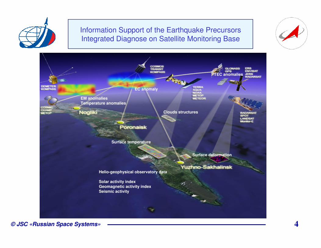
Information Support of the Earthquake Precursors
Integrated Diagnose on Satellite Monitoring Base
TEC anomalies
Surface deformation
Surface temperature
Clouds structures
EC anomaly
EM anomaliesTemperature anomalies
Helio-geophysical observatory data
Solar activity indexGeomagnetic activity indexSeismic activity

© JSC «Russian Space Systems» 5
Seismic Activity in Sakhalin Island (Russia)
(Geophysical Survey RAS)
02.08.2007 05:01
02.08.2007 10:37
09.08.2007 03:34
14.08.2007 04:13
02.08.2007 08:06
02.08.2007 05:22
02.08.2007 02:59
Date and time are represented in UTC

© JSC «Russian Space Systems» 6
Anomaly Phenomena in Different Media
(21.07.2007 - 03.08.2007)
The research parameters variations has forerun the earthquake in 02.08.2007 02:37 UTC and epicenter located in 46.68°N, 141.77°E, IO 7-8
Surface temperature anomalies
Sea surface temperature anomalies
Ionosphere TEC anomalies
Ionosphere electron concentration anomalies
Air temperature anomalies
Air relative humidity anomalies
not revealed
not revealed
revealed
revealed
22.07.2007 30.07.2007
revealed
revealed
revealed
revealed
not revealed
revealed
revealed
revealed

© JSC «Russian Space Systems» 7
Anomaly Cloud Structures
30.07.2007 and 31.07.07

© JSC «Russian Space Systems» 8
3-èþ ë 5-èþ ë 7-èþ ë 9-èþ ë 11-èþ ë13-èþ ë15-èþ ë17-èþ ë19-èþ ë21-èþ ë23-èþ ë25-èþ ë27-èþ ë29-èþ ë31-èþ ë 2-àâã
0
2
4
6
8
10
Tm
ax- T
min
70
80
90
100
RH
(%)
The Diurnal Air Temperature Range and Air Relative
Humidity Variations
Air temperature in Holmsk (Sakhalin Island, Russia)(about 50 km of epicenter) and surface temperature
Diurnal air temperature rangeand relative humidity in Nevelsk.Black curve – temperature. Blue curve – relative humidity.
30
Pulinets S.A.
Tronin А.А.
Data
22 30
© JSC «Russian Space Systems» 9
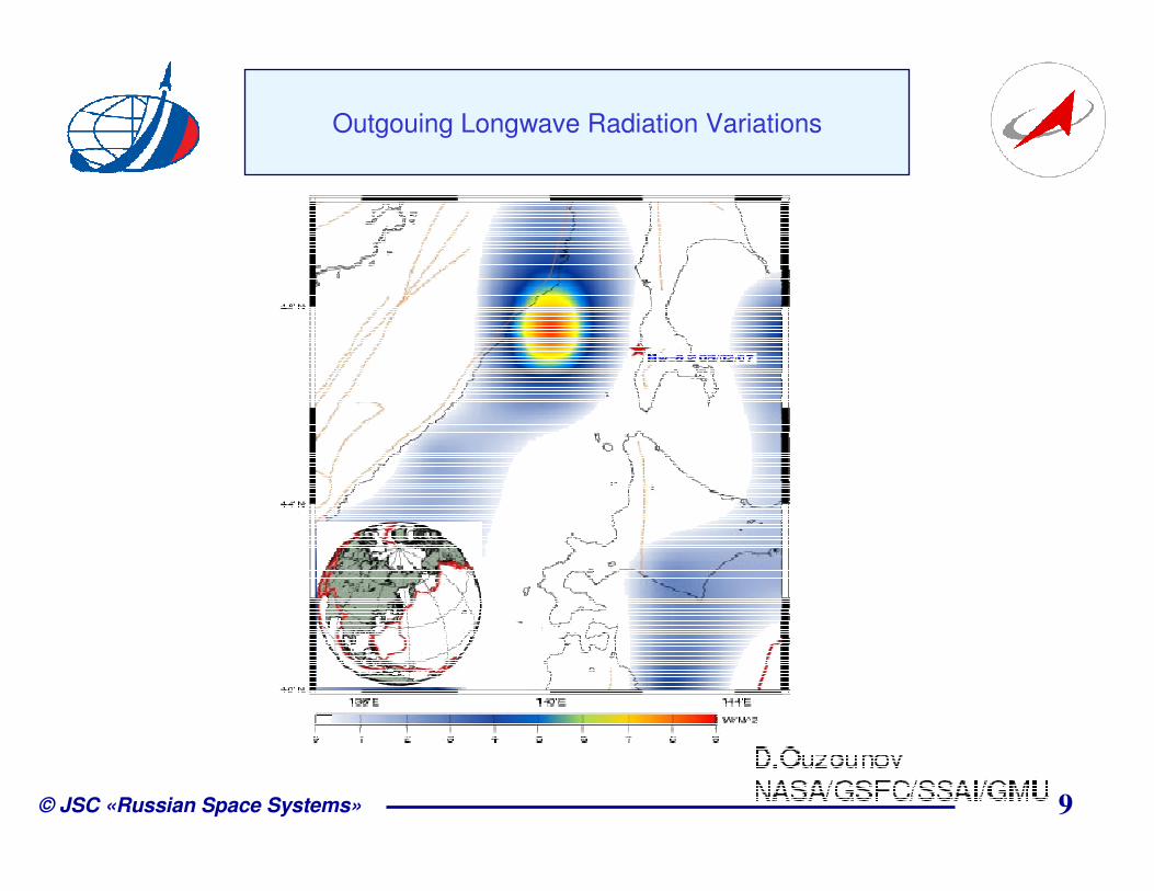
Outgouing Longwave Radiation Variations

© JSC «Russian Space Systems» 10
Ionosphere Total Electron Content Variations
Pulinets S.A.
Regional ionosphere variability index
Dst index
04 06 08 10 12 14 16 18 20 22 24 26 28 30 01 03 05 07 09 11 13 15 17 19 21 23 25 27Èþ ëü-àâãóñò 2007 ã.
-50
-25
0
25
50
Dst (
nT
)
Pulinets S.A.
July-August 2007

© JSC «Russian Space Systems» 11
Ionosphere Electron Concentration Height Distribution
30.07.2007 13:45 UTC
Distance, km
Hei
gh
t, k
m
Yuzno-Sakhalinsk
Ne, 1011 el/m330.07.2007 13:45 UTC (23:45 LT)

© JSC «Russian Space Systems» 12
Perspectives of Data Receiving Segment
Oha
Nogliki
Poronaisk
Yuzhno-Sakhalinsk
Mombetsu
Obihiro

© JSC «Russian Space Systems» 13
The Receiving Segment Enlargement Benefits
U-SakhalinskPoronaisk Nogliki OhaMombetsu
Obihiro
Reconstruction coverage extensionSakhalin coverage
Reconstruction errors decreasing
Spatial resolution increasing

© JSC «Russian Space Systems» 14
Использование наноспутников для глобального
мониторинга состояния ионосферы
Signals receiving segment transfer into space makes it possible to realize the global ionosphere monitoring and to completely refuse from ground tomography stations
Traditional ionosphere tomography
scheme with ground stations
provides only local monitoring
Perspective ionosphere monitoring system
on the basis of nano-satellites cluster

© JSC «Russian Space Systems» 15
Ionosphere monitoring small satellite prototype on the
basis of TNS-0
Mass: ~ 10 kgPower: <6 WPrice: 250 000 euro
Payload: two-frequency coherent transmitter
Mass: < 1 kg (including antenna)Power: < 2 WPrice: 20 000 euro (w/o design work)
TNS-0 TNS-0 #2

© JSC «Russian Space Systems» 16
Satellite systems:
• Attitude system – rotate stabilizationand active magnetic orientation
• Power supply system on the basis ofGaAs-solar battery
• Control channel via Globalstar system• GLONASS/GPS navigation system
Possible payload:• Remote sensing equipment• Ionosphere tomography equipment• C-band radio-line
Remote Sensing TNS-1 As A Prototype For Ionosphere Research Satellite

© JSC «Russian Space Systems» 17
Conclusions
1. The major goals and objectives for the experiment are achieved;
2. The complex study of space geospatial data, experimentally measured
parameters of the “Heliosphere-atmosphere-lithosphere” system and
anomalies possibly corresponded to seismic activity allocation (anomalies of
TEC and ionosphere electron concentration distribution, outgoing longwave
radiation variations, specific clouds formation…) is performed;
3. The basic principals for making the regional prototype of the earthquake
precursors monitoring automated system based on space geospatial
information and technologies including the combined usage of several
information sources (navigation systems, visible cameras and IR sensors)
and meteorological data in the frameworks of the LAIC model are shown;
4. The importance of the Russian ionosphere tomography chain spreading to
Japan territory (2 stations in Mombetsu and Obihiro) in the frameworks of the
potential international collaboration is revealed;
5. The possibility of the new space geospatial data gathering systems creation
on the basis of the small satellites is revealed.

© JSC «Russian Space Systems» 18
Thanks for your attention!
Alexander Romanov,
Project manager,JSC “Russian Space Systems”DSc.,Tel: +7(495)6739934Fax:+7(495)5091200
E-mail: [email protected]