sovereignty over and ownership of offshore oil and gas—the law of the sea … · 2017-01-19 ·...
TRANSCRIPT

219
10Sovereignty Over and Ownership of Offshore Oil and Gas—The Law of the Sea and Joint Development Zones
Introduction
Many state sovereignty disputes onshore continue into waters offshore, because sovereignty rights offshore belong to the state having sovereignty rights onshore. So,
when sovereignty rights on the land are unclear or ambiguous, the derivative sovereign rights on offshore extensions of the land also will be unclear or ambiguous. But special complexities peculiar to offshore sovereignty also will result from such factors as complexities in shorelines or geology and even from locating marine boundaries between adjacent or opposing states.
An important treaty, the United Nations Convention on the Law of the Sea (UNCLOS), has tried to clarify the offshore rights and obligations of states.1 Although not all important maritime states have ratified the treaty,2 most have signed and ratified it, and even nonratifying maritime states have agreed unilaterally to most of its provisions as a matter of national law. In any event, UNCLOS terminology is now the language in which law of the sea issues are analyzed.
This chapter discusses the historical background, the structure of UNCLOS, and the general rights and obligations of states in the maritime zones created by UNCLOS. It also discusses joint development zones: practical compromises under which coastal states defer argument over offshore boundaries and sovereignty in order to cooperate in joint exploitation of resources located in disputed areas. Other chapters in this book, however, address in greater detail the special application of UNCLOS to dispute resolution (chapter 6 covers arbitration), offshore pollution and facilities’ decommissioning (in chapter 18), and maritime environmental protection and national regulation of liquefied natural gas facilities and ocean-going tankers (in chapter 22).
Pre-UNCLOS HistoryUntil the late 1400s, international lawyers believed that a coastal state’s sovereignty
rights stopped at its coastline, such that all of the ocean’s waters belonged to no one and therefore to everyone.
Order & save 10%! Use code HughesChapter10 at checkout!

Fundamentals of International Oil and Gas Law
220
Soon evident, however, was that coastal states had vital interests in controlling their coastal waters to prevent smuggling and attack. An international consensus developed that coastal states had sovereignty rights to territorial seas offshore, but lacking was any consensus as to how far from the coast the territorial seas extended or how to measure the width of the territorial seas where the coast had irregularities like islands and bays. When technical advances after 1950 made exploitation of seabed minerals, including oil and gas, possible, defining a coastal state’s rights to seabed and subsoil of offshore areas (as well as to the waters of offshore areas) then became practical and urgent.
Maritime states made various efforts to come to agreement on such issues, making some progress in 1958 in UN-sponsored treaties called Geneva Conventions.3 But comprehensive agreement on many issues came only in 1982, when approximately 135 countries (including what is now the European Union) signed the United Nations Convention on the Law of the Sea (UNCLOS).
The UNCLOS Water and Seabed ZonesAmong other things, UNCLOS establishes various zones for offshore waters; it also
separately establishes zones for offshore seabed and subsoil.4 While there exist general correspondence between the water zones and the seabed zones in some cases, in other cases they do not correspond at all. The treaty allocates to states the sovereign rights and obligations within each of the zones with regard to transit, regulatory and enforcement jurisdiction, control of natural resources such as oil and gas, and environmental protection. The treaty also deals with marine boundaries and settlement of marine boundary disputes.
Figure 10–1 shows the zones of waters and seabed.The baseline is the line from which the treaty defines or measures various zones of
waters and seabed. The baseline runs along each coast and corresponds generally to the coastline’s low-tide mark. But the baseline is subject to special rules dealing with coastlines and such complexities as islands, archipelagos, large bays, adjacent or opposing coastal states, and historical claims (fig. 10–2).5
With regard to the zones of waters defined or measured in reference to the baseline, waters located on the land side of the baseline are referred to as a coastal state’s internal waters. The internal waters include not only freshwater bodies like lakes and rivers, but also bays located on the land side of the baseline.6 A canal such as the Suez Canal in Egypt lies within the land boundaries of its country and so may be thought of as internal waters.
From the baseline and moving seaward, UNCLOS then establishes a series of further zones of waters located above the seabed and subsoil, with each water zone having legal consequences for the coastal and noncoastal states. The territorial sea is the initial width of sea or ocean, measured from the baseline and extending 12 nautical miles (NM) seaward.7 The contiguous zone is a second and further 12-mile-wide zone of waters as measured from the outer boundary of the territorial sea. (The treaty is somewhat confusing here regarding measurement.) The exclusive economic zone (EEZ) extends
Order & save 10%! Use code HughesChapter10 at checkout!

Chapter 10Sovereignty Over and Ownership of Offshore Oil and Gas—
The Law of the Sea and Joint Development Zones
221
seaward from the territorial sea, but measurement of the EEZ’s 200 NM width is made from the baseline.8 Finally, the high seas are waters beyond the outer limit of the EEZ.
Fig. 10–1. UNCLOS zone scheme. *Although the EEZ and Continental Shelf extend seaward from the outer edge of the territorial sea, the distance of the extension is measured from the baseline
Adjacent Coastlines
Island(s) Indented Coastlines
Opposing Coastlines Historical Claims
Examples of Coastline Complexities
AB A
BAAA
A
B
AA
A
B
Fig. 10–2. Coastal zones create complex borders for countries.
Order & save 10%! Use code HughesChapter10 at checkout!

Fundamentals of International Oil and Gas Law
222
In addition to establishing this series of zones of waters, UNCLOS also establishes zones of seabed and subsoil below the waters. UNCLOS gives no special name to the seabed and subsoil below the territorial sea, but the continental shelf consists of the seabed and subsoil under the waters extending from the land and beyond the territorial sea in a seaward direction. Article 76 defines the continental shelf in geological terms, but subject to complex minimum and maximum criteria and subject to adjustment by reason of boundary rights of opposing and adjacent states: The continental shelf is the seabed and subsoil of the land extending “to the outer edge of the [submerged] continental margin,” but not less than 200 NM as measured from the baseline. If the outer edge of the submerged prolongation of the geologic continental margin extends more than 200 NM from the baseline, then the continental shelf as defined in the treaty may exceed the 200 NM (but not exceed a maximum generally consisting of 350 NM), to points defined in terms of the thickness of sedimentary rock relative to the foot of the continental slope, the change in gradient at the base of the slope, and water depth.9 It is evident, then, that at least to the extent the continental shelf does not exceed 200 NM from the baseline, the continental shelf is that portion of the seabed and subsoil generally corresponding to the EEZ of the waters above. But continental shelves extending more than 200 NM from the baseline are not unusual. In the Gulf of Mexico, for example, the US continental shelf extends beyond the 200 NM limit of the EEZ.
The Area is the deep seabed, ocean floor, and subsoil beyond the continental shelf. Thus it is evident that the Area is the zone of seabed and subsoil generally corresponding to the water zone of high seas above it, except where the continental shelf extends beyond the 200 NM minimum as measured from the baseline, the high seas may actually begin over some part of the continental shelf rather than over the Area.
States’ Rights and Obligations within the ZonesIn addition to defining the different zones of waters and seabed relative to the baseline,
the treaty tries to allocate rights and obligations of states within each of those zones. In addition, UNCLOS (or customary international law) addresses several other categories of waters or facilities (canals, ports, and straits) usually present in or through various zones. Discussions in the following sections summarize, zone by zone, states’ rights and obligations regarding transit, regulatory and enforcement jurisdiction, oil and gas exploration and production, placement of facilities, and environmental protection.
UNCLOS Zone: Issue Analysis1. Transit of vessels2. Regulatory and enforcement jurisdiction3. Oil and gas exploration and production4. Construction of facilities5. Environment protection
Within a coastal state’s internal waters. A state generally has and may exercise full sovereignty rights over its internal waters (and seabed and subsoil under the internal
Order & save 10%! Use code HughesChapter10 at checkout!
Chapter 10Sovereignty Over and Ownership of Offshore Oil and Gas—
The Law of the Sea and Joint Development Zones
223
waters) as if the internal waters were its own land territory. Thus, a state generally has unrestricted sovereignty to determine whether it will authorize transit across its internal waters, is free to determine the legal regime for exploration and production, and may regulate the placement of facilities and environmental protection concerning its internal waters.10 Of course, a sovereign state by treaty or legislation may agree to give up one or more of these sovereign rights.
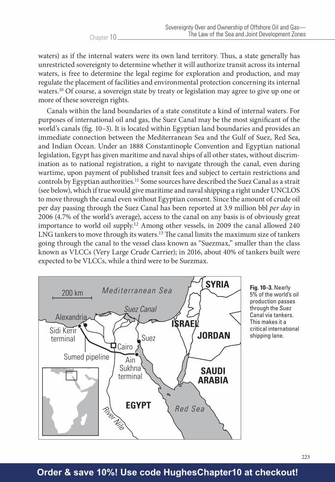
Canals within the land boundaries of a state constitute a kind of internal waters. For purposes of international oil and gas, the Suez Canal may be the most significant of the world’s canals (fig. 10–3). It is located within Egyptian land boundaries and provides an immediate connection between the Mediterranean Sea and the Gulf of Suez, Red Sea, and Indian Ocean. Under an 1888 Constantinople Convention and Egyptian national legislation, Egypt has given maritime and naval ships of all other states, without discrim-ination as to national registration, a right to navigate through the canal, even during wartime, upon payment of published transit fees and subject to certain restrictions and controls by Egyptian authorities.11 Some sources have described the Suez Canal as a strait (see below), which if true would give maritime and naval shipping a right under UNCLOS to move through the canal even without Egyptian consent. Since the amount of crude oil per day passing through the Suez Canal has been reported at 3.9 million bbl per day in 2006 (4.7% of the world’s average), access to the canal on any basis is of obviously great importance to world oil supply.12 Among other vessels, in 2009 the canal allowed 240 LNG tankers to move through its waters.13 The canal limits the maximum size of tankers going through the canal to the vessel class known as “Suezmax,” smaller than the class known as VLCCs (Very Large Crude Carrier); in 2016, about 40% of tankers built were expected to be VLCCs, while a third were to be Suezmax.
SuezCairo
AinSukhnaterminal
Sidi Kerirterminal
Sumed pipeline
Alexandria
EGYPT
ISRAEL
SAUDIARABIA
JORDAN
SYRIAMedi te r ranean Sea
Red Sea
Suez Canal
River Nile
200 kmFig. 10–3. Nearly 5% of the world’s oil production passes through the Suez Canal via tankers. This makes it a critical international shipping lane.
Order & save 10%! Use code HughesChapter10 at checkout!

Fundamentals of International Oil and Gas Law
224
Within a coastal state’s ports. Under UNCLOS, ports are regarded as part of the coast.14 Customary international law treats ports as part of the coastal state’s internal waters, and the port state has jurisdiction over foreign merchant vessels that are voluntarily within that state’s ports, unless a treaty between the port state and flag state modifies the jurisdiction.15 This means a foreign flagged ship must comply with criminal and noncriminal laws of the port state. In the interests of maritime trade, however, it is common for port states to not exercise the maximum jurisdiction allowed to them, except when the port state’s peace or dignity and tranquility of the port are at issue.16 But the port state can exercise full jurisdiction as it wishes, even as to internal shipboard matters concerning foreign flag vessels. Thus, a flag state is said to have concurrent jurisdiction with the port state over what occurs onboard its vessels while in foreign ports, but with the flag state exercising jurisdiction permitted by customary international law unless the port state has asserted jurisdiction.17 With regard to foreign flag warships and government noncommercial ships, customary international rules give greater jurisdictional rights to port states.
UNCLOS affirms a port state’s rights to enforce international standards and to protect the marine environment within its ports (as well as within its territorial sea and exclusive economic zone, as discussed below), including rights to prosecute vessels that violate the port state’s pollution laws.18 But in regard to enforcing the port state’s pollution laws, UNCLOS enforcement provisions generally restrict port states to enforcement of national laws that reflect international rules and standards, and so UNCLOS implies restrictions on enforcement of a state’s nonconforming national environmental rules and standards. Moreover, UNCLOS safeguard provisions (unrelated to safeguard provisions under the WTO treaty) restrict a state’s environmental enforcement rights against foreign flag vessels within its ports to rights to conducting inspection of vessels there, to instituting enforcement proceedings, and to delaying or detaining foreign flag vessels. Variously required (depending on vessel location and violation location) are clear grounds for believing that international rules and standards have been violated; that actual, substantial polluting discharge has occurred within the state’s waters; or a threat of major damage exists. Port states may investigate and detain foreign flag vessels for pollution occurring within or affecting port state territorial waters, subject to certain foreign vessel rights of release on bond.19 States taking unlawful or excessive enforcement measures are liable for consequential damages or loss.20 With regard to maritime casualties such as vessel collisions, port and coastal state rights under UNCLOS are somewhat broader than their other enforcement rights, but state action still must be “proportionate to the actual or threatened damage..., which may reasonably be expected to result in major harmful consequences.”21
Applications: A Coastal State’s Right to Ban Use of Its Ports: The Case of Turkey and Cyprus
Coastal state sovereignty extends to banning vessels from its ports altogether in the port state’s discretion, such as whenever a vessel has connections with states found objectionable
Order & save 10%! Use code HughesChapter10 at checkout!

Chapter 10Sovereignty Over and Ownership of Offshore Oil and Gas—
The Law of the Sea and Joint Development Zones
225
by the port state. A good example is Turkey’s ban of Cyprus-related shipping. Turkey has long supported ethnic Turks in the northern part of Cyprus who have lived in mutual hostility with the majority Greek population (and the Republic of Cyprus) in the southern part of the island. In the 1980s and early 1990s, the Republic of Cyprus had a reputation as a flag of convenience, since shipowners would register there based on low registration fees and lax inspections and regulation. But under pressure from port state organizations such as the 20-state organization of maritime states known as the Paris Memorandum of Understanding, the Republic of Cyprus gradually improved its maritime registration regulation regime, with the result in May 2005, the Paris MOU removed Cyprus from its blacklist of substandard flag states. In 1987 Turkey had banned Cyprus-registered ships from calling on Turkish ports to load or discharge cargo or to change crews; in 1988 it extended its ban to ships of any flag that had called on a Cypriot port before sailing directly to Turkey, but it took no action to lift the ban after the Paris MOU lifted Cyprus from its blacklist. High volumes of crude oil delivered through the Baku-Ceyhan pipeline from the Caspian to Turkey make Turkey a very attractive port of call for oil tankers, so Turkish bans have caused several hundred tankers to change registration from Cyprus, and by Greek estimates bans have caused several hundred more tankers to reregister ships somewhere other than Cyprus. Turkey’s continued ban of Cyprus-related ships from its ports following the removal of Cyprus from the Paris MOU blacklist became an issue in Turkey’s efforts to join the European Union. EU member Cyprus threatened to veto Turkish membership, and other EU members pointed out that one member state’s boycott of ships from another member state would be inconsistent with the idea of the EU as a free trade area.
Within a coastal state’s territorial sea. Within its territorial sea, as with its ports, a coastal state exercises sovereignty rights, but under UNCLOS these rights are subject to the rules of UNCLOS and to international law.22 These UNCLOS rules represent an apparent treaty preference for freedom of the seas over coastal state jurisdiction, in a way affecting a coastal state’s regulatory and enforcement jurisdiction over foreign flag vessels operating within the coastal state’s territorial sea: All ships have a broad right of innocent passage through a coastal state’s territorial sea, without discrimination as to flag and without transit fees.23 To be innocent, the passage must not be “prejudicial to the peace, good order or security” of the coastal state, which means that a vessel must not engage in any of various specific activities listed in article 19 (such as engaging in any act of “willful or serious pollution contrary to” UNCLOS). The coastal state can regulate navigation, customs, immigration, and pipeline protection within its territorial sea, but it cannot regulate matters such as design, construction, equipping ,or manning of foreign vessels operating there; and to the extent the coastal state regulates permitted things, the regulation must be consistent with international rules and standards.24 As discussed above in connection with ports, these limitations on coastal state jurisdiction to regulate are also generally true of UNCLOS limitations on a coastal state’s jurisdiction to enforce its national environmental protection laws within its territorial sea.
Order & save 10%! Use code HughesChapter10 at checkout!

Fundamentals of International Oil and Gas Law
226
If UNCLOS limits coastal state regulatory and enforcement jurisdiction to interna-tional substantive standards, what are those international standards? The interna-tional standards may include the general ones set forth in UNCLOS itself, as well as the more specific standards set by UN-related organizations like the International Marine Organization (IMO), and those set by international and regional organizations discussed below in chapter 18. EU council directives, for example, set standards and obligations for EU member states in regard to shipping, ports, maritime traffic, vessel inspections, enforcement and detention procedures, and shipboard conditions.25
What the coastal state cannot regulate is left to regulation by the foreign vessel’s flag state, although the flag state does have certain duties in regard to regulation.26 So without prior evidence that a foreign-flag vessel is violating international rules within the regulatory jurisdiction of the coastal state, a coastal state’s stopping and inspecting a foreign vessel within its waters would probably hamper the vessel’s innocent passage and so violate UNCLOS.27 Where conduct onboard a foreign vessel in the coastal state’s territorial sea constitutes a crime under coastal state law, a coastal state may arrest the wrongdoer onboard the ship, but only if the crime’s consequences extend to the coastal state, or where the crime disturbs the peace of the coastal state or its territorial sea; in any event, certain diplomatic conditions are required, and due regard must be given to navigation interests.28 Article 27 recognizes coastal state rights to board a vessel and make arrests and investigate crimes related to illegal drug trafficking, and it recognizes coastal state hot pursuit rights for vessels that move from internal waters into a territorial sea. Under UNCLOS, coastal state sovereignty within a territorial sea is always subject to UNCLOS rules and international law.29
A coastal state’s sovereignty extends not only over its territorial sea, but also over its associated seabed and subsoil, subject to any general restrictions under UNCLOS or under international law relating to matters such as marine pollution.30 By implication, therefore, a coastal state has exclusive jurisdiction whether or not to allow (and over regulation concerning) offshore structures and pipelines located within its territorial sea and associated seabed and subsoil.31 UNCLOS does not explicitly recognize this exclusive jurisdiction, however.
Vessel movement through straits. UNCLOS contains a special Part III (articles 34–45) to deal with straits used for international navigation. Part III provides a regime of transit passage through international straits, provides that the legal status of ocean waters and seabeds making up the straits will be otherwise unaffected, and provides that the sovereignty of coastal states bordering the straits are to be exercised subject to Part III and to other rules of international law.32
The straits included in Part III are those used for international navigation between one part of the high seas or an EEZ and some other part of the high seas or an EEZ, so by its definition’s exclusion and otherwise, Part III is clear that its right of transit passage through international straits is not the same as any right of innocent passage through a coastal state’s territorial sea.33 In Part III straits, all vessels enjoy a right of transit passage “solely for the purpose of continuous and expeditious transit”; vessels exercising the right are to move without delay and are to refrain from any threat against the sovereignty
Order & save 10%! Use code HughesChapter10 at checkout!
Chapter 10Sovereignty Over and Ownership of Offshore Oil and Gas—
The Law of the Sea and Joint Development Zones
227
of the bordering states, to comply with generally accepted international regulations for marine safety and pollution prevention, and to refrain from research or survey activities unless authorized by the states bordering the straits.34
Border states may designate (and later alter, with advance notice) sea lanes and prescribe traffic separation regulations where necessary and if consistent with generally accepted standards. Though border states may also adopt laws regulating the transit passage (with respect to safety, pollution prevention, and such matters as customs and immigration), the laws may not discriminate among foreign-flag vessels or have the effect of denying or hampering transit. In addition, any flag state of a vessel violating such border state laws “shall bear international responsibility for any loss or damage” resulting to the border states, at least where the vessel is entitled to sovereign immunity.35
Applications: Potential Bottlenecks and Disputes Involving Straits
Since adoption of UNCLOS in 1982, the increases in shipping volume, in technical developments like LNG, and in maritime piracy and terrorism, have posed questions whether the treaty’s rights of transit passage through straits reflect maritime reality. Even without counting the Suez Canal as a strait through which maritime shipping might have rights of passage, the volume of crude oil passing daily through three other straits vital to the world markets in oil and gas is substantial.36
Bab el Mandab 3.4 million B/D 201137
Strait of Hormuz 17 million B/D 201238
2 Tcf/D LNG 2012Strait of Malacca 15.2 million B/D 201139
And shipping volumes through these and other straits show congestion, a risk of potential disaster or terrorism, and the reality of disputes between states.
The Bosporus. Each year from 2008 to 2013, between 46,000 and 55,000 ships traveled through the Bosporus strait connecting the Black Sea with the Aegean.40 Oil tankers constituted about 4% of this traffic, and they generally used Turkish pilots on board to make the trip. But under the 1936 Montreux Convention, international shipping has free access through the Bosporus, so Turkey can neither require use of pilots nor charge tolls. The result is that only about half of all ships use pilots. Dangerous transit accidents there have been common, threatening the waters as well as the city of Istanbul with fires and oil spills. A 1979 Romanian tanker fire killed 43 people and burned for several weeks in the strait, and in 1994, a collision involving a Cypriot-registered tanker spilled thousands of tons of crude oil. Turkish regulations limit tanker movement to one at a time and bar night passage, but this produces delays, with resulting costs estimated in 2006 at $1 billion annually.
Pipeline delivery of crude oil has been a common suggestion as a way of reducing tanker traffic through the Bosporus. As discussed in chapter 21, one pipeline proposal
Order & save 10%! Use code HughesChapter10 at checkout!

Fundamentals of International Oil and Gas Law
228
by Russia (which sends about a quarter of its exports through the Bosporus) has been for an oil pipeline to carry Russian and Kazakh oil from the Russian port of Novorossilysk on the Black Sea to Burgas (in Bulgaria), to the Greek Aegean port of Alexandroupolis, and from there on to world markets. Th e Turks have proposed an alternative pipeline going from Turkey’s Black Sea port of Unye to Ceyhan and from Ceyhan on to world markets. Neither of these proposals has received wide commercial acceptance. A more southerly pipeline presently existing runs from Baku (in Azerbaijan, on the Caspian Sea) to Ceyhan, and in 2006 it began delivering a volume equivalent of about one tanker load per day—hardly enough to relieve much tanker pressure on the Bosporus strait.
Th e Strait of Hormuz. 41 Th e Strait of Hormuz separates the Persian Gulf from the Gulf of Oman and Arabian Sea. Its location makes it crucial to connecting oil and gas production in and around the gulf and refi neries and markets outside the Middle East (fi g. 10–4). Traffi c through the strait is heavy: in 2012 an average of 13 supertankers per day carrying 17 million B/D of crude oil—four times China’s daily imports, one third of all seaborne-traded oil, and 20% of global LNG. Th e importance of the strait is even more important than these statistics indicate, since Saudi Arabia’s spare capacity also depends on Hormuz passage for delivery.
Gul f o f Oman
Strait of Hormuz
Bashra oilterminal
Mina al-Ahmadi
To theRed Sea
Ras Tanura
Jebel Dhana
Fujairah
Um Said
KhargIsland
IRAN
IRAN
SAUDIARABIA
BAHRAIN
UNITED ARAB EMRATES OMAN
IRAQ
KUWAIT
Oil Export Pipelinebypassing theStrait of Hormuz
60 km
Tanker TerminalOil Re�nery
Maritime BorderShipping Lane
Abu Dhabi
Manama
Doha
Kuwait City Strait of Hormuz
IRAN
OMAN
GreaterTunb*
Abu Musa*
UAE
Lesser Tunb*
*Islands occupied by Iran but claimed by UAE
35% of all seabornetraded oil �ows throughthe Strait daily
2 1
First traf�c separation scheme2 miles width of shipping lanes2 miles width of buffer zone25 miles of shipping lanes
Western traf�c separation scheme3 miles width of shipping lanes3 miles width of buffer zone50 miles of shipping lanes
2
1
QATAR
Fig. 10–4. The Strait of Hormuz has a critical location in connecting Middle East petroleum with international markets.
At its narrowest point between the land territories of Iran and Oman, it is less than 21 miles wide, but because most supertankers need a 20–25 meter draft , the strait is usable for tanker traffi c only at its deepest part, an area much less than 21 miles wide. Because of its physical characteristics of shallow waters and narrow width, closing the strait by
Order & save 10%! Use code HughesChapter10 at checkout!

Chapter 10Sovereignty Over and Ownership of Offshore Oil and Gas—
The Law of the Sea and Joint Development Zones
229
blockade or blockage would be technically easy. During the 1984–88 Tanker War, Iraq and Iran attacked all tankers and each other’s ports, sinking 250 supertankers in the gulf.
Supertankers approaching the strait must move through Iranian waters and then enter (and stay within) a 25-mile-long navigation area called the First Traffic Separation Scheme lying within Omani territorial waters. On the gulf (western) side of the navigation area, however, lies what is called the Western Traffic Separation Scheme, which is entirely within territorial waters claimed or occupied by Iran. (Several islands in the WTSS are claimed by the UAE but occupied by Iran.) Within the WTSS are two 3-mile-wide and 50-mile-long lanes separated by an 8-mile-wide buffer corridor; the WTSS is intended to keep tanker traffic coming through the strait into the gulf within the WTSS northern lane, while keeping tanker traffic going out of the gulf within its southern lane.
The 1982 UNCLOS prohibits ratifying coastal and other states from blockading a strait or otherwise interfering with maritime traffic moving though it. But neither Iran nor the US has ratified the UNCLOS. The US is a party to the earlier 1958 Geneva Convention providing that all maritime traffic may exercise innocent passage through the territorial waters of any coastal state, with innocent passage probably describing oil tankers but not armed naval vessels. But the Geneva Convention’s status is unclear in light of acceptance by most other maritime states of the subsequent UNCLOS.
Aside from a naval blockade or sunk-vessel blockage, a risk to traffic through the strait is that the strait’s coastal states such as Iran might disrupt traffic by a program of searching every maritime vessel moving through it in the coastal state’s territorial waters, in effect creating a bottleneck. The 1982 UNCLOS allows a coastal state to search vessels in its territorial waters where there is evidence of criminal activity, but also prohibits measures that have the “practical effect of denying, hampering or impairing the right” of transit through those internal waters or through a strait.
Canada’s Northwest Passage. Early European explorers in the 1600s looked for an Atlantic-to-Pacific northwest passage that would allow ships to move through Canada’s 36,000 northern islands and go from Europe to Asia, but found the passage impossible due to constant ice. With recent warming in the Arctic, however, it is now foreseeable the passage will open, to accommodate not only shipping but also access to oil and gas reserves that are now believed to lie in the area. It is no surprise, then, that countries such as Russia, the US, Denmark, Greenland, and of course Canada have been trying to mark the locations of continental shelves and to stake claims to maritime boundaries. With regard to the passage, Canada asserts the passage route lies in Canadian internal waters, such that non-Canadian ships and aircraft must obtain Canadian permission to enter or overfly the islands and must submit to Canadian regulatory and enforcement jurisdiction while in those waters. Other states, including the US, claim the waters are a strait, such that non-Canadian vessels may pass through it freely and at will, without obtaining Canadian permission. By all accounts, the various claimants intend to settle their differences peacefully, perhaps through UN mechanisms.
The Harbor Head Passage through Canada’s Islands in Passamaquoddy Bay. A proposed LNG regasification plant on the US Maine coast would require LNG tankers to pass through the Harbor Head Passage between Canadian islands in Canadian waters of
Order & save 10%! Use code HughesChapter10 at checkout!

Fundamentals of International Oil and Gas Law
230
the Passamaquoddy Bay, a passage that US and Canadian ships have used for more than 200 years. The Maine regasification plant would compete with a Canadian regasification plant (Canaport) being built in Canada’s New Brunswick, 30 miles from the proposed Maine site. Canaport gas would serve primarily the US’s New England gas market and so would compete with gas from the proposed Maine plant. The Canadian government announced in 2007 it would block LNG tankers from moving through the Harbor Head Passage straits to deliver LNG to the Maine facility, though would allow tankers to make deliveries to Canaport, citing environmental and safety concerns but denying any intent to protect the Canaport project from US competition. Then-US Secretary of State Condoleezza Rice told the Canadian government that Canada’s position of restricting traffic through the strait violated rights of transit passage under UNCLOS by giving preference to Canadian-related traffic. More broadly, Canada and several countries have an ongoing dispute whether the Northwest Passage winding through the Canadian Arctic archipelago constitutes an international strait or Canadian internal waters such that Canadian permission is required of vessels sailing through it.
The contiguous zone. For purposes of oil and gas exploration and production, the contiguous zone as such has no unique significance for oil and gas, except insofar as it is the first part of the exclusive economic zone (EEZ).
Within the coastal state’s exclusive economic zone and continental shelf. Within a coastal state’s EEZ, vessels of other states have rights of “navigation and overflight and of the laying of submarine cables and pipelines,” but in exercising such rights the non-coastal state’s vessels must “have due regard to the rights and duties of the coastal state and shall comply” with those coastal state’s laws and regulations that conform with international law.42 By avoiding the term innocent passage, a navigation right would seem then to be a transit right unlimited by the various restrictions making up the UNCLOS article 19 definition of innocent passage. A coastal state’s rights under UNCLOS to regulate foreign-flag vessels navigating within its EEZ therefore would seem much more limited than its rights to regulate vessels within its territorial sea.43 Indeed, the name of the EEZ and the provisions of the UNCLOS dealing with it seem to make clear that the waters of the EEZ are international waters open to all shipping, granting to the coastal state only rights of economic exploitation of resources within the waters along with rights of regulation limited to those few allowed by international law. The UNCLOS provisions on navigation rights in the EEZ are thus another example of the treaty’s preference for freedom of the seas against a coastal state regulatory jurisdiction. Also evident again is the preference for international regulatory standards over national law standards of coastal states.
In regard to exploration and production of oil and gas, a coastal state within its EEZ “has... sovereign rights for the purpose of exploring [for] and exploiting... natural resources” in those waters, as well as “the exclusive right to construct and to authorize and regulate the construction, operation, and use of... installations and structures for... economic purposes...,”44 but the coastal state must exercise those sovereign rights with due regard for rights and obligations of other states.45
Order & save 10%! Use code HughesChapter10 at checkout!
Chapter 10Sovereignty Over and Ownership of Offshore Oil and Gas—
The Law of the Sea and Joint Development Zones
231
This means a coastal state has an exclusive right to authorize (or not) others to explore for and exploit natural resources, exclusive rights to grant (or not) licenses to construct and authorize, and exclusive rights to regulate offshore structures within the EEZ and on the continental shelf.46 The coastal state therefore has an exclusive right to authorize (or not) and regulate drilling in those areas.47 The expansiveness of the coastal state’s exclusive rights means that the limiting language (“rights and obligations of other states”) should not be taken to imply that other states have limited rights to drill or construct platforms without the consent of the coastal state. The limiting language rather refers to other unstated matters—probably navigation rights of vessels in the EEZ and rights under articles 58 and 79 granted to all states to lay and operate submarine cables and pipelines within other states’ EEZs and continental shelves. And even with regard to noncoastal states’ rights to lay and operate cables and pipelines on a coastal state’s continental shelf, the coastal state retains jurisdiction to regulate in a reasonable way those cables and pipelines.48
Pursuant to or consistent with UNCLOS’s recognition of a coastal state’s jurisdiction to regulate fixed facilities in its waters, many states have adopted regulation of the facilities. Within Europe, for example, it is principally member state national law and bilateral treaties such as UK-Norwegian agreements that regulate the construction, operation, and safety of offshore installations and pipelines.49 UK national regulation of offshore pipelines is discussed in chapter 21, along with discussion of UK offshore gas regulation.
As with UNCLOS, customary international law generally has recognized the sovereign right of a state to explore for and exploit oil and gas offshore within the state’s own continental shelves. While recognizing lack of uniformity in state practice, however, some commentators have said there is no state right of ownership offshore: “...States do not ‘own’ the resources [offshore] but enjoy sovereignty to explore and exploit them. Nonetheless, several of the [EU] states... claim not only a right to regulate but also ownership of offshore oil and gas resources (e.g., Denmark, Norway, Spain, and the Netherlands).”50 The meaning and importance of the distinction between sovereignty and ownership here is not completely clear.
With regard to mineral production on the continental shelf beyond 200 NM from the baseline, UNCLOS article 82 resembles the treaty’s provisions dealing with the Area (described below in the section titled The Deep Seabed Regime, Developed States’ Objections, and Present Status). The article outlines that coastal states are to make payments or contributions in kind to a UN agency known as the Authority created under UNCLOS Part XI (article 156), which will redistribute them on the basis of “equitable sharing criteria” for “the benefit of mankind as a whole.” The rate of article 82 taxation varies with the age of the site production: taxation is 0% for the first 5 years, then increasing 1% each year up to a continuing maximum of 7% in and after the 12th year following commencement of production.
Order & save 10%! Use code HughesChapter10 at checkout!

Fundamentals of International Oil and Gas Law
232
Applications: Federal Structures of the US Government and their Effect on Sovereignty over the US Continental Shelf
Under international law a sovereign coastal state controls what happens to the oil and gas below the seabed of its continental shelf. But in some countries like the US, the constitu-tional federal structure of government and the political power of its constituent states complicate who controls these resources. US states control drilling out to 3 miles from the coastline, while the US national government controls most drilling from the 3-mile limit out to 200 miles from the coastline and beyond. Congress has made various proposals extending US states’ authority out to 200 miles, or giving US coastal states the right to lease the national seabed for natural gas exploration, or allowing them to collect a share of royalties on gas produced beyond the 3-mile limit. Most of these proposals involve waiving two moratoriums on exploration on the outer US continental shelf. One of these moratoriums Congress renews annually; the second was imposed by President George H.W. Bush (and extended by President Bill Clinton to 2012). Cheap and plentiful gas supplies in the 1980s combined political support from the gas industry (to limit supply) with that of environmentalists (to block drilling and production). In 2005, when gas prices rose again, the gas industry lobbied for opening up the continental shelf to gas exploration, though environmentalists continued to support the moratoriums. Proposals to share revenue with US states are, in part, an effort to attract states’ political support for opening the continental shelf to drilling by giving them a financial incentive to support the change, since some states like Florida historically have opposed drilling offshore out of fear of environmental damage to their beaches. US states in the Gulf of Mexico that consent to drilling in open areas get royalties of 37% from any production. It has been estimated conservatively that gas available for US offshore production is 328 trillion cubic feet, an amount sufficient to meet all gas usage in the US for 15 years.
In 2007, the US Department of the Interior, which manages oil and gas leasing on US lands and in the outer US continental shelf, approved a five-year program to open new areas of the continental shelf to seismic exploration. The program was to begin with 48 million acres off the state of Virginia on the US East coast and eventually extend to areas offshore of Alaska and the Gulf of Mexico. Although the approval related only to seismic testing, it drew strong objections from environmental groups. Then–US President George W. Bush lifted the presidential moratorium in 2008, but it was reimposed by President Obama in 2011 for the majority of the outer continental shelf (OSC) after the 2010 Macondo spill (discussed in chapter 18). However, the moratorium was reversed later for certain areas of the Gulf of Mexico and Alaska. As a result, in August 2012, the 2012–2017 OCS Oil and Gas Leasing Program became effective.51 The program establishes a lease sale schedule for six areas in the Gulf of Mexico and Alaska, and it serves as the basis for determining when and where oil and gas leases are appropriate. The areas are considered to hold more than 75% of the total undiscovered recoverable oil and gas resources in the OCS.52 Moreover, in 2014 the Interior Department approved geological and geophysical survey activities in certain mid- and south-Atlantic planning areas on the basis of a programmatic environ-mental impact statement (PEIS).53 Below in chapter 17, an applications note on Alaska gives more detail on US law regarding oil and gas exploration and production there.
Order & save 10%! Use code HughesChapter10 at checkout!

Chapter 10Sovereignty Over and Ownership of Offshore Oil and Gas—
The Law of the Sea and Joint Development Zones
233
On the high seas. By definition, the high seas lie beyond the sovereignty of any coastal state, and under customary international law, a vessel on the high seas is generally subject only to its flag state’s exclusive regulatory and enforcement jurisdiction over its registered vessels. UNCLOS continues this general approach to freedom of the high seas.54 Under UNCLOS, the exclusiveness of the flag state’s jurisdiction on the high seas has narrow exceptions for such special criminal cases as piracy, slaving, the trafficking of narcotic drugs, and hot pursuit; in such exceptional cases, every state enjoys universal jurisdiction to act, and coastal states also have a right of pursuit of a criminal vessel trying to escape from their territorial waters.55
Applications: Vessel Registration and Iran Sanctions 2012
Under customary international law, all vessels must be registered under the laws of some country, and failure to be registered is grounds for a ship’s being treated as a pirate, seized, and taken to port for forfeiture. In 2012, as discussed in chapter 4 above, the US and the EU had imposed sanctions against Iran, and under the sanctions partici-pating countries had agreed, among other things, not to register tankers owned by the National Iran Tanker Company or to accept crude oil from tankers flagged in Iran. Iran had responded to earlier sanctions by dropping its own flag and reregistering in Malta and Cyprus, but when the EU agreed to impose sanctions on Iran, registering tankers in the EU states of Cyprus and Malta became impossible. So Iran then reregistered its ships in Tanzania and the Pacific island state of Tuvalu. However, pressure from the US and the EU on those two registering countries resulted in their deregistering Iran’s tankers, forcing Iran to find another flagging jurisdiction. Worse for Iran, the sanctions barred refineries in sanctioning countries from using their own tankers for hauling Iranian oil, and insurance companies from writing maritime insurance to insure ships hauling Iranian oil. Most maritime insurance is provided by sanctions-restricted London-based underwriters. The US Treasury Department said the Iranian government was also attempting to evade sanctions by using front companies as ship owners, by repainting vessels, and by disabling the GPS vessel tracking devices.56
The flag state’s generally exclusive jurisdiction over its vessels on the high seas can be and has been waived by signing states for certain purposes under various bilateral and multilateral treaties, such as the 1990 International Intervention Convention. Among other things, the 1990 convention allows signing states to take action on the high seas against foreign-flag vessels from other signing states to prevent or eliminate grave dangers to their coastlines after a tanker accident.
Within and under the high seas, the UNCLOS freedom of the seas allows all states to lay submarine cables and pipelines and to construct artificial islands and other installations permitted by international law, as long as the cables, pipelines, and installations do not interfere with already-existing cables and pipelines, subject to the treaty’s part dealing with the continental shelf, and with due regard for UNCLOS-authorized activities in what UNCLOS calls the Area.57
Order & save 10%! Use code HughesChapter10 at checkout!

Fundamentals of International Oil and Gas Law
234
UNCLOS’s provisions for exploration and production of oil and gas beyond the continental shelf are generally included in Part XI of the treaty, discussed later in this chapter.
Although UNCLOS helps to reduce uncertainty about maritime boundaries, many disputes have arisen and remain outstanding. Disputes generally involve locating boundaries between adjacent and opposing states and calculating the extent of continental shelf width. Valuable offshore oil and gas reserves provide coastal states with ample incentives to argue. Indeed, virtually every important offshore reserve has produced maritime boundary disputes.58 Nor are these disputes of historical interest only: in 2007, Argentina protested the UK’s granting an exploration license to the east of the Falkland/Malvinas Islands, over which the two countries fought a war in the 1980s; and Russia, Canada, Denmark (through Greenland), the US, and Norway have made international law territorial and continental shelf claims to sovereignty over an Arctic seabed area named the Lomonosov Ridge.59
Applications: Five Law of the Sea Disputes: East China Sea, South China Sea, Timor Sea, Western Sahara, and the Caspian Sea
As legal disputes, law of the sea controversies can involve many different issues, and what seems to be the simplest—where to draw a line between opposing or adjacent coastal states—can itself present difficulties arising out of historical or other factors. The following diagram, for example, supposes there are two opposing coastal states, A and B. Intuitionally, it would seem the best place to draw a maritime boundary between the two states is halfway between them. But suppose, as in figure 10–5, that the continental shelf of State A extends farther out from the coast of A than B’s continental shelf extends from the coast of B. Should that affect the placement of the dividing line? This common complication produces many law of the sea disputes.
LandContinental
Shelf Median Line
Seabed Boundary Disputes:Median line or continental shelf?
A B
Fig. 10–5. Seabed boundary disputes: Median line or continental shelf?
Most states manage to resolve their maritime boundary disputes by negotiation. Thus, for example, Russia and Norway in 2010 reached agreement on locating a boundary
Order & save 10%! Use code HughesChapter10 at checkout!

Chapter 10Sovereignty Over and Ownership of Offshore Oil and Gas—
The Law of the Sea and Joint Development Zones
235
dividing their waters and seabed in the Barents Sea. Canada and Denmark agreed in 2012 where to locate their water boundaries between Canada and Greenland (but were unable to agree on sovereignty over Hans Island in those waters). Disputes in active negotiation include rights in the Beaufort Sea north of Alaska and Yukon, and claims in the Arctic generally.60
The following several important law of the sea disputes are among those presently or recently in progress. The locations, parties, and issues of each dispute are summarized.
East China Sea. China and Japan, two East Asian countries eager to secure energy sources for their industries, have several maritime boundary disputes in the East China Sea (fig. 10–6). One is whether offshore national maritime boundaries should extend only to a midline between adjacent and opposing states’ waters (as Japan claims) or rather should reflect location priority based on the width of one of the parties’ geologic continental shelf (as China claims). On this issue, a 1958 Geneva Convention on the continental shelf adopted an equidistance–special circumstances rule, under which a median line between adjacent or opposing states controls their offshore maritime boundaries, absent special circumstances. But in 1982, the UNCLOS failed to adopt the same or any other rule or clarification.61 A second dispute relates to whether a small land mass protruding above the water 1,740 km from Tokyo is an island (as Japan claims) or merely a rock (as China claims). The dispute as to island and rock derives from UNCLOS article 121, which uses the term island and says islands (but not rocks) will have water and seabed zones just like other land territory. A third dispute relates to the Senkaku Islands (called Diaoyus by the Chinese) in waters northeast of Taiwan.
Longjing/Asunaro
Location ofDiaoyu/Senkaku Islands
Tianwaitian/KashiDuanqiao/Kusunoki
Chunxiao/Shirabaka
EEZ border claimed by JapanEEZ border claimed by ChinaOil/gas �elds(Chinese name/Japanese name)Disputed area
Pac i�c Ocean
CHINA
JAPAN
NORTHKOREA
SOUTHKOREA
Fig. 10–6. China and Japan have several offshore boundary disputes in the East China Sea. Source: US Energy Information Administration
Order & save 10%! Use code HughesChapter10 at checkout!

Fundamentals of International Oil and Gas Law
236
The median maritime boundary between the two countries that lies at the heart of the first dispute overlies a large natural gas field named Chunxaio by the Chinese, under an EEZ claimed by each country. Japan had prohibited exploration of the field for several decades to avoid confrontation with China, and each country’s navy conducts regular patrols in its waters. In June 2004, however, China began constructing offshore drilling platforms near the boundary; the platforms lie in waters both countries agree belong to China, but they are located close enough to waters claimed by Japan that any gas production from the platforms potentially drains gas claimed by Japan. At about the same time, Japan had dispatched a Norwegian survey ship to map what it said was the Japanese side of the boundary, and the Chinese navy surrounded the survey ship. China claims that the continental shelf marking its maritime boundary extends almost up to the Japanese coastline. The Chinese have ignored Japan’s requests for data that might indicate the size of the field, its offers to create a joint development zone for oil and gas reserves in the area on each side of the median line, and its suggestions that each country suspend development of resources within the disputed area but outside of the proposed JDZ. The Japanese contend that arbitration panels have generally adopted a median-line approach to resolving boundary disputes between opposing states, ignoring continental shelf locations. In April 2006, a Chinese National Offshore Oil Company (CNOOC) spokesman announced that gas production from the field would not start until later in 2006; other sources reported that CNOOC had already begun producing from the wells.
The second dispute (the rock dispute) relates to an uninhabited land mass named Okinotori, far from Japan but under control of the Japanese government. Whether the mass is a rock or island is important, because UNCLOS contains special provisions for determining an EEZ around an island, while there are no such provisions relating to rocks. To enhance Japanese claims to the land mass, the governor of Tokyo has proposed building a power station there.
The third disputes relates to five small uninhabited islands northwest of Taiwan—islands the Japanese call the Senkaku, the Chinese call Diaoyu, and the Taiwanese call Diaoyutai (see map in fig. 10–6). The islands and their surrounding waters are believed to lie above large natural gas reserves. The islands also have substantial geopolitical location, lying astride shipping lanes that supply China and Japan. Japan presently controls the islands, having incorporated them in 1895 into its Okinawa Prefecture during a Sino-Japanese war, and says they were at that time terra nullius. Japanese lived on the islands until WW II, when the US took the islands along with Okinawa, returning the islands to Japanese control in 1971. (The significance of the US action is disputed: Japan advances it as evidence of US support for its sovereignty; but in 1971 the US lacked diplomatic relations with China, and language in the transfer documents disclaims any position on sovereignty claims.) China and Taiwan base their claims on 15th-century maps and records showing the islands to be part of Taiwan—which China also claims as Chinese territory. China and Taiwan say the Japanese occupation of the islands in 1895 was part of that country’s launch of its military empire, and China has argued that its continental shelf extends well beyond EEZ limits described in the UNCLOS, encompassing the islands. Neither China nor Taiwan seem to have challenged Japan’s sovereignty until after UN surveys in the 1960s suggested the presence of oil. Since 1971,
Order & save 10%! Use code HughesChapter10 at checkout!

Chapter 10Sovereignty Over and Ownership of Offshore Oil and Gas—
The Law of the Sea and Joint Development Zones
237
Japan has left the islands undeveloped, but beginning in 2010, Chinese and Japanese naval and fishing vessels began challenging each other’s ships for control of the waters. When the Tokyo mayor in 2012 agreed that Japan would buy the islands from a private owner for development and Japanese activists landed on the islands, the Chinese took the moves to be a provocative change in the status quo. Statements by Japanese officials have expressed an unwillingness to compromise on matters of sovereignty. Various Chinese military officials have threatened to go to war over island sovereignty, mobs in China have rioted and destroyed Japanese cars and businesses, and the dispute seriously reduced the quantity of Japanese exports to China. The dispute worsened in 2012 when a small Chinese plane entered Japanese airspace (for the first time since 1958), and Japanese fighter planes were sent to chase it back into Chinese airspace. Shortly afterward, the Japanese say Chinese naval vessels locked weapon guidance radar onto Japanese naval vessels as if intending to fire. And in 2013, China unilaterally declared an Air Defense Identification Zone that included the islands and required commercial and military aircraft to get Chinese clearance before entering. Since 2013, Chinese fighter planes have conducted a number of what the US Air Force calls “unsafe intercept” of US reconnaissance flights operating over international waters of the East China and South China Seas (see below), with the fighter planes at high speed flying within 50 feet of the US planes. Japanese and Chinese efforts to negotiate a joint development zone as a temporary solution have failed. The disputes between China and Japan in the East China Sea are not related to a dispute between Korea and Japan regarding the Takeshima Islands, now occupied by Korea but to which the Japanese say they claimed sovereignty as early as the 1600s, making them part of a Japanese governorship in 1905.
The South China Sea dispute is a combination of disputes involving, most directly (and in different combinations), China, Vietnam, Taiwan, Brunei, Malaysia, and the Philippines.62 One dispute is whether maritime boundary issues should be decided bilaterally (between only China and Vietnam, say), as China insists, or whether the issues should be decided multilaterally between China and the regional security pact known as ASEAN, which includes India, Australia, Japan, New Zealand, South Korea, Russia, and the US. ASEAN members have said that bilateral talks with China invite Chinese intimidation of individual member states. China’s substantive claims go well beyond its UNCLOS-defined maritime zones and into the EEZs of the other states, close to the shorelines of the other states’ mainlands, with China saying that what it calls its territorial waters extend more than 1,000 kilometers from the coastline of its mainland and include almost all of the South China Sea (fig. 10–7). Among other things, China’s state-owned company CNOOC has offered prospective rights to foreign companies in blocks within Vietnam’s 200 NM EEZ—attempting to enlist foreign company support for Chinese maritime claims. And a final dispute is whether China is bound to arbitrate its maritime dispute (with the Philippines) as it had agreed.
Chinese maritime claims in part relate to its sovereignty claims to the Paracel and Spratley Islands groups and to the Scarborough Shoal off the Philippines. (The Scarborough Shoal is 125 miles off the Philippine coast, but 700 miles off the Chinese coast.) China says its sailors were first to discover these island groups many years ago and that it has occupied the Paracels since 1974; Vietnam and Taiwan also claim the Paracels.
Order & save 10%! Use code HughesChapter10 at checkout!

Fundamentals of International Oil and Gas Law
238
The Spratleys are largely uninhabited islands and reefs located closest to the coasts of Malaysia, Brunei, and the Philippines with ownership disputed by China, Taiwan, Vietnam, the Philippines, and Malaysia. China’s maritime claims as to its territorial seas also stem from what is called the nine-dotted line on a 1947 map possibly used by the Republic of China and then by its successor, the People’s Republic of China. (The People’s Republic ordinarily says actions taken by the Republic of China are illegitimate; in 1947, the People’s Republic controlled much of China’s mainland and succeeded in expelling the Republic of China government and army to Taiwan in 1949.). Some have argued China’s maritime claims are in fact vague and limited to rights to fishing, navigation, and the disputed islands themselves, not to the entire sea. But Chinese government and military officials have reiterated exclusive claims to waters beyond China’s UNCLOS-defined EEZ, producing confrontations between the Chinese navy, ASEAN member state coast guard and naval vessels, and commercial ships. A 1988 clash between China and Vietnam near the Spratleys resulted in 70 Vietnamese sailors killed, and later confrontations have involved oil exploration vessels in ASEAN member state EEZs. In May 2012, the Chinese offshore oil company CNOOC began deep sea drilling in waters between the Paracels and the Macclesfield Bank, on a rig that has been described as the size of two football fields. The Chinese Communist Party newspaper People’s Daily applauded the move as “effective ways to reinforce China’s territorial claims in the region,” responding to criticisms by military officers and others that the government had delayed too long. For its part, CNOOC chairman described the rig as a strategic weapon for the oil industry. Major confrontations in May 2014 had 80 Chinese naval vessels, including (according to Vietnamese navy accounts) 7 military ships supported by aircraft that “repeatedly rammed Vietnamese coast guard vessels.”
Hong Kong
SouthChina Sea
China’s claimedterritorial waters
CHINA TAIWAN
Hainan Tanmen
PHILIPPINES
VIETNAM
MALAYSIA
SprattyIslands
400 km
Fig. 10–7. China has offshore boundary disputes with several countries in the South China Sea
Order & save 10%! Use code HughesChapter10 at checkout!

Chapter 10Sovereignty Over and Ownership of Offshore Oil and Gas—
The Law of the Sea and Joint Development Zones
239
Waters around the island groups and the South China Sea generally constitute important navigation routes—a third of global maritime traffic navigates through the sea, and the seabeds are known to contain large oil and gas deposits—more than a third of China’s total oil and gas reserves according to CNOOC. Other countries (such as India) having no claim to the Paracels or Spratleys as such do have claims that they have license rights in the Phu Khanh Basin off the southern coast of Vietnam and claim transit rights throughout the South China Sea, which they say constitutes high seas under UNCLOS. China has complained particularly about US support for ASEAN claims that the waters are open to international navigation. The disputes have generated not only diplomatic threats, but confrontational action by Chinese warships and military aircraft, directed at maritime oil exploration activity by non-Chinese vessels and against US naval vessels and military aircraft. In mid-2012, China announced it would establish a population presence on the islands, supplemented by an administrative governor and a military garrison, all of which has been taken by observers to be an effort to reinforce Chinese claims of sovereignty to the islands and surrounding waters. Vietnam, Malaysia, and the Philippines occupy certain other islands in the Spratley group, in a similar effort. The Philippines commenced arbitration proceedings under UNCLOS in 2013 in the UN Permanent Court of Arbitration in The Hague to resolve the maritime boundary dispute with China. China, after first refusing to participate, filed a lengthy objection to the court’s jurisdiction in late 2014. Both countries have signed and ratified the UNCLOS treaty.
The Chinese occupied Scarborough Shoal, then controlled by the Philippines, and have promised to ignore the tribunal’s findings resulting from the Philippines’ arbitration case. Also beginning with the filing of the case in 2014, China commenced an island-building program (hauling 3,200 acres of landfill) to convert Spratly shoals and reefs into facilities containing airfields, barracks, artificial harbors, and communications centers, with three airfields long enough (almost 10,000 feet) for Chinese jet fighter operations. The US response has been limited to conducting what it calls “freedom of navigation operations” (“fonops”), occasionally moving within 12 nautical miles of new Chinese facilities, which has produced vague Chinese threats of a military counter-response.
Notwithstanding disputes over maritime boundaries, China and Vietnam are parties to a joint development zone west of Hainan Island, off the north coast of Vietnam, under which they have engaged in joint exploration and will operate jointly in the event commercial oil is discovered.
Timor Sea. In general, a source of disagreements about sovereignty over offshore areas can derive from disagreements about sovereignty over onshore areas. This should not be surprising; an offshore area is obviously off of someone’s shore, so if the identity of the someone with sovereignty over the land is unclear, then that ambiguity carries over into the adjacent waters. But another source of disagreement is about the rules for locating maritime boundaries, and here the treaties are not always very helpful. So underlying land sovereignty disputes themselves can be complex, but factors like historical usage, court decisions, and intervening and inconsistent treaties between the states involved can complicate things further.
Order & save 10%! Use code HughesChapter10 at checkout!
Fundamentals of International Oil and Gas Law
240
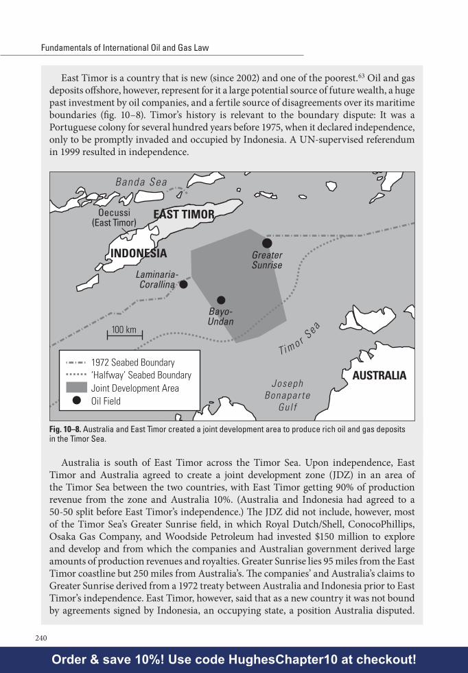
East Timor is a country that is new (since 2002) and one of the poorest.63 Oil and gas deposits offshore, however, represent for it a large potential source of future wealth, a huge past investment by oil companies, and a fertile source of disagreements over its maritime boundaries (fig. 10–8). Timor’s history is relevant to the boundary dispute: It was a Portuguese colony for several hundred years before 1975, when it declared independence, only to be promptly invaded and occupied by Indonesia. A UN-supervised referendum in 1999 resulted in independence.
JosephBonapar te
Gul f
GreaterSunrise
Laminaria-Corallina
Bayo-Undan
Banda Sea
EAST TIMOR
INDONESIA
Oecussi(East Timor)
AUSTRALIA
Ti m o r S
ea
Oil Field
100 km
1972 Seabed Boundary‘Halfway’ Seabed BoundaryJoint Development Area
Fig. 10–8. Australia and East Timor created a joint development area to produce rich oil and gas deposits in the Timor Sea.
Australia is south of East Timor across the Timor Sea. Upon independence, East Timor and Australia agreed to create a joint development zone (JDZ) in an area of the Timor Sea between the two countries, with East Timor getting 90% of production revenue from the zone and Australia 10%. (Australia and Indonesia had agreed to a 50-50 split before East Timor’s independence.) The JDZ did not include, however, most of the Timor Sea’s Greater Sunrise field, in which Royal Dutch/Shell, ConocoPhillips, Osaka Gas Company, and Woodside Petroleum had invested $150 million to explore and develop and from which the companies and Australian government derived large amounts of production revenues and royalties. Greater Sunrise lies 95 miles from the East Timor coastline but 250 miles from Australia’s. The companies’ and Australia’s claims to Greater Sunrise derived from a 1972 treaty between Australia and Indonesia prior to East Timor’s independence. East Timor, however, said that as a new country it was not bound by agreements signed by Indonesia, an occupying state, a position Australia disputed.
Order & save 10%! Use code HughesChapter10 at checkout!

Chapter 10Sovereignty Over and Ownership of Offshore Oil and Gas—
The Law of the Sea and Joint Development Zones
241
(There are other multinational company claims deriving from concessions awarded by the Portuguese government prior to 1975; East Timor also disputed these claims.) East Timor claimed as its maritime boundary the median line between the two countries, bringing Greater Sunrise within East Timor’s EEZ. Australia, however, relied not only on its treaty with the Indonesian government, but said that while some international tribunals have used the median line to determine maritime boundaries, others have recognized different boundaries having long-standing historical usage, which was the case with the boundary between present-day East Timor and Australia.
Between 2005 and 2007, East Timor and Australia reached agreement that the two countries would postpone final resolution of their boundary disputes (apparently reducing their agreed postponement time from 99 years) and agreed that during the postponement time Australia would reduce its royalties from Greater Sunrise. Based on these settlements and on ratification of the JDZ agreement by East Timor’s parliament, Australia’s Woodside Petroleum Company announced it would begin work on a Greater Sunrise liquefied natural gas facility.
Western Sahara. As noted above in the case of East Timor, land sovereignty disputes extend into waters offshore of disputed lands. The offshore boundary dispute involving Western Sahara is an extension of the land sovereignty dispute involving Western Sahara described in chapter 9.
The confusion over whether Morocco or the Polisario Front had sovereignty over Western Sahara (formerly Spanish Sahara) continued into 2005 and into waters offshore of Western Sahara: Morocco, claiming sovereignty over Western Sahara, by 2002, granted offshore exploration rights to the large French oil company Total and to the US independent oil company Kerr McGee. The Polisario, claiming sovereignty rights over the same maritime area, gave a concession to the Australian company Fusion (later known as Ophir). And Spain (which although it gave up sovereignty claims to the Western Sahara and its offshore waters nonetheless retained sovereignty claims over the Canary Islands and their EEZ in waters west of Western Sahara’s coast) gave exploration rights to the Spanish company Repsol. Morocco announced Spain’s action to be unfriendly and recalled its ambassador from Madrid. (Other issues between the two countries include disputes over Spain’s 500-year continued occupation of and exercise of sovereignty over the cities of Ceuta and Tetouan, located within Morocco’s landmass, the Parsley Islands off Morocco’s northern coast, Spanish fishing rights, Spain’s immigration policy, and Spanish support for complete independence for Western Sahara.)
By 2005, no drilling had yet occurred, in part because a UN resolution prohibited drilling until agreement on sovereignty disputes regarding Western Sahara, and Total had ceased its exploration efforts because of disappointing seismic results. Still, interest in the Western Sahara offshore continued to exist for other companies due to deposits found to the south, offshore of Mauritania. In 2005, the Polisario invited bids on 12 offshore licenses, reportedly offering assurance agreements to prospective bidders to confirm license terms in the event of independence of Western Sahara.
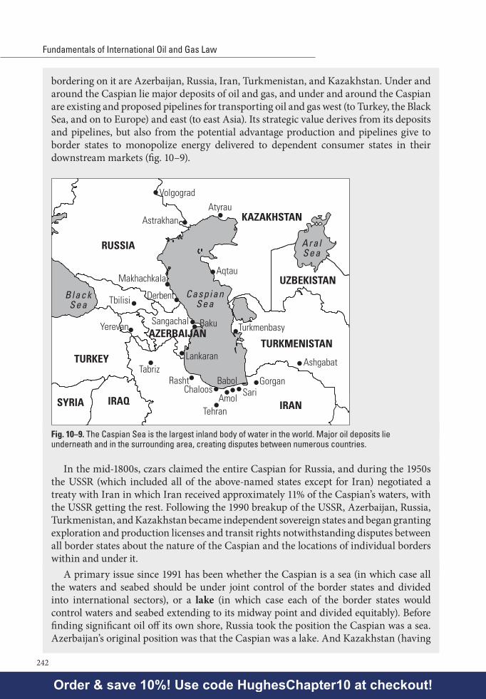
The Caspian. 64 The Caspian Sea is the largest inland body of water on Earth, being approximately 750 miles long and on average 200 miles wide. Countries presently
Order & save 10%! Use code HughesChapter10 at checkout!
Fundamentals of International Oil and Gas Law
242
bordering on it are Azerbaijan, Russia, Iran, Turkmenistan, and Kazakhstan. Under and around the Caspian lie major deposits of oil and gas, and under and around the Caspian are existing and proposed pipelines for transporting oil and gas west (to Turkey, the Black Sea, and on to Europe) and east (to east Asia). Its strategic value derives from its deposits and pipelines, but also from the potential advantage production and pipelines give to border states to monopolize energy delivered to dependent consumer states in their downstream markets (fig. 10–9).
Tbilisi
Yerevan
Tehran
Baku
Lankaran
Sangachal
TabrizRasht
ChaloosAmol
BabolSari
Gorgan
Ashgabat
Turkmenbasy
Aqtau
Volgograd
Astrakhan
Makhachkala
Derbent
Atyrau
TURKEY
RUSSIA
IRAQSYRIA IRAN
TURKMENISTAN
KAZAKHSTAN
AZERBAIJAN
UZBEKISTAN
AralSea
BlackSea
CaspianSea
Fig. 10–9. The Caspian Sea is the largest inland body of water in the world. Major oil deposits lie underneath and in the surrounding area, creating disputes between numerous countries.
In the mid-1800s, czars claimed the entire Caspian for Russia, and during the 1950s the USSR (which included all of the above-named states except for Iran) negotiated a treaty with Iran in which Iran received approximately 11% of the Caspian’s waters, with the USSR getting the rest. Following the 1990 breakup of the USSR, Azerbaijan, Russia, Turkmenistan, and Kazakhstan became independent sovereign states and began granting exploration and production licenses and transit rights notwithstanding disputes between all border states about the nature of the Caspian and the locations of individual borders within and under it.
A primary issue since 1991 has been whether the Caspian is a sea (in which case all the waters and seabed should be under joint control of the border states and divided into international sectors), or a lake (in which case each of the border states would control waters and seabed extending to its midway point and divided equitably). Before finding significant oil off its own shore, Russia took the position the Caspian was a sea. Azerbaijan’s original position was that the Caspian was a lake. And Kazakhstan (having
Order & save 10%! Use code HughesChapter10 at checkout!

Chapter 10Sovereignty Over and Ownership of Offshore Oil and Gas—
The Law of the Sea and Joint Development Zones
243
the Caspian’s largest oil field off the Kazakh shore) said the water was an enclosed sea under UNCLOS articles 122–123, but the seabed was more like a lake bed. When Russia discovered large fields off its shore in 1997, it adopted Kazakhstan’s position. Iran is now dissatisfied with the 11% it got from its treaty with the USSR in the 1950s and says it should get 29% to include three large oil fields presently claimed by and operated under license from Azerbaijan. And Turkmenistan says that Azerbaijan’s two largest fields are Turkmen, with a third Azerbaijan field (also claimed by Iran) likewise belonging to Turkmenistan.
Patrol boats from the arguing border states armed with machine guns have forced licensee ships out of the Caspian sectors in disputes.
The Deep Seabed Regime, Developed States’ Objections, and Present Status
As indicated in the UNCLOS discussion above, waters known as the high seas and seabed and subsoil known as the Area (but widely called the deep seabed) lie beyond the EEZ and continental shelf. The UNCLOS treatment of mining in the deep seabed is important in understanding the legal regime for control of offshore resources and also understanding why the US has not ratified the treaty.
Part XI of the 1982 convention dedicates mineral resources in the deep seabed to “the common heritage of mankind” and creates a bureaucracy called the Authority with exclusive rights to regulate mining there. Regulation is to occur according to rules to be adopted by a new Assembly and Council, and the convention creates a UN-sponsored company called the Enterprise to engage in the mining (either alone or in a joint ventures with commercial companies). The convention also creates a Seabed Disputes Chamber of a new International Tribunal for the Law of the Sea (ITLOS) to handle the compulsory arbitration. Both the Enterprise and states and commercial companies that are licensed to mine the deep seabed by the Authority are to pay fees and royalties to the Authority, which is to distribute receipts to UNCLOS-signing states on the basis of equitable sharing criteria, taking into account the interests and needs of developing states, particularly the landlocked and least developed among them. An Annex III to UNCLOS (Basic Conditions of Prospecting, Exploration and Exploitation) sets forth more specific requirements for obtaining licenses in the Area, dealing specifically with technology transfers, data transfers, annual fees, and payment of the UN’s portion of attributable net proceeds.
The US had promoted the convening of the conference producing UNCLOS and actively participated in negotiating the treaty; however, before finalizing it, a US election resulted in a new president (Ronald Reagan), and the new administration announced the US would not agree to Part XI. The US’s expressed objections may be summarized as follows:65 Part XI is a redistribution-of-wealth scheme falling unfairly on US nationals. It uses a non-free-market and central planning approach to development that requires transfers to the Enterprise of US national proprietary technology as a condition to obtaining licenses, imposes unwise and unnecessary production limits on mining, and
Order & save 10%! Use code HughesChapter10 at checkout!
Fundamentals of International Oil and Gas Law
244
extracts unjustifiably high payments from licensees. It fails to provide meaningful US participation in the several new UN bureaucracies created to issue licenses and to handle and disburse monies collected from operators, and money collected would likely be spent to fund political movements hostile to the US. Based on these objections, the US tried but failed to separate Part XI from the rest of the treaty, which the US said it was otherwise prepared to sign. Based on similar objections, other developed states (including the UK, Germany, and the USSR) also refused to sign or to ratify the treaty at the time the conference adopted it.
The US has expressed its understanding that customary international law provides that deep seabed minerals belong to no one and therefore belong to everyone based on principles of freedom of the seas,66 although some academics have argued that UN General Assembly resolutions in the 1960s and 1970s changed relevant customary law.67 This US belief implies that while coastal states do not own unmined resources located in the deep seabed beyond their continental shelves, they are free both to mine and license mining of the resources by their nationals. More specifically, the US view is that under customary international law, individual countries can authorize exploration and exploitation on a nonexclusive basis, an ability that would be limited or lost where countries enter into a treaty like UNCLOS that provides for different rights and obligation.68
Following their rejections of Part XI and based on their then-common understandings of customary international law, states such as the US, Germany, France, Japan, the UK, and the USSR enacted national legislation regulating their granting of national licenses for mining within the deep seabed,69 signing treaties with each other to coordinate their national exploration and exploitation licensing programs. At the same time, states that had signed and ratified the treaty (all of which were then developing countries) objected to unilateral national licensing as violations of international law and as reflected in UNCLOS.
An “Agreement Relating to the Implementation of Part XI of UNCLOS” represented an effort in 1994 to accommodate objections by nonsigning and nonratifying states. The agreement was in the form of an annex to a UN General Assembly resolution and purported to control interpretation of Part XI, the terms of which were otherwise reaffirmed. The 1994 agreement eliminated certain apparent requirements of Part XI (large annual mining fees, production limits, and state funding of mining by the Enterprise), directed nonimplementation of certain other apparent requirements (mandatory, uncompensated technology transfers by licensees), promised nondiscrim-ination for multinational licensees, and promised that new rules and procedures would be adopted by the Authority to replace the detailed rules and procedures contained in Part XI. The 1994 agreement also changed the Part XI decision-making apparatus to give industrialized states a decisive collective vote on substantive decisions and to withhold from a Part XI “Review Conference” its Part XI-granted power to amend signing states’ treaty obligations without their consent. Under the 1994 agreement, however, states that had ratified the 1982 treaty itself prior to 1994 apparently would not be bound by the 1994 agreement if they objected to the later agreement. Whether the 1994 agreement dealt adequately with or merely palliated US and other developed states’ objections is debatable.
Order & save 10%! Use code HughesChapter10 at checkout!

Chapter 10Sovereignty Over and Ownership of Offshore Oil and Gas—
The Law of the Sea and Joint Development Zones
245
By 1994, a new US president (Bill Clinton) announced that the new agreement satisfied US objections, signed the agreement, and under US constitutional procedures sent it to the US Senate for ratification. The treaty has remained in the Senate, unratified. Therefore, the US as of late 2016 is not a party to or adherent to the deep seabed mining regime or to the balance of the 1982 UNCLOS. However, by presidential proclamation and congres-sional action, the US has substantially adopted most of the important parts of UNCLOS other than Part XI.70 Since 1994, other developed states that originally refused to sign or ratify the treaty have now ratified it. Also, since 1982, many of the states that would have qualified at that time as either developing or landlocked (and therefore potential recipients of transfers of proceeds of production from the Area) are now known to have substantial oil and gas reserves and so have become potential donors rather than recipients. In 2012, the administration of President Barack Obama began pushing for ratification of the treaty, arguing that membership in the treaty would give the US better standing to object to treaty interpretations by countries such as China, which they saw as pushing the limits of their territorial seas beyond 12 miles.
The present status of the deep seabed regime is an International Seabed Authority that operates under the 1982 treaty and 1994 agreement and has adopted regulations on prospecting and exploration for polymetallic nodules, polymetallic sulphides, and cobalt-rich crusts and has entered into 15 exploration contracts relating to seabed hard minerals.71
Joint Development ZonesOne way to defer disputes over maritime boundaries in order to take advantage of
collection of revenues from oil and gas production is the joint development zone (JDZ) agreement (fig. 10–10). A JDZ is an agreement to disagree, but one that meanwhile undertakes to develop a disputed area to mutual advantage. The approach is more or less that of UNCLOS itself, which anticipates the existence of such disputes, directs disputing parties to try to resolve them, and says that adjacent and opposing states’ EEZ and continental shelves are to be split by agreement “on the basis of international law... in order to achieve an equitable solution,” with disputes to be resolved by UNCLOS dispute resolution measures and with disputing states to enter into practical provisional arrangements.72 Notwithstanding the potential temporary advantages offered to disputing states by JDZs, however, surprisingly few have been negotiated successfully.
Although the JDZ is here discussed as a phenomenon of offshore oil and gas development, there is no reason why the same approach cannot be used and structured to apply to onshore oil and gas development. In fact, examination of maps of the Arabian peninsula shows a diamond-shaped neutral zone—effectively a JDZ—created in 1923 under the encouragement of New Zealander Major Frank Holmes, placing the area under joint control of Saudi Arabia and Kuwait. A second neutral zone exists on land between and under joint control of Saudi Arabia and Iraq.73
A major problem in negotiating a compromise JDZ agreement is getting one disputing party to trust the other with a grant of even temporary management responsi-bility for operating some aspect of a prospect in their common interest. To deal with
Order & save 10%! Use code HughesChapter10 at checkout!

Fundamentals of International Oil and Gas Law
246
this management dilemma, JDZ agreements have approached organizing a zone in the following various ways:74
• Creating subzones within the JDZ, with each subzone controlled separately by one of the disputing states to produce separate concessions and operators.
• Creating a single joint authority for a unified JDZ.• Allowing one of the disputing states to have exclusive rights to develop the
entire JDZ, with an obligation to account for and share costs and benefits of production.
• Relying on private licensees to negotiate joint agreements between themselves. (Whether this avoids a joint agreement between the disputing states is doubtful.)
These four approaches may be illustrated by the following diagrams:
1. Divide JDZ into subzones, each separately controlled
Various Models/Approachesfor Joint Development Zones
A
B
A
B
B
A
B
A
B
A
B
A
A
B
A
B
2. Single joint authority for uni�ed JDZ
3. One arguing state has exclusive control subject to sharing obligation.4. Each state appoints its own licensee for licensed area.
JDZ Authority
Fig. 10–10. A joint development zone is one way countries can resolve a disputed boundary and still develop and profit from offshore resources.
Which of these alternatives is optimal depends on the nature and seriousness of the dispute, on the parties’ ability to work together, and on the prospect’s quality.
Whichever approach is taken by a JDZ agreement, an agreement between parties must do several things to succeed. It must of course create an efficient system to administer and govern the zone and project. It must take a form that reassures operator, investors, and lenders that time and money risks will be recovered and compensated. It must provide a transparent and fair collection and sharing of net revenues, so that other, new disputes will not arise between the disputing states. And it must preserve the disputing parties’ underlying claims, so that their legal positions are not worsened because of the compromise.
Order & save 10%! Use code HughesChapter10 at checkout!

Chapter 10Sovereignty Over and Ownership of Offshore Oil and Gas—
The Law of the Sea and Joint Development Zones
247
Applications: JDZs for Nigeria-São Tomé, Malaysia-Brunei, Trinidad-Venezuela, and Mexico-US
A JDZ can provide a temporary fix to competing claims of state sovereignty offshore. Early examples of a JDZ-type of arrangement are the neutral zones between Saudi Arabia and Kuwait and between Saudi Arabia and Iraq, albeit the examples involve onshore areas and were largely originated by the British government in 1922 to be administered jointly between then-feuding states for the purpose of allowing nomads and their herds to cross freely in and out of the area for pasturage.75 Today in one neutral zone, Saudi Arabia and Kuwait equally share the petroleum production from their zone, with the US major oil company Chevron operating sites in four fields on behalf of the Saudis and managing the sites jointly with the Kuwait Gulf Oil Company.
More recently, the JDZ device seems to have worked tolerably well in one area (the Gulf of Guinea), has been proposed as a practical compromise in another area (the South China Sea), and might materialize and lead to something more ambitious—a regional, multistate-owned oil company, perhaps—in a third (the Southern Caribbean).
Nigeria and the island republic of São Tomé e Príncipe negotiated for years to produce in 2001 a JDZ for 28,000 square km. in the Gulf of Guinea, covering an area over which the two countries had maritime boundary disputes. Under their 45-year agreement, the two countries created a joint development authority to explore for and develop reserves in the Area (fig. 10–11). The Authority has four executive directors to manage the Area—two from Nigeria and two from São Tomé—a staff similarly divided between nationals from each country, with proceeds to be split 60% (Nigeria) and 40% (São Tomé). The JDZ authority opened a bidding round on nine blocks in April 2003. The success of the treaty so far has attracted officials from other states considering a JDZ solution, to study how it was accomplished. This JDZ is unrelated to Nigeria’s maritime border dispute with the Cameroons in another sector of the Gulf of Guinea.
Joint development zone
NIGERIA
EQ.GUINEA
GABON
PRINCIPE
SÃO TOMÉ
CAMEROON
At lant icOcean
200 km
Fig. 10–11. Nigeria and São Tomé created a joint development zone to manage offshore resources in the Gulf of Guinea in West Africa.
Order & save 10%! Use code HughesChapter10 at checkout!

Fundamentals of International Oil and Gas Law
248
By contrast, commercial quantities of oil found offshore in the South China Sea produced a maritime border dispute between Malaysia and Brunei, with each country proceeding in 2003 to grant competing licenses (Brunei to the French company Total and negotiating with Royal Dutch Shell, while Malaysia’s state oil company Petronas awarded two blocks to its subsidiary and to Murphy Oil Company). In 2003, each country sent gunboats to the area to chase off drilling ships from the other country’s licensees, with exploration efforts then ceasing. Malaysia and Thailand have a JDZ 50-50 sharing arrangement functioning in the Gulf of Thailand, and Malaysia and Brunei have made JDZ offers to each other with respect to the South China Sea dispute.
In August 2003, Venezuela and the Republic of Trinidad and Tobago signed an agreement to share exploration and development of oil and gas deposits in the Caribbean waters between them. Then–Venezuelan President Hugo Chavez described the agreement as a step in the direction of forming a single company—to be called either Petroamerica or Petrosud—to exploit energy resources throughout Latin America and the Caribbean.
In February 2012, Mexico and the US signed a treaty that created a JDZ of 1.5 million acres located on seabeds in disputed maritime border areas in the Gulf of Mexico. Exploration and development in the Area had been impossible due to the ambiguity as to rights. In light of Mexico’s then-constitutional restrictions on foreign ownership of its oil, the treaty divided the zone into different subzones, with each country to separately auction blocks within its own subzones. The treaty provides for joint action by Mexican and US safety officials to set and enforce safety standards in the zone—important after the April 2010 Macondo well spill in US waters of the Gulf of Mexico.
Additional Resources• Most books and US law school casebooks on international law devote substantial
space to law of the sea issues. B. Carter et al., supra ch. 2 note 1, chapter 9 at 813–78, contains a thorough discussion of UNCLOS and its issues. See also Catherine Redgwell, International Regulation of Energy Activities, in Martha M. Roggenkamp et al., supra ch. 1 Additional Resources, at § 2.67 et seq. The UNCLOS conference documentary record is contained in the 17-volume Third United Nations Conference on the Law of the Sea: Documents (Renate Platzöder ed., 1982). A comprehensive treatment of the treaty, updated periodically, includes the three-volume reporter, New Directions in the Law of the Sea: Global Developments (Roy S. Lee & Morita Hayashi eds.) and the three-volume New Directions in the Law of the Sea: Regional and National Developments (Roy S. Lee & Morita Hayashi eds., 2008). Generally on the law of the sea see also Malcolm D. Evans, The Law of the Sea in International Law 651, 658 (Malcolm D. Evans ed., 3d ed. 2010); Donald R. Rothwell & Tim Stephens, The International Law of the Sea (U. Sydney Law Sch., Legal Studies Research Paper No. 11/02, 2011), available at http://papers.ssrn.com/sol3/papers.cfm?abstract_id=1739387; and Helmut Tuerk, Reflections on the Contemporary Law of the Sea (2012).
Order & save 10%! Use code HughesChapter10 at checkout!

Chapter 10Sovereignty Over and Ownership of Offshore Oil and Gas—
The Law of the Sea and Joint Development Zones
249
• The UN Law of the Sea website (http://www.un.org/depts/los/) contains the text, ratification status, useful information, and publication lists of the UN’s Law of the Sea office. For the argument that the 1994 agreement substantially accommodates US and other developed states’ objections to the deep seabed mining regime, see Bernard H. Oxman, Law of the Sea Forum: The 1994 Agreement on Implementation of the Seabed Provisions of the Convention on the Law of the Sea, 88 Amer. J. Int’l L. 687 (1994). The website for the International Seabed Authority is http://www.isa.org.jm/.
• For law review commentary on law of the sea boundary disputes, see David H. Anderson, Some Recent Developments in the Law Relating to the Continental Shelf, 6 J. Energy & Nat. Resources L. 95 (1988); Paul Bravender-Coyle, The Emerging Legal Principles and Equitable Criteria Governing the Delimitation of Maritime Boundaries Between States, 19 Ocean Dev. & Int’l L. 171 (1988); Roseann Bassler, International Disputes over Control of the Oceans, 7 Geo. Int’l Envtl. L. Rev. 855 (1995); and Jon D. Carlson et al., The Scramble for the Arctic: The United Nations Convention on the Law of the Sea (UNCLOS) and Extending National Seabed Claims, Mar. 30, 2009, available at http://papers.ssrn.com/sol3/papers.cfm?abstract_id=1472552.
• General works on joint development zones include the two-volume Joint Development of Offshore Oil and Gas (Hazel Fox ed., 1989).
• For commentary on the Timor Sea JDZ, see Ernst Willheim, Australia-Indonesia Sea-Bed Boundary Negotiations: Proposals for a Joint Development Zone in the “Timor Gap,” 29 Nat. Resources J. 821 (1989); Gillian Triggs, Proposed Timor Sea Arrangements between Australia and the East Timor Transitional Administration, 20 J. Energy & Nat. Resources L. 40 (2002); David Ong, The New Timor Sea Arrangement 2001: Is Joint Development of Common Offshore Oil and Gas Deposits Mandated under International Law?, 17 Int’l J. Mar. & Coastal L. 79 (2002) (containing an appendix on the agreement between Australia and the East Timor Transitional Authority); and Donald K. Anton, Arbitrating the Treaty on Certain Maritime Arrangements in the Timor Sea: The Latest Round between Timor-Leste and Australia (Australian National U. Law Sch. Research Paper No. 13-20, 2013), available at http://papers.ssrn.com/sol3/papers.cfm?abstract_id=2364996.
• For commentary on disputes in the South China Sea and East China Sea, see Choon-Ho Park, The South China Sea Disputes: Who Owns the Islands and the Natural Resources?, 5 Ocean Dev. & Int’l L. 27 (1978); Paul C. Yuan, China’s Offshore Oil Development: Legal and Geopolitical Perspectives, 18 Tex. Int’l L.J. 107 (1983); Jonathan I. Charney, Central East Asian Maritime Boundaries and the Law of the Sea, 89 Am. J. Int’l L. 724 (1995); Tao Cheng, The Dispute Over the South China Sea Islands, 10 Tex. Int’l L.J. 265 (1975); East China Sea Tensions: Perspectives and Implications (Richard Pearson ed., 2014); and Recent Developments in the South China Sea Dispute: The Prospect of a Joint Development Regime (Wu Shicun & Nong Hong eds., 2014).
• For commentary on boundary disputes in the Caspian Sea, see Blanche Sas, Legal Issues in the Control of the Construction and Operations of Pipelines and the Issue of Transit in the Caspian and Black Sea Regions, 7 Oil & Gas L. & Tax’n Rev. 274
Order & save 10%! Use code HughesChapter10 at checkout!
Fundamentals of International Oil and Gas Law
250
(1995); Sergei Vinogradov, Transboundary Water Resources in the Former Soviet Union: Between Conflict and Cooperation, 36 Nat. Resources J. 393 (1996); Kamyar Mehdiyoun, Current Developments, Ownership of Oil and Gas Resources in the Caspian Sea, 94 Am. J. Int’l L. 179 (2000); and Hanna Zimnitskaya & James von Geldern, Is the Caspian Sea a Sea; and Why Does It Matter?, 1–14 J. Eurasian Stud. 1 (2011), available at http://www.sciencedirect.com/science/article/pii/S1879366510000424.
• The text of the Agreement Between Japan and the Republic of Korea Concerning Joint Development of the Southern Part of the Continental Shelf Adjacent to the Two Countries, Jan. 30, 1974, is set forth in Pak Hfui-gwfon, The Law of the Sea and Northeast Asia: A Challenge for Annexation, annex V, at 181 (2000) and on the University of Singapore website at http://cil.nus.edu.sg/.
• E. Smith et al., supra ch. 1 Additional Resources, at 105–59 addresses law of the sea and offshore sovereignty questions. The materials include those relating to disputes in the North Sea between Germany and Denmark, and between Germany and Holland (126–31), in the Black Sea between Romania and the Ukraine (131–45), in the Mediterranean between Malta and Libya (145–46), and others. Joint development zones issues are discussed at 159–67 and 170–80, with the deep seabed at 122–23. Maritime disputes in the South China Sea are discussed at 149–53, and in the Caspian Sea at 153–54.
Problems1. If oil and gas in the deep seabed can be developed equally under national licensing
or under UN-sponsored licensing, should international law prescribe one method of development in lieu of another? Can it be argued that private development pursuant to national licensing offers a better opportunity to benefit landlocked or poor countries than does public development pursuant to UN-sponsored licensing?
2. In describing a coastal state’s rights, is there any significance to the difference in language used under UNCLOS article 56 (the “coastal state has sovereign rights” to resources in the seabed and subsoil below its internal and territorial waters) and article 77 (“the coastal state exercises... sovereign rights” over resources in the seabed and subsoil below its continental shelf)? If the treaty presently provides that a coastal state only exercises sovereign rights over exploitation of continental shelf oil and gas up to 200 NM from the baseline, does that imply that someone else has the rights and that the coastal state’s exercise of the rights might be nonexclusive, restricted, or eliminated in some way? What would be required in order to bring about that restriction or elimination? Article 82 requires a coastal state to make payments or contributions in kind to the Authority for oil and gas exploited beyond 200 NM from the baseline. What is the argument that article 82 would not support changing a state’s ability to keep all profits within the 200 NM area? That article 82 does support changing the state’s ability to keep all profits within the 200 NM area?
Order & save 10%! Use code HughesChapter10 at checkout!
Chapter 10Sovereignty Over and Ownership of Offshore Oil and Gas—
The Law of the Sea and Joint Development Zones
251
Notes1. United Nations Convention on the Law of the Sea, opened for signature Dec. 10, 1982, 1833 U.N.T.S.
397 (entered into force Nov. 16, 1994), 21 I.L.M. 1261 (1982) (sometimes called the Montego Bay treaty) [hereinafter UNCLOS]. The abbreviation UNCLOS is sometimes also used to describe the conferences between 1958 and 1982 that led to the adoption of the convention. Other abbreviations for the convention are LOSC and LOST.
2. For example, the US and Denmark have not ratified the treaty. The reasons for the US refusal and the present US status of law of the sea are set forth later in this chapter.
3. The Convention on the Territorial Sea and Contiguous Zone, Apr. 29, 1958, 15 U.S.T. 1606, T.I.A.S. No. 5639, 516 U.N.T.S. 205; and the Convention on the Continental Shelf, Apr. 29, 1958, 15 U.S.T. 471, T.I.A.S. No. 5578, 499 U.N.T.S. 311. Some commentators have raised the possibility that the 1958 conventions continue to apply to states signing and ratifying the 1958 conventions but not signing or ratifying the UNCLOS E.g., Catherine Redgwell, International Regulation of Energy Activities, in Martha M. Roggenkamp et al., supra ch. 1 Additional Resources, at § 2.68.
4. See, e.g., comprehensive discussion in B. Carter et al., supra ch. 2 note 1, at 813–79. See also J.A. Thomas, New Developments in the International Legal Regime for the Offshore Oil and Gas Industry, 12 Oil & Gas L. & Tax’n Rev. 110 (1994).
5. UNCLOS arts. 5 through 14.6. Id. art. 87. Id. arts. 3, 4, and 15. A nautical mile is not defined in the treaty but is a traditional measurement of distance
in land or sea navigation and equals 6,020 feet, which is longer than a statute mile (5,280 feet). A nautical mile equals 1.852 kilometers.
8. UNCLOS arts. 55 and 57.9. Id. art. 76(4) through (7). The article contemplates that each coastal state will establish the limits of its
own continental shelf and (if beyond the 200 NM limit) submit the determination to an UNCLOS-created Commission on the Limits of the Continental Shelf. The Commission’s recommendations regarding the limit are final and binding if then established by the coastal state, unless there are disputes involving adjacent or opposing states. Art.76 language suggests, but in fact is vague on whether, the Commission’s “recommendations” are final and binding if not established by a coastal state or if there exist disputes between states on the recommendations. The Commission consists of 21 part-time geoscientists and, given the crush and complexity of claims, expects that some may take decades to resolve. States generally have ten years after ratification within which to file their claims, but original and early signers had a filing deadline of May 1999. To avoid waiver of rights, the deadline resulted in the filing of some exaggerated or marginal claims even where a prospect of immediate economic benefit was lacking. The US, which has not ratified UNCLOS and has not filed any claims. See generally Robert Lee Hotz, Column, Board of Scientists Is Swamped by Claims for Rich Sea Floors, Wall St. J., Feb. 22, 2008, at B1; and The Economist, Briefing: The Scramble for the Seabed, May 16, 2009, at 29–31.
10. This is a general practice observed by states as a matter of customary international law. Malcolm D. Evans, The Law of the Sea, in International Law 651, 658 (Malcolm D. Evans ed., 3d ed. 2010). UNCLOS does not explicitly say as much and does not use the words own or ownership for internal waters.
11. The treaty and certain of the regulations are contained in http://www.suezcanal.gov.eg.12. E.g., Nick Timiraos, Arctic Thaw Defrosts a Sea Treaty, Wall St. J., Nov. 3, 2007, at A18 (also estimating the
percentage in 2030 to be 5.3%).13. Javier Blas and Gregory Meyers, Don’t Panic: Oil Traders Adapt to $100 a Barrel, Fin. Times, Feb. 2, 2011, at
23 (analyzing history and importance of Suez Canal). 14. UNCLOS art. 11.15. E.g., J.L. Brierly, supra ch. 2 Additional Resources, at 194–95. See also Mark W. Janis & John E. Noyes,
International Law: Cases and Commentary at 694 (2d ed. 2001) (also noting apparent disagreement whether merchant vessels have a right of access to ports, even if the vessels comply with the coastal state’s health and safety regulations).
16. E.g., Wildenhus’ Case, 120 U.S. 1, 12 (1887). A 1951 US-UK Consular Convention, art. 22(2), is an example of a bilateral treaty confirming the relaxed practice. Consular Convention, U.S.-U.K., art. 22(2), June 6, 1951, 3 U.S.T. 3426.
Order & save 10%! Use code HughesChapter10 at checkout!

Fundamentals of International Oil and Gas Law
252
17. E.g., United States v. Flores, 289 U.S. 137, 158–59 (1933) (murder of US citizen by US citizen onboard a US-registered ship while in Belgian colonial port, held: US prosecution permitted in absence of Belgian prosecution).
18. UNCLOS arts. 211(3) through (6), 218, and 220.19. Id. arts. 218(1), 220(1), and 220(7). International Marine Organization Procedures for Control of Ships
relates to port state inspection and detention of foreign vessels.20. Id. art. 232.21. Id. art. 221.22. UNCLOS art. 2. UNCLOS does not use the words “own” or “ownership.”23. Id. arts. 17, 24, and 26. Art. 19 defines innocent passage as one posing no threat to the coastal state’s peace,
good order, or security, which potentially includes engaging in any activity “not having a direct bearing on passage.”
24. Id. art. 21. 25. E.g., Council Directive 95/21 of 19 June 1995 Concerning the enforcement, in respect of shipping using
Community ports and sailing in the waters under the jurisdiction of the Member States, of international standards for ship safety, pollution prevention, and shipboard living and working conditions, 1995 O.J. (L 157) 1.
26. UNCLOS arts. 94 (flag state jurisdiction) and 91–94 (flag state duties).27. Id. cf. art. 24.28. Id. art. 27.29. Id. art. 2.30. Id.31. Id. art. 208, for example, discussed in chapter 18, requires coastal states to enforce their international
law-compliant national pollution laws as to seabed activities and artificial installations and structures.32. Id. art. 34.33. Id. arts. 37, 45, and 38(1). Transit passage is a category of rights less permissive (for vessels) than those
freedoms enjoyed on the high seas and those most restrictive (for vessels) while traveling in innocent passage through the territorial sea. Although a vessel exercising transit passage must not use or threaten force (art. 39), transit passage does not include the restrictions on innocent passage specified in art. 19 (such as “any... activity not having a direct bearing on passage,” art. 19(2)(l)).
34. Id. arts. 39 and 40.35. Id. art. 42.36. Chart, Energy Diary: Dire Straits, Wall St. J., Nov. 13, 2007, at A18.37. US Energy Information Administration, World Oil Transit Chokepoints, Nov. 10, 2014, at 9, available at
http://www.eia.gov/countries/analysisbriefs/World_Oil_Transit_Chokepoints/wotc.pdf.38. Id. at 3. This figure represented 35% of all seaborne oil traded and 20% of oil traded worldwide in 2012.39. Id. at 5.40. See generally Thomas de Waal, Bottleneck at the Bosphorus, Fin. Times, Jan. 5–6, 2008, p. L&A-2. See
also Alkman Granitsas, Bypassing a Major Oil Choke Point, Wall St. J., Nov. 14, 2006, at A14; and John Roberts, Maritime Motorway Fuels Environmental Concerns, Fin. Times, Oct. 17, 2012, at Istanbul Supp. 3; and Yearly Ship Statistics of Bosphorus Strait – 2013, Bosphorus Strait News, March 13, 2014, available at http://www.bosphorusstrait.com/2014/03/13/yearly-ship-statistics-of-bosphorus-strait-2013/.
41. See discussion in Javier Blas, Iran Standoff Sparks Fears of $200-a-Barrel Oil, Fin. Times, Nov. 9, 2011, at 21; and Javier Blas and Caroline Binham, Traders Delve into Past to Calm Gulf Tensions, Fin. Times, Jan. 19, 2012, at 4. See generally also Rouhollah K. Ramazani, The Persian Gulf and the Strait of Hormuz (1979).
42. UNCLOS art. 58.43. Id. art. 56(1)(c).44. Id. arts. 56 and 60.45. Id.46. Id. arts. 58, 77, and 81.
Order & save 10%! Use code HughesChapter10 at checkout!

Chapter 10Sovereignty Over and Ownership of Offshore Oil and Gas—
The Law of the Sea and Joint Development Zones
253
47. Id.48. To summarize, regarding UNCLOS’s grant or recognition of sovereignty (art. 56) and the exercise of
sovereignty (art. 77) over internal waters, territorial sea, and EEZ, the treaty does not use the words own or ownership in reference to oil and gas resources in its continental shelf within 200 NM of the baseline; UNCLOS also does not state explicitly that the wealth of and profit from continental shelf oil and gas belong to the coastal states; some (but not all) states and commentators interpret a coastal state’s rights in all of the continental shelf to fall short of ownership. See, e.g., discussion in Catherine Redgwell, International Regulation of Energy Activities, in Martha M. Roggenkamp et al., supra ch. 1 Additional Resources, at 52–3. There are theoretical differences between a state that has sovereignty but not ownership rights (as offshore), and a state that has both sovereignty and ownership rights (as onshore). But whether theoretical differences produce practical consequences is debatable. The differences may affect when a licensee can get title to unproduced oil and gas from the licensing state, the extent to which a lender has secured party rights in unproduced oil and gas, and whether the state’s rights in unproduced oil and gas can be taken away or restricted.
49. Patricia D. Park, supra ch. 2 note 8, at 58.50. Catherine Redgwell et al., Energy Law in Europe: Comparisons and Conclusions, in Martha M.
Roggenkamp et al., supra ch. 1 Additional Resources, at § 16.17 et seq. Because of its reading of interna-tional law, the UK does not claim ownership of unextracted offshore oil and gas. Stephen R. Dow, Energy Law in the United Kingdom, in Martha M. Roggenkamp et al., supra ch. 1 Additional Resources, at § 15.58. In the US, the US government (and not individual US states) control offshore seabed and subsoil and related oil and gas beyond three miles from the coast under the US Outer Continental Shelf Lands Act, 43 U.S.C. §§ 1331–1343, though it is unclear whether the US Congress has asserted US ownership as well as jurisdiction. Cf. Treasure Salvors, Inc. v. Unidentified Wrecked and Abandoned Sailing Vessel, 569 F.2d 330 (5th Cir. 1978) (holding OCSLA asserts control but not ownership as such).
51. Bureau of Ocean Energy Management, 2012–2017 OCS Oil and Gas Leasing Program, Aug. 27, 2012, available at http://www.boem.gov/Five-Year-Program-2012-2017/.
52. Bureau of Ocean Energy Management, Proposed Final Outer Continental Shelf Oil and Gas Leasing Program 2012-2017, June 2012, at 2, available at http://www.boem.gov/uploadedFiles/BOEM/Oil_and_Gas_Energy_Program/Leasing/Five_Year_Program/2012-2017_Five_Year_Program/PFP%2012-17.pdf.
53. Bureau of Ocean Energy Management, Proposed Geological and Geophysical (G&G) Activities on the Mid- and South Atlantic Outer Continental Shelf (OCS), 79 Fed. Reg. 42815 (July 23, 2014). Bureau of Ocean Energy Management, Atlantic Geological and Geophysical (G&G) Activities Programmatic Environmental Impact Statement (PEIS), Feb. 2014, available at http://www.boem.gov/Atlantic-G-G-PEIS/#Final%20PEIS.
54. UNCLOS arts. 89, 95, and 96. As noted earlier, under art. 94, a flag state has jurisdiction over what occurs on board its flagships and must regulate construction, equipment, seaworthiness, and manning, so as to prevent (for example) collision and pollution in accordance with generally accepted international standards. International Convention on Oil Pollution Preparedness, Response and Co-operation, Nov. 30, 1990, 30 I.L.M. 733. The convention is discussed in chapter 17.
55. UNCLOS arts. 99, 100, 107–108, and 111.56. Javier Blas, Iran Forced to Reflag Oil Tankers, Fin. Times, Aug. 22, 2012, at 3. See also Claudia Rosett,
Opinion, Iran’s Hong Kong Shipping Shell Game, Wall St. J., Aug. 30, 2011, at A15.57. Id. arts. 87 and 112. The UNCLOS reference to its part dealing with the continental shelf is not quite
clear. The UNCLOS reference to its provisions dealing with activities in the Area obviously relates to the provisions of Part XI, giving to UN bodies rights to control exploitation of oil and gas under the high seas.
58. E.g., the North Sea, Tunisia and Libya, Libya and Malta, the South China Sea, the E. China Sea, the Sea of Japan, the Yellow Sea, Australia and Indonesia, Mexico and the US, and Venezuela and Colombia. See E. Smith et al., supra ch. 1 Additional Resources, at 240–41, 312, and 321. European states have generally dealt with such disputes by means of bilateral treaties. See Catherine Redgwell, International Regulation of Energy Activities, in Martha M. Roggenkamp et al., supra ch. 1 Additional Resources, at § 2.78.
59. Jude Webber, Argentina Riled by Falklands Oil Stake, Fin. Times, Oct. 4, 2007, at 6; Isabel Gorst, Russia Raises Stakes over Arctic Seabed, Fin. Times, Aug. 2, 2007, at 3; and Michael Peel and Daniel Dombey, Battle for Oil Rests Not on Flags but on Obscure UN Panel, Fin. Times, Aug. 11–12, 2007, at 7. In 2010, Argentina announced that any ship taking goods to the Falklands needed special permission from Argentina before sailing through Argentine waters, a contention the UK rejected. Caroline Henshaw, UK Firms Mobilize in New Falklands Foray, Wall St. J., Jan. 25, 2010, at B4; WSJ News Roundup, UK Rejects Boat Decree amid Falklands Row, Wall St. J., Feb. 18, 2010, at A15; Shane Romig, Nation Adds Pressure on UK over Falklands,
Order & save 10%! Use code HughesChapter10 at checkout!
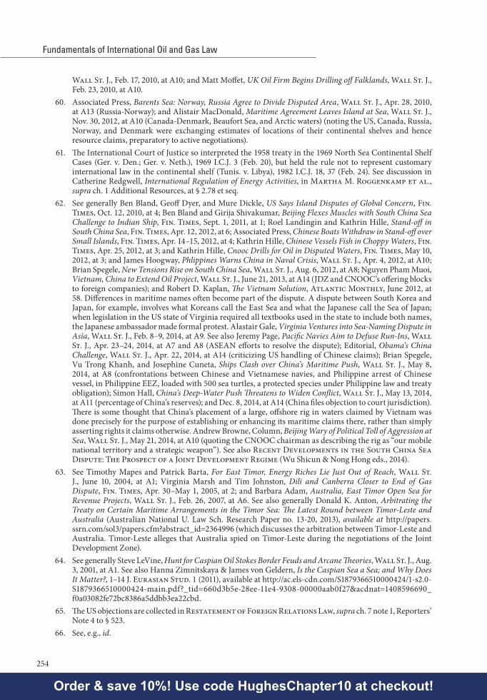
Fundamentals of International Oil and Gas Law
254
Wall St. J., Feb. 17, 2010, at A10; and Matt Moffet, UK Oil Firm Begins Drilling off Falklands, Wall St. J., Feb. 23, 2010, at A10.
60. Associated Press, Barents Sea: Norway, Russia Agree to Divide Disputed Area, Wall St. J., Apr. 28, 2010, at A13 (Russia-Norway); and Alistair MacDonald, Maritime Agreement Leaves Island at Sea, Wall St. J., Nov. 30, 2012, at A10 (Canada-Denmark, Beaufort Sea, and Arctic waters) (noting the US, Canada, Russia, Norway, and Denmark were exchanging estimates of locations of their continental shelves and hence resource claims, preparatory to active negotiations).
61. The International Court of Justice so interpreted the 1958 treaty in the 1969 North Sea Continental Shelf Cases (Ger. v. Den.; Ger. v. Neth.), 1969 I.C.J. 3 (Feb. 20), but held the rule not to represent customary international law in the continental shelf (Tunis. v. Libya), 1982 I.C.J. 18, 37 (Feb. 24). See discussion in Catherine Redgwell, International Regulation of Energy Activities, in Martha M. Roggenkamp et al., supra ch. 1 Additional Resources, at § 2.78 et seq.
62. See generally Ben Bland, Geoff Dyer, and Mure Dickle, US Says Island Disputes of Global Concern, Fin. Times, Oct. 12, 2010, at 4; Ben Bland and Girija Shivakumar, Beijing Flexes Muscles with South China Sea Challenge to Indian Ship, Fin. Times, Sept. 1, 2011, at 1; Roel Landingin and Kathrin Hille, Stand-off in South China Sea, Fin. Times, Apr. 12, 2012, at 6; Associated Press, Chinese Boats Withdraw in Stand-off over Small Islands, Fin. Times, Apr. 14–15, 2012, at 4; Kathrin Hille, Chinese Vessels Fish in Choppy Waters, Fin. Times, Apr. 25, 2012, at 3; and Kathrin Hille, Cnooc Drills for Oil in Disputed Waters, Fin. Times, May 10, 2012, at 3; and James Hoogway, Phlippines Warns China in Naval Crisis, Wall St. J., Apr. 4, 2012, at A10; Brian Spegele, New Tensions Rise on South China Sea, Wall St. J., Aug. 6, 2012, at A8; Nguyen Pham Muoi, Vietnam, China to Extend Oil Project, Wall St. J., June 21, 2013, at A14 (JDZ and CNOOC’s offering blocks to foreign companies); and Robert D. Kaplan, The Vietnam Solution, Atlantic Monthly, June 2012, at 58. Differences in maritime names often become part of the dispute. A dispute between South Korea and Japan, for example, involves what Koreans call the East Sea and what the Japanese call the Sea of Japan; when legislation in the US state of Virginia required all textbooks used in the state to include both names, the Japanese ambassador made formal protest. Alastair Gale, Virginia Ventures into Sea-Naming Dispute in Asia, Wall St. J., Feb. 8–9, 2014, at A9. See also Jeremy Page, Pacific Navies Aim to Defuse Run-Ins, Wall St. J., Apr. 23–24, 2014, at A7 and A8 (ASEAN efforts to resolve the dispute); Editorial, Obama’s China Challenge, Wall St. J., Apr. 22, 2014, at A14 (criticizing US handling of Chinese claims); Brian Spegele, Vu Trong Khanh, and Josephine Cuneta, Ships Clash over China’s Maritime Push, Wall St. J., May 8, 2014, at A8 (confrontations between Chinese and Vietnamese navies, and Philippine arrest of Chinese vessel, in Philippine EEZ, loaded with 500 sea turtles, a protected species under Philippine law and treaty obligation); Simon Hall, China’s Deep-Water Push Threatens to Widen Conflict, Wall St. J., May 13, 2014, at A11 (percentage of China’s reserves); and Dec. 8, 2014, at A14 (China files objection to court jurisdiction). There is some thought that China’s placement of a large, offshore rig in waters claimed by Vietnam was done precisely for the purpose of establishing or enhancing its maritime claims there, rather than simply asserting rights it claims otherwise. Andrew Browne, Column, Beijing Wary of Political Toll of Aggression at Sea, Wall St. J., May 21, 2014, at A10 (quoting the CNOOC chairman as describing the rig as “our mobile national territory and a strategic weapon”). See also Recent Developments in the South China Sea Dispute: The Prospect of a Joint Development Regime (Wu Shicun & Nong Hong eds., 2014).
63. See Timothy Mapes and Patrick Barta, For East Timor, Energy Riches Lie Just Out of Reach, Wall St. J., June 10, 2004, at A1; Virginia Marsh and Tim Johnston, Dili and Canberra Closer to End of Gas Dispute, Fin. Times, Apr. 30–May 1, 2005, at 2; and Barbara Adam, Australia, East Timor Open Sea for Revenue Projects, Wall St. J., Feb. 26, 2007, at A6. See also generally Donald K. Anton, Arbitrating the Treaty on Certain Maritime Arrangements in the Timor Sea: The Latest Round between Timor-Leste and Australia (Australian National U. Law Sch. Research Paper no. 13-20, 2013), available at http://papers.ssrn.com/sol3/papers.cfm?abstract_id=2364996 (which discusses the arbitration between Timor-Leste and Australia. Timor-Leste alleges that Australia spied on Timor-Leste during the negotiations of the Joint Development Zone).
64. See generally Steve LeVine, Hunt for Caspian Oil Stokes Border Feuds and Arcane Theories, Wall St. J., Aug. 3, 2001, at A1. See also Hanna Zimnitskaya & James von Geldern, Is the Caspian Sea a Sea; and Why Does It Matter?, 1–14 J. Eurasian Stud. 1 (2011), available at http://ac.els-cdn.com/S1879366510000424/1-s2.0-S1879366510000424-main.pdf?_tid=660d3b5e-28ee-11e4-9308-00000aab0f27&acdnat=1408596690_f0a03082fe72bc8386a5ddbb3ea22cbd.
65. The US objections are collected in Restatement of Foreign Relations Law, supra ch. 7 note 1, Reporters’ Note 4 to § 523.
66. See, e.g., id.
Order & save 10%! Use code HughesChapter10 at checkout!

Chapter 10Sovereignty Over and Ownership of Offshore Oil and Gas—
The Law of the Sea and Joint Development Zones
255
67. See discussion in L. Damrosch et al., supra ch. 8 note 4, at 1456–57. (UN General Assembly resolutions declared deep seabed resources a “common heritage of mankind”; the academic argument is that such resolutions constitute evidence of common acceptance of a general rule. The US response has been that the resolutions state the general rules incorrectly, and that General Assembly has authority only to make recommendations under UN Charter art.10, but lacks authority to make or declare international law.)
68. See Restatement of Foreign Relations Law, supra ch. 7 note 1, at § 523(b) for a statement of the US understanding.
69. E.g., Deep Seabed Hard Mineral Resources Act, 30 U.S.C. §§ 1401–1473 (2002) (US legislation proclaiming that international freedom of the seas allows deep seabed mining).
70. See e.g., Proclamation 5928 for Territorial Sea (Dec. 27, 1988), text at 43 U.S.C. § 1331 (2012); 7219 Contiguous Zone (Sept. 2, 1999), text at 43 U.S.C. § 1331 (2012); and 5030 Exclusive Economic Zone (Mar. 10, 1983), text at 16 U.S.C. § 1453 (2012). Regarding the US continental shelf, the Truman Proclamation in 1945 asserted that resources there “appertain[ed]” to the US, which had jurisdiction over and right to control them. Proclamation No. 2667 regarding the Policy of the United States with Respect to the Natural Resources of the Subsoil and Seabed of the Continental Shelf, 327 U.S. Dept. of State Bull. 485, 10 Fed. Reg. 12303 (1945), 3 C.F.R. 67 (1943–1948 Comp.), 59 Stat. 884 (1945), reproduced in 40 Am. J. Int’l L. 45 (1946). US legislation concerning the continental shelf is contained in the Outer Continental Shelf Lands Act, 43 U.S.C. §§ 1301–1315 and 1333 (2012). Various bilateral treaties negotiated or proposed between the US and Canada, Cuba, Mexico, Russia, and the Bahamas deal with US lateral and seaward maritime boundaries. US regulation of licensing and mining from the deep seabed is largely contained in the Deep Seabed Hard Mineral Resources Act, 30 U.S.C. §§ 1401–1473 (2012).
71. More information can be found on the website of the International Seabed Authority: http://www.isa.org.jm.72. UNCLOS arts. 74 and 83.73. See generally Daniel Yergin, The New Prize in World Oil, Wall St. J., Mar. 9, 2010, at A10, and Daniel
Yergin, The Prize, supra ch. 3 note 35, at 281, 285.74. The discussion here is drawn from E. Smith et al., supra ch. 1 Additional Resources, at 176 et seq.,
summarizing the Timor Sea Joint Petroleum Development Agreement. For the negotiations, see Ernst Willheim, Australia-Indonesia Sea-Bed Boundary Negotiations: Proposals for a Joint Development Zone in the “Timor Gap”, 29 Nat. Resources J. 821 (1989), redacted in an earlier edition of E. Smith.
75. E.g., Daniel Yergin, The Prize, supra ch. 3 note 35, at 437–39.
Order & save 10%! Use code HughesChapter10 at checkout!

Order & save 10%! Use code HughesChapter10 at checkout!