southern inland queensland visitor guide · visitor guide featuring bunya mountains national park...
TRANSCRIPT
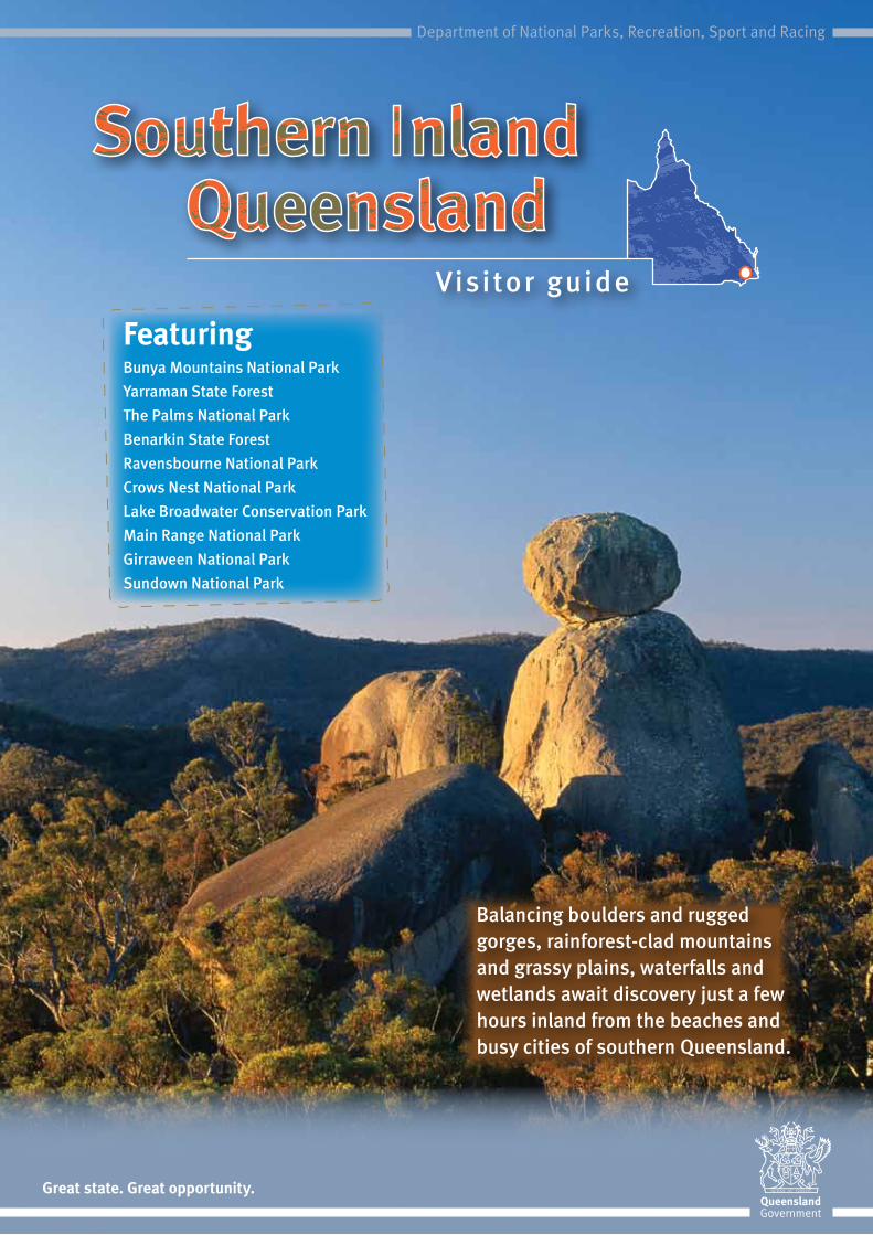
Visitor guide
FeaturingBunya Mountains National ParkYarraman State ForestThe Palms National ParkBenarkin State ForestRavensbourne National ParkCrows Nest National ParkLake Broadwater Conservation ParkMain Range National ParkGirraween National ParkSundown National Park
Balancing boulders and rugged gorges, rainforest-clad mountains and grassy plains, waterfalls and wetlands await discovery just a few hours inland from the beaches and busy cities of southern Queensland.
Great state. Great opportunity.
Department of National Parks, Recreation, Sport and Racing
Park
offi
ce
Toile
ts
On-
site
in
form
atio
n
Dri
nkin
g w
ater
She
lter s
hed
Picn
ic ta
ble
Elec
tric
bar
becu
e
Woo
d ba
rbec
ue/
firep
lace
Wal
king
trac
k
Loo
kout
Dog
s al
low
ed
(on
leas
h)
Cam
ping
Car
avan
/
Cam
perv
anH
ikin
g (p
erha
ps
over
nigh
t)
Dar
ling
Dow
ns
and
Sou
th B
urne
tt
Bunya Mountains National Park p4 • • • • • • • • •
Yarraman State Forest P5 • • • • •
Benarkin State Forest p5 • • • • • •
The Palms National Park p6 • • •
Lake Broadwater Conservation Park p6 • • • • • •
Crows Nest National Park P7 • • • • • • • • •
Ravensbourne National Park P8 • • • • • • •
Sth
Dow
ns
and
Gra
nite
B
elt
Main Range National Park p9 • • • • • • • •
Girraween National Park p10 • • • • • • • • • • •
Sundown National Park p11 • • • • • • • •
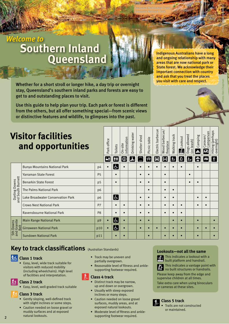
Key to track classificationsClass 1 track • Easy,level,widetracksuitablefor
visitors with reduced mobility (including wheelchairs). High level of facilities and interpretation.
Class 2 track • Easy,level,well-gradedtracksuitable
Class 3 track • Gentlysloping,well-definedtrack
with slight inclines or some steps.• Cautionneededonloosegravelor
muddy surfaces and at exposed natural lookouts.
Class 5 track • Trailsarenotconstructed
or maintained.
Welcome to Southern Inland Queensland
Whether for a short stroll or longer hike, a day trip or overnight stay, Queensland’s southern inland parks and forests are easy to get to and outstanding places to visit.
Use this guide to help plan your trip. Each park or forest is different from the others, but all offer something special—from scenic views or distinctive features and wildlife, to glimpses into the past.
Phot
o: K
en C
hapm
an
Secluded McAllisters Creek, Sundown National Park.
Indigenous Australians have a long and ongoing relationship with many areas that are now national park or State forest. We acknowledge their important connection with country and ask that you treat the places you visit with care and respect.
Lookouts—not all the sameThis indicates a lookout with a built platform and handrail.
This indicates a vantage point with no built structures or handrails.
Please keep away from the edge and supervise children at all times.
Take extra care when using binoculars or cameras at these sites.
Visitor facilities and opportunities
• Trackmaybeunevenand partially overgrown.
• Reasonableleveloffitnessandankle-supporting footwear required.
Class 4 track • Distincttrackmaybenarrow,
up and down or overgrown.• Usuallywithsteepexposed
inclines or many steps.• Cautionneededonloosegravel
surfaces, muddy areas, and at exposed natural lookouts.
• Moderateleveloffitnessandankle-supporting footwear required.
(Australian Standards)
Phot
o: R
ober
t Ash
dow
n
2
Cour
tesy
of B
ruce
Tho
mso
n
BenarkinState Forest
Lake BroadwaterConservation Park
The PalmsNational Park
Dalby
KumbiaNanango
Maclagan
Yarraman
Blackbutt
Kingaroy
Cooyar
Bunya Mountains
National Park
OakeyJondaryan
Maidenwell
Crows NestNational Park
Esk
RavensbourneNational Park
Gatton
Yarraman State Forest
Toowoomba
Bell
Crows Nest
Millmerran
Main RangeNational Park
Warwick
Allora
Stanthorpe
KillarneyQueen Mary Falls
Inglewood
SundownNational Park Girraween
National Park
Texas
Wallangarra
Ballandean
Mingoola
Queensland
Tenterfield
New South Wales
Pittsworth
Ne
w Englan
d Highw
ay
Gore Highway
Cunningham
High
way
Bruxne r Highway
To Brisbane
Hampton
10 20 30 40kmScale0
LegendMajor road
Minor road (sealed)
Minor road (unsealed)
4WD road
Walking track
Bicentennial National Trail
Brisbane Valley Rail Trail
QLD–NSW border
Creek
Mountain
Waterfall
National Park
State Forest
Conservation Park
Key to symbols
Information
Ranger station
Parking area
Toilets
Disabled access
BBQ—wood
BBQ—electric
Sheltered picnic table
Picnic table
Natural viewpoint
Built lookout
Hiking
Walking track
Interpretive trail
Tent sites only
Tent sites near vehicles
4WD camping
Caravan site
Campervan/camper trailer site
Shower
Accommodation
Kiosk
Telephone
Dog-on-leash area
Swimming
Canoeing/Kayaking
Fishing
Horses
Camping prohibited
Diving prohibited
Water—treat before drinking
Phot
o: B
ruce
Tho
mso
n
Photo: Robert Ashdown,
Queensland Government
3

Eastern rainforest circuitsStroll beneath giant bunya pines in a fern-carpeted rainforest along easy tracks. Walk past waterfalls and to lookouts giving views to the east.
1 Bunya Bunya track 500 m return 10 mins
2 Scenic circuit 4 km return
1 hr 20 mins
3 Barker Creek circuit 10 km return 3–4 hrs
4 Barker Creek lookout 5.4 km return 2 hours
Bunya MountainsNational Park
Cherry Plain
GhinghionLookout
Bottle Tree Bluff
Cherry PlainLookout
KoondaiiLookout
Big Falls
Barker CreekLookout
Big FallsLookout
Pine GorgeLookout
Tim SheaFalls
ParadiseFalls
WestcliffLookout
LittleFalls
Burtons WellMt Kiangarow1135 m
Dandabah
Saddle-tree Ck
Westcott
Koondaii Creek
Festoon Falls
Mt Mowbullan1101 m Buny
a Ave
9
8
7
6
5 3
4
3
2
1
To Dalby
To Kingaroy
Paradise
1 kmScale0
Traditional Custodians have a long and ongoing association with the Bunya Mountains. In times past, long distances were travelled to attend festivals held to coincide with huge crops of bunya nuts.
Bunya Mountains National Park
Discover the largest stand of bunya pines in the world. Rainforests, waterfalls, mountain-top grasslands known as ‘balds’ and colourful birdlife feature in Queensland’s second oldest national park.
Getting thereThe Great Bunya Drive from Dalby, Kingaroy or Nanango leads up steep and narrow winding roads to the mountain top. Some sections from Maidenwell and Maclagan are unsealed. The Department of Transport and Main Roads advises that all access roads are unsuitable for travel by long and/or heavy vehicles. Discretion is urged with respect to caravans, motorhomes and buses.
Places to visit and stay Picnic or start your walk at Dandabah, Westcott and Burtons Well where there are toilets, barbecues and picnic tables. Tracks can also be accessed from car parks at Paradise or Cherry Plain.
Westcott and Burtons Well camping areas have tent sites only. Dandabah camping area is a large open area with vehicle access and electric barbecues. Book in advance for all camping.
A small general store, food and holiday accommodation is available nearby.
Learn about the park and places you can walk from on-site signs or visit www.nprsr.qld.gov.au.
Phot
o: B
ruce
Tho
mso
n
Phot
o: M
icha
el O
’Con
nor,
Q
ueen
slan
d G
over
nmen
t
Places to walkEnjoy 35 km of walking tracks; ranging from a short 500 m stroll to a 10 km hike.
Western walks
Shady rainforest gives way to sunny eucalypt-clad ridges with views to the west. Start and finish at picnic areas or link together to make a longer walk.
5 Paradise to Westcott 3.2 km + 1.5 km return by road 2–3 hrs
6 Koondaii circuit 2.5 km return 1 hr
7 Westcott to Cherry Plain 4.8 km + 1.8 km return by road 3–4 hrs
8 Cherry Plain to Burtons Well 6 km + 2.4 km return by road 3–4 hrs
9 Mt Kiangarow track 2.3 km return 1 hr
Photo: Michael O’Connor, Qld
Gov
t
4

Benarkin State Forest
Majestic hoop pine plantations, towering eucalypt forests and dense vine scrub cover the scenic Blackbutt Range and the rolling hills at the head of the Brisbane River.
Getting thereTurn off the D’Aguilar Highway 3.5 km east of Blackbutt. Gravel roads are accessible by conventional vehicles but caution is needed, especially after rain.
Places to visit and stayClancys camping area and Emu Creek camping and day-use areas are situated on small flats beside the semi-permanent waters of Emu Creek They have toilets, fireplaces and picnic tables. Book in advance for all camping.
Dogs are permitted (on-leash at all times) in day-use areas and can stay overnight at Clancys camping area.
Beware of logging trucks hauling timber along narrow, unsealed roads.
Clancys camping area Emu Creek camping
and day-use areas
Benarkin
Trailer Hill
Blackbutt
Benarkin day-use areaTo Yarraman 13 km
Weatherhead C re
ek
Emu Creek Gorge
Emu Creek
W
allaby Creek
Wallaby C
reek south branch
D’AGUILAR
HIGHW
AY
Brisba
ne Valley
Rail Tr
ail
To Brisbane
2 kmScale0
Photo: Karen Smith, Queensland Government
Phot
o: M
icha
el O
’Con
nor,
Q
ueen
slan
d G
over
nmen
t
Access roads to Emu Creek camping and day-use areas may be closed due to flood damage. To check if open, visit www.nprsr.qld.gov.au.
Photo: Karen Smith, Queensland Government
Things to doLogging and service tracks criss-cross the forest and can be used for cycling, walking or horse riding. Motorised vehicles are restricted to formed roads only. Entry into harvesting areas is not permitted. Obey all signs.
A section of The Brisbane Valley Rail Trail (open to walking, cycling and horse riding) also passes through Benarkin State Forest, following the old rail line up the Blackbutt Range. Find trail information and access details at www.brisbanevalleyrailtrail.org.au.
Horse riders can also follow the Bicentennial National Trail through Benarkin State Forest. Visit www.nationaltrail.com.au for trail details.
Yarraman State Forest
Hoop pine grows naturally above vine forests and in straight plantation rows adjacent to eucalypt forests and woodlands.
Getting thereTurn off the D’Aguilar Highway 1.5 km north of Yarraman.
Places to visit Drive 1.4 km through pine plantations to picnic at shady Rogers Park. Toilets, picnic tables and barbecues are provided. Bring your own firewood.
Dogs must remain on leash and be restrained at all times. Camping is not permitted.
5
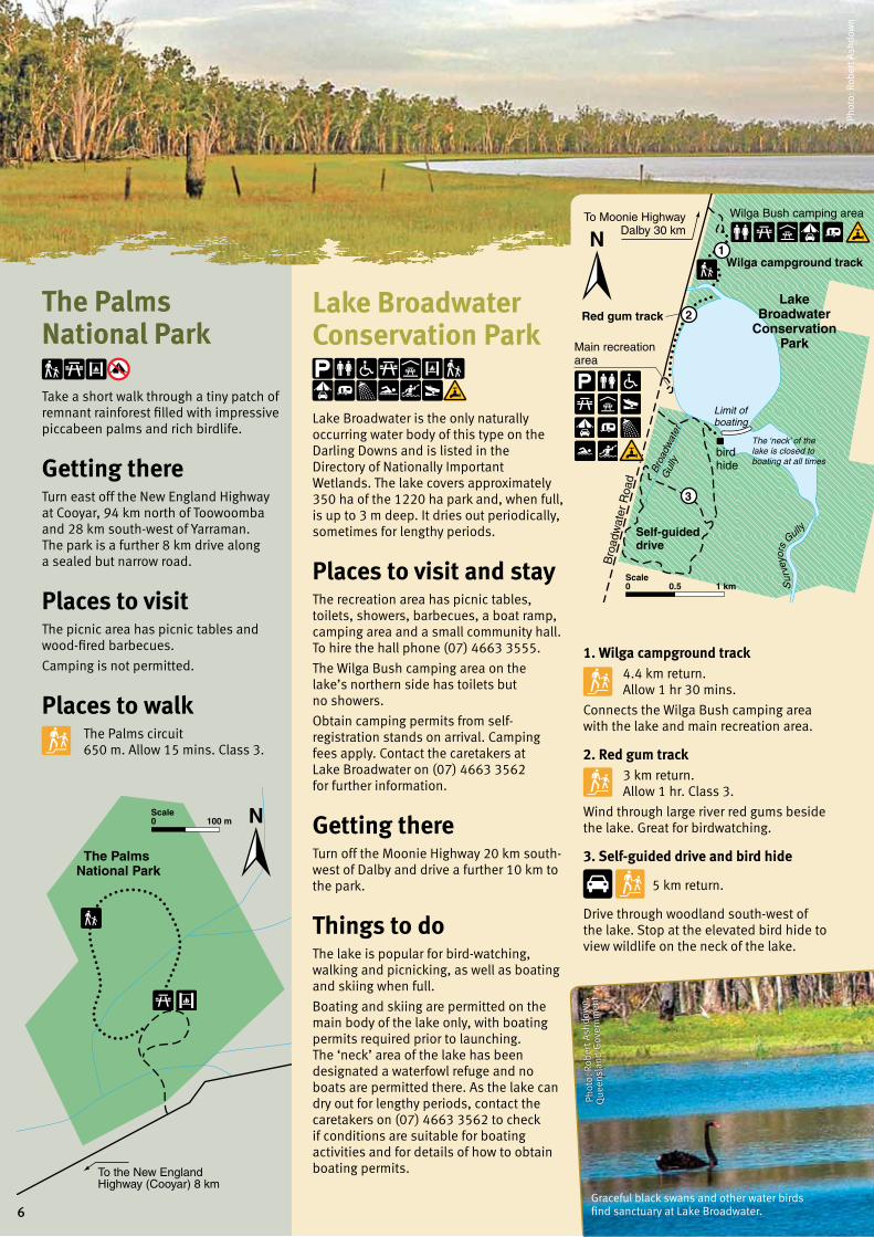
Photo: Michael O’Connor, NPRSR
Wilga Bush camping area
Wilga campground track
To Moonie HighwayDalby 30 km
Red gum trackLake
BroadwaterConservation
ParkMain recreation area
Bro
adw
ater
Roa
d
Bro
adw
ater
G
ully
Self-guided drive
bird hide
The ‘neck’ of the lake is closed to boating at all times
Limit of boating
2
3
1
0.5 1 kmScale0 S
urv
eyor
s
Gully
To the New England Highway (Cooyar) 8 km
100 mScale0
The Palms National Park
Lake Broadwater Conservation Park
Lake Broadwater is the only naturally occurring water body of this type on the Darling Downs and is listed in the Directory of Nationally Important Wetlands. The lake covers approximately 350 ha of the 1220 ha park and, when full, is up to 3 m deep. It dries out periodically, sometimes for lengthy periods.
Places to visit and stay The recreation area has picnic tables, toilets, showers, barbecues, a boat ramp, camping area and a small community hall. To hire the hall phone (07) 4663 3555.
The Wilga Bush camping area on the lake’s northern side has toilets but no showers.
Obtain camping permits from self-registration stands on arrival. Camping fees apply. Contact the caretakers at Lake Broadwater on (07) 4663 3562 for further information.
Getting thereTurn off the Moonie Highway 20 km south-west of Dalby and drive a further 10 km to the park.
Things to doThe lake is popular for bird-watching, walking and picnicking, as well as boating and skiing when full.
Boating and skiing are permitted on the main body of the lake only, with boating permits required prior to launching. The ‘neck’ area of the lake has been designated a waterfowl refuge and no boats are permitted there. As the lake can dry out for lengthy periods, contact the caretakers on (07) 4663 3562 to check if conditions are suitable for boating activities and for details of how to obtain boating permits.
The Palms National Park
Take a short walk through a tiny patch of remnant rainforest filled with impressive piccabeen palms and rich birdlife.
Getting there Turn east off the New England Highway at Cooyar, 94 km north of Toowoomba and 28 km south-west of Yarraman. The park is a further 8 km drive along a sealed but narrow road.
Places to visitThe picnic area has picnic tables and wood-fired barbecues.
Camping is not permitted.
Places to walk The Palms circuit 650 m. Allow 15 mins. Class 3.
1. Wilga campground track 4.4 km return. Allow 1 hr 30 mins.
Connects the Wilga Bush camping area with the lake and main recreation area.
2. Red gum track 3 km return. Allow 1 hr. Class 3.
Wind through large river red gums beside the lake. Great for birdwatching.
3. Self-guided drive and bird hide
5 km return.
Drive through woodland south-west of the lake. Stop at the elevated bird hide to view wildlife on the neck of the lake.
Phot
o: R
ober
t Ash
dow
n
Graceful black swans and other water birds find sanctuary at Lake Broadwater.
Phot
o: R
ober
t Ash
dow
n,
Que
ensl
and
Gov
ernm
ent
6
The Cascades
Kauyoo Pool
Crows Nest Falls
KooninLookout
Crows
Creek
Cressbrook C
kValley ofDiamonds
Picnic area
Camping area
Nest
To Crows Nest 6 km
Pe
rs everance ck
2
1 3
Bottlebrush Pool
200 400 mScale0
Phot
o: Q
ueen
slan
d G
over
nmen
t
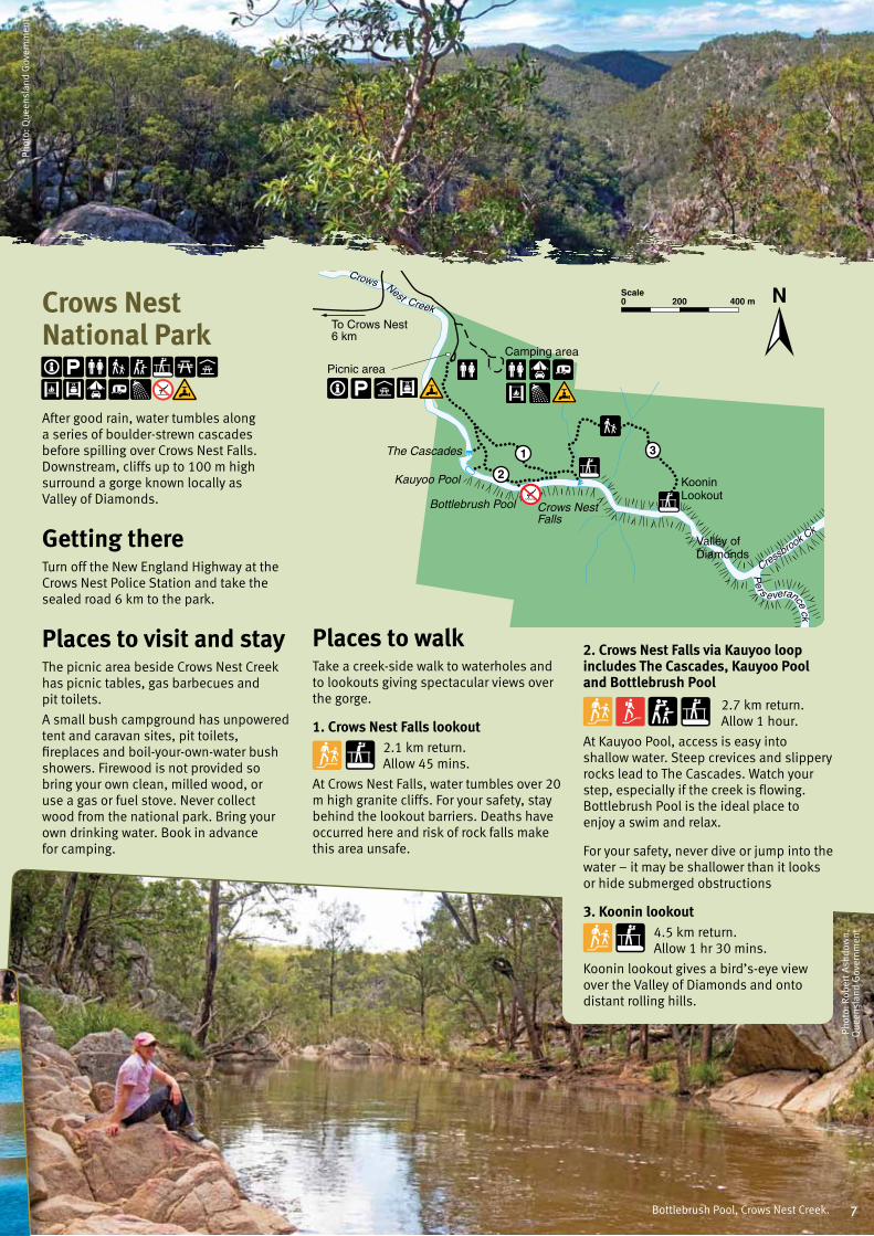
Places to walkTake a creek-side walk to waterholes and to lookouts giving spectacular views over the gorge.
1. Crows Nest Falls lookout2.1 km return. Allow 45 mins.
At Crows Nest Falls, water tumbles over 20 m high granite cliffs. For your safety, stay behind the lookout barriers. Deaths have occurred here and risk of rock falls make this area unsafe.
Crows Nest National Park
After good rain, water tumbles along a series of boulder-strewn cascades before spilling over Crows Nest Falls. Downstream, cliffs up to 100 m high surround a gorge known locally as Valley of Diamonds.
Getting thereTurn off the New England Highway at the Crows Nest Police Station and take the sealed road 6 km to the park.
Places to visit and stayThe picnic area beside Crows Nest Creek has picnic tables, gas barbecues and pit toilets.
A small bush campground has unpowered tent and caravan sites, pit toilets, fireplaces and boil-your-own-water bush showers. Firewood is not provided so bring your own clean, milled wood, or use a gas or fuel stove. Never collect wood from the national park. Bring your own drinking water. Book in advance for camping.
Bottlebrush Pool, Crows Nest Creek.
Phot
o: R
ober
t Ash
dow
n,
Que
ensl
and
Gov
ernm
ent
2. Crows Nest Falls via Kauyoo loop includes The Cascades, Kauyoo Pool and Bottlebrush Pool
2.7 km return. Allow 1 hour.
At Kauyoo Pool, access is easy into shallow water. Steep crevices and slippery rocks lead to The Cascades. Watch your step, especially if the creek is flowing. Bottlebrush Pool is the ideal place to enjoy a swim and relax.
For your safety, never dive or jump into the water – it may be shallower than it looks or hide submerged obstructions
3. Koonin lookout4.5 km return. Allow 1 hr 30 mins.
Koonin lookout gives a bird’s-eye view over the Valley of Diamonds and onto distant rolling hills.
7
×
Buaraba Creek
Palm Creek
Buaraba Creek trackRavensbourne
National Park
Rainforestcircuit
Palm Creekcircuit
To Esk
Cedar Blockday-use area
Blackbeanday-use area Sandstone
overhang
4
1
3
2
Cedar Blockcircuit
Gus Beutel lookout
Toow
oom
baTo
17 M
ile Rd
200 400 mScale0
Phot
o: B
rett
Rob
erts
, Que
ensl
and
Gov
ernm
ent
Photo: Karen Smith, Queensland Government
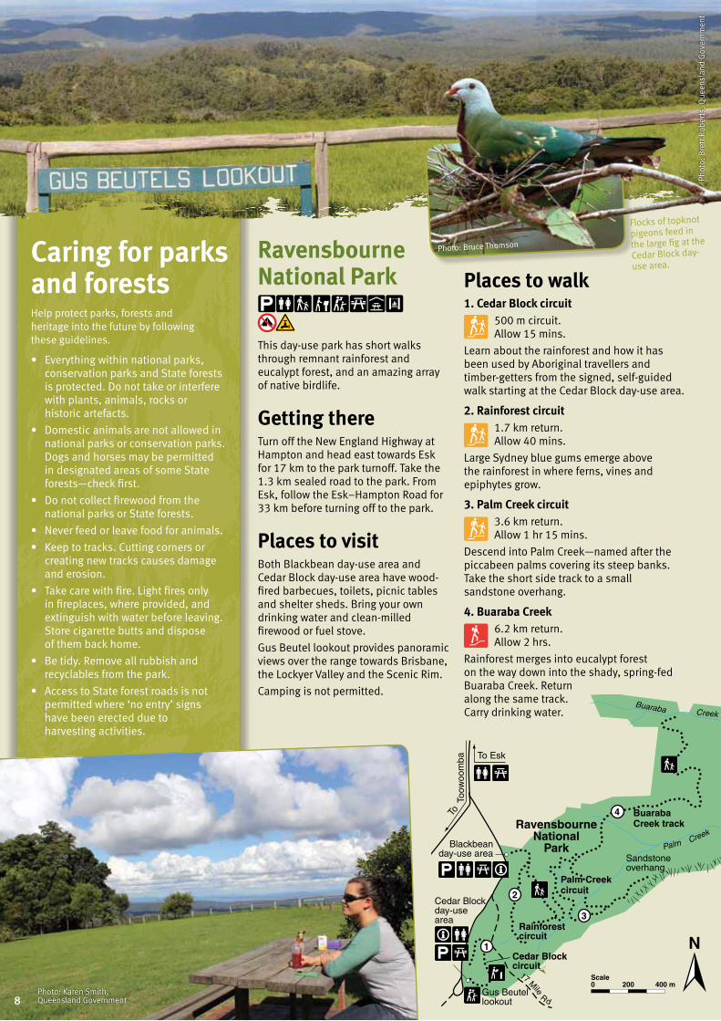
Ravensbourne National Park
This day-use park has short walks through remnant rainforest and eucalypt forest, and an amazing array of native birdlife.
Getting thereTurn off the New England Highway at Hampton and head east towards Esk for 17 km to the park turnoff. Take the 1.3 km sealed road to the park. From Esk, follow the Esk–Hampton Road for 33 km before turning off to the park.
Places to visit Both Blackbean day-use area and Cedar Block day-use area have wood-fired barbecues, toilets, picnic tables and shelter sheds. Bring your own drinking water and clean-milled firewood or fuel stove.
Gus Beutel lookout provides panoramic views over the range towards Brisbane, the Lockyer Valley and the Scenic Rim.
Camping is not permitted.
Places to walk 1. Cedar Block circuit 500 m circuit. Allow 15 mins.
Learn about the rainforest and how it has been used by Aboriginal travellers and timber-getters from the signed, self-guided walk starting at the Cedar Block day-use area.
2. Rainforest circuit 1.7 km return. Allow 40 mins.
Large Sydney blue gums emerge above the rainforest in where ferns, vines and epiphytes grow.
3. Palm Creek circuit 3.6 km return. Allow 1 hr 15 mins.
Descend into Palm Creek—named after the piccabeen palms covering its steep banks. Take the short side track to a small sandstone overhang.
4. Buaraba Creek 6.2 km return. Allow 2 hrs.
Rainforest merges into eucalypt forest on the way down into the shady, spring-fed Buaraba Creek. Return along the same track. Carry drinking water.
Caring for parks and forestsHelp protect parks, forests and heritage into the future by following these guidelines.
• Everythingwithinnationalparks,conservation parks and State forests is protected. Do not take or interfere with plants, animals, rocks or historic artefacts.
• Domesticanimalsarenotallowedinnational parks or conservation parks. Dogs and horses may be permitted in designated areas of some State forests—check first.
• Donotcollectfirewoodfromthenational parks or State forests.
• Neverfeedorleavefoodforanimals.
• Keeptotracks.Cuttingcornersorcreating new tracks causes damage and erosion.
• Takecarewithfire.Lightfiresonlyin fireplaces, where provided, and extinguish with water before leaving. Store cigarette butts and dispose of them back home.
• Betidy.Removeallrubbishandrecyclables from the park.
• AccesstoStateforestroadsisnotpermitted where ‘no entry’ signs have been erected due to harvesting activities.
Flocks of topknot
pigeons feed in
the large fig at the
Cedar Block day-
use area.
Photo: Bruce Thomson
8
Allora
Main RangeNational Park
New England H
wy
Gladfield
Killarney
Queen Mary Falls
NewSouth Wales
Inverramsay Road
Cunningham Highway
Spicers
Gap Rd
Car
ne
y’s C
k R
d
Spring C
re
ek Rd
Goomburra
Spicers Gap
The H
ead R d
To BrisbaneTo Toowoomba
Warwick
Scale0 10 km
Cunninghams Gap
Buaraba Creek
Palm Creek
Buaraba Creek trackRavensbourne
National Park
Rainforestcircuit
Palm Creekcircuit
To Esk
Cedar Blockday-use area
Blackbeanday-use area Sandstone
overhang
4
1
3
2
Cedar Blockcircuit
Gus Beutel lookout
Toow
oom
baTo
17 M
ile Rd
200 400 mScale0
Tracks from Cunninghams Gap1 Box forest track 5 km return 2 hrs
2 Rainforest circuit 1.6 km return 25 mins
3 Gap Creek Falls 9.8 km return 6 hrs
4 Palm Grove circuit 4.4 km return 2 hrs
5 Mount Cordeaux track 6.8 km return 2 hrs 30 mins
6 Bare Rock/Morgans walk 12.4 km return 4 hrs 30 mins
7 Mount Mitchell track 10.2 km return 3 hrs
Tracks around Spicers Gap
8 Pioneer Graves track 260 m return 15 mins
9 Moss’s Well track 120 m return 10 mins
10 Governors Chair lookout 300 m return 15 mins
11 Heritage Trail 3.2 km return 1 hr
12 Mount Mathieson trail 8.1 km return 3 hrs
Goomburra section tracks13 North Branch track 7 km return 3 hrs 30 mins
14 Dalrymple circuit 1.2 km return 30 mins
15 Cascades circuit 6.5 km return 3 hrs
16 Ridge track 5 km return 2 hrs 30 mins
17 Araucaria Falls 3.6 km return 1 hr 30 mins
18 Sylvesters lookout 940 m return 30 min
19 Mount Castle lookout 960 m return 30 mins
20 Winder track 12 km return 4 hrs
Queen Mary Falls tracks
21 Cliff circuit 400 m return 20 mins
22 Queen Mary Falls circuit 2 km return 40 mins
Phot
o: Q
ueen
slan
d G
over
nmen
t
Main Range National Park
Impressive mountain peaks, escarpments and ridges are part of the Gondwana Rainforests of Australia World Heritage Area and offer excellent walking opportunities and breathtaking views.
Getting thereCunninghams Gap is a distinctive landmark on the Cunningham Highway 116 km south-west of Brisbane and 50 km east of Warwick.
Spicers Gap is accessible to conventional vehicles from the east. Turn off the Cunningham Highway 5 km west of Aratula onto Lake Moogerah Road, then right into Spicers Gap Road. The last 5 km is unsealed.
Queen Mary Falls is a popular day trip destination 11 km east of Killarney or 64 km south-west of Boonah on the Killarney–Boonah Road. The scenic and winding road from the east is steep and should be travelled with care. It is not suitable for caravans.
Goomburra is nestled in the western foothills of the Great Dividing Range. Turn off the Cunningham Highway at Gladfield, 25 km west of Cunninghams Gap and follow the signs; or from Warwick or Toowoomba, turn off the New England Highway 3 km south of Allora and head east. The last 6 km is unsealed. After heavy rain, creek crossings may be
flooded or roads to lookouts closed. Check road conditions before visiting.
Places to visit and stayPicnic at Cunninghams Gap, Spicers Gap, Goomburra and Queen Mary Falls. Camp at Goomburra and Spicers Gap. All sites have toilets, but bring your own drinking water and firewood or fuel stove.
Places to walkWalks range from short, easy strolls to long, physically demanding hikes.
Main Range also offers spectacular remote area bushwalking. Only experienced, fit and well-prepared walkers should attempt
Phot
o: R
ober
t Ash
dow
n,
Que
ensl
and
Gov
ernm
ent
Some tracks were damaged during heavy rains in 2013. To check which tracks are open visit www.nprsr.qld.gov.au.
hikes into remote and extremely rugged mountain terrain.
Limited bush campsites are available. Visit www.nprsr.qld.gov.au for details.
9

Dr Roberts Waterhole
Wallangarra
QUEENSLAND
NEWSOUTH WALES
New England Highway
The Pyramid
Girraween National Park Bald Rock
National Park
Bald Rock
Ballandean
TheJunction
Underground Creek
Granite Arch
Turtle Rock
To Stanthorpe 20 km
To Stanthorpe 23 km via Storm King Dam
To Tenterfield17 km
Bald Rock Creek
Mt N
orm
an R
oad
Mount Lindsay H
ighway
Pyra
mids Road
To Tenterfield 18 km
The Sphinx
Mt Norman
Mt Norman day-use area
Castle Rock
Start of Northern walking tracksStart of Southern walking tracksStart of Eastern walking tracks
5 kmScale0
Bald Rock Creek camping area
Granite Arch
Bald Rock Creek day-use area
Castle Rock camping area
Information centre
Wyberba walkBald Rock
Creek circuit
Southern walking tracks (from Pyramids Road)
Castle Rock 5.2 km return 1.5–2 hrs
The Sphinx and Turtle Rock 7.4 km return 3–4 hrs
Mt Norman 11 km return 4–5 hrs
Mt Norman (from the Mt Norman day-use area) 4 km return 1.5–2 hrs
Eastern walking tracks (from Dr Roberts carpark)
Dr Roberts waterhole 1.2 km return 30 min
UndergroundCreek 2.8 km return 1–1.5 hrs
Northern walking tracks (from Bald Rock Creek day-use area)
Wyberba Walk 280 m 15 min
Granite Arch 1.6 km return 30 min
Bald Rock Creek circuit 2.2 km return 1 hr
The Junction 5.2 km return 2 hrs
The Pyramid 3.7 km return 1.5–2 hrs
Phot
o: Q
ueen
slan
d G
over
nmen
t
Firewood is not provided so bring your own clean, milled wood or purchase it locally on the way to Girraween. Caravan sites are not powered and generators are not permitted. This park is popular so book well in advance for holidays and long weekends.
Bush camping is permitted in some remote locations providing permits are obtained in advance. All bush camping is for walking access only.
Places to walk
Girraween National Park
Girraween —meaning ‘place of flowers’—is a landscape of massive granite outcrops, precariously balanced boulders and spectacular wildflower displays in spring.
The park is renowned for its walking and birdwatching opportunities.
Getting thereTurn off the New England Highway 26 km south of Stanthorpe or 11 km north of Wallangarra, then continue east for 9 km to the Girraween visitor information centre.
Places to visit and stayThe Bald Rock Creek day-use area has electric barbecues, picnic tables and toilets.
Two camping areas—Castle Rock and Bald Rock Creek—have hot showers, flushing toilets, picnic tables and fireplaces.
Except where indicated, Girraween’s 17 km of walking tracks start near the visitor information centre or day-use area. Main tracks are well defined but expect rocky sections. Most summit tracks have steep upper slopes. For track details, refer to on-site signs or visit www.nprsr.qld.gov.au.
Visit the Girraween visitor information centre to learn more about the park.
Photo: Robert Ashdown10
The Broadwater
Permanent Waterhole
The HellHole Rats
Castle
DonovansWaterhole
Red RockWaterhole
Nundubbermere Falls
ReedyWaterhole Red Rock
Gorge
Mt Lofty
Mt Donaldson
SundownMine
Beecroft Mine
ChannelWaterhole
Jibbinbar Mountain
To Stanthorpe–Texas Road
Queensland
New South Wales
BurrowsWaterhole
To Ballandean
To Stanthorpe–Texas Road
To Mingoola
Bac
k C
reek
Geo
rge
Cre
ek
Sundown Cre
ek
Stony Creek
Donaldso n Ck
McAllisters Creek
Ooline Creek
Blue
Gorge
Cree k
Mt E
mily
Cre
ek
Re
d R
ock Ck
Severn R
i ver
Sev
er
n Riv
er
2 4 kmScale0
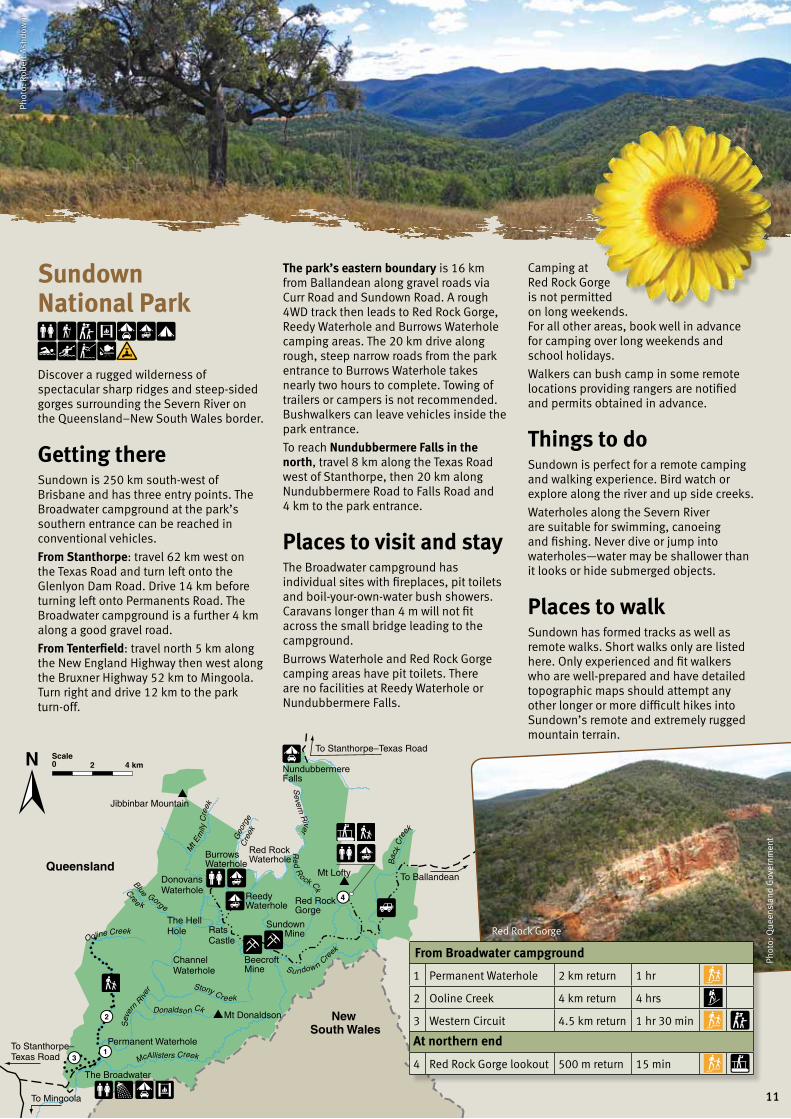
From Broadwater campground
1 Permanent Waterhole 2 km return 1 hr
2 Ooline Creek 4 km return 4 hrs
3 Western Circuit 4.5 km return 1 hr 30 min At northern end
4 Red Rock Gorge lookout 500 m return 15 min
Phot
o: R
ober
t Ash
dow
n
Sundown National Park
Discover a rugged wilderness of spectacular sharp ridges and steep-sided gorges surrounding the Severn River on the Queensland–New South Wales border.
Getting thereSundown is 250 km south-west of Brisbane and has three entry points. The Broadwater campground at the park’s southern entrance can be reached in conventional vehicles.
From Stanthorpe: travel 62 km west on the Texas Road and turn left onto the Glenlyon Dam Road. Drive 14 km before turning left onto Permanents Road. The Broadwater campground is a further 4 km along a good gravel road.
From Tenterfield: travel north 5 km along the New England Highway then west along the Bruxner Highway 52 km to Mingoola. Turn right and drive 12 km to the park turn-off.
The park’s eastern boundary is 16 km from Ballandean along gravel roads via Curr Road and Sundown Road. A rough 4WD track then leads to Red Rock Gorge, Reedy Waterhole and Burrows Waterhole camping areas. The 20 km drive along rough, steep narrow roads from the park entrance to Burrows Waterhole takes nearly two hours to complete. Towing of trailers or campers is not recommended. Bushwalkers can leave vehicles inside the park entrance.
To reach Nundubbermere Falls in the north, travel 8 km along the Texas Road west of Stanthorpe, then 20 km along Nundubbermere Road to Falls Road and 4 km to the park entrance.
Places to visit and stayThe Broadwater campground has individual sites with fireplaces, pit toilets and boil-your-own-water bush showers. Caravans longer than 4 m will not fit across the small bridge leading to the campground.
Burrows Waterhole and Red Rock Gorge camping areas have pit toilets. There are no facilities at Reedy Waterhole or Nundubbermere Falls.
Camping at Red Rock Gorge is not permitted on long weekends. For all other areas, book well in advance for camping over long weekends and school holidays.
Walkers can bush camp in some remote locations providing rangers are notified and permits obtained in advance.
Things to doSundown is perfect for a remote camping and walking experience. Bird watch or explore along the river and up side creeks.
Waterholes along the Severn River are suitable for swimming, canoeing and fishing. Never dive or jump into waterholes—water may be shallower than it looks or hide submerged objects.
Places to walkSundown has formed tracks as well as remote walks. Short walks only are listed here. Only experienced and fit walkers who are well-prepared and have detailed topographic maps should attempt any other longer or more difficult hikes into Sundown’s remote and extremely rugged mountain terrain.
Phot
o: Q
ueen
slan
d G
over
nmen
t
Red Rock Gorge
11
© State of Queensland. BP1863 May 2013. Queensland Parks and Wildlife Service, Department of National Parks, Recreation, Sport and Racing. Printed on eco-friendly paper to save energy and resources.
In an emergency call Triple Zero 000
• IfyoucannotreachTripleZero(000)fromaGSMmobile, try 112.
• Ifdeaforspeechorhearingimpaired,call106usinga text phone.
• Advisethelocationandnatureoftheemergency.
• Stayonthephoneuntiladvisedtohangup.
All information provided in this guide is correct at the time of printing. Check for park alerts and closures online at www.nprsr.qld.gov.au/parks or at the nearest accredited visitor information centre.
Front cover photo: The Sphinx, Girraween National Park. Darren Jew, Queensland Government
Back cover photo: Castle Rock camping area, Girraween National Park. Karen Smith, Queensland Government
Mobile phone coverage is limited or non-existent in most park or forest areas.
Before camping overnight in a park or forest, you must obtain a camping permit and pay your camping fees. People who camp without a permit can be fined.
Book and pay for your permit before you arrive. School and public holidays can be very busy so book several months ahead.
To obtain camping permits or camping credits*:
• visitwww.qld.gov.au/camping• phone13QGOV(137468).Mobile
phone charges may apply.
A booking number will be issued which is to be prominently displayed on your camping structure.
*Camping credits are a convenient way for campers to pay for camping without providing credit card or personal details every time a booking is made. Customers with credits must still have a valid camping permit before setting up camp.
Overnight stays and camping
Further informationVisit www.nprsr.qld.gov.au.
Go to ‘Park alerts’ for the latest information on access, closures and conditions.
Or phone 13 QGOV (13 74 68) . Mobile phone charges may apply.
For information on road conditions visit www.131940.qld.gov.au or phone 13 19 40.
Other contactsPolice • Toowoombaarea(07)46316333
• Dalbyarea(07)46699222
• Warwickarea(07)46604444
RACQ roadside assistance 13 11 11
Staying safeYour safety is our concern but your responsibility. Be aware of potential dangers and follow these guidelines to keep yourself and others safe.
• Supervisechildrenclosely.
• Takecareatcliffedges.
• Neverdiveorjumpintowater.Itmaybe shallower than it looks or hide submerged objects.
• Obeywarningandadvisorysignsandpark closure notices.
• Tracks,rocksandcreekcrossingscanbe slippery, especially after rain.
• Carrydrinkingwater,afirst-aidkitandinsect repellent.
• Wearsturdyfootwearandchoosetracksappropriate to your fitness level and time available.
• Neverwalkaloneandstayonthetracksunless you are a very experienced and well-equipped bushwalker.
• Plantocompletewalksordriveswellbefore dark.
• Drivecarefully—obeyspeedlimitsandroad rules. Roads may be unsealed with loose gravel, sharp curves, narrow sections and steep grades.
• Watchoutfortheunexpected.Slowdown to allow time to react to changed road conditions, wildlife, other park users and logging trucks (in or near State forests).
• Tellfriendsorfamilywhereyouaregoing and when you expect to return. If your plans change, let them know.
Phot
o: K
aren
Sm
ith,
Que
ensl
and
Gov
ernm
ent