south of the m4 strategic development location
TRANSCRIPT

South of the M4 Strategic Development Location Supplementary Planning Document
Adopted October 2011
3

ii
South of M4: Development Brief SPD
Our approved Core Strategy (Local Plan) sets out the broad vision for how the Borough of Wokingham will develop in the period to 2026 and how the Council aims to protect and enhance the very good quality of life enjoyed in the Borough. The adoption of our SPDs further secures our control over development over that period.
The Core Strategy is a vitally important document that sets out the local policies we need to ensure the provision of the new roads we will drive on, the new homes we will live in, the new schools our children will go to, the new parks they will play in, the new shops and doctors’ surgeries we will visit – in short, the way our communities will look across the Borough. It takes forward the views of the community for high quality development concentrated in a few locations with all necessary infrastructure delivered.
Foreword
The Core Strategy identifies four Strategic Development Locations (SDLs). These are Arborfield Garrison, South of the M4, North and South Wokingham. Separate design briefs called Supplementary Planning Documents (SPD) have been produced for each SDL along with an overarching Infrastructure Delivery SPD which covers all of the SDLs (5 SPDs in all).
These documents have been subject of extensive public consultation which is summarised in the statement of consultation. Even the most recent consultation has produced more comments and suggestions which has proved valuable to further improving the documents. With the Supplementary Planning Documents in place we can promote the best possible standards of development and have more and stronger reasons to reject inappropriate aspects of any proposal.
I would personally like to thank the Council Officers, the many members of the community and others who have put so much effort in these documents. I also thank my predecessor Councillor Gary Cowan for his considerable input to the formulation of these documents.
The Infrastructure Delivery & Contributions SPD has evolved from work undertaken in preparing the Core Strategy. It is aimed at delivering a viable infrastructure rich solution to support the new developments and this was set out and endorsed in the Core Strategy through policies and Appendix 7. The key message is that I expect that the identified high level of new infrastructure be provided with the highest possible design quality.
“

iii
October 2011
I appreciate that many people did not want further development at all, but I have been encouraged that residents now recognise that if we show we need further development then it must be of the very highest standard. We do live in what is still a high growth area for our nation’s economy and this brings with it inevitable housing needs. I challenge the developers to not only meet but exceed our current design standards.
Where possible we need to integrate developments with existing communities and ensure that they are in keeping with the area in which they will be located. I will expect developers to give particularly careful attention to this. Provision of community hubs within the new areas will help ‘kick-start’ the sense of community with the benefits that can bring to all. Work continues on further refining those requirements, e.g. by applying improved and updated traffic modelling results.
These SPDs and policies both in the adopted Core Strategy and in the emerging Managing Development Delivery Development Plan Document will provide the framework for developers to continue working with the Council as Planning Authority prior to the submission of any planning applications. Work continues to refine the requirements, such as on roads where recent updated traffic modelling work can inform detailed design and ensure the development does not adversely affect the local highway network. Ensuring any existing flood risks are not made worse is another vital area of continuing work. Any applications will be tested against all policies and guidance and guidance and those found wanting will be refused or re-negotiated in order to find the best possible solution.
In summary, this guidance aims at enabling infrastructure rich, high quality design solutions for our SDLs which we can be proud of when completed.
Councillor Angus Ross
Executive Member for Strategic Highways and Planning
Wokingham Borough Council
October 2011
”

iv
Section 1:In
trod
uctio
n
South of M4: Development Brief SPD
ContentsSection 1: Introduction 1
1.1 Background 1
1.2 The Purpose of this Document 2
1.3 The Role of the SPD: Establishing Good Design and Delivery
6
Section 2: Site Context 9
2.1 Location 9
2.2 Constraints and opportunities 10
2.3 Planning Policy Framework 12
A Supportive Development Plan 12
Planning guidance 14
2.4 Community Engagement 15
Stakeholder Workshop 15
Community Workshop 1 15
Community Workshop 2 16
Options Exhibition 17
Statutory Consultation 1 18
Wokingham Community Hubs Consultation
21
Statutory Consultation 2 21
SA/SEA 24
Statutory Consultation 3 25
Section 5: Climate change and sustainability
75
5.1 Introduction 75
5.2 SDL-wide Sustainable Urban Design 75
Land use and travel 75
Layout and orientation 76
Surface water 76
Section 6: Delivery 77
6.1 Outline planning applications 77
6.2 Ensuring Design Excellence 79
Design and Access Statements, parameter plans and illustrative master plans
80
Design Review 81
Building for Life Assessment 81
Design Codes 81
6.3 Conditions and Planning Obligations 82
Planning Conditions 82
Planning Obligations 83
Delivery & Contributions 83
6.4 Strategic Phasing 84
Sequence of Phasing 84
6.5 Management and Maintenance 85
Highways drainage & open space 85
Community Infrastructure 86
Delivery Board 86
Section 3: Vision and Development Concept 28
3.1 Vision for South of the M4 and development concept
28
Retaining Distinctive Villages 28
Maintaining the Rural Character 29
Promoting Sustainability 30
Building in Sustainability 31
Designing for Healthy and Vibrant Communities
32
Development components for the Master Plan
33
Section 4: Key design principles 36
1. Landscape Framework 37
2. Village Expansion Areas 46
3. Character 53
4. Centres & Primary Schools 63
5. Access & Movement Framework 67
6. Phasing 73

1
October 2011
Section 1:In
trod
uctio
nSection 1:Introduction
South of the M4 SDL is a major opportunity to deliver infrastructure rich and high quality extensions to Shinfield, Spencers Wood and Three Mile Cross. The location is identified in the Wokingham Borough Core Strategy as being capable of accommodating around 2,500 new dwellings with associated transport, green and community infrastructure. The development has the potential to create a series of well connected extensions to the three villages along with enhanced services and extensive public open space.
1.1 Background
1.1.1 Regard has also been taken to the planned revocation of the Regional Spatial Strategy (The South East Plan) by the Secretary of State in July 2010. Notwithstanding the planned revocation, the Council continues to regard the approach set out in the adopted Core Strategy as robust.
1.1.2 The identification of four Strategic Development Locations (SDLs) within Wokingham Borough represents a major and unprecedented opportunity to plan for new development in a comprehensive manner, to ensure that the development of new homes goes hand in hand with the provision of essential physical and community infrastructure. The objective is not simply to meet housing targets, but to plan for the long-term delivery of sustainable urban communities, and to avoid the need for piecemeal small-scale housing development which may harm the character of well-established communities. The four SDLs are:
• Arborfield Garrison;
• South of the M4 Motorway;
• South Wokingham; and
• North Wokingham.

2
Section 1:In
trod
uctio
n
South of M4: Development Brief SPD
1.1.3 Each SDL is the subject of a separate Supplementary Planning Document (SPD) and an overarching Infrastructure Delivery and Contributions SPD for the SDLs, which sets out how and when infrastructure is to be provided and the mechanisms for securing this.
1.1.4 The South of the M4 SDL is concentrated on the villages of Shinfield, Spencers Wood and Three Mile Cross, south of the M4 near to Junction 11 and between the A33 and A327.
1.2 The Purpose of this Document
1.2.1 This SPD has been produced by WBC as a guide for future development of the SDL and to establish the Borough Council’s expectations about the masterplanning and design quality that will be forthcoming in future planning applications and subsequent approved development.. It does not contain detailed proposals for the SDL but, once adopted, will be a material consideration in determining the appropriateness of planning applications and in moving forward through implementation. The document has been prepared on the assumption that applications accompanied by a single co-ordinating Masterplan and SDL-wide Infrastructure Delivery Plan will be submitted followed by Reserved Matters applications as appropriate.
For the avoidance of doubt, any standards or requirements set out in this document will also apply to submission of Full applications.
1.2.2 The SPD relates to the area of land identified in red on Figure 2.1. The SPD does not include new policies for the SDL but builds on the adopted Core Strategy (CS), in particular Policy CP19 and the South of the M4 Concept Statement contained in Appendix 7. It should be read in conjunction with the CS, including the Wokingham Local Plan saved policies, the emerging Managing Development Delivery Development Plan Document and the Infrastructure Delivery and Contributions SPD for the SDLs, as well as with other relevant planning documents.
3
October 2011
Section 1:In
trod
uctio
n
1.2.3 The SPD has been prepared in accordance with the provisions of the Town and Country Planning (Local Development) (England) Regulations 2004 (as amended).
1.2.4 The SPD has been prepared through a process involving the public, stakeholders, representatives from public sector agencies, the current development consortium, landowners, Officers and Members of the Council. It aims to balance the aspirations and objectives of all of these groups with acknowledged best practice principles for the design and development of sustainable, high quality places.
1.2.5 Extensive up-front consultation has taken place and views have been taken into account in the formulation of this document as summarised in Section 2 and set out in a separate Statement of Community Views (SCV). This SPD reflects input from the third statutory consultation stage conducted in June and July 2011. A number of changes to the text and the illustrations have been required.
Consultation stages
February – March 2010 – First statutory consultation.
October 2010 – Adoption of North and South Wokingham SPDs and adoption of Infrastructure Delivery and Contributions SPD.
November – December 2010 – Second statutory consultation of South of the M4 SPD.
June – July 2011 – third statutory consultation of the South of M4 SPD and second statutory consultation of the Arborfield, North Wokingham and South Wokingham SPDs and the Infrastructure Contributions and Delivery SPD.

4
Section 1:In
trod
uctio
n
South of M4: Development Brief SPD
1.2.6 The SPD is accompanied by a Sustainability Appraisal/Strategic Environmental Assessment (SA/SEA), which has also been subject to consultation. The guidance from both the European Commission and the Government indicates how local authorities can comply with the requirements of Directive 2001/42/EC and the subsequent “Environmental Assessment of Plans and Programmes Regulations 2004” (the SEA Regulations) which amplify its operation within England. Under the SEA Regulations, local authorities must, where appropriate, carry out a SEA of land-use and spatial plans. Regulation 5(2) of the Regulations describes that an environmental assessment should be undertaken for a plan or programme which:
(a) is prepared for agriculture, forestry, fisheries, energy, industry, transport, waste management, water management,
telecommunications, tourism, town and country planning or land use; and
(b) sets the framework for future development consent of projects listed in Annex I or II to Council Directive 85/337/EEC on the assessment of the effects of certain public and private projects on the environment, as amended by Council Directive 97/11/EC.
1.2.7 The SPD falls under criterion (a) of Regulation 5(2), being a plan prepared for town and country planning or land use. In respect of sub-paragraph (b) the SPD will amplify policy within the Adopted Core Strategy, providing further guidance on the requirements in respect of a spatial framework plan which should form the starting point for master planning the SDL.
1.2.8 Wokingham Borough Council considered whether the SPDs were likely to require an SA/SEA as the SPDs are required in the form of development briefs by the Core Strategy and will set the framework for the future development consent of EIA projects. Taking account of its conclusion that an SEA was required for the SPDs, the Council has produced a SA/SEA, which details the likely significant effects on the environment of implementing the SPDs and the reasonable alternatives considered, taking into account the objectives of the SPDs. It is important to stress that the final statutory consultation was based on new SPDs, rather than revised SPDs, in order that the SPDs could be assessed in the context of the SA/SEA exercise, and alternative options for the SPD given due regard under the provisions of the SA/SEA. The June – July 2011 consultation SPD presents the preferred option following the SA/SEA exercise.

5
October 2011
Section 1:In
trod
uctio
n
1.2.9 The Habitats Regulations Assessment (HRA) tests the likely impacts of a proposal on nature conservation sites of international importance. These internationally important sites include Special Areas of Conservation (SAC) and Special Protection Areas (SPA), which are often referred to as Natura 2000 sites. HRA assesses the possible effects of a plan’s policies on the integrity of the Natura 2000 sites including possible effects in combination with other plan projects and programmes.
1.2.10 In matters of biodiversity protection, flood risk management, sustainable surface water drainage and wider environmental sustainability the EA is supportive of the SPD approach. Consultation with the Environment Agency (EA) is part of an ongoing partnership approach to assessing and managing flood risk within the Borough. The EA worked with the Borough on the 2007 Strategic
Flood Risk Assessment, and is working in 2011 to update that as part of an ongoing monitoring exercise. The principles upon which the assessment and management of flood risk are based are set out in Planning Policy Statement 25: Development and Flood Risk (PPS25). In accordance with PPS25, the 2007 risk assessment informed the CS. The EA is content that ongoing partnership work, including further detailed assessments by the landowner/applicant, will inform planning decisions and lead to acceptable solutions. The SPDs will be monitored in light of this ongoing work, in accordance with Appendix 5 of the CS. The EA accept the principle of revision following adoption of the SPD.
1.2.11 Regard will also be had to the Equality Act 2010 by Wokingham Borough Council in delivering the SDLs.

6
Section 1:In
trod
uctio
n
South of M4: Development Brief SPD
1.3 The Role of the SPD: Establishing Good Design and Delivery
1.3.1 This SPD sets out the minimum design standards which should be achieved to deliver the new development. Developers will be encouraged to exceed these standards where possible and will be expected to apply new standards that arise during the life of the document.
1.3.2 The guidance given here reflects up to date best practice and the general principles can be used to inform all new development in Wokingham.
1.3.3 The key elements of the SPD are:
• a preferred spatial framework plan which should form the applicant’s starting point for masterplanning the SDL;
• design principles aimed at delivering a high quality scheme;
• requirements for addressing sustainable design;
• requirements relating to the scheme’s delivery; and
• requirements which should be met at the Outline planning application stage and beyond to ensure adequate and consistent approaches to quality and delivery.
1.3.4 The SPD should be read in conjunction with other Government policy documents relating to large-scale development, sustainability, and design, in particular:
• Planning Policy Statement (PPS) 1 including Planning and Climate Change Supplement;
• Planning Policy Statement (PPS) 3;
• Planning Policy Statement (PPS) 5;
• Planning Policy Statement (PPS) 25;
• By Design (DETR);
• The Urban Design Compendium (editions 1 & 2) (Homes and Communities Agency);
• Places Streets and Movement: Better Places to Live by Design (CABE);
• The Manual for Streets (DfT); and
• The Manual for Streets 2 (DfT).

7
October 2011
1.3.5 These documents collectively promote a consensus view of good design principles which should lie at the heart of the design of the SDL, comprising:
• Character – somewhere with a sense of place and local distinction;
• Legibility – a place which is easy to understand and navigate;
• Permeability – achieving a form of layout which makes for efficient pedestrian, vehicular movement and public transport provision ensuring places connect with each other;
• An articulated townscape – creating an interesting, contextually responsive townscape utilising building height, scale and massing, all of which should be related to human scale;
• An integrated landscape – a place which responds to its landscape setting and draws green space and infrastructure into the heart of the development;
• Human scale – the arrangement of building forms which are easy for the human eye to read and provide a sense of scale and perspective;
• Secure, natural surveillance – creating places which are properly overlooked and make for effective passive and active policing;
• Detailing, richness and interest – promoting ornamentation, rhythm, consistent vernacular, richness, and intrigue to the built environment;
• Quality within the public realm – promoting routes and spaces which are attractive, safe and uncluttered;
• Continuity and enclosure – promoting the continuity of the street frontage and the definition of public and private space;
• Adaptability, robustness and sustainability – the layout of the SDL and individual buildings should all contribute towards the minimisation of resources from the design stage; and
• Diversity – promoting diversity and choice through a mix of developments and uses, responding to local need.

8
Section 1:In
trod
uctio
n
South of M4: Development Brief SPD
1.3.6 The remainder of this SPD covers the following:
• Location, Context and Policy (Section 2): A summary of the location, characteristics, planning policy framework and consultation events.
• Vision and objectives for South of the M4 (Section 3): A summary of the overall concept and vision for the SDL.
• Key Design Principles (Section 4): An explanation of what will be required in the development proposals in order to meet the key design principles for the SDL.
• Climate change and sustainability (Section 5): The development expectations for the SDL regarding sustainable design and construction.
• Delivery (Section 6): A summary of the expectations for Outline application submissions, conditions and planning obligations, strategic phasing and management and maintenance.
1.3.7 The guidance provided in this SPD is intended as part of an ongoing design process. WBC will require the preparation of design codes and development briefs in advance of Reserved Matters applications in order to build upon the guidance, themes and principles set out in this document. Section 6 contains further advice on how design excellence will be carried through the planning and construction process.
1.3.8 For the avoidance of doubt, areas not shown as having specific designation will be subject to policies contained within the Managing Development Delivery Development Plan Document, scheduled for adoption in December 2012.

9
October 2011
Section 2:S
ite C
on
tex
tSection 2:Site Context
2.1 Location
2.1.1 The South of the M4 SDL is intended as distinct but connected village extensions to Shinfield, Spencers Wood, and Three Mile Cross at land south of Junction 11 of the M4 and between the A33 and A327.
Figure 2.1: Strategic Development Location Boundary
This map is based upon Ordnance Survey Material with the permission of Ordnance Survey on behalf of the Controller of HMSO © Crown Copyright. Unauthorised reproduction infringes Crown Copyright and may lead to prosecution or civil proceedings.
Wokingham Borough Council License No. 100019592 2009. For reference purposes only. No further copies may be made.
0km 1km

10
Section 2:S
ite C
on
tex
t
South of M4: Development Brief SPD
2.2 Constraints and opportunities
2.2.1 Figure 2.2 illustrates the key constraints on the SDL which will affect the planning application masterplan. In summary the key constrains affecting the preparation of the SPD are considered to be:
• There is a ridgeline that runs southwest – northeast across the SDL. This is a prominent feature of the area and as such any development that would occur here would be clearly visible. The impact on the SPD process has been to ensure that careful decisions are made in terms of location and appearance of development around this area. No development is identified on the northern slopes of the ridgeline in the SPD.
north and south of the M4 should be retained.
• The flat Loddon Valley to the east of Shinfield is a functional floodplain. This constrains development in this part of the SDL, but also provides an opportunity for a strategic landscape and leisure corridor.
• The M4 separates the South of the M4 SDL and Reading, and as such, it acts as a barrier to movement with limited crossing points. This adds to congestion and, consequently, the high volumes of through traffic are beginning to have a significant impact on the quality of life in the three settlements. Queuing at key points of the local road network, specifically the A327 and A33, during peak periods delays travel times and increases local air pollution.
• South of the M4 is typified by the rural settlements of Shinfield, Spencers Wood and Three Mile Cross, each with small historic cores, and the existing development at Ryeish Green. New development in this area should be sensitive to its context and reflect an organic settlement growth pattern as well as local building styles. Open space provides physical separation between and distinction of the different settlements.
• In order to retain the character of the existing settlements and wider surrounding landscape it is considered that the existing open space which separates Shinfield, Spencers Wood, Ryeish Green and Three Mile Cross, much of which is in private ownership, should be retained to keep a clear distinction between the settlements. In addition separation between settlements to the

11
October 2011
Section 2:S
ite C
on
tex
t
• There are a number of woodland areas, including an area of ancient woodland at High Copse, trees and hedgerows within the SDL that have a beneficial effect on the landscape and support local ecology. There is a local wildlife reserve at Clares Green. These features would need to be sensitively incorporated into the overall development and landscape strategy.
• There are a number of listed buildings within and immediately adjacent to the SDL. Due regard must be given to these buildings to ensure that their setting is preserved. Any existing views of these buildings from within the built area or from the open countryside must be incorporated into the development layout. Development proposals should be in accordance with Planning Policy Statement 5 Planning for the Historic Environment.
0km 1km
Figure 2.2: Constraints Plan
This map is based upon Ordnance Survey Material with the permission of Ordnance Survey on behalf of the Controller of HMSO © Crown Copyright. Unauthorised reproduction infringes Crown Copyright and may lead to prosecution or civil proceedings.
Wokingham Borough Council License No. 100019592 2009. For reference purposes only. No further copies may be made.
WBC SDL Boundary
Existing Roads
Existing Woodland & Hedgerows
Existing Settlements
Local Plan Allocated & Approved Residential Sites
Flood Risk Zone 3
Flood Risk Zone 2
Existing Water Course
Listed Buildings
Clare’s Green Local Wildlife Site
Ridge Line
Settlement Separation (Core Strategy CP19)

12
Section 2:S
ite C
on
tex
t
South of M4: Development Brief SPD
2.3 Planning Policy Framework
A Supportive Development Plan
2.3.1 Policies CP18 – CP21 of the adopted WCS set out how the majority of housing growth in the Borough will be delivered. Some 10,000 new dwellings are to be delivered through SDLs at: Arborfield Garrison, South of the M4, South Wokingham and North Wokingham.
2.3.2 The Inspector’s Report on the WCS Examination confirms that around 2,500 new dwellings is an appropriate guideline figure for the plan period. This includes 705 dwellings already allocated in the Wokingham District Local Plan and those already consented.
2.3.3 Policy CP4 states that planning permission will not be granted unless appropriate infrastructure is agreed for major development. Policy CP19 sets out key requirements for the development of South of the M4, in summary
• Phased delivery of around 2,500 dwellings, including a minimum of 35% affordable homes in accordance with Policy CP5;
• Appropriate employment;
• Appropriate retail and leisure facilities;
• Social and physical infrastructure (including provision for up to 2 new primary schools and the likely expansion of existing primary provision together with expansion of existing children centre and youth facilities);
• Measures to retain separation of these settlements from each other and from Green Park Business Park (Reading), settlements within the administrative Borough of Reading, Shinfield (North of M4) and Swallowfield;
• Necessary measures to avoid and mitigate the impact of development upon the Thames Basin Heaths Special Protection Area including Suitable Alternative Natural Greenspace;
• Improvements to highway capacity along the A327 (on routes to Reading and the M3, including Shinfield Eastern Relief Road) and the A33 (route to Reading);
• Measures to improve accessibility by non-car transport modes along the A327 and A33 corridors and routes to the stations at Green Park and Winnersh Triangle; and
• Provision of a Park and Ride in the vicinity of Junction 11 of the M4.

13
October 2011
Section 2:S
ite C
on
tex
t
2.3.4 In terms of key infrastructure requirements, the supporting text identifies the need for retail facilities within the SDL including the upgrade of existing centres in Shinfield and Spencers Wood. In addition, there is scope for further employment provision utilising unimplemented floorspace in Shinfield and the expansion of Wellington Industrial Estate in Spencers Wood. Furthermore, Policy CP16 identifies a science park on land adjoining the SDL and proposals for both the science park and SDL should relate well to each other in terms of transport and sustainability.
2.3.5 A Concept Statement for South of the M4 is included as part of the WCS at Appendix 7 and, along with other policies of the WCS, forms the basis for this SPD. The Concept Statement includes a Concept rationale, strategic objectives and key requirements including landscape structure, sustainability, infrastructure, housing land and mix, key design principles and planning obligations. The detail of the concept statement is not repeated in this summary. The strategic objectives and key design principles are elaborated in Section 4 of this SPD. In summary, the objectives for the SDL are:
• New growth focussed on the three villages whilst retaining distinctiveness and a separation between them.
• Development adjoining the existing villages to form expanded settlements which sensitively redefine the urban edges and the transition between town and country.
• Shinfield could be expanded to the west, east and north east and should include new and enhanced local facilities including a new primary school; Three Mile Cross to be expanded to the west and east; and Spencers Wood to be expanded to the north east and the east including a new primary school.
• A new road to be included to the east of Shinfield and connecting over the M4.
• A review of highway capacity and package of green travel measures.
• SANGs located adjoining the River Loddon and north of the ridgeline which connects Shinfield and Spencers Wood, along with land adjoining the Clares Green Local Wildlife Site.

14
Section 2:S
ite C
on
tex
t
South of M4: Development Brief SPD
2.3.6 Policy CP19 of the adopted Core Strategy emphasises the importance of retaining separation between the settlements of Shinfield, Three Mile Cross and Spencers Wood, and from Green Park Business Park (Reading), settlements within the administrative Borough of Reading, Shinfield (North of M4) and Swallowfield, which is illustrated by the Core Strategy’s Key Diagram (Figure 2.3). This commitment reflects the Core Strategy’s Spatial Issues and Spatial Vision together with the adopted Bracknell Forest Core Strategy (policies CS4 and CS9 together with paragraph 123). The need to keep the separation of settlements reflects the study of Gaps and Green Wedges in the Borough which has also found that it is essential to retain them; this reflects the Community Strategy and Audit Report. Ryeish Green is also regarded as worthy of recognition as a separate area of development; the WCS EiP
Inspector recognised the importance of the separation of Ryeish Green from Shinfield in his report. As such the SPD includes measures that retain the separation of these settlements and areas.
2.3.7 The Managing Development Delivery Development Plan Document (DPD) is expected to be adopted during the lifetime of this SPD and will form part of the statutory development plan. The DPD will translate high level policies of the Core Strategy into more detailed development management principles. It will define the development limits within the boundaries of the SDLs and provide further clarification regarding where the development envisaged within each SDL would occur. In defining the development limits the Council will have regard to the guidance in the adopted SDL SPDs.
Planning guidance
2.3.8 There are other SPDs and other Supplementary Planning Guidance produced by WBC which should be read in conjunction with this SPD. These include:
Supplementary Planning Documents
• Infrastructure Delivery and Contributions SPD for Strategic Development Locations 2010.
• Wokingham Borough Design Guide 2007 (currently under review).
• Village Design Statements.
• Sustainable Design and Construction 2010.

15
October 2011
Section 2:S
ite C
on
tex
t
Other relevant documents
• Landscape Character Assessment SPG 2004.
• Highway Design Guide 2004.
• Highway Design Guide Review 2010.
• Design and Access Statements 2006.
• Planning Advice Note 2010.
• Wokingham Borough Strategic Flood Risk Assessment 2007.
• Wokingham Community Hubs Consultation Report June 2010.
• The Wokingham Transport Model 2011
• The Statement of Community Views (SCV)
2.3.9 Other planning guidance is likely to emerge during the lifetime of this document which is likely to be relevant to the determination of planning applications.
2.4 Community Engagement
2.4.1 This SPD has been prepared in consultation with the local community and other stakeholders and potential developers.
2.4.2 Three workshops were held to help inform the initial options phase of the SPD process as follows:
Stakeholder Workshop (14th May 2009 Wokingham Borough Council Offices)
2.4.3 The stakeholder workshop involved a half-day event comprising invited technical stakeholders and the developer consortia from each SDL. It provided an early opportunity for issues and opportunities to be highlighted and key SDL constraints to be discussed.
Community Workshop 1 (20th June 2009 Arborfield Parish Hall)
2.4.4 The workshop was held in conjunction with the consideration of Arborfield Garrison SDL. The morning session involved a discussion of the key issues and a visit to the SDL area. Clear themes emerged from the workshop which can be summarised within broad headings:
• Traffic and Travel; in relation to residential amenity, road capacity and movement choices.
• Community and Social Infrastructure; in relation to open space provision and availability of services for all ages.
• Environment; in terms of environmental quality, such as reduced impacts from flooding and noise.

16
Section 2:S
ite C
on
tex
t
South of M4: Development Brief SPD
• Character; so that new development fits well with the existing context.
• Economy; to preserve and enhance employment opportunities.
• Delivery and Funding; in terms of developing a suitable phasing strategy to ensure adequate infrastructure is put in place in the early stages of development.
2.4.5 The afternoon session involved a site planning exercise in which tiles could be plotted on a map showing locational preferences for development of the SDL. The results of the exercise are recorded in the SCV.
Community Workshop 2 (25th July 2009, WBC Offices, Wokingham)
2.4.6 This workshop provided another opportunity for those unable to attend Workshop 1 to be involved in the process and a further opportunity for the previous attendees to comment and ask questions. Notably, three strategic options were produced and displayed for comment. In addition, views were sought over the character and form of development. Key points included:
• Sustainable travel and design should be included from the outset;
• Good links with Greater Reading public transport network should be established;
• Existing public transport routes should be enhanced rather than establishing new links. New streets should integrate well with the existing settlement street network;
• Despite the impact on the ridgeline, consideration should be given to housing off Church Lane;
• The re-use of Ryeish School site should be considered, if not for education then other community uses; and
• Open space and playing fields should be located within walking distance of existing communities.

17
October 2011
Section 2:S
ite C
on
tex
t
Options Exhibition
2.4.7 Following the workshops, an Exhibition was held to display three strategic options and to seek views on the overall options and the various components of the options. The options were not mutually exclusive; different components from each were taken forward to the preferred option. The main boards were displayed at WBC offices and brochures were deposited at various other venues throughout the Borough. The exhibition and questionnaire were available in electronic form on the Council’s web site. The exhibition ran for six weeks during September and October 2009 and questionnaires and comments were collated, recorded and analysed. The key issues arising from the consultation included:
• Mixed views on the preferred location for residential development with some concern over too much development on land west of Shinfield and including land east of Shinfield, but general support for including land off Church Lane;
• General support for including linked Suitable Alternative Green Space (SANG) between the three settlements;
• Strong support for enhanced public transport services;
• General support for the re-use of Ryeish Green school site for community and recreational uses, but not for residential;
• Concern over lack of a Secondary School within the SDL;
• Mixed views over the character of the proposed Shinfield Eastern Relief Road with some prioritising the road’s capacity and others concerned about the relationship with built development; and
• A clear resistance to establishing a strategic road link between the A33 and A327.
Option 3: Dispersed Growth and East West Road LinkOption 2: West Shinfield FocusOption 1: Balanced Growth of the Three Settlements

18
Section 2:S
ite C
on
tex
t
South of M4: Development Brief SPD
Statutory Consultation 1 (February to March 2010)
2.4.8 As part of an iterative design approach, feedback from the workshops and exhibition event was used by the consultant team to help inform the generation of design solutions – sensitive to views expressed at the community engagement events and balanced with the WCS objectives – for each of the SDLs.
2.4.9 The outcomes of the series of informal consultations were a significant part of the process and were influential in preparation of the draft SPDs which were subject of the statutory consultation which took place between the 9th February and 23rd March 2010. The consultation produced 877 written responses and these are considered in the Statement of Consultation. Very few of the consultation responses
questioned the principle of development, although many were very concerned about the practical implications of this amount of development. In particular they were concerned how the developments and their associated infrastructure would be delivered in accordance with the SPDs and the Core Strategy. Not surprisingly, the majority of responses were concerned with issues of traffic and highway safety but the greater majority of responses also reflected a number of detailed concerns or issues of which the headlines were:
• Loss of open/green land/trees and threats to wildlife. Comments relating to these issues reflect one of the impacts of the choice made in pursuing SDLs as the main delivery mechanism for the growth of Wokingham rather than in a piecemeal manner in the existing urban area. In the case of Arborfield there was
considerable concern that ‘greenfield’ land would be developed before ‘brownfield’ (previously developed) land or that the previously developed land would not be redeveloped at all. This concern was magnified by a perception of uncertainty regarding the Ministry of Defence’s position about their vacation of the site. The SPDs have been created with a view to retaining the best of the established trees and open spaces as well as preserving protected wildlife and their habitats. Additional protection will be afforded by use of Tree Preservation Orders and use of planning conditions;
• Location of proposed housing, community facilities and SANG’s in the SDLs. The draft SPDs were constructed by balancing the professional, technical and stakeholder inputs collated through an ongoing design process and the

19
October 2011
Section 2:S
ite C
on
tex
t
consultation comments. It is considered that the original principles were sound and there has been no need to modify the overall approach chosen;
• Separation of settlements. This was a key concern in the initial preparation of the SPDs themselves and it prompted further consideration of the issue by the Council. This relates to the South of M4 SDL in the main and to a lesser extent to South Wokingham and Arborfield;
• Viability and phasing of infrastructure. There was considerable concern that the developments would proceed without the infrastructure requirements of Appendix 7 of the Adopted Core Strategy being met or being only partially met. Detailed consideration of viability has taken place using external consultants which further supports deliverability as established through the EiP Inspector’s report and
the adopted Core Strategy. Phasing will be critical and this will be an integral consideration to the determination of the subsequent planning applications based upon the consortia’s and developer’s infrastructure delivery plans in due course. These will be agreed as part of submitted planning applications;
• Ability of services and infrastructure (e.g. flood management and education etc) to handle the new development. Detailed consultation was undertaken with the widest possible range of service providers and statutory undertakers as part of the formulation of the SPDs. The requirements identified by them and set out in the Core Strategy are therefore robustly carried forward into subsequent planning applications and associated legal agreements;
• Delivery of high quality development. This is a key concern of the Council and the original suite of documents and plans was put together with this clear objective. The documents have been further tested via a detailed legal checking process and it is considered that they are as robust as possible in the context of the type of document that they are. These matters will be dealt with in more detail through the later planning application processes and will be subject to further consultation and consideration at that time;
• Further development beyond the headline figures for each SDL. The numbers required from the SDLs and the densities to be achieved are set out by the Core Strategy and endorsed by the Inspector at the EiP and developers will be expected to work within the policy framework;

20
Section 2:S
ite C
on
tex
t
South of M4: Development Brief SPD
• Transport issues. The SDLs have been traffic modelled and the outputs show that the SDL package once delivered will achieve a nil detriment scenario in 2026. A more detailed assessment of North Wokingham has confirmed this is the case, based upon the Council’s preferred transport option. Residents wanted specific details of road alignments, routes or junction details. This was particularly the case, for instance in North Wokingham in relation to the Northern Relief Road/Ashridge Interchange issue which has been subject to further modelling as recommended by the EiP Inspector and in Arborfield particularly in relation to the by-pass and Park Lane. To a lesser extent this was also true of the South Wokingham Southern Distributor Road and in the case of this SPD, the Shinfield Eastern Relief Road. There has
also been concern as to the impact of off-site works on minor roads, particularly in respect of how the character of the roads will be protected. A number of specific roads were suggested in representations. These are matters that will be dealt with in more detail through the planning application process and will be subject of further public consultation at that time. Traffic modelling has been completed and ongoing discussions with the Highways Agency and neighbouring authorities will help inform and refine transport solutions; and
• Other matters: A large number of respondents sought details outside of the scope of the SPD. For instance, many wanted clarification of what will happen to Emmbrook Secondary School (North Wokingham) or questioned the logic of closure of Ryeish Green Secondary School
(South of M4). Others wanted specific details of how closure or partial closure of railway crossings (South Wokingham) would work. Others sought details or reassurances of matters that will be dealt with in more detail through the planning application process and will be subject of further public consultation at that time.
2.4.10 A further 80 responses were received after 23 March. These raised no new issues which had not already been addressed via those received before that date. All responses were summarised and now form a background paper to the Statement of Consultation.

21
October 2011
Section 2:S
ite C
on
tex
t
Wokingham Community Hubs Consultation (17th June – 19th June 2010)
2.4.11 Three workshops were held separately to help gain a better understanding of the spatial needs of each local group to explore the size and requirements for new faith facilities and community centres. These included statutory consultees (session 1), local stakeholders North Wokingham, South Wokingham and Arbofield (session 2) and South of the M4 (session 3). All the events took place at the Finchampstead. The key conclusions that could be drawn from the three workshops include:
• The role of centres in helping to foster stronger ties within and between different communities. As such an approach that considers the whole area should be used when considering the location of new facilities.
• Benefits to users from collocating different community uses and the synergies gained from locating next to a school.
• The importance of reflecting the needs of all users when locating different facilities.
• Exploring alternative methods for managing and controlling open spaces and playing fields through for example, community trusts.
• Reusing and revitalising underused buildings as part of establishing a new community.
• Bringing green infrastructure into new public spaces and for public buildings to take a lead role in promoting sustainable design.
• Centres and local facilities should be collocated thoughtfully with sustainable modes of transport and opportunities for walking and cycling.
Statutory Consultation 2 (November & December 2010)
2.4.12 Revisions to the draft South of M4 SDL SPD were prepared throughout the summer and autumn of 2010. These revisions sought to respond to concerns expressed by local residents and stakeholders about the scale of the settlement separation between Shinfield and Spencers Wood taking into account the presence of development and former school site at Ryeish Green, and the avoidance of coalescence between settlements. The revised draft SPD (October 2010) is best distinguished by the notable amendment to Figure 3.1, which introduced a requirement for an increase in the distance between Spencers Wood and Shinfield, and a reconsideration of a suitable alternative way to grow Shinfield in order to accommodate the level of development required. In the revised draft

22
Section 2:S
ite C
on
tex
t
South of M4: Development Brief SPD
SPD, Figure 3.1 seeks growth of Shinfield in a westerly and easterly direction, with the Shinfield Eastern Relief Road marking the limit of development in the east. Consequently, the scale of Area C to the west of Shinfield was reduced, and the scale of Area D to the east of Shinfield increased to show development to the south of Cutbush Lane.
2.4.13 Further statutory consultation took place between 9th November 2010 and 21st December 2010. A total of 143 consultation responses were received. Consultation responses again did not dwell on the principle of development, but focused on a number of concerns about the design, development and delivery of the SDL and associated infrastructure. The key issues raised were:
• Relocated housing sites: Concerns were expressed about the suitability of Area D for development, in particular the impacts on Cutbush Lane resulting from the need to access Area D, the impact of noise on local residents from the Shinfield Eastern Relief Road; the suitability of this area for housing given the proximity of land which floods; continued access for walkers to land to the east of Shinfield; and wildlife protection. The Council will require the applicants to address all matters of access and flood risk alleviation through their Outline and Reserved Matters applications. Statutory requirements in relation to noise and flood risk will have to be followed. Concern was also expressed about the exclusion of land to the north-west at Church Lane; this was excluded because it lies to the north of the ridgeline, which is not considered appropriate in the adopted Core Strategy.
• Separation of Settlements: Comments made reference to the urbanisation of the green space between Spencers Wood and Shinfield resulting from the proposed use of the space for playing fields, and the excessive encroachment of development, resulting in a lack of “openness”. Concerns were also expressed about the ability to retain the open green space in perpetuity, and there was concern that the space between Spencers Wood and Shinfield should be identified as SANG to ensure its ongoing protection. The Council is seeking to balance a number of factors in its approach to the SDL, including the clear separation of settlements and the accommodation of new housing for the Borough. It has a number of powers which can be used to protect open space, and it must be understood that designation of land as

23
October 2011
Section 2:S
ite C
on
tex
t
SANG does not represent a permanent guarantee that SANG cannot be relocated at a future date.
• Traffic and Transport: Doubt about the ability to resolve traffic issues, for example on the A327, by the development of the Shinfield Eastern Relief Road was expressed. These matters have been addressed in the adopted Core Strategy and are further dealt with in the Infrastructure Contributions and Delivery SPD. The principle of nil-detriment will be applied, requiring applicants to demonstrate that their proposals will not worsen the existing traffic issues. Concerns were also expressed about the impact of the proposed bus link between Spencers Wood and Shinfield on the open green space. The Council is working with applicants to establish the requirements for sustainable travel within
the SDL and beyond. Additional concerns were expressed about the feasibility of the public transport proposals; the Council is committed to working closely with adjoining authorities to promote development which is supported by public transport.
• Housing Numbers and Details: Comments about a perceived increase in housing numbers above 2,500 were addressed through a revised version of Figure 3.1 which corrects errors in the accompanying housing numbers for Area C. The Council confirms that the Core Strategy requires a total of around 2,500 new dwellings up to 2026, 705 of which have already been permitted or allocated. Questions were raised about the level of affordable housing required; the adopted Core Strategy CP5 sets a requirement for a minimum 35% of all homes within the SDLs to be affordable.
• Community Infrastructure and Local Jobs: Questions were raised about the proposed neighbourhood centres and possible adverse impact on the existing centre focused on school green; the Council acknowledges the importance of the centre and confirms that the new centre west of Shinfield should seek to reinforce the existing village centre and reduce the need for all local residents to travel to shops further afield. Queries were made about school provision, in particular about the closure of Ryeish Green; this is an issue which has been addressed by the Education Authority. The SDL will reinforce local primary provision to ensure places are available locally for children living in the existing and new homes. Comments were raised about the need to link new homes to jobs; the Council has recently granted

24
Section 2:S
ite C
on
tex
t
South of M4: Development Brief SPD
consent for the development of a science park to the north-east of Shinfield; in its entirety, South of M4 will become a place where people can choose to live, work, shop and go to school in very close proximity, and can use alternatives to the car to get around.
• Ecology and Existing Vegetation: A range of comments were made about the importance of retaining existing habitats and landscape features. The SPD requires all of these matters to be addressed by applicants, principally through the preparation and submission of Environmental Impact Assessments.
• Quality of Design: Comments were made about the need to observe the existing village character, the need to reduce impact on existing homes, the need to reduce average housing densities to below 30 – 35 dwellings per hectare, and the importance of ensuring no impact on listed buildings. The SPD focuses on the quality of new development, and sets a clear agenda of items which applicants must address in their plans, both at the Outline and reserved matters stages. Density requirements are set by the adopted Core Strategy. Transition areas have been identified where extra consideration is to be given to the relationship between new and existing homes to ensure sensitive integration.
SA/SEA
2.4.14 The SA/SEA considered alternative options for the SDL, including an assessment of the short, medium and long term impact. The preferred option that was subsequently subject to statutory consultation and is contained in this new SPD was found to be the most sustainable solution within the context of the Core Strategy.

25
October 2011
Section 2:S
ite C
on
tex
t
Statutory Consultation 3 (June & July 2011)
2.4.15 The consultation on the South of the M4 Draft Strategic Development Location Supplementary Planning Document published for consultation in June 2011 generated a total of 108 written responses. As is the case with all SDL SPD responses, comments fell generally into three overarching categories: those relating to matters contained in the CS; those relating to the content of the SPDs; and those addressing implementation matters, which will come to the fore as the process of ongoing design, planning and management of the SDL progresses. Very few of the consultation responses questioned the principle of the development; although many were very concerned about the practical implications of this amount of development. The key concerns are described below:
• Settlement Separation – One of the most common concerns raised (particularly from local residents) relates to the separation of the settlements between Shinfield, Three Mile Cross and Spencers Wood. The SPD introduces a 500 metre separation zone between Spencers Wood and Shinfield to prevent coalescence of the villages, which has been well received by the majority of local residents who responded. It is suggested that the land should be owned and maintained by either Wokingham Borough Council or Shinfield Parish Council to ensure that no development can encroach the area, and that it is retained in perpetuity as green open space.
• Loss of open/green space and threats to wildlife – The impact on the wildlife and environment in the SDL is another priority raised by local residents. The SPDs have been created with a view to retaining the best of the established trees and open spaces as well as preserving protected wildlife and their habitats. Additional protection can be afforded by use of Tree Preservation Orders and the use of planning conditions.
• SANG – There was an overwhelming response that the large area of open countryside separating the settlements should be protected from ‘infill’ development in the future either as SANG or through another appropriate mechanism. It should be noted that Natural England agreed with the location

26
Section 2:S
ite C
on
tex
t
South of M4: Development Brief SPD
of the SANG consulted upon, whilst Core Strategy policies pertaining to settlement separation in CP 18 – 21 apply to this area to ensure protection.
• Lack of Services and Infrastructure – The majority of respondents are concerned that not enough infrastructure provision (road improvements, schools, sports and community facilities etc.) has been incorporated into the SPD to cater for the scale of development proposed. However, the adopted Wokingham Core Strategy has identified the SDLs as being capable of accommodating new homes supported by infrastructure in Policies CP4 and CP18 – CP21 and supporting information in Appendix 7. Many of the responses highlight capacity issues relating to existing local primary and secondary schools and the subsequent need to provide new schools at an early stage of the
development to accommodate increased demand. Overarching Infrastructure Delivery Plans, to include an appropriate phasing strategy will be required. Other issues were raised that sought details outside of the scope of the SPD such as clarification regarding the future of the Ryeish Green former school site.
• Flooding – A range of comments were raised about flooding and the importance of mitigating flood risks. Flooding is seen as an important implementation issue. The SPD requires flood risk issues to be dealt with through a flood risk assessment and comprehensive water management plans as part of future planning applications. The area experiences some flooding, although areas shown for development in the Preferred Spatial Framework Plan do not co-inside with know flood areas. The
Eastern Relief Road, which is identified in the CS as essential infrastructure, will affect functional floodplain and as such guidance in PPS25 must be applied in relation to managing flood risk in this area. The Environmental Agency will continue to be engaged in discussions about water management.
• Transport Issues – The timely provision of new highway infrastructure was also raised as a key issue. There is widespread feeling that further resolution of highways issues must be achieved, based on a firm evidence base. The transport model has been completed by the Council and this will inform design for highways as plans progress.

27
October 2011
Section 2:S
ite C
on
tex
t
• Introducing a new Public Transport Corridor – Doubt about the proposed public transport corridor across the proposed settlement separation was expressed because of the detrimental impact it would have on the landscape and visual amenity of the area and its likely creation of a barrier for users of the public open space. The Council retain a requirement for a sustainable travel route, which should include provision for walking and cycling, and may permit buses if the case for a public transport link in this location can be adequately demonstrated.
2.4.15 All responses have been summarised and are referred to within the Statement of Consultation.
2.4.16 The four Strategic Development Location SPDs and the Infrastructure Delivery & Contributions SPD have been amended to reflect output from the statutory consultation. A number of new changes to the text have been required both in order to amend or to clarify issues or to correct facts. The text has also been amended in order to reflect changes to the SPDs or to graphics embodied within the documents. Where appropriate illustrative material has also been amended in order to provide additional clarity.

28
Section 3:V
ision
& D
eve
lop
me
nt C
on
cep
t
South of M4: Development Brief SPD
Section 3:Vision & Development Concept
3.1 Vision for South of the M4 SDL and Development Concept
3.1.1 The South of the M4 SDL is distinctive in that it contains three existing villages at Three Mile Cross, Shinfield and Spencers Wood, and in addition the existing development at Ryeish Green, all of which were recognised as important by the CS EiP Inspector. Set within a rural area, yet with immediate access to the M4 (Junction 11) and Reading, the SDL offers the opportunity to provide new homes in an attractive and desirable setting, with the benefit of proximity to a wide range of jobs, services, facilities and public transport associated with a major urban area.
3.1.2 In order to maximise this opportunity it will be essential for any development to achieve the objectives outlined in this section, which are central to the SDL Vision. The requirements of “Building for Life” should be taken into account in preparing applications for the SDL insofar as these requirements are relevant and appropriate to the stage of the development in question; the Council’s aspiration is to achieve Silver Standard at each SDL within the Borough.
Retaining Distinctive Villages
3.1.3 Each of the settlements has a separate identity, with open land between the settlements. It will be important that this identity is retained by ensuring that the design and location of new development relates well to each settlement and does not lead to coalescence between the settlements. To achieve this, new development will form village extension areas, related to the scale, services and character of each settlement. Fundamentally it must not lead to, nor generate a sense of coalescence between the settlements. This approach will ensure that no single settlement becomes disproportionately larger within the SDL red line.

29
October 2011
Section 3:V
ision
& D
eve
lop
me
nt C
on
cep
t
3.1.4 Additionally, the character of each village is unique, and the landowner / developer should demonstrate that the built form and public space characteristics of each village have been noted and have informed the layout, density and appearance of the proposed new development. Reference should be made to the published Village Design Statements.
Retaining the Rural Character
3.1.5 It is recognised that an SDL of around 2,500 will change the existing character. However, whilst each village is set to expand, it will be important that the wider rural character of the area is retained. This will require a sensitive approach to the design and location of development and its edges that avoids ribbon development along frontages, and which should be informed by the character of the landscape, including its existing features, topography and views. The development form at the new settlement edges should allow for a transition between development and the open countryside.
3.1.6 In particular, an open area of land should be retained north-south through the centre of the SDL, linking with extensive open SANGs areas to the north and south and providing
recreational links to that wider rural character. Transferring this land into public ownership would provide the opportunity to protect it in perpetuity. It is recognised that the most appropriate location for sports pitch provision for the SDL is likely to be within this central belt of open land, but this must be balanced with other open uses including, for instance farmland and woodland in the interests of retaining a physical functional and perceived separation between settlements. Activities should be designed to reflect a multifunctional open space that balances appropriately a variety of uses such as agricultural land, public rights of way, wildlife habitats and leisure uses. The balance of different uses in the land between settlements should be properly addressed. It is also important that the north slopes of the ridge, that separates Shinfield and Spencers Wood from the main built-up area north of the M4, are kept open.

30
Section 3:V
ision
& D
eve
lop
me
nt C
on
cep
t
South of M4: Development Brief SPD
Promoting Sustainability
3.1.7 Despite its rural character and context, the development at the SDL offers good scope for the promotion of a sustainable development form. Overall, the vision for the SDL should be to grow the existing villages in a way which fosters community integration, opportunities for reduced travel and good quality, viable local facilities and services. In particular:
• The expansion of the villages will bring added support for existing services such as local shops, and allow for the introduction of additional local shops and services to serve both new and existing residents. To ensure easy access for all residents, and to foster opportunities for mutual support between the villages, it will be important to deliver good quality connections. In particular, the
encouragement of walking and cycling through the provision of safe routes between villages will reduce the need for local residents to travel extensively to meet their everyday needs. To achieve this, the planning application masterplan for the SDL should include a new sustainable movement route connecting Spencers Wood and Shinfield. Use of this route should be limited to sustainable travel choices including walking and cycling and possibly buses. This will be subject to further modelling work. If a bus link proves necessary, the design will be subject of special attention to ensure that it prevents access by modes other than cycles, pedestrians and buses and is not visually intrusive. Its alignment and location should carefully balance a response to the sensitivity of the landscape setting with the need
to ensure convenient and safe access between the two villages. Best practice and tried and tested solutions from other places in the design and management of routes with restricted access should be introduced to ensure the effectiveness of this route, to avoid its miss-use and to deliver an attractive and safe route for all allocated users.
• The proximity to Reading should be exploited through the provision of excellent access to buses, which will allow residents to travel to Reading town centre and employment areas without the need to drive. The proposed A33 Park & Ride south of Junction 11 should be easily accessible to residents via non-car modes of travel. Additionally, a new connection east of Shinfield from the A327, leading to access across the M4 and into Reading will be delivered and will include bus

31
October 2011
Section 3:V
ision
& D
eve
lop
me
nt C
on
cep
t
priority measures. Planning for efficient and convenient public transport for those undertaking journeys beyond the SDL, as part of a package of measures to manage travel demand, should be evident in any Outline planning application, and the use of alternative modes of travel should be made appealing and attractive for local trips. The Local Planning Authority will need to be reassured that incentives and innovations are in place to encourage residents to adopt sustainable travel patterns from the scheme’s inception.
Building in Sustainability
3.1.8 In addition to demonstrating a sensitive approach to the SDL through the planning application masterplan, the environmental performance of the SDL should be to very high standards. Carbon neutrality should be seen as an objective for the SDL site’s owners and developers, and their strategy and programme for delivering this should be clearly set out in any planning application.
3.1.9 New buildings at the SDL will demonstrate the use of sustainable building techniques to ensure high levels of energy efficiency. Whilst the character of the architecture and the finishing materials used should draw on the local village context, the style of the buildings is expected to be contemporary in so far as it
reflects the influence of sustainable building design. Applicants should demonstrate the principle of how local features and character are to influence the appearance of contemporary architecture within the SDL. The SDL should strive to become an exemplar scheme where public buildings demonstrate best practice in green building design.
3.1.10 The scale of the development offers an opportunity for local energy generation, and water and waste management schemes. The Council’s Core Strategy and Sustainable Design and Construction SPD provide further guidance and requirements in respect of sustainable development and climate change. Long-term management of the landscape will encompass such activities and plans to demonstrate how this will be achieved will be required.

32
Section 3:V
ision
& D
eve
lop
me
nt C
on
cep
t
South of M4: Development Brief SPD
Designing for Healthy, Vibrant and Equitable Communities
3.1.11 This will be a place in which access to open space, play and sports facilities will be a priority. The greenspace network, and in particular the open land between the villages, creates opportunities to provide useable space in a central location which is accessible to all residents. Connected by safe walking and cycling routes, there will be an emphasis on promoting opportunities for healthy and active lifestyles.
3.1.12 A wide range of housing types, sizes and tenures will be made available to ensure housing choice and inclusivity for the widest possible group of residents. The layout and design of residential areas will create local distinctiveness in response to the setting of the SDL and the planning application masterplan structure. Variety will be evident as people move through the SDL, however, a sense of cohesion should prevail as a result of the materials used and reference to the existing village character.
3.1.13 The local needs of residents should be catered for through provision of a mix of services which are easily and safely accessible on foot, bike or by public transport. Higher order needs can be met through ensuring safe and attractive accessibility to Reading and Wokingham town centres and the railway stations.

33
October 2011
Section 3:V
ision
& D
eve
lop
me
nt C
on
cep
t
Development components for the Planning application masterplan
3.1.14 The following development components should be evident in a single planning application masterplan for the SDL. Each component will be governed and guided by the principles set out in Section 4.
• A landscape framework which embodies a green infrastructure and open space strategy, including provision for Suitable Alternative Natural Green space (SANG) and the maintenance of the separation between villages. Natural features and groups of trees and hedgerows should be incorporated, and the framework should integrate sensitively with the surrounds at the edges of the SDL. Provision for sports, play and recreation is to be a priority.
• The distribution of land uses including residential neighbourhoods, designed to integrate with and complete existing and allocated residential neighbourhoods, should be scaled and designed in accordance with the principles of walkable neighbourhoods, to provide an appropriate mix of housing to suit the needs of the whole community.
• The character of new development should reinforce the structure and character of the villages. The intensity of development (density), the street types and the design of the public places should combine to reinforce local distinctiveness.
• Two new neighbourhood centres and two primary schools designed to act as community hubs within the SDL will provide local retail, community, health, recreation and education facilities for the
residents of the SDL to enable them to access local facilities without the need to travel. The centres will be designed to include good quality public realm.
• An access and movement framework to include a hierarchy of routes which distinguish between higher and lower order routes within each development area. The hierarchy should also facilitate easy and safe walking and cycling and public transport use within the SDL and to adjacent areas.
• Good physical connections with existing villages, between villages and beyond to ensure community integration and access to new and existing facilities. This will require the proposed street network to join up with the existing streets, and for continuity of existing footpaths, cycleways and other recognised connections.

34
Section 3:V
ision
& D
eve
lop
me
nt C
on
cep
t
South of M4: Development Brief SPD
3.1.15 The accompanying illustrative preferred spatial framework plan (figure 3.1 opposite) highlights the anticipated configuration of the strategic development components outlined above. It will be subject to ongoing refinement as the master planning of the SDL progresses through the Outline and Reserved Matters stages, in order to ensure the best possible design solution for large scale development are achieved throughout the plan period.
3.1.16 Settlement boundaries will be established by the Managing Development Delivery DPD and the separation of settlements cemented in accordance with WCS policy CP19.
Primary Streets
Existing Public Transport Corridors to be Enhanced
New Strategic Link Road
Indicative Secondary Street Connections
Primary Schools
School Playing Fields to help maintain Separation of Settlements
Neighbourhood Centre
Suitable Residential Area
Potential Green Open Space Location
SANG Location
15m Buffer Zone is required for Ancient Woodland
Listed Buildings on Site
Proposed Employment
Existing Development
Existing Village Centres Suitable for Enhancement
Local Plan Allocated and Approved Residential Sites
Proposed Balancing Ponds
Existing Ponds
Proposed Mixed Use Community Facilities
Transition Areas
Settlement Separation (Core Strategy CP19)

35
October 2011
Section 3:V
ision
& D
eve
lop
me
nt C
on
cep
t
0km 1km
Figure 3.1: Preferred Spatial Framework Plan (exact development areas to be agreed through ongoing discussions with LPA)
This map is based upon Ordnance Survey Material with the permission of Ordnance Survey on behalf of the Controller of HMSO © Crown Copyright. Unauthorised reproduction infringes Crown Copyright and may lead to prosecution or civil proceedings.
Wokingham Borough Council License No. 100019592 2009. For reference purposes only. No further copies may be made.
Approximate Indicative area (ha)
Indicative dwelling capacity
(dwellings)
Area A 9 270
Area B 17 400
Including a Primary School
Area C 30 750
Including a Neighbourhood Centre and Primary School
Area D 12 375
1,795
Notes
1. SDL to be planned according to guideline figure of 2,500 dwellings including existing allocated and permitted residential (705 dwellings) up up to 2026. The housing numbers for each development area are based on an average site density. It is recognised that there is scope for some refinement through the detailed masterplanning process although they are expected to be broadly consistent with the numbers given in the table.
2. Land for Primary School assumed to be 2.5 ha or whatever standards apply at the time of development.
3. Land for Neighbourhood Centre assumed to be up to 1.5 ha. Other sites may be available but the overriding principle is one of co-location of local services and facilities to create recognisable community hubs.
4. Areas A – D indicate areas for development and do not refer to development phasing.
5. In order to protect the existing mature trees a detailed tree survey of the site should be undertaken to inform the master plan for each development area.
6. Ongoing investigation will be pursued with applicants to confirm the nature of the sustainable transport route. It should make provision for pedestrians and cyclists, and may make provision for public transport.
A.
B.
C.
D.

36
Section 4:K
ey D
esig
n P
rincip
les
South of M4: Development Brief SPD
Section 4:Key Design Principles
4.1.1 This section takes each component of the Preferred Spatial Framework Plan and provides a set of principles to guide the design of the SDL, both at the Outline application stage and for any subsequent Reserved Matters applications.
4.1.2 These principles are seen as a starting point for ongoing design, and are by no means exhaustive. Applicants are expected to develop and refine these ideas at the Outline and Reserved Matters stages, and to demonstrate how they have taken account of these principles through their Design & Access Statements and applied these to the development as a whole as well as individual sites within the SDL.
Hedgerows and hedgerow trees define the pattern of fields across parts of the SDL. They should be a design consideration informing the master plan process.
4.1.3 Reference is made to the WCS Appendix 7 Concept Statement requirements. In evolving these, a list of development requirements are grouped under a number of design and development principles. Applicants are required to respond directly to these objectives and themes through their Design and Access Statements, in order to demonstrate and explain how they have been taken into account.

37
October 2011
Section 4:K
ey D
esig
n P
rincip
les
Parts of the SDL have an open field pattern which contrasts with a more intimate and enclosed character elsewhere. These contrasting characters should be carefully considered as part of the master planning process.
The character of this footpath contributes to the landscape character of the SDL.
1. Landscape Framework
The Core Strategy requires:
• Awellconnectednetworkofopenspace to include provision for formal and informal recreation, SANGs provision, and mechanisms to mitigate against noise and odour;
• SeparationbetweentheSDLsettlements and between them and development to the north of the M4, and the maintenance of their distinct identifies;
• RetentionoftheexistingfloodcapacityoftheLoddonValleyflooranduseofpartsofthefloodplainwithinthegreenspace network;
• Apositiveresponsetothetopographyof the SDL and existing tree planting, which should be incorporated into the layout;
• Theprovisionofarobustnewlandscape framework, related to existing woods and hedgerows, to soften the boundaries between the built and open areas of the SDL and its relationship with the wider countryside; and
• Publicartshouldbeintegratedintothedesign of the development.
The following design principles build on this requirement:
A number of small lanes run through the SDL contributing to its overall character particularly where there is a robust framework of hedgerows and trees alongside.

38
Section 4:K
ey D
esig
n P
rincip
les
South of M4: Development Brief SPD
Design Principle 1a: The landscape design should draw on the existing landscape context which is a unique and distinctive element of the SDL and will assist in delivering a strong character providing an enviable setting for development. This in turn has significant potential to enhance development values within the SDL.
Requirements
1a(i): The landscape framework should seek to retain all important existing landscape features, including the local topography, hedgerows, the existing tree pattern, watercourses, ponds, wetland areas and grassland. The applicants should demonstrate how these have influenced the planning application masterplan, and how they will be incorporated into the landscape framework and within proposed development areas.
1a(ii): The existing network of footpaths and bridleways should be retained, allowing for the diversion and replacement of lengths where realignment would benefit masterplanning and circulation.
1a(iii): The existing landscape character zones across the SDL and beyond its boundaries should inform the landscape framework, and in turn the landscape treatment within the new residential neighbourhoods. The applicants should set out their analysis of the existing landscape character, and clearly explain how these have influenced the planning application masterplan, and how new development will respond to this important context.
1a(iv): Between the expanded residential developments of Spencers Wood and Shinfield the open area should be a minimum of 500m, and between Ryeish Green and Shinfield it should be a minimum of 350m. These distances are considered appropriate to allow for a mixture of formal and informal open

39
October 2011
Section 4:K
ey D
esig
n P
rincip
les
space provision and continuing agricultural use. It is envisaged that once established, these spaces will be protected from future development in perpetuity, in the long term interests of the local community and to ensure the ongoing distinction of the individual settlements.
1a(v): No development should occur to the north of, nor on the north slopes of the landscape ridge in order to retain separation with development north of the M4. This excludes the intended expansion of Three Mile Cross.
Design Principle 1b: The landscape framework should aim to protect and enhance ecological habitat and biodiversity across the SDL.
Requirements
1b(i): In seeking to retain and enhance the existing landscape features, consideration should be given to the protection of all important ecological habitat and biodiversity features of the SDL. No development will be allowed within 15m of copses and ancient woodlands.
1b(ii): Any impact on the ecological habitat and biodiversity of the SDL as a result of built development should be mitigated against in a manner which enriches and enhances the overall habitat and biodiversity assets of the SDL. Applicants will be required to demonstrate that proposals for the protection and enrichment of habitat and biodiversity across the SDL are capable of delivery and, where necessary, ongoing maintenance, within the wider landscape framework.

40
Section 4:K
ey D
esig
n P
rincip
les
South of M4: Development Brief SPD
Design Principle 1c: The landscape framework should introduce new landscape and green infrastructure features to the SDL in order to enhance and protect the residential setting and quality. Landscape design within the SDL should relate to place making at both the strategic and local level, in order to create a living and engaging landscape.
Requirements
1c(i): Public open space should be provided in accordance with Appendix 4 of the WCS and/or any subsequent DPD adopted by the Council.
1c(ii): A flood risk assessment should be prepared and a comprehensive system for water management should be provided, which takes account of existing SDL features. All measures will need to be agreed with the Environment Agency, who supports the principle of comprehensive water management plans for the SDL. The new system should include, at least:
• proposals for effective drainage, including sustainable urban drainage, drawing on evidence from other developments;
• measures for flood prevention and protection;
• new ponds, which can enhance the recreational and visual qualities of the SDL;
• wetland areas; and
• intended maintenance measures.
1c(iii): New planting will be carried out across the SDL to enhance the existing planting. New native woodland and tree planting, new hedgerows, grasslands and wild flower meadows should be considered and proposed through the landscape framework.

41
October 2011
Section 4:K
ey D
esig
n P
rincip
les
1c(iv): Transition areas are required to ensure new development adjacent to existing homes is designed with minimal impact on the residential amenity and privacy of existing residents. When considering the transition between new and existing developments a thoughtful approach should be used to help enhance the interface between existing and proposed developments such as shared public open spaces, pedestrian, vehicular and/or landscape connections. In particular, the sensitive introduction of new planting should be considered where appropriate to break up continuous lines of development and help enhance and protect the distinct residential setting of Shinfield, Spencers Wood and Three Mile Cross. Where existing properties back onto the development land, generous rear boundary planting is encouraged to soften views from existing properties.
0km 1km
Figure 4.1: Landscape Framework Diagram
This map is based upon Ordnance Survey Material with the permission of Ordnance Survey on behalf of the Controller of HMSO © Crown Copyright. Unauthorised reproduction infringes Crown Copyright and may lead to prosecution or civil proceedings.
Wokingham Borough Council License No. 100019592 2009. For reference purposes only. No further copies may be made.
Proposed SANG
Suitable Location for Multi-Functional Green Open Space Connecting SANG Areas
Tree Lined Avenues
Existing Formal Open Space to be Retained and Enhanced
Existing Structure Planting to be Retained and Enhanced
Existing Development
New Development
Local Plan Allocated and Approved Residential Sites
Small ponds and watercourses are an important asset and may be incorporated as part of the wider landscape and surface water drainage strategy for the SDL.

42
Section 4:K
ey D
esig
n P
rincip
les
South of M4: Development Brief SPD
1c(v): In addition to open space requirements, proposals for allotments and orchards should be made in order to promote local food production. These should be easily accessible for residents, and can form attractive and interesting focal points within residential neighbourhoods; on this basis they should not necessarily be located in peripheral locations, but should be integrated as part of the living landscape.
1c(vi): Provision for sports and play is essential to promote opportunities for healthy and active lifestyles. Playing fields should be provided and designed with regard to Sport England guidance, design guidance from sporting National Governing Bodies, and the principles set out in Fields in Trust: Planning & Design for Outdoor Sport and Play. This will include provision for:
• Outdoor sports pitches, including natural turf pitches in suitably level and easy draining locations;
• Sports provision for indoor and outdoor activities such as badminton, tennis, bowls and basketball; and
• Changing facilities, club storage facilities, lighting and safe parking (including secure cycle parking).
Shared and dual use of indoor and outdoor sports facilities between new schools and clubs should be thoroughly explored with the Local Education Authority, local stakeholders and community groups. Where this is proposed the applicants will be required to demonstrate that such agreements with the LEA can be delivered.
Provision for play will include
• Designated play areas (NEAPs, LEAPs, Local Landscaped Area for Play, and LAPs) within or in immediate proximity to residential areas. All play areas should benefit from casual safety surveillance, by direct overlooking from adjacent and surrounding development, and by proximity to routes and connections through and across the SDL;
• Other outdoor play and recreational facilities, including Multi Use Games Areas, Skate Parks, BMX Tracks, Youth Shelters, at safe and appropriate locations;
Allotment gardens should form an integral part of the landscape framework.
Outdoor play space must be conveniently located close to residential areas like this example at Skylark Way, Shinfield.

43
October 2011
Section 4:K
ey D
esig
n P
rincip
les
1c(vii): Suitable Alternative Natural Greenspace (SANG) should be provided in accordance with the requirements of the WCS, and will therefore be based on a formula of 8 hectares per 1000 population assuming an average household size of 2.4 persons per dwelling for development land within 5 km radius of the Special Protection Area, and 1.73 ha per 1000 population for the development land lying between 5 and 7 km from the Special Protection Area. It should take full account of the design criteria and specification of Natural England. WBC will put in place measures to protect SANG in perpetuity. Regard should also be given to the Thames Basin Heath’s Strategic Access Management and Monitoring (SAMM) project, for which a planning contribution may be sought.
Design Principle 1d: The design of the village landscape will contribute to the sustainability, ecology, and amenity of the development.
Requirements
1d(i): Streets should be characterised by well maintained planting, to include street trees of an appropriate scale and robustness. Existing hedgerows may be incorporated into new streets where possible and steps should be taken to ensure their protection during construction and thereafter.
1d(ii): SUDS (Sustainable Urban Drainage System) will be required to permeate built-up areas of the SDL. Where SUDS features are present in streets they should be designed to fit that context, and to be an integral part of the street. The choice of surface materials for hard landscape areas will take into account the opportunity for comprehensive SUDS; this will need to be demonstrated at the Reserved Matters stage as detail landscape schemes begin to emerge.
At New Hall in Harlow careful attention to detail, a unified palette of materials and street tree planting create a high quality tertiary street that accommodates all users.
In Exeter a modern extension to a listed mill building utilises a low maintenance sedum roof that minimises rainwater run-off and provides a valuable city centre habitat.

44
Section 4:K
ey D
esig
n P
rincip
les
South of M4: Development Brief SPD
1d(iii): Play areas are expected to be designed on an individual basis to respond to their context. Therefore, those within the built areas will have a different design approach to those located in areas of strategic open space.
1d(iv): Opportunities for the use of green and brown roofs and green walls should be pursued for public and community buildings. The primary schools in particular are considered suitable candidates for these features, as green roofs and walls will aid natural cooling and insulation. In addition, schools should benefit from outdoor classrooms and good levels of sun-shading.
Design Principle 1e: The landscape framework should include high levels of connectivity between areas of open space, green infrastructure, sports and play areas in order to ensure good access and use.
Requirements
1e(i): A system of local recreational routes should cross the SDL and make provision for walking and cycling. Where possible, these routes should seek to enhance existing SUSTRANS routes and connect to existing and new public rights of way and bridleways so as to afford access beyond the SDL boundaries.
1e(ii): These routes should be regarded as green corridors, and should in themselves enhance ecological connections around the SDL.
1e(iii): Particular attention should be given to providing good connections between and within the proposed SANG and the residential neighbourhoods.
Sustainable Urban Drainage principles have been built into the layout of The Carillons, Wokingham providing a strong setting for development and an important open space network.
The landscape framework must provide for a variety of informal recreational activities as well a mix of habitats as at this green space in Wokingham.
Footpaths provide ready access to this open space at The Carillons in Wokingham.

45
October 2011
Section 4:K
ey D
esig
n P
rincip
les
1e(iv): Public art should feature as an integral component of the landscape framework. Installations and art features should be located where they can be encountered as people move around the SDL, so that they can be enjoyed by a greater number of people. Art which draws inspiration from local traditions or history, or providing a strong statement relating to the location as a place will be encouraged. To ensure this is achieved, a strategy for public art should form part of the planning application process. The strategy should identify themes and locations (within both built areas and open landscape areas) for public art, and make clear the methods of funding and delivery that will be brought forward as the development progresses.
Design Principle 1f: A system of landscape management should be put in place to ensure ongoing maintenance, enhancement and stewardship of the landscape.
Requirements
1f(i): The applicants should enter into discussions with the Wokingham Borough Council with regard to the ongoing management and maintenance of all of the landscape elements of the development. Innovative strategies and alternative mechanisms for maintenance by the Council should be tabled for discussion at an early stage in the masterplanning process. These matters will be the subject of Section 106 legal agreements to ensure that they are both achieved and retained.
Public art is an important component in the design of the landscape framework. This example is in Campbell Park, Milton Keynes.

46
Section 4:K
ey D
esig
n P
rincip
les
South of M4: Development Brief SPD
2. Village Expansion Areas
The Core Strategy requires:
• Growthfocusedaroundtheexistingsettlements of Shinfield, Spencers Wood and Three Mile Cross;
• Carefulattentiontothecompositionof the street frontage and street corners to ensure a continuous building line and help define the street. Long featureless blank frontages should be avoided; and
• Developmentwhichisinclusiveandaccessible for all in accordance with Policy CP2.
The following requirements build on these objectives:
Design Principle 2a: The preferred locations for structured built development to create expansion areas for each village are:
• To the west and east of Shinfield;
• To the north-east and east of Spencers Wood; and,
• To the west and east of Three Mile Cross.
Requirements
2a(i): At Shinfield, a substantial volume of development will wrap closely around the south-western part of the village where it will be closest to existing primary road infrastructure and local facilities, and where it can be accommodated without excessive visual impact on the landscape. Development at this location in Shinfield will include a new community hub. The centre should be located to ensure easy access for both new and existing residents, and should be developed to complement and link to the existing village centre.
This local centre at Oxley Park in Milton Keynes provides for a mix of retail opportunities with apartments above. Development fronts onto a square that accommodates areas for seating, parking and a public transport route.
The local Primary School at Shinfield is a distinctive building that creates a local landmark and relates positively to the street and adjoining housing.

47
October 2011
Section 4:K
ey D
esig
n P
rincip
les
0km 1km
Figure 4.2: Walkable Neighbourhoods
This map is based upon Ordnance Survey Material with the permission of Ordnance Survey on behalf of the Controller of HMSO © Crown Copyright. Unauthorised reproduction infringes Crown Copyright and may lead to prosecution or civil proceedings.
Wokingham Borough Council License No. 100019592 2009. For reference purposes only. No further copies may be made.
Proposed New Neighbourhood Centre
Existing Village Centres Suitable for Enhancement
400m Walkable Distance to Centres
2a(ii): It will be important that one of the required primary schools is closely related to this centre, to ensure it adds to the vitality of the centre and offers opportunities for dual purpose trips. Whilst the primary school building should be have a visual and physical relationship with the centre, its playing fields can be located at the village edge so that they add to the sense of openness and contribute to the perception of separation between villages.
2a(iii): In addition, a further area of development will be sought north-east of the village adjacent to Cutbush Lane and its eastern perimeter being defined by the proposed Shinfield Eastern Relief Road. This area will be developed for housing, with provision for informal public open space and play spaces within the vicinity. A new neighbourhood centre is also proposed that will provide convenient access for new and existing residents of the eastern

48
Section 4:K
ey D
esig
n P
rincip
les
South of M4: Development Brief SPD
and northern parts of Shinfield. Whilst the CS indicates that development could also take place to the north – west of Shinfield the most recent appeal related to development on Church lane has highlighted the considerable harm associated with development on the ridgeline or on its northern slopes.
2a (iv): At Spencers Wood development will be concentrated to the east of the village to form a new village edge. The expansion will accommodate a new primary school, and again whilst the school building will form part of the physical and visual fabric of the village, the playing fields can flow out towards the open space to add to greenspace continuity.
2a(v): At Three Mile Cross the village will expand eastwards to form a new settlement edge with the countryside. The opportunity should be taken to ensure a positive address of
open space, with development fronting the countryside rather than backing onto it as it does at present.
2a(vi): At Ryeish Green School, scope for redevelopment of the current built area may come forward during the plan period. Proposals would be subject to separate public consultation at that time.
2a(vii): The layout of each village expansion area should be designed so that access to new and existing centres is direct, easy and safe. Priorities for access should be as follows:
• the first priority should be given to the safety, comfort and convenience of pedestrians;
• second priority should be afforded to cyclists, who should also benefit from safe and easy routes, as well as secure cycle parking;
• public transport users should be given third priority for movement to centres, with public transport stops being located within a short walk of each dwelling, and provision made for real time information and well designed shelters.
• Some parking provision should be made within the proposed neighbourhood centre; this should be integrated into the landscape scheme for the centre, and should be shared by all facilities and services, rather than allocated for different uses. Further requirements for car parking are set out in relation to the street network and neighbourhood centre elsewhere in this section.
2a(viii): Village expansion areas should be organised around a robust and traditional pattern of streets and blocks. Traditional streets and blocks are regarded as the most land efficient
A mixed use block within Wokingham town centre accommodates retail premises at ground floor with apartments above.
The development of Ravenswood in Ipswich allows for easy accessibility to key facilities by pedestrians and public transport users.

49
October 2011
Section 4:K
ey D
esig
n P
rincip
les
and flexible way to provide housing, and lead to safer and more active streets. They allow for the creation of private rear gardens and a variety of ways to accommodate car parking on-plot. Within the SDL there is an opportunity to follow the existing field boundaries in laying out the areas, and to integrate the hedge pattern into this layout.
2a(ix): The dimension of the blocks is critical to ensure good levels of pedestrian connectivity through the village expansion areas. Given an average residential density of between 30 – 35 dwellings per hectare will prevail throughout the SDL, the rule-of-thumb for residential blocks is 60m × 80m; this will allow for a range of parking options and provision for private rear gardens. Mixed use blocks can be larger where they need to accommodate larger footprint uses, but consideration should still be given to pedestrian connectivity.
Existing hedgerows should form the basis for street layout Figure 4.3: Traditional perimeter block layout incorporating mews court

50
Section 4:K
ey D
esig
n P
rincip
les
South of M4: Development Brief SPD
2a(x): Traditional blocks will ensure streets are fronted and enclosed by buildings. Frontages are the most publicly visible part of a building and should therefore be detailed accordingly. A clearly legible pattern of frontage development highlighted by appropriate detailing should form a key built form component within the SDL. The intersection between two frontages often denotes a junction between two streets. The treatment of the corner in built form terms can highlight the relative importance of a particular location. Corners offer opportunity locations for transition of character and scale. Such opportunities should be used sparingly to greater effect.
2a(xi): Safe neighbourhoods should be achieved through the careful consideration and application of the principles outlined in urban design best practice documents and Secured by Design, as well as local design guidance.
The intersection between two frontages creates a corner which draws the eye and attractively terminates the vista along this tertiary street at Upton, Northampton. Paving materials and detailing are particularly well executed.
Figure 4.4: Overlooking and Natural Surveillance
Trees increase privacy across street
Bay window gives wide angle view from inside
Outdoor semi private space

51
October 2011
Section 4:K
ey D
esig
n P
rincip
les
Design Principle 2b: Each village expansion area should make provision for a mix of house types and tenures in order to promote inclusivity and choice (the design of residential built form should respond to the requirements set out under “Character Types” in this section).
Requirements
2b(i): A full range of house types should be provided for, including apartments, small and larger family homes, homes for the elderly and homes for people with special needs and disabilities.
2b(ii): The applicants should fully comply with the Council’s requirements for Lifetime Homes.
2b(iii): All housing should be “tenure blind” so as not to distinguish between private ownership, social rented and shared ownership properties in the appearance and setting of the dwelling.
2b(iv): Some provision should be made within at least one expansion area for self- build plots to enable individuals to design and construct their own dwellings.
These houses in Wokingham Town Centre front the street and have a well defined base, middle and roofline which provide a clear structure to the façade.
The use of a taller apartment building at Accordia in Cambridge helps define and contain a primary street that accommodates tree planting.
Off-street parking at Skylark Way in Wokingham has been carefully considered as part of the overall street scene and incorporates opportunities for tree planting.
Self-build plots can offer scope for greater variety and individual buildings. This example is at Hampton, Peterborough.

52
Section 4:K
ey D
esig
n P
rincip
les
South of M4: Development Brief SPD
Design Principle 2c: Inclusive design is essential to the SDL in order to help break down barriers and exclusion. The needs of the diverse groups of people who will use and live in the SDL should be fully considered.
Requirements
2c(i): The Disability Rights Commission guidance on inclusive design should be followed to ensure compliance with the Disability and Discrimination Act 1995. This requires development that is:
• Easily used by as many people as possible without undue effort, special treatment or separation;
• Able to offer people the freedom to chose how they access and use it and allow them to participate equally in all activities it may host;
• Able to embrace diversity and difference;
• Safe, legible and predictable; and
• Of consistently high quality in design and layout terms.

53
October 2011
Section 4:K
ey D
esig
n P
rincip
les
3. Character Relevant Core Strategy requirements are:
• Abuiltformwhichsupportsthe strategic objectives for the development and assists in creating a recognisable identity;
• Ademonstrationofhowthesettlementedge will be managed;
• Architecturaldesignofahighqualityand which ensures a sense of cohesion. New buildings should be inspired by the character of existing high quality architecture in the Borough. Regard must be given to the Borough’s Residential Design Guide; and
• Vehicleparkingasanintegralpartofthe plan for the scheme should ensure limited impact on visual amenity and residential privacy. Larger surface level car parks should make provision for generous planting to aid visual containment.
The following requirements will help to evolve these requirements.
Design Principle 3a: Diversity and distinction within the SDL should be enhanced through the application of character typologies, which will reinforce the distinction between the settlements. The typologies will inform the design of the built form, streets and spaces and landscape treatment of the built areas of the SDL.

54
Section 4:K
ey D
esig
n P
rincip
les
South of M4: Development Brief SPD
The following table summarises the requirements relating to the three identified typologies; these will be developed further through detailed masterplanning by the applicant which will ensure each village expansion area responds to the unique qualities of each village. Any Village Design Statements should inform detailed master planning.
0km 1km
Figure 4.5: Character Typologies
This map is based upon Ordnance Survey Material with the permission of Ordnance Survey on behalf of the Controller of HMSO © Crown Copyright. Unauthorised reproduction infringes Crown Copyright and may lead to prosecution or civil proceedings.
Wokingham Borough Council License No. 100019592 2009. For reference purposes only. No further copies may be made.
Village Centre
Village Residential
Interface/Edge
Locations Suitable for Open Space
SANG
Existing Structural Planting
Proposed Employment
Existing Employment
Existing Development
Local Plan Allocated and Approved Residential Sites

55
October 2011
Section 4:K
ey D
esig
n P
rincip
les
DESIGN COMPONENTS VILLAGE CENTRE VILLAGE RESIDENTIAL RURAL INTERFACE
General layoutClose grain with continuous building frontages. Buildings parallel to the street to create well enclosed streets and spaces.
Generally parallel to the street, with some scope for relaxation in places, to create well lined but less formal streets and spaces.
Development should front onto and address open space and the surrounding landscape. Settlement edges should be carefully considered to reflect the rural context.
Development should not back onto open space or surrounding countryside, but it should back onto currently exposed backs of properties to create frontage development onto streets and open spaces.
Built Form
Regular built form, generally townhouses, terraces and apartments parallel to the street. Taller properties could be justified where appropriate. No, or small front gardens.
Generally narrower plot widths and regular massing should produce vertical repetition along the street and generate a more “urban” feel.
Scope for less regular built form, with shorter terraces and some semi-detached houses, with occasional detached buildings. Two storeys, with occasional three storeys at key corners and along important secondary streets. Setbacks should allow for small front gardens. Varying plot width should create variety but retain an overall sense of enclosure.
Larger, wider plots with larger semi-detached and detached forms and more spacing between plots will generate a more informal character in response to the immediate context and should enhance the relationship between development and the open countryside. Two storeys. Sizeable gardens and more informal layout should also reinforce this character.
Indicative average residential density
(based on WCS requirement of an
average of 30 – 35 dph)
Approximately 40 – 45 dph Approximately 30 – 40 dph Approximately 25 – 30 dph

56
Section 4:K
ey D
esig
n P
rincip
les
South of M4: Development Brief SPD
DESIGN COMPONENTS VILLAGE CENTRE VILLAGE RESIDENTIAL RURAL INTERFACE
Indicative block configuration
Approach to streets, open space and
landscape design
More formal, with an emphasis on hard landscape treatment and formal tree planting patterns with limited mix of species, in response to the more built-up character of the area and the provision of neighbourhood and district centres.
Generally informal in order to create a relaxed residential setting. Careful blend of hard and soft landscape treatment, with semi-formal planting and limited mix of tree species.
New development and open space should seek to enhance the relationship with the countryside. Emphasis on informal and soft landscape. Very informal tree planting regime with greatest mix of species at the urban edge.
Residential parking
A mix of on-street and off-street parking. Parking courts can be used for apartments. Mews lanes and shared surfaces can be used for terraces and townhouses.
Predominantly on-plot parking, with some mews parking and informal on-street visitor parking.
On-plot parking, with some informal on-street visitor parking.
Residential boundary treatment
Formal, consistent style to all residential properties with a setback. Predominantly walls and railings.
Semi-formal, with a mix of walls, or railings and hedges.
Very informal, predominantly hedges or rural fencing. Where properties are located at the edges of the SDL hedges should always be used.
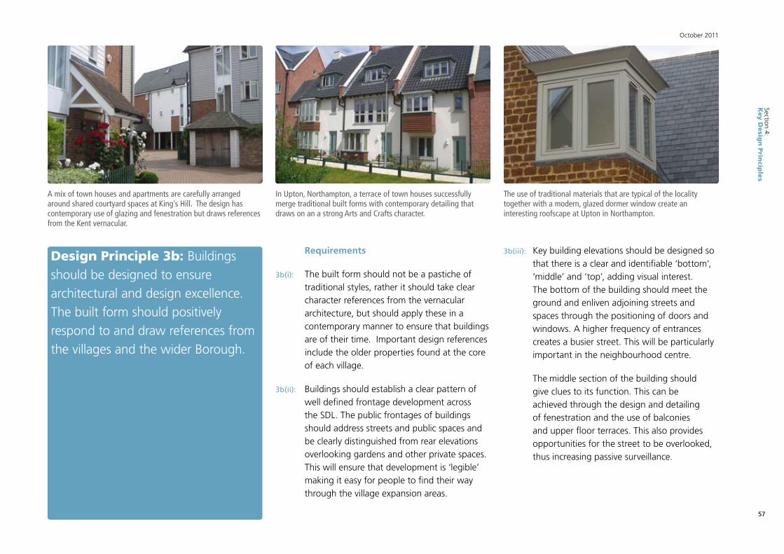
57
October 2011
Section 4:K
ey D
esig
n P
rincip
les
Design Principle 3b: Buildings should be designed to ensure architectural and design excellence. The built form should positively respond to and draw references from the villages and the wider Borough.
Requirements
3b(i): The built form should not be a pastiche of traditional styles, rather it should take clear character references from the vernacular architecture, but should apply these in a contemporary manner to ensure that buildings are of their time. Important design references include the older properties found at the core of each village.
3b(ii): Buildings should establish a clear pattern of well defined frontage development across the SDL. The public frontages of buildings should address streets and public spaces and be clearly distinguished from rear elevations overlooking gardens and other private spaces. This will ensure that development is ‘legible’ making it easy for people to find their way through the village expansion areas.
A mix of town houses and apartments are carefully arranged around shared courtyard spaces at King’s Hill. The design has contemporary use of glazing and fenestration but draws references from the Kent vernacular.
In Upton, Northampton, a terrace of town houses successfully merge traditional built forms with contemporary detailing that draws on an a strong Arts and Crafts character.
The use of traditional materials that are typical of the locality together with a modern, glazed dormer window create an interesting roofscape at Upton in Northampton.
3b(iii): Key building elevations should be designed so that there is a clear and identifiable ‘bottom’, ‘middle’ and ‘top’, adding visual interest. The bottom of the building should meet the ground and enliven adjoining streets and spaces through the positioning of doors and windows. A higher frequency of entrances creates a busier street. This will be particularly important in the neighbourhood centre.
The middle section of the building should give clues to its function. This can be achieved through the design and detailing of fenestration and the use of balconies and upper floor terraces. This also provides opportunities for the street to be overlooked, thus increasing passive surveillance.

58
Section 4:K
ey D
esig
n P
rincip
les
South of M4: Development Brief SPD
The top of the building should also be carefully considered. An interesting and dynamic roofscape adds visual interest with roof pitch and roofline articulated to lend distinction to different parts of the SDL. With commercial buildings and schools any ventilation arrangements, air conditioning, lighting, servicing and any telecommunications equipment should be carefully designed and integrated into the overall structure of the building and should be masked from public view points. On domestic buildings consideration should be given to providing opportunities for discrete locations for satellite dishes.
Design Principle 3c: Landmark buildings should be designed and located to emphasise the role and status of a particular building or place. Landmark buildings should include those with a special architectural character, those incorporating distinctive features and those with special functions.
This contemporary house at Upton is very much of its time but uses a warm palette of traditional materials. It demonstrates a clearly defined building elevation and a positive relationship fronting onto the street.
In New Hall, Harlow, a distinctive landmark has been built adjoining a mixed use local centre. The building accommodates apartments and uses copper cladding that will weather to verdigris over time.
Requirements
3c(i): Landmark buildings or features should be located to aid legibility. Increases in building heights can reinforce the presence of the neighbourhood centre. Views to existing landmark buildings and features should be incorporated into the planning application masterplan.

59
October 2011
Section 4:K
ey D
esig
n P
rincip
les
Design Principle 3d: High quality materials should firmly establish the character and identity of the SDL, both in respect of the public realm and the built form of buildings and structures.
Requirements
3d(i): A strategy for a restrained palette of colours and materials should be prepared at the Reserved Matters stage to influence the detailed design of the development. This should include, but is not limited to warm red brick, clay roof tiles, timber cladding and panels of painted render, which are commonly found throughout the Borough. Within each settlement particular reference to the distinctiveness of the context should be demonstrated. Modern interpretation of these materials will ensure that the SDL can be identified as a contemporary place. The image of place will also be reinforced by built form, decorative detailing, public art and even basic features such as windows and doorways.
As shown here, local building have a restrained palette of materials including red brick and clay roof tiles.

60
Section 4:K
ey D
esig
n P
rincip
les
South of M4: Development Brief SPD
Design Principle 3e: Vehicle and cycle parking should be well planned and designed to ensure that it does not have a detrimental impact on the amenity and character of the SDL.
Requirements
3e(i): A comprehensive strategy for vehicle parking should be prepared, which clearly sets out how provision will be made across the scheme for both residential, visitor, employment and shopper parking. In general terms, residential parking should be accommodated on-plot, in garages/car ports or on driveways (or in combination) or in mews lanes where some degree of overlooking can be achieved. Mews lanes will be particularly relevant for dwellings fronting primary streets where direct vehicle access to the plot may be inhibited. There will be a presumption against rear parking courts except for apartment buildings and in instances where flats over garages (FOGs) are proposed, and unless exceptional landscape and built design can be demonstrated to provide high quality courtyard spaces, and, in order to maximise the level of privacy, amenity and security for dwellings.
3e(ii): On-street parking will be permitted where it is designed into the street from inception. Designated parking bays of up to a maximum of six vehicles, divided by street trees should be provided.
3e(iii): Public car parks should be well designed, lit and landscaped. Boundaries should avoid the use of close-boarded fencing in favour of brick walls to help establish attractive areas.
3e(iv): Secure and useable cycle parking and storage facilities, including bin storage, should be incorporated into new development, as part of the street or development block. Facilities should be safe to use and well overlooked. Within the public realm cycle stands should be located at key locations such as the neighbourhood centre.
A mews street at Accordia in Cambridge integrates garaging and storage into the design and layout of the development. The street is overlooked through use of roof terraces and balconies.
Use of high quality materials and street tree planting define parking bays at Upton in Northampton. The street is well overlooked by adjoining houses.

61
October 2011
Section 4:K
ey D
esig
n P
rincip
les
Design Principle 3f: Public art will form an integral component of the built form in order to reinforce local identity.
Requirements
3f(i): A strategy for public art within the built areas should be prepared. This should make provision for the involvement of artists in place making at the local level. The strategy should make explicit the timing, funding and delivery arrangements for public art.
3f(ii): Opportunities for public art should be widely considered, and may include:
• art installations and sculpture;
• unique street furniture and signage;
• surface treatment;
• lighting;
• unique walls and railings;
• paintings, murals, mosaics;
• uniquely crafted landforms; and
• individual elements and adornments within buildings.
Bespoke seating in Portsmouth celebrates the city as birthplace of Charles Dickens. Public art can be functional as well as visually engaging.
In Hull a simple but beautifully detailed sequence of installations creates a ‘Fish Trail’ through the city centre. Here the images of Whitebait are set into specially commissioned paviors.
Dramatic glazing on this café building at Princesshay in Exeter creates a striking local landmark. An artist in residence was employed as part of the development team.

62
Section 4:K
ey D
esig
n P
rincip
les
South of M4: Development Brief SPD
Design principle 3g: Place names should be carefully considered to ensure they are directly relevant to the location.
Requirements
3g(i): The developer will be encouraged to enter into discussions with the appropriate authorities including the Council and the Parish Council, other community representative organisations, and with acknowledged experts to develop an agreed approach to naming of streets and areas within the SDL, including parks, open spaces, schools and community centres. Use of local historic names or names of persons and uses associated with an area can add richness to the SDL.

63
October 2011
Section 4:K
ey D
esig
n P
rincip
les
4. Centres & Primary Schools The Core Strategy requires:
• AnewlocalcentreatalocationinShinfield,whichiseasilyaccessible on foot to new and existing homes; and
• NewprimaryschoolsatShinfieldandSpencersWood,atalocation accessible by public transport.
Design Principle 4a: Local facilities should act as community hubs for local activity. The scale of the neighbourhood centres and the uses contained within them will ensure good levels of access for local everyday needs, and will reinforce the objective of integrating new and existing communities.
Requirements:
4a(i): In accordance with the Preferred Spatial Framework Plan provided in the preceding section of this SPD, the development will deliver two community hubs at Shinfield, which will make provision for a food store of 2,500m2 plus a range of compatible services and facilities to serve local needs, including existing health facilities, community uses, nursery or crèche facilities, a mixed-use community building to accommodate police and library functions, sport and faith facilities, services and other retail uses which may include a public house, hot food takeaway, and financial and professional services. The primary school will also be well related to the south-western neighbourhood centre.
4a(ii): Consideration will be given to granting planning permission that will allow movement between Use Classes if it can be demonstrated that this will assist in delivering a viable and sustainable centre.
4a(iii): At Spencers Wood, the proposed primary school will act as a new community focal point. It should be easily accessed from within the village and should be a recognisable local landmark, emphasising the contribution that new development can make to the improvement in local services. The school playing fields should be located adjacent to the settlement separation, at the eastern most point of the Spencers Wood expansion in order to increase the perception of settlement distinctiveness.

64
Section 4:K
ey D
esig
n P
rincip
les
South of M4: Development Brief SPD
Design Principle 4b: The neighbourhood centres should be characterised by high quality public realm which will add to their appeal and attraction.
Requirements:
4b(i): The design and layout of the neighbourhood centres should provide a good degree of containment and enclosure around a central public space, street or area. This space will be scaled in response to the size of the centre.
4b(ii): Materials, lighting, street furniture, signage and advertising, and planting should be carried out under a comprehensive strategy for the SDL, which allows for some distinction between each of the centres.
4b(iii): Provision for travel will be integral to the design of this outdoor space. Public transport stops, secure cycle parking and car parking (at a standard to be agreed with the Local Planning Authority) will be designed to seamlessly integrate with the public realm, and should not detract from the visual amenity or safety of the development.
At Ravenswood, Ipswich, street furniture, cycle stands and paving are all coordinated in a mixed use local centre.
The Village Centre in Shinfield accommodates the local primary school, leisure/community facilities and offices which front onto a public square and provides a focus for the neighbourhood.
Design Principle 4c: The position and design of buildings should help to distinguish the centres and the primary schools. They should demonstrate the application of good urban design principles.

65
October 2011
Section 4:K
ey D
esig
n P
rincip
les
Requirements:
4c(i): All of these buildings will form part of the street frontage. At Shinfield the aim will be to establish a “high street” or “village square” around which development is located. Development should positively address the public realm by fronting onto principal streets and spaces. Pavilion buildings set within areas of surface car parking should be avoided and will not be an acceptable design response.
4c(ii): Large footprint buildings, for example the primary schools, should:
• have its principal front door onto the public street or space, with limited setback from the edge of the adoptable street area;
• not have blank elevations facing any publicly accessible area;
• be serviced, and have storage and delivery areas which are unobtrusive. Service yards can be located within the centre of development blocks in order that they remain hidden from view. Access points should be discretely located and when not in use they should be gated to provide continuous frontage to the street; and
• have any allocated parking located within an area which is away from the main street frontage, and structured around an attractive landscape design which reduces the visual impact of the car park.
The new neighbourhood centre has the potential to connect new and existing residential areas.
The main entrance and principal frontage of a supermarket is carefully integrated into the layout of the mixed use district centre at King’s Hill in Kent.
At the Whitefriars Centre in Canterbury a service yard is obscured from view behind a simple gateway.

66
Section 4:K
ey D
esig
n P
rincip
les
South of M4: Development Brief SPD
Design Principle 4d: Residential uses should be included in the neighbourhood centres and are seen as essential for their vibrancy, safety and appeal.
Requirements
4d(i): Housing, including apartments and townhouses should be included in the centre. Apartments should be located above ground floor uses, in particular shops, in order to increase the use mix within each centre.
4d(ii): To safeguard the amenity of all users of the neighbourhood centre, in particular the residents, attention should be given to ensuring issues of noise transmission and vibration, refuse storage and collection, odour and light pollution are all adequately addressed through the design process. Care will need to be taken in the siting of mechanical extraction equipment and external lighting sources for example, and apartments and townhouses will need to be designed to minimise noise and disturbance from adjoining uses through appropriate sound insulation measures.
This local centre at Poundbury incorporates apartments above a ground floor retail unit. Community facilities and other shops are focused around a landscape square which also provides parking space.
High quality materials, tree planting and convenient pedestrian crossings distinguish this primary street at Ingress Park in Kent.

67
October 2011
Section 4:K
ey D
esig
n P
rincip
les
5. Access & Movement Framework
The Core Strategy requires:
• Alayoutwhichincludesahighdegreeof connectivity between old and new areas of housing, and provides a legible hierarchy of streets which distinguishes through routes from quieter residential streets.
Design Principle 5a: The layout and design of the SDL should promote easy and efficient movement, balanced with high levels of residential amenity and an attractive environment. This will be achieved through a hierarchy of streets and routes which respond to different travel needs, and which will be designed and delivered to ensure nil-detriment across the network.
Requirements
5a(i): The detailed design of streets should conform to the principles set out in the Department for Transport’s Manual for Streets 2, and should be generated through discussions with the Local Highway Authority. The emphasis of these discussions will be first to establish agreed ambitions for built quality, and then to work closely with the authority to establish how this can be achieved on a technical level in order to enable adoption. The authority intends to provide updated street design guidance in due course, which will help to inform these discussions.
5a(ii): The basic street hierarchy is set out overleaf. This provides a starting point for design discussion. It is anticipated that the general aspirations and parameters provided will be designed in detail according to the particular characteristics of each village location.
Generous pavements, robust frontage development and opportunities for on-street parking are provided as part of the design of a secondary street at Skylark Way in Shinfield.
A shared surface tertiary street fronted by dwellings establishes an attractive residential environment at King’s Hill in Kent.

68
Section 4:K
ey D
esig
n P
rincip
les
South of M4: Development Brief SPD
0km 1km
Figure 4.7: Transport and Movement Diagram
This map is based upon Ordnance Survey Material with the permission of Ordnance Survey on behalf of the Controller of HMSO © Crown Copyright. Unauthorised reproduction infringes Crown Copyright and may lead to prosecution or civil proceedings.
Wokingham Borough Council License No. 100019592 2009. For reference purposes only. No further copies may be made.
Primary Streets Connecting to Existing Movement Network
Primary Public Transport Route
Indicative Secondary Street Access
New Bus Stops
400m Walkable Distance to Bus Stops
A Network Of Leisure Routes Access To Open Spaces

69
October 2011
Section 4:K
ey D
esig
n P
rincip
lesDESIGN REQUIREMENTS PRIMARY STREETS SECONDARY STREETS TERTIARY STREETS MEWS LANES PEDESTRIAN AND
CYCLE ROUTES
General function
To carry vehicles travelling through the development, to connect neighbourhoods and to give access and exposure to the neighbourhood centre
To make up the local network, giving access to and through residential neighbourhoods
Lower order routes giving access to dwellings, with no relevance to through movement
Access to rear garages and for very local movement
For recreational and functional purposes, and to allow movement around the SDL without the need to mix with vehicles
Public TransportMain public transport route
Some secondary routes may be used for public transport
No No No
Design criteria
Carriageways should be sufficient width to carry public transport.
Cycle lanes should be incorporated into the street.
Generous pedestrian footpaths should be created along both sides.
Tree planting along both sides of the street should be achieved.
Carriageways should be designed for a lower level of traffic movement. The emphasis should be on pedestrian comfort and safe cyclist movement. Street trees should line at least one side of the street, ideally both. Footpaths should be provided on both sides.
Can be designed as shared surfaces, with an informal layout giving equal priority to slow moving vehicles and pedestrians.
Informal planting should reinforce the quiet relaxed character of the street.
Narrow lanes should be overlooked by some development. Shared surfaces and very informal landscape treatment. Security can be improved by the provision of resident controlled gates.
Set within the landscape, but convenient to dwellings, and connecting to the centres. Routes should be sufficient width to avoid pedestrian and cyclist conflict.
Frontage developmentContinuous throughout the built areas
Continuous throughout the built areas
Continuous Partial Partial
On street parking In designated bays In designated baysShould be designed into the street layout
No N/A
Vehicle cross over Limited opportunities Permissible Permissible N/A No

70
Section 4:K
ey D
esig
n P
rincip
les
South of M4: Development Brief SPD
5a(iii): There will be a requirement for two primary streets within the SDL connecting through the village expansion area at Shinfield. This route will connect directly into the existing principle access through the village at three points, in order to enhance the local highway network, encourage the dispersal of traffic and facilitate bus access.
5a(iv) The new north-eastern expansion area will be accessed from Cutbush Lane and also potentially from the new Shinfield Eastern Relief Road. The precise location of the access points will be subject to discussion through the planning application process and through detailed design. Access points should be connected by secondary streets that provide access to and through the new north-eastern residential neighbourhood.
5a(v): The street network should promote good connections with the existing community to ensure a good degree of physical and visual integration. This includes pedestrian and cycle routes as well as vehicular streets.
5a(vi) Improvements to the existing network of local roads including the off-site network may be required to ensure nil-detriment within the network and make adequate provision for public transport access. This should be discussed with the local highways authority.
5a(vii): An SDL-wide Infrastructure Delivery Plan must be submitted with any planning application.
Cross Section – Primary Streets
Cross Section – Tertiary Streets
Cross Section – Secondary Streets
Direct pedestrian crossings are provided as part of raised table at this junction in Ingress Park, Kent. A simple and consistent palette of quality materials is utilised.
Design Principle 5b: The landscape design of the street should be governed by a detailed street design strategy, which should be prepared by the developer in advance of the Reserved Matters stage as part of a design code.

71
October 2011
Section 4:K
ey D
esig
n P
rincip
les
Careful attention to detail produces a quality streetscape at Ingress Park, Kent which includes the use of street trees.
The consistent use of a family of street furniture, paving materials which incorporates existing treet planting establishes a quality environment at Accordia in Cambridge.
Simple high quality and robust materials should be used at public transport stops. This example in Wokingham town centre incorporates “real-time” information
Requirements
5b(i): Street trees are an essential component of the new development. A selected list of trees and shrubs should be prepared which identifies suitable species for each street type. Their scale, shape, robustness, attractiveness and ease of maintenance should be carefully considered. Similarly, shrubs which are compatible with the street type and character types should be identified within the strategy.
5b(ii): A simple palette of materials for use across the movement network should be identified in discussion with the Council. Materials from this palette should be used to highlight the distinction between different streets within the established hierarchy. Materials should be selected with careful consideration being given to appearance, safety, suitability and fitness for purpose.
5b(iii): Tree and shrub species and materials should be applied to public spaces also, in order to create a coherent public realm.
5b(iv): The strategy should also make proposals for the specification of street furniture components including seating, litterbins, lamp stands, bus shelters, bollards and signage. These items should add to the overall identity, quality and character of the development, and should reinforce the village character whilst avoiding ‘clutter’.
Design principle 5c: The design of the SDL should facilitate easy and efficient use of public transport and to encourage longer journeys to be undertaken by this mode.

72
Section 4:K
ey D
esig
n P
rincip
les
South of M4: Development Brief SPD
Requirements
5c(i): Early engagement with bus operators is essential to maximise the potential of the opportunity to establish sustainable travel patterns and behaviour from the early phases of the development, in order to better manage travel demand.
5c(ii): Emphasis should be given to passenger comfort, safety and convenience. Therefore bus stop location, lighting, information systems, shelter and proximity to active uses will be essential. High quality, lightweight, contemporary glazed canopies incorporating seating and real time information should be provided.
5c(iii): The SDL will make a contribution towards the delivery of a new Park and Ride facility south of Junction 11 of the M4 on the A33 to
Direct, at-grade pedestrian crossings together with minimal guard rails provide easy access with minimal public realm clutter at this busy junction in Wokingham.
provide direct bus access to Reading via the proposed Reading Mass Rapid Transit (RMRT) scheme. The design of the Park & Ride will accommodate bus interchange facilities to allow local people to access RMRT services via public transport. The Park & Ride will provide a safe, secure and convenient environment for passengers, and should demonstrate best practice drawn from examples in both the UK and overseas in order to maximise the opportunity to promote public transport patronage.
5c(iv): The SDL will include a sustainable travel connection linking Spencers Wood and Shinfield. Subject to ongoing design and discussion with the local highways authority, this connection may accommodate travel by bus, bicycle and on foot, and emergency vehicles, but will not be accessible to cars, delivery vehicles and other modes. The design
of the route will be sensitive to the landscape setting, and careful consideration will be given to its alignment, dimension, lighting and landscaping to ensure that it does not have a detrimental impact on the visual quality and amenity of the open countryside that it will cross.
5c(v): The SDL will provide for a Shinfield Eastern Relief Road between the A327 Arborfield Road and the A327 Black Boy Junction, which will afford access to the proposed new overbridge across the M4 (planned to relieve rather than replace the existing bridge crossing), and a connection to Shinfeld Road at the northern end of Shinfield at Lane End Farm. The purpose of the road will be to respond to the travel demand generated by both the South of M4 and Arborfield SDLs. It will incorporate bus priority measures which will generate favourable travel times for bus

73
October 2011
Section 4:K
ey D
esig
n P
rincip
les
passengers. Consideration should also be given to priority measures for car sharers, and the applicants should enter into detailed discussion with the Council about how the road will help to enhance sustainable travel.
Additionally, the Shinfield Eastern Relief Road should be designed to ensure it is visually sensitive to its rural context; landscape treatment, lighting, alignment and dimension should all be carefully considered. It is also important that the design of the road anticipates the development to the east of Shinfield in line with this SPD, and is capable of adding to an attractive residential environment which enjoys a positive relationship with open countryside to the east. Therefore, it should not read as a traditional by-pass, but as a country road which may in the future form a new eastern edge to the village.
6. PhasingThe WCS requires:
• Aphasingstrategywhichprioritisesthe provision of non-vehicle links, landscape planting and education within the early years of the scheme.
The following principles should be adhered to:
Design principle 6a: The development should be sequenced in a manner which sees the introduction of essential services and facilities delivered earlier on in the development of the SDL in order to begin to establish local community.

74
Section 4:K
ey D
esig
n P
rincip
les
South of M4: Development Brief SPD
Requirements
6a(i): An indicative phasing strategy will be included in any Outline planning application. A detailed phasing strategy will be prepared in advance of any Reserved Matters applications which clearly set out the timing of:
• landscape and green infrastructure, including drainage, sports facilities and play areas;
• the provision of services and facilities, including education, and any incremental growth of these facilities as the development advances;
• the programme and approach to developing the neighbourhoods, including the timing of the centre; and
• the sequencing of the movement infrastructure and the provision of public transport infrastructure.
6a(ii): The phasing and delivery of the scheme should accord with the requirements of the Infrastructure Delivery and Contributions SPD prepared by the Borough Council.

75
October 2011
Section 5:C
lima
te C
ha
nce
an
d S
usta
ina
bility
Section 5:Climate Change and Sustainability
5.1 Introduction
5.1.1 Delivering sustainable development in the Borough is a key objective of the Core Strategy and Policy CP1 sets out key sustainability principles for development proposals. The South of the M4 SDL provides a significant opportunity to design in measures to mitigate and deal with the effects of climate change and to deliver innovative and integrated sustainable solutions.
5.1.2 The Borough wide Sustainable Design and Construction SPD sets out more detailed guidance for proposals which should be taken into account as part of the planning application process. A Sustainability Report, including an Energy Statement, should inform and be submitted with the Outline planning application.
5.1.3 Paragraph 4.13 of the Core Strategy states that Policy CP1 (Sustainable Development) will be delivered through a variety of different options including a Sustainable Design and Construction SPD. The main purpose of that SPD is to provide guidance on the measures and opportunities available to developers and householders to integrate sustainability into the development. It will help developers to think through the impacts and will offer real, alternative sustainability solutions to developments. It will provide clear and accessible information that can steer choices towards sustainable development and will also include a Sustainability Checklist. It will provide guidance for the SDLs but it will also be applicable to all planning applications within the Borough.
5.2 SDL-wide Sustainable Urban Design
Land use and travel
5.2.1 The SDL will be a sustainable development which provides for local needs and contains a mix of jobs, services and homes to reduce travel. The overall development concept for South of the M4 should create accessible neighbourhoods in which all homes are within approximately 5 – 10 minutes walking distance of a new or existing Neighbourhood Centre. Neighbourhood Centres should be easily walkable from schools and should accommodate public transport to reduce the need to travel.

76
Section 5:C
lima
te C
ha
nce
an
d S
usta
ina
bility
South of M4: Development Brief SPD
5.2.2 The developers will be required to create a clear network of safe and attractive pedestrian and cycle routes within, and linking beyond, the red line boundary to encourage sustainable travel.
Layout and orientation
5.2.3 Detailed layouts should, where possible:
• position buildings to avoid overshadowing of southern elevations and maximise use of natural daylight; and
• use landscape to reduce effects of wind and to reduce solar gain during summer months.
Surface water
5.2.4 Surface water drainage arrangements for South of the M4 SDL should ensure volumes and peak flow rates of surface water leaving the SDL are no greater than the rates prior to the proposed development. In this regard, developers will be expected to make contributions to the construction and maintenance of Sustainable Drainage Systems (SUDS) and other agreed measures in accordance with Environment Agency advice. Regard will also need to be given to the Flood and Water Management Act 2010 in regards to SUDs maintenance. Attention should be given to the existing network of watercourses and drainage ditches on the South of the M4 SDL as part of the overall flood attenuation and open space strategy.

77
October 2011
Section 6:D
eliv
ery
Section 6:Delivery
This section of the SPD sets out guidance for applicants regarding the application process, to help deliver design excellence, strategic phasing principles and the future management of the South of the M4 SDL.
Approaches from applications should be made to the Council’s dedicated SDL teams within the Develop Management section, to ensure consistency and co-ordination.
6.1 Outline planning applications
6.1.1 In accordance with Policy CP4 of the Core Strategy the Local Planning Authority will assess the infrastructure requirements of all new development proposals. To ensure the delivery of all the infrastructure requirements laid down in Policies CP18-21 and Appendix 7 of the Core Strategy the Council seeks either an overarching infrastructure planning application or another relevant mechanism such as an overarching Infrastructure Delivery Plan. If there is not an overarching application the Council will expect planning applications to be accompanied by an Infrastructure Delivery Plan for the whole SDL and for Section 106 agreements to reflect this approach. This is in order to deliver the infrastructure requirements laid down in the Core Strategy including Policies CP18-21 and Appendix 7. This reflects Paragraphs
A7.13, A7.28, A7.41 and A7.53 of Appendix 7. This infrastructure will include highways, transport, community buildings, schools, open space and SANG. The Local Planning Authority will seek a programme of consents for the infrastructure outlined in Policies CP18-21 and Appendix 7 of the Core Strategy to ensure it is deliverable in accordance with the agreed phasing strategy for the delivery of development of the SDL as a whole.
6.1.2 The Infrastructure Delivery Plan should address the SDL-wide needs, including the location, capacity and phasing of common infrastructure including primary routes, utilities, strategic flood prevention and protection measures. Also, school sites, strategic public open space, SANG, sports and community buildings and neighbourhood centres should be included.

78
Section 6:D
eliv
ery
South of M4: Development Brief SPD
6.1.3 A single, overarching Masterplan for the entire SDL is required. This should include, as a minimum, the intended disposition of land uses, the primary highway access, and green infrastructure including strategic, formal and informal open space, play area and sports provision, the retention of existing site features, development density and building heights.
6.1.4 Any piecemeal planning applications will need to demonstrate how they will provide the infrastructure requirements laid down in the Core Strategy.
6.1.5 Pre-application discussions are expected and encouragement given to a Planning Performance Agreement to establish agreed timetable, key milestones and information requirements.
6.1.6 It is likely that any planning application will need to be supported by an Environmental Impact Assessment as required by EEC Directive 85/337/EEC, as amended by EC Directive 97/11/EC; and in accordance with the Environmental Impact Assessment Regulations. A Scoping Opinion, in accordance with Regulation 10, should be sought from WBC in advance of undertaking the EIA. In addition, sufficient information should be provided for the Authority to undertake a Habitats Regulations Appropriate Assessment as required by EU Directive 92/43/EEC (in respect of the Thames Basin Heaths Special Protection Area) unless Suitable Alternative Natural Greenspace (SANG) has been included in the development proposal such that this avoids an effect on the SPA. In that case, the Competent Authority will be in a position to conclude that an Appropriate Assessment would not be required.
6.1.7 A flood risk assessment (FRA) will be required. This will be prepared in discussion with the Environment Agency, and will inform an overarching plan for water management that should form part of the overarching infrastructure delivery plan. This should provide a strategy for drainage, flood protection and prevention, flood water attenuation, strategic surface water drainage and any other relevant issues identified by the SFRA.
6.1.8 An overarching utilities plan should also form part of the overarching infrastructure delivery plan. This should set out the strategy for the installation and delivery of services including electricity, gas, water supply, waster/foul water and information technology.

79
October 2011
Section 6:D
eliv
ery
6.2 Ensuring Design Excellence
6.2.1 This SPD is one mechanism for controlling the quality of the design within a hierarchy of policies, guidance and application stages, as is illustrated below.
Policy & GuidanceWokingham Core Strategy including Concept Statement.
Infrastructure Delivery and Contributions SPD.
Outline Planning
Outline planning application submitted.
Approved documents including Parameter Plans, Description of Development and Environmental Statement.
Supporting Information including illustrative layout and Design and Access Statement.
Design review process and Building for Life Assessment.
Outline Planning permission with conditions, including requirement for Design Code/s and Development Briefs, and planning obligations.
Design EvolutionPreparation and approval of Design Code/s and Briefs for key areas of the SDL or each phase (potentially accompanied by a reserved matters application for an initial phase to demonstrate effectiveness).
Reserved MattersReserved Matters Applications.
Reserved Matters Approvals with conditions.
Development Construction, monitoring and management.

80
Section 6:D
eliv
ery
South of M4: Development Brief SPD
Design and Access Statements, Parameter Plans and Illustrative Layouts
6.2.2 Design and Access Statements are required under the 2004 Act. Regard should be had to the requirements of the Regulations and the DCLG publication “Guidance on Local Information requirements and Validation”. The design principles and components set out in Design and Access Statements for Outline Applications should also be in accordance with the WCS, other Wokingham guidance, best practice and this SPD. Wokingham Borough Council has produced a check list of matters to be considered in a Design and Access Statement for Outline and Full Planning Applications.
6.2.3 The Design and Access Statements should provide the basis for the quality of design to be controlled through subsequent Design Codes and Reserved Matters applications. Applicants will be expected to demonstrate how they have incorporated high standards of design throughout the design evolution process and how these will be carried through to completions and subsequent maintenance. If the applicants are not the developer, the applicants will be expected to set out what steps will be taken to ensure that these high standards are carried forward by subsequent developers to completions and maintenance.
6.2.4 It is also a requirement of the 2004 Act for applications to include, as a minimum: details of uses proposed in different areas of the SDL; the amount of development for each use; an indicative layout; parameters of the sizes of buildings; and highways and access points.
6.2.5 Given the scale of the SDL, it would be appropriate to develop illustrative layouts which demonstrate how for the design objectives including residential density can be delivered and articulated across the SDL. It would also be appropriate to include typologies depicting typical blocks, streets and open spaces, with clear principles for the relationship between the built form, spaces and streets. The information should be in accordance with the principles of this SPD.

81
October 2011
Section 6:D
eliv
ery
Design Review
6.2.6 Design Review Panels provide an independent service in which peers can comment on major development schemes. It is desirable that proposals for the South of M4 SDL will be reviewed by the anticipated local design review panel or other appropriate design review panel. This should take place at an early stage of pre-application discussions in order to allow for recommendations of the review panel to be taken into account in preparing the proposals.
Building for Life Assessment
6.2.7 Building for Life (BfL) assessments score the design quality of planned or completed developments. BfL was introduced by CABE to provide a tool for Local Authorities and developers to achieve greater design consistency and is based upon design 20 criteria (www.buildingforlife.org).
6.2.8 In preparing a Design and Access Statement for the SDL, the 20 BfL criteria should be considered. WBC will also undertake a formal BfLassessment of major planning applications for the SDL.
Design Codes
6.2.9 It will be necessary for strategic Design Codes to be submitted and approved following Outline stage pursuant to conditions and prior to submission of Reserved Matters. Reserved Matters will need to be in accordance with the approved Design Codes. A Design Code sets out specific rules to guide the nature of the built form, streets and spaces and should be prepared in accordance with the principles of this SPD and subsequent approved Design and Access Statements. Design Codes will help to deliver the highest feasible and viable design standards and provide certainty and clarity to developers and other stakeholders about the form of development expected at the detailed stage.

82
Section 6:D
eliv
ery
South of M4: Development Brief SPD
6.2.10 Design Codes should be prepared in partnership between the developers, Local Planning Authority, service providers and other stakeholders. The Design Codes should prescribe the design of:
• primary, secondary and tertiary streets;
• edges, gateways and corners;
• community buildings and facilities;
• indoor and outdoor sports facilities
• public spaces;
• block sizes ;
• built form, character and materials
• appropriate parking solutions;
• building heights and set backs;
• tree and shrub species to be used; and
• hard and soft landscape materials.
6.2.11 Greater flexibility should be applied to building style within the guiding principles of ensuring distinctiveness, character and high quality.
6.3 Conditions and Planning Obligations
Planning Conditions
6.3.1 This SPD refers to various matters which may be controlled via planning conditions. As part of the planning application process draft planning conditions will be prepared by WBC for discussions with the applicants. Conditions should be in accordance with the advice contained in Circular 11/95 or replacement advice and should be necessary, relevant to planning, relevant to the development to be permitted, enforceable, precise, and reasonable in all other respects.
6.3.2 Due to the scale of development the potential impact of the resultant construction traffic and other construction impacts should be carefully considered in terms of protecting the amenities of existing residents.

83
October 2011
Section 6:D
eliv
ery
Planning Obligations
6.3.3 A legal agreement under section 106 of the Town and Country Planning Act (as amended) will be negotiated between WBC and applicants prior to the granting of planning permission to ensure appropriate delivery of key infrastructure and facilities and long-term management of infrastructure and public spaces. Section 106 agreements will be negotiated in accordance with Circular 05/2005. Draft Heads of Terms should be submitted with Outline planning applications to inform negotiations.
Delivery & Contributions
6.3.4 The Infrastructure Delivery and Contributions SPD sets out that planning contribution may take the following forms:
• the direct provision of essential, relevant and necessary infrastructure both on and off the SDL;
• the provision of land for a specific community/specialist use as agreed between the developer and the Council;
• commuted payments in lieu of provision of infrastructure normally derived through standard formulae which may be pooled; and/or
• monetary contributions towards Strategic and off SDL Community Infrastructure normally derived through standard charges and or formulae which may be pooled with an allowance being made for situations where strategic infrastructure is provided as part of the development.
6.3.5 Other Section 106 contributions might be imposed in order to prescribe the nature of development or use of land. WBC will ensure that development is not double charged in respect of the same obligation.
6.3.6 The Planning Act (2008) provides for Local Authorities to apply a Community Infrastructure Levy (CIL) to development proposals to support infrastructure delivery in an area, in accordance with the 2010 CIL Regulations. However it is envisaged that the Policies and provisions of the Core Strategy and this SPD and the Infrastructure Delivery and Contributions SPD for the Strategic Development Locations could be readily incorporated into a future CIL if this is the mechanism chosen by the Local Planning Authority.

84
Section 6:D
eliv
ery
South of M4: Development Brief SPD
6.4 Strategic Phasing
6.4.1 The Wokingham Borough Housing Trajectory identifies a build-out period of 15 years or more to deliver the South of the M4 SDL. Infrastructure and development should be delivered at the right time and in the right place to ensure a high quality and sustainable community is established. Regard should be given to the phasing indicated in the Infrastructure Delivery and Contributions SPD. Piecemeal and ad hoc planning applications which fail to deliver coherent and integrated strategic infrastructure will be resisted.
6.4.2 The phasing plans submitted with planning applications will be expected to be in accordance with the following principles:
• Establish key public transport infrastructure and routes, including the Shinfield Eastern Relief Road, at the early phase;
• Ensure a Neighbourhood Centre and primary school are delivered early on in the first development phase;
• Include requisite green infrastructure in addition to the SANG;
• Each development phase should contribute to the wider infrastructure costs to ensure it can be delivered and later phases remain viable; and
• Develop outwards from existing neighbourhoods and avoid disconnected and isolated pockets of residential development.
6.4.3 The Local Planning Authority will seek an overarching infrastructure planning application or Infrastructure Delivery Plan to demonstrate how each SDL will deliver the infrastructure requirements laid down in the Infrastructure Delivery and Contributions SPD and Policies CP18-21 and Appendix 7 of the Core Strategy.
Sequencing of phasing
6.4.4 The following outlines the sequence of development and infrastructure requirements in the first phase, estimated to be 2011-2016, and subsequent phases, 2017 onwards. This sequencing should be read in conjunction with the Infrastructure Delivery and Contributions SPD for the SDLs and the estimated dwelling completion is based on the latest Housing Trajectory.

85
October 2011
Section 6:D
eliv
ery
6.4.5 The Infrastructure Delivery and Contributions SPD sets out the infrastructure requirements for South of the M4SDL in more detail and this delivery section should be read in conjunction with that document. Build out rates will be influenced by prevailing market conditions and are difficult to predict over a 15 year timeframe but the phasing principles and sequencing should be adhered to. Strategic phasing principles and guidance contained in this SPD are intended to provide clear guidance and the proposed phasing strategy for development should be submitted with Outline planning applications. Developers should take a co-ordinated approach to the delivery of necessary infrastructure, facilities, utilities and services.
6.5 Management and Maintenance
6.5.1 Long-term management and maintenance arrangements should be considered early in the application process.
Highways drainage & open space
6.5.2 Wokingham Borough Council has a maintenance responsibility for the adoption of new public highways associated with development. Commuted sums will apply to all non-standard solutions that will cost more to maintain than a standard solution. Commuted sums are a capital payment towards the future maintenance and this money should be ring-fenced for such purposes.
6.5.3 Contributions will be expected for the construction of Sustainable Urban Drainage Systems (SUDS) and their on-going maintenance.
6.5.4 The successful maintenance of public open space, SANG and green infrastructure is as important as the design and creation of the spaces and landscape. It is therefore essential that measures are put into place to ensure the long-term effective management and retention of these uses, and WBC will expect developers to engage in discussions about the management of public open space either by a management company or community development trust, or by the Borough or Parish Council where it might be appropriate for these public organisations to adopt the land; this is likely to apply to the ongoing stewardship and management of SANG for instance.

86
Section 6:D
eliv
ery
South of M4: Development Brief SPD
Community Infrastructure
6.5.5 The applicants will be encouraged to discuss the provision of community infrastructure with the Council’s Development Management Team in the first instance, and thereafter agree with the service provider the detailed requirements in the right location to ensure the general public have the best access to the community facilities. In this regard a key design principle is that the Neighbourhood Centre is the focus of community uses. The Neighbourhood Centre and multi use community centre, which should form a ‘community hub’, should be managed either by a management company established by the developer or other such arrangements appropriate for the community. Ownership, management and maintenance of the community centre to be in line with the legal agreement or agreed adoption strategy.
Delivery Board
6.5.6 As part of the management of the delivery of the South of the M4 SDL, the Borough Council has set up a Delivery Board Structure and will implement measures for continuing community engagement, including the Parish and Town Council’s, for the life of the project. The current members of the Consortia have set up a corresponding structure as a primary point of liaison between the respective parties with the principal aim of taking forward the guidance in this document into detailed design and planning applications. The Council will encourage all developers throughout the lifetime of this project, including the current members of the Consortia in each SDL, to work together and with local people, both within the existing and emerging communities to ensure the delivery of high
quality development and the infrastructure requirements of the Adopted Core Strategy in a timely manner.

87
October 2011
Section 6:D
eliv
ery

South of M4: Development Brief SPD
Wokingham Borough CouncilCivic OfficesShute End
WokinghamBerkshire
RG40 1BN
tel: (0118) 974 6000fax: (0118) 978 9078
minicom: (0118) 974 6991email: [email protected]
www.wokingham.gov.uk
David Lock Associates50 North Thirteenth Street
Central Milton KeynesBuckinghamshire
MK9 3BP
tel: (01908) 666276fax: (01908) 605747
email: [email protected]
www.davidlock.com