sonarwiz magnetometry post-processing reference · 2019-08-15 · 1 magnetometry post-processing...
TRANSCRIPT

SonarWiz Magnetometry Post-Processing Reference
Revision 31, 7/25/2019
Chesapeake Technology, Inc.
eMail: [email protected] Main Web site: http://www.chesapeaketech.com
Support Web site: http://www.chestech-support.com
1605 W. El Camino Real, Suite 100 Mountain View, CA 94040
Tel: 650-967-2045 Fax: 650-450-9300
MagPostProcessingReference.PDF Chesapeake Technology, Inc. copyright 2017-2019
Rev 31, 7/25/2019 [email protected] 650-967-2045 Page 2
Table of Contents
1 Magnetometry Post-Processing Feature - Tutorial ................................................... 4
1.1 Generating a MAG File ...................................................................................... 6
1.2 Importing a MAG File - Example ........................................................................ 8
1.2.1 Imported MAG Lines - Representation in MML file .................................... 13
1.3 Editing Your MAG file - Example ...................................................................... 13
1.3.1 Mag-data decimation (down-sampling) to 1hz rate - 5.07.0012 and earlier14
1.3.2 Mag-data Down-sampling - 5.07.0013 and beyond ................................... 14
1.3.3 Identifying Anomalies ................................................................................ 15
1.4 Adding Layback to a Mag Line ......................................................................... 16
1.4.1 Setting Mag Layback - Example ................................................................ 16
1.4.2 Set Cable Out and Offset Cable Out ......................................................... 20
1.5 Controlling Mag Editor Presentation - Raw, Smoothed, Ambient ..................... 21
1.6 Computation of Anomaly Amplitude, and Z export in XYZ export .................... 23
1.7 Auto-Detection of Anomalies ............................................................................ 23
1.7.1 Anomaly amplitude (peak-to-peak RAW difference) measurement ........... 24
1.8 Manually Picking, or Editing Anomalies ........................................................... 28
1.8.1 Anomalies - Storage in the ANO file .......................................................... 30
1.9 Creating Grid and Contour Exports of your Mag data ...................................... 30
1.10 Adding Color-scaled Mag Grids to the Project .............................................. 35
1.11 MAG Real-time and Post-Process - PLAYBACK Options ............................. 36
1.11.1 MAG / SS correlated Viewing - Real-Time or Post-Processing ................. 36
1.11.2 Post-processing correlated SS Map View and Mag Editor Data View ....... 41
1.12 Gradiometer Post-Processing in SonarWiz ................................................... 42
1.12.1 Gradiometer Sample Data Set - optional images ...................................... 42
1.13 SIT Recommendations ................................................................................. 44
2 Magnetometer File Format Templates - Overview ................................................. 44
2.1 Choosing a File Template and Pre-viewing your Magnetometer Data ............. 45
2.2 Managing your Mag Project - project movement limitations ............................. 46
3 Magnetometer File Templates - Format Summary ................................................. 47
MagPostProcessingReference.PDF Chesapeake Technology, Inc. copyright 2017-2019
Rev 31, 7/25/2019 [email protected] 650-967-2045 Page 3
4 Magnetometer File Format Templates – Details .................................................... 49
4.1 AquaScan AXL ................................................................................................. 49
4.2 Arts Gavia MAG ............................................................................................... 49
4.3 Balaswamy-MAG ............................................................................................. 50
4.4 C&C Magnetometer ......................................................................................... 50
4.5 CSF Magnetometer .......................................................................................... 51
4.6 FSL-MAG ......................................................................................................... 52
4.7 G882_Type3 .................................................................................................... 53
4.8 GEMS_Meren13_INT ....................................................................................... 53
4.9 GEMS_Meren13_INT_SHIFT .......................................................................... 54
4.10 GEMS-gradiometer ....................................................................................... 55
4.11 GEMS-INT-mag1 .......................................................................................... 56
4.12 GEMS-INT-mag2 .......................................................................................... 56
4.13 GEMS-MagLog ............................................................................................. 57
4.14 GEMS-MagLog-CSV ..................................................................................... 58
4.15 GEO_G882_Mag .......................................................................................... 59
4.16 HWTMA-2011-1-MAG ................................................................................... 59
4.17 HYPACK RAW File Magnetometer ............................................................... 60
4.18 JSF_MAG_IMPORT ..................................................................................... 60
4.19 Lat Lon MAG (tab delimited) ......................................................................... 60
4.20 Lon Lat MAG (space delimited) .................................................................... 61
4.21 Maglog Type 4 .............................................................................................. 61
4.22 Maglog Type 5 .............................................................................................. 62
4.23 Maglog Type 6 .............................................................................................. 62
4.24 Maglog Type 7 .............................................................................................. 63
4.25 Maglog Type 8 (no longer supported) ........................................................... 64
4.26 Maglog GPS-Pos w/Altitude .......................................................................... 65
4.27 Maglog GPS-Pos-Alt-MAG2-MAG3 .............................................................. 65
4.28 Maglog Magnetometer .................................................................................. 66
4.29 Maglog w/Altitude .......................................................................................... 67
4.30 MagLog-Spencer .......................................................................................... 67
MagPostProcessingReference.PDF Chesapeake Technology, Inc. copyright 2017-2019
Rev 31, 7/25/2019 [email protected] 650-967-2045 Page 4
4.31 MMT Maglog GPS-Pos w/Altitude ................................................................. 69
4.32 OFG-Mag-2 ................................................................................................... 69
4.33 PLR Magnetometer ....................................................................................... 70
4.34 PLR Magnetometer (m) ................................................................................ 70
4.35 SeaLink MAG ................................................................................................ 71
4.36 SeaLink-Wilhelm ........................................................................................... 71
4.37 SeaSpy Type 3 ............................................................................................. 72
4.38 SonarWiz-Default-MAG ................................................................................ 73
4.39 SWM-E,T,D,L,L,X,M,A,D,S ........................................................................... 73
4.40 SWM-MAG882 .............................................................................................. 74
4.41 SonarWiz-MAG-file-default ........................................................................... 75
4.42 SWM-SEASPY.............................................................................................. 75
4.43 SWM-SEASPY_XY ....................................................................................... 76
4.44 TBSmith Hypack MAG .................................................................................. 76
4.45 TeslaOffshore-MAG-1 ................................................................................... 77
4.46 UDEL_G882_1.............................................................................................. 78
4.47 UDEL_G882_2.............................................................................................. 79
4.48 XYZ MAG ...................................................................................................... 80
4.49 XYZA MAG ................................................................................................... 81
5 Document History ................................................................................................... 82
1 Magnetometry Post-Processing Feature - Tutorial
Magnetometry post-processing is available in SonarWiz with purchase of the
magnetometry post-processing license option. The templates described below for mag
file import, are current as of version 6.05.0025 and 7.04.05.
Mag data is typically a text-format file, though it can be saved internal to some sonar
files. With any real-time acquisition interface, mag real-time acquisition comes
along as a feature for free.
What you pay for in the mag post-processing license, is the ability to add magnetometry
file post-processing (import and post-processing) for files such as those you have saved
during a previous survey, or captured with SonarWiz to disk.

MagPostProcessingReference.PDF Chesapeake Technology, Inc. copyright 2017-2019
Rev 31, 7/25/2019 [email protected] 650-967-2045 Page 5
When you record to disk, the mag data can be formatted per your choice, with a set-up
dialog under Data Acquisition->Magnetometry. You specify the input format and output
file format, if you want to vary it from the default format:
Here's an example of output file format fields formatting choice:

MagPostProcessingReference.PDF Chesapeake Technology, Inc. copyright 2017-2019
Rev 31, 7/25/2019 [email protected] 650-967-2045 Page 6
So then the saved file exists after the survey, on your hard drive, typically in the MAG
folder of your project.
1.1 Generating a MAG File
There are a few ways to generate a MAG data file. Here are some options:
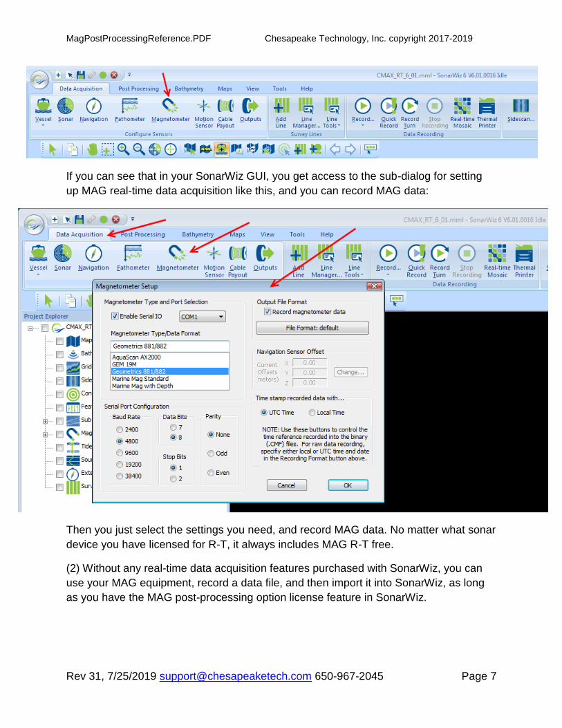
(1) With ANY real-time feature set purchase with SonarWiz, you get access to the
entire set of DATA ACQUISITION tabs in SonarWiz. This means that a purchase
of Edgetech 4200 sidescan R-T, for example, licenses access to ALL these tabs in
the SonarWiz GUI:
MagPostProcessingReference.PDF Chesapeake Technology, Inc. copyright 2017-2019
Rev 31, 7/25/2019 [email protected] 650-967-2045 Page 7
If you can see that in your SonarWiz GUI, you get access to the sub-dialog for setting
up MAG real-time data acquisition like this, and you can record MAG data:
Then you just select the settings you need, and record MAG data. No matter what sonar
device you have licensed for R-T, it always includes MAG R-T free.
(2) Without any real-time data acquisition features purchased with SonarWiz, you can
use your MAG equipment, record a data file, and then import it into SonarWiz, as long
as you have the MAG post-processing option license feature in SonarWiz.
MagPostProcessingReference.PDF Chesapeake Technology, Inc. copyright 2017-2019
Rev 31, 7/25/2019 [email protected] 650-967-2045 Page 8
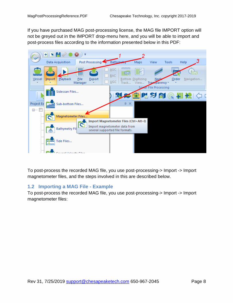
If you have purchased MAG post-processing license, the MAG file IMPORT option will
not be greyed out in the IMPORT drop-menu here, and you will be able to import and
post-process files according to the information presented below in this PDF:
To post-process the recorded MAG file, you use post-processing-> Import -> Import
magnetometer files, and the steps involved in this are described below.
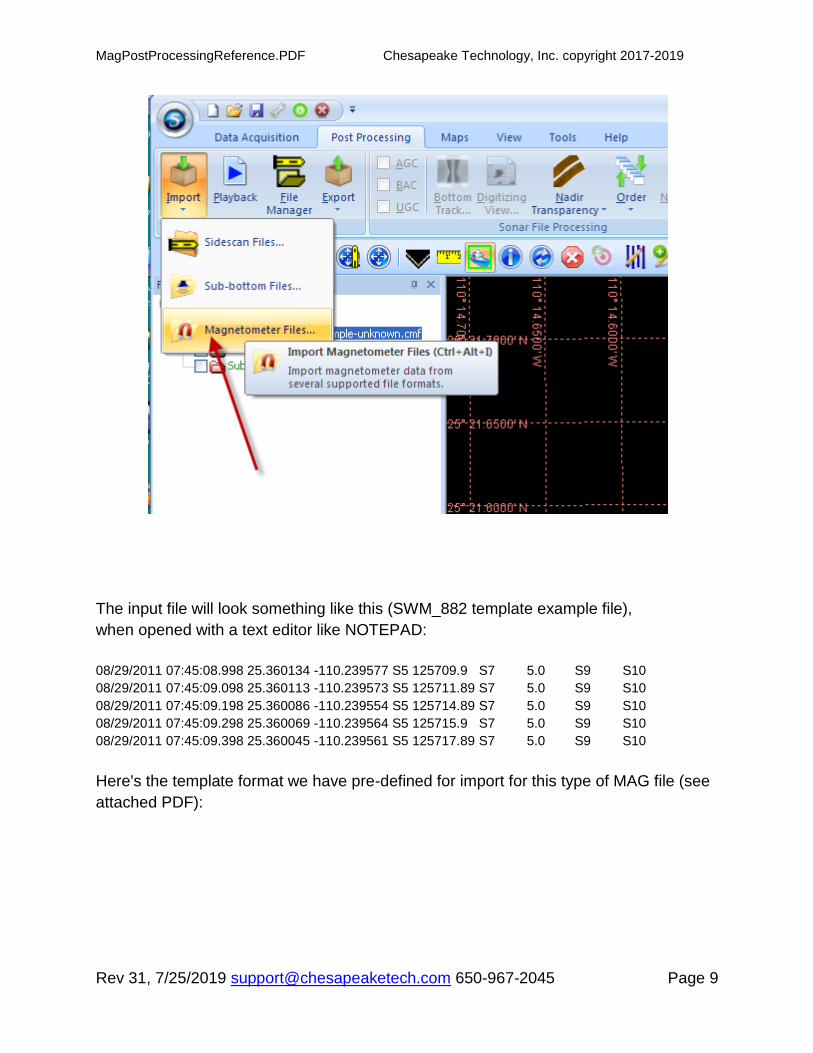
1.2 Importing a MAG File - Example
To post-process the recorded MAG file, you use post-processing-> Import -> Import
magnetometer files:
MagPostProcessingReference.PDF Chesapeake Technology, Inc. copyright 2017-2019
Rev 31, 7/25/2019 [email protected] 650-967-2045 Page 9
The input file will look something like this (SWM_882 template example file),
when opened with a text editor like NOTEPAD:
08/29/2011 07:45:08.998 25.360134 -110.239577 S5 125709.9 S7 5.0 S9 S10
08/29/2011 07:45:09.098 25.360113 -110.239573 S5 125711.89 S7 5.0 S9 S10
08/29/2011 07:45:09.198 25.360086 -110.239554 S5 125714.89 S7 5.0 S9 S10
08/29/2011 07:45:09.298 25.360069 -110.239564 S5 125715.9 S7 5.0 S9 S10
08/29/2011 07:45:09.398 25.360045 -110.239561 S5 125717.89 S7 5.0 S9 S10
Here's the template format we have pre-defined for import for this type of MAG file (see
attached PDF):

MagPostProcessingReference.PDF Chesapeake Technology, Inc. copyright 2017-2019
Rev 31, 7/25/2019 [email protected] 650-967-2045 Page 10
Here's the import dialog to bring in the file, accessed by:
Post-processing -> Import -> Import Magnetometry file

MagPostProcessingReference.PDF Chesapeake Technology, Inc. copyright 2017-2019
Rev 31, 7/25/2019 [email protected] 650-967-2045 Page 11
Then the SWM-MAG882 format file imports (in this case 11475 records) and shows first
in the mosaic view:

MagPostProcessingReference.PDF Chesapeake Technology, Inc. copyright 2017-2019
Rev 31, 7/25/2019 [email protected] 650-967-2045 Page 12
MagPostProcessingReference.PDF Chesapeake Technology, Inc. copyright 2017-2019
Rev 31, 7/25/2019 [email protected] 650-967-2045 Page 13
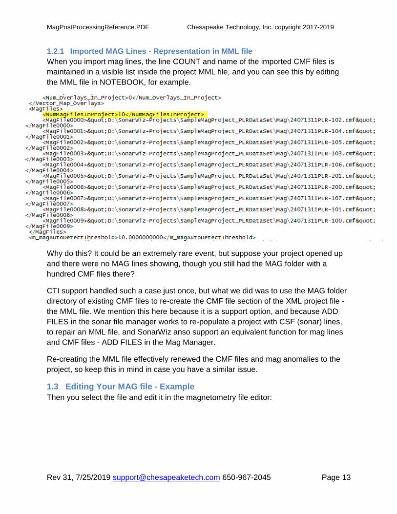
1.2.1 Imported MAG Lines - Representation in MML file
When you import mag lines, the line COUNT and name of the imported CMF files is
maintained in a visible list inside the project MML file, and you can see this by editing
the MML file in NOTEBOOK, for example.
Why do this? It could be an extremely rare event, but suppose your project opened up
and there were no MAG lines showing, though you still had the MAG folder with a
hundred CMF files there?
CTI support handled such a case just once, but what we did was to use the MAG folder
directory of existing CMF files to re-create the CMF file section of the XML project file -
the MML file. We mention this here because it is a support option, and because ADD
FILES in the sonar file manager works to re-populate a project with CSF (sonar) lines,
to repair an MML file, and SonarWiz anso support an equivalent function for mag lines
and CMF files - ADD FILES in the Mag Manager.
Re-creating the MML file effectively renewed the CMF files and mag anomalies to the
project, so keep this in mind in case you have a similar issue.
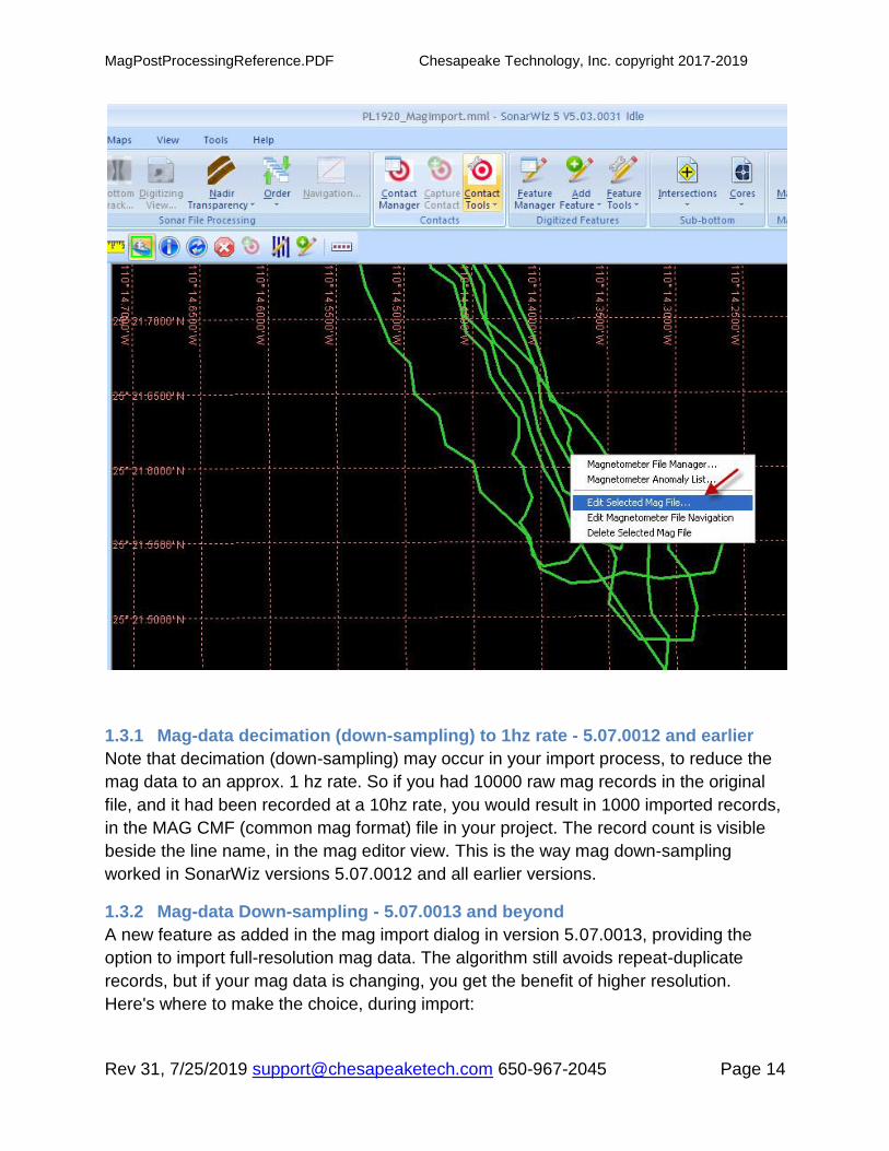
1.3 Editing Your MAG file - Example
Then you select the file and edit it in the magnetometry file editor:
MagPostProcessingReference.PDF Chesapeake Technology, Inc. copyright 2017-2019
Rev 31, 7/25/2019 [email protected] 650-967-2045 Page 14
1.3.1 Mag-data decimation (down-sampling) to 1hz rate - 5.07.0012 and earlier
Note that decimation (down-sampling) may occur in your import process, to reduce the
mag data to an approx. 1 hz rate. So if you had 10000 raw mag records in the original
file, and it had been recorded at a 10hz rate, you would result in 1000 imported records,
in the MAG CMF (common mag format) file in your project. The record count is visible
beside the line name, in the mag editor view. This is the way mag down-sampling
worked in SonarWiz versions 5.07.0012 and all earlier versions.
1.3.2 Mag-data Down-sampling - 5.07.0013 and beyond
A new feature as added in the mag import dialog in version 5.07.0013, providing the
option to import full-resolution mag data. The algorithm still avoids repeat-duplicate
records, but if your mag data is changing, you get the benefit of higher resolution.
Here's where to make the choice, during import:

MagPostProcessingReference.PDF Chesapeake Technology, Inc. copyright 2017-2019
Rev 31, 7/25/2019 [email protected] 650-967-2045 Page 15
To see the effect, make a copy of your mag line, save it so you have the same file under
two different filenames, then import it twice - once as file1, with Down-sampling OFF,
and once as file2, with Down-sampling to 1 Hz. This way, you can see the effect on
imported record count, and decide which you prefer.
A second format of implicit automatic down-sampling occurs when duplicate
positions occur within the import records. With duplicated positions, only the
FINAL record at the same position is saved into the import data set.
1.3.3 Identifying Anomalies
The mag editor view of the data auto-scales nicely, and then you can identify anomalies
(kind of like picking targets or contacts in sonar data). Here I have opened the mag
editor and am
adding my first anomaly:

MagPostProcessingReference.PDF Chesapeake Technology, Inc. copyright 2017-2019
Rev 31, 7/25/2019 [email protected] 650-967-2045 Page 16
1.4 Adding Layback to a Mag Line
Application of Cable-Out to a mag line can be done, and is done in much the same way
as we add layback to sidescan data, as described in the layback tutorial PDF here:
SonarWiz - Layback_CableOut_Tutorial.pdf
The basic plan is to select your mag line in the mosaic view or in the mag file manager,
then select the Set Cable Out button, and identify the cable out (in meters), and lines to
which it will be applied.
1.4.1 Setting Mag Layback - Example
This example uses the Sample Mag Data set PLR-type TXT file input from the SAMPLE
DATA area of www.chestech-support.com using SonarWiz 5.06.0046:

MagPostProcessingReference.PDF Chesapeake Technology, Inc. copyright 2017-2019
Rev 31, 7/25/2019 [email protected] 650-967-2045 Page 17
(1) select a mag line after import, in the mosaic view
(2) select Magnetometer File Manager
(3) In the File Manager, select the button to set Cable Out:

MagPostProcessingReference.PDF Chesapeake Technology, Inc. copyright 2017-2019
Rev 31, 7/25/2019 [email protected] 650-967-2045 Page 18
(4) Specify the Cable Out in meters, choose the affected lines, and then click OK

MagPostProcessingReference.PDF Chesapeake Technology, Inc. copyright 2017-2019
Rev 31, 7/25/2019 [email protected] 650-967-2045 Page 19
(5) Finally, select the percentage of CableOut to apply for Layback for each line, or set it
in one line and use MAKE LIKE SELECTED to apply the same setting to other lines:

MagPostProcessingReference.PDF Chesapeake Technology, Inc. copyright 2017-2019
Rev 31, 7/25/2019 [email protected] 650-967-2045 Page 20
1.4.2 Set Cable Out and Offset Cable Out
SET CABLE OUT is an absolute setting option. To set the CableOut to 50m or 100m,
just use SET CABLE OUT.
OFFSET CABLE OUT is an additive adjustment. Use it once and set OFFSET CABLE
OUT = 25.0 and 25m gets added to the previous CABLE OUT value. Use it again and
set OFFSET CABLE OUT = 50.0 and ANOTHER 50.0m gets added to the previous
CABLE OUT value. for a total 75.0 m additive adjustment.
See your current values of CABLE OUT by reading the CBL value in the MAG EDITOR.

MagPostProcessingReference.PDF Chesapeake Technology, Inc. copyright 2017-2019
Rev 31, 7/25/2019 [email protected] 650-967-2045 Page 21
After all the adjustments, to reset the CABLE OUT to ZERO and start over for clarity,
just use SET CABLE OUT = 0.0m.
Using OFFSET CABLE OUT = 0.0m will have NO EFFECT on the current CABLE OUT
value.
1.5 Controlling Mag Editor Presentation - Raw, Smoothed, Ambient
The ambient data trace in the mag editor is created by over-smoothing the mag data.
The settings are controlled in Settings and Preferences, selecting the top green
OPTIONS icon in SonarWiz:
then selecting Magnetometer Post-processing:

MagPostProcessingReference.PDF Chesapeake Technology, Inc. copyright 2017-2019
Rev 31, 7/25/2019 [email protected] 650-967-2045 Page 22
By default, SonarWiz creates the ambient trace (black line, in the editor) by using 500-
point smoothing. If you want to change the value used in the project, change it in the
OPTIONS, then close SonarWiz, re-open, and re-import the mag data. The ambient
trace will be updated.
By default, SonarWiz creates the smoothed trace (green line, in the editor) by using 20-
point smoothing.
The blue line in the editor is your un-smoothed (observed) raw data. So the "Observed
data" smoothing is for presentation of the green line in the mag editor. Typically you
would select to view the green and black lines for comparison: RAW TRACE is not
checked here:

MagPostProcessingReference.PDF Chesapeake Technology, Inc. copyright 2017-2019
Rev 31, 7/25/2019 [email protected] 650-967-2045 Page 23
1.6 Computation of Anomaly Amplitude, and Z export in XYZ export
The "Ambient" column (9th column displayed in mag editor) displays the RAW value
peak actually, at the anomaly location. The AMPLITUDE value for the anomaly is RAW
- AMBIENT at that X,Y location. When you export an ASCII XYZ format CSV, the Z
value you are exporting is also the RAW value at that X,Y location. So you can display
SMOOTHED data, but it is not part of anomaly height, or Z-value export, computations.
1.7 Auto-Detection of Anomalies
The Auto-detect is just a numerical threshold setting that you need to decide empirically,
to help it work for you. It works much like a software-version of an electronic Schmidtt
level-detection trigger. In the example data above, let's say we want to auto-identify the
trace ping positions 300 and 800 as anomalies. They are huge, so we can set the auto-
detect threshold at say, 100, and those will be the only two spikes identified at auto-
detected anomalies.
NOTE: the RAW (observed) data amplitude is used for auto-detect and anomaly size
report - even if it is not displayed. The same goes for Z values in XYZ export - it is
the RAW (observed) value. Smoothed traces are just for visual comparison.
MagPostProcessingReference.PDF Chesapeake Technology, Inc. copyright 2017-2019
Rev 31, 7/25/2019 [email protected] 650-967-2045 Page 24
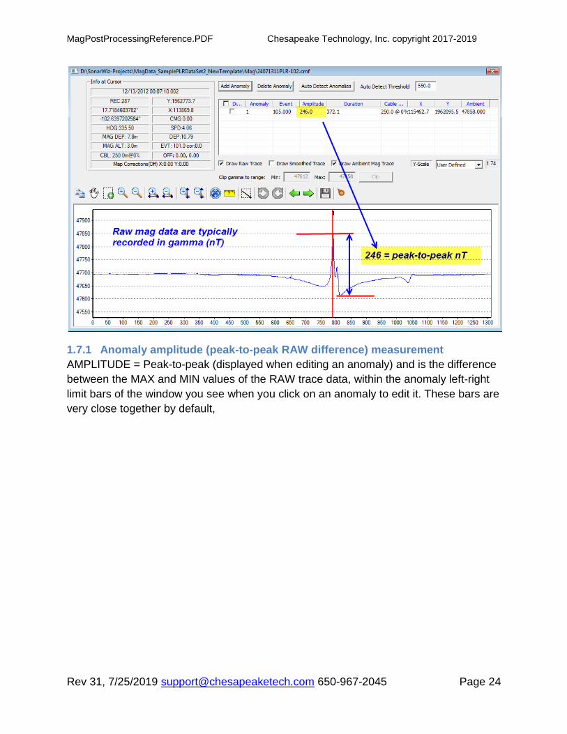
1.7.1 Anomaly amplitude (peak-to-peak RAW difference) measurement
AMPLITUDE = Peak-to-peak (displayed when editing an anomaly) and is the difference
between the MAX and MIN values of the RAW trace data, within the anomaly left-right
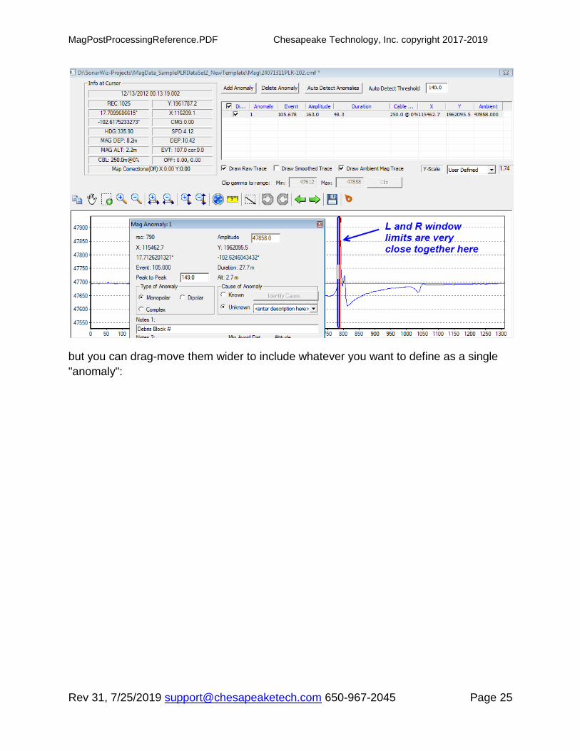
limit bars of the window you see when you click on an anomaly to edit it. These bars are
very close together by default,
MagPostProcessingReference.PDF Chesapeake Technology, Inc. copyright 2017-2019
Rev 31, 7/25/2019 [email protected] 650-967-2045 Page 25
but you can drag-move them wider to include whatever you want to define as a single
"anomaly":
MagPostProcessingReference.PDF Chesapeake Technology, Inc. copyright 2017-2019
Rev 31, 7/25/2019 [email protected] 650-967-2045 Page 26
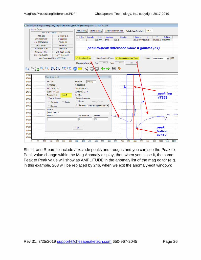
Shift L and R bars to include / exclude peaks and troughs and you can see the Peak to
Peak value change within the Mag Anomaly display, then when you close it, the same
Peak to Peak value will show as AMPLITUDE in the anomaly list of the mag editor (e.g.
in this example, 203 will be replaced by 246, when we exit the anomaly-edit window):

MagPostProcessingReference.PDF Chesapeake Technology, Inc. copyright 2017-2019
Rev 31, 7/25/2019 [email protected] 650-967-2045 Page 27

MagPostProcessingReference.PDF Chesapeake Technology, Inc. copyright 2017-2019
Rev 31, 7/25/2019 [email protected] 650-967-2045 Page 28
If you do not like the results, just delete the anomalies and try again with a different
threshold value.
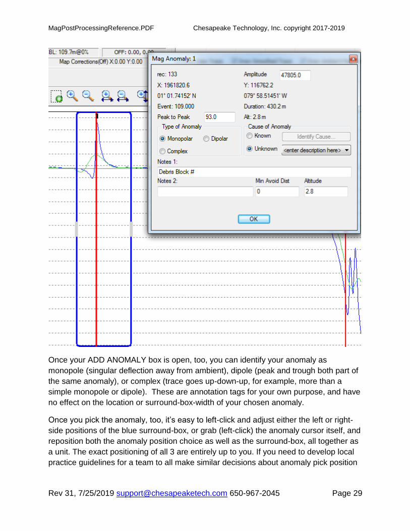
1.8 Manually Picking, or Editing Anomalies
You can manually pick anomalies just as easily. When you select ADD ANOMALY
button:
You get a PEN cursor and can pick an anomaly. The exact position is entirely up to you.
Once you pick it, a vertical red cursor will be drawn on your pick location, and a
“surround” box will be drawn around your choice, in blue, with sides left and right of your
choice, where apparently the signal returns to ‘flat” near ambient. I.e. the software tries
to define this “area” as your “adjacent to the picked” anomaly area. It’s rather arbitrary,
and you can adjust it.
MagPostProcessingReference.PDF Chesapeake Technology, Inc. copyright 2017-2019
Rev 31, 7/25/2019 [email protected] 650-967-2045 Page 29
Once your ADD ANOMALY box is open, too, you can identify your anomaly as
monopole (singular deflection away from ambient), dipole (peak and trough both part of
the same anomaly), or complex (trace goes up-down-up, for example, more than a
simple monopole or dipole). These are annotation tags for your own purpose, and have
no effect on the location or surround-box-width of your chosen anomaly.
Once you pick the anomaly, too, it’s easy to left-click and adjust either the left or right-
side positions of the blue surround-box, or grab (left-click) the anomaly cursor itself, and
reposition both the anomaly position choice as well as the surround-box, all together as
a unit. The exact positioning of all 3 are entirely up to you. If you need to develop local
practice guidelines for a team to all make similar decisions about anomaly pick position

MagPostProcessingReference.PDF Chesapeake Technology, Inc. copyright 2017-2019
Rev 31, 7/25/2019 [email protected] 650-967-2045 Page 30
or surround-box-width around an anomaly, go ahead and do that. We suggest leaving
this responsibility entirely up to you as the user.
1.8.1 Anomalies - Storage in the ANO file
When you add anomalies to the MAG project, they are stored in a binary type (not TXT
format) file in the MAG folder of your project, with the file-name = project-name, and the
file extension is ANO:
You can see that it is a rather small file, 183KB containing 50 anomalies in this case.
In a second project, we saw that over 500 anomalies were stored in an ANO file that
was 1.9MB in size. So even though you can't see inside the file except for with
SonarWiz, you can tell from its size if it has anomalies in it.
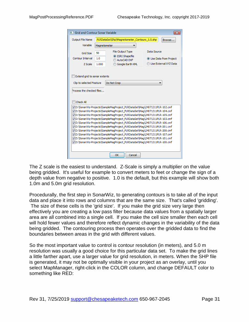
1.9 Creating Grid and Contour Exports of your Mag data
Using the Tools -> Grid / Contour option, you can create gridded mag exports to profile
your data. Here's the grid/contour export dialog:
MagPostProcessingReference.PDF Chesapeake Technology, Inc. copyright 2017-2019
Rev 31, 7/25/2019 [email protected] 650-967-2045 Page 31
The Z scale is the easiest to understand. Z-Scale is simply a multiplier on the value being gridded. It's useful for example to convert meters to feet or change the sign of a depth value from negative to positive. 1.0 is the default, but this example will show both 1.0m and 5.0m grid resolution. Procedurally, the first step in SonarWiz, to generating contours is to take all of the input data and place it into rows and columns that are the same size. That's called 'gridding'. The size of these cells is the 'grid size'. If you make the grid size very large then effectively you are creating a low pass filter because data values from a spatially larger area are all combined into a single cell. If you make the cell size smaller then each cell will hold fewer values and therefore reflect dynamic changes in the variability of the data being gridded. The contouring process then operates over the gridded data to find the boundaries between areas in the grid with different values.
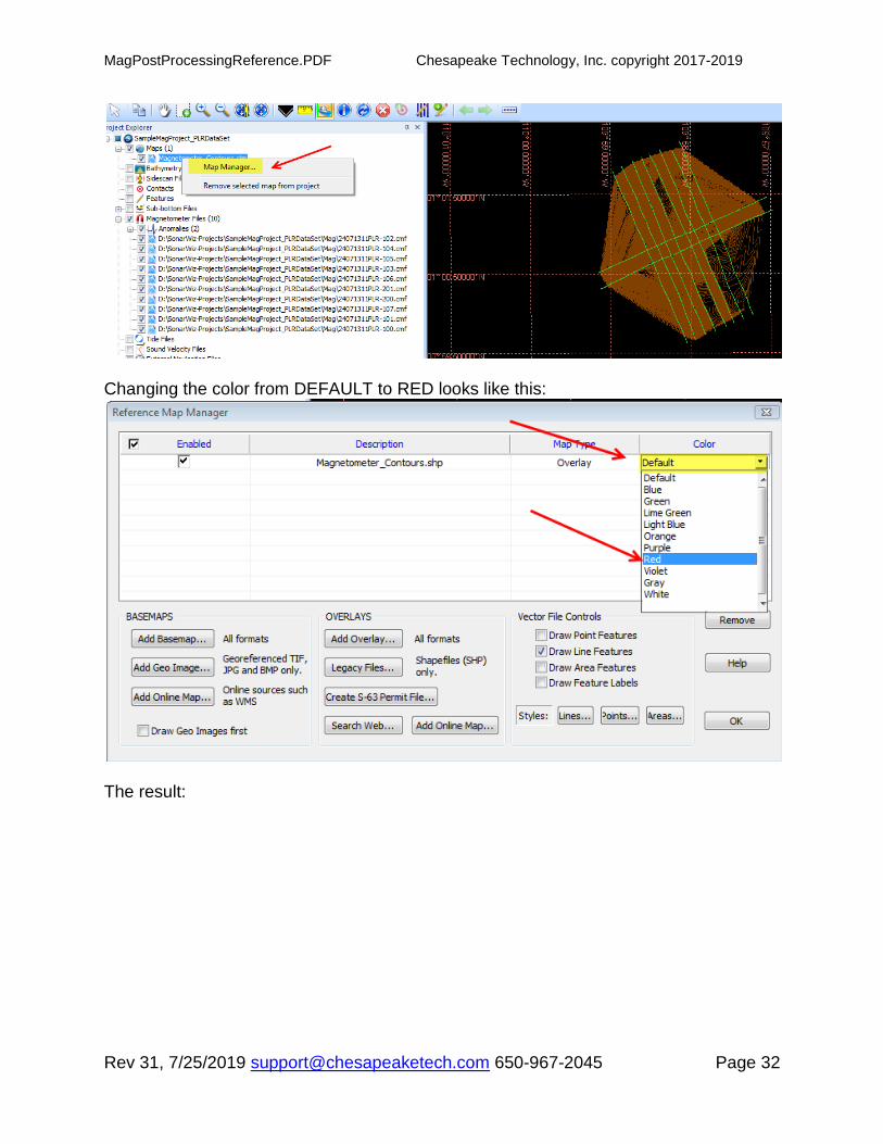
So the most important value to control is contour resolution (in meters), and 5.0 m resolution was usually a good choice for this particular data set. To make the grid lines a little farther apart, use a larger value for grid resolution, in meters. When the SHP file is generated, it may not be optimally visible in your project as an overlay, until you select MapManager, right-click in the COLOR column, and change DEFAULT color to something like RED:
MagPostProcessingReference.PDF Chesapeake Technology, Inc. copyright 2017-2019
Rev 31, 7/25/2019 [email protected] 650-967-2045 Page 32
Changing the color from DEFAULT to RED looks like this:
The result:
MagPostProcessingReference.PDF Chesapeake Technology, Inc. copyright 2017-2019
Rev 31, 7/25/2019 [email protected] 650-967-2045 Page 33
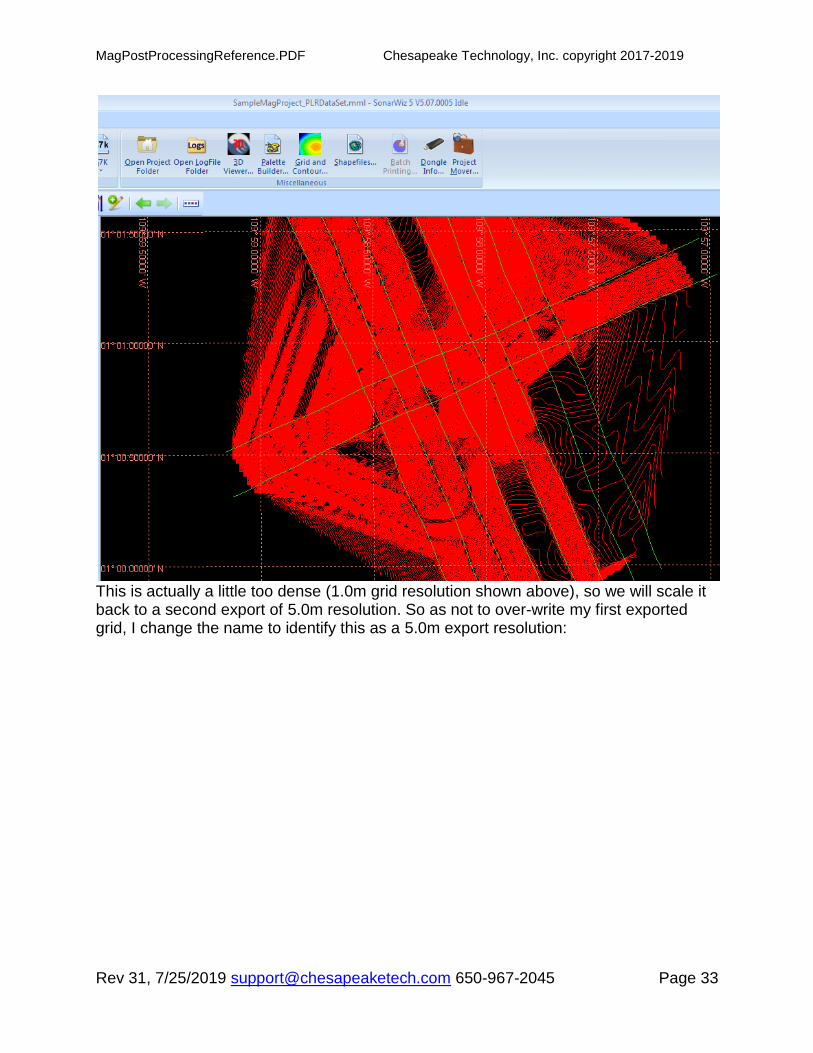
This is actually a little too dense (1.0m grid resolution shown above), so we will scale it back to a second export of 5.0m resolution. So as not to over-write my first exported grid, I change the name to identify this as a 5.0m export resolution:

MagPostProcessingReference.PDF Chesapeake Technology, Inc. copyright 2017-2019
Rev 31, 7/25/2019 [email protected] 650-967-2045 Page 34
This is a fantastic 2D view of the mag data, but in terms of directing divers on a second view of the seafloor, the anomaly report may be better. This makes for a good publication view of the overall survey though. 5.0m resolution looked better in this survey. The resolution looking best in your own survey will depend upon how closely, and in what direction, your survey lines move with respect to one another. This PLR sample data survey was a well-designed set of parallel survey lines with a few intersecting lines. Overall grid view, at 5.0 meter grid resolution, Z=1.0, GridSize = 50, stepped back a few notches on the ZOOM:

MagPostProcessingReference.PDF Chesapeake Technology, Inc. copyright 2017-2019
Rev 31, 7/25/2019 [email protected] 650-967-2045 Page 35
1.10 Adding Color-scaled Mag Grids to the Project
The "SonarWiz Gridding" PDF, Rev 9.0 or later, in your SonarWiz 7 DOCS folder (use
HELP -> Browse HELPDOCS folder) explains another option for mag data
presentation. The grid / Contour dialog allows you to select ESRI SHP file export format,
but it actually exports 2 formats of your data:
(1) the ESRI SHP file show in the examples above, and
(2) a GRD file of the same name, a Surfer6 GRID file. These are added to the project
using the Project Explorer GRIDS category -> ADD GRID function, and are color-
mapped to the mag amplitude data using COLOR WINDOW technique, not the map
manager "color" selection. (See section 1.1 of the SOnarWiz Gridding PDF to see how
to select group color (SonarWiz 6, or SonarWiz 7.01.003 or earlier), or solo-item color
(SonarWiz 7.01.004 or later) and create a color-mapped grid scaled according to the
way you want to see color mapped to mag amplitude. Example:

MagPostProcessingReference.PDF Chesapeake Technology, Inc. copyright 2017-2019
Rev 31, 7/25/2019 [email protected] 650-967-2045 Page 36
1.11 MAG Real-time and Post-Process - PLAYBACK Options
We've described the mag editor view of the mag data, which shows the ambient filtered
data versus your raw data and the anomalies you have picked. There are 3 more
interesting ways to view the mag data which we will describe here.
1.11.1 MAG / SS correlated Viewing - Real-Time or Post-Processing
You can set up a View -> Data Acquisition -> SENSOR GRAPH display graphic on your
GUI and dock it, for viewing MAG data, and this works in 2 situations:
(1) Real-time viewing of the mag sensor graph works DURING the real-time data
acquisition of mag data.

MagPostProcessingReference.PDF Chesapeake Technology, Inc. copyright 2017-2019
Rev 31, 7/25/2019 [email protected] 650-967-2045 Page 37
Then dock the sensor graph display graphic - say to the right of the map view, and you
will see live MAG data as it records. Use the SETTINGS gear icon to choose
MAGNETOMETER as the data type to display:

MagPostProcessingReference.PDF Chesapeake Technology, Inc. copyright 2017-2019
Rev 31, 7/25/2019 [email protected] 650-967-2045 Page 38
The incoming mag data will display like so:

MagPostProcessingReference.PDF Chesapeake Technology, Inc. copyright 2017-2019
Rev 31, 7/25/2019 [email protected] 650-967-2045 Page 39
(2) If you have previously recorded a sidescan file, and the mag data is inside (e.g. XTF
data recorded in www.chestech-support.com SAMPLE DATA area Sample Data Set
7, San Francisco Bay, 2007 Klein3000 SS/mag data), then during post-processing,
you can play back XTF data

MagPostProcessingReference.PDF Chesapeake Technology, Inc. copyright 2017-2019
Rev 31, 7/25/2019 [email protected] 650-967-2045 Page 40
and have both a sidescan waterfall and a sensor graph waterfall:
This does need you to have recorded the mag data INSIDE the sidescan file, which is
supported for a variety of the SonarWiz real-time servers.

MagPostProcessingReference.PDF Chesapeake Technology, Inc. copyright 2017-2019
Rev 31, 7/25/2019 [email protected] 650-967-2045 Page 41
1.11.2 Post-processing correlated SS Map View and Mag Editor Data View
A third way to see the correlation between mag data in the mag editor, and same-
position sidescan data in the map view, is to have the MAG EDITOR open, and the
MAP VIEW sidescan visible beside it, then move the mouse cursor to the mag anomaly:
It may be hard to see in a PDF, but on-screen it's easy to see the moving blue cross-
hair cursor, which shows the co-located sidescan position (right side of GUI) of where
you are pointing the mouse in the mag editor data (left side dialog). In this case it's easy
to see the 2 ships causing the mag anomaly.

MagPostProcessingReference.PDF Chesapeake Technology, Inc. copyright 2017-2019
Rev 31, 7/25/2019 [email protected] 650-967-2045 Page 42
1.12 Gradiometer Post-Processing in SonarWiz
Gradiometer post-processing is now supported directly in SonarWiz 7, since version
7.00.0019:
7.00.0019 64-bit
1/26/2018 12:34:26 PM
3. ENHANCMENT:MAG:SI-568 -- We have added a new field to the magnetometer file import template types which allows us to create mag_file templates with two mag amplitude values in the same template. The idea is that when the template parser sees two mag amplitudes it will subtract mag1-mag2 and store that difference in the CMF file. The first new template that uses the new "mag_amplitude2" field is called GEMS_Gradiometer and appears in FFtemplates_system.db3 version 7.65
See sections 4.8, 4.9, and 4.19 above, describing our first set of sample gradiometer
data, and how it can be imported. Your gradiometer data file will need position and
mag1 and mag2 columns, as a minimum, to import and compute gradiometer results.
Previous versions of SonarWiz supported the separate mag1 or mag2 post-processing,
serially, from a single file. The results could be comnpared by SonarWIz in grid format,
using the volumn calculator, which supports grid subtraction. The new feature in
7.00.0019 supported in SonarWiz, is that the subtraction of mag1 - mag2 columns can
be done during the import stage, so that direct viewing, editing, anomaly-identification,
and all other magnetometry post-processing functions, can be applied to the
gradiometer results. All it takes is to have at least position and mag1 and mag2 columns
within the same data file, to be able to import it and compute the mag1 - mag2
gradiometer results during import.
1.12.1 Gradiometer Sample Data Set - optional images
All the basic functions of magnetometry post-processing are aavailable on a
gradiometer data set. Specifically though, you may want to consider these 3 optional
views:
(1) Direct import, editing, gridding and contour line views of the mag1 data alone;

MagPostProcessingReference.PDF Chesapeake Technology, Inc. copyright 2017-2019
Rev 31, 7/25/2019 [email protected] 650-967-2045 Page 43
(2) Direct import, editing, gridding and contour line views of the mag1 data alone;
(3) Direct import, editing, gridding and contour line views of the mag1-mag2 gradiometer
data.
There is value in viewing all 3 options. The individual mag1 and mag2 views show you
background ambient mag influences, in addition to the sensor-specific anomalies. The
gradiometer trace being a subtraction of mag1-mag2, gives the benefit of a common-
mode rejection factor, since common signals at both sensors will subtract out, leaving
only a difference function showing where mag1 and mag2 were independently seeing a
magnetic disturbance, more at one sensor than the other.
MagPostProcessingReference.PDF Chesapeake Technology, Inc. copyright 2017-2019
Rev 31, 7/25/2019 [email protected] 650-967-2045 Page 44
1.13 SIT Recommendations
Surrogate Item Trial (SIT) is a recommended test practice discussed in many
magnetometer vendor web-sites,. The basic idea is to calibrate your sensor and see
how much magnetic deflection you get, when surveying at various distances from a
ferrous object of known mass. If you've done that, then you have a better sense of what
the ferrous mass might be, when you perform a real survey, and see a magnetic
deflection of a certain amplitude.
2 Magnetometer File Format Templates - Overview
Inside the SonarWiz Program Files folder is a special file, controlling the ability to import
mag files (and other serial-data template-parsed inputs): FFTemplates_system.db3.
Note that FFTemplates_system.db3 also contains templates for magnetometer sensors,
but for magnetometer file import, only the template choices available of type
“magnetometer file” are presented in the SonarWiz import “File template” choice drop-
menu, shown below for SonarWiz (newest changes in yellow)::

MagPostProcessingReference.PDF Chesapeake Technology, Inc. copyright 2017-2019
Rev 31, 7/25/2019 [email protected] 650-967-2045 Page 45
N OTE: The choices above are present in version 7.00.0019 and beyond. These
import options can be made available in SonarWiz 6, by downloading and
installing the UTILITIES area FFTemplates_system.db3 file from
http://www.chestech-support.com.
2.1 Choosing a File Template and Pre-viewing your Magnetometer Data
Based upon the magnetometer file import templates shown below, examine your own
ASCII text file magnetometer data and see if it matches an existing template. Using an
existing template is easiest, but if we don’t have one to match your file, we can create
one. Magnetometer files are easily imported into EXCEL, and can then be manipulated
by column, and can often be set up to match an existing template. In fact, the

MagPostProcessingReference.PDF Chesapeake Technology, Inc. copyright 2017-2019
Rev 31, 7/25/2019 [email protected] 650-967-2045 Page 46
magnetometer data can easily be pre-viewed in EXCEL by viewing columns as a line
graph.
2.2 Managing your Mag Project - project movement limitations
Anomalies are linked to the specific filename (CMF) and location of those files, in your
project, and this has implications. If you create the project at a certain drive letter and
path name and project name, you can move the project to another PC, but you must
maintain the exact same drive letter, path name (folders sequence), and project name,
in the new location, in order to be able to fully re-use (edit, add, delete) anomalies from
the first project.
For example, if the first computer project is:
D:\SonarWiz-projects\MagProject1 (on computer #1)
then that entire folder can move intact to computer #2 and be placed at the exact same
location, and it will open and be fully useable with the same or a later version of
SonarWiz, e.g.
D:\SonarWiz-projects\MagProject1 (on computer #2)
If you need to add to the project after the move, new files and anomalies will be possible
too!

MagPostProcessingReference.PDF Chesapeake Technology, Inc. copyright 2017-2019
Rev 31, 7/25/2019 [email protected] 650-967-2045 Page 47
3 Magnetometer File Templates - Format Summary
In the Magnetometry file import options, here are the File Template types which may be
selected:
(These mag file templates are all available in 7.00.0019 and later versions.)

MagPostProcessingReference.PDF Chesapeake Technology, Inc. copyright 2017-2019
Rev 31, 7/25/2019 [email protected] 650-967-2045 Page 48
These are the key fields in the following templates:
File Template Name Fields Key Fields
AquaScan AXL 8 Preamble, mag, latitude, lat-hem, longitude, lon-hem,skip,skip
Arts Gavia MAG 6 Longitude, latitude, mag_alt, mag_amp, skip
Balaswamy-MAG 6 Time, date, shot#, mag_amplitude, easting, northing
C&C Magnetometer 11 Shot, time, date, latitude, longitude, easting, northing, mag
CSF Magnetometer N/A Importing embedded MAG channel from within a CSF file FSL - MAG 6 Date,time,mag,easting,northing
G882_Type3 15 Date,time,lat,long,skip,skip,mag_amplitude,skip,skip,skip
GEMS_Meren13_INT 15 Mag, skip,depth,date,time,long.,lat.,skips ...linename,skip
GEMS_Meren13_INT_SHIFT 15 Mag, skip,depth,date,time,skip,skip,long.,lat.,skips ...linename,skip
GEMS-gradiometer 26 Mag, skip1, depth, altitude, Mag2 ... date,time ... cable-out
GEMS-INT-mag1 26 Mag, skip1, depth, altitude, skip2 ... date,time ... cable-out
GEMS-INT-mag2 26 skip1, skip2, depth, altitude, Mag ... date,time ... cable-out
GEMS-MagLog 15 Mag,sig1,depth,date,time,skip,skip,long.,lat.,skip,skip,skip.height...
GEMS-MagLog-CSV 15 Mag,sig1,depth,date,time,skip,skip,long.,lat.,skip,skip,skip.height...
GEO_G882_MAG 9 Skip,skip,easting,northing,skip,skip,mag_amplitude,skip,skip
HWTMA-2011-1-MAG 9 Date, time, line, easting, northing, mag, alt, hdg, layback
Hypack Raw Magnetometer N/A Complex text-file format (not template-driven) JSF_MAG_IMPORT 8 Date,time,latitude,longitude,mag,skip, depth,altitude
Lat Lon Mag (tab delimited) 3 Latitude, longitude, mag
Lon Lat Mag (space delimited) 3 Longitude, latitude, mag Mag Log Type 4 19 Mag, sig1, depth, altitude, date, time, longitude, latitude …
Mag Log Type 5 16 Mag, sig1, date, time, long, lat, shift_lon, shift_lat, atargets, nmags ...
Mag Log Type 6 17 Mag, sig1, date, time, long, lat, shift_lon, shift_lat, atargets, nmags ...
Mag Log Type 7 18 Date,time,mag_amp,sigQ,mag_depth …
Maglog GPS-POS w/Altitude 16 Mag, depth, altitude, date, time, longitude, latitude … Maglog GPS-Pos-Alt-MAG2-MAG3 25 Mag, depth, altitude, date, time, longitude, latitude …
Maglog Magnetometer 17 Mag, depth, altitude, date, time, longitude, latitude …
Maglog w/Altitude 18 Mag, depth, altitude, date, time, longitude, latitude … MagLog-Spencer 18 Mag, sig1, depth, alt, date, time, long, lat, shift_lon, shift_lat ...
MMT Maglog GPS-pos w/altitude 8 Mag, signal, depth, altitude, date, time, longitude, latitude
PLR Magnetometer 18 Time, line, shot, northing, easting, heading, speed, mag…
PLR Magnetometer (m) 18 Time, line, shot, northing, easting, heading, speed, mag…
SeaLink MAG 6 Date, time, mag_amp, easting, northing, mag_alt
SeaLink-Wilhelm 19 Skip0,Mag, Skip2-8,altitude, latitude, longitude, Skip12-19
SeaSpy Type 3 16 Skip,time,date,lat.,long.,north.,east.,mag,skip,skip,cable-out ...
SonarWiz-Default-MAG 10 Date,time,lat,long,Easting,Northing,mag_amp,skip,skip,skip
SWM-E,T,D,L,L,Y,X,M,A,D,S 11 Shot,Time,Date,Lat,Long,skip,skip,mag, alt, depth,skip
SWM-MAG882 9 Date, time, latitude, longitude, mag, strength, depth
SonarWiz- MAG-file-default 10 Date,time,lat,long,Easting,Northing,mag_amp,skip,skip,skip
SWM-SEASPY 12 Date, time, latitude, longitude, mag, depth, altitude
SWM-SEASPY_XY 12 Date, time, easting, northing, mag, depth, altitude
TBSmith Hypack MAG 5 Shot, easting, northing, mag, linename
TeslaOffshore-MAG-1 12 Shot, skip,skip,depth,easting,northing,mag,alt,skip,date,time ...
UDEL_G882_1 30 Mag_amplitude is in column 21

MagPostProcessingReference.PDF Chesapeake Technology, Inc. copyright 2017-2019
Rev 31, 7/25/2019 [email protected] 650-967-2045 Page 49
UDEL_G882_2 32 Mag_amplitude is in column 32
XYZ MAG 3 Easting, northing, mag
4 Magnetometer File Format Templates – Details
The following named templates are currently supported by SonarWiz 6.05.0009 and
subsequent versions, and are selectable under the “File Template” button of the mag
file import dialog.
4.1 AquaScan AXL
Delimited by: Line Count
Lines per record: 1
Column name record: None
Initial skip count: 0
Record delimiters: Newline
Number of fields: 8
Fields delimited by: single delimiter character
Field delimiter: comma
Template format details
Field Name Type Format
0 preamble char
1 Mag_amplitude float
2 latitude Geocoord DDDMM.mmm
3 Lat-hemisphere char
4 longitude Geocoord DDDMM.mmm
5 Lon-hemisphere char
6 Unused_1 float
7 Unused_2 integer
4.2 Arts Gavia MAG
Delimited by: Line Count
Lines per record: 1
Column name record: None
Initial skip count: 1
Record delimiters: Newline
Number of fields: 7
Fields delimited by: single delimiter character
Field delimiter: space

MagPostProcessingReference.PDF Chesapeake Technology, Inc. copyright 2017-2019
Rev 31, 7/25/2019 [email protected] 650-967-2045 Page 50
Template format details
Field Name Type Format
0 longitude geocoord DDD.ddd
1 latitude geocoord DDD.ddd
2 Mag_altitude float
3 Mag_amplitude float
4 skip float
5 time time HH:MM:SS.sss
6 date float
4.3 Balaswamy-MAG
Delimited by: Line Count
Lines per record: 1
Column name record: None
Initial skip count: 1
Record delimiters: Newline
Number of fields: 7
Fields delimited by: single delimiter character
Field delimiter: space
Template format details
Field Name Type Format
0 longitude geocoord DDD.ddd
1 latitude geocoord DDD.ddd
2 Mag_altitude float
3 Mag_amplitude float
4 skip float
5 time time HH:MM:SS.sss
6 date float
4.4 C&C Magnetometer
Delimited by: Line Count
Lines per record: 1
Column name record: None
Initial skip count: 0
Record delimiters: Newline
Number of fields: 11
Fields delimited by: single delimiter character
Field delimiter: comma
Template format details
MagPostProcessingReference.PDF Chesapeake Technology, Inc. copyright 2017-2019
Rev 31, 7/25/2019 [email protected] 650-967-2045 Page 51
Field Name Type Format
0 shotnumber char
1 time time HH:MM:SS.sss
2 date date MM/DD/YY
2 latitude geocoord
4 longitude geocoord
5 easting gridcoord
6 northing gridcoord
7 mag_amplitude float
8 mag_altitude float
9 mag_depth float
10 signal_strength float
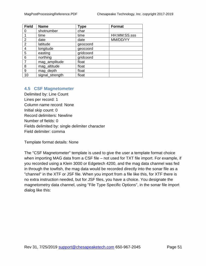
4.5 CSF Magnetometer
Delimited by: Line Count
Lines per record: 1
Column name record: None
Initial skip count: 0
Record delimiters: Newline
Number of fields: 0
Fields delimited by: single delimiter character
Field delimiter: comma
Template format details: None
The "CSF Magnetometer" template is used to give the user a template format choice
when importing MAG data from a CSF file – not used for TXT file import. For example, if
you recorded using a Klein 3000 or Edgetech 4200, and the mag data channel was fed
in through the towfish, the mag data would be recorded directly into the sonar file as a
"channel" in the XTF or JSF file. When you import from a file like this, for XTF there is
no extra instruction needed, but for JSF files, you have a choice. You designate the
magnetometry data channel, using "File Type Specific Options", in the sonar file import
dialog like this:

MagPostProcessingReference.PDF Chesapeake Technology, Inc. copyright 2017-2019
Rev 31, 7/25/2019 [email protected] 650-967-2045 Page 52
After importing the sonar file, which creates the internal "Compact Sonar File" CSF file
format in the SonarWiz mosaic, you then import the magnetometer data - which
basically extracts it from the CSF file, and makes it editable as a separate "CMF"
(Compact mag format) file, supported by the mag editing features of the magnetometry
post-processing license of SonarWiz.
4.6 FSL-MAG
Delimited by: Line Count
Lines per record: 1
Column name record: None
Initial skip count: 5
Record delimiters: Newline
Number of fields: 6
Fields delimited by: variable delimiter characters

MagPostProcessingReference.PDF Chesapeake Technology, Inc. copyright 2017-2019
Rev 31, 7/25/2019 [email protected] 650-967-2045 Page 53
Template format details
Field Name Type Format
0 date date DD/MM/YYYY
1 time time HH:MM:SS.sss
2 mag_amplitude float
3 shotnumber char
4 easting gridcoord
5 northing gridcoord
4.7 G882_Type3
Delimited by: Line Count
Lines per record: 1
Column name record: None
Initial skip count: 0
Record delimiters: Newline
Number of fields: 10
Fields delimited by: single delimiter character
Field delimiter: comma
Template format details:
Field Name Type Format
0 date date DD/MM/YY
1 time time HH:MM:SS.sss
2 latitude geocoord DDD.ddd
3 longitude geocoord DDD.ddd
4 skip1 float
5 skip2 float
6 mag_amplitude float
7 Skip_3 float
8 Skip_4 float
9 Skip_5 integer
4.8 GEMS_Meren13_INT
Delimited by: Line Count
Lines per record: 1
Column name record: None
Initial skip count: 0
Record delimiters: Newline
Number of fields: 15
Fields delimited by: single delimiter character
Field delimiter: space
Template format details:

MagPostProcessingReference.PDF Chesapeake Technology, Inc. copyright 2017-2019
Rev 31, 7/25/2019 [email protected] 650-967-2045 Page 54
Field Name Type Format
0 mag_amplitude float
1 Skip_1 float
2 mag_depth float
3 date date MM/DD/YY
4 time time HH:MM:SS.sss
5 longitude geocoord DDD.ddd
6 latitude geocoord DDD.ddd
7 Skip_2 float
8 Skip_3 float
9 Skip_4 integer
10 Skip_5 integer
11 Skip_6 integer
12 Skip_7 float
13 linename char
14 Skip_layback float
4.9 GEMS_Meren13_INT_SHIFT
Very similar to the previous template, but longitude, latitude shift by 2 positions, from 5,6
to 7,8.
Delimited by: Line Count
Lines per record: 1
Column name record: None
Initial skip count: 0
Record delimiters: Newline
Number of fields: 15
Fields delimited by: single delimiter character
Field delimiter: space
Template format details
Field Name Type Format
0 mag_amplitude float
1 Skip_1 float
2 mag_depth float
3 date date DD/MM/YY
4 time time HH:MM:SS.sss
5 Skip_2 float
6 Skip_3 float
7 longitude geocoord DDD.ddd
8 latitude geocoord DDD.ddd
9 Skip_4 integer
10 Skip_5 integer
11 Skip_6 integer
12 Skip_7 float
13 linename char

MagPostProcessingReference.PDF Chesapeake Technology, Inc. copyright 2017-2019
Rev 31, 7/25/2019 [email protected] 650-967-2045 Page 55
14 Skip_layback float
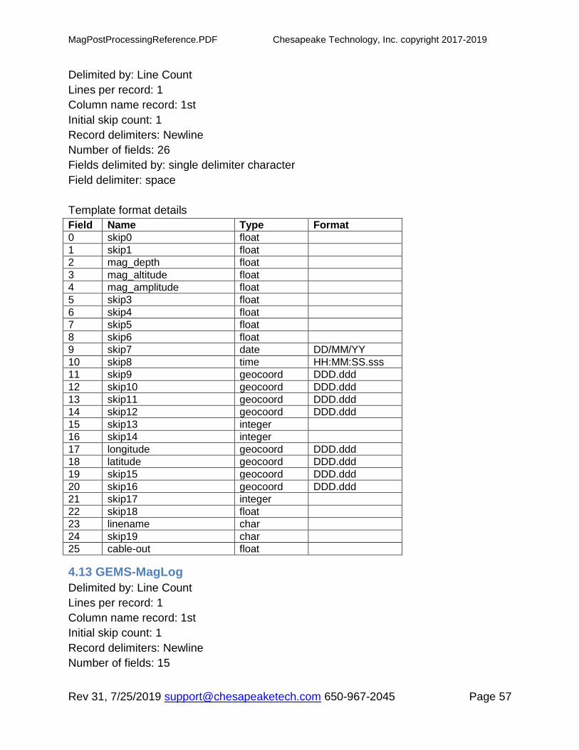
4.10 GEMS-gradiometer
See the next 2 templates. This template reads mag1 (index 0) and mag2 (index 4) and
subtracts them, producing a singular gradiometer result, which gets saved as the
imported CMF file, as the mag amplitude.
Delimited by: Line Count
Lines per record: 1
Column name record: 1st
Initial skip count: 1
Record delimiters: Newline
Number of fields: 26
Fields delimited by: single delimiter character
Field delimiter: space
Template format details
Field Name Type Format
0 mag_amplitude float
1 skip1 float
2 mag_depth float
3 mag_altitude float
4 mag_amplitude2 float
5 skip2 float
6 skip3 float
7 skip4 float
8 skip5 float
9 date date DD/MM/YY
10 time time HH:MM:SS.sss
11 skip8
12 skip9
13 skip10
14 skip11
15 skip12 integer
16 skip13 integer
17 longitude geocoord DDD.ddd
18 latitude geocoord DDD.ddd
19 skip14
20 skip15
21 skip16 integer
22 skip17 float
23 linename char
24 skip18 char
25 cable-out float

MagPostProcessingReference.PDF Chesapeake Technology, Inc. copyright 2017-2019
Rev 31, 7/25/2019 [email protected] 650-967-2045 Page 56
4.11 GEMS-INT-mag1
This template allows individual viewing/editing of a gradiometer component - the first
mag-amplitude appearing in the data (column index 0).
Delimited by: Line Count
Lines per record: 1
Column name record: 1st
Initial skip count: 1
Record delimiters: Newline
Number of fields: 26
Fields delimited by: single delimiter character
Field delimiter: space
Template format details
Field Name Type Format
0 mag_amplitude float
1 skip1 float
2 mag_depth float
3 mag_altitude float
4 skip2 float
5 skip3 float
6 skip4 float
7 skip5 float
8 skip6 float
9 skip7 date DD/MM/YY
10 skip8 time HH:MM:SS.sss
11 skip9 geocoord DDD.ddd
12 skip10 geocoord DDD.ddd
13 skip11 geocoord DDD.ddd
14 skip12 geocoord DDD.ddd
15 skip13 integer
16 skip14 integer
17 longitude geocoord DDD.ddd
18 latitude geocoord DDD.ddd
19 skip15 geocoord DDD.ddd
20 skip16 geocoord DDD.ddd
21 skip17 integer
22 skip18 float
23 linename char
24 skip19 char
25 cable-out float
4.12 GEMS-INT-mag2
This template allows individual viewing/editing of a gradiometer component - the second
mag-amplitude appearing in the data (column index 4).
MagPostProcessingReference.PDF Chesapeake Technology, Inc. copyright 2017-2019
Rev 31, 7/25/2019 [email protected] 650-967-2045 Page 57
Delimited by: Line Count
Lines per record: 1
Column name record: 1st
Initial skip count: 1
Record delimiters: Newline
Number of fields: 26
Fields delimited by: single delimiter character
Field delimiter: space
Template format details
Field Name Type Format
0 skip0 float
1 skip1 float
2 mag_depth float
3 mag_altitude float
4 mag_amplitude float
5 skip3 float
6 skip4 float
7 skip5 float
8 skip6 float
9 skip7 date DD/MM/YY
10 skip8 time HH:MM:SS.sss
11 skip9 geocoord DDD.ddd
12 skip10 geocoord DDD.ddd
13 skip11 geocoord DDD.ddd
14 skip12 geocoord DDD.ddd
15 skip13 integer
16 skip14 integer
17 longitude geocoord DDD.ddd
18 latitude geocoord DDD.ddd
19 skip15 geocoord DDD.ddd
20 skip16 geocoord DDD.ddd
21 skip17 integer
22 skip18 float
23 linename char
24 skip19 char
25 cable-out float
4.13 GEMS-MagLog
Delimited by: Line Count
Lines per record: 1
Column name record: 1st
Initial skip count: 1
Record delimiters: Newline
Number of fields: 15

MagPostProcessingReference.PDF Chesapeake Technology, Inc. copyright 2017-2019
Rev 31, 7/25/2019 [email protected] 650-967-2045 Page 58
Fields delimited by: single delimiter character
Field delimiter: space
Template format details
Field Name Type Format
0 mag_amplitude float
1 Signal_1 float
2 mag_depth float
3 date date DD/MM/YY
4 time time HH:MM:SS.sss
5 SKIP1 float
6 SKIP2 float
7 longitude geocoord DDD.ddd
8 latitude geocoord DDD.ddd
9 SKIP3 integer
10 SKIP4 integer
11 SKIP5 integer
12 GPS_Height float
13 LINE integer
14 Mag_Cableout float
4.14 GEMS-MagLog-CSV
Delimited by: Line Count
Lines per record: 1
Column name record: 1st
Initial skip count: 1
Record delimiters: Newline
Number of fields: 15
Fields delimited by: single delimiter character
Field delimiter: comma
Template format details
Field Name Type Format
0 mag_amplitude float
1 Signal_1 float
2 mag_depth float
3 date date DD/MM/YY
4 time time HH:MM:SS.sss
5 SKIP1 float
6 SKIP2 float
7 longitude geocoord DDD.ddd
8 latitude geocoord DDD.ddd
9 SKIP3 integer
10 SKIP4 integer
11 SKIP5 integer
12 GPS_Height float

MagPostProcessingReference.PDF Chesapeake Technology, Inc. copyright 2017-2019
Rev 31, 7/25/2019 [email protected] 650-967-2045 Page 59
13 LINE integer
14 Mag_Cableout float
4.15 GEO_G882_Mag
(Added in release 5.08.0009)
Delimited by: Character
Lines per record: N/A
Column name record: None
Initial skip count: 0
Record delimiters: Newline
Number of fields: 9
Fields delimited by: single delimiter character
Field delimiter: comma
Template format details
Field Name Type Format
0 SKIP1 float
1 SKIP2 float
2 Easting gridcoord
3 Northing gridcoord
4 SKIP3 float
5 SKIP4 integer
6 Mag_amplitude float
7 SKIP5 float
8 SKIP6 float
4.16 HWTMA-2011-1-MAG
Delimited by: Line Count
Lines per record: 1
Column name record: None
Initial skip count: 0
Record delimiters: Newline
Number of fields: 9
Fields delimited by: single delimiter character
Field delimiter: comma
Template format details
Field Name Type Format
0 date date MM/DD/YYYY
1 time time HH:MM:SS.sss
2 Linename char

MagPostProcessingReference.PDF Chesapeake Technology, Inc. copyright 2017-2019
Rev 31, 7/25/2019 [email protected] 650-967-2045 Page 60
2 easting gridcoord
4 northing gridcoord
5 mag_amplitude float
6 mag_altitude float
7 mag_depth float
8 mag_cableout float
4.17 HYPACK RAW File Magnetometer
A binary file type import from HYPACK RAW files.
4.18 JSF_MAG_IMPORT
Used during Edgetech server recording of mag data, which then gets imported.
Delimited by: Line Count
Lines per record: 1
Column name record: None
Initial skip count: 0
Record delimiters: Newline
Number of fields: 8
Fields delimited by: single delimiter character
Field delimiter: comma
Template format details
Field Name Type Format
0 date date MM/DD/YYYY
1 time time HH:MM:SS.sss
2 latitude gridcoord DDD.ddd
3 longitude gridcoord DDD.ddd
4 mag_amplitude float
5 skip float
6 mag_depth float
7 mag_altitude float
4.19 Lat Lon MAG (tab delimited)
Delimited by: Line Count
Lines per record: 1
Column name record: None
Initial skip count: 0
Record delimiters: Newline
Number of fields: 3
Fields delimited by: Single delimiter characters (tab)
MagPostProcessingReference.PDF Chesapeake Technology, Inc. copyright 2017-2019
Rev 31, 7/25/2019 [email protected] 650-967-2045 Page 61
Template format details
Field Name Type Format
0 latitude geocoord
1 longitude geocoord
2 mag_amplitude float
4.20 Lon Lat MAG (space delimited)
Delimited by: Line Count
Lines per record: 1
Column name record: None
Initial skip count: 0
Record delimiters: Newline
Number of fields: 3
Fields delimited by: Single delimiter character (space)
Template format details
Field Name Type Format
0 longitude geocoord
1 latitude geocoord
2 mag_amplitude float
4.21 Maglog Type 4
Delimited by: Line Count
Lines per record: 1
Column name record: 1st
Initial skip count: 1
Record delimiters: Newline
Number of fields: 19
Fields delimited by: single delimiter character
Field delimiter: space
Template format details
Field Name Type Format
0 mag_amplitude float
1 Unused_signal1 float
2 mag_depth float
3 mag_altitude float
4 date date MM/DD/YY
5 time time HH:MM:SS.sss
6 Gps_longitude geocoord DDD.ddd
7 GPS_latitude geocoord DDD.ddd
8 Shift_longitude geocoord DDD.ddd
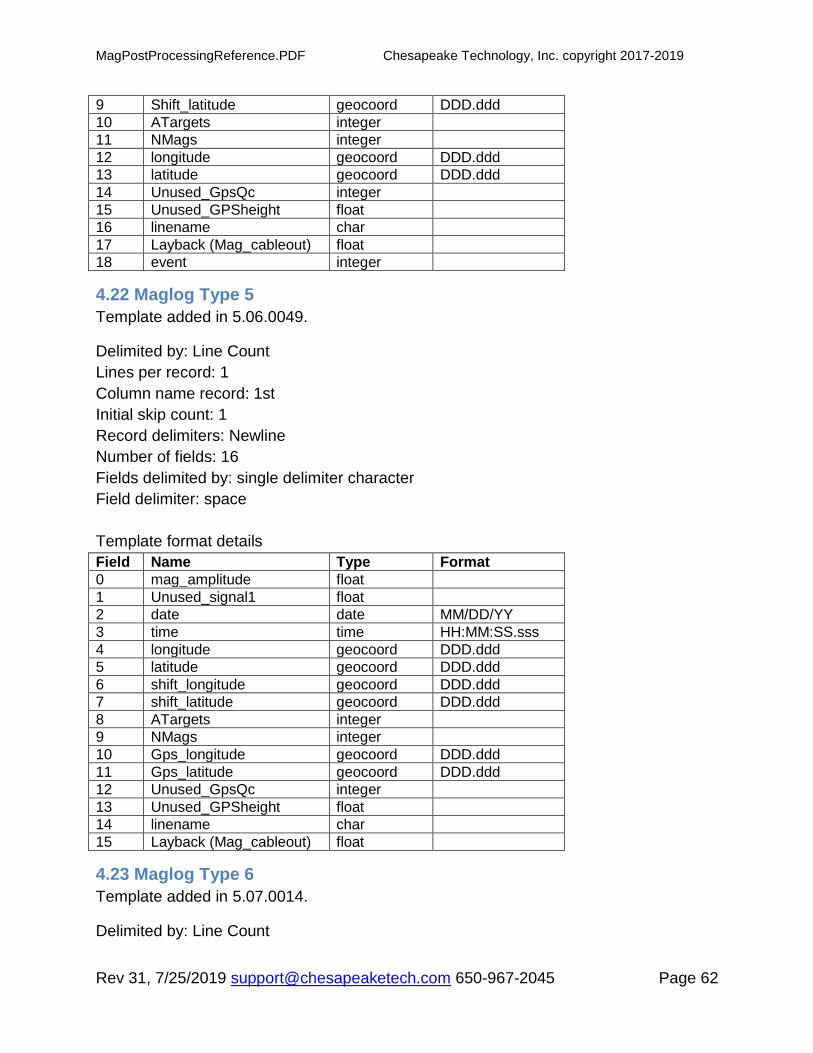
MagPostProcessingReference.PDF Chesapeake Technology, Inc. copyright 2017-2019
Rev 31, 7/25/2019 [email protected] 650-967-2045 Page 62
9 Shift_latitude geocoord DDD.ddd
10 ATargets integer
11 NMags integer
12 longitude geocoord DDD.ddd
13 latitude geocoord DDD.ddd
14 Unused_GpsQc integer
15 Unused_GPSheight float
16 linename char
17 Layback (Mag_cableout) float
18 event integer
4.22 Maglog Type 5
Template added in 5.06.0049.
Delimited by: Line Count
Lines per record: 1
Column name record: 1st
Initial skip count: 1
Record delimiters: Newline
Number of fields: 16
Fields delimited by: single delimiter character
Field delimiter: space
Template format details
Field Name Type Format
0 mag_amplitude float
1 Unused_signal1 float
2 date date MM/DD/YY
3 time time HH:MM:SS.sss
4 longitude geocoord DDD.ddd
5 latitude geocoord DDD.ddd
6 shift_longitude geocoord DDD.ddd
7 shift_latitude geocoord DDD.ddd
8 ATargets integer
9 NMags integer
10 Gps_longitude geocoord DDD.ddd
11 Gps_latitude geocoord DDD.ddd
12 Unused_GpsQc integer
13 Unused_GPSheight float
14 linename char
15 Layback (Mag_cableout) float
4.23 Maglog Type 6
Template added in 5.07.0014.
Delimited by: Line Count

MagPostProcessingReference.PDF Chesapeake Technology, Inc. copyright 2017-2019
Rev 31, 7/25/2019 [email protected] 650-967-2045 Page 63
Lines per record: 1
Column name record: 1st
Initial skip count: 1
Record delimiters: Newline
Number of fields: 17
Fields delimited by: single delimiter character
Field delimiter: space
Template format details
Field Name Type Format
0 mag_amplitude float
1 unused_signal1 float
2 date date MM/DD/YY
3 time time HH:MM:SS.sss
4 gps_longitude geocoord DDD.ddd
5 gps_latitude geocoord DDD.ddd
6 shift_longitude geocoord DDD.ddd
7 shift_latitude geocoord DDD.ddd
8 ATargets integer
9 NMags integer
10 longitude geocoord DDD.ddd
11 latitude geocoord DDD.ddd
12 Unused_GpsQc integer
13 Unused_GPSheight float
14 linename char
15 Route char
16 Layback (Mag_cableout) float
4.24 Maglog Type 7
Template added in 5.08.0003.
Delimited by: Line Count
Lines per record: 1
Column name record: 1st
Initial skip count: 1
Record delimiters: Newline
Number of fields: 18
Fields delimited by: single delimiter character
Field delimiter: comma
Template format details:
Field Name Type Format
0 date date MM/DD/YYYY
1 time time HH:MM:SS.sss

MagPostProcessingReference.PDF Chesapeake Technology, Inc. copyright 2017-2019
Rev 31, 7/25/2019 [email protected] 650-967-2045 Page 64
2 mag_amplitude float
3 signalQuality integer
4 mag_depth float
5 linename char Used to split files!
6 longitude geocoord DDD.ddd
7 latitude geocoord DDD.ddd
8 mag Easting gridcoord
9 mag Northing gridcoord
10 Utmzone char e.g. 34N
11 GPSlatitude geocoord DDD.ddd
12 GPSlongitude geocoord DDD.ddd
13 GPS Easting gridcoord
14 GPS Northing gridcoord
15 GPSzone char e.g. 34N
16 Marker char
17 MarkerTime char
4.25 Maglog Type 8 (no longer supported)
Delimited by: Line Count
Lines per record: 1
Column name record: 1st
Initial skip count: 1
Record delimiters: Newline
Number of fields: 19
Fields delimited by: single delimiter character
Field delimiter: space
Template format details
Field Name Type Format
0 mag_amplitude float
1 Unused_signal1 float
2 mag_depth float
3 mag_altitude float
4 date date MM/DD/YY
5 time time HH:MM:SS.sss
6 Gps_longitude geocoord DDD.ddd
7 GPS_latitude geocoord DDD.ddd
8 Shift_longitude geocoord DDD.ddd
9 Shift_latitude geocoord DDD.ddd
10 ATargets integer
11 NMags integer
12 longitude geocoord DDD.ddd
13 latitude geocoord DDD.ddd
14 Unused_GpsQc integer
15 Unused_GPSheight float
MagPostProcessingReference.PDF Chesapeake Technology, Inc. copyright 2017-2019
Rev 31, 7/25/2019 [email protected] 650-967-2045 Page 65
16 linename char Used to split files!
17 route-name char
18 Layback (Mag_cableout) float
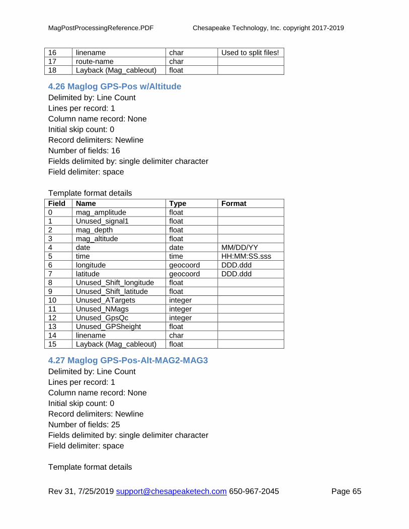
4.26 Maglog GPS-Pos w/Altitude
Delimited by: Line Count
Lines per record: 1
Column name record: None
Initial skip count: 0
Record delimiters: Newline
Number of fields: 16
Fields delimited by: single delimiter character
Field delimiter: space
Template format details
Field Name Type Format
0 mag_amplitude float
1 Unused_signal1 float
2 mag_depth float
3 mag_altitude float
4 date date MM/DD/YY
5 time time HH:MM:SS.sss
6 longitude geocoord DDD.ddd
7 latitude geocoord DDD.ddd
8 Unused_Shift_longitude float
9 Unused_Shift_latitude float
10 Unused_ATargets integer
11 Unused_NMags integer
12 Unused_GpsQc integer
13 Unused_GPSheight float
14 linename char
15 Layback (Mag_cableout) float
4.27 Maglog GPS-Pos-Alt-MAG2-MAG3
Delimited by: Line Count
Lines per record: 1
Column name record: None
Initial skip count: 0
Record delimiters: Newline
Number of fields: 25
Fields delimited by: single delimiter character
Field delimiter: space
Template format details
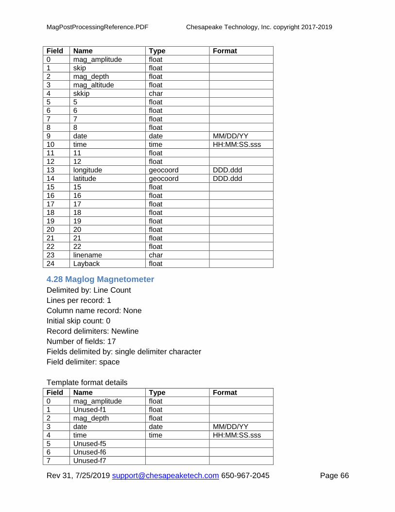
MagPostProcessingReference.PDF Chesapeake Technology, Inc. copyright 2017-2019
Rev 31, 7/25/2019 [email protected] 650-967-2045 Page 66
Field Name Type Format
0 mag_amplitude float
1 skip float
2 mag_depth float
3 mag_altitude float
4 skkip char
5 5 float
6 6 float
7 7 float
8 8 float
9 date date MM/DD/YY
10 time time HH:MM:SS.sss
11 11 float
12 12 float
13 longitude geocoord DDD.ddd
14 latitude geocoord DDD.ddd
15 15 float
16 16 float
17 17 float
18 18 float
19 19 float
20 20 float
21 21 float
22 22 float
23 linename char
24 Layback float
4.28 Maglog Magnetometer
Delimited by: Line Count
Lines per record: 1
Column name record: None
Initial skip count: 0
Record delimiters: Newline
Number of fields: 17
Fields delimited by: single delimiter character
Field delimiter: space
Template format details
Field Name Type Format
0 mag_amplitude float
1 Unused-f1 float
2 mag_depth float
3 date date MM/DD/YY
4 time time HH:MM:SS.sss
5 Unused-f5
6 Unused-f6
7 Unused-f7

MagPostProcessingReference.PDF Chesapeake Technology, Inc. copyright 2017-2019
Rev 31, 7/25/2019 [email protected] 650-967-2045 Page 67
8 Unused-f8
9 Unused-f9
10 Unused-f10
11 longitude geocoord DDD.ddd
12 latitude geocoord DDD.ddd
13 Unused-f13
14 Unused-f14
15 linename char
16 mag_cableout float
4.29 Maglog w/Altitude
Delimited by: Line Count
Lines per record: 1
Column name record: None
Initial skip count: 0
Record delimiters: Newline
Number of fields: 18
Fields delimited by: single delimiter character
Field delimiter: space
Template format details
Field Name Type Format
0 mag_amplitude float
1 Unused-f1 float
2 mag_depth float
3 mag_altitude float
4 date date MM/DD/YY
5 time time HH:MM:SS.sss
6 Unused-f5
7 Unused-f6
8 Unused-f7
9 Unused-f8
10 Unused-f9
11 Unused-f10
12 longitude geocoord DDD.ddd
13 latitude geocoord DDD.ddd
14 Unused-f13
15 Unused-f14
16 linename char
17 mag_cableout float
4.30 MagLog-Spencer
Template added in 5.06.0059.

MagPostProcessingReference.PDF Chesapeake Technology, Inc. copyright 2017-2019
Rev 31, 7/25/2019 [email protected] 650-967-2045 Page 68
Delimited by: Line Count
Lines per record: 1
Column name record: 1st
Initial skip count: 1
Record delimiters: Newline
Number of fields: 18
Fields delimited by: single delimiter character
Field delimiter: space
Template format details
Field Name Type Format
0 mag_amplitude float
1 skip_signal1 float
2 mag_depth float
3 mag_altitude float
4 date date MM/DD/YY
5 time time HH:MM:SS.sss
6 longitude geocoord DDD.ddd
7 latitude geocoord DDD.ddd
8 skip_shift_lon float
9 skip_shift_lat float
10 skip_ATARGETS float
11 skip_NMAGS float
12 skip_LON_MAG1 float
13 skip_LAT_MAG1 float
14 skip_GPS_QC float
15 skip_GPS_HEIGHT float
16 linename char
17 mag_cableout float
MagPostProcessingReference.PDF Chesapeake Technology, Inc. copyright 2017-2019
Rev 31, 7/25/2019 [email protected] 650-967-2045 Page 69
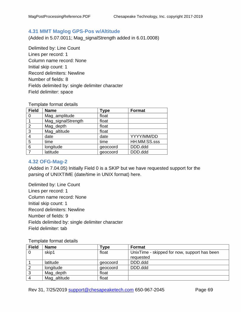
4.31 MMT Maglog GPS-Pos w/Altitude
(Added in 5.07.0011; Mag_signalStrength added in 6.01.0008)
Delimited by: Line Count
Lines per record: 1
Column name record: None
Initial skip count: 1
Record delimiters: Newline
Number of fields: 8
Fields delimited by: single delimiter character
Field delimiter: space
Template format details
Field Name Type Format
0 Mag_amplitude float
1 Mag_signalStrength float
2 Mag_depth float
3 Mag_altitude float
4 date date YYYY/MM/DD
5 time time HH:MM:SS.sss
6 longitude geocoord DDD.ddd
7 latitude geocoord DDD.ddd
4.32 OFG-Mag-2
(Added in 7.04.05) Initially Field 0 is a SKIP but we have requested support for the
parsing of UNIXTIME (date/time in UNIX format) here.
Delimited by: Line Count
Lines per record: 1
Column name record: None
Initial skip count: 1
Record delimiters: Newline
Number of fields: 9
Fields delimited by: single delimiter character
Field delimiter: tab
Template format details
Field Name Type Format
0 skip1 float UnixTime - skipped for now, support has been requested
1 latitude geocoord DDD.ddd
2 longitude geocoord DDD.ddd
3 Mag_depth float
4 Mag_altitude float

MagPostProcessingReference.PDF Chesapeake Technology, Inc. copyright 2017-2019
Rev 31, 7/25/2019 [email protected] 650-967-2045 Page 70
5 skip2 float
6 skip3 float
7 skip4 float
8 Mag_amplitude float
4.33 PLR Magnetometer
Delimited by: Line Count
Lines per record: 1
Column name record: None
Initial skip count: 0
Record delimiters: Newline
Number of fields: 18
Fields delimited by: single delimiter character
Field delimiter: space
Template format details
Field Name Type Format
0 id char
1 time time JJJHHMMSS.s
2 linename char
3 shotnumber char
4 northing gridcoord
5 easting gridcoord
6 depthprimsounder
7 unused1
8 unused2
9 cmg
10 heading float
11 speed float
12 distancegone
13 crosstrack
14 mag_amplitude float
15 mag_depth float
16 mag_cableout float
17 mag_altitude float
4.34 PLR Magnetometer (m)
Delimited by: Line Count
Lines per record: 1
Column name record: None
Initial skip count: 0
Record delimiters: Newline
Number of fields: 18
Fields delimited by: single delimiter character
MagPostProcessingReference.PDF Chesapeake Technology, Inc. copyright 2017-2019
Rev 31, 7/25/2019 [email protected] 650-967-2045 Page 71
Field delimiter: space
Template format details
Field Name Type Format
0 id char
1 time time JJJHHMMSS.s
2 linename char
3 shotnumber char
4 northing gridcoord
5 easting gridcoord
6 depthprimsounder
7 unused1
8 unused2
9 cmg
10 heading float
11 speed float
12 distancegone
13 crosstrack
14 mag_amplitude float
15 mag_depth float
16 mag_cableout float
17 mag_altitude float
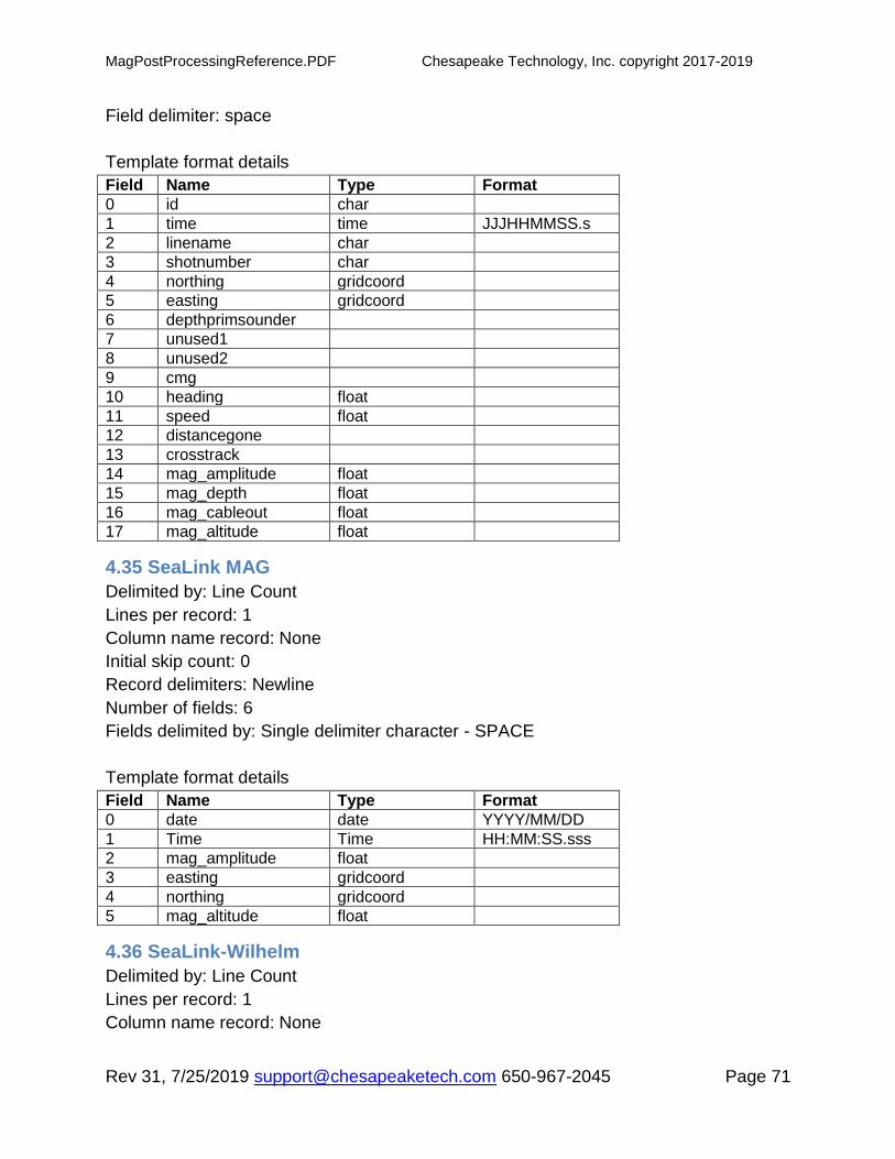
4.35 SeaLink MAG
Delimited by: Line Count
Lines per record: 1
Column name record: None
Initial skip count: 0
Record delimiters: Newline
Number of fields: 6
Fields delimited by: Single delimiter character - SPACE
Template format details
Field Name Type Format
0 date date YYYY/MM/DD
1 Time Time HH:MM:SS.sss
2 mag_amplitude float
3 easting gridcoord
4 northing gridcoord
5 mag_altitude float
4.36 SeaLink-Wilhelm
Delimited by: Line Count
Lines per record: 1
Column name record: None

MagPostProcessingReference.PDF Chesapeake Technology, Inc. copyright 2017-2019
Rev 31, 7/25/2019 [email protected] 650-967-2045 Page 72
Initial skip count: 0
Record delimiters: Newline
Number of fields: 19 (should be 20)
Fields delimited by: Single delimiter character - SPACE
Template format details
Field Name Type Format
0 Skip-0 char
1 Mag_amplitude float
2 Skip-2 char
3 Skip-3 char
4 Skip-4 char
5 Skip-5 char
6 Skip-6 char
7 Skip-7 char
8 Skip-8 char
9 Mag_altitude float
10 longitude geocoord DDD.ddd
11 latitude geocoord DDD.ddd
12 Skip-12 char
13 Skip-13 char
14 Skip-14 char
15 Skip-15 char
16 Skip-16 char
17 Skip-17 char
18 Skip-18 char
19 Skip-19 char
4.37 SeaSpy Type 3
Delimited by: Line Count
Lines per record: 1
Column name record: None
Initial skip count: 0
Record delimiters: Newline
Number of fields: 16
Fields delimited by: Single delimiter character
Field delimiter: comma
Template format details
Field Name Type Format
0 Skip1 integer
1 Time Time HH:MM:SS.sss
2 Date char MM/DD/YY
3 latitude Geocoord DDD.ddd
4 Longitude Geocoord DDD.ddd
MagPostProcessingReference.PDF Chesapeake Technology, Inc. copyright 2017-2019
Rev 31, 7/25/2019 [email protected] 650-967-2045 Page 73
5 Northing Gridcoord
6 Easting Gridcoord
7 Mag_amplitude float
8 Skip2 float
9 Skip3 integer
10 Mag_cableout float
11 Mag_copy1 float
12 Skip4 char
13 Skip5 char
14 Date2 date MM/DD/YY
15 Time2 time HH:MM:SS.sss
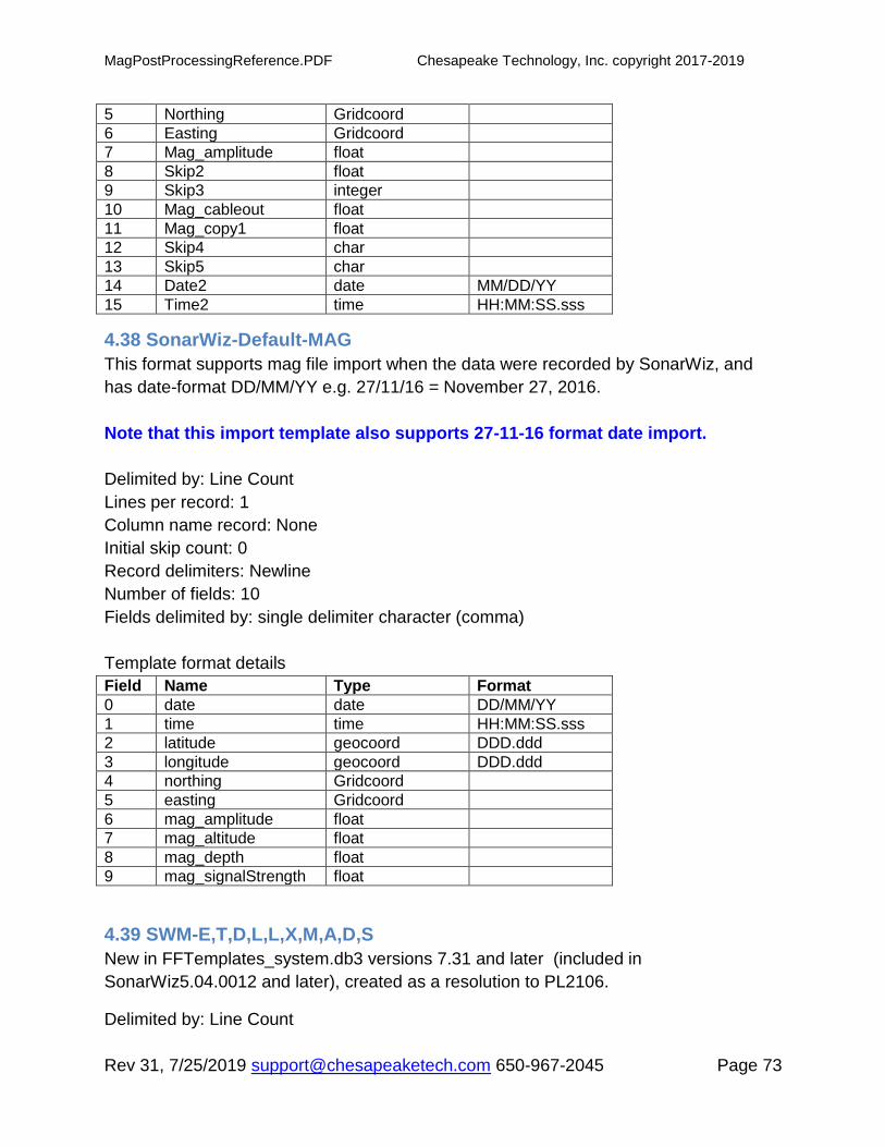
4.38 SonarWiz-Default-MAG
This format supports mag file import when the data were recorded by SonarWiz, and
has date-format DD/MM/YY e.g. 27/11/16 = November 27, 2016.
Note that this import template also supports 27-11-16 format date import.
Delimited by: Line Count
Lines per record: 1
Column name record: None
Initial skip count: 0
Record delimiters: Newline
Number of fields: 10
Fields delimited by: single delimiter character (comma)
Template format details
Field Name Type Format
0 date date DD/MM/YY
1 time time HH:MM:SS.sss
2 latitude geocoord DDD.ddd
3 longitude geocoord DDD.ddd
4 northing Gridcoord
5 easting Gridcoord
6 mag_amplitude float
7 mag_altitude float
8 mag_depth float
9 mag_signalStrength float
4.39 SWM-E,T,D,L,L,X,M,A,D,S
New in FFTemplates_system.db3 versions 7.31 and later (included in
SonarWiz5.04.0012 and later), created as a resolution to PL2106.
Delimited by: Line Count

MagPostProcessingReference.PDF Chesapeake Technology, Inc. copyright 2017-2019
Rev 31, 7/25/2019 [email protected] 650-967-2045 Page 74
Lines per record: 1
Column name record: None
Initial skip count: 0
Record delimiters: Newline
Number of fields: 11
Fields delimited by: Single delimiter characters (comma)
Template format details
Field Name Type Format
0 shotnumber char
1 time time HH:MM:SS.sss
2 date date MM/DD/YY
3 latitude geocoord DDD.ddd
4 longitude geocoord DDD.ddd
5 skip1 float
6 skip2 float
7 mag_amplitude float
8 mag_altitude float
9 mag_depth float
10 skip3 float
4.40 SWM-MAG882
Delimited by: Line Count
Lines per record: 1
Column name record: None
Initial skip count: 0
Record delimiters: Newline
Number of fields: 14 (said 14 but there were only 9 fields defined)
Fields delimited by: Variable delimiter characters (comma or space)
Template format details
Field Name Type Format
0 date date MM/DD/YYYY
1 time time HH:MM:SS.sss
2 latitude geocoord DDD.ddd
3 longitude geocoord DDD.ddd
4 skip1 char
5 mag_amplitude float
6 skip_field_strength float
7 mag_depth float
8 skip_to_end char

MagPostProcessingReference.PDF Chesapeake Technology, Inc. copyright 2017-2019
Rev 31, 7/25/2019 [email protected] 650-967-2045 Page 75
4.41 SonarWiz-MAG-file-default
This format supports mag file import when the data were recorded by SonarWiz, and
has date-format MM/DD/YY e.g. 11/27/16 = November 27, 2016.
Note that this import template also supports 11-27-16 format date import.
Delimited by: Line Count
Lines per record: 1
Column name record: None
Initial skip count: 0
Record delimiters: Newline
Number of fields: 10
Fields delimited by: single delimiter character (comma)
Template format details
Field Name Type Format
0 date date MM/DD/YY
1 time time HH:MM:SS.sss
2 latitude geocoord DDD.ddd
3 longitude geocoord DDD.ddd
4 northing Gridcoord
5 easting Gridcoord
6 mag_amplitude float
7 mag_altitude float
8 mag_depth float
9 mag_signalStrength float
4.42 SWM-SEASPY
Delimited by: Line Count
Lines per record: 1
Column name record: None
Initial skip count: 0
Record delimiters: Newline
Number of fields: 12
Fields delimited by: Variable delimiter characters (space)
Template format details
Field Name Type Format
0 date date MM/DD/YYYY
1 time time HH:MM:SS.sss
2 latitude geocoord DDD.ddd
3 longitude geocoord DDD.ddd
4 skip-1 char
5 skip-2 char
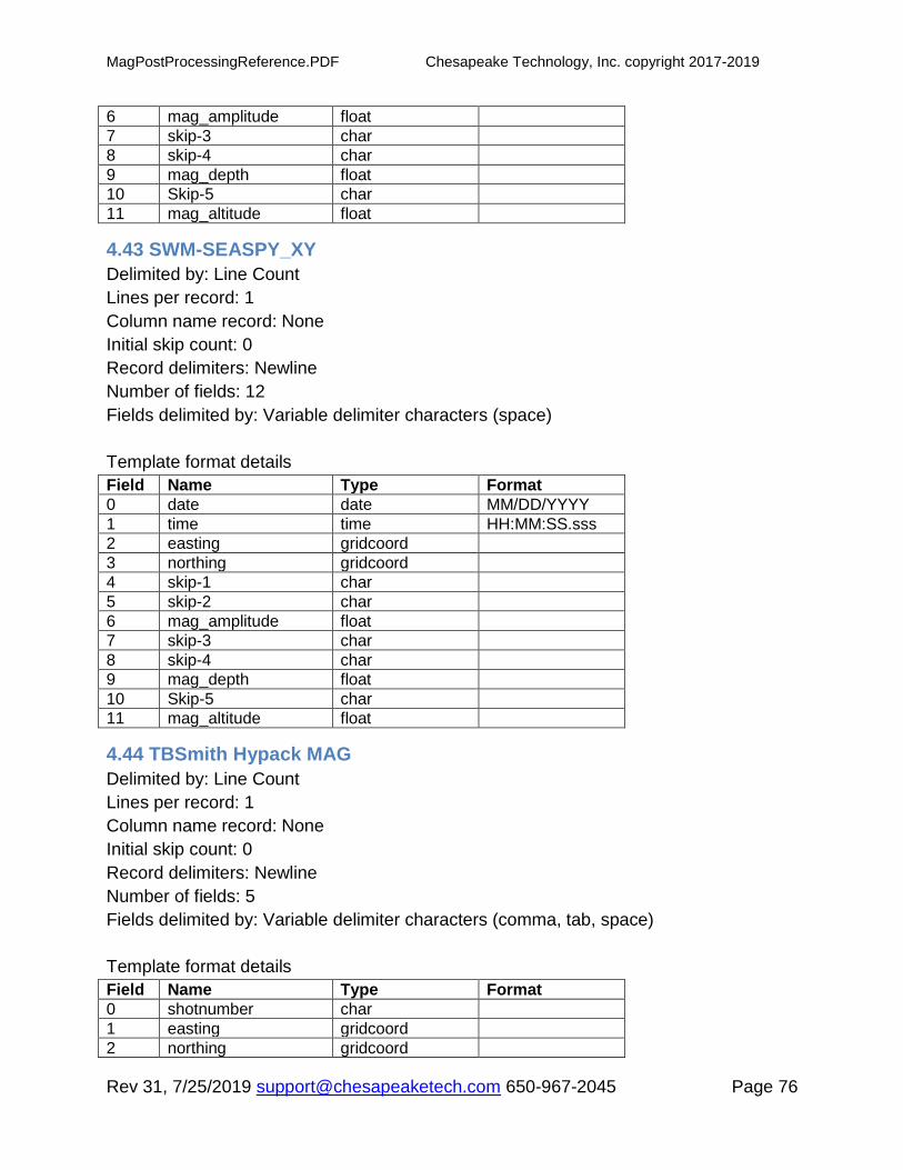
MagPostProcessingReference.PDF Chesapeake Technology, Inc. copyright 2017-2019
Rev 31, 7/25/2019 [email protected] 650-967-2045 Page 76
6 mag_amplitude float
7 skip-3 char
8 skip-4 char
9 mag_depth float
10 Skip-5 char
11 mag_altitude float
4.43 SWM-SEASPY_XY
Delimited by: Line Count
Lines per record: 1
Column name record: None
Initial skip count: 0
Record delimiters: Newline
Number of fields: 12
Fields delimited by: Variable delimiter characters (space)
Template format details
Field Name Type Format
0 date date MM/DD/YYYY
1 time time HH:MM:SS.sss
2 easting gridcoord
3 northing gridcoord
4 skip-1 char
5 skip-2 char
6 mag_amplitude float
7 skip-3 char
8 skip-4 char
9 mag_depth float
10 Skip-5 char
11 mag_altitude float
4.44 TBSmith Hypack MAG
Delimited by: Line Count
Lines per record: 1
Column name record: None
Initial skip count: 0
Record delimiters: Newline
Number of fields: 5
Fields delimited by: Variable delimiter characters (comma, tab, space)
Template format details
Field Name Type Format
0 shotnumber char
1 easting gridcoord
2 northing gridcoord

MagPostProcessingReference.PDF Chesapeake Technology, Inc. copyright 2017-2019
Rev 31, 7/25/2019 [email protected] 650-967-2045 Page 77
3 mag_amplitude float
4 linename char
4.45 TeslaOffshore-MAG-1
Mag from EVNAV software.
Delimited by: Line Count
Lines per record: 1
Column name record: None
Initial skip count: 0
Record delimiters: Newline
Number of fields: 12
Fields delimited by: single delimiter character (comma)
Template format details
Field Name Type Format
0 shotnumber char
1 skip-1 float
2 Skip-2 float
3 mag_depth float
4 easting gridcoord
5 northing gridcoord
6 mag_amplitude float
7 mag_altitude float
8 skip-8 float
9 date date DD/MM/YYYY
10 time time HH:MM:SS
11 skip-11 float
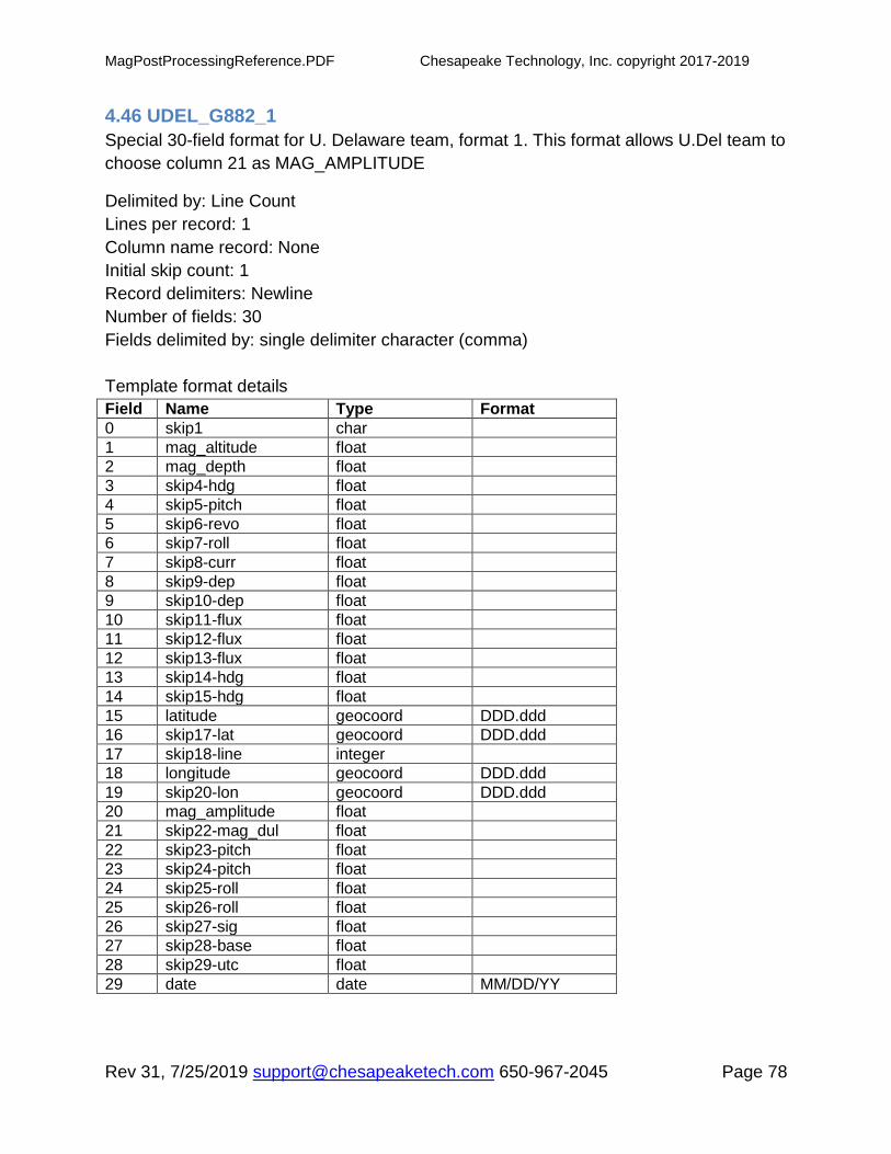
MagPostProcessingReference.PDF Chesapeake Technology, Inc. copyright 2017-2019
Rev 31, 7/25/2019 [email protected] 650-967-2045 Page 78
4.46 UDEL_G882_1
Special 30-field format for U. Delaware team, format 1. This format allows U.Del team to
choose column 21 as MAG_AMPLITUDE
Delimited by: Line Count
Lines per record: 1
Column name record: None
Initial skip count: 1
Record delimiters: Newline
Number of fields: 30
Fields delimited by: single delimiter character (comma)
Template format details
Field Name Type Format
0 skip1 char
1 mag_altitude float
2 mag_depth float
3 skip4-hdg float
4 skip5-pitch float
5 skip6-revo float
6 skip7-roll float
7 skip8-curr float
8 skip9-dep float
9 skip10-dep float
10 skip11-flux float
11 skip12-flux float
12 skip13-flux float
13 skip14-hdg float
14 skip15-hdg float
15 latitude geocoord DDD.ddd
16 skip17-lat geocoord DDD.ddd
17 skip18-line integer
18 longitude geocoord DDD.ddd
19 skip20-lon geocoord DDD.ddd
20 mag_amplitude float
21 skip22-mag_dul float
22 skip23-pitch float
23 skip24-pitch float
24 skip25-roll float
25 skip26-roll float
26 skip27-sig float
27 skip28-base float
28 skip29-utc float
29 date date MM/DD/YY

MagPostProcessingReference.PDF Chesapeake Technology, Inc. copyright 2017-2019
Rev 31, 7/25/2019 [email protected] 650-967-2045 Page 79
4.47 UDEL_G882_2
Special format for U. Delaware team, format 2, allows U.Del team to use comp-mag-dul
column 32 data for mag_amplitude.
Delimited by: Line Count
Lines per record: 1
Column name record: None
Initial skip count: 1
Record delimiters: Newline
Number of fields: 32
Fields delimited by: single delimiter character (comma)
Template format details
Field Name Type Format
0 skip1 char
1 mag_altitude float
2 mag_depth float
3 skip4-hdg float
4 skip5-pitch float
5 skip6-revo float
6 skip7-roll float
7 skip8-curr float
8 skip9-dep float
9 skip10-dep float
10 skip11-flux float
11 skip12-flux float
12 skip13-flux float
13 skip14-hdg float
14 skip15-hdg float
15 latitude geocoord DDD.ddd
16 skip17-lat float
17 skip18-line integer
18 longitude geocoord DDD.ddd
19 skip20-lon float
20 skip21-mag float
21 skip22-mag_dul float
22 skip23-pitch float
23 skip24-pitch float
24 skip25-roll float
25 skip26-roll float
26 skip27-sig float
27 skip28-magbase float
28 skip29-utc float
29 date date MM/DD/YY
30 skip31-time char
31 mag_amplitude float

MagPostProcessingReference.PDF Chesapeake Technology, Inc. copyright 2017-2019
Rev 31, 7/25/2019 [email protected] 650-967-2045 Page 80
4.48 XYZ MAG
Our simplest format - always a great option if you have an obscure new format and
simply want to see the data, without necessarily time or date. You can manipulate your
data in EXCEL, drop and swap columns and save an X,Y.MAG format (e.g. easting,
northing, MAG) in CSV format, set up a project at the right position and import the data
in XYZ format.
Delimited by: Line Count
Lines per record: 1
Column name record: None
Initial skip count: 0
Record delimiters: Newline
Number of fields: 3
Fields delimited by: Variable delimiter characters (comma, space)
Template format details
Field Name Type Format
1 easting gridcoord
2 northing gridcoord
3 mag_amplitude float
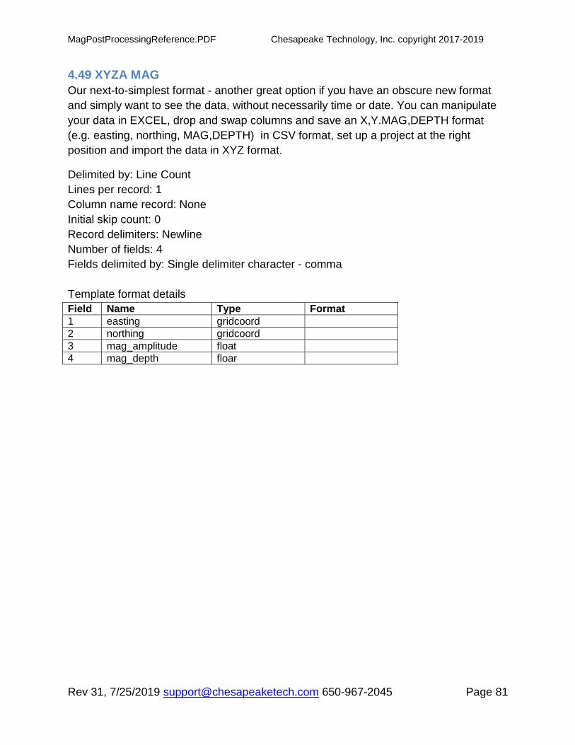
MagPostProcessingReference.PDF Chesapeake Technology, Inc. copyright 2017-2019
Rev 31, 7/25/2019 [email protected] 650-967-2045 Page 81
4.49 XYZA MAG
Our next-to-simplest format - another great option if you have an obscure new format
and simply want to see the data, without necessarily time or date. You can manipulate
your data in EXCEL, drop and swap columns and save an X,Y.MAG,DEPTH format
(e.g. easting, northing, MAG,DEPTH) in CSV format, set up a project at the right
position and import the data in XYZ format.
Delimited by: Line Count
Lines per record: 1
Column name record: None
Initial skip count: 0
Record delimiters: Newline
Number of fields: 4
Fields delimited by: Single delimiter character - comma
Template format details
Field Name Type Format
1 easting gridcoord
2 northing gridcoord
3 mag_amplitude float
4 mag_depth floar

MagPostProcessingReference.PDF Chesapeake Technology, Inc. copyright 2017-2019
Rev 31, 7/25/2019 [email protected] 650-967-2045 Page 82
5 Document History
Rev 31, 7/25/2019 - Sections 4.42 describes new OFG-Mag-2 format, and a new
description of implicit automatic duplicated-position down-sampling was added.
Rev 30, 2/19/2019 - Sections 1.4.2 added to clarify the set cable out and offset cable
out operations
Rev 29, 10/24/2018 - Sections 1.11 revised to explain color-mapped GRID presentation
options for mag data
Rev 28, 2/27/2018 - Sections 1.11 and 1.12 on gradiometer post-processing and SIT
recommendations added.
Rev 27, 1/29/2018 - Sections 4.8, 9, 10 added describing the new sample data format
for gradiometer post-processing, new in SonarWiz 7.00.0019.
Rev 26, 11/10/2017 - Section 1.10 added to explain mag-SS correlated viewing options.
Rev 25, 10/9/2017 - Clarification added about the anomaly amplitude (peak-to-peak
RAW value difference) within an anomaly left-right-window limits user-defined area,
section 1.7
Rev 24, 2/9/2017 - New format XYZA appears in 7.00.0009 (maybe 6.05.0020) with
FFTemplates_system.db3 version 7.63.
Rev 23, 2/9/2017 - New formats SonarWiz-Default-MAG, SWM-MAG_file-default,
UDEL_G882_1, and UDEL_G882_2 added.
Rev 22, 8/24/2016 - Clarifications added explaining that RAW (observed) data are used
for anomaly amplitude, and XYZ (Z portion) of export data. Section 1.5 is clarified to
explain how to change the value of the ambient smoothing count in a project. New
section 1.6 also clarifies the computational details of anolamie height and Z-value in
XYZ export.
Rev 21, 11/23/2015 - New section 1.2.1 describing the CMF files area of the MML file,
and section 1.7.1 added explaining where the ANO file is stored, containing
anomalies.
Rev 20, 6/30/2015 - New section 1.1 added to clarify how you generate MAG data files
and that the MAG R-T option is FREE with any sonar R-T feature purchase on your
license key.
Rev 19, 4/28/2015 - Template 26 MMT Maglog GPS-Pos w/Altitude -
Mag_SignalStrength added to replace position 2 Unused_MagSignal parameter.

MagPostProcessingReference.PDF Chesapeake Technology, Inc. copyright 2017-2019
Rev 31, 7/25/2019 [email protected] 650-967-2045 Page 83
Enhancement appears in SonarWiz 6.01.0008, and data imported using this
template may be edited in ZEDIT to see the graph of Mag_signalStrength.