soils limited stanford hill main investigation report
TRANSCRIPT

Soils Limited Stanford Hill Main Investigation Report
Control Document
Project
Stanford Hill, Lymington, Hampshire SO41 8DE
Document Type
Main Investigation Report
Document Reference
18076/MIR_R27
Document Status
Final
Date
April 2020
Prepared by
T Rudkin BSc. (Hons.), MSc., FGS.
First check by
Eur Ing R B Higginson BSc, PGDip, CEng, MICE, FGS.
Second check by
N J Lambert BSc (Hons), CEnv, FGS, MIEnvSc.
This is not a valid document for use in the design of the project unless it is titled Final in the document status
box.
Current regulations and good practice were used in the preparation of this report. The recommendations
given in this report must be reviewed by an appropriately qualified person at the time of preparation of the
scheme design to ensure that any recommendations given remain valid in light of changes in regulation and
practice, or additional information obtained regarding the site.

Soils Limited Stanford Hill Main Investigation Report
Commission
Soils Limited was commissioned by Pegasus Life Limited to undertake an intrusive
ground investigation and prepare a Main Investigation Report on land at Stanford Hill,
Lymington, Hampshire SO41 8DE. The scope of the investigation was outlined in the
Soils Limited quotation reference Q22083/Rev.01, dated 28th November 2019.
This document comprises the Main Investigation Report and incorporates the results,
discussion and conclusions to this intrusive works.
This Main Investigation Report must be read in conjunction with the Preliminary
Investigation Report undertaken on the above site by Soils Limited, Report ref:
18076/PIR, dated April 2020.
Standards
The site works, soil descriptions and geotechnical testing was undertaken in accordance
with the following standards:
• BS 5930:2015 and BS EN ISO 22476-2 2005+A1:2011
• BS EN 1997-1:2004+A1:2013
• BS EN ISO 14688-1:2002+A1:2013
• BS EN ISO 14688-2:2004+A1:2013
• BS 10175:2011+A2:2017
• NHBC Standards 2020
• BRE Special Digest 1:2005
• BRE Digest 240:1993
• BRE DG 365:2016
The geotechnical laboratory testing was performed by GEO Site & Testing Services Ltd
(GSTL) in accordance with the methods given in BS 1377:1990 Parts 1 to 8 and their
UKAS accredited test methods.
For the preparation of this report, the relevant BS code of practice was adopted for the
geotechnical laboratory testing technical specifications, in the absence of the relevant
Eurocode specifications (ref: ISO TS 17892).
The chemical analyses were undertaken by Derwentside Environmental Testing Services
(DETS) in accordance with their UKAS and MCERTS accredited test methods or their
documented in-house testing procedures. This investigation did not comprise an
environmental audit of the site or its environs.

Soils Limited Stanford Hill Main Investigation Report
Trial hole is a generic term used to describe a method of direct investigation. The term
trial pit, borehole or window sample borehole implies the specific technique used to
produce a trial hole.
Soils Limited Stanford Hill Main Investigation Report
Contents
Section 1 Introduction ................................................................................................... 1
1.1 Objective of Investigation .................................................................................... 1
1.2 Location .............................................................................................................. 1
1.3 Site Description ................................................................................................... 1
1.4 Proposed Development ...................................................................................... 1
1.5 Anticipated Geology ............................................................................................ 2
1.5.1 River Terrace Deposits ....................................................................................... 2
1.5.2 Headon and Osborne Beds ................................................................................ 2
1.6 Limitations and Disclaimers ................................................................................ 2
Section 2 Site Works ..................................................................................................... 5
2.1 Proposed Project Works ..................................................................................... 5
2.1.1 Actual Project Works ........................................................................................... 5
2.2 Ground Conditions .............................................................................................. 6
2.3 Ground Conditions Encountered in Trial Holes ................................................... 7
2.3.1 Topsoil ................................................................................................................ 7
2.3.2 River Terrace Deposits ....................................................................................... 8
2.3.3 Headon and Osborne Beds ................................................................................ 8
2.4 Roots .................................................................................................................. 9
2.5 Groundwater ....................................................................................................... 9
Section 3 Discussion of Geotechnical In-Situ and Laboratory Testing .................. 11
3.1 Dynamic Probe Tests ........................................................................................ 11
3.2 Infiltration Tests ................................................................................................ 11
3.3 Atterberg Limit Tests ......................................................................................... 12
3.4 Particle Size Distribution Tests ......................................................................... 12
3.5 Sulphate and pH Tests ..................................................................................... 12
Section 4 Foundation Design ...................................................................................... 13
4.1 General ............................................................................................................. 13
4.1.1 Made Ground and Topsoil ................................................................................ 13
4.1.2 River Terrace Deposits ..................................................................................... 13
4.1.3 Headon and Osborne Beds .............................................................................. 14
4.1.4 Roots ................................................................................................................ 15
4.1.5 Groundwater ..................................................................................................... 15
Soils Limited Stanford Hill Main Investigation Report
4.2 Foundation Scheme General ............................................................................ 15
4.2.1 Guidance on Shrinkable Soils ........................................................................... 15
4.3 Foundation Scheme .......................................................................................... 16
4.3.1 Piled Foundations ............................................................................................. 17
4.3.2 Ground Floor Slab ............................................................................................ 17
4.4 Subsurface Concrete ........................................................................................ 18
4.5 Excavations ...................................................................................................... 18
4.6 Soakaways ....................................................................................................... 18
Section 5 Determination of Chemical Analysis ........................................................ 19
5.1 Site Characterisation and Revised Conceptual Site Model ............................... 19
5.2 Soil Sampling .................................................................................................... 19
5.3 Determination of Chemical Analysis ................................................................. 20
Section 6 Qualitative Risk Assessment ...................................................................... 21
6.1 Assessment Criteria .......................................................................................... 21
6.2 Representative Contamination Criteria - Soil .................................................... 21
6.2.1 Asbestos ........................................................................................................... 22
6.3 Risk to Groundwater ......................................................................................... 22
6.4 Tier 1 Quantitative Risk Assessment ................................................................ 22
6.4.1 Soils .................................................................................................................. 22
6.4.2 Groundwater ..................................................................................................... 23
6.4.3 Soil Gas ............................................................................................................ 23
6.5 Remedial Objective ........................................................................................... 23
6.6 Development of Soil Remediation Strategy ....................................................... 23
6.6.1 Further Chemical Testing and Human Health Risk Assessment ....................... 24
6.6.2 Asbestos ........................................................................................................... 24
6.7 Duty of Care ...................................................................................................... 24
6.8 Excavated Material ........................................................................................... 24
6.9 Re-use of Excavated Material On-site .............................................................. 25
6.10 Imported Material .............................................................................................. 26
6.11 Discovery Strategy ............................................................................................ 26
List of Figures
Figure 1 – Site Location Map ......................................................................................... 28
Soils Limited Stanford Hill Main Investigation Report
Figure 2 – Aerial Photograph ......................................................................................... 29
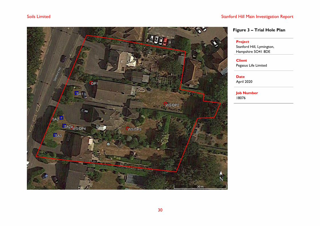
Figure 3 – Trial Hole Plan .............................................................................................. 30
List of Tables
Table 2.1 Final Depth of Trial Holes ................................................................................. 6
Table 2.2 Ground Conditions ........................................................................................... 7
Table 2.3 Final Depth of Topsoil ...................................................................................... 8
Table 2.4 Final Depth of River Terrace Deposits ............................................................. 8
Table 2.5 Final Depth of Headon and Osborne Beds ....................................................... 9
Table 2.6 Depth of Root Penetration ................................................................................ 9
Table 5.1 Sampling Strategy .......................................................................................... 19
Table 5.2 Chemical Analysis Specification ..................................................................... 20
Table 6.1 Summary of Chemical Analysis of Soils Sample Exceedance ........................ 21
Table B.1.1 SPT "N" Blow Count Cohesive Classification
Table B.1.2 SPT "N" Blow Count Granular Classification
Table B.2.1 Interpretation of DPSH Blow Counts
Table B.2.2 Interpretation of Atterberg Limit Tests
Table B.2.3 Interpretation of PSD Tests
Table C.1.1 CSM Revised Pre-Testing
Table C.1.2 CSM Revised Post Testing
List of Appendices
Field Work
Appendix A.1 Engineers Logs
Geotechnical In-Situ and Laboratory Testing
Appendix B.1 Classification
Appendix B.2 Interpretation
Appendix B.3 Geotechnical In-Situ and Laboratory Results
Chemical Laboratory Testing
Appendix C.1 Conceptual Site Model
Appendix C.2 Chemical Laboratory Results

Soils Limited Stanford Hill Main Investigation Report
Appendix C.3 General Assessment Criteria
Information Provided by the Client

Soils Limited Stanford Hill Main Investigation Report
1
Section 1 Introduction
1.1 Objective of Investigation
Soils Limited was commissioned by Pegasus Life Limited to undertake an intrusive
ground investigation and to prepare a Main Investigation Report to supply the client and
their designers with information regarding ground conditions, to assist in preparing a
foundation scheme for development that was appropriate to the settings present on the
site.
The investigation was to be undertaken to provide comment on appropriate foundation
options for the proposed residential development. The investigation was to be made by
means of in-situ testing and geotechnical laboratory testing undertaken on soil samples
taken from the trial holes.
Soil samples were taken for chemical laboratory testing to enable recommendations for
the safe redevelopment of the site and the protection of site workers, end-users and the
public from any contamination identified as dictated by the Conceptual Site Model (CSM)
in the Preliminary Investigation Report undertaken for the site by Soils Limited (Report
ref: 18076/PIR, dated April 2020) and/or the Revised Conceptual Site Model presented
in Appendix C.1.
1.2 Location
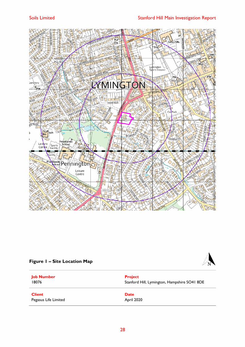
The site was located at Stanford Hill, Lymington, Hampshire SO41 8DE and had an
approximate O.S Land Ranger Grid Reference of SZ 318 952.
The site location plan is given in Figure 1.
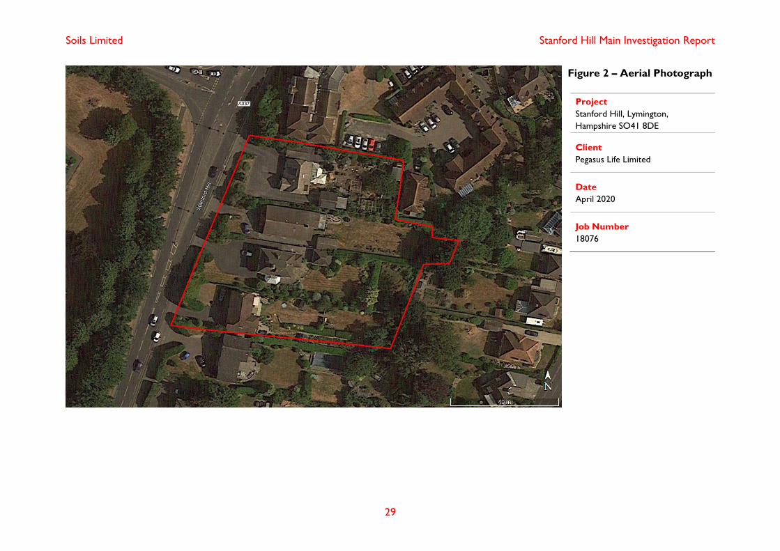
1.3 Site Description
The site comprised four residential plots comprising a single and two storey residential
home with associated private gardens and detached single storey garages. Where
undeveloped, the site was of predominantly grass landscaping with areas of tarmac
comprising driveways and walkways. The site was relatively flat with a gradual gradient
down to the south. Trees and vegetation were scattered across the garden areas and the
site and plot boundaries were largely formed by a hedgerow. The side was bounded by
residential homes with mature trees, shrubs and hedgerows within garden areas.
An aerial photograph of the site and its environs has been included in Figure 2.
1.4 Proposed Development
The proposal comprised demolition of the existing structures located on 4no. residential
plots and gardens and redeveloping the site with 45no. age restricted apartments within
a three-storey complex with common open space but no private gardens.
Soils Limited Stanford Hill Main Investigation Report
2
In compiling this report reliance was placed on drawing 1913 02 Site Plan by David
James Architects & Partners Ltd. dated August 2019. Any change or deviation from the
scheme outlined in the drawing could invalidate the recommendations presented within
this report. Soils Limited must be notified about any such changes.
Development plans provided by the client are presented in Appendix D.
1.5 Anticipated Geology
The 1:50,000 BGS map showed the site to be located directly upon Headon and
Osborne Beds with overlying superficial deposits of River Terrace Deposits.
1.5.1 River Terrace Deposits
The rivers Test and Itchen have deposited extensive spreads of River Terrace
Deposits in the Southampton area, representative of ancient floodplains. In total,
eleven terraces have been recorded. The River Terrace Deposits consist
predominantly of gravels made up of subangular to subrounded flints with a
significant sand component locally with lenses of silt, clay or peat.
1.5.2 Headon and Osborne Beds
The Headon and Osborne Beds comprise a thick band of coloured clays, with
occasional sand beds, some lignite and bands of limestone. Shells are common
throughout the stratum.
1.6 Limitations and Disclaimers
This Main Investigation Report relates to the site located at Stanford Hill, Lymington,
Hampshire SO41 8DE and was prepared for the sole benefit of Pegasus Life Limited
(The “Client”). The report was prepared solely for the brief described in Section 1.1 of
this report.
Soils Limited disclaims any responsibility to the Client and others in respect of any
matters outside the scope of the above.
This report has been prepared by Soils Limited, with all reasonable skill, care and
diligence within the terms of the Contract with the Client, incorporation of our General
Conditions of Contract of Business and taking into account the resources devoted to us
by agreement with the Client.
The report is personal and confidential to the Client and Soils Limited accept no
responsibility of whatever nature to third parties to whom this report, or any part thereof,
is made known. Any such party relies on the report wholly at its own risk.
The Client may not assign the benefit of the report or any part to any third party without
the written consent of Soils Limited.

Soils Limited Stanford Hill Main Investigation Report
3
The ground is a product of continuing natural and artificial processes. As a result, the
ground will exhibit a variety of characteristics that vary from place to place across a site,
and also with time. Whilst a ground investigation will mitigate to a greater or lesser
degree against the resulting risk from variation, the risks cannot be eliminated.
The investigation, interpretations, and recommendations given in this report were
prepared for the sole benefit of the client in accordance with their brief. As such these do
not necessarily address all aspects of ground behaviour at the site.
Current regulations and good practice were used in the preparation of this report. An
appropriately qualified person must review the recommendations given in this report at
the time of preparation of the scheme design to ensure that any recommendations given
remain valid in light of changes in regulation and practice, or additional information
obtained regarding the site.
The depth to roots and/or of desiccation may vary from that found during the
investigation. The client is responsible for establishing the depth to roots and/or of
desiccation on a plot by plot basis prior to the construction of foundations. Supplied site
surveys may not include substantial shrubs or bushes and is also unlikely to have data or
any trees, bushes or shrubs removed prior to or following the site survey.
Where trees are mentioned in the text this means existing trees, substantial bushes or
shrubs, recently removed trees (approximately 20 years to full recovery on cohesive
soils) and those planned as part of the site landscaping).
It should be noted that a detailed survey of the possible presence or absence of invasive
species, such as Japanese Knotweed, is outside of the scope of investigation,
particularly given that the site walkover has been undertaken in winter, when invasive
species would not be significantly notable due to dieback.
Ownership of land brings with it onerous legal liabilities in respect of harm to the
environment. “Contaminated Land” is defined in Section 57 of the Environment Act 1995
as:
“Land which is in such a condition by reason of substances in, on or under the land that
significant harm is being caused or that there is a significant possibility of such harm
being caused or that pollution of controlled waters is being, or is likely to be caused”.
The investigation, analysis or recommendations in respect of contamination are made
solely in respect of the prevention of harm to vulnerable receptors, using where possible
best practice at the date of preparation of the report. The investigation and report do not
address, define or make recommendations in respect of environmental liabilities. A
separate environmental audit and liaison with statutory authorities is required to address
these issues.

Soils Limited Stanford Hill Main Investigation Report
4
Ownership of copyright of all printed material including reports, laboratory test results,
trial pit and borehole log sheets, including drillers log sheets remains with Soils Limited.
License is for the sole use of the client and may not be assigned, transferred or given to
a third party.

Soils Limited Stanford Hill Main Investigation Report
5
Section 2 Site Works
2.1 Proposed Project Works
The proposed intrusive investigation was designed to provide information on the ground
conditions and to aid the design of foundations for the proposed residential development.
The intended investigation, as outlined within the Soils Limited quotation
(Q22083/Rev.01, dated 28th November 2019) was to comprise the following items:
• Windowless sampler boreholes and dynamic probes
• Infiltration testing to BRE DG 365:2016
• Geotechnical laboratory testing
• Contamination laboratory testing.
Installation of monitoring wells was subsequently commissioned by the client.
2.1.1 Actual Project Works
The actual project works were undertaken on 13th March 2020 and comprised:
• 3No. windowless sampler boreholes (WS2 – WS4)
• Installation of 2no. soil gas and groundwater monitoring standpipes (WS2 &
WS4)
• 4No. super heavy dynamic probes (DP1 – DP4)
• 4No. machine excavated trial pits with infiltration testing to BRE DG
365:2016 (SA1, SA2, SA2a, SA3)
• Geotechnical laboratory testing
• Contamination laboratory testing
Two windowless sampler boreholes (WS2 and WS4) were backfilled with gravel
and bentonite following installation of monitoring standpipes, WS3 was backfilled
with bentonite on completion.
All machine excavated trial pits were backfilled with arisings on completion of the
infiltration testing.
All trial hole locations have been presented in Figure 3.
Following completion of site works, soil cores were logged and sub sampled so that
samples could be sent to the laboratory for both contamination and geotechnical
testing.
Soils Limited Stanford Hill Main Investigation Report
6
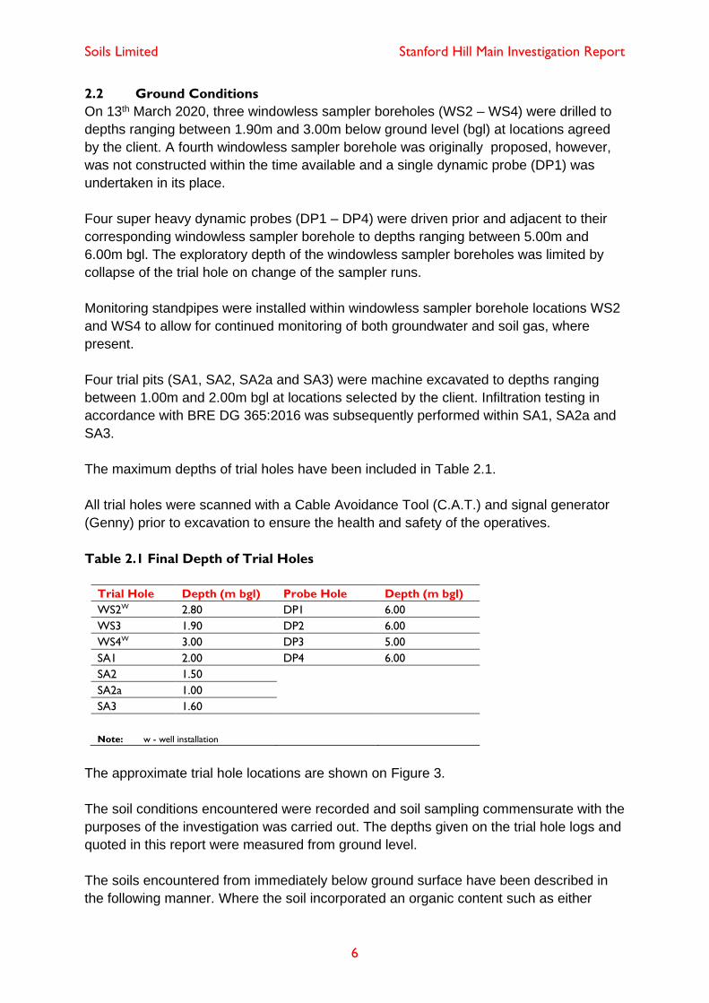
2.2 Ground Conditions
On 13th March 2020, three windowless sampler boreholes (WS2 – WS4) were drilled to
depths ranging between 1.90m and 3.00m below ground level (bgl) at locations agreed
by the client. A fourth windowless sampler borehole was originally proposed, however,
was not constructed within the time available and a single dynamic probe (DP1) was
undertaken in its place.
Four super heavy dynamic probes (DP1 – DP4) were driven prior and adjacent to their
corresponding windowless sampler borehole to depths ranging between 5.00m and
6.00m bgl. The exploratory depth of the windowless sampler boreholes was limited by
collapse of the trial hole on change of the sampler runs.
Monitoring standpipes were installed within windowless sampler borehole locations WS2
and WS4 to allow for continued monitoring of both groundwater and soil gas, where
present.
Four trial pits (SA1, SA2, SA2a and SA3) were machine excavated to depths ranging
between 1.00m and 2.00m bgl at locations selected by the client. Infiltration testing in
accordance with BRE DG 365:2016 was subsequently performed within SA1, SA2a and
SA3.
The maximum depths of trial holes have been included in Table 2.1.
All trial holes were scanned with a Cable Avoidance Tool (C.A.T.) and signal generator
(Genny) prior to excavation to ensure the health and safety of the operatives.
Table 2.1 Final Depth of Trial Holes
Trial Hole Depth (m bgl) Probe Hole Depth (m bgl)
WS2W 2.80 DP1 6.00
WS3 1.90 DP2 6.00
WS4W 3.00 DP3 5.00
SA1 2.00 DP4 6.00
SA2 1.50
SA2a 1.00
SA3 1.60
Note: w - well installation
The approximate trial hole locations are shown on Figure 3.
The soil conditions encountered were recorded and soil sampling commensurate with the
purposes of the investigation was carried out. The depths given on the trial hole logs and
quoted in this report were measured from ground level.
The soils encountered from immediately below ground surface have been described in
the following manner. Where the soil incorporated an organic content such as either

Soils Limited Stanford Hill Main Investigation Report
7
decomposing leaf litter or roots or has been identified as part of the in-situ weathering
profile, it has been described as Topsoil both on the logs and within this report. Where
man has clearly either placed the soil, or the composition altered, with say greater than
an estimated 5% of a non-natural constituent, it has been referred to as Made Ground
both on the log and within this report.
For more complete information about the soils encountered within the general area of the
site reference should be made to the detailed records given within Appendix A, but for
the purposes of discussion, the succession of conditions encountered in the trial holes in
descending order can be summarised as:
Topsoil (TS)
River Terrace Deposits (RTD)
Headon and Osborne Beds (HEOS)
The ground conditions encountered in the trial holes are summarised in Table 2.2.
Table 2.2 Ground Conditions
Strata Epoch Depth Encountered
(m bgl)
Typical
Thickness
(m)
Typical Description
Top Bottom
TS Anthropocene 0.00 0.30 – 0.85 0.60 Dark brown and greyish brown slightly
gravelly slightly sandy CLAY with
frequent roots/rootlets.
RTD Quaternary 0.30 – 0.85 2.20 – 2.903 2.00 Interbedded orangish brown and greyish
brown mottled yellowish brown slightly
sandy gravelly CLAY and clayey SAND &
GRAVEL.
HEOS Eocene 2.20 – 2.903 >6.001,3 Not
proven2
Yellowish brown and light grey mottled
red, locally greenish grey, silty CLAY.
Note: 1 Final depth of trial hole. 2 Base of strata not encountered. 3 Depth inferred from dynamic probe.
2.3 Ground Conditions Encountered in Trial Holes
The ground conditions encountered in trial holes have been described below in
descending order. The engineering logs are presented in Appendix A.1.
2.3.1 Topsoil
Soils described as Topsoil were encountered in all trial holes from ground level and
persisted to depths ranging between 0.30m and 0.85m bgl.
The Topsoil typically comprised dark brown and greyish brown slightly gravelly
slightly sandy CLAY with frequent roots/rootlets. Gravel is angular to subangular
clasts of flint, with rare concrete and clinker locally.
The final depths of Topsoil have been included in Table 2.3.

Soils Limited Stanford Hill Main Investigation Report
8
Table 2.3 Final Depth of Topsoil
Trial Hole Depth (m bgl)
WS2 0.85
WS3 0.70
WS4 0.30
SA1 0.60
SA2 0.70
SA2a 0.60
SA3 0.60
2.3.2 River Terrace Deposits
Soils described as River Terrace Deposits were encountered in all trial holes
underlying the Topsoil and were proven to depths ranging between 2.00m and
2.20m bgl and inferred to a maximum depth of 2.90m bgl in DP3, where the
stratum was not fully penetrated by WS3.
The River Terrace Deposits comprised interbedded orangish brown and greyish
brown mottled yellowish brown slightly sandy gravelly CLAY and clayey SAND &
GRAVEL. Gravel is fine to medium occasionally coarse angular to sub rounded
clasts of flint.
The depth of River Terrace Deposits has been included in Table 2.4.
Table 2.4 Final Depth of River Terrace Deposits
Trial Hole Depth (m bgl)
DP1 2.102
WS2 2.20
WS3/DP3 >1.901/2.902
WS4 2.00
SA1 >2.001
SA2 >1.501
SA2a >1.001
SA3 >1.601
Note:1 Final depth of trial hole. 2 Inferred from dynamic probe
2.3.3 Headon and Osborne Beds
Soils described as undifferentiated Headon and Osborne Beds were encountered
underlying the River Terrace Deposits and were inferred to persist the full
investigatory depth of 6.00m bgl within the dynamic probes.
Where recovered, the Headon and Osborne Beds comprised yellowish brown and
light grey mottled red, locally greenish grey, silty CLAY and was inferred to remain
cohesive with depth.
The depth of Headon and Osborne Beds has been included in Table 2.5.

Soils Limited Stanford Hill Main Investigation Report
9
Table 2.5 Final Depth of Headon and Osborne Beds
Trial Hole Depth (m bgl)
DP1 >6.001,2
WS2/DP2 >2.801/>6.001,2
WS3/DP3 Not encountered/>5.001,2
WS4/DP4 >3.001/>6.001,2
Note: 1 Final depth of trial hole. 2 Inferred from dynamic probe
2.4 Roots
Trees, shrubs and hedgerows were recorded to be abundant onsite within the private
garden areas, and along the site perimeters.
Roots/rootlets were observed within all seven trial holes recorded to depths ranging
between 1.10m and 1.40m bgl.
The depths of root penetration have been included in Table 2.6.
Table 2.6 Depth of Root Penetration
Trial Hole Depth (m bgl)
WS2 1.30
WS3 1.30
WS4 1.40
SA1 1.10
SA2 1.10
SA2a 1.001
SA3 1.30
Note: 1 Final depth of trial hole.
Roots may be found to greater depth at other locations on the site particularly close to
trees and/or trees that have been removed both within the site and its close environs.
It must be emphasised that the probability of determining the maximum depth of roots
from a narrow diameter borehole is low. A direct observation such as from within a trial
pit is necessary to gain a better indication of the maximum root depth.
2.5 Groundwater
Groundwater “strikes” were recorded during the construction of the windowless sampler
boreholes and trial pits onsite, struck at depths ranging between 1.30m and 1.60m bgl.
Changes in groundwater level occur for a number of reasons including seasonal effects
and variations in drainage. The investigation was conducted in March (2020), when

Soils Limited Stanford Hill Main Investigation Report
10
groundwater levels are typically at their annual maximum (highest) elevation.
Groundwater equilibrium conditions may only be conclusively established, if a series of
observations are made via groundwater monitoring wells. Two monitoring standpipes
were installed as part of this investigation should groundwater level monitoring be
required. At the time of reporting, Soils Limited had not been instructed to undertaken
groundwater level readings at the site.

Soils Limited Stanford Hill Main Investigation Report
11
Section 3 Discussion of Geotechnical In-Situ and Laboratory Testing
3.1 Dynamic Probe Tests
Dynamic probing (DPSH) was undertaken at four locations (DP1 – DP4) prior and
adjacent to their corresponding windowless sampler borehole to depths ranging between
5.00m and 6.00m bgl. The results were converted to equivalent SPT “N60” values based
on dynamic energy using commercial computer software (Geostru). The results were
then interpreted based on the classifications outlined in Appendix B.1.
The SPT “N60” values presented have been corrected in accordance with BS EN 22476
Part 3, to account for the rig efficiency, borehole depth, overburden factors etc. Further
correction of the ‘N’ values should therefore not be necessary. The energy ratio for each
location is presented on the individual logs within Appendix A.1.
The River Terrace Deposits recorded equivalent SPT “N60” values between <4 and 7,
locally 11 to 23 in DP2, in cohesive beds and between 11 and 15, locally 23 to 50+ in
DP3, in granular beds. The cohesive soils were classified as very low, locally medium to
high, strength with undrained cohesions typically <20kPa. The granular soils were
classified as medium dense, locally dense to very dense in DP3, relative density.
The Headon and Osborne Beds recorded equivalent SPT “N60” values between 7 and
34, classifying the cohesive soils as medium to very high strength with undrained
cohesions between 35kPa and 170kPa, with typical values of between 35kPa and
55kPa.
A full interpretation of the DPSH tests are outlined in Appendix B.2, Table B.2.1.
3.2 Infiltration Tests
Infiltration testing was undertaken in SA1, SA2a and SA3 within the River Terrace
Deposits at depths ranging between 1.00m and 2.00m bgl following the principles of BRE
DG 365:2016. Both predominantly cohesive and granular soils were encountered within
the test pits, with the granular soils observed to have a high faction of fines. BRE 365
states that for an accurate infiltration rate to be obtained a soakage pit needs to be filled
three times in quick succession. Each test can only be ended once 75% of the water
present has drained away.
Shallow groundwater was encountered at the base of trial pits SA1, SA2 and SA3. SA2
was re-excavated adjacent to shallower depth and named SA2a. There was insufficient
room to re-excavate SA1 or SA3 to a shallower depth.
A 10mm fall in head was observed in SA1 over 176 minutes, a 10mm fall in head was
observed in SA2a over 142 minutes and a 20mm fall in head was observed in SA3 over
159 minutes. Each test was terminated as three complete test cycles were unlikely to be
achieved within the agreed timescales for testing.
Soils Limited Stanford Hill Main Investigation Report
12
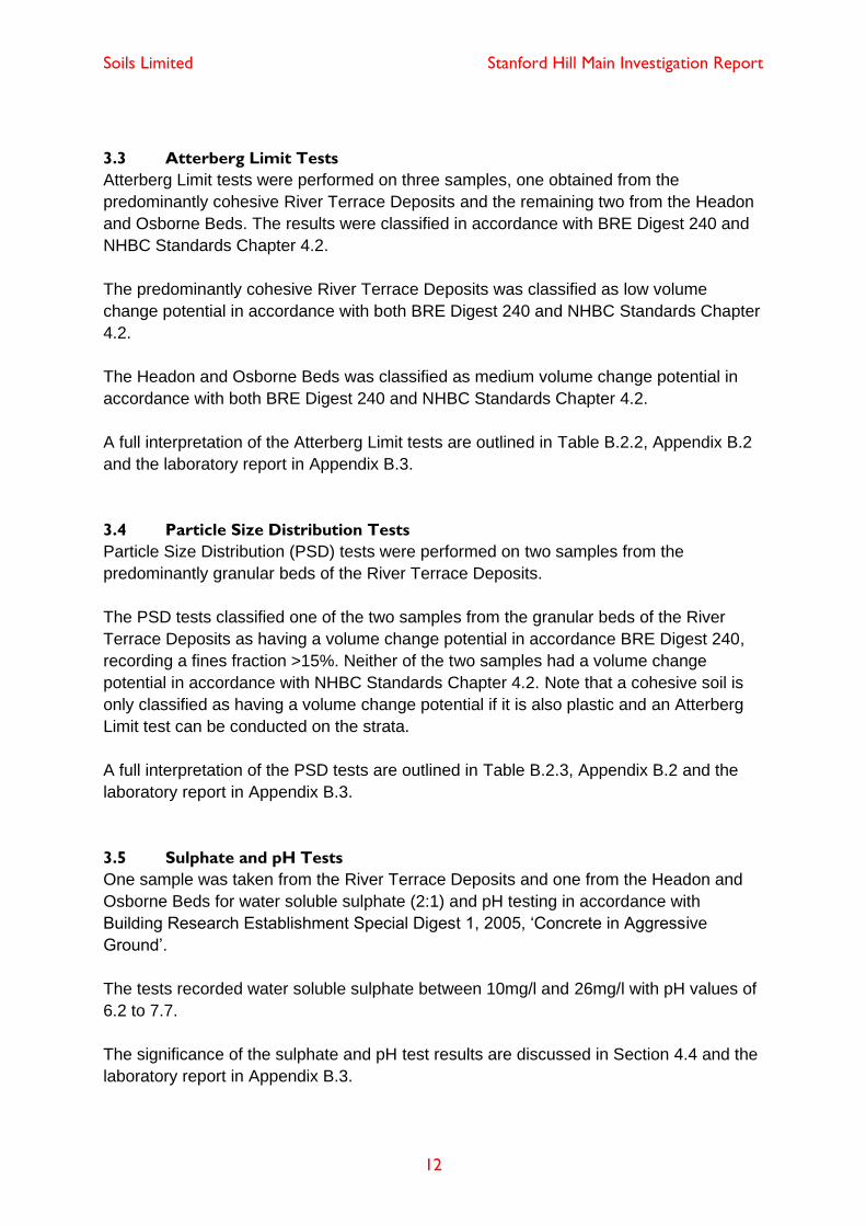
3.3 Atterberg Limit Tests
Atterberg Limit tests were performed on three samples, one obtained from the
predominantly cohesive River Terrace Deposits and the remaining two from the Headon
and Osborne Beds. The results were classified in accordance with BRE Digest 240 and
NHBC Standards Chapter 4.2.
The predominantly cohesive River Terrace Deposits was classified as low volume
change potential in accordance with both BRE Digest 240 and NHBC Standards Chapter
4.2.
The Headon and Osborne Beds was classified as medium volume change potential in
accordance with both BRE Digest 240 and NHBC Standards Chapter 4.2.
A full interpretation of the Atterberg Limit tests are outlined in Table B.2.2, Appendix B.2
and the laboratory report in Appendix B.3.
3.4 Particle Size Distribution Tests
Particle Size Distribution (PSD) tests were performed on two samples from the
predominantly granular beds of the River Terrace Deposits.
The PSD tests classified one of the two samples from the granular beds of the River
Terrace Deposits as having a volume change potential in accordance BRE Digest 240,
recording a fines fraction >15%. Neither of the two samples had a volume change
potential in accordance with NHBC Standards Chapter 4.2. Note that a cohesive soil is
only classified as having a volume change potential if it is also plastic and an Atterberg
Limit test can be conducted on the strata.
A full interpretation of the PSD tests are outlined in Table B.2.3, Appendix B.2 and the
laboratory report in Appendix B.3.
3.5 Sulphate and pH Tests
One sample was taken from the River Terrace Deposits and one from the Headon and
Osborne Beds for water soluble sulphate (2:1) and pH testing in accordance with
Building Research Establishment Special Digest 1, 2005, ‘Concrete in Aggressive
Ground’.
The tests recorded water soluble sulphate between 10mg/l and 26mg/l with pH values of
6.2 to 7.7.
The significance of the sulphate and pH test results are discussed in Section 4.4 and the
laboratory report in Appendix B.3.
Soils Limited Stanford Hill Main Investigation Report
13
Section 4 Foundation Design
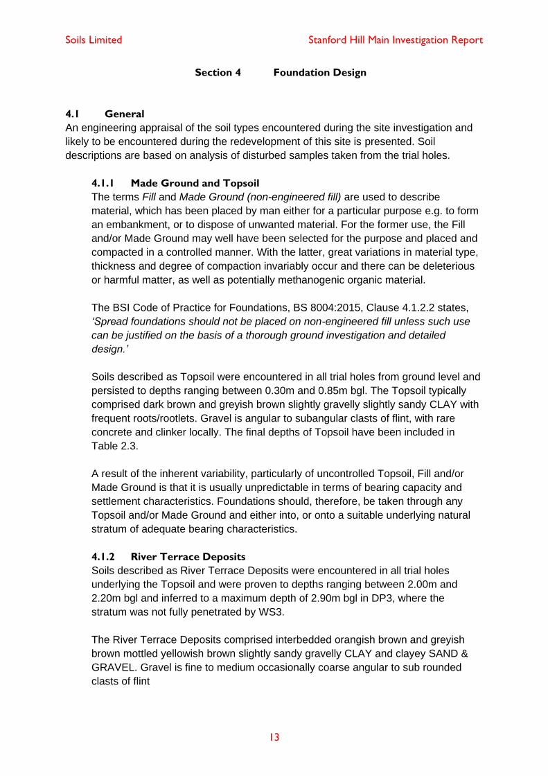
4.1 General
An engineering appraisal of the soil types encountered during the site investigation and
likely to be encountered during the redevelopment of this site is presented. Soil
descriptions are based on analysis of disturbed samples taken from the trial holes.
4.1.1 Made Ground and Topsoil
The terms Fill and Made Ground (non-engineered fill) are used to describe
material, which has been placed by man either for a particular purpose e.g. to form
an embankment, or to dispose of unwanted material. For the former use, the Fill
and/or Made Ground may well have been selected for the purpose and placed and
compacted in a controlled manner. With the latter, great variations in material type,
thickness and degree of compaction invariably occur and there can be deleterious
or harmful matter, as well as potentially methanogenic organic material.
The BSI Code of Practice for Foundations, BS 8004:2015, Clause 4.1.2.2 states,
‘Spread foundations should not be placed on non-engineered fill unless such use
can be justified on the basis of a thorough ground investigation and detailed
design.’
Soils described as Topsoil were encountered in all trial holes from ground level and
persisted to depths ranging between 0.30m and 0.85m bgl. The Topsoil typically
comprised dark brown and greyish brown slightly gravelly slightly sandy CLAY with
frequent roots/rootlets. Gravel is angular to subangular clasts of flint, with rare
concrete and clinker locally. The final depths of Topsoil have been included in
Table 2.3.
A result of the inherent variability, particularly of uncontrolled Topsoil, Fill and/or
Made Ground is that it is usually unpredictable in terms of bearing capacity and
settlement characteristics. Foundations should, therefore, be taken through any
Topsoil and/or Made Ground and either into, or onto a suitable underlying natural
stratum of adequate bearing characteristics.
4.1.2 River Terrace Deposits
Soils described as River Terrace Deposits were encountered in all trial holes
underlying the Topsoil and were proven to depths ranging between 2.00m and
2.20m bgl and inferred to a maximum depth of 2.90m bgl in DP3, where the
stratum was not fully penetrated by WS3.
The River Terrace Deposits comprised interbedded orangish brown and greyish
brown mottled yellowish brown slightly sandy gravelly CLAY and clayey SAND &
GRAVEL. Gravel is fine to medium occasionally coarse angular to sub rounded
clasts of flint
Soils Limited Stanford Hill Main Investigation Report
14
The results from DPSH testing inferred that the cohesive soils of the River Terrace
Deposits were typically of very low strength with undrained cohesions >20kPa,
recording medium to high strength soils locally in DP2. The granular soils were
classified as medium dense, locally dense to very dense in DP3, relative density.
The results from an Atterberg Limit test undertaken on the predominantly cohesive
soils showed that the cohesive River Terrace Deposits had a low volume change
potential in accordance with both BRE Digest 240 and NHBC Standards Chapter
4.2.
The results from PSD testing showed on of the two samples tested had a volume
change potential in accordance with BRE Digest 240. None of the samples tested
had a volume change potential in accordance with NHBC Standards 4.2. as each
sample recorded <35% fines fraction.
Soils of the River Terrace Deposits are normally consolidated interbedded cohesive
and granular soils and as such are expected to display low to moderate bearing
capacities with moderate to high settlement characteristics. The soils of the River
Terrace Deposits were not considered suitable for the proposed development due
to likely variations both in composition and deposition thickness.
4.1.3 Headon and Osborne Beds
Soils described as undifferentiated Headon and Osborne Beds were encountered
underlying the River Terrace Deposits and were inferred to persist the full
investigatory depth of 6.00m bgl within the dynamic probes.
The Headon and Osborne Beds comprised yellowish brown and light grey mottled
red, locally greenish grey, silty CLAY and was inferred to remain cohesive with
depth.
The results from DPSH testing inferred that the cohesive soils of the Headon and
Osborne Beds were typically of medium to very high cohesive strength, with
undrained cohesions between 35kPa and 170kPa, typically between 35kPa and
55kPa.
The results from Atterberg Limit testing showed the cohesive soils of the Headon
and Osborne Beds had medium volume change potential in accordance with both
BRE Digest 240 and NHBC Standards Chapter 4.2.
Soils of the Headon ad Osborne Beds are overconsoldiated predominantly
cohesive soils and are expected to display moderate bearing and settlement
characteristics. The Headon and Osborne Beds were considered a suitable bearing
stratum for the proposed development adopting a piled foundation solution given
the depth to its upper horizon and high groundwater levels encountered across the
site.
Soils Limited Stanford Hill Main Investigation Report
15
4.1.4 Roots
Roots/rootlets were observed in all trial holes persisting to depths of between
1.10m and 1.40m bgl. Roots may be found to greater depth at other locations on
the site particularly close to trees and/or trees that have been removed both within
the site and its close environs.
Trees, shrubs and hedgerows were recorded to be abundant onsite within the
private garden areas, and along the site perimeters.
4.1.5 Groundwater
Groundwater “strikes” were recorded during the construction of the windowless
sampler boreholes and trial pits onsite, struck at depths ranging between 1.30m
and 1.60m bgl. Changes in groundwater level occur for a number of reasons
including seasonal effects and variations in drainage. The investigation was
conducted in March (2020), when groundwater levels are typically at their annual
maximum (highest) elevation.
Groundwater equilibrium conditions may only be conclusively established, if a
series of observations are made via groundwater monitoring wells. Two monitoring
standpipes were installed as part of this investigation should groundwater level
monitoring be required. At the time of reporting, Soils Limited had not been
instructed to undertaken groundwater level readings at the site.
4.2 Foundation Scheme General
The proposal comprised demolition of the existing structures located on 4no. residential
plots and gardens and redeveloping the site with 45no. age restricted apartments within
a three-storey complex with common open space but no private gardens.
In compiling this report reliance was placed on drawing 1913 02 Site Plan by Davidjames
Architects & Partners Ltd.Davidjames Architects & Partners Ltd. dated August 2019. Any
change or deviation from the scheme outlined in the drawing could invalidate the
recommendations presented within this report. Soils Limited must be notified about any
such changes.
Development plans provided by the client are presented in Appendix D.
4.2.1 Guidance on Shrinkable Soils
The Building Research Establishment (BRE) Digests 240, 241 and 242 provide
guidance on ‘best practice’ for the design and construction of foundations on
shrinkable soils.
The results from Atterberg Limits tests showed that the predominantly cohesive
River Terrace Deposits had low volume change potential, and the cohesive
Headon and Osborne Beds had medium volume change potential, in accordance
Soils Limited Stanford Hill Main Investigation Report
16
with both BRE Digest 240 and NHBC Standards Chapter 4.2.
The BRE Digest 241 states: “An increasingly common, potentially damaging
situation is where trees or hedges have been cut down prior to building. The
subsequent long-term swelling of the zone of clay desiccated by the roots, as
moisture slowly returns to the ground, can be substantial. The rate at which the
ground recovers is very difficult to predict and if there is any doubt that recovery is
complete then bored pile foundations with suspended beams and floors should be
used”.
The stated intention of the NHBC is to ensure that shrinkage and swelling of plastic
soils does not adversely affect the structural integrity of foundations to such a
degree that remedial works would be required to restore the serviceability of the
building. It must be borne in mind that adherence to the NHBC tables and design
recommendations may not, in all cases, totally prevent foundation movement and
cracking of brickwork might occur.
The BRE Digest 240 suggests: “Two courses of action are open:
Estimate the potential for swelling or shrinkage and try to avoid large changes in
the water content, for example by not planting trees near the foundations.
Accept that swelling or shrinkage will occur and take account of it. The foundations
can be designed to resist resulting ground movements or the superstructure can be
designed to accommodate movement without damage.”
The design of foundations suitable to withstand movements is presented in BRE
Digest 241 “Low-rise buildings on shrinkable clay soils: Part 2”
4.3 Foundation Scheme
Foundations must not be constructed within any Made Ground/Topsoil and River
Terrace Deposits due to the likely variability and potential for large load induced
settlements both total and differential.
Roots/rootlets were encountered in all trial holes persisting to depths ranging between
1.10m and 1.40m bgl. If roots are encountered during the construction phase
foundations must not be placed within any live root penetrated or desiccated
cohesive soils or those with a volume change potential. Should the foundation
excavations reveal such materials, the excavations must be extended to greater depth in
order to bypass these unsuitable soils. Excavations must be checked by a suitable
person prior to concrete being poured.
Soils Limited Stanford Hill Main Investigation Report
17
When selecting the most viable foundation solution, the following points were
considered:
• Shallow foundations within the interbedded granular and cohesive River Terrace
Deposits will need to be designed to avoid overstressing the soft cohesive beds
• Given recorded root depths between 1.10m and 1.40m bgl and presence of low to
medium volume change soils would require foundations placed no shallower than
1.50m to 1.60m bgl and therefore likely to be below groundwater level
• Very low blow counts recorded at this depth dictates foundation depth minimum of
2.00m bgl would be required, with an expected allowable bearing capacity
ranging between 70kPa and 90kPa, which would not be considered sufficient for
the proposed development.
Based on this information, piled foundations are considered the most viable.
Additional intrusive investigation to greater depth via cable percussive boreholes or
similar will be required to gain parameters to aid pile design.
4.3.1 Piled Foundations
If adopted, the piled foundations must be taken through any Made Ground and
River Terrace Deposits into suitable strength soils of the Headon and Osborne
Beds.
The construction of a piled foundation is a specialist job with the actual pile working
load depending on the particular type pile and installation method. Prior to finalising
the foundation design the advice from a reputable contractor who is familiar with
the ground and groundwater conditions present at the site should be sought.
4.3.2 Ground Floor Slab
NHBC Standards 2019 states ground floors should be constructed as suspended
floors where:
• “the foundation depth dictated by the NHBC Standards 2019, Chapter
4.2.10 would exceed 1.5m bgl;”
• “ground floor construction is undertaken when the surface soils are
seasonally desiccated;”
• “the depth of fill exceeds 600mm;”
• “there is shrinkable soil that could be subject to movement, expansive
material or other unstable soils;”
• “the ground has been subject to vibratory improvement;” or
• “ground or fill is not suitable to support ground-bearing slabs.”
Floor slabs should be designed as suspended for the site due to presence of soils
with a volume change potential which could be subject to movement.

Soils Limited Stanford Hill Main Investigation Report
18
4.4 Subsurface Concrete
Sulphate concentration measured in 2:1 water/soil extracts fell into Class DS-1 of the
BRE Special Digest 1 2005, ‘Concrete in Aggressive Ground’. Table C2 of the Digest
indicated ACEC (Aggressive Chemical Environment for Concrete) site classifications of
AC-1. The pH of the soils tested ranged between 6.2 and 7.7. The classification given
was determined using the mobile groundwater case. The laboratory results are
presented in Appendix B.3.
Concrete to be placed in contact with soil or groundwater must be designed in
accordance with the recommendations of Building Research Establishment Special
Digest 1 2005, ‘Concrete in Aggressive Ground’ taking into account any possible
exposure of potentially pyrite bearing natural ground and the pH of the soils.
4.5 Excavations
Shallow excavations in the Made Ground/Topsoil and River Terrace Deposits are likely
to be marginally stable in the short term at best and are likely to be unstable below the
groundwater table.
Deeper excavations taken into the Headon and Osborne Beds are likely to be stable in
the short term, depending on the thickness of overlying River Terrace Deposits.
Unsupported earth faces formed during excavation may be liable to collapse without
warning and suitable safety precautions should therefore be taken to ensure that such
earth faces are adequately supported or battered back to a safe angle of repose before
excavations are entered by personnel.
Excavations beneath the groundwater table are likely to be unstable and dewatering of
foundation trenches may be necessary. At the time of investigation (March 2020),
groundwater was encountered at depths ranging between 1.30m and 1.60m bgl,
therefore, the requirement of supporting and dewatering of excavations is considered
likely.
4.6 Soakaways
Infiltration testing was carried out in trial pits SA1, SA2a and SA3 in accordance with the
principles of BRE DG 365:2016. The infiltration tests recorded a maximum fall in head of
20mm over an observation period of 159 minutes, therefore, given the encountered
ground conditions and high groundwater level, the testing undertaken indicates that
conventional soakaways are unlikely to function effectively at the site.
On-site storage and attenuation together with alternative storm water disposal options
should be considered.
Consultation with the Environment Agency must be sought regarding any use which may
have an impact on groundwater resources.

Soils Limited Stanford Hill Main Investigation Report
19
Section 5 Determination of Chemical Analysis
5.1 Site Characterisation and Revised Conceptual Site Model
The Preliminary Investigation Report undertaken by Soils Limited (report ref: 18076/PIR
dated April 2020) identified no significant potential sources and therefore no potential
linkages to vulnerable receptors from previous usage of the site and offsite sources. On
this basis it was recommended that limited precautionary sampling be undertaken in
concert with other site investigation activities so as to be able to confirm these findings.
The Main Investigation Report identified no Made Ground as such, but certain potential
contaminants were noted in the Topsoil which has clearly been reworked in places
incorporating rare concrete and clinker. A very slight potential hydrocarbon odour was
reported from WS3.
Superficial deposits of River Terrace Deposits were encountered underlying the Topsoil.
Shallow groundwater (1.30-1.60m) was encountered within the River Terrace Deposits.
In view of the continuing lack of identified sources, the Conceptual Site Model (CSM) has
not been modified to account for these findings, which already assumed the presence of
an underlying aquifer at relatively shallow depth.
5.2 Soil Sampling
A non-targeted sampling strategy is appropriate when there is:
• No adequate information available regarding the likely locations of contamination;
• No sensitive areas where there is a need for a high degree of confidence.
A targeted sampling strategy is appropriate when there is:
• Adequate information available regarding the likely locations of contamination
• Sensitive areas where there is a need for a high degree of confidence.
The initial CSM identified no potential sources and a non-targeted sampling pattern was
therefore adopted as most appropriate in this case with samples taken from across the
site to give an overall view. Table 5.1 outlines the sampling undertaken.
Table 5.1 Sampling Strategy
Sample Strategy Proposed Use
SA1:0.20 Topsoil Front Garden Area close to Main Road Open Space, Access or Parking
WS2:0.20 Topsoil Rear Garden Open Space or Building
WS2:0.90 River Terrace Deposits Rear Garden Open Space or Building
WS3:0.40 Topsoil Garage/House Area – Reworked Topsoil
Potentially Hydrocarbon Impacted
Building
WS4:0.20 Topsoil Front Garden Area close to Main Road Open Space, Access or Parking
Note:

Soils Limited Stanford Hill Main Investigation Report
20
5.3 Determination of Chemical Analysis
The driver for determination of the analysis suite was the information obtained from the
Preliminary Investigation Report and Main Investigation Report intrusive investigation. In
this case, as no specific significant sources had been identified but some general
industrial activity was noted in the areas to the north and north east, an initial generic
screening suite including metals, non-metals, hydrocarbons and asbestos was
scheduled, as this would also allow for consideration of any potential waste issues that
might be identified in relation to removal of materials from site.
Table 5.2 outlines the specification for each sample tested.
Table 5.2 Chemical Analysis Specification
Substance Locations: Depths (m bgl)
SA1:0.20S WS2:0.20S WS2:0.90S WS3:0.40S WS4:0.20S
Asbestos Screen ✓ ✓ ✓ ✓ ✓
Total Phenols ✓ ✓ ✓ ✓ ✓
Organic Matter ✓ ✓ ✓ ✓ ✓
pH ✓ ✓ ✓ ✓ ✓
Metals ✓ ✓ ✓ ✓ ✓
Metalloids ✓ ✓ ✓ ✓ ✓
PAHs ✓ ✓ ✓ ✓ ✓
TPH-Texas ✓ ✓ ✓ ✓ ✓
Notes: Metals: Cd, Cr, Pb, Hg, Ni, Se, Cu, V, Zn. Metalloids: As,Bo. PAH: USEPA 16 speciated PAH, TPH (Texas Banded).
Asbestos screening was undertaken in accordance with HSG 248. S = Soil sample.
Soils Limited Stanford Hill Main Investigation Report
21
Section 6 Qualitative Risk Assessment
6.1 Assessment Criteria
The assessment criteria used to determine risks to human health are derived and
explained within Appendix C.3.
6.2 Representative Contamination Criteria - Soil
The proposal comprised demolition of the existing structures located on 4no. residential
plots and gardens and redeveloping the site with 45no. age restricted apartments within
a three-storey complex with common open space but no private gardens.
In compiling this report reliance was placed on drawing 1913 02 Site Plan by David
James Architects & Partners Ltd. dated August 2019. Any change or deviation from the
scheme outlined in the drawing could invalidate the recommendations presented within
this report. Soils Limited must be notified about any such changes.
Based on the proposed development, the results of the chemical analysis have been
compared against generic guidance values for a Public Open Space Residential end
use, as presented in SP1010: Development of Category 4 Screening Levels for
Assessment of Land Affected by Contamination December 2014 (C4SL), derived for the
protection of human health. Where this document has not published screening values
for determinants, generic screening values derived for the same end use have been
adopted from the following published guidance; DEFRA Soil Guideline Values (SGV) and
LQM/CIEH/Suitable 4 Use Level (S4UL).
To assess the potential toxicity of organic determinants (Petroleum Hydrocarbons and
Polyaromatic Hydrocarbons) to the human health, soils samples where analysed for Soil
Organic Matter (SOM). The selected samples analysed recorded, SOM values of
between 0.7% and 3.5%. For each soil sample tested, the resultant Soil Organic Matter
allowed for the correct comparison to be made with the appropriate guideline value for
each organic determinants analysed.
Table 6.1 outlines the samples that have exceeded their relevant assessment criteria.
The full laboratory report is presented in Appendix C.2.
Table 6.1 Summary of Chemical Analysis of Soils Sample Exceedance
Substance Sample locations where SGV, C4SL or S4UL adopted were exceeded for the
Public Open Space Residential land-use scenario
None Noted
Asbestos locations where material found (no threshold just presence)
None Noted
The guideline values are assessed against Public Open Space Residential land-use

Soils Limited Stanford Hill Main Investigation Report
22
scenario, which was considered the most appropriate land-use scenario, given the type
of the proposed redevelopment.
In summary, none of the samples tested showed concentrations in excess of the relevant
guidance for a Public Open Space Residential land-use scenario.
However, it is interesting to note the presence of slightly elevated (but not significant)
concentrations of lead, zinc, arsenic and copper, as well as certain PAH’s and
hydrocarbon fractions in WS2:0.20m. PAH ratio analysis and the concentration towards
upper bands (C16+) in the TPH suggests a possible coal tar base for this material and/or
burning. Such material could be a fragment of an exterior paint of some type or reflect
use of limited areas in gardens for localised burning and the incorporation of such
materials as soils improvers (WS2 also notes the presence of clinker) which was a
common practice for much of the period during which the site has been used. Such
contaminants would be very highly localised and would probably not be visible to the
naked eye.
The slight hydrocarbon odour noted in the logs from WS3 was not reflected significantly
in the analytical results, though it is notable that the sample from this location
(WS3:0.40m) recorded only TPH in the C8-C12 range, but even then the results were
only marginally above the detection limit of the method.
6.2.1 Asbestos
Neither Asbestos Containing Material (ACM) or Asbestos Containing Soil (ACS)
were detected within any log or sample.
However, given the residential history of the site, it remains possible that asbestos
is present in other areas of the site. If encountered, specialist advice should be
sought, and care must be taken to ensure any such material is separated and
disposed of in an appropriate manner to a licensed waste facility.
6.3 Risk to Groundwater
No risk to groundwater has been either identified or confirmed from this or previous
investigation and whilst precautionary standpipes have been installed for groundwater
monitoring, no samples have yet been commissioned for analysis.
6.4 Tier 1 Quantitative Risk Assessment
Quantitative risk assessments are undertaken for the soil, groundwater and soil gas. The
CSM has been updated to take account of the assessments below and presented in
Appendix C.1. The full laboratory chemical report is presented in Appendix C.2.
6.4.1 Soils
None of the samples analysed recorded any exceedance of the relevant guidance
values or the presence of asbestos. There may be outliers present as indicated by

Soils Limited Stanford Hill Main Investigation Report
23
the possible exterior paint or historical burning and soil improvement identified in
WS2 0.20m and the slight odour in WS3, but they cannot be confirmed as such due
to the limited nature of the data (<10 no. samples). These do appear to be isolated
and limited and probably relate to residential uses and activities historically
undertaken at the site rather than local industrial ones.
The Tier 1 Quantitative risk assessment based on the results of the analysis
therefore appear to have confirmed the initial CSM findings that there was no risk
to the human health receptors of construction workers or future end-users.
6.4.2 Groundwater
The initial Groundwater Risk Assessment, enhanced by the confirmation of no
additional significant sources being identified as a result of this investigation, has
not been modified and groundwater is still not considered to be at any significant
risk.
6.4.3 Soil Gas
The Preliminary Investigation Report identified no significant risk of soil gas given
the age, distance, topography and development associated with potential local
sources such as areas infilled and possibly drained during residential development
of the surrounding areas. In addition, if the River Terrace Gravels are more
extensive in this area than previously suggested by the initial geological map
search, this would provide even more routes for escape of gas (assuming such was
potentially being generated in such areas) to other intervening open areas rather
than towards or into the site.
6.5 Remedial Objective
Limited precautionary soil chemical analysis recorded none with substance levels over
their representative guideline values, appearing to confirm that no significant sources
were present. Localised areas of elevated, but not significant, contaminants have been
identified but appear related purely to residential activities and therefore are considered
likely to be highly localised and very minor in extent.
The remedial objective for a site is to ensure site clean-up removes any unacceptable
risk to the identified receptors of Human Health, Building Structures and Services and
Groundwater receptor. In essence the remedial objective should sever any source-
pathway-receptor pollutant linkages that have been established. Once this has been
achieved, by whatever means, there can theoretically be no risk.
6.6 Development of Soil Remediation Strategy
Production of a remediation strategy report was not part of the brief for this Main
Investigation Report Intrusive Investigation and is not required in this case as no
significant sources or linkages have been identified or confirmed. However, a number of
factors for consideration during the development of this site are noted below.
Soils Limited Stanford Hill Main Investigation Report
24
6.6.1 Further Chemical Testing and Human Health Risk Assessment
Despite the limited nature of the analysis, no further systematic analysis is
considered necessary and no significant unknowns are considered to remain
outstanding. However, precautionary locations have been installed that could be
monitored and/or sampled if required i.e. to confirm local changes in water depth
over time to advise on possible foundation depths.
6.6.2 Asbestos
Whilst considered unlikely, there remains a potential for asbestos as ACM or ACS
as a result of historic residential site development. If encountered, works should
immediately cease in the area and specialist advice be obtained.
6.7 Duty of Care
Groundworkers must maintain a good standard of personal hygiene including the
wearing of overalls, boots, gloves and eye protectors and the use of dust masks during
periods of dry weather.
To prevent exposure to airborne dust by both the general public and construction
personnel the site should be kept damp during dry weather and at other times when dust
is generated as a result of construction activities. The site should be securely fenced at
all times to prevent unauthorised access.
Washing facilities should be provided and eating restricted to mess huts.
6.8 Excavated Material
Excavated material as waste must be defined or classified prior to any disposal,
transport, recycling or re-use at or by an appropriately licensed or exempt carrier and/or
off-site disposal facility. The requirements inherent in both Duty of Care and Health and
Safety must also be complied with. In order to determine what is to happen, what is
suitable, appropriate and most effective in the disposal of wastes, especially those
subject to CDM waste management plan requirements, several factors must be
considered and competent advice should always be sought.
The amount, type and nature of the material to be removed will in part determine the
amount and type of analysis that may be required to comply with current waste guidance,
and thereby allow a competent person to suitably classify the material. Often this data is
uncertain or unavailable, especially in the early stages of a project, and therefore further
investigation, testing and analysis may be required as additional information regarding
the development becomes available.
Wastes must be classified and defined by their solid characteristics to comply with
current waste guidance. Existing information and analysis derived for environmental
purposes may therefore be suitable for use in this context. Waste Acceptance Criteria

Soils Limited Stanford Hill Main Investigation Report
25
(WAC) report the leachability of materials and therefore cannot be used to classify,
characterise or define wastes. The only purpose of a WAC analysis is to determine the
suitability of a given material for acceptance at one of the three different types of
available licenced landfills (inert, stable non-reactive hazardous or hazardous).
Other options are available that may lead to significant savings against disposal to landfill
and expert advice should always be sought from a competent person to advise on their
relative costs or benefits and advise on any additional analysis, sampling or investigation
that may be required to reduce remaining uncertainties and comply with current
guidance. Further consideration of results using HazWasteOnlineTM can be undertaken
on request to give an indication of potentially hazardous properties in the materials
analysed.
6.9 Re-use of Excavated Material On-site
The re-use of on-site soils may be undertaken either under the Environmental Permitting
Regulations 2007 (EPR), in which case soils other than uncontaminated soils are
classed as waste, or under the CL:AIRE Voluntary Code of Practice (CoP) which was
published in September 2008 and is accepted as an alternative regime to the EPR.
Under the EPR, material that is contaminated but otherwise suitable for re-use is also
classified as waste and its re-use should be in accordance with the Environmental
Permitting Regulations 2007 (EPR). Environmental Permit Exemptions (EPE) are for the
re-use of non-hazardous or inert waste only; hazardous waste cannot be re-used under a
permit exemption. EPE apply only to imported inert waste materials; inert material arising
on site and recovered on site is not classified as waste and does not require an
exemption. It is possible that materials arising on-site will be classified as inert and would
not need an exemption.
Environmental Permit Exemptions are only allowed for certain activities, placing controls
on the quantities that can be stored and re-used. The re-use of waste shall be within
areas and levels defined in planning applications and permissions for the development.
An EPE requires a site-specific risk assessment for the receptor site to demonstrate that
the materials are suitable for use, i.e. that they will not give rise to harm to human health
or pollution of the environment.
Under the CL:AIRE voluntary code of practice (CoP) materials excavated on-site are not
deemed contaminated if suitable for re-use at specified locations or generally within the
site.
Material that may have been classified as hazardous waste under the EPR may be re-
used. The CoP regime requires that a ‘Qualified Person’ as defined under the CoP
reviews the development of the Materials Management Plan, including review of Risk
Assessments and Remediation Strategy/Design Statement together with documentation
relating to Planning and Regulatory issues, and signs a Declaration which is forwarded to
the Environment Agency and which confirms compliance with the CoP.

Soils Limited Stanford Hill Main Investigation Report
26
Should it be necessary to import materials from another site where materials are
excavated and which is not material from a quarry or produced under a WRAP protocol,
then an EPE would be necessary for the imported material whether the work was
managed under the CoP or the EPR.
6.10 Imported Material
Any soil, which is to be imported onto the site, must undergo chemical analysis to permit
classification prior to its importation and placement in order to ascertain its status with
specific regard to contamination, i.e. to prove that it is suitable for the purpose for which it
is intended.
6.11 Discovery Strategy
There may be areas of contamination not identified during the course of the investigation.
Such occurrences may also be discovered during the demolition and construction
phases for the redevelopment of the site.
Care should be taken during excavation works especially to investigate any soils, which
appear by eye (e.g. such as fibrous materials, large amounts of ash and unusual
discolouration), odour (e.g. fuel, oil and chemical type odours or unusual odours such as
sweet odours or fishy odours) or wellbeing (e.g. light headedness and/or nausea,
burning of nasal passages and blistering or reddening of skin due to contact with soil) to
be contaminated or of unusual and/or different character to standard soils or those
analysed.
In the event of any discovery of potentially contaminated soils or materials, this discovery
should be quarantined and reported to the most senior member of site staff or the
designated responsible person at the site for action. The location, type and quantity must
be recorded and the Local Authority, and a competent and appropriate third-party
Engineer/Environmental consultant notified immediately. An approval from the Local
authority must be sought prior to implementing any proposed mitigation action.
The discovery strategy must remain on site at all times and must demonstrate a clear
allocation of responsibility for reporting and dealing with contamination. A copy of the
strategy must be placed on the health and safety notice board and /or displayed in a
prominent area where all site staff are able to take note of and consult the document at
any time. Any member of the workforce entering the site to undertake any excavation
must be made aware of the potential to discover contamination and the discovery
strategy.

Soils Limited Stanford Hill Main Investigation Report
27
List of Figures
Figure 1 – Site Location Map ......................................................................................... 28
Figure 2 – Aerial Photograph ......................................................................................... 29
Figure 3 – Trial Hole Plan .............................................................................................. 30
List of Appendices
Field Work
Appendix A.1 Engineers Logs
Geotechnical In-Situ and Laboratory Testing
Appendix B.1 Classification
Appendix B.2 Interpretation
Appendix B.3 Geotechnical In-Situ and Laboratory Results
Chemical Laboratory Testing
Appendix C.1 Conceptual Site Model
Appendix C.2 Chemical Laboratory Results
Appendix C.3 General Assessment Criteria
Information Provided by the Client
Soils Limited Stanford Hill Main Investigation Report
28
Figure 1 – Site Location Map
Job Number
18076
Project
Stanford Hill, Lymington, Hampshire SO41 8DE
Client
Pegasus Life Limited
Date
April 2020
Soils Limited Stanford Hill Main Investigation Report
29
Figure 2 – Aerial Photograph
Project
Stanford Hill, Lymington,
Hampshire SO41 8DE
Client
Pegasus Life Limited
Date
April 2020
Job Number
18076
Soils Limited Stanford Hill Main Investigation Report
30
Figure 3 – Trial Hole Plan
Project
Stanford Hill, Lymington,
Hampshire SO41 8DE
Client
Pegasus Life Limited
Date
April 2020
Job Number
18076

Soils Limited Stanford Hill Main Investigation Report
Field Work
Appendix A.1 Engineers Logs
Samples & In Situ Testing
Depth Type Results
Strata DetailsLevel
(mAOD)Depth (m)
(Thickness)
(0.70)
0.70
0.90
1.10(0.35)1.45
(0.30)1.751.90
Legend Strata DescriptionVery soft dark brown to greyish brown with depth, slightly sandy, slightly gravelly silty CLAY. Gravel is angular to sub-angular, fine to coarse flint. Occasional rootlets. Faint WD40 odour. TOPSO L.
Low recovery in top of stratum.
Greyish brown, orangish brown, and yellowish brown mottled, slightly sandy, slightly gravelly silty CLAY. Gravel is angular to sub-angular, fine to coarse flint. Occasional rootlets. RIVER TERRACE DEPOSITS Greyish brown and yellowish brown mottled, orangish brown slightly sandy, slightly gravelly CLAY. Gravel is angular to sub-angular, fine to coarse flint. Occasional rootlets. Occasional organic black staining. RIVER TERRACE DEPOSITSGrey, yellowish brown, and orangish brown mottled, slightly sandy, gravelly silty CLAY. Gravel is angular to well rounded, fine to coarse flint. Rare rootlets. RIVER TERRACE DEPOSITSYellowish brown and light grey mottled CLAY. RIVER TERRACE DEPOSITSOrangish brown mottled, light grey, slightly clayey sandy GRAVEL. Gravel is angular to sub-angular,fine to coarse flint. RIVER TERRACE DEPOSITS
End of Borehole at 1.90m
1
2
3
4
5
6
7
8
9
10
GroundwaterWaterStrike
Backfill/Installation
0.40 DES
0.80 DES
1.00 D1.20 D
1.50 D
1.80 D
Contract Name: Client:Standford Hill Pegasuslife
Contract Number: Start and End Date: Logged By: Checked By: Status:
18076 13-03-20 DWEasting: Northing: Ground Level: Plant Used: Print Date:
Archway 15-04-2020
Hole ID:WS3
Hole Type:
WSScale:
1:50Weather: Termination: Sheet 1 of 1
Remarks:Rootlets observed to 1.3m bgl.
Hand vane (HV), Hand penetrometer (HP) reported in kPa. PID reported in ppm.
Start & End of Shift ObservationsDate Time Depth (m) Casing (m) Water (m)
ChisellingFrom (m) To (m) Duration Remarks
Borehole DiameterDepth (m) Dia (mm)
Casing DiameterDepth (m) Dia (mm)
InstallationTop (m) Base (m) Type Dia (mm)
Water StrikesStrike (m) Casing (m) Sealed (m) Time (mins) Rose to (m) Remarks
1.40 20 1.40


Wat
er
Strik
e Samples & In Situ TestingDepth Type Results
Depth(m)
0.60
1.10
1.60
2.00
Level(mAOD) Legend Stratum Description
Dark brown slightly gravelly sandy SILT with frequent rootlets. Gravel is fine to medium angular clasts of flint. TOPSOIL
Light orangish bown sandy slightly gravelly CLAY wi h occasional rootlets. Sand is fine to coarse. Gravel is fine to medium angular clasts of flint. RIVER TERRACE DEPOSITS
Light orangish brown clayey gravelly SAND. Sand is fine to coarse, angular quartz. RIVER TERRACE DEPOSITS
Yellowish brown mottled grey sandy gravelly CLAY. Sand is fine to coarse. Gravel is fine to medium angular quartz. RIVER TERRACE DEPOSITS
End of Pit at 2.000m
1
2
3
4
5
0.20 ES D
0.50 ES D
1.00 ES B
1.20 B
1.50 D
2.00 B
Soils LimitedNewton House, Cross Road, Tadworth KT20 5SR
Tel: 01737 814221 Email: [email protected] Pit Log
Trial Pit No.
SA1Sheet 1 of 1
Project Name:
Location:
Standford Hill Project No.: 18076
Lymington, Hampshire SO41 8DE
Method:Plant:Support:
JCB 3CXHole Type
TPScale
Client: Pegasuslife Trial Pit Length: m Trial Pit Width: m
Dates: 13-03-2020 Level: Co-ords:
1:25Logged By
CB
General Remarks: Sample Type
Groundwater Remarks:
D: DisturbedB: BulkJ: JarW: Water

Wat
er
Strik
e Samples & In Situ TestingDepth Type Results
Depth(m)
0.70
1.10
1.50
Level(mAOD) Legend Stratum Description
Dark brown slightly gravelly sandy SILT with frequent rootlets. Gravel is fine to medium angular clasts of flint. TOPSOIL
Light orangish brown sandy slightly gravelly CLAY with occasional rootlets. RIVER TERRACE DEPOSITS
Light orangish brown clayey gravelly SAND. Gravel is angular quartz. RIVER TERRACE DEPOSITS
End of Pit at 1.500m
1
2
3
4
5
0.20 ES D
0.50 ES D
1.00 ES B
1.50 B
Soils LimitedNewton House, Cross Road, Tadworth KT20 5SR
Tel: 01737 814221 Email: [email protected] Pit Log
Trial Pit No.
SA2Sheet 1 of 1
Project Name:
Location:
Standford Hill Project No.: 18076
Lymington, Hampshire SO41 8DE
Method:Plant:Support:
JCB 3CXHole Type
TPScale
Client: Pegasuslife Trial Pit Length: m Trial Pit Width: m
Dates: 13-03-2020 Level: Co-ords:
1:25Logged By
CB
General Remarks: Sample Type
Groundwater Remarks:
D: DisturbedB: BulkJ: JarW: Water

Wat
er
Strik
e Samples & In Situ TestingDepth Type Results
Depth(m)
0.60
1.00
Level(mAOD) Legend Stratum Description
Dark brown slightly gravelly sandy SILT with frequent rootlets. Gravel is fine to medium angular clasts of flint. TOPSOIL
Light orangish brown sandy slightly gravelly CLAY. Sand is fine to coarse. Gravel is fine to coarse, angular quartz. RIVER TERRACE DEPOSITS
End of Pit at 1.000m 1
2
3
4
5
0.20 D
0.50 D
1.00 D
Soils LimitedNewton House, Cross Road, Tadworth KT20 5SR
Tel: 01737 814221 Email: [email protected] Pit Log
Trial Pit No.
SA2aSheet 1 of 1
Project Name:
Location:
Standford Hill Project No.: 18076
Lymington, Hampshire SO41 8DE
Method:Plant:Support:
JCB 3CXHole Type
TPScale
Client: Pegasuslife Trial Pit Length: m Trial Pit Width: m
Dates: 13-03-2020 Level: Co-ords:
1:25Logged By
CB
General Remarks: Sample Type
Groundwater Remarks:
D: DisturbedB: BulkJ: JarW: Water

Wat
er
Strik
e Samples & In Situ TestingDepth Type Results
Depth(m)
0.60
1.30
1.60
Level(mAOD) Legend Stratum Description
Dark brown slightly gravelly sandy SILT with frequent rootlets. Gravel is fine to medium angular clasts of flint. TOPSOIL
Light orangish brown sandy slightly gravelly CLAY. RIVER TERRACE DEPOSITS
Light orangish brown clayey gravelly SAND. Gravel is fine to coarse, angular quartz. RIVER TERRACE DEPOSITS
End of Pit at 1.600m
1
2
3
4
5
0.20 ES D
0.50 ES D
1.00 ES B
1.50 D1.60 B
Soils LimitedNewton House, Cross Road, Tadworth KT20 5SR
Tel: 01737 814221 Email: [email protected] Pit Log
Trial Pit No.
SA3Sheet 1 of 1
Project Name:
Location:
Standford Hill Project No.: 18076
Lymington, Hampshire SO41 8DE
Method:Plant:Support:
JCB 3CXHole Type
TPScale
Client: Pegasuslife Trial Pit Length: m Trial Pit Width: m
Dates: 13-03-2020 Level: Co-ords:
1:25Logged By
CB
General Remarks: Sample Type
Groundwater Remarks:
D: DisturbedB: BulkJ: JarW: Water
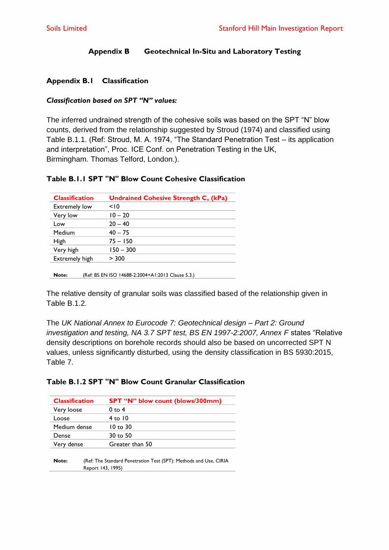
Soils Limited Stanford Hill Main Investigation Report
Geotechnical In-Situ and Laboratory Testing
Appendix B.1 Classification
Classification based on SPT “N” values:
The inferred undrained strength of the cohesive soils was based on the SPT “N” blow
counts, derived from the relationship suggested by Stroud (1974) and classified using
Table B.1.1. (Ref: Stroud, M. A. 1974, “The Standard Penetration Test – its application
and interpretation”, Proc. ICE Conf. on Penetration Testing in the UK,
Birmingham. Thomas Telford, London.).
Table B.1.1 SPT "N" Blow Count Cohesive Classification
Classification Undrained Cohesive Strength Cu (kPa)
Extremely low <10
Very low 10 – 20
Low 20 – 40
Medium 40 – 75
High 75 – 150
Very high 150 – 300
Extremely high > 300
Note: (Ref: BS EN ISO 14688-2:2004+A1:2013 Clause 5.3.)
The relative density of granular soils was classified based of the relationship given in
Table B.1.2.
The UK National Annex to Eurocode 7: Geotechnical design – Part 2: Ground
investigation and testing, NA 3.7 SPT test, BS EN 1997-2:2007, Annex F states “Relative
density descriptions on borehole records should also be based on uncorrected SPT N
values, unless significantly disturbed, using the density classification in BS 5930:2015,
Table 7.
Table B.1.2 SPT "N" Blow Count Granular Classification
Classification SPT “N” blow count (blows/300mm)
Very loose 0 to 4
Loose 4 to 10
Medium dense 10 to 30
Dense 30 to 50
Very dense Greater than 50
Note: (Ref: The Standard Penetration Test (SPT): Methods and Use, CIRIA
Report 143, 1995)
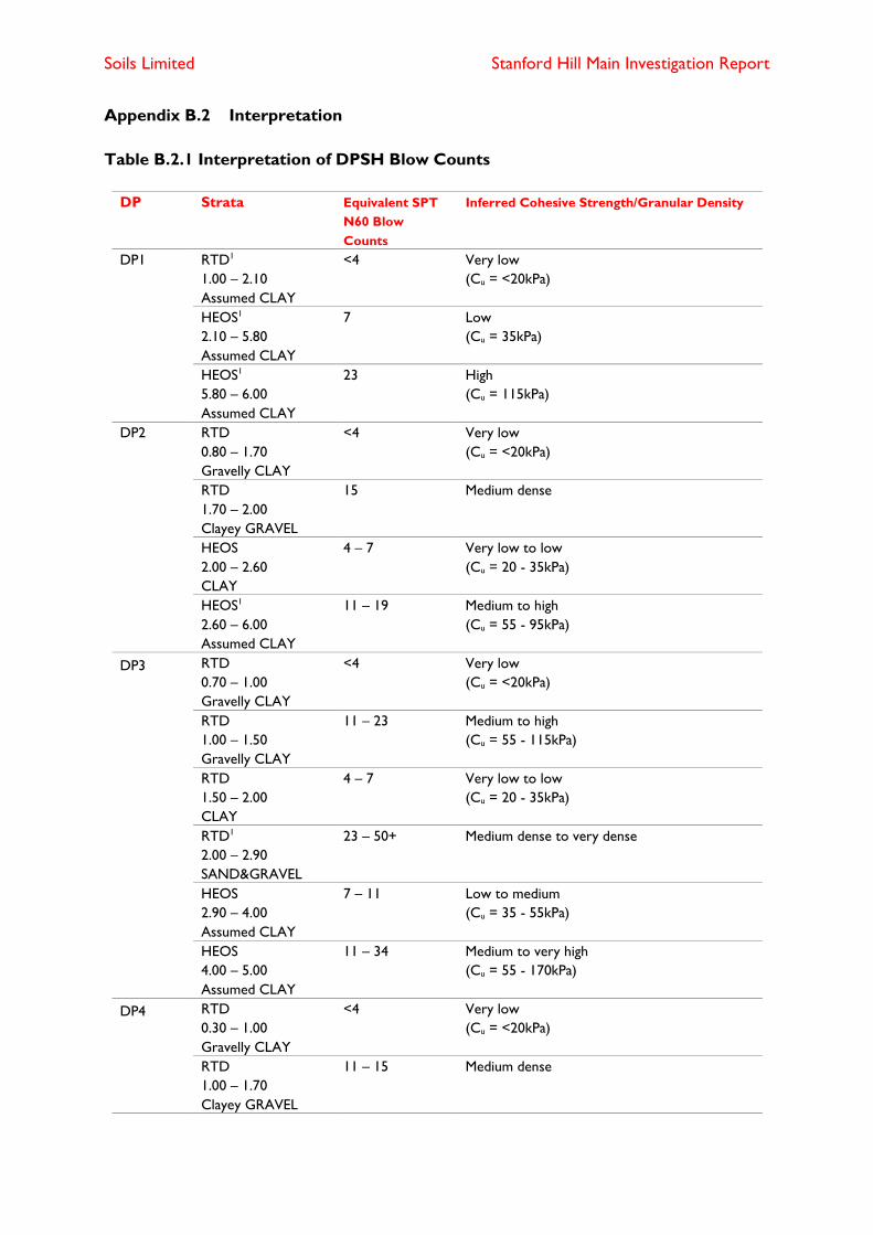
Soils Limited Stanford Hill Main Investigation Report
Appendix B.2 Interpretation
Table B.2.1 Interpretation of DPSH Blow Counts
DP Strata Equivalent SPT
N60 Blow
Counts
Inferred Cohesive Strength/Granular Density
DP1 RTD1
1.00 – 2.10
Assumed CLAY
<4 Very low
(Cu = <20kPa)
HEOS1
2.10 – 5.80
Assumed CLAY
7 Low
(Cu = 35kPa)
HEOS1
5.80 – 6.00
Assumed CLAY
23 High
(Cu = 115kPa)
DP2 RTD
0.80 – 1.70
Gravelly CLAY
<4 Very low
(Cu = <20kPa)
RTD
1.70 – 2.00
Clayey GRAVEL
15 Medium dense
HEOS
2.00 – 2.60
CLAY
4 – 7 Very low to low
(Cu = 20 - 35kPa)
HEOS1
2.60 – 6.00
Assumed CLAY
11 – 19 Medium to high
(Cu = 55 - 95kPa)
DP3 RTD
0.70 – 1.00
Gravelly CLAY
<4 Very low
(Cu = <20kPa)
RTD
1.00 – 1.50
Gravelly CLAY
11 – 23 Medium to high
(Cu = 55 - 115kPa)
RTD
1.50 – 2.00
CLAY
4 – 7 Very low to low
(Cu = 20 - 35kPa)
RTD1
2.00 – 2.90
SAND&GRAVEL
23 – 50+ Medium dense to very dense
HEOS
2.90 – 4.00
Assumed CLAY
7 – 11 Low to medium
(Cu = 35 - 55kPa)
HEOS
4.00 – 5.00
Assumed CLAY
11 – 34 Medium to very high
(Cu = 55 - 170kPa)
DP4 RTD
0.30 – 1.00
Gravelly CLAY
<4 Very low
(Cu = <20kPa)
RTD
1.00 – 1.70
Clayey GRAVEL
11 – 15 Medium dense
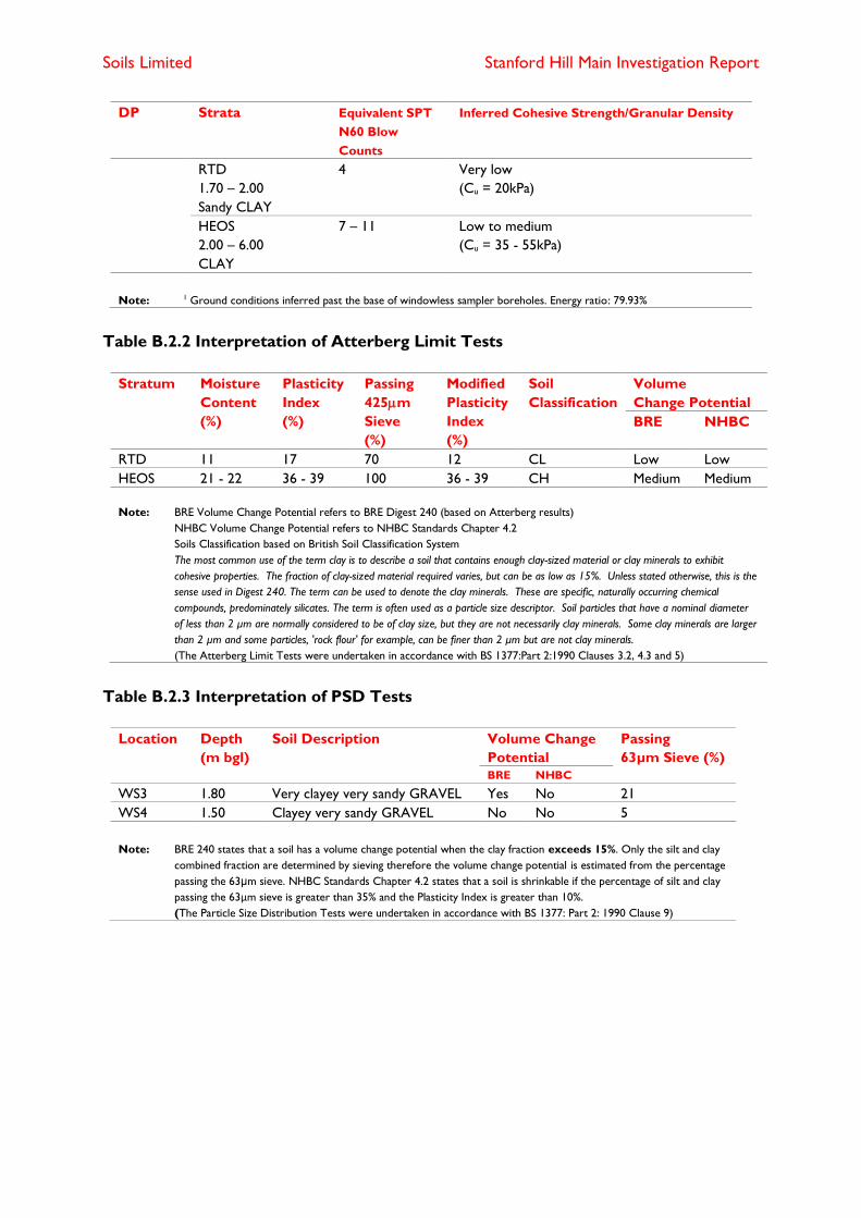
Soils Limited Stanford Hill Main Investigation Report
DP Strata Equivalent SPT
N60 Blow
Counts
Inferred Cohesive Strength/Granular Density
RTD
1.70 – 2.00
Sandy CLAY
4 Very low
(Cu = 20kPa)
HEOS
2.00 – 6.00
CLAY
7 – 11 Low to medium
(Cu = 35 - 55kPa)
Note: 1 Ground conditions inferred past the base of windowless sampler boreholes. Energy ratio: 79.93%
Table B.2.2 Interpretation of Atterberg Limit Tests
Stratum Moisture
Content
(%)
Plasticity
Index
(%)
Passing
425m
Sieve
(%)
Modified
Plasticity
Index
(%)
Soil
Classification
Volume
Change Potential
BRE NHBC
RTD 11 17 70 12 CL Low Low
HEOS 21 - 22 36 - 39 100 36 - 39 CH Medium Medium
Note: BRE Volume Change Potential refers to BRE Digest 240 (based on Atterberg results)
NHBC Volume Change Potential refers to NHBC Standards Chapter 4.2
Soils Classification based on British Soil Classification System
The most common use of the term clay is to describe a soil that contains enough clay-sized material or clay minerals to exhibit
cohesive properties. The fraction of clay-sized material required varies, but can be as low as 15%. Unless stated otherwise, this is the
sense used in Digest 240. The term can be used to denote the clay minerals. These are specific, naturally occurring chemical
compounds, predominately silicates. The term is often used as a particle size descriptor. Soil particles that have a nominal diameter
of less than 2 µm are normally considered to be of clay size, but they are not necessarily clay minerals. Some clay minerals are larger
than 2 µm and some particles, 'rock flour' for example, can be finer than 2 µm but are not clay minerals.
(The Atterberg Limit Tests were undertaken in accordance with BS 1377:Part 2:1990 Clauses 3.2, 4.3 and 5)
Table B.2.3 Interpretation of PSD Tests
Location Depth
(m bgl)
Soil Description Volume Change
Potential
Passing
63µm Sieve (%)
BRE NHBC
WS3 1.80 Very clayey very sandy GRAVEL Yes No 21
WS4 1.50 Clayey very sandy GRAVEL No No 5
Note: BRE 240 states that a soil has a volume change potential when the clay fraction exceeds 15%. Only the silt and clay
combined fraction are determined by sieving therefore the volume change potential is estimated from the percentage
passing the 63μm sieve. NHBC Standards Chapter 4.2 states that a soil is shrinkable if the percentage of silt and clay
passing the 63μm sieve is greater than 35% and the Plasticity Index is greater than 10%.
(The Particle Size Distribution Tests were undertaken in accordance with BS 1377: Part 2: 1990 Clause 9)

Soils Limited Stanford Hill Main Investigation Report
Appendix B.3 Geotechnical In-Situ and Laboratory Results

Depth(m)
1
2
3
4
5
6
7
8
9
10
Blows/100mm
10 20 30 40
10
10
11
0111111
2111111
22
33333
22
42222
322222222
32
32222
322
32
33
68
Torque(Nm)
5
20
35
15
25
45
Soils Limited
Newton House, Cross Road, Tadworth KT20 5SRTel: 01737 814221 Email: [email protected]
Probe LogProbe No.
DP1Sheet 1 of 1
Project Name: Standford Hill Project No.18076 Co-ords: Hole Type
DP
Location: Lymington, Hampshire SO41 8DE Level: m AOD Scale1:50
Client: Pegasuslife Dates: 13-03-2020 Logged By
Remarks Fall HeightHammer WeightProbe Type
750mm63.5kgDPSH
Cone Base DiameterFinal DepthEnergy Ratio (Er)
50.5mm6m79.93%
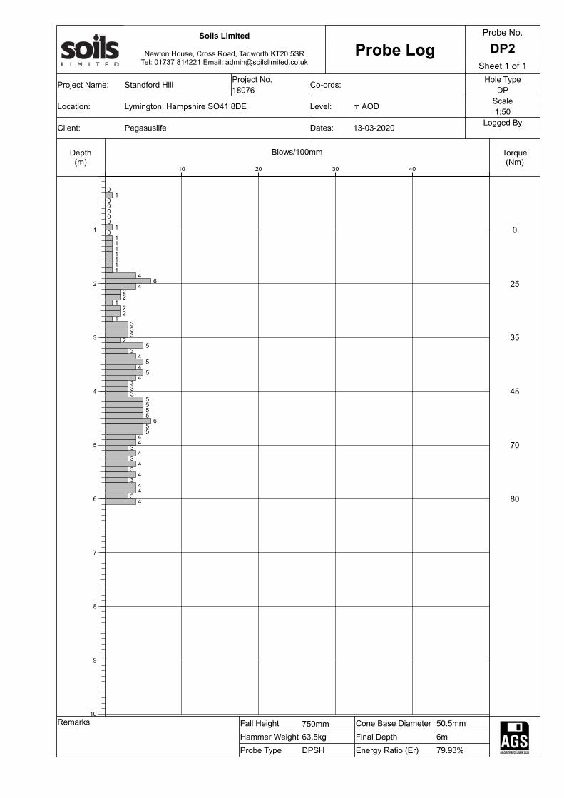
Depth(m)
1
2
3
4
5
6
7
8
9
10
Blows/100mm
10 20 30 40
01
00000
10
1111111
46
422
122
1333
25
34
54
54
333
5555
655
44
34
34
34
344
34
Torque(Nm)
0
25
35
45
70
80
Soils Limited
Newton House, Cross Road, Tadworth KT20 5SRTel: 01737 814221 Email: [email protected]
Probe LogProbe No.
DP2Sheet 1 of 1
Project Name: Standford Hill Project No.18076 Co-ords: Hole Type
DP
Location: Lymington, Hampshire SO41 8DE Level: m AOD Scale1:50
Client: Pegasuslife Dates: 13-03-2020 Logged By
Remarks Fall HeightHammer WeightProbe Type
750mm63.5kgDPSH
Cone Base DiameterFinal DepthEnergy Ratio (Er)
50.5mm6m79.93%
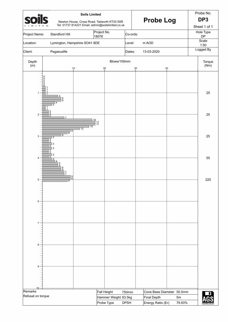
Depth(m)
1
2
3
4
5
6
7
8
9
10
Blows/100mm
10 20 30 40
00000
1111
566
43
11
222
716
1717
1512
98
63
22
32
322
32
34
55
66
77
99
8
Torque(Nm)
25
25
25
55
220
Soils Limited
Newton House, Cross Road, Tadworth KT20 5SRTel: 01737 814221 Email: [email protected]
Probe LogProbe No.
DP3Sheet 1 of 1
Project Name: Standford Hill Project No.18076 Co-ords: Hole Type
DP
Location: Lymington, Hampshire SO41 8DE Level: m AOD Scale1:50
Client: Pegasuslife Dates: 13-03-2020 Logged By
RemarksRefusal on torque
Fall HeightHammer WeightProbe Type
750mm63.5kgDPSH
Cone Base DiameterFinal DepthEnergy Ratio (Er)
50.5mm5m79.93%
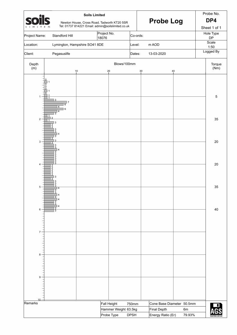
Depth(m)
1
2
3
4
5
6
7
8
9
10
Blows/100mm
10 20 30 40
01
000
10
11
37
64
64
31
21
322
33
43
23
233
4333333
22222
32
333
433
43
433
433
Torque(Nm)
5
35
20
20
35
40
Soils Limited
Newton House, Cross Road, Tadworth KT20 5SRTel: 01737 814221 Email: [email protected]
Probe LogProbe No.
DP4Sheet 1 of 1
Project Name: Standford Hill Project No.18076 Co-ords: Hole Type
DP
Location: Lymington, Hampshire SO41 8DE Level: m AOD Scale1:50
Client: Pegasuslife Dates: 13-03-2020 Logged By
Remarks Fall HeightHammer WeightProbe Type
750mm63.5kgDPSH
Cone Base DiameterFinal DepthEnergy Ratio (Er)
50.5mm6m79.93%
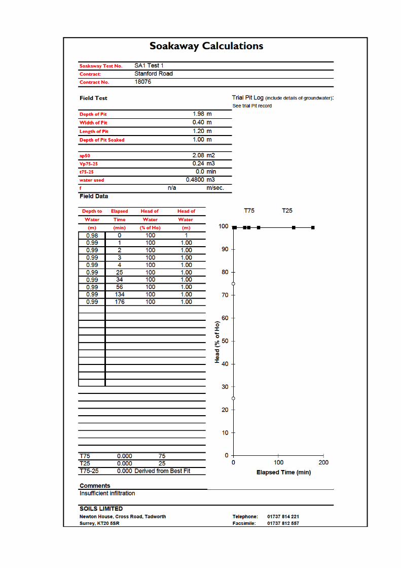
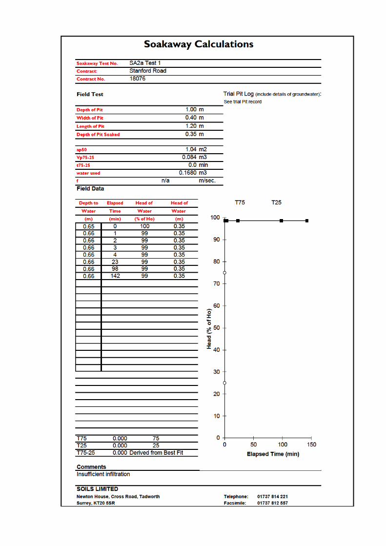


LaboratoryReport
GEO Site & Testing Services Ltd
Contract Number: 48284
Notes: Observations and Interpretations are outside the UKAS Accreditation* - denotes test included in laboratory scope of accreditation# - denotes test carried out by approved contractor@ - denotes non accredited tests
This certificate is issued in accordance with the accreditation requirements of the United Kingdom Accreditation Service. The results reported herein relate only to the material supplied to the laboratory. This certificate shall not be reproduced except in full, without the prior written approval of the laboratory.
Approved Signatories:Emma Sharp (Office Manager) - Paul Evans (Quality/Technical Manager) - Richard John (Advanced Testing Manager)Sean Penn (Administrative/Accounts Assistant) - Shaun Jones (Laboratory manager) - Wayne Honey (Administrative/Quality Assistant)
GEO Site & Testing Services LtdUnit 3-4, Heol Aur, Dafen Ind Estate, Dafen, Llanelli, Carmarthenshire SA14 8QNTel: 01554 784040 Fax: 01554 784041 [email protected] gstl.co.uk
Client Ref: 18076 Report Date: 07-04-2020Client PO: 18076
Client Soils LimitedNewton HouseCross RoadTadworthSurreyKT20 5SR
Contract Title: Stanford Hill, LymingtonFor the attention of: Tim Rudkin
Date Received: 26-03-2020Date Completed: 07-04-2020
Test Description Qty
Moisture ContentBS 1377:1990 - Part 2 : 3.2 - * UKAS
3
1 Point Liquid & Plastic LimitBS 1377:1990 - Part 2 : 4.4 & 5.3 - * UKAS
3
PSD Wet Sieve methodBS 1377:1990 - Part 2 : 9.2 - * UKAS
2
Disposal of samples for job 1
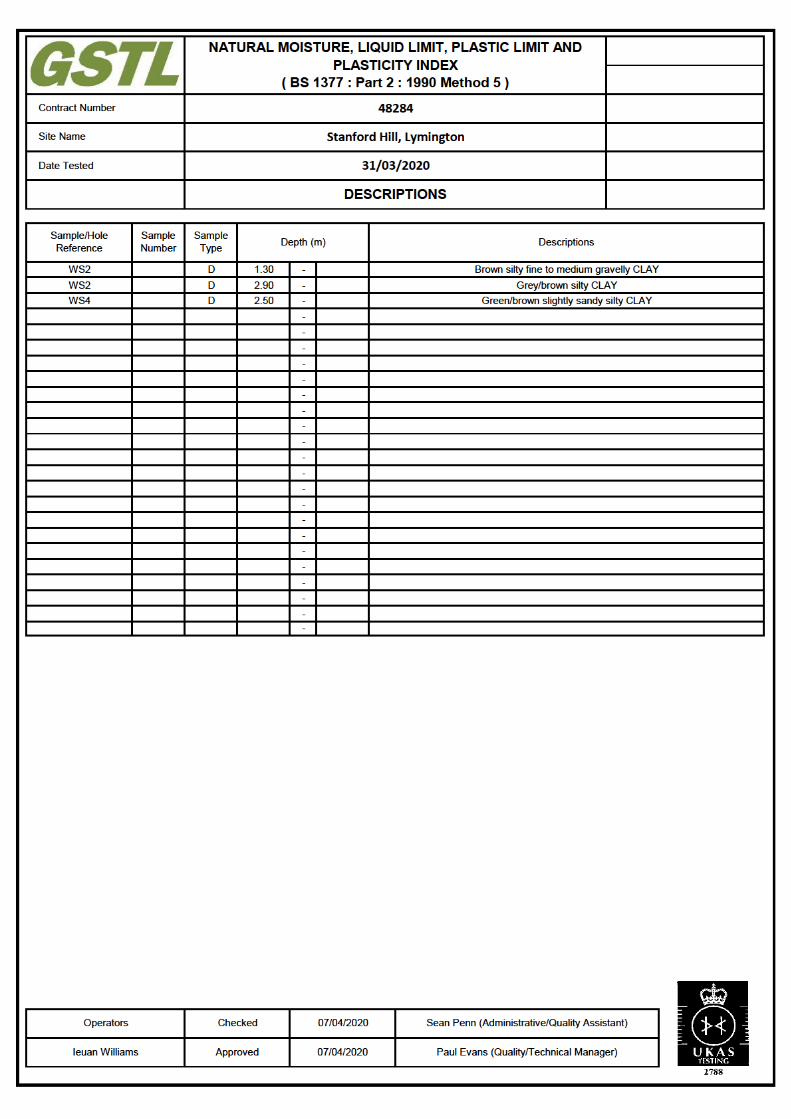
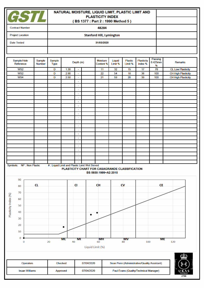
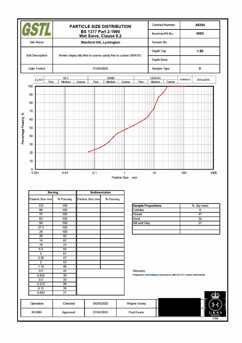
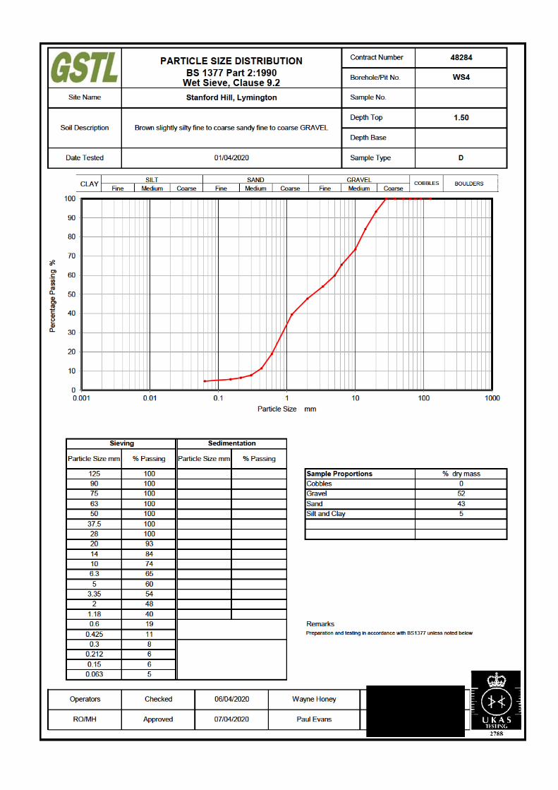
Tim Rudkin DETS Ltd
Soils Ltd Unit 1
Rose Lane Industrial Estate
Rose Lane
Lenham Heath
Kent
ME17 2JN
t: 01622 850410
Site Reference: Stanford Hill, Lymington
Project / Job Ref: 18076
Order No: 18076
Sample Receipt Date: 26/03/2020
Sample Scheduled Date: 26/03/2020
Report Issue Number: 1
Reporting Date: 01/04/2020
Authorised by:
Kevin Old
General Manager
Dates of laboratory activities for each tested analyte are available upon request.
Newton House
Cross Road
Tadworth
Surrey
KT20 5SR
DETS Report No: 20-03885
Opinions and interpretations are outside the laboratory's scope of ISO 17025 accreditation. This certificate is issued in accordance
with the accreditation requirements of the United Kingdom Accreditation Service. The results reported herein relate only to the
material supplied to the laboratory. This certificate shall not be reproduced except in full, without the prior written approval of the
laboratory.
Page 1 of 4

None Supplied None Supplied
None Supplied None Supplied
SA1 WS2
None Supplied None Supplied
1.00 2.40
471033 471034
Determinand Unit RL Accreditation
pH pH Units N/a MCERTS 6.2 7.7
Total Sulphate as SO4 mg/kg < 200 NONE 273 214
Total Sulphate as SO4 % < 0.02 NONE 0.03 0.02
W/S Sulphate as SO4 (2:1) mg/l < 10 MCERTS < 10 26
W/S Sulphate as SO4 (2:1) g/l < 0.01 MCERTS < 0.01 0.03
Total Sulphur % < 0.02 NONE < 0.02 < 0.02
Ammonium as NH4 mg/kg < 0.5 NONE 2.2 0.5
Ammonium as NH4 mg/l < 0.05 NONE 0.22 0.05
W/S Chloride (2:1) mg/kg < 1 MCERTS 5 26
W/S Chloride (2:1) mg/l < 0.5 MCERTS 2.6 13
Water Soluble Nitrate (2:1) as NO3 mg/kg < 3 MCERTS < 3 8
Water Soluble Nitrate (2:1) as NO3 mg/l < 1.5 MCERTS < 1.5 3.8
W/S Magnesium mg/l < 0.1 NONE 0.5 1.5Analytical results are expressed on a dry weight basis where samples are assisted-dried at less than 30°C. The Samples Descriptions page describes if the test is performed on the dried or as-received portion
Subcontracted analysis (S)
Kent ME17 2JN
DETS Ltd Unit 1, Rose Lane Industrial Estate
Rose Lane
Lenham Heath
Maidstone
Tel : 01622 850410
Soil Analysis CertificateDETS Report No: 20-03885 Date Sampled
Soils Ltd Time Sampled
Reporting Date: 01/04/2020 DETS Sample No
Site Reference: Stanford Hill, Lymington TP / BH No
Project / Job Ref: 18076 Additional Refs
Order No: 18076 Depth (m)
Page 2 of 4
DETS Sample No TP / BH No Additional Refs Depth (m)Moisture
Content (%)
^ 471033 SA1 None Supplied 1.00 12.6
^ 471034 WS2 None Supplied 2.40 16.5
Moisture content is part of procedure E003 & is not an accredited testInsufficient Sample
I/S
Unsuitable Sample U/S
^ no sampling date provided; unable to confirm if samples are within acceptable holding times
Project / Job Ref: 18076
DETS Ltd
Unit 1, Rose Lane Industrial Estate
Rose Lane
Lenham Heath
Maidstone
Kent ME17 2JN
Tel : 01622 850410
Soil Analysis Certificate - Sample DescriptionsDETS Report No: 20-03885
Soils Ltd
Site Reference: Stanford Hill, Lymington
Order No: 18076
Reporting Date: 01/04/2020
Sample Matrix Description
Brown sandy clay with stones
Light brown clay
Page 3 of 4

Matrix Analysed
On
Determinand Brief Method Description Method
No
Soil D Boron - Water Soluble Determination of water soluble boron in soil by 2:1 hot water extract followed by ICP-OES E012
Soil AR BTEX Determination of BTEX by headspace GC-MS E001
Soil D Cations Determination of cations in soil by aqua-regia digestion followed by ICP-OES E002
Soil D Chloride - Water Soluble (2:1) Determination of chloride by extraction with water & analysed by ion chromatography E009
Soil AR Chromium - HexavalentDetermination of hexavalent chromium in soil by extraction in water then by acidification, addition of
1,5 diphenylcarbazide followed by colorimetryE016
Soil AR Cyanide - Complex Determination of complex cyanide by distillation followed by colorimetry E015
Soil AR Cyanide - Free Determination of free cyanide by distillation followed by colorimetry E015
Soil AR Cyanide - Total Determination of total cyanide by distillation followed by colorimetry E015
Soil D Cyclohexane Extractable Matter (CEM) Gravimetrically determined through extraction with cyclohexane E011
Soil AR Diesel Range Organics (C10 - C24) Determination of hexane/acetone extractable hydrocarbons by GC-FID E004
Soil AR Electrical ConductivityDetermination of electrical conductivity by addition of saturated calcium sulphate followed by
electrometric measurementE022
Soil AR Electrical Conductivity Determination of electrical conductivity by addition of water followed by electrometric measurement E023
Soil D Elemental Sulphur Determination of elemental sulphur by solvent extraction followed by GC-MS E020
Soil AR EPH (C10 – C40) Determination of acetone/hexane extractable hydrocarbons by GC-FID E004
Soil AR EPH Product ID Determination of acetone/hexane extractable hydrocarbons by GC-FID E004
Soil AREPH TEXAS (C6-C8, C8-C10, C10-C12,
C12-C16, C16-C21, C21-C40)
Determination of acetone/hexane extractable hydrocarbons by GC-FID for C8 to C40. C6 to C8 by
headspace GC-MSE004
Soil D Fluoride - Water Soluble Determination of Fluoride by extraction with water & analysed by ion chromatography E009
Soil D FOC (Fraction Organic Carbon)Determination of fraction of organic carbon by oxidising with potassium dichromate followed by
titration with iron (II) sulphateE010
Soil D Loss on Ignition @ 450oCDetermination of loss on ignition in soil by gravimetrically with the sample being ignited in a muffle
furnaceE019
Soil D Magnesium - Water Soluble Determination of water soluble magnesium by extraction with water followed by ICP-OES E025
Soil D Metals Determination of metals by aqua-regia digestion followed by ICP-OES E002
Soil AR Mineral Oil (C10 - C40)Determination of hexane/acetone extractable hydrocarbons by GC-FID fractionating with SPE
cartridgeE004
Soil AR Moisture Content Moisture content; determined gravimetrically E003
Soil D Nitrate - Water Soluble (2:1) Determination of nitrate by extraction with water & analysed by ion chromatography E009
Soil D Organic MatterDetermination of organic matter by oxidising with potassium dichromate followed by titration with
iron (II) sulphateE010
Soil AR PAH - Speciated (EPA 16)Determination of PAH compounds by extraction in acetone and hexane followed by GC-MS with the
use of surrogate and internal standardsE005
Soil AR PCB - 7 Congeners Determination of PCB by extraction with acetone and hexane followed by GC-MS E008
Soil D Petroleum Ether Extract (PEE) Gravimetrically determined through extraction with petroleum ether E011
Soil AR pH Determination of pH by addition of water followed by electrometric measurement E007
Soil AR Phenols - Total (monohydric) Determination of phenols by distillation followed by colorimetry E021
Soil D Phosphate - Water Soluble (2:1) Determination of phosphate by extraction with water & analysed by ion chromatography E009
Soil D Sulphate (as SO4) - Total Determination of total sulphate by extraction with 10% HCl followed by ICP-OES E013
Soil D Sulphate (as SO4) - Water Soluble (2:1) Determination of sulphate by extraction with water & analysed by ion chromatography E009
Soil D Sulphate (as SO4) - Water Soluble (2:1) Determination of water soluble sulphate by extraction with water followed by ICP-OES E014
Soil AR Sulphide Determination of sulphide by distillation followed by colorimetry E018
Soil D Sulphur - Total Determination of total sulphur by extraction with aqua-regia followed by ICP-OES E024
Soil AR SVOCDetermination of semi-volatile organic compounds by extraction in acetone and hexane followed by
GC-MSE006
Soil AR Thiocyanate (as SCN)Determination of thiocyanate by extraction in caustic soda followed by acidification followed by
addition of ferric nitrate followed by colorimetryE017
Soil D Toluene Extractable Matter (TEM) Gravimetrically determined through extraction with toluene E011
Soil D Total Organic Carbon (TOC)Determination of organic matter by oxidising with potassium dichromate followed by titration with
iron (II) sulphateE010
Soil AR
TPH CWG (ali: C5- C6, C6-C8, C8-C10,
C10-C12, C12-C16, C16-C21, C21-C34,
aro: C5-C7, C7-C8, C8-C10, C10-C12,
C12-C16, C16-C21, C21-C35)
Determination of hexane/acetone extractable hydrocarbons by GC-FID fractionating with SPE
cartridge for C8 to C35. C5 to C8 by headspace GC-MSE004
Soil AR
TPH LQM (ali: C5-C6, C6-C8, C8-C10,
C10-C12, C12-C16, C16-C35, C35-C44,
aro: C5-C7, C7-C8, C8-C10, C10-C12,
C12-C16, C16-C21, C21-C35, C35-C44)
Determination of hexane/acetone extractable hydrocarbons by GC-FID fractionating with SPE
cartridge for C8 to C44. C5 to C8 by headspace GC-MSE004
Soil AR VOCs Determination of volatile organic compounds by headspace GC-MS E001
Soil AR VPH (C6-C8 & C8-C10) Determination of hydrocarbons C6-C8 by headspace GC-MS & C8-C10 by GC-FID E001
D Dried
AR As Received
Kent ME17 2JN
DETS Ltd
Unit 1, Rose Lane Industrial Estate
Rose Lane
Lenham Heath
Maidstone
Order No: 18076
Reporting Date: 01/04/2020
Tel : 01622 850410
Soil Analysis Certificate - Methodology & Miscellaneous InformationDETS Report No: 20-03885
Soils Ltd
Site Reference: Stanford Hill, Lymington
Project / Job Ref: 18076
Page 4 of 4

Soils Limited Stanford Hill Main Investigation Report
Chemical Laboratory Testing
Appendix C.1 Conceptual Site Model

Soils Limited Stanford Hill Main Investigation Report
Table C.1.1 CSM Revised Pre-Testing Source
Potential Contaminant
Exposure Pathway
Receptor
Initial Assessment from Preliminary
Investigation Report Information
Comments Proposed Investigation
Severity Probability Risk
None Identified
Inhalation of dust Site Workers/Site Maintenance None No significant sources identified, risk none by default as no
linkages determined.
It would be prudent to confirm this conclusion by limited
testing and analysis as uncertainties remain i.e. in relation
to limited map data around WWII period.
Emplacement of a discovery strategy during works would
also be recommended.
End Users None
Off-site Users None
Inhalation of Vapour/gases (including
Radon)
Site Workers/Site Maintenance None
End Users None
Off-site Users None
Ingestion and absorption via direct
contact
Site Workers/Site Maintenance None
End Users None
Migration via surface runoff Surface Water
Groundwater Shallow Aquifer None
Deep Aquifer None
Direct contact with construction
material
Buried structures None
Buried Services None
Migration of gases via permeable
soils
Site Workers/Site Maintenance None
End Users None
Off-site Users None
Building and confined spaces None
Table C.1.2 CSM Revised Post Testing Source
Potential Contaminant
Exposure Pathway
Receptor
Initial Assessment from Preliminary
Investigation Report Information
Comments Proposed Investigation
Severity Probability Risk
None Identified
Inhalation of dust Site Workers/Site Maintenance None No significant sources identified, risk none by default as no
linkages determined.
No additional sources identified as a result of limited
analysis and investigation.
Highly localised contaminants noted in results, but not in
significant concentrations in the context of the proposed
development and likely to be the result of historical on-site
residential rather than off-site industrial activities.
Emplacement of a discovery strategy during the works
would be recommended and specialist advice sought if
asbestos is encountered or suspected
End Users None
Off-site Users None
Inhalation of Vapour/gases (including
Radon)
Site Workers/Site Maintenance None
End Users None
Off-site Users None
Ingestion and absorption via direct
contact
Site Workers/Site Maintenance None
End Users None
Migration via surface runoff Surface Water
Groundwater Shallow Aquifer None
Deep Aquifer None
Direct contact with construction
material
Buried structures None
Buried Services None
Migration of gases via permeable
soils
Site Workers/Site Maintenance None
End Users None
Off-site Users None
Building and confined spaces None

Soils Limited Stanford Hill Main Investigation Report
Appendix C.2 Chemical Laboratory Results
None Supplied None Supplied None Supplied None Supplied None Supplied
None Supplied None Supplied None Supplied None Supplied None Supplied
SA1 WS2 WS2 WS3 WS4
None Supplied None Supplied None Supplied None Supplied None Supplied
0.20 0.20 0.90 0.40 0.20
471028 471029 471030 471031 471032
Determinand Unit RL Accreditation
Asbestos Screen (S) N/a N/a ISO17025 Not Detected Not Detected Not Detected Not Detected Not Detected
pH pH Units N/a MCERTS 5.6 6.2 6.6 5.9 5.3
Organic Matter % < 0.1 MCERTS 2.9 3.5 0.7 1.4 2.4
Arsenic (As) mg/kg < 2 MCERTS 5 9 5 3 4
W/S Boron mg/kg < 1 NONE < 1 < 1 < 1 < 1 < 1
Cadmium (Cd) mg/kg < 0.2 MCERTS < 0.2 0.4 < 0.2 < 0.2 < 0.2
Chromium (Cr) mg/kg < 2 MCERTS 12 20 23 10 10
Chromium (hexavalent) mg/kg < 2 NONE < 2 < 2 < 2 < 2 < 2
Copper (Cu) mg/kg < 4 MCERTS 20 52 8 10 11
Lead (Pb) mg/kg < 3 MCERTS 116 268 24 43 70
Mercury (Hg) mg/kg < 1 NONE < 1 < 1 < 1 < 1 < 1
Nickel (Ni) mg/kg < 3 MCERTS 8 11 7 6 5
Selenium (Se) mg/kg < 3 NONE < 3 < 3 < 3 < 3 < 3
Vanadium (V) mg/kg < 2 NONE 20 27 34 15 15
Zinc (Zn) mg/kg < 3 MCERTS 43 221 22 19 26
Total Phenols (monohydric) mg/kg < 2 NONE < 2 < 2 < 2 < 2 < 2Analytical results are expressed on a dry weight basis where samples are assisted-dried at less than 30°C. The Samples Descriptions page describes if the test is performed on the dried or as-received portion
Subcontracted analysis (S)
Kent ME17 2JN
DETS Ltd Unit 1, Rose Lane Industrial Estate
Rose Lane
Lenham Heath
Maidstone
Tel : 01622 850410
Soil Analysis CertificateDETS Report No: 20-03884 Date Sampled
Soils Ltd Time Sampled
Reporting Date: 02/04/2020 DETS Sample No
Site Reference: Stanford Hill, Lymington TP / BH No
Project / Job Ref: 18076 Additional Refs
Order No: 18076 Depth (m)
Page 2 of 6

None Supplied None Supplied None Supplied None Supplied None Supplied
None Supplied None Supplied None Supplied None Supplied None Supplied
SA1 WS2 WS2 WS3 WS4
None Supplied None Supplied None Supplied None Supplied None Supplied
0.20 0.20 0.90 0.40 0.20
471028 471029 471030 471031 471032
Determinand Unit RL Accreditation
Naphthalene mg/kg < 0.1 MCERTS < 0.1 < 0.1 < 0.1 < 0.1 < 0.1
Acenaphthylene mg/kg < 0.1 MCERTS < 0.1 < 0.1 < 0.1 < 0.1 < 0.1
Acenaphthene mg/kg < 0.1 MCERTS < 0.1 < 0.1 < 0.1 < 0.1 < 0.1
Fluorene mg/kg < 0.1 MCERTS < 0.1 < 0.1 < 0.1 < 0.1 < 0.1
Phenanthrene mg/kg < 0.1 MCERTS < 0.1 0.97 < 0.1 < 0.1 0.42
Anthracene mg/kg < 0.1 MCERTS < 0.1 0.20 < 0.1 < 0.1 < 0.1
Fluoranthene mg/kg < 0.1 MCERTS 0.33 2.93 < 0.1 < 0.1 0.58
Pyrene mg/kg < 0.1 MCERTS 0.30 2.65 < 0.1 < 0.1 0.47
Benzo(a)anthracene mg/kg < 0.1 MCERTS 0.16 1.43 < 0.1 < 0.1 0.19
Chrysene mg/kg < 0.1 MCERTS 0.21 1.73 < 0.1 < 0.1 0.27
Benzo(b)fluoranthene mg/kg < 0.1 MCERTS 0.54 2.78 < 0.1 < 0.1 0.51
Benzo(k)fluoranthene mg/kg < 0.1 MCERTS < 0.1 1.24 < 0.1 < 0.1 < 0.1
Benzo(a)pyrene mg/kg < 0.1 MCERTS 0.37 2.48 < 0.1 < 0.1 0.31
Indeno(1,2,3-cd)pyrene mg/kg < 0.1 MCERTS 0.16 0.79 < 0.1 < 0.1 0.13
Dibenz(a,h)anthracene mg/kg < 0.1 MCERTS < 0.1 < 0.1 < 0.1 < 0.1 < 0.1
Benzo(ghi)perylene mg/kg < 0.1 MCERTS 0.13 0.61 < 0.1 < 0.1 < 0.1
Total EPA-16 PAHs mg/kg < 1.6 MCERTS 2.2 17.8 < 1.6 < 1.6 2.9
Kent ME17 2JN
DETS Ltd
Unit 1, Rose Lane Industrial Estate
Rose Lane
Lenham Heath
Maidstone
Tel : 01622 850410
Soil Analysis Certificate - Speciated PAHsDETS Report No: 20-03884 Date Sampled
Soils Ltd Time Sampled
Reporting Date: 02/04/2020 DETS Sample No
Site Reference: Stanford Hill, Lymington TP / BH No
Project / Job Ref: 18076 Additional Refs
Order No: 18076 Depth (m)
Page 3 of 6
None Supplied None Supplied None Supplied None Supplied None Supplied
None Supplied None Supplied None Supplied None Supplied None Supplied
SA1 WS2 WS2 WS3 WS4
None Supplied None Supplied None Supplied None Supplied None Supplied
0.20 0.20 0.90 0.40 0.20
471028 471029 471030 471031 471032
Determinand Unit RL Accreditation
EPH Texas (C6 - C8) mg/kg < 0.05 NONE < 0.05 < 0.05 < 0.05 < 0.05 < 0.05
EPH Texas (>C8 - C10) mg/kg < 1 MCERTS < 1 < 1 < 1 3 < 1
EPH Texas (>C10 - C12) mg/kg < 1 MCERTS < 1 < 1 < 1 2 < 1
EPH Texas (>C12 - C16) mg/kg < 1 MCERTS < 1 < 1 < 1 < 1 < 1
EPH Texas (>C16 - C21) mg/kg < 1 MCERTS 1 11 < 1 < 1 2
EPH Texas (>C21 - C40) mg/kg < 6 MCERTS 12 45 < 6 < 6 11
EPH Texas (C6 - C40) mg/kg < 6 NONE 13 56 < 6 < 6 13
Kent ME17 2JN
DETS Ltd
Unit 1, Rose Lane Industrial Estate
Rose Lane
Lenham Heath
Maidstone
Tel : 01622 850410
Soil Analysis Certificate - EPH Texas BandedDETS Report No: 20-03884 Date Sampled
Soils Ltd Time Sampled
Reporting Date: 02/04/2020 DETS Sample No
Site Reference: Stanford Hill, Lymington TP / BH No
Project / Job Ref: 18076 Additional Refs
Order No: 18076 Depth (m)
Page 4 of 6
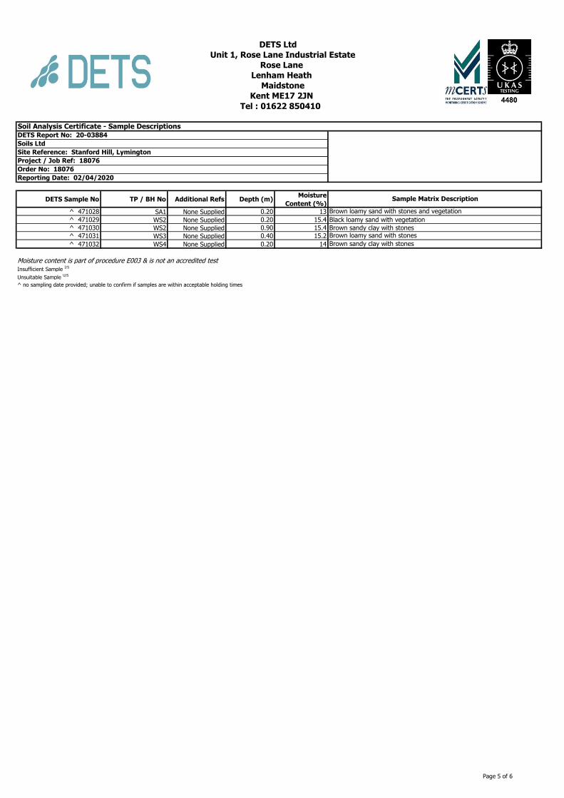
DETS Sample No TP / BH No Additional Refs Depth (m)Moisture
Content (%)
^ 471028 SA1 None Supplied 0.20 13
^ 471029 WS2 None Supplied 0.20 15.4
^ 471030 WS2 None Supplied 0.90 15.4
^ 471031 WS3 None Supplied 0.40 15.2
^ 471032 WS4 None Supplied 0.20 14
Moisture content is part of procedure E003 & is not an accredited testInsufficient Sample
I/S
Unsuitable Sample U/S
^ no sampling date provided; unable to confirm if samples are within acceptable holding times
Project / Job Ref: 18076
DETS Ltd
Unit 1, Rose Lane Industrial Estate
Rose Lane
Lenham Heath
Maidstone
Kent ME17 2JN
Tel : 01622 850410
Soil Analysis Certificate - Sample DescriptionsDETS Report No: 20-03884
Soils Ltd
Site Reference: Stanford Hill, Lymington
Brown loamy sand with stones
Brown sandy clay with stones
Order No: 18076
Reporting Date: 02/04/2020
Sample Matrix Description
Brown loamy sand with stones and vegetation
Black loamy sand with vegetation
Brown sandy clay with stones
Page 5 of 6

Matrix Analysed
On
Determinand Brief Method Description Method
No
Soil D Boron - Water Soluble Determination of water soluble boron in soil by 2:1 hot water extract followed by ICP-OES E012
Soil AR BTEX Determination of BTEX by headspace GC-MS E001
Soil D Cations Determination of cations in soil by aqua-regia digestion followed by ICP-OES E002
Soil D Chloride - Water Soluble (2:1) Determination of chloride by extraction with water & analysed by ion chromatography E009
Soil AR Chromium - HexavalentDetermination of hexavalent chromium in soil by extraction in water then by acidification, addition of
1,5 diphenylcarbazide followed by colorimetryE016
Soil AR Cyanide - Complex Determination of complex cyanide by distillation followed by colorimetry E015
Soil AR Cyanide - Free Determination of free cyanide by distillation followed by colorimetry E015
Soil AR Cyanide - Total Determination of total cyanide by distillation followed by colorimetry E015
Soil D Cyclohexane Extractable Matter (CEM) Gravimetrically determined through extraction with cyclohexane E011
Soil AR Diesel Range Organics (C10 - C24) Determination of hexane/acetone extractable hydrocarbons by GC-FID E004
Soil AR Electrical ConductivityDetermination of electrical conductivity by addition of saturated calcium sulphate followed by
electrometric measurementE022
Soil AR Electrical Conductivity Determination of electrical conductivity by addition of water followed by electrometric measurement E023
Soil D Elemental Sulphur Determination of elemental sulphur by solvent extraction followed by GC-MS E020
Soil AR EPH (C10 – C40) Determination of acetone/hexane extractable hydrocarbons by GC-FID E004
Soil AR EPH Product ID Determination of acetone/hexane extractable hydrocarbons by GC-FID E004
Soil AREPH TEXAS (C6-C8, C8-C10, C10-C12,
C12-C16, C16-C21, C21-C40)
Determination of acetone/hexane extractable hydrocarbons by GC-FID for C8 to C40. C6 to C8 by
headspace GC-MSE004
Soil D Fluoride - Water Soluble Determination of Fluoride by extraction with water & analysed by ion chromatography E009
Soil D FOC (Fraction Organic Carbon)Determination of fraction of organic carbon by oxidising with potassium dichromate followed by
titration with iron (II) sulphateE010
Soil D Loss on Ignition @ 450oCDetermination of loss on ignition in soil by gravimetrically with the sample being ignited in a muffle
furnaceE019
Soil D Magnesium - Water Soluble Determination of water soluble magnesium by extraction with water followed by ICP-OES E025
Soil D Metals Determination of metals by aqua-regia digestion followed by ICP-OES E002
Soil AR Mineral Oil (C10 - C40)Determination of hexane/acetone extractable hydrocarbons by GC-FID fractionating with SPE
cartridgeE004
Soil AR Moisture Content Moisture content; determined gravimetrically E003
Soil D Nitrate - Water Soluble (2:1) Determination of nitrate by extraction with water & analysed by ion chromatography E009
Soil D Organic MatterDetermination of organic matter by oxidising with potassium dichromate followed by titration with
iron (II) sulphateE010
Soil AR PAH - Speciated (EPA 16)Determination of PAH compounds by extraction in acetone and hexane followed by GC-MS with the
use of surrogate and internal standardsE005
Soil AR PCB - 7 Congeners Determination of PCB by extraction with acetone and hexane followed by GC-MS E008
Soil D Petroleum Ether Extract (PEE) Gravimetrically determined through extraction with petroleum ether E011
Soil AR pH Determination of pH by addition of water followed by electrometric measurement E007
Soil AR Phenols - Total (monohydric) Determination of phenols by distillation followed by colorimetry E021
Soil D Phosphate - Water Soluble (2:1) Determination of phosphate by extraction with water & analysed by ion chromatography E009
Soil D Sulphate (as SO4) - Total Determination of total sulphate by extraction with 10% HCl followed by ICP-OES E013
Soil D Sulphate (as SO4) - Water Soluble (2:1) Determination of sulphate by extraction with water & analysed by ion chromatography E009
Soil D Sulphate (as SO4) - Water Soluble (2:1) Determination of water soluble sulphate by extraction with water followed by ICP-OES E014
Soil AR Sulphide Determination of sulphide by distillation followed by colorimetry E018
Soil D Sulphur - Total Determination of total sulphur by extraction with aqua-regia followed by ICP-OES E024
Soil AR SVOCDetermination of semi-volatile organic compounds by extraction in acetone and hexane followed by
GC-MSE006
Soil AR Thiocyanate (as SCN)Determination of thiocyanate by extraction in caustic soda followed by acidification followed by
addition of ferric nitrate followed by colorimetryE017
Soil D Toluene Extractable Matter (TEM) Gravimetrically determined through extraction with toluene E011
Soil D Total Organic Carbon (TOC)Determination of organic matter by oxidising with potassium dichromate followed by titration with
iron (II) sulphateE010
Soil AR
TPH CWG (ali: C5- C6, C6-C8, C8-C10,
C10-C12, C12-C16, C16-C21, C21-C34,
aro: C5-C7, C7-C8, C8-C10, C10-C12,
C12-C16, C16-C21, C21-C35)
Determination of hexane/acetone extractable hydrocarbons by GC-FID fractionating with SPE
cartridge for C8 to C35. C5 to C8 by headspace GC-MSE004
Soil AR
TPH LQM (ali: C5-C6, C6-C8, C8-C10,
C10-C12, C12-C16, C16-C35, C35-C44,
aro: C5-C7, C7-C8, C8-C10, C10-C12,
C12-C16, C16-C21, C21-C35, C35-C44)
Determination of hexane/acetone extractable hydrocarbons by GC-FID fractionating with SPE
cartridge for C8 to C44. C5 to C8 by headspace GC-MSE004
Soil AR VOCs Determination of volatile organic compounds by headspace GC-MS E001
Soil AR VPH (C6-C8 & C8-C10) Determination of hydrocarbons C6-C8 by headspace GC-MS & C8-C10 by GC-FID E001
D Dried
AR As Received
Kent ME17 2JN
DETS Ltd
Unit 1, Rose Lane Industrial Estate
Rose Lane
Lenham Heath
Maidstone
Order No: 18076
Reporting Date: 02/04/2020
Tel : 01622 850410
Soil Analysis Certificate - Methodology & Miscellaneous InformationDETS Report No: 20-03884
Soils Ltd
Site Reference: Stanford Hill, Lymington
Project / Job Ref: 18076
Page 6 of 6

Soils Limited Stanford Hill Main Investigation Report
Appendix C.3 General Assessment Criteria
Soils Limited February 2020 – Human Health Risk Assessment
1
HUMAN HEALTH RISK ASSESSMENT
Introduction
The statutory definition of contaminated land is defined in the Environmental Protection
Act 1990, ref. 1.1, which was introduced by the Environment Act 1995, ref. 1.2;
‘Land which appears to the local authority in whose area it is situated to be in such a
condition, by reason of substances in, on or under the land, that –
(a) significant harm is being caused or there is a significant possibility of such
harm being caused; or
(b) pollution of controlled waters is being, or is likely to be, caused.’
The UK guidance on the assessment of contaminated has developed as a direct result of
the introduction of these two Acts. The technical guidance supporting the new legislation
has been summarised in a number of key documents collectively known as the
Contaminated Land Reports (CLRs), a proposed series of twelve documents. Seven
were originally published in March 1994, four more were published in April 2002, while
the last remaining guidance document, CLR 11, ref 1.3 was published in 2004. In 2008
CLR reports 7 to 10 were withdrawn by DEFRA and the Environment Agency and
updated version of CLR 9 and 10 were produced in the form of Science Reports SR2,
ref. 1.4 and SR3, ref. 1.5.
In establishing whether a site fulfils the statutory definition of ‘contaminated land’ it is
necessary to identify, whether a pollutant linkage exists in respect of the land in question
and whether the pollutant linkage:
• is resulting in significant harm being caused to the receptor in the pollutant
linkage,
• presents a significant possibility of significant harm being caused to that receptor,
• is resulting in the pollution of the controlled waters which constitute the receptor,
or
• is likely to result in such pollution.
A ‘pollutant linkage’ may be defined as the link between a contaminant ‘source’ and a
‘receptor’ by means of a ‘pathway’.
Soils Limited February 2020 – Human Health Risk Assessment
3
The end-use may be defined as one of the following ref. 1.15;
• Residential with homegrown produce – domestic low rise and low density housing
with gardens where vegetables may be grown for home consumption
• Residential without homegrown produce – domestic low density and low density
housing where no gardens are present.
• Allotments – specific areas where vegetables are grown for home consumption.
• Public open space in close proximity to residential housing – includes the
predominantly grassed area adjacent to high density housing and the central
green area around which houses are developed. This land-use includes the
smaller areas commonly incorporated in newer developments as informal grassed
areas or more formal landscaped areas with a mixture of open space and covered
soil with planting.
• Public open space in use as general parkland – provided for recreational use and
may be used for family visits and picnics, children’s play area, sports grounds and
dig walking.
• Commercial – industrial premises where there is limited exposure to soil.
Standard Land-use Scenarios
The standard land-use scenarios used to develop conceptual exposure models are
presented in the following sections:
Residential with homegrown produce
Generic scenario assumes a typical two-storey house built on a ground bearing
slab with a private garden having a lawn, flowerbeds and a small fruit and
vegetable patch.
• Critical receptor is a young female child (zero to six years old)
• Exposure duration is six years.
• Exposure pathways include direct soil and indoor dust ingestion, consumption of home-
grown produce and any adhering soil, skin contact with soils and indoor dust and
inhalation of indoor and outdoor dust and vapours.
• Building type is a two-storey small terraced house.
A sub-set of the Residential land-use is Residential without Homegrown
produce. The generic scenario assumes low density housing with communal
landscaped gardens where the consumption of home grown vegetables will not
occur.
Allotments
Provision of open space (about 250sq.m) commonly made available to tenants by
the local authority to grow fruit and vegetable for their own consumption.
Typically, there are a number of plots to a site which may have a total area of up
to 1 hectare. The tenants are assumed to be adults and that young children make
occasional accompanied visits.

Soils Limited February 2020 – Human Health Risk Assessment
4
Although some allotment holders may choose to keep animals including rabbits,
hens, and ducks, potential exposure to contaminated meat and eggs is not
considered.
• Critical receptor is a young female child (zero to six years old)
• Exposure duration is six years.
• Exposure pathways include direct soil ingestion, consumption of homegrown produce and
any adhering soil, skin contact with soils and inhalation of outdoor dust and vapours.
• There is no building.
Commercial
The generic scenario assumes a typical commercial or light industrial property
comprising a three-storey building at which employees spend most time indoors
and are involved in office-based or relatively light physical work.
• Critical receptor is a working female adult (aged 16 to 65 years old).
• Exposure duration is a working lifetime of 49 years.
• Exposure pathways include direct soil and indoor dust ingestion, skin contact with soils and
dusts and inhalation of dust and vapours.
• Building type is a three-storey office (pre 1970).
Public Open Space within Residential Area
The generic scenario refers to any grassed area 0.05 ha and that is close to
Housing.
• Grassed area of up to 0.05 ha and a considerable proportion of this (up to 50%) may be bare
soil
• Predominantly used by children for playing and may be used for activities such as a football
kick about
• Sufficiently close proximity to home for tracking back of soil to occur, thus indoor exposure
pathways apply
• older children as the critical receptor on basis that they will use site most frequently (Age
class 4-9)
• ingestion rate 75 mg.day-1
Public Open Space Park
This generic scenario refers to any public park that is more than 0.5ha in area:
• Public park (>0.5 ha), predominantly grassed and may also contain children’s play equipment
and border areas of soil containing flowers or shrubs (75% cover)
• Female child age classes 1-6
• Soil ingestion rate of 50 mg.day-1
• Occupancy period outdoors = 2 hours.day-1
• Exposure frequency of 170 days.year-1 for age classes 2-18 and 85
• days.year-1 for age class 1
• Outdoor exposure pathways only (no tracking back).
Human Health Generic Quantitative Risk Assessment (GQRA) involves the comparison
of contaminant concentrations measured in soil at the site with Generic Assessment
Criteria (GAC).
Soils Limited February 2020 – Human Health Risk Assessment
5
GAC are conservative values adopted to ensure that they are applicable to the majority
of possible contaminated site. These values may be published Contaminated Land
Exposure Assessment Model (CLEA) derived GAC derived by a third party or the
Environment Agency/ DEFRA. It is imperative to the risk assessor to understand the
uncertainties and limitations associated with these GAC to ensure that they are used
appropriately. Where the adoption of a GAC is not appropriate, for instance when the
intended land-use is at variance the CLEA standard land-uses, then a Detailed
Quantitative Risk Assessment (DQRA) may be undertaken to develop site specific
values for relevant soil contaminants based on the site specific conditions.
In 2014, the publication of Category 4 Screening Levels (C4SL) ref 1.15, 1.16, as part of
the Defra-funded research project SP1010, included modifications to certain exposure
assumptions documented within EA Science Report SC050221/SR3 (herein after
referred to as SR3) ref 1.5 used in the generation of SGVs. C4SL were published for six
substances (cadmium, arsenic, benzene, benzo(a)pyrene, chromium VI and lead) for a
sandy loam soil type with 6% soil organic matter, based on a low level of toxicological
concern (LLTC; see Section 2.3 of research project report SP1010 ref 1.16. Where a
C4SL has been published, Soils Limited has adopted them as GAC for these six
substances.
For all other substances the soils will be compared to Suitable 4 Use Levels (S4ULs)
published by LQM ref. 1.12, which were developed for around 85 substances and are
intended to enable a screening assessment of the risks posed by soil quality on
development sites. The updated LQM/CIEH GAC publication was developed to
accommodate recent developments in the understanding of chemical, toxicological and
routine exposure to soil-based contaminants.
Where no S4UL or C4SL is available, the assessment criteria (AC) may be generated
using the Contaminated Land Exposure Assessment (CLEA) Software Version 1.07, ref.
1.13. Toxicological and physico-chemical/fate and transport data used to generate the
AC has been derived from a hierarchy of data sources as follows:
1. Environment Agency or Department of Environment Food and Rural Affairs
(DEFRA) documents;
2. Other documents produced by UK Government or state organisations;
3. European institution documents;
4. International organisation documents;
5. Foreign government institutions.
In the case of the majority of contaminants considered, the toxicological data has been
drawn from the relevant CLR 9 TOX report, or updated toxicological data published by
the Environment Agency (2009), ref. 1.6, where available. Where no TOX report is
available reference has been made to the health criteria values, derived for use in Land
Quality Press (2006), ref. 1.17, as this is considered to represent a peer reviewed data
source. Similarly, fate and transport data has been derived in the first instance from
Environment Agency (2003), ref. 1.18 and for contaminants not considered in this
Soils Limited February 2020 – Human Health Risk Assessment
6
document the fate and transport data used in previous versions of the CLEA model has
been used.
Chemical laboratory test results are processed as follows. A statistical analysis of the
results is conducted, as detailed in CIEH and CL:AIRE ‘Guidance on Comparing Soil
Contamination Data with a Critical Concentration’, ref. 1.14. Individual concentrations
are compared to the selected guideline values to identify concentrations of contaminants
that are above the selected screening criteria.
Where the risk estimation identifies significant concentrations of one or more
contaminants, a further risk evaluation needs to be undertaken.
Soils Limited February 2020 – Human Health Risk Assessment
7
References
1.1 The Environmental Protection Act, Part IIA, Section 78, DoE 1990.
1.2 Environment Act 1995, Section 57, DoE 1995.
1.3 CLR 11, ‘Model Procedures for the Management of Contaminated Land’, DEFRA and Environment Agency, 2004.
1.4 Environment Agency Science Report SC050021/SR2 ‘Human health toxicological assessment of contaminants in soil’.
1.5 Science Report SC050021/SR3 ‘Updated technical background to the CLEA model’, Environment Agency, 2008
1.6 CLR 2, ‘Guidance on preliminary site inspection of contaminated land’, Report by Applied Environmental, DoE 1994.
1.7 CLR 3 ‘Documentary Research on Industrial Sites’, Report by RPS Consultants Ltd., DOE, 1994
1.8 CLR 4, ‘Sampling strategies for contaminated land’, Report by The Centre for Research into the Built Environment, the Nottingham Trent University, DoE, 1994
1.9 BS 10175: 2011 ‘Investigation of potentially contaminated sites. Code of practice’, British Standards Institute, 2011
1.10 BS 5930: 2015 ‘Code of practice for ground investigations’, British Standards Institute, 2015
1.11 Science Report SC050021 ‘Contaminants in Soil: Updated Collation of Toxicological Data and Intake Values for Humans’, Environment Agency, 2009
1.12 The LQM/S4ULs for Human Health Risk Assessment, Nathanail P, McCaffery C, Gillett A, Ogden R, and Nathanail J, Land Quality Press, Nottingham, published 2015.
1.13 CLEA ‘Software Version 1.071’ (downloaded from the Environment Agency website, http://www.environment-agency.gov.uk)
1.14 CIEH ‘Guidance on Comparing Soil Contamination Data with a Critical Concentration’, Chartered Institute of Environmental Health (CIEH) and Contaminated Land: Applications in Real Environments (CL:AIRE), May 2008.
1.15 DEFRA SP1010: Development of Category 4 Screening Levels for the Assessment of Land Affected by Contamination, published March 2014.
1.16 Contaminated Land: Applications in Real Environment (CL:AIRE) (2014). ‘Development of Category 4 Screening Levels for Assessment of Land Affected by Contamination’, Revision 2, DEFRA research project SP1010.
1.17 Generic Assessment Criteria for Human Health Risk Assessment, Nathanial CP, McCaffery C, Ashmore M, Cheng Y, Gillett A, Hooker P and Ogden RC
1.18 CLR 2, ‘Guidance on preliminary site inspection of contaminated land’, Report by
Applied Environmental, DoE 1994.

Soils Limited February 2020 – Human Health Risk Assessment
8
Land Use
Residential With or Without Plant Uptake
Allotments Commercial
Public Open Space (POS)
Nam
e
Au
tho
rity
Date
With
home-grown produce
Without
home-grown produce Residential Park
SOM 1.0 2.5 6 1 2.5 6 1 2.5 6 1 2.5 6 1 2.5 6 1 2.5 6
Type Contaminants Species Year
Antimony 2010 550 7500 EIC/AGS/
CL:AIRE
EIC/AGS/
CL:AIRE
2010
Meta
ls
Arsenic 2014 37 40 49 640 79 168 C4SL DEFRA 2014
2015 37 40 40 640 79 170 S4UL LQM/CIEH 2015
Beryllium 2015 1.7 1.7 35 12 2.2 63 S4UL LQM/CIEH 2015
Boron 2015 290 11000 45 240000 21000 46000 S4UL LQM/CIEH 2015
Cadmium 2015 11 85 1.9 190 120 532 S4UL LQM/CIEH 2015
2014 26 149 4.9 410 220 880 C4SL DEFRA 2014
Chromium III 2015 910 910 18000 8600 1500 33000 S4UL LQM/CIEH 2015
VI 2014 21 21 170 49 23 250 C4SL DEFRA 2014
VI 2015 6 6 1.8 33 7.7 220 S4UL LQM/CIEH 2015
Copper 2015 2400 7100 520 68000 12000 44000 S4UL LQM/CIEH 2015
Lead 200 310 80 2330 630 1300 C4SL DEFRA 2014
Mercury Elemental 2012 1.0 1.0 26 26 SGV DEFRA 2012
2015 1.2 1.2 21 58 16 30 S4UL LQM/CIEH 2015
Inorganic 2012 170 170 80 36000 SGV DEFRA 2012
2015 40 56 19 1100 120 240 S4UL LQM/CIEH 2015
Methyl 2012 11 11 8 410 SGV DEFRA 2012
2015 11 15 6 320 40 68 S4UL LQM/CIEH 2015
Nickel 2012 130 130 230 1800 SGV DEFRA 2012
2015 130 180 53 980 230 800 S4UL LQM/CIEH 2015
Selenium 2012 350 350 120 13000 SGV DEFRA 2012
2015 250 430 88 12000 1100 1800 S4UL LQM/CIEH 2015
Vanadium 2015 410 1200 91 9000 2000 5000 S4UL LQM/CIEH 2015
Zinc 2015 3700 40000 620 730000 81000 170000 S4UL LQM/CIEH 2015
BT
EX
& M
TB
E
Benzene 2012 0.33 0.33 0.07 95 SGV DEFRA 2012
2014 0.87 3.3 0.18 98 140 230 C4SL DEFRA 2014
2015 0.087 0.17 0.37 0.38 0.7 1.4 0.017 0.034 0.075 27 47 90 72 72 73 90 100 110 S4UL LQM/CIEH 2015
Toluene 2012 610 610 120 4400 SGV DEFRA 2012
2015 130 290 660 880 1900 3900 22 51 120 65000 110000 180000 56000 56000 56000 87000 95000 100000 S4UL LQM/CIEH 2015
Ethylbenzene 2012 350 350 90 2800 SGV DEFRA 2012
2015 47 110 260 83 190 440 16 39 91 4700 13000 27000 24000 24000 25000 17000 22000 27000 S4UL LQM/CIEH 2015
Xylenes o-xylene 2012 250 250 160 2600 SGV DEFRA 2012
2015 60 140 330 88 210 480 28 67 160 6600 15000 33000 41000 42000 43000 17000 24000 33000 S4UL LQM/CIEH 2015
m-xylene 2012 240 240 180 3500 SGV DEFRA 2012
2015 59 140 320 82 190 450 31 74 170 6200 14000 31000 41000 42000 43000 17000 24000 32000 S4UL LQM/CIEH 2015
p-xylene 2012 230 230 160 3200 SGV DEFRA 2012
2015 56 130 310 79 180 310 29 69 160 5900 14000 30000 41000 42000 43000 17000 23000 31000 S4UL LQM/CIEH 2015
Petr
ole
um
Hyd
rocarb
on
s F
racti
on
s
Aliphatic >C5 - C6 2015 42 78 160 42 78 160 730 1700 3900 3200 5900 12000 570000 590000 600000 95000 130000 180000 S4UL LQM/CIEH 2015
Aliphatic >C6 - C8 2015 100 230 530 100 230 530 2300 5600 13000 7800 17000 40000 600000 610000 620000 150000 220000 320000 S4UL LQM/CIEH 2015
Aliphatic >C8 - C10 2015 27 65 150 27 65 150 320 770 1700 2000 4800 11000 13000 13000 13000 14000 18000 21000 S4UL LQM/CIEH 2015
Aliphatic >C10 - C12 2015 130 330 760 130 330 770 2200 4400 7300 9700 23000 47000 13000 13000 13000 21000 23000 24000 S4UL LQM/CIEH 2015
Aliphatic >C12 - C16 2015 1100 2400 4300 1100 2400 4400 11000 13000 13000 59000 82000 90000 13000 13000 13000 25000 25000 26000 S4UL LQM/CIEH 2015
Aliphatic >C16 - C35 2015 65000 92000 110000 65000 92000 110000 260000 270000 270000 1600000 1700000 1800000 250000 250000 250000 450000 480000 490000 S4UL LQM/CIEH 2015
Aliphatic >C35 - C44 2015 65000 92000 140000 65000 92000 110000 260000 270000 270000 1600000 1700000 1800000 250000 250000 250000 450000 480000 490000 S4UL LQM/CIEH 2015
Aromatic >C5 - C7 2015 70 140 300 370 690 1400 13 27 57 26000 46000 86000 56000 56000 56000 76000 84000 92000 S4UL LQM/CIEH 2015
Aromatic >C7 - C8 2015 130 290 660 860 1800 3900 22 51 120 56000 110000 180000 56000 56000 56000 87000 95000 100000 S4UL LQM/CIEH 2015
Aromatic >C8 - C10 2015 34 83 190 47 110 270 8.6 21 51 3500 8100 17000 5000 5000 5000 7200 8500 9300 S4UL LQM/CIEH 2015
Aromatic >C10 - C12 2015 74 180 380 250 590 1200 13 31 74 16000 28000 34000 5000 5000 5000 9200 9700 10000 S4UL LQM/CIEH 2015
Aromatic >C12 - C16 2015 140 330 660 1800 2300 2500 23 57 130 36000 37000 38000 5100 5100 5000 10000 10000 10000 S4UL LQM/CIEH 2015
Aromatic >C16 - C21 2015 260 540 930 1900 1900 1900 46 110 260 28000 28000 28000 3800 3800 3800 7600 7700 7800 S4UL LQM/CIEH 2015
Aromatic >C21 - C35 2015 1100 1500 1700 1900 1900 1900 370 820 1600 28000 28000 28000 3800 3800 3800 7800 7800 7900 S4UL LQM/CIEH 2015

Soils Limited February 2020 – Human Health Risk Assessment
9
Land Use
Residential With or Without Plant Uptake
Allotments Commercial
Public Open Space (POS)
Nam
e
Au
tho
rity
Date
With
home-grown produce
Without
home-grown produce Residential Park
SOM 1.0 2.5 6 1 2.5 6 1 2.5 6 1 2.5 6 1 2.5 6 1 2.5 6
Type Contaminants Species Year
Aromatic >C34 - C44 2015 1100 1500 1700 1900 1900 1900 370 820 1600 28000 28000 28000 3800 3800 3800 7800 7800 7900 S4UL LQM/CIEH 2015
Aliphatic + Aromatic >C44 - C70
1600 1800 1900 1900 1900 1900 1200 2100 3000 28000 28000 28000 3800 3800 3800 7800 7800 7900 S4UL LQM/CIEH 2015
Po
lycyclic A
rom
ati
c H
yd
rocarb
on
s
(PA
H’
s) (
mg/k
g)
Acenaphthene 2015 210 510 1100 3000 4700 6000 34 85 200 84000 97000 100000 15000 15000 15000 29000 30000 30000 S4UL LQM/CIEH 2015
Acenaphthylene 2015 170 420 920 2900 4600 6000 28 69 160 83000 97000 100000 15000 15000 15000 29000 30000 30000 S4UL LQM/CIEH 2015
Anthracene 2015 2400 5400 11000 31000 35000 37000 380 950 2200 520000 54000 540000 74000 74000 74000 150000 150000 150000 S4UL LQM/CIEH 2015
Benzo(a)anthracene 2015 7.2 11 13 11 14 15 2.9 6.5 13 170 170 180 29 29 29 49 56 62 S4UL LQM/CIEH 2015
Benzo(a)pyrene 2014
5
5.3
5.7
76
10
21 C4SL DEFRA 2014
2015 2.2 2.7 3 3.2 3.2 3.2 0.97 2 3.5 35 35 36 5.7 5.7 5.7 11 12 13 S4UL LQM/CIEH 2015
Benzo(b)fluoranthene 2015 2.6 3.3 3.7 3.9 4.0 4.0 0.99 2.1 3.9 44 44 45 7.1 7.2 7.2 13 15 16 S4UL LQM/CIEH 2015
Benzo(ghi)perylene 2015 320 340 350 360 360 360 290 470 640 3900 4000 4000 640 640 640 1400 1500 1600 S4UL LQM/CIEH 2015
Benzo(k)fluoranthene 2015 77 93 100 110 110 110 37 75 130 1200 1200 1200 190 190 190 370 410 440 S4UL LQM/CIEH 2015
Chrysene 2015 15 22 27 30 31 32 4.1 9.4 19 350 350 350 57 57 57 93 110 120 S4UL LQM/CIEH 2015
Dibenz(a,h)anthracene 2015 0.24 0.28 0.3 0.31 0.32 0.32 0.14 0.27 0.43 3.5 3.6 3.6 0.57 0.57 0.58 1.1 1.3 1.4 S4UL LQM/CIEH 2015
Fluoranthene 2015 280 560 890 1500 1600 1600 52 130 290 23000 23000 23000 3100 3100 3100 6300 6300 6400 S4UL LQM/CIEH 2015
Fluorene 2015 170 400 860 2800 3800 4500 27 67 160 63000 68000 71000 9900 9900 9900 20000 20000 20000 S4UL LQM/CIEH 2015
Indeno(1,2,3-cd)pyrene 2015 27 36 41 45 46 46 9.5 21 39 500 510 510 82 82 82 150 170 180 S4UL LQM/CIEH 2015
Naphthalene 2015 2.3 5.6 13 2.3 5.6 13 4.1 10 24 190 460 1100 4900 4900 4900 1200 1900 3000 S4UL LQM/CIEH 2015
Phenanthrene 2015 95 220 440 1300 1500 1500 15 38 90 22000 22000 23000 3100 3100 3100 6200 6200 6300 S4UL LQM/CIEH 2015
Pyrene 2015 620 1200 2000 3700 3800 3800 110 270 620 54000 54000 54000 7400 7400 7400 15000 15000 15000 S4UL LQM/CIEH 2015
Coal Tar(Bap as surrogate matter) 2015 0.79 0.98 1.1 1.2 1.2 1.2 0.32 0.67 1.2 15 15 15 2.2 2.2 2.2 4.4 4.7 4.8 S4UL LQM/CIEH 2015
Ch
loro
alk
an
es
&
alk
en
es
1,2 Dichloroethane 2015 0.0071 0.011 0.019 0.0092 0.013 0.023 0.0046 0.0083 0.016 0.67 0.97 1.7 29 29 29 21 24 28 S4UL LQM/CIEH 2015
1,1,1 Trichloroethane 2015 8.8 18 39 9 18 40 48 110 240 660 1300 3000 140000 140000 140000 57000 76000 100000 S4UL LQM/CIEH 2015
1,1,2,2 Tetrachloroethane 2015 1.6 3.4 7.5 3.9 8 17 0.41 0.89 2 270 550 1100 1400 1400 1400 1800 2100 2300 S4UL LQM/CIEH 2015
1,1,1,2 Tetrachloroethane 2015 1.2 2.8 6.4 1.5 3.5 8.2 0.79 1.9 4.4 110 250 560 1400 1400 1400 1500 1800 2100 S4UL LQM/CIEH 2015
Tetrachloroethene 2015 0.18 0.39 0.9 0.18 0.4 0.92 0.65 1.5 3.6 19 42 95 1400 1400 1400 810 1100 1500 S4UL LQM/CIEH 2015
Tetrachloromethane (Carbon
Tetrachloride)
2015 0.026 0.056 0.13 0.026 0.056 0.13 0.45 1 2.4 2.9 6.3 14 890 920 950 190 270 400 S4UL LQM/CIEH 2015
Trichloroethene 2015 0.016 0.034 0.075 0.017 0.036 0.08 0.041 0.091 0.21 1.2 2.6 5.7 120 120 120 70 91 120 S4UL LQM/CIEH 2015
Trichloromethane 2015 0.91 1.7 3.4 1.2 2.1 4.2 0.42 0.83 1.7 99 170 350 2500 2500 2500 2600 2800 3100 S4UL LQM/CIEH 2015
Vinyl Chloride (cloroethene) 2015 0.00064 0.00087 0.0014 0.00077 0.001 0.0015 0.00055 0.001 0.0018 0.059 0.077 0.12 3.5 3.5 3.5 4.8 5 5.4 S4UL LQM/CIEH 2015
Exp
losi
ves
2,4,6 Trinitrotoluene 2015 1.6 3.7 8.1 65 66 66 0.24 0.58 1.4 1000 1000 1000 130 130 130 260 270 270 S4UL LQM/CIEH 2015
RDX (Hexogen/Cyclonite/1,3,5-trinitro-
1,3,5-triazacyclohexane)
2015 120 250 540 13000 13000 13000 17 38 85 210000 210000 210000 26000 26000 27000 49000 51000 53000 S4UL LQM/CIEH 2015
HMX (Octogen/1,3,5,7-tetrenitro-
1,3,5,7-tetrazacyclo-octane)
2015 5.7 13 26 6700 6700 6700 0.86 1.9 3.9 110000 110000 110000 13000 13000 13000 23000 23000 24000 S4UL LQM/CIEH 2015
Pest
icid
es
Aldrin 2015 5.7 6.6 7.1 7.3 7.4 7.5 3.2 6.1 9.6 170 170 170 18 18 18 30 31 31 S4UL LQM/CIEH 2015
Dieldrin 2015 0.97 2 3.5 7 7.3 7.4 0.17 0.41 0.96 170 170 170 18 18 18 30 30 31 S4UL LQM/CIEH 2015
Atrazine 2015 3.3 7.6 17.4 610 620 620 0.5 1.2 2.7 9300 9400 9400 1200 1200 1200 2300 2400 2400 S4UL LQM/CIEH 2015
Dichlorvos 2015 0.032 0.066 0.14 6.4 6.5 6.6 0.0049 0.01 0.022 140 140 140 16 16 16 26 26 27 S4UL LQM/CIEH 2015
Alpha - Endosulfan 2015 7.4 18 41 160 280 410 1.2 2.9 6.8 5600 7400 8400 1200 1200 1200 2400 2400 2500 S4UL LQM/CIEH 2015
Beta - Endosulfan 2015 7 17 39 190 320 440 1.1 2.7 6.4 6300 7800 8700 1200 1200 1200 2400 2400 2500 S4UL LQM/CIEH 2015
Alpha -Hexachlorocyclohexanes 2015 0.23 0.55 1.2 6.9 9.2 11 0.035 0.087 0.21 170 180 180 24 24 24 47 48 48 S4UL LQM/CIEH 2015
Beta -Hexachlorocyclohexanes 2015 0.085 0.2 0.46 3.7 3.8 3.8 0.013 0.032 0.077 65 65 65 8.1 8.1 8.1 15 15 16 S4UL LQM/CIEH 2015
Gamma -Hexachlorocyclohexanes 2015 0.06 0.14 0.33 2.9 3.3 3.5 0.0092 0.023 0.054 67 69 70 8.2 8.2 8.2 14 15 15 S4UL LQM/CIEH 2015
Ch
loro
ben
zen
es
Chlorobenzene 2015 0.46 1 2.4 0.46 1 2.4 5.9 14 32 56 130 290 11000 13000 14000 1300 2000 2900 S4UL LQM/CIEH 2015
1,2-Dichlorobenzene 2015 23 55 130 24 57 130 94 230 540 2000 4800 11000 90000 95000 98000 24000 36000 51000 S4UL LQM/CIEH 2015
1,3-Dichlorobenzene 2015 0.4 1 2.3 0.44 1.1 2.5 0.25 0.6 1.5 30 73 170 300 300 300 390 440 470 S4UL LQM/CIEH 2015
1,4-Dichlorobenzene 2015 61 150 350 61 150 350 15 37 88 4400 10000 25000 17000 17000 1700 36000 36000 36000 S4UL LQM/CIEH 2015
1,2,3,-Trichlorobenzene 2015 1.5 3.6 8.6 1.5 3.7 8.8 4.7 12 28 102 250 590 1800 1800 1800 770 1100 1600 S4UL LQM/CIEH 2015
1,2,4,-Trichlorobenzene 2015 2.6 6.4 15 2.6 6.4 15 55 140 320 220 530 1300 15000 17000 19000 1700 2600 4000 S4UL LQM/CIEH 2015
1,3,5,-Trichlorobenzene 2015 0.33 0.81 1.9 0.33 0.81 1.9 4.7 12 28 23 55 130 1700 1700 1800 380 580 860 S4UL LQM/CIEH 2015
1,2,3,4,-Tetrachlorobenzene 2015 15 36 78 24 56 120 4.4 11 26 1700 3080 4400 830 830 830 1500 1600 1600 S4UL LQM/CIEH 2015

Soils Limited February 2020 – Human Health Risk Assessment
10
Land Use
Residential With or Without Plant Uptake
Allotments Commercial
Public Open Space (POS)
Nam
e
Au
tho
rity
Date
With
home-grown produce
Without
home-grown produce Residential Park
SOM 1.0 2.5 6 1 2.5 6 1 2.5 6 1 2.5 6 1 2.5 6 1 2.5 6
Type Contaminants Species Year
1,2,3,5,- Tetrachlobenzene 2015 0.66 1.6 3.7 0.75 1.9 4.3 0.38 0.9 2.2 49 120 240 78 79 79 110 120 130 S4UL LQM/CIEH 2015
1,2,4, 5,- Tetrachlobenzene 2015 0.33 0.77 1.6 0.73 1.7 3.5 0.06 0.16 0.37 42 72 96 13 13 13 25 26 26 S4UL LQM/CIEH 2015
Pentachlrobenzene 2015 5.8 12 22 19 30 38 1.2 3.1 7 640 770 830 100 100 100 190 190 190 S4UL LQM/CIEH 2015
Hexachlorobenzene 2015 1.8 3.3 4.9 4.1 5.7 6.7 0.47 1.1 2.5 110 120 120 16 16 16 30 30 30 S4UL LQM/CIEH 2015
Ph
en
ols
&
Ch
loro
ph
en
ols
Phenols
2012 420 420 280 3200 SGV DEFRA 2012
2015 120 200 380 440 690 1200 23 42 83 440 690 1300 440 690 1300 440 690 1300 S4UL LQM/CIEH 2015
Chlorophenols (4 Congeners) 2015 0.87 2 4.5 94 150 210 0.13 0.3 0.7 3500 4000 4300 620 620 620 1100 1100 1100 S4UL LQM/CIEH 2015
Pentachlorophenols 2015 0.22 0.52 1.2 27 29 31 0.03 0.08 0.19 400 400 400 60 60 60 110 120 120 S4UL LQM/CIEH 2015
Oth
ers
Carbon Disulphide 2015 0.14 0.29 0.62 0.14 0.29 0.62 4.8 10 23 11 22 47 11000 11000 12000 1300 1900 2700 S4UL LQM/CIEH 2015
Hexachloro-1,3-Butadiene 2015 0.29 0.7 1.6 0.32 0.78 1.8 0.25 0.61 1.4 31 66 120 25 25 25 48 50 51 S4UL LQM/CIEH 2015
Sum of PCDDs, PCDFs and dioxin-like
PCB’s.
2012 8 8 8 240 SGV DEFRA 2012
NOTE
Priority Guideline (mg kg -1)
1 Site Specific Assessment Criteria (SSAC) (Soils Limited)
2 2014: Category 4 Screening Level (C4SL) (Contaminated Land: Application in Real Environment (CL:ARE), 2014)
3 2012: Soil Guideline Value (SGV) (Environment Agency, 2009)
4 2015: Suitable 4 Use Level (S4UL) (Nathanail et al, 2015)
For Generic Risk Assessment, the values in Bold have priority
Table reviewed February 2020

Soils Limited Stanford Hill Main Investigation Report
Information Provided by the Client


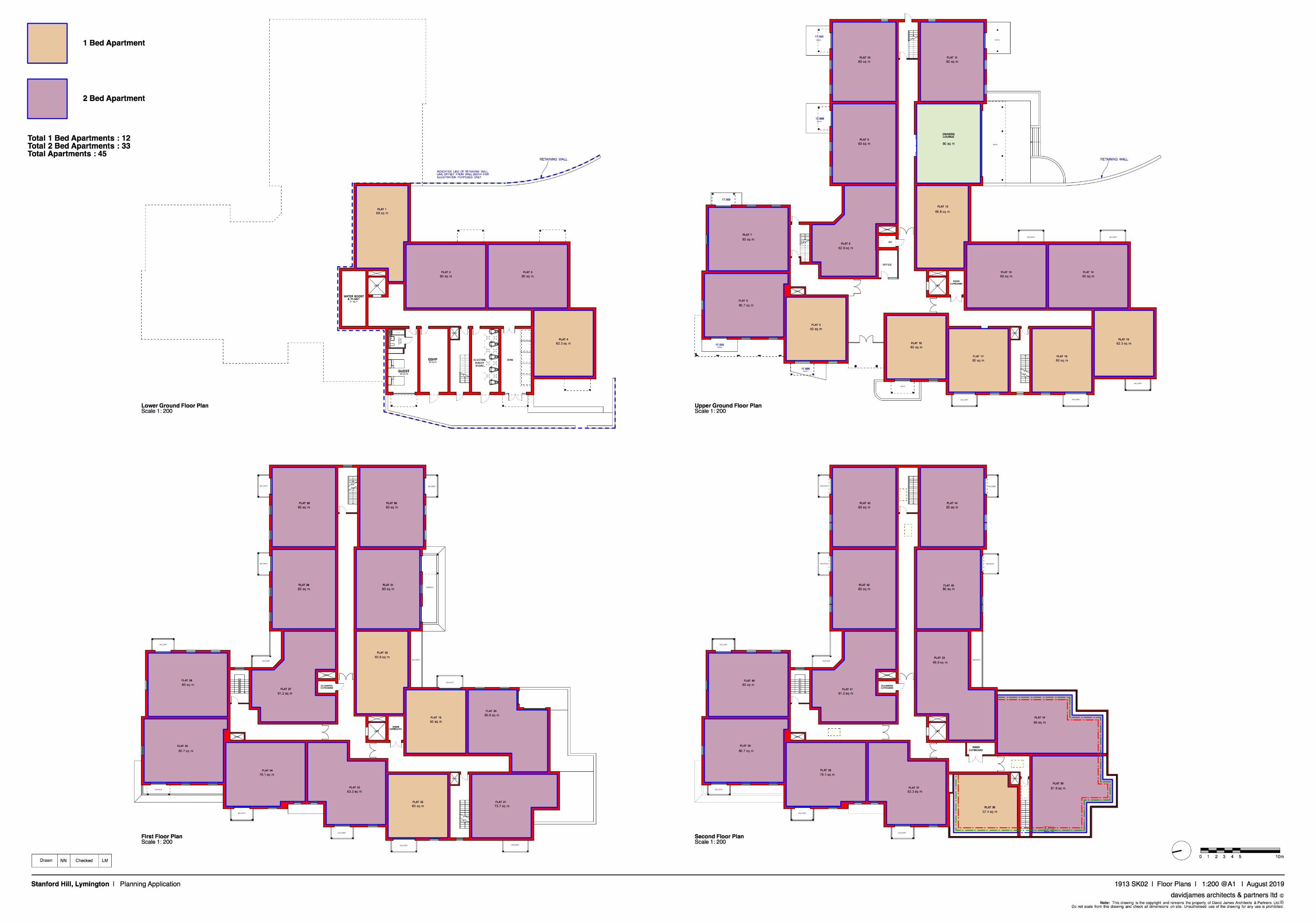
Soils Limited Stanford Hill Main Investigation Report
Soils Limited
Geotechnical & Environmental Consultants
Newton House
Cross Road, Tadworth
Surrey KT20 5SR
T 01737 814221
W soilslimited.co.uk