soil survey of montgomery county, ohio - ohio department of
TRANSCRIPT
United States Department of Agriculture Natural Resources Conservation Service
In cooperation with Ohio Department of Natural Resources, Division of Soil and Water Conservation; Ohio Agricultural Research and Development Center; Ohio State University Extension; Montgomery Soil and Water Conservation District; and Montgomery County Commissioners
Soil Survey of Montgomery County, Ohio
Supplement March 2004

2

How to use this survey General Soil Map The general soil map (p. 506), which is the color map at the end of this document, shows the survey area divided into groups of associated soils called general soil map units. This map is useful in planning the use and management of large areas. To find information about your area of interest, locate that area on the map, identify the name of the map unit in the area on the color-coded map legend, then refer to the section General Soil Map Units of this survey for a general description of the soils in your area. Detailed Soil Maps The detailed soil maps which accompany this publication are useful in planning the use and management of small areas. To find information about your area of interest, locate that area on the Index to Map Sheets, which accompanies the soil maps. Note the number of the map sheet, and select that sheet. Locate your area of interest on the map sheet. Note the map unit symbols that are in that area. Turn to the Contents, which lists the map units by symbol and name and shows the page where each map unit is described. The Contents also shows which table has data on a specific land use for each detailed soil map unit. See Contents for sections of this publication that may address your specific needs.

4
This revised soil survey is a publication of the National Cooperative Soil Survey, a joint effort of the United States Department of Agriculture and other Federal agencies, State agencies including the Agricultural Experiment Stations, and local agencies. The Natural Resources Conservation Service (formerly the Soil Conservation Service) has leadership for the Federal part of the National Cooperative Soil Survey. Major fieldwork for this soil survey was completed in 1967. Soil names and descriptions were approved in 1969. Unless otherwise indicated, statements in this publication refer to conditions in the survey area in 1966. The 1976 survey was made cooperatively by the Natural Resources Conservation Service, Ohio Department of Natural Resources, Division of Soil and Water Conservation, Ohio Agricultural Research and Development Center, the Ohio State University Extension, the Montgomery Soil and Water Conservation District and the Montgomery County Commissioners. This survey is part of the technical assistance furnished to the Montgomery Soil and Water Conservation District. Soil maps, referred to in this publication, may be copied without permission. Enlargement of these maps, however, could cause misunderstanding of the detail of mapping. If enlarged, maps do not show the small areas of contrasting soils that could have been shown at a larger scale. The United States Department of Agriculture (USDA) prohibits discrimination in all of its programs on the basis of race, color, national origin, gender, religion, age, disability, political beliefs, sexual orientation, and marital or family status. (Not all prohibited bases apply to all programs.) Persons with disabilities who require alternative means for communication of program information (Braille, large print, audiotape, etc.) should contact the USDA's TARGET Center at 202-720-2600 (voice or TDD). To file a complaint of discrimination, write USDA, Director, Office of Civil Rights, Room 326W, Whitten Building, 14th and Independence Avenue SW, Washington, DC 20250-9410, or call 202-720-5964 (voice or TDD). USDA is an equal opportunity provider and employer. Cover: This area of Brookston silty clay loam is an ideal wetland wildlife habitat when undrained.

5
Contents How to use this survey......................................... 3 Preface ................................................................ 8
General Nature of the County .......................... 9 Climate.......................................................... 9 Geology ...................................................... 10 How This Survey Was Made ...................... 10
General Soil Map Units.................................... 13 1. Lewisburg-Brookston-Pyrmont association 13 2. Miamian-Celina association ....................... 14 3. Brookston-Crosby association ................... 15 4. Brookston-Fincastle association ................ 15 5. Xenia-Russell association .......................... 16 6. Milton-Ritchey-Millsdale association .......... 16 7. Fox-Ockley association .............................. 18 8. Westland-Montgomery association............ 19 9. Ross-Medway association ......................... 19
Detailed Soil Map Units ................................... 20 Ag—Algiers silt loam ...................................... 21 Bo—Borrow pits ............................................. 22 Bp—Brookston silt loam................................. 22 Br—Brookston silt loam, overwash ................ 24 Bs—Brookston silty clay loam........................ 25 Bu—Brookston-Urban land complex.............. 26 Ca—Carlisle muck.......................................... 27 CeA—Celina silt loam, 0 to 2 percent slopes. 29 CeB—Celina silt loam, 2 to 6 percent slopes. 30 CeB2—Celina silt loam, 2 to 6 percent
slopes, moderately eroded........................ 31 ClB—Celina bouldery silt loam, 2 to 6
percent slopes........................................... 32 CoA—Corwin silt loam, 0 to 2 percent slopes 34 CoB—Corwin silt loam, 2 to 6 percent slopes 35 CsA—Crosby silt loam, 0 to 2 percent slopes 37 CtB—Crosby-Celina silt loams, 2 to 6
percent slopes........................................... 38 Cu—Crosby-Urban land complex .................. 40 DaB—Dana silt loam, 2 to 6 percent slopes .. 41 FaE2—Fairmount silty clay loam, 12 to 25
percent slopes, moderately eroded........... 42 FaF2—Fairmount silty clay loam, 25 to 50
percent slopes, moderately eroded........... 44 FcA—Fincastle silt loam, 0 to 4 percent
slopes........................................................ 45 FkA—Fox sandy loam, 0 to 2 percent slopes 46 FkB—Fox sandy loam, 2 to 6 percent slopes 48 FlA—Fox loam, 0 to 2 percent slopes............ 49 FlB—Fox loam, 2 to 6 percent slopes............ 50 FlC2—Fox loam, 6 to 12 percent slopes,
moderately eroded .................................... 51 FmA—Fox silt loam, 0 to 2 percent slopes .... 52 FmB—Fox silt loam, 2 to 6 percent slopes .... 53 FmC2—Fox silt loam, 6 to 12 percent
slopes, moderately eroded........................ 55
FmD2—Fox silt loam, 12 to 18 percent slopes, moderately eroded........................ 56
FsC3—Fox soils, 6 to 12 percent slopes, severely eroded......................................... 57
FuB—Fox-Urban land complex, gently sloping....................................................... 59
FuC—Fox-Urban land complex, rolling .......... 59 FuF—Fox-Urban land complex, steep ........... 60 Gp—Gravel pits.............................................. 61 HeE2—Hennepin and Miamian silt loams,
18 to 25 percent slopes, moderately eroded ....................................................... 61
HeF2—Hennepin and Miamian silt loams, 25 to 50 percent slopes, moderately eroded ....................................................... 63
HmF3—Hennepin and Miamian soils, 18 to 50 percent slopes, severely eroded .......... 65
KeA—Kendallville silt loam, 0 to 2 percent slopes........................................................ 67
KeB—Kendallville silt loam, 2 to 6 percent slopes........................................................ 68
KeC2—Kendallville silt loam, 6 to 12 percent slopes, moderately eroded........... 69
Ld—Landes sandy loam................................. 71 Lg—Lanier sandy loam .................................. 72 LsB—Lewisburg silt loam, 2 to 6 percent
slopes........................................................ 73 LxC2—Lorenzo-Rodman complex, 4 to 12
percent slopes, moderately eroded........... 74 LxD2—Lorenzo-Rodman complex, 12 to 18
percent slopes, moderately eroded........... 76 Mb—Made land .............................................. 79 Md—Medway silt loam ................................... 79 MlA—Miamian silt loam, 0 to 2 percent
slopes........................................................ 80 MlB—Miamian silt loam, 2 to 6 percent
slopes........................................................ 81 MlB2—Miamian silt loam, 2 to 6 percent
slopes, moderately eroded........................ 82 MlC2—Miamian silt loam, 6 to 12 percent
slopes, moderately eroded........................ 83 MlD2—Miamian silt loam, 12 to 18 percent
slopes, moderately eroded........................ 85 MmB—Miamian bouldery silt loam, 2 to 6
percent slopes........................................... 86 MnB3—Miamian clay loam, 2 to 6 percent
slopes, severely eroded ............................ 87 MnC3—Miamian clay loam, 6 to 12 percent
slopes, severely eroded ............................ 88 MnD3—Miamian clay loam, 12 to 18 percent
slopes, severely eroded ............................ 89 MoB—Miamian-Urban land complex,
undulating.................................................. 90

6
MoC—Miamian-Urban land complex, rolling . 91 MoE—Miamian-Urban land complex, steep .. 92 MrA—Millsdale silty clay loam, 0 to 3
percent slopes........................................... 92 MsA—Milton silt loam, 0 to 2 percent slopes . 94 MsB—Milton silt loam, 2 to 6 percent slopes . 95 MsB2—Milton silt loam, 2 to 6 percent
slopes, moderately eroded........................ 96 MsC2—Milton silt loam, 6 to 12 percent
slopes, moderately eroded........................ 98 MsD2—Milton silt loam, 12 to 18 percent
slopes, moderately eroded...................... 100 MtD3—Milton silty clay loam, 6 to 18
percent slopes, severely eroded............. 101 MuB—Milton-Urban land complex,
undulating................................................ 103 MuC—Milton-Urban land complex, rolling ... 104 MuD—Milton-Urban land complex, hilly ....... 105 Mv—Montgomery silty clay loam ................. 106 OcA—Ockley silt loam, 0 to 2 percent
slopes...................................................... 107 OcB—Ockley silt loam, 2 to 6 percent
slopes...................................................... 108 PlB—Plattville silt loam, 2 to 6 percent
slopes...................................................... 109 PlC—Plattville silt loam, 6 to 12 percent
slopes...................................................... 110 PyA—Pyrmont silt loam, 0 to 2 percent
slopes...................................................... 112 Qu—Quarries ............................................... 113 RcA—Randolph silt loam, 0 to 2 percent
slopes...................................................... 113 ReB—Ritchey silt loam, 2 to 6 percent
slopes...................................................... 115 ReB2—Ritchey silt loam, 2 to 6 percent
slopes, moderately eroded...................... 116 ReC2—Ritchey silt loam, 6 to 12 percent
slopes, moderately eroded...................... 117 ReE2—Ritchey silt loam, 12 to 25 percent
slopes, moderately eroded...................... 119 ReF2—Ritchey silt loam, 25 to 50 percent
slopes, moderately eroded...................... 120 RfD3—Ritchey silt clay loam, 6 to 18
percent slopes, severely eroded............. 121 Rh—Riverwash ............................................ 123 RlE2—Rodman and Fox soils, 18 to 25
percent slopes, moderately eroded......... 123 RlF2—Rodman and Fox soils, 25 to 50
percent slopes, moderately eroded......... 125 Rs—Ross silt loam....................................... 127 Rt—Ross-Urban land complex..................... 128 RuB—Russell silt loam, 2 to 6 percent
slopes...................................................... 129 RvC2—Russell-Miamian silt loams, 6 to 12
percent slopes, moderately eroded......... 130 RvD2—Russell-Miamian silt loams, 12 to
18 percent slopes, moderately eroded.... 133 Sh—Shoals silt loam .................................... 135
So—Sloan silt loam ...................................... 136 ThA—Thackery silt loam, till substratum,
0 to 2 percent slopes............................... 137 TpA—Tippecanoe silt loam, 0 to 2 percent
slopes...................................................... 139 Ua—Urban land, alluvial............................... 140 Ud—Udorthents............................................ 140 Ug—Urban land, gravelly material ............... 140 Um—Urban land, loamy material ................. 140 WaA—Warsaw silt loam, 0 to 2 percent
slopes...................................................... 140 WaB—Warsaw silt loam, 2 to 6 percent
slopes...................................................... 142 WeA—Wea silt loam, 0 to 2 percent slopes. 143 WeB—Wea silt loam, 2 to 6 percent slopes. 144 Ws—Westland silty clay loam ...................... 145 WyB2—Wynn silt loam, 2 to 6 percent
slopes, moderately eroded...................... 146 XeA—Xenia silt loam, 0 to 2 percent slopes 147 XeB—Xenia silt loam, 2 to 6 percent slopes 149
Important Farmland.......................................... 151 Prime Farmland............................................ 151 Unique Farmland.......................................... 151 Additional Farmland of Statewide
Importance .............................................. 151 Additional Farmland of Local Importance..... 152
Hydric Soils ...................................................... 153 Soil Quality ....................................................... 154 Use and Management of the Soils................ 157
Interpretive Ratings ...................................... 157 Rating Class Terms...................................... 157 Numerical Ratings ........................................ 157 Cropland Limitations and Hazards ............... 157
Crops and Pasture.................................... 160 Crop Yield Index ....................................... 160 Land Capability Classification................... 161 Pasture and Hayland Suitability Groups... 161
Woodland Management and Productivity .... 163 Woodland Management............................ 163 Woodland Productivity .............................. 164 Windbreaks and Environmental Plantings 165
Recreational Development ........................... 165 Wildlife Habitat ............................................. 166 Engineering .................................................. 168 Construction Materials.................................. 169 Building Site Development ........................... 170 Sanitary Facilities ......................................... 171 Agricultural Waste Management .................. 173 Water Management...................................... 174
Soil Properties................................................ 177 Engineering Index Properties....................... 177 Physical Properties....................................... 178 Chemical Properties ..................................... 179 Water Features............................................. 180 Soil Features ................................................ 181
Classification of the Soils ............................. 182 Soil Series and Their Morphology ................ 182
Algiers Series............................................ 182

7
Brookston Series ...................................... 183 Carlisle Series........................................... 184 Celina Series ............................................ 184 Corwin Series ........................................... 185 Crosby Series ........................................... 186 Dana Series .............................................. 186 Fairmount Series ...................................... 187 Fincastle Series ........................................ 187 Fox Series................................................. 188 Hennepin Series ....................................... 188 Kendallville Series .................................... 189 Landes Series........................................... 189 Lanier Series............................................. 190 Lewisburg Series ...................................... 190 Lorenzo Series.......................................... 190 Medway Series ......................................... 191 Miamian Series ......................................... 191 Millsdale Series......................................... 192 Milton Series ............................................. 193 Montgomery Series................................... 193 Ockley Series............................................ 194 Plattville Series ......................................... 194 Pyrmont Series ......................................... 195 Randolph Series ....................................... 195 Ritchey Series........................................... 196 Rodman Series ......................................... 196 Ross Series .............................................. 197 Russell Series........................................... 197 Shoals Series............................................ 198 Sloan Series ............................................. 198 Thackery Series........................................ 199 Tippecanoe Series.................................... 199 Warsaw Series.......................................... 200 Wea Series ............................................... 200 Westland Series........................................ 201 Wynn Series ............................................. 201 Xenia Series ............................................. 202
Formation of the Soils ................................... 204 Factors of Soil Formation ............................. 204 Parent Material ............................................. 204 Climate ......................................................... 205 Living Organisms.......................................... 205 Relief ............................................................ 206 Time.............................................................. 206
Processes of Soil Formation ........................ 206 References...................................................... 208 Glossary.......................................................... 211 Tables.............................................................. 228
Table 1.--Temperature and Precipitation ..... 229 Table 2.--Freeze Dates in Spring and Fall ... 230 Table 3.--Growing Season ........................... 230 Table 4.--Acreage and Proportionate
Extent of the Map Units........................... 231 Table 5.--Prime Farmland ............................ 233 Table 6.--Hydric Soils List ............................ 234 Table 7.--Non-Hydric Mapunits with Hydric
Components............................................ 235 Table 8.--Cropland Limitations and Hazards 239 Table 9.--Crop Yield Index ........................... 245 Table 10.--Acreage by Capability Classes
and Subclasses....................................... 249 Table 11.--Woodland Management.............. 250 Table 12.--Woodland Harvesting Activities .. 258 Table 13.--Woodland Regeneration
Activities .................................................. 268 Table 14.--Woodland Productivity ................ 279 Table 15.--Windbreaks and Environmental
Plantings.................................................. 295 Table 16.—Recreation Part 1....................... 304 Table 17.—Recreation Part 2....................... 316 Table 18.--Wildlife Habitat ............................ 325 Table 19.--Construction Materials Part 1 ..... 332 Table 20.--Construction Materials Part 2 ..... 342 Table 21.--Building Site Development Part 1358 Table 22.--Building Site Development Part 2369 Table 23.--Sanitary Facilities Part 1 ............. 383 Table 24.--Sanitary Facilities Part 2 ............. 396 Table 25.--Agricultural Waste Management. 407 Table 26.--Water Management Part 1.......... 427 Table 27.--Water Management Part 2.......... 437 Table 28.--Engineering Index Properties ..... 452 Table 29.--Physical Properties of the Soils .. 464 Table 30.--Chemical Properties of the Soils. 474 Table 31.--Water Features ........................... 484 Table 32.--Soil Features............................... 490 Table 33.--Classification of the Soils............ 496 Table 34.--Interpretive Groups ..................... 497

8 Soil Survey
Preface
This soil survey contains information that affects land use planning in Montgomery County. It contains predictions of soil behavior for selected land uses. The survey also highlights soil limitations, improvements needed to overcome the limitations, and the impact of selected land uses on the environment.
This soil survey is designed for many different users. Farmers, foresters, and agronomists can use it to evaluate the potential of the soil and the management needed for maximum food and fiber production. Planners, community officials, engineers, developers, builders, and homebuyers can use the survey to plan land use, select sites for construction, and identify special practices needed to ensure proper performance. Conservationists, teachers, students, and specialists in recreation, wildlife management, waste disposal, and pollution control can use the survey to help them understand, protect, and enhance the environment.
Various land use regulations of Federal, State, and local governments may impose special restrictions on land use or land treatment. The information in this report is intended to identify soil properties that are used in making various land use or land treatment decisions. Statements made in this report are intended to help the land users identify and reduce the effects of soil limitations on various land uses. The landowner or user is responsible for identifying and complying with existing laws and regulations.
Great differences in soil properties can occur within short distances. Some soils are seasonally wet or subject to flooding. Some are shallow to bedrock. Some are too unstable to be used as a foundation for buildings or roads. Clayey or wet soils are poorly suited to use as septic tank absorption fields. A high water table makes a soil poorly suited to basements or underground installations.
These and many other soil properties that affect land use are described in this soil survey. Broad areas of soils are shown on the general soil map. The location of each soil is shown on the detailed soil maps. Each soil in the survey area is described. Information on specific uses is given for each soil. Help in using this publication and additional information are available at the local office of the Natural Resources Conservation Service or the Ohio State University Extension.

Montgomery County, Ohio 9
Soil Survey of Montgomery County, Ohio
By Paul E. Davis, Norbert Lerch, Larry Tornes, Joseph Steiger, Neil Smeck, Howard Andrus, John Trimmer, and George Bottrell, Soil Conservation Service (presently Natural Resources Conservation Service)
Revised by S.A. Miller, Ohio Department of Natural Resources, Division of Soil and Water Conservation. Technical advisors, R.M. Gehring and J.A.. Glanville, Natural Resources Conservation Service, United States Department of Agriculture
Soil Conservation Service, in Cooperation with The Ohio Department of Natural Resources, Division of Lands and Soil, and The Ohio Agricultural Research and Development Center
Montgomery County, in the southwestern part of Ohio, occupies 465 square miles, or 297,152 acres.
The county lies entirely in the region in Ohio that was glaciated during the Wisconsinan Age. The northern and western parts of the county are nearly level or gently rolling till plains. Elevation ranges from 680 to 1,100 feet above sea level. The Miami River and its tributaries dissect and drain most of the county, except for the southeastern corner, which is part of the Little Miami watershed. General Nature of the County
In general, Montgomery County can be characterized as a broad, nearly level to gently rolling till plain. Glaciation has altered the former rolling to moderately steep limestone topography by a grinding-down and filling-in process. Glacial action and subsequent stream development resulted in the Mad River, Stillwater River, Twin Creek, Wolf Creek, and the Miami River. The Miami River flows through the middle of the county, north to south, toward the Ohio River. Maximum relief within the county is about 420 feet. About 300 feet of this can be accounted for by the abrupt descent from the uplands onto the main river bottoms.
Most of the county is uplands, and local relief is 10 to 50 feet within 1 mile. The soils, developed over moderately slowly permeable glacial till, are in sizable areas that are naturally very poorly drained. Tile drainage must be carefully planned to gain a suitable outlet in many places. Climate Prepared by the Natural Resources Conservation Service National Water and Climate Center, Portland, Oregon.
Climate Tables are created from climate
station Dayton, Ohio. Thunderstorm days, relative humidity, percent
sunshine, and wind information are estimated from First Order station Dayton, Ohio.
Table 1 (p, 229) gives data on temperature and precipitation for the survey area as recorded at Dayton in the period 1971 to 2000. Table 2 (p. 230) shows probable dates of the first freeze in fall and the last freeze in spring. Table 3 (p. 230)provides data on the length of the growing season.
In winter, the average temperature is 31.0 degrees F and the average daily minimum temperature is 23.4 degrees. The lowest temperature on record, which occurred at Dayton on January 20, 1985, was -21 degrees. In summer, the average temperature is 75.0 degrees and the average daily maximum temperature is 85.3 degrees. The highest temperature, which occurred at Dayton on July 22, 1934, was 105 degrees.
Growing degree days are shown in Table 1 (p, 229). They are equivalent to "heat units". During the month, growing degree days accumulate by the amount that the average temperature each day exceeds a base temperature (40 degrees F). The normal monthly accumulation is used to schedule single or successive plantings of a crop between the last freeze in spring and the first freeze in fall.
The average annual total precipitation is about 39.46 inches. Of this, about 25.09 inches, or 64 percent, usually falls in April through October. The growing season for most crops falls within this period. The heaviest 1-day rainfall during the period of record was 4.65 inches at Dayton on September 14, 1979. Thunderstorms occur on about 40 days each year, and most occur in June and July.
The average seasonal snowfall is 15.6 inches. The greatest snow depth at any one time during the period of record was 21 inches recorded on

10 Soil Survey
January 27, 1978. On an average, 22 days per year have at least 1 inch of snow on the ground. The heaviest 1-day snowfall on record was 10.5 inches recorded on November 26, 1950.
The average relative humidity in mid-afternoon is about 60 percent. Humidity is higher at night, and the average at dawn is about 80 percent. The sun shines 67 percent of the time in summer and 41 percent in winter. The prevailing wind is from the south-southwest. Average wind speed is highest, around 12 miles per hour, in March. Geology
The parent material for the soils in Montgomery County originated from bedrock, from ice- and water-transported glacial drift, from wind-deposited loess, or from a combination of these. The thick mantle of assorted unconsolidated gravel, sand, clay, stones, and boulders that now covers the county was left by two major glacial ice sheets of the Pleistocene age. The Wisconsin age had the greatest effect on the county, and it was largely responsible for the present distribution of the mantle over the bedrock. The loess was blown in and deposited in a post-glacial era. Loess deposits more than 36 inches thick occur only in the southeastern corner of the county.
The underlying bedrock structure helps to determine the direction of stream drainage (30). The crest of a giant underground hump of rock layers, called the Cincinnati arch, crosses Montgomery County in a northeasterly direction. Rock layers near the top of this crest drop from the northeast at about 5 feet per mile. Out on the edge of the hump (anticline), the dip is less than 1 foot per mile. The youngest bedrock formations are of the Niagara Group in the Silurian System. These formations are the upper layers of bedrock on the arch and are mostly limestones and dolomites. The oldest rocks, exposed in the valleys, are those of the Maysville Group of the Ordovician system. The Ordovician bedrock is shale with thin, interbedded limestone strata. All bedrock strata exposed in the county are sedimentary rocks.
Most of the mantle in the county is in the form of stream-dissected glacial till plains. Parts of these plains are crossed by recessional moraines marked by hummocky topography or by the presence of many boulders in the glacial till. Till deposits range from less than 1 foot in thickness near bedrock exposures to 150 to 300 feet in thickness where these deposits fill preglacial valleys. Average thickness of glacial till on the till plain is about 20 feet.
Another result of glacial activity is the outwash
observed in the form of stream-sorted deposits of gravel, sand, and even clay in kames and on valley-train terraces along the major streams of the county. Outwash also is variable in depth. It exists in deposits ranging from thin lenses to huge areas 180 feet thick in the Southern Hills and Oakwood Heights sections of south Dayton. How This Survey Was Made
This survey was made to provide information about the soils and miscellaneous areas in the survey area. The information includes a description of the soils and miscellaneous areas and their location and a discussion of their suitability, limitations, and management for specified uses. Soil scientists observed the steepness, length, and shape of the slopes; the general pattern of drainage; the kinds of crops and native plants; and the kinds of bedrock. They dug many holes to study the soil profile, which is the sequence of natural layers, or horizons, in a soil. The profile extends from the surface down into the unconsolidated material in which the soil formed. The unconsolidated material is devoid of roots and other living organisms and has not been changed by other biological activity.
The soils and miscellaneous areas in the survey area are in an orderly pattern that is related to the geology, landforms, relief, climate, and natural vegetation of the area. Each kind of soil and miscellaneous area is associated with a particular kind of landform or with a segment of the landform. By observing the soils and miscellaneous areas in the survey area and relating their position to specific segments of the landform, a soil scientist develops a concept or model of how they were formed. Thus, during mapping, this model enables the soil scientist to predict with a considerable degree of accuracy the kind of soil or miscellaneous area at a specific location on the landscape.
Commonly, individual soils on the landscape merge into one another as their characteristics gradually change. To construct an accurate soil map, however, soil scientists must determine the boundaries between the soils. They can observe only a limited number of soil profiles. Nevertheless, these observations, supplemented by an understanding of the soil-vegetation-landscape relationship, are sufficient to verify predictions of the kinds of soil in an area and to determine the boundaries.
Soil scientists recorded the characteristics of the soil profiles that they studied. They noted soil color, texture, size and shape of soil aggregates, kind and amount of rock fragments, distribution of plant roots, reaction, and other features that

Montgomery County, Ohio 11
enable them to identify soils. After describing the soils in the survey area and determining their properties, the soil scientists assigned the soils to taxonomic classes (units). Taxonomic classes are concepts. Each taxonomic class has a set of soil characteristics with precisely defined limits. The classes are used as a basis for comparison to classify soils systematically. Soil taxonomy, the system of taxonomic classification used in the United States, is based mainly on the kind and character of soil properties and the arrangement of horizons within the profile. After the soil scientists classified and named the soils in the survey area, they compared the individual soils with similar soils in the same taxonomic class in other areas so that they could confirm data and assemble additional data based on experience and research.
While a soil survey is in progress, samples of some of the soils in the area generally are collected for laboratory analyses and for engineering tests. Soil scientists interpret the data from these analyses and tests as well as the field-observed characteristics and the soil properties to
determine the expected behavior of the soils under different uses. Interpretations for all of the soils are field tested through observation of the soils in different uses and under different levels of management. Some interpretations are modified to fit local conditions, and some new interpretations are developed to meet local needs. Data are assembled from other sources, such as research information, production records, and field experience of specialists.
Predictions about soil behavior are based not only on soil properties but also on such variables as climate and biological activity. Soil conditions are predictable over long periods of time, but they are not predictable from year to year. For example, soil scientists can predict with a fairly high degree of accuracy that a given soil will have a high water table within certain depths in most years, but they cannot predict that a high water table will always be at a specific level in the soil on a specific date.
After soil scientists located and identified the significant natural bodies of soil in the survey area, they drew the boundaries of these bodies on
Figure 2. Sloan soils are ideally suited for warm season grasses and wildflowers.

12 Soil Survey
aerial photographs and identified each as a specific map unit. Aerial photographs show trees, buildings, fields, roads, and rivers, all of which help in locating boundaries accurately.

Montgomery County, Ohio 13
General Soil Map Units
The general soil map in this publication shows broad areas that have a distinctive pattern of soils, relief, and drainage. Each map unit on the general soil map is a unique natural landscape. Typically, it consists of one or more major soils or miscellaneous areas and some minor soils or miscellaneous areas. It is named for the major soils or miscellaneous areas. The components of one map unit can occur in another but in a different pattern.
The general soil map can be used to compare the suitability of large areas for general land uses. Areas of suitable soils can be identified on the map. Likewise, areas where the soils are not suitable can be identified.
Because of its small scale, the map is not suitable for planning the management of a farm or field or for selecting a site for a road or building or other structure. The soils in any one map unit differ from place to place in slope, depth, drainage, and other characteristics that affect management.
Some soil boundaries and soil names in this survey area do not fully match those in adjacent survey areas that were published at an earlier date. Differences are the result of changes and refinements in soil series concepts, updated soil taxonomy, slightly different map unit composition in survey areas, and the use of the State Soil Geographic data (STATSGO) map as the base for the general soil map in this publication.
General Soil Map The general soil map at the end of this
publication shows, in color, the soil associations in Montgomery County. A soil association is a landscape that has a distinctive pattern of soils. It normally consists of one or more major soils and at least one minor soil, and it is named for the major soils. The soils in one association may occur in another, but in a different pattern.
A map showing soil associations is useful to people who want a general idea of the soils in a county, who want to compare different parts of a county, or who want to know the location of large tracts that are suitable for a certain kind of land use. Such a map is a useful general guide in managing a watershed, a wooded tract, or a wildlife area, or in planning engineering works, recreational facilities, and community developments. It is not a suitable map for planning the management of a farm or field or for selecting the exact location of a road, building, or similar
structure, because the soils in any one association ordinarily differ in slope, depth, stoniness, drainage, and other characteristics that affect their management.
The nine soil associations in Montgomery County are discussed in the following pages. It should be noted that the soil associations shown on the general soil map of this county do not exactly match those on the general soil maps of the Preble County and Warren County published soil surveys. The major soils are similar or the same, but they occur in a slightly different pattern. 1. Lewisburg-Brookston-Pyrmont association Deep, nearly level to moderately steep, moderately well drained to very poorly drained soils that have a moderately fine textured and fine textured subsoil; formed in thin loess and glacial till
This association consists of soils that
dominantly are nearly level to gently sloping and occur on stream-dissected till plains, or they are gently sloping to moderately steep along the larger waterways.
This association occupies less than 1 percent of the county. About 30 percent of this is Lewisburg soils, 30 percent is Brookston soils, 20 percent is Pyrmont soils, and the remaining 20 percent is other soils.
The moderately well drained Lewisburg soils and the somewhat poorly drained Pyrmont soils have a thin, clayey subsoil and are shallow over calcareous till. Lewisburg soils are on knolls between drainageways and are gently sloping adjacent to larger drainageways. Pyrmont soils are nearly level. Brookston soils are deep, nearly level to depressional, dark colored, and very poorly drained. The Brookston soils are adjacent to the lighter colored Lewisburg and Pyrmont soils.
Other soils in this association are the moderately well drained Celina soils, the well drained Miamian soils, and the somewhat poorly drained Crosby soils.
Brookston and Pyrmont soils are seasonally wet and need to be artificially drained. Erosion is a hazard on Lewisburg soils.
Moderately slow or slow permeability and seasonal wetness are the major limitations for farm crops.

14 Soil Survey
2. Miamian-Celina association Deep, mainly gently sloping to moderately steep, well drained and moderately well drained soils that have a moderately fine textured and fine textured subsoil; formed in thin loess and glacial till
This association consists of nearly level to rolling areas on the glacial till plain and hilly moraines dissected by streams. It is in all parts of the county except in the northwestern and southeastern corners.
This association occupies about 51 percent of Montgomery County. About 55 percent of this is
Figure 3. Typical pattern of soils and underlying material in association 1.
Figure 4. Typical pattern of soils and underlying material in association 2.

Montgomery County, Ohio 15
Miamian soils, 20 percent is Celina soils, and 25 percent is other soils. The Miamian and Celina soils are moderately deep to calcareous till. The Miamian soils are well drained, and the Celina soils are moderately well drained. The Miamian soils typically occupy knolls and are rolling to moderately steep adjacent to drainageways. The Celina soils are gently sloping.
Other soils in this association are the somewhat poorly drained Crosby soils, the dark-colored, very poorly drained Brookston soils, the moderately well drained Medway soils, and the shallow, well drained Hennepin soils.
The control of runoff and erosion is the main concern in managing the soils of this association for farming. Moderately slow permeability and slope are dominant limitations to many nonfarm uses. 3. Brookston-Crosby association Deep, mainly nearly level to gently sloping, very poorly drained and somewhat poorly drained soils that have a moderately fine textured and fine textured subsoil; formed in thin loess and glacial till
This association occurs in one large, nearly level to undulating area in the northwestern corner of the county and in medium-sized to small areas scattered throughout the rest of the county. This
association occupies about 18 percent of the county. About 60 percent of this is Brookston soils, 25 percent is Crosby soils, and the remaining 15 percent is other soils.
The Brookston soils are dark colored, very poorly drained, and typically nearly level to depressional. The somewhat poorly drained Crosby soils occur on gently undulating, low knolls. They are lighter colored than the Brookston soils and are nearly level to gently sloping.
Among the other soils in the association are Miamian and Celina soils that are steeper than the Brookston and Crosby soils.
The dominant soils in this association are seasonally wet. Farming is delayed in spring unless the soils are artificially drained. Much of the association is artificially drained by tile. Moderately slow permeability and a seasonal high water table are soil limitations for many nonfarm uses. 4. Brookston-Fincastle association Deep, mainly nearly level to gently sloping, very poorly drained and somewhat poorly drained soils that have a moderately fine textured subsoil; formed in thick loess and glacial till
This association occurs as small, scattered areas in the southeastern part of the county. The major soils of the association are nearly level to
Figure 5. Typical pattern of soils and underlying material in association 3.

16 Soil Survey
undulating and are on till plains. They have a silt or loess capping 18 to 40 inches thick or more.
This association occupies slightly more than 1 percent of the county. About 55 percent of this is Brookston soils, 40 percent is Fincastle soils, and the remaining 5 percent is other soils.
The Brookston soils are deep, dark colored, and very poorly drained. They are nearly level to depressional. The Fincastle soils are deep and somewhat poorly drained. They occupy the slight rises or low knolls between areas of Brookston soils and Xenia soils and have better drainage and a lighter color than Brookston soils. The rest of the association consists of smaller areas of the moderately well drained Xenia and other soils.
The major soils in this association are seasonally wet. Farming is delayed in spring unless the soils are artificially drained. Much of the association is drained for farming. Moderately slow permeability and a seasonal high water table are the major limitations of the dominant soils for many nonfarm uses. 5. Xenia-Russell association Very deep, mainly nearly level to gently sloping, moderately well drained and well drained soils that have a moderately fine textured subsoil; formed in thick loess and glacial till
This association is in the southeastern part of
the county. Most of the association consists of
nearly level to gently sloping soils on a till plain. The dominant soils have a silt or loess capping 18 to 40 inches thick. In small areas of this association there are strongly sloping soils along drainageways.
This association occupies slightly more than 6 percent of the county. About 25 percent of this is Xenia soils, 25 percent is Russell soils, and the remaining 50 percent is other soils.
The Xenia soils are very deep and moderately well drained. The Russell soils are very deep and well drained. Russell soils are steeper than Xenia soils and occupy more elevated positions on the landscape.
Among the other soils in this association are the somewhat poorly drained Fincastle soils and the very poorly drained Brookston soils. Also, the Brookston-Urban land complex and the Miamian-Urban land complex occupy sizable acreages.
Control of surface runoff and erosion is the main management concern in the use of the soils of this association for farming. Moderately slow permeability is a limitation for some nonfarm uses. 6. Milton-Ritchey-Millsdale association Moderately deep and shallow, nearly level to very steep, well drained and very poorly drained soils that have a moderately fine textured and fine textured subsoil; formed in glacial till over limestone
Figure 6. Typical pattern of soils and underlying material in association 4.

Montgomery County, Ohio 17
This association occurs in small, scattered areas throughout the county. It consists of bedrock-controlled hills that rise above the till plain and of the walls of stream-cut valleys.
This association occupies about 5 percent of the county. About 55 percent of this is Milton soils, 15 percent is Ritchey soils, and 10 percent is Millsdale soils. The remaining 20 percent is other
Figure 7. Typical pattern of soils and underlying material in association 5.
Figure 8. Typical pattern of soils and underlying material in association 6.
18 Soil Survey
soils. The Milton soils are moderately deep, well
drained, and nearly level to moderately steep. Limestone bedrock occurs at a depth of 20 to 40 inches. The Ritchey soils are shallow, well drained, and nearly level to very steep. Limestone bedrock occurs within a depth of 20 inches. Millsdale soils are dark colored, very poorly drained, and nearly level to gently sloping. Limestone bedrock occurs at a depth of 20 to 40 inches.
The remainder of the association is made up of the well drained, sloping to very steep Fairmount soils; the somewhat poorly drained, nearly level Randolph soils; the dark-colored, well drained, gently sloping Plattville soils; and other less extensive soils.
Surface runoff and erosion are the major concerns in management if the Milton and Ritchey soils are farmed. Seasonal wetness is the dominant limitation of the very poorly drained Millsdale soils.
Limestone quarries are in this association. In the Milton, Ritchey, and Millsdale soils, limestone near the surface limits farm and nonfarm uses.
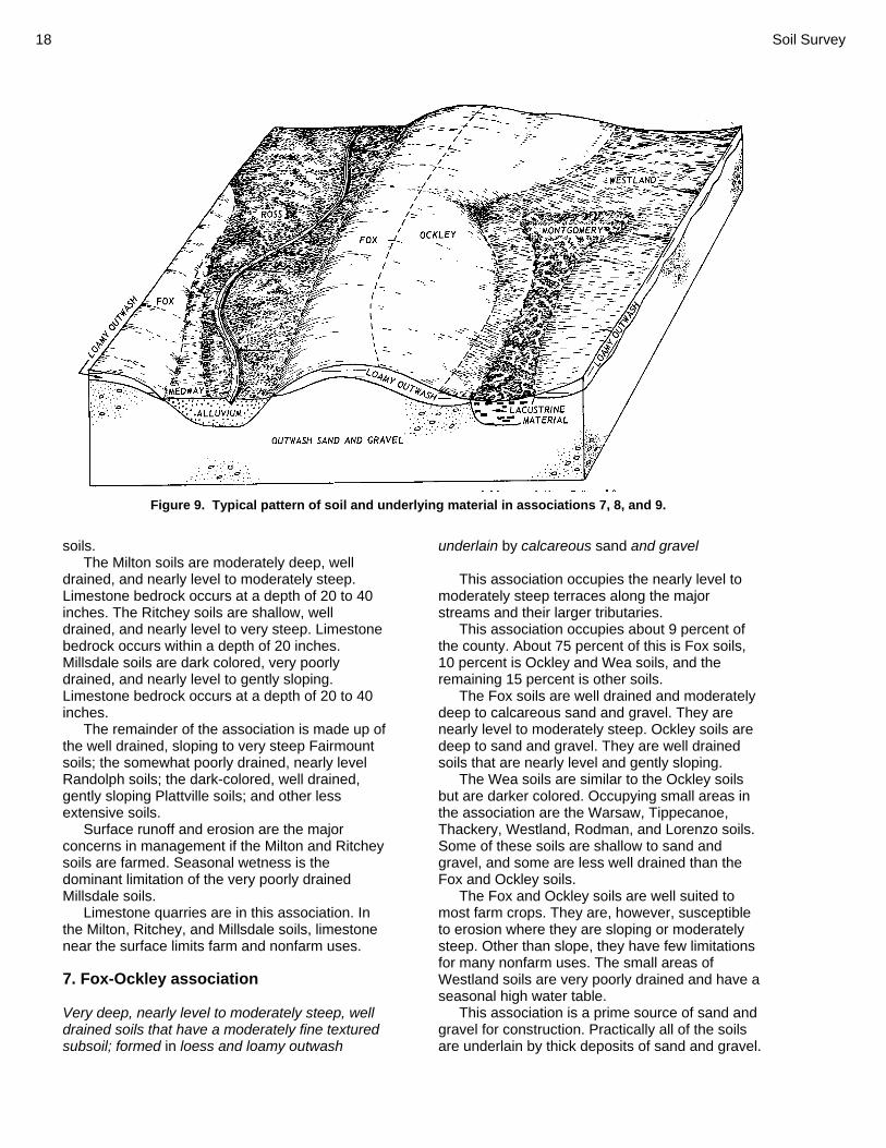
7. Fox-Ockley association Very deep, nearly level to moderately steep, well drained soils that have a moderately fine textured subsoil; formed in loess and loamy outwash
underlain by calcareous sand and gravel This association occupies the nearly level to
moderately steep terraces along the major streams and their larger tributaries.
This association occupies about 9 percent of the county. About 75 percent of this is Fox soils, 10 percent is Ockley and Wea soils, and the remaining 15 percent is other soils.
The Fox soils are well drained and moderately deep to calcareous sand and gravel. They are nearly level to moderately steep. Ockley soils are deep to sand and gravel. They are well drained soils that are nearly level and gently sloping.
The Wea soils are similar to the Ockley soils but are darker colored. Occupying small areas in the association are the Warsaw, Tippecanoe, Thackery, Westland, Rodman, and Lorenzo soils. Some of these soils are shallow to sand and gravel, and some are less well drained than the Fox and Ockley soils.
The Fox and Ockley soils are well suited to most farm crops. They are, however, susceptible to erosion where they are sloping or moderately steep. Other than slope, they have few limitations for many nonfarm uses. The small areas of Westland soils are very poorly drained and have a seasonal high water table.
This association is a prime source of sand and gravel for construction. Practically all of the soils are underlain by thick deposits of sand and gravel.
Figure 9. Typical pattern of soil and underlying material in associations 7, 8, and 9.

Montgomery County, Ohio 19
8. Westland-Montgomery association Very deep, nearly level to depressional, very poorly drained soils that have a dominantly moderately fine textured and fine textured subsoil; formed in loamy outwash and clayey lacustrine material
This association occupies the level and
depressional areas of undulating terraces. This association makes up less than 1 percent
of the county. About 50 percent of this is Westland soils, 40 percent is Montgomery soils, and the remaining 10 percent is other soils.
The Westland soils are very deep and very poorly drained. They have a dark-colored surface layer and are underlain by calcareous sand and gravel. The Montgomery soils are very deep and very poorly drained. They have a dark-colored surface layer and a clayey subsoil that is underlain by clayey sediments of old lake bottoms.
Among the other soils in this association are Carlisle muck and the very poorly drained Sloan soils.
The major soils in this association are seasonally wet. Farming is delayed in spring unless the soils are artificially drained. The seasonally high water table is a limitation for many uses other than farming.
9. Ross-Medway association Very deep, nearly level, well drained and moderately well drained soils that have a dominantly moderately coarse textured and medium textured subsoil or underlying material; formed in loamy alluvium
This association occupies the nearly level flood
plains along most of the streams in the county. This association makes up 8 percent of the
county. About 60 percent of this is Ross soils, 15 percent is Medway soils, and the remaining 25 percent is other soils.
Ross and Medway soils are very deep, loamy, and dark colored.
Among the other soils in this association are the well drained Landes and Lanier soils that are moderately deep or shallow over gravel, the somewhat poorly drained Shoals soils, and the very poorly drained Sloan soils.
These soils are subject to periodic stream overflow. Most flooding occurs in winter and early in spring and normally does not interfere with summer crops. Flooding, however, is a serious limitation for most nonfarm uses of these soils.

20 Soil Survey
Detailed Soil Map Units
The map units delineated on the detailed soil maps in this survey represent the soils or miscellaneous areas in the survey area. The map unit descriptions in this section, along with the maps, can be used to determine the suitability and potential of a unit for specific uses. They also can be used to plan the management needed for those uses.
A map unit delineation on a soil map represents an area dominated by one or more major kinds of soil or miscellaneous areas. A map unit is identified and named according to the taxonomic classification of the dominant soils. Within a taxonomic class there are precisely defined limits for the properties of the soils. On the landscape, however, the soils are natural phenomena, and they have the characteristic variability of all natural phenomena. Thus, the range of some observed properties may extend beyond the limits defined for a taxonomic class. Areas of soils of a single taxonomic class rarely, if ever, can be mapped without including areas of other taxonomic classes. Consequently, every map unit is made up of the soils or miscellaneous areas for which it is named and some minor components that belong to taxonomic classes other than those of the major soils.
Most minor soils have properties similar to those of the dominant soil or soils in the map unit, and thus they do not affect use and management. These are called noncontrasting, or similar, components. They may or may not be mentioned in a particular map unit description. Other minor components, however, have properties and behavioral characteristics divergent enough to affect use or to require different management. These are called contrasting, or dissimilar, components. They generally are in small areas and could not be mapped separately because of the scale used. Some small areas of strongly contrasting soils or miscellaneous areas are identified by a special symbol on the maps. The contrasting components are mentioned in the map unit descriptions. A few areas of minor components may not have been observed, and consequently they are not mentioned in the descriptions, especially where the pattern was so complex that it was impractical to make enough observations to identify all the soils and miscellaneous areas on the landscape.
The presence of minor components in a map unit in no way diminishes the usefulness or accuracy of the data. The objective of mapping is
not to delineate pure taxonomic classes but rather to separate the landscape into landforms or landform segments that have similar use and management requirements. The delineation of such segments on the map provides sufficient information for the development of resource plans. If intensive use of small areas is planned, however, onsite investigation is needed to define and locate the soils and miscellaneous areas.
The detailed map unit descriptions list management statements for most major uses of the soils: cropland, pasture, woodland, building sites, septic tank absorption fields, and local roads and streets. The management statements listed for a particular map unit address the most limiting features of that soil for a certain use. Some management statements suggest specific measures that may help alleviate the effects of these limiting soil features. The mention of such management measures is not a recommendation, especially where current laws or programs may prohibit an activity, such as installation of drainage. Even the best management practices cannot overcome some limitations of the soil.
An identifying symbol precedes the map unit name in the map unit descriptions. Each description includes general facts about the unit and gives the principal hazards and limitations to be considered in planning for specific uses.
Soils that have profiles that are almost alike make up a soil series. Except for differences in texture of the surface layer, all the soils of a series have major horizons that are similar in composition, thickness, and arrangement.
Soils of one series can differ in texture of the surface layer, slope, stoniness, salinity, degree of erosion, and other characteristics that affect their use. On the basis of such differences, a soil series is divided into soil phases. Most of the areas shown on the detailed soil maps are phases of soil series. The name of a soil phase commonly indicates a feature that affects use or management. For example, Miamian silt loam, 0 to 2 percent slopes is a phase of the Miamian series.
Some map units are made up of two or more major soils or miscellaneous areas. These map units are complexes, associations, or undifferentiated groups.
A complex consists of two or more soils or miscellaneous areas in such an intricate pattern or in such small areas that they cannot be shown separately on the maps. The pattern and

Montgomery County, Ohio 21
proportion of the soils or miscellaneous areas are somewhat similar in all areas. Crosby–Celina silt loams, 2 to 6 percent slopes is an example.
This survey includes miscellaneous areas. Such areas have little or no soil material and support little or no vegetation. Gravel pits is an example.
Table 4 (p. 231) gives the acreage and proportionate extent of each map unit. Other tables give properties of the soils and the limitations, capabilities, and potentials for many uses. The Glossary defines many of the terms used in describing the soils or miscellaneous areas. Ag—Algiers silt loam Setting Landform: Alluvial fans and flood plains Size of areas: 2 to 100 acres Map Unit Composition Algiers and similar components: 90 percent
Contrasting Components Sloan soils: 5 percent Westland soils: 5 percent
Map Unit Interpretive Groups Land capability classification: 2w Prime farmland: Prime farmland if drained Soil Properties and Qualities ALGIERS Available water capacity: About 10.8 inches to a
depth of 60 inches Cation-exchange capacity of the surface layer: 10
to 24 meq per 100 grams Depth class: Very deep Depth to root restrictive feature: Greater than 60
inches Depth to the top of the seasonal high water table:
0.0 to 1.5 feet Water table kind: Apparent Ponding: None Drainage class: Somewhat poorly drained Flooding: Occasional Organic matter content in the surface layer: 2.0 to
4.0 percent Parent material: Loamy alluvium Permeability: Moderately slow Potential frost action: High Shrink-swell potential: Moderate Surface layer texture: Silt loam Potential for surface runoff: Low Wind erosion hazard: Slight
Use and Management Considerations Cropland • The root system of winter grain crops may be
damaged by frost action. • Careful selection and application of chemicals
and fertilizers help to minimize the possibility of groundwater contamination.
• Controlling traffic can minimize soil compaction.
• Maintaining or increasing the content of organic matter in the soil helps to prevent crusting, improves tilth, and increases the rate of water infiltration.
• Measures that protect the soil from scouring and minimize the loss of crop residue by floodwaters are needed.
• Small grain crops may be damaged by flooding in winter and spring.
• Subsurface drainage helps to lower the seasonal high water table.
Pastureland • Forage production can be improved by
seeding grass-legume mixtures that are tolerant of flooding.
• Sediment left on forage plants after a flood event may reduce palatability and forage intake by the grazing animal.
• Excess water should be removed, or grass or legume species that are adapted to wet soil conditions should be planted.
• The root systems of plants may be damaged by frost action.
• Restricting grazing during wet periods can minimize compaction.
Woodland • A seasonal high water table can inhibit the
growth of some species of seedlings by reducing root respiration.
• The low strength of the soil may cause the formation of ruts, which can result in unsafe conditions and damage to equipment.
• The low strength of the soil increases the cost of constructing haul roads and log landings.
• Flooding may result in damage to haul roads and increased maintenance costs.
• Soil wetness may limit the use of this soil by log trucks.
• Flooding restricts the safe use of roads by log trucks.
• Because of low soil strength, harvesting equipment may be difficult to operate and

22 Soil Survey
damage may result. The low strength of the soil may create unsafe conditions for log trucks.
Building Sites • Under normal weather conditions, this soil is
subject to occasional flooding. The flooding may result in physical damage and costly repairs to buildings. This soil is generally unsuited to homesites. Special design of some structures, such as farm outbuildings, may be needed to prevent damage caused by flooding.
Septic Tank Absorption Fields • This soil is generally unsuited to septic tank
absorption fields. The flooding in areas of this soil greatly limits the absorption and proper treatment of the effluent from septic systems. Rapidly moving floodwaters may damage some components of septic systems.
• Because of the seasonal high water table, this soil is generally unsuited to use as a site for septic tank absorption fields.
Local Roads and Streets • Because of shrinking and swelling, this soil
may not be suitable for use as base material for local roads and streets.
• Local roads and streets may be damaged by frost action, which is caused by the freezing and thawing of soil moisture.
• The seasonal high water table affects the ease of excavation and grading and reduces the bearing capacity of this soil.
• The low bearing strength of this soil is generally unfavorable for supporting heavy loads. Special design of local roads and streets is needed to prevent the structural damage caused by low soil strength.
• Special design of roads and bridges is needed to prevent the damage caused by flooding.
Component Interpretive Groups ALGIERS Pasture and hayland suitability group: C-3 Hydric soil: No
Bo—Borrow pits Setting Size of areas: 2 to 150 acres Map Unit Composition Borrow pits and similar components: 100 percent Land capability classification: None assigned Use and Management Considerations Onsite investigation is needed to determine the suitability for specific uses. Component Interpretive Groups BORROW PITS Hydric soil: Unranked Bp—Brookston silt loam Setting Landform: Flats and depressions on ground
moraines Size of areas: 2 to 300 acres Map Unit Composition Brookston and similar components: 93 percent
Similar components Brookston overwash Contrasting Components Crosby soils: 5 percent Dark surface, somewhat poorly drained soil: 2 percent
Map Unit Interpretive Groups Land capability classification: 2w Prime farmland: Prime farmland if drained Soil Properties and Qualities BROOKSTON Available water capacity: About 9.7 inches to a
depth of 60 inches Cation-exchange capacity of the surface layer: 20
to 24 meq per 100 grams Depth class: Very deep Depth to root restrictive feature: Greater than 60
inches Depth to the top of the seasonal high water table:
At or near the surface Water table kind: Apparent Ponding: Long Depth of ponding: 0.0 to 0.5 feet

Montgomery County, Ohio 23
Drainage class: Very poorly drained Flooding: None Organic matter content in the surface layer: 3.0 to
5.0 percent Parent material: Loamy till Permeability: Moderate; moderately slow in the
underlying till Potential frost action: High Shrink-swell potential: Moderate Surface layer texture: Silt loam Potential for surface runoff: Low Wind erosion hazard: Slight Use and Management Considerations Cropland • The root system of winter grain crops may be
damaged by frost action.
• Careful selection and application of chemicals and fertilizers help to minimize the possibility of groundwater contamination.
• Controlling traffic can minimize soil compaction.
• A combination of surface and subsurface drainage helps to remove excess water.
Pastureland • Excess water should be removed, or grass or
legume species that are adapted to wet soil conditions should be planted.
• The root systems of plants may be damaged by frost action.
• Restricting grazing during wet periods can minimize compaction.
Figure 10. Brookston and Crosby soils are suitable for sludge application from municipal wastewater treatment plants.
24 Soil Survey
Woodland • A seasonal high water table can inhibit the
growth of some species of seedlings by reducing root respiration.
• Standing water can inhibit the growth of some species of seedlings by restricting root respiration.
• The low strength of the soil may cause the formation of ruts, which can result in unsafe conditions and damage to equipment.
• The low strength of the soil increases the cost of constructing haul roads and log landings.
• Soil wetness may limit the use of this soil by log trucks.
• Ponding restricts the safe use of roads by log trucks.
• Because of low soil strength, harvesting equipment may be difficult to operate and damage may result. The low strength of the soil may create unsafe conditions for log trucks.
Building Sites • Because water tends to pond on this soil, the
period when excavations can be made may be restricted and intensive construction site development and building maintenance may be needed. The soil is generally unsuited to building site development.
Septic Tank Absorption Fields • Because of ponding, this soil is generally
unsuited to use as a site for septic tank absorption fields.
Local Roads and Streets • Ponding affects the ease of excavation and
grading and limits the bearing capacity of this soil.
• Because of shrinking and swelling, this soil may not be suitable for use as base material for local roads and streets.
• Local roads and streets may be damaged by frost action, which is caused by the freezing and thawing of soil moisture.
• The low bearing strength of this soil is generally unfavorable for supporting heavy loads. Special design of local roads and streets is needed to prevent the structural damage caused by low soil strength.
Component Interpretive Groups BROOKSTON Pasture and hayland suitability group: C-1 Hydric soil: Yes Br—Brookston silt loam, overwash Setting Landform: Flats and depressions on ground
moraines Size of areas: 2 to 150 acres Map Unit Composition Brookston and similar components: 100 percent Map Unit Interpretive Groups Land capability classification: 2w Prime farmland: Prime farmland if drained Soil Properties and Qualities BROOKSTON Available water capacity: About 10.1 inches to a
depth of 60 inches Cation-exchange capacity of the surface layer: 20
to 24 meq per 100 grams Depth class: Very deep Depth to root restrictive feature: Greater than 72
inches Depth to the top of the seasonal high water table:
At or near the surface Water table kind: Apparent Ponding: Long Depth of ponding: 0.0 to 0.5 feet Drainage class: Very poorly drained Flooding: None Organic matter content in the surface layer: 3.0 to
5.0 percent Parent material: Loamy till Permeability: Moderate; moderately slow in the
underlying till Potential frost action: High Shrink-swell potential: Moderate Surface layer texture: Silt loam Potential for surface runoff: Low Wind erosion hazard: Slight Use and Management Considerations Cropland • The root system of winter grain crops may be
damaged by frost action.

Montgomery County, Ohio 25
• Careful selection and application of chemicals and fertilizers help to minimize the possibility of groundwater contamination.
• Controlling traffic can minimize soil compaction.
• A combination of surface and subsurface drainage helps to remove excess water.
Pastureland • Excess water should be removed, or grass or
legume species that are adapted to wet soil conditions should be planted.
• The root systems of plants may be damaged by frost action.
• Restricting grazing during wet periods can minimize compaction.
Woodland • A seasonal high water table can inhibit the
growth of some species of seedlings by reducing root respiration.
• Standing water can inhibit the growth of some species of seedlings by restricting root respiration.
• The low strength of the soil may cause the formation of ruts, which can result in unsafe conditions and damage to equipment.
• The low strength of the soil increases the cost of constructing haul roads and log landings.
• Soil wetness may limit the use of this soil by log trucks.
• Ponding restricts the safe use of roads by log trucks.
• Because of low soil strength, harvesting equipment may be difficult to operate and damage may result. The low strength of the soil may create unsafe conditions for log trucks.
Building Sites • Because water tends to pond on this soil, the
period when excavations can be made may be restricted and intensive construction site development and building maintenance may be needed. The soil is generally unsuited to building site development.
Septic Tank Absorption Fields • Because of ponding, this soil is generally
unsuited to use as a site for septic tank absorption fields.
Local Roads and Streets • Ponding affects the ease of excavation and
grading and limits the bearing capacity of this soil.
• Because of shrinking and swelling, this soil may not be suitable for use as base material for local roads and streets.
• Local roads and streets may be damaged by frost action, which is caused by the freezing and thawing of soil moisture.
• The low bearing strength of this soil is generally unfavorable for supporting heavy loads. Special design of local roads and streets is needed to prevent the structural damage caused by low soil strength.
Component Interpretive Groups BROOKSTON Pasture and hayland suitability group: C-1 Hydric soil: Yes Bs—Brookston silty clay loam Setting Landform: Flats and depressions on ground
moraines Size of areas: 2 to over 8,000 acres Map Unit Composition Brookston and similar components: 93 percent
Similar components Brookston overwash Contrasting Components Crosby soils: 7 percent
Map Unit Interpretive Groups Land capability classification: 2w Prime farmland: Prime farmland if drained Soil Properties and Qualities BROOKSTON Available water capacity: About 9.7 inches to a
depth of 60 inches Cation-exchange capacity of the surface layer: 27
to 35 meq per 100 grams Depth class: Very deep Depth to root restrictive feature: Greater than 60
inches Depth to the top of the seasonal high water table:
At or near the surface Water table kind: Apparent

26 Soil Survey
Ponding: Long Depth of ponding: 0.0 to 0.5 feet Drainage class: Very poorly drained Flooding: None Organic matter content in the surface layer: 3.0 to
5.0 percent Parent material: Loamy till Permeability: Moderate; moderately slow in the
underlying till Potential frost action: High Shrink-swell potential: Moderate Surface layer texture: Silty clay loam Potential for surface runoff: Low Wind erosion hazard: Slight Use and Management Considerations Cropland • The root system of winter grain crops may be
damaged by frost action. • Careful selection and application of chemicals
and fertilizers help to minimize the possibility of groundwater contamination.
• Controlling traffic can minimize soil compaction.
• Maintaining or increasing the content of organic matter in the soil helps to prevent crusting, improves tilth, and increases the rate of water infiltration.
• A combination of surface and subsurface drainage helps to remove excess water.
Pastureland • Excess water should be removed, or grass or
legume species that are adapted to wet soil conditions should be planted.
• The root systems of plants may be damaged by frost action.
• Restricting grazing during wet periods can minimize compaction.
Woodland • A seasonal high water table can inhibit the
growth of some species of seedlings by reducing root respiration.
• Standing water can inhibit the growth of some species of seedlings by restricting root respiration.
• The low strength of the soil may cause the formation of ruts, which can result in unsafe conditions and damage to equipment.
• The low strength of the soil increases the cost of constructing haul roads and log landings.
• Soil wetness may limit the use of this soil by log trucks.
• Ponding restricts the safe use of roads by log trucks.
• Because of low soil strength, harvesting equipment may be difficult to operate and damage may result. The low strength of the soil may create unsafe conditions for log trucks.
• A loss of soil productivity may occur following an episode of fire.
Building Sites • Because water tends to pond on this soil, the
period when excavations can be made may be restricted and intensive construction site development and building maintenance may be needed. The soil is generally unsuited to building site development.
Septic Tank Absorption Fields • Because of ponding, this soil is generally
unsuited to use as a site for septic tank absorption fields.
Local Roads and Streets • Ponding affects the ease of excavation and
grading and limits the bearing capacity of this soil.
• Because of shrinking and swelling, this soil may not be suitable for use as base material for local roads and streets.
• Local roads and streets may be damaged by frost action, which is caused by the freezing and thawing of soil moisture.
• The low bearing strength of this soil is generally unfavorable for supporting heavy loads. Special design of local roads and streets is needed to prevent the structural damage caused by low soil strength.
Component Interpretive Groups BROOKSTON Pasture and hayland suitability group: C-1 Hydric soil: Yes Bu—Brookston-Urban land complex Setting Landform: Flats and depressions on ground
moraines Size of areas: 2 to 350 acres

Montgomery County, Ohio 27
Map Unit Composition Brookston and similar components: 45 percent Urban land and similar components: 40 percent
Contrasting Components Crosby soils: 10 percent Fincastle soils: 5 percent
Map Unit Interpretive Groups Prime farmland: Not prime farmland Soil Properties and Qualities BROOKSTON Available water capacity: About 9.7 inches to a
depth of 60 inches Cation-exchange capacity of the surface layer: 27
to 35 meq per 100 grams Depth class: Very deep Depth to root restrictive feature: Greater than 60
inches Depth to the top of the seasonal high water table:
At or near the surface Water table kind: Apparent Ponding: Long Depth of ponding: 0.0 to 0.5 feet Drainage class: Very poorly drained Flooding: None Organic matter content in the surface layer: 3.0 to
5.0 percent Parent material: Loamy till Permeability: Moderate; moderately slow in the
underlying till Potential frost action: High Shrink-swell potential: Moderate Surface layer texture: Silty clay loam Potential for surface runoff: Low Wind erosion hazard: Slight Use and Management Considerations Building Sites • Because water tends to pond on this soil, the
period when excavations can be made may be restricted and intensive construction site development and building maintenance may be needed. The soil is generally unsuited to building site development.
Septic Tank Absorption Fields • Because of ponding, this soil is generally
unsuited to use as a site for septic tank absorption fields.
Local Roads and Streets • Ponding affects the ease of excavation and
grading and limits the bearing capacity of this soil.
• Because of shrinking and swelling, this soil may not be suitable for use as base material for local roads and streets.
• Local roads and streets may be damaged by frost action, which is caused by the freezing and thawing of soil moisture.
• The low bearing strength of this soil is generally unfavorable for supporting heavy loads. Special design of local roads and streets is needed to prevent the structural damage caused by low soil strength.
Component Interpretive Groups BROOKSTON Hydric soil: Yes URBAN LAND Use and Management Considerations Onsite investigation is needed to determine the suitability for specific uses. Component Interpretive Groups URBAN LAND Hydric soil: Unranked Ca—Carlisle muck Setting Landform: Potholes on lakebeds (relict) Size of areas: 3 to 40 acres Map Unit Composition Carlisle and similar components: 95 percent
Similar components Muck less than 50 inches thick Contrasting Components Mineral overwash soil: 5 percent
Map Unit Interpretive Groups Land capability classification: 3w Prime farmland: Not prime farmland

28 Soil Survey
Soil Properties and Qualities CARLISLE Available water capacity: About 13.2 inches to a
depth of 60 inches Cation-exchange capacity of the surface layer:
150 to 230 meq per 100 grams Depth class: Very deep Depth to root restrictive feature: Greater than 90
inches Depth to the top of the seasonal high water table:
At or near the surface Water table kind: Apparent Ponding: Very long Depth of ponding: 0.0 to 0.5 feet Drainage class: Very poorly drained Flooding: None Organic matter content in the surface layer: 70.0
to 99.0 percent Parent material: Organic material Permeability: Moderately rapid in the muck; slow
in the underlying clay Potential frost action: High Shrink-swell potential: High Surface layer texture: Muck Potential for surface runoff: Very low Wind erosion hazard: Severe Use and Management Considerations Cropland • Maintaining vegetative cover and establishing
windbreaks reduce the hazard of wind erosion.
• The root system of winter grain crops may be damaged by frost action.
• Careful selection and application of chemicals and fertilizers help to minimize the possibility of groundwater contamination.
• A combination of surface and subsurface drainage helps to remove excess water.
• Subsidence or shrinkage of the muck causes displacement of subsurface drains.
• Control of the water table helps reduce subsidence, prevent burning, and reduce the hazard of wind erosion.
• The soil may be deficient in micronutrients because of the high content of organic matter.
Pastureland • Excess water should be removed, or grass or
legume species that are adapted to wet soil conditions should be planted.
• The root systems of plants may be damaged by frost action.
Woodland • A seasonal high water table can inhibit the
growth of some species of seedlings by reducing root respiration.
• Standing water can inhibit the growth of some species of seedlings by restricting root respiration.
• The low strength of the soil may cause the formation of ruts, which can result in unsafe conditions and damage to equipment.
• The low strength of the soil increases the cost of constructing haul roads and log landings.
• Soil wetness may limit the use of this soil by log trucks.
• Ponding restricts the safe use of roads by log trucks.
• Because of low soil strength, harvesting equipment may be difficult to operate and damage may result. The low strength of the soil may create unsafe conditions for log trucks.
Building Sites • When drained, the organic layers in this soil
subside. Subsidence leads to differential rates of settlement which may cause foundations to break. Because of the high potential for subsidence, this soil is generally unsuited to building site development.
• Because water tends to pond on this soil, the period when excavations can be made may be restricted and intensive construction site development and building maintenance may be needed. The soil is generally unsuited to building site development.
Septic Tank Absorption Fields • Because of ponding, this soil is generally
unsuited to use as a site for septic tank absorption fields.
Local Roads and Streets • Ponding affects the ease of excavation and
grading and limits the bearing capacity of this soil.
• Subsidence of the organic material reduces the bearing capacity of this soil.
• Local roads and streets may be damaged by frost action, which is caused by the freezing and thawing of soil moisture.
• The low bearing strength of this soil is generally unfavorable for supporting heavy loads. Special design of local roads and

Montgomery County, Ohio 29
streets is needed to prevent the structural damage caused by low soil strength.
Component Interpretive Groups CARLISLE Pasture and hayland suitability group: D-1 Hydric soil: Yes CeA—Celina silt loam, 0 to 2 percent slopes Setting Landform: Moraines Size of areas: 2 to over 1,000 acres Map Unit Composition Celina and similar components: 90 percent
Contrasting Components Brookston soils: 5 percent Crosby soils: 5 percent
Map Unit Interpretive Groups Land capability classification: 1 Prime farmland: All areas are prime farmland Soil Properties and Qualities CELINA Available water capacity: About 7.9 inches to a
depth of 60 inches Cation-exchange capacity of the surface layer: 9
to 19 meq per 100 grams Depth class: Very deep Depth to root restrictive feature: Greater than 60
inches Depth to the top of the seasonal high water table:
1.5 to 3.0 feet Water table kind: Perched Ponding: None Drainage class: Moderately well drained Flooding: None Organic matter content in the surface layer: 1.0 to
3.0 percent Parent material: Silty loess over loamy till Permeability: Moderately slow Potential frost action: High Shrink-swell potential: Moderate Surface layer texture: Silt loam Potential for surface runoff: Low Wind erosion hazard: Slight
Use and Management Considerations Cropland • The root system of winter grain crops may be
damaged by frost action. • Controlling traffic can minimize soil
compaction. • The rooting depth of crops may be restricted
by the high clay content. • Maintaining or increasing the content of
organic matter in the soil helps to prevent crusting, improves tilth, and increases the rate of water infiltration.
Pastureland • The root systems of plants may be damaged
by frost action. Woodland • The low strength of the soil may cause the
formation of ruts, which can result in unsafe conditions and damage to equipment.
• The low strength of the soil increases the cost of constructing haul roads and log landings.
• Because of low soil strength, harvesting equipment may be difficult to operate and damage may result. The low strength of the soil may create unsafe conditions for log trucks.
• The stickiness of the soil reduces the efficiency of mechanical planting equipment.
Building Sites • The seasonal high water table may restrict the
period when excavations can be made and may require a higher degree of construction site development and building maintenance. It is poorly suited to building site development and structures may need special design to avoid damage from wetness.
• Moderate shrinking and swelling of the soil may crack foundations and basement walls. Foundations and other structures may require some special design and construction techniques or maintenance.
Septic Tank Absorption Fields • The restricted permeability of this soil limits
the absorption and proper treatment of the effluent from septic systems.
• The seasonal high water table in areas of this soil greatly limits the absorption and proper

30 Soil Survey
treatment of the effluent from septic systems. Costly measures may be needed to lower the water table in the area of the absorption field.
Local Roads and Streets • Because of shrinking and swelling, this soil
may not be suitable for use as base material for local roads and streets.
• Local roads and streets may be damaged by frost action, which is caused by the freezing and thawing of soil moisture.
• The seasonal high water table affects the ease of excavation and grading and reduces the bearing capacity of this soil.
• The low bearing strength of this soil is generally unfavorable for supporting heavy loads. Special design of local roads and streets is needed to prevent the structural damage caused by low soil strength.
Component Interpretive Groups CELINA Pasture and hayland suitability group: A-6 Hydric soil: No CeB—Celina silt loam, 2 to 6 percent slopes Setting Landform: Ridges on moraines Size of areas: 2 to 250 acres Map Unit Composition Celina and similar components: 95 percent
Similar components Miamian Contrasting Components Brookston soils: 5 percent
Map Unit Interpretive Groups Land capability classification: 2e Prime farmland: All areas are prime farmland Soil Properties and Qualities CELINA Available water capacity: About 7.9 inches to a
depth of 60 inches Cation-exchange capacity of the surface layer: 9
to 19 meq per 100 grams Depth class: Very deep
Depth to root restrictive feature: Greater than 60 inches
Depth to the top of the seasonal high water table: 1.5 to 3.0 feet
Water table kind: Perched Ponding: None Drainage class: Moderately well drained Flooding: None Organic matter content in the surface layer: 1.0 to
3.0 percent Parent material: Silty loess over loamy till Permeability: Moderately slow Potential frost action: High Shrink-swell potential: Moderate Surface layer texture: Silt loam Potential for surface runoff: Low Wind erosion hazard: Slight Use and Management Considerations Cropland • Grassed waterways can be used in some
areas to slow and direct the movement of water and reduce erosion.
• Using a system of conservation tillage and planting cover crops reduce the runoff rate and help to minimize soil loss by erosion.
• The root system of winter grain crops may be damaged by frost action.
• Controlling traffic can minimize soil compaction.
• The rooting depth of crops may be restricted by the high clay content.
• Maintaining or increasing the content of organic matter in the soil helps to prevent crusting, improves tilth, and increases the rate of water infiltration.
Pastureland • Erosion control is needed when pastures are
renovated. • The root systems of plants may be damaged
by frost action. Woodland • The low strength of the soil may cause the
formation of ruts, which can result in unsafe conditions and damage to equipment.
• The low strength of the soil increases the cost of constructing haul roads and log landings.
• Because of low soil strength, harvesting equipment may be difficult to operate and damage may result. The low strength of the

Montgomery County, Ohio 31
soil may create unsafe conditions for log trucks.
• The stickiness of the soil reduces the efficiency of mechanical planting equipment.
Building Sites • The seasonal high water table may restrict the
period when excavations can be made and may require a higher degree of construction site development and building maintenance. It is poorly suited to building site development and structures may need special design to avoid damage from wetness.
• Moderate shrinking and swelling of the soil may crack foundations and basement walls. Foundations and other structures may require some special design and construction techniques or maintenance.
Septic Tank Absorption Fields • The restricted permeability of this soil limits
the absorption and proper treatment of the effluent from septic systems.
• The seasonal high water table in areas of this soil greatly limits the absorption and proper treatment of the effluent from septic systems. Costly measures may be needed to lower the water table in the area of the absorption field.
Local Roads and Streets • Because of shrinking and swelling, this soil
may not be suitable for use as base material for local roads and streets.
• Local roads and streets may be damaged by frost action, which is caused by the freezing and thawing of soil moisture.
• The seasonal high water table affects the ease of excavation and grading and reduces the bearing capacity of this soil.
• The low bearing strength of this soil is generally unfavorable for supporting heavy loads. Special design of local roads and streets is needed to prevent the structural damage caused by low soil strength.
Component Interpretive Groups CELINA Pasture and hayland suitability group: A-6 Hydric soil: No
CeB2—Celina silt loam, 2 to 6 percent slopes, moderately eroded Setting Landform: Moraines Size of areas: 2 to 40 acres Map Unit Composition Celina and similar components: 95 percent
Similar components Slightly eroded areas Miamian Contrasting Components Brookston soils: 5 percent
Map Unit Interpretive Groups Land capability classification: 2e Prime farmland: All areas are prime farmland Soil Properties and Qualities CELINA Available water capacity: About 7.9 inches to a
depth of 60 inches Cation-exchange capacity of the surface layer: 9
to 19 meq per 100 grams Depth class: Very deep Depth to root restrictive feature: Greater than 60
inches Depth to the top of the seasonal high water table:
1.5 to 3.0 feet Water table kind: Perched Ponding: None Drainage class: Moderately well drained Flooding: None Organic matter content in the surface layer: 1.0 to
3.0 percent Parent material: Silty loess over loamy till Permeability: Moderately slow Potential frost action: High Shrink-swell potential: Moderate Surface layer texture: Silt loam Potential for surface runoff: Low Wind erosion hazard: Slight Use and Management Considerations Cropland • Grassed waterways can be used in some
areas to slow and direct the movement of water and reduce erosion.
• Using a system of conservation tillage and planting cover crops reduce the runoff rate and help to minimize soil loss by erosion.

32 Soil Survey
• Erosion has removed part of the surface soil, and the remaining surface soil is less productive and more difficult to manage.
• The root system of winter grain crops may be damaged by frost action.
• Controlling traffic can minimize soil compaction.
• The rooting depth of crops may be restricted by the high clay content.
• Maintaining or increasing the content of organic matter in the soil helps to prevent crusting, improves tilth, and increases the rate of water infiltration.
Pastureland • Erosion control is needed when pastures are
renovated. • The root systems of plants may be damaged
by frost action. Woodland • The low strength of the soil may cause the
formation of ruts, which can result in unsafe conditions and damage to equipment.
• The low strength of the soil increases the cost of constructing haul roads and log landings.
• Because of low soil strength, harvesting equipment may be difficult to operate and damage may result. The low strength of the soil may create unsafe conditions for log trucks.
• The stickiness of the soil reduces the efficiency of mechanical planting equipment.
Building Sites • The seasonal high water table may restrict the
period when excavations can be made and may require a higher degree of construction site development and building maintenance. It is poorly suited to building site development and structures may need special design to avoid damage from wetness.
• Moderate shrinking and swelling of the soil may crack foundations and basement walls. Foundations and other structures may require some special design and construction techniques or maintenance.
Septic Tank Absorption Fields • The restricted permeability of this soil limits
the absorption and proper treatment of the effluent from septic systems.
• The seasonal high water table in areas of this soil greatly limits the absorption and proper treatment of the effluent from septic systems. Costly measures may be needed to lower the water table in the area of the absorption field.
Local Roads and Streets • Because of shrinking and swelling, this soil
may not be suitable for use as base material for local roads and streets.
• Local roads and streets may be damaged by frost action, which is caused by the freezing and thawing of soil moisture.
• The seasonal high water table affects the ease of excavation and grading and reduces the bearing capacity of this soil.
• The low bearing strength of this soil is generally unfavorable for supporting heavy loads. Special design of local roads and streets is needed to prevent the structural damage caused by low soil strength.
Component Interpretive Groups CELINA Pasture and hayland suitability group: A-6 Hydric soil: No ClB—Celina bouldery silt loam, 2 to 6 percent slopes Setting Landform: Ridges on moraines Size of areas: 2 to 20 acres Map Unit Composition Celina and similar components: 96 percent
Similar components Miamian Eroded areas Contrasting Components Brookston: 4 percent
Map Unit Interpretive Groups Land capability classification: 2e Prime farmland: All areas are prime farmland Soil Properties and Qualities CELINA Available water capacity: About 7.9 inches to a
depth of 60 inches
Montgomery County, Ohio 33
Cation-exchange capacity of the surface layer: 9 to 19 meq per 100 grams
Depth class: Very deep Depth to root restrictive feature: Greater than 60
inches Depth to the top of the seasonal high water table:
1.5 to 3.0 feet Water table kind: Perched Ponding: None Drainage class: Moderately well drained Flooding: None Organic matter content in the surface layer: 1.0 to
3.0 percent Parent material: Silty loess over loamy till Permeability: Moderately slow Potential frost action: High Shrink-swell potential: Moderate Surface layer texture: Silt loam Potential for surface runoff: Low Wind erosion hazard: Slight Use and Management Considerations Cropland • Grassed waterways can be used in some
areas to slow and direct the movement of water and reduce erosion.
• Using a system of conservation tillage and planting cover crops reduce the runoff rate and help to minimize soil loss by erosion.
• The root system of winter grain crops may be damaged by frost action.
• Controlling traffic can minimize soil compaction.
• The rooting depth of crops may be restricted by the high clay content.
• Maintaining or increasing the content of organic matter in the soil helps to prevent crusting, improves tilth, and increases the rate of water infiltration.
• Large stones restrict the use of most farm machinery.
Pastureland • Erosion control is needed when pastures are
renovated. • The root systems of plants may be damaged
by frost action. • Large stones on the surface may restrict the
operation of some farm machinery during pasture renovation.
Woodland • The low strength of the soil may cause the
formation of ruts, which can result in unsafe conditions and damage to equipment.
• The low strength of the soil increases the cost of constructing haul roads and log landings.
• Because of low soil strength, harvesting equipment may be difficult to operate and damage may result. The low strength of the soil may create unsafe conditions for log trucks.
• Rock fragments obstruct the use of mechanical planting equipment.
• The stickiness of the soil reduces the efficiency of mechanical planting equipment.
Building Sites • The seasonal high water table may restrict the
period when excavations can be made and may require a higher degree of construction site development and building maintenance. It is poorly suited to building site development and structures may need special design to avoid damage from wetness.
• Moderate shrinking and swelling of the soil may crack foundations and basement walls. Foundations and other structures may require some special design and construction techniques or maintenance.
Septic Tank Absorption Fields • The restricted permeability of this soil limits
the absorption and proper treatment of the effluent from septic systems.
• The seasonal high water table in areas of this soil greatly limits the absorption and proper treatment of the effluent from septic systems. Costly measures may be needed to lower the water table in the area of the absorption field.
Local Roads and Streets • Because of shrinking and swelling, this soil
may not be suitable for use as base material for local roads and streets.
• Local roads and streets may be damaged by frost action, which is caused by the freezing and thawing of soil moisture.
• The seasonal high water table affects the ease of excavation and grading and reduces the bearing capacity of this soil.
• The low bearing strength of this soil is generally unfavorable for supporting heavy loads. Special design of local roads and

34 Soil Survey
streets is needed to prevent the structural damage caused by low soil strength.
Component Interpretive Groups CELINA Pasture and hayland suitability group: A-6 Hydric soil: No CoA—Corwin silt loam, 0 to 2 percent slopes Setting Landform: Ground moraines Size of areas: 2 to 40 acres Map Unit Composition Corwin and similar components: 95 percent
Similar components Celina Contrasting Components Brookston: 5 percent
Map Unit Interpretive Groups Land capability classification: 1 Prime farmland: All areas are prime farmland Soil Properties and Qualities CORWIN Available water capacity: About 8.3 inches to a
depth of 60 inches Cation-exchange capacity of the surface layer: 10
to 24 meq per 100 grams Depth class: Very deep Depth to root restrictive feature: Greater than 60
inches Depth to the top of the seasonal high water table:
1.5 to 3.0 feet Water table kind: Apparent Ponding: None Drainage class: Moderately well drained Flooding: None Organic matter content in the surface layer: 2.0 to
4.0 percent Parent material: Silty loess over loamy till Permeability: Moderately slow Potential frost action: Moderate Shrink-swell potential: Moderate Surface layer texture: Silt loam Potential for surface runoff: Low Wind erosion hazard: Slight
Use and Management Considerations Cropland • Careful selection and application of chemicals
and fertilizers help to minimize the possibility of groundwater contamination.
• Controlling traffic can minimize soil compaction.
• Maintaining or increasing the content of organic matter in the soil helps to prevent crusting, improves tilth, and increases the rate of water infiltration.
Pastureland • This soil is well suited to pasture. Woodland • The low strength of the soil may cause the
formation of ruts, which can result in unsafe conditions and damage to equipment.
• The low strength of the soil increases the cost of constructing haul roads and log landings.
• Because of low soil strength, harvesting equipment may be difficult to operate and damage may result. The low strength of the soil may create unsafe conditions for log trucks.
Building Sites • The seasonal high water table may restrict the
period when excavations can be made and may require a higher degree of construction site development and building maintenance. It is poorly suited to building site development and structures may need special design to avoid damage from wetness.
• Moderate shrinking and swelling of the soil may crack foundations and basement walls. Foundations and other structures may require some special design and construction techniques or maintenance.
Septic Tank Absorption Fields • The restricted permeability of this soil limits
the absorption and proper treatment of the effluent from septic systems.
• The seasonal high water table in areas of this soil greatly limits the absorption and proper treatment of the effluent from septic systems. Costly measures may be needed to lower the water table in the area of the absorption field.

Montgomery County, Ohio 35
Local Roads and Streets • Because of shrinking and swelling, this soil
may not be suitable for use as base material for local roads and streets.
• Local roads and streets may be damaged by frost action, which is caused by the freezing and thawing of soil moisture.
• The seasonal high water table affects the ease of excavation and grading and reduces the bearing capacity of this soil.
• The low bearing strength of this soil is generally unfavorable for supporting heavy loads. Special design of local roads and streets is needed to prevent the structural damage caused by low soil strength.
Component Interpretive Groups Corwin Pasture and hayland suitability group: A-1 Hydric soil: No
CoB—Corwin silt loam, 2 to 6 percent slopes Setting Landform: Ground moraines Size of areas: 2 to 200 acres Map Unit Composition Corwin and similar components: 95 percent
Similar components Slopes of 6 to 12 percent Moderately deep somewhat poorly drained soils Well drained soils Contrasting Components Brookston: 5 percent
Map Unit Interpretive Groups Land capability classification: 2e Prime farmland: All areas are prime farmland
Figure 11. This wetland was constructed in Millsdale silty clay loam.

36 Soil Survey
Soil Properties and Qualities CORWIN Available water capacity: About 8.3 inches to a
depth of 60 inches Cation-exchange capacity of the surface layer: 10
to 24 meq per 100 grams Depth class: Very deep Depth to root restrictive feature: Greater than 60
inches Depth to the top of the seasonal high water table:
1.5 to 3.0 feet Water table kind: Apparent Ponding: None Drainage class: Moderately well drained Flooding: None Organic matter content in the surface layer: 2.0 to
4.0 percent Parent material: Silty loess over loamy till Permeability: Moderately slow Potential frost action: Moderate Shrink-swell potential: Moderate Surface layer texture: Silt loam Potential for surface runoff: Low Wind erosion hazard: Slight Use and Management Considerations Cropland • Grassed waterways can be used in some
areas to slow and direct the movement of water and reduce erosion.
• Using a system of conservation tillage and planting cover crops reduce the runoff rate and help to minimize soil loss by erosion.
• Careful selection and application of chemicals and fertilizers help to minimize the possibility of groundwater contamination.
• Controlling traffic can minimize soil compaction.
• Maintaining or increasing the content of organic matter in the soil helps to prevent crusting, improves tilth, and increases the rate of water infiltration.
Pastureland • Erosion control is needed when pastures are
renovated. Woodland • The low strength of the soil may cause the
formation of ruts, which can result in unsafe conditions and damage to equipment.
• The low strength of the soil increases the cost of constructing haul roads and log landings.
• Because of low soil strength, harvesting equipment may be difficult to operate and damage may result. The low strength of the soil may create unsafe conditions for log trucks.
Building Sites • The seasonal high water table may restrict the
period when excavations can be made and may require a higher degree of construction site development and building maintenance. It is poorly suited to building site development and structures may need special design to avoid damage from wetness.
• Moderate shrinking and swelling of the soil may crack foundations and basement walls. Foundations and other structures may require some special design and construction techniques or maintenance.
Septic Tank Absorption Fields • The restricted permeability of this soil limits
the absorption and proper treatment of the effluent from septic systems.
• The seasonal high water table in areas of this soil greatly limits the absorption and proper treatment of the effluent from septic systems. Costly measures may be needed to lower the water table in the area of the absorption field.
Local Roads and Streets • Because of shrinking and swelling, this soil
may not be suitable for use as base material for local roads and streets.
• Local roads and streets may be damaged by frost action, which is caused by the freezing and thawing of soil moisture.
• The seasonal high water table affects the ease of excavation and grading and reduces the bearing capacity of this soil.
• The low bearing strength of this soil is generally unfavorable for supporting heavy loads. Special design of local roads and streets is needed to prevent the structural damage caused by low soil strength.
Component Interpretive Groups Corwin Pasture and hayland suitability group: A-1 Hydric soil: No
Montgomery County, Ohio 37
CsA—Crosby silt loam, 0 to 2 percent slopes Setting Landform: Knolls on ground moraines Size of areas: 2 to 450 acres Map Unit Composition Crosby and similar components: 90 percent
Contrasting Components Brookston: 4 percent Celina soils: 4 percent Bouldery areas: 2 percent
Map Unit Interpretive Groups Land capability classification: 2w Prime farmland: Prime farmland if drained Soil Properties and Qualities CROSBY Available water capacity: About 7.5 inches to a
depth of 60 inches Cation-exchange capacity of the surface layer: 6
to 20 meq per 100 grams Depth class: Very deep Depth to root restrictive feature: Greater than 60
inches Depth to the top of the seasonal high water table:
0.5 to 1.5 feet Water table kind: Perched Ponding: None Drainage class: Somewhat poorly drained Flooding: None Organic matter content in the surface layer: 1.0 to
3.0 percent Parent material: Silty loess over loamy till Permeability: Moderately slow Potential frost action: High Shrink-swell potential: High Surface layer texture: Silt loam Potential for surface runoff: Medium Wind erosion hazard: Slight Use and Management Considerations Cropland • The root system of winter grain crops may be
damaged by frost action. • Controlling traffic can minimize soil
compaction. • The rooting depth of crops may be restricted
by the high clay content. • Maintaining or increasing the content of
organic matter in the soil helps to prevent
crusting, improves tilth, and increases the rate of water infiltration.
• Subsurface drainage helps to lower the seasonal high water table.
• Including deep-rooted cover crops in the rotation is important for improving soil structure and providing pathways in the clayey subsoil to facilitate the movement of water into subsurface drains.
Pastureland • Excess water should be removed, or grass or
legume species that are adapted to wet soil conditions should be planted.
• The root systems of plants may be damaged by frost action.
• Restricting grazing during wet periods can minimize compaction.
Woodland • A seasonal high water table can inhibit the
growth of some species of seedlings by reducing root respiration.
• The low strength of the soil may cause the formation of ruts, which can result in unsafe conditions and damage to equipment.
• The low strength of the soil increases the cost of constructing haul roads and log landings.
• Soil wetness may limit the use of this soil by log trucks.
• Because of low soil strength, harvesting equipment may be difficult to operate and damage may result. The low strength of the soil may create unsafe conditions for log trucks.
• The stickiness of the soil reduces the efficiency of mechanical planting equipment.
Building Sites • The seasonal high water table may restrict the
period when excavations can be made and may require a higher degree of construction site development and building maintenance. It is poorly suited to building site development and structures may need special design to avoid damage from wetness.
• Severe shrinking and swelling of the soil may crack foundations and basement walls. Foundations and other structures generally require special design and construction techniques or intensive maintenance.
• In some areas the dense nature of the subsurface layer increases the difficulty of

38 Soil Survey
digging and compacting the soil material in shallow excavations.
Septic Tank Absorption Fields • The restricted permeability of this soil limits
the absorption and proper treatment of the effluent from septic systems.
• The seasonal high water table in areas of this soil greatly limits the absorption and proper treatment of the effluent from septic systems. Costly measures may be needed to lower the water table in the area of the absorption field.
Local Roads and Streets • Local roads and streets may be damaged by
frost action, which is caused by the freezing and thawing of soil moisture.
• The seasonal high water table affects the ease of excavation and grading and reduces the bearing capacity of this soil.
• The low bearing strength of this soil is generally unfavorable for supporting heavy loads. Special design of local roads and streets is needed to prevent the structural damage caused by low soil strength.
Component Interpretive Groups CROSBY Pasture and hayland suitability group: C-1 Hydric soil: No CtB—Crosby-Celina silt loams, 2 to 6 percent slopes Setting Landform: Upland slopes on ground moraines
Broad interstream divides on ground moraines
Knolls on ground moraines Size of areas: 2 to 75 acres Map Unit Composition Crosby and similar components: 55 percent Celina and similar components: 35 percent
Contrasting Components Brookston: 10 percent
Map Unit Interpretive Groups Land capability classification: 2w Prime farmland: Prime farmland if drained
Soil Properties and Qualities CROSBY Available water capacity: About 7.3 inches to a
depth of 60 inches Cation-exchange capacity of the surface layer: 6
to 20 meq per 100 grams Depth class: Very deep Depth to root restrictive feature: Greater than 60
inches Depth to the top of the seasonal high water table:
0.5 to 1.5 feet Water table kind: Perched Ponding: None Drainage class: Somewhat poorly drained Flooding: None Organic matter content in the surface layer: 1.0 to
3.0 percent Parent material: Silty loess over loamy till Permeability: Moderately slow Potential frost action: High Shrink-swell potential: High Surface layer texture: Silt loam Potential for surface runoff: Medium Wind erosion hazard: Slight Use and Management Considerations Cropland • The root system of winter grain crops may be
damaged by frost action. • Controlling traffic can minimize soil
compaction. • The rooting depth of crops may be restricted
by the high clay content. • Maintaining or increasing the content of
organic matter in the soil helps to prevent crusting, improves tilth, and increases the rate of water infiltration.
• Subsurface drainage helps to lower the seasonal high water table.
• Including deep-rooted cover crops in the rotation is important for improving soil structure and providing pathways in the clayey subsoil to facilitate the movement of water into subsurface drains.
Pastureland • Excess water should be removed, or grass or
legume species that are adapted to wet soil conditions should be planted.
• The root systems of plants may be damaged by frost action.
• Restricting grazing during wet periods can minimize compaction.

Montgomery County, Ohio 39
Woodland • A seasonal high water table can inhibit the
growth of some species of seedlings by reducing root respiration.
• The low strength of the soil may cause the formation of ruts, which can result in unsafe conditions and damage to equipment.
• The low strength of the soil increases the cost of constructing haul roads and log landings.
• Soil wetness may limit the use of this soil by log trucks.
• Because of low soil strength, harvesting equipment may be difficult to operate and damage may result. The low strength of the soil may create unsafe conditions for log trucks.
• The stickiness of the soil reduces the efficiency of mechanical planting equipment.
Building Sites • The seasonal high water table may restrict the
period when excavations can be made and may require a higher degree of construction site development and building maintenance. It is poorly suited to building site development and structures may need special design to avoid damage from wetness.
• Severe shrinking and swelling of the soil may crack foundations and basement walls. Foundations and other structures generally require special design and construction techniques or intensive maintenance.
• In some areas the dense nature of the subsurface layer increases the difficulty of digging and compacting the soil material in shallow excavations.
Septic Tank Absorption Fields • The restricted permeability of this soil limits
the absorption and proper treatment of the effluent from septic systems.
• The seasonal high water table in areas of this soil greatly limits the absorption and proper treatment of the effluent from septic systems. Costly measures may be needed to lower the water table in the area of the absorption field.
Local Roads and Streets • Local roads and streets may be damaged by
frost action, which is caused by the freezing and thawing of soil moisture.
• The seasonal high water table affects the ease of excavation and grading and reduces the bearing capacity of this soil.
• The low bearing strength of this soil is generally unfavorable for supporting heavy loads. Special design of local roads and streets is needed to prevent the structural damage caused by low soil strength.
Component Interpretive Groups CROSBY Pasture and hayland suitability group: C-1 Hydric soil: No Soil Properties and Qualities CELINA Available water capacity: About 7.8 inches to a
depth of 60 inches Cation-exchange capacity of the surface layer: 9
to 19 meq per 100 grams Depth class: Very deep Depth to root restrictive feature: Greater than 60
inches Depth to the top of the seasonal high water table:
1.5 to 3.0 feet Water table kind: Perched Ponding: None Drainage class: Moderately well drained Flooding: None Organic matter content in the surface layer: 1.0 to
3.0 percent Parent material: Silty loess over loamy till Permeability: Moderately slow Potential frost action: High Shrink-swell potential: Moderate Surface layer texture: Silt loam Potential for surface runoff: Low Wind erosion hazard: Slight Use and Management Considerations Cropland • Grassed waterways can be used in some
areas to slow and direct the movement of water and reduce erosion.
• Using a system of conservation tillage and planting cover crops reduce the runoff rate and help to minimize soil loss by erosion.
• The root system of winter grain crops may be damaged by frost action.
• Controlling traffic can minimize soil compaction.
• The rooting depth of crops may be restricted by the high clay content.

40 Soil Survey
• Maintaining or increasing the content of organic matter in the soil helps to prevent crusting, improves tilth, and increases the rate of water infiltration.
Pastureland • Erosion control is needed when pastures are
renovated. • The root systems of plants may be damaged
by frost action. Woodland • The low strength of the soil may cause the
formation of ruts, which can result in unsafe conditions and damage to equipment.
• The low strength of the soil increases the cost of constructing haul roads and log landings.
• Because of low soil strength, harvesting equipment may be difficult to operate and damage may result. The low strength of the soil may create unsafe conditions for log trucks.
• The stickiness of the soil reduces the efficiency of mechanical planting equipment.
Building Sites • The seasonal high water table may restrict the
period when excavations can be made and may require a higher degree of construction site development and building maintenance. It is poorly suited to building site development and structures may need special design to avoid damage from wetness.
Septic Tank Absorption Fields • The restricted permeability of this soil limits
the absorption and proper treatment of the effluent from septic systems.
• The seasonal high water table in areas of this soil greatly limits the absorption and proper treatment of the effluent from septic systems. Costly measures may be needed to lower the water table in the area of the absorption field.
Local Roads and Streets • Local roads and streets may be damaged by
frost action, which is caused by the freezing and thawing of soil moisture.
• The seasonal high water table affects the ease of excavation and grading and reduces the bearing capacity of this soil.
• The low bearing strength of this soil is generally unfavorable for supporting heavy loads. Special design of local roads and streets is needed to prevent the structural damage caused by low soil strength.
Component Interpretive Groups CELINA Pasture and hayland suitability group: A-6 Hydric soil: No Cu—Crosby-Urban land complex Setting Landform: Ground moraines Size of areas: 2 to over 1,500 acres Map Unit Composition Crosby and similar components: 55 percent Urban land and similar components: 35 percent
Similar Components Fincastle Contrasting Components Brookston: 5 percent Xenia soils: 5 percent
Map Unit Interpretive Groups Prime farmland: Not prime farmland Soil Properties and Qualities CROSBY Available water capacity: About 7.3 inches to a
depth of 60 inches Cation-exchange capacity of the surface layer: 6
to 20 meq per 100 grams Depth class: Very deep Depth to root restrictive feature: Greater than 60
inches Depth to the top of the seasonal high water table:
0.5 to 1.5 feet Water table kind: Perched Ponding: None Drainage class: Somewhat poorly drained Flooding: None Organic matter content in the surface layer: 1.0 to
3.0 percent Parent material: Silty loess over loamy till Permeability: Moderately slow Potential frost action: High Shrink-swell potential: High Surface layer texture: Silt loam Potential for surface runoff: Medium
Montgomery County, Ohio 41
Wind erosion hazard: Slight Use and Management Considerations Building Sites • The seasonal high water table may restrict the
period when excavations can be made and may require a higher degree of construction site development and building maintenance. It is poorly suited to building site development and structures may need special design to avoid damage from wetness.
• Severe shrinking and swelling of the soil may crack foundations and basement walls. Foundations and other structures generally require special design and construction techniques or intensive maintenance.
• In some areas the dense nature of the subsurface layer increases the difficulty of digging and compacting the soil material in shallow excavations.
Septic Tank Absorption Fields • The restricted permeability of this soil limits
the absorption and proper treatment of the effluent from septic systems.
• The seasonal high water table in areas of this soil greatly limits the absorption and proper treatment of the effluent from septic systems. Costly measures may be needed to lower the water table in the area of the absorption field.
Local Roads and Streets • Local roads and streets may be damaged by
frost action, which is caused by the freezing and thawing of soil moisture.
• The seasonal high water table affects the ease of excavation and grading and reduces the bearing capacity of this soil.
• The low bearing strength of this soil is generally unfavorable for supporting heavy loads. Special design of local roads and streets is needed to prevent the structural damage caused by low soil strength.
Component Interpretive Groups CROSBY Hydric soil: No Use and Management Considerations Onsite investigation is needed to determine the suitability for specific uses.
Component Interpretive Groups Urban land Hydric soil: Unranked DaB—Dana silt loam, 2 to 6 percent slopes Setting Landform: Hillslopes on ground moraines Size of areas: 2 to 65 acres Map Unit Composition Dana and similar components: 95 percent
Similar Components Better drained soils Nearly level soils Contrasting Components Brookston: 5 percent
Map Unit Interpretive Groups Land capability classification: 2e Prime farmland: All areas are prime farmland Soil Properties and Qualities DANA Available water capacity: About 10.4 inches to a
depth of 60 inches Cation-exchange capacity of the surface layer: 10
to 25 meq per 100 grams Depth class: Very deep Depth to root restrictive feature: Greater than 60
inches Depth to the top of the seasonal high water table:
1.5 to 3.0 feet Water table kind: Perched Ponding: None Drainage class: Moderately well drained Flooding: None Organic matter content in the surface layer: 3.0 to
5.0 percent Parent material: Silty loess over loamy till Permeability: Moderately slow Potential frost action: High Shrink-swell potential: Moderate Surface layer texture: Silt loam Potential for surface runoff: Low Wind erosion hazard: Slight

42 Soil Survey
Use and Management Considerations Cropland • Grassed waterways can be used in some
areas to slow and direct the movement of water and reduce erosion.
• Using a system of conservation tillage and planting cover crops reduce the runoff rate and help to minimize soil loss by erosion.
• The root system of winter grain crops may be damaged by frost action.
• Controlling traffic can minimize soil compaction.
Pastureland • Erosion control is needed when pastures are
renovated. • The root systems of plants may be damaged
by frost action. Woodland • The low strength of the soil may cause the
formation of ruts, which can result in unsafe conditions and damage to equipment.
• The low strength of the soil increases the cost of constructing haul roads and log landings.
• Because of low soil strength, harvesting equipment may be difficult to operate and damage may result. The low strength of the soil may create unsafe conditions for log trucks.
• The stickiness of the soil reduces the efficiency of mechanical planting equipment.
Building Sites • The seasonal high water table may restrict the
period when excavations can be made and may require a higher degree of construction site development and building maintenance. It is poorly suited to building site development and structures may need special design to avoid damage from wetness.
• Moderate shrinking and swelling of the soil may crack foundations and basement walls. Foundations and other structures may require some special design and construction techniques or maintenance.
Septic Tank Absorption Fields • The restricted permeability of this soil limits
the absorption and proper treatment of the effluent from septic systems.
• The seasonal high water table in areas of this soil greatly limits the absorption and proper treatment of the effluent from septic systems. Costly measures may be needed to lower the water table in the area of the absorption field.
Local Roads and Streets • Because of shrinking and swelling, this soil
may not be suitable for use as base material for local roads and streets.
• Local roads and streets may be damaged by frost action, which is caused by the freezing and thawing of soil moisture.
• The seasonal high water table affects the ease of excavation and grading and reduces the bearing capacity of this soil.
• The low bearing strength of this soil is generally unfavorable for supporting heavy loads. Special design of local roads and streets is needed to prevent the structural damage caused by low soil strength.
Component Interpretive Groups DANA Pasture and hayland suitability group: A-6 Hydric soil: No FaE2—Fairmount silty clay loam, 12 to 25 percent slopes, moderately eroded Setting Landform: Narrow ridges and hillsides Size of areas: 2 to 65 acres Map Unit Composition Fairmount and similar components: 100 percent
Similar Components Slopes of 6 to 12 percent Milton Ritchey Bedrock at 20 to 36 inches Severely eroded areas
Map Unit Interpretive Groups Land capability classification: 6e Prime farmland: Not prime farmland Soil Properties and Qualities FAIRMOUNT Available water capacity: About 2.7 inches to a
depth of 16 inches

Montgomery County, Ohio 43
Cation-exchange capacity of the surface layer: 13 to 30 meq per 100 grams
Depth class: Shallow Depth to root restrictive feature: Bedrock (lithic):
12 to 20 inches Depth to the top of the seasonal high water table:
Greater than 3.0 feet Ponding: None Drainage class: Well drained Flooding: None Organic matter content in the surface layer: 2.0 to
4.0 percent Parent material: Residuum weathered from
limestone and shale Permeability: Moderately slow Potential frost action: Moderate Shrink-swell potential: Moderate Surface layer texture: Silty clay loam Potential for surface runoff: Very high Wind erosion hazard: Slight Use and Management Considerations Pastureland • Avoiding overgrazing can reduce the hazard
of erosion. • Maintaining healthy plants and vegetative
cover can reduce the hazard of erosion. • Erosion control is needed when pastures are
renovated. • Plants may suffer moisture stress during the
drier summer months because of the limited available water capacity.
• Using a system of conservation tillage when pastures are renovated conserves soil moisture.
• This soil provides poor summer pasture. • The rooting depth of plants may be restricted
by bedrock. Woodland • If the soil is disturbed, the slope increases the
hazard of erosion. • The slope increases excavation costs, poses
safety hazards, and creates a potential for erosion during construction of haul roads and log landings.
• The low strength of the soil may cause the formation of ruts, which can result in unsafe conditions and damage to equipment.
• The low strength of the soil increases the cost of constructing haul roads and log landings.
• Bedrock may interfere with the construction of haul roads and log landing sites.
• Because of the content of clay, this soil becomes sticky when wet. The stickiness increases the cost of constructing haul roads and log landings.
• The slope creates unsafe operating conditions and reduces the operating efficiency of log trucks.
• Because of low soil strength, harvesting equipment may be difficult to operate and damage may result. The low strength of the soil may create unsafe conditions for log trucks.
• The slope may restrict the use of some mechanical planting equipment.
• Rock fragments obstruct the use of mechanical planting equipment.
• The stickiness of the soil reduces the efficiency of mechanical planting equipment.
• The slope restricts the use of equipment for preparing this site for planting and seeding.
• Because of the stickiness of the soil, the use of equipment for site preparation is restricted to the drier periods.
• Burning may destroy organic matter. Building Sites • The depth to bedrock and hardness of the
bedrock greatly reduce the ease of excavation and increase the difficulty in constructing foundations and installing utilities.
• The slope influences the use of machinery and the amount of excavation required. Special building practices and designs are required to ensure satisfactory performance.
• Moderate shrinking and swelling of the soil may crack foundations and basement walls. Foundations and other structures may require some special design and construction techniques or maintenance.
Septic Tank Absorption Fields • Because of the limited depth to bedrock, this
soil is generally unsuited to use as a site for septic tank absorption fields.
Local Roads and Streets • Because of the limited depth to hard bedrock,
excavation is difficult. • Because of shrinking and swelling, this soil
may not be suitable for use as base material for local roads and streets.
• Local roads and streets may be damaged by frost action, which is caused by the freezing and thawing of soil moisture.

44 Soil Survey
• The low bearing strength of this soil is generally unfavorable for supporting heavy loads. Special design of local roads and streets is needed to prevent the structural damage caused by low soil strength.
• Because of the slope, designing local roads and streets is difficult.
Component Interpretive Groups FAIRMOUNT Pasture and hayland suitability group: E-1 Hydric soil: No FaF2—Fairmount silty clay loam, 25 to 50 percent slopes, moderately eroded Setting Landform: Hillsides Size of areas: 3 to 100 acres Map Unit Composition Fairmount and similar components: 100 percent
Similar Components Ritchey Slightly eroded areas; 10-15 percent Flagstones on surface
Map Unit Interpretive Groups Land capability classification: 6e Prime farmland: Not prime farmland Soil Properties and Qualities FAIRMOUNT Available water capacity: About 2.5 inches to a
depth of 15 inches Cation-exchange capacity of the surface layer: 13
to 30 meq per 100 grams Depth class: Shallow Depth to root restrictive feature: Bedrock (lithic):
12 to 20 inches Depth to the top of the seasonal high water table:
Greater than 3.0 feet Ponding: None Drainage class: Well drained Flooding: None Organic matter content in the surface layer: 2.0 to
4.0 percent Parent material: Residuum weathered from
limestone and shale Permeability: Moderately slow Potential frost action: Moderate Shrink-swell potential: Moderate Surface layer texture: Silty clay loam
Potential for surface runoff: Very high Wind erosion hazard: Slight Use and Management Considerations Pastureland • This soil is generally not recommended for
pasture. Woodland • If the soil is disturbed, the slope increases the
hazard of erosion. • The slope increases excavation costs, poses
safety hazards, and creates a potential for erosion during construction of haul roads and log landings.
• The low strength of the soil may cause the formation of ruts, which can result in unsafe conditions and damage to equipment.
• The low strength of the soil increases the cost of constructing haul roads and log landings.
• Because of the content of clay, this soil becomes sticky when wet. The stickiness increases the cost of constructing haul roads and log landings.
• The slope creates unsafe operating conditions and reduces the operating efficiency of log trucks.
• Because of low soil strength, harvesting equipment may be difficult to operate and damage may result. The low strength of the soil may create unsafe conditions for log trucks.
• The slope creates unsafe operating conditions and reduces the operating efficiency of harvesting and mechanical planting equipment.
• Because of the slope, use of equipment to prepare this site for planting and seeding is not practical.
• Because of the slope, the use of mechanical planting equipment is not practical.
• Rock fragments obstruct the use of mechanical planting equipment.
• The stickiness of the soil reduces the efficiency of mechanical planting equipment.
• Because of the stickiness of the soil, the use of equipment for site preparation is restricted to the drier periods.
• Burning may destroy organic matter. Building Sites • The depth to bedrock and hardness of the
bedrock greatly reduce the ease of excavation
Montgomery County, Ohio 45
and increase the difficulty in constructing foundations and installing utilities.
• The slope influences the use of machinery and the amount of excavation required. Special building practices and designs are required to ensure satisfactory performance.
• Moderate shrinking and swelling of the soil may crack foundations and basement walls. Foundations and other structures may require some special design and construction techniques or maintenance.
Septic Tank Absorption Fields • Because of the limited depth to bedrock, this
soil is generally unsuited to use as a site for septic tank absorption fields.
Local Roads and Streets • Because of the limited depth to hard bedrock,
excavation is difficult. • Because of shrinking and swelling, this soil
may not be suitable for use as base material for local roads and streets.
• Local roads and streets may be damaged by frost action, which is caused by the freezing and thawing of soil moisture.
• The low bearing strength of this soil is generally unfavorable for supporting heavy loads. Special design of local roads and streets is needed to prevent the structural damage caused by low soil strength.
• Because of the slope, designing local roads and streets is difficult.
Component Interpretive Groups FAIRMOUNT Pasture and hayland suitability group: E-2 Hydric soil: No FcA—Fincastle silt loam, 0 to 4 percent slopes Setting Landform: Large, flat ridges on ground moraines Size of areas: 2 to 150 acres Map Unit Composition Fincastle and similar components: 92 percent
Similar Components Crosby Darker colored surface layer
Contrasting Components Brookston: 4 percent Ragsdale soils: 4 percent
Map Unit Interpretive Groups Land capability classification: 2w Prime farmland: Prime farmland if drained Soil Properties and Qualities FINCASTLE Available water capacity: About 8.4 inches to a
depth of 60 inches Cation-exchange capacity of the surface layer: 6
to 20 meq per 100 grams Depth class: Very deep Depth to root restrictive feature: Greater than 60
inches Depth to the top of the seasonal high water table:
0.5 to 1.5 feet Water table kind: Apparent Ponding: None Drainage class: Somewhat poorly drained Flooding: None Organic matter content in the surface layer: 1.0 to
3.0 percent Parent material: Silty loess over loamy till Permeability: Moderately slow Potential frost action: High Shrink-swell potential: Moderate Surface layer texture: Silt loam Potential for surface runoff: Medium Wind erosion hazard: Slight Use and Management Considerations Cropland • The root system of winter grain crops may be
damaged by frost action. • Careful selection and application of chemicals
and fertilizers help to minimize the possibility of groundwater contamination.
• Controlling traffic can minimize soil compaction.
• Maintaining or increasing the content of organic matter in the soil helps to prevent crusting, improves tilth, and increases the rate of water infiltration.
• Subsurface drainage helps to lower the seasonal high water table.
Pastureland • Excess water should be removed, or grass or
legume species that are adapted to wet soil conditions should be planted.

46 Soil Survey
• The root systems of plants may be damaged by frost action.
• Restricting grazing during wet periods can minimize compaction.
Woodland • A seasonal high water table can inhibit the
growth of some species of seedlings by reducing root respiration.
• The low strength of the soil may cause the formation of ruts, which can result in unsafe conditions and damage to equipment.
• The low strength of the soil increases the cost of constructing haul roads and log landings.
• Soil wetness may limit the use of this soil by log trucks.
• Because of low soil strength, harvesting equipment may be difficult to operate and damage may result. The low strength of the soil may create unsafe conditions for log trucks.
Building Sites • The seasonal high water table may restrict the
period when excavations can be made and may require a higher degree of construction site development and building maintenance. It is poorly suited to building site development and structures may need special design to avoid damage from wetness.
• Moderate shrinking and swelling of the soil may crack foundations and basement walls. Foundations and other structures may require some special design and construction techniques or maintenance.
Septic Tank Absorption Fields • The restricted permeability of this soil limits
the absorption and proper treatment of the effluent from septic systems.
• The seasonal high water table in areas of this soil greatly limits the absorption and proper treatment of the effluent from septic systems. Costly measures may be needed to lower the water table in the area of the absorption field.
Local Roads and Streets • Because of shrinking and swelling, this soil
may not be suitable for use as base material for local roads and streets.
• Local roads and streets may be damaged by frost action, which is caused by the freezing and thawing of soil moisture.
• The seasonal high water table affects the ease of excavation and grading and reduces the bearing capacity of this soil.
• The low bearing strength of this soil is generally unfavorable for supporting heavy loads. Special design of local roads and streets is needed to prevent the structural damage caused by low soil strength.
Component Interpretive Groups FINCASTLE Pasture and hayland suitability group: C-1 Hydric soil: No FkA—Fox sandy loam, 0 to 2 percent slopes Setting Landform: Terraces Size of areas: 3 to 300 acres Map Unit Composition Fox and similar components: 100 percent Map Unit Interpretive Groups Land capability classification: 2s Prime farmland: All areas are prime farmland Soil Properties and Qualities FOX Available water capacity: About 4.9 inches to a
depth of 29 inches Cation-exchange capacity of the surface layer: 3
to 20 meq per 100 grams Depth class: Very deep Depth to root restrictive feature: Strongly
contrasting textural stratification: 24 to 42 inches
Depth to the top of the seasonal high water table: Greater than 3.0 feet
Ponding: None Drainage class: Well drained Flooding: None Organic matter content in the surface layer: 1.0 to
3.0 percent Parent material: Loamy outwash over sandy and
gravelly outwash Permeability: Moderate in the subsoil; rapid in the
substratum Potential frost action: Moderate Shrink-swell potential: Moderate Surface layer texture: Sandy loam Potential for surface runoff: Low Wind erosion hazard: Moderate
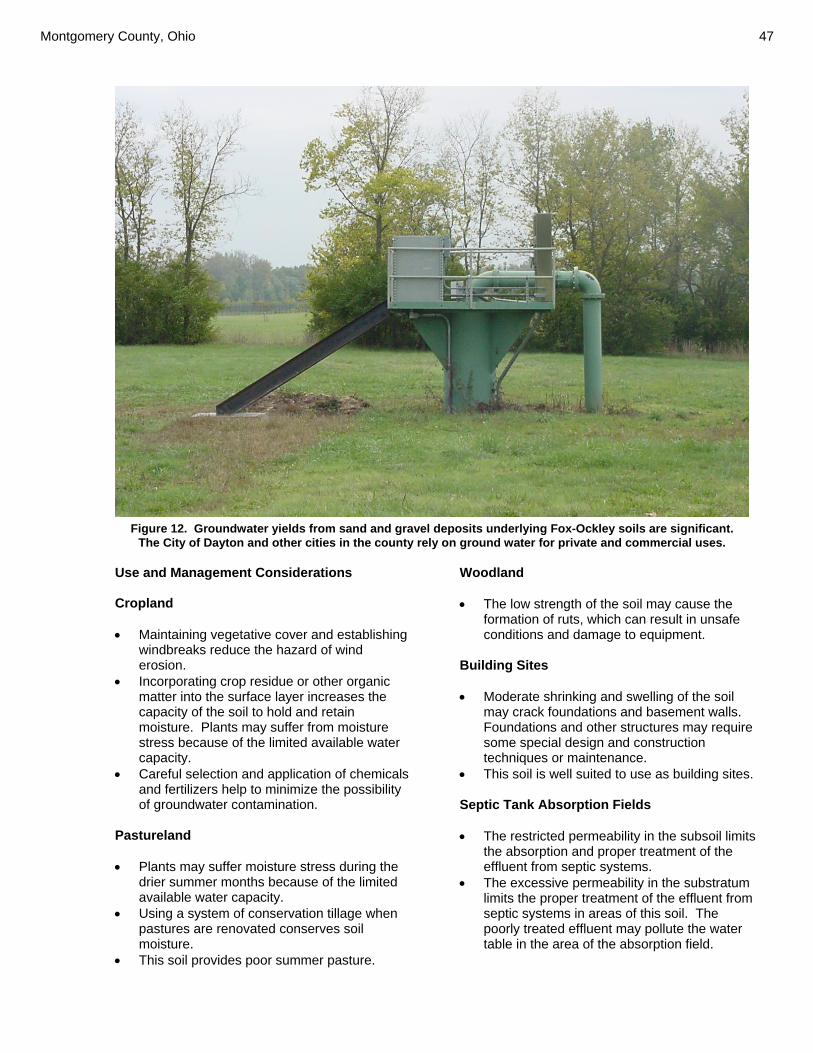
Montgomery County, Ohio 47
Use and Management Considerations Cropland • Maintaining vegetative cover and establishing
windbreaks reduce the hazard of wind erosion.
• Incorporating crop residue or other organic matter into the surface layer increases the capacity of the soil to hold and retain moisture. Plants may suffer from moisture stress because of the limited available water capacity.
• Careful selection and application of chemicals and fertilizers help to minimize the possibility of groundwater contamination.
Pastureland • Plants may suffer moisture stress during the
drier summer months because of the limited available water capacity.
• Using a system of conservation tillage when pastures are renovated conserves soil moisture.
• This soil provides poor summer pasture.
Woodland • The low strength of the soil may cause the
formation of ruts, which can result in unsafe conditions and damage to equipment.
Building Sites • Moderate shrinking and swelling of the soil
may crack foundations and basement walls. Foundations and other structures may require some special design and construction techniques or maintenance.
• This soil is well suited to use as building sites. Septic Tank Absorption Fields • The restricted permeability in the subsoil limits
the absorption and proper treatment of the effluent from septic systems.
• The excessive permeability in the substratum limits the proper treatment of the effluent from septic systems in areas of this soil. The poorly treated effluent may pollute the water table in the area of the absorption field.
Figure 12. Groundwater yields from sand and gravel deposits underlying Fox-Ockley soils are significant. The City of Dayton and other cities in the county rely on ground water for private and commercial uses.

48 Soil Survey
Local Roads and Streets • Because of shrinking and swelling, this soil
may not be suitable for use as base material for local roads and streets.
• Local roads and streets may be damaged by frost action, which is caused by the freezing and thawing of soil moisture.
• Special design of roads and streets is needed to prevent the structural damage caused by low soil strength.
Component Interpretive Groups FOX Pasture and hayland suitability group: B-1 Hydric soil: No FkB—Fox sandy loam, 2 to 6 percent slopes Setting Landform: Terraces Size of areas: 2 to 55 acres Map Unit Composition Fox and similar components: 100 percent Map Unit Interpretive Groups Land capability classification: 2e Prime farmland: All areas are prime farmland Soil Properties and Qualities FOX Available water capacity: About 4.9 inches to a
depth of 29 inches Cation-exchange capacity of the surface layer: 3
to 20 meq per 100 grams Depth class: Very deep Depth to root restrictive feature: Strongly
contrasting textural stratification: 24 to 42 inches
Depth to the top of the seasonal high water table: Greater than 3.0 feet
Ponding: None Drainage class: Well drained Flooding: None Organic matter content in the surface layer: 1.0 to
3.0 percent Parent material: Loamy outwash over sandy and
gravelly outwash Permeability: Moderate in the subsoil; rapid in the
substratum Potential frost action: Moderate Shrink-swell potential: Moderate
Surface layer texture: Sandy loam Potential for surface runoff: Low Wind erosion hazard: Moderate Use and Management Considerations Cropland • Grassed waterways can be used in some
areas to slow and direct the movement of water and reduce erosion.
• Using a system of conservation tillage and planting cover crops reduce the runoff rate and help to minimize soil loss by erosion.
• Maintaining vegetative cover and establishing windbreaks reduce the hazard of wind erosion.
• Incorporating crop residue or other organic matter into the surface layer increases the capacity of the soil to hold and retain moisture. Plants may suffer from moisture stress because of the limited available water capacity.
• Careful selection and application of chemicals and fertilizers help to minimize the possibility of groundwater contamination.
Pastureland • Erosion control is needed when pastures are
renovated. • Plants may suffer moisture stress during the
drier summer months because of the limited available water capacity.
• Using a system of conservation tillage when pastures are renovated conserves soil moisture.
• This soil provides poor summer pasture. Woodland • The low strength of the soil may cause the
formation of ruts, which can result in unsafe conditions and damage to equipment.
Building Sites • Moderate shrinking and swelling of the soil
may crack foundations and basement walls. Foundations and other structures may require some special design and construction techniques or maintenance.
• This soil is well suited to use as building sites.

Montgomery County, Ohio 49
Septic Tank Absorption Fields • The restricted permeability in the subsoil limits
the absorption and proper treatment of the effluent from septic systems.
• The excessive permeability in the substratum limits the proper treatment of the effluent from septic systems in areas of this soil. The poorly treated effluent may pollute the water table in the area of the absorption field.
Local Roads and Streets • Because of shrinking and swelling, this soil
may not be suitable for use as base material for local roads and streets.
• Local roads and streets may be damaged by frost action, which is caused by the freezing and thawing of soil moisture.
• Special design of roads and streets is needed to prevent the structural damage caused by low soil strength.
Component Interpretive Groups FOX Pasture and hayland suitability group: B-1 Hydric soil: No FlA—Fox loam, 0 to 2 percent slopes Setting Landform: Terraces Size of areas: 2 to 150 acres Map Unit Composition Fox and similar components: 100 percent
Similar Components Gravelly areas Loam till at 5 to 6 feet
Map Unit Interpretive Groups Land capability classification: 2s Prime farmland: All areas are prime farmland Soil Properties and Qualities FOX Available water capacity: About 4.9 inches to a
depth of 29 inches Cation-exchange capacity of the surface layer: 4
to 20 meq per 100 grams Depth class: Very deep
Depth to root restrictive feature: Strongly contrasting textural stratification: 24 to 42 inches
Depth to the top of the seasonal high water table: Greater than 3.0 feet
Ponding: None Drainage class: Well drained Flooding: None Organic matter content in the surface layer: 1.0 to
3.0 percent Parent material: Loamy outwash over sandy and
gravelly outwash Permeability: Moderate in the subsoil; rapid in the
substratum Potential frost action: Moderate Shrink-swell potential: Moderate Surface layer texture: Loam Potential for surface runoff: Low Wind erosion hazard: Slight Use and Management Considerations Cropland • Incorporating crop residue or other organic
matter into the surface layer increases the capacity of the soil to hold and retain moisture. Plants may suffer from moisture stress because of the limited available water capacity.
• Careful selection and application of chemicals and fertilizers help to minimize the possibility of groundwater contamination.
Pastureland • Plants may suffer moisture stress during the
drier summer months because of the limited available water capacity.
• Using a system of conservation tillage when pastures are renovated conserves soil moisture.
• This soil provides poor summer pasture. Woodland • The low strength of the soil may cause the
formation of ruts, which can result in unsafe conditions and damage to equipment.
• The low strength of the soil increases the cost of constructing haul roads and log landings.
• Because of low soil strength, harvesting equipment may be difficult to operate and damage may result. The low strength of the soil may create unsafe conditions for log trucks.
50 Soil Survey
Building Sites • Moderate shrinking and swelling of the soil
may crack foundations and basement walls. Foundations and other structures may require some special design and construction techniques or maintenance.
• This soil is well suited to use as building sites. Septic Tank Absorption Fields • The restricted permeability in the subsoil limits
the absorption and proper treatment of the effluent from septic systems.
• The excessive permeability in the substratum limits the proper treatment of the effluent from septic systems in areas of this soil. The poorly treated effluent may pollute the water table in the area of the absorption field.
Local Roads and Streets • Because of shrinking and swelling, this soil
may not be suitable for use as base material for local roads and streets.
• Local roads and streets may be damaged by frost action, which is caused by the freezing and thawing of soil moisture.
• Special design of roads and streets is needed to prevent the structural damage caused by low soil strength.
Component Interpretive Groups FOX Pasture and hayland suitability group: B-1 Hydric soil: No FlB—Fox loam, 2 to 6 percent slopes Setting Landform: along major streams on ridges on
terraces broad, gently rolling ridges on terraces
Size of areas: 2 to 40 acres Map Unit Composition Fox and similar components: 100 percent
Similar components Gravelly areas Moderately eroded reddish soil
Map Unit Interpretive Groups Land capability classification: 2e Prime farmland: All areas are prime farmland
Soil Properties and Qualities FOX Available water capacity: About 4.9 inches to a
depth of 29 inches Cation-exchange capacity of the surface layer: 4
to 20 meq per 100 grams Depth class: Very deep Depth to root restrictive feature: Strongly
contrasting textural stratification: 24 to 42 inches
Depth to the top of the seasonal high water table: Greater than 3.0 feet
Ponding: None Drainage class: Well drained Flooding: None Organic matter content in the surface layer: 1.0 to
3.0 percent Parent material: Loamy outwash over sandy and
gravelly outwash Permeability: Moderate in the subsoil; rapid in the
substratum Potential frost action: Moderate Shrink-swell potential: Moderate Surface layer texture: Loam Potential for surface runoff: Low Wind erosion hazard: Slight Use and Management Considerations Cropland • Grassed waterways can be used in some
areas to slow and direct the movement of water and reduce erosion.
• Using a system of conservation tillage and planting cover crops reduce the runoff rate and help to minimize soil loss by erosion.
• Incorporating crop residue or other organic matter into the surface layer increases the capacity of the soil to hold and retain moisture. Plants may suffer from moisture stress because of the limited available water capacity.
• Careful selection and application of chemicals and fertilizers help to minimize the possibility of groundwater contamination.
Pastureland • Erosion control is needed when pastures are
renovated. • Plants may suffer moisture stress during the
drier summer months because of the limited available water capacity.

Montgomery County, Ohio 51
• Using a system of conservation tillage when pastures are renovated conserves soil moisture.
• This soil provides poor summer pasture. Woodland • The low strength of the soil may cause the
formation of ruts, which can result in unsafe conditions and damage to equipment.
• The low strength of the soil increases the cost of constructing haul roads and log landings.
• Because of low soil strength, harvesting equipment may be difficult to operate and damage may result. The low strength of the soil may create unsafe conditions for log trucks.
Building Sites • Moderate shrinking and swelling of the soil
may crack foundations and basement walls. Foundations and other structures may require some special design and construction techniques or maintenance.
• This soil is well suited to use as building sites. Septic Tank Absorption Fields • The restricted permeability in the subsoil limits
the absorption and proper treatment of the effluent from septic systems.
• The excessive permeability in the substratum limits the proper treatment of the effluent from septic systems in areas of this soil. The poorly treated effluent may pollute the water table in the area of the absorption field.
Local Roads and Streets • Because of shrinking and swelling, this soil
may not be suitable for use as base material for local roads and streets.
• Local roads and streets may be damaged by frost action, which is caused by the freezing and thawing of soil moisture.
• Special design of roads and streets is needed to prevent the structural damage caused by low soil strength.
Component Interpretive Groups FOX Pasture and hayland suitability group: B-1 Hydric soil: No
FlC2—Fox loam, 6 to 12 percent slopes, moderately eroded Setting Landform: Terraces Size of areas: 2 to 15 acres Map Unit Composition Fox and similar components: 100 percent
Similar Components Gravelly surface layer Sandy loam surface layer
Map Unit Interpretive Groups Land capability classification: 3e Prime farmland: Not prime farmland Soil Properties and Qualities FOX Available water capacity: About 3.6 inches to a
depth of 29 inches Cation-exchange capacity of the surface layer: 4
to 20 meq per 100 grams Depth class: Very deep Depth to root restrictive feature: Strongly
contrasting textural stratification: 24 to 42 inches
Depth to the top of the seasonal high water table: Greater than 3.0 feet
Ponding: None Drainage class: Well drained Flooding: None Organic matter content in the surface layer: 1.0 to
3.0 percent Parent material: Loamy outwash over sandy and
gravelly outwash Permeability: Moderate in the subsoil; rapid in the
substratum Potential frost action: Moderate Shrink-swell potential: Moderate Surface layer texture: Loam Potential for surface runoff: Medium Wind erosion hazard: Slight Use and Management Considerations Cropland • Using a system of conservation tillage and
planting cover crops reduce the runoff rate and help to minimize soil loss by erosion.
• Erosion has removed part of the surface soil, and the remaining surface soil is less productive and more difficult to manage.

52 Soil Survey
• Incorporating crop residue or other organic matter into the surface layer increases the capacity of the soil to hold and retain moisture. Plants may suffer from moisture stress because of the limited available water capacity.
• Careful selection and application of chemicals and fertilizers help to minimize the possibility of groundwater contamination.
• Maintaining or increasing the content of organic matter in the soil helps to prevent crusting, improves tilth, and increases the rate of water infiltration.
Pastureland • Avoiding overgrazing can reduce the hazard
of erosion. • Maintaining healthy plants and vegetative
cover can reduce the hazard of erosion. • Erosion control is needed when pastures are
renovated. • Plants may suffer moisture stress during the
drier summer months because of the limited available water capacity.
• Using a system of conservation tillage when pastures are renovated conserves soil moisture.
• This soil provides poor summer pasture. Woodland • The low strength of the soil may cause the
formation of ruts, which can result in unsafe conditions and damage to equipment.
• The low strength of the soil increases the cost of constructing haul roads and log landings.
• The slope creates unsafe operating conditions and reduces the operating efficiency of log trucks.
• Because of low soil strength, harvesting equipment may be difficult to operate and damage may result. The low strength of the soil may create unsafe conditions for log trucks.
• The slope may restrict the use of some mechanical planting equipment.
• Burning may destroy organic matter. Building Sites • The slope influences the use of machinery
and the amount of excavation required. Special building practices and designs may be required to ensure satisfactory performance.
Septic Tank Absorption Fields • The excessive permeability limits the proper
treatment of the effluent from septic systems in areas of this soil. The poorly treated effluent may pollute the water table in the area of the absorption field.
• Because of the slope, special design and installation techniques are needed for the effluent distribution lines.
Local Roads and Streets • Local roads and streets may be damaged by
frost action, which is caused by the freezing and thawing of soil moisture.
• Because of the slope, designing local roads and streets is difficult.
Component Interpretive Groups FOX Pasture and hayland suitability group: B-1 Hydric soil: No FmA—Fox silt loam, 0 to 2 percent slopes Setting Landform: Terraces Size of areas: 2 to 250 acres Map Unit Composition Fox and similar components: 100 percent
Similar Components Darker colored surface layer Lorenzo Ockley Loam till at 5 to 6 feet
Map Unit Interpretive Groups Land capability classification: 2s Prime farmland: All areas are prime farmland Soil Properties and Qualities FOX Available water capacity: About 4.9 inches to a
depth of 29 inches Cation-exchange capacity of the surface layer: 4
to 20 meq per 100 grams Depth class: Very deep Depth to root restrictive feature: Strongly
contrasting textural stratification: 24 to 42 inches

Montgomery County, Ohio 53
Depth to the top of the seasonal high water table: Greater than 3.0 feet
Ponding: None Drainage class: Well drained Flooding: None Organic matter content in the surface layer: 1.0 to
3.0 percent Parent material: Loamy outwash over sandy and
gravelly outwash Permeability: Moderate in the subsoil; rapid in the
substratum Potential frost action: Moderate Shrink-swell potential: Moderate Surface layer texture: Silt loam Potential for surface runoff: Low Wind erosion hazard: Slight Use and Management Considerations Cropland • Incorporating crop residue or other organic
matter into the surface layer increases the capacity of the soil to hold and retain moisture. Plants may suffer from moisture stress because of the limited available water capacity.
• Careful selection and application of chemicals and fertilizers help to minimize the possibility of groundwater contamination.
• Controlling traffic can minimize soil compaction.
• Maintaining or increasing the content of organic matter in the soil helps to prevent crusting, improves tilth, and increases the rate of water infiltration.
Pastureland • Plants may suffer moisture stress during the
drier summer months because of the limited available water capacity.
• Using a system of conservation tillage when pastures are renovated conserves soil moisture.
• This soil provides poor summer pasture. Woodland • The low strength of the soil may cause the
formation of ruts, which can result in unsafe conditions and damage to equipment.
• The low strength of the soil increases the cost of constructing haul roads and log landings.
• Because of low soil strength, harvesting equipment may be difficult to operate and damage may result. The low strength of the
soil may create unsafe conditions for log trucks.
Building Sites • Moderate shrinking and swelling of the soil
may crack foundations and basement walls. Foundations and other structures may require some special design and construction techniques or maintenance.
• This soil is well suited to use as building sites. Septic Tank Absorption Fields • The restricted permeability in the subsoil limits
the absorption and proper treatment of the effluent from septic systems.
• The excessive permeability in the substratum limits the proper treatment of the effluent from septic systems in areas of this soil. The poorly treated effluent may pollute the water table in the area of the absorption field.
Local Roads and Streets • Because of shrinking and swelling, this soil
may not be suitable for use as base material for local roads and streets.
• Local roads and streets may be damaged by frost action, which is caused by the freezing and thawing of soil moisture.
• Special design of roads and streets is needed to prevent the structural damage caused by low soil strength.
Component Interpretive Groups FOX Pasture and hayland suitability group: B-1 Hydric soil: No FmB—Fox silt loam, 2 to 6 percent slopes Setting Landform: Terraces Size of areas: 2 to 150 acres Map Unit Composition Fox and similar components: 100 percent
Similar Components Lorenzo Thicker soils Moderately eroded soils that are droughtier and redder

54 Soil Survey
Map Unit Interpretive Groups Land capability classification: 2e Prime farmland: All areas are prime farmland Soil Properties and Qualities FOX Available water capacity: About 4.9 inches to a
depth of 29 inches Cation-exchange capacity of the surface layer: 4
to 20 meq per 100 grams Depth class: Very deep Depth to root restrictive feature: Strongly
contrasting textural stratification: 24 to 42 inches
Depth to the top of the seasonal high water table: Greater than 3.0 feet
Ponding: None Drainage class: Well drained Flooding: None Organic matter content in the surface layer: 1.0 to
3.0 percent Parent material: Loamy outwash over sandy and
gravelly outwash Permeability: Moderate in the subsoil; rapid in the
substratum Potential frost action: Moderate Shrink-swell potential: Moderate Surface layer texture: Silt loam Potential for surface runoff: Low Wind erosion hazard: Slight Use and Management Considerations Cropland • Grassed waterways can be used in some
areas to slow and direct the movement of water and reduce erosion.
• Using a system of conservation tillage and planting cover crops reduce the runoff rate and help to minimize soil loss by erosion.
• Incorporating crop residue or other organic matter into the surface layer increases the capacity of the soil to hold and retain moisture. Plants may suffer from moisture stress because of the limited available water capacity.
• Careful selection and application of chemicals and fertilizers help to minimize the possibility of groundwater contamination.
• Controlling traffic can minimize soil compaction.
• Maintaining or increasing the content of organic matter in the soil helps to prevent crusting, improves tilth, and increases the rate of water infiltration.
Pastureland • Erosion control is needed when pastures are
renovated. • Plants may suffer moisture stress during the
drier summer months because of the limited available water capacity.
• Using a system of conservation tillage when pastures are renovated conserves soil moisture.
• This soil provides poor summer pasture. Woodland • The low strength of the soil may cause the
formation of ruts, which can result in unsafe conditions and damage to equipment.
• The low strength of the soil increases the cost of constructing haul roads and log landings.
• Because of low soil strength, harvesting equipment may be difficult to operate and damage may result. The low strength of the soil may create unsafe conditions for log trucks.
Building Sites • Moderate shrinking and swelling of the soil
may crack foundations and basement walls. Foundations and other structures may require some special design and construction techniques or maintenance.
• This soil is well suited to use as building sites. Septic Tank Absorption Fields • The restricted permeability in the subsoil limits
the absorption and proper treatment of the effluent from septic systems.
• The excessive permeability in the substratum limits the proper treatment of the effluent from septic systems in areas of this soil. The poorly treated effluent may pollute the water table in the area of the absorption field.
Local Roads and Streets • Because of shrinking and swelling, this soil
may not be suitable for use as base material for local roads and streets.
• Local roads and streets may be damaged by frost action, which is caused by the freezing and thawing of soil moisture.
• Special design of roads and streets is needed to prevent the structural damage caused by low soil strength.

Montgomery County, Ohio 55
Component Interpretive Groups FOX Pasture and hayland suitability group: B-1 Hydric soil: No FmC2—Fox silt loam, 6 to 12 percent slopes, moderately eroded Setting Landform: broad, rolling terraces and hills Size of areas: 2 to 100 acres Map Unit Composition Fox and similar components: 100 percent
Similar Components Lorenzo
Map Unit Interpretive Groups Land capability classification: 3e Prime farmland: Not prime farmland Soil Properties and Qualities FOX Available water capacity: About 3.6 inches to a
depth of 29 inches Cation-exchange capacity of the surface layer: 4
to 20 meq per 100 grams Depth class: Very deep Depth to root restrictive feature: Strongly
contrasting textural stratification: 24 to 42 inches
Depth to the top of the seasonal high water table: Greater than 3.0 feet
Ponding: None Drainage class: Well drained Flooding: None Organic matter content in the surface layer: 1.0 to
3.0 percent Parent material: Loamy outwash over sandy and
gravelly outwash Permeability: Moderate in the subsoil; rapid in the
substratum Potential frost action: Moderate Shrink-swell potential: Moderate Surface layer texture: Silt loam Potential for surface runoff: Medium Wind erosion hazard: Slight
Use and Management Considerations Cropland • Using a system of conservation tillage and
planting cover crops reduce the runoff rate and help to minimize soil loss by erosion.
• Erosion has removed part of the surface soil, and the remaining surface soil is less productive and more difficult to manage.
• Incorporating crop residue or other organic matter into the surface layer increases the capacity of the soil to hold and retain moisture. Plants may suffer from moisture stress because of the limited available water capacity.
• Careful selection and application of chemicals and fertilizers help to minimize the possibility of groundwater contamination.
• Controlling traffic can minimize soil compaction.
• Maintaining or increasing the content of organic matter in the soil helps to prevent crusting, improves tilth, and increases the rate of water infiltration.
Pastureland • Avoiding overgrazing can reduce the hazard
of erosion. • Maintaining healthy plants and vegetative
cover can reduce the hazard of erosion. • Erosion control is needed when pastures are
renovated. • Plants may suffer moisture stress during the
drier summer months because of the limited available water capacity.
• Using a system of conservation tillage when pastures are renovated conserves soil moisture.
• This soil provides poor summer pasture. Woodland • The low strength of the soil may cause the
formation of ruts, which can result in unsafe conditions and damage to equipment.
• The low strength of the soil increases the cost of constructing haul roads and log landings.
• The slope creates unsafe operating conditions and reduces the operating efficiency of log trucks.
• Because of low soil strength, harvesting equipment may be difficult to operate and damage may result. The low strength of the soil may create unsafe conditions for log trucks.

56 Soil Survey
• The slope may restrict the use of some mechanical planting equipment.
• Burning may destroy organic matter. Building Sites • The slope influences the use of machinery
and the amount of excavation required. Special building practices and designs may be required to ensure satisfactory performance.
Septic Tank Absorption Fields • The excessive permeability limits the proper
treatment of the effluent from septic systems in areas of this soil. The poorly treated effluent may pollute the water table in the area of the absorption field.
• Because of the slope, special design and installation techniques are needed for the effluent distribution lines.
Local Roads and Streets • Local roads and streets may be damaged by
frost action, which is caused by the freezing and thawing of soil moisture.
• Because of the slope, designing local roads and streets is difficult.
Component Interpretive Groups FOX Pasture and hayland suitability group: B-1 Hydric soil: No FmD2—Fox silt loam, 12 to 18 percent slopes, moderately eroded Setting Landform: outer edge of broad, rolling hills and
terraces Size of areas: 2 to 100 acres Map Unit Composition Fox and similar components: 95 percent
Similar Components Loam surface layer Contrasting Components Severely eroded areas: 3 percent Gravelly surface layer: 2 percent
Map Unit Interpretive Groups Land capability classification: 4e
Prime farmland: Not prime farmland Soil Properties and Qualities FOX Available water capacity: About 3.6 inches to a
depth of 29 inches Cation-exchange capacity of the surface layer: 4
to 20 meq per 100 grams Depth class: Very deep Depth to root restrictive feature: Strongly
contrasting textural stratification: 24 to 42 inches
Depth to the top of the seasonal high water table: Greater than 3.0 feet
Ponding: None Drainage class: Well drained Flooding: None Organic matter content in the surface layer: 1.0 to
3.0 percent Parent material: Loamy outwash over sandy and
gravelly outwash Permeability: Moderate in the subsoil; rapid in the
substratum Potential frost action: Moderate Shrink-swell potential: Moderate Surface layer texture: Silt loam Potential for surface runoff: Medium Wind erosion hazard: Slight Use and Management Considerations Cropland • Using a system of conservation tillage and
planting cover crops reduce the runoff rate and help to minimize soil loss by erosion.
• Erosion has removed part of the surface soil, and the remaining surface soil is less productive and more difficult to manage.
• Incorporating crop residue or other organic matter into the surface layer increases the capacity of the soil to hold and retain moisture. Plants may suffer from moisture stress because of the limited available water capacity.
• Careful selection and application of chemicals and fertilizers help to minimize the possibility of groundwater contamination.
• Controlling traffic can minimize soil compaction.
• Maintaining or increasing the content of organic matter in the soil helps to prevent crusting, improves tilth, and increases the rate of water infiltration.

Montgomery County, Ohio 57
Pastureland • Avoiding overgrazing can reduce the hazard
of erosion. • Maintaining healthy plants and vegetative
cover can reduce the hazard of erosion. • Erosion control is needed when pastures are
renovated. • Plants may suffer moisture stress during the
drier summer months because of the limited available water capacity.
• Using a system of conservation tillage when pastures are renovated conserves soil moisture.
• This soil provides poor summer pasture. Woodland • If the soil is disturbed, the slope increases the
hazard of erosion. • The slope increases excavation costs, poses
safety hazards, and creates a potential for erosion during construction of haul roads and log landings.
• The low strength of the soil may cause the formation of ruts, which can result in unsafe conditions and damage to equipment.
• The low strength of the soil increases the cost of constructing haul roads and log landings.
• Sandy layers in this soil increase the maintenance of haul roads and log landings.
• The slope creates unsafe operating conditions and reduces the operating efficiency of log trucks.
• Because of low soil strength, harvesting equipment may be difficult to operate and damage may result. The low strength of the soil may create unsafe conditions for log trucks.
• The slope may restrict the use of some mechanical planting equipment.
• The slope restricts the use of equipment for preparing this site for planting and seeding.
• Burning may destroy organic matter. Building Sites • The slope influences the use of machinery
and the amount of excavation required. Special building practices and designs are required to ensure satisfactory performance.
Septic Tank Absorption Fields • The excessive permeability limits the proper
treatment of the effluent from septic systems in areas of this soil. The poorly treated
effluent may pollute the water table in the area of the absorption field.
• Because of the slope, special design and installation techniques are needed for the effluent distribution lines.
Local Roads and Streets • Local roads and streets may be damaged by
frost action, which is caused by the freezing and thawing of soil moisture.
• Because of the slope, designing local roads and streets is difficult.
Component Interpretive Groups FOX Pasture and hayland suitability group: B-1 Hydric soil: No FsC3—Fox soils, 6 to 12 percent slopes, severely eroded Setting Landform: short, steep slopes on hills and
terraces Size of areas: 2 to 20 acres Map Unit Composition Fox and similar components: 95 percent
Similar Components Loam surface layer Silt loam surface layer Contrasting Components Gravelly loam surface layer: 5 percent
Map Unit Interpretive Groups Land capability classification: 4e Prime farmland: Not prime farmland Soil Properties and Qualities FOX Available water capacity: About 3.0 inches to a
depth of 18 inches Cation-exchange capacity of the surface layer: 5
to 30 meq per 100 grams Depth class: Very deep Depth to root restrictive feature: Strongly
contrasting textural stratification: 18 to 42 inches
Depth to the top of the seasonal high water table: Greater than 3.0 feet
Ponding: None

58 Soil Survey
Drainage class: Well drained Flooding: None Organic matter content in the surface layer: 0.5 to
2.0 percent Parent material: Loamy outwash over sandy and
gravelly outwash Permeability: Moderate in the subsoil; rapid in the
substratum Potential frost action: Moderate Shrink-swell potential: Moderate Surface layer texture: Clay loam Potential for surface runoff: Medium Wind erosion hazard: Slight Use and Management Considerations Cropland • Using a system of conservation tillage and
planting cover crops reduce the runoff rate and help to minimize soil loss by erosion.
• Erosion has removed part of the surface soil, and the remaining surface soil is less productive and more difficult to manage.
• Incorporating crop residue or other organic matter into the surface layer increases the capacity of the soil to hold and retain moisture. Plants may suffer from moisture stress because of the limited available water capacity.
• Careful selection and application of chemicals and fertilizers help to minimize the possibility of groundwater contamination.
• Controlling traffic can minimize soil compaction.
• Maintaining or increasing the content of organic matter in the soil helps to prevent crusting, improves tilth, and increases the rate of water infiltration.
Pastureland • Avoiding overgrazing can reduce the hazard
of erosion. • Maintaining healthy plants and vegetative
cover can reduce the hazard of erosion. • Erosion control is needed when pastures are
renovated. • Plants may suffer moisture stress during the
drier summer months because of the limited available water capacity.
• Using a system of conservation tillage when pastures are renovated conserves soil moisture.
• This soil provides poor summer pasture.
Woodland • The low strength of the soil may cause the
formation of ruts, which can result in unsafe conditions and damage to equipment.
• The low strength of the soil increases the cost of constructing haul roads and log landings.
• The slope creates unsafe operating conditions and reduces the operating efficiency of log trucks.
• Because of low soil strength, harvesting equipment may be difficult to operate and damage may result. The low strength of the soil may create unsafe conditions for log trucks.
• The slope may restrict the use of some mechanical planting equipment.
• Burning may destroy organic matter. Building Sites • The slope influences the use of machinery
and the amount of excavation required. Special building practices and designs may be required to ensure satisfactory performance.
Septic Tank Absorption Fields • The excessive permeability limits the proper
treatment of the effluent from septic systems in areas of this soil. The poorly treated effluent may pollute the water table in the area of the absorption field.
• Because of the slope, special design and installation techniques are needed for the effluent distribution lines.
Local Roads and Streets • Local roads and streets may be damaged by
frost action, which is caused by the freezing and thawing of soil moisture.
• Because of the slope, designing local roads and streets is difficult.
Component Interpretive Groups FOX Pasture and hayland suitability group: B-1 Hydric soil: No

Montgomery County, Ohio 59
FuB—Fox-Urban land complex, gently sloping Setting Landform: Terraces Size of areas: 5 to over 1,000 acres Map Unit Composition Fox and similar components: 50 percent Urban land and similar components: 50 percent
Similar Components Thackery Warsaw Wea Ockley
Map Unit Interpretive Groups Prime farmland: Not prime farmland Soil Properties and Qualities FOX Available water capacity: About 4.9 inches to a
depth of 29 inches Cation-exchange capacity of the surface layer: 4
to 20 meq per 100 grams Depth class: Very deep Depth to root restrictive feature: Strongly
contrasting textural stratification: 24 to 42 inches
Depth to the top of the seasonal high water table: Greater than 3.0 feet
Ponding: None Drainage class: Well drained Flooding: None Organic matter content in the surface layer: 1.0 to
3.0 percent Parent material: Loamy outwash over sandy and
gravelly outwash Permeability: Moderate in the subsoil; rapid in the
substratum Potential frost action: Moderate Shrink-swell potential: Moderate Surface layer texture: Silt loam Potential for surface runoff: Low Wind erosion hazard: Slight Use and Management Considerations Building Sites • Moderate shrinking and swelling of the soil
may crack foundations and basement walls. Foundations and other structures may require some special design and construction techniques or maintenance.
• This soil is well suited to use as building sites. Septic Tank Absorption Fields • The restricted permeability in the subsoil limits
the absorption and proper treatment of the effluent from septic systems.
• The excessive permeability in the substratum limits the proper treatment of the effluent from septic systems in areas of this soil. The poorly treated effluent may pollute the water table in the area of the absorption field.
Local Roads and Streets • Because of shrinking and swelling, this soil
may not be suitable for use as base material for local roads and streets.
• Local roads and streets may be damaged by frost action, which is caused by the freezing and thawing of soil moisture.
• Special design of roads and streets is needed to prevent the structural damage caused by low soil strength.
Component Interpretive Groups FOX Hydric soil: No URBAN LAND Use and Management Considerations Onsite investigation is needed to determine the suitability for specific uses. Component Interpretive Groups URBAN LAND Hydric soil: Unranked FuC—Fox-Urban land complex, rolling Setting Landform: Terraces Size of areas: 2 to 300 acres Map Unit Composition Urban land and similar components: 60 percent Fox and similar components: 40 percent
Similar components Ockley

60 Soil Survey
URBAN LAND Use and Management Considerations Onsite investigation is needed to determine the suitability for specific uses. Component Interpretive Groups URBAN LAND Hydric soil: Unranked Soil Properties and Qualities FOX Available water capacity: About 3.6 inches to a
depth of 29 inches Cation-exchange capacity of the surface layer: 4
to 20 meq per 100 grams Depth class: Very deep Depth to root restrictive feature: Strongly
contrasting textural stratification: 24 to 42 inches
Depth to the top of the seasonal high water table: Greater than 3.0 feet
Ponding: None Drainage class: Well drained Flooding: None Organic matter content in the surface layer: 1.0 to
3.0 percent Parent material: Loamy outwash over sandy and
gravelly outwash Permeability: Moderate in the subsoil; rapid in the
substratum Potential frost action: Moderate Shrink-swell potential: Moderate Surface layer texture: Silt loam Potential for surface runoff: Medium Wind erosion hazard: Slight Use and Management Considerations Building Sites • The slope influences the use of machinery
and the amount of excavation required. Special building practices and designs may be required to ensure satisfactory performance.
Septic Tank Absorption Fields • The excessive permeability limits the proper
treatment of the effluent from septic systems in areas of this soil. The poorly treated effluent may pollute the water table in the area of the absorption field.
• Because of the slope, special design and installation techniques are needed for the effluent distribution lines.
Local Roads and Streets • Local roads and streets may be damaged by
frost action, which is caused by the freezing and thawing of soil moisture.
• Because of the slope, designing local roads and streets is difficult.
Component Interpretive Groups FOX Hydric soil: No FuF—Fox-Urban land complex, steep Setting Landform: Kame terraces Size of areas: 2 to 25 acres Map Unit Composition Urban land and similar components: 60 percent Fox and similar components: 40 percent
Similar Components Ockley Rodman
URBAN LAND Use and Management Considerations Onsite investigation is needed to determine the suitability for specific uses. Component Interpretive Groups URBAN LAND Hydric soil: Unranked Soil Properties and Qualities FOX Available water capacity: About 3.0 inches to a
depth of 18 inches Cation-exchange capacity of the surface layer: 4
to 20 meq per 100 grams Depth class: Very deep Depth to root restrictive feature: Strongly
contrasting textural stratification: 18 to 42 inches
Depth to the top of the seasonal high water table: Greater than 3.0 feet

Montgomery County, Ohio 61
Ponding: None Drainage class: Well drained Flooding: None Organic matter content in the surface layer: 1.0 to
3.0 percent Parent material: Loamy outwash over sandy and
gravelly outwash Permeability: Moderate in the subsoil; rapid in the
substratum Potential frost action: Moderate Shrink-swell potential: Moderate Surface layer texture: Silt loam Potential for surface runoff: Wind erosion hazard: Slight Use and Management Considerations Building Sites • The slope influences the use of machinery
and the amount of excavation required. Special building practices and designs are required to ensure satisfactory performance.
Septic Tank Absorption Fields • The excessive permeability limits the proper
treatment of the effluent from septic systems in areas of this soil. The poorly treated effluent may pollute the water table in the area of the absorption field.
• Because of the slope, special design and installation techniques are needed for the effluent distribution lines.
Local Roads and Streets • Local roads and streets may be damaged by
frost action, which is caused by the freezing and thawing of soil moisture.
• Because of the slope, designing local roads and streets is difficult.
Component Interpretive Groups FOX Hydric soil: No Gp—Gravel pits Setting Size of areas: 2 to 300 acres Map Unit Composition Gravel pits and similar components: 100 percent
Land capability classification: None assigned Use and Management Considerations Onsite investigation is needed to determine the suitability for specific uses. Component Interpretive Groups GRAVEL PITS Hydric soil: Unranked HeE2—Hennepin and Miamian silt loams, 18 to 25 percent slopes, moderately eroded Setting Landform: Banks of drainageways and valley
sides Size of areas: 2 to 150 acres Map Unit Composition Hennepin and similar components: 60 percent Miamian and similar components: 40 percent
Similar Components Soils shallow to limestone Soils shallow to sand and gravel Kendallville
Map Unit Interpretive Groups Land capability classification: 6e Prime farmland: Not prime farmland Soil Properties and Qualities HENNEPIN Available water capacity: About 5.8 inches to a
depth of 60 inches Cation-exchange capacity of the surface layer: 14
to 22 meq per 100 grams Depth class: Very deep Depth to root restrictive feature: Greater than 60
inches Depth to the top of the seasonal high water table:
Greater than 3.0 feet Ponding: None Drainage class: Well drained Flooding: None Organic matter content in the surface layer: 1.0 to
2.0 percent Parent material: Loamy till Permeability: Moderately slow Potential frost action: Moderate Shrink-swell potential: Low Surface layer texture: Silt loam

62 Soil Survey
Potential for surface runoff: Very high Wind erosion hazard: Slight Use and Management Considerations Pastureland • Avoiding overgrazing can reduce the hazard
of erosion. • Maintaining healthy plants and vegetative
cover can reduce the hazard of erosion. • Erosion control is needed when pastures are
renovated. • Plants may suffer moisture stress during the
drier summer months because of the limited available water capacity.
• Using a system of conservation tillage when pastures are renovated conserves soil moisture.
• This soil provides poor summer pasture. Woodland • If the soil is disturbed, the slope increases the
hazard of erosion. • The slope increases excavation costs, poses
safety hazards, and creates a potential for erosion during construction of haul roads and log landings.
• The low strength of the soil may cause the formation of ruts, which can result in unsafe conditions and damage to equipment.
• The low strength of the soil increases the cost of constructing haul roads and log landings.
• The slope creates unsafe operating conditions and reduces the operating efficiency of log trucks.
• Because of low soil strength, harvesting equipment may be difficult to operate and damage may result. The low strength of the soil may create unsafe conditions for log trucks.
• The slope creates unsafe operating conditions and reduces the operating efficiency of harvesting and mechanical planting equipment.
• The slope may restrict the use of some mechanical planting equipment.
• The slope restricts the use of equipment for preparing this site for planting and seeding.
• Burning may destroy organic matter. Building Sites • The slope influences the use of machinery
and the amount of excavation required.
Special building practices and designs are required to ensure satisfactory performance.
Septic Tank Absorption Fields • The restricted permeability of this soil limits
the absorption and proper treatment of the effluent from septic systems.
• Because of the slope, special design and installation techniques are needed for the effluent distribution lines.
Local Roads and Streets • Local roads and streets may be damaged by
frost action, which is caused by the freezing and thawing of soil moisture.
• Special design of roads and streets is needed to prevent the structural damage caused by low soil strength.
• Because of the slope, designing local roads and streets is difficult.
Component Interpretive Groups HENNEPIN Pasture and hayland suitability group: B-1 Hydric soil: No Soil Properties and Qualities MIAMIAN Available water capacity: About 6.9 inches to a
depth of 60 inches Cation-exchange capacity of the surface layer: 10
to 18 meq per 100 grams Depth class: Very deep Depth to root restrictive feature: Greater than 60
inches Depth to the top of the seasonal high water table:
Greater than 3.0 feet Ponding: None Drainage class: Well drained Flooding: None Organic matter content in the surface layer: 1.0 to
3.0 percent Parent material: Silty loess over loamy till Permeability: Moderately slow Potential frost action: Moderate Shrink-swell potential: Moderate Surface layer texture: Silt loam Potential for surface runoff: Very high Wind erosion hazard: Slight

Montgomery County, Ohio 63
Use and Management Considerations Pastureland • Avoiding overgrazing can reduce the hazard
of erosion. • Maintaining healthy plants and vegetative
cover can reduce the hazard of erosion. • Erosion control is needed when pastures are
renovated. Woodland • If the soil is disturbed, the slope increases the
hazard of erosion. • The slope increases excavation costs, poses
safety hazards, and creates a potential for erosion during construction of haul roads and log landings.
• The low strength of the soil may cause the formation of ruts, which can result in unsafe conditions and damage to equipment.
• The low strength of the soil increases the cost of constructing haul roads and log landings.
• The slope creates unsafe operating conditions and reduces the operating efficiency of log trucks.
• Because of low soil strength, harvesting equipment may be difficult to operate and damage may result. The low strength of the soil may create unsafe conditions for log trucks.
• The slope creates unsafe operating conditions and reduces the operating efficiency of harvesting and mechanical planting equipment.
• The slope may restrict the use of some mechanical planting equipment.
• The stickiness of the soil reduces the efficiency of mechanical planting equipment.
• The slope restricts the use of equipment for preparing this site for planting and seeding.
Building Sites • The slope influences the use of machinery
and the amount of excavation required. Special building practices and designs are required to ensure satisfactory performance.
• Moderate shrinking and swelling of the soil may crack foundations and basement walls. Foundations and other structures may require some special design and construction techniques or maintenance.
Septic Tank Absorption Fields • The restricted permeability of this soil limits
the absorption and proper treatment of the effluent from septic systems.
• Because of the slope, special design and installation techniques are needed for the effluent distribution lines.
Local Roads and Streets • Because of shrinking and swelling, this soil
may not be suitable for use as base material for local roads and streets.
• Local roads and streets may be damaged by frost action, which is caused by the freezing and thawing of soil moisture.
• The low bearing strength of this soil is generally unfavorable for supporting heavy loads. Special design of local roads and streets is needed to prevent the structural damage caused by low soil strength.
• Because of the slope, designing local roads and streets is difficult.
Component Interpretive Groups MIAMIAN Pasture and hayland suitability group: A-2 Hydric soil: No HeF2—Hennepin and Miamian silt loams, 25 to 50 percent slopes, moderately eroded Setting Landform: banks of drainageways and valley
sides Size of areas: 2 to 400 acres Map Unit Composition Hennepin and similar components: 60 percent Miamian and similar components: 38 percent
Similar Components Soils shallow to limestone Soils shallow to sand and gravel Contrasting Components Escarpments: 2 percent
Map Unit Interpretive Groups Land capability classification: 7e Prime farmland: Not prime farmland

64 Soil Survey
Soil Properties and Qualities HENNEPIN Available water capacity: About 5.8 inches to a
depth of 60 inches Cation-exchange capacity of the surface layer: 14
to 22 meq per 100 grams Depth class: Very deep Depth to root restrictive feature: Greater than 60
inches Depth to the top of the seasonal high water table:
Greater than 3.0 feet Ponding: None Drainage class: Well drained Flooding: None Organic matter content in the surface layer: 1.0 to
2.0 percent Parent material: Loamy till Permeability: Moderately slow Potential frost action: Moderate Shrink-swell potential: Low Surface layer texture: Silt loam Potential for surface runoff: Very high Wind erosion hazard: Slight Use and Management Considerations Pastureland • This soil is generally not recommended for
pasture. Woodland • If the soil is disturbed, the slope increases the
hazard of erosion. • The slope increases excavation costs, poses
safety hazards, and creates a potential for erosion during construction of haul roads and log landings.
• The low strength of the soil may cause the formation of ruts, which can result in unsafe conditions and damage to equipment.
• The low strength of the soil increases the cost of constructing haul roads and log landings.
• The slope creates unsafe operating conditions and reduces the operating efficiency of log trucks.
• Because of low soil strength, harvesting equipment may be difficult to operate and damage may result. The low strength of the soil may create unsafe conditions for log trucks.
• The slope creates unsafe operating conditions and reduces the operating efficiency of harvesting and mechanical planting equipment.
• Because of the slope, use of equipment to prepare this site for planting and seeding is not practical.
• Because of the slope, the use of mechanical planting equipment is not practical.
• Burning may destroy organic matter. Building Sites • The slope influences the use of machinery
and the amount of excavation required. Special building practices and designs are required to ensure satisfactory performance.
Septic Tank Absorption Fields • The restricted permeability of this soil limits
the absorption and proper treatment of the effluent from septic systems.
• Because of the slope, special design and installation techniques are needed for the effluent distribution lines.
Local Roads and Streets • Local roads and streets may be damaged by
frost action, which is caused by the freezing and thawing of soil moisture.
• Special design of roads and streets is needed to prevent the structural damage caused by low soil strength.
• Because of the slope, designing local roads and streets is difficult.
Component Interpretive Groups HENNEPIN Pasture and hayland suitability group: B-2 Hydric soil: No Soil Properties and Qualities MIAMIAN Available water capacity: About 7.1 inches to a
depth of 60 inches Cation-exchange capacity of the surface layer: 10
to 18 meq per 100 grams Depth class: Very deep Depth to root restrictive feature: Greater than 60
inches Depth to the top of the seasonal high water table:
Greater than 3.0 feet Ponding: None Drainage class: Well drained Flooding: None Organic matter content in the surface layer: 1.0 to
3.0 percent

Montgomery County, Ohio 65
Parent material: Silty loess over loamy till Permeability: Moderately slow Potential frost action: Moderate Shrink-swell potential: Moderate Surface layer texture: Silt loam Potential for surface runoff: Very high Wind erosion hazard: Slight Use and Management Considerations Pastureland • This soil is generally not recommended for
pasture. Woodland • If the soil is disturbed, the slope increases the
hazard of erosion. • The slope increases excavation costs, poses
safety hazards, and creates a potential for erosion during construction of haul roads and log landings.
• The low strength of the soil may cause the formation of ruts, which can result in unsafe conditions and damage to equipment.
• The low strength of the soil increases the cost of constructing haul roads and log landings.
• The slope creates unsafe operating conditions and reduces the operating efficiency of log trucks.
• Because of low soil strength, harvesting equipment may be difficult to operate and damage may result. The low strength of the soil may create unsafe conditions for log trucks.
• The slope creates unsafe operating conditions and reduces the operating efficiency of harvesting and mechanical planting equipment.
• Because of the slope, use of equipment to prepare this site for planting and seeding is not practical.
• Because of the slope, the use of mechanical planting equipment is not practical.
• The stickiness of the soil reduces the efficiency of mechanical planting equipment.
Building Sites • The slope influences the use of machinery
and the amount of excavation required. Special building practices and designs are required to ensure satisfactory performance.
• Moderate shrinking and swelling of the soil may crack foundations and basement walls. Foundations and other structures may require
some special design and construction techniques or maintenance.
Septic Tank Absorption Fields • The restricted permeability of this soil limits
the absorption and proper treatment of the effluent from septic systems.
• Because of the slope, special design and installation techniques are needed for the effluent distribution lines.
Local Roads and Streets • Because of shrinking and swelling, this soil
may not be suitable for use as base material for local roads and streets.
• Local roads and streets may be damaged by frost action, which is caused by the freezing and thawing of soil moisture.
• The low bearing strength of this soil is generally unfavorable for supporting heavy loads. Special design of local roads and streets is needed to prevent the structural damage caused by low soil strength.
• Because of the slope, designing local roads and streets is difficult.
Component Interpretive Groups MIAMIAN Pasture and hayland suitability group: A-3 Hydric soil: No HmF3—Hennepin and Miamian soils, 18 to 50 percent slopes, severely eroded Setting Landform: banks of drainageways and valley
sides Size of areas: 2 to 50 acres Map Unit Composition Hennepin and similar components: 60 percent Miamian and similar components: 40 percent
Similar Components Soils shallow to limestone Soils shallow to sand and gravel Clay loam surface layer
Map Unit Interpretive Groups Land capability classification: 7e Prime farmland: Not prime farmland

66 Soil Survey
Soil Properties and Qualities HENNEPIN Available water capacity: About 5.3 inches to a
depth of 60 inches Cation-exchange capacity of the surface layer: 11
to 19 meq per 100 grams Depth class: Very deep Depth to root restrictive feature: Greater than 60
inches Depth to the top of the seasonal high water table:
Greater than 3.0 feet Ponding: None Drainage class: Well drained Flooding: None Organic matter content in the surface layer: 0.0 to
0.5 percent Parent material: Loamy till Permeability: Moderately slow Potential frost action: Moderate Shrink-swell potential: Low Surface layer texture: Loam Potential for surface runoff: Very high Wind erosion hazard: Slight Use and Management Considerations Pastureland • Avoiding overgrazing can reduce the hazard
of erosion. • Maintaining healthy plants and vegetative
cover can reduce the hazard of erosion. • The slope may restrict the use of some farm
equipment. • Plants may suffer moisture stress during the
drier summer months because of the limited available water capacity.
• Using a system of conservation tillage when pastures are renovated conserves soil moisture.
• This soil provides poor summer pasture. Woodland • If the soil is disturbed, the slope increases the
hazard of erosion. • The slope increases excavation costs, poses
safety hazards, and creates a potential for erosion during construction of haul roads and log landings.
• The low strength of the soil may cause the formation of ruts, which can result in unsafe conditions and damage to equipment.
• The low strength of the soil increases the cost of constructing haul roads and log landings.
• The slope creates unsafe operating conditions and reduces the operating efficiency of log trucks.
• Because of low soil strength, harvesting equipment may be difficult to operate and damage may result. The low strength of the soil may create unsafe conditions for log trucks.
• The slope creates unsafe operating conditions and reduces the operating efficiency of harvesting and mechanical planting equipment.
• Because of the slope, the use of mechanical planting equipment is not practical.
• The slope restricts the use of equipment for preparing this site for planting and seeding.
• Burning may destroy organic matter. Building Sites • The slope influences the use of machinery
and the amount of excavation required. Special building practices and designs are required to ensure satisfactory performance.
Septic Tank Absorption Fields • The restricted permeability of this soil limits
the absorption and proper treatment of the effluent from septic systems.
• Because of the slope, special design and installation techniques are needed for the effluent distribution lines.
Local Roads and Streets • Local roads and streets may be damaged by
frost action, which is caused by the freezing and thawing of soil moisture.
• Special design of roads and streets is needed to prevent the structural damage caused by low soil strength.
• Because of the slope, designing local roads and streets is difficult.
Component Interpretive Groups HENNEPIN Pasture and hayland suitability group: B-2 Hydric soil: No Soil Properties and Qualities MIAMIAN Available water capacity: About 6.2 inches to a
depth of 60 inches

Montgomery County, Ohio 67
Cation-exchange capacity of the surface layer: 17 to 28 meq per 100 grams
Depth class: Very deep Depth to root restrictive feature: Greater than 60
inches Depth to the top of the seasonal high water table:
Greater than 3.0 feet Ponding: None Drainage class: Well drained Flooding: None Organic matter content in the surface layer: 0.5 to
2.0 percent Parent material: Silty loess over loamy till Permeability: Moderately slow Potential frost action: Moderate Shrink-swell potential: Moderate Surface layer texture: Clay loam Potential for surface runoff: Very high Wind erosion hazard: Slight Use and Management Considerations Pastureland • Avoiding overgrazing can reduce the hazard
of erosion. • Maintaining healthy plants and vegetative
cover can reduce the hazard of erosion. • The slope may restrict the use of some farm
equipment. Woodland • If the soil is disturbed, the slope increases the
hazard of erosion. • The slope increases excavation costs, poses
safety hazards, and creates a potential for erosion during construction of haul roads and log landings.
• The low strength of the soil may cause the formation of ruts, which can result in unsafe conditions and damage to equipment.
• The low strength of the soil increases the cost of constructing haul roads and log landings.
• The slope creates unsafe operating conditions and reduces the operating efficiency of log trucks.
• Because of low soil strength, harvesting equipment may be difficult to operate and damage may result. The low strength of the soil may create unsafe conditions for log trucks.
• The slope creates unsafe operating conditions and reduces the operating efficiency of harvesting and mechanical planting equipment.
• Because of the slope, the use of mechanical planting equipment is not practical.
• The stickiness of the soil reduces the efficiency of mechanical planting equipment.
• The slope restricts the use of equipment for preparing this site for planting and seeding.
• A loss of soil productivity may occur following an episode of fire.
Building Sites • The slope influences the use of machinery
and the amount of excavation required. Special building practices and designs are required to ensure satisfactory performance.
Septic Tank Absorption Fields • The restricted permeability of this soil limits
the absorption and proper treatment of the effluent from septic systems.
• Because of the slope, special design and installation techniques are needed for the effluent distribution lines.
Local Roads and Streets • Local roads and streets may be damaged by
frost action, which is caused by the freezing and thawing of soil moisture.
• Because of the slope, designing local roads and streets is difficult.
Component Interpretive Groups MIAMIAN Pasture and hayland suitability group: A-3 Hydric soil: No KeA—Kendallville silt loam, 0 to 2 percent slopes Setting Landform: Terraces Size of areas: 2 to 50 acres Map Unit Composition Kendallville and similar components: 100 percent
Similar Components Fox Miamian
Map Unit Interpretive Groups Land capability classification: 1

68 Soil Survey
Prime farmland: All areas are prime farmland Soil Properties and Qualities KENDALLVILLE Available water capacity: About 8.1 inches to a
depth of 60 inches Cation-exchange capacity of the surface layer: 8
to 20 meq per 100 grams Depth class: Very deep Depth to root restrictive feature: Greater than 60
inches Depth to the top of the seasonal high water table:
Greater than 3.0 feet Ponding: None Drainage class: Well drained Flooding: None Organic matter content in the surface layer: 1.0 to
3.0 percent Parent material: Loamy outwash over loamy till Permeability: Moderate in the subsoil; moderately
slow in the underlying till Potential frost action: Moderate Shrink-swell potential: Moderate Surface layer texture: Silt loam Potential for surface runoff: Low Wind erosion hazard: Slight Use and Management Considerations Cropland • Controlling traffic can minimize soil
compaction. • Maintaining or increasing the content of
organic matter in the soil helps to prevent crusting, improves tilth, and increases the rate of water infiltration.
Pastureland • This soil is well suited to pasture. Woodland • The low strength of the soil may cause the
formation of ruts, which can result in unsafe conditions and damage to equipment.
• The low strength of the soil increases the cost of constructing haul roads and log landings.
• Because of low soil strength, harvesting equipment may be difficult to operate and damage may result. The low strength of the soil may create unsafe conditions for log trucks.
Building Sites • Moderate shrinking and swelling of the soil
may crack foundations and basement walls. Foundations and other structures may require some special design and construction techniques or maintenance.
• This soil is well suited to use as building sites. Septic Tank Absorption Fields • The restricted permeability of this soil limits
the absorption and proper treatment of the effluent from septic systems.
Local Roads and Streets • Because of shrinking and swelling, this soil
may not be suitable for use as base material for local roads and streets.
• Local roads and streets may be damaged by frost action, which is caused by the freezing and thawing of soil moisture.
• Special design of roads and streets is needed to prevent the structural damage caused by low soil strength.
Component Interpretive Groups KENDALLVILLE Pasture and hayland suitability group: A-1 Hydric soil: No KeB—Kendallville silt loam, 2 to 6 percent slopes Setting Landform: Moraines Size of areas: 2 to 40 acres Map Unit Composition Kendallville and similar components: 100 percent
Similar Components Miamian
Map Unit Interpretive Groups Land capability classification: 2e Prime farmland: All areas are prime farmland Soil Properties and Qualities KENDALLVILLE Available water capacity: About 8.1 inches to a
depth of 60 inches

Montgomery County, Ohio 69
Cation-exchange capacity of the surface layer: 8 to 20 meq per 100 grams
Depth class: Very deep Depth to root restrictive feature: Greater than 60
inches Depth to the top of the seasonal high water table:
Greater than 3.0 feet Ponding: None Drainage class: Well drained Flooding: None Organic matter content in the surface layer: 1.0 to
3.0 percent Parent material: Loamy outwash over loamy till Permeability: Moderate in the subsoil; moderately
slow in the underlying till Potential frost action: Moderate Shrink-swell potential: Moderate Surface layer texture: Silt loam Potential for surface runoff: Low Wind erosion hazard: Slight Use and Management Considerations Cropland • Grassed waterways can be used in some
areas to slow and direct the movement of water and reduce erosion.
• Using a system of conservation tillage and planting cover crops reduce the runoff rate and help to minimize soil loss by erosion.
• Controlling traffic can minimize soil compaction.
• Maintaining or increasing the content of organic matter in the soil helps to prevent crusting, improves tilth, and increases the rate of water infiltration.
Pastureland • Erosion control is needed when pastures are
renovated. Woodland • The low strength of the soil may cause the
formation of ruts, which can result in unsafe conditions and damage to equipment.
• The low strength of the soil increases the cost of constructing haul roads and log landings.
• Because of low soil strength, harvesting equipment may be difficult to operate and damage may result. The low strength of the soil may create unsafe conditions for log trucks.
Building Sites • Moderate shrinking and swelling of the soil
may crack foundations and basement walls. Foundations and other structures may require some special design and construction techniques or maintenance.
• This soil is well suited to use as building sites. Septic Tank Absorption Fields • The restricted permeability of this soil limits
the absorption and proper treatment of the effluent from septic systems.
Local Roads and Streets • Because of shrinking and swelling, this soil
may not be suitable for use as base material for local roads and streets.
• Local roads and streets may be damaged by frost action, which is caused by the freezing and thawing of soil moisture.
• Special design of roads and streets is needed to prevent the structural damage caused by low soil strength.
Component Interpretive Groups KENDALLVILLE Pasture and hayland suitability group: A-1 Hydric soil: No KeC2—Kendallville silt loam, 6 to 12 percent slopes, moderately eroded Setting Landform: Upland slopes Size of areas: 2 to 30 acres Map Unit Composition Kendallville and similar components: 98 percent
Similar Components Miamian Contrasting Components Severely eroded areas: 2 percent
Map Unit Interpretive Groups Land capability classification: 3e Prime farmland: Not prime farmland

70 Soil Survey
Soil Properties and Qualities KENDALLVILLE Available water capacity: About 7.8 inches to a
depth of 60 inches Cation-exchange capacity of the surface layer: 4
to 18 meq per 100 grams Depth class: Very deep Depth to root restrictive feature: Greater than 60
inches Depth to the top of the seasonal high water table:
Greater than 3.0 feet Ponding: None Drainage class: Well drained Flooding: None Organic matter content in the surface layer: 1.0 to
3.0 percent Parent material: Loamy outwash over loamy till Permeability: Moderate in the subsoil; moderately
slow in the underlying till Potential frost action: Moderate Shrink-swell potential: Moderate Surface layer texture: Silt loam Potential for surface runoff: Medium Wind erosion hazard: Slight Use and Management Considerations Cropland • Using a system of conservation tillage and
planting cover crops reduce the runoff rate and help to minimize soil loss by erosion.
• Erosion has removed part of the surface soil, and the remaining surface soil is less productive and more difficult to manage.
• Controlling traffic can minimize soil compaction.
• Maintaining or increasing the content of organic matter in the soil helps to prevent crusting, improves tilth, and increases the rate of water infiltration.
Pastureland • Avoiding overgrazing can reduce the hazard
of erosion. • Maintaining healthy plants and vegetative
cover can reduce the hazard of erosion. • Erosion control is needed when pastures are
renovated. Woodland • The low strength of the soil may cause the
formation of ruts, which can result in unsafe conditions and damage to equipment.
• The low strength of the soil increases the cost of constructing haul roads and log landings.
• The slope creates unsafe operating conditions and reduces the operating efficiency of log trucks.
• Because of low soil strength, harvesting equipment may be difficult to operate and damage may result. The low strength of the soil may create unsafe conditions for log trucks.
• The slope may restrict the use of some mechanical planting equipment.
Building Sites • Moderate shrinking and swelling of the soil
may crack foundations and basement walls. Foundations and other structures may require some special design and construction techniques or maintenance.
• The slope influences the use of machinery and the amount of excavation required. Special building practices and designs may be required to ensure satisfactory performance.
Septic Tank Absorption Fields • The restricted permeability of this soil limits
the absorption and proper treatment of the effluent from septic systems.
• Because of the slope, special design and installation techniques are needed for the effluent distribution lines and seepage of poorly treated effluent is a concern.
Local Roads and Streets • Because of shrinking and swelling, this soil
may not be suitable for use as base material for local roads and streets.
• Local roads and streets may be damaged by frost action, which is caused by the freezing and thawing of soil moisture.
• Because of the slope, designing local roads and streets is difficult.
Component Interpretive Groups KENDALLVILLE Pasture and hayland suitability group: A-1 Hydric soil: No

Montgomery County, Ohio 71
Ld—Landes sandy loam Setting Landform: Flood plains Size of areas: 2 to 150 acres Map Unit Composition Landes and similar components: 95 percent
Similar Components Ross Sandier surface layer Contrasting Components Gravelly surface layer: 3 percent Sloan soils: 2 percent
Map Unit Interpretive Groups Land capability classification: 2w Prime farmland: All areas are prime farmland Soil Properties and Qualities LANDES Available water capacity: About 4.7 inches to a
depth of 60 inches Cation-exchange capacity of the surface layer: 5
to 16 meq per 100 grams Depth class: Very deep Depth to root restrictive feature: Greater than 60
inches Depth to the top of the seasonal high water table:
Greater than 3.0 feet Ponding: None Drainage class: Well drained Flooding: Occasional Organic matter content in the surface layer: 1.0 to
2.0 percent Parent material: Sandy alluvium over sandy and
gravelly alluvium Permeability: Rapid Potential frost action: Moderate Shrink-swell potential: Low Surface layer texture: Sandy loam Potential for surface runoff: Negligible Wind erosion hazard: Moderate Use and Management Considerations Cropland • Maintaining vegetative cover and establishing
windbreaks reduce the hazard of wind erosion.
• Incorporating crop residue or other organic matter into the surface layer increases the capacity of the soil to hold and retain
moisture. Plants may suffer from moisture stress because of the limited available water capacity.
• Careful selection and application of chemicals and fertilizers help to minimize the possibility of groundwater contamination.
• Measures that protect the soil from scouring and minimize the loss of crop residue by floodwaters are needed.
• Small grain crops may be damaged by flooding in winter and spring.
Pastureland • Plants may suffer moisture stress during the
drier summer months because of the limited available water capacity.
• Using a system of conservation tillage when pastures are renovated conserves soil moisture.
• This soil provides poor summer pasture. • Forage production can be improved by
seeding grass-legume mixtures that are tolerant of flooding.
• Sediment left on forage plants after a flood event may reduce palatability and forage intake by the grazing animal.
Woodland • The low strength of the soil may cause the
formation of ruts, which can result in unsafe conditions and damage to equipment.
• Flooding may result in damage to haul roads and increased maintenance costs.
• Flooding restricts the safe use of roads by log trucks.
• A loss of soil productivity may occur following an episode of fire.
Building Sites • Under normal weather conditions, this soil is
subject to occasional flooding. The flooding may result in physical damage and costly repairs to buildings. This soil is generally unsuited to homesites. Special design of some structures, such as farm outbuildings, may be needed to prevent damage caused by flooding.
Septic Tank Absorption Fields • This soil is generally unsuited to septic tank
absorption fields. The flooding in areas of this soil greatly limits the absorption and proper treatment of the effluent from septic systems.

72 Soil Survey
Rapidly moving floodwaters may damage some components of septic systems.
Local Roads and Streets • Local roads and streets may be damaged by
frost action, which is caused by the freezing and thawing of soil moisture.
• Special design of roads and bridges is needed to prevent the damage caused by flooding.
Component Interpretive Groups LANDES Pasture and hayland suitability group: B-3 Hydric soil: No Lg—Lanier sandy loam Setting Landform: Flood plains Size of areas: 2 to 60 acres Map Unit Composition Lanier and similar components: 95 percent
Contrasting Components Ross: 3 percent Sloan soils: 2 percent
Map Unit Interpretive Groups Land capability classification: 2w Prime farmland: All areas are prime farmland Soil Properties and Qualities LANIER Available water capacity: About 2.2 inches to a
depth of 20 inches Cation-exchange capacity of the surface layer: 4
to 17 meq per 100 grams Depth class: Very deep Depth to root restrictive feature: Strongly
contrasting textural stratification: 16 to 24 inches
Depth to the top of the seasonal high water table: Greater than 3.0 feet
Ponding: None Drainage class: Well drained Flooding: Occasional Organic matter content in the surface layer: 1.0 to
4.0 percent Parent material: Loamy alluvium over sandy and
gravelly alluvium Permeability: Rapid Potential frost action: Moderate Shrink-swell potential: Low
Surface layer texture: Sandy loam Potential for surface runoff: Negligible Wind erosion hazard: Moderate Use and Management Considerations Cropland • Maintaining vegetative cover and establishing
windbreaks reduce the hazard of wind erosion.
• Incorporating crop residue or other organic matter into the surface layer increases the capacity of the soil to hold and retain moisture. Plants may suffer from moisture stress because of the limited available water capacity.
• Careful selection and application of chemicals and fertilizers help to minimize the possibility of groundwater contamination.
• Measures that protect the soil from scouring and minimize the loss of crop residue by floodwaters are needed.
• Small grain crops may be damaged by flooding in winter and spring.
Pastureland • Plants may suffer moisture stress during the
drier summer months because of the limited available water capacity.
• Using a system of conservation tillage when pastures are renovated conserves soil moisture.
• This soil provides poor summer pasture. • Forage production can be improved by
seeding grass-legume mixtures that are tolerant of flooding.
• Sediment left on forage plants after a flood event may reduce palatability and forage intake by the grazing animal.
Woodland • The low strength of the soil may cause the
formation of ruts, which can result in unsafe conditions and damage to equipment.
• Flooding may result in damage to haul roads and increased maintenance costs.
• Flooding restricts the safe use of roads by log trucks.
Building Sites • Under normal weather conditions, this soil is
subject to occasional flooding. The flooding may result in physical damage and costly

Montgomery County, Ohio 73
repairs to buildings. This soil is generally unsuited to homesites. Special design of some structures, such as farm outbuildings, may be needed to prevent damage caused by flooding.
Septic Tank Absorption Fields • This soil is generally unsuited to septic tank
absorption fields. The flooding in areas of this soil greatly limits the absorption and proper treatment of the effluent from septic systems. Rapidly moving floodwaters may damage some components of septic systems.
Local Roads and Streets • Local roads and streets may be damaged by
frost action, which is caused by the freezing and thawing of soil moisture.
• Special design of roads and bridges is needed to prevent the damage caused by flooding.
Component Interpretive Groups LANIER Pasture and hayland suitability group: B-3 Hydric soil: No LsB—Lewisburg silt loam, 2 to 6 percent slopes Setting Landform: Low, undulating ridges on ground
moraines Size of areas: 2 to 55 acres Map Unit Composition Lewisburg and similar components: 95 percent
Similar Components Eroded areas Contrasting Components Brookston: 3 percent Pyrmont soils: 2 percent
Map Unit Interpretive Groups Land capability classification: 2e Prime farmland: All areas are prime farmland Soil Properties and Qualities LEWISBURG Available water capacity: About 6.0 inches to a
depth of 60 inches
Cation-exchange capacity of the surface layer: 8 to 19 meq per 100 grams
Depth class: Very deep Depth to root restrictive feature: Greater than 60
inches Depth to the top of the seasonal high water table:
1.5 to 3.0 feet Water table kind: Perched Ponding: None Drainage class: Moderately well drained Flooding: None Organic matter content in the surface layer: 1.0 to
3.0 percent Parent material: Loamy till Permeability: Moderately slow Potential frost action: Moderate Shrink-swell potential: Moderate Surface layer texture: Silt loam Potential for surface runoff: Medium Wind erosion hazard: Slight Use and Management Considerations Cropland • Grassed waterways can be used in some
areas to slow and direct the movement of water and reduce erosion.
• Using a system of conservation tillage and planting cover crops reduce the runoff rate and help to minimize soil loss by erosion.
• Controlling traffic can minimize soil compaction.
• The rooting depth of crops may be restricted by the high clay content.
• Maintaining or increasing the content of organic matter in the soil helps to prevent crusting, improves tilth, and increases the rate of water infiltration.
Pastureland • Erosion control is needed when pastures are
renovated. Woodland • The low strength of the soil may cause the
formation of ruts, which can result in unsafe conditions and damage to equipment.
• The low strength of the soil increases the cost of constructing haul roads and log landings.
• Because of low soil strength, harvesting equipment may be difficult to operate and damage may result. The low strength of the soil may create unsafe conditions for log trucks.

74 Soil Survey
• The stickiness of the soil reduces the efficiency of mechanical planting equipment.
Building Sites • The seasonal high water table may restrict the
period when excavations can be made and may require a higher degree of construction site development and building maintenance. It is poorly suited to building site development and structures may need special design to avoid damage from wetness.
• In some areas the dense nature of the subsurface layer increases the difficulty of digging and compacting the soil material in shallow excavations.
Septic Tank Absorption Fields • The restricted permeability of this soil limits
the absorption and proper treatment of the effluent from septic systems.
• The seasonal high water table in areas of this soil greatly limits the absorption and proper treatment of the effluent from septic systems. Costly measures may be needed to lower the water table in the area of the absorption field.
Local Roads and Streets • Local roads and streets may be damaged by
frost action, which is caused by the freezing and thawing of soil moisture.
• The seasonal high water table affects the ease of excavation and grading and reduces the bearing capacity of this soil.
Component Interpretive Groups LEWISBURG Pasture and hayland suitability group: A-1 Hydric soil: No LxC2—Lorenzo-Rodman complex, 4 to 12 percent slopes, moderately eroded Setting Landform: Stream terraces Size of areas: 2 to 20 acres Map Unit Composition Lorenzo and similar components: 55 percent Rodman and similar components: 45 percent
Similar Components Deeper, lighter colored soils
Map Unit Interpretive Groups Land capability classification: 4e Prime farmland: Not prime farmland Soil Properties and Qualities LORENZO Available water capacity: About 2.4 inches to a
depth of 15 inches Cation-exchange capacity of the surface layer: 11
to 19 meq per 100 grams Depth class: Very deep Depth to root restrictive feature: Strongly
contrasting textural stratification: 10 to 24 inches
Depth to the top of the seasonal high water table: Greater than 3.0 feet
Ponding: None Drainage class: Well drained Flooding: None Organic matter content in the surface layer: 2.0 to
4.0 percent Parent material: Loamy outwash over sandy and
gravelly outwash Permeability: Moderately rapid Potential frost action: Low Shrink-swell potential: Moderate Surface layer texture: Loam Potential for surface runoff: Low Wind erosion hazard: Slight Use and Management Considerations Cropland • Grassed waterways can be used in some
areas to slow and direct the movement of water and reduce erosion.
• Using a system of conservation tillage and planting cover crops reduce the runoff rate and help to minimize soil loss by erosion.
• Erosion has removed part of the surface soil, and the remaining surface soil is less productive and more difficult to manage.
• Incorporating crop residue or other organic matter into the surface layer increases the capacity of the soil to hold and retain moisture. Plants may suffer from moisture stress because of the limited available water capacity.
• Careful selection and application of chemicals and fertilizers help to minimize the possibility of groundwater contamination.
• Maintaining or increasing the content of organic matter in the soil helps to prevent crusting, improves tilth, and increases the rate of water infiltration.

Montgomery County, Ohio 75
Pastureland • Avoiding overgrazing can reduce the hazard
of erosion. • Maintaining healthy plants and vegetative
cover can reduce the hazard of erosion. • Erosion control is needed when pastures are
renovated. • Plants may suffer moisture stress during the
drier summer months because of the limited available water capacity.
• Using a system of conservation tillage when pastures are renovated conserves soil moisture.
• This soil provides poor summer pasture. Woodland • The low strength of the soil may cause the
formation of ruts, which can result in unsafe conditions and damage to equipment.
• The slope creates unsafe operating conditions and reduces the operating efficiency of log trucks.
• Because of low soil strength, harvesting equipment may be difficult to operate and damage may result. The low strength of the soil may create unsafe conditions for log trucks.
• The slope may restrict the use of some mechanical planting equipment.
Building Sites • The slope influences the use of machinery
and the amount of excavation required. Special building practices and designs may be required to ensure satisfactory performance.
Septic Tank Absorption Fields • The excessive permeability limits the proper
treatment of the effluent from septic systems in areas of this soil. The poorly treated effluent may pollute the water table in the area of the absorption field.
• Because of the slope, special design and installation techniques are needed for the effluent distribution lines.
Local Roads and Streets • Because of the slope, designing local roads
and streets is difficult.
Component Interpretive Groups LORENZO Pasture and hayland suitability group: B-1 Hydric soil: No Soil Properties and Qualities RODMAN Available water capacity: About 1.1 inches to a
depth of 9 inches Cation-exchange capacity of the surface layer: 5
to 16 meq per 100 grams Depth class: Very deep Depth to root restrictive feature: Strongly
contrasting textural stratification: 8 to 12 inches
Depth to the top of the seasonal high water table: Greater than 3.0 feet
Ponding: None Drainage class: Excessively drained Flooding: None Organic matter content in the surface layer: 2.0 to
4.0 percent Parent material: Loamy outwash over sandy and
gravelly outwash Permeability: Rapid Potential frost action: Low Shrink-swell potential: Low Surface layer texture: Loam Potential for surface runoff: Very low Wind erosion hazard: Slight Use and Management Considerations Cropland • Grassed waterways can be used in some
areas to slow and direct the movement of water and reduce erosion.
• Using a system of conservation tillage and planting cover crops reduce the runoff rate and help to minimize soil loss by erosion.
• Erosion has removed part of the surface soil, and the remaining surface soil is less productive and more difficult to manage.
• Incorporating crop residue or other organic matter into the surface layer increases the capacity of the soil to hold and retain moisture. Plants may suffer from moisture stress because of the limited available water capacity.
• Careful selection and application of chemicals and fertilizers help to minimize the possibility of groundwater contamination.
• Maintaining or increasing the content of organic matter in the soil helps to prevent

76 Soil Survey
crusting, improves tilth, and increases the rate of water infiltration.
• Plant nutrients are leached at an accelerated rate because of the sandy layer.
Pastureland • Erosion control is needed when pastures are
renovated. • Plants may suffer moisture stress during the
drier summer months because of the limited available water capacity.
• Using a system of conservation tillage when pastures are renovated conserves soil moisture.
• This soil provides poor summer pasture. Woodland • The low strength of the soil may cause the
formation of ruts, which can result in unsafe conditions and damage to equipment.
• The low strength of the soil increases the cost of constructing haul roads and log landings.
• Sandy layers in this soil increase the maintenance of haul roads and log landings.
• The slope creates unsafe operating conditions and reduces the operating efficiency of log trucks.
• Because of low soil strength, harvesting equipment may be difficult to operate and damage may result. The low strength of the soil may create unsafe conditions for log trucks.
• Sandy layers may slough, thus reducing the efficiency of mechanical planting equipment.
• The slope may restrict the use of some mechanical planting equipment.
• Rock fragments obstruct the use of mechanical planting equipment.
• Burning may destroy organic matter. Building Sites • The slope influences the use of machinery
and the amount of excavation required. Special building practices and designs may be required to ensure satisfactory performance.
Septic Tank Absorption Fields • The excessive permeability limits the proper
treatment of the effluent from septic systems in areas of this soil. The poorly treated effluent may pollute the water table in the area of the absorption field.
• Because of the slope, special design and installation techniques are needed for the effluent distribution lines.
Local Roads and Streets • Because of the slope, designing local roads
and streets is difficult. Component Interpretive Groups RODMAN Pasture and hayland suitability group: B-1 Hydric soil: No LxD2—Lorenzo-Rodman complex, 12 to 18 percent slopes, moderately eroded Setting Landform: Terraces Size of areas: 2 to 25 acres Map Unit Composition Lorenzo and similar components: 55 percent Rodman and similar components: 45 percent
Similar Components Deeper, lighter colored soils
Map Unit Interpretive Groups Land capability classification: 6e Prime farmland: Not prime farmland Soil Properties and Qualities LORENZO Available water capacity: About 2.4 inches to a
depth of 15 inches Cation-exchange capacity of the surface layer: 11
to 19 meq per 100 grams Depth class: Very deep Depth to root restrictive feature: Strongly
contrasting textural stratification: 10 to 24 inches
Depth to the top of the seasonal high water table: Greater than 3.0 feet
Ponding: None Drainage class: Well drained Flooding: None Organic matter content in the surface layer: 2.0 to
4.0 percent Parent material: Loamy outwash over sandy and
gravelly outwash Permeability: Moderately rapid Potential frost action: Low

Montgomery County, Ohio 77
Shrink-swell potential: Moderate Surface layer texture: Loam Potential for surface runoff: Low Wind erosion hazard: Slight Use and Management Considerations Cropland • Using a system of conservation tillage and
planting cover crops reduce the runoff rate and help to minimize soil loss by erosion.
• Erosion has removed part of the surface soil, and the remaining surface soil is less productive and more difficult to manage.
• Incorporating crop residue or other organic matter into the surface layer increases the capacity of the soil to hold and retain moisture. Plants may suffer from moisture stress because of the limited available water capacity.
• Careful selection and application of chemicals and fertilizers help to minimize the possibility of groundwater contamination.
• Maintaining or increasing the content of organic matter in the soil helps to prevent crusting, improves tilth, and increases the rate of water infiltration.
Pastureland • Avoiding overgrazing can reduce the hazard
of erosion. • Maintaining healthy plants and vegetative
cover can reduce the hazard of erosion. • Erosion control is needed when pastures are
renovated. • Plants may suffer moisture stress during the
drier summer months because of the limited available water capacity.
• Using a system of conservation tillage when pastures are renovated conserves soil moisture.
• This soil provides poor summer pasture. Woodland • If the soil is disturbed, the slope increases the
hazard of erosion. • The slope increases excavation costs, poses
safety hazards, and creates a potential for erosion during construction of haul roads and log landings.
• The low strength of the soil may cause the formation of ruts, which can result in unsafe conditions and damage to equipment.
• Sandy layers in this soil increase the maintenance of haul roads and log landings.
• The slope creates unsafe operating conditions and reduces the operating efficiency of log trucks.
• Because of low soil strength, harvesting equipment may be difficult to operate and damage may result. The low strength of the soil may create unsafe conditions for log trucks.
• The slope may restrict the use of some mechanical planting equipment.
• The slope restricts the use of equipment for preparing this site for planting and seeding.
Building Sites • The slope influences the use of machinery
and the amount of excavation required. Special building practices and designs are required to ensure satisfactory performance.
Septic Tank Absorption Fields • The excessive permeability limits the proper
treatment of the effluent from septic systems in areas of this soil. The poorly treated effluent may pollute the water table in the area of the absorption field.
• Because of the slope, special design and installation techniques are needed for the effluent distribution lines.
Local Roads and Streets • Because of the slope, designing local roads
and streets is difficult. Component Interpretive Groups LORENZO Pasture and hayland suitability group: B-1 Hydric soil: No Soil Properties and Qualities RODMAN Available water capacity: About 1.2 inches to a
depth of 10 inches Cation-exchange capacity of the surface layer: 5
to 16 meq per 100 grams Depth class: Very deep Depth to root restrictive feature: Strongly
contrasting textural stratification: 8 to 12 inches
Depth to the top of the seasonal high water table: Greater than 3.0 feet

78 Soil Survey
Ponding: None Drainage class: Excessively drained Flooding: None Organic matter content in the surface layer: 2.0 to
4.0 percent Parent material: Loamy outwash over sandy and
gravelly outwash Permeability: Rapid Potential frost action: Low Shrink-swell potential: Low Surface layer texture: Loam Potential for surface runoff: Very low Wind erosion hazard: Slight Use and Management Considerations Cropland • Using a system of conservation tillage and
planting cover crops reduce the runoff rate and help to minimize soil loss by erosion.
• Erosion has removed part of the surface soil, and the remaining surface soil is less productive and more difficult to manage.
• Incorporating crop residue or other organic matter into the surface layer increases the capacity of the soil to hold and retain moisture. Plants may suffer from moisture stress because of the limited available water capacity.
• Careful selection and application of chemicals and fertilizers help to minimize the possibility of groundwater contamination.
• Maintaining or increasing the content of organic matter in the soil helps to prevent crusting, improves tilth, and increases the rate of water infiltration.
• Plant nutrients are leached at an accelerated rate because of the sandy layer.
Pastureland • Avoiding overgrazing can reduce the hazard
of erosion. • Maintaining healthy plants and vegetative
cover can reduce the hazard of erosion. • Erosion control is needed when pastures are
renovated. • Plants may suffer moisture stress during the
drier summer months because of the limited available water capacity.
• Using a system of conservation tillage when pastures are renovated conserves soil moisture.
• This soil provides poor summer pasture.
Woodland • If the soil is disturbed, the slope increases the
hazard of erosion. • The slope increases excavation costs, poses
safety hazards, and creates a potential for erosion during construction of haul roads and log landings.
• The low strength of the soil may cause the formation of ruts, which can result in unsafe conditions and damage to equipment.
• The low strength of the soil increases the cost of constructing haul roads and log landings.
• Sandy layers in this soil increase the maintenance of haul roads and log landings.
• The slope creates unsafe operating conditions and reduces the operating efficiency of log trucks.
• Because of low soil strength, harvesting equipment may be difficult to operate and damage may result. The low strength of the soil may create unsafe conditions for log trucks.
• Sandy layers may slough, thus reducing the efficiency of mechanical planting equipment.
• The slope may restrict the use of some mechanical planting equipment.
• Rock fragments obstruct the use of mechanical planting equipment.
• The slope restricts the use of equipment for preparing this site for planting and seeding.
• Burning may destroy organic matter. Building Sites • The slope influences the use of machinery
and the amount of excavation required. Special building practices and designs are required to ensure satisfactory performance.
Septic Tank Absorption Fields • The excessive permeability limits the proper
treatment of the effluent from septic systems in areas of this soil. The poorly treated effluent may pollute the water table in the area of the absorption field.
• Because of the slope, special design and installation techniques are needed for the effluent distribution lines.
Local Roads and Streets • Because of the slope, designing local roads
and streets is difficult.

Montgomery County, Ohio 79
Component Interpretive Groups RODMAN Pasture and hayland suitability group: B-1 Hydric soil: No Mb—Made land Setting Size of areas: 2 to 100 acres Map Unit Composition Made land and similar components: 100 percent Land capability classification: None assigned Use and Management Considerations Onsite investigation is needed to determine the suitability for specific uses. Component Interpretive Groups MADE LAND Hydric soil: Unranked Md—Medway silt loam Setting Landform: Flood plains Size of areas: 2 to 350 acres Map Unit Composition Medway and similar components: 98 percent
Similar Components Loam surface layer Gravelly substratum at a depth of as little as 30 inches Sandy substratum at a depth of as little as 30 inches Lighter colored surface layer Contrasting Components Sloan soils: 2 percent
Map Unit Interpretive Groups Land capability classification: 2w Prime farmland: All areas are prime farmland Soil Properties and Qualities MEDWAY Available water capacity: About 7.7 inches to a
depth of 60 inches
Cation-exchange capacity of the surface layer: 13 to 28 meq per 100 grams
Depth class: Very deep Depth to root restrictive feature: Greater than 60
inches Depth to the top of the seasonal high water table:
1.5 to 3.0 feet Water table kind: Apparent Ponding: None Drainage class: Moderately well drained Flooding: Occasional Organic matter content in the surface layer: 3.0 to
6.0 percent Parent material: Loamy alluvium over sandy and
gravelly alluvium Permeability: Moderate Potential frost action: High Shrink-swell potential: Low Surface layer texture: Silt loam Potential for surface runoff: Low Wind erosion hazard: Slight Use and Management Considerations Cropland • The root system of winter grain crops may be
damaged by frost action. • Careful selection and application of chemicals
and fertilizers help to minimize the possibility of groundwater contamination.
• Controlling traffic can minimize soil compaction.
• Measures that protect the soil from scouring and minimize the loss of crop residue by floodwaters are needed.
• Small grain crops may be damaged by flooding in winter and spring.
Pastureland • Forage production can be improved by
seeding grass-legume mixtures that are tolerant of flooding.
• Sediment left on forage plants after a flood event may reduce palatability and forage intake by the grazing animal.
• The root systems of plants may be damaged by frost action.
Woodland • The low strength of the soil may cause the
formation of ruts, which can result in unsafe conditions and damage to equipment.
• The low strength of the soil increases the cost of constructing haul roads and log landings.

80 Soil Survey
• Flooding may result in damage to haul roads and increased maintenance costs.
• Flooding restricts the safe use of roads by log trucks.
• Because of low soil strength, harvesting equipment may be difficult to operate and damage may result. The low strength of the soil may create unsafe conditions for log trucks.
Building Sites • Under normal weather conditions, this soil is
subject to occasional flooding. The flooding may result in physical damage and costly repairs to buildings. This soil is generally unsuited to homesites. Special design of some structures, such as farm outbuildings, may be needed to prevent damage caused by flooding.
• Because of the high content of sand or gravel in the soil, the resistance to sloughing is reduced in shallow excavations and cutbanks are susceptible to caving.
Septic Tank Absorption Fields • This soil is generally unsuited to septic tank
absorption fields. The flooding in areas of this soil greatly limits the absorption and proper treatment of the effluent from septic systems. Rapidly moving floodwaters may damage some components of septic systems.
Local Roads and Streets • Local roads and streets may be damaged by
frost action, which is caused by the freezing and thawing of soil moisture.
• The seasonal high water table affects the ease of excavation and grading and reduces the bearing capacity of this soil.
• Special design of roads and bridges is needed to prevent the damage caused by flooding.
Component Interpretive Groups MEDWAY Pasture and hayland suitability group: A-5 Hydric soil: No
MlA—Miamian silt loam, 0 to 2 percent slopes Setting Landform: Moraines Size of areas: 2 to over 1,000 acres Map Unit Composition Miamian and similar components: 98 percent
Similar Components Celina Contrasting Components Brookston: 2 percent
Map Unit Interpretive Groups Land capability classification: 1 Prime farmland: All areas are prime farmland Soil Properties and Qualities MIAMIAN Available water capacity: About 6.9 inches to a
depth of 60 inches Cation-exchange capacity of the surface layer: 10
to 18 meq per 100 grams Depth class: Very deep Depth to root restrictive feature: Greater than 60
inches Depth to the top of the seasonal high water table:
Greater than 3.0 feet Ponding: None Drainage class: Well drained Flooding: None Organic matter content in the surface layer: 1.0 to
3.0 percent Parent material: Silty loess over loamy till Permeability: Moderately slow Potential frost action: Moderate Shrink-swell potential: Moderate Surface layer texture: Silt loam Potential for surface runoff: Medium Wind erosion hazard: Slight Use and Management Considerations Cropland • Controlling traffic can minimize soil
compaction. • The rooting depth of crops may be restricted
by the high clay content. • Maintaining or increasing the content of
organic matter in the soil helps to prevent crusting, improves tilth, and increases the rate of water infiltration.
Montgomery County, Ohio 81
Pastureland • This soil is well suited to pasture. Woodland • The low strength of the soil may cause the
formation of ruts, which can result in unsafe conditions and damage to equipment.
• The low strength of the soil increases the cost of constructing haul roads and log landings.
• Because of low soil strength, harvesting equipment may be difficult to operate and damage may result. The low strength of the soil may create unsafe conditions for log trucks.
• The stickiness of the soil reduces the efficiency of mechanical planting equipment.
Building Sites • This soil is well suited to use as building sites. Septic Tank Absorption Fields • The restricted permeability of this soil limits
the absorption and proper treatment of the effluent from septic systems.
Local Roads and Streets • Local roads and streets may be damaged by
frost action, which is caused by the freezing and thawing of soil moisture.
Component Interpretive Groups MIAMIAN Pasture and hayland suitability group: A-1 Hydric soil: No MlB—Miamian silt loam, 2 to 6 percent slopes Setting Landform: low, undulating ridges on moraines Size of areas: 2 to 600 acres Map Unit Composition Miamian and similar components: 97 percent
Similar Components Celina Milton
Contrasting Components Brookston: 3 percent
Map Unit Interpretive Groups Land capability classification: 2e Prime farmland: All areas are prime farmland Soil Properties and Qualities MIAMIAN Available water capacity: About 6.9 inches to a
depth of 60 inches Cation-exchange capacity of the surface layer: 10
to 18 meq per 100 grams Depth class: Very deep Depth to root restrictive feature: Greater than 60
inches Depth to the top of the seasonal high water table:
Greater than 3.0 feet Ponding: None Drainage class: Well drained Flooding: None Organic matter content in the surface layer: 1.0 to
3.0 percent Parent material: Silty loess over loamy till Permeability: Moderately slow Potential frost action: Moderate Shrink-swell potential: Moderate Surface layer texture: Silt loam Potential for surface runoff: Negligible Wind erosion hazard: Slight Use and Management Considerations Cropland • Grassed waterways can be used in some
areas to slow and direct the movement of water and reduce erosion.
• Using a system of conservation tillage and planting cover crops reduce the runoff rate and help to minimize soil loss by erosion.
• Controlling traffic can minimize soil compaction.
• The rooting depth of crops may be restricted by the high clay content.
• Maintaining or increasing the content of organic matter in the soil helps to prevent crusting, improves tilth, and increases the rate of water infiltration.
Pastureland • Erosion control is needed when pastures are
renovated.

82 Soil Survey
Woodland • The low strength of the soil may cause the
formation of ruts, which can result in unsafe conditions and damage to equipment.
• The low strength of the soil increases the cost of constructing haul roads and log landings.
• Because of low soil strength, harvesting equipment may be difficult to operate and damage may result. The low strength of the soil may create unsafe conditions for log trucks.
• The stickiness of the soil reduces the efficiency of mechanical planting equipment.
Building Sites • This soil is well suited to use as building sites. Septic Tank Absorption Fields • The restricted permeability of this soil limits
the absorption and proper treatment of the effluent from septic systems.
Local Roads and Streets • Local roads and streets may be damaged by
frost action, which is caused by the freezing and thawing of soil moisture.
Component Interpretive Groups MIAMIAN Pasture and hayland suitability group: A-1 Hydric soil: No MlB2—Miamian silt loam, 2 to 6 percent slopes, moderately eroded Setting Landform: Recessional moraines Ground moraines Size of areas: 2 to 250 acres
Figure 13. Miamian soils are generally suitable for animal waste storage ponds.
Montgomery County, Ohio 83
Map Unit Composition Miamian and similar components: 94 percent
Similar Components Milton Contrasting Components Brookston: 3 percent Severely eroded areas: 3 percent
Map Unit Interpretive Groups Land capability classification: 2e Prime farmland: All areas are prime farmland Soil Properties and Qualities MIAMIAN Available water capacity: About 7.1 inches to a
depth of 60 inches Cation-exchange capacity of the surface layer: 10
to 18 meq per 100 grams Depth class: Very deep Depth to root restrictive feature: Greater than 60
inches Depth to the top of the seasonal high water table:
Greater than 3.0 feet Ponding: None Drainage class: Well drained Flooding: None Organic matter content in the surface layer: 0.5 to
2.0 percent Parent material: Silty loess over loamy till Permeability: Moderately slow Potential frost action: Moderate Shrink-swell potential: Moderate Surface layer texture: Silt loam Potential for surface runoff: Medium Wind erosion hazard: Slight Use and Management Considerations Cropland • Grassed waterways can be used in some
areas to slow and direct the movement of water and reduce erosion.
• Using a system of conservation tillage and planting cover crops reduce the runoff rate and help to minimize soil loss by erosion.
• Erosion has removed part of the surface soil, and the remaining surface soil is less productive and more difficult to manage.
• Controlling traffic can minimize soil compaction.
• The rooting depth of crops may be restricted by the high clay content.
• Maintaining or increasing the content of organic matter in the soil helps to prevent crusting, improves tilth, and increases the rate of water infiltration.
Pastureland • Erosion control is needed when pastures are
renovated. Woodland • The low strength of the soil may cause the
formation of ruts, which can result in unsafe conditions and damage to equipment.
• The low strength of the soil increases the cost of constructing haul roads and log landings.
• Because of low soil strength, harvesting equipment may be difficult to operate and damage may result. The low strength of the soil may create unsafe conditions for log trucks.
• The stickiness of the soil reduces the efficiency of mechanical planting equipment.
• Burning may destroy organic matter. Building Sites • This soil is well suited to use as building sites. Septic Tank Absorption Fields • The restricted permeability of this soil limits
the absorption and proper treatment of the effluent from septic systems.
Local Roads and Streets • Local roads and streets may be damaged by
frost action, which is caused by the freezing and thawing of soil moisture.
Component Interpretive Groups MIAMIAN Pasture and hayland suitability group: A-1 Hydric soil: No MlC2—Miamian silt loam, 6 to 12 percent slopes, moderately eroded Setting Landform: Drainageway on moraines Size of areas: 2 to 150 acres
84 Soil Survey
Map Unit Composition Miamian and similar components: 93 percent
Similar Components Slightly eroded areas Contrasting Components Brookston: 3 percent Severely eroded areas: 3 percent Bouldery areas: 1 percent
Map Unit Interpretive Groups Land capability classification: 3e Prime farmland: Not prime farmland Soil Properties and Qualities MIAMIAN Available water capacity: About 7.1 inches to a
depth of 60 inches Cation-exchange capacity of the surface layer: 10
to 18 meq per 100 grams Depth class: Very deep Depth to root restrictive feature: Greater than 60
inches Depth to the top of the seasonal high water table:
Greater than 3.0 feet Ponding: None Drainage class: Well drained Flooding: None Organic matter content in the surface layer: 0.5 to
2.0 percent Parent material: Silty loess over loamy till Permeability: Moderately slow Potential frost action: Moderate Shrink-swell potential: Moderate Surface layer texture: Silt loam Potential for surface runoff: High Wind erosion hazard: Slight Use and Management Considerations Cropland • Using a system of conservation tillage and
planting cover crops reduce the runoff rate and help to minimize soil loss by erosion.
• Erosion has removed part of the surface soil, and the remaining surface soil is less productive and more difficult to manage.
• Controlling traffic can minimize soil compaction.
• The rooting depth of crops may be restricted by the high clay content.
• Maintaining or increasing the content of organic matter in the soil helps to prevent
crusting, improves tilth, and increases the rate of water infiltration.
Pastureland • Avoiding overgrazing can reduce the hazard
of erosion. • Maintaining healthy plants and vegetative
cover can reduce the hazard of erosion. • Erosion control is needed when pastures are
renovated. Woodland • The low strength of the soil may cause the
formation of ruts, which can result in unsafe conditions and damage to equipment.
• The low strength of the soil increases the cost of constructing haul roads and log landings.
• The slope creates unsafe operating conditions and reduces the operating efficiency of log trucks.
• Because of low soil strength, harvesting equipment may be difficult to operate and damage may result. The low strength of the soil may create unsafe conditions for log trucks.
• The slope may restrict the use of some mechanical planting equipment.
• The stickiness of the soil reduces the efficiency of mechanical planting equipment.
• Burning may destroy organic matter. Building Sites • The slope influences the use of machinery
and the amount of excavation required. Special building practices and designs may be required to ensure satisfactory performance.
Septic Tank Absorption Fields • The restricted permeability of this soil limits
the absorption and proper treatment of the effluent from septic systems.
• Because of the slope, special design and installation techniques are needed for the effluent distribution lines and seepage of poorly treated effluent is a concern.
Local Roads and Streets • Local roads and streets may be damaged by
frost action, which is caused by the freezing and thawing of soil moisture.
• Because of the slope, designing local roads and streets is difficult.
Montgomery County, Ohio 85
Component Interpretive Groups MIAMIAN Pasture and hayland suitability group: A-1 Hydric soil: No MlD2—Miamian silt loam, 12 to 18 percent slopes, moderately eroded Setting Landform: Drainageways on moraines Size of areas: 2 to 150 acres Map Unit Composition Miamian and similar components: 100 percent Map Unit Interpretive Groups Land capability classification: 4e Prime farmland: Not prime farmland Soil Properties and Qualities MIAMIAN Available water capacity: About 6.7 inches to a
depth of 60 inches Cation-exchange capacity of the surface layer: 10
to 18 meq per 100 grams Depth class: Very deep Depth to root restrictive feature: Greater than 60
inches Depth to the top of the seasonal high water table:
Greater than 3.0 feet Ponding: None Drainage class: Well drained Flooding: None Organic matter content in the surface layer: 0.5 to
2.0 percent Parent material: Silty loess over loamy till Permeability: Moderately slow Potential frost action: Moderate Shrink-swell potential: Moderate Surface layer texture: Silt loam Potential for surface runoff: High Wind erosion hazard: Slight Use and Management Considerations Cropland • Using a system of conservation tillage and
planting cover crops reduce the runoff rate and help to minimize soil loss by erosion.
• Erosion has removed part of the surface soil, and the remaining surface soil is less productive and more difficult to manage.
• Controlling traffic can minimize soil compaction.
• The rooting depth of crops may be restricted by the high clay content.
• Maintaining or increasing the content of organic matter in the soil helps to prevent crusting, improves tilth, and increases the rate of water infiltration.
Pastureland • Avoiding overgrazing can reduce the hazard
of erosion. • Maintaining healthy plants and vegetative
cover can reduce the hazard of erosion. • Erosion control is needed when pastures are
renovated. Woodland • If the soil is disturbed, the slope increases the
hazard of erosion. • The slope increases excavation costs, poses
safety hazards, and creates a potential for erosion during construction of haul roads and log landings.
• The low strength of the soil may cause the formation of ruts, which can result in unsafe conditions and damage to equipment.
• The low strength of the soil increases the cost of constructing haul roads and log landings.
• The slope creates unsafe operating conditions and reduces the operating efficiency of log trucks.
• Because of low soil strength, harvesting equipment may be difficult to operate and damage may result. The low strength of the soil may create unsafe conditions for log trucks.
• The slope may restrict the use of some mechanical planting equipment.
• The stickiness of the soil reduces the efficiency of mechanical planting equipment.
• The slope restricts the use of equipment for preparing this site for planting and seeding.
• Burning may destroy organic matter. Building Sites • The slope influences the use of machinery
and the amount of excavation required. Special building practices and designs are required to ensure satisfactory performance.

86 Soil Survey
Septic Tank Absorption Fields • The restricted permeability of this soil limits
the absorption and proper treatment of the effluent from septic systems.
• Because of the slope, special design and installation techniques are needed for the effluent distribution lines.
Local Roads and Streets • Local roads and streets may be damaged by
frost action, which is caused by the freezing and thawing of soil moisture.
• Because of the slope, designing local roads and streets is difficult.
Component Interpretive Groups MIAMIAN Pasture and hayland suitability group: A-1 Hydric soil: No MmB—Miamian bouldery silt loam, 2 to 6 percent slopes Setting Landform: Moraines Size of areas: 2 to 30 acres Map Unit Composition Miamian and similar components: 99 percent
Similar Components Celina Contrasting Components Brookston: 1 percent
Map Unit Interpretive Groups Land capability classification: 2e Prime farmland: Not prime farmland Soil Properties and Qualities MIAMIAN Available water capacity: About 7.1 inches to a
depth of 60 inches Cation-exchange capacity of the surface layer: 10
to 18 meq per 100 grams Depth class: Very deep Depth to root restrictive feature: Greater than 60
inches Depth to the top of the seasonal high water table:
Greater than 3.0 feet Ponding: None
Drainage class: Well drained Flooding: None Organic matter content in the surface layer: 1.0 to
3.0 percent Parent material: Silty loess over loamy till Permeability: Moderately slow Potential frost action: Moderate Shrink-swell potential: Moderate Surface layer texture: Silt loam Potential for surface runoff: Medium Wind erosion hazard: Slight Use and Management Considerations Cropland • Grassed waterways can be used in some
areas to slow and direct the movement of water and reduce erosion.
• Using a system of conservation tillage and planting cover crops reduce the runoff rate and help to minimize soil loss by erosion.
• Controlling traffic can minimize soil compaction.
• The rooting depth of crops may be restricted by the high clay content.
• Maintaining or increasing the content of organic matter in the soil helps to prevent crusting, improves tilth, and increases the rate of water infiltration.
• Large stones restrict the use of most farm machinery.
Pastureland • Erosion control is needed when pastures are
renovated. • Large stones on the surface may restrict the
operation of some farm machinery during pasture renovation.
Woodland • The low strength of the soil may cause the
formation of ruts, which can result in unsafe conditions and damage to equipment.
• The low strength of the soil increases the cost of constructing haul roads and log landings.
• Because of low soil strength, harvesting equipment may be difficult to operate and damage may result. The low strength of the soil may create unsafe conditions for log trucks.
• The stickiness of the soil reduces the efficiency of mechanical planting equipment.

Montgomery County, Ohio 87
Building Sites • This soil is well suited to use as building sites. Septic Tank Absorption Fields • The restricted permeability of this soil limits
the absorption and proper treatment of the effluent from septic systems.
Local Roads and Streets • Local roads and streets may be damaged by
frost action, which is caused by the freezing and thawing of soil moisture.
Component Interpretive Groups MIAMIAN Pasture and hayland suitability group: A-1 Hydric soil: No MnB3—Miamian clay loam, 2 to 6 percent slopes, severely eroded Setting Landform: small knobs on moraines Size of areas: 2 to 30 acres Map Unit Composition Miamian and similar components: 98 percent
Similar Components Slopes slightly more than 6 percent Contrasting Components Brookston: 2 percent
Map Unit Interpretive Groups Land capability classification: 3e Prime farmland: Not prime farmland Soil Properties and Qualities MIAMIAN Available water capacity: About 6.9 inches to a
depth of 60 inches Cation-exchange capacity of the surface layer: 14
to 20 meq per 100 grams Depth class: Very deep Depth to root restrictive feature: Greater than 60
inches Depth to the top of the seasonal high water table:
Greater than 3.0 feet Ponding: None Drainage class: Well drained Flooding: None
Organic matter content in the surface layer: 0.0 to 1.0 percent
Parent material: Silty loess over loamy till Permeability: Moderately slow Potential frost action: Moderate Shrink-swell potential: Moderate Surface layer texture: Clay loam Potential for surface runoff: Medium Wind erosion hazard: Slight Use and Management Considerations Cropland • Grassed waterways can be used in some
areas to slow and direct the movement of water and reduce erosion.
• Using a system of conservation tillage and planting cover crops reduce the runoff rate and help to minimize soil loss by erosion.
• Erosion has removed part of the surface soil, and the remaining surface soil is less productive and more difficult to manage.
• Controlling traffic can minimize soil compaction.
• The rooting depth of crops may be restricted by the high clay content.
• Maintaining or increasing the content of organic matter in the soil helps to prevent crusting, improves tilth, and increases the rate of water infiltration.
Pastureland • Erosion control is needed when pastures are
renovated. Woodland • The low strength of the soil may cause the
formation of ruts, which can result in unsafe conditions and damage to equipment.
• The low strength of the soil increases the cost of constructing haul roads and log landings.
• Because of low soil strength, harvesting equipment may be difficult to operate and damage may result. The low strength of the soil may create unsafe conditions for log trucks.
• The stickiness of the soil reduces the efficiency of mechanical planting equipment.
• Burning may destroy organic matter. Building Sites • This soil is well suited to use as building sites.

88 Soil Survey
Septic Tank Absorption Fields • The restricted permeability of this soil limits
the absorption and proper treatment of the effluent from septic systems.
Local Roads and Streets • Local roads and streets may be damaged by
frost action, which is caused by the freezing and thawing of soil moisture.
Component Interpretive Groups MIAMIAN Pasture and hayland suitability group: A-1 Hydric soil: No MnC3—Miamian clay loam, 6 to 12 percent slopes, severely eroded Setting Landform: Drainageways on moraines Size of areas: 2 to 65 acres Map Unit Composition Miamian and similar components: 93 percent
Contrasting Components Calcareous till at the surface: 5 percent Brookston: 2 percent
Map Unit Interpretive Groups Land capability classification: 4e Prime farmland: Not prime farmland Soil Properties and Qualities MIAMIAN Available water capacity: About 6.9 inches to a
depth of 60 inches Cation-exchange capacity of the surface layer: 14
to 20 meq per 100 grams Depth class: Very deep Depth to root restrictive feature: Greater than 60
inches Depth to the top of the seasonal high water table:
Greater than 3.0 feet Ponding: None Drainage class: Well drained Flooding: None Organic matter content in the surface layer: 0.0 to
1.0 percent Parent material: Silty loess over loamy till Permeability: Moderately slow
Potential frost action: Moderate Shrink-swell potential: Moderate Surface layer texture: Clay loam Potential for surface runoff: High Wind erosion hazard: Slight Use and Management Considerations Cropland • Using a system of conservation tillage and
planting cover crops reduce the runoff rate and help to minimize soil loss by erosion.
• Erosion has removed part of the surface soil, and the remaining surface soil is less productive and more difficult to manage.
• Controlling traffic can minimize soil compaction.
• The rooting depth of crops may be restricted by the high clay content.
• Maintaining or increasing the content of organic matter in the soil helps to prevent crusting, improves tilth, and increases the rate of water infiltration.
Pastureland • Avoiding overgrazing can reduce the hazard
of erosion. • Maintaining healthy plants and vegetative
cover can reduce the hazard of erosion. • Erosion control is needed when pastures are
renovated. Woodland • The low strength of the soil may cause the
formation of ruts, which can result in unsafe conditions and damage to equipment.
• The low strength of the soil increases the cost of constructing haul roads and log landings.
• The slope creates unsafe operating conditions and reduces the operating efficiency of log trucks.
• Because of low soil strength, harvesting equipment may be difficult to operate and damage may result. The low strength of the soil may create unsafe conditions for log trucks.
• The slope may restrict the use of some mechanical planting equipment.
• The stickiness of the soil reduces the efficiency of mechanical planting equipment.
• Burning may destroy organic matter.

Montgomery County, Ohio 89
Building Sites • The slope influences the use of machinery
and the amount of excavation required. Special building practices and designs may be required to ensure satisfactory performance.
Septic Tank Absorption Fields • The restricted permeability of this soil limits
the absorption and proper treatment of the effluent from septic systems.
• Because of the slope, special design and installation techniques are needed for the effluent distribution lines and seepage of poorly treated effluent is a concern.
Local Roads and Streets • Local roads and streets may be damaged by
frost action, which is caused by the freezing and thawing of soil moisture.
• Because of the slope, designing local roads and streets is difficult.
Component Interpretive Groups MIAMIAN Pasture and hayland suitability group: A-1 Hydric soil: No MnD3—Miamian clay loam, 12 to 18 percent slopes, severely eroded Setting Landform: Moraines Size of areas: 2 to 100 acres Map Unit Composition Miamian and similar components: 95 percent
Contrasting Components Gullied areas: 5 percent
Map Unit Interpretive Groups Land capability classification: 6e Prime farmland: Not prime farmland Soil Properties and Qualities MIAMIAN Available water capacity: About 6.7 inches to a
depth of 60 inches Cation-exchange capacity of the surface layer: 14
to 20 meq per 100 grams Depth class: Very deep
Depth to root restrictive feature: Greater than 60 inches
Depth to the top of the seasonal high water table: Greater than 3.0 feet
Ponding: None Drainage class: Well drained Flooding: None Organic matter content in the surface layer: 0.0 to
1.0 percent Parent material: Silty loess over loamy till Permeability: Moderately slow Potential frost action: Moderate Shrink-swell potential: Moderate Surface layer texture: Clay loam Potential for surface runoff: High Wind erosion hazard: Slight Use and Management Considerations Cropland • Using a system of conservation tillage and
planting cover crops reduce the runoff rate and help to minimize soil loss by erosion.
• Erosion has removed part of the surface soil, and the remaining surface soil is less productive and more difficult to manage.
• Controlling traffic can minimize soil compaction.
• The rooting depth of crops may be restricted by the high clay content.
• Maintaining or increasing the content of organic matter in the soil helps to prevent crusting, improves tilth, and increases the rate of water infiltration.
Pastureland • Avoiding overgrazing can reduce the hazard
of erosion. • Maintaining healthy plants and vegetative
cover can reduce the hazard of erosion. • Erosion control is needed when pastures are
renovated. Woodland • If the soil is disturbed, the slope increases the
hazard of erosion. • The slope increases excavation costs, poses
safety hazards, and creates a potential for erosion during construction of haul roads and log landings.
• The low strength of the soil may cause the formation of ruts, which can result in unsafe conditions and damage to equipment.

90 Soil Survey
• The low strength of the soil increases the cost of constructing haul roads and log landings.
• The slope creates unsafe operating conditions and reduces the operating efficiency of log trucks.
• Because of low soil strength, harvesting equipment may be difficult to operate and damage may result. The low strength of the soil may create unsafe conditions for log trucks.
• The slope may restrict the use of some mechanical planting equipment.
• The stickiness of the soil reduces the efficiency of mechanical planting equipment.
• The slope restricts the use of equipment for preparing this site for planting and seeding.
• Burning may destroy organic matter. Building Sites • The slope influences the use of machinery
and the amount of excavation required. Special building practices and designs are required to ensure satisfactory performance.
Septic Tank Absorption Fields • The restricted permeability of this soil limits
the absorption and proper treatment of the effluent from septic systems.
• Because of the slope, special design and installation techniques are needed for the effluent distribution lines.
Local Roads and Streets • Local roads and streets may be damaged by
frost action, which is caused by the freezing and thawing of soil moisture.
• Because of the slope, designing local roads and streets is difficult.
Component Interpretive Groups MIAMIAN Pasture and hayland suitability group: A-1 Hydric soil: No MoB—Miamian-Urban land complex, undulating Setting Landform: Moraines Size of areas: 2 to over 4,000 acres
Map Unit Composition Miamian and similar components: 59 percent Urban land and similar components: 40 percent
Similar Components Celina Crosby Fincastle Kendallville Russell Xenia Contrasting Components Brookston: 1 percent
Map Unit Interpretive Groups Prime farmland: Not prime farmland Soil Properties and Qualities MIAMIAN Available water capacity: About 7.1 inches to a
depth of 60 inches Cation-exchange capacity of the surface layer: 10
to 18 meq per 100 grams Depth class: Very deep Depth to root restrictive feature: Greater than 60
inches Depth to the top of the seasonal high water table:
Greater than 3.0 feet Ponding: None Drainage class: Well drained Flooding: None Organic matter content in the surface layer: 1.0 to
3.0 percent Parent material: Silty loess over loamy till Permeability: Moderately slow Potential frost action: Moderate Shrink-swell potential: Moderate Surface layer texture: Silt loam Potential for surface runoff: Medium Wind erosion hazard: Slight Use and Management Considerations Building Sites • This soil is well suited to use as building sites. Septic Tank Absorption Fields • The restricted permeability of this soil limits
the absorption and proper treatment of the effluent from septic systems.

Montgomery County, Ohio 91
Local Roads and Streets • Local roads and streets may be damaged by
frost action, which is caused by the freezing and thawing of soil moisture.
Component Interpretive Groups Miamian Hydric soil: No URBAN LAND Use and Management Considerations Onsite investigation is needed to determine the suitability for specific uses. Component Interpretive Groups URBAN LAND Hydric soil: Unranked MoC—Miamian-Urban land complex, rolling Setting Landform: Moraines Size of areas: 2 to 400 acres Map Unit Composition Miamian and similar components: 63 percent Urban land and similar components: 35 percent
Similar Components Kendallville Russell Contrasting Components Brookston: 2 percent
Map Unit Interpretive Groups Prime farmland: Not prime farmland Soil Properties and Qualities MIAMIAN Available water capacity: About 7.1 inches to a
depth of 60 inches Cation-exchange capacity of the surface layer: 10
to 18 meq per 100 grams Depth class: Very deep Depth to root restrictive feature: Greater than 60
inches Depth to the top of the seasonal high water table:
Greater than 3.0 feet
Ponding: None Drainage class: Well drained Flooding: None Organic matter content in the surface layer: 1.0 to
3.0 percent Parent material: Silty loess over loamy till Permeability: Moderately slow Potential frost action: Moderate Shrink-swell potential: Moderate Surface layer texture: Silt loam Potential for surface runoff: High Wind erosion hazard: Slight Use and Management Considerations Building Sites • The slope influences the use of machinery
and the amount of excavation required. Special building practices and designs may be required to ensure satisfactory performance.
Septic Tank Absorption Fields • The restricted permeability of this soil limits
the absorption and proper treatment of the effluent from septic systems.
• Because of the slope, special design and installation techniques are needed for the effluent distribution lines and seepage of poorly treated effluent is a concern.
Local Roads and Streets • Local roads and streets may be damaged by
frost action, which is caused by the freezing and thawing of soil moisture.
• Because of the slope, designing local roads and streets is difficult.
Component Interpretive Groups Miamian Hydric soil: No URBAN LAND Use and Management Considerations Onsite investigation is needed to determine the suitability for specific uses. Component Interpretive Groups Urban land Hydric soil: Unranked
92 Soil Survey
MoE—Miamian-Urban land complex, steep Setting Landform: Upland slopes Size of areas: 2 to 300 acres Map Unit Composition Miamian and similar components: 60 percent Urban land and similar components: 40 percent
Similar Components Kendallville Russell
Map Unit Interpretive Groups Prime farmland: Not prime farmland Soil Properties and Qualities MIAMIAN Available water capacity: About 7.0 inches to a
depth of 60 inches Cation-exchange capacity of the surface layer: 10
to 18 meq per 100 grams Depth class: Very deep Depth to root restrictive feature: Greater than 60
inches Depth to the top of the seasonal high water table:
Greater than 3.0 feet Ponding: None Drainage class: Well drained Flooding: None Organic matter content in the surface layer: 1.0 to
3.0 percent Parent material: Silty loess over loamy till Permeability: Moderately slow Potential frost action: Moderate Shrink-swell potential: Moderate Surface layer texture: Silt loam Potential for surface runoff: Very high Wind erosion hazard: Slight Use and Management Considerations Building Sites • The slope influences the use of machinery
and the amount of excavation required. Special building practices and designs are required to ensure satisfactory performance.
Septic Tank Absorption Fields • The restricted permeability of this soil limits
the absorption and proper treatment of the effluent from septic systems.
• Because of the slope, special design and installation techniques are needed for the effluent distribution lines.
Local Roads and Streets • Local roads and streets may be damaged by
frost action, which is caused by the freezing and thawing of soil moisture.
• Because of the slope, designing local roads and streets is difficult.
Component Interpretive Groups MIAMIAN Hydric soil: No URBAN LAND Use and Management Considerations Onsite investigation is needed to determine the suitability for specific uses. Component Interpretive Groups URBAN LAND Hydric soil: Unranked MrA—Millsdale silty clay loam, 0 to 3 percent slopes Setting Landform: Depressions Size of areas: 2 to 55 acres Map Unit Composition Millsdale and similar components: 100 percent Map Unit Interpretive Groups Land capability classification: 3w Prime farmland: Prime farmland if drained Soil Properties and Qualities MILLSDALE Available water capacity: About 5.6 inches to a
depth of 36 inches Cation-exchange capacity of the surface layer: 20
to 36 meq per 100 grams Depth class: Moderately deep Depth to root restrictive feature: Bedrock (lithic):
20 to 40 inches Depth to the top of the seasonal high water table:
0.0 to 0.5 feet Water table kind: Apparent

Montgomery County, Ohio 93
Ponding: Long Depth of ponding: 0.0 to 1.0 feet Drainage class: Very poorly drained Flooding: None Organic matter content in the surface layer: 4.0 to
7.0 percent Parent material: Till over limestone-shale Permeability: Moderately slow Potential frost action: High Shrink-swell potential: High Surface layer texture: Silty clay loam Potential for surface runoff: High Wind erosion hazard: Slight Use and Management Considerations Cropland • The rooting depth of crops is restricted by
bedrock and a high clay content. • Plants may suffer from moisture stress
because of the limited available water capacity.
• The root system of winter grain crops may be damaged by frost action.
• Careful selection and application of chemicals and fertilizers help to minimize the possibility of groundwater contamination.
• Controlling traffic can minimize soil compaction.
• Maintaining or increasing the content of organic matter in the soil helps to prevent crusting, improves tilth, and increases the rate of water infiltration.
• A combination of surface and subsurface drainage helps to remove excess water.
• The movement of water into subsurface drains is restricted. Drainage guides can be used to determine tile spacing requirements.
• Including deep-rooted cover crops in the rotation is important for improving soil structure and providing pathways in the clayey subsoil to facilitate the movement of water into subsurface drains.
• The depth to bedrock may restrict the gradient needed to provide adequate drainage from subsurface systems.
Pastureland • Plants may suffer moisture stress during the
drier summer months because of the limited available water capacity.
• Using a system of conservation tillage when pastures are renovated conserves soil moisture.
• This soil provides poor summer pasture.
• Excess water should be removed, or grass or legume species that are adapted to wet soil conditions should be planted.
• The root systems of plants may be damaged by frost action.
• The rooting depth of plants may be restricted by bedrock.
• Restricting grazing during wet periods can minimize compaction.
Woodland • A seasonal high water table can inhibit the
growth of some species of seedlings by reducing root respiration.
• Standing water can inhibit the growth of some species of seedlings by restricting root respiration.
• The low strength of the soil may cause the formation of ruts, which can result in unsafe conditions and damage to equipment.
• The low strength of the soil increases the cost of constructing haul roads and log landings.
• Bedrock may interfere with the construction of haul roads and log landing sites.
• Soil wetness may limit the use of this soil by log trucks.
• Ponding restricts the safe use of roads by log trucks.
• Because of low soil strength, harvesting equipment may be difficult to operate and damage may result. The low strength of the soil may create unsafe conditions for log trucks.
• A loss of soil productivity may occur following an episode of fire.
Building Sites • Because water tends to pond on this soil, the
period when excavations can be made may be restricted and intensive construction site development and building maintenance may be needed. The soil is generally unsuited to building site development.
• In some areas the high content of clay in the subsurface layer increases the difficulty of digging, filling, and compacting the soil material in shallow excavations.
Septic Tank Absorption Fields • Because of the limited depth to bedrock, this
soil is generally unsuited to use as a site for septic tank absorption fields.

94 Soil Survey
• Because of ponding, this soil is generally unsuited to use as a site for septic tank absorption fields.
Local Roads and Streets • The depth to bedrock and hardness of the
bedrock reduce the ease of excavation and increase the difficulty of constructing roads.
• Ponding affects the ease of excavation and grading and limits the bearing capacity of this soil.
• Local roads and streets may be damaged by frost action, which is caused by the freezing and thawing of soil moisture.
• The low bearing strength of this soil is generally unfavorable for supporting heavy loads. Special design of local roads and streets is needed to prevent the structural damage caused by low soil strength.
Component Interpretive Groups MILLSDALE Pasture and hayland suitability group: C-2 Hydric soil: Yes MsA—Milton silt loam, 0 to 2 percent slopes Setting Landform: Hills Size of areas: 2 to 150 acres Map Unit Composition Milton and similar components: 100 percent
Similar Components Limestone and shale substratum Miamian
Map Unit Interpretive Groups Land capability classification: 2s Prime farmland: All areas are prime farmland Soil Properties and Qualities MILTON Available water capacity: About 4.9 inches to a
depth of 28 inches Cation-exchange capacity of the surface layer: 10
to 22 meq per 100 grams Depth class: Moderately deep Depth to root restrictive feature: Bedrock (lithic):
20 to 40 inches
Depth to the top of the seasonal high water table: Greater than 3.0 feet
Ponding: None Drainage class: Well drained Flooding: None Organic matter content in the surface layer: 1.0 to
3.0 percent Parent material: Till over limestone Permeability: Moderately slow Potential frost action: Moderate Shrink-swell potential: High Surface layer texture: Silt loam Potential for surface runoff: High Wind erosion hazard: Slight Use and Management Considerations Cropland • The rooting depth of crops is restricted by
bedrock and a high clay content. • Incorporating crop residue or other organic
matter into the surface layer increases the capacity of the soil to hold and retain moisture. Plants may suffer from moisture stress because of the limited available water capacity.
• Careful selection and application of chemicals and fertilizers help to minimize the possibility of groundwater contamination.
• Controlling traffic can minimize soil compaction.
• Maintaining or increasing the content of organic matter in the soil helps to prevent crusting, improves tilth, and increases the rate of water infiltration.
Pastureland • Plants may suffer moisture stress during the
drier summer months because of the limited available water capacity.
• Using a system of conservation tillage when pastures are renovated conserves soil moisture.
• This soil provides poor summer pasture. • The rooting depth of plants may be restricted
by bedrock. Woodland • The low strength of the soil may cause the
formation of ruts, which can result in unsafe conditions and damage to equipment.
• The low strength of the soil increases the cost of constructing haul roads and log landings.
Montgomery County, Ohio 95
• Bedrock may interfere with the construction of haul roads and log landing sites.
• Because of low soil strength, harvesting equipment may be difficult to operate and damage may result. The low strength of the soil may create unsafe conditions for log trucks.
• The stickiness of the soil reduces the efficiency of mechanical planting equipment.
Building Sites • The depth to bedrock and hardness of the
bedrock greatly reduce the ease of excavation and increase the difficulty in constructing foundations and installing utilities.
• Moderate shrinking and swelling of the soil may crack foundations and basement walls. Foundations and other structures may require some special design and construction techniques or maintenance.
• In some areas the high content of clay in the subsurface layer increases the difficulty of digging, filling, and compacting the soil material in shallow excavations.
Septic Tank Absorption Fields • Because of the limited depth to bedrock, this
soil is generally unsuited to use as a site for septic tank absorption fields.
Local Roads and Streets • The depth to bedrock and hardness of the
bedrock reduce the ease of excavation and increase the difficulty of constructing roads.
• Because of shrinking and swelling, this soil may not be suitable for use as base material for local roads and streets.
• Local roads and streets may be damaged by frost action, which is caused by the freezing and thawing of soil moisture.
• The low bearing strength of this soil is generally unfavorable for supporting heavy loads. Special design of local roads and streets is needed to prevent the structural damage caused by low soil strength.
Component Interpretive Groups MILTON Pasture and hayland suitability group: F-1 Hydric soil: No
MsB—Milton silt loam, 2 to 6 percent slopes Setting Landform: Crest of bedrock-controlled hills Rim of valley Size of areas: 2 to 100 acres Map Unit Composition Milton and similar components: 100 percent
Similar Components Limestone and shale substratum Miamian
Map Unit Interpretive Groups Land capability classification: 2e Prime farmland: All areas are prime farmland Soil Properties and Qualities MILTON Available water capacity: About 4.9 inches to a
depth of 28 inches Cation-exchange capacity of the surface layer: 10
to 22 meq per 100 grams Depth class: Moderately deep Depth to root restrictive feature: Bedrock (lithic):
20 to 40 inches Depth to the top of the seasonal high water table:
Greater than 3.0 feet Ponding: None Drainage class: Well drained Flooding: None Organic matter content in the surface layer: 1.0 to
3.0 percent Parent material: Till over limestone Permeability: Moderately slow Potential frost action: Moderate Shrink-swell potential: High Surface layer texture: Silt loam Potential for surface runoff: High Wind erosion hazard: Slight Use and Management Considerations Cropland • The rooting depth of crops is restricted by
bedrock and a high clay content. • Grassed waterways can be used in some
areas to slow and direct the movement of water and reduce erosion.
• Using a system of conservation tillage and planting cover crops reduce the runoff rate and help to minimize soil loss by erosion.

96 Soil Survey
• Incorporating crop residue or other organic matter into the surface layer increases the capacity of the soil to hold and retain moisture. Plants may suffer from moisture stress because of the limited available water capacity.
• Careful selection and application of chemicals and fertilizers help to minimize the possibility of groundwater contamination.
• Controlling traffic can minimize soil compaction.
• Maintaining or increasing the content of organic matter in the soil helps to prevent crusting, improves tilth, and increases the rate of water infiltration.
Pastureland • Erosion control is needed when pastures are
renovated. • Plants may suffer moisture stress during the
drier summer months because of the limited available water capacity.
• Using a system of conservation tillage when pastures are renovated conserves soil moisture.
• This soil provides poor summer pasture. • The rooting depth of plants may be restricted
by bedrock. Woodland • The low strength of the soil may cause the
formation of ruts, which can result in unsafe conditions and damage to equipment.
• The low strength of the soil increases the cost of constructing haul roads and log landings.
• Bedrock may interfere with the construction of haul roads and log landing sites.
• Because of low soil strength, harvesting equipment may be difficult to operate and damage may result. The low strength of the soil may create unsafe conditions for log trucks.
• The stickiness of the soil reduces the efficiency of mechanical planting equipment.
Building Sites • The depth to bedrock and hardness of the
bedrock greatly reduce the ease of excavation and increase the difficulty in constructing foundations and installing utilities.
• Moderate shrinking and swelling of the soil may crack foundations and basement walls. Foundations and other structures may require
some special design and construction techniques or maintenance.
• In some areas the high content of clay in the subsurface layer increases the difficulty of digging, filling, and compacting the soil material in shallow excavations.
Septic Tank Absorption Fields • Because of the limited depth to bedrock, this
soil is generally unsuited to use as a site for septic tank absorption fields.
Local Roads and Streets • The depth to bedrock and hardness of the
bedrock reduce the ease of excavation and increase the difficulty of constructing roads.
• Because of shrinking and swelling, this soil may not be suitable for use as base material for local roads and streets.
• Local roads and streets may be damaged by frost action, which is caused by the freezing and thawing of soil moisture.
• The low bearing strength of this soil is generally unfavorable for supporting heavy loads. Special design of local roads and streets is needed to prevent the structural damage caused by low soil strength.
Component Interpretive Groups MILTON Pasture and hayland suitability group: F-1 Hydric soil: No MsB2—Milton silt loam, 2 to 6 percent slopes, moderately eroded Setting Landform: Crest of bedrock-controlled hills Rim of valleys Size of areas: 2 to 200 acres Map Unit Composition Milton and similar components: 96 percent
Similar Components Limestone deeper than 40 inches Limestone and shale substratum Contrasting Components Severely eroded areas: 4 percent

Montgomery County, Ohio 97
Map Unit Interpretive Groups Land capability classification: 2e Prime farmland: All areas are prime farmland Soil Properties and Qualities MILTON Available water capacity: About 4.5 inches to a
depth of 25 inches Cation-exchange capacity of the surface layer: 10
to 22 meq per 100 grams Depth class: Moderately deep Depth to root restrictive feature: Bedrock (lithic):
20 to 40 inches Depth to the top of the seasonal high water table:
Greater than 3.0 feet Ponding: None Drainage class: Well drained Flooding: None Organic matter content in the surface layer: 1.0 to
3.0 percent Parent material: Till over limestone Permeability: Moderately slow Potential frost action: Moderate Shrink-swell potential: High Surface layer texture: Silt loam
Potential for surface runoff: High Wind erosion hazard: Slight Use and Management Considerations Cropland • The rooting depth of crops is restricted by
bedrock and a high clay content. • Grassed waterways can be used in some
areas to slow and direct the movement of water and reduce erosion.
• Using a system of conservation tillage and planting cover crops reduce the runoff rate and help to minimize soil loss by erosion.
• Erosion has removed part of the surface soil, and the remaining surface soil is less productive and more difficult to manage.
• Incorporating crop residue or other organic matter into the surface layer increases the capacity of the soil to hold and retain moisture. Plants may suffer from moisture stress because of the limited available water capacity.
Figure 14. Milton, Millsdale, and Randolph soils may support quarry operations like this one near Phillipsburg.

98 Soil Survey
• Careful selection and application of chemicals and fertilizers help to minimize the possibility of groundwater contamination.
• Controlling traffic can minimize soil compaction.
• Maintaining or increasing the content of organic matter in the soil helps to prevent crusting, improves tilth, and increases the rate of water infiltration.
Pastureland • Erosion control is needed when pastures are
renovated. • Plants may suffer moisture stress during the
drier summer months because of the limited available water capacity.
• Using a system of conservation tillage when pastures are renovated conserves soil moisture.
• This soil provides poor summer pasture. • The rooting depth of plants may be restricted
by bedrock. Woodland • The low strength of the soil may cause the
formation of ruts, which can result in unsafe conditions and damage to equipment.
• The low strength of the soil increases the cost of constructing haul roads and log landings.
• Bedrock may interfere with the construction of haul roads and log landing sites.
• Because of low soil strength, harvesting equipment may be difficult to operate and damage may result. The low strength of the soil may create unsafe conditions for log trucks.
• The stickiness of the soil reduces the efficiency of mechanical planting equipment.
Building Sites • The depth to bedrock and hardness of the
bedrock greatly reduce the ease of excavation and increase the difficulty in constructing foundations and installing utilities.
• Moderate shrinking and swelling of the soil may crack foundations and basement walls. Foundations and other structures may require some special design and construction techniques or maintenance.
• In some areas the high content of clay in the subsurface layer increases the difficulty of digging, filling, and compacting the soil material in shallow excavations.
Septic Tank Absorption Fields • Because of the limited depth to bedrock, this
soil is generally unsuited to use as a site for septic tank absorption fields.
Local Roads and Streets • The depth to bedrock and hardness of the
bedrock reduce the ease of excavation and increase the difficulty of constructing roads.
• Because of shrinking and swelling, this soil may not be suitable for use as base material for local roads and streets.
• Local roads and streets may be damaged by frost action, which is caused by the freezing and thawing of soil moisture.
• The low bearing strength of this soil is generally unfavorable for supporting heavy loads. Special design of local roads and streets is needed to prevent the structural damage caused by low soil strength.
Component Interpretive Groups Milton Pasture and hayland suitability group: F-1 Hydric soil: No MsC2—Milton silt loam, 6 to 12 percent slopes, moderately eroded Setting Landform: Valley sides Size of areas: 2 to 200 acres Map Unit Composition Milton and similar components: 100 percent
Similar Components Ritchey
Map Unit Interpretive Groups Land capability classification: 3e Prime farmland: Not prime farmland Soil Properties and Qualities MILTON Available water capacity: About 4.4 inches to a
depth of 25 inches Cation-exchange capacity of the surface layer: 10
to 22 meq per 100 grams Depth class: Moderately deep Depth to root restrictive feature: Bedrock (lithic):
20 to 40 inches

Montgomery County, Ohio 99
Depth to the top of the seasonal high water table: Greater than 3.0 feet
Ponding: None Drainage class: Well drained Flooding: None Organic matter content in the surface layer: 1.0 to
3.0 percent Parent material: Till over limestone Permeability: Moderately slow Potential frost action: Moderate Shrink-swell potential: High Surface layer texture: Silt loam Potential for surface runoff: High Wind erosion hazard: Slight Use and Management Considerations Cropland • The rooting depth of crops is restricted by
bedrock and a high clay content. • Using a system of conservation tillage and
planting cover crops reduce the runoff rate and help to minimize soil loss by erosion.
• Erosion has removed part of the surface soil, and the remaining surface soil is less productive and more difficult to manage.
• Incorporating crop residue or other organic matter into the surface layer increases the capacity of the soil to hold and retain moisture. Plants may suffer from moisture stress because of the limited available water capacity.
• Careful selection and application of chemicals and fertilizers help to minimize the possibility of groundwater contamination.
• Controlling traffic can minimize soil compaction.
• Maintaining or increasing the content of organic matter in the soil helps to prevent crusting, improves tilth, and increases the rate of water infiltration.
Pastureland • Avoiding overgrazing can reduce the hazard
of erosion. • Maintaining healthy plants and vegetative
cover can reduce the hazard of erosion. • Erosion control is needed when pastures are
renovated. • Plants may suffer moisture stress during the
drier summer months because of the limited available water capacity.
• Using a system of conservation tillage when pastures are renovated conserves soil moisture.
• This soil provides poor summer pasture. • The rooting depth of plants may be restricted
by bedrock. Woodland • The low strength of the soil may cause the
formation of ruts, which can result in unsafe conditions and damage to equipment.
• The low strength of the soil increases the cost of constructing haul roads and log landings.
• Bedrock may interfere with the construction of haul roads and log landing sites.
• The slope creates unsafe operating conditions and reduces the operating efficiency of log trucks.
• Because of low soil strength, harvesting equipment may be difficult to operate and damage may result. The low strength of the soil may create unsafe conditions for log trucks.
• The slope may restrict the use of some mechanical planting equipment.
• The stickiness of the soil reduces the efficiency of mechanical planting equipment.
Building Sites • The depth to bedrock and hardness of the
bedrock greatly reduce the ease of excavation and increase the difficulty in constructing foundations and installing utilities.
• Moderate shrinking and swelling of the soil may crack foundations and basement walls. Foundations and other structures may require some special design and construction techniques or maintenance.
• The slope influences the use of machinery and the amount of excavation required. Special building practices and designs may be required to ensure satisfactory performance.
• In some areas the high content of clay in the subsurface layer increases the difficulty of digging, filling, and compacting the soil material in shallow excavations.
Septic Tank Absorption Fields • Because of the limited depth to bedrock, this
soil is generally unsuited to use as a site for septic tank absorption fields.
Local Roads and Streets • The depth to bedrock and hardness of the
bedrock reduce the ease of excavation and increase the difficulty of constructing roads.

100 Soil Survey
• Because of shrinking and swelling, this soil may not be suitable for use as base material for local roads and streets.
• Local roads and streets may be damaged by frost action, which is caused by the freezing and thawing of soil moisture.
• The low bearing strength of this soil is generally unfavorable for supporting heavy loads. Special design of local roads and streets is needed to prevent the structural damage caused by low soil strength.
• Because of the slope, designing local roads and streets is difficult.
Component Interpretive Groups MILTON Pasture and hayland suitability group: F-1 Hydric soil: No MsD2—Milton silt loam, 12 to 18 percent slopes, moderately eroded Setting Landform: Valley sides Size of areas: 2 to 30 acres Map Unit Composition Milton and similar components: 100 percent
Similar Components Ritchey
Map Unit Interpretive Groups Land capability classification: 4e Prime farmland: Not prime farmland Soil Properties and Qualities MILTON Available water capacity: About 4.3 inches to a
depth of 24 inches Cation-exchange capacity of the surface layer: 10
to 22 meq per 100 grams Depth class: Moderately deep Depth to root restrictive feature: Bedrock (lithic):
20 to 40 inches Depth to the top of the seasonal high water table:
Greater than 3.0 feet Ponding: None Drainage class: Well drained Flooding: None Organic matter content in the surface layer: 1.0 to
3.0 percent Parent material: Till over limestone Permeability: Moderately slow
Potential frost action: Moderate Shrink-swell potential: High Surface layer texture: Silt loam Potential for surface runoff: High Wind erosion hazard: Slight Use and Management Considerations Cropland • The rooting depth of crops is restricted by
bedrock and a high clay content. • Using a system of conservation tillage and
planting cover crops reduce the runoff rate and help to minimize soil loss by erosion.
• Erosion has removed part of the surface soil, and the remaining surface soil is less productive and more difficult to manage.
• Incorporating crop residue or other organic matter into the surface layer increases the capacity of the soil to hold and retain moisture. Plants may suffer from moisture stress because of the limited available water capacity.
• Careful selection and application of chemicals and fertilizers help to minimize the possibility of groundwater contamination.
• Controlling traffic can minimize soil compaction.
• Maintaining or increasing the content of organic matter in the soil helps to prevent crusting, improves tilth, and increases the rate of water infiltration.
Pastureland • Avoiding overgrazing can reduce the hazard
of erosion. • Maintaining healthy plants and vegetative
cover can reduce the hazard of erosion. • Erosion control is needed when pastures are
renovated. • Plants may suffer moisture stress during the
drier summer months because of the limited available water capacity.
• Using a system of conservation tillage when pastures are renovated conserves soil moisture.
• This soil provides poor summer pasture. • The rooting depth of plants may be restricted
by bedrock. Woodland • If the soil is disturbed, the slope increases the
hazard of erosion.

Montgomery County, Ohio 101
• The slope increases excavation costs, poses safety hazards, and creates a potential for erosion during construction of haul roads and log landings.
• The low strength of the soil may cause the formation of ruts, which can result in unsafe conditions and damage to equipment.
• The low strength of the soil increases the cost of constructing haul roads and log landings.
• Bedrock may interfere with the construction of haul roads and log landing sites.
• The slope creates unsafe operating conditions and reduces the operating efficiency of log trucks.
• Because of low soil strength, harvesting equipment may be difficult to operate and damage may result. The low strength of the soil may create unsafe conditions for log trucks.
• The slope may restrict the use of some mechanical planting equipment.
• The stickiness of the soil reduces the efficiency of mechanical planting equipment.
• The slope restricts the use of equipment for preparing this site for planting and seeding.
Building Sites • The depth to bedrock and hardness of the
bedrock greatly reduce the ease of excavation and increase the difficulty in constructing foundations and installing utilities.
• The slope influences the use of machinery and the amount of excavation required. Special building practices and designs are required to ensure satisfactory performance.
• Moderate shrinking and swelling of the soil may crack foundations and basement walls. Foundations and other structures may require some special design and construction techniques or maintenance.
• In some areas the high content of clay in the subsurface layer increases the difficulty of digging, filling, and compacting the soil material in shallow excavations.
Septic Tank Absorption Fields • Because of the limited depth to bedrock, this
soil is generally unsuited to use as a site for septic tank absorption fields.
Local Roads and Streets • The depth to bedrock and hardness of the
bedrock reduce the ease of excavation and increase the difficulty of constructing roads.
• Because of shrinking and swelling, this soil may not be suitable for use as base material for local roads and streets.
• Local roads and streets may be damaged by frost action, which is caused by the freezing and thawing of soil moisture.
• The low bearing strength of this soil is generally unfavorable for supporting heavy loads. Special design of local roads and streets is needed to prevent the structural damage caused by low soil strength.
• Because of the slope, designing local roads and streets is difficult.
Component Interpretive Groups MILTON Pasture and hayland suitability group: F-1 Hydric soil: No MtD3—Milton silty clay loam, 6 to 18 percent slopes, severely eroded Setting Landform: Valley sides Size of areas: 2 to 100 acres Map Unit Composition Milton and similar components: 95 percent
Contrasting Components Bedrock at the surface: 5 percent
Map Unit Interpretive Groups Land capability classification: 6e Prime farmland: Not prime farmland Soil Properties and Qualities MILTON Available water capacity: About 3.8 inches to a
depth of 23 inches Cation-exchange capacity of the surface layer: 16
to 24 meq per 100 grams Depth class: Moderately deep Depth to root restrictive feature: Bedrock (lithic):
20 to 40 inches Depth to the top of the seasonal high water table:
Greater than 3.0 feet Ponding: None Drainage class: Well drained Flooding: None Organic matter content in the surface layer: 0.0 to
1.0 percent Parent material: Till over limestone Permeability: Moderately slow
102 Soil Survey
Potential frost action: Moderate Shrink-swell potential: High Surface layer texture: Silty clay loam Potential for surface runoff: High Wind erosion hazard: Slight Use and Management Considerations Cropland • The rooting depth of crops is restricted by
bedrock and a high clay content. • Using a system of conservation tillage and
planting cover crops reduce the runoff rate and help to minimize soil loss by erosion.
• Erosion has removed part of the surface soil, and the remaining surface soil is less productive and more difficult to manage.
• Incorporating crop residue or other organic matter into the surface layer increases the capacity of the soil to hold and retain moisture. Plants may suffer from moisture stress because of the limited available water capacity.
• Careful selection and application of chemicals and fertilizers help to minimize the possibility of groundwater contamination.
• Controlling traffic can minimize soil compaction.
• Maintaining or increasing the content of organic matter in the soil helps to prevent crusting, improves tilth, and increases the rate of water infiltration.
Pastureland • Avoiding overgrazing can reduce the hazard
of erosion. • Maintaining healthy plants and vegetative
cover can reduce the hazard of erosion. • Erosion control is needed when pastures are
renovated. • Plants may suffer moisture stress during the
drier summer months because of the limited available water capacity.
• Using a system of conservation tillage when pastures are renovated conserves soil moisture.
• This soil provides poor summer pasture. • The rooting depth of plants may be restricted
by bedrock. Woodland • If the soil is disturbed, the slope increases the
hazard of erosion.
• The low strength of the soil may cause the formation of ruts, which can result in unsafe conditions and damage to equipment.
• The low strength of the soil increases the cost of constructing haul roads and log landings.
• Bedrock may interfere with the construction of haul roads and log landing sites.
• The slope creates unsafe operating conditions and reduces the operating efficiency of log trucks.
• Because of low soil strength, harvesting equipment may be difficult to operate and damage may result. The low strength of the soil may create unsafe conditions for log trucks.
• The slope may restrict the use of some mechanical planting equipment.
• The stickiness of the soil reduces the efficiency of mechanical planting equipment.
• Burning may destroy organic matter. Building Sites • The depth to bedrock and hardness of the
bedrock greatly reduce the ease of excavation and increase the difficulty in constructing foundations and installing utilities.
• The slope influences the use of machinery and the amount of excavation required. Special building practices and designs are required to ensure satisfactory performance.
• Moderate shrinking and swelling of the soil may crack foundations and basement walls. Foundations and other structures may require some special design and construction techniques or maintenance.
• In some areas the high content of clay in the subsurface layer increases the difficulty of digging, filling, and compacting the soil material in shallow excavations.
Septic Tank Absorption Fields • Because of the limited depth to bedrock, this
soil is generally unsuited to use as a site for septic tank absorption fields.
Local Roads and Streets • The depth to bedrock and hardness of the
bedrock reduce the ease of excavation and increase the difficulty of constructing roads.
• Because of shrinking and swelling, this soil may not be suitable for use as base material for local roads and streets.

Montgomery County, Ohio 103
• Local roads and streets may be damaged by frost action, which is caused by the freezing and thawing of soil moisture.
• The low bearing strength of this soil is generally unfavorable for supporting heavy loads. Special design of local roads and streets is needed to prevent the structural damage caused by low soil strength.
• Because of the slope, designing local roads and streets is difficult.
Component Interpretive Groups MILTON Pasture and hayland suitability group: F-1 Hydric soil: No MuB—Milton-Urban land complex, undulating Setting Landform: Moraines Size of areas: 2 to 450 acres Map Unit Composition Milton and similar components: 55 percent Urban land and similar components: 40 percent
Similar Components Ritchey Contrasting Components Randolph soils: 5 percent
Map Unit Interpretive Groups Prime farmland: Not prime farmland Soil Properties and Qualities MILTON Available water capacity: About 5.0 inches to a
depth of 28 inches Cation-exchange capacity of the surface layer: 10
to 22 meq per 100 grams Depth class: Moderately deep Depth to root restrictive feature: Bedrock (lithic):
20 to 40 inches Depth to the top of the seasonal high water table:
Greater than 3.0 feet Ponding: None Drainage class: Well drained Flooding: None Organic matter content in the surface layer: 1.0 to
3.0 percent Parent material: Till over limestone Permeability: Moderately slow
Potential frost action: Moderate Shrink-swell potential: High Surface layer texture: Silt loam Potential for surface runoff: High Wind erosion hazard: Slight Use and Management Considerations Building Sites • The depth to bedrock and hardness of the
bedrock greatly reduce the ease of excavation and increase the difficulty in constructing foundations and installing utilities.
• Moderate shrinking and swelling of the soil may crack foundations and basement walls. Foundations and other structures may require some special design and construction techniques or maintenance.
• In some areas the high content of clay in the subsurface layer increases the difficulty of digging, filling, and compacting the soil material in shallow excavations.
Septic Tank Absorption Fields • Because of the limited depth to bedrock, this
soil is generally unsuited to use as a site for septic tank absorption fields.
Local Roads and Streets • The depth to bedrock and hardness of the
bedrock reduce the ease of excavation and increase the difficulty of constructing roads.
• Because of shrinking and swelling, this soil may not be suitable for use as base material for local roads and streets.
• Local roads and streets may be damaged by frost action, which is caused by the freezing and thawing of soil moisture.
• The low bearing strength of this soil is generally unfavorable for supporting heavy loads. Special design of local roads and streets is needed to prevent the structural damage caused by low soil strength.
Component Interpretive Groups MILTON Hydric soil: No

104 Soil Survey
URBAN LAND Use and Management Considerations Onsite investigation is needed to determine the suitability for specific uses. Component Interpretive Groups URBAN LAND Hydric soil: Unranked MuC—Milton-Urban land complex, rolling Setting Landform: Moraines Size of areas: 2 to 100 acres Map Unit Composition Milton and similar components: 60 percent Urban land and similar components: 40 percent
Similar Components Ritchey Wynn
Map Unit Interpretive Groups Prime farmland: Not prime farmland Soil Properties and Qualities MILTON Available water capacity: About 5.0 inches to a
depth of 28 inches Cation-exchange capacity of the surface layer: 10
to 22 meq per 100 grams Depth class: Moderately deep Depth to root restrictive feature: Bedrock (lithic):
20 to 40 inches Depth to the top of the seasonal high water table:
Greater than 3.0 feet Ponding: None Drainage class: Well drained Flooding: None Organic matter content in the surface layer: 1.0 to
3.0 percent Parent material: Till over limestone Permeability: Moderately slow Potential frost action: Moderate Shrink-swell potential: High Surface layer texture: Silt loam Potential for surface runoff: High Wind erosion hazard: Slight
Use and Management Considerations Building Sites • The depth to bedrock and hardness of the
bedrock greatly reduce the ease of excavation and increase the difficulty in constructing foundations and installing utilities.
• Moderate shrinking and swelling of the soil may crack foundations and basement walls. Foundations and other structures may require some special design and construction techniques or maintenance.
• The slope influences the use of machinery and the amount of excavation required. Special building practices and designs may be required to ensure satisfactory performance.
• In some areas the high content of clay in the subsurface layer increases the difficulty of digging, filling, and compacting the soil material in shallow excavations.
Septic Tank Absorption Fields • Because of the limited depth to bedrock, this
soil is generally unsuited to use as a site for septic tank absorption fields.
Local Roads and Streets • The depth to bedrock and hardness of the
bedrock reduce the ease of excavation and increase the difficulty of constructing roads.
• Because of shrinking and swelling, this soil may not be suitable for use as base material for local roads and streets.
• Local roads and streets may be damaged by frost action, which is caused by the freezing and thawing of soil moisture.
• The low bearing strength of this soil is generally unfavorable for supporting heavy loads. Special design of local roads and streets is needed to prevent the structural damage caused by low soil strength.
• Because of the slope, designing local roads and streets is difficult.
Component Interpretive Groups MILTON Hydric soil: No
Montgomery County, Ohio 105
URBAN LAND Use and Management Considerations Onsite investigation is needed to determine the suitability for specific uses. Component Interpretive Groups URBAN LAND Hydric soil: Unranked MuD—Milton-Urban land complex, hilly Setting Landform: Moraines Size of areas: 4 to 30 acres Map Unit Composition Milton and similar components: 60 percent Urban land and similar components: 40 percent
Similar Components Fairmount Ritchey
Map Unit Interpretive Groups Prime farmland: Not prime farmland Soil Properties and Qualities MILTON Available water capacity: About 4.9 inches to a
depth of 28 inches Cation-exchange capacity of the surface layer: 10
to 22 meq per 100 grams Depth class: Moderately deep Depth to root restrictive feature: Bedrock (lithic):
20 to 40 inches Depth to the top of the seasonal high water table:
Greater than 3.0 feet Ponding: None Drainage class: Well drained Flooding: None Organic matter content in the surface layer: 1.0 to
3.0 percent Parent material: Till over limestone Permeability: Moderately slow Potential frost action: Moderate Shrink-swell potential: Moderate Surface layer texture: Silt loam Potential for surface runoff: High Wind erosion hazard: Slight
Use and Management Considerations Building Sites • The depth to bedrock and hardness of the
bedrock greatly reduce the ease of excavation and increase the difficulty in constructing foundations and installing utilities.
• The slope influences the use of machinery and the amount of excavation required. Special building practices and designs are required to ensure satisfactory performance.
• Moderate shrinking and swelling of the soil may crack foundations and basement walls. Foundations and other structures may require some special design and construction techniques or maintenance.
• In some areas the high content of clay in the subsurface layer increases the difficulty of digging, filling, and compacting the soil material in shallow excavations.
Septic Tank Absorption Fields • Because of the limited depth to bedrock, this
soil is generally unsuited to use as a site for septic tank absorption fields.
Local Roads and Streets • The depth to bedrock and hardness of the
bedrock reduce the ease of excavation and increase the difficulty of constructing roads.
• Because of shrinking and swelling, this soil may not be suitable for use as base material for local roads and streets.
• Local roads and streets may be damaged by frost action, which is caused by the freezing and thawing of soil moisture.
• The low bearing strength of this soil is generally unfavorable for supporting heavy loads. Special design of local roads and streets is needed to prevent the structural damage caused by low soil strength.
• Because of the slope, designing local roads and streets is difficult.
Component Interpretive Groups MILTON Hydric soil: No
106 Soil Survey
URBAN LAND Use and Management Considerations Onsite investigation is needed to determine the suitability for specific uses. Component Interpretive Groups URBAN LAND Hydric soil: Unranked Mv—Montgomery silty clay loam Setting Landform: Depressions Size of areas: 3 to 250 acres Map Unit Composition Montgomery and similar components: 100 percent
Similar Components Thin layers of muck in the subsoil Westland
Map Unit Interpretive Groups Land capability classification: 3w Prime farmland: Prime farmland if drained Soil Properties and Qualities MONTGOMERY Available water capacity: About 9.3 inches to a
depth of 60 inches Cation-exchange capacity of the surface layer: 20
to 36 meq per 100 grams Depth class: Very deep Depth to root restrictive feature: Greater than 60
inches Depth to the top of the seasonal high water table:
0.0 to 0.5 feet Water table kind: Apparent Ponding: Long Depth of ponding: 0.0 to 1.0 feet Drainage class: Very poorly drained Flooding: None Organic matter content in the surface layer: 3.0 to
6.0 percent Parent material: Silty and clayey lacustrine
deposits Permeability: Very slow or slow Potential frost action: High Shrink-swell potential: High Surface layer texture: Silty clay loam Potential for surface runoff: Medium Wind erosion hazard: Slight
Use and Management Considerations Cropland • The root system of winter grain crops may be
damaged by frost action. • Careful selection and application of chemicals
and fertilizers help to minimize the possibility of groundwater contamination.
• Clods may form if the soil is tilled when wet. • Controlling traffic can minimize soil
compaction. • The rooting depth of crops may be restricted
by the high clay content. • Maintaining or increasing the content of
organic matter in the soil helps to prevent crusting, improves tilth, and increases the rate of water infiltration.
• A combination of surface and subsurface drainage helps to remove excess water.
• The movement of water into subsurface drains is restricted. Drainage guides can be used to determine tile spacing requirements.
• Including deep-rooted cover crops in the rotation is important for improving soil structure and providing pathways in the clayey subsoil to facilitate the movement of water into subsurface drains.
Pastureland • Excess water should be removed, or grass or
legume species that are adapted to wet soil conditions should be planted.
• The root systems of plants may be damaged by frost action.
• Restricting grazing during wet periods can minimize compaction.
Woodland • A seasonal high water table can inhibit the
growth of some species of seedlings by reducing root respiration.
• Standing water can inhibit the growth of some species of seedlings by restricting root respiration.
• The low strength of the soil may cause the formation of ruts, which can result in unsafe conditions and damage to equipment.
• The low strength of the soil increases the cost of constructing haul roads and log landings.
• Soil wetness may limit the use of this soil by log trucks.
• Ponding restricts the safe use of roads by log trucks.

Montgomery County, Ohio 107
• Because of low soil strength, harvesting equipment may be difficult to operate and damage may result. The low strength of the soil may create unsafe conditions for log trucks.
• The stickiness of the soil reduces the efficiency of mechanical planting equipment.
• Because of the stickiness of the soil, the use of equipment for site preparation is restricted to the drier periods.
• Burning may destroy organic matter. Building Sites • Because water tends to pond on this soil, the
period when excavations can be made may be restricted and intensive construction site development and building maintenance may be needed. The soil is generally unsuited to building site development.
• In some areas the high content of clay in the subsurface layer increases the difficulty of digging, filling, and compacting the soil material in shallow excavations.
Septic Tank Absorption Fields • Because of ponding, this soil is generally
unsuited to use as a site for septic tank absorption fields.
Local Roads and Streets • Ponding affects the ease of excavation and
grading and limits the bearing capacity of this soil.
• Local roads and streets may be damaged by frost action, which is caused by the freezing and thawing of soil moisture.
• The low bearing strength of this soil is generally unfavorable for supporting heavy loads. Special design of local roads and streets is needed to prevent the structural damage caused by low soil strength.
Component Interpretive Groups MONTGOMERY Pasture and hayland suitability group: C-2 Hydric soil: Yes
OcA—Ockley silt loam, 0 to 2 percent slopes Setting Landform: Terraces Size of areas: 2 to 150 acres Map Unit Composition Ockley and similar components: 100 percent
Similar Components Fox Darker colored surface layer Till at 5 to 6 feet
Map Unit Interpretive Groups Land capability classification: 1 Prime farmland: All areas are prime farmland Soil Properties and Qualities OCKLEY Available water capacity: About 8.5 inches to a
depth of 48 inches Cation-exchange capacity of the surface layer: 3
to 15 meq per 100 grams Depth class: Very deep Depth to root restrictive feature: Strongly
contrasting textural stratification: 40 to 60 inches
Depth to the top of the seasonal high water table: Greater than 3.0 feet
Ponding: None Drainage class: Well drained Flooding: None Organic matter content in the surface layer: 1.0 to
3.0 percent Parent material: Silty loess over loamy outwash Permeability: Moderate in the subsoil; rapid in the
substratum Potential frost action: Moderate Shrink-swell potential: Moderate Surface layer texture: Silt loam Potential for surface runoff: Low Wind erosion hazard: Slight Use and Management Considerations Cropland • Careful selection and application of chemicals
and fertilizers help to minimize the possibility of groundwater contamination.
• Controlling traffic can minimize soil compaction.

108 Soil Survey
• Maintaining or increasing the content of organic matter in the soil helps to prevent crusting, improves tilth, and increases the rate of water infiltration.
Pastureland • This soil is well suited to pasture. Woodland • The low strength of the soil may cause the
formation of ruts, which can result in unsafe conditions and damage to equipment.
• The low strength of the soil increases the cost of constructing haul roads and log landings.
• Because of low soil strength, harvesting equipment may be difficult to operate and damage may result. The low strength of the soil may create unsafe conditions for log trucks.
Building Sites • Moderate shrinking and swelling of the soil
may crack foundations and basement walls. Foundations and other structures may require some special design and construction techniques or maintenance.
Septic Tank Absorption Fields • The restricted permeability in the subsoil limits
the absorption and proper treatment of the effluent from septic systems.
• The excessive permeability in the substratum limits the proper treatment of the effluent from septic systems in areas of this soil. The poorly treated effluent may pollute the water table in the area of the absorption field.
Local Roads and Streets • Because of shrinking and swelling, this soil
may not be suitable for use as base material for local roads and streets.
• Local roads and streets may be damaged by frost action, which is caused by the freezing and thawing of soil moisture.
• Special design of roads and streets is needed to prevent the structural damage caused by low soil strength.
Component Interpretive Groups OCKLEY Pasture and hayland suitability group: A-1 Hydric soil: No
OcB—Ockley silt loam, 2 to 6 percent slopes Setting Landform: Terraces Size of areas: 2 to 60 acres Map Unit Composition Ockley and similar components: 100 percent
Similar Components Fox Slopes of more than 6 percent Darker colored surface layer Eroded areas
Map Unit Interpretive Groups Land capability classification: 2e Prime farmland: All areas are prime farmland Soil Properties and Qualities OCKLEY Available water capacity: About 8.5 inches to a
depth of 48 inches Cation-exchange capacity of the surface layer: 3
to 15 meq per 100 grams Depth class: Very deep Depth to root restrictive feature: Strongly
contrasting textural stratification: 40 to 60 inches
Depth to the top of the seasonal high water table: Greater than 3.0 feet
Ponding: None Drainage class: Well drained Flooding: None Organic matter content in the surface layer: 1.0 to
3.0 percent Parent material: Silty loess over loamy outwash Permeability: Moderate in the subsoil; rapid in the
substratum Potential frost action: Moderate Shrink-swell potential: Moderate Surface layer texture: Silt loam Potential for surface runoff: Low Wind erosion hazard: Slight Use and Management Considerations Cropland • Grassed waterways can be used in some
areas to slow and direct the movement of water and reduce erosion.
• Using a system of conservation tillage and planting cover crops reduce the runoff rate and help to minimize soil loss by erosion.

Montgomery County, Ohio 109
• Careful selection and application of chemicals and fertilizers help to minimize the possibility of groundwater contamination.
• Controlling traffic can minimize soil compaction.
• Maintaining or increasing the content of organic matter in the soil helps to prevent crusting, improves tilth, and increases the rate of water infiltration.
Pastureland • Erosion control is needed when pastures are
renovated. Woodland • The low strength of the soil may cause the
formation of ruts, which can result in unsafe conditions and damage to equipment.
• The low strength of the soil increases the cost of constructing haul roads and log landings.
• Because of low soil strength, harvesting equipment may be difficult to operate and damage may result. The low strength of the soil may create unsafe conditions for log trucks.
Building Sites • Moderate shrinking and swelling of the soil
may crack foundations and basement walls. Foundations and other structures may require some special design and construction techniques or maintenance.
Septic Tank Absorption Fields • The restricted permeability in the subsoil limits
the absorption and proper treatment of the effluent from septic systems.
• The excessive permeability in the substratum limits the proper treatment of the effluent from septic systems in areas of this soil. The poorly treated effluent may pollute the water table in the area of the absorption field.
Local Roads and Streets • Because of shrinking and swelling, this soil
may not be suitable for use as base material for local roads and streets.
• Local roads and streets may be damaged by frost action, which is caused by the freezing and thawing of soil moisture.
• Special design of roads and streets is needed to prevent the structural damage caused by low soil strength.
Component Interpretive Groups OCKLEY Pasture and hayland suitability group: A-1 Hydric soil: No PlB—Plattville silt loam, 2 to 6 percent slopes Setting Landform: Hills Size of areas: 2 to 35 acres Map Unit Composition Plattville and similar components: 97 percent
Similar Components Corwin Bedrock at less than 20 inches Thicker surface layer Contrasting Components Millsdale: 3 percent
Map Unit Interpretive Groups Land capability classification: 2e Prime farmland: All areas are prime farmland Soil Properties and Qualities PLATTVILLE Available water capacity: About 4.9 inches to a
depth of 27 inches Cation-exchange capacity of the surface layer: 18
to 26 meq per 100 grams Depth class: Moderately deep Depth to root restrictive feature: Bedrock (lithic):
20 to 40 inches Depth to the top of the seasonal high water table:
Greater than 3.0 feet Ponding: None Drainage class: Well drained Flooding: None Organic matter content in the surface layer: 3.0 to
5.0 percent Parent material: Till over limestone-shale Permeability: Moderately slow Potential frost action: Moderate Shrink-swell potential: High Surface layer texture: Silt loam Potential for surface runoff: High Wind erosion hazard: Slight

110 Soil Survey
Use and Management Considerations Cropland • The rooting depth of crops is restricted by
bedrock. • Grassed waterways can be used in some
areas to slow and direct the movement of water and reduce erosion.
• Using a system of conservation tillage and planting cover crops reduce the runoff rate and help to minimize soil loss by erosion.
• Plants may suffer from moisture stress because of the limited available water capacity.
• Careful selection and application of chemicals and fertilizers help to minimize the possibility of groundwater contamination.
• Controlling traffic can minimize soil compaction.
Pastureland • Erosion control is needed when pastures are
renovated. • Plants may suffer moisture stress during the
drier summer months because of the limited available water capacity.
• Using a system of conservation tillage when pastures are renovated conserves soil moisture.
• This soil provides poor summer pasture. • The rooting depth of plants may be restricted
by bedrock. Woodland • The low strength of the soil may cause the
formation of ruts, which can result in unsafe conditions and damage to equipment.
• The low strength of the soil increases the cost of constructing haul roads and log landings.
• Bedrock may interfere with the construction of haul roads and log landing sites.
• Because of low soil strength, harvesting equipment may be difficult to operate and damage may result. The low strength of the soil may create unsafe conditions for log trucks.
Building Sites • The depth to bedrock and hardness of the
bedrock greatly reduce the ease of excavation and increase the difficulty in constructing foundations and installing utilities.
• Moderate shrinking and swelling of the soil may crack foundations and basement walls. Foundations and other structures may require some special design and construction techniques or maintenance.
Septic Tank Absorption Fields • Because of the limited depth to bedrock, this
soil is generally unsuited to use as a site for septic tank absorption fields.
Local Roads and Streets • The depth to bedrock and hardness of the
bedrock reduce the ease of excavation and increase the difficulty of constructing roads.
• Because of shrinking and swelling, this soil may not be suitable for use as base material for local roads and streets.
• Local roads and streets may be damaged by frost action, which is caused by the freezing and thawing of soil moisture.
• The low bearing strength of this soil is generally unfavorable for supporting heavy loads. Special design of local roads and streets is needed to prevent the structural damage caused by low soil strength.
Component Interpretive Groups PLATTVILLE Pasture and hayland suitability group: F-1 Hydric soil: No PlC—Plattville silt loam, 6 to 12 percent slopes Setting Landform: Upland slopes Size of areas: 2 to 20 acres Map Unit Composition Plattville and similar components: 97 percent
Similar Components Corwin Shallower to bedrock Contrasting Components Millsdale: 3 percent
Map Unit Interpretive Groups Land capability classification: 3e Prime farmland: Not prime farmland

Montgomery County, Ohio 111
Soil Properties and Qualities PLATTVILLE Available water capacity: About 5.0 inches to a
depth of 27 inches Cation-exchange capacity of the surface layer: 18
to 26 meq per 100 grams Depth class: Moderately deep Depth to root restrictive feature: Bedrock (lithic):
20 to 40 inches Depth to the top of the seasonal high water table:
Greater than 3.0 feet Ponding: None Drainage class: Well drained Flooding: None Organic matter content in the surface layer: 2.0 to
4.0 percent Parent material: Till over limestone-shale Permeability: Moderately slow Potential frost action: Moderate Shrink-swell potential: High Surface layer texture: Silt loam Potential for surface runoff: High Wind erosion hazard: Slight Use and Management Considerations Cropland • The rooting depth of crops is restricted by
bedrock. • Using a system of conservation tillage and
planting cover crops reduce the runoff rate and help to minimize soil loss by erosion.
• Incorporating crop residue or other organic matter into the surface layer increases the capacity of the soil to hold and retain moisture. Plants may suffer from moisture stress because of the limited available water capacity.
• Careful selection and application of chemicals and fertilizers help to minimize the possibility of groundwater contamination.
• Controlling traffic can minimize soil compaction.
• Maintaining or increasing the content of organic matter in the soil helps to prevent crusting, improves tilth, and increases the rate of water infiltration.
Pastureland • Avoiding overgrazing can reduce the hazard
of erosion. • Maintaining healthy plants and vegetative
cover can reduce the hazard of erosion.
• Erosion control is needed when pastures are renovated.
• Plants may suffer moisture stress during the drier summer months because of the limited available water capacity.
• Using a system of conservation tillage when pastures are renovated conserves soil moisture.
• This soil provides poor summer pasture. • The rooting depth of plants may be restricted
by bedrock. Woodland • The low strength of the soil may cause the
formation of ruts, which can result in unsafe conditions and damage to equipment.
• The low strength of the soil increases the cost of constructing haul roads and log landings.
• Bedrock may interfere with the construction of haul roads and log landing sites.
• The slope creates unsafe operating conditions and reduces the operating efficiency of log trucks.
• Because of low soil strength, harvesting equipment may be difficult to operate and damage may result. The low strength of the soil may create unsafe conditions for log trucks.
• The slope may restrict the use of some mechanical planting equipment.
Building Sites • The depth to bedrock and hardness of the
bedrock greatly reduce the ease of excavation and increase the difficulty in constructing foundations and installing utilities.
• Moderate shrinking and swelling of the soil may crack foundations and basement walls. Foundations and other structures may require some special design and construction techniques or maintenance.
• The slope influences the use of machinery and the amount of excavation required. Special building practices and designs may be required to ensure satisfactory performance.
Septic Tank Absorption Fields • Because of the limited depth to bedrock, this
soil is generally unsuited to use as a site for septic tank absorption fields.

112 Soil Survey
Local Roads and Streets • The depth to bedrock and hardness of the
bedrock reduce the ease of excavation and increase the difficulty of constructing roads.
• Because of shrinking and swelling, this soil may not be suitable for use as base material for local roads and streets.
• Local roads and streets may be damaged by frost action, which is caused by the freezing and thawing of soil moisture.
• The low bearing strength of this soil is generally unfavorable for supporting heavy loads. Special design of local roads and streets is needed to prevent the structural damage caused by low soil strength.
• Because of the slope, designing local roads and streets is difficult.
Component Interpretive Groups PLATTVILLE Pasture and hayland suitability group: F-1 Hydric soil: No PyA—Pyrmont silt loam, 0 to 2 percent slopes Setting Landform: Ridges Size of areas: 2 to 15 acres Map Unit Composition Pyrmont and similar components: 96 percent
Similar Components Soils deeper to till Moderately eroded areas Contrasting Components Brookston: 4 percent
Map Unit Interpretive Groups Land capability classification: 2w Prime farmland: Prime farmland if drained Soil Properties and Qualities PYRMONT Available water capacity: About 6.4 inches to a
depth of 60 inches Cation-exchange capacity of the surface layer: 8
to 22 meq per 100 grams Depth class: Very deep Depth to root restrictive feature: Greater than 60
inches
Depth to the top of the seasonal high water table: 0.5 to 1.5 feet
Water table kind: Perched Ponding: None Drainage class: Somewhat poorly drained Flooding: None Organic matter content in the surface layer: 1.0 to
3.0 percent Parent material: Loamy till Permeability: Slow or moderately slow Potential frost action: High Shrink-swell potential: Moderate Surface layer texture: Silt loam Potential for surface runoff: High Wind erosion hazard: Slight Use and Management Considerations Cropland • The root system of winter grain crops may be
damaged by frost action. • Controlling traffic can minimize soil
compaction. • Maintaining or increasing the content of
organic matter in the soil helps to prevent crusting, improves tilth, and increases the rate of water infiltration.
• Subsurface drainage helps to lower the seasonal high water table.
Pastureland • Excess water should be removed, or grass or
legume species that are adapted to wet soil conditions should be planted.
• The root systems of plants may be damaged by frost action.
• Restricting grazing during wet periods can minimize compaction.
Woodland • A seasonal high water table can inhibit the
growth of some species of seedlings by reducing root respiration.
• The low strength of the soil may cause the formation of ruts, which can result in unsafe conditions and damage to equipment.
• The low strength of the soil increases the cost of constructing haul roads and log landings.
• Soil wetness may limit the use of this soil by log trucks.
• Because of low soil strength, harvesting equipment may be difficult to operate and damage may result. The low strength of the
Montgomery County, Ohio 113
soil may create unsafe conditions for log trucks.
• The stickiness of the soil reduces the efficiency of mechanical planting equipment.
Building Sites • The seasonal high water table may restrict the
period when excavations can be made and may require a higher degree of construction site development and building maintenance. It is poorly suited to building site development and structures may need special design to avoid damage from wetness.
• In some areas the dense nature of the subsurface layer increases the difficulty of digging and compacting the soil material in shallow excavations.
Septic Tank Absorption Fields • The restricted permeability of this soil limits
the absorption and proper treatment of the effluent from septic systems.
• The seasonal high water table in areas of this soil greatly limits the absorption and proper treatment of the effluent from septic systems. Costly measures may be needed to lower the water table in the area of the absorption field.
Local Roads and Streets • Local roads and streets may be damaged by
frost action, which is caused by the freezing and thawing of soil moisture.
• The seasonal high water table affects the ease of excavation and grading and reduces the bearing capacity of this soil.
Component Interpretive Groups PYRMONT Pasture and hayland suitability group: C-1 Hydric soil: No Qu—Quarries Setting Size of areas: 2 to 55 acres Map Unit Composition Quarries and similar components: 100 percent Land capability classification: None assigned
Use and Management Considerations Onsite investigation is needed to determine the suitability for specific uses. Component Interpretive Groups QUARRIES Hydric soil: Unranked RcA—Randolph silt loam, 0 to 2 percent slopes Setting Landform: top of valley sides top of hills on moraines Size of areas: 2 to 50 acres Map Unit Composition Randolph and similar components: 96 percent
Similar Components Crosby Gently sloping areas Contrasting Components Millsdale soils: 4 percent
Map Unit Interpretive Groups Land capability classification: 3w Prime farmland: Prime farmland if drained Soil Properties and Qualities RANDOLPH Available water capacity: About 5.3 inches to a
depth of 31 inches Cation-exchange capacity of the surface layer: 8
to 22 meq per 100 grams Depth class: Moderately deep Depth to root restrictive feature: Bedrock (lithic):
20 to 40 inches Depth to the top of the seasonal high water table:
0.5 to 1.5 feet Water table kind: Perched Ponding: None Drainage class: Somewhat poorly drained Flooding: None Organic matter content in the surface layer: 1.0 to
3.0 percent Parent material: Till over limestone-shale Permeability: Moderately slow Potential frost action: High Shrink-swell potential: High Surface layer texture: Silt loam Potential for surface runoff: High Wind erosion hazard: Slight
114 Soil Survey
Use and Management Considerations Cropland • The rooting depth of crops is restricted by
bedrock and a high clay content. • Incorporating crop residue or other organic
matter into the surface layer increases the capacity of the soil to hold and retain moisture. Plants may suffer from moisture stress because of the limited available water capacity.
• The root system of winter grain crops may be damaged by frost action.
• Careful selection and application of chemicals and fertilizers help to minimize the possibility of groundwater contamination.
• Controlling traffic can minimize soil compaction.
• Maintaining or increasing the content of organic matter in the soil helps to prevent crusting, improves tilth, and increases the rate of water infiltration.
• The movement of water into subsurface drains is restricted. Drainage guides can be used to determine tile spacing requirements.
• Subsurface drainage helps to lower the seasonal high water table.
• Including deep-rooted cover crops in the rotation is important for improving soil structure and providing pathways in the clayey subsoil to facilitate the movement of water into subsurface drains.
• The depth to bedrock may restrict the gradient needed to provide adequate drainage from subsurface systems.
Pastureland • Plants may suffer moisture stress during the
drier summer months because of the limited available water capacity.
• Using a system of conservation tillage when pastures are renovated conserves soil moisture.
• This soil provides poor summer pasture. • Excess water should be removed, or grass or
legume species that are adapted to wet soil conditions should be planted.
• The root systems of plants may be damaged by frost action.
• The rooting depth of plants may be restricted by bedrock.
• Restricting grazing during wet periods can minimize compaction.
Woodland • A seasonal high water table can inhibit the
growth of some species of seedlings by reducing root respiration.
• The low strength of the soil may cause the formation of ruts, which can result in unsafe conditions and damage to equipment.
• The low strength of the soil increases the cost of constructing haul roads and log landings.
• Bedrock may interfere with the construction of haul roads and log landing sites.
• Soil wetness may limit the use of this soil by log trucks.
• Because of low soil strength, harvesting equipment may be difficult to operate and damage may result. The low strength of the soil may create unsafe conditions for log trucks.
Building Sites • The depth to bedrock and hardness of the
bedrock greatly reduce the ease of excavation and increase the difficulty in constructing foundations and installing utilities.
• The seasonal high water table may restrict the period when excavations can be made and may require a higher degree of construction site development and building maintenance. It is poorly suited to building site development and structures may need special design to avoid damage from wetness.
• Severe shrinking and swelling of the soil may crack foundations and basement walls. Foundations and other structures generally require special design and construction techniques or intensive maintenance.
• In some areas the high content of clay in the subsurface layer increases the difficulty of digging, filling, and compacting the soil material in shallow excavations.
Septic Tank Absorption Fields • Because of the limited depth to bedrock, this
soil is generally unsuited to use as a site for septic tank absorption fields.
Local Roads and Streets • The depth to bedrock and hardness of the
bedrock reduce the ease of excavation and increase the difficulty of constructing roads.
• Local roads and streets may be damaged by frost action, which is caused by the freezing and thawing of soil moisture.
Montgomery County, Ohio 115
• The seasonal high water table affects the ease of excavation and grading and reduces the bearing capacity of this soil.
• The low bearing strength of this soil is generally unfavorable for supporting heavy loads. Special design of local roads and streets is needed to prevent the structural damage caused by low soil strength.
Component Interpretive Groups Randolph Pasture and hayland suitability group: C-2 Hydric soil: No ReB—Ritchey silt loam, 2 to 6 percent slopes Setting Landform: Hillslopes Size of areas: 2 to 100 acres Map Unit Composition Ritchey and similar components: 100 percent
Similar Components Nearly level soils Bedrock at more than 20 inches
Map Unit Interpretive Groups Land capability classification: 3e Prime farmland: Not prime farmland Soil Properties and Qualities RITCHEY Available water capacity: About 3.0 inches to a
depth of 18 inches Cation-exchange capacity of the surface layer: 13
to 22 meq per 100 grams Depth class: Shallow Depth to root restrictive feature: Bedrock (lithic):
10 to 20 inches Depth to the top of the seasonal high water table:
Greater than 3.0 feet Ponding: None Drainage class: Well drained Flooding: None Organic matter content in the surface layer: 1.0 to
3.0 percent Parent material: Till over limestone-shale Permeability: Moderate Potential frost action: Moderate Shrink-swell potential: Moderate Surface layer texture: Silt loam Potential for surface runoff: High
Wind erosion hazard: Slight Use and Management Considerations Cropland • The rooting depth of crops is restricted by
bedrock. • Grassed waterways can be used in some
areas to slow and direct the movement of water and reduce erosion.
• Using a system of conservation tillage and planting cover crops reduce the runoff rate and help to minimize soil loss by erosion.
• Incorporating crop residue or other organic matter into the surface layer increases the capacity of the soil to hold and retain moisture. Plants may suffer from moisture stress because of the limited available water capacity.
• Careful selection and application of chemicals and fertilizers help to minimize the possibility of groundwater contamination.
• Controlling traffic can minimize soil compaction.
• Maintaining or increasing the content of organic matter in the soil helps to prevent crusting, improves tilth, and increases the rate of water infiltration.
Pastureland • Erosion control is needed when pastures are
renovated. • Plants may suffer moisture stress during the
drier summer months because of the limited available water capacity.
• Using a system of conservation tillage when pastures are renovated conserves soil moisture.
• This soil provides poor summer pasture. • The rooting depth of plants may be restricted
by bedrock. Woodland • The low strength of the soil may cause the
formation of ruts, which can result in unsafe conditions and damage to equipment.
• The low strength of the soil increases the cost of constructing haul roads and log landings.
• Bedrock may interfere with the construction of haul roads and log landing sites.
• Because of low soil strength, harvesting equipment may be difficult to operate and damage may result. The low strength of the

116 Soil Survey
soil may create unsafe conditions for log trucks.
• Rock fragments obstruct the use of mechanical planting equipment.
Building Sites • The depth to bedrock and hardness of the
bedrock greatly reduce the ease of excavation and increase the difficulty in constructing foundations and installing utilities.
• Moderate shrinking and swelling of the soil may crack foundations and basement walls. Foundations and other structures may require some special design and construction techniques or maintenance.
Septic Tank Absorption Fields • Because of the limited depth to bedrock, this
soil is generally unsuited to use as a site for septic tank absorption fields.
Local Roads and Streets • Because of the limited depth to hard bedrock,
excavation is difficult. • Because of shrinking and swelling, this soil
may not be suitable for use as base material for local roads and streets.
• Local roads and streets may be damaged by frost action, which is caused by the freezing and thawing of soil moisture.
• The low bearing strength of this soil is generally unfavorable for supporting heavy loads. Special design of local roads and streets is needed to prevent the structural damage caused by low soil strength.
Component Interpretive Groups Ritchey Pasture and hayland suitability group: E-1 Hydric soil: No ReB2—Ritchey silt loam, 2 to 6 percent slopes, moderately eroded Setting Landform: Hillslopes Position on the landform: Shoulder Size of areas: 2 to 35 acres Map Unit Composition Ritchey and similar components: 95 percent
Contrasting Components Severely eroded soils: 4 percent Bedrock outcrops: 1 percent
Map Unit Interpretive Groups Land capability classification: 3e Prime farmland: Not prime farmland Soil Properties and Qualities RITCHEY Available water capacity: About 2.3 inches to a
depth of 14 inches Cation-exchange capacity of the surface layer: 13
to 22 meq per 100 grams Depth class: Shallow Depth to root restrictive feature: Bedrock (lithic):
10 to 20 inches Depth to the top of the seasonal high water table:
Greater than 3.0 feet Ponding: None Drainage class: Well drained Flooding: None Organic matter content in the surface layer: 1.0 to
3.0 percent Parent material: Till over limestone-shale Permeability: Moderate Potential frost action: Moderate Shrink-swell potential: Moderate Surface layer texture: Silt loam Potential for surface runoff: High Wind erosion hazard: Slight Use and Management Considerations Cropland • The rooting depth of crops is restricted by
bedrock. • Grassed waterways can be used in some
areas to slow and direct the movement of water and reduce erosion.
• Using a system of conservation tillage and planting cover crops reduce the runoff rate and help to minimize soil loss by erosion.
• Erosion has removed part of the surface soil, and the remaining surface soil is less productive and more difficult to manage.
• Incorporating crop residue or other organic matter into the surface layer increases the capacity of the soil to hold and retain moisture. Plants may suffer from moisture stress because of the limited available water capacity.
• Careful selection and application of chemicals and fertilizers help to minimize the possibility of groundwater contamination.

Montgomery County, Ohio 117
• Controlling traffic can minimize soil compaction.
• Maintaining or increasing the content of organic matter in the soil helps to prevent crusting, improves tilth, and increases the rate of water infiltration.
Pastureland • Erosion control is needed when pastures are
renovated. • Plants may suffer moisture stress during the
drier summer months because of the limited available water capacity.
• Using a system of conservation tillage when pastures are renovated conserves soil moisture.
• This soil provides poor summer pasture. • The rooting depth of plants may be restricted
by bedrock. Woodland • The low strength of the soil may cause the
formation of ruts, which can result in unsafe conditions and damage to equipment.
• The low strength of the soil increases the cost of constructing haul roads and log landings.
• Bedrock may interfere with the construction of haul roads and log landing sites.
• Because of low soil strength, harvesting equipment may be difficult to operate and damage may result. The low strength of the soil may create unsafe conditions for log trucks.
• Rock fragments obstruct the use of mechanical planting equipment.
Building Sites • The depth to bedrock and hardness of the
bedrock greatly reduce the ease of excavation and increase the difficulty in constructing foundations and installing utilities.
• Moderate shrinking and swelling of the soil may crack foundations and basement walls. Foundations and other structures may require some special design and construction techniques or maintenance.
Septic Tank Absorption Fields • Because of the limited depth to bedrock, this
soil is generally unsuited to use as a site for septic tank absorption fields.
Local Roads and Streets • Because of the limited depth to hard bedrock,
excavation is difficult. • Because of shrinking and swelling, this soil
may not be suitable for use as base material for local roads and streets.
• Local roads and streets may be damaged by frost action, which is caused by the freezing and thawing of soil moisture.
• The low bearing strength of this soil is generally unfavorable for supporting heavy loads. Special design of local roads and streets is needed to prevent the structural damage caused by low soil strength.
Component Interpretive Groups RITCHEY Pasture and hayland suitability group: E-1 Hydric soil: No ReC2—Ritchey silt loam, 6 to 12 percent slopes, moderately eroded Setting Landform: Hillslopes Size of areas: 2 to 65 acres Map Unit Composition Ritchey and similar components: 100 percent
Similar Components Milton Slightly eroded areas
Map Unit Interpretive Groups Land capability classification: 4e Prime farmland: Not prime farmland Soil Properties and Qualities RITCHEY Available water capacity: About 2.3 inches to a
depth of 14 inches Cation-exchange capacity of the surface layer: 13
to 22 meq per 100 grams Depth class: Shallow Depth to root restrictive feature: Bedrock (lithic):
10 to 20 inches Depth to the top of the seasonal high water table:
Greater than 3.0 feet Ponding: None Drainage class: Well drained Flooding: None

118 Soil Survey
Organic matter content in the surface layer: 1.0 to 3.0 percent
Parent material: Till over limestone-shale Permeability: Moderate Potential frost action: Moderate Shrink-swell potential: Moderate Surface layer texture: Silt loam Potential for surface runoff: High Wind erosion hazard: Slight Use and Management Considerations Cropland • The rooting depth of crops is restricted by
bedrock. • Using a system of conservation tillage and
planting cover crops reduce the runoff rate and help to minimize soil loss by erosion.
• Erosion has removed part of the surface soil, and the remaining surface soil is less productive and more difficult to manage.
• Incorporating crop residue or other organic matter into the surface layer increases the capacity of the soil to hold and retain moisture. Plants may suffer from moisture stress because of the limited available water capacity.
• Careful selection and application of chemicals and fertilizers help to minimize the possibility of groundwater contamination.
• Controlling traffic can minimize soil compaction.
• Maintaining or increasing the content of organic matter in the soil helps to prevent crusting, improves tilth, and increases the rate of water infiltration.
Pastureland • Avoiding overgrazing can reduce the hazard
of erosion. • Maintaining healthy plants and vegetative
cover can reduce the hazard of erosion. • Erosion control is needed when pastures are
renovated. • Plants may suffer moisture stress during the
drier summer months because of the limited available water capacity.
• Using a system of conservation tillage when pastures are renovated conserves soil moisture.
• This soil provides poor summer pasture. • The rooting depth of plants may be restricted
by bedrock.
Woodland • The low strength of the soil may cause the
formation of ruts, which can result in unsafe conditions and damage to equipment.
• The low strength of the soil increases the cost of constructing haul roads and log landings.
• Bedrock may interfere with the construction of haul roads and log landing sites.
• The slope creates unsafe operating conditions and reduces the operating efficiency of log trucks.
• Because of low soil strength, harvesting equipment may be difficult to operate and damage may result. The low strength of the soil may create unsafe conditions for log trucks.
• The slope may restrict the use of some mechanical planting equipment.
• Rock fragments obstruct the use of mechanical planting equipment.
Building Sites • The depth to bedrock and hardness of the
bedrock greatly reduce the ease of excavation and increase the difficulty in constructing foundations and installing utilities.
• Moderate shrinking and swelling of the soil may crack foundations and basement walls. Foundations and other structures may require some special design and construction techniques or maintenance.
• The slope influences the use of machinery and the amount of excavation required. Special building practices and designs may be required to ensure satisfactory performance.
Septic Tank Absorption Fields • Because of the limited depth to bedrock, this
soil is generally unsuited to use as a site for septic tank absorption fields.
Local Roads and Streets • Because of the limited depth to hard bedrock,
excavation is difficult. • Because of shrinking and swelling, this soil
may not be suitable for use as base material for local roads and streets.
• Local roads and streets may be damaged by frost action, which is caused by the freezing and thawing of soil moisture.
• The low bearing strength of this soil is generally unfavorable for supporting heavy loads. Special design of local roads and

Montgomery County, Ohio 119
streets is needed to prevent the structural damage caused by low soil strength.
• Because of the slope, designing local roads and streets is difficult.
Component Interpretive Groups RITCHEY Pasture and hayland suitability group: E-1 Hydric soil: No ReE2—Ritchey silt loam, 12 to 25 percent slopes, moderately eroded Setting Landform: Valley sides Size of areas: 2 to 125 acres Map Unit Composition Ritchey and similar components: 97 percent Similar components Slightly eroded areas
Contrasting Components Severely eroded areas: 3 percent
Map Unit Interpretive Groups Land capability classification: 6e Prime farmland: Not prime farmland Soil Properties and Qualities RITCHEY Available water capacity: About 1.9 inches to a
depth of 12 inches Cation-exchange capacity of the surface layer: 13
to 22 meq per 100 grams Depth class: Shallow Depth to root restrictive feature: Bedrock (lithic):
10 to 20 inches Depth to the top of the seasonal high water table:
Greater than 3.0 feet Ponding: None Drainage class: Well drained Flooding: None Organic matter content in the surface layer: 1.0 to
3.0 percent Parent material: Till over limestone-shale Permeability: Moderate Potential frost action: Moderate Shrink-swell potential: Moderate Surface layer texture: Silt loam Potential for surface runoff: Very high Wind erosion hazard: Slight
Use and Management Considerations Pastureland • Avoiding overgrazing can reduce the hazard
of erosion. • Maintaining healthy plants and vegetative
cover can reduce the hazard of erosion. • Erosion control is needed when pastures are
renovated. • Plants may suffer moisture stress during the
drier summer months because of the limited available water capacity.
• Using a system of conservation tillage when pastures are renovated conserves soil moisture.
• This soil provides poor summer pasture. • The rooting depth of plants may be restricted
by bedrock. Woodland • If the soil is disturbed, the slope increases the
hazard of erosion. • The slope increases excavation costs, poses
safety hazards, and creates a potential for erosion during construction of haul roads and log landings.
• The low strength of the soil may cause the formation of ruts, which can result in unsafe conditions and damage to equipment.
• The low strength of the soil increases the cost of constructing haul roads and log landings.
• Bedrock may interfere with the construction of haul roads and log landing sites.
• The slope creates unsafe operating conditions and reduces the operating efficiency of log trucks.
• Because of low soil strength, harvesting equipment may be difficult to operate and damage may result. The low strength of the soil may create unsafe conditions for log trucks.
• The slope may restrict the use of some mechanical planting equipment.
• Rock fragments obstruct the use of mechanical planting equipment.
• The slope restricts the use of equipment for preparing this site for planting and seeding.
• Burning may destroy organic matter. Building Sites • The depth to bedrock and hardness of the
bedrock greatly reduce the ease of excavation and increase the difficulty in constructing foundations and installing utilities.
120 Soil Survey
• The slope influences the use of machinery and the amount of excavation required. Special building practices and designs are required to ensure satisfactory performance.
• Moderate shrinking and swelling of the soil may crack foundations and basement walls. Foundations and other structures may require some special design and construction techniques or maintenance.
Septic Tank Absorption Fields • Because of the limited depth to bedrock, this
soil is generally unsuited to use as a site for septic tank absorption fields.
Local Roads and Streets • Because of the limited depth to hard bedrock,
excavation is difficult. • Because of shrinking and swelling, this soil
may not be suitable for use as base material for local roads and streets.
• Local roads and streets may be damaged by frost action, which is caused by the freezing and thawing of soil moisture.
• The low bearing strength of this soil is generally unfavorable for supporting heavy loads. Special design of local roads and streets is needed to prevent the structural damage caused by low soil strength.
• Because of the slope, designing local roads and streets is difficult.
Component Interpretive Groups RITCHEY Pasture and hayland suitability group: E-1 Hydric soil: No ReF2—Ritchey silt loam, 25 to 50 percent slopes, moderately eroded Setting Landform: Valley sides and hillsides Size of areas: 2 to 150 acres Map Unit Composition Ritchey and similar components: 95 percent
Contrasting Components Severely eroded soils: 3 percent Bedrock outcrops: 2 percent
Map Unit Interpretive Groups Land capability classification: 6e Prime farmland: Not prime farmland Soil Properties and Qualities RITCHEY Available water capacity: About 1.7 inches to a
depth of 11 inches Cation-exchange capacity of the surface layer: 13
to 22 meq per 100 grams Depth class: Shallow Depth to root restrictive feature: Bedrock (lithic):
10 to 20 inches Depth to the top of the seasonal high water table:
Greater than 3.0 feet Ponding: None Drainage class: Well drained Flooding: None Organic matter content in the surface layer: 1.0 to
3.0 percent Parent material: Till over limestone-shale Permeability: Moderate Potential frost action: Moderate Shrink-swell potential: Moderate Surface layer texture: Silt loam Potential for surface runoff: Very high Wind erosion hazard: Slight Use and Management Considerations Pastureland • This soil is generally not recommended for
pasture. Woodland • If the soil is disturbed, the slope increases the
hazard of erosion. • The slope increases excavation costs, poses
safety hazards, and creates a potential for erosion during construction of haul roads and log landings.
• The low strength of the soil may cause the formation of ruts, which can result in unsafe conditions and damage to equipment.
• The low strength of the soil increases the cost of constructing haul roads and log landings.
• The slope creates unsafe operating conditions and reduces the operating efficiency of log trucks.
• The slope creates unsafe operating conditions and reduces the operating efficiency of harvesting and mechanical planting equipment.

Montgomery County, Ohio 121
• The depth to hard bedrock restricts the use of equipment during site preparation for planting or seeding and interferes with mechanical planting equipment.
• Because of the slope, use of equipment to prepare this site for planting and seeding is not practical.
• Because of the slope, the use of mechanical planting equipment is not practical.
• Rock fragments obstruct the use of mechanical planting equipment.
• Burning may destroy organic matter. Building Sites • The depth to bedrock and hardness of the
bedrock greatly reduce the ease of excavation and increase the difficulty in constructing foundations and installing utilities.
• The slope influences the use of machinery and the amount of excavation required. Special building practices and designs are required to ensure satisfactory performance.
• Moderate shrinking and swelling of the soil may crack foundations and basement walls. Foundations and other structures may require some special design and construction techniques or maintenance.
Septic Tank Absorption Fields • Because of the limited depth to bedrock, this
soil is generally unsuited to use as a site for septic tank absorption fields.
Local Roads and Streets • Because of the limited depth to hard bedrock,
excavation is difficult. • Because of shrinking and swelling, this soil
may not be suitable for use as base material for local roads and streets.
• Local roads and streets may be damaged by frost action, which is caused by the freezing and thawing of soil moisture.
• The low bearing strength of this soil is generally unfavorable for supporting heavy loads. Special design of local roads and streets is needed to prevent the structural damage caused by low soil strength.
• Because of the slope, designing local roads and streets is difficult.
Component Interpretive Groups RITCHEY Pasture and hayland suitability group: E-2 Hydric soil: No
RfD3—Ritchey silt clay loam, 6 to 18 percent slopes, severely eroded Setting Landform: Valley sides Size of areas: 2 to 30 acres Map Unit Composition Ritchey and similar components: 98 percent
Contrasting Components Bedrock outcrops: 2 percent Gullied areas:
Map Unit Interpretive Groups Land capability classification: 4e Prime farmland: Not prime farmland Soil Properties and Qualities RITCHEY Available water capacity: About 1.4 inches to a
depth of 9 inches Cation-exchange capacity of the surface layer: 17
to 23 meq per 100 grams Depth class: Shallow Depth to root restrictive feature: Bedrock (lithic): 9
to 20 inches Depth to the top of the seasonal high water table:
Greater than 3.0 feet Ponding: None Drainage class: Well drained Flooding: None Organic matter content in the surface layer: 0.5 to
1.0 percent Parent material: Till over limestone-shale Permeability: Moderate Potential frost action: Moderate Shrink-swell potential: Moderate Surface layer texture: Silty clay loam Potential for surface runoff: Very high Wind erosion hazard: Slight Use and Management Considerations Cropland • The rooting depth of crops is restricted by
bedrock. • Using a system of conservation tillage and
planting cover crops reduce the runoff rate and help to minimize soil loss by erosion.
• Erosion has removed part of the surface soil, and the remaining surface soil is less productive and more difficult to manage.
• Incorporating crop residue or other organic matter into the surface layer increases the

122 Soil Survey
capacity of the soil to hold and retain moisture. Plants may suffer from moisture stress because of the limited available water capacity.
• Careful selection and application of chemicals and fertilizers help to minimize the possibility of groundwater contamination.
• Clods may form if the soil is tilled when wet. • Controlling traffic can minimize soil
compaction. • Maintaining or increasing the content of
organic matter in the soil helps to prevent crusting, improves tilth, and increases the rate of water infiltration.
Pastureland • Avoiding overgrazing can reduce the hazard
of erosion. • Maintaining healthy plants and vegetative
cover can reduce the hazard of erosion. • Erosion control is needed when pastures are
renovated. • Plants may suffer moisture stress during the
drier summer months because of the limited available water capacity.
• Using a system of conservation tillage when pastures are renovated conserves soil moisture.
• This soil provides poor summer pasture. • The rooting depth of plants may be restricted
by bedrock. Woodland • If the soil is disturbed, the slope increases the
hazard of erosion. • The low strength of the soil may cause the
formation of ruts, which can result in unsafe conditions and damage to equipment.
• The low strength of the soil increases the cost of constructing haul roads and log landings.
• Bedrock may interfere with the construction of haul roads and log landing sites.
• The slope creates unsafe operating conditions and reduces the operating efficiency of log trucks.
• Because of low soil strength, harvesting equipment may be difficult to operate and damage may result. The low strength of the soil may create unsafe conditions for log trucks.
• The depth to hard bedrock restricts the use of equipment during site preparation for planting or seeding and interferes with mechanical planting equipment.
• The slope may restrict the use of some mechanical planting equipment.
• Rock fragments obstruct the use of mechanical planting equipment.
• A loss of soil productivity may occur following an episode of fire.
Building Sites • The depth to bedrock and hardness of the
bedrock greatly reduce the ease of excavation and increase the difficulty in constructing foundations and installing utilities.
• The slope influences the use of machinery and the amount of excavation required. Special building practices and designs are required to ensure satisfactory performance.
• Moderate shrinking and swelling of the soil may crack foundations and basement walls. Foundations and other structures may require some special design and construction techniques or maintenance.
Septic Tank Absorption Fields • Because of the limited depth to bedrock, this
soil is generally unsuited to use as a site for septic tank absorption fields.
Local Roads and Streets • Because of the limited depth to hard bedrock,
excavation is difficult. • Because of shrinking and swelling, this soil
may not be suitable for use as base material for local roads and streets.
• Local roads and streets may be damaged by frost action, which is caused by the freezing and thawing of soil moisture.
• The low bearing strength of this soil is generally unfavorable for supporting heavy loads. Special design of local roads and streets is needed to prevent the structural damage caused by low soil strength.
• Because of the slope, designing local roads and streets is difficult.
Component Interpretive Groups RITCHEY Pasture and hayland suitability group: E-1 Hydric soil: No

Montgomery County, Ohio 123
Rh—Riverwash Setting Landform: Flood plains Size of areas: 2 to 30 acres Map Unit Composition Riverwash and similar components: 100 percent Land capability classification: None assigned Use and Management Considerations Onsite investigation is needed to determine the suitability for specific uses. Component Interpretive Groups RIVERWASH Hydric soil: Unranked RlE2—Rodman and Fox soils, 18 to 25 percent slopes, moderately eroded Setting Landform: Hills and stream terraces Size of areas: 2 to 80 acres Map Unit Composition Rodman and similar components: 50 percent Fox and similar components: 45 percent
Similar Components Gravelly loam surface layer Contrasting Components Severely eroded areas: 5 percent
Map Unit Interpretive Groups Land capability classification: 7s Prime farmland: Not prime farmland Soil Properties and Qualities RODMAN Available water capacity: About 1.2 inches to a
depth of 10 inches Cation-exchange capacity of the surface layer: 5
to 16 meq per 100 grams Depth class: Very deep Depth to root restrictive feature: Strongly
contrasting textural stratification: 8 to 12 inches
Depth to the top of the seasonal high water table: Greater than 3.0 feet
Ponding: None Drainage class: Excessively drained
Flooding: None Organic matter content in the surface layer: 2.0 to
4.0 percent Parent material: Loamy outwash over sandy and
gravelly outwash Permeability: Rapid Potential frost action: Low Shrink-swell potential: Low Surface layer texture: Loam Potential for surface runoff: Very low Wind erosion hazard: Slight Use and Management Considerations Pastureland • Avoiding overgrazing can reduce the hazard
of erosion. • Maintaining healthy plants and vegetative
cover can reduce the hazard of erosion. • Erosion control is needed when pastures are
renovated. • Plants may suffer moisture stress during the
drier summer months because of the limited available water capacity.
• Using a system of conservation tillage when pastures are renovated conserves soil moisture.
• This soil provides poor summer pasture. Woodland • If the soil is disturbed, the slope increases the
hazard of erosion. • The slope increases excavation costs, poses
safety hazards, and creates a potential for erosion during construction of haul roads and log landings.
• The low strength of the soil may cause the formation of ruts, which can result in unsafe conditions and damage to equipment.
• The low strength of the soil increases the cost of constructing haul roads and log landings.
• Sandy layers in this soil increase the maintenance of haul roads and log landings.
• The slope creates unsafe operating conditions and reduces the operating efficiency of log trucks.
• Because of low soil strength, harvesting equipment may be difficult to operate and damage may result. The low strength of the soil may create unsafe conditions for log trucks.
• The slope creates unsafe operating conditions and reduces the operating efficiency of harvesting and mechanical planting equipment.

124 Soil Survey
• Sandy layers may slough, thus reducing the efficiency of mechanical planting equipment.
• The slope may restrict the use of some mechanical planting equipment.
• Rock fragments obstruct the use of mechanical planting equipment.
• The slope restricts the use of equipment for preparing this site for planting and seeding.
Building Sites • The slope influences the use of machinery
and the amount of excavation required. Special building practices and designs are required to ensure satisfactory performance.
Septic Tank Absorption Fields • The excessive permeability limits the proper
treatment of the effluent from septic systems in areas of this soil. The poorly treated effluent may pollute the water table in the area of the absorption field.
• Because of the slope, special design and installation techniques are needed for the effluent distribution lines.
Local Roads and Streets • Because of the slope, designing local roads
and streets is difficult. Component Interpretive Groups RODMAN Pasture and hayland suitability group: B-1 Hydric soil: No Soil Properties and Qualities FOX Available water capacity: About 3.6 inches to a
depth of 29 inches Cation-exchange capacity of the surface layer: 4
to 20 meq per 100 grams Depth class: Very deep Depth to root restrictive feature: Strongly
contrasting textural stratification: 24 to 42 inches
Depth to the top of the seasonal high water table: Greater than 3.0 feet
Ponding: None Drainage class: Well drained Flooding: None Organic matter content in the surface layer: 1.0 to
3.0 percent
Parent material: Loamy outwash over sandy and gravelly outwash
Permeability: Moderate in the subsoil; rapid in the substratum
Potential frost action: Moderate Shrink-swell potential: Moderate Surface layer texture: Loam Potential for surface runoff: High Wind erosion hazard: Slight Use and Management Considerations Pastureland • Avoiding overgrazing can reduce the hazard
of erosion. • Maintaining healthy plants and vegetative
cover can reduce the hazard of erosion. • Erosion control is needed when pastures are
renovated. • Plants may suffer moisture stress during the
drier summer months because of the limited available water capacity.
• Using a system of conservation tillage when pastures are renovated conserves soil moisture.
• This soil provides poor summer pasture. Woodland • If the soil is disturbed, the slope increases the
hazard of erosion. • The slope increases excavation costs, poses
safety hazards, and creates a potential for erosion during construction of haul roads and log landings.
• The low strength of the soil may cause the formation of ruts, which can result in unsafe conditions and damage to equipment.
• The low strength of the soil increases the cost of constructing haul roads and log landings.
• Sandy layers in this soil increase the maintenance of haul roads and log landings.
• The slope creates unsafe operating conditions and reduces the operating efficiency of log trucks.
• Because of low soil strength, harvesting equipment may be difficult to operate and damage may result. The low strength of the soil may create unsafe conditions for log trucks.
• The slope creates unsafe operating conditions and reduces the operating efficiency of harvesting and mechanical planting equipment.
• The slope may restrict the use of some mechanical planting equipment.

Montgomery County, Ohio 125
• The slope restricts the use of equipment for preparing this site for planting and seeding.
• Burning may destroy organic matter. Building Sites • The slope influences the use of machinery
and the amount of excavation required. Special building practices and designs are required to ensure satisfactory performance.
Septic Tank Absorption Fields • The excessive permeability limits the proper
treatment of the effluent from septic systems in areas of this soil. The poorly treated effluent may pollute the water table in the area of the absorption field.
• Because of the slope, special design and installation techniques are needed for the effluent distribution lines.
Local Roads and Streets • Local roads and streets may be damaged by
frost action, which is caused by the freezing and thawing of soil moisture.
• Because of the slope, designing local roads and streets is difficult.
Component Interpretive Groups FOX Pasture and hayland suitability group: B-1 Hydric soil: No RlF2—Rodman and Fox soils, 25 to 50 percent slopes, moderately eroded Setting Landform: Hills and stream terraces Size of areas: 2 to 45 acres Map Unit Composition Rodman and similar components: 50 percent Fox and similar components: 45 percent
Similar Components Gravelly loam surface layer Contrasting Components Severely eroded areas: 5 percent
Map Unit Interpretive Groups Land capability classification: 7s Prime farmland: Not prime farmland
Soil Properties and Qualities RODMAN Available water capacity: About 1.1 inches to a
depth of 9 inches Cation-exchange capacity of the surface layer: 5
to 16 meq per 100 grams Depth class: Very deep Depth to root restrictive feature: Strongly
contrasting textural stratification: 9 to 20 inches
Depth to the top of the seasonal high water table: Greater than 3.0 feet
Ponding: None Drainage class: Excessively drained Flooding: None Organic matter content in the surface layer: 2.0 to
4.0 percent Parent material: Loamy outwash over sandy and
gravelly outwash Permeability: Rapid Potential frost action: Low Shrink-swell potential: Low Surface layer texture: Loam Potential for surface runoff: Low Wind erosion hazard: Slight Use and Management Considerations Pastureland • This soil is generally not recommended for
pasture. Woodland • If the soil is disturbed, the slope increases the
hazard of erosion. • The slope increases excavation costs, poses
safety hazards, and creates a potential for erosion during construction of haul roads and log landings.
• The low strength of the soil may cause the formation of ruts, which can result in unsafe conditions and damage to equipment.
• The low strength of the soil increases the cost of constructing haul roads and log landings.
• Sandy layers in this soil increase the maintenance of haul roads and log landings.
• The slope creates unsafe operating conditions and reduces the operating efficiency of log trucks.
• Because of low soil strength, harvesting equipment may be difficult to operate and damage may result. The low strength of the soil may create unsafe conditions for log trucks.

126 Soil Survey
• The slope creates unsafe operating conditions and reduces the operating efficiency of harvesting and mechanical planting equipment.
• Sandy layers may slough, thus reducing the efficiency of mechanical planting equipment.
• Because of the slope, use of equipment to prepare this site for planting and seeding is not practical.
• Because of the slope, the use of mechanical planting equipment is not practical.
• Rock fragments obstruct the use of mechanical planting equipment.
• Burning may destroy organic matter. Building Sites • The slope influences the use of machinery
and the amount of excavation required. Special building practices and designs are required to ensure satisfactory performance.
Septic Tank Absorption Fields • The excessive permeability limits the proper
treatment of the effluent from septic systems in areas of this soil. The poorly treated effluent may pollute the water table in the area of the absorption field.
• Because of the slope, special design and installation techniques are needed for the effluent distribution lines.
Local Roads and Streets • Because of the slope, designing local roads
and streets is difficult. Component Interpretive Groups RODMAN Pasture and hayland suitability group: B-2 Hydric soil: No Soil Properties and Qualities FOX Available water capacity: About 3.6 inches to a
depth of 29 inches Cation-exchange capacity of the surface layer: 4
to 20 meq per 100 grams Depth class: Very deep Depth to root restrictive feature: Strongly
contrasting textural stratification: 24 to 42 inches
Depth to the top of the seasonal high water table: Greater than 3.0 feet
Ponding: None Drainage class: Well drained Flooding: None Organic matter content in the surface layer: 1.0 to
3.0 percent Parent material: Loamy outwash over sandy and
gravelly outwash Permeability: Moderate in the subsoil; rapid in the
substratum Potential frost action: Moderate Shrink-swell potential: Moderate Surface layer texture: Loam Potential for surface runoff: High Wind erosion hazard: Slight Use and Management Considerations Pastureland • Avoiding overgrazing can reduce the hazard
of erosion. • Maintaining healthy plants and vegetative
cover can reduce the hazard of erosion. • The slope may restrict the use of some farm
equipment. • Plants may suffer moisture stress during the
drier summer months because of the limited available water capacity.
• Using a system of conservation tillage when pastures are renovated conserves soil moisture.
• This soil provides poor summer pasture. Woodland • If the soil is disturbed, the slope increases the
hazard of erosion. • The slope increases excavation costs, poses
safety hazards, and creates a potential for erosion during construction of haul roads and log landings.
• The low strength of the soil may cause the formation of ruts, which can result in unsafe conditions and damage to equipment.
• The low strength of the soil increases the cost of constructing haul roads and log landings.
• The slope creates unsafe operating conditions and reduces the operating efficiency of log trucks.
• Because of low soil strength, harvesting equipment may be difficult to operate and damage may result. The low strength of the soil may create unsafe conditions for log trucks.
• The slope creates unsafe operating conditions and reduces the operating efficiency of

Montgomery County, Ohio 127
harvesting and mechanical planting equipment.
• Because of the slope, the use of mechanical planting equipment is not practical.
• The slope restricts the use of equipment for preparing this site for planting and seeding.
• Burning may destroy organic matter. Building Sites • The slope influences the use of machinery
and the amount of excavation required. Special building practices and designs are required to ensure satisfactory performance.
Septic Tank Absorption Fields • The excessive permeability limits the proper
treatment of the effluent from septic systems in areas of this soil. The poorly treated effluent may pollute the water table in the area of the absorption field.
• Because of the slope, special design and installation techniques are needed for the effluent distribution lines.
Local Roads and Streets • Local roads and streets may be damaged by
frost action, which is caused by the freezing and thawing of soil moisture.
• Because of the slope, designing local roads and streets is difficult.
Component Interpretive Groups FOX Pasture and hayland suitability group: B-2 Hydric soil: No Rs—Ross silt loam Setting Landform: Flood plains Size of areas: 3 to 600 acres Map Unit Composition Ross and similar components: 97 percent
Similar Components Lighter colored sandy loam surface layer Sandy or gravelly substratum as shallow as 36 inches Contrasting Components Sloan soils: 3 percent
Map Unit Interpretive Groups Land capability classification: 2w Prime farmland: All areas are prime farmland Soil Properties and Qualities ROSS Available water capacity: About 10.4 inches to a
depth of 60 inches Cation-exchange capacity of the surface layer: 12
to 26 meq per 100 grams Depth class: Very deep Depth to root restrictive feature: Greater than 60
inches Depth to the top of the seasonal high water table:
Greater than 3.0 feet Ponding: None Drainage class: Well drained Flooding: Occasional Organic matter content in the surface layer: 3.0 to
5.0 percent Parent material: Loamy alluvium over sandy and
gravelly alluvium Permeability: Moderate Potential frost action: Moderate Shrink-swell potential: Low Surface layer texture: Silt loam Potential for surface runoff: Low Wind erosion hazard: Slight Use and Management Considerations Cropland • Controlling traffic can minimize soil
compaction. • Measures that protect the soil from scouring
and minimize the loss of crop residue by floodwaters are needed.
• Small grain crops may be damaged by flooding in winter and spring.
Pastureland • Forage production can be improved by
seeding grass-legume mixtures that are tolerant of flooding.
• Sediment left on forage plants after a flood event may reduce palatability and forage intake by the grazing animal.
Woodland • The low strength of the soil may cause the
formation of ruts, which can result in unsafe conditions and damage to equipment.

128 Soil Survey
• The low strength of the soil increases the cost of constructing haul roads and log landings.
• Flooding may result in damage to haul roads and increased maintenance costs.
• Flooding restricts the safe use of roads by log trucks.
• Because of low soil strength, harvesting equipment may be difficult to operate and damage may result. The low strength of the soil may create unsafe conditions for log trucks.
Building Sites • Under normal weather conditions, this soil is
subject to occasional flooding. The flooding may result in physical damage and costly repairs to buildings. This soil is generally unsuited to homesites. Special design of some structures, such as farm outbuildings, may be needed to prevent damage caused by flooding.
Septic Tank Absorption Fields • This soil is generally unsuited to septic tank
absorption fields. The flooding in areas of this soil greatly limits the absorption and proper treatment of the effluent from septic systems. Rapidly moving floodwaters may damage some components of septic systems.
Local Roads and Streets • Local roads and streets may be damaged by
frost action, which is caused by the freezing and thawing of soil moisture.
• Special design of roads and bridges is needed to prevent the damage caused by flooding.
Component Interpretive Groups ROSS Pasture and hayland suitability group: A-5 Hydric soil: No Rt—Ross-Urban land complex Setting Landform: Flood plains Size of areas: 5 to 700 acres Map Unit Composition Urban land and similar components: 50 percent Ross and similar components: 48 percent
Similar Components Landes Medway Contrasting Components Sloan soils: 2 percent
URBAN LAND Use and Management Considerations Onsite investigation is needed to determine the suitability for specific uses. Component Interpretive Groups URBAN LAND Hydric soil: Unranked Soil Properties and Qualities ROSS Available water capacity: About 10.5 inches to a
depth of 60 inches Cation-exchange capacity of the surface layer: 12
to 26 meq per 100 grams Depth class: Very deep Depth to root restrictive feature: Greater than 60
inches Depth to the top of the seasonal high water table:
Greater than 3.0 feet Ponding: None Drainage class: Well drained Flooding: Occasional Organic matter content in the surface layer: 3.0 to
5.0 percent Parent material: Loamy alluvium over sandy and
gravelly alluvium Permeability: Moderate Potential frost action: Moderate Shrink-swell potential: Low Surface layer texture: Silt loam Potential for surface runoff: Low Wind erosion hazard: Slight Use and Management Considerations Building Sites • Under normal weather conditions, this soil is
subject to occasional flooding. The flooding may result in physical damage and costly repairs to buildings. This soil is generally unsuited to homesites. Special design of some structures, such as farm outbuildings, may be needed to prevent damage caused by flooding.

Montgomery County, Ohio 129
Septic Tank Absorption Fields • This soil is generally unsuited to septic tank
absorption fields. The flooding in areas of this soil greatly limits the absorption and proper treatment of the effluent from septic systems. Rapidly moving floodwaters may damage some components of septic systems.
Local Roads and Streets • Local roads and streets may be damaged by
frost action, which is caused by the freezing and thawing of soil moisture.
• Special design of roads and bridges is needed to prevent the damage caused by flooding.
Component Interpretive Groups ROSS Hydric soil: No RuB—Russell silt loam, 2 to 6 percent slopes Setting Landform: Long hillslopes on moraines Long, linear crest of ridges on moraines Size of areas: 2 to 200 acres Map Unit Composition Russell and similar components: 98 percent
Similar Components Miamian Nearly level areas Calcareous silty substratum Moderately eroded areas Contrasting Components Ragsdale soils: 2 percent
Map Unit Interpretive Groups Land capability classification: 2e Prime farmland: All areas are prime farmland Soil Properties and Qualities RUSSELL Available water capacity: About 8.5 inches to a
depth of 60 inches Cation-exchange capacity of the surface layer: 5
to 19 meq per 100 grams Depth class: Very deep Depth to root restrictive feature: Greater than 60
inches Depth to the top of the seasonal high water table:
Greater than 3.0 feet Ponding: None Drainage class: Well drained Flooding: None Organic matter content in the surface layer: 0.5 to
2.0 percent Parent material: Silty loess over loamy till Permeability: Moderately slow Potential frost action: High Shrink-swell potential: Moderate Surface layer texture: Silt loam Potential for surface runoff: Low Wind erosion hazard: Slight Use and Management Considerations Cropland • Grassed waterways can be used in some
areas to slow and direct the movement of water and reduce erosion.
• Using a system of conservation tillage and planting cover crops reduce the runoff rate and help to minimize soil loss by erosion.
• The root system of winter grain crops may be damaged by frost action.
• Controlling traffic can minimize soil compaction.
• Maintaining or increasing the content of organic matter in the soil helps to prevent crusting, improves tilth, and increases the rate of water infiltration.
Figure 15. Exposed underlying sand and gravel deposits are typical of alluvial soils, such as Ross
and Medway.

130 Soil Survey
Pastureland • Erosion control is needed when pastures are
renovated. • The root systems of plants may be damaged
by frost action. Woodland • The low strength of the soil may cause the
formation of ruts, which can result in unsafe conditions and damage to equipment.
• The low strength of the soil increases the cost of constructing haul roads and log landings.
• Because of low soil strength, harvesting equipment may be difficult to operate and damage may result. The low strength of the soil may create unsafe conditions for log trucks.
• The stickiness of the soil reduces the efficiency of mechanical planting equipment.
• A loss of soil productivity may occur following an episode of fire.
Building Sites • Moderate shrinking and swelling of the soil
may crack foundations and basement walls. Foundations and other structures may require some special design and construction techniques or maintenance.
• This soil is well suited to use as building sites. Septic Tank Absorption Fields • The restricted permeability of this soil limits
the absorption and proper treatment of the effluent from septic systems.
Local Roads and Streets • Because of shrinking and swelling, this soil
may not be suitable for use as base material for local roads and streets.
• Local roads and streets may be damaged by frost action, which is caused by the freezing and thawing of soil moisture.
• The low bearing strength of this soil is generally unfavorable for supporting heavy loads. Special design of local roads and streets is needed to prevent the structural damage caused by low soil strength.
Component Interpretive Groups RUSSELL Pasture and hayland suitability group: A-6
Hydric soil: No RvC2—Russell-Miamian silt loams, 6 to 12 percent slopes, moderately eroded Setting Landform: Adjacent to waterways and shoulders
on moraines Size of areas: 2 to 25 acres Map Unit Composition Russell and similar components: 55 percent Miamian and similar components: 43 percent
Similar Components Slightly eroded areas Contrasting Components Brookston: 2 percent
Map Unit Interpretive Groups Land capability classification: 3e Prime farmland: Not prime farmland Soil Properties and Qualities RUSSELL Available water capacity: About 11.0 inches to a
depth of 60 inches Cation-exchange capacity of the surface layer: 5
to 19 meq per 100 grams Depth class: Very deep Depth to root restrictive feature: Greater than 60
inches Depth to the top of the seasonal high water table:
Greater than 3.0 feet Ponding: None Drainage class: Well drained Flooding: None Organic matter content in the surface layer: 0.5 to
2.0 percent Parent material: Silty loess over loamy till Permeability: Moderately slow Potential frost action: High Shrink-swell potential: Moderate Surface layer texture: Silt loam Potential for surface runoff: Medium Wind erosion hazard: Slight

Montgomery County, Ohio 131
Figure 16. Alluvial soils, such as this Ross soil
along Twin Creek, are subject to flooding.
Use and Management Considerations Cropland • Using a system of conservation tillage and
planting cover crops reduce the runoff rate and help to minimize soil loss by erosion.
• Erosion has removed part of the surface soil, and the remaining surface soil is less productive and more difficult to manage.
• The root system of winter grain crops may be damaged by frost action.
• Controlling traffic can minimize soil compaction.
• Maintaining or increasing the content of organic matter in the soil helps to prevent crusting, improves tilth, and increases the rate of water infiltration.
Pastureland • Avoiding overgrazing can reduce the hazard
of erosion. • Maintaining healthy plants and vegetative
cover can reduce the hazard of erosion. • Erosion control is needed when pastures are
renovated. • The root systems of plants may be damaged
by frost action. Woodland • The low strength of the soil may cause the
formation of ruts, which can result in unsafe conditions and damage to equipment.
• The low strength of the soil increases the cost of constructing haul roads and log landings.
• The slope creates unsafe operating conditions and reduces the operating efficiency of log trucks.
• Because of low soil strength, harvesting equipment may be difficult to operate and damage may result. The low strength of the soil may create unsafe conditions for log trucks.
• The slope may restrict the use of some mechanical planting equipment.
• The stickiness of the soil reduces the efficiency of mechanical planting equipment.
• A loss of soil productivity may occur following an episode of fire.
Building Sites • Moderate shrinking and swelling of the soil
may crack foundations and basement walls. Foundations and other structures may require some special design and construction techniques or maintenance.
• The slope influences the use of machinery and the amount of excavation required. Special building practices and designs may be required to ensure satisfactory performance.
Septic Tank Absorption Fields • The restricted permeability of this soil limits
the absorption and proper treatment of the effluent from septic systems.
• Because of the slope, special design and installation techniques are needed for the effluent distribution lines and seepage of poorly treated effluent is a concern.
Local Roads and Streets • Because of shrinking and swelling, this soil
may not be suitable for use as base material for local roads and streets.
• Local roads and streets may be damaged by frost action, which is caused by the freezing and thawing of soil moisture.
• The low bearing strength of this soil is generally unfavorable for supporting heavy loads. Special design of local roads and streets is needed to prevent the structural damage caused by low soil strength.
• Because of the slope, designing local roads and streets is difficult.
Component Interpretive Groups RUSSELL Pasture and hayland suitability group: A-6 Hydric soil: No
132 Soil Survey
Soil Properties and Qualities MIAMIAN Available water capacity: About 7.3 inches to a
depth of 60 inches Cation-exchange capacity of the surface layer: 10
to 18 meq per 100 grams Depth class: Very deep Depth to root restrictive feature: Greater than 60
inches Depth to the top of the seasonal high water table:
Greater than 3.0 feet Ponding: None Drainage class: Well drained Flooding: None Organic matter content in the surface layer: 1.0 to
3.0 percent Parent material: Silty loess over loamy till Permeability: Moderately slow Potential frost action: Moderate Shrink-swell potential: Moderate Surface layer texture: Silt loam Potential for surface runoff: High Wind erosion hazard: Slight Use and Management Considerations Cropland • Using a system of conservation tillage and
planting cover crops reduce the runoff rate and help to minimize soil loss by erosion.
• Erosion has removed part of the surface soil, and the remaining surface soil is less productive and more difficult to manage.
• Controlling traffic can minimize soil compaction.
• The rooting depth of crops may be restricted by the high clay content.
• Maintaining or increasing the content of organic matter in the soil helps to prevent crusting, improves tilth, and increases the rate of water infiltration.
Pastureland • Avoiding overgrazing can reduce the hazard
of erosion. • Maintaining healthy plants and vegetative
cover can reduce the hazard of erosion. • Erosion control is needed when pastures are
renovated.
Woodland • The low strength of the soil may cause the
formation of ruts, which can result in unsafe conditions and damage to equipment.
• The low strength of the soil increases the cost of constructing haul roads and log landings.
• The slope creates unsafe operating conditions and reduces the operating efficiency of log trucks.
• Because of low soil strength, harvesting equipment may be difficult to operate and damage may result. The low strength of the soil may create unsafe conditions for log trucks.
• The slope may restrict the use of some mechanical planting equipment.
• The stickiness of the soil reduces the efficiency of mechanical planting equipment.
Building Sites • The slope influences the use of machinery
and the amount of excavation required. Special building practices and designs may be required to ensure satisfactory performance.
Septic Tank Absorption Fields • The restricted permeability of this soil limits
the absorption and proper treatment of the effluent from septic systems.
• Because of the slope, special design and installation techniques are needed for the effluent distribution lines and seepage of poorly treated effluent is a concern.
Local Roads and Streets • Local roads and streets may be damaged by
frost action, which is caused by the freezing and thawing of soil moisture.
• Because of the slope, designing local roads and streets is difficult.
Component Interpretive Groups MIAMIAN Pasture and hayland suitability group: A-1 Hydric soil: No

Montgomery County, Ohio 133
RvD2—Russell-Miamian silt loams, 12 to 18 percent slopes, moderately eroded Setting Landform: Adjacent to drainageways on hillslopes
on moraines Size of areas: 2 to 35 acres Map Unit Composition Russell and similar components: 55 percent Miamian and similar components: 40 percent
Contrasting Components Severely eroded areas: 5 percent
Map Unit Interpretive Groups Land capability classification: 4e Prime farmland: Not prime farmland Soil Properties and Qualities RUSSELL Available water capacity: About 8.5 inches to a
depth of 60 inches Cation-exchange capacity of the surface layer: 5
to 19 meq per 100 grams Depth class: Very deep Depth to root restrictive feature: Greater than 60
inches Depth to the top of the seasonal high water table:
Greater than 3.0 feet Ponding: None Drainage class: Well drained Flooding: None Organic matter content in the surface layer: 0.5 to
2.0 percent Parent material: Silty loess over loamy till Permeability: Moderately slow Potential frost action: High Shrink-swell potential: Moderate Surface layer texture: Silt loam Potential for surface runoff: Medium Wind erosion hazard: Slight Use and Management Considerations Cropland • Using a system of conservation tillage and
planting cover crops reduce the runoff rate and help to minimize soil loss by erosion.
• Erosion has removed part of the surface soil, and the remaining surface soil is less productive and more difficult to manage.
• The root system of winter grain crops may be damaged by frost action.
• Controlling traffic can minimize soil compaction.
• Maintaining or increasing the content of organic matter in the soil helps to prevent crusting, improves tilth, and increases the rate of water infiltration.
Pastureland • Avoiding overgrazing can reduce the hazard
of erosion. • Maintaining healthy plants and vegetative
cover can reduce the hazard of erosion. • Erosion control is needed when pastures are
renovated. • The root systems of plants may be damaged
by frost action. Woodland • If the soil is disturbed, the slope increases the
hazard of erosion. • The slope increases excavation costs, poses
safety hazards, and creates a potential for erosion during construction of haul roads and log landings.
• The low strength of the soil may cause the formation of ruts, which can result in unsafe conditions and damage to equipment.
• The low strength of the soil increases the cost of constructing haul roads and log landings.
• The slope creates unsafe operating conditions and reduces the operating efficiency of log trucks.
• Because of low soil strength, harvesting equipment may be difficult to operate and damage may result. The low strength of the soil may create unsafe conditions for log trucks.
• The slope may restrict the use of some mechanical planting equipment.
• The stickiness of the soil reduces the efficiency of mechanical planting equipment.
• The slope restricts the use of equipment for preparing this site for planting and seeding.
• A loss of soil productivity may occur following an episode of fire.
Building Sites • The slope influences the use of machinery
and the amount of excavation required. Special building practices and designs are required to ensure satisfactory performance.
• Moderate shrinking and swelling of the soil may crack foundations and basement walls. Foundations and other structures may require

134 Soil Survey
some special design and construction techniques or maintenance.
Septic Tank Absorption Fields • The restricted permeability of this soil limits
the absorption and proper treatment of the effluent from septic systems.
• Because of the slope, special design and installation techniques are needed for the effluent distribution lines.
Local Roads and Streets • Because of shrinking and swelling, this soil
may not be suitable for use as base material for local roads and streets.
• Local roads and streets may be damaged by frost action, which is caused by the freezing and thawing of soil moisture.
• The low bearing strength of this soil is generally unfavorable for supporting heavy loads. Special design of local roads and streets is needed to prevent the structural damage caused by low soil strength.
• Because of the slope, designing local roads and streets is difficult.
Component Interpretive Groups RUSSELL Pasture and hayland suitability group: A-6 Hydric soil: No Soil Properties and Qualities MIAMIAN Available water capacity: About 6.9 inches to a
depth of 60 inches Cation-exchange capacity of the surface layer: 10
to 18 meq per 100 grams Depth class: Very deep Depth to root restrictive feature: Greater than 60
inches Depth to the top of the seasonal high water table:
Greater than 3.0 feet Ponding: None Drainage class: Well drained Flooding: None Organic matter content in the surface layer: 1.0 to
3.0 percent Parent material: Silty loess over loamy till Permeability: Moderately slow Potential frost action: Moderate Shrink-swell potential: Moderate Surface layer texture: Silt loam Potential for surface runoff: High
Wind erosion hazard: Slight Use and Management Considerations Cropland • Using a system of conservation tillage and
planting cover crops reduce the runoff rate and help to minimize soil loss by erosion.
• Erosion has removed part of the surface soil, and the remaining surface soil is less productive and more difficult to manage.
• Controlling traffic can minimize soil compaction.
• The rooting depth of crops may be restricted by the high clay content.
• Maintaining or increasing the content of organic matter in the soil helps to prevent crusting, improves tilth, and increases the rate of water infiltration.
Pastureland • Avoiding overgrazing can reduce the hazard
of erosion. • Maintaining healthy plants and vegetative
cover can reduce the hazard of erosion. • Erosion control is needed when pastures are
renovated. Woodland • If the soil is disturbed, the slope increases the
hazard of erosion. • The slope increases excavation costs, poses
safety hazards, and creates a potential for erosion during construction of haul roads and log landings.
• The low strength of the soil may cause the formation of ruts, which can result in unsafe conditions and damage to equipment.
• The low strength of the soil increases the cost of constructing haul roads and log landings.
• The slope creates unsafe operating conditions and reduces the operating efficiency of log trucks.
• Because of low soil strength, harvesting equipment may be difficult to operate and damage may result. The low strength of the soil may create unsafe conditions for log trucks.
• The slope may restrict the use of some mechanical planting equipment.
• The stickiness of the soil reduces the efficiency of mechanical planting equipment.
• The slope restricts the use of equipment for preparing this site for planting and seeding.

Montgomery County, Ohio 135
Building Sites • The slope influences the use of machinery
and the amount of excavation required. Special building practices and designs are required to ensure satisfactory performance.
Septic Tank Absorption Fields • The restricted permeability of this soil limits
the absorption and proper treatment of the effluent from septic systems.
• Because of the slope, special design and installation techniques are needed for the effluent distribution lines.
Local Roads and Streets • Local roads and streets may be damaged by
frost action, which is caused by the freezing and thawing of soil moisture.
• Because of the slope, designing local roads and streets is difficult.
Component Interpretive Groups MIAMIAN Pasture and hayland suitability group: A-1 Hydric soil: No Sh—Shoals silt loam Setting Landform: Flood plains Size of areas: 2 to 20 acres Map Unit Composition Shoals and similar components: 95 percent
Similar Components Loam surface layer Contrasting Components Sloan soils: 5 percent
Map Unit Interpretive Groups Land capability classification: 2w Prime farmland: Prime farmland if drained Soil Properties and Qualities SHOALS Available water capacity: About 10.6 inches to a
depth of 60 inches Cation-exchange capacity of the surface layer: 12
to 27 meq per 100 grams
Depth class: Very deep Depth to root restrictive feature: Greater than 60
inches Depth to the top of the seasonal high water table:
0.5 to 1.5 feet Water table kind: Apparent Ponding: None Drainage class: Somewhat poorly drained Flooding: Occasional Organic matter content in the surface layer: 1.0 to
3.0 percent Parent material: Loamy alluvium Permeability: Moderate Potential frost action: High Shrink-swell potential: Low Surface layer texture: Silt loam Potential for surface runoff: Low Wind erosion hazard: Slight Use and Management Considerations Cropland • The root system of winter grain crops may be
damaged by frost action. • Careful selection and application of chemicals
and fertilizers help to minimize the possibility of groundwater contamination.
• Controlling traffic can minimize soil compaction.
• Maintaining or increasing the content of organic matter in the soil helps to prevent crusting, improves tilth, and increases the rate of water infiltration.
• Measures that protect the soil from scouring and minimize the loss of crop residue by floodwaters are needed.
• Small grain crops may be damaged by flooding in winter and spring.
• Subsurface drainage helps to lower the seasonal high water table.
Pastureland • Forage production can be improved by
seeding grass-legume mixtures that are tolerant of flooding.
• Sediment left on forage plants after a flood event may reduce palatability and forage intake by the grazing animal.
• Excess water should be removed, or grass or legume species that are adapted to wet soil conditions should be planted.
• The root systems of plants may be damaged by frost action.
• Restricting grazing during wet periods can minimize compaction.

136 Soil Survey
Woodland • A seasonal high water table can inhibit the
growth of some species of seedlings by reducing root respiration.
• The low strength of the soil may cause the formation of ruts, which can result in unsafe conditions and damage to equipment.
• The low strength of the soil increases the cost of constructing haul roads and log landings.
• Flooding may result in damage to haul roads and increased maintenance costs.
• Soil wetness may limit the use of this soil by log trucks.
• Flooding restricts the safe use of roads by log trucks.
• Because of low soil strength, harvesting equipment may be difficult to operate and damage may result. The low strength of the soil may create unsafe conditions for log trucks.
Building Sites • Under normal weather conditions, this soil is
subject to occasional flooding. The flooding may result in physical damage and costly repairs to buildings. This soil is generally unsuited to homesites. Special design of some structures, such as farm outbuildings, may be needed to prevent damage caused by flooding.
Septic Tank Absorption Fields • This soil is generally unsuited to septic tank
absorption fields. The flooding in areas of this soil greatly limits the absorption and proper treatment of the effluent from septic systems. Rapidly moving floodwaters may damage some components of septic systems.
Local Roads and Streets • Local roads and streets may be damaged by
frost action, which is caused by the freezing and thawing of soil moisture.
• The seasonal high water table affects the ease of excavation and grading and reduces the bearing capacity of this soil.
• Special design of roads and bridges is needed to prevent the damage caused by flooding.
Component Interpretive Groups SHOALS Pasture and hayland suitability group: C-3
Hydric soil: No So—Sloan silt loam Setting Landform: Depressions on flood plains Size of areas: 2 to 125 acres Map Unit Composition Sloan and similar components: 100 percent
Similar Components Calcareous throughout Sand and gravel at 35 to 40 inches Developed areas
Map Unit Interpretive Groups Land capability classification: 3w Prime farmland: Not prime farmland Soil Properties and Qualities SLOAN Available water capacity: About 8.4 inches to a
depth of 60 inches Cation-exchange capacity of the surface layer: 13
to 26 meq per 100 grams Depth class: Very deep Depth to root restrictive feature: Greater than 60
inches Depth to the top of the seasonal high water table:
At or near the surface Water table kind: Apparent Ponding: Long Depth of ponding: 0.0 to 1.0 feet Drainage class: Very poorly drained Flooding: Frequent Organic matter content in the surface layer: 3.0 to
6.0 percent Parent material: Loamy alluvium Permeability: Moderately slow Potential frost action: High Shrink-swell potential: Moderate Surface layer texture: Silt loam Potential for surface runoff: Medium Wind erosion hazard: Slight Use and Management Considerations Cropland • The root system of winter grain crops may be
damaged by frost action. • Careful selection and application of chemicals
and fertilizers help to minimize the possibility of groundwater contamination.

Montgomery County, Ohio 137
• Controlling traffic can minimize soil compaction.
• Winter grain crops are commonly not grown because of frequent flooding.
• Measures that protect the soil from scouring and minimize the loss of crop residue by floodwaters are needed.
• A combination of surface and subsurface drainage helps to remove excess water.
Pastureland • Forage production can be improved by
seeding grass-legume mixtures that are tolerant of flooding.
• Sediment left on forage plants after a flood event may reduce palatability and forage intake by the grazing animal.
• Excess water should be removed, or grass or legume species that are adapted to wet soil conditions should be planted.
• The root systems of plants may be damaged by frost action.
• Restricting grazing during wet periods can minimize compaction.
Woodland • A seasonal high water table can inhibit the
growth of some species of seedlings by reducing root respiration.
• Standing water can inhibit the growth of some species of seedlings by restricting root respiration.
• The low strength of the soil may cause the formation of ruts, which can result in unsafe conditions and damage to equipment.
• The low strength of the soil increases the cost of constructing haul roads and log landings.
• Flooding may result in damage to haul roads and increased maintenance costs.
• Soil wetness may limit the use of this soil by log trucks.
• Flooding restricts the safe use of roads by log trucks.
• Ponding restricts the safe use of roads by log trucks.
• Because of low soil strength, harvesting equipment may be difficult to operate and damage may result. The low strength of the soil may create unsafe conditions for log trucks.
Building Sites • The frequent flooding in areas of this soil
greatly increases the risk of damage
associated with floodwaters. Because of the flooding, this soil is generally unsuited to building site development.
• Because water tends to pond on this soil, the period when excavations can be made may be restricted and intensive construction site development and building maintenance may be needed. The soil is generally unsuited to building site development.
Septic Tank Absorption Fields • This soil is generally unsuited to septic tank
absorption fields. The flooding in areas of this soil greatly limits the absorption and proper treatment of the effluent from septic systems. Rapidly moving floodwaters may damage some components of septic systems.
• Because of ponding, this soil is generally unsuited to use as a site for septic tank absorption fields.
Local Roads and Streets • Ponding affects the ease of excavation and
grading and limits the bearing capacity of this soil.
• Local roads and streets may be damaged by frost action, which is caused by the freezing and thawing of soil moisture.
• Special design of roads and bridges is needed to prevent the damage caused by flooding.
Component Interpretive Groups SLOAN Pasture and hayland suitability group: C-3 Hydric soil: Yes ThA—Thackery silt loam, till substratum, 0 to 2 percent slopes Setting Landform: Terraces Size of areas: 2 to 40 acres Map Unit Composition Thackery and similar components: 97 percent
Similar Components Slopes of 2 to 4 percent Contrasting Components Westland soils: 3 percent

138 Soil Survey
Map Unit Interpretive Groups Land capability classification: 1 Prime farmland: All areas are prime farmland Soil Properties and Qualities THACKERY Available water capacity: About 8.8 inches to a
depth of 60 inches Cation-exchange capacity of the surface layer: 8
to 21 meq per 100 grams Depth class: Very deep Depth to root restrictive feature: Greater than 60
inches Depth to the top of the seasonal high water table:
1.5 to 3.0 feet Water table kind: Apparent Ponding: None Drainage class: Moderately well drained Flooding: None Organic matter content in the surface layer: 1.0 to
3.0 percent Parent material: Loamy outwash over loamy till Permeability: moderate above the till substratum;
moderately slow in the underlying till Potential frost action: Moderate Shrink-swell potential: Moderate Surface layer texture: Silt loam Potential for surface runoff: Low Wind erosion hazard: Slight Use and Management Considerations Cropland • Careful selection and application of chemicals
and fertilizers help to minimize the possibility of groundwater contamination.
• Controlling traffic can minimize soil compaction.
• Maintaining or increasing the content of organic matter in the soil helps to prevent crusting, improves tilth, and increases the rate of water infiltration.
Pastureland • This soil is well suited to pasture. Woodland • The low strength of the soil may cause the
formation of ruts, which can result in unsafe conditions and damage to equipment.
• The low strength of the soil increases the cost of constructing haul roads and log landings.
• Because of low soil strength, harvesting equipment may be difficult to operate and damage may result. The low strength of the soil may create unsafe conditions for log trucks.
Building Sites • The seasonal high water table may restrict the
period when excavations can be made and may require a higher degree of construction site development and building maintenance. It is poorly suited to building site development and structures may need special design to avoid damage from wetness.
• Moderate shrinking and swelling of the soil may crack foundations and basement walls. Foundations and other structures may require some special design and construction techniques or maintenance.
Septic Tank Absorption Fields • The restricted permeability of this soil limits
the absorption and proper treatment of the effluent from septic systems.
• The seasonal high water table in areas of this soil greatly limits the absorption and proper treatment of the effluent from septic systems. Costly measures may be needed to lower the water table in the area of the absorption field.
Local Roads and Streets • Because of shrinking and swelling, this soil
may not be suitable for use as base material for local roads and streets.
• Local roads and streets may be damaged by frost action, which is caused by the freezing and thawing of soil moisture.
• The seasonal high water table affects the ease of excavation and grading and reduces the bearing capacity of this soil.
• The low bearing strength of this soil is generally unfavorable for supporting heavy loads. Special design of local roads and streets is needed to prevent the structural damage caused by low soil strength.
Component Interpretive Groups THACKERY Pasture and hayland suitability group: A-1 Hydric soil: No

Montgomery County, Ohio 139
TpA—Tippecanoe silt loam, 0 to 2 percent slopes Setting Landform: Stream terraces Size of areas: 2 to 35 acres Map Unit Composition Tippecanoe and similar components: 95 percent
Contrasting Components Westland soils: 3 percent Sloan soils: 2 percent
Map Unit Interpretive Groups Land capability classification: 1 Prime farmland: All areas are prime farmland Soil Properties and Qualities TIPPECANOE Available water capacity: About 8.3 inches to a
depth of 60 inches Cation-exchange capacity of the surface layer: 11
to 27 meq per 100 grams Depth class: Very deep Depth to root restrictive feature: Greater than 60
inches Depth to the top of the seasonal high water table:
1.5 to 3.0 feet Water table kind: Apparent Ponding: None Drainage class: Moderately well drained Flooding: None Organic matter content in the surface layer: 2.0 to
5.0 percent Parent material: Loamy outwash over sandy and
gravelly outwash Permeability: Moderate Potential frost action: Moderate Shrink-swell potential: Moderate Surface layer texture: Silt loam Potential for surface runoff: Low Wind erosion hazard: Slight Use and Management Considerations Cropland • Careful selection and application of chemicals
and fertilizers help to minimize the possibility of groundwater contamination.
• Controlling traffic can minimize soil compaction.
Pastureland • This soil is well suited to pasture. Woodland • The low strength of the soil may cause the
formation of ruts, which can result in unsafe conditions and damage to equipment.
• The low strength of the soil increases the cost of constructing haul roads and log landings.
• Because of low soil strength, harvesting equipment may be difficult to operate and damage may result. The low strength of the soil may create unsafe conditions for log trucks.
Building Sites • The seasonal high water table may restrict the
period when excavations can be made and may require a higher degree of construction site development and building maintenance. It is poorly suited to building site development and structures may need special design to avoid damage from wetness.
• Moderate shrinking and swelling of the soil may crack foundations and basement walls. Foundations and other structures may require some special design and construction techniques or maintenance.
Septic Tank Absorption Fields • The restricted permeability in the subsoil limits
the absorption and proper treatment of the effluent from septic systems.
• The excessive permeability in the substratum limits the proper treatment of the effluent from septic systems in areas of this soil. The poorly treated effluent may pollute the water table in the area of the absorption field.
• The seasonal high water table in areas of this soil greatly limits the absorption and proper treatment of the effluent from septic systems. Costly measures may be needed to lower the water table in the area of the absorption field.
Local Roads and Streets • Because of shrinking and swelling, this soil
may not be suitable for use as base material for local roads and streets.
• Local roads and streets may be damaged by frost action, which is caused by the freezing and thawing of soil moisture.

140 Soil Survey
• The seasonal high water table affects the ease of excavation and grading and reduces the bearing capacity of this soil.
• Special design of roads and streets is needed to prevent the structural damage caused by low soil strength.
Component Interpretive Groups TIPPECANOE Pasture and hayland suitability group: A-1 Hydric soil: No Ua—Urban land, alluvial Setting Landform: Flood plains Size of areas: 9 to 650 acres Map Unit Composition Urban land and similar components: 100 percent Use and Management Considerations Onsite investigation is needed to determine the suitability for specific uses. Component Interpretive Groups URBAN LAND Hydric soil: Unranked Ud—Udorthents Setting Size of areas: 10 to 650 acres Map Unit Composition Udorthents and similar components: 100 percent Land capability classification: None assigned Use and Management Considerations Onsite investigation is needed to determine the suitability for specific uses. Component Interpretive Groups UDORTHENTS Hydric soil: Unranked
Ug—Urban land, gravelly material Setting Landform: Terraces Size of areas: 11 to 300 acres Map Unit Composition Urban land and similar components: 100 percent Use and Management Considerations Onsite investigation is needed to determine the suitability for specific uses. Component Interpretive Groups URBAN LAND Hydric soil: Unranked Um—Urban land, loamy material Setting Landform: Moraines Size of areas: 20 to 125 acres Map Unit Composition Urban land and similar components: 100 percent Use and Management Considerations Onsite investigation is needed to determine the suitability for specific uses. Component Interpretive Groups URBAN LAND Hydric soil: Unranked WaA—Warsaw silt loam, 0 to 2 percent slopes Setting Landform: Terraces Size of areas: 2 to 50 acres Map Unit Composition Warsaw and similar components: 100 percent
Similar Components Surface layer 20 to 25 inches thick Wea
Map Unit Interpretive Groups Land capability classification: 2s

Montgomery County, Ohio 141
Prime farmland: All areas are prime farmland Soil Properties and Qualities WARSAW Available water capacity: About 4.9 inches to a
depth of 32 inches Cation-exchange capacity of the surface layer: 10
to 25 meq per 100 grams Depth class: Very deep Depth to root restrictive feature: Strongly
contrasting textural stratification: 24 to 42 inches
Depth to the top of the seasonal high water table: Greater than 3.0 feet
Ponding: None Drainage class: Well drained Flooding: None Organic matter content in the surface layer: 2.0 to
5.0 percent Parent material: Loamy outwash over sandy and
gravelly outwash Permeability: Moderate in the solum; rapid in the
substratum Potential frost action: Moderate Shrink-swell potential: Moderate Surface layer texture: Silt loam Potential for surface runoff: Low Wind erosion hazard: Slight Use and Management Considerations Cropland • Plants may suffer from moisture stress
because of the limited available water capacity.
• Careful selection and application of chemicals and fertilizers help to minimize the possibility of groundwater contamination.
• Controlling traffic can minimize soil compaction.
Pastureland • Plants may suffer moisture stress during the
drier summer months because of the limited available water capacity.
• Using a system of conservation tillage when pastures are renovated conserves soil moisture.
• This soil provides poor summer pasture.
Woodland • The low strength of the soil may cause the
formation of ruts, which can result in unsafe conditions and damage to equipment.
• The low strength of the soil increases the cost of constructing haul roads and log landings.
• Because of low soil strength, harvesting equipment may be difficult to operate and damage may result. The low strength of the soil may create unsafe conditions for log trucks.
Building Sites • Moderate shrinking and swelling of the soil
may crack foundations and basement walls. Foundations and other structures may require some special design and construction techniques or maintenance.
• This soil is well suited to use as building sites. Septic Tank Absorption Fields • The restricted permeability in the subsoil limits
the absorption and proper treatment of the effluent from septic systems.
• The excessive permeability in the substratum limits the proper treatment of the effluent from septic systems in areas of this soil. The poorly treated effluent may pollute the water table in the area of the absorption field.
Local Roads and Streets • Because of shrinking and swelling, this soil
may not be suitable for use as base material for local roads and streets.
• Local roads and streets may be damaged by frost action, which is caused by the freezing and thawing of soil moisture.
• Special design of roads and streets is needed to prevent the structural damage caused by low soil strength.
Component Interpretive Groups WARSAW Pasture and hayland suitability group: A-1 Hydric soil: No
142 Soil Survey
WaB—Warsaw silt loam, 2 to 6 percent slopes Setting Landform: Terraces Size of areas: 2 to 15 acres Map Unit Composition Warsaw and similar components: 100 percent
Similar Components Surface layer 20 to 25 inches thick Wea
Map Unit Interpretive Groups Land capability classification: 2e Prime farmland: All areas are prime farmland Soil Properties and Qualities WARSAW Available water capacity: About 4.9 inches to a
depth of 32 inches Cation-exchange capacity of the surface layer: 10
to 25 meq per 100 grams Depth class: Very deep Depth to root restrictive feature: Strongly
contrasting textural stratification: 24 to 42 inches
Depth to the top of the seasonal high water table: Greater than 3.0 feet
Ponding: None Drainage class: Well drained Flooding: None Organic matter content in the surface layer: 2.0 to
5.0 percent Parent material: Loamy outwash over sandy and
gravelly outwash Permeability: Moderate in the solum; rapid in the
substratum Potential frost action: Moderate Shrink-swell potential: Moderate Surface layer texture: Silt loam Potential for surface runoff: Low Wind erosion hazard: Slight Use and Management Considerations Cropland • Grassed waterways can be used in some
areas to slow and direct the movement of water and reduce erosion.
• Using a system of conservation tillage and planting cover crops reduce the runoff rate and help to minimize soil loss by erosion.
• Plants may suffer from moisture stress because of the limited available water capacity.
• Careful selection and application of chemicals and fertilizers help to minimize the possibility of groundwater contamination.
• Controlling traffic can minimize soil compaction.
Pastureland • Erosion control is needed when pastures are
renovated. • Plants may suffer moisture stress during the
drier summer months because of the limited available water capacity.
• Using a system of conservation tillage when pastures are renovated conserves soil moisture.
• This soil provides poor summer pasture. Woodland • The low strength of the soil may cause the
formation of ruts, which can result in unsafe conditions and damage to equipment.
• The low strength of the soil increases the cost of constructing haul roads and log landings.
• Because of low soil strength, harvesting equipment may be difficult to operate and damage may result. The low strength of the soil may create unsafe conditions for log trucks.
Building Sites • Moderate shrinking and swelling of the soil
may crack foundations and basement walls. Foundations and other structures may require some special design and construction techniques or maintenance.
• This soil is well suited to use as building sites. Septic Tank Absorption Fields • The restricted permeability in the subsoil limits
the absorption and proper treatment of the effluent from septic systems.
• The excessive permeability in the substratum limits the proper treatment of the effluent from septic systems in areas of this soil. The poorly treated effluent may pollute the water table in the area of the absorption field.

Montgomery County, Ohio 143
Local Roads and Streets • Because of shrinking and swelling, this soil
may not be suitable for use as base material for local roads and streets.
• Local roads and streets may be damaged by frost action, which is caused by the freezing and thawing of soil moisture.
• Special design of roads and streets is needed to prevent the structural damage caused by low soil strength.
Component Interpretive Groups WARSAW Pasture and hayland suitability group: A-1 Hydric soil: No WeA—Wea silt loam, 0 to 2 percent slopes Setting Landform: Terraces Size of areas: 2 to 250 acres Map Unit Composition Wea and similar components: 100 percent
Similar Components Warsaw Surface layer 20 to 25 inches thick
Map Unit Interpretive Groups Land capability classification: 1 Prime farmland: All areas are prime farmland Soil Properties and Qualities WEA Available water capacity: About 8.7 inches to a
depth of 47 inches Cation-exchange capacity of the surface layer: 8
to 24 meq per 100 grams Depth class: Very deep Depth to root restrictive feature: Strongly
contrasting textural stratification: 42 to 60 inches
Depth to the top of the seasonal high water table: Greater than 3.0 feet
Ponding: None Drainage class: Well drained Flooding: None Organic matter content in the surface layer: 2.0 to
5.0 percent Parent material: Loamy outwash over sandy and
gravelly outwash
Permeability: Moderate in the solum; rapid in the substratum
Potential frost action: Moderate Shrink-swell potential: Moderate Surface layer texture: Silt loam Potential for surface runoff: Low Wind erosion hazard: Slight Use and Management Considerations Cropland • Careful selection and application of chemicals
and fertilizers help to minimize the possibility of groundwater contamination.
• Controlling traffic can minimize soil compaction.
Pastureland • This soil is well suited to pasture. Woodland • The low strength of the soil may cause the
formation of ruts, which can result in unsafe conditions and damage to equipment.
• The low strength of the soil increases the cost of constructing haul roads and log landings.
• Because of low soil strength, harvesting equipment may be difficult to operate and damage may result. The low strength of the soil may create unsafe conditions for log trucks.
Building Sites • Moderate shrinking and swelling of the soil
may crack foundations and basement walls. Foundations and other structures may require some special design and construction techniques or maintenance.
Septic Tank Absorption Fields • The restricted permeability in the subsoil limits
the absorption and proper treatment of the effluent from septic systems.
• The excessive permeability in the substratum limits the proper treatment of the effluent from septic systems in areas of this soil. The poorly treated effluent may pollute the water table in the area of the absorption field.

144 Soil Survey
Local Roads and Streets • Because of shrinking and swelling, this soil
may not be suitable for use as base material for local roads and streets.
• Local roads and streets may be damaged by frost action, which is caused by the freezing and thawing of soil moisture.
• The low bearing strength of this soil is generally unfavorable for supporting heavy loads. Special design of local roads and streets is needed to prevent the structural damage caused by low soil strength.
Component Interpretive Groups WEA Pasture and hayland suitability group: A-1 Hydric soil: No WeB—Wea silt loam, 2 to 6 percent slopes Setting Landform: Terraces Size of areas: 2 to 35 acres Map Unit Composition Wea and similar components: 100 percent
Similar Components Warsaw Surface layer 20 to 25 inches thick
Map Unit Interpretive Groups Land capability classification: 2e Prime farmland: All areas are prime farmland Soil Properties and Qualities WEA Available water capacity: About 8.7 inches to a
depth of 47 inches Cation-exchange capacity of the surface layer: 8
to 24 meq per 100 grams Depth class: Very deep Depth to root restrictive feature: Strongly
contrasting textural stratification: 42 to 60 inches
Depth to the top of the seasonal high water table: Greater than 3.0 feet
Ponding: None Drainage class: Well drained Flooding: None Organic matter content in the surface layer: 2.0 to
5.0 percent
Parent material: Loamy outwash over sandy and gravelly outwash
Permeability: Moderate in the solum; rapid in the substratum
Potential frost action: Moderate Shrink-swell potential: Moderate Surface layer texture: Silt loam Potential for surface runoff: Low Wind erosion hazard: Slight Use and Management Considerations Cropland • Grassed waterways can be used in some
areas to slow and direct the movement of water and reduce erosion.
• Using a system of conservation tillage and planting cover crops reduce the runoff rate and help to minimize soil loss by erosion.
• Careful selection and application of chemicals and fertilizers help to minimize the possibility of groundwater contamination.
• Controlling traffic can minimize soil compaction.
Pastureland • Erosion control is needed when pastures are
renovated. Woodland • The low strength of the soil may cause the
formation of ruts, which can result in unsafe conditions and damage to equipment.
• The low strength of the soil increases the cost of constructing haul roads and log landings.
• Because of low soil strength, harvesting equipment may be difficult to operate and damage may result. The low strength of the soil may create unsafe conditions for log trucks.
Building Sites • Moderate shrinking and swelling of the soil
may crack foundations and basement walls. Foundations and other structures may require some special design and construction techniques or maintenance.
Septic Tank Absorption Fields • The restricted permeability in the subsoil limits
the absorption and proper treatment of the effluent from septic systems.

Montgomery County, Ohio 145
• The excessive permeability in the substratum limits the proper treatment of the effluent from septic systems in areas of this soil. The poorly treated effluent may pollute the water table in the area of the absorption field.
Local Roads and Streets • Because of shrinking and swelling, this soil
may not be suitable for use as base material for local roads and streets.
• Local roads and streets may be damaged by frost action, which is caused by the freezing and thawing of soil moisture.
• The low bearing strength of this soil is generally unfavorable for supporting heavy loads. Special design of local roads and streets is needed to prevent the structural damage caused by low soil strength.
Component Interpretive Groups WEA Pasture and hayland suitability group: A-1 Hydric soil: No Ws—Westland silty clay loam Setting Landform: Depressions Size of areas: 2 to 175 acres Map Unit Composition Westland and similar components: 100 percent
Similar Components Loam till substratum at 70 to 80 inches Clay or silty clay subsoil
Map Unit Interpretive Groups Land capability classification: 2w Prime farmland: Prime farmland if drained Soil Properties and Qualities WESTLAND Available water capacity: About 6.3 inches to a
depth of 45 inches Cation-exchange capacity of the surface layer: 15
to 31 meq per 100 grams Depth class: Very deep Depth to root restrictive feature: Strongly
contrasting textural stratification: 42 to 72 inches
Depth to the top of the seasonal high water table: 0.0 to 0.5 feet
Water table kind: Apparent Ponding: Long Depth of ponding: 0.0 to 0.5 feet Drainage class: Very poorly drained Flooding: None Organic matter content in the surface layer: 2.0 to
6.0 percent Parent material: Loamy outwash over sandy and
gravelly outwash Permeability: Moderate in the upper part of the
solum; moderately rapid in the lower part of the solum; rapid in the substratum
Potential frost action: High Shrink-swell potential: Moderate Surface layer texture: Silty clay loam Potential for surface runoff: Low Wind erosion hazard: Slight Use and Management Considerations Cropland • The root system of winter grain crops may be
damaged by frost action. • Careful selection and application of chemicals
and fertilizers help to minimize the possibility of groundwater contamination.
• Controlling traffic can minimize soil compaction.
• Maintaining or increasing the content of organic matter in the soil helps to prevent crusting, improves tilth, and increases the rate of water infiltration.
• A combination of surface and subsurface drainage helps to remove excess water.
Pastureland • Excess water should be removed, or grass or
legume species that are adapted to wet soil conditions should be planted.
• The root systems of plants may be damaged by frost action.
• Restricting grazing during wet periods can minimize compaction.
Woodland • A seasonal high water table can inhibit the
growth of some species of seedlings by reducing root respiration.
• Standing water can inhibit the growth of some species of seedlings by restricting root respiration.
• The low strength of the soil may cause the formation of ruts, which can result in unsafe conditions and damage to equipment.

146 Soil Survey
• The low strength of the soil increases the cost of constructing haul roads and log landings.
• Soil wetness may limit the use of this soil by log trucks.
• Ponding restricts the safe use of roads by log trucks.
• Because of low soil strength, harvesting equipment may be difficult to operate and damage may result. The low strength of the soil may create unsafe conditions for log trucks.
• Burning may destroy organic matter. Building Sites • Because water tends to pond on this soil, the
period when excavations can be made may be restricted and intensive construction site development and building maintenance may be needed. The soil is generally unsuited to building site development.
Septic Tank Absorption Fields • Because of ponding, this soil is generally
unsuited to use as a site for septic tank absorption fields.
Local Roads and Streets • Ponding affects the ease of excavation and
grading and limits the bearing capacity of this soil.
• Because of shrinking and swelling, this soil may not be suitable for use as base material for local roads and streets.
• Local roads and streets may be damaged by frost action, which is caused by the freezing and thawing of soil moisture.
• The low bearing strength of this soil is generally unfavorable for supporting heavy loads. Special design of local roads and streets is needed to prevent the structural damage caused by low soil strength.
Component Interpretive Groups WESTLAND Pasture and hayland suitability group: C-1 Hydric soil: Yes
WyB2—Wynn silt loam, 2 to 6 percent slopes, moderately eroded Setting Landform: Crest of hills on moraines Size of areas: 3 to 125 acres Map Unit Composition Wynn and similar components: 100 percent
Similar Components Slightly eroded areas Milton
Map Unit Interpretive Groups Land capability classification: 2e Prime farmland: All areas are prime farmland Soil Properties and Qualities WYNN Available water capacity: About 5.2 inches to a
depth of 29 inches Cation-exchange capacity of the surface layer: 9
to 22 meq per 100 grams Depth class: Moderately deep Depth to root restrictive feature: Bedrock (lithic):
24 to 40 inches Depth to the top of the seasonal high water table:
>3.0 Water table kind: Apparent Ponding: None Drainage class: Well drained Flooding: None Organic matter content in the surface layer: 1.0 to
3.0 percent Parent material: Silty loess over till over limestone Permeability: Moderately slow Potential frost action: Moderate Shrink-swell potential: Moderate Surface layer texture: Silt loam Potential for surface runoff: High Wind erosion hazard: Slight Use and Management Considerations Cropland • The rooting depth of crops is restricted by
bedrock. • Grassed waterways can be used in some
areas to slow and direct the movement of water and reduce erosion.
• Using a system of conservation tillage and planting cover crops reduce the runoff rate and help to minimize soil loss by erosion.
Montgomery County, Ohio 147
• Erosion has removed part of the surface soil, and the remaining surface soil is less productive and more difficult to manage.
• Incorporating crop residue or other organic matter into the surface layer increases the capacity of the soil to hold and retain moisture. Plants may suffer from moisture stress because of the limited available water capacity.
• Careful selection and application of chemicals and fertilizers help to minimize the possibility of groundwater contamination.
• Controlling traffic can minimize soil compaction.
• Maintaining or increasing the content of organic matter in the soil helps to prevent crusting, improves tilth, and increases the rate of water infiltration.
Pastureland • Erosion control is needed when pastures are
renovated. • Plants may suffer moisture stress during the
drier summer months because of the limited available water capacity.
• Using a system of conservation tillage when pastures are renovated conserves soil moisture.
• This soil provides poor summer pasture. • The rooting depth of plants may be restricted
by bedrock. Woodland • The low strength of the soil may cause the
formation of ruts, which can result in unsafe conditions and damage to equipment.
• The low strength of the soil increases the cost of constructing haul roads and log landings.
• Bedrock may interfere with the construction of haul roads and log landing sites.
• Because of low soil strength, harvesting equipment may be difficult to operate and damage may result. The low strength of the soil may create unsafe conditions for log trucks.
Building Sites • The depth to bedrock and hardness of the
bedrock greatly reduce the ease of excavation and increase the difficulty in constructing foundations and installing utilities.
• Moderate shrinking and swelling of the soil may crack foundations and basement walls. Foundations and other structures may require
some special design and construction techniques or maintenance.
• The seasonal high water table may restrict the period when excavations can be made and may require a higher degree of construction site development and building maintenance. Special design of structures is needed to prevent damage caused by wetness.
Septic Tank Absorption Fields • Because of the limited depth to bedrock, this
soil is generally unsuited to use as a site for septic tank absorption fields.
Local Roads and Streets • The depth to bedrock and hardness of the
bedrock reduce the ease of excavation and increase the difficulty of constructing roads.
• Because of shrinking and swelling, this soil may not be suitable for use as base material for local roads and streets.
• Local roads and streets may be damaged by frost action, which is caused by the freezing and thawing of soil moisture.
• The low bearing strength of this soil is generally unfavorable for supporting heavy loads. Special design of local roads and streets is needed to prevent the structural damage caused by low soil strength.
Component Interpretive Groups WYNN Pasture and hayland suitability group: F-1 Hydric soil: No XeA—Xenia silt loam, 0 to 2 percent slopes Setting Landform: Rises on moraines Size of areas: 2 to 165 acres Map Unit Composition Xenia and similar components: 97 percent
Similar Components Celina Fincastle Calcareous silty substratum Contrasting Components Brookston: 3 percent
148 Soil Survey
Map Unit Interpretive Groups Land capability classification: 1 Prime farmland: All areas are prime farmland Soil Properties and Qualities XENIA Available water capacity: About 9.3 inches to a
depth of 60 inches Cation-exchange capacity of the surface layer: 6
to 20 meq per 100 grams Depth class: Very deep Depth to root restrictive feature: Greater than 78
inches Depth to the top of the seasonal high water table:
1.5 to 3.0 feet Water table kind: Apparent Ponding: None Drainage class: Moderately well drained Flooding: None Organic matter content in the surface layer: 1.0 to
3.0 percent Parent material: Silty loess over loamy till Permeability: Moderately slow Potential frost action: High Shrink-swell potential: Moderate Surface layer texture: Silt loam Potential for surface runoff: Low Wind erosion hazard: Slight Use and Management Considerations Cropland • The root system of winter grain crops may be
damaged by frost action. • Careful selection and application of chemicals
and fertilizers help to minimize the possibility of groundwater contamination.
• Controlling traffic can minimize soil compaction.
• Maintaining or increasing the content of organic matter in the soil helps to prevent crusting, improves tilth, and increases the rate of water infiltration.
Pastureland • The root systems of plants may be damaged
by frost action. Woodland • The low strength of the soil may cause the
formation of ruts, which can result in unsafe conditions and damage to equipment.
• The low strength of the soil increases the cost of constructing haul roads and log landings.
• Because of low soil strength, harvesting equipment may be difficult to operate and damage may result. The low strength of the soil may create unsafe conditions for log trucks.
• The stickiness of the soil reduces the efficiency of mechanical planting equipment.
Building Sites • The seasonal high water table may restrict the
period when excavations can be made and may require a higher degree of construction site development and building maintenance. It is poorly suited to building site development and structures may need special design to avoid damage from wetness.
• Moderate shrinking and swelling of the soil may crack foundations and basement walls. Foundations and other structures may require some special design and construction techniques or maintenance.
Septic Tank Absorption Fields • The restricted permeability of this soil limits
the absorption and proper treatment of the effluent from septic systems.
• The seasonal high water table in areas of this soil greatly limits the absorption and proper treatment of the effluent from septic systems. Costly measures may be needed to lower the water table in the area of the absorption field.
Local Roads and Streets • Because of shrinking and swelling, this soil
may not be suitable for use as base material for local roads and streets.
• Local roads and streets may be damaged by frost action, which is caused by the freezing and thawing of soil moisture.
• The seasonal high water table affects the ease of excavation and grading and reduces the bearing capacity of this soil.
• The low bearing strength of this soil is generally unfavorable for supporting heavy loads. Special design of local roads and streets is needed to prevent the structural damage caused by low soil strength.
Component Interpretive Groups XENIA Pasture and hayland suitability group: A-6 Hydric soil: No

Montgomery County, Ohio 149
XeB—Xenia silt loam, 2 to 6 percent slopes Setting Landform: slight rises on moraines Size of areas: 2 to 100 acres Map Unit Composition Xenia and similar components: 97 percent
Similar Components Celina Fincastle Contrasting Components Brookston: 3 percent
Map Unit Interpretive Groups Land capability classification: 2e Prime farmland: All areas are prime farmland Soil Properties and Qualities XENIA Available water capacity: About 9.4 inches to a
depth of 60 inches Cation-exchange capacity of the surface layer: 6
to 20 meq per 100 grams Depth class: Very deep Depth to root restrictive feature: Greater than 78
inches Depth to the top of the seasonal high water table:
1.5 to 3.0 feet Water table kind: Apparent Ponding: None Drainage class: Moderately well drained Flooding: None Organic matter content in the surface layer: 1.0 to
3.0 percent Parent material: Silty loess over loamy till Permeability: Moderately slow Potential frost action: High Shrink-swell potential: Moderate Surface layer texture: Silt loam Potential for surface runoff: Low Wind erosion hazard: Slight Use and Management Considerations Cropland • Grassed waterways can be used in some
areas to slow and direct the movement of water and reduce erosion.
• Using a system of conservation tillage and planting cover crops reduce the runoff rate and help to minimize soil loss by erosion.
• The root system of winter grain crops may be damaged by frost action.
• Careful selection and application of chemicals and fertilizers help to minimize the possibility of groundwater contamination.
• Controlling traffic can minimize soil compaction.
• Maintaining or increasing the content of organic matter in the soil helps to prevent crusting, improves tilth, and increases the rate of water infiltration.
Pastureland • Erosion control is needed when pastures are
renovated. • The root systems of plants may be damaged
by frost action. Woodland • The low strength of the soil may cause the
formation of ruts, which can result in unsafe conditions and damage to equipment.
• The low strength of the soil increases the cost of constructing haul roads and log landings.
• Because of low soil strength, harvesting equipment may be difficult to operate and damage may result. The low strength of the soil may create unsafe conditions for log trucks.
• The stickiness of the soil reduces the efficiency of mechanical planting equipment.
Building Sites • The seasonal high water table may restrict the
period when excavations can be made and may require a higher degree of construction site development and building maintenance. It is poorly suited to building site development and structures may need special design to avoid damage from wetness.
• Moderate shrinking and swelling of the soil may crack foundations and basement walls. Foundations and other structures may require some special design and construction techniques or maintenance.
Septic Tank Absorption Fields • The restricted permeability of this soil limits
the absorption and proper treatment of the effluent from septic systems.
• The seasonal high water table in areas of this soil greatly limits the absorption and proper treatment of the effluent from septic systems.
150 Soil Survey
Costly measures may be needed to lower the water table in the area of the absorption field.
Local Roads and Streets • Because of shrinking and swelling, this soil
may not be suitable for use as base material for local roads and streets.
• Local roads and streets may be damaged by frost action, which is caused by the freezing and thawing of soil moisture.
• The seasonal high water table affects the ease of excavation and grading and reduces the bearing capacity of this soil.
• The low bearing strength of this soil is generally unfavorable for supporting heavy loads. Special design of local roads and streets is needed to prevent the structural damage caused by low soil strength.
Component Interpretive Groups XENIA Pasture and hayland suitability group: A-6 Hydric soil: No

Montgomery County, Ohio 151
Important Farmland Prime Farmland
Prime farmland is one of several kinds of important farmland defined by the U.S. Department of Agriculture. It is of major importance in meeting the Nation's short– and long–range needs for food and fiber. Because the supply of high–quality farmland is limited, the U.S. Department of Agriculture recognizes that responsible levels of government, as well as individuals, should encourage and facilitate the wise use of our Nation's prime farmland.
Prime farmland, as defined by the U.S. Department of Agriculture, is land that has the best combination of physical and chemical characteristics for producing food, feed, forage, fiber, and oilseed crops and is available for these uses. It could be cultivated land, pastureland, woodland, or other land, but it is not urban or built-up land or water areas. The soil qualities, growing season, and moisture supply are those needed for the soil to economically produce sustained high yields of crops when proper management, including water management, and acceptable farming methods are applied. In general, prime farmland has an adequate and dependable supply of moisture from precipitation or irrigation, a favorable temperature and growing season, acceptable acidity or alkalinity, and few or no rocks. It is permeable to water and air. It is not excessively erodible or saturated with water for long periods, and it either is not frequently flooded during the growing season or is protected from flooding. Slope ranges mainly from 0 to 6 percent. More detailed information about the criteria for prime farmland is available at the local office of the Natural Resources Conservation Service.
Most of the prime farmland in the county is used as cropland. Urbanization in and around cities and along interstate corridors account for the majority of prime farmland lost to agricultural uses.
A recent trend in land use in some parts of the survey area has been the loss of some prime farmland to industrial and urban uses. The loss of prime farmland to other uses puts pressure on marginal lands, which generally are more erodible, droughty, and less productive and cannot be easily cultivated.
The map units in the survey area that are considered prime farmland are listed in table 5
(p. 233). These lists do not constitute a recommendation for a particular land use. On some soils included in the lists, measures that overcome a hazard or limitation, such as flooding, wetness, and droughtiness, are needed. Onsite evaluation is needed to determine whether or not the hazard or limitation has been overcome by corrective measures. The extent of each listed map unit is shown in table 4 (p. 231). The location is shown on the detailed soil maps. The soil qualities that affect use and management are described under the heading "Detailed Soil Map Units." Unique Farmland
Unique farmland is land other than prime farmland that is used for the production of specific high–value food and fiber crops. It has the special combination of soil qualities, location, growing season, and moisture supply needed for the economic production of sustained high yields of a specific high–quality crop when treated and managed by acceptable farming methods. Examples of such crops are tree fruits, berries, and vegetables.
Unique farmland has an adequate supply of available moisture for the specific crops for which it is used because of stored moisture, precipitation, or irrigation and has a combination of soil qualities, growing season, temperature, humidity, air drainage, elevation, aspect, and other factors, such as nearness to markets, that favors the production of a specific food or fiber crop.
Lists of unique farmland are developed as needed in cooperation with conservation districts and others. Additional Farmland of Statewide Importance
Some areas other than areas of prime farmland and unique farmland are of statewide importance in the production of food, feed, fiber, forage, and oilseed crops. The criteria used in defining and delineating these areas are determined by the appropriate state agency or agencies. Generally, additional farmland of statewide importance includes areas that nearly meet the criteria for prime farmland and that economically produce high yields of crops when treated and managed by acceptable farming methods. Some areas can produce as high a yield

152 Soil Survey
as areas of prime farmland if conditions are favorable. In some states additional farmland of statewide importance may include tracts of land that have been designated for agriculture by state law. Additional Farmland of Local Importance
This land consists of areas that are of local importance in the production of food, feed, fiber, forage, and oilseed crops and are not identified as having national or statewide importance. Where appropriate, this land is identified by local agencies. It may include tracts of land that have been designated for agriculture by local ordinance.
Lists of this land are developed as needed in cooperation with conservation districts and others.
Figure 17. Farmstead Brookston, Crosby, and Celina soils.
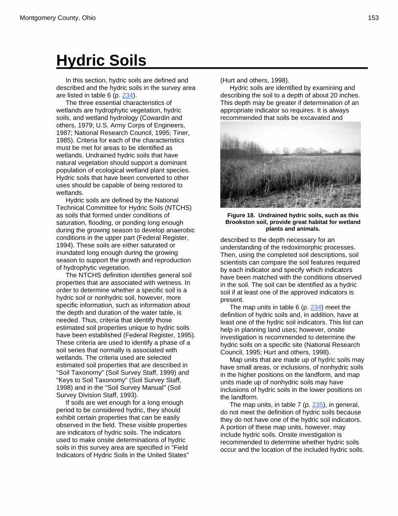
Montgomery County, Ohio 153
Hydric Soils
In this section, hydric soils are defined and described and the hydric soils in the survey area are listed in table 6 (p. 234).
The three essential characteristics of wetlands are hydrophytic vegetation, hydric soils, and wetland hydrology (Cowardin and others, 1979; U.S. Army Corps of Engineers, 1987; National Research Council, 1995; Tiner, 1985). Criteria for each of the characteristics must be met for areas to be identified as wetlands. Undrained hydric soils that have natural vegetation should support a dominant population of ecological wetland plant species. Hydric soils that have been converted to other uses should be capable of being restored to wetlands.
Hydric soils are defined by the National Technical Committee for Hydric Soils (NTCHS) as soils that formed under conditions of saturation, flooding, or ponding long enough during the growing season to develop anaerobic conditions in the upper part (Federal Register, 1994). These soils are either saturated or inundated long enough during the growing season to support the growth and reproduction of hydrophytic vegetation.
The NTCHS definition identifies general soil properties that are associated with wetness. In order to determine whether a specific soil is a hydric soil or nonhydric soil, however, more specific information, such as information about the depth and duration of the water table, is needed. Thus, criteria that identify those estimated soil properties unique to hydric soils have been established (Federal Register, 1995). These criteria are used to identify a phase of a soil series that normally is associated with wetlands. The criteria used are selected estimated soil properties that are described in "Soil Taxonomy" (Soil Survey Staff, 1999) and "Keys to Soil Taxonomy" (Soil Survey Staff, 1998) and in the "Soil Survey Manual" (Soil Survey Division Staff, 1993).
If soils are wet enough for a long enough period to be considered hydric, they should exhibit certain properties that can be easily observed in the field. These visible properties are indicators of hydric soils. The indicators used to make onsite determinations of hydric soils in this survey area are specified in "Field Indicators of Hydric Soils in the United States"
(Hurt and others, 1998). Hydric soils are identified by examining and
describing the soil to a depth of about 20 inches. This depth may be greater if determination of an appropriate indicator so requires. It is always recommended that soils be excavated and
Figure 18. Undrained hydric soils, such as this
Brookston soil, provide great habitat for wetland plants and animals.
described to the depth necessary for an understanding of the redoximorphic processes. Then, using the completed soil descriptions, soil scientists can compare the soil features required by each indicator and specify which indicators have been matched with the conditions observed in the soil. The soil can be identified as a hydric soil if at least one of the approved indicators is present.
The map units in table 6 (p. 234) meet the definition of hydric soils and, in addition, have at least one of the hydric soil indicators. This list can help in planning land uses; however, onsite investigation is recommended to determine the hydric soils on a specific site (National Research Council, 1995; Hurt and others, 1998).
Map units that are made up of hydric soils may have small areas, or inclusions, of nonhydric soils in the higher positions on the landform, and map units made up of nonhydric soils may have inclusions of hydric soils in the lower positions on the landform.
The map units, in table 7 (p. 235), in general, do not meet the definition of hydric soils because they do not have one of the hydric soil indicators. A portion of these map units, however, may include hydric soils. Onsite investigation is recommended to determine whether hydric soils occur and the location of the included hydric soils.

154 Soil Survey
Soil Quality Prepared by Natural Resources Conservation Service, Soil Quality Institute, Ames, Iowa.
SOIL QUALITY is how well soil does what we want it to do. More specifically, soil quality is the capacity of a specific kind of soil to function, within natural or managed ecosystem boundaries, to sustain plant and animal productivity, maintain or enhance water and air quality, and support human health and habitation.
People have different ideas of what a quality soil
is. For example: for people active in production agriculture, it may mean highly productive land, sustaining or enhancing productivity, maximizing profits, or maintaining the soil resource for future generations; for consumers, it may mean plentiful, healthful, and inexpensive food for present and future generations; for naturalists, it may mean
soil in harmony with the landscape and its surroundings; for the environmentalist, it may mean soil functioning at its potential in an ecosystem with respect to maintenance or enhancement of biodiversity, water quality, nutrient cycling, and biomass production. What Does Soil Do?
Healthy soil gives us clean air and water, bountiful crops and forests, productive rangeland, diverse wildlife, and beautiful landscapes. Soil does all this by performing five essential functions: • Regulating water. Soil helps control where
rain, snowmelt, and irrigation water goes. Water and dissolved solutes flow over the land or into and through the soil.
• Sustaining plant and animal life. The diversity and productivity of living things depends on soil.
• Filtering potential pollutants. The minerals and microbes in soil are responsible for filtering, buffering, degrading, immobilizing, and detoxifying organic and inorganic materials, including industrial and municipal by-products and atmospheric deposits.
• Cycling nutrients. Carbon, nitrogen, phosphorus, and many other nutrients are stored, transformed, and cycled through soil.
• Supporting structures. Buildings need stable soil for support, and archeological treasures associated with human habitation are protected in soils.
Here are some examples of indicators of soil quality:
Indicator Relationship to Soil Health
Soil organic matter (SOM) Soil fertility, structure, stability, nutrient retention; soil erosion.
PHYSICAL: Soil structure, depth of soil, Infiltration and bulk density; water holding capacity
Retention and transport of water and nutrients; habitat for microbes; estimate of crop productivity potential; compaction, plow pan, water movement; porosity; workability.
CHEMICAL: pH; electrical conductivity; extractable N-P-K
Biological and chemical activity thresholds; plant and microbial activity thresholds; plant available nutrients and potential for N and P loss.
BIOLOGICAL: Microbial biomass C and N; potentially mineralizable N; soil respiration.
Microbial catalytic potential and repository for C and N; soil productivity and N supplying potential; microbial activity measure
Figure 19. Example of a quality soil.

Montgomery County, Ohio 155
Soil Has Both Inherent and Dynamic Quality.
Inherent soil quality is a soil’s natural ability to function. For example, sandy soils drain faster than clayey soils. Deep soils will have more room for roots than soils with bedrock near the surface. These characteristics do not change easily.
Dynamic soil quality is how soil changes depending on how it is managed. Management choices affect the amount of soil organic matter, soil structure, soil depth, water and nutrient holding capacity. One goal of soil quality research is to learn how to manage soil in a way that improves soil function. Soils respond differently to management depending on the inherent properties of the soil and the surrounding landscape. Soil Quality is Linked to Sustainability.
Understanding soil quality means assessing and managing soil so that it functions optimally now and is not degraded for future use. By monitoring changes in soil quality, a land manager can determine if a set of practices are sustainable. Assessing Soil Quality
Soil quality is an assessment of how well soil performs all of its functions. It cannot be determined by measuring only crop yield, water quality, or any other single outcome. The quality of a soil is an assessment of how it performs all of its functions now and how those functions are being preserved for future use.
Soil quality cannot be measured directly, so we evaluate indicators. Indicators are measurable properties of soil or plants that provide clues about how well the soil can function. Indicators can be physical, chemical, and biological characteristics. Useful indicators :
• are easy to measure • measure changes in soil functions • encompass chemical, biological, and
physical properties • are accessible to many users and
applicable to field conditions • are sensitive to variations in climate
and management.
Indicators can be assessed by qualitative or quantitative techniques. After measurements are collected, they can be evaluated by looking for patterns and comparing results to measurements taken at a different time or field. Soil Quality is Not an End in Itself.
The ultimate purpose of researching and assessing soil quality is not to achieve high aggregate stability, biological activity, or some other soil property. The purpose is to protect and improve long-term agricultural productivity, water quality, and habitats of all organisms including people. We use soil characteristics as indicators of soil quality, but in the end, soil quality must be identified by how it performs its functions. Managing for Soil Quality
Each combination of soil type and land use calls for a different set of practices to enhance soil quality. Yet, several principles apply in most situations. 1. Add organic matter. Regular additions of
organic matter are linked to many aspects of soil quality. Organic matter may come from crop residues at the surface, roots of cover crops, animal manure, green manure, compost, and others. Organic matter, and the organisms that eat it, can improve water holding capacity, nutrient availability, and can help protect against erosion.
2. Avoid excessive tillage. Tillage has positive
effects, but it also triggers excessive organic matter degradation, disrupts soil structure, and can cause compaction. For more information about conservation tillage, visit the Conservation Tillage Information Center site.
3. Carefully manage fertilizer and pesticide use.
In this century, pesticides and chemical fertilizers have revolutionized U.S. agriculture. In addition to their desired effects, they can harm non-target organisms and pollute water and air if they are mismanaged. Nutrients from organic sources also can become pollutants when misapplied or over-applied. On the positive side, fertilizer can increase plant growth and the amount of organic matter returned to the soil.
4. Increase ground cover. Bare soil is
susceptible to wind and water erosion, and to

156 Soil Survey
drying and crusting. Ground cover protects soil, provides habitats for larger soil organisms, such as insects and earthworms, and can improve water availability. Cover crops, perennials, and surface residue increase the amount of time that the soil surface is covered each year.
5. Increase plant diversity. Diversity is
beneficial for several reasons. Each crop contributes a unique root structure and type of residue to the soil. A diversity of soil
organisms can help control pest populations, and a diversity of cultural practices can reduce weed and disease pressures. Diversity across the landscape and over time can be increased by using buffer strips, small fields, contour strip cropping, crop rotations, and by varying tillage practices. Changing vegetation across the landscape or over time increases plant diversity, and the types of insects, microorganisms, and wildlife that live on your farm.

Montgomery County, Ohio 157
Use and Management of the Soils
This soil survey is an inventory and evaluation of the soils in the survey area. It can be used to adjust land uses to the limitations and potentials of natural resources and the environment. Also, it can help to prevent soil-related failures in land uses. In preparing a soil survey, soil scientists, conservationists, engineers, and others collect extensive field data about the nature and behavioral characteristics of the soils. They collect data on erosion, droughtiness, flooding, and other factors that affect various soil uses and management. Field experience and collected data on soil properties and performance are used as a basis in predicting soil behavior.
Information in this section can be used to plan the use and management of soils for crops and pasture; as woodland; as sites for buildings, sanitary facilities, highways and other transportation systems, and parks and other recreational facilities; and for wildlife habitat. It can be used to identify the potentials and limitations of each soil for specific land uses and to help prevent construction failures caused by unfavorable soil properties. Interpretative ratings help engineers, planners, and others understand how soil properties influence important nonagricultural uses, such as building site development and construction materials. The ratings indicate the most restrictive soil features affecting the suitability of the soils for these uses. Soils are rated in their natural state. No unusual modification of the soil site or material is made other than that which is considered normal practice for the rated use. Even though soils may have limitations, it is important to remember that engineers and others can modify soil features or can design or adjust the plans for a structure to compensate for most of the limitations. Most of these practices, however, are costly. The final decision in selecting a site for a particular use generally involves weighing the costs of site preparation and maintenance. Planners and others using soil survey information can evaluate the effect of specific land uses on productivity and on the environment in all or part of the survey area. The survey can help planners to maintain or create a land use pattern in harmony with the natural soil.
Contractors can use this survey to locate sources of sand and gravel, roadfill, and topsoil. They can use it to identify areas where bedrock, wetness, or very firm soil layers can cause difficulty in excavation.
Health officials, highway officials, engineers, and others may also find this survey useful. The survey can help them plan the safe disposal of wastes and locate sites for pavements, sidewalks, campgrounds, playgrounds, lawns, and trees and shrubs. The classification of the soils in this survey area are shown in table 33 (p. 496). The extent of the soils are shown in table 4 (p. 231). Interpretive Ratings
The interpretive tables in this survey rate the soils in the survey area for various uses. Many of the tables identify the limitations that affect specified uses and indicate the severity of those limitations. The ratings in these tables are both verbal and numerical. Rating Class Terms
Rating classes are expressed in the tables in terms that indicate the extent to which the soils are limited by all of the soil features that affect a specified use or in terms that indicate the suitability of the soils for the use. Thus, the tables may show limitation classes or suitability classes. Terms for the limitation classes are not limited, somewhat limited, and very limited. The suitability ratings are expressed as well suited, moderately suited, poorly suited, and unsuited or as good, fair, and poor. Numerical Ratings
Numerical ratings in the tables indicate the relative severity of individual limitations. The ratings are shown as decimal fractions ranging from 0.00 to 1.00. They indicate gradations between the point at which a soil feature has the greatest negative impact on the use and the point at which the soil feature is not a limitation. The limitations appear in order from the most limiting to the least limiting. Thus, if more than one limitation is identified, the most severe limitation is listed first and the least severe one is listed last. Cropland Limitations and Hazards The management concerns affecting the use of the detailed map units in the survey area for crops are shown in table 8 (p. 239). The main concerns in managing nonirrigated cropland are

158 Soil Survey
controlling flooding and water erosion, preventing groundwater pollution, removing excess water, reducing surface crusting, reducing compaction, and maintaining soil tilth, organic matter, and fertility. Generally, a combination of several practices is needed to control water erosion. Conservation tillage, stripcropping, contour farming, conservation cropping systems, crop residue management, diversions, and grassed waterways help to prevent excessive soil loss. Surface and/or subsurface drainage is used to remove excess water, lower seasonal high water tables, and to reduce ponding. A surface crust forms in tilled areas after hard rains and may inhibit seedling emergence. Regular additions of crop residue, manure, or other organic materials help to improve soil structure and minimize crusting. Tilling within the proper range in moisture content minimizes compaction. Measures that are effective in maintaining soil tilth, organic matter, and fertility include applying fertilizer, both organic and inorganic, including manure; incorporating crop residue or green manure crops into the soil; and using proper crop rotations. Controlling erosion helps
to prevent the loss of organic matter and plant nutrients and thus helps to maintain productivity, although the level of fertility can be reduced even in areas where erosion is controlled. All soils used for nonirrigated crops respond well to applications of fertilizer.
Some of the limitations and hazards shown in the table cannot be easily overcome. These are flooding, ponding, slope, limited organic matter content, and depth to bedrock.
Flooding.—Flooding can damage winter grain and forage crops. A tillage method that partly covers crop residue and leaves a rough or ridged surface helps to prevent removal of crop residue by floodwater. Tilling and planting should be delayed in the spring until flooding is no longer a hazard.
Ponding.—Surface drains helps to remove excess surface water and reduce damage from ponding.
Slope.—Where the slope is more than 25 percent, water erosion is excessive. The selection of crops and use of equipment is limited. Cultivation may be restricted.
Limited organic matter content.—Many soils that have a light colored surface layer have a low or moderately low organic matter content and
Figure 20. Steep to very steep Hennepin soils can be severely eroded if not managed properly.
Montgomery County, Ohio 159
weak or moderate structure. Regularly adding crop residue, manure, and other organic matter materials to the soil maintains or improves the organic matter content and the soil structure.
Depth to bedrock.—Rooting depth and available moisture may be limited by bedrock within a depth of 40 inches.
Additional limitations and hazards are as
follows: Potential for groundwater pollution.—This is
a hazard in soils with excessive permeability, moderately deep or shallow bedrock, or a water table within the profile.
Limited available water capacity, poor tilth, restricted permeability, and surface crusting.—These limitations can be overcome by incorporating green manure crops, manure, or crop residue into the soil; applying a system of conservation tillage; and using conservation cropping systems.
Frost action.—Frost action can damage deep rooted legumes and some small grains.
Sandy layers.—Deep leaching of nutrients and pesticides may result from sandy layers. Crops generally respond better to smaller, more frequent applications of fertilizer and lime than to one large application.
Clodding. —Clods may inhibit germination, reduce water infiltration and increase runoff.
Subsidence of the muck. —Subsidence or shrinking occurs as a result of oxidation in the muck after the soil is drained. Control of the water table by subirrigation through subsurface drain lines reduces the hazards of subsidence, burning, and soil blowing.
High clay content.—The high clay content in the soil reduces rooting depth and water movement.
Root restrictive layers.—Root restrictive layers limit root growth and water movement.
Excessive alkalinity.—High pH in the upper part of the soil may inhibit plant growth and reduce availability of potassium and micronutrients.
Excessive acidity.—Low pH in the upper part of the soil may increase concentrations of aluminum and manganese and may injure plants.
Gravelly surface.—This limitation causes rapid wear of tillage equipment. It cannot be easily overcome.
Stony surface.—Stones or boulders on the surface can hinder normal tillage unless they are removed. Following is an explanation of the criteria used to determine the limitations or hazards
for cropland. Easily eroded.—The surface K factor multiplied by the relative value of the slope is more than 2 (same as prime farmland criteria). (See table 29 for K factors.) Erosion hazard.—The relative value of the slope is greater than 2. Frequent flooding.—The component of the map unit is frequently flooded.
Occasional flooding.—The component of the map unit is occasionally flooded. Limited available water capacity.—The available water capacity calculated to a depth of 60 inches or to a root-limiting layer is 6 inches or less. Ponding.—Ponding duration is assigned to the component of the map unit. Ponded for extended periods.—Very long ponding duration is assigned to the component of the map unit. Gravelly surface. —The surface texture has flaggy, very flaggy, extremely flaggy, very gravelly, extremely gravelly, or very channery modifier. Stony surface.—The surface texture has bouldery, very bouldery, extremely bouldery, stony, very stony, extremely stony, cobbly, very cobbly, or extremely cobbly modifier. Sandy layers.—The family particle size is sandy, sandy or sandy-skeletal, sandy over loamy, sandy over clayey, sandy-skeletal, sandy-skeletal over clayey, or sandy-skeletal over loamy; or the subgroup is Arenic or Psammentic; or the suborder is Psamments. Depth to bedrock.—Bedrock is at a depth of less than 40 inches. High potential for groundwater pollution.—Hard bedrock is within a depth of 40 inches, or permeability is more than 6 inches per hour in some layer within a depth of 80 inches and is not 0.2 inch per hour or less in some layer within that depth. Moderate potential for groundwater pollution.—An apparent water table is within a depth of 4 feet, or permeability is moderately rapid in some layer between depths of 24 and 60 inches and is not 0.2 inch per hour or less in some layer within a depth of 80 inches. Poor tilth. —The component of the map unit is severely eroded, has less than 1 percent organic matter in the surface layer, or 35 percent or more clay in the surface layer. Fair tilth.—The component of the map unit has a silty clay loam or clay loam surface layer and less than 35 percent clay or moderately eroded and a silt loam or loam surface texture. Excessive acidity.—The upper range of the soil

160 Soil Survey
pH is less than 4.5 within 40 inches. Excessive alkalinity.—The lower range of the
soil pH is more than 7.9 within 40 inches. Restricted permeability.—Permeability is 0.06 inches per hour or less within 40 inches and a seasonal high water table is within 18 inches.
Seasonal high water table.—The seasonal high water table is within a depth of 18 inches. Excessive slope.—The upper slope range of the component of the map unit is more than 25 percent. Surface crusting.—The organic matter content of the surface layer is less than or equal to 3 percent and the texture is silt loam or silty clay loam.
Surface compaction. —The component of the map unit has a silt loam, silty clay loam, clay loam, clay, or silty clay surface layer. Frost action.—The component of the map unit has a high potential frost action. Part of surface removed.—The surface layer of the component of the map unit is moderately eroded. Most of surface removed.—The surface layer of the component of the map unit is severely eroded.
Subsidence of the muck. —The organic matter content of the surface layer of the component of the map unit is greater than or equal to 20 percent. Wind erosion.—The upper range of the slope is less than or equal to 25 percent and the wind erodibility group is 1, 2, or 3. (See table 29 for wind erodibility group values.) Clodding. —The relative value of the total clay in the surface layer is greater than 32 percent. Root restrictive layer.—Fragipan or dense material within 40 inches. High clay content.—A layer within 40 inches of the surface has clay content that averages between 40 and 60 percent. Very high clay content. —A layer within 40 inches of the surface has clay content that averages more than 60 percent. Crops and Pasture
General management needed for crops and pasture is suggested in this section. The system of land capability classification used by the Natural Resources Conservation Service is explained below.
Planners of management systems for individual fields or farms should consider the detailed information given in the description of each soil under the heading "Detailed Soil Map
Units." Specific information can be obtained from the local office of the Natural Resources Conservation Service or the Cooperative Extension Service.
Figure 11. Erosion is a concern even on gently sloping topography such as this Celina soil.
Crop Yield Index
Table 9 (p. 245) is the crop yield index for
Montgomery County. The yield index reflects the yield potential of a soil in relation to other soils in the county. It is based on the most productive soil, Bs—Brookston silty clay loam, receiving a rating of 100, and other soils are ranked against this standard.
The yields used to calculate the index values are based on using good management practices.
To calculate estimated yields, use the yield index number as a percentage, and multiply it by the crop yield in the table header. For example, to calculate estimated corn yield for Bp, multiply 0.92 by the corn yield in the table header, which is 125. 0.92 x 125 = 115 bushels of corn estimated for Bp.
To use this yield index in the future to calculate estimated yields, use current yield data. Additional information on calculating estimated yields can be obtained from the local office of the

Montgomery County, Ohio 161
Natural Resources Conservation Service or the Cooperative Extension Service.
Land Capability Classification
Land capability classification shows, in a general way, the suitability of soils for most kinds of field crops. Crops that require special management are excluded. The soils are grouped according to their limitations for field crops, the risk of damage if they are used for crops, and the way they respond to management. The criteria used in grouping the soils do not include major and generally expensive landforming that would change slope, depth, or other characteristics of the soils, nor do they include possible but unlikely major reclamation projects. Capability classification is not a substitute for interpretations designed to show suitability and limitations of groups of soils for woodland, or for engineering purposes.
In the capability system, soils are generally grouped at three levels—capability class, subclass, and unit.
Capability classes, the broadest groups, are designated by the numbers 1 through 8. The numbers indicate progressively greater limitations and narrower choices for practical use. The classes are defined as follows: Class 1 soils have slight limitations that restrict
their use. Class 2 soils have moderate limitations that
restrict the choice of plants or that require moderate conservation practices.
Class 3 soils have severe limitations that restrict the choice of plants or that require special conservation practices, or both.
Class 4 soils have very severe limitations that restrict the choice of plants or that require very careful management, or both.
Class 5 soils are subject to little or no erosion but have other limitations, impractical to remove, that restrict their use mainly to pasture, woodland, or wildlife habitat. Class 6 soils have severe limitations that make them generally unsuitable for cultivation and that restrict their use mainly to pasture, woodland, or wildlife habitat.
Class 7 soils have very severe limitations that make them unsuitable for cultivation and that restrict their use mainly to grazing, woodland, or wildlife habitat.
Class 8 soils and miscellaneous areas have limitations that preclude commercial plant production and that restrict their use to recreational purposes, wildlife habitat, watershed, or aesthetic purposes.
Capability subclasses are soil groups within one class. They are designated by adding a small letter, e, w, s, or c, to the class numeral, for example, 2e. The letter e shows that the main hazard is the risk of erosion unless close-growing plant cover is maintained; w shows that water in or on the soil interferes with plant growth or cultivation (in some soils the wetness can be partly corrected by artificial drainage); s shows that the soil is limited mainly because it is shallow, droughty, or stony; and c, used in only some parts of the United States, shows that the chief limitation is climate that is very cold or very dry.
In class 1 there are no subclasses because the soils of this class have few limitations. Class 5 contains only the subclasses indicated by w, s, or c because the soils in class 5 are subject to little or no erosion. They have other limitations that restrict their use to pasture, woodland, wildlife habitat, or recreation.
The acreage of soils in each capability class or subclass is shown in table 10 (p. 249). The capability classification of map units in this survey area is given in the section "Detailed Soil Map Units" and in the yields table. Pasture and Hayland Suitability Groups
The pasture and hayland suitability group
symbol for each soil is listed in each map unit description under the "Component interpretative groups" heading and in table 34 (p. 497). Soils assigned the same suitability group symbol require the same general management and have about the same potential productivity. The pasture and hayland suitability groups are organized by soil characteristics and limitations. The groups are defined as follows: Group A soils have few limitations affecting the
management and growth of climatically adapted plants.
Group A-1 consists of deep and very deep, well and moderately well drained soils. The available water capacity ranges from moderate to very high. Slopes range from 0 to 18 percent. Plants on these soils respond well to additions of lime. Frequent applications may be needed to maintain an adequate pH level. A low pH level in the subsoil shortens the life of some deep-rooted legumes.
Group A-2 consists of deep and very deep, well and moderately well drained soils. Available water capacity ranges from moderate to very high. Plants on these soils respond well to additions of lime. Frequent applications may be needed to maintain an adequate pH level.
162 Soil Survey
A low pH level in the subsoil shortens the life of some deep-rooted legumes. Slopes range from 18 to 25 percent. They may interfere with clipping, mowing, and spraying for weed control. The slopes increase the risk of erosion if the pasture is overgrazed or cultivated for reseeding. These soils are suited to no-till reseeding and interseeding.
Group A-3 consists of deep and very deep, well and moderately well drained soils. Available water capacity ranges from moderate to very high. Slopes range from 25 to 40 percent. These soils are not suited to pasture or hay, but some grass pasture is produced.
Group A-4 consists of deep and very deep, well and moderately well drained soils that have stones or boulders on the surface that are extensive enough to preclude the use of hay making equipment. Slopes range from 0 to 40 percent.
Group A-5 consists of well and moderately well drained soils that are subject to flooding. Grazing is limited during periods of stream overflow. The floodwater deposits sediments that lower the quality of the forage. The available water capacity ranges from moderate to very high. Slopes range from 0 to 18 percent.
Group A-6 consists of deep and very deep, well and moderately well drained soils that are subject to frost action, which can damage legumes. Mixing fibrous-rooted grasses with the legumes and applying good grazing management minimize the damage caused by frost action. The available water capacity ranges from moderate to very high. Slopes range from 0 to 18 percent.
Group B soils are limited because of
droughtiness. Group B-1 consists of deep and very deep, well
and moderately well drained soils. The available water capacity is low or very low and limits forage growth and production. Slopes range from 0 to 25 percent.
Group B-2 consists of deep and very deep, well and moderately well drained soils. The available water capacity is low or very low and limits forage growth and production. Slopes range from 25 to 40 percent.
Group B-3 consists of somewhat poorly drained to well drained soils that are subject to flooding. Slopes range from 0 to 6 percent.
Group B-4 consists of deep and very deep, well and moderately well drained reclaimed mine soils. The available water capacity is low or very low. Slopes range from 0 to 25 percent. The substratum contains a high
percentage of rock fragments. The rooting zone is 20 to 30 inches deep.
Group C soils are wet because of a seasonal high
water. Group C-1 consists of deep and very deep
somewhat poorly drained, poorly drained, and very poorly drained soils. These soils normally respond well to subsurface drainage. Slopes range from 0 to 12 percent.
Group C-2 consists of deep and very deep somewhat poorly drained, poorly drained, and very poorly drained soils. The seasonal high water table limits the rooting depth of deep-rooted forage plants. Shallow-rooted species grow best on these soils. Subsurface drains are used to lower the seasonal high water table. The effectiveness of subsurface drainage is usually limited by permeability of the subsoil, high amounts of clay in the subsoil, or a fragipan. Because of the limited root zone, these soils are better suited to forage species that do not have a taproot than to other species. Slopes range from 0 to 12 percent.
Group C-3 consists of somewhat poorly drained, poorly drained, and very poorly drained soils that are subject to flooding. Grazing is limited during periods of stream overflow. The available water capacity ranges from moderate to very high. Slopes range from 0 to 6 percent. The seasonal high water table limits the rooting depth of forage plants. Shallow-rooted species grow best on these soils.
Group D soils have a high organic matter content. Group D-1 consists of soils formed entirely or
partially in organic material. Slope is 0 to 2 percent.
Group E consists of shallow soils in which the root
zone is less than 20 inches deep. Group E-1 consists of soils that are shallow or
very shallow. The available water capacity is low or very low. It restricts forage production. These soils are well suited to native warm-season grasses. Slopes range from 0 to 25 percent.
Group E-2 consists of soils that have are shallow and very shallow or have a high bulk density and cobbles and stones in the upper part. The available water capacity is low or very low. Slopes range from 25 to 40 percent. Shallow-rooted species should be selected for planting.
Group E-3 soils have a high bulk density and cobbles and stones in the upper part. The

Montgomery County, Ohio 163
available water capacity is low or very low. Slopes range from 0 to 25 percent.
Group F consists of soils that have a root zone
that extends to a depth of 20 to 40 inches. These soils are better suited to forage species that do not have a taproot than to other species.
Group F-1 consists of moderately deep, well and moderately well drained soils. Slopes range from 0 to 25 percent.
Group F-2 consists of moderately deep, well and moderately well drained soils. Slopes range from 25 to 40 percent. This group generally is not suited to hay.Group F-3 consists of well and moderately well drained soils that are moderately deep to a fragipan. Slopes range from 0 to 25 percent.
Group F-4 consists of well and moderately well drained soils that are moderately deep to a fragipan. Slopes range from 25 to 40 percent.
Group F-5 consists of well and moderately well drained soils with high bulk density, a high clay content, slow permeability or a combination of these factors in the subsoil that restrict rooting depth. Slopes range from 0 to 25 percent.
Group F-6 consists of well and moderately well drained soils with high bulk density, a high clay content, slow permeability or a combination of these factors in the subsoil that restrict rooting depth. Slopes range from 25 to 40 percent.
Group F-7 consists of somewhat poorly drained, poorly drained, and very poorly drained soils with a high clay content and very slow permeability in the subsoil that restrict rooting depth. Slopes range from 0 to 12 percent.
Group G soils have chemical properties that are
unfavorable for many climatically adapted plants.
Group G-1 consists of well and moderately well drained soils that are shallow or moderately deep to toxic spoil from surface mine operations. Available water capacity is low or very low in the root zone. Slopes range from 0 to 25 percent.
Group G-2 consists of well and moderately well drained soils that are shallow or moderately deep to toxic spoil from surface mine operations. Slopes range from 25 to 40 percent.
Group H soils are toxic or too steep for forage
production.
Group H-1 consists of soils toxic materials from surface mining operation or on slopes greater than or equal to 40 percent. These soils generally are unsuited to pasture and hay.
Woodland Management and Productivity
The tables in this section can help woodland
owners or managers plan the use of soils for wood crops. They show the potential productivity of the soils for wood crops and rate the soils according to the limitations that affect various aspects of woodland management.
Woodland Management
In table 11 (p. 250), table 12 (p. 258), and
table 13 (p. 268), interpretive ratings are given for various aspects of woodland management. The ratings are both verbal and numerical.
Some rating class terms indicate the degree to which the soils are suited to a specified woodland management practice. Well suited indicates that the soil has features that are favorable for the specified practice and has no limitations. Good performance can be expected, and little or no maintenance is needed. Moderately suited indicates that the soil has features that are moderately favorable for the specified practice. One or more soil properties are less than desirable, and fair performance can be expected. Some maintenance is needed. Poorly suited indicates that the soil has one or more properties that are unfavorable for the specified practice. Overcoming the unfavorable properties requires special design, extra maintenance, and costly alteration. Unsuited indicates that the expected performance of the soil is unacceptable for the specified practice or that extreme measures are needed to overcome the undesirable soil properties.
Numerical ratings in the tables indicate the severity of individual limitations. The ratings are shown as decimal fractions ranging from 0.01 to 1.00. They indicate gradations between the point at which a soil feature has the greatest negative impact on the specified woodland management practice (1.00) and the point at which the soil feature is not a limitation (0.00).
Rating class terms for fire damage and seedling mortality are expressed as low, moderate, and high. Where these terms are used, the numerical ratings indicate gradations between the point at which the potential for fire damage or seedling mortality is highest (1.00) and the point at which the potential is lowest (0.00).
The paragraphs that follow indicate the soil properties considered in rating the soils for
164 Soil Survey
woodland management practices. More detailed information about the criteria used in the ratings is available in the "National Forestry Manual," which is available in local offices of the Natural Resources Conservation Service or on the Internet .
Ratings in the column erosion hazard are based on slope and on soil erodibility factor K. The soil loss is caused by sheet or rill erosion in off-road or off-trail areas where 50 to 75 percent of the surface has been exposed by logging, grazing, mining, or other kinds of disturbance. The hazard is described as slight, moderate, severe, or very severe. A rating of slight indicates that erosion is unlikely under ordinary climatic conditions; moderate indicates that some erosion is likely and that erosion-control measures may be needed; severe indicates that erosion is very likely and that erosion-control measures, including revegetation of bare areas, are advised; and very severe indicates that significant erosion is expected, loss of soil productivity and off–site damage are likely, and erosion–control measures are costly and generally impractical.
Ratings in the column seedling mortality are based on flooding, ponding, depth to a water table, content of lime, reaction, salinity, available water capacity, soil moisture regime, soil temperature regime, aspect, and slope. The soils are described as having a low, moderate, or high potential for seedling mortality.
Ratings in the column soil rutting hazard are based on depth to a water table, rock fragments on or below the surface, the Unified classification, depth to a restrictive layer, and slope. Ruts form as a result of the operation of woodland equipment. The hazard is described as slight, moderate, or severe. A rating of slight indicates that the soil is subject to little or no rutting, moderate indicates that rutting is likely, and severe indicates that ruts form readily.
For limitations affecting construction of haul roads and log landings, the ratings are based on slope, flooding, permafrost, plasticity index, the hazard of soil slippage, content of sand, the Unified classification, rock fragments on or below the surface, depth to a restrictive layer that is indurated, depth to a water table, and ponding. The limitations are described as slight, moderate, or severe. A rating of slight indicates that no significant limitations affect construction activities, moderate indicates that one or more limitations can cause some difficulty in construction, and severe indicates that one or more limitations can make construction very difficult or very costly.
Ratings in the column suitability for roads
(natural surface) are based on slope, rock fragments on the surface, plasticity index, content of sand, the Unified classification, depth to a water table, ponding, flooding, and the hazard of soil slippage. The ratings indicate the suitability for using the natural surface of the soil for roads. The soils are described as well suited, moderately suited, or poorly suited to this use.
Ratings in the column harvest equipment operability are based on slope, rock fragments on the surface, plasticity index, content of sand, the Unified classification, depth to a water table, and ponding. The soils are described as well suited, moderately suited, or poorly suited to this use.
Ratings in the column suitability for mechanical planting are based on slope, depth to a restrictive layer, content of sand, plasticity index, rock fragments on or below the surface, depth to a water table, and ponding. The soils are described as well suited, moderately suited, poorly suited, or unsuited to these methods of planting. It is assumed that necessary site preparation is completed before seedlings are planted.
Ratings in the column suitability for site preparation are based on slope, depth to a restrictive layer, plasticity index, rock fragments on or below the surface, depth to a water table, and ponding. The soils are described as well suited, poorly suited, or unsuited to this management activity. The part of the soil from the surface to a depth of about 1 foot is considered in the ratings.
Ratings in the column potential for damage to soil by fire are based on texture of the surface layer, content of rock fragments and organic matter in the surface layer, thickness of the surface layer, and slope. The soils are described as having a low, moderate, or high potential for this kind of damage. The ratings indicate an evaluation of the potential impact of prescribed fires or wildfires that are intense enough to remove the duff layer and consume organic matter in the surface layer. Woodland Productivity
In table 14 (p. 279), the potential productivity of merchantable or common trees on a soil is expressed as a site index and as a volume number. The site index is the average height, in feet, that dominant and codominant trees of a given species attain in a specified number of years. The site index applies to fully stocked, even-aged, unmanaged stands. Commonly grown trees are those that woodland managers generally favor in intermediate or improvement cuttings. They are selected on the basis of growth rate, quality, value, and marketability. More detailed

Montgomery County, Ohio 165
information regarding site index is available in the "National Forestry Manual," which is available in local offices of the Natural Resources Conservation Service or on the Internet.
The volume of wood fiber, a number, is the yield likely to be produced by the most important tree species. This number, expressed as cubic feet per acre per year and calculated at the age of culmination of the mean annual increment (CMAI), indicates the amount of fiber produced in a fully stocked, even-aged, unmanaged stand.
Trees to manage are those that are preferred for planting, seeding, or natural regeneration and those that remain in the stand after thinning or partial harvest. Windbreaks and Environmental Plantings
Farm and homestead windbreaks are rows of trees or shrubs established adjacent to farm buildings, feedlots, and homes. These windbreaks are usually planted perpendicular to the prevailing winter wind. Planting multiple rows of various species provides the best protection from winds and results in more varied wildlife habitat. Field windbreaks are narrow plantings made at right angles to the prevailing wind and at specific intervals across the field. The interval depends on the erodibility of the soil.
Environmental plantings help to beautify and screen houses and other buildings and to abate noise. The plants, mostly evergreen shrubs and trees, are closely spaced. To ensure plant survival, a healthy planting stock of suitable species should be planted properly on a well prepared site and maintained in good condition.
Table 15 (p. 295) shows the height that locally grown trees and shrubs are expected to reach in 20 years on various soils. The estimates in table 15 (p. 295) are based on measurements and observation of established plantings that have been given adequate care. They can be used as a guide in planning windbreaks and screens. Additional information on planning windbreaks and screens and planting and caring for trees and shrubs can be obtained from the local office of the Natural Resources Conservation Service, the Ohio Department of Natural Resources, Division of Forestry, or of the Cooperative Extension Service or from a commercial nursery. Recreational Development
The soils of the survey area are rated in table 16 (p. 304) and table 17 (p. 316) according to
limitations that affect their suitability for recreation. The ratings are both verbal and numerical. Rating class terms indicate the extent to which the soils are limited by all of the soil features that affect the recreational uses. Not limited indicates that the soil has features that are very favorable for the specified use. Good performance and very low maintenance can be expected. Somewhat limited indicates that the soil has features that are moderately favorable for the specified use. The limitations can be overcome or minimized by special planning, design, or installation. Fair performance and moderate maintenance can be expected. Very limited indicates that the soil has one or more features that are unfavorable for the specified use. The limitations generally cannot be overcome without major soil reclamation, special design, or expensive installation procedures. Poor performance and high maintenance can be expected.
Numerical ratings in the tables indicate the severity of individual limitations. The ratings are shown as decimal fractions ranging from 0.01 to 1.00. They indicate gradations between the point at which a soil feature has the greatest negative impact on the use (1.00) and the point at which the soil feature is not a limitation (0.00).
The ratings in the tables are based on restrictive soil features, such as wetness, slope, and texture of the surface layer. Susceptibility to flooding is considered. Not considered in the ratings, but important in evaluating a site, are the location and accessibility of the area, the size and shape of the area and its scenic quality, vegetation, access to water, potential water impoundment sites, and access to public sewer lines. The capacity of the soil to absorb septic tank effluent and the ability of the soil to support vegetation also are important. Soils that are subject to flooding are limited for recreational uses by the duration and intensity of flooding and the season when flooding occurs. In planning recreational facilities, onsite assessment of the height, duration, intensity, and frequency of flooding is essential.
The information in table 16 (p. 304) and table 17 (p. 316) can be supplemented by other information in this survey, for example, interpretations for building site development, construction materials, sanitary facilities, and water management.
Camp areas require site preparation, such as shaping and leveling the tent and parking areas, stabilizing roads and intensively used areas, and installing sanitary facilities and utility lines. Camp areas are subject to heavy foot traffic and some vehicular traffic. The ratings are based on the soil properties that affect the ease of developing camp

166 Soil Survey
areas and the performance of the areas after development. Slope, stoniness, and depth to bedrock or a cemented pan are the main concerns affecting the development of camp areas. The soil properties that affect the performance of the areas after development are those that influence trafficability and promote the growth of vegetation, especially in heavily used areas. For good trafficability, the surface of camp areas should absorb rainfall readily, remain firm under heavy foot traffic, and not be dusty when dry. The soil properties that influence trafficability are texture of the surface layer, depth to a water table, ponding, flooding, permeability, and large stones. The soil properties that affect the growth of plants are depth to bedrock or a cemented pan, permeability, and toxic substances in the soil.
Picnic areas are subject to heavy foot traffic. Most vehicular traffic is confined to access roads and parking areas. The ratings are based on the soil properties that affect the ease of developing picnic areas and that influence trafficability and the growth of vegetation after development. Slope and stoniness are the main concerns affecting the development of picnic areas. For good trafficability, the surface of picnic areas should absorb rainfall readily, remain firm under heavy foot traffic, and not be dusty when dry. The soil properties that influence trafficability are texture of the surface layer, depth to a water table, ponding, flooding, permeability, and large stones. The soil properties that affect the growth of plants are depth to bedrock or a cemented pan, permeability, and toxic substances in the soil.
Playgrounds require soils that are nearly level, are free of stones, and can withstand intensive foot traffic. The ratings are based on the soil properties that affect the ease of developing playgrounds and that influence trafficability and the growth of vegetation after development. Slope and stoniness are the main concerns affecting the development of playgrounds. For good trafficability, the surface of the playgrounds should absorb rainfall readily, remain firm under heavy foot traffic, and not be dusty when dry. The soil properties that influence trafficability are texture of the surface layer, depth to a water table, ponding, flooding, permeability, and large stones. The soil properties that affect the growth of plants are depth to bedrock or a cemented pan, permeability, and toxic substances in the soil.
Paths and trails for hiking and horseback riding should require little or no slope modification through cutting and filling. The ratings are based on the soil properties that
affect trafficability and erodibility. These properties are stoniness, depth to a water table, ponding, flooding, slope, and texture of the surface layer.
Off-road motorcycle trails require little or no site preparation. They are not covered with surfacing material or vegetation. Considerable compaction of the soil material is likely. The ratings are based on the soil properties that influence erodibility, trafficability, dustiness, and the ease of revegetation. These properties are stoniness, slope, depth to a water table, ponding, flooding, and texture of the surface layer.
Golf fairways are subject to heavy foot traffic and some light vehicular traffic. Cutting or filling may be required. Irrigation is not considered in the ratings. The ratings are based on the soil properties that affect plant growth and trafficability after vegetation is established. The properties that affect plant growth are reaction; depth to a water table; ponding; depth to bedrock or a cemented pan; the available water capacity in the upper 40 inches; the content of salts, sodium, or calcium carbonate; and sulfidic materials. The properties that affect trafficability are flooding, depth to a water table, ponding, slope, stoniness, and the amount of sand, clay, or organic matter in the surface layer. The suitability of the soil for traps, tees, roughs, and greens is not considered in the ratings. Wildlife Habitat
Soils affect the kind and amount of vegetation that is available to wildlife as food and cover. They also affect the construction of water impoundments. The kind and abundance of wildlife depend largely on the amount and distribution of food, cover, and water. Wildlife habitat can be created or improved by planting appropriate vegetation, by maintaining the existing plant cover, or by promoting the natural establishment of desirable plants.
In table 18 (p. 325), the soils in the survey area are rated according to their potential for providing habitat for various kinds of wildlife. This information can be used in planning parks, wildlife refuges, nature study areas, and other developments for wildlife; in selecting soils that are suitable for establishing, improving, or maintaining specific elements of wildlife habitat; and in determining the intensity of management needed for each element of the habitat.
The potential of the soil is rated good, fair, poor, or very poor. A rating of good indicates that the element or kind of habitat is easily established, improved, or maintained. Few or no limitations affect management, and satisfactory results can be expected. A rating of fair indicates

Montgomery County, Ohio 167
that the element or kind of habitat can be established, improved, or maintained in most places. Moderately intensive management is required for satisfactory results. A rating of poor indicates that limitations are severe for the designated element or kind of habitat. Habitat can be created, improved, or maintained in most places, but management is difficult and must be intensive. A rating of very poor indicates that restrictions for the element or kind of habitat are very severe and that unsatisfactory results can be expected. Creating, improving, or maintaining habitat is impractical or impossible.
The elements of wildlife habitat are described in the following paragraphs.
Grain and seed crops are domestic grains and seed-producing herbaceous plants. Soil properties and features that affect the growth of grain and seed crops are depth of the root zone, texture of the surface layer, available water capacity, wetness, slope, surface stoniness, and flooding. Soil temperature and soil moisture also are considerations. Examples of grain and seed crops are corn, wheat, oats, soybeans, and barley.
Grasses and legumes are domestic perennial grasses and herbaceous legumes. Soil properties and features that affect the growth of grasses and legumes are depth of the root zone, texture of the surface layer, available water capacity, wetness, surface stoniness, flooding, and slope. Soil temperature and soil moisture also are considerations. Examples of grasses and legumes are fescue, lovegrass, bromegrass, clover, and alfalfa.
Wild herbaceous plants are native or naturally established grasses and forbs, including weeds. Soil properties and features that affect the growth of these plants are depth of the root zone, texture of the surface layer, available water capacity, wetness, surface stoniness, and flooding. Soil temperature and soil moisture also are considerations. Examples of wild herbaceous plants are bluestem, goldenrod, beggarweed, wheatgrass, and grama.
Hardwood trees and woody understory produce nuts or other fruit, buds, catkins, twigs, bark, and foliage. Soil properties and features
that affect the growth of hardwood trees and shrubs are depth of the root zone, available water capacity, and wetness. Examples of these plants are oak, poplar, cherry, sweetgum, apple, hawthorn, dogwood, hickory, blackberry, raspberry, and blueberry. Examples of fruit-producing shrubs that are suitable for planting on soils rated good are autumn-olive, and crabapple.
Coniferous plants furnish browse and seeds. Soil properties and features that affect the growth of coniferous trees, shrubs, and ground cover are depth of the root zone, available water capacity, and wetness. Examples of coniferous plants are pine, spruce, fir, cedar, and juniper.
Wetland plants are annual and perennial wild herbaceous plants that grow on moist or wet sites. Submerged or floating aquatic plants are excluded. Soil properties and features affecting wetland plants are texture of the surface layer, wetness, reaction, salinity, slope, and surface stoniness. Examples of wetland plants are smartweed, wild millet, wildrice, saltgrass, cordgrass, rushes, sedges, and reeds.
Shallow water areas have an average depth of less than 5 feet. Some are naturally wet areas. Others are created by dams, levees, or other water-control structures. Soil properties and features affecting shallow water areas are depth to bedrock, wetness, surface stoniness, slope, and permeability. Examples of shallow water areas are marshes, waterfowl feeding areas, and ponds.
The habitat for various kinds of wildlife is described in the following paragraphs.
Habitat for openland wildlife consists of cropland, pasture, meadows, and areas that are overgrown with grasses, herbs, shrubs, and vines. These areas produce grain and seed crops, grasses and legumes, and wild herbaceous plants. Wildlife attracted to these areas include bobwhite quail, pheasant, meadowlark, field sparrow, cottontail, and red fox.
Habitat for woodland wildlife consists of areas of deciduous and/or coniferous plants and associated grasses, legumes, and wild herbaceous plants. Wildlife attracted to these areas include wild turkey, ruffed grouse, woodcock, thrushes, woodpeckers, squirrels, gray fox, raccoon, and deer.

168 Soil Survey
Habitat for wetland wildlife consists of open, marshy or swampy shallow water areas. Some of the wildlife attracted to such areas are ducks, geese, herons, shore birds, muskrat, mink, and beaver. Engineering
This section provides information for planning land uses related to urban development and to water management. Soils are rated for various uses, and the most limiting features are identified. Ratings are given for building site development, sanitary facilities, construction materials, and water management. The ratings are based on observed performance of the soils and on the data in the tables described under the heading "Soil Properties."
Information in this section is intended for land use planning, for evaluating land use alternatives, and for planning site investigations prior to design and construction. The information, however, has limitations. For example, estimates and other data generally apply only to that part of the soil between the surface and a depth of 5 to 7 feet. Because of
the map scale, small areas of different soils may be included within the mapped areas of a specific soil.
The information is not site specific and does not eliminate the need for onsite investigation of the soils or for testing and analysis by personnel experienced in the design and construction of engineering works.
Government ordinances and regulations that restrict certain land uses or impose specific design criteria were not considered in preparing the information in this section. Local ordinances and regulations should be considered in planning, in site selection, and in design. Soil properties, site features, and observed performance were considered in determining the ratings in this section. During the fieldwork for this soil survey, determinations were made about particle-size distribution, liquid limit, plasticity index, soil reaction, depth to bedrock, hardness of bedrock within 5 to 7 feet of the surface, soil wetness, depth to a water table, ponding, slope, likelihood of flooding, natural soil structure aggregation, and soil density. Data were collected about kinds of clay minerals, mineralogy of the sand and silt fractions, and the kinds of adsorbed cations.
Figure 22. Hydric soils, such as this Brookston soil, are highly productive with drainage improvements.

Montgomery County, Ohio 169
Estimates were made for erodibility, permeability, corrosivity, shrink-swell potential, available water capacity, and other behavioral characteristics affecting engineering uses. This information can be used to evaluate the potential of areas for residential, commercial, industrial, and recreational uses; make preliminary estimates of construction conditions; evaluate alternative routes for roads, streets, highways, pipelines, and underground cables; evaluate alternative sites for sanitary landfills, septic tank absorption fields, and sewage lagoons; plan detailed onsite investigations of soils and geology; locate potential sources of gravel, sand, earth fill, and topsoil; plan drainage systems, irrigation systems, ponds, terraces, and other structures for soil and water conservation; and predict performance of proposed small structures and pavements by comparing the performance of existing similar structures on the same or similar soils. The information in the tables, along with the soil maps, the soil descriptions, and other data provided in this survey, can be used to make additional interpretations. Some of the terms used in this soil survey have a special meaning in soil science and are defined in the Glossary. Construction Materials
Table 19 (p. 332) and table 20 (p. 342) give information about the soils as potential sources of gravel, sand, topsoil, reclamation material, and roadfill. Normal compaction, minor processing, and other standard construction practices are assumed.
Sand and gravel are natural aggregates suitable for commercial use with a minimum of processing. They are used in many kinds of construction. Specifications for each use vary widely. In table 19 (p. 332), only the likelihood of finding material in suitable quantity is evaluated. The suitability of the material for specific purposes is not evaluated, nor are factors that affect excavation of the material. The properties used to evaluate the soil as a source of sand or gravel are gradation of grain sizes (as indicated by the Unified classification of the soil), the thickness of suitable material, and the content of rock fragments. If the bottom layer of the soil contains sand or gravel, the soil is considered a likely source regardless of thickness. The assumption is that the sand or gravel layer below the depth of observation exceeds the minimum thickness.
The soils are rated good, fair, or poor as potential sources of sand and gravel. A rating of good or fair means that the source material is
likely to be in or below the soil. The bottom layer and the thickest layer of the soils are assigned numerical ratings. These ratings indicate the likelihood that the layer is a source of sand or gravel. The number 0.00 indicates that the layer is a poor source. The number 1.00 indicates that the layer is a good source. A number between 0.00 and 1.00 indicates the degree to which the layer is a likely source.
The soils are rated good, fair, or poor as potential sources of reclamation material, roadfill, and topsoil. The features that limit the soils as sources of these materials are specified in the tables. The numerical ratings given after the specified features indicate the degree to which the features limit the soils as sources of reclamation material, roadfill, or topsoil. The lower the number, the greater the limitation.
Reclamation material is used in areas that have been drastically disturbed by surface mining or similar activities. When these areas are reclaimed, layers of soil material or unconsolidated geological material, or both, are replaced in a vertical sequence. The reconstructed soil favors plant growth. The ratings in the table do not apply to quarries and other mined areas that require an offsite source of reconstruction material. The ratings are based on the soil properties that affect erosion and stability of the surface and the productive potential of the reconstructed soil. These properties include the content of sodium, salts, and calcium carbonate; reaction; available water capacity; erodibility; texture; content of rock fragments; and content of organic matter and other features that affect fertility.
Roadfill is soil material that is excavated in one place and used in road embankments in another place. In this table, the soils are rated as a source of roadfill for low embankments, generally less than 6 feet high and less exacting in design than higher embankments.
The ratings are for the whole soil, from the surface to a depth of about 5 feet. It is assumed that soil layers will be mixed when the soil material is excavated and spread.
The ratings are based on the amount of suitable material and on soil properties that affect the ease of excavation and the performance of the material after it is in place. The thickness of the suitable material is a major consideration. The ease of excavation is affected by large stones, depth to a water table, and slope. How well the soil performs in place after it has been compacted and drained is determined by its strength (as inferred from the AASHTO classification of the soil) and linear extensibility (shrink-swell potential).

170 Soil Survey
Topsoil is used to cover an area so that vegetation can be established and maintained. The upper 40 inches of a soil is evaluated for use as topsoil. Also evaluated is the reclamation potential of the borrow area. The ratings are based on the soil properties that affect plant growth; the ease of excavating, loading, and spreading the material; and reclamation of the borrow area. Toxic substances, soil reaction, and the properties that are inferred from soil texture, such as available water capacity and fertility, affect plant growth. The ease of excavating, loading, and spreading is affected by rock fragments, slope, depth to a water table, soil texture, and thickness of suitable material. Reclamation of the borrow area is affected by slope, depth to a water table, rock fragments, depth to bedrock or a cemented pan, and toxic material.
The surface layer of most soils is generally preferred for topsoil because of its organic matter content. Organic matter greatly increases the absorption and retention of moisture and nutrients for plant growth. Building Site Development
Soil properties influence the development of building sites, including the selection of the site, the design of the structure, construction, performance after construction, and maintenance. Table 21 (p. 358) and table 22 (p. 369) show the degree and kind of soil limitations that affect dwellings with and without basements, small commercial buildings, local roads and streets, shallow excavations, and lawns and landscaping.
The ratings in the tables are both verbal and numerical. Rating class terms indicate the extent to which the soils are limited by all of the soil features that affect building site development. Not limited indicates that the soil has features that are very favorable for the specified use. Good performance and very low maintenance can be expected. Somewhat limited indicates that the soil has features that are moderately favorable for the specified use. The limitations can be overcome or minimized by special planning, design, or installation. Fair performance and moderate maintenance can be expected. Very limited indicates that the soil has one or more features that are unfavorable for the specified use. The limitations generally cannot be overcome without major soil reclamation, special design, or expensive installation procedures. Poor performance and high maintenance can be expected. Numerical ratings in the tables indicate the severity of
individual limitations. The ratings are shown as decimal fractions ranging from 0.01 to 1.00. They indicate gradations between the point at which a soil feature has the greatest negative impact on the use (1.00) and the point at which the soil feature is not a limitation (0.00).
Dwellings are single-family houses of three stories or less. For dwellings without basements, the foundation is assumed to consist of spread footings of reinforced concrete built on undisturbed soil at a depth of 2 feet or at the depth of maximum frost penetration, whichever is deeper. For dwellings with basements, the foundation is assumed to consist of spread footings of reinforced concrete built on undisturbed soil at a depth of about 7 feet.
The ratings for dwellings are based on the soil properties that affect the capacity of the soil to support a load without movement and on the properties that affect excavation and construction costs. The properties that affect the load-supporting capacity include depth to a water table, ponding, flooding, subsidence, linear extensibility (shrink-swell potential), and compressibility. Compressibility is inferred from the Unified classification.
The properties that affect the ease and amount of excavation include depth to a water table, ponding, flooding, slope, depth to bedrock or a cemented pan, hardness of bedrock or a cemented pan, and the amount and size of rock fragments.
Small commercial buildings are structures that are less than three stories high and do not have basements. The foundation is assumed to consist of spread footings of reinforced concrete built on undisturbed soil at a depth of 2 feet or at the depth of maximum frost penetration, whichever is deeper. The ratings are based on the soil properties that affect the capacity of the soil to support a load without movement and on the properties that affect excavation and construction costs. The properties that affect the load-supporting capacity include depth to a water table, ponding, flooding, subsidence, linear extensibility (shrink-swell potential), and compressibility (which is inferred from the Unified classification). The properties that affect the ease and amount of excavation include flooding, depth to a water table, ponding, slope, depth to bedrock or a cemented pan, hardness of bedrock or a cemented pan, and the amount and size of rock fragments.
Local roads and streets have an all-weather surface and carry automobile and light truck traffic all year. They have a subgrade of cut or fill soil material; a base of gravel, crushed rock, or soil material stabilized by lime or cement; and a

Montgomery County, Ohio 171
surface of flexible material (asphalt), rigid material (concrete), or gravel with a binder. The ratings are based on the soil properties that affect the ease of excavation and grading and the traffic-supporting capacity. The properties that affect the ease of excavation and grading are depth to bedrock or a cemented pan, hardness of bedrock or a cemented pan, depth to a water table, ponding, flooding, the amount of large stones, and slope. The properties that affect the traffic-supporting capacity are soil strength (as inferred from the AASHTO group index number), subsidence, linear extensibility (shrink-swell potential), the potential for frost action, depth to a water table, and ponding.
Shallow excavations are trenches or holes dug to a maximum depth of 5 or 6 feet for graves, utility lines, open ditches, or other purposes. The ratings are based on the soil properties that influence the ease of digging and the resistance to sloughing. Depth to bedrock or a cemented pan, hardness of bedrock or a cemented pan, the amount of large stones, and dense layers influence the ease of digging, filling, and compacting. Depth to the seasonal high water table, flooding, and ponding may restrict the period when excavations can be made. Slope influences the ease of using machinery. Soil texture, depth to the water table, and linear extensibility (shrink-swell potential) influence the resistance to sloughing.
Lawns and landscaping require soils on which turf and ornamental trees and shrubs can be established and maintained. Irrigation is not considered in the ratings. The ratings are based on the soil properties that affect plant growth and trafficability after vegetation is established. The properties that affect plant growth are reaction; depth to a water table; ponding; depth to bedrock or a cemented pan; the available water capacity in the upper 40 inches; the content of salts, sodium, or calcium carbonate; and sulfidic materials. The properties that affect trafficability are flooding, depth to a water table, ponding, slope, stoniness, and the amount of sand, clay, or organic matter in the surface layer. Sanitary Facilities
Table 23 (p. 383) and table 24 (p. 396) show
the degree and kind of soil limitations that affect septic tank absorption fields, sewage lagoons, sanitary landfills, and daily cover for landfill. The ratings are both verbal and numerical. Rating class terms indicate the extent to which the soils are limited by all of the soil features that affect these uses. Not limited indicates that the soil
has features that are very favorable for the specified use. Good performance and very low maintenance can be expected. Somewhat limited indicates that the soil has features that are moderately favorable for the specified use. The limitations can be overcome or minimized by special planning, design, or installation. Fair performance and moderate maintenance can be expected. Very limited indicates that the soil has one or more features that are unfavorable for the specified use. The limitations generally cannot be overcome without major soil reclamation, special design, or expensive installation procedures. Poor performance and high maintenance can be expected.
Numerical ratings in the tables indicate the severity of individual limitations. The ratings are shown as decimal fractions ranging from 0.01 to 1.00. They indicate gradations between the point at which a soil feature has the greatest negative impact on the use (1.00) and the point at which the soil feature is not a limitation (0.00).
Septic tank absorption fields are areas in which effluent from a septic tank is distributed into the soil through subsurface tiles or perforated pipe. Only that part of the soil between depths of 24 and 60 inches is evaluated. The ratings are based on the soil properties that affect absorption of the effluent, construction and maintenance of the system, and public health. Permeability, depth to a water table, ponding, depth to bedrock or a cemented pan, and flooding affect absorption of the effluent. Stones and boulders, ice, and bedrock or a cemented pan interfere with installation. Subsidence interferes with installation and maintenance. Excessive slope may cause lateral seepage and surfacing of the effluent in down slope areas.
Some soils are underlain by loose sand and gravel or fractured bedrock at a depth of less than 4 feet below the distribution lines. In these soils the absorption field may not adequately filter the effluent, particularly when the system is new. As a result, the ground water may become contaminated.
Sewage lagoons are shallow ponds constructed to hold sewage while aerobic bacteria decompose the solid and liquid wastes. Lagoons should have a nearly level floor surrounded by cut slopes or embankments of compacted soil. Nearly impervious soil material for the lagoon floor and sides is required to minimize seepage and contamination of ground water. Considered in the ratings are slope, permeability, depth to a water table, ponding, depth to bedrock or a cemented pan, flooding, large stones, and content of organic matter.
Soil permeability is a critical property affecting
172 Soil Survey
the suitability for sewage lagoons. Most porous soils eventually become sealed when they are used as sites for sewage lagoons. Until sealing occurs, however, the hazard of pollution is severe. Soils that have a permeability rate of more than 2 inches per hour are too porous for the proper functioning of sewage lagoons. In these soils, seepage of the effluent can result in contamination of the ground water. Groundwater contamination is also a hazard if fractured bedrock is within a depth of 40 inches, if the water table is high enough to raise the level of sewage in the lagoon, or if floodwater overtops the lagoon.
A high content of organic matter is detrimental to proper functioning of the lagoon because it inhibits aerobic activity. Slope, bedrock, and cemented pans can cause construction problems, and large stones can hinder compaction of the lagoon floor. If the lagoon is to be uniformly deep throughout, the slope must be gentle enough and the soil material must be thick enough over bedrock or a cemented pan to make land smoothing practical.
A trench sanitary landfill is an area where solid waste is placed in successive layers in an excavated trench. The waste is spread, compacted, and covered daily with a thin layer of soil excavated at the site. When the trench is full, a final cover of soil material at least 2 feet thick is placed over the landfill. The ratings in the table are based on the soil properties that affect the risk of pollution, the ease of excavation, trafficability, and revegetation. These properties include permeability, depth to bedrock or a cemented pan, depth to a water table, ponding, slope, flooding, texture, stones and boulders, highly organic layers, soil reaction, and content of salts and sodium. Unless otherwise stated, the ratings apply only to that part of the soil within a depth of about 6 feet. For deeper trenches, onsite investigation may be needed.
Hard, nonrippable bedrock, creviced bedrock, or highly permeable strata in or directly below the proposed trench bottom can affect the ease of excavation and the hazard of groundwater pollution. Slope affects construction of the trenches and the movement of surface water around the landfill. It also affects the construction and performance of roads in areas of the landfill.
Soil texture and consistence affect the ease with which the trench is dug and the ease with which the soil can be used as daily or final cover. They determine the workability of the soil when dry and when wet. Soils that are plastic and sticky when wet are difficult to excavate, grade, or compact and are difficult to place as a
uniformly thick cover over a layer of refuse. The soil material used as the final cover for a
trench landfill should be suitable for plants. It should not have excess sodium or salts and should not be too acid. The surface layer generally has the best workability, the highest content of organic matter, and the best potential for plants. Material from the surface layer should be stockpiled for use as the final cover.
In an area sanitary landfill, solid waste is placed in successive layers on the surface of the soil. The waste is spread, compacted, and covered daily with a thin layer of soil from a source away from the site. A final cover of soil material at least 2 feet thick is placed over the completed landfill. The ratings in the table are based on the soil properties that affect trafficability and the risk of pollution. These properties include flooding, permeability, depth to a water table, ponding, slope, and depth to bedrock or a cemented pan.
Flooding is a serious problem because it can result in pollution in areas downstream from the landfill. If permeability is too rapid or if fractured bedrock, a fractured cemented pan, or the water table is close to the surface, the leachate can contaminate the water supply. Slope is a consideration because of the extra grading required to maintain roads in the steeper areas of the landfill. Also, leachate may flow along the surface of the soils in the steeper areas and cause difficult seepage problems.
Daily cover for landfill is the soil material that is used to cover compacted solid waste in an area sanitary landfill. The soil material is obtained offsite, transported to the landfill, and spread over the waste. The ratings in the table also apply to the final cover for a landfill. They are based on the soil properties that affect workability, the ease of digging, and the ease of moving and spreading the material over the refuse daily during wet and dry periods. These properties include soil texture, depth to a water table, ponding, rock fragments, slope, depth to bedrock or a cemented pan, reaction, and content of salts, sodium, or lime.
Loamy or silty soils that are free of large stones and excess gravel are the best cover for a landfill. Clayey soils may be sticky and difficult to spread; sandy soils are subject to wind erosion.
Slope affects the ease of excavation and of moving the cover material. Also, it can influence runoff, erosion, and reclamation of the borrow area.
After soil material has been removed, the soil material remaining in the borrow area must be thick enough over bedrock, a cemented pan, or the water table to permit revegetation. The soil material used as the final cover for a landfill

Montgomery County, Ohio 173
should be suitable for plants. It should not have excess sodium, salts, or lime and should not be too acid. Agricultural Waste Management
Soil properties are important considerations in areas where soils are used as sites for the treatment and disposal of organic waste and wastewater. Selection of soils with properties that favor waste management can help to prevent environmental damage.
Table 25 (p. 407) shows the degree and kind of soil limitations affecting the treatment of agricultural waste, including municipal and food-processing wastewater and effluent from lagoons or storage ponds. Municipal wastewater is the waste stream from a municipality. It contains domestic waste and may contain industrial waste. It may have received primary or secondary treatment. It is rarely untreated sewage. Food-processing wastewater results from the preparation of fruits, vegetables, milk, cheese, and meats for public consumption. In places it is high in content of sodium and chloride. In the context of these tables, the effluent in lagoons and storage ponds is from facilities used to treat or store food-processing wastewater or domestic or animal waste. Domestic and food-processing wastewater is very dilute, and the effluent from the facilities that treat or store it commonly is very low in content of carbonaceous and nitrogenous material; the content of nitrogen commonly ranges from 10 to 30 milligrams per liter. The wastewater from animal waste treatment lagoons or storage ponds, however, has much higher concentrations of these materials, mainly because the manure has not been diluted as much as the domestic waste. The content of nitrogen in this wastewater generally ranges from 50 to 2,000 milligrams per liter. When wastewater is applied, checks should be made to ensure that nitrogen, heavy metals, and salts are not added in excessive amounts.
The ratings in the tables are for waste management systems that not only dispose of and treat organic waste or wastewater but also are beneficial to crops (application of manure and food-processing waste, application of sewage sludge, and disposal of wastewater by irrigation) and for waste management systems that are designed only for the purpose of wastewater disposal and treatment (overland flow of wastewater, rapid infiltration of wastewater, and slow rate treatment of wastewater).
Figure 23. Manure application on Brookston-
Crosby-Celina soils.
The ratings are both verbal and numerical. Rating class terms indicate the extent to which the soils are limited by all of the soil features that affect agricultural waste management. Not limited indicates that the soil has features that are very favorable for the specified use. Good performance and very low maintenance can be expected. Somewhat limited indicates that the soil has features that are moderately favorable for the specified use. The limitations can be overcome or minimized by special planning, design, or installation. Fair performance and moderate maintenance can be expected. Very limited indicates that the soil has one or more features that are unfavorable for the specified use. The limitations generally cannot be overcome without major soil reclamation, special design, or expensive installation procedures. Poor performance and high maintenance can be expected.
Numerical ratings in the tables indicate the severity of individual limitations. The ratings are shown as decimal fractions ranging from 0.01 to 1.00. They indicate gradations between the point at which a soil feature has the greatest negative impact on the use (1.00) and the point at which the soil feature is not a limitation (0.00).
Application of manure and food-processing waste not only disposes of waste material but also can improve crop production by increasing the supply of nutrients in the soils where the material is applied. Manure is the excrement of livestock and poultry, and food-processing waste is damaged fruit and vegetables and the peelings, stems, leaves, pits, and soil particles removed in food preparation. The manure and food-processing waste are either solid, slurry, or liquid. Their nitrogen content varies. A high content of nitrogen limits the application rate. Toxic or otherwise dangerous wastes, such as those mixed with the lye used in food processing, are not considered in the ratings.
The ratings are based on the soil properties
174 Soil Survey
that affect absorption, plant growth, microbial activity, erodibility, the rate at which the waste is applied, and the method by which the waste is applied. The properties that affect absorption include permeability, depth to a water table, ponding, the sodium adsorption ratio, depth to bedrock or a cemented pan, and available water capacity. The properties that affect plant growth and microbial activity include reaction, the sodium adsorption ratio, salinity, and bulk density. The wind erodibility group, the soil erodibility factor K, and slope are considered in estimating the likelihood that wind erosion or water erosion will transport the waste material from the application site. Stones, cobbles, a water table, ponding, and flooding can hinder the application of waste. Permanently frozen soils are unsuitable for waste treatment.
Application of sewage sludge not only disposes of waste material but also can improve crop production by increasing the supply of nutrients in the soils where the material is applied. In the context of this table, sewage sludge is the residual product of the treatment of municipal sewage. The solid component consists mainly of cell mass, primarily bacteria cells that developed during secondary treatment and have incorporated soluble organics into their own bodies. The sludge has small amounts of sand, silt, and other solid debris. The content of nitrogen varies. Some sludge has constituents that are toxic to plants or hazardous to the food chain, such as heavy metals and exotic organic compounds, and should be analyzed chemically prior to use.
The content of water in the sludge ranges from about 98 percent to less than 40 percent. The sludge is considered liquid if it is more than about 90 percent water, slurry if it is about 50 to 90 percent water, and solid if it is less than about 50 percent water.
The ratings in the table are based on the soil properties that affect absorption, plant growth, microbial activity, erodibility, the rate at which the sludge is applied, and the method by which the sludge is applied. The properties that affect absorption, plant growth, and microbial activity include permeability, depth to a water table, ponding, the sodium adsorption ratio, depth to bedrock or a cemented pan, available water capacity, reaction, salinity, and bulk density. The wind erodibility group, the soil erodibility factor K, and slope are considered in estimating the likelihood that wind erosion or water erosion will transport the waste material from the application site. Stones, cobbles, a water table, ponding, and flooding can hinder the application of sludge. Permanently frozen soils are unsuitable
for waste treatment. Disposal of wastewater by irrigation not only
disposes of municipal wastewater and wastewater from food-processing plants, lagoons, and storage ponds but also can improve crop production by increasing the amount of water available to crops. The ratings in the table are based on the soil properties that affect the design, construction, management, and performance of the irrigation system. The properties that affect design and management include the sodium adsorption ratio, depth to a water table, ponding, available water capacity, permeability, slope, and flooding. The properties that affect construction include stones, cobbles, depth to bedrock or a cemented pan, depth to a water table, and ponding. The properties that affect performance include depth to bedrock or a cemented pan, bulk density, the sodium adsorption ratio, salinity, reaction, and the cation–exchange capacity, which is used to estimate the capacity of a soil to adsorb heavy metals. Permanently frozen soils are not suitable for disposal of wastewater by irrigation. Water Management
Table 26 (p. 427) and table 27 (p. 437) give information on the soil properties and site features that affect water management. The degree and kind of soil limitations are given for pond reservoir areas; embankments, dikes, and levees; aquifer-fed excavated ponds; grassed waterways; terraces and diversions; and drainage. The ratings are both verbal and numerical. Rating class terms indicate the extent to which the soils are limited by all of the soil features that affect these uses. Not limited indicates that the soil has features that are very favorable for the specified use. Good performance and very low maintenance can be expected. Somewhat limited indicates that the soil has features that are moderately favorable for the specified use. The limitations can be overcome or minimized by special planning, design, or installation. Fair performance and moderate maintenance can be expected. Very limited indicates that the soil has one or more features that are unfavorable for the specified use. The limitations generally cannot be overcome without major soil reclamation, special design, or expensive installation procedures. Poor performance and high maintenance can be expected.
Numerical ratings in the tables indicate the severity of individual limitations. The ratings are shown as decimal fractions ranging from 0.01 to 1.00. They indicate gradations between the point at which a soil feature has the greatest negative impact on the use (1.00) and the point at which
Montgomery County, Ohio 175
the soil feature is not a limitation (0.00). Pond reservoir areas hold water behind a
dam or embankment. Soils best suited to this use have low seepage potential in the upper 60 inches. The seepage potential is determined by the permeability of the soil and the depth to fractured bedrock or other permeable material. Excessive slope can affect the storage capacity of the reservoir area.
Embankments, dikes, and levees are raised structures of soil material, generally less than 20 feet high, constructed to impound water or to protect land against overflow. Embankments that have zoned construction (core and shell) are not considered. In this table, the soils are rated as a source of material for embankment fill. The ratings apply to the soil material below the surface layer to a depth of about 5 feet. It is assumed that soil layers will be uniformly mixed and compacted during construction.
The ratings do not indicate the ability of the natural soil to support an embankment. Soil properties to a depth even greater than the height of the embankment can affect performance and safety of the embankment. Generally, deeper onsite investigation is needed to determine these properties.
Soil material in embankments must be resistant to seepage, piping, and erosion and have favorable compaction characteristics. Unfavorable features include less than 5 feet of suitable material and a high content of stones or boulders, organic matter, or salts or sodium. A high water table affects the amount of usable
material. It also affects trafficability. Aquifer–fed excavated ponds are pits or
dugouts that extend to a groundwater aquifer or to a depth below a permanent water table. Excluded are ponds that are fed only by surface runoff and embankment ponds that impound water 3 feet or more above the original surface. Excavated ponds are affected by depth to a permanent water table, permeability of the aquifer, and quality of the water as inferred from the salinity of the soil. Depth to bedrock and the content of large stones affect the ease of excavation.
Grassed waterways are natural or constructed channels, generally broad and shallow, that conduct surface water to outlets at a nonerosive velocity. Large stones, wetness, slope, and depth to bedrock or a cemented pan affect the construction of grassed waterways. A hazard of water erosion, low available water capacity, restricted rooting depth, toxic substances such as salts and sodium, and restricted permeability adversely affect the growth and maintenance of the grass after construction.
Terraces and diversions are embankments or a combination of channels and ridges constructed across a slope to control erosion and conserve moisture by intercepting runoff. Slope, wetness, large stones, and depth to bedrock or a cemented pan affect the construction of terraces and diversions. A restricted rooting depth, a severe hazard of wind erosion or water erosion, an excessively coarse texture, and restricted permeability adversely affect maintenance.

176 Soil Survey
Drainage is the removal of excess surface and subsurface water from the soil. How easily and effectively the soil is drained depends on the depth to bedrock, a cemented pan, or other layers that affect the rate of water movement; permeability; depth to a high water table or depth of standing water if the soil is subject to ponding; slope; susceptibility to flooding; subsidence of organic layers; and the potential
for frost action. Excavating and grading and the stability of ditchbanks are affected by depth to bedrock or a cemented pan, large stones, slope, and the hazard of cutbanks caving. The productivity of the soil after drainage is adversely affected by extreme acidity or by toxic substances in the root zone, such as salts, sodium, and sulfur. Availability of drainage outlets is not considered in the ratings.
Figure 24. This area of Ross silt loam along Twin Creek is susceptible to stream bank erosion.
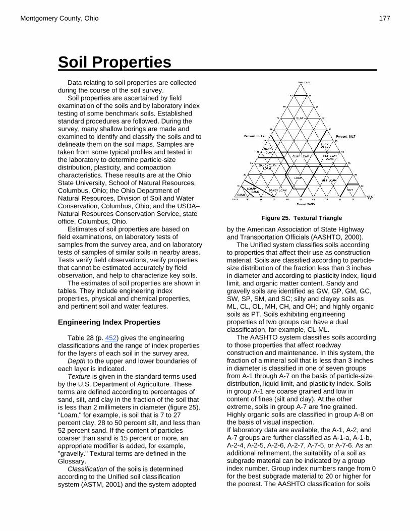
Montgomery County, Ohio 177
Soil Properties
Data relating to soil properties are collected during the course of the soil survey.
Soil properties are ascertained by field examination of the soils and by laboratory index testing of some benchmark soils. Established standard procedures are followed. During the survey, many shallow borings are made and examined to identify and classify the soils and to delineate them on the soil maps. Samples are taken from some typical profiles and tested in the laboratory to determine particle-size distribution, plasticity, and compaction characteristics. These results are at the Ohio State University, School of Natural Resources, Columbus, Ohio; the Ohio Department of Natural Resources, Division of Soil and Water Conservation, Columbus, Ohio; and the USDA–Natural Resources Conservation Service, state office, Columbus, Ohio.
Estimates of soil properties are based on field examinations, on laboratory tests of samples from the survey area, and on laboratory tests of samples of similar soils in nearby areas. Tests verify field observations, verify properties that cannot be estimated accurately by field observation, and help to characterize key soils.
The estimates of soil properties are shown in tables. They include engineering index properties, physical and chemical properties, and pertinent soil and water features. Engineering Index Properties
Table 28 (p. 452) gives the engineering classifications and the range of index properties for the layers of each soil in the survey area.
Depth to the upper and lower boundaries of each layer is indicated.
Texture is given in the standard terms used by the U.S. Department of Agriculture. These terms are defined according to percentages of sand, silt, and clay in the fraction of the soil that is less than 2 millimeters in diameter (figure 25). "Loam," for example, is soil that is 7 to 27 percent clay, 28 to 50 percent silt, and less than 52 percent sand. If the content of particles coarser than sand is 15 percent or more, an appropriate modifier is added, for example, "gravelly." Textural terms are defined in the Glossary.
Classification of the soils is determined according to the Unified soil classification system (ASTM, 2001) and the system adopted
Figure 25. Textural Triangle
by the American Association of State Highway and Transportation Officials (AASHTO, 2000).
The Unified system classifies soils according to properties that affect their use as construction material. Soils are classified according to particle-size distribution of the fraction less than 3 inches in diameter and according to plasticity index, liquid limit, and organic matter content. Sandy and gravelly soils are identified as GW, GP, GM, GC, SW, SP, SM, and SC; silty and clayey soils as ML, CL, OL, MH, CH, and OH; and highly organic soils as PT. Soils exhibiting engineering properties of two groups can have a dual classification, for example, CL-ML.
The AASHTO system classifies soils according to those properties that affect roadway construction and maintenance. In this system, the fraction of a mineral soil that is less than 3 inches in diameter is classified in one of seven groups from A-1 through A-7 on the basis of particle-size distribution, liquid limit, and plasticity index. Soils in group A-1 are coarse grained and low in content of fines (silt and clay). At the other extreme, soils in group A-7 are fine grained. Highly organic soils are classified in group A-8 on the basis of visual inspection. If laboratory data are available, the A-1, A-2, and A-7 groups are further classified as A-1-a, A-1-b, A-2-4, A-2-5, A-2-6, A-2-7, A-7-5, or A-7-6. As an additional refinement, the suitability of a soil as subgrade material can be indicated by a group index number. Group index numbers range from 0 for the best subgrade material to 20 or higher for the poorest. The AASHTO classification for soils

178 Soil Survey
tested, with group index numbers in parentheses, is given in table 28 (p. 452).
Rock fragments larger than 10 inches in diameter and 3 to 10 inches in diameter are indicated as a percentage of the total soil on a dry–weight basis. The percentages are estimates determined mainly by converting volume percentage in the field to weight percentage.
Percentage (of soil particles) passing designated sieves is the percentage of the soil fraction less than 3 inches in diameter based on an ovendry weight. The sieves, numbers 4, 10, 40, and 200 (USA Standard Series), have openings of 4.76, 2.00, 0.420, and 0.074 millimeters, respectively. Estimates are based on laboratory tests of soils sampled in the survey area and in nearby areas and on estimates made in the field.
Liquid limit and plasticity index (Atterberg limits) indicate the plasticity characteristics of a soil. The estimates are based on test data from the survey area or from nearby areas and on field examination.
The estimates of particle–size distribution, liquid limit, and plasticity index are generally rounded to the nearest 5 percent. Thus, if the ranges of gradation and Atterberg limits extend a marginal amount (1 or 2 percentage points) across classification boundaries, the classification in the marginal zone is generally omitted in the table. Physical Properties
Table 29 (p. 464) shows estimates of some physical characteristics and features that affect soil behavior. These estimates are given for the layers of each soil in the survey area. The estimates are based on field observations and on test data for these and similar soils.
Depth to the upper and lower boundaries of each layer is indicated.
Particle size is the effective diameter of a soil particle as measured by sedimentation, sieving, or micrometric methods. Particle sizes are expressed as classes with specific effective diameter class limits. The broad classes are sand, silt, and clay, ranging from the larger to the smaller.
Clay as a soil separate consists of mineral soil particles that are less than 0.002 millimeter in diameter. In table 29 (p. 464), the estimated clay content of each soil layer is given as a percentage, by weight, of the soil material that is less than 2 millimeters in diameter.
The content of sand, silt, and clay affects the physical behavior of a soil. Particle size is
important for engineering and agronomic interpretations, for determination of soil hydrologic qualities, and for soil classification.
The amount and kind of clay affect the fertility and physical condition of the soil and the ability of the soil to adsorb cations and to retain moisture. They influence shrink–swell potential, permeability, plasticity, the ease of soil dispersion, and other soil properties. The amount and kind of clay in a soil also affect tillage and earthmoving operations.
Moist bulk density is the weight of soil (ovendry) per unit volume. Volume is measured when the soil is at field moisture capacity, that is, the moisture content at 1/3- or 1/10-bar (33kPa or 10kPa) moisture tension. Weight is determined after the soil is dried at 105 degrees C. In the table, the estimated moist bulk density of each soil horizon is expressed in grams per cubic centimeter of soil material that is less than 2 millimeters in diameter. Bulk density data are used to compute shrink–swell potential, available water capacity, total pore space, and other soil properties. The moist bulk density of a soil indicates the pore space available for water and roots. Depending on soil texture, a bulk density of more than 1.4 can restrict water storage and root penetration. Moist bulk density is influenced by texture, kind of clay, content of organic matter, and soil structure.
Permeability refers to the ability of a soil to transmit water or air. The estimates in the table indicate the rate of water movement, in inches per hour (in/hr), when the soil is saturated. They are based on soil characteristics observed in the field, particularly structure, porosity, and texture. Permeability is considered in the design of soil drainage systems and septic tank absorption fields.
Available water capacity refers to the quantity of water that the soil is capable of storing for use by plants. The capacity for water storage is given in inches of water per inch of soil for each soil layer. The capacity varies, depending on soil properties that affect retention of water. The most important properties are the content of organic matter, soil texture, bulk density, and soil structure. Available water capacity is an important factor in the choice of plants or crops to be grown and in the design and management of irrigation systems. Available water capacity is not an estimate of the quantity of water actually available to plants at any given time.
Shrink-swell potential is the potential for volume change in a soil with a loss or gain in moisture. Volume change occurs mainly because of the interaction of clay minerals with water and varies with the amount and type of clay minerals
Montgomery County, Ohio 179
in the soil. The size of the load on the soil and the magnitude of the change in soil moisture content influence the amount of swelling of soils in place. Laboratory measurements of swelling of undisturbed clods were made for many soils. For others, swelling was estimated on the basis of the kind and amount of clay minerals in the soil and on the basis of measurements of similar soils.
If the shrink-swell potential is rated moderate to very high, shrinking and swelling can cause damage to buildings, roads, and other structures. Special design is often needed.
Shrink-swell potential classes are based on the change in length of an unconfined clod as moisture content is increased from air–dry to field capacity. The classes are low, a change of 3 percent; moderate, 3 to 6 percent; high, more than 6 percent; and very high, greater than 9 percent.
Erosion factors are shown in table 29 (p. 464) as the K factor (Kw and Kf) and the T factor. Erosion factor K indicates the susceptibility of a soil to sheet and rill erosion by water. Factor K is one of six factors used in the Universal Soil Loss Equation (USLE) and the Revised Universal Soil Loss Equation (RUSLE) to predict the average annual rate of soil loss by sheet and rill erosion in tons per acre per year. The estimates are based primarily on percentage of silt, sand, and organic matter and on soil structure and permeability. Values of K range from 0.02 to 0.69. Other factors being equal, the higher the value, the more susceptible the soil is to sheet and rill erosion by water.
Erosion factor Kw indicates the erodibility of the whole soil. The estimates are modified by the presence of rock fragments.
Erosion factor Kf indicates the erodibility of the fine-earth fraction, or the material less than 2 millimeters in size.
Erosion factor T is an estimate of the maximum average annual rate of soil erosion by wind or water that can occur without affecting crop productivity over a sustained period. The rate is in tons per acre per year.
Wind erodibility groups are made up of soils that have similar properties affecting their susceptibility to wind erosion in cultivated areas. The soils assigned to group 1 are the most susceptible to wind erosion, and those assigned to group 8 are the least susceptible. The groups are as follows:
1.—Coarse sands, sands, fine sands, and very fine sands.
2.—Loamy coarse sands, loamy sands, loamy fine sands, loamy very fine sands, ash material, and sapric soil material.
3.—Coarse sandy loams, sandy loams, fine sandy loams, and very fine sandy loams.
4L.—Calcareous loams, silt loams, clay loams, and silty clay loams.
4.—Clays, silty clays, noncalcareous clay loams, and silty clay loams that are more than 35 percent clay.
5.—Noncalcareous loams and silt loams that are less than 20 percent clay and sandy clay loams, sandy clays, and hemic soil material.
6.—Noncalcareous loams and silt loams that are more than 20 percent clay and noncalcareous clay loams that are less than 35 percent clay.
7.—Silts, noncalcareous silty clay loams that are less than 35 percent clay, and fibric soil material.
8.—Soils that are not subject to wind erosion because of rock fragments on the surface or because of surface wetness. Chemical Properties
Table 30 (p. 474) shows estimates of some chemical characteristics and features that affect soil behavior. These estimates are given for the layers of each soil in the survey area. The estimates are based on field observations and on test data for these and similar soils.
Depth to the upper and lower boundaries of each layer is indicated.
Soil reaction is a measure of acidity or alkalinity. The pH of each soil horizon is based on many field tests. For many soils, values have been verified by laboratory analyses. Soil reaction is important in selecting crops and other plants, in evaluating soil amendments for fertility and stabilization, and in determining the risk of corrosion.
Organic matter is the plant and animal residue in the soil at various stages of decomposition. In table 30 (p. 474), the estimated content of organic matter is expressed as a percentage, by weight, of the soil material that is less than 2 millimeters in diameter.
The content of organic matter in a soil can be maintained by returning crop residue to the soil. Organic matter has a positive effect on available water capacity, water infiltration, soil organism activity, and tilth. It is a source of nitrogen and other nutrients for crops and soil organisms.
Cation–exchange capacity is the total amount of extractable bases that can be held by the soil, expressed in terms of milliequivalents per 100 grams of soil at neutrality (pH 7.0) or at some other stated pH value. Soils having a low cation–exchange capacity hold fewer cations and may require more frequent applications of fertilizer than soils having a high cation–exchange capacity. The

180 Soil Survey
ability to retain cations reduces the hazard of groundwater pollution.
Calcium carbonate equivalent is the percent of carbonates, by weight, in the fraction of the soil less than 2 millimeters in size. The availability of plant nutrients is influenced by the amount of carbonates in the soil. Incorporating nitrogen fertilizer into calcareous soils helps to prevent nitrite accumulation and ammonium–N volatilization. Water Features
Table 31 (p. 484) gives estimates of various water features. The estimates are used in land use planning that involves engineering considerations.
Hydrologic soil groups are based on estimates of runoff potential. Soils are assigned to one of four groups according to the rate of water infiltration when the soils are not protected by vegetation, are thoroughly wet, and receive precipitation from long–duration storms.
The four hydrologic soil groups are: Group A. Soils having a high infiltration rate
(low runoff potential) when thoroughly wet. These consist mainly of deep, well drained to excessively drained sands or gravelly sands. These soils have a high rate of water transmission.
Group B. Soils having a moderate infiltration rate when thoroughly wet. These consist chiefly of moderately deep or deep, moderately well drained or well drained soils that have moderately fine texture to moderately coarse texture. These soils have a moderate rate of water transmission.
Group C. Soils having a slow infiltration rate when thoroughly wet. These consist chiefly of soils having a layer that impedes the downward movement of water or soils of moderately fine texture or fine texture. These soils have a slow rate of water transmission.
Group D. Soils having a very slow infiltration rate (high runoff potential) when thoroughly wet. These consist chiefly of clays that have a high shrink–swell potential, soils that have a high water table, soils that have a claypan or clay layer at or near the surface, and soils that are shallow over nearly impervious material. These soils have a very slow rate of water transmission.
If a soil is assigned to a dual hydrologic group (A/D, B/D, or C/D), the first letter is for drained areas and the second is for undrained areas.
The months in the table indicate the portion of the year in which the feature is most likely to
be a concern. Water table refers to a saturated zone in the
soil. Table K1 indicates, by month, depth to the top (upper limit) and base (lower limit) of the saturated zone in most years. Estimates of the upper and lower limits are based mainly on observations of the water table at selected sites and on evidence of a saturated zone, namely grayish colors or mottles (redoximorphic features) in the soil. A saturated zone that lasts for less than a month is not considered a water table.
Ponding is standing water in a closed depression. Unless a drainage system is installed, the water is removed only by percolation, transpiration, or evaporation. Table 32 indicates surface water depth and the duration and frequency of ponding. Duration is expressed as very brief if less than 2 days, brief if 2 to 7 days, long if 7 to 30 days, and very long if more than 30 days. Frequency is expressed as none, rare, occasional, and frequent. None means that ponding is not probable; rare that it is unlikely but possible under unusual weather conditions (the chance of ponding is nearly 0 percent to 5 percent in any year); occasional that it occurs, on the average, once or less in 2 years (the chance of ponding is 5 to 50 percent in any year); and frequent that it occurs, on the average, more than once in 2 years (the chance of ponding is more than 50 percent in any year).
Flooding is the temporary inundation of an area caused by overflowing streams, by runoff from adjacent slopes, or by tides. Water standing for short periods after rainfall or snowmelt is not considered flooding, and water standing in swamps and marshes is considered ponding rather than flooding.
Duration and frequency are estimated. Duration is expressed as extremely brief if 0.1 hour to 4 hours, very brief if 4 hours to 2 days, brief if 2 to 7 days, long if 7 to 30 days, and very long if more than 30 days. Frequency is expressed as none, very rare, rare, occasional, frequent, and very frequent. None means that flooding is not probable; very rare that it is very unlikely but possible under extremely unusual weather conditions (the chance of flooding is less than 1 percent in any year); rare that it is unlikely but possible under unusual weather conditions (the chance of flooding is 1 to 5 percent in any year); occasional that it occurs infrequently under normal weather conditions (the chance of flooding is 5 to 50 percent in any year); frequent that it is likely to occur often under normal weather conditions (the chance of flooding is more than 50 percent in any year but is less than 50 percent in all months in any year); and very frequent that it is likely to occur very often under normal weather

Montgomery County, Ohio 181
conditions (the chance of flooding is more than 50 percent in all months of any year).
The information is based on evidence in the soil profile, namely thin strata of gravel, sand, silt, or clay deposited by floodwater; irregular decrease in organic matter content with increasing depth; and little or no horizon development.
Also considered are local information about the extent and levels of flooding and the relation of each soil on the landscape to historic floods. Information on the extent of flooding based on soil data is less specific than that provided by detailed engineering surveys that delineate flood–prone areas at specific flood frequency levels. Soil Features
Table 32 (p. 490) gives estimates of various soil features. The estimates are used in land use planning that involves engineering considerations.
A restrictive layer is a nearly continuous layer that has one or more physical, chemical, or thermal properties that significantly impede the movement of water and air through the soil or that restrict roots or otherwise provide an unfavorable root environment. Examples are bedrock, cemented layers, dense layers, and frozen layers. The table indicates the hardness and thickness of the restrictive layer, both of which significantly affect the ease of excavation. Depth to top is the vertical distance from the soil surface to the upper boundary of the restrictive layer.
Subsidence is the settlement of organic soils or of saturated mineral soils of very low density. Subsidence generally results from either desiccation and shrinkage or oxidation of organic material, or both, following drainage. Subsidence takes place gradually, usually over a period of several years. The table shows the expected initial subsidence, which usually is a result of drainage, and total subsidence, which results from a combination of factors.
Potential for frost action is the likelihood of upward or lateral expansion of the soil caused by the formation of segregated ice lenses (frost heave) and the subsequent collapse of the soil and loss of strength on thawing. Frost action occurs when moisture moves into the freezing zone of the soil. Temperature, texture, density, permeability, content of organic matter, and depth to the water table are the most important factors considered in evaluating the potential for frost action. It is assumed that the soil is not insulated by vegetation or snow and is not artificially drained. Silty and highly structured, clayey soils that have a high water table in winter are the most susceptible to frost action. Well drained, very gravelly, or very sandy soils are the least susceptible. Frost heave and low soil strength during thawing cause damage to pavements and other rigid structures.
Risk of corrosion pertains to potential soil–induced electrochemical or chemical action that corrodes or weakens uncoated steel or concrete. The rate of corrosion of uncoated steel is related to such factors as soil moisture, particle-size distribution, acidity, and electrical conductivity of the soil. The rate of corrosion of concrete is based mainly on the sulfate and sodium content, texture, moisture content, and acidity of the soil. Special site examination and design may be needed if the combination of factors results in a severe hazard of corrosion. The steel or concrete in installations that intersect soil boundaries or soil layers is more susceptible to corrosion than the steel or concrete in installations that are entirely within one kind of soil or within one soil layer.
For uncoated steel, the risk of corrosion, expressed as low, moderate, or high, is based on soil drainage class, total acidity, electrical resistivity near field capacity, and electrical conductivity of the saturation extract.
For concrete, the risk of corrosion also is expressed as low, moderate, or high. It is based on soil texture, acidity, and amount of sulfates in the saturation extract.

182 Soil Survey
Classification of the Soils
The system of soil classification used by the National Cooperative Soil Survey has six categories (Soil Survey Staff, 1998 and 1999). Beginning with the broadest, these categories are the order, suborder, great group, subgroup, family, and series. Classification is based on soil properties observed in the field or inferred from those observations or from laboratory measurements. Table 33 (p. 496) shows the classification of the soils in the survey area. The categories are defined in the following paragraphs.
ORDER.—Twelve soil orders are recognized. The differences among orders reflect the dominant soil–forming processes and the degree of soil formation. Each order is identified by a word ending in sol. An example is Alfisol.
SUBORDER.—Each order is divided into suborders primarily on the basis of properties that influence soil genesis and are important to plant growth or properties that reflect the most important variables within the orders. The last syllable in the name of a suborder indicates the order. An example is Udalf (Ud, meaning humid, plus alf, from Alfisol).
GREAT GROUP.—Each suborder is divided into great groups on the basis of close similarities in kind, arrangement, and degree of development of pedogenic horizons; soil moisture and temperature regimes; type of saturation; and base status. Each great group is identified by the name of a suborder and by a prefix that indicates a property of the soil. An example is Hapludalfs (Hapl, meaning minimal horizonation, plus udalf, the suborder of the Alfisols that has a udic moisture regime).
SUBGROUP.—Each great group has a typic subgroup. Other subgroups are intergrades or extragrades. The typic subgroup is the central concept of the great group; it is not necessarily the most extensive. Intergrades are transitions to other orders, suborders, or great groups. Extragrades have some properties that are not representative of the great group but do not indicate transitions to any other taxonomic class. Each subgroup is identified by one or more adjectives preceding the name of the great group. The adjective Typic identifies the subgroup that typifies the great group. An example is Typic Hapludalfs.
FAMILY.—Families are established within a subgroup on the basis of physical and chemical properties and other characteristics that affect
management. Generally, the properties are those of horizons below plow depth where there is much biological activity. Among the properties and characteristics considered are particle–size class, mineralogy class, cation–exchange activity class, soil temperature regime, soil depth, and reaction class. A family name consists of the name of a subgroup preceded by terms that indicate soil properties. An example is fine-loamy, mixed, active, mesic Typic Hapludalfs.
SERIES.—The series consists of soils within a family that have horizons similar in color, texture, structure, reaction, consistence, mineral and chemical composition, and arrangement in the profile. Soil Series and Their Morphology
In this section, each soil series recognized in the survey area is described. Characteristics of the soil and the material in which it formed are identified for each series. A pedon, a small three-dimensional area of soil, that is typical of the series in the survey area is described. Pedon descriptions published in this survey come from Montgomery County or adjacent counties. The detailed description of each soil horizon follows standards in the "Soil Survey Manual" (Soil Survey Division Staff, 1993). Many of the technical terms used in the descriptions are defined in "Soil Taxonomy" (Soil Survey Staff, 1999) and in "Keys to Soil Taxonomy" (Soil Survey Staff, 1998). Unless otherwise indicated, colors in the descriptions are for moist soil. Following the pedon description is the range of important characteristics of the soils in the series.
Algiers Series
The Algiers series consists of nearly level, somewhat poorly drained soils that occur on flood plains along small streams and on alluvial fans along the valley walls of larger streams. These soils consist of light colored recent alluvium over a buried soil, which is dark colored, very poorly drained alluvium.
A representative profile of an Algiers soil has a plow layer that is dark grayish brown silt loam about 8 inches thick. Between depths of 8 and 15 inches is a layer of brown silt loam. Both layers lack mottles or other evidence of wetness. Between depths of 15 and 42 inches are layers of very dark gray silt loam and silty clay loam that
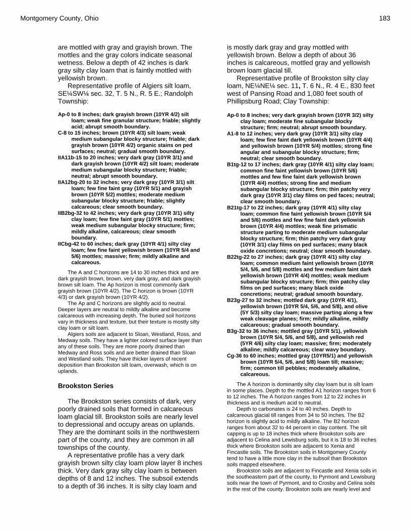
Montgomery County, Ohio 183
are mottled with gray and grayish brown. The mottles and the gray colors indicate seasonal wetness. Below a depth of 42 inches is dark gray silty clay loam that is faintly mottled with yellowish brown.
Representative profile of Algiers silt loam, SE¼SW¼ sec. 32, T. 5 N., R. 5 E.; Randolph Township: Ap-0 to 8 inches; dark grayish brown (10YR 4/2) silt
loam; weak fine granular structure; friable; slightly acid; abrupt smooth boundary.
C-8 to 15 inches; brown (10YR 4/3) silt loam; weak medium subangular blocky structure; friable; dark grayish brown (10YR 4/2) organic stains on ped surfaces; neutral; gradual smooth boundary.
IIA11b-15 to 20 inches; very dark gray (10YR 3/1) and dark grayish brown (10YR 4/2) silt loam; moderate medium subangular blocky structure; friable; neutral; abrupt smooth boundary.
IIA12bg-20 to 32 inches; very dark gray (10YR 3/1) silt loam; few fine faint gray (10YR 5/1) and grayish brown (10YR 5/2) mottles; moderate medium subangular blocky structure; friable; slightly calcareous; clear smooth boundary.
IIB2bg-32 to 42 inches; very dark gray (10YR 3/1) silty clay loam; few fine faint gray (10YR 5/1) mottles; weak medium subangular blocky structure; firm; mildly alkaline, calcareous; clear smooth boundary.
IICbg-42 to 60 inches; dark gray (10YR 4/1) silty clay loam; few fine faint yellowish brown (10YR 5/4 and 5/6) mottles; massive; firm; mildly alkaline and calcareous.
The A and C horizons are 14 to 30 inches thick and are dark grayish brown, brown, very dark gray, and dark grayish brown silt loam. The Ap horizon is most commonly dark grayish brown (10YR 4/2). The C horizon is brown (10YR 4/3) or dark grayish brown (10YR 4/2).
The Ap and C horizons are slightly acid to neutral. Deeper layers are neutral to mildly alkaline and become calcareous with increasing depth. The buried soil horizons vary in thickness and texture, but their texture is mostly silty clay loam or silt loam.
Algiers soils are adjacent to Sloan, Westland, Ross, and Medway soils. They have a lighter colored surface layer than any of these soils. They are more poorly drained than Medway and Ross soils and are better drained than Sloan and Westland soils. They have thicker layers of recent deposition than Brookston silt loam, overwash, which is on uplands. Brookston Series
The Brookston series consists of dark, very poorly drained soils that formed in calcareous loam glacial till. Brookston soils are nearly level to depressional and occupy areas on uplands. They are the dominant soils in the northwestern part of the county, and they are common in all townships of the county.
A representative profile has a very dark grayish brown silty clay loam plow layer 8 inches thick. Very dark gray silty clay loam is between depths of 8 and 12 inches. The subsoil extends to a depth of 36 inches. It is silty clay loam and
is mostly dark gray and gray mottled with yellowish brown. Below a depth of about 36 inches is calcareous, mottled gray and yellowish brown loam glacial till.
Representative profile of Brookston silty clay loam, NE¼NE¼ sec. 11, T. 6 N., R. 4 E., 830 feet west of Pansing Road and 1,080 feet south of Phillipsburg Road; Clay Township: Ap-0 to 8 inches; very dark grayish brown (10YR 3/2) silty
clay loam; moderate fine subangular blocky structure; firm; neutral; abrupt smooth boundary.
A1-8 to 12 inches; very dark gray (10YR 3/1) silty clay loam; few fine faint dark yellowish brown (10YR 4/4) and yellowish brown (10YR 5/4) mottles; strong fine angular and subangular blocky structure; firm; neutral; clear smooth boundary.
B1tg-12 to 17 inches; dark gray (10YR 4/1) silty clay loam; common fine faint yellowish brown (10YR 5/6) mottles and few fine faint dark yellowish brown (10YR 4/4) mottles; strong fine and medium subangular blocky structure; firm; thin patchy very dark gray (10YR 3/1) clay films on ped faces; neutral; clear smooth boundary.
B21tg-17 to 22 inches; dark gray (10YR 4/1) silty clay loam; common fine faint yellowish brown (10YR 5/4 and 5/6) mottles and few fine faint dark yellowish brown (10YR 4/4) mottles; weak fine prismatic structure parting to moderate medium subangular blocky structure; firm; thin patchy very dark gray (10YR 3/1) clay films on ped surfaces; many black oxide concretions; neutral; clear smooth boundary.
B22tg-22 to 27 inches; dark gray (10YR 4/1) silty clay loam; common medium faint yellowish brown (10YR 5/4, 5/6, and 5/8) mottles and few medium faint dark yellowish brown (10YR 4/4) mottles; weak medium subangular blocky structure; firm; thin patchy clay films on ped surfaces; many black oxide concretions; neutral; gradual smooth boundary.
B23g-27 to 32 inches; mottled dark gray (10YR 4/1), yellowish brown (10YR 5/4, 5/6, and 5/8), and olive (5Y 5/3) silty clay loam; massive parting along a few weak cleavage planes; firm; mildly alkaline, mildly calcareous; gradual smooth boundary.
B3g-32 to 36 inches; mottled gray (10YR 5/1), yellowish brown (10YR 5/4, 5/6, and 5/8), and yellowish red (5YR 4/6) silty clay loam; massive; firm; moderately alkaline; mildly calcareous; clear wavy boundary.
Cg-36 to 60 inches; mottled gray (10YR5/1) and yellowish brown (10YR 5/4, 5/6, and 5/8) loam till; massive; firm; common till pebbles; moderately alkaline, calcareous.
The A horizon is dominantly silty clay loam but is silt loam in some places. Depth to the mottled A1 horizon ranges from 6 to 12 inches. The A horizon ranges from 12 to 22 inches in thickness and is medium acid to neutral.
Depth to carbonates is 24 to 40 inches. Depth to calcareous glacial till ranges from 34 to 50 inches. The B2 horizon is slightly acid to mildly alkaline. The B2 horizon ranges from about 32 to 44 percent in clay content. The silt capping is up to 18 inches thick where Brookston soils are adjacent to Celina and Lewisburg soils, but it is 18 to 36 inches thick where Brookston soils are adjacent to Xenia and Fincastle soils. The Brookston soils in Montgomery County tend to have a little more clay in the subsoil than Brookston soils mapped elsewhere.
Brookston soils are adjacent to Fincastle and Xenia soils in the southeastern part of the county, to Pyrmont and Lewisburg soils near the town of Pyrmont, and to Crosby and Celina soils in the rest of the county. Brookston soils are nearly level and

184 Soil Survey
depressional where they are intermingled with these slightly higher adjacent soils and are more poorly drained and darker colored. Brookston soils are more poorly drained than the dark colored Dana soils. The Brookston soils formed in silt-capped glacial till and have relatively little gravel in the underlying layers, but the very poorly drained dark colored Westland soils formed in loamy glacial outwash and have a considerable amount of gravel in the deep layers. The subsoil of Brookston soils is silty clay loam, but the very poorly drained Montgomery soils, which formed in sediments on old lake bottoms, have more clay in the subsoil. Brookston soils are underlain by thick glacial till, whereas the very poorly drained Millsdale soils have limestone and clay shale bedrock at a depth of 20 to 40 inches.
Carlisle Series
The Carlisle series consists of deep, very poorly drained soils that formed in thick deposits of organic material. These soils are nearly level to depressional and are naturally swampy. Most areas are in the beds of old lakes that existed after the glacial age.
A representative profile of a Carlisle soil has a black muck surface layer that is very high in organic matter content. It is about 11 inches thick. Next are layers of black muck that are 15 to 30 percent dark reddish brown, fibrous, undecomposed organic material. Beneath the organic material, at a depth of about 82 inches, is dark gray clay.
Representative profile of Carlisle muck, SE¼NE¼ sec. 20, R. 7, T. 2, 1,780 foot west of Woodman Drive and 3,230 feet north of Patterson Road; city of Kettering:
Oap-0 to 5 inches; black (10YR 2/1) muck; strong very fine and fine granular structure; firm; many roots; neutral; clear smooth boundary.
Oal-5 to 11 inches; black (10YR 2/1) muck, black (5YR 2/1) when rubbed; strong medium subangular blocky structure that parts to strong fine subangular blocky structure; firm; many fine specks of dark reddish brown (2.5YR 3/4) undecomposed organic matter; many roots; many wormcasts; neutral; clear wavy boundary.
Oa2-11 to 21 inches; black (5YR 2/1) muck; massive except for random horizontal and vertical cleavages; firm and compact; 15 percent dark reddish brown (5YR 3/4), fibrous, undecomposed organic matter; common roots; neutral; gradual smooth boundary.
Oa3-21 to 82 inches; black (5YR 2/1) peaty muck; massive; loose; 30 percent dark reddish brown (5YR 3/4), undecomposed organic matter; few roots; common, black (10YR 2/1), slick, horizontal ped surfaces; neutral.
IICg-82 to 90 inches; dark gray (5YR 4/1) clay; massive; firm; calcareous.
The surface horizon is black (10YR 2/1) or very dark brown (10YR 2/2). The underlying organic material is black (5YR 2/1 to 10YR 2/1) and contains dark reddish brown (5YR 3/4) peaty material that increases in volume as depth increases. Depth to clayey mineral material is more than 50 inches.
Carlisle soils differ from all other very poorly drained soils in the county by having formed in organic material in
contrast to mineral material.
Celina Series
The Celina series consists of moderately well drained soils formed in calcareous loam glacial till. In some places Celina soils have up to 18 inches of wind–deposited silty material (loess) capping the glacial till material. These soils are nearly level to gently sloping, and they occupy areas of till plains and moraines. They are common in all parts of the county except the southeastern part.
A representative profile has a dark brown and brown silt loam plow layer about 8 inches thick. Below the plow layer is a thin, yellowish brown silty clay loam layer. Beneath a depth of 10 inches, the subsoil is dark yellowish brown silty clay loam, silty clay, and loam. Yellowish brown mottles are present in the subsoil. Beneath the subsoil, between depths of 30 and 60 inches, is calcareous, olive brown and dark yellowish brown loam till. The content of pebbles and coarse fragments in the till varies, but it is generally less than 15 percent.
Representative profile of Celina silt loam, 2 to 6 percent slopes, SW¼NW¼ sec. 27, T. 6 N., R. 4 E., 1,655 feet south of Pleasant Plain Road and 615 feet east of State Route 311; Clay Township (Sample MT-4 in laboratory data):
Ap1-0 to 6 inches; dark brown (10YR 4/3) silt loam; dark grayish brown (10YR 4/2) when crushed; weak medium granular structure; very friable; neutral; clear smooth boundary.
Ap2-6 to 8 inches; brown (10YR 4/3) silt loam; weak thick platy structure parting to weak fine subangular blocky structure; very friable; neutral; abrupt smooth boundary.
IIB&A-8 to 10 inches; yellowish brown (10YR 5/4) silty clay loam; weak medium and coarse subangular blocky structure; friable; vertical faces of peds have thin very patchy brown (10YR 4/3) clay films and grayish brown (10YR 5/2) and light brownish gray (10YR 6/2) silt coatings; few till pebbles; slightly acid; clear smooth boundary.
IIB21t-10 to 14 inches; dark yellowish brown (10YR 4/4) silty clay loam; weak medium and coarse subangular blocky structure parting to moderate fine subangular blocky structure; firm; both horizontal and vertical faces of peds have moderately thick patchy dark gray (10YR 4/1) and dark grayish brown (10YR 4/2) clay films and patchy gray (10YR 5/1) silt coatings; few medium faint black (10YR 2/1) oxide stains; medium acid; clear wavy boundary.
IIB22t-14 to 19 inches; dark yellowish brown (10YR 4/4) silty clay; few fine distinct yellowish brown (10YR 5/8) and grayish brown (10YR 5/2) mottles; weak medium prismatic structure parting to moderate medium subangular blocky structure; firm; moderately thick patchy dark gray (10YR 4/1) and very dark gray (10YR 3/1) clay films on both horizontal and vertical faces of the peds; few medium faint black (10YR 2/1) oxide stains and concretions; strongly acid; gradual smooth boundary.
IIB23t-19 to 24 inches; dark yellowish brown (10YR 4/4)

Montgomery County, Ohio 185
silty clay loam; common fine faint grayish brown (10YR 5/2) mottles and few medium distinct yellowish brown (10YR 5/8) mottles; weak medium prismatic structure parting to moderate medium subangular blocky structure; firm; very dark gray (10YR 3/1) clay films that are thick and patchy on vertical surfaces of peds and moderately thick and patchy on horizontal surfaces; few fine faint black (10YR 2/1) oxide concretions; few shale fragments; clear wavy boundary.
IIB3-24 to 30 inches; dark yellowish brown (10YR 4/4) loam that has few fine faint grayish brown (10YR 5/2) mottles and common medium distinct yellowish brown (10YR 5/8) mottles; massive parting to weak very coarse prismatic structure along clay flows; firm; compact; thick patchy very dark gray (10YR 3/1) clay films on the vertical surfaces of peds; neutral; calcareous ped interiors; 13 percent pebbles, mostly limestone; clear wavy boundary.
IIC1-30 to 41 inches; olive brown (2.5Y 4/4) loam; massive; firm; mildly alkaline; strongly calcareous; clear wavy boundary.
IIC2-41 to 60 inches; dark yellowish brown (10YR 4/4) and olive brown (2.5Y 4/4) loam; massive; firm and compact; moderately alkaline, strongly calcareous.
The loess ranges from 0 to 18 inches in thickness. Depth to carbonates ranges from 18 to 36 inches. The A horizon is dark grayish brown (10YR 4/2), brown or dark brown (10YR 4/3), or dark gray (10YR 4/1). The B horizon is brown (10YR 4/3), dark yellowish brown (10YR 4/4), or yellowish brown (10YR 5/4). The B2 horizon is clay loam, silty clay loam, and silty clay. Depth to the mottled horizon ranges from 14 to 28 inches. The minimum reaction of the solum is in the B1 horizon, where present, or in the upper part of the B2 horizon. Reaction ranges from strongly acid to slightly acid.
The Celina soils are adjacent to Miamian, Crosby, and Brookston soils. Drainage is not so good in the Celina soils as it is in the Miamian soils but it is better than the drainage of the Crosby or Brookston soils. Celina soils have a silt capping 0 to 18 inches thick, but the Xenia soils have a silt capping more than 18 inches thick. The Celina soils are 18 to 36 inches deep to carbonates, but the Lewisburg soils are less than 18 inches. The Celina, soils are similar to Corwin soils, but they have a lighter colored surface layer.
Corwin Series
The Corwin series consists of dark colored, moderately well drained soils that formed in calcareous loam glacial till. In places these soils have a silt cap of loess as much as 18 inches thick. They are nearly level to gently sloping and occupy upland areas. These soils occur in all parts of the county except the southeastern part.
A representative profile has a very dark grayish brown silt loam plow layer about 6 inches thick. The next layer is very dark brown silt loam 3 inches thick. Several layers make up the subsoil. The topmost layer of the subsoil is dark brown silty clay loam. Deeper layers are dark yellowish brown silty clay loam and clay loam and brown loam. The subsoil is underlain by calcareous loam glacial till at a depth of about 43 inches.
Representative profile of a Corwin silt loam, SW¼NW¼, sec. 27, T. 6 N., R. 4 E., Clay Township; (Sample MT-6 in laboratory data):
Ap-0 to 6 inches; very dark grayish brown (10YR 3/2) silt loam; weak fine granular structure; very friable; neutral; clear smooth boundary.
A1-6 to 9 inches; very dark brown (10YR 2/2) silt loam; weak fine granular structure; very friable; neutral; clear smooth boundary.
B21t-9 to 13 inches; dark brown (10YR 3/3) silty clay loam; moderate fine subangular blocky structure; friable; thin continuous very dark brown (10YR 2/2) clay films on ped surfaces; neutral; clear smooth boundary.
IIB22t-13 to 17 inches; dark yellowish brown (10YR 4/4) silty clay loam; moderate coarse subangular blocky structure parting to moderate fine and medium subangular blocky structure; firm; medium continuous very dark brown (10YR 2/2) and very dark grayish brown (10YR 3/2) clay films on the vertical faces of the peds and medium patchy coatings of very dark brown and very dark grayish brown (10YR 2/2, 3/2) on the horizontal faces; neutral; clear smooth boundary.
IIB23t-17 to 24 inches; dark yellowish brown (10YR 4/4) silty clay loam; weak medium prismatic structure parting to moderate medium and coarse subangular blocky structure; firm; very dark brown (10YR 2/2) and very dark grayish brown (10YR 3/2) patchy clay films on the vertical faces of the peds and thin patchy clay films on the horizontal faces; neutral; gradual smooth boundary.
IIB24t-24 to 30 inches; dark yellowish brown (10YR 4/4) silty clay; few medium faint gray (10YR 5/1) mottles and many medium faint yellowish brown (10YR 5/6) mottles; very weak coarse prismatic structure parting to weak coarse subangular blocky structure; firm; medium very dark grayish brown (10YR 3/2) clay films that are continuous on the vertical faces of the peds and patchy on the horizontal faces; few shale fragments; mildly alkaline; gradual smooth boundary.
IIB25t-30 to 36 inches; yellowish brown (10YR 5/6) and dark yellowish brown (10YR 4/4) clay loam; few medium faint gray (10YR 5/1) mottles and many medium faint yellowish brown (10YR 5/8) mottles; very weak coarse prismatic structure; firm; thin patchy very dark gray (10YR 3/1) clay films on vertical and horizontal faces of peds; mildly alkaline; abrupt irregular boundary.
IIB3-36 to 43 inches; brown (10YR 4/3) loam; few medium faint gray (10YR 5/1) mottles and many medium faint yellowish brown (10YR 5/8) mottles; very weak coarse prismatic structure; firm; very dark grayish brown (10YR 3/2) clay coatings on vertical ped faces; many till pebbles and highly weathered limestone remnants; calcareous ped interiors; clear wavy boundary.
IIC-43 to 60 inches; brown (10YR 4/3) loam till; massive; firm; gray (10YR 5/1) streaks; moderately alkaline, strongly calcareous.
The depth to calcareous material ranges from about 25 to 40 inches. The A horizon is very dark brown (10YR 2/2), black (10YR 2/1), and very dark grayish brown (10YR 3/2). The matrix of the B2 horizon is brown (10YR 4/3), dark brown (10YR 3/3), dark yellowish brown (10YR 4/4), or yellowish brown (10YR 5/6). Films of very dark grayish brown (10YR 3/1) are common on ped surfaces in the B2 horizon. The B2 horizon is clay loam or silty clay loam. The A horizon ranges

186 Soil Survey
from strongly acid to neutral. Horizons deeper in the profile are progressively less acid.
Corwin soils are adjacent to Miamian, Celina, and Brookston soils. They have a dark colored surface layer, but Miamian and Celina soils have a light colored surface layer. Corwin soils are moderately well drained, but Brookston soils are very poorly drained. The silt capping of the Corwin soils is 18 inches thick or less, but it is 18 to 40 inches in the Dana soils. Corwin soils have no bedrock at a depth of less than 40 inches, whereas the dark colored Plattville soils have limestone bedrock at a depth of 20 to 40 inches. Crosby Series
The Crosby series consists of somewhat poorly drained soils that formed in calcareous loam glacial till. In places the till is capped with up to 18 inches of silty loess. Crosby soils are on uplands and are nearly level to gently sloping. They are common throughout the county except in the southeastern part.
A representative profile of a Crosby soil has a dark grayish brown silt loam plow layer about 8 inches thick. The subsoil is dark grayish brown or brown silty clay loam, clay loam, and loam mottled with yellowish brown. Grayish coatings are on the structural faces. Below this, at a depth of about 31 inches, is calcareous loam glacial till. This till is firm and compact, and it restricts movement of water and penetration of roots.
Representative profile of Crosby silt loam, 0 to 2 percent slopes, NW¼SW¼ sec. 5, T. 5 N., R. 4 E.; Perry Township:
Ap-0 to 8 inches; dark grayish brown (10YR 4/2) silt loam; weak fine granular structure; friable; slightly acid; abrupt smooth boundary.
B21tg-8 to 14 inches; dark grayish brown (10YR 4/2) silty clay loam that has common medium distinct gray (10YR 5/1) mottles and common fine distinct yellowish brown (10YR 5/6) mottles; moderate fine subangular blocky structure; firm; thin patchy clay films on ped faces; few oxide concretions; medium acid; clear smooth boundary.
IIB22tg-14 to 20 inches; dark grayish brown (10YR 4/2) clay loam; common medium faint brown (10YR 5/3) mottles and few fine distinct yellowish brown (10YR 5/6) mottles; moderate fine subangular blocky structure; firm; many fine oxide concretions; thin continuous dark grayish brown (10YR 4/2) clay films on vertical faces of peds and thin patchy dark grayish brown (10YR 4/2) clay films on horizontal faces of peds; slightly acid; gradual smooth boundary.
IIB23tg-20 to 26 inches; brown (10YR 5/3) clay loam; common fine faint yellowish brown (10YR 5/6) mottles and common medium faint yellowish brown (10YR 5/4) mottles; moderate medium subangular blocky structure; firm; thick patchy gray (10YR 5/1) clay films on horizontal faces of peds; few oxide concretions; neutral; clear smooth boundary.
IIB3-26 to 31 inches; brown (10YR 5/3) loam; many coarse faint yellowish brown (10YR 5/4) mottles and few fine faint yellowish brown (10YR 5/6) mottles; weak coarse subangular blocky structure;
firm; thin patchy gray (10YR 5/1) clay films on vertical faces of peds; few weathered limestone remnants; very few dark brown or black oxide concretions; mildly alkaline; slightly calcareous; clear smooth boundary.
IIC-31 to 60 inches; brown (10YR 5/3) loam; common medium faint yellowish brown (10YR 5/4 and 5/6) mottles; massive; firm; thin light brownish gray (10YR 6/2) streaks; moderately alkaline (strongly calcareous).
The A horizon is dark grayish brown (10YR 4/2), grayish brown (10YR 5/2), or brown (10YR 4/3). In the B horizon, the matrix colors are dark gray (10YR 4/1), dark grayish brown (10YR 4/2), grayish brown (10YR 5/2), or brown (10YR 4/3 and 10YR 5/3). A grayish matrix is not dominant in the B horizon in all places. Mottles in the B horizon have a hue of 10YR, values of 4 and 5, and chromas of 1 to 6. Clay films in the B horizon are dark grayish brown (10YR 4/2) or gray (10YR 5/1).
The B2 horizon dominantly is clay loam or silty clay loam, but some part of the B horizon is generally clay. Depth from the surface to mottled horizons ranges from 6 to 9 inches. Depth to calcareous material is at a minimum where Crosby soils are adjacent to Lewisburg and Pyrmont soils. Minimum reaction of the solum is in the B1 horizon where present, or in the upper part of the B2 horizon, and is strongly acid to slightly acid. The solum is less acid as depth increases.
Crosby soils are adjacent to Miamian, Celina, and Brookston soils. Crosby soils are less well drained than Miamian and Celina soils and are lighter colored and better drained than the very poorly drained Brookston soils. The silt capping is less than 18 inches thick on the Crosby soils, but it is more than 18 inches thick on the Fincastle soils. Crosby soils are deeper to calcareous till than Pyrmont soils. Bedrock is not within 40 inches of the surface of the Crosby soils, but the somewhat poorly drained Randolph soils have limestone bedrock within 40 inches of the surface. Dana Series
The Dana series consists of dark colored, moderately well drained soils that formed in 18 to 40 inches of loess and underlying calcareous loam glacial till. These soils are gently sloping and are on uplands in the southeastern part of the county.
In a representative profile, the surface layer is black silt loam and silty clay loam 12 inches thick. The upper part of the subsoil is dark yellowish brown silty clay loam. The lower part is dark yellowish brown silty clay loam and clay loam. The underlying material is at a depth of about 36 inches and consists of calcareous loam glacial till.
Representative profile of Dana silt loam, 2 to 6 percent slopes, NW¼SE¼ sec. 11, R. 5, T. 2; Miami Township:
Ap-0 to 7 inches; black (10YR 2/1) silt loam; moderate medium granular structure; friable; slightly acid; abrupt smooth boundary.
A1-7 to 12 inches; black (10YR 2/1) silty clay loam; strong fine and medium subangular blocky structure; firm; slightly acid; clear smooth boundary.
B21t-12 to 18 inches; dark yellowish brown (10YR 4/4) silty clay loam; strong medium and coarse subangular blocky structure; firm; medium continuous very dark gray (10YR 3/1) clay films on ped faces; neutral; clear smooth boundary.

Montgomery County, Ohio 187
B22t-18 to 28 inches; dark yellowish brown (10YR 4/4) silty clay loam; few fine faint yellowish brown (10YR 5/8) mottles; moderate medium and coarse subangular blocky structure; firm; medium continuous very dark gray (10YR 3/1) clay films on ped surfaces; neutral; clear smooth boundary.
IIB3-28 to 36 inches; dark yellowish brown (10YR 4/4) clay loam; few fine faint yellowish brown (10YR 5/8) mottles; very weak coarse subangular blocky structure; friable; neutral; clear wavy boundary.
IIC-36 to 60 inches, grayish brown (10YR 5/2) and yellowish brown (10YR 5/4) loam till; massive; firm; moderately alkaline (calcareous).
The wind-deposited silt ranges from 18 to 40 inches in
thickness. Depth to calcareous material ranges from about 34 inches to 56 inches. The dark A horizon is black (10YR 2/1), very dark brown (10YR 2/2), very dark gray (10YR 3/1), or very dark grayish brown (10YR 3/2). The B2t horizon is brown (10YR 4/3) or dark yellowish brown (10YR 4/4). Ped coatings in the B2t horizon are very dark gray (10YR 3/1) and very dark grayish brown (10YR 3/2). The B2t horizon is silty clay loam or clay loam. Depth to mottling ranges from 14 to 24 inches. The A horizon is medium acid to neutral, and the reaction increases as depth in the solum increases.
Dana soils are adjacent to Xenia, Russell, and Brookston soils. They have a darker colored surface layer than Xenia and Russell soils. Dana soils are moderately well drained, whereas Brookston soils are very poorly drained. The mantle of silt in Dana soils is 18 to 40 inches thick, but that of Corwin soils is less than 18 inches thick. Fairmount Series
The Fairmount series consists of well drained, dark colored soils that formed in residuum weathered from thin-bedded limestone and clay shale bedrock. These soils are moderately steep and very steep.
In a representative profile, the surface layer is very dark grayish brown silty clay loam about 7 inches thick. The subsoil is olive brown and olive silty clay. It overlies interbedded limestone and clay shale bedrock at a depth of 19 inches.
Representative profile of a Fairmount silty clay loam, NE¼NE¼SW¼ sec. 31, T. 4 N., R. 4 E.; Jackson Township:
A1-0 to 7 inches; very dark grayish brown (10YR 3/2) silty clay loam; moderate fine subangular blocky structure; friable; neutral; abrupt smooth boundary.
B21-7 to 12 inches; olive brown (2.5Y 4/4) silty clay; moderate coarse prismatic structure parting to strong medium subangular blocky structure; firm; dark grayish brown (2.5Y 4/2) stains on ped surfaces; mildly alkaline; clear smooth boundary.
B22-12 to 19 inches; olive (5Y 5/3) silty clay; moderate coarse prismatic structure breaking to weak medium subangular blocky structure; firm; thin discontinuous grayish brown (2.5Y 5/2) coatings on ped surfaces; thin line of stone fragments along upper boundary; moderately alkaline (calcareous); abrupt smooth boundary.
C-19 inches; interbedded limestone and calcareous clay shale bedrock.
The A horizon is black (10YR 2/1), very dark brown (10YR 2/2), or very dark grayish brown (10YR 3/2 to 2.5Y
3/2). Except in eroded areas, it ranges from 6 to 8 inches in thickness. The B horizon is olive (5Y 5/3, 5/6, 4/3, or 4/4) olive gray (5Y 4/2), light olive brown (2.5Y 5/4), or olive brown (2.5Y 4/4). Stains slightly darker than the matrix are fairly common on the ped surfaces. Where a B1 horizon occurs, it is silty clay loam or silty clay. The B2 horizon is silty clay or clay. Depth to the underlying C horizon, which is limestone or calcareous clay shale, ranges from about 12 inches to 20 inches. Limestone fragments occur throughout the profile in amounts estimated at 1 to 5 percent, by volume.
Fairmount soils are adjacent to Ritchey and Milton soils. They occupy positions similar to those of Lorenzo-Rodman complexes and of undifferentiated Rodman and Fox soils and Hennepin and Miamian soils. Fairmount soils formed entirely in residual materials and have a dark colored surface layer, whereas Ritchey and Milton soils formed in glacial till over limestone and clay shale bedrock and have a light colored surface layer. Unlike Fairmount soils, Lorenzo-Rodman complexes and the undifferentiated Rodman and Fox soils and Hennepin and Miamian soils formed in glacial till and outwash materials. The Fairmount soils are more shallow to limestone and shale than the dark colored Plattville soils.
Fincastle Series
The Fincastle series consists of somewhat poorly drained soils that formed partly in loess and partly in weathered loam glacial till. Fincastle soils are nearly level to gently sloping, and they occupy upland areas in the southeastern part of the county.
A representative profile has a dark grayish brown silt loam plow layer about 8 inches thick. Beneath the plow layer is grayish brown silt loam that is 5 inches thick and is distinctly mottled with brown. At depths between 13 and 19 inches is mottled pale brown silt loam. The subsoil is between depths of 19 and 38 inches. It consists of brown and dark yellowish brown silty clay loam and clay loam mottled with grayish brown and yellowish brown. Underlying the subsoil is calcareous, yellowish brown loam glacial till.
Representative profile of Fincastle silt loam, 0 to 4 percent slopes, NE¼NE¼ sec. 34, R. 5, T. 3; Washington Township:
Ap-0 to 8 inches; dark grayish brown (10YR 4/2) silt loam; weak very fine granular structure; friable; medium acid; abrupt smooth boundary.
A2-8 to 13 inches; grayish brown (10YR 5/2) silt loam; few fine distinct brown (10YR 4/3) mottles; weak medium granular structure; friable; medium acid; abrupt smooth boundary.
A&B-13 to 19 inches; pale brown (10YR 6/3) silt loam; few medium faint yellowish brown (10YR 5/8) mottles and common fine faint yellowish brown (10YR 5/4, 5/6) mottles; weak medium subangular blocky structure; friable; medium acid; clear smooth boundary.
B21t-19 to 25 inches; brown (10YR 4/3) silty clay loam; common medium faint grayish brown (10YR 5/2) mottles and common fine faint yellowish brown (10YR 5/6) mottles; weak medium subangular blocky structure; firm; thin continuous dark grayish brown (10YR 4/2) clay films on ped surfaces; dark oxide stains; medium acid; clear smooth boundary.
IIB22t-25 to 31 inches; brown (10YR 4/3) clay loam; common medium faint grayish brown (10YR 5/2)

188 Soil Survey
mottles and few fine faint yellowish brown (10YR 5/8) mottles; moderate medium prismatic structure breaking to moderate medium subangular blocky structure; very firm; continuous medium dark grayish brown (10YR 4/2) clay films on horizontal and vertical faces of peds; oxide concretions; neutral; clear wavy boundary.
IIB3t-31 to 38 inches; dark yellowish brown (10YR 4/4) silty clay loam; few fine faint yellowish brown (10YR 5/6) mottles; weak fine and medium subangular blocky structure; firm; continuous; medium dark gray (10YR 4/1) clay films on vertical ped faces; moderately alkaline; clear wavy boundary.
IIC-38 to 60 inches; yellowish brown (10YR 5/4) loam till; massive; friable; moderately alkaline (calcareous).
The loess ranges from 18 to about 40 inches in
thickness. Depth to the calcareous C horizon ranges from 34 inches to about 42 inches. The Ap horizon ranges from dark grayish brown (10YR 4/2) to brown (10YR 4/3). The matrix of the B2t horizon ranges from dark yellowish brown (10YR 4/4) to brown (10YR 4/3) and yellowish brown (10YR 5/4). Mottles and ped coatings that have a chroma of 2 or 1 are present in the Bt horizon. The B2t horizon is silty clay loam and clay loam. The upper part of the B2t horizon is strongly acid to slightly acid.
Fincastle soils are somewhat poorly drained members of a drainage sequence that includes the well drained Russell soils, the moderately well drained Xenia soils, and the very poorly drained Brookston soils. Fincastle soils are commonly adjacent to the Xenia and Brookston soils. They are similar to the Crosby soils but have a thicker loess capping.
Fox Series
The Fox series consists of well drained soils that formed in loamy glacial outwash material. These soils have a substratum of sand and gravel at a depth of 24 to 42 inches. Fox soils are nearly level to very steep, and they occupy areas on terraces along the major streams in the county.
A representative profile has a dark yellowish brown silt loam plow layer about 8 inches thick. The subsoil consists of layers of mainly brown loam, dark brown clay loam, and reddish brown and brown sandy clay loam. It extends to a depth of 29 inches, where calcareous sand and gravel occur. Representative profile of Fox silt loam, 0 to 2 percent slopes, NE¼SE¼NE¼ sec. 19, T. 3 N., R. 4 E.; German Township; (Sample MT-17 in laboratory data):
Ap-0 to 8 inches; dark yellowish brown (10YR 3/4) silt loam; weak very fine and fine granular structure; friable; medium acid; abrupt smooth boundary.
B1-8 to 11 inches; brown (7.5YR 4/4) loam; weak medium subangular blocky structure parting to moderate fine subangular blocky structure; friable; strongly acid; clear smooth boundary.
B21t-11 to 14 inches; dark brown (7.5YR 4/4) clay loam; moderate fine subangular blocky structure; firm; medium patchy dark reddish brown (5YR 3/4) clay films on ped faces; some pebbles; very strongly acid; clear smooth boundary.
B22t-14 to 20 inches; reddish brown (5YR 4/4) sandy
clay loam; weak medium subangular blocky structure; firm; medium patchy dark reddish brown (5YR 3/4) clay films on horizontal ped faces and thick patchy dark reddish brown (5YR 3/4) clay films on vertical ped faces; some pebbles; very strongly acid; clear smooth boundary.
B23t-20 to 26 inches; brown (7.5YR 4/4) sandy clay loam; very weak medium subangular blocky structure; firm; fine dark reddish brown (5YR 3/4) clay films; strongly acid; clear wavy boundary.
IIB3t-26 to 29 inches; brown (7.5YR 4/4) gravelly sandy loam; massive; friable; medium dark brown (7 .5YR 3/2) clay that bridges sand grains; neutral; clear wavy boundary.
IIC-29 to 60 inches; brown (10YR 5/3) mixed sand and gravel; single grain; loose; 75 percent coarse material; 10 to 15 percent cobblestones; calcareous.
The A horizon is silt loam, loam, and sandy loam. The B2t horizon is sandy clay loam, sandy clay, gravelly clay loam, clay loam, or clay. The A horizon is dark yellowish brown (10YR 3/4 and 4/4) and brown (10YR 4/3). The B horizon is dark brown (7.5YR 3/4 and 4/4), brown (7.5YR 4/4), reddish brown (5YR 4/4), or dark reddish brown (5YR 3/3 and 3/4). Depth to calcareous sand and gravel ranges from 24 to 42 inches. Reaction of the B1 horizon or the upper part of the B2 horizon ranges from very strongly acid to slightly acid.
Included in all Fox mapping units in this county are areas in which the uppermost part of the B2 horizon contains slightly more clay than is typical of Fox soils elsewhere. These inclusions, though outside the range of the Fox series, are similar to Fox soils in use and management.
Fox soils are adjacent to Ockley, Thackery, Warsaw, Wea, and Lorenzo soils. They are not so deep to sand and gravel as Ockley, Thackery, and Wea soils, but they are deeper to sand and gravel than Lorenzo soils. The Fox soils have a lighter colored surface layer than Warsaw, Wea, and Lorenzo soils. Fox soils differ from Kendallville soils in that Kendallville soils are underlain by calcareous glacial till at a depth of less than 42 inches. Hennepin Series
The Hennepin series consists of well drained soils that are shallow to calcareous loam glacial till. These soils are steep to very steep, and they are in all townships of the county. In Montgomery County the Hennepin soils are mapped only in undifferentiated mapping units with Miamian soils.
A representative profile has a thin, dark grayish brown silt loam surface layer about 4 inches thick. This is underlain by a thin, brown clay loam and loam subsoil. Brown, calcareous loam till is at a depth of about 12 inches.
Representative profile of a Hennepin silt loam, SW¼SE¼ sec. 8, T. 3 N., R. 4 E.; German Township:
A1-0 to 4 inches; dark grayish brown (10YR 4/2) silt loam, dark grayish brown (10YR 4/2) when rubbed; moderate coarse granular structure parting to moderate fine and medium granular structure; friable; neutral; clear smooth boundary.
B2-4 to 8 inches; brown (10YR 4/3) clay loam; weak medium subangular blocky structure; firm; thin very patchy dark yellowish brown (10YR 3/4) clay films on horizontal and vertical ped faces; mildly alkaline; slightly calcareous; clear wavy boundary.
B3-8 to 12 inches; brown (10YR 4/3) loam; weak fine

Montgomery County, Ohio 189
subangular blocky structure; firm; mildly alkaline (moderately calcareous); clear smooth boundary.
C-12 to 60 inches; brown (10YR 5/3) loam till; massive; friable; moderately alkaline; strongly calcareous.
The A horizon is very dark grayish brown (10YR 3/2), dark grayish brown (10YR 4/2), brown (10YR 4/3 and 10YR 5/3), and dark yellowish brown (10YR 4/4). Very dark grayish brown (10YR 3/2) is most common in wooded areas. The B horizon is brown (7.5YR 4/4), yellowish brown (10YR 5/4), or brown (10YR 4/3). It ranges from clay loam to loam. Some clay films occur in the B horizon in most places. The depth to calcareous soil material is 8 to 15 inches. Reaction is mostly neutral to moderately alkaline throughout the profile.
Hennepin soils are much shallower to calcareous till than Miamian soils and have a thinner subsoil. Structure is weaker and content of clay is less in the B horizon of Hennepin soils than in corresponding layers in Lewisburg soils. Hennepin soils are brighter colored throughout the profile and are better drained than Lewisburg soils. Kendallville Series
The Kendallville series consists of well drained soils that formed partly in loamy glacial outwash and partly in the underlying, calcareous loam glacial till. These soils are nearly level to sloping and occur in upland areas of till plains and moraines.
A representative profile has a dark brown silt loam plow layer about 9 inches thick. The subsoil extends to a depth of 36 inches and is brown silty clay loam, reddish brown clay loam, and reddish brown sandy clay loam. Underlying the subsoil is yellowish brown, calcareous loam till.
Representative profile of a Kendallville silt loam, SW¼NE¼ sec. 28, T. 3 N., R. 5 E., 1,850 feet west of Union Road and 1,300 feet north of the Warren County line in Jefferson Township: Ap-0 to 9 inches; dark brown (10YR 4/3) silt loam; weak
fine granular structure; friable; medium acid; abrupt smooth boundary.
B1t-9 to 15 inches; brown (7.5YR 4/4) silty clay loam; moderate fine subangular blocky structure; firm; thin continuous dark brown (7.5YR 3/4) clay films on ped surfaces; slightly acid; clear smooth boundary.
IIB2t-15 to 26 inches; reddish brown (5YR 4/4) clay loam; moderate fine and medium subangular blocky structure; firm; medium continuous dark reddish brown (5YR 3/4) clay films on ped surfaces; 30 to 35 percent sand and common rounded pebbles; slightly acid; clear smooth boundary.
IIB3t-26 to 36 inches; reddish brown (5YR 4/4) sandy clay loam; weak coarse subangular blocky structure; firm; thick dark brown (7.5YR 3/4) clay films on vertical faces of peds; small lenses of sand present; neutral; clear smooth boundary.
IIIC-36 to 60 inches; yellowish brown (10YR 5/4) loam; massive; firm; mildly alkaline to moderately alkaline (calcareous).
The A horizon is brown (10YR 4/3), dark grayish brown (10YR 4/2), and dark brown (10YR 4/3). The B horizon ranges from 5YR to 10YR in hue, is 3 or 4 in value, and is 4 in chroma. It is clay loam, sandy clay loam, or gravelly clay
loam. The depth to carbonates is 24 to 38 inches. The IIB3 horizon formed in weathered outwash. The greatest acidity of the solum is in the B1 horizon or upper part of the B2 horizon and ranges from strongly acid to slightly acid. In about 20 percent of the acreage of Kendallville soils, thin layers of calcareous gravel occur between the part of these soils formed in outwash and the part formed in till.
Kendallville soils are adjacent to Miamian, Hennepin, and Fox soils. The uppermost 20 to 40 inches of Kendallville soils formed in loamy outwash material, but the corresponding part of Miamian soils did not. Kendallville soils are much thicker and more developed than Hennepin soils, which are shallow to till. They lack the substratum of calcareous sand and gravel that is characteristic of Fox soils.
Landes Series
The Landes series consists of deep, well drained soils that formed in sandy sediments on flood plains. They are nearly level and occupy flood plains scattered along most of the streams in the county.
In a representative profile, the surface layer is very dark grayish brown sandy loam, very dark brown fine sandy loam, and black silt loam that combined are 19 inches thick. This layer is neutral or mildly alkaline. The layer between depths of 19 and 42 inches is fine sandy loam, loamy sand, and sandy loam, and it contains fine gravel. It is dark yellowish brown or dark brown. The material below a depth of 42 inches is mostly sand, but some gravel is present.
Representative profile of Landes sandy loam, NW¼SW¼ sec. 29, T. 2 N., R. 5 E.; German Township:
Ap-0 to 6 inches; very dark grayish brown (10YR 3/2) sandy loam, mostly from recent depositions; massive; friable; mildly alkaline; calcareous; abrupt smooth boundary.
A11-6 to 13 inches; very dark brown (10YR 2/2) fine sandy loam that appears to be an old surface layer; weak fine granular structure; friable; mildly alkaline; slightly calcareous; clear wavy boundary.
A12-13 to 19 inches; black (10YR 2/1) silt loam; weak very fine subangular blocky structure; friable; mildly alkaline; slightly calcareous; clear wavy boundary.
C1-19 to 26 inches; dark yellowish brown (10YR 3/4) fine sandy loam; massive; friable; common very dark brown (10YR 2/2) worm casts; thin line of fine gravel along upper boundary; mildly alkaline; slightly calcareous; clear wavy boundary.
C2-26 to 32 inches; dark brown (10YR 3/3) sandy loam; massive; friable; mildly alkaline; slightly calcareous; clear wavy boundary.
C3-32 to 42 inches; dark yellowish brown (10YR 3/4) loamy sand; few fine faint yellowish brown (10YR 5/6) mottles; massive; friable; mildly alkaline and calcareous; abrupt wavy boundary.
IIC4-42 to 60 inches; sand; single grain; loose; 10 to 20 percent gravel; mildly alkaline; strongly calcareous.
The Ap horizon is generally sandy loam. The A12 horizon is sandy loam, fine sandy loam, or silt loam. The texture between depths of 10 and 40 inches is dominantly sandy loam and fine sandy loam, and there are a few strata of silt loam and loam. The weighted average clay content between these depths is 12 to 15 percent.

190 Soil Survey
The A horizon is very dark grayish brown (10YR 3/2), black (10YR 2/1), very dark brown (10YR 2/2), or dark brown (10YR 3/3). The C horizon is dark yellowish brown (10YR 4/4 and 3/4), brown (10YR 4/3), and dark grayish brown (10YR 4/2). Where Landes soils are adjacent to Medway soils, faint, grayish mottles occur below a depth of 30 inches.
Landes soils are neutral to mildly alkaline in the uppermost 18 inches. They are calcareous to the surface in some places, but they are generally calcareous at a depth of more than 18 inches. Depth to calcareous sand or sand and gravel ranges from about 40 to 60 inches.
Landes soils generally are adjacent to well drained Ross soils. They are sandier than the Ross and Medway soils. Landes soils are better drained than Medway soils, which are mottled at a depth of 18 to 24 inches. They are less gravelly than the Lanier soils.
Lanier Series
The Lanier series consists of dark colored, well drained soils that formed in recent alluvium that is shallow over mixed sand and gravel. These soils are nearly level and occupy flood plains of streams throughout the county.
A representative profile has a very dark grayish brown sandy loam and silt loam surface layer about 15 inches thick. Under this is a dark brown sandy loam layer that extends to a depth of 20 inches. Strata of sand and gravel are between depths of 20 and 50 inches.
Representative profile of Lanier sandy loam, NW¼ SW¼ sec. 7, T. 4 N., R. 5 E.; Madison Township:
A11-0 to 10 inches; very dark grayish brown (10YR 3/2) sandy loam; weak fine granular structure; friable; mildly alkaline; calcareous; clear smooth boundary.
A12-10 to 15 inches; very dark grayish brown (10YR 3/2) silt loam; weak fine subangular blocky structure; friable; mildly alkaline; calcareous; clear smooth boundary.
IIC1-15 to 20 inches; dark brown (10YR 4/2) sandy loam; massive; friable; thin streaks of pale brown (10YR 6/3); mildly alkaline (calcareous); abrupt smooth boundary.
IIIC2-20 to 50 inches, sand and gravel; single grain; loose; mildly alkaline; calcareous.
The soil material from a depth of 10 inches to about 20 inches is dominantly sandy loam, coarse loam, or silt loam. Depth to sand and gravel ranges from 16 to 24 inches. The A horizon is very dark grayish brown (10YR 3/2), dark brown (10YR 3/3), and very dark brown (10YR 2/2). The C horizon is dark grayish brown (10YR 4/2), brown (10YR 4/3), very dark grayish brown (10YR 3/2), dark brown (10YR 4/2), and dark yellowish brown (10YR 4/4). The surface layer is neutral to mildly alkaline and is slightly calcareous. The underlying layers are mildly alkaline and more strongly calcareous as depth increases.
These soils are adjacent to well drained Ross and Landes soils. They are sandier than Ross and Medway soils and have a gravelly substratum that is absent in Landes soils. Lanier soils are better drained than Medway soils, which are mottled at a depth of 18 to 24 inches.
Lewisburg Series The Lewisburg series consists of moderately
well drained soils that formed in calcareous loam glacial till. These soils are shallow to calcareous till. They are gently sloping and occupy uplands in the northwestern part of Perry Township.
A representative profile has a dark brown silt loam plow layer about 7 inches thick. The uppermost 5 inches of the subsoil is brown clay, and the next 3 inches is brown clay loam. Firm, calcareous loam glacial till underlies the subsoil at a depth of 15 inches.
Representative profile of Lewisburg silt loam, 2 to 6 percent slopes, NW¼SE¼ sec. 7, T. 5 N., R. 4 E.; Perry Township:
Ap-0 to 7 inches; dark brown (10YR 4/3) silt loam; weak fine and medium granular structure; friable; many roots; neutral; abrupt smooth boundary.
B2t-7 to 12 inches; brown (10YR 4/3) clay; moderate medium subangular blocky structure; firm; medium continuous dark grayish brown (10YR 4/2) clay films on ped faces; neutral; clear smooth boundary.
B3t-12 to 15 inches; brown (10YR 4/3) clay loam; weak medium subangular blocky structure; firm; thin patchy dark brown (10YR 4/3) clay films on ped surfaces; mildly alkaline (calcareous); abrupt smooth boundary.
C-15 to 60 inches; yellowish brown (10YR 5/4 and 5/8) loam; massive; firm; grayish brown (10YR 5/2) vertical seams or streaks; moderately alkaline; strongly calcareous in till.
The A horizon ranges from brown (10YR 4/3) to dark grayish brown (10YR 4/2). A thin, dark brown (10YR 3/3) horizon occurs in some wooded areas. Where the solum is of maximum thickness, a thin B1 horizon is commonly present. In many places the B1 horizon has been incorporated into the plow layer. The B2t horizon ranges from dark yellowish brown (10YR 4/4) to brown (10YR 4/3) or dark brown (10YR 3/3). It is clay or clay loam. The A and B2t horizons are slightly acid to neutral, and the B3t horizon is neutral to mildly alkaline. The B2t horizon ranges from 2 to 8 inches in thickness. Depth to carbonates ranges from 7 to 18 inches.
The Lewisburg soils are adjacent to Pyrmont and Brookston soils and have better natural drainage than those soils. Lewisburg soils have little or no silt capping, and they have thinner subsoil layers and a shallower depth to underlying glacial till than the moderately well drained Celina soils. They are slightly less well drained than Hennepin soils and have more clay in the subsoil.
Lorenzo Series
The Lorenzo series consists of dark colored,
well drained soils that formed in loamy glacial outwash. These soils are shallow to calcareous sand and gravel. They are nearly level to moderately steep.
In a representative profile, the surface layer is very dark grayish brown loam about 6 inches thick. The subsoil is dark brown clay loam and gravelly clay loam about 11 inches thick. Both the surface layer and subsoil contain some pebbles. Brown, calcareous sand and gravel is at a depth

Montgomery County, Ohio 191
of about 17 inches. Representative profile of a Lorenzo loam,
SW¼NE¼ sec. 32, T. 4 N., R. 4 E.; Jackson Township:
A1-0 to 6 inches; very dark grayish brown (10YR 3/2) loam; moderate fine granular structure; friable; many roots; neutral; clear smooth boundary.
B1-6 to 11 inches; dark brown (7.5YR 3/2) clay loam; moderate fine granular structure; firm; clay bridging between sand grains in lower part; many roots; some pebbles; neutral; abrupt smooth boundary.
B2t-11 to 17 inches; dark brown (7.5YR 3/4) gravelly clay loam; weak fine subangular blocky structure; firm; thin continuous brown (7.5YR 4/4) clay films on ped surfaces; neutral; weakly calcareous in places; clear smooth boundary.
C-17 to 60 inches; brown (7.5YR 4/4) sand and gravel; single grain; loose; moderately alkaline; strongly calcareous.
The A horizon is dark brown (7.5YR 3/2, 7.5YR 3/3, and 10YR 3/3) and very dark grayish brown (10YR 3/2). These colors lighten very little when the material is rubbed. The B horizon is dark reddish brown (5YR 3/3 and 3/4), reddish brown (5YR 4/4), dark brown (7.5YR 3/2 or 3/4), and brown (7.5YR 4/4). It is clay loam, gravelly clay loam, or sandy clay loam. The B horizon is medium acid to neutral. Depth to calcareous sand and gravel ranges from 10 to 24 inches.
The profile described as representative for the series is an uneroded inclusion in an area of Rodman and Fox soils. In Montgomery County, Lorenzo soils are only mapped in complexes with Rodman soils. The Rodman soil is described under the heading "Rodman Series."
The Lorenzo soils are adjacent to Fox, Rodman, and Kendallville soils. Lorenzo soils are darker colored than Fox and Kendallville soils and are not weathered so deeply. They have a clay loam subsoil in contrast to Rodman soils in which the A horizon is underlain by calcareous sand and gravel.
Medway Series
The Medway series consists of dark colored,
moderately well drained soils that formed in recent alluvium. Medway soils are nearly level and lie on bottom lands along streams. They are the major soils on flood plains along the smaller streams in the county.
A representative profile has a very dark grayish brown silt loam plow layer about 9 inches thick. Between depths of 9 and 16 inches, there are layers of very dark grayish brown silt loam and dark brown loam. The subsurface layer is dark brown loam about 4 inches thick. The subsoil is dark grayish brown loam and dark grayish brown sandy loam. It is between depths of 20 and 33 inches and is mottled with grayish brown and yellowish brown. The underlying material consists of strata of strong brown and dark gray sandy loam that extend to a depth of 45 inches. Gravelly sand is below a depth of 45 inches.
Representative profile of Medway silt loam, NW¼NE¼ sec. 18, T. 4 N., R. 5 E., 790 feet
east of Nolan Road and 2,000 feet north of Wolf Creek Pike in the field just north of Wolf Creek; Madison Township:
Ap-0 to 9 inches; very dark grayish brown (10YR 3/2) silt loam, very dark grayish brown (10YR 3/2) when rubbed; weak fine granular structure; friable; mildly alkaline; weakly calcareous; abrupt smooth boundary.
A11-9 to 13 inches; very dark grayish brown (10YR 3/2) silt loam, very dark grayish brown (10YR 3/2) when rubbed; weak fine granular structure; friable; mildly alkaline; weakly calcareous; clear smooth boundary.
A12-13 to 16 inches; dark brown (10YR 3/3) loam, dark brown (10YR 3/3) when rubbed; weak fine subangular blocky structure; friable; mildly alkaline; weakly calcareous; clear smooth boundary.
A3-16 to 20 inches; dark brown (10YR 3/3) loam, dark brown (10YR 3/3) when rubbed; few fine faint yellowish brown (10YR 5/4) mottles; massive; friable; mildly alkaline; weakly calcareous; clear smooth boundary.
B1-20 to 29 inches; dark grayish brown (10YR 4/2) loam; common fine faint grayish brown (10YR 5/2) and yellowish brown (10YR 5/4) mottles; massive; friable; mildly alkaline; moderately calcareous; abrupt smooth boundary.
B2-29 to 33 inches; dark grayish brown (10YR 4/2) sandy loam; common medium distinct grayish brown (10YR 5/2) and yellowish brown (10YR 5/6) mottles; massive; friable; mildly alkaline; moderately calcareous; clear smooth boundary.
C1-33 to 36 inches; strong brown (7.5YR 5/6) sandy loam; many medium distinct grayish brown (10YR 5/2) mottles and few fine distinct brown (10YR 5/3) mottles; massive; friable; moderately alkaline; weakly calcareous; clear smooth boundary.
C2-36 to 45 inches; dark gray (10YR 4/1) sandy loam; very dark gray (10YR 3/1) streaks; massive; friable; moderately alkaline; weakly calcareous; clear smooth boundary.
IIC3-45 to 60 inches; gravelly sand; single grain; loose; moderately alkaline (calcareous).
When the A horizon is moist, it ranges from black (10YR 2/1) to dark brown (10YR 3/3) when broken and from very dark grayish brown (10YR 3/2) to dark brown (10YR 3/3) when rubbed. When this horizon is dry, it is grayish brown (10YR 5/2) and brown (10YR 5/3) when broken or rubbed. The A horizon ranges from 20 inches to about 30 inches in thickness. The upper part of the A horizon is silt loam, but the lower part is silt loam or loam. Depth to mottling ranges from 16 inches to about 28 inches. The reaction is neutral to mildly alkaline. In many places free carbonates are present in the A horizon. The B horizon is sandy loam, loam, silt loam, or silty clay loam that occurs in layers of variable thickness or in discontinuous lenses. The profile described as representative for the series is on the coarse side of the range of the series.
Medway soils are adjacent to Ross and Shoals soils. They are less well drained than Ross soils but are better drained and darker colored than Shoals soils. Medway soils contain less sand and gravel than Landes or Lanier soils. They are better drained than Algiers soils and have a dark colored surface layer. Miamian Series
The Miamian series consists of well drained soils that formed either wholly or partly in calcareous glacial till. The upper part of most Miamian soils is a capping of silt or loess that

192 Soil Survey
ranges from 0 to 18 inches in thickness. These soils are nearly level to very steep. They occupy upland areas of till plains and moraines in all parts of the county.
A representative profile has a brown silt loam plow layer about 7 inches thick. The upper part of the subsoil is 3 inches of dark yellowish brown silty clay loam. In descending order, the subsoil from a depth of 10 to 30 inches is dark yellowish brown clay, dark yellowish brown clay loam, and yellowish brown loam. Below the subsoil, at a depth of about 30 inches, is calcareous loam glacial till that is dense and compact.
Representative profile of Miamian silt loam, 0 to 2 percent slopes, SW¼SW¼ sec. 13, T. 6 N., R. 5 E., 725 feet west and 480 feet north of the intersection of Meeker Road and Frederick Pike; Butler Township:
Ap-0 to 7 inches; brown (10YR 4/3) silt loam; weak medium and coarse granular structure; friable; many roots; slightly acid; abrupt smooth boundary.
B1t-7 to 10 inches; dark yellowish brown (10YR 4/4) silty clay loam; strong medium subangular blocky structure; firm; thin patchy dark brown (10YR 4/3) clay films; common roots; slightly acid; clear wavy boundary.
IIB21t-10 to 17 inches, dark yellowish brown (10YR 4/4) clay; strong medium and coarse subangular blocky structure; firm; thin continuous brown (7.5YR 4/4) clay films; common roots; strongly acid; clear smooth boundary.
IIB22t-17 to 24 inches; dark yellowish brown (10YR 4/4) clay loam; strong coarse subangular blocky structure; very firm; thin continuous dark brown (7.5YR 3/2) clay films; common roots; medium acid; clear irregular boundary.
IIB3-24 to 30 inches; yellowish brown (10YR 5/4) loam; weak coarse subangular blocky structure; firm; thick continuous vertical dark brown (10YR 3/3) clay flows; common till pebbles; common roots in clay flows; few roots in matrix; clay flows neutral; mildly alkaline and calcareous in matrix; diffuse wavy boundary.
IIC1-30 to 36 inches; yellowish brown (10YR 5/4) loam; massive; firm; common unweathered till pebbles; few medium continuous vertical dark brown (10YR 3/3) clay flows; few roots along clay flows; moderately alkaline; calcareous; diffuse smooth boundary.
HC2-36 to 60 inches, yellowish brown (10YR 5/4) loam till; massive; firm; moderately alkaline; strongly calcareous.
The A horizon is dark grayish brown (10YR 4/2), brown (10YR 4/3), or dark yellowish brown (10YR 4/4). The B horizon has a hue of 7.5YR or 10YR, values of 3 to 5, and chromas of 3 to 5. The weighted average clay content of the upper 20 inches of the B2t horizon ranges from 35 percent to about 45 percent; the most common range is 36 to 42 percent. The depth to calcareous material ranges from 18 to 40 inches, and the most common range is 24 to 37 inches. Reaction of the B1 horizon or the upper part of the B2 horizon ranges from strongly acid to slightly acid.
The nearly level to strongly sloping Miamian soils are adjacent to Celina and Crosby soils, and the steep and very steep Miamian soils are adjacent to Hennepin soils. Miamian soils have a brighter overall color than Celina or Crosby
soils, and they have a more clayey, thicker subsoil than Hennepin soils. The upper horizons of Miamian soils formed in loess or till, whereas the upper horizons of Kendallville soils formed in outwash material. Millsdale Series
The Millsdale series consists of dark colored, very poorly drained soils that are moderately deep to limestone. These soils formed in 20 to 40 inches of calcareous glacial till over limestone and limestone interbedded with clay shale bedrock. Millsdale soils occupy uplands and are nearly level to gently sloping.
A representative profile has a silty clay loam surface layer about 14 inches thick. The upper 7 inches is very dark brown, and the lower part is very dark grayish brown. The subsoil is 22 inches thick. The upper part is 6 inches thick and consists of black silty clay loam. The lower part is mottled dark gray or gray clay and silty clay. Limestone bedrock is at a depth of 36 inches.
Representative profile of Millsdale silty clay loam, 0 to 3 percent slopes, NW¼SW¼ sec. 6, T. 2 N., R. 5 E.; German Township:
Ap-0 to 7 inches; very dark brown (10YR 2/2) silty clay loam; strong fine and medium granular structure; friable; neutral; abrupt smooth boundary.
A3-7 to 14 inches; very dark grayish brown (10YR 3/2) silty clay loam; few fine faint yellowish brown (10YR 5/4) mottles; moderate medium blocky structure; firm; common dark brown or black oxide concretions; slightly acid; clear smooth boundary.
B21tg-14 to 20 inches; black (10YR 2/1) silty clay loam; few medium distinct yellowish brown (10YR 5/4) mottles and few very fine distinct yellowish brown (10YR 5/8) mottles; weak medium prismatic structure; firm; thin patchy very dark gray (10YR 3/1) clay films on ped surfaces; neutral; clear smooth boundary.
B22tg-20 to 30 inches; dark gray (10YR 4/1) and dark grayish brown (10YR 4/2) clay; common medium distinct yellowish brown (10YR 5/4, 5/6) mottles and few fine prominent yellowish brown (10YR 5/8) mottles; very weak coarse subangular blocky structure; firm; thin continuous dark grayish brown (10YR 4/2) clay films on ped surfaces; mildly alkaline; abrupt smooth boundary.
IIB3-30 to 36 inches; gray (5Y 5/1) silty clay; common fine distinct olive (5Y 5/6) mottles and few fine prominent yellowish brown (10YR 5/8) mottles; massive; firm; many limestone fragments; mildly alkaline; strongly calcareous; abrupt wavy boundary.
R-36 to 40 inches; limestone bedrock.
The A horizon is very dark brown (10YR 2/2) to very dark grayish brown (10YR 3/2), very dark gray (10YR 3/1), and black (10YR 2/1). The B horizon is dark grayish brown (10YR 4/2) to dark gray (10YR 4/1), grayish brown (10YR 5/2), black (10YR 2/1), and very dark gray (10YR 3/1). The uppermost part of the B horizon is black (10YR 2/1) in most places. The B horizon is clay, silty clay, or silty clay loam. Depth to bedrock ranges from 20 to 40 inches. The surface layer is medium acid to neutral. The horizons deeper in the profile are less acid as depth increases, and the lower part of the B2 horizon and the B3 horizon are neutral to mildly alkaline and calcareous.
Millsdale soils are adjacent to Milton and Randolph soils

Montgomery County, Ohio 193
and are darker and more poorly drained than those soils. The Millsdale soils have limestone or calcareous clay shale bedrock at a depth of less than 40 inches, but the Brookston soils are underlain by calcareous loam till and have no bedrock within 40 inches of the soil surface.
Milton Series
The Milton series consists of well drained soils that formed in 20 to 40 inches of glacial till over limestone bedrock. These soils occupy uplands and are nearly level to moderately steep slopes.
A representative profile has a dark brown silt loam plow layer about 5 inches thick. The subsurface layer is brown silt loam and is similar to the plow layer. These two layers combined are 9 inches thick. To a depth of 25 inches, the subsoil is brown silty clay loam. Below this is dark yellowish brown clay that weathered from limestone. Limestone bedrock is at a depth of 28 inches.
Representative profile of Milton silt loam, 2 to 6 percent slopes, NE¼NE¼ sec. 13, R. 8, T. 2; Mad River Township:
Ap-0 to 5 inches; dark brown (10YR 4/3) silt loam; moderate fine and medium granular structure; friable; neutral; abrupt smooth boundary.
A3-5 to 9 inches; brown (7.5YR 4/4) silt loam; weak medium platy structure parting to moderate very fine subangular blocky structure; friable; dark brown (10YR 4/3) worm and root channels; medium acid; clear smooth boundary.
B21t-9 to 14 inches; brown (7.5YR 4/4) silty clay loam; strong very fine subangular blocky structure; firm; thin very patchy dark yellowish brown (10YR 4/4) clay films on ped surfaces; slightly acid; clear smooth boundary.
B22t-14 to 19 inches; brown (10YR 4/3) silty clay loam; strong fine and medium subangular blocky structure; firm; thin continuous dark brown (10YR 3/3) clay films on ped surfaces; slightly acid; gradual smooth boundary.
B23t-19 to 25 inches; brown (7.5YR 4/4) silty clay loam; moderate fine and medium subangular blocky structure; firm; moderately thick continuous dark brown (7.5YR 3/4) clay films on ped surfaces; slightly acid; clear smooth boundary.
lIB24t-25 to 28 inches; dark yellowish brown (10YR 4/4) clay; moderate medium subangular blocky structure; firm; thick continuous dark yellowish brown (10YR 3/4) clay films on ped surfaces; 3 or 4 percent of horizon is limestone fragments; neutral; abrupt smooth boundary.
R-28 to 35 inches; limestone bedrock.
Depth to limestone bedrock ranges from 20 to 40 inches. When the A horizon is moist, it is dark brown or brown (10YR 4/3), dark grayish brown (10YR 4/2), or dark brown (10YR 3/3); when the material is rubbed, the A horizon is brown (10YR 4/3), dark grayish brown (10YR 4/2), or dark yellowish brown (10YR 4/4). The matrix of the B horizon is 5YR to 10YR in hue, 4 in value, and 3 or 4 in chroma. Where the B horizon formed in till, it is clay loam, silty clay loam, and silty clay. In some places the B horizon was derived from glacial drift and is directly above the limestone, and there is no intervening IIB horizon. In some areas there is a
thin C horizon of glacial drift that has been influenced by limestone.
Milton soils are adjacent to Randolph, Ritchey, Plattville, Millsdale and Miamian soils. The Milton soils are better drained than Randolph and Millsdale soils. They are underlain by limestone at a depth of 20 to 40 inches, but limestone is at a depth of less than 20 inches under the Ritchey soils. Milton soils formed in thinner glacial till than Miamian soils. The surface layer of Milton soils is lighter colored than that of Plattville soils. The B horizon of Milton soils is not influenced by shale, as it is in the Wynn soils.
Montgomery Series
The Montgomery series consists of dark
colored, very poorly drained soils that formed in sediments of old lakes. These soils occupy depressional areas on outwash terraces and till plains.
A representative profile has a black silty clay loam plow layer about 8 inches thick. The upper part of the subsoil is about 9 inches thick and consists of black silty clay mottled with yellowish brown and light brownish gray. The lower part of the subsoil is between depths of 17 and 33 inches and is gray silty clay mottled with yellowish brown. Underlying the subsoil is greenish gray and dark gray clay mottled with yellowish brown.
Representative profile of Montgomery silty clay loam, N¼SW¼ sec. 14, R. 7, T. 2, 925 feet east of Woodman Drive and 2,100 feet north of Patterson Road in the City of Kettering:
Ap-0 to 8 inches; black (10YR 2/1) silty clay loam; moderate medium granular structure; friable; neutral; abrupt smooth boundary.
B21tg-8 to 17 inches; black (10YR 2/1) silty clay; common fine distinct yellowish brown (10YR 5/4) mottles and common fine distinct light brownish gray (10YR 6/2) mottles; strong medium angular blocky structure; firm; medium continuous very dark gray (N 3/0) clay films on ped surfaces; neutral; clear irregular boundary.
B22tg-17 to 33 inches; gray (5Y 5/1) silty clay; many fine distinct yellowish brown (10YR 5/6 and 10YR 5/8) mottles; moderate medium and coarse angular blocky structure; firm; medium patchy very dark gray (5Y 3/1) clay films; black (10YR 2/1) krotovinas; neutral; diffuse wavy boundary.
Cg-33 to 60 inches; greenish-gray (5GY 5/1) and dark gray (5Y 4/1) clay; few fine distinct yellowish brown (10YR 5/6) mottles; massive; firm; mildly alkaline (calcareous).
The A horizon is black (10YR 2/1), very dark brown (10YR 2/2), very dark gray (10YR 3/1), or very dark grayish brown (10YR 3/2). These dark colors extend from the surface to a depth of 11 to 20 inches, and in some profiles they are in the upper part of the B horizon. The B22 horizon is gray (5Y 5/1 or 5Y 6/1 and 10YR 5/1) and dark gray (10YR 4/1). The B horizon is silty clay or clay. Depth to the underlying calcareous clay material is 30 to 60 inches. The B horizon is slightly acid or neutral, and the C horizon is neutral to mildly alkaline.
The B horizon of Montgomery soils in this county contain illuvial clay, but this is not a characteristic of Montgomery soils in other survey areas. This feature does not alter use and management of these soils.
Montgomery soils are adjacent to Brookston soils on

194 Soil Survey
uplands and to Westland soils on stream terraces. They formed in clayey lake sediments and have a finer textured subsoil that contains less sand than the subsoil of Brookston or Westland soils. Montgomery soils lack glacial till or sand and gravel to a depth of 5 feet or more. They are more clayey in the subsoil than Sloan soils. Ockley Series
The Ockley series consists of well drained soils that formed in loess and loamy glacial outwash that is underlain with sand and gravel at a depth of 40 to 60 inches. These soils are nearly level and gently sloping. They occur on terraces in valleys of major streams.
A representative profile has a dark brown silt loam plow layer about 9 inches thick. The subsurface layer is a brown silt loam 4 inches thick. The subsoil is between depths of 13 and 48 inches and consists of dark yellowish brown silty clay loam, brown clay loam, and dark brown sandy clay. The substratum is calcareous brown sand and gravel.
Representative profile of Ockley silt loam, 2 to 6 percent slopes, SW¼NW¼ sec. 20, T. 2 N., R. 5 E., German Township:
Ap-0 to 9 inches; dark brown (10YR 3/3) silt loam that is brown (10YR 4/3) when rubbed; moderate fine and medium granular structure; friable; medium acid; abrupt smooth boundary.
A3-9 to 13 inches; brown (10YR 4/3) silt loam; moderate fine subangular blocky structure; friable; many dark brown (10YR 3/3) coatings on ped surfaces; medium acid; clear wavy boundary.
B21t-13 to 20 inches; dark yellowish brown (10YR 4/4) silty clay loam; moderate medium subangular blocky structure; firm; thin patchy brown (10YR 4/3) clay films on ped surfaces; medium acid; clear wavy boundary.
IIB22t-20 to 29 inches; dark yellowish brown (10YR 4/4) silty clay loam; moderate medium subangular blocky structure; firm; thin patchy brown (10YR 4/3) clay films on ped surfaces; slightly acid; clear smooth boundary.
IIB23t-29 to 40 inches; brown (7.5YR 4/4) clay loam; moderate medium and coarse subangular blocky structure; firm; medium continuous dark brown (10YR 4/3) clay films on ped surfaces; few black (10YR 2/1) oxide concretions; slightly acid.
IIB3t-40 to 48 inches; dark brown (7.5YR 4/4) sandy clay; moderate medium subangular blocky structure; very firm; thick continuous dark brown (7.5YR 3/4) clay films on ped surfaces; 5 percent gravel; slightly acid; clear smooth boundary.
IIC1-48 to 54 inches; dark brown (7.5YR 3/4) sand; single grain; loose; neutral; clear smooth boundary.
IIC2-54 to 60 inches; brown (10YR 5/3) sand and gravel; single grain; loose; calcareous.
The Ap horizon is dark brown (10YR 3/3) or dark
yellowish brown (10YR 3/4) if the soil material is not rubbed. If the material is rubbed, the value is one unit higher. The B horizon is brown (10YR 4/3), brown and dark brown (7.5YR 4/4), or dark yellowish brown (10YR 4/4). The B21t horizon is silt loam or silty clay loam. The B22t and B23t horizons are silty clay loam, clay loam, sandy clay, and sandy clay loam. Depth to calcareous sand and gravel ranges from 40
to 60 inches. The A3 and B21t horizons range from strongly acid to slightly acid. The B22t and B23t horizons range from slightly acid to neutral.
Ockley soils are adjacent to Fox and Thackery soils. The Ockley soils are deeper to sand and gravel than the Fox soils and are better drained than the Thackery soils. They are similar to Wea soils but have a lighter colored surface layer. Ockley soils are lighter colored and better drained than the moderately well drained Tippecanoe soils. Plattville Series
The Plattville series consists of dark colored,
well drained soils. These soils formed in calcareous glacial till that is 20 to 40 inches thick over limestone or limestone interbedded with calcareous clay shale. The soils are on uplands and are gently sloping to sloping.
A representative profile has a very dark brown silt loam surface layer about 10 inches thick. The upper part of the subsoil is 7 inches thick and is very dark grayish brown silty clay loam. The lower part of the subsoil is brown and yellowish brown clay loam about 6 inches thick. Above the limestone bedrock, between depths of 23 and 27 inches, is olive gray silty clay loam.
Representative profile of Plattville silt loam, 2 to 6 percent slopes, SW¼SW¼ sec. 6, T. 2 N., R. 5 E., German Township:
Ap-0 to 7 inches; very dark brown (10YR 2/2) silt loam; weak fine granular structure; friable; neutral; abrupt smooth boundary.
A1-7 to 10 inches; very dark brown (10YR 2/2) silt loam; moderate medium granular structure; friable; neutral; abrupt smooth boundary.
B1-10 to 17 inches; very dark grayish brown (10YR 3/2) silty clay loam; moderate medium and fine subangular blocky structure; firm; neutral; clear smooth boundary.
B2t-17 to 20 inches; brown (10YR 4/3) clay loam; weak medium subangular blocky structure; firm; thin continuous dark brown (10YR 3/3) clay films on ped surfaces; neutral; clear wavy boundary.
B3t-20 to 23 inches, yellowish brown (10YR 5/4) clay loam; weak, coarse, subangular blocky structure; firm; thin, patchy, dark brown (10YR 3/3) clay films; many angular till pebbles; mildly alkaline; slightly calcareous; clear, smooth boundary.
IIC-23 to 27 inches; olive gray (5Y 5/2) silty clay loam; massive; firm; few thin streaks of light olive brown (2.5Y 5/6); mildly alkaline to moderately alkaline; strongly calcareous; abrupt smooth boundary.
IIR-27 to 30 inches +, fractured limestone bedrock.
In some areas Plattville soils have a thin loess mantle. The A horizon is very dark brown (10YR 2/2), dark brown (10YR 3/3), or black (10YR 2/1). The upper part of the B horizon is brown (10YR 4/3) or very dark grayish brown (10YR 3/2). The lower part of the B2 horizon and the B3 horizon are brown (10YR 4/3), dark yellowish brown (10YR 4/4), or yellowish brown (10YR 5/4). The B horizon is clay loam and silty clay loam and has less than 35 percent clay and more than 15 percent sand coarser than very fine sand. Depth to limestone or limestone and shale bedrock ranges from 20 to 40 inches. The B1 horizon and the upper part of the B2 horizon range from strongly acid to neutral.
The Plattville soils in this county are slightly better drained

Montgomery County, Ohio 195
than Plattville soils elsewhere. They lack mottles that have a chroma of 2 in the B horizon. This slight difference has little effect on use and management of these soils.
Plattville soils are adjacent to Milton soils. They have a darker colored surface layer than Milton soils. Plattville soils have bedrock at a depth of 20 to 40 inches, whereas the moderately well drained Corwin soils have no underlying bedrock within 40 inches of the surface.
Pyrmont Series
The Pyrmont series consists of somewhat poorly drained soils that formed in calcareous loam glacial till. These soils are shallow to calcareous till material. They are nearly level and occupy upland areas in the northwestern part of Perry Township.
A representative profile has a dark grayish brown silt loam plow layer about 7 inches thick. It has a thin, grayish brown silt loam subsurface layer. The subsoil consists of about 7 inches of brown clay and clay loam mottled with yellowish brown and dark yellowish brown. Underlying the subsoil, at a depth of 16 inches, is very firm loam glacial till that is calcareous.
Representative profile of Pyrmont silt loam, 0 to 2 percent slopes, NW¼NW¼ sec. 7, T. 5 N., R. 4 E.; Perry Township:
Ap-0 to 7 inches; dark grayish brown (10YR 4/2) silt loam; weak fine granular structure; friable; slightly acid; abrupt smooth boundary.
A2g-7 to 9 inches; grayish brown (10YR 5/2) silt loam; common fine faint dark yellowish brown (10YR l 4/4) mottles; weak fine and medium subangular blocky structure; friable; slightly acid; abrupt smooth boundary.
B21t-9 to 13 inches; brown (10YR 5/3 and 10YR 4/3) clay; few fine faint yellowish brown (10YR 5/6) mottles and common fine faint dark yellowish brown (10YR 4/4) mottles; moderate fine and medium angular blocky structure; firm; thin patchy dark grayish brown (10YR 4/2) clay films on peds; neutral; clear wavy boundary.
B22t-13 to 16 inches, brown (10YR 4/3) clay loam that has common fine faint grayish brown (10YR 5/2) and dark yellowish brown (10YR 4/4) mottles; moderate fine and medium angular and subangular blocky structure; firm; very dark grayish brown (10YR 3/2) clay flows; thin patchy dark grayish brown (10YR 4/2) films on peds; till pebbles and weathered limestone pebble remnants present; neutral to mildly alkaline; weakly calcareous; clear wavy boundary.
C1-16 to 22 inches; brown (10YR 4/3) loam; common medium faint dark yellowish brown (10YR l 4/4) and dark grayish brown (10YR 4/2) mottles; massive; very firm; few vertical very dark grayish brown (10YR 3/2) clay flows in the upper 3 inches; moderately alkaline; strongly calcareous; gradual smooth boundary.
C2-22 to 60 inches; brown (10YR 4/3) loam; few fine faint yellowish brown (10YR 5/6) mottles; massive; very firm; light gray (10YR 7/2) and grayish brown (10YR 5/2) vertical seams of high carbonate content; moderately alkaline; strongly calcareous.
The A horizon is dark grayish brown (10YR 4/2), grayish
brown (10YR 5/2), or dark grayish brown (2.5Y 4/2). The color of the B horizon is in a hue of 2.5Y or 10YR, a value of 3 to 5, and a chroma of 3 or 4. The B2 horizon is clay or clay loam. The A horizon is medium acid to neutral. The B2 horizon is slightly acid to mildly alkaline. The B2 horizon ranges from 2 to 7 inches in thickness. The depth to carbonates ranges from 7 to 18 inches. Thickness of horizons within the solum varies in direct relationship to the thickness of the solum. Where the solum is of minimum thickness, the B1 and B3 horizons are less than 1 inch thick or are absent. In some areas the grayish brown A2 horizon is incorporated into the plow layer.
Pyrmont soils are adjacent to the moderately well drained Lewisburg soils and the dark colored, very poorly drained Brookston soils. Pyrmont soils are shallower to calcareous till than are the Crosby soils.
Randolph Series
The Randolph series consists of somewhat poorly drained soils that are mostly moderately deep to bedrock. These soils formed in glacial till over limestone or limestone imbedded with bedrock of calcareous clay shale. Randolph soils are nearly level and are in upland areas of till plains and moraines where the till is 20 to 40 inches thick over bedrock.
A representative profile has a dark grayish brown silt loam plow layer about 10 inches thick. It has a thin, grayish brown silt loam subsurface layer and a thin, yellowish brown silt loam layer that is transitional to the subsoil. The subsoil extends to a depth of about 27 inches. It consists of yellowish brown clay, brown clay, and dark yellowish brown silty clay loam. Below the subsoil is calcareous silty clay loam glacial till. At a depth of 31 inches, limestone or clay shale bedrock occurs.
Representative profile of Randolph silt loam, 0 to 2 percent slopes, SW¼NW¼ sec. 14, T. 6 N., R. 4 E., 500 feet east of Brookville-Phillipsburg Road and 1,600 feet south of Sweet Potato Ridge Road; Clay Township:
Ap-0 to 10 inches; dark grayish brown (10YR 4/2) silt loam; weak fine granular structure; friable; medium acid; abrupt smooth boundary.
A2g-10 to 12 inches; grayish brown (10YR 5/2) silt loam; common fine distinct yellowish brown (10YR 5/6) mottles; weak thin platy structure parting to weak granular structure; friable; few fine black (10YR 2/1) oxide concretions; medium acid; clear smooth boundary.
B&A-12 to 14 inches; yellowish brown (10YR 5/4) silt loam; few fine faint yellowish brown (10YR 5/6 and 10YR 5/8) mottles; weak fine subangular blocky structure; friable; grayish brown (10YR 5/2) silt coatings on 80 percent of surface of peds; common fine black (10YR 2/1) oxide concretions; slightly acid; clear smooth boundary.
IIB21tg-14 to 20 inches; yellowish brown (10YR 5/4) clay that has few fine faint grayish brown (10YR 5/2) and yellowish brown (10YR 5/6 and 10YR 5/8) mottles; moderate medium subangular blocky structure; firm; thin continuous grayish brown (10YR 5/2) clay films; many fine and medium black (10YR 2/1) oxide concretions; slightly acid; clear smooth boundary.

196 Soil Survey
IIB22tg-20 to 23 inches; brown (10YR 4/3) clay that has common fine distinct yellowish brown (10YR 5/6) mottles; moderate medium and coarse subangular blocky structure; firm; thick continuous dark grayish brown (10YR 4/2) clay films; medium very patchy very dark grayish brown (10YR 3/2) clay films; few fine black (10YR 2/1) oxide concretions; neutral; clear smooth boundary.
IIB3tg-23 to 27 inches; dark yellowish brown (10YR 4/4) silty clay loam that has common fine distinct dark gray (10YR 4/1) mottles; weak medium subangular blocky structure; firm; thick continuous dark gray (10YR 4/1) clay films; medium very patchy very dark grayish brown (10YR 3/2) clay films; few fine black (10YR 2/1) oxide concretions; mildly alkaline; weakly calcareous; clear smooth boundary.
IIC-27 to 31 inches; yellowish brown (10YR 5/4) silty clay loam; massive; firm; medium very patchy very dark grayish brown (10YR 3/2) and dark grayish brown (10YR 4/2) clay flows from B3 horizon; medium continuous grayish brown (2.5Y 5/2) calcium coatings on vertical cleavage planes; mildly alkaline; strongly calcareous.
IIIR-31 inches; limestone bedrock.
The B horizon is yellowish brown (10YR 5/4), dark yellowish brown (10YR 4/4), or brown (10YR 4/3). Depth to yellowish brown (10YR 5/6 and 10YR 5/8) and grayish brown (10YR 5/2) mottles is 8 to 12 inches. The B horizon is clay, silty clay, clay loam, and silty clay loam. Depth to limestone bedrock ranges from 20 to 40 inches, and depth to the C horizon is 18 to 36 inches. The B3 horizon is directly on the bedrock in some areas, and no intervening till is present. In some places Randolph soils have up to 18 inches of loess capping.
Randolph soils are adjacent to Milton and Millsdale soils. They have better natural drainage and a lighter colored surface layer than the Millsdale soils. Randolph soils are not so well drained as the Milton soils. Limestone or clay shale bedrock is at a depth of less than 40 inches in Randolph soils, but Crosby soils have no bedrock within 40 inches of the surface.
Ritchey Series
The Ritchey series consists of well drained
soils that are shallow to bedrock. These soils formed in calcareous glacial till and residuum from limestone and limestone interbedded with clay shale bedrock. Ritchey soils are on uplands and are gently sloping to very steep. Bedrock is at a depth of 10 to 20 inches.
A representative profile has a thin, dark grayish brown silt loam surface layer over a thin, brown silt loam subsurface layer. These layers combined are 6 inches thick. The upper part of the subsoil is 6 inches thick and consists of dark yellowish brown silty clay loam. Dark yellowish brown silty clay is at depths between 12 and 15 inches. The lower part of the subsoil is 3 inches thick and is typically brown silty clay containing many limestone fragments. Below this layer, at a depth of about 18 inches, is limestone or clay shale bedrock.
Representative profile of Ritchey silt loam, 25 to 50 percent slopes, moderately eroded, NE¼SW¼ sec. 21, R. 6, T.1, near West
Carrollton; Miami Township:
A1-0 to 3 inches; dark grayish brown (10YR 4/2) silt loam; strong medium and fine granular structure; friable; many root; neutral; clear smooth boundary.
A3-3 to 6 inches; brown (10YR 4/3) silt loam; moderate medium subangular blocky structure; firm; very dark grayish brown (10YR 3/2) wormcasts and root channels; many roots; medium acid; clear smooth boundary.
B21t-6 to 12 inches; dark yellowish brown (10YR 4/4) silty clay loam; moderate medium subangular blocky structure parting to moderate fine subangular blocky structure; firm; thin discontinuous dark grayish brown (10YR 4/2) clay films; slightly acid; clear smooth boundary.
B22t-12 to 15 inches; dark yellowish brown (10YR 4/4) silty clay; strong medium and coarse subangular blocky structure parting to strong fine subangular blocky structure; firm; thin continuous dark yellowish brown (10YR 3/4) clay films; neutral; clear smooth boundary.
IIB23t-15 to 18 inches; brown (10YR 5/3) silty clay; moderate medium subangular blocky structure; firm; thin continuous dark yellowish brown (10YR 3/4) clay films; common limestone fragment; moderately alkaline; calcareous; clear smooth boundary.
IIR-18 inches +; limestone bedrock.
The A1 or Ap horizon is brown (10YR 4/3), dark grayish brown (10YR 4/2), or brown (10YR 5/3). In some undisturbed areas the uppermost 1 to 3 inches is very dark grayish brown (10YR 3/2) or very dark brown (10YR 2/2). The B horizon formed from glacial till and is 7.5YR or 10YR in hue, 3 to 5 in value, and 3 or 4 in chroma. The lower part of the B horizon formed from weathered limestone bedrock and has a hue of 7.5YR or 10YR, values of 3 to 5, and chromas of 2 to 4. The B horizon is silty clay loam, clay loam, clay, or silty clay. Thickness of the solum and depth to bedrock range from 10 to 20 inches. The upper part of the solum ranges from slightly acid to medium acid. The lower part of the solum is normally neutral or mildly alkaline.
The Ritchey soils in this county have a B horizon that is more clayey than that of Ritchey soils elsewhere. This is partly because the B horizon formed in calcareous clay shale or was influenced by the clay shale. The B horizon reflects the colors of the parent material and has a hue of 10YR, 2.5Y, or 5Y, a value of 4 or 5, and chromas of 3 to 6.
Ritchey soils are similar to the Milton, Fairmount, and Plattville soils. Ritchey soils have limestone bedrock at a depth of less than 20 inches, but limestone is more than 20 inches from the surface in the Milton and Plattville soils. The surface layer of Ritchey soils is lighter colored than that of the Fairmount or Plattville soils.
Rodman Series
The Rodman series consists of dark colored, well drained soils that formed in loamy glacial outwash material. These soils are less than 12 inches thick over calcareous sand and gravel. They are gently sloping to very steep and are on terraces along streams. In Montgomery County the Rodman soils are mapped only in complexes with Lorenzo soils and in undifferentiated mapping units with Fox soils.
A representative profile has a surface layer of black loam over very dark grayish brown gravelly loam that combined are about 10 inches thick.

Montgomery County, Ohio 197
The next layer is calcareous, brown sand and gravel.
Representative profile of a Rodman soil that has a loam surface layer, SW¼NE¼ sec. 4, R. 6, T. 1, city of Kettering:
A11-0 to 4 inches; black (10YR 2/1) loam; moderate fine granular structure; friable; 5 percent gravel by volume; mildly alkaline; slightly calcareous; clear smooth boundary.
A12-4 to 10 inches; very dark grayish brown (10YR 3/2) gravelly loam; moderate very fine granular structure; friable; 40 percent gravel by volume; mildly alkaline; slightly calcareous; clear smooth boundary.
C-10 to 60 inches; brown (10YR 4/3) sand and gravel; single grain; loose; moderately alkaline; strongly calcareous.
The A horizon is black (10YR 2/1), very dark grayish brown (10YR 3/2), and very dark brown (10YR 2/2). Depth to calcareous sand and gravel is 8 to 12 inches, and the thickness of the dark surface layer coincides with this depth.
Rodman soils in Montgomery County have a higher content of carbonates than Rodman soils elsewhere. This difference does not greatly affect the use and management of the soils.
Rodman soils are adjacent to Lorenzo and Fox soils. They are thinner to sand and gravel than these adjacent soils, and they lack a B horizon enriched with illuvial clay. Rodman soils are darker colored than the Fox soils.
Ross Series
The Ross series consists of dark colored, well drained soils that formed in recent alluvium on flood plains. The soils are nearly level and occupy bottom lands. They are the dominant soils along the larger streams of the county and are common along the smaller streams.
A representative profile has a very dark grayish brown plow layer about 8 inches thick. At depths between 8 and 22 inches is very dark grayish brown and very dark brown silt loam that differs only slightly from the plow layer. Between depths of 22 and 56 inches, there are brownish layers of fine sandy loam, silt loam, and loam. Gravelly loamy sand is below a depth of 56 inches.
Representative profile of Ross silt loam, SE¼SW¼ sec. 11, T. 3 N., R. 4 E., 1,150 feet west of Creek Road and 2,000 feet north of State Route 725; German Township:
Ap-0 to 8 inches; very dark grayish brown (10YR 3/2) silt loam; very weak fine granular structure; friable; many roots; mildly alkaline; slightly calcareous; abrupt smooth boundary.
A11-8 to 13 inches; very dark grayish brown (10YR 3/2) silt loam; weak medium subangular blocky structure; friable; many roots; abundant very dark brown (10YR 2/2) wormcasts; mildly alkaline; slightly calcareous; abrupt smooth boundary.
A12-13 to 22 inches; very dark brown (10YR 2/2) silt loam; weak medium and coarse granular structure; friable; common roots; abundant wormcasts; mildly alkaline; slightly calcareous; clear smooth
boundary. C1-22 to 34 inches; dark yellowish brown (10YR 3/4) fine
sandy loam; massive; friable; many very dark brown (10YR 2/2) wormcasts that are fewer with depth; mildly alkaline; mildly calcareous; clear smooth boundary.
C2-34 to 45 inches; dark brown (10YR 3/3) silt loam; massive; friable; mildly alkaline; calcareous; clear smooth boundary.
C3-45 to 56 inches; very dark grayish brown (10YR 3/2) loam that has few medium faint gray (10YR 5/1) mottles and few fine faint dark yellowish brown (10YR 4/4) mottles; massive; friable; common snail shells; moderately alkaline; strongly calcareous; clear smooth boundary.
IIC4-56 to 60 inches; gravelly loamy sand; single grain; loose; calcareous.
The A horizon, when moist, ranges from black (10YR 2/1) to very dark grayish brown (10YR 3/2) or dark brown (10YR 3/3) if broken. It is very dark grayish brown (10YR 3/2) and dark brown (10YR 3/3) when rubbed. When the A horizon is dry, it is grayish brown (10YR 5/2) and brown (10YR 5/3); both when broken and when rubbed. The A horizon ranges from 20 inches to about 34 inches in thickness. Reaction is neutral to moderately alkaline throughout the profile and, in many places, free carbonates are present in the A horizon. The C horizon is loamy sand, sandy loam, loam, silt loam, clay loam, or silty clay loam. This material is in layers of variable thickness or in discontinuous lenses.
Some of the Ross soils in this county have less than the 24 inches of dark colored material in the surface layer, which is outside the range as defined for the series. This difference does not alter the usefulness of the soils.
Ross soils are adjacent to Algiers, Medway, Landes, Lanier, and Shoals soils. Drainage is better for Ross soils than for Algiers, Medway, and Shoals soils, which are mottled at shallower depths. The Ross soils have a thicker dark colored surface layer than Landes or Lanier soils and are finer textured throughout.
Russell Series
The Russell series consists of well drained soils that formed in loess-capped loam glacial till. These soils are gently sloping to moderately steep and are in upland areas in the southeastern part of the county.
A representative profile has a dark grayish brown silt loam plow layer 8 inches thick. The subsurface layer is brown silt loam 4 inches thick. The subsoil, between depths of 12 and 24 inches, is dark yellowish brown silty clay loam. The lower part of the subsoil is brown clay loam that extends to a depth of 39 inches. It is underlain by calcareous yellowish brown loam glacial till.
Representative profile of Russell silt loam, 2 to 6 percent slopes, NW¼SW¼ sec. 14, R. 6, T. 2, 660 feet east of Bigger Road and 2,500 feet north of Alexandersville-Bellbrook Road; Washington Township:
Ap-0 to 8 inches; dark grayish brown (10YR 4/2) silt loam; weak fine granular structure; friable; slightly acid; abrupt smooth boundary.
A3-8 to 12 inches; brown (10YR 4/3) silt loam; weak fine subangular blocky structure; friable; dark grayish brown (10YR 4/2) wormcasts and silt coatings on ped

198 Soil Survey
surfaces; medium acid; clear smooth boundary. B21t-12 to 18 inches; dark yellowish brown (10YR 4/4)
silty clay loam; moderate medium subangular blocky structure; firm; thin continuous brown (10YR 4/3) clay films on ped surfaces; slightly acid; clear smooth boundary.
B22t-18 to 24 inches; dark yellowish brown (10YR 4/4) silty clay loam; moderate fine and medium subangular blocky structure; firm; thin continuous brown (10YR 4/3) clay films on ped surfaces; neutral; clear wavy boundary.
IIB23t-24 to 29 inches; brown (10YR 4/3) clay loam; weak fine and medium subangular blocky structure; firm; thin continuous dark brown (10YR 3/3) clay films on ped faces; black (10YR 2/1) oxide concretions; many angular till pebbles; neutral; clear smooth boundary.
IIB3t-29 to 39 inches; brown (10YR 4/3) clay loam; weak coarse subangular blocky structure; firm; black (10YR 2/1) oxide concretions; very patchy medium dark brown (10YR 3/3) clay films on vertical ped surfaces; neutral; clear wavy boundary.
IIC-39 to 60 inches; yellowish brown (10YR 5/4) loam; massive; friable; calcareous.
The loess ranges from 18 to 40 inches in thickness. The A horizon is dark grayish brown (10YR 4/2) and brown (10YR 4/3 and 10YR 5/3). The upper part of the Bt horizon is dark yellowish brown (10YR 4/4), and the lower part is brown (10YR 4/3 and 7.5YR 4/4). The upper part of the B horizon is silty clay loam, and the IIB horizon is clay loam. Depth to calcareous material ranges from 34 to 60 inches. The upper part of the B horizon and the lower part of the A horizon are strongly acid to slightly acid.
Russell soils are adjacent to Xenia, Fincastle, and Brookston soils and are better drained than any of these soils. Russell soils are capped with 18 to 40 inches of loess or silt, whereas Miamian soils are capped with less than 18 inches. They are deeper to bedrock than Wynn soils, which have limestone bedrock at a depth of less than 40 inches. The Russell soils are better drained and lighter colored than Dana soils.
Shoals Series
The Shoals series consists of somewhat poorly drained soils that formed in recent alluvium on flood plains. Shoals soils are nearly level and occupy areas of flood plains that are scattered throughout the county. A representative profile of a Shoals soil has a dark grayish brown silt loam surface layer about 8 inches thick. The subsoil is a dark grayish brown silt loam that is about 5 inches thick and that has yellowish brown and dark reddish brown mottles. The underlying material, between depths of 13 and 60 inches or more, is dark gray and dark grayish brown sandy loam and sandy clay loam that have very dark gray, yellowish brown, and reddish brown mottles. Representative profile of Shoals silt loam, NW¼SE¼ sec. 33, T. 4 N., R. 4 E., 1,700 feet west of Farmersville Road and 1,850 feet north of Manning Road; Jackson Township:
Ap-0 to 8 inches; dark grayish brown (10YR 4/2) silt loam; weak fine granular structure; friable; mildly alkaline (calcareous); abrupt smooth boundary.
Bg-8 to 13 inches; dark grayish brown (10YR 4/2) silt loam with few fine distinct dark reddish brown (5YR 3/4) and yellowish brown (10YR 5/4) mottles and few medium distinct yellowish brown (10YR 5/8) mottles; weak fine subangular blocky structure; friable; dark gray (10YR 4/1) films on ped surfaces; very dark grayish brown (10YR 3/2) wormcasts in upper part of horizon; mildly alkaline (calcareous); clear smooth boundary.
C1g-13 to 22 inches; dark gray (10YR 4/1) sandy loam that has common medium distinct yellowish brown (10YR 5/6) mottles, few medium faint very dark gray (10YR 3/1) mottles, and few fine prominent yellowish red (5YR 4/6) mottles; massive; friable; mildly alkaline (calcareous); clear smooth boundary.
C2g-22 to 30 inches; dark gray (10YR 4/1) and dark grayish brown (10YR 4/2) sandy clay loam that has common medium distinct reddish brown (5YR 4/4) mottles; massive; firm; moderately alkaline (calcareous); clear wavy boundary.
C3-30 to 60 inches; dark grayish brown (10YR 4/2) sandy loam; massive; friable; moderately alkaline (calcareous).
The A horizon is dark grayish brown (10YR 4/2) or grayish brown (10YR 5/2). The C horizon has a hue of 10YR values of 4 and 5, and chromas of 1 and 2. The texture of the C horizon is loam, sandy clay loam, clay loam, sandy loam, and silt loam. Reaction throughout the profile is slightly acid to moderately alkaline.
Shoals soils are adjacent to dark colored Ross, Medway, and Sloan soils. They are lighter colored and more poorly drained than Ross and Medway soils. They are lighter colored and better drained than Sloan soils.
Sloan Series
The Sloan series consists of dark colored, very poorly drained soils that are subject to flooding. Sloan soils are depressional to nearly level and occupy low-lying areas of flood plains throughout the county.
A representative profile of a Sloan soil has a black silt loam surface layer about 12 inches thick. The subsurface layer is very dark gray clay loam that is mottled with yellowish brown and brownish yellow and extends to a depth of about 20 inches. At a depth below 20 inches is dark gray clay loam that is mottled mainly with yellowish brown. This layer is 5 inches thick and contains many rounded pebbles. Beneath this is more than 30 inches of dark grayish brown gravelly loam that is mottled with yellowish brown.
Representative profile of Sloan silt loam, SE¼NE¼ sec. 4, R. 8, T. 2, 50 feet west of the Greene-Montgomery County line and 300 feet north of Chambersburg Road; Wayne Township:
Ap-0 to 9 inches; black (10YR 2/1) silt loam; weak fine granular structure; friable; neutral; abrupt smooth boundary.
A1-9 to 12 inches; black (10YR 2/1) silt loam; few fine distinct dark yellowish brown (10YR 4/4) and yellowish brown (10YR 5/4) mottles; weak coarse subangular blocky structure; friable; neutral; clear smooth boundary.
A3g-12 to 20 inches; very dark gray (10YR 3/1) clay loam; few fine distinct yellowish brown (10YR 5/4 and 5/8)

Montgomery County, Ohio 199
and brownish yellow (10YR 6/6) mottles; massive; firm; neutral; clear smooth boundary.
B2g-20 to 25 inches; dark gray (10YR 4/1) clay loam; few fine distinct brown (10YR 5/3), yellowish brown (10YR 5/4), and brownish yellow (10YR 6/6) mottles; massive; firm; many rounded pebbles; mildly alkaline, slightly calcareous; clear smooth boundary.
IIC-25 to 60 inches; dark grayish brown (10YR 4/2) gravelly loam; many fine distinct yellowish brown (10YR 5/4) mottles and few fine distinct yellowish brown (10YR 5/6 and 5/8) mottles; massive; 35 to 40 percent pebble content; very friable; mildly alkaline (calcareous).
The A horizon is black (10YR 2/1), very dark gray (10YR 3/1), very dark brown (10YR 2/2), or very dark grayish brown (10YR 3/2) to a depth of about 10 to 24 inches. The underlying alluvium (B and C horizons) is very dark gray (10YR 3/1), dark gray (10YR 4/1), and very dark grayish brown (10YR 3/2), and it becomes dark grayish brown (10YR 4/2) and brown (10YR 4/3) with depth. The B horizon has a weak and moderate, medium and coarse, subangular blocky structure, or it is structureless. The weighted average clay content in the B and C horizons to a depth of 40 inches is between 18 and 35 percent. The C horizon ranges in texture from gravelly loam to sandy loam or loam.
Sloan soils are adjacent to Ross and Medway soils on the larger flood plains and to soils such as Miamian and Celina soils on the smaller, more narrow flood plains. Sloan soils have a darker colored surface layer and are more poorly drained than Shoals soils. The subsoil in Sloan soils lacks a Bt horizon and is less well developed, than that of Brookston, Westland, and Montgomery soils. Sloan soils are dark colored at the surface, but Algiers soils have a layer of light colored recent alluvium over dark colored, very poorly drained material
Thackery Series
The Thackery series consists of moderately
well drained soils that formed in glacial outwash material. They are nearly level and occupy areas on stream terraces.
A representative profile of a Thackery soil has a dark grayish brown silt loam plow layer about 7 inches thick. Beneath the plow layer, to a depth of 15 inches, the upper part of the subsoil is dark yellowish brown silt loam. The lower part of the subsoil is dark yellowish brown silty clay loam, clay loam, and gravelly clay loam. The sand content increases with depth throughout the subsoil. At a depth of 40 to 50 inches, there are strata of loamy sand and sandy loam. Calcareous loam glacial till is below a depth of 50 inches.
Representative profile of Thackery silt loam, till substratum, 0 to 2 percent slopes, SE¼SE¼ sec. 21, T. 2 N., R. 5 E.; Miami Township:
Ap-0 to 7 inches; dark grayish brown (10YR 4/2) silt loam; weak fine granular structure; friable; neutral; abrupt smooth boundary.
B1-7 to 15 inches; dark yellowish brown (10YR 4/4) silt loam; moderate fine angular blocky structure; friable; medium acid; clear smooth boundary.
B21t-15 to 23 inches; dark yellowish brown (10YR 4/4) silty clay loam; few fine faint yellowish brown
(10YR 5/6) mottles; moderate fine and medium subangular blocky structure; firm; thin patchy dark yellowish brown (10YR 3/4) clay films on ped surfaces; slightly acid; clear smooth boundary.
B22t-23 to 30 inches; dark yellowish brown (10YR 4/4) clay loam; few fine faint yellowish brown (10YR 5/4 and 5/6) mottles; moderate medium subangular blocky structure; firm; 5 percent (by volume) fine gravel; thin patchy brown (10YR 4/3) clay films; slightly acid; clear smooth boundary.
IIB3-30 to 40 inches; dark yellowish brown (10YR 4/4) gravelly clay loam; massive parting along vertical clay flows to weak coarse subangular blocky structure; firm; neutral; clear smooth boundary.
IIC1-40 to 45 inches; brown (10YR 4/3) loamy sand; massive; friable; neutral; gradual smooth boundary.
IIC2-45 to 50 inches; dark yellowish brown (10YR 4/4) sandy loam; massive; friable; mildly alkaline (calcareous); gradual smooth boundary.
IIIC3-50 to 60 inches; dark yellowish brown (10YR 4/4) loam; massive; friable; strongly calcareous.
The A horizon is dark grayish brown (10YR 4/2) or brown (10YR 4/3). Color of the B horizon is dark yellowish brown (10YR 4/4) and brown (10YR 4/3 or 7.5YR 4/4). Weighted average clay content of the Bt horizon is 30 to 34 percent. The upper part of the B horizon is medium acid to slightly acid. Depth to the more sandy IIC horizon is 40 to 48 inches.
Thackery soils in Montgomery County have a till substratum that is not representative of that of the Thackery soils in most other survey areas. Typically, Thackery soils are formed in loess-capped loamy outwash over thick deposits of sand and gravel. In this county the till is at a depth of 50 to 70 inches. These soils also lack grayish mottles in the upper part of the Bt horizon as do typical Thackery soils elsewhere. Use and management of these soils, however, are commonly similar to those of the more typical Thackery soils.
Thackery soils are commonly adjacent to Ockley and Tippecanoe soils. They are not so well drained as Ockley soils, and they are lighter colored than the Tippecanoe soils.
Tippecanoe Series
The Tippecanoe series consists of dark,
moderately well drained soils that formed in loamy glacial outwash. They are nearly level and are on terraces along streams.
A representative profile of Tippecanoe soil has a very dark grayish brown silt loam surface layer about 12 inches thick. The upper part of the subsoil is very dark grayish brown, brown, and dark yellowish brown clay loam mottled with brown and yellowish brown. This part extends to a depth of about 36 inches. The lower part of the subsoil is brown loam and loamy sand. Loose sand and gravel underlie the subsoil at a depth of about 52 inches.
A representative profile of Tippecanoe silt loam, 0 to 2 percent slopes, NE¼NW¼ sec. 17, T. 2 N., R. 5 E.; German Township (east):
Ap-0 to 7 inches; very dark grayish brown (10YR 3/2) silt loam; weak fine granular structure; friable; medium acid; abrupt smooth boundary.
A1-7 to 12 inches; very dark grayish brown (10YR 3/2) silt loam; moderate fine and very fine subangular blocky structure; friable; slightly acid; clear smooth boundary.

200 Soil Survey
IIB21t-12 to 18 inches; very dark grayish brown (10YR 3/2) clay loam; few fine faint brown (10YR 5/3) mottles; moderate fine subangular blocky structure; friable; thin patchy very dark brown (10YR 2/2) clay films on ped surfaces; slightly acid; gradual smooth boundary.
IIB22t-18 to 25 inches; brown (10YR 4/3) clay loam; few fine faint yellowish brown (10YR 5/4) mottles; moderate coarse subangular blocky structure; firm; thin patchy very dark grayish brown (10YR 3/2) clay films on ped surfaces; slightly acid; clear smooth boundary.
IIB23t-25 to 36 inches; dark yellowish brown (10YR 4/4) clay loam; few fine faint brown (10YR 5/3) and yellowish brown (10YR 5/4) mottles; moderate very coarse subangular blocky structure; firm; medium patchy dark grayish brown (10YR 4/2) clay films; neutral; clear smooth boundary.
IIB31-36 to 45 inches; brown (10YR 4/3) loam; weak coarse subangular blocky structure; friable; abundant light brownish gray (10YR 6/2) and yellowish brown (10YR 5/4) weathered limestone remnants; mildly alkaline, slightly calcareous; clear smooth boundary.
IIB32-45 to 52 inches; brown (10YR 4/3) loamy sand; single grain; loose; limestone remnant as in IIB31 horizon; moderately alkaline (calcareous); clear smooth boundary.
IIC-52 to 60 inches; sand and gravel; single grain; loose; strongly calcareous.
The A horizon and the upper part of the B horizon are very dark grayish brown (10YR 3/2) and very dark brown (10YR 2/2). The thickness of these dark layers ranges from 14 to 19 inches. The lower part of the B horizon is brown (10YR 4/3), dark yellowish brown (10YR 4/4), and yellowish brown (10YR 5/4). Weighted average clay content of the Bt horizon is 32 to 34 percent. The reaction of the upper part of the B horizon is medium acid to slightly acid. Horizons are progressively less acid with depth. Depth to calcareous sand and gravel is 46 to 60 inches.
Tippecanoe soils are adjacent to Warsaw, Fox, and Ockley soils. Tippecanoe soils are less well drained than these adjacent soils and have a darker surface layer than Fox or Ockley soils. They are deeper to sand and gravel than the Fox soils. Tippecanoe soils also are darker than the moderately well drained Thackery soils that also are adjacent in places.
Warsaw Series
The Warsaw series consists of dark colored, well drained soils that formed in loamy glacial outwash that is underlain by sand and gravel at a depth of 24 to 42 inches. These soils are nearly level to gently sloping and are on stream terraces.
A representative profile of a Warsaw soil has a very dark grayish brown silt loam surface layer about 6 inches thick. The upper part of the subsoil is very dark grayish brown and very dark brown silty clay loam that extends to a depth of 15 inches. Below a depth of 15 inches, the subsoil is a dark yellowish brown clay loam and gravelly sandy loam to a depth of 32 inches. Loose calcareous sand and gravel is at a depth of 32 inches and extends to a depth of more than 60 inches.
Representative profile of Warsaw silt loam, 0 to 2 percent slopes, NE¼NE¼ sec. 21, R. 6, T. 1; Miami Township:
A1-0 to 6 inches; very dark grayish brown (10YR 3/2) silt loam; moderate fine granular structure; friable; slightly acid; clear smooth boundary.
B1-6 to 11 inches; very dark grayish brown (10YR 3/2) silty clay loam; moderate fine subangular blocky structure; firm; medium acid; abrupt smooth boundary.
B21t-11 to 15 inches; very dark brown (10YR 2/2) silty clay loam; moderate medium subangular blocky structure; firm; slightly acid; clear smooth boundary.
B22t-15 to 25 inches; dark yellowish brown (10YR 4/4) clay loam; weak medium subangular blocky structure; firm; thin continuous dark brown (10YR 3/3) clay films on ped surfaces; neutral; diffuse smooth boundary.
B3-25 to 32 inches; dark yellowish brown (10YR 4/4) gravelly sandy loam; massive; friable; very dark grayish brown (10YR 3/2) clay flows; mildly alkaline, slightly calcareous; clear wavy boundary.
C-32 to 60 inches; sand and gravel; single grain; loose; calcareous.
The A horizon is very dark brown (10YR 2/2) or very dark grayish brown (10YR 3/2). These colors extend to a depth of 12 to 20 inches and include the B1 horizon and the upper part of the Bt horizon. The lower part of the Bt horizon is dark yellowish brown (10YR 4/4) and brown (10YR 4/3 and 7.5YR 4/4).
The B2t horizon is clay loam, sandy clay loam, and silty clay loam. Depth to calcareous sand and gravel ranges from 24 to 42 inches, but a depth of 32 to 34 inches is typical. The B1 horizon is medium acid to slightly acid. Acidity decreases with depth, and the lower horizons are neutral.
Warsaw soils are adjacent to Fox, Wea, and Tippecanoe soils. Warsaw soils have a darker surface layer than Fox soils, and they are more shallow to calcareous sand and gravel than Wea and Tippecanoe soils. They also are better drained than Tippecanoe soils.
Wea Series
The Wea series consists of dark colored, well
drained soils that formed in glacial outwash materials. These soils are nearly level and gently sloping and are on river and stream terraces.
A representative profile of a Wea soil has a very dark grayish brown silt loam surface layer about 14 inches thick. The upper part of the subsoil is brown silty clay loam to a depth of 22 inches. The lower part of the subsoil is dark yellowish brown clay loam that extends to a depth of 47 inches. Below the subsoil is calcareous sand and gravel.
Representative profile of Wea silt loam, 0 to 2 percent slopes, NW¼SE¼ sec. 5, R. 8, T. 2, 100 feet east and 30 feet south of New Carlisle Road and Taylorsville Road intersection; Wayne Township:
Ap-0 to 8 inches; very dark grayish brown (10YR 3/2) silt loam; weak fine granular structure; friable; slightly acid; abrupt smooth boundary.
A1-8 to 14 inches; very dark grayish brown (10YR 3/2) silt loam; weak fine subangular blocky structure parting

Montgomery County, Ohio 201
to moderate fine granular structure; neutral; clear smooth boundary.
B1-14 to 22 inches; brown (10YR 4/3) silty clay loam; moderate fine subangular blocky structure; firm; very dark grayish brown (10YR 3/2) organic stains on ped surfaces; neutral; clear smooth boundary.
B21t-22 to 27 inches; dark yellowish brown (10YR 4/4) clay loam; moderate medium subangular blocky structure; firm; black (10YR 2/1) oxide stains; medium continuous dark brown (10YR 3/3) clay films on ped surfaces; neutral; clear smooth boundary.
B22t-27 to 38 inches; dark yellowish brown (10YR 4/4) clay loam; moderate medium subangular blocky structure; firm; thin continuous dark yellowish brown (10YR 3/4) clay films on ped surfaces; neutral; clear smooth boundary.
B3-38 to 47 inches; dark yellowish brown (10YR 4/4) clay loam; very weak medium subangular blocky structure; firm; thick vertical dark brown (10YR 3/3) clay flows; mildly alkaline, slightly calcareous; clear wavy boundary.
C-47 to 52 inches; sand and gravel; single grain; loose; calcareous.
The A horizon and the B1 horizon, to a depth of 12 to 20 inches, are very dark grayish brown (10YR 3/2) or very dark brown (10YR 2/2). The lower part of the B horizon is dark yellowish brown (10YR 4/4) or brown (10YR 4/3 and 7.5YR 4/4).
The B2 horizon is clay loam, silty clay loam, and sandy clay loam. Depth to calcareous sand and gravel is 42 to 60 inches. The B1 horizon is slightly acid to neutral.
Wea soils are adjacent to Fox, Ockley, Warsaw, and Tippecanoe soils. They have a darker surface layer than Fox and Ockley soils, and they are deeper to calcareous sand and gravel than Fox and Warsaw soils. They are better drained than moderately well drained Tippecanoe soils.
Westland Series
The Westland series consists of dark colored, very poorly drained soils that formed in glacial outwash. They overlie calcareous sand and gravel at a depth of 42 to 72 inches. These nearly level soils are on terraces along the rivers and streams.
A representative profile has a very dark gray silty clay loam plow layer about 8 inches thick. The upper part of the subsoil is like the plow layer in color and texture and extends to a depth of 16 inches. To a depth of 28 inches, the subsoil is dark gray silty clay loam that is mottled with dark yellowish brown and yellowish brown. It is gray sandy loam between depths of 28 and 45 inches. The subsoil is underlain with calcareous gray sand.
Representative profile of Westland silty clay loam, NW¼SE¼ sec. 14, R. 7, T. 2, 600 feet east of Spaulding Road and 2000 feet north of Patterson Road; city of Kettering:
Ap-0 to 8 inches; very dark gray (10YR 3/1) silty clay loam; moderate fine granular structure; friable; neutral; abrupt smooth boundary.
B21tg-8 to 16 inches; very dark gray (10YR 3/1) silty clay loam; weak medium prismatic structure parting to
moderate medium subangular blocky structure; firm; thin patchy very dark gray (10YR 3/1) clay films on horizontal and vertical faces of peds; neutral; gradual smooth boundary.
B22tg-16 to 28 inches; dark gray (N 4/0) silty clay loam; common medium distinct dark yellowish brown (10YR 4/4) and yellowish brown (10YR 5/4) mottles; moderate coarse subangular blocky structure; firm; thin patchy very dark gray (10YR 3/1) clay films on vertical ped surfaces; neutral; clear smooth boundary.
IIB3g-28 to 45 inches; gray (10YR 5/1) sandy loam; few fine faint dark grayish brown (10YR 4/2) mottles; massive; friable; many greenish gray (5GY 6/1) limestone remnants; mildly alkaline, slightly calcareous; clear smooth boundary.
IICg-45 to 60 inches; gray (10YR 5/1) sand; single grain; loose; strongly calcareous.
The A horizon is black (10YR 2/1) to very dark gray (10YR 3/1), very dark grayish brown (10YR 3/2), and very dark brown (10YR 2/2). The B horizon is dark gray (N 4/0, 10YR 4/1), very dark gray (10YR 3/1), and gray (10YR 5/1). Clay content of the B2 horizon ranges from 28 to 35 percent, with a weighted average in most profiles of 32 to 34 percent. Thickness of the dark surface layer is 10 to 18 inches. Depth to underlying sand and sand and gravel is 42 to 72 inches. The A horizon is slightly acid to neutral. The B horizon is neutral to moderately alkaline.
Westland soils are adjacent to the well drained Fox and Ockley soils and the very poorly drained Montgomery soils. They are darker colored and much more poorly drained than either Fox or Ockley soils. They have a coarser texture throughout than Montgomery soils. Westland soils have a higher content of sand and coarse fragments than the very poorly drained Brookston soils on uplands. They lack the light colored surface layer of the Algiers soils. Westland soils differ from Sloan soils because they have a Bt horizon and Sloan soils do not.
Wynn Series
The Wynn series consists of well drained soils
that formed in silt-capped calcareous till that is moderately deep to limestone bedrock. Wynn soils are gently sloping and are mostly in the southeastern part of the county.
A representative profile has a dark grayish brown silt loam plow layer about 9 inches thick. Beneath the plow layer is a thin, brown silt loam subsurface layer about 2 inches thick. The subsoil is a dark yellowish brown silty clay loam and clay loam. Limestone bedrock is at a depth of 29 inches.
Representative profile of Wynn silt loam, 2 to 6 percent slopes, moderately eroded, SW¼ sec. 30, R. 6, T. 2, 600 feet west of Route 48 and 1,650 feet north of Spring Valley Road; Washington Township:
Ap-0 to 9 inches; dark grayish brown (10YR 4/2) silt loam; weak very fine granular structure; friable; neutral; abrupt smooth boundary.
A2-9 to 11 inches; brown (10YR 5/3) silt loam; weak thin platy structure; friable; slightly acid; clear wavy boundary.
B&A-11 to 14 inches; dark yellowish brown (10YR 4/4) silt loam; weak fine subangular blocky structure; friable;

202 Soil Survey
thin patchy brown (10YR 5/3) silt coats on ped surfaces; medium acid; clear smooth boundary.
B21t-14 to 19 inches; dark yellowish brown (10YR 4/4) silty clay loam; weak medium subangular blocky structure parting to weak fine angular blocky structure; firm; thin continuous dark grayish brown (10YR 4/2) clay films; slightly acid; clear smooth boundary.
IIB22t-19 to 25 inches; dark yellowish brown (10YR 4/4) clay loam; moderate medium subangular blocky structure; firm; medium continuous dark brown (10YR 4/3) clay films; neutral; clear smooth boundary.
IIB23t-25 to 29 inches; dark yellowish brown (10YR 4/4) clay loam; weak medium subangular blocky structure; firm; medium patchy dark brown (10YR 3/3) clay films on vertical ped faces; approximately 10 percent weathered limestone fragments; neutral; abrupt smooth boundary.
IIIR-29 to 35 inches; limestone bedrock; calcareous.
The Ap horizon is dark grayish brown (10YR 4/2) and dark brown (10YR 4/3). The B horizon is dark yellowish brown (10YR 4/4), yellowish brown (10YR 5/4), and brown (7.5YR 4/4). The B horizon is clay loam or silty clay loam. The thickness of the silt capping is 18 to 40 inches. The depth to calcareous material, where present, is 24 to 36 inches, and the depth to limestone bedrock is 24 to 40 inches. Reaction of the upper part of the B horizon is medium acid or slightly acid.
Where the Wynn soils are underlain by Ordovician calcareous limestone and shale bedrock, the layer just above the stone in places developed from the shale and is greenish gray (5GY 5/1) and gray (5Y 5/1) in some pedons. Till derived layers over the Ordovician rock contain small amounts of stone fragments mixed with the glacial material in some places.
Wynn soils are adjacent to Russell and Xenia soils. They are underlain by limestone bedrock at a depth of 24 to 40 inches, whereas Russell and Xenia soils have no bedrock at these depths. Wynn soils have a thicker loess cap than Milton soils. The loess cap of Wynn soils is 18 inches thick or more, but it is 18 inches thick or less on Milton soils.
Xenia Series
The Xenia series consists of moderately well drained soils that formed partly in loess and partly in calcareous loam glacial till. They are nearly level to gently sloping and are on uplands in the southeastern part of the county.
A representative profile of a Xenia soil has a dark grayish brown silt loam plow layer about 7 inches thick. Below the plow layer is a thin, dark yellowish brown silt loam subsurface layer about 4 inches thick. The upper part of the subsoil is yellowish brown silty clay loam about 12 inches thick. The middle part of the subsoil is dark yellowish brown and dark brown silty clay loam about 12 inches thick. The lower part of the subsoil, at a depth of 35 to 45 inches, is mainly dark grayish brown clay loam that formed in weathered till. Below the subsoil, at a depth of 45 to 78 inches, is calcareous loam glacial till.
Representative profile of Xenia silt loam, 2 to 6 percent slopes, NW¼NW¼ sec. 14, R. 6, T. 2; 990 feet south of north line of sec. 14 and 825
feet east of Bigger Road; Washington Township (Sample MT-21 in laboratory data):
Ap-0 to 7 inches; dark grayish brown (10YR 4/2) silt loam; weak fine granular structure; friable; medium acid; abrupt smooth boundary.
A3-7 to 11 inches; dark yellowish brown (10YR 4/4) silt loam; moderate fine granular structure; friable; brown (10YR 4/3) organic stains on ped surfaces; few black (10YR 2/1) oxide concretions; strongly acid; clear smooth boundary.
B21t-11 to 17 inches; yellowish brown (10YR 5/4) silty clay loam; common fine distinct grayish brown (10YR 5/2) mottles; moderate fine subangular blocky structure; firm; few black (10YR 2/1) oxide concretions; thin patchy dark yellowish brown (10YR 4/4) clay films on ped surfaces; medium acid; clear smooth boundary.
B22t-17 to 23 inches; yellowish brown (10YR 5/4) silty clay loam; common fine distinct grayish brown (10YR 5/2) mottles; moderate medium subangular blocky structure; firm; thin patchy dark brown (7.5YR 4/4) clay films on ped surfaces; few black (10YR 2/1) oxide concretions; slightly acid; clear smooth boundary.
B23t-23 to 29 inches; dark yellowish brown (10YR 4/4) silty clay loam; common fine faint yellowish brown (10YR 5/6) mottles and many fine distinct grayish brown (10YR 5/2) mottles; moderate medium subangular blocky structure; firm; thin continuous dark brown (7.5YR 4/4) clay films on ped surfaces; many dark brown (10YR 4/3) concretions and stains; slightly acid; clear smooth boundary.
B24t-29 to 35 inches; dark brown (10YR 4/3) silty clay loam; common fine faint yellowish brown (10YR 5/6 and 10YR 5/8) mottles; weak fine subangular blocky structure; firm; thin patchy grayish brown (10YR 5/2) clay films on ped surfaces; many medium oxide stains; neutral; abrupt smooth boundary.
IIB25t-35 to 41 inches; dark grayish brown (10YR 4/2) and dark brown (10YR 4/3) clay loam; common fine faint yellowish brown (10YR 5/6 and 10YR 5/8) mottles; weak medium subangular blocky structure; firm; thin patchy grayish brown (10YR 5/2) clay films on peds; angular till pebbles present; neutral; clear smooth boundary.
IIB3-41 to 45 inches; dark grayish brown (10YR 4/2) clay loam; many fine distinct yellowish brown (10YR 5/6) mottles; massive; firm; mildly alkaline; clear smooth boundary.
IIC1-45 to 53 inches; yellowish brown (10YR 5/4) loam; massive; firm; mildly alkaline; calcareous.
IIC2-53 to 78 inches, brown (10YR 5/3) loam; massive, firm; mildly alkaline; calcareous.
The A1 or Ap horizon is dark grayish brown (10YR 4/2)
and brown (10YR 4/3). The B horizon is dark yellowish brown (10YR 4/4), brown or dark brown (10YR 4/3), yellowish brown (10YR 5/4), and dark grayish brown (10YR 4/2).
The B horizon is silty clay loam and clay loam. Depth to mottling ranges from 16 to 24 inches. The depth of loess ranges from 18 to 40 inches, and the depth to calcareous till ranges from 34 to 60 inches. The reaction in the upper part of the B horizon or in the lower part of the A horizon is strongly acid to slightly acid.
Xenia soils are adjacent to well drained Russell, somewhat poorly drained Fincastle, and very poorly drained Brookston soils. Xenia soils are the moderately well drained soils of this drainage sequence. They have a thicker loess or silt capping than Celina soils. The silt capping is 18 to 40 inches thick on Xenia soils and less than 18 inches thick on Celina soils. Xenia soils have a lighter colored surface layer than moderately well drained Dana soils, which are formed from similar materials.

Montgomery County, Ohio 203
Rock is not within 40 inches of the surface in Xenia soils, but in Wynn soils limestone or shale is within 40 inches of the surface.
204 Soil Survey
Formation of the Soils
This section relates the factors of soil formation to the soils in Montgomery County and explains the processes of soil formation. Factors of Soil Formation
A soil is a three-dimensional natural body consisting of mineral and organic material that can support plant growth. The nature of any soil at a given site is the result of the interaction of five general factors—parent material, climate, plants and animals, relief, and time. Climate and plants and animals have an effect on parent material that is modified by relief over time. Theoretically, if all these factors were identical at different sites, the soils at these sites would be identical. Differences among the soils are caused by variations in one or more of these factors. Parent Material
Parent material is the raw material acted on by the soil forming processes. It largely determines soil texture, which, in turn, affects other properties, such as natural soil drainage and permeability. The physical and chemical composition of parent material has an important effect on the kind of soil that forms.
The soils in Montgomery County formed in many different kinds of parent material. Many of the soils formed in material deposited by the glaciers that covered much of the survey area thousands of years ago or by the meltwater from these glaciers. Other soils formed in loess, which is silty windblown material, or in alluvium, which is material recently deposited by streams. In unglaciated areas, the soils formed in material that was either weathered from bedrock in place or moved by gravity. A few soils formed in organic material that resulted from the slow accumulation of plant residue in marshes or ponds over thousands of years.
Glacial till is material that was deposited directly by glacial ice with little or no water action. It typically has particles that vary in size, including sand, silt, clay, and some pebbles, cobblestones, and larger rock fragments. The smaller rock fragments generally are angular. The composition of the till depends on the nature of the area over which the ice passed before the till was deposited. Some of the material was transported great distances by the ice, but most of the till was of local origin. Most of the till throughout the county
was deposited during the latest major glaciation, the Wisconsinan Glaciation.
The glacial plains in Montgomery County are either ground moraines or end moraines. The soils that formed in these two types of deposits have different properties, reflecting variations in the method and rate of till deposition.
Till deposits on ground moraines generally are massive, compact, and dense. They make up the nearly level and gently undulating till plains in Montgomery County. The soils that formed in this kind of till generally are compact and are slowly or moderately slowly permeable. Brookston, Celina, Crosby, Dana, Fincastle, Millsdale, and Pyrmont soils typically formed in ground moraine till of Wisconsinan age.
Till deposits on end moraines can vary more in texture than those on ground moraines. In some areas they are stratified and tend to be less dense. They make up the moderately rolling bands of ridges that trend in a northeasterly direction through the central part of the county. The soils that formed in this kind of till generally are less compact and more permeable than the soils on ground moraines. Hennepin and Miamian soils typically formed in till of Wisconsinan age on end moraines.
Outwash deposits, laid down by moving water, and lacustrine deposits, laid down in still water, are two general kinds of meltwater deposits. The size of the particles that can be carried suspended in water depends on the speed of the moving water. When the water slows to a given speed, the suspended particles that are larger than a given size will settle in the water. Water slows wherever a stream loses grade or flows into a body of still water. At that time, the coarser sand and gravel particles settle near the mouth of the stream and the silt and fine clay particles are carried farther into the lake, where they slowly settle.
The soils that formed in outwash deposits are of moderate extent in Montgomery County. They formed in deposits laid down as surging meltwater poured from the glacier, depositing sand and gravel as outwash terraces, deltas, kames, and kame terraces. The meltwater washed away the smaller particles of silt and clay, leaving behind sand and gravel. The soils that formed in outwash generally have rapid permeability in the substratum.
The amount of natural lime and the proportion of shale, sandstone, limestone, and igneous

Montgomery County, Ohio 205
pebbles in the glacial outwash are determined by the source of the outwash. The Wisconsinan outwash deposits along the major terraces in Montgomery County were derived from limestone influenced glacial drift. Fox, Ockley, Rodman, Warsaw, and Wea soils formed in limy glacial outwash of Wisconsinan age.
Soils that formed in lacustrine deposits are of relatively minor extent throughout Montgomery County, although they are locally extensive in places. They formed in deposits laid down in scattered old glacial or post-glacial lakes. Montgomery soils formed in these silty deposits.
Loess is wind-deposited soil material. Soils that formed in loess are of large extent throughout Montgomery County. The loess was deposited as the outwash terraces were forming. Strong winds swept across these open, level terraces, picked up silt particles, and later deposited them, commonly on landforms at higher elevations. In the southeastern part of the county, Brookston, Fincastle, Russell, and Xenia soils formed in thick deposits of loess deposited over till.
Soils that formed in material weathered from limestone are extensive throughout most of the county. Generally, limestone weathers to silt and clay. Most of the soils that formed in limestone have a thin layer of overlying till or loess or both. Millsdale, Milton, Plattville, Randolph, and Ritchey soils formed in till over limestone and shale bedrock. Fairmount soil formed entirely from limestone and clay shale bedrock.
Recent alluvium is soil material deposited by floodwater along streams. The texture of the soil material varies, depending on the speed of the floodwater, the duration of flooding, and the distance from the streambank. Soils that formed in recent alluvium can be highly stratified. The soil horizons are weakly expressed because the soil forming processes are interrupted with each new deposition. The source of the alluvium generally is material eroded from other soils farther upstream in the watershed. Algiers, Medway, Shoals, and Sloan soils formed in alluvium.
Organic soils formed in decomposed plant material that accumulated under water when ponds were filling with water. Ponds and marshes naturally age as they fill with organic material derived from algae, sedges, rushes, and other water-tolerant plants. The plant residue accumulates because the permanently wet condition of the soils prevents oxidation and slows decomposition. Freshly exposed organic material commonly has a reddish brown color that rapidly turns black when the material is exposed to the air. Carlisle soils formed in decomposed plant material.
Climate
The climate in Montgomery County has significantly affected the soil forming processes. Climatic factors, such as precipitation and temperature, have influenced the existing plant and animal communities and the physical and chemical weathering of the parent material.
During the colder glacial epoch, the advancing glaciers spread over the glaciated part of the county and buried the boreal forest and the underlying soils. The cold temperatures in the soil reduced the rate of chemical reactions in the existing soils and in the raw parent material. Increased frost action, resulting from a periglacial climate, caused frost churning in some soils. Strong winds swept across the recently deposited glacial parent material, which was largely devoid of vegetation, and carried away large amounts of silt sized particles, which were later deposited as loess. When the glacial ice retreated and the climate gradually warmed, deciduous forests eventually succeeded the boreal vegetation.
The county currently has a humid, temperate climate, which has persisted for thousands of years. In this climatic environment, physical and chemical weathering of the parent material can occur along with the accumulation of organic matter, the decomposition of minerals, the formation and translocation of clay, the leaching of soluble compounds, and alternating periods of freezing and thawing.
The microclimate in a given area can affect soil formation. Brookston soils, which are in depressional or low lying areas, receive runoff from the higher adjacent slopes. The runoff creates a wet microclimate that results in prolonged saturation, the reduction of iron, and a gray subsoil. Sloping soils, such as Ritchey soils, formed under a drier microclimate because of runoff. This better external drainage results in better aeration, the oxidation of iron, and a yellowish brown subsoil. Through its effect on the amount of sunlight and heat energy reaching the soil, the trees that grow on the soil, the accumulation of organic matter in the soil, aspect also affects the microclimate. Living Organisms
The vegetation under which a soil forms influences soil properties, such as color, structure, reaction, and content and distribution of organic matter. Vegetation extracts water from the soil, recycles nutrients, and adds organic matter to the soil. Gases derived from root respiration combine with water to form acids that influence the weathering of minerals. Because of a lower

206 Soil Survey
content of organic matter, soils that formed under forest vegetation are generally lighter colored than those that formed under grasses.
At the time Montgomery County was settled, the native vegetation consisted mainly of hardwood forests. Red oak, white oak, sugar maple, and American beech commonly grew on the better drained soils on the Wisconsinan till plains. Pin oak, shagbark hickory, red maple, American elm, and white ash were common on the wetter soils on these till plains. White oak, red oak, hickory, and dogwood were common on the Illinoian till plains and in unglaciated areas. Water-tolerant reeds and sedges, willow, tamarack, and alder grew in scattered small fens or marshes.
Bacteria, fungi, and many other micro–organisms decompose organic matter and release nutrients to growing plants. They influence the formation of peds. Soil properties, such as drainage, temperature, and reaction, influence the type of microorganisms that live in the soil. Fungi are generally more active in the more acid soils, while bacteria are more active in the less active soils.
Earthworms, insects, and small burrowing animals mix the soil and create small channels that influence soil aeration and the percolation of water. Earthworms help to incorporate crop residue or other organic matter into the soil. The organic material improves tilth. In areas that are well populated with earthworms, the leaf litter that accumulates on the soil in the fall is generally incorporated into the soil by the following spring. If the earthworm population is low, part of the leaf fall can remain on the surface of the soil for several years.
Human activities have significantly influenced soil formation. Native forests have been cleared and developed for farming and other uses. Cultivation has accelerated erosion on sloping soils, wet soils have been drained, and manure, lime, chemical fertilizer, and pesticides have been applied in cultivated areas. Cultivation has affected soil structure and compaction and lowered the content of organic matter. The development of land for urban uses or for mining has significantly influenced the soils in some areas. Relief
Relief influences soil formation mainly through its effect on runoff and erosion. To a lesser extent, it also influences soil temperature, the plant cover, depth to the water table, and the accumulation and removal of organic matter.
Because it causes differences in external soil
drainage, relief can differentiate soils that formed in the same kind of parent material. Water that runs off the more sloping soils can collect in depressions or swales. Brookston and Lewisburg soils both formed in loamy till. The sloping to steep Lewisburg soils on ridges, knolls, and side slopes are moderately well drained. They are in areas where external drainage is good. The nearly level Brookston soils are very poorly drained. They are in swales or depressions that receive runoff from the higher adjacent soils, such as Miamian and Crosby soils.
Relief varies greatly in Montgomery County. On the ground moraines in the western part of the county, the soils generally are nearly level to gently undulating. Relief becomes more pronounced in the middle to eastern part of the county, where the Great Miami River dissects the county. The Stillwater River and other drainageways dissect the county causing significant relief change. Time
The length of time that the parent material has been exposed to soil forming processes influences the nature of the soil that forms. The youngest soils in Montgomery County, such as Algiers and Shoals soils, formed in recent alluvium. These soils can be stratified and have weakly expressed horizons because the soil forming processes are interrupted with each new deposition.
Glaciers advanced over all of Montgomery County during the Wisconsinan Glaciation and the Illinoian Glaciation, possibly as much as 100,000 years apart. Glacial deposits of Wisconsinan age are geologically young, yet enough time has elapsed for the initially raw parent material to weather into soils that have distinct horizons. In most of the soils, including Miamian, Lewisburg, and Crosby soils, carbonates have been leached to a depth of about 10 to 40 inches, clay has been translocated from the A horizon to the B horizon, and organic matter has accumulated in the A horizon. Processes of Soil Formation
Soil forms through complex processes that are grouped into four general categories. These are additions, removals, transfers, and transformations. These processes affect soil formation, although in differing degrees.
The accumulation of organic matter in the A horizon of the mineral soils in Montgomery County is an example of an addition. This accumulation is the main reason for the dark color of the A

Montgomery County, Ohio 207
horizon. The color of the raw parent material is uniform with increasing depth.
The leaching of lime from the upper 1 to 4 feet in many of the soils in Montgomery County that formed in till is an example of a removal. The parent material of these soils was initially limy, but the lime has been leached from the upper part of the profile by percolating water.
The translocation of clay from the A horizon to the B horizon in many soils on uplands in the county is an example of a transfer. The A horizon or an E horizon is a zone of eluviation, or loss. The B horizon is a zone of illuviation, or gain. In Miamian and Celina soils, and other soils, the B horizon has more clay than the parent material and the A horizon has less clay. In the B horizon of some soils, thin clay films are in pores and on
faces of peds. This clay has been transferred from the A horizon.
An example of a transformation is the reduction and solubilization of ferrous iron. This process takes place under wet, saturated conditions in which there is no molecular oxygen. Gleying, or the reduction of iron, is evident in Algiers, Brookston, and Celina soils, which have a dominantly gray subsoil. The gray color indicates the presence of reduced ferrous iron, which, in turn, implies wetness. Reduced iron is soluble, but it commonly has been moved short distances in the soils in Montgomery County, stopping either in the horizon where it originated or in an underlying horizon. Part of this iron can be reoxidized and segregated in the form of stains, concretions, or bright yellow and red mottles.
208 Soil Survey
References 1. Adams, F. 1984. Soil acidity and liming.
American Society of Agronomy, Agronomy Monograph 12, 2nd edition.
2. Allan, P.F., L.E. Garland, and R.
Dugan. 1963. Rating northeastern soils for their suitability for wildlife habitat. In Transactions of the twenty-eighth North American wildlife and natural resources conference, pp. 247-261.
3. American Association of State Highway and Transportation Officials (AASHTO). 2000. Standard specifications for transportation materials and methods of sampling and testing. 20th edition, 2 volumes.
4. American Society for Testing and
Materials (ASTM). 2001. Standard classification of soils for engineering purposes. ASTM Standard D 2487-00.
5. Beck, Donald E. 1962. Yellow–poplar
site index curves. U.S. Department of Agriculture, Forest Service, Southeastern Forest Experiment Station Research Note 180.
6. Birkeland, Peter W. 1974. Pedology,
weathering, and geomorphological research.
7. Birkeland, Peter W. 1984. Soils and
geomorphology. 2nd edition. 8. Black, C.A. 1968. Soil-plant
relationships. 2nd edition. 9. Buol, S.W., F.D. Hole, and R.J.
McCracken. 1980. Soil genesis and classification. 3rd edition.
10. Carmean, Willard H. 1967. Soil survey
refinements for predicting black oak site quality in southeastern Ohio. Soil Science Society of America Proceedings 31: 805-810.
11. Coleman, Steven M. 1981. Rock-
weathering rates as functions of time. Quaternary Research 15: 250-264.
12. Cowardin, L.M., V. Carter, F.C. Golet, and E.T. LaRoe. 1979. Classification of wetlands and deep-water habitats of the United States. U.S. Fish and Wildlife Service FWS/OBS-79/31.
13. Doolittle, James A. 1982. Characterizing soil map
units with the ground-penetrating radar. Soil Survey Horizons 23(4): 3-10.
14. Doolittle, James A. 1983. Investigating Histosols
with the ground penetrating radar. Soil Survey Horizons 24(3): 23-28.
15. Eyre, F.H., editor. 1980. Forest cover types of the
United States and Canada. Society of American Forestry.
16. Federal Register. July 13, 1994. Changes in hydric
soils of the United States. 17. Federal Register. February 24, 1995. Hydric soils
of the United States. 18. Hurt, G.W., P.M. Whited, and R.F. Pringle, editors.
Version 4.0, 1998. Field indicators of hydric soils in the United States.
19. Jenny, Hans. 1941. Factors of soil formation. 20. Jenny, Hans. 1980. The soil resource: Origin and
behavior. Ecological Studies 37. 21. Johnson, R.W., R. Glaccum, and R. Wojtasinski.
1980. Application of ground penetrating radar to soil survey. Soil and Crop Science Society of Florida Proceedings 39: 68-72. (Reprinted in Soil Survey Horizons 23(3): 17-25)
22. Khasawneh, F.E., E.C. Sample, and E.J.
Kamprath, editors. 1980. The role of phosphorus in agriculture. American Society of Agronomy.
23. McArdle, R.E., W.H. Meyer, and D. Bruce. 1961.
The yield of Douglas fir in the Pacific Northwest. U.S. Department of Agriculture Technical Bulletin 201.
24. Meyer, W.H. 1961. Yield of even aged stands of
ponderosa pine. U.S. Department of Agriculture Technical Bulletin 630.
25. Michigan State University, Departments of Crop
and Soil Sciences and Horticulture. 1985. Fertilizer
Montgomery County, Ohio 209
recommendations for vegetables and field crops in Michigan. Extension Bulletin E-550.
26. Mokma, D.L. 1978. Soil management
units and land use planning. Michigan State University, Extension Bulletin E-1262.
27. Morrison, R.B. 1965. Quaternary
geology of the Great Basin. In The Quaternary of the United States, pp. 265-285.
28. Munson, Robert D., editor. 1985.
Potassium in agriculture. American Society of Agronomy.
29. National Research Council. 1995.
Wetlands: Characteristics and boundaries.
30. Norris, Stanley E. 1948. Water
Resources of Montgomery County, Ohio. Ohio Water Resource Board Bul. 12.
31. Ohio Cooperative Extension Service.
1985. Ohio agronomy guide. Ohio State University, Bulletin 472, Agdex 100.
32. Peterson, F.F. 1981. Landforms of the
Basin and Range province defined for soil survey. Nevada Agricultural Experiment Station Technical Bulletin 28.
33. Portland Cement Association. 1973.
PCA soil primer. 34. Ruhe, Robert V. 1956. Geomorphic
surfaces and the nature of soils. Soil Science 82: 441-455.
35. Ruhe, Robert V. 1969. Quaternary
landscapes in Iowa. 36. Schumacher, F.X., and T.S. Coile.
1960. Growth and yield of natural stands of the southern pines.
37. Shih, S.F., and J.A. Doolittle. 1984.
Using radar to investigate organic soil thickness in the Florida Everglades. Soil Science Society of America Proceedings 48: 651-656.
38. Simonson, Roy W. 1959. Outline of a
generalized theory of soil genesis. Soil Science Society of America Proceedings 23: 152-156.
39. Soil Survey Division Staff. 1993. Soil survey
manual. Soil Conservation Service. U.S. Department of Agriculture Handbook 18.
40. Soil Survey Staff. 1998. Keys to soil taxonomy. 8th
edition. U.S. Department of Agriculture, Natural Resources Conservation Service.
41. Soil Survey Staff. 1999. Soil taxonomy: A basic
system of soil classification for making and interpreting soil surveys. 2nd edition. Natural Resources Conservation Service. U.S. Department of Agriculture Handbook 436.
42. Stevenson, F.J. 1982. Humus chemistry: Genesis,
composition, reactions. 43. Stevenson, F.J., editor. 1982. Nitrogen in
agricultural soils. American Society of Agronomy, Agronomy Monograph 22.
44. Storie, R.E. 1976. Storie index rating. University of
California, Division of Agricultural Science Special Publication 3203.
45. Thornbury, William D. 1969. Principles of
geomorphology. 2nd edition. 46. United States Army Corps of Engineers,
Environmental Laboratory. 1987. Corps of Engineers wetlands delineation manual. Waterways Experiment Station Technical Report Y-87-1.
47. United States Department of Agriculture, Forest
Service. 1976. Volume, yield, and stand tables for second growth southern pines. Forest Service Miscellaneous Publication 50.
48. United States Department of Agriculture, Natural
Resources Conservation Service. National forestry manual.
49. United States Department of Agriculture, Natural
Resources Conservation Service. National soil survey handbook, title 430-VI. (http://www.statlab.iastate.edu/soils/nssh/)
50. United States Department of Agriculture, Natural
Resources Conservation Service. 1996. Soil survey laboratory methods manual. Soil Survey Investigations Report 42.
51. United States Department of Agriculture, Soil
Conservation Service. 1961. Land capability

210 Soil Survey
classification. U.S. Department of Agriculture Handbook 210.
52. United States Department of
Agriculture, Soil Conservation Service. 1981. Land resource regions and major land resource areas of the United States. U.S. Department of Agriculture Handbook 296.
53. United States Department of
Agriculture, Soil Conservation Service.
1985. Site index and yield of second growth baldcypress. Soil Conservation Service Technical Note 5.
54. United States Department of Agriculture, Soil
Conservation Service. 1987. Basic statistics, 1982 national resources inventory. Statistical Bulletin 756.
55. Walsh, L.M., and J.D. Beaton, editors. 1973. Soil
testing and plant analysis. Soil Science Society of America.

Montgomery County, Ohio 211
Glossary ABC soil. A soil having an A, a B, and a C
horizon. Ablation till. Loose, permeable till
deposited during the final downwasting of glacial ice. Lenses of crudely sorted sand and gravel are common.
AC soil. A soil having only an A and a C
horizon. Commonly, such soil formed in recent alluvium or on steep, rocky slopes.
Aeration, soil. The exchange of air in soil
with air from the atmosphere. The air in a well aerated soil is similar to that in the atmosphere; the air in a poorly aerated soil is considerably higher in carbon dioxide and lower in oxygen.
Aggregate, soil. Many fine particles held in
a single mass or cluster. Natural soil aggregates, such as granules, blocks, or prisms, are called peds. Clods are aggregates produced by tillage or logging.
Alluvial fan. The fanlike deposit of a
stream where it issues from a gorge upon a plain or of a tributary stream near or at its junction with its main stream.
Alluvium. Material, such as sand, silt, or
clay, deposited on land by streams. Alpha, alpha-dipyridyl. A dye that when
dissolved in 1N ammonium acetate is used to detect the presence of reduced iron (Fe II) in the soil. A positive reaction indicates a type of redoximorphic feature.
Animal unit month (AUM). The amount of
forage required by one mature cow of approximately 1,000 pounds weight, with or without a calf, for 1 month.
Aquic conditions. Current soil wetness
characterized by saturation, reduction, and redoximorphic features.
Argillic horizon. A subsoil horizon
characterized by an accumulation of illuvial clay. Aspect. The direction in which a slope faces. Association, soil. A group of soils or miscellaneous
areas geographically associated in a characteristic repeating pattern and defined and delineated as a single map unit.
Available water capacity (available water capacity).
The capacity of soils to hold water available for use by most plants. It is commonly defined as the difference between the amount of soil water at field moisture capacity and the amount at wilting point. It is commonly expressed as inches of water per inch of soil. The capacity, in inches, in a 60-inch profile or to a limiting layer is expressed as:
Very low 0 to 3 Low 3 to 6 Moderate 6 to 9 High 9 to 12 Very high more than 12
Backslope. The position that forms the steepest and
generally linear, middle portion of a hillslope. In profile, backslopes are commonly bounded by a convex shoulder above and a concave footslope below.
Backswamp. A floodplain landform. Extensive, marshy
or swampy, depressed areas of flood plains between natural levees and valley sides or terraces.
Basal area. The area of a cross section of a tree,
generally referring to the section at breast height and measured outside the bark. It is a measure of stand density, commonly expressed in square feet.
Basal till. Compact till deposited beneath the ice. Base saturation. The degree to which material having
cation-exchange properties is saturated with exchangeable bases (sum of Ca, Mg, Na, and K), expressed as a percentage of the total cation-exchange capacity.
Base slope. A geomorphic component of hills
consisting of the concave to linear (perpendicular to the contour) slope that, regardless of the lateral shape, forms an apron or wedge at the bottom of a hillside dominated by colluvium and slope-wash sediments (for example, slope alluvium).
212 Soil Survey
Beach ridge. A low, essentially continuous mound of beach or beach and dune material heaped up by the action of waves and currents on the backshore of a beach, beyond the present limit of storm waves, and occurring singly or as one of a series of approximately parallel deposits. These ridges define the limits of relict lakes.
Bedding planes. Fine strata, less than 5
millimeters thick, in unconsolidated alluvial, eolian, lacustrine, or marine sediment.
Bedding system. A drainage system made
by plowing, grading, or otherwise shaping the surface of a flat field. It consists of a series of low ridges separated by shallow, parallel dead furrows.
Bedrock. The solid rock that underlies the
soil and other unconsolidated material or that is exposed at the surface.
Bedrock-controlled topography. A
landscape where the configuration and relief of the landforms are determined or strongly influenced by the underlying bedrock.
Beta horizon. A special type of lower Bt
horizon with a significant accumulation of translocated silicate clay between two contrasting parent materials.
Borrow pit. An open excavation from
which soil and underlying material have been removed, usually for construction purposes. Typically less than 2 acres in size. Larger areas are mapped as Udorthents.
Bottom land. The normal flood plain of a
stream, subject to flooding. Boulders. Rock fragments larger than 2
feet (60 centimeters) in diameter. Breaks. The steep and very steep broken
land at the border of an upland summit that is dissected by ravines.
Breast height. An average height of 4.5
feet above the ground surface; the point on a tree where diameter measurements are ordinarily taken.
Brush management. Use of mechanical, chemical, or biological methods to make conditions favorable for reseeding or to reduce or eliminate competition from woody vegetation and thus allow understory grasses and forbs to recover. Brush management increases forage production and thus reduces the hazard of erosion. It can improve the habitat for some species of wildlife.
Bulk density. The mass of a dry soil per unit bulk
volume. The bulk volume is determined before drying to a constant weight at 105 degrees C. The value is expressed in grams per cubic centimeter.
Cable yarding. A method of moving felled trees to a
nearby central area for transport to a processing facility. Most cable yarding systems involve use of a drum, a pole, and wire cables in an arrangement similar to that of a rod and reel used for fishing. To reduce friction and soil disturbance, felled trees generally are reeled in while one end is lifted or the entire log is suspended.
Calcareous soil. A soil containing enough calcium
carbonate (commonly combined with magnesium carbonate) to effervesce visibly when treated with cold, dilute hydrochloric acid.
California bearing ratio (CBR). The load-supporting
capacity of a soil as compared to that of standard crushed limestone, expressed as a ratio. First standardized in California. A soil having a CBR of 16 supports 16 percent of the load that would be supported by standard crushed limestone, per unit area, with the same degree of distortion.
Canopy. The leafy crown of trees or shrubs. (See
Crown.) Capillary water. Water held as a film around soil
particles and in tiny spaces between particles. Surface tension is the adhesive force that holds capillary water in the soil.
Catena. A sequence, or "chain," of soils on a
landscape that formed in similar kinds of parent material but have different characteristics as a result of differences in relief and drainage.
Cation. An ion carrying a positive charge of electricity.
The common soil cations are calcium, potassium, magnesium, sodium, and hydrogen.
Cation-exchange capacity. The total amount of
exchangeable cations that can be held by the soil, expressed in terms of milliequivalents per 100 grams of soil at neutrality (pH 7.0) or at some other stated pH value. The term, as applied to soils, is
Montgomery County, Ohio 213
synonymous with base-exchange capacity but is more precise in meaning.
Cement rock. Shaly limestone used in the
manufacture of cement. Channery soil material. Soil material that
has, by volume, 15 to 35 percent thin, flat fragments of sandstone, shale, slate, limestone, or schist as much as 6 inches (15 centimeters) along the longest axis. A single piece is called a channer.
Chemical treatment. Control of unwanted
vegetation through the use of chemicals.
Chiseling. Tillage with an implement
having one or more soil-penetrating points that shatter or loosen hard, compacted layers to a depth below normal plow depth.
Clay. As a soil separate, the mineral soil
particles less than 0.002 millimeter in diameter. As a soil textural class, soil material that is 40 percent or more clay, less than 45 percent sand, and less than 40 percent silt.
Clay depletions. Low-chroma zones
having a low content of iron, manganese, and clay because of the chemical reduction of iron and manganese and the removal of iron, manganese, and clay. A type of redoximorphic depletion.
Clay film. A thin coating of oriented clay on
the surface of a soil aggregate or lining pores or root channels. Synonyms: clay coating, clay skin.
Clayey. Containing more than 35 percent
clay. Claypan. A slowly permeable soil horizon
that contains much more clay than the horizons above it. A claypan is commonly hard when dry and plastic or stiff when wet.
Climax plant community. The stabilized
plant community on a particular site. The plant cover reproduces itself and does not change so long as the
environment remains the same. Closed depression. A shallow, saucer-shaped area
that is slightly lower on the landscape than the surrounding area and is without a natural outlet for surface drainage.
Coarse textured soil. Sand or loamy sand. Cobble (or cobblestone). A rounded or partly
rounded fragment of rock 3 to 10 inches (7.6 to 25 centimeters) in diameter.
Cobbly soil material. Material that has 15 to 35
percent, by volume, rounded or partially rounded rock fragments 3 to 10 inches (7.6 to 25 centimeters) in diameter. Very cobbly soil material has 35 to 60 percent of these rock fragments, and extremely cobbly soil material has more than 60 percent.
COLE (coefficient of linear extensibility). See Linear
extensibility. Colluvium. Soil material or rock fragments, or both,
moved by creep, slide, or local wash and deposited at the base of steep slopes.
Compaction. Any process by which the mineral grains
of soil are rearranged to decrease void space and bring them into closer contact with one another, thereby increasing the weight of solid material per cubic foot. In agronomy, usually associated with machinery traffic across the soil during farming operations.
Complex, soil. A map unit of two or more kinds of soil
or miscellaneous areas in such an intricate pattern or so small in area that it is not practical to map them separately at the selected scale of mapping. The pattern and proportion of the soils or miscellaneous areas are somewhat similar in all areas.
Complex slope. Irregular or variable slope. Planning
or establishing terraces, diversions, and other water-control structures on a complex slope is difficult.
Concretions. Cemented bodies with crude internal
symmetry organized around a point, a line, or a plane. They typically take the form of concentric layers visible to the naked eye. Calcium carbonate, iron oxide, and manganese oxide are common compounds making up concretions. If formed in place, concretions of iron oxide or manganese oxide are generally considered a type of redoximorphic concentration.

214 Soil Survey
Conglomerate. A coarse grained, clastic rock composed of rounded or subangular rock fragments more than 2 millimeters in diameter. It commonly has a matrix of sand and finer textured material. Conglomerate is the consolidated equivalent of gravel.
Conservation cropping system. Growing
crops in combination with needed cultural and management practices. In a good conservation cropping system, the soil-improving crops and practices more than offset the effects of the soil-depleting crops and practices. Cropping systems are needed on all tilled soils. Soil-improving practices in a conservation cropping system include the use of rotations that contain grasses and legumes and the return of crop residue to the soil. Other practices include the use of green manure crops of grasses and legumes, proper tillage, adequate fertilization, and weed and pest control.
Conservation tillage. A tillage system that
does not invert the soil and that leaves a protective amount of crop residue on the surface throughout the year.
Consistence, soil. Refers to the degree of
cohesion and adhesion of soil material and its resistance to deformation when ruptured. Consistence includes resistance of soil material to rupture and to penetration; plasticity, toughness, and stickiness of puddled soil material; and the manner in which the soil material behaves when subject to compression. Terms describing consistence are defined in the "Soil Survey Manual."
Contour. An imaginary line on the surface
of the earth connecting points of the same elevation.
Contour stripcropping. Growing crops in
strips that follow the contour. Strips of grass or close-growing crops are alternated with strips of clean-tilled crops or summer fallow.
Control section. The part of the soil on
which classification is based. The thickness varies among different kinds of soil, but for many it is that part of the
soil profile between depths of 10 inches and 40 or 80 inches.
Coprogenous earth (sedimentary peat). Fecal
material deposited in water by aquatic organisms. Corrosion. Soil-induced electrochemical or chemical
action that dissolves or weakens concrete or uncoated steel.
Cover crop. A close-growing crop grown primarily to
improve and protect the soil between periods of regular crop production, or a crop grown between trees and vines in orchards and vineyards.
Crop residue management. Returning crop residue to
the soil, which helps to maintain soil structure, organic matter content, and fertility and helps to control erosion.
Cropland. Land used primarily for the production of
adapted cultivated, close-growing crops, fruit, or nut crops for harvest, alone or in association with sod crops.
Cropping system. Growing crops according to a
planned system of rotation and management practices.
Cross-slope farming. Deliberately conducting farming
operations on sloping farmland in such a way that tillage is across the general slope.
Crown. The upper part of a tree or shrub, including the
living branches and their foliage. Culmination of the mean annual increment (CMAI).
The average annual increase per acre in the volume of a stand. Computed by dividing the total volume of the stand by its age. As the stand increases in age, the mean annual increment continues to increase until mortality begins to reduce the rate of increase. The point where the stand reaches its maximum annual rate of growth is called the culmination of the mean annual increment.
Cutbanks cave (in tables). The walls of excavations
tend to cave in or slough. Deferred grazing. Postponing grazing or resting
grazing land for a prescribed period. Delta. A body of alluvium having a surface that is
nearly flat and fan shaped; deposited at or near the mouth of a river or stream where it enters a body of relatively quiet water, generally a sea or lake.

Montgomery County, Ohio 215
Dense material. A very firm, massive, noncemented, root-restrictive layer (commonly till) that has no cracks or in which the spacing of cracks that roots can enter is 10 centimeters or more. The materials within the survey area have a bulk density of more than 1.8 grams per cubic centimeter.
Depth, soil. Generally, the thickness of the
soil over bedrock. Very deep soils are more than 60 inches deep over bedrock; deep soils, 40 to 60 inches; moderately deep, 20 to 40 inches; shallow, 10 to 20 inches; and very shallow, less than 10 inches.
Depth to bedrock (in tables). Bedrock is
too near the surface for the specified use.
Depth to dense layer (in tables). A very
firm, massive layer that has a bulk density of more than 1.8 grams per cubic centimeter. Such a layer affects the ease of digging and can affect filling and compacting.
Dip slope. A slope of the land surface,
roughly determined by and approximately conforming to the dip of the underlying bedrock.
Diversion (or diversion terrace). A ridge
of earth, generally a terrace, built to protect downslope areas by diverting runoff from its natural course.
Divided-slope farming. A form of field
stripcropping in which crops are grown in a systematic arrangement of two strips, or bands, across the slope to reduce the hazard of water erosion. One strip is in a close-growing crop that provides protection from erosion, and the other strip is in a crop that provides less protection from erosion. This practice is used where slopes are not long enough to permit a full stripcropping pattern to be used.
Dolostone. A term used for the
sedimentary rock dolomite in order to avoid confusion with the mineral of the same name. A carbonate sedimentary rock consisting mostly (more than 50 percent by weight) of the mineral dolomite [CaMg(CO3)2].
Drainage, surface. Runoff, or surface flow of water, from an area.
Drainage class (natural). Refers to the frequency and
duration of wet periods under conditions similar to those under which the soil formed. Alterations of the water regime by human activities, either through drainage or irrigation, are not a consideration unless they have significantly changed the morphology of the soil. Seven classes of natural soil drainage are recognized=excessively drained, somewhat excessively drained, well drained, moderately well drained, somewhat poorly drained, poorly drained, and very poorly drained. These classes are defined in the "Soil Survey Manual."
Drainageway. A general term for a course or channel
along which water moves in draining an area. A term restricted to relatively small, linear depressions that at some time move concentrated water and either do not have a defined channel or have only a small defined channel.
Draw. A small stream valley that generally is more
open and has broader bottom land than a ravine or gulch.
Drift. Pulverized and other rock material transported by
glacial ice and then deposited. Also, the sorted and unsorted material deposited by streams flowing from glaciers.
Duff. A generally firm organic layer on the surface of
mineral soils. It consists of fallen plant material that is in the process of decomposition and includes everything from the litter on the surface to underlying pure humus.
Ecological site. An area where climate, soil, and relief
are sufficiently uniform to produce a distinct natural plant community. An ecological site is the product of all the environmental factors responsible for its development. It is typified by an association of species that differ from those on other ecological sites in kind and/or proportion of species or in total production.
Effervescence. The gaseous response (observed as
bubbles) of soil to applied hydrochloric acid (HCl) or other chemicals. A field or laboratory test to determine the presence of carbonates in the soil.
Eluviation. The movement of material in true solution
or colloidal suspension from one place to another within the soil. Soil horizons that have lost material through eluviation are eluvial; those that have received material are illuvial.

216 Soil Survey
End moraine. A moraine produced at the front of an actively flowing glacier at any given time.
Endosaturation. A type of saturation of the
soil in which all horizons between the upper boundary of saturation and a depth of 2 meters are saturated.
Eolian soil material. Earthy parent
material accumulated through wind action; commonly refers to sandy material in dunes or to loess in blankets on the surface.
Ephemeral stream. A stream, or reach of a
stream, that flows only in direct response to precipitation. It receives no long-continued supply from melting snow or other source, and its channel is above the water table at all times.
Episaturation. A type of saturation
indicating a perched water table in a soil in which saturated layers are underlain by one or more unsaturated layers within 2 meters of the surface.
Erosion. The wearing away of the land
surface by water, wind, ice, or other geologic agents and by such processes as gravitational creep.
Erosion (geologic). Erosion caused by
geologic processes acting over long geologic periods and resulting in the wearing away of mountains and the building up of such landscape features as flood plains and coastal plains. Synonym: natural erosion.
Erosion (accelerated). Erosion much more
rapid than geologic erosion, mainly as a result of human or animal activities or of a catastrophe in nature, such as a fire, that exposes the surface.
Escarpment. A relatively continuous and
steep slope or cliff, generally produced by erosion or faulting, breaking the general continuity of more gently sloping land surfaces. Exposed nonbedrock material is nonsoil material or very shallow, poorly developed soil. Typically 0.1 acre to 2 acres in size. Synonym: scarp.
Esker. A narrow, winding ridge of stratified gravelly and sandy drift deposited by a stream flowing in a tunnel beneath a glacier.
Fertility, soil. The quality that enables a soil to provide
plant nutrients, in adequate amounts and in proper balance, for the growth of specified plants when light, moisture, temperature, tilth, and other growth factors are favorable.
Fibric soil material (peat). The least decomposed of
all organic soil material. Peat contains a large amount of well preserved fiber that is readily identifiable according to botanical origin. Peat has the lowest bulk density and the highest water content at saturation of all organic soil material.
Field moisture capacity. The moisture content of a
soil, expressed as a percentage of the ovendry weight, after the gravitational, or free, water has drained away; the field moisture content 2 or 3 days after a soaking rain; also called normal field capacity, normal moisture capacity, or capillary capacity.
Filtering capacity (in tables). Because of rapid or very
rapid permeability, the soil may not adequately filter effluent from a waste disposal system.
Fine textured soil. Sandy clay, silty clay, or clay. First bottom. The normal flood plain of a stream,
subject to frequent or occasional flooding. Flaggy soil material. Material that has, by volume, 15
to 35 percent flagstones. Very flaggy soil material has 35 to 60 percent flagstones, and extremely flaggy soil material has more than 60 percent flagstones.
Flagstone. A thin fragment of sandstone, limestone,
slate, shale, or (rarely) schist 6 to 15 inches (15 to 38 centimeters) long.
Floodplain. A nearly level alluvial plain that borders a
stream and is subject to flooding unless protected artificially.
Fluvial. Of or pertaining to rivers; produced by river
action, as a fluvial plain. Footslope. The geomorphic component that forms the
inner, gently inclined surface at the base of a hillslope. The surface profile is dominantly concave. In terms of gradational processes, the footslope is a transition zone between upslope sites of erosion and transport (shoulders and backslopes) and downslope sites of deposition

Montgomery County, Ohio 217
(toeslopes). Forb. Any herbaceous plant not a grass or
a sedge. Forest cover. All trees and other woody
plants (underbrush) covering the ground in a forest.
Forest type. A stand of trees similar in
composition and development because of given physical and biological factors by which it may be differentiated from other stands.
Fragipan. A loamy, brittle subsurface
horizon low in porosity and content of organic matter and low or moderate in clay but high in silt or very fine sand. A fragipan appears cemented and restricts roots. When dry, it is hard or very hard and has a higher bulk density than the horizon or horizons above. When moist, it tends to rupture suddenly under pressure rather than to deform slowly.
Frost action (in tables). Freezing and
thawing of soil moisture. Frost action can damage roads, buildings and other structures, and plant roots.
Genesis, soil. The mode of origin of the
soil. Refers especially to the processes or soil–forming factors responsible for the formation of the solum, or true soil, from the unconsolidated parent material.
Glaciofluvial deposits. Material moved by
glaciers and subsequently sorted and deposited by streams flowing from the melting ice. The deposits are stratified and occur as kames, eskers, deltas, and outwash plains.
Glaciolacustrine deposits. Material
ranging from fine clay to sand derived from glaciers and deposited in glacial lakes mainly by glacial meltwater. Many deposits are interbedded or laminated.
Gleyed soil. Soil that formed under poor
drainage, resulting in the reduction of iron and other elements in the profile and in gray colors.
Graded stripcropping. Growing crops in
strips that grade toward a protected waterway. Grassed waterway. A natural or constructed
waterway, typically broad and shallow, seeded to grass as protection against erosion. Conducts surface water away from cropland.
Gravel. Rounded or angular fragments of rock as
much as 3 inches (2 millimeters to 7.6 centimeters) in diameter. An individual piece is a pebble.
Gravel pit. An open excavation from which soil and the
loose underlying material have been removed and used as a source of sand or gravel, usually for construction purposes.
Gravelly soil material. Material that has 15 to 35
percent, by volume, rounded or angular rock fragments, not prominently flattened, as much as 3 inches (7.6 centimeters) in diameter.
Gravelly spot. An area in which the surface layer has
more than 35 percent, by volume, rock fragments (mostly less than 3 inches in diameter) in an area of surrounding soil that has less than 15 percent rock fragments.
Green manure crop (agronomy). A soil–improving
crop grown to be plowed under in an early stage of maturity or soon after maturity.
Ground moraine. An extensive, fairly even layer of till
that has an uneven, undulating surface; a deposit of rock and mineral debris dragged along, in, on, and beneath a glacier and emplaced by processes including basal lodgment and release from downwasting stagnant ice by ablation.
Ground water. Water filling all the unblocked pores of
the material below the water table. Gully. A miniature valley with steep sides cut by
running water and through which water ordinarily runs only after rainfall. The distinction between a gully and a rill is one of depth. A gully generally is an obstacle to farm machinery and is too deep to be obliterated by ordinary tillage; a rill is of lesser depth and can be smoothed over by ordinary tillage.
Hard bedrock. Bedrock that cannot be excavated
except by blasting or by the use of special equipment that is not commonly used in construction.
Hard to reclaim (in tables). Reclamation is difficult
after the removal of soil for construction and other uses. Revegetation and erosion control are

218 Soil Survey
extremely difficult. Hardpan. A hardened or cemented soil
horizon, or layer. The soil material is sandy, loamy, or clayey and is cemented by iron oxide, silica, calcium carbonate, or other substance.
Head out. To form a flower head. Head slope. A geomorphic component of
hills consisting of a laterally concave area of a hillside, especially at the head of a drainageway. The overland waterflow is converging.
Hemic soil material (mucky peat).
Organic soil material intermediate in degree of decomposition between the less decomposed fibric material and the more decomposed sapric material.
High–residue crops. Such crops as small
grain and corn used for grain. If properly managed, residue from these crops can be used to control erosion until the next crop in the rotation is established. These crops return large amounts of organic matter to the soil.
Hill. A natural elevation of the land surface,
rising as much as 1,000 feet above surrounding lowlands, commonly of limited summit area and having a well defined outline; hillsides generally have slopes of more than 15 percent. The distinction between a hill and a mountain is arbitrary and is dependent on local usage.
Horizon, soil. A layer of soil, approximately
parallel to the surface, having distinct characteristics produced by soil–forming processes. In the identification of soil horizons, an uppercase letter represents the major horizons. Numbers or lowercase letters that follow represent subdivisions of the major horizons. An explanation of the subdivisions is given in the "Soil Survey Manual." The major horizons of mineral soil are as follows:
O horizon.—An organic layer of fresh and
decaying plant residue. A horizon.—The mineral horizon at or near
the surface in which an accumulation of
humified organic matter is mixed with the mineral material. Also, a plowed surface horizon, most of which was originally part of a B horizon.
E horizon.—The mineral horizon in which the main
feature is loss of silicate clay, iron, aluminum, or some combination of these.
B horizon.—The mineral horizon below an A horizon.
The B horizon is in part a layer of transition from the overlying A to the underlying C horizon. The B horizon also has distinctive characteristics, such as (1) accumulation of clay, sesquioxides, humus, or a combination of these; (2) prismatic or blocky structure; (3) redder or browner colors than those in the A horizon; or (4) a combination of these.
C horizon.—The mineral horizon or layer, excluding
indurated bedrock, that is little affected by soil–forming processes and does not have the properties typical of the overlying soil material. The material of a C horizon may be either like or unlike that in which the solum formed. If the material is known to differ from that in the solum, an Arabic numeral, commonly a 2, precedes the letter C.
Cr horizon.—Soft, consolidated bedrock beneath the
soil. R layer.—Consolidated bedrock beneath the soil. The
bedrock commonly underlies a C horizon, but it can be directly below an A or a B horizon.
Humus. The well decomposed, more or less stable
part of the organic matter in mineral soils. Hydrologic soil groups. Refers to soils grouped
according to their runoff potential. The soil properties that influence this potential are those that affect the minimum rate of water infiltration on a bare soil during periods after prolonged wetting when the soil is not frozen. These properties are depth to a seasonal high water table, the infiltration rate and permeability after prolonged wetting, and depth to a very slowly permeable layer. The slope and the kind of plant cover are not considered but are separate factors in predicting runoff.
Igneous rock. Rock formed by solidification from a
molten or partially molten state. Major varieties include plutonic and volcanic rock. Examples are andesite, basalt, and granite.
Illuviation. The movement of soil material from one
horizon to another in the soil profile. Generally, material is removed from an upper horizon and deposited in a lower horizon.

Montgomery County, Ohio 219
Impervious soil. A soil through which water, air, or roots penetrate slowly or not at all. No soil is absolutely impervious to air and water all the time.
Infiltration. The downward entry of water
into the immediate surface of soil or other material, as contrasted with percolation, which is movement of water through soil layers or material.
Infiltration capacity. The maximum rate at
which water can infiltrate into a soil under a given set of conditions.
Infiltration rate. The rate at which water
penetrates the surface of the soil at any given instant, usually expressed in inches per hour. The rate can be limited by the infiltration capacity of the soil or the rate at which water is applied at the surface.
Intake rate. The average rate of water
entering the soil under irrigation. Most soils have a fast initial rate; the rate decreases with application time. Therefore, intake rate for design purposes is not a constant but is a variable depending on the net irrigation application. The rate of water intake, in inches per hour, is expressed as follows:
Less than 0.2 very low 0.2 to 0.4 low 0.4 to 0.75 moderately low 0.75 to 1.25 moderate 1.25 to 1.75 moderately high 1.75 to 2.5 high More than 2.5 very high
Interfluve. An elevated area between two
drainageways that sheds water to those drainageways.
Intermittent stream. A stream, or reach of
a stream, that flows for prolonged periods only when it receives ground–water discharge or long, continued contributions from melting snow or other surface and shallow subsurface sources.
Iron depletions. Low–chroma zones
having a low content of iron and manganese oxide because of chemical reduction and removal, but having a clay content similar to that of the
adjacent matrix. A type of redoximorphic depletion. Irrigation. Application of water to soils to assist in
production of crops. Methods of irrigation are: Basin.—Water is applied rapidly to nearly level plains
surrounded by levees or dikes. Border.—Water is applied at the upper end of a strip in
which the lateral flow of water is controlled by small earth ridges called border dikes, or borders.
Controlled flooding.—Water is released at intervals
from closely spaced field ditches and distributed uniformly over the field.
Corrugation.—Water is applied to small, closely
spaced furrows or ditches in fields of close–growing crops or in orchards so that it flows in only one direction.
Drip (or trickle).—Water is applied slowly and under
low pressure to the surface of the soil or into the soil through such applicators as emitters, porous tubing, or perforated pipe.
Furrow.—Water is applied in small ditches made by
cultivation implements. Furrows are used for tree and row crops.
Sprinkler.—Water is sprayed over the soil surface
through pipes or nozzles from a pressure system. Subirrigation.—Water is applied in open ditches or tile
lines until the water table is raised enough to wet the soil.
Wild flooding.—Water, released at high points, is
allowed to flow onto an area without controlled distribution.
Kame. An irregular, short ridge or hill of stratified drift. Karst (topography). The relief of an area underlain by
limestone that dissolves in differing degrees, thus forming numerous depressions or small basins.
Knoll. A small, low, rounded hill rising above adjacent
landforms. Lacustrine deposit. Material deposited in lake water
and exposed when the water level is lowered or the elevation of the land is raised.
Landfill. An area where waste products of human
habitation are disposed. These products can be above or below natural ground level.

220 Soil Survey
Landslide. The rapid downhill movement of a mass of soil and loose rock, generally when wet or saturated. The speed and distance of movement, as well as the amount of soil and rock material, vary greatly.
Large stones (in tables). Rock fragments 3
inches (7.6 centimeters) or more across. Large stones adversely affect the specified use of the soil.
Leaching. The removal of soluble material
from soil or other material by percolating water.
Limestone. A sedimentary rock composed
of calcium carbonate. There are many impure varieties.
Linear extensibility. Refers to the change
in length of an unconfined clod as moisture content is decreased from a moist to a dry state. Linear extensibility is used to determine the shrink-swell potential of soils. It is an expression of the volume change between the water content of the clod at 1/3- or 1/10-bar tension (33kPa or 10kPa tension) and oven dryness. Volume change is influenced by the amount and type of clay minerals in the soil. The volume change is the percent change for the whole soil. If it is expressed as a fraction, the resulting value is COLE, coefficient of linear extensibility.
Liquid limit. The moisture content at which
the soil passes from a plastic to a liquid state.
Lithic contact. A boundary between soil
and continuous, coherent underlying material. The underlying material must be sufficiently coherent to make hand digging with a spade impractical.
Loam. Soil material that is 7 to 27 percent
clay particles, 28 to 50 percent silt particles, and less than 52 percent sand particles.
Loess. Fine grained material, dominantly of
silt–sized particles, deposited by wind. Longshore bar. A narrow, elongate,
coarse textured ridge that once rose near to, or barely above, a pluvial or
glacial lake and extended generally parallel to the shore but was separated from it by an intervening trough or lagoon; both the bar and lagoon are now relict features.
Low–residue crops. Such crops as corn used for
silage, peas, beans, and potatoes. Residue from these crops is not adequate to control erosion until the next crop in the rotation is established. These crops return little organic matter to the soil.
Low strength. The soil is not strong enough to support
loads. Marl. An earthy, unconsolidated deposit consisting
chiefly of calcium carbonate mixed with clay in approximately equal amounts.
Marsh. A water–saturated, very poorly drained area,
intermittently or permanently covered by water. Marsh areas dominantly support sedges, cattails, and rushes. Not used in map units where poorly drained or very poorly drained soils are the named components. Typically 0.5 acre to 2 acres in size.
Masses. Concentrations of substances in the soil
matrix that do not have a clearly defined boundary with the surrounding soil material and cannot be removed as a discrete unit. Common compounds making up masses are calcium carbonate, gypsum or other soluble salts, iron oxide, and manganese oxide. Masses consisting of iron oxide or manganese oxide generally are considered a type of redoximorphic concentration.
Mechanical treatment. Use of mechanical equipment
for seeding, brush management, and other management practices.
Medium textured soil. Very fine sandy loam, loam, silt
loam, or silt. Metamorphic rock. Rock of any origin altered in
mineralogical composition, chemical composition, or structure by heat, pressure, and movement. Nearly all such rocks are crystalline.
Mineral soil. Soil that is mainly mineral material and
low in organic material. Its bulk density is more than that of organic soil.
Minimum tillage. Only the tillage essential to crop
production and prevention of soil damage. Miscellaneous area. An area that has little or no
natural soil and supports little or no vegetation. Moderately coarse textured soil. Coarse sandy loam,

Montgomery County, Ohio 221
sandy loam, or fine sandy loam. Moderately fine textured soil. Clay loam,
sandy clay loam, or silty clay loam. Mollic epipedon. A thick, dark, humus–rich
surface horizon (or horizons) that has high base saturation and pedogenic soil structure. It may include the upper part of the subsoil.
Moraine. An accumulation of earth, stones,
and other debris deposited by a glacier. Some types are terminal, lateral, medial, and ground.
Morphology, soil. The physical makeup of
the soil, including the texture, structure, porosity, consistence, color, and other physical, mineral, and biological properties of the various horizons, and the thickness and arrangement of those horizons in the soil profile.
Mottling, soil. Irregular spots of different
colors that vary in number and size. Descriptive terms are as follows: abundance=few, common, and many; size=fine, medium, and coarse; and contrast=faint, distinct, and prominent. The size measurements are of the diameter along the greatest dimension. Fine indicates less than 5 millimeters (about 0.2 inch); medium, from 5 to 15 millimeters (about 0.2 to 0.6 inch); and coarse, more than 15 millimeters (about 0.6 inch).
Muck. Dark, finely divided, well
decomposed organic soil material. (See Sapric soil material.)
Mudstone. Sedimentary rock formed by
induration of silt and clay in approximately equal amounts.
Mulch. Any material, such as straw,
sawdust, leaves, plastic film, or loose soil, that is spread upon the surface of the soil to protect the soil and plant roots from the effects of raindrops, soil crusting, freezing, and evaporation.
Munsell notation. A designation of color
by degrees of three simple variables—hue, value, and chroma. For example, a notation of 10YR 6/4 is a color with hue of 10YR, value of 6, and chroma of
4. Neutral soil. A soil having a pH value of 6.6 to 7.3.
(See Reaction, soil.) Nodules. Cemented bodies lacking visible internal
structure. Calcium carbonate, iron oxide, and manganese oxide are common compounds making up nodules. If formed in place, nodules of iron oxide or manganese oxide are considered types of redoximorphic concentrations.
No–till farming. A method of planting crops that
involves no seedbed preparation other than opening the soil for the purpose of placing the seed at the intended depth, which typically involves opening a small slit or punching a hole into the soil. There is usually no cultivation during crop production. Chemical weed control is normally used.
Nose slope. A geomorphic component of hills
consisting of the projecting end (laterally convex area) of a hillside. The overland waterflow is predominantly divergent.
Nutrient, plant. Any element taken in by a plant
essential to its growth. Plant nutrients are mainly nitrogen, phosphorus, potassium, calcium, magnesium, sulfur, iron, manganese, copper, boron, and zinc obtained from the soil and carbon, hydrogen, and oxygen obtained from the air and water.
Organic matter. Plant and animal residue in the soil in
various stages of decomposition. The content of organic matter in the surface layer is described as follows:
Very low less than 0.5 percent Low 0.5 to 1.0 percent Moderately low 1.0 to 2.0 percent Moderate 2.0 to 4.0 percent High 4.0 to 8.0 percent Very high more than 8.0 percent
Outwash. Gravel, sand, and silt, commonly stratified,
deposited by glacial meltwater. Outwash plain. A landform of mainly sandy or coarse
textured material of glaciofluvial origin. An outwash plain is commonly smooth; where pitted, it generally is low in relief.
Pan. A compact, dense layer in a soil that impedes the
movement of water and the growth of roots. For example, hardpan, fragipan, claypan, plowpan, and traffic pan.

222 Soil Survey
Paralithic contact. Similar to a lithic contact, except that the underlying material is softer and can be dug with difficulty with a spade.
Parent material. The unconsolidated
organic and mineral material in which soil forms.
Peat. Unconsolidated material, largely
undecomposed organic matter, that has accumulated under excess moisture. (See Fibric soil material.)
Pebbles. Rounded or partially rounded
rock or mineral fragments between 2 and 75 millimeters in diameter.
Ped. An individual natural soil aggregate,
such as a granule, a prism, or a block. Pedon. The smallest volume that can be
called "a soil." A pedon is three dimensional and large enough to permit study of all horizons. Its area ranges from about 10 to 100 square feet (1 square meter to 10 square meters), depending on the variability of the soil.
Percolation. The movement of water
through the soil. Perennial water. A natural or manmade
lake, pool, pit, or stream course that contains water for most of the year.
Permafrost. Layers of soil, or even
bedrock, occurring in arctic or subarctic regions, in which a temperature below freezing has existed continuously for a long time.
Permeability. The quality of the soil that
enables water or air to move downward through the profile. The rate at which a saturated soil transmits water is accepted as a measure of this quality. In soil physics, the rate is referred to as "saturated hydraulic conductivity," which is defined in the "Soil Survey Manual." In line with conventional usage in the engineering profession and with traditional usage in published soil surveys, this rate of flow continues to be expressed as "permeability." Terms describing permeability, measured in inches per hour, are as follows:
Impermeable less than 0.0015 Very slow 0.0015 to 0.06
Slow 0.06 to 0.2 Moderately slow 0.2 to 0.6 Moderate 0.6 inch to 2.0 Moderately rapid 2.0 to 6.0 Rapid 6.0 to 20 Very rapid more than 20
pH value. A numerical designation of acidity and
alkalinity in soil. (See Reaction, soil.) Phase, soil. A subdivision of a soil series based on
features that affect its use and management, such as slope, stoniness, and flooding.
Piping (in tables). Formation of subsurface tunnels or
pipelike cavities by water moving through the soil. Plastic limit. The moisture content at which a soil
changes from semisolid to plastic. Plasticity index. The numerical difference between
the liquid limit and the plastic limit; the range of moisture content within which the soil remains plastic.
Plowpan. A compacted layer formed in the soil directly
below the plowed layer. Ponding. Standing water on soils in depressions.
Unless the soils are artificially drained, the water can be removed only by percolation or evapotranspiration.
Poorly graded. Refers to a coarse grained soil or soil
material consisting mainly of particles of nearly the same size. Because there is little difference in size of the particles, density can be increased only slightly by compaction.
Potential native plant community. See Climax plant
community. Potential rooting depth (effective rooting depth).
Depth to which roots could penetrate if the content of moisture in the soil were adequate. The soil has no properties restricting the penetration of roots to this depth.
Prescribed burning. Deliberately burning an area for
specific management purposes, under the appropriate conditions of weather and soil moisture and at the proper time of day.
Productivity, soil. The capability of a soil for
producing a specified plant or sequence of plants under specific management.

Montgomery County, Ohio 223
Profile, soil. A vertical section of the soil extending through all its horizons and into the parent material.
Proper grazing use. Grazing at an
intensity that maintains enough cover to protect the soil and maintain or improve the quantity and quality of the desirable vegetation. This practice increases the vigor and reproduction capacity of the key plants and promotes the accumulation of litter and mulch necessary to conserve soil and water.
Quarry. An open excavation from which
bedrock has been removed. Reaction, soil. A measure of acidity or
alkalinity of a soil, expressed in pH values. A soil that tests to pH 7.0 is described as precisely neutral in reaction because it is neither acid nor alkaline. The degrees of acidity or alkalinity, expressed as pH values, are:
Ultra acid less than 3.5 Extremely acid 3.5 to 4.4 Very strongly acid 4.5 to 5.0 Strongly acid 5.1 to 5.5 Moderately acid 5.6 to 6.0 Slightly acid 6.1 to 6.5 Neutral 6.6 to 7.3 Slightly alkaline 7.4 to 7.8 Moderately alkaline 7.9 to 8.4 Strongly alkaline 8.5 to 9.0 Very strongly alkaline 9.1 and higher
Red beds. Sedimentary strata that are
mainly red and are made up largely of sandstone and shale.
Redoximorphic concentrations. Nodules,
concretions, soft masses, pore linings, and other features resulting from the accumulation of iron or manganese oxide. An indication of chemical reduction and oxidation resulting from saturation.
Redoximorphic depletions. Low–chroma
zones from which iron and manganese oxide or a combination of iron and manganese oxide and clay has been removed. These zones are indications of the chemical reduction of iron resulting from saturation.
Redoximorphic features. Redoximorphic
concentrations, redoximorphic
depletions, reduced matrices, a positive reaction to alpha, alpha-dipyridyl, and other features indicating the chemical reduction and oxidation of iron and manganese compounds resulting from saturation.
Reduced matrix. A soil matrix that has low chroma in
situ because of chemically reduced iron (Fe II). The chemical reduction results from nearly continuous wetness. The matrix undergoes a change in hue or chroma within 30 minutes after exposure to air as the iron is oxidized (Fe III). A type of redoximorphic feature.
Regolith. The unconsolidated mantle of weathered
rock and soil material on the earth's surface; the loose earth material above the solid rock.
Relief. The elevations or inequalities of a land surface,
considered collectively. Residuum (residual soil material). Unconsolidated,
weathered or partly weathered mineral material that accumulated as consolidated rock disintegrated in place.
Restricted permeability (in tables). The slow
movement of water through the soil adversely affects the specified use.
Rill. A steep–sided channel resulting from accelerated
erosion. A rill generally is a few inches deep and not wide enough to be an obstacle to farm machinery.
Rise. A geomorphic component of flat plains (e.g., lake
plain, low coastal plain, low–gradient till plain) consisting of a slightly elevated but low, broad area with slow slope gradients (i.e., slopes of 1 to 3 percent); typically a microfeature but can be fairly extensive. Commonly, soils on a rise are better drained than those in the surrounding flat area.
Riser. The sloping surface of a series of natural
steplike landforms, as those of successive stream terraces.
Road cut. A sloping surface produced by mechanical
means during road construction. It is commonly on the uphill side of the road.
Rock fragments. Rock or mineral fragments having a
diameter of 2 millimeters or more; for example, pebbles, cobbles, stones, and boulders.
Rock outcrop. Exposures of base bedrock, typically
hard rock, at the surface of the earth. Root zone. The part of the soil that can be penetrated

224 Soil Survey
by plant roots. Runoff. The precipitation discharged into
stream channels from an area. The water that flows off the surface of the land without sinking into the soil is called surface runoff. Water that enters the soil before reaching surface streams is called groundwater runoff or seepage flow from groundwater.
Sand. As a soil separate, individual rock or
mineral fragments from 0.05 millimeter to 2.0 millimeters in diameter. Most sand grains consist of quartz. As a soil textural class, a soil that is 85 percent or more sand and not more than 10 percent clay.
Sandstone. Sedimentary rock containing
dominantly sand–sized particles. Sapric soil material (muck). The most
highly decomposed of all organic soil material. Muck has the least amount of plant fiber, the highest bulk density, and the lowest water content at saturation of all organic soil material.
Saturation. Wetness characterized by zero
or positive pressure of the soil water. Under conditions of saturation, the water will flow from the soil matrix into an unlined auger hole.
Scarification. The act of abrading,
scratching, loosening, crushing, or modifying the surface to increase water absorption or to provide a more tillable soil.
Second bottom. The first terrace above
the normal flood plain (or first bottom) of a river.
Sedimentary rock. Rock made up of
particles deposited from suspension in water. The chief kinds of sedimentary rock are conglomerate, formed from gravel; sandstone, formed from sand; shale, formed from clay; and limestone, formed from soft masses of calcium carbonate. There are many intermediate types. Some wind–deposited sand is consolidated into sandstone.
Seepage (in tables). The movement of
water through the soil. Seepage adversely affects the specified use.
Sequum. A sequence consisting of an illuvial horizon
and the overlying eluvial horizon. (See Eluviation.) Series, soil. A group of soils that have profiles that are
almost alike, except for differences in texture of the surface layer. All the soils of a series have horizons that are similar in composition, thickness, and arrangement.
Shale. Sedimentary rock formed by the hardening of a
clay deposit. Sheet erosion. The removal of a fairly uniform layer of
soil material from the land surface by the action of rainfall and surface runoff.
Short steep slope. A narrow area in which the soil has
slopes that are at least two slope classes steeper than the slope class of the surrounding map unit.
Shoulder. The position that forms the uppermost
inclined surface near the top of a hillslope. It is a transition from backslope to summit. The surface is dominantly convex in profile and erosional in origin.
Shrink–swell (in tables). The shrinking of soil when
dry and the swelling when wet. Shrinking and swelling can damage roads, dams, building foundations, and other structures. It can also damage plant roots.
Side slope. A geomorphic component of hills
consisting of a laterally planar area of a hillside. The overland waterflow is predominantly parallel.
Silica. A combination of silicon and oxygen. The
mineral form is called quartz. Silt. As a soil separate, individual mineral particles that
range in diameter from the upper limit of clay (0.002 millimeter) to the lower limit of very fine sand (0.05 millimeter). As a soil textural class, soil that is 80 percent or more silt and less than 12 percent clay.
Siltstone. Sedimentary rock made up of dominantly
silt–sized particles. Sinkhole. A depression in the landscape where
limestone has been dissolved. Site index. A designation of the quality of a forest site
based on the height of the dominant stand at an arbitrarily chosen age. For example, if the average height attained by dominant and codominant trees

Montgomery County, Ohio 225
in a fully stocked stand at the age of 50 years is 75 feet, the site index is 75.
Slick spot. A small area of soil having a
puddled, crusted, or smooth surface and an excess of exchangeable sodium. The soil generally is silty or clayey, is slippery when wet, and is low in productivity.
Slickensides. Polished and grooved
surfaces produced by one mass sliding past another. In soils, slickensides may occur at the bases of slip surfaces on the steeper slopes; on faces of blocks, prisms, and columns; and in swelling clayey soils, where there is marked change in moisture content.
Slope. The inclination of the land surface
from the horizontal. Percentage of slope is the vertical distance divided by horizontal distance, then multiplied by 100. Thus, a slope of 20 percent is a drop of 20 feet in 100 feet of horizontal distance.
Slope (in tables). Slope is great enough
that special practices are required to ensure satisfactory performance of the soil for a specific use.
Sloughed till. Water-saturated till that has
flowed slowly downhill from its original place of deposit by glacial ice. It may rest on other till, on outwash, or on a glaciolacustrine deposit.
Slow refill (in tables). The slow filling of
ponds, resulting from restricted permeability in the soil.
Soft bedrock. Bedrock that can be
excavated with trenching machines, backhoes, small rippers, and other equipment commonly used in construction.
Soil. A natural, three-dimensional body at
the earth's surface. It is capable of supporting plants and has properties resulting from the integrated effect of climate and living matter acting on earthy parent material, as conditioned by relief over periods of time.
Soil separates. Mineral particles less than
2 millimeters in equivalent diameter and
ranging between specified size limits. The names and sizes, in millimeters, of separates recognized in the United States are as follows:
Very coarse sand 2.0 to 1.0 Coarse sand 1.0 to 0.5 Medium sand 0.5 to 0.25 Fine sand 0.25 to 0.10 Very fine sand 0.10 to 0.05 Silt 0.05 to 0.002 Clay less than 0.002
Solum. The upper part of a soil profile, above the C
horizon, in which the processes of soil formation are active. The solum in soil consists of the A, E, and B horizons. Generally, the characteristics of the material in these horizons are unlike those of the material below the solum. The living roots and plant and animal activities are largely confined to the solum.
Stone line. A concentration of coarse fragments in a
soil. Generally, it is indicative of an old weathered surface. In a cross section, the line may be one fragment or more thick. It generally overlies material that weathered in place and is overlain by recent sediment of variable thickness.
Stones. Rock fragments 10 to 24 inches (25 to 60
centimeters) in diameter if rounded or 15 to 24 inches (38 to 60 centimeters) in length if flat.
Stony. Refers to a soil containing stones in numbers
that interfere with or prevent tillage. Stripcropping. Growing crops in a systematic
arrangement of strips or bands that provide vegetative barriers to wind erosion and water erosion.
Structure, soil. The arrangement of primary soil
particles into compound particles or aggregates. The principal forms of soil structure are—platy (laminated), prismatic (vertical axis of aggregates longer than horizontal), columnar (prisms with rounded tops), blocky (angular or subangular), and granular. Structureless soils are either single grained (each grain by itself, as in dune sand) or massive (the particles adhering without any regular cleavage, as in many hardpans).
Stubble mulch. Stubble or other crop residue left on
the soil or partly worked into the soil. It protects the soil from wind erosion and water erosion after harvest, during preparation of a seedbed for the next crop, and during the early growing period of the new crop.
Subsidence. The loss in volume that occurs in muck
226 Soil Survey
soils when they oxidize or dry. Subsoil. Technically, the B horizon;
roughly, the part of the solum below plow depth.
Subsoiling. Tilling a soil below normal
plow depth, ordinarily to shatter a hardpan or claypan.
Substratum. The part of the soil below the
solum. Subsurface layer. Any surface soil horizon
(A, E, AB, or EB) below the surface layer.
Summit. The topographically highest
position of a hillslope. It has a nearly level (planar or only slightly convex) surface.
Surface layer. The soil ordinarily moved in
tillage, or its equivalent in uncultivated soil, ranging in depth from 4 to 10 inches (10 to 25 centimeters). Frequently designated as the "plow layer," or the "Ap horizon."
Surface soil. The A, E, AB, and EB
horizons, considered collectively. It includes all subdivisions of these horizons.
Swamp. An area that is saturated with
water throughout much of the year but in which the surface of the soil is generally not deeply submerged. Swamp areas dominantly support trees and shrubs.
Taxadjuncts. Soils that cannot be
classified in a series recognized in the classification system. Such soils are named for a series they strongly resemble and are designated as taxadjuncts to that series because they differ in ways too small to be of consequence in interpreting their use and behavior. Soils are recognized as taxadjuncts only when one or more of their characteristics are slightly outside the range defined for the family of the series for which the soils are named.
Terminal moraine. A belt of thick drift that
generally marks the termination of important glacial advances.
Terrace. An embankment, or ridge, constructed across sloping soils on the contour or at a slight angle to the contour. The terrace intercepts surface runoff so that water soaks into the soil or flows slowly to a prepared outlet. A terrace in a field generally is built so that the field can be farmed. A terrace intended mainly for drainage has a deep channel that is maintained in permanent sod.
Terrace (geologic). An old alluvial plain, ordinarily flat
or undulating, bordering a river, a lake, or the sea. Texture, soil. The relative proportions of sand, silt,
and clay particles in a mass of soil. The basic textural classes, in order of increasing proportion of fine particles, are sand, loamy sand, sandy loam, loam, silt loam, silt, sandy clay loam, clay loam, silty clay loam, sandy clay, silty clay, and clay. The sand, loamy sand, and sandy loam classes may be further divided by specifying "coarse," "fine," or "very fine."
Thin layer (in tables). Otherwise suitable soil material
that is too thin for the specified use. Till. Unsorted, nonstratified drift consisting of clay, silt,
sand, and boulders transported and deposited by glacial ice.
Till plain. An extensive area of nearly level to
undulating soils underlain by till. Tilth, soil. The physical condition of the soil as related
to tillage, seedbed preparation, seedling emergence, and root penetration.
Toeslope. The position that forms the gently inclined
surface at the base of a hillslope. Toeslopes in profile are commonly gentle and linear and are constructional surfaces forming the lower part of a hillslope continuum that grades to valley or closed–depression floors.
Topsoil. The upper part of the soil, which is the most
favorable material for plant growth. It is ordinarily rich in organic matter and is used to topdress roadbanks, lawns, and land affected by mining.
Trace elements. Chemical elements, for example,
zinc, cobalt, manganese, copper, and iron, in soils in extremely small amounts. They are essential to plant growth.
Tread. The flat or gently sloping surface of natural
steplike landforms, commonly one of a series, such as successive stream terraces.
Typical pedon. The site of the pedon described as

Montgomery County, Ohio 227
typical for the series in the survey area. Upland. Land at a higher elevation, in
general, than the alluvial plain or stream terrace; land above the lowlands along streams.
Valley fill. In glaciated regions, material
deposited in stream valleys by glacial meltwater. In nonglaciated regions, alluvium deposited by heavily loaded streams.
Variegation. Refers to patterns of
contrasting colors assumed to be inherited from the parent material rather than to be the result of poor drainage.
Varve. A sedimentary layer or a lamina or
sequence of laminae deposited in a body of still water within a year. Specifically, a thin pair of graded glaciolacustrine layers seasonally deposited, usually by meltwater streams, in a glacial lake or other body of still water in front of a glacier.
Water bars. Smooth, shallow ditches or
depressional areas that are excavated at an angle across a sloping road. They are used to reduce the downward velocity of water and divert it off and away from the road surface. Water bars can easily be driven over if constructed
properly. Water table. The upper surface of ground water, or the
level below which the soil is saturated with water. Weathering. All physical and chemical changes
produced in rocks or other deposits at or near the earth's surface by atmospheric agents. These changes result in disintegration and decomposition of the material.
Well graded. Refers to soil material consisting of
coarse grained particles that are well distributed over a wide range in size or diameter. Such soil normally can be easily increased in density and bearing properties by compaction. Contrasts with poorly graded soil.
Wet spot. An area of soil that is somewhat poorly
drained to very poorly drained and that is at least two drainage classes wetter than the named soils in the surrounding map unit.
Wilting point (or permanent wilting point). The
moisture content of soil, on an ovendry basis, at which a plant (specifically a sunflower) wilts so much that it does not recover when placed in a humid, dark chamber.
Windthrow. The uprooting and tipping over of trees by
the wind.

228 Soil Survey
TABLES

Montgomery County, Ohio 229
TABLE 1.--TEMPERATURE AND PRECIPITATION (Recorded in the period 1971-2000 at DAYTON, OH2067. See text on page 9 for additional information.) _______________________________________________________________________________________________________________ | | | Temperature | Precipitation | | | | | | 2 years in | | |2 years in 10| | Month | | | | 10 will have-- | Average | | will have-- | Average |Average |Average|Average|Average| Maximum | Minimum |number of|Average| | |number of|snowfall | daily | daily | |temperature|temperature| growing | | Less | More |days with| |maximum|minimum| | higher | lower | degree | |than--|than--|0.10 inch| | | | | than-- | than-- | days* | | | | or more | | | | | | | | | | | | | °F | °F | °F | °F | °F | Units | In | In | In | | In | | | | | | | | | | | January-----| 35.2 | 20.6 | 27.9 | 64 | -9 | 27 | 2.65 | 1.43| 3.85| 6 | 6.4 | | | | | | | | | | | February----| 40.0 | 23.5 | 31.8 | 71 | -2 | 49 | 2.41 | 1.17| 3.63| 5 | 3.5 | | | | | | | | | | | March-------| 50.8 | 32.2 | 41.5 | 79 | 11 | 164 | 3.08 | 2.10| 3.96| 7 | 2.0 | | | | | | | | | | | April-------| 62.9 | 42.1 | 52.5 | 86 | 24 | 384 | 4.04 | 2.43| 5.54| 7 | 0.2 | | | | | | | | | | | May---------| 74.1 | 53.1 | 63.6 | 92 | 36 | 725 | 4.38 | 2.40| 6.23| 8 | 0.0 | | | | | | | | | | | June--------| 83.3 | 62.6 | 72.9 | 98 | 47 | 972 | 4.17 | 2.42| 5.95| 7 | 0.0 | | | | | | | | | | | July--------| 87.3 | 66.8 | 77.0 | 100 | 54 | 1140 | 3.93 | 2.24| 5.52| 6 | 0.0 | | | | | | | | | | | August------| 85.4 | 64.6 | 75.0 | 97 | 52 | 1077 | 3.28 | 1.74| 4.57| 5 | 0.0 | | | | | | | | | | | September---| 78.6 | 57.1 | 67.9 | 95 | 40 | 827 | 2.60 | 1.03| 4.01| 4 | 0.0 | | | | | | | | | | | October-----| 65.9 | 45.3 | 55.6 | 86 | 29 | 483 | 2.69 | 1.52| 3.71| 5 | 0.0 | | | | | | | | | | | November----| 52.2 | 36.2 | 44.2 | 77 | 18 | 193 | 3.27 | 1.78| 4.52| 6 | 0.4 | | | | | | | | | | | December----| 40.3 | 26.2 | 33.2 | 67 | 0 | 54 | 2.94 | 1.67| 4.19| 6 | 3.1 | | | | | | | | | | | | | | | | | | | | | | Yearly: | | | | | | | | | | | | | | | | | | | | | | Average---| 63.0 | 44.2 | 53.6 | --- | --- | --- | --- | ---| ---| --- | --- | | | | | | | | | | | Extreme---| 104 | -21 | --- | 100 | -11 | --- | --- | ---| ---| --- | --- | | | | | | | | | | | Total-----| --- | --- | --- | --- | --- | 6093 | 39.46 | 33.55| 44.77| 72 | 15.6 | | | | | | | | | | |
* A growing degree day is a unit of heat available for plant growth. It can be calculated by adding the maximum and minimum daily temperatures, dividing the sum by 2, and subtracting the temperature below which growth is minimal for the principal crops in the area (40 degrees. F)
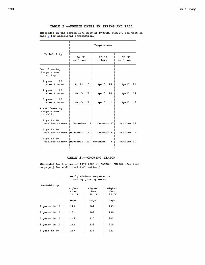
230 Soil Survey
TABLE 2.--FREEZE DATES IN SPRING AND FALL
(Recorded in the period 1971-2000 at DAYTON, OH2067. See text on page 9 for additional information.) | | Temperature | | _ Probability | | | | 24 °F | 28 °F | 32 °F | or lower | or lower | or lower | | | | | | Last freezing | | | temperature | | | in spring: | | | | | | 1 year in 10 | | | later than-- | April 3 | April 14 | April 21 | | | 2 year in 10 | | | later than-- | March 29 | April 10 | April 17 | | | 5 year in 10 | | | later than-- | March 21 | April 1 | April 9 | | | First freezing | | | temperature | | | in fall: | | | | | | 1 yr in 10 | | | earlier than-- | November 5| October 27| October 16 | | | 2 yr in 10 | | | earlier than-- |November 11 | October 31| October 21 | | | 5 yr in 10 | | | earlier than-- |November 23 |November 8 | October 30 | | | | | |
TABLE 3.--GROWING SEASON
(Recorded for the period 1971-2000 at DAYTON, OH2067. See text on page 9 for additional information.) | | Daily Minimum Temperature | During growing season | Probability | | | | Higher | Higher | Higher | than | than | than | 24 °F | 28 °F | 32 °F | | | | Days | Days | Days | | | 9 years in 10 | 223 | 202 | 183 | | | 8 years in 10 | 231 | 208 | 190 | | | 5 years in 10 | 246 | 220 | 202 | | | 2 years in 10 | 262 | 233 | 215 | | | 1 year in 10 | 269 | 239 | 221 | | |
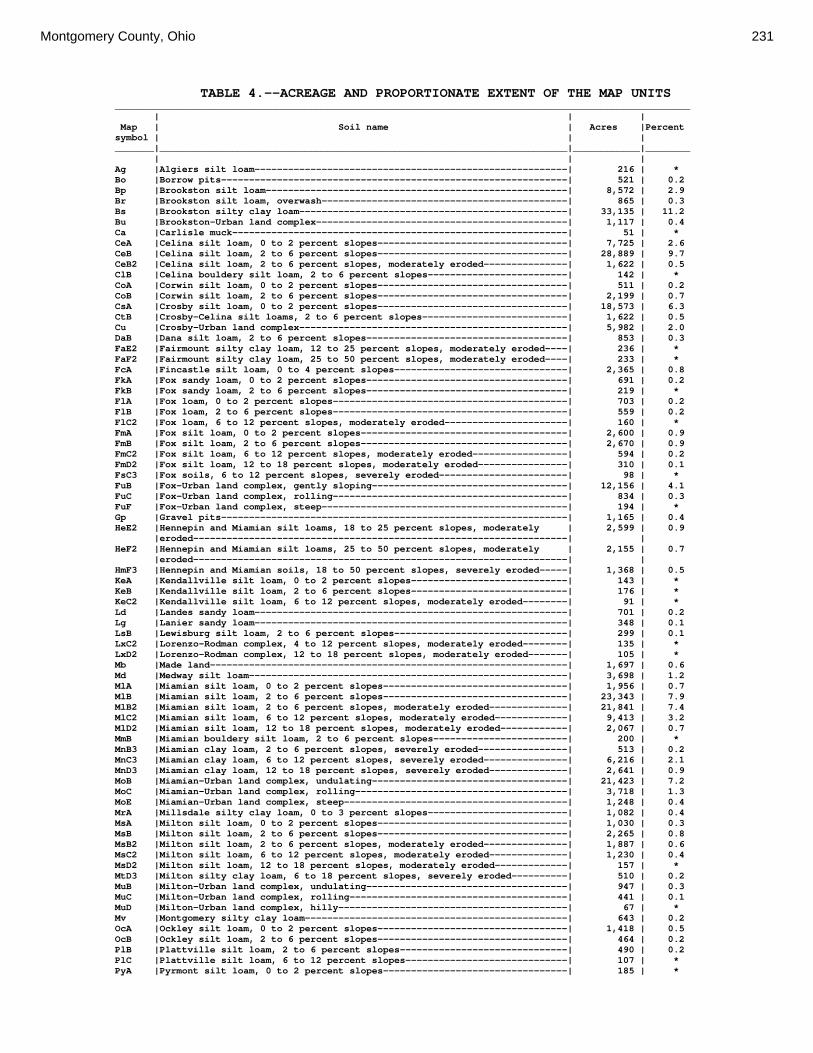
Montgomery County, Ohio 231
TABLE 4.--ACREAGE AND PROPORTIONATE EXTENT OF THE MAP UNITS _______________________________________________________________________________________________________ | | | Map | Soil name | Acres |Percent symbol | | | _______|_________________________________________________________________________|____________|________ | | | Ag |Algiers silt loam--------------------------------------------------------| 216 | * Bo |Borrow pits--------------------------------------------------------------| 521 | 0.2 Bp |Brookston silt loam------------------------------------------------------| 8,572 | 2.9 Br |Brookston silt loam, overwash--------------------------------------------| 865 | 0.3 Bs |Brookston silty clay loam------------------------------------------------| 33,135 | 11.2 Bu |Brookston-Urban land complex---------------------------------------------| 1,117 | 0.4 Ca |Carlisle muck------------------------------------------------------------| 51 | * CeA |Celina silt loam, 0 to 2 percent slopes----------------------------------| 7,725 | 2.6 CeB |Celina silt loam, 2 to 6 percent slopes----------------------------------| 28,889 | 9.7 CeB2 |Celina silt loam, 2 to 6 percent slopes, moderately eroded---------------| 1,622 | 0.5 ClB |Celina bouldery silt loam, 2 to 6 percent slopes-------------------------| 142 | * CoA |Corwin silt loam, 0 to 2 percent slopes----------------------------------| 511 | 0.2 CoB |Corwin silt loam, 2 to 6 percent slopes----------------------------------| 2,199 | 0.7 CsA |Crosby silt loam, 0 to 2 percent slopes----------------------------------| 18,573 | 6.3 CtB |Crosby-Celina silt loams, 2 to 6 percent slopes--------------------------| 1,622 | 0.5 Cu |Crosby-Urban land complex------------------------------------------------| 5,982 | 2.0 DaB |Dana silt loam, 2 to 6 percent slopes------------------------------------| 853 | 0.3 FaE2 |Fairmount silty clay loam, 12 to 25 percent slopes, moderately eroded----| 236 | * FaF2 |Fairmount silty clay loam, 25 to 50 percent slopes, moderately eroded----| 233 | * FcA |Fincastle silt loam, 0 to 4 percent slopes-------------------------------| 2,365 | 0.8 FkA |Fox sandy loam, 0 to 2 percent slopes------------------------------------| 691 | 0.2 FkB |Fox sandy loam, 2 to 6 percent slopes------------------------------------| 219 | * FlA |Fox loam, 0 to 2 percent slopes------------------------------------------| 703 | 0.2 FlB |Fox loam, 2 to 6 percent slopes------------------------------------------| 559 | 0.2 FlC2 |Fox loam, 6 to 12 percent slopes, moderately eroded----------------------| 160 | * FmA |Fox silt loam, 0 to 2 percent slopes-------------------------------------| 2,600 | 0.9 FmB |Fox silt loam, 2 to 6 percent slopes-------------------------------------| 2,670 | 0.9 FmC2 |Fox silt loam, 6 to 12 percent slopes, moderately eroded-----------------| 594 | 0.2 FmD2 |Fox silt loam, 12 to 18 percent slopes, moderately eroded----------------| 310 | 0.1 FsC3 |Fox soils, 6 to 12 percent slopes, severely eroded-----------------------| 98 | * FuB |Fox-Urban land complex, gently sloping-----------------------------------| 12,156 | 4.1 FuC |Fox-Urban land complex, rolling------------------------------------------| 834 | 0.3 FuF |Fox-Urban land complex, steep--------------------------------------------| 194 | * Gp |Gravel pits--------------------------------------------------------------| 1,165 | 0.4 HeE2 |Hennepin and Miamian silt loams, 18 to 25 percent slopes, moderately | 2,599 | 0.9 |eroded-------------------------------------------------------------------| | HeF2 |Hennepin and Miamian silt loams, 25 to 50 percent slopes, moderately | 2,155 | 0.7 |eroded-------------------------------------------------------------------| | HmF3 |Hennepin and Miamian soils, 18 to 50 percent slopes, severely eroded-----| 1,368 | 0.5 KeA |Kendallville silt loam, 0 to 2 percent slopes----------------------------| 143 | * KeB |Kendallville silt loam, 2 to 6 percent slopes----------------------------| 176 | * KeC2 |Kendallville silt loam, 6 to 12 percent slopes, moderately eroded--------| 91 | * Ld |Landes sandy loam--------------------------------------------------------| 701 | 0.2 Lg |Lanier sandy loam--------------------------------------------------------| 348 | 0.1 LsB |Lewisburg silt loam, 2 to 6 percent slopes-------------------------------| 299 | 0.1 LxC2 |Lorenzo-Rodman complex, 4 to 12 percent slopes, moderately eroded--------| 135 | * LxD2 |Lorenzo-Rodman complex, 12 to 18 percent slopes, moderately eroded-------| 105 | * Mb |Made land----------------------------------------------------------------| 1,697 | 0.6 Md |Medway silt loam---------------------------------------------------------| 3,698 | 1.2 MlA |Miamian silt loam, 0 to 2 percent slopes---------------------------------| 1,956 | 0.7 MlB |Miamian silt loam, 2 to 6 percent slopes---------------------------------| 23,343 | 7.9 MlB2 |Miamian silt loam, 2 to 6 percent slopes, moderately eroded--------------| 21,841 | 7.4 MlC2 |Miamian silt loam, 6 to 12 percent slopes, moderately eroded-------------| 9,413 | 3.2 MlD2 |Miamian silt loam, 12 to 18 percent slopes, moderately eroded------------| 2,067 | 0.7 MmB |Miamian bouldery silt loam, 2 to 6 percent slopes------------------------| 200 | * MnB3 |Miamian clay loam, 2 to 6 percent slopes, severely eroded----------------| 513 | 0.2 MnC3 |Miamian clay loam, 6 to 12 percent slopes, severely eroded---------------| 6,216 | 2.1 MnD3 |Miamian clay loam, 12 to 18 percent slopes, severely eroded--------------| 2,641 | 0.9 MoB |Miamian-Urban land complex, undulating-----------------------------------| 21,423 | 7.2 MoC |Miamian-Urban land complex, rolling--------------------------------------| 3,718 | 1.3 MoE |Miamian-Urban land complex, steep----------------------------------------| 1,248 | 0.4 MrA |Millsdale silty clay loam, 0 to 3 percent slopes-------------------------| 1,082 | 0.4 MsA |Milton silt loam, 0 to 2 percent slopes----------------------------------| 1,030 | 0.3 MsB |Milton silt loam, 2 to 6 percent slopes----------------------------------| 2,265 | 0.8 MsB2 |Milton silt loam, 2 to 6 percent slopes, moderately eroded---------------| 1,887 | 0.6 MsC2 |Milton silt loam, 6 to 12 percent slopes, moderately eroded--------------| 1,230 | 0.4 MsD2 |Milton silt loam, 12 to 18 percent slopes, moderately eroded-------------| 157 | * MtD3 |Milton silty clay loam, 6 to 18 percent slopes, severely eroded----------| 510 | 0.2 MuB |Milton-Urban land complex, undulating------------------------------------| 947 | 0.3 MuC |Milton-Urban land complex, rolling---------------------------------------| 441 | 0.1 MuD |Milton-Urban land complex, hilly-----------------------------------------| 67 | * Mv |Montgomery silty clay loam-----------------------------------------------| 643 | 0.2 OcA |Ockley silt loam, 0 to 2 percent slopes----------------------------------| 1,418 | 0.5 OcB |Ockley silt loam, 2 to 6 percent slopes----------------------------------| 464 | 0.2 PlB |Plattville silt loam, 2 to 6 percent slopes------------------------------| 490 | 0.2 PlC |Plattville silt loam, 6 to 12 percent slopes-----------------------------| 107 | * PyA |Pyrmont silt loam, 0 to 2 percent slopes---------------------------------| 185 | *

232 Soil Survey
TABLE 4.--ACREAGE AND PROPORTIONATE EXTENT OF THE MAP UNITS--Continued _______________________________________________________________________________________________________ | | | Map | Soil name | Acres |Percent symbol | | | _______|_________________________________________________________________________|____________|________ Qu |Quarries-----------------------------------------------------------------| 203 | * RcA |Randolph silt loam, 0 to 2 percent slopes--------------------------------| 664 | 0.2 ReB |Ritchey silt loam, 2 to 6 percent slopes---------------------------------| 271 | * ReB2 |Ritchey silt loam, 2 to 6 percent slopes, moderately eroded--------------| 192 | * ReC2 |Ritchey silt loam, 6 to 12 percent slopes, moderately eroded-------------| 458 | 0.2 ReE2 |Ritchey silt loam, 12 to 25 percent slopes, moderately eroded------------| 445 | 0.1 ReF2 |Ritchey silt loam, 25 to 50 percent slopes, moderately eroded------------| 373 | 0.1 RfD3 |Ritchey silt clay loam, 6 to 18 percent slopes, severely eroded----------| 106 | * Rh |Riverwash----------------------------------------------------------------| 258 | * RlE2 |Rodman and Fox soils, 18 to 25 percent slopes, moderately eroded---------| 403 | 0.1 RlF2 |Rodman and Fox soils, 25 to 50 percent slopes, moderately eroded---------| 302 | 0.1 Rs |Ross silt loam-----------------------------------------------------------| 10,731 | 3.6 Rt |Ross-Urban land complex--------------------------------------------------| 3,786 | 1.3 RuB |Russell silt loam, 2 to 6 percent slopes---------------------------------| 3,953 | 1.3 RvC2 |Russell-Miamian silt loams, 6 to 12 percent slopes, moderately eroded----| 489 | 0.2 RvD2 |Russell-Miamian silt loams, 12 to 18 percent slopes, moderately eroded---| 116 | * Sh |Shoals silt loam---------------------------------------------------------| 101 | * So |Sloan silt loam----------------------------------------------------------| 953 | 0.3 ThA |Thackery silt loam, till substratum, 0 to 2 percent slopes---------------| 145 | * TpA |Tippecanoe silt loam, 0 to 2 percent slopes------------------------------| 134 | * Ua |Urban land, alluvial-----------------------------------------------------| 738 | 0.2 Ud |Udorthents---------------------------------------------------------------| 2,196 | 0.7 Ug |Urban land, gravelly material--------------------------------------------| 186 | * Um |Urban land, loamy material-----------------------------------------------| 74 | * W |Water--------------------------------------------------------------------| 2,233 | 0.8 WaA |Warsaw silt loam, 0 to 2 percent slopes----------------------------------| 408 | 0.1 WaB |Warsaw silt loam, 2 to 6 percent slopes----------------------------------| 75 | * WeA |Wea silt loam, 0 to 2 percent slopes-------------------------------------| 1,424 | 0.5 WeB |Wea silt loam, 2 to 6 percent slopes-------------------------------------| 179 | * Ws |Westland silty clay loam-------------------------------------------------| 898 | 0.3 WyB2 |Wynn silt loam, 2 to 6 percent slopes, moderately eroded-----------------| 199 | * XeA |Xenia silt loam, 0 to 2 percent slopes-----------------------------------| 1,224 | 0.4 XeB |Xenia silt loam, 2 to 6 percent slopes-----------------------------------| 3,836 | 1.3 | |____________|________ | Total---------------------------------------------------------------| 297,152 | 100.0 _______|_________________________________________________________________________|____________|________ * Less than 0.1 percent.

Montgomery County, Ohio 233
TABLE 5.--PRIME FARMLAND (Only the soils considered prime farmland are listed. Urban or built-up areas of the soils listed are not considered prime farmland. If a soil is prime farmland only under certain conditions, the conditions are specified in parentheses after the soil name. See text on page 151 for additional information.) ____________________________________________________________________________________________ | Map | Soil name symbol | _______|____________________________________________________________________________________ | Ag |Algiers silt loam (Prime farmland if drained) Bp |Brookston silt loam (Prime farmland if drained) Br |Brookston silt loam, overwash (Prime farmland if drained) Bs |Brookston silty clay loam (Prime farmland if drained) CeA |Celina silt loam, 0 to 2 percent slopes CeB |Celina silt loam, 2 to 6 percent slopes CeB2 |Celina silt loam, 2 to 6 percent slopes, moderately eroded ClB |Celina bouldery silt loam, 2 to 6 percent slopes CoA |Corwin silt loam, 0 to 2 percent slopes CoB |Corwin silt loam, 2 to 6 percent slopes CsA |Crosby silt loam, 0 to 2 percent slopes (Prime farmland if drained) CtB |Crosby-Celina silt loams, 2 to 6 percent slopes (Prime farmland if drained) DaB |Dana silt loam, 2 to 6 percent slopes FcA |Fincastle silt loam, 0 to 4 percent slopes (Prime farmland if drained) FkA |Fox sandy loam, 0 to 2 percent slopes FkB |Fox sandy loam, 2 to 6 percent slopes FlA |Fox loam, 0 to 2 percent slopes FlB |Fox loam, 2 to 6 percent slopes FmA |Fox silt loam, 0 to 2 percent slopes FmB |Fox silt loam, 2 to 6 percent slopes KeA |Kendallville silt loam, 0 to 2 percent slopes KeB |Kendallville silt loam, 2 to 6 percent slopes Ld |Landes sandy loam Lg |Lanier sandy loam LsB |Lewisburg silt loam, 2 to 6 percent slopes Md |Medway silt loam MlA |Miamian silt loam, 0 to 2 percent slopes MlB |Miamian silt loam, 2 to 6 percent slopes MlB2 |Miamian silt loam, 2 to 6 percent slopes, moderately eroded MrA |Millsdale silty clay loam, 0 to 3 percent slopes (Prime farmland if drained) MsA |Milton silt loam, 0 to 2 percent slopes MsB |Milton silt loam, 2 to 6 percent slopes MsB2 |Milton silt loam, 2 to 6 percent slopes, moderately eroded Mv |Montgomery silty clay loam (Prime farmland if drained) OcA |Ockley silt loam, 0 to 2 percent slopes OcB |Ockley silt loam, 2 to 6 percent slopes PlB |Plattville silt loam, 2 to 6 percent slopes PyA |Pyrmont silt loam, 0 to 2 percent slopes (Prime farmland if drained) RcA |Randolph silt loam, 0 to 2 percent slopes (Prime farmland if drained) Rs |Ross silt loam RuB |Russell silt loam, 2 to 6 percent slopes Sh |Shoals silt loam (Prime farmland if drained) ThA |Thackery silt loam, till substratum, 0 to 2 percent slopes TpA |Tippecanoe silt loam, 0 to 2 percent slopes WaA |Warsaw silt loam, 0 to 2 percent slopes WaB |Warsaw silt loam, 2 to 6 percent slopes WeA |Wea silt loam, 0 to 2 percent slopes WeB |Wea silt loam, 2 to 6 percent slopes Ws |Westland silty clay loam (Prime farmland if drained) WyB2 |Wynn silt loam, 2 to 6 percent slopes, moderately eroded XeA |Xenia silt loam, 0 to 2 percent slopes XeB |Xenia silt loam, 2 to 6 percent slopes _______|____________________________________________________________________________________
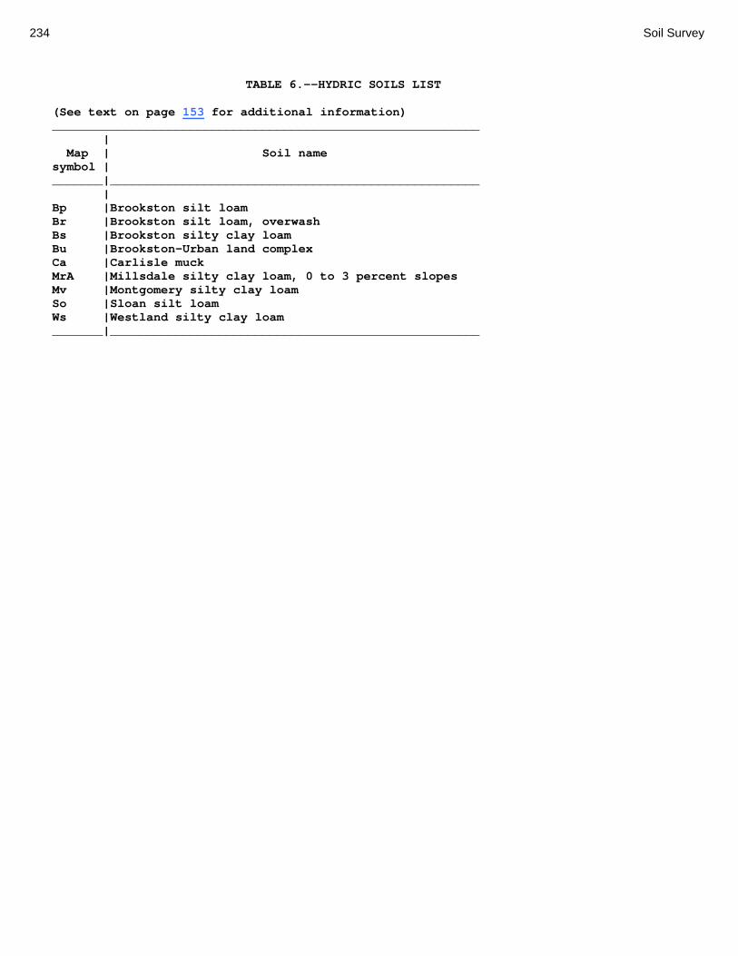
234 Soil Survey
TABLE 6.--HYDRIC SOILS LIST (See text on page 153 for additional information) ___________________________________________________________ | Map | Soil name symbol | _______|___________________________________________________ | Bp |Brookston silt loam Br |Brookston silt loam, overwash Bs |Brookston silty clay loam Bu |Brookston-Urban land complex Ca |Carlisle muck MrA |Millsdale silty clay loam, 0 to 3 percent slopes Mv |Montgomery silty clay loam So |Sloan silt loam Ws |Westland silty clay loam _______|___________________________________________________

Montgomery County, Ohio 235
TABLE 7.--NON-HYDRIC MAPUNITS WITH HYDRIC COMPONENTS (See text on page 153 for additional information) _____________________________________________________________________________________________ | | | | Map symbol and |Hydric | | map unit name |Component |Landform |__________________________________________________|____________________|____________________ |Ag: | | |Algiers silt loam | | | |Sloan |depression, slough, | | | flood plain | | | | |Westland |depression, terrace | | | |CeA: | | |Celina silt loam, 0 to 2 percent slopes | | | |Brookston |depression, ground | | | moraine | | | |CeB: | | |Celina silt loam, 2 to 6 percent slopes | | | |Brookston |drainageway, | | | depression, ground | | | moraine | | | |CeB2: | | |Celina silt loam, 2 to 6 percent slopes, | | | moderately eroded | | | |Brookston |drainageway, | | | depression, ground | | | moraine | | | |ClB: | | |Celina bouldery silt loam, 2 to 6 percent slopes | | | |Brookston |drainageway, | | | depression, ground | | | moraine | | | |CoA: | | |Corwin silt loam, 0 to 2 percent slopes | | | |Brookston |depression, ground | | | moraine | | | |CoB: | | |Corwin silt loam, 2 to 6 percent slopes | | | |Brookston |drainageway, | | | depression, ground | | | moraine | | | |CsA: | | |Crosby silt loam, 0 to 2 percent slopes | | | |Brookston |depression, ground | | | moraine | | | |CtB: | | |Crosby-Celina silt loams, 2 to 6 percent slopes | | | |Brookston |drainageway, | | | depression, ground | | | moraine | | | |Cu: | | |Crosby-Urban land complex | | | |Brookston |depression, ground | | | moraine | | | |DaB: | | |Dana silt loam, 2 to 6 percent slopes | | | |Brookston |drainageway, | | | depression, ground | | | moraine | | |

236 Soil Survey
TABLE 7.--NON-HYDRIC MAPUNITS WITH HYDRIC COMPONENTS--Continued _____________________________________________________________________________________________ | | | | Map symbol and |Hydric | | map unit name |Component |Landform |__________________________________________________|____________________|____________________ |FcA: | | |Fincastle silt loam, 0 to 4 percent slopes | | | |Brookston |depression, ground | | | moraine | | | |Lg: | | |Lanier sandy loam | | | |Sloan |oxbow, flood plain | | | |LsB: | | |Lewisburg silt loam, 2 to 6 percent slopes | | | |Brookston |depression, | | | drainageway, ground | | | moraine | | | |Md: | | |Medway silt loam | | | |Sloan |slough, oxbow, flood | | | plain | | | |MlA: | | |Miamian silt loam, 0 to 2 percent slopes | | | |Brookston |drainageway, | | | depression, ground | | | moraine | | | |MlB: | | |Miamian silt loam, 2 to 6 percent slopes | | | |Brookston |drainageway, | | | depression, ground | | | moraine | | | |MlB2: | | |Miamian silt loam, 2 to 6 percent slopes, | | | moderately eroded | | | |Brookston |drainageway, | | | depression, ground | | | moraine | | | |MlC2: | | |Miamian silt loam, 6 to 12 percent slopes, | | | moderately eroded | | | |Brookston |drainageway, ground | | | moraine | | | |MmB: | | |Miamian bouldery silt loam, 2 to 6 percent slopes | | | |Brookston |drainageway, | | | depression, ground | | | moraine | | | |MnB3: | | |Miamian clay loam, 2 to 6 percent slopes, severely| | | eroded | | | |Brookston |drainageway, | | | depression, ground | | | moraine | | | |MnC3: | | |Miamian clay loam, 6 to 12 percent slopes, | | | severely eroded | | | |Brookston |drainageway, | | | depression, ground | | | moraine | | |

Montgomery County, Ohio 237
TABLE 7.--NON-HYDRIC MAPUNITS WITH HYDRIC COMPONENTS--Continued _____________________________________________________________________________________________ | | | | Map symbol and |Hydric | | map unit name |Component |Landform |__________________________________________________|____________________|____________________ |MoB: | | |Miamian-Urban land complex, undulating | | | |Brookston |depression, flat, | | | ground moraine | | | |MoC: | | |Miamian-Urban land complex, rolling | | | |Brookston |depression, flat, | | | ground moraine |PlB: | | |Plattville silt loam, 2 to 6 percent slopes | | | |Millsdale |depression | | | |PlC: | | |Plattville silt loam, 6 to 12 percent slopes | | | |Millsdale |depression | | | |PyA: | | |Pyrmont silt loam, 0 to 2 percent slopes | | | |Brookston |depression | | | |RcA: | | |Randolph silt loam, 0 to 2 percent slopes | | | |Millsdale |depression | | | |Rs: | | |Ross silt loam | | | |Sloan |slough, oxbow, flood | | | plain | | | |Rt: | | |Ross-Urban land complex | | | |Sloan |oxbow, flood plain | | | |RuB: | | |Russell silt loam, 2 to 6 percent slopes | | | |Ragsdale |drainageway, | | | depression, ground | | | moraine | | | |RvC2: | | |Russell-Miamian silt loams, 6 to 12 percent | | | slopes, moderately eroded | | | |Brookston |drainageway, | | | depression, ground | | | moraine | | | |Sh: | | |Shoals silt loam | | | |Sloan |oxbow, slough, flood | | | plain | | | |ThA: | | |Thackery silt loam, till substratum, 0 to 2 | | | percent slopes | | | |Westland |depression | | | |TpA: | | |Tippecanoe silt loam, 0 to 2 percent slopes | | | |Westland |depression, | | | drainageway | | | |XeA: | | |Xenia silt loam, 0 to 2 percent slopes | | | |Brookston |drainageway | | |

238 Soil Survey
TABLE 7.--NON-HYDRIC MAPUNITS WITH HYDRIC COMPONENTS--Continued _____________________________________________________________________________________________ | | | | Map symbol and |Hydric | | map unit name |Component |Landform |__________________________________________________|____________________|____________________ |XeB: | | |Xenia silt loam, 2 to 6 percent slopes | | | |Brookston |drainageway | | | |__________________________________________________|____________________|____________________

Montgomery County, Ohio 239
TABLE 8.--CROPLAND LIMITATIONS AND HAZARDS (See text on page 157 for a description of the limitations and hazards listed in this table. Only soils suitable for cultivated crops are listed in this table.) _________________________________________________________________________________________________ | Soil name | and | Cropland map symbol | limitations and hazards __________________________|______________________________________________________________________ | Ag: | Algiers---------------|Occasional flooding, seasonal high water table, surface compaction, |moderate potential for ground-water pollution, frost action, surface |crusting. | Bp: | Brookston-------------|Ponding, surface compaction, moderate potential for ground-water |pollution, frost action. | Br: | Brookston-------------|Ponding, surface compaction, moderate potential for ground-water |pollution, frost action. | Bs: | Brookston-------------|Ponding, surface compaction, moderate potential for ground-water |pollution, frost action, fair tilth. | Ca: | Carlisle--------------|Ponded for extended periods, moderate potential for ground-water |pollution, frost action, subsidence of the muck, very high organic |matter content, wind erosion. | CeA: | Celina----------------|Surface compaction, frost action, surface crusting, high clay content. | CeB: | Celina----------------|Surface compaction, frost action, surface crusting, erosion hazard, |high clay content. | CeB2: | Celina----------------|Part of the surface layer removed by erosion, surface compaction, |frost action, fair tilth, surface crusting, erosion hazard, high clay |content. | ClB: | Celina----------------|Stony surface, surface compaction, frost action, surface crusting, |erosion hazard, high clay content. | CoA: | Corwin----------------|Surface compaction, moderate potential for ground-water pollution, |surface crusting. | CoB: | Corwin----------------|Surface compaction, moderate potential for ground-water pollution, |surface crusting, erosion hazard. | CsA: | Crosby----------------|Seasonal high water table, surface compaction, frost action, surface |crusting, high clay content. | CtB: | Crosby----------------|Seasonal high water table, surface compaction, frost action, surface |crusting, high clay content. | Celina----------------|Surface compaction, frost action, surface crusting, erosion hazard, |high clay content. | DaB: | Dana------------------|Surface compaction, frost action, erosion hazard. |

240 Soil Survey
TABLE 8.--CROPLAND LIMITATIONS AND HAZARDS--Continued _________________________________________________________________________________________________ | Soil name | and | Cropland map symbol | limitations and hazards _________________________|______________________________________________________________________ | FcA: | Fincastle-------------|Seasonal high water table, surface compaction, moderate potential for |ground-water pollution, frost action, surface crusting. | FkA: | Fox-------------------|High potential for ground-water pollution, wind erosion, limited |available water capacity. | FkB: | Fox-------------------|High potential for ground-water pollution, erosion hazard, wind |erosion, limited available water capacity. | FlA: | Fox-------------------|High potential for ground-water pollution, limited available water |capacity. | FlB: | Fox-------------------|High potential for ground-water pollution, erosion hazard, limited |available water capacity. | FlC2: | Fox-------------------|Part of the surface layer removed by erosion, high potential for |ground-water pollution, fair tilth, easily eroded, erosion hazard, |limited available water capacity. | FmA: | Fox-------------------|Surface compaction, high potential for ground-water pollution, surface |crusting, limited available water capacity. | FmB: | Fox-------------------|Surface compaction, high potential for ground-water pollution, surface |crusting, erosion hazard, limited available water capacity. | FmC2: | Fox-------------------|Part of the surface layer removed by erosion, surface compaction, high |potential for ground-water pollution, fair tilth, surface crusting, |easily eroded, erosion hazard, limited available water capacity. | FmD2: | Fox-------------------|Part of the surface layer removed by erosion, surface compaction, high |potential for ground-water pollution, fair tilth, surface crusting, |easily eroded, erosion hazard, limited available water capacity. | FsC3: | Fox-------------------|Most of the surface layer removed by erosion, surface compaction, high |potential for ground-water pollution, fair tilth, easily eroded, |erosion hazard, limited available water capacity. | KeA: | Kendallville----------|Surface compaction, surface crusting. | KeB: | Kendallville----------|Surface compaction, surface crusting, erosion hazard. | KeC2: | Kendallville----------|Part of the surface layer removed by erosion, surface compaction, fair |tilth, surface crusting, easily eroded, erosion hazard. | Ld: | Landes----------------|Occasional flooding, high potential for ground-water pollution, wind |erosion, limited available water capacity. | Lg: | Lanier----------------|Occasional flooding, high potential for ground-water pollution, wind |erosion, limited available water capacity.

Montgomery County, Ohio 241
TABLE 8.--CROPLAND LIMITATIONS AND HAZARDS--Continued _________________________________________________________________________________________________ | Soil name | and | Cropland map symbol | limitations and hazards _________________________|______________________________________________________________________ | LsB: | Lewisburg-------------|Surface compaction, surface crusting, erosion hazard, high clay |content. | LxC2: | Lorenzo---------------|Part of the surface layer removed by erosion, high potential for |ground-water pollution, fair tilth, easily eroded, erosion hazard, |limited available water capacity. | Rodman----------------|Part of the surface layer removed by erosion, high potential for |ground-water pollution, fair tilth, erosion hazard, limited available |water capacity, sandy layers. | LxD2: | Lorenzo---------------|Part of the surface layer removed by erosion, high potential for |ground-water pollution, fair tilth, easily eroded, erosion hazard, |limited available water capacity. | Rodman----------------|Part of the surface layer removed by erosion, high potential for |ground-water pollution, fair tilth, easily eroded, erosion hazard, |limited available water capacity, sandy layers. | Md: | Medway----------------|Occasional flooding, surface compaction, moderate potential for |ground-water pollution, frost action. | MlA: | Miamian---------------|Surface compaction, surface crusting, high clay content. | MlB: | Miamian---------------|Surface compaction, surface crusting, erosion hazard, high clay |content. | MlB2: | Miamian---------------|Part of the surface layer removed by erosion, surface compaction, fair |tilth, surface crusting, erosion hazard, high clay content. | MlC2: | Miamian---------------|Part of the surface layer removed by erosion, surface compaction, fair |tilth, surface crusting, easily eroded, erosion hazard, high clay |content. | MlD2: | Miamian---------------|Part of the surface layer removed by erosion, surface compaction, fair |tilth, surface crusting, easily eroded, erosion hazard, high clay |content. | MmB: | Miamian---------------|Stony surface, surface compaction, surface crusting, erosion hazard, |high clay content. | MnB3: | Miamian---------------|Most of the surface layer removed by erosion, surface compaction, poor |tilth, erosion hazard, high clay content. | MnC3: | Miamian---------------|Most of the surface layer removed by erosion, surface compaction, poor |tilth, easily eroded, erosion hazard, high clay content. | MnD3: | Miamian---------------|Most of the surface layer removed by erosion, surface compaction, poor |tilth, easily eroded, erosion hazard, high clay content. |

242 Soil Survey
TABLE 8.--CROPLAND LIMITATIONS AND HAZARDS--Continued _________________________________________________________________________________________________ | Soil name | and | Cropland map symbol | limitations and hazards _________________________|______________________________________________________________________ | MrA: | Millsdale-------------|Ponding, surface compaction, depth to bedrock, high potential for |ground-water pollution, frost action, fair tilth, limited available |water capacity, high clay content. | MsA: | Milton----------------|Surface compaction, depth to bedrock, high potential for ground-water |pollution, surface crusting, limited available water capacity, high |clay content. | MsB: | Milton----------------|Surface compaction, depth to bedrock, high potential for ground-water |pollution, surface crusting, erosion hazard, limited available water |capacity, high clay content. | MsB2: | Milton----------------|Part of the surface layer removed by erosion, surface compaction, |depth to bedrock, high potential for ground-water pollution, fair |tilth, surface crusting, erosion hazard, limited available water |capacity, high clay content. | MsC2: | Milton----------------|Part of the surface layer removed by erosion, surface compaction, |depth to bedrock, high potential for ground-water pollution, fair |tilth, surface crusting, easily eroded, erosion hazard, limited |available water capacity, high clay content. | MsD2: | Milton----------------|Part of the surface layer removed by erosion, surface compaction, |depth to bedrock, high potential for ground-water pollution, fair |tilth, surface crusting, easily eroded, erosion hazard, limited |available water capacity, high clay content. | MtD3: | Milton----------------|Most of the surface layer removed by erosion, surface compaction, |depth to bedrock, high potential for ground-water pollution, poor |tilth, surface crusting, easily eroded, erosion hazard, limited |available water capacity, high clay content. | Mv: | Montgomery------------|Ponding, surface compaction, moderate potential for ground-water |pollution, poor tilth, frost action, restricted permeability, |clodding, high clay content. | OcA: | Ockley----------------|Surface compaction, high potential for ground-water pollution, surface |crusting. | OcB: | Ockley----------------|Surface compaction, high potential for ground-water pollution, surface |crusting, erosion hazard. | PlB: | Plattville------------|Surface compaction, depth to bedrock, high potential for ground-water |pollution, erosion hazard, limited available water capacity. | PlC: | Plattville------------|Surface compaction, depth to bedrock, high potential for ground-water |pollution, surface crusting, easily eroded, erosion hazard, limited |available water capacity. | PyA: | Pyrmont---------------|Seasonal high water table, surface compaction, frost action, surface |crusting. |

Montgomery County, Ohio 243
TABLE 8.--CROPLAND LIMITATIONS AND HAZARDS--Continued _________________________________________________________________________________________________ | Soil name | and | Cropland map symbol | limitations and hazards _________________________|______________________________________________________________________ | RcA: | Randolph--------------|Seasonal high water table, surface compaction, depth to bedrock, high |potential for ground-water pollution, frost action, surface crusting, |limited available water capacity, high clay content. | ReB: | Ritchey---------------|Surface compaction, depth to bedrock, high potential for ground-water |pollution, surface crusting, erosion hazard, limited available water |capacity. | ReB2: | Ritchey---------------|Part of the surface layer removed by erosion, surface compaction, |depth to bedrock, high potential for ground-water pollution, fair |tilth, surface crusting, erosion hazard, limited available water |capacity. | ReC2: | Ritchey---------------|Part of the surface layer removed by erosion, surface compaction, |depth to bedrock, high potential for ground-water pollution, fair |tilth, surface crusting, easily eroded, erosion hazard, limited |available water capacity. | RfD3: | Ritchey---------------|Most of the surface layer removed by erosion, surface compaction, |depth to bedrock, high potential for ground-water pollution, poor |tilth, surface crusting, easily eroded, erosion hazard, limited |available water capacity, clodding. | Rs: | Ross------------------|Occasional flooding, surface compaction. | RuB: | Russell---------------|Surface compaction, frost action, surface crusting, erosion hazard. | RvC2: | Russell---------------|Part of the surface layer removed by erosion, surface compaction, |frost action, fair tilth, surface crusting, easily eroded, erosion |hazard. | Miamian---------------|Part of the surface layer removed by erosion, surface compaction, fair |tilth, surface crusting, easily eroded, erosion hazard, high clay |content. | RvD2: | Russell---------------|Part of the surface layer removed by erosion, surface compaction, |frost action, fair tilth, surface crusting, easily eroded, erosion |hazard. | Miamian---------------|Part of the surface layer removed by erosion, surface compaction, fair |tilth, surface crusting, easily eroded, erosion hazard, high clay |content. | Sh: | Shoals----------------|Occasional flooding, seasonal high water table, surface compaction, |moderate potential for ground-water pollution, frost action, surface |crusting. | So: | Sloan-----------------|Frequent flooding, ponding, surface compaction, moderate potential for |ground-water pollution, frost action. | ThA: | Thackery--------------|Surface compaction, moderate potential for ground-water pollution, |surface crusting. |

244 Soil Survey
TABLE 8.--CROPLAND LIMITATIONS AND HAZARDS--Continued _________________________________________________________________________________________________ | Soil name | and | Cropland map symbol | limitations and hazards _________________________|______________________________________________________________________ | TpA: | Tippecanoe------------|Surface compaction, high potential for ground-water pollution. | WaA: | Warsaw----------------|Surface compaction, high potential for ground-water pollution, limited |available water capacity. | WaB: | Warsaw----------------|Surface compaction, high potential for ground-water pollution, erosion |hazard, limited available water capacity. | WeA: | Wea-------------------|Surface compaction, high potential for ground-water pollution. | WeB: | Wea-------------------|Surface compaction, high potential for ground-water pollution, erosion |hazard. | Ws: | Westland--------------|Ponding, surface compaction, high potential for ground-water |pollution, frost action, fair tilth. | WyB2: | Wynn------------------|Part of the surface layer removed by erosion, surface compaction, |depth to bedrock, high potential for ground-water pollution, fair |tilth, surface crusting, erosion hazard, limited available water |capacity. | XeA: | Xenia-----------------|Surface compaction, moderate potential for ground-water pollution, |frost action, surface crusting. | XeB: | Xenia-----------------|Surface compaction, moderate potential for ground-water pollution, |frost action, surface crusting, erosion hazard. |

Montgomery County, Ohio 245
TABLE 9.--CROP YIELD INDEX (This table is based on yields from the years 1992-2000. Estimated yields for soils with a yield index of 100 are: corn - 125 bushels; soybeans - 45 bushels; and wheat - 45 bushels. Refer to Crop Yield Index section in the text on page 160 for more information on how this table was developed, and instructions on converting yield index numbers to estimated yields. Absence of a yield index indicates that the soil is not suited to the crop or the crop is generally not grown on the soil.) _________________________________________________________________ | | | Map symbol | Corn | Soybeans |Winter Wheat and soil name | | | _________________________|____________|____________|_____________ | | | Ag: | 100 | 89 | 100 Algiers-----------------| | | | | | Bp: | 92 | 89 | 100 Brookston---------------| | | | | | Br: | 92 | 89 | 100 Brookston---------------| | | | | | Bs: | 100 | 100 | 100 Brookston---------------| | | | | | Ca: | 100 | --- | --- Carlisle----------------| | | | | | CeA: | 92 | 89 | 100 Celina------------------| | | | | | CeB: | 88 | 89 | 100 Celina------------------| | | | | | CeB2: | 80 | 78 | 89 Celina------------------| | | | | | ClB: | 80 | 73 | 89 Celina------------------| | | | | | CoA: | 80 | 78 | 89 Corwin------------------| | | | | | CoB: | 96 | 89 | 100 Corwin------------------| | | | | | CsA: | 88 | 89 | 89 Crosby------------------| | | | | | CtB: | 92 | 89 | 89 Crosby------------------| | | Celina------------------| | | | | | DaB: | 88 | 89 | 98 Dana--------------------| | | | | | FcA: | 84 | 89 | 89 Fincastle---------------| | | | | | FkA: | 68 | 58 | 78 Fox---------------------| | | | | | FkB: | 58 | 56 | 64 Fox---------------------| | | | | | FlA: | 72 | 67 | 89 Fox---------------------| | | | | |

246 Soil Survey
TABLE 9.--CROP YIELD INDEX--Continued _____________________________________________________________________ | | | Map symbol | Corn | Soybeans |Winter Wheat and soil name | | | _________________________|____________|____________|____________ | | | FlB: | 72 | 62 | 89 Fox---------------------| | | | | | FlC2: | 62 | 56 | 78 Fox---------------------| | | | | | FmA: | 76 | 71 | 89 Fox---------------------| | | | | | FmB: | 76 | 71 | 89 Fox---------------------| | | | | | FmC2: | 64 | 56 | 73 Fox---------------------| | | | | | FmD2: | 56 | 47 | 49 Fox---------------------| | | | | | FsC3: | 48 | 47 | 49 Fox---------------------| | | | | | KeA: | 88 | 76 | 100 Kendallville------------| | | | | | KeB: | 88 | 76 | 100 Kendallville------------| | | | | | KeC2: | 84 | 78 | 89 Kendallville------------| | | | | | Ld: | 82 | 76 | 87 Landes------------------| | | | | | Lg: | 60 | 56 | 76 Lanier------------------| | | | | | LsB: | 80 | 78 | 89 Lewisburg---------------| | | | | | LxC2: | 52 | 44 | 56 Lorenzo-----------------| | | Rodman------------------| | | | | | LxD2: | --- | --- | --- Lorenzo-----------------| | | Rodman------------------| | | | | | Md: | 100 | 100 | 89 Medway------------------| | | | | | MlA: | 80 | 89 | 89 Miamian-----------------| | | | | | MlB: | 80 | 89 | 89 Miamian-----------------| | | | | | MlB2: | 72 | 62 | 80 Miamian-----------------| | | | | | MlC2: | 68 | 58 | 80 Miamian-----------------| | | | | | MlD2: | 60 | 44 | 58 Miamian-----------------| | | | | |

Montgomery County, Ohio 247
TABLE 9.--CROP YIELD INDEX--Continued _____________________________________________________________________ | | | Map symbol | Corn | Soybeans |Winter Wheat and soil name | | | _________________________|____________|____________|____________ | | | MmB: | 72 | 76 | 87 Miamian-----------------| | | | | | MnB3: | 56 | 44 | 67 Miamian-----------------| | | | | | MnC3: | 52 | 56 | 56 Miamian-----------------| | | | | | MnD3: | --- | --- | --- Miamian-----------------| | | | | | MrA: | 84 | 89 | 100 Millsdale---------------| | | | | | MsA: | 72 | 71 | 93 Milton------------------| | | | | | MsB: | 68 | 67 | 89 Milton------------------| | | | | | MsB2: | 64 | 56 | 78 Milton------------------| | | | | | MsC2: | 60 | 56 | 76 Milton------------------| | | | | | MsD2: | 48 | 40 | 67 Milton------------------| | | | | | MtD3: | 48 | 36 | 53 Milton------------------| | | | | | Mv: | 100 | 93 | 98 Montgomery--------------| | | | | | OcA: | 88 | 89 | 89 Ockley------------------| | | | | | OcB: | 84 | 76 | 96 Ockley------------------| | | | | | PlB: | 76 | 71 | 84 Plattville--------------| | | | | | PlC: | 72 | 62 | 78 Plattville--------------| | | | | | PyA: | 48 | 62 | 67 Pyrmont-----------------| | | | | | RcA: | 80 | 71 | 76 Randolph----------------| | | | | | ReB: | 52 | 49 | 67 Ritchey-----------------| | | | | | ReB2: | 48 | 44 | 67 Ritchey-----------------| | | | | | ReC2: | --- | --- | 62 Ritchey-----------------| | | | | | RfD3: | --- | --- | 49 Ritchey-----------------| | |

248 Soil Survey
TABLE 9.--CROP YIELD INDEX--Continued _____________________________________________________________________ | | | Map symbol | Corn | Soybeans |Winter Wheat and soil name | | | _________________________|____________|____________|____________ | | | Rs: | 100 | 89 | 100 Ross--------------------| | | | | | RuB: | 80 | 80 | 93 Russell-----------------| | | | | | RvC2: | 68 | 67 | 84 Russell-----------------| | | Miamian-----------------| | | | | | RvD2: | 60 | 47 | 60 Russell-----------------| | | Miamian-----------------| | | | | | Sh: | 80 | 89 | 89 Shoals------------------| | | | | | So: | 88 | 100 | 100 Sloan-------------------| | | | | | ThA: | 82 | 78 | 93 Thackery----------------| | | | | | TpA: | 94 | 87 | 87 Tippecanoe--------------| | | | | | WaA: | 88 | 89 | 89 Warsaw------------------| | | | | | WaB: | 86 | 89 | 89 Warsaw------------------| | | | | | WeA: | 96 | 100 | 100 Wea---------------------| | | | | | WeB: | 92 | 71 | 87 Wea---------------------| | | | | | Ws: | 100 | 84 | 89 Westland----------------| | | | | | WyB2: | 72 | 67 | 80 Wynn--------------------| | | | | | XeA: | 84 | 78 | 100 Xenia-------------------| | | | | | XeB: | 80 | 67 | 89 Xenia-------------------| | | | | | _________________________|____________|____________|____________

Montgomery County, Ohio 249
TABLE 10.--ACREAGE BY CAPABILITY CLASSES AND SUBCLASSES (See text on page 161 for additional information.) _____________________________________________ | | Capability | Capability | Acreage class | subclass | ______________|______________|______________ | | Unclassified | | | --- | 61,184 ______________|______________|______________ 1 | | | --- | 14,680 ______________|______________|______________ 2 | | | e | 96,360 | | | w | 82,010 | | | s | 5,432 ______________|______________|______________ 3 | | | e | 13,060 | | | w | 3,393 ______________|______________|______________ 4 | | | e | 9,663 ______________|______________|______________ 6 | | | e | 7,142 ______________|______________|______________ 7 | | | e | 3,523 | | | s | 705 ______________|______________|______________

250 Soil Survey
TABLE 11.--WOODLAND MANAGEMENT (The information in this table indicates the dominant soil condition but does not eliminate the need for onsite investigation. The numbers in the value columns range from 0.01 to 1.00. The larger the value, the greater the potential limitation. See text on page 163 for further explanation of ratings in this table.) ___________________________________________________________________________________________________ | | | Map symbol | Erosion hazard | Seedling | Soil rutting and soil name | | mortality | hazard |_________________________|_________________________|_________________________ | Rating class and |Value| Rating class and |Value| Rating class and |Value | limiting features | | limiting features | | limiting features | _____________________|___________________|_____|___________________|_____|___________________|_____ | | | | | | Ag: | | | | | | Algiers-------------|Slight | |High | |Severe | | Water erosion |0.02 | Wetness |1.00 | Low strength |1.00 | | | | | | Bo: | | | | | | Borrow Pits---------|Not rated | |Not rated | |Not rated | | | | | | | Bp: | | | | | | Brookston-----------|Slight | |High | |Severe | | Water erosion |0.01 | Wetness |1.00 | Low strength |1.00 | | | | | | Br: | | | | | | Brookston-----------|Slight | |High | |Severe | | Water erosion |0.01 | Wetness |1.00 | Low strength |1.00 | | | | | | Bs: | | | | | | Brookston-----------|Slight | |High | |Severe | | Water erosion |0.01 | Wetness |1.00 | Low strength |1.00 | | | | | | Bu: | | | | | | Brookston-----------|Not rated | |Not rated | |Not rated | | | | | | | Urban Land----------|Not rated | |Not rated | |Not rated | | | | | | | Ca: | | | | | | Carlisle------------|Slight | |High | |Severe | | Water erosion |0.01 | Wetness |1.00 | Low strength |1.00 | | | | | | CeA: | | | | | | Celina--------------|Slight | |Low | |Severe | | Water erosion |0.02 | | | Low strength |1.00 | | | | | | CeB: | | | | | | Celina--------------|Slight | |Low | |Severe | | Water erosion |0.10 | | | Low strength |1.00 | | | | | | CeB2: | | | | | | Celina--------------|Slight | |Low | |Severe | | Water erosion |0.10 | | | Low strength |1.00 | | | | | | ClB: | | | | | | Celina--------------|Slight | |Low | |Severe | | Water erosion |0.10 | | | Low strength |1.00 | | | | | | CoA: | | | | | | Corwin--------------|Slight | |Low | |Severe | | Water erosion |0.01 | | | Low strength |1.00 | | | | | | CoB: | | | | | | Corwin--------------|Slight | |Low | |Severe | | Water erosion |0.05 | | | Low strength |1.00 | | | | | | CsA: | | | | | | Crosby--------------|Slight | |High | |Severe | | Water erosion |0.02 | Wetness |1.00 | Low strength |1.00 | | | | | |

Montgomery County, Ohio 251
TABLE 11.--WOODLAND MANAGEMENT--Continued ___________________________________________________________________________________________________ | | | Map symbol | Erosion hazard | Seedling | Soil rutting and soil name | | mortality | hazard |_________________________|_________________________|_________________________ | Rating class and |Value| Rating class and |Value| Rating class and |Value | limiting features | | limiting features | | limiting features | _____________________|___________________|_____|___________________|_____|___________________|_____ | | | | | | CtB: | | | | | | Crosby--------------|Slight | |High | |Severe | | Water erosion |0.05 | Wetness |1.00 | Low strength |1.00 | | | | | | Celina--------------|Slight | |Low | |Severe | | Water erosion |0.10 | | | Low strength |1.00 | | | | | | Cu: | | | | | | Crosby--------------|Not rated | |Not rated | |Not rated | | | | | | | Urban Land----------|Not rated | |Not rated | |Not rated | | | | | | | DaB: | | | | | | Dana----------------|Slight | |Low | |Severe | | Water erosion |0.05 | | | Low strength |1.00 | | | | | | FaE2: | | | | | | Fairmount-----------|Moderate | |Low | |Severe | | Water erosion |0.46 | | | Low strength |1.00 | | | | | | FaF2: | | | | | | Fairmount-----------|Severe | |Low | |Severe | | Water erosion |0.93 | | | Low strength |1.00 | | | | | | FcA: | | | | | | Fincastle-----------|Slight | |High | |Severe | | Water erosion |0.05 | Wetness |1.00 | Low strength |1.00 | | | | | | FkA: | | | | | | Fox-----------------|Slight | |Moderate | |Moderate | | Water erosion |0.01 | Carbonate content|0.50 | Low strength |0.50 | | | | | | FkB: | | | | | | Fox-----------------|Slight | |Moderate | |Moderate | | Water erosion |0.05 | Carbonate content|0.50 | Low strength |0.50 | | | | | | FlA: | | | | | | Fox-----------------|Slight | |Moderate | |Severe | | Water erosion |0.02 | Carbonate content|0.50 | Low strength |1.00 | | | | | | FlB: | | | | | | Fox-----------------|Slight | |Moderate | |Severe | | Water erosion |0.10 | Carbonate content|0.50 | Low strength |1.00 | | | | | | FlC2: | | | | | | Fox-----------------|Slight | |Moderate | |Severe | | Water erosion |0.22 | Carbonate content|0.50 | Low strength |1.00 | | | | | | FmA: | | | | | | Fox-----------------|Slight | |Moderate | |Severe | | Water erosion |0.02 | Carbonate content|0.50 | Low strength |1.00 | | | | | | FmB: | | | | | | Fox-----------------|Slight | |Moderate | |Severe | | Water erosion |0.10 | Carbonate content|0.50 | Low strength |1.00 | | | | | | FmC2: | | | | | | Fox-----------------|Slight | |Moderate | |Severe | | Water erosion |0.22 | Carbonate content|0.50 | Low strength |1.00 | | | | | | FmD2: | | | | | | Fox-----------------|Moderate | |Moderate | |Severe | | Water erosion |0.37 | Carbonate content|0.50 | Low strength |1.00

252 Soil Survey
TABLE 11.--WOODLAND MANAGEMENT--Continued ___________________________________________________________________________________________________ | | | Map symbol | Erosion hazard | Seedling | Soil rutting and soil name | | mortality | hazard |_________________________|_________________________|_________________________ | Rating class and |Value| Rating class and |Value| Rating class and |Value | limiting features | | limiting features | | limiting features | _____________________|___________________|_____|___________________|_____|___________________|_____ | | | | | | FsC3: | | | | | | Fox-----------------|Slight | |Moderate | |Severe | | Water erosion |0.13 | Carbonate content|0.50 | Low strength |1.00 | | | | | | FuB: | | | | | | Fox-----------------|Not rated | |Not rated | |Not rated | | | | | | | Urban Land----------|Not rated | |Not rated | |Not rated | | | | | | | FuC: | | | | | | Urban Land----------|Not rated | |Not rated | |Not rated | | | | | | | Fox-----------------|Not rated | |Not rated | |Not rated | | | | | | | FuF: | | | | | | Urban Land----------|Not rated | |Not rated | |Not rated | | | | | | | Fox-----------------|Not rated | |Not rated | |Not rated | | | | | | | Gp: | | | | | | Gravel Pits---------|Not rated | |Not rated | |Not rated | | | | | | | HeE2: | | | | | | Hennepin------------|Moderate | |Moderate | |Severe | | Water erosion |0.37 | Carbonate content|0.50 | Low strength |1.00 | | | Soil reaction |0.50 | | | | | | | | Miamian-------------|Moderate | |Low | |Severe | | Water erosion |0.54 | | | Low strength |1.00 | | | | | | HeF2: | | | | | | Hennepin------------|Severe | |Moderate | |Severe | | Water erosion |0.68 | Carbonate content|0.50 | Low strength |1.00 | | | Soil reaction |0.50 | | | | | | | | Miamian-------------|Severe | |Low | |Severe | | Water erosion |0.93 | | | Low strength |1.00 | | | | | | HmF3: | | | | | | Hennepin------------|Moderate | |Moderate | |Severe | | Water erosion |0.58 | Carbonate content|0.50 | Low strength |1.00 | | | Soil reaction |0.50 | | | | | | | | Miamian-------------|Severe | |Low | |Severe | | Water erosion |0.83 | | | Low strength |1.00 | | | | | | KeA: | | | | | | Kendallville--------|Slight | |Low | |Severe | | Water erosion |0.02 | | | Low strength |1.00 | | | | | | KeB: | | | | | | Kendallville--------|Slight | |Low | |Severe | | Water erosion |0.10 | | | Low strength |1.00 | | | | | | KeC2: | | | | | | Kendallville--------|Slight | |Low | |Severe | | Water erosion |0.22 | | | Low strength |1.00 | | | | | | Ld: | | | | | | Landes--------------|Slight | |Low | |Moderate | | Water erosion |0.01 | | | Low strength |0.50 | | | | | |

Montgomery County, Ohio 253
TABLE 11.--WOODLAND MANAGEMENT--Continued ___________________________________________________________________________________________________ | | | Map symbol | Erosion hazard | Seedling | Soil rutting and soil name | | mortality | hazard |_________________________|_________________________|_________________________ | Rating class and |Value| Rating class and |Value| Rating class and |Value | limiting features | | limiting features | | limiting features | _____________________|___________________|_____|___________________|_____|___________________|_____ | | | | | | Lg: | | | | | | Lanier--------------|Slight | |Low | |Moderate | | Water erosion |0.01 | | | Low strength |0.50 | | | | | | LsB: | | | | | | Lewisburg-----------|Slight | |Low | |Severe | | Water erosion |0.10 | | | Low strength |1.00 | | | | | | LxC2: | | | | | | Lorenzo-------------|Slight | |Low | |Severe | | Water erosion |0.12 | | | Low strength |1.00 | | | | | | Rodman--------------|Slight | |Moderate | |Severe | | Water erosion |0.12 | Carbonate content|0.50 | Low strength |1.00 | | | Soil reaction |0.50 | | | | | | | | LxD2: | | | | | | Lorenzo-------------|Moderate | |Low | |Severe | | Water erosion |0.25 | | | Low strength |1.00 | | | | | | Rodman--------------|Moderate | |Moderate | |Severe | | Water erosion |0.25 | Carbonate content|0.50 | Low strength |1.00 | | | Soil reaction |0.50 | | | | | | | | Mb: | | | | | | Made Land-----------|Not rated | |Not rated | |Not rated | | | | | | | Md: | | | | | | Medway--------------|Slight | |Low | |Severe | | Water erosion |0.01 | | | Low strength |1.00 | | | | | | MlA: | | | | | | Miamian-------------|Slight | |Low | |Severe | | Water erosion |0.02 | | | Low strength |1.00 | | | | | | MlB: | | | | | | Miamian-------------|Slight | |Low | |Severe | | Water erosion |0.10 | | | Low strength |1.00 | | | | | | MlB2: | | | | | | Miamian-------------|Slight | |Low | |Severe | | Water erosion |0.10 | | | Low strength |1.00 | | | | | | MlC2: | | | | | | Miamian-------------|Slight | |Low | |Severe | | Water erosion |0.22 | | | Low strength |1.00 | | | | | | MlD2: | | | | | | Miamian-------------|Moderate | |Low | |Severe | | Water erosion |0.37 | | | Low strength |1.00 | | | | | | MmB: | | | | | | Miamian-------------|Slight | |Low | |Severe | | Water erosion |0.10 | | | Low strength |1.00 | | | | | | MnB3: | | | | | | Miamian-------------|Slight | |Low | |Severe | | Water erosion |0.05 | | | Low strength |1.00 | | | | | | MnC3: | | | | | | Miamian-------------|Slight | |Low | |Severe | | Water erosion |0.13 | | | Low strength |1.00 | | | | | |

254 Soil Survey
TABLE 11.--WOODLAND MANAGEMENT--Continued ___________________________________________________________________________________________________ | | | Map symbol | Erosion hazard | Seedling | Soil rutting and soil name | | mortality | hazard |_________________________|_________________________|_________________________ | Rating class and |Value| Rating class and |Value| Rating class and |Value | limiting features | | limiting features | | limiting features | _____________________|___________________|_____|___________________|_____|___________________|_____ | | | | | | MnD3: | | | | | | Miamian-------------|Moderate | |Low | |Severe | | Water erosion |0.25 | | | Low strength |1.00 | | | | | | MoB: | | | | | | Miamian-------------|Not rated | |Not rated | |Not rated | | | | | | | Urban Land----------|Not rated | |Not rated | |Not rated | | | | | | | MoC: | | | | | | Miamian-------------|Not rated | |Not rated | |Not rated | | | | | | | Urban Land----------|Not rated | |Not rated | |Not rated | | | | | | | MoE: | | | | | | Miamian-------------|Not rated | |Not rated | |Not rated | | | | | | | Urban Land----------|Not rated | |Not rated | |Not rated | | | | | | | MrA: | | | | | | Millsdale-----------|Slight | |High | |Severe | | Water erosion |0.01 | Wetness |1.00 | Low strength |1.00 | | | | | | MsA: | | | | | | Milton--------------|Slight | |Low | |Severe | | Water erosion |0.02 | | | Low strength |1.00 | | | | | | MsB: | | | | | | Milton--------------|Slight | |Low | |Severe | | Water erosion |0.10 | | | Low strength |1.00 | | | | | | MsB2: | | | | | | Milton--------------|Slight | |Low | |Severe | | Water erosion |0.10 | | | Low strength |1.00 | | | | | | MsC2: | | | | | | Milton--------------|Slight | |Low | |Severe | | Water erosion |0.22 | | | Low strength |1.00 | | | | | | MsD2: | | | | | | Milton--------------|Moderate | |Low | |Severe | | Water erosion |0.37 | | | Low strength |1.00 | | | | | | MtD3: | | | | | | Milton--------------|Moderate | |Low | |Severe | | Water erosion |0.29 | | | Low strength |1.00 | | | | | | MuB: | | | | | | Milton--------------|Not rated | |Not rated | |Not rated | | | | | | | Urban Land----------|Not rated | |Not rated | |Not rated | | | | | | | MuC: | | | | | | Milton--------------|Not rated | |Not rated | |Not rated | | | | | | | Urban Land----------|Not rated | |Not rated | |Not rated | | | | | | | MuD: | | | | | | Milton--------------|Not rated | |Not rated | |Not rated | | | | | | | Urban Land----------|Not rated | |Not rated | |Not rated | | | | | | |

Montgomery County, Ohio 255
TABLE 11.--WOODLAND MANAGEMENT--Continued ___________________________________________________________________________________________________ | | | Map symbol | Erosion hazard | Seedling | Soil rutting and soil name | | mortality | hazard |_________________________|_________________________|_________________________ | Rating class and |Value| Rating class and |Value| Rating class and |Value | limiting features | | limiting features | | limiting features | _____________________|___________________|_____|___________________|_____|___________________|_____ | | | | | | Mv: | | | | | | Montgomery----------|Slight | |High | |Severe | | Water erosion |0.01 | Wetness |1.00 | Low strength |1.00 | | | | | | OcA: | | | | | | Ockley--------------|Slight | |Low | |Severe | | Water erosion |0.02 | | | Low strength |1.00 | | | | | | OcB: | | | | | | Ockley--------------|Slight | |Low | |Severe | | Water erosion |0.10 | | | Low strength |1.00 | | | | | | PlB: | | | | | | Plattville----------|Slight | |Low | |Severe | | Water erosion |0.05 | | | Low strength |1.00 | | | | | | PlC: | | | | | | Plattville----------|Slight | |Low | |Severe | | Water erosion |0.13 | | | Low strength |1.00 | | | | | | PyA: | | | | | | Pyrmont-------------|Slight | |High | |Severe | | Water erosion |0.02 | Wetness |1.00 | Low strength |1.00 | | | | | | Qu: | | | | | | Quarries------------|Not rated | |Not rated | |Not rated | | | | | | | RcA: | | | | | | Randolph------------|Slight | |High | |Severe | | Water erosion |0.02 | Wetness |1.00 | Low strength |1.00 | | | | | | ReB: | | | | | | Ritchey-------------|Slight | |Low | |Severe | | Water erosion |0.10 | | | Low strength |1.00 | | | | | | ReB2: | | | | | | Ritchey-------------|Slight | |Low | |Severe | | Water erosion |0.10 | | | Low strength |1.00 | | | | | | ReC2: | | | | | | Ritchey-------------|Slight | |Low | |Severe | | Water erosion |0.22 | | | Low strength |1.00 | | | | | | ReE2: | | | | | | Ritchey-------------|Moderate | |Low | |Severe | | Water erosion |0.46 | | | Low strength |1.00 | | | | | | ReF2: | | | | | | Ritchey-------------|Severe | |Low | |Severe | | Water erosion |0.93 | | | Low strength |1.00 | | | | | | RfD3: | | | | | | Ritchey-------------|Moderate | |Low | |Severe | | Water erosion |0.29 | | | Low strength |1.00 | | | | | | Rh: | | | | | | Riverwash-----------|Not rated | |Not rated | |Not rated | | | | | | |

256 Soil Survey
TABLE 11.--WOODLAND MANAGEMENT--Continued ___________________________________________________________________________________________________ | | | Map symbol | Erosion hazard | Seedling | Soil rutting and soil name | | mortality | hazard |_________________________|_________________________|_________________________ | Rating class and |Value| Rating class and |Value| Rating class and |Value | limiting features | | limiting features | | limiting features | _____________________|___________________|_____|___________________|_____|___________________|_____ | | | | | | RlE2: | | | | | | Rodman--------------|Moderate | |Moderate | |Severe | | Water erosion |0.37 | Carbonate content|0.50 | Low strength |1.00 | | | Soil reaction |0.50 | | | | | | | | Fox-----------------|Moderate | |Moderate | |Severe | | Water erosion |0.54 | Carbonate content|0.50 | Low strength |1.00 | | | | | | RlF2: | | | | | | Rodman--------------|Severe | |Moderate | |Severe | | Water erosion |0.68 | Carbonate content|0.50 | Low strength |1.00 | | | Soil reaction |0.50 | | | | | | | | Fox-----------------|Severe | |Moderate | |Severe | | Water erosion |0.73 | Carbonate content|0.50 | Low strength |1.00 | | | | | | Rs: | | | | | | Ross----------------|Slight | |Low | |Severe | | Water erosion |0.01 | | | Low strength |1.00 | | | | | | Rt: | | | | | | Urban Land----------|Not rated | |Not rated | |Not rated | | | | | | | Ross----------------|Not rated | |Not rated | |Not rated | | | | | | | RuB: | | | | | | Russell-------------|Slight | |Low | |Severe | | Water erosion |0.10 | | | Low strength |1.00 | | | | | | RvC2: | | | | | | Russell-------------|Slight | |Low | |Severe | | Water erosion |0.22 | | | Low strength |1.00 | | | | | | Miamian-------------|Slight | |Low | |Severe | | Water erosion |0.22 | | | Low strength |1.00 | | | | | | RvD2: | | | | | | Russell-------------|Moderate | |Low | |Severe | | Water erosion |0.37 | | | Low strength |1.00 | | | | | | Miamian-------------|Moderate | |Low | |Severe | | Water erosion |0.37 | | | Low strength |1.00 | | | | | | Sh: | | | | | | Shoals--------------|Slight | |High | |Severe | | Water erosion |0.01 | Wetness |1.00 | Low strength |1.00 | | | | | | So: | | | | | | Sloan---------------|Slight | |High | |Severe | | Water erosion |0.01 | Wetness |1.00 | Low strength |1.00 | | | | | | ThA: | | | | | | Thackery------------|Slight | |Low | |Severe | | Water erosion |0.02 | | | Low strength |1.00 | | | | | | TpA: | | | | | | Tippecanoe----------|Slight | |Low | |Severe | | Water erosion |0.01 | | | Low strength |1.00 | | | | | | Ua: | | | | | | Urban Land----------|Not rated | |Not rated | |Not rated | | | | | | |

Montgomery County, Ohio 257
TABLE 11.--WOODLAND MANAGEMENT--Continued ___________________________________________________________________________________________________ | | | Map symbol | Erosion hazard | Seedling | Soil rutting and soil name | | mortality | hazard |_________________________|_________________________|_________________________ | Rating class and |Value| Rating class and |Value| Rating class and |Value | limiting features | | limiting features | | limiting features | _____________________|___________________|_____|___________________|_____|___________________|_____ | | | | | | Ud: | | | | | | Udorthents----------|Not rated | |Not rated | |Not rated | | | | | | | Ug: | | | | | | Urban Land----------|Not rated | |Not rated | |Not rated | | | | | | | Um: | | | | | | Urban Land----------|Not rated | |Not rated | |Not rated | | | | | | | WaA: | | | | | | Warsaw--------------|Slight | |Low | |Severe | | Water erosion |0.01 | | | Low strength |1.00 | | | | | | WaB: | | | | | | Warsaw--------------|Slight | |Low | |Severe | | Water erosion |0.05 | | | Low strength |1.00 | | | | | | WeA: | | | | | | Wea-----------------|Slight | |Low | |Severe | | Water erosion |0.01 | | | Low strength |1.00 | | | | | | WeB: | | | | | | Wea-----------------|Slight | |Low | |Severe | | Water erosion |0.05 | | | Low strength |1.00 | | | | | | Ws: | | | | | | Westland------------|Slight | |High | |Severe | | Water erosion |0.01 | Wetness |1.00 | Low strength |1.00 | | | | | | WyB2: | | | | | | Wynn----------------|Slight | |Low | |Severe | | Water erosion |0.10 | | | Low strength |1.00 | | | | | | XeA: | | | | | | Xenia---------------|Slight | |Low | |Severe | | Water erosion |0.02 | | | Low strength |1.00 | | | | | | XeB: | | | | | | Xenia---------------|Slight | |Low | |Severe | | Water erosion |0.10 | | | Low strength |1.00 | | | | | | _____________________|___________________|_____|___________________|_____|___________________|_____
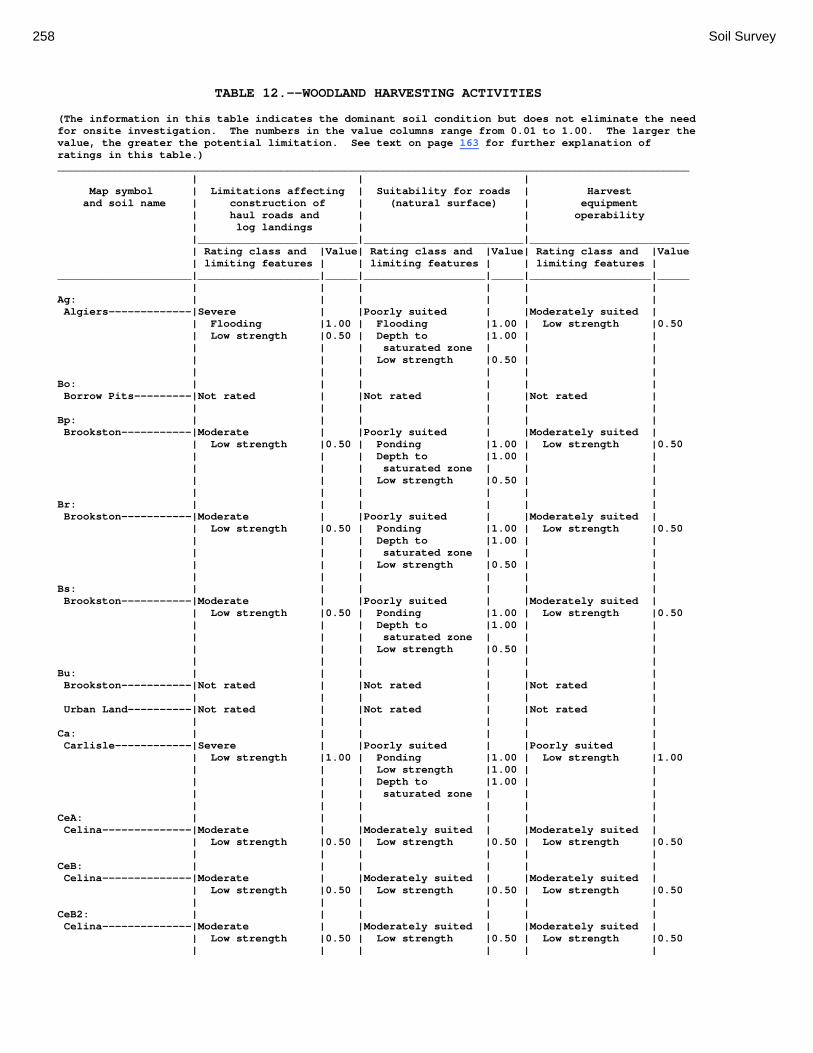
258 Soil Survey
TABLE 12.--WOODLAND HARVESTING ACTIVITIES (The information in this table indicates the dominant soil condition but does not eliminate the need for onsite investigation. The numbers in the value columns range from 0.01 to 1.00. The larger the value, the greater the potential limitation. See text on page 163 for further explanation of ratings in this table.) ___________________________________________________________________________________________________ | | | Map symbol | Limitations affecting | Suitability for roads | Harvest and soil name | construction of | (natural surface) | equipment | haul roads and | | operability | log landings | | |_________________________|_________________________|_________________________ | Rating class and |Value| Rating class and |Value| Rating class and |Value | limiting features | | limiting features | | limiting features | _____________________|___________________|_____|___________________|_____|___________________|_____ | | | | | | Ag: | | | | | | Algiers-------------|Severe | |Poorly suited | |Moderately suited | | Flooding |1.00 | Flooding |1.00 | Low strength |0.50 | Low strength |0.50 | Depth to |1.00 | | | | | saturated zone | | | | | | Low strength |0.50 | | | | | | | | Bo: | | | | | | Borrow Pits---------|Not rated | |Not rated | |Not rated | | | | | | | Bp: | | | | | | Brookston-----------|Moderate | |Poorly suited | |Moderately suited | | Low strength |0.50 | Ponding |1.00 | Low strength |0.50 | | | Depth to |1.00 | | | | | saturated zone | | | | | | Low strength |0.50 | | | | | | | | Br: | | | | | | Brookston-----------|Moderate | |Poorly suited | |Moderately suited | | Low strength |0.50 | Ponding |1.00 | Low strength |0.50 | | | Depth to |1.00 | | | | | saturated zone | | | | | | Low strength |0.50 | | | | | | | | Bs: | | | | | | Brookston-----------|Moderate | |Poorly suited | |Moderately suited | | Low strength |0.50 | Ponding |1.00 | Low strength |0.50 | | | Depth to |1.00 | | | | | saturated zone | | | | | | Low strength |0.50 | | | | | | | | Bu: | | | | | | Brookston-----------|Not rated | |Not rated | |Not rated | | | | | | | Urban Land----------|Not rated | |Not rated | |Not rated | | | | | | | Ca: | | | | | | Carlisle------------|Severe | |Poorly suited | |Poorly suited | | Low strength |1.00 | Ponding |1.00 | Low strength |1.00 | | | Low strength |1.00 | | | | | Depth to |1.00 | | | | | saturated zone | | | | | | | | | CeA: | | | | | | Celina--------------|Moderate | |Moderately suited | |Moderately suited | | Low strength |0.50 | Low strength |0.50 | Low strength |0.50 | | | | | | CeB: | | | | | | Celina--------------|Moderate | |Moderately suited | |Moderately suited | | Low strength |0.50 | Low strength |0.50 | Low strength |0.50 | | | | | | CeB2: | | | | | | Celina--------------|Moderate | |Moderately suited | |Moderately suited | | Low strength |0.50 | Low strength |0.50 | Low strength |0.50 | | | | | |

Montgomery County, Ohio 259
TABLE 12.--WOODLAND HARVESTING ACTIVITIES--Continued ___________________________________________________________________________________________________ | | | Map symbol | Limitations affecting | Suitability for roads | Harvest and soil name | construction of | (natural surface) | equipment | haul roads and | | operability | log landings | | |_________________________|_________________________|_________________________ | Rating class and |Value| Rating class and |Value| Rating class and |Value | limiting features | | limiting features | | limiting features | _____________________|___________________|_____|___________________|_____|___________________|_____ | | | | | | ClB: | | | | | | Celina--------------|Moderate | |Moderately suited | |Moderately suited | | Low strength |0.50 | Low strength |0.50 | Low strength |0.50 | | | | | | CoA: | | | | | | Corwin--------------|Moderate | |Moderately suited | |Moderately suited | | Low strength |0.50 | Low strength |0.50 | Low strength |0.50 | | | | | | CoB: | | | | | | Corwin--------------|Moderate | |Moderately suited | |Moderately suited | | Low strength |0.50 | Low strength |0.50 | Low strength |0.50 | | | | | | CsA: | | | | | | Crosby--------------|Moderate | |Moderately suited | |Moderately suited | | Low strength |0.50 | Depth to |0.50 | Low strength |0.50 | | | saturated zone | | | | | | Low strength |0.50 | | | | | | | | CtB: | | | | | | Crosby--------------|Moderate | |Moderately suited | |Moderately suited | | Low strength |0.50 | Depth to |0.50 | Low strength |0.50 | | | saturated zone | | | | | | Low strength |0.50 | | | | | | | | Celina--------------|Moderate | |Moderately suited | |Moderately suited | | Low strength |0.50 | Low strength |0.50 | Low strength |0.50 | | | | | | Cu: | | | | | | Crosby--------------|Not rated | |Not rated | |Not rated | | | | | | | Urban Land----------|Not rated | |Not rated | |Not rated | | | | | | | DaB: | | | | | | Dana----------------|Moderate | |Moderately suited | |Moderately suited | | Low strength |0.50 | Low strength |0.50 | Low strength |0.50 | | | | | | FaE2: | | | | | | Fairmount-----------|Severe | |Poorly suited | |Moderately suited | | Soil slippage |1.00 | Soil slippage |1.00 | Low strength |0.50 | Depth to bedrock |1.00 | Slope |1.00 | | | Slope |0.50 | Low strength |0.50 | | | Stickiness |0.50 | | | | | Low strength |0.50 | | | | | | | | | | FaF2: | | | | | | Fairmount-----------|Severe | |Poorly suited | |Poorly suited | | Soil slippage |1.00 | Slope |1.00 | Slope |1.00 | Slope |1.00 | Soil slippage |1.00 | Low strength |0.50 | Low strength |0.50 | Low strength |0.50 | | | | | | | | FcA: | | | | | | Fincastle-----------|Moderate | |Moderately suited | |Moderately suited | | Low strength |0.50 | Depth to |0.50 | Low strength |0.50 | | | saturated zone | | | | | | Low strength |0.50 | | | | | | | | FkA: | | | | | | Fox-----------------|Slight | |Well suited | |Well suited | | | | | | | FkB: | | | | | | Fox-----------------|Slight | |Well suited | |Well suited |
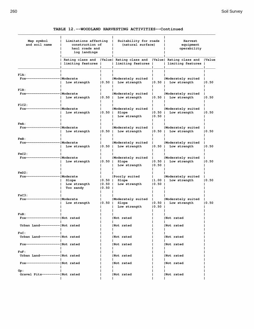
260 Soil Survey
TABLE 12.--WOODLAND HARVESTING ACTIVITIES--Continued ___________________________________________________________________________________________________ | | | Map symbol | Limitations affecting | Suitability for roads | Harvest and soil name | construction of | (natural surface) | equipment | haul roads and | | operability | log landings | | |_________________________|_________________________|_________________________ | Rating class and |Value| Rating class and |Value| Rating class and |Value | limiting features | | limiting features | | limiting features | _____________________|___________________|_____|___________________|_____|___________________|_____ | | | | | | FlA: | | | | | | Fox-----------------|Moderate | |Moderately suited | |Moderately suited | | Low strength |0.50 | Low strength |0.50 | Low strength |0.50 | | | | | | FlB: | | | | | | Fox-----------------|Moderate | |Moderately suited | |Moderately suited | | Low strength |0.50 | Low strength |0.50 | Low strength |0.50 | | | | | | FlC2: | | | | | | Fox-----------------|Moderate | |Moderately suited | |Moderately suited | | Low strength |0.50 | Slope |0.50 | Low strength |0.50 | | | Low strength |0.50 | | | | | | | | FmA: | | | | | | Fox-----------------|Moderate | |Moderately suited | |Moderately suited | | Low strength |0.50 | Low strength |0.50 | Low strength |0.50 | | | | | | FmB: | | | | | | Fox-----------------|Moderate | |Moderately suited | |Moderately suited | | Low strength |0.50 | Low strength |0.50 | Low strength |0.50 | | | | | | FmC2: | | | | | | Fox-----------------|Moderate | |Moderately suited | |Moderately suited | | Low strength |0.50 | Slope |0.50 | Low strength |0.50 | | | Low strength |0.50 | | | | | | | | FmD2: | | | | | | Fox-----------------|Moderate | |Poorly suited | |Moderately suited | | Slope |0.50 | Slope |1.00 | Low strength |0.50 | Low strength |0.50 | Low strength |0.50 | | | Too sandy |0.50 | | | | | | | | | | FsC3: | | | | | | Fox-----------------|Moderate | |Moderately suited | |Moderately suited | | Low strength |0.50 | Slope |0.50 | Low strength |0.50 | | | Low strength |0.50 | | | | | | | | FuB: | | | | | | Fox-----------------|Not rated | |Not rated | |Not rated | | | | | | | Urban Land----------|Not rated | |Not rated | |Not rated | | | | | | | FuC: | | | | | | Urban Land----------|Not rated | |Not rated | |Not rated | | | | | | | Fox-----------------|Not rated | |Not rated | |Not rated | | | | | | | FuF: | | | | | | Urban Land----------|Not rated | |Not rated | |Not rated | | | | | | | Fox-----------------|Not rated | |Not rated | |Not rated | | | | | | | Gp: | | | | | | Gravel Pits---------|Not rated | |Not rated | |Not rated | | | | | | |

Montgomery County, Ohio 261
TABLE 12.--WOODLAND HARVESTING ACTIVITIES--Continued ___________________________________________________________________________________________________ | | | Map symbol | Limitations affecting | Suitability for roads | Harvest and soil name | construction of | (natural surface) | equipment | haul roads and | | operability | log landings | | |_________________________|_________________________|_________________________ | Rating class and |Value| Rating class and |Value| Rating class and |Value | limiting features | | limiting features | | limiting features | _____________________|___________________|_____|___________________|_____|___________________|_____ | | | | | | HeE2: | | | | | | Hennepin------------|Moderate | |Poorly suited | |Moderately suited | | Slope |0.50 | Slope |1.00 | Low strength |0.50 | Low strength |0.50 | Low strength |0.50 | Slope |0.50 | | | | | | Miamian-------------|Moderate | |Poorly suited | |Moderately suited | | Slope |0.50 | Slope |1.00 | Low strength |0.50 | Low strength |0.50 | Low strength |0.50 | Slope |0.50 | | | | | | HeF2: | | | | | | Hennepin------------|Severe | |Poorly suited | |Poorly suited | | Slope |1.00 | Slope |1.00 | Slope |1.00 | Low strength |0.50 | Low strength |0.50 | Low strength |0.50 | | | | | | Miamian-------------|Severe | |Poorly suited | |Poorly suited | | Slope |1.00 | Slope |1.00 | Slope |1.00 | Low strength |0.50 | Low strength |0.50 | Low strength |0.50 | | | | | | HmF3: | | | | | | Hennepin------------|Severe | |Poorly suited | |Moderately suited | | Slope |1.00 | Slope |1.00 | Slope |0.50 | Low strength |0.50 | Low strength |0.50 | Low strength |0.50 | | | | | | Miamian-------------|Severe | |Poorly suited | |Moderately suited | | Slope |1.00 | Slope |1.00 | Slope |0.50 | Low strength |0.50 | Low strength |0.50 | Low strength |0.50 | | | | | | KeA: | | | | | | Kendallville--------|Moderate | |Moderately suited | |Moderately suited | | Low strength |0.50 | Low strength |0.50 | Low strength |0.50 | | | | | | KeB: | | | | | | Kendallville--------|Moderate | |Moderately suited | |Moderately suited | | Low strength |0.50 | Low strength |0.50 | Low strength |0.50 | | | | | | KeC2: | | | | | | Kendallville--------|Moderate | |Moderately suited | |Moderately suited | | Low strength |0.50 | Slope |0.50 | Low strength |0.50 | | | Low strength |0.50 | | | | | | | | Ld: | | | | | | Landes--------------|Severe | |Poorly suited | |Well suited | | Flooding |1.00 | Flooding |1.00 | | | | | | | | Lg: | | | | | | Lanier--------------|Severe | |Poorly suited | |Well suited | | Flooding |1.00 | Flooding |1.00 | | | | | | | | LsB: | | | | | | Lewisburg-----------|Moderate | |Moderately suited | |Moderately suited | | Low strength |0.50 | Low strength |0.50 | Low strength |0.50 | | | | | | LxC2: | | | | | | Lorenzo-------------|Slight | |Moderately suited | |Moderately suited | | | | Low strength |0.50 | Low strength |0.50 | | | Slope |0.50 | | | | | | | | Rodman--------------|Moderate | |Moderately suited | |Moderately suited | | Low strength |0.50 | Low strength |0.50 | Low strength |0.50 | | | Slope |0.50 | | | | | | | |

262 Soil Survey
TABLE 12.--WOODLAND HARVESTING ACTIVITIES--Continued ___________________________________________________________________________________________________ | | | Map symbol | Limitations affecting | Suitability for roads | Harvest and soil name | construction of | (natural surface) | equipment | haul roads and | | operability | log landings | | |_________________________|_________________________|_________________________ | Rating class and |Value| Rating class and |Value| Rating class and |Value | limiting features | | limiting features | | limiting features | _____________________|___________________|_____|___________________|_____|___________________|_____ | | | | | | LxD2: | | | | | | Lorenzo-------------|Moderate | |Poorly suited | |Moderately suited | | Slope |0.50 | Slope |1.00 | Low strength |0.50 | Too sandy |0.50 | Low strength |0.50 | | | | | | | | Rodman--------------|Moderate | |Poorly suited | |Moderately suited | | Slope |0.50 | Slope |1.00 | Low strength |0.50 | Low strength |0.50 | Low strength |0.50 | | | Too sandy |0.50 | | | | | | | | | | Mb: | | | | | | Made Land-----------|Not rated | |Not rated | |Not rated | | | | | | | Md: | | | | | | Medway--------------|Severe | |Poorly suited | |Moderately suited | | Flooding |1.00 | Flooding |1.00 | Low strength |0.50 | Low strength |0.50 | Low strength |0.50 | | | | | | | | MlA: | | | | | | Miamian-------------|Moderate | |Moderately suited | |Moderately suited | | Low strength |0.50 | Low strength |0.50 | Low strength |0.50 | | | | | | MlB: | | | | | | Miamian-------------|Moderate | |Moderately suited | |Moderately suited | | Low strength |0.50 | Low strength |0.50 | Low strength |0.50 | | | | | | MlB2: | | | | | | Miamian-------------|Moderate | |Moderately suited | |Moderately suited | | Low strength |0.50 | Low strength |0.50 | Low strength |0.50 | | | | | | MlC2: | | | | | | Miamian-------------|Moderate | |Moderately suited | |Moderately suited | | Low strength |0.50 | Slope |0.50 | Low strength |0.50 | | | Low strength |0.50 | | | | | | | | MlD2: | | | | | | Miamian-------------|Moderate | |Poorly suited | |Moderately suited | | Slope |0.50 | Slope |1.00 | Low strength |0.50 | Low strength |0.50 | Low strength |0.50 | | | | | | | | MmB: | | | | | | Miamian-------------|Moderate | |Moderately suited | |Moderately suited | | Low strength |0.50 | Low strength |0.50 | Low strength |0.50 | | | | | | MnB3: | | | | | | Miamian-------------|Moderate | |Moderately suited | |Moderately suited | | Low strength |0.50 | Low strength |0.50 | Low strength |0.50 | | | | | | MnC3: | | | | | | Miamian-------------|Moderate | |Moderately suited | |Moderately suited | | Low strength |0.50 | Slope |0.50 | Low strength |0.50 | | | Low strength |0.50 | | | | | | | | MnD3: | | | | | | Miamian-------------|Moderate | |Poorly suited | |Moderately suited | | Slope |0.50 | Slope |1.00 | Low strength |0.50 | Low strength |0.50 | Low strength |0.50 | | | | | | | |

Montgomery County, Ohio 263
TABLE 12.--WOODLAND HARVESTING ACTIVITIES--Continued ___________________________________________________________________________________________________ | | | Map symbol | Limitations affecting | Suitability for roads | Harvest and soil name | construction of | (natural surface) | equipment | haul roads and | | operability | log landings | | |_________________________|_________________________|_________________________ | Rating class and |Value| Rating class and |Value| Rating class and |Value | limiting features | | limiting features | | limiting features | _____________________|___________________|_____|___________________|_____|___________________|_____ | | | | | | MoB: | | | | | | Miamian-------------|Not rated | |Not rated | |Not rated | | | | | | | Urban Land----------|Not rated | |Not rated | |Not rated | | | | | | | MoC: | | | | | | Miamian-------------|Not rated | |Not rated | |Not rated | | | | | | | Urban Land----------|Not rated | |Not rated | |Not rated | | | | | | | MoE: | | | | | | Miamian-------------|Not rated | |Not rated | |Not rated | | | | | | | Urban Land----------|Not rated | |Not rated | |Not rated | | | | | | | MrA: | | | | | | Millsdale-----------|Moderate | |Poorly suited | |Moderately suited | | Low strength |0.50 | Ponding |1.00 | Low strength |0.50 | Depth to bedrock |0.50 | Depth to |1.00 | | | | | saturated zone | | | | | | Low strength |0.50 | | | | | | | | MsA: | | | | | | Milton--------------|Moderate | |Moderately suited | |Moderately suited | | Low strength |0.50 | Low strength |0.50 | Low strength |0.50 | Depth to bedrock |0.50 | | | | | | | | | | MsB: | | | | | | Milton--------------|Moderate | |Moderately suited | |Moderately suited | | Low strength |0.50 | Low strength |0.50 | Low strength |0.50 | Depth to bedrock |0.50 | | | | | | | | | | MsB2: | | | | | | Milton--------------|Moderate | |Moderately suited | |Moderately suited | | Low strength |0.50 | Low strength |0.50 | Low strength |0.50 | Depth to bedrock |0.50 | | | | | | | | | | MsC2: | | | | | | Milton--------------|Moderate | |Moderately suited | |Moderately suited | | Low strength |0.50 | Slope |0.50 | Low strength |0.50 | Depth to bedrock |0.50 | Low strength |0.50 | | | | | | | | MsD2: | | | | | | Milton--------------|Severe | |Poorly suited | |Moderately suited | | Depth to bedrock |1.00 | Slope |1.00 | Low strength |0.50 | Slope |0.50 | Low strength |0.50 | | | Low strength |0.50 | | | | | | | | | | MtD3: | | | | | | Milton--------------|Moderate | |Moderately suited | |Moderately suited | | Depth to bedrock |0.50 | Slope |0.50 | Low strength |0.50 | Low strength |0.50 | Low strength |0.50 | | | | | | | | MuB: | | | | | | Milton--------------|Not rated | |Not rated | |Not rated | | | | | | | Urban Land----------|Not rated | |Not rated | |Not rated | | | | | | |

264 Soil Survey
TABLE 12.--WOODLAND HARVESTING ACTIVITIES--Continued ___________________________________________________________________________________________________ | | | Map symbol | Limitations affecting | Suitability for roads | Harvest and soil name | construction of | (natural surface) | equipment | haul roads and | | operability | log landings | | |_________________________|_________________________|_________________________ | Rating class and |Value| Rating class and |Value| Rating class and |Value | limiting features | | limiting features | | limiting features | _____________________|___________________|_____|___________________|_____|___________________|_____ | | | | | | MuC: | | | | | | Milton--------------|Not rated | |Not rated | |Not rated | | | | | | | Urban Land----------|Not rated | |Not rated | |Not rated | | | | | | | MuD: | | | | | | Milton--------------|Not rated | |Not rated | |Not rated | | | | | | | Urban Land----------|Not rated | |Not rated | |Not rated | | | | | | | Mv: | | | | | | Montgomery----------|Moderate | |Poorly suited | |Moderately suited | | Low strength |0.50 | Ponding |1.00 | Low strength |0.50 | | | Depth to |1.00 | | | | | saturated zone | | | | | | Low strength |0.50 | | | | | | | | OcA: | | | | | | Ockley--------------|Moderate | |Moderately suited | |Moderately suited | | Low strength |0.50 | Low strength |0.50 | Low strength |0.50 | | | | | | OcB: | | | | | | Ockley--------------|Moderate | |Moderately suited | |Moderately suited | | Low strength |0.50 | Low strength |0.50 | Low strength |0.50 | | | | | | PlB: | | | | | | Plattville----------|Moderate | |Moderately suited | |Moderately suited | | Low strength |0.50 | Low strength |0.50 | Low strength |0.50 | Depth to bedrock |0.50 | | | | | | | | | | PlC: | | | | | | Plattville----------|Moderate | |Moderately suited | |Moderately suited | | Low strength |0.50 | Slope |0.50 | Low strength |0.50 | Depth to bedrock |0.50 | Low strength |0.50 | | | | | | | | PyA: | | | | | | Pyrmont-------------|Moderate | |Moderately suited | |Moderately suited | | Low strength |0.50 | Depth to |0.50 | Low strength |0.50 | | | saturated zone | | | | | | Low strength |0.50 | | | | | | | | Qu: | | | | | | Quarries------------|Not rated | |Not rated | |Not rated | | | | | | | RcA: | | | | | | Randolph------------|Moderate | |Moderately suited | |Moderately suited | | Low strength |0.50 | Depth to |0.50 | Low strength |0.50 | | | saturated zone | | | | Depth to bedrock |0.50 | Low strength |0.50 | | | | | | | | ReB: | | | | | | Ritchey-------------|Severe | |Moderately suited | |Moderately suited | | Depth to bedrock |1.00 | Low strength |0.50 | Low strength |0.50 | Low strength |0.50 | | | | | | | | | | ReB2: | | | | | | Ritchey-------------|Severe | |Moderately suited | |Moderately suited | | Depth to bedrock |1.00 | Low strength |0.50 | Low strength |0.50 | Low strength |0.50 | | | | | | | | | |

Montgomery County, Ohio 265
TABLE 12.--WOODLAND HARVESTING ACTIVITIES--Continued ___________________________________________________________________________________________________ | | | Map symbol | Limitations affecting | Suitability for roads | Harvest and soil name | construction of | (natural surface) | equipment | haul roads and | | operability | log landings | | |_________________________|_________________________|_________________________ | Rating class and |Value| Rating class and |Value| Rating class and |Value | limiting features | | limiting features | | limiting features | _____________________|___________________|_____|___________________|_____|___________________|_____ | | | | | | ReC2: | | | | | | Ritchey-------------|Severe | |Moderately suited | |Moderately suited | | Depth to bedrock |1.00 | Slope |0.50 | Low strength |0.50 | Low strength |0.50 | Low strength |0.50 | | | | | | | | ReE2: | | | | | | Ritchey-------------|Severe | |Poorly suited | |Moderately suited | | Depth to bedrock |1.00 | Slope |1.00 | Low strength |0.50 | Slope |0.50 | Low strength |0.50 | | | Low strength |0.50 | | | | | | | | | | ReF2: | | | | | | Ritchey-------------|Severe | |Poorly suited | |Poorly suited | | Slope |1.00 | Slope |1.00 | Slope |1.00 | Low strength |0.50 | Low strength |0.50 | Low strength |0.50 | | | | | | RfD3: | | | | | | Ritchey-------------|Severe | |Moderately suited | |Moderately suited | | Depth to bedrock |1.00 | Slope |0.50 | Low strength |0.50 | Low strength |0.50 | Low strength |0.50 | | | | | | | | Rh: | | | | | | Riverwash-----------|Not rated | |Not rated | |Not rated | | | | | | | RlE2: | | | | | | Rodman--------------|Moderate | |Poorly suited | |Moderately suited | | Slope |0.50 | Slope |1.00 | Low strength |0.50 | Low strength |0.50 | Low strength |0.50 | Slope |0.50 | Too sandy |0.50 | | | | | | | | | | Fox-----------------|Moderate | |Poorly suited | |Moderately suited | | Slope |0.50 | Slope |1.00 | Low strength |0.50 | Low strength |0.50 | Low strength |0.50 | Slope |0.50 | Too sandy |0.50 | | | | | | | | | | RlF2: | | | | | | Rodman--------------|Severe | |Poorly suited | |Poorly suited | | Slope |1.00 | Slope |1.00 | Slope |1.00 | Low strength |0.50 | Low strength |0.50 | Low strength |0.50 | | | | | | Fox-----------------|Moderate | |Poorly suited | |Moderately suited | | Slope |0.50 | Slope |1.00 | Slope |0.50 | Low strength |0.50 | Low strength |0.50 | Low strength |0.50 | Too sandy |0.50 | | | | | | | | | | Rs: | | | | | | Ross----------------|Severe | |Poorly suited | |Moderately suited | | Flooding |1.00 | Flooding |1.00 | Low strength |0.50 | Low strength |0.50 | Low strength |0.50 | | | | | | | | Rt: | | | | | | Urban Land----------|Not rated | |Not rated | |Not rated | | | | | | | Ross----------------|Not rated | |Not rated | |Not rated | | | | | | | RuB: | | | | | | Russell-------------|Moderate | |Moderately suited | |Moderately suited | | Low strength |0.50 | Low strength |0.50 | Low strength |0.50 | | | | | |

266 Soil Survey
TABLE 12.--WOODLAND HARVESTING ACTIVITIES--Continued ___________________________________________________________________________________________________ | | | Map symbol | Limitations affecting | Suitability for roads | Harvest and soil name | construction of | (natural surface) | equipment | haul roads and | | operability | log landings | | |_________________________|_________________________|_________________________ | Rating class and |Value| Rating class and |Value| Rating class and |Value | limiting features | | limiting features | | limiting features | _____________________|___________________|_____|___________________|_____|___________________|_____ | | | | | | RvC2: | | | | | | Russell-------------|Moderate | |Moderately suited | |Moderately suited | | Low strength |0.50 | Slope |0.50 | Low strength |0.50 | | | Low strength |0.50 | | | | | | | | Miamian-------------|Moderate | |Moderately suited | |Moderately suited | | Low strength |0.50 | Slope |0.50 | Low strength |0.50 | | | Low strength |0.50 | | | | | | | | RvD2: | | | | | | Russell-------------|Moderate | |Poorly suited | |Moderately suited | | Slope |0.50 | Slope |1.00 | Low strength |0.50 | Low strength |0.50 | Low strength |0.50 | | | | | | | | Miamian-------------|Moderate | |Poorly suited | |Moderately suited | | Slope |0.50 | Slope |1.00 | Low strength |0.50 | Low strength |0.50 | Low strength |0.50 | | | | | | | | Sh: | | | | | | Shoals--------------|Severe | |Poorly suited | |Moderately suited | | Flooding |1.00 | Flooding |1.00 | Low strength |0.50 | Low strength |0.50 | Depth to |0.50 | | | | | saturated zone | | | | | | Low strength |0.50 | | | | | | | | So: | | | | | | Sloan---------------|Severe | |Poorly suited | |Moderately suited | | Flooding |1.00 | Ponding |1.00 | Low strength |0.50 | Low strength |0.50 | Flooding |1.00 | | | | | Depth to |1.00 | | | | | saturated zone | | | | | | Low strength |0.50 | | | | | | | | ThA: | | | | | | Thackery------------|Moderate | |Moderately suited | |Moderately suited | | Low strength |0.50 | Low strength |0.50 | Low strength |0.50 | | | | | | TpA: | | | | | | Tippecanoe----------|Moderate | |Moderately suited | |Moderately suited | | Low strength |0.50 | Low strength |0.50 | Low strength |0.50 | | | | | | Ua: | | | | | | Urban Land----------|Not rated | |Not rated | |Not rated | | | | | | | Ud: | | | | | | Udorthents----------|Not rated | |Not rated | |Not rated | | | | | | | Ug: | | | | | | Urban Land----------|Not rated | |Not rated | |Not rated | | | | | | | Um: | | | | | | Urban Land----------|Not rated | |Not rated | |Not rated | | | | | | | WaA: | | | | | | Warsaw--------------|Moderate | |Moderately suited | |Moderately suited | | Low strength |0.50 | Low strength |0.50 | Low strength |0.50 | | | | | |

Montgomery County, Ohio 267
TABLE 12.--WOODLAND HARVESTING ACTIVITIES--Continued ___________________________________________________________________________________________________ | | | Map symbol | Limitations affecting | Suitability for roads | Harvest and soil name | construction of | (natural surface) | equipment | haul roads and | | operability | log landings | | |_________________________|_________________________|_________________________ | Rating class and |Value| Rating class and |Value| Rating class and |Value | limiting features | | limiting features | | limiting features | _____________________|___________________|_____|___________________|_____|___________________|_____ | | | | | | WaB: | | | | | | Warsaw--------------|Moderate | |Moderately suited | |Moderately suited | | Low strength |0.50 | Low strength |0.50 | Low strength |0.50 | | | | | | WeA: | | | | | | Wea-----------------|Moderate | |Moderately suited | |Moderately suited | | Low strength |0.50 | Low strength |0.50 | Low strength |0.50 | | | | | | WeB: | | | | | | Wea-----------------|Moderate | |Moderately suited | |Moderately suited | | Low strength |0.50 | Low strength |0.50 | Low strength |0.50 | | | | | | Ws: | | | | | | Westland------------|Moderate | |Poorly suited | |Moderately suited | | Low strength |0.50 | Ponding |1.00 | Low strength |0.50 | | | Depth to |1.00 | | | | | saturated zone | | | | | | Low strength |0.50 | | | | | | | | WyB2: | | | | | | Wynn----------------|Moderate | |Moderately suited | |Moderately suited | | Low strength |0.50 | Low strength |0.50 | Low strength |0.50 | Depth to bedrock |0.50 | | | | | | | | | | XeA: | | | | | | Xenia---------------|Moderate | |Moderately suited | |Moderately suited | | Low strength |0.50 | Low strength |0.50 | Low strength |0.50 | | | | | | XeB: | | | | | | Xenia---------------|Moderate | |Moderately suited | |Moderately suited | | Low strength |0.50 | Low strength |0.50 | Low strength |0.50 | | | | | | _____________________|___________________|_____|___________________|_____|___________________|_____

268 Soil Survey
TABLE 13.--WOODLAND REGENERATION ACTIVITIES (The information in this table indicates the dominant soil condition but does not eliminate the need for onsite investigation. The numbers in the value columns range from 0.01 to 1.00. The larger the value, the greater the potential limitation. See text on page 163 for further explanation of ratings in this table.) ___________________________________________________________________________________________________ | | | Map symbol | Suitability for | Suitability for | Potential for damage and soil name | mechanical planting | site preparation | to soil by fire |_________________________|_________________________|_________________________ | Rating class and |Value| Rating class and |Value| Rating class and |Value | limiting features | | limiting features | | limiting features | _____________________|___________________|_____|___________________|_____|___________________|_____ | | | | | | Ag: | | | | | | Algiers-------------|Well suited | |Well suited | |Low | | | | | | Texture/rock |0.01 | | | | | fragments | | | | | | | Bo: | | | | | | Borrow Pits---------|Not rated | |Not rated | |Not rated | | | | | | | Bp: | | | | | | Brookston-----------|Well suited | |Well suited | |Low | | | | | | Texture/rock |0.01 | | | | | fragments | | | | | | | Br: | | | | | | Brookston-----------|Well suited | |Well suited | |Low | | | | | | Texture/rock |0.01 | | | | | fragments | | | | | | | Bs: | | | | | | Brookston-----------|Well suited | |Well suited | |Low | | | | | | Texture/rock |0.30 | | | | | fragments | | | | | | | Bu: | | | | | | Brookston-----------|Not rated | |Not rated | |Not rated | | | | | | | Urban Land----------|Not rated | |Not rated | |Not rated | | | | | | | Ca: | | | | | | Carlisle------------|Well suited | |Well suited | |Low | | | | | | | CeA: | | | | | | Celina--------------|Moderately suited | |Well suited | |Low | | Stickiness |0.50 | | | Texture/rock |0.01 | | | | | fragments | | | | | | | CeB: | | | | | | Celina--------------|Moderately suited | |Well suited | |Low | | Stickiness |0.50 | | | Texture/rock |0.01 | | | | | fragments | | | | | | | CeB2: | | | | | | Celina--------------|Moderately suited | |Well suited | |Low | | Stickiness |0.50 | | | Texture/rock |0.01 | | | | | fragments | | | | | | | ClB: | | | | | | Celina--------------|Poorly suited | |Well suited | |Low | | Rock fragment |0.75 | | | Texture/rock |0.01 | content | | | | fragments | | Stickiness |0.50 | | | | | | | | | | CoA: | | | | | | Corwin--------------|Well suited | |Well suited | |Low | | | | | | Texture/rock |0.01 | | | | | fragments | | | | | | |

Montgomery County, Ohio 269
TABLE 13.--WOODLAND REGENERATION ACTIVITIES--Continued ___________________________________________________________________________________________________ | | | Map symbol | Suitability for | Suitability for | Potential for damage and soil name | mechanical planting | site preparation | to soil by fire |_________________________|_________________________|_________________________ | Rating class and |Value| Rating class and |Value| Rating class and |Value | limiting features | | limiting features | | limiting features | _____________________|___________________|_____|___________________|_____|___________________|_____ | | | | | | CoB: | | | | | | Corwin--------------|Well suited | |Well suited | |Low | | | | | | Texture/rock |0.01 | | | | | fragments | | | | | | | CsA: | | | | | | Crosby--------------|Moderately suited | |Well suited | |Low | | Stickiness |0.50 | | | Texture/rock |0.01 | | | | | fragments | | | | | | | CtB: | | | | | | Crosby--------------|Moderately suited | |Well suited | |Low | | Stickiness |0.50 | | | Texture/rock |0.01 | | | | | fragments | | | | | | | Celina--------------|Moderately suited | |Well suited | |Low | | Stickiness |0.50 | | | Texture/rock |0.01 | | | | | fragments | | | | | | | Cu: | | | | | | Crosby--------------|Not rated | |Not rated | |Not rated | | | | | | | Urban Land----------|Not rated | |Not rated | |Not rated | | | | | | | DaB: | | | | | | Dana----------------|Moderately suited | |Well suited | |Low | | Stickiness |0.50 | | | Texture/rock |0.01 | | | | | fragments | | | | | | | FaE2: | | | | | | Fairmount-----------|Poorly suited | |Poorly suited | |Moderate | | Slope |0.75 | Slope |0.75 | Texture/surface |0.50 | | | | | depth/rock | | | | | | fragments | | Stickiness |0.75 | Stickiness |0.50 | | | Rock fragment |0.50 | | | | | content | | | | | | | | | | | FaF2: | | | | | | Fairmount-----------|Unsuited | |Unsuited | |Moderate | | Slope |1.00 | Slope |1.00 | Texture/slope/sur|0.50 | | | | | face depth | | Stickiness |0.75 | Stickiness |0.50 | | | Rock fragment |0.50 | | | | | content | | | | | | | | | | | FcA: | | | | | | Fincastle-----------|Well suited | |Well suited | |Low | | | | | | Texture/rock |0.01 | | | | | fragments | | | | | | | FkA: | | | | | | Fox-----------------|Well suited | |Well suited | |Low | | | | | | Texture/rock |0.01 | | | | | fragments | | | | | | | FkB: | | | | | | Fox-----------------|Well suited | |Well suited | |Low | | | | | | Texture/rock |0.01 | | | | | fragments | | | | | | |

270 Soil Survey
TABLE 13.--WOODLAND REGENERATION ACTIVITIES--Continued ___________________________________________________________________________________________________ | | | Map symbol | Suitability for | Suitability for | Potential for damage and soil name | mechanical planting | site preparation | to soil by fire |_________________________|_________________________|_________________________ | Rating class and |Value| Rating class and |Value| Rating class and |Value | limiting features | | limiting features | | limiting features | _____________________|___________________|_____|___________________|_____|___________________|_____ | | | | | | FlA: | | | | | | Fox-----------------|Well suited | |Well suited | |Low | | | | | | Texture/rock |0.01 | | | | | fragments | | | | | | | FlB: | | | | | | Fox-----------------|Well suited | |Well suited | |Low | | | | | | Texture/rock |0.01 | | | | | fragments | | | | | | | FlC2: | | | | | | Fox-----------------|Moderately suited | |Well suited | |Low | | Slope |0.50 | | | Texture/surface |0.30 | | | | | depth/rock | | | | | | fragments | | | | | | | FmA: | | | | | | Fox-----------------|Well suited | |Well suited | |Low | | | | | | Texture/rock |0.01 | | | | | fragments | | | | | | | FmB: | | | | | | Fox-----------------|Well suited | |Well suited | |Low | | | | | | Texture/rock |0.01 | | | | | fragments | | | | | | | FmC2: | | | | | | Fox-----------------|Moderately suited | |Well suited | |Low | | Slope |0.50 | | | Texture/surface |0.30 | | | | | depth/rock | | | | | | fragments | | | | | | | FmD2: | | | | | | Fox-----------------|Poorly suited | |Poorly suited | |Low | | Slope |0.75 | Slope |0.75 | Texture/surface |0.30 | | | | | depth/rock | | | | | | fragments | | | | | | | FsC3: | | | | | | Fox-----------------|Moderately suited | |Well suited | |Moderate | | Slope |0.50 | | | Texture/surface |0.50 | | | | | depth/rock | | | | | | fragments | | | | | | | FuB: | | | | | | Fox-----------------|Not rated | |Not rated | |Not rated | | | | | | | Urban Land----------|Not rated | |Not rated | |Not rated | | | | | | | FuC: | | | | | | Urban Land----------|Not rated | |Not rated | |Not rated | | | | | | | Fox-----------------|Not rated | |Not rated | |Not rated | | | | | | | FuF: | | | | | | Urban Land----------|Not rated | |Not rated | |Not rated | | | | | | | Fox-----------------|Not rated | |Not rated | |Not rated | | | | | | | Gp: | | | | | | Gravel Pits---------|Not rated | |Not rated | |Not rated | | | | | | |

Montgomery County, Ohio 271
TABLE 13.--WOODLAND REGENERATION ACTIVITIES--Continued ___________________________________________________________________________________________________ | | | Map symbol | Suitability for | Suitability for | Potential for damage and soil name | mechanical planting | site preparation | to soil by fire |_________________________|_________________________|_________________________ | Rating class and |Value| Rating class and |Value| Rating class and |Value | limiting features | | limiting features | | limiting features | _____________________|___________________|_____|___________________|_____|___________________|_____ | | | | | | HeE2: | | | | | | Hennepin------------|Poorly suited | |Poorly suited | |Moderate | | Slope |0.75 | Slope |0.75 | Texture/surface |0.50 | | | | | depth/rock | | | | | | fragments | | | | | | | Miamian-------------|Poorly suited | |Poorly suited | |Low | | Slope |0.75 | Slope |0.75 | Texture/surface |0.30 | | | | | depth/rock | | | | | | fragments | | Stickiness |0.50 | | | | | | | | | | HeF2: | | | | | | Hennepin------------|Unsuited | |Unsuited | |High | | Slope |1.00 | Slope |1.00 | Texture/slope/sur|1.00 | | | | | face depth/rock | | | | | | fragments | | | | | | | Miamian-------------|Unsuited | |Unsuited | |Moderate | | Slope |1.00 | Slope |1.00 | Texture/slope/sur|0.50 | | | | | face depth/rock | | | | | | fragments | | Stickiness |0.50 | | | | | | | | | | HmF3: | | | | | | Hennepin------------|Unsuited | |Poorly suited | |Moderate | | Slope |1.00 | Slope |0.75 | Texture/slope/roc|0.70 | | | | | k fragments | | | | | | | Miamian-------------|Unsuited | |Poorly suited | |Moderate | | Slope |1.00 | Slope |0.75 | Texture/rock |0.70 | | | | | fragments | | Stickiness |0.50 | | | Texture/rock |0.50 | | | | | fragments | | | | | | | KeA: | | | | | | Kendallville--------|Well suited | |Well suited | |Low | | | | | | Texture/rock |0.01 | | | | | fragments | | | | | | | KeB: | | | | | | Kendallville--------|Well suited | |Well suited | |Low | | | | | | Texture/rock |0.01 | | | | | fragments | | | | | | | KeC2: | | | | | | Kendallville--------|Moderately suited | |Well suited | |Low | | Slope |0.50 | | | Texture/surface |0.30 | | | | | depth/rock | | | | | | fragments | | | | | | | Ld: | | | | | | Landes--------------|Well suited | |Well suited | |Moderate | | | | | | Texture/rock |0.50 | | | | | fragments | | | | | | | Lg: | | | | | | Lanier--------------|Well suited | |Well suited | |Low | | | | | | Texture/rock |0.01 | | | | | fragments | | | | | | |

272 Soil Survey
TABLE 13.--WOODLAND REGENERATION ACTIVITIES--Continued ___________________________________________________________________________________________________ | | | Map symbol | Suitability for | Suitability for | Potential for damage and soil name | mechanical planting | site preparation | to soil by fire |_________________________|_________________________|_________________________ | Rating class and |Value| Rating class and |Value| Rating class and |Value | limiting features | | limiting features | | limiting features | _____________________|___________________|_____|___________________|_____|___________________|_____ | | | | | | LsB: | | | | | | Lewisburg-----------|Moderately suited | |Well suited | |Low | | Stickiness |0.50 | | | Texture/rock |0.01 | | | | | fragments | | | | | | | LxC2: | | | | | | Lorenzo-------------|Moderately suited | |Well suited | |Low | | Slope |0.50 | | | Texture/surface |0.30 | | | | | depth/rock | | | | | | fragments | | | | | | | Rodman--------------|Moderately suited | |Well suited | |Low | | Too sandy |0.50 | | | Texture/surface |0.30 | | | | | depth/rock | | | | | | fragments | | Slope |0.50 | | | | | Rock fragment |0.50 | | | | | content | | | | | | | | | | | LxD2: | | | | | | Lorenzo-------------|Poorly suited | |Poorly suited | |Low | | Slope |0.75 | Slope |0.75 | Texture/surface |0.30 | | | | | depth/rock | | | | | | fragments | | | | | | | Rodman--------------|Poorly suited | |Poorly suited | |Low | | Slope |0.75 | Slope |0.75 | Texture/surface |0.30 | | | | | depth/rock | | | | | | fragments | | Too sandy |0.50 | | | | | Rock fragment |0.50 | | | | | content | | | | | | | | | | | Mb: | | | | | | Made Land-----------|Not rated | |Not rated | |Not rated | | | | | | | Md: | | | | | | Medway--------------|Well suited | |Well suited | |Low | | | | | | Texture/rock |0.01 | | | | | fragments | | | | | | | MlA: | | | | | | Miamian-------------|Moderately suited | |Well suited | |Low | | Stickiness |0.50 | | | Texture/rock |0.01 | | | | | fragments | | | | | | | MlB: | | | | | | Miamian-------------|Moderately suited | |Well suited | |Low | | Stickiness |0.50 | | | Texture/rock |0.01 | | | | | fragments | | | | | | | MlB2: | | | | | | Miamian-------------|Moderately suited | |Well suited | |Moderate | | Stickiness |0.50 | | | Texture/rock |0.50 | | | | | fragments | | | | | | | MlC2: | | | | | | Miamian-------------|Moderately suited | |Well suited | |Moderate | | Stickiness |0.50 | | | Texture/rock |0.50 | | | | | fragments | | Slope |0.50 | | | | | | | | | |

Montgomery County, Ohio 273
TABLE 13.--WOODLAND REGENERATION ACTIVITIES--Continued ___________________________________________________________________________________________________ | | | Map symbol | Suitability for | Suitability for | Potential for damage and soil name | mechanical planting | site preparation | to soil by fire |_________________________|_________________________|_________________________ | Rating class and |Value| Rating class and |Value| Rating class and |Value | limiting features | | limiting features | | limiting features | _____________________|___________________|_____|___________________|_____|___________________|_____ | | | | | | MlD2: | | | | | | Miamian-------------|Poorly suited | |Poorly suited | |Moderate | | Slope |0.75 | Slope |0.75 | Texture/surface |0.50 | | | | | depth/rock | | | | | | fragments | | Stickiness |0.50 | | | | | | | | | | MmB: | | | | | | Miamian-------------|Moderately suited | |Well suited | |Low | | Stickiness |0.50 | | | Texture/rock |0.01 | | | | | fragments | | | | | | | MnB3: | | | | | | Miamian-------------|Moderately suited | |Well suited | |Moderate | | Stickiness |0.50 | | | Texture/rock |0.50 | | | | | fragments | | | | | | | MnC3: | | | | | | Miamian-------------|Moderately suited | |Well suited | |Moderate | | Stickiness |0.50 | | | Texture/rock |0.50 | | | | | fragments | | Slope |0.50 | | | | | | | | | | MnD3: | | | | | | Miamian-------------|Poorly suited | |Poorly suited | |Moderate | | Slope |0.75 | Slope |0.75 | Texture/surface |0.50 | | | | | depth/rock | | | | | | fragments | | Stickiness |0.50 | | | | | | | | | | MoB: | | | | | | Miamian-------------|Not rated | |Not rated | |Not rated | | | | | | | Urban Land----------|Not rated | |Not rated | |Not rated | | | | | | | MoC: | | | | | | Miamian-------------|Not rated | |Not rated | |Not rated | | | | | | | Urban Land----------|Not rated | |Not rated | |Not rated | | | | | | | MoE: | | | | | | Miamian-------------|Not rated | |Not rated | |Not rated | | | | | | | Urban Land----------|Not rated | |Not rated | |Not rated | | | | | | | MrA: | | | | | | Millsdale-----------|Well suited | |Well suited | |Low | | | | | | Texture/rock |0.30 | | | | | fragments | | | | | | | MsA: | | | | | | Milton--------------|Moderately suited | |Well suited | |Low | | Stickiness |0.50 | | | Texture/rock |0.01 | | | | | fragments | | | | | | | MsB: | | | | | | Milton--------------|Moderately suited | |Well suited | |Low | | Stickiness |0.50 | | | Texture/rock |0.01 | | | | | fragments | | | | | | |

274 Soil Survey
TABLE 13.--WOODLAND REGENERATION ACTIVITIES--Continued ___________________________________________________________________________________________________ | | | Map symbol | Suitability for | Suitability for | Potential for damage and soil name | mechanical planting | site preparation | to soil by fire |_________________________|_________________________|_________________________ | Rating class and |Value| Rating class and |Value| Rating class and |Value | limiting features | | limiting features | | limiting features | _____________________|___________________|_____|___________________|_____|___________________|_____ | | | | | | MsB2: | | | | | | Milton--------------|Moderately suited | |Well suited | |Low | | Stickiness |0.50 | | | Texture/rock |0.01 | | | | | fragments | | | | | | | MsC2: | | | | | | Milton--------------|Moderately suited | |Well suited | |Low | | Slope |0.50 | | | Texture/rock |0.01 | | | | | fragments | | Stickiness |0.50 | | | | | | | | | | MsD2: | | | | | | Milton--------------|Poorly suited | |Poorly suited | |Low | | Slope |0.75 | Slope |0.75 | Texture/rock |0.01 | | | | | fragments | | Stickiness |0.50 | | | | | | | | | | MtD3: | | | | | | Milton--------------|Moderately suited | |Well suited | |High | | Slope |0.50 | | | Texture/surface |1.00 | | | | | depth/rock | | | | | | fragments | | Stickiness |0.50 | | | | | | | | | | MuB: | | | | | | Milton--------------|Not rated | |Not rated | |Not rated | | | | | | | Urban Land----------|Not rated | |Not rated | |Not rated | | | | | | | MuC: | | | | | | Milton--------------|Not rated | |Not rated | |Not rated | | | | | | | Urban Land----------|Not rated | |Not rated | |Not rated | | | | | | | MuD: | | | | | | Milton--------------|Not rated | |Not rated | |Not rated | | | | | | | Urban Land----------|Not rated | |Not rated | |Not rated | | | | | | | Mv: | | | | | | Montgomery----------|Poorly suited | |Poorly suited | |Low | | Stickiness |0.75 | Stickiness |0.50 | Texture/rock |0.30 | | | | | fragments | | | | | | | OcA: | | | | | | Ockley--------------|Well suited | |Well suited | |Low | | | | | | Texture/rock |0.01 | | | | | fragments | | | | | | | OcB: | | | | | | Ockley--------------|Well suited | |Well suited | |Low | | | | | | Texture/rock |0.01 | | | | | fragments | | | | | | | PlB: | | | | | | Plattville----------|Well suited | |Well suited | |Low | | | | | | Texture/rock |0.01 | | | | | fragments | | | | | | | PlC: | | | | | | Plattville----------|Moderately suited | |Well suited | |Low | | Slope |0.50 | | | Texture/rock |0.01 | | | | | fragments |
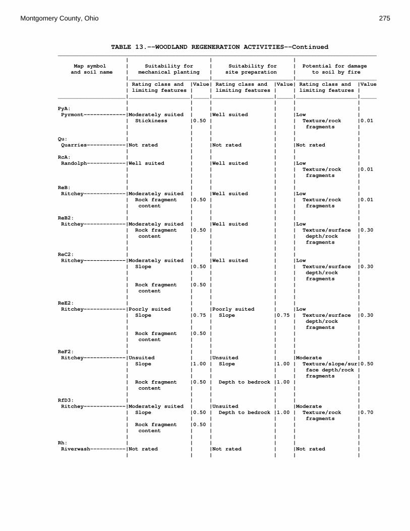
Montgomery County, Ohio 275
TABLE 13.--WOODLAND REGENERATION ACTIVITIES--Continued ___________________________________________________________________________________________________ | | | Map symbol | Suitability for | Suitability for | Potential for damage and soil name | mechanical planting | site preparation | to soil by fire |_________________________|_________________________|_________________________ | Rating class and |Value| Rating class and |Value| Rating class and |Value | limiting features | | limiting features | | limiting features | _____________________|___________________|_____|___________________|_____|___________________|_____ | | | | | | PyA: | | | | | | Pyrmont-------------|Moderately suited | |Well suited | |Low | | Stickiness |0.50 | | | Texture/rock |0.01 | | | | | fragments | | | | | | | Qu: | | | | | | Quarries------------|Not rated | |Not rated | |Not rated | | | | | | | RcA: | | | | | | Randolph------------|Well suited | |Well suited | |Low | | | | | | Texture/rock |0.01 | | | | | fragments | | | | | | | ReB: | | | | | | Ritchey-------------|Moderately suited | |Well suited | |Low | | Rock fragment |0.50 | | | Texture/rock |0.01 | content | | | | fragments | | | | | | | ReB2: | | | | | | Ritchey-------------|Moderately suited | |Well suited | |Low | | Rock fragment |0.50 | | | Texture/surface |0.30 | content | | | | depth/rock | | | | | | fragments | | | | | | | ReC2: | | | | | | Ritchey-------------|Moderately suited | |Well suited | |Low | | Slope |0.50 | | | Texture/surface |0.30 | | | | | depth/rock | | | | | | fragments | | Rock fragment |0.50 | | | | | content | | | | | | | | | | | ReE2: | | | | | | Ritchey-------------|Poorly suited | |Poorly suited | |Low | | Slope |0.75 | Slope |0.75 | Texture/surface |0.30 | | | | | depth/rock | | | | | | fragments | | Rock fragment |0.50 | | | | | content | | | | | | | | | | | ReF2: | | | | | | Ritchey-------------|Unsuited | |Unsuited | |Moderate | | Slope |1.00 | Slope |1.00 | Texture/slope/sur|0.50 | | | | | face depth/rock | | | | | | fragments | | Rock fragment |0.50 | Depth to bedrock |1.00 | | | content | | | | | | | | | | | RfD3: | | | | | | Ritchey-------------|Moderately suited | |Unsuited | |Moderate | | Slope |0.50 | Depth to bedrock |1.00 | Texture/rock |0.70 | | | | | fragments | | Rock fragment |0.50 | | | | | content | | | | | | | | | | | Rh: | | | | | | Riverwash-----------|Not rated | |Not rated | |Not rated | | | | | | |

276 Soil Survey
TABLE 13.--WOODLAND REGENERATION ACTIVITIES--Continued ___________________________________________________________________________________________________ | | | Map symbol | Suitability for | Suitability for | Potential for damage and soil name | mechanical planting | site preparation | to soil by fire |_________________________|_________________________|_________________________ | Rating class and |Value| Rating class and |Value| Rating class and |Value | limiting features | | limiting features | | limiting features | _____________________|___________________|_____|___________________|_____|___________________|_____ | | | | | | RlE2: | | | | | | Rodman--------------|Poorly suited | |Poorly suited | |Low | | Slope |0.75 | Slope |0.75 | Texture/surface |0.30 | | | | | depth/rock | | | | | | fragments | | Rock fragment |0.50 | | | | | content | | | | | | | | | | | Fox-----------------|Poorly suited | |Poorly suited | |Low | | Slope |0.75 | Slope |0.75 | Texture/surface |0.30 | | | | | depth/rock | | | | | | fragments | | | | | | | RlF2: | | | | | | Rodman--------------|Unsuited | |Unsuited | |Moderate | | Slope |1.00 | Slope |1.00 | Texture/slope/sur|0.50 | | | | | face depth/rock | | | | | | fragments | | Too sandy |0.50 | | | | | Rock fragment |0.50 | | | | | content | | | | | | | | | | | Fox-----------------|Unsuited | |Poorly suited | |Moderate | | Slope |1.00 | Slope |0.75 | Texture/slope/sur|0.50 | | | | | face depth/rock | | | | | | fragments | | | | | | | Rs: | | | | | | Ross----------------|Well suited | |Well suited | |Low | | | | | | Texture/rock |0.01 | | | | | fragments | | | | | | | Rt: | | | | | | Urban Land----------|Not rated | |Not rated | |Not rated | | | | | | | Ross----------------|Not rated | |Not rated | |Not rated | | | | | | | RuB: | | | | | | Russell-------------|Moderately suited | |Well suited | |Moderate | | Stickiness |0.50 | | | Texture/rock |0.50 | | | | | fragments | | | | | | | RvC2: | | | | | | Russell-------------|Moderately suited | |Well suited | |Moderate | | Slope |0.50 | | | Texture/rock |0.50 | | | | | fragments | | Stickiness |0.50 | | | | | | | | | | Miamian-------------|Moderately suited | |Well suited | |Low | | Stickiness |0.50 | | | Texture/rock |0.01 | | | | | fragments | | Slope |0.50 | | | | | | | | | | RvD2: | | | | | | Russell-------------|Poorly suited | |Poorly suited | |Moderate | | Slope |0.75 | Slope |0.75 | Texture/rock |0.50 | | | | | fragments | | Stickiness |0.50 | | | | | | | | | | Miamian-------------|Poorly suited | |Poorly suited | |Low | | Slope |0.75 | Slope |0.75 | Texture/rock |0.01 | | | | | fragments | | Stickiness |0.50 | | | |

Montgomery County, Ohio 277
TABLE 13.--WOODLAND REGENERATION ACTIVITIES--Continued ___________________________________________________________________________________________________ | | | Map symbol | Suitability for | Suitability for | Potential for damage and soil name | mechanical planting | site preparation | to soil by fire |_________________________|_________________________|_________________________ | Rating class and |Value| Rating class and |Value| Rating class and |Value | limiting features | | limiting features | | limiting features | _____________________|___________________|_____|___________________|_____|___________________|_____ | | | | | | Sh: | | | | | | Shoals--------------|Well suited | |Well suited | |Low | | | | | | Texture/rock |0.01 | | | | | fragments | | | | | | | So: | | | | | | Sloan---------------|Well suited | |Well suited | |Low | | | | | | Texture/rock |0.01 | | | | | fragments | | | | | | | ThA: | | | | | | Thackery------------|Well suited | |Well suited | |Low | | | | | | Texture/rock |0.01 | | | | | fragments | | | | | | | TpA: | | | | | | Tippecanoe----------|Well suited | |Well suited | |Low | | | | | | Texture/rock |0.01 | | | | | fragments | | | | | | | Ua: | | | | | | Urban Land----------|Not rated | |Not rated | |Not rated | | | | | | | Ud: | | | | | | Udorthents----------|Not rated | |Not rated | |Not rated | | | | | | | Ug: | | | | | | Urban Land----------|Not rated | |Not rated | |Not rated | | | | | | | Um: | | | | | | Urban Land----------|Not rated | |Not rated | |Not rated | | | | | | | WaA: | | | | | | Warsaw--------------|Well suited | |Well suited | |Low | | | | | | Texture/rock |0.01 | | | | | fragments | | | | | | | WaB: | | | | | | Warsaw--------------|Well suited | |Well suited | |Low | | | | | | Texture/rock |0.01 | | | | | fragments | | | | | | | WeA: | | | | | | Wea-----------------|Well suited | |Well suited | |Low | | | | | | Texture/rock |0.01 | | | | | fragments | | | | | | | WeB: | | | | | | Wea-----------------|Well suited | |Well suited | |Low | | | | | | Texture/rock |0.01 | | | | | fragments | | | | | | | Ws: | | | | | | Westland------------|Well suited | |Well suited | |Low | | | | | | Texture/rock |0.30 | | | | | fragments | | | | | | |

278 Soil Survey
TABLE 13.--WOODLAND REGENERATION ACTIVITIES--Continued ___________________________________________________________________________________________________ | | | Map symbol | Suitability for | Suitability for | Potential for damage and soil name | mechanical planting | site preparation | to soil by fire |_________________________|_________________________|_________________________ | Rating class and |Value| Rating class and |Value| Rating class and |Value | limiting features | | limiting features | | limiting features | _____________________|___________________|_____|___________________|_____|___________________|_____ | | | | | | WyB2: | | | | | | Wynn----------------|Well suited | |Well suited | |Low | | | | | | Texture/rock |0.01 | | | | | fragments | | | | | | | XeA: | | | | | | Xenia---------------|Moderately suited | |Well suited | |Low | | Stickiness |0.50 | | | Texture/rock |0.01 | | | | | fragments | | | | | | | XeB: | | | | | | Xenia---------------|Moderately suited | |Well suited | |Low | | Stickiness |0.50 | | | Texture/rock |0.01 | | | | | fragments | | | | | | | _____________________|___________________|_____|___________________|_____|___________________|_____

Montgomery County, Ohio 279
TABLE 14.--WOODLAND PRODUCTIVITY (See text on page 164 for additional information.) _________________________________________________________________________________ | Potential productivity | |___________________________________| Map symbol and | | | | soil name | Common trees |Site | Volume | Trees to manage | |index|of wood | | | | fiber | _________________________|____________________|_____|________|___________________ | | |cu ft/ac| | | | | Ag: | | | | Algiers-----------------|black cherry--------| --- | --- |American sycamore, |northern red oak----| 76 | 57 | black cherry, |sugar maple---------| --- | --- | black locust, |tuliptree-----------| --- | --- | eastern |white ash-----------| --- | --- | cottonwood, |white oak-----------| --- | --- | eastern white | | | | pine, green ash, | | | | northern red oak, | | | | red pine, | | | | tuliptree, white | | | | ash, white oak Bo: | | | | Borrow Pits-------------| --- | --- | --- | --- | | | | Bp: | | | | Brookston---------------|northern red oak----| 78 | 57 |baldcypress, |pin oak-------------| 86 | 72 | eastern white |sweetgum------------| 90 | 100 | pine, red maple, |white oak-----------| 75 | 57 | sweetgum, white | | | | ash | | | | Br: | | | | Brookston---------------|northern red oak----| 78 | 57 |baldcypress, |pin oak-------------| 86 | 72 | eastern white |sweetgum------------| 90 | 100 | pine, red maple, |white oak-----------| 75 | 57 | sweetgum, white | | | | ash | | | | Bs: | | | | Brookston---------------|northern red oak----| 78 | 57 |baldcypress, |pin oak-------------| 86 | 72 | eastern white |sweetgum------------| 90 | 100 | pine, red maple, |white oak-----------| 75 | 57 | sweetgum, white | | | | ash | | | | Bu: | | | | Brookston---------------|northern red oak----| 78 | 57 |baldcypress, |pin oak-------------| 86 | 72 | eastern white |sweetgum------------| 90 | 100 | pine, red maple, |white oak-----------| 75 | 57 | sweetgum, white | | | | ash | | | | Urban Land--------------| --- | --- | --- | --- | | | | Ca: | | | | Carlisle----------------|black cherry--------| --- | --- |black willow, |eastern cottonwood--| 80 | 86 | eastern |green ash-----------| --- | --- | cottonwood, green |swamp white oak-----| --- | --- | ash |white ash-----------| --- | --- | | | | | CeA: | | | | Celina------------------|black cherry--------| --- | --- |black walnut, |black walnut--------| --- | --- | eastern white |northern red oak----| 90 | 72 | pine, northern red |sugar maple---------| --- | --- | oak, red pine, |tuliptree-----------| 110 | 129 | tuliptree, white |white ash-----------| --- | --- | ash, white oak |white oak-----------| --- | --- |
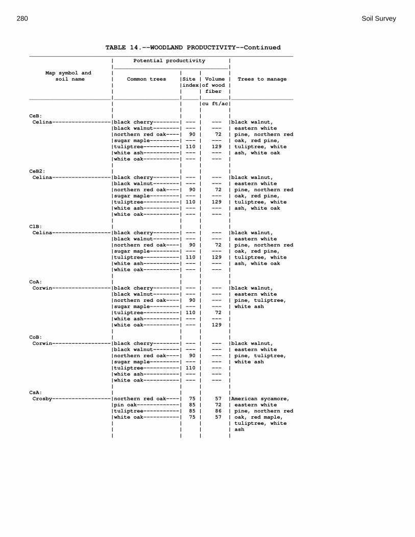
280 Soil Survey
TABLE 14.--WOODLAND PRODUCTIVITY--Continued _________________________________________________________________________________ | Potential productivity | |___________________________________| Map symbol and | | | | soil name | Common trees |Site | Volume | Trees to manage | |index|of wood | | | | fiber | _________________________|____________________|_____|________|___________________ | | |cu ft/ac| | | | | CeB: | | | | Celina------------------|black cherry--------| --- | --- |black walnut, |black walnut--------| --- | --- | eastern white |northern red oak----| 90 | 72 | pine, northern red |sugar maple---------| --- | --- | oak, red pine, |tuliptree-----------| 110 | 129 | tuliptree, white |white ash-----------| --- | --- | ash, white oak |white oak-----------| --- | --- | | | | | CeB2: | | | | Celina------------------|black cherry--------| --- | --- |black walnut, |black walnut--------| --- | --- | eastern white |northern red oak----| 90 | 72 | pine, northern red |sugar maple---------| --- | --- | oak, red pine, |tuliptree-----------| 110 | 129 | tuliptree, white |white ash-----------| --- | --- | ash, white oak |white oak-----------| --- | --- | | | | | ClB: | | | | Celina------------------|black cherry--------| --- | --- |black walnut, |black walnut--------| --- | --- | eastern white |northern red oak----| 90 | 72 | pine, northern red |sugar maple---------| --- | --- | oak, red pine, |tuliptree-----------| 110 | 129 | tuliptree, white |white ash-----------| --- | --- | ash, white oak |white oak-----------| --- | --- | | | | | CoA: | | | | Corwin------------------|black cherry--------| --- | --- |black walnut, |black walnut--------| --- | --- | eastern white |northern red oak----| 90 | --- | pine, tuliptree, |sugar maple---------| --- | --- | white ash |tuliptree-----------| 110 | 72 | |white ash-----------| --- | --- | |white oak-----------| --- | 129 | | | | | CoB: | | | | Corwin------------------|black cherry--------| --- | --- |black walnut, |black walnut--------| --- | --- | eastern white |northern red oak----| 90 | --- | pine, tuliptree, |sugar maple---------| --- | --- | white ash |tuliptree-----------| 110 | --- | |white ash-----------| --- | --- | |white oak-----------| --- | --- | | | | | CsA: | | | | Crosby------------------|northern red oak----| 75 | 57 |American sycamore, |pin oak-------------| 85 | 72 | eastern white |tuliptree-----------| 85 | 86 | pine, northern red |white oak-----------| 75 | 57 | oak, red maple, | | | | tuliptree, white | | | | ash | | | |

Montgomery County, Ohio 281
TABLE 14.--WOODLAND PRODUCTIVITY--Continued _________________________________________________________________________________ | Potential productivity | |___________________________________| Map symbol and | | | | soil name | Common trees |Site | Volume | Trees to manage | |index|of wood | | | | fiber | _________________________|____________________|_____|________|___________________ | | |cu ft/ac| | | | | CtB: | | | | Crosby------------------|northern red oak----| 75 | 57 |American sycamore, |pin oak-------------| 85 | 72 | eastern white |tuliptree-----------| 85 | 86 | pine, northern red |white oak-----------| 75 | 57 | oak, red maple, | | | | tuliptree, white | | | | ash | | | | Celina------------------|black cherry--------| --- | --- |black walnut, |black walnut--------| --- | --- | eastern white |northern red oak----| 90 | 72 | pine, northern red |sugar maple---------| --- | --- | oak, red pine, |tuliptree-----------| 110 | 129 | tuliptree, white |white ash-----------| --- | --- | ash, white oak |white oak-----------| --- | --- | | | | | Cu: | | | | Crosby------------------|northern red oak----| 75 | 57 |American sycamore, |pin oak-------------| 85 | 72 | eastern white |tuliptree-----------| 85 | 86 | pine, northern red |white oak-----------| 75 | 57 | oak, red maple, | | | | tuliptree, white | | | | ash | | | | Urban Land--------------| --- | --- | --- | --- | | | | DaB: | | | | Dana--------------------|black cherry--------| --- | --- |black locust, black |black walnut--------| --- | --- | walnut, eastern |northern red oak----| 90 | 72 | white pine, red |sugar maple---------| --- | --- | pine, tuliptree, |tuliptree-----------| 110 | 129 | white ash |white ash-----------| --- | --- | |white oak-----------| --- | --- | | | | | FaE2: | | | | Fairmount---------------|black locust--------| --- | --- |Virginia pine, |black oak-----------| 65 | 43 | northern red oak, |black walnut--------| --- | --- | white oak |chinkapin oak-------| --- | --- | |eastern redcedar----| 41 | 43 | |northern red oak----| 74 | 57 | |scarlet oak---------| 60 | 43 | |white ash-----------| --- | --- | | | | | FaF2: | | | | Fairmount---------------|black locust--------| --- | --- |Virginia pine, |black oak-----------| 65 | 43 | northern red oak, |black walnut--------| --- | --- | white oak |chinkapin oak-------| --- | --- | |eastern redcedar----| 41 | 43 | |northern red oak----| 74 | 57 | |scarlet oak---------| 60 | 43 | |white ash-----------| --- | --- | | | | | FcA: | | | | Fincastle---------------|northern red oak----| 75 | 57 |American sycamore, |pin oak-------------| 85 | 72 | baldcypress, |sweetgum------------| 80 | 86 | eastern white |tuliptree-----------| 85 | 86 | pine, red maple, |white oak-----------| 75 | 57 | tuliptree, white | | | | ash

282 Soil Survey
TABLE 14.--WOODLAND PRODUCTIVITY--Continued _________________________________________________________________________________ | Potential productivity | |___________________________________| Map symbol and | | | | soil name | Common trees |Site | Volume | Trees to manage | |index|of wood | | | | fiber | _________________________|____________________|_____|________|___________________ | | |cu ft/ac| | | | | FkA: | | | | Fox---------------------|northern red oak----| 80 | 57 |black locust, |sugar maple---------| --- | --- | eastern white |white oak-----------| --- | --- | pine, red pine, | | | | tuliptree, white | | | | ash | | | | FkB: | | | | Fox---------------------|northern red oak----| 80 | 57 |black locust, |sugar maple---------| --- | --- | eastern white |white oak-----------| --- | --- | pine, red pine, | | | | tuliptree, white | | | | ash | | | | FlA: | | | | Fox---------------------|northern red oak----| 80 | 57 |black locust, |sugar maple---------| --- | --- | eastern white |white oak-----------| --- | --- | pine, red pine, | | | | tuliptree, white | | | | ash | | | | FlB: | | | | Fox---------------------|northern red oak----| 80 | 57 |black locust, |sugar maple---------| --- | --- | eastern white |white oak-----------| --- | --- | pine, red pine, | | | | tuliptree, white | | | | ash | | | | FlC2: | | | | Fox---------------------|northern red oak----| 80 | 57 |black locust, |sugar maple---------| --- | --- | eastern white |white oak-----------| --- | --- | pine, red pine, | | | | tuliptree, white | | | | ash | | | | FmA: | | | | Fox---------------------|northern red oak----| 80 | 57 |black locust, |sugar maple---------| --- | --- | eastern white |white oak-----------| --- | --- | pine, red pine, | | | | tuliptree, white | | | | ash | | | | FmB: | | | | Fox---------------------|northern red oak----| 80 | 57 |black locust, |sugar maple---------| --- | --- | eastern white |white oak-----------| --- | --- | pine, red pine, | | | | tuliptree, white | | | | ash | | | | FmC2: | | | | Fox---------------------|northern red oak----| 80 | 57 |black locust, |sugar maple---------| --- | --- | eastern white |white oak-----------| --- | --- | pine, red pine, | | | | tuliptree, white | | | | ash | | | | FmD2: | | | | Fox---------------------|northern red oak----| 80 | 57 |black locust, |sugar maple---------| --- | --- | eastern white |white oak-----------| --- | --- | pine, red pine, | | | | tuliptree, white | | | | ash

Montgomery County, Ohio 283
TABLE 14.--WOODLAND PRODUCTIVITY--Continued _________________________________________________________________________________ | Potential productivity | |___________________________________| Map symbol and | | | | soil name | Common trees |Site | Volume | Trees to manage | |index|of wood | | | | fiber | _________________________|____________________|_____|________|___________________ | | |cu ft/ac| | | | | FsC3: | | | | Fox---------------------|northern red oak----| 80 | 57 |black locust, |sugar maple---------| --- | --- | eastern white |white oak-----------| --- | --- | pine, red pine, | | | | tuliptree, white | | | | ash | | | | FuB: | | | | Fox---------------------|northern red oak----| 80 | 57 |black locust, |sugar maple---------| --- | --- | eastern white |white oak-----------| --- | --- | pine, red pine, | | | | tuliptree, white | | | | ash | | | | Urban Land--------------| --- | --- | --- | --- | | | | FuC: | | | | Urban Land--------------| --- | --- | --- | --- | | | | Fox---------------------|northern red oak----| 80 | 57 |black locust, |sugar maple---------| --- | --- | eastern white |white oak-----------| --- | --- | pine, red pine, | | | | tuliptree, white | | | | ash | | | | FuF: | | | | Urban Land--------------| --- | --- | --- | --- | | | | Fox---------------------|northern red oak----| 80 | 57 |black locust, |sugar maple---------| --- | --- | eastern white |white oak-----------| --- | --- | pine, red pine, | | | | tuliptree, white | | | | ash | | | | Gp: | | | | Gravel Pits-------------| --- | --- | --- | --- | | | | HeE2: | | | | Hennepin----------------|northern red oak----| 85 | 72 |black walnut, |white oak-----------| --- | --- | eastern redcedar, | | | | eastern white | | | | pine, green ash, | | | | northern red oak, | | | | red pine, white | | | | oak | | | | Miamian-----------------|black cherry--------| --- | --- |black walnut, |black walnut--------| --- | --- | eastern white |northern red oak----| 87 | 72 | pine, northern red |sugar maple---------| --- | --- | oak, red pine, |tuliptree-----------| --- | --- | tuliptree, white |white ash-----------| --- | --- | ash, white oak |white oak-----------| --- | --- | | | | |

284 Soil Survey
TABLE 14.--WOODLAND PRODUCTIVITY--Continued _________________________________________________________________________________ | Potential productivity | |___________________________________| Map symbol and | | | | soil name | Common trees |Site | Volume | Trees to manage | |index|of wood | | | | fiber | _________________________|____________________|_____|________|___________________ | | |cu ft/ac| | | | | HeF2: | | | | Hennepin----------------|northern red oak----| 85 | 72 |black walnut, |white oak-----------| --- | --- | eastern redcedar, | | | | eastern white | | | | pine, green ash, | | | | northern red oak, | | | | red pine, white | | | | oak | | | | Miamian-----------------|black cherry--------| --- | --- |black walnut, |black walnut--------| --- | --- | eastern white |northern red oak----| 87 | 72 | pine, northern red |sugar maple---------| --- | --- | oak, red pine, |tuliptree-----------| --- | --- | tuliptree, white |white ash-----------| --- | --- | ash, white oak |white oak-----------| --- | --- | | | | | HmF3: | | | | Hennepin----------------|northern red oak----| 85 | 72 |black walnut, |white oak-----------| --- | --- | eastern redcedar, | | | | eastern white | | | | pine, green ash, | | | | northern red oak, | | | | red pine, white | | | | oak | | | | Miamian-----------------|black cherry--------| --- | --- |black walnut, |black walnut--------| --- | --- | eastern white |northern red oak----| 87 | 72 | pine, northern red |sugar maple---------| --- | --- | oak, red pine, |tuliptree-----------| --- | --- | tuliptree, white |white ash-----------| --- | --- | ash, white oak |white oak-----------| --- | --- | | | | | KeA: | | | | Kendallville------------|black cherry--------| --- | --- |black walnut, |black walnut--------| --- | --- | eastern white |northern red oak----| 87 | 72 | pine, northern red |sugar maple---------| --- | --- | oak, red pine, |tuliptree-----------| 95 | 100 | tuliptree, white |white ash-----------| --- | --- | ash, white oak |white oak-----------| --- | --- | | | | | KeB: | | | | Kendallville------------|black cherry--------| --- | --- |black walnut, |black walnut--------| --- | --- | eastern white |northern red oak----| 87 | 72 | pine, northern red |sugar maple---------| --- | --- | oak, red pine, |tuliptree-----------| 95 | 100 | tuliptree, white |white ash-----------| --- | --- | ash, white oak |white oak-----------| --- | --- | | | | | KeC2: | | | | Kendallville------------|black cherry--------| --- | --- |black walnut, |black walnut--------| --- | --- | eastern white |northern red oak----| 87 | 72 | pine, northern red |sugar maple---------| --- | --- | oak, red pine, |tuliptree-----------| 95 | 100 | tuliptree, white |white ash-----------| --- | --- | ash, white oak |white oak-----------| --- | --- | | | | |

Montgomery County, Ohio 285
TABLE 14.--WOODLAND PRODUCTIVITY--Continued _________________________________________________________________________________ | Potential productivity | |___________________________________| Map symbol and | | | | soil name | Common trees |Site | Volume | Trees to manage | |index|of wood | | | | fiber | _________________________|____________________|_____|________|___________________ | | |cu ft/ac| Ld: | | | | Landes------------------|American sycamore---| --- | --- |American sycamore, |eastern cottonwood--| 105 | 143 | black walnut, |green ash-----------| --- | --- | eastern |sweetgum------------| --- | --- | cottonwood, |tuliptree-----------| 95 | 100 | eastern white | | | | pine, green ash, | | | | sugar maple, | | | | sweetgum, | | | | tuliptree | | | | Lg: | | | | Lanier------------------|black oak-----------| 80 | 57 |eastern white pine, |bur oak-------------| --- | --- | green ash, red |green ash-----------| --- | --- | pine |northern red oak----| 80 | 57 | |quaking aspen-------| --- | --- | |red maple-----------| --- | --- | |slippery elm--------| --- | --- | | | | | LsB: | | | | Lewisburg---------------|black cherry--------| --- | --- |American sycamore, |northern red oak----| 80 | 57 | black cherry, |sugar maple---------| --- | --- | black locust, |tuliptree-----------| --- | --- | eastern |white ash-----------| --- | --- | cottonwood, |white oak-----------| 75 | 57 | eastern white | | | | pine, green ash, | | | | northern red oak, | | | | red pine, | | | | tuliptree, white | | | | ash, white oak | | | | LxC2: | | | | Lorenzo-----------------| --- | --- | --- | --- | | | | Rodman------------------|eastern white pine--| 85 | 200 |eastern white pine, |northern red oak----| 70 | 57 | jack pine, red |red pine------------| 75 | 143 | pine |white oak-----------| 70 | 57 | | | | | LxD2: | | | | Lorenzo-----------------| --- | --- | --- | --- | | | | Rodman------------------|eastern white pine--| 85 | 200 |eastern white pine, |northern red oak----| 70 | 57 | jack pine, red |red pine------------| 75 | 143 | pine |white oak-----------| 70 | 57 | | | | | Mb: | | | | Made Land---------------| --- | --- | --- | --- | | | | Md: | | | | Medway------------------|black cherry--------| --- | --- |black walnut, |black walnut--------| --- | --- | eastern white |northern red oak----| 86 | 72 | pine, northern red |sugar maple---------| --- | --- | oak, red pine, |tuliptree-----------| 96 | 100 | tuliptree, white |white ash-----------| --- | --- | ash, white oak |white oak-----------| --- | --- | | | | |

286 Soil Survey
TABLE 14.--WOODLAND PRODUCTIVITY--Continued _________________________________________________________________________________ | Potential productivity | |___________________________________| Map symbol and | | | | soil name | Common trees |Site | Volume | Trees to manage | |index|of wood | | | | fiber | _________________________|____________________|_____|________|___________________ | | |cu ft/ac| MlA: | | | | Miamian-----------------|black cherry--------| --- | --- |black walnut, |black walnut--------| --- | --- | eastern white |northern red oak----| 87 | 72 | pine, northern red |sugar maple---------| --- | --- | oak, red pine, |tuliptree-----------| --- | --- | tuliptree, white |white ash-----------| --- | --- | ash, white oak |white oak-----------| --- | --- | | | | | MlB: | | | | Miamian-----------------|black cherry--------| --- | --- |black walnut, |black walnut--------| --- | --- | eastern white |northern red oak----| 87 | 72 | pine, northern red |sugar maple---------| --- | --- | oak, red pine, |tuliptree-----------| --- | --- | tuliptree, white |white ash-----------| --- | --- | ash, white oak |white oak-----------| --- | --- | | | | | MlB2: | | | | Miamian-----------------|black cherry--------| --- | --- |black walnut, |black walnut--------| --- | --- | eastern white |northern red oak----| 87 | 72 | pine, northern red |sugar maple---------| --- | --- | oak, red pine, |tuliptree-----------| --- | --- | tuliptree, white |white ash-----------| --- | --- | ash, white oak |white oak-----------| --- | --- | | | | | MlC2: | | | | Miamian-----------------|black cherry--------| --- | --- |black walnut, |black walnut--------| --- | --- | eastern white |northern red oak----| 87 | 72 | pine, northern red |sugar maple---------| --- | --- | oak, red pine, |tuliptree-----------| --- | --- | tuliptree, white |white ash-----------| --- | --- | ash, white oak |white oak-----------| --- | --- | | | | | MlD2: | | | | Miamian-----------------|black cherry--------| --- | --- |black walnut, |black walnut--------| --- | --- | eastern white |northern red oak----| 87 | 72 | pine, northern red |sugar maple---------| --- | --- | oak, red pine, |tuliptree-----------| --- | --- | tuliptree, white |white ash-----------| --- | --- | ash, white oak |white oak-----------| --- | --- | | | | | MmB: | | | | Miamian-----------------|black cherry--------| --- | --- |black walnut, |black walnut--------| --- | --- | eastern white |northern red oak----| 87 | 72 | pine, northern red |sugar maple---------| --- | --- | oak, red pine, |tuliptree-----------| --- | --- | tuliptree, white |white ash-----------| --- | --- | ash, white oak |white oak-----------| --- | --- | | | | | MnB3: | | | | Miamian-----------------|black cherry--------| --- | --- |black walnut, |black walnut--------| --- | --- | eastern white |northern red oak----| 87 | 72 | pine, northern red |sugar maple---------| --- | --- | oak, red pine, |tuliptree-----------| --- | --- | tuliptree, white |white ash-----------| --- | --- | ash, white oak |white oak-----------| --- | --- | | | | |

Montgomery County, Ohio 287
TABLE 14.--WOODLAND PRODUCTIVITY--Continued _________________________________________________________________________________ | Potential productivity | |___________________________________| Map symbol and | | | | soil name | Common trees |Site | Volume | Trees to manage | |index|of wood | | | | fiber | _________________________|____________________|_____|________|___________________ | | |cu ft/ac| MnC3: | | | | Miamian-----------------|black cherry--------| --- | --- |black walnut, |black walnut--------| --- | --- | eastern white |northern red oak----| 87 | 72 | pine, northern red |sugar maple---------| --- | --- | oak, red pine, |tuliptree-----------| --- | --- | tuliptree, white |white ash-----------| --- | --- | ash, white oak |white oak-----------| --- | --- | | | | | MnD3: | | | | Miamian-----------------|black cherry--------| --- | --- |black walnut, |black walnut--------| --- | --- | eastern white |northern red oak----| 87 | 72 | pine, northern red |sugar maple---------| --- | --- | oak, red pine, |tuliptree-----------| --- | --- | tuliptree, white |white ash-----------| --- | --- | ash, white oak |white oak-----------| --- | --- | | | | | MoB: | | | | Miamian-----------------|black cherry--------| --- | --- |black walnut, |black walnut--------| --- | --- | eastern white |northern red oak----| 87 | 72 | pine, northern red |sugar maple---------| --- | --- | oak, red pine, |tuliptree-----------| --- | --- | tuliptree, white |white ash-----------| --- | --- | ash, white oak |white oak-----------| --- | --- | | | | | Urban Land--------------| --- | --- | --- | --- | | | | MoC: | | | | Miamian-----------------|black cherry--------| --- | --- |black walnut, |black walnut--------| --- | --- | eastern white |northern red oak----| 87 | 72 | pine, northern red |sugar maple---------| --- | --- | oak, red pine, |tuliptree-----------| --- | --- | tuliptree, white |white ash-----------| --- | --- | ash, white oak |white oak-----------| --- | --- | | | | | Urban Land--------------| --- | --- | --- | --- | | | | MoE: | | | | Miamian-----------------|black cherry--------| --- | --- |black walnut, |black walnut--------| --- | --- | eastern white |northern red oak----| 87 | 72 | pine, northern red |sugar maple---------| --- | --- | oak, red pine, |tuliptree-----------| --- | --- | tuliptree, white |white ash-----------| --- | --- | ash, white oak |white oak-----------| --- | --- | | | | | Urban Land--------------| --- | --- | --- | --- | | | | MrA: | | | | Millsdale---------------|black cherry--------| --- | --- |American sycamore, |eastern cottonwood--| --- | --- | baldcypress, |green ash-----------| --- | --- | eastern |pin oak-------------| 86 | 72 | cottonwood, green |red maple-----------| --- | --- | ash, pin oak, red |swamp white oak-----| --- | --- | maple, swamp white | | | | oak, sweetgum | | | |
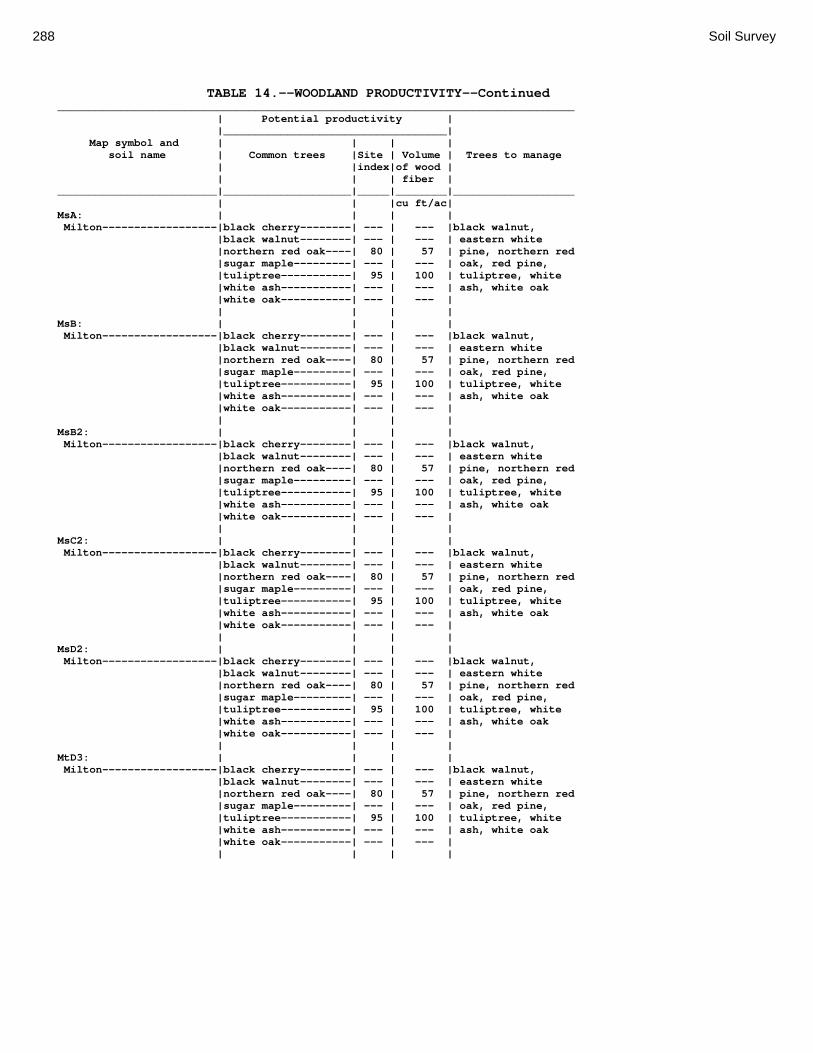
288 Soil Survey
TABLE 14.--WOODLAND PRODUCTIVITY--Continued _________________________________________________________________________________ | Potential productivity | |___________________________________| Map symbol and | | | | soil name | Common trees |Site | Volume | Trees to manage | |index|of wood | | | | fiber | _________________________|____________________|_____|________|___________________ | | |cu ft/ac| MsA: | | | | Milton------------------|black cherry--------| --- | --- |black walnut, |black walnut--------| --- | --- | eastern white |northern red oak----| 80 | 57 | pine, northern red |sugar maple---------| --- | --- | oak, red pine, |tuliptree-----------| 95 | 100 | tuliptree, white |white ash-----------| --- | --- | ash, white oak |white oak-----------| --- | --- | | | | | MsB: | | | | Milton------------------|black cherry--------| --- | --- |black walnut, |black walnut--------| --- | --- | eastern white |northern red oak----| 80 | 57 | pine, northern red |sugar maple---------| --- | --- | oak, red pine, |tuliptree-----------| 95 | 100 | tuliptree, white |white ash-----------| --- | --- | ash, white oak |white oak-----------| --- | --- | | | | | MsB2: | | | | Milton------------------|black cherry--------| --- | --- |black walnut, |black walnut--------| --- | --- | eastern white |northern red oak----| 80 | 57 | pine, northern red |sugar maple---------| --- | --- | oak, red pine, |tuliptree-----------| 95 | 100 | tuliptree, white |white ash-----------| --- | --- | ash, white oak |white oak-----------| --- | --- | | | | | MsC2: | | | | Milton------------------|black cherry--------| --- | --- |black walnut, |black walnut--------| --- | --- | eastern white |northern red oak----| 80 | 57 | pine, northern red |sugar maple---------| --- | --- | oak, red pine, |tuliptree-----------| 95 | 100 | tuliptree, white |white ash-----------| --- | --- | ash, white oak |white oak-----------| --- | --- | | | | | MsD2: | | | | Milton------------------|black cherry--------| --- | --- |black walnut, |black walnut--------| --- | --- | eastern white |northern red oak----| 80 | 57 | pine, northern red |sugar maple---------| --- | --- | oak, red pine, |tuliptree-----------| 95 | 100 | tuliptree, white |white ash-----------| --- | --- | ash, white oak |white oak-----------| --- | --- | | | | | MtD3: | | | | Milton------------------|black cherry--------| --- | --- |black walnut, |black walnut--------| --- | --- | eastern white |northern red oak----| 80 | 57 | pine, northern red |sugar maple---------| --- | --- | oak, red pine, |tuliptree-----------| 95 | 100 | tuliptree, white |white ash-----------| --- | --- | ash, white oak |white oak-----------| --- | --- | | | | |

Montgomery County, Ohio 289
TABLE 14.--WOODLAND PRODUCTIVITY--Continued _________________________________________________________________________________ | Potential productivity | |___________________________________| Map symbol and | | | | soil name | Common trees |Site | Volume | Trees to manage | |index|of wood | | | | fiber | _________________________|____________________|_____|________|___________________ | | |cu ft/ac| MuB: | | | | Milton------------------|black cherry--------| --- | --- |black walnut, |black walnut--------| --- | --- | eastern white |northern red oak----| 80 | 57 | pine, northern red |sugar maple---------| --- | --- | oak, red pine, |tuliptree-----------| 95 | 100 | tuliptree, white |white ash-----------| --- | --- | ash, white oak |white oak-----------| --- | --- | | | | | Urban Land--------------| --- | --- | --- | --- | | | | MuC: | | | | Milton------------------|black cherry--------| --- | --- |black walnut, |black walnut--------| --- | --- | eastern white |northern red oak----| 80 | 57 | pine, northern red |sugar maple---------| --- | --- | oak, red pine, |tuliptree-----------| 95 | 100 | tuliptree, white |white ash-----------| --- | --- | ash, white oak |white oak-----------| --- | --- | | | | | Urban Land--------------| --- | --- | --- | --- | | | | MuD: | | | | Milton------------------|black cherry--------| --- | --- |black walnut, |black walnut--------| --- | --- | eastern white |northern red oak----| 80 | 57 | pine, northern red |sugar maple---------| --- | --- | oak, red pine, |tuliptree-----------| 95 | 100 | tuliptree, white |white ash-----------| --- | --- | ash, white oak |white oak-----------| --- | --- | | | | | Urban Land--------------| --- | --- | --- | --- | | | | Mv: | | | | Montgomery--------------|pin oak-------------| 88 | 72 |American sycamore, |sweetgum------------| 90 | 100 | eastern |white oak-----------| 75 | 57 | cottonwood, green | | | | ash, pin oak, red | | | | maple, silver | | | | maple | | | | OcA: | | | | Ockley------------------|northern red oak----| 90 | 72 |black walnut, |sweetgum------------| 76 | 72 | eastern white |tuliptree-----------| 98 | 100 | pine, red pine, |white oak-----------| 90 | 72 | tuliptree, white | | | | ash | | | | OcB: | | | | Ockley------------------|northern red oak----| 90 | 72 |black walnut, |sweetgum------------| 76 | 72 | eastern white |tuliptree-----------| 98 | 100 | pine, red pine, |white oak-----------| 90 | 72 | tuliptree, white | | | | ash | | | | PlB: | | | | Plattville--------------|black cherry--------| --- | --- |Scotch pine, black |black walnut--------| --- | --- | walnut, eastern |northern red oak----| 80 | 57 | white pine, green |sugar maple---------| --- | --- | ash, red pine |tuliptree-----------| 95 | 100 | |white ash-----------| --- | --- | |white oak-----------| --- | --- |
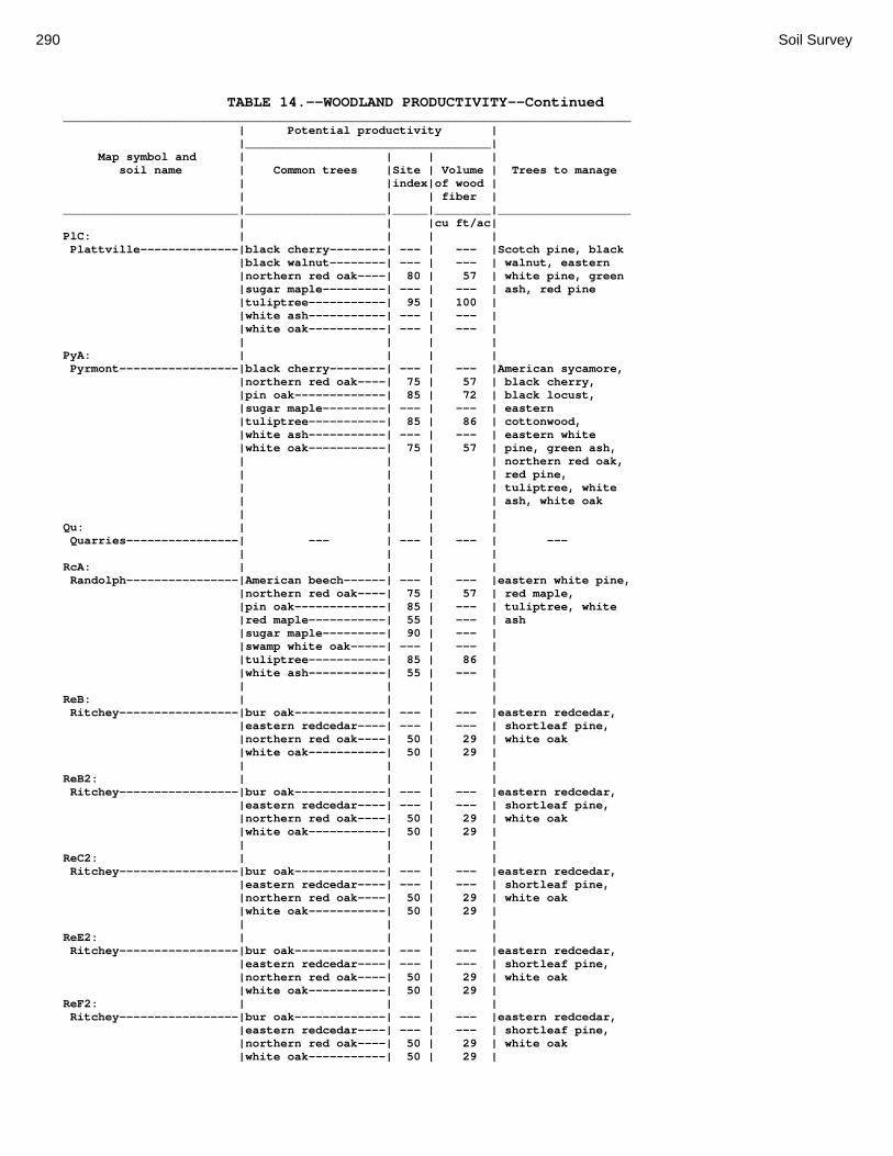
290 Soil Survey
TABLE 14.--WOODLAND PRODUCTIVITY--Continued _________________________________________________________________________________ | Potential productivity | |___________________________________| Map symbol and | | | | soil name | Common trees |Site | Volume | Trees to manage | |index|of wood | | | | fiber | _________________________|____________________|_____|________|___________________ | | |cu ft/ac| PlC: | | | | Plattville--------------|black cherry--------| --- | --- |Scotch pine, black |black walnut--------| --- | --- | walnut, eastern |northern red oak----| 80 | 57 | white pine, green |sugar maple---------| --- | --- | ash, red pine |tuliptree-----------| 95 | 100 | |white ash-----------| --- | --- | |white oak-----------| --- | --- | | | | | PyA: | | | | Pyrmont-----------------|black cherry--------| --- | --- |American sycamore, |northern red oak----| 75 | 57 | black cherry, |pin oak-------------| 85 | 72 | black locust, |sugar maple---------| --- | --- | eastern |tuliptree-----------| 85 | 86 | cottonwood, |white ash-----------| --- | --- | eastern white |white oak-----------| 75 | 57 | pine, green ash, | | | | northern red oak, | | | | red pine, | | | | tuliptree, white | | | | ash, white oak | | | | Qu: | | | | Quarries----------------| --- | --- | --- | --- | | | | RcA: | | | | Randolph----------------|American beech------| --- | --- |eastern white pine, |northern red oak----| 75 | 57 | red maple, |pin oak-------------| 85 | --- | tuliptree, white |red maple-----------| 55 | --- | ash |sugar maple---------| 90 | --- | |swamp white oak-----| --- | --- | |tuliptree-----------| 85 | 86 | |white ash-----------| 55 | --- | | | | | ReB: | | | | Ritchey-----------------|bur oak-------------| --- | --- |eastern redcedar, |eastern redcedar----| --- | --- | shortleaf pine, |northern red oak----| 50 | 29 | white oak |white oak-----------| 50 | 29 | | | | | ReB2: | | | | Ritchey-----------------|bur oak-------------| --- | --- |eastern redcedar, |eastern redcedar----| --- | --- | shortleaf pine, |northern red oak----| 50 | 29 | white oak |white oak-----------| 50 | 29 | | | | | ReC2: | | | | Ritchey-----------------|bur oak-------------| --- | --- |eastern redcedar, |eastern redcedar----| --- | --- | shortleaf pine, |northern red oak----| 50 | 29 | white oak |white oak-----------| 50 | 29 | | | | | ReE2: | | | | Ritchey-----------------|bur oak-------------| --- | --- |eastern redcedar, |eastern redcedar----| --- | --- | shortleaf pine, |northern red oak----| 50 | 29 | white oak |white oak-----------| 50 | 29 | ReF2: | | | | Ritchey-----------------|bur oak-------------| --- | --- |eastern redcedar, |eastern redcedar----| --- | --- | shortleaf pine, |northern red oak----| 50 | 29 | white oak |white oak-----------| 50 | 29 |
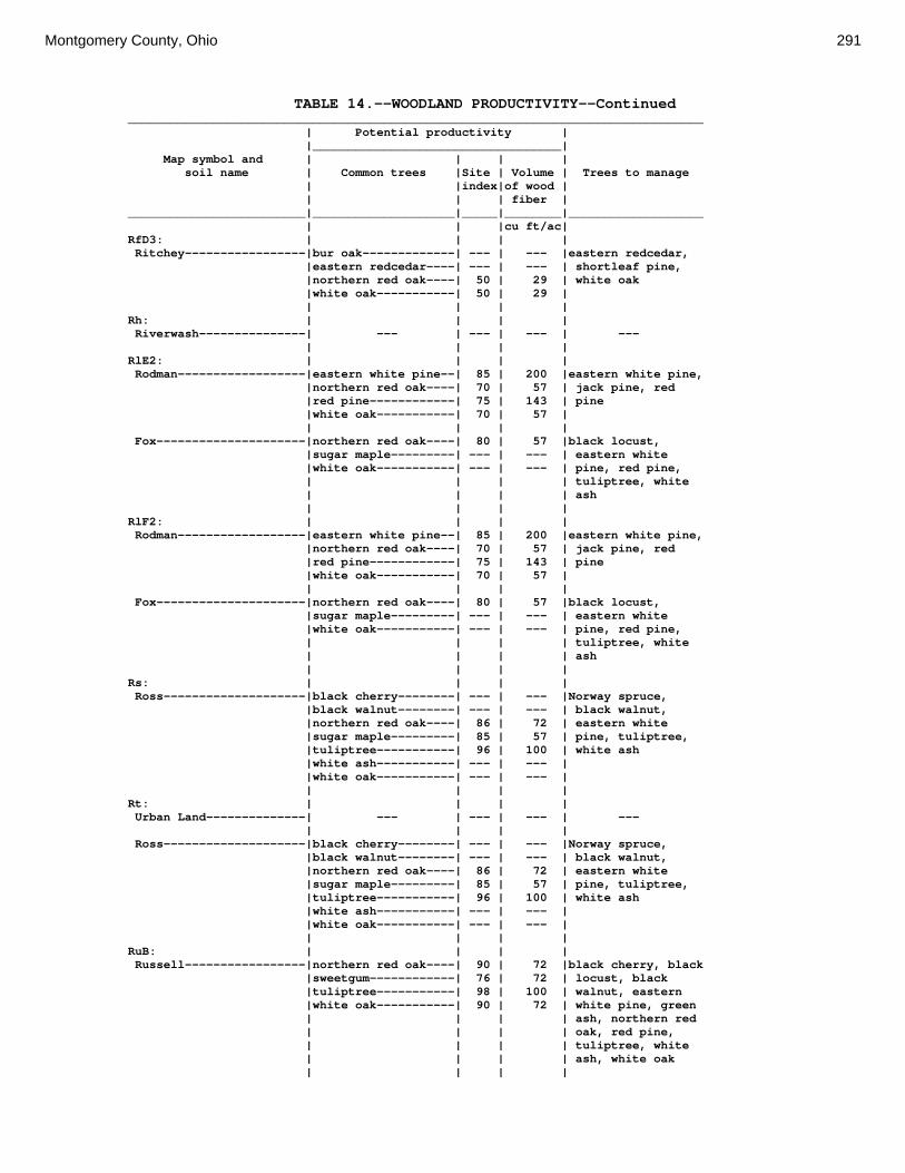
Montgomery County, Ohio 291
TABLE 14.--WOODLAND PRODUCTIVITY--Continued _________________________________________________________________________________ | Potential productivity | |___________________________________| Map symbol and | | | | soil name | Common trees |Site | Volume | Trees to manage | |index|of wood | | | | fiber | _________________________|____________________|_____|________|___________________ | | |cu ft/ac| RfD3: | | | | Ritchey-----------------|bur oak-------------| --- | --- |eastern redcedar, |eastern redcedar----| --- | --- | shortleaf pine, |northern red oak----| 50 | 29 | white oak |white oak-----------| 50 | 29 | | | | | Rh: | | | | Riverwash---------------| --- | --- | --- | --- | | | | RlE2: | | | | Rodman------------------|eastern white pine--| 85 | 200 |eastern white pine, |northern red oak----| 70 | 57 | jack pine, red |red pine------------| 75 | 143 | pine |white oak-----------| 70 | 57 | | | | | Fox---------------------|northern red oak----| 80 | 57 |black locust, |sugar maple---------| --- | --- | eastern white |white oak-----------| --- | --- | pine, red pine, | | | | tuliptree, white | | | | ash | | | | RlF2: | | | | Rodman------------------|eastern white pine--| 85 | 200 |eastern white pine, |northern red oak----| 70 | 57 | jack pine, red |red pine------------| 75 | 143 | pine |white oak-----------| 70 | 57 | | | | | Fox---------------------|northern red oak----| 80 | 57 |black locust, |sugar maple---------| --- | --- | eastern white |white oak-----------| --- | --- | pine, red pine, | | | | tuliptree, white | | | | ash | | | | Rs: | | | | Ross--------------------|black cherry--------| --- | --- |Norway spruce, |black walnut--------| --- | --- | black walnut, |northern red oak----| 86 | 72 | eastern white |sugar maple---------| 85 | 57 | pine, tuliptree, |tuliptree-----------| 96 | 100 | white ash |white ash-----------| --- | --- | |white oak-----------| --- | --- | | | | | Rt: | | | | Urban Land--------------| --- | --- | --- | --- | | | | Ross--------------------|black cherry--------| --- | --- |Norway spruce, |black walnut--------| --- | --- | black walnut, |northern red oak----| 86 | 72 | eastern white |sugar maple---------| 85 | 57 | pine, tuliptree, |tuliptree-----------| 96 | 100 | white ash |white ash-----------| --- | --- | |white oak-----------| --- | --- | | | | | RuB: | | | | Russell-----------------|northern red oak----| 90 | 72 |black cherry, black |sweetgum------------| 76 | 72 | locust, black |tuliptree-----------| 98 | 100 | walnut, eastern |white oak-----------| 90 | 72 | white pine, green | | | | ash, northern red | | | | oak, red pine, | | | | tuliptree, white | | | | ash, white oak | | | |

292 Soil Survey
TABLE 14.--WOODLAND PRODUCTIVITY--Continued _________________________________________________________________________________ | Potential productivity | |___________________________________| Map symbol and | | | | soil name | Common trees |Site | Volume | Trees to manage | |index|of wood | | | | fiber | _________________________|____________________|_____|________|___________________ | | |cu ft/ac| RvC2: | | | | Russell-----------------|northern red oak----| 90 | 72 |black cherry, black |sweetgum------------| 76 | 72 | locust, black |tuliptree-----------| 98 | 100 | walnut, eastern |white oak-----------| 90 | 72 | white pine, green | | | | ash, northern red | | | | oak, red pine, | | | | tuliptree, white | | | | ash, white oak | | | | Miamian-----------------|black cherry--------| --- | --- |black walnut, |black walnut--------| --- | --- | eastern white |northern red oak----| 87 | 72 | pine, northern red |sugar maple---------| --- | --- | oak, red pine, |tuliptree-----------| --- | --- | tuliptree, white |white ash-----------| --- | --- | ash, white oak |white oak-----------| --- | --- | | | | | RvD2: | | | | Russell-----------------|northern red oak----| 90 | 72 |black cherry, black |sweetgum------------| 76 | 72 | locust, black |tuliptree-----------| 98 | 100 | walnut, eastern |white oak-----------| 90 | 72 | white pine, green | | | | ash, northern red | | | | oak, red pine, | | | | tuliptree, white | | | | ash, white oak | | | | Miamian-----------------|black cherry--------| --- | --- |black walnut, |black walnut--------| --- | --- | eastern white |northern red oak----| 87 | 72 | pine, northern red |sugar maple---------| --- | --- | oak, red pine, |tuliptree-----------| --- | --- | tuliptree, white |white ash-----------| --- | --- | ash, white oak |white oak-----------| --- | --- | | | | | Sh: | | | | Shoals------------------|Virginia pine-------| 90 | 129 |pin oak, red maple, |eastern cottonwood--| --- | --- | swamp chestnut |pin oak-------------| 90 | 72 | oak, sweetgum, |sweetgum------------| 86 | 100 | tuliptree |tuliptree-----------| 90 | 86 | |white ash-----------| --- | --- | | | | | So: | | | | Sloan-------------------|eastern cottonwood--| --- | --- |American sycamore, |green ash-----------| --- | --- | eastern |pin oak-------------| 86 | 72 | cottonwood, green |red maple-----------| --- | --- | ash, pin oak, red |swamp white oak-----| --- | --- | maple, silver | | | | maple, swamp white | | | | oak, sweetgum | | | |
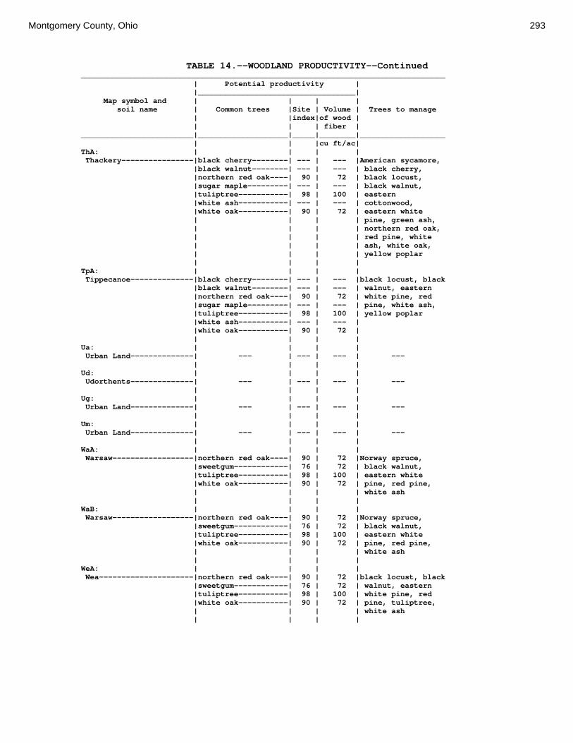
Montgomery County, Ohio 293
TABLE 14.--WOODLAND PRODUCTIVITY--Continued _________________________________________________________________________________ | Potential productivity | |___________________________________| Map symbol and | | | | soil name | Common trees |Site | Volume | Trees to manage | |index|of wood | | | | fiber | _________________________|____________________|_____|________|___________________ | | |cu ft/ac| ThA: | | | | Thackery----------------|black cherry--------| --- | --- |American sycamore, |black walnut--------| --- | --- | black cherry, |northern red oak----| 90 | 72 | black locust, |sugar maple---------| --- | --- | black walnut, |tuliptree-----------| 98 | 100 | eastern |white ash-----------| --- | --- | cottonwood, |white oak-----------| 90 | 72 | eastern white | | | | pine, green ash, | | | | northern red oak, | | | | red pine, white | | | | ash, white oak, | | | | yellow poplar | | | | TpA: | | | | Tippecanoe--------------|black cherry--------| --- | --- |black locust, black |black walnut--------| --- | --- | walnut, eastern |northern red oak----| 90 | 72 | white pine, red |sugar maple---------| --- | --- | pine, white ash, |tuliptree-----------| 98 | 100 | yellow poplar |white ash-----------| --- | --- | |white oak-----------| 90 | 72 | | | | | Ua: | | | | Urban Land--------------| --- | --- | --- | --- | | | | Ud: | | | | Udorthents--------------| --- | --- | --- | --- | | | | Ug: | | | | Urban Land--------------| --- | --- | --- | --- | | | | Um: | | | | Urban Land--------------| --- | --- | --- | --- | | | | WaA: | | | | Warsaw------------------|northern red oak----| 90 | 72 |Norway spruce, |sweetgum------------| 76 | 72 | black walnut, |tuliptree-----------| 98 | 100 | eastern white |white oak-----------| 90 | 72 | pine, red pine, | | | | white ash | | | | WaB: | | | | Warsaw------------------|northern red oak----| 90 | 72 |Norway spruce, |sweetgum------------| 76 | 72 | black walnut, |tuliptree-----------| 98 | 100 | eastern white |white oak-----------| 90 | 72 | pine, red pine, | | | | white ash | | | | WeA: | | | | Wea---------------------|northern red oak----| 90 | 72 |black locust, black |sweetgum------------| 76 | 72 | walnut, eastern |tuliptree-----------| 98 | 100 | white pine, red |white oak-----------| 90 | 72 | pine, tuliptree, | | | | white ash | | | |

294 Soil Survey
TABLE 14.--WOODLAND PRODUCTIVITY--Continued _________________________________________________________________________________ | Potential productivity | |___________________________________| Map symbol and | | | | soil name | Common trees |Site | Volume | Trees to manage | |index|of wood | | | | fiber | _________________________|____________________|_____|________|___________________ | | |cu ft/ac| WeB: | | | | Wea---------------------|northern red oak----| 90 | 72 |black locust, black |sweetgum------------| 76 | 72 | walnut, eastern |tuliptree-----------| 98 | 100 | white pine, red |white oak-----------| 90 | 72 | pine, tuliptree, | | | | white ash | | | | Ws: | | | | Westland----------------|pin oak-------------| 85 | 72 |baldcypress, |sweetgum------------| 90 | 100 | eastern white |white oak-----------| 75 | 57 | pine, red maple, | | | | sweetgum, white | | | | ash | | | | WyB2: | | | | Wynn--------------------|black cherry--------| --- | --- |black walnut, |black walnut--------| --- | --- | eastern white |northern red oak----| 85 | 72 | pine, red pine, |sugar maple---------| --- | --- | tuliptree, white |tuliptree-----------| 95 | 100 | ash, white oak |white ash-----------| --- | --- | |white oak-----------| 85 | 72 | | | | | XeA: | | | | Xenia-------------------|sweetgum------------| 76 | 72 |black walnut, |tuliptree-----------| 98 | 100 | eastern white |white oak-----------| 90 | 72 | pine, red pine, | | | | tuliptree, white | | | | ash | | | | XeB: | | | | Xenia-------------------|sweetgum------------| 76 | 72 |black walnut, |tuliptree-----------| 98 | 100 | eastern white |white oak-----------| 90 | 72 | pine, red pine, | | | | tuliptree, white | | | | ash | | | | _________________________|____________________|_____|________|___________________

Montgomery County, Ohio 295
TABLE 15.--WINDBREAKS AND ENVIRONMENTAL PLANTINGS (Absence of an entry indicates that trees generally do not grow to the given height. See text on page 165 for additional information.) ___________________________________________________________________________________________________________________________ | Trees having predicted 20-year average height, in feet, of-- Map symbol |_________________________________________________________________________________________________ and soil name | <8 | 8-15 | 16-25 | 26-35 | >35 _________________________|____________________|____________________|____________________|____________________|_____________ | | | | | Ag: | | | | | Algiers-----------------|silky dogwood |American |blue spruce; |Austrian pine; |eastern white | | cranberrybush | northern white- | Norway spruce | pine, pin | | | cedar; Washington | | oak | | | hawthorn; white fir| | | | | | | Bo: | | | | | Borrow pits-------------| --- | --- | --- | --- | --- | | | | | Bp: | | | | | Brookston---------------|silky dogwood |American |Austrian pine; blue |eastern white pine; |pin oak | | cranberrybush | spruce; northern | Norway spruce | | | | white-cedar; | | | | | Washington | | | | | hawthorn; white fir| | | | | | | Br: | | | | | Brookston---------------|silky dogwood |American |Austrian pine; blue |eastern white pine; |pin oak | | cranberrybush | spruce; northern | Norway spruce | | | | white-cedar; | | | | | Washington | | | | | hawthorn; white fir| | | | | | | Bs: | | | | | Brookston---------------|silky dogwood |American |Austrian pine; blue |eastern white pine; |pin oak | | cranberrybush | spruce; northern | Norway spruce | | | | white-cedar; | | | | | Washington | | | | | hawthorn; white fir| | | | | | | Bu: | | | | | Brookston---------------|silky dogwood |American |Austrian pine; blue |eastern white pine; |pin oak | | cranberrybush | spruce; northern | Norway spruce | | | | white-cedar; | | | | | Washington | | | | | hawthorn; white fir| | | | | | | Urban land--------------| --- | --- | --- | --- | --- | | | | | Ca: | | | | | Carlisle----------------| --- | --- | --- | --- | --- | | | | | CeA: | | | | | Celina------------------|silky dogwood |American |blue spruce; |Austrian pine; |eastern white | | cranberrybush | northern white- | Norway spruce | pine, pin | | | cedar; Washington | | oak | | | hawthorn; white fir| | | | | | | CeB: | | | | | Celina------------------|silky dogwood |American |blue spruce; |Austrian pine; |eastern white | | cranberrybush | northern white- | Norway spruce | pine, pin | | | cedar; Washington | | oak | | | hawthorn; white fir| | | | | | | CeB2: | | | | | Celina------------------|silky dogwood |American |blue spruce; |Austrian pine; |eastern white | | cranberrybush | northern white- | Norway spruce | pine, pin | | | cedar; Washington | | oak | | | hawthorn; white fir| | | | | | | ClB: | | | | | Celina------------------|silky dogwood |American |blue spruce; |Austrian pine; |eastern white | | cranberrybush | northern white- | Norway spruce | pine, pin | | | cedar; Washington | |oak | | | hawthorn; white fir| | | | | | | CoA: | | | | | Corwin------------------|silky dogwood |American |blue spruce; |Austrian pine; |eastern white | | cranberrybush | northern white- | Norway spruce | pine, pin | | | cedar; Washington | | oak | | | hawthorn; white fir| | | | | | | CoB: | | | | | Corwin------------------|silky dogwood |American |blue spruce; |Austrian pine; |eastern white | | cranberrybush | northern white- | Norway spruce | pine, pin | | | cedar; Washington | | oak | | | hawthorn; white fir| | | | | | |

296 Soil Survey
TABLE 15.--WINDBREAKS AND ENVIRONMENTAL PLANTINGS--Continued ___________________________________________________________________________________________________________________________ | Trees having predicted 20-year average height, in feet, of-- Map symbol |_________________________________________________________________________________________________ and soil name | <8 | 8-15 | 16-25 | 26-35 | >35 _________________________|____________________|____________________|____________________|____________________|_____________ | | | | | CsA: | | | | | Crosby------------------|American |southern arrowwood |Austrian pine; |eastern white pine; | --- | cranberrybush | | eastern redcedar; | pin oak | | | | green ash; | | | | | osageorange; | | | | | Washington hawthorn| | | | | | | CtB: | | | | | Crosby------------------|American |southern arrowwood |Austrian pine; |eastern white pine; | --- | cranberrybush | | eastern redcedar; | pin oak | | | | green ash; | | | | | osageorange; | | | | | Washington hawthorn| | | | | | | | | | | | Celina------------------|silky dogwood |American |blue spruce; |Austrian pine; |eastern white | | cranberrybush | northern white- | Norway spruce | pine, pin | | | cedar; Washington | | oak | | | hawthorn; white fir| | | | | | | Cu: | | | | | Crosby------------------|American |southern arrowwood |Austrian pine; |eastern white pine; | --- | cranberrybush | | eastern redcedar; | pin oak | | | | green ash; | | | | | osageorange; | | | | | Washington hawthorn| | | | | | | Urban land--------------| --- | --- | --- | --- | --- | | | | | DaB: | | | | | Dana--------------------|silky dogwood |American |blue spruce; |Austrian pine; |eastern white | | cranberrybush | northern white- | Norway spruce | pine, pin | | | cedar; Washington | | oak | | | hawthorn; white fir| | | | | | | FaE2: | | | | | Fairmount---------------| --- | --- | --- | --- | --- | | | | | FaF2: | | | | | Fairmount---------------| --- | --- | --- | --- | --- | | | | | FcA: | | | | | Fincastle---------------|silky dogwood |American |blue spruce; |Austrian pine; |eastern white | | cranberrybush | northern white- | Norway spruce | pine, pin | | | cedar; Washington | | oak | | | hawthorn; white fir| | | | | | | FkA: | | | | | Fox---------------------|common lilac; |eastern redcedar; |Austrian pine; | --- | --- | Siberian peashrub | radiant crabapple; | eastern white pine;| | | | Washington hawthorn| jack pine; red pine| | | | | | | FkB: | | | | | Fox---------------------|common lilac; |eastern redcedar; |Austrian pine; | --- | --- | Siberian peashrub | radiant crabapple; | eastern white pine;| | | | Washington hawthorn| jack pine; red pine| | | | | | | FlA: | | | | | Fox---------------------|common lilac; |eastern redcedar; |Austrian pine; | --- | --- | Siberian peashrub | radiant crabapple; | eastern white pine;| | | | Washington hawthorn| jack pine; red pine| | | | | | | FlB: | | | | | Fox---------------------|common lilac; |eastern redcedar; |Austrian pine; | --- | --- | Siberian peashrub | radiant crabapple; | eastern white pine;| | | | Washington hawthorn| jack pine; red pine| | | | | | | FlC2: | | | | | Fox---------------------|common lilac; |eastern redcedar; |Austrian pine; | --- | --- | Siberian peashrub | radiant crabapple; | eastern white pine;| | | | Washington hawthorn| jack pine; red pine| | | | | | | FmA: | | | | | Fox---------------------|common lilac; |eastern redcedar; |Austrian pine; | --- | --- | Siberian peashrub | radiant crabapple; | eastern white pine;| | | | Washington hawthorn| jack pine; red pine| | | | | | | FmB: | | | | | Fox---------------------|common lilac; |eastern redcedar; |Austrian pine; | --- | --- | Siberian peashrub | radiant crabapple; | eastern white pine;| | | | Washington hawthorn| jack pine; red pine| | | | | | |

Montgomery County, Ohio 297
TABLE 15.--WINDBREAKS AND ENVIRONMENTAL PLANTINGS--Continued ___________________________________________________________________________________________________________________________ | Trees having predicted 20-year average height, in feet, of-- Map symbol |_________________________________________________________________________________________________ and soil name | <8 | 8-15 | 16-25 | 26-35 | >35 _________________________|____________________|____________________|____________________|____________________|_____________ | | | | | FmC2: | | | | | Fox---------------------|common lilac; |eastern redcedar; |Austrian pine; | --- | --- | Siberian peashrub | radiant crabapple; | eastern white pine;| | | | Washington hawthorn| jack pine; red pine| | | | | | | FmD2: | | | | | Fox---------------------|common lilac; |eastern redcedar; |Austrian pine; | --- | --- | Siberian peashrub | radiant crabapple; | eastern white pine;| | | | Washington hawthorn| jack pine; red pine| | | | | | | FsC3: | | | | | Fox---------------------|common lilac; |eastern redcedar; |Austrian pine; | --- | --- | Siberian peashrub | radiant crabapple; | eastern white pine;| | | | Washington hawthorn| jack pine; red pine| | | | | | | FuB: | | | | | Fox---------------------|common lilac; |eastern redcedar; |Austrian pine; | --- | --- | Siberian peashrub | radiant crabapple; | eastern white pine;| | | | Washington hawthorn| jack pine; red pine| | | | | | | Urban land--------------| --- | --- | --- | --- | --- | | | | | FuC: | | | | | Urban land--------------| --- | --- | --- | --- | --- | | | | | Fox---------------------|common lilac; |eastern redcedar; |Austrian pine; | --- | --- | Siberian peashrub | radiant crabapple; | eastern white pine;| | | | Washington hawthorn| jack pine; red pine| | | | | | | FuF: | | | | | Urban land--------------| --- | --- | --- | --- | --- | | | | | Fox---------------------|common lilac; |eastern redcedar; |Austrian pine; | --- | --- | Siberian peashrub | radiant crabapple; | eastern white pine;| | | | Washington hawthorn| jack pine; red pine| | | | | | | Gp: | | | | | Gravel pits-------------| --- | --- | --- | --- | --- | | | | | HeE2: | | | | | Hennepin----------------|gray dogwood; |American |honeylocust; | --- | --- | Siberian peashrub; | cranberrybush; | northern catalpa | | | silky dogwood | eastern redcedar; | | | | | jack pine; | | | | | osageorange; | | | | | Russian olive; | | | | | Washington hawthorn| | | | | | | | Miamian-----------------|silky dogwood |American |blue spruce; |Austrian pine; |eastern white | | cranberrybush | northern white- | Norway spruce | pine, pin | | | cedar; Washington | | oak | | | hawthorn; white fir| | | | | | | HeF2: | | | | | Hennepin----------------|gray dogwood; |American |honeylocust; | --- | --- | Siberian peashrub; | cranberrybush; | northern catalpa | | | silky dogwood | eastern redcedar; | | | | | jack pine; | | | | | osageorange; | | | | | Russian olive; | | | | | Washington hawthorn| | | | | | | | Miamian-----------------|silky dogwood |American |blue spruce; |Austrian pine; |eastern white | | cranberrybush | northern white- | Norway spruce | pine, pin | | | cedar; Washington | | oak | | | hawthorn; white fir| | | | | | | HmF3: | | | | | Hennepin----------------|gray dogwood; |American |honeylocust; | --- | --- | Siberian peashrub; | cranberrybush; | northern catalpa | | | silky dogwood | eastern redcedar; | | | | | jack pine; | | | | | osageorange; | | | | | Russian olive; | | | | | Washington hawthorn| | | | | | | | Miamian-----------------|silky dogwood |American |blue spruce; |Austrian pine; |eastern white | | cranberrybush | northern white- | Norway spruce | pine, pin | | | cedar; Washington | | oak | | | hawthorn; white fir| | | | | | |

298 Soil Survey
TABLE 15.--WINDBREAKS AND ENVIRONMENTAL PLANTINGS--Continued ___________________________________________________________________________________________________________________________ | Trees having predicted 20-year average height, in feet, of-- Map symbol |_________________________________________________________________________________________________ and soil name | <8 | 8-15 | 16-25 | 26-35 | >35 _________________________|____________________|____________________|____________________|____________________|_____________ | | | | | KeA: | | | | | Kendallville------------|silky dogwood |American |blue spruce; |Austrian pine; |eastern white | | cranberrybush | northern white- | Norway spruce | pine, pin | | | cedar; Washington | | oak | | | hawthorn; white fir| | | | | | | KeB: | | | | | Kendallville------------|silky dogwood |American |blue spruce; |Austrian pine; |eastern white | | cranberrybush | northern white- | Norway spruce | pine, pin | | | cedar; Washington | | oak | | | hawthorn; white fir| | | | | | | KeC2: | | | | | Kendallville------------|silky dogwood |American |blue spruce; |Austrian pine; |eastern white | | cranberrybush | northern white- | Norway spruce | pine, pin | | | cedar; Washington | | oak | | | hawthorn; white fir| | | | | | | Ld: | | | | | Landes------------------|silky dogwood |American |blue spruce; |Austrian pine; |eastern white pine; | | cranberrybush | northern white- | Norway spruce | pin oak | | | cedar; Washington | | | | | hawthorn; white fir| | | | | | | Lg: | | | | | Lanier------------------| --- |Siberian peashrub |eastern redcedar; |black willow | --- | | | green ash; | | | | | nannyberry; | | | | | northern white- | | | | | cedar; osageorange;| | | | | Washington | | | | | hawthorn; white | | | | | spruce | | | | | | | LsB: | | | | | Lewisburg---------------|Siberian peashrub |eastern redcedar; |honeylocust; | --- | --- | | jack pine; | northern catalpa | | | | osageorange; | | | | | Russian olive; | | | | | Washington hawthorn| | | | | | | | LxC2: | | | | | Lorenzo-----------------|common lilac; |eastern redcedar; |Austrian pine; | --- | --- | Siberian peashrub | radiant crabapple; | eastern white pine;| | | | Washington hawthorn| jack pine; red pine| | | | | | | Rodman------------------|gray dogwood; |eastern redcedar; |Austrian pine; black| --- | --- | Siberian peashrub; | radiant crabapple; | locust; jack pine; | | | silky dogwood | Washington hawthorn| Virginia pine | | | | | | | LxD2: | | | | | Lorenzo-----------------|common lilac; |eastern redcedar; |Austrian pine; | --- | --- | Siberian peashrub | radiant crabapple; | eastern white pine;| | | | Washington hawthorn| jack pine; red pine| | | | | | | Rodman------------------|gray dogwood; |eastern redcedar; |Austrian pine; black| --- | --- | Siberian peashrub; | radiant crabapple; | locust; jack pine; | | | silky dogwood | Washington hawthorn| Virginia pine | | | | | | | Mb: | | | | | Made land---------------| --- | --- | --- | --- | --- | | | | | Md: | | | | | Medway------------------|silky dogwood |American |blue spruce; |Austrian pine; |eastern white | | cranberrybush | northern white- | Norway spruce | pine | | | cedar; Washington | | | | | hawthorn; white fir| | | | | | | MlA: | | | | | Miamian-----------------|silky dogwood |American |blue spruce; |Austrian pine; |eastern white | | cranberrybush | northern white- | Norway spruce | pine, pin | | | cedar; Washington | | oak | | | hawthorn; white fir| | | | | | | MlB: | | | | | Miamian-----------------|silky dogwood |American |blue spruce; |Austrian pine; |eastern white | | cranberrybush | northern white- | Norway spruce | pine, pin | | | cedar; Washington | | oak | | | hawthorn; white fir| | | | | | |

Montgomery County, Ohio 299
TABLE 15.--WINDBREAKS AND ENVIRONMENTAL PLANTINGS--Continued ___________________________________________________________________________________________________________________________ | Trees having predicted 20-year average height, in feet, of-- Map symbol |_________________________________________________________________________________________________ and soil name | <8 | 8-15 | 16-25 | 26-35 | >35 _________________________|____________________|____________________|____________________|____________________|_____________ | | | | | MlB2: | | | | | Miamian-----------------|silky dogwood |American |blue spruce; |Austrian pine; |eastern white | | cranberrybush | northern white- | Norway spruce | pine, pin | | | cedar; Washington | | oak | | | hawthorn; white fir| | | | | | | MlC2: | | | | | Miamian-----------------|silky dogwood |American |blue spruce; |Austrian pine; |eastern white | | cranberrybush | northern white- | Norway spruce | pine, pin | | | cedar; Washington | | oak | | | hawthorn; white fir| | | | | | | MlD2: | | | | | Miamian-----------------|silky dogwood |American |blue spruce; |Austrian pine; |eastern white | | cranberrybush | northern white- | Norway spruce | pine, pin | | | cedar; Washington | | oak | | | hawthorn; white fir| | | | | | | MmB: | | | | | Miamian-----------------|silky dogwood |American |blue spruce; |Austrian pine; |eastern white | | cranberrybush | northern white- | Norway spruce | pine, pin | | | cedar; Washington | | oak | | | hawthorn; white fir| | | | | | | MnB3: | | | | | Miamian-----------------|silky dogwood |American |blue spruce; |Austrian pine; |eastern white | | cranberrybush | northern white- | Norway spruce | pine, pin | | | cedar; Washington | | oak | | | hawthorn; white fir| | | | | | | MnC3: | | | | | Miamian-----------------|silky dogwood |American |blue spruce; |Austrian pine; |eastern white | | cranberrybush | northern white- | Norway spruce | pine, pin | | | cedar; Washington | | oak | | | hawthorn; white fir| | | | | | | MnD3: | | | | | Miamian-----------------|silky dogwood |American |blue spruce; |Austrian pine; |eastern white | | cranberrybush | northern white- | Norway spruce | pine, pin | | | cedar; Washington | | oak | | | hawthorn; white fir| | | | | | | MoB: | | | | | Miamian-----------------|silky dogwood |American |blue spruce; |Austrian pine; |eastern white | | cranberrybush | northern white- | Norway spruce | pine, pin | | | cedar; Washington | | oak | | | hawthorn; white fir| | | | | | | Urban land--------------| --- | --- | --- | --- | --- | | | | | MoC: | | | | | Miamian-----------------|silky dogwood |American |blue spruce; |Austrian pine; |eastern white | | cranberrybush | northern white- | Norway spruce | pine, pin | | | cedar; Washington | | oak | | | hawthorn; white fir| | | | | | | Urban land--------------| --- | --- | --- | --- | --- | | | | | MoE: | | | | | Miamian-----------------|silky dogwood |American |blue spruce; |Austrian pine; |eastern white | | cranberrybush | northern white- | Norway spruce | pine, pin | | | cedar; Washington | | oak | | | hawthorn; white fir| | | | | | | Urban land--------------| --- | --- | --- | --- | --- | | | | | MrA: | | | | | Millsdale---------------|silky dogwood |American |Austrian pine; blue |eastern white pine; | --- | | cranberrybush | spruce; northern | Norway spruce | | | | white-cedar; | | | | | Washington | | | | | hawthorn; white fir| | | | | | | MsA: | | | | | Milton------------------|common lilac; |eastern redcedar; |Austrian pine; | --- | --- | Siberian peashrub | radiant crabapple; | eastern white pine;| | | | Washington hawthorn| jack pine; red pine| | | | | | | MsB: | | | | | Milton------------------|common lilac; |eastern redcedar; |Austrian pine; | --- | --- | Siberian peashrub | radiant crabapple; | eastern white pine;| | | | Washington hawthorn| jack pine; red pine| | | | | | |

300 Soil Survey
TABLE 15.--WINDBREAKS AND ENVIRONMENTAL PLANTINGS--Continued ___________________________________________________________________________________________________________________________ | Trees having predicted 20-year average height, in feet, of-- Map symbol |_________________________________________________________________________________________________ and soil name | <8 | 8-15 | 16-25 | 26-35 | >35 _________________________|____________________|____________________|____________________|____________________|_____________ | | | | | MsB2: | | | | | Milton------------------|common lilac; |eastern redcedar; |Austrian pine; | --- | --- | Siberian peashrub | radiant crabapple; | eastern white pine;| | | | Washington hawthorn| jack pine; red pine| | | | | | | MsC2: | | | | | Milton------------------|common lilac; |eastern redcedar; |Austrian pine; | --- | --- | Siberian peashrub | radiant crabapple; | eastern white pine;| | | | Washington hawthorn| jack pine; red pine| | | | | | | MsD2: | | | | | Milton------------------|common lilac; |eastern redcedar; |Austrian pine; | --- | --- | Siberian peashrub | radiant crabapple; | eastern white pine;| | | | Washington hawthorn| jack pine; red pine| | | | | | | MtD3: | | | | | Milton------------------|common lilac; |eastern redcedar; |Austrian pine; | --- | --- | Siberian peashrub | radiant crabapple; | eastern white pine;| | | | Washington hawthorn| jack pine; red pine| | | | | | | MuB: | | | | | Milton------------------|common lilac; |eastern redcedar; |Austrian pine; | --- | --- | Siberian peashrub | radiant crabapple; | eastern white pine;| | | | Washington hawthorn| jack pine; red pine| | | | | | | Urban land--------------| --- | --- | --- | --- | --- | | | | | MuC: | | | | | Milton------------------|common lilac; |eastern redcedar; |Austrian pine; | --- | --- | Siberian peashrub | radiant crabapple; | eastern white pine;| | | | Washington hawthorn| jack pine; red pine| | | | | | | Urban land--------------| --- | --- | --- | --- | --- | | | | | MuD: | | | | | Milton------------------|common lilac; |eastern redcedar; |Austrian pine; | --- | --- | Siberian peashrub | radiant crabapple; | eastern white pine;| | | | Washington hawthorn| jack pine; red pine| | | | | | | Urban land--------------| --- | --- | --- | --- | --- | | | | | Mv: | | | | | Montgomery--------------|silky dogwood |American |Austrian pine; blue |eastern white pine; |pin oak | | cranberrybush | spruce; northern | Norway spruce | | | | white-cedar; | | | | | Washington | | | | | hawthorn; white fir| | | | | | | OcA: | | | | | Ockley------------------|silky dogwood |American |blue spruce; |Austrian pine; |eastern white | | cranberrybush | northern white- | Norway spruce | pine, pin | | | cedar; Washington | | oak | | | hawthorn; white fir| | | | | | | OcB: | | | | | Ockley------------------|silky dogwood |American |blue spruce; |Austrian pine; |eastern white | | cranberrybush | northern white- | Norway spruce | pine, pin | | | cedar; Washington | | oak | | | hawthorn; white fir| | | | | | | PlB: | | | | | Plattville--------------|silky dogwood |American |blue spruce; |Austrian pine; |eastern white | | cranberrybush | northern white- | Norway spruce | pine, pin | | | cedar; Washington | | oak | | | hawthorn; white fir| | | | | | | PlC: | | | | | Plattville--------------|common lilac; |eastern redcedar; |Austrian pine; | --- | --- | Siberian peashrub; | radiant crabapple; | eastern white pine;| | | silky dogwood | Washington hawthorn| jack pine; red pine| | | | | | | PyA: | | | | | Pyrmont-----------------| --- |Siberian peashrub |eastern redcedar; |black willow | --- | | | green ash; | | | | | nannyberry; | | | | | northern white- | | | | | cedar; osageorange;| | | | | Washington | | | | | hawthorn; white | | | | | spruce | | | | | | | Qu: | | | | | Quarries----------------| --- | --- | --- | --- | ---

Montgomery County, Ohio 301
TABLE 15.--WINDBREAKS AND ENVIRONMENTAL PLANTINGS--Continued ___________________________________________________________________________________________________________________________ | Trees having predicted 20-year average height, in feet, of-- Map symbol |_________________________________________________________________________________________________ and soil name | <8 | 8-15 | 16-25 | 26-35 | >35 _________________________|____________________|____________________|____________________|____________________|_____________ | | | | | RcA: | | | | | Randolph----------------|silky dogwood |American |arborvitae; Austrian|Norway spruce; pin |green ash | | cranberrybush; | pine; baldcypress; | oak | | | American | eastern redcedar | | | | cranberrybush; | | | | | baldcypress; | | | | | blackhaw; European | | | | | alder; southern | | | | | arrowwood; | | | | | Washington hawthorn| | | | | | | | ReB: | | | | | Ritchey-----------------| --- | --- | --- | --- | --- | | | | | ReB2: | | | | | Ritchey-----------------| --- | --- | --- | --- | --- | | | | | ReC2: | | | | | Ritchey-----------------| --- | --- | --- | --- | --- | | | | | ReE2: | | | | | Ritchey-----------------| --- | --- | --- | --- | --- | | | | | ReF2: | | | | | Ritchey-----------------| --- | --- | --- | --- | --- | | | | | RfD3: | | | | | Ritchey-----------------| --- | --- | --- | --- | --- | | | | | Rh: | | | | | Riverwash---------------| --- | --- | --- | --- | --- | | | | | RlE2: | | | | | Rodman------------------|gray dogwood; |eastern redcedar; |Austrian pine; black| --- | --- | Siberian peashrub; | radiant crabapple; | locust; jack pine; | | | silky dogwood | Washington hawthorn| Virginia pine | | | | | | | Fox---------------------|common lilac; |eastern redcedar; |Austrian pine; | --- | --- | Siberian peashrub | radiant crabapple; | eastern white pine;| | | | Washington hawthorn| jack pine; red pine| | | | | | | RlF2: | | | | | Rodman------------------|gray dogwood; |eastern redcedar; |Austrian pine; black| --- | --- | Siberian peashrub; | radiant crabapple; | locust; jack pine; | | | silky dogwood | Washington hawthorn| Virginia pine | | | | | | | Fox---------------------|common lilac; |eastern redcedar; |Austrian pine; | --- | --- | Siberian peashrub | radiant crabapple; | eastern white pine;| | | | Washington hawthorn| jack pine; red pine| | | | | | | Rs: | | | | | Ross--------------------|silky dogwood |American |blue spruce; |Austrian pine; |eastern white | | cranberrybush | northern white- | Norway spruce | pine, pin | | | cedar; Washington | | oak | | | hawthorn; white fir| | | | | | | Rt: | | | | | Urban land--------------| --- | --- | --- | --- | --- | | | | | Ross--------------------|silky dogwood |American |blue spruce; |Austrian pine; |eastern white | | cranberrybush | northern white- | Norway spruce | pine, pin | | | cedar; Washington | | oak | | | hawthorn; white fir| | | | | | | RuB: | | | | | Russell-----------------|silky dogwood |American |blue spruce; |Austrian pine; |eastern white | | cranberrybush | northern white- | Norway spruce | pine, pin | | | cedar; Washington | | oak | | | hawthorn; white fir| | | | | | | RvC2: | | | | | Russell-----------------|silky dogwood |American |blue spruce; |Austrian pine; |eastern white | | cranberrybush | northern white- | Norway spruce | pine, pin | | | cedar; Washington | | oak | | | hawthorn; white fir| | | | | | | Miamian-----------------|silky dogwood |American |blue spruce; |Austrian pine; |eastern white | | cranberrybush | northern white- | Norway spruce | pine, pin | | | cedar; Washington | | oak | | | hawthorn; white fir| | | | | | |

302 Soil Survey
TABLE 15.--WINDBREAKS AND ENVIRONMENTAL PLANTINGS--Continued ___________________________________________________________________________________________________________________________ | Trees having predicted 20-year average height, in feet, of-- Map symbol |_________________________________________________________________________________________________ and soil name | <8 | 8-15 | 16-25 | 26-35 | >35 _________________________|____________________|____________________|____________________|____________________|_____________ | | | | | RvD2: | | | | | Russell-----------------|silky dogwood |American |blue spruce; |Austrian pine; |eastern white | | cranberrybush | northern white- | Norway spruce | pine, pin | | | cedar; Washington | | oak | | | hawthorn; white fir| | | | | | | Miamian-----------------|silky dogwood |American |blue spruce; |Austrian pine; |eastern white | | cranberrybush | northern white- | Norway spruce | pine, pin | | | cedar; Washington | | oak | | | hawthorn; white fir| | | | | | | Sh: | | | | | Shoals------------------|silky dogwood |American |blue spruce; |Austrian pine; |eastern white | | cranberrybush | northern white- | Norway spruce | pine, pin | | | cedar; Washington | | oak | | | hawthorn; white fir| | | | | | | So: | | | | | Sloan-------------------|silky dogwood |American |Austrian pine; blue |eastern white pine; |pin oak | | cranberrybush | spruce; northern | Norway spruce | | | | white-cedar; | | | | | Washington | | | | | hawthorn; white fir| | | | | | | ThA: | | | | | Thackery----------------|silky dogwood |American |arborvitae; |Austrian pine; green|eastern white | | cranberrybush; | baldcypress; blue | ash; Norway spruce;| pine | | European alder; | spruce; eastern | pin oak | | | Washington hawthorn| redcedar; white fir| | | | | | | TpA: | | | | | Tippecanoe--------------|silky dogwood |American |blue spruce; |Austrian pine; |eastern white | | cranberrybush | northern white- | Norway spruce | pine, pin | | | cedar; Washington | | oak | | | hawthorn; white fir| | | | | | | Ua: | | | | | Urban land--------------| --- | --- | --- | --- | --- | | | | | Ud: | | | | | Udorthents--------------| --- | --- | --- | --- | --- | | | | | Ug: | | | | | Urban land--------------| --- | --- | --- | --- | --- | | | | | Um: | | | | | Urban land--------------| --- | --- | --- | --- | --- | | | | | W: | | | | | Water-------------------| --- | --- | --- | --- | --- | | | | | WaA: | | | | | Warsaw------------------|common lilac; |eastern redcedar; |Austrian pine; | --- | --- | Siberian peashrub | radiant crabapple; | eastern white pine;| | | | Washington hawthorn| jack pine; red pine| | | | | | | WaB: | | | | | Warsaw------------------|common lilac; |eastern redcedar; |Austrian pine; | --- | --- | Siberian peashrub | radiant crabapple; | eastern white pine;| | | | Washington hawthorn| jack pine; red pine| | | | | | | WeA: | | | | | Wea---------------------|silky dogwood |American |blue spruce; |Austrian pine; |eastern white | | cranberrybush | northern white- | Norway spruce | pine, pin | | | cedar; Washington | | oak | | | hawthorn; white fir| | | | | | | WeB: | | | | | Wea---------------------|silky dogwood |American |blue spruce; |Austrian pine; |eastern white | | cranberrybush | northern white- | Norway spruce | pine, pin | | | cedar; Washington | | oak | | | hawthorn; white fir| | | | | | | Ws: | | | | | Westland----------------|silky dogwood |American |Austrian pine; blue |eastern white pine; |pin oak | | cranberrybush | spruce; northern | Norway spruce | | | | white-cedar; | | | | | Washington | | | | | hawthorn; white fir| | | | | | |
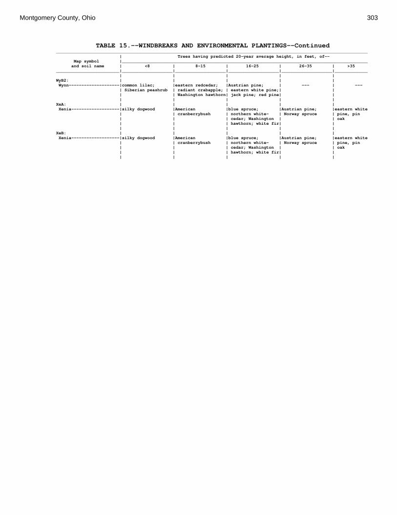
Montgomery County, Ohio 303
TABLE 15.--WINDBREAKS AND ENVIRONMENTAL PLANTINGS--Continued ___________________________________________________________________________________________________________________________ | Trees having predicted 20-year average height, in feet, of-- Map symbol |_________________________________________________________________________________________________ and soil name | <8 | 8-15 | 16-25 | 26-35 | >35 _________________________|____________________|____________________|____________________|____________________|_____________ | | | | | WyB2: | | | | | Wynn--------------------|common lilac; |eastern redcedar; |Austrian pine; | --- | --- | Siberian peashrub | radiant crabapple; | eastern white pine;| | | | Washington hawthorn| jack pine; red pine| | | | | | | XeA: | | | | | Xenia-------------------|silky dogwood |American |blue spruce; |Austrian pine; |eastern white | | cranberrybush | northern white- | Norway spruce | pine, pin | | | cedar; Washington | | oak | | | hawthorn; white fir| | | | | | | XeB: | | | | | Xenia-------------------|silky dogwood |American |blue spruce; |Austrian pine; |eastern white | | cranberrybush | northern white- | Norway spruce | pine, pin | | | cedar; Washington | | oak | | | hawthorn; white fir| | | | | | |

304 Soil Survey
TABLE 16.—RECREATION PART 1 (The information in this table indicates the dominant soil condition but does not eliminate the need for onsite investigation. The numbers in the value columns range from 0.01 to 1.00. The larger the value, the greater the potential limitation. See text on page 165 for further explanation of ratings in this table.) ___________________________________________________________________________________________________ | | | Map symbol | Camp areas | Picnic areas | Playgrounds and soil name | | | |_________________________|_________________________|_________________________ | Rating class and |Value| Rating class and |Value| Rating class and |Value | limiting features | | limiting features | | limiting features | _____________________|___________________|_____|___________________|_____|___________________|_____ | | | | | | Ag: | | | | | | Algiers-------------|Very limited | |Very limited | |Very limited | | Depth to |1.00 | Depth to |1.00 | Depth to |1.00 | saturated zone | | saturated zone | | saturated zone | | Flooding |1.00 | Restricted |0.10 | Flooding |0.60 | | | permeability | | | | Restricted |0.10 | | | Restricted |0.10 | permeability | | | | permeability | | | | | | | Bo: | | | | | | Borrow Pits---------|Not Rated | |Not Rated | |Not Rated | | | | | | | Bp: | | | | | | Brookston-----------|Very limited | |Very limited | |Very limited | | Depth to |1.00 | Depth to |1.00 | Depth to |1.00 | saturated zone | | saturated zone | | saturated zone | | Ponding |1.00 | Ponding |1.00 | Ponding |1.00 | | | | | | Br: | | | | | | Brookston-----------|Very limited | |Very limited | |Very limited | | Depth to |1.00 | Depth to |1.00 | Depth to |1.00 | saturated zone | | saturated zone | | saturated zone | | Ponding |1.00 | Ponding |1.00 | Ponding |1.00 | | | | | | Bs: | | | | | | Brookston-----------|Very limited | |Very limited | |Very limited | | Depth to |1.00 | Depth to |1.00 | Depth to |1.00 | saturated zone | | saturated zone | | saturated zone | | Ponding |1.00 | Ponding |1.00 | Ponding |1.00 | | | | | | Bu: | | | | | | Brookston-----------|Very limited | |Very limited | |Very limited | | Depth to |1.00 | Depth to |1.00 | Depth to |1.00 | saturated zone | | saturated zone | | saturated zone | | Ponding |1.00 | Ponding |1.00 | Ponding |1.00 | | | | | | Urban Land----------|Not Rated | |Not Rated | |Not Rated | | | | | | | Ca: | | | | | | Carlisle------------|Very limited | |Very limited | |Very limited | | Depth to |1.00 | Depth to |1.00 | Gravel content |1.00 | saturated zone | | saturated zone | | | | Gravel content |1.00 | Content of |1.00 | Depth to |1.00 | | | organic matter | | saturated zone | | Content of |1.00 | Gravel content |1.00 | Content of |1.00 | organic matter | | | | organic matter | | Ponding |1.00 | Ponding |1.00 | Ponding |1.00 | | | | | | CeA: | | | | | | Celina--------------|Somewhat limited | |Somewhat limited | |Somewhat limited | | Restricted |0.21 | Restricted |0.21 | Restricted |0.21 | permeability | | permeability | | permeability | | Depth to |0.10 | Depth to |0.05 | Depth to |0.10 | saturated zone | | saturated zone | | saturated zone | | | | | | |

Montgomery County, Ohio 305
TABLE 16.—RECREATION PART 1--Continued ___________________________________________________________________________________________________ | | | Map symbol | Camp areas | Picnic areas | Playgrounds and soil name | | | |_________________________|_________________________|_________________________ | Rating class and |Value| Rating class and |Value| Rating class and |Value | limiting features | | limiting features | | limiting features | _____________________|___________________|_____|___________________|_____|___________________|_____ | | | | | | CeB: | | | | | | Celina--------------|Somewhat limited | |Somewhat limited | |Somewhat limited | | Restricted |0.21 | Restricted |0.21 | Slope |0.50 | permeability | | permeability | | | | Depth to |0.10 | Depth to |0.05 | Restricted |0.21 | saturated zone | | saturated zone | | permeability | | | | | | Depth to |0.10 | | | | | saturated zone | | | | | | | CeB2: | | | | | | Celina--------------|Somewhat limited | |Somewhat limited | |Somewhat limited | | Restricted |0.21 | Restricted |0.21 | Slope |0.50 | permeability | | permeability | | | | Depth to |0.10 | Depth to |0.05 | Restricted |0.21 | saturated zone | | saturated zone | | permeability | | | | | | Depth to |0.10 | | | | | saturated zone | | | | | | | ClB: | | | | | | Celina--------------|Somewhat limited | |Somewhat limited | |Somewhat limited | | Restricted |0.21 | Restricted |0.21 | Slope |0.50 | permeability | | permeability | | | | Depth to |0.10 | Depth to |0.05 | Content of large |0.32 | saturated zone | | saturated zone | | stones | | | | | | Restricted |0.21 | | | | | permeability | | | | | | Depth to |0.10 | | | | | saturated zone | | | | | | | CoA: | | | | | | Corwin--------------|Somewhat limited | |Somewhat limited | |Somewhat limited | | Restricted |0.21 | Restricted |0.21 | Restricted |0.21 | permeability | | permeability | | permeability | | Depth to |0.10 | Depth to |0.05 | Depth to |0.10 | saturated zone | | saturated zone | | saturated zone | | | | | | | CoB: | | | | | | Corwin--------------|Somewhat limited | |Somewhat limited | |Somewhat limited | | Restricted |0.21 | Restricted |0.21 | Slope |0.50 | permeability | | permeability | | | | Depth to |0.10 | Depth to |0.05 | Restricted |0.21 | saturated zone | | saturated zone | | permeability | | | | | | Depth to |0.10 | | | | | saturated zone | | | | | | | CsA: | | | | | | Crosby--------------|Very limited | |Very limited | |Very limited | | Depth to |1.00 | Depth to |1.00 | Depth to |1.00 | saturated zone | | saturated zone | | saturated zone | | Restricted |0.11 | Restricted |0.11 | Restricted |0.11 | permeability | | permeability | | permeability | | | | | | |

306 Soil Survey
TABLE 16.—RECREATION PART 1--Continued ___________________________________________________________________________________________________ | | | Map symbol | Camp areas | Picnic areas | Playgrounds and soil name | | | |_________________________|_________________________|_________________________ | Rating class and |Value| Rating class and |Value| Rating class and |Value | limiting features | | limiting features | | limiting features | _____________________|___________________|_____|___________________|_____|___________________|_____ | | | | | | CtB: | | | | | | Crosby--------------|Very limited | |Very limited | |Very limited | | Depth to |1.00 | Depth to |1.00 | Depth to |1.00 | saturated zone | | saturated zone | | saturated zone | | Restricted |0.43 | Restricted |0.43 | Restricted |0.43 | permeability | | permeability | | permeability | | | | | | | Celina--------------|Somewhat limited | |Somewhat limited | |Somewhat limited | | Restricted |0.21 | Restricted |0.21 | Slope |0.50 | permeability | | permeability | | | | Depth to |0.10 | Depth to |0.05 | Restricted |0.21 | saturated zone | | saturated zone | | permeability | | | | | | Depth to |0.10 | | | | | saturated zone | | | | | | | Cu: | | | | | | Crosby--------------|Very limited | |Very limited | |Very limited | | Depth to |1.00 | Depth to |1.00 | Depth to |1.00 | saturated zone | | saturated zone | | saturated zone | | Restricted |0.43 | Restricted |0.43 | Restricted |0.43 | permeability | | permeability | | permeability | | | | | | | Urban Land----------|Not Rated | |Not Rated | |Not Rated | | | | | | | DaB: | | | | | | Dana----------------|Somewhat limited | |Somewhat limited | |Somewhat limited | | Restricted |0.21 | Restricted |0.21 | Slope |0.50 | permeability | | permeability | | | | Depth to |0.10 | Depth to |0.05 | Restricted |0.21 | saturated zone | | saturated zone | | permeability | | | | | | Depth to |0.10 | | | | | saturated zone | | | | | | | FaE2: | | | | | | Fairmount-----------|Very limited | |Very limited | |Very limited | | Depth to bedrock |1.00 | Depth to bedrock |1.00 | Slope |1.00 | Slope |1.00 | Slope |1.00 | Depth to bedrock |1.00 | Restricted |0.21 | Restricted |0.21 | Restricted |0.21 | permeability | | permeability | | permeability | | | | | | Content of large |0.01 | | | | | stones | | | | | | | FaF2: | | | | | | Fairmount-----------|Very limited | |Very limited | |Very limited | | Slope |1.00 | Slope |1.00 | Slope |1.00 | Depth to bedrock |1.00 | Depth to bedrock |1.00 | Depth to bedrock |1.00 | Restricted |0.21 | Restricted |0.21 | Restricted |0.21 | permeability | | permeability | | permeability | | | | | | Content of large |0.01 | | | | | stones | | | | | | | FcA: | | | | | | Fincastle-----------|Very limited | |Very limited | |Very limited | | Depth to |1.00 | Depth to |1.00 | Depth to |1.00 | saturated zone | | saturated zone | | saturated zone | | Restricted |0.21 | Restricted |0.21 | Restricted |0.21 | permeability | | permeability | | permeability | | | | | | | FkA: | | | | | | Fox-----------------|Not limited | |Not limited | |Somewhat limited | | | | | | Gravel content |0.06 | | | | | |

Montgomery County, Ohio 307
TABLE 16.—RECREATION PART 1--Continued ___________________________________________________________________________________________________ | | | Map symbol | Camp areas | Picnic areas | Playgrounds and soil name | | | |_________________________|_________________________|_________________________ | Rating class and |Value| Rating class and |Value| Rating class and |Value | limiting features | | limiting features | | limiting features | _____________________|___________________|_____|___________________|_____|___________________|_____ | | | | | | FkB: | | | | | | Fox-----------------|Not limited | |Not limited | |Somewhat limited | | | | | | Slope |0.50 | | | | | Gravel content |0.06 | | | | | | FlA: | | | | | | Fox-----------------|Not limited | |Not limited | |Somewhat limited | | | | | | Gravel content |0.06 | | | | | | FlB: | | | | | | Fox-----------------|Not limited | |Not limited | |Somewhat limited | | | | | | Slope |0.50 | | | | | Gravel content |0.08 | | | | | | FlC2: | | | | | | Fox-----------------|Somewhat limited | |Somewhat limited | |Very limited | | Slope |0.32 | Slope |0.32 | Slope |1.00 | | | | | Gravel content |0.08 | | | | | | FmA: | | | | | | Fox-----------------|Not limited | |Not limited | |Somewhat limited | | | | | | Gravel content |0.08 | | | | | | FmB: | | | | | | Fox-----------------|Not limited | |Not limited | |Somewhat limited | | | | | | Slope |0.50 | | | | | Gravel content |0.08 | | | | | | FmC2: | | | | | | Fox-----------------|Somewhat limited | |Somewhat limited | |Very limited | | Slope |0.32 | Slope |0.32 | Slope |1.00 | | | | | Gravel content |0.08 | | | | | | FmD2: | | | | | | Fox-----------------|Very limited | |Very limited | |Very limited | | Slope |1.00 | Slope |1.00 | Slope |1.00 | | | | | Gravel content |0.08 | | | | | | FsC3: | | | | | | Fox-----------------|Somewhat limited | |Somewhat limited | |Very limited | | Slope |0.32 | Slope |0.32 | Slope |1.00 | | | | | Gravel content |0.08 | | | | | | FuB: | | | | | | Fox-----------------|Not limited | |Not limited | |Somewhat limited | | | | | | Slope |0.13 | | | | | Gravel content |0.08 | | | | | | Urban Land----------|Not Rated | |Not Rated | |Not Rated | | | | | | | FuC: | | | | | | Urban Land----------|Not Rated | |Not Rated | |Not Rated | | | | | | | Fox-----------------|Somewhat limited | |Somewhat limited | |Very limited | | Slope |0.32 | Slope |0.32 | Slope |1.00 | | | | | Gravel content |0.08 | | | | | | FuF: | | | | | | Urban Land----------|Not Rated | |Not Rated | |Not Rated | | | | | | | Fox-----------------|Very limited | |Very limited | |Very limited | | Slope |1.00 | Slope |1.00 | Slope |1.00 | | | | | Gravel content |0.08

308 Soil Survey
TABLE 16.—RECREATION PART 1--Continued ___________________________________________________________________________________________________ | | | Map symbol | Camp areas | Picnic areas | Playgrounds and soil name | | | |_________________________|_________________________|_________________________ | Rating class and |Value| Rating class and |Value| Rating class and |Value | limiting features | | limiting features | | limiting features | _____________________|___________________|_____|___________________|_____|___________________|_____ | | | | | | Gp: | | | | | | Gravel Pits---------|Not Rated | |Not Rated | |Not Rated | | | | | | | HeE2: | | | | | | Hennepin------------|Very limited | |Very limited | |Very limited | | Slope |1.00 | Slope |1.00 | Slope |1.00 | Restricted |0.21 | Restricted |0.21 | Restricted |0.21 | permeability | | permeability | | permeability | | | | | | | Miamian-------------|Very limited | |Very limited | |Very limited | | Slope |1.00 | Slope |1.00 | Slope |1.00 | Restricted |0.21 | Restricted |0.21 | Restricted |0.21 | permeability | | permeability | | permeability | | | | | | | HeF2: | | | | | | Hennepin------------|Very limited | |Very limited | |Very limited | | Slope |1.00 | Slope |1.00 | Slope |1.00 | Restricted |0.21 | Restricted |0.21 | Restricted |0.21 | permeability | | permeability | | permeability | | | | | | | Miamian-------------|Very limited | |Very limited | |Very limited | | Slope |1.00 | Slope |1.00 | Slope |1.00 | Restricted |0.21 | Restricted |0.21 | Restricted |0.21 | permeability | | permeability | | permeability | | | | | | | HmF3: | | | | | | Hennepin------------|Very limited | |Very limited | |Very limited | | Slope |1.00 | Slope |1.00 | Slope |1.00 | Restricted |0.21 | Restricted |0.21 | Restricted |0.21 | permeability | | permeability | | permeability | | | | | | | Miamian-------------|Very limited | |Very limited | |Very limited | | Slope |1.00 | Slope |1.00 | Slope |1.00 | Restricted |0.21 | Restricted |0.21 | Restricted |0.21 | permeability | | permeability | | permeability | | | | | | | KeA: | | | | | | Kendallville--------|Somewhat limited | |Somewhat limited | |Somewhat limited | | Restricted |0.21 | Restricted |0.21 | Restricted |0.21 | permeability | | permeability | | permeability | | | | | | | KeB: | | | | | | Kendallville--------|Somewhat limited | |Somewhat limited | |Somewhat limited | | Restricted |0.21 | Restricted |0.21 | Slope |0.50 | permeability | | permeability | | | | | | | | Restricted |0.21 | | | | | permeability | | | | | | | KeC2: | | | | | | Kendallville--------|Somewhat limited | |Somewhat limited | |Very limited | | Slope |0.32 | Slope |0.32 | Slope |1.00 | Restricted |0.21 | Restricted |0.21 | Restricted |0.21 | permeability | | permeability | | permeability | | | | | | | Ld: | | | | | | Landes--------------|Very limited | |Not limited | |Somewhat limited | | Flooding |1.00 | | | Flooding |0.60 | | | | | Gravel content |0.56 | | | | | | Lg: | | | | | | Lanier--------------|Very limited | |Not limited | |Somewhat limited | | Flooding |1.00 | | | Flooding |0.60 | | | | | Gravel content |0.56

Montgomery County, Ohio 309
TABLE 16.—RECREATION PART 1--Continued ___________________________________________________________________________________________________ | | | Map symbol | Camp areas | Picnic areas | Playgrounds and soil name | | | |_________________________|_________________________|_________________________ | Rating class and |Value| Rating class and |Value| Rating class and |Value | limiting features | | limiting features | | limiting features | _____________________|___________________|_____|___________________|_____|___________________|_____ | | | | | | LsB: | | | | | | Lewisburg-----------|Somewhat limited | |Somewhat limited | |Somewhat limited | | Restricted |0.21 | Restricted |0.21 | Slope |0.50 | permeability | | permeability | | | | Depth to |0.10 | Depth to |0.05 | Restricted |0.21 | saturated zone | | saturated zone | | permeability | | | | | | Depth to |0.10 | | | | | saturated zone | | | | | | | LxC2: | | | | | | Lorenzo-------------|Somewhat limited | |Somewhat limited | |Very limited | | Slope |0.18 | Slope |0.18 | Slope |1.00 | | | | | | Rodman--------------|Somewhat limited | |Somewhat limited | |Very limited | | Slope |0.18 | Slope |0.18 | Slope |1.00 | | | | | | LxD2: | | | | | | Lorenzo-------------|Very limited | |Very limited | |Very limited | | Slope |1.00 | Slope |1.00 | Slope |1.00 | | | | | | Rodman--------------|Very limited | |Very limited | |Very limited | | Slope |1.00 | Slope |1.00 | Slope |1.00 | | | | | | Mb: | | | | | | Made Land-----------|Not Rated | |Not Rated | |Not Rated | | | | | | | Md: | | | | | | Medway--------------|Very limited | |Somewhat limited | |Somewhat limited | | Flooding |1.00 | Depth to |0.05 | Flooding |0.60 | | | saturated zone | | | | Depth to |0.10 | | | Depth to |0.10 | saturated zone | | | | saturated zone | | | | | | | MlA: | | | | | | Miamian-------------|Somewhat limited | |Somewhat limited | |Somewhat limited | | Restricted |0.21 | Restricted |0.21 | Restricted |0.21 | permeability | | permeability | | permeability | | | | | | | MlB: | | | | | | Miamian-------------|Somewhat limited | |Somewhat limited | |Somewhat limited | | Restricted |0.21 | Restricted |0.21 | Slope |0.50 | permeability | | permeability | | | | | | | | Restricted |0.21 | | | | | permeability | | | | | | | MlB2: | | | | | | Miamian-------------|Somewhat limited | |Somewhat limited | |Somewhat limited | | Restricted |0.21 | Restricted |0.21 | Slope |0.50 | permeability | | permeability | | | | | | | | Restricted |0.21 | | | | | permeability | | | | | | | MlC2: | | | | | | Miamian-------------|Somewhat limited | |Somewhat limited | |Very limited | | Slope |0.32 | Slope |0.32 | Slope |1.00 | Restricted |0.21 | Restricted |0.21 | Restricted |0.21 | permeability | | permeability | | permeability | | | | | | | MlD2: | | | | | | Miamian-------------|Very limited | |Very limited | |Very limited | | Slope |1.00 | Slope |1.00 | Slope |1.00 | Restricted |0.21 | Restricted |0.21 | Restricted |0.21 | permeability | | permeability | | permeability |

310 Soil Survey
TABLE 16.—RECREATION PART 1--Continued ___________________________________________________________________________________________________ | | | Map symbol | Camp areas | Picnic areas | Playgrounds and soil name | | | |_________________________|_________________________|_________________________ | Rating class and |Value| Rating class and |Value| Rating class and |Value | limiting features | | limiting features | | limiting features | _____________________|___________________|_____|___________________|_____|___________________|_____ | | | | | | MmB: | | | | | | Miamian-------------|Somewhat limited | |Somewhat limited | |Somewhat limited | | Restricted |0.21 | Restricted |0.21 | Slope |0.50 | permeability | | permeability | | | | | | | | Content of large |0.32 | | | | | stones | | | | | | Restricted |0.21 | | | | | permeability | | | | | | | MnB3: | | | | | | Miamian-------------|Somewhat limited | |Somewhat limited | |Somewhat limited | | Restricted |0.21 | Restricted |0.21 | Slope |0.50 | permeability | | permeability | | | | | | | | Restricted |0.21 | | | | | permeability | | | | | | | MnC3: | | | | | | Miamian-------------|Somewhat limited | |Somewhat limited | |Very limited | | Slope |0.32 | Slope |0.32 | Slope |1.00 | Restricted |0.21 | Restricted |0.21 | Restricted |0.21 | permeability | | permeability | | permeability | | | | | | | MnD3: | | | | | | Miamian-------------|Very limited | |Very limited | |Very limited | | Slope |1.00 | Slope |1.00 | Slope |1.00 | Restricted |0.21 | Restricted |0.21 | Restricted |0.21 | permeability | | permeability | | permeability | | | | | | | MoB: | | | | | | Miamian-------------|Somewhat limited | |Somewhat limited | |Somewhat limited | | Restricted |0.21 | Restricted |0.21 | Slope |0.50 | permeability | | permeability | | | | | | | | Restricted |0.21 | | | | | permeability | | | | | | | Urban Land----------|Not Rated | |Not Rated | |Not Rated | | | | | | | MoC: | | | | | | Miamian-------------|Somewhat limited | |Somewhat limited | |Very limited | | Slope |0.32 | Slope |0.32 | Slope |1.00 | Restricted |0.21 | Restricted |0.21 | Restricted |0.21 | permeability | | permeability | | permeability | | | | | | | Urban Land----------|Not Rated | |Not Rated | |Not Rated | | | | | | | MoE: | | | | | | Miamian-------------|Very limited | |Very limited | |Very limited | | Slope |1.00 | Slope |1.00 | Slope |1.00 | Restricted |0.21 | Restricted |0.21 | Restricted |0.21 | permeability | | permeability | | permeability | | | | | | | Urban Land----------|Not Rated | |Not Rated | |Not Rated | | | | | | | MrA: | | | | | | Millsdale-----------|Very limited | |Very limited | |Very limited | | Depth to |1.00 | Depth to |1.00 | Depth to |1.00 | saturated zone | | saturated zone | | saturated zone | | Ponding |1.00 | Ponding |1.00 | Ponding |1.00 | | | | | | MsA: | | | | | | Milton--------------|Somewhat limited | |Somewhat limited | |Somewhat limited | | Restricted |0.21 | Restricted |0.21 | Restricted |0.21 | permeability | | permeability | | permeability |

Montgomery County, Ohio 311
TABLE 16.—RECREATION PART 1--Continued ___________________________________________________________________________________________________ | | | Map symbol | Camp areas | Picnic areas | Playgrounds and soil name | | | |_________________________|_________________________|_________________________ | Rating class and |Value| Rating class and |Value| Rating class and |Value | limiting features | | limiting features | | limiting features | _____________________|___________________|_____|___________________|_____|___________________|_____ | | | | | | MsB: | | | | | | Milton--------------|Somewhat limited | |Somewhat limited | |Somewhat limited | | Restricted |0.21 | Restricted |0.21 | Depth to bedrock |0.65 | permeability | | permeability | | | | | | | | Slope |0.50 | | | | | Restricted |0.21 | | | | | permeability | | | | | | | MsB2: | | | | | | Milton--------------|Not limited | |Not limited | |Somewhat limited | | | | | | Depth to bedrock |0.84 | | | | | Slope |0.50 | | | | | | MsC2: | | | | | | Milton--------------|Somewhat limited | |Somewhat limited | |Very limited | | Slope |0.32 | Slope |0.32 | Slope |1.00 | Restricted |0.21 | Restricted |0.21 | Depth to bedrock |0.84 | permeability | | permeability | | | | | | | | Restricted |0.21 | | | | | permeability | | | | | | | MsD2: | | | | | | Milton--------------|Very limited | |Very limited | |Very limited | | Slope |1.00 | Slope |1.00 | Slope |1.00 | Restricted |0.21 | Restricted |0.21 | Depth to bedrock |0.90 | permeability | | permeability | | | | | | | | Restricted |0.21 | | | | | permeability | | | | | | | MtD3: | | | | | | Milton--------------|Somewhat limited | |Somewhat limited | |Very limited | | Slope |0.82 | Slope |0.82 | Slope |1.00 | Restricted |0.21 | Restricted |0.21 | Depth to bedrock |0.95 | permeability | | permeability | | | | | | | | Restricted |0.21 | | | | | permeability | | | | | | | MuB: | | | | | | Milton--------------|Somewhat limited | |Somewhat limited | |Somewhat limited | | Restricted |0.21 | Restricted |0.21 | Depth to bedrock |0.65 | permeability | | permeability | | | | | | | | Slope |0.50 | | | | | Restricted |0.21 | | | | | permeability | | | | | | | Urban Land----------|Not Rated | |Not Rated | |Not Rated | | | | | | | MuC: | | | | | | Milton--------------|Somewhat limited | |Somewhat limited | |Very limited | | Slope |0.32 | Slope |0.32 | Slope |1.00 | Restricted |0.21 | Restricted |0.21 | Depth to bedrock |0.65 | permeability | | permeability | | | | | | | | Restricted |0.21 | | | | | permeability | | | | | | | Urban Land----------|Not Rated | |Not Rated | |Not Rated | | | | | | |
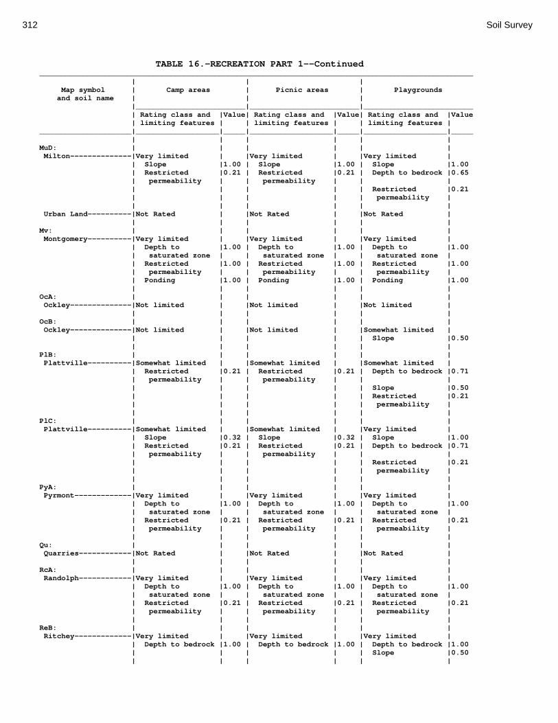
312 Soil Survey
TABLE 16.—RECREATION PART 1--Continued ___________________________________________________________________________________________________ | | | Map symbol | Camp areas | Picnic areas | Playgrounds and soil name | | | |_________________________|_________________________|_________________________ | Rating class and |Value| Rating class and |Value| Rating class and |Value | limiting features | | limiting features | | limiting features | _____________________|___________________|_____|___________________|_____|___________________|_____ | | | | | | MuD: | | | | | | Milton--------------|Very limited | |Very limited | |Very limited | | Slope |1.00 | Slope |1.00 | Slope |1.00 | Restricted |0.21 | Restricted |0.21 | Depth to bedrock |0.65 | permeability | | permeability | | | | | | | | Restricted |0.21 | | | | | permeability | | | | | | | Urban Land----------|Not Rated | |Not Rated | |Not Rated | | | | | | | Mv: | | | | | | Montgomery----------|Very limited | |Very limited | |Very limited | | Depth to |1.00 | Depth to |1.00 | Depth to |1.00 | saturated zone | | saturated zone | | saturated zone | | Restricted |1.00 | Restricted |1.00 | Restricted |1.00 | permeability | | permeability | | permeability | | Ponding |1.00 | Ponding |1.00 | Ponding |1.00 | | | | | | OcA: | | | | | | Ockley--------------|Not limited | |Not limited | |Not limited | | | | | | | OcB: | | | | | | Ockley--------------|Not limited | |Not limited | |Somewhat limited | | | | | | Slope |0.50 | | | | | | PlB: | | | | | | Plattville----------|Somewhat limited | |Somewhat limited | |Somewhat limited | | Restricted |0.21 | Restricted |0.21 | Depth to bedrock |0.71 | permeability | | permeability | | | | | | | | Slope |0.50 | | | | | Restricted |0.21 | | | | | permeability | | | | | | | PlC: | | | | | | Plattville----------|Somewhat limited | |Somewhat limited | |Very limited | | Slope |0.32 | Slope |0.32 | Slope |1.00 | Restricted |0.21 | Restricted |0.21 | Depth to bedrock |0.71 | permeability | | permeability | | | | | | | | Restricted |0.21 | | | | | permeability | | | | | | | PyA: | | | | | | Pyrmont-------------|Very limited | |Very limited | |Very limited | | Depth to |1.00 | Depth to |1.00 | Depth to |1.00 | saturated zone | | saturated zone | | saturated zone | | Restricted |0.21 | Restricted |0.21 | Restricted |0.21 | permeability | | permeability | | permeability | | | | | | | Qu: | | | | | | Quarries------------|Not Rated | |Not Rated | |Not Rated | | | | | | | RcA: | | | | | | Randolph------------|Very limited | |Very limited | |Very limited | | Depth to |1.00 | Depth to |1.00 | Depth to |1.00 | saturated zone | | saturated zone | | saturated zone | | Restricted |0.21 | Restricted |0.21 | Restricted |0.21 | permeability | | permeability | | permeability | | | | | | | ReB: | | | | | | Ritchey-------------|Very limited | |Very limited | |Very limited | | Depth to bedrock |1.00 | Depth to bedrock |1.00 | Depth to bedrock |1.00 | | | | | Slope |0.50 | | | | | |

Montgomery County, Ohio 313
TABLE 16.—RECREATION PART 1--Continued ___________________________________________________________________________________________________ | | | Map symbol | Camp areas | Picnic areas | Playgrounds and soil name | | | |_________________________|_________________________|_________________________ | Rating class and |Value| Rating class and |Value| Rating class and |Value | limiting features | | limiting features | | limiting features | _____________________|___________________|_____|___________________|_____|___________________|_____ | | | | | | ReB2: | | | | | | Ritchey-------------|Very limited | |Very limited | |Very limited | | Depth to bedrock |1.00 | Depth to bedrock |1.00 | Depth to bedrock |1.00 | | | | | Slope |0.50 | | | | | | ReC2: | | | | | | Ritchey-------------|Very limited | |Very limited | |Very limited | | Depth to bedrock |1.00 | Depth to bedrock |1.00 | Slope |1.00 | Slope |0.32 | Slope |0.32 | Depth to bedrock |1.00 | | | | | | ReE2: | | | | | | Ritchey-------------|Very limited | |Very limited | |Very limited | | Depth to bedrock |1.00 | Depth to bedrock |1.00 | Slope |1.00 | Slope |1.00 | Slope |1.00 | Depth to bedrock |1.00 | | | | | | ReF2: | | | | | | Ritchey-------------|Very limited | |Very limited | |Very limited | | Slope |1.00 | Slope |1.00 | Slope |1.00 | Depth to bedrock |1.00 | Depth to bedrock |1.00 | Depth to bedrock |1.00 | | | | | | RfD3: | | | | | | Ritchey-------------|Very limited | |Very limited | |Very limited | | Depth to bedrock |1.00 | Depth to bedrock |1.00 | Slope |1.00 | Slope |0.82 | Slope |0.82 | Depth to bedrock |1.00 | | | | | Content of large |0.03 | | | | | stones | | | | | | | Rh: | | | | | | Riverwash-----------|Not Rated | |Not Rated | |Not Rated | | | | | | | RlE2: | | | | | | Rodman--------------|Very limited | |Very limited | |Very limited | | Slope |1.00 | Slope |1.00 | Slope |1.00 | | | | | | Fox-----------------|Very limited | |Very limited | |Very limited | | Slope |1.00 | Slope |1.00 | Slope |1.00 | | | | | Gravel content |0.08 | | | | | | RlF2: | | | | | | Rodman--------------|Very limited | |Very limited | |Very limited | | Slope |1.00 | Slope |1.00 | Slope |1.00 | | | | | | Fox-----------------|Very limited | |Very limited | |Very limited | | Slope |1.00 | Slope |1.00 | Slope |1.00 | | | | | Gravel content |0.08 | | | | | | Rs: | | | | | | Ross----------------|Very limited | |Not limited | |Somewhat limited | | Flooding |1.00 | | | Flooding |0.60 | | | | | | Rt: | | | | | | Urban Land----------|Not Rated | |Not Rated | |Not Rated | | | | | | | Ross----------------|Very limited | |Not limited | |Somewhat limited | | Flooding |1.00 | | | Flooding |0.60 | | | | | | RuB: | | | | | | Russell-------------|Somewhat limited | |Somewhat limited | |Somewhat limited | | Restricted |0.21 | Restricted |0.21 | Slope |0.50 | permeability | | permeability | | | | | | | | Restricted |0.21 | | | | | permeability | | | | | | |

314 Soil Survey
TABLE 16.—RECREATION PART 1--Continued ___________________________________________________________________________________________________ | | | Map symbol | Camp areas | Picnic areas | Playgrounds and soil name | | | |_________________________|_________________________|_________________________ | Rating class and |Value| Rating class and |Value| Rating class and |Value | limiting features | | limiting features | | limiting features | _____________________|___________________|_____|___________________|_____|___________________|_____ | | | | | | RvC2: | | | | | | Russell-------------|Somewhat limited | |Somewhat limited | |Very limited | | Slope |0.32 | Slope |0.32 | Slope |1.00 | Restricted |0.21 | Restricted |0.21 | Restricted |0.21 | permeability | | permeability | | permeability | | | | | | | Miamian-------------|Somewhat limited | |Somewhat limited | |Very limited | | Slope |0.32 | Slope |0.32 | Slope |1.00 | Restricted |0.21 | Restricted |0.21 | Restricted |0.21 | permeability | | permeability | | permeability | | | | | | | RvD2: | | | | | | Russell-------------|Very limited | |Very limited | |Very limited | | Slope |1.00 | Slope |1.00 | Slope |1.00 | Restricted |0.21 | Restricted |0.21 | Restricted |0.21 | permeability | | permeability | | permeability | | | | | | | Miamian-------------|Very limited | |Very limited | |Very limited | | Slope |1.00 | Slope |1.00 | Slope |1.00 | Restricted |0.21 | Restricted |0.21 | Restricted |0.21 | permeability | | permeability | | permeability | | | | | | | Sh: | | | | | | Shoals--------------|Very limited | |Very limited | |Very limited | | Depth to |1.00 | Depth to |1.00 | Depth to |1.00 | saturated zone | | saturated zone | | saturated zone | | Flooding |1.00 | | | Flooding |0.60 | | | | | | So: | | | | | | Sloan---------------|Very limited | |Very limited | |Very limited | | Depth to |1.00 | Depth to |1.00 | Depth to |1.00 | saturated zone | | saturated zone | | saturated zone | | Flooding |1.00 | Ponding |1.00 | Flooding |1.00 | Ponding |1.00 | Flooding |0.40 | Ponding |1.00 | Restricted |0.21 | Restricted |0.21 | Restricted |0.21 | permeability | | permeability | | permeability | | | | | | | ThA: | | | | | | Thackery------------|Somewhat limited | |Somewhat limited | |Somewhat limited | | Depth to |0.10 | Depth to |0.05 | Depth to |0.10 | saturated zone | | saturated zone | | saturated zone | | | | | | | TpA: | | | | | | Tippecanoe----------|Somewhat limited | |Somewhat limited | |Somewhat limited | | Depth to |0.10 | Depth to |0.05 | Depth to |0.10 | saturated zone | | saturated zone | | saturated zone | | | | | | | Ua: | | | | | | Urban Land----------|Not Rated | |Not Rated | |Not Rated | | | | | | | Ud: | | | | | | Udorthents----------|Not Rated | |Not Rated | |Not Rated | | | | | | | Ug: | | | | | | Urban Land----------|Not Rated | |Not Rated | |Not Rated | | | | | | | Um: | | | | | | Urban Land----------|Not Rated | |Not Rated | |Not Rated | | | | | | |
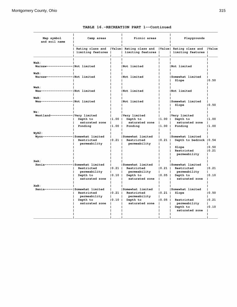
Montgomery County, Ohio 315
TABLE 16.—RECREATION PART 1--Continued ___________________________________________________________________________________________________ | | | Map symbol | Camp areas | Picnic areas | Playgrounds and soil name | | | |_________________________|_________________________|_________________________ | Rating class and |Value| Rating class and |Value| Rating class and |Value | limiting features | | limiting features | | limiting features | _____________________|___________________|_____|___________________|_____|___________________|_____ | | | | | | WaA: | | | | | | Warsaw--------------|Not limited | |Not limited | |Not limited | | | | | | | WaB: | | | | | | Warsaw--------------|Not limited | |Not limited | |Somewhat limited | | | | | | Slope |0.50 | | | | | | WeA: | | | | | | Wea-----------------|Not limited | |Not limited | |Not limited | | | | | | | WeB: | | | | | | Wea-----------------|Not limited | |Not limited | |Somewhat limited | | | | | | Slope |0.50 | | | | | | Ws: | | | | | | Westland------------|Very limited | |Very limited | |Very limited | | Depth to |1.00 | Depth to |1.00 | Depth to |1.00 | saturated zone | | saturated zone | | saturated zone | | Ponding |1.00 | Ponding |1.00 | Ponding |1.00 | | | | | | WyB2: | | | | | | Wynn----------------|Somewhat limited | |Somewhat limited | |Somewhat limited | | Restricted |0.21 | Restricted |0.21 | Depth to bedrock |0.54 | permeability | | permeability | | | | | | | | Slope |0.50 | | | | | Restricted |0.21 | | | | | permeability | | | | | | | XeA: | | | | | | Xenia---------------|Somewhat limited | |Somewhat limited | |Somewhat limited | | Restricted |0.21 | Restricted |0.21 | Restricted |0.21 | permeability | | permeability | | permeability | | Depth to |0.10 | Depth to |0.05 | Depth to |0.10 | saturated zone | | saturated zone | | saturated zone | | | | | | | XeB: | | | | | | Xenia---------------|Somewhat limited | |Somewhat limited | |Somewhat limited | | Restricted |0.21 | Restricted |0.21 | Slope |0.50 | permeability | | permeability | | | | Depth to |0.10 | Depth to |0.05 | Restricted |0.21 | saturated zone | | saturated zone | | permeability | | | | | | Depth to |0.10 | | | | | saturated zone | | | | | | | _____________________|___________________|_____|___________________|_____|___________________|_____

316 Soil Survey
TABLE 17.—RECREATION PART 2 (The information in this table indicates the dominant soil condition but does not eliminate the need for onsite investigation. The numbers in the value columns range from 0.01 to 1.00. The larger the value, the greater the potential limitation. See text on page 165 for further explanation of ratings in this table.) ___________________________________________________________________________________________________ | | | Map symbol | Paths and trails | Off-road | Golf fairways and soil name | | motorcycle trails | |_________________________|_________________________|_________________________ | Rating class and |Value| Rating class and |Value| Rating class and |Value | limiting features | | limiting features | | limiting features | _____________________|___________________|_____|___________________|_____|___________________|_____ | | | | | | Ag: | | | | | | Algiers-------------|Very limited | |Very limited | |Very limited | | Depth to |1.00 | Depth to |1.00 | Depth to |1.00 | saturated zone | | saturated zone | | saturated zone | | | | | | Flooding |0.60 | | | | | | Bo: | | | | | | Borrow Pits---------|Not Rated | |Not Rated | |Not Rated | | | | | | | Bp: | | | | | | Brookston-----------|Very limited | |Very limited | |Very limited | | Depth to |1.00 | Depth to |1.00 | Depth to |1.00 | saturated zone | | saturated zone | | saturated zone | | Ponding |1.00 | Ponding |1.00 | Ponding |1.00 | | | | | | Br: | | | | | | Brookston-----------|Very limited | |Very limited | |Very limited | | Depth to |1.00 | Depth to |1.00 | Depth to |1.00 | saturated zone | | saturated zone | | saturated zone | | Ponding |1.00 | Ponding |1.00 | Ponding |1.00 | | | | | | Bs: | | | | | | Brookston-----------|Very limited | |Very limited | |Very limited | | Depth to |1.00 | Depth to |1.00 | Depth to |1.00 | saturated zone | | saturated zone | | saturated zone | | Ponding |1.00 | Ponding |1.00 | Ponding |1.00 | | | | | | Bu: | | | | | | Brookston-----------|Very limited | |Very limited | |Very limited | | Depth to |1.00 | Depth to |1.00 | Depth to |1.00 | saturated zone | | saturated zone | | saturated zone | | Ponding |1.00 | Ponding |1.00 | Ponding |1.00 | | | | | | Urban Land----------|Not Rated | |Not Rated | |Not Rated | | | | | | | Ca: | | | | | | Carlisle------------|Very limited | |Very limited | |Very limited | | Gravel content |1.00 | Gravel content |1.00 | Content of |1.00 | | | | | organic matter | | Depth to |1.00 | Depth to |1.00 | Gravel content |1.00 | saturated zone | | saturated zone | | | | Content of |1.00 | Content of |1.00 | Depth to |1.00 | organic matter | | organic matter | | saturated zone | | Ponding |1.00 | Ponding |1.00 | Ponding |1.00 | | | | | | CeA: | | | | | | Celina--------------|Not limited | |Not limited | |Somewhat limited | | | | | | Depth to |0.03 | | | | | saturated zone | | | | | | | CeB: | | | | | | Celina--------------|Not limited | |Not limited | |Somewhat limited | | | | | | Depth to |0.03 | | | | | saturated zone | | | | | | |

Montgomery County, Ohio 317
TABLE 17.—RECREATION PART 2--Continued ___________________________________________________________________________________________________ | | | Map symbol | Paths and trails | Off-road | Golf fairways and soil name | | motorcycle trails | |_________________________|_________________________|_________________________ | Rating class and |Value| Rating class and |Value| Rating class and |Value | limiting features | | limiting features | | limiting features | _____________________|___________________|_____|___________________|_____|___________________|_____ | | | | | | CeB2: | | | | | | Celina--------------|Not limited | |Not limited | |Somewhat limited | | | | | | Depth to |0.03 | | | | | saturated zone | | | | | | | ClB: | | | | | | Celina--------------|Not limited | |Not limited | |Somewhat limited | | | | | | Content of large |0.32 | | | | | stones | | | | | | Depth to |0.03 | | | | | saturated zone | | | | | | | CoA: | | | | | | Corwin--------------|Not limited | |Not limited | |Somewhat limited | | | | | | Depth to |0.03 | | | | | saturated zone | | | | | | | CoB: | | | | | | Corwin--------------|Not limited | |Not limited | |Somewhat limited | | | | | | Depth to |0.03 | | | | | saturated zone | | | | | | | CsA: | | | | | | Crosby--------------|Very limited | |Very limited | |Very limited | | Depth to |1.00 | Depth to |1.00 | Depth to |1.00 | saturated zone | | saturated zone | | saturated zone | | | | | | | CtB: | | | | | | Crosby--------------|Very limited | |Very limited | |Very limited | | Depth to |1.00 | Depth to |1.00 | Depth to |1.00 | saturated zone | | saturated zone | | saturated zone | | | | | | | Celina--------------|Not limited | |Not limited | |Somewhat limited | | | | | | Depth to |0.03 | | | | | saturated zone | | | | | | | Cu: | | | | | | Crosby--------------|Very limited | |Very limited | |Very limited | | Depth to |1.00 | Depth to |1.00 | Depth to |1.00 | saturated zone | | saturated zone | | saturated zone | | | | | | | Urban Land----------|Not Rated | |Not Rated | |Not Rated | | | | | | | DaB: | | | | | | Dana----------------|Not limited | |Not limited | |Somewhat limited | | | | | | Depth to |0.03 | | | | | saturated zone | | | | | | | FaE2: | | | | | | Fairmount-----------|Very limited | |Very limited | |Very limited | | Water erosion |1.00 | Water erosion |1.00 | Depth to bedrock |1.00 | Slope |0.57 | | | Slope |1.00 | | | | | Droughty |0.73 | | | | | Content of large |0.01 | | | | | stones | | | | | | | FaF2: | | | | | | Fairmount-----------|Very limited | |Very limited | |Very limited | | Water erosion |1.00 | Water erosion |1.00 | Depth to bedrock |1.00 | Slope |1.00 | Slope |0.96 | Slope |1.00 | | | | | Droughty |0.86 | | | | | Content of large |0.01 | | | | | stones |
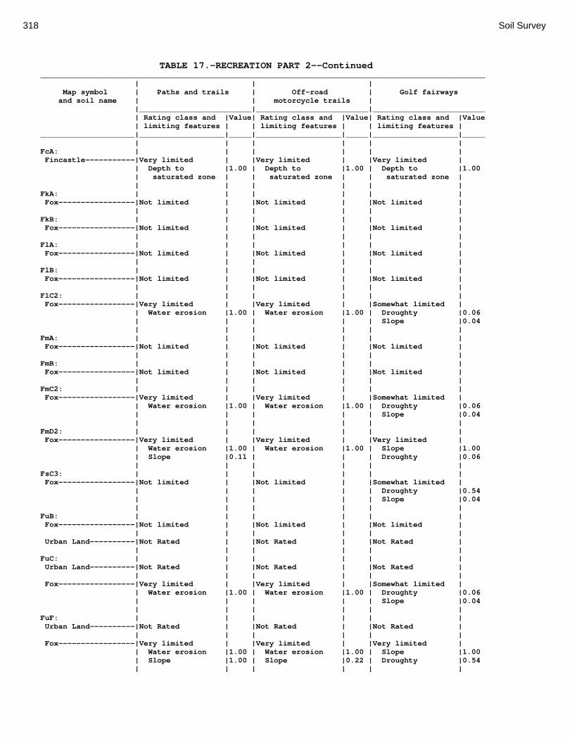
318 Soil Survey
TABLE 17.—RECREATION PART 2--Continued ___________________________________________________________________________________________________ | | | Map symbol | Paths and trails | Off-road | Golf fairways and soil name | | motorcycle trails | |_________________________|_________________________|_________________________ | Rating class and |Value| Rating class and |Value| Rating class and |Value | limiting features | | limiting features | | limiting features | _____________________|___________________|_____|___________________|_____|___________________|_____ | | | | | | FcA: | | | | | | Fincastle-----------|Very limited | |Very limited | |Very limited | | Depth to |1.00 | Depth to |1.00 | Depth to |1.00 | saturated zone | | saturated zone | | saturated zone | | | | | | | FkA: | | | | | | Fox-----------------|Not limited | |Not limited | |Not limited | | | | | | | FkB: | | | | | | Fox-----------------|Not limited | |Not limited | |Not limited | | | | | | | FlA: | | | | | | Fox-----------------|Not limited | |Not limited | |Not limited | | | | | | | FlB: | | | | | | Fox-----------------|Not limited | |Not limited | |Not limited | | | | | | | FlC2: | | | | | | Fox-----------------|Very limited | |Very limited | |Somewhat limited | | Water erosion |1.00 | Water erosion |1.00 | Droughty |0.06 | | | | | Slope |0.04 | | | | | | FmA: | | | | | | Fox-----------------|Not limited | |Not limited | |Not limited | | | | | | | FmB: | | | | | | Fox-----------------|Not limited | |Not limited | |Not limited | | | | | | | FmC2: | | | | | | Fox-----------------|Very limited | |Very limited | |Somewhat limited | | Water erosion |1.00 | Water erosion |1.00 | Droughty |0.06 | | | | | Slope |0.04 | | | | | | FmD2: | | | | | | Fox-----------------|Very limited | |Very limited | |Very limited | | Water erosion |1.00 | Water erosion |1.00 | Slope |1.00 | Slope |0.11 | | | Droughty |0.06 | | | | | | FsC3: | | | | | | Fox-----------------|Not limited | |Not limited | |Somewhat limited | | | | | | Droughty |0.54 | | | | | Slope |0.04 | | | | | | FuB: | | | | | | Fox-----------------|Not limited | |Not limited | |Not limited | | | | | | | Urban Land----------|Not Rated | |Not Rated | |Not Rated | | | | | | | FuC: | | | | | | Urban Land----------|Not Rated | |Not Rated | |Not Rated | | | | | | | Fox-----------------|Very limited | |Very limited | |Somewhat limited | | Water erosion |1.00 | Water erosion |1.00 | Droughty |0.06 | | | | | Slope |0.04 | | | | | | FuF: | | | | | | Urban Land----------|Not Rated | |Not Rated | |Not Rated | | | | | | | Fox-----------------|Very limited | |Very limited | |Very limited | | Water erosion |1.00 | Water erosion |1.00 | Slope |1.00 | Slope |1.00 | Slope |0.22 | Droughty |0.54 | | | | | |

Montgomery County, Ohio 319
TABLE 17.—RECREATION PART 2--Continued ___________________________________________________________________________________________________ | | | Map symbol | Paths and trails | Off-road | Golf fairways and soil name | | motorcycle trails | |_________________________|_________________________|_________________________ | Rating class and |Value| Rating class and |Value| Rating class and |Value | limiting features | | limiting features | | limiting features | _____________________|___________________|_____|___________________|_____|___________________|_____ | | | | | | Gp: | | | | | | Gravel Pits---------|Not Rated | |Not Rated | |Not Rated | | | | | | | HeE2: | | | | | | Hennepin------------|Somewhat limited | |Not limited | |Very limited | | Slope |0.89 | | | Slope |1.00 | | | | | | Miamian-------------|Very limited | |Very limited | |Very limited | | Water erosion |1.00 | Water erosion |1.00 | Slope |1.00 | Slope |0.89 | | | | | | | | | | HeF2: | | | | | | Hennepin------------|Very limited | |Somewhat limited | |Very limited | | Slope |1.00 | Slope |0.96 | Slope |1.00 | | | | | | Miamian-------------|Very limited | |Very limited | |Very limited | | Water erosion |1.00 | Water erosion |1.00 | Slope |1.00 | Slope |1.00 | Slope |0.96 | | | | | | | | HmF3: | | | | | | Hennepin------------|Very limited | |Somewhat limited | |Very limited | | Slope |1.00 | Slope |0.68 | Slope |1.00 | | | | | Droughty |0.07 | | | | | | Miamian-------------|Very limited | |Very limited | |Very limited | | Water erosion |1.00 | Water erosion |1.00 | Slope |1.00 | Slope |1.00 | Slope |0.68 | | | | | | | | KeA: | | | | | | Kendallville--------|Not limited | |Not limited | |Not limited | | | | | | | KeB: | | | | | | Kendallville--------|Not limited | |Not limited | |Not limited | | | | | | | KeC2: | | | | | | Kendallville--------|Very limited | |Very limited | |Somewhat limited | | Water erosion |1.00 | Water erosion |1.00 | Slope |0.04 | | | | | | Ld: | | | | | | Landes--------------|Not limited | |Not limited | |Somewhat limited | | | | | | Flooding |0.60 | | | | | Droughty |0.01 | | | | | | Lg: | | | | | | Lanier--------------|Not limited | |Not limited | |Somewhat limited | | | | | | Droughty |0.98 | | | | | Flooding |0.60 | | | | | | LsB: | | | | | | Lewisburg-----------|Not limited | |Not limited | |Somewhat limited | | | | | | Depth to |0.03 | | | | | saturated zone | | | | | | | LxC2: | | | | | | Lorenzo-------------|Not limited | |Not limited | |Somewhat limited | | | | | | Droughty |0.92 | | | | | Slope |0.01 | | | | | | Rodman--------------|Not limited | |Not limited | |Very limited | | | | | | Droughty |1.00 | | | | | Slope |0.01 | | | | | |

320 Soil Survey
TABLE 17.—RECREATION PART 2--Continued ___________________________________________________________________________________________________ | | | Map symbol | Paths and trails | Off-road | Golf fairways and soil name | | motorcycle trails | |_________________________|_________________________|_________________________ | Rating class and |Value| Rating class and |Value| Rating class and |Value | limiting features | | limiting features | | limiting features | _____________________|___________________|_____|___________________|_____|___________________|_____ | | | | | | LxD2: | | | | | | Lorenzo-------------|Somewhat limited | |Not limited | |Very limited | | Slope |0.11 | | | Slope |1.00 | | | | | Droughty |0.92 | | | | | | Rodman--------------|Somewhat limited | |Not limited | |Very limited | | Slope |0.11 | | | Droughty |1.00 | | | | | Slope |1.00 | | | | | | Mb: | | | | | | Made Land-----------|Not Rated | |Not Rated | |Not Rated | | | | | | | Md: | | | | | | Medway--------------|Not limited | |Not limited | |Somewhat limited | | | | | | Flooding |0.60 | | | | | Depth to |0.03 | | | | | saturated zone | | | | | | | MlA: | | | | | | Miamian-------------|Not limited | |Not limited | |Not limited | | | | | | | MlB: | | | | | | Miamian-------------|Not limited | |Not limited | |Not limited | | | | | | | MlB2: | | | | | | Miamian-------------|Not limited | |Not limited | |Not limited | | | | | | | MlC2: | | | | | | Miamian-------------|Very limited | |Very limited | |Somewhat limited | | Water erosion |1.00 | Water erosion |1.00 | Slope |0.04 | | | | | | MlD2: | | | | | | Miamian-------------|Very limited | |Very limited | |Very limited | | Water erosion |1.00 | Water erosion |1.00 | Slope |1.00 | Slope |0.11 | | | | | | | | | | MmB: | | | | | | Miamian-------------|Not limited | |Not limited | |Somewhat limited | | | | | | Content of large |0.32 | | | | | stones | | | | | | | MnB3: | | | | | | Miamian-------------|Not limited | |Not limited | |Not limited | | | | | | | MnC3: | | | | | | Miamian-------------|Very limited | |Very limited | |Somewhat limited | | Water erosion |1.00 | Water erosion |1.00 | Slope |0.04 | | | | | | MnD3: | | | | | | Miamian-------------|Very limited | |Very limited | |Very limited | | Water erosion |1.00 | Water erosion |1.00 | Slope |1.00 | Slope |0.11 | | | | | | | | | | MoB: | | | | | | Miamian-------------|Not limited | |Not limited | |Not limited | | | | | | | Urban Land----------|Not Rated | |Not Rated | |Not Rated | | | | | | | MoC: | | | | | | Miamian-------------|Very limited | |Very limited | |Somewhat limited | | Water erosion |1.00 | Water erosion |1.00 | Slope |0.04 | | | | | | Urban Land----------|Not Rated | |Not Rated | |Not Rated |
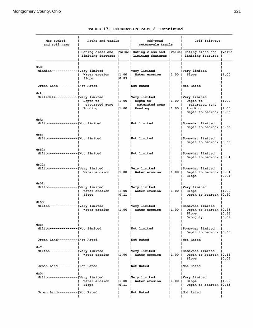
Montgomery County, Ohio 321
TABLE 17.—RECREATION PART 2--Continued ___________________________________________________________________________________________________ | | | Map symbol | Paths and trails | Off-road | Golf fairways and soil name | | motorcycle trails | |_________________________|_________________________|_________________________ | Rating class and |Value| Rating class and |Value| Rating class and |Value | limiting features | | limiting features | | limiting features | _____________________|___________________|_____|___________________|_____|___________________|_____ | | | | | | MoE: | | | | | | Miamian-------------|Very limited | |Very limited | |Very limited | | Water erosion |1.00 | Water erosion |1.00 | Slope |1.00 | Slope |0.89 | | | | | | | | | | Urban Land----------|Not Rated | |Not Rated | |Not Rated | | | | | | | MrA: | | | | | | Millsdale-----------|Very limited | |Very limited | |Very limited | | Depth to |1.00 | Depth to |1.00 | Depth to |1.00 | saturated zone | | saturated zone | | saturated zone | | Ponding |1.00 | Ponding |1.00 | Ponding |1.00 | | | | | Depth to bedrock |0.06 | | | | | | MsA: | | | | | | Milton--------------|Not limited | |Not limited | |Somewhat limited | | | | | | Depth to bedrock |0.65 | | | | | | MsB: | | | | | | Milton--------------|Not limited | |Not limited | |Somewhat limited | | | | | | Depth to bedrock |0.65 | | | | | | MsB2: | | | | | | Milton--------------|Not limited | |Not limited | |Somewhat limited | | | | | | Depth to bedrock |0.84 | | | | | | MsC2: | | | | | | Milton--------------|Very limited | |Very limited | |Somewhat limited | | Water erosion |1.00 | Water erosion |1.00 | Depth to bedrock |0.84 | | | | | Slope |0.04 | | | | | | MsD2: | | | | | | Milton--------------|Very limited | |Very limited | |Very limited | | Water erosion |1.00 | Water erosion |1.00 | Slope |1.00 | Slope |0.11 | | | Depth to bedrock |0.90 | | | | | | MtD3: | | | | | | Milton--------------|Very limited | |Very limited | |Somewhat limited | | Water erosion |1.00 | Water erosion |1.00 | Depth to bedrock |0.95 | | | | | Slope |0.63 | | | | | Droughty |0.02 | | | | | | MuB: | | | | | | Milton--------------|Not limited | |Not limited | |Somewhat limited | | | | | | Depth to bedrock |0.65 | | | | | | Urban Land----------|Not Rated | |Not Rated | |Not Rated | | | | | | | MuC: | | | | | | Milton--------------|Very limited | |Very limited | |Somewhat limited | | Water erosion |1.00 | Water erosion |1.00 | Depth to bedrock |0.65 | | | | | Slope |0.04 | | | | | | Urban Land----------|Not Rated | |Not Rated | |Not Rated | | | | | | | MuD: | | | | | | Milton--------------|Very limited | |Very limited | |Very limited | | Water erosion |1.00 | Water erosion |1.00 | Slope |1.00 | Slope |0.11 | | | Depth to bedrock |0.65 | | | | | | Urban Land----------|Not Rated | |Not Rated | |Not Rated | | | | | | |

322 Soil Survey
TABLE 17.—RECREATION PART 2--Continued ___________________________________________________________________________________________________ | | | Map symbol | Paths and trails | Off-road | Golf fairways and soil name | | motorcycle trails | |_________________________|_________________________|_________________________ | Rating class and |Value| Rating class and |Value| Rating class and |Value | limiting features | | limiting features | | limiting features | _____________________|___________________|_____|___________________|_____|___________________|_____ | | | | | | Mv: | | | | | | Montgomery----------|Very limited | |Very limited | |Very limited | | Depth to |1.00 | Depth to |1.00 | Depth to |1.00 | saturated zone | | saturated zone | | saturated zone | | Ponding |1.00 | Ponding |1.00 | Ponding |1.00 | | | | | | OcA: | | | | | | Ockley--------------|Not limited | |Not limited | |Not limited | | | | | | | OcB: | | | | | | Ockley--------------|Not limited | |Not limited | |Not limited | | | | | | | PlB: | | | | | | Plattville----------|Not limited | |Not limited | |Somewhat limited | | | | | | Depth to bedrock |0.71 | | | | | | PlC: | | | | | | Plattville----------|Not limited | |Not limited | |Somewhat limited | | | | | | Depth to bedrock |0.71 | | | | | Slope |0.04 | | | | | | PyA: | | | | | | Pyrmont-------------|Very limited | |Very limited | |Very limited | | Depth to |1.00 | Depth to |1.00 | Depth to |1.00 | saturated zone | | saturated zone | | saturated zone | | | | | | | Qu: | | | | | | Quarries------------|Not Rated | |Not Rated | |Not Rated | | | | | | | RcA: | | | | | | Randolph------------|Very limited | |Very limited | |Very limited | | Depth to |1.00 | Depth to |1.00 | Depth to |1.00 | saturated zone | | saturated zone | | saturated zone | | | | | | Depth to bedrock |0.35 | | | | | | ReB: | | | | | | Ritchey-------------|Not limited | |Not limited | |Very limited | | | | | | Depth to bedrock |1.00 | | | | | Droughty |0.55 | | | | | | ReB2: | | | | | | Ritchey-------------|Not limited | |Not limited | |Very limited | | | | | | Depth to bedrock |1.00 | | | | | Droughty |0.96 | | | | | | ReC2: | | | | | | Ritchey-------------|Very limited | |Very limited | |Very limited | | Water erosion |1.00 | Water erosion |1.00 | Depth to bedrock |1.00 | | | | | Droughty |0.96 | | | | | Slope |0.04 | | | | | | ReE2: | | | | | | Ritchey-------------|Very limited | |Very limited | |Very limited | | Water erosion |1.00 | Water erosion |1.00 | Depth to bedrock |1.00 | Slope |0.57 | | | Droughty |1.00 | | | | | Slope |1.00 | | | | | | ReF2: | | | | | | Ritchey-------------|Very limited | |Very limited | |Very limited | | Water erosion |1.00 | Water erosion |1.00 | Depth to bedrock |1.00 | Slope |1.00 | Slope |0.96 | Slope |1.00 | | | | | Droughty |1.00 | | | | | |
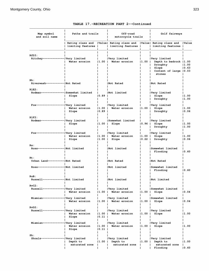
Montgomery County, Ohio 323
TABLE 17.—RECREATION PART 2--Continued ___________________________________________________________________________________________________ | | | Map symbol | Paths and trails | Off-road | Golf fairways and soil name | | motorcycle trails | |_________________________|_________________________|_________________________ | Rating class and |Value| Rating class and |Value| Rating class and |Value | limiting features | | limiting features | | limiting features | _____________________|___________________|_____|___________________|_____|___________________|_____ | | | | | | RfD3: | | | | | | Ritchey-------------|Very limited | |Very limited | |Very limited | | Water erosion |1.00 | Water erosion |1.00 | Depth to bedrock |1.00 | | | | | Droughty |1.00 | | | | | Slope |0.63 | | | | | Content of large |0.03 | | | | | stones | | | | | | | Rh: | | | | | | Riverwash-----------|Not Rated | |Not Rated | |Not Rated | | | | | | | RlE2: | | | | | | Rodman--------------|Somewhat limited | |Not limited | |Very limited | | Slope |0.89 | | | Slope |1.00 | | | | | Droughty |1.00 | | | | | | Fox-----------------|Very limited | |Very limited | |Very limited | | Water erosion |1.00 | Water erosion |1.00 | Slope |1.00 | Slope |0.89 | | | Droughty |0.06 | | | | | | RlF2: | | | | | | Rodman--------------|Very limited | |Somewhat limited | |Very limited | | Slope |1.00 | Slope |0.96 | Slope |1.00 | | | | | Droughty |1.00 | | | | | | Fox-----------------|Very limited | |Very limited | |Very limited | | Water erosion |1.00 | Water erosion |1.00 | Slope |1.00 | Slope |1.00 | Slope |0.22 | Droughty |0.06 | | | | | | Rs: | | | | | | Ross----------------|Not limited | |Not limited | |Somewhat limited | | | | | | Flooding |0.60 | | | | | | Rt: | | | | | | Urban Land----------|Not Rated | |Not Rated | |Not Rated | | | | | | | Ross----------------|Not limited | |Not limited | |Somewhat limited | | | | | | Flooding |0.60 | | | | | | RuB: | | | | | | Russell-------------|Not limited | |Not limited | |Not limited | | | | | | | RvC2: | | | | | | Russell-------------|Very limited | |Very limited | |Somewhat limited | | Water erosion |1.00 | Water erosion |1.00 | Slope |0.04 | | | | | | Miamian-------------|Very limited | |Very limited | |Somewhat limited | | Water erosion |1.00 | Water erosion |1.00 | Slope |0.04 | | | | | | RvD2: | | | | | | Russell-------------|Very limited | |Very limited | |Very limited | | Water erosion |1.00 | Water erosion |1.00 | Slope |1.00 | Slope |0.11 | | | | | | | | | | Miamian-------------|Very limited | |Very limited | |Very limited | | Water erosion |1.00 | Water erosion |1.00 | Slope |1.00 | Slope |0.11 | | | | | | | | | | Sh: | | | | | | Shoals--------------|Very limited | |Very limited | |Very limited | | Depth to |1.00 | Depth to |1.00 | Depth to |1.00 | saturated zone | | saturated zone | | saturated zone | | | | | | Flooding |0.60

324 Soil Survey
TABLE 17.—RECREATION PART 2--Continued ___________________________________________________________________________________________________ | | | Map symbol | Paths and trails | Off-road | Golf fairways and soil name | | motorcycle trails | |_________________________|_________________________|_________________________ | Rating class and |Value| Rating class and |Value| Rating class and |Value | limiting features | | limiting features | | limiting features | _____________________|___________________|_____|___________________|_____|___________________|_____ | | | | | | So: | | | | | | Sloan---------------|Very limited | |Very limited | |Very limited | | Depth to |1.00 | Depth to |1.00 | Flooding |1.00 | saturated zone | | saturated zone | | | | Ponding |1.00 | Ponding |1.00 | Depth to |1.00 | | | | | saturated zone | | Flooding |0.40 | Flooding |0.40 | Ponding |1.00 | | | | | | ThA: | | | | | | Thackery------------|Not limited | |Not limited | |Somewhat limited | | | | | | Depth to |0.03 | | | | | saturated zone | | | | | | | TpA: | | | | | | Tippecanoe----------|Not limited | |Not limited | |Somewhat limited | | | | | | Depth to |0.03 | | | | | saturated zone | | | | | | | Ua: | | | | | | Urban Land----------|Not Rated | |Not Rated | |Not Rated | | | | | | | Ud: | | | | | | Udorthents----------|Not Rated | |Not Rated | |Not Rated | | | | | | | Ug: | | | | | | Urban Land----------|Not Rated | |Not Rated | |Not Rated | | | | | | | Um: | | | | | | Urban Land----------|Not Rated | |Not Rated | |Not Rated | | | | | | | WaA: | | | | | | Warsaw--------------|Not limited | |Not limited | |Not limited | | | | | | | WaB: | | | | | | Warsaw--------------|Not limited | |Not limited | |Not limited | | | | | | | WeA: | | | | | | Wea-----------------|Not limited | |Not limited | |Not limited | | | | | | | WeB: | | | | | | Wea-----------------|Not limited | |Not limited | |Not limited | | | | | | | Ws: | | | | | | Westland------------|Very limited | |Very limited | |Very limited | | Depth to |1.00 | Depth to |1.00 | Depth to |1.00 | saturated zone | | saturated zone | | saturated zone | | Ponding |1.00 | Ponding |1.00 | Ponding |1.00 WyB2: | | | | | | Wynn----------------|Not limited | |Not limited | |Somewhat limited | | | | | | Depth to bedrock |0.54 XeA: | | | | | | Xenia---------------|Not limited | |Not limited | |Somewhat limited | | | | | | Depth to |0.03 | | | | | saturated zone | XeB: | | | | | | Xenia---------------|Not limited | |Not limited | |Somewhat limited | | | | | | Depth to |0.03 | | | | | saturated zone | | | | | | | _____________________|___________________|_____|___________________|_____|___________________|_____

Montgomery County, Ohio 325
TABLE 18.--WILDLIFE HABITAT (See text on page 166 for definitions of terms used in this table. Absence of an entry indicates that no rating is applicable.) ___________________________________________________________________________________________________________ | Potential for habitat elements |Potential as habitat for |______________________________________________________________|________________________ Map symbol | | | Wild | | | | | | | and soil name | Grain |Grasses | herba- |Hardwood| Conif- |Wetland |Shallow |Openland|Woodland|Wetlnd |and seed| and | ceous | trees | erous | plants | water |wild- |wild- |wild- | crops |legumes | plants | | plants | | areas | life | life | life ___________________|________|________|________|________|________|________|________|________|________|______ | | | | | | | | | | Ag: | | | | | | | | | | Algiers-----------|Fair |Good |Good |Good |Good |Fair |Fair |Good |Good |Fair. | | | | | | | | | | Bo: | | | | | | | | | | Borrow pits-------| --- | --- | --- | --- | --- | --- | --- | --- | --- |--- | | | | | | | | | | Bp: | | | | | | | | | | Brookston---------|Fair |Poor |Poor |Poor |Poor |Good |Good |Poor |Poor |Good. | | | | | | | | | | Br: | | | | | | | | | | Brookston---------|Fair |Poor |Poor |Poor |Poor |Good |Good |Poor |Poor |Good. | | | | | | | | | | Bs: | | | | | | | | | | Brookston---------|Fair |Poor |Poor |Poor |Poor |Good |Good |Poor |Poor |Good. | | | | | | | | | | Bu: | | | | | | | | | | Brookston---------|Fair |Poor |Poor |Poor |Poor |Good |Good |Poor |Poor |Good. | | | | | | | | | | Urban land--------| --- | --- | --- | --- | --- | --- | --- | --- | --- |--- | | | | | | | | | | Ca: | | | | | | | | | | Carlisle----------|Fair |Poor |Poor |Poor |Poor |Good |Good |Poor |Poor |Good. | | | | | | | | | | CeA: | | | | | | | | | | Celina------------|Good |Good |Good |Good |Good |Poor |Poor |Good |Good |Poor. | | | | | | | | | | CeB: | | | | | | | | | | Celina------------|Fair |Good |Good |Good |Good |Poor |Very |Good |Good |Very | | | | | | | poor. | | | poor. | | | | | | | | | | CeB2: | | | | | | | | | | Celina------------|Fair |Good |Good |Good |Good |Poor |Very |Good |Good |Very | | | | | | | poor. | | | poor. | | | | | | | | | | ClB: | | | | | | | | | | Celina------------|Fair |Good |Good |Good |Good |Poor |Very |Good |Good |Very | | | | | | | poor. | | | poor. | | | | | | | | | | CoA: | | | | | | | | | | Corwin------------|Good |Good |Good |Good |Good |Poor |Fair |Good |Good |Poor. | | | | | | | | | | CoB: | | | | | | | | | | Corwin------------|Good |Good |Good |Good |Good |Poor |Fair |Good |Good |Poor. | | | | | | | | | | CsA: | | | | | | | | | | Crosby------------|Good |Good |Good |Good |Good |Fair |Fair |Good |Good |Fair. | | | | | | | | | | CtB: | | | | | | | | | | Crosby------------|Good |Good |Good |Good |Good |Poor |Very |Good |Good |Very | | | | | | | poor. | | | poor. | | | | | | | | | | Celina------------|Fair |Good |Good |Good |Good |Poor |Very |Good |Good |Very | | | | | | | poor. | | | poor. | | | | | | | | | | Cu: | | | | | | | | | | Crosby------------|Good |Good |Good |Good |Good |Fair |Fair |Good |Good |Fair. | | | | | | | | | | Urban land--------| --- | --- | --- | --- | --- | --- | --- | --- | --- |--- | | | | | | | | | | DaB: | | | | | | | | | | Dana--------------|Good |Good |Good |Good |Good |Poor |Very |Good |Good |Very | | | | | | | poor. | | | poor. FaE2: | | | | | | | | | | Fairmount---------|Poor |Poor |Fair |Poor |Poor |Very |Very |Poor |Poor |Very | | | | | | poor. | poor. | | | poor.
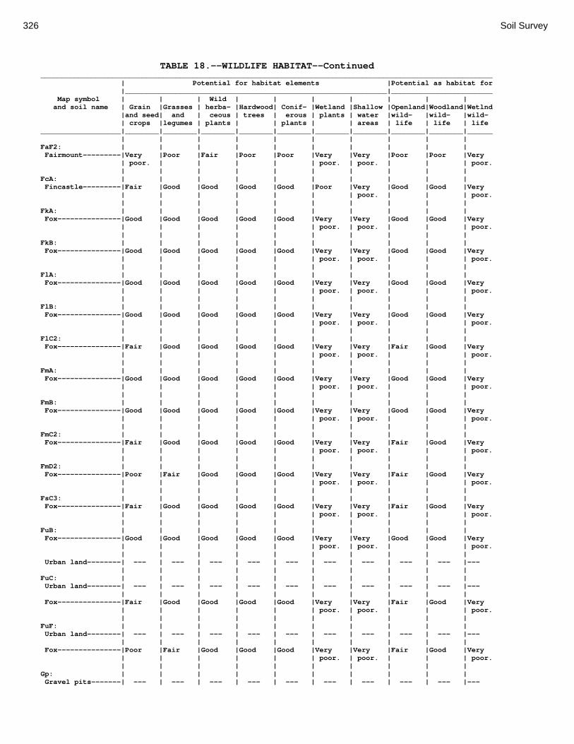
326 Soil Survey
TABLE 18.--WILDLIFE HABITAT--Continued ___________________________________________________________________________________________________________ | Potential for habitat elements |Potential as habitat for |______________________________________________________________|________________________ Map symbol | | | Wild | | | | | | | and soil name | Grain |Grasses | herba- |Hardwood| Conif- |Wetland |Shallow |Openland|Woodland|Wetlnd |and seed| and | ceous | trees | erous | plants | water |wild- |wild- |wild- | crops |legumes | plants | | plants | | areas | life | life | life ___________________|________|________|________|________|________|________|________|________|________|______ | | | | | | | | | | FaF2: | | | | | | | | | | Fairmount---------|Very |Poor |Fair |Poor |Poor |Very |Very |Poor |Poor |Very | poor. | | | | | poor. | poor. | | | poor. | | | | | | | | | | FcA: | | | | | | | | | | Fincastle---------|Fair |Good |Good |Good |Good |Poor |Very |Good |Good |Very | | | | | | | poor. | | | poor. | | | | | | | | | | FkA: | | | | | | | | | | Fox---------------|Good |Good |Good |Good |Good |Very |Very |Good |Good |Very | | | | | | poor. | poor. | | | poor. | | | | | | | | | | FkB: | | | | | | | | | | Fox---------------|Good |Good |Good |Good |Good |Very |Very |Good |Good |Very | | | | | | poor. | poor. | | | poor. | | | | | | | | | | FlA: | | | | | | | | | | Fox---------------|Good |Good |Good |Good |Good |Very |Very |Good |Good |Very | | | | | | poor. | poor. | | | poor. | | | | | | | | | | FlB: | | | | | | | | | | Fox---------------|Good |Good |Good |Good |Good |Very |Very |Good |Good |Very | | | | | | poor. | poor. | | | poor. | | | | | | | | | | FlC2: | | | | | | | | | | Fox---------------|Fair |Good |Good |Good |Good |Very |Very |Fair |Good |Very | | | | | | poor. | poor. | | | poor. | | | | | | | | | | FmA: | | | | | | | | | | Fox---------------|Good |Good |Good |Good |Good |Very |Very |Good |Good |Very | | | | | | poor. | poor. | | | poor. | | | | | | | | | | FmB: | | | | | | | | | | Fox---------------|Good |Good |Good |Good |Good |Very |Very |Good |Good |Very | | | | | | poor. | poor. | | | poor. | | | | | | | | | | FmC2: | | | | | | | | | | Fox---------------|Fair |Good |Good |Good |Good |Very |Very |Fair |Good |Very | | | | | | poor. | poor. | | | poor. | | | | | | | | | | FmD2: | | | | | | | | | | Fox---------------|Poor |Fair |Good |Good |Good |Very |Very |Fair |Good |Very | | | | | | poor. | poor. | | | poor. | | | | | | | | | | FsC3: | | | | | | | | | | Fox---------------|Fair |Good |Good |Good |Good |Very |Very |Fair |Good |Very | | | | | | poor. | poor. | | | poor. | | | | | | | | | | FuB: | | | | | | | | | | Fox---------------|Good |Good |Good |Good |Good |Very |Very |Good |Good |Very | | | | | | poor. | poor. | | | poor. | | | | | | | | | | Urban land--------| --- | --- | --- | --- | --- | --- | --- | --- | --- |--- | | | | | | | | | | FuC: | | | | | | | | | | Urban land--------| --- | --- | --- | --- | --- | --- | --- | --- | --- |--- | | | | | | | | | | Fox---------------|Fair |Good |Good |Good |Good |Very |Very |Fair |Good |Very | | | | | | poor. | poor. | | | poor. | | | | | | | | | | FuF: | | | | | | | | | | Urban land--------| --- | --- | --- | --- | --- | --- | --- | --- | --- |--- | | | | | | | | | | Fox---------------|Poor |Fair |Good |Good |Good |Very |Very |Fair |Good |Very | | | | | | poor. | poor. | | | poor. | | | | | | | | | | Gp: | | | | | | | | | | Gravel pits-------| --- | --- | --- | --- | --- | --- | --- | --- | --- |---

Montgomery County, Ohio 327
TABLE 18.--WILDLIFE HABITAT--Continued ___________________________________________________________________________________________________________ | Potential for habitat elements |Potential as habitat for |______________________________________________________________|________________________ Map symbol | | | Wild | | | | | | | and soil name | Grain |Grasses | herba- |Hardwood| Conif- |Wetland |Shallow |Openland|Woodland|Wetlnd |and seed| and | ceous | trees | erous | plants | water |wild- |wild- |wild- | crops |legumes | plants | | plants | | areas | life | life | life ___________________|________|________|________|________|________|________|________|________|________|______ | | | | | | | | | | HeE2: | | | | | | | | | | Hennepin----------|Poor |Fair |Good |Good |Fair |Very |Very |Fair |Good |Very | | | | | | poor. | poor. | | | poor. | | | | | | | | | | Miamian-----------|Poor |Fair |Good |Good |Good |Very |Very |Fair |Good |Very | | | | | | poor. | poor. | | | poor. | | | | | | | | | | HeF2: | | | | | | | | | | Hennepin----------|Very |Poor |Good |Good |Fair |Very |Very |Poor |Good |Very | poor. | | | | | poor. | poor. | | | poor. | | | | | | | | | | Miamian-----------|Very |Poor |Good |Good |Good |Very |Very |Poor |Good |Very | poor. | | | | | poor. | poor. | | | poor. | | | | | | | | | | HmF3: | | | | | | | | | | Hennepin----------|Very |Poor |Good |Good |Fair |Very |Very |Poor |Good |Very | poor. | | | | | poor. | poor. | | | poor. | | | | | | | | | | Miamian-----------|Very |Fair |Good |Good |Good |Very |Very |Fair |Good |Very | poor. | | | | | poor. | poor. | | | poor. | | | | | | | | | | KeA: | | | | | | | | | | Kendallville------|Good |Good |Good |Good |Good |Poor |Very |Good |Good |Very | | | | | | | poor. | | | poor. | | | | | | | | | | KeB: | | | | | | | | | | Kendallville------|Fair |Good |Good |Good |Good |Poor |Very |Good |Good |Very | | | | | | | poor. | | | poor. | | | | | | | | | | KeC2: | | | | | | | | | | Kendallville------|Fair |Good |Good |Good |Good |Very |Very |Good |Good |Very | | | | | | poor. | poor. | | | poor. | | | | | | | | | | Ld: | | | | | | | | | | Landes------------|Good |Good |Good |Good |Good |Poor |Very |Good |Good |Very | | | | | | | poor. | | | poor. | | | | | | | | | | Lg: | | | | | | | | | | Lanier------------|Fair |Good |Good |Fair |Fair |Poor |Very |Good |Fair |Very | | | | | | | poor. | | | poor. | | | | | | | | | | LsB: | | | | | | | | | | Lewisburg---------|Good |Good |Good |Good |Good |Poor |Very |Good |Good |Very | | | | | | | poor. | | | poor. | | | | | | | | | | LxC2: | | | | | | | | | | Lorenzo-----------|Fair |Good |Good |Good |Good |Very |Very |Good |Good |Very | | | | | | poor. | poor. | | | poor. | | | | | | | | | | Rodman------------|Very |Poor |Fair |Poor |Poor |Very |Very |Poor |Poor |Very | poor. | | | | | poor. | poor. | | | poor. | | | | | | | | | | LxD2: | | | | | | | | | | Lorenzo-----------|Poor |Fair |Good |Good |Good |Very |Very |Fair |Good |Very | | | | | | poor. | poor. | | | poor. | | | | | | | | | | Rodman------------|Very |Poor |Fair |Poor |Poor |Very |Very |Poor |Poor |Very | poor. | | | | | poor. | poor. | | | poor. | | | | | | | | | | Mb: | | | | | | | | | | Made land---------| --- | --- | --- | --- | --- | --- | --- | --- | --- |--- | | | | | | | | | | Md: | | | | | | | | | | Medway------------|Good |Good |Good |Good |Good |Poor |Poor |Good |Good |Poor. | | | | | | | | | | MlA: | | | | | | | | | | Miamian-----------|Good |Good |Good |Good |Good |Poor |Very |Good |Good |Very | | | | | | | poor. | | | poor.

328 Soil Survey
TABLE 18.--WILDLIFE HABITAT--Continued ___________________________________________________________________________________________________________ | Potential for habitat elements |Potential as habitat for |______________________________________________________________|________________________ Map symbol | | | Wild | | | | | | | and soil name | Grain |Grasses | herba- |Hardwood| Conif- |Wetland |Shallow |Openland|Woodland|Wetlnd |and seed| and | ceous | trees | erous | plants | water |wild- |wild- |wild- | crops |legumes | plants | | plants | | areas | life | life | life ___________________|________|________|________|________|________|________|________|________|________|______ | | | | | | | | | | MlB: | | | | | | | | | | Miamian-----------|Fair |Good |Good |Good |Good |Poor |Very |Good |Good |Very | | | | | | | poor. | | | poor. | | | | | | | | | | MlB2: | | | | | | | | | | Miamian-----------|Fair |Good |Good |Good |Good |Poor |Very |Good |Good |Very | | | | | | | poor. | | | poor. | | | | | | | | | | MlC2: | | | | | | | | | | Miamian-----------|Fair |Good |Good |Good |Good |Very |Very |Good |Good |Very | | | | | | poor. | poor. | | | poor. | | | | | | | | | | MlD2: | | | | | | | | | | Miamian-----------|Poor |Fair |Good |Good |Good |Very |Very |Fair |Good |Very | | | | | | poor. | poor. | | | poor. | | | | | | | | | | MmB: | | | | | | | | | | Miamian-----------|Fair |Good |Good |Good |Good |Poor |Very |Good |Good |Very | | | | | | | poor. | | | poor. | | | | | | | | | | MnB3: | | | | | | | | | | Miamian-----------|Fair |Good |Good |Good |Good |Poor |Very |Good |Good |Very | | | | | | | poor. | | | poor. | | | | | | | | | | MnC3: | | | | | | | | | | Miamian-----------|Fair |Good |Good |Good |Good |Very |Very |Good |Good |Very | | | | | | poor. | poor. | | | poor. | | | | | | | | | | MnD3: | | | | | | | | | | Miamian-----------|Poor |Fair |Good |Good |Good |Very |Very |Fair |Good |Very | | | | | | poor. | poor. | | | poor. | | | | | | | | | | MoB: | | | | | | | | | | Miamian-----------|Fair |Good |Good |Good |Good |Poor |Very |Good |Good |Very | | | | | | | poor. | | | poor. | | | | | | | | | | Urban land--------| --- | --- | --- | --- | --- | --- | --- | --- | --- |--- | | | | | | | | | | MoC: | | | | | | | | | | Miamian-----------|Fair |Good |Good |Good |Good |Very |Very |Good |Good |Very | | | | | | poor. | poor. | | | poor. | | | | | | | | | | Urban land--------| --- | --- | --- | --- | --- | --- | --- | --- | --- |--- | | | | | | | | | | MoE: | | | | | | | | | | Miamian-----------|Poor |Fair |Good |Good |Good |Very |Very |Fair |Good |Very | | | | | | poor. | poor. | | | poor. | | | | | | | | | | Urban land--------| --- | --- | --- | --- | --- | --- | --- | --- | --- |--- | | | | | | | | | | MrA: | | | | | | | | | | Millsdale---------|Fair |Fair |Fair |Fair |Poor |Good |Fair |Fair |Fair |Fair. | | | | | | | | | | MsA: | | | | | | | | | | Milton------------|Fair |Good |Good |Good |Good |Poor |Very |Fair |Good |Very | | | | | | | poor. | | | poor. | | | | | | | | | | MsB: | | | | | | | | | | Milton------------|Fair |Good |Good |Good |Good |Poor |Very |Fair |Good |Very | | | | | | | poor. | | | poor. | | | | | | | | | | MsB2: | | | | | | | | | | Milton------------|Fair |Good |Good |Good |Good |Poor |Very |Fair |Good |Very | | | | | | | poor. | | | poor. | | | | | | | | | | MsC2: | | | | | | | | | | Milton------------|Fair |Good |Good |Good |Good |Very |Very |Good |Good |Very | | | | | | poor. | poor. | | | poor.

Montgomery County, Ohio 329
TABLE 18.--WILDLIFE HABITAT--Continued ___________________________________________________________________________________________________________ | Potential for habitat elements |Potential as habitat for |______________________________________________________________|________________________ Map symbol | | | Wild | | | | | | | and soil name | Grain |Grasses | herba- |Hardwood| Conif- |Wetland |Shallow |Openland|Woodland|Wetlnd |and seed| and | ceous | trees | erous | plants | water |wild- |wild- |wild- | crops |legumes | plants | | plants | | areas | life | life | life ___________________|________|________|________|________|________|________|________|________|________|______ | | | | | | | | | | MsD2: | | | | | | | | | | Milton------------|Poor |Fair |Good |Good |Good |Very |Very |Fair |Good |Very | | | | | | poor. | poor. | | | poor. | | | | | | | | | | MtD3: | | | | | | | | | | Milton------------|Fair |Good |Good |Good |Good |Very |Very |Good |Good |Very | | | | | | poor. | poor. | | | poor. | | | | | | | | | | MuB: | | | | | | | | | | Milton------------|Fair |Good |Good |Good |Good |Poor |Very |Fair |Good |Very | | | | | | | poor. | | | poor. | | | | | | | | | | Urban land--------| --- | --- | --- | --- | --- | --- | --- | --- | --- |--- | | | | | | | | | | MuC: | | | | | | | | | | Milton------------|Fair |Good |Good |Good |Good |Very |Very |Good |Good |Very | | | | | | poor. | poor. | | | poor. | | | | | | | | | | Urban land--------| --- | --- | --- | --- | --- | --- | --- | --- | --- |--- | | | | | | | | | | MuD: | | | | | | | | | | Milton------------|Poor |Fair |Good |Good |Good |Very |Very |Fair |Good |Very | | | | | | poor. | poor. | | | poor. | | | | | | | | | | Urban land--------| --- | --- | --- | --- | --- | --- | --- | --- | --- |--- | | | | | | | | | | Mv: | | | | | | | | | | Montgomery--------|Fair |Poor |Poor |Poor |Poor |Good |Good |Poor |Poor |Good. | | | | | | | | | | OcA: | | | | | | | | | | Ockley------------|Good |Good |Good |Good |Good |Poor |Very |Good |Good |Very | | | | | | | poor. | | | poor. | | | | | | | | | | OcB: | | | | | | | | | | Ockley------------|Good |Good |Good |Good |Good |Poor |Very |Good |Good |Very | | | | | | | poor. | | | poor. | | | | | | | | | | PlB: | | | | | | | | | | Plattville--------|Good |Good |Good |Good |Good |Poor |Very |Good |Good |Very | | | | | | | poor. | | | poor. | | | | | | | | | | PlC: | | | | | | | | | | Plattville--------|Fair |Good |Good |Good |Good |Poor |Very |Good |Good |Very | | | | | | | poor. | | | poor. | | | | | | | | | | PyA: | | | | | | | | | | Pyrmont-----------|Fair |Good |Good |Good |Good |Fair |Fair |Good |Good |Fair. | | | | | | | | | | Qu: | | | | | | | | | | Quarries----------| --- | --- | --- | --- | --- | --- | --- | --- | --- |--- | | | | | | | | | | RcA: | | | | | | | | | | Randolph----------|Fair |Good |Good |Good |Good |Fair |Fair |Good |Good |Fair. | | | | | | | | | | ReB: | | | | | | | | | | Ritchey-----------|Poor |Poor |Fair |Fair |Fair |Poor |Very |Poor |Fair |Very | | | | | | | poor. | | | poor. | | | | | | | | | | ReB2: | | | | | | | | | | Ritchey-----------|Poor |Poor |Fair |Fair |Fair |Poor |Very |Poor |Fair |Very | | | | | | | poor. | | | poor. | | | | | | | | | | ReC2: | | | | | | | | | | Ritchey-----------|Poor |Poor |Fair |Fair |Fair |Poor |Very |Poor |Fair |Very | | | | | | | poor. | | | poor. | | | | | | | | | |

330 Soil Survey
TABLE 18.--WILDLIFE HABITAT--Continued ___________________________________________________________________________________________________________ | Potential for habitat elements |Potential as habitat for |______________________________________________________________|________________________ Map symbol | | | Wild | | | | | | | and soil name | Grain |Grasses | herba- |Hardwood| Conif- |Wetland |Shallow |Openland|Woodland|Wetlnd |and seed| and | ceous | trees | erous | plants | water |wild- |wild- |wild- | crops |legumes | plants | | plants | | areas | life | life | life ___________________|________|________|________|________|________|________|________|________|________|______ | | | | | | | | | | ReE2: | | | | | | | | | | Ritchey-----------|Poor |Poor |Fair |Fair |Fair |Poor |Very |Poor |Fair |Very | | | | | | | poor. | | | poor. | | | | | | | | | | ReF2: | | | | | | | | | | Ritchey-----------|Poor |Poor |Fair |Fair |Fair |Poor |Very |Poor |Fair |Very | | | | | | | poor. | | | poor. | | | | | | | | | | RfD3: | | | | | | | | | | Ritchey-----------|Poor |Poor |Fair |Fair |Fair |Poor |Very |Poor |Fair |Very | | | | | | | poor. | | | poor. | | | | | | | | | | Rh: | | | | | | | | | | Riverwash---------| --- | --- | --- | --- | --- | --- | --- | --- | --- |--- | | | | | | | | | | RlE2: | | | | | | | | | | Rodman------------|Very |Poor |Fair |Poor |Poor |Very |Very |Poor |Poor |Very | poor. | | | | | poor. | poor. | | | poor. | | | | | | | | | | Fox---------------|Poor |Fair |Good |Good |Good |Very |Very |Fair |Good |Very | | | | | | poor. | poor. | | | poor. | | | | | | | | | | RlF2: | | | | | | | | | | Rodman------------|Very |Poor |Fair |Poor |Poor |Very |Very |Poor |Poor |Very | poor. | | | | | poor. | poor. | | | poor. | | | | | | | | | | Fox---------------|Poor |Fair |Good |Good |Good |Very |Very |Fair |Good |Very | | | | | | poor. | poor. | | | poor. | | | | | | | | | | Rs: | | | | | | | | | | Ross--------------|Good |Good |Good |Good |Good |Poor |Very |Good |Good |Very | | | | | | | poor. | | | poor. | | | | | | | | | | Rt: | | | | | | | | | | Urban land--------| --- | --- | --- | --- | --- | --- | --- | --- | --- |--- | | | | | | | | | | Ross--------------|Good |Good |Good |Good |Good |Poor |Very |Good |Good |Very | | | | | | | poor. | | | poor. | | | | | | | | | | RuB: | | | | | | | | | | Russell-----------|Good |Good |Good |Good |Good |Poor |Very |Good |Good |Very | | | | | | | poor. | | | poor. | | | | | | | | | | RvC2: | | | | | | | | | | Russell-----------|Fair |Good |Good |Good |Good |Very |Very |Good |Good |Very | | | | | | poor. | poor. | | | poor. | | | | | | | | | | Miamian-----------|Fair |Good |Good |Good |Good |Very |Very |Good |Good |Very | | | | | | poor. | poor. | | | poor. | | | | | | | | | | RvD2: | | | | | | | | | | Russell-----------|Poor |Fair |Good |Good |Good |Very |Very |Fair |Good |Very | | | | | | poor. | poor. | | | poor. | | | | | | | | | | Miamian-----------|Poor |Fair |Good |Good |Good |Very |Very |Fair |Good |Very | | | | | | poor. | poor. | | | poor. | | | | | | | | | | Sh: | | | | | | | | | | Shoals------------|Poor |Fair |Fair |Good |Good |Fair |Fair |Fair |Good |Fair. | | | | | | | | | | So: | | | | | | | | | | Sloan-------------|Fair |Fair |Fair |Poor |Poor |Good |Good |Fair |Poor |Good. | | | | | | | | | | ThA: | | | | | | | | | | Thackery----------|Good |Good |Good |Good |Good |Poor |Very |Good |Good |Poor. | | | | | | | poor. | | | | | | | | | | | | |

Montgomery County, Ohio 331
TABLE 18.--WILDLIFE HABITAT--Continued ___________________________________________________________________________________________________________ | Potential for habitat elements |Potential as habitat for |______________________________________________________________|________________________ Map symbol | | | Wild | | | | | | | and soil name | Grain |Grasses | herba- |Hardwood| Conif- |Wetland |Shallow |Openland|Woodland|Wetlnd |and seed| and | ceous | trees | erous | plants | water |wild- |wild- |wild- | crops |legumes | plants | | plants | | areas | life | life | life ___________________|________|________|________|________|________|________|________|________|________|______ | | | | | | | | | | TpA: | | | | | | | | | | Tippecanoe--------|Good |Good |Good |Good |Good |Poor |Very |Good |Good |Very | | | | | | | poor. | | | poor. | | | | | | | | | | Ua: | | | | | | | | | | Urban land--------| --- | --- | --- | --- | --- | --- | --- | --- | --- |--- | | | | | | | | | | Ud: | | | | | | | | | | Udorthents--------| --- | --- | --- | --- | --- | --- | --- | --- | --- |--- | | | | | | | | | | Ug: | | | | | | | | | | Urban land--------| --- | --- | --- | --- | --- | --- | --- | --- | --- |--- | | | | | | | | | | Um: | | | | | | | | | | Urban land--------| --- | --- | --- | --- | --- | --- | --- | --- | --- |--- | | | | | | | | | | WaA: | | | | | | | | | | Warsaw------------|Good |Good |Good |Good |Good |Poor |Very |Good |Good |Very | | | | | | | poor. | | | poor. | | | | | | | | | | WaB: | | | | | | | | | | Warsaw------------|Good |Good |Good |Good |Good |Poor |Very |Good |Good |Very | | | | | | | poor. | | | poor. | | | | | | | | | | WeA: | | | | | | | | | | Wea---------------|Good |Good |Good |Good |Good |Poor |Very |Good |Good |Very | | | | | | | poor. | | | poor. | | | | | | | | | | WeB: | | | | | | | | | | Wea---------------|Good |Good |Good |Good |Good |Poor |Very |Good |Good |Very | | | | | | | poor. | | | poor. | | | | | | | | | | Ws: | | | | | | | | | | Westland----------|Fair |Poor |Poor |Poor |Poor |Good |Good |Poor |Poor |Good. | | | | | | | | | | WyB2: | | | | | | | | | | Wynn--------------|Fair |Good |Good |Good |Good |Poor |Very |Good |Good |Very | | | | | | | poor. | | | poor. | | | | | | | | | | XeA: | | | | | | | | | | Xenia-------------|Good |Good |Good |Good |Good |Poor |Poor |Good |Good |Poor. | | | | | | | | | | XeB: | | | | | | | | | | Xenia-------------|Good |Good |Good |Good |Good |Poor |Poor |Good |Good |Poor. | | | | | | | | | | ___________________|________|________|________|________|________|________|________|________|________|_______

332 Soil Survey
TABLE 19.--CONSTRUCTION MATERIALS PART 1 (The information in this table indicates the dominant soil condition but does not eliminate the need for onsite investigation. The numbers in the value columns range from 0.00 to 0.99. The greater the value, the greater the likelihood that the bottom layer or thickest layer of the soil is a source of sand or gravel. See text on page 169 for further explanation of ratings in this table.) _________________________________________________________________________ | | Map symbol | Potential source of | Potential source of and soil name | gravel | sand |_________________________|_________________________ | Rating class |Value| Rating class |Value _____________________|___________________|_____|___________________|_____ | | | | Ag: | | | | Algiers-------------|Poor | |Poor | | Thickest layer |0.00 | Thickest layer |0.00 | Bottom layer |0.00 | Bottom layer |0.00 | | | | Bo: | | | | Borrow Pits---------|Not rated | |Not rated | | | | | | | | | Bp: | | | | Brookston-----------|Poor | |Poor | | Thickest layer |0.00 | Thickest layer |0.00 | Bottom layer |0.00 | Bottom layer |0.00 | | | | Br: | | | | Brookston-----------|Poor | |Poor | | Thickest layer |0.00 | Thickest layer |0.00 | Bottom layer |0.00 | Bottom layer |0.00 | | | | Bs: | | | | Brookston-----------|Poor | |Poor | | Thickest layer |0.00 | Thickest layer |0.00 | Bottom layer |0.00 | Bottom layer |0.00 | | | | Bu: | | | | Brookston-----------|Poor | |Poor | | Thickest layer |0.00 | Thickest layer |0.00 | Bottom layer |0.00 | Bottom layer |0.00 | | | | Urban Land----------|Not rated | |Not rated | | | | | | | | | Ca: | | | | Carlisle------------|Poor | |Poor | | Thickest layer |0.00 | Thickest layer |0.00 | Bottom layer |0.00 | Bottom layer |0.00 | | | | CeA: | | | | Celina--------------|Poor | |Poor | | Thickest layer |0.00 | Thickest layer |0.00 | Bottom layer |0.00 | Bottom layer |0.00 | | | | CeB: | | | | Celina--------------|Poor | |Poor | | Thickest layer |0.00 | Thickest layer |0.00 | Bottom layer |0.00 | Bottom layer |0.00 | | | | CeB2: | | | | Celina--------------|Poor | |Poor | | Thickest layer |0.00 | Thickest layer |0.00 | Bottom layer |0.00 | Bottom layer |0.00 | | | | ClB: | | | | Celina--------------|Poor | |Poor | | Thickest layer |0.00 | Thickest layer |0.00 | Bottom layer |0.00 | Bottom layer |0.00

Montgomery County, Ohio 333
TABLE 19.--CONSTRUCTION MATERIALS PART 1--Continued _________________________________________________________________________ | | Map symbol | Potential source of | Potential source of and soil name | gravel | sand |_________________________|_________________________ | Rating class |Value| Rating class |Value _____________________|___________________|_____|___________________|_____ | | | | CoA: | | | | Corwin--------------|Poor | |Poor | | Thickest layer |0.00 | Thickest layer |0.00 | Bottom layer |0.00 | Bottom layer |0.00 | | | | CoB: | | | | Corwin--------------|Poor | |Poor | | Thickest layer |0.00 | Thickest layer |0.00 | Bottom layer |0.00 | Bottom layer |0.00 | | | | CsA: | | | | Crosby--------------|Poor | |Poor | | Thickest layer |0.00 | Thickest layer |0.00 | Bottom layer |0.00 | Bottom layer |0.00 | | | | CtB: | | | | Crosby--------------|Poor | |Poor | | Thickest layer |0.00 | Thickest layer |0.00 | Bottom layer |0.00 | Bottom layer |0.00 | | | | Celina--------------|Poor | |Poor | | Thickest layer |0.00 | Thickest layer |0.00 | Bottom layer |0.00 | Bottom layer |0.00 | | | | Cu: | | | | Crosby--------------|Poor | |Poor | | Thickest layer |0.00 | Thickest layer |0.00 | Bottom layer |0.00 | Bottom layer |0.00 | | | | Urban Land----------|Not rated | |Not rated | | | | | | | | | DaB: | | | | Dana----------------|Poor | |Poor | | Thickest layer |0.00 | Thickest layer |0.00 | Bottom layer |0.00 | Bottom layer |0.00 | | | | FaE2: | | | | Fairmount-----------|Poor | |Poor | | Thickest layer |0.00 | Thickest layer |0.00 | Bottom layer |0.00 | Bottom layer |0.00 | | | | FaF2: | | | | Fairmount-----------|Poor | |Poor | | Thickest layer |0.00 | Thickest layer |0.00 | Bottom layer |0.00 | Bottom layer |0.00 | | | | FcA: | | | | Fincastle-----------|Poor | |Poor | | Thickest layer |0.00 | Thickest layer |0.00 | Bottom layer |0.00 | Bottom layer |0.00 | | | | FkA: | | | | Fox-----------------|Fair | |Fair | | Thickest layer |0.64 | Thickest layer |0.76 | Bottom layer |0.94 | Bottom layer |0.90 | | | | FkB: | | | | Fox-----------------|Fair | |Fair | | Thickest layer |0.64 | Thickest layer |0.76 | Bottom layer |0.95 | Bottom layer |0.91 | | | |

334 Soil Survey
TABLE 19.--CONSTRUCTION MATERIALS PART 1--Continued _________________________________________________________________________ | | Map symbol | Potential source of | Potential source of and soil name | gravel | sand |_________________________|_________________________ | Rating class |Value| Rating class |Value _____________________|___________________|_____|___________________|_____ | | | | FlA: | | | | Fox-----------------|Fair | |Fair | | Thickest layer |0.64 | Thickest layer |0.76 | Bottom layer |0.95 | Bottom layer |0.91 | | | | FlB: | | | | Fox-----------------|Fair | |Fair | | Thickest layer |0.00 | Bottom layer |0.41 | Bottom layer |0.50 | Thickest layer |0.45 | | | | FlC2: | | | | Fox-----------------|Fair | |Fair | | Thickest layer |0.00 | Bottom layer |0.41 | Bottom layer |0.50 | Thickest layer |0.45 | | | | FmA: | | | | Fox-----------------|Fair | |Fair | | Thickest layer |0.00 | Bottom layer |0.40 | Bottom layer |0.50 | Thickest layer |0.45 | | | | FmB: | | | | Fox-----------------|Fair | |Fair | | Thickest layer |0.00 | Bottom layer |0.41 | Bottom layer |0.50 | Thickest layer |0.45 | | | | FmC2: | | | | Fox-----------------|Fair | |Fair | | Thickest layer |0.64 | Bottom layer |0.90 | Bottom layer |0.94 | Thickest layer |0.95 | | | | FmD2: | | | | Fox-----------------|Fair | |Fair | | Thickest layer |0.64 | Bottom layer |0.90 | Bottom layer |0.94 | Thickest layer |0.95 | | | | FsC3: | | | | Fox-----------------|Fair | |Fair | | Thickest layer |0.00 | Bottom layer |0.41 | Bottom layer |0.50 | Thickest layer |0.45 | | | | FuB: | | | | Fox-----------------|Fair | |Fair | | Thickest layer |0.00 | Bottom layer |0.41 | Bottom layer |0.50 | Thickest layer |0.45 | | | | Urban Land----------|Not rated | |Not rated | | | | | FuC: | | | | Urban Land----------|Not rated | |Not rated | | | | | | | | | Fox-----------------|Fair | |Fair | | Thickest layer |0.00 | Bottom layer |0.41 | Bottom layer |0.50 | Thickest layer |0.45 | | | | FuF: | | | | Urban Land----------|Not rated | |Not rated | | | | | | | | | Fox-----------------|Fair | |Fair | | Thickest layer |0.00 | Bottom layer |0.41 | Bottom layer |0.50 | Thickest layer |0.45 | | | |
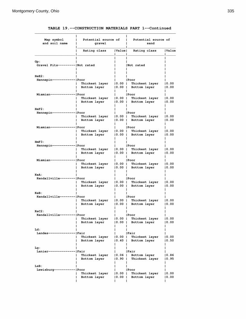
Montgomery County, Ohio 335
TABLE 19.--CONSTRUCTION MATERIALS PART 1--Continued _________________________________________________________________________ | | Map symbol | Potential source of | Potential source of and soil name | gravel | sand |_________________________|_________________________ | Rating class |Value| Rating class |Value _____________________|___________________|_____|___________________|_____ | | | | Gp: | | | | Gravel Pits---------|Not rated | |Not rated | | | | | | | | | HeE2: | | | | Hennepin------------|Poor | |Poor | | Thickest layer |0.00 | Thickest layer |0.00 | Bottom layer |0.00 | Bottom layer |0.00 | | | | Miamian-------------|Poor | |Poor | | Thickest layer |0.00 | Thickest layer |0.00 | Bottom layer |0.00 | Bottom layer |0.00 | | | | HeF2: | | | | Hennepin------------|Poor | |Poor | | Thickest layer |0.00 | Thickest layer |0.00 | Bottom layer |0.00 | Bottom layer |0.00 | | | | Miamian-------------|Poor | |Poor | | Thickest layer |0.00 | Thickest layer |0.00 | Bottom layer |0.00 | Bottom layer |0.00 | | | | HmF3: | | | | Hennepin------------|Poor | |Poor | | Thickest layer |0.00 | Thickest layer |0.00 | Bottom layer |0.00 | Bottom layer |0.00 | | | | Miamian-------------|Poor | |Poor | | Thickest layer |0.00 | Thickest layer |0.00 | Bottom layer |0.00 | Bottom layer |0.00 | | | | KeA: | | | | Kendallville--------|Poor | |Poor | | Thickest layer |0.00 | Thickest layer |0.00 | Bottom layer |0.00 | Bottom layer |0.00 | | | | KeB: | | | | Kendallville--------|Poor | |Poor | | Thickest layer |0.00 | Thickest layer |0.00 | Bottom layer |0.00 | Bottom layer |0.00 | | | | KeC2: | | | | Kendallville--------|Poor | |Poor | | Thickest layer |0.00 | Thickest layer |0.00 | Bottom layer |0.00 | Bottom layer |0.00 | | | | Ld: | | | | Landes--------------|Fair | |Fair | | Thickest layer |0.00 | Thickest layer |0.00 | Bottom layer |0.40 | Bottom layer |0.50 | | | | Lg: | | | | Lanier--------------|Fair | |Fair | | Thickest layer |0.06 | Bottom layer |0.86 | Bottom layer |0.90 | Thickest layer |0.95 | | | | LsB: | | | | Lewisburg-----------|Poor | |Poor | | Thickest layer |0.00 | Thickest layer |0.00 | Bottom layer |0.00 | Bottom layer |0.00 | | | |

336 Soil Survey
TABLE 19.--CONSTRUCTION MATERIALS PART 1--Continued _________________________________________________________________________ | | Map symbol | Potential source of | Potential source of and soil name | gravel | sand |_________________________|_________________________ | Rating class |Value| Rating class |Value _____________________|___________________|_____|___________________|_____ | | | | LxC2: | | | | Lorenzo-------------|Fair | |Fair | | Thickest layer |0.00 | Bottom layer |0.36 | Bottom layer |0.50 | Thickest layer |0.45 | | | | Rodman--------------|Fair | |Fair | | Thickest layer |0.00 | Bottom layer |0.36 | Bottom layer |0.50 | Thickest layer |0.41 | | | | LxD2: | | | | Lorenzo-------------|Fair | |Fair | | Thickest layer |0.00 | Bottom layer |0.36 | Bottom layer |0.50 | Thickest layer |0.45 | | | | Rodman--------------|Fair | |Fair | | Thickest layer |0.00 | Bottom layer |0.36 | Bottom layer |0.50 | Thickest layer |0.41 | | | | Mb: | | | | Made Land-----------|Not rated | |Not rated | | | | | | | | | Md: | | | | Medway--------------|Poor | |Fair | | Thickest layer |0.00 | Thickest layer |0.00 | Bottom layer |0.00 | Bottom layer |0.50 | | | | MlA: | | | | Miamian-------------|Poor | |Poor | | Thickest layer |0.00 | Thickest layer |0.00 | Bottom layer |0.00 | Bottom layer |0.00 | | | | MlB: | | | | Miamian-------------|Poor | |Poor | | Thickest layer |0.00 | Thickest layer |0.00 | Bottom layer |0.00 | Bottom layer |0.00 | | | | MlB2: | | | | Miamian-------------|Poor | |Poor | | Thickest layer |0.00 | Thickest layer |0.00 | Bottom layer |0.00 | Bottom layer |0.00 | | | | MlC2: | | | | Miamian-------------|Poor | |Poor | | Thickest layer |0.00 | Thickest layer |0.00 | Bottom layer |0.00 | Bottom layer |0.00 | | | | MlD2: | | | | Miamian-------------|Poor | |Poor | | Thickest layer |0.00 | Thickest layer |0.00 | Bottom layer |0.00 | Bottom layer |0.00 | | | | MmB: | | | | Miamian-------------|Poor | |Poor | | Thickest layer |0.00 | Thickest layer |0.00 | Bottom layer |0.00 | Bottom layer |0.00 | | | | MnB3: | | | | Miamian-------------|Poor | |Poor | | Thickest layer |0.00 | Thickest layer |0.00 | Bottom layer |0.00 | Bottom layer |0.00 | | | |

Montgomery County, Ohio 337
TABLE 19.--CONSTRUCTION MATERIALS PART 1--Continued _________________________________________________________________________ | | Map symbol | Potential source of | Potential source of and soil name | gravel | sand |_________________________|_________________________ | Rating class |Value| Rating class |Value _____________________|___________________|_____|___________________|_____ | | | | MnC3: | | | | Miamian-------------|Poor | |Poor | | Thickest layer |0.00 | Thickest layer |0.00 | Bottom layer |0.00 | Bottom layer |0.00 | | | | MnD3: | | | | Miamian-------------|Poor | |Poor | | Thickest layer |0.00 | Thickest layer |0.00 | Bottom layer |0.00 | Bottom layer |0.00 | | | | MoB: | | | | Miamian-------------|Poor | |Poor | | Thickest layer |0.00 | Thickest layer |0.00 | Bottom layer |0.00 | Bottom layer |0.00 | | | | Urban Land----------|Not rated | |Not rated | | | | | | | | | MoC: | | | | Miamian-------------|Poor | |Poor | | Thickest layer |0.00 | Thickest layer |0.00 | Bottom layer |0.00 | Bottom layer |0.00 | | | | Urban Land----------|Not rated | |Not rated | | | | | | | | | MoE: | | | | Miamian-------------|Poor | |Poor | | Thickest layer |0.00 | Thickest layer |0.00 | Bottom layer |0.00 | Bottom layer |0.00 | | | | Urban Land----------|Not rated | |Not rated | | | | | | | | | MrA: | | | | Millsdale-----------|Poor | |Poor | | Thickest layer |0.00 | Thickest layer |0.00 | Bottom layer |0.00 | Bottom layer |0.00 | | | | MsA: | | | | Milton--------------|Poor | |Poor | | Thickest layer |0.00 | Thickest layer |0.00 | Bottom layer |0.00 | Bottom layer |0.00 | | | | MsB: | | | | Milton--------------|Poor | |Poor | | Thickest layer |0.00 | Thickest layer |0.00 | Bottom layer |0.00 | Bottom layer |0.00 | | | | MsB2: | | | | Milton--------------|Poor | |Poor | | Thickest layer |0.00 | Thickest layer |0.00 | Bottom layer |0.00 | Bottom layer |0.00 | | | | MsC2: | | | | Milton--------------|Poor | |Poor | | Thickest layer |0.00 | Thickest layer |0.00 | Bottom layer |0.00 | Bottom layer |0.00 | | | | MsD2: | | | | Milton--------------|Poor | |Poor | | Thickest layer |0.00 | Thickest layer |0.00 | Bottom layer |0.00 | Bottom layer |0.00 | | | |

338 Soil Survey
TABLE 19.--CONSTRUCTION MATERIALS PART 1--Continued _________________________________________________________________________ | | Map symbol | Potential source of | Potential source of and soil name | gravel | sand |_________________________|_________________________ | Rating class |Value| Rating class |Value _____________________|___________________|_____|___________________|_____ | | | | MtD3: | | | | Milton--------------|Poor | |Poor | | Thickest layer |0.00 | Thickest layer |0.00 | Bottom layer |0.00 | Bottom layer |0.00 | | | | MuB: | | | | Milton--------------|Poor | |Poor | | Thickest layer |0.00 | Thickest layer |0.00 | Bottom layer |0.00 | Bottom layer |0.00 | | | | Urban Land----------|Not rated | |Not rated | | | | | | | | | MuC: | | | | Milton--------------|Poor | |Poor | | Thickest layer |0.00 | Thickest layer |0.00 | Bottom layer |0.00 | Bottom layer |0.00 | | | | Urban Land----------|Not rated | |Not rated | | | | | | | | | MuD: | | | | Milton--------------|Poor | |Poor | | Thickest layer |0.00 | Thickest layer |0.00 | Bottom layer |0.00 | Bottom layer |0.00 | | | | Urban Land----------|Not rated | |Not rated | | | | | | | | | Mv: | | | | Montgomery----------|Poor | |Poor | | Thickest layer |0.00 | Thickest layer |0.00 | Bottom layer |0.00 | Bottom layer |0.00 | | | | OcA: | | | | Ockley--------------|Fair | |Fair | | Thickest layer |0.00 | Thickest layer |0.00 | Bottom layer |0.50 | Bottom layer |0.36 | | | | OcB: | | | | Ockley--------------|Fair | |Fair | | Thickest layer |0.00 | Thickest layer |0.00 | Bottom layer |0.50 | Bottom layer |0.36 | | | | PlB: | | | | Plattville----------|Poor | |Poor | | Thickest layer |0.00 | Thickest layer |0.00 | Bottom layer |0.00 | Bottom layer |0.00 | | | | PlC: | | | | Plattville----------|Poor | |Poor | | Thickest layer |0.00 | Thickest layer |0.00 | Bottom layer |0.00 | Bottom layer |0.00 | | | | PyA: | | | | Pyrmont-------------|Poor | |Poor | | Thickest layer |0.00 | Thickest layer |0.00 | Bottom layer |0.00 | Bottom layer |0.00 | | | | Qu: | | | | Quarries------------|Not rated | |Not rated | | | | | | | | |
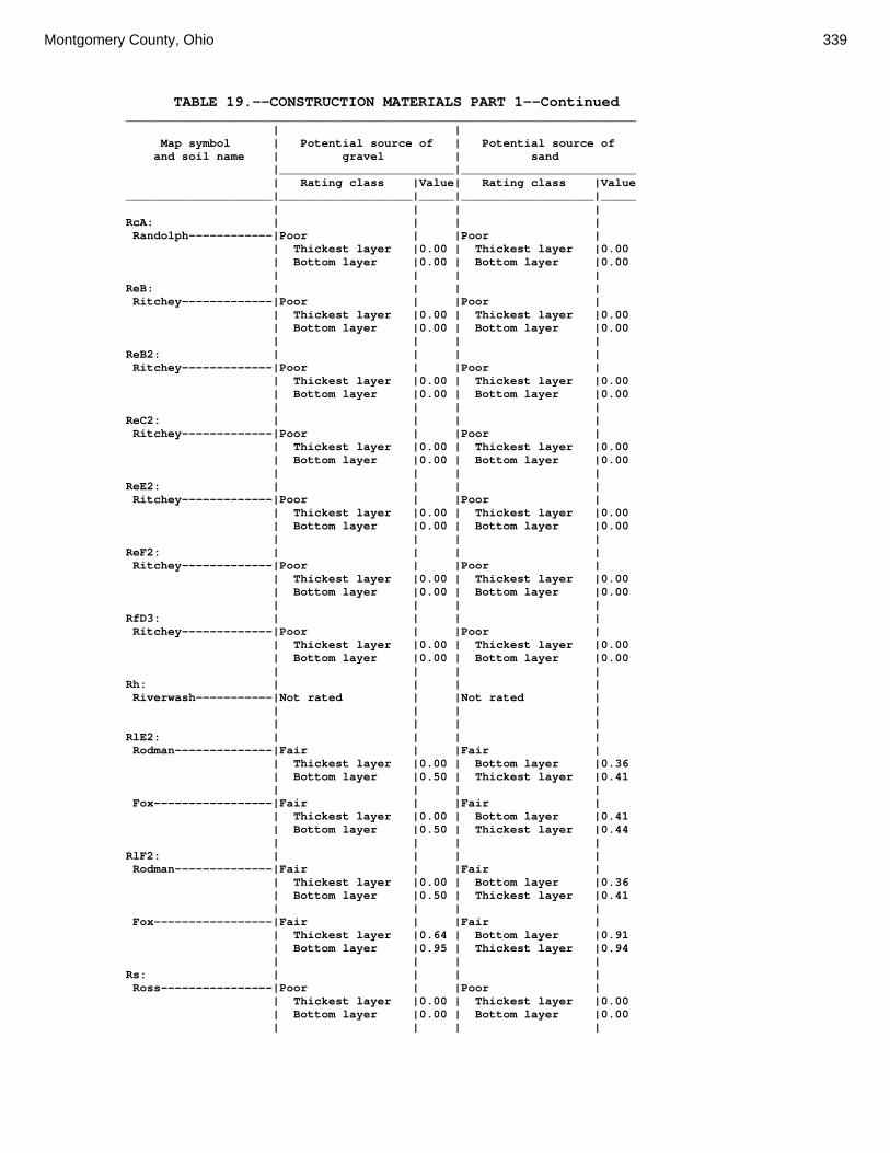
Montgomery County, Ohio 339
TABLE 19.--CONSTRUCTION MATERIALS PART 1--Continued _________________________________________________________________________ | | Map symbol | Potential source of | Potential source of and soil name | gravel | sand |_________________________|_________________________ | Rating class |Value| Rating class |Value _____________________|___________________|_____|___________________|_____ | | | | RcA: | | | | Randolph------------|Poor | |Poor | | Thickest layer |0.00 | Thickest layer |0.00 | Bottom layer |0.00 | Bottom layer |0.00 | | | | ReB: | | | | Ritchey-------------|Poor | |Poor | | Thickest layer |0.00 | Thickest layer |0.00 | Bottom layer |0.00 | Bottom layer |0.00 | | | | ReB2: | | | | Ritchey-------------|Poor | |Poor | | Thickest layer |0.00 | Thickest layer |0.00 | Bottom layer |0.00 | Bottom layer |0.00 | | | | ReC2: | | | | Ritchey-------------|Poor | |Poor | | Thickest layer |0.00 | Thickest layer |0.00 | Bottom layer |0.00 | Bottom layer |0.00 | | | | ReE2: | | | | Ritchey-------------|Poor | |Poor | | Thickest layer |0.00 | Thickest layer |0.00 | Bottom layer |0.00 | Bottom layer |0.00 | | | | ReF2: | | | | Ritchey-------------|Poor | |Poor | | Thickest layer |0.00 | Thickest layer |0.00 | Bottom layer |0.00 | Bottom layer |0.00 | | | | RfD3: | | | | Ritchey-------------|Poor | |Poor | | Thickest layer |0.00 | Thickest layer |0.00 | Bottom layer |0.00 | Bottom layer |0.00 | | | | Rh: | | | | Riverwash-----------|Not rated | |Not rated | | | | | | | | | RlE2: | | | | Rodman--------------|Fair | |Fair | | Thickest layer |0.00 | Bottom layer |0.36 | Bottom layer |0.50 | Thickest layer |0.41 | | | | Fox-----------------|Fair | |Fair | | Thickest layer |0.00 | Bottom layer |0.41 | Bottom layer |0.50 | Thickest layer |0.44 | | | | RlF2: | | | | Rodman--------------|Fair | |Fair | | Thickest layer |0.00 | Bottom layer |0.36 | Bottom layer |0.50 | Thickest layer |0.41 | | | | Fox-----------------|Fair | |Fair | | Thickest layer |0.64 | Bottom layer |0.91 | Bottom layer |0.95 | Thickest layer |0.94 | | | | Rs: | | | | Ross----------------|Poor | |Poor | | Thickest layer |0.00 | Thickest layer |0.00 | Bottom layer |0.00 | Bottom layer |0.00 | | | |

340 Soil Survey
TABLE 19.--CONSTRUCTION MATERIALS PART 1--Continued _________________________________________________________________________ | | Map symbol | Potential source of | Potential source of and soil name | gravel | sand |_________________________|_________________________ | Rating class |Value| Rating class |Value _____________________|___________________|_____|___________________|_____ | | | | Rt: | | | | Urban Land----------|Not rated | |Not rated | | | | | | | | | Ross----------------|Poor | |Poor | | Thickest layer |0.00 | Thickest layer |0.00 | Bottom layer |0.00 | Bottom layer |0.00 | | | | RuB: | | | | Russell-------------|Poor | |Poor | | Thickest layer |0.00 | Thickest layer |0.00 | Bottom layer |0.00 | Bottom layer |0.00 | | | | RvC2: | | | | Russell-------------|Poor | |Poor | | Thickest layer |0.00 | Thickest layer |0.00 | Bottom layer |0.00 | Bottom layer |0.00 | | | | Miamian-------------|Poor | |Poor | | Thickest layer |0.00 | Thickest layer |0.00 | Bottom layer |0.00 | Bottom layer |0.00 | | | | RvD2: | | | | Russell-------------|Poor | |Poor | | Thickest layer |0.00 | Thickest layer |0.00 | Bottom layer |0.00 | Bottom layer |0.00 | | | | Miamian-------------|Poor | |Poor | | Thickest layer |0.00 | Thickest layer |0.00 | Bottom layer |0.00 | Bottom layer |0.00 | | | | Sh: | | | | Shoals--------------|Poor | |Poor | | Thickest layer |0.00 | Thickest layer |0.00 | Bottom layer |0.00 | Bottom layer |0.00 | | | | So: | | | | Sloan---------------|Poor | |Poor | | Thickest layer |0.00 | Thickest layer |0.00 | Bottom layer |0.00 | Bottom layer |0.00 | | | | ThA: | | | | Thackery------------|Poor | |Poor | | Thickest layer |0.00 | Thickest layer |0.00 | Bottom layer |0.00 | Bottom layer |0.00 | | | | TpA: | | | | Tippecanoe----------|Fair | |Fair | | Thickest layer |0.00 | Thickest layer |0.00 | Bottom layer |0.50 | Bottom layer |0.36 | | | | Ua: | | | | Urban Land----------|Not rated | |Not rated | | | | | | | | | Ud: | | | | Udorthents----------|Not rated | |Not rated | | | | | | | | | Ug: | | | | Urban Land----------|Not rated | |Not rated | | | | | | | | |
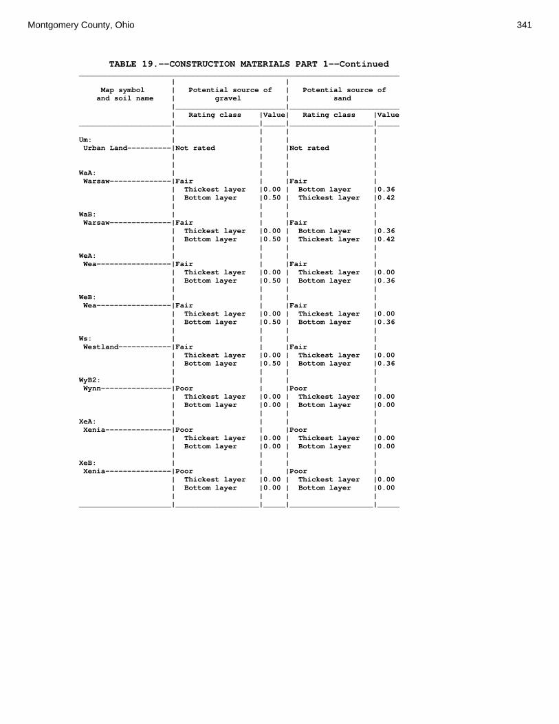
Montgomery County, Ohio 341
TABLE 19.--CONSTRUCTION MATERIALS PART 1--Continued _________________________________________________________________________ | | Map symbol | Potential source of | Potential source of and soil name | gravel | sand |_________________________|_________________________ | Rating class |Value| Rating class |Value _____________________|___________________|_____|___________________|_____ | | | | Um: | | | | Urban Land----------|Not rated | |Not rated | | | | | | | | | WaA: | | | | Warsaw--------------|Fair | |Fair | | Thickest layer |0.00 | Bottom layer |0.36 | Bottom layer |0.50 | Thickest layer |0.42 | | | | WaB: | | | | Warsaw--------------|Fair | |Fair | | Thickest layer |0.00 | Bottom layer |0.36 | Bottom layer |0.50 | Thickest layer |0.42 | | | | WeA: | | | | Wea-----------------|Fair | |Fair | | Thickest layer |0.00 | Thickest layer |0.00 | Bottom layer |0.50 | Bottom layer |0.36 | | | | WeB: | | | | Wea-----------------|Fair | |Fair | | Thickest layer |0.00 | Thickest layer |0.00 | Bottom layer |0.50 | Bottom layer |0.36 | | | | Ws: | | | | Westland------------|Fair | |Fair | | Thickest layer |0.00 | Thickest layer |0.00 | Bottom layer |0.50 | Bottom layer |0.36 | | | | WyB2: | | | | Wynn----------------|Poor | |Poor | | Thickest layer |0.00 | Thickest layer |0.00 | Bottom layer |0.00 | Bottom layer |0.00 | | | | XeA: | | | | Xenia---------------|Poor | |Poor | | Thickest layer |0.00 | Thickest layer |0.00 | Bottom layer |0.00 | Bottom layer |0.00 | | | | XeB: | | | | Xenia---------------|Poor | |Poor | | Thickest layer |0.00 | Thickest layer |0.00 | Bottom layer |0.00 | Bottom layer |0.00 | | | | _____________________|___________________|_____|___________________|_____

342 Soil Survey
TABLE 20.--CONSTRUCTION MATERIALS PART 2 (The information in this table indicates the dominant soil condition but does not eliminate the need for onsite investigation. The numbers in the value columns range from 0.00 to 0.99. The smaller the value, the greater the limitation. See text on page 169 for further explanation of ratings in this table.) ___________________________________________________________________________________________________ | | | Map symbol | Potential source of | Potential source of | Potential source of and soil name | reclamation material | roadfill | topsoil |_________________________|_________________________|_________________________ | Rating class and |Value| Rating class and |Value| Rating class and |Value | limiting features | | limiting features | | limiting features | _____________________|___________________|_____|___________________|_____|___________________|_____ | | | | | | Ag: | | | | | | Algiers-------------|Fair | |Poor | |Poor | | Low content of |0.68 | Depth to |0.00 | Depth to |0.00 | organic matter | | saturated zone | | saturated zone | | Water erosion |0.99 | Low strength |0.00 | | | | | Shrink-swell |0.87 | | | | | | | | Bo: | | | | | | Borrow Pits---------|Not rated | |Not rated | |Not rated | | | | | | | | | | | | | Bp: | | | | | | Brookston-----------|Fair | |Poor | |Poor | | Carbonate content|0.92 | Depth to |0.00 | Depth to |0.00 | | | saturated zone | | saturated zone | | | | Low strength |0.00 | | | | | | | | Br: | | | | | | Brookston-----------|Fair | |Poor | |Poor | | Carbonate content|0.92 | Depth to |0.00 | Depth to |0.00 | | | saturated zone | | saturated zone | | | | Low strength |0.00 | | | | | Shrink-swell |0.98 | | | | | | | | Bs: | | | | | | Brookston-----------|Fair | |Poor | |Poor | | Carbonate content|0.92 | Depth to |0.00 | Depth to |0.00 | | | saturated zone | | saturated zone | | | | Low strength |0.00 | | | | | | | | Bu: | | | | | | Brookston-----------|Fair | |Poor | |Poor | | Carbonate content|0.92 | Depth to |0.00 | Depth to |0.00 | | | saturated zone | | saturated zone | | | | Low strength |0.00 | | | | | | | | Urban Land----------|Not rated | |Not rated | |Not rated | | | | | | | | | | | | | Ca: | | | | | | Carlisle------------|Poor | |Poor | |Poor | | Wind erosion |0.00 | Depth to |0.00 | Depth to |0.00 | | | saturated zone | | saturated zone | | | | Low strength |0.00 | Hard to reclaim |0.00 | | | | | Content of |0.00 | | | | | organic matter | | | | | | | CeA: | | | | | | Celina--------------|Fair | |Poor | |Fair | | Too clayey |0.02 | Low strength |0.00 | Too clayey |0.01 | Carbonate content|0.08 | Depth to |0.76 | Hard to reclaim |0.54 | | | saturated zone | | | | Low content of |0.32 | | | Depth to |0.76 | organic matter | | | | saturated zone | | Water erosion |0.99 | | | | | | | | | |

Montgomery County, Ohio 343
TABLE 20.--CONSTRUCTION MATERIALS PART 2--Continued ___________________________________________________________________________________________________ | | | Map symbol | Potential source of | Potential source of | Potential source of and soil name | reclamation material | roadfill | topsoil |_________________________|_________________________|_________________________ | Rating class and |Value| Rating class and |Value| Rating class and |Value | limiting features | | limiting features | | limiting features | _____________________|___________________|_____|___________________|_____|___________________|_____ | | | | | | CeB: | | | | | | Celina--------------|Fair | |Poor | |Fair | | Too clayey |0.02 | Low strength |0.00 | Too clayey |0.01 | Carbonate content|0.08 | Depth to |0.76 | Hard to reclaim |0.54 | | | saturated zone | | | | Low content of |0.32 | | | Depth to |0.76 | organic matter | | | | saturated zone | | Water erosion |0.99 | | | | | | | | | | CeB2: | | | | | | Celina--------------|Fair | |Poor | |Fair | | Too clayey |0.02 | Low strength |0.00 | Too clayey |0.01 | Carbonate content|0.08 | Depth to |0.76 | Hard to reclaim |0.54 | | | saturated zone | | | | Low content of |0.32 | | | Depth to |0.76 | organic matter | | | | saturated zone | | Water erosion |0.99 | | | | | | | | | | ClB: | | | | | | Celina--------------|Fair | |Poor | |Fair | | Too clayey |0.02 | Low strength |0.00 | Too clayey |0.01 | Carbonate content|0.08 | Depth to |0.76 | Hard to reclaim |0.54 | | | saturated zone | | | | Low content of |0.32 | | | Depth to |0.76 | organic matter | | | | saturated zone | | Water erosion |0.99 | | | | | | | | | | CoA: | | | | | | Corwin--------------|Fair | |Poor | |Fair | | Low content of |0.50 | Low strength |0.00 | Depth to |0.76 | organic matter | | | | saturated zone | | Carbonate content|0.92 | Depth to |0.76 | Hard to reclaim |0.94 | | | saturated zone | | | | Water erosion |0.99 | | | | | | | | | | CoB: | | | | | | Corwin--------------|Fair | |Poor | |Fair | | Low content of |0.50 | Low strength |0.00 | Depth to |0.76 | organic matter | | | | saturated zone | | Carbonate content|0.92 | Depth to |0.76 | Hard to reclaim |0.94 | | | saturated zone | | | | Water erosion |0.99 | | | | | | | | | | CsA: | | | | | | Crosby--------------|Fair | |Poor | |Poor | | Too clayey |0.02 | Low strength |0.00 | Depth to |0.00 | | | | | saturated zone | | Low content of |0.12 | Depth to |0.00 | Too clayey |0.01 | organic matter | | saturated zone | | | | Carbonate content|0.68 | Shrink-swell |0.99 | Hard to reclaim |0.20 | Water erosion |0.90 | | | | | | | | | |

344 Soil Survey
TABLE 20.--CONSTRUCTION MATERIALS PART 2--Continued ___________________________________________________________________________________________________ | | | Map symbol | Potential source of | Potential source of | Potential source of and soil name | reclamation material | roadfill | topsoil |_________________________|_________________________|_________________________ | Rating class and |Value| Rating class and |Value| Rating class and |Value | limiting features | | limiting features | | limiting features | _____________________|___________________|_____|___________________|_____|___________________|_____ | | | | | | CtB: | | | | | | Crosby--------------|Fair | |Poor | |Poor | | Too clayey |0.02 | Low strength |0.00 | Depth to |0.00 | | | | | saturated zone | | Low content of |0.12 | Depth to |0.00 | Too clayey |0.01 | organic matter | | saturated zone | | | | Carbonate content|0.68 | Shrink-swell |0.99 | Hard to reclaim |0.20 | Water erosion |0.90 | | | | | | | | | | Celina--------------|Fair | |Poor | |Fair | | Too clayey |0.02 | Low strength |0.00 | Too clayey |0.01 | Carbonate content|0.08 | Depth to |0.76 | Hard to reclaim |0.54 | | | saturated zone | | | | Low content of |0.32 | | | Depth to |0.76 | organic matter | | | | saturated zone | | Water erosion |0.99 | | | | | | | | | | Cu: | | | | | | Crosby--------------|Fair | |Poor | |Poor | | Too clayey |0.02 | Low strength |0.00 | Depth to |0.00 | | | | | saturated zone | | Low content of |0.12 | Depth to |0.00 | Too clayey |0.01 | organic matter | | saturated zone | | | | Carbonate content|0.68 | Shrink-swell |0.99 | Hard to reclaim |0.20 | Water erosion |0.90 | | | | | | | | | | Urban Land----------|Not rated | |Not rated | |Not rated | | | | | | | | | | | | | DaB: | | | | | | Dana----------------|Fair | |Poor | |Fair | | Low content of |0.24 | Low strength |0.00 | Hard to reclaim |0.35 | organic matter | | | | | | Water erosion |0.90 | Depth to |0.76 | Too clayey |0.70 | | | saturated zone | | | | Carbonate content|0.92 | | | Depth to |0.76 | | | | | saturated zone | | Too clayey |0.98 | | | | | | | | | | FaE2: | | | | | | Fairmount-----------|Poor | |Poor | |Poor | | Depth to bedrock |0.00 | Depth to bedrock |0.00 | Depth to bedrock |0.00 | Droughty |0.00 | Low strength |0.00 | Slope |0.00 | Too clayey |0.00 | Slope |0.68 | Too clayey |0.00 | Low content of |0.88 | Shrink-swell |0.87 | Rock fragments |0.88 | organic matter | | | | | | Water erosion |0.99 | | | | | | | | | | FaF2: | | | | | | Fairmount-----------|Poor | |Poor | |Poor | | Droughty |0.00 | Depth to bedrock |0.00 | Slope |0.00 | Depth to bedrock |0.00 | Slope |0.00 | Depth to bedrock |0.00 | Too clayey |0.00 | Low strength |0.00 | Too clayey |0.00 | Low content of |0.88 | Shrink-swell |0.87 | Rock fragments |0.88 | organic matter | | | | | | Water erosion |0.99 | | | | FcA: | | | | | | Fincastle-----------|Fair | |Poor | |Poor | | Low content of |0.12 | Low strength |0.00 | Depth to |0.00 | organic matter | | | | saturated zone | | Carbonate content|0.68 | Depth to |0.00 | Hard to reclaim |0.99 | | | saturated zone | | | | Water erosion |0.99 | | | |

Montgomery County, Ohio 345
TABLE 20.--CONSTRUCTION MATERIALS PART 2--Continued ___________________________________________________________________________________________________ | | | Map symbol | Potential source of | Potential source of | Potential source of and soil name | reclamation material | roadfill | topsoil |_________________________|_________________________|_________________________ | Rating class and |Value| Rating class and |Value| Rating class and |Value | limiting features | | limiting features | | limiting features | _____________________|___________________|_____|___________________|_____|___________________|_____ | | | | | | FkA: | | | | | | Fox-----------------|Fair | |Poor | |Fair | | Low content of |0.12 | Low strength |0.00 | Rock fragments |0.50 | organic matter | | | | | | Carbonate content|0.68 | Shrink-swell |0.90 | Carbonate content|0.80 | Droughty |0.76 | | | | | | | | | | FkB: | | | | | | Fox-----------------|Fair | |Poor | |Fair | | Low content of |0.12 | Low strength |0.00 | Rock fragments |0.50 | organic matter | | | | | | Carbonate content|0.68 | Shrink-swell |0.90 | Carbonate content|0.80 | Droughty |0.76 | | | | | | | | | | FlA: | | | | | | Fox-----------------|Fair | |Poor | |Fair | | Low content of |0.12 | Low strength |0.00 | Rock fragments |0.50 | organic matter | | | | | | Carbonate content|0.68 | Shrink-swell |0.90 | Too clayey |0.55 | Droughty |0.76 | | | Carbonate content|0.80 | Too clayey |0.95 | | | | | Water erosion |0.99 | | | | | | | | | | FlB: | | | | | | Fox-----------------|Fair | |Poor | |Fair | | Low content of |0.12 | Low strength |0.00 | Rock fragments |0.50 | organic matter | | | | | | Carbonate content|0.68 | Shrink-swell |0.90 | Too clayey |0.55 | Droughty |0.76 | | | Carbonate content|0.80 | Too clayey |0.95 | | | | | Water erosion |0.99 | | | | | | | | | | FlC2: | | | | | | Fox-----------------|Fair | |Poor | |Fair | | Droughty |0.11 | Low strength |0.00 | Rock fragments |0.50 | Low content of |0.12 | | | Too clayey |0.55 | organic matter | | | | | | Carbonate content|0.68 | | | Carbonate content|0.80 | Too clayey |0.95 | | | Slope |0.96 | Water erosion |0.99 | | | | | | | | | | FmA: | | | | | | Fox-----------------|Fair | |Poor | |Fair | | Low content of |0.12 | Low strength |0.00 | Rock fragments |0.50 | organic matter | | | | | | Carbonate content|0.68 | Shrink-swell |0.90 | Too clayey |0.55 | Droughty |0.76 | | | Carbonate content|0.80 | Too clayey |0.95 | | | | | Water erosion |0.99 | | | | | | | | | | FmB: | | | | | | Fox-----------------|Fair | |Poor | |Fair | | Low content of |0.12 | Low strength |0.00 | Rock fragments |0.50 | organic matter | | | | | | Carbonate content|0.68 | Shrink-swell |0.90 | Too clayey |0.55 | Droughty |0.76 | | | Carbonate content|0.80 | Too clayey |0.95 | | | | | Water erosion |0.99 | | | | | | | | | |

346 Soil Survey
TABLE 20.--CONSTRUCTION MATERIALS PART 2--Continued ___________________________________________________________________________________________________ | | | Map symbol | Potential source of | Potential source of | Potential source of and soil name | reclamation material | roadfill | topsoil |_________________________|_________________________|_________________________ | Rating class and |Value| Rating class and |Value| Rating class and |Value | limiting features | | limiting features | | limiting features | _____________________|___________________|_____|___________________|_____|___________________|_____ | | | | | | FmC2: | | | | | | Fox-----------------|Fair | |Poor | |Fair | | Droughty |0.11 | Low strength |0.00 | Rock fragments |0.50 | Low content of |0.12 | | | Too clayey |0.55 | organic matter | | | | | | Carbonate content|0.68 | | | Carbonate content|0.80 | Too clayey |0.95 | | | Slope |0.96 | Water erosion |0.99 | | | | | | | | | | FmD2: | | | | | | Fox-----------------|Fair | |Poor | |Poor | | Droughty |0.11 | Low strength |0.00 | Slope |0.00 | Low content of |0.12 | | | Rock fragments |0.50 | organic matter | | | | | | Carbonate content|0.68 | | | Too clayey |0.55 | Too clayey |0.95 | | | Carbonate content|0.80 | Water erosion |0.99 | | | | | | | | | | FsC3: | | | | | | Fox-----------------|Poor | |Poor | |Fair | | Droughty |0.00 | Low strength |0.00 | Rock fragments |0.50 | Low content of |0.12 | Shrink-swell |0.87 | Too clayey |0.55 | organic matter | | | | | | Carbonate content|0.68 | | | Carbonate content|0.80 | Too clayey |0.95 | | | Slope |0.96 | | | | | | FuB: | | | | | | Fox-----------------|Fair | |Poor | |Fair | | Low content of |0.12 | Low strength |0.00 | Rock fragments |0.50 | organic matter | | | | | | Carbonate content|0.68 | Shrink-swell |0.90 | Too clayey |0.55 | Droughty |0.76 | | | Carbonate content|0.80 | Too clayey |0.95 | | | | | Water erosion |0.99 | | | | | | | | | | Urban Land----------|Not rated | |Not rated | |Not rated | | | | | | | | | | | | | FuC: | | | | | | Urban Land----------|Not rated | |Not rated | |Not rated | | | | | | | | | | | | | Fox-----------------|Fair | |Poor | |Fair | | Droughty |0.11 | Low strength |0.00 | Rock fragments |0.50 | Low content of |0.12 | | | Too clayey |0.55 | organic matter | | | | | | Carbonate content|0.68 | | | Carbonate content|0.80 | Too clayey |0.95 | | | Slope |0.96 | Water erosion |0.99 | | | | | | | | | | FuF: | | | | | | Urban Land----------|Not rated | |Not rated | |Not rated | | | | | | | | | | | | | Fox-----------------|Poor | |Poor | |Poor | | Droughty |0.00 | Low strength |0.00 | Slope |0.00 | Low content of |0.12 | Slope |0.00 | Rock fragments |0.50 | organic matter | | | | | | Carbonate content|0.68 | Shrink-swell |0.87 | Too clayey |0.55 | Too clayey |0.95 | | | Carbonate content|0.80 | Water erosion |0.99 | | | | | | | | | |

Montgomery County, Ohio 347
TABLE 20.--CONSTRUCTION MATERIALS PART 2--Continued ___________________________________________________________________________________________________ | | | Map symbol | Potential source of | Potential source of | Potential source of and soil name | reclamation material | roadfill | topsoil |_________________________|_________________________|_________________________ | Rating class and |Value| Rating class and |Value| Rating class and |Value | limiting features | | limiting features | | limiting features | _____________________|___________________|_____|___________________|_____|___________________|_____ | | | | | | Gp: | | | | | | Gravel Pits---------|Not rated | |Not rated | |Not rated | | | | | | | | | | | | | HeE2: | | | | | | Hennepin------------|Fair | |Poor | |Poor | | Low content of |0.12 | Low strength |0.00 | Slope |0.00 | organic matter | | | | | | Carbonate content|0.46 | Slope |0.18 | Hard to reclaim |0.00 | Droughty |0.99 | | | Carbonate content|0.46 | | | | | Rock fragments |0.88 | | | | | | Miamian-------------|Fair | |Poor | |Poor | | Too clayey |0.02 | Low strength |0.00 | Slope |0.00 | Carbonate content|0.08 | Slope |0.18 | Too clayey |0.01 | Low content of |0.18 | | | Hard to reclaim |0.16 | organic matter | | | | | | Water erosion |0.99 | | | | | | | | | | HeF2: | | | | | | Hennepin------------|Fair | |Poor | |Poor | | Low content of |0.12 | Slope |0.00 | Slope |0.00 | organic matter | | | | | | Carbonate content|0.46 | Low strength |0.00 | Hard to reclaim |0.00 | Droughty |0.99 | | | Carbonate content|0.46 | | | | | Rock fragments |0.88 | | | | | | Miamian-------------|Fair | |Poor | |Poor | | Too clayey |0.02 | Slope |0.00 | Slope |0.00 | Carbonate content|0.08 | Low strength |0.00 | Too clayey |0.01 | Low content of |0.18 | | | Hard to reclaim |0.16 | organic matter | | | | | | Water erosion |0.99 | | | | | | | | | | HmF3: | | | | | | Hennepin------------|Fair | |Poor | |Poor | | Low content of |0.12 | Low strength |0.00 | Slope |0.00 | organic matter | | | | | | Carbonate content|0.46 | Slope |0.00 | Hard to reclaim |0.00 | Droughty |0.91 | | | Carbonate content|0.46 | | | | | Rock fragments |0.88 | | | | | | Miamian-------------|Fair | |Poor | |Poor | | Too clayey |0.02 | Low strength |0.00 | Slope |0.00 | Carbonate content|0.08 | Slope |0.00 | Hard to reclaim |0.01 | Low content of |0.75 | | | Too clayey |0.02 | organic matter | | | | | | Water erosion |0.99 | | | | | | | | | | KeA: | | | | | | Kendallville--------|Fair | |Poor | |Good | | Low content of |0.05 | Low strength |0.00 | | | organic matter | | | | | | Carbonate content|0.16 | | | | | Water erosion |0.99 | | | | | | | | | | KeB: | | | | | | Kendallville--------|Fair | |Poor | |Fair | | Low content of |0.05 | Low strength |0.00 | Too acid |0.98 | organic matter | | | | | | Carbonate content|0.16 | | | | | Water erosion |0.99 | | | | | | | | | |
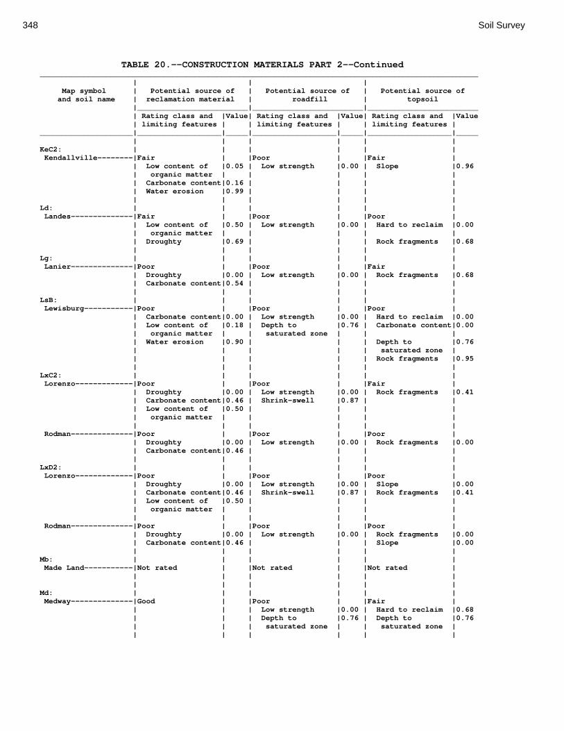
348 Soil Survey
TABLE 20.--CONSTRUCTION MATERIALS PART 2--Continued ___________________________________________________________________________________________________ | | | Map symbol | Potential source of | Potential source of | Potential source of and soil name | reclamation material | roadfill | topsoil |_________________________|_________________________|_________________________ | Rating class and |Value| Rating class and |Value| Rating class and |Value | limiting features | | limiting features | | limiting features | _____________________|___________________|_____|___________________|_____|___________________|_____ | | | | | | KeC2: | | | | | | Kendallville--------|Fair | |Poor | |Fair | | Low content of |0.05 | Low strength |0.00 | Slope |0.96 | organic matter | | | | | | Carbonate content|0.16 | | | | | Water erosion |0.99 | | | | | | | | | | Ld: | | | | | | Landes--------------|Fair | |Poor | |Poor | | Low content of |0.50 | Low strength |0.00 | Hard to reclaim |0.00 | organic matter | | | | | | Droughty |0.69 | | | Rock fragments |0.68 | | | | | | Lg: | | | | | | Lanier--------------|Poor | |Poor | |Fair | | Droughty |0.00 | Low strength |0.00 | Rock fragments |0.68 | Carbonate content|0.54 | | | | | | | | | | LsB: | | | | | | Lewisburg-----------|Poor | |Poor | |Poor | | Carbonate content|0.00 | Low strength |0.00 | Hard to reclaim |0.00 | Low content of |0.18 | Depth to |0.76 | Carbonate content|0.00 | organic matter | | saturated zone | | | | Water erosion |0.90 | | | Depth to |0.76 | | | | | saturated zone | | | | | | Rock fragments |0.95 | | | | | | LxC2: | | | | | | Lorenzo-------------|Poor | |Poor | |Fair | | Droughty |0.00 | Low strength |0.00 | Rock fragments |0.41 | Carbonate content|0.46 | Shrink-swell |0.87 | | | Low content of |0.50 | | | | | organic matter | | | | | | | | | | | Rodman--------------|Poor | |Poor | |Poor | | Droughty |0.00 | Low strength |0.00 | Rock fragments |0.00 | Carbonate content|0.46 | | | | | | | | | | LxD2: | | | | | | Lorenzo-------------|Poor | |Poor | |Poor | | Droughty |0.00 | Low strength |0.00 | Slope |0.00 | Carbonate content|0.46 | Shrink-swell |0.87 | Rock fragments |0.41 | Low content of |0.50 | | | | | organic matter | | | | | | | | | | | Rodman--------------|Poor | |Poor | |Poor | | Droughty |0.00 | Low strength |0.00 | Rock fragments |0.00 | Carbonate content|0.46 | | | Slope |0.00 | | | | | | Mb: | | | | | | Made Land-----------|Not rated | |Not rated | |Not rated | | | | | | | | | | | | | Md: | | | | | | Medway--------------|Good | |Poor | |Fair | | | | Low strength |0.00 | Hard to reclaim |0.68 | | | Depth to |0.76 | Depth to |0.76 | | | saturated zone | | saturated zone | | | | | | |

Montgomery County, Ohio 349
TABLE 20.--CONSTRUCTION MATERIALS PART 2--Continued ___________________________________________________________________________________________________ | | | Map symbol | Potential source of | Potential source of | Potential source of and soil name | reclamation material | roadfill | topsoil |_________________________|_________________________|_________________________ | Rating class and |Value| Rating class and |Value| Rating class and |Value | limiting features | | limiting features | | limiting features | _____________________|___________________|_____|___________________|_____|___________________|_____ | | | | | | MlA: | | | | | | Miamian-------------|Fair | |Poor | |Fair | | Too clayey |0.02 | Low strength |0.00 | Too clayey |0.01 | Carbonate content|0.08 | | | Hard to reclaim |0.10 | Low content of |0.18 | | | | | organic matter | | | | | | Water erosion |0.99 | | | | | | | | | | MlB: | | | | | | Miamian-------------|Fair | |Poor | |Fair | | Too clayey |0.02 | Low strength |0.00 | Too clayey |0.01 | Carbonate content|0.08 | | | Hard to reclaim |0.10 | Low content of |0.18 | | | | | organic matter | | | | | | Water erosion |0.99 | | | | | | | | | | MlB2: | | | | | | Miamian-------------|Fair | |Poor | |Fair | | Too clayey |0.02 | Low strength |0.00 | Too clayey |0.01 | Carbonate content|0.08 | | | Hard to reclaim |0.10 | Low content of |0.18 | | | | | organic matter | | | | | | Water erosion |0.99 | | | | | | | | | | MlC2: | | | | | | Miamian-------------|Fair | |Poor | |Fair | | Too clayey |0.02 | Low strength |0.00 | Too clayey |0.01 | Carbonate content|0.08 | | | Hard to reclaim |0.10 | Low content of |0.18 | | | Slope |0.96 | organic matter | | | | | | Water erosion |0.99 | | | | | | | | | | MlD2: | | | | | | Miamian-------------|Fair | |Poor | |Poor | | Carbonate content|0.08 | Low strength |0.00 | Slope |0.00 | Low content of |0.18 | | | Hard to reclaim |0.01 | organic matter | | | | | | Water erosion |0.99 | | | Carbonate content|0.08 | | | | | Rock fragments |0.72 | | | | | | MmB: | | | | | | Miamian-------------|Fair | |Poor | |Fair | | Too clayey |0.02 | Low strength |0.00 | Too clayey |0.01 | Carbonate content|0.08 | | | Hard to reclaim |0.10 | Low content of |0.18 | | | | | organic matter | | | | | | Water erosion |0.99 | | | | | | | | | | MnB3: | | | | | | Miamian-------------|Fair | |Poor | |Fair | | Carbonate content|0.08 | Low strength |0.00 | Hard to reclaim |0.03 | Low content of |0.18 | | | Carbonate content|0.08 | organic matter | | | | | | Water erosion |0.99 | | | Rock fragments |0.72 | | | | | | MnC3: | | | | | | Miamian-------------|Fair | |Poor | |Fair | | Carbonate content|0.08 | Low strength |0.00 | Hard to reclaim |0.03 | Low content of |0.18 | | | Carbonate content|0.08 | organic matter | | | | | | Water erosion |0.99 | | | Rock fragments |0.72 | | | | | Slope |0.96 | | | | | |
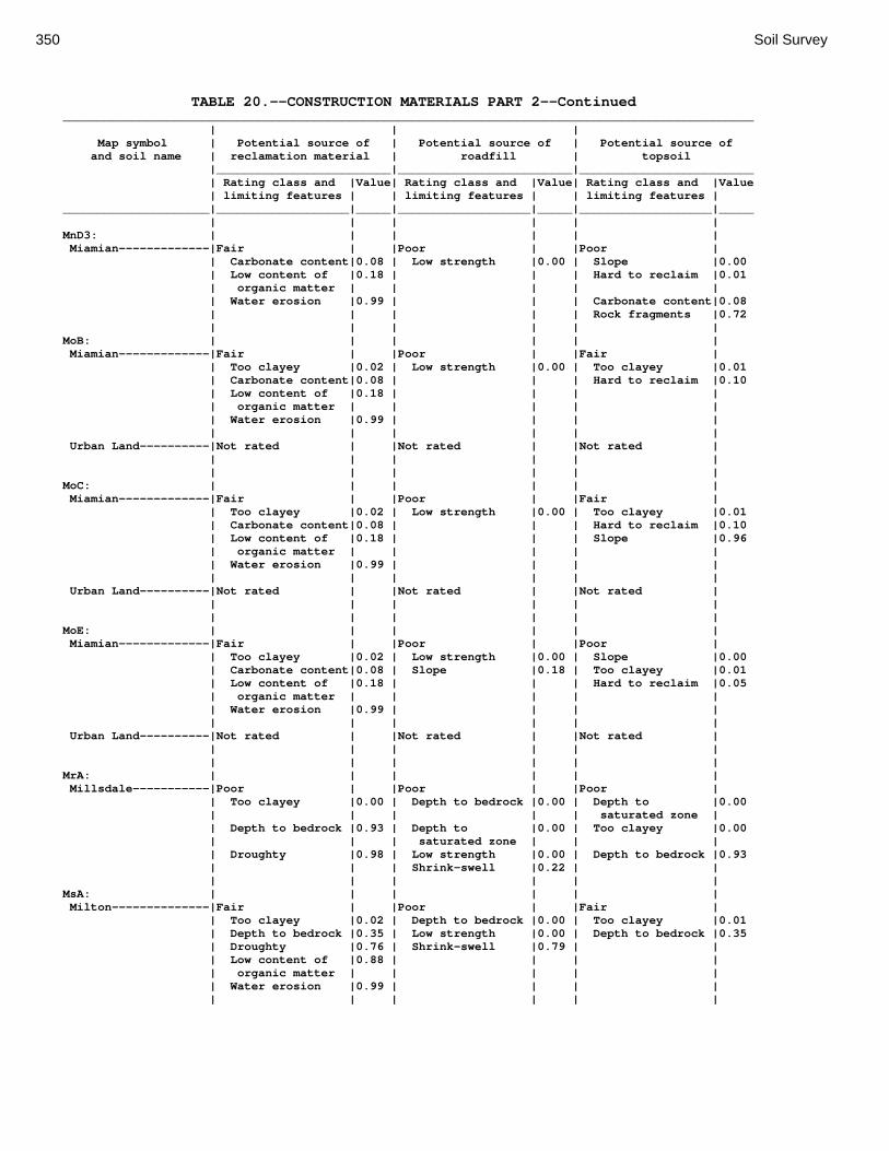
350 Soil Survey
TABLE 20.--CONSTRUCTION MATERIALS PART 2--Continued ___________________________________________________________________________________________________ | | | Map symbol | Potential source of | Potential source of | Potential source of and soil name | reclamation material | roadfill | topsoil |_________________________|_________________________|_________________________ | Rating class and |Value| Rating class and |Value| Rating class and |Value | limiting features | | limiting features | | limiting features | _____________________|___________________|_____|___________________|_____|___________________|_____ | | | | | | MnD3: | | | | | | Miamian-------------|Fair | |Poor | |Poor | | Carbonate content|0.08 | Low strength |0.00 | Slope |0.00 | Low content of |0.18 | | | Hard to reclaim |0.01 | organic matter | | | | | | Water erosion |0.99 | | | Carbonate content|0.08 | | | | | Rock fragments |0.72 | | | | | | MoB: | | | | | | Miamian-------------|Fair | |Poor | |Fair | | Too clayey |0.02 | Low strength |0.00 | Too clayey |0.01 | Carbonate content|0.08 | | | Hard to reclaim |0.10 | Low content of |0.18 | | | | | organic matter | | | | | | Water erosion |0.99 | | | | | | | | | | Urban Land----------|Not rated | |Not rated | |Not rated | | | | | | | | | | | | | MoC: | | | | | | Miamian-------------|Fair | |Poor | |Fair | | Too clayey |0.02 | Low strength |0.00 | Too clayey |0.01 | Carbonate content|0.08 | | | Hard to reclaim |0.10 | Low content of |0.18 | | | Slope |0.96 | organic matter | | | | | | Water erosion |0.99 | | | | | | | | | | Urban Land----------|Not rated | |Not rated | |Not rated | | | | | | | | | | | | | MoE: | | | | | | Miamian-------------|Fair | |Poor | |Poor | | Too clayey |0.02 | Low strength |0.00 | Slope |0.00 | Carbonate content|0.08 | Slope |0.18 | Too clayey |0.01 | Low content of |0.18 | | | Hard to reclaim |0.05 | organic matter | | | | | | Water erosion |0.99 | | | | | | | | | | Urban Land----------|Not rated | |Not rated | |Not rated | | | | | | | | | | | | | MrA: | | | | | | Millsdale-----------|Poor | |Poor | |Poor | | Too clayey |0.00 | Depth to bedrock |0.00 | Depth to |0.00 | | | | | saturated zone | | Depth to bedrock |0.93 | Depth to |0.00 | Too clayey |0.00 | | | saturated zone | | | | Droughty |0.98 | Low strength |0.00 | Depth to bedrock |0.93 | | | Shrink-swell |0.22 | | | | | | | | MsA: | | | | | | Milton--------------|Fair | |Poor | |Fair | | Too clayey |0.02 | Depth to bedrock |0.00 | Too clayey |0.01 | Depth to bedrock |0.35 | Low strength |0.00 | Depth to bedrock |0.35 | Droughty |0.76 | Shrink-swell |0.79 | | | Low content of |0.88 | | | | | organic matter | | | | | | Water erosion |0.99 | | | | | | | | | |

Montgomery County, Ohio 351
TABLE 20.--CONSTRUCTION MATERIALS PART 2--Continued ___________________________________________________________________________________________________ | | | Map symbol | Potential source of | Potential source of | Potential source of and soil name | reclamation material | roadfill | topsoil |_________________________|_________________________|_________________________ | Rating class and |Value| Rating class and |Value| Rating class and |Value | limiting features | | limiting features | | limiting features | _____________________|___________________|_____|___________________|_____|___________________|_____ | | | | | | MsB: | | | | | | Milton--------------|Fair | |Poor | |Fair | | Too clayey |0.02 | Depth to bedrock |0.00 | Too clayey |0.01 | Depth to bedrock |0.35 | Low strength |0.00 | Depth to bedrock |0.35 | Droughty |0.76 | Shrink-swell |0.79 | | | Low content of |0.88 | | | | | organic matter | | | | | | Water erosion |0.99 | | | | | | | | | | MsB2: | | | | | | Milton--------------|Fair | |Poor | |Fair | | Too clayey |0.02 | Depth to bedrock |0.00 | Too clayey |0.01 | Depth to bedrock |0.16 | Low strength |0.00 | Depth to bedrock |0.16 | Droughty |0.52 | Shrink-swell |0.87 | | | Low content of |0.82 | | | | | organic matter | | | | | | Water erosion |0.99 | | | | | | | | | | MsC2: | | | | | | Milton--------------|Fair | |Poor | |Fair | | Too clayey |0.02 | Depth to bedrock |0.00 | Too clayey |0.01 | Depth to bedrock |0.16 | Low strength |0.00 | Depth to bedrock |0.16 | Droughty |0.48 | Shrink-swell |0.75 | Slope |0.96 | Low content of |0.82 | | | | | organic matter | | | | | | Water erosion |0.99 | | | | | | | | | | MsD2: | | | | | | Milton--------------|Fair | |Poor | |Poor | | Too clayey |0.02 | Depth to bedrock |0.00 | Slope |0.00 | Depth to bedrock |0.10 | Low strength |0.00 | Too clayey |0.01 | Droughty |0.40 | Shrink-swell |0.74 | Depth to bedrock |0.10 | Low content of |0.75 | | | | | organic matter | | | | | | Water erosion |0.99 | | | | | | | | | | MtD3: | | | | | | Milton--------------|Fair | |Poor | |Fair | | Too clayey |0.02 | Depth to bedrock |0.00 | Too clayey |0.01 | Depth to bedrock |0.05 | Low strength |0.00 | Depth to bedrock |0.05 | Droughty |0.17 | Shrink-swell |0.74 | Slope |0.37 | Low content of |0.75 | | | | | organic matter | | | | | | Water erosion |0.99 | | | | | | | | | | MuB: | | | | | | Milton--------------|Fair | |Poor | |Fair | | Too clayey |0.02 | Depth to bedrock |0.00 | Too clayey |0.01 | Depth to bedrock |0.35 | Low strength |0.00 | Depth to bedrock |0.35 | Low content of |0.82 | Shrink-swell |0.79 | | | organic matter | | | | | | Droughty |0.83 | | | | | Water erosion |0.99 | | | | | | | | | | Urban Land----------|Not rated | |Not rated | |Not rated | | | | | | | | | | | | |

352 Soil Survey
TABLE 20.--CONSTRUCTION MATERIALS PART 2--Continued ___________________________________________________________________________________________________ | | | Map symbol | Potential source of | Potential source of | Potential source of and soil name | reclamation material | roadfill | topsoil |_________________________|_________________________|_________________________ | Rating class and |Value| Rating class and |Value| Rating class and |Value | limiting features | | limiting features | | limiting features | _____________________|___________________|_____|___________________|_____|___________________|_____ | | | | | | MuC: | | | | | | Milton--------------|Fair | |Poor | |Fair | | Too clayey |0.02 | Depth to bedrock |0.00 | Too clayey |0.01 | Depth to bedrock |0.35 | Low strength |0.00 | Depth to bedrock |0.35 | Droughty |0.82 | Shrink-swell |0.79 | Slope |0.96 | Low content of |0.82 | | | | | organic matter | | | | | | Water erosion |0.99 | | | | | | | | | | Urban Land----------|Not rated | |Not rated | |Not rated | | | | | | | | | | | | | MuD: | | | | | | Milton--------------|Fair | |Poor | |Poor | | Too clayey |0.02 | Depth to bedrock |0.00 | Slope |0.00 | Depth to bedrock |0.35 | Low strength |0.00 | Too clayey |0.01 | Droughty |0.76 | Shrink-swell |0.87 | Depth to bedrock |0.35 | Low content of |0.82 | | | | | organic matter | | | | | | Water erosion |0.99 | | | | | | | | | | Urban Land----------|Not rated | |Not rated | |Not rated | | | | | | | | | | | | | Mv: | | | | | | Montgomery----------|Poor | |Poor | |Poor | | Too clayey |0.00 | Depth to |0.00 | Too clayey |0.00 | | | saturated zone | | | | Low content of |0.12 | Low strength |0.00 | Depth to |0.00 | organic matter | | | | saturated zone | | Carbonate content|0.92 | Shrink-swell |0.12 | | | Water erosion |0.99 | | | | | | | | | | OcA: | | | | | | Ockley--------------|Fair | |Poor | |Good | | Low content of |0.12 | Low strength |0.00 | | | organic matter | | | | | | Carbonate content|0.68 | Shrink-swell |0.91 | | | Water erosion |0.99 | | | | | | | | | | OcB: | | | | | | Ockley--------------|Fair | |Poor | |Good | | Low content of |0.12 | Low strength |0.00 | | | organic matter | | | | | | Carbonate content|0.68 | Shrink-swell |0.91 | | | Water erosion |0.99 | | | | | | | | | | PlB: | | | | | | Plattville----------|Fair | |Poor | |Fair | | Depth to bedrock |0.29 | Depth to bedrock |0.00 | Depth to bedrock |0.29 | Droughty |0.75 | Low strength |0.00 | | | Low content of |0.88 | Shrink-swell |0.72 | | | organic matter | | | | | | | | | | | PlC: | | | | | | Plattville----------|Fair | |Poor | |Fair | | Depth to bedrock |0.29 | Depth to bedrock |0.00 | Depth to bedrock |0.29 | Low content of |0.50 | Low strength |0.00 | Slope |0.96 | organic matter | | | | | | Droughty |0.81 | Shrink-swell |0.72 | | | | | | | |
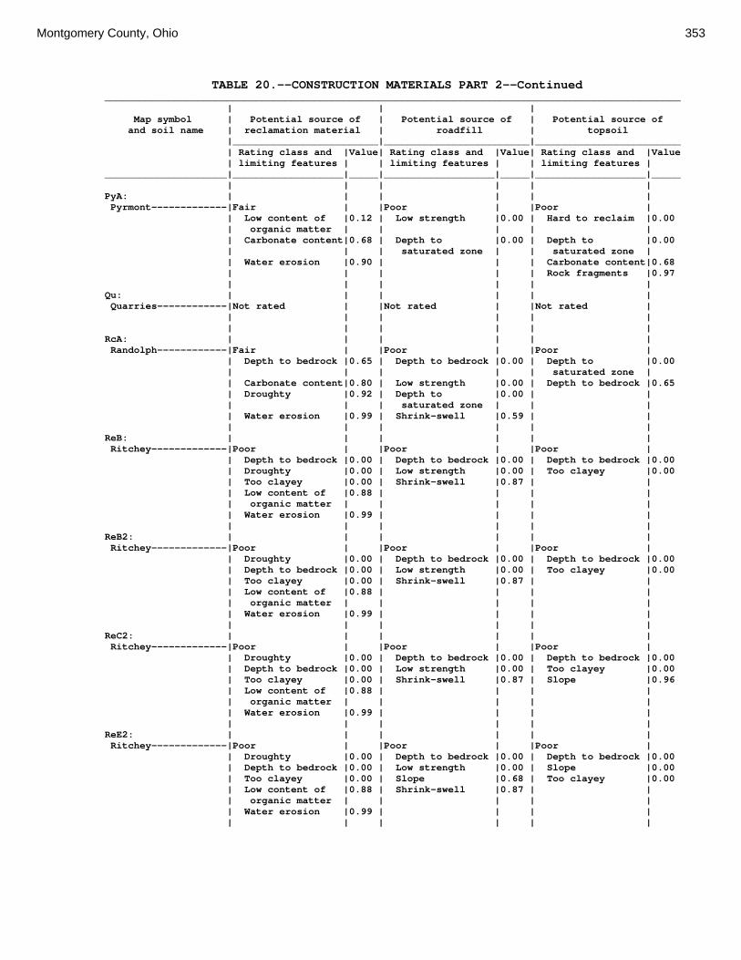
Montgomery County, Ohio 353
TABLE 20.--CONSTRUCTION MATERIALS PART 2--Continued ___________________________________________________________________________________________________ | | | Map symbol | Potential source of | Potential source of | Potential source of and soil name | reclamation material | roadfill | topsoil |_________________________|_________________________|_________________________ | Rating class and |Value| Rating class and |Value| Rating class and |Value | limiting features | | limiting features | | limiting features | _____________________|___________________|_____|___________________|_____|___________________|_____ | | | | | | PyA: | | | | | | Pyrmont-------------|Fair | |Poor | |Poor | | Low content of |0.12 | Low strength |0.00 | Hard to reclaim |0.00 | organic matter | | | | | | Carbonate content|0.68 | Depth to |0.00 | Depth to |0.00 | | | saturated zone | | saturated zone | | Water erosion |0.90 | | | Carbonate content|0.68 | | | | | Rock fragments |0.97 | | | | | | Qu: | | | | | | Quarries------------|Not rated | |Not rated | |Not rated | | | | | | | | | | | | | RcA: | | | | | | Randolph------------|Fair | |Poor | |Poor | | Depth to bedrock |0.65 | Depth to bedrock |0.00 | Depth to |0.00 | | | | | saturated zone | | Carbonate content|0.80 | Low strength |0.00 | Depth to bedrock |0.65 | Droughty |0.92 | Depth to |0.00 | | | | | saturated zone | | | | Water erosion |0.99 | Shrink-swell |0.59 | | | | | | | | ReB: | | | | | | Ritchey-------------|Poor | |Poor | |Poor | | Depth to bedrock |0.00 | Depth to bedrock |0.00 | Depth to bedrock |0.00 | Droughty |0.00 | Low strength |0.00 | Too clayey |0.00 | Too clayey |0.00 | Shrink-swell |0.87 | | | Low content of |0.88 | | | | | organic matter | | | | | | Water erosion |0.99 | | | | | | | | | | ReB2: | | | | | | Ritchey-------------|Poor | |Poor | |Poor | | Droughty |0.00 | Depth to bedrock |0.00 | Depth to bedrock |0.00 | Depth to bedrock |0.00 | Low strength |0.00 | Too clayey |0.00 | Too clayey |0.00 | Shrink-swell |0.87 | | | Low content of |0.88 | | | | | organic matter | | | | | | Water erosion |0.99 | | | | | | | | | | ReC2: | | | | | | Ritchey-------------|Poor | |Poor | |Poor | | Droughty |0.00 | Depth to bedrock |0.00 | Depth to bedrock |0.00 | Depth to bedrock |0.00 | Low strength |0.00 | Too clayey |0.00 | Too clayey |0.00 | Shrink-swell |0.87 | Slope |0.96 | Low content of |0.88 | | | | | organic matter | | | | | | Water erosion |0.99 | | | | | | | | | | ReE2: | | | | | | Ritchey-------------|Poor | |Poor | |Poor | | Droughty |0.00 | Depth to bedrock |0.00 | Depth to bedrock |0.00 | Depth to bedrock |0.00 | Low strength |0.00 | Slope |0.00 | Too clayey |0.00 | Slope |0.68 | Too clayey |0.00 | Low content of |0.88 | Shrink-swell |0.87 | | | organic matter | | | | | | Water erosion |0.99 | | | | | | | | | |
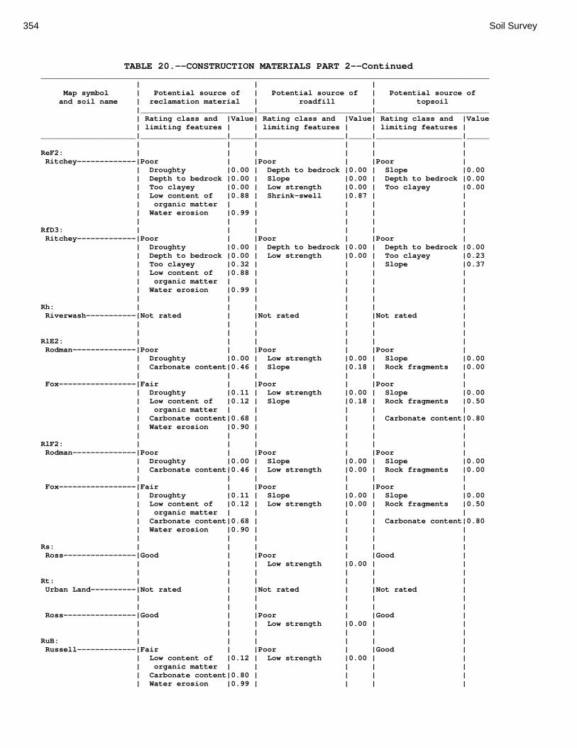
354 Soil Survey
TABLE 20.--CONSTRUCTION MATERIALS PART 2--Continued ___________________________________________________________________________________________________ | | | Map symbol | Potential source of | Potential source of | Potential source of and soil name | reclamation material | roadfill | topsoil |_________________________|_________________________|_________________________ | Rating class and |Value| Rating class and |Value| Rating class and |Value | limiting features | | limiting features | | limiting features | _____________________|___________________|_____|___________________|_____|___________________|_____ | | | | | | ReF2: | | | | | | Ritchey-------------|Poor | |Poor | |Poor | | Droughty |0.00 | Depth to bedrock |0.00 | Slope |0.00 | Depth to bedrock |0.00 | Slope |0.00 | Depth to bedrock |0.00 | Too clayey |0.00 | Low strength |0.00 | Too clayey |0.00 | Low content of |0.88 | Shrink-swell |0.87 | | | organic matter | | | | | | Water erosion |0.99 | | | | | | | | | | RfD3: | | | | | | Ritchey-------------|Poor | |Poor | |Poor | | Droughty |0.00 | Depth to bedrock |0.00 | Depth to bedrock |0.00 | Depth to bedrock |0.00 | Low strength |0.00 | Too clayey |0.23 | Too clayey |0.32 | | | Slope |0.37 | Low content of |0.88 | | | | | organic matter | | | | | | Water erosion |0.99 | | | | | | | | | | Rh: | | | | | | Riverwash-----------|Not rated | |Not rated | |Not rated | | | | | | | | | | | | | RlE2: | | | | | | Rodman--------------|Poor | |Poor | |Poor | | Droughty |0.00 | Low strength |0.00 | Slope |0.00 | Carbonate content|0.46 | Slope |0.18 | Rock fragments |0.00 | | | | | | Fox-----------------|Fair | |Poor | |Poor | | Droughty |0.11 | Low strength |0.00 | Slope |0.00 | Low content of |0.12 | Slope |0.18 | Rock fragments |0.50 | organic matter | | | | | | Carbonate content|0.68 | | | Carbonate content|0.80 | Water erosion |0.90 | | | | | | | | | | RlF2: | | | | | | Rodman--------------|Poor | |Poor | |Poor | | Droughty |0.00 | Slope |0.00 | Slope |0.00 | Carbonate content|0.46 | Low strength |0.00 | Rock fragments |0.00 | | | | | | Fox-----------------|Fair | |Poor | |Poor | | Droughty |0.11 | Slope |0.00 | Slope |0.00 | Low content of |0.12 | Low strength |0.00 | Rock fragments |0.50 | organic matter | | | | | | Carbonate content|0.68 | | | Carbonate content|0.80 | Water erosion |0.90 | | | | | | | | | | Rs: | | | | | | Ross----------------|Good | |Poor | |Good | | | | Low strength |0.00 | | | | | | | | Rt: | | | | | | Urban Land----------|Not rated | |Not rated | |Not rated | | | | | | | | | | | | | Ross----------------|Good | |Poor | |Good | | | | Low strength |0.00 | | | | | | | | RuB: | | | | | | Russell-------------|Fair | |Poor | |Good | | Low content of |0.12 | Low strength |0.00 | | | organic matter | | | | | | Carbonate content|0.80 | | | | | Water erosion |0.99 | | | |
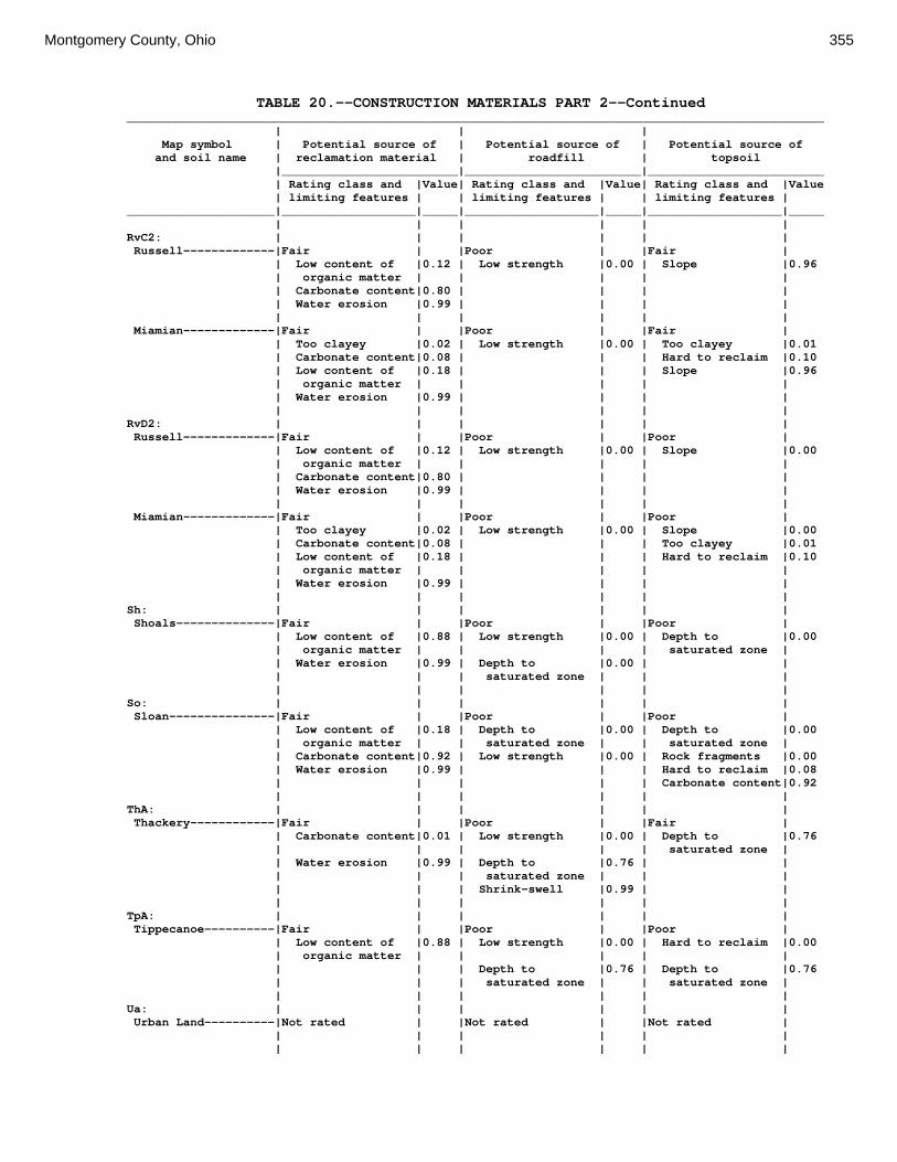
Montgomery County, Ohio 355
TABLE 20.--CONSTRUCTION MATERIALS PART 2--Continued ___________________________________________________________________________________________________ | | | Map symbol | Potential source of | Potential source of | Potential source of and soil name | reclamation material | roadfill | topsoil |_________________________|_________________________|_________________________ | Rating class and |Value| Rating class and |Value| Rating class and |Value | limiting features | | limiting features | | limiting features | _____________________|___________________|_____|___________________|_____|___________________|_____ | | | | | | RvC2: | | | | | | Russell-------------|Fair | |Poor | |Fair | | Low content of |0.12 | Low strength |0.00 | Slope |0.96 | organic matter | | | | | | Carbonate content|0.80 | | | | | Water erosion |0.99 | | | | | | | | | | Miamian-------------|Fair | |Poor | |Fair | | Too clayey |0.02 | Low strength |0.00 | Too clayey |0.01 | Carbonate content|0.08 | | | Hard to reclaim |0.10 | Low content of |0.18 | | | Slope |0.96 | organic matter | | | | | | Water erosion |0.99 | | | | | | | | | | RvD2: | | | | | | Russell-------------|Fair | |Poor | |Poor | | Low content of |0.12 | Low strength |0.00 | Slope |0.00 | organic matter | | | | | | Carbonate content|0.80 | | | | | Water erosion |0.99 | | | | | | | | | | Miamian-------------|Fair | |Poor | |Poor | | Too clayey |0.02 | Low strength |0.00 | Slope |0.00 | Carbonate content|0.08 | | | Too clayey |0.01 | Low content of |0.18 | | | Hard to reclaim |0.10 | organic matter | | | | | | Water erosion |0.99 | | | | | | | | | | Sh: | | | | | | Shoals--------------|Fair | |Poor | |Poor | | Low content of |0.88 | Low strength |0.00 | Depth to |0.00 | organic matter | | | | saturated zone | | Water erosion |0.99 | Depth to |0.00 | | | | | saturated zone | | | | | | | | | So: | | | | | | Sloan---------------|Fair | |Poor | |Poor | | Low content of |0.18 | Depth to |0.00 | Depth to |0.00 | organic matter | | saturated zone | | saturated zone | | Carbonate content|0.92 | Low strength |0.00 | Rock fragments |0.00 | Water erosion |0.99 | | | Hard to reclaim |0.08 | | | | | Carbonate content|0.92 | | | | | | ThA: | | | | | | Thackery------------|Fair | |Poor | |Fair | | Carbonate content|0.01 | Low strength |0.00 | Depth to |0.76 | | | | | saturated zone | | Water erosion |0.99 | Depth to |0.76 | | | | | saturated zone | | | | | | Shrink-swell |0.99 | | | | | | | | TpA: | | | | | | Tippecanoe----------|Fair | |Poor | |Poor | | Low content of |0.88 | Low strength |0.00 | Hard to reclaim |0.00 | organic matter | | | | | | | | Depth to |0.76 | Depth to |0.76 | | | saturated zone | | saturated zone | | | | | | | Ua: | | | | | | Urban Land----------|Not rated | |Not rated | |Not rated | | | | | | | | | | | | |

356 Soil Survey
TABLE 20.--CONSTRUCTION MATERIALS PART 2--Continued ___________________________________________________________________________________________________ | | | Map symbol | Potential source of | Potential source of | Potential source of and soil name | reclamation material | roadfill | topsoil |_________________________|_________________________|_________________________ | Rating class and |Value| Rating class and |Value| Rating class and |Value | limiting features | | limiting features | | limiting features | _____________________|___________________|_____|___________________|_____|___________________|_____ | | | | | | Ud: | | | | | | Udorthents----------|Not rated | |Not rated | |Not rated | | | | | | | | | | | | | Ug: | | | | | | Urban Land----------|Not rated | |Not rated | |Not rated | | | | | | | | | | | | | Um: | | | | | | Urban Land----------|Not rated | |Not rated | |Not rated | | | | | | | | | | | | | WaA: | | | | | | Warsaw--------------|Fair | |Poor | |Fair | | Droughty |0.78 | Low strength |0.00 | Rock fragments |0.95 | Carbonate content|0.92 | Shrink-swell |0.98 | | | | | | | | WaB: | | | | | | Warsaw--------------|Fair | |Poor | |Fair | | Droughty |0.78 | Low strength |0.00 | Rock fragments |0.95 | Carbonate content|0.92 | Shrink-swell |0.98 | | | | | | | | WeA: | | | | | | Wea-----------------|Fair | |Poor | |Good | | Carbonate content|0.97 | Low strength |0.00 | | | | | Shrink-swell |0.93 | | | | | | | | WeB: | | | | | | Wea-----------------|Fair | |Poor | |Good | | Carbonate content|0.97 | Low strength |0.00 | | | | | Shrink-swell |0.93 | | | | | | | | Ws: | | | | | | Westland------------|Fair | |Poor | |Poor | | Carbonate content|0.92 | Depth to |0.00 | Depth to |0.00 | | | saturated zone | | saturated zone | | | | Low strength |0.00 | | | | | | | | WyB2: | | | | | | Wynn----------------|Fair | |Poor | |Fair | | Low content of |0.32 | Depth to bedrock |0.00 | Depth to bedrock |0.46 | organic matter | | | | | | Depth to bedrock |0.46 | Low strength |0.00 | Too clayey |0.57 | Droughty |0.90 | Shrink-swell |0.96 | Rock fragments |0.98 | Too clayey |0.92 | | | | | Water erosion |0.99 | | | | | | | | | | XeA: | | | | | | Xenia---------------|Fair | |Poor | |Fair | | Low content of |0.12 | Low strength |0.00 | Too clayey |0.67 | organic matter | | | | | | Carbonate content|0.16 | Depth to |0.76 | Depth to |0.76 | | | saturated zone | | saturated zone | | Too clayey |0.98 | Shrink-swell |0.98 | Hard to reclaim |0.90 | Water erosion |0.99 | | | | | | | | | |

Montgomery County, Ohio 357
TABLE 20.--CONSTRUCTION MATERIALS PART 2--Continued ___________________________________________________________________________________________________ | | | Map symbol | Potential source of | Potential source of | Potential source of and soil name | reclamation material | roadfill | topsoil |_________________________|_________________________|_________________________ | Rating class and |Value| Rating class and |Value| Rating class and |Value | limiting features | | limiting features | | limiting features | _____________________|___________________|_____|___________________|_____|___________________|_____ | | | | | | XeB: | | | | | | Xenia---------------|Fair | |Poor | |Fair | | Low content of |0.12 | Low strength |0.00 | Too clayey |0.67 | organic matter | | | | | | Carbonate content|0.16 | Depth to |0.76 | Depth to |0.76 | | | saturated zone | | saturated zone | | Too clayey |0.98 | Shrink-swell |0.98 | Hard to reclaim |0.90 | Water erosion |0.99 | | | | | | | | | | _____________________|___________________|_____|___________________|_____|___________________|_____
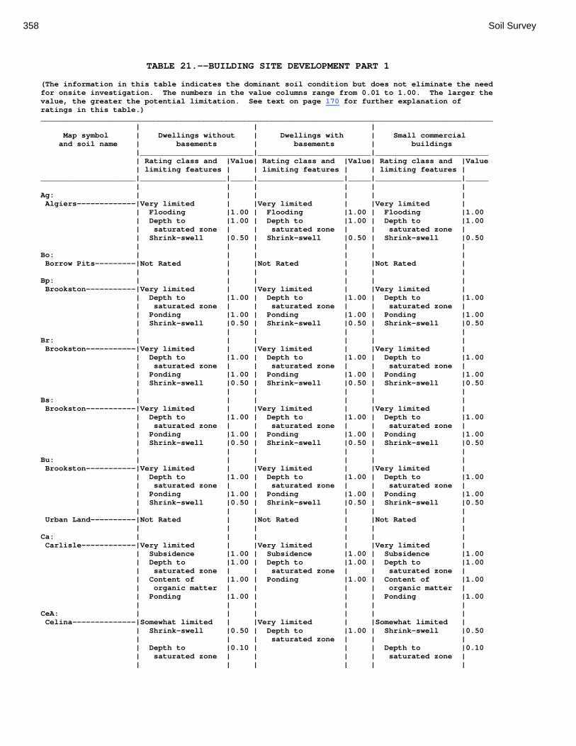
358 Soil Survey
TABLE 21.--BUILDING SITE DEVELOPMENT PART 1 (The information in this table indicates the dominant soil condition but does not eliminate the need for onsite investigation. The numbers in the value columns range from 0.01 to 1.00. The larger the value, the greater the potential limitation. See text on page 170 for further explanation of ratings in this table.) ____________________________________________________________________________________________________ | | | Map symbol | Dwellings without | Dwellings with | Small commercial and soil name | basements | basements | buildings |_________________________|_________________________|_________________________ | Rating class and |Value| Rating class and |Value| Rating class and |Value | limiting features | | limiting features | | limiting features | _____________________|___________________|_____|___________________|_____|___________________|_____ | | | | | | Ag: | | | | | | Algiers-------------|Very limited | |Very limited | |Very limited | | Flooding |1.00 | Flooding |1.00 | Flooding |1.00 | Depth to |1.00 | Depth to |1.00 | Depth to |1.00 | saturated zone | | saturated zone | | saturated zone | | Shrink-swell |0.50 | Shrink-swell |0.50 | Shrink-swell |0.50 | | | | | | Bo: | | | | | | Borrow Pits---------|Not Rated | |Not Rated | |Not Rated | | | | | | | Bp: | | | | | | Brookston-----------|Very limited | |Very limited | |Very limited | | Depth to |1.00 | Depth to |1.00 | Depth to |1.00 | saturated zone | | saturated zone | | saturated zone | | Ponding |1.00 | Ponding |1.00 | Ponding |1.00 | Shrink-swell |0.50 | Shrink-swell |0.50 | Shrink-swell |0.50 | | | | | | Br: | | | | | | Brookston-----------|Very limited | |Very limited | |Very limited | | Depth to |1.00 | Depth to |1.00 | Depth to |1.00 | saturated zone | | saturated zone | | saturated zone | | Ponding |1.00 | Ponding |1.00 | Ponding |1.00 | Shrink-swell |0.50 | Shrink-swell |0.50 | Shrink-swell |0.50 | | | | | | Bs: | | | | | | Brookston-----------|Very limited | |Very limited | |Very limited | | Depth to |1.00 | Depth to |1.00 | Depth to |1.00 | saturated zone | | saturated zone | | saturated zone | | Ponding |1.00 | Ponding |1.00 | Ponding |1.00 | Shrink-swell |0.50 | Shrink-swell |0.50 | Shrink-swell |0.50 | | | | | | Bu: | | | | | | Brookston-----------|Very limited | |Very limited | |Very limited | | Depth to |1.00 | Depth to |1.00 | Depth to |1.00 | saturated zone | | saturated zone | | saturated zone | | Ponding |1.00 | Ponding |1.00 | Ponding |1.00 | Shrink-swell |0.50 | Shrink-swell |0.50 | Shrink-swell |0.50 | | | | | | Urban Land----------|Not Rated | |Not Rated | |Not Rated | | | | | | | Ca: | | | | | | Carlisle------------|Very limited | |Very limited | |Very limited | | Subsidence |1.00 | Subsidence |1.00 | Subsidence |1.00 | Depth to |1.00 | Depth to |1.00 | Depth to |1.00 | saturated zone | | saturated zone | | saturated zone | | Content of |1.00 | Ponding |1.00 | Content of |1.00 | organic matter | | | | organic matter | | Ponding |1.00 | | | Ponding |1.00 | | | | | | CeA: | | | | | | Celina--------------|Somewhat limited | |Very limited | |Somewhat limited | | Shrink-swell |0.50 | Depth to |1.00 | Shrink-swell |0.50 | | | saturated zone | | | | Depth to |0.10 | | | Depth to |0.10 | saturated zone | | | | saturated zone | | | | | | |

Montgomery County, Ohio 359
TABLE 21.--BUILDING SITE DEVELOPMENT PART 1--Continued ____________________________________________________________________________________________________ | | | Map symbol | Dwellings without | Dwellings with | Small commercial and soil name | basements | basements | buildings |_________________________|_________________________|_________________________ | Rating class and |Value| Rating class and |Value| Rating class and |Value | limiting features | | limiting features | | limiting features | _____________________|___________________|_____|___________________|_____|___________________|_____ | | | | | | CeB: | | | | | | Celina--------------|Somewhat limited | |Very limited | |Somewhat limited | | Shrink-swell |0.50 | Depth to |1.00 | Shrink-swell |0.50 | | | saturated zone | | | | Depth to |0.10 | | | Slope |0.10 | saturated zone | | | | | | | | | | Depth to |0.10 | | | | | saturated zone | | | | | | | CeB2: | | | | | | Celina--------------|Somewhat limited | |Very limited | |Somewhat limited | | Shrink-swell |0.50 | Depth to |1.00 | Shrink-swell |0.50 | | | saturated zone | | | | Depth to |0.10 | | | Slope |0.10 | saturated zone | | | | | | | | | | Depth to |0.10 | | | | | saturated zone | | | | | | | ClB: | | | | | | Celina--------------|Somewhat limited | |Very limited | |Somewhat limited | | Shrink-swell |0.50 | Depth to |1.00 | Shrink-swell |0.50 | | | saturated zone | | | | Depth to |0.10 | | | Slope |0.10 | saturated zone | | | | | | | | | | Depth to |0.10 | | | | | saturated zone | | | | | | | CoA: | | | | | | Corwin--------------|Somewhat limited | |Very limited | |Somewhat limited | | Shrink-swell |0.50 | Depth to |1.00 | Shrink-swell |0.50 | | | saturated zone | | | | Depth to |0.10 | Shrink-swell |0.50 | Depth to |0.10 | saturated zone | | | | saturated zone | | | | | | | CoB: | | | | | | Corwin--------------|Somewhat limited | |Very limited | |Somewhat limited | | Shrink-swell |0.50 | Depth to |1.00 | Shrink-swell |0.50 | | | saturated zone | | | | Depth to |0.10 | Shrink-swell |0.50 | Slope |0.10 | saturated zone | | | | | | | | | | Depth to |0.10 | | | | | saturated zone | | | | | | | CsA: | | | | | | Crosby--------------|Very limited | |Very limited | |Very limited | | Depth to |1.00 | Depth to |1.00 | Depth to |1.00 | saturated zone | | saturated zone | | saturated zone | | Shrink-swell |1.00 | | | Shrink-swell |1.00 | | | | | | CtB: | | | | | | Crosby--------------|Very limited | |Very limited | |Very limited | | Depth to |1.00 | Depth to |1.00 | Depth to |1.00 | saturated zone | | saturated zone | | saturated zone | | Shrink-swell |1.00 | | | Shrink-swell |1.00 | | | | | | Celina--------------|Somewhat limited | |Very limited | |Somewhat limited | | Depth to |0.10 | Depth to |1.00 | Slope |0.10 | saturated zone | | saturated zone | | | | | | | | Depth to |0.10 | | | | | saturated zone | | | | | | |

360 Soil Survey
TABLE 21.--BUILDING SITE DEVELOPMENT PART 1--Continued ____________________________________________________________________________________________________ | | | Map symbol | Dwellings without | Dwellings with | Small commercial and soil name | basements | basements | buildings |_________________________|_________________________|_________________________ | Rating class and |Value| Rating class and |Value| Rating class and |Value | limiting features | | limiting features | | limiting features | _____________________|___________________|_____|___________________|_____|___________________|_____ | | | | | | Cu: | | | | | | Crosby--------------|Very limited | |Very limited | |Very limited | | Depth to |1.00 | Depth to |1.00 | Depth to |1.00 | saturated zone | | saturated zone | | saturated zone | | Shrink-swell |1.00 | | | Shrink-swell |1.00 | | | | | | Urban Land----------|Not Rated | |Not Rated | |Not Rated | | | | | | | DaB: | | | | | | Dana----------------|Somewhat limited | |Very limited | |Somewhat limited | | Shrink-swell |0.50 | Depth to |1.00 | Shrink-swell |0.50 | | | saturated zone | | | | Depth to |0.10 | | | Slope |0.10 | saturated zone | | | | | | | | | | Depth to |0.10 | | | | | saturated zone | | | | | | | FaE2: | | | | | | Fairmount-----------|Very limited | |Very limited | |Very limited | | Depth to bedrock |1.00 | Depth to bedrock |1.00 | Slope |1.00 | Slippage |1.00 | Slippage |1.00 | Depth to bedrock |1.00 | Slope |1.00 | Slope |1.00 | Slippage |1.00 | Shrink-swell |0.50 | Shrink-swell |0.50 | Shrink-swell |0.50 | | | | | | FaF2: | | | | | | Fairmount-----------|Very limited | |Very limited | |Very limited | | Slope |1.00 | Slope |1.00 | Slope |1.00 | Depth to bedrock |1.00 | Depth to bedrock |1.00 | Depth to bedrock |1.00 | Slippage |1.00 | Slippage |1.00 | Slippage |1.00 | Shrink-swell |0.50 | Shrink-swell |0.50 | Shrink-swell |0.50 | | | | | | FcA: | | | | | | Fincastle-----------|Very limited | |Very limited | |Very limited | | Depth to |1.00 | Depth to |1.00 | Depth to |1.00 | saturated zone | | saturated zone | | saturated zone | | Shrink-swell |0.50 | | | Shrink-swell |0.50 | | | | | | FkA: | | | | | | Fox-----------------|Somewhat limited | |Somewhat limited | |Somewhat limited | | Shrink-swell |0.50 | Shrink-swell |0.50 | Shrink-swell |0.50 | | | | | | FkB: | | | | | | Fox-----------------|Somewhat limited | |Somewhat limited | |Somewhat limited | | Shrink-swell |0.50 | Shrink-swell |0.50 | Shrink-swell |0.50 | | | | | Slope |0.10 | | | | | | FlA: | | | | | | Fox-----------------|Somewhat limited | |Somewhat limited | |Somewhat limited | | Shrink-swell |0.50 | Shrink-swell |0.50 | Shrink-swell |0.50 | | | | | | FlB: | | | | | | Fox-----------------|Somewhat limited | |Somewhat limited | |Somewhat limited | | Shrink-swell |0.50 | Shrink-swell |0.50 | Shrink-swell |0.50 | | | | | Slope |0.10 | | | | | | FlC2: | | | | | | Fox-----------------|Somewhat limited | |Somewhat limited | |Very limited | | Shrink-swell |0.50 | Shrink-swell |0.50 | Slope |1.00 | Slope |0.04 | Slope |0.04 | Shrink-swell |0.50 | | | | | | FmA: | | | | | | Fox-----------------|Somewhat limited | |Somewhat limited | |Somewhat limited | | Shrink-swell |0.50 | Shrink-swell |0.50 | Shrink-swell |0.50

Montgomery County, Ohio 361
TABLE 21.--BUILDING SITE DEVELOPMENT PART 1--Continued ____________________________________________________________________________________________________ | | | Map symbol | Dwellings without | Dwellings with | Small commercial and soil name | basements | basements | buildings |_________________________|_________________________|_________________________ | Rating class and |Value| Rating class and |Value| Rating class and |Value | limiting features | | limiting features | | limiting features | _____________________|___________________|_____|___________________|_____|___________________|_____ | | | | | | FmB: | | | | | | Fox-----------------|Somewhat limited | |Somewhat limited | |Somewhat limited | | Shrink-swell |0.50 | Shrink-swell |0.50 | Shrink-swell |0.50 | | | | | Slope |0.10 | | | | | | FmC2: | | | | | | Fox-----------------|Somewhat limited | |Somewhat limited | |Very limited | | Shrink-swell |0.50 | Shrink-swell |0.50 | Slope |1.00 | Slope |0.04 | Slope |0.04 | Shrink-swell |0.50 | | | | | | FmD2: | | | | | | Fox-----------------|Very limited | |Very limited | |Very limited | | Slope |1.00 | Slope |1.00 | Slope |1.00 | Shrink-swell |0.50 | Shrink-swell |0.50 | Shrink-swell |0.50 | | | | | | FsC3: | | | | | | Fox-----------------|Somewhat limited | |Somewhat limited | |Very limited | | Shrink-swell |0.50 | Shrink-swell |0.50 | Slope |1.00 | Slope |0.04 | Slope |0.04 | Shrink-swell |0.50 | | | | | | FuB: | | | | | | Fox-----------------|Somewhat limited | |Somewhat limited | |Somewhat limited | | Shrink-swell |0.50 | Shrink-swell |0.50 | Shrink-swell |0.50 | | | | | | Urban Land----------|Not Rated | |Not Rated | |Not Rated | | | | | | | FuC: | | | | | | Urban Land----------|Not Rated | |Not Rated | |Not Rated | | | | | | | Fox-----------------|Somewhat limited | |Somewhat limited | |Very limited | | Shrink-swell |0.50 | Shrink-swell |0.50 | Slope |1.00 | Slope |0.04 | Slope |0.04 | Shrink-swell |0.50 | | | | | | FuF: | | | | | | Urban Land----------|Not Rated | |Not Rated | |Not Rated | | | | | | | Fox-----------------|Very limited | |Very limited | |Very limited | | Slope |1.00 | Slope |1.00 | Slope |1.00 | Shrink-swell |0.50 | Shrink-swell |0.50 | Shrink-swell |0.50 | | | | | | Gp: | | | | | | Gravel Pits---------|Not Rated | |Not Rated | |Not Rated | | | | | | | HeE2: | | | | | | Hennepin------------|Very limited | |Very limited | |Very limited | | Slope |1.00 | Slope |1.00 | Slope |1.00 | | | | | | Miamian-------------|Very limited | |Very limited | |Very limited | | Slope |1.00 | Slope |1.00 | Slope |1.00 | Shrink-swell |0.50 | | | Shrink-swell |0.50 | | | | | | HeF2: | | | | | | Hennepin------------|Very limited | |Very limited | |Very limited | | Slope |1.00 | Slope |1.00 | Slope |1.00 | | | | | | Miamian-------------|Very limited | |Very limited | |Very limited | | Slope |1.00 | Slope |1.00 | Slope |1.00 | Shrink-swell |0.50 | | | Shrink-swell |0.50 | | | | | |

362 Soil Survey
TABLE 21.--BUILDING SITE DEVELOPMENT PART 1--Continued ____________________________________________________________________________________________________ | | | Map symbol | Dwellings without | Dwellings with | Small commercial and soil name | basements | basements | buildings |_________________________|_________________________|_________________________ | Rating class and |Value| Rating class and |Value| Rating class and |Value | limiting features | | limiting features | | limiting features | _____________________|___________________|_____|___________________|_____|___________________|_____ | | | | | | HmF3: | | | | | | Hennepin------------|Very limited | |Very limited | |Very limited | | Slope |1.00 | Slope |1.00 | Slope |1.00 | | | | | | Miamian-------------|Very limited | |Very limited | |Very limited | | Slope |1.00 | Slope |1.00 | Slope |1.00 | | | | | | KeA: | | | | | | Kendallville--------|Somewhat limited | |Not limited | |Somewhat limited | | Shrink-swell |0.50 | | | Shrink-swell |0.50 | | | | | | KeB: | | | | | | Kendallville--------|Somewhat limited | |Not limited | |Somewhat limited | | Shrink-swell |0.50 | | | Shrink-swell |0.50 | | | | | Slope |0.10 | | | | | | KeC2: | | | | | | Kendallville--------|Somewhat limited | |Somewhat limited | |Very limited | | Shrink-swell |0.50 | Slope |0.04 | Slope |1.00 | Slope |0.04 | | | Shrink-swell |0.50 | | | | | | Ld: | | | | | | Landes--------------|Very limited | |Very limited | |Very limited | | Flooding |1.00 | Flooding |1.00 | Flooding |1.00 | | | | | | Lg: | | | | | | Lanier--------------|Very limited | |Very limited | |Very limited | | Flooding |1.00 | Flooding |1.00 | Flooding |1.00 | | | | | | LsB: | | | | | | Lewisburg-----------|Somewhat limited | |Very limited | |Somewhat limited | | Depth to |0.10 | Depth to |1.00 | Slope |0.10 | saturated zone | | saturated zone | | | | | | | | Depth to |0.10 | | | | | saturated zone | | | | | | | LxC2: | | | | | | Lorenzo-------------|Somewhat limited | |Somewhat limited | |Somewhat limited | | Shrink-swell |0.50 | Shrink-swell |0.50 | Slope |0.99 | Slope |0.01 | Slope |0.01 | Shrink-swell |0.50 | | | | | | Rodman--------------|Somewhat limited | |Somewhat limited | |Somewhat limited | | Slope |0.01 | Slope |0.01 | Slope |0.99 | | | | | | LxD2: | | | | | | Lorenzo-------------|Very limited | |Very limited | |Very limited | | Slope |1.00 | Slope |1.00 | Slope |1.00 | Shrink-swell |0.50 | Shrink-swell |0.50 | Shrink-swell |0.50 | | | | | | Rodman--------------|Very limited | |Very limited | |Very limited | | Slope |1.00 | Slope |1.00 | Slope |1.00 | | | | | | Mb: | | | | | | Made Land-----------|Not Rated | |Not Rated | |Not Rated | | | | | | | Md: | | | | | | Medway--------------|Very limited | |Very limited | |Very limited | | Flooding |1.00 | Flooding |1.00 | Flooding |1.00 | Depth to |0.10 | Depth to |1.00 | Depth to |0.10 | saturated zone | | saturated zone | | saturated zone | | | | | | | MlA: | | | | | | Miamian-------------|Not limited | |Not limited | |Not limited |
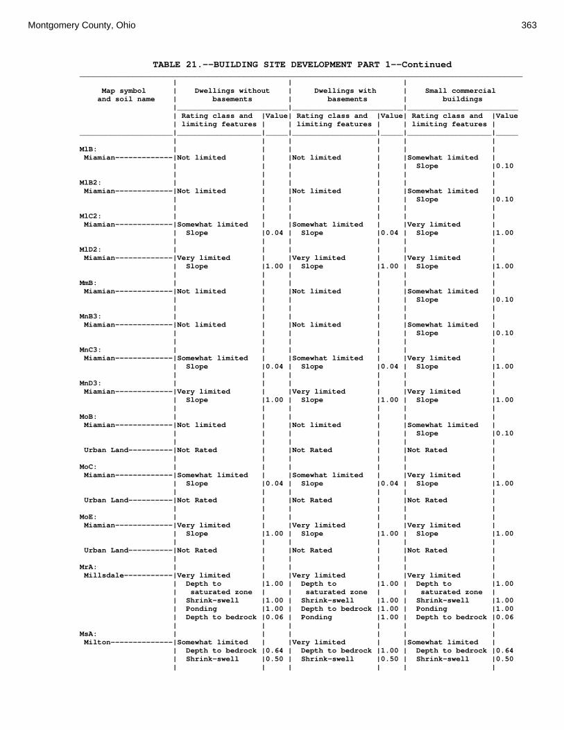
Montgomery County, Ohio 363
TABLE 21.--BUILDING SITE DEVELOPMENT PART 1--Continued ____________________________________________________________________________________________________ | | | Map symbol | Dwellings without | Dwellings with | Small commercial and soil name | basements | basements | buildings |_________________________|_________________________|_________________________ | Rating class and |Value| Rating class and |Value| Rating class and |Value | limiting features | | limiting features | | limiting features | _____________________|___________________|_____|___________________|_____|___________________|_____ | | | | | | MlB: | | | | | | Miamian-------------|Not limited | |Not limited | |Somewhat limited | | | | | | Slope |0.10 | | | | | | MlB2: | | | | | | Miamian-------------|Not limited | |Not limited | |Somewhat limited | | | | | | Slope |0.10 | | | | | | MlC2: | | | | | | Miamian-------------|Somewhat limited | |Somewhat limited | |Very limited | | Slope |0.04 | Slope |0.04 | Slope |1.00 | | | | | | MlD2: | | | | | | Miamian-------------|Very limited | |Very limited | |Very limited | | Slope |1.00 | Slope |1.00 | Slope |1.00 | | | | | | MmB: | | | | | | Miamian-------------|Not limited | |Not limited | |Somewhat limited | | | | | | Slope |0.10 | | | | | | MnB3: | | | | | | Miamian-------------|Not limited | |Not limited | |Somewhat limited | | | | | | Slope |0.10 | | | | | | MnC3: | | | | | | Miamian-------------|Somewhat limited | |Somewhat limited | |Very limited | | Slope |0.04 | Slope |0.04 | Slope |1.00 | | | | | | MnD3: | | | | | | Miamian-------------|Very limited | |Very limited | |Very limited | | Slope |1.00 | Slope |1.00 | Slope |1.00 | | | | | | MoB: | | | | | | Miamian-------------|Not limited | |Not limited | |Somewhat limited | | | | | | Slope |0.10 | | | | | | Urban Land----------|Not Rated | |Not Rated | |Not Rated | | | | | | | MoC: | | | | | | Miamian-------------|Somewhat limited | |Somewhat limited | |Very limited | | Slope |0.04 | Slope |0.04 | Slope |1.00 | | | | | | Urban Land----------|Not Rated | |Not Rated | |Not Rated | | | | | | | MoE: | | | | | | Miamian-------------|Very limited | |Very limited | |Very limited | | Slope |1.00 | Slope |1.00 | Slope |1.00 | | | | | | Urban Land----------|Not Rated | |Not Rated | |Not Rated | | | | | | | MrA: | | | | | | Millsdale-----------|Very limited | |Very limited | |Very limited | | Depth to |1.00 | Depth to |1.00 | Depth to |1.00 | saturated zone | | saturated zone | | saturated zone | | Shrink-swell |1.00 | Shrink-swell |1.00 | Shrink-swell |1.00 | Ponding |1.00 | Depth to bedrock |1.00 | Ponding |1.00 | Depth to bedrock |0.06 | Ponding |1.00 | Depth to bedrock |0.06 | | | | | | MsA: | | | | | | Milton--------------|Somewhat limited | |Very limited | |Somewhat limited | | Depth to bedrock |0.64 | Depth to bedrock |1.00 | Depth to bedrock |0.64 | Shrink-swell |0.50 | Shrink-swell |0.50 | Shrink-swell |0.50 | | | | | |

364 Soil Survey
TABLE 21.--BUILDING SITE DEVELOPMENT PART 1--Continued ____________________________________________________________________________________________________ | | | Map symbol | Dwellings without | Dwellings with | Small commercial and soil name | basements | basements | buildings |_________________________|_________________________|_________________________ | Rating class and |Value| Rating class and |Value| Rating class and |Value | limiting features | | limiting features | | limiting features | _____________________|___________________|_____|___________________|_____|___________________|_____ | | | | | | MsB: | | | | | | Milton--------------|Somewhat limited | |Very limited | |Somewhat limited | | Depth to bedrock |0.64 | Depth to bedrock |1.00 | Depth to bedrock |0.64 | Shrink-swell |0.50 | Shrink-swell |0.50 | Shrink-swell |0.50 | | | | | Slope |0.10 | | | | | | MsB2: | | | | | | Milton--------------|Somewhat limited | |Very limited | |Somewhat limited | | Depth to bedrock |0.84 | Depth to bedrock |1.00 | Depth to bedrock |0.84 | Shrink-swell |0.50 | Shrink-swell |0.50 | Shrink-swell |0.50 | | | | | Slope |0.10 | | | | | | MsC2: | | | | | | Milton--------------|Somewhat limited | |Very limited | |Very limited | | Depth to bedrock |0.84 | Depth to bedrock |1.00 | Slope |1.00 | Shrink-swell |0.50 | Shrink-swell |0.50 | Depth to bedrock |0.84 | Slope |0.04 | Slope |0.04 | Shrink-swell |0.50 | | | | | | MsD2: | | | | | | Milton--------------|Very limited | |Very limited | |Very limited | | Slope |1.00 | Depth to bedrock |1.00 | Slope |1.00 | Depth to bedrock |0.90 | Slope |1.00 | Depth to bedrock |0.90 | Shrink-swell |0.50 | Shrink-swell |0.50 | Shrink-swell |0.50 | | | | | | MtD3: | | | | | | Milton--------------|Somewhat limited | |Very limited | |Very limited | | Depth to bedrock |0.95 | Depth to bedrock |1.00 | Slope |1.00 | Slope |0.63 | Slope |0.63 | Depth to bedrock |0.95 | Shrink-swell |0.50 | Shrink-swell |0.50 | Shrink-swell |0.50 | | | | | | MuB: | | | | | | Milton--------------|Somewhat limited | |Very limited | |Somewhat limited | | Depth to bedrock |0.64 | Depth to bedrock |1.00 | Depth to bedrock |0.64 | Shrink-swell |0.50 | Shrink-swell |0.50 | Shrink-swell |0.50 | | | | | Slope |0.10 | | | | | | Urban Land----------|Not Rated | |Not Rated | |Not Rated | | | | | | | MuC: | | | | | | Milton--------------|Somewhat limited | |Very limited | |Very limited | | Depth to bedrock |0.64 | Depth to bedrock |1.00 | Slope |1.00 | Shrink-swell |0.50 | Shrink-swell |0.50 | Depth to bedrock |0.64 | Slope |0.04 | Slope |0.04 | Shrink-swell |0.50 | | | | | | Urban Land----------|Not Rated | |Not Rated | |Not Rated | | | | | | | MuD: | | | | | | Milton--------------|Very limited | |Very limited | |Very limited | | Slope |1.00 | Depth to bedrock |1.00 | Slope |1.00 | Depth to bedrock |0.64 | Slope |1.00 | Depth to bedrock |0.64 | Shrink-swell |0.50 | Shrink-swell |0.50 | Shrink-swell |0.50 | | | | | | Urban Land----------|Not Rated | |Not Rated | |Not Rated | | | | | | | Mv: | | | | | | Montgomery----------|Very limited | |Very limited | |Very limited | | Depth to |1.00 | Depth to |1.00 | Depth to |1.00 | saturated zone | | saturated zone | | saturated zone | | Shrink-swell |1.00 | Shrink-swell |1.00 | Shrink-swell |1.00 | Ponding |1.00 | Ponding |1.00 | Ponding |1.00 | | | | | |
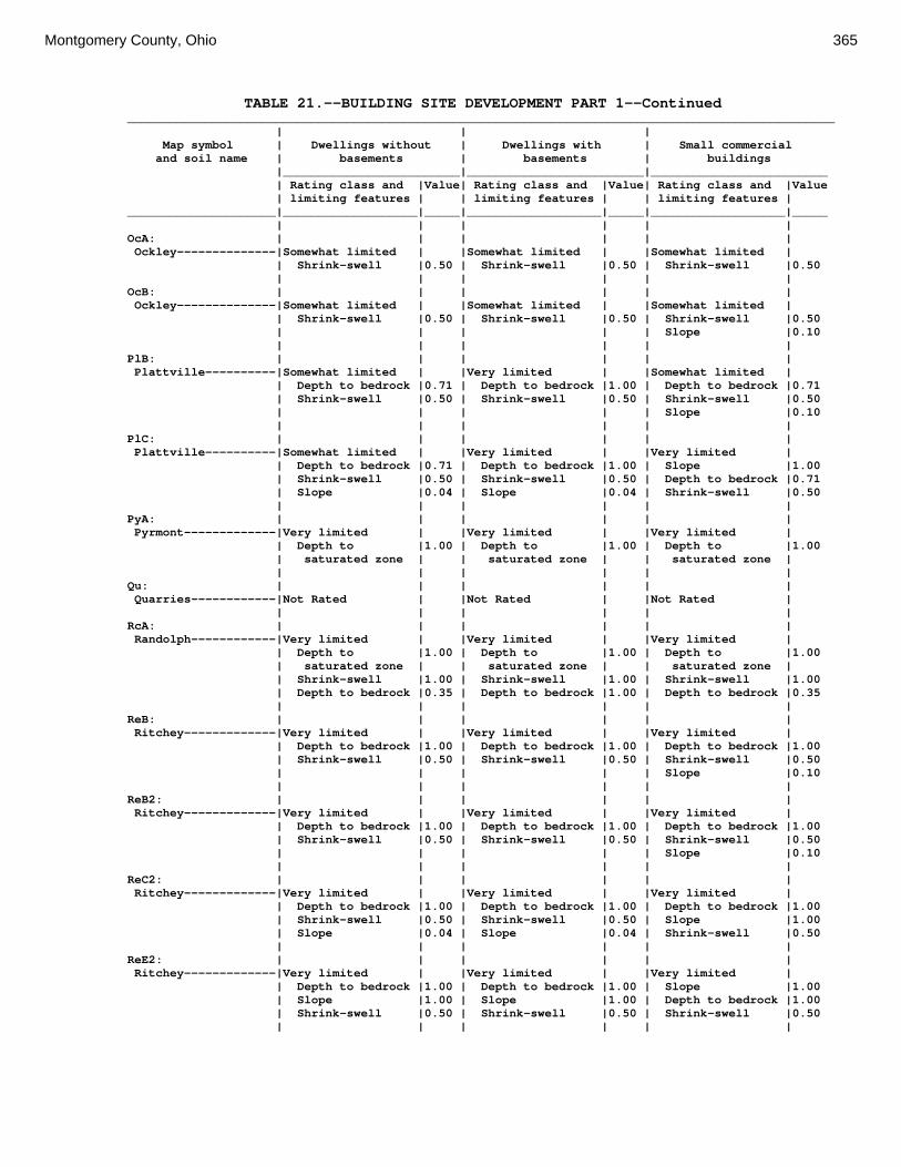
Montgomery County, Ohio 365
TABLE 21.--BUILDING SITE DEVELOPMENT PART 1--Continued ____________________________________________________________________________________________________ | | | Map symbol | Dwellings without | Dwellings with | Small commercial and soil name | basements | basements | buildings |_________________________|_________________________|_________________________ | Rating class and |Value| Rating class and |Value| Rating class and |Value | limiting features | | limiting features | | limiting features | _____________________|___________________|_____|___________________|_____|___________________|_____ | | | | | | OcA: | | | | | | Ockley--------------|Somewhat limited | |Somewhat limited | |Somewhat limited | | Shrink-swell |0.50 | Shrink-swell |0.50 | Shrink-swell |0.50 | | | | | | OcB: | | | | | | Ockley--------------|Somewhat limited | |Somewhat limited | |Somewhat limited | | Shrink-swell |0.50 | Shrink-swell |0.50 | Shrink-swell |0.50 | | | | | Slope |0.10 | | | | | | PlB: | | | | | | Plattville----------|Somewhat limited | |Very limited | |Somewhat limited | | Depth to bedrock |0.71 | Depth to bedrock |1.00 | Depth to bedrock |0.71 | Shrink-swell |0.50 | Shrink-swell |0.50 | Shrink-swell |0.50 | | | | | Slope |0.10 | | | | | | PlC: | | | | | | Plattville----------|Somewhat limited | |Very limited | |Very limited | | Depth to bedrock |0.71 | Depth to bedrock |1.00 | Slope |1.00 | Shrink-swell |0.50 | Shrink-swell |0.50 | Depth to bedrock |0.71 | Slope |0.04 | Slope |0.04 | Shrink-swell |0.50 | | | | | | PyA: | | | | | | Pyrmont-------------|Very limited | |Very limited | |Very limited | | Depth to |1.00 | Depth to |1.00 | Depth to |1.00 | saturated zone | | saturated zone | | saturated zone | | | | | | | Qu: | | | | | | Quarries------------|Not Rated | |Not Rated | |Not Rated | | | | | | | RcA: | | | | | | Randolph------------|Very limited | |Very limited | |Very limited | | Depth to |1.00 | Depth to |1.00 | Depth to |1.00 | saturated zone | | saturated zone | | saturated zone | | Shrink-swell |1.00 | Shrink-swell |1.00 | Shrink-swell |1.00 | Depth to bedrock |0.35 | Depth to bedrock |1.00 | Depth to bedrock |0.35 | | | | | | ReB: | | | | | | Ritchey-------------|Very limited | |Very limited | |Very limited | | Depth to bedrock |1.00 | Depth to bedrock |1.00 | Depth to bedrock |1.00 | Shrink-swell |0.50 | Shrink-swell |0.50 | Shrink-swell |0.50 | | | | | Slope |0.10 | | | | | | ReB2: | | | | | | Ritchey-------------|Very limited | |Very limited | |Very limited | | Depth to bedrock |1.00 | Depth to bedrock |1.00 | Depth to bedrock |1.00 | Shrink-swell |0.50 | Shrink-swell |0.50 | Shrink-swell |0.50 | | | | | Slope |0.10 | | | | | | ReC2: | | | | | | Ritchey-------------|Very limited | |Very limited | |Very limited | | Depth to bedrock |1.00 | Depth to bedrock |1.00 | Depth to bedrock |1.00 | Shrink-swell |0.50 | Shrink-swell |0.50 | Slope |1.00 | Slope |0.04 | Slope |0.04 | Shrink-swell |0.50 | | | | | | ReE2: | | | | | | Ritchey-------------|Very limited | |Very limited | |Very limited | | Depth to bedrock |1.00 | Depth to bedrock |1.00 | Slope |1.00 | Slope |1.00 | Slope |1.00 | Depth to bedrock |1.00 | Shrink-swell |0.50 | Shrink-swell |0.50 | Shrink-swell |0.50 | | | | | |

366 Soil Survey
TABLE 21.--BUILDING SITE DEVELOPMENT PART 1--Continued ____________________________________________________________________________________________________ | | | Map symbol | Dwellings without | Dwellings with | Small commercial and soil name | basements | basements | buildings |_________________________|_________________________|_________________________ | Rating class and |Value| Rating class and |Value| Rating class and |Value | limiting features | | limiting features | | limiting features | _____________________|___________________|_____|___________________|_____|___________________|_____ | | | | | | ReF2: | | | | | | Ritchey-------------|Very limited | |Very limited | |Very limited | | Slope |1.00 | Slope |1.00 | Slope |1.00 | Depth to bedrock |1.00 | Depth to bedrock |1.00 | Depth to bedrock |1.00 | Shrink-swell |0.50 | Shrink-swell |0.50 | Shrink-swell |0.50 | | | | | | RfD3: | | | | | | Ritchey-------------|Very limited | |Very limited | |Very limited | | Depth to bedrock |1.00 | Depth to bedrock |1.00 | Depth to bedrock |1.00 | Slope |0.63 | Slope |0.63 | Slope |1.00 | Shrink-swell |0.50 | Shrink-swell |0.50 | Shrink-swell |0.50 | | | | | | Rh: | | | | | | Riverwash-----------|Not Rated | |Not Rated | |Not Rated | | | | | | | RlE2: | | | | | | Rodman--------------|Very limited | |Very limited | |Very limited | | Slope |1.00 | Slope |1.00 | Slope |1.00 | | | | | | Fox-----------------|Very limited | |Very limited | |Very limited | | Slope |1.00 | Slope |1.00 | Slope |1.00 | Shrink-swell |0.50 | Shrink-swell |0.50 | Shrink-swell |0.50 | | | | | | RlF2: | | | | | | Rodman--------------|Very limited | |Very limited | |Very limited | | Slope |1.00 | Slope |1.00 | Slope |1.00 | | | | | | Fox-----------------|Very limited | |Very limited | |Very limited | | Slope |1.00 | Slope |1.00 | Slope |1.00 | Shrink-swell |0.50 | Shrink-swell |0.50 | Shrink-swell |0.50 | | | | | | Rs: | | | | | | Ross----------------|Very limited | |Very limited | |Very limited | | Flooding |1.00 | Flooding |1.00 | Flooding |1.00 | | | | | | Rt: | | | | | | Urban Land----------|Not Rated | |Not Rated | |Not Rated | | | | | | | Ross----------------|Very limited | |Very limited | |Very limited | | Flooding |1.00 | Flooding |1.00 | Flooding |1.00 | | | | | | RuB: | | | | | | Russell-------------|Somewhat limited | |Not limited | |Somewhat limited | | Shrink-swell |0.50 | | | Shrink-swell |0.50 | | | | | Slope |0.10 | | | | | | RvC2: | | | | | | Russell-------------|Somewhat limited | |Somewhat limited | |Very limited | | Shrink-swell |0.50 | Slope |0.04 | Slope |1.00 | Slope |0.04 | | | Shrink-swell |0.50 | | | | | | Miamian-------------|Somewhat limited | |Somewhat limited | |Very limited | | Slope |0.04 | Slope |0.04 | Slope |1.00 | | | | | | RvD2: | | | | | | Russell-------------|Very limited | |Very limited | |Very limited | | Slope |1.00 | Slope |1.00 | Slope |1.00 | Shrink-swell |0.50 | | | Shrink-swell |0.50 | | | | | | Miamian-------------|Very limited | |Very limited | |Very limited | | Slope |1.00 | Slope |1.00 | Slope |1.00 | | | | | |

Montgomery County, Ohio 367
TABLE 21.--BUILDING SITE DEVELOPMENT PART 1--Continued ____________________________________________________________________________________________________ | | | Map symbol | Dwellings without | Dwellings with | Small commercial and soil name | basements | basements | buildings |_________________________|_________________________|_________________________ | Rating class and |Value| Rating class and |Value| Rating class and |Value | limiting features | | limiting features | | limiting features | _____________________|___________________|_____|___________________|_____|___________________|_____ | | | | | | Sh: | | | | | | Shoals--------------|Very limited | |Very limited | |Very limited | | Flooding |1.00 | Flooding |1.00 | Flooding |1.00 | Depth to |1.00 | Depth to |1.00 | Depth to |1.00 | saturated zone | | saturated zone | | saturated zone | | | | | | | So: | | | | | | Sloan---------------|Very limited | |Very limited | |Very limited | | Flooding |1.00 | Flooding |1.00 | Flooding |1.00 | Depth to |1.00 | Depth to |1.00 | Depth to |1.00 | saturated zone | | saturated zone | | saturated zone | | Ponding |1.00 | Ponding |1.00 | Ponding |1.00 | | | | | | ThA: | | | | | | Thackery------------|Somewhat limited | |Very limited | |Somewhat limited | | Shrink-swell |0.50 | Depth to |1.00 | Shrink-swell |0.50 | | | saturated zone | | | | Depth to |0.10 | Shrink-swell |0.50 | Depth to |0.10 | saturated zone | | | | saturated zone | | | | | | | TpA: | | | | | | Tippecanoe----------|Somewhat limited | |Very limited | |Somewhat limited | | Shrink-swell |0.50 | Depth to |1.00 | Shrink-swell |0.50 | | | saturated zone | | | | Depth to |0.10 | Shrink-swell |0.50 | Depth to |0.10 | saturated zone | | | | saturated zone | | | | | | | Ua: | | | | | | Urban Land----------|Not Rated | |Not Rated | |Not Rated | | | | | | | Ud: | | | | | | Udorthents----------|Not Rated | |Not Rated | |Not Rated | | | | | | | Ug: | | | | | | Urban Land----------|Not Rated | |Not Rated | |Not Rated | | | | | | | Um: | | | | | | Urban Land----------|Not Rated | |Not Rated | |Not Rated | | | | | | | WaA: | | | | | | Warsaw--------------|Somewhat limited | |Somewhat limited | |Somewhat limited | | Shrink-swell |0.50 | Shrink-swell |0.50 | Shrink-swell |0.50 | | | | | | WaB: | | | | | | Warsaw--------------|Somewhat limited | |Somewhat limited | |Somewhat limited | | Shrink-swell |0.50 | Shrink-swell |0.50 | Shrink-swell |0.50 | | | | | Slope |0.10 | | | | | | WeA: | | | | | | Wea-----------------|Somewhat limited | |Somewhat limited | |Somewhat limited | | Shrink-swell |0.50 | Shrink-swell |0.50 | Shrink-swell |0.50 | | | | | | WeB: | | | | | | Wea-----------------|Somewhat limited | |Somewhat limited | |Somewhat limited | | Shrink-swell |0.50 | Shrink-swell |0.50 | Shrink-swell |0.50 | | | | | Slope |0.10 | | | | | |
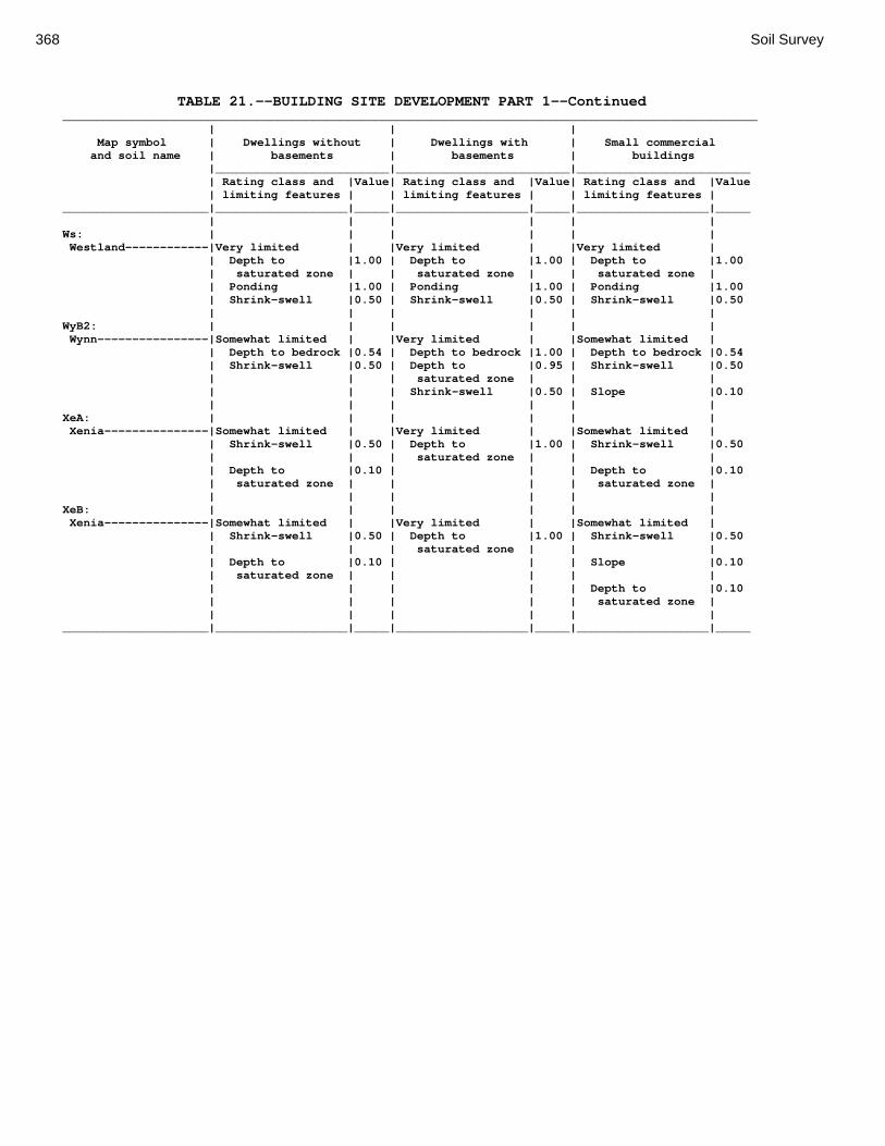
368 Soil Survey
TABLE 21.--BUILDING SITE DEVELOPMENT PART 1--Continued ____________________________________________________________________________________________________ | | | Map symbol | Dwellings without | Dwellings with | Small commercial and soil name | basements | basements | buildings |_________________________|_________________________|_________________________ | Rating class and |Value| Rating class and |Value| Rating class and |Value | limiting features | | limiting features | | limiting features | _____________________|___________________|_____|___________________|_____|___________________|_____ | | | | | | Ws: | | | | | | Westland------------|Very limited | |Very limited | |Very limited | | Depth to |1.00 | Depth to |1.00 | Depth to |1.00 | saturated zone | | saturated zone | | saturated zone | | Ponding |1.00 | Ponding |1.00 | Ponding |1.00 | Shrink-swell |0.50 | Shrink-swell |0.50 | Shrink-swell |0.50 | | | | | | WyB2: | | | | | | Wynn----------------|Somewhat limited | |Very limited | |Somewhat limited | | Depth to bedrock |0.54 | Depth to bedrock |1.00 | Depth to bedrock |0.54 | Shrink-swell |0.50 | Depth to |0.95 | Shrink-swell |0.50 | | | saturated zone | | | | | | Shrink-swell |0.50 | Slope |0.10 | | | | | | XeA: | | | | | | Xenia---------------|Somewhat limited | |Very limited | |Somewhat limited | | Shrink-swell |0.50 | Depth to |1.00 | Shrink-swell |0.50 | | | saturated zone | | | | Depth to |0.10 | | | Depth to |0.10 | saturated zone | | | | saturated zone | | | | | | | XeB: | | | | | | Xenia---------------|Somewhat limited | |Very limited | |Somewhat limited | | Shrink-swell |0.50 | Depth to |1.00 | Shrink-swell |0.50 | | | saturated zone | | | | Depth to |0.10 | | | Slope |0.10 | saturated zone | | | | | | | | | | Depth to |0.10 | | | | | saturated zone | | | | | | | _____________________|___________________|_____|___________________|_____|___________________|_____
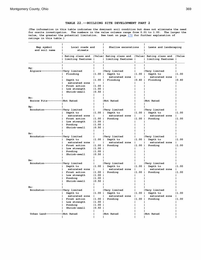
Montgomery County, Ohio 369
TABLE 22.--BUILDING SITE DEVELOPMENT PART 2 (The information in this table indicates the dominant soil condition but does not eliminate the need for onsite investigation. The numbers in the value columns range from 0.01 to 1.00. The larger the value, the greater the potential limitation. See text on page 170 for further explanation of ratings in this table.) ___________________________________________________________________________________________________ | | | Map symbol | Local roads and | Shallow excavations | Lawns and landscaping and soil name | streets | | |_________________________|_________________________|_________________________ | Rating class and |Value| Rating class and |Value| Rating class and |Value | limiting features | | limiting features | | limiting features | _____________________|___________________|_____|___________________|_____|___________________|_____ | | | | | | Ag: | | | | | | Algiers-------------|Very limited | |Very limited | |Very limited | | Flooding |1.00 | Depth to |1.00 | Depth to |1.00 | | | saturated zone | | saturated zone | | Depth to |1.00 | Flooding |0.60 | Flooding |0.60 | saturated zone | | | | | | Frost action |1.00 | | | | | Low strength |1.00 | | | | | Shrink-swell |0.50 | | | | | | | | | | Bo: | | | | | | Borrow Pits---------|Not Rated | |Not Rated | |Not Rated | | | | | | | Bp: | | | | | | Brookston-----------|Very limited | |Very limited | |Very limited | | Depth to |1.00 | Depth to |1.00 | Depth to |1.00 | saturated zone | | saturated zone | | saturated zone | | Frost action |1.00 | Ponding |1.00 | Ponding |1.00 | Low strength |1.00 | | | | | Ponding |1.00 | | | | | Shrink-swell |0.50 | | | | | | | | | | Br: | | | | | | Brookston-----------|Very limited | |Very limited | |Very limited | | Depth to |1.00 | Depth to |1.00 | Depth to |1.00 | saturated zone | | saturated zone | | saturated zone | | Frost action |1.00 | Ponding |1.00 | Ponding |1.00 | Low strength |1.00 | | | | | Ponding |1.00 | | | | | Shrink-swell |0.50 | | | | | | | | | | Bs: | | | | | | Brookston-----------|Very limited | |Very limited | |Very limited | | Depth to |1.00 | Depth to |1.00 | Depth to |1.00 | saturated zone | | saturated zone | | saturated zone | | Frost action |1.00 | Ponding |1.00 | Ponding |1.00 | Low strength |1.00 | | | | | Ponding |1.00 | | | | | Shrink-swell |0.50 | | | | | | | | | | Bu: | | | | | | Brookston-----------|Very limited | |Very limited | |Very limited | | Depth to |1.00 | Depth to |1.00 | Depth to |1.00 | saturated zone | | saturated zone | | saturated zone | | Frost action |1.00 | Ponding |1.00 | Ponding |1.00 | Low strength |1.00 | | | | | Ponding |1.00 | | | | | Shrink-swell |0.50 | | | | | | | | | | Urban Land----------|Not Rated | |Not Rated | |Not Rated | | | | | | |

370 Soil Survey
TABLE 22.--BUILDING SITE DEVELOPMENT PART 2--Continued ___________________________________________________________________________________________________ | | | Map symbol | Local roads and | Shallow excavations | Lawns and landscaping and soil name | streets | | |_________________________|_________________________|_________________________ | Rating class and |Value| Rating class and |Value| Rating class and |Value | limiting features | | limiting features | | limiting features | _____________________|___________________|_____|___________________|_____|___________________|_____ | | | | | | Ca: | | | | | | Carlisle------------|Very limited | |Very limited | |Very limited | | | | | | | | Depth to |1.00 | Depth to |1.00 | Content of |1.00 | saturated zone | | saturated zone | | organic matter | | Subsidence |1.00 | Content of |1.00 | Depth to | | | | organic matter | | saturated zone |1.00 | Frost action |1.00 | Ponding |1.00 | | | | | | | Ponding |1.00 | Ponding |1.00 | | | | | | | | | | CeA: | | | | | | Celina--------------|Very limited | |Very limited | |Somewhat limited | | Frost action |1.00 | Depth to |1.00 | Depth to |0.03 | | | saturated zone | | saturated zone | | Low strength |1.00 | | | | | Shrink-swell |0.50 | | | | | Depth to |0.03 | | | | | saturated zone | | | | | | | | | | | CeB: | | | | | | Celina--------------|Very limited | |Very limited | |Somewhat limited | | Frost action |1.00 | Depth to |1.00 | Depth to |0.03 | | | saturated zone | | saturated zone | | Low strength |1.00 | | | | | Shrink-swell |0.50 | | | | | Depth to |0.03 | | | | | saturated zone | | | | | | | | | | | CeB2: | | | | | | Celina--------------|Very limited | |Very limited | |Somewhat limited | | Frost action |1.00 | Depth to |1.00 | Depth to |0.03 | | | saturated zone | | saturated zone | | Low strength |1.00 | | | | | Shrink-swell |0.50 | | | | | Depth to |0.03 | | | | | saturated zone | | | | | | | | | | | ClB: | | | | | | Celina--------------|Very limited | |Very limited | |Somewhat limited | | Frost action |1.00 | Depth to |1.00 | Content of large |0.32 | | | saturated zone | | stones | | Low strength |1.00 | | | Depth to |0.03 | | | | | saturated zone | | Shrink-swell |0.50 | | | | | Depth to |0.03 | | | | | saturated zone | | | | | | | | | | | CoA: | | | | | | Corwin--------------|Very limited | |Very limited | |Somewhat limited | | Low strength |1.00 | Depth to |1.00 | Depth to |0.03 | | | saturated zone | | saturated zone | | Shrink-swell |0.50 | | | | | Frost action |0.50 | | | | | Depth to |0.03 | | | | | saturated zone | | | | | | | | | | |

Montgomery County, Ohio 371
TABLE 22.--BUILDING SITE DEVELOPMENT PART 2--Continued ___________________________________________________________________________________________________ | | | Map symbol | Local roads and | Shallow excavations | Lawns and landscaping and soil name | streets | | |_________________________|_________________________|_________________________ | Rating class and |Value| Rating class and |Value| Rating class and |Value | limiting features | | limiting features | | limiting features | _____________________|___________________|_____|___________________|_____|___________________|_____ | | | | | | CoB: | | | | | | Corwin--------------|Very limited | |Very limited | |Somewhat limited | | Low strength |1.00 | Depth to |1.00 | Depth to |0.03 | | | saturated zone | | saturated zone | | Shrink-swell |0.50 | | | | | Frost action |0.50 | | | | | Depth to |0.03 | | | | | saturated zone | | | | | | | | | | | CsA: | | | | | | Crosby--------------|Very limited | |Very limited | |Very limited | | Low strength |1.00 | Depth to |1.00 | Depth to |1.00 | | | saturated zone | | saturated zone | | Frost action |1.00 | Depth to dense |0.50 | | | | | layer | | | | Shrink-swell |1.00 | | | | | Depth to |1.00 | | | | | saturated zone | | | | | | | | | | | CtB: | | | | | | Crosby--------------|Very limited | |Very limited | |Very limited | | Low strength |1.00 | Depth to |1.00 | Depth to |1.00 | | | saturated zone | | saturated zone | | Frost action |1.00 | Depth to dense |0.50 | | | | | layer | | | | Shrink-swell |1.00 | | | | | Depth to |1.00 | | | | | saturated zone | | | | | | | | | | | Celina--------------|Very limited | |Very limited | |Somewhat limited | | Frost action |1.00 | Depth to |1.00 | Depth to |0.03 | | | saturated zone | | saturated zone | | Low strength |1.00 | | | | | Depth to |0.03 | | | | | saturated zone | | | | | | | | | | | Cu: | | | | | | Crosby--------------|Very limited | |Very limited | |Very limited | | Low strength |1.00 | Depth to |1.00 | Depth to |1.00 | | | saturated zone | | saturated zone | | Frost action |1.00 | Depth to dense |0.50 | | | | | layer | | | | Shrink-swell |1.00 | | | | | Depth to |1.00 | | | | | saturated zone | | | | | | | | | | | Urban Land----------|Not Rated | |Not Rated | |Not Rated | | | | | | | DaB: | | | | | | Dana----------------|Very limited | |Very limited | |Somewhat limited | | Low strength |1.00 | Depth to |1.00 | Depth to |0.03 | | | saturated zone | | saturated zone | | Frost action |1.00 | | | | | Shrink-swell |0.50 | | | | | Depth to |0.03 | | | | | saturated zone | | | | | | | | | | |
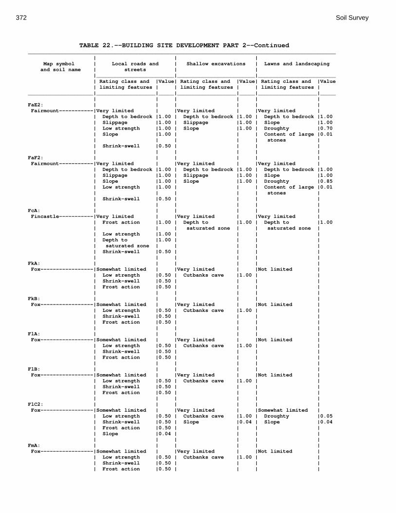
372 Soil Survey
TABLE 22.--BUILDING SITE DEVELOPMENT PART 2--Continued ___________________________________________________________________________________________________ | | | Map symbol | Local roads and | Shallow excavations | Lawns and landscaping and soil name | streets | | |_________________________|_________________________|_________________________ | Rating class and |Value| Rating class and |Value| Rating class and |Value | limiting features | | limiting features | | limiting features | _____________________|___________________|_____|___________________|_____|___________________|_____ | | | | | | FaE2: | | | | | | Fairmount-----------|Very limited | |Very limited | |Very limited | | Depth to bedrock |1.00 | Depth to bedrock |1.00 | Depth to bedrock |1.00 | Slippage |1.00 | Slippage |1.00 | Slope |1.00 | Low strength |1.00 | Slope |1.00 | Droughty |0.70 | Slope |1.00 | | | Content of large |0.01 | | | | | stones | | Shrink-swell |0.50 | | | | | | | | | | FaF2: | | | | | | Fairmount-----------|Very limited | |Very limited | |Very limited | | Depth to bedrock |1.00 | Depth to bedrock |1.00 | Depth to bedrock |1.00 | Slippage |1.00 | Slippage |1.00 | Slope |1.00 | Slope |1.00 | Slope |1.00 | Droughty |0.85 | Low strength |1.00 | | | Content of large |0.01 | | | | | stones | | Shrink-swell |0.50 | | | | | | | | | | FcA: | | | | | | Fincastle-----------|Very limited | |Very limited | |Very limited | | Frost action |1.00 | Depth to |1.00 | Depth to |1.00 | | | saturated zone | | saturated zone | | Low strength |1.00 | | | | | Depth to |1.00 | | | | | saturated zone | | | | | | Shrink-swell |0.50 | | | | | | | | | | FkA: | | | | | | Fox-----------------|Somewhat limited | |Very limited | |Not limited | | Low strength |0.50 | Cutbanks cave |1.00 | | | Shrink-swell |0.50 | | | | | Frost action |0.50 | | | | | | | | | | FkB: | | | | | | Fox-----------------|Somewhat limited | |Very limited | |Not limited | | Low strength |0.50 | Cutbanks cave |1.00 | | | Shrink-swell |0.50 | | | | | Frost action |0.50 | | | | | | | | | | FlA: | | | | | | Fox-----------------|Somewhat limited | |Very limited | |Not limited | | Low strength |0.50 | Cutbanks cave |1.00 | | | Shrink-swell |0.50 | | | | | Frost action |0.50 | | | | | | | | | | FlB: | | | | | | Fox-----------------|Somewhat limited | |Very limited | |Not limited | | Low strength |0.50 | Cutbanks cave |1.00 | | | Shrink-swell |0.50 | | | | | Frost action |0.50 | | | | | | | | | | FlC2: | | | | | | Fox-----------------|Somewhat limited | |Very limited | |Somewhat limited | | Low strength |0.50 | Cutbanks cave |1.00 | Droughty |0.05 | Shrink-swell |0.50 | Slope |0.04 | Slope |0.04 | Frost action |0.50 | | | | | Slope |0.04 | | | | | | | | | | FmA: | | | | | | Fox-----------------|Somewhat limited | |Very limited | |Not limited | | Low strength |0.50 | Cutbanks cave |1.00 | | | Shrink-swell |0.50 | | | | | Frost action |0.50 | | | |

Montgomery County, Ohio 373
TABLE 22.--BUILDING SITE DEVELOPMENT PART 2--Continued ___________________________________________________________________________________________________ | | | Map symbol | Local roads and | Shallow excavations | Lawns and landscaping and soil name | streets | | |_________________________|_________________________|_________________________ | Rating class and |Value| Rating class and |Value| Rating class and |Value | limiting features | | limiting features | | limiting features | _____________________|___________________|_____|___________________|_____|___________________|_____ | | | | | | FmB: | | | | | | Fox-----------------|Somewhat limited | |Very limited | |Not limited | | Low strength |0.50 | Cutbanks cave |1.00 | | | Shrink-swell |0.50 | | | | | Frost action |0.50 | | | | | | | | | | FmC2: | | | | | | Fox-----------------|Somewhat limited | |Very limited | |Somewhat limited | | Low strength |0.50 | Cutbanks cave |1.00 | Droughty |0.05 | Shrink-swell |0.50 | Slope |0.04 | Slope |0.04 | Frost action |0.50 | | | | | Slope |0.04 | | | | | | | | | | FmD2: | | | | | | Fox-----------------|Very limited | |Very limited | |Very limited | | Slope |1.00 | Cutbanks cave |1.00 | Slope |1.00 | Low strength |0.50 | Slope |1.00 | Droughty |0.05 | Shrink-swell |0.50 | | | | | Frost action |0.50 | | | | | | | | | | FsC3: | | | | | | Fox-----------------|Somewhat limited | |Very limited | |Somewhat limited | | Low strength |0.50 | Cutbanks cave |1.00 | Droughty |0.51 | Shrink-swell |0.50 | Slope |0.04 | Slope |0.04 | Frost action |0.50 | | | | | Slope |0.04 | | | | | | | | | | FuB: | | | | | | Fox-----------------|Somewhat limited | |Very limited | |Not limited | | Low strength |0.50 | Cutbanks cave |1.00 | | | Shrink-swell |0.50 | | | | | Frost action |0.50 | | | | | | | | | | Urban Land----------|Not Rated | |Not Rated | |Not Rated | | | | | | | FuC: | | | | | | Urban Land----------|Not Rated | |Not Rated | |Not Rated | | | | | | | Fox-----------------|Somewhat limited | |Very limited | |Somewhat limited | | Low strength |0.50 | Cutbanks cave |1.00 | Droughty |0.05 | Shrink-swell |0.50 | Slope |0.04 | Slope |0.04 | Frost action |0.50 | | | | | Slope |0.04 | | | | | | | | | | FuF: | | | | | | Urban Land----------|Not Rated | |Not Rated | |Not Rated | | | | | | | Fox-----------------|Very limited | |Very limited | |Very limited | | Slope |1.00 | Cutbanks cave |1.00 | Slope |1.00 | Low strength |0.50 | Slope |1.00 | Droughty |0.51 | Shrink-swell |0.50 | | | | | Frost action |0.50 | | | | | | | | | | Gp: | | | | | | Gravel Pits---------|Not Rated | |Not Rated | |Not Rated | | | | | | |

374 Soil Survey
TABLE 22.--BUILDING SITE DEVELOPMENT PART 2--Continued ___________________________________________________________________________________________________ | | | Map symbol | Local roads and | Shallow excavations | Lawns and landscaping and soil name | streets | | |_________________________|_________________________|_________________________ | Rating class and |Value| Rating class and |Value| Rating class and |Value | limiting features | | limiting features | | limiting features | _____________________|___________________|_____|___________________|_____|___________________|_____ | | | | | | HeE2: | | | | | | Hennepin------------|Very limited | |Very limited | |Very limited | | Slope |1.00 | Slope |1.00 | Slope |1.00 | Frost action |0.50 | | | | | Low strength |0.28 | | | | | | | | | | Miamian-------------|Very limited | |Very limited | |Very limited | | Slope |1.00 | Slope |1.00 | Slope |1.00 | Low strength |1.00 | | | | | Shrink-swell |0.50 | | | | | Frost action |0.50 | | | | | | | | | | HeF2: | | | | | | Hennepin------------|Very limited | |Very limited | |Very limited | | Slope |1.00 | Slope |1.00 | Slope |1.00 | Frost action |0.50 | | | | | Low strength |0.28 | | | | | | | | | | Miamian-------------|Very limited | |Very limited | |Very limited | | Slope |1.00 | Slope |1.00 | Slope |1.00 | Low strength |1.00 | | | | | Shrink-swell |0.50 | | | | | Frost action |0.50 | | | | | | | | | | HmF3: | | | | | | Hennepin------------|Very limited | |Very limited | |Very limited | | Slope |1.00 | Slope |1.00 | Slope |1.00 | Frost action |0.50 | | | Droughty |0.06 | Low strength |0.28 | | | | | | | | | | Miamian-------------|Very limited | |Very limited | |Very limited | | Slope |1.00 | Slope |1.00 | Slope |1.00 | Frost action |0.50 | | | | | | | | | | KeA: | | | | | | Kendallville--------|Somewhat limited | |Not limited | |Not limited | | Shrink-swell |0.50 | | | | | Frost action |0.50 | | | | | Low strength |0.28 | | | | | | | | | | KeB: | | | | | | Kendallville--------|Somewhat limited | |Not limited | |Not limited | | Shrink-swell |0.50 | | | | | Frost action |0.50 | | | | | Low strength |0.28 | | | | | | | | | | KeC2: | | | | | | Kendallville--------|Somewhat limited | |Somewhat limited | |Somewhat limited | | Shrink-swell |0.50 | Slope |0.04 | Slope |0.04 | Frost action |0.50 | | | | | Slope |0.04 | | | | | | | | | | Ld: | | | | | | Landes--------------|Very limited | |Very limited | |Somewhat limited | | Flooding |1.00 | Cutbanks cave |1.00 | Flooding |0.60 | Frost action |0.50 | Flooding |0.60 | Droughty |0.01 | | | | | | Lg: | | | | | | Lanier--------------|Very limited | |Very limited | |Somewhat limited | | Flooding |1.00 | Cutbanks cave |1.00 | Droughty |0.97 | Frost action |0.50 | Flooding |0.60 | Flooding |0.60 | | | | | |
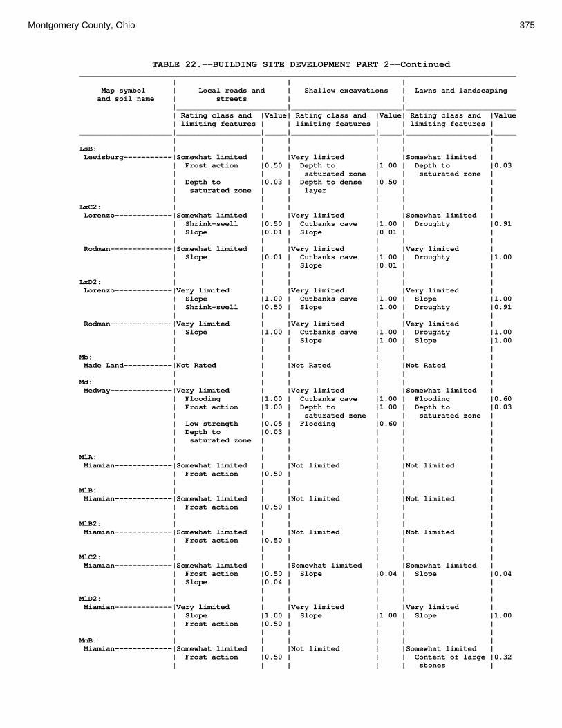
Montgomery County, Ohio 375
TABLE 22.--BUILDING SITE DEVELOPMENT PART 2--Continued ___________________________________________________________________________________________________ | | | Map symbol | Local roads and | Shallow excavations | Lawns and landscaping and soil name | streets | | |_________________________|_________________________|_________________________ | Rating class and |Value| Rating class and |Value| Rating class and |Value | limiting features | | limiting features | | limiting features | _____________________|___________________|_____|___________________|_____|___________________|_____ | | | | | | LsB: | | | | | | Lewisburg-----------|Somewhat limited | |Very limited | |Somewhat limited | | Frost action |0.50 | Depth to |1.00 | Depth to |0.03 | | | saturated zone | | saturated zone | | Depth to |0.03 | Depth to dense |0.50 | | | saturated zone | | layer | | | | | | | | | LxC2: | | | | | | Lorenzo-------------|Somewhat limited | |Very limited | |Somewhat limited | | Shrink-swell |0.50 | Cutbanks cave |1.00 | Droughty |0.91 | Slope |0.01 | Slope |0.01 | | | | | | | | Rodman--------------|Somewhat limited | |Very limited | |Very limited | | Slope |0.01 | Cutbanks cave |1.00 | Droughty |1.00 | | | Slope |0.01 | | | | | | | | LxD2: | | | | | | Lorenzo-------------|Very limited | |Very limited | |Very limited | | Slope |1.00 | Cutbanks cave |1.00 | Slope |1.00 | Shrink-swell |0.50 | Slope |1.00 | Droughty |0.91 | | | | | | Rodman--------------|Very limited | |Very limited | |Very limited | | Slope |1.00 | Cutbanks cave |1.00 | Droughty |1.00 | | | Slope |1.00 | Slope |1.00 | | | | | | Mb: | | | | | | Made Land-----------|Not Rated | |Not Rated | |Not Rated | | | | | | | Md: | | | | | | Medway--------------|Very limited | |Very limited | |Somewhat limited | | Flooding |1.00 | Cutbanks cave |1.00 | Flooding |0.60 | Frost action |1.00 | Depth to |1.00 | Depth to |0.03 | | | saturated zone | | saturated zone | | Low strength |0.05 | Flooding |0.60 | | | Depth to |0.03 | | | | | saturated zone | | | | | | | | | | | MlA: | | | | | | Miamian-------------|Somewhat limited | |Not limited | |Not limited | | Frost action |0.50 | | | | | | | | | | MlB: | | | | | | Miamian-------------|Somewhat limited | |Not limited | |Not limited | | Frost action |0.50 | | | | | | | | | | MlB2: | | | | | | Miamian-------------|Somewhat limited | |Not limited | |Not limited | | Frost action |0.50 | | | | | | | | | | MlC2: | | | | | | Miamian-------------|Somewhat limited | |Somewhat limited | |Somewhat limited | | Frost action |0.50 | Slope |0.04 | Slope |0.04 | Slope |0.04 | | | | | | | | | | MlD2: | | | | | | Miamian-------------|Very limited | |Very limited | |Very limited | | Slope |1.00 | Slope |1.00 | Slope |1.00 | Frost action |0.50 | | | | | | | | | | MmB: | | | | | | Miamian-------------|Somewhat limited | |Not limited | |Somewhat limited | | Frost action |0.50 | | | Content of large |0.32 | | | | | stones |

376 Soil Survey
TABLE 22.--BUILDING SITE DEVELOPMENT PART 2--Continued ___________________________________________________________________________________________________ | | | Map symbol | Local roads and | Shallow excavations | Lawns and landscaping and soil name | streets | | |_________________________|_________________________|_________________________ | Rating class and |Value| Rating class and |Value| Rating class and |Value | limiting features | | limiting features | | limiting features | _____________________|___________________|_____|___________________|_____|___________________|_____ | | | | | | MnB3: | | | | | | Miamian-------------|Somewhat limited | |Not limited | |Not limited | | Frost action |0.50 | | | | | | | | | | MnC3: | | | | | | Miamian-------------|Somewhat limited | |Somewhat limited | |Somewhat limited | | Frost action |0.50 | Slope |0.04 | Slope |0.04 | Slope |0.04 | | | | | | | | | | MnD3: | | | | | | Miamian-------------|Very limited | |Very limited | |Very limited | | Slope |1.00 | Slope |1.00 | Slope |1.00 | Frost action |0.50 | | | | | | | | | | MoB: | | | | | | Miamian-------------|Somewhat limited | |Not limited | |Not limited | | Frost action |0.50 | | | | | | | | | | Urban Land----------|Not Rated | |Not Rated | |Not Rated | | | | | | | MoC: | | | | | | Miamian-------------|Somewhat limited | |Somewhat limited | |Somewhat limited | | Frost action |0.50 | Slope |0.04 | Slope |0.04 | Slope |0.04 | | | | | | | | | | Urban Land----------|Not Rated | |Not Rated | |Not Rated | | | | | | | MoE: | | | | | | Miamian-------------|Very limited | |Very limited | |Very limited | | Slope |1.00 | Slope |1.00 | Slope |1.00 | Frost action |0.50 | | | | | | | | | | Urban Land----------|Not Rated | |Not Rated | |Not Rated | | | | | | | MrA: | | | | | | Millsdale-----------|Very limited | |Very limited | |Very limited | | Depth to |1.00 | Depth to bedrock |1.00 | Depth to |1.00 | saturated zone | | | | saturated zone | | Low strength |1.00 | Depth to |1.00 | Ponding |1.00 | | | saturated zone | | | | Frost action |1.00 | Ponding |1.00 | Depth to bedrock |0.06 | Shrink-swell |1.00 | Too clayey |0.50 | | | Ponding |1.00 | | | | | | | | | | MsA: | | | | | | Milton--------------|Very limited | |Very limited | |Somewhat limited | | Low strength |1.00 | Depth to bedrock |1.00 | Depth to bedrock |0.65 | Depth to bedrock |0.64 | Too clayey |0.50 | | | Shrink-swell |0.50 | | | | | Frost action |0.50 | | | | | | | | | | MsB: | | | | | | Milton--------------|Very limited | |Very limited | |Somewhat limited | | Low strength |1.00 | Depth to bedrock |1.00 | Depth to bedrock |0.65 | Depth to bedrock |0.64 | Too clayey |0.50 | | | Shrink-swell |0.50 | | | | | Frost action |0.50 | | | | MsB2: | | | | | | Milton--------------|Very limited | |Very limited | |Somewhat limited | | Low strength |1.00 | Depth to bedrock |1.00 | Depth to bedrock |0.84 | Depth to bedrock |0.84 | Too clayey |0.50 | | | Shrink-swell |0.50 | | | | | Frost action |0.50 | | | |
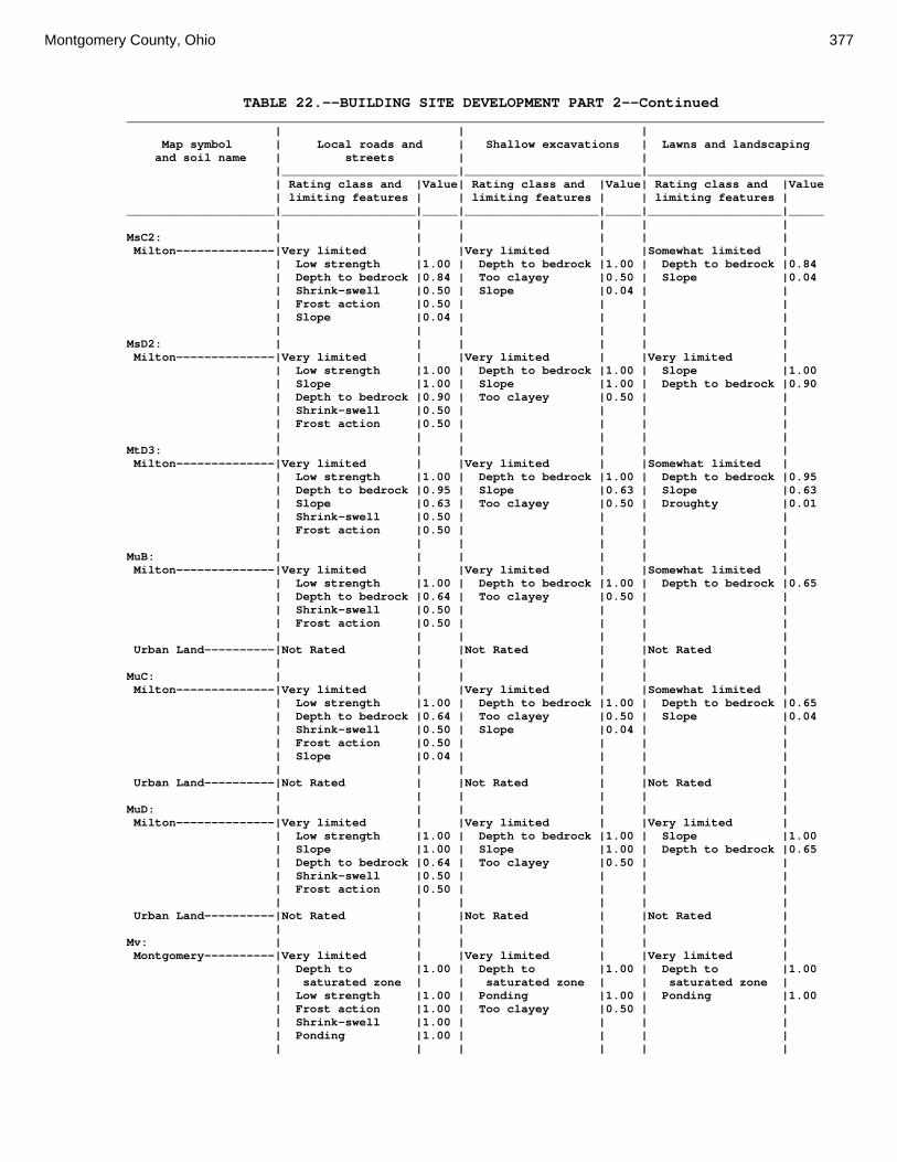
Montgomery County, Ohio 377
TABLE 22.--BUILDING SITE DEVELOPMENT PART 2--Continued ___________________________________________________________________________________________________ | | | Map symbol | Local roads and | Shallow excavations | Lawns and landscaping and soil name | streets | | |_________________________|_________________________|_________________________ | Rating class and |Value| Rating class and |Value| Rating class and |Value | limiting features | | limiting features | | limiting features | _____________________|___________________|_____|___________________|_____|___________________|_____ | | | | | | MsC2: | | | | | | Milton--------------|Very limited | |Very limited | |Somewhat limited | | Low strength |1.00 | Depth to bedrock |1.00 | Depth to bedrock |0.84 | Depth to bedrock |0.84 | Too clayey |0.50 | Slope |0.04 | Shrink-swell |0.50 | Slope |0.04 | | | Frost action |0.50 | | | | | Slope |0.04 | | | | | | | | | | MsD2: | | | | | | Milton--------------|Very limited | |Very limited | |Very limited | | Low strength |1.00 | Depth to bedrock |1.00 | Slope |1.00 | Slope |1.00 | Slope |1.00 | Depth to bedrock |0.90 | Depth to bedrock |0.90 | Too clayey |0.50 | | | Shrink-swell |0.50 | | | | | Frost action |0.50 | | | | | | | | | | MtD3: | | | | | | Milton--------------|Very limited | |Very limited | |Somewhat limited | | Low strength |1.00 | Depth to bedrock |1.00 | Depth to bedrock |0.95 | Depth to bedrock |0.95 | Slope |0.63 | Slope |0.63 | Slope |0.63 | Too clayey |0.50 | Droughty |0.01 | Shrink-swell |0.50 | | | | | Frost action |0.50 | | | | | | | | | | MuB: | | | | | | Milton--------------|Very limited | |Very limited | |Somewhat limited | | Low strength |1.00 | Depth to bedrock |1.00 | Depth to bedrock |0.65 | Depth to bedrock |0.64 | Too clayey |0.50 | | | Shrink-swell |0.50 | | | | | Frost action |0.50 | | | | | | | | | | Urban Land----------|Not Rated | |Not Rated | |Not Rated | | | | | | | MuC: | | | | | | Milton--------------|Very limited | |Very limited | |Somewhat limited | | Low strength |1.00 | Depth to bedrock |1.00 | Depth to bedrock |0.65 | Depth to bedrock |0.64 | Too clayey |0.50 | Slope |0.04 | Shrink-swell |0.50 | Slope |0.04 | | | Frost action |0.50 | | | | | Slope |0.04 | | | | | | | | | | Urban Land----------|Not Rated | |Not Rated | |Not Rated | | | | | | | MuD: | | | | | | Milton--------------|Very limited | |Very limited | |Very limited | | Low strength |1.00 | Depth to bedrock |1.00 | Slope |1.00 | Slope |1.00 | Slope |1.00 | Depth to bedrock |0.65 | Depth to bedrock |0.64 | Too clayey |0.50 | | | Shrink-swell |0.50 | | | | | Frost action |0.50 | | | | | | | | | | Urban Land----------|Not Rated | |Not Rated | |Not Rated | | | | | | | Mv: | | | | | | Montgomery----------|Very limited | |Very limited | |Very limited | | Depth to |1.00 | Depth to |1.00 | Depth to |1.00 | saturated zone | | saturated zone | | saturated zone | | Low strength |1.00 | Ponding |1.00 | Ponding |1.00 | Frost action |1.00 | Too clayey |0.50 | | | Shrink-swell |1.00 | | | | | Ponding |1.00 | | | | | | | | | |

378 Soil Survey
TABLE 22.--BUILDING SITE DEVELOPMENT PART 2--Continued ___________________________________________________________________________________________________ | | | Map symbol | Local roads and | Shallow excavations | Lawns and landscaping and soil name | streets | | |_________________________|_________________________|_________________________ | Rating class and |Value| Rating class and |Value| Rating class and |Value | limiting features | | limiting features | | limiting features | _____________________|___________________|_____|___________________|_____|___________________|_____ | | | | | | OcA: | | | | | | Ockley--------------|Somewhat limited | |Very limited | |Not limited | | Low strength |0.90 | Cutbanks cave |1.00 | | | Shrink-swell |0.50 | | | | | Frost action |0.50 | | | | | | | | | | OcB: | | | | | | Ockley--------------|Somewhat limited | |Very limited | |Not limited | | Low strength |0.90 | Cutbanks cave |1.00 | | | Shrink-swell |0.50 | | | | | Frost action |0.50 | | | | | | | | | | PlB: | | | | | | Plattville----------|Very limited | |Very limited | |Somewhat limited | | Low strength |1.00 | Depth to bedrock |1.00 | Depth to bedrock |0.71 | Depth to bedrock |0.71 | | | | | Shrink-swell |0.50 | | | | | Frost action |0.50 | | | | | | | | | | PlC: | | | | | | Plattville----------|Very limited | |Very limited | |Somewhat limited | | Low strength |1.00 | Depth to bedrock |1.00 | Depth to bedrock |0.71 | Depth to bedrock |0.71 | Slope |0.04 | Slope |0.04 | Shrink-swell |0.50 | | | | | Frost action |0.50 | | | | | Slope |0.04 | | | | | | | | | | PyA: | | | | | | Pyrmont-------------|Very limited | |Very limited | |Very limited | | Frost action |1.00 | Depth to |1.00 | Depth to |1.00 | | | saturated zone | | saturated zone | | Depth to |1.00 | Depth to dense |0.50 | | | saturated zone | | layer | | | | | | | | | Qu: | | | | | | Quarries------------|Not Rated | |Not Rated | |Not Rated | | | | | | | RcA: | | | | | | Randolph------------|Very limited | |Very limited | |Very limited | | Low strength |1.00 | Depth to bedrock |1.00 | Depth to |1.00 | | | | | saturated zone | | Frost action |1.00 | Depth to |1.00 | Depth to bedrock |0.35 | | | saturated zone | | | | Shrink-swell |1.00 | Too clayey |0.50 | | | Depth to |1.00 | | | | | saturated zone | | | | | | Depth to bedrock |0.35 | | | | | | | | | | ReB: | | | | | | Ritchey-------------|Very limited | |Very limited | |Very limited | | Depth to bedrock |1.00 | Depth to bedrock |1.00 | Depth to bedrock |1.00 | Low strength |1.00 | | | Droughty |0.52 | Shrink-swell |0.50 | | | | | Frost action |0.50 | | | | | | | | | | ReB2: | | | | | | Ritchey-------------|Very limited | |Very limited | |Very limited | | Depth to bedrock |1.00 | Depth to bedrock |1.00 | Depth to bedrock |1.00 | Low strength |1.00 | | | Droughty |0.95 | Shrink-swell |0.50 | | | | | Frost action |0.50 | | | | | | | | | |
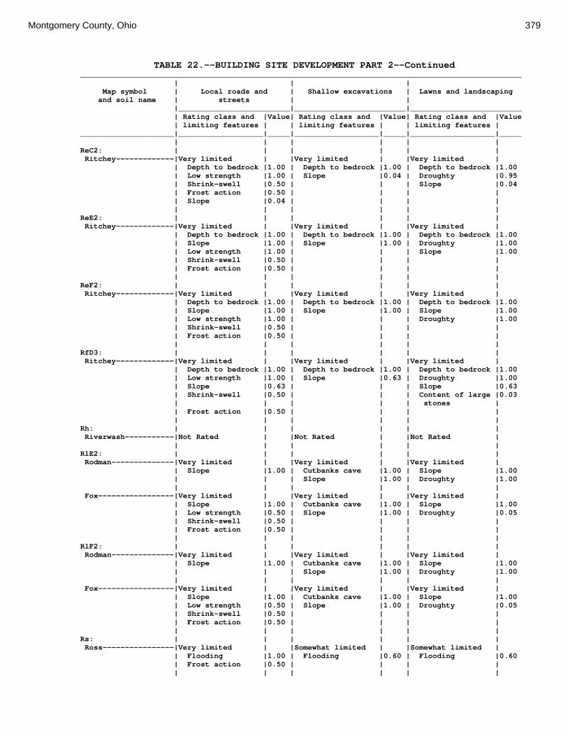
Montgomery County, Ohio 379
TABLE 22.--BUILDING SITE DEVELOPMENT PART 2--Continued ___________________________________________________________________________________________________ | | | Map symbol | Local roads and | Shallow excavations | Lawns and landscaping and soil name | streets | | |_________________________|_________________________|_________________________ | Rating class and |Value| Rating class and |Value| Rating class and |Value | limiting features | | limiting features | | limiting features | _____________________|___________________|_____|___________________|_____|___________________|_____ | | | | | | ReC2: | | | | | | Ritchey-------------|Very limited | |Very limited | |Very limited | | Depth to bedrock |1.00 | Depth to bedrock |1.00 | Depth to bedrock |1.00 | Low strength |1.00 | Slope |0.04 | Droughty |0.95 | Shrink-swell |0.50 | | | Slope |0.04 | Frost action |0.50 | | | | | Slope |0.04 | | | | | | | | | | ReE2: | | | | | | Ritchey-------------|Very limited | |Very limited | |Very limited | | Depth to bedrock |1.00 | Depth to bedrock |1.00 | Depth to bedrock |1.00 | Slope |1.00 | Slope |1.00 | Droughty |1.00 | Low strength |1.00 | | | Slope |1.00 | Shrink-swell |0.50 | | | | | Frost action |0.50 | | | | | | | | | | ReF2: | | | | | | Ritchey-------------|Very limited | |Very limited | |Very limited | | Depth to bedrock |1.00 | Depth to bedrock |1.00 | Depth to bedrock |1.00 | Slope |1.00 | Slope |1.00 | Slope |1.00 | Low strength |1.00 | | | Droughty |1.00 | Shrink-swell |0.50 | | | | | Frost action |0.50 | | | | | | | | | | RfD3: | | | | | | Ritchey-------------|Very limited | |Very limited | |Very limited | | Depth to bedrock |1.00 | Depth to bedrock |1.00 | Depth to bedrock |1.00 | Low strength |1.00 | Slope |0.63 | Droughty |1.00 | Slope |0.63 | | | Slope |0.63 | Shrink-swell |0.50 | | | Content of large |0.03 | | | | | stones | | Frost action |0.50 | | | | | | | | | | Rh: | | | | | | Riverwash-----------|Not Rated | |Not Rated | |Not Rated | | | | | | | RlE2: | | | | | | Rodman--------------|Very limited | |Very limited | |Very limited | | Slope |1.00 | Cutbanks cave |1.00 | Slope |1.00 | | | Slope |1.00 | Droughty |1.00 | | | | | | Fox-----------------|Very limited | |Very limited | |Very limited | | Slope |1.00 | Cutbanks cave |1.00 | Slope |1.00 | Low strength |0.50 | Slope |1.00 | Droughty |0.05 | Shrink-swell |0.50 | | | | | Frost action |0.50 | | | | | | | | | | RlF2: | | | | | | Rodman--------------|Very limited | |Very limited | |Very limited | | Slope |1.00 | Cutbanks cave |1.00 | Slope |1.00 | | | Slope |1.00 | Droughty |1.00 | | | | | | Fox-----------------|Very limited | |Very limited | |Very limited | | Slope |1.00 | Cutbanks cave |1.00 | Slope |1.00 | Low strength |0.50 | Slope |1.00 | Droughty |0.05 | Shrink-swell |0.50 | | | | | Frost action |0.50 | | | | | | | | | | Rs: | | | | | | Ross----------------|Very limited | |Somewhat limited | |Somewhat limited | | Flooding |1.00 | Flooding |0.60 | Flooding |0.60 | Frost action |0.50 | | | | | | | | | |

380 Soil Survey
TABLE 22.--BUILDING SITE DEVELOPMENT PART 2--Continued ___________________________________________________________________________________________________ | | | Map symbol | Local roads and | Shallow excavations | Lawns and landscaping and soil name | streets | | |_________________________|_________________________|_________________________ | Rating class and |Value| Rating class and |Value| Rating class and |Value | limiting features | | limiting features | | limiting features | _____________________|___________________|_____|___________________|_____|___________________|_____ | | | | | | Rt: | | | | | | Urban Land----------|Not Rated | |Not Rated | |Not Rated | | | | | | | Ross----------------|Very limited | |Somewhat limited | |Somewhat limited | | Flooding |1.00 | Flooding |0.60 | Flooding |0.60 | Frost action |0.50 | | | | | | | | | | RuB: | | | | | | Russell-------------|Very limited | |Not limited | |Not limited | | Frost action |1.00 | | | | | Low strength |1.00 | | | | | Shrink-swell |0.50 | | | | | | | | | | RvC2: | | | | | | Russell-------------|Very limited | |Somewhat limited | |Somewhat limited | | Frost action |1.00 | Slope |0.04 | Slope |0.04 | Low strength |1.00 | | | | | Shrink-swell |0.50 | | | | | Slope |0.04 | | | | | | | | | | Miamian-------------|Somewhat limited | |Somewhat limited | |Somewhat limited | | Frost action |0.50 | Slope |0.04 | Slope |0.04 | Slope |0.04 | | | | | | | | | | RvD2: | | | | | | Russell-------------|Very limited | |Very limited | |Very limited | | Frost action |1.00 | Slope |1.00 | Slope |1.00 | Low strength |1.00 | | | | | Slope |1.00 | | | | | Shrink-swell |0.50 | | | | | | | | | | Miamian-------------|Very limited | |Very limited | |Very limited | | Slope |1.00 | Slope |1.00 | Slope |1.00 | Frost action |0.50 | | | | | | | | | | Sh: | | | | | | Shoals--------------|Very limited | |Very limited | |Very limited | | Flooding |1.00 | Depth to |1.00 | Depth to |1.00 | | | saturated zone | | saturated zone | | Frost action |1.00 | Flooding |0.60 | Flooding |0.60 | Depth to |1.00 | | | | | saturated zone | | | | | | | | | | | So: | | | | | | Sloan---------------|Very limited | |Very limited | |Very limited | | Flooding |1.00 | Depth to |1.00 | Flooding |1.00 | | | saturated zone | | | | Depth to |1.00 | Ponding |1.00 | Depth to |1.00 | saturated zone | | | | saturated zone | | Frost action |1.00 | Flooding |0.80 | Ponding |1.00 | Ponding |1.00 | | | | | | | | | | ThA: | | | | | | Thackery------------|Very limited | |Very limited | |Somewhat limited | | Low strength |1.00 | Depth to |1.00 | Depth to |0.03 | | | saturated zone | | saturated zone | | Shrink-swell |0.50 | | | | | Frost action |0.50 | | | | | Depth to |0.03 | | | | | saturated zone | | | | | | | | | | |

Montgomery County, Ohio 381
TABLE 22.--BUILDING SITE DEVELOPMENT PART 2--Continued ___________________________________________________________________________________________________ | | | Map symbol | Local roads and | Shallow excavations | Lawns and landscaping and soil name | streets | | |_________________________|_________________________|_________________________ | Rating class and |Value| Rating class and |Value| Rating class and |Value | limiting features | | limiting features | | limiting features | _____________________|___________________|_____|___________________|_____|___________________|_____ | | | | | | TpA: | | | | | | Tippecanoe----------|Somewhat limited | |Very limited | |Somewhat limited | | Low strength |0.90 | Cutbanks cave |1.00 | Depth to |0.03 | | | | | saturated zone | | Shrink-swell |0.50 | Depth to |1.00 | | | | | saturated zone | | | | Frost action |0.50 | | | | | Depth to |0.03 | | | | | saturated zone | | | | | | | | | | | Ua: | | | | | | Urban Land----------|Not Rated | |Not Rated | |Not Rated | | | | | | | Ud: | | | | | | Udorthents----------|Not Rated | |Not Rated | |Not Rated | | | | | | | Ug: | | | | | | Urban Land----------|Not Rated | |Not Rated | |Not Rated | | | | | | | Um: | | | | | | Urban Land----------|Not Rated | |Not Rated | |Not Rated | | | | | | | WaA: | | | | | | Warsaw--------------|Somewhat limited | |Very limited | |Not limited | | Shrink-swell |0.50 | Cutbanks cave |1.00 | | | Frost action |0.50 | | | | | Low strength |0.05 | | | | | | | | | | WaB: | | | | | | Warsaw--------------|Somewhat limited | |Very limited | |Not limited | | Shrink-swell |0.50 | Cutbanks cave |1.00 | | | Frost action |0.50 | | | | | Low strength |0.05 | | | | | | | | | | WeA: | | | | | | Wea-----------------|Very limited | |Very limited | |Not limited | | Low strength |1.00 | Cutbanks cave |1.00 | | | Shrink-swell |0.50 | | | | | Frost action |0.50 | | | | | | | | | | WeB: | | | | | | Wea-----------------|Very limited | |Very limited | |Not limited | | Low strength |1.00 | Cutbanks cave |1.00 | | | Shrink-swell |0.50 | | | | | Frost action |0.50 | | | | | | | | | | Ws: | | | | | | Westland------------|Very limited | |Very limited | |Very limited | | Depth to |1.00 | Cutbanks cave |1.00 | Depth to |1.00 | saturated zone | | | | saturated zone | | Frost action |1.00 | Depth to |1.00 | Ponding |1.00 | | | saturated zone | | | | Low strength |1.00 | Ponding |1.00 | | | Ponding |1.00 | | | | | Shrink-swell |0.50 | | | | | | | | | |
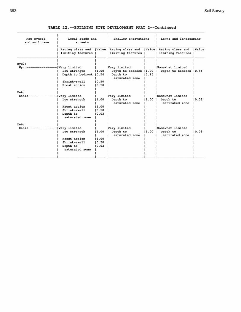
382 Soil Survey
TABLE 22.--BUILDING SITE DEVELOPMENT PART 2--Continued ___________________________________________________________________________________________________ | | | Map symbol | Local roads and | Shallow excavations | Lawns and landscaping and soil name | streets | | |_________________________|_________________________|_________________________ | Rating class and |Value| Rating class and |Value| Rating class and |Value | limiting features | | limiting features | | limiting features | _____________________|___________________|_____|___________________|_____|___________________|_____ | | | | | | WyB2: | | | | | | Wynn----------------|Very limited | |Very limited | |Somewhat limited | | Low strength |1.00 | Depth to bedrock |1.00 | Depth to bedrock |0.54 | Depth to bedrock |0.54 | Depth to |0.95 | | | | | saturated zone | | | | Shrink-swell |0.50 | | | | | Frost action |0.50 | | | | | | | | | | XeA: | | | | | | Xenia---------------|Very limited | |Very limited | |Somewhat limited | | Low strength |1.00 | Depth to |1.00 | Depth to |0.03 | | | saturated zone | | saturated zone | | Frost action |1.00 | | | | | Shrink-swell |0.50 | | | | | Depth to |0.03 | | | | | saturated zone | | | | | | | | | | | XeB: | | | | | | Xenia---------------|Very limited | |Very limited | |Somewhat limited | | Low strength |1.00 | Depth to |1.00 | Depth to |0.03 | | | saturated zone | | saturated zone | | Frost action |1.00 | | | | | Shrink-swell |0.50 | | | | | Depth to |0.03 | | | | | saturated zone | | | | | | | | | | | _____________________|___________________|_____|___________________|_____|___________________|_____

Montgomery County, Ohio 383
TABLE 23.--SANITARY FACILITIES PART 1 (The information in this table indicates the dominant soil condition but does not eliminate the need for onsite investigation. The numbers in the value columns range from 0.01 to 1.00. The larger the value, the greater the potential limitation. See text on page 171 for further explanation of ratings in this table.) _________________________________________________________________________ | | Map symbol | Septic tank | Sewage lagoons and soil name | absorption fields | |_________________________|_________________________ | Rating class and |Value| Rating class and |Value | limiting features | | limiting features | _____________________|___________________|_____|___________________|_____ | | | | Ag: | | | | Algiers-------------|Very limited | |Very limited | | Flooding |1.00 | Depth to |1.00 | | | saturated zone | | Depth to |1.00 | Flooding |1.00 | saturated zone | | | | Restricted |1.00 | | | permeability | | | | | | | Bo: | | | | Borrow Pits---------|Not Rated | |Not Rated | | | | | Bp: | | | | Brookston-----------|Very limited | |Very limited | | Depth to |1.00 | Depth to |1.00 | saturated zone | | saturated zone | | Ponding |1.00 | Ponding |1.00 | Restricted |0.46 | Seepage |0.53 | permeability | | | | | | | Br: | | | | Brookston-----------|Very limited | |Very limited | | Depth to |1.00 | Depth to |1.00 | saturated zone | | saturated zone | | Ponding |1.00 | Ponding |1.00 | Restricted |0.46 | Seepage |0.53 | permeability | | | | | | | Bs: | | | | Brookston-----------|Very limited | |Very limited | | Depth to |1.00 | Depth to |1.00 | saturated zone | | saturated zone | | Ponding |1.00 | Ponding |1.00 | Restricted |0.46 | Seepage |0.53 | permeability | | | | | | | Bu: | | | | Brookston-----------|Very limited | |Very limited | | Depth to |1.00 | Depth to |1.00 | saturated zone | | saturated zone | | Ponding |1.00 | Ponding |1.00 | Restricted |0.46 | Seepage |0.53 | permeability | | | | | | | Urban Land----------|Not Rated | |Not Rated | | | | | Ca: | | | | Carlisle------------|Very limited | |Very limited | | Depth to |1.00 | Depth to |1.00 | saturated zone | | saturated zone | | Subsidence |1.00 | Ponding |1.00 | Ponding |1.00 | Content of |1.00 | | | organic matter | | | | |

384 Soil Survey
TABLE 23.--SANITARY FACILITIES PART 1--Continued _________________________________________________________________________ | | Map symbol | Septic tank | Sewage lagoons and soil name | absorption fields | |_________________________|_________________________ | Rating class and |Value| Rating class and |Value | limiting features | | limiting features | _____________________|___________________|_____|___________________|_____ | | | | CeA: | | | | Celina--------------|Very limited | |Very limited | | Depth to |1.00 | Depth to |1.00 | saturated zone | | saturated zone | | Restricted |1.00 | Seepage |0.53 | permeability | | | | | | | CeB: | | | | Celina--------------|Very limited | |Very limited | | Depth to |1.00 | Depth to |1.00 | saturated zone | | saturated zone | | Restricted |1.00 | Seepage |0.53 | permeability | | | | | | Slope |0.32 | | | | CeB2: | | | | Celina--------------|Very limited | |Very limited | | Depth to |1.00 | Depth to |1.00 | saturated zone | | saturated zone | | Restricted |1.00 | Seepage |0.53 | permeability | | | | | | Slope |0.32 | | | | ClB: | | | | Celina--------------|Very limited | |Very limited | | Depth to |1.00 | Depth to |1.00 | saturated zone | | saturated zone | | Restricted |1.00 | Seepage |0.53 | permeability | | | | | | Slope |0.32 | | | | CoA: | | | | Corwin--------------|Very limited | |Very limited | | Depth to |1.00 | Depth to |1.00 | saturated zone | | saturated zone | | Restricted |1.00 | Seepage |0.53 | permeability | | | | | | | CoB: | | | | Corwin--------------|Very limited | |Very limited | | Depth to |1.00 | Depth to |1.00 | saturated zone | | saturated zone | | Restricted |1.00 | Seepage |0.53 | permeability | | | | | | Slope |0.32 | | | | CsA: | | | | Crosby--------------|Very limited | |Very limited | | Depth to |1.00 | Depth to |1.00 | saturated zone | | saturated zone | | Restricted |1.00 | | | permeability | | | | | | |

Montgomery County, Ohio 385
TABLE 23.--SANITARY FACILITIES PART 1--Continued _________________________________________________________________________ | | Map symbol | Septic tank | Sewage lagoons and soil name | absorption fields | |_________________________|_________________________ | Rating class and |Value| Rating class and |Value | limiting features | | limiting features | _____________________|___________________|_____|___________________|_____ | | | | CtB: | | | | Crosby--------------|Very limited | |Very limited | | Depth to |1.00 | Depth to |1.00 | saturated zone | | saturated zone | | Restricted |1.00 | Slope |0.01 | permeability | | | | | | | Celina--------------|Very limited | |Very limited | | Depth to |1.00 | Depth to |1.00 | saturated zone | | saturated zone | | Restricted |1.00 | Seepage |0.53 | permeability | | | | | | Slope |0.32 | | | | Cu: | | | | Crosby--------------|Very limited | |Very limited | | Depth to |1.00 | Depth to |1.00 | saturated zone | | saturated zone | | Restricted |1.00 | | | permeability | | | | | | | Urban Land----------|Not Rated | |Not Rated | | | | | DaB: | | | | Dana----------------|Very limited | |Very limited | | Depth to |1.00 | Depth to |1.00 | saturated zone | | saturated zone | | Restricted |1.00 | Seepage |0.53 | permeability | | | | | | Slope |0.32 | | | | FaE2: | | | | Fairmount-----------|Very limited | |Very limited | | Depth to bedrock |1.00 | Depth to bedrock |1.00 | Slippage |1.00 | Slope |1.00 | Slope |1.00 | | | | | | FaF2: | | | | Fairmount-----------|Very limited | |Very limited | | Depth to bedrock |1.00 | Depth to bedrock |1.00 | Slope |1.00 | Slope |1.00 | Slippage |1.00 | | | | | | FcA: | | | | Fincastle-----------|Very limited | |Very limited | | Depth to |1.00 | Depth to |1.00 | saturated zone | | saturated zone | | Restricted |1.00 | Slope |0.01 | permeability | | | | | | | FkA: | | | | Fox-----------------|Very limited | |Very limited | | Filtering |1.00 | Seepage |1.00 | capacity | | | | Restricted |0.46 | | | permeability | | | | | | | FkB: | | | | Fox-----------------|Very limited | |Very limited | | Filtering |1.00 | Seepage |1.00 | capacity | | | | Restricted |0.46 | Slope |0.32 | permeability | | |

386 Soil Survey
TABLE 23.--SANITARY FACILITIES PART 1--Continued _________________________________________________________________________ | | Map symbol | Septic tank | Sewage lagoons and soil name | absorption fields | |_________________________|_________________________ | Rating class and |Value| Rating class and |Value | limiting features | | limiting features | _____________________|___________________|_____|___________________|_____ | | | | FlA: | | | | Fox-----------------|Very limited | |Very limited | | Filtering |1.00 | Seepage |1.00 | capacity | | | | Restricted |0.46 | | | permeability | | | | | | | FlB: | | | | Fox-----------------|Very limited | |Very limited | | Filtering |1.00 | Seepage |1.00 | capacity | | | | Restricted |0.46 | Slope |0.32 | permeability | | | | | | | FlC2: | | | | Fox-----------------|Very limited | |Very limited | | Filtering |1.00 | Seepage |1.00 | capacity | | | | Slope |0.04 | Slope |1.00 | | | | FmA: | | | | Fox-----------------|Very limited | |Very limited | | Filtering |1.00 | Seepage |1.00 | capacity | | | | Restricted |0.46 | | | permeability | | | | | | | FmB: | | | | Fox-----------------|Very limited | |Very limited | | Filtering |1.00 | Seepage |1.00 | capacity | | | | Restricted |0.46 | Slope |0.32 | permeability | | | | | | | FmC2: | | | | Fox-----------------|Very limited | |Very limited | | Filtering |1.00 | Seepage |1.00 | capacity | | | | Slope |0.04 | Slope |1.00 | | | | FmD2: | | | | Fox-----------------|Very limited | |Very limited | | Filtering |1.00 | Slope |1.00 | capacity | | | | Slope |1.00 | Seepage |1.00 | | | | FsC3: | | | | Fox-----------------|Very limited | |Very limited | | Filtering |1.00 | Seepage |1.00 | capacity | | | | Slope |0.04 | Slope |1.00 | | | | FuB: | | | | Fox-----------------|Very limited | |Very limited | | Filtering |1.00 | Seepage |1.00 | capacity | | | | Restricted |0.46 | Slope |0.08 | permeability | | | | | | | Urban Land----------|Not Rated | |Not Rated | | | | |

Montgomery County, Ohio 387
TABLE 23.--SANITARY FACILITIES PART 1--Continued _________________________________________________________________________ | | Map symbol | Septic tank | Sewage lagoons and soil name | absorption fields | |_________________________|_________________________ | Rating class and |Value| Rating class and |Value | limiting features | | limiting features | _____________________|___________________|_____|___________________|_____ | | | | FuC: | | | | Urban Land----------|Not Rated | |Not Rated | | | | | Fox-----------------|Very limited | |Very limited | | Filtering |1.00 | Seepage |1.00 | capacity | | | | Slope |0.04 | Slope |1.00 | | | | FuF: | | | | Urban Land----------|Not Rated | |Not Rated | | | | | Fox-----------------|Very limited | |Very limited | | Filtering |1.00 | Slope |1.00 | capacity | | | | Slope |1.00 | Seepage |1.00 | | | | Gp: | | | | Gravel Pits---------|Not Rated | |Not Rated | | | | | HeE2: | | | | Hennepin------------|Very limited | |Very limited | | Slope |1.00 | Slope |1.00 | Restricted |1.00 | | | permeability | | | | | | | Miamian-------------|Very limited | |Very limited | | Slope |1.00 | Slope |1.00 | Restricted |1.00 | | | permeability | | | | | | | HeF2: | | | | Hennepin------------|Very limited | |Very limited | | Slope |1.00 | Slope |1.00 | Restricted |1.00 | | | permeability | | | | | | | Miamian-------------|Very limited | |Very limited | | Slope |1.00 | Slope |1.00 | Restricted |1.00 | | | permeability | | | | | | | HmF3: | | | | Hennepin------------|Very limited | |Very limited | | Slope |1.00 | Slope |1.00 | Restricted |1.00 | | | permeability | | | | | | | Miamian-------------|Very limited | |Very limited | | Slope |1.00 | Slope |1.00 | Restricted |1.00 | | | permeability | | | | | | | KeA: | | | | Kendallville--------|Very limited | |Somewhat limited | | Restricted |1.00 | Seepage |0.53 | permeability | | | | | | | KeB: | | | | Kendallville--------|Very limited | |Somewhat limited | | Restricted |1.00 | Seepage |0.53 | permeability | | | | | | Slope |0.32 | | | |

388 Soil Survey
TABLE 23.--SANITARY FACILITIES PART 1--Continued _________________________________________________________________________ | | Map symbol | Septic tank | Sewage lagoons and soil name | absorption fields | |_________________________|_________________________ | Rating class and |Value| Rating class and |Value | limiting features | | limiting features | _____________________|___________________|_____|___________________|_____ | | | | KeC2: | | | | Kendallville--------|Very limited | |Very limited | | Restricted |1.00 | Slope |1.00 | permeability | | | | Slope |0.04 | Seepage |0.53 | | | | Ld: | | | | Landes--------------|Very limited | |Very limited | | Flooding |1.00 | Flooding |1.00 | Filtering |1.00 | Seepage |1.00 | capacity | | | | | | | Lg: | | | | Lanier--------------|Very limited | |Very limited | | Flooding |1.00 | Flooding |1.00 | Filtering |1.00 | Seepage |1.00 | capacity | | | | | | | LsB: | | | | Lewisburg-----------|Very limited | |Very limited | | Depth to |1.00 | Depth to |1.00 | saturated zone | | saturated zone | | Restricted |1.00 | Slope |0.32 | permeability | | | | | | | LxC2: | | | | Lorenzo-------------|Very limited | |Very limited | | Filtering |1.00 | Seepage |1.00 | capacity | | | | Slope |0.01 | Slope |1.00 | | | | Rodman--------------|Very limited | |Very limited | | Filtering |1.00 | Seepage |1.00 | capacity | | | | Slope |0.01 | Slope |1.00 | | | | LxD2: | | | | Lorenzo-------------|Very limited | |Very limited | | Filtering |1.00 | Slope |1.00 | capacity | | | | Slope |1.00 | Seepage |1.00 | | | | Rodman--------------|Very limited | |Very limited | | Filtering |1.00 | Slope |1.00 | capacity | | | | Slope |1.00 | Seepage |1.00 | | | | Mb: | | | | Made Land-----------|Not Rated | |Not Rated | | | | | Md: | | | | Medway--------------|Very limited | |Very limited | | Flooding |1.00 | Depth to |1.00 | | | saturated zone | | Depth to |1.00 | Flooding |1.00 | saturated zone | | | | Restricted |0.46 | Seepage |1.00 | permeability | | | | | | | MlA: | | | | Miamian-------------|Very limited | |Not limited | | Restricted |1.00 | | | permeability | | |

Montgomery County, Ohio 389
TABLE 23.--SANITARY FACILITIES PART 1--Continued _________________________________________________________________________ | | Map symbol | Septic tank | Sewage lagoons and soil name | absorption fields | |_________________________|_________________________ | Rating class and |Value| Rating class and |Value | limiting features | | limiting features | _____________________|___________________|_____|___________________|_____ | | | | MlB: | | | | Miamian-------------|Very limited | |Somewhat limited | | Restricted |1.00 | Slope |0.32 | permeability | | | | | | | MlB2: | | | | Miamian-------------|Very limited | |Somewhat limited | | Restricted |1.00 | Slope |0.32 | permeability | | | | | | | MlC2: | | | | Miamian-------------|Very limited | |Very limited | | Restricted |1.00 | Slope |1.00 | permeability | | | | Slope |0.04 | | | | | | MlD2: | | | | Miamian-------------|Very limited | |Very limited | | Restricted |1.00 | Slope |1.00 | permeability | | | | Slope |1.00 | | | | | | MmB: | | | | Miamian-------------|Very limited | |Somewhat limited | | Restricted |1.00 | Slope |0.32 | permeability | | | | | | | MnB3: | | | | Miamian-------------|Very limited | |Somewhat limited | | Restricted |1.00 | Slope |0.32 | permeability | | | | | | | MnC3: | | | | Miamian-------------|Very limited | |Very limited | | Restricted |1.00 | Slope |1.00 | permeability | | | | Slope |0.04 | | | | | | MnD3: | | | | Miamian-------------|Very limited | |Very limited | | Restricted |1.00 | Slope |1.00 | permeability | | | | Slope |1.00 | | | | | | MoB: | | | | Miamian-------------|Very limited | |Somewhat limited | | Restricted |1.00 | Slope |0.32 | permeability | | | | | | | Urban Land----------|Not Rated | |Not Rated | | | | | MoC: | | | | Miamian-------------|Very limited | |Very limited | | Restricted |1.00 | Slope |1.00 | permeability | | | | Slope |0.04 | | | | | | Urban Land----------|Not Rated | |Not Rated | | | | |

390 Soil Survey
TABLE 23.--SANITARY FACILITIES PART 1--Continued _________________________________________________________________________ | | Map symbol | Septic tank | Sewage lagoons and soil name | absorption fields | |_________________________|_________________________ | Rating class and |Value| Rating class and |Value | limiting features | | limiting features | _____________________|___________________|_____|___________________|_____ | | | | MoE: | | | | Miamian-------------|Very limited | |Very limited | | Slope |1.00 | Slope |1.00 | Restricted |1.00 | | | permeability | | | | | | | Urban Land----------|Not Rated | |Not Rated | | | | | MrA: | | | | Millsdale-----------|Very limited | |Very limited | | Depth to bedrock |1.00 | Depth to bedrock |1.00 | Depth to |1.00 | Depth to |1.00 | saturated zone | | saturated zone | | Ponding |1.00 | Ponding |1.00 | Restricted |0.46 | Seepage |0.53 | permeability | | | | | | Slope |0.01 | | | | MsA: | | | | Milton--------------|Very limited | |Very limited | | Depth to bedrock |1.00 | Depth to bedrock |1.00 | Restricted |1.00 | Seepage |0.53 | permeability | | | | | | | MsB: | | | | Milton--------------|Very limited | |Very limited | | Depth to bedrock |1.00 | Depth to bedrock |1.00 | Restricted |1.00 | Seepage |0.53 | permeability | | | | | | Slope |0.32 | | | | MsB2: | | | | Milton--------------|Very limited | |Very limited | | Depth to bedrock |1.00 | Depth to bedrock |1.00 | Restricted |0.46 | Seepage |0.53 | permeability | | | | | | Slope |0.32 | | | | MsC2: | | | | Milton--------------|Very limited | |Very limited | | Depth to bedrock |1.00 | Depth to bedrock |1.00 | Restricted |1.00 | Slope |1.00 | permeability | | | | Slope |0.04 | Seepage |0.53 | | | | MsD2: | | | | Milton--------------|Very limited | |Very limited | | Depth to bedrock |1.00 | Depth to bedrock |1.00 | Restricted |1.00 | Slope |1.00 | permeability | | | | Slope |1.00 | Seepage |0.53 | | | | MtD3: | | | | Milton--------------|Very limited | |Very limited | | Depth to bedrock |1.00 | Depth to bedrock |1.00 | Slope |0.63 | Slope |1.00 | | | Seepage |0.53 | | | |

Montgomery County, Ohio 391
TABLE 23.--SANITARY FACILITIES PART 1--Continued _________________________________________________________________________ | | Map symbol | Septic tank | Sewage lagoons and soil name | absorption fields | |_________________________|_________________________ | Rating class and |Value| Rating class and |Value | limiting features | | limiting features | _____________________|___________________|_____|___________________|_____ | | | | MuB: | | | | Milton--------------|Very limited | |Very limited | | Depth to bedrock |1.00 | Depth to bedrock |1.00 | Restricted |1.00 | Seepage |0.53 | permeability | | | | | | Slope |0.32 | | | | Urban Land----------|Not Rated | |Not Rated | | | | | MuC: | | | | Milton--------------|Very limited | |Very limited | | Depth to bedrock |1.00 | Depth to bedrock |1.00 | Restricted |1.00 | Slope |1.00 | permeability | | | | Slope |0.04 | Seepage |0.53 | | | | Urban Land----------|Not Rated | |Not Rated | | | | | MuD: | | | | Milton--------------|Very limited | |Very limited | | Depth to bedrock |1.00 | Depth to bedrock |1.00 | Restricted |1.00 | Slope |1.00 | permeability | | | | Slope |1.00 | Seepage |0.53 | | | | Urban Land----------|Not Rated | |Not Rated | | | | | Mv: | | | | Montgomery----------|Very limited | |Very limited | | Restricted |1.00 | Depth to |1.00 | permeability | | saturated zone | | Depth to |1.00 | Ponding |1.00 | saturated zone | | | | Ponding |1.00 | | | | | | OcA: | | | | Ockley--------------|Very limited | |Very limited | | Filtering |1.00 | Seepage |1.00 | capacity | | | | Restricted |0.46 | | | permeability | | | | | | | OcB: | | | | Ockley--------------|Very limited | |Very limited | | Filtering |1.00 | Seepage |1.00 | capacity | | | | Restricted |0.46 | Slope |0.32 | permeability | | | | | | | PlB: | | | | Plattville----------|Very limited | |Very limited | | Depth to bedrock |1.00 | Depth to bedrock |1.00 | Restricted |1.00 | Slope |0.32 | permeability | | | | | | | PlC: | | | | Plattville----------|Very limited | |Very limited | | Depth to bedrock |1.00 | Depth to bedrock |1.00 | Restricted |1.00 | Slope |1.00 | permeability | | | | Slope |0.04 | | | | | |
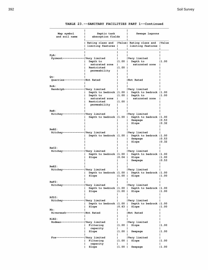
392 Soil Survey
TABLE 23.--SANITARY FACILITIES PART 1--Continued _________________________________________________________________________ | | Map symbol | Septic tank | Sewage lagoons and soil name | absorption fields | |_________________________|_________________________ | Rating class and |Value| Rating class and |Value | limiting features | | limiting features | _____________________|___________________|_____|___________________|_____ | | | | PyA: | | | | Pyrmont-------------|Very limited | |Very limited | | Depth to |1.00 | Depth to |1.00 | saturated zone | | saturated zone | | Restricted |1.00 | | | permeability | | | | | | | Qu: | | | | Quarries------------|Not Rated | |Not Rated | | | | | RcA: | | | | Randolph------------|Very limited | |Very limited | | Depth to bedrock |1.00 | Depth to bedrock |1.00 | Depth to |1.00 | Depth to |1.00 | saturated zone | | saturated zone | | Restricted |1.00 | | | permeability | | | | | | | ReB: | | | | Ritchey-------------|Very limited | |Very limited | | Depth to bedrock |1.00 | Depth to bedrock |1.00 | | | Seepage |0.53 | | | Slope |0.32 | | | | ReB2: | | | | Ritchey-------------|Very limited | |Very limited | | Depth to bedrock |1.00 | Depth to bedrock |1.00 | | | Seepage |0.53 | | | Slope |0.32 | | | | ReC2: | | | | Ritchey-------------|Very limited | |Very limited | | Depth to bedrock |1.00 | Depth to bedrock |1.00 | Slope |0.04 | Slope |1.00 | | | Seepage |0.53 | | | | ReE2: | | | | Ritchey-------------|Very limited | |Very limited | | Depth to bedrock |1.00 | Depth to bedrock |1.00 | Slope |1.00 | Slope |1.00 | | | | ReF2: | | | | Ritchey-------------|Very limited | |Very limited | | Depth to bedrock |1.00 | Depth to bedrock |1.00 | Slope |1.00 | Slope |1.00 | | | | RfD3: | | | | Ritchey-------------|Very limited | |Very limited | | Depth to bedrock |1.00 | Depth to bedrock |1.00 | Slope |0.63 | Slope |1.00 Rh: | | | | Riverwash-----------|Not Rated | |Not Rated | | | | | RlE2: | | | | Rodman--------------|Very limited | |Very limited | | Filtering |1.00 | Slope |1.00 | capacity | | | | Slope |1.00 | Seepage |1.00 | | | | Fox-----------------|Very limited | |Very limited | | Filtering |1.00 | Slope |1.00 | capacity | | | | Slope |1.00 | Seepage |1.00

Montgomery County, Ohio 393
TABLE 23.--SANITARY FACILITIES PART 1--Continued _________________________________________________________________________ | | Map symbol | Septic tank | Sewage lagoons and soil name | absorption fields | |_________________________|_________________________ | Rating class and |Value| Rating class and |Value | limiting features | | limiting features | _____________________|___________________|_____|___________________|_____ | | | | RlF2: | | | | Rodman--------------|Very limited | |Very limited | | Filtering |1.00 | Slope |1.00 | capacity | | | | Slope |1.00 | Seepage |1.00 | | | | Fox-----------------|Very limited | |Very limited | | Filtering |1.00 | Slope |1.00 | capacity | | | | Slope |1.00 | Seepage |1.00 | | | | Rs: | | | | Ross----------------|Very limited | |Very limited | | Flooding |1.00 | Flooding |1.00 | Restricted |0.46 | Seepage |0.53 | permeability | | | | | | | Rt: | | | | Urban Land----------|Not Rated | |Not Rated | | | | | Ross----------------|Very limited | |Very limited | | Flooding |1.00 | Flooding |1.00 | Restricted |0.46 | Seepage |0.53 | permeability | | | | | | | RuB: | | | | Russell-------------|Very limited | |Somewhat limited | | Restricted |1.00 | Seepage |0.53 | permeability | | | | | | Slope |0.32 | | | | RvC2: | | | | Russell-------------|Very limited | |Very limited | | Restricted |1.00 | Slope |1.00 | permeability | | | | Slope |0.04 | Seepage |0.53 | | | | Miamian-------------|Very limited | |Very limited | | Restricted |1.00 | Slope |1.00 | permeability | | | | Slope |0.04 | | | | | | RvD2: | | | | Russell-------------|Very limited | |Very limited | | Restricted |1.00 | Slope |1.00 | permeability | | | | Slope |1.00 | Seepage |0.53 | | | | Miamian-------------|Very limited | |Very limited | | Restricted |1.00 | Slope |1.00 | permeability | | | | Slope |1.00 | | | | | | Sh: | | | | Shoals--------------|Very limited | |Very limited | | Flooding |1.00 | Depth to |1.00 | | | saturated zone | | Depth to |1.00 | Flooding |1.00 | saturated zone | | | | Restricted |0.46 | Seepage |0.53 | permeability | | | | | | |

394 Soil Survey
TABLE 23.--SANITARY FACILITIES PART 1--Continued _________________________________________________________________________ | | Map symbol | Septic tank | Sewage lagoons and soil name | absorption fields | |_________________________|_________________________ | Rating class and |Value| Rating class and |Value | limiting features | | limiting features | _____________________|___________________|_____|___________________|_____ | | | | So: | | | | Sloan---------------|Very limited | |Very limited | | Flooding |1.00 | Depth to |1.00 | | | saturated zone | | Depth to |1.00 | Flooding |1.00 | saturated zone | | | | Restricted |1.00 | Ponding |1.00 | permeability | | | | Ponding |1.00 | Seepage |0.53 | | | | ThA: | | | | Thackery------------|Very limited | |Very limited | | Depth to |1.00 | Depth to |1.00 | saturated zone | | saturated zone | | Restricted |1.00 | Seepage |0.40 | permeability | | | | | | | TpA: | | | | Tippecanoe----------|Very limited | |Very limited | | Depth to |1.00 | Depth to |1.00 | saturated zone | | saturated zone | | Filtering |1.00 | Seepage |1.00 | capacity | | | | Restricted |0.46 | | | permeability | | | | | | | Ua: | | | | Urban Land----------|Not Rated | |Not Rated | | | | | Ud: | | | | Udorthents----------|Not Rated | |Not Rated | | | | | Ug: | | | | Urban Land----------|Not Rated | |Not Rated | | | | | Um: | | | | Urban Land----------|Not Rated | |Not Rated | | | | | WaA: | | | | Warsaw--------------|Very limited | |Very limited | | Filtering |1.00 | Seepage |1.00 | capacity | | | | Restricted |0.46 | | | permeability | | | | | | | WaB: | | | | Warsaw--------------|Very limited | |Very limited | | Filtering |1.00 | Seepage |1.00 | capacity | | | | Restricted |0.46 | Slope |0.32 | permeability | | | | | | | WeA: | | | | Wea-----------------|Very limited | |Very limited | | Filtering |1.00 | Seepage |1.00 | capacity | | | | Restricted |0.46 | | | permeability | | | | | | |
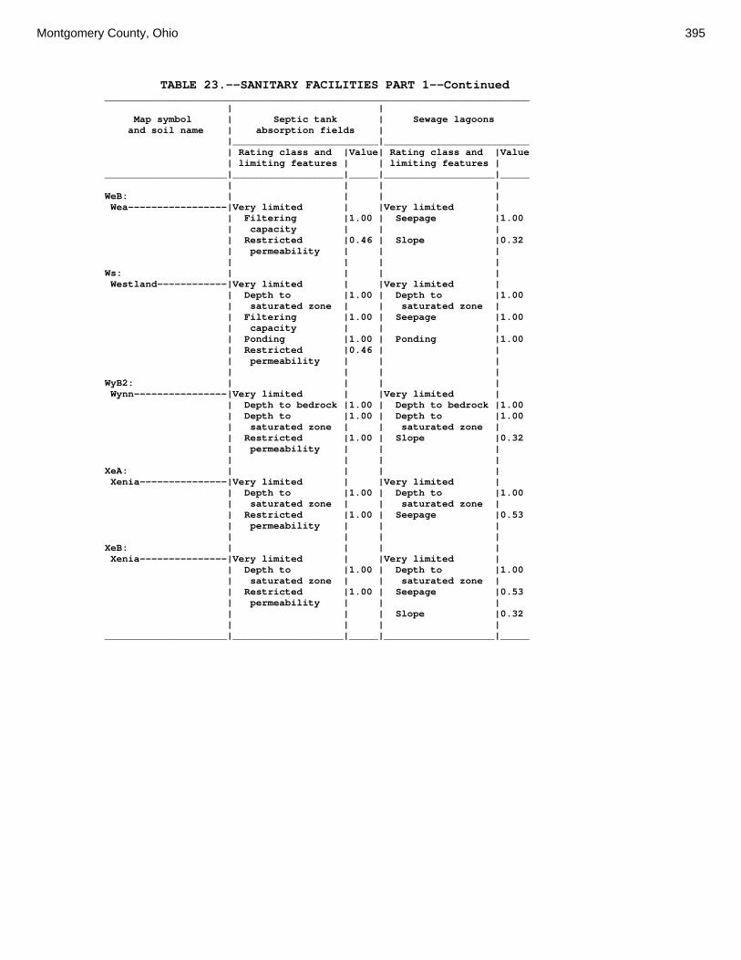
Montgomery County, Ohio 395
TABLE 23.--SANITARY FACILITIES PART 1--Continued _________________________________________________________________________ | | Map symbol | Septic tank | Sewage lagoons and soil name | absorption fields | |_________________________|_________________________ | Rating class and |Value| Rating class and |Value | limiting features | | limiting features | _____________________|___________________|_____|___________________|_____ | | | | WeB: | | | | Wea-----------------|Very limited | |Very limited | | Filtering |1.00 | Seepage |1.00 | capacity | | | | Restricted |0.46 | Slope |0.32 | permeability | | | | | | | Ws: | | | | Westland------------|Very limited | |Very limited | | Depth to |1.00 | Depth to |1.00 | saturated zone | | saturated zone | | Filtering |1.00 | Seepage |1.00 | capacity | | | | Ponding |1.00 | Ponding |1.00 | Restricted |0.46 | | | permeability | | | | | | | WyB2: | | | | Wynn----------------|Very limited | |Very limited | | Depth to bedrock |1.00 | Depth to bedrock |1.00 | Depth to |1.00 | Depth to |1.00 | saturated zone | | saturated zone | | Restricted |1.00 | Slope |0.32 | permeability | | | | | | | XeA: | | | | Xenia---------------|Very limited | |Very limited | | Depth to |1.00 | Depth to |1.00 | saturated zone | | saturated zone | | Restricted |1.00 | Seepage |0.53 | permeability | | | | | | | XeB: | | | | Xenia---------------|Very limited | |Very limited | | Depth to |1.00 | Depth to |1.00 | saturated zone | | saturated zone | | Restricted |1.00 | Seepage |0.53 | permeability | | | | | | Slope |0.32 | | | | _____________________|___________________|_____|___________________|_____

396 Soil Survey
TABLE 24.--SANITARY FACILITIES PART 2 (The information in this table indicates the dominant soil condition but does not eliminate the need for onsite investigation. The numbers in the value columns range from 0.01 to 1.00. The larger the value, the greater the potential limitation. See text on page 171 for further explanation of ratings in this table.) ___________________________________________________________________________________________________ | | | Map symbol | Trench sanitary | Area sanitary | Daily cover for and soil name | landfill | landfill | landfill |_________________________|_________________________|_________________________ | Rating class and |Value| Rating class and |Value| Rating class and |Value | limiting features | | limiting features | | limiting features | _____________________|___________________|_____|___________________|_____|___________________|_____ | | | | | | Ag: | | | | | | Algiers-------------|Very limited | |Very limited | |Very limited | | Flooding |1.00 | Flooding |1.00 | Depth to |1.00 | | | | | saturated zone | | Depth to |1.00 | Depth to |1.00 | Too clayey |0.50 | saturated zone | | saturated zone | | | | Too clayey |0.50 | | | | | | | | | | Bo: | | | | | | Borrow Pits---------|Not Rated | |Not Rated | |Not Rated | | | | | | | Bp: | | | | | | Brookston-----------|Very limited | |Very limited | |Very limited | | Depth to |1.00 | Depth to |1.00 | Depth to |1.00 | saturated zone | | saturated zone | | saturated zone | | Ponding |1.00 | Ponding |1.00 | Ponding |1.00 | Too clayey |0.50 | | | Too clayey |0.50 | | | | | | Br: | | | | | | Brookston-----------|Very limited | |Very limited | |Very limited | | Depth to |1.00 | Depth to |1.00 | Depth to |1.00 | saturated zone | | saturated zone | | saturated zone | | Ponding |1.00 | Ponding |1.00 | Ponding |1.00 | Too clayey |0.50 | | | Too clayey |0.50 | | | | | | Bs: | | | | | | Brookston-----------|Very limited | |Very limited | |Very limited | | Depth to |1.00 | Depth to |1.00 | Depth to |1.00 | saturated zone | | saturated zone | | saturated zone | | Ponding |1.00 | Ponding |1.00 | Ponding |1.00 | Too clayey |0.50 | | | Too clayey |0.50 | | | | | | Bu: | | | | | | Brookston-----------|Very limited | |Very limited | |Very limited | | Depth to |1.00 | Depth to |1.00 | Depth to |1.00 | saturated zone | | saturated zone | | saturated zone | | Ponding |1.00 | Ponding |1.00 | Ponding |1.00 | Too clayey |0.50 | | | Too clayey |0.50 | | | | | | Urban Land----------|Not Rated | |Not Rated | |Not Rated | | | | | | | Ca: | | | | | | Carlisle------------|Very limited | |Very limited | |Very limited | | Depth to |1.00 | Depth to |1.00 | Content of |1.00 | saturated zone | | saturated zone | | organic matter | | Content of |1.00 | Seepage |1.00 | Depth to |1.00 | organic matter | | | | saturated zone | | Ponding |1.00 | Ponding |1.00 | Ponding |1.00 | | | | | | CeA: | | | | | | Celina--------------|Very limited | |Very limited | |Somewhat limited | | Depth to |1.00 | Depth to |1.00 | Depth to |0.68 | saturated zone | | saturated zone | | saturated zone | | | | | | | CeB: | | | | | | Celina--------------|Very limited | |Very limited | |Somewhat limited | | Depth to |1.00 | Depth to |1.00 | Depth to |0.68 | saturated zone | | saturated zone | | saturated zone |

Montgomery County, Ohio 397
TABLE 24.--SANITARY FACILITIES PART 2--Continued ___________________________________________________________________________________________________ | | | Map symbol | Trench sanitary | Area sanitary | Daily cover for and soil name | landfill | landfill | landfill |_________________________|_________________________|_________________________ | Rating class and |Value| Rating class and |Value| Rating class and |Value | limiting features | | limiting features | | limiting features | _____________________|___________________|_____|___________________|_____|___________________|_____ | | | | | | CeB2: | | | | | | Celina--------------|Very limited | |Very limited | |Somewhat limited | | Depth to |1.00 | Depth to |1.00 | Depth to |0.68 | saturated zone | | saturated zone | | saturated zone | | | | | | | ClB: | | | | | | Celina--------------|Very limited | |Very limited | |Somewhat limited | | Depth to |1.00 | Depth to |1.00 | Depth to |0.68 | saturated zone | | saturated zone | | saturated zone | | | | | | | CoA: | | | | | | Corwin--------------|Very limited | |Very limited | |Somewhat limited | | Depth to |1.00 | Depth to |1.00 | Depth to |0.68 | saturated zone | | saturated zone | | saturated zone | | Too clayey |0.50 | | | Too clayey |0.50 | | | | | | CoB: | | | | | | Corwin--------------|Very limited | |Very limited | |Somewhat limited | | Depth to |1.00 | Depth to |1.00 | Depth to |0.68 | saturated zone | | saturated zone | | saturated zone | | Too clayey |0.50 | | | Too clayey |0.50 | | | | | | CsA: | | | | | | Crosby--------------|Very limited | |Very limited | |Very limited | | Depth to |1.00 | Depth to |1.00 | Depth to |1.00 | saturated zone | | saturated zone | | saturated zone | | | | | | | CtB: | | | | | | Crosby--------------|Very limited | |Very limited | |Very limited | | Depth to |1.00 | Depth to |1.00 | Depth to |1.00 | saturated zone | | saturated zone | | saturated zone | | | | | | | Celina--------------|Very limited | |Very limited | |Somewhat limited | | Depth to |1.00 | Depth to |1.00 | Depth to |0.68 | saturated zone | | saturated zone | | saturated zone | | | | | | | Cu: | | | | | | Crosby--------------|Very limited | |Very limited | |Very limited | | Depth to |1.00 | Depth to |1.00 | Depth to |1.00 | saturated zone | | saturated zone | | saturated zone | | | | | | | Urban Land----------|Not Rated | |Not Rated | |Not Rated | | | | | | | DaB: | | | | | | Dana----------------|Very limited | |Very limited | |Somewhat limited | | Depth to |1.00 | Depth to |1.00 | Depth to |0.68 | saturated zone | | saturated zone | | saturated zone | | | | | | | FaE2: | | | | | | Fairmount-----------|Very limited | |Very limited | |Very limited | | Depth to bedrock |1.00 | Slippage |1.00 | Depth to bedrock |1.00 | Too clayey |1.00 | Depth to bedrock |1.00 | Too clayey |1.00 | Slope |1.00 | Slope |1.00 | Hard to compact |1.00 | | | | | Slope |1.00 | | | | | | FaF2: | | | | | | Fairmount-----------|Very limited | |Very limited | |Very limited | | Slope |1.00 | Slippage |1.00 | Depth to bedrock |1.00 | Depth to bedrock |1.00 | Slope |1.00 | Slope |1.00 | Too clayey |1.00 | Depth to bedrock |1.00 | Too clayey |1.00 | | | | | Hard to compact |1.00 | | | | | |

398 Soil Survey
TABLE 24.--SANITARY FACILITIES PART 2--Continued ___________________________________________________________________________________________________ | | | Map symbol | Trench sanitary | Area sanitary | Daily cover for and soil name | landfill | landfill | landfill |_________________________|_________________________|_________________________ | Rating class and |Value| Rating class and |Value| Rating class and |Value | limiting features | | limiting features | | limiting features | _____________________|___________________|_____|___________________|_____|___________________|_____ | | | | | | FcA: | | | | | | Fincastle-----------|Very limited | |Very limited | |Very limited | | Depth to |1.00 | Depth to |1.00 | Depth to |1.00 | saturated zone | | saturated zone | | saturated zone | | | | | | | FkA: | | | | | | Fox-----------------|Very limited | |Very limited | |Very limited | | Seepage |1.00 | Seepage |1.00 | Seepage |1.00 | | | | | | FkB: | | | | | | Fox-----------------|Very limited | |Very limited | |Very limited | | Seepage |1.00 | Seepage |1.00 | Seepage |1.00 | | | | | | FlA: | | | | | | Fox-----------------|Very limited | |Very limited | |Very limited | | Seepage |1.00 | Seepage |1.00 | Seepage |1.00 | Too clayey |0.50 | | | Too clayey |0.50 | | | | | | FlB: | | | | | | Fox-----------------|Very limited | |Very limited | |Very limited | | Seepage |1.00 | Seepage |1.00 | Seepage |1.00 | Too clayey |0.50 | | | Too clayey |0.50 | | | | | | FlC2: | | | | | | Fox-----------------|Very limited | |Very limited | |Very limited | | Seepage |1.00 | Seepage |1.00 | Seepage |1.00 | Too clayey |0.50 | Slope |0.04 | Too clayey |0.50 | Slope |0.04 | | | Gravel content |0.23 | | | | | Slope |0.04 | | | | | | FmA: | | | | | | Fox-----------------|Very limited | |Very limited | |Very limited | | Seepage |1.00 | Seepage |1.00 | Seepage |1.00 | Too clayey |0.50 | | | Too clayey |0.50 | | | | | | FmB: | | | | | | Fox-----------------|Very limited | |Very limited | |Very limited | | Seepage |1.00 | Seepage |1.00 | Seepage |1.00 | Too clayey |0.50 | | | Too clayey |0.50 | | | | | | FmC2: | | | | | | Fox-----------------|Very limited | |Very limited | |Very limited | | Seepage |1.00 | Seepage |1.00 | Seepage |1.00 | Too clayey |0.50 | Slope |0.04 | Too clayey |0.50 | Slope |0.04 | | | Gravel content |0.21 | | | | | Slope |0.04 | | | | | | FmD2: | | | | | | Fox-----------------|Very limited | |Very limited | |Very limited | | Seepage |1.00 | Seepage |1.00 | Seepage |1.00 | Slope |1.00 | Slope |1.00 | Slope |1.00 | Too clayey |0.50 | | | Too clayey |0.50 | | | | | Gravel content |0.21 | | | | | | FsC3: | | | | | | Fox-----------------|Very limited | |Very limited | |Very limited | | Seepage |1.00 | Seepage |1.00 | Seepage |1.00 | Too clayey |0.50 | Slope |0.04 | Too clayey |0.50 | Slope |0.04 | | | Slope |0.04 | | | | | |

Montgomery County, Ohio 399
TABLE 24.--SANITARY FACILITIES PART 2--Continued ___________________________________________________________________________________________________ | | | Map symbol | Trench sanitary | Area sanitary | Daily cover for and soil name | landfill | landfill | landfill |_________________________|_________________________|_________________________ | Rating class and |Value| Rating class and |Value| Rating class and |Value | limiting features | | limiting features | | limiting features | _____________________|___________________|_____|___________________|_____|___________________|_____ | | | | | | FuB: | | | | | | Fox-----------------|Very limited | |Very limited | |Very limited | | Seepage |1.00 | Seepage |1.00 | Seepage |1.00 | Too clayey |0.50 | | | Too clayey |0.50 | | | | | | Urban Land----------|Not Rated | |Not Rated | |Not Rated | | | | | | | FuC: | | | | | | Urban Land----------|Not Rated | |Not Rated | |Not Rated | | | | | | | Fox-----------------|Very limited | |Very limited | |Very limited | | Seepage |1.00 | Seepage |1.00 | Seepage |1.00 | Too clayey |0.50 | Slope |0.04 | Too clayey |0.50 | Slope |0.04 | | | Gravel content |0.23 | | | | | Slope |0.04 | | | | | | FuF: | | | | | | Urban Land----------|Not Rated | |Not Rated | |Not Rated | | | | | | | Fox-----------------|Very limited | |Very limited | |Very limited | | Slope |1.00 | Slope |1.00 | Slope |1.00 | Seepage |1.00 | Seepage |1.00 | Seepage |1.00 | Too clayey |0.50 | | | Too clayey |0.50 | | | | | | Gp: | | | | | | Gravel Pits---------|Not Rated | |Not Rated | |Not Rated | | | | | | | HeE2: | | | | | | Hennepin------------|Very limited | |Very limited | |Very limited | | Slope |1.00 | Slope |1.00 | Slope |1.00 | | | | | | Miamian-------------|Very limited | |Very limited | |Very limited | | Slope |1.00 | Slope |1.00 | Slope |1.00 | | | | | | HeF2: | | | | | | Hennepin------------|Very limited | |Very limited | |Very limited | | Slope |1.00 | Slope |1.00 | Slope |1.00 | | | | | | Miamian-------------|Very limited | |Very limited | |Very limited | | Slope |1.00 | Slope |1.00 | Slope |1.00 | | | | | | HmF3: | | | | | | Hennepin------------|Very limited | |Very limited | |Very limited | | Slope |1.00 | Slope |1.00 | Slope |1.00 | | | | | | Miamian-------------|Very limited | |Very limited | |Very limited | | Slope |1.00 | Slope |1.00 | Slope |1.00 | | | | | | KeA: | | | | | | Kendallville--------|Not limited | |Not limited | |Not limited | | | | | | | KeB: | | | | | | Kendallville--------|Not limited | |Not limited | |Not limited | | | | | | | KeC2: | | | | | | Kendallville--------|Somewhat limited | |Somewhat limited | |Somewhat limited | | Slope |0.04 | Slope |0.04 | Slope |0.04 | | | | | | Ld: | | | | | | Landes--------------|Very limited | |Very limited | |Somewhat limited | | Flooding |1.00 | Flooding |1.00 | Gravel content |0.06 | Seepage |1.00 | Seepage |1.00 | | | | | | | |
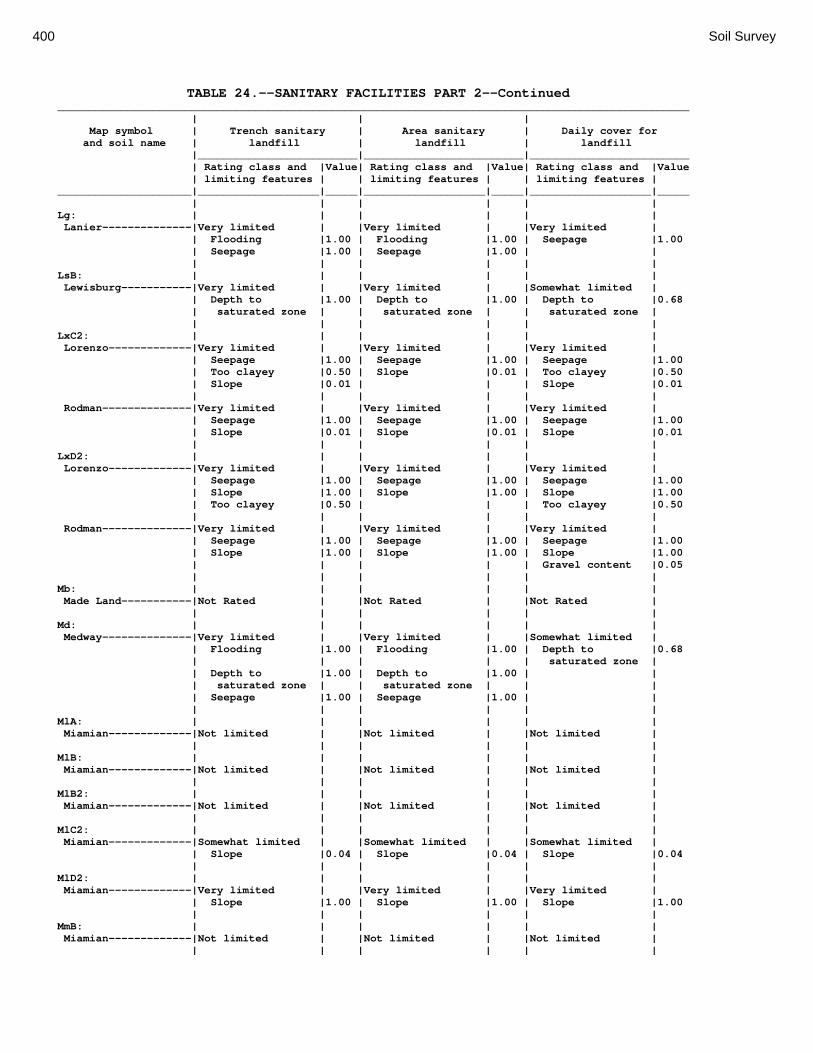
400 Soil Survey
TABLE 24.--SANITARY FACILITIES PART 2--Continued ___________________________________________________________________________________________________ | | | Map symbol | Trench sanitary | Area sanitary | Daily cover for and soil name | landfill | landfill | landfill |_________________________|_________________________|_________________________ | Rating class and |Value| Rating class and |Value| Rating class and |Value | limiting features | | limiting features | | limiting features | _____________________|___________________|_____|___________________|_____|___________________|_____ | | | | | | Lg: | | | | | | Lanier--------------|Very limited | |Very limited | |Very limited | | Flooding |1.00 | Flooding |1.00 | Seepage |1.00 | Seepage |1.00 | Seepage |1.00 | | | | | | | | LsB: | | | | | | Lewisburg-----------|Very limited | |Very limited | |Somewhat limited | | Depth to |1.00 | Depth to |1.00 | Depth to |0.68 | saturated zone | | saturated zone | | saturated zone | | | | | | | LxC2: | | | | | | Lorenzo-------------|Very limited | |Very limited | |Very limited | | Seepage |1.00 | Seepage |1.00 | Seepage |1.00 | Too clayey |0.50 | Slope |0.01 | Too clayey |0.50 | Slope |0.01 | | | Slope |0.01 | | | | | | Rodman--------------|Very limited | |Very limited | |Very limited | | Seepage |1.00 | Seepage |1.00 | Seepage |1.00 | Slope |0.01 | Slope |0.01 | Slope |0.01 | | | | | | LxD2: | | | | | | Lorenzo-------------|Very limited | |Very limited | |Very limited | | Seepage |1.00 | Seepage |1.00 | Seepage |1.00 | Slope |1.00 | Slope |1.00 | Slope |1.00 | Too clayey |0.50 | | | Too clayey |0.50 | | | | | | Rodman--------------|Very limited | |Very limited | |Very limited | | Seepage |1.00 | Seepage |1.00 | Seepage |1.00 | Slope |1.00 | Slope |1.00 | Slope |1.00 | | | | | Gravel content |0.05 | | | | | | Mb: | | | | | | Made Land-----------|Not Rated | |Not Rated | |Not Rated | | | | | | | Md: | | | | | | Medway--------------|Very limited | |Very limited | |Somewhat limited | | Flooding |1.00 | Flooding |1.00 | Depth to |0.68 | | | | | saturated zone | | Depth to |1.00 | Depth to |1.00 | | | saturated zone | | saturated zone | | | | Seepage |1.00 | Seepage |1.00 | | | | | | | | MlA: | | | | | | Miamian-------------|Not limited | |Not limited | |Not limited | | | | | | | MlB: | | | | | | Miamian-------------|Not limited | |Not limited | |Not limited | | | | | | | MlB2: | | | | | | Miamian-------------|Not limited | |Not limited | |Not limited | | | | | | | MlC2: | | | | | | Miamian-------------|Somewhat limited | |Somewhat limited | |Somewhat limited | | Slope |0.04 | Slope |0.04 | Slope |0.04 | | | | | | MlD2: | | | | | | Miamian-------------|Very limited | |Very limited | |Very limited | | Slope |1.00 | Slope |1.00 | Slope |1.00 | | | | | | MmB: | | | | | | Miamian-------------|Not limited | |Not limited | |Not limited | | | | | | |
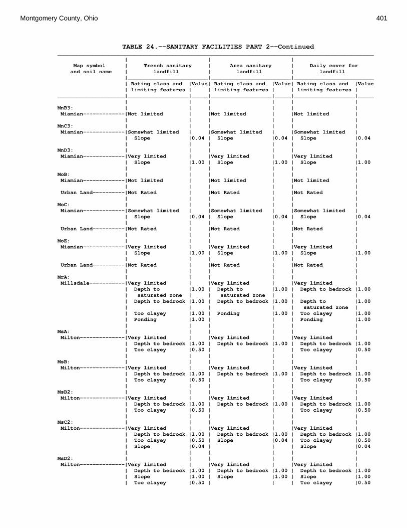
Montgomery County, Ohio 401
TABLE 24.--SANITARY FACILITIES PART 2--Continued ___________________________________________________________________________________________________ | | | Map symbol | Trench sanitary | Area sanitary | Daily cover for and soil name | landfill | landfill | landfill |_________________________|_________________________|_________________________ | Rating class and |Value| Rating class and |Value| Rating class and |Value | limiting features | | limiting features | | limiting features | _____________________|___________________|_____|___________________|_____|___________________|_____ | | | | | | MnB3: | | | | | | Miamian-------------|Not limited | |Not limited | |Not limited | | | | | | | MnC3: | | | | | | Miamian-------------|Somewhat limited | |Somewhat limited | |Somewhat limited | | Slope |0.04 | Slope |0.04 | Slope |0.04 | | | | | | MnD3: | | | | | | Miamian-------------|Very limited | |Very limited | |Very limited | | Slope |1.00 | Slope |1.00 | Slope |1.00 | | | | | | MoB: | | | | | | Miamian-------------|Not limited | |Not limited | |Not limited | | | | | | | Urban Land----------|Not Rated | |Not Rated | |Not Rated | | | | | | | MoC: | | | | | | Miamian-------------|Somewhat limited | |Somewhat limited | |Somewhat limited | | Slope |0.04 | Slope |0.04 | Slope |0.04 | | | | | | Urban Land----------|Not Rated | |Not Rated | |Not Rated | | | | | | | MoE: | | | | | | Miamian-------------|Very limited | |Very limited | |Very limited | | Slope |1.00 | Slope |1.00 | Slope |1.00 | | | | | | Urban Land----------|Not Rated | |Not Rated | |Not Rated | | | | | | | MrA: | | | | | | Millsdale-----------|Very limited | |Very limited | |Very limited | | Depth to |1.00 | Depth to |1.00 | Depth to bedrock |1.00 | saturated zone | | saturated zone | | | | Depth to bedrock |1.00 | Depth to bedrock |1.00 | Depth to |1.00 | | | | | saturated zone | | Too clayey |1.00 | Ponding |1.00 | Too clayey |1.00 | Ponding |1.00 | | | Ponding |1.00 | | | | | | MsA: | | | | | | Milton--------------|Very limited | |Very limited | |Very limited | | Depth to bedrock |1.00 | Depth to bedrock |1.00 | Depth to bedrock |1.00 | Too clayey |0.50 | | | Too clayey |0.50 | | | | | | MsB: | | | | | | Milton--------------|Very limited | |Very limited | |Very limited | | Depth to bedrock |1.00 | Depth to bedrock |1.00 | Depth to bedrock |1.00 | Too clayey |0.50 | | | Too clayey |0.50 | | | | | | MsB2: | | | | | | Milton--------------|Very limited | |Very limited | |Very limited | | Depth to bedrock |1.00 | Depth to bedrock |1.00 | Depth to bedrock |1.00 | Too clayey |0.50 | | | Too clayey |0.50 | | | | | | MsC2: | | | | | | Milton--------------|Very limited | |Very limited | |Very limited | | Depth to bedrock |1.00 | Depth to bedrock |1.00 | Depth to bedrock |1.00 | Too clayey |0.50 | Slope |0.04 | Too clayey |0.50 | Slope |0.04 | | | Slope |0.04 | | | | | | MsD2: | | | | | | Milton--------------|Very limited | |Very limited | |Very limited | | Depth to bedrock |1.00 | Depth to bedrock |1.00 | Depth to bedrock |1.00 | Slope |1.00 | Slope |1.00 | Slope |1.00 | Too clayey |0.50 | | | Too clayey |0.50

402 Soil Survey
TABLE 24.--SANITARY FACILITIES PART 2--Continued ___________________________________________________________________________________________________ | | | Map symbol | Trench sanitary | Area sanitary | Daily cover for and soil name | landfill | landfill | landfill |_________________________|_________________________|_________________________ | Rating class and |Value| Rating class and |Value| Rating class and |Value | limiting features | | limiting features | | limiting features | _____________________|___________________|_____|___________________|_____|___________________|_____ | | | | | | MtD3: | | | | | | Milton--------------|Very limited | |Very limited | |Very limited | | Depth to bedrock |1.00 | Depth to bedrock |1.00 | Depth to bedrock |1.00 | Slope |0.63 | Slope |0.63 | Slope |0.63 | Too clayey |0.50 | | | Too clayey |0.50 | | | | | | MuB: | | | | | | Milton--------------|Very limited | |Very limited | |Very limited | | Depth to bedrock |1.00 | Depth to bedrock |1.00 | Depth to bedrock |1.00 | Too clayey |0.50 | | | Too clayey |0.50 | | | | | | Urban Land----------|Not Rated | |Not Rated | |Not Rated | | | | | | | MuC: | | | | | | Milton--------------|Very limited | |Very limited | |Very limited | | Depth to bedrock |1.00 | Depth to bedrock |1.00 | Depth to bedrock |1.00 | Too clayey |0.50 | Slope |0.04 | Too clayey |0.50 | Slope |0.04 | | | Slope |0.04 | | | | | | Urban Land----------|Not Rated | |Not Rated | |Not Rated | | | | | | | MuD: | | | | | | Milton--------------|Very limited | |Very limited | |Very limited | | Depth to bedrock |1.00 | Depth to bedrock |1.00 | Depth to bedrock |1.00 | Slope |1.00 | Slope |1.00 | Slope |1.00 | Too clayey |0.50 | | | Too clayey |0.50 | | | | | | Urban Land----------|Not Rated | |Not Rated | |Not Rated | | | | | | | Mv: | | | | | | Montgomery----------|Very limited | |Very limited | |Very limited | | Depth to |1.00 | Depth to |1.00 | Depth to |1.00 | saturated zone | | saturated zone | | saturated zone | | Too clayey |1.00 | Ponding |1.00 | Too clayey |1.00 | Ponding |1.00 | | | Ponding |1.00 | | | | | | OcA: | | | | | | Ockley--------------|Very limited | |Not limited | |Somewhat limited | | Seepage |1.00 | | | Too clayey |0.50 | Too clayey |0.50 | | | | | | | | | | OcB: | | | | | | Ockley--------------|Very limited | |Not limited | |Somewhat limited | | Seepage |1.00 | | | Too clayey |0.50 | Too clayey |0.50 | | | | | | | | | | PlB: | | | | | | Plattville----------|Very limited | |Very limited | |Very limited | | Depth to bedrock |1.00 | Depth to bedrock |1.00 | Depth to bedrock |1.00 | Too clayey |0.50 | | | Too clayey |0.50 | | | | | | PlC: | | | | | | Plattville----------|Very limited | |Very limited | |Very limited | | Depth to bedrock |1.00 | Depth to bedrock |1.00 | Depth to bedrock |1.00 | Too clayey |0.50 | Slope |0.04 | Too clayey |0.50 | Slope |0.04 | | | Slope |0.04 | | | | | | PyA: | | | | | | Pyrmont-------------|Very limited | |Very limited | |Very limited | | Depth to |1.00 | Depth to |1.00 | Depth to |1.00 | saturated zone | | saturated zone | | saturated zone | | | | | | |

Montgomery County, Ohio 403
TABLE 24.--SANITARY FACILITIES PART 2--Continued ___________________________________________________________________________________________________ | | | Map symbol | Trench sanitary | Area sanitary | Daily cover for and soil name | landfill | landfill | landfill |_________________________|_________________________|_________________________ | Rating class and |Value| Rating class and |Value| Rating class and |Value | limiting features | | limiting features | | limiting features | _____________________|___________________|_____|___________________|_____|___________________|_____ | | | | | | Qu: | | | | | | Quarries------------|Not Rated | |Not Rated | |Not Rated | | | | | | | RcA: | | | | | | Randolph------------|Very limited | |Very limited | |Very limited | | Depth to |1.00 | Depth to |1.00 | Depth to bedrock |1.00 | saturated zone | | saturated zone | | | | Depth to bedrock |1.00 | Depth to bedrock |1.00 | Depth to |1.00 | | | | | saturated zone | | Too clayey |1.00 | | | Too clayey |1.00 | | | | | | ReB: | | | | | | Ritchey-------------|Very limited | |Very limited | |Very limited | | Depth to bedrock |1.00 | Depth to bedrock |1.00 | Depth to bedrock |1.00 | Too clayey |1.00 | | | Too clayey |1.00 | | | | | | ReB2: | | | | | | Ritchey-------------|Very limited | |Very limited | |Very limited | | Depth to bedrock |1.00 | Depth to bedrock |1.00 | Depth to bedrock |1.00 | Too clayey |1.00 | | | Too clayey |1.00 | | | | | | ReC2: | | | | | | Ritchey-------------|Very limited | |Very limited | |Very limited | | Depth to bedrock |1.00 | Depth to bedrock |1.00 | Depth to bedrock |1.00 | Too clayey |1.00 | Slope |0.04 | Too clayey |1.00 | Slope |0.04 | | | Slope |0.04 | | | | | | ReE2: | | | | | | Ritchey-------------|Very limited | |Very limited | |Very limited | | Depth to bedrock |1.00 | Depth to bedrock |1.00 | Depth to bedrock |1.00 | Too clayey |1.00 | Slope |1.00 | Too clayey |1.00 | Slope |1.00 | | | Slope |1.00 | | | | | | ReF2: | | | | | | Ritchey-------------|Very limited | |Very limited | |Very limited | | Slope |1.00 | Slope |1.00 | Depth to bedrock |1.00 | Depth to bedrock |1.00 | Depth to bedrock |1.00 | Slope |1.00 | Too clayey |1.00 | | | Too clayey |1.00 | | | | | | RfD3: | | | | | | Ritchey-------------|Very limited | |Very limited | |Very limited | | Depth to bedrock |1.00 | Depth to bedrock |1.00 | Depth to bedrock |1.00 | Slope |0.63 | Slope |0.63 | Slope |0.63 | Too clayey |0.50 | | | Too clayey |0.50 | | | | | | Rh: | | | | | | Riverwash-----------|Not Rated | |Not Rated | |Not Rated | | | | | | | RlE2: | | | | | | Rodman--------------|Very limited | |Very limited | |Very limited | | Slope |1.00 | Slope |1.00 | Slope |1.00 | Seepage |1.00 | Seepage |1.00 | Seepage |1.00 | | | | | | Fox-----------------|Very limited | |Very limited | |Very limited | | Slope |1.00 | Slope |1.00 | Slope |1.00 | Seepage |1.00 | Seepage |1.00 | Seepage |1.00 | Too clayey |0.50 | | | Too clayey |0.50 | | | | | Gravel content |0.20 | | | | | |

404 Soil Survey
TABLE 24.--SANITARY FACILITIES PART 2--Continued ___________________________________________________________________________________________________ | | | Map symbol | Trench sanitary | Area sanitary | Daily cover for and soil name | landfill | landfill | landfill |_________________________|_________________________|_________________________ | Rating class and |Value| Rating class and |Value| Rating class and |Value | limiting features | | limiting features | | limiting features | _____________________|___________________|_____|___________________|_____|___________________|_____ | | | | | | RlF2: | | | | | | Rodman--------------|Very limited | |Very limited | |Very limited | | Slope |1.00 | Slope |1.00 | Slope |1.00 | Seepage |1.00 | Seepage |1.00 | Seepage |1.00 | | | | | Gravel content |0.01 | | | | | | Fox-----------------|Very limited | |Very limited | |Very limited | | Slope |1.00 | Slope |1.00 | Slope |1.00 | Seepage |1.00 | Seepage |1.00 | Seepage |1.00 | Too clayey |0.50 | | | Too clayey |0.50 | | | | | Gravel content |0.20 | | | | | | Rs: | | | | | | Ross----------------|Very limited | |Very limited | |Not limited | | Flooding |1.00 | Flooding |1.00 | | | | | | | | Rt: | | | | | | Urban Land----------|Not Rated | |Not Rated | |Not Rated | | | | | | | Ross----------------|Very limited | |Very limited | |Not limited | | Flooding |1.00 | Flooding |1.00 | | | | | | | | RuB: | | | | | | Russell-------------|Not limited | |Not limited | |Not limited | | | | | | | RvC2: | | | | | | Russell-------------|Somewhat limited | |Somewhat limited | |Somewhat limited | | Slope |0.04 | Slope |0.04 | Slope |0.04 | | | | | | Miamian-------------|Somewhat limited | |Somewhat limited | |Somewhat limited | | Slope |0.04 | Slope |0.04 | Slope |0.04 | | | | | | RvD2: | | | | | | Russell-------------|Very limited | |Very limited | |Very limited | | Slope |1.00 | Slope |1.00 | Slope |1.00 | | | | | | Miamian-------------|Very limited | |Very limited | |Very limited | | Slope |1.00 | Slope |1.00 | Slope |1.00 | | | | | | Sh: | | | | | | Shoals--------------|Very limited | |Very limited | |Very limited | | Flooding |1.00 | Flooding |1.00 | Depth to |1.00 | | | | | saturated zone | | Depth to |1.00 | Depth to |1.00 | | | saturated zone | | saturated zone | | | | | | | | | So: | | | | | | Sloan---------------|Very limited | |Very limited | |Very limited | | Flooding |1.00 | Flooding |1.00 | Depth to |1.00 | | | | | saturated zone | | Depth to |1.00 | Depth to |1.00 | Ponding |1.00 | saturated zone | | saturated zone | | | | Ponding |1.00 | Ponding |1.00 | Gravel content |0.07 | | | | | | ThA: | | | | | | Thackery------------|Very limited | |Very limited | |Somewhat limited | | Depth to |1.00 | Depth to |1.00 | Depth to |0.68 | saturated zone | | saturated zone | | saturated zone | | Too clayey |0.50 | | | Too clayey |0.50 | | | | | |

Montgomery County, Ohio 405
TABLE 24.--SANITARY FACILITIES PART 2--Continued ___________________________________________________________________________________________________ | | | Map symbol | Trench sanitary | Area sanitary | Daily cover for and soil name | landfill | landfill | landfill |_________________________|_________________________|_________________________ | Rating class and |Value| Rating class and |Value| Rating class and |Value | limiting features | | limiting features | | limiting features | _____________________|___________________|_____|___________________|_____|___________________|_____ | | | | | | TpA: | | | | | | Tippecanoe----------|Very limited | |Very limited | |Somewhat limited | | Depth to |1.00 | Depth to |1.00 | Depth to |0.68 | saturated zone | | saturated zone | | saturated zone | | Seepage |1.00 | | | Too clayey |0.50 | Too clayey |0.50 | | | | | | | | | | Ua: | | | | | | Urban Land----------|Not Rated | |Not Rated | |Not Rated | | | | | | | Ud: | | | | | | Udorthents----------|Not Rated | |Not Rated | |Not Rated | | | | | | | Ug: | | | | | | Urban Land----------|Not Rated | |Not Rated | |Not Rated | | | | | | | Um: | | | | | | Urban Land----------|Not Rated | |Not Rated | |Not Rated | | | | | | | WaA: | | | | | | Warsaw--------------|Very limited | |Very limited | |Very limited | | Seepage |1.00 | Seepage |1.00 | Seepage |1.00 | Too clayey |0.50 | | | Too clayey |0.50 | | | | | | WaB: | | | | | | Warsaw--------------|Very limited | |Very limited | |Very limited | | Seepage |1.00 | Seepage |1.00 | Seepage |1.00 | Too clayey |0.50 | | | Too clayey |0.50 | | | | | | WeA: | | | | | | Wea-----------------|Very limited | |Not limited | |Somewhat limited | | Seepage |1.00 | | | Too clayey |0.50 | Too clayey |0.50 | | | | | | | | | | WeB: | | | | | | Wea-----------------|Very limited | |Not limited | |Somewhat limited | | Seepage |1.00 | | | Too clayey |0.50 | Too clayey |0.50 | | | | | | | | | | Ws: | | | | | | Westland------------|Very limited | |Very limited | |Very limited | | saturated zone | | saturated zone | | saturated zone | | Seepage |1.00 | Seepage |1.00 | Ponding |1.00 | Ponding |1.00 | Ponding |1.00 | Too clayey |0.50 | Too clayey |0.50 | | | | | | | | | | WyB2: | | | | | | Wynn----------------|Very limited | |Very limited | |Very limited | | Depth to |1.00 | Depth to |1.00 | Depth to bedrock |1.00 | saturated zone | | saturated zone | | | | Depth to bedrock |1.00 | Depth to bedrock |1.00 | Too clayey |0.50 | Too clayey |0.50 | | | Depth to |0.11 | | | | | saturated zone | | | | | | | XeA: | | | | | | Xenia---------------|Very limited | |Very limited | |Somewhat limited | | Depth to |1.00 | Depth to |1.00 | Depth to |0.68 | saturated zone | | saturated zone | | saturated zone | | | | | | Too clayey |0.50 | | | | | |

406 Soil Survey
TABLE 24.--SANITARY FACILITIES PART 2--Continued ___________________________________________________________________________________________________ | | | Map symbol | Trench sanitary | Area sanitary | Daily cover for and soil name | landfill | landfill | landfill |_________________________|_________________________|_________________________ | Rating class and |Value| Rating class and |Value| Rating class and |Value | limiting features | | limiting features | | limiting features | _____________________|___________________|_____|___________________|_____|___________________|_____ | | | | | | XeB: | | | | | | Xenia---------------|Very limited | |Very limited | |Somewhat limited | | Depth to |1.00 | Depth to |1.00 | Depth to |0.68 | saturated zone | | saturated zone | | saturated zone | | | | | | Too clayey |0.50 | | | | | | _____________________|___________________|_____|___________________|_____|___________________|_____

Montgomery County, Ohio 407
TABLE 25.--AGRICULTURAL WASTE MANAGEMENT (The information in this table indicates the dominant soil condition but does not eliminate the need for onsite investigation. The numbers in the value columns range from 0.01 to 1.00. The larger the value, the greater the limitation. See text on page 173 for further explanation of ratings in this table.) ____________________________________________________________________________________________________ | | | Map symbol | Application of | Application | Disposal of and soil name | manure and food- | of sewage sludge | wastewater | processing waste | | by irrigation |_________________________|_________________________|_________________________ | Rating class and |Value| Rating class and |Value| Rating class and |Value | limiting features | | limiting features | | limiting features | _____________________|___________________|_____|___________________|_____|___________________|_____ | | | | | | Ag: | | | | | | Algiers-------------|Very limited | |Very limited | |Very limited | | Depth to |1.00 | Depth to |1.00 | Depth to |1.00 | saturated zone | | saturated zone | | saturated zone | | Flooding |1.00 | Flooding |1.00 | Flooding |0.60 | Leaching |0.50 | Restricted |0.14 | Restricted |0.14 | limitation | | permeability | | permeability | | Restricted |0.18 | | | | | permeability | | | | | | | | | | | Bo: | | | | | | Borrow Pits---------|Not rated | |Not rated | |Not rated | | | | | | | Bp: | | | | | | Brookston-----------|Very limited | |Very limited | |Very limited | | Depth to |1.00 | Depth to |1.00 | Depth to |1.00 | saturated zone | | saturated zone | | saturated zone | | Ponding |1.00 | Ponding |1.00 | Ponding |1.00 | Leaching |0.70 | | | | | limitation | | | | | | | | | | | Br: | | | | | | Brookston-----------|Very limited | |Very limited | |Very limited | | Depth to |1.00 | Depth to |1.00 | Depth to |1.00 | saturated zone | | saturated zone | | saturated zone | | Ponding |1.00 | Ponding |1.00 | Ponding |1.00 | Leaching |0.70 | | | | | limitation | | | | | | | | | | | Bs: | | | | | | Brookston-----------|Very limited | |Very limited | |Very limited | | Depth to |1.00 | Depth to |1.00 | Depth to |1.00 | saturated zone | | saturated zone | | saturated zone | | Ponding |1.00 | Ponding |1.00 | Ponding |1.00 | Leaching |0.70 | | | | | limitation | | | | | | | | | | | Bu: | | | | | | Brookston-----------|Not rated | |Not rated | |Not rated | | | | | | | Urban Land----------|Not rated | |Not rated | |Not rated | | | | | | | Ca: | | | | | | Carlisle------------|Very limited | |Very limited | |Very limited | | Depth to |1.00 | Depth to |1.00 | Depth to |1.00 | saturated zone | | saturated zone | | saturated zone | | Ponding |1.00 | Ponding |1.00 | Ponding |1.00 | Leaching |0.90 | | | | | limitation | | | | | | | | | | |

408 Soil Survey
TABLE 25.--AGRICULTURAL WASTE MANAGEMENT--Continued ____________________________________________________________________________________________________ | | | Map symbol | Application of | Application | Disposal of and soil name | manure and food- | of sewage sludge | wastewater | processing waste | | by irrigation |_________________________|_________________________|_________________________ | Rating class and |Value| Rating class and |Value| Rating class and |Value | limiting features | | limiting features | | limiting features | _____________________|___________________|_____|___________________|_____|___________________|_____ | | | | | | CeA: | | | | | | Celina--------------|Somewhat limited | |Somewhat limited | |Somewhat limited | | | | | | | | Depth to |0.95 | Depth to |0.95 | Depth to |0.95 | saturated zone | | saturated zone | | saturated zone | | Restricted |0.41 | Too acid |0.42 | Too acid |0.42 | permeability | | | | | | Too acid |0.11 | Restricted |0.31 | Restricted |0.31 | | | permeability | | permeability | | | | | | | CeB: | | | | | | Celina--------------|Somewhat limited | |Somewhat limited | |Somewhat limited | | Depth to |0.95 | Depth to |0.95 | Depth to |0.95 | saturated zone | | saturated zone | | saturated zone | | Restricted |0.41 | Too acid |0.42 | Too acid |0.42 | permeability | | | | | | Too acid |0.11 | Restricted |0.31 | Restricted |0.31 | | | permeability | | permeability | | | | | | Too steep for |0.08 | | | | | surface | | | | | | application | | | | | | | CeB2: | | | | | | Celina--------------|Somewhat limited | |Somewhat limited | |Somewhat limited | | Depth to |0.95 | Depth to |0.95 | Depth to |0.95 | saturated zone | | saturated zone | | saturated zone | | Restricted |0.41 | Too acid |0.31 | Too acid |0.31 | permeability | | | | | | Too acid |0.08 | Restricted |0.31 | Restricted |0.31 | | | permeability | | permeability | | | | | | Too steep for |0.08 | | | | | surface | | | | | | application | | | | | | | ClB: | | | | | | Celina--------------|Very limited | |Very limited | |Very limited | | Large stones on |1.00 | Large stones on |1.00 | Large stones on |1.00 | the surface | | the surface | | the surface | | Depth to |0.95 | Depth to |0.95 | Depth to |0.95 | saturated zone | | saturated zone | | saturated zone | | Restricted |0.41 | Too acid |0.31 | Too acid |0.31 | permeability | | | | | | Too acid |0.08 | Restricted |0.31 | Restricted |0.31 | | | permeability | | permeability | | | | | | Too steep for |0.08 | | | | | surface | | | | | | application | | | | | | | CoA: | | | | | | Corwin--------------|Somewhat limited | |Somewhat limited | |Somewhat limited | | Depth to |0.95 | Depth to |0.95 | Depth to |0.95 | saturated zone | | saturated zone | | saturated zone | | Restricted |0.41 | Too acid |0.31 | Too acid |0.31 | permeability | | | | | | Too acid |0.08 | Restricted |0.31 | Restricted |0.31 | | | permeability | | permeability | | | | | | |

Montgomery County, Ohio 409
TABLE 25.--AGRICULTURAL WASTE MANAGEMENT--Continued ____________________________________________________________________________________________________ | | | Map symbol | Application of | Application | Disposal of and soil name | manure and food- | of sewage sludge | wastewater | processing waste | | by irrigation |_________________________|_________________________|_________________________ | Rating class and |Value| Rating class and |Value| Rating class and |Value | limiting features | | limiting features | | limiting features | _____________________|___________________|_____|___________________|_____|___________________|_____ | | | | | | CoB: | | | | | | Corwin--------------|Somewhat limited | |Somewhat limited | |Somewhat limited | | Depth to |0.95 | Depth to |0.95 | Depth to |0.95 | saturated zone | | saturated zone | | saturated zone | | Restricted |0.41 | Too acid |0.31 | Too acid |0.31 | permeability | | | | | | Too acid |0.08 | Restricted |0.31 | Restricted |0.31 | | | permeability | | permeability | | | | | | Too steep for |0.08 | | | | | surface | | | | | | application | | | | | | | CsA: | | | | | | Crosby--------------|Very limited | |Very limited | |Very limited | | Depth to |1.00 | Depth to |1.00 | Depth to |1.00 | saturated zone | | saturated zone | | saturated zone | | Restricted |0.20 | Too acid |0.31 | Too acid |0.31 | permeability | | | | | | Too acid |0.08 | Restricted |0.15 | Restricted |0.15 | | | permeability | | permeability | | | | | | | CtB: | | | | | | Crosby--------------|Very limited | |Very limited | |Very limited | | Depth to |1.00 | Depth to |1.00 | Depth to |1.00 | saturated zone | | saturated zone | | saturated zone | | Restricted |0.74 | Restricted |0.60 | Restricted |0.60 | permeability | | permeability | | permeability | | Too acid |0.08 | Too acid |0.31 | Too acid |0.31 | | | | | | Celina--------------|Somewhat limited | |Somewhat limited | |Somewhat limited | | Depth to |0.95 | Depth to |0.95 | Depth to |0.95 | saturated zone | | saturated zone | | saturated zone | | Restricted |0.41 | Too acid |0.31 | Too acid |0.31 | permeability | | | | | | Too acid |0.08 | Restricted |0.31 | Restricted |0.31 | | | permeability | | permeability | | | | | | Too steep for |0.08 | | | | | surface | | | | | | application | | | | | | | Cu: | | | | | | Crosby--------------|Not rated | |Not rated | |Not rated | | | | | | | Urban Land----------|Not rated | |Not rated | |Not rated | | | | | | | DaB: | | | | | | Dana----------------|Somewhat limited | |Somewhat limited | |Somewhat limited | | Depth to |0.95 | Depth to |0.95 | Depth to |0.95 | saturated zone | | saturated zone | | saturated zone | | Restricted |0.41 | Restricted |0.31 | Restricted |0.31 | permeability | | permeability | | permeability | | Too acid |0.05 | Too acid |0.21 | Too acid |0.21 | | | | | Too steep for |0.08 | | | | | surface | | | | | | application | | | | | | |

410 Soil Survey
TABLE 25.--AGRICULTURAL WASTE MANAGEMENT--Continued ____________________________________________________________________________________________________ | | | Map symbol | Application of | Application | Disposal of and soil name | manure and food- | of sewage sludge | wastewater | processing waste | | by irrigation |_________________________|_________________________|_________________________ | Rating class and |Value| Rating class and |Value| Rating class and |Value | limiting features | | limiting features | | limiting features | _____________________|___________________|_____|___________________|_____|___________________|_____ | | | | | | FaE2: | | | | | | Fairmount-----------|Very limited | |Very limited | |Very limited | | Depth to bedrock |1.00 | Depth to bedrock |1.00 | Depth to bedrock |1.00 | Droughty |1.00 | Droughty |1.00 | Too steep for |1.00 | | | | | surface | | | | | | application | | Slope |1.00 | Slope |1.00 | Droughty |1.00 | Restricted |0.41 | Restricted |0.31 | Too steep for |1.00 | permeability | | permeability | | sprinkler | | | | | | application | | Runoff limitation|0.40 | | | Restricted |0.31 | | | | | permeability | | | | | | | FaF2: | | | | | | Fairmount-----------|Very limited | |Very limited | |Very limited | | Slope |1.00 | Droughty |1.00 | Droughty |1.00 | Depth to bedrock |1.00 | Depth to bedrock |1.00 | Depth to bedrock |1.00 | Droughty |1.00 | Slope |1.00 | Too steep for |1.00 | | | | | surface | | | | | | application | | Restricted |0.41 | Restricted |0.31 | Too steep for |1.00 | permeability | | permeability | | sprinkler | | | | | | application | | Runoff limitation|0.40 | | | Restricted |0.31 | | | | | permeability | | | | | | | FcA: | | | | | | Fincastle-----------|Very limited | |Very limited | |Very limited | | Depth to |1.00 | Depth to |1.00 | Depth to |1.00 | saturated zone | | saturated zone | | saturated zone | | Restricted |0.41 | Restricted |0.31 | Restricted |0.31 | permeability | | permeability | | permeability | | Too acid |0.05 | Too acid |0.21 | Too acid |0.21 | | | | | | FkA: | | | | | | Fox-----------------|Very limited | |Very limited | |Very limited | | Filtering |1.00 | Filtering |1.00 | Filtering |1.00 | capacity | | capacity | | capacity | | Shallow to |0.54 | Shallow to |0.54 | Droughty |0.24 | Discontinuity | | Discontinuity | | | | Droughty |0.24 | Droughty |0.24 | Too acid |0.07 | Too acid |0.02 | Too acid |0.07 | | | | | | | | FkB: | | | | | | Fox-----------------|Very limited | |Very limited | |Very limited | | Filtering |1.00 | Filtering |1.00 | Filtering |1.00 | capacity | | capacity | | capacity | | Shallow to |0.54 | Shallow to |0.54 | Droughty |0.24 | Discontinuity | | Discontinuity | | | | Droughty |0.24 | Droughty |0.24 | Too steep for |0.08 | | | | | surface | | | | | | application | | Too acid |0.02 | Too acid |0.07 | Too acid |0.07 | | | | | | FlA: | | | | | | Fox-----------------|Very limited | |Very limited | |Very limited | | Filtering |1.00 | Filtering |1.00 | Filtering |1.00 | capacity | | capacity | | capacity | | Shallow to |0.54 | Shallow to |0.54 | Droughty |0.24 | Discontinuity | | Discontinuity | | | | Droughty |0.24 | Droughty |0.24 | Too acid |0.07 | Too acid |0.02 | Too acid |0.07 | |

Montgomery County, Ohio 411
TABLE 25.--AGRICULTURAL WASTE MANAGEMENT--Continued ____________________________________________________________________________________________________ | | | Map symbol | Application of | Application | Disposal of and soil name | manure and food- | of sewage sludge | wastewater | processing waste | | by irrigation |_________________________|_________________________|_________________________ | Rating class and |Value| Rating class and |Value| Rating class and |Value | limiting features | | limiting features | | limiting features | _____________________|___________________|_____|___________________|_____|___________________|_____ | | | | | | FlB: | | | | | | Fox-----------------|Very limited | |Very limited | |Very limited | | Filtering |1.00 | Filtering |1.00 | Filtering |1.00 | capacity | | capacity | | capacity | | Shallow to |0.54 | Shallow to |0.54 | Droughty |0.24 | Discontinuity | | Discontinuity | | | | Droughty |0.24 | Droughty |0.24 | Too steep for |0.08 | | | | | surface | | | | | | application | | Too acid |0.02 | Too acid |0.07 | Too acid |0.07 | | | | | | FlC2: | | | | | | Fox-----------------|Very limited | |Very limited | |Very limited | | Filtering |1.00 | Filtering |1.00 | Filtering |1.00 | capacity | | capacity | | capacity | | Droughty |0.89 | Droughty |0.89 | Too steep for |1.00 | | | | | surface | | | | | | application | | Shallow to |0.54 | Shallow to |0.54 | Droughty |0.89 | Discontinuity | | Discontinuity | | | | Slope |0.04 | Too acid |0.07 | Too steep for |0.22 | | | | | sprinkler | | | | | | application | | Too acid |0.02 | Slope |0.04 | Too acid |0.07 | | | | | | FmA: | | | | | | Fox-----------------|Very limited | |Very limited | |Very limited | | Filtering |1.00 | Filtering |1.00 | Filtering |1.00 | capacity | | capacity | | capacity | | Shallow to |0.54 | Shallow to |0.54 | Droughty |0.24 | Discontinuity | | Discontinuity | | | | Droughty |0.24 | Droughty |0.24 | Too acid |0.21 | Too acid |0.05 | Too acid |0.21 | | | | | | | | FmB: | | | | | | Fox-----------------|Very limited | |Very limited | |Very limited | | Filtering |1.00 | Filtering |1.00 | Filtering |1.00 | capacity | | capacity | | capacity | | Shallow to |0.54 | Shallow to |0.54 | Droughty |0.24 | Discontinuity | | Discontinuity | | | | Droughty |0.24 | Droughty |0.24 | Too steep for |0.08 | | | | | surface | | | | | | application | | Too acid |0.02 | Too acid |0.07 | Too acid |0.07 | | | | | | FmC2: | | | | | | Fox-----------------|Very limited | |Very limited | |Very limited | | Filtering |1.00 | Filtering |1.00 | Filtering |1.00 | capacity | | capacity | | capacity | | Droughty |0.89 | Droughty |0.89 | Too steep for |1.00 | | | | | surface | | | | | | application | | Shallow to |0.54 | Shallow to |0.54 | Droughty |0.89 | Discontinuity | | Discontinuity | | | | Slope |0.04 | Too acid |0.07 | Too steep for |0.22 | | | | | sprinkler | | | | | | application | | Too acid |0.02 | Slope |0.04 | Too acid |0.07 | | | | | |

412 Soil Survey
TABLE 25.--AGRICULTURAL WASTE MANAGEMENT--Continued ____________________________________________________________________________________________________ | | | Map symbol | Application of | Application | Disposal of and soil name | manure and food- | of sewage sludge | wastewater | processing waste | | by irrigation |_________________________|_________________________|_________________________ | Rating class and |Value| Rating class and |Value| Rating class and |Value | limiting features | | limiting features | | limiting features | _____________________|___________________|_____|___________________|_____|___________________|_____ | | | | | | FmD2: | | | | | | Fox-----------------|Very limited | |Very limited | |Very limited | | Filtering |1.00 | Filtering |1.00 | Filtering |1.00 | capacity | | capacity | | capacity | | Slope |1.00 | Slope |1.00 | Too steep for |1.00 | | | | | surface | | | | | | application | | Droughty |0.89 | Droughty |0.89 | Too steep for |1.00 | | | | | sprinkler | | | | | | application | | Shallow to |0.54 | Shallow to |0.54 | Droughty |0.89 | Discontinuity | | Discontinuity | | | | Too acid |0.02 | Too acid |0.07 | Too acid |0.07 | | | | | | FsC3: | | | | | | Fox-----------------|Very limited | |Very limited | |Very limited | | Filtering |1.00 | Filtering |1.00 | Filtering |1.00 | capacity | | capacity | | capacity | | Shallow to |1.00 | Shallow to |1.00 | Too steep for |1.00 | Discontinuity | | Discontinuity | | surface | | | | | | application | | Droughty |1.00 | Droughty |1.00 | Droughty |1.00 | Slope |0.04 | Too acid |0.07 | Too steep for |0.22 | | | | | sprinkler | | | | | | application | | Too acid |0.02 | Slope |0.04 | Too acid |0.07 | | | | | | FuB: | | | | | | Fox-----------------|Not rated | |Not rated | |Not rated | | | | | | | Urban Land----------|Not rated | |Not rated | |Not rated | | | | | | | FuC: | | | | | | Urban Land----------|Not rated | |Not rated | |Not rated | | | | | | | Fox-----------------|Not rated | |Not rated | |Not rated | | | | | | | FuF: | | | | | | Urban Land----------|Not rated | |Not rated | |Not rated | | | | | | | Fox-----------------|Not rated | |Not rated | |Not rated | | | | | | | Gp: | | | | | | Gravel Pits---------|Not rated | |Not rated | |Not rated | | | | | | |
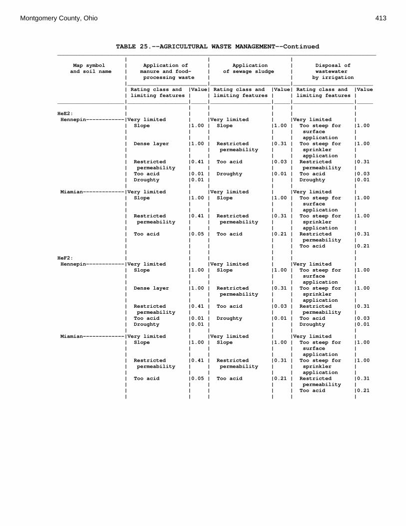
Montgomery County, Ohio 413
TABLE 25.--AGRICULTURAL WASTE MANAGEMENT--Continued ____________________________________________________________________________________________________ | | | Map symbol | Application of | Application | Disposal of and soil name | manure and food- | of sewage sludge | wastewater | processing waste | | by irrigation |_________________________|_________________________|_________________________ | Rating class and |Value| Rating class and |Value| Rating class and |Value | limiting features | | limiting features | | limiting features | _____________________|___________________|_____|___________________|_____|___________________|_____ | | | | | | HeE2: | | | | | | Hennepin------------|Very limited | |Very limited | |Very limited | | Slope |1.00 | Slope |1.00 | Too steep for |1.00 | | | | | surface | | | | | | application | | Dense layer |1.00 | Restricted |0.31 | Too steep for |1.00 | | | permeability | | sprinkler | | | | | | application | | Restricted |0.41 | Too acid |0.03 | Restricted |0.31 | permeability | | | | permeability | | Too acid |0.01 | Droughty |0.01 | Too acid |0.03 | Droughty |0.01 | | | Droughty |0.01 | | | | | | Miamian-------------|Very limited | |Very limited | |Very limited | | Slope |1.00 | Slope |1.00 | Too steep for |1.00 | | | | | surface | | | | | | application | | Restricted |0.41 | Restricted |0.31 | Too steep for |1.00 | permeability | | permeability | | sprinkler | | | | | | application | | Too acid |0.05 | Too acid |0.21 | Restricted |0.31 | | | | | permeability | | | | | | Too acid |0.21 | | | | | | HeF2: | | | | | | Hennepin------------|Very limited | |Very limited | |Very limited | | Slope |1.00 | Slope |1.00 | Too steep for |1.00 | | | | | surface | | | | | | application | | Dense layer |1.00 | Restricted |0.31 | Too steep for |1.00 | | | permeability | | sprinkler | | | | | | application | | Restricted |0.41 | Too acid |0.03 | Restricted |0.31 | permeability | | | | permeability | | Too acid |0.01 | Droughty |0.01 | Too acid |0.03 | Droughty |0.01 | | | Droughty |0.01 | | | | | | Miamian-------------|Very limited | |Very limited | |Very limited | | Slope |1.00 | Slope |1.00 | Too steep for |1.00 | | | | | surface | | | | | | application | | Restricted |0.41 | Restricted |0.31 | Too steep for |1.00 | permeability | | permeability | | sprinkler | | | | | | application | | Too acid |0.05 | Too acid |0.21 | Restricted |0.31 | | | | | permeability | | | | | | Too acid |0.21 | | | | | |

414 Soil Survey
TABLE 25.--AGRICULTURAL WASTE MANAGEMENT--Continued ____________________________________________________________________________________________________ | | | Map symbol | Application of | Application | Disposal of and soil name | manure and food- | of sewage sludge | wastewater | processing waste | | by irrigation |_________________________|_________________________|_________________________ | Rating class and |Value| Rating class and |Value| Rating class and |Value | limiting features | | limiting features | | limiting features | _____________________|___________________|_____|___________________|_____|___________________|_____ | | | | | | HmF3: | | | | | | Hennepin------------|Very limited | |Very limited | |Very limited | | Slope |1.00 | Slope |1.00 | Too steep for |1.00 | | | | | surface | | | | | | application | | Dense layer |1.00 | Restricted |0.31 | Too steep for |1.00 | | | permeability | | sprinkler | | | | | | application | | Restricted |0.41 | Droughty |0.09 | Restricted |0.31 | permeability | | | | permeability | | Droughty |0.09 | | | Droughty |0.09 | | | | | | Miamian-------------|Very limited | |Very limited | |Very limited | | Slope |1.00 | Slope |1.00 | Too steep for |1.00 | | | | | surface | | | | | | application | | Dense layer |1.00 | Restricted |0.31 | Too steep for |1.00 | | | permeability | | sprinkler | | | | | | application | | Restricted |0.41 | Too acid |0.21 | Restricted |0.31 | permeability | | | | permeability | | Too acid |0.05 | | | Too acid |0.21 | | | | | | KeA: | | | | | | Kendallville--------|Somewhat limited | |Somewhat limited | |Somewhat limited | | Restricted |0.41 | Restricted |0.31 | Restricted |0.31 | permeability | | permeability | | permeability | | Too acid |0.05 | Too acid |0.21 | Too acid |0.21 | | | | | | KeB: | | | | | | Kendallville--------|Somewhat limited | |Somewhat limited | |Somewhat limited | | Restricted |0.41 | Restricted |0.31 | Restricted |0.31 | permeability | | permeability | | permeability | | Too acid |0.05 | Too acid |0.21 | Too acid |0.21 | | | | | Too steep for |0.08 | | | | | surface | | | | | | application | | | | | | | KeC2: | | | | | | Kendallville--------|Somewhat limited | |Somewhat limited | |Very limited | | Restricted |0.41 | Restricted |0.31 | Too steep for |1.00 | permeability | | permeability | | surface | | | | | | application | | Slope |0.04 | Too acid |0.07 | Restricted |0.31 | | | | | permeability | | Too acid |0.02 | Slope |0.04 | Too steep for |0.22 | | | | | sprinkler | | | | | | application | | | | | | Too acid |0.07 | | | | | | Ld: | | | | | | Landes--------------|Very limited | |Very limited | |Very limited | | Filtering |1.00 | Filtering |1.00 | Filtering |1.00 | capacity | | capacity | | capacity | | Flooding |1.00 | Flooding |1.00 | Flooding |0.60 | Droughty |0.31 | Droughty |0.31 | Droughty |0.31 | | | | | |
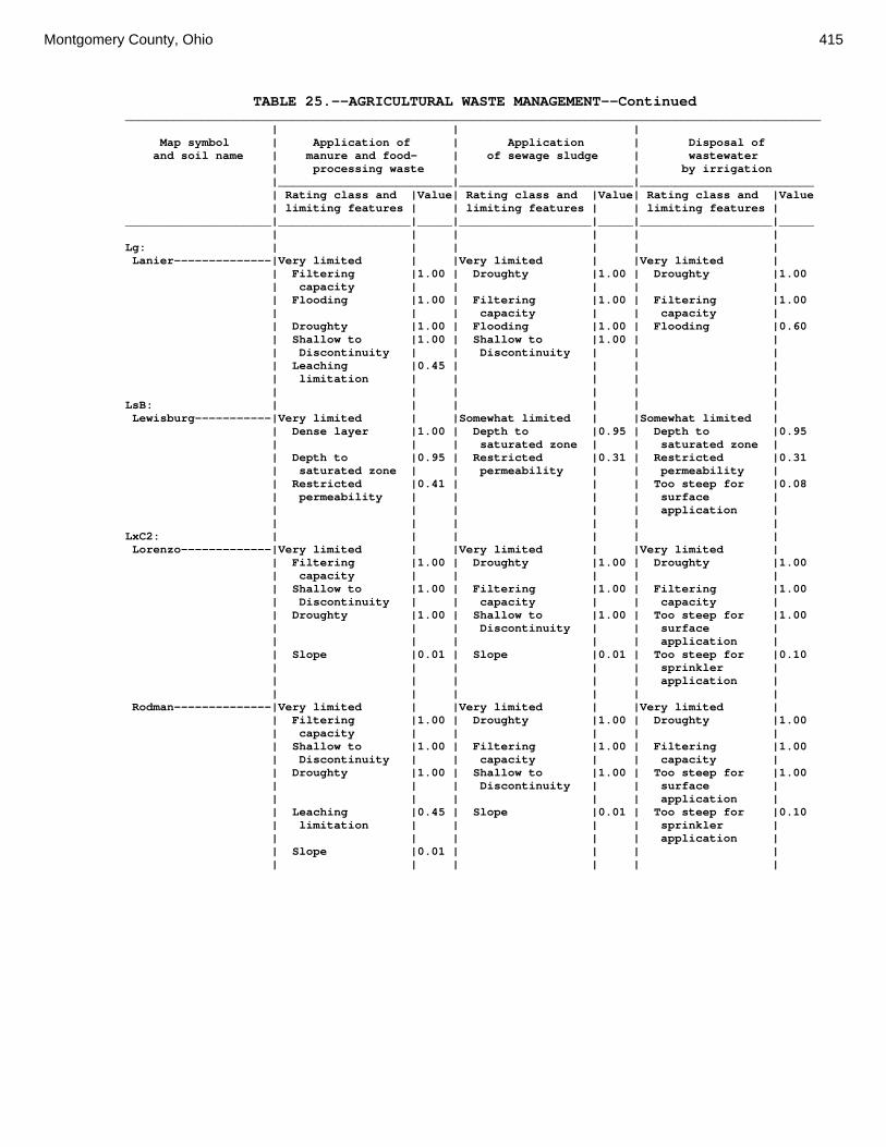
Montgomery County, Ohio 415
TABLE 25.--AGRICULTURAL WASTE MANAGEMENT--Continued ____________________________________________________________________________________________________ | | | Map symbol | Application of | Application | Disposal of and soil name | manure and food- | of sewage sludge | wastewater | processing waste | | by irrigation |_________________________|_________________________|_________________________ | Rating class and |Value| Rating class and |Value| Rating class and |Value | limiting features | | limiting features | | limiting features | _____________________|___________________|_____|___________________|_____|___________________|_____ | | | | | | Lg: | | | | | | Lanier--------------|Very limited | |Very limited | |Very limited | | Filtering |1.00 | Droughty |1.00 | Droughty |1.00 | capacity | | | | | | Flooding |1.00 | Filtering |1.00 | Filtering |1.00 | | | capacity | | capacity | | Droughty |1.00 | Flooding |1.00 | Flooding |0.60 | Shallow to |1.00 | Shallow to |1.00 | | | Discontinuity | | Discontinuity | | | | Leaching |0.45 | | | | | limitation | | | | | | | | | | | LsB: | | | | | | Lewisburg-----------|Very limited | |Somewhat limited | |Somewhat limited | | Dense layer |1.00 | Depth to |0.95 | Depth to |0.95 | | | saturated zone | | saturated zone | | Depth to |0.95 | Restricted |0.31 | Restricted |0.31 | saturated zone | | permeability | | permeability | | Restricted |0.41 | | | Too steep for |0.08 | permeability | | | | surface | | | | | | application | | | | | | | LxC2: | | | | | | Lorenzo-------------|Very limited | |Very limited | |Very limited | | Filtering |1.00 | Droughty |1.00 | Droughty |1.00 | capacity | | | | | | Shallow to |1.00 | Filtering |1.00 | Filtering |1.00 | Discontinuity | | capacity | | capacity | | Droughty |1.00 | Shallow to |1.00 | Too steep for |1.00 | | | Discontinuity | | surface | | | | | | application | | Slope |0.01 | Slope |0.01 | Too steep for |0.10 | | | | | sprinkler | | | | | | application | | | | | | | Rodman--------------|Very limited | |Very limited | |Very limited | | Filtering |1.00 | Droughty |1.00 | Droughty |1.00 | capacity | | | | | | Shallow to |1.00 | Filtering |1.00 | Filtering |1.00 | Discontinuity | | capacity | | capacity | | Droughty |1.00 | Shallow to |1.00 | Too steep for |1.00 | | | Discontinuity | | surface | | | | | | application | | Leaching |0.45 | Slope |0.01 | Too steep for |0.10 | limitation | | | | sprinkler | | | | | | application | | Slope |0.01 | | | | | | | | | |

416 Soil Survey
TABLE 25.--AGRICULTURAL WASTE MANAGEMENT--Continued ____________________________________________________________________________________________________ | | | Map symbol | Application of | Application | Disposal of and soil name | manure and food- | of sewage sludge | wastewater | processing waste | | by irrigation |_________________________|_________________________|_________________________ | Rating class and |Value| Rating class and |Value| Rating class and |Value | limiting features | | limiting features | | limiting features | _____________________|___________________|_____|___________________|_____|___________________|_____ | | | | | | LxD2: | | | | | | Lorenzo-------------|Very limited | |Very limited | |Very limited | | Filtering |1.00 | Droughty |1.00 | Droughty |1.00 | capacity | | | | | | Shallow to |1.00 | Filtering |1.00 | Filtering |1.00 | Discontinuity | | capacity | | capacity | | Droughty |1.00 | Shallow to |1.00 | Too steep for |1.00 | | | Discontinuity | | surface | | | | | | application | | Slope |1.00 | Slope |1.00 | Too steep for |1.00 | | | | | sprinkler | | | | | | application | | | | | | | Rodman--------------|Very limited | |Very limited | |Very limited | | Filtering |1.00 | Droughty |1.00 | Droughty |1.00 | capacity | | | | | | Shallow to |1.00 | Filtering |1.00 | Filtering |1.00 | Discontinuity | | capacity | | capacity | | Droughty |1.00 | Shallow to |1.00 | Too steep for |1.00 | | | Discontinuity | | surface | | | | | | application | | Slope |1.00 | Slope |1.00 | Too steep for |1.00 | | | | | sprinkler | | | | | | application | | Leaching |0.45 | | | | | limitation | | | | | | | | | | | Mb: | | | | | | Made Land-----------|Not rated | |Not rated | |Not rated | | | | | | | Md: | | | | | | Medway--------------|Very limited | |Very limited | |Somewhat limited | | Flooding |1.00 | Flooding |1.00 | Depth to |0.95 | | | | | saturated zone | | Depth to |0.95 | Depth to |0.95 | Flooding |0.60 | saturated zone | | saturated zone | | | | | | | | | MlA: | | | | | | Miamian-------------|Somewhat limited | |Somewhat limited | |Somewhat limited | | Restricted |0.41 | Restricted |0.31 | Restricted |0.31 | permeability | | permeability | | permeability | | Too acid |0.05 | Too acid |0.21 | Too acid |0.21 | | | | | | MlB: | | | | | | Miamian-------------|Somewhat limited | |Somewhat limited | |Somewhat limited | | Restricted |0.41 | Restricted |0.31 | Restricted |0.31 | permeability | | permeability | | permeability | | Too acid |0.05 | Too acid |0.21 | Too acid |0.21 | | | | | Too steep for |0.08 | | | | | surface | | | | | | application | | | | | | | MlB2: | | | | | | Miamian-------------|Somewhat limited | |Somewhat limited | |Somewhat limited | | Restricted |0.41 | Restricted |0.31 | Restricted |0.31 | permeability | | permeability | | permeability | | Too acid |0.05 | Too acid |0.21 | Too acid |0.21 | | | | | Too steep for |0.08 | | | | | surface | | | | | | application | | | | | | |
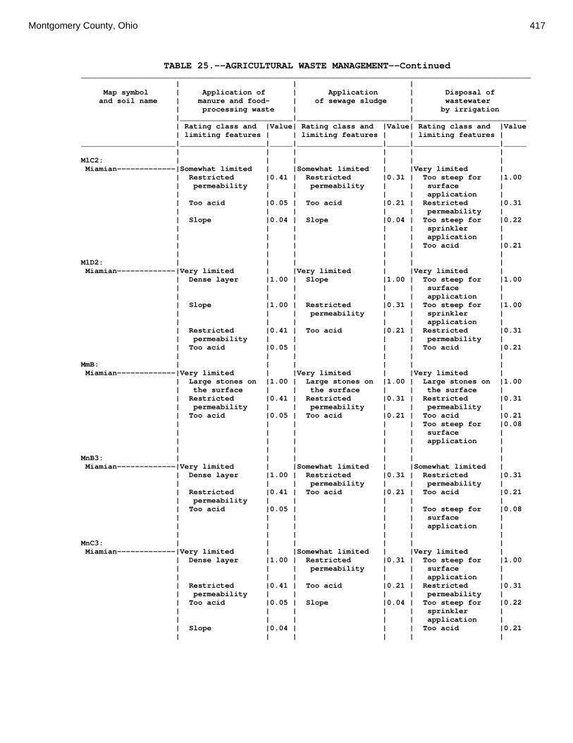
Montgomery County, Ohio 417
TABLE 25.--AGRICULTURAL WASTE MANAGEMENT--Continued ____________________________________________________________________________________________________ | | | Map symbol | Application of | Application | Disposal of and soil name | manure and food- | of sewage sludge | wastewater | processing waste | | by irrigation |_________________________|_________________________|_________________________ | Rating class and |Value| Rating class and |Value| Rating class and |Value | limiting features | | limiting features | | limiting features | _____________________|___________________|_____|___________________|_____|___________________|_____ | | | | | | MlC2: | | | | | | Miamian-------------|Somewhat limited | |Somewhat limited | |Very limited | | Restricted |0.41 | Restricted |0.31 | Too steep for |1.00 | permeability | | permeability | | surface | | | | | | application | | Too acid |0.05 | Too acid |0.21 | Restricted |0.31 | | | | | permeability | | Slope |0.04 | Slope |0.04 | Too steep for |0.22 | | | | | sprinkler | | | | | | application | | | | | | Too acid |0.21 | | | | | | MlD2: | | | | | | Miamian-------------|Very limited | |Very limited | |Very limited | | Dense layer |1.00 | Slope |1.00 | Too steep for |1.00 | | | | | surface | | | | | | application | | Slope |1.00 | Restricted |0.31 | Too steep for |1.00 | | | permeability | | sprinkler | | | | | | application | | Restricted |0.41 | Too acid |0.21 | Restricted |0.31 | permeability | | | | permeability | | Too acid |0.05 | | | Too acid |0.21 | | | | | | MmB: | | | | | | Miamian-------------|Very limited | |Very limited | |Very limited | | Large stones on |1.00 | Large stones on |1.00 | Large stones on |1.00 | the surface | | the surface | | the surface | | Restricted |0.41 | Restricted |0.31 | Restricted |0.31 | permeability | | permeability | | permeability | | Too acid |0.05 | Too acid |0.21 | Too acid |0.21 | | | | | Too steep for |0.08 | | | | | surface | | | | | | application | | | | | | | MnB3: | | | | | | Miamian-------------|Very limited | |Somewhat limited | |Somewhat limited | | Dense layer |1.00 | Restricted |0.31 | Restricted |0.31 | | | permeability | | permeability | | Restricted |0.41 | Too acid |0.21 | Too acid |0.21 | permeability | | | | | | Too acid |0.05 | | | Too steep for |0.08 | | | | | surface | | | | | | application | | | | | | | MnC3: | | | | | | Miamian-------------|Very limited | |Somewhat limited | |Very limited | | Dense layer |1.00 | Restricted |0.31 | Too steep for |1.00 | | | permeability | | surface | | | | | | application | | Restricted |0.41 | Too acid |0.21 | Restricted |0.31 | permeability | | | | permeability | | Too acid |0.05 | Slope |0.04 | Too steep for |0.22 | | | | | sprinkler | | | | | | application | | Slope |0.04 | | | Too acid |0.21 | | | | | |

418 Soil Survey
TABLE 25.--AGRICULTURAL WASTE MANAGEMENT--Continued ____________________________________________________________________________________________________ | | | Map symbol | Application of | Application | Disposal of and soil name | manure and food- | of sewage sludge | wastewater | processing waste | | by irrigation |_________________________|_________________________|_________________________ | Rating class and |Value| Rating class and |Value| Rating class and |Value | limiting features | | limiting features | | limiting features | _____________________|___________________|_____|___________________|_____|___________________|_____ | | | | | | MnD3: | | | | | | Miamian-------------|Very limited | |Very limited | |Very limited | | Dense layer |1.00 | Slope |1.00 | Too steep for |1.00 | | | | | surface | | | | | | application | | Slope |1.00 | Restricted |0.31 | Too steep for |1.00 | | | permeability | | sprinkler | | | | | | application | | Restricted |0.41 | Too acid |0.21 | Restricted |0.31 | permeability | | | | permeability | | Too acid |0.05 | | | Too acid |0.21 | | | | | | MoB: | | | | | | Miamian-------------|Not rated | |Not rated | |Not rated | | | | | | | Urban Land----------|Not rated | |Not rated | |Not rated | | | | | | | MoC: | | | | | | Miamian-------------|Not rated | |Not rated | |Not rated | | | | | | | Urban Land----------|Not rated | |Not rated | |Not rated | | | | | | | MoE: | | | | | | Miamian-------------|Not rated | |Not rated | |Not rated | | | | | | | Urban Land----------|Not rated | |Not rated | |Not rated | | | | | | | MrA: | | | | | | Millsdale-----------|Very limited | |Very limited | |Very limited | | Depth to |1.00 | Depth to |1.00 | Depth to |1.00 | saturated zone | | saturated zone | | saturated zone | | Ponding |1.00 | Ponding |1.00 | Ponding |1.00 | Leaching |0.70 | Too acid |0.07 | Too acid |0.07 | limitation | | | | | | Depth to bedrock |0.06 | Depth to bedrock |0.06 | Depth to bedrock |0.06 | Droughty |0.02 | Droughty |0.02 | Droughty |0.02 | | | | | | MsA: | | | | | | Milton--------------|Somewhat limited | |Somewhat limited | |Somewhat limited | | Depth to bedrock |0.65 | Depth to bedrock |0.65 | Depth to bedrock |0.65 | Restricted |0.41 | Restricted |0.31 | Restricted |0.31 | permeability | | permeability | | permeability | | Droughty |0.24 | Droughty |0.24 | Droughty |0.24 | Too acid |0.05 | Too acid |0.21 | Too acid |0.21 | | | | | | MsB: | | | | | | Milton--------------|Somewhat limited | |Somewhat limited | |Somewhat limited | | Depth to bedrock |0.65 | Depth to bedrock |0.65 | Depth to bedrock |0.65 | Restricted |0.41 | Restricted |0.31 | Restricted |0.31 | permeability | | permeability | | permeability | | Droughty |0.24 | Droughty |0.24 | Droughty |0.24 | Too acid |0.05 | Too acid |0.21 | Too acid |0.21 | | | | | Too steep for |0.08 | | | | | surface | | | | | | application | | | | | | |

Montgomery County, Ohio 419
TABLE 25.--AGRICULTURAL WASTE MANAGEMENT--Continued ____________________________________________________________________________________________________ | | | Map symbol | Application of | Application | Disposal of and soil name | manure and food- | of sewage sludge | wastewater | processing waste | | by irrigation |_________________________|_________________________|_________________________ | Rating class and |Value| Rating class and |Value| Rating class and |Value | limiting features | | limiting features | | limiting features | _____________________|___________________|_____|___________________|_____|___________________|_____ | | | | | | MsB2: | | | | | | Milton--------------|Somewhat limited | |Somewhat limited | |Somewhat limited | | Depth to bedrock |0.84 | Depth to bedrock |0.84 | Depth to bedrock |0.84 | Droughty |0.48 | Droughty |0.48 | Droughty |0.48 | Too acid |0.05 | Too acid |0.21 | Too acid |0.21 | | | | | Too steep for |0.08 | | | | | surface | | | | | | application | | | | | | | MsC2: | | | | | | Milton--------------|Somewhat limited | |Somewhat limited | |Very limited | | Depth to bedrock |0.84 | Depth to bedrock |0.84 | Too steep for |1.00 | | | | | surface | | | | | | application | | Droughty |0.52 | Droughty |0.52 | Depth to bedrock |0.84 | Restricted |0.41 | Restricted |0.31 | Droughty |0.52 | permeability | | permeability | | | | Too acid |0.05 | Too acid |0.21 | Restricted |0.31 | | | | | permeability | | Slope |0.04 | Slope |0.04 | Too steep for |0.22 | | | | | sprinkler | | | | | | application | | | | | | | MsD2: | | | | | | Milton--------------|Very limited | |Very limited | |Very limited | | Slope |1.00 | Slope |1.00 | Too steep for |1.00 | | | | | surface | | | | | | application | | Depth to bedrock |0.90 | Depth to bedrock |0.90 | Too steep for |1.00 | | | | | sprinkler | | | | | | application | | Droughty |0.60 | Droughty |0.60 | Depth to bedrock |0.90 | Restricted |0.41 | Too acid |0.31 | Droughty |0.60 | permeability | | | | | | Too acid |0.08 | Restricted |0.31 | Too acid |0.31 | | | permeability | | | | | | | | | MtD3: | | | | | | Milton--------------|Somewhat limited | |Somewhat limited | |Very limited | | Depth to bedrock |0.95 | Depth to bedrock |0.95 | Too steep for |1.00 | | | | | surface | | | | | | application | | Droughty |0.83 | Droughty |0.83 | Depth to bedrock |0.95 | Slope |0.63 | Slope |0.63 | Droughty |0.83 | Restricted |0.41 | Restricted |0.31 | Too steep for |0.78 | permeability | | permeability | | sprinkler | | | | | | application | | Too acid |0.05 | Too acid |0.21 | Restricted |0.31 | | | | | permeability | | | | | | | MuB: | | | | | | Milton--------------|Not rated | |Not rated | |Not rated | | | | | | | Urban Land----------|Not rated | |Not rated | |Not rated | | | | | | | MuC: | | | | | | Milton--------------|Not rated | |Not rated | |Not rated | | | | | | | Urban Land----------|Not rated | |Not rated | |Not rated | | | | | | |

420 Soil Survey
TABLE 25.--AGRICULTURAL WASTE MANAGEMENT--Continued ____________________________________________________________________________________________________ | | | Map symbol | Application of | Application | Disposal of and soil name | manure and food- | of sewage sludge | wastewater | processing waste | | by irrigation |_________________________|_________________________|_________________________ | Rating class and |Value| Rating class and |Value| Rating class and |Value | limiting features | | limiting features | | limiting features | _____________________|___________________|_____|___________________|_____|___________________|_____ | | | | | | MuD: | | | | | | Milton--------------|Not rated | |Not rated | |Not rated | | | | | | | Urban Land----------|Not rated | |Not rated | |Not rated | | | | | | | Mv: | | | | | | Montgomery----------|Very limited | |Very limited | |Very limited | | Depth to |1.00 | Depth to |1.00 | Depth to |1.00 | saturated zone | | saturated zone | | saturated zone | | Restricted |1.00 | Restricted |1.00 | Restricted |1.00 | permeability | | permeability | | permeability | | Ponding |1.00 | Ponding |1.00 | Ponding |1.00 | Runoff limitation|0.40 | | | | | | | | | | OcA: | | | | | | Ockley--------------|Very limited | |Very limited | |Very limited | | Filtering |1.00 | Filtering |1.00 | Filtering |1.00 | capacity | | capacity | | capacity | | Too acid |0.03 | Too acid |0.14 | Too acid |0.14 | | | | | | OcB: | | | | | | Ockley--------------|Very limited | |Very limited | |Very limited | | Filtering |1.00 | Filtering |1.00 | Filtering |1.00 | capacity | | capacity | | capacity | | Too acid |0.03 | Too acid |0.14 | Too acid |0.14 | | | | | Too steep for |0.08 | | | | | surface | | | | | | application | | | | | | | PlB: | | | | | | Plattville----------|Somewhat limited | |Somewhat limited | |Somewhat limited | | Depth to bedrock |0.71 | Depth to bedrock |0.71 | Depth to bedrock |0.71 | Restricted |0.41 | Restricted |0.31 | Restricted |0.31 | permeability | | permeability | | permeability | | Droughty |0.25 | Droughty |0.25 | Droughty |0.25 | Too acid |0.05 | Too acid |0.21 | Too acid |0.21 | | | | | Too steep for |0.08 | | | | | surface | | | | | | application | | | | | | | PlC: | | | | | | Plattville----------|Somewhat limited | |Somewhat limited | |Very limited | | Depth to bedrock |0.71 | Depth to bedrock |0.71 | Too steep for |1.00 | | | | | surface | | | | | | application | | Restricted |0.41 | Restricted |0.31 | Depth to bedrock |0.71 | permeability | | permeability | | | | Droughty |0.19 | Too acid |0.21 | Restricted |0.31 | | | | | permeability | | Too acid |0.05 | Droughty |0.19 | Too steep for |0.22 | | | | | sprinkler | | | | | | application | | Slope |0.04 | Slope |0.04 | Too acid |0.21 | | | | | |

Montgomery County, Ohio 421
TABLE 25.--AGRICULTURAL WASTE MANAGEMENT--Continued ____________________________________________________________________________________________________ | | | Map symbol | Application of | Application | Disposal of and soil name | manure and food- | of sewage sludge | wastewater | processing waste | | by irrigation |_________________________|_________________________|_________________________ | Rating class and |Value| Rating class and |Value| Rating class and |Value | limiting features | | limiting features | | limiting features | _____________________|___________________|_____|___________________|_____|___________________|_____ | | | | | | PyA: | | | | | | Pyrmont-------------|Very limited | |Very limited | |Very limited | | Depth to |1.00 | Depth to |1.00 | Depth to |1.00 | saturated zone | | saturated zone | | saturated zone | | Dense layer |1.00 | Restricted |0.31 | Restricted |0.31 | | | permeability | | permeability | | Restricted |0.41 | Too acid |0.21 | Too acid |0.21 | permeability | | | | | | Runoff limitation|0.40 | | | | | Too acid |0.05 | | | | | | | | | | Qu: | | | | | | Quarries------------|Not rated | |Not rated | |Not rated | | | | | | | RcA: | | | | | | Randolph------------|Very limited | |Very limited | |Very limited | | Depth to |1.00 | Depth to |1.00 | Depth to |1.00 | saturated zone | | saturated zone | | saturated zone | | Restricted |0.41 | Depth to bedrock |0.35 | Depth to bedrock |0.35 | permeability | | | | | | Depth to bedrock |0.35 | Restricted |0.31 | Restricted |0.31 | | | permeability | | permeability | | Droughty |0.08 | Droughty |0.08 | Droughty |0.08 | Too acid |0.02 | Too acid |0.07 | Too acid |0.07 | | | | | | ReB: | | | | | | Ritchey-------------|Very limited | |Very limited | |Very limited | | Depth to bedrock |1.00 | Depth to bedrock |1.00 | Depth to bedrock |1.00 | Droughty |1.00 | Droughty |1.00 | Droughty |1.00 | Runoff limitation|0.40 | | | Too steep for |0.08 | | | | | surface | | | | | | application | | | | | | | ReB2: | | | | | | Ritchey-------------|Very limited | |Very limited | |Very limited | | Depth to bedrock |1.00 | Droughty |1.00 | Droughty |1.00 | Droughty |1.00 | Depth to bedrock |1.00 | Depth to bedrock |1.00 | Runoff limitation|0.40 | | | Too steep for |0.08 | | | | | surface | | | | | | application | | | | | | | ReC2: | | | | | | Ritchey-------------|Very limited | |Very limited | |Very limited | | Depth to bedrock |1.00 | Droughty |1.00 | Droughty |1.00 | Droughty |1.00 | Depth to bedrock |1.00 | Depth to bedrock |1.00 | Runoff limitation|0.40 | Too acid |0.07 | Too steep for |1.00 | | | | | surface | | | | | | application | | Slope |0.04 | Slope |0.04 | Too steep for |0.22 | | | | | sprinkler | | | | | | application | | Too acid |0.02 | | | Too acid |0.07 ReE2: | | | | | | Ritchey-------------|Very limited | |Very limited | |Very limited | | Depth to bedrock |1.00 | Droughty |1.00 | Droughty |1.00 | Droughty |1.00 | Depth to bedrock |1.00 | Depth to bedrock |1.00 | Slope |1.00 | Slope |1.00 | Too steep for |1.00 | | | | | surface | | | | | | application | | Runoff limitation|0.40 | | | Too steep for |1.00 | | | | | sprinkler | | | | | | application |

422 Soil Survey
TABLE 25.--AGRICULTURAL WASTE MANAGEMENT--Continued ____________________________________________________________________________________________________ | | | Map symbol | Application of | Application | Disposal of and soil name | manure and food- | of sewage sludge | wastewater | processing waste | | by irrigation |_________________________|_________________________|_________________________ | Rating class and |Value| Rating class and |Value| Rating class and |Value | limiting features | | limiting features | | limiting features | _____________________|___________________|_____|___________________|_____|___________________|_____ | | | | | | ReF2: | | | | | | Ritchey-------------|Very limited | |Very limited | |Very limited | | Slope |1.00 | Droughty |1.00 | Droughty |1.00 | Depth to bedrock |1.00 | Depth to bedrock |1.00 | Depth to bedrock |1.00 | Droughty |1.00 | Slope |1.00 | Too steep for |1.00 | | | | | surface | | | | | | application | | Runoff limitation|0.40 | | | Too steep for |1.00 | | | | | sprinkler | | | | | | application | | | | | | | RfD3: | | | | | | Ritchey-------------|Very limited | |Very limited | |Very limited | | Depth to bedrock |1.00 | Droughty |1.00 | Droughty |1.00 | Droughty |1.00 | Depth to bedrock |1.00 | Depth to bedrock |1.00 | Slope |0.63 | Slope |0.63 | Too steep for |1.00 | | | | | surface | | | | | | application | | Runoff limitation|0.40 | | | Too steep for |0.78 | | | | | sprinkler | | | | | | application | | | | | | | Rh: | | | | | | Riverwash-----------|Not rated | |Not rated | |Not rated | | | | | | | RlE2: | | | | | | Rodman--------------|Very limited | |Very limited | |Very limited | | Slope |1.00 | Droughty |1.00 | Droughty |1.00 | Filtering |1.00 | Filtering |1.00 | Filtering |1.00 | capacity | | capacity | | capacity | | Shallow to |1.00 | Shallow to |1.00 | Too steep for |1.00 | Discontinuity | | Discontinuity | | surface | | | | | | application | | Droughty |1.00 | Slope |1.00 | Too steep for |1.00 | | | | | sprinkler | | | | | | application | | Leaching |0.45 | | | | | limitation | | | | | | | | | | | Fox-----------------|Very limited | |Very limited | |Very limited | | Slope |1.00 | Filtering |1.00 | Filtering |1.00 | | | capacity | | capacity | | Filtering |1.00 | Slope |1.00 | Too steep for |1.00 | capacity | | | | surface | | | | | | application | | Droughty |0.89 | Droughty |0.89 | Too steep for |1.00 | | | | | sprinkler | | | | | | application | | Shallow to |0.54 | Shallow to |0.54 | Droughty |0.89 | Discontinuity | | Discontinuity | | | | Too acid |0.02 | Too acid |0.07 | Too acid |0.07 | | | | | |

Montgomery County, Ohio 423
TABLE 25.--AGRICULTURAL WASTE MANAGEMENT--Continued ____________________________________________________________________________________________________ | | | Map symbol | Application of | Application | Disposal of and soil name | manure and food- | of sewage sludge | wastewater | processing waste | | by irrigation |_________________________|_________________________|_________________________ | Rating class and |Value| Rating class and |Value| Rating class and |Value | limiting features | | limiting features | | limiting features | _____________________|___________________|_____|___________________|_____|___________________|_____ | | | | | | RlF2: | | | | | | Rodman--------------|Very limited | |Very limited | |Very limited | | Slope |1.00 | Droughty |1.00 | Droughty |1.00 | Filtering |1.00 | Filtering |1.00 | Filtering |1.00 | capacity | | capacity | | capacity | | Shallow to |1.00 | Shallow to |1.00 | Too steep for |1.00 | Discontinuity | | Discontinuity | | surface | | | | | | application | | Droughty |1.00 | Slope |1.00 | Too steep for |1.00 | | | | | sprinkler | | | | | | application | | Leaching |0.45 | | | | | limitation | | | | | | | | | | | Fox-----------------|Very limited | |Very limited | |Very limited | | Slope |1.00 | Filtering |1.00 | Filtering |1.00 | | | capacity | | capacity | | Filtering |1.00 | Slope |1.00 | Too steep for |1.00 | capacity | | | | surface | | | | | | application | | Droughty |0.89 | Droughty |0.89 | Too steep for |1.00 | | | | | sprinkler | | | | | | application | | Shallow to |0.54 | Shallow to |0.54 | Droughty |0.89 | Discontinuity | | Discontinuity | | | | Too acid |0.05 | Too acid |0.21 | Too acid |0.21 | | | | | | Rs: | | | | | | Ross----------------|Very limited | |Very limited | |Somewhat limited | | Flooding |1.00 | Flooding |1.00 | Flooding |0.60 | | | | | | Rt: | | | | | | Urban Land----------|Not rated | |Not rated | |Not rated | | | | | | | Ross----------------|Not rated | |Not rated | |Not rated | | | | | | | RuB: | | | | | | Russell-------------|Somewhat limited | |Somewhat limited | |Somewhat limited | | Restricted |0.41 | Restricted |0.31 | Restricted |0.31 | permeability | | permeability | | permeability | | Too acid |0.05 | Too acid |0.21 | Too acid |0.21 | | | | | Too steep for |0.08 | | | | | surface | | | | | | application | | | | | | |
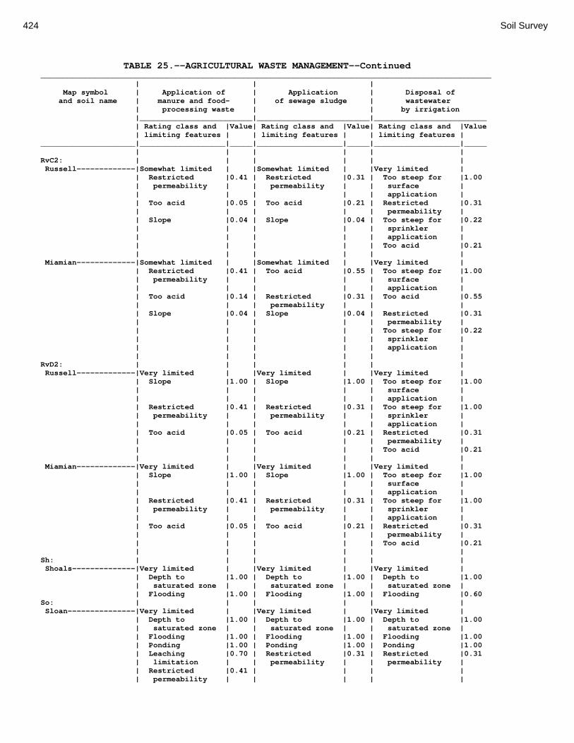
424 Soil Survey
TABLE 25.--AGRICULTURAL WASTE MANAGEMENT--Continued ____________________________________________________________________________________________________ | | | Map symbol | Application of | Application | Disposal of and soil name | manure and food- | of sewage sludge | wastewater | processing waste | | by irrigation |_________________________|_________________________|_________________________ | Rating class and |Value| Rating class and |Value| Rating class and |Value | limiting features | | limiting features | | limiting features | _____________________|___________________|_____|___________________|_____|___________________|_____ | | | | | | RvC2: | | | | | | Russell-------------|Somewhat limited | |Somewhat limited | |Very limited | | Restricted |0.41 | Restricted |0.31 | Too steep for |1.00 | permeability | | permeability | | surface | | | | | | application | | Too acid |0.05 | Too acid |0.21 | Restricted |0.31 | | | | | permeability | | Slope |0.04 | Slope |0.04 | Too steep for |0.22 | | | | | sprinkler | | | | | | application | | | | | | Too acid |0.21 | | | | | | Miamian-------------|Somewhat limited | |Somewhat limited | |Very limited | | Restricted |0.41 | Too acid |0.55 | Too steep for |1.00 | permeability | | | | surface | | | | | | application | | Too acid |0.14 | Restricted |0.31 | Too acid |0.55 | | | permeability | | | | Slope |0.04 | Slope |0.04 | Restricted |0.31 | | | | | permeability | | | | | | Too steep for |0.22 | | | | | sprinkler | | | | | | application | | | | | | | RvD2: | | | | | | Russell-------------|Very limited | |Very limited | |Very limited | | Slope |1.00 | Slope |1.00 | Too steep for |1.00 | | | | | surface | | | | | | application | | Restricted |0.41 | Restricted |0.31 | Too steep for |1.00 | permeability | | permeability | | sprinkler | | | | | | application | | Too acid |0.05 | Too acid |0.21 | Restricted |0.31 | | | | | permeability | | | | | | Too acid |0.21 | | | | | | Miamian-------------|Very limited | |Very limited | |Very limited | | Slope |1.00 | Slope |1.00 | Too steep for |1.00 | | | | | surface | | | | | | application | | Restricted |0.41 | Restricted |0.31 | Too steep for |1.00 | permeability | | permeability | | sprinkler | | | | | | application | | Too acid |0.05 | Too acid |0.21 | Restricted |0.31 | | | | | permeability | | | | | | Too acid |0.21 | | | | | | Sh: | | | | | | Shoals--------------|Very limited | |Very limited | |Very limited | | Depth to |1.00 | Depth to |1.00 | Depth to |1.00 | saturated zone | | saturated zone | | saturated zone | | Flooding |1.00 | Flooding |1.00 | Flooding |0.60 So: | | | | | | Sloan---------------|Very limited | |Very limited | |Very limited | | Depth to |1.00 | Depth to |1.00 | Depth to |1.00 | saturated zone | | saturated zone | | saturated zone | | Flooding |1.00 | Flooding |1.00 | Flooding |1.00 | Ponding |1.00 | Ponding |1.00 | Ponding |1.00 | Leaching |0.70 | Restricted |0.31 | Restricted |0.31 | limitation | | permeability | | permeability | | Restricted |0.41 | | | | | permeability | | | | |

Montgomery County, Ohio 425
TABLE 25.--AGRICULTURAL WASTE MANAGEMENT--Continued ____________________________________________________________________________________________________ | | | Map symbol | Application of | Application | Disposal of and soil name | manure and food- | of sewage sludge | wastewater | processing waste | | by irrigation |_________________________|_________________________|_________________________ | Rating class and |Value| Rating class and |Value| Rating class and |Value | limiting features | | limiting features | | limiting features | _____________________|___________________|_____|___________________|_____|___________________|_____ | | | | | | ThA: | | | | | | Thackery------------|Somewhat limited | |Somewhat limited | |Somewhat limited | | Depth to |0.95 | Depth to |0.95 | Depth to |0.95 | saturated zone | | saturated zone | | saturated zone | | Restricted |0.41 | Restricted |0.31 | Restricted |0.31 | permeability | | permeability | | permeability | | Too acid |0.05 | Too acid |0.21 | Too acid |0.21 | | | | | | TpA: | | | | | | Tippecanoe----------|Very limited | |Very limited | |Very limited | | Filtering |1.00 | Filtering |1.00 | Filtering |1.00 | capacity | | capacity | | capacity | | Depth to |0.95 | Depth to |0.95 | Depth to |0.95 | saturated zone | | saturated zone | | saturated zone | | Too acid |0.05 | Too acid |0.21 | Too acid |0.21 | | | | | | Ua: | | | | | | Urban Land----------|Not rated | |Not rated | |Not rated | | | | | | | Ud: | | | | | | Udorthents----------|Not rated | |Not rated | |Not rated | | | | | | | Ug: | | | | | | Urban Land----------|Not rated | |Not rated | |Not rated | | | | | | | Um: | | | | | | Urban Land----------|Not rated | |Not rated | |Not rated | | | | | | | WaA: | | | | | | Warsaw--------------|Very limited | |Very limited | |Very limited | | Filtering |1.00 | Filtering |1.00 | Filtering |1.00 | capacity | | capacity | | capacity | | Shallow to |0.29 | Shallow to |0.29 | Droughty |0.22 | Discontinuity | | Discontinuity | | | | Droughty |0.22 | Droughty |0.22 | | | | | | | | WaB: | | | | | | Warsaw--------------|Very limited | |Very limited | |Very limited | | Filtering |1.00 | Filtering |1.00 | Filtering |1.00 | capacity | | capacity | | capacity | | Shallow to |0.29 | Shallow to |0.29 | Droughty |0.22 | Discontinuity | | Discontinuity | | | | Droughty |0.22 | Droughty |0.22 | Too steep for |0.08 | | | | | surface | | | | | | application | | | | | | | WeA: | | | | | | Wea-----------------|Very limited | |Very limited | |Very limited | | Filtering |1.00 | Filtering |1.00 | Filtering |1.00 | capacity | | capacity | | capacity | | | | | | | WeB: | | | | | | Wea-----------------|Very limited | |Very limited | |Very limited | | Filtering |1.00 | Filtering |1.00 | Filtering |1.00 | capacity | | capacity | | capacity | | | | | | Too steep for |0.08 | | | | | surface | | | | | | application | | | | | | |

426 Soil Survey
TABLE 25.--AGRICULTURAL WASTE MANAGEMENT--Continued ____________________________________________________________________________________________________ | | | Map symbol | Application of | Application | Disposal of and soil name | manure and food- | of sewage sludge | wastewater | processing waste | | by irrigation |_________________________|_________________________|_________________________ | Rating class and |Value| Rating class and |Value| Rating class and |Value | limiting features | | limiting features | | limiting features | _____________________|___________________|_____|___________________|_____|___________________|_____ | | | | | | Ws: | | | | | | Westland------------|Very limited | |Very limited | |Very limited | | Filtering |1.00 | Filtering |1.00 | Filtering |1.00 | capacity | | capacity | | capacity | | Depth to |1.00 | Depth to |1.00 | Depth to |1.00 | saturated zone | | saturated zone | | saturated zone | | Ponding |1.00 | Ponding |1.00 | Ponding |1.00 | Leaching |0.70 | Too acid |0.21 | Too acid |0.21 | limitation | | | | | | Too acid |0.05 | | | | | | | | | | WyB2: | | | | | | Wynn----------------|Somewhat limited | |Somewhat limited | |Somewhat limited | | Depth to bedrock |0.54 | Depth to bedrock |0.54 | Depth to bedrock |0.54 | Depth to |0.46 | Depth to |0.46 | Depth to |0.46 | saturated zone | | saturated zone | | saturated zone | | Restricted |0.41 | Restricted |0.31 | Restricted |0.31 | permeability | | permeability | | permeability | | Droughty |0.10 | Too acid |0.21 | Too acid |0.21 | Too acid |0.05 | Droughty |0.10 | Droughty |0.10 | | | | | | XeA: | | | | | | Xenia---------------|Somewhat limited | |Somewhat limited | |Somewhat limited | | Depth to |0.95 | Depth to |0.95 | Depth to |0.95 | saturated zone | | saturated zone | | saturated zone | | Restricted |0.41 | Restricted |0.31 | Restricted |0.31 | permeability | | permeability | | permeability | | Too acid |0.05 | Too acid |0.21 | Too acid |0.21 | | | | | | XeB: | | | | | | Xenia---------------|Somewhat limited | |Somewhat limited | |Somewhat limited | | Depth to |0.95 | Depth to |0.95 | Depth to |0.95 | saturated zone | | saturated zone | | saturated zone | | Restricted |0.41 | Restricted |0.31 | Restricted |0.31 | permeability | | permeability | | permeability | | Too acid |0.05 | Too acid |0.21 | Too acid |0.21 | | | | | Too steep for |0.08 | | | | | surface | | | | | | application | | | | | | | _____________________|___________________|_____|___________________|_____|___________________|_____

Montgomery County, Ohio 427
TABLE 26.--WATER MANAGEMENT PART 1 (The information in this table indicates the dominant soil condition but does not eliminate the need for onsite investigation. The numbers in the value columns range from 0.01 to 1.00. The larger the value, the greater the limitation. See text on page 174 for further explanation of ratings in this table.) ___________________________________________________________________________________________________ | | | Map symbol | Pond reservoir areas | Embankments, dikes, and | Aquifer-fed and soil name | | levees | excavated ponds |_________________________|_________________________|_________________________ | Rating class and |Value| Rating class and |Value| Rating class and |Value | limiting features | | limiting features | | limiting features | _____________________|___________________|_____|___________________|_____|___________________|_____ | | | | | | Ag: | | | | | | Algiers-------------|Somewhat limited | |Very limited | |Somewhat limited | | Seepage |0.50 | Depth to |1.00 | Slow refill |0.28 | | | saturated zone | | | | | | Piping |0.50 | Cutbanks cave |0.10 | | | | | | Bo: | | | | | | Borrow Pits---------|Not Rated | |Not Rated | |Not Rated | | | | | | | Bp: | | | | | | Brookston-----------|Somewhat limited | |Very limited | |Somewhat limited | | Seepage |0.50 | Ponding |1.00 | Slow refill |0.28 | | | Depth to |1.00 | Cutbanks cave |0.10 | | | saturated zone | | | | | | Piping |0.50 | | | | | | | | Br: | | | | | | Brookston-----------|Somewhat limited | |Very limited | |Somewhat limited | | Seepage |0.50 | Ponding |1.00 | Slow refill |0.28 | | | Depth to |1.00 | Cutbanks cave |0.10 | | | saturated zone | | | | | | Piping |0.50 | | | | | | | | Bs: | | | | | | Brookston-----------|Somewhat limited | |Very limited | |Somewhat limited | | Seepage |0.50 | Ponding |1.00 | Slow refill |0.28 | | | Depth to |1.00 | Cutbanks cave |0.10 | | | saturated zone | | | | | | Piping |0.50 | | | | | | | | Bu: | | | | | | Brookston-----------|Somewhat limited | |Very limited | |Somewhat limited | | Seepage |0.50 | Ponding |1.00 | Slow refill |0.28 | | | Depth to |1.00 | Cutbanks cave |0.10 | | | saturated zone | | | | | | Piping |0.50 | | | | | | | | Urban Land----------|Not Rated | |Not Rated | |Not Rated | | | | | | | Ca: | | | | | | Carlisle------------|Very limited | |Very limited | |Somewhat limited | | Seepage |1.00 | Ponding |1.00 | Cutbanks cave |0.10 | | | Depth to |1.00 | | | | | saturated zone | | | | | | Content of |1.00 | | | | | organic matter | | | | | | | | | CeA: | | | | | | Celina--------------|Somewhat limited | |Very limited | |Somewhat limited | | Seepage |0.50 | Piping |1.00 | Slow refill |0.28 | | | Depth to |0.95 | Cutbanks cave |0.10 | | | saturated zone | | | | | | | | Depth to water |0.02 | | | | | |
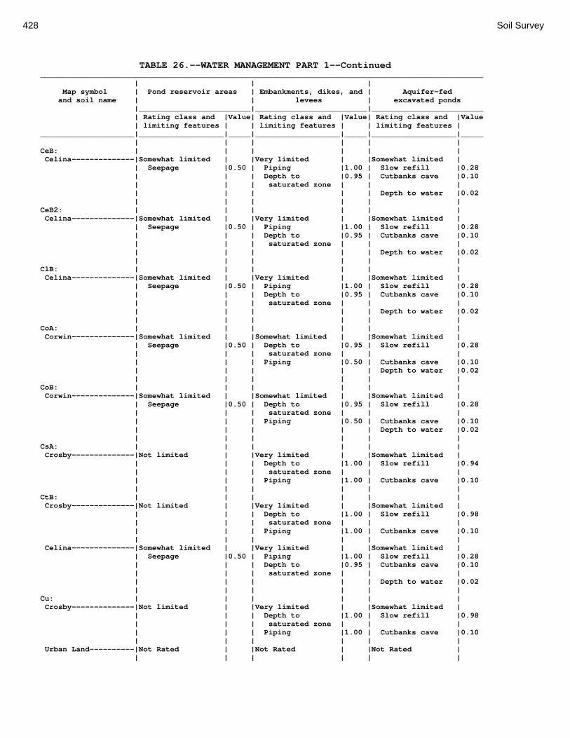
428 Soil Survey
TABLE 26.--WATER MANAGEMENT PART 1--Continued ___________________________________________________________________________________________________ | | | Map symbol | Pond reservoir areas | Embankments, dikes, and | Aquifer-fed and soil name | | levees | excavated ponds |_________________________|_________________________|_________________________ | Rating class and |Value| Rating class and |Value| Rating class and |Value | limiting features | | limiting features | | limiting features | _____________________|___________________|_____|___________________|_____|___________________|_____ | | | | | | CeB: | | | | | | Celina--------------|Somewhat limited | |Very limited | |Somewhat limited | | Seepage |0.50 | Piping |1.00 | Slow refill |0.28 | | | Depth to |0.95 | Cutbanks cave |0.10 | | | saturated zone | | | | | | | | Depth to water |0.02 | | | | | | CeB2: | | | | | | Celina--------------|Somewhat limited | |Very limited | |Somewhat limited | | Seepage |0.50 | Piping |1.00 | Slow refill |0.28 | | | Depth to |0.95 | Cutbanks cave |0.10 | | | saturated zone | | | | | | | | Depth to water |0.02 | | | | | | ClB: | | | | | | Celina--------------|Somewhat limited | |Very limited | |Somewhat limited | | Seepage |0.50 | Piping |1.00 | Slow refill |0.28 | | | Depth to |0.95 | Cutbanks cave |0.10 | | | saturated zone | | | | | | | | Depth to water |0.02 | | | | | | CoA: | | | | | | Corwin--------------|Somewhat limited | |Somewhat limited | |Somewhat limited | | Seepage |0.50 | Depth to |0.95 | Slow refill |0.28 | | | saturated zone | | | | | | Piping |0.50 | Cutbanks cave |0.10 | | | | | Depth to water |0.02 | | | | | | CoB: | | | | | | Corwin--------------|Somewhat limited | |Somewhat limited | |Somewhat limited | | Seepage |0.50 | Depth to |0.95 | Slow refill |0.28 | | | saturated zone | | | | | | Piping |0.50 | Cutbanks cave |0.10 | | | | | Depth to water |0.02 | | | | | | CsA: | | | | | | Crosby--------------|Not limited | |Very limited | |Somewhat limited | | | | Depth to |1.00 | Slow refill |0.94 | | | saturated zone | | | | | | Piping |1.00 | Cutbanks cave |0.10 | | | | | | CtB: | | | | | | Crosby--------------|Not limited | |Very limited | |Somewhat limited | | | | Depth to |1.00 | Slow refill |0.98 | | | saturated zone | | | | | | Piping |1.00 | Cutbanks cave |0.10 | | | | | | Celina--------------|Somewhat limited | |Very limited | |Somewhat limited | | Seepage |0.50 | Piping |1.00 | Slow refill |0.28 | | | Depth to |0.95 | Cutbanks cave |0.10 | | | saturated zone | | | | | | | | Depth to water |0.02 | | | | | | Cu: | | | | | | Crosby--------------|Not limited | |Very limited | |Somewhat limited | | | | Depth to |1.00 | Slow refill |0.98 | | | saturated zone | | | | | | Piping |1.00 | Cutbanks cave |0.10 | | | | | | Urban Land----------|Not Rated | |Not Rated | |Not Rated | | | | | | |

Montgomery County, Ohio 429
TABLE 26.--WATER MANAGEMENT PART 1--Continued ___________________________________________________________________________________________________ | | | Map symbol | Pond reservoir areas | Embankments, dikes, and | Aquifer-fed and soil name | | levees | excavated ponds |_________________________|_________________________|_________________________ | Rating class and |Value| Rating class and |Value| Rating class and |Value | limiting features | | limiting features | | limiting features | _____________________|___________________|_____|___________________|_____|___________________|_____ | | | | | | DaB: | | | | | | Dana----------------|Somewhat limited | |Very limited | |Somewhat limited | | Seepage |0.50 | Piping |1.00 | Slow refill |0.28 | | | Depth to |0.95 | Cutbanks cave |0.10 | | | saturated zone | | | | | | | | Depth to water |0.02 | | | | | | FaE2: | | | | | | Fairmount-----------|Very limited | |Very limited | |Very limited | | Slippage |1.00 | Thin layer |1.00 | Depth to water |1.00 | Depth to bedrock |1.00 | Hard to compact |1.00 | | | Slope |0.10 | | | | | | | | | | FaF2: | | | | | | Fairmount-----------|Very limited | |Very limited | |Very limited | | Slippage |1.00 | Thin layer |1.00 | Depth to water |1.00 | Depth to bedrock |1.00 | Hard to compact |1.00 | | | Slope |0.82 | | | | | | | | | | FcA: | | | | | | Fincastle-----------|Not limited | |Very limited | |Somewhat limited | | | | Depth to |1.00 | Slow refill |0.28 | | | saturated zone | | | | | | Piping |1.00 | Cutbanks cave |0.10 | | | Thin layer |0.17 | | | | | | | | FkA: | | | | | | Fox-----------------|Very limited | |Very limited | |Very limited | | Seepage |1.00 | Seepage |1.00 | Depth to water |1.00 | | | | | | FkB: | | | | | | Fox-----------------|Very limited | |Very limited | |Very limited | | Seepage |1.00 | Seepage |1.00 | Depth to water |1.00 | | | | | | FlA: | | | | | | Fox-----------------|Very limited | |Very limited | |Very limited | | Seepage |1.00 | Seepage |1.00 | Depth to water |1.00 | | | | | | FlB: | | | | | | Fox-----------------|Very limited | |Very limited | |Very limited | | Seepage |1.00 | Seepage |1.00 | Depth to water |1.00 | | | | | | FlC2: | | | | | | Fox-----------------|Very limited | |Very limited | |Very limited | | Seepage |1.00 | Seepage |1.00 | Depth to water |1.00 | | | | | | FmA: | | | | | | Fox-----------------|Very limited | |Very limited | |Very limited | | Seepage |1.00 | Seepage |1.00 | Depth to water |1.00 | | | | | | FmB: | | | | | | Fox-----------------|Very limited | |Very limited | |Very limited | | Seepage |1.00 | Seepage |1.00 | Depth to water |1.00 | | | | | | FmC2: | | | | | | Fox-----------------|Very limited | |Very limited | |Very limited | | Seepage |1.00 | Seepage |1.00 | Depth to water |1.00 | | | | | | FmD2: | | | | | | Fox-----------------|Very limited | |Very limited | |Very limited | | Seepage |1.00 | Seepage |1.00 | Depth to water |1.00 | Slope |0.03 | | | | | | | | | |
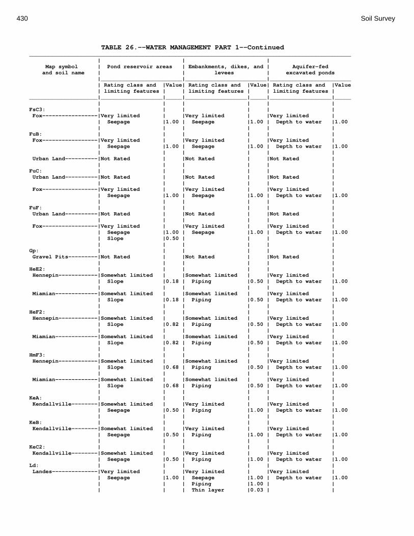
430 Soil Survey
TABLE 26.--WATER MANAGEMENT PART 1--Continued ___________________________________________________________________________________________________ | | | Map symbol | Pond reservoir areas | Embankments, dikes, and | Aquifer-fed and soil name | | levees | excavated ponds |_________________________|_________________________|_________________________ | Rating class and |Value| Rating class and |Value| Rating class and |Value | limiting features | | limiting features | | limiting features | _____________________|___________________|_____|___________________|_____|___________________|_____ | | | | | | FsC3: | | | | | | Fox-----------------|Very limited | |Very limited | |Very limited | | Seepage |1.00 | Seepage |1.00 | Depth to water |1.00 | | | | | | FuB: | | | | | | Fox-----------------|Very limited | |Very limited | |Very limited | | Seepage |1.00 | Seepage |1.00 | Depth to water |1.00 | | | | | | Urban Land----------|Not Rated | |Not Rated | |Not Rated | | | | | | | FuC: | | | | | | Urban Land----------|Not Rated | |Not Rated | |Not Rated | | | | | | | Fox-----------------|Very limited | |Very limited | |Very limited | | Seepage |1.00 | Seepage |1.00 | Depth to water |1.00 | | | | | | FuF: | | | | | | Urban Land----------|Not Rated | |Not Rated | |Not Rated | | | | | | | Fox-----------------|Very limited | |Very limited | |Very limited | | Seepage |1.00 | Seepage |1.00 | Depth to water |1.00 | Slope |0.50 | | | | | | | | | | Gp: | | | | | | Gravel Pits---------|Not Rated | |Not Rated | |Not Rated | | | | | | | HeE2: | | | | | | Hennepin------------|Somewhat limited | |Somewhat limited | |Very limited | | Slope |0.18 | Piping |0.50 | Depth to water |1.00 | | | | | | Miamian-------------|Somewhat limited | |Somewhat limited | |Very limited | | Slope |0.18 | Piping |0.50 | Depth to water |1.00 | | | | | | HeF2: | | | | | | Hennepin------------|Somewhat limited | |Somewhat limited | |Very limited | | Slope |0.82 | Piping |0.50 | Depth to water |1.00 | | | | | | Miamian-------------|Somewhat limited | |Somewhat limited | |Very limited | | Slope |0.82 | Piping |0.50 | Depth to water |1.00 | | | | | | HmF3: | | | | | | Hennepin------------|Somewhat limited | |Somewhat limited | |Very limited | | Slope |0.68 | Piping |0.50 | Depth to water |1.00 | | | | | | Miamian-------------|Somewhat limited | |Somewhat limited | |Very limited | | Slope |0.68 | Piping |0.50 | Depth to water |1.00 | | | | | | KeA: | | | | | | Kendallville--------|Somewhat limited | |Very limited | |Very limited | | Seepage |0.50 | Piping |1.00 | Depth to water |1.00 | | | | | | KeB: | | | | | | Kendallville--------|Somewhat limited | |Very limited | |Very limited | | Seepage |0.50 | Piping |1.00 | Depth to water |1.00 | | | | | | KeC2: | | | | | | Kendallville--------|Somewhat limited | |Very limited | |Very limited | | Seepage |0.50 | Piping |1.00 | Depth to water |1.00 Ld: | | | | | | Landes--------------|Very limited | |Very limited | |Very limited | | Seepage |1.00 | Seepage |1.00 | Depth to water |1.00 | | | Piping |1.00 | | | | | Thin layer |0.03 | |

Montgomery County, Ohio 431
TABLE 26.--WATER MANAGEMENT PART 1--Continued ___________________________________________________________________________________________________ | | | Map symbol | Pond reservoir areas | Embankments, dikes, and | Aquifer-fed and soil name | | levees | excavated ponds |_________________________|_________________________|_________________________ | Rating class and |Value| Rating class and |Value| Rating class and |Value | limiting features | | limiting features | | limiting features | _____________________|___________________|_____|___________________|_____|___________________|_____ | | | | | | Lg: | | | | | | Lanier--------------|Very limited | |Very limited | |Very limited | | Slippage |1.00 | Seepage |1.00 | Depth to water |1.00 | | | | | | LsB: | | | | | | Lewisburg-----------|Not limited | |Very limited | |Somewhat limited | | | | Piping |1.00 | Slow refill |0.96 | | | Depth to |0.95 | Cutbanks cave |0.10 | | | saturated zone | | | | | | | | Depth to water |0.02 | | | | | | LxC2: | | | | | | Lorenzo-------------|Very limited | |Very limited | |Very limited | | Seepage |1.00 | Seepage |1.00 | Depth to water |1.00 | | | | | | Rodman--------------|Very limited | |Very limited | |Very limited | | Seepage |1.00 | Seepage |1.00 | Depth to water |1.00 | | | | | | LxD2: | | | | | | Lorenzo-------------|Very limited | |Very limited | |Very limited | | Seepage |1.00 | Seepage |1.00 | Depth to water |1.00 | Slope |0.03 | | | | | | | | | | Rodman--------------|Very limited | |Very limited | |Very limited | | Seepage |1.00 | Seepage |1.00 | Depth to water |1.00 | Slope |0.03 | | | | | | | | | | Mb: | | | | | | Made Land-----------|Not Rated | |Not Rated | |Not Rated | | | | | | | Md: | | | | | | Medway--------------|Very limited | |Very limited | |Very limited | | Slippage |1.00 | Seepage |1.00 | Cutbanks cave |1.00 | | | Piping |1.00 | Depth to water |0.02 | | | Depth to |0.95 | | | | | saturated zone | | | | | | Thin layer |0.67 | | | | | | | | MlA: | | | | | | Miamian-------------|Not limited | |Very limited | |Very limited | | | | Piping |1.00 | Depth to water |1.00 | | | | | | MlB: | | | | | | Miamian-------------|Not limited | |Very limited | |Very limited | | | | Piping |1.00 | Depth to water |1.00 | | | | | | MlB2: | | | | | | Miamian-------------|Not limited | |Somewhat limited | |Very limited | | | | Piping |0.50 | Depth to water |1.00 | | | | | | MlC2: | | | | | | Miamian-------------|Not limited | |Very limited | |Very limited | | | | Piping |1.00 | Depth to water |1.00 | | | | | | MlD2: | | | | | | Miamian-------------|Somewhat limited | |Very limited | |Very limited | | Slope |0.03 | Piping |1.00 | Depth to water |1.00 | | | | | | MmB: | | | | | | Miamian-------------|Not limited | |Very limited | |Very limited | | | | Piping |1.00 | Depth to water |1.00 | | | | | |
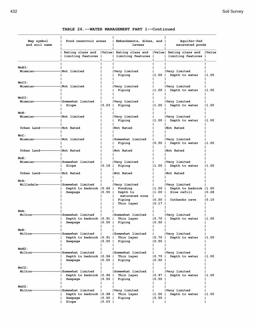
432 Soil Survey
TABLE 26.--WATER MANAGEMENT PART 1--Continued ___________________________________________________________________________________________________ | | | Map symbol | Pond reservoir areas | Embankments, dikes, and | Aquifer-fed and soil name | | levees | excavated ponds |_________________________|_________________________|_________________________ | Rating class and |Value| Rating class and |Value| Rating class and |Value | limiting features | | limiting features | | limiting features | _____________________|___________________|_____|___________________|_____|___________________|_____ | | | | | | MnB3: | | | | | | Miamian-------------|Not limited | |Very limited | |Very limited | | | | Piping |1.00 | Depth to water |1.00 | | | | | | MnC3: | | | | | | Miamian-------------|Not limited | |Very limited | |Very limited | | | | Piping |1.00 | Depth to water |1.00 | | | | | | MnD3: | | | | | | Miamian-------------|Somewhat limited | |Very limited | |Very limited | | Slope |0.03 | Piping |1.00 | Depth to water |1.00 | | | | | | MoB: | | | | | | Miamian-------------|Not limited | |Very limited | |Very limited | | | | Piping |1.00 | Depth to water |1.00 | | | | | | Urban Land----------|Not Rated | |Not Rated | |Not Rated | | | | | | | MoC: | | | | | | Miamian-------------|Not limited | |Somewhat limited | |Very limited | | | | Piping |0.50 | Depth to water |1.00 | | | | | | Urban Land----------|Not Rated | |Not Rated | |Not Rated | | | | | | | MoE: | | | | | | Miamian-------------|Somewhat limited | |Very limited | |Very limited | | Slope |0.18 | Piping |1.00 | Depth to water |1.00 | | | | | | Urban Land----------|Not Rated | |Not Rated | |Not Rated | | | | | | | MrA: | | | | | | Millsdale-----------|Somewhat limited | |Very limited | |Very limited | | Depth to bedrock |0.66 | Ponding |1.00 | Depth to bedrock |1.00 | Seepage |0.50 | Depth to |1.00 | Slow refill |0.28 | | | saturated zone | | | | | | Piping |0.50 | Cutbanks cave |0.10 | | | Thin layer |0.17 | | | | | | | | MsA: | | | | | | Milton--------------|Somewhat limited | |Somewhat limited | |Very limited | | Depth to bedrock |0.91 | Thin layer |0.70 | Depth to water |1.00 | Seepage |0.50 | Piping |0.50 | | | | | | | | MsB: | | | | | | Milton--------------|Somewhat limited | |Somewhat limited | |Very limited | | Depth to bedrock |0.91 | Thin layer |0.70 | Depth to water |1.00 | Seepage |0.50 | Piping |0.50 | | | | | | | | MsB2: | | | | | | Milton--------------|Somewhat limited | |Somewhat limited | |Very limited | | Depth to bedrock |0.96 | Thin layer |0.70 | Depth to water |1.00 | Seepage |0.50 | Piping |0.50 | | | | | | | | MsC2: | | | | | | Milton--------------|Somewhat limited | |Somewhat limited | |Very limited | | Depth to bedrock |0.96 | Thin layer |0.97 | Depth to water |1.00 | Seepage |0.50 | Piping |0.50 | | | | | | | | MsD2: | | | | | | Milton--------------|Somewhat limited | |Very limited | |Very limited | | Depth to bedrock |0.98 | Thin layer |1.00 | Depth to water |1.00 | Seepage |0.50 | Piping |0.50 | | | Slope |0.03 | | | |

Montgomery County, Ohio 433
TABLE 26.--WATER MANAGEMENT PART 1--Continued ___________________________________________________________________________________________________ | | | Map symbol | Pond reservoir areas | Embankments, dikes, and | Aquifer-fed and soil name | | levees | excavated ponds |_________________________|_________________________|_________________________ | Rating class and |Value| Rating class and |Value| Rating class and |Value | limiting features | | limiting features | | limiting features | _____________________|___________________|_____|___________________|_____|___________________|_____ | | | | | | MtD3: | | | | | | Milton--------------|Somewhat limited | |Very limited | |Very limited | | Depth to bedrock |0.99 | Thin layer |1.00 | Depth to water |1.00 | Seepage |0.50 | Piping |0.50 | | | Slope |0.01 | | | | | | | | | | MuB: | | | | | | Milton--------------|Somewhat limited | |Somewhat limited | |Very limited | | Depth to bedrock |0.91 | Thin layer |0.70 | Depth to water |1.00 | Seepage |0.50 | Piping |0.50 | | | | | | | | Urban Land----------|Not Rated | |Not Rated | |Not Rated | | | | | | | MuC: | | | | | | Milton--------------|Somewhat limited | |Somewhat limited | |Very limited | | Depth to bedrock |0.91 | Thin layer |0.70 | Depth to water |1.00 | Seepage |0.50 | Piping |0.50 | | | | | | | | Urban Land----------|Not Rated | |Not Rated | |Not Rated | | | | | | | MuD: | | | | | | Milton--------------|Somewhat limited | |Somewhat limited | |Very limited | | Depth to bedrock |0.91 | Thin layer |0.70 | Depth to water |1.00 | Seepage |0.50 | Piping |0.50 | | | Slope |0.03 | | | | | | | | | | Urban Land----------|Not Rated | |Not Rated | |Not Rated | | | | | | | Mv: | | | | | | Montgomery----------|Not limited | |Very limited | |Somewhat limited | | | | Ponding |1.00 | Slow refill |0.36 | | | Depth to |1.00 | Cutbanks cave |0.10 | | | saturated zone | | | | | | Piping |0.50 | | | | | | | | OcA: | | | | | | Ockley--------------|Very limited | |Somewhat limited | |Very limited | | Seepage |1.00 | Piping |0.50 | Depth to water |1.00 | | | | | | OcB: | | | | | | Ockley--------------|Very limited | |Somewhat limited | |Very limited | | Seepage |1.00 | Piping |0.50 | Depth to water |1.00 | | | | | | PlB: | | | | | | Plattville----------|Somewhat limited | |Somewhat limited | |Very limited | | Depth to bedrock |0.93 | Thin layer |0.90 | Depth to water |1.00 | | | Piping |0.50 | | | | | | | | PlC: | | | | | | Plattville----------|Somewhat limited | |Somewhat limited | |Very limited | | Depth to bedrock |0.93 | Thin layer |0.90 | Depth to water |1.00 | | | Piping |0.50 | | | | | | | | PyA: | | | | | | Pyrmont-------------|Not limited | |Very limited | |Somewhat limited | | | | Depth to |1.00 | Slow refill |0.96 | | | saturated zone | | | | | | Piping |1.00 | Cutbanks cave |0.10 | | | | | | Qu: | | | | | | Quarries------------|Not Rated | |Not Rated | |Not Rated | | | | | | |

434 Soil Survey
TABLE 26.--WATER MANAGEMENT PART 1--Continued ___________________________________________________________________________________________________ | | | Map symbol | Pond reservoir areas | Embankments, dikes, and | Aquifer-fed and soil name | | levees | excavated ponds |_________________________|_________________________|_________________________ | Rating class and |Value| Rating class and |Value| Rating class and |Value | limiting features | | limiting features | | limiting features | _____________________|___________________|_____|___________________|_____|___________________|_____ | | | | | | RcA: | | | | | | Randolph------------|Somewhat limited | |Very limited | |Very limited | | Depth to bedrock |0.83 | Thin layer |1.00 | Depth to bedrock |1.00 | | | Depth to |1.00 | Slow refill |0.28 | | | saturated zone | | | | | | Piping |0.50 | Cutbanks cave |0.10 | | | | | | ReB: | | | | | | Ritchey-------------|Very limited | |Very limited | |Very limited | | Depth to bedrock |1.00 | Thin layer |1.00 | Depth to water |1.00 | | | Piping |0.50 | | | | | | | | ReB2: | | | | | | Ritchey-------------|Very limited | |Very limited | |Very limited | | Depth to bedrock |1.00 | Thin layer |1.00 | Depth to water |1.00 | | | Piping |0.50 | | | | | | | | ReC2: | | | | | | Ritchey-------------|Very limited | |Very limited | |Very limited | | Depth to bedrock |1.00 | Thin layer |1.00 | Depth to water |1.00 | | | Piping |0.50 | | | | | | | | ReE2: | | | | | | Ritchey-------------|Very limited | |Very limited | |Very limited | | Depth to bedrock |1.00 | Thin layer |1.00 | Depth to water |1.00 | Slope |0.10 | Piping |0.50 | | | | | | | | ReF2: | | | | | | Ritchey-------------|Very limited | |Very limited | |Very limited | | Depth to bedrock |1.00 | Thin layer |1.00 | Depth to water |1.00 | Slope |0.82 | Piping |0.50 | | | | | | | | RfD3: | | | | | | Ritchey-------------|Very limited | |Very limited | |Very limited | | Depth to bedrock |1.00 | Thin layer |1.00 | Depth to water |1.00 | Slope |0.01 | Piping |0.50 | | | | | | | | Rh: | | | | | | Riverwash-----------|Not Rated | |Not Rated | |Not Rated | | | | | | | RlE2: | | | | | | Rodman--------------|Very limited | |Very limited | |Very limited | | Seepage |1.00 | Seepage |1.00 | Depth to water |1.00 | Slope |0.18 | | | | | | | | | | Fox-----------------|Very limited | |Very limited | |Very limited | | Seepage |1.00 | Seepage |1.00 | Depth to water |1.00 | Slope |0.18 | | | | | | | | | | RlF2: | | | | | | Rodman--------------|Very limited | |Very limited | |Very limited | | Seepage |1.00 | Seepage |1.00 | Depth to water |1.00 | Slope |0.82 | | | | | | | | | | Fox-----------------|Very limited | |Very limited | |Very limited | | Seepage |1.00 | Seepage |1.00 | Depth to water |1.00 | Slope |0.50 | | | | | | | | | | Rs: | | | | | | Ross----------------|Somewhat limited | |Very limited | |Very limited | | Seepage |0.50 | Piping |1.00 | Depth to water |1.00 | | | | | |

Montgomery County, Ohio 435
TABLE 26.--WATER MANAGEMENT PART 1--Continued ___________________________________________________________________________________________________ | | | Map symbol | Pond reservoir areas | Embankments, dikes, and | Aquifer-fed and soil name | | levees | excavated ponds |_________________________|_________________________|_________________________ | Rating class and |Value| Rating class and |Value| Rating class and |Value | limiting features | | limiting features | | limiting features | _____________________|___________________|_____|___________________|_____|___________________|_____ | | | | | | Rt: | | | | | | Urban Land----------|Not Rated | |Not Rated | |Not Rated | | | | | | | Ross----------------|Not Rated | |Very limited | |Very limited | | | | Piping |1.00 | Depth to water |1.00 | | | | | | RuB: | | | | | | Russell-------------|Somewhat limited | |Very limited | |Very limited | | Seepage |0.50 | Piping |1.00 | Depth to water |1.00 | | | Thin layer |0.23 | | | | | | | | RvC2: | | | | | | Russell-------------|Somewhat limited | |Very limited | |Very limited | | Seepage |0.50 | Piping |1.00 | Depth to water |1.00 | | | Thin layer |0.23 | | | | | | | | Miamian-------------|Not limited | |Very limited | |Very limited | | | | Piping |1.00 | Depth to water |1.00 | | | | | | RvD2: | | | | | | Russell-------------|Somewhat limited | |Very limited | |Very limited | | Seepage |0.50 | Piping |1.00 | Depth to water |1.00 | Slope |0.03 | Thin layer |0.23 | | | | | | | | Miamian-------------|Somewhat limited | |Very limited | |Very limited | | Slope |0.03 | Piping |1.00 | Depth to water |1.00 | | | | | | Sh: | | | | | | Shoals--------------|Somewhat limited | |Very limited | |Somewhat limited | | Seepage |0.50 | Depth to |1.00 | Slow refill |0.28 | | | saturated zone | | | | | | Piping |1.00 | Cutbanks cave |0.10 | | | | | | So: | | | | | | Sloan---------------|Somewhat limited | |Very limited | |Very limited | | Seepage |0.50 | Ponding |1.00 | Cutbanks cave |1.00 | | | Depth to |1.00 | Slow refill |0.28 | | | saturated zone | | | | | | Piping |1.00 | | | | | | | | ThA: | | | | | | Thackery------------|Somewhat limited | |Very limited | |Very limited | | Seepage |0.37 | Piping |1.00 | Cutbanks cave |1.00 | | | Depth to |0.95 | Slow refill |0.36 | | | saturated zone | | | | | | Thin layer |0.73 | Depth to water |0.02 | | | | | | TpA: | | | | | | Tippecanoe----------|Very limited | |Somewhat limited | |Somewhat limited | | Seepage |1.00 | Depth to |0.95 | Cutbanks cave |0.10 | | | saturated zone | | | | | | Piping |0.50 | Depth to water |0.02 | | | | | | Ua: | | | | | | Urban Land----------|Not Rated | |Not Rated | |Not Rated | | | | | | | Ud: | | | | | | Udorthents----------|Not Rated | |Not Rated | |Not Rated | | | | | | | Ug: | | | | | | Urban Land----------|Not Rated | |Not Rated | |Not Rated | | | | | | |

436 Soil Survey
TABLE 26.--WATER MANAGEMENT PART 1--Continued ___________________________________________________________________________________________________ | | | Map symbol | Pond reservoir areas | Embankments, dikes, and | Aquifer-fed and soil name | | levees | excavated ponds |_________________________|_________________________|_________________________ | Rating class and |Value| Rating class and |Value| Rating class and |Value | limiting features | | limiting features | | limiting features | _____________________|___________________|_____|___________________|_____|___________________|_____ | | | | | | Um: | | | | | | Urban Land----------|Not Rated | |Not Rated | |Not Rated | | | | | | | WaA: | | | | | | Warsaw--------------|Very limited | |Very limited | |Very limited | | Seepage |1.00 | Seepage |1.00 | Depth to water |1.00 | | | | | | WaB: | | | | | | Warsaw--------------|Very limited | |Very limited | |Very limited | | Seepage |1.00 | Seepage |1.00 | Depth to water |1.00 | | | | | | WeA: | | | | | | Wea-----------------|Very limited | |Somewhat limited | |Very limited | | Seepage |1.00 | Piping |0.50 | Depth to water |1.00 | | | | | | WeB: | | | | | | Wea-----------------|Very limited | |Somewhat limited | |Very limited | | Seepage |1.00 | Piping |0.50 | Depth to water |1.00 | | | | | | Ws: | | | | | | Westland------------|Very limited | |Very limited | |Somewhat limited | | Seepage |1.00 | Ponding |1.00 | Cutbanks cave |0.10 | | | Depth to |1.00 | | | | | saturated zone | | | | | | Piping |0.50 | | | | | Thin layer |0.47 | | | | | | | | WyB2: | | | | | | Wynn----------------|Somewhat limited | |Somewhat limited | |Very limited | | Depth to bedrock |0.88 | Thin layer |0.73 | Depth to bedrock |1.00 | | | Piping |0.50 | Depth to water |0.24 | | | Depth to |0.46 | Cutbanks cave |0.10 | | | saturated zone | | | | | | | | | XeA: | | | | | | Xenia---------------|Somewhat limited | |Very limited | |Somewhat limited | | Seepage |0.50 | Piping |1.00 | Slow refill |0.28 | | | Depth to |0.95 | Cutbanks cave |0.10 | | | saturated zone | | | | | | | | Depth to water |0.02 | | | | | | XeB: | | | | | | Xenia---------------|Somewhat limited | |Very limited | |Somewhat limited | | Seepage |0.50 | Piping |1.00 | Slow refill |0.28 | | | Depth to |0.95 | Cutbanks cave |0.10 | | | saturated zone | | | | | | | | Depth to water |0.02 | | | | | | _____________________|___________________|_____|___________________|_____|___________________|_____
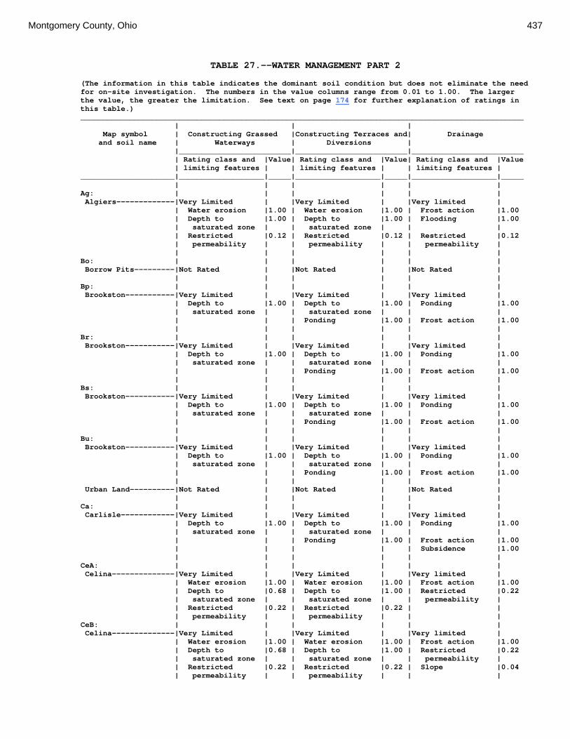
Montgomery County, Ohio 437
TABLE 27.--WATER MANAGEMENT PART 2 (The information in this table indicates the dominant soil condition but does not eliminate the need for on-site investigation. The numbers in the value columns range from 0.01 to 1.00. The larger the value, the greater the limitation. See text on page 174 for further explanation of ratings in this table.) ___________________________________________________________________________________________________ | | | Map symbol | Constructing Grassed |Constructing Terraces and| Drainage and soil name | Waterways | Diversions | |_________________________|_________________________|_________________________ | Rating class and |Value| Rating class and |Value| Rating class and |Value | limiting features | | limiting features | | limiting features | _____________________|___________________|_____|___________________|_____|___________________|_____ | | | | | | Ag: | | | | | | Algiers-------------|Very Limited | |Very Limited | |Very limited | | Water erosion |1.00 | Water erosion |1.00 | Frost action |1.00 | Depth to |1.00 | Depth to |1.00 | Flooding |1.00 | saturated zone | | saturated zone | | | | Restricted |0.12 | Restricted |0.12 | Restricted |0.12 | permeability | | permeability | | permeability | | | | | | | Bo: | | | | | | Borrow Pits---------|Not Rated | |Not Rated | |Not Rated | | | | | | | Bp: | | | | | | Brookston-----------|Very Limited | |Very Limited | |Very limited | | Depth to |1.00 | Depth to |1.00 | Ponding |1.00 | saturated zone | | saturated zone | | | | | | Ponding |1.00 | Frost action |1.00 | | | | | | Br: | | | | | | Brookston-----------|Very Limited | |Very Limited | |Very limited | | Depth to |1.00 | Depth to |1.00 | Ponding |1.00 | saturated zone | | saturated zone | | | | | | Ponding |1.00 | Frost action |1.00 | | | | | | Bs: | | | | | | Brookston-----------|Very Limited | |Very Limited | |Very limited | | Depth to |1.00 | Depth to |1.00 | Ponding |1.00 | saturated zone | | saturated zone | | | | | | Ponding |1.00 | Frost action |1.00 | | | | | | Bu: | | | | | | Brookston-----------|Very Limited | |Very Limited | |Very limited | | Depth to |1.00 | Depth to |1.00 | Ponding |1.00 | saturated zone | | saturated zone | | | | | | Ponding |1.00 | Frost action |1.00 | | | | | | Urban Land----------|Not Rated | |Not Rated | |Not Rated | | | | | | | Ca: | | | | | | Carlisle------------|Very Limited | |Very Limited | |Very limited | | Depth to |1.00 | Depth to |1.00 | Ponding |1.00 | saturated zone | | saturated zone | | | | | | Ponding |1.00 | Frost action |1.00 | | | | | Subsidence |1.00 | | | | | | CeA: | | | | | | Celina--------------|Very Limited | |Very Limited | |Very limited | | Water erosion |1.00 | Water erosion |1.00 | Frost action |1.00 | Depth to |0.68 | Depth to |1.00 | Restricted |0.22 | saturated zone | | saturated zone | | permeability | | Restricted |0.22 | Restricted |0.22 | | | permeability | | permeability | | | CeB: | | | | | | Celina--------------|Very Limited | |Very Limited | |Very limited | | Water erosion |1.00 | Water erosion |1.00 | Frost action |1.00 | Depth to |0.68 | Depth to |1.00 | Restricted |0.22 | saturated zone | | saturated zone | | permeability | | Restricted |0.22 | Restricted |0.22 | Slope |0.04 | permeability | | permeability | | |

438 Soil Survey
TABLE 27.--WATER MANAGEMENT PART 2--Continued ___________________________________________________________________________________________________ | | | Map symbol | Constructing Grassed |Constructing Terraces and| Drainage and soil name | Waterways | Diversions | |_________________________|_________________________|_________________________ | Rating class and |Value| Rating class and |Value| Rating class and |Value | limiting features | | limiting features | | limiting features | _____________________|___________________|_____|___________________|_____|___________________|_____ | | | | | | CeB2: | | | | | | Celina--------------|Very Limited | |Very Limited | |Very limited | | Water erosion |1.00 | Water erosion |1.00 | Frost action |1.00 | Depth to |0.68 | Depth to |1.00 | Restricted |0.22 | saturated zone | | saturated zone | | permeability | | Restricted |0.22 | Restricted |0.22 | Slope |0.04 | permeability | | permeability | | | | | | | | | ClB: | | | | | | Celina--------------|Very Limited | |Very Limited | |Very limited | | Water erosion |1.00 | Water erosion |1.00 | Frost action |1.00 | Depth to |0.68 | Depth to |1.00 | Restricted |0.22 | saturated zone | | saturated zone | | permeability | | Restricted |0.22 | Restricted |0.22 | Slope |0.04 | permeability | | permeability | | | | | | | | | CoA: | | | | | | Corwin--------------|Very Limited | |Very Limited | |Somewhat limited | | Water erosion |1.00 | Water erosion |1.00 | Restricted |0.22 | | | | | permeability | | Depth to |0.68 | Depth to |1.00 | | | saturated zone | | saturated zone | | | | Restricted |0.22 | Restricted |0.22 | | | permeability | | permeability | | | | | | | | | CoB: | | | | | | Corwin--------------|Very Limited | |Very Limited | |Somewhat limited | | Water erosion |1.00 | Water erosion |1.00 | Restricted |0.22 | | | | | permeability | | Depth to |0.68 | Depth to |1.00 | Slope |0.04 | saturated zone | | saturated zone | | | | Restricted |0.22 | Restricted |0.22 | | | permeability | | permeability | | | | | | | | | CsA: | | | | | | Crosby--------------|Very Limited | |Very Limited | |Very limited | | Water erosion |1.00 | Water erosion |1.00 | Frost action |1.00 | Depth to |1.00 | Depth to |1.00 | Restricted |0.13 | saturated zone | | saturated zone | | permeability | | Restricted |0.13 | Restricted |0.13 | | | permeability | | permeability | | | | | | | | | CtB: | | | | | | Crosby--------------|Very Limited | |Very Limited | |Very limited | | Water erosion |1.00 | Water erosion |1.00 | Frost action |1.00 | Depth to |1.00 | Depth to |1.00 | Restricted |0.40 | saturated zone | | saturated zone | | permeability | | Restricted |0.40 | Restricted |0.40 | | | permeability | | permeability | | | | | | | | | Celina--------------|Very Limited | |Very Limited | |Very limited | | Water erosion |1.00 | Water erosion |1.00 | Frost action |1.00 | Depth to |0.68 | Depth to |1.00 | Restricted |0.22 | saturated zone | | saturated zone | | permeability | | Restricted |0.22 | Restricted |0.22 | Slope |0.04 | permeability | | permeability | | | | | | | | |

Montgomery County, Ohio 439
TABLE 27.--WATER MANAGEMENT PART 2--Continued ___________________________________________________________________________________________________ | | | Map symbol | Constructing Grassed |Constructing Terraces and| Drainage and soil name | Waterways | Diversions | |_________________________|_________________________|_________________________ | Rating class and |Value| Rating class and |Value| Rating class and |Value | limiting features | | limiting features | | limiting features | _____________________|___________________|_____|___________________|_____|___________________|_____ | | | | | | Cu: | | | | | | Crosby--------------|Very Limited | |Very Limited | |Very limited | | Water erosion |1.00 | Water erosion |1.00 | Frost action |1.00 | Depth to |1.00 | Depth to |1.00 | Restricted |0.40 | saturated zone | | saturated zone | | permeability | | Restricted |0.40 | Restricted |0.40 | | | permeability | | permeability | | | | | | | | | Urban Land----------|Not Rated | |Not Rated | |Not Rated | | | | | | | DaB: | | | | | | Dana----------------|Very Limited | |Very Limited | |Very limited | | Water erosion |1.00 | Water erosion |1.00 | Frost action |1.00 | Depth to |0.68 | Depth to |1.00 | Restricted |0.22 | saturated zone | | saturated zone | | permeability | | Restricted |0.22 | Restricted |0.22 | Slope |0.04 | permeability | | permeability | | | | | | | | | FaE2: | | | | | | Fairmount-----------|Very Limited | |Very Limited | |Very limited | | Slope |1.00 | Water erosion |1.00 | Slope |1.00 | Water erosion |1.00 | Slope |1.00 | Depth to |1.00 | | | | | saturated zone | | Depth to bedrock |1.00 | Depth to bedrock |1.00 | Depth to bedrock |0.66 | Droughty |1.00 | Content of large |0.28 | Restricted |0.22 | | | stones | | permeability | | Content of large |0.28 | Restricted |0.22 | | | stones | | permeability | | | | | | | | | FaF2: | | | | | | Fairmount-----------|Very Limited | |Very Limited | |Very limited | | Slope |1.00 | Water erosion |1.00 | Slope |1.00 | Water erosion |1.00 | Slope |1.00 | Depth to |1.00 | | | | | saturated zone | | Depth to bedrock |1.00 | Depth to bedrock |1.00 | Depth to bedrock |0.71 | Droughty |1.00 | Content of large |0.31 | Restricted |0.22 | | | stones | | permeability | | Content of large |0.31 | Restricted |0.22 | | | stones | | permeability | | | | | | | | | FcA: | | | | | | Fincastle-----------|Very Limited | |Very Limited | |Very limited | | Water erosion |1.00 | Water erosion |1.00 | Frost action |1.00 | Depth to |1.00 | Depth to |1.00 | Restricted |0.22 | saturated zone | | saturated zone | | permeability | | Restricted |0.22 | Restricted |0.22 | | | permeability | | permeability | | | | | | | | | FkA: | | | | | | Fox-----------------|Not Limited | |Not Limited | |Very limited | | | | | | Depth to |1.00 | | | | | saturated zone | | | | | | | FkB: | | | | | | Fox-----------------|Not Limited | |Not Limited | |Very limited | | | | | | Depth to |1.00 | | | | | saturated zone | | | | | | Slope |0.04 | | | | | | FlA: | | | | | | Fox-----------------|Very Limited | |Very Limited | |Very limited | | Water erosion |1.00 | Water erosion |1.00 | Depth to |1.00 | | | | | saturated zone |

440 Soil Survey
TABLE 27.--WATER MANAGEMENT PART 2--Continued ___________________________________________________________________________________________________ | | | Map symbol | Constructing Grassed |Constructing Terraces and| Drainage and soil name | Waterways | Diversions | |_________________________|_________________________|_________________________ | Rating class and |Value| Rating class and |Value| Rating class and |Value | limiting features | | limiting features | | limiting features | _____________________|___________________|_____|___________________|_____|___________________|_____ | | | | | | FlB: | | | | | | Fox-----------------|Very Limited | |Very Limited | |Very limited | | Water erosion |1.00 | Water erosion |1.00 | Depth to |1.00 | | | | | saturated zone | | | | | | Slope |0.04 | | | | | | FlC2: | | | | | | Fox-----------------|Very Limited | |Very Limited | |Very limited | | Water erosion |1.00 | Water erosion |1.00 | Depth to |1.00 | | | | | saturated zone | | Slope |1.00 | Slope |1.00 | Slope |0.96 | Droughty |1.00 | | | | | | | | | | FmA: | | | | | | Fox-----------------|Very Limited | |Very Limited | |Very limited | | Water erosion |1.00 | Water erosion |1.00 | Depth to |1.00 | | | | | saturated zone | | | | | | | FmB: | | | | | | Fox-----------------|Very Limited | |Very Limited | |Very limited | | Water erosion |1.00 | Water erosion |1.00 | Depth to |1.00 | | | | | saturated zone | | | | | | Slope |0.04 | | | | | | FmC2: | | | | | | Fox-----------------|Very Limited | |Very Limited | |Very limited | | Water erosion |1.00 | Water erosion |1.00 | Depth to |1.00 | | | | | saturated zone | | Slope |1.00 | Slope |1.00 | Slope |0.96 | Droughty |1.00 | | | | | | | | | | FmD2: | | | | | | Fox-----------------|Very Limited | |Very Limited | |Very limited | | Slope |1.00 | Water erosion |1.00 | Slope |1.00 | Water erosion |1.00 | Slope |1.00 | Depth to |1.00 | | | | | saturated zone | | Droughty |1.00 | | | | | | | | | | FsC3: | | | | | | Fox-----------------|Very Limited | |Very Limited | |Very limited | | Droughty |1.00 | Slope |1.00 | Depth to |1.00 | | | | | saturated zone | | Slope |1.00 | | | Slope |0.96 | | | | | | FuB: | | | | | | Fox-----------------|Very Limited | |Very Limited | |Very limited | | Water erosion |1.00 | Water erosion |1.00 | Depth to |1.00 | | | | | saturated zone | | | | | | | Urban Land----------|Not Rated | |Not Rated | |Not Rated | | | | | | | FuC: | | | | | | Urban Land----------|Not Rated | |Not Rated | |Not Rated | | | | | | | Fox-----------------|Very Limited | |Very Limited | |Very limited | | Water erosion |1.00 | Water erosion |1.00 | Depth to |1.00 | | | | | saturated zone | | Slope |1.00 | Slope |1.00 | Slope |0.96 | Droughty |1.00 | | | | | | | | | |

Montgomery County, Ohio 441
TABLE 27.--WATER MANAGEMENT PART 2--Continued ___________________________________________________________________________________________________ | | | Map symbol | Constructing Grassed |Constructing Terraces and| Drainage and soil name | Waterways | Diversions | |_________________________|_________________________|_________________________ | Rating class and |Value| Rating class and |Value| Rating class and |Value | limiting features | | limiting features | | limiting features | _____________________|___________________|_____|___________________|_____|___________________|_____ | | | | | | FuF: | | | | | | Urban Land----------|Not Rated | |Not Rated | |Not Rated | | | | | | | Fox-----------------|Very Limited | |Very Limited | |Very limited | | Slope |1.00 | Water erosion |1.00 | Slope |1.00 | Water erosion |1.00 | Slope |1.00 | Depth to |1.00 | | | | | saturated zone | | Droughty |1.00 | | | | | | | | | | Gp: | | | | | | Gravel Pits---------|Not Rated | |Not Rated | |Not Rated | | | | | | | HeE2: | | | | | | Hennepin------------|Very Limited | |Very Limited | |Very limited | | Slope |1.00 | Slope |1.00 | Slope |1.00 | Restricted |0.22 | Restricted |0.22 | Depth to |1.00 | permeability | | permeability | | saturated zone | | | | | | Restricted |0.22 | | | | | permeability | | | | | | | Miamian-------------|Very Limited | |Very Limited | |Very limited | | Slope |1.00 | Water erosion |1.00 | Slope |1.00 | Water erosion |1.00 | Slope |1.00 | Depth to |1.00 | | | | | saturated zone | | Restricted |0.22 | Restricted |0.22 | Restricted |0.22 | permeability | | permeability | | permeability | | | | | | | HeF2: | | | | | | Hennepin------------|Very Limited | |Very Limited | |Very limited | | Slope |1.00 | Slope |1.00 | Slope |1.00 | Restricted |0.22 | Restricted |0.22 | Depth to |1.00 | permeability | | permeability | | saturated zone | | | | | | Restricted |0.22 | | | | | permeability | | | | | | | Miamian-------------|Very Limited | |Very Limited | |Very limited | | Slope |1.00 | Water erosion |1.00 | Slope |1.00 | Water erosion |1.00 | Slope |1.00 | Depth to |1.00 | | | | | saturated zone | | Restricted |0.22 | Restricted |0.22 | Restricted |0.22 | permeability | | permeability | | permeability | | | | | | | HmF3: | | | | | | Hennepin------------|Very Limited | |Very Limited | |Very limited | | Slope |1.00 | Slope |1.00 | Slope |1.00 | Droughty |1.00 | Restricted |0.22 | Depth to |1.00 | | | permeability | | saturated zone | | Restricted |0.22 | | | Restricted |0.22 | permeability | | | | permeability | | | | | | | Miamian-------------|Very Limited | |Very Limited | |Very limited | | Slope |1.00 | Water erosion |1.00 | Slope |1.00 | Water erosion |1.00 | Slope |1.00 | Depth to |1.00 | | | | | saturated zone | | Restricted |0.22 | Restricted |0.22 | Restricted |0.22 | permeability | | permeability | | permeability | | | | | | | KeA: | | | | | | Kendallville--------|Very Limited | |Very Limited | |Very limited | | Water erosion |1.00 | Water erosion |1.00 | Depth to |1.00 | | | | | saturated zone | | Restricted |0.22 | Restricted |0.22 | Restricted |0.22 | permeability | | permeability | | permeability |

442 Soil Survey
TABLE 27.--WATER MANAGEMENT PART 2--Continued ___________________________________________________________________________________________________ | | | Map symbol | Constructing Grassed |Constructing Terraces and| Drainage and soil name | Waterways | Diversions | |_________________________|_________________________|_________________________ | Rating class and |Value| Rating class and |Value| Rating class and |Value | limiting features | | limiting features | | limiting features | _____________________|___________________|_____|___________________|_____|___________________|_____ | | | | | | KeB: | | | | | | Kendallville--------|Very Limited | |Very Limited | |Very limited | | Water erosion |1.00 | Water erosion |1.00 | Depth to |1.00 | | | | | saturated zone | | Restricted |0.22 | Restricted |0.22 | Restricted |0.22 | permeability | | permeability | | permeability | | | | | | Slope |0.04 | | | | | | KeC2: | | | | | | Kendallville--------|Very Limited | |Very Limited | |Very limited | | Water erosion |1.00 | Water erosion |1.00 | Depth to |1.00 | | | | | saturated zone | | Slope |1.00 | Slope |1.00 | Slope |0.96 | Restricted |0.22 | Restricted |0.22 | Restricted |0.22 | permeability | | permeability | | permeability | | | | | | | Ld: | | | | | | Landes--------------|Not Limited | |Not Limited | |Very limited | | | | | | Flooding |1.00 | | | | | Depth to |1.00 | | | | | saturated zone | | | | | | | Lg: | | | | | | Lanier--------------|Very Limited | |Not Limited | |Very limited | | Droughty |1.00 | | | Flooding |1.00 | | | | | Depth to |1.00 | | | | | saturated zone | | | | | | | LsB: | | | | | | Lewisburg-----------|Very Limited | |Very Limited | |Somewhat limited | | Water erosion |1.00 | Water erosion |1.00 | Restricted |0.22 | | | | | permeability | | Depth to |0.68 | Depth to |1.00 | Slope |0.04 | saturated zone | | saturated zone | | | | Restricted |0.22 | Restricted |0.22 | | | permeability | | permeability | | | | | | | | | LxC2: | | | | | | Lorenzo-------------|Very Limited | |Not Limited | |Very limited | | Droughty |1.00 | | | Depth to |1.00 | | | | | saturated zone | | | | | | Slope |0.84 | | | | | | Rodman--------------|Very Limited | |Not Limited | |Very limited | | Droughty |1.00 | | | Depth to |1.00 | | | | | saturated zone | | | | | | Slope |0.84 | | | | | | LxD2: | | | | | | Lorenzo-------------|Very Limited | |Very Limited | |Very limited | | Slope |1.00 | Slope |1.00 | Slope |1.00 | Droughty |1.00 | | | Depth to |1.00 | | | | | saturated zone | | | | | | | Rodman--------------|Very Limited | |Very Limited | |Very limited | | Slope |1.00 | Slope |1.00 | Slope |1.00 | Droughty |1.00 | | | Depth to |1.00 | | | | | saturated zone | | | | | | | Mb: | | | | | | Made Land-----------|Not Rated | |Not Rated | |Not Rated | | | | | | |

Montgomery County, Ohio 443
TABLE 27.--WATER MANAGEMENT PART 2--Continued ___________________________________________________________________________________________________ | | | Map symbol | Constructing Grassed |Constructing Terraces and| Drainage and soil name | Waterways | Diversions | |_________________________|_________________________|_________________________ | Rating class and |Value| Rating class and |Value| Rating class and |Value | limiting features | | limiting features | | limiting features | _____________________|___________________|_____|___________________|_____|___________________|_____ | | | | | | Md: | | | | | | Medway--------------|Somewhat Limited | |Very Limited | |Very limited | | Depth to |0.68 | Depth to |1.00 | Frost action |1.00 | saturated zone | | saturated zone | | | | | | | | Flooding |1.00 | | | | | | MlA: | | | | | | Miamian-------------|Very Limited | |Very Limited | |Very limited | | Water erosion |1.00 | Water erosion |1.00 | Depth to |1.00 | | | | | saturated zone | | Restricted |0.22 | Restricted |0.22 | Restricted |0.22 | permeability | | permeability | | permeability | | | | | | | MlB: | | | | | | Miamian-------------|Very Limited | |Very Limited | |Very limited | | Water erosion |1.00 | Water erosion |1.00 | Depth to |1.00 | | | | | saturated zone | | Restricted |0.22 | Restricted |0.22 | Restricted |0.22 | permeability | | permeability | | permeability | | | | | | Slope |0.04 | | | | | | MlB2: | | | | | | Miamian-------------|Very Limited | |Very Limited | |Very limited | | Water erosion |1.00 | Water erosion |1.00 | Depth to |1.00 | | | | | saturated zone | | Restricted |0.22 | Restricted |0.22 | Restricted |0.22 | permeability | | permeability | | permeability | | | | | | Slope |0.04 | | | | | | MlC2: | | | | | | Miamian-------------|Very Limited | |Very Limited | |Very limited | | Water erosion |1.00 | Water erosion |1.00 | Depth to |1.00 | | | | | saturated zone | | Slope |1.00 | Slope |1.00 | Slope |0.96 | Restricted |0.22 | Restricted |0.22 | Restricted |0.22 | permeability | | permeability | | permeability | | | | | | | MlD2: | | | | | | Miamian-------------|Very Limited | |Very Limited | |Very limited | | Slope |1.00 | Water erosion |1.00 | Slope |1.00 | Water erosion |1.00 | Slope |1.00 | Depth to |1.00 | | | | | saturated zone | | Restricted |0.22 | Restricted |0.22 | Restricted |0.22 | permeability | | permeability | | permeability | | | | | | | MmB: | | | | | | Miamian-------------|Very Limited | |Very Limited | |Very limited | | Water erosion |1.00 | Water erosion |1.00 | Depth to |1.00 | | | | | saturated zone | | Restricted |0.22 | Restricted |0.22 | Restricted |0.22 | permeability | | permeability | | permeability | | | | | | Slope |0.04 | | | | | | MnB3: | | | | | | Miamian-------------|Very Limited | |Very Limited | |Very limited | | Water erosion |1.00 | Water erosion |1.00 | Depth to |1.00 | | | | | saturated zone | | Restricted |0.22 | Restricted |0.22 | Restricted |0.22 | permeability | | permeability | | permeability | | | | | | Slope |0.04 | | | | | |

444 Soil Survey
TABLE 27.--WATER MANAGEMENT PART 2--Continued ___________________________________________________________________________________________________ | | | Map symbol | Constructing Grassed |Constructing Terraces and| Drainage and soil name | Waterways | Diversions | |_________________________|_________________________|_________________________ | Rating class and |Value| Rating class and |Value| Rating class and |Value | limiting features | | limiting features | | limiting features | _____________________|___________________|_____|___________________|_____|___________________|_____ | | | | | | MnC3: | | | | | | Miamian-------------|Very Limited | |Very Limited | |Very limited | | Water erosion |1.00 | Water erosion |1.00 | Depth to |1.00 | | | | | saturated zone | | Slope |1.00 | Slope |1.00 | Slope |0.96 | Restricted |0.22 | Restricted |0.22 | Restricted |0.22 | permeability | | permeability | | permeability | | | | | | | MnD3: | | | | | | Miamian-------------|Very Limited | |Very Limited | |Very limited | | Slope |1.00 | Water erosion |1.00 | Slope |1.00 | Water erosion |1.00 | Slope |1.00 | Depth to |1.00 | | | | | saturated zone | | Restricted |0.22 | Restricted |0.22 | Restricted |0.22 | permeability | | permeability | | permeability | | | | | | | MoB: | | | | | | Miamian-------------|Very Limited | |Very Limited | |Very limited | | Water erosion |1.00 | Water erosion |1.00 | Depth to |1.00 | | | | | saturated zone | | Restricted |0.22 | Restricted |0.22 | Restricted |0.22 | permeability | | permeability | | permeability | | | | | | Slope |0.04 | | | | | | Urban Land----------|Not Rated | |Not Rated | |Not Rated | | | | | | | MoC: | | | | | | Miamian-------------|Very Limited | |Very Limited | |Very limited | | Water erosion |1.00 | Water erosion |1.00 | Depth to |1.00 | | | | | saturated zone | | Slope |1.00 | Slope |1.00 | Slope |0.96 | Restricted |0.22 | Restricted |0.22 | Restricted |0.22 | permeability | | permeability | | permeability | | | | | | | Urban Land----------|Not Rated | |Not Rated | |Not Rated | | | | | | | MoE: | | | | | | Miamian-------------|Very Limited | |Very Limited | |Very limited | | Slope |1.00 | Water erosion |1.00 | Slope |1.00 | Water erosion |1.00 | Slope |1.00 | Depth to |1.00 | | | | | saturated zone | | Restricted |0.22 | Restricted |0.22 | Restricted |0.22 | permeability | | permeability | | permeability | | | | | | | Urban Land----------|Not Rated | |Not Rated | |Not Rated | | | | | | | MrA: | | | | | | Millsdale-----------|Very Limited | |Very Limited | |Very limited | | Depth to bedrock |1.00 | Depth to |1.00 | Ponding |1.00 | | | saturated zone | | | | Depth to |1.00 | Ponding |1.00 | Frost action |1.00 | saturated zone | | | | | | | | Depth to bedrock |0.06 | Depth to bedrock |0.02 | | | | | | MsA: | | | | | | Milton--------------|Very Limited | |Very Limited | |Very limited | | Water erosion |1.00 | Water erosion |1.00 | Depth to |1.00 | | | | | saturated zone | | Depth to bedrock |1.00 | Depth to bedrock |0.64 | Restricted |0.22 | | | | | permeability | | Restricted |0.22 | Restricted |0.22 | Depth to bedrock |0.17 | permeability | | permeability | | | | | | | | |

Montgomery County, Ohio 445
TABLE 27.--WATER MANAGEMENT PART 2--Continued ___________________________________________________________________________________________________ | | | Map symbol | Constructing Grassed |Constructing Terraces and| Drainage and soil name | Waterways | Diversions | |_________________________|_________________________|_________________________ | Rating class and |Value| Rating class and |Value| Rating class and |Value | limiting features | | limiting features | | limiting features | _____________________|___________________|_____|___________________|_____|___________________|_____ | | | | | | MsB: | | | | | | Milton--------------|Very Limited | |Very Limited | |Very limited | | Water erosion |1.00 | Water erosion |1.00 | Depth to |1.00 | | | | | saturated zone | | Depth to bedrock |1.00 | Depth to bedrock |0.64 | Restricted |0.22 | | | | | permeability | | Restricted |0.22 | Restricted |0.22 | Depth to bedrock |0.17 | permeability | | permeability | | | | | | | | Slope |0.04 | | | | | | MsB2: | | | | | | Milton--------------|Very Limited | |Very Limited | |Very limited | | Water erosion |1.00 | Water erosion |1.00 | Depth to |1.00 | | | | | saturated zone | | Depth to bedrock |1.00 | Depth to bedrock |0.84 | Depth to bedrock |0.26 | | | | | Slope |0.04 | | | | | | MsC2: | | | | | | Milton--------------|Very Limited | |Very Limited | |Very limited | | Water erosion |1.00 | Water erosion |1.00 | Depth to |1.00 | | | | | saturated zone | | Depth to bedrock |1.00 | Slope |1.00 | Slope |0.96 | Slope |1.00 | Depth to bedrock |0.84 | Depth to bedrock |0.26 | Restricted |0.22 | Restricted |0.22 | Restricted |0.22 | permeability | | permeability | | permeability | | | | | | | MsD2: | | | | | | Milton--------------|Very Limited | |Very Limited | |Very limited | | Slope |1.00 | Water erosion |1.00 | Slope |1.00 | Water erosion |1.00 | Slope |1.00 | Depth to |1.00 | | | | | saturated zone | | Depth to bedrock |1.00 | Depth to bedrock |0.90 | Depth to bedrock |0.30 | Restricted |0.22 | Restricted |0.22 | Restricted |0.22 | permeability | | permeability | | permeability | | | | | | | MtD3: | | | | | | Milton--------------|Very Limited | |Very Limited | |Very limited | | Water erosion |1.00 | Water erosion |1.00 | Depth to |1.00 | | | | | saturated zone | | Depth to bedrock |1.00 | Slope |1.00 | Slope |1.00 | Slope |1.00 | Depth to bedrock |0.95 | Depth to bedrock |0.35 | Droughty |1.00 | Restricted |0.22 | Restricted |0.22 | | | permeability | | permeability | | Restricted |0.22 | | | | | permeability | | | | | | | | | | | MuB: | | | | | | Milton--------------|Very Limited | |Very Limited | |Very limited | | Water erosion |1.00 | Water erosion |1.00 | Depth to |1.00 | | | | | saturated zone | | Depth to bedrock |1.00 | Depth to bedrock |0.64 | Restricted |0.22 | | | | | permeability | | Restricted |0.22 | Restricted |0.22 | Depth to bedrock |0.17 | permeability | | permeability | | | | | | | | Slope |0.04 | | | | | | Urban Land----------|Not Rated | |Not Rated | |Not Rated | | | | | | |

446 Soil Survey
TABLE 27.--WATER MANAGEMENT PART 2--Continued ___________________________________________________________________________________________________ | | | Map symbol | Constructing Grassed |Constructing Terraces and| Drainage and soil name | Waterways | Diversions | |_________________________|_________________________|_________________________ | Rating class and |Value| Rating class and |Value| Rating class and |Value | limiting features | | limiting features | | limiting features | _____________________|___________________|_____|___________________|_____|___________________|_____ | | | | | | MuC: | | | | | | Milton--------------|Very Limited | |Very Limited | |Very limited | | Water erosion |1.00 | Water erosion |1.00 | Depth to |1.00 | | | | | saturated zone | | Depth to bedrock |1.00 | Slope |1.00 | Slope |0.96 | Slope |1.00 | Depth to bedrock |0.64 | Restricted |0.22 | | | | | permeability | | Restricted |0.22 | Restricted |0.22 | Depth to bedrock |0.17 | permeability | | permeability | | | | | | | | | Urban Land----------|Not Rated | |Not Rated | |Not Rated | | | | | | | MuD: | | | | | | Milton--------------|Very Limited | |Very Limited | |Very limited | | Slope |1.00 | Water erosion |1.00 | Slope |1.00 | Water erosion |1.00 | Slope |1.00 | Depth to |1.00 | | | | | saturated zone | | Depth to bedrock |1.00 | Depth to bedrock |0.64 | Restricted |0.22 | | | | | permeability | | Restricted |0.22 | Restricted |0.22 | Depth to bedrock |0.17 | permeability | | permeability | | | | | | | | | Urban Land----------|Not Rated | |Not Rated | |Not Rated | | | | | | | Mv: | | | | | | Montgomery----------|Very Limited | |Very Limited | |Very limited | | Water erosion |1.00 | Water erosion |1.00 | Ponding |1.00 | Depth to |1.00 | Depth to |1.00 | Frost action |1.00 | saturated zone | | saturated zone | | | | Restricted |1.00 | Ponding |1.00 | Restricted |1.00 | permeability | | | | permeability | | | | Restricted |1.00 | | | | | permeability | | | | | | | | | OcA: | | | | | | Ockley--------------|Very Limited | |Very Limited | |Very limited | | Water erosion |1.00 | Water erosion |1.00 | Depth to |1.00 | | | | | saturated zone | | | | | | | OcB: | | | | | | Ockley--------------|Very Limited | |Very Limited | |Very limited | | Water erosion |1.00 | Water erosion |1.00 | Depth to |1.00 | | | | | saturated zone | | | | | | Slope |0.04 | | | | | | PlB: | | | | | | Plattville----------|Very Limited | |Somewhat Limited | |Very limited | | Depth to bedrock |1.00 | Depth to bedrock |0.71 | Depth to |1.00 | | | | | saturated zone | | Restricted |0.22 | Restricted |0.22 | Restricted |0.22 | permeability | | permeability | | permeability | | | | | | Depth to bedrock |0.19 | | | | | Slope |0.04 | | | | | | PlC: | | | | | | Plattville----------|Very Limited | |Very Limited | |Very limited | | Depth to bedrock |1.00 | Slope |1.00 | Depth to |1.00 | | | | | saturated zone | | Slope |1.00 | Depth to bedrock |0.71 | Slope |0.96 | Restricted |0.22 | Restricted |0.22 | Restricted |0.22 | permeability | | permeability | | permeability | | | | | | Depth to bedrock |0.19 | | | | | |
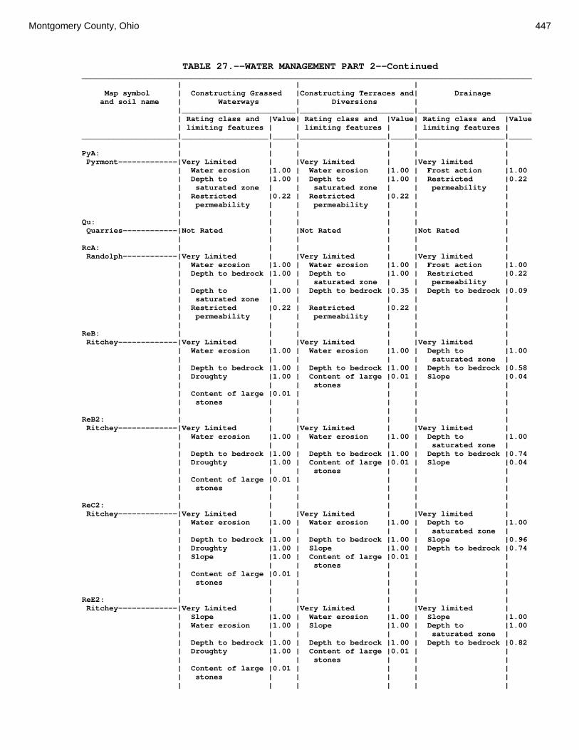
Montgomery County, Ohio 447
TABLE 27.--WATER MANAGEMENT PART 2--Continued ___________________________________________________________________________________________________ | | | Map symbol | Constructing Grassed |Constructing Terraces and| Drainage and soil name | Waterways | Diversions | |_________________________|_________________________|_________________________ | Rating class and |Value| Rating class and |Value| Rating class and |Value | limiting features | | limiting features | | limiting features | _____________________|___________________|_____|___________________|_____|___________________|_____ | | | | | | PyA: | | | | | | Pyrmont-------------|Very Limited | |Very Limited | |Very limited | | Water erosion |1.00 | Water erosion |1.00 | Frost action |1.00 | Depth to |1.00 | Depth to |1.00 | Restricted |0.22 | saturated zone | | saturated zone | | permeability | | Restricted |0.22 | Restricted |0.22 | | | permeability | | permeability | | | | | | | | | Qu: | | | | | | Quarries------------|Not Rated | |Not Rated | |Not Rated | | | | | | | RcA: | | | | | | Randolph------------|Very Limited | |Very Limited | |Very limited | | Water erosion |1.00 | Water erosion |1.00 | Frost action |1.00 | Depth to bedrock |1.00 | Depth to |1.00 | Restricted |0.22 | | | saturated zone | | permeability | | Depth to |1.00 | Depth to bedrock |0.35 | Depth to bedrock |0.09 | saturated zone | | | | | | Restricted |0.22 | Restricted |0.22 | | | permeability | | permeability | | | | | | | | | ReB: | | | | | | Ritchey-------------|Very Limited | |Very Limited | |Very limited | | Water erosion |1.00 | Water erosion |1.00 | Depth to |1.00 | | | | | saturated zone | | Depth to bedrock |1.00 | Depth to bedrock |1.00 | Depth to bedrock |0.58 | Droughty |1.00 | Content of large |0.01 | Slope |0.04 | | | stones | | | | Content of large |0.01 | | | | | stones | | | | | | | | | | | ReB2: | | | | | | Ritchey-------------|Very Limited | |Very Limited | |Very limited | | Water erosion |1.00 | Water erosion |1.00 | Depth to |1.00 | | | | | saturated zone | | Depth to bedrock |1.00 | Depth to bedrock |1.00 | Depth to bedrock |0.74 | Droughty |1.00 | Content of large |0.01 | Slope |0.04 | | | stones | | | | Content of large |0.01 | | | | | stones | | | | | | | | | | | ReC2: | | | | | | Ritchey-------------|Very Limited | |Very Limited | |Very limited | | Water erosion |1.00 | Water erosion |1.00 | Depth to |1.00 | | | | | saturated zone | | Depth to bedrock |1.00 | Depth to bedrock |1.00 | Slope |0.96 | Droughty |1.00 | Slope |1.00 | Depth to bedrock |0.74 | Slope |1.00 | Content of large |0.01 | | | | | stones | | | | Content of large |0.01 | | | | | stones | | | | | | | | | | | ReE2: | | | | | | Ritchey-------------|Very Limited | |Very Limited | |Very limited | | Slope |1.00 | Water erosion |1.00 | Slope |1.00 | Water erosion |1.00 | Slope |1.00 | Depth to |1.00 | | | | | saturated zone | | Depth to bedrock |1.00 | Depth to bedrock |1.00 | Depth to bedrock |0.82 | Droughty |1.00 | Content of large |0.01 | | | | | stones | | | | Content of large |0.01 | | | | | stones | | | | | | | | | | |

448 Soil Survey
TABLE 27.--WATER MANAGEMENT PART 2--Continued ___________________________________________________________________________________________________ | | | Map symbol | Constructing Grassed |Constructing Terraces and| Drainage and soil name | Waterways | Diversions | |_________________________|_________________________|_________________________ | Rating class and |Value| Rating class and |Value| Rating class and |Value | limiting features | | limiting features | | limiting features | _____________________|___________________|_____|___________________|_____|___________________|_____ | | | | | | ReF2: | | | | | | Ritchey-------------|Very Limited | |Very Limited | |Very limited | | Slope |1.00 | Water erosion |1.00 | Slope |1.00 | Water erosion |1.00 | Slope |1.00 | Depth to |1.00 | | | | | saturated zone | | Depth to bedrock |1.00 | Depth to bedrock |1.00 | Depth to bedrock |0.84 | Droughty |1.00 | Content of large |0.05 | | | | | stones | | | | Content of large |0.05 | | | | | stones | | | | | | | | | | | RfD3: | | | | | | Ritchey-------------|Very Limited | |Very Limited | |Very limited | | Water erosion |1.00 | Water erosion |1.00 | Depth to |1.00 | | | | | saturated zone | | Depth to bedrock |1.00 | Depth to bedrock |1.00 | Slope |1.00 | Droughty |1.00 | Slope |1.00 | Depth to bedrock |0.89 | Slope |1.00 | Content of large |0.18 | | | | | stones | | | | Content of large |0.18 | | | | | stones | | | | | | | | | | | Rh: | | | | | | Riverwash-----------|Not Rated | |Not Rated | |Not Rated | | | | | | | RlE2: | | | | | | Rodman--------------|Very Limited | |Very Limited | |Very limited | | Slope |1.00 | Slope |1.00 | Slope |1.00 | Droughty |1.00 | | | Depth to |1.00 | | | | | saturated zone | | | | | | | Fox-----------------|Very Limited | |Very Limited | |Very limited | | Slope |1.00 | Water erosion |1.00 | Slope |1.00 | Water erosion |1.00 | Slope |1.00 | Depth to |1.00 | | | | | saturated zone | | Droughty |1.00 | | | | | | | | | | RlF2: | | | | | | Rodman--------------|Very Limited | |Very Limited | |Very limited | | Slope |1.00 | Slope |1.00 | Slope |1.00 | Droughty |1.00 | | | Depth to |1.00 | | | | | saturated zone | | | | | | | Fox-----------------|Very Limited | |Very Limited | |Very limited | | Slope |1.00 | Water erosion |1.00 | Slope |1.00 | Water erosion |1.00 | Slope |1.00 | Depth to |1.00 | | | | | saturated zone | | Droughty |1.00 | | | | | | | | | | Rs: | | | | | | Ross----------------|Not Limited | |Not Limited | |Very limited | | | | | | Flooding |1.00 | | | | | Depth to |1.00 | | | | | saturated zone | | | | | | | Rt: | | | | | | Urban Land----------|Not Rated | |Not Rated | |Not Rated | | | | | | | Ross----------------|Not Limited | |Not Limited | |Very limited | | | | | | Flooding |1.00 | | | | | Depth to |1.00 | | | | | saturated zone | | | | | | |

Montgomery County, Ohio 449
TABLE 27.--WATER MANAGEMENT PART 2--Continued ___________________________________________________________________________________________________ | | | Map symbol | Constructing Grassed |Constructing Terraces and| Drainage and soil name | Waterways | Diversions | |_________________________|_________________________|_________________________ | Rating class and |Value| Rating class and |Value| Rating class and |Value | limiting features | | limiting features | | limiting features | _____________________|___________________|_____|___________________|_____|___________________|_____ | | | | | | RuB: | | | | | | Russell-------------|Very Limited | |Very Limited | |Very limited | | Water erosion |1.00 | Water erosion |1.00 | Frost action |1.00 | Restricted |0.22 | Restricted |0.22 | Depth to |1.00 | permeability | | permeability | | saturated zone | | | | | | Restricted |0.22 | | | | | permeability | | | | | | Slope |0.04 | | | | | | RvC2: | | | | | | Russell-------------|Very Limited | |Very Limited | |Very limited | | Water erosion |1.00 | Water erosion |1.00 | Frost action |1.00 | Slope |1.00 | Slope |1.00 | Depth to |1.00 | | | | | saturated zone | | Restricted |0.22 | Restricted |0.22 | Slope |0.96 | permeability | | permeability | | | | | | | | Restricted |0.22 | | | | | permeability | | | | | | | Miamian-------------|Very Limited | |Very Limited | |Very limited | | Water erosion |1.00 | Water erosion |1.00 | Depth to |1.00 | | | | | saturated zone | | Slope |1.00 | Slope |1.00 | Slope |0.96 | Restricted |0.22 | Restricted |0.22 | Restricted |0.22 | permeability | | permeability | | permeability | | | | | | | RvD2: | | | | | | Russell-------------|Very Limited | |Very Limited | |Very limited | | Slope |1.00 | Water erosion |1.00 | Frost action |1.00 | Water erosion |1.00 | Slope |1.00 | Slope |1.00 | Restricted |0.22 | Restricted |0.22 | Depth to |1.00 | permeability | | permeability | | saturated zone | | | | | | Restricted |0.22 | | | | | permeability | | | | | | | Miamian-------------|Very Limited | |Very Limited | |Very limited | | Slope |1.00 | Water erosion |1.00 | Slope |1.00 | Water erosion |1.00 | Slope |1.00 | Depth to |1.00 | | | | | saturated zone | | Restricted |0.22 | Restricted |0.22 | Restricted |0.22 | permeability | | permeability | | permeability | | | | | | | Sh: | | | | | | Shoals--------------|Very Limited | |Very Limited | |Very limited | | Water erosion |1.00 | Water erosion |1.00 | Frost action |1.00 | Depth to |1.00 | Depth to |1.00 | Flooding |1.00 | saturated zone | | saturated zone | | | | | | | | | So: | | | | | | Sloan---------------|Very Limited | |Very Limited | |Very limited | | Water erosion |1.00 | Water erosion |1.00 | Ponding |1.00 | Depth to |1.00 | Depth to |1.00 | Frost action |1.00 | saturated zone | | saturated zone | | | | Restricted |0.22 | Ponding |1.00 | Flooding |1.00 | permeability | | | | | | | | Restricted |0.22 | Restricted |0.22 | | | permeability | | permeability | | | | | | | ThA: | | | | | | Thackery------------|Very Limited | |Very Limited | |Not Limited | | Water erosion |1.00 | Water erosion |1.00 | | | Depth to |0.68 | Depth to |1.00 | | | saturated zone | | saturated zone | | |

450 Soil Survey
TABLE 27.--WATER MANAGEMENT PART 2--Continued ___________________________________________________________________________________________________ | | | Map symbol | Constructing Grassed |Constructing Terraces and| Drainage and soil name | Waterways | Diversions | |_________________________|_________________________|_________________________ | Rating class and |Value| Rating class and |Value| Rating class and |Value | limiting features | | limiting features | | limiting features | _____________________|___________________|_____|___________________|_____|___________________|_____ | | | | | | TpA: | | | | | | Tippecanoe----------|Somewhat Limited | |Very Limited | |Not Limited | | Depth to |0.68 | Depth to |1.00 | | | saturated zone | | saturated zone | | | | | | | | | Ua: | | | | | | Urban Land----------|Not Rated | |Not Rated | |Not Rated | | | | | | | Ud: | | | | | | Udorthents----------|Not Rated | |Not Rated | |Not Rated | | | | | | | Ug: | | | | | | Urban Land----------|Not Rated | |Not Rated | |Not Rated | | | | | | | Um: | | | | | | Urban Land----------|Not Rated | |Not Rated | |Not Rated | | | | | | | WaA: | | | | | | Warsaw--------------|Not Limited | |Not Limited | |Very limited | | | | | | Depth to |1.00 | | | | | saturated zone | | | | | | | WaB: | | | | | | Warsaw--------------|Not Limited | |Not Limited | |Very limited | | | | | | Depth to |1.00 | | | | | saturated zone | | | | | | Slope |0.04 | | | | | | WeA: | | | | | | Wea-----------------|Not Limited | |Not Limited | |Very limited | | | | | | Depth to |1.00 | | | | | saturated zone | | | | | | | WeB: | | | | | | Wea-----------------|Not Limited | |Not Limited | |Very limited | | | | | | Depth to |1.00 | | | | | saturated zone | | | | | | Slope |0.04 | | | | | | Ws: | | | | | | Westland------------|Very Limited | |Very Limited | |Very limited | | Depth to |1.00 | Depth to |1.00 | Ponding |1.00 | saturated zone | | saturated zone | | | | | | Ponding |1.00 | Frost action |1.00 | | | | | | WyB2: | | | | | | Wynn----------------|Very Limited | |Very Limited | |Very limited | | Water erosion |1.00 | Water erosion |1.00 | Depth to |1.00 | | | | | saturated zone | | Depth to bedrock |1.00 | Depth to bedrock |0.54 | Restricted |0.22 | | | | | permeability | | Restricted |0.22 | Restricted |0.22 | Depth to bedrock |0.14 | permeability | | permeability | | | | Depth to |0.11 | | | Slope |0.04 | saturated zone | | | | | | | | | | |

Montgomery County, Ohio 451
TABLE 27.--WATER MANAGEMENT PART 2--Continued ___________________________________________________________________________________________________ | | | Map symbol | Constructing Grassed |Constructing Terraces and| Drainage and soil name | Waterways | Diversions | |_________________________|_________________________|_________________________ | Rating class and |Value| Rating class and |Value| Rating class and |Value | limiting features | | limiting features | | limiting features | _____________________|___________________|_____|___________________|_____|___________________|_____ | | | | | | XeA: | | | | | | Xenia---------------|Very Limited | |Very Limited | |Very limited | | Water erosion |1.00 | Water erosion |1.00 | Frost action |1.00 | Depth to |0.68 | Depth to |1.00 | Restricted |0.22 | saturated zone | | saturated zone | | permeability | | Restricted |0.22 | Restricted |0.22 | | | permeability | | permeability | | | | | | | | | XeB: | | | | | | Xenia---------------|Very Limited | |Very Limited | |Very limited | | Water erosion |1.00 | Water erosion |1.00 | Frost action |1.00 | Depth to |0.68 | Depth to |1.00 | Restricted |0.22 | saturated zone | | saturated zone | | permeability | | Restricted |0.22 | Restricted |0.22 | Slope |0.04 | permeability | | permeability | | | | | | | | | _____________________|___________________|_____|___________________|_____|___________________|_____

452 Soil Survey
TABLE 28.--ENGINEERING INDEX PROPERTIES (Absence of an entry indicates that the data were not estimated. See text on page 177 for additional information.) _____________________________________________________________________________________________________________________________ | | | Classification | Fragments | Percentage passing | | Map symbol | Depth | USDA texture |__________________________|_____________| sieve number-- |Liquid| Plas- and soil name | | | | | >10 | 3-10 |___________________________|limit |ticity | | | Unified | AASHTO |inches|inches| 4 | 10 | 40 | 200 | |index _________________|________|_______________|____________|_____________|______|______|______|______|______|______|______|______ | In | | | | Pct | Pct | | | | | Pct | | | | | | | | | | | | | Ag: | | | | | | | | | | | | Algiers---------| 0-20 |Silt loam |ML, CL-ML |A-4 | 0 | 0 | 100 |90-100|80-90 |75-85 |30-40 | 4-10 | 20-60 |Silty clay |CL, CL-ML |A-6, A-7 | 0 | 0 | 100 |90-100|85-95 |70-80 |30-45 | 7-19 | | loam, silt | | | | | | | | | | | | loam | | | | | | | | | | | | | | | | | | | | | | Bo: | | | | | | | | | | | | Borrow Pits-----| --- | --- | --- | --- | --- | --- | --- | --- | --- | --- | --- | --- | | | | | | | | | | | | Bp: | | | | | | | | | | | | Brookston-------| 0-12 |Silt loam |ML, CL-ML, |A-7 | 0 | 0 | 100 | 100 |90-100|85-95 |20-30 | 5-15 | | | MH | | | | | | | | | | 12-36 |Silty clay loam|CL-ML, CH, |A-7 | 0 | 0 | 100 |90-100|90-100|85-90 |25-40 | 8-20 | | | CL | | | | | | | | | | 36-60 |Loam |CL, CL-ML |A-4, A-6 | 0 | 0 |90-100|85-95 |75-90 |65-75 |20-30 | 5-15 | | | | | | | | | | | | Br: | | | | | | | | | | | | Brookston-------| 0-12 |Silt loam |MH, CL-ML, |A-7 | 0 | 0 | 100 | 100 |90-100|85-95 |20-30 | 5-15 | | | ML, CL | | | | | | | | | | 12-44 |Silty clay |CL-ML, CH, |A-7 | 0 | 0 | 100 |90-100|90-100|85-90 |25-40 | 8-20 | | loam, loam | CL | | | | | | | | | | 44-72 |Loam |CL, CL-ML |A-4, A-6 | 0 | 0 |90-100|85-95 |75-90 |65-75 |20-30 | 5-15 | | | | | | | | | | | | Bs: | | | | | | | | | | | | Brookston-------| 0-12 |Silty clay loam|CL-ML, ML, |A-7 | 0 | 0 | 100 | 100 |90-100|85-95 |30-40 |10-20 | | | MH, CL | | | | | | | | | | 12-36 |Clay loam, |CL-ML, CL, |A-7 | 0 | 0 | 100 |90-100|90-100|85-90 |25-40 | 8-20 | | silty clay | CH | | | | | | | | | | | loam, loam | | | | | | | | | | | 36-60 |Loam |CL, CL-ML |A-4, A-6 | 0 | 0 |90-100|85-95 |75-90 |65-75 |20-30 | 5-15 | | | | | | | | | | | | Bu: | | | | | | | | | | | | Brookston-------| 0-12 |Silty clay loam|CL, CL-ML, |A-7 | 0 | 0 | 100 | 100 |90-100|85-95 |30-40 |10-20 | | | ML, MH | | | | | | | | | | 12-36 |Silty clay loam|CL-ML, CL, |A-7 | 0 | 0 | 100 |90-100|90-100|85-90 |25-40 | 8-20 | | | CH | | | | | | | | | | 36-60 |Loam |CL, CL-ML |A-4, A-6 | 0 | 0 |90-100|85-95 |75-90 |65-75 |20-30 | 5-15 | | | | | | | | | | | | Urban Land------| --- | --- | --- | --- | --- | --- | --- | --- | --- | --- | --- | --- | | | | | | | | | | | | Ca: | | | | | | | | | | | | Carlisle--------| 0-82 |Muck |PT |A-8 | 0 | 0 | 0 | 0 | 0 | 0 | --- | --- | 82-90 |Clay |CH |A-7, A-6 | 0 | 0 | 100 | 100 |95-100|90-100|40-55 |20-32 | | | | | | | | | | | | CeA: | | | | | | | | | | | | Celina----------| 0-8 |Silt loam |ML, CL-ML |A-4 | 0 | 0 | 100 |90-100|90-100|70-85 |26-40 | 3-10 | 8-30 |Clay loam, |CL, CL-ML |A-6, A-7 | 0 | 0 | 100 |90-100|80-95 |70-85 |32-48 |12-28 | | silty clay | | | | | | | | | | | | loam, silty | | | | | | | | | | | | clay | | | | | | | | | | | 30-60 |Loam |CL, CL-ML |A-4 | 0 | 0 |75-95 |70-90 |60-75 |50-65 |20-36 | 4-16 | | | | | | | | | | | | CeB: | | | | | | | | | | | | Celina----------| 0-8 |Silt loam |ML, CL-ML |A-4 | 0 | 0 | 100 |90-100|90-100|70-85 |26-40 | 3-10 | 8-30 |Clay loam, |CL, CL-ML |A-6, A-7 | 0 | 0 | 100 |90-100|80-95 |70-85 |32-48 |12-28 | | silty clay | | | | | | | | | | | | loam, silty | | | | | | | | | | | | clay | | | | | | | | | | | 30-60 |Loam |CL, CL-ML |A-4 | 0 | 0 |75-95 |70-90 |60-75 |50-65 |20-36 | 4-16 | | | | | | | | | | | | CeB2: | | | | | | | | | | | | Celina----------| 0-8 |Silt loam |ML, CL-ML |A-4 | 0 | 0 | 100 |90-100|90-100|70-85 |26-40 | 3-10 | 8-30 |Clay loam, |CL, CL-ML |A-6, A-7 | 0 | 0 | 100 |90-100|80-95 |70-85 |32-48 |12-28 | | silty clay | | | | | | | | | | | | loam, silty | | | | | | | | | | | | clay | | | | | | | | | | | 30-60 |Loam |CL, CL-ML |A-4 | 0 | 0 |75-95 |70-90 |60-75 |50-65 |20-36 | 4-16 | | | | | | | | | | | | ClB: | | | | | | | | | | | | Celina----------| 0-8 |Silt loam |ML, CL-ML |A-4 |10-25 | 0 | 100 |90-100|90-100|70-85 |26-40 | 3-10 | 8-30 |Clay loam, |CL, CL-ML |A-6, A-7 | 0 | 0 | 100 |90-100|80-95 |70-85 |32-48 |12-28 | | silty clay | | | | | | | | | | | | loam, silty | | | | | | | | | | | | clay | | | | | | | | | | | 30-60 |Loam |CL, CL-ML |A-4 | 0 | 0 |75-95 |70-90 |60-75 |50-65 |20-36 | 4-16 | | | | | | | | | | | |
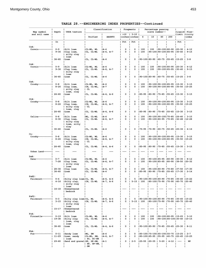
Montgomery County, Ohio 453
TABLE 28.--ENGINEERING INDEX PROPERTIES--Continued _____________________________________________________________________________________________________________________________ | | | Classification | Fragments | Percentage passing | | Map symbol | Depth | USDA texture |__________________________|_____________| sieve number-- |Liquid| Plas- and soil name | | | | | >10 | 3-10 |___________________________|limit |ticity | | | Unified | AASHTO |inches|inches| 4 | 10 | 40 | 200 | |index _________________|________|_______________|____________|_____________|______|______|______|______|______|______|______|______ | In | | | | Pct | Pct | | | | | Pct | | | | | | | | | | | | | CoA: | | | | | | | | | | | | Corwin----------| 0-9 |Silt loam |CL-ML, ML |A-4 | 0 | 0 | 100 | 100 |90-100|80-90 |20-30 | 4-12 | 9-36 |Clay loam, |CL, CL-ML |A-6, A-7 | 0 | 0 | 100 |95-100|90-100|85-95 |30-40 | 9-15 | | silty clay | | | | | | | | | | | | loam | | | | | | | | | | | 36-60 |Loam |CL, CL-ML |A-4 | 0 | 0 |90-100|80-90 |60-75 |55-65 |15-25 | 3-8 | | | | | | | | | | | | CoB: | | | | | | | | | | | | Corwin----------| 0-9 |Silt loam |CL-ML, ML |A-4 | 0 | 0 | 100 | 100 |90-100|80-90 |20-30 | 4-12 | 9-36 |Clay loam, |CL, CL-ML |A-6, A-7 | 0 | 0 | 100 | 100 |90-100|85-95 |30-40 | 9-15 | | silty clay | | | | | | | | | | | | loam | | | | | | | | | | | 36-60 |Loam |CL, CL-ML |A-4 | 0 | 0 |90-100|80-90 |60-75 |55-65 |15-25 | 3-8 | | | | | | | | | | | | CsA: | | | | | | | | | | | | Crosby----------| 0-8 |Silt loam |CL-ML, ML |A-4 | 0 | 0 | 100 |90-100|90-100|85-95 |15-30 | 3-15 | 8-26 |Clay loam, |CH, CL-ML, |A-7 | 0 | 0 | 100 |90-100|90-100|80-95 |35-50 |15-25 | | silty clay | CL | | | | | | | | | | | loam, clay | | | | | | | | | | | 26-60 |Loam |CL, CL-ML |A-4, A-6 | 0 | 0 |85-95 |80-90 |75-85 |55-65 |15-30 | 3-15 | | | | | | | | | | | | CtB: | | | | | | | | | | | | Crosby----------| 0-8 |Silt loam |CL-ML, ML |A-4 | 0 | 0 | 100 |90-100|90-100|85-95 |15-30 | 3-15 | 8-26 |Clay loam, |CH, CL-ML, |A-6, A-7 | 0 | 0 | 100 |90-100|90-100|80-95 |35-50 |15-25 | | silty clay | CL | | | | | | | | | | | loam, clay | | | | | | | | | | | 26-60 |Loam |CL, CL-ML |A-4, A-6 | 0 | 0 |85-95 |80-90 |75-85 |55-65 |15-30 | 3-15 | | | | | | | | | | | | Celina----------| 0-8 |Silt loam |ML, CL-ML |A-4 | 0 | 0 | 100 |90-100|90-100|70-85 |26-40 | 3-10 | 8-30 |Clay loam, |CL, CL-ML |A-6, A-7 | 0 | 0 | 100 |90-100|80-95 |70-85 |32-48 |12-28 | | silty clay | | | | | | | | | | | | loam, silty | | | | | | | | | | | | clay | | | | | | | | | | | 30-60 |Loam |CL, CL-ML |A-4 | 0 | 0 |75-95 |70-90 |60-75 |50-65 |20-36 | 4-16 | | | | | | | | | | | | Cu: | | | | | | | | | | | | Crosby----------| 0-8 |Silt loam |CL-ML, ML |A-4 | 0 | 0 | 100 |90-100|90-100|85-95 |15-30 | 3-15 | 8-26 |Clay loam, |CH, CL-ML, |A-6, A-7 | 0 | 0 | 100 |90-100|90-100|80-95 |35-50 |15-25 | | silty clay | CL | | | | | | | | | | | loam, clay | | | | | | | | | | | 26-60 |Loam |CL, CL-ML |A-4, A-6 | 0 | 0 |85-95 |80-90 |75-85 |55-65 |15-30 | 3-15 | | | | | | | | | | | | Urban Land------| --- | --- | --- | --- | --- | --- | --- | --- | --- | --- | --- | --- | | | | | | | | | | | | DaB: | | | | | | | | | | | | Dana------------| 0-7 |Silt loam |CL-ML, ML |A-4 | 0 | 0 | 100 |90-100|85-95 |80-90 |30-35 | 8-12 | 7-28 |Clay loam, |CL, CL-ML |A-6, A-7 | 0 | 0 | 100 |90-100|85-95 |80-90 |38-50 |20-32 | | silty clay | | | | | | | | | | | | loam | | | | | | | | | | | 28-36 |Clay loam |CL, CL-ML |A-6, A-7 | 0 | 0 | 100 |95-100|80-90 |70-80 |37-50 |17-30 | 36-60 |Loam |CL, CL-ML |A-4 | 0 | 0 |85-95 |80-90 |75-85 |55-65 |17-30 | 2-14 | | | | | | | | | | | | FaE2: | | | | | | | | | | | | Fairmount-------| 0-4 |Silty clay loam|CL, ML |A-6, A-4 | 0 | 5 |90-100|90-100|80-90 |70-85 |35-45 |15-22 | 4-16 |Silty clay, |CH, CL-ML |A-7, A-6 | 0 | 5-15 | 100 |80-100|75-90 |70-90 |40-70 |20-40 | | silty clay | | | | | | | | | | | | loam | | | | | | | | | | | 16-18 |Unweathered | | | --- | --- | --- | --- | --- | --- | --- | --- | | bedrock | | | | | | | | | | | | | | | | | | | | | | FaF2: | | | | | | | | | | | | Fairmount-------| 0-3 |Silty clay loam|CL, ML |A-6, A-4 | 0 | 5 |90-100|90-100|80-90 |70-85 |35-45 |15-22 | 3-15 |Silty clay, |CH, CL-ML |A-7, A-6 | 0 | 5-15 | 100 |80-100|75-90 |70-90 |40-70 |20-40 | | silty clay | | | | | | | | | | | | loam | | | | | | | | | | | 15-17 |Unweathered | | | --- | --- | --- | --- | --- | --- | --- | --- | | bedrock | | | | | | | | | | FcA: | | | | | | | | | | | | Fincastle-------| 0-19 |Silt loam |CL-ML, ML |A-4 | 0 | 0 | 100 | 100 |90-100|80-95 |15-25 | 3-10 | 19-38 |Silty clay |CL, CL-ML |A-6, A-7 | 0 | 0 | 100 | 100 |90-100|85-100|30-40 |10-15 | | loam, clay | | | | | | | | | | | | loam | | | | | | | | | | | 38-60 |Loam |CL, CL-ML |A-4, A-6 | 0 | 0 |90-100|85-90 |70-85 |55-65 |25-30 | 8-11 | | | | | | | | | | | | FkA: | | | | | | | | | | | | Fox-------------| 0-11 |Sandy loam |ML, SM |A-4 | 0 | 0 |85-100|75-100|65-100|55-70 |15-25 | 2-7 | 11-29 |Loam, sandy |CL-ML, SM, |A-6, A-7 | 0 | 0 |80-100|65-95 |55-95 |40-75 |22-45 |10-25 | | loam | SC, SC-SM | | | | | | | | | | 29-60 |Sand and gravel|GP, GP-GM, |A-1 | 0 | 2-5 |25-55 |20-35 | 5-20 | 4-12 | --- | NP | | | SP, SP-SM, | | | | | | | | | | | | GW | | | | | | | | |

454 Soil Survey
TABLE 28.--ENGINEERING INDEX PROPERTIES--Continued _____________________________________________________________________________________________________________________________ | | | Classification | Fragments | Percentage passing | | Map symbol | Depth | USDA texture |__________________________|_____________| sieve number-- |Liquid| Plas- and soil name | | | | | >10 | 3-10 |___________________________|limit |ticity | | | Unified | AASHTO |inches|inches| 4 | 10 | 40 | 200 | |index _________________|________|_______________|____________|_____________|______|______|______|______|______|______|______|______ | In | | | | Pct | Pct | | | | | Pct | | | | | | | | | | | | | FkB: | | | | | | | | | | | | Fox-------------| 0-11 |Sandy loam |ML, SM |A-4 | 0 | 0 |85-100|75-100|65-100|55-70 |15-25 | 2-7 | 11-29 |Loam, sandy |CL-ML, SM, |A-6, A-7 | 0 | 0 |80-100|65-95 |55-95 |40-75 |22-45 |10-25 | | loam | SC | | | | | | | | | | 29-60 |Sand and gravel|GP, GP-GM, |A-1 | 0 | 2-5 |25-55 |20-35 | 5-20 | 4-12 | --- | NP | | | SP, SP-SM, | | | | | | | | | | | | GW | | | | | | | | | | | | | | | | | | | | | FlA: | | | | | | | | | | | | Fox-------------| 0-11 |Loam |CL-ML, ML |A-4 | 0 | 0 |85-100|75-100|65-100|55-70 |15-25 | 3-8 | 11-29 |Gravelly clay |CL-ML, SC, |A-6, A-7 | 0 | 0 |80-100|65-95 |55-95 |40-75 |22-45 |10-25 | | loam, sandy | CL | | | | | | | | | | | clay, clay | | | | | | | | | | | | loam, loam, | | | | | | | | | | | | sandy clay | | | | | | | | | | | | loam | | | | | | | | | | | 29-60 |Sand and gravel|GP, GW, SP, |A-1 | 0 | 2-5 |25-55 |20-35 | 5-20 | 4-12 | --- | NP | | | GW-GM | | | | | | | | | | | | | | | | | | | | | FlB: | | | | | | | | | | | | Fox-------------| 0-11 |Loam |CL-ML, ML |A-4 | 0 | 0 |85-100|75-100|65-100|55-70 |15-25 | 3-8 | 11-29 |Gravelly clay |CL-ML, SC, |A-6, A-7 | 0 | 0 |80-100|65-95 |55-95 |40-75 |22-45 |10-25 | | loam, clay | CL | | | | | | | | | | | loam, loam, | | | | | | | | | | | | sandy clay | | | | | | | | | | | | loam, sandy | | | | | | | | | | | | clay | | | | | | | | | | | 29-60 |Sand and gravel|GP, GW, GW- |A-1 | 0 | 2-5 |25-55 |20-35 | 5-20 | 4-12 | --- | NP | | | GM | | | | | | | | | | | | | | | | | | | | | FlC2: | | | | | | | | | | | | Fox-------------| 0-3 |Loam |CL-ML, ML |A-4 | 0 | 0 |85-100|75-100|65-100|55-70 |15-25 | 3-8 | 3-21 |Clay loam, |CL-ML, SC, |A-6, A-7 | 0 | 0 |80-100|65-95 |55-95 |40-75 |22-45 |10-25 | | loam, sandy | CL | | | | | | | | | | | clay loam, | | | | | | | | | | | | sandy clay | | | | | | | | | | | 21-60 |Sand and gravel|GP, GW, GW- |A-1 | 0 | 2-5 |25-55 |20-35 | 5-20 | 4-12 | --- | NP | | | GM | | | | | | | | | | | | | | | | | | | | | FmA: | | | | | | | | | | | | Fox-------------| 0-11 |Silt loam |CL-ML, ML |A-4 | 0 | 0 |85-100|75-100|65-100|55-70 |15-25 | 3-8 | 11-29 |Clay loam, |CL-ML, SC, |A-6, A-7 | 0 | 0 |80-100|65-95 |55-95 |40-75 |22-45 |10-25 | | loam, sandy | CL | | | | | | | | | | | clay loam, | | | | | | | | | | | | sandy clay | | | | | | | | | | | 29-60 |Sand and gravel|GP, GW, GW- |A-1 | 0 | 2-5 |25-55 |20-35 | 5-20 | 4-12 | --- | NP | | | GM | | | | | | | | | | | | | | | | | | | | | FmB: | | | | | | | | | | | | Fox-------------| 0-11 |Silt loam |ML, CL-ML |A-4 | 0 | 0 |85-100|75-100|65-100|55-70 |15-25 | 3-8 | 11-29 |Clay loam, |CL-ML, SC, |A-6, A-7 | 0 | 0 |80-100|65-95 |55-95 |40-75 |22-45 |10-25 | | loam, sandy | CL | | | | | | | | | | | clay loam, | | | | | | | | | | | | sandy clay | | | | | | | | | | | 29-60 |Sand and gravel|GP, GW, GW- |A-1 | 0 | 2-5 |25-55 |20-35 | 5-20 | 4-12 | --- | NP | | | GM | | | | | | | | | | | | | | | | | | | | | FmC2: | | | | | | | | | | | | Fox-------------| 0-3 |Silt loam |CL-ML, ML |A-4 | 0 | 0 |85-100|75-100|65-100|55-70 |15-25 | 3-8 | 3-21 |Clay loam, |CL-ML, SC, |A-6, A-7 | 0 | 0 |80-100|65-95 |55-95 |40-75 |22-45 |10-25 | | loam, sandy | CL | | | | | | | | | | | clay loam, | | | | | | | | | | | | sandy clay | | | | | | | | | | | 21-60 |Sand and gravel|GP, GP-GM, |A-1 | 0 | 2-5 |25-55 |20-35 | 5-20 | 4-12 | --- | NP | | | SP, SP-SM | | | | | | | | | | | | | | | | | | | | | FmD2: | | | | | | | | | | | | Fox-------------| 0-3 |Silt loam |CL-ML, ML |A-4 | 0 | 0 |85-100|75-100|75-100|55-70 |15-25 | 3-8 | 3-21 |Clay loam, |CL-ML, GC, |A-6, A-7 | 0 | 0 |80-100|65-95 |55-95 |40-75 |22-45 |10-25 | | loam, sandy | CL | | | | | | | | | | | clay loam, | | | | | | | | | | | | sandy clay | | | | | | | | | | | 21-60 |Sand and gravel|GP, GP-GM, |A-1 | 0 | 2-5 |25-55 |20-35 | 5-20 | 4-12 | --- | NP | | | SP, SP-SM | | | | | | | | | | | | | | | | | | | | |

Montgomery County, Ohio 455
TABLE 28.--ENGINEERING INDEX PROPERTIES--Continued _____________________________________________________________________________________________________________________________ | | | Classification | Fragments | Percentage passing | | Map symbol | Depth | USDA texture |__________________________|_____________| sieve number-- |Liquid| Plas- and soil name | | | | | >10 | 3-10 |___________________________|limit |ticity | | | Unified | AASHTO |inches|inches| 4 | 10 | 40 | 200 | |index _________________|________|_______________|____________|_____________|______|______|______|______|______|______|______|______ | In | | | | Pct | Pct | | | | | Pct | | | | | | | | | | | | | FsC3: | | | | | | | | | | | | Fox-------------| 0-3 |Clay loam |CL-ML, ML |A-4 | 0 | 0 |85-100|75-100|65-100|55-70 |25-40 | 9-20 | 3-18 |Clay loam, |CL-ML, SC, |A-6, A-7 | 0 | 0 |80-100|65-95 |55-95 |40-75 |22-45 |10-25 | | loam, sandy | CL | | | | | | | | | | | clay loam, | | | | | | | | | | | | sandy clay | | | | | | | | | | | 18-60 |Sand and gravel|GP, GW, GW- |A-1 | 0 | 2-5 |25-55 |20-35 | 5-20 | 4-12 | --- | NP | | | GM | | | | | | | | | | | | | | | | | | | | | FuB: | | | | | | | | | | | | Fox-------------| 0-11 |Silt loam |CL-ML, ML |A-4 | 0 | 0 |85-100|75-100|65-100|55-70 |15-25 | 3-8 | 11-29 |Clay loam, |CL-ML, SC, |A-6, A-7 | 0 | 0 |80-100|65-95 |55-95 |40-75 |22-45 |10-25 | | loam, sandy | CL | | | | | | | | | | | clay loam, | | | | | | | | | | | | sandy clay | | | | | | | | | | | 29-60 |Sand and gravel|GP, GW, GW- |A-1 | 0 | 2-5 |25-55 |20-35 | 5-20 | 4-12 | --- | NP | | | GM | | | | | | | | | | | | | | | | | | | | | Urban Land------| --- | --- | --- | --- | --- | --- | --- | --- | --- | --- | --- | --- | | | | | | | | | | | | FuC: | | | | | | | | | | | | Urban Land------| --- | --- | --- | --- | --- | --- | --- | --- | --- | --- | --- | --- | | | | | | | | | | | | Fox-------------| 0-3 |Silt loam |CL-ML, ML |A-4 | 0 | 0 |85-100|75-100|65-100|55-70 |15-25 | 3-8 | 3-21 |Clay loam, |CL-ML, SC, |A-6, A-7 | 0 | 0 |80-100|65-95 |55-95 |40-75 |22-45 |10-25 | | loam, sandy | CL | | | | | | | | | | | clay loam, | | | | | | | | | | | | sandy clay | | | | | | | | | | | 21-60 |Sand and gravel|GP, GW, GW- |A-1 | 0 | 2-5 |25-55 |20-35 | 5-20 | 4-12 | --- | NP | | | GM | | | | | | | | | | | | | | | | | | | | | FuF: | | | | | | | | | | | | Urban Land------| --- | --- | --- | --- | --- | --- | --- | --- | --- | --- | --- | --- | | | | | | | | | | | | Fox-------------| 0-3 |Silt loam |CL-ML, ML |A-4 | 0 | 0 |85-100|75-100|65-100|55-70 |15-25 | 3-8 | 3-18 |Clay loam, |CL-ML, SC, |A-6, A-7 | 0 | 0 |80-100|65-95 |55-95 |40-75 |22-45 |10-25 | | loam, sandy | CL | | | | | | | | | | | clay loam, | | | | | | | | | | | | sandy clay | | | | | | | | | | | 18-60 |Sand and gravel|GP, GW, GW- |A-1 | 0 | 2-5 |25-55 |20-35 | 5-20 | 4-12 | --- | NP | | | GM | | | | | | | | | | | | | | | | | | | | | Gp: | | | | | | | | | | | | Gravel Pits-----| --- | --- | --- | --- | --- | --- | --- | --- | --- | --- | --- | --- | | | | | | | | | | | | HeE2: | | | | | | | | | | | | Hennepin--------| 0-4 |Silt loam |CL-ML, ML |A-4 | 0 | 0 |90-100|90-100|80-90 |75-80 |25-45 | 5-20 | 4-12 |Loam, clay loam|CL, ML |A-4, A-6 | 0 | 0 |90-100|90-100|70-90 |65-75 |20-50 | 5-25 | 12-60 |Loam |CL, CL-ML |A-4, A-6 | 0 | 0 |90-100|80-90 |70-80 |55-65 |20-50 | 5-25 | | | | | | | | | | | | Miamian---------| 0-4 |Silt loam |CL-ML, ML |A-4 | 0 | 0 |90-100|90-100|80-90 |70-90 |25-40 | 4-12 | 4-25 |Silty clay |CL |A-6, A-7 | 0 | 0 |90-100|85-95 |75-90 |70-85 |35-50 |15-30 | | loam, clay | | | | | | | | | | | | loam, clay | | | | | | | | | | | 25-60 |Loam |CL, CL-ML |A-4 | 0 | 0 |75-95 |75-90 |65-85 |55-70 |20-35 | 3-13 | | | | | | | | | | | | HeF2: | | | | | | | | | | | | Hennepin--------| 0-3 |Silt loam |CL-ML, ML |A-4 | 0 | 0 |90-100|90-100|80-90 |75-80 |25-45 | 5-20 | 3-12 |Loam, clay loam|CL, ML |A-4, A-6 | 0 | 0 |90-100|90-100|70-80 |65-75 |20-50 | 5-25 | 12-60 |Loam |CL, CL-ML |A-4, A-6 | 0 | 0 |90-100|80-90 |70-80 |55-65 |20-50 | 5-25 | | | | | | | | | | | | Miamian---------| 0-4 |Silt loam |ML, CL-ML |A-4 | 0 | 0 |90-100|90-100|80-90 |70-90 |25-40 | 4-12 | 4-25 |Silty clay |CL |A-6, A-7 | 0 | 0 |90-100|85-95 |75-90 |70-85 |35-50 |15-30 | | loam, clay | | | | | | | | | | | | loam, clay | | | | | | | | | | | 25-60 |Loam |CL, CL-ML |A-4 | 0 | 0 |75-95 |75-90 |65-85 |55-70 |20-35 | 3-13 | | | | | | | | | | | | HmF3: | | | | | | | | | | | | Hennepin--------| 0-6 |Loam |CL, ML |A-4, A-6 | 0 | 0 |90-100|90-100|70-90 |65-75 |20-50 | 5-25 | 6-60 |Loam |CL, CL-ML |A-4, A-6 | 0 | 0 |90-100|80-90 |70-80 |55-65 |20-50 | 5-25 | | | | | | | | | | | | Miamian---------| 0-21 |Clay loam |CL |A-6, A-7 | 0 | 0 |90-100|85-95 |75-90 |70-85 |35-50 |15-30 | 21-60 |Loam |CL, CL-ML |A-4 | 0 | 0 |75-95 |75-90 |65-85 |55-70 |20-35 | 3-13 | | | | | | | | | | | |

456 Soil Survey
TABLE 28.--ENGINEERING INDEX PROPERTIES--Continued _____________________________________________________________________________________________________________________________ | | | Classification | Fragments | Percentage passing | | Map symbol | Depth | USDA texture |__________________________|_____________| sieve number-- |Liquid| Plas- and soil name | | | | | >10 | 3-10 |___________________________|limit |ticity | | | Unified | AASHTO |inches|inches| 4 | 10 | 40 | 200 | |index _________________|________|_______________|____________|_____________|______|______|______|______|______|______|______|______ | In | | | | Pct | Pct | | | | | Pct | | | | | | | | | | | | | KeA: | | | | | | | | | | | | Kendallville----| 0-9 |Silt loam |ML, CL-ML |A-4 | 0 | 0 | 100 |90-100|70-90 |65-80 |26-40 | 4-12 | 9-26 |Clay loam, |CL, CL-ML |A-6, A-7 | 0 | 0 | 100 |90-100|75-95 |65-90 |25-40 | 5-15 | | silty clay | | | | | | | | | | | | loam | | | | | | | | | | | 26-36 |Clay loam, |CL, CL-ML, |A-6 | 0 | 0 |80-90 |70-80 |60-75 |40-55 |25-40 | 5-15 | | gravelly clay | SC | | | | | | | | | | | loam, sandy | | | | | | | | | | | | clay loam | | | | | | | | | | | 36-60 |Loam |CL, CL-ML |A-4 | 0 | 0 |90-100|85-95 |70-80 |55-70 |20-35 | 3-15 | | | | | | | | | | | | KeB: | | | | | | | | | | | | Kendallville----| 0-9 |Silt loam |ML, CL-ML |A-4 | 0 | 0 | 100 |90-100|70-90 |65-80 |26-40 | 4-12 | 9-26 |Clay loam, |CL, CL-ML |A-6, A-7 | 0 | 0 | 100 |90-100|75-95 |65-90 |25-40 | 5-15 | | silty clay | | | | | | | | | | | | loam | | | | | | | | | | | 26-36 |Clay loam, |CL, SC |A-4, A-6 | 0 | 0 |80-90 |70-80 |60-75 |40-55 |25-40 | 5-15 | | gravelly clay | | | | | | | | | | | | loam, sandy | | | | | | | | | | | | clay loam | | | | | | | | | | | 36-60 |Loam |CL, CL-ML |A-4 | 0 | 0 |90-100|85-95 |70-80 |55-70 |20-35 | 3-15 | | | | | | | | | | | | KeC2: | | | | | | | | | | | | Kendallville----| 0-4 |Silt loam |CL-ML |A-4, A-6 | 0 | 0 | 100 |90-100|70-90 |65-80 |26-40 | 4-12 | 4-21 |Clay loam, |CL, CL-ML |A-6, A-7 | 0 | 0 | 100 |90-100|75-95 |65-90 |25-40 | 5-15 | | silty clay | | | | | | | | | | | | loam | | | | | | | | | | | 21-36 |Clay loam, |CL, CL-ML, |A-6 | 0 | 0 |80-90 |70-80 |60-75 |40-55 |25-40 | 5-15 | | gravelly clay | SC | | | | | | | | | | | loam, sandy | | | | | | | | | | | | clay loam | | | | | | | | | | | 36-60 |Loam |CL, CL-ML |A-4 | 0 | 0 |90-100|85-95 |70-80 |55-70 |20-35 | 3-15 | | | | | | | | | | | | Ld: | | | | | | | | | | | | Landes----------| 0-19 |Fine sandy |SM |A-2, A-4 | 0 | 0 |95-100|75-90 |30-50 |25-40 |15-25 |NP-10 | | loam, sandy | | | | | | | | | | | | loam | | | | | | | | | | | 19-42 |Loamy sand, |SM |A-4, A-2 | 0 | 0 |95-100|75-90 |30-50 |25-40 |15-25 |NP-10 | | sand, fine | | | | | | | | | | | | sandy loam, | | | | | | | | | | | | loam | | | | | | | | | | | 42-60 |Sand and gravel|GM, SM, SW- |A-2, A-1 | 0 | 5-10 |50-75 |30-50 |20-40 | 5-35 |15-30 |NP-10 | | | SM | | | | | | | | | | | | | | | | | | | | | Lg: | | | | | | | | | | | | Lanier----------| 0-20 |Sandy loam, |SM |A-2, A-4 | 0 | 0 |95-100|75-90 |30-50 |25-40 |15-25 |NP-7 | | loam, silt | | | | | | | | | | | | loam | | | | | | | | | | | 20-60 |Sand and gravel|GM, SW, GW- |A-1, A-2 | 0 | 5-10 |50-75 |30-50 |20-40 | 5-35 | --- | NP | | | GM, SW-SM | | | | | | | | | | | | | | | | | | | | | LsB: | | | | | | | | | | | | Lewisburg-------| 0-7 |Silt loam |CL-ML, ML |A-4 | 0 | 0 | 100 |95-100|85-95 |70-80 |24-40 | 4-14 | 7-15 |Clay loam, clay|CH, CL |A-6, A-7 | 0 | 0 | 100 |95-100|80-95 |75-85 |30-55 |10-35 | 15-60 |Loam |CL, CL-ML |A-4, A-6 | 0 | 0 |90-95 |85-90 |70-85 |55-70 |20-35 | 5-20 | | | | | | | | | | | | LxC2: | | | | | | | | | | | | Lorenzo---------| 0-4 |Loam |ML |A-4 | 0 | 0 |90-100|90-100|80-90 |65-75 |25-40 |10-20 | 4-15 |Loam, clay |SC |A-6, A-4 | 0 | 0 |70-90 |55-80 |50-75 |40-50 |30-50 |10-25 | | loam, sandy | | | | | | | | | | | | clay loam | | | | | | | | | | | 15-60 |Sand and gravel|GW, GW-GM, |A-1 | 0 | 5-10 |25-55 |20-35 | 5-20 | 4-12 |15-30 |NP-10 | | | GP | | | | | | | | | | | | | | | | | | | | | Rodman----------| 0-3 |Loam |ML |A-4 | 0 | 0 |90-100|90-100|75-90 |65-75 |15-30 | 3-10 | 3-9 |Gravelly loam |ML, SM |A-4 | 0 | 2-5 |70-90 |55-80 |50-60 |40-55 |15-30 |NP-10 | 9-60 |Sand and gravel|GW-GM, GW |A-1 | 0 | 5-10 |25-55 |20-35 | 5-20 | 4-12 | --- | NP | | | | | | | | | | | | LxD2: | | | | | | | | | | | | Lorenzo---------| 0-4 |Loam |ML |A-4 | 0 | 0-9 |90-100|90-100|80-90 |65-75 |25-40 |10-20 | 4-15 |Loam, clay |SC |A-6, A-4 | 0 | 0 |70-90 |55-80 |50-75 |40-50 |30-50 |10-25 | | loam, sandy | | | | | | | | | | | | clay loam | | | | | | | | | | | 15-60 |Sand and gravel|GW, GW-GM, |A-1 | 0 | 5-10 |25-55 |20-35 | 5-20 | 4-12 |15-30 |NP-10 | | | GP | | | | | | | | | | | | | | | | | | | | | Rodman----------| 0-3 |Loam |ML |A-4 | 0 | 0 |90-100|90-100|75-90 |65-75 |15-30 | 3-10 | 3-9 |Gravelly loam |ML, SM |A-4 | 0 | 2-5 |70-90 |55-70 |50-60 |40-55 |15-30 |NP-10 | 9-60 |Sand and gravel|GW, GW-GM |A-1 | 0 | 5-10 |25-55 |20-35 | 5-20 | 4-12 | --- | NP | | | | | | | | | | | |

Montgomery County, Ohio 457
TABLE 28.--ENGINEERING INDEX PROPERTIES--Continued _____________________________________________________________________________________________________________________________ | | | Classification | Fragments | Percentage passing | | Map symbol | Depth | USDA texture |__________________________|_____________| sieve number-- |Liquid| Plas- and soil name | | | | | >10 | 3-10 |___________________________|limit |ticity | | | Unified | AASHTO |inches|inches| 4 | 10 | 40 | 200 | |index _________________|________|_______________|____________|_____________|______|______|______|______|______|______|______|______ | In | | | | Pct | Pct | | | | | Pct | | | | | | | | | | | | | Mb: | | | | | | | | | | | | Made Land-------| --- | --- | --- | --- | --- | --- | --- | --- | --- | --- | --- | --- | | | | | | | | | | | | Md: | | | | | | | | | | | | Medway----------| 0-20 |Silt loam |CL-ML, ML |A-4 | 0 | 0 | 100 | 100 |80-90 |70-80 |20-40 | 3-15 | 20-29 |Loam |ML |A-4 | 0 | 0 | 100 |90-100|75-90 |65-90 |20-45 | 4-20 | 29-45 |Loam, silt |CL-ML, SM |A-2, A-4 | 0 | 0 |95-100|80-85 |40-50 |30-45 |15-30 |NP-15 | | loam, silty | | | | | | | | | | | | clay loam, | | | | | | | | | | | | sandy loam | | | | | | | | | | | 45-60 |Gravelly sand |SW-SM, SM |A-1, A-2 | 0 | 0-5 | 100 |55-75 |50-70 | 5-30 |15-30 |NP-15 | | | | | | | | | | | | MlA: | | | | | | | | | | | | Miamian---------| 0-7 |Silt loam |ML, CL-ML |A-4 | 0 | 0 |90-100|90-100|80-90 |70-90 |25-40 | 4-12 | 7-24 |Silty clay |CL |A-6, A-7 | 0 | 0-5 |90-100|85-95 |75-90 |70-85 |35-50 |15-30 | | loam, clay | | | | | | | | | | | | loam, clay | | | | | | | | | | | 24-60 |Loam |CL, CL-ML |A-4 | 0 | 0-5 |75-95 |75-90 |65-75 |55-70 |20-35 | 3-13 | | | | | | | | | | | | MlB: | | | | | | | | | | | | Miamian---------| 0-7 |Silt loam |CL-ML, ML |A-4 | 0 | 0 |90-100|90-100|80-90 |70-90 |25-40 | 4-12 | 7-24 |Silty clay |CL |A-6, A-7 | 0 | 0-5 |90-100|85-95 |75-90 |70-85 |35-50 |15-30 | | loam, clay | | | | | | | | | | | | loam, clay | | | | | | | | | | | 24-60 |Loam |CL, CL-ML |A-4 | 0 | 0-5 |75-95 |75-90 |65-75 |55-70 |20-35 | 3-13 | | | | | | | | | | | | MlB2: | | | | | | | | | | | | Miamian---------| 0-7 |Silt loam |ML, CL-ML |A-4 | 0 | 0 |90-100|90-100|80-90 |70-90 |25-40 | 4-12 | 7-24 |Silty clay |CL, CL-ML |A-6, A-7 | 0 | 0-5 |90-100|85-95 |75-90 |70-85 |35-50 |15-30 | | loam, clay | | | | | | | | | | | | loam, clay | | | | | | | | | | | 24-60 |Loam |CL |A-4 | 0 | 0-5 |75-95 |75-90 |65-75 |55-70 |20-35 | 3-13 | | | | | | | | | | | | MlC2: | | | | | | | | | | | | Miamian---------| 0-7 |Silt loam |CL-ML, ML |A-4 | 0 | 0 |90-100|90-100|80-90 |70-90 |25-40 | 4-12 | 7-24 |Silty clay |CL, CL-ML |A-6, A-7 | 0 | 0-5 |90-100|85-95 |75-90 |70-85 |35-50 |15-30 | | loam, clay | | | | | | | | | | | | loam, clay | | | | | | | | | | | 24-60 |Loam |CL, CL-ML |A-4 | 0 | 0-5 |75-95 |75-90 |65-75 |55-70 |20-35 | 3-13 | | | | | | | | | | | | MlD2: | | | | | | | | | | | | Miamian---------| 0-4 |Silt loam |ML, CL-ML |A-4 | 0 | 0 |90-100|90-100|80-90 |70-90 |25-40 | 4-12 | 4-21 |Silty clay |CL |A-6, A-7 | 0 | 0-5 |90-100|85-95 |75-90 |70-85 |35-50 |15-30 | | loam, clay | | | | | | | | | | | | loam, clay | | | | | | | | | | | 21-60 |Loam |CL, CL-ML |A-4 | 0 | 0-5 |75-95 |75-90 |65-75 |55-70 |20-35 | 3-13 | | | | | | | | | | | | MmB: | | | | | | | | | | | | Miamian---------| 0-7 |Silt loam |ML, CL-ML |A-4, A-6 |10-25 | 0 |90-100|90-100|80-90 |70-90 |25-40 | 4-12 | 7-24 |Silty clay |CL |A-6, A-7 | 0 | 0-5 |90-100|85-95 |75-90 |70-85 |35-50 |15-30 | | loam, clay | | | | | | | | | | | | loam, clay | | | | | | | | | | | 24-60 |Loam |CL, CL-ML |A-4 | 0 | 0-5 |75-95 |75-90 |65-75 |55-70 |20-35 | 3-13 | | | | | | | | | | | | MnB3: | | | | | | | | | | | | Miamian---------| 0-5 |Clay loam |CL |A-6, A-7 | 0 | 0 |90-100|90-100|80-90 |70-90 |30-45 |15-25 | 5-22 |Silty clay |CL |A-6, A-7 | 0 | 0-5 |90-100|85-95 |75-90 |70-85 |35-50 |15-30 | | loam, clay | | | | | | | | | | | | loam, clay | | | | | | | | | | | 22-60 |Loam |CL, CL-ML |A-4 | 0 | 0-5 |75-95 |75-90 |65-75 |55-70 |20-35 | 3-13 | | | | | | | | | | | | MnC3: | | | | | | | | | | | | Miamian---------| 0-5 |Clay loam |CL |A-6, A-7 | 0 | 0 |90-100|90-100|80-90 |70-90 |30-45 |15-25 | 5-22 |Clay loam, clay|CL |A-6, A-7 | 0 | 0-5 |90-100|85-95 |75-90 |70-85 |35-50 |15-30 | 22-60 |Loam |CL, CL-ML |A-4 | 0 | 0-5 |75-95 |75-90 |65-75 |55-70 |20-35 | 3-13 | | | | | | | | | | | | MnD3: | | | | | | | | | | | | Miamian---------| 0-4 |Clay loam |CL |A-6, A-7 | 0 | 0 |90-100|90-100|80-90 |70-90 |30-45 |15-25 | 4-21 |Silty clay |CL |A-6, A-7 | 0 | 0-5 |90-100|85-95 |75-90 |70-85 |35-50 |15-30 | | loam, clay | | | | | | | | | | | | loam, clay | | | | | | | | | | | 21-60 |Loam |CL, CL-ML |A-4 | 0 | 0-5 |75-95 |75-90 |65-75 |55-70 |20-35 | 3-13 | | | | | | | | | | | | MoB: | | | | | | | | | | | | Miamian---------| 0-7 |Silt loam |CL-ML, ML |A-4, A-6 | 0 | 0 |90-100|90-100|80-90 |70-90 |25-40 | 4-12 | 7-24 |Silty clay |CL |A-6, A-7 | 0 | 0-5 |90-100|85-95 |75-90 |70-85 |35-50 |15-30 | | loam, clay | | | | | | | | | | | | loam, clay | | | | | | | | | | | 24-60 |Loam |CL, CL-ML |A-4 | 0 | 0-5 |75-95 |75-90 |65-75 |55-70 |20-35 | 3-13 | | | | | | | | | | | | Urban Land------| --- | --- | --- | --- | --- | --- | --- | --- | --- | --- | --- | ---

458 Soil Survey
TABLE 28.--ENGINEERING INDEX PROPERTIES--Continued _____________________________________________________________________________________________________________________________ | | | Classification | Fragments | Percentage passing | | Map symbol | Depth | USDA texture |__________________________|_____________| sieve number-- |Liquid| Plas- and soil name | | | | | >10 | 3-10 |___________________________|limit |ticity | | | Unified | AASHTO |inches|inches| 4 | 10 | 40 | 200 | |index _________________|________|_______________|____________|_____________|______|______|______|______|______|______|______|______ | In | | | | Pct | Pct | | | | | Pct | | | | | | | | | | | | | MoC: | | | | | | | | | | | | Miamian---------| 0-7 |Silt loam |CL-ML, ML |A-4 | 0 | 0 |90-100|90-100|80-90 |70-90 |25-40 | 4-12 | 7-24 |Silty clay |CL |A-6, A-7 | 0 | 0-5 |90-100|85-95 |75-90 |70-85 |35-50 |15-30 | | loam, clay | | | | | | | | | | | | loam, clay | | | | | | | | | | | 24-60 |Loam |CL, CL-ML |A-4 | 0 | 0-5 |75-95 |75-90 |65-75 |55-70 |20-35 | 3-13 | | | | | | | | | | | | Urban Land------| --- | --- | --- | --- | --- | --- | --- | --- | --- | --- | --- | --- | | | | | | | | | | | | MoE: | | | | | | | | | | | | Miamian---------| 0-6 |Silt loam |CL-ML, ML |A-4 | 0 | 0 |90-100|90-100|80-90 |70-90 |25-40 | 4-12 | 6-23 |Silty clay |CL |A-6, A-7 | 0 | 0-5 |90-100|85-95 |75-90 |70-85 |35-50 |15-30 | | loam, clay | | | | | | | | | | | | loam, clay | | | | | | | | | | | 23-60 |Loam |CL, CL-ML |A-4 | 0 | 0-5 |75-95 |75-90 |65-75 |55-70 |20-35 | 3-13 | | | | | | | | | | | | Urban Land------| --- | --- | --- | --- | --- | --- | --- | --- | --- | --- | --- | --- | | | | | | | | | | | | MrA: | | | | | | | | | | | | Millsdale-------| 0-14 |Silty clay loam|CL, CL-ML |A-7, A-6 | 0 | 0 | 100 |95-100|90-100|80-90 |32-50 |12-25 | 14-36 |Clay, silty |CL, CL-ML, |A-7, A-6 | 0 | 0-5 |90-100|90-100|85-95 |85-95 |40-60 |20-35 | | clay loam, | CH | | | | | | | | | | | silty clay | | | | | | | | | | | 36-40 |Unweathered | | | --- | --- | --- | --- | --- | --- | --- | --- | | bedrock | | | | | | | | | | | | | | | | | | | | | | MsA: | | | | | | | | | | | | Milton----------| 0-9 |Silt loam |CL-ML, ML |A-4, A-6 | 0 | 0 |95-100|90-100|85-95 |80-90 |26-36 | 4-12 | 9-25 |Silty clay |CL, CL-ML |A-6, A-7 | 0 | 0 |95-100|80-100|75-100|70-95 |32-48 |12-28 | | loam, clay | | | | | | | | | | | | loam, silty | | | | | | | | | | | | clay | | | | | | | | | | | 25-28 |Clay |CH, CL-ML, |A-6, A-7 | 0 | 0-5 |95-100|90-100|85-95 |80-90 |32-55 |14-33 | | | CL | | | | | | | | | | 28-30 |Unweathered | | | --- | --- | --- | --- | --- | --- | --- | --- | | bedrock | | | | | | | | | | | | | | | | | | | | | | MsB: | | | | | | | | | | | | Milton----------| 0-9 |Silt loam |CL-ML, ML |A-4, A-6 | 0 | 0 |95-100|90-100|85-95 |80-90 |26-36 | 4-12 | 9-25 |Silty clay |CL, CL-ML |A-6, A-7 | 0 | 0 |95-100|80-100|75-100|70-95 |32-48 |12-28 | | loam, clay | | | | | | | | | | | | loam, silty | | | | | | | | | | | | clay | | | | | | | | | | | 25-28 |Clay |CH, CL-ML, |A-6, A-7 | 0 | 0-5 |95-100|90-100|85-95 |80-90 |32-55 |14-33 | | | CL | | | | | | | | | | 28-35 |Unweathered | | | --- | --- | --- | --- | --- | --- | --- | --- | | bedrock | | | | | | | | | | | | | | | | | | | | | | MsB2: | | | | | | | | | | | | Milton----------| 0-9 |Silt loam |CL-ML, ML |A-4, A-6 | 0 | 0 |95-100|90-100|85-95 |80-90 |26-36 | 4-12 | 9-25 |Silty clay |CL, CL-ML |A-6, A-7 | 0 | 0 |95-100|80-100|75-100|70-95 |32-48 |12-28 | | loam, clay | | | | | | | | | | | | loam, silty | | | | | | | | | | | | clay | | | | | | | | | | | 25-28 |Clay |CH, CL-ML, |A-6, A-7 | 0 | 0-5 |95-100|90-100|85-95 |80-90 |32-55 |14-33 | | | CL | | | | | | | | | | 28-30 |Unweathered | | | --- | --- | --- | --- | --- | --- | --- | --- | | bedrock | | | | | | | | | | | | | | | | | | | | | | MsC2: | | | | | | | | | | | | Milton----------| 0-9 |Silt loam |CL-ML, ML |A-4, A-6 | 0 | 0 |95-100|90-100|85-95 |80-90 |26-36 | 4-12 | 9-22 |Silty clay |CL, CL-ML |A-6, A-7 | 0 | 0 |95-100|80-100|75-100|70-95 |32-48 |12-28 | | loam, clay | | | | | | | | | | | | loam, silty | | | | | | | | | | | | clay | | | | | | | | | | | 22-25 |Clay |CH, CL-ML, |A-6, A-7 | 0 | 0-5 |95-100|90-100|85-95 |80-90 |32-55 |14-33 | | | CL | | | | | | | | | | 25-27 |Unweathered | | | --- | --- | --- | --- | --- | --- | --- | --- | | bedrock | | | | | | | | | | | | | | | | | | | | | | MsD2: | | | | | | | | | | | | Milton----------| 0-5 |Silt loam |CL-ML, ML |A-4, A-6 | 0 | 0 |95-100|90-100|85-95 |80-90 |26-36 | 4-12 | 5-21 |Silty clay |CL, CL-ML |A-6, A-7 | 0 | 0 |95-100|80-100|75-100|70-95 |32-48 |12-28 | | loam, clay | | | | | | | | | | | | loam, silty | | | | | | | | | | | | clay | | | | | | | | | | | 21-24 |Clay |CH, CL-ML, |A-6, A-7 | 0 | 0-5 |95-100|90-100|85-95 |80-90 |32-55 |14-33 | | | CL | | | | | | | | | | 24-26 |Unweathered | | | --- | --- | --- | --- | --- | --- | --- | --- | | bedrock | | | | | | | | | | | | | | | | | | | | | |

Montgomery County, Ohio 459
TABLE 28.--ENGINEERING INDEX PROPERTIES--Continued _____________________________________________________________________________________________________________________________ | | | Classification | Fragments | Percentage passing | | Map symbol | Depth | USDA texture |__________________________|_____________| sieve number-- |Liquid| Plas- and soil name | | | | | >10 | 3-10 |___________________________|limit |ticity | | | Unified | AASHTO |inches|inches| 4 | 10 | 40 | 200 | |index _________________|________|_______________|____________|_____________|______|______|______|______|______|______|______|______ | In | | | | Pct | Pct | | | | | Pct | | | | | | | | | | | | | MtD3: | | | | | | | | | | | | Milton----------| 0-4 |Silty clay loam|CL, CL-ML |A-6, A-7 | 0 | 0 |95-100|90-100|85-95 |80-90 |30-45 |15-25 | 4-20 |Clay loam, clay|CL, CL-ML |A-6, A-7 | 0 | 0 |95-100|80-100|75-100|70-95 |32-48 |12-28 | 20-23 |Clay, silty |CH, CL-ML, |A-6, A-7 | 0 | 0-5 |95-100|90-100|85-95 |80-90 |32-55 |14-33 | | clay loam | CL | | | | | | | | | | 23-25 |Unweathered | | | --- | --- | --- | --- | --- | --- | --- | --- | | bedrock | | | | | | | | | | | | | | | | | | | | | | MuB: | | | | | | | | | | | | Milton----------| 0-9 |Silt loam |CL-ML, ML |A-4, A-6 | 0 | 0 |95-100|90-100|85-95 |80-90 |26-36 | 4-12 | 9-25 |Silty clay |CL, CL-ML |A-6, A-7 | 0 | 0 |95-100|80-100|75-100|70-95 |32-48 |12-28 | | loam, clay | | | | | | | | | | | | loam, clay | | | | | | | | | | | 25-28 |Clay |CH, CL-ML, |A-6, A-7 | 0 | 0-5 |95-100|90-100|85-95 |80-90 |32-55 |14-33 | | | CL | | | | | | | | | | 28-30 |Unweathered | | | --- | --- | --- | --- | --- | --- | --- | --- | | bedrock | | | | | | | | | | | | | | | | | | | | | | Urban Land------| --- | --- | --- | --- | --- | --- | --- | --- | --- | --- | --- | --- | | | | | | | | | | | | MuC: | | | | | | | | | | | | Milton----------| 0-9 |Silt loam |CL-ML, ML |A-4, A-6 | 0 | 0 |95-100|90-100|85-95 |80-90 |26-36 | 4-12 | 9-25 |Silty clay |CL, CL-ML |A-6, A-7 | 0 | 0 |95-100|80-100|75-100|70-95 |32-48 |12-28 | | loam, clay | | | | | | | | | | | | loam, clay | | | | | | | | | | | 25-28 |Silty clay, |CH, CL-ML, |A-6, A-7 | 0 | 0-5 |95-100|90-100|85-95 |80-90 |32-55 |14-33 | | clay | CL | | | | | | | | | | 28-30 |Unweathered | | | --- | --- | --- | --- | --- | --- | --- | --- | | bedrock | | | | | | | | | | | | | | | | | | | | | | Urban Land------| --- | --- | --- | --- | --- | --- | --- | --- | --- | --- | --- | --- | | | | | | | | | | | | MuD: | | | | | | | | | | | | Milton----------| 0-9 |Silt loam |CL-ML, ML |A-4, A-6 | 0 | 0 |95-100|90-100|85-95 |80-90 |26-36 | 4-12 | 9-25 |Silty clay |CL, CL-ML |A-7, A-6 | 0 | 0 |95-100|80-100|75-100|70-95 |32-48 |12-28 | | loam, clay | | | | | | | | | | | | loam, silty | | | | | | | | | | | | clay | | | | | | | | | | | 25-28 |Clay |CH, CL-ML, |A-6, A-7 | 0 | 0-5 |95-100|90-100|85-95 |80-90 |32-55 |14-33 | | | CL | | | | | | | | | | 28-30 |Unweathered | | | --- | --- | --- | --- | --- | --- | --- | --- | | bedrock | | | | | | | | | | | | | | | | | | | | | | Urban Land------| --- | --- | --- | --- | --- | --- | --- | --- | --- | --- | --- | --- | | | | | | | | | | | | Mv: | | | | | | | | | | | | Montgomery------| 0-8 |Silty clay loam|CL, ML |A-4, A-6 | 0 | 0 | 100 | 100 |90-100|80-100|40-50 |20-30 | 8-33 |Silty clay, |CH, CL-ML |A-7, A-6 | 0 | 0 | 100 | 100 |90-100|90-100|50-65 |30-42 | | clay | | | | | | | | | | | 33-60 |Clay |CH, CL-ML, |A-7, A-6 | 0 | 0 | 100 | 100 |90-100|90-100|40-55 |20-32 | | | CL | | | | | | | | | | | | | | | | | | | | | OcA: | | | | | | | | | | | | Ockley----------| 0-13 |Silt loam |CL-ML, ML |A-4 | 0 | 0 | 100 | 100 |80-100|70-95 |15-30 | 3-10 | 13-40 |Sandy clay, |CL, CL-ML |A-7, A-6 | 0 | 0 |95-100|90-100|80-95 |70-90 |25-40 | 8-15 | | silty clay | | | | | | | | | | | | loam, clay | | | | | | | | | | | | loam, sandy | | | | | | | | | | | | clay loam | | | | | | | | | | | 40-48 |Sandy clay |CL, SC |A-6, A-7 | 0 | 0-5 |95-100|90-100|60-85 |45-70 |25-40 | 8-15 | 48-60 |Sand and gravel|GW, GP-GM, |A-1 | 0 | 5-10 |25-55 |20-35 | 5-20 | 4-12 | --- | NP | | | GW-GM | | | | | | | | | | | | | | | | | | | | | OcB: | | | | | | | | | | | | Ockley----------| 0-13 |Silt loam |CL-ML, ML |A-4 | 0 | 0 | 100 | 100 |80-100|70-95 |15-30 | 3-10 | 13-40 |Silty clay |CL, CL-ML |A-6, A-7 | 0 | 0 |95-100|90-100|80-95 |70-90 |25-40 | 8-15 | | loam, clay | | | | | | | | | | | | loam, sandy | | | | | | | | | | | | clay loam | | | | | | | | | | | 40-48 |Sandy clay |CL, SC |A-6, A-7 | 0 | 0-5 |95-100|90-100|60-85 |45-70 |25-40 | 8-15 | 48-60 |Sand and gravel|GW, GW-GM |A-1 | 0 | 5-10 |25-55 |20-35 | 5-20 | 4-12 | --- | NP | | | | | | | | | | | | PlB: | | | | | | | | | | | | Plattville------| 0-10 |Silt loam |CL-ML, ML |A-4 | 0 | 0 |95-100|90-100|80-90 |70-90 |30-40 | 8-18 | 10-23 |Clay loam, |CL, CL-ML |A-6 | 0 | 0 |90-100|85-95 |80-90 |70-90 |35-50 |11-25 | | silty clay | | | | | | | | | | | | loam | | | | | | | | | | | 23-27 |Silty clay loam|CL-ML, CL |A-6, A-7 | 0 | 2-5 |90-100|85-95 |80-90 |75-85 |35-50 |11-25 | 27-29 |Unweathered | | | --- | --- | --- | --- | --- | --- | --- | --- | | bedrock | | | | | | | | | | | | | | | | | | | | | |
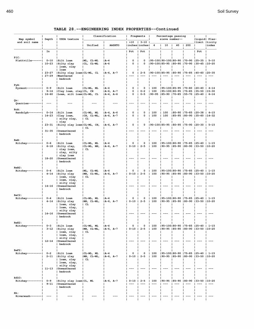
460 Soil Survey
TABLE 28.--ENGINEERING INDEX PROPERTIES--Continued _____________________________________________________________________________________________________________________________ | | | Classification | Fragments | Percentage passing | | Map symbol | Depth | USDA texture |__________________________|_____________| sieve number-- |Liquid| Plas- and soil name | | | | | >10 | 3-10 |___________________________|limit |ticity | | | Unified | AASHTO |inches|inches| 4 | 10 | 40 | 200 | |index _________________|________|_______________|____________|_____________|______|______|______|______|______|______|______|______ | In | | | | Pct | Pct | | | | | Pct | | | | | | | | | | | | | PlC: | | | | | | | | | | | | Plattville------| 0-10 |Silt loam |ML, CL-ML |A-4 | 0 | 0 |95-100|90-100|80-90 |70-90 |25-35 | 5-10 | 10-23 |Silty clay |CL, CL-ML |A-6 | 0 | 0 |90-100|85-95 |80-90 |70-90 |30-45 |10-20 | | loam, clay | | | | | | | | | | | | loam | | | | | | | | | | | 23-27 |Silty clay loam|CL-ML, CL |A-6, A-7 | 0 | 2-5 |90-100|85-95 |80-90 |75-85 |40-60 |20-35 | 27-29 |Weathered | | | --- | --- | --- | --- | --- | --- | --- | --- | | bedrock | | | | | | | | | | | | | | | | | | | | | | PyA: | | | | | | | | | | | | Pyrmont---------| 0-9 |Silt loam |CL-ML, ML |A-4 | 0 | 0 | 100 |95-100|85-95 |70-80 |20-40 | 4-14 | 9-16 |Clay loam, clay|CL, CH |A-6, A-7 | 0 | 0-2 | 100 |95-100|80-95 |75-85 |35-50 |15-30 | 16-60 |Loam, silt loam|CL-ML, CL |A-4, A-6 | 0 | 0-5 |90-95 |85-90 |70-85 |55-70 |25-40 | 6-16 | | | | | | | | | | | | Qu: | | | | | | | | | | | | Quarries--------| --- | --- | --- | --- | --- | --- | --- | --- | --- | --- | --- | --- | | | | | | | | | | | | RcA: | | | | | | | | | | | | Randolph--------| 0-14 |Silt loam |CL-ML, ML |A-4, A-6 | 0 | 0 | 100 | 100 |80-90 |75-85 |20-38 | 4-15 | 14-23 |Clay loam, |CH, CL-ML, |A-6, A-7 | 0 | 0 | 100 | 100 |85-95 |80-90 |35-60 |14-32 | | silty clay, | CL | | | | | | | | | | | clay | | | | | | | | | | | 23-31 |Silty clay loam|CL-ML, CH, |A-6, A-7 | 0 | 0 |90-100|85-95 |80-95 |75-90 |20-30 | 5-15 | | | CL | | | | | | | | | | 31-35 |Unweathered | | | --- | --- | --- | --- | --- | --- | --- | --- | | bedrock | | | | | | | | | | | | | | | | | | | | | | ReB: | | | | | | | | | | | | Ritchey---------| 0-6 |Silt loam |CL-ML, ML |A-4 | 0 | 0 | 100 |95-100|80-90 |75-85 |25-40 | 1-15 | 6-18 |Silty clay, |CL-ML, MH, |A-6, A-7 | 0-10 | 2-5 | 100 |90-95 |85-90 |80-90 |33-50 |10-20 | | clay loam, | CL | | | | | | | | | | | clay, silty | | | | | | | | | | | | clay loam | | | | | | | | | | | 18-20 |Unweathered | | | --- | --- | --- | --- | --- | --- | --- | --- | | bedrock | | | | | | | | | | | | | | | | | | | | | | ReB2: | | | | | | | | | | | | Ritchey---------| 0-4 |Silt loam |ML, CL-ML |A-4 | 0 | 0 | 100 |95-100|80-90 |75-85 |25-40 | 1-15 | 4-14 |Silty clay |MH, CL-ML, |A-6, A-7 | 0-10 | 2-5 | 100 |90-95 |85-90 |80-90 |33-50 |10-20 | | loam, clay | CL | | | | | | | | | | | loam, clay, | | | | | | | | | | | | silty clay | | | | | | | | | | | 14-16 |Unweathered | | | --- | --- | --- | --- | --- | --- | --- | --- | | bedrock | | | | | | | | | | | | | | | | | | | | | | ReC2: | | | | | | | | | | | | Ritchey---------| 0-4 |Silt loam |CL-ML, ML |A-4 | 0 | 0 | 100 |95-100|80-90 |75-85 |25-40 | 1-15 | 4-14 |Silty clay |MH, CL-ML, |A-6, A-7 | 0-10 | 2-5 | 100 |90-95 |85-90 |80-90 |33-50 |10-20 | | loam, clay | CL | | | | | | | | | | | loam, clay, | | | | | | | | | | | | silty clay | | | | | | | | | | | 14-16 |Unweathered | | | --- | --- | --- | --- | --- | --- | --- | --- | | bedrock | | | | | | | | | | | | | | | | | | | | | | ReE2: | | | | | | | | | | | | Ritchey---------| 0-3 |Silt loam |CL-ML, ML |A-4 | 0 | 0 | 100 |95-100|80-90 |75-85 |25-40 | 1-15 | 3-12 |Silty clay |MH, CL-ML, |A-6, A-7 | 0-10 | 2-5 | 100 |90-95 |85-90 |80-90 |33-50 |10-20 | | loam, clay | CL | | | | | | | | | | | loam, clay, | | | | | | | | | | | | silty clay | | | | | | | | | | | 12-14 |Unweathered | | | --- | --- | --- | --- | --- | --- | --- | --- | | bedrock | | | | | | | | | | | | | | | | | | | | | | ReF2: | | | | | | | | | | | | Ritchey---------| 0-2 |Silt loam |CL-ML, ML |A-4 | 0 | 0 | 100 |95-100|80-90 |75-85 |25-40 | 1-15 | 2-11 |Silty clay |MH, CL-ML, |A-6, A-7 | 0-10 | 2-5 | 100 |90-95 |85-90 |80-90 |33-50 |10-20 | | loam, clay | CL | | | | | | | | | | | loam, clay, | | | | | | | | | | | | silty clay | | | | | | | | | | | 11-13 |Unweathered | | | --- | --- | --- | --- | --- | --- | --- | --- | | bedrock | | | | | | | | | | | | | | | | | | | | | | RfD3: | | | | | | | | | | | | Ritchey---------| 0-9 |Silty clay loam|CL, ML |A-6, A-7 | 0-10 | 2-5 | 100 |90-95 |85-90 |80-90 |33-50 |10-20 | 9-11 |Unweathered | | | --- | --- | --- | --- | --- | --- | --- | --- | | bedrock | | | | | | | | | | | | | | | | | | | | | | Rh: | | | | | | | | | | | | Riverwash-------| --- | --- | --- | --- | --- | --- | --- | --- | --- | --- | --- | --- | | | | | | | | | | | |
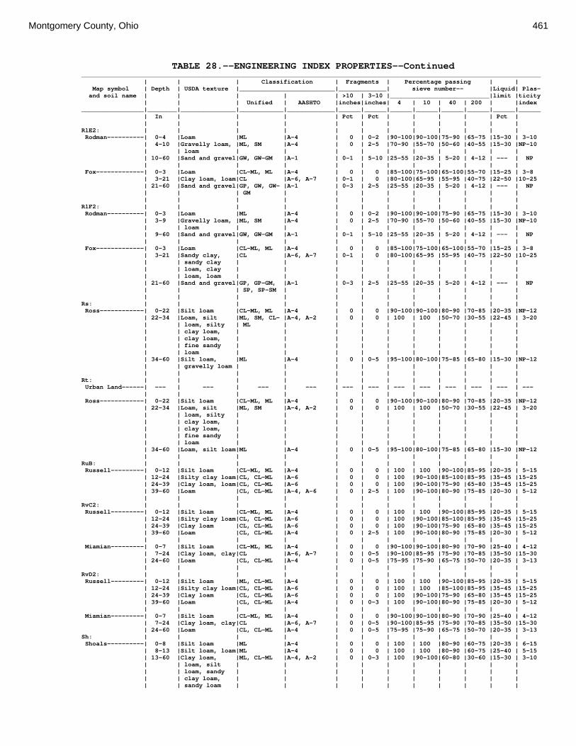
Montgomery County, Ohio 461
TABLE 28.--ENGINEERING INDEX PROPERTIES--Continued _____________________________________________________________________________________________________________________________ | | | Classification | Fragments | Percentage passing | | Map symbol | Depth | USDA texture |__________________________|_____________| sieve number-- |Liquid| Plas- and soil name | | | | | >10 | 3-10 |___________________________|limit |ticity | | | Unified | AASHTO |inches|inches| 4 | 10 | 40 | 200 | |index _________________|________|_______________|____________|_____________|______|______|______|______|______|______|______|______ | In | | | | Pct | Pct | | | | | Pct | | | | | | | | | | | | | RlE2: | | | | | | | | | | | | Rodman----------| 0-4 |Loam |ML |A-4 | 0 | 0-2 |90-100|90-100|75-90 |65-75 |15-30 | 3-10 | 4-10 |Gravelly loam, |ML, SM |A-4 | 0 | 2-5 |70-90 |55-70 |50-60 |40-55 |15-30 |NP-10 | | loam | | | | | | | | | | | 10-60 |Sand and gravel|GW, GW-GM |A-1 | 0-1 | 5-10 |25-55 |20-35 | 5-20 | 4-12 | --- | NP | | | | | | | | | | | | Fox-------------| 0-3 |Loam |CL-ML, ML |A-4 | 0 | 0 |85-100|75-100|65-100|55-70 |15-25 | 3-8 | 3-21 |Clay loam, loam|CL |A-6, A-7 | 0-1 | 0 |80-100|65-95 |55-95 |40-75 |22-50 |10-25 | 21-60 |Sand and gravel|GP, GW, GW- |A-1 | 0-3 | 2-5 |25-55 |20-35 | 5-20 | 4-12 | --- | NP | | | GM | | | | | | | | | | | | | | | | | | | | | RlF2: | | | | | | | | | | | | Rodman----------| 0-3 |Loam |ML |A-4 | 0 | 0-2 |90-100|90-100|75-90 |65-75 |15-30 | 3-10 | 3-9 |Gravelly loam, |ML, SM |A-4 | 0 | 2-5 |70-90 |55-70 |50-60 |40-55 |15-30 |NP-10 | | loam | | | | | | | | | | | 9-60 |Sand and gravel|GW, GW-GM |A-1 | 0-1 | 5-10 |25-55 |20-35 | 5-20 | 4-12 | --- | NP | | | | | | | | | | | | Fox-------------| 0-3 |Loam |CL-ML, ML |A-4 | 0 | 0 |85-100|75-100|65-100|55-70 |15-25 | 3-8 | 3-21 |Sandy clay, |CL |A-6, A-7 | 0-1 | 0 |80-100|65-95 |55-95 |40-75 |22-50 |10-25 | | sandy clay | | | | | | | | | | | | loam, clay | | | | | | | | | | | | loam, loam | | | | | | | | | | | 21-60 |Sand and gravel|GP, GP-GM, |A-1 | 0-3 | 2-5 |25-55 |20-35 | 5-20 | 4-12 | --- | NP | | | SP, SP-SM | | | | | | | | | | | | | | | | | | | | | Rs: | | | | | | | | | | | | Ross------------| 0-22 |Silt loam |CL-ML, ML |A-4 | 0 | 0 |90-100|90-100|80-90 |70-85 |20-35 |NP-12 | 22-34 |Loam, silt |ML, SM, CL- |A-4, A-2 | 0 | 0 | 100 | 100 |50-70 |30-55 |22-45 | 3-20 | | loam, silty | ML | | | | | | | | | | | clay loam, | | | | | | | | | | | | clay loam, | | | | | | | | | | | | fine sandy | | | | | | | | | | | | loam | | | | | | | | | | | 34-60 |Silt loam, |ML |A-4 | 0 | 0-5 |95-100|80-100|75-85 |65-80 |15-30 |NP-12 | | gravelly loam | | | | | | | | | | | | | | | | | | | | | | Rt: | | | | | | | | | | | | Urban Land------| --- | --- | --- | --- | --- | --- | --- | --- | --- | --- | --- | --- | | | | | | | | | | | | Ross------------| 0-22 |Silt loam |CL-ML, ML |A-4 | 0 | 0 |90-100|90-100|80-90 |70-85 |20-35 |NP-12 | 22-34 |Loam, silt |ML, SM |A-4, A-2 | 0 | 0 | 100 | 100 |50-70 |30-55 |22-45 | 3-20 | | loam, silty | | | | | | | | | | | | clay loam, | | | | | | | | | | | | clay loam, | | | | | | | | | | | | fine sandy | | | | | | | | | | | | loam | | | | | | | | | | | 34-60 |Loam, silt loam|ML |A-4 | 0 | 0-5 |95-100|80-100|75-85 |65-80 |15-30 |NP-12 | | | | | | | | | | | | RuB: | | | | | | | | | | | | Russell---------| 0-12 |Silt loam |CL-ML, ML |A-4 | 0 | 0 | 100 | 100 |90-100|85-95 |20-35 | 5-15 | 12-24 |Silty clay loam|CL, CL-ML |A-6 | 0 | 0 | 100 |90-100|85-100|85-95 |35-45 |15-25 | 24-39 |Clay loam, loam|CL, CL-ML |A-6 | 0 | 0 | 100 |90-100|75-90 |65-80 |35-45 |15-25 | 39-60 |Loam |CL, CL-ML |A-4, A-6 | 0 | 2-5 | 100 |90-100|80-90 |75-85 |20-30 | 5-12 | | | | | | | | | | | | RvC2: | | | | | | | | | | | | Russell---------| 0-12 |Silt loam |CL-ML, ML |A-4 | 0 | 0 | 100 | 100 |90-100|85-95 |20-35 | 5-15 | 12-24 |Silty clay loam|CL, CL-ML |A-6 | 0 | 0 | 100 |90-100|85-100|85-95 |35-45 |15-25 | 24-39 |Clay loam |CL, CL-ML |A-6 | 0 | 0 | 100 |90-100|75-90 |65-80 |35-45 |15-25 | 39-60 |Loam |CL, CL-ML |A-4 | 0 | 2-5 | 100 |90-100|80-90 |75-85 |20-30 | 5-12 | | | | | | | | | | | | Miamian---------| 0-7 |Silt loam |CL-ML, ML |A-4 | 0 | 0 |90-100|90-100|80-90 |70-90 |25-40 | 4-12 | 7-24 |Clay loam, clay|CL |A-6, A-7 | 0 | 0-5 |90-100|85-95 |75-90 |70-85 |35-50 |15-30 | 24-60 |Loam |CL, CL-ML |A-4 | 0 | 0-5 |75-95 |75-90 |65-75 |50-70 |20-35 | 3-13 | | | | | | | | | | | | RvD2: | | | | | | | | | | | | Russell---------| 0-12 |Silt loam |ML, CL-ML |A-4 | 0 | 0 | 100 | 100 |90-100|85-95 |20-35 | 5-15 | 12-24 |Silty clay loam|CL, CL-ML |A-6 | 0 | 0 | 100 | 100 |85-100|85-95 |35-45 |15-25 | 24-39 |Clay loam |CL, CL-ML |A-6 | 0 | 0 | 100 |90-100|75-90 |65-80 |35-45 |15-25 | 39-60 |Loam |CL, CL-ML |A-4 | 0 | 0-3 | 100 |90-100|80-90 |75-85 |20-30 | 5-12 | | | | | | | | | | | | Miamian---------| 0-7 |Silt loam |CL-ML, ML |A-4 | 0 | 0 |90-100|90-100|80-90 |70-90 |25-40 | 4-12 | 7-24 |Clay loam, clay|CL |A-6, A-7 | 0 | 0-5 |90-100|85-95 |75-90 |70-85 |35-50 |15-30 | 24-60 |Loam |CL, CL-ML |A-4 | 0 | 0-5 |75-95 |75-90 |65-75 |50-70 |20-35 | 3-13 Sh: | | | | | | | | | | | | Shoals----------| 0-8 |Silt loam |ML |A-4 | 0 | 0 | 100 | 100 |80-90 |60-75 |20-35 | 6-15 | 8-13 |Silt loam, loam|ML |A-4 | 0 | 0 | 100 | 100 |80-90 |60-75 |25-40 | 5-15 | 13-60 |Clay loam, |ML, CL-ML |A-4, A-2 | 0 | 0-3 | 100 |90-100|60-80 |30-60 |15-30 | 3-10 | | loam, silt | | | | | | | | | | | | loam, sandy | | | | | | | | | | | | clay loam, | | | | | | | | | | | | sandy loam | | | | | | | | | |

462 Soil Survey
TABLE 28.--ENGINEERING INDEX PROPERTIES--Continued _____________________________________________________________________________________________________________________________ | | | Classification | Fragments | Percentage passing | | Map symbol | Depth | USDA texture |__________________________|_____________| sieve number-- |Liquid| Plas- and soil name | | | | | >10 | 3-10 |___________________________|limit |ticity | | | Unified | AASHTO |inches|inches| 4 | 10 | 40 | 200 | |index _________________|________|_______________|____________|_____________|______|______|______|______|______|______|______|______ | In | | | | Pct | Pct | | | | | Pct | | | | | | | | | | | | | So: | | | | | | | | | | | | Sloan-----------| 0-12 |Silt loam |CL-ML, ML |A-4, A-6 | 0 | 0 | 100 |90-100|80-90 |75-85 |20-40 | 3-15 | 12-25 |Clay loam |CL, CL-ML |A-6 | 0 | 0 |90-100|80-95 |75-85 |70-80 |30-45 | 8-18 | 25-60 |Gravelly loam, |CL, ML, SM |A-4 | 0 | 0 |80-90 |50-60 |45-55 |40-55 |25-40 | 3-15 | | loam, gravelly| | | | | | | | | | | | sandy loam | | | | | | | | | | | | | | | | | | | | | | ThA: | | | | | | | | | | | | Thackery--------| 0-15 |Silt loam |CL-ML, ML |A-4 | 0 | 0 | 100 |90-100|75-90 |70-85 |22-36 | 3-14 | 15-30 |Silty clay |CL-ML, CL |A-7, A-6 | 0 | 0 | 100 |80-90 |75-90 |75-85 |25-40 | 8-18 | | loam, clay | | | | | | | | | | | | loam | | | | | | | | | | | 30-45 |Gravelly clay |ML, SM |A-6, A-4 | 0 | 0 |80-90 |65-75 |55-70 |40-60 |25-40 | 8-18 | | loam | | | | | | | | | | | 45-60 |Sandy loam, |CL-ML, CL |A-4 | 0 | 2-5 |95-100|80-90 |75-90 |65-85 | --- | --- | | loam | | | | | | | | | | | | | | | | | | | | | | TpA: | | | | | | | | | | | | Tippecanoe------| 0-12 |Silt loam |CL-ML, ML |A-4, A-6 | 0 | 0 | 100 |95-100|80-90 |70-85 |20-35 | 5-15 | 12-36 |Clay loam |CL, CL-ML |A-6, A-7 | 0 | 0 | 100 |90-100|80-90 |65-80 |25-40 |10-20 | 36-45 |Loam |ML, CL-ML |A-4 | 0 | 0-3 |95-100|80-90 |70-85 |60-80 |20-30 | 5-10 | 45-60 |Sand and gravel|GP, GW, GM |A-1 | 0 | 5-10 |25-60 |20-50 | 5-30 | 4-25 | --- | NP | | | | | | | | | | | | Ua: | | | | | | | | | | | | Urban Land------| --- | --- | --- | --- | --- | --- | --- | --- | --- | --- | --- | --- | | | | | | | | | | | | Ud: | | | | | | | | | | | | Udorthents------| --- | --- | --- | --- | --- | --- | --- | --- | --- | --- | --- | --- | | | | | | | | | | | | Ug: | | | | | | | | | | | | Urban Land------| --- | --- | --- | --- | --- | --- | --- | --- | --- | --- | --- | --- | | | | | | | | | | | | Um: | | | | | | | | | | | | Urban Land------| --- | --- | --- | --- | --- | --- | --- | --- | --- | --- | --- | --- | | | | | | | | | | | | WaA: | | | | | | | | | | | | Warsaw----------| 0-6 |Silt loam |ML, CL-ML |A-4 | 0 | 0 | 100 |90-100|75-85 |65-80 |20-30 | 4-12 | 6-25 |Sandy clay |CL, CL-ML |A-6, A-7 | 0 | 0-3 |90-100|85-90 |75-90 |65-85 |20-35 | 6-15 | | loam, clay | | | | | | | | | | | | loam, silty | | | | | | | | | | | | clay loam | | | | | | | | | | | 25-32 |Gravelly sandy |SM |A-2 | 0 | 0-5 |80-95 |55-70 |40-60 |20-30 |20-35 | 6-15 | | loam, gravelly| | | | | | | | | | | | clay loam | | | | | | | | | | | 32-60 |Sand and gravel|GP, GW-GM, |A-1 | 0 | 5-10 |25-55 |20-35 | 5-20 | 4-12 |15-20 | NP | | | GW | | | | | | | | | | | | | | | | | | | | | WaB: | | | | | | | | | | | | Warsaw----------| 0-6 |Silt loam |ML, CL-ML |A-4 | 0 | 0 | 100 |90-100|75-85 |65-80 |20-30 | 4-12 | 6-25 |Sandy clay |CL, CL-ML |A-6, A-7 | 0 | 0-3 |90-100|85-90 |75-90 |65-85 |20-35 | 6-15 | | loam, clay | | | | | | | | | | | | loam, silty | | | | | | | | | | | | clay loam | | | | | | | | | | | 25-32 |Gravelly sandy |SM |A-2 | 0 | 0-5 |80-95 |55-70 |40-60 |20-30 |20-35 | 6-15 | | loam, gravelly| | | | | | | | | | | | clay loam | | | | | | | | | | | 32-60 |Sand and gravel|GP, GW-GM, |A-1 | 0 | 5-10 |25-55 |20-35 | 5-20 | 4-12 |15-20 | NP | | | GW | | | | | | | | | | | | | | | | | | | | | WeA: | | | | | | | | | | | | Wea-------------| 0-14 |Silt loam |CL-ML, ML |A-4 | 0 | 0 | 100 |90-100|80-95 |75-90 |20-30 | 4-13 | 14-47 |Silty clay |CL, CL-ML |A-7, A-6 | 0 | 0 | 100 |90-100|85-95 |70-85 |30-40 |11-20 | | loam, clay | | | | | | | | | | | | loam, sandy | | | | | | | | | | | | clay loam | | | | | | | | | | | 47-60 |Sand and gravel|GP, GW-GM, |A-1 | 0-1 | 5-10 |25-55 |20-35 | 5-20 | 4-12 | --- | NP | | | GW | | | | | | | | | | | | | | | | | | | | | WeB: | | | | | | | | | | | | Wea-------------| 0-14 |Silt loam |CL-ML, ML |A-4 | 0 | 0 | 100 |90-100|80-95 |75-90 |20-30 | 4-13 | 14-47 |Silty clay |CL, CL-ML |A-7, A-6 | 0 | 0 | 100 |90-100|85-95 |70-85 |30-40 |11-20 | | loam, clay | | | | | | | | | | | | loam, sandy | | | | | | | | | | | | clay loam | | | | | | | | | | | 47-60 |Sand and gravel|GP, GW-GM, |A-1 | 0-1 | 5-10 |25-55 |20-35 | 5-20 | 4-12 | --- | NP | | | GW | | | | | | | | | | | | | | | | | | | | |
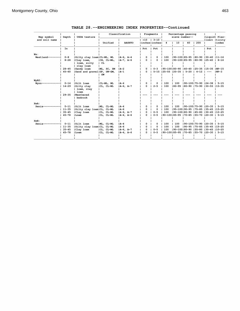
Montgomery County, Ohio 463
TABLE 28.--ENGINEERING INDEX PROPERTIES--Continued _____________________________________________________________________________________________________________________________ | | | Classification | Fragments | Percentage passing | | Map symbol | Depth | USDA texture |__________________________|_____________| sieve number-- |Liquid| Plas- and soil name | | | | | >10 | 3-10 |___________________________|limit |ticity | | | Unified | AASHTO |inches|inches| 4 | 10 | 40 | 200 | |index _________________|________|_______________|____________|_____________|______|______|______|______|______|______|______|______ | In | | | | Pct | Pct | | | | | Pct | | | | | | | | | | | | | Ws: | | | | | | | | | | | | Westland--------| 0-8 |Silty clay loam|CL-ML, ML |A-6, A-4 | 0 | 0 | 100 |90-100|85-95 |80-90 |30-40 |11-16 | 8-28 |Clay loam, |CH, CL-ML, |A-7, A-6 | 0 | 0 | 100 |90-100|85-95 |80-90 |25-40 | 8-16 | | loam, silty | CL | | | | | | | | | | | clay loam | | | | | | | | | | | 28-45 |Sandy loam |ML, SC, SM |A-2 | 0 | 0-3 |95-100|80-90 |40-60 |25-35 |15-35 |NP-15 | 45-60 |Sand and gravel|GP, GW-GM, |A-1 | 0 | 5-10 |25-55 |20-35 | 5-20 | 4-12 | --- |NP-3 | | | GW | | | | | | | | | | | | | | | | | | | | | WyB2: | | | | | | | | | | | | Wynn------------| 0-14 |Silt loam |CL-ML, ML |A-4 | 0 | 0 | 100 | 100 |90-100|75-90 |24-38 | 5-15 | 14-29 |Silty clay |CL, CL-ML |A-6, A-7 | 0 | 2-5 | 100 |80-95 |80-90 |75-90 |30-55 |15-35 | | loam, clay | | | | | | | | | | | | loam | | | | | | | | | | | 29-35 |Weathered | | | --- | --- | --- | --- | --- | --- | --- | --- | | bedrock | | | | | | | | | | | | | | | | | | | | | | XeA: | | | | | | | | | | | | Xenia-----------| 0-11 |Silt loam |ML, CL-ML |A-4 | 0 | 0 | 100 | 100 |90-100|75-90 |20-35 | 5-15 | 11-35 |Silty clay loam|CL, CL-ML |A-6 | 0 | 0 | 100 |95-100|90-95 |75-85 |35-45 |15-25 | 35-45 |Clay loam |CL, CL-ML |A-6, A-7 | 0 | 0-5 | 100 |90-100|80-90 |65-80 |30-45 |10-25 | 45-78 |Loam |CL, CL-ML |A-4, A-6 | 0 | 0-5 |90-100|85-95 |70-85 |55-70 |20-30 | 5-15 | | | | | | | | | | | | XeB: | | | | | | | | | | | | Xenia-----------| 0-11 |Silt loam |ML, CL-ML |A-4 | 0 | 0 | 100 | 100 |90-100|75-90 |20-35 | 5-15 | 11-35 |Silty clay loam|CL, CL-ML |A-6 | 0 | 0 | 100 | 100 |90-95 |75-85 |35-45 |15-25 | 35-45 |Clay loam |CL, CL-ML |A-6, A-7 | 0 | 0-5 | 100 |90-100|80-90 |55-80 |30-45 |10-25 | 45-78 |Loam |CL, CL-ML |A-4, A-6 | 0 | 0-5 |90-100|85-95 |70-85 |55-70 |20-30 | 5-15 | | | | | | | | | | | | _________________|________|_______________|____________|_____________|______|______|______|______|______|______|______|______

464 Soil Survey
TABLE 29.--PHYSICAL PROPERTIES OF THE SOILS (Entries under "Erosion factors--T" apply to the entire profile. Entries under "Wind erodibility group" apply only to the surface layer. Absence of an entry indicates that data were not estimated. See text on page 178 for additional information.) _______________________________________________________________________________________________ | | | | | | |Erosion factors|Wind Map symbol |Depth | Clay | Moist | Permea- |Available| Shrink- |_______________|erodi- and soil name | | | bulk | bility | water | swell | | | |bility | | | density | |capacity |potential| Kw | Kf | T |group _________________|______|______|_________|___________|_________|_________|_____|_____|___|______ | In | Pct | g/cc | In/hr | In/in | | | | | | | | | | | | | | | Ag: | | | | | | | | | | Algiers---------| 0-20 | 15-27|1.20-1.45| 0.60-2.00 |0.16-0.19|Moderate | .37 | .37 | 5 | 6 |20-60 | 20-35|1.25-1.65| 0.20-0.60 |0.16-0.20|Moderate | .37 | .37 | | | | | | | | | | | | Bo: | | | | | | | | | | Borrow pits-----| --- | --- | --- | --- | --- | --- | --- | --- | - | --- | | | | | | | | | | Bp: | | | | | | | | | | Brookston-------| 0-12 | 14-27|1.35-1.50| 0.60-2.00 |0.21-0.24|Moderate | .28 | .28 | 5 | 6 |12-36 | 25-35|1.40-1.60| 0.60-2.00 |0.15-0.19|Moderate | .28 | .32 | | |36-60 | 15-26|1.45-1.70| 0.60-2.00 |0.05-0.19| Low | .28 | .32 | | | | | | | | | | | | Br: | | | | | | | | | | Brookston-------| 0-12 | 14-27|1.35-1.50| 0.60-2.00 |0.21-0.24|Moderate | .28 | .28 | 5 | 6 |12-44 | 25-35|1.40-1.60| 0.60-2.00 |0.15-0.19|Moderate | .28 | .32 | | |44-72 | 15-26|1.45-1.70| 0.60-2.00 |0.05-0.19| Low | .28 | .32 | | | | | | | | | | | | Bs: | | | | | | | | | | Brookston-------| 0-12 | 27-35|1.40-1.55| 0.60-2.00 |0.21-0.24|Moderate | .28 | .28 | 5 | 6 |12-36 | 25-35|1.40-1.60| 0.60-2.00 |0.15-0.19|Moderate | .28 | .32 | | |36-60 | 15-26|1.45-1.70| 0.60-2.00 |0.05-0.19| Low | .28 | .32 | | | | | | | | | | | | Bu: | | | | | | | | | | Brookston-------| 0-12 | 27-35|1.40-1.55| 0.60-2.00 |0.21-0.24|Moderate | .28 | .28 | 5 | 6 |12-36 | 25-35|1.40-1.60| 0.60-2.00 |0.15-0.19|Moderate | .28 | .32 | | |36-60 | 15-26|1.45-1.70| 0.60-2.00 |0.05-0.19| Low | .28 | .32 | | | | | | | | | | | | Urban land------| --- | --- | --- | --- | --- | --- | --- | --- | - | --- | | | | | | | | | | Ca: | | | | | | | | | | Carlisle--------| 0-82 | 0-4 |0.13-0.23| 0.20-6.00 |0.20-0.25| --- | --- | --- | 3 | 2 |82-90 | 60-80|1.50-1.60| 0.06-0.20 |0.06-0.10| High | .15 | .15 | | | | | | | | | | | | CeA: | | | | | | | | | | Celina----------| 0-8 | 14-26|1.30-1.50| 0.60-2.00 |0.17-0.20| Low | .37 | .37 | 4 | 6 | 8-30 | 35-48|1.45-1.60| 0.60-2.00 |0.16-0.19|Moderate | .37 | .37 | | |30-60 | 16-35|1.60-1.82| 0.20-0.60 |0.06-0.10| Low | .37 | .49 | | | | | | | | | | | | CeB: | | | | | | | | | | Celina----------| 0-8 | 14-26|1.30-1.50| 0.60-2.00 |0.17-0.20| Low | .37 | .37 | 4 | 6 | 8-30 | 35-48|1.45-1.60| 0.60-2.00 |0.16-0.19|Moderate | .37 | .37 | | |30-60 | 16-35|1.60-1.82| 0.20-0.60 |0.06-0.10| Low | .37 | .49 | | | | | | | | | | | | CeB2: | | | | | | | | | | Celina----------| 0-8 | 14-26|1.30-1.50| 0.60-2.00 |0.17-0.20| Low | .37 | .37 | 4 | 6 | 8-30 | 35-48|1.45-1.60| 0.60-2.00 |0.16-0.19|Moderate | .37 | .37 | | |30-60 | 16-35|1.60-1.82| 0.20-0.60 |0.06-0.10| Low | .37 | .49 | | | | | | | | | | | | ClB: | | | | | | | | | | Celina----------| 0-8 | 14-26|1.30-1.50| 0.60-2.00 |0.17-0.20| Low | .37 | .37 | 4 | 6 | 8-30 | 35-48|1.45-1.60| 0.60-2.00 |0.16-0.19|Moderate | .37 | .37 | | |30-60 | 16-35|1.60-1.82| 0.20-0.60 |0.06-0.10| Low | .37 | .49 | | | | | | | | | | | | CoA: | | | | | | | | | | Corwin----------| 0-9 | 12-22|1.30-1.45| 0.60-2.00 |0.18-0.22| Low | .28 | .28 | 5 | 5 | 9-36 | 25-35|1.40-1.60| 0.60-2.00 |0.16-0.19|Moderate | .28 | .28 | | |36-60 | 10-25|1.70-1.90| 0.20-0.60 |0.06-0.10| Low | .37 | .43 | | | | | | | | | | | |

Montgomery County, Ohio 465
TABLE 29.--PHYSICAL PROPERTIES OF THE SOILS--Continued _______________________________________________________________________________________________ | | | | | | |Erosion factors|Wind Map symbol |Depth | Clay | Moist | Permea- |Available| Shrink- |_______________|erodi- and soil name | | | bulk | bility | water | swell | | | |bility | | | density | |capacity |potential| Kw | Kf | T |group _________________|______|______|_________|___________|_________|_________|_____|_____|___|______ | In | Pct | g/cc | In/hr | In/in | | | | | | | | | | | | | | | CoB: | | | | | | | | | | Corwin----------| 0-9 | 12-22|1.30-1.45| 0.60-2.00 |0.18-0.22| Low | .28 | .28 | 5 | 5 | 9-36 | 25-35|1.40-1.60| 0.60-2.00 |0.16-0.19|Moderate | .28 | .28 | | |36-60 | 10-25|1.70-1.90| 0.20-0.60 |0.06-0.10| Low | .37 | .43 | | | | | | | | | | | | CsA: | | | | | | | | | | Crosby----------| 0-8 | 11-24|1.35-1.45| 0.60-2.00 |0.17-0.20| Low | .43 | .43 | 4 | 5 | 8-26 | 35-45|1.50-1.60| 0.20-0.60 |0.15-0.19| High | .43 | .49 | | |26-60 | 15-27|1.70-2.00| 0.20-0.60 |0.06-0.10| Low | .43 | .49 | | | | | | | | | | | | CtB: | | | | | | | | | | Crosby----------| 0-8 | 11-24|1.35-1.45| 0.60-2.00 |0.17-0.20| Low | .43 | .43 | 4 | 5 | 8-26 | 35-45|1.50-1.60| 0.20-0.60 |0.15-0.19| High | .43 | .49 | | |26-60 | 15-27|1.70-2.00| 0.20-0.60 |0.06-0.10| Low | .43 | .49 | | | | | | | | | | | | Celina----------| 0-8 | 14-26|1.30-1.50| 0.60-2.00 |0.17-0.20|Moderate | .37 | .37 | 4 | 6 | 8-30 | 35-48|1.45-1.60| 0.60-2.00 |0.16-0.19| Low | .37 | .37 | | |30-60 | 16-35|1.60-1.82| 0.20-0.60 |0.06-0.10| Low | .37 | .49 | | | | | | | | | | | | Cu: | | | | | | | | | | Crosby----------| 0-8 | 11-24|1.35-1.45| 0.60-2.00 |0.17-0.20| Low | .43 | .43 | 4 | 5 | 8-26 | 35-45|1.50-1.60| 0.20-0.60 |0.15-0.19| High | .43 | .49 | | |26-60 | 15-27|1.70-2.00| 0.20-0.60 |0.06-0.10| Low | .43 | .49 | | | | | | | | | | | | Urban land------| --- | --- | --- | --- | --- | --- | --- | --- | - | --- | | | | | | | | | | DaB: | | | | | | | | | | Dana------------| 0-7 | 11-22|1.40-1.55| 0.60-2.00 |0.18-0.22| Low | .32 | .32 | 5 | 5 | 7-28 | 27-35|1.45-1.65| 0.60-2.00 |0.16-0.20|Moderate | .43 | .43 | | |28-36 | 27-35|1.45-1.65| 0.20-0.60 |0.15-0.18|Moderate | .43 | .49 | | |36-60 | 15-25|1.70-1.90| 0.20-0.60 |0.14-0.17| Low | .43 | .55 | | | | | | | | | | | | FaE2: | | | | | | | | | | Fairmount-------| 0-4 | 27-40|1.20-1.40| 0.60-2.00 |0.16-0.22| Low | .37 | .37 | 1 | 6 | 4-16 | 35-60|1.40-1.60| 0.20-0.60 |0.14-0.18|Moderate | .37 | .28 | | |16-18 | --- | --- | 0.00-0.20 | --- | --- | --- | --- | | | | | | | | | | | | FaF2: | | | | | | | | | | Fairmount-------| 0-3 | 27-40|1.20-1.40| 0.60-2.00 |0.16-0.22| Low | .37 | .37 | 1 | 6 | 3-15 | 35-60|1.40-1.60| 0.20-0.60 |0.14-0.18|Moderate | .37 | .28 | | |15-17 | --- | --- | 0.00-0.20 | --- | --- | --- | --- | | | | | | | | | | | | FcA: | | | | | | | | | | Fincastle-------| 0-19 | 11-22|1.40-1.55| 0.60-2.00 |0.16-0.20| Low | .37 | .37 | 5 | 5 |19-38 | 23-35|1.45-1.65| 0.20-0.60 |0.15-0.18|Moderate | .37 | .37 | | |38-60 | 20-26|1.55-1.90| 0.20-0.60 |0.06-0.10| Low | .37 | .43 | | | | | | | | | | | | FkA: | | | | | | | | | | Fox-------------| 0-11 | 5-15|1.40-1.70| 0.60-2.00 |0.16-0.20| Low | .24 | .24 | 4 | 3 |11-29 | 18-27|1.55-1.65| 0.60-2.00 |0.14-0.18|Moderate | .32 | .32 | | |29-60 | 0-2 |1.30-1.70| 6.00-20.00|0.02-0.05| Low | .10 | .24 | | | | | | | | | | | | FkB: | | | | | | | | | | Fox-------------| 0-11 | 5-15|1.40-1.70| 0.60-2.00 |0.16-0.20| Low | .24 | .24 | 4 | 3 |11-29 | 18-27|1.55-1.65| 0.60-2.00 |0.14-0.18|Moderate | .32 | .32 | | |29-60 | 0-2 |1.30-1.70| 6.00-20.00|0.02-0.05| Low | .10 | .24 | | | | | | | | | | | | FlA: | | | | | | | | | | Fox-------------| 0-11 | 10-20|1.35-1.55| 0.60-2.00 |0.16-0.20| Low | .37 | .37 | 4 | 5 |11-29 | 18-45|1.55-1.65| 0.60-2.00 |0.14-0.18|Moderate | .32 | .32 | | |29-60 | 0-2 |1.30-1.70| 6.00-20.00|0.02-0.05| Low | .10 | .24 | | | | | | | | | | | |

466 Soil Survey
TABLE 29.--PHYSICAL PROPERTIES OF THE SOILS--Continued _______________________________________________________________________________________________ | | | | | | |Erosion factors|Wind Map symbol |Depth | Clay | Moist | Permea- |Available| Shrink- |_______________|erodi- and soil name | | | bulk | bility | water | swell | | | |bility | | | density | |capacity |potential| Kw | Kf | T |group _________________|______|______|_________|___________|_________|_________|_____|_____|___|______ | In | Pct | g/cc | In/hr | In/in | | | | | FlB: | | | | | | | | | | Fox-------------| 0-11 | 10-20|1.35-1.55| 0.60-2.00 |0.16-0.20| Low | .37 | .37 | 4 | 5 |11-29 | 18-45|1.55-1.65| 0.60-2.00 |0.14-0.18|Moderate | .32 | .32 | | |29-60 | 0-2 |1.30-1.70| 6.00-20.00|0.02-0.05| Low | .10 | .24 | | | | | | | | | | | | FlC2: | | | | | | | | | | Fox-------------| 0-3 | 10-20|1.35-1.55| 0.60-2.00 |0.16-0.20| Low | .37 | .37 | 4 | 5 | 3-21 | 18-45|1.55-1.65| 0.60-2.00 |0.14-0.18|Moderate | .32 | .32 | | |21-60 | 0-2 |1.30-1.70| 6.00-20.00|0.02-0.05| Low | .10 | .24 | | | | | | | | | | | | FmA: | | | | | | | | | | Fox-------------| 0-11 | 10-20|1.35-1.55| 0.60-2.00 |0.16-0.20| Low | .37 | .37 | 4 | 5 |11-29 | 18-45|1.55-1.65| 0.60-2.00 |0.14-0.18|Moderate | .32 | .32 | | |29-60 | 0-2 |1.30-1.70| 6.00-20.00|0.02-0.05| Low | .10 | .24 | | | | | | | | | | | | FmB: | | | | | | | | | | Fox-------------| 0-11 | 10-20|1.35-1.55| 0.60-2.00 |0.16-0.20| Low | .37 | .37 | 4 | 5 |11-29 | 18-45|1.55-1.65| 0.60-2.00 |0.14-0.18|Moderate | .32 | .32 | | |29-60 | 0-2 |1.30-1.70| 6.00-20.00|0.02-0.05| Low | .10 | .24 | | | | | | | | | | | | FmC2: | | | | | | | | | | Fox-------------| 0-3 | 10-20|1.35-1.55| 0.60-2.00 |0.16-0.20| Low | .37 | .37 | 4 | 5 | 3-21 | 18-45|1.55-1.65| 0.60-2.00 |0.14-0.18|Moderate | .32 | .32 | | |21-60 | 0-2 |1.30-1.70| 6.00-20.00|0.02-0.05| Low | .10 | .24 | | | | | | | | | | | | FmD2: | | | | | | | | | | Fox-------------| 0-3 | 10-20|1.35-1.55| 0.60-2.00 |0.16-0.20| Low | .37 | .37 | 4 | 5 | 3-21 | 18-45|1.55-1.65| 0.60-2.00 |0.14-0.18|Moderate | .32 | .32 | | |21-60 | 0-2 |1.30-1.70| 6.00-20.00|0.02-0.05| Low | .10 | .24 | | | | | | | | | | | | FsC3: | | | | | | | | | | Fox-------------| 0-3 | 20-35|1.55-1.65| 0.60-2.00 |0.16-0.20|Moderate | .32 | .32 | 4 | 6 | 3-18 | 18-45|1.55-1.65| 0.60-2.00 |0.14-0.18|Moderate | .32 | .32 | | |18-60 | 0-2 |1.30-1.70| 6.00-20.00|0.02-0.05| Low | .10 | .24 | | | | | | | | | | | | FuB: | | | | | | | | | | Fox-------------| 0-11 | 10-20|1.35-1.55| 0.60-2.00 |0.16-0.20| Low | .37 | .37 | 4 | 5 |11-29 | 18-45|1.55-1.65| 0.60-2.00 |0.14-0.18|Moderate | .32 | .32 | | |29-60 | 0-2 |1.30-1.70| 6.00-20.00|0.02-0.05| Low | .10 | .24 | | | | | | | | | | | | Urban land------| --- | --- | --- | --- | --- | --- | --- | --- | - | --- | | | | | | | | | | FuC: | | | | | | | | | | Urban land------| --- | --- | --- | --- | --- | --- | --- | --- | - | --- | | | | | | | | | | Fox-------------| 0-3 | 10-20|1.35-1.55| 0.60-2.00 |0.16-0.20| Low | .37 | .37 | 4 | 5 | 3-21 | 18-45|1.55-1.65| 0.60-2.00 |0.14-0.18|Moderate | .32 | .32 | | |21-60 | 0-2 |1.30-1.70| 6.00-20.00|0.02-0.05| Low | .10 | .24 | | | | | | | | | | | | FuF: | | | | | | | | | | Urban land------| --- | --- | --- | --- | --- | --- | --- | --- | - | --- | | | | | | | | | | Fox-------------| 0-3 | 10-20|1.35-1.55| 0.60-2.00 |0.16-0.20| Low | .37 | .37 | 4 | 5 | 3-18 | 18-45|1.55-1.65| 0.60-2.00 |0.14-0.18|Moderate | .32 | .32 | | |18-60 | 0-2 |1.30-1.70| 6.00-20.00|0.02-0.05| Low | .10 | .24 | | | | | | | | | | | | Gp: | | | | | | | | | | Gravel pits-----| --- | --- | --- | --- | --- | --- | --- | --- | - | --- | | | | | | | | | |

Montgomery County, Ohio 467
TABLE 29.--PHYSICAL PROPERTIES OF THE SOILS--Continued _______________________________________________________________________________________________ | | | | | | |Erosion factors|Wind Map symbol |Depth | Clay | Moist | Permea- |Available| Shrink- |_______________|erodi- and soil name | | | bulk | bility | water | swell | | | |bility | | | density | |capacity |potential| Kw | Kf | T |group _________________|______|______|_________|___________|_________|_________|_____|_____|___|______ | In | Pct | g/cc | In/hr | In/in | | | | | HeE2: | | | | | | | | | | Hennepin--------| 0-4 | 20-27|1.20-1.40| 0.60-2.00 |0.15-0.19| Low | .28 | .28 | 5 | 6 | 4-12 | 18-35|1.30-1.60| 0.60-2.00 |0.14-0.18| Low | .32 | .32 | | |12-60 | 18-35|1.70-1.85| 0.20-0.60 |0.06-0.10| Low | .32 | .32 | | | | | | | | | | | | Miamian---------| 0-4 | 14-27|1.30-1.50| 0.60-2.00 |0.17-0.20| Low | .37 | .37 | 4 | 6 | 4-25 | 35-48|1.45-1.70| 0.20-0.60 |0.14-0.19|Moderate | .37 | .43 | | |25-60 | 16-31|1.60-1.85| 0.20-0.60 |0.06-0.10| Low | .37 | .49 | | | | | | | | | | | | HeF2: | | | | | | | | | | Hennepin--------| 0-3 | 20-27|1.20-1.40| 0.60-2.00 |0.15-0.19| Low | .28 | .28 | 5 | 6 | 3-12 | 18-35|1.30-1.60| 0.60-2.00 |0.14-0.18| Low | .32 | .32 | | |12-60 | 18-35|1.70-1.85| 0.20-0.60 |0.06-0.10| Low | .32 | .32 | | | | | | | | | | | | Miamian---------| 0-4 | 14-27|1.30-1.50| 0.60-2.00 |0.17-0.20| Low | .37 | .37 | 4 | 6 | 4-25 | 35-48|1.45-1.70| 0.20-0.60 |0.14-0.19|Moderate | .37 | .43 | | |25-60 | 16-31|1.60-1.85| 0.20-0.60 |0.06-0.10| Low | .37 | .49 | | | | | | | | | | | | HmF3: | | | | | | | | | | Hennepin--------| 0-6 | 18-35|1.30-1.60| 0.60-2.00 |0.14-0.18| Low | .28 | .28 | 5 | 6 | 6-60 | 18-35|1.70-1.85| 0.20-0.60 |0.06-0.10| Low | .32 | .32 | | | | | | | | | | | | Miamian---------| 0-21 | 35-48|1.45-1.70| 0.20-0.60 |0.12-0.17|Moderate | .37 | .37 | 4 | 6 |21-60 | 16-31|1.60-1.85| 0.20-0.60 |0.06-0.10| Low | .37 | .49 | | | | | | | | | | | | KeA: | | | | | | | | | | Kendallville----| 0-9 | 15-24|1.30-1.50| 0.60-2.00 |0.17-0.20| Low | .37 | .43 | 5 | 6 | 9-26 | 20-35|1.40-1.60| 0.60-2.00 |0.16-0.20|Moderate | .37 | .37 | | |26-36 | 23-38|1.40-1.65| 0.60-2.00 |0.12-0.15|Moderate | .37 | .55 | | |36-60 | 12-30|1.45-1.75| 0.20-0.60 |0.06-0.10| Low | .37 | .43 | | | | | | | | | | | | KeB: | | | | | | | | | | Kendallville----| 0-9 | 15-24|1.30-1.50| 0.60-2.00 |0.17-0.20| Low | .37 | .43 | 5 | 6 | 9-26 | 20-35|1.40-1.60| 0.60-2.00 |0.16-0.20|Moderate | .37 | .37 | | |26-36 | 23-38|1.40-1.65| 0.60-2.00 |0.12-0.15|Moderate | .37 | .55 | | |36-60 | 12-30|1.45-1.75| 0.20-0.60 |0.06-0.10| Low | .37 | .43 | | | | | | | | | | | | KeC2: | | | | | | | | | | Kendallville----| 0-4 | 15-24|1.30-1.50| 0.60-2.00 |0.17-0.20| Low | .37 | .43 | 5 | 6 | 4-21 | 20-35|1.40-1.60| 0.60-2.00 |0.16-0.20|Moderate | .37 | .37 | | |21-36 | 23-38|1.40-1.65| 0.60-2.00 |0.12-0.15|Moderate | .37 | .55 | | |36-60 | 12-30|1.45-1.75| 0.20-0.60 |0.06-0.10| Low | .37 | .43 | | | | | | | | | | | | Ld: | | | | | | | | | | Landes----------| 0-19 | 5-20|1.40-1.60| 6.00-20.00|0.08-0.12| Low | .20 | .20 | 5 | 3 |19-42 | 5-18|1.45-1.70| 6.00-20.00|0.08-0.12| Low | .20 | .20 | | |42-60 | 2-10|1.60-1.70| 6.00-20.00|0.02-0.05| Low | .20 | .20 | | | | | | | | | | | | Lg: | | | | | | | | | | Lanier----------| 0-20 | 5-14|1.20-1.50| 6.00-20.00|0.09-0.14| Low | .20 | .24 | 5 | 3 |20-60 | 1-8 |1.30-1.60| 6.00-20.00|0.02-0.05| Low | .15 | .64 | | | | | | | | | | | | LsB: | | | | | | | | | | Lewisburg-------| 0-7 | 16-27|1.30-1.55| 0.60-2.00 |0.17-0.20| Low | .43 | .49 | 3 | 6 | 7-15 | 35-45|1.40-1.70| 0.20-0.60 |0.12-0.17|Moderate | .32 | .37 | | |15-60 | 18-27|1.70-2.00| 0.20-0.60 |0.06-0.10| Low | .32 | .37 | | | | | | | | | | | | LxC2: | | | | | | | | | | Lorenzo---------| 0-4 | 18-27|1.25-1.40| 2.00-6.00 |0.14-0.18| Low | .28 | .28 | 3 | 6 | 4-15 | 20-35|1.60-1.70| 2.00-6.00 |0.14-0.18|Moderate | .28 | .32 | | |15-60 | 1-5 |1.40-1.60| 6.00-12.00|0.02-0.05| Low | .10 | --- | | | | | | | | | | | | Rodman----------| 0-3 | 8-20|1.20-1.40| 6.00-12.00|0.14-0.18| Low | .20 | .24 | 3 | 5 | 3-9 | 5-25|1.10-1.50| 6.00-12.00|0.08-0.14| Low | .20 | .32 | | | 9-60 | 0-5 |1.40-1.60| 6.00-12.00|0.02-0.05| Low | .10 | .43 | |

468 Soil Survey
TABLE 29.--PHYSICAL PROPERTIES OF THE SOILS--Continued _______________________________________________________________________________________________ | | | | | | |Erosion factors|Wind Map symbol |Depth | Clay | Moist | Permea- |Available| Shrink- |_______________|erodi- and soil name | | | bulk | bility | water | swell | | | |bility | | | density | |capacity |potential| Kw | Kf | T |group _________________|______|______|_________|___________|_________|_________|_____|_____|___|______ | In | Pct | g/cc | In/hr | In/in | | | | | LxD2: | | | | | | | | | | Lorenzo---------| 0-4 | 18-27|1.25-1.40| 2.00-6.00 |0.14-0.18| Low | .28 | .28 | 3 | 6 | 4-15 | 20-35|1.60-1.70| 2.00-6.00 |0.14-0.18|Moderate | .28 | .32 | | |15-60 | 1-5 |1.40-1.60| 6.00-12.00|0.02-0.05| Low | .10 | --- | | | | | | | | | | | | Rodman----------| 0-3 | 8-20|1.20-1.40| 6.00-12.00|0.14-0.18| Low | .20 | .24 | 3 | 5 | 3-9 | 5-25|1.10-1.50| 6.00-12.00|0.08-0.14| Low | .32 | .32 | | | 9-60 | 0-5 |1.40-1.60| 6.00-12.00|0.02-0.05| Low | .10 | .43 | | | | | | | | | | | | Mb: | | | | | | | | | | Made land-------| --- | --- | --- | --- | --- | --- | --- | --- | - | --- | | | | | | | | | | Md: | | | | | | | | | | Medway----------| 0-20 | 18-27|1.20-1.45| 0.60-2.00 |0.17-0.22| Low | .28 | .28 | 5 | 6 |20-29 | 18-35|1.20-1.50| 0.60-2.00 |0.15-0.19| Low | .32 | .37 | | |29-45 | 5-30|1.20-1.60| 0.60-6.00 |0.08-0.14| Low | .32 | .37 | | |45-60 | 5-10|1.20-1.60| 0.60-6.00 |0.02-0.05| Low | .32 | .49 | | | | | | | | | | | | MlA: | | | | | | | | | | Miamian---------| 0-7 | 14-27|1.30-1.50| 0.60-2.00 |0.17-0.20| Low | .37 | .37 | 4 | 6 | 7-24 | 35-48|1.45-1.70| 0.20-0.60 |0.14-0.19|Moderate | .37 | .43 | | |24-60 | 16-31|1.60-1.85| 0.20-0.60 |0.06-0.10| Low | .37 | .49 | | | | | | | | | | | | MlB: | | | | | | | | | | Miamian---------| 0-7 | 14-27|1.30-1.50| 0.60-2.00 |0.17-0.20| Low | .37 | .37 | 4 | 6 | 7-24 | 35-48|1.45-1.70| 0.20-0.60 |0.14-0.19|Moderate | .37 | .43 | | |24-60 | 16-31|1.60-1.85| 0.20-0.60 |0.06-0.10| Low | .37 | .49 | | | | | | | | | | | | MlB2: | | | | | | | | | | Miamian---------| 0-7 | 14-27|1.30-1.50| 0.60-2.00 |0.17-0.20| Low | .37 | .37 | 4 | 6 | 7-24 | 35-48|1.45-1.70| 0.20-0.60 |0.14-0.19|Moderate | .37 | .43 | | |24-60 | 16-31|1.60-1.85| 0.20-0.60 |0.06-0.10| Low | .37 | .49 | | | | | | | | | | | | MlC2: | | | | | | | | | | Miamian---------| 0-7 | 14-27|1.30-1.50| 0.60-2.00 |0.17-0.20| Low | .37 | .37 | 4 | 6 | 7-24 | 35-48|1.45-1.70| 0.20-0.60 |0.14-0.19|Moderate | .37 | .43 | | |24-60 | 16-31|1.60-1.85| 0.20-0.60 |0.06-0.10| Low | .37 | .49 | | | | | | | | | | | | MlD2: | | | | | | | | | | Miamian---------| 0-4 | 14-27|1.30-1.50| 0.60-2.00 |0.17-0.20| Low | .37 | .37 | 4 | 6 | 4-21 | 35-48|1.45-1.70| 0.20-0.60 |0.14-0.19|Moderate | .37 | .43 | | |21-60 | 16-31|1.60-1.85| 0.20-0.60 |0.06-0.10| Low | .37 | .49 | | | | | | | | | | | | MmB: | | | | | | | | | | Miamian---------| 0-7 | 14-27|1.30-1.50| 0.60-2.00 |0.17-0.20| Low | .37 | .55 | 4 | 6 | 7-24 | 35-48|1.45-1.70| 0.20-0.60 |0.14-0.19|Moderate | .37 | .43 | | |24-60 | 16-31|1.60-1.85| 0.20-0.60 |0.06-0.10| Low | .37 | .49 | | | | | | | | | | | | MnB3: | | | | | | | | | | Miamian---------| 0-5 | 27-35|1.35-1.55| 0.20-0.60 |0.17-0.20|Moderate | .32 | .32 | 4 | 6 | 5-22 | 35-48|1.45-1.70| 0.20-0.60 |0.14-0.19|Moderate | .37 | .43 | | |22-60 | 16-31|1.60-1.85| 0.20-0.60 |0.06-0.10| Low | .37 | .49 | | | | | | | | | | | | MnC3: | | | | | | | | | | Miamian---------| 0-5 | 27-35|1.35-1.55| 0.20-0.60 |0.17-0.20|Moderate | .32 | .32 | 4 | 6 | 5-22 | 35-48|1.45-1.70| 0.20-0.60 |0.14-0.19|Moderate | .37 | .43 | | |22-60 | 16-31|1.60-1.85| 0.20-0.60 |0.06-0.10| Low | .37 | .49 | | | | | | | | | | | | MnD3: | | | | | | | | | | Miamian---------| 0-4 | 27-35|1.35-1.55| 0.20-0.60 |0.17-0.20|Moderate | .32 | .32 | 4 | 6 | 4-21 | 35-48|1.45-1.70| 0.20-0.60 |0.14-0.19|Moderate | .37 | .43 | | |21-60 | 16-31|1.60-1.85| 0.20-0.60 |0.06-0.10| Low | .37 | .49 | | | | | | | | | | | |

Montgomery County, Ohio 469
TABLE 29.--PHYSICAL PROPERTIES OF THE SOILS--Continued _______________________________________________________________________________________________ | | | | | | |Erosion factors|Wind Map symbol |Depth | Clay | Moist | Permea- |Available| Shrink- |_______________|erodi- and soil name | | | bulk | bility | water | swell | | | |bility | | | density | |capacity |potential| Kw | Kf | T |group _________________|______|______|_________|___________|_________|_________|_____|_____|___|______ | In | Pct | g/cc | In/hr | In/in | | | | | MoB: | | | | | | | | | | Miamian---------| 0-7 | 14-27|1.30-1.50| 0.60-2.00 |0.17-0.20| Low | .37 | .37 | 4 | 6 | 7-24 | 35-48|1.45-1.70| 0.20-0.60 |0.14-0.19|Moderate | .37 | .43 | | |24-60 | 16-31|1.60-1.85| 0.20-0.60 |0.06-0.10| Low | .37 | .49 | | | | | | | | | | | | Urban land------| --- | --- | --- | --- | --- | --- | --- | --- | - | --- | | | | | | | | | | MoC: | | | | | | | | | | Miamian---------| 0-7 | 14-27|1.30-1.50| 0.60-2.00 |0.17-0.20| Low | .37 | .37 | 4 | 6 | 7-24 | 35-48|1.45-1.70| 0.20-0.60 |0.14-0.19|Moderate | .37 | .43 | | |24-60 | 16-31|1.60-1.85| 0.20-0.60 |0.06-0.10| Low | .37 | .49 | | | | | | | | | | | | Urban land------| --- | --- | --- | --- | --- | --- | --- | --- | - | --- | | | | | | | | | | MoE: | | | | | | | | | | Miamian---------| 0-6 | 14-27|1.30-1.50| 0.60-2.00 |0.17-0.20| Low | .37 | .37 | 4 | 6 | 6-23 | 35-48|1.45-1.70| 0.20-0.60 |0.14-0.19|Moderate | .37 | .43 | | |23-60 | 16-31|1.60-1.85| 0.20-0.60 |0.06-0.10| Low | .37 | .49 | | | | | | | | | | | | Urban land------| --- | --- | --- | --- | --- | --- | --- | --- | - | --- | | | | | | | | | | MrA: | | | | | | | | | | Millsdale-------| 0-14 | 27-35|1.30-1.50| 0.60-2.00 |0.16-0.19|Moderate | .28 | .32 | 2 | 6 |14-36 | 35-45|1.40-1.65| 0.60-2.00 |0.13-0.15| High | .32 | .37 | | |36-40 | --- | --- | 0.00-0.06 | --- | --- | --- | --- | | | | | | | | | | | | MsA: | | | | | | | | | | Milton----------| 0-9 | 14-27|1.30-1.50| 0.60-2.00 |0.17-0.20| Low | .37 | .37 | 2 | 6 | 9-25 | 35-50|1.45-1.65| 0.60-2.00 |0.16-0.19|Moderate | .37 | .43 | | |25-28 | 25-45|1.40-1.70| 0.20-0.60 |0.13-0.16| High | .37 | .43 | | |28-30 | --- | --- | 0.00-0.06 | --- | --- | --- | --- | | | | | | | | | | | | MsB: | | | | | | | | | | Milton----------| 0-9 | 14-27|1.30-1.50| 0.60-2.00 |0.17-0.20| Low | .37 | .37 | 2 | 6 | 9-25 | 35-50|1.45-1.65| 0.60-2.00 |0.16-0.19|Moderate | .37 | .43 | | |25-28 | 25-45|1.40-1.70| 0.20-0.60 |0.13-0.16| High | .37 | .43 | | |28-35 | --- | --- | 0.00-0.06 | --- | --- | --- | --- | | | | | | | | | | | | MsB2: | | | | | | | | | | Milton----------| 0-9 | 14-27|1.30-1.50| 0.60-2.00 |0.17-0.20| Low | .37 | .37 | 2 | 6 | 9-25 | 35-50|1.45-1.65| 0.60-2.00 |0.16-0.19|Moderate | .37 | .43 | | |25-28 | 25-45|1.40-1.70| 0.20-0.60 |0.13-0.16| High | .37 | .43 | | |28-30 | --- | --- | 0.00-0.06 | --- | --- | --- | --- | | | | | | | | | | | | MsC2: | | | | | | | | | | Milton----------| 0-9 | 14-27|1.30-1.50| 0.60-2.00 |0.17-0.20| Low | .37 | .37 | 2 | 6 | 9-22 | 35-50|1.45-1.65| 0.60-2.00 |0.16-0.19|Moderate | .37 | .43 | | |22-25 | 25-45|1.40-1.70| 0.20-0.60 |0.13-0.16| High | .37 | .43 | | |25-27 | --- | --- | 0.00-0.06 | --- | --- | --- | --- | | | | | | | | | | | | MsD2: | | | | | | | | | | Milton----------| 0-5 | 14-27|1.30-1.50| 0.60-2.00 |0.17-0.20| Low | .37 | .37 | 2 | 6 | 5-21 | 35-50|1.45-1.65| 0.60-2.00 |0.16-0.19|Moderate | .37 | .43 | | |21-24 | 25-45|1.40-1.70| 0.20-0.60 |0.13-0.16| High | .37 | .43 | | |24-26 | --- | --- | 0.00-0.06 | --- | --- | --- | --- | | | | | | | | | | | | MtD3: | | | | | | | | | | Milton----------| 0-4 | 27-35|1.35-1.55| 0.60-2.00 |0.16-0.19|Moderate | .37 | .37 | 2 | 6 | 4-20 | 35-50|1.45-1.65| 0.60-2.00 |0.16-0.19|Moderate | .37 | .43 | | |20-23 | 25-45|1.40-1.70| 0.20-0.60 |0.13-0.16| High | .37 | .43 | | |23-25 | --- | --- | 0.00-0.06 | --- | --- | --- | --- | | | | | | | | | | | |
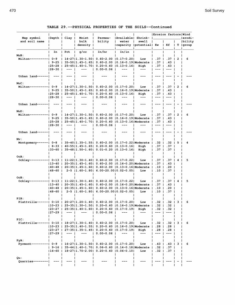
470 Soil Survey
TABLE 29.--PHYSICAL PROPERTIES OF THE SOILS--Continued _______________________________________________________________________________________________ | | | | | | |Erosion factors|Wind Map symbol |Depth | Clay | Moist | Permea- |Available| Shrink- |_______________|erodi- and soil name | | | bulk | bility | water | swell | | | |bility | | | density | |capacity |potential| Kw | Kf | T |group _________________|______|______|_________|___________|_________|_________|_____|_____|___|______ | In | Pct | g/cc | In/hr | In/in | | | | | MuB: | | | | | | | | | | Milton----------| 0-9 | 14-27|1.30-1.50| 0.60-2.00 |0.17-0.20| Low | .37 | .37 | 2 | 6 | 9-25 | 35-50|1.45-1.65| 0.60-2.00 |0.16-0.19|Moderate | .37 | .43 | | |25-28 | 25-45|1.40-1.70| 0.20-0.60 |0.13-0.16| High | .37 | .43 | | |28-30 | --- | --- | 0.00-0.06 | --- | --- | --- | --- | | | | | | | | | | | | Urban land------| --- | --- | --- | --- | --- | --- | --- | --- | - | --- | | | | | | | | | | MuC: | | | | | | | | | | Milton----------| 0-9 | 14-27|1.30-1.50| 0.60-2.00 |0.17-0.20| Low | .37 | .37 | 2 | 6 | 9-25 | 35-50|1.45-1.65| 0.60-2.00 |0.16-0.19|Moderate | .37 | .43 | | |25-28 | 25-45|1.40-1.70| 0.20-0.60 |0.13-0.16| High | .37 | .43 | | |28-30 | --- | --- | 0.00-0.06 | --- | --- | --- | --- | | | | | | | | | | | | Urban land------| --- | --- | --- | --- | --- | --- | --- | --- | - | --- | | | | | | | | | | MuD: | | | | | | | | | | Milton----------| 0-9 | 14-27|1.30-1.50| 0.60-2.00 |0.17-0.20| Low | .37 | .37 | 2 | 6 | 9-25 | 35-50|1.45-1.65| 0.60-2.00 |0.16-0.19|Moderate | .37 | .43 | | |25-28 | 25-45|1.40-1.70| 0.20-0.60 |0.13-0.16|Moderate | .37 | .43 | | |28-30 | --- | --- | 0.00-0.06 | --- | --- | --- | --- | | | | | | | | | | | | Urban land------| --- | --- | --- | --- | --- | --- | --- | --- | - | --- | | | | | | | | | | Mv: | | | | | | | | | | Montgomery------| 0-8 | 35-40|1.35-1.55| 0.60-2.00 |0.17-0.22|Moderate | .32 | .32 | 5 | 4 | 8-33 | 40-55|1.45-1.65| 0.20-0.60 |0.13-0.16| High | .37 | .37 | | |33-60 | 35-48|1.50-1.60| 0.01-0.20 |0.13-0.16| High | .37 | .37 | | | | | | | | | | | | OcA: | | | | | | | | | | Ockley----------| 0-13 | 11-22|1.30-1.40| 0.60-2.00 |0.17-0.22| Low | .37 | .37 | 4 | 5 |13-40 | 20-35|1.45-1.60| 0.60-2.00 |0.16-0.20|Moderate | .37 | .43 | | |40-48 | 20-35|1.45-1.60| 0.60-2.00 |0.13-0.16|Moderate | .10 | .20 | | |48-60 | 2-5 |1.60-1.80| 6.00-20.00|0.02-0.05| Low | .10 | .37 | | | | | | | | | | | | OcB: | | | | | | | | | | Ockley----------| 0-13 | 11-22|1.30-1.40| 0.60-2.00 |0.17-0.22| Low | .37 | .37 | 4 | 5 |13-40 | 20-35|1.45-1.60| 0.60-2.00 |0.16-0.20|Moderate | .37 | .43 | | |40-48 | 20-35|1.45-1.60| 0.60-2.00 |0.13-0.16|Moderate | .10 | .20 | | |48-60 | 2-5 |1.60-1.80| 6.00-20.00|0.02-0.05| Low | .10 | .37 | | | | | | | | | | | | PlB: | | | | | | | | | | Plattville------| 0-10 | 20-27|1.20-1.40| 0.60-2.00 |0.17-0.20| Low | .32 | .32 | 3 | 6 |10-23 | 25-35|1.30-1.50| 0.20-0.60 |0.16-0.19|Moderate | .32 | .32 | | |23-27 | 25-35|1.40-1.60| 0.20-0.60 |0.17-0.19| High | .32 | .32 | | |27-29 | --- | --- | 0.00-0.06 | --- | --- | --- | --- | | | | | | | | | | | | PlC: | | | | | | | | | | Plattville------| 0-10 | 18-27|1.30-1.40| 0.60-2.00 |0.17-0.20| Low | .32 | .32 | 3 | 6 |10-23 | 25-35|1.40-1.55| 0.20-0.60 |0.16-0.19|Moderate | .28 | .28 | | |23-27 | 27-35|1.35-1.45| 0.20-0.60 |0.17-0.19| High | .28 | .28 | | |27-29 | --- | --- | 0.00-0.06 | --- | --- | --- | --- | | | | | | | | | | | | PyA: | | | | | | | | | | Pyrmont---------| 0-9 | 16-27|1.30-1.50| 0.60-2.00 |0.17-0.20| Low | .43 | .43 | 3 | 6 | 9-16 | 35-44|1.40-1.70| 0.06-0.60 |0.14-0.18|Moderate | .32 | .37 | | |16-60 | 18-27|1.70-2.00| 0.20-0.60 |0.06-0.10| Low | .32 | .37 | | | | | | | | | | | | Qu: | | | | | | | | | | Quarries--------| --- | --- | --- | --- | --- | --- | --- | --- | - | --- | | | | | | | | | |

Montgomery County, Ohio 471
TABLE 29.--PHYSICAL PROPERTIES OF THE SOILS--Continued _______________________________________________________________________________________________ | | | | | | |Erosion factors|Wind Map symbol |Depth | Clay | Moist | Permea- |Available| Shrink- |_______________|erodi- and soil name | | | bulk | bility | water | swell | | | |bility | | | density | |capacity |potential| Kw | Kf | T |group _________________|______|______|_________|___________|_________|_________|_____|_____|___|______ | In | Pct | g/cc | In/hr | In/in | | | | | RcA: | | | | | | | | | | Randolph--------| 0-14 | 16-27|1.30-1.45| 0.60-2.00 |0.17-0.20|Moderate | .37 | .37 | 2 | 6 |14-23 | 35-50|1.40-1.65| 0.20-0.60 |0.13-0.15| High | .37 | .43 | | |23-31 | --- | --- | 0.20-0.60 |0.15-0.18|Moderate | .37 | .64 | | |31-35 | --- | --- | 0.00-0.06 | --- | --- | --- | --- | | | | | | | | | | | | ReB: | | | | | | | | | | Ritchey---------| 0-6 | 18-27|1.20-1.40| 0.60-2.00 |0.17-0.20| Low | .37 | .37 | 1 | 6 | 6-18 | 27-45|1.35-1.60| 0.60-2.00 |0.13-0.17|Moderate | .37 | .32 | | |18-20 | --- | --- | 0.00-0.20 | --- | --- | --- | --- | | | | | | | | | | | | ReB2: | | | | | | | | | | Ritchey---------| 0-4 | 18-27|1.20-1.40| 0.60-2.00 |0.17-0.20| Low | .37 | .37 | 1 | 6 | 4-14 | 27-45|1.35-1.60| 0.60-2.00 |0.13-0.17|Moderate | .37 | .32 | | |14-16 | --- | --- | 0.00-0.20 | --- | --- | --- | --- | | | | | | | | | | | | ReC2: | | | | | | | | | | Ritchey---------| 0-4 | 18-27|1.20-1.40| 0.60-2.00 |0.17-0.20| Low | .37 | .37 | 1 | 6 | 4-14 | 27-45|1.35-1.60| 0.60-2.00 |0.13-0.17|Moderate | .37 | .32 | | |14-16 | --- | --- | 0.00-0.20 | --- | --- | --- | --- | | | | | | | | | | | | ReE2: | | | | | | | | | | Ritchey---------| 0-3 | 18-27|1.20-1.40| 0.60-2.00 |0.17-0.20| Low | .37 | .37 | 1 | 6 | 3-12 | 27-45|1.35-1.60| 0.60-2.00 |0.13-0.17|Moderate | .37 | .32 | | |12-14 | --- | --- | 0.00-0.20 | --- | --- | --- | --- | | | | | | | | | | | | ReF2: | | | | | | | | | | Ritchey---------| 0-2 | 18-27|1.20-1.40| 0.60-2.00 |0.17-0.20| Low | .37 | .37 | 1 | 6 | 2-11 | 27-45|1.35-1.60| 0.60-2.00 |0.13-0.17|Moderate | .37 | .32 | | |11-13 | --- | --- | 0.00-0.20 | --- | --- | --- | --- | | | | | | | | | | | | RfD3: | | | | | | | | | | Ritchey---------| 0-9 | 27-45|1.35-1.60| 0.60-2.00 |0.13-0.17|Moderate | .37 | .37 | 1 | 6 | 9-11 | --- | --- | 0.00-0.20 | --- | --- | --- | --- | | | | | | | | | | | | Rh: | | | | | | | | | | Riverwash-------| --- | --- | --- | --- | --- | --- | --- | --- | - | --- | | | | | | | | | | RlE2: | | | | | | | | | | Rodman----------| 0-4 | 8-20|1.20-1.40| 6.00-12.00|0.14-0.18| Low | .20 | .24 | 3 | 5 | 4-10 | 5-25|1.10-1.50| 6.00-12.00|0.08-0.14| Low | .20 | .32 | | |10-60 | 0-5 |1.40-1.60| 6.00-20.00|0.02-0.05| Low | .10 | .43 | | | | | | | | | | | | Fox-------------| 0-3 | 10-17|1.35-1.55| 0.60-2.00 |0.16-0.20| Low | .37 | .37 | 4 | 5 | 3-21 | 18-35|1.55-1.65| 0.60-2.00 |0.14-0.18|Moderate | .43 | .43 | | |21-60 | 0-2 |1.30-1.70| 6.00-20.00|0.02-0.05| Low | .10 | .24 | | | | | | | | | | | | RlF2: | | | | | | | | | | Rodman----------| 0-3 | 8-20|1.20-1.40| 6.00-12.00|0.14-0.18| Low | .20 | .24 | 3 | 5 | 3-9 | 5-25|1.10-1.50| 6.00-12.00|0.08-0.14| Low | .20 | .32 | | | 9-60 | 0-5 |1.40-1.60| 6.00-20.00|0.02-0.05| Low | .10 | .43 | | | | | | | | | | | | Fox-------------| 0-3 | 10-17|1.35-1.55| 0.60-2.00 |0.16-0.20| Low | .37 | .37 | 4 | 5 | 3-21 | 18-35|1.55-1.65| 0.60-2.00 |0.14-0.18|Moderate | .43 | .43 | | |21-60 | 0-2 |1.30-1.70| 6.00-20.00|0.02-0.05| Low | .10 | .24 | | | | | | | | | | | | Rs: | | | | | | | | | | Ross------------| 0-22 | 15-27|1.20-1.45| 0.60-2.00 |0.18-0.24| Low | .32 | .32 | 5 | 6 |22-34 | 18-35|1.20-1.50| 0.60-2.00 |0.12-0.15| Low | .32 | .32 | | |34-60 | 5-25|1.35-1.60| 0.60-2.00 |0.16-0.18| Low | .32 | .49 | | | | | | | | | | | |

472 Soil Survey
TABLE 29.--PHYSICAL PROPERTIES OF THE SOILS--Continued _______________________________________________________________________________________________ | | | | | | |Erosion factors|Wind Map symbol |Depth | Clay | Moist | Permea- |Available| Shrink- |_______________|erodi- and soil name | | | bulk | bility | water | swell | | | |bility | | | density | |capacity |potential| Kw | Kf | T |group _________________|______|______|_________|___________|_________|_________|_____|_____|___|______ | In | Pct | g/cc | In/hr | In/in | | | | | Rt: | | | | | | | | | | Urban land------| --- | --- | --- | --- | --- | --- | --- | --- | - | --- | | | | | | | | | | Ross------------| 0-22 | 15-27|1.20-1.45| 0.60-2.00 |0.18-0.24| Low | .32 | .32 | 5 | 6 |22-34 | 18-35|1.20-1.50| 0.60-2.00 |0.12-0.15| Low | .32 | .32 | | |34-60 | 5-25|1.35-1.60| 0.60-2.00 |0.16-0.18| Low | .32 | .49 | | | | | | | | | | | | RuB: | | | | | | | | | | Russell---------| 0-12 | 11-25|1.30-1.45| 0.60-2.00 |0.17-0.22| Low | .37 | .37 | 5 | 5 |12-24 | 25-35|1.40-1.60| 0.60-2.00 |0.16-0.19|Moderate | .37 | .37 | | |24-39 | 23-35|1.40-1.60| 0.20-0.60 |0.16-0.19|Moderate | .37 | .37 | | |39-60 | 14-27|1.60-1.80| 0.20-0.60 |0.06-0.10| Low | .37 | .43 | | | | | | | | | | | | RvC2: | | | | | | | | | | Russell---------| 0-12 | 11-25|1.30-1.45| 0.60-2.00 |0.17-0.22| Low | .37 | .37 | 5 | 5 |12-24 | 25-35|1.40-1.60| 0.60-2.00 |0.16-0.19|Moderate | .37 | .37 | | |24-39 | 23-35|1.40-1.60| 0.20-0.60 |0.16-0.19|Moderate | .37 | .37 | | |39-60 | 14-27|1.60-1.80| 0.20-0.60 |0.16-0.19| Low | .37 | .43 | | | | | | | | | | | | Miamian---------| 0-7 | 14-27|1.30-1.50| 0.60-2.00 |0.17-0.20| Low | .37 | .37 | 4 | 6 | 7-24 | 35-48|1.45-1.70| 0.20-0.60 |0.14-0.19|Moderate | .37 | .43 | | |24-60 | 16-31|1.60-1.85| 0.20-0.60 |0.06-0.10| Low | .37 | .49 | | | | | | | | | | | | RvD2: | | | | | | | | | | Russell---------| 0-12 | 11-25|1.30-1.45| 0.60-2.00 |0.17-0.22| Low | .37 | .37 | 5 | 5 |12-24 | 25-35|1.40-1.60| 0.60-2.00 |0.16-0.19|Moderate | .37 | .37 | | |24-39 | 23-35|1.40-1.60| 0.20-0.60 |0.16-0.19|Moderate | .37 | .37 | | |39-60 | 14-27|1.60-1.80| 0.20-0.60 |0.06-0.10| Low | .37 | .43 | | | | | | | | | | | | Miamian---------| 0-7 | 14-27|1.30-1.50| 0.60-2.00 |0.17-0.20| Low | .37 | .37 | 4 | 6 | 7-24 | 35-48|1.45-1.70| 0.20-0.60 |0.14-0.19|Moderate | .37 | .43 | | |24-60 | 16-31|1.60-1.85| 0.20-0.60 |0.06-0.10| Low | .37 | .49 | | | | | | | | | | | | Sh: | | | | | | | | | | Shoals----------| 0-8 | 18-27|1.30-1.50| 0.60-2.00 |0.18-0.22| Low | .24 | .24 | 5 | 6 | 8-13 | 18-27|1.35-1.55| 0.60-2.00 |0.18-0.22| Low | .37 | .37 | | |13-60 | 12-25|1.35-1.60| 0.60-2.00 |0.16-0.19| Low | .37 | .43 | | | | | | | | | | | | So: | | | | | | | | | | Sloan-----------| 0-12 | 15-27|1.20-1.40| 0.60-2.00 |0.18-0.22| Low | .28 | .28 | 5 | 6 |12-25 | 22-35|1.25-1.55| 0.20-0.60 |0.17-0.20|Moderate | .37 | .37 | | |25-60 | 10-30|1.20-1.50| 0.60-2.00 |0.08-0.12| Low | .37 | .43 | | | | | | | | | | | | ThA: | | | | | | | | | | Thackery--------| 0-15 | 15-25|1.30-1.50| 0.60-2.00 |0.17-0.20| Low | .37 | .37 | 4 | 5 |15-30 | 20-30|1.30-1.55| 0.60-2.00 |0.16-0.19|Moderate | .37 | .43 | | |30-45 | 25-35|1.35-1.60| 0.60-2.00 |0.12-0.16|Moderate | .10 | .49 | | |45-60 | 15-27|1.25-1.55| 0.20-0.60 |0.06-0.10| Low | .10 | .49 | | | | | | | | | | | | TpA: | | | | | | | | | | Tippecanoe------| 0-12 | 18-27|1.30-1.45| 0.60-2.00 |0.17-0.20| Low | .32 | .32 | 4 | 6 |12-36 | 22-35|1.40-1.60| 0.60-2.00 |0.16-0.19|Moderate | .32 | .37 | | |36-45 | 15-18|1.50-1.70| 0.60-2.00 |0.14-0.18| Low | .20 | .37 | | |45-60 | 1-7 |1.50-1.75| 6.00-20.00|0.03-0.06| Low | .10 | .24 | | | | | | | | | | | | Ua: | | | | | | | | | | Urban land------| --- | --- | --- | --- | --- | --- | --- | --- | - | --- | | | | | | | | | | Ud: | | | | | | | | | | Udorthents------| --- | --- | --- | --- | --- | --- | --- | --- | - | --- | | | | | | | | | | Ug: | | | | | | | | | | Urban land------| --- | --- | --- | --- | --- | --- | --- | --- | - | --- | | | | | | | | | |

Montgomery County, Ohio 473
TABLE 29.--PHYSICAL PROPERTIES OF THE SOILS--Continued _______________________________________________________________________________________________ | | | | | | |Erosion factors|Wind Map symbol |Depth | Clay | Moist | Permea- |Available| Shrink- |_______________|erodi- and soil name | | | bulk | bility | water | swell | | | |bility | | | density | |capacity |potential| Kw | Kf | T |group _________________|______|______|_________|___________|_________|_________|_____|_____|___|______ | In | Pct | g/cc | In/hr | In/in | | | | | Um: | | | | | | | | | | Urban land------| --- | --- | --- | --- | --- | --- | --- | --- | - | --- | | | | | | | | | | WaA: | | | | | | | | | | Warsaw----------| 0-6 | 15-25|1.30-1.50| 0.60-2.00 |0.17-0.22| Low | .28 | .28 | 4 | 5 | 6-25 | 17-35|1.35-1.60| 0.60-2.00 |0.16-0.19|Moderate | .28 | .32 | | |25-32 | 18-30|1.40-1.65| 0.60-2.00 |0.01-0.10| Low | .28 | .43 | | |32-60 | 2-8 |1.40-1.65| 6.00-20.00|0.03-0.06| Low | .10 | .37 | | | | | | | | | | | | WaB: | | | | | | | | | | Warsaw----------| 0-6 | 15-25|1.30-1.50| 0.60-2.00 |0.17-0.22| Low | .28 | .28 | 4 | 5 | 6-25 | 17-35|1.35-1.60| 0.60-2.00 |0.16-0.19|Moderate | .28 | .32 | | |25-32 | 18-30|1.40-1.65| 0.60-2.00 |0.01-0.10| Low | .28 | .43 | | |32-60 | 2-8 |1.40-1.65| 6.00-20.00|0.03-0.06| Low | .10 | .37 | | | | | | | | | | | | WeA: | | | | | | | | | | Wea-------------| 0-14 | 12-22|1.30-1.45| 0.60-2.00 |0.18-0.22| Low | .32 | .32 | 4 | 5 |14-47 | 20-35|1.40-1.60| 0.60-2.00 |0.16-0.20|Moderate | .32 | .32 | | |47-60 | 1-5 |1.60-1.80| 6.00-20.00|0.03-0.06| Low | .10 | .28 | | | | | | | | | | | | WeB: | | | | | | | | | | Wea-------------| 0-14 | 12-22|1.30-1.45| 0.60-2.00 |0.18-0.22| Low | .32 | .32 | 4 | 5 |14-47 | 20-35|1.40-1.60| 0.60-2.00 |0.16-0.20|Moderate | .32 | .32 | | |47-60 | 1-5 |1.60-1.80| 6.00-20.00|0.03-0.06| Low | .10 | .28 | | | | | | | | | | | | Ws: | | | | | | | | | | Westland--------| 0-8 | 27-35|1.45-1.55| 0.60-2.00 |0.18-0.22|Moderate | .24 | .28 | 4 | 7 | 8-28 | 20-35|1.40-1.65| 0.60-2.00 |0.16-0.19|Moderate | .28 | .32 | | |28-45 | 5-30|1.55-1.70| 2.00-6.00 |0.06-0.10| Low | .28 | .37 | | |45-60 | 1-10|1.65-1.95| 6.00-20.00|0.03-0.05| Low | .10 | .24 | | | | | | | | | | | | WyB2: | | | | | | | | | | Wynn------------| 0-14 | 17-27|1.30-1.50| 0.60-2.00 |0.17-0.22| Low | .37 | .37 | 4 | 6 |14-29 | 27-37|1.40-1.70| 0.20-0.60 |0.16-0.19|Moderate | .37 | .49 | | |29-35 | --- | --- | 0.00-0.06 | --- | --- | --- | --- | | | | | | | | | | | | XeA: | | | | | | | | | | Xenia-----------| 0-11 | 11-25|1.30-1.50| 0.60-2.00 |0.17-0.20| Low | .37 | .37 | 5 | 5 |11-35 | 27-35|1.45-1.65| 0.60-2.00 |0.16-0.19|Moderate | .37 | .37 | | |35-45 | 24-35|1.45-1.65| 0.20-0.60 |0.16-0.19|Moderate | .37 | .43 | | |45-78 | 12-25|1.70-1.90| 0.20-0.60 |0.06-0.10| Low | .37 | .43 | | | | | | | | | | | | XeB: | | | | | | | | | | Xenia-----------| 0-11 | 11-25|1.30-1.50| 0.60-2.00 |0.17-0.20| Low | .37 | .37 | 5 | 5 |11-35 | 27-35|1.45-1.65| 0.60-2.00 |0.16-0.19|Moderate | .37 | .37 | | |35-45 | 24-35|1.45-1.65| 0.20-0.60 |0.16-0.19|Moderate | .37 | .43 | | |45-78 | 12-25|1.70-1.90| 0.20-0.60 |0.06-0.10| Low | .37 | .43 | | | | | | | | | | | | _________________|______|______|_________|___________|_________|_________|_____|_____|___|______

474 Soil Survey
TABLE 30.--CHEMICAL PROPERTIES OF THE SOILS (Absence of an entry indicates that data were not estimated. See text on page 179 for additional information.) _________________________________________________________________ | | | | | Map symbol | Depth | Soil |Organic |Cation- |Calcium and soil name | |reaction | matter |exchange |carbonate | | | |capacity | _________________|_______|_________|_________|_________|_________ | In | pH | Pct |meq/100 g| Pct | | | | | Ag: | | | | | Algiers---------| 0-20 | 6.1-7.3 | 2.0-4.0 | 10-24 | 0 | 20-60 | 6.1-7.3 | 0.1-1.0 | 10-22 | 5-10 | | | | | Bo: | | | | | Borrow pits-----| --- | --- | --- | --- | --- | | | | | Bp: | | | | | Brookston-------| 0-12 | 6.1-7.3 | 3.0-5.0 | 20-24 | 0 | 12-36 | 6.1-7.3 | 0.5-2.0 | 8.0-20 | 0 | 36-60 | 7.4-8.4 | 0.1-1.0 | 3.0-16 | 5-35 | | | | | Br: | | | | | Brookston-------| 0-12 | 6.1-7.3 | 3.0-5.0 | 20-24 | 0 | 12-44 | 6.1-7.3 | 0.5-2.0 | 8.0-20 | 0 | 44-72 | 7.4-8.4 | 0.1-1.0 | 3.0-16 | 5-35 | | | | | Bs: | | | | | Brookston-------| 0-12 | 6.1-7.3 | 3.0-5.0 | 27-35 | 0 | 12-36 | 6.1-7.3 | 0.5-2.0 | 8.0-20 | 0 | 36-60 | 7.4-8.4 | 0.1-1.0 | 3.0-16 | 5-35 | | | | | Bu: | | | | | Brookston-------| 0-12 | 6.1-7.3 | 3.0-5.0 | 27-35 | 0 | 12-36 | 6.1-7.3 | 0.5-2.0 | 8.0-20 | 0 | 36-60 | 7.4-8.4 | 0.1-1.0 | 3.0-16 | 5-35 | | | | | Urban land------| --- | --- | --- | --- | --- | | | | | Ca: | | | | | Carlisle--------| 0-82 | 6.6-7.3 | 70-99 | 150-230 | 0 | 82-90 | 7.4-8.4 | 0.0-1.0 | 4.0-30 | 0-20 | | | | | CeA: | | | | | Celina----------| 0-8 | 5.1-6.5 | 1.0-3.0 | 9.0-19 | 0 | 8-30 | 5.1-6.5 | 0.5-1.0 | 18-32 | 0-15 | 30-60 | 7.4-8.4 | 0.3-0.5 | 8.0-14 | 25-45 | | | | | CeB: | | | | | Celina----------| 0-8 | 5.1-6.5 | 1.0-3.0 | 9.0-19 | 0 | 8-30 | 5.1-6.5 | 0.5-1.0 | 18-32 | 0-15 | 30-60 | 7.4-8.4 | 0.3-0.5 | 8.0-14 | 25-45 | | | | | CeB2: | | | | | Celina----------| 0-8 | 5.1-6.5 | 1.0-3.0 | 9.0-19 | 0 | 8-30 | 5.1-6.5 | 0.5-1.0 | 18-32 | 0-15 | 30-60 | 7.4-8.4 | 0.3-0.5 | 8.0-14 | 25-45 | | | | | ClB: | | | | | Celina----------| 0-8 | 5.1-6.5 | 1.0-3.0 | 9.0-19 | 0 | 8-30 | 5.0-6.5 | 0.5-1.0 | 18-32 | 0-15 | 30-60 | 7.4-8.4 | 0.3-0.5 | 8.0-14 | 25-45 | | | | | CoA: | | | | | Corwin----------| 0-9 | 5.1-6.5 | 2.0-4.0 | 10-24 | 0 | 9-36 | 5.6-7.3 | 0.0-1.0 | 11-23 | 0-15 | 36-60 | 7.4-8.4 | 0.0-1.0 | 12-23 | 10-30 CoB: | | | | | Corwin----------| 0-9 | 5.1-6.5 | 2.0-4.0 | 10-24 | 0 | 9-36 | 5.6-7.3 | 0.0-1.0 | 11-23 | 0-15 | 36-60 | 7.4-8.4 | 0.0-1.0 | 12-23 | 10-30

Montgomery County, Ohio 475
TABLE 30.--CHEMICAL PROPERTIES OF THE SOILS--Continued _________________________________________________________________ | | | | | Map symbol | Depth | Soil |Organic |Cation- |Calcium and soil name | |reaction | matter |exchange |carbonate | | | |capacity | _________________|_______|_________|_________|_________|_________ | In | pH | Pct |meq/100 g| Pct | | | | | CsA: | | | | | Crosby----------| 0-8 | 5.1-6.5 | 1.0-3.0 | 6.0-20 | 0 | 8-26 | 5.1-7.3 | 0.0-0.5 | 7.0-18 | 0 | 26-60 | 7.4-8.4 | 0.0-0.5 | 15-29 | 10-40 | | | | | CtB: | | | | | Crosby----------| 0-8 | 5.1-6.5 | 1.0-3.0 | 6.0-20 | 0 | 8-26 | 5.1-7.3 | 0.0-0.5 | 7.0-18 | 0 | 26-60 | 7.4-8.4 | 0.0-0.5 | 15-29 | 10-40 | | | | | Celina----------| 0-8 | 5.1-6.5 | 1.0-3.0 | 9.0-19 | 0 | 8-30 | 5.1-6.5 | 0.5-1.0 | 18-32 | 0-15 | 30-60 | 7.4-8.4 | 0.3-0.5 | 8.0-14 | 25-45 | | | | | Cu: | | | | | Crosby----------| 0-8 | 5.1-6.5 | 1.0-3.0 | 6.0-20 | 0 | 8-26 | 5.1-7.3 | 0.0-0.5 | 7.0-18 | 0 | 26-60 | 7.4-8.4 | 0.0-0.5 | 15-29 | 10-40 | | | | | Urban land------| --- | --- | --- | --- | --- | | | | | DaB: | | | | | Dana------------| 0-7 | 5.6-6.5 | 3.0-5.0 | 10-25 | 0 | 7-28 | 6.1-7.3 | 0.5-1.0 | 10-25 | 0 | 28-36 | 6.6-7.3 | 0.2-0.5 | 10-20 | 0-10 | 36-60 | 7.4-8.4 | 0.2-0.5 | 5.0-15 | 15-25 | | | | | FaE2: | | | | | Fairmount-------| 0-4 | 6.6-7.3 | 2.0-4.0 | 13-30 | 0 | 4-16 | 6.6-7.8 | 0.5-1.0 | 14-38 | 0-10 | 16-18 | --- | --- | --- | --- | | | | | FaF2: | | | | | Fairmount-------| 0-3 | 6.6-7.3 | 2.0-4.0 | 13-30 | 0 | 3-15 | 6.6-7.8 | 0.5-1.0 | 14-38 | 0-10 | 15-17 | --- | --- | --- | --- | | | | | FcA: | | | | | Fincastle-------| 0-19 | 5.1-6.5 | 1.0-3.0 | 6.0-20 | 0 | 19-38 | 5.1-7.3 | 0.0-0.5 | 9.0-23 | 0-25 | 38-60 | 7.4-8.4 | 0.0-0.5 | 8.0-16 | 15-35 | | | | | FkA: | | | | | Fox-------------| 0-11 | 5.1-6.5 | 1.0-3.0 | 3.0-20 | 0 | 11-29 | 5.6-6.5 | 0.0-0.5 | 4.0-30 | 0-45 | 29-60 | 7.4-8.4 | 0.0-0.5 | 0.0-3.0 | 5-45 | | | | | FkB: | | | | | Fox-------------| 0-11 | 5.1-6.5 | 1.0-3.0 | 3.0-20 | 0 | 11-29 | 5.6-6.5 | 0.0-0.5 | 4.0-30 | 0-45 | 29-60 | 7.4-8.4 | 0.0-0.5 | 0.0-3.0 | 5-45 | | | | | FlA: | | | | | Fox-------------| 0-11 | 5.1-6.5 | 1.0-3.0 | 4.0-20 | 0 | 11-29 | 5.6-6.5 | 0.0-0.5 | 4.0-30 | 0-45 | 29-60 | 7.4-8.4 | 0.0-0.5 | 0.0-3.0 | 5-45 | | | | | FlB: | | | | | Fox-------------| 0-11 | 5.1-6.5 | 1.0-3.0 | 4.0-20 | 0 | 11-29 | 5.6-6.5 | 0.0-0.5 | 4.0-30 | 0-45 | 29-60 | 7.4-8.4 | 0.0-0.5 | 0.0-3.0 | 5-45 | | | | |
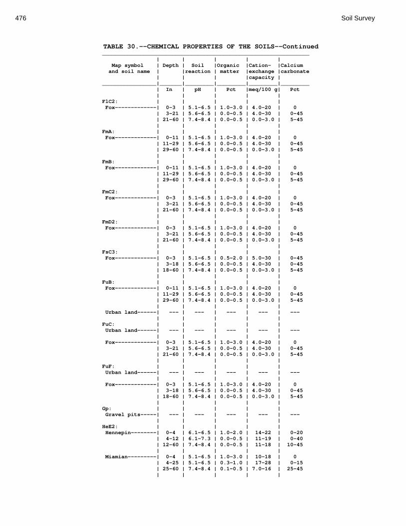
476 Soil Survey
TABLE 30.--CHEMICAL PROPERTIES OF THE SOILS--Continued _________________________________________________________________ | | | | | Map symbol | Depth | Soil |Organic |Cation- |Calcium and soil name | |reaction | matter |exchange |carbonate | | | |capacity | _________________|_______|_________|_________|_________|_________ | In | pH | Pct |meq/100 g| Pct | | | | | FlC2: | | | | | Fox-------------| 0-3 | 5.1-6.5 | 1.0-3.0 | 4.0-20 | 0 | 3-21 | 5.6-6.5 | 0.0-0.5 | 4.0-30 | 0-45 | 21-60 | 7.4-8.4 | 0.0-0.5 | 0.0-3.0 | 5-45 | | | | | FmA: | | | | | Fox-------------| 0-11 | 5.1-6.5 | 1.0-3.0 | 4.0-20 | 0 | 11-29 | 5.6-6.5 | 0.0-0.5 | 4.0-30 | 0-45 | 29-60 | 7.4-8.4 | 0.0-0.5 | 0.0-3.0 | 5-45 | | | | | FmB: | | | | | Fox-------------| 0-11 | 5.1-6.5 | 1.0-3.0 | 4.0-20 | 0 | 11-29 | 5.6-6.5 | 0.0-0.5 | 4.0-30 | 0-45 | 29-60 | 7.4-8.4 | 0.0-0.5 | 0.0-3.0 | 5-45 | | | | | FmC2: | | | | | Fox-------------| 0-3 | 5.1-6.5 | 1.0-3.0 | 4.0-20 | 0 | 3-21 | 5.6-6.5 | 0.0-0.5 | 4.0-30 | 0-45 | 21-60 | 7.4-8.4 | 0.0-0.5 | 0.0-3.0 | 5-45 | | | | | FmD2: | | | | | Fox-------------| 0-3 | 5.1-6.5 | 1.0-3.0 | 4.0-20 | 0 | 3-21 | 5.6-6.5 | 0.0-0.5 | 4.0-30 | 0-45 | 21-60 | 7.4-8.4 | 0.0-0.5 | 0.0-3.0 | 5-45 | | | | | FsC3: | | | | | Fox-------------| 0-3 | 5.1-6.5 | 0.5-2.0 | 5.0-30 | 0-45 | 3-18 | 5.6-6.5 | 0.0-0.5 | 4.0-30 | 0-45 | 18-60 | 7.4-8.4 | 0.0-0.5 | 0.0-3.0 | 5-45 | | | | | FuB: | | | | | Fox-------------| 0-11 | 5.1-6.5 | 1.0-3.0 | 4.0-20 | 0 | 11-29 | 5.6-6.5 | 0.0-0.5 | 4.0-30 | 0-45 | 29-60 | 7.4-8.4 | 0.0-0.5 | 0.0-3.0 | 5-45 | | | | | Urban land------| --- | --- | --- | --- | --- | | | | | FuC: | | | | | Urban land------| --- | --- | --- | --- | --- | | | | | Fox-------------| 0-3 | 5.1-6.5 | 1.0-3.0 | 4.0-20 | 0 | 3-21 | 5.6-6.5 | 0.0-0.5 | 4.0-30 | 0-45 | 21-60 | 7.4-8.4 | 0.0-0.5 | 0.0-3.0 | 5-45 | | | | | FuF: | | | | | Urban land------| --- | --- | --- | --- | --- | | | | | Fox-------------| 0-3 | 5.1-6.5 | 1.0-3.0 | 4.0-20 | 0 | 3-18 | 5.6-6.5 | 0.0-0.5 | 4.0-30 | 0-45 | 18-60 | 7.4-8.4 | 0.0-0.5 | 0.0-3.0 | 5-45 | | | | | Gp: | | | | | Gravel pits-----| --- | --- | --- | --- | --- | | | | | HeE2: | | | | | Hennepin--------| 0-4 | 6.1-6.5 | 1.0-2.0 | 14-22 | 0-20 | 4-12 | 6.1-7.3 | 0.0-0.5 | 11-19 | 0-40 | 12-60 | 7.4-8.4 | 0.0-0.5 | 11-18 | 10-45 | | | | | Miamian---------| 0-4 | 5.1-6.5 | 1.0-3.0 | 10-18 | 0 | 4-25 | 5.1-6.5 | 0.3-1.0 | 17-28 | 0-15 | 25-60 | 7.4-8.4 | 0.1-0.5 | 7.0-16 | 25-45 | | | | |

Montgomery County, Ohio 477
TABLE 30.--CHEMICAL PROPERTIES OF THE SOILS--Continued _________________________________________________________________ | | | | | Map symbol | Depth | Soil |Organic |Cation- |Calcium and soil name | |reaction | matter |exchange |carbonate | | | |capacity | _________________|_______|_________|_________|_________|_________ | In | pH | Pct |meq/100 g| Pct | | | | | HeF2: | | | | | Hennepin--------| 0-3 | 6.1-6.5 | 1.0-2.0 | 14-22 | 0-20 | 3-12 | 6.1-7.3 | 0.0-0.5 | 11-19 | 0-40 | 12-60 | 7.4-8.4 | 0.0-0.5 | 11-18 | 10-45 | | | | | Miamian---------| 0-4 | 5.1-6.5 | 1.0-3.0 | 10-18 | 0 | 4-25 | 5.1-6.5 | 0.3-1.0 | 17-28 | 0-15 | 25-60 | 7.4-8.4 | 0.1-0.5 | 7.0-16 | 25-45 | | | | | HmF3: | | | | | Hennepin--------| 0-6 | 6.1-7.3 | 0.0-0.5 | 11-19 | 0-40 | 6-60 | 7.4-8.4 | 0.0-0.5 | 11-18 | 10-45 | | | | | Miamian---------| 0-21 | 5.1-6.5 | 0.5-2.0 | 17-28 | 0-15 | 21-60 | 7.4-8.4 | 0.3-1.0 | 7.0-16 | 25-45 | | | | | KeA: | | | | | Kendallville----| 0-9 | 5.1-7.3 | 1.0-3.0 | 8.0-20 | 0 | 9-26 | 5.1-6.0 | 0.2-0.5 | 8.0-18 | 0 | 26-36 | 5.6-7.3 | 0.1-0.3 | 10-28 | 0 | 36-60 | 7.4-8.4 | 0.0-0.3 | 7.0-18 | 20-45 | | | | | KeB: | | | | | Kendallville----| 0-9 | 5.1-7.3 | 1.0-3.0 | 8.0-20 | 0 | 9-26 | 5.1-6.0 | 0.2-0.5 | 8.0-18 | 0 | 26-36 | 5.6-7.3 | 0.1-0.3 | 10-28 | 0 | 36-60 | 7.4-8.4 | 0.0-0.3 | 7.0-18 | 20-45 | | | | | KeC2: | | | | | Kendallville----| 0-4 | 5.1-7.3 | 1.0-3.0 | 4.0-18 | 0 | 4-21 | 5.1-6.0 | 0.2-0.5 | 8.0-18 | 0 | 21-36 | 5.6-7.3 | 0.1-0.3 | 10-28 | 0 | 36-60 | 7.4-8.4 | 0.0-0.5 | 7.0-18 | 20-45 | | | | | Ld: | | | | | Landes----------| 0-19 | 6.6-7.8 | 1.0-2.0 | 5.0-16 | 0 | 19-42 | 6.6-7.8 | 0.0-1.0 | 3.0-13 | 0-10 | 42-60 | 7.4-8.4 | 0.0-1.0 | 3.0-13 | 0-20 | | | | | Lg: | | | | | Lanier----------| 0-20 | 6.6-7.8 | 1.0-4.0 | 4.0-17 | 0-15 | 20-60 | 7.4-8.4 | 0.0-1.0 | 1.0-5.0 | 15-40 | | | | | LsB: | | | | | Lewisburg-------| 0-7 | 5.6-7.3 | 1.0-3.0 | 8.0-19 | 0 | 7-15 | 6.1-7.3 | 0.5-1.0 | 14-28 | 0-10 | 15-60 | 7.4-8.4 | 0.1-0.5 | 8.0-16 | 30-47 | | | | | LxC2: | | | | | Lorenzo---------| 0-4 | 6.6-7.3 | 2.0-4.0 | 11-19 | 0 | 4-15 | 6.6-7.3 | 0.0-1.0 | 10-22 | 0-10 | 15-60 | 7.4-8.4 | 0.0-1.0 | 1.0-3.0 | 10-45 | | | | | Rodman----------| 0-3 | 6.6-7.8 | 2.0-4.0 | 5.0-16 | 0-15 | 3-9 | 7.4-8.4 | 0.0-2.0 | 1.0-14 | 0-25 | 9-60 | 7.4-8.4 | 0.0-1.0 | 1.0-6.0 | 10-45 | | | | |

478 Soil Survey
TABLE 30.--CHEMICAL PROPERTIES OF THE SOILS--Continued _________________________________________________________________ | | | | | Map symbol | Depth | Soil |Organic |Cation- |Calcium and soil name | |reaction | matter |exchange |carbonate | | | |capacity | _________________|_______|_________|_________|_________|_________ | In | pH | Pct |meq/100 g| Pct | | | | | LxD2: | | | | | Lorenzo---------| 0-4 | 6.6-7.3 | 2.0-4.0 | 11-19 | 0 | 4-15 | 6.6-7.3 | 0.0-1.0 | 10-22 | 0-10 | 15-60 | 7.4-8.4 | 0.0-1.0 | 1.0-3.0 | 10-45 | | | | | Rodman----------| 0-3 | 6.6-7.8 | 2.0-4.0 | 5.0-16 | 0-15 | 3-9 | 7.4-8.4 | 0.0-2.0 | 1.0-14 | 0-25 | 9-60 | 7.4-8.4 | 0.0-1.0 | 1.0-6.0 | 10-45 | | | | | Mb: | | | | | Made land-------| --- | --- | --- | --- | --- | | | | | Md: | | | | | Medway----------| 0-20 | 6.6-7.8 | 3.0-6.0 | 13-28 | 0 | 20-29 | 6.6-7.8 | 0.5-1.0 | 7.0-17 | 0-5 | 29-45 | 6.6-7.8 | 0.5-1.0 | 4.0-18 | 0-10 | 45-60 | 7.4-8.4 | 0.0-0.5 | 2.0-18 | 10-20 | | | | | MlA: | | | | | Miamian---------| 0-7 | 5.1-6.5 | 1.0-3.0 | 10-18 | 0 | 7-24 | 5.1-6.5 | 0.3-1.0 | 17-28 | 0-15 | 24-60 | 7.4-8.4 | 0.1-0.5 | 7.0-16 | 25-45 | | | | | MlB: | | | | | Miamian---------| 0-7 | 5.1-6.5 | 1.0-3.0 | 10-18 | 0 | 7-24 | 5.1-6.5 | 0.3-1.0 | 17-28 | 0-15 | 24-60 | 7.4-8.4 | 0.1-0.5 | 7.0-16 | 25-45 | | | | | MlB2: | | | | | Miamian---------| 0-7 | 5.1-6.5 | 0.5-2.0 | 10-18 | 0 | 7-24 | 5.1-6.5 | 0.3-1.0 | 17-28 | 0-15 | 24-60 | 7.4-8.4 | 0.1-0.5 | 7.0-16 | 25-45 | | | | | MlC2: | | | | | Miamian---------| 0-7 | 5.1-6.5 | 0.5-2.0 | 10-18 | 0 | 7-24 | 5.1-6.5 | 0.3-1.0 | 17-28 | 0-15 | 24-60 | 7.4-8.4 | 0.1-0.5 | 7.0-16 | 25-45 | | | | | MlD2: | | | | | Miamian---------| 0-4 | 5.1-6.5 | 0.5-2.0 | 10-18 | 0 | 4-21 | 5.1-6.5 | 0.3-1.0 | 17-28 | 0-15 | 21-60 | 7.4-8.4 | 0.1-0.5 | 7.0-16 | 25-45 | | | | | MmB: | | | | | Miamian---------| 0-7 | 5.1-6.5 | 1.0-3.0 | 10-18 | 0 | 7-24 | 5.1-6.5 | 0.3-1.0 | 17-28 | 0-15 | 24-60 | 7.4-8.4 | 0.1-0.5 | 7.0-16 | 25-45 | | | | | MnB3: | | | | | Miamian---------| 0-5 | 5.1-6.5 | 0.0-1.0 | 14-20 | 0-10 | 5-22 | 5.1-6.5 | 0.3-1.0 | 17-28 | 0-15 | 22-60 | 7.4-8.4 | 0.1-0.5 | 7.0-16 | 25-45 | | | | | MnC3: | | | | | Miamian---------| 0-5 | 5.1-6.5 | 0.0-1.0 | 14-20 | 0-10 | 5-22 | 5.1-6.5 | 0.3-1.0 | 17-28 | 0-15 | 22-60 | 7.4-8.4 | 0.1-0.5 | 7.0-16 | 25-45 | | | | | MnD3: | | | | | Miamian---------| 0-4 | 5.1-6.5 | 0.0-1.0 | 14-20 | 0-10 | 4-21 | 5.1-6.5 | 0.3-1.0 | 17-28 | 0-15 | 21-60 | 7.4-8.4 | 0.1-0.5 | 7.0-16 | 25-45 | | | | |
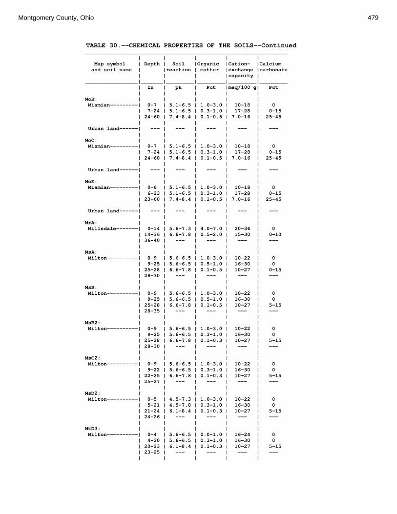
Montgomery County, Ohio 479
TABLE 30.--CHEMICAL PROPERTIES OF THE SOILS--Continued _________________________________________________________________ | | | | | Map symbol | Depth | Soil |Organic |Cation- |Calcium and soil name | |reaction | matter |exchange |carbonate | | | |capacity | _________________|_______|_________|_________|_________|_________ | In | pH | Pct |meq/100 g| Pct | | | | | MoB: | | | | | Miamian---------| 0-7 | 5.1-6.5 | 1.0-3.0 | 10-18 | 0 | 7-24 | 5.1-6.5 | 0.3-1.0 | 17-28 | 0-15 | 24-60 | 7.4-8.4 | 0.1-0.5 | 7.0-16 | 25-45 | | | | | Urban land------| --- | --- | --- | --- | --- | | | | | MoC: | | | | | Miamian---------| 0-7 | 5.1-6.5 | 1.0-3.0 | 10-18 | 0 | 7-24 | 5.1-6.5 | 0.3-1.0 | 17-28 | 0-15 | 24-60 | 7.4-8.4 | 0.1-0.5 | 7.0-16 | 25-45 | | | | | Urban land------| --- | --- | --- | --- | --- | | | | | MoE: | | | | | Miamian---------| 0-6 | 5.1-6.5 | 1.0-3.0 | 10-18 | 0 | 6-23 | 5.1-6.5 | 0.3-1.0 | 17-28 | 0-15 | 23-60 | 7.4-8.4 | 0.1-0.5 | 7.0-16 | 25-45 | | | | | Urban land------| --- | --- | --- | --- | --- | | | | | MrA: | | | | | Millsdale-------| 0-14 | 5.6-7.3 | 4.0-7.0 | 20-36 | 0 | 14-36 | 6.6-7.8 | 0.5-2.0 | 15-30 | 0-10 | 36-40 | --- | --- | --- | --- | | | | | MsA: | | | | | Milton----------| 0-9 | 5.6-6.5 | 1.0-3.0 | 10-22 | 0 | 9-25 | 5.6-6.5 | 0.5-1.0 | 16-30 | 0 | 25-28 | 6.6-7.8 | 0.1-0.5 | 10-27 | 0-15 | 28-30 | --- | --- | --- | --- | | | | | MsB: | | | | | Milton----------| 0-9 | 5.6-6.5 | 1.0-3.0 | 10-22 | 0 | 9-25 | 5.6-6.5 | 0.5-1.0 | 16-30 | 0 | 25-28 | 6.6-7.8 | 0.1-0.5 | 10-27 | 5-15 | 28-35 | --- | --- | --- | --- | | | | | MsB2: | | | | | Milton----------| 0-9 | 5.6-6.5 | 1.0-3.0 | 10-22 | 0 | 9-25 | 5.6-6.5 | 0.3-1.0 | 16-30 | 0 | 25-28 | 6.6-7.8 | 0.1-0.3 | 10-27 | 5-15 | 28-30 | --- | --- | --- | --- | | | | | MsC2: | | | | | Milton----------| 0-9 | 5.6-6.5 | 1.0-3.0 | 10-22 | 0 | 9-22 | 5.6-6.5 | 0.3-1.0 | 16-30 | 0 | 22-25 | 6.6-7.8 | 0.1-0.3 | 10-27 | 5-15 | 25-27 | --- | --- | --- | --- | | | | | MsD2: | | | | | Milton----------| 0-5 | 4.5-7.3 | 1.0-3.0 | 10-22 | 0 | 5-21 | 4.5-7.8 | 0.3-1.0 | 16-30 | 0 | 21-24 | 6.1-8.4 | 0.1-0.3 | 10-27 | 5-15 | 24-26 | --- | --- | --- | --- | | | | | MtD3: | | | | | Milton----------| 0-4 | 5.6-6.5 | 0.0-1.0 | 16-24 | 0 | 4-20 | 5.6-6.5 | 0.3-1.0 | 16-30 | 0 | 20-23 | 6.1-8.4 | 0.1-0.3 | 10-27 | 5-15 | 23-25 | --- | --- | --- | --- | | | | |

480 Soil Survey
TABLE 30.--CHEMICAL PROPERTIES OF THE SOILS--Continued _________________________________________________________________ | | | | | Map symbol | Depth | Soil |Organic |Cation- |Calcium and soil name | |reaction | matter |exchange |carbonate | | | |capacity | _________________|_______|_________|_________|_________|_________ | In | pH | Pct |meq/100 g| Pct | | | | | MuB: | | | | | Milton----------| 0-9 | 5.6-6.5 | 1.0-3.0 | 10-22 | 0 | 9-25 | 5.6-6.5 | 0.3-1.0 | 16-30 | 0 | 25-28 | 6.6-7.8 | 0.1-0.3 | 10-27 | 5-15 | 28-30 | --- | --- | --- | --- | | | | | Urban land------| --- | --- | --- | --- | --- | | | | | MuC: | | | | | Milton----------| 0-9 | 5.6-6.5 | 1.0-3.0 | 10-22 | 0 | 9-25 | 5.6-6.5 | 0.3-1.0 | 16-30 | 0 | 25-28 | 6.6-7.8 | 0.1-0.3 | 10-27 | 5-15 | 28-30 | --- | --- | --- | --- | | | | | Urban land------| --- | --- | --- | --- | --- | | | | | MuD: | | | | | Milton----------| 0-9 | 5.6-6.5 | 1.0-3.0 | 10-22 | 0 | 9-25 | 5.6-6.5 | 0.3-1.0 | 16-30 | 0 | 25-28 | 6.6-7.8 | 0.1-0.3 | 10-27 | 5-15 | 28-30 | --- | --- | --- | --- | | | | | Urban land------| --- | --- | --- | --- | --- | | | | | Mv: | | | | | Montgomery------| 0-8 | 6.1-7.3 | 3.0-6.0 | 20-36 | 0-5 | 8-33 | 6.6-7.3 | 0.0-1.0 | 20-35 | 0-10 | 33-60 | 6.6-8.4 | 0.0-0.5 | 20-35 | 5-35 | | | | | OcA: | | | | | Ockley----------| 0-13 | 5.6-7.3 | 1.0-3.0 | 3.0-15 | 0 | 13-40 | 5.6-6.0 | 0.0-0.5 | 5.0-15 | 0 | 40-48 | 6.1-7.3 | 0.0-0.5 | 2.0-15 | 0-10 | 48-60 | 7.4-8.4 | 0.0-0.2 | 1.0-3.0 | 10-40 | | | | | OcB: | | | | | Ockley----------| 0-13 | 5.6-7.3 | 1.0-3.0 | 3.0-15 | 0 | 13-40 | 5.6-6.0 | 0.0-0.5 | 5.0-15 | 0 | 40-48 | 6.1-7.3 | 0.0-0.5 | 2.0-15 | 0-10 | 48-60 | 7.4-8.4 | 0.0-0.2 | 1.0-3.0 | 10-40 | | | | | PlB: | | | | | Plattville------| 0-10 | 5.6-6.5 | 3.0-5.0 | 18-26 | 0 | 10-23 | 5.6-6.5 | 0.5-1.0 | 16-23 | 0 | 23-27 | 6.6-7.8 | 0.2-0.5 | 15-22 | 0-5 | 27-29 | --- | --- | --- | --- | | | | | PlC: | | | | | Plattville------| 0-10 | 5.6-6.5 | 2.0-4.0 | 18-26 | 0 | 10-23 | 5.6-6.5 | 0.0-1.0 | 16-23 | 0 | 23-27 | 6.6-7.8 | 0.2-0.5 | 15-22 | 0-5 | 27-29 | --- | --- | --- | --- | | | | | PyA: | | | | | Pyrmont---------| 0-9 | 5.6-6.5 | 1.0-3.0 | 8.0-22 | 0 | 9-16 | 6.1-7.3 | 0.0-1.0 | 14-26 | 0 | 16-60 | 7.4-8.4 | 0.0-0.5 | 6.0-16 | 10-40 | | | | | Qu: | | | | | Quarries--------| --- | --- | --- | --- | --- | | | | |

Montgomery County, Ohio 481
TABLE 30.--CHEMICAL PROPERTIES OF THE SOILS--Continued _________________________________________________________________ | | | | | Map symbol | Depth | Soil |Organic |Cation- |Calcium and soil name | |reaction | matter |exchange |carbonate | | | |capacity | _________________|_______|_________|_________|_________|_________ | In | pH | Pct |meq/100 g| Pct | | | | | RcA: | | | | | Randolph--------| 0-14 | 5.6-7.3 | 1.0-3.0 | 8.0-22 | 0 | 14-23 | 6.1-7.3 | 0.5-1.0 | 14-30 | 0-45 | 23-31 | 6.6-7.8 | 0.0-0.5 | 8.0-20 | 5-25 | 31-35 | --- | --- | --- | --- | | | | | ReB: | | | | | Ritchey---------| 0-6 | 5.6-7.3 | 1.0-3.0 | 13-22 | 0 | 6-18 | 6.1-7.3 | 0.5-1.0 | 17-23 | 0-20 | 18-20 | --- | --- | --- | --- | | | | | ReB2: | | | | | Ritchey---------| 0-4 | 5.6-7.3 | 1.0-3.0 | 13-22 | 0 | 4-14 | 6.1-7.3 | 0.5-1.0 | 17-23 | 0-20 | 14-16 | --- | --- | --- | --- | | | | | ReC2: | | | | | Ritchey---------| 0-4 | 5.6-7.3 | 1.0-3.0 | 13-22 | 0 | 4-14 | 6.1-7.3 | 0.5-1.0 | 17-23 | 0-20 | 14-16 | --- | --- | --- | --- | | | | | ReE2: | | | | | Ritchey---------| 0-3 | 5.6-7.3 | 1.0-3.0 | 13-22 | 0 | 3-12 | 6.1-7.3 | 0.5-1.0 | 17-23 | 0-20 | 12-14 | --- | --- | --- | --- | | | | | ReF2: | | | | | Ritchey---------| 0-2 | 5.6-7.3 | 1.0-3.0 | 13-22 | 0 | 2-11 | 6.1-7.3 | 0.5-1.0 | 17-23 | 0-20 | 11-13 | --- | --- | --- | --- | | | | | RfD3: | | | | | Ritchey---------| 0-9 | 6.1-7.3 | 0.5-1.0 | 17-23 | 0-20 | 9-11 | --- | --- | --- | --- | | | | | Rh: | | | | | Riverwash-------| --- | --- | --- | --- | --- | | | | | RlE2: | | | | | Rodman----------| 0-4 | 6.6-7.8 | 2.0-4.0 | 5.0-16 | 0-15 | 4-10 | 7.4-8.4 | 0.0-2.0 | 1.0-14 | 0-25 | 10-60 | 7.4-8.4 | 0.0-1.0 | 1.0-6.0 | 10-45 | | | | | Fox-------------| 0-3 | 5.1-6.5 | 1.0-3.0 | 4.0-20 | 0 | 3-21 | 5.1-7.3 | 0.0-0.5 | 4.0-30 | 0-45 | 21-60 | 7.4-8.4 | 0.0-0.5 | 0.0-3.0 | 5-45 | | | | | RlF2: | | | | | Rodman----------| 0-3 | 6.6-7.8 | 2.0-4.0 | 5.0-16 | 0-15 | 3-9 | 7.4-8.4 | 0.0-2.0 | 1.0-14 | 0-25 | 9-60 | 7.4-8.4 | 0.0-1.0 | 1.0-6.0 | 10-45 | | | | | Fox-------------| 0-3 | 5.1-6.5 | 1.0-3.0 | 4.0-20 | 0 | 3-21 | 5.1-7.3 | 0.0-0.5 | 4.0-30 | 0-45 | 21-60 | 7.4-8.4 | 0.0-0.5 | 0.0-3.0 | 5-45 | | | | | Rs: | | | | | Ross------------| 0-22 | 6.6-7.8 | 3.0-5.0 | 12-26 | 0 | 22-34 | 6.6-7.8 | 1.0-3.0 | 8.0-20 | 0-20 | 34-60 | 6.6-7.8 | 0.5-2.0 | 2.0-15 | 0-30 | | | | |

482 Soil Survey
TABLE 30.--CHEMICAL PROPERTIES OF THE SOILS--Continued _________________________________________________________________ | | | | | Map symbol | Depth | Soil |Organic |Cation- |Calcium and soil name | |reaction | matter |exchange |carbonate | | | |capacity | _________________|_______|_________|_________|_________|_________ | In | pH | Pct |meq/100 g| Pct | | | | | Rt: | | | | | Urban land------| --- | --- | --- | --- | --- | | | | | Ross------------| 0-22 | 6.6-7.8 | 3.0-5.0 | 12-26 | 0 | 22-34 | 6.6-7.8 | 1.0-3.0 | 8.0-20 | 0-20 | 34-60 | 6.6-7.8 | 0.5-2.0 | 2.0-15 | 0-30 | | | | | RuB: | | | | | Russell---------| 0-12 | 5.6-6.5 | 0.5-2.0 | 5.0-19 | 0 | 12-24 | 5.1-6.0 | 0.5-1.0 | 11-22 | 0 | 24-39 | 5.6-7.3 | 0.0-1.0 | 9.0-22 | 0 | 39-60 | 7.4-8.4 | 0.0-0.5 | 5.0-18 | 10-35 | | | | | RvC2: | | | | | Russell---------| 0-12 | 5.6-6.5 | 0.5-2.0 | 5.0-19 | 0 | 12-24 | 5.1-6.0 | 0.5-1.0 | 11-22 | 0 | 24-39 | 5.6-7.3 | 0.0-1.0 | 9.0-22 | 0 | 39-60 | 7.4-8.4 | 0.0-0.5 | 5.0-18 | 10-35 | | | | | Miamian---------| 0-7 | 5.1-6.5 | 1.0-3.0 | 10-18 | 0 | 7-24 | 5.1-6.5 | 0.3-1.0 | 17-28 | 0-15 | 24-60 | 7.4-8.4 | 0.1-0.5 | 7.0-16 | 25-45 | | | | | RvD2: | | | | | Russell---------| 0-12 | 5.6-6.5 | 0.5-2.0 | 5.0-19 | 0 | 12-24 | 5.1-6.0 | 0.5-1.0 | 11-22 | 0 | 24-39 | 5.6-6.5 | 0.3-1.0 | 9.0-22 | 0 | 39-60 | 7.4-8.4 | 0.0-0.5 | 5.0-18 | 10-35 | | | | | Miamian---------| 0-7 | 5.1-6.5 | 1.0-3.0 | 10-18 | 0 | 7-24 | 5.1-6.5 | 0.3-1.0 | 17-28 | 0-15 | 24-60 | 7.4-8.4 | 0.1-0.5 | 7.0-16 | 25-45 | | | | | Sh: | | | | | Shoals----------| 0-8 | 6.1-7.8 | 1.0-3.0 | 12-27 | 0-5 | 8-13 | 6.1-7.8 | 0.5-2.0 | 8.0-24 | 0-10 | 13-60 | 6.6-7.8 | 0.5-1.0 | 3.0-19 | 0-25 | | | | | So: | | | | | Sloan-----------| 0-12 | 6.1-7.3 | 3.0-6.0 | 13-26 | 0 | 12-25 | 6.6-7.8 | 0.5-1.0 | 10-20 | 0-20 | 25-60 | 6.6-7.8 | 0.1-0.5 | 4.0-18 | 5-40 | | | | | ThA: | | | | | Thackery--------| 0-15 | 5.6-7.3 | 1.0-3.0 | 8.0-21 | 0 | 15-30 | 5.6-6.5 | 0.3-0.5 | 10-21 | 0 | 30-45 | 6.1-7.3 | 0.1-0.3 | 1.0-6.0 | 30-55 | 45-60 | 7.4-8.4 | 0.1-0.3 | 1.0-6.0 | 30-55 | | | | | TpA: | | | | | Tippecanoe------| 0-12 | 5.6-6.5 | 2.0-5.0 | 11-27 | 0 | 12-36 | 5.6-7.3 | 0.5-1.0 | 9.0-23 | 0 | 36-45 | 6.1-7.3 | 0.0-1.0 | 6.0-16 | 0 | 45-60 | 7.4-8.4 | 0.0-0.5 | 1.0-6.0 | 5-20 | | | | | Ua: | | | | | Urban land------| --- | --- | --- | --- | --- | | | | | Ud: | | | | | Udorthents------| --- | --- | --- | --- | --- | | | | | Ug: | | | | | Urban land------| --- | --- | --- | --- | --- | | | | |
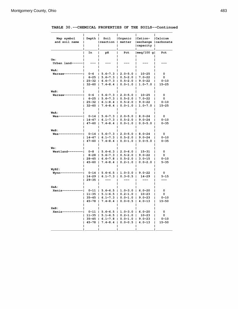
Montgomery County, Ohio 483
TABLE 30.--CHEMICAL PROPERTIES OF THE SOILS--Continued _________________________________________________________________ | | | | | Map symbol | Depth | Soil |Organic |Cation- |Calcium and soil name | |reaction | matter |exchange |carbonate | | | |capacity | _________________|_______|_________|_________|_________|_________ | In | pH | Pct |meq/100 g| Pct | | | | | Um: | | | | | Urban land------| --- | --- | --- | --- | --- | | | | | WaA: | | | | | Warsaw----------| 0-6 | 5.6-7.3 | 2.0-5.0 | 10-25 | 0 | 6-25 | 5.6-7.3 | 0.5-2.0 | 7.0-22 | 0 | 25-32 | 6.6-7.3 | 0.5-2.0 | 9.0-22 | 0-10 | 32-60 | 7.4-8.4 | 0.0-1.0 | 1.0-7.0 | 15-25 | | | | | WaB: | | | | | Warsaw----------| 0-6 | 5.6-7.3 | 2.0-5.0 | 10-25 | 0 | 6-25 | 5.6-7.3 | 0.5-2.0 | 7.0-22 | 0 | 25-32 | 6.1-8.4 | 0.5-2.0 | 9.0-22 | 0-10 | 32-60 | 7.4-8.4 | 0.0-1.0 | 1.0-7.0 | 15-25 | | | | | WeA: | | | | | Wea-------------| 0-14 | 5.6-7.3 | 2.0-5.0 | 8.0-24 | 0 | 14-47 | 6.1-7.3 | 0.5-2.0 | 9.0-24 | 0-10 | 47-60 | 7.4-8.4 | 0.0-1.0 | 0.0-5.0 | 0-35 | | | | | WeB: | | | | | Wea-------------| 0-14 | 5.6-7.3 | 2.0-5.0 | 8.0-24 | 0 | 14-47 | 6.1-7.3 | 0.5-2.0 | 9.0-24 | 0-10 | 47-60 | 7.4-8.4 | 0.0-1.0 | 0.0-5.0 | 0-35 | | | | | Ws: | | | | | Westland--------| 0-8 | 5.6-6.3 | 2.0-6.0 | 15-31 | 0 | 8-28 | 5.6-7.3 | 0.5-2.0 | 9.0-22 | 0 | 28-45 | 6.6-7.8 | 0.5-2.0 | 3.0-15 | 0-10 | 45-60 | 7.4-8.4 | 0.2-1.0 | 0.0-2.0 | 5-35 | | | | | WyB2: | | | | | Wynn------------| 0-14 | 5.6-6.5 | 1.0-3.0 | 9.0-22 | 0 | 14-29 | 6.1-7.3 | 0.3-0.5 | 14-29 | 5-15 | 29-35 | --- | --- | --- | --- | | | | | XeA: | | | | | Xenia-----------| 0-11 | 5.6-6.5 | 1.0-3.0 | 6.0-20 | 0 | 11-35 | 5.1-6.5 | 0.2-1.0 | 10-23 | 0 | 35-45 | 6.1-7.3 | 0.0-1.0 | 9.0-23 | 0-10 | 45-78 | 7.4-8.4 | 0.0-0.5 | 4.0-13 | 15-50 | | | | | XeB: | | | | | Xenia-----------| 0-11 | 5.6-6.5 | 1.0-3.0 | 6.0-20 | 0 | 11-35 | 5.1-6.5 | 0.2-1.0 | 10-23 | 0 | 35-45 | 6.1-7.8 | 0.0-1.0 | 9.0-23 | 0-10 | 45-78 | 7.4-8.4 | 0.0-0.5 | 4.0-13 | 15-50 | | | | | _________________|_______|_________|_________|_________|_________

484 Soil Survey
TABLE 31.--WATER FEATURES (Depths of layers are in feet. See text for definitions of terms used in this table. Absence of an entry indicates that the feature is not a concern or that data were not estimated. See text on page 180 for additional information.) ____________________________________________________________________________________________________________________ | | | Water table | Ponding | Flooding | | |_______________________|______________________________|_________________________ Map symbol |Hydro-| Month | Upper | Lower | Kind |Surface| Duration |Frequency | Duration | Frequency and soil name |logic | | limit | limit | | water | | | | |group | | | | | depth | | | | _________________|______|__________|_______|_______|________|_______|__________|__________|____________| | | | | | | | | | | Ag: | | | | | | | | | | Algiers---------| C/D | Jan-Jun |0.0-1.5| >6.0 |Apparent| --- | --- | None | Very brief | Occasional | | Jul-Nov | --- | --- | --- | --- | --- | None | --- | None | | Dec | --- | --- | --- | --- | --- | None | Very brief | Occasional | | | | | | | | | | Bo: | | | | | | | | | | Borrow pits-----| --- | Jan-Dec | --- | --- | --- | --- | --- | --- | --- | None | | | | | | | | | | Bp: | | | | | | | | | | Brookston-------| B/D | Jan-May | 0 | >6.0 |Apparent|0.0-0.5| Long | Frequent | --- | None | | Jun-Nov | --- | --- | --- | --- | --- | None | --- | None | | Dec | 0 | >6.0 |Apparent|0.0-0.5| Long | Frequent | --- | None | | | | | | | | | | Br: | | | | | | | | | | Brookston-------| B/D | Jan-May | 0 | >6.0 |Apparent|0.0-0.5| Long | Frequent | --- | None | | Jun-Nov | --- | --- | --- | --- | --- | None | --- | None | | Dec | 0 | >6.0 |Apparent|0.0-0.5| Long | Frequent | --- | None | | | | | | | | | | Bs: | | | | | | | | | | Brookston-------| B/D | Jan-May | 0 | >6.0 |Apparent|0.0-0.5| Long | Frequent | --- | None | | Jun-Nov | --- | --- | --- | --- | --- | None | --- | None | | Dec | 0 | >6.0 |Apparent|0.0-0.5| Long | Frequent | --- | None | | | | | | | | | | Bu: | | | | | | | | | | Brookston-------| B/D | Jan-May | 0 | >6.0 |Apparent|0.0-0.5| Long | Frequent | --- | None | | Jun-Nov | --- | --- | --- | --- | --- | None | --- | None | | Dec | 0 | >6.0 |Apparent|0.0-0.5| Long | Frequent | --- | None | | | | | | | | | | Urban land------| --- | Jan-Dec | --- | --- | --- | --- | --- | --- | --- | None | | | | | | | | | | Ca: | | | | | | | | | | Carlisle--------| A/D | Jan-Jun | 0 | >6.0 |Apparent|0.0-0.5|Very long | Frequent | --- | None | | Jul-Aug | --- | --- | --- | --- | --- | None | --- | None | | Sep-Dec | 0 | >6.0 |Apparent|0.0-0.5|Very long | Frequent | --- | None | | | | | | | | | | CeA: | | | | | | | | | | Celina----------| C | Jan-Apr |1.5-3.0|1.5-3.5|Perched | --- | --- | None | --- | None | | May-Dec | --- | --- | --- | --- | --- | None | --- | None | | | | | | | | | | CeB: | | | | | | | | | | Celina----------| C | Jan-Apr |1.5-3.0|1.5-3.5|Perched | --- | --- | None | --- | None | | May-Dec | --- | --- | --- | --- | --- | None | --- | None | | | | | | | | | | CeB2: | | | | | | | | | | Celina----------| C | Jan-Apr |1.5-3.0|1.5-3.5|Perched | --- | --- | None | --- | None | | May-Dec | --- | --- | --- | --- | --- | None | --- | None | | | | | | | | | | ClB: | | | | | | | | | | Celina----------| C | Jan-Apr |1.5-3.0|1.5-3.5|Perched | --- | --- | None | --- | None | | May-Dec | --- | --- | --- | --- | --- | None | --- | None | | | | | | | | | | CoA: | | | | | | | | | | Corwin----------| B | Jan-Apr |1.5-3.0| >6.0 |Apparent| --- | --- | None | --- | None | | May-Dec | --- | --- | --- | --- | --- | None | --- | None | | | | | | | | | | CoB: | | | | | | | | | | Corwin----------| B | Jan-Apr |1.5-3.0| >6.0 |Apparent| --- | --- | None | --- | None | | May-Dec | --- | --- | --- | --- | --- | None | --- | None | | | | | | | | | | CsA: | | | | | | | | | | Crosby----------| C | Jan-Apr |0.5-1.5|1.0-3.0|Perched | --- | --- | None | --- | None | | May-Dec | --- | --- | --- | --- | --- | None | --- | None | | | | | | | | | | CtB: | | | | | | | | | | Crosby----------| C | Jan-Apr |0.5-1.5|1.0-3.0|Perched | --- | --- | None | --- | None | | May-Dec | --- | --- | --- | --- | --- | None | --- | None | | | | | | | | | | Celina----------| C | Jan-Apr |1.5-3.0|1.5-3.5|Perched | --- | --- | None | --- | None | | May-Dec | --- | --- | --- | --- | --- | None | --- | None | | | | | | | | | |

Montgomery County, Ohio 485
TABLE 31.--WATER FEATURES--Continued ____________________________________________________________________________________________________________________ | | | Water table | Ponding | Flooding | | |_______________________|______________________________|_________________________ Map symbol |Hydro-| Month | Upper | Lower | Kind |Surface| Duration |Frequency | Duration | Frequency and soil name |logic | | limit | limit | | water | | | | |group | | | | | depth | | | | _________________|______|__________|_______|_______|________|_______|__________|__________|____________| | | | | | | | | | | Cu: | | | | | | | | | | Crosby----------| C | Jan-Apr |0.5-1.5|1.0-3.0|Perched | --- | --- | None | --- | None | | May-Dec | --- | --- | --- | --- | --- | None | --- | None | | | | | | | | | | Urban land------| --- | Jan-Dec | --- | --- | --- | --- | --- | --- | --- | None | | | | | | | | | | DaB: | | | | | | | | | | Dana------------| B | Jan-Feb | --- | --- | --- | --- | --- | None | --- | None | | Mar-Apr |1.5-3.0|3.0-6.0|Perched | --- | --- | None | --- | None | | May-Dec | --- | --- | --- | --- | --- | None | --- | None | | | | | | | | | | FaE2: | | | | | | | | | | Fairmount-------| D | Jan-Dec | >3.0 | >3.0 | --- | --- | --- | None | --- | None | | | | | | | | | | FaF2: | | | | | | | | | | Fairmount-------| D | Jan-Dec | >3.0 | >3.0 | --- | --- | --- | None | --- | None | | | | | | | | | | FcA: | | | | | | | | | | Fincastle-------| C | Jan-Apr |0.5-1.5| >6.0 |Apparent| --- | --- | None | --- | None | | May-Dec | --- | --- | --- | --- | --- | None | --- | None | | | | | | | | | | FkA: | | | | | | | | | | Fox-------------| B | Jan-Dec | >3.0 | >3.0 | --- | --- | --- | None | --- | None | | | | | | | | | | FkB: | | | | | | | | | | Fox-------------| B | Jan-Dec | >3.0 | >3.0 | --- | --- | --- | None | --- | None | | | | | | | | | | FlA: | | | | | | | | | | Fox-------------| B | Jan-Dec | >3.0 | >3.0 | --- | --- | --- | None | --- | None | | | | | | | | | | FlB: | | | | | | | | | | Fox-------------| B | Jan-Dec | >3.0 | >3.0 | --- | --- | --- | None | --- | None | | | | | | | | | | FlC2: | | | | | | | | | | Fox-------------| B | Jan-Dec | >3.0 | >3.0 | --- | --- | --- | None | --- | None | | | | | | | | | | FmA: | | | | | | | | | | Fox-------------| B | Jan-Dec | >3.0 | >3.0 | --- | --- | --- | None | --- | None | | | | | | | | | | FmB: | | | | | | | | | | Fox-------------| B | Jan-Dec | >3.0 | >3.0 | --- | --- | --- | None | --- | None | | | | | | | | | | FmC2: | | | | | | | | | | Fox-------------| B | Jan-Dec | >3.0 | >3.0 | --- | --- | --- | None | --- | None | | | | | | | | | | FmD2: | | | | | | | | | | Fox-------------| B | Jan-Dec | >3.0 | >3.0 | --- | --- | --- | None | --- | None | | | | | | | | | | FsC3: | | | | | | | | | | Fox-------------| B | Jan-Dec | >3.0 | >3.0 | --- | --- | --- | None | --- | None | | | | | | | | | | FuB: | | | | | | | | | | Fox-------------| B | Jan-Dec | >3.0 | >3.0 | --- | --- | --- | None | --- | None | | | | | | | | | | Urban land------| --- | Jan-Dec | --- | --- | --- | --- | --- | --- | --- | None | | | | | | | | | | FuC: | | | | | | | | | | Urban land------| --- | Jan-Dec | --- | --- | --- | --- | --- | --- | --- | None | | | | | | | | | | Fox-------------| B | Jan-Dec | >3.0 | >3.0 | --- | --- | --- | None | --- | None | | | | | | | | | | FuF: | | | | | | | | | | Urban land------| --- | Jan-Dec | --- | --- | --- | --- | --- | --- | --- | None | | | | | | | | | | Fox-------------| B | Jan-Dec | >3.0 | >3.0 | --- | --- | --- | None | --- | None | | | | | | | | | | HeE2: | | | | | | | | | | Hennepin--------| B | Jan-Dec | >3.0 | >3.0 | --- | --- | --- | None | --- | None | | | | | | | | | | Miamian---------| C | Jan-Dec | >3.0 | >3.0 | --- | --- | --- | None | --- | None | | | | | | | | | | HeF2: | | | | | | | | | | Hennepin--------| B | Jan-Dec | >3.0 | >3.0 | --- | --- | --- | None | --- | None | | | | | | | | | | Miamian---------| C | Jan-Dec | >3.0 | >3.0 | --- | --- | --- | None | --- | None

486 Soil Survey
TABLE 31.--WATER FEATURES--Continued ____________________________________________________________________________________________________________________ | | | Water table | Ponding | Flooding | | |_______________________|______________________________|_________________________ Map symbol |Hydro-| Month | Upper | Lower | Kind |Surface| Duration |Frequency | Duration | Frequency and soil name |logic | | limit | limit | | water | | | | |group | | | | | depth | | | | _________________|______|__________|_______|_______|________|_______|__________|__________|____________| | | | | | | | | | | HmF3: | | | | | | | | | | Hennepin--------| B | Jan-Dec | >3.0 | >3.0 | --- | --- | --- | None | --- | None | | | | | | | | | | Miamian---------| C | Jan-Dec | >3.0 | >3.0 | --- | --- | --- | None | --- | None | | | | | | | | | | KeA: | | | | | | | | | | Kendallville----| B | Jan-Dec | >3.0 | >3.0 | --- | --- | --- | None | --- | None | | | | | | | | | | KeB: | | | | | | | | | | Kendallville----| B | Jan-Dec | >3.0 | >3.0 | --- | --- | --- | None | --- | None | | | | | | | | | | KeC2: | | | | | | | | | | Kendallville----| B | Jan-Dec | >3.0 | >3.0 | --- | --- | --- | None | --- | None | | | | | | | | | | Ld: | | | | | | | | | | Landes----------| B | Jan-Dec | >3.0 | >3.0 | --- | --- | --- | None | Brief | Occasional | | | | | | | | | | Lg: | | | | | | | | | | Lanier----------| A | Jan-Jun | >3.0 | >3.0 | --- | --- | --- | None | Brief | Occasional | | Jul-Oct | >3.0 | >3.0 | --- | --- | --- | None | --- | None | | Nov-Dec | >3.0 | >3.0 | --- | --- | --- | None | Brief | Occasional | | | | | | | | | | LsB: | | | | | | | | | | Lewisburg-------| C | Jan-Apr |1.5-3.0|1.5-5.0|Perched | --- | --- | None | --- | None | | May-Dec | --- | --- | --- | --- | --- | None | --- | None | | | | | | | | | | LxC2: | | | | | | | | | | Lorenzo---------| B | Jan-Dec | >3.0 | >3.0 | --- | --- | --- | None | --- | None | | | | | | | | | | Rodman----------| A | Jan-Dec | >3.0 | >3.0 | --- | --- | --- | None | --- | None | | | | | | | | | | LxD2: | | | | | | | | | | Lorenzo---------| B | Jan-Dec | >3.0 | >3.0 | --- | --- | --- | None | --- | None | | | | | | | | | | Rodman----------| A | Jan-Dec | >3.0 | >3.0 | --- | --- | --- | None | --- | None | | | | | | | | | | Md: | | | | | | | | | | Medway----------| B | Jan-Apr |1.5-3.0| >6.0 |Apparent| --- | --- | None | Brief | Occasional | | May-Jun | --- | --- | --- | --- | --- | None | Brief | Occasional | | Jul-Oct | --- | --- | --- | --- | --- | None | --- | None | | Nov-Dec | --- | --- | --- | --- | --- | None | Brief | Occasional | | | | | | | | | | MlA: | | | | | | | | | | Miamian---------| C | Jan-Dec | >3.0 | >3.0 | --- | --- | --- | None | --- | None | | | | | | | | | | MlB: | | | | | | | | | | Miamian---------| C | Jan-Dec | >3.0 | >3.0 | --- | --- | --- | None | --- | None | | | | | | | | | | MlB2: | | | | | | | | | | Miamian---------| C | Jan-Dec | >3.0 | >3.0 | --- | --- | --- | None | --- | None | | | | | | | | | | MlC2: | | | | | | | | | | Miamian---------| C | Jan-Dec | >3.0 | >3.0 | --- | --- | --- | None | --- | None | | | | | | | | | | MlD2: | | | | | | | | | | Miamian---------| C | Jan-Dec | >3.0 | >3.0 | --- | --- | --- | None | --- | None | | | | | | | | | | MmB: | | | | | | | | | | Miamian---------| C | Jan-Dec | >3.0 | >3.0 | --- | --- | --- | None | --- | None | | | | | | | | | | MnB3: | | | | | | | | | | Miamian---------| C | Jan-Dec | >3.0 | >3.0 | --- | --- | --- | None | --- | None | | | | | | | | | | MnC3: | | | | | | | | | | Miamian---------| C | Jan-Dec | >3.0 | >3.0 | --- | --- | --- | None | --- | None | | | | | | | | | | MnD3: | | | | | | | | | | Miamian---------| C | Jan-Dec | >3.0 | >3.0 | --- | --- | --- | None | --- | None | | | | | | | | | | MoB: | | | | | | | | | | Miamian---------| C | Jan-Dec | >3.0 | >3.0 | --- | --- | --- | None | --- | None | | | | | | | | | | Urban land------| --- | Jan-Dec | --- | --- | --- | --- | --- | --- | --- | None | | | | | | | | | |
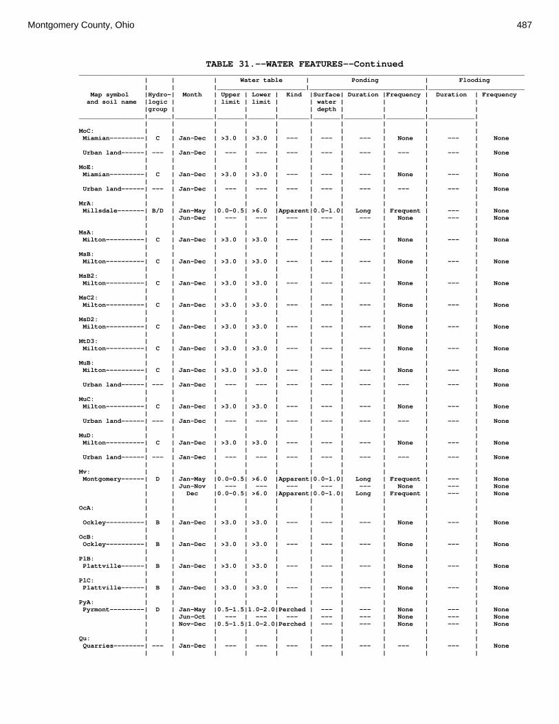
Montgomery County, Ohio 487
TABLE 31.--WATER FEATURES--Continued ____________________________________________________________________________________________________________________ | | | Water table | Ponding | Flooding | | |_______________________|______________________________|_________________________ Map symbol |Hydro-| Month | Upper | Lower | Kind |Surface| Duration |Frequency | Duration | Frequency and soil name |logic | | limit | limit | | water | | | | |group | | | | | depth | | | | _________________|______|__________|_______|_______|________|_______|__________|__________|____________| | | | | | | | | | | MoC: | | | | | | | | | | Miamian---------| C | Jan-Dec | >3.0 | >3.0 | --- | --- | --- | None | --- | None | | | | | | | | | | Urban land------| --- | Jan-Dec | --- | --- | --- | --- | --- | --- | --- | None | | | | | | | | | | MoE: | | | | | | | | | | Miamian---------| C | Jan-Dec | >3.0 | >3.0 | --- | --- | --- | None | --- | None | | | | | | | | | | Urban land------| --- | Jan-Dec | --- | --- | --- | --- | --- | --- | --- | None | | | | | | | | | | MrA: | | | | | | | | | | Millsdale-------| B/D | Jan-May |0.0-0.5| >6.0 |Apparent|0.0-1.0| Long | Frequent | --- | None | | Jun-Dec | --- | --- | --- | --- | --- | None | --- | None | | | | | | | | | | MsA: | | | | | | | | | | Milton----------| C | Jan-Dec | >3.0 | >3.0 | --- | --- | --- | None | --- | None | | | | | | | | | | MsB: | | | | | | | | | | Milton----------| C | Jan-Dec | >3.0 | >3.0 | --- | --- | --- | None | --- | None | | | | | | | | | | MsB2: | | | | | | | | | | Milton----------| C | Jan-Dec | >3.0 | >3.0 | --- | --- | --- | None | --- | None | | | | | | | | | | MsC2: | | | | | | | | | | Milton----------| C | Jan-Dec | >3.0 | >3.0 | --- | --- | --- | None | --- | None | | | | | | | | | | MsD2: | | | | | | | | | | Milton----------| C | Jan-Dec | >3.0 | >3.0 | --- | --- | --- | None | --- | None | | | | | | | | | | MtD3: | | | | | | | | | | Milton----------| C | Jan-Dec | >3.0 | >3.0 | --- | --- | --- | None | --- | None | | | | | | | | | | MuB: | | | | | | | | | | Milton----------| C | Jan-Dec | >3.0 | >3.0 | --- | --- | --- | None | --- | None | | | | | | | | | | Urban land------| --- | Jan-Dec | --- | --- | --- | --- | --- | --- | --- | None | | | | | | | | | | MuC: | | | | | | | | | | Milton----------| C | Jan-Dec | >3.0 | >3.0 | --- | --- | --- | None | --- | None | | | | | | | | | | Urban land------| --- | Jan-Dec | --- | --- | --- | --- | --- | --- | --- | None | | | | | | | | | | MuD: | | | | | | | | | | Milton----------| C | Jan-Dec | >3.0 | >3.0 | --- | --- | --- | None | --- | None | | | | | | | | | | Urban land------| --- | Jan-Dec | --- | --- | --- | --- | --- | --- | --- | None | | | | | | | | | | Mv: | | | | | | | | | | Montgomery------| D | Jan-May |0.0-0.5| >6.0 |Apparent|0.0-1.0| Long | Frequent | --- | None | | Jun-Nov | --- | --- | --- | --- | --- | None | --- | None | | Dec |0.0-0.5| >6.0 |Apparent|0.0-1.0| Long | Frequent | --- | None | | | | | | | | | | OcA: | | | | | | | | | | | | | | | | | | | | Ockley----------| B | Jan-Dec | >3.0 | >3.0 | --- | --- | --- | None | --- | None | | | | | | | | | | OcB: | | | | | | | | | | Ockley----------| B | Jan-Dec | >3.0 | >3.0 | --- | --- | --- | None | --- | None | | | | | | | | | | PlB: | | | | | | | | | | Plattville------| B | Jan-Dec | >3.0 | >3.0 | --- | --- | --- | None | --- | None | | | | | | | | | | PlC: | | | | | | | | | | Plattville------| B | Jan-Dec | >3.0 | >3.0 | --- | --- | --- | None | --- | None | | | | | | | | | | PyA: | | | | | | | | | | Pyrmont---------| D | Jan-May |0.5-1.5|1.0-2.0|Perched | --- | --- | None | --- | None | | Jun-Oct | --- | --- | --- | --- | --- | None | --- | None | | Nov-Dec |0.5-1.5|1.0-2.0|Perched | --- | --- | None | --- | None | | | | | | | | | | Qu: | | | | | | | | | | Quarries--------| --- | Jan-Dec | --- | --- | --- | --- | --- | --- | --- | None | | | | | | | | | |

488 Soil Survey
TABLE 31.--WATER FEATURES--Continued ____________________________________________________________________________________________________________________ | | | Water table | Ponding | Flooding | | |_______________________|______________________________|_________________________ Map symbol |Hydro-| Month | Upper | Lower | Kind |Surface| Duration |Frequency | Duration | Frequency and soil name |logic | | limit | limit | | water | | | | |group | | | | | depth | | | | _________________|______|__________|_______|_______|________|_______|__________|__________|____________| | | | | | | | | | | RcA: | | | | | | | | | | Randolph--------| C | Jan-Apr |0.5-1.5|1.0-2.5|Perched | --- | --- | None | --- | None | | May-Dec | --- | --- | --- | --- | --- | None | --- | None | | | | | | | | | | ReB: | | | | | | | | | | Ritchey---------| D | Jan-Dec | >3.0 | >3.0 | --- | --- | --- | None | --- | None | | | | | | | | | | ReB2: | | | | | | | | | | Ritchey---------| D | Jan-Dec | >3.0 | >3.0 | --- | --- | --- | None | --- | None | | | | | | | | | | ReC2: | | | | | | | | | | Ritchey---------| D | Jan-Dec | >3.0 | >3.0 | --- | --- | --- | None | --- | None | | | | | | | | | | ReE2: | | | | | | | | | | Ritchey---------| D | Jan-Dec | >3.0 | >3.0 | --- | --- | --- | None | --- | None | | | | | | | | | | ReF2: | | | | | | | | | | Ritchey---------| D | Jan-Dec | >3.0 | >3.0 | --- | --- | --- | None | --- | None | | | | | | | | | | RfD3: | | | | | | | | | | Ritchey---------| D | Jan-Dec | >3.0 | >3.0 | --- | --- | --- | None | --- | None | | | | | | | | | | RlE2: | | | | | | | | | | Rodman----------| A | Jan-Dec | >3.0 | >3.0 | --- | --- | --- | None | --- | None | | | | | | | | | | Fox-------------| B | Jan-Dec | >3.0 | >3.0 | --- | --- | --- | None | --- | None | | | | | | | | | | RlF2: | | | | | | | | | | Rodman----------| A | Jan-Dec | >3.0 | >3.0 | --- | --- | --- | None | --- | None | | | | | | | | | | Fox-------------| B | Jan-Dec | >3.0 | >3.0 | --- | --- | --- | None | --- | None | | | | | | | | | | Rs: | | | | | | | | | | Ross------------| B | Jan-Jun | >3.0 | >3.0 | --- | --- | --- | None | Brief | Occasional | | Jul-Oct | >3.0 | >3.0 | --- | --- | --- | None | --- | None | | Nov-Dec | >3.0 | >3.0 | --- | --- | --- | None | Brief | Occasional | | | | | | | | | | Rt: | | | | | | | | | | Urban land------| --- | Jan-Dec | --- | --- | --- | --- | --- | --- | --- | None | | | | | | | | | | Ross------------| B | Jan-Jun | >3.0 | >3.0 | --- | --- | --- | None | Brief | Occasional | | Jul-Oct | >3.0 | >3.0 | --- | --- | --- | None | --- | None | | Nov-Dec | >3.0 | >3.0 | --- | --- | --- | None | Brief | Occasional | | | | | | | | | | RuB: | | | | | | | | | | Russell---------| B | Jan-Dec | >3.0 | >3.0 | --- | --- | --- | None | --- | None | | | | | | | | | | RvC2: | | | | | | | | | | Russell---------| B | Jan-Dec | >3.0 | >3.0 | --- | --- | --- | None | --- | None | | | | | | | | | | Miamian---------| C | Jan-Dec | >3.0 | >3.0 | --- | --- | --- | None | --- | None | | | | | | | | | | RvD2: | | | | | | | | | | Russell---------| B | Jan-Dec | >3.0 | >3.0 | --- | --- | --- | None | --- | None | | | | | | | | | | Miamian---------| C | Jan-Dec | >3.0 | >3.0 | --- | --- | --- | None | --- | None | | | | | | | | | | Sh: | | | | | | | | | | Shoals----------| C | Jan-Apr |0.5-1.5| >6.0 |Apparent| --- | --- | None | Brief | Occasional | | May-Jun | --- | --- | --- | --- | --- | None | Brief | Occasional | | Jul-Sep | --- | --- | --- | --- | --- | None | --- | None | | Oct-Dec | --- | --- | --- | --- | --- | None | Brief | Occasional | | | | | | | | | | So: | | | | | | | | | | Sloan-----------| B/D | Jan-Jun | 0 | >6.0 |Apparent|0.0-1.0| Long | Frequent | Long | Frequent | | Jul-Oct | --- | --- | --- | --- | --- | None | --- | None | | Nov-Dec | 0 | >6.0 |Apparent|0.0-1.0| Long | Frequent | Long | Frequent | | | | | | | | | | ThA: | | | | | | | | | | Thackery--------| B | Jan-Dec |1.5-3.0| >6.0 |Apparent| --- | --- | None | --- | None | | | | | | | | | | TpA: | | | | | | | | | | Tippecanoe------| B | Jan-Apr |1.5-3.0| >6.0 |Apparent| --- | --- | None | --- | None | | May-Nov | --- | --- | --- | --- | --- | None | --- | None | | Dec |1.5-3.0| >6.0 |Apparent| --- | --- | None | --- | None

Montgomery County, Ohio 489
TABLE 31.--WATER FEATURES--Continued ____________________________________________________________________________________________________________________ | | | Water table | Ponding | Flooding | | |_______________________|______________________________|_________________________ Map symbol |Hydro-| Month | Upper | Lower | Kind |Surface| Duration |Frequency | Duration | Frequency and soil name |logic | | limit | limit | | water | | | | |group | | | | | depth | | | | _________________|______|__________|_______|_______|________|_______|__________|__________|____________| | | | | | | | | | | Ua: | | | | | | | | | | Urban land------| --- | Jan-Dec | --- | --- | --- | --- | --- | --- | --- | None | | | | | | | | | | Ud: | | | | | | | | | | Udorthents------| --- | Jan-Dec | --- | --- | --- | --- | --- | --- | --- | None | | | | | | | | | | Ug: | | | | | | | | | | Urban land------| --- | Jan-Dec | --- | --- | --- | --- | --- | --- | --- | None | | | | | | | | | | Um: | | | | | | | | | | Urban land------| --- | Jan-Dec | --- | --- | --- | --- | --- | --- | --- | None | | | | | | | | | | WaA: | | | | | | | | | | Warsaw----------| B | Jan-Dec | >3.0 | >3.0 | --- | --- | --- | None | --- | None | | | | | | | | | | WaB: | | | | | | | | | | Warsaw----------| B | Jan-Dec | >3.0 | >3.0 | --- | --- | --- | None | --- | None | | | | | | | | | | WeA: | | | | | | | | | | Wea-------------| B | Jan-Dec | >3.0 | >3.0 | --- | --- | --- | None | --- | None | | | | | | | | | | WeB: | | | | | | | | | | Wea-------------| B | Jan-Dec | >3.0 | >3.0 | --- | --- | --- | None | --- | None | | | | | | | | | | Ws: | | | | | | | | | | Westland--------| B/D | Jan-May |0.0-0.5| >6.0 |Apparent|0.0-0.5| Long | Frequent | --- | None | | Jun-Nov | --- | --- | --- | --- | --- | None | --- | None | | Dec |0.0-0.5| >6.0 |Apparent|0.0-0.5| Long | Frequent | --- | None | | | | | | | | | | WyB2: | | | | | | | | | | Wynn------------| B | Jan-Dec | >3.0 | >6.0 |Apparent| --- | --- | None | --- | None | | | | | | | | | | XeA: | | | | | | | | | | Xenia-----------| B | Jan-Apr |1.5-3.0| >6.0 |Apparent| --- | --- | None | --- | None | | May-Nov | --- | --- | --- | --- | --- | None | --- | None | | Dec |1.5-3.0| >6.0 |Apparent| --- | --- | None | --- | None | | | | | | | | | | XeB: | | | | | | | | | | Xenia-----------| B | Jan-Apr |1.5-3.0| >6.0 |Apparent| --- | --- | None | --- | None | | May-Nov | --- | --- | --- | --- | --- | None | --- | None | | Dec |1.5-3.0| >6.0 |Apparent| --- | --- | None | --- | None | | | | | | | | | | _________________|______|__________|_______|_______|________|_______|__________|__________|____________|____________

490 Soil Survey
TABLE 32.--SOIL FEATURES (See text on page 181 for definitions of terms used in this table. Absence of an entry indicates that the feature is not a concern or that data were not estimated.) _____________________________________________________________________________________________________________________________________ | Restrictive layer | Subsidence | | Risk of corrosion Map symbol |_____________________________________________________|_______________| Potential |_________________________ and soil name | | Depth | | | | | for | Uncoated | | Kind |to top |Thickness| Hardness |Initial| Total |frost action| steel | Concrete ____________________|_________________|_______|_________|_________________|_______|_______|____________|____________|____________ | | In | In | | In | In | | | Ag: | | | | | | | | | Algiers------------| --- |> 60 | --- | --- | | --- |High--------|High--------|Low. | | | | | | | | | Bo: | | | | | | | | | Borrow pits--------| --- | --- | --- | --- | | --- | --- | --- | --- | | | | | | | | | Bp: | | | | | | | | | Brookston----------| --- |> 60 | --- | --- | | --- |High--------|High--------|Low. | | | | | | | | | Br: | | | | | | | | | Brookston----------| --- |> 72 | --- | --- | | --- |High--------|High--------|Low. | | | | | | | | | Bs: | | | | | | | | | Brookston----------| --- |> 60 | --- | --- | | --- |High--------|High--------|Low. | | | | | | | | | Bu: | | | | | | | | | Brookston----------| --- |> 60 | --- | --- | | --- |High--------|High--------|Low. | | | | | | | | | Urban land---------| --- | --- | --- | --- | | --- | --- | --- | --- | | | | | | | | | Ca: | | | | | | | | | Carlisle-----------| --- |> 90 | --- | --- | 22-27 | 43-54 |High--------|High--------|Low. | | | | | | | | | CeA: | | | | | | | | | Celina-------------| --- |> 60 | --- | --- | | --- |High--------|High--------|Moderate. | | | | | | | | | CeB: | | | | | | | | | Celina-------------| --- |> 60 | --- | --- | | --- |High--------|High--------|Moderate. | | | | | | | | | CeB2: | | | | | | | | | Celina-------------| --- |> 60 | --- | --- | | --- |High--------|High--------|Moderate. | | | | | | | | | ClB: | | | | | | | | | Celina-------------| --- |> 60 | --- | --- | | --- |High--------|High--------|Moderate. | | | | | | | | | CoA: | | | | | | | | | Corwin-------------| --- |> 60 | --- | --- | | --- |Moderate----|High--------|Moderate. | | | | | | | | | CoB: | | | | | | | | | Corwin-------------| --- |> 60 | --- | --- | | --- |Moderate----|High--------|Moderate. | | | | | | | | | CsA: | | | | | | | | | Crosby-------------| --- |> 60 | --- | --- | | --- |High--------|High--------|Moderate. | | | | | | | | | CtB: | | | | | | | | | Crosby-------------| --- |> 60 | --- | --- | | --- |High--------|High--------|Moderate. | | | | | | | | | Celina-------------| --- |> 60 | --- | --- | | --- |High--------|High--------|Moderate. | | | | | | | | | Cu: | | | | | | | | | Crosby-------------| --- |> 60 | --- | --- | | --- |High--------|High--------|Moderate. | | | | | | | | | Urban land---------| --- | --- | --- | --- | | --- | --- | --- | --- | | | | | | | | | DaB: | | | | | | | | | Dana---------------| --- |> 60 | --- | --- | | --- |High--------|High--------|Moderate. | | | | | | | | | FaE2: | | | | | | | | | Fairmount----------|Bedrock (lithic) | 12- 20| --- | --- | | --- |Moderate----|High--------|Low. | | | | | | | | | FaF2: | | | | | | | | | Fairmount----------|Bedrock (lithic) | 12- 20| --- | --- | | --- |Moderate----|High--------|Low. | | | | | | | | | FcA: | | | | | | | | | Fincastle----------| --- |> 60 | --- | --- | | --- |High--------|High--------|Moderate. | | | | | | | | | FkA: | | | | | | | | | Fox----------------|Strongly | 24- 42| --- | --- | | --- |Moderate----|Moderate----|Moderate. | contrasting | | | | | | | | | textural | | | | | | | | | stratification | | | | | | | | | | | | | | | | | FkB: | | | | | | | | | Fox----------------|Strongly | 24- 42| --- | --- | | --- |Moderate----|Moderate----|Moderate. | contrasting | | | | | | | | | textural | | | | | | | | | stratification | | | | | | | | | | | | | | | | | FlA: | | | | | | | | | Fox----------------|Strongly | 24- 42| --- | --- | | --- |Moderate----|Moderate----|Moderate. | contrasting | | | | | | | | | textural | | | | | | | | | stratification | | | | | | | | | | | | | | | | |

Montgomery County, Ohio 491
TABLE 32.--SOIL FEATURES--Continued _____________________________________________________________________________________________________________________________________ | Restrictive layer | Subsidence | | Risk of corrosion Map symbol |_____________________________________________________|_______________| Potential |_________________________ and soil name | | Depth | | | | | for | Uncoated | | Kind |to top |Thickness| Hardness |Initial| Total |frost action| steel | Concrete ____________________|_________________|_______|_________|_________________|_______|_______|____________|____________|____________ | | In | In | | In | In | | | FlB: | | | | | | | | | Fox----------------|Strongly | 24- 42| --- | --- | | --- |Moderate----|Moderate----|Moderate. | contrasting | | | | | | | | | textural | | | | | | | | | stratification | | | | | | | | | | | | | | | | | FlC2: | | | | | | | | | Fox----------------|Strongly | 24- 42| --- | --- | | --- |Moderate----|Moderate----|Moderate. | contrasting | | | | | | | | | textural | | | | | | | | | stratification | | | | | | | | | | | | | | | | | FmA: | | | | | | | | | Fox----------------|Strongly | 24- 42| --- | --- | | --- |Moderate----|Moderate----|Moderate. | contrasting | | | | | | | | | textural | | | | | | | | | stratification | | | | | | | | | | | | | | | | | FmB: | | | | | | | | | Fox----------------|Strongly | 24- 42| --- | --- | | --- |Moderate----|Moderate----|Moderate. | contrasting | | | | | | | | | textural | | | | | | | | | stratification | | | | | | | | | | | | | | | | | FmC2: | | | | | | | | | Fox----------------|Strongly | 24- 42| --- | --- | | --- |Moderate----|Moderate----|Moderate. | contrasting | | | | | | | | | textural | | | | | | | | | stratification | | | | | | | | | | | | | | | | | FmD2: | | | | | | | | | Fox----------------|Strongly | 24- 42| --- | --- | | --- |Moderate----|Moderate----|Moderate. | contrasting | | | | | | | | | textural | | | | | | | | | stratification | | | | | | | | | | | | | | | | | FsC3: | | | | | | | | | Fox----------------|Strongly | 18- 42| --- | --- | | --- |Moderate----|Moderate----|Moderate. | contrasting | | | | | | | | | textural | | | | | | | | | stratification | | | | | | | | | | | | | | | | | FuB: | | | | | | | | | Fox----------------|Strongly | 24- 42| --- | --- | | --- |Moderate----|Moderate----|Moderate. | contrasting | | | | | | | | | textural | | | | | | | | | stratification | | | | | | | | | | | | | | | | | Urban land---------| --- | --- | --- | --- | | --- | --- | --- | --- | | | | | | | | | FuC: | | | | | | | | | Urban land---------| --- | > | --- | --- | | --- | --- | --- | --- | | | | | | | | | Fox----------------|Strongly | 24- 42| --- | --- | | --- |Moderate----|Moderate----|Moderate. | contrasting | | | | | | | | | textural | | | | | | | | | stratification | | | | | | | | | | | | | | | | | FuF: | | | | | | | | | Urban land---------| --- | --- | --- | --- | | --- | --- | --- | --- | | | | | | | | | Fox----------------|Strongly | 18- 42| --- | --- | | --- |Moderate----|Moderate----|Moderate. | contrasting | | | | | | | | | textural | | | | | | | | | stratification | | | | | | | | | | | | | | | | | Gp: | | | | | | | | | Gravel pits--------| --- | --- | --- | --- | | --- | --- | --- | --- | | | | | | | | | HeE2: | | | | | | | | | Hennepin-----------| --- |> 60 | --- | --- | | --- |Moderate----|Moderate----|Low. | | | | | | | | | Miamian------------| --- |> 60 | --- | --- | | --- |Moderate----|High--------|Moderate. | | | | | | | | | HeF2: | | | | | | | | | Hennepin-----------| --- |> 60 | --- | --- | | --- |Moderate----|Moderate----|Low. | | | | | | | | | Miamian------------| --- |> 60 | --- | --- | | --- |Moderate----|High--------|Moderate. | | | | | | | | | HmF3: | | | | | | | | | Hennepin-----------| --- |> 60 | --- | --- | | --- |Moderate----|Moderate----|Low. | | | | | | | | | Miamian------------| --- |> 60 | --- | --- | | --- |Moderate----|High--------|Moderate. | | | | | | | | | KeA: | | | | | | | | | Kendallville-------| --- |> 60 | --- | --- | | --- |Moderate----|Moderate----|Moderate. | | | | | | | | | KeB: | | | | | | | | | Kendallville-------| --- |> 60 | --- | --- | | --- |Moderate----|Moderate----|Moderate.

492 Soil Survey
TABLE 32.--SOIL FEATURES--Continued _____________________________________________________________________________________________________________________________________ | Restrictive layer | Subsidence | | Risk of corrosion Map symbol |_____________________________________________________|_______________| Potential |_________________________ and soil name | | Depth | | | | | for | Uncoated | | Kind |to top |Thickness| Hardness |Initial| Total |frost action| steel | Concrete ____________________|_________________|_______|_________|_________________|_______|_______|____________|____________|____________ | | In | In | | In | In | | | | | | | | | | | | KeC2: | | | | | | | | | Kendallville-------| --- |> 60 | --- | --- | | --- |Moderate----|Moderate----|Moderate. | | | | | | | | | Ld: | | | | | | | | | Landes-------------| --- |> 60 | --- | --- | | --- |Moderate----|Low---------|Low. | | | | | | | | | Lg: | | | | | | | | | Lanier-------------|Strongly | 16- 24| --- | --- | | --- |Moderate----|Low---------|Low. | contrasting | | | | | | | | | textural | | | | | | | | | stratification | | | | | | | | | | | | | | | | | LsB: | | | | | | | | | Lewisburg----------| --- |> 60 | --- | --- | | --- |Moderate----|High--------|Moderate. | | | | | | | | | LxC2: | | | | | | | | | Lorenzo------------|Strongly | 10- 24| --- | --- | | --- |Low---------|Low---------|Low. | contrasting | | | | | | | | | textural | | | | | | | | | stratification | | | | | | | | | | | | | | | | | Rodman-------------|Strongly | 8- 12| --- | --- | | --- |Low---------|Low---------|Low. | contrasting | | | | | | | | | textural | | | | | | | | | stratification | | | | | | | | | | | | | | | | | LxD2: | | | | | | | | | Lorenzo------------|Strongly | 10- 24| --- | --- | | --- |Low---------|Low---------|Low. | contrasting | | | | | | | | | textural | | | | | | | | | stratification | | | | | | | | | | | | | | | | | Rodman-------------|Strongly | 8- 12| --- | --- | | --- |Low---------|Low---------|Low. | contrasting | | | | | | | | | textural | | | | | | | | | stratification | | | | | | | | | | | | | | | | | Mb: | | | | | | | | | Made land----------| --- | --- | --- | --- | | --- | --- | --- | --- | | | | | | | | | Md: | | | | | | | | | Medway-------------| --- |> 60 | --- | --- | | --- |High--------|Moderate----|Low. | | | | | | | | | MlA: | | | | | | | | | Miamian------------| --- |> 60 | --- | --- | | --- |Moderate----|High--------|Moderate. | | | | | | | | | MlB: | | | | | | | | | Miamian------------| --- |> 60 | --- | --- | | --- |Moderate----|High--------|Moderate. | | | | | | | | | MlB2: | | | | | | | | | Miamian------------| --- |> 60 | --- | --- | | --- |Moderate----|High--------|Moderate. | | | | | | | | | MlC2: | | | | | | | | | Miamian------------| --- |> 60 | --- | --- | | --- |Moderate----|High--------|Moderate. | | | | | | | | | MlD2: | | | | | | | | | Miamian------------| --- |> 60 | --- | --- | | --- |Moderate----|High--------|Moderate. | | | | | | | | | MmB: | | | | | | | | | Miamian------------| --- |> 60 | --- | --- | | --- |Moderate----|High--------|Moderate. | | | | | | | | | MnB3: | | | | | | | | | Miamian------------| --- |> 60 | --- | --- | | --- |Moderate----|High--------|Moderate. | | | | | | | | | MnC3: | | | | | | | | | Miamian------------| --- |> 60 | --- | --- | | --- |Moderate----|High--------|Moderate. | | | | | | | | | MnD3: | | | | | | | | | Miamian------------| --- |> 60 | --- | --- | | --- |Moderate----|High--------|Moderate. | | | | | | | | | MoB: | | | | | | | | | Miamian------------| --- |> 60 | --- | --- | | --- |Moderate----|High--------|Moderate. | | | | | | | | | Urban land---------| --- | --- | --- | --- | | --- | --- | --- | --- | | | | | | | | | MoC: | | | | | | | | | Miamian------------| --- |> 60 | --- | --- | | --- |Moderate----|High--------|Moderate. | | | | | | | | | Urban land---------| --- | --- | --- | --- | | --- | --- | --- | --- | | | | | | | | | MoE: | | | | | | | | | Miamian------------| --- |> 60 | --- | --- | | --- |Moderate----|High--------|Moderate. | | | | | | | | | Urban land---------| --- | --- | --- | --- | | --- | --- | --- | --- | | | | | | | | | MrA: | | | | | | | | | Millsdale----------|Bedrock (lithic) | 20- 40| --- | --- | | --- |High--------|High--------|Low. | | | | | | | | |

Montgomery County, Ohio 493
TABLE 32.--SOIL FEATURES--Continued _____________________________________________________________________________________________________________________________________ | Restrictive layer | Subsidence | | Risk of corrosion Map symbol |_____________________________________________________|_______________| Potential |_________________________ and soil name | | Depth | | | | | for | Uncoated | | Kind |to top |Thickness| Hardness |Initial| Total |frost action| steel | Concrete ____________________|_________________|_______|_________|_________________|_______|_______|____________|____________|____________ | | In | In | | In | In | | | MsA: | | | | | | | | | Milton-------------|Bedrock (lithic) | 20- 40| --- | --- | | --- |Moderate----|Moderate----|Moderate. | | | | | | | | | MsB: | | | | | | | | | Milton-------------|Bedrock (lithic) | 20- 40| --- | --- | | --- |Moderate----|Moderate----|Moderate. | | | | | | | | | MsB2: | | | | | | | | | Milton-------------|Bedrock (lithic) | 20- 40| --- | --- | | --- |Moderate----|Moderate----|Moderate. | | | | | | | | | MsC2: | | | | | | | | | Milton-------------|Bedrock (lithic) | 20- 40| --- | --- | | --- |Moderate----|Moderate----|Moderate. | | | | | | | | | MsD2: | | | | | | | | | Milton-------------|Bedrock (lithic) | 20- 40| --- | --- | | --- |Moderate----|Moderate----|Moderate. | | | | | | | | | MtD3: | | | | | | | | | Milton-------------|Bedrock (lithic) | 20- 40| --- | --- | | --- |Moderate----|Moderate----|Moderate. | | | | | | | | | MuB: | | | | | | | | | Milton-------------|Bedrock (lithic) | 20- 40| --- | --- | | --- |Moderate----|Moderate----|Moderate. | | | | | | | | | Urban land---------| --- | --- | --- | --- | | --- | --- | --- | --- | | | | | | | | | MuC: | | | | | | | | | Milton-------------|Bedrock (lithic) | 20- 40| --- | --- | | --- |Moderate----|Moderate----|Moderate. | | | | | | | | | Urban land---------| --- | --- | --- | --- | | --- | --- | --- | --- | | | | | | | | | MuD: | | | | | | | | | Milton-------------|Bedrock (lithic) | 20- 40| --- | --- | | --- |Moderate----|Moderate----|Moderate. | | | | | | | | | Urban land---------| --- | --- | --- | --- | | --- | --- | --- | --- | | | | | | | | | Mv: | | | | | | | | | Montgomery---------| --- |> 60 | --- | --- | | --- |High--------|High--------|Low. | | | | | | | | | OcA: | | | | | | | | | Ockley-------------|Strongly | 40- 60| --- | --- | | --- |Moderate----|Moderate----|Moderate. | contrasting | | | | | | | | | textural | | | | | | | | | stratification | | | | | | | | | | | | | | | | | OcB: | | | | | | | | | Ockley-------------|Strongly | 40- 60| --- | --- | | --- |Moderate----|Moderate----|Moderate. | contrasting | | | | | | | | | textural | | | | | | | | | stratification | | | | | | | | | | | | | | | | | PlB: | | | | | | | | | Plattville---------|Bedrock (lithic) | 20- 40| --- | --- | | --- |Moderate----|Moderate----|Moderate. | | | | | | | | | PlC: | | | | | | | | | Plattville---------|Bedrock (lithic) | 20- 40| --- | --- | | --- |Moderate----|Moderate----|Moderate. | | | | | | | | | PyA: | | | | | | | | | Pyrmont------------| --- |> 60 | --- | --- | | --- |High--------|High--------|Low. | | | | | | | | | Qu: | | | | | | | | | Quarries-----------| --- | --- | --- | --- | | --- | --- | --- | --- | | | | | | | | | RcA: | | | | | | | | | Randolph-----------|Bedrock (lithic) | 20- 40| --- | --- | | --- |High--------|High--------|Moderate. | | | | | | | | | ReB: | | | | | | | | | Ritchey------------|Bedrock (lithic) | 10- 20| --- | --- | | --- |Moderate----|Moderate----|Moderate. | | | | | | | | | ReB2: | | | | | | | | | Ritchey------------|Bedrock (lithic) | 10- 20| --- | --- | | --- |Moderate----|Moderate----|Moderate. | | | | | | | | | ReC2: | | | | | | | | | Ritchey------------|Bedrock (lithic) | 10- 20| --- | --- | | --- |Moderate----|Moderate----|Moderate. | | | | | | | | | ReE2: | | | | | | | | | Ritchey------------|Bedrock (lithic) | 10- 20| --- | --- | | --- |Moderate----|Moderate----|Moderate. | | | | | | | | | ReF2: | | | | | | | | | Ritchey------------|Bedrock (lithic) | 10- 20| --- | --- | | --- |Moderate----|Moderate----|Moderate. | | | | | | | | | RfD3: | | | | | | | | | Ritchey------------|Bedrock (lithic) | 9- 20| --- | --- | | --- |Moderate----|Moderate----|Moderate. | | | | | | | | | Rh: | | | | | | | | | Riverwash----------| --- | --- | --- | --- | | --- | --- | --- | --- | | | | | | | | |

494 Soil Survey
TABLE 32.--SOIL FEATURES--Continued _____________________________________________________________________________________________________________________________________ | Restrictive layer | Subsidence | | Risk of corrosion Map symbol |_____________________________________________________|_______________| Potential |_________________________ and soil name | | Depth | | | | | for | Uncoated | | Kind |to top |Thickness| Hardness |Initial| Total |frost action| steel | Concrete ____________________|_________________|_______|_________|_________________|_______|_______|____________|____________|____________ | | In | In | | In | In | | | RlE2: | | | | | | | | | Rodman-------------|Strongly | 8- 12| --- | --- | | --- |Low---------|Low---------|Low. | contrasting | | | | | | | | | textural | | | | | | | | | stratification | | | | | | | | | | | | | | | | | Fox----------------|Strongly | 24- 42| --- | --- | | --- |Moderate----|Moderate----|Moderate. | contrasting | | | | | | | | | textural | | | | | | | | | stratification | | | | | | | | | | | | | | | | | RlF2: | | | | | | | | | Rodman-------------|Strongly | 9- 20| --- | --- | | --- |Low---------|Low---------|Low. | contrasting | | | | | | | | | textural | | | | | | | | | stratification | | | | | | | | | | | | | | | | | Fox----------------|Strongly | 24- 42| --- | --- | | --- |Moderate----|Moderate----|Moderate. | contrasting | | | | | | | | | textural | | | | | | | | | stratification | | | | | | | | | | | | | | | | | Rs: | | | | | | | | | Ross---------------| --- |> 60 | --- | --- | | --- |Moderate----|Moderate----|Low. | | | | | | | | | Rt: | | | | | | | | | Urban land---------| --- | --- | --- | --- | | --- | --- | --- | --- | | | | | | | | | Ross---------------| --- |> 60 | --- | --- | | --- |Moderate----|Moderate----|Low. | | | | | | | | | RuB: | | | | | | | | | Russell------------| --- |> 60 | --- | --- | | --- |High--------|Moderate----|Moderate. | | | | | | | | | RvC2: | | | | | | | | | Russell------------| --- |> 60 | --- | --- | | --- |High--------|Moderate----|Moderate. | | | | | | | | | Miamian------------| --- |> 60 | --- | --- | | --- |Moderate----|High--------|Moderate. | | | | | | | | | RvD2: | | | | | | | | | Russell------------| --- |> 60 | --- | --- | | --- |High--------|Moderate----|Moderate. | | | | | | | | | Miamian------------| --- |> 60 | --- | --- | | --- |Moderate----|High--------|Moderate. | | | | | | | | | Sh: | | | | | | | | | Shoals-------------| --- |> 60 | --- | --- | | --- |High--------|High--------|Low. | | | | | | | | | So: | | | | | | | | | Sloan--------------| --- |> 60 | --- | --- | | --- |High--------|High--------|Low. | | | | | | | | | ThA: | | | | | | | | | Thackery-----------| --- |> 60 | --- | --- | | --- |Moderate----|Moderate----|Moderate. | | | | | | | | | TpA: | | | | | | | | | Tippecanoe---------| --- |> 60 | --- | --- | | --- |Moderate----|High--------|Moderate. | | | | | | | | | Ua: | | | | | | | | | Urban land---------| --- | --- | --- | --- | | --- | --- | --- | --- | | | | | | | | | Ud: | | | | | | | | | Udorthents---------| --- | --- | --- | --- | | --- | --- | --- | --- | | | | | | | | | Ug: | | | | | | | | | Urban land---------| --- | --- | --- | --- | | --- | --- | --- | --- | | | | | | | | | Um: | | | | | | | | | Urban land---------| --- | --- | --- | --- | | --- | --- | --- | --- | | | | | | | | | WaA: | | | | | | | | | Warsaw-------------|Strongly | 24- 42| --- | --- | | --- |Moderate----|Moderate----|Moderate. | contrasting | | | | | | | | | textural | | | | | | | | | stratification | | | | | | | | | | | | | | | | | WaB: | | | | | | | | | Warsaw-------------|Strongly | 24- 42| --- | --- | | --- |Moderate----|Moderate----|Moderate. | contrasting | | | | | | | | | textural | | | | | | | | | stratification | | | | | | | | | | | | | | | | | WeA: | | | | | | | | | Wea----------------|Strongly | 42- 60| --- | --- | | --- |Moderate----|Moderate----|Moderate. | contrasting | | | | | | | | | textural | | | | | | | | | stratification | | | | | | | | | | | | | | | | |

Montgomery County, Ohio 495
TABLE 32.--SOIL FEATURES--Continued _____________________________________________________________________________________________________________________________________ | Restrictive layer | Subsidence | | Risk of corrosion Map symbol |_____________________________________________________|_______________| Potential |_________________________ and soil name | | Depth | | | | | for | Uncoated | | Kind |to top |Thickness| Hardness |Initial| Total |frost action| steel | Concrete ____________________|_________________|_______|_________|_________________|_______|_______|____________|____________|____________ | | In | In | | In | In | | | WeB: | | | | | | | | | Wea----------------|Strongly | 42- 60| --- | --- | | --- |Moderate----|Moderate----|Moderate. | contrasting | | | | | | | | | textural | | | | | | | | | stratification | | | | | | | | | | | | | | | | | Ws: | | | | | | | | | Westland-----------|Strongly | 42- 72| --- | --- | | --- |High--------|High--------|Low. | contrasting | | | | | | | | | textural | | | | | | | | | stratification | | | | | | | | | | | | | | | | | WyB2: | | | | | | | | | Wynn---------------|Bedrock (lithic) | 24- 40| --- | --- | | --- |Moderate----|Moderate----|Moderate. | | | | | | | | | XeA: | | | | | | | | | Xenia--------------| --- |> 78 | --- | --- | | --- |High--------|High--------|Moderate. | | | | | | | | | XeB: | | | | | | | | | Xenia--------------| --- |> 78 | --- | --- | | --- |High--------|High--------|Moderate. | | | | | | | | | ____________________|_________________|_______|_________|_________________|_______|_______|____________|____________|____________

496 Soil Survey
TABLE 33.--CLASSIFICATION OF THE SOILS (An asterisk in the first column indicates a taxadjunct to the series. See text on page 182 for a description of those characteristics that are outside the range of the series.) ____________________________________________________________________________________________________ | Soil name | Family or higher taxonomic class __________________________|_________________________________________________________________________ | Algiers------------------|Fine-loamy, mixed, nonacid, mesic Aquic Udifluvents *Brookston----------------|Fine-loamy, mixed, noncalcareous, mesic Typic Argiaquolls Carlisle-----------------|Euic, mesic Typic Medisaprists Celina-------------------|Fine, mixed, mesic Aquic Hapludalfs Corwin-------------------|Fine-loamy, mixed, mesic Typic Argiudolls Crosby-------------------|Fine, mixed, mesic Aeric Ochraqualfs Dana---------------------|Fine-silty, mixed, mesic Typic Argiudolls Fairmount----------------|Clayey, mixed, mesic, shallow Typic Hapludolls Fincastle----------------|Fine-silty, mixed, mesic Aeric Ochraqualfs Fox----------------------|Fine-loamy over sandy or sandy-skeletal, mixed, mesic Typic Hapludalfs Hennepin-----------------|Fine-loamy, mixed, mesic Typic Eutrochrepts Kendallville-------------|Fine-loamy, mixed, mesic Typic Hapludalfs Landes-------------------|Coarse-loamy, mixed, mesic Fluventic Hapludolls Lanier-------------------|Loamy-skeletal, mixed, mesic Fluventic Hapludolls Lewisburg----------------|Fine, illitic, mesic Typic Hapludalfs Lorenzo------------------|Fine-loamy over sandy or sandy-skeletal, mixed, mesic Typic Argiudolls Medway-------------------|Fine-loamy, mixed, mesic Fluvaquentic Hapludolls Miamian------------------|Fine, mixed, mesic Typic Hapludalfs Millsdale----------------|Fine, mixed, noncalcareous, mesic Typic Argiaquolls Milton-------------------|Fine, mixed, mesic Typic Hapludalfs *Montgomery---------------|Fine, mixed, noncalcareous, mesic Typic Haplaquolls Ockley-------------------|Fine-loamy, mixed, mesic Typic Hapludalfs *Plattville---------------|Fine-loamy, mixed, mesic Aquic Argiudolls Pyrmont------------------|Fine, illitic, mesic Aeric Ochraqualfs Randolph-----------------|Fine, illitic, mesic Aeric Ochraqualfs *Ritchey------------------|Loamy, mixed, mesic Lithic Hapludalfs *Rodman-------------------|Sandy-skeletal, mixed, mesic Typic Hapludolls *Ross---------------------|Fine-loamy, mixed, mesic Cumulic Hapludolls Russell------------------|Fine-silty, mixed, mesic Typic Hapludalfs Shoals-------------------|Fine-loamy, mixed, nonacid, mesic Aeric Fluvaquents Sloan--------------------|Fine-loamy, mixed, noncalcareous, mesic Fluvaquentic Haplaquolls *Thackery-----------------|Fine-loamy, mixed, mesic Aquic Hapludalfs Tippecanoe---------------|Fine-loamy, mixed, mesic Typic Argiudolls Warsaw-------------------|Fine-loamy over sandy or sandy-skeletal, mixed, mesic Typic Argiudolls Wea----------------------|Fine-loamy, mixed, mesic Typic Argiudolls Westland-----------------|Fine-loamy, mixed, noncalcareous, mesic Typic Argiaquolls Wynn---------------------|Fine-loamy, mixed, mesic Typic Hapludalfs Xenia--------------------|Fine-silty, mixed, mesic Aquic Hapludalfs __________________________|_________________________________________________________________________
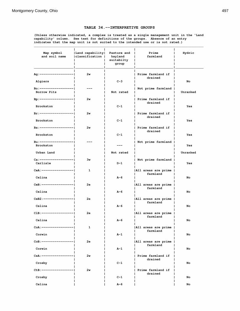
Montgomery County, Ohio 497
TABLE 34.--INTERPRETIVE GROUPS (Unless otherwise indicated, a complex is treated as a single management unit in the 'Land capability' column. See text for definitions of the groups. Absence of an entry indicates that the map unit is not suited to the intended use or is not rated.) __________________________________________________________________________________________ | | | | Map symbol |Land capability| Pasture and | Prime | Hydric and soil name |classification | hayland | farmland | | | suitabilty | | | | group | | _____________________|_______________|_______________|____________________|_______________ | | | | Ag:------------------| 2w | | Prime farmland if | | | | drained | Algiers | | C-3 | | No | | | | Bo:------------------| --- | | Not prime farmland | Borrow Pits | | Not rated | | Unranked | | | | Bp:------------------| 2w | | Prime farmland if | | | | drained | Brookston | | C-1 | | Yes | | | | Br:------------------| 2w | | Prime farmland if | | | | drained | Brookston | | C-1 | | Yes | | | | Bs:------------------| 2w | | Prime farmland if | | | | drained | Brookston | | C-1 | | Yes | | | | Bu:------------------| --- | | Not prime farmland | Brookston | | --- | | Yes | | | | Urban Land | | Not rated | | Unranked | | | | Ca:------------------| 3w | | Not prime farmland | Carlisle | | D-1 | | Yes | | | | CeA:-----------------| 1 | |All areas are prime | | | | farmland | Celina | | A-6 | | No | | | | CeB:-----------------| 2e | |All areas are prime | | | | farmland | Celina | | A-6 | | No | | | | CeB2:----------------| 2e | |All areas are prime | | | | farmland | Celina | | A-6 | | No | | | | ClB:-----------------| 2e | |All areas are prime | | | | farmland | Celina | | A-6 | | No | | | | CoA:-----------------| 1 | |All areas are prime | | | | farmland | Corwin | | A-1 | | No | | | | CoB:-----------------| 2e | |All areas are prime | | | | farmland | Corwin | | A-1 | | No | | | | CsA:-----------------| 2w | | Prime farmland if | | | | drained | Crosby | | C-1 | | No | | | | CtB:-----------------| 2w | | Prime farmland if | | | | drained | Crosby | | C-1 | | No | | | | Celina | | A-6 | | No
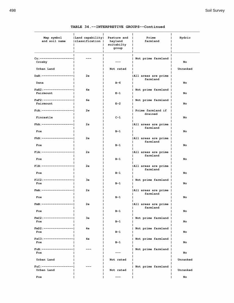
498 Soil Survey
TABLE 34.--INTERPRETIVE GROUPS--Continued __________________________________________________________________________________________ | | | | Map symbol |Land capability| Pasture and | Prime | Hydric and soil name |classification | hayland | farmland | | | suitabilty | | | | group | | _____________________|_______________|_______________|____________________|_______________ | | | | Cu:------------------| --- | | Not prime farmland | Crosby | | --- | | No | | | | Urban Land | | Not rated | | Unranked | | | | DaB:-----------------| 2e | |All areas are prime | | | | farmland | Dana | | A-6 | | No | | | | FaE2:----------------| 6e | | Not prime farmland | Fairmount | | E-1 | | No | | | | FaF2:----------------| 6e | | Not prime farmland | Fairmount | | E-2 | | No | | | | FcA:-----------------| 2w | | Prime farmland if | | | | drained | Fincastle | | C-1 | | No | | | | FkA:-----------------| 2s | |All areas are prime | | | | farmland | Fox | | B-1 | | No | | | | FkB:-----------------| 2e | |All areas are prime | | | | farmland | Fox | | B-1 | | No | | | | FlA:-----------------| 2s | |All areas are prime | | | | farmland | Fox | | B-1 | | No | | | | FlB:-----------------| 2e | |All areas are prime | | | | farmland | Fox | | B-1 | | No | | | | FlC2:----------------| 3e | | Not prime farmland | Fox | | B-1 | | No | | | | FmA:-----------------| 2s | |All areas are prime | | | | farmland | Fox | | B-1 | | No | | | | FmB:-----------------| 2e | |All areas are prime | | | | farmland | Fox | | B-1 | | No | | | | FmC2:----------------| 3e | | Not prime farmland | Fox | | B-1 | | No | | | | FmD2:----------------| 4e | | Not prime farmland | Fox | | B-1 | | No | | | | FsC3:----------------| 4e | | Not prime farmland | Fox | | B-1 | | No | | | | FuB:-----------------| --- | | Not prime farmland | Fox | | --- | | No | | | | Urban Land | | Not rated | | Unranked | | | | FuC:-----------------| --- | | Not prime farmland | Urban Land | | Not rated | | Unranked | | | | Fox | | --- | | No
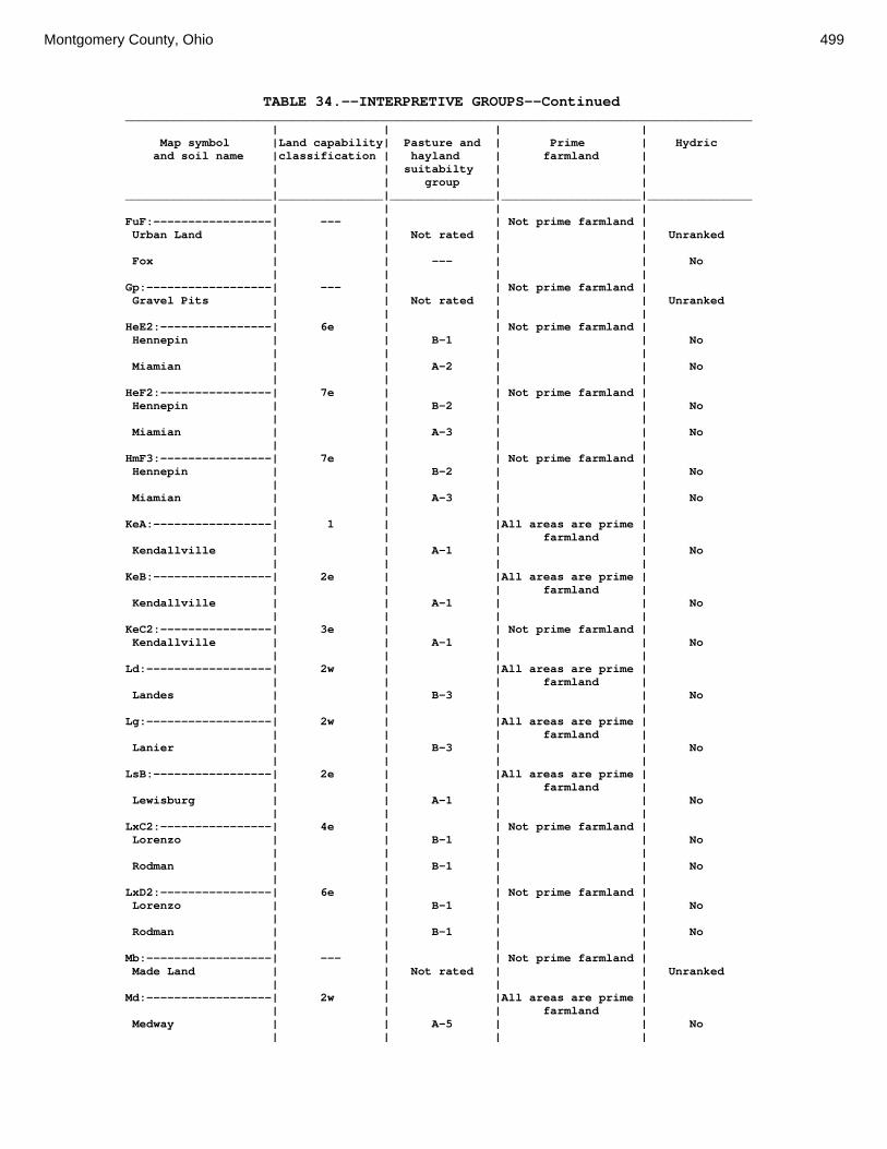
Montgomery County, Ohio 499
TABLE 34.--INTERPRETIVE GROUPS--Continued __________________________________________________________________________________________ | | | | Map symbol |Land capability| Pasture and | Prime | Hydric and soil name |classification | hayland | farmland | | | suitabilty | | | | group | | _____________________|_______________|_______________|____________________|_______________ | | | | FuF:-----------------| --- | | Not prime farmland | Urban Land | | Not rated | | Unranked | | | | Fox | | --- | | No | | | | Gp:------------------| --- | | Not prime farmland | Gravel Pits | | Not rated | | Unranked | | | | HeE2:----------------| 6e | | Not prime farmland | Hennepin | | B-1 | | No | | | | Miamian | | A-2 | | No | | | | HeF2:----------------| 7e | | Not prime farmland | Hennepin | | B-2 | | No | | | | Miamian | | A-3 | | No | | | | HmF3:----------------| 7e | | Not prime farmland | Hennepin | | B-2 | | No | | | | Miamian | | A-3 | | No | | | | KeA:-----------------| 1 | |All areas are prime | | | | farmland | Kendallville | | A-1 | | No | | | | KeB:-----------------| 2e | |All areas are prime | | | | farmland | Kendallville | | A-1 | | No | | | | KeC2:----------------| 3e | | Not prime farmland | Kendallville | | A-1 | | No | | | | Ld:------------------| 2w | |All areas are prime | | | | farmland | Landes | | B-3 | | No | | | | Lg:------------------| 2w | |All areas are prime | | | | farmland | Lanier | | B-3 | | No | | | | LsB:-----------------| 2e | |All areas are prime | | | | farmland | Lewisburg | | A-1 | | No | | | | LxC2:----------------| 4e | | Not prime farmland | Lorenzo | | B-1 | | No | | | | Rodman | | B-1 | | No | | | | LxD2:----------------| 6e | | Not prime farmland | Lorenzo | | B-1 | | No | | | | Rodman | | B-1 | | No | | | | Mb:------------------| --- | | Not prime farmland | Made Land | | Not rated | | Unranked | | | | Md:------------------| 2w | |All areas are prime | | | | farmland | Medway | | A-5 | | No | | | |

500 Soil Survey
TABLE 34.--INTERPRETIVE GROUPS--Continued __________________________________________________________________________________________ | | | | Map symbol |Land capability| Pasture and | Prime | Hydric and soil name |classification | hayland | farmland | | | suitabilty | | | | group | | _____________________|_______________|_______________|____________________|_______________ | | | | MlA:-----------------| 1 | |All areas are prime | | | | farmland | Miamian | | A-1 | | No | | | | MlB:-----------------| 2e | |All areas are prime | | | | farmland | Miamian | | A-1 | | No | | | | MlB2:----------------| 2e | |All areas are prime | | | | farmland | Miamian | | A-1 | | No | | | | MlC2:----------------| 3e | | Not prime farmland | Miamian | | A-1 | | No | | | | MlD2:----------------| 4e | | Not prime farmland | Miamian | | A-1 | | No | | | | MmB:-----------------| 2e | | Not prime farmland | Miamian | | A-1 | | No | | | | MnB3:----------------| 3e | | Not prime farmland | Miamian | | A-1 | | No | | | | MnC3:----------------| 4e | | Not prime farmland | Miamian | | A-1 | | No | | | | MnD3:----------------| 6e | | Not prime farmland | Miamian | | A-1 | | No | | | | MoB:-----------------| --- | | Not prime farmland | Miamian | | --- | | No | | | | Urban Land | | Not rated | | Unranked | | | | MoC:-----------------| --- | | Not prime farmland | Miamian | | --- | | No | | | | Urban Land | | Not rated | | Unranked | | | | MoE:-----------------| --- | | Not prime farmland | Miamian | | --- | | No | | | | Urban Land | | Not rated | | Unranked | | | | MrA:-----------------| 3w | | Prime farmland if | | | | drained | Millsdale | | C-2 | | Yes | | | | MsA:-----------------| 2s | |All areas are prime | | | | farmland | Milton | | F-1 | | No | | | | MsB:-----------------| 2e | |All areas are prime | | | | farmland | Milton | | F-1 | | No | | | | MsB2:----------------| 2e | |All areas are prime | | | | farmland | Milton | | F-1 | | No | | | | MsC2:----------------| 3e | | Not prime farmland | Milton | | F-1 | | No | | | |
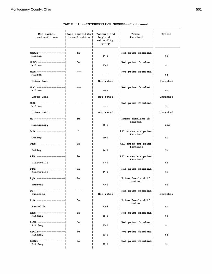
Montgomery County, Ohio 501
TABLE 34.--INTERPRETIVE GROUPS--Continued __________________________________________________________________________________________ | | | | Map symbol |Land capability| Pasture and | Prime | Hydric and soil name |classification | hayland | farmland | | | suitabilty | | | | group | | _____________________|_______________|_______________|____________________|_______________ | | | | MsD2:----------------| 4e | | Not prime farmland | Milton | | F-1 | | No | | | | MtD3:----------------| 6e | | Not prime farmland | Milton | | F-1 | | No | | | | MuB:-----------------| --- | | Not prime farmland | Milton | | --- | | No | | | | Urban Land | | Not rated | | Unranked | | | | MuC:-----------------| --- | | Not prime farmland | Milton | | --- | | No | | | | Urban Land | | Not rated | | Unranked | | | | MuD:-----------------| --- | | Not prime farmland | Milton | | --- | | No | | | | Urban Land | | Not rated | | Unranked | | | | Mv:------------------| 3w | | Prime farmland if | | | | drained | Montgomery | | C-2 | | Yes | | | | OcA:-----------------| 1 | |All areas are prime | | | | farmland | Ockley | | A-1 | | No | | | | OcB:-----------------| 2e | |All areas are prime | | | | farmland | Ockley | | A-1 | | No | | | | PlB:-----------------| 2e | |All areas are prime | | | | farmland | Plattville | | F-1 | | No | | | | PlC:-----------------| 3e | | Not prime farmland | Plattville | | F-1 | | No | | | | PyA:-----------------| 2w | | Prime farmland if | | | | drained | Pyrmont | | C-1 | | No | | | | Qu:------------------| --- | | Not prime farmland | Quarries | | Not rated | | Unranked | | | | RcA:-----------------| 3w | | Prime farmland if | | | | drained | Randolph | | C-2 | | No | | | | ReB:-----------------| 3e | | Not prime farmland | Ritchey | | E-1 | | No | | | | ReB2:----------------| 3e | | Not prime farmland | Ritchey | | E-1 | | No | | | | ReC2:----------------| 4e | | Not prime farmland | Ritchey | | E-1 | | No | | | | ReE2:----------------| 6e | | Not prime farmland | Ritchey | | E-1 | | No | | | |

502 Soil Survey
TABLE 34.--INTERPRETIVE GROUPS--Continued __________________________________________________________________________________________ | | | | Map symbol |Land capability| Pasture and | Prime | Hydric and soil name |classification | hayland | farmland | | | suitabilty | | | | group | | _____________________|_______________|_______________|____________________|_______________ | | | | ReF2:----------------| 6e | | Not prime farmland | Ritchey | | E-2 | | No | | | | RfD3:----------------| 4e | | Not prime farmland | Ritchey | | E-1 | | No | | | | Rh:------------------| --- | | Not prime farmland | Riverwash | | Not rated | | Unranked | | | | RlE2:----------------| 7s | | Not prime farmland | Rodman | | B-1 | | No | | | | Fox | | B-1 | | No | | | | RlF2:----------------| 7s | | Not prime farmland | Rodman | | B-2 | | No | | | | Fox | | B-2 | | No | | | | Rs:------------------| 2w | |All areas are prime | | | | farmland | Ross | | A-5 | | No | | | | Rt:------------------| --- | | Not prime farmland | Urban Land | | Not rated | | Unranked | | | | Ross | | --- | | No | | | | RuB:-----------------| 2e | |All areas are prime | | | | farmland | Russell | | A-6 | | No | | | | RvC2:----------------| 3e | | Not prime farmland | Russell | | A-6 | | No | | | | Miamian | | A-1 | | No | | | | RvD2:----------------| 4e | | Not prime farmland | Russell | | A-6 | | No | | | | Miamian | | A-1 | | No | | | | Sh:------------------| 2w | | Prime farmland if | | | | drained | Shoals | | C-3 | | No | | | | So:------------------| 3w | | Not prime farmland | Sloan | | C-3 | | Yes | | | | ThA:-----------------| 1 | |All areas are prime | | | | farmland | Thackery | | A-1 | | No | | | | TpA:-----------------| 1 | |All areas are prime | | | | farmland | Tippecanoe | | A-1 | | No | | | | Ua:------------------| --- | | Not prime farmland | Urban Land | | Not rated | | Unranked | | | | Ud:------------------| --- | | Not prime farmland | Udorthents | | Not rated | | Unranked | | | |
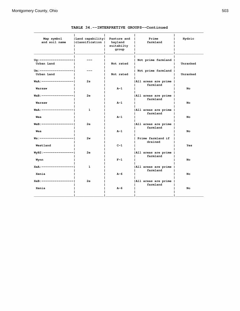
Montgomery County, Ohio 503
TABLE 34.--INTERPRETIVE GROUPS--Continued __________________________________________________________________________________________ | | | | Map symbol |Land capability| Pasture and | Prime | Hydric and soil name |classification | hayland | farmland | | | suitabilty | | | | group | | _____________________|_______________|_______________|____________________|_______________ | | | | Ug:------------------| --- | | Not prime farmland | Urban Land | | Not rated | | Unranked | | | | Um:------------------| --- | | Not prime farmland | Urban Land | | Not rated | | Unranked | | | | WaA:-----------------| 2s | |All areas are prime | | | | farmland | Warsaw | | A-1 | | No | | | | WaB:-----------------| 2e | |All areas are prime | | | | farmland | Warsaw | | A-1 | | No | | | | WeA:-----------------| 1 | |All areas are prime | | | | farmland | Wea | | A-1 | | No | | | | WeB:-----------------| 2e | |All areas are prime | | | | farmland | Wea | | A-1 | | No | | | | Ws:------------------| 2w | | Prime farmland if | | | | drained | Westland | | C-1 | | Yes | | | | WyB2:----------------| 2e | |All areas are prime | | | | farmland | Wynn | | F-1 | | No | | | | XeA:-----------------| 1 | |All areas are prime | | | | farmland | Xenia | | A-6 | | No | | | | XeB:-----------------| 2e | |All areas are prime | | | | farmland | Xenia | | A-6 | | No | | | | _____________________|_______________|_______________|____________________|_______________