sodankylä national satellite data centre › sites › default › files... · national sentinel...
TRANSCRIPT
Sodankylä National
Satellite Data Centre
Jyri Heilimo
Head of Satellite based services R&D

Sodankylä National Satellite Data Centre
National satellite data center providing satellite data reception and data processing services to Finnish and international
partners
2 29.10.2014 Sodankylä National Satellite Data Centre
Sodankylä National Satellite Data Centre 3
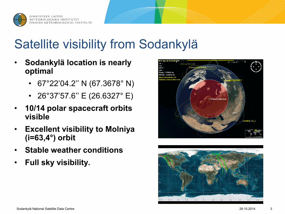
Satellite visibility from Sodankylä
• Sodankylä location is nearly optimal
• 67°22’04.2’’ N (67.3678° N)
• 26°37’57.6’’ E (26.6327° E)
• 10/14 polar spacecraft orbits visible
• Excellent visibility to Molniya (i=63,4°) orbit
• Stable weather conditions
• Full sky visibility.
29.10.2014

Satellite data availability from FMI Arctic Research
Current operational (free access)
• EOS-Terra/MODIS
• EOS-Aura/ OMI
• Suomi-NPP/VIIRS & OMPS
Current operational (commercial)
• COSMO-SkyMed (SAR)
Future
• FY-3C & FY-3B / MERSI
• Sentinel-1 Collaborative GS: NRT delivery from local reception
• Sentinel-1/2/3 Collaborative GS : National Mirror Site
4 29.10.2014 Sodankylä National Satellite Data Centre
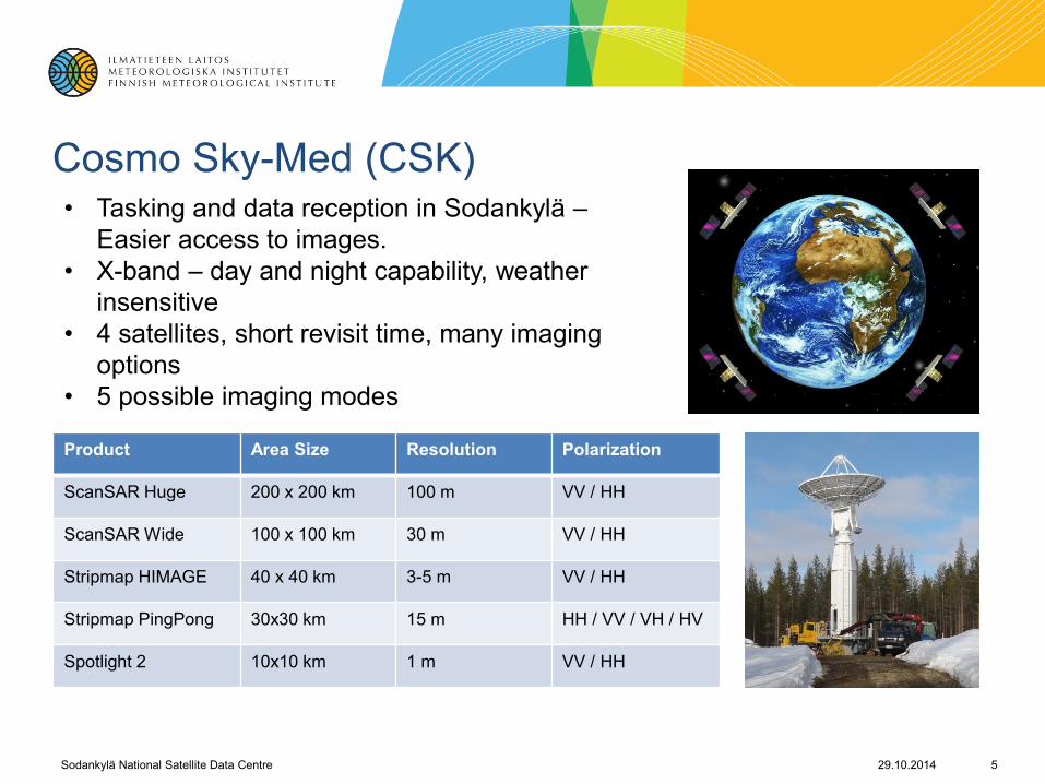
Cosmo Sky-Med (CSK)
Product Area Size Resolution Polarization
ScanSAR Huge 200 x 200 km 100 m VV / HH
ScanSAR Wide 100 x 100 km 30 m VV / HH
Stripmap HIMAGE 40 x 40 km 3-5 m VV / HH
Stripmap PingPong 30x30 km 15 m HH / VV / VH / HV
Spotlight 2 10x10 km 1 m VV / HH
• Tasking and data reception in Sodankylä –
Easier access to images.
• X-band – day and night capability, weather
insensitive
• 4 satellites, short revisit time, many imaging
options
• 5 possible imaging modes
29.10.2014 Sodankylä National Satellite Data Centre 5

Processing Lines
• Streamlined processing chains for data production
• Virtualization provides flexibility and scalability
• Cluster processing system (32 cores) for high performance computing
• Current archiving capacity >300TB
• Possibility to host both
• External servers
• Processing in virtual environment
Sodankylä National Satellite Data Centre 6 29.10.2014

Copernicus Ground Segment
Finnish Collaborative
Ground Segment
29.10.2014 Sodankylä National Satellite Data Centre 7
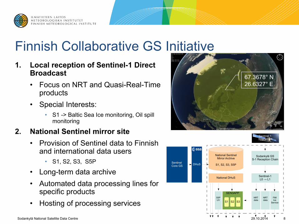
Finnish Collaborative GS Initiative
1. Local reception of Sentinel-1 Direct Broadcast
• Focus on NRT and Quasi-Real-Time products
• Special Interests:
• S1 -> Baltic Sea Ice monitoring, Oil spill monitoring
2. National Sentinel mirror site
• Provision of Sentinel data to Finnish and international data users
• S1, S2, S3, S5P
• Long-term data archive
• Automated data processing lines for specific products
• Hosting of processing services
8
National SentinelMirror Archive
S1, S2, S3, S5P
National DHuS
SEN3APP
FMIIce
Service
Sentinel-1L0 → L1
DHuS
NRTdata
Sentinel Core GS
Sentinel 1Spacecraft
Sodankylä GSS-1 Reception Chain
S1 S2 S3
NRTdata
S5PUV
67.3678° N
26.6327° E
29.10.2014 Sodankylä National Satellite Data Centre

Development activities on-going • SPARK
• Collaborative Acquisition Station (CAS): Sentinel-1 local reception, Quasi-real time products from S-1
• Services to various fields: Arctic ocean, aviation, energy sector, etc
• ENVIBASE
• Collaborative Archiving and Dissemination Centre (CAC)
• Fast access to limited area data:
• Long-term archiving
• Data dissemination to customers
• Calvalus distributed processing system
• SEN3APP
• EU funded project
• Processing lines for cryospheric products, land cover/fenology applications
• CryoBal-Thematic Exploitation Platform
• Infrastructure development for processing services close to data; IaaS, PaaS
• Data available for international partners also: Finland, Sweden, Estonia, Latvia, etc. have common interests
29.10.2014 Sodankylä National Satellite Data Centre 9
Data products from
Sodankylä NSDC
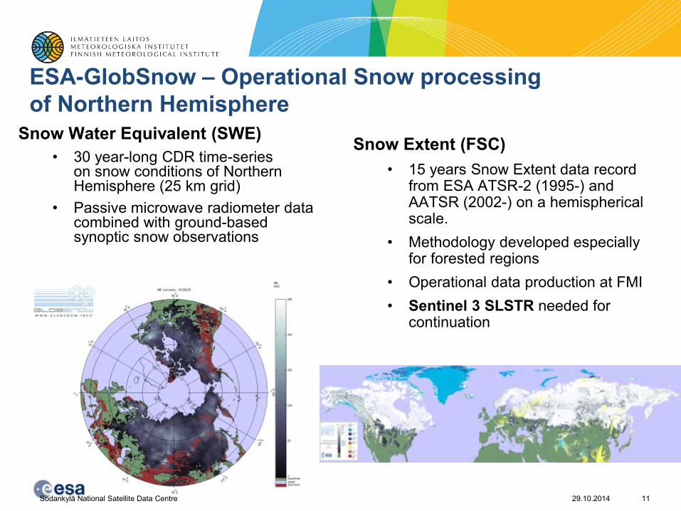
ESA-GlobSnow – Operational Snow processing
of Northern Hemisphere
Snow Water Equivalent (SWE)
• 30 year-long CDR time-series on snow conditions of Northern Hemisphere (25 km grid)
• Passive microwave radiometer data combined with ground-based synoptic snow observations
Snow Extent (FSC)
• 15 years Snow Extent data record from ESA ATSR-2 (1995-) and AATSR (2002-) on a hemispherical scale.
• Methodology developed especially for forested regions
• Operational data production at FMI
• Sentinel 3 SLSTR needed for continuation
11 29.10.2014 Sodankylä National Satellite Data Centre

Baltic Sea Ice Charting and Oil spill monitoring
• Commercial and environmental needs
• Finland is essentially an island
• ~90% of Finland’s import and export via sea routes
• Gulf of Finland is one of the most busiest marine routes for oil transport
• SAR for sea ice charting
• Currently RSAT2 and CSK images used. S1 welcomed addition in 2015
• Daily products for ice breakers and ships
• SAR for oil spill monitoring COSMO-SkyMed Product © ASI 2012- Distributed by e-GEOS.
All Rights Reserved
12 29.10.2014 Sodankylä National Satellite Data Centre

SAR Flood Detection
• Open areas – SAR backscatter from water areas lower due to specular reflection on the water surface.
• Forests – SAR backscatter from flooded forests higher due to water-trunk reflection.
• Sparse/low-tree forests – Expansion of detected flood areas using other spatial data such as:
• high resolution DEM
• Forest data (tree height and canopy closure based on LiDAR)
• Land cover information
Blue: Floods in open areas
Green: Floods in forests
Orange: Floods in sparse/low-tree forests
29.10.2014 Sodankylä National Satellite Data Centre 13

14
Atmospheric data products
29.10.2014 Sodankylä National Satellite Data Centre
• Near real-time provision of
• Atmospheric ozone and UV-radiation products from OMI and OMPS
• Volcanic ash products (SO2)
• Clouds and aerosols
• Data available within minutes in internet
• sampo.fmi.fi

15 Kuva: Matias Takala
Contact information:
Jyri Heilimo
Head of satellite services research and development
Finnish Meteorological Institute/ Arctic Research
Erik Palménin aukio 1
P.O.Box 503
FIN-00101 Helsinki
Finland
Tel: +358 50 568 0802
Email: [email protected]
29.10.2014 Sodankylä National Satellite Data Centre