social economic background
TRANSCRIPT

8/6/2019 Social Economic Background
http://slidepdf.com/reader/full/social-economic-background 1/9
Social-economic Background
Location of Project: Miani Hor (including villages of Sonmiani, Dam, Bhira and
Baloch Goth)
2008
Study conducted by: Coastal Association for Research And Development –CARD at the CoastalAreas of Sonmiani District Lasbella, Balochistan
Address: Office Dam Bunder Tehsil Sonmiani P.O Winder District lasbela
WWW.CARD.ORG.PK © 2011. All Rights Reserved.
8/6/2019 Social Economic Background
http://slidepdf.com/reader/full/social-economic-background 2/9
Balochistan PakistanPhone no. 0853-621004 , 03458848305Email: [email protected] Web: www.card.org.pk
Report By: Muhammad Anwar Executive Director
Social-economic Background of the Area Objectives of study. The research activity is aim understanding target communities, attitudes and knowledgeabout their livelihood resources, besides collection of vital information about their socioeconomic conditions and poverty levels. The research will also facilitate inunderstanding and involving the local communities in data collection as well aspreparation of community-based management and conservation plan for forestry andfisheries resources of these communities to ensure sustainable livelihood for themthrough mitigation of threats resulting in natural resources degradation and poverty Sonmiani.
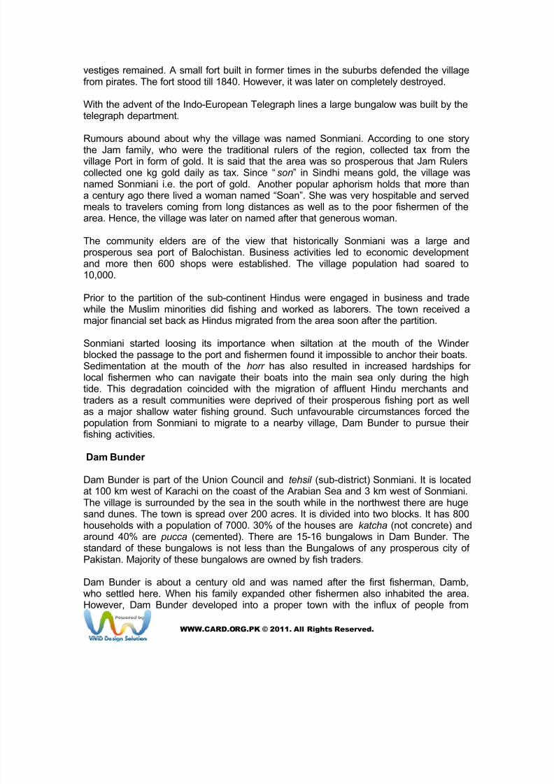
Sonmiani is part of the Lasbela district of Balochistan. Lasbela was declared a districtin 1954. It derives its name from Las, which means plain and Bela, jungle. They alsohappen to be the principal towns. The head quarter of the district is in Uthal. Lasbelais located on the southern coast of Balochistan. It is bounded on the north by Khuzdar district, on the south by the Arabian Sea, on the east by Dadu, Malir and Karachi districtsof Sindh, and on the west by Gwadar and Awaran districts.Table: 1
Historical Timeline of the Area
Year Event
1947-48 Large scale migration of Hindus from Sonmiani
1950 Primary School was established in Dam village
1951 Houses vacated by Hindus were allotted to locals
1953 Tehsil headquarter shifted to Winder
1957 Middle School was established in Sonmiani
1966 Water flow increased in Winder river due to high floods
1968 Sonmiani was made a tehsil
1972 Road was constructed between Sonmiani and Winder
1973 Drinking water was supplied through pipeline from Winder town
1978 Drastic reduction in the Winder River due to lack of rains
1986 Hospital for women was constructed in Sonmiani town1989 Electricity was provided to Sonmiani
Topographically, Lasbela district can be divided into three zones● The north-eastern mountains and hilly areas;
WWW.CARD.ORG.PK © 2011. All Rights Reserved.

8/6/2019 Social Economic Background
http://slidepdf.com/reader/full/social-economic-background 3/9
● The south-western hilly areas; and● The central plains.
The main drainage of the district is carried out by the Porali River and its tributaries, theWinder and the Wirhab rivers. The Phor and the Hingol Rivers rise in the hills of Awaran
district and flow for a short distance through Lasbela before falling into the Arabian Sea.The social set up of the district is tribal. All the tribes other than Baloch and Brahui, Med,Khoja and Hindus, who have settled in Lasbela are known as Lasi.
Sonmiani is one of the tehsils of District Lasbela. Sonmiani town is situated some 95 kmfrom Karachi near the Winder River Delta and 13 km from RCD Highway in the west. It islinked with RCD by a road which passes from the center of the village and terminates atDam Bunder some 3 km to the West of Sonmiani. Winder River forms its delta in South-East of the village. The village spans over 127 acres. There are about 300 households inthe town with the total population of 3000. The village has 5 mosques, one Dargah andthree Chhapras where fish is traded. Chhapra is a local name for a company.
Village Map of Sonmiani prepared by the village communities
Historically Sonmiani was a place of considerable importance and much of the tradefrom Central Asia, which is now carried to Karachi by the railway, made its way throughKalat to the coast at Miani. Historical record say that in Sonmiani’s golden days, 500boats were engaged in fishing and 250 large native crafts in carrying trade to Muscat,Karachi, Bombay and elsewhere. Pearl oysters were found in the bay. Around 1805 theJoasmi pirates of Ras-ul- Khima, known as Uttumi sacked and burned down the town.
At one time Sonmiani was encircled by a mud wall, but it eroded and by 1838 only its
WWW.CARD.ORG.PK © 2011. All Rights Reserved.
8/6/2019 Social Economic Background
http://slidepdf.com/reader/full/social-economic-background 4/9
vestiges remained. A small fort built in former times in the suburbs defended the villagefrom pirates. The fort stood till 1840. However, it was later on completely destroyed. With the advent of the Indo-European Telegraph lines a large bungalow was built by thetelegraph department.
Rumours abound about why the village was named Sonmiani. According to one storythe Jam family, who were the traditional rulers of the region, collected tax from thevillage Port in form of gold. It is said that the area was so prosperous that Jam Rulerscollected one kg gold daily as tax. Since “son” in Sindhi means gold, the village wasnamed Sonmiani i.e. the port of gold. Another popular aphorism holds that more thana century ago there lived a woman named “Soan”. She was very hospitable and servedmeals to travelers coming from long distances as well as to the poor fishermen of thearea. Hence, the village was later on named after that generous woman.
The community elders are of the view that historically Sonmiani was a large andprosperous sea port of Balochistan. Business activities led to economic developmentand more then 600 shops were established. The village population had soared to
10,000. Prior to the partition of the sub-continent Hindus were engaged in business and tradewhile the Muslim minorities did fishing and worked as laborers. The town received amajor financial set back as Hindus migrated from the area soon after the partition. Sonmiani started loosing its importance when siltation at the mouth of the Winder blocked the passage to the port and fishermen found it impossible to anchor their boats.Sedimentation at the mouth of the horr has also resulted in increased hardships for local fishermen who can navigate their boats into the main sea only during the hightide. This degradation coincided with the migration of affluent Hindu merchants andtraders as a result communities were deprived of their prosperous fishing port as well
as a major shallow water fishing ground. Such unfavourable circumstances forced thepopulation from Sonmiani to migrate to a nearby village, Dam Bunder to pursue their fishing activities. Dam Bunder Dam Bunder is part of the Union Council and tehsil (sub-district) Sonmiani. It is locatedat 100 km west of Karachi on the coast of the Arabian Sea and 3 km west of Sonmiani.The village is surrounded by the sea in the south while in the northwest there are hugesand dunes. The town is spread over 200 acres. It is divided into two blocks. It has 800households with a population of 7000. 30% of the houses are katcha (not concrete) andaround 40% are pucca (cemented). There are 15-16 bungalows in Dam Bunder. The
standard of these bungalows is not less than the Bungalows of any prosperous city of Pakistan. Majority of these bungalows are owned by fish traders.
Dam Bunder is about a century old and was named after the first fisherman, Damb,who settled here. When his family expanded other fishermen also inhabited the area.However, Dam Bunder developed into a proper town with the influx of people from
WWW.CARD.ORG.PK © 2011. All Rights Reserved.
8/6/2019 Social Economic Background
http://slidepdf.com/reader/full/social-economic-background 5/9
Sonmiani, who migrated due to the degradation of the Winder delta.
Some fishermen of Karachi also came here and with the passage of time this smallvillage has transformed into a big commercial town. In contrast to the sleepy town of Sonmiani, Dam Bunder has a busy fishing port. Business activity is at its peak during thefishing season, when a large number of outsiders temporarily settle in the village and
earn their livelihoods by working as laborers on fishing boats. The main occupation of the villagers is fishing. The fishing season commences inAugust and continues till May. Most of the people are Sindhi speaking. In the fishingseason about 3000 people throng from other areas like Uthal, Lakhara, Bela, Sonmiani,Khuzdar, Hingol in Balochistan; Rahimyar Khan, Multan, Lahore, Rawalpindi in Punjab;Karachi, Hyderabad, Jati, Thatta, Mirpurekhas, Larkana in Sindh and Peshawar, Bannuin NWFP and also from Azad Kashmir. Bengalis and Burmese also throng this townduring the fishing season. The number of Afghanis and Bengalis supersedes that of locals in the fishing season. The town is distinctly divided into two parts
● Commercial part which is close to the Bunder and● The residential portion.
The seasonal migrants live in small huts owned by the locals and rented out to themduring the fishing season. In order to maintain and uphold their cultural and traditionalidentities, outsiders are not allowed to enter their residential areas. They remainconfined to the commercial section only. The intensity of the commercial activitiescan be judged from the fact that there are about 100 small and big shops, cabins andgrocery shops etc in town. Both dish antennas and cable system are available. Besides,there is a sound public transport system as many buses, taxis, Datsuns etc run betweenthe town, Winder, Karachi, Hub etc.
Bhira & Baloch Goth
Settlements in Bhira and Baloch Goth are not as old as settlements in Sonmiani or DamBunder. Baloch Goth, which is also known as “Washi” is flanked by Sonmiani and DamBunder. People settled here some 14 years back. There are 70 households in the villagewith an overall population of 400. This village, like other fisherfolk villages in the area, isdivided into three localities:
● Dagarzai which is the major locality;● Sanghoor is the second largest locality; and● Lahooti has only 6 households
There are separate Zikirkhanas in all localities, however, Sanghoor has a mosque as
well. Bhira village is situated 2½ km north of Dam Bunder. According to the villagers it isabout 200 years old, however, no historical document or report authenticates suchclaims. The inhabitants of the Bhira are mostly poor and live in wooden houses. Theyfollow the Zikiri school of thought. They migrated from Kalmat (near Pasni) along the
WWW.CARD.ORG.PK © 2011. All Rights Reserved.
8/6/2019 Social Economic Background
http://slidepdf.com/reader/full/social-economic-background 6/9
Makran coast. Only one or two people in the community are influential and have decisionmaking power. This community is very conservative and lives in a closed environment.They are very reluctant to mingle with communities other than those belonging to theZikri sect. Although the main profession of the community is fishing yet not all of themown boats.
There are 171 households in Bhira. The population is 803 with 405 males and 388females. The village is bounded by the coast in the west and big sand dunes run fromeast to south. Houses are not clustered together and are settled at a distance from eachother. Only extended families have their houses in the close proximity of each other.
All houses in the village are katcha. Only the school, dispensary and two Zikirkhanas are pucca. The villagers originally belong to Makran, Layari, Kalmat and Sangoor castes. Itis divided into two localities
● Murad Ali Para● Bagarzai.
According to the local communities the government sanctioned 200 acres of land to thevillage; however, residents don’t have ownership documents. The villagers belong to the Zikri sect. No mosque exists in the village. There are twoZikirkhanas, one for males and other for females. The villagers including femalesperform Zikir regularly. Migration has been reported in the village contrary to other villages of the area. Each year about 5-6 families migrate. The basic cause is lack of drinking water and unreliable passage to the village as it is usually inundated during hightide. Their sole occupation is fishing. About 50 villagers have matriculated and five have
passed Intermediate out of which two are teachers. Only five villagers have government jobs i.e. one is dispenser, one is a midwife, two are teachers and one is a peonin school. There is one community organization in the village: Maheeger TarqiyatiTanzeem. However, the organization has no strong roots among the villagers becauseit has yet not contributed to the welfare of the local villagers. Altogether the village hasabout 100 small
Fish Resources
Different kinds of fish and shrimp species are found in the coastal waters of Sonmianiand Dam Bunder. The major fish species, according to local communities are Loor,
Mor Manger, Bhanbhor, Dandiyoon, Mushkan, Ghore, Khaga, Paplet, Chodi and others.Amongst shrimps Patas, Jairo, Kiddi and Kaket are of great commercial value.
The fishing season begins in August and continues up to the mid of March. In Juneand July fishing is not done because of high tides in the sea and an official ban due tothe breeding season. In summer fishermen resume to catching different kinds of crabs
WWW.CARD.ORG.PK © 2011. All Rights Reserved.
8/6/2019 Social Economic Background
http://slidepdf.com/reader/full/social-economic-background 7/9
including Blue and Red Crabs.Box: 3
Vanishing Palla Fish
Incessant rains, in the past used to replenish the Winder River. It brought millions of cusecs of fresh water
as well as thousands of tons of silt. It pushed back the sea currents and expanded the Winder Delta area.
Palla flourished and this indigenous delta fish was found in abundance. However, with the drastic reductionin Winder flow due to constant decrease in rains in the region, Palla fish has almost vanished from the
fishing grounds of Sonmiani.
Fifteen kinds of fishes are found in the area. Out of them six are poisonous. The catchof Palla, Pomfret (black and white), Surmai, Kiga (Singal or Singar), Sood, Mungro andseveral other species has declined drastically. Following are the species of fishes andshrimps harvested in the coastal waters.
● Loowar: It is a small fish usually used as feed for poultry. It is called “gand” in thelocal language. Due to increase in the poultry farming substantive quantities of trash fish like loowar is in demand. This induces the fishermen to catch loowar .
● Shrimps: They are locally known as “Sana.” They are very popular and fetch
good money due to its export value. There are four major species - Jaira, Kalri,Kiddi and Tiger.● Sua: It is known for its delicious taste. Fishermen who catch Sua are
considered “fortunate.” Whenever, it is caught, it is caught in large numbers.According to fishermen, this year, one fishing boat caught about 500 pieces of Sua with the overall weight of 15,500 kg and earned Rs. 4 million. Another fishingparty was fortunate enough to catch 900 pieces that weighed 27,000 kg andearned Rs. 7 million.
Mangrove Resources
Mangrove forests are the key natural resource of the area. These forests are found inMiani Hor, which is a swampy lagoon situated 90 km West of Karachi and on the north-eastern part of the Balochistan coast. This 60 km long and 7 km wide tortuous andcontorted body of water opens up to the sea and its mouth is 4 km wide. Porali andWindor rivers are the main sources of freshwater for Miani Hor, which enter the bay. Thetotal area of the bay is about 125.5 sq. km and the shelf adjacent to it is about 80 kmwide.
According to the locals there are three species of mangroves in Maini Hor. They arelocally known as Timar, Kumri and Kain. The local communities don’t consider Timar tobe endangered, as there is little cutting and chopping of this species. Since it is nutritiousthe community prefers to use it only as fodder for the cattle. However, the Kumri speciesis certainly on decline because its wood is straight and is used in building houses etc.Kain is also vanishing fast due to cutting and grazing by animals especially camels,belonging to Layari, Bhira and other villages. Regular cutting of mangroves has reduced its cover. Nonetheless considerableawareness about the importance of mangrove conservation has developed due tounstinting efforts of WWF and the local CBOs. Now mangroves are cut down only for
WWW.CARD.ORG.PK © 2011. All Rights Reserved.

8/6/2019 Social Economic Background
http://slidepdf.com/reader/full/social-economic-background 8/9
fuel wood.
Resource Exploitation and its Impact
Exploitation of Fish Resource and its Impact
Coastal waters near the Winder River delta are a common fishing ground. In summer due to high tides the fishermen do not go into the deep-sea and prefer to fish in thechannels of the Winder. With the start of the fishing season which extends from Augustto March, the fishermen of Sonmiani go to Dam Bunder. It has jetty facilities and manyfish purchasing companies operate there. Fishermen of Sonmiani use different kinds of nets in shallow waters. These include Thukri, Raybiyoon, Makhan rach etc. The local fishermen seem to be very concerned about the use of unsustainable fishinggears. They are aware of its adverse impacts on fish resources of the region. Accordingto the local communities, Nazim of District Lasbela has been appealing to localfishermen to refrain from applying unsustainable fishing methods. However, such kindsof nets are still in use despite his repeated pleas. They were of the view that the use of
these harmful nets can be stopped if the local people stand united and struggle againstthe unsustainable fishing methods. They suggested that fishermen should work with theconcerned authorities to put pressure on the influential people who are mostly involvedin unsustainable fishing practices.
Another stress on the fish resources is that people from upland countryside as well asillegal immigrants from Bangladesh, Burma and Afghanistan fish in the area castingharmful nets. They also cut down mangrove trees. Similarly, the local fishermencomplained that Sindh’s fish trawlers over-exploit the fish resources by using trawl nets.According to them the Balochistan Fisheries Department has not taken any seriousaction to address these issues.
Locals lament that the Fisheries Department, Government of Balochistan and MarineFisheries Department are not dealing with these threats seriously. Following are thedetails of exploitation and present status of various fish and shrimp species by the localcommunities.
Decline in Different Fish Species Suggested by the Local Communities
SerialNumber
Fish Status during last 5 years Causes of Reduction
1 Sua 50% reduction Over fishing, harmful nets
2 All 50% reduction Over fishing , harmfulnets
3 Dangro 25% reduction Harmful nets
4 Paplet 50% reduction. Bolo-Gujjo
5 Seeari 25%reduction Over fishing
6 Manger 50% reduction Deep sea trawlers
7 Soeeri 25% reduction Over fishing
8 Gore Surmai 75% reduction Deep sea trawlers
9 Seeari (Ranwas) 25% reduction Deep-sea trawlers
WWW.CARD.ORG.PK © 2011. All Rights Reserved.
8/6/2019 Social Economic Background
http://slidepdf.com/reader/full/social-economic-background 9/9
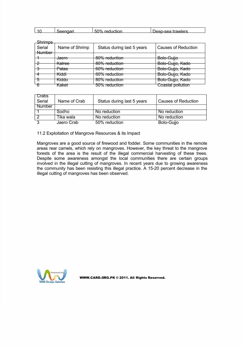
10 Seengari 50% reduction Deep-sea trawlers
Shrimps
SerialNumber
Name of Shrimp Status during last 5 years Causes of Reduction
1 Jaero 80% reduction Bolo-Gujjo
2 Kalree 80% reduction Bolo-Gujjo, Kado
3 Patas 60% reduction Bolo-Gujjo, Kado
4 Kiddi 60% reduction Bolo-Gujjo, Kado
5 Kiddo 80% reduction Bolo-Gujjo, Kado
6 Kaket 50% reduction Coastal pollution
Crabs
SerialNumber
Name of Crab Status during last 5 years Causes of Reduction
1 Sodho No reduction No reduction
2 Tika wala No reduction No reduction
3 Jaero Crab 50% reduction Bolo-Gujjo
11.2 Exploitation of Mangrove Resources & its Impact
Mangroves are a good source of firewood and fodder. Some communities in the remoteareas rear camels, which rely on mangroves. However, the key threat to the mangroveforests of the area is the result of the illegal commercial harvesting of these trees.Despite some awareness amongst the local communities there are certain groupsinvolved in the illegal cutting of mangroves. In recent years due to growing awarenessthe community has been resisting this illegal practice. A 15-20 percent decrease in theillegal cutting of mangroves has been observed.
WWW.CARD.ORG.PK © 2011. All Rights Reserved.