são francisco river mouth, northeastern brazil wave
TRANSCRIPT

BioOne sees sustainable scholarly publishing as an inherently collaborative enterprise connecting authors, nonprofit publishers, academic institutions, researchlibraries, and research funders in the common goal of maximizing access to critical research.
Wave Refraction, River Damming, and Episodes of Severe Shoreline Erosion: TheSão Francisco River Mouth, Northeastern BrazilAuthor(s) :Abílio Carlos Da Silva Pinto Bittencourt, José Maria Landim Dominguez, Luiz Carlos S.Fontes, Daiana Leite Sousa, Iracema Reimão Silva, and Franz Rangel Da SilvaSource: Journal of Coastal Research, Number 234:930-938. 2007.Published By: Coastal Education and Research FoundationDOI:URL: http://www.bioone.org/doi/full/10.2112/05-0600.1
BioOne (www.bioone.org) is a a nonprofit, online aggregation of core research in the biological, ecological, andenvironmental sciences. BioOne provides a sustainable online platform for over 170 journals and books publishedby nonprofit societies, associations, museums, institutions, and presses.
Your use of this PDF, the BioOne Web site, and all posted and associated content indicates your acceptance ofBioOne’s Terms of Use, available at www.bioone.org/page/terms_of_use.
Usage of BioOne content is strictly limited to personal, educational, and non-commercial use. Commercial inquiriesor rights and permissions requests should be directed to the individual publisher as copyright holder.

Journal of Coastal Research 23 4 930–938 West Palm Beach, Florida July 2007
Wave Refraction, River Damming, and Episodes of SevereShoreline Erosion: The Sao Francisco River Mouth,Northeastern BrazilAbılio Carlos Da Silva Pinto Bittencourt†, Jose Maria Landim Dominguez‡, Luiz Carlos S. Fontes§,Daiana Leite Sousa††, Iracema Reimao Silva‡‡, Franz Rangel Da Silva§§
†Laboratorio de Estudos CosteirosCentro do Pesquisa en Geofisica eGeologia
Instituto de Geociencias–UFBACampus Universitario da Federacao40170-290 Salvador-Bahia, Brazilabı[email protected].
‡Laboratorio de Estudos Costeiros(CPGG)
Instituto de Geociencias–UFBACampus Universitario da Federacao40170-290 Salvador-Bahia, Brazil
§Curso de Pos-Graduacao em Geologia–Universidade Federal do Bahia
Campus Universitario da Federacao40170-290 Salvador-Bahia, Brazil
††Curso de Graduacao em Geologia–UFBA
Campus Universitario da Federacao40170-290 Salvador-Bahia, Brazil
‡‡Mestrado em Planejamento Territoriale Desenvolvimento Social
Universidade Catolica do SalvadorAv. Anita Garibaldi nº 298141940-450 Salvador-Bahia, Brazil
§§Geohidro Consultoria, Avenida ACM,3840
Ed. Capemi, 1º andar, Pituba41821-900 Salvador-Bahia, Brazil
ABSTRACT
BITTENCOURT, A.C.S.P.; DOMINGUEZ, J.M.L.; FONTES, L.C.S.; SOUSA, D.L.; SILVA, I.R., and DA SILVA, F.R.,2007. Wave refraction, river damming, and episodes of severe shoreline erosion: The Sao Francisco River mouth,northeastern Brazil. Journal of Coastal Research, 23(4), 930–938. West Palm Beach (Florida), ISSN 0749-0208.
The Sao Francisco River mouth is undergoing a severe erosional process that has caused the destruction of a villageand the partial immersion of a lighthouse constructed in 1856. The present work comprises an historic time evaluationof this phenomenon based on the analysis of the sediment dispersion patterns caused by waves along three distinctshoreline traces. For this, we define a wave climate model based on the construction of refraction diagrams, whichare assumed to be valid for the three shorelines. The resulting sediment transport patterns obtained by numericalmodeling from the refraction diagrams—taking into account the angle of approach and the wave height along thecoast—allow us to establish a first-order correlation between coastal dynamics and erosion phenomenon. The resultsalso suggest that a permanent reduction in the solid river discharge, in response to the construction of large dams,probably will have two direct consequences in the river mouth region: (i) a chronic shoreline erosion downdrift of themouth and (ii) a progressive deflection of the mouth in the downdrift direction.
ADDITIONAL INDEX WORDS: Longshore drift, numerical modeling, coastal evolution, river mouth bar, wave-domi-nated delta, human impacts.
INTRODUCTION
The Sao Francisco River mouth (Figure 1) is currently ex-periencing a severe erosive process that has already de-stroyed the village of Cabeco, located on its right bank, aswell as caused the partial immersion of a lighthouse built in1856 (Figure 2). At the time of its construction, the lighthousewas located approximately 280 m inland from the shoreline(FONTES, 2001), and in 2005 was partially below sea level, ata distance of approximately 200 m from the shoreline (Figure3). On the left of the river bank, the erosive phenomenon ismuch less accentuated. Among the authors that have ana-lyzed this subject, there is a consensus in attributing themagnitude of this erosive process to a significant reductionin the discharge of solids in the lower river course, which is
DOI:10.2112/05-0600.1 received 07 October 2005; accepted in revision14 February 2006.
the result of the construction of a series of dams along itscourse (DOMINGUEZ et al., 2003; FONTES, 2001; OLIVEIRA etal., 2003; SILVA et al., 2001; VITAL et al., 2001). Based onqualitative analysis of wave refraction diagrams, DOMIN-GUEZ (1999) proposed that this erosive process is probablythe result of modifications in the wave refraction patternscaused by geometric changes around the mouth bar. Lateron, OLIVEIRA (2003) evaluated the erosional problem alongthe coast of the State of Sergipe (Figure 1), including thecoastal section of the Sao Francisco River mouth. Based on aquantitative analysis of wave refraction diagrams, construct-ed on the scale of 1:300,000, OLIVEIRA (2003) concluded thatthe right bank erosion in the Sao Francisco River mouth maybe due to a divergence in the direction of net longshore driftof sediments, which generates a local deficit of sediments thatis not compensated by river deposition.
The aim of the present paper is to evaluate and clarify thissevere coastal erosion phenomena associated with the Sao

931River Damming and Shoreline Erosion, Brazil
Journal of Coastal Research, Vol. 23, No. 4, 2007
Figure 1. Physiographic characteristics of the mouth of the Sao Fran-cisco River and the internal continental shelf for the year 1981 (accordingto DHN, 1983).
Francisco River mouth, based on the analysis of sedimentdispersion patterns driven by sea wave motions.
GEOLOGICAL-PHYSIOGRAPHIC SETTING
Historically, the coastal plain of the Sao Francisco Rivermouth has been considered as a classic example of a ‘‘wave-dominated delta.’’ Its evolution has been fundamentally con-ditioned by the struggle between the river and the waves(BACCOCOLI, 1971; GALLOWAY, 1975; WRIGHT and COLE-MAN, 1973). BITTENCOURT et al. (1982), DOMINGUEZ et al.(1987), and DOMINGUEZ (1996) all have highlight the rolesplayed by longshore drift of sediments and the relative sea-level variations in the area. BHATTACHARYA and GIOSAN
(2003) proposed denominating this coastal system as an‘‘asymmetric wave-influenced delta.’’
The coastal plain associated with the Sao Francisco Rivermouth extends over a shoreline of approximately 75 km, witha maximum width of 25 km. This plain is composed of Qua-ternary deposits, including regressive coastal sand deposits,alluvial fans, mangroves, fluvial terraces and dunes (BAR-BOSA and DOMINGUEZ, 2003; BITTENCOURT et al., 1982;DOMINGUEZ, 1996).
The longshore sediment drift in the study region is oriented
from NE to SW (BITTENCOURT et al., 1982; COLEMAN andWRIGHT, 1972; DOMINGUEZ, 1996; DOMINGUEZ et al., 1983).Therefore, updrift from the mouth, the coastal plain is basi-cally fed by longshore drift of sediments (‘‘groin effect’’), whiledowndrift of the river, river sediments predominate (BHAT-TACHARYA and GIOSAN, 2003; DOMINGUEZ, 1996).
The continental shelf in front of the Sao Francisco Rivercoastal plain has widths between 20 and 25 km, with topo-graphic gradients varying between 1:300 and 1:500, and ashelf break located at approximately 50 m depth (FRANCA,1979).
The region neighboring the Sao Francisco River mouth canbe classified as having micro- and mesotides, with an equi-noctial tide amplitude of 2.6 m and semidiurnal character.
The climate in the region of the Sao Francisco River mouthhas a semihumid character, with four consecutive dry monthsper year. According to some authors, this dry season favorsthe development of a coastal field of dunes (BARBOSA andDOMINGUEZ, 2003). The annual rainfall in the Sao FranciscoRiver basin varies from 1250 mm/y in its headwaters and inthe coastal zone, to 500 mm/y in its central portion (NIMER,1989).
An outstanding hydrographic characteristic of the SaoFrancisco River basin is the presence of nine dams along itscourse, constructed to regulate urban water supplies andflood controls and to attain giant irrigation projects and pro-duction of electric energy. These dams have caused drasticmodifications in the river hydro-sedimentological character-istics, as can be seen in Figure 4, which shows the large var-iations in the average water flows in the lower Sao FranciscoRiver (FONTES and HOLANDA, 2002). From this figure, it canbe observed that: (i) from 1956 to 1978, there is a strong re-duction in average water flows, (ii) from 1978 to 1985, sig-nificantly higher flows were reached, above those for 1978,and (iii) beginning in 1986, the flows dropped considerably,reaching the lowest average levels in this historical series.According to OLIVEIRA et al. (2003), between 1996 and 2002,the average observed flow was of 2000 m3/s, well below thehistorical average of 2850 m3/s. FONTES and HOLANDA (2002)attributed this drop to the flow regularization, controlled bydams, which became more effective in 1994, after the con-struction of the last dam on the lower course of the Sao Fran-cisco River. This dam, located 190 km from the mouth, thelast link in the sediment retention chain, reduced the totalload of transported solids to 0.466 � 106 t/y, representingonly 3.8% of the sediment load carried to the Sao FranciscoRiver mouth in the period prior to the dams’ construction(OLIVEIRA et al., 2002). This figure is very close, for instance,to that reported by STANLEY and WARNER (1998) regardingthe Nile River.
VARIATIONS IN THE SHORELINE POSITION
On the most external part of the coastal plain, on the rightbank of the Sao Francisco River mouth, there are several setsof coastal Holocene beach-ridges presenting truncated pat-terns (Figure 5). These patterns are evidence that the line ofthe coastal mouth has not advanced to the ocean in a contin-uous manner; it has been interrupted by episodes of erosion

932 Bittencourt et al.
Journal of Coastal Research, Vol. 23, No. 4, 2007
Figure 2. Village of Cabeco, partially destroyed (1998). In the background, the lighthouse can already be seen in the water (see text).
(DOMINGUEZ, 1999). In this same place, DOMINGUEZ (1999)has shown, based on comparative analysis of aerial photo-graph, satellite images, and nautical charts (Figure 6), thatthe shoreline has remained more or less stable between 1960and 1981, prograding to a maximum distance of 1080 m in1986. After this, a retreat culminated with the destruction ofthe village of Cabeco in 1998, which continues to this day.The rate of shoreline retreat between 1986 and 2001, of ap-proximately 98.6 m/y, is comparable, for example, to that ob-served in some sections of the Nile delta (KOMAR, 2000;WHITE and EL ASMAR, 1999). Regarding the left bank of theestuary, DOMINGUEZ (1999) observed that, between 1960 and1971, the shoreline remained more or less stable, then re-treated until 1981, approximately 240 m, at the same timethat it advanced to the south approximately 480 m (Figure6). Later, between 1981 and 1986, this shoreline advanced tothe east approximately 680 m, followed by a retreat until2001 of approximately 880 m (DOMINGUEZ, 1999; OLIVEIRA,2003).
DOMINGUEZ et al. (2003) suggested that these modifica-tions in the shoreline were related to natural variations inthe discharge of solids and liquids of the Sao Francisco River.Superimposed on these natural variations is the last episodeof severe shoreline erosion caused by sediment retention inlarge dams.
WAVE CLIMATE MODEL
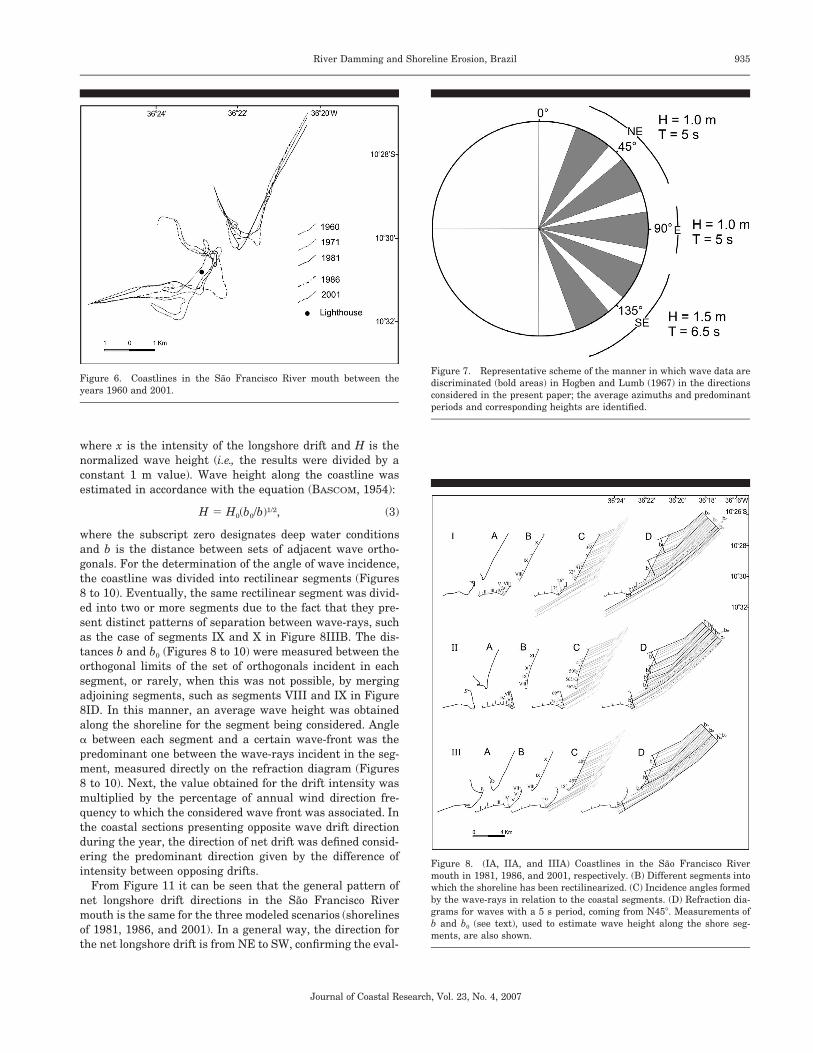
Significant direct measurements of the wave regime for thearea under study are not available. However, in the north-eastern Brazilian region where this area is, sea-type wavespredominate (DAVIES, 1972), that is, waves that are gener-ated by local winds, a fact that is confirmed by wave statisticsavailable in HOGBEN and LUMB (1967). According to data ofthe Brazilian Air Force meteorological station (BARBOSA,1997), for the period from 1979 to 1988 in the coastal city ofAracaju, at an approximated distance of 100 km south of theSao Francisco River mouth, the following wind directions andfrequencies predominate: NE (N45�) 19%; E (N90�) 49%; andSE (N135�) 32%. The wave conditions used in this study wereextracted from HOGBEN and LUMB (1967) (area 37) from dataobtained in open the sea by visual observations made fromships. The wave data in HOGBEN and LUMB (1967) are or-ganized into angular sectors, which were grouped, for pur-poses of the present study, into three sets, as shown in Figure7. To these sets wind frequencies of the same direction mea-sured in the city of Aracaju were attributed.
It should be pointed out that the wave data used in thiswork have, naturally, uncertainties due to inaccuracies in-herent in the manner in which they were obtained. The ob-server is determining some average height for the chaotic

933River Damming and Shoreline Erosion, Brazil
Journal of Coastal Research, Vol. 23, No. 4, 2007
Figure 3. Right bank of the Sao Francisco River mouth, now without the village of Cabeco. The lighthouse can be seen already approximately 200 mfrom the shoreline (2002).
Figure 4. Average flows in the lower Sao Francisco River between 1956and 2002, measured at the fluviometric station of Traipu, downstreamfrom the system of dams and approximately 150 km from the mouth(according to Fontes and Holanda, 2002).
wave surface (YOUNG and HOLLAND, 1996). Furthermore,the poor coverage given by ships should be considered, sincethey tend to follow standard routes.
Based on these data, refraction diagrams were constructedmanually, in accordance with procedures described in CERC(1984), resulting in a generic wave climate model for the stud-ied area. The bathymetric data used in the construction ofthese diagrams were extracted from the 1981 Nautical Chartof the Brazilian Navy (DHN, 1983), on the scale of 1:20,000(Figure 1). Refraction diagrams were constructed for threedistinct scenarios of the shoreline position: two with erosivecharacteristics, represented by the shorelines of 1981 and2001, and a third with constructive characteristics corre-sponding to the shoreline of 1986 (Figures 6 and 8–10). Forthis, it was assumed that the bathymetry for 1981, for depthsgreater than 5 m, remained unaltered during the 1981 to2001 period. In this way, the refraction diagrams, constructedwith the 1981 bathymetry, had the wave-rays refracted onlyto the isobath of 5 m and, from this point, maintained the

934 Bittencourt et al.
Journal of Coastal Research, Vol. 23, No. 4, 2007
Figure 5. Sao Francisco River mouth in 2003 showing old truncated beach ridges.
last direction of propagation, extending to the shoreline of1981, 1986, and 2001.
By examining Figures 8–10, it can be seen that the wavesfrom NE are the ones that present more refraction. Thewaves from SE are the ones that present complex intercross-ings of wave-rays and focuses of ray convergence along theshoreline.
SEDIMENT DISPERSION PATTERNS
Several formulas have been proposed to model the trans-port of sediments along the coast (CERC, 1984; KAMPHIUS,1991, among others) that use different parameters including:direction and height of the wave, granulometry, sand porosityand density, water density, and environmental coefficients,among others. Considering the limitations imposed by thedata quality, it was opted to adopt a simple approach, de-scribed in BITTENCOURT et al. (2000, 2002, 2005), for the de-
termination of the potential intensity of longshore drift ofsediments. This approach considers that: (i) wave energy out-side the break zone is directly proportional to the square ofits height (DAVIES, 1972; MUNK and TRAYLOR, 1947); and (ii)the intensity of the longshore drift is proportional to the an-gle with which the wave-front strikes the coastline (KOKOT,1997; KOMAR, 1976; ZENKOVITCH, 1967), in accordance withthe function (KOMAR, 1976):
y � sin � � cos �, (1)
where y is an intensity factor for the potential longshore drift,and � is the angle of incidence of the wave orthogonal to theshoreline. In this manner, potential longshore drift intensitycan be expressed by a nondimensional number, according tothe function:
x � yH2, (2)
935River Damming and Shoreline Erosion, Brazil
Journal of Coastal Research, Vol. 23, No. 4, 2007
Figure 6. Coastlines in the Sao Francisco River mouth between theyears 1960 and 2001.
Figure 7. Representative scheme of the manner in which wave data arediscriminated (bold areas) in Hogben and Lumb (1967) in the directionsconsidered in the present paper; the average azimuths and predominantperiods and corresponding heights are identified.
Figure 8. (IA, IIA, and IIIA) Coastlines in the Sao Francisco Rivermouth in 1981, 1986, and 2001, respectively. (B) Different segments intowhich the shoreline has been rectilinearized. (C) Incidence angles formedby the wave-rays in relation to the coastal segments. (D) Refraction dia-grams for waves with a 5 s period, coming from N45�. Measurements ofb and b0 (see text), used to estimate wave height along the shore seg-ments, are also shown.
where x is the intensity of the longshore drift and H is thenormalized wave height (i.e., the results were divided by aconstant 1 m value). Wave height along the coastline wasestimated in accordance with the equation (BASCOM, 1954):
H � H0(b0/b)1/2, (3)
where the subscript zero designates deep water conditionsand b is the distance between sets of adjacent wave ortho-gonals. For the determination of the angle of wave incidence,the coastline was divided into rectilinear segments (Figures8 to 10). Eventually, the same rectilinear segment was divid-ed into two or more segments due to the fact that they pre-sent distinct patterns of separation between wave-rays, suchas the case of segments IX and X in Figure 8IIIB. The dis-tances b and b0 (Figures 8 to 10) were measured between theorthogonal limits of the set of orthogonals incident in eachsegment, or rarely, when this was not possible, by mergingadjoining segments, such as segments VIII and IX in Figure8ID. In this manner, an average wave height was obtainedalong the shoreline for the segment being considered. Angle� between each segment and a certain wave-front was thepredominant one between the wave-rays incident in the seg-ment, measured directly on the refraction diagram (Figures8 to 10). Next, the value obtained for the drift intensity wasmultiplied by the percentage of annual wind direction fre-quency to which the considered wave front was associated. Inthe coastal sections presenting opposite wave drift directionduring the year, the direction of net drift was defined consid-ering the predominant direction given by the difference ofintensity between opposing drifts.
From Figure 11 it can be seen that the general pattern ofnet longshore drift directions in the Sao Francisco Rivermouth is the same for the three modeled scenarios (shorelinesof 1981, 1986, and 2001). In a general way, the direction forthe net longshore drift is from NE to SW, confirming the eval-

936 Bittencourt et al.
Journal of Coastal Research, Vol. 23, No. 4, 2007
Figure 9. (IA, IIA, and IIIA) Coastlines in the Sao Francisco Rivermouth in 1981, 1986, and 2001, respectively. (B) Different segments intowhich the shoreline has been rectilinearized. (C) Incidence angles formedby the wave-rays in relation to the coastal segments. (D) Refraction dia-grams for waves with a 5 s period, coming from N90�. Measurements ofb and b0 (see text), used to estimate wave height along the shore seg-ments, are also shown.
Figure 10. (IA, IIA, and IIIA) Coastlines in the Sao Francisco Rivermouth in 1981, 1986, and 2001, respectively. (B) Different segments intowhich the shoreline has been rectilinearized. (C) Incidence angles formedby the wave-rays in relation to the coastal segments. (D) Refraction dia-grams for waves with a 6.5 s period, coming from N135�. Measurementsof b and b0 (see text), used to estimate wave height along the shore seg-ments, are also shown.
uations of different authors previously mentioned. An excep-tion is observed on the right bank, where there is a diver-gence in the drift direction, with the nodal points varyingslightly in position between the three outlines of the shore-line. This divergence in drift direction regarding the 1981shoreline has already been pointed out by OLIVEIRA (2003).
DISCUSSION
The shorelines updrift and downdrift of the Sao FranciscoRiver mouth present differences in the dispersal patterns andin the supply of sediments (DOMINGUEZ, 1996; BHATTACHAR-YA and GIOSAN, 2003). Regarding the sediments supply, theupdrift shoreline is fed by net longshore drift from NE to SW(Figure 11), which is retained in the mouth of the river bythe ‘‘groin effect,’’ while on the downdrift shoreline, sedimentis basically supplied by the river. Regarding the sedimentdispersal patterns, the shoreline on the downdrift side pre-sents a divergence in the direction of net longshore drift ofsediments that is not observed on the updrift shoreline, whichhas a single direction for net drift. This divergence is main-tained during the three scenarios drawn for the modeledshoreline (Figure 11). Such conditions establish a deficit ofsediments in the downdrift shoreline and, therefore, vulner-ability to erosion, which needs an adequate supply of riversediment to be compensated.
The phases of progradation and retreat of the shorelinerepresented in Figure 6, observed by DOMINGUEZ et al.
(2003), can be better understood with the help of the sedi-ment dispersal model proposed herein. Between 1960 and1981, a retreat was observed in the updrift shoreline and itsconcomitant extension to the south. In the same period, inthe section immediate downdrift, the shoreline remainedpractically unaltered, while a little further to the southwest,this same shoreline experienced erosion. These modificationsseem to be related to decrease in average flows of the SaoFrancisco River in the period between 1956 and 1978 (Figure4). This decrease would cause a decrease in the ‘‘groin effect,’’producing a southward migration of the updrift bank, accord-ing to the mechanism described by DOMINGUEZ (1996). Onthe downdrift shoreline, the reduction in the solid discharge(here considered as directly proportional to the liquid dis-charge) would be responsible for the observed erosion effects.
The shoreline progradation phase observed on both banksof the Sao Francisco River between 1981 and 1986 can bealso related to the large average river flows measured be-tween 1978 and 1985 (Figure 4). On the updrift shoreline, anincrease of the groin effect, resulting from these flows, would

937River Damming and Shoreline Erosion, Brazil
Journal of Coastal Research, Vol. 23, No. 4, 2007
Figure 11. Directions of net longshore drift of sediments, computed inthe present paper for each rectilinearized segment, corresponding to thecoastlines in 1981 (A), 1986 (B), and 2001 (C).
have caused the progradation of the shoreline through theinterruption of coastal transportation from NE to SW. On thedowndrift shoreline, the increase in the discharge of solidsalso produced progradation of the shoreline in spite of thepresence, in this section, of the divergence zone previouslypointed out.
These tendencies were reversed in the 1986 to 2001 period,when the average flows underwent considerable reduction,mainly starting in 1994 (Figure 4), as a function of sediment
retention by dams. During this river discharge reduction pe-riod, the groin effect became less effective, and the updriftshoreline from the mouth of the river started to experienceerosion of the material deposited in the previous phase, ac-cording to the mechanism described in DOMINGUEZ (1996).On the downdrift shoreline, the reduction in solid dischargeproduced a severe erosion effect in the section where diver-gence is seen in the net drift direction.
CONCLUSIONS
Although it is recognized that there are a number of limi-tations in the present model, which include different levelsof uncertainty, the results give a convenient approximationthat allows a first-order correlation between the coastal dy-namics in the Sao Francisco River mouth and the severe ero-sion phenomenon that is currently occurring there. The re-sults also suggest that the permanent reduction in solids dis-charged by the Sao Francisco River, resulting from the con-struction of the large dams, will probably have two directconsequences on the estuary region: (i) chronic erosion of theshoreline on the downdrift side of the shoreline and (ii) pos-sible evolution of the delta system to the category ‘‘deflecteddelta influenced by wave’’ proposed by BHATTACHARYA andGIOSAN (2003), with the progressive deflection of the mouthin the downdrift direction.
ACKNOWLEDGMENTS
A.C.S.P. Bittencourt, J.M.L. Dominguez, and D.L. Sousathank CNPq (National Council for Scientific and Technolog-ical Development), the first two for their Research FellowshipGrant, and the third for the Scientific Initiation Scholarship.I.R. Silva thanks CAPES (Coordenacao de Aperfeicoamentode Pessoal de Nıvel Superior) and CNPq, respectively, forMasters and Ph.D. scholarships. We acknowledge an anony-mous reviewer for their comments and suggestions.
LITERATURE CITED
BACCOCOLI, G., 1971. Os deltas holocenicos brasileiros—Uma ten-tativa de classificacao. Boletim Tecnico da Petrobras, 14 (1/2), 5–38.
BARBOSA, L.M., 1997. Campos de dunas costeiras associadas a de-sembocadura do Rio Sao Francisco (SE/AL): origem e controlesambientais. Bahia, Brazil: Universidade Federal da Bahia, Insti-tuto de Geociencias, Ph.D. thesis, 203p.
BARBOSA, L.M. and DOMINGUEZ, J.M.L., 2003. Coastal dune fieldsat the Sao Francisco River strandplain, northeastern Brazil: mor-phology and environmental controls. Earth Surface Processes andLandforms, 29, 443–456.
BASCOM, W.J., 1954. The control of stream outlets by wave refrac-tion. Journal of Geology, 62, 600–605.
BHATTACHARYA, J.P. and GIOSAN, L., 2003. Wave-influenced deltas:geomorphological implications for facies reconstruction. Sedimen-tology, 50, 187–210.
BITTENCOURT, A.C.S.P.; DOMINGUEZ, J.M.L.; MARTIN, L., and FER-REIRA, Y.A., 1982. Dados preliminares sobre a evolucao do deltado Rio Francisco (SE/AL) durante o Quaternario: influencia dasvariacoes do nıvel do mar. In: SUGUIO, K.; MEIS, M.R.M., and TES-SLER, M.G. (eds.), IV Simposio do Quaternario Costeiro do Brasil(Rio de Janeiro, Brazil), pp. 49–68.
BITTENCOURT, A.C.S.P.; DOMINGUEZ, J.M.L.; MARTIN, L., and SIL-VA, I.R., 2000. Patterns of sediment dispersion coastwise the State

938 Bittencourt et al.
Journal of Coastal Research, Vol. 23, No. 4, 2007
of Bahia, Brazil. Anais da Academia Brasileira de Ciencias, 72,271–287.
BITTENCOURT, A.C.S.P.; MARTIN, L.; DOMINGUEZ, J.M.L.; Silva,I.R., and SOUSA, D.L., 2002. A significant longshore transport di-vergence zone at the northeastern Brazilian coast: Implications oncoastal Quaternary evolution. Anais da Academia Brasileira deCiencias, 74, 505–518.
BITTENCOURT, A.C.S.P.; DOMINGUEZ, J.M.L.; MARTIN, L., and SIL-VA, I.R., 2005. Longshore transport on the northeastern Braziliancoast and implications to the location of large-scale accumulativeand erosive zones: An overview. Marine Geology, 219, 219–234.
CERC (Coastal Engineering Research Center), 1984. Shore Protec-tion Manual. Washington, D.C.: U.S. Army Corps of Engineers, V.I, 597p.
COLEMAN, J.M. and WRIGHT, L.D., 1972. Delta morphology in re-lation to the discharge/wave power climate. In: Anais XXVI Con-gresso Brasileiro de Geologia (Belem, Brazil), pp. 145–155.
DAVIES, J.L., 1972. Geographical variation in coastal development.New York, U.S.A.: Longman, 204p.
DHN (Diretoria de Hidrografia e Navegacao), 1983. Brasil-CostaLeste: Barra do Rio Sao Francisco do Norte. Rio de Janeiro, Brazil:Ministerio da Marinha, Carta Nautica nº 1002, escala: 1:20,000.
DOMINGUEZ, J.M.L.; BITTENCOURT, A.C.S.P., and MARTIN, L., 1983.O papel da deriva litoranea de sedimentos arenosos na construcaodas planıcies costeiras associadas as desembocaduras dos rios SaoFrancisco (SE/AL), Jequitinhonha (BA), Doce (ES) e Paraıba doSul (RJ). Revista Brasileira de Geociencias, 13, 98–105.
DOMINGUEZ, J.M.L.; MARTIN, L., and BITTENCOURT, A.C.S.P., 1987.Sea-level history and the Quaternary evolution of river mouth-associated beach-ridge plains along the east-southeast coast ofBrazil: a summary. In: NUMMEDAL, D., PILKEY, D.H., and HOW-ARD, J.D. (eds.), Sea-Level Fluctuation and Coastal Evolution. Tuc-son, Arizona: Society of Economic Paleontologists and Mineralo-gists Special Publication 41, pp. 115–127.
DOMINGUEZ, J.M.L., 1996. The Sao Francisco strandplain: a para-digm for wave-dominated deltas? In: DE BAPTIST, M. and JACOBS,P. (eds.), Geology of Siliciclastic Shelf Seas. London: Geological So-ciety of London Special Publication 117, pp. 217–231.
DOMINGUEZ, J.M.L., 1999. Erosao Costeira na Regiao Leste-Nord-este do Brasil. Bahia, Brazil: Universidade Federal da Bahia, In-stituto de Geociencias, Full Professor thesis, 175p.
DOMINGUEZ, J.M.L.; BITTENCOURT, A.C.S.P.; MARTIN, L.; Oliveira,M.B.; Silva, R.; Andrade, A.C.S.; Lavenere-Wanderley, A.A.O.;Freitas, L.M.B.; Queiroz, I.G. and SILVA, I.R., 2003. Tendenciasde Erosao Costeira nos Estados da Bahia e Sergipe. In: Anais IXCongresso da ABEQUA (Recife, Brazil), CD-ROM (not sequentiallynumbered).
FONTES, A.L., 2001. Processos erosivos na desembocadura do RioSao Francisco. In: Boletim de Resumos, VIII Congresso da ABE-QUA (Imbe, RS, Brazil), pp. 66–67.
FONTES, L.C.S. and HOLANDA, F.S.R., 2002. Estudo do processo ero-sivo das margens do baixo Sao Francisco e seus efeitos na din-amica de sedimentacao do rio. Aracaju, SE, Brazil: Relatorio FinalProjeto GEF Sao Francisco (ANA/GEF/PNUMA/OEA), Subprojeto2.4, 512p.
FRANCA, A.M.C., 1979. Geomorfologia da margem continental leste
brasileira e da bacia oceanica adjacente. In: CHAVES, H. (ed.), Geo-morfologia da margem continental brasileira e das areas oceanicasadjacentes. Rio de Janeiro, Brazil: Serie Projeto REMAC Nº 7, Pe-trobras/Cenpes, pp. 89–127.
GALLOWAY, W.E., 1975. Process framework for describing the mor-phologic and stratigraphic evolution of deltaic depositional sys-tems. In: BROUSSARD, M.L. (ed.), Deltas, Models for Exploration.Houston, Texas: Houston Geological Society, pp. 87–98.
HOGBEN, N. and LUMB, F.E., 1967. Ocean wave statistics. London,England: National Physical Laboratory, Ministry of Technology,263p.
KAMPHIUS, J.W., 1991. Alongshore sediment transport rate. Journalof Waterways, Port, Coastal and Ocean Engineering, 117, 624–641.
KOKOT, R.R., 1997. Littoral drift, evolution and management in Pun-ta Medanos, Argentina. Journal of Coastal Research, 13, 192–197.
KOMAR, P.D., 1976. Beach process and sedimentation. New Jersey,U.S.A.: Prentice Hall, 429p.
KOMAR, P.D., 2000. Coastal Erosion—underlying factors and humanimpacts. Shore and Beach, 88, 3–16.
MUNK, W.H. and TRAYLOR, M.A., 1947. Refraction of ocean waves;a process linking underwater topography to beach erosion. Journalof Geology, 55, 1–26.
NIMER, E., 1989. Climatologia do Brasil. Rio de Janeiro, Brazil: In-stituto Brasileiro de Geografia e Estatıstica, 421p.
OLIVEIRA, A.M.; SEGUNDO, G.H.C.; SANTOS, R.C., JR.; HERNANDEZ,A.O., and MATOS, A.E., 2002. Caracterizacao Hidrodinamica—se-dimentologica do Baixo Sao Francisco. Aracaju, Sergipe, Brazil:Relatorio Final Projeto GEF Sao Francisco (ANA/GEF/PNUMA/OEA), Subprojeto 1.1.A, 325p.
OLIVEIRA, A.M.; SANTOS, R.C., JR.; HERNANDEZ, A.O.; SEGUNDO,G.H.C., and ARAUJO, A.E.M., 2003. A morte do delta do Rio SaoFrancisco. In: Anais IX Congresso da ABEQUA (Recife, Brazil),CD-ROM.
OLIVEIRA, M.B., 2003. Caracterizacao integrada da linha de costa doEstado de Sergipe, Brasil. Bahia, Brazil: Universidade Federal daBahia, Instituto de Geociencias, Master’s thesis, 102p.
SILVA, F.R.; DOMINGUEZ, J.M.L., and BITTENCOURT, A.C.S.P., 2001.Variacoes morfodinamicas da barra de desembocadura do Rio SaoFrancisco e sua influencia no clima de ondas. In: Boletim de Re-sumos, VIII Congresso da ABEQUA (Imbe, RS, Brazil), pp. 503–504.
STANLEY, D.J. and WARNER, A.G., 1998. Nile Delta in its destructionphase. Journal of Coastal Research, 14, 794–825.
VITAL, H.; OLIVEIRA, A.M., and TABOSA, W.F., 2001. Caracterizacaode Padroes de Formas de Fundo da Foz do Rio Sao Francisco.Pesquisas em Geociencias, 28, 125–131.
WHITE, K. and EL ASMAR, H.M., 1999. Monitoring changing positionof coastlines using thematic mapper imagery, an example from theNile Delta. Geomorphology, 29, 93–105.
WRIGHT, L.D. and COLEMAN, J.M., 1973. Variations in morphologyof major river deltas as functions of ocean waves and river dis-charge regimes. American Association of Petroleum Geologists Bul-letin, 57, 370–398.
YOUNG, I.R. and HOLLAND, G.J., 1996. Atlas of the Oceans: Windand Wave Climate. Oxford, England: Pergamon, 238p.
ZENKOVITCH, V.P., 1967. Processes of Coastal Development. London,England: Oliver & Boyd, 738p.