snh commissioned report 894: harbour seal haul-out ... · harbour seal haul-out monitoring, sound...
TRANSCRIPT

Harbour seal haul-out monitoring,Sound of Islay
Scottish Natural Heritage Commissioned Report No. 894

C O M M I S S I O N E D R E P O R T
Commissioned Report No. 894
Harbour seal haul-out monitoring,
Sound of Islay
For further information on this report please contact:
George Lees Scottish Natural Heritage Battleby Redgorton PERTH PH1 3EW Telephone: 01738 458621 E-mail: [email protected]
This report should be quoted as: Paterson, W., Russell, D. J. F, Wu, M., McConnell, B. J. & Thompson, D. 2015. Harbour seal haul-out monitoring, Sound of Islay. Scottish Natural Heritage Commissioned Report No. 894.
This report, or any part of it, should not be reproduced without the permission of Scottish Natural Heritage. This permission will not be withheld unreasonably. The views expressed by the author(s) of this report should not be taken as the views and policies of Scottish Natural Heritage or of Marine Scotland.
© Scottish Natural Heritage Year 2015.

Harbour seal haul-out monitoring, Sound of Islay Commissioned Report No. 894 Project No: 13123 Contractor: Sea Mammal Research Unit, University of St Andrews Year of publication: 2015 Keywords
Harbour seal; monitoring; Sound of Islay; haul-out; disturbance; marine renewables. Background
The purpose of this report is to provide an overview of the current techniques available for monitoring seal haul-out sites either at the Sound of Islay or at haul-out sites elsewhere. This report builds on existing knowledge of harbour seal behaviour in the Sound of Islay and the South-East Islay Skerries SAC based on telemetry data collected in 2011 and 2012 with an assessment of data collected by GPS phone tags deployed in April 2014. Main findings
Controlled disturbance trials were carried out to assess the effect of disturbance by increased boat activity on haul-out behaviour. Concurrent monitoring of haul-out sites using remote camera systems recorded behavioural responses to trials, as well as giving daily seal counts at particular sites.
Modelling of transition probability indicated that controlled disturbance trials did not affect the probability of harbour seals transiting from one haul-out site to another. Seals generally displayed a high degree of site fidelity. The relationship between site fidelity and transition probability varied with whether seals hauled out again on the same or on a subsequent low tide period after a disturbance. Overall, seals were more likely to transit from one haul-out site to another if the trip in between included at least one high tide period.
The results of this study suggest that increased boat activity during the construction phase of the proposed tidal turbine development will not cause individual seals to transit from one haul-out site to another. If seals are flushed from their haulout they are likely to return to the same haul-out site either during the same or on a subsequent low tide period. The recommendation of this report is therefore that monitoring effort to mitigate against any perceived risk of an increase in levels of disturbance by boat need only be on a local scale relative to any proposed development.
In light of these results a simple, time lapse photography based method of haulout monitoring that should provide sufficient information to identify and characterise any boat based disturbance events is described
For further information on this project contact: George Lees, Scottish Natural Heritage, Battleby, Redgorton, Perth, PH1 3EW.
Tel: 01738 458621 or [email protected] For further information on the SNH Research & Technical Support Programme contact:
Knowledge & Information Unit, Scottish Natural Heritage, Great Glen House, Inverness, IV3 8NW. Tel: 01463 725000 or [email protected]
COMMISSIONED REPORT
Summary

ii
Table of Contents Page
1. BACKGROUND 1
2. INTRODUCTION 2 2.1 Disturbance of seals 2 2.2 Monitoring seal haul-out sites 2 2.3 Legislation 3 2.4 Conservation and animal welfare considerations 3
3. AIMS AND OBJECTIVES 5
4. REVIEW OF METHODS FOR MONITORING SEAL HAUL-OUTS 6 4.1 Aerial surveys 6 4.1.1 Grey seals 6 4.1.2 Harbour seals 6 4.1.3 Fixed wing vertical photography 9 4.1.4 Aerial oblique photography 9 4.1.5 Helicopter with thermal imaging camera 9 4.1.6 Survey timing 9 4.2 Boat-based surveys 10 4.3 Ground counts 10 4.4 Remote camera systems 10 4.5 Photo-ID 11 4.6 Telemetry 12
5. SOUND OF ISLAY 2014 DISTURBANCE TRIALS 14 5.1 Introduction 14 5.2 Methods 14 5.2.1 Existing telemetry data 14 5.2.2 Monitoring haul-out sites using remote cameras 14 5.2.3 GPS/GSM phone tag deployment 15 5.2.4 Controlled disturbance trials 17 5.2.5 Analysis of haul-out behaviour 17 5.3 Results 18 5.3.1 Monitoring haul-out sites using remote cameras 18 5.3.2 GPS/GSM phone tag deployment 23 5.3.3 Analysis of haul-out behaviour 26 5.4 Discussion 27 5.5 Conclusions 29
6. MONITORING PROTOCOL FOR DISTURBANCE AT HAUL-OUT SITES 30 6.1 Introduction 30 6.2 Type of disturbance 31 6.3 What is the appropriate geographical scale of monitoring? 31 6.4 Appropriate monitoring methods 32 6.4.1 What technology should be applied? 32 6.4.2 What is the appropriate frequency of observation? 33 6.4.3 What is the appropriate field of view/photographic coverage? 33 6.5 Important caveats 34
7. WORKED EXAMPLE OF A MONITORING PROGRAMME TO DETECT DISTURBANCE EVENTS ASSOCIATED WITH MARINE INDUSTRIAL ACTIVITIES IN THE SOUND OF ISLAY 35 7.1 Criteria for selecting sites to monitor 35 7.1.1 Location of sites and size and composition of haul-out groups 35 7.1.2 Vulnerability/ proximity to disturbance 36

iii
7.1.3 Conservation/management status 37 7.1.4 Physical site characteristics 37 7.2 Selecting appropriate monitoring methods 38 7.3 Data collection 39 7.4 Analysis to detect and identify causes of disturbance 40 7.5 Reporting requirements 41
8. REFERENCES 42

iv
Acknowledgements We are grateful to Simon Moss, Matt Bivins and all field team members who took part in the 2011, 2012 and 2014 telemetry deployments. A special thank you to Gus Newman and the team at Stormcats, who provided boats and skippers as well as logistical help throughout. Thank you also to Chris Morris and Callan Duck for assistance with generation of aerial survey data on maps and to Ben Goss for assistance in image processing. This study was funded by Scottish Natural Heritage and Marine Scotland.

1
1. BACKGROUND
Under the Marine (Scotland) Act 2010 it is an offence to intentionally or recklessly disturb or harass grey (Halichoerus grypus) and harbour (Phoca vitulina) seals at designated haul-out sites around Scotland. This protection measure is designed to prevent repeated or intense levels of disturbance that may influence local and regional distributions of seals and potentially impact on their conservation status. Since there are considerable numbers of grey and harbour seals around the Scottish coast, including in areas of interest to marine renewable development, it is possible that developers will be required to monitor certain haul-out sites to identify possible responses of these species to activities associated with renewables developments. It is important that the required monitoring is fit for purpose, which in this case means that monitoring should be capable of detecting disturbance of normal haul-out patterns and that these observations will then be useful in assigning causation. Current methods for long-term monitoring of UK seals are restricted to biennial pup counts for grey seals and regular (yearly to five-yearly) counts of harbour seals during the moulting periods. More detailed but much more localised monitoring programmes have been established as research tools to investigate seasonal and longer term patterns in behaviour, site use and demography at existing and potential marine renewable sites as part of their environmental monitoring programmes. There is now a need to develop protocols that go some way towards combining the attributes of these two methods in order to examine both short and medium term effects of anthropogenic disturbance at least at a local population level. The Sound of Islay demonstration project provides an opportunity to develop and test observation programmes for detecting and monitoring the effects of various potential environmental impacts. In particular, the planned construction of a ten-turbine tidal array in the Sound of Islay, consented by Marine Scotland in 2015 and to be undertaken by Scottish Power Renewables Limited, offers scope for gauging the impacts of turbine deployment, maintenance and operation on seal behaviour at haul-out sites within the vicinity of the proposed development. Telemetry studies were carried out in 2011, 2012 and 2014 to address this. These studies provide both an opportunity to develop a general methodology for monitoring haul-out use and the possibility of assessing the direct costs of any observed disturbances. This project aimed to provide a protocol for monitoring haul-out sites capable of both detecting localised disturbance effects and of being delivered by developers or their consultants. This study identifies specific methods of monitoring to provide the spatial and temporal coverage and resolution needed to identify localised effects. The large and geographically widespread telemetry data sets collected by SMRU for harbour seals in and around the Sound of Islay were used to describe the seasonal and geographical variability in haul-out usage and the extent of both local and wider scale re-distribution of seals at haul-out sites. The available information on spatial and temporal patterns of haul-out behaviour is used to estimate the geographical range of influence of localised disturbances and determine the geographical scale of monitoring required to potentially allow identification of causal agents. A time series of haul-out counts was collected in the Sound of Islay as part of a worked example of application of a monitoring protocol. These were combined with data from GPS/GSM tags deployed on adult harbour seals around the Sound of Islay in 2014 to test the effects of a series of controlled disturbance trials to provide a comprehensive test of the protocol’s ability to detect realistic levels of disturbance.

2
2. INTRODUCTION
2.1 Disturbance of seals
The impact of anthropogenic activity on marine mammals is a growing area of concern, but in many systems is poorly understood. A thorough understanding of the short term effects and medium to long term costs of disturbance is important for developing robust guidelines to effectively protect marine mammals. Well-designed monitoring schemes can provide the basic information required to develop this understanding. The UK holds 30% of the European population of harbour seals, with 79% found in Scottish waters. Approximately 38% of the world’s grey seals breed in the UK and 88% of these breed at colonies in Scotland, with the main concentrations in the Outer Hebrides and in Orkney (SCOS, 2013). Seal haul-out sites are important locations for breeding, resting and social aggregation that are used year-round. The breeding season and the moult are particular periods in the annual life cycle of seals when they are hauled out in higher numbers, making them more vulnerable to marine developments or other anthropogenic activities that cause disturbance at haul-out sites. Increased levels of onshore and near-shore activity associated with marine renewable energy developments may have the potential to cause disturbance to seals at some sites. It is possible that licence conditions for any such developments will contain some requirement to conduct monitoring of seals at local or designated haul-out sites in order to identify, quantify and assess the effects of any such disturbance. However, the practicalities of monitoring seal haul-out sites to determine to what extent seals are being disturbed into the water are different for each site. 2.2 Monitoring seal haul-out sites
Monitoring seal numbers and/or behaviour at haul-out sites is a relatively straightforward task. Various methods have been used depending on the spatial scale and temporal resolution at which data are required. It is however, often not clear what spatial-temporal extent and resolution is required in order to identify both the existence of and the potential effects of a disturbance event. Assessing the level of disturbance will likely involve an analysis of the connectivity between haul-out sites in an area, the short term movement rates between inter-connected sites and the responses of animals to individual and repeated disturbance events. This is especially important at the Sound of Islay where there is evidence that seals move between haul-out sites within the sound around the proposed development and the South-East Islay Skerries SAC (Sparling, 2013). On a larger spatial scale it is important to determine what haul-out sites are important for breeding and moulting, but also to appreciate that haul-out site usage is a dynamic process. Local population increases or declines can change the way in which haul-out sites are used and long-term aerial survey data allow the assessment of how the importance of each haul-out site changes as a result. By identifying important haul-out sites that qualify for protection under EU and Scottish law, resources can be focused to monitor these haul-out sites using the most appropriate methods. Measures aimed at monitoring seal haul-out sites should consider the spatial scale over which animals move, including movement to and from haul-out sites, and at-sea usage areas. Here the monitoring techniques likely to be employed to monitor haul-out sites are reviewed. Methods for monitoring both at relatively large, regional spatial scales and at individual haul-out sites are reviewed.

3
2.3 Legislation
European legislation relevant to conservation of protected species in Scotland is encompassed in the European Habitats Directive. Member states of the European Union are obliged to protect species listed under Annex II of the Directive, which includes both grey and harbour seals. This requires that specific areas are identified and managed in order to maintain a favourable conservation status for both species. These areas are designated as Special Areas of Conservation (SACs) and they are proven to be “a clearly identifiable area essential to the life and reproduction” of the qualifying species. The legislation imposes a requirement that such sites are surveyed in an appropriate manner to allow assessment of local population status. A total of 14 coastal SACs have been identified in Scotland, protecting seal breeding colonies and sites important for moulting and resting. Six of these sites qualify as SACs due to the presence of grey seals and eight for the presence of harbour seals, one of which is the South-East Islay Skerries (Table 1). Scottish Government legislation extends the protection of seals in Scotland under section 117 of the Marine (Scotland) Act 2010, stating that it is an offence to harass seals intentionally or recklessly at designated haul-out sites. In 2014, under The Protection of Seals (Designation of Seal Haul-Out Sites) (Scotland) Order 2014, 194 seal haul-out sites were designated in Scotland by Scottish Government, following consultation with SMRU. These sites represent the major coastal usage sites in Scotland for both species.
Table 1. List of SAC sites for seals in Scotland.
2.4 Conservation and animal welfare considerations
Guidelines produced by Scottish Natural Heritage (SNH) state that seals should not be disturbed to the extent that they are forced to enter the water from their haul-out (Scottish Marine Wildlife Watching Code, 2006). Being disturbed into the water may be particularly important for young seals that risk hypothermia due to a reduced blubber layer and a higher body surface area to volume ratio compared with adults. There will also be a cost incurred when the amount of time available for suckling events is reduced due to forced entry into the water. Harbour seal pups primarily suckle while on land (Renouf & Diemand, 1984) and where haul-out sites are intertidal sandbanks or skerries there may only be a limited amount
Species Management area Location Harbour seal West Scotland – South South-East Islay Skerries West Scotland – South Lismore West Scotland – Central Ascrib, Islay & Loch
Dunvegan Orkney Sanday Shetland Yell Sound Shetland Mousa Moray Firth Dornoch Firth & Morrich
More East Coast Firth of Tay & Eden Estuary Grey seal West Scotland – South Treshnish Isles Western Scotland Monach Isles Western Scotland North Rona Orkney Faray & Holm of Faray East Coast Isle of May East Coast Berwickshire & North
Northumberland Coast

4
of time during which those suckling events can occur (Reijnders, 1981). If the frequency with which young pups are forced into the water is sufficiently high then those pups may be pushed into negative energy balance and not be able to support normal body temperature (Jansen et al., 2010). A negative energy balance will affect mass at weaning which has been shown to correlate with reduced over-winter survival in young harbour seals (Harding et al., 2005). There may also be consequences for adult seals that are moulting, which has been shown to be an energetically demanding process at least in grey seals (Sparling et al., 2006). Repeated immersion events due to disturbance during the moult may result in a cumulative heat loss at a time when seals are actively hauling out more and perfusing the skin surface to facilitate the growth of new hair (Paterson et al., 2012). Given that there are clear biological/physiological consequences when levels of disturbance of seals are sufficiently high, the Scottish Government has published Guidance on the Offence of Harassment at Seal Haul-out Sites for use by developers and others (Marine Scotland, 2014). Any proposed development that potentially has adverse effects on the haul-out behaviour of seals should seek to monitor seals in the immediate vicinity of the project and perhaps on a wider scale. This project aims to provide developers and regulators with a clear protocol for assessing whether or not disturbance at haul-out sites is a cause for concern, how to assign causality to disturbance events and finally how to reduce disturbance levels in the interests of both animal welfare and conservation of seal populations.

5
3. AIMS AND OBJECTIVES
There is a need for a protocol for monitoring seal haul-outs in the vicinity of marine development sites that provides a means of detecting disturbance of seals and is able to assign causality. The proposed tidal turbine array at the Sound of Islay provides an opportunity to develop a protocol that developers can follow in order to detect and, if necessary, avoid or reduce disturbing activities or mitigate the effects of disturbance at seal haul-out sites. This project aims to develop a protocol appropriate to the Sound of Islay development but which may also be used at other similar development sites. A protocol for monitoring disturbance of seals at haul-out sites has been formulated according to the following objectives:
1. Reviewed current methods for monitoring the numbers and where possible the identities of seals using haul-out sites. The review part of this study covers methods for monitoring grey and harbour seals in the UK and globally for pinnipeds in general. This includes a review of the various technologies used such as infra-red cameras and automated identification of animals to monitor usage and an assessment of their capacity to monitor potential disturbance at seal haul-out sites.
2. The most appropriate survey platforms/methods for monitoring seal numbers in the Sound of Islay were identified based on site specific issues relating to site accessibility, etc.
3. Temporal and spatial patterns in haul-out behaviour and local movements between haul-out sites were assessed using the existing telemetry datasets. High resolution GPS data from harbour seals tagged in the Sound of Islay in 2011 and 2012 were used for this purpose.
4. Behavioural responses of tagged seals to disturbance at haul-out sites were investigated using a combination of directed controlled disturbance trials and opportunistic observations of other disturbance events.
5. The results of the review and methods assessment and the haul-out behaviour analysis were used to develop monitoring protocols for both harbour and grey seals providing information capable of detecting, and where possible identifying, causes of disturbance events.
6. These protocols were tested at sites in the Sound of Islay.

6
4. REVIEW OF METHODS FOR MONITORING SEAL HAUL-OUTS
4.1 Aerial surveys
The techniques involved in conducting aerial surveys to monitor seal populations in the UK are well established (SCOS, 2013). The Natural Environment Research Council (NERC) has a duty to provide scientific advice to government on matters related to the management of seal populations. NERC has appointed a Special Committee on Seals (SCOS) to formulate this advice. Formal advice is given annually based on the latest scientific information provided to SCOS by SMRU. As part of that commitment aerial surveys are conducted annually by SMRU using methodology that is dependent on factors including the species of seal being monitored, time of year and the habitat in which the local population is found. Aerial surveys help determine the most important haul-out sites for seals in the UK and how the usage of those important haul-out sites changes through time. 4.1.1 Grey seals
Aerial surveys to count the number of grey seal pups produced in the UK have been carried out since 1967 (Vaughan, 1971). The methodology used to obtain these counts was largely improved by Hiby et al. (1987) and is now the standard method for aerial surveys of grey seals in Scotland. The technique involves using vertical aerial photography with a high resolution digital camera on a vibration-damped, motion compensating cradle mounted in a light fixed wing aircraft. Grey seal aerial surveys are carried out during the breeding season when white coat pups are born on land and are easily detectable using aerial photography. This allows for a series of counts of the numbers of pups on the colony at weekly intervals throughout the breeding season. Count data are then used in a model that incorporates time related functions of birth, stage transition and leaving probabilities to estimate the total number of pups born at each of the surveyed grey seal breeding colonies. These data are then summed to produce regional estimates of overall pup production in any given year. Surveys carried out during the breeding season for grey seals provide data on the status of established major breeding colonies and also the potential development of new colonies. 4.1.2 Harbour seals
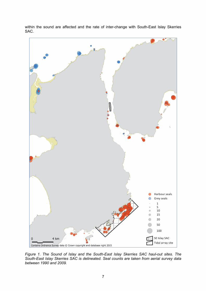
The methodology used to count grey seal pups cannot easily be applied in the same way to count harbour seal pups. Harbour seal pups shed their white coat in utero and are much more precocial when born. This presents two problems, in that pups and adults are much more camouflaged against rocky or seaweed covered shores and pups enter the water more readily within a few hours of birth. Fixed wing vertical photography is restricted to counting harbour seals that are easily detected in sandy habitats such as estuaries. However, this is not the typical haul-out substrate found in the Sound of Islay and South-East Islay Skerries SAC. Haul-out sites at the Sound of Islay and the South-East Islay Skerries SAC have been identified using a database of aerial survey data collected by SMRU (Figure 1). The haul-out sites identified within the sound will be used as the basis for studies to assess whether disturbance caused by the proposed development will affect haul-out behaviour and whether or not that disturbance is detectable by the methods employed during this project. Figure 2 shows haul-out sites in the immediate vicinity of the proposed development. It should be noted that none of the haul-out sites within the Sound of Islay were designated as “important” haul-out sites during the Scottish Government consultation process. However, the extensive database of telemetry data that SMRU has at its disposal suggests that there is some degree of movement of harbour seals between the area surrounding the proposed development and the South-East Islay Skerries SAC. This demonstrates that animals that use the South-East Islay Skerries SAC also use the sound between Islay and Jura to forage and/or haul out to rest. Therefore it is necessary to determine both how the haul-out sites
7
within the sound are affected and the rate of inter-change with South-East Islay Skerries SAC.
Figure 1. The Sound of Islay and the South-East Islay Skerries SAC haul-out sites. The South-East Islay Skerries SAC is delineated. Seal counts are taken from aerial survey data between 1990 and 2009.

8
Figure 2. Location of the boundary of the proposed tidal array development (delineated and shaded in black) in relation to nearby haul-out sites; Rubha Bhoraraic (RBR) and Bunnahabhain (BHN). Seal counts are taken from aerial survey data between 1990 and 2009.
9
4.1.3 Fixed wing vertical photography
Surveys of harbour seals using fixed wing vertical photography are carried out during the summer breeding season when most breeding females with pups will be ashore or during the annual moult when there are large aggregations of both adult males and females (Lonergan et al., 2007). At least in some parts of Scotland the distribution of harbour seals during the moult is more concentrated than during the breeding season and animals haul out in greater numbers more consistently. Consequently, many harbour seal aerial surveys carried out by SMRU are conducted in the first three weeks of August when animals are moulting (Thompson & Harwood, 1990; Thompson et al., 2005). Seals may use different haul-out sites for moulting than for breeding and so aerial surveys provide a means for determining which sites are important for either activity. 4.1.4 Aerial oblique photography
An alternative method to fixed wing vertical aerial photography is to use oblique aerial photography. This can be done either from a light fixed wing aircraft or from a helicopter. Using this technique both harbour and grey seal haul-outs are photographed using a digital SLR camera with an image stabilised lens and the images used to count animals, as well as, where possible, to classify group composition. As stated above seals hauled out on rocky or seaweed covered shores are difficult to detect by eye and on those types of substrate there is an increased risk of missing animals during surveys. At SMRU this technique is restricted to estuarine haul-out sites and sandbanks on the east coast of Britain (SCOS, 2013). Again, this technique is not applicable in the Sound of Islay or the South-East Islay Skerries SAC. 4.1.5 Helicopter with thermal imaging camera
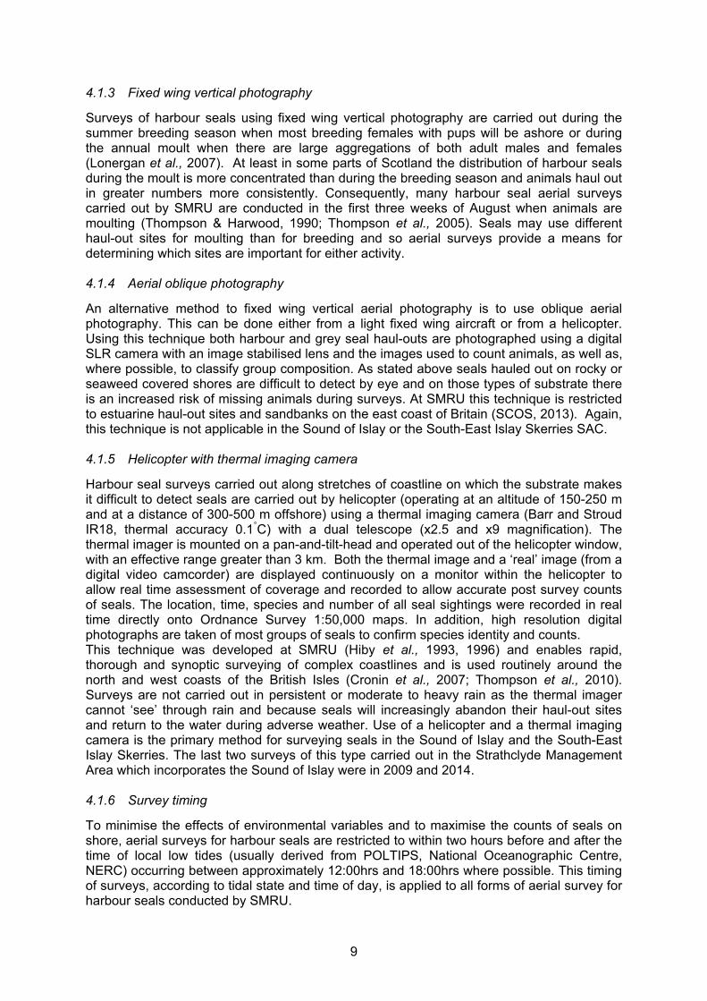
Harbour seal surveys carried out along stretches of coastline on which the substrate makes it difficult to detect seals are carried out by helicopter (operating at an altitude of 150-250 m and at a distance of 300-500 m offshore) using a thermal imaging camera (Barr and Stroud IR18, thermal accuracy 0.1°C) with a dual telescope (x2.5 and x9 magnification). The thermal imager is mounted on a pan-and-tilt-head and operated out of the helicopter window, with an effective range greater than 3 km. Both the thermal image and a ‘real’ image (from a digital video camcorder) are displayed continuously on a monitor within the helicopter to allow real time assessment of coverage and recorded to allow accurate post survey counts of seals. The location, time, species and number of all seal sightings were recorded in real time directly onto Ordnance Survey 1:50,000 maps. In addition, high resolution digital photographs are taken of most groups of seals to confirm species identity and counts. This technique was developed at SMRU (Hiby et al., 1993, 1996) and enables rapid, thorough and synoptic surveying of complex coastlines and is used routinely around the north and west coasts of the British Isles (Cronin et al., 2007; Thompson et al., 2010). Surveys are not carried out in persistent or moderate to heavy rain as the thermal imager cannot ‘see’ through rain and because seals will increasingly abandon their haul-out sites and return to the water during adverse weather. Use of a helicopter and a thermal imaging camera is the primary method for surveying seals in the Sound of Islay and the South-East Islay Skerries. The last two surveys of this type carried out in the Strathclyde Management Area which incorporates the Sound of Islay were in 2009 and 2014. 4.1.6 Survey timing
To minimise the effects of environmental variables and to maximise the counts of seals on shore, aerial surveys for harbour seals are restricted to within two hours before and after the time of local low tides (usually derived from POLTIPS, National Oceanographic Centre, NERC) occurring between approximately 12:00hrs and 18:00hrs where possible. This timing of surveys, according to tidal state and time of day, is applied to all forms of aerial survey for harbour seals conducted by SMRU.

10
4.2 Boat-based surveys
Boat-based surveys are most useful when the sites to be surveyed are confined to a relatively small area and are difficult to get to by land or where no vantage point is offered. For small areas, surveys by boat can be relatively cheap compared with aerial surveys and may allow repeat counts of an area to be made throughout the year. This has two advantages in that it can provide estimates of the variability in numbers of animals using an area and may allow seasonal changes in haul-out numbers to be assessed. The main problem with boat based surveys is that they are slow and it is therefore rarely possible to obtain a synoptic count of more than a small local group of haul-out sites. In addition, surveys that rely on boats are entirely reliant on good weather conditions, require trained crew and may be logistically difficult with effective ranges restricted by access to sheltered harbours or launching sites. Boat based surveys may cause disturbance if boats approach too close to haul-out sites so care should be taken when using this method to minimise the amount of disturbance caused. Boat surveys carried out at a designated haul-out site or within a SAC may require submission of a Habitat Regulations Appraisal and a Natura Proforma issued by SNH or other appropriate SNCA. 4.3 Ground counts
The simplest and cheapest method of counting seals that are hauled out is to conduct ground count surveys. Ground counts of seals are carried out regularly at local sites throughout the UK but the methodology employed can differ markedly between sites. Where vantage points are available to allow counts to be made of a representative proportion of a haul-out site or breeding colony from distance, relatively little disturbance is caused. As with boat-based surveys, ground count surveys have the advantage that their relatively low cost may allow repeat surveys of the same area throughout the year. Ground count surveys also don’t require specialist equipment or skills that aerial surveys and boat surveys do and are less likely to be halted by particular weather conditions. A pair of binoculars or a telescope is often all that is necessary to make an accurate count of the number of animals on a haul-out site or breeding colony. Where ground counting requires approaching the haul-out site or breeding colony care should be taken to minimise the amount of disturbance caused. If this involves approaching animals at a designated haul-out site or within a SAC, submission of a Habitat Regulations Appraisal and a Natura Proforma may be required. 4.4 Remote camera systems
Remote cameras offer a non-invasive method of monitoring seals at particular haul-out sites. By using time-lapse photography or by recording continuous video footage, data can be collected without causing any additional disturbance to the animals being observed. Both types of system have been used to remotely monitor pinniped species such as Steller sea lions (Eumetopias jubatus) (Kulinchenko et al., 2004; Maniscalco et al., 2006), northern elephant seals (Mirounga angustirostris) (California State Parks, 2009), grey seals (Strathspey Surveys, 2006; NOAA, 2011) and harbour seals (Hoover-Miller et al., 2004; Andersen et al., 2012). Typically for pinniped studies, these camera systems are used to collect behavioural data and to count animals (Thompson & Harwood, 1990; Maniscalco et al., 2007) but have in recent times been used to monitor seals at marine developments (Brasseur et al., 2009; Edren et al., 2010). Remote video cameras are currently used to view seals at part of the Isle of May SAC during the grey seal breeding season (Strathspey Surveys, 2006). Live video footage is transmitted to the Scottish Seabird Centre 17km away in North Berwick where members of the public visiting the centre can remotely control cameras to view the behaviour of grey seals during the breeding season. These cameras provide high quality video footage that has been used for scientific purposes as well as for

11
public engagement. Stills taken from video footage recorded by the Scottish Seabird Centre’s cameras at the Isle of May have been used to match images of individual grey seals using photo-ID software developed at SMRU (Hiby, 2012). There is also the potential to use that same footage to conduct surveys such as pup counts on the beach where the cameras are located. The remote cameras at the Isle of May demonstrate how this tool can be used to engage with the public while also generating data that are useful for the long-term monitoring of seals at a SAC. This technology is applicable to even the most remote sites as wind and solar energy can be used to provide power while the data can be transmitted via microwave signal to a receiver several kilometres away. Video footage can then be viewed live or recorded for post-processing and analysis. Such systems using both video and time-lapse photography have been used extensively to assess cave use and estimate local populations of endangered Mediterranean monk seal (Hiby & Jeffery, 1987; Dendrinos et al., 2007). Remote cameras are limited in that they only cover relatively small areas of shoreline. Depending on the topography of the site to be surveyed and the purpose of the survey, more than one camera may be required. However, once set up they allow continuous coverage of the site using a survey technique that causes no disturbance. Systems range in complexity from simple time lapse digital still cameras in weather-proof housings through to complex microwave-transmitted, video systems and costs vary accordingly. Where the survey effort at a site is intended to provide a long-term monitoring capacity the initial cost of setting up a remote system may be less than the protracted cost of repeat surveys using alternative methods. 4.5 Photo-ID
The coats of individual grey and harbour seals have unique patterns. Where these patterns are clear enough to be differentiated by either direct observation or from photographs the seals are effectively tagged and can be reliably identified in the field. Photo-identification is a method used to distinguish between individual seals both on land and at sea and has been employed in Scotland for both harbour seals (Thompson & Wheeler, 2008; Cunningham, 2009) and grey seals (Smout et al., 2011; Hiby et al., 2013). The matching of photographs of individual animals is either done by eye or using semi-automated software (Hiby, 2012). The method employed depends on the number of animals being photographed which in turn determines the amount of labour involved in making matches. Where large numbers of photographs are taken over successive years the time required to manually match images becomes impractical and the aid of matching software is required. This non-invasive technique provides the opportunity to collect long-term data on several individuals that can only be achieved otherwise by handling animals and applying artificial marks such as flipper tags or brands. Photo-ID has been used on a large scale to estimate population size (Hiby et al., 2007) and movement across regions (Kiely et al., 2000). However, it is more commonly used on a smaller scale at particular sites where seals are known to be site faithful (Mackey et al., 2008; Cordes et al., 2011). Other population parameters can be estimated using photo-ID such as immigration/emigration and survival (Smout et al., 2011; Hiby et al., 2013), while the accuracy of counts where animals are found in large aggregations can be improved by avoiding counting the same individuals more than once. Photo-ID suffers from the same problem as conventional ground counts, in that the topography of the land must give sufficient vantage points so as not to miss animals while surveying. However, where the site offers good vantage points this technique provides a tool to assess the fidelity of individuals to particular sites within and between seasons.

12
4.6 Telemetry
Telemetry devices offer high resolution data on haul-out activity, at-sea locations and dive behaviour of seals that is otherwise impractical or impossible to obtain. Telemetry tags used for grey seal and harbour seal studies come in different forms depending on the objectives of the study. Historically, VHF radio tags have been used to study at-sea behaviour (Thompson et al., 1989). However, tags of this type are limited in that data collection relies on being within relatively close proximity to radio receivers in order to pick up the signal produced by the tag. This is impractical when monitoring highly mobile species such as seals, whose movements will often go beyond the signalling distance of the tag, creating windows of missing data. Where the aim is simply to monitor haul-out use at specific sites, VHF telemetry may be sufficient. More frequently used telemetry devices used for seal studies are Argos satellite (McConnell et al., 1999; Lonergan et al., 2013) and GPS mobile phone tags (McConnell et al., 2004; Cordes et al., 2011). In addition to providing track data, both systems provide details of individual haul-out events, as well as dive behaviour. Also, at-sea usage data can be used to assess the spatial scale over which seals move. The interconnectivity of haul-out sites and at-sea usage areas should be considered when monitoring seals that can move over large areas. The main difference between Argos satellite tags and GPS mobile phone tags is the level of error associated with the location data they generate. Argos satellite tags transmit a signal from the tag to low-orbiting weather satellites of the National Oceanic and Atmospheric Administration (NOAA) that then determine the location of the tag based on information on the Doppler shift of the transmitted signal. Some studies have assessed the error rate of Argos satellite tracking of marine mammals (Vincent et al., 2002; White & Sjoberg, 2002). The values obtained vary widely but the level of accuracy can be expected to be much lower than for GPS mobile phone tags (Costa et al., 2010). As such, Argos satellite tags are used where location accuracy need only be broad-scale and/or where more emphasis is placed on the other data being transmitted by the tag such, as haul-out frequency (Lonergan et al., 2012). Where location accuracy is important, such as when determining important haul-out sites or when assessing interactions of seals with marine developments, GPS equipped tags should be used. GPS phone tags developed at SMRU combine GPS quality locations with the ability to transmit data via the GSM international mobile phone network. While hauled out, as long as the seal is within GSM phone coverage, Fastloc GPS locations will be transmitted at a frequency set by the user. When a seal leaves a haul-out to go to sea, Fastloc GPS locations are obtained when the seal surfaces and stored in the memory of the tag until such time as it returns within range of GSM phone coverage. GPS positions and behavioural data are then transmitted directly back to SMRU for post-processing. As well as increased accuracy of location data, these tags are more energy efficient, allowing the quantity and frequency at which data are recorded and transmitted to be increased. Attachment of the tag is done by gluing the device to the fur on the back of the head of the animal, a technique first practically demonstrated by Fedak et al. (1983). This maximises the signal transmissions of the tag while minimising the impact on the animal and provides a means for automatic detachment when animals are moulting. For both grey and harbour seals the methodology normally used for attaching telemetry tags is such that, when their hair is shed during the annual moult, the tag is shed with it. The moult period for grey seals occurs between December and April and for harbour seals during August and September. These are windows of time when it should be expected that conventional telemetry device attachment methods cannot be used. Telemetry data can, however, be collected during the moult period using ARGOS transmitters attached to flipper tags (Lonergan et al., 2012).

13
In 2011 and 2012, under contract to SNH and the Scottish Government, SMRU deployed a total of 17 GPS mobile phone tags on adult harbour seals in the Sound of Islay and at the South-East Islay Skerries SAC. The telemetry data gathered showed that there was a degree of interchange between the seals using haul-out sites in the Sound of Islay itself and the South-East Islay Skerries SAC. The existing dataset were used to determine which haul-out sites are most relevant in terms of assessing the effects of disturbance due to the proposed development and where effort should be focussed to try and detect that disturbance.

14
5. SOUND OF ISLAY 2014 DISTURBANCE TRIALS
5.1 Introduction
Several studies have described the normal haul-out pattern of harbour seals in relation to environmental conditions (Watts, 1992; Grellier et al., 1996), tidal state (Pauli & Terhune, 1987), diurnal activity (Watts, 1996) and seasonal events such as the breeding and moult periods (Thompson et al., 1989). The expected haul-out pattern of harbour seals is therefore well understood. Understanding what happens when that normal haul-out pattern is affected when anthropogenic activity causes disturbance is key to targeting mitigation to minimise the impact of disturbance on seals. Previous studies looking at the causes of disturbance of seals at haul-out sites have typically focused on factors such as the distance at which seals are disturbed by boats (Jansen et al., 2010), the type of boat activity that causes disturbance (Johnson & Acevedo-Gutierrez, 2007) and disturbance by pedestrians (Osinga et al., 2012). However, having identified the causes of disturbance it is important to then quantify the associated effects in terms of behavioural changes in the seals being studied. This study assesses the impact of repeated disturbance of harbour seals from their haul-out sites and how this might be relevant to the proposed tidal turbine development in the Sound of Islay. The aim is to provide a protocol for monitoring haul-out sites that is both capable of detecting localised disturbance effects and of being delivered by developers and/or their consultants. The information gathered on spatial and temporal patterns of haul-out behaviour will be used to estimate the geographical range of influence of localised disturbances and to determine the scale of monitoring required to identify causal agents of disturbance. 5.2 Methods
5.2.1 Existing telemetry data
A total of 17 harbour seals were tagged in and around the Sound of Islay in 2011 and 2012. These telemetry data show that there is some degree of interchange between haul-out sites surrounding the proposed development in the Sound of Islay and the South-East Islay Skerries SAC. Figure 3 shows the GPS tracks of individuals tagged in the Sound of Islay in 2012 demonstrating how seals used the Sound either for transit/foraging or to haul out and the geographical extent of their movement beyond the Sound during the tag deployment. The movement of seals tagged in 2011 and 2012 is briefly described in Sparling (2013). These data, along with aerial survey data, were used to determine the haul-out sites within the Sound of Islay that are most frequently used by harbour seals, especially those in the vicinity of the proposed tidal turbine development. This was with the aim of choosing the best locations for a new deployment of telemetry tags and for setting up remote camera systems. 5.2.2 Monitoring haul-out sites using remote cameras
Monitoring all haul-out sites used in the Sound of Islay according to the 2011/2012 telemetry data would be prohibitively expensive and, at least at some lesser used sites, unnecessary. Remote time-lapse cameras were set up at vantage points overlooking the two most frequently used haul-out sites within the Sound of Islay in 2011/2012. These sites were Rubha Bhoraraic (RBR) and Bunnahabhain (BHN), either side of the proposed development (Figure 2). Time-lapse photography was collected continuously throughout the study period. Data collection commenced at BHN on the 23/04/2014 and at RBR on the 24/04/2014. At both sites camera systems were recovered on the 22/07/2014 at the end of the study. Each camera system consisted of two Canon EOS 1100 DSLR cameras in a single weatherproof housing, each with one camera equipped with an 18-55mm lens and the other with a 70-300mm lens. This provided both a wider scale view of activity around the haul-out and a view more focused on the haul-out itself. The frequency of time-lapse photographs taken was set at one per minute for each set of cameras. Background counts could then be done

15
for those sites during daylight hours while also recording the recovery of seals hauling out again within the same low tide period after being disturbed into the water. A high time-lapse frequency also allowed for observations of disturbance events other than those carried out purposefully during this study. 5.2.3 GPS/GSM phone tag deployment
In order to monitor changes in seal distributions at multiple haul-outs that may result from anthropogenic sources, it is first necessary to know the geographical extent to monitor. For example, if individual seals were faithful to only one haul-out there is only a need to monitor counts at the haul-out sites nearest to it, i.e. within foraging trip distance of the source of disturbance. On the other hand, if seals regularly transited amongst distant haul-out sites, then the monitoring extent would have to be appropriately increased. By using telemetry devices to monitor the movements and haul-out patterns of harbour seals this study aimed to determine the geographical extent over which animals move in relation to the proposed Sound of Islay tidal turbine development. This project also aimed to quantify the frequency with which animals transit from one haul-out to another within that geographical context.

16
Figure 3. Tracks of 10 harbour seals (colour-coded by individual) tagged within the Sound of Islay in 2012. H represents a subset of the ‘known haul-out’ list showing locations in and around the Sound of Islay where telemetered harbour seals have hauled out historically.

17
In April 2014 eight SMRU GPS/GSM phone tags were deployed on adult female harbour seals. Animals were captured at either BHN or RBR as the 2011/2012 telemetry data suggested that these sites are most frequently used to haul out within the Sound of Islay. By choosing these two sites for the capture of seals for telemetry tag deployment the likelihood of finding these animals again to implement disturbance trials would be highest. Also, their haul-out behaviour in relation to other non-telemetered seals would be more likely to be recorded concurrently using the remote camera systems. This approach aimed to quantify the normal haul-out and movement behaviour of harbour seals at the two most frequently used haul-out sites within the Sound of Islay and to what extent those behaviours were affected by disturbance. 5.2.4 Controlled disturbance trials
The type of disturbance most relevant to the proposed tidal turbine array at the Sound of Islay is a higher than normal exposure to boat traffic during the construction phase. To simulate this type of increased anthropogenic activity experimental disturbance trials were carried out by approaching hauled out seals, at two sites in the Sound of Islay, in a 14ft RIB at a speed of five knots. Neither of these sites is a designated haul-out site. Approaches were initiated at a distance of approximately 300m and continued in a straight line until the haul-out site was reached and all seals were flushed into the water. Seals were approached at an angle that provided the clearest line of sight between animals on the haul-out and the approaching boat. This method of disturbing seals into the water is extreme in the sense that at the two sites overlooked by time-lapse cameras (RBR and BHN) animals were disturbed into the water whether telemetered animals were present or not. However, at all other sites a telemetered animal had to be present before a disturbance trial was carried out. Disturbance of seals from their haul-out was restricted to approximately two hours before low tide to allow time for animals to haul out again within the same low tide period. To maximise the efficiency with which telemetered animals could be found GPS/GSM tags were programmed to transmit regular updates on the location of tagged animals so that they could be located on a daily basis. This focused efforts in finding tagged animals when deciding where and when to simulate disturbance events. Telemetry data from sites at which seals were flushed into the water provided information on the effects of disturbance in terms of their subsequent haul-out behaviour and whether or not disturbance caused animals to transit between haul-out sites more frequently. Tags deployed in 2014 added to data collected in 2011/2012 enabling better quantification of the amount of interchange between haul-out sites in the Sound of Islay and the nearby South-East Islay Skerries SAC. 5.2.5 Analysis of haul-out behaviour
SMRU GPS/GSM tags record haul-out events and from the track data it is possible to assign a location to each haul-out event. The time series of GPS fixes are irregular and so there may be times when no locations were obtained during a given event. When this happened during the disturbance trials an approximate location was calculated using linear interpolation. In parallel, a list of ‘known haul-out’ sites that had been visited at some time by telemetered seals was accumulated. The estimated haul-out location was then snapped to a ‘known haul-out’ location. Where there was a large mismatch (snapDist > 2km) and the haul-out was on land, this new location was added to the ‘known haul-out’ list. Note that haul-outs (as defined by the tags’ > 10 minutes continuous dry rule) may occasionally occur at sea. Such at-sea haul-outs (here defined as > 2km from the shore) were omitted from this analysis. In this study a haul-out event was defined as having ended when the tags were wet for > 10 minutes and an animal was then defined as being on a trip. The location of and time until a subsequent haul-out event then determined if an animal had returned to the same haul-out site or transited to a different haul-out site, and in what timeframe either of those events occurred.

18
Data from the first week were excluded from the final dataset. This allowed time for any behavioural changes associated with seals being captured to return to normal but was also necessary when looking at haul-out site use in the previous week during the analysis. All statistical data analyses were carried out using the statistics package R (R Development Core Team, 2014). An examination was carried out on how transition probability, i.e. seals moving from one haul-out site to another, was influenced by: Julian day, site fidelity, tidal cycle and disturbance. Julian day was included because there may be seasonal changes in the propensity of seals to switch haul-out location. Site fidelity may also influence transition probability and was defined as the percentage of haul-out events in the previous week that were at the current haul-out location. Both Julian day and site fidelity were input as smooth terms. Whether or not seals hauled out during the same or a subsequent low tide period was included as a factor to determine to what extent seals repeatedly haul out and how often they switch haul-out sites within a single low tide. In the context of disturbance this is relevant in that once disturbed into the water seals have four choices; (i) haul out within the same low tide period at the same haul-out site, (ii) haul out again within the same low tide period at a different haul-out site, (iii) haul out on a subsequent low tide period at the same haul-out site, and (iv) haul out on a subsequent low tide period at a different haul-out site. Disturbance was included as a factor defined as whether or not seals were flushed into the water during a haul-out event while carrying out controlled disturbance trials. The maximal model also included an interaction between site fidelity and tidal cycle because the effect of site fidelity on transition probability may depend on whether the animal is hauling out in the same or a subsequent low tide period. A Generalised Additive Mixed Model (GAMM) framework, within the R package mgcv (Wood, 2004), was used with an AR1 correlation structure incorporated to account for autocorrelation among trips within each individual. Backward model selection was carried out using AIC selection. The primary aim of this part of the study was to determine if repeated disturbance events affected seals’ haul-out behaviour. However, this modelling approach also aimed to identify the main variables that influence whether or not seals transit to a different haul-out site after they have entered the water regardless of the presence or absence of disturbance. 5.3 Results
5.3.1 Monitoring haul-out sites using remote cameras
5.3.1.1 General counts
When conditions permitted, the number of seals on haul-outs was counted between 04:00 and 22:00 at both BHN and RBR. Tidal cycles at each site were defined as 6 hours either side of low tide at Port Askaig and counts were recorded relative to the closest low tide. Counts of seals were then grouped by month and whether or not the count was made during a spring or a neap tide. Figure 4 and Figure 5 show the mean and maximum counts during spring and neap tides in May, June and July at BHN and RBR respectively. During spring high tides both haul-out sites are completely submerged, truncating the time available to seals to haul out during a tidal cycle. However, during neap high tides at least a small amount of land protrudes from the water meaning seals can choose to remain hauled out at high tide. This pattern of haul-out time being truncated during spring tides and more widely spread during neap tides was quite evident at BHN. However, at RBR the pattern was less clear, perhaps due to the lower use of that haul-out site by seals as the study progressed. 5.3.1.2 Disturbance trials
On disturbance trial days counts were made every minute in the lead up to and beyond the time of disturbance. Counts were made until 6 hours after the low tide period in which disturbance trials took place, allowing an assessment of the recovery of haul-out numbers from pre-disturbance to post-disturbance levels.

19
At BHN a total of 17 disturbance trials were recorded using time-lapse photography. The mean percentage recovery of seal numbers on the haul-out to pre-disturbance levels is shown for BHN in Figure 6. Mean counts of seals before and after disturbance trials indicated that the number of seals on the haul-out returned to ~50-60% of pre-disturbance numbers within 30 minutes and ~90-100% of pre-disturbance numbers within 240 minutes. Beyond that time the influence of the rising tide caused mean counts to decline. Time-lapse photography indicated that BHN was regularly used as a haul-out site throughout this study with counts of zero seals occurring on very few days. Seals were therefore available for disturbance trials on almost every occasion the site was visited. Time-lapse photography indicated that counts of zero animals on the haul-out occurred on only 2 days in May, 3 in June and 1 in July. At RBR a total of 10 disturbance trials were recorded using time-lapse photography. The low number of trials recorded at RBR compared with BHN was due to this site being less used by seals as the season progressed. On several occasions when disturbance trials were due to be carried out there were no animals on the haul-out. Figure 5 shows that mean counts at RBR were quite low during the study period, especially in June. This was also evident in the telemetry data as only one of the telemetered animals in this study visited RBR beyond April. Even then, that animal hauled out at RBR for less than 2 hours on each occasion and did not return to that site on the next haul-out. There were several days at RBR when time-lapse photography indicated that there were no seals hauled out at low tide. Specifically, there were 11 days in May, 17 days in June and 11 days in July when time-lapse photography showed that there were no seals on the haul-out at low tide.

20
Figure 4. Shown are the mean counts of hauled out seals (solid red) with 95% confidence intervals (dashed red lines) against time relative to low tide at BHN. Mean peak counts are also given (solid black). Data are divided into spring and neap tide periods for May, June and July.

21
Figure 5. Shown are the mean counts of hauled out seals (solid red) with 95% confidence intervals (dashed red lines) against time relative to low tide at RBR. Mean peak counts are also given (solid black). Data are divided into spring and neap tide periods for May, June and July.

22
Figure 6. Shown is the mean percentage recovery of the number of hauled out seals (solid black line) with 95% confidence intervals (dashed red lines) over minutes relative to the disturbance trials. Data are for BHN.
The response of seals to disturbance was quite different at RBR compared to BHN. In all 10 of the disturbance trials carried out at RBR no seals hauled out again within the following 30 minutes and on only one occasion did a seal haul out again within 60 minutes of the disturbance, the disturbance trial involving only one animal in this instance. The number of seals being disturbed at any one time at RBR was generally quite low. On four occasions only one seal was disturbed into the water. On two occasions there were relatively high numbers of seals on the haul-out, 6 and 8 on the 11/06/14 and 15/07/14 respectively. However, even in these disturbance trials, recovery of the counts of seals to pre-disturbance levels did not occur. It would seem therefore that the effect of disturbance at RBR is to cause seals not to haul out again at that site in the same low tide period. However, due to the fact that none of the telemetered animals in this study were part of disturbance trials at RBR, it is not possible to say what seals did beyond that point. The mean peak counts of seals on the haul-out at BHN and RBR were compared for the day before, the day of, and the day after disturbance trials (Figure 7). Data for BHN and RBR were compiled together due to the low number of disturbance trials carried out at RBR. Mean peak counts of seals were slightly lower on disturbance trial days as compared with the day before and the day after. However, this difference was not found to be significant (F(2,54)=0.621, p>0.05). A lower number of seals on the haul-out during disturbance trial days might be expected if the disturbance trial itself reduces the amount of time available to the seal to haul out in a given low tide period. Also, the telemetry data suggest that a proportion of animals will leave the site of disturbance which again would result in lower peak counts during disturbance trial days.

23
Figure 7. Mean peak counts of seals at BHN and RBR on the day before, the day of and the day after disturbance trials were carried out. Error bars are +/- 1 standard error.
5.3.2 GPS/GSM phone tag deployment
In the 2014 telemetry study a total of 626 days of seal tracking data were collected from eight adult female harbour seals. The mean duration of tag deployment was 78 days (range = 41 to 107 days, SE=6.98). 5.3.2.1 Use of haul-out sites
For all animals there was a total of 634 haul-out events separated by more than 10 minutes. Overall, 16 haul-out sites were used throughout the study, with individual seals using a mean of five haul-out sites (range=3 to 9, SE=0.77). The mean duration of haul-out events, not including those in which disturbance trials were conducted, was 5.2 hours (SE=0.28). Some degree of site fidelity was shown for particular sites in both the overall mean duration of haul-out time spent at each site and the mean number of times each site was visited. Table 2 shows these figures for each of the haul-out sites used, as well as giving the number of individuals that visited each site throughout the duration of the 2014 study period.

24
Table 2. Listed are site code abbreviations, their location and the latitude, longitude co-ordinates for all sites used by telemetered seals as haul-out sites in 2014. Also included are the number of times each site was visited, the mean duration of haul-out events at those sites and how many individuals visited each site during this study. * Time lapse cameras were deployed at BHN and RBR Site Code
Site Name Location Lat Lon No. of visits
Mean haul-out event duration (hours)
No. of individuals
BDH Bagh an Da Dhoruis Islay 55.93559 -6.15097 87 3.2 3
BHN* Bunnahabhainn Islay 55.891175 -6.131105 123 5 7
BRP Brein Phort Jura 55.922896 -6.064843 23 5.3 3 CAS Carragh an t-Struith Jura 55.87061 -6.096444 4 2.3 2
CON Colonsay North Colonsay 56.14747079 -6.167427959 2 4.7 1
EGH Eileanan Gainmhich Islay 55.864512 -6.110327 59 3.9 6
EGR Eilean Gleann Righ Jura 55.968332 -5.986099 230 6.2 6
EST Eileanan Stafa South Uist 57.39659 -7.288119 35 6.9 1
HAU Haun South Uist 57.090523 -7.296631 8 3.5 1
HOU Hough Skerries Tiree 56.52 -7.020000047 1 0.6 1
HRT Hairteamul South Uist 57.084119 -7.229136 1 1.1 1
ISL Nave Island Islay 55.8991244 -6.34078397 1 0.5 1
RBL Rubha Liath Jura 55.962461 -5.950904 22 5.6 2
RBR* Rubha Bhoraraic Islay 55.819718 -6.103997 4 1.6 3
SAN Sanda Island Kintyre 55.284856 -5.571027 4 2.9 1
SGB Sgeiran a Bhudragain Jura 55.958036 -5.946192 22 4.5 3

25
5.3.2.2 Movement between haul-out sites
After filtering the data, a total of 626 trips were identified in the 2014 dataset. The total number of trips that resulted in seals transiting from one haul-out site to another was 162 (26%), with a mean trip duration of 34.1 hours (SE=4.58). Trips that resulted in seals returning to the site they had departed from totalled 464 (74%), with a mean trip duration of 14.25 hours (SE=0.95). The lower trip duration when returning to the same haul-out is partly explained by some trips not resulting in heading out to sea to forage but simply entering the water for a short period and hauling out again. Also, shorter trips with higher site fidelity were increasingly observed as the pupping season progressed. For trips that resulted in a transition to another haul-out site the mean number of times that seals hauled out at that site in the previous week was 2.6 (SE=0.27), compared to 7.2 (SE=0.28) when it was a return trip. This suggests that on a short temporal scale seals were more likely to haul out repeatedly in the same place. However, it was apparent that seals did make broad-scale seasonal changes in haul-out site usage, with several animals moving to the north end of the Sound of Islay and into Loch Tarbert on the west side of Jura from the beginning of June onwards. When looking at the influence of tidal cycle on seal movement in the Sound of Islay, of the 162 trips that resulted in a transition only 13 were transitions to a different site within the same low tide period. Two of these trips occurred after a controlled disturbance trial. The remaining 149 trips were transitions that occurred on a subsequent low tide which suggests that if a seal is to transit from one haul-out site to another they are more likely to do so having been at sea for a longer period. Of the 464 return trips 51 occurred within the same low tide period. Some of these trips may be explained by seals entering the water for a short period and then hauling out again on a different part of the same haul-out site. Additionally, 11 of these trips were undertaken directly after controlled disturbance trials. The remaining 413 return trips occurred on a subsequent low tide period. Overall, whether trips were transitions or returns, 90% were separated by at least one high tide period demonstrating a clear influence of the high tide period dictating that seals were more likely to move from their haul-out sites. At some sites used to haul out by seals in this study, for example RBR and BHN, spring high tides result in the haul-out being completely submerged. This dictates that seals will then have to embark on an inter-haul-out trip. In contrast to this, on neap high tides, while both haul-outs are much reduced in size, at least part of each is still available for seals to haul out on. In this case space limitation on the haul-out might reduce the likelihood of a seal remaining hauled out but does not necessarily dictate that a haul-out event will end. 5.3.2.3 Controlled disturbance trials
Disturbance trials commenced on 26/05/2014 and were repeated every three days (weather permitting) for a total of 20 disturbance trial days. This effort largely spanned the duration of the transmissions from the telemetry tags. Figure 8 summarises the haul-out sites at which seals were disturbed and whether they hauled out within the same or on a subsequent low tide period. There were 22 seal disturbance events when seals were flushed into the water and the telemetry data were successfully uploaded from the tag. Of those, 13 resulted in animals hauling out again within the same low tide period. On 12 of those occasions seals returned to the same haul-out location and only once did a seal transit to a different haul-out site within the same low tide period. The remaining nine seal disturbance events resulted in seals starting a trip that was separated by at least one tidal cycle. When on these trips, seals appeared to behave normally, visiting the same areas they would use for what may be foraging trips. On eight of these occasions seals later returned to the haul-out site from which they departed and on only one occasion did a seal haul out at a different haul-out site on a subsequent low tide.

26
Arrive
BHN
BDH
EGR
BRP
Dep
art
BHN
5
1
BDH
1
EGR
6
BRP
BHN’
5
1
BDH’
1
EGR’
2
BRP’
Figure 8. Haul-out/trip transition matrix showing where seals departed from and where they hauled out again after simulated disturbance trials. The total number of disturbance trials resulting in each scenario are given. In the upper part of the matrix in grey are locations where seals hauled out again within the same low tide period after being disturbed into the water. In the lower part of the matrix in pink are locations suffixed with ‘ where seals hauled out again in any subsequent low tide period having started a trip after being disturbed into the water’.
5.3.3 Analysis of haul-out behaviour
By the process of backwards model selection using AIC, only the interaction between site fidelity and tidal cycle was retained in the final model. It is likely that Julian day was not retained because although seals did change the site at which they preferred to haul-out during this study, this was mostly associated with the onset of the pupping season when broad scale changes were made. When seals did switch haul-out sites they switched preference for one haul-out site to another rather than regularly switching between different haul-out sites. This was reflected in the fact that site fidelity was retained showing that the higher the proportion of haul-out events in the previous week that occurred at a particular site, the more likely they were to haul out there again rather than elsewhere. However, the shape of the relationship between site fidelity and transition probability varied with whether seals hauled out again on the same or on a subsequent low tide period (Figure 9). Overall seals were more likely to transit from one haul-out site to another if the trip in between included at least one high tide period.

27
Figure 9. Transition probabilities for seals dependent on the proportion of times they had hauled out at the site of departure within the previous week. Transition probabilities are shown for the two scenarios of either hauling out again on the same (blue) or on a subsequent (red) low tide period. Solid lines are model predictions with 95% confidence intervals as dashed lines.
5.4 Discussion
The results of this study suggest that repeated disturbance of harbour seals in the Sound of Islay does not cause broad-scale changes in the location at which they choose to haul out. Instead, seals either haul out relatively quickly in the same location within the same low tide period after being disturbed into the water, or they go on a trip before hauling out in a subsequent low tide period at the location from which they were disturbed. The main effect of disturbance therefore seems to be to reduce the amount of time seals spend hauled out around the point of disturbance. In the case where seals haul out again within the same low tide period that effect will be minimal. However, at the higher usage haul-out sites where the mean duration of haul out was 5-6 hours a disturbance event that resulted in seals heading out to sea would reduce haul-out time within that low tide period. This is particularly true at haul-out sites that are submerged at high tide. A similar study by Andersen et al. (2012) suggested that extended inter-haul-out trips that occurred directly after a disturbance event were foraging trips, indicating a behavioural adaptation to offset the cost of being disturbed into the water. The 2014 telemetry data from the animals in the Sound of Islay suggest this may be true as the areas visited after disturbance events and the observed behaviours while in those areas were similar to those during normal trips outwith days when disturbance trials took place. It therefore seems that the behavioural response of seals to disturbance in the Sound of Islay is to either haul out again quickly or to embark on a trip having already been forced into the water. Additionally in both scenarios, the response is almost always to return to the same haul-out site where the disturbance event took place.
0.00 0.10 0.20 0.30 0.40 0.50 0.60 0.70 0.80 0.90 1.00
0.0
0.2
0.4
0.6
0.8
1.0
Proportion of previous week haulout
Tra
nsiti
on p
roba
bilit
y DifferentSame

28
Previous studies that assess the effects of disturbance provide evidence that anthropogenic activities can alter the haul-out behaviour of harbour seals. For example, Henry and Hammill (2001) suggest that increased human activity during good weather or during summer vacations increases the number of disturbance events of harbour seals in Métis Bay, Canada. Similarly, Lonergan et al. (2013) suggest that harbour seals on the west coast of Scotland haul out less at the weekends as opposed to during weekdays, which may be attributable to differing levels of anthropogenic activity. It has also been suggested that harbour seals may switch to a nocturnal haul-out pattern to avoid hauling out during the day when anthropogenic activity is high (London et al., 2012). Repeated disturbance can therefore illicit broad-scale changes in the timing and frequency with which harbour seals haul out during their annual life cycle. This study found that repeatedly flushing seals into the water did not cause seals to transit from one haul-out site to another. However, conclusions drawn from this result that are relevant to potential marine renewable developers only apply to activity that involves boat work in close proximity to haul-out sites. Other types of anthropogenic activity that may be thought to cause disturbance would have to be assessed separately. The seals in this study displayed a high degree of site fidelity, repeatedly returning to the same haul-out sites after trips. Site fidelity in harbour seals has also been observed in other studies (Dietz et al., 2013; Thompson et al., 1989) and has been observed to change seasonally (Thompson et al., 1994; Lowry et al., 2001). The results of this study show that a relatively intense level of disturbance does not adversely affect site fidelity. Even when repeatedly flushed into the water seals generally returned to the haul-out site from which they were disturbed either immediately or during a subsequent low tide period. However, the fact that repeated disturbance by the methodology used in this study did not cause seals to switch haul-out sites suggests frequent disturbance events at a particular haul-out site is likely to cause the same animals to be flushed into the water repeatedly. There was a seasonal change observed in the spatial distribution of seals with a shift north to Loch Tarbert for the pupping season being most notable. However, this did not result in an increase in the probability of seals transiting between haul-out sites due to the behavioural change being a sudden and sustained switch of haul-out preference from one site to another. Only one site, BHN, was used as a pupping location within the Sound. All other pups were observed either in the South-East Islay Skerries SAC or in Loch Tarbert in Jura. Harbour seals tagged in the Sound of Islay shifting to a more northerly distribution was also noted in Sparling (2013) based on the 2012 telemetry data. The mode of disturbance used in controlled trials for this study was to approach seals on haul-out sites by boat until they flushed into the water. This was to simulate the type of disturbance that might result from increased boat activity associated with a tidal turbine development in the Sound. It is possible that pedestrian disturbance at the same intensity as that implemented through controlled disturbance trials by boat may have had a stronger effect. However, this was not found to be the case in a comparison of boat versus pedestrian disturbance in a study by Andersen et al. (2012). At the two sites where most seals were observed in the vicinity of the proposed development, BHN and RBR, pedestrian access is very limited and so it should be expected that disturbance by pedestrians would be minimal. This was found to be the case according to the time-lapse photography data at both these sites, which demonstrated that pedestrians rarely approach these haul-out sites. Generally, seals in the Sound of Islay are exposed to boat traffic on a daily basis at a distance that does not cause them to flush from their haul-out sites. The time-lapse photography data show that neither of the two haul-out sites, BHN and RBR, were ever approached by boats at a proximity similar to that during controlled disturbance trials. It is unclear whether boat activity associated with the proposed tidal turbine development would ever be in such close proximity to haul-out sites within the Sound.

29
5.5 Conclusions
Planned construction at the Sound of Islay is likely to overlap with important periods in the life cycle of seals that regularly use the area to haul out. The results of this study suggest that despite repeated disturbance events seals will return to the same haul-out location either immediately within the same low tide period or during a subsequent low tide period having gone on an inter-haul-out trip. It should therefore be expected that increased anthropogenic activity at or near a particular haul-out location will not cause individual seals that use that haul-out site to transit to another haul-out site as a result. In this study seals were exposed to controlled disturbance trials that resulted in animals being flushed into the water by an approaching boat. The level of boat disturbance created by this study is likely to exceed that caused by the construction phase of the proposed development in the Sound of Islay. By quantifying behavioural changes associated with frequent disturbance events this study shows that the expected effect of increased boat traffic on the probability of seals transiting from one haul-out site to another will be negligible. Also, this study suggests that monitoring effort to mitigate any perceived risk of increase in disturbance levels need only be on a local scale due to the continued site fidelity of harbour seals when exposed to disturbance caused by approaching boats.

30
6. MONITORING PROTOCOL FOR DISTURBANCE AT HAUL-OUT SITES
6.1 Introduction
There is a requirement for a standardised protocol for monitoring seal haul-out sites for the purpose of detecting disturbance events and, if feasible, identifying their causes. This report discusses the requirements of such monitoring programmes, describes available, appropriate methods and then describes how such a programme could be carried out using the Sound of Islay as a worked example. Current SNH guidance on monitoring for disturbance and/or displacement during construction, deployment and operation of devices (Sparling et al., 2011) states that “Monitoring for disturbance and displacement (including barrier) effects during construction and deployment should focus on measuring changes in abundance and distribution of animals present in the study area during the construction and operational phases.” Previous guidelines (e.g. Adams et al., 2009; Sparling et al., 2011) have been focused on detecting the longer term impacts resulting from disturbance, such as reductions in range, population density, or usage of particular habitats or barrier effects. The methods appropriate for monitoring longer term changes in distribution and abundance (relative or absolute) include vantage point surveys, boat or aerial line transect surveys, haul out counts and telemetry, and are described in the draft SNH guidance (Sparling et al., 2011). The Marine (Scotland) Act (2010) makes it an offence to harass, intentionally or recklessly, seals at designated haul-out sites. As a consequence, licensable marine operations in the vicinity of seal haul-out sites may, in addition to assessing the medium and longer term effects, be required to monitor haul-out sites to detect individual disturbance events in order to identify their cause and assess their severity and frequency. It is important that such monitoring is targeted effectively to maximise the chances of detecting and characterising disturbance events while at the same time minimising the cost of such activities. Although it has been shown that harbour seals show more vigilance behaviour during disturbance events, these changes are subtle (Henry and Hammill, 2001). It is unlikely that any long term monitoring programme designed to record seal numbers over entire haul-out sites will be able to record such fine scale changes in behaviour. It is assumed that the aim of an observation programme is to record the frequency of disturbance events that cause at least a proportion of the seals to leave the haul-out site and enter the water. There are three main considerations when designing a monitoring programme for detecting disturbance events and assessing their long term effects:
1. The structure of the monitoring programme will depend to some extent on the type of disturbance likely to occur at a site of interest.
2. It is necessary to determine the appropriate geographical scale of the monitoring to be able to detect and identify the causes of specific/individual disturbance events.
3. It is necessary to identify the monitoring methods that will provide adequate data for detecting disturbance events, this will include consideration of : What technology should be applied. What is the appropriate frequency of observation. What should be the local geographical scale of observation.
The results of the targeted disturbance study and time lapse camera monitoring together with the telemetry data collected in this and previous studies in the Sound of Islay provide useful information to help address these questions.

31
6.2 Type of disturbance
Anthropogenic disturbance of seals is most likely to be due to either boat activity in close proximity to a haul-out site or the presence of people on or close to the haul-out site. In the case of marine renewable energy developments, the most likely cause of disturbance is expected to be increased vessel activity in the vicinity of the haul-out sites. However, land based activities associated with the marine renewables development may involve disturbance ranging from occasional visits to haul-out sites through to frequent or continuous long term disturbance of sites. From a management perspective it is important that the monitoring methodology employed is able to identify the source of the disturbance in each event and its relative severity and impact. There is little evidence on what the intensity or proximity of activity has to be for it to be likely to cause disturbance in any particular situation. There are no published reports of grey or harbour seals habituating to terrestrial disturbance at haul-out sites although anecdotal reports suggest that seals may become more tolerant to human activity especially where there is some form of physical separation, such as a channel between the haul-out site and the human activity. Harbour seals may respond to humans approaching on land at ranges of over 500m (Henry and Hammill, 2001; Wilson et al., 2011). Pedestrian activity behind a pupping group in the Netherlands often caused disturbance at <200m (Osinga et al., 2012). Harbour seal reaction ranges to vessels seem to depend on vessel type and activity pattern. Suryan and Harvey (1999) found that seals moved into the water when any vessel approached to within 200–300m. Disturbance responses have been recorded at ranges of 300–500m from cruise ships (Calambokidis et al., 1991), 300m for tour boats and 140m for kayaks (Henry and Hamill, 2001; Johnson and Acevedo-Gutiérrez, 2007). Motor vessels passing close to hauled out seals are less likely to cause disturbance than vessels that stop (Johnson and Acevedo-Gutiérrez, 2007). The experimental boat disturbance work did not attempt to assess the likelihood of any specific activity causing disturbance, but it did show that for a powerboat operating in the Sound of Islay, a close and direct approach was required to flush all of the harbour seals from haul-out sites. A priori it may be difficult to identify the type of disturbance that will result from activities associated with a particular renewable development project. In such cases it will be necessary to establish a monitoring programme that will identify any and all disturbance events and their causes. In general, although it may be possible to identify causes associated with the development, it may be equally important for developers and regulators to be able to confidently identify the causes of other non-development related disturbance events. 6.3 What is the appropriate geographical scale of monitoring?
The results of the experimental disturbance trials suggest that when specifically trying to detect disturbance events and their immediate or short term effects it is sufficient to monitor only those sites where numbers of seals are likely to change in direct response to that disturbance, i.e. the site subjected to the disturbance. The results presented above suggest that the monitoring can be safely restricted to those haul-out sites that are likely to be directly affected by disturbance events. After being disturbed into the water seals either left the site to carry out a typical foraging trip or hauled out again relatively quickly at the same site. Transitions to other haul-out sites did occur, but at a rate that was not significantly different to that observed after normal undisturbed haul-out events. These results suggest that there will be little or no effect of short term

32
disturbance on other undisturbed haul-out sites in the local area. The observations described above are based on animals’ reactions to a relatively intense series of targeted disturbance events, where all the seals were flushed from their haul-out sites on each event and such events were repeated regularly throughout the summer. It is unlikely that marine renewables construction activities will lead to such levels of repeated severe disturbance, but even if they do the results suggest that there is little point in monitoring sites that will not be directly subjected to disturbance. Results of the preliminary modelling exercise described in section 5.3 suggest that if disturbance is intense enough to effectively close a haul-out site the most likely observable effect would be an increase in the numbers of seals using those sites which have frequent interchange with the affected site. Usually this would be one or more relatively local sites. Not all sites in a local area are connected and in some cases remote sites can be affected while some local sites remain unaffected. Effects in most cases would be small and probably undetectable. Even if the disturbance was as intense as during the experimental disturbance trials, the effects on other sites would probably be undetectable, supporting the suggestion that there would be little point in monitoring sites not directly subjected to disturbance. 6.4 Appropriate monitoring methods
The design of a disturbance monitoring programme will depend to a large extent on the characteristics of the site and size of any potential impact footprint. The first requirement is a realistic assessment of the likelihood of disturbance to any haul-out sites due to development activities in the area of interest. This should be based on an in-depth knowledge of the locations of those haul-out sites and the expected activity patterns of the vessels operating in the area during each phase of the development. Distribution of haul-out sites for both grey and harbour seals is known throughout Scotland as a result of the harbour seal monitoring programme carried out by SMRU on behalf of NERC and SNH. This data set is available to site developers but it is limited to the harbour seal moult in August and seals may use additional sites at other times of year. The developer should undertake a review of the available information on seal haul-out distribution within the area of increased shipping/construction activity. The identification of sites at risk should be based on a combination of the SMRU data and any other available data from local surveys for hauled out seals at other times of year. Once the sites in the area have been identified, their distribution should be compared to the predicted patterns of shipping/construction vessel activity. Sites requiring monitoring will be those deemed most likely to be subject to close approaches and/or those where a significant increase in passing traffic is expected. Clearly the size of the haul-out site in terms of total numbers of seals using the site, and perhaps also the proportion of the local population using the site, will need to be taken into account. Monitoring sites used by few seals or with sporadic occupancy will be unlikely to provide data to allow assessment of disturbance effects. 6.4.1 What technology should be applied?
Once the sites at risk have been identified there are a number of monitoring methods available. The requirement is to be able to detect changes in numbers of seals at a site co-incident with vessel activity. This can be achieved simply by obtaining a series of regular counts of the numbers of seals hauled out at each of the identified/prioritised sites. In the case of infrequent vessel activity it may be sufficient to arrange for visual observation of the site at the appropriate time. Counts of seals on a specific haul-out or set of haul-outs

33
should be carried out over a period of several hours prior to the expected vessel activity, throughout the activity and for several hours immediately after cessation. The actual extent of recording required will depend on the type, severity and duration of the disturbance events. Such monitoring will only be appropriate where the timing of sporadic vessel activity can be predicted with confidence. It will not allow comparison of disturbance due to development based activity with disturbance due to other causes. However, any requirement placed on the developers might be expected to stipulate monitoring only for disturbance due to the development. If there is likely to be frequent activity that could potentially lead to disturbance, or the developers do not have the ability to predict the timing of such activity, some form of longer term, continuous monitoring will be required to identify disturbance events. This is likely to be the case at most development sites. The simplest and most cost effective method is to deploy a basic time-lapse camera system. This has the advantage of providing continuous data for long periods of “normal” activity for comparison with the periods of vessel activity. It also provides the opportunity to detect and classify other disturbance events not related to the renewables developments. Specialist time lapse and continuous video recording systems are available. However, a simple and relatively cheap system based on two DSLR cameras is described above. Most DSLR cameras have high resolution CCD chips (12 megapixel CMOS sensors and above are normal in entry level DSLRs) and good low light sensitivity. The size and topography of the site will determine the number and configuration of camera systems required to provide adequate coverage. 6.4.2 What is the appropriate frequency of observation?
Frequency of observations should be set to allow detection of the disturbance event and if possible allow identification of the cause of the disturbance event. Detecting that a disturbance event has occurred does not require high frequency observations. The drops in numbers of hauled out seals as a result of the experimental disturbance trials were clearly detectable throughout the rest of the low tide period, often for several hours. However, the ability to detect/identify the causal agent greatly increases the value of the observations and is essential where there are multiple potential causes. Causes will probably be transient events, such as close transits by large vessels or short visits by kayakers, etc. If the camera system is set to cover the open sea beyond the haul-out site (see below) the repetition rate should be set to ensure that a transiting vessel will be captured on at least one frame. This will be determined by the field of view of the camera and the maximum likely speed of transit. For example, if the field of view is 400m wide and vessels pass at 10kt (5m.s.-1), a repetition rate of <1 frame per minute would be sufficient to capture the vessel. Obviously faster transits or narrower fields of view require faster repetition rates. High repetition rates will produce large numbers of photographs which will need to be examined to obtain seal counts and detect disturbance events. However, it is possible to view the images as a time-lapse movie and scan long time periods of data collection in a relatively short period of post processing (see worked example below). 6.4.3 What is the appropriate field of view/photographic coverage?
Cameras should be positioned to cover as much of the haul-out site as possible, at sufficiently high resolution to provide counts of seals and, at the same time, provide wide area coverage to monitor for the causal agents of disturbance events. Again, there are various available methods to achieve this aim, but the simple method applied in the experimental disturbance study was to fit two DSLR cameras with different lenses to give

34
high magnification images of the haul-out sites and low magnification images of the Sound of Islay around the sites. The availability of cheap zoom lenses covering a wide range of focal length makes it relatively simple to find the correct combination of lenses for any site. In some circumstances it may be difficult to identify specific vessels from wide area, low magnification images. However, the identities of all vessels operating as part of the development will be known. Larger vessels passing the site should be identifiable from AIS monitoring data, which can be collected in situ using a relatively inexpensive AIS receiver/logger or may be available from commercial or open access AIS web-sites. Smaller vessels (<300t) are not required to fit an AIS transmitter although many do. In most cases, being able to identify small vessels to vessel type will be sufficient. 6.5 Important caveats
The method of data collection described above will produce a time series of counts of seals on haul-out sites identified as potentially at risk of direct disturbance. There are clear limitations to such a monitoring programme. If it is exclusively targeted on specific sites it will not be able to differentiate between
local changes in abundance and large scale seasonal changes in distribution as observed at several tidal channel sites used by harbour seals. However, if the frequency of image capture and the ground coverage are sufficient it should be possible to determine if disturbance by vessel operations is the cause of such changes in numbers.
The system will only work in daylight. The option to use night vision equipment does exist but would massively increase the cost and complexity of the systems. Simple time lapse systems can be set to continue shooting during darkness. The resulting images will be useless for counting seals, but vessel lights will be detectable and otherwise unexplained changes in numbers hauling out could be compared to levels of night time vessel activity if needed.
At most sites it will not be possible to obtain complete site coverage. This is a general problem for all observation/counting methods other than aerial surveys, which are not an option for long term, fine temporal-scale observations. However, this should not compromise the monitoring programme as long as a significant proportion of the animals are hauling out on an observable section of the site and any disturbance can be assumed to equally affect seals in view and those nearby but out of view. The simple time lapse camera system will not be suitable for a situation where seals that are not observable are in a position that makes them more likely to be disturbed.
The system will only detect visual signals of disturbance in the field of view. Such systems will not detect loud acoustic stimuli from construction activity and perhaps more likely, disturbance due to terrestrial activity out of the field of view. In such circumstances, additional investigation of the cause of disturbance may be required.
Taking these caveats into consideration, it seems likely that a relatively simple, low cost monitoring programme such as that applied in the experimental disturbance study will provide sufficient information to allow detection and characterisation of direct disturbance at haul-out sites.

35
7. WORKED EXAMPLE OF A MONITORING PROGRAMME TO DETECT DISTURBANCE EVENTS ASSOCIATED WITH MARINE INDUSTRIAL ACTIVITIES IN THE SOUND OF ISLAY
This section presents a description of the recommended steps involved in designing a monitoring programme in the Sound of Islay, using the monitoring component of the disturbance response study as a worked example. It is assumed that the purpose of monitoring is to detect and where possible identify the causes of disturbance events, with the aim of assessing the effects of licensed activities associated with a tidal turbine development. It is also assumed that the developers or their consultants will have limited resources and the programme is therefore designed to provide cost-effective monitoring. Clearly the level of effort/investment should be subject to discussion between the developers and regulators. The worked example study was designed to test the impacts of deliberate disturbance. The sites were selected for their suitability as monitoring sites but with the added criterion of being suitable for conducting controlled disturbances, in effect this was suitability for catching and tagging seals. Less emphasis was placed on proximity to either the development site or proposed vessel traffic routes, this will be highlighted below. A monitoring programme for detecting disturbance will have four main steps: 1) selecting suitable monitoring sites; 2) selecting appropriate monitoring methods; 3) collecting data; and 4) analysis to detect and identify causes of disturbance. 7.1 Criteria for selecting sites to monitor
Monitoring all haul-out sites in the region surrounding a development such as the Sound of Islay would be prohibitively expensive and, at least at some lesser used sites, unnecessary. There will therefore be a process of site selection that will need to take into account certain criteria. These criteria may differ depending on the activity being undertaken, but for the disturbance study the following simple criteria will be considered: Location of sites and size and composition of haul-out groups. Vulnerability/ proximity to disturbance. Conservation/management status. Accessibility/practicability.
7.1.1 Location of sites and size and composition of haul-out groups
Three discrete datasets were used to identify the locations of haul-out sites within the Sound of Islay and to assess their relative importance. Aerial surveys during the moult (August)
Information on locations of haul-out sites and number of seals using them during the moult are available throughout Scotland. These are the result of helicopter-based thermal imagery surveys carried out by SMRU. Data from the time series of surveys up to 2009 for sites in the Sound of Islay and the South East Islay SAC are shown in Figure 1 with a closer view of sites in the vicinity of the proposed array in Figure 2. These data represent the numbers of seals using particular sites during the late summer, but comprise a series of sporadic single surveys conducted at roughly five year intervals. Designed to provide a consistent index of the population to track population status on a regional scale, they provide a good synoptic view of the spatial distribution of seals around the Sound of Islay. However, this is a snapshot and should be treated with caution.

36
Targeted Visual observations Additional information on seal haul-out numbers is available for part of the Sound of Islay and is likely to be available at most development sites. These data usually comprise a series of counts of seals from one or more vantage points. In the case of the Sound of Islay study, four sites were used for visual observations. The counts are much more frequent than the aerial survey data and give some information on the number of sites used as well as seasonal and inter-survey variability in both distribution and number of seals. For example, in the Sound of Islay baseline monitoring, several haul-out sites were identified along the coastline between the proposed landfall sites and the array site, with a maximum of 27 seals counted in a single watch period. There was no clear seasonal pattern in the use of these sites. The use of such vantage point studies will likely be to produce a better assessment of the suitability of haul-outs as monitoring sites rather than simply relying on the sporadic moult counts from the nationwide aerial survey programme.
Telemetry tracking data In some cases additional information on site use can be gleaned from other data sources. In the case of the Sound of Islay there have been a number of deployments of high resolution GPS tracking devices on harbour seals, both within the Sound of Islay and in the South-East Islay Skerries SAC site. A total of 17 harbour seals were tagged in and around the Sound of Islay in 2011 and 2012. These telemetry data show that there is some degree of interchange between haul-out sites surrounding the proposed development in the Sound of Islay and the South-East Islay Skerries SAC. In this specific case the telemetry information did not increase the number of sites recorded in the various visual monitoring programmes. However, in areas where visual observations are scarce, telemetry based tracking information may provide valuable information on site locations and some information on site usage patterns.
7.1.2 Vulnerability/ proximity to disturbance
The steps detailed above will provide a list of haul-out sites with an indication of their relative importance in terms of numbers of seals and possibly an indication of site use patterns. The next action should be to assess the vulnerability of sites to disturbance associated with the developments. As a first pass, this could simply be based on the proximity of haul-out sites to the proposed turbine array or any of the associated land activities. However, as development plans become clearer it should be possible to describe the expected patterns of vessel movements. Assessing vulnerability to disturbance due to vessel traffic and construction or operational activity can be as simple as overlaying a map of the predicted vessel tracks and locations of other activities over a map of the haul-out locations. Selection of sites may need to be modified in light of any changes to predicted activity patterns. Although it is preferable to have a long time series of data from specific sites, the fact that this monitoring is primarily to detect and assess the severity of disturbance events means that it is not essential that monitoring is continuously carried out at any particular location. If the operational practices during construction or operation differ from the predictions, then it is acceptable to change the monitoring sites. Changes in vessel movements notified by the vessel operators supplemented by assessments of shipping/vessel activity from the time lapse photographic monitoring (see

37
below) and/or from regular AIS monitoring should be used to continuously assess the choice of sites. Information from these steps identifying the importance of haul-out sites can then be used to decide if changing monitoring sites is required. 7.1.3 Conservation/management status
It will be important to determine if any sites within the potential disturbance zone have special status under any environmental legislation e.g. SACs, SSSIs or, in the case of Scotland, have been classed as designated haul-out sites for the purposes of the Marine (Scotland) Act. Any such site should have been identified at an early stage in the permitting process and it is likely that such sites will be prioritised as monitoring sites. It should be noted that none of the haul-out sites within the Sound of Islay were designated as “important” haul-out sites during the Scottish Government consultation process. 7.1.4 Physical site characteristics
A final stage in the selection process will be a careful assessment of the physical characteristics of each site to assess its suitability as a monitoring site. This will include a realistic assessment of: The degree of coverage achievable with the selected monitoring method (see below)
in terms of both the proportion of the seals observable and the coverage/detectability of likely disturbing activities. o Complete coverage of a site, while desirable is not an absolute necessity. At
almost all sites there will be some sections that are shielded from view. If it is reasonable to assume that seals are equally likely to react to disturbance irrespective of their visibility to the cameras, then monitoring a proportion of the group should provide useful data. If, however, seals in the field of view are screened from approaching vessels and those out of view are exposed to them, then cameras will have to be re-positioned or an alternative site chosen for camera deployment.
The ease and safety of access to the site. o Easy, safe access to the monitoring systems will facilitate regular servicing which
will increase the likelihood of continuous system operation and reduce the effects of system breakdowns between site visits.
The level of potential disturbance to the site during setup and maintenance of the monitoring equipment. o Cameras should be positioned to minimise disturbance to the haul-out site during
both deployment and servicing. This can best be achieved by positioning them remote from the haul-out with screened approach routes. If possible, access to cameras at tidal sites should be restricted to times around high water when few if any seals will be hauled out.
The simplest means of assessing these aspects of potential sites is through a series of site visits by staff with appropriate experience or expertise. For the disturbance study being used here as the worked example, the two haul-out sites within the Sound of Islay that were most frequented by tagged harbour seals during previous telemetry studies in 2011/2012 were chosen for monitoring. These sites were Rubha Bhoraraic (RBR) and Bunnahabhain (BHN); one to the north and one to the south of the proposed array site.

38
7.2 Selecting appropriate monitoring methods
The selection of appropriate monitoring methods requires consideration of the spatial and temporal resolution and coverage needed to detect and identify causes of disturbance events. These will be site specific to some extent, but will have some common requirements. In all cases there will be a requirement to provide: Images of haul-out sites of sufficient resolution to allow individual seals to be reliably
detected and counted. Images of haul-out sites with sufficient coverage to ensure counts of a large proportion
(preferably all ) of the seals hauled out at any time. Images of haul-out sites at sufficiently high repetition rates to allow detection of
disturbance events. Images of surrounding water and land at sufficiently high repetition rates to ensure
observation of the causes of disturbance events. Images of surrounding water and land of sufficient resolution to allow detection and
identification of the causes of disturbance events Time-lapse camera systems were deployed to provide a time series of counts with sufficient temporal resolution and sufficient temporal coverage. Site visits and inspection of maps and aerial photographs confirmed that wide area coverage at high resolution would be required for the site monitoring, providing approximately 100m field of view across the haul-out site. A simple and relatively inexpensive time lapse system was purpose built for the study. Each camera system consisted of two Canon EOS 1100 DSLR cameras in a single weatherproof housing; one camera equipped with an 18-55mm lens and the other with a 70-300mm lens. The weather proof housing was a simple electronics equipment box with a clear window of picture frame glass fixed into the front face using silicone sealant. The combination of zoom lenses provided both a wide area view of activity around the haul-out and a narrower, higher magnification view of the haul-out. The use of two different focal range zoom lenses provided a large degree of flexibility allowing the field of view of each camera to be set to the optimum at the time of deployment. Figure 10 shows the field of view of the images from the two cameras deployed at Bunnahabhain. The upper image is used for counting seals while the lower image provides a record of vessel activity within approximately 400m of the site. The frame rate was set and controlled by a simple intervalometer, versions of which are widely available from camera equipment retailers. Each system was powered by a rechargeable, sealed 12v lead acid battery. The frequent site visits required by the disturbance trials meant that batteries could be regularly replaced. A solar or wind generator or large capacity batteries (e.g. 12v Leisure batteries) would be required for situations with longer gaps between service visits. The frequency of time-lapse photographs taken was set at one per minute for each system. This was initially chosen as a high rate to allow fine scale assessment of responses to targeted disturbance trials. However, experience from that study suggests that setting the maximum frame rate is likely to be the safest option in all cases. Mean counts of seals before and after disturbance trials indicated that the number of seals on the haul-out returned to ~50-60% of pre-disturbance numbers within 30 minutes and ~90-100% of pre-disturbance numbers within 240 minutes. Beyond that time the influence of the rising tide caused mean counts to decline. Given the fairly rapid recovery of numbers on the haul-out site it seems sensible to maximise the frame rate.

39
Figure 10. Close up and wide-angle images from the two remote time-lapse cameras deployed at Bunnahabhain.
The limit on frame rate will be either the battery capacity or the memory card storage capacity. These can be increased by using larger capacity batteries or cards, but for any combination the frame rates should be set to provide continuous sampling at the maximum rate between site visits. 7.3 Data collection
In order to detect disturbance effects it is essential to conduct observations during and for at least one tidal cycle after any activity. Data from periods before disturbance will provide background information on variability in haul-out counts to inform the analysis required to identify disturbance events. However, the amount of pre-activity monitoring required will depend on the level of background variability. There is no a priori reason for setting a particular duration for sampling. As long as disturbing events occur the monitoring will be capable of detecting them. If disturbance effects are not detected then some time limit should be set through discussions between developers and regulators.

40
In the disturbance study two of the remote time-lapse camera systems were set up at vantage points overlooking the sites at Rubha Bhoraraic (RBR) and Bunnahabhain (BHN). Time-lapse photography was collected continuously throughout the study period between 23/04/2014 and 22/07/2014. Memory cards and batteries were retrieved and replaced on selected disturbance trial visits. The cameras took approximately 1440 frames per day. These data were collected and downloaded to a PC. Photography is obviously only effective when light conditions are reasonable. In heavy rain, fog and at night there is little likelihood of extracting useable information. However, for simplicity frame rates were kept constant and recording continued in all conditions. Poor pictures can be easily skipped over in the analysis. 7.4 Analysis to detect and identify causes of disturbance
Analysis was simply a matter of counting seals at specific intervals. In practice the easiest method of counting was to watch the time-lapse sequence as a movie and record when individual seals appeared or disappeared from the images. At a relatively slow replay rate of one frame per second, it should take one counter less than 20 minutes of viewing to complete data extraction for a day, excluding periods of darkness. Given that many periods of low light/precipitation will be excluded the data extraction should be fairly efficient. However, for simple disturbance detection it may be possible to subsample the data and only inspect a proportion of the images during the first pass. One observation every five minutes (i.e. looking at every fifth image) would have allowed all of the deliberate disturbance events to be recorded as no seals returned to land within five minutes of a disturbance event. It may therefore be possible to further reduce the time required to extract the appropriate count data. Watching the images as a movie will also allow the observer to identify and record times of vessel activity and/or terrestrial activity. Later, close inspection of the appropriate images will allow identification of the specific vessel or activity concerned. The disturbance trials described above were extreme in so far as every seal was flushed from the site on every trial, therefore every disturbance event was detectable. The time taken for counts to recover to 50% of pre-disturbance levels means that disturbance events were clear in the count data for at least 30 minutes after the event and usually longer. Figure 11 shows the longer term effects of the disturbance trials suggesting that disturbance effects should be detectable over the majority of a low tide period. Individual events, of course, produce a much clearer signal in the count data over that specific tidal period. Results from the experimental disturbance work show the importance of high temporal resolution data for identifying transient disturbance events. Comparing the mean peak counts of seals on the haul-out for the day before, the day of, and the day after disturbance trials showed no significant differences. Any sudden decreases in the numbers of seals on the haul-out should be flagged-up and cross- referenced to the high resolution haul-out images over the preceding 10 to 15 minutes to identify the timing of the flushing. Once the timing is confirmed examination of the associated wide angle photographs will then allow confirmation of the presence or absence of anthropogenic activity in the run up to the flushing event. If no vessel traffic or other explanatory activity is identifiable, an examination of AIS records for the area outside the wide angle field of view will allow identification of potential long range disturbance due to large vessels. Examination of activity records and discussions with the operators of the tidal-turbine array development will allow identification of any other activity over the time period running up to the disturbance.

41
Figure 11. Mean counts of the number of hauled out seals (solid black line) with 95% confidence intervals (dashed red lines) relative to low tide during periods when (a) no disturbance trials took place (n=88) and (b) when disturbance trials were carried out (n=17). Data are for BHN.
7.5 Reporting requirements
A reporting schedule should be agreed with the regulators before the programme of activity starts. Reports should include summaries of the routine count data and detailed descriptions of any disturbance events recorded. Any indications of intense or repeated disturbance from any source should be reported as soon as it becomes apparent. The threshold of severity and or number of disturbance events triggering an interim report should again be established with the regulator before the programme of activity starts.
a)
b)

42
8. REFERENCES
Adams, D., D. Press, M. Hester, H. Nevins, D. Roberts, B. Becker, H. Jensen, E. Flynn, M. Koenen, and S. Allen. 2009. San Francisco Bay Area Network pinniped monitoring protocol. Natural Resource Report NPS/SFAN/NRR—2009/170, National Park Service, Fort Collins, Colorado. Andersen, S. M., Teilmann, J., Dietz, R., Schmidt, N. M., & Miller, L. A. 2012. Behavioural responses of harbour seals to human-induced disturbances. Aquatic Conservation-Marine and Freshwater Ecosystems, 22, 113-121. Brasseur, S., Polanen-Petel, T., Geelhoed, S., Aarts, G., & Meesters, E. 2009. Zeezoogdieren in de Eeems; stude naar de effecten van bouwactiviteiten van GSP, RWE en NUON in de Eemshaven in 2009, Jaarrapportage/IMARES Rapport C086/10. California State Parks. 2009. http://www.parks.ca.gov/pages/712/files/2009anonuevohidefvideocam.pdf. Calambokidis J., Jeffries S. J., Huber H., Steiger G. & Evenson J. 1991. Censuses and disturbance of harbor seals at Wood w ard Bay and recommendations for protection. Final report prepared for Washington Department of Natural Resources, Olympia, Washington by Cascadia Research Collective, Olympia, Washington and Washington Department of Wildlife Cordes, L. S., Duck, C. D., Mackey, B. L., Hall, A. J., & Thompson, P. M. 2011. Long-term patterns in harbour seal site-use and the consequences for managing protected areas. Animal Conservation, 14, 430-438. Costa, D. P., Robinson, P. W., Arnould, J. P. Y., Harrison, A. L., Simmons, S. E., Hassrick, J. L., Hoskins, A. J., Kirkman, S. P., Oosthuizen, H., Villegas-Amtmann, S. & Crocker, D. E. 2010. Accuracy of ARGOS Locations of Pinnipeds at-Sea Estimated Using Fastloc GPS. Plos One, 5, 9. Cronin, M., Duck, C., Cadhla, O. O., Nairn, R., Strong, D. & O'Keeffe, C. 2007. An assessment of population size and distribution of harbour seals in the Republic of Ireland during the moult season in August 2003. Journal of Zoology, 273, 131-139. Cunningham, L. 2009. Using computer-assisted photo-identification and capture-recapture techniques to monitor the conservation status of harbour seals (Phoca vitulina). Aquatic Mammals, 35, 319-329. Dendrinos, P., Tounta, E., Karamanlidis, A. A., Legakis, A. & Kotomatas, S. 2007. A video surveillance system for monitoring the endangered Mediterranean monk seal (Monachus monachus). Aquatic Mammals, 33, 179-184. Dietz, R., Teilmann, J., Andersen S. M. Rigét, F., and Olsen, M. T. 2013. Movements and site fidelity of harbour seals (Phoca vitulina) in Kattegat, Denmark, with implications for the epidemiology of the phocine distemper virus. ICES Journal of Marine Science, 70,186–195. Edren, S. M. C., Andersen, S. M., Teilmann, J., Carstensen, J., Harders, P. B., Dietz, R., & Miller, L. A. 2010. The effect of a large Danish offshore wind farm on harbor and gray seal haul-out behavior. Marine Mammal Science, 26, 614-634. Fedak, M. A., Anderson, S. S. & Curry, M. G. 1983. Attachment of a radio tag to the fur of seals. Journal of Zoology, 200, 298-300.

43
Grellier, K., Thompson, P. M. & Corpe, H. M. 1996. The effect of weather conditions on harbour seal (Phoca vitulina) haul-out behaviour in the Moray Firth, northeast Scotland. Canadian Journal of Zoology-Revue Canadienne De Zoologie, 74, 1806-1811. Harding, K. C., Fujiwara, M., Axberg, Y. & Harkonen, T. 2005. Mass-dependent energetics and survival in Harbour Seal pups. Functional Ecology, 19, 129-135. Henry, E., & Hammill, M. O. 2001. Impact of small boats on the haul-out activity of harbour seals (Phoca vitulina) in Metis Bay, Saint Lawrence Estuary, Quebec, Canada. Aquatic Mammals, 27, 140-148. Hiby, L. 2012. ExtractCompare (Version 1.20) [Computer Software]. Conservation Research Ltd., Cambridge and Sea Mammal Research Unit, University of St. Andrews. Available from www.isleofmaygreyseals.co.uk/?page_id=16 Hiby, L., Duck, C. & Thompson, D. 1993. Seal stocks in Great Britain: Surveys conducted in 1991. NERC News, January. Hiby, L., Duck, C., Thompson, D., Hall, A. & Hammond, J. 1996. Seal stocks in Great Britain. NERC News, January. Hiby, L., & Jeffery, J. S. 1987. Census techniques for small populations, with special reference to the Mediterranean monk seal. Symposia of the Zoological Society of London, 58, 193-210. Hiby, L., Paterson, W. D., Redman, P., Watkins, J., Twiss, S. D. & Pomeroy, P. 2013. Analysis of photo-id data allowing for missed matches and individuals identified from opposite sides. Methods in Ecology and Evolution, 4, 252-259. Hiby, L., Thompson, D. & Ward, A. 1987. Improving census by aerial-photography - An inexpensive system based on non-specialist equipment. Wildlife Society Bulletin, 15, 438-443. Hiby, L., Lundberg, T., Karlsson, O., Watkins, J., Jussi, M., Jussi, I., & Helander, B. 2007. Estimates of the size of the Baltic grey seal population based on photo-identification data. NAMMCO Scientific Publications, 6, 163-176. Hoover-Miller, A., Atkinson, S. & Armato, P. 2004. Live feed video monitoring of harbor seal. National Park Science, National Park Service, Anchorage, Alaska, 3, 25-29. Jansen, J. K., Boveng, P. L., Dahle, S. P. & Bengston, J. L. 2010. Reaction of harbor seals to cruise ships. Journal of Wildlife Management, 74, 1186-1194. Johnson, A. & Acevedo-Gutierrez, A. 2007. Regulation compliance by vessels and disturbance of harbour seals (Phoca vitulina). Canadian Journal of Zoology-Revue Canadienne De Zoologie, 85, 290-294. Kiely, O., Lidgard, D., McKibben, M., Connolly, N., & Baines, M. 2000. Grey seals: Status and monitoring in the Irish and Celtic Seas. Maritime Ireland-Wales INTERREG Report, 3, i-vi, 1-76. Kulinchenko, A. B., Rogers, E. O., Kopylova, Y., Olsen, E., Andrews, J., Sirnpson, P. K., Jones, M., & ieee. 2004. Steller Watch - Time-lapse photography system for remote Steller Sea Lion sites. Igarss 2004: Ieee International Geoscience and Remote Sensing Symposium

44
Proceedings, 1-7, Science for Society: Exploring and Managing a Changing Planet, 1447-1450. London, J. M., Hoef, J. M. V., Jeffries, S. J., Lance, M. M., & Boveng, P. L. 2012. Haul-out behavior of harbor seals (Phoca vitulina) in Hood Canal, Washington. Plos One, 7, e38180. Lonergan, M., Duck, C., Moss, S., Morris, C. & Thompson, D. 2013. Rescaling of aerial survey data with information from small numbers of telemetry tags to estimate the size of a declining harbour seal population. Aquatic Conservation-Marine and Freshwater Ecosystems, 23, 135-144. Lonergan, M., Duck, C. D., Thompson, D., Mackey, B. L., Cunningham, L., & Boyd, I. L. 2007. Using sparse survey data to investigate the declining abundance of British harbour seals. Journal of Zoology, 271(3), 261-269. doi: 10.1111/j.1469-7998.2007.00311.x Lowry, L. F., Frost, K. J., Ver Hoef, J. M., & DeLong, R. A. 2001. Movements of satellite-tagged subadult and adult harbor seals in Prince William Sound, Alaska. Marine Mammal Science, 17(4), 835-861. doi: 10.1111/j.1748-7692.2001.tb01301.x Mackey, B. L., Durban, J. W., Middlemas, S. J. & Thompson, P. M. 2008. A Bayesian estimate of harbour seal survival using sparse photo-identification data. Journal of Zoology, 274, 18-27. Maniscalco, J. M., Matkin, C. O., Maldini, D., Calkins, D. G. & Atkinson, S. 2007. Assessing killer whale predation on steller sea lions from field observations in Kenai Fjords, Alaska. Marine Mammal Science, 23, 306-321. Maniscalco, J. M., Parker, P. & Atkinson, S. 2006. Interseasonal and interannual measures of maternal care among individual Steller sea lions (Eumetopias jubatus). Journal of Mammalogy, 87, 304-311. Marine Scotland. 2014. Guidance on the offence of harassment at seal haul-out sites. MPP – Marine Environment. http://www.gov.scot/Resource/0045/00452869.pdf McConnell, B., Bryant, E., Hunter, C., Lovell, P., & Hall, A. 2004. Phoning home - A new GSM mobile phone telemetry system to collect mark-recapture data. Marine Mammal Science, 20, 274-283. McConnell, B. J., Fedak, M. A., Lovell, P. & Hammond, P. S. 1999. Movements and foraging areas of grey seals in the North Sea. Journal of Applied Ecology, 36, 573-590. Morris, C., Duck, C., Lonergan, M., Baxter, J., Middlemas, S. & Walker, I. 2012. Method used to identify key haul-out sites in Scotland for designation under the Marine (Scotland) Act Section 117 1. Sea Mammal Research Unit, University of St Andrews, St Andrews. NOAA. 2011. http://www.nefsc.noaa.gov/news/features/seal_cam/ Osinga, N., Nussbaum, S. B., Brakefield, P. M. & de Haes, H. A. U. 2012. Response of common seals (Phoca vitulina) to human disturbances in the Dollard estuary of the Wadden Sea. Mammalian Biology, 77, 281-287. Paterson, W., Sparling, C. E., Thompson, D., Pomeroy, P. P., Currie, J. I. & McCafferty, D. J. 2012. Seals like it hot: Changes in surface temperature of harbour seals (Phoca vitulina) from late pregnancy to moult. Journal of Thermal Biology, 37, 454-461.

45
Pauli, B. D. & Terhune, J. M. 1987. Tidal and temporal interaction on harbour seal haul-out patterns. Aquatic Mammals, 13, 93-95. R Development Core Team. 2014. R: A language and environment for statistical computing. R Foundation for Statistical Computing, Vienna, Austria. Reijnders, P. J. H. 1981. Management and conservation of the harbor seal, Phoca vitulina, population in the international Wadden Sea area. Biological Conservation, 19, 213-221. Renouf, D. & Diemand, D. 1984. Behavioral interactions between harbor seal mothers and pups during weaning (Pinnipeds, Phocidae). Mammalia, 48, 53-58. SCOS. 2013. Scientific advice on matters related to the management of seal populations: 2013. Reports of the UK Special Committee on Seals. Sea Mammal Research Unit, University of St Andrews, St Andrews. Scottish Marine Wildlife Watching Code. 2006. Scottish Marine Wildlife Watching Code: A Guide to Best Practice for Watching Marine Wildlife. Smout, S., King, R. & Pomeroy, P. 2011. Integrating heterogeneity of detection and mark loss to estimate survival and transience in UK grey seal colonies. Journal of Applied Ecology, 48, 364-372. Sparling, C. E. 2013. Sound of Islay Marine Mammal Baseline Data – Year 2 Update. SMRUL-SPR-2013-004 to Scottish Power Renewables (Unpublished). Sparling, C. E., Speakman, J. R. & Fedak, M. A. 2006. Seasonal variation in the metabolic rate and body composition of female grey seals: fat conservation prior to high-cost reproduction in a capital breeder? Journal of Comparative Physiology B-Biochemical Systemic and Environmental Physiology, 176, 505-512. Sparling, C., Grellier, K., Philpott, E., Macleod, K. & Wilson, J. 2011. Guidance on survey and monitoring in relation to marine renewables deployments in Scotland. Volume 3, Seals. Unpublished draft report to Scottish Natural Heritage and Marine Scotland. Strathspey Surveys. 2006. Evaluation of effectiveness of interpretation at six visitor centres - Scottish Seabird Centre. Scottish Natural Heritage Commissioned Report No. 186 (Part 5 of 7) (ROAME No. F01AB02). Suryan, R. M. & Harvey J. T. 1999. Variability in reactions of Pacific harbour seals, Phoca vitulina richardsii, to disturbance. Fisheries Bulletin 97, 332 – 339. Thompson, D., Duck, C. D. & Lonergan, M. E. 2010. The status of harbour seals (Phoca vitulina) in the United Kingdom. NAMMCO Scientific Publications, 8, 117-128. Thompson, D., Lonergan, M. & Duck, C. 2005. Population dynamics of harbour seals Phoca vitulina in England: monitoring growth and catastrophic declines. Journal of Applied Ecology, 42, 638-648. Thompson, P. M., Fedak, M. A., McConnell, B. J. & Nicholas, K. S. 1989. Seasonal and sex-related variation in the activity patterns of common seals (Phoca vitulina). Journal of Applied Ecology, 26, 521-535. Thompson, P. M. & Harwood, J. 1990. Methods for estimating the population-size of common seals, Phoca vitulina. Journal of Applied Ecology, 27, 924-938.

46
Thompson, P. M., Miller, D., Cooper, R. & Hammond, P. S. 1994. Changes in the distribution and activity of female harbor seals during the breeding season - Implications for their lactation strategy and mating patterns. Journal of Animal Ecology, 63, 24-30. Thompson, P. M. & Wheeler, H. 2008. Photo-ID-based estimates of reproductive patterns in female harbor seals. Marine Mammal Science, 24, 138-146. Vaughan, R. W. 1971. Aerial photography in seals research. Pages 88-98 in R. Goodier, ed. The ap- plication of aerial photography to the work of the Nature Conservancy Council. Her Majesty's Stationery Office, Edinburgh, U.K. Vincent, C., McConnell, B. J., Ridoux, V. & Fedak, M. A. 2002. Assessment of Argos location accuracy from satellite tags deployed on captive gray seals. Marine Mammal Science, 18, 156-166. Watts, P. 1992. Thermal constraints on hauling out by harbor seals (Phoca vitulina). Canadian Journal of Zoology-Revue Canadienne De Zoologie, 70, 553-560. Watts, P. 1996. The diel hauling-out cycle of harbour seals in an open marine environment: Correlates and constraints. Journal of Zoology, 240, 175-200. White, N. A., & Sjoberg, M. 2002. Accuracy of satellite positions from free-ranging grey seals using ARGOS. Polar Biology, 25, 629-631. Wilson S, O’Malley D, Cassidy D and Clarke D. 2011. Surveying the seals of Carlingford Lough – a preliminary study 2008–11. Report to the Loughs Agency (N.Ireland), December 2011. Wood, S. N. 2004. Stable and efficient multiple smoothing parameter estimation for generalized additive models. Journal of the American Statistical Association, 99, 673-686.

www.snh.gov.uk© Scottish Natural Heritage 2015 ISBN: 978-1-78391-354-1
Policy and Advice Directorate, Great Glen House,Leachkin Road, Inverness IV3 8NWT: 01463 725000
You can download a copy of this publication from the SNH website.