slip along the san andreas fault associated with the...
TRANSCRIPT

SLIP ALONG THE SAN ANDREAS FAULT ASSOCIATED WITH THE EARTHQUAKE 1
By KERRY E. SIEH, CALIFORNIA INSTITUTE OF TECHNOLOGY
CONTENTS
Page
Abstract ________________________________ 155Introduction ______________________________ 155Observations _______________________________ 155Comparison with 1968 slippage __________________ 157
Similarities ______________________________ 157Differences ________________________________ 157
Discussion ________________________________ 157Acknowledgments -_________________________^_ 159References cited ________________________________ 159
ABSTRACT
Some of the fault slip associated with the 1979 Imperial Valley earthquake occurred along other than the Imperial fault and the Brawley fault zone. More than 90 km to the north of the seismogenic fault, a 39-km-long section of the San Andreas fault developed a discontinuous set of surficial fractures soon after the earthquake. This set of fractures consisted of small left-stepping echelon cracks display ing extensional and dextral components of movement. Average dex- tral slip was about 4 mm, and slip reached 10 mm at one point along the fault. In one locality the cracks formed between Va and 4Vfe days after the main shock, although slippage at depth may have been nearly simultaneous with the earthquake.
In general, this set of breaks duplicates the location, style, and slip magnitude of the set that was mapped in 1968 after the Borrego Mountain, Calif, earthquake. Such near-duplication indicates that this section of the San Andreas fault, in particular, is susceptible to small amounts of triggered slip. Although the reasons for such behav ior are far from clear, similar behavior of the Imperial fault before 1979 suggests that this section of the San Andreas fault may generate a moderate earthquake within the next few decades.
INTRODUCTION
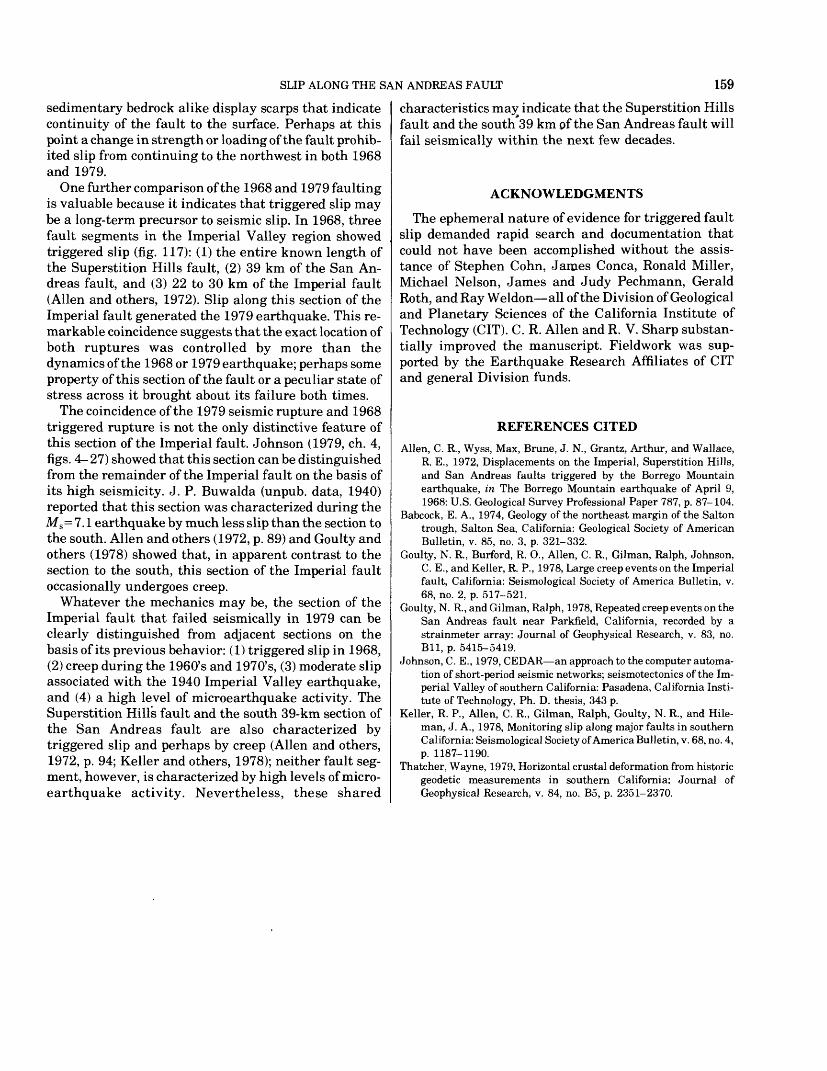
Soon after the Borrego Mountain, Calif., ML = 6.4 earthquake of 1968, which was generated by slip along the Coyote Creek fault, fractures along parts of the surficial traces of the nearby Imperial, Superstition Hills, and San Andreas faults were detected (Alien and others, 1972) (fig. 117). The fractures displayed only a centimeter or so of dextral slip, but involved tens of
'Contribution No. 3379, Division of Geological and Planetary Sciences, California Institute of Technology, Pasadena, CA 91125.
kilometers of fault length. These fractures formed within a few days of the earthquake but did not appear to have been caused abruptly by seismic slip. Alien and others (1972) reasoned that the fractures were induced by seismic shaking and not by changes in the static- strain field that accompanied the earthquake.
At about the same time in the 1979 Imperial Valley earthquake, which was generated by slip along the Im perial fault, sets of fractures similar to those observed in 1968 again formed along the Superstition Hills and San Andreas faults. Fuis (this volume) discusses recent frac turing along the Superstition Hills fault; here, I discuss those fractures that formed along the San Andreas fault. A comparison of the 1968 and 1979 fracture sets raises intriguing new questions as to their significance, because the 1979 earthquake was generated by slip along the same section of the Imperial fault that dis played triggered slip in 1968 (fig. 117).
OBSERVATIONS
The cracks that formed along the trace of the San Andreas fault in 1979 were generally shorter than 1 m and displayed dextral movement of as much as 10 mm measured parallel to the main fault trace. These cracks were arranged in left-stepping echelon patterns within zones that only rarely exceeded half a meter in width (for example, at km 2.8, pi. 3) or were accompanied by adjacent sets of fractures (at km 26.0). Numerous pho tographs of this sort of fracturing were presented by Alien and others (1972).
Plate 3 compiles detailed observations on the location of observed fractures and the magnitude of dextral slip. Only those segments along which the fractures were unambiguously tectonic are represented on the map (pi. 3). The fracture sets were not continuous along the 39-km section of the fault shown but, instead, formed groups ranging in length from less than 1 m to 3.7 km. In most localities, dextral slip was between 2 and 4 mm; the maximum measured was 10 mm, at one point near the northwest terminus (at km 1.0, pi. 3). The amount of slip did not vary in any clearly systematic fashion along the fault.
155

156 THE IMPERIAL VALLEY, CALIFORNIA, EARTHQUAKE OF OCTOBER 15, 1979
Knowledge of the time of formation of these fractures is important in understanding their cause. Near Mecca Beach Campground on the east shore of the Salton Sea, surficial fractures did not appear until more than 7
116°
10 20 30 KILOMETERSI I I
FIGURE 117. Comparison of slip triggered in 1968 and 1979. In 1968, seismic movement along Coyote Creek fault triggered slip along parts of San Andreas, Superstition Hills, and Imperial faults (heavy lines). In 1979, triggered slip on heavy-lined sections of Superstition Hills and San Andreas faults was associated with seismic rupture on Imperial fault and in Brawley fault zone.
hours after the earthquake. An 80-m segment of the fault trace at this site (dot at km 26.2, pi. 3) was first visited between 11:10 and 11:14 p.m. P.d.t. October 15 by Ronald Miller, Michael Nelson, Gerald Roth, and myself, using a gasoline lantern and flashlights. The fault trace is particularly evident here because it is marked by a knee-high scarp in young alluvium. We walked along the scarp and carefully searched for frac tures but found none. At about 7:30 a.m. P.d.t. October 20, I discovered echelon cracks at the same site. Our earlier footprints at two points crossed and in several other places were within a meter of the new set of frac tures. Therefore, the origin time of these fractures may be placed with reasonable confidence between Vs and 4 l/2 days after the earthquake. The records from a portable creepmeter that was designed, installed at the site, and monitored by Ralph Oilman indicate that no additional dextral fault slip occurred from the time of installation at 8 a.m. P.d.t. October 23 until November 9. Remeas- urement of slip on several fractures at this site showed no appreciable further slip between October 20 and December 11.
Whether or not the time of origin of these cracks is representative of the formation of cracks elsewhere along the fault trace or at depth is uncertain. Perhaps fault slip occurred simultaneously with the main shock at depth but required several hours or days to propagate to the surface. A similar time lag has been observed at least twice before: in association with the 1971 Imperial Valley ML = 5.3 earthquake (Alien and others, 1972, p. 102), and during creep events on the San Andreas fault near Parkfield in central California (Goulty and Oil man, 1978). If rupturing at depth was simultaneous with the main shock, this rupturing must have been aseismic because reports from Coachella, a nearby community, indicated low intensities for the main shock (Nason, this volume).
The possibility that the rupturing coincided with af tershocks of the main event can probably be ruled out. No aftershocks have been located along the fractured section of the San Andreas fault, using either the seis mic network or strong-motion records (C. E. Johnson and T. H. Heaton, oral commun., 1979). Any such after shocks must also have been of rather low magnitude (ML <4) to have gone unreported in nearby com munities. Finally, if all the cracks originated seismi- cally after the main shock, such an event must have produced 39 km of discontinuous fault rupture with very little slip. In the light of the above restrictions, it is reasonable just as Alien and others (1972) concluded in analyzing 1968 fracturing to exclude the possibility that the rupture was caused by seismic slip during one or more aftershocks.
A plausible alternative is that the ruptures formed in

SLIP ALONG THE SAN ANDREAS FAULT 157
association with postseismic creep events occurring at depth. Thatcher's (1979) interpretation of geodetic data is that very large amounts of aseismic dextral slip did occur at depth along this section of the San Andreas fault during the decade following the 1940 Imperial Valley earthquake. Perhaps further geodetic studies will allow selection of a suitable hypothesis for the for mation of these fractures.
COMPARISON WITH 1968 SLIPPAGE
The fracturing of 1979 resembles that of 1968 (fig. 117). The most recent cracks formed in association with seismic rupture on the Imperial fault, tens of kilometers to the southeast. The 1968 cracks originated within a few days of the seismic rupture on the Coyote Creek fault, tens of kilometers to the southwest (Alien and others, 1972). In both events, the surficial breaks appear to have formed aseismically; both sets of fractures are characterized by discontinuity and a low ratio of dextral slip to rupture length.
Plate 3 compares in detail the locations of 1968 and 1979 fracturing. The 1968 breaks (dotted lines, pi. 3) were mapped on aerial photographs by R. E. Wallace and Max Wyss (Alien and others, 1972, pi. 2). To elimi nate any inconsistencies in the 1968 and 1979 data sets due to tranference from photographic to topographic base, I inspected their annotated aerial photographs and plotted their data on my photographs; both sets of data were then transferred onto the topographic base.
SIMILARITIES
At only one locality where breaks occurred in both years could it be ascertained that the breaks occurred on different fault strands. Between kilometers 36.72 and 36.80 (pi. 3), a thorough search yielded only one zone of echelon cracks, about 10 to 15 m northeast of the small scarp that marks the main fault trace. The 1979 zone is probably the northeasternmost of the 10 to 12 subparal- lel zones observed there by R. E. Wallace and Max Wyss (Alien and others, 1972, pi. 2) over a 10-m width. Al though more detailed and thorough study might have revealed other sites where the 1968 and 1979 fractures did not exactly coincide, in general the fractures seemed to be in the same places. Along much of the fault, for example, both sets of fractures appeared at the base of an older scarp or at a major fault in the sedimentary bedrock. In addition, in most places the fault locations plotted on the aerial photgraphs in 1968 by R. E. Wal lace cannot be distinguished from those I plotted in 1979. Precision of locations on the photographs is a few meters.
The northwest and southeast limits of ground ruptur ing in 1968 and 1979 are nearly identical. One small set
of fractures in 1979 was about 600 m farther northwest than the mapped limit of fractures in 1968 (at km 0, pi. 3). This isolated short northwesternmost set of recent fractures was so inconspicuous, however, that a similar set could easily have gone unnoticed in 1968. In 1968, fractures were found along a short reach of the fault 1 km southeast of the southeasternmost breaks of 1979 (at km 39.7, pi. 3). Thus, the northwest and southeast terminations of the two fracture sets were within 1 km of each other, and both sets were 39 km long.
In addition to sharing nearly identical termini and lengths, the 1968 and 1979 ruptures share two major unbroken segments between termini: a 1.7-km segment between kilometers 3.3 and 5.0, and a 17.1-km segment between kilometers 8.7 and 25.8. With two exceptions (km 20.2-21.4 in 1968, and at km 12.3 in 1979, pi. 3), surficial slip was not observed along these fault seg ments after either event. In addition, the 1968 and 1979 termini of these largely unbroken segments are everywhere within 100 m of each other (approx 60 m at km 25.8, approx 20 m at km 8.7, and approx 30 m at km 5.0 and 3.3, pi. 3).
DIFFERENCES
At almost every locality where cracks formed in both years, the magnitude of dextral slip in 1979 was less than that in 1968. In general, the 1979 slip values were about one-sixth to one-half those of 1968. Curiously, however, the maximum measured slip from both events was within a few kilometers of the northwest terminus of ground rupturing.
In addition to its smaller slip, the 1979 rupture clearly was less continuous than the 1968 break (see pi. 3), and only from kilometer 26.9 to 29.1 did a long zone of new cracks form in 1979 where none were reported in 1968. Total fracture length in 1979, excluding unbroken segments, was about 10.4 km, and in 1968 about 13.7 km. In many places, short sets of cracks formed in 1979 where none were observed in 1968; likewise, many short fractured segments of 1968 did not break again in 1979 (see pi. 3).
DISCUSSION
During their studies of the 1968 Borrego Mountain earthquake, Alien and others (1972) made the impor tant discovery that the earthquake triggered aseismic fault slip outside the epicentral region. This phenome non has now been observed again within the same re gion, and its repetition enables a better assessment of its significance.
Discontinuous minor surficial slip along a 39-km sec tion of the San Andreas fault was triggered by both the

158 THE IMPERIAL VALLEY, CALIFORNIA, EARTHQUAKE OF OCTOBER 15, 1979
1968 and 1979 earthquakes. Although the gross simi larity between the two sets of triggered fractures is remarkable, in detail neither the magnitude of slip nor the location of individual breaks along the fault is iden tical for these two events.
If, indeed, the passage of these two earthquakes through the fault zone in some manner enabled the fault to slip, a repeat performance should not be an identical performance. The amplitudes, times histories, and wavelengths of the seismic strains that passed through the fault zone in 1979 must certainly have differed from those in 1968. If the amount of triggered slip were a function of the amplitude of the dynamic seismic strains, the earthquake from the more distance source (the Imperial fault in 1979) might be expected to have triggered less slip than the nearer earthquake of 1968. The 1979 slip was, in fact, smaller and less continuous at most localities. If the specific location of a broken segment is determined by details of the seismic radia tion passing through its frequency content, amplitude variation, and time history then the 1968 and 1979 distributions of fracture sets should differ both in detail (by tens of meters) and generally (by hundreds of meters to kilometers).
Although differences in the 1968 and 1979 seismic strains may have produced the differences in the two fracture sets, the similarities in the two sets are not so readily explained in terms of the seismic sources. It is unlikely that the northwest termini of the two 39-km- long zones would fall within a few hundred meters of each other if the fracture locations were entirely a func tion of seismic imput. It also is unplausible that the termini of the major faulted segments in 1979 would fall within a few meters of their locations in 1968 if the dynamics of each earthquake determined their place ment.
Therefore, these and other similarities apparently indicate features or properties of the fault zone itself. Four static factors are plausible.1. Young unfaulted sedimentary deposits may impede
the propagation of subsurface fractures to the sur face. In no locality, however, did cracking termi nate at the edge of an alluvial cover. Near kilometer 39 (pi. 3) the cracks end, although clear exposures of Pleistocene semiconsolidated deposits continue to the southeast. Similar situations obtain from kilometers 33V2 to 36y2 ,31 to 32,20 to 21,8% to 11%, and 3V2 to 5. Only between kilometers 0 and 1 and between kilometers 13 and 25V& can alluvial cover have hindered the 1968 and 1979 fractures from reaching the surface; because kilometers 14 to 20 was not searched in 1979 (nor, perhaps, in 1968), no strong case for sedimentary hindrance can be made there. Moreover, the presence of well-defined
small scarps indicates that older faulting did break the surface along parts of both these alluviated segments.
2. Tectonic slip along segments of the fault that traverse expansive-clayey sedimentary bedrock may be completely obscured by larger expansion cracks. In several places the fault cuts such mate rial, rife with polygonal cracks, typically with ex- tensional separations of about a centimeter. In these localities (for example, km 4-5 and 9-9V2), dextral slip of a few millimeters may have been obscured by the expansion cracks.
3. Tectonic slip along segments of the fault that consist of numerous branches or that have a substantial component of nonbrittle fracture (warping) may be too small to be visible or to propagate to the surface. Where the fault zone is diffuse and complex (km 3V2-5 and 9-12), tectonic slip may have been spread over several traces or over a wide zone of deforma tion. If slip on individual traces was thereby re duced to less than about 1 mm, surficial cracks might not have formed or been recognized.
4. The various segments of the fault may be prestressed to different amounts or have different shear strengths, and only those near failure may be triggered to move. Differences in stress or strength may be related to bends or discontinuities in the fault or inhomogeneity of materials. Perhaps the fractured segments are weaker than the unfrac- tured.
At kilometer 26V2, the fault makes a leftward bend of about 30 m over a distance of about 80 m. Segments of dextral faults with this geometry are probably stronger than straight or right-stepping segments (Paul Segall and D. D. Pollard, written commun., 1979). Faulting in 1968 ended at this bend (pi. 3). In 1979, fractures were nearly continuous to the northwest and southeast of the bend but were nonexistent through the bend (except for the few very inconspicuous segments shown in pi. 3). Perhaps the fault is stronger at the bend than to the southeast or northwest.
At the 1968 and 1979 southeast termini, the fault trace traverses severely folded Pleistocene beds of the Borrego Formation of Babcock (1974), but no change in the nature of the bedrock is readily apparent along the several kilometers of fault trace nearby. The fault trace does, however, change in trend from N. 47V20 W. (km 35-39) to N. 53V2 0 W. (km 39-43). This bend at the 1968 and 1979 fracture termini may be equivalent to a left ward bend in the fault, inasmuch as it may give the fault greater resistance to dextral shear.
Between kilometers 0 and 1 are the northwest ter mini of both the 1968 and 1979 fractures. The fault is continuous and straight at this point, and alluvium and
SLIP ALONG THE SAN ANDREAS FAULT 159
sedimentary bedrock alike display scarps that indicate continuity of the fault to the surface. Perhaps at this point a change in strength or loading of the fault prohib ited slip from continuing to the northwest in both 1968 and 1979.
One further comparison of the 1968 and 1979 faulting is valuable because it indicates that triggered slip may be a long-term precursor to seismic slip. In 1968, three fault segments in the Imperial Valley region showed triggered slip (fig. 117): (1) the entire known length of the Superstition Hills fault, (2) 39 km of the San An- dreas fault, and (3) 22 to 30 km of the Imperial fault (Alien and others, 1972). Slip along this section of the Imperial fault generated the 1979 earthquake. This re markable coincidence suggests that the exact location of both ruptures was controlled by more than the dynamics of the 1968 or 1979 earthquake; perhaps some property of this section of the fault or a peculiar state of stress across it brought about its failure both times.
The coincidence of the 1979 seismic rupture and 1968 triggered rupture is not the only distinctive feature of this section of the Imperial fault. Johnson (1979, ch. 4, figs. 4-27) showed that this section can be distinguished from the remainder of the Imperial fault on the basis of its high seismicity. J. P. Buwalda (unpub. data, 1940) reported that this section was characterized during the Ms =7.1 earthquake by much less slip than the section to the south. Alien and others (1972, p. 89) and Goulty and others (1978) showed that, in apparent contrast to the section to the south, this section of the Imperial fault occasionally undergoes creep.
Whatever the mechanics may be, the section of the Imperial fault that failed seismically in 1979 can be clearly distinguished from adjacent sections on the basis of its previous behavior: (1) triggered slip in 1968, (2) creep during the 1960's and 1970's, (3) moderate slip associated with the 1940 Imperial Valley earthquake, and (4) a high level of microearthquake activity. The Superstition Hills fault and the south 39-km section of the San Andreas fault are also characterized by triggered slip and perhaps by creep (Alien and others, 1972, p. 94; Keller and others, 1978); neither fault seg ment, however, is characterized by high levels of micro- earthquake activity. Nevertheless, these shared
characteristics may indicate that the Superstition Hills fault and the south 39 km of the San Andreas fault will fail seismically within the next few decades.
ACKNOWLEDGMENTS
The ephemeral nature of evidence for triggered fault slip demanded rapid search and documentation that could not have been accomplished without the assis tance of Stephen Cohn, James Conca, Ronald Miller, Michael Nelson, James and Judy Pechmann, Gerald Roth, and Ray Weldon all of the Division of Geological and Planetary Sciences of the California Institute of Technology (CIT). C. R. Alien and R. V. Sharp substan tially improved the manuscript. Fieldwork was sup ported by the Earthquake Research Affiliates of CIT and general Division funds.
REFERENCES CITED
Alien, C. R., Wyss, Max, Brune, J. N., Grantz, Arthur, and Wallace, R. E., 1972, Displacements on the Imperial, Superstition Hills, and San Andreas faults triggered by the Borrego Mountain earthquake, in The Borrego Mountain earthquake of April 9, 1968: U.S. Geological Survey Professional Paper 787, p. 87-104.
Babcock, E. A., 1974, Geology of the northeast margin of the Salton trough, Salton Sea, California: Geological Society of American Bulletin, v. 85, no. 3, p. 321-332.
Goulty, N. R., Burford, R. O., Alien, C. R., Gilman, Ralph, Johnson, C. E., and Keller, R. P., 1978, Large creep events on the Imperial fault, California: Seismological Society of America Bulletin, v. 68, no. 2, p. 517-521.
Goulty, N. R., and Gilman, Ralph, 1978, Repeated creep events on the San Andreas fault near Parkfield, California, recorded by a strainmeter array: Journal of Geophysical Research, v. 83, no. Bll, p. 5415-5419.
Johnson, C. E., 1979, CEDAR an approach to the computer automa tion of short-period seismic networks; seismotectonics of the Im perial Valley of southern California: Pasadena, California Insti tute of Technology, Ph. D. thesis, 343 p.
Keller, R. P., Alien, C. R., Gilman, Ralph, Goulty, N. R., and Hile- man, J. A., 1978, Monitoring slip along major faults in southern California: Seismological Society of America Bulletin, v. 68, no. 4, p. 1187-1190.
Thatcher, Wayne, 1979, Horizontal crustal deformation from historic geodetic measurements in southern California: Journal of Geophysical Research, v. 84, no. B5, p. 2351-2370.

The Imperial Valley, California, Earthquake of October 15, 1979GEOLOGICAL SURVEY PROFESSIONAL PAPER 1254
Contributions from:American Iron and Steel InstituteCalifornia Department of TransportationCalifornia Division of Mines and GeologyCalifornia Institute of TechnologyCentro de Investigacion Cientifica y Educacibn Superior
de Ensenada, Baja CaliforniaH. J. Degenkolb &f Associates, Consulting Structural Engineers Imperial College, LondonJ. D. Raggett &f Associates, Inc., Structural Engineers Scripps Institution of Oceanography U.S. Department of the Interior, Geological Survey Universidad Nacional Autbnoma de Mexico
UNITED STATES GOVERNMENT PRINTING OFFICE, W ASH I N GTO N : 1982