slab creek reservoir west end boating access plan
TRANSCRIPT

Slab Creek Reservoir West End Boating Access Plan Sacramento Municipal Utility District
Hydro License Implementation • July 2016 Upper American River Project FERC Project No. 2101

Slab Creek Reservoir West End Boating Access
July 2016
Sacramento Municipal Utility District Upper American River Project FERC Project No. 2101
i
CONTENTS
1. INTRODUCTION AND OBJECTIVES .................................................................. 1
2. PROJECT ELEMENTS ........................................................................................ 2 2.1. Design Criteria for Widening, Turnouts, and Turnaround ........................ 2
2.1.1. Access Road Design Criteria ........................................................ 2 2.1.2. Turnout Design Criteria ................................................................ 2 2.1.3. Turnaround Design Criteria .......................................................... 3
2.2. Parking .................................................................................................... 3 2.3. Restroom Facility .................................................................................... 3 2.4. Garbage Collection ................................................................................. 4 2.5. Signage and Public Information .............................................................. 4 2.6. Resource Protection ................................................................................ 4
3. REFERENCES ..................................................................................................... 6
APPENDICES
Appendix A Site Development Drawing

Slab Creek Reservoir West End Boating Access
July 2016
Sacramento Municipal Utility District Upper American River Project FERC Project No. 2101 1
1. INTRODUCTION AND OBJECTIVES
The Sacramento Municipal Utility District (SMUD), as required under Federal Energy Regulatory Commission (FERC) License for Project No. 2101 (License), dated July 23, 2014 for the Upper American River Project (UARP), has prepared this Slab Creek Reservoir West End Boating Access Development Plan (Development Plan) to fulfill those requirements pertaining to the Boat launch at Slab Creek Reservoir near Dam in License Appendix B, U.S. Forest Service (USFS) Condition No. 45.
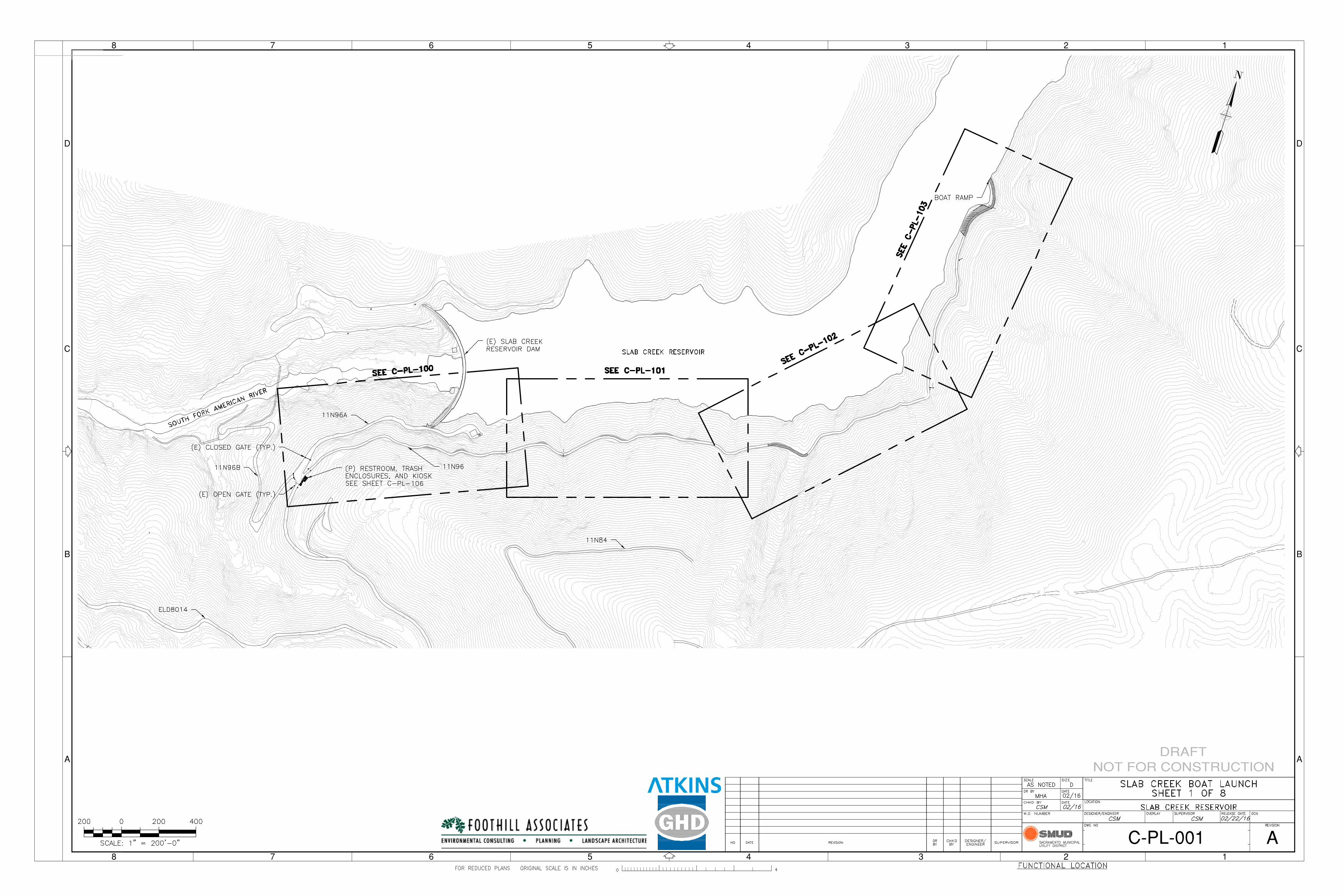
The Development Plan addresses safe and reasonable boating access, impacts from unmanaged recreation, and the need for additional day use facilities at the west end of Slab Creek Reservoir. The Development Plan does not include detailed engineering design, environmental review, permitting, or construction procedures. Schematic site development drawings of the boat launch location and the associated access route are shown in Appendix A.
Elements required to be addressed in the Development Plan are:
• Construct needed improvements to road access—such as widening, adding a turnaround at the boat launch, providing turnouts, installing signs, etc.—from County Road 8014 (ELD 8014) and Forest Road 11N96 to provide for public safety.
• Provide parking for a minimum of ten vehicles within a reasonable distance of the boat launch.
• Improve the boat launch, harden it to extend it to the minimum operating level as allowed under the License reservoir level, and restrict trailer use.
• Provide a one-unit vault restroom. • Explore the need for garbage collection. • Provide resource protection measures at the boat launch and along Forest Road
11N96. • Install a directional sign at the intersection of ELD 8014 and Forest Road 11N96,
and provide an information kiosk or signboard at the boat launch.
Most elements of this Development Plan are located in steep terrain with extremely limited and difficult access.

Slab Creek Reservoir West End Boating Access
July 2016
Sacramento Municipal Utility District Upper American River Project FERC Project No. 2101 2
2. PROJECT ELEMENTS
2.1. Design Criteria for Widening, Turnouts, and Turnaround 2.1.1. Access Road Design Criteria Access road design is to be completed following the guidance from the USFS (Wiest 1998). The following elements provide the guiding design criteria for the Slab Creek Reservoir West End Boat Access Road (hereinafter 11N96):
• Maximum un-surfaced grade = 12 percent • Minimum travel width = 12 feet • No traffic shoulders • Annual average daily traffic (AADT) post-construction = 2 vehicles • Post-construction design life = 50 years • Finish surface = Existing native rock and soil with local areas of aggregate base
(AB) • Drainage improvements = 24-hour, 100-year storm event • Design speed = 15 miles per hour (mph) • Fill slopes steeper than 2:1 will use mechanically stabilized earth (MSE) walls • Cut slopes are not to exceed 0.5(H):1(V) • Restricted public access • Design vehicle = automobiles and small pickup trucks • Minimum inside turning radius = 25 feet
2.1.2. Turnout Design Criteria The Development Plan includes enhancing eight turnout locations along 11N96. In general, the turnouts are located in existing widened areas or in areas where widening will result in minimal cut or fill impacts to the environment. Turnout design is to be completed following the guidance from the USFS (Wiest 1998).
Turnouts on the up-slope (south) side of 11N96 (Turnouts 1 and 4) will be small turnouts with minimal grading. The grading anticipated will include localized slope trimming to a maximum inclination of 0.5:1. Where soil is encountered and disturbed, cut inclinations will flatten to a maximum inclination of 1.5:1 and will be stabilized with standard USFS methods based on approved guidelines (Wiest 1998).
Turnouts on the down-slope (north) side of 11N96 (Turnouts 2-3 and 5-8) will include localized and shallow cut and fill grading, with a guard-rail installed at the slope break.

Slab Creek Reservoir West End Boating Access
July 2016
Sacramento Municipal Utility District Upper American River Project FERC Project No. 2101 3
2.1.3. Turnaround Design Criteria The Development Plan includes a turnaround near the terminus 11N96. The turnaround will redirect users back along this low-speed, single-lane access road. It will be built following guidance from the USFS (Wiest 1998). The following elements provide the guiding design criteria for the turnaround:
• Cross slope of 2 percent to a maximum of 4 percent • Minimum travel width of 12 feet • Minimum radius of 25 feet • The turnaround will be located near the terminus of the Slab Creek Reservoir
West End Boat Access Road
2.2. Parking A total of 10 parking spaces are included adjacent to the turnaround and near the terminus of 11N96. Each parking space will be 9 feet wide and 20 feet deep and oriented roughly diagonal to the access road. The existing road will be a minimum of 12 feet wide in this location. The adjacent parking area will be widened and constructed by placing fill within and behind an MSE wall to be constructed in accordance with USFS standards and painted black in conformance with other applications on USFS Land. The wall facing is filled with rock, which serves to aid the structure in blending into the surroundings. The wall facing is steep and ranges from vertical to a batter of 0.33:1. The typical installation is stair-stepped, rising up 18 inches and stepping in 6 inches horizontally. The wall facing is freely draining. Engineered fill, structural geogrid, and drainage is constructed behind the wall as it is built to the design grade. A guardrail is proposed at the outer edge of the improved parking lot for safety. The roadway and the parking area will be locally covered with 6 inches of Class II aggregate base rock compacted to 95 percent of its maximum dry density as determined by ASTM D-1557.
An additional two to three limited-duration (15 minute) parking spaces will be located at the intersection of 11N96, 11N96A, 11N96B, and ELD 8014 to accommodate use of the restroom, dumpsters, and kiosk described below.
2.3. Restroom Facility A one-unit vault restroom will be located near the intersection of 11N96, 11N96A, 11N96B, and ELD 8014. This restroom will be a USFS-approved single-vault restroom similar to other single-vault style restrooms installed on USFS lands. One example is the CXT Cascadian single-vault restroom, as shown on Sheet C-PL-106 in Appendix A.

Slab Creek Reservoir West End Boating Access
July 2016
Sacramento Municipal Utility District Upper American River Project FERC Project No. 2101 4
2.4. Garbage Collection Two concrete trash bin pads will be located near the intersection of 11N96, 11N96A, 11N96B, and ELD 8014. The pads will be constructed to accommodate 3-cubic yard capacity, bear-resistant dumpsters.
2.5. Signage and Public Information The intersection of 11N96, 11N96A, 11N96B, and ELD 8014 is a convergence of multiple entries for users of the recreational areas in the vicinity of Slab Creek Reservoir. An informational kiosk will be installed at this location.
The kiosk will be modeled using guidance from the USFS sign manual (USFS 2013) for natural settings and consists of 4-inch x 4-inch and 4-inch x 6-inch treated redwood timbers and a standing seam metal roof. If vandalized, sign panels can be removed for replacement, and they are backed by steel plate for durability. A replaceable, laminated recreational streamflow water release schedule can be mounted to the panels, held in place by a bolt-on plexiglass plate. Kiosk information might include a You-Are-Here map, information on fish and wildlife found in the reservoir and surrounding area, historical facts, boating safety tips, and the recreational streamflow release schedule for whitewater boating.
Additional recreational, travel management, fire prevention, and public safety signage will be located in consultation with the USFS using guidance from the USFS sign manual (USFS 2013).
2.6. Resource Protection SMUD will install and maintain Best Management Practices (BMPs) designed by a Qualified Stormwater Pollution Plan (SWPPP) Developer to protect natural resources during implementation of this Development Plan. BMPs would be removed when final stabilization is achieved.
SMUD will address potential resource degradation resulting from increased usage associated with the proposed recreational facilities through the following measures:
• A removable bollard designed to restrict unauthorized vehicular access to the boat launch.
• The boat access below the bollard will be sufficiently armored to minimize erosion and sedimentation resulting from increased traffic in this area.
• Signage and gates will restrict use outside of authorized areas.

Slab Creek Reservoir West End Boating Access
July 2016
Sacramento Municipal Utility District Upper American River Project FERC Project No. 2101 5
Surface drainage will be conveyed and designed for the 24-hour, 100-year storm event. Surface drainage design at the improvement areas will follow the guidance from the USFS (Wiest 1998). In general, this preliminary design assumes that the existing drainage improvements on 11N96 are adequate for this low-speed, single-lane access road. Proposed improvements for the boat launch area include removal of a damaged corrugated metal pipe and re-conveyance of the design flow through a V-Ditch as shown on sheet C-PL-104 in Attachment A.
Restrooms and trash enclosures will be provided to address sanitation issues. Garbage removal, including the placement of bear-resistant dumpsters, is not provided by SMUD. Those services ultimately would be supplied by USFS, or a contractor acting on their behalf.
Slab Creek Reservoir West End Boating Access
July 2016
Sacramento Municipal Utility District Upper American River Project FERC Project No. 2101 6
3. REFERENCES
United States Forest Service (USFS). Sign and Poster Guidelines for the Forest Service. Available at: http://www.fs.usda.gov/Internet/FSE_DOCUMENTS/ stelprd3810021.pdf. Revised October 2013.
Wiest, Richard L. July 1998. A Landowner’s Guide to Building Forest Access Roads—Road Planning & Location. Available at: http://www.na.fs.fed.us/spfo/pubs/stewardship/ accessroads/ accessroads.pdf

Slab Creek Reservoir West End Boating Access
July 2016
Sacramento Municipal Utility District Upper American River Project FERC Project No. 2101
APPENDIX A SITE DEVELOPMENT DRAWING


1942
1946
1950
6
1
2
4
5
7
4
9
3
8
10
11
4
1
LEGEND
3
STANDING SEAM METAL ROOF
2"X6" REDWOOD FASCIA BOARD
1
2
" GALVANIZED LAG SCREW AND
DECORATIVE WASHER
1
2
" GALVANIZED TIE ROD, NUTS AND
DECORATIVE WASHERS
1
4
"X2'X3' CORTEN STEEL PLATE WITH
INTERPRETIVE SIGN PANEL
6"X6" PRESSURE TREATED POST
1
4
"X4"X8" CORTEN STEEL ANGLE IRON,
WELDED TO STEEL BACKING PLATE
1
2
" GALVANIZED BOLT AND NUT, WITH
DECORATIVE WASHER
CONCRETE FOOTING
FINISHED GRADE
GRAVEL SUBBASE
4"X6" REDWOOD STRINGER
2"X4" REDWOOD RAFTER
2
5
6
8
7
9
10
11
6
1
2
4
5
7
4
9
3
10
12
12
12
12
12
13
13
9'-2"
9'-6
"
6'
2'
3'
NOTES:
A. ALL WOOD SHALL BE PRESSURE TREATED REDWOOD.
B. SLOPE CROWN OF CONCRETE FOOTING TO DRAIN AS SHOWN.
C. STRUCTURAL CALCULATIONS HAVE NOT BEEN DONE. STRUCTURAL ENGINEER TO REVIEW AND APPROVE STRUCTURE AND FOOTING DETAILS PRIOR TO CONSTRUCTION.
D. SIGN PANELS TO BE ATTACHED TO BACKING PLATE WITH THEFT-PROOF STAINLESS STEEL SCREWS.
CONCEPTUAL PLAN, RESTROOM AREA
CONCEPTUAL KIOSK DESIGN
CXT CASCADIAN SINGLE VAULT RESTROOM
KIOSK, SEE DETAIL THIS PAGE
TRASH ENCLOSURES, 3 YD. (2)
CATCH BASIN DI
RESTROOM, CXT CASCADIAN SINGLE VAULT
MSE OR SPLIT FACE WALL, 5-7' HIGH
12" CULVERT
(E) LOCKED GATE
(E) OPEN GATE
(E) LOCKED GATE
(E) OPEN GATE